STAFF REPORT. Agenda Item: 4(d)
|
|
|
- Harriet Simpson
- 5 years ago
- Views:
Transcription
 Background: The future land use map amendment and rezoning application involves an approximately 70 acre parcel of which about 10 acres would be rezoned")
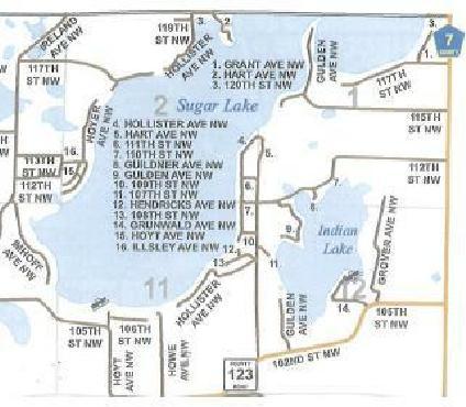
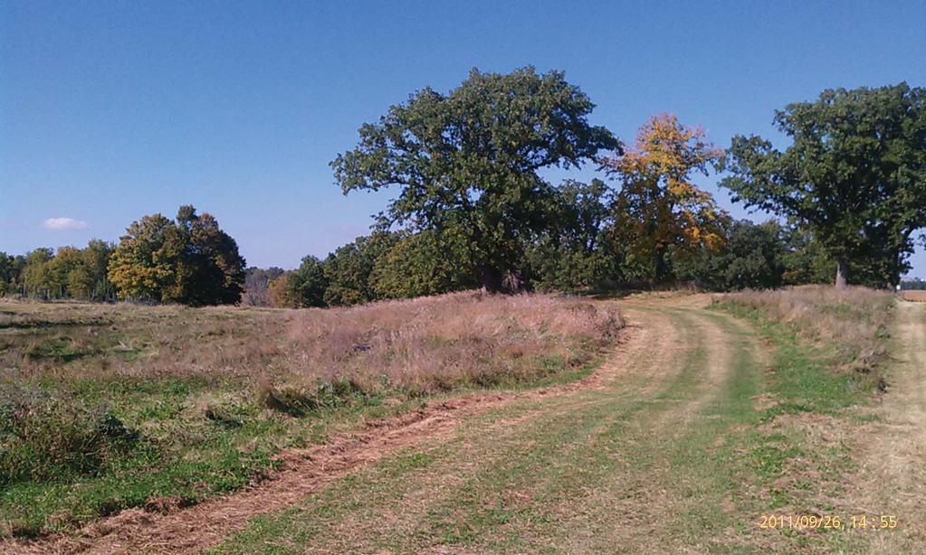
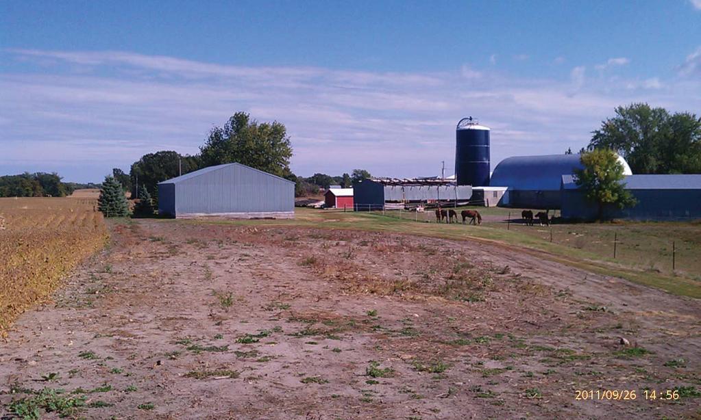
1 STAFF REPORT Application: Request to amend Comprehensive Plan Future Land Use Map designation from Rural Preservation to Shoreline Residential and to rezone lakeshore portion of property from AG to R-1. Applicant: John Bishop Agenda Item: 4(d) Background: The future land use map amendment and rezoning application involves an approximately 70 acre parcel of which about 10 acres would be rezoned and amended on the future land use map. The property has road frontage on Hart Avenue along the west side and 11oth Street NW on the south side. The majority of the 70 acre parcel is currently being farmed. The area proposed for rezoning and map amendment is heavily wooded with large, mature trees and has steep slopes throughout (as well as what appears to be a bluff on part of Lot 3). Lot 3 has the greatest change in elevation dropping from a high elevation of 1036 feet to the ordinary high water level of feet (about a 48 foot drop). Lot 2 has about a 42 foot drop. Lot 1 has about a 32 foot drop. There appears to be one small wetland on Lot 1 as well as a natural drainage way that has relatively large flat area at the bottom of the slope before it enters the lake. The parcels to either side of the area proposed for rezoning are zoned Urban/Rural Transition (R-1) the same that is proposed for the applicants land. Some land to the NE of the 70 acre parcel is zoned Agricultural/Residential (A/R). All other surrounding properties are zoned General Agriculture (AG). The property is currently identified as follows: Corinna Township/Wright County Zoning Map: General Agriculture (AG) Corinna Township Future Land Use Map: Rural Preservation Wright County Land Use Map: Residential Large Lot The requested changes would result in the following: Corinna Township/Wright County Zoning Map: Urban/Rural Transition (R-1) Corinna Township Future Land Use Map: Shoreline Residential Wright County Land Use Map: Residential Large Lot (no change) If the rezoning is approved, the applicant intends to follow with an application for subdivision of the parcel into three (3) separate parcels sized about 2.7 acres, 2.7 acres and 4.4 acres as shown in the enclosed sketch from Otto Associates dated 7/11/2011. Hart Avenue would need to be extended to serve the three lots that are anticipated for a future subdivision request. Applicable Statutes/ Ordinances: This application is subject to the following regulations: Corinna Township September 13, (b)-1
2 Corinna Township Zoning Ordinance The subject property is current zoned General Agriculture (AG), which is given the following purpose in the Zoning Ordinance: 604. GENERAL AGRICULTURE AG Purpose General Agricultural areas are established for the purpose of preserving, promoting, maintaining and enhancing the use of land for commercial agricultural purposes, to prevent scattered and leap-frog non-farm growth, to protect and preserve natural resource areas and to stabilize increases in public expenditures for such public services as roads and road maintenance, police and fire protection, and schools. The requested zoning classification is Urban/Rural Transition, whose purpose is described as: 603. AGRICULTURAL/RESIDENTIAL A/R Purpose This district is created to serve as a buffer between commercial agricultural areas and more intensely developed residential areas, to provide for very low density residential development in areas especially unsuited to long term agricultural uses, and to allow limited residential development which will not be provided with an urban level of services. Requests for Zoning Amendments, including amendments to the zoning map, are subject to Section IX of the Corinna Township Zoning Ordinance: The language in Section 504 is deleted. SECTION IX ZONING AMENDMENTS County Control. All requests for rezoning within Corinna Township shall be made to Wright County and follow the procedures adopted by Wright County. The final decision to establish a zoning classification within Corinna Township shall belong to the Wright County Board of Commissioners Township Evaluation. If Wright County requests input from Corinna Township as part of a process to establish or modify zoning classifications within Corinna Township, the Township shall make a recommendation to the County only after consideration of the following criteria: A. Preservation of natural sensitive areas. B. Present ownership and development. C. Soil types and their engineering capabilities. D. Topographic characteristics. E. Vegetative cover. F. Quality of the land for agricultural purposes. G. In-water physical characteristics. 1 Amended 10/21/08 Corinna Township September 13, (b)-2
3 H. Recreational use of surface water. I. Road and service center accessibility. J. Socio economic development needs of the public. K. Availability of public sewer and water utilities. L. The necessity to reserve and restore certain areas having significant historical or ecological value. M. Conflicts between land uses and impacts of commercial uses or higher densities on adjacent properties. N. Alternatives available for desired land use. O. Prevention of spot zoning. P. Conformance to the Corinna Township Comprehensive Plan. Q. Conformance to the Corinna Township Future Land Use Map and any other official maps of the Township. Corinna Township Comprehensive Plan The Corinna Township Comprehensive Plan (adopted in 2007) classifies the property and most of the surrounding properties as appropriate for a future land use of Rural Preservation, which is described as: Rural Preservation: A land use designation for properties that are best suited for rural farmsteads and farming. This classification would be most consistent with the Wright County Agricultural zoning classification. The Township believes it prudent to respond to future growth pressure by considering low-density, rural residential development in these areas, utilizing a cluster-style development strategy to maintain the rural character of the community. The properties adjacent to the subject property are identified for a future land use of Shoreline Residential : Shoreline Residential: A designation for shoreline properties already developed, or to be developed, residentially. Wright County Comprehensive Plan The Wright County Comprehensive Plan, just adopted in 2009, classifies the property as appropriate for Residential Large Lot, which is described as: Residential Large Lot Primarily designates those areas that have already been converted to a rural/suburban, residential environment with lot sizes ranging from two to ten acres due to past decisions. Undeveloped lands that are surrounded or nearly surrounded by such patterns may also be included in this district. Existing land types may include large wooded areas, non-productive farmland near existing developed areas, infill on lands near highly developed lakeshore areas and other areas where large lot development may occur without posing a threat to the environment, or long term agricultural uses. Appropriate zoning may include Agricultural, Agricultural Residential, R-2(a) and, in special cases, R-2. Rezoning from Agricultural to residential districts will generally be considered appropriate for large lot (R-2a) proposals and for smaller sizes (R-2) in cases where existing development trends or environmental factors are Corinna Township September 13, (b)-3
4 appropriate. Rezoning to R-1 will only be considered for riparian lots on shorelands especially suited to that type of residential development, or for small areas of "infill" which are predominately R-1 already. Staff Findings: We propose the following findings for consideration by the Planning Commission, based on the criteria for making zoning amendments in Section IX of the Corinna Township Zoning Ordinance: 1. Preservation of natural sensitive areas. The subject property does contain heavily wooded land, steep slopes, a natural drainageway (that appears to have a large area that held water at the bottom of the hill during the wet 2011 season), and at least two wetlands. All of these are considered sensitive features that would require special care during any construction on the lots and on an ongoing basis. If the land is developed as shown in the concept plan, Staff would have some concerns about maintaining adequate drainage of the surrounding area via the natural drainageway in Lot 1 and how the construction of a driveway, house/garage and grading for a yard would impact this drainage pattern. Also, given the steep slopes it would be necessary to consider carefully where homes and other improvements would be placed on all of the lots. 2. Present ownership and development. The property is currently actively farmed, although not in the area which is proposed for rezoning. Adjacent properties are primarily a mix of farmed land and shoreline residential. 3. Soil types and their engineering capabilities. The subject property contains several soil types, but the bulk of the area that is requested for rezoning is either 1023D (Lester-Malardi complex, 12 to 18 percent slopes, eroded) or 231C (Lester fine sandy loam, 6 to 12 percent slopes). These soils are listed as either somewhat limited (231C) or very limited (1023D) for building site development due primarily to the steep slopes and the potential for shrink-swell action in the soil. There are no soils in the area to be rezoned that are considered prime farmland. 4. Topographic characteristics. The topography of the site is dominated by steep slopes and some bluff. There is a relatively flat area near the lake on Lot 1 that appears to hold water in wet years such as was experienced in Vegetative cover. The site is heavily wooded with large, mature trees. 6. Quality of the land for agricultural purposes. The land has very limited value for agricultural purposes. The steep slopes and heavily wooded nature make it impractical for row crops. 7. In-water physical characteristics. Corinna Township September 13, (b)-4
5 The lake bottom appears to be sandy near the area. An area in front of Lot 3 has a significant stand of bulrushes. 8. Recreational use of surface water. The rezoning of this area, and eventual subdivision into residential lots, would likely increase recreational use of the surface water. 9. Road and service center accessibility. The property would be served by an extension of Hart Avenue. Hart Avenue, north of 111 th Street NW, is a narrow gravel road. The extension of Hart Avenue nec essary to serve the anticipated three lots would need to be built to Township standards. The applicant has stated he would dedicate enough land to allow for a 66 foot right-of-way on all of Hart Avenue north of 110 th Street NW. 10. Socio economic development needs of the public. The area is currently heavily wooded and contributes to wildlife habitat in the area. The requested rezoning would allow for up to three homes on the area to be rezoned. The land proposed for rezoning provides very little value for farming purposes. 11. Availability of public sewer and water utilities. The lot would be served by private sewer and water. 12. The necessity to reserve and restore certain areas having significant historical or ecological value. The property is heavily wooded with mature trees and may have some biological value. Staff is investigating further whether the MN County Biological Survey has any information on the site. 13. Conflicts between land uses and impacts of commercial uses or higher densities on adjacent properties. The proposed rezoning would create more of a mix between agricultural and residential uses. Staff would not expect significant conflict regarding direct farming activities, but given the large drainageway that leads from the farm field down to the lake, there is some possibility for conflict regarding water draining by a home that might be built in that area. 14. Alternatives available for desired land use. The alternative land use for this property is essentially just to remain being used as it currently is as wooded open space. Alternatively, the land could be used residentially, but at a lesser density than what is sought (i.e. 1-2 homes rather than three. 15. Prevention of spot zoning. The request is to rezone the property from AG to R-1. Adjacent shoreline properties on either side are currently zoned R-1. Staff does not feel that rezoning to R-1, or any other residential category, would be considered spot zoning given that adjacent properties are zoned Corinna Township September 13, (b)-5
6 R-1 and a residential zoning classification is anticipated in the Corinna and Wright County Comprehensive Plans. 16. Conformance to the Corinna Township Comprehensive Plan. The Comprehensive Plan of Corinna Township identifies this property as Rural Preservation, which could be consistent with a rezoning to R-1 or another residential category so long as unique and sensitive features (as well as farmland) is protected. The primary goal for development within the Rural Preservation classification is to prevent the loss of agriculturally productive land and rural character. A significant concern desire of the Township was to encourage cluster type developments that allowed for housing, but preserved and protected sensitive environmental or agricultural features. As noted before, there are a number of significant and sensitive environmental features on the land proposed for rezoning that would need to be protected during development in order to conform with the Comprehensive Plan. 17. Conformance to the Corinna Township Future Land Use Map and any other official maps of the Township. See answer to #16 above. Planning Commission Direction: The Planning Commission can approve the request, deny the request, or table the request if additional information is needed. If the decision is for approval or denial, findings of fact should be cited. Staff Comments: Staff s opinion is that the property has enough sensitive environmental features that the land should be developed in a way that allows for the protection or preservation of as much of these features as possible. It would appear difficult to place a home/garage, driveway and yard on Lot 1 in particular, without significantly affecting the functioning of the natural drainageway. It may be that with culverts and appropriate grading these concerns can be addressed, but it would likely involve significant changes to the natural features as they exist today. Lots 2 and 3 generate fewer concerns for Staff, although the steep slopes and wooded lands should be protected as much as possible to be consistent with the Comprehensive Plan. The Wright County Land Use Plan notes that a rezoning to R-1 should only be done when the land is especially suited to residential development. A rezoning to R-2a (min. 5 acres and 300 ft width) or R-2 (min. 2.5 acres and 200 ft width) may be more appropriate. Alternatively, a PUD overlay may be appropriate for this property as a way to allow the three homes desired, but ensure that the homes are placed in areas especially suited to them and that will minimize the impact on the drainageway, steep slopes and wooded nature of the property. Staff sees at least three options for the Planning Commission to consider: Corinna Township September 13, (b)-6
7 1. Recommend rezoning the property to R-1 as requested. A subsequent subdivision application would be subject to the minimum requirements of that district (i.e. min. 1 acre lots with 150 ft width), but could have stricter requirements imposed in order to help protect the sensitive environmental features. The concept plan already proposes larger than required lots and widths and thus other requirements would need to be made to help protect the steep slopes, the drainageway and the wooded areas. This would likely mean requiring that home avoid certain areas. This option would be a somewhat cumbersome way of directing where homes and other improvements could be built (more so than a PUD). Minutes from a previous subdivision proposal on this property in 2005/2006 (heard by Wright County) suggests that the County was not likely to approve a rezoning of the shoreland area to R-1 or even R-2a. They did seem more open to R-2. The previous application involved back lots as well, but the discussion of limiting the shoreland to fewer than three lots was specific to that area. 2. Recommend rezoning to R-2 or R-2a. This would essentially limit the density to either 1 or 2 residential lots due to the increased minimum lot widths (R-2 = 200 ft width = 2 lots possible; R-2a = 300 feet width = 1 lot possible). The property contains about 480 feet of shoreline. A subsequent subdivision request would have to comply with these minimums. This would help to ensure that the drainageway could be preserved in a more natural state and other features (such as the bluff and wetland) could be avoided. 3. Recommend rezoning the property to R-2 with a PUD overlay now. Any subsequent subdivision application would have to be conducted as a PUD. Recommend that a concept of a PUD subdivision be submitted to Wright County at the time they consider the rezoning. This would allow for three (possibly 4) homes, but then require that a portion of the land be considered common open space owned and maintained either by a public agency or a homeowner s association consistent with the requirements of the ordinance. Staff Recommendation: Based on the findings of fact presented in this report, staff recommends that the Planning Commission either table the request so that additional information can be provided about how the drainageway, in particular, would have its functionality preserved if the land were subdivided as shown in the concept plan. Given the existing information, it appears that the drainageway could be significantly altered and potentially create new problems for the lake and neighboring properties. Alternatively, if the Commission simply feels that an R-1 zoning classification is unwarranted due to the number of sensitive environmental features, it could deny the request. Specific findings of fact would need to be developed (or referral to Staff s suggested findings with some rewording to specify the Commission s exact reasoning). If the applicant and the Commission are open to an R-2 zoning and/or a PUD overlay, the applicant would have to apply for that classification and a new public notice would need to be sent out; essentially it would be a new application. In regards to amending the Township s Future Land Use Map, staff would recommend amending the map only if it determines that some form of shoreline residential Corinna Township September 13, (b)-7
8 development is desired for this area (R-1, R-2 or R-2a). If not, then the map should not be amended (this would leave open the possibility of developing the property using any remaining entitlements under current AG zoning or under a potential A/R rezoning). Amending of the map would not necessarily mean that the property should be rezoned, but it would signal that rezoning to R-1, R-2 or R-2a would likely be approved. Corinna Township September 13, (b)-8
9
10

11 Wright County, MN Date Created: 9/22/2011 Overview Legend Roads CSAHCL CTYCL MUNICL PRIVATECL TWPCL City/Township Limits c t Parcels Water 745 ft Parcel ID Sec/Twp/Rng Property Address Alternate ID n/a Class AGRICULTURAL Acreage Owner Address JOHN M BISHOP REVOCABLE TRUST JOHN M BISHOP TRUSTEE 558 LAKESHORE CIR PO BOX 389 ANNANDALE, MN District Brief Tax Description n/a Sect-01 Twp-121 Range-027 UNPLATTED LAND CORINNA TWP AC GOV LTS5&6EX TR DES BEG AT PT ON S LN OF SD LT6WH SEC LN INT/SEC INDIAN LK TH NLY FOL TH LK253FT TH DUE N TO RD32FT TH SWLY ALG RD540FT TO SEC LN TH E ALG SEC LN424FT TO POB ALSO EX TR BEG COR STAKE OF NE COR OF MAPLE VILLA PLAT TH S193FT TH E90D300FT TH N90D278FT TH NW120D110FT TO MEANDER LN OF SUGAR LK SHR TH ALG SHRLN TO POB ALSO EX TR BEG AT PT209FT S&16FT E OF NE COR OF MAPLE VILLA PLAT TH S50FT AT90D TH E284FT AT90D TH N50FT AT90D TH W284FT TO POB&EX TR DES IN BK EX TR DES ON DOC540862EX TR DES ON DOC (Note: Not to be used on legal documents) Last Data Upload: 9/20/2011 8:12:19 AM

12

13

14

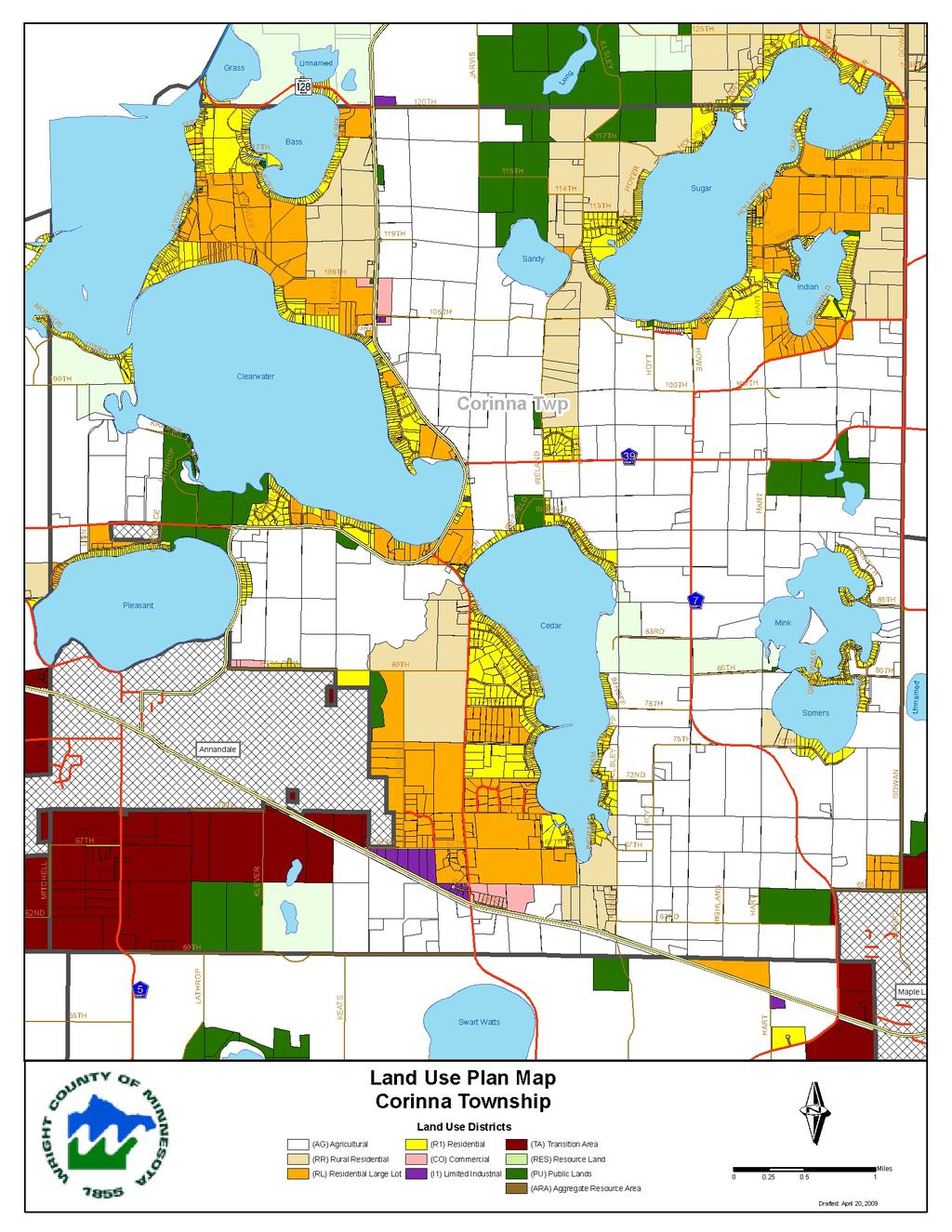
15 18 Corinna Township Section 4. Future Land Use The Planning Task Force has prepared a land use map as part of implementing the land use vision of the Township. The land use map is the geographic representation of the growth strategy for the Township, reflecting the goals and strategies contained in this plan. It is not a zoning map, but should be used to make decisions on how to respond to zoning and annexation requests. The map contains the following land use designations: Open Space: A designation for the preservation of environmentally-sensitive areas, unique resources, and other designated non-developable lands. Areas such as wetlands, lakes, bluffs, threatened and endangered species habitat, historic sites, land set aside as part of the development process, and other areas determined to be of special importance or value should be zoned Open Space. What is cluster development? The basic premise of cluster development is to group new homes onto part of the property to be developed and preserve the rest of the property as open space. The clustering of the homes can have dual benefits: building more homes than would otherwise be permitted and protecting natural resources. Typically, subdivision design divides up all the development property so that the entire property is designated as private residential parcels or as roadway, regardless of the natural resources, topography, or surrounding development in the area. On the other hand, cluster development would place the new homes on smaller lots typically taking up no more than half of the development property while designating the remainder of the property as public open space through conservation easements or land trusts. Public: A designation for the preservation of publicly-owned lands. All lands designated as Green Space are publicly owned and are set aside from development. Rural Preservation: A land use designation for properties that are best suited for rural farmsteads and farming. This classification would be most consistent with the Wright County Agricultural zoning classification. The Township believes it prudent to respond to future growth pressure by considering low-density, rural residential development in these areas, utilizing a cluster-style development strategy to maintain the rural character of the community. Neighborhood Residential: A designation for residential properties already subdivided into lots too small to further subdivide. The properties may or may not have structures on them, but are sized so that additional subdivision would not be feasible. Shoreline Residential: A designation for shoreline properties already developed, or to be developed, residentially. Urban-Rural Transition: A designation that provides market-based options for land development in potential annexation areas. Although developments in this district could be done at larger lot sizes, higher densities would be allowed as part of a rural cluster. Rural clusters would need to be designed to preserve the outward appearance of rural character through open-space preservation while still allowing for flexibility of design. Commercial and light industrial uses would be allowed in this zone, focused along the Highway 55 corridor. Commercial: A land use designation to memorialize existing, low-intensity commercial development and to identify potential future low-intensity commercial growth areas along major growth corridors.


16 Comprehensive Plan 19
17
18 4.4 Land Use Definitions A major purpose of this Land Use Plan is to provide a guide for future decision-making by County Officials. Most land use decisions deal with incremental changes in zoning and land uses proposed by individual property owners. Often, such decisions seem not to be crucial, nor overly important when viewed in isolation. However, the precedents set, policies established and accumulated effect over time of many such decisions can lead to unexpected and undesirable results. Most, if not all of the land use and environmental problems in Wright County have resulted from decisions, or the absence of decisions made during times past, when little or no effort was made to regulate land use and development. It is often too easy to become overly involved with the details and emotions of individual land use cases, and to lose sight of the overall goals and purposes of regulating land use. The Land Use Plan is meant to serve as the primary framework within which land use decisions should be made. Zoning proposals will be evaluated primarily by their conformance to the Land Use Plan. It is not meant to be totally inflexible, as rare and unusual circumstances may justify occasional departures from the plan maps. However, consistent or simply convenient departures from the Plan without adequate justification will eventually defeat the purpose and goals of the Plan. Deviations from the Plan should only be made in the public interest, and not to benefit an individual or small group. The following definitions of the districts on the maps shall be used in making future decisions to carry out the Land Use Plan, and to review specific proposals. (Incorporated Cities, Public Lands and Lakes are self explanatory). Agricultural Designates those areas appropriate to remain in agricultural use over the long term. The purpose is to both preserve productive farmland for the future and to protect agricultural activity from encroachment by other activities. Existing land types may include productive farmland, pasture, farm woodlots, wetlands and other agricultural or open lands. Appropriate zoning will generally include only the Agricultural District. Rezoning to other districts will be considered only in rare and unique circumstances, or for riparian lots on shorelands especially suited to residential development. Rural Residential Designates those areas where a combination of agriculture, hobby farms and very large lot residential areas is deemed appropriate. The purpose is to provide a buffer between agricultural and other uses, and also to provide housing opportunities in a rural environment where large lot sizes and the rural atmosphere will be maintained. Existing land types may include large wooded areas, non prime farmland, pasture and other lands in areas not well suited to long term agricultural uses. Appropriate zoning may include Agricultural, Agricultural Residential, or, in unique circumstances, R-2(a). Rezoning from Agricultural to Agricultural Residential will be considered on a case by case basis, and not considered to be automatic, with the need for residential land, effect on nearby agricultural operations, the timing of the proposal in light of land uses in the area, and plan policies being prime considerations. Rezoning to R-1 or R-2 will only be considered for riparian lots on shorelands especially suited to Wright County Land Use Plan Page 79
19 residential development. Rezoning to R-2a may be appropriate in unique circumstances such as: infill for areas that are already developed in a similar manner; adjacent to developed areas with smaller lot sizes to serve as a transition, and; other unique situations which do not establish R-2a as a new zoning district in a previously "undeveloped" area. Residential Large Lot Primarily designates those areas that have already been converted to a rural/suburban, residential environment with lot sizes ranging from two to ten acres due to past decisions. Undeveloped lands that are surrounded or nearly surrounded by such patterns may also be included in this district. Existing land types may include large wooded areas, non-productive farmland near existing developed areas, infill on lands near highly developed lakeshore areas and other areas where large lot development may occur without posing a threat to the environment, or long term agricultural uses. Appropriate zoning may include Agricultural, Agricultural Residential, R-2(a) and, in special cases, R-2. Rezoning from Agricultural to residential districts will generally be considered appropriate for large lot (R-2a) proposals and for smaller sizes (R-2) in cases where existing development trends or environmental factors are appropriate. Rezoning to R-1 will only be considered for riparian lots on shorelands especially suited to that type of residential development, or for small areas of "infill" which are predominately R-1 already. Residential Designates existing residential areas that are already characterized by relatively small lots (for unsewered areas) and those limited undeveloped areas deemed appropriate for conversion to similar use. Most areas currently exist as a result of lakeshore development prior to any zoning or environmental regulation, and other isolated areas exist that developed with small lots historically. In general, due to the environmental and health impacts of developing areas with small lots and on-site sewage treatment, such development will be discouraged. However, in certain limited cases, such as riparian lots on general development and recreation development lakes, or infill in areas that are surrounded by similar development, some expansion of residential areas can be allowed. Rezoning from Agricultural to residential districts will generally be considered appropriate in this district, depending on environmental factors. Rezoning to R-1 will only be considered for riparian lakeshore lots, or as "infill" where most surrounding land is already zoned R-1. Multi-family structures are not allowed in areas without municipal sewer and water services. Commercial Designates existing commercial areas and undeveloped land well suited to commercial development that does not require a significant level of urban services. The purpose is to provide for limited commercial development in areas that are especially well suited to such use. Existing land types may include areas near major highway interchanges, existing service centers (unincorporated communities) or adjacent to urban commercial areas. Appropriate zoning may include the B-l or B-2 district. Limited Industrial Designates existing industrial areas as well as undeveloped land considered especially well suited to industrial uses that do not require urban services. The purpose is to provide for certain industrial uses that may not be appropriate in urban areas, or are near urban industrial areas, or on land especially well-suited to industrial Wright County Land Use Plan Page 80
20 STAFF REPORT Application: Create an entitlement split of acres (max. 10 acres allowed). Applicant: James Wurm Agenda Item: 4(e) Background: The applicant has one remaining dwelling entitlement on his farm. He would like to split off approximately 12.6 acres as his allowable dwelling entitlement. The 12.6 acres currently does not have public road frontage, but the applicant has approached the Town Board regarding granting of a 66-foot wide strip that would be an easement for a public road in perpetuity. The Town Board has discussed and appears open to the idea, with the understanding that the road would not be built up or maintained by the Township at this time. The road could be taken over by the Township in the future, but would require specific action by the Town Board at the time. The Township ordinance would alternatively allow for a private access strip to lead back into the 12.6 acre property, but this strip would have to be owned as part of the 12.6 acre lot (making it larger). The applicant and the Town Board have both expressed reservations about taking this approach. The Township ordinance requires that an entitlement split be no larger than 10 acres primarily with the purpose of protecting productive farmland. This 12.6 acre parcel however is hilly, partially wooded, and the applicant states that it is only good for pasturing not for row crops. He also indicates that reducing the lot size to 10 acres or less would do little to preserve farmland, as the land he would keep as part of his farm would not be good for farming anyways. The property is currently zoned General Agriculture (AG). Applicable Statutes/ Ordinances: This application is subject to the following regulations: Corinna Township Zoning Ordinance The subject property is current zoned General Agriculture (AG), which is given the following purpose in the Zoning Ordinance: 604. GENERAL AGRICULTURE AG Purpose General Agricultural areas are established for the purpose of preserving, promoting, maintaining and enhancing the use of land for commercial agricultural purposes, to prevent scattered and leap-frog non-farm growth, to protect and preserve natural resource areas and to stabilize increases in public expenditures for such public services as roads and road maintenance, police and fire protection, and schools Requirements and Standards for Dwellings and Permitted Divisions Corinna Township October 11, (e)-1
21 (4) Entitlement Divisions If a landowner chooses to use an entitlement on an eligible lot of record or quarter-quarter section as a division, the division and remainder of the eligible parcel shall be subject to the following requirements. (a) Deed Restriction - The owner(s) (including, in all cases, the fee owner) of the eligible parcel must sign and record a deed restriction to apply to the remainder of the parcel. The restriction shall limit any further residences, divisions or nonagricultural development of the remainder in accord with the terms of this section, unless it is rezoned. The restriction shall be on a form provided by the zoning administrator. (b) Landlocked parcels prohibited - The remainder must have frontage on a public road, or must be held in common ownership with contiguous lands which have road frontage. No lot nor parcel may be created which does not have road frontage in accord with the requirements herein. (c) Lot Standards (1) The minimum lot size shall be one (1) acre. Minimum road frontage, lot width, depth, setback and other standards shall be the same as for the residential zoning district closest to the lot's size. (2) A private access strip no less than thirty-three (33) nor more than sixty-six (66) feet in width, which abuts a public road, may be approved by the zoning administrator in lieu of the standard road frontage requirement, if the intent is to provide access to a wooded site, or to otherwise preserve active agricultural land or practices. The strip shall not be an easement, but owned in fee with the division. Maintenance shall be the complete responsibility of the property owner. In no case may such a strip be used to serve more than one residence, unless accepted as a public road by the township. Refusal by the zoning administrator to approve such a strip may be appealed to the Board of Adjustment. (3) Maximum lot size shall be: - Five (5) acres for divisions from eligible lots of record - Two and one-half (2.5) acres for divisions from eligible quarterquarter sections if the building site is undeveloped cropland classified as prime farmland or farmland of statewide importance as defined in the Land Use Plan - Ten (10) acres in all other instances (d) Lot Status - The division shall remain zoned AG, General Agriculture, but for the application of rules pertaining to livestock, outdoor storage Corinna Township October 11, (e)-2
22 (8) General and other general standards, a division ten (10) acres or less in size shall be considered a residential lot. The intent of these standards shall be to preserve an average density of one dwelling per forty (40) acres in the AG district, except where legal lots of record are involved. This intent shall be considered when questions regarding interpretation of these regulations may arise. Corinna Township Comprehensive Plan The Corinna Township Comprehensive Plan (adopted in 2007) classifies the property and most of the surrounding properties as appropriate for a future land use of Rural Preservation, which is described as: Rural Preservation: A land use designation for properties that are best suited for rural farmsteads and farming. This classification would be most consistent with the Wright County Agricultural zoning classification. The Township believes it prudent to respond to future growth pressure by considering low-density, rural residential development in these areas, utilizing a cluster-style development strategy to maintain the rural character of the community. Staff Findings: We propose the following findings for consideration by the Planning Commission, based on the criteria for making zoning amendments in Section IX of the Corinna Township Zoning Ordinance: 1) Will the granting of the variance be in harmony with the general purposes and intent of the Corinna Township Land Use (Zoning) and/or Subdivision Ordinance? a) Needs discussion. The spirit and intent of the ordinance (maximum lot size for an entitlement division) is presumably to minimize the amount of land that is taken out of agricultural production and converted to a residential lot. The land proposed to be split has apparently not been farmed in the past only pastured. That is apparently due largely to the hilly nature of the property. However, the soil survey does identify the great majority of the soils on the parcel as prime farmland so the soil apparently has the capacity to be productive agriculturally. 2) Will the granting of the variance be consistent with the Corinna Township Comprehensive Plan? Needs discussion. The Comprehensive Plan does not directly address variance requests such as this, except that it has a general goal to Encourage preservation of productive farm operations and a specific strategy to: o Require developments that may occur in or near productive farmland to design subdivisions in a way that preserves the greatest amount of productive farmland for continued agricultural use. Corinna Township October 11, (e)-3
23 Staff Comment: Whether the proposal meets the intent of the Comprehensive Plan depends on how the Township views the potential agricultural productivity of this land. The ordinance would require that a lot split be no more than 2.5 acres if this were being split from an eligible quarter-quarter section. In this case, the max. lot size is 10 acres. The proposal would be for 12.6 acres. If the applicant were to reduce the lot size to less than 10 acres, the only feasible way to do so would essentially be to take either the western strip or the eastern strip of the proposed parcel and attach it to adjacent land. The amount of the strip would have to be about 90 feet wide to reduce the size below 10 acres. 3) Is the proposed use of the property reasonable? Yes. The applicant is requesting the ability to make use of his remaining dwelling entitlement. The parcel proposed to be split for the entitlement has not been used for row crop farming in the recent past and thus the proposed split would not eliminate any productive farmland a goal of the Township. 4) Is the plight of the landowner due to circumstances unique to the property not created by the landowner? Needs discussion. The proposed lot split is partially due to the historical use and functionality of the land itself. The applicant is splitting off a parcel that does not contain any lands that have been used for row crops in the recent past. The finger of land that runs to the southeast for the proposed split however, is primarily for the purpose of deeding land that includes an existing shed over to the buyer of this lot. While removing this finger would not reduce the lot below 10 acres, it does increase the size and creates an odd-shaped parcel and eliminating it would reduce the amount of variance requested. 5) Will the variance, if granted, alter the essential character of the locality? No. The neighborhood where the property is located is primarily used agriculturally. The addition of one new home would not likely alter this essential character. 6) Are economic considerations the only reason the applicant cannot meet the strict requirements of the ordinance? No. There are other considerations than simply economic. These include the layout of the land now (including ownership boundaries) and the lack of usefulness of an approximate 90 foot strip of land for agricultural purposes. 7) Could the practical difficulty be alleviated by a feasible method other than a variance (taking into account economic considerations)? Needs discussion. As discussed before, the need for the variance could be reduced if the finger of land were eliminated from the entitlement division, but there would still be need for a variance. 8) Will the granting of the variance adversely affect the environmental quality of the area? No. The impact of the split whether 10 acres or 12.6 acres would be expected to have no significant impact on environmental quality. Corinna Township October 11, (e)-4
24 Planning Commission Direction: The Planning Commission can approve the request, deny the request, or table the request if additional information is needed. If the decision is for approval or denial, findings of fact should be cited. Staff Recommendation: Based on the findings of fact presented in this report, staff recommends that the Board of Adjustment approve the requested variance. The Board may wish to discuss whether they feel the extra finger of land at the SE of the proposed split is warranted as part of the variance or if they feel the variance should be minimized by eliminating this section from the split. Staff recommends the following conditions of approval: 1. That the Town Board accept an easement for a public road as depicted in the Certificate of Description submitted with this application, or that would otherwise provide the required 300 feet of road frontage to this lot. 2. That the existing shed located on the proposed split will be considered a legal, non-conformity for the purposes of eventual maintenance and possible rebuilding/enlarging of the building. Based on current ordinances and state statutes, expansion of the building would be prohibited without a variance. Replacement would be allowed. Corinna Township October 11, (e)-5
25
26
27


28 Wright County, MN Date Created: 9/22/2011 Overview Legend Roads CSAHCL CTYCL MUNICL PRIVATECL TWPCL City/Township Limits c t Parcels 745 ft Parcel ID Sec/Twp/Rng Property Address Alternate ID n/a Class AGRICULTURAL Acreage Owner Address JAMES M & MARLENE A WURM 6501 HIGHLAND AVE NW MAPLE LAKE, MN District Brief Tax Description n/a Sect-35 Twp-121 Range-027 UNPLATTED LAND CORINNA TWP AC NW1/4 OF NE1/4 &W1/2 OF NE1/4 OF NE1/4 EX TRI PIECE DESC BEG AT PT 33FT S OF NW COR OF NE1/4 TH N33FT TO SD NW COR TH E33FT TH SWLY TO POB ALSO TR DES ON DOC EX TR DES ON DOC ( (Note: Not to be used on legal documents) Last Data Upload: 9/20/2011 8:12:19 AM
29

30
31
STAFF REPORT. Permit History:
 STAFF REPORT Application: Request to rezone property from General Agriculture (AG) to Suburban Residential (a) (R-2a) Applicant: Perry Puncochar Agenda Item: 4(g) Background Information: Proposal: The
STAFF REPORT. Applicable Statutes/Ordinances: Corinna Township Subdivision Ordinance
 STAFF REPORT Application: Preliminary plat application to subdivide an approximate 6.47 acre parcel into two lots (2.81 and 3.42 acres) with a 0.24 acre remainder to be attached to an existing nonconforming
STAFF REPORT. Arthur and Kathleen Quiggle 4(b)
") STAFF REPORT Application: Requests related to the construction of a 28' x 41' dwelling and 6' wrap-around open deck to replace an existing 24' x 32' cabin and wrap-around open deck and the installation
STAFF REPORT Application: Requests related to the construction of a 28' x 41' dwelling and 6' wrap-around open deck to replace an existing 24' x 32' cabin and wrap-around open deck and the installation
STAFF REPORT. Gary and Kathleen Miron. Background Information:
 STAFF REPORT Application: Variance to add a second story addition approximately 7-8 feet from a side property line (min. required 15 feet). Existing building coverage is 20.3% (max. 15% allowed). Existing
** If your lot does not meet the requirements above, please read Sec below
 Sec. 13-1-60 Zoning District Dimensional Requirements. For the Zoning Dept To Issue a Land Use Permit The Following Dimensions are Required. Minimum Side and Rear Yards s Lakes Classification Minimum Class
DRAFT FOR PUBLIC HEARING (rev. March, 2016)
") Chapter 200. ZONING Article VI. Conservation/Cluster Subdivisions 200-45. Intent and Purpose These provisions are intended to: A. Guide the future growth and development of the community consistent with
Chapter 200. ZONING Article VI. Conservation/Cluster Subdivisions 200-45. Intent and Purpose These provisions are intended to: A. Guide the future growth and development of the community consistent with
Chapter 100 Planned Unit Development in Corvallis Urban Fringe
 100.100 Scope and Purpose. Chapter 100 Planned Unit Development in Corvallis Urban Fringe (1) All applications for land divisions in the Urban Residential (UR) and Flood Plain Agriculture (FPA) zones within
Land Use. Land Use Categories. Chart 5.1. Nepeuskun Existing Land Use Inventory. Overview
 Land Use State Comprehensive Planning Requirements for this Chapter A compilation of objectives, policies, goals, maps and programs to guide the future development and redevelopment of public and private
Town of. River Falls. Land Use Element Vierbicher Associates, Inc
 Town of River Falls 2005 Vierbicher Associates, Inc Contents Contents s. 66.1001(2)(h) Wis. Stats................................................. ii Introduction................................................................
City of Independence
 City of Independence Request for a Variance from the Side Yard Setbacks for the Property Located at 4618 South Lake Sarah Drive To: From: Planning Commission Mark Kaltsas, City Planner Meeting Date: May
Land Use. Existing Land Use
 8 Land Use 8.1 Land Use Chapter Purpose and Contents This element includes a brief summary of existing land use conditions and trends followed by a series of goals, objectives, and recommendations to guide
Draft Model Access Management Overlay Ordinance
 Draft Model Access Management Overlay Ordinance This model was developed using the City of Hutchinson and the Trunk Highway 7 corridor. The basic provisions of this model may be adopted by any jurisdiction
Special Use Permit - Planned Unit Development Checklist. Property Address:
 Special Use Permit - Planned Unit Development Checklist Special Use Permit Number. Parcel Code/s #28-11- - - Property Address: Applicant: ARTICLE VIII Ordinance Reference - Section 8.1.2 Permit Procedures:
4. If any perennial surface water passes through or along the property lines of the acreage, a minimum of 200 feet or frontage should be required.
 b. Provide adequate acreage for appropriate productive use of rural residential land, such as small numbers of livestock, large gardens, etc. 3. Minimum of 200 feet of frontage on an improved county or
March 26, Sutter County Planning Commission
 March 26, 2003 To: Re: Sutter County Planning Commission Agenda Item #12: Public hearing on Rezoning #03-04 to change the zoning classification of two parcels totaling 324+ acres from the AG (General Agricultural)
ARTICLE III District Regulations. A map entitled "Franklin Zoning Map" is hereby adopted as part of this chapter 1.
 ARTICLE III District Regulations ~ 305-8. Adoption of Zoning Map. A map entitled "Franklin Zoning Map" is hereby adopted as part of this chapter 1. ~ 305-9. Official Zoning Map; amendments. Regardless
Instructions to the Applicant
 CONDITIONAL USE PERMIT APPLICATION Lake of the Woods County Land and Water Planning Office 206 8 th Avenue Southeast, Suite #290 Baudette MN 56623-2867 www.co.lake-of-the-woods.mn.us Phone: (218) 634-1945
LAKE OF THE WOODS COUNTY WETLAND CONSERVATION ORDINANCE OF 2002
 Ordinance # LAKE OF THE WOODS COUNTY WETLAND CONSERVATION ORDINANCE OF 2002 ARTICLE 1 TITLE AND PURPOSE Section 1.1. Title This Ordinance shall be known, cited and referred to as the Lake of the Woods
8Land Use. The Land Use Plan consists of the following elements:
 8Land Use 1. Introduction The Land Use Plan consists of the following elements: 1. Introduction 2. Existing Conditions 3. Opportunities for Redevelopment 4. Land Use Projections 5. Future Land Use Policies
Residential Construction in Farmland Preservation Zoning Districts
 Updated Draft: October 25, 2009 Residential Construction in Farmland Preservation Zoning Districts 2009 Wis. Act 28 repealed and recreated Wisconsin s Farmland Preservation program under ch. 91, Stats.
CCC XXX Rural Neighborhood Conservation (NC)
") CCC 33.10.XXX Rural Neighborhood Conservation (NC) Purpose: Maintain low density rural residential areas and associated uses commonly found in rural areas consistent with the local character of the distinctive
CCC 33.10.XXX Rural Neighborhood Conservation (NC) Purpose: Maintain low density rural residential areas and associated uses commonly found in rural areas consistent with the local character of the distinctive
SUBURBAN AND URBAN RESIDENTIAL LAND USE
 SUBURBAN AND URBAN RESIDENTIAL LAND USE GOAL 1 DISCOURAGE URBAN AND SUBURBAN DEVELOPMENT OUTSIDE INCORPORATED AREAS IN WHITMAN COUNTY, EXCEPT WITHIN DESIGNATED UNINCORPORATED COMMUNITIES, AND THOSE AREAS
Article XII. R-1 Agricultural-Low Density Residential District
 Article XII R-1 Agricultural-Low Density Residential District Section 1200. Declaration of Legislative Intent In expansion of the Declaration of Legislative Intent and Statement of Community Development
Comprehensive Plan 2030
 Introduction Land use, both existing and future, is the central element of a Comprehensive Plan. Previous chapters have discussed: Projected population growth. The quality housing available in the Township
CORINNA TOWNSHIP BOARD OF ADJUSTMENT / PLANNING COMMISSION
 CORINNA TOWNSHIP BOARD OF ADJUSTMENT / PLANNING COMMISSION MEETING PACKET FOR November 13, 2012 1. Call to Order 2. Roll Call CORINNA TOWNSHIP AGENDA BOARD OF ADJUSTMENT / PLANNING AND ZONING COMMISSION
HOW TO APPLY FOR A USE PERMIT
 HOW TO APPLY FOR A USE PERMIT MENDOCINO COUNTY PLANNING AND BUILDING SERVICES What is the purpose of a use permit? Throughout the County, people use their properties in many different ways. They build
ARTICLE XI - CONSERVATION SUBDIVISIONS
 ARTICLE XI - CONSERVATION SUBDIVISIONS Section 1101: Purpose and Intent. This Article is intended to provide for residential subdivisions that are designed based first and foremost on the preservation
INCOMPLETE APPLICATIONS WILL BE RETURNED! GENERAL PROPERTY INFORMATION. Applicant s name Day Phone address Authorized Agent (if applicable)
") Environmental Services Planning & Zoning 601 Third Avenue Two Harbors, MN 55616 www.co.lake.mn.us (218)834-8327 Fax: (218)-834-8365 LAKE COUNTY ADMINISTRATIVE SUBDIVISION APPLICATION PLEASE COMPLETE IN
Environmental Services Planning & Zoning 601 Third Avenue Two Harbors, MN 55616 www.co.lake.mn.us (218)834-8327 Fax: (218)-834-8365 LAKE COUNTY ADMINISTRATIVE SUBDIVISION APPLICATION PLEASE COMPLETE IN
PLANNING & DEVELOPMENT
 PLANNING & DEVELOPMENT STAFF REPORT Rezoning PETITION: APPLICANT: PROPERTY OWNER: TYPE OF REQUEST: SIZE OF TRACT: LOCATION: (#17-22) Rezone from A-PUD (Agri-Business Planned Unit Development) to A-PUD
CHAPTER 3 PRELIMINARY PLAT
 10-3-1 10-3-3 SECTION: CHAPTER 3 PRELIMINARY PLAT 10-3-1: Consultation 10-3-2: Filing 10-3-3: Requirements 10-3-4: Approval 10-3-5: Time Limitation 10-3-6: Grading Limitation 10-3-1: CONSULTATION: Each
Chapter Planned Residential Development Overlay
 Chapter 19.29 Planned Residential Development Overlay Sections 010 Purpose 020 Scope 030 Definitions 030 Minimum Size 040 Allowable Uses 050 Minimum Development Standards 060 Density Bonus 070 Open Space
APPLICATION FOR SUBDIVISION APPROVAL OF A SKETCH PLAN with checklist
 Prior to filing any application for SUBDIVISION approval, the applicant shall request in writing that the zoning administrator schedule a pre-submission conference. APPLICATION TO THE PLANNING BOARD TOWN
6.1 SCHEDULE OF AREA, FRONTAGE, YARD AND HEIGHT REQUIREMENTS
 SECTION 6.0 6.1 SCHEDULE OF AREA, FRONTAGE, YARD AND HEIGHT REQUIREMENTS Minimum Minimum Minimum Minimum Minimum Maximum Maximum Lot Lot Front Side Rear Height Lot District Area Front Yard Yard Yard Coverage
AGENDA STATEMENT NO BUSINESS OF THE PLANNING COMMISSION City of Victoria, Minnesota STAFF REPORT. Casco Ventures (Developer)
") AGENDA STATEMENT NO. 17-1 BUSINESS OF THE PLANNING COMMISSION City of Victoria, Minnesota STAFF REPORT TO: Planning Commission PREPARED BY: Erin Smith, Senior Planner RE: Waterford Landing Project Rezoning
AGENDA STATEMENT NO. 17-1 BUSINESS OF THE PLANNING COMMISSION City of Victoria, Minnesota STAFF REPORT TO: Planning Commission PREPARED BY: Erin Smith, Senior Planner RE: Waterford Landing Project Rezoning
Conservation Design Subdivisions
 Conservation Design Subdivisions An excerpt from the Rules and Regulations Governing Division of Land in Sheridan County, Wyoming, November 5, 2010 Sheridan County Public Works Department 224 S. Main Street
Staff Report: Date: Applicant: Property Identification: Acreage of Request: Current Zoning of Requested Area: Requested Action: Attached:
 Staff Report: Completed by Jeff Palmer Director of Planning & Zoning Date: November 7, 2018 Applicant: Greg Smith, Oberer Land Developer agent for Ronald Montgomery ET AL Property Identification: Frontage
Lake of the Woods County Land Use Permit Instruction Sheet
 Lake of the Woods County Land Use Permit Instruction Sheet PROPERTY DATA SECTION Legal Description: Please write out your complete legal description. A written description on a separate sheet of paper
Charter Township of Plymouth Zoning Ordinance No. 99 Page 208 Article 21: Residential Unit Developments Amendments: ARTICLE XXI
 Charter Township of Plymouth Zoning Ordinance No. 99 Page 208 ARTICLE XXI RESIDENTIAL UNIT DEVELOPMENTS PURPOSE The purpose of the Residential Unit Development (RUD) is to permit two (2) optional methods
THE COUNTY BOARD OF SUPERVISORS OF THE COUNTY OF DOUGLAS DOES ORDAIN AS FOLLOWS:
 8.1 SUBDIVISION CONTROL ORDINANCE THE COUNTY BOARD OF SUPERVISORS OF THE COUNTY OF DOUGLAS DOES ORDAIN AS FOLLOWS: SECTION I. GENERAL INTERPRETATION This ordinance shall not repeal, impair or modify private
ARTICLE FIVE FINAL DRAFT
 ARTICLE FIVE 021218 FINAL DRAFT Sec. 503.6 Open Space Preservation Option Open Space Preservation Option Open Space Preservation developments may be approved in the AR, R-1, R-2 and R-3 zoning districts,
Present Harmoning Oleson Naaktgeboren: T
 CORINNA TOWNSHIP MINUTES BOARD OF ADJUSTMENT / PLANNING AND ZONING COMMISSION January 13, 2015 7:00 PM Charlotte Quiggle called meeting to order at 7:00 PM on January 13, 2015. Roll Call: Board of Adjustment/Planning
BOA David Hollerich Centerline Setback Variance 09/05/2012
 BOA 10-12 David Hollerich Centerline Setback Variance 09/05/2012 Request for variance to reduce the required centerline setback from Granite Circle of 65 feet to 40 feet for a proposed farm equipment building
CHAPTER 10 Planned Unit Development Zoning Districts
 CHAPTER 10 Planned Unit Development Zoning Districts Section 10.1 Intent and Purpose The Planned Unit Development (PUD) districts are intended to offer design flexibility for projects that further the
BOA Howard Tauer Centerline Setback Variance 07/11/12
 BOA 09-12 Howard Tauer Centerline Setback Variance 07/11/12 Request for an after-the-fact variance to reduce the required centerline setback from 130 feet to 65 feet for a partially constructed deck located
Appendix J - Planned Unit Development (PUD)
") Appendix J - Planned Unit Development (PUD) Intent and Purpose The purpose of the PUD is: 1. To provide development that is consistent with the Comprehensive Land Use Plan and promote the goals and objectives
Appendix J - Planned Unit Development (PUD) Intent and Purpose The purpose of the PUD is: 1. To provide development that is consistent with the Comprehensive Land Use Plan and promote the goals and objectives
Residential Project Convenience Facilities
 Standards for Specific Land Uses 35.42.220 E. Findings. The review authority shall approve a Land Use Permit in compliance with Subsection 35.82.110.E (Findings required for approval) or a Conditional
PLANNING REPORT. Lot 5, SDR Lot 6 and 7 Concession 3 Township of Normanby Municipality of West Grey County of Grey
 PLANNING REPORT Dwelling Surplus to a Farm Operation Official Plan and Zoning By-law Amendment and Consent to Sever Lot 5, SDR Lot 6 and 7 Concession 3 Township of Normanby Municipality of West Grey County
Staff Report: Date: Applicant: Property Identification: Acreage of Request: Current Zoning of Requested Area: Requested Action: Attached:
 Staff Report: Completed by Jeff Palmer Director of Planning & Zoning Date: November 7, 2018, Updated November 20, 2018 Applicant: Greg Smith, Oberer Land Developer agent for Ronald Montgomery ET AL Property
Polk County Board of Adjustment October 3, 2014
 Polk County Board of Adjustment October 3, 2014 Call to Order: 10:58 A.M. Members in Attendance: Kerry Winkelmann, Robert Franks, Courtney Pulkrabek, Donovan Wright and Alternate, Rolland Gagner. Members
BY BOARD OF COUNTY COMMISSIONERS AN ACT TO BE ENTITLED
 BY BOARD OF COUNTY COMMISSIONERS ORDINANCE NO. AN ACT TO BE ENTITLED AN ORDINANCE AMENDING THE PASCO COUNTY LAND DEVELOPMENT CODE, ARTICLE 700, BY REPEALING EXISTING SECTION 702, ENVIRONMENTALLY SENSITIVE
The following regulations shall apply in the R-E District:
 "R-E" RESIDENTIAL ESTATE DISTRICT (8/06) The following regulations shall apply in the R-E District: 1. Uses Permitted: The following uses are permitted. A Zoning Certificate may be required as provided
ZONING VARIANCES - ADMINISTRATIVE
 Planning Department 200 W. Oak Street 3 rd Floor Fort Collins, CO 80521 970-498-7683 www.larimer.org/planning ZONING VARIANCES - ADMINISTRATIVE The submittal requirements listed in this packet are intended
PLANNED UNIT DEVELOPMENT (PUD) AREA PLAN/REZONING REVIEW PROCEDURE
 AREA PLAN/REZONING REVIEW PROCEDURE") PLANNED UNIT DEVELOPMENT (PUD) AREA PLAN/REZONING REVIEW PROCEDURE Professional inquiries will be made to our Township Planning Consultant, Township Engineer, and Township Attorney to get their opinions
PLANNED UNIT DEVELOPMENT (PUD) AREA PLAN/REZONING REVIEW PROCEDURE Professional inquiries will be made to our Township Planning Consultant, Township Engineer, and Township Attorney to get their opinions
ELK RAPIDS TOWNSHIP ANTRIM COUNTY, MICHIGAN ORDINANCE NO
 ELK RAPIDS TOWNSHIP ANTRIM COUNTY, MICHIGAN ORDINANCE NO. 3-2011 AN ORDINANCE TO REPLACE THE SUBDIVISION CONTROL ORDINANCE WITH A NEW SUBDIVISION DEVELOPMENT ORDINANCE, IN ACCORD WITH THE LAND DIVISION
ARTICLE 15 - PLANNED UNIT DEVELOPMENT
 Section 15.1 - Intent. ARTICLE 15 - PLANNED UNIT DEVELOPMENT A PUD, or Planned Unit Development, is not a District per se, but rather a set of standards that may be applied to a development type. The Planned
PLEASE READ THIS IMPORTANT INFORMATION REGARDING VARIANCE APPLICATIONS
 PLEASE READ THIS IMPORTANT INFORMATION REGARDING VARIANCE APPLICATIONS I. APPLICATION Complete the Variance Application. The Environmental Services staff will provide assistance in filling out forms and
L. LAND USE. Page L-1
 L. LAND USE 1. Purpose This section discusses current and likely future land use patterns in Orland. An understanding of land use trends is very important in determining Orland's ability to absorb future
Cover Letter with Narrative Statement
 Cover Letter with Narrative Statement March 31, 2017 rev July 27, 2017 RE: Rushton Pointe Residential Planned Unit Development Application for Public Hearing for RPUD Rezone PL2015 000 0306 Mr. Eric Johnson,
Rural Municipality of Kellross No Official Community Plan. Bylaw No
 Rural Municipality of Kellross No. 247 Official Community Plan Bylaw No. 2009-03 2 BYLAW NO. 2009-03 THE RURAL MUNICIPALITY OF KELLROSS NO. 247 LEROSS, SASKATCHEWAN A Bylaw of the Rural Municipality of
REZONING APPLICATION INSTRUCTIONS
 REZONING APPLICATION INSTRUCTIONS All required information, as stated on the Rezoning Application Checklist, must be included to qualify as a complete application. Upon receipt, staff will review the application
MAPLE GROVE PLANNING COMMISSION May 26, 2015
 MAPLE GROVE PLANNING COMMISSION CALL TO ORDER A meeting of the Maple Grove Planning Commission was held at 7:00 p.m. on at the Maple Grove City Hall, Hennepin County, Minnesota. Chair Colson called the
ARTICLE 14 PLANNED UNIT DEVELOPMENT (PUD) DISTRICT
 DISTRICT") ARTICLE 14 PLANNED UNIT DEVELOPMENT (PUD) DISTRICT Section 14.01 Intent. It is the intent of this Article to allow the use of the planned unit development (PUD) process, as authorized by the Michigan Zoning
ARTICLE 14 PLANNED UNIT DEVELOPMENT (PUD) DISTRICT Section 14.01 Intent. It is the intent of this Article to allow the use of the planned unit development (PUD) process, as authorized by the Michigan Zoning
PLANNING COMMISSION REPORT REGULAR AGENDA
 PP-4-4-11 Item No. 9-1 PLANNING COMMISSION REPORT REGULAR AGENDA PC Staff Report 06/22/11 ITEM NO 9: PRELIMINARY PLAT; KASOLD WATER TOWER ADDITION; SE OF TAM O SHANTER & KASOLD DR (MKM) PP-4-4-11: Consider
Umatilla County Department of Land Use Planning
 Umatilla County Department of Land Use Planning 216 SE 4 th ST, Pendleton, OR 97801, (541) 278-6252 PROCESSING TYPE I & III APPLICATIONS Land Division, Type I - IV Supplemental Application & Information
A. Preserve natural resources as identified in the Comprehensive Plan.
 1370.08 Conservation Residential Overlay District. Subd. 1 Findings. The City finds that the lands and resources within the Conservation Residential Overlay District are a unique and valuable resource
Josephine County, Oregon
 Josephine County, Oregon PLANNING OFFICE 700 NW Dimmick Street, Suite C, Grants Pass OR 97526 (541) 474-5421 / Fax (541) 474-5422 E-mail: planning@co.josephine.or.us VARIANCE APPLICATION (General Development
CHAPTER NONCONFORMITIES.
 - i CHAPTER. - NONCONFORMITIES. Sec. -. - Intent. Sec. -2. - Development as a matter of right. Sec. -3. - Nonconforming development. Sec. -. - Vested rights. Sec. -. - Hardship relief; Variances. 2 3 admin.
MIDWAY CITY Municipal Code
 MIDWAY CITY Municipal Code TITLE 9 ANNEXATION CHAPTER 9.01 PURPOSE CHAPTER 9.02 GENERAL REQUIREMENTS CHAPTER 9.03 PROPERTY OWNER INITIATION OF ANNEXATION CHAPTER 9.04 PROCEDURES FOR CONSIDERATION OF PETITION
Comprehensive Plan 2030
 Introduction The purpose of this chapter of the Comprehensive Plan is to accurately describe, in words and images, the goals and visions for the future of Clearfield, as determined by the people who live
ADAMS COUNTY, NEBRASKA
 ADAMS COUNTY, NEBRASKA LAND USE PLAN 2010 AMENDED AND ADOPTED BY ADAMS COUNTY, NEBRASKA AUGUST 3, 2010 RESOLUTION NO. 10-08-03.1 Prepared By 1 EXISTING LAND USE INTRODUCTION Evaluating the land uses that
Staff Report PLANNED DEVELOPMENT. Salt Lake City Planning Commission. From: Lauren Parisi, Associate Planner; Date: December 14, 2016
 Staff Report PLANNING DIVISION COMMUNITY & NEIGHBORHOODS To: Salt Lake City Planning Commission From: Lauren Parisi, Associate Planner; 801-535-7932 Date: December 14, 2016 Re: 1611 South 1600 East PLANNED
TREASURE COAST REGIONAL PLANNING COUNCIL M E M O R A N D U M
 TREASURE COAST REGIONAL PLANNING COUNCIL M E M O R A N D U M To: Council Members AGENDA ITEM 6A From: Date: Subject: Staff May 20, 2011 Council Meeting Local Government Comprehensive Plan Review Draft
VARIANCE PROCEDURE The City Council will consider the request and either grant or deny the variance.
 VARIANCE PROCEDURE 1 The Minnetrista City Code was established to protect both current and future residents from the negative impacts of improper development and to ensure a positive future for the city.
TOWNSHIP OF GEORGIAN BLUFFS APPLICATION FOR AMENDMENT TO THE ZONING BY-LAW
 TOWNSHIP OF GEORGIAN BLUFFS APPLICATION FOR AMENDMENT TO THE ZONING BY-LAW NOTE A PRECONSULTATION MEETING IS REQUIRED PRIOR TO THE SUBMISSION OF APPLICATIONS FOR A ZONING BY-LAW AMENDMENT OR REZONING.
Amendment to the Zoning and Subdivision Ordinances; Consider Repeal Cluster Development Standards
 2 Board of Supervisors Meg Bohmke, Chairman Gary F. Snellings, Vice Chairman Jack R. Cavalier Thomas C. Coen L. Mark Dudenhefer Wendy E. Maurer Cindy C. Shelton February 28, 2018 Thomas C. Foley County
PLANNING COMMISSION STAFF REPORT
 PLANNING COMMISSION STAFF REPORT ZONING MAP AMENDMENT PLNPCM2011-00091- Zoning Map Amendment PLNSUB2011-00090 Subdivision Amendment Approximately 700 North Columbus Court August 10, 2011 Planning and Zoning
PLANNED UNIT DEVELOPMENTS
 PLANNED UNIT DEVELOPMENTS SECTION 9.01 DESCRIPTION AND PURPOSE. A. The purpose of a planned unit development (PUD) is to permit greater flexibility in development than is generally possible under standard
ZONING AMENDMENT, PLANNED UNIT DEVELOPMENT & SUBDIVISION STAFF REPORT Date: March 5, 2009
 ZONING AMENDMENT, PLANNED UNIT DEVELOPMENT & SUBDIVISION STAFF REPORT Date: March 5, 2009 NAME SUBDIVISION NAME LOCATION Kentress Morrisette Booker T. Washington Highlands Subdivision, First Addition,
Larimer County Planning Dept. Procedural Guide for 1041 PERMITS
 - Larimer County Planning Dept. Procedural Guide for 1041 PERMITS PLEASE NOTE: A PRE-APPLICATION CONFERENCE IS REQUIRED PRIOR TO SUBMITTING THIS APPLICATION. PURPOSE: State Statutes allow local governments
Chesapeake Bay Critical Area Conservation Plan
 The Maryland-National Capital Park and Planning Commission Prince George s County Planning Department Development Review Division 301-952-3530 Note: Staff reports can be accessed at www.mncppc.org/pgco/planning/plan.htm.
STAFF REPORT. Permit Number: Porter. Kitsap County Board of Commissioners; Kitsap County Planning Commission
 STAFF REPORT Permit Number: 15 00461 Porter DATE: November 9, 2015 TO: FROM: Kitsap County Board of Commissioners; Kitsap County Planning Commission Katrina Knutson, AICP, Senior Planner, DCD and Jeff
Town of Gorham Development Transfer Fee Program SECTION XVIII DEVELOPMENT TRANSFER OVERLAY DISTRICT
 Town of Gorham Development Transfer Fee Program SECTION XVIII DEVELOPMENT TRANSFER OVERLAY DISTRICT [Note: The Development Transfer Overlay District (a Development Transfer Fee program) is included as
Burnett County, WI LAND USE VARIANCE APPLICATION, EXPLANATION, & REQUIREMENTS
 Burnett County, WI LAND USE VARIANCE APPLICATION, EXPLANATION, & REQUIREMENTS A variance is a relaxation of a standard in a land use ordinance. Variances are decided by the Board of Adjustment/Appeals
Spirit Lake North, LLC
 BONNER COUNTY PLANNING DEPARTMENT PLANNING AND ZONING COMMISSION STAFF REPORT FOR March 1, 2018 Project Name: Amendment & Zone Change: Spirit Lake North, LLC File Number,Type: AM 162-18/ZC365-18 Request:
Village WASHINGTON TOWNSHIP MASTER PLAN SYNTHESIS. Page 197
 Village P l a n WASHINGTON TOWNSHIP MASTER PLAN SYNTHESIS Page 197 SECTION 11.0 MASTER PLAN SYNTHESIS INTRODUCTION The proposals presented in the various plans result in a graphic synthesis: The Land Use
Local units of government control the use of private
 9 Land Use REEB 24.085 Chapter Overview Land use issues are one of the hottest topics in the area of real estate. This chapter outlines the basics of land use regulation. Important Terminology conditional
SUBDIVISION, PLANNED UNIT DEVELOPMENT, ZONING AMENDMENT, & SIDEWALK WAIVER STAFF REPORT Date: July 19, 2018
 SUBDIVISION, PLANNED UNIT DEVELOPMENT, ZONING AMENDMENT, & SIDEWALK WAIVER STAFF REPORT Date: July 19, 2018 NAME SUBDIVISION NAME LOCATION West Mobile Properties, LLC U.S. Machine Subdivision 556, 566,
APPLICANT NAME SUBDIVISION NAME DEVELOPMENT NAME LOCATION. CITY COUNCIL DISTRICT Council District 4 PRESENT ZONING PROPOSED ZONING
 SUBDIVISION, PLANNED UNIT DEVELOPMENT, PLANNING APPROVAL, ZONING AMENDMENT, & SIDEWALK WAIVER REQUEST STAFF REPORT Date: February 17, 2010 APPLICANT NAME SUBDIVISION NAME DEVELOPMENT NAME LOCATION David
DEVELOPMENT DEPARTMENT STAFF REPORT DRESDEN HEIGHTS PHASE II DCI
 DEVELOPMENT DEPARTMENT Meeting Date: January 10, 2019 Item #: PZ2019-393 Project Name: Applicant and Owner: Proposed Development: Requests: STAFF REPORT DRESDEN HEIGHTS PHASE II DCI Dresden Heights Phase
R E S O L U T I O N. a. Remove Table B from the plan.
 R E S O L U T I O N WHEREAS, Werrlein Property is the owner of a 0.3902-acre parcel of land in the 5th Election District of Prince George s County, Maryland, being zoned One-Family Detached Residential
Title 6 - Local Government Provisions Applicable to Special Purpose Districts and Other Political Subdivisions
 Title 6 - Local Government Provisions Applicable to Special Purpose Districts and Other Political Subdivisions CHAPTER 29. SOUTH CAROLINA LOCAL GOVERNMENT COMPREHENSIVE PLANNING ENABLING ACT OF 1994 1994
19.12 CLUSTER RESIDENTIAL DISTRICT
 Chapter 19.12 CLUSTER RESIDENTIAL DISTRICT (Adopted 12/22/2003; Ordinance #0061970). Amended 7/3/17, Ordinance #079100. Section 19.12.010 - Declaration of Intent. The Cluster Residential District provides
Kitsap County Department of Community Development
 Kitsap County Department of Community Development Staff Report and Recommendation Annual Comprehensive Plan Amendment Process for 2018 George s Corner LAMIRD Boundary Adjustment Report Date 7/16/2018 Hearing
Planning Justification Report
 Planning Justification Report, Township of Puslinch FARHI HOLDINGS CORPORATION Updated January 27, 2017 Zelinka Priamo Ltd. Page i TABLE OF CONTENTS Page No. 1.0 1.1 1.2 1.3 2.0 2.1 2.2 2.3 2.4 2.5 3.0
4. facilitate the construction of streets, utilities and public services in a more economical and efficient manner;
 PVPC MODEL BYLAW BY-RIGHT CLUSTER ZONING BYLAW Prepared by Pioneer Valley Planning Commission Revised: October 2001 1.00 Development 1.01 Development Allowed By Right Development in accordance with this
DOUGLAS COUNTY ZONING RESOLUTION Section 4 LRR - Large Rural Residential District 3/10/99. -Section Contents-
 SECTION 4 LRR LARGE RURAL RESIDENTIAL DISTRICT -Section Contents- 401 Intent... 4-2 402 Principal Uses... 4-2 403 Accessory Uses... 4-3 404 Uses Permitted by Special Review... 4-4 405 Land Dedication...
ZONING VARIANCES ADMINISTRATIVE
 200 W. Oak Street, 3rd Floor Fort Collins, CO 80521 (970) 498-7683 / larimer.org/planning ZONING VARIANCES ADMINISTRATIVE The submittal requirements listed in this packet are intended to collect all of
CASS COUNTY MASTER PLAN July 1, Appendix C LAND USE
 Appendix C LAND USE Introduction Existing land use and development patterns in Cass County are important considerations in the development of policies addressing future growth and land use. Existing land
PLANNED RESIDENTIAL DEVELOPMENT (PRD)
") PLANNED RESIDENTIAL DEVELOPMENT SECTION 10. PLANNED RESIDENTIAL DEVELOPMENT (PRD) 10.1 Purpose Planned Residential Development allows by special permit from the Board an alternative pattern of residential
PLANNED RESIDENTIAL DEVELOPMENT SECTION 10. PLANNED RESIDENTIAL DEVELOPMENT (PRD) 10.1 Purpose Planned Residential Development allows by special permit from the Board an alternative pattern of residential
Please complete each entry and check off each item. An incomplete application will be returned.
 CARLTON COUNTY ZONING AND ENVIRONMENTAL SERVICES Permit number 301 Walnut Avenue, Room 103 P.O. Box 220 Carlton, MN 55718-0220 Township 218-384-9176 www.co.carlton.mn.us CONDITIONAL OR INTERIM USE PERMIT