Application For Rezoning To PUD
|
|
|
- Dinah Grant
- 5 years ago
- Views:
Transcription
1 Application For Rezoning To PUD Print Page 1 of 4 10/13/2016 Application For Rezoning To PUD Planning and Development Department Info Ordinance # Staff Sign-Off/Date N/A / N/A Filing Date N/A Number of Signs to Post 2 Hearing Dates: 1st City Council 11/22/2016 Planning Comission 11/17/2016 Land Use & Zoning 12/06/2016 2nd City Council N/A Neighborhood Association GREATER HOOD NEIGHBORHOOD ASSOCIATION Neighborhood Action Plan/Corridor Study NONE Application Info Tracking # 1277 Application Status FILED COMPLETE Date Started 10/13/2016 Date Submitted 10/13/2016 General Information On Applicant Last Name DAY Company Name H. SMITH, INC. Mailing Address 1 SAN JOSE PLACE, SUITE 7 City JACKSONVILLE First Name JOHN State FL Middle Name NATE Zip Code Phone Fax 904 NDAY@HSMITH-INC.COM General Information On Owner(s) Check to fill first Owner with Applicant Info Last Name CONTE Company/Trust Name First Name NICHOLAS Middle Name Mailing Address 22 DOGWOOD DR City MIDDLESEX State NJ Zip Code Phone Fax Last Name CONTE Company/Trust Name First Name MARY Middle Name LYNN Mailing Address 9906 CHRIS CRAFT COURT
2 Application For Rezoning To PUD Print Page 2 of 4 City TAMPA State FL Zip Code Phone Fax Property Information Previous Zoning Application Filed For Site? If Yes, State Application No(s) Map RE# Council District Planning District From Zoning District(s) Map RR-ACRE PUD Ensure that RE# is a 10 digit number with a space (###### ####) Existing Land Use Category LDR Land Use Category Proposed? If Yes, State Land Use Application # To Zoning District Total Land Area (Nearest 1/100th of an Acre) Proposed PUD Name KEVIN ROAD Development Number Justification For Rezoning Application SEE WRITTEN DESCRIPTION Location Of Property General Location END OF KEVIN ROAD OFF OF SUNBEAM ROAD House # 9670 Street Name, Type and Direction KEVIN RD Zip Code Between Streets SUNBEAM ROAD and KEVIN ROAD Required Attachments For Formal, Complete application The following items must be labeled as exhibits and attached to application in the order prescribed below. All pages of the application must be on 8½" X 11" paper with provision for page numbering by the staff as prescribed in the application instructions manual. Please check each item below and the PUD Check List for inclusion of information required. Exhibit 1 Exhibit A Exhibit B Exhibit C Exhibit D A very clear, accurate and legible legal description of the property that must be only and entirely placed on the JP&DD formatted forms provided with the application package. The legal description may be either lot and block or metes and bounds. Property Ownership Affidavit Notarized Letter(s). Agent Authorization - Notarized letter(s) designating the agent. Binding Letter. Written description in accordance with the PUD Checklist and with provision for dual page numbering by the JP&DD staff. 10/13/2016
3 Application For Rezoning To PUD Print Page 3 of 4 10/13/2016 Exhibit E Exhibit F Exhibit G Scalable site plan with provision for dual page numbering by the JP&DD staff drawn at a scale large enough to clearly indicate the following: (a) North arrow and scale; (b) Property lines and dimensions of the site; (c) Building locations and building lot coverage; (d) Parking area; (e) Required Landscaped Areas; (f) All ingress and egress locations (driveways, alleys and easements) within 660 feet; (g) Adjacent streets and rights-of-way; (h) jurisdictional wetlands; and (i) existing site conditions and improvements that will be undisturbed. Land Use Table Copy of the deed to indicate proof of property ownership. Supplemental Information Supplemental Information items are submitted separately and not part of the formal application Exhibit H Exhibit I Exhibit J Exhibit K Aerial Photograph. Listed Species Survey (If the proposed site is greater than fifty acres). Other Information as required by the Department (i.e.-*building elevations, *signage details, traffic analysis, etc.). Site Location Map. Public Hearings And Posting Of Signs No application will be accepted until all the requested information has been supplied and the required fee has been paid. Acceptance of a completed application does not guarantee its approval by the City Council. The applicant will be notified of public hearing dates on this application upon the filing of the application. The applicant or authorized agent MUST BE PRESENT at the public hearings. The required SIGN(S) must be POSTED on the property BY THE APPLICANT within 5 days after the filing of an application. The sign(s) may be removed only after final action of the Council and must be removed within 10 days of such action. The applicant must also pay for the required public notice stating the nature of the proposed request which is required to be published in an approved newspaper AT LEAST 14 DAYS IN ADVANCE OF THE PUBLIC HEARING. (The Daily Record - 10 North Newnan Street, Jacksonville, FL (904) Fax (904) ) Advertising costs are payable by the applicant directly to the newspaper and the applicant must furnish PROOF OF PUBLICATION to the Planning and Development Department, 214 North Hogan Street, Ed Ball Building, Suite 300, Jacksonville, Florida, 32202, prior to the public hearing. Application Certification I, hereby, certify that I am the owner or the authorized agent of the owner(s) of the property described herein, that all answers to the questions in this application and all information contained in the material attached to and made a part of this application, are accurate and true to the best of my knowledge and belief. I also attest that all required information for this rezoning application is completed and duly attached in the prescribed order. Furthermore, if the package is found to be lacking the above requirements, I understand that the application will be returned for correct information. Agreed to and submitted Filing Fee Information 1) Rezoning Application's General Base Fee: $2, ) Plus Cost Per Acre or Portion Thereof $10.00 /acre: $ ) Plus Notification Costs Per Addressee
4 Application For Rezoning To PUD Print Page 4 of 4 10/13/ $7.00 /each: $ ) Total Rezoning Application Cost (Not to Exceed $15,000.00): $ NOTE: Advertising Costs To Be Billed to Owner/Agent
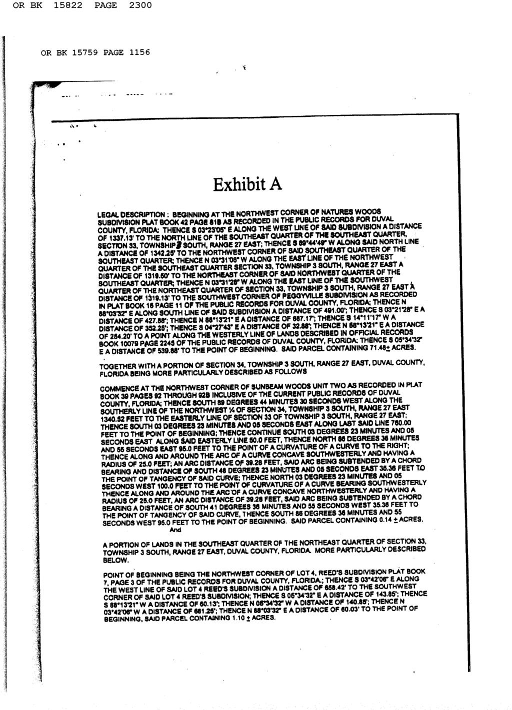
5 ORDINANCE Legal Description EXHIBIT 1 Page of
6 KEVIN ROAD SHELLIE ROAD IL PUD PUD PUD SUNBEAM ROAD PUD PUD CRO RLD-60 WALKER CIRCLE RMD-D RMD-A RMD-A RMD-D RMD-A # # RR-Acre PUD REED AVENUE RR-Acre PUD RR-Acre RR-Acre MAXWOOD ROAD RLD-90 DOVETAIL COURT SOUTH GOSHAWK DRIVE NORTH RLD-90 RR-Acre PUD PUD PUD RR-Acre MONROE FOREST DRIVE PUD BALLASTO REQUEST: N FROM: RR-Acre W E S TO: RLD-60 # COUNCIL DISTRICT: 06 ORDINANCE NUMBER: ORD TRACKING NUMBER: T Page 1 of 1
7
8
9
10
11
12
13 Exhibit D Hunter s Hideaway PUD Written Description Date: October 12, 2016 I. SUMMARY DESCRIPTION OF THE PROPERTY A. Current Land Use Designation: LDR B. Current Zoning District: RR-Acre C. Requested Zoning District: PUD D. RE #: E. City Development Number: F. Project Architect/Planner: N/A G. Project Engineer: Dominion Engineering Group, Inc Southpoint Boulevard, Suite 204 Jacksonville, Florida H. Project Developer: H. Smith, Inc San Jose Place, Suite 7 Jacksonville, FL II. SUMMARY DESCRIPTION OF THE PLAN The Applicant proposes to rezone approximately 72.59± acres of property from Rural Residential (RR-Acre) to Planned Unit Development (PUD). A conceptual site plan of the proposed development is attached as Exhibit E to this application (the Revised Site Plan ). The proposed PUD rezoning permits the Property to be developed as an upscale residential community consisting of up to one hundred forty-five (145) single family detached homes. The proposed PUD differs from the usual application of the Zoning Code for Rural Residential by reducing the minimum width from 100 feet to 50 feet, reducing the minimum area from 43,560 square feet to 5,000 square feet, increasing the maximum lot coverage from 25 percent to 50 percent, reducing the front setback from 25 feet to 15 feet (20 feet for the face of the garage) and reducing the side setback from 10 feet to 5 feet. The subject property (the Property ) is currently owned by Mary Lynn Conte and Nicholas Conte and is more particularly described in the legal description attached as Exhibit Exhibit 3 Page 1 of 6
14 1. The Property is located at the end of Kevin Road, as shown on Exhibit K. The land use designation of the Property is LDR in the Future Land Use Map in the City's Comprehensive Plan and is undeveloped. The gross density of 2 units per acre is consistent with the seven (7) units per acre currently permitted under the Comprehensive Plan The property is currently vacant and is a mix of cleared uplands and pine trees with some hardwoods on the majority of the eastern part of the property, and forested wetlands on the western portion of the property. The Property s elevation slopes from the east to the west towards the wetland on the western portion. The proposed residential product will consist of one and two story fee simple homes on a mixture of lots with integrated minimum two car garages. The proposed development of the Property will be both aesthetically and environmentally appealing. A recreational area, including but not limited to, picnic tables, benches and tot lot will be provided for the residents. The project will be developed in two (2) phases. The first phase of construction will commence in the early part of 2017, and will consist of roughly half the lots. The second phase will commence in mid to late 2018, and will consist of the remaining lots. Wetlands are present along the western portion of the Property which make the clustering of the lots to the eastern side of the Property and the mixture of lot size appropriate as shown on the Revised Site Plan. A combination of buffering, landscaping and architectural controls are provided to create this integrated community and blend the proposed development into the surrounding area. III. PUD DEVELOPMENT CRITERIA A. Description of Uses. 1. One hundred forty-five (145) one and two story single family units with enclosed minimum two car garage; 2. Supporting amenities/recreation facilities including, but not limited to, tot lot, park and similar uses; 3. Essential services including roads, water, sewer, gas, telephone, stormwater management facilities, radio, television, electric, marine and land communication devices, small satellite dishes, and similar uses subject to performance standards set forth in Part 4 of the City of Jacksonville Zoning Code. 4. Home occupations meeting the performance standards set forth in Part 4 of the City of Jacksonville Zoning Code. B. Permitted Accessory Uses and Structures. Accessory uses and structures are allowed as defined in Section of the Zoning Code. Exhibit 3 Page 2 of 6
15 C. Minimum Lot and Building Requirements. 1. Minimum building setback and yard requirements. The building setbacks for all uses and structures are as follows: a. Front: (1) From face of garage twenty (20) feet. (2) From building face fifteen (15) feet. b. Side Five (5) feet. c. Rear Ten (10) feet. Note: Encroachments by sidewalks, parking, signage, utility structures, fences, street/park furniture, HVAC units, and other similar improvements shall be permitted within the minimum building setbacks. 2. Minimum Lot Requirements. Fifty (50) feet wide by one hundred (100) feet deep. However, cul-de-sacs, curve and corner lots will require a minimum of twenty-five (25) feet of frontage. So long as a cul-de-sac, curve or corner lot is fifty (50) feet in width at some point (not necessarily at the BRL), the structure can be built anywhere on the lot so long as required setbacks and required building restriction lines are met. 3. Maximum Height of Structures. Thirty-five (35) feet. As provided in Section of the City of Jacksonville Zoning Code, spires, cupolas, antennas, chimneys and other appurtenances not intended for human occupancy may be placed above the maximum heights provided for herein. 4. Maximum parcel coverage by all buildings. Fifty (50) percent. D. Common Area Landscape Maintenance. The Applicant shall ensure the proper maintenance of all common areas, lawns, and landscaping to be funded by mandatory homeowners association dues. E. Access. Access to the site will be from Kevin Road only. As indicated on the Site Plan, the Property will have one primary access point. The design of the access points and internal roads as shown on the Site Plan may vary prior to development; provided, however, that the final design of both shall be subject to the review and approval of the Planning and Development Department and the Traffic Engineer. Upon completion, the internal road will be dedicated to the City. No access shall be permitted from Reed Road or Dovetail Court/Drive. F. Pedestrian Circulation. The site will be developed with an internal sidewalk system. The location of all sidewalks is conceptual and final sidewalk plans are subject to the review and approval of the Planning and Development Department. External sidewalks will be provided consistent with the Comprehensive Plan. Exhibit 3 Page 3 of 6
16 G. Recreational/Open Space. Unless otherwise approved by the Planning and Development Department, recreational open space (including active recreational facilities such as playgrounds with play equipment, amenity/recreation center, pool, cabana/clubhouse, health/exercise facility, walking/activity trails and similar uses) shall be provided at a ratio of a minimum of 436 square feet per lot. H. Signage. The PUD shall be permitted one double-faced or two single-faced externally-illuminated monument sign(s), not to exceed twenty-four (24) square feet in area per sign face and twelve (12) feet in height, at the entrance. Directional Signs that indicate ways to and from property entrances, major buildings, common areas and key components of the development within the PUD, for drivers of vehicles, and for pedestrian users of the PUD shall be permitted throughout the PUD. The design of such Directional Signs shall be reflective of the overall character of the PUD, and may include the relevant project logo and name. Vehicle-oriented Directional Signs shall be a maximum of four (4) square feet in area per sign face. Pedestrian-oriented Directional Signs, such as informational sidewalk kiosks, 1-, 2-, 3- or 4-sided (or cylindrical signs) shall be a maximum of four (4) square feet per side (or 16 square feet for a cylinder). Directional signs may be attached to lighting fixtures within the PUD. Real estate signs and construction signs in compliance with Part 13 of the Zoning Code are also permitted. Signs to identify entrances to buildings that contain residential model units not to exceed twelve (12) square feet shall be permitted throughout the PUD. Because the signs discussed above are architectural elements of the PUD, intended to be compatible with and complementary of the buildings in the PUD, they may be located in structures or frames that are part of the architecture of the project. Accordingly, the area of such signs shall be computed on the basis of the smallest regular geometric shape encompassing the outermost individual letter, words, and numbers on the sign and shall not include the frame or surrounding mount. I. Parking and Loading Requirements. The proposed PUD will provide integrated parking facilities to support the proposed residential community. Parking within the PUD will be provided in accordance with the City's off-street parking and loading requirements as set forth in Part 6 of the City of Jacksonville Zoning Code. The homes will have integrated two car garages, and sufficient driveway space to park one car without protruding into the internal sidewalk. Modifications to parking requirements within the PUD may be permitted by an administrative modification. J. Landscaping/Fencing/Screening. Buffering will be consistent with the requirements of Section of the Zoning Code. K. Architectural Design. Throughout the PUD, any dumpsters, compactors, propane tanks, and similar appurtenances shall be kept behind or within substantially opaque enclosures composed of the same material and painted the same color as the nearby Exhibit 3 Page 4 of 6
17 structure within the Property, such that the dumpster, compactors propane tank, or similar appurtenance is screened from view from surrounding roadways and adjacent properties. L. Lighting. PUD lighting shall be designed and installed to localize illumination onto the Property and to minimize unreasonable interference or impact on any residential zoning districts outside of the PUD. The recreational area will not be lighted. M. Stormwater Retention. Stormwater retention/detention system shall be designed and constructed in accordance with the requirements of the City of Jacksonville and the St. Johns River Water Management District, and may include underground detention vaults. N. Utilities. Electric power, water and sewer services will be available to the site by JEA. O. Temporary Uses. Temporary sales, leasing and construction office(s) and trailers shall be allowed to be placed within the PUD. P. Modifications. Amendments to this approved PUD district may be accomplished by administrative modification, administrative deviation, by minor modification, or by the filing of a rezoning application pursuant to Section of the City of Jacksonville Zoning Code. PUD amendments, including administrative modification, administrative deviations, minor modifications, or rezonings, may be sought for individual parcels or access points within the PUD. Q. Conceptual Site Plan. The configuration of the development as depicted in the Revised Site Plan is conceptual and revisions to the Revised Site Plan, including access points and internal circulation, may be required as the proposed development proceeds through final engineering and site plan review, subject to the review and approval of the Planning and Development Department. R. Phasing. Upon approval of the construction plans for the infrastructure improvements within the PUD, the Applicant may seek and obtain building permits for the construction of the residential and recreational buildings within the PUD prior to the recordation of the plat(s) for the subdivision. IV. PUD REVIEW CRITERIA A. Consistency with Comprehensive Plan. The Property is currently within the RR land use category, which permits residential development at a density of up to 2 units per acre. At 55.56± acres, the proposed density of (111 d.u. / 55.56± acres) is consistent with the RR land use category. The proposed development is consistent with the following policies of the 2030 Comprehensive Plan: 1.1.1, 1.1.8, 1.1.9, , , 1.4.5, 3.1.5, and B. Roadways / Consistency with the Concurrence Management System. The development of the Property will comply with the requirements of the Concurrency Exhibit 3 Page 5 of 6
18 Management System. An application for concurrency will be submitted concurrently to the Concurrency Management System Office. C. Allocation of Residential Land Use. This proposed development will not exceed the projected holding capacity reflected in Table L20 of the Future Land Use Element of the 2030 Comprehensive Plan. D. Internal Compatibility/Vehicular Access. The Revised Site Plan attached as Exhibit E addresses access and circulation within the site. The Property will have one primary access point from Grover Road. The location and find design of the access point are subject to the review and approval of the City Traffic Engineer and the Planning and Development Department. The completed internal road will be dedicated to the City. E. External Compatibility/Intensity of Development. The proposed development is consistent with and comparable to permitted development in the area. The Property is bounded to the north by single family lots in the RPI Land Use category and RLD-60 Zoning district, to the south by single family lots in the LDR Land Use category and PUD Zoning district, to the east by single family lots in the LDR Land Use category and the RLD-90 Land Use category and RR-Acre Zoning district, and to the west by the old Sunbeam Road landfill that is now a mixed use development with single family and multifamily units in the PBF Land Use category and PUD Zoning district. All along Sunbeam Road, which is the access point for this neighborhood, are various multifamily apartment complexes, high density single family residential, and commercial developments. The proposed use is compatible in both intensity and density with these surrounding uses and zoning districts. F. Recreation/Open Space. The PUD provides ample open spaces and recreational opportunities. G. Impact on Wetlands. Development that would impact wetlands will be permitted in accordance with local, state and federal requirements. H. Listed Species Regulations. A listed species survey has been included with the PUD application. I. Off-Street Parking & Loading Requirements. The proposed PUD will provide integrated parking facilities to support the proposed residential community as described above. J. Sidewalks, Trails, and Bikeways. External sidewalks will be provided as required by the Comprehensive Plan. Internal sidewalks will be provided as shown on the Revised Site Plan. The location of all sidewalks is conceptual and final sidewalk plans are subject to the review and approval of the Planning and Development Department. Exhibit 3 Page 6 of 6
19 October 13, 2016 Exhibit 4 Page 1 of 1 No STATE OF C4 PRELIMINARY LAYOUT 4
20
21
22
23
24
25

26 Duval Map October 12, :9, mi km
, Esri (Thailand), Duval Map 149030 0050 October")
27 km Sources: Esri, HERE, DeLorme, USGS, Intermap, increment P Corp., NRCAN, Esri Japan, METI, Esri China (Hong Kong), Esri (Thailand), Duval Map October 12, :72, mi
28 21 West Church Street Jacksonville, Florida E L E C T R I C W A T E R S E W E R R E C L A I M E D Mike BOWLES Dominion Engineering Group 4348 Southpoint Blvd, Suite 204 Jacksonville, Florida, May 19, 2016 Project Name: Availability#: Conte Parcel(see also ) Dear Mr/Mrs Mike BOWLES, Thank you for your inquiry regarding the availability of electric, potable water, sanitary sewer and reclaimed water (WS&R) service. The eight digit availability number referenced in this letter will be the number JEA uses to track your project. Please reference this number when making inquiries and submitting related documents. This availability letter will expire one year from the date above. Point of Connection: A summary of connection points for WS&R services are identified on the following page. JEA recognizes Connection Point #1 as the primary point of connection (POC); however, a secondary, conditional POC will be listed if available. JEA assumes no responsibility for the inaccuracy of any service connection portrayed on a JEA utility system record drawing. JEA strongly recommends field verification of all POCs prior to any construction to ensure connection availability. Please note the Special Conditions stated in each section contain pertinent information and additional requirements as well as further instructions. Offsite Improvements: For all utilities located in the public Right of Way or JEA easement, the new WS&R utilities shall be dedicated to JEA upon completion and final inspection, unless otherwise noted. It shall be the applicant's responsibility to engage the services of a professional engineer, licensed in the State of Florida. All WS&R construction shall conform to current JEA Water, Sewer & Reuse Design Guidelines which may be found on jea.com. Reservation of Capacity: This availability response does not represent JEA's commitment for or reservation of WS&R capacity. In accordance with JEA's policies and procedures, commitment to serve is made only upon JEA's approval of your application for service and receipt of your payment of all applicable fees. A detailed overview of the process can be found at JEA.com. This document along with other important forms and submittal processes can be found at the subsequent link, JEA Stages of a Project or by following the steps below: Sincerely, Mollie Price Water/Wastewater System Planning (904)
29 21 West Church Street Jacksonville, Florida E L E C T R I C W A T E R S E W E R R E C L A I M E D Availability#: Request Received On: 5/18/2016 Availability Response: 5/19/2016 Prepared by: Mollie Price Project Information Name: Conte Parcel(see also ) Type: Requested Flow: Location: Single Family 25,900 gpd end of Dovetail Drive Parcel ID No.: Description: 74 single family homes Potable Water Connection Water Treatment Grid: Connection Point #1: Connection Point #2: Special Conditions: SOUTH GRID Existing 12" water main along the southerly side of Sunbeam Rd. (See Special Conditions) Existing 8" water main stub in the intersection of Dovetail Dr. and Dovetail Ct.. (See Special Conditions) Fire protection needs to be addressed. POC #1 and #2 need to be connected together in your development to form a loop system for reliability. For the estimated cost of connecting to the JEA system, please call the Pre-service Counter at Copies of As-Built records can be requested from JEA As-Built & Record section at Sewer Connection Sewer Treatment Plant: Connection Point #1: Connection Point #2: Special Conditions: MANDARIN Existing gravity manhole in the intersection of Dovetail Dr. and Dovetail Ct. NA If connection to the gravity sewer system is unavailable, then connection to the JEA-owned sewer system for your project will require the design and construction of an onsite, JEA owned and maintained pump station, and a JEA dedicated force main (min. 4'' dia.). For the estimated cost of connecting to the JEA system, please call the Pre-service Counter at Copies of As-Built records can be requested from JEA As-Built & Record section at Reclaimed Water Connection Sewer Region/Plant: Connection Point #1: Connection Point #2: Special Conditions: South Grid No reclaim in the foreseeable future NA No reclaim in the foreseeable future. General Comments: Electric Availability: The subject property lies within the geographic area legally served by JEA. JEA will provide electric service as per JEA''s most current Rules and Regulations.
Exhibit D. Tallow Ridge PUD. Written Description. Date: January 5, E. City Development Number:
 Exhibit D Tallow Ridge PUD Written Description Date: January 5, 2016 I. SUMMARY DESCRIPTION OF THE PROPERTY A. Current Land Use Designation: RR B. Current Zoning District: PUD C. Requested Zoning District:
Application For Rezoning To Conventional Zoning District
 Application For Rezoning To Conventional Zoning District Print http://maps.coj.net/luzap/appconvprint.aspx Page 1 of 3 1/28/216 Application For Rezoning To Conventional Zoning District Planning and Development
REPORT OF THE PLANNING AND DEVELOPMENT DEPARTMENT FOR APPLICATION FOR REZONING ORDINANCE TO PLANNED UNIT DEVELOPMENT FEBRUARY 5, 2015
 2015-49 BEL REPORT OF THE PLANNING AND DEVELOPMENT DEPARTMENT FOR APPLICATION FOR REZONING ORDINANCE 2015-49 TO PLANNED UNIT DEVELOPMENT FEBRUARY 5, 2015 The Planning and Development Department hereby
REPORT OF THE PLANNING AND DEVELOPMENT DEPARTMENT FOR APPLICATION FOR REZONING ORDINANCE TO PLANNED UNIT DEVELOPMENT JANUARY 21, 2015
 REPORT OF THE PLANNING AND DEVELOPMENT DEPARTMENT FOR APPLICATION FOR REZONING ORDINANCE 2015-843 TO PLANNED UNIT DEVELOPMENT JANUARY 21, 2015 2015-843 AWH The Planning and Development Department hereby
EXHIBIT D. Planned Unit Development Written Description April 13, 2016 Rouen Cove Phase II PUD
 1 EXHIBIT D Planned Unit Development Written Description April 13, 2016 Rouen Cove Phase II PUD Development # 8986.001 Developer: Curtis L. Hart Hart Resources LLC 8051 Tara Lane Jacksonville, Florida
REPORT OF THE PLANNING AND DEVELOPMENT DEPARTMENT FOR APPLICATION FOR REZONING ORDINANCE TO PLANNED UNIT DEVELOPMENT JANUARY 8, 2015
 214-49 BEL REPORT OF THE PLANNING AND DEVELOPMENT DEPARTMENT FOR APPLICATION FOR REZONING ORDINANCE 214-49 TO PLANNED UNIT DEVELOPMENT JANUARY 8, 215 The Planning and Development Department hereby forwards
EXHIBIT D. WRITTEN DESCRIPTION For. TOWNSEND VILLAGE PUD December 23, 2015 (Revised)
") I. PROJECT DESCRIPTION EXHIBIT D WRITTEN DESCRIPTION For TOWNSEND VILLAGE PUD December 23, 2015 (Revised) A. This 7.2 acre single-family residential project is located on the East side of Townsend Boulevard,
I. PROJECT DESCRIPTION EXHIBIT D WRITTEN DESCRIPTION For TOWNSEND VILLAGE PUD December 23, 2015 (Revised) A. This 7.2 acre single-family residential project is located on the East side of Townsend Boulevard,
REPORT OF THE PLANNING AND DEVELOPMENT DEPARTMENT FOR APPLICATION FOR REZONING ORDINANCE TO PLANNED UNIT DEVELOPMENT MAY 7, 2015
 2015-0240 AAG REPORT OF THE PLANNING AND DEVELOPMENT DEPARTMENT FOR APPLICATION FOR REZONING ORDINANCE 2015-0240 TO PLANNED UNIT DEVELOPMENT MAY 7, 2015 The Planning and Development Department hereby forwards
PLANNED DEVELOPMENT DISTRICT STANDARDS. Cadence Site
 PLANNED DEVELOPMENT DISTRICT STANDARDS Cadence Site A Planned Development District 1. Statement of General Facts, Conditions and Objectives Property Size: Approximately 57.51 Acres York County Tax Map
REPORT OF THE PLANNING AND DEVELOPMENT DEPARTMENT FOR APPLICATION FOR REZONING ORDINANCE TO PLANNED UNIT DEVELOPMENT SEPTEMBER 22, 2016
 BEL REPORT OF THE PLANNING AND DEVELOPMENT DEPARTMENT FOR APPLICATION FOR REZONING ORDINANCE 2016-576 TO PLANNED UNIT DEVELOPMENT SEPTEMBER 22, 2016 The Planning and Development Department hereby forwards
Exhibit THIRD AMENDED PUD WRITTEN DESCRIPTION. Willens Claire Lane PUD
 Exhibit D THIRD AMENDED PUD WRITTEN DESCRIPTION Willens Claire Lane PUD Date: May 7, 14 Current Zoning District: PUD Current Land Use Designation: RPI Proposed Zoning District: PUD RE #: 166- I. PROJECT
ARTICLE 14 PLANNED UNIT DEVELOPMENT (PUD) DISTRICT
 DISTRICT") ARTICLE 14 PLANNED UNIT DEVELOPMENT (PUD) DISTRICT Section 14.01 Intent. It is the intent of this Article to allow the use of the planned unit development (PUD) process, as authorized by the Michigan Zoning
ARTICLE 14 PLANNED UNIT DEVELOPMENT (PUD) DISTRICT Section 14.01 Intent. It is the intent of this Article to allow the use of the planned unit development (PUD) process, as authorized by the Michigan Zoning
REPORT OF THE PLANNING AND DEVELOPMENT DEPARTMENT FOR APPLICATION FOR REZONING ORDINANCE TO PLANNED UNIT DEVELOPMENT MAY 18, 2017
 BEL REPORT OF THE PLANNING AND DEVELOPMENT DEPARTMENT FOR APPLICATION FOR REZONING ORDINANCE 2016-805 TO PLANNED UNIT DEVELOPMENT MAY 18, 2017 The Planning and Development Department hereby forwards to
SECTION 10.7 R-PUD (RESIDENTIAL PLANNED UNIT DEVELOPMENT) ZONE
 ZONE") Article X Zones 10-20 SECTION 10.7 R-PUD (RESIDENTIAL PLANNED UNIT DEVELOPMENT) ZONE A. PURPOSE AND INTENT: The R-PUD Residential PUD Zone is intended to provide alternative, voluntary zoning procedures
Article X Zones 10-20 SECTION 10.7 R-PUD (RESIDENTIAL PLANNED UNIT DEVELOPMENT) ZONE A. PURPOSE AND INTENT: The R-PUD Residential PUD Zone is intended to provide alternative, voluntary zoning procedures
CONDOMINIUM REGULATIONS
 ARTICLE 37 CONDOMINIUM REGULATIONS SECTION 37.01. Purpose The purpose of this Article is to regulate projects that divide real property under a contractual arrangement known as a condominium. New and conversion
Site Plan Application
 Site Plan Application City of St. Pete Beach Community Development Department 155 Corey Avenue St. Pete Beach, Florida 33706 (727) 367-2735 www.stpetebeach.org Case Number: PROPERTY OWNER: Name: Address:
ARTICLE 23 CONDOMINIUM STANDARDS
 ARTICLE 23 CONDOMINIUM STANDARDS Section 23.01 Intent. The intent of this Article is to provide regulatory standards for condominiums and site condominiums similar to those required for projects developed
CHECKLIST FOR DEVELOPMENT REVIEW
 CHECKLIST FOR DEVELOPMENT REVIEW Petitions and related documents and plans for land development or other proposals regulated by Title 16 of the Municipal Code (Development Ordinance) and Title 17 of the
Cover Letter with Narrative Statement
 Cover Letter with Narrative Statement March 31, 2017 rev July 27, 2017 RE: Rushton Pointe Residential Planned Unit Development Application for Public Hearing for RPUD Rezone PL2015 000 0306 Mr. Eric Johnson,
Article 7: Residential Land Use and Development Requirements
 Article 7: Residential Land Use and Section 701: Statement of Intent (A) (B) (C) The intent of Article 7 is to develop certain land use and development requirements for the residential uses within Cumru
PERMITTED USES: Within the MX-1 Mixed Use Neighborhood District the following uses are permitted:
 6.25 MX-1 - MIXED USE NEIGHBORHOOD 6.25.1 INTENT: The purpose of the MX-1 Mixed Use Neighborhood District is to accommodate the development of a wide-range of residential and compatible non-residential
ARTICLE 13 CONDOMINIUM REGULATIONS
 ARTICLE 13 CONDOMINIUM REGULATIONS Section 13.01 Purpose. The purpose of this Article is to regulate projects that divide real property under a contractual arrangement known as a condominium. New and conversion
Condominium Unit Requirements.
 ARTICLE 19 CONDOMINIUM REGULATIONS Section 19.01 Purpose. The purpose of this Article is to regulate projects that divide real property under a contractual arrangement known as a condominium. New and conversion
LABEL PLEASE NOTE: ALL APPLICATIONS AND SITE PLANS MUST BE COMPLETED IN BLACK OR BLUE INK ONLY Intake by:
 STAFF USE ONLY Thurston County Resource Stewardship 2000 Lakeridge Dr. S.W. Olympia, WA 98502 (360)786-5490 / (360)754-2939 (Fax) TDD Line (360) 754-2933 Email: permit@co.thurston.wa.us Supplemental Application
Individual Well Individual Septic. Community Well 19. What is the proposed method of sewage disposal? Public. None
 Please Answer the Following Questions: (attach sheet if needed). What type of facility is being proposed? Campground Recreational Vehicle (RV) Park Both 2. What is the total acreage of the proposed facility?
REPORT OF THE PLANNING AND DEVELOPMENT DEPARTMENT FOR APPLICATION FOR REZONING ORDINANCE TO PLANNED UNIT DEVELOPMENT APRIL 21, 2016
 BEL REPORT OF THE PLANNING AND DEVELOPMENT DEPARTMENT FOR APPLICATION FOR REZONING ORDINANCE TO PLANNED UNIT DEVELOPMENT APRIL 21, 2016 The Planning and Development Department hereby forwards to the Planning
CITY OF RIALTO PLANNING DIVISION ENTITLEMENT APPLICATION
 ENTITLEMENT APPLICATION LEGAL OWNER INFORMATION: I hereby certify that I am (we are) the record owner(s) for property tax assessment purposes of the property encompassed by this application. I understand
CITY OF RIALTO PLANNING DIVISION
 ENTITLEMENT APPLICATION LEGAL OWNER PROPERTY INFORMATION: I hereby certify that I am (we are) the record owner(s) for property tax assessment purposes of the property encompassed by this application. I
Form 11.A.9.17 INSTRUCTIONS FOR APPLICATION FOR PLAT WAIVER (Art. 11.A.8)
") Form 11.A.9.17 INSTRUCTIONS FOR APPLICATION FOR PLAT WAIVER (Art. 11.A.8) All questions in each part must be completed. When a question is not applicable to the property, enter "N/A" or other phrase indicating
Form 11.A.9.17 INSTRUCTIONS FOR APPLICATION FOR PLAT WAIVER (Art. 11.A.8) All questions in each part must be completed. When a question is not applicable to the property, enter "N/A" or other phrase indicating
PLANNED UNIT DEVELOPMENT & SUBDIVISION STAFF REPORT Date: April 18, 2019
 PLANNED UNIT DEVELOPMENT & SUBDIVISION STAFF REPORT Date: April 18, 2019 DEVELOPMENT NAME SUBDIVISION NAME Springhill Village Subdivision Springhill Village Subdivision LOCATION 4350, 4354, 4356, 4358,
Staff Report: Date: Applicant: Property Identification: Acreage of Request: Current Zoning of Requested Area: Requested Action: Attached:
 Staff Report: Completed by Jeff Palmer Director of Planning & Zoning Date: November 7, 2018, Updated November 20, 2018 Applicant: Greg Smith, Oberer Land Developer agent for Ronald Montgomery ET AL Property
Operating Standards Attachment to Development Application
 Planning & Development Services 2255 W Berry Ave. Littleton, CO 80120 Phone: 303-795-3748 Mon-Fri: 8am-5pm www.littletongov.org Operating Standards Attachment to Development Application 1 PLANNED DEVELOPMENT
Residential Major Subdivision Review Checklist
 Residential Major Subdivision Review Checklist Plan Submittal Requirements: 2 full sets of stamped plans Electric submittal - all plans contained in a single PDF 3 full sets if commercial kitchen or dining
In order to permit maximum applicability of the PUD District, PUD-1 and PUD-2 Districts are hereby created.
 ARTICLE III. PUD ned Unit Development Overlay District 205-128. Purpose. The PUD ned Unit Development Overlay District is intended to provide flexibility in the design of planned projects; to encourage
Washington County, Minnesota Ordinances
 Washington County, Minnesota Ordinances Ordinance No. 153 Text Amendment to the Washington County Development Code - Chapter One, Section 2 and Chapter Two, Part 1, Part 2, Part 3, of the Development Code
BY THE CITY COMMISSION ORDINANCE NO.:
 BY THE CITY COMMISSION ORDINANCE NO.: 2005-0868 AN ORDINANCE BY THE CITY COMMISSION OF THE CITY OF DADE CITY, FLORIDA CREATING A DEVELOPMENT REVIEW PROCEDURES ORDINANCE; PROVIDING FOR INTENT, PURPOSE,
Administrative Plat Application Form
 1 Administrative Plat Application Form This form shall be submitted with each application for an administrative plat. CONTACT INFORMATION Applicant Architect (if different) Property Owner (if different)
CITY OF OCOEE LAND DEVELOPMENT CODE SUFFICIENCY TABLE WITH NOTES
 CITY OF OCOEE LAND DEVELOPMENT CODE SUFFICIENCY TABLE WITH NOTES The Sufficiency Table is a checklist to help identify the types of information and documentation needed for various types of projects. The
Planned Residential Development ( PRD ) Application
 Application") FOR PLANNING USE ONLY Application # PRD Application Fee $ Receipt No. Filing Date Completeness Date Planned Residential Development ( PRD ) Application A. PROJECT INFORMATION 1. Project Name: 2. Address
FOR PLANNING USE ONLY Application # PRD Application Fee $ Receipt No. Filing Date Completeness Date Planned Residential Development ( PRD ) Application A. PROJECT INFORMATION 1. Project Name: 2. Address
PRELIMINARY DEVELOPMENT PLAN REVIEW - CITY OF MARYLAND HEIGHTS
 APPLICATION NUMBER: PDP16-0004 APPLICATION (PROJECT) NAME: MARYLAND OAKS APPLICANT: McBride Maryland Oaks, LLC 16091 Swingley Ridge Road, Suite 300 Chesterfield, MO 63017 PROPERTY OWNER NAME: Basston Holdings
(a) Commercial uses on Laurel Avenue, abutting the TRO District to the
 Commercial uses on Laurel Avenue, abutting the TRO District to the") 32X Zoning Code 150.36 TRANSITIONAL RESIDENTIAL OVERLAY DISTRICT. (A) Intent and purpose. (1) It is the intent of the Transitional Residential Overlay District (hereinafter referred to as the "TRO District")
32X Zoning Code 150.36 TRANSITIONAL RESIDENTIAL OVERLAY DISTRICT. (A) Intent and purpose. (1) It is the intent of the Transitional Residential Overlay District (hereinafter referred to as the "TRO District")
APPLICATION PROCEDURE
 ANTRIM PLANNING BOARD P. O. Box 517 Antrim, New Hampshire 03440 Phone: 603-588-6785 FAX: 603-588-2969 APPLICATION FORM AND CHECKLIST FOR MINOR OR MAJOR SITE PLAN REVIEW File Date Received By APPLICATION
COMPREHENSIVE PLAN FUTURE LAND USE MAP AMENDMENT APPLICATION
 COUNTY STAFF DATA ONLY Date Received: Project No. CPA-20 - GADSDEN COUNTY DEPARTMENT OF PLANNING & COMMUNITY DEVELOPMENT 1-B East Jefferson Street, Post Office Box 1799, Quincy, FL 32353-1799 PLANNING
SUBJECT PARCEL(S) Property Owner(s) TMS Number Approximate Acreage Carolina Park Development, LLC
 Property Owner(s) TMS Number Approximate Acreage Carolina Park Development, LLC") Staff Report Special Planning Commission Meeting November 19, 2014 For reference, the Zoning Code and Land Development Regulations are available online. AGENDA ITEM 5c. SKETCH PLAN APPROVAL REQUEST: Request
Staff Report Special Planning Commission Meeting November 19, 2014 For reference, the Zoning Code and Land Development Regulations are available online. AGENDA ITEM 5c. SKETCH PLAN APPROVAL REQUEST: Request
CHAPTER34 PRUD - PLANNED RESIDENTIAL UNIT DEVELOPMENT
 CHAPTER34 PRUD - PLANNED RESIDENTIAL UNIT DEVELOPMENT 17-34-1 17-34-2 17-34-3 17-34-4 17-34-5 17-34-6 17-34-7 17-34-8 17-34-9 Purpose Planned Residential Unit Development Defined Planned Residential Unit
ZONING AMENDMENT & SUBDIVISION STAFF REPORT Date: June 18, 2015
 ZONING AMENDMENT & SUBDIVISION STAFF REPORT Date: June 18, 2015 APPLICANT NAME SUBDIVISION NAME EAA LLC / Eryka Rogers Aaiden Place Subdivision LOCATION 2480 Government Boulevard (North side of Government
Major Subdivision Application Packet. Revised June 2018
 Major Subdivision Application Packet Revised June 2018 Caroline County Department of Planning and Community Development 233 West Broaddus Avenue Bowling Green, VA 22427 www.co.caroline.va.us Phone: 804-633-4303
SMALL CELL TECHNOLOGY in the Right-of-Way ADMINISTRATIVE VARIANCE APPLICATION Community Development Department
 PURPOSE OF ADMINISTRATIVE VARIANCE SMALL CELL TECHNOLOGY in the Right-of-Way Pursuant to Sec. 23-706(h), an Administrative Variance is required for installation of a new Small Cell Technology Wireless
SUBDIVISION APPLICATION
 SUBDIVISION APPLICATION Community Planning and Economic Development Development Services Division 250 South 4 th Street, Room 300 Minneapolis MN 55415-1316 612-673-3000 This application packet is used
PRELIMINARY PLAT Checklist
 PRELIMINARY PLAT Checklist 3715 Bridgeport Way W University Place, WA 98466 PH: (253) 566-5656 FAX: (253) 460-2541 This is a checklist of materials required for a Preliminary Plat. This checklist is provided
M E M O R A N D U M. Meeting Date: October 23, Item No. F-1. Planning and Zoning Commission. Daniel Turner, Planner I
 M E M O R A N D U M Meeting Date: October 23, 2017 Item No. F-1 To: From: Subject: Planning and Zoning Commission Daniel Turner, Planner I PUBLIC HEARING: Consider a recommendation of a of Planned Development
Exhibit "A" have applied for a re-zoning and re-classification of that property from OPEN RURAL (OR) to that of a PLANNED UNIT DEVELOPMENT (PUD); and
 to that of a PLANNED UNIT DEVELOPMENT (PUD); and") I NSTR # 200632845 OR BK 61439 PGS 0728-0750 RECORDED 06/24/2066 12:25:50 PR JOHN Q. CRAWFOKD CLERK OF CIRCUIT COURT NASSAU COUNTY, FLORIDA RECORDING FEES 1.37.80 ORDINANCE NO. 2006-65 AN ORDINANCE AMENDING
I NSTR # 200632845 OR BK 61439 PGS 0728-0750 RECORDED 06/24/2066 12:25:50 PR JOHN Q. CRAWFOKD CLERK OF CIRCUIT COURT NASSAU COUNTY, FLORIDA RECORDING FEES 1.37.80 ORDINANCE NO. 2006-65 AN ORDINANCE AMENDING
City of East Orange. Department of Policy, Planning and Development LAND USE APPLICATION & SITE PLAN REVIEW CHECKLIST
 Department of Policy, Planning and Development LAND USE APPLICATION & SITE PLAN REVIEW CHECKLIST COMPLETE: Applicant Information: Type of Proposal: OFFICE USE ONLY: New Residential Case #: Date: New Accessory
ZONING AMENDMENT, PLANNED UNIT DEVELOPMENT & SUBDIVISION STAFF REPORT Date: August 8, 2013
 ZONING AMENDMENT, PLANNED UNIT DEVELOPMENT & SUBDIVISION STAFF REPORT Date: August 8, 2013 NAME SUBDIVISION NAME PV-Magnolia, LLC Twelve Trees Subdivision LOCATION 2860, 2862 and 2866 Pleasant Valley Road
1 September 9, 2015 Public Hearing
 1 September 9, 2015 Public Hearing APPLICANT & PROPERTY OWNER: HOLLOMON- BROWN FUNERAL HOME, INC. STAFF PLANNER: Carolyn A.K. Smith REQUEST: Change of Zoning (R-5D Residential District to Conditional O-2
ARTICLE 9 SPECIFICATIONS FOR DOCUMENTS TO BE SUBMITTED
 ARTICLE 9 SPECIFICATIONS FOR DOCUMENTS TO BE SUBMITTED SECTION 950 GENERALLY All applications shall be properly signed and filed by the owner or, with the owner s specific written consent, a contract purchaser
Residential Minor Subdivision Review Checklist
 Residential Minor Subdivision Review Checklist Plan Submittal Requirements: 2 full sets of stamped plans Electric submittal - all plans contained in a single PDF 3 full sets if commercial kitchen or dining
ARTICLE 5.0 SCHEDULE OF REGULATIONS
 ARTICLE 5.0 SCHEDULE OF REGULATIONS Section 5.101 Table of Dimensional Standards by District. Dimensional Standards AG AG with sewer Districts Rural Residential Business Other SF SF with sewer R-1 R-1
ZONING ORDINANCE: OPEN SPACE COMMUNITY. Hamburg Township, MI
 ZONING ORDINANCE: OPEN SPACE COMMUNITY Hamburg Township, MI ARTICLE 14.00 OPEN SPACE COMMUNITY (Adopted 1/16/92) Section 14.1. Intent It is the intent of this Article to offer an alternative to traditional
APPLICATION PROCEDURES FOR A PLAT AMENDMENT OR REVISION
 APPLICATION PROCEDURES FOR A PLAT AMENDMENT OR REVISION DEFINITION: Any revision or amendment to an approved recorded or unrecorded final plat. A revision (not recorded) does not require a public hearing
APPLICATION for MINOR SUBDIVISION REVIEW for CONCEPT and FINAL PLAT within COALVILLE CITY. Project Name: Project Address or Area: Name of Owner:
 APPLICATION for MINOR SUBDIVISION REVIEW for CONCEPT and FINAL PLAT within COALVILLE CITY For Office Use Only: Application #: Application Date: PC Approval Date: CC Approval Date: Community Development
Lake County Planning, Building and Development Department
 SUBMISSION CHECKLIST FOR SUBDIVISION FINAL PLAT Lake County Planning, Building and Development Department 500 W. Winchester Rd. Unit 101 Libertyville, Illinois 60048-1331 Telephone (847) 377-2600 E-mail:
PLANNING AND ZONING COMMISSION AGENDA MEMORANDUM
 City and County of Broomfield, Colorado PLANNING AND ZONING COMMISSION AGENDA MEMORANDUM To: Planning and Zoning Commission From: John Hilgers, Planning Director Anna Bertanzetti, Principal Planner Meeting
The following regulations shall apply in the R-E District:
 "R-E" RESIDENTIAL ESTATE DISTRICT (8/06) The following regulations shall apply in the R-E District: 1. Uses Permitted: The following uses are permitted. A Zoning Certificate may be required as provided
ARTICLE 15 - PLANNED UNIT DEVELOPMENT
 Section 15.1 - Intent. ARTICLE 15 - PLANNED UNIT DEVELOPMENT A PUD, or Planned Unit Development, is not a District per se, but rather a set of standards that may be applied to a development type. The Planned
CITY OF FERNDALE HEARING EXAMINER
 CITY OF FERNDALE HEARING EXAMINER RE: Planned Unit Development ) 16001-PUD Preliminary Plat ) 16018-SE Plat Variance ) 16002-VAR Application by ) ) MD General, L.L.C. ) FINDINGS OF FACT, Malloy Heights
Chapter 22 PLANNED UNIT DEVELOPMENT.
 Chapter 22 PLANNED UNIT DEVELOPMENT. Sec. 22.1 INTENT. The use of land and the construction and use of buildings and other structures as Planned Unit Developments in Georgetown Township may be established
PLANNED UNIT DEVELOPMENTS
 PLANNED UNIT DEVELOPMENTS SECTION 9.01 DESCRIPTION AND PURPOSE. A. The purpose of a planned unit development (PUD) is to permit greater flexibility in development than is generally possible under standard
SPECIAL ZONING DISTRICTS
 SPECIAL ZONING DISTRICTS 5.01 5.99 RESERVED 5.100 PLANNED DEVELOPMENTS: Purpose: This district is intended to accommodate unified design of residential, commercial, office, professional services, retail
APPLICATION FOR WAIVER OF MINIMUM REQUIRED SETBACKS/SEPARATION
 APPLICATION FOR WAIVER OF MINIMUM REQUIRED SETBACKS/SEPARATION This application must be typed or printed in black ink and submitted with four (4) copies, with all required attachments, to: Planning and
Plan nt Plan Filing and
 PARISH OF ASCENSION OFFICE OF PLANNING AND DEVELOPMENT PLANNING DEPARTMENT APPENDIX VI PLANNED UNIT DEVELOPMENT (PUD) CODE Contents: 17-601. General Purpose: Procedures... 3 17-602. General Character:...
Level III Preliminary and Final Site Plans Development Review Application Portland, Maine Planning and Urban Development Department Planning Division
 Level III Preliminary and Final Site Plans Development Review Application Portland, Maine Planning and Urban Development Department Planning Division Portland s Planning and Urban Development Department
MINOR SUBDIVISION FINAL PLAT APPLICATION Town of Apex, North Carolina
 MINOR SUBDIVISION FINAL PLAT APPLICATION Town of Apex, North Carolina This document is a public record under the North Carolina Public Records Act and may be published on the Town s website or disclosed
May 12, Chapter RH HILLSIDE RESIDENTIAL ZONES REGULATIONS Sections:
 May 12, 2017 Chapter 17.13 RH HILLSIDE RESIDENTIAL ZONES REGULATIONS Sections: 17.13.010 Title, intent, and description. 17.13.020 Required design review process. 17.13.030 Permitted and conditionally
Chapter Residential Mixed Density Zone
 Chapter 19.16 Residential Mixed Density Zone 19.16.010 Purpose and Intent 19.16.020 Permitted Uses 19.16.030 Accessory Permitted Uses 19.16.040 Secondary Permitted Uses 19.16.050 Conditional Uses 19.16.060
APPLICATION REVIEW CHECKLISTS
 APPLICATION REVIEW CHECKLISTS The following must be submitted with and are part of each application. No application is complete until all required documentation has been submitted to the Community Development
Salem Township Zoning Ordinance Page 50-1 ARTICLE 50.0: PUD PLANNED UNIT DEVELOPMENT
 Salem Township Zoning Ordinance Page 50-1 ARTICLE 50.0 PLANNED UNIT DEVELOPMENT Section 50.01 Purpose The provisions of this Article provide enabling authority and standards for the submission, review,
CHAPTER 14 PLANNED UNIT DEVELOPMENTS
 9-14-1 9-14-1 CHAPTER 14 PLANNED UNIT DEVELOPMENTS SECTION: 9-14-1: Purpose 9-14-2: Governing Provisions 9-14-3: Minimum Area 9-14-4: Uses Permitted 9-14-5: Common Open Space 9-14-6: Utility Requirements
PRELIMINARY PLANNED AREA DEVELOPMENT APPLICATION (PAD)
") PRELIMINARY PLANNED AREA DEVELOPMENT APPLICATION (PAD) Preliminary Planned Area Development Fee: Date Paid SECTION 1.9.4.1 PRELIMINARY PAD APPLICATION A Master development plan (showing general land use
PRELIMINARY PLANNED AREA DEVELOPMENT APPLICATION (PAD) Preliminary Planned Area Development Fee: Date Paid SECTION 1.9.4.1 PRELIMINARY PAD APPLICATION A Master development plan (showing general land use
APPLICATION PACKET ARC SIGN REVIEW. COMMUNITY DEVELOPMENT DEPARTMENT CHARTER TOWNSHIP OF PLYMOUTH 9955 N. Haggerty Road Plymouth, MI 48170
 APPLICATION PACKET ARC SIGN REVIEW COMMUNITY DEVELOPMENT DEPARTMENT CHARTER TOWNSHIP OF PLYMOUTH 9955 N. Haggerty Road Plymouth, MI 48170 Fees Revised 9.13.2017 APPLICATION PACKET ARC SIGN REVIEW Community
Division of Land Application
 FOR PLANNING USE ONLY Application # DIV Application Fee Receipt No. Filing Date Completeness Date Division of Land Application A. PROJECT INFORMATION 1. Project Name: 2. Address of Subject Property: 3.
ML-4 MULTIFAMILY RESIDENTIAL ZONE. [Added by Ord. No ]
![ML-4 MULTIFAMILY RESIDENTIAL ZONE. [Added by Ord. No ]](/thumbs/90/103301433.jpg "ML-4 MULTIFAMILY RESIDENTIAL ZONE. [Added by Ord. No ]") 55-26. ML-4 MULTIFAMILY RESIDENTIAL ZONE. [Added 2-2-98 by Ord. No. 1998-1 2] The following regulations apply in the ML-4 Zone. A. Permitted Uses. (1) Garden apartments, together with accessory structures
55-26. ML-4 MULTIFAMILY RESIDENTIAL ZONE. [Added 2-2-98 by Ord. No. 1998-1 2] The following regulations apply in the ML-4 Zone. A. Permitted Uses. (1) Garden apartments, together with accessory structures
PLANNED DEVELOPMENT: MASTER PLAN (Preliminary Subdivision Plat)
") TOWN OF CLAYTON Planning Department 111 E. Second Street, Clayton, NC 27520 P.O. Box 879, Clayton, NC 27528 Phone: 919-553-5002 Fax: 919-553-1720 PLANNED DEVELOPMENT: MASTER PLAN (Preliminary Subdivision
TOWN OF CLAYTON Planning Department 111 E. Second Street, Clayton, NC 27520 P.O. Box 879, Clayton, NC 27528 Phone: 919-553-5002 Fax: 919-553-1720 PLANNED DEVELOPMENT: MASTER PLAN (Preliminary Subdivision
4.2 RESIDENTIAL ZONING DISTRICTS
 4.2 RESIDENTIAL ZONING DISTRICTS A. Purpose: To define regulations and standards for each residential zoning district in the City. The following sections identify uses, regulations, and performance standards
ZONING AMENDMENT & SUBDIVISION STAFF REPORT Date: November 3, 2016
 ZONING AMENDMENT & SUBDIVISION STAFF REPORT Date: November 3, 2016 APPLICANT NAME SUBDIVISION NAME David Shumer 5955 Airport Subdivision CITY COUNCIL DISTRICT District 6 5955 Airport Boulevard, 754 Linlen
SIMPLIFIED SITE PLAN
 SIMPLIFIED SITE PLAN WHAT IS A SIMPLIFIED SITE PLAN? A simplified site plan can be an engineered, or nonengineered plan, drawn to scale, showing uses and structures, either proposed or existing, for a
SECTION 874 SITE PLAN REVIEW
 SECTION 874 SITE PLAN REVIEW When a site plan review is required by this Division or Chapters 17.72 or 17.30 of the Fresno County Ordinance Code, the following procedure shall apply: A. SITE PLAN The purpose
RP-2, RP-3, RP-4, AND RP-5 PLANNED RESIDENTIAL DISTRICTS
 6.10 - RP-2, RP-3, RP-4, AND RP-5 PLANNED RESIDENTIAL DISTRICTS 6.10.1 GENERAL DESCRIPTION: 6.10.1.1 The regulations established in this Section are intended to provide optional methods of land development
Application for a Public Hearing for PUD Rezone, Amendment to PUD or PUD to PUD Rezone
 GROWTH MANAGEMENT DEPARTMENT www.colliergov.net NAPLES, FLORIDA 34104 (239) 252-2400 FA: (239) 252-6358 Application for a Public Hearing for PUD Rezone, Amendment to PUD or PUD to PUD Rezone PETITION NO
TOWN OF MELBOURNE BEACH 2016 DEVELOPMENT APPLICATION
 TOWN OF MELBOURNE BEACH 2016 DEVELOPMENT APPLICATION I. SUBMITTAL REQUIREMENTS: 1. Fees per current schedule. 2. Deed to property. 3. Pre-Application meeting is mandatory. Contact the Building Official
Conditional Use Application
 Conditional Use Application City of St. Pete Beach Community Development Department 155 Corey Avenue St. Pete Beach, Florida 33706 (727) 367-2735 www.stpetebeach.org Case Number: PROPERTY OWNER: Name:
Draft Zoning Changes for the 2nd Planning Board Public Hearing, January 22, 2018.
 Draft Zoning Changes for the 2nd Planning Board Public Hearing, January 22, 2018. No changes were made at the 1st Public Hearing. Proposed wording for the 1 st Public Hearing in red, eliminated text in
TOWN OF ORO VALLEY PLANNING & ZONING COMMISSION MEETING DATE: December 6, 2011
 PLANNING & ZONING COMMISSION MEETING DATE: December 6, 2011 TO: FROM: SUBJECT: PLANNING & ZONING COMMISSION Matt Michels, Senior Planner mmichels@orovalleyaz.gov; tel. 229-4822 Public Hearing: Rancho de
ORDINANCE NOW THEREFORE, BE IT ENACTED BY THE CITY COMMISSION OF THE CITY OF WINTER GARDEN, FLORIDA, AS FOLLOWS:
 ORDINANCE 12-02 AN ORDINANCE OF THE CITY OF WINTER GARDEN, FLORIDA, AMENDING ARTICLE V OF CHAPTER 118 OF THE WINTER GARDEN CODE OF ORDINANCES ENTITLED PLANNED UNIT DEVELOPMENTS CREATING URBAN VILLAGE PLANNED
PLANNED UNIT DEVELOPMENT (PUD) AREA PLAN/REZONING REVIEW PROCEDURE
 AREA PLAN/REZONING REVIEW PROCEDURE") PLANNED UNIT DEVELOPMENT (PUD) AREA PLAN/REZONING REVIEW PROCEDURE Professional inquiries will be made to our Township Planning Consultant, Township Engineer, and Township Attorney to get their opinions
PLANNED UNIT DEVELOPMENT (PUD) AREA PLAN/REZONING REVIEW PROCEDURE Professional inquiries will be made to our Township Planning Consultant, Township Engineer, and Township Attorney to get their opinions
Permit No: SPR CUP MHR AgLD IPM PUD MP - (Circle one)
") APPENDIX NO. 1A UNIFORM APPLICATION FORM (Rev. 16-02) FOR ZONING PERMIT APPLICATIONS, PURSUANT TO THE KINGS COUNTY DEVELOPMENT CODE (Please print with ink or type) Permit No: SPR CUP MHR AgLD IPM PUD MP
APPENDIX NO. 1A UNIFORM APPLICATION FORM (Rev. 16-02) FOR ZONING PERMIT APPLICATIONS, PURSUANT TO THE KINGS COUNTY DEVELOPMENT CODE (Please print with ink or type) Permit No: SPR CUP MHR AgLD IPM PUD MP
DRAFT FOR PUBLIC HEARING (rev. March, 2016)
") Chapter 200. ZONING Article VI. Conservation/Cluster Subdivisions 200-45. Intent and Purpose These provisions are intended to: A. Guide the future growth and development of the community consistent with
Chapter 200. ZONING Article VI. Conservation/Cluster Subdivisions 200-45. Intent and Purpose These provisions are intended to: A. Guide the future growth and development of the community consistent with
APPLICATION PACKET SINGLE FAMILY CLUSTER HOUSING OPTION REVIEW
 APPLICATION PACKET SINGLE FAMILY CLUSTER HOUSING OPTION REVIEW COMMUNITY DEVELOPMENT DEPARTMENT CHARTER TOWNSHIP OF PLYMOUTH 9955 N. Haggerty Road Plymouth, MI 48170 Fees Revised 9.13.2017 1. PURPOSE APPLICATION
DIVISION 2 - CONSTRUCTION PLAN AND MISCELLANEOUS REQUIREMENTS
 DIVISION 2 - CONSTRUCTION PLAN AND MISCELLANEOUS REQUIREMENTS 2.1 Required Plan Sheets 2.2 Drawing Requirements 2.3 Graphic Standards 2.4 Easements 2.5 Utility Locations 2.6 Private Facility Locations
APPLICATION PACKET LAND SPLIT OR COMBINATION REVIEW
 APPLICATION PACKET LAND SPLIT OR COMBINATION REVIEW COMMUNITY DEVELOPMENT DEPARTMENT CHARTER TOWNSHIP OF PLYMOUTH 9955 N. Haggerty Road Plymouth, MI 48170 Fees Revised 9.13.2017 APPLICATION PACKET LAND