REPORT OF THE PLANNING AND DEVELOPMENT DEPARTMENT FOR APPLICATION FOR REZONING ORDINANCE TO PLANNED UNIT DEVELOPMENT JANUARY 8, 2015
|
|
|
- Allison Cook
- 5 years ago
- Views:
Transcription
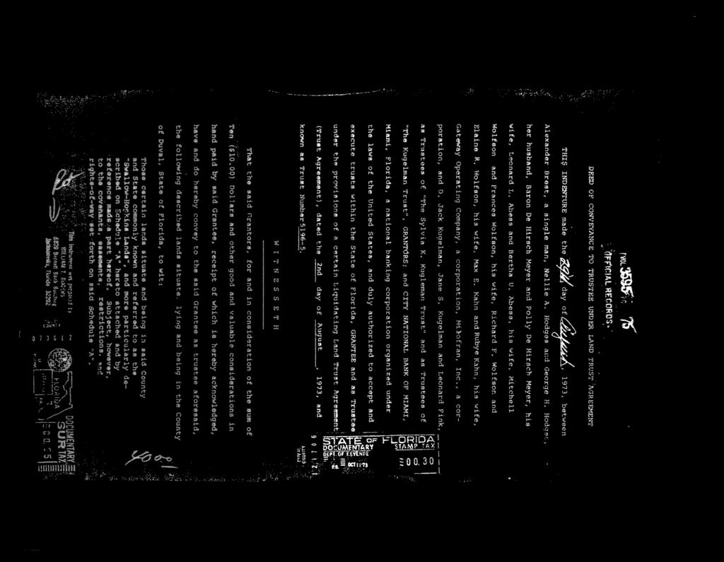
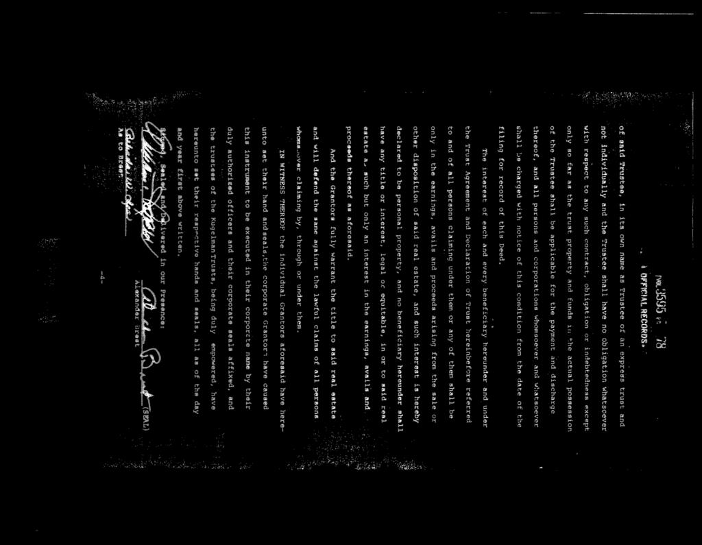
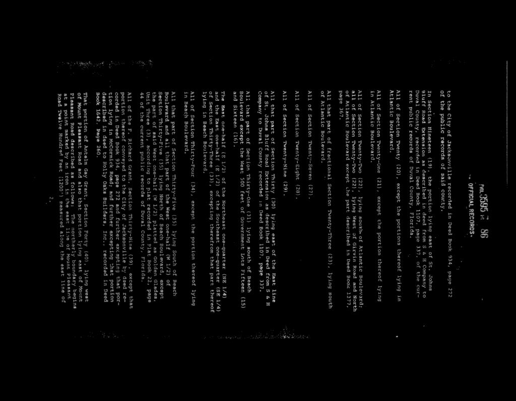
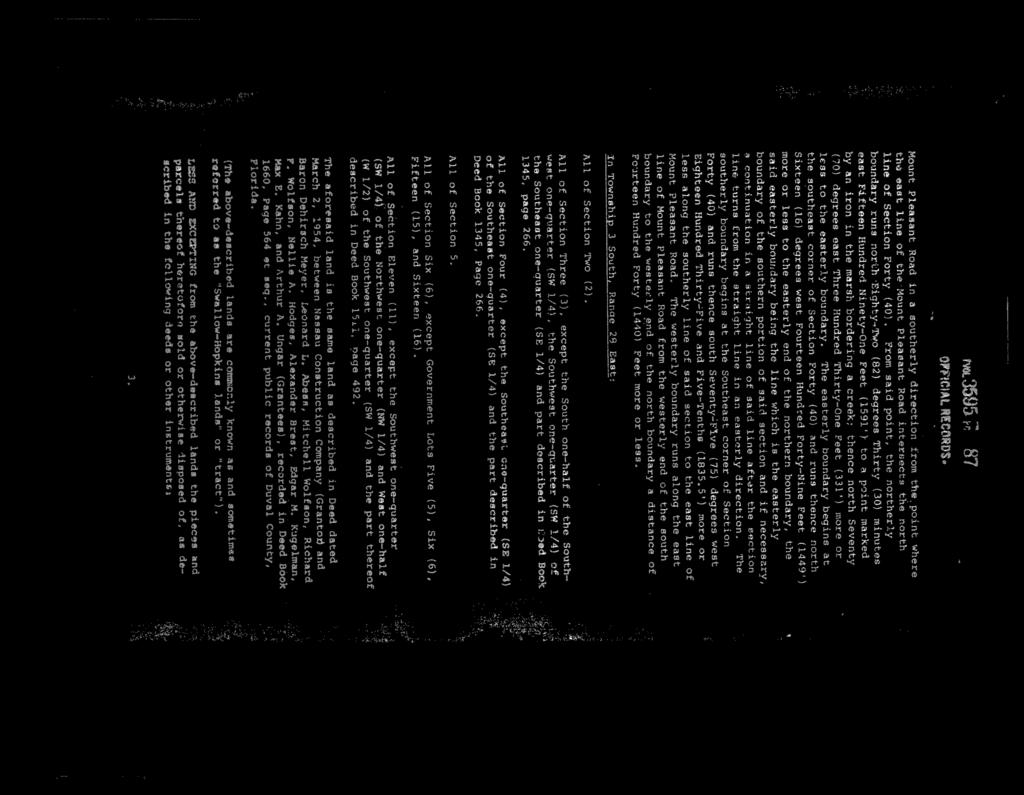
1 BEL REPORT OF THE PLANNING AND DEVELOPMENT DEPARTMENT FOR APPLICATION FOR REZONING ORDINANCE TO PLANNED UNIT DEVELOPMENT JANUARY 8, 215 The Planning and Development Department hereby forwards to the Planning Commission, Land Use and Zoning Committee and City Council its comments and recommendation regarding Application for Rezoning Ordinance to Planned Unit Development. Location: East side of Kernan Boulevard, between Atlantic Boulevard and Kensington Lakes Drive Real Estate Number(s): Current Zoning District: Proposed Zoning District: Current Land Use Category: Planned Unit Development (PUD E) Planned Unit Development (PUD) Community General Commercial (CGC) Planning District: Greater Arlington/Beaches, District 2 Planning Commissioner: Anthony Robbins City Council District: The Honorable Richard Clark, District 3 Applicant/Agent: Owner: Staff Recommendation: Paul Harden, Esq. 91 Riverside Avenue, Suite 91 Jacksonville, Florida 3222 George Hodges, Jr. City National Bank of Florida Jacksonville, Florida 3222 APPROVE WITH CONDITIONS GENERAL INFORMATION Application for Planned Unit Development seeks to rezone approximately acres of land from PUD to PUD. The rezoning to PUD is being sought so that the property can be developed with one of three schemes: (1) commercial uses with a maximum of 21,
2 January 8, 215 Page 2 square feet / single family with a maximum 52 lots; (2) commercial uses with a maximum of 21, square feet / multiple family with a maximum 12 townhomes; (3) commercial uses maximum of 21, square feet / institutional use. The site is located in the School Regulation Zone area as defined by Florida Statute and as governed by Sec of the City of Jacksonville Code of Ordinances (Zoning Code). The existing PUD allows for a maximum of 9, square feet of commercial and office uses with an additional one acre out-parcel. In November 23, a small plane crashed on this parcel while attempting a landing at Craig Airport. CRITERIA FOR REVIEW Pursuant to the provisions of Section of the Zoning Code, the Planning and Development Department, Planning Commission and City Council (including the appropriate committee) shall evaluate and consider the following criteria of an application for rezoning to Planned Unit Development. (1) Is the proposed zoning district consistent with the 23 Comprehensive Plan? Yes. The Planning and Development Department finds that the subject property is located in the Community General Commercial (CGC) functional land use category as defined by the Future Land Use Map series (FLUMs) contained within the Future Land Use Element (FLUE) adopted as part of the 23 Comprehensive Plan. The CGC functional land use category allows a variety of commercial retail uses, service establishments, institutional uses, single family dwellings and multifamily dwellings. The proposed PUD proposes a gross density of 1.8 dwelling units to the acre and will have full urban services available to the site. Therefore, the proposed rezoning is consistent with the FLUMs adopted as part of the 23 Comprehensive Plan pursuant to Chapter 65 Comprehensive planning for future development of the Ordinance Code. A description of the category is noted below. Community General Commercial (CGC) is a category intended to provide for a wide variety of retail goods and services which serve large areas of the City and a diverse set of neighborhoods. Uses should generally be developed in nodal and corridor development patterns. Nodes are generally located at major roadway intersections and corridor development should provide continuity between the nodes and serve adjacent neighborhoods in order to reduce the number of Vehicle Miles Traveled. Development within the category should be compact and connected and should support multi-modal transportation. All uses should be designed in a manner which emphasizes the use of transit, bicycle, and pedestrian mobility, ease of access between neighboring uses, and compatibility with adjacent residential neighborhoods. Transit-Oriented Developments (TOD), as defined in this element, are encouraged when in close proximity to an existing or planned JTA mass transit system station
3 January 8, 215 Page 3 or Rapid Transit System (RTS). Density, location and mix of uses shall be pursuant to the Development Areas as set forth herein. The uses provided herein shall be applicable to all CGC sites within the Urban Area. Principal Uses: Commercial retail sales and service establishments including auto sales; Restaurants; Hotels and motels; Offices, Business and Professional Offices including veterinary offices; Financial institutions; Multi-family dwellings; Live/Work Units; Commercial recreational and entertainment facilities; Auto repair and sales, mobile home/motor home rental and sales, boat storage and sales; Off street parking lots and garages; Filling stations; and Uses associated with and developed as an integral component of TOD. Residential uses shall not be the sole use and shall not exceed 8 percent of a development. Secondary Uses: Secondary uses shall be permitted pursuant to the Commercial land use introduction. In addition, the following secondary uses may also be permitted: Group care facilities; Criminal justice facilities; Personal property storage establishments; Accessory Uses: Warehousing, light manufacturing and fabricating may be permitted provided it is part of a commercial retail sales or service establishment, and the accessory use shall be located on a road classified as collector or higher on the Functional Highway Classification Map. The maximum gross density in the Urban Area shall be 4 units/acre and there shall be no minimum density; except as provided herein. For sites abutting Low Density Residential (LDR) and Rural Residential (RR), the maximum gross density shall be 2 units/acre. Transit-Oriented Developments (TOD) shall provide a minimum gross density of 2 units/acre; and may increase the maximum gross density by an additional 2 units/acre; except for sites abutting Low Density Residential (LDR) and Rural Residential (RR), in which case the maximum gross density shall be 2 units/acre. (2) Does the proposed rezoning further the goals, objectives and policies of the 23 Comprehensive Plan? The evaluation of the goals, objectives and policies of the Comprehensive Plan can be found later in this report. (3) Does the proposed rezoning conflict with any portion of the City s land use Regulations? The institutional component of the written description and the site plan of the intended plan of development does not meet the City s land use regulations. The remaining portions of the written description and the site plan of the intended plan of development meet the City s land use regulations and further their intent by providing specific development standards. The site is located in the School Regulation Zone area as defined by Florida Statute and as governed by Sec of the Zoning Code. The proposed plan of development is in direct conflict with the provisions of both standards.
4 January 8, 215 Page Educational Facilities No new educational facility of a public or private school, with the exception of aviation school facilities, shall be permitted within an area extending along the centerline of any runway and measured from the end of the runway and extending for a distance of five miles and having a width equal to one half the runway length. Exceptions approving construction of an educational facility within the delineated area shall only be granted when the Planning Commission and/or City Council make specific findings detailing how the public policy reasons for allowing construction outweigh health and safety concerns prohibiting such a location. F.S (3) In the manner provided in subsection (1), airport zoning regulations shall be adopted which restrict new incompatible uses, activities, or construction within runway clear zones, including uses, activities, or construction in runway clear zones which are incompatible with normal airport operations or endanger public health, safety, and welfare by resulting in congregations of people, emissions of light or smoke, or attraction of birds. Such regulations shall prohibit the construction of an educational facility of a public or private school at either end of a runway of a publicly owned, public-use airport within an area which extends 5 miles in a direct line along the centerline of the runway, and which has a width measuring one-half the length of the runway. Exceptions approving construction of an educational facility within the delineated area shall only be granted when the political subdivision administering the zoning regulations makes specific findings detailing how the public policy reasons for allowing the construction outweigh health and safety concerns prohibiting such a location. (4) The procedures outlined in subsections (1), (2), and (3) for the adoption of such regulations are supplemental to any existing procedures utilized by political subdivisions in the adoption of such regulations. The subject property is within the area that extends five miles in a direct line along the centerline of the runway of NAS Jacksonville, having a width one-half the runway length. The staff recommends the institutional use be prohibited.
 of the Zoning Code, the Planning and Development Department, Planning Commission and City Council (including the appropriate committee) shall evaluate and consider the following criteria for")
5 January 8, 215 Page 5 Pursuant to the provisions of Section (d) of the Zoning Code, the Planning and Development Department, Planning Commission and City Council (including the appropriate committee) shall evaluate and consider the following criteria for rezoning to Planned Unit Development district: (1) Consistency with the 23 Comprehensive Plan In accordance with Section Advisory recommendation on amendment of Zoning Code or rezoning of land of the Zoning Code, the subject property is within the following functional land use category as identified in the Future Land Use Map series (FLUMs): Community General Commercial (CGC). A portion of the proposed rezoning to Planned Unit Development which permits institutional uses is inconsistent with the 23 Comprehensive Plan, and does not further the following goals, objectives and policies contained herein, including:
6 January 8, 215 Page 6 FLUE Objective 2.5 Support and strengthen the role of Jacksonville Aviation Authority (JAA) and the United States Military in the local community, and recognize the unique requirements of the City's other airports (civilian and military) by requiring that all adjacent development be compatible with aviation-related activities. FLUE Policy Continue to regulate development in approach zones to airport runways in accordance with the Federal Aviation Authority (FAA) and United States Military Air Installation Compatible Use Zones (AICUZ) and local land development regulations in order to protect the safety and welfare of property owners, residents and businesses in the community. FLUE Policy The City shall update its land development regulations to ensure compatible land uses near airports. New incompatible uses such as residential use and places of public assembly shall be limited. This request is not consistent with official City of Jacksonville policies to limit places of public assembly near airports. The portions of the proposed rezoning to Planned Unit Development for residential and commercial development are consistent with the 23 Comprehensive Plan, and furthers the following goals, objectives and policies contained herein, including: FLUE Policy The City shall provide for development of a wide variety of housing types by area, consistent with the housing needs characteristics and socioeconomic profiles of the City's households as described in the Housing Element. FLUE Policy Protect neighborhoods from potential negative impacts by providing a gradation of uses and scale transition. The Land Development Regulations shall be amended to provide for an administrative process to review and grant, when appropriate, relief from the scale transition requirements. (2) Consistency with the Concurrency Mobility and Management System Pursuant to the provisions of Chapter 655 Concurrency and Mobility Management System of the Ordinance Code, the development will be required to comply with all appropriate requirements of the Concurrency and Mobility Management System (CMMSO) prior to development approvals. The Fair Share (F.S. # / CDN ) for this parcel was abandoned. A new CCAS or CRC application and a Mobility application are required.
7 January 8, 215 Page 7 (3) Allocation of residential land use This proposed Planned Unit Development intends to utilize lands for a single family or multifamily development with commercial uses. This proposed development will not exceed the projected holding capacity reflected in Table L-2, Land Use Acreage Allocation Analysis For 23 Comprehensive Plan s Future Land Use Element, contained within the Future Land Use Element (FLUE) of the 23 Comprehensive Plan. (4) Internal compatibility This proposed PUD is consistent with the internal compatibility factors with specific reference to the following: The use of topography, physical environment and other natural features: The site is wooded and relatively flat. Traffic and pedestrian circulation patterns: A loop road will be constructed under the residential development schemes to provide efficient circulation. The use and variety of building setback lines, separations, and buffering: The written description includes setbacks and buffering that are consistent with the Zoning Code/ Compatible relationship between land uses in a mixed use project: The written description includes commercial uses which should not create any adverse impacts to the proposed single or multi-family residential uses. (5) External Compatibility Based on the written description of the intended plan of development and site plan, the Planning and Development Department finds that external compatibility is achieved by the following: The type, number and location of surrounding external uses: The proposed development is located in an area where single family and multi-family residential, office and commercial uses function as a mixed-use development. The mixture of residential and commercial development at this location complements the existing residential, office and commercial uses in the immediate area.
8 January 8, 215 Page 8 The Comprehensive Plan and existing zoning on surrounding lands: The adjacent uses, zoning and land use categories are as follows: Adjacent Land Use Zoning Current Use Property Category District North CGC PUD (89-569) Commercial shopping center South MDR PUD (89-165) Multi-family dwellings East MDR PUD (89-165) Multi-family dwellings West RPI PUD (3-131) Banks Any other factor deemed relevant to the privacy, safety, preservation, protection or welfare of lands surrounding the proposed PUD which includes any existing or planned use of such lands: The site is located in the School Regulation Zone area as defined by Florida Statute and as governed by Sec of the Zoning Code. The proposed plan of development is in direct conflict with the provisions of both standards. Below are the comments from JAA The JAA wishes to record that this development is in the direct flight path of of runway 14/32 and is 1, 291 feet away from the end of that runway. This property will experience overflight from aircraft using this runway. Additionally, the proposed development is within the 5 foot height zone as indicated in the City of Jacksonville s GIS. Should the top elevation of the proposed structure exceed 5 ft, it will be necessary for the developer to coordinate with the Jacksonville Aviation Authority prior to constructing in order to obtain the necessary Federal Aviation Administration permit. (6) Intensity of Development The proposed development is consistent with the CGC functional land use category and is a single-use, multi-family development, which is not to exceed 52 single family or 12 multifamily dwelling units. The PUD is appropriate at this location because it will support the existing offices and service establishments in the area. The existing residential density and intensity of use of surrounding lands: A multi-family residential surrounds the property on the ease and south boundaries.

 Impact on wetlands Review of a 24 Florida Land Use and Cover Classification System map provided by the St.")
9 January 8, 215 Page 9 (7) Usable open spaces plazas, recreation areas. The written description indicates that either single family or multifamily development will provide a minimum of ½ acre of useable active recreation area which meets the minimum stand of the Zoning Code. (8) Impact on wetlands Review of a 24 Florida Land Use and Cover Classification System map provided by the St. Johns River Water Management District did not identify any wetlands on-site. However, any development impacting wetlands will be permitted pursuant to local, state and federal permitting requirements.
 Off-street parking including loading and unloading areas. The site will be developed in accordance with Part 6 of the Zoning Code.")
10 January 8, 215 Page 1 (9) Listed species regulations No wildlife survey was required as the project is less than the 5-acre threshold. (1) Off-street parking including loading and unloading areas. The site will be developed in accordance with Part 6 of the Zoning Code. (11) Sidewalks, trails, and bikeways The project will contain a pedestrian system that meets the 23 Comprehensive Plan. SUPPLEMENTAL INFORMATION Upon visual inspection of the subject property on December 18, 214, the required Notice of Public Hearing sign was posted.

11 January 8, 215 Page 11 RECOMMENDATION Based on the foregoing, it is the recommendation of the Planning and Development Department that Application for Rezoning be APPROVED with the following conditions: 1. The subject property is legally described in the original legal description dated October 1, The subject property shall be developed in accordance with the original written description dated November 14, The subject property shall be developed in accordance with the original site plan dated October 1, The subject property shall be developed in accordance with the Development Services Division Memorandum dated December 12, 214 or as otherwise approved by the Planning and Development Department. 5. Assembly uses (public, private or charter school, church, day care or similar use) shall be prohibited.

12 January 8, 215 Page 12 View of site from adjacent commercial parking lot to the north. Aerial view of site.
13 January 8, 215 Page 13 PUD ATLANTIC BOULEVARD CCG-1 CO RMD-A PUD KERNAN BOULEVARD SOUTH PUD PUD CO RMD-A PUD PUD PUD PUD PUD PUD REQUEST SOUGHT: KENSINGTON LAKES DRIVE PUD PUD N W E FROM: PUD # S 1 Feet TO: PUD COUNCIL DISTRICT: 3 ORDINANCE FILE COPY

14 D E V E L O P M E N T S E R V I C E S December 12, 214 MEMORANDUM TO: FROM: Subject: Bruce Lewis, City Planner Supervisor Planning and Development Department Lisa King Traffic Technician Senior Kernan II PUD R fka R Upon review of the referenced application, and based on the information provided to date, the Development Services Division has the following comments: 1. Developer shall provide a traffic study for Kernan Boulevard South and access to site. The study shall include a queue storage analysis of the existing lanes, need for additional lanes and a traffic signal warrant analysis based on the MUTCD warrants. Development Services shall approve the study prior to the final approval of the Civil Engineering Plan set. Plans for any required improvements shall be included with the Civil Engineering plan set. The Developer will be responsible for all cost associated with the design, construction of any required improvements, as well as the study. Turn lanes will be designed to FDOT standards based on the design speed (posted plus 5 mph minimum) and a minimum 1 ft queue, and will include extruded thermoplastic pavement markings, reflective pavement markers and an overlay of the entire construction limits. 2. Access to site shall be at existing driveway. One right in/right out driveway is also permitted. Design and location of right in/right out driveway is subject to review and approval of Development Services Division different site plans were submitted. Depending on how the site is developed, additional requirements may be made at the time of PUD Verification and 1 set review. 4. Signage, fence, wall and landscaping shall be located so that they do not obstruct horizontal line of sight as outlined in FDOT Index There shall be no cross access within 1 feet of outside lane of Kernan Boulevard South. 6. It should be noted that Exhibit E-1 shows a subdivision that is accessed by a shared driveway. Development as a residential subdivision requires access to a named public or approved, named private roadway. Since the existing driveway cannot meet design standards for a public roadway it would have to be an approved private roadway. Please understand that this does not constitute approval of the design elements. Approval of the design elements (driveway location, dimensions, roadway geometry, traffic circulation, etc.) shall be facilitated through the 1-set and 1-set review process. If you have any questions regarding the comment outlined above, please call me directly at R fka R Kernan II PUD P L A N N I N G AND D E V E L O P M E N T 214 N. Hogan Street Suite 21 Jacksonville, FL 3222 Phone: Fax:
15
16 Application For Rezoning To PUD Print Page 1 of 3 11/2/214 Application For Rezoning To PUD Planning and Development Department Info Ordinance # Staff Sign-Off/Date BEL / 11/18/214 Filing Date N/A Number of Signs to Post 2 Hearing Dates: 1st City Council 12/9/214 Planning Comission 12/4/214 Land Use & Zoning 1/6/215 2nd City Council Neighborhood Association WEST BEACHES COMMUNITY ASSOC., KENSINGTON ASSOC., COALITION OF KENSINGTON COMMUNITIES, SEASON AT KENSINGTON CONDO ASSOC. Neighborhood Action Plan/Corridor Study N/A N/A Application Info Tracking # 738 Application Status PENDING Date Started 11/13/214 Date Submitted 11/13/214 General Information On Applicant Last Name First Name HARDEN PAUL Middle Name M Company Name LAW OFFICES OF PAUL HARDEN Mailing Address 51 RIVERSIDE AVENUE, SUITE 91 City JACKSONVILLE State FL Zip Code 3222 Phone Fax 94 PAUL_HARDEN@BELLSOUTH.NET General Information On Owner(s) Check to fill first Owner with Applicant Info Last Name HODGES, JR. First Name GEORGE Middle Name Company/Trust Name CITY NATIONAL BANK OF FLORIDA Mailing Address City State Zip Code Phone Fax Property Information Previous Zoning Application Filed For Site? If Yes, State Application No(s) Map RE# Council District Planning District From Zoning District(s) To Zoning District
17 Application For Rezoning To PUD Print Page 2 of 3 11/2/214 Map PUD PUD Ensure that RE# is a 1 digit number with a space (###### ####) Existing Land Use Category CGC Land Use Category Proposed? If Yes, State Land Use Application # Total Land Area (Nearest 1/1th of an Acre) Development Number Proposed PUD Name KERNAN BOULEVARD II Justification For Rezoning Application TO ALLOW DEVELOPMENT CONSISTENT WITH SURROUNDING USES. Location Of Property General Location EAST SIDE OF KERNAN BLVD House # Street Name, Type and Direction KERNAN BV S Zip Code Between Streets ATLANTIC BLVD and KENSINGTON LAKES DR Required Attachments For Formal, Complete application The following items must be labeled as exhibits and attached to application in the order prescribed below. All pages of the application must be on 8½" X 11" paper with provision for page numbering by the staff as prescribed in the application instructions manual. Please check each item below and the PUD Check List for inclusion of information required. Exhibit 1 Exhibit A Exhibit B Exhibit C Exhibit D Exhibit E Exhibit F Exhibit G A very clear, accurate and legible legal description of the property that must be only and entirely placed on the JP&DD formatted forms provided with the application package. The legal description may be either lot and block or metes and bounds. Property Ownership Affidavit Notarized Letter(s). Agent Authorization - Notarized letter(s) designating the agent. Binding Letter. Written description in accordance with the PUD Checklist and with provision for dual page numbering by the JP&DD staff. Scalable site plan with provision for dual page numbering by the JP&DD staff drawn at a scale large enough to clearly indicate the following: (a) North arrow and scale; (b) Property lines and dimensions of the site; (c) Building locations and building lot coverage; (d) Parking area; (e) Required Landscaped Areas; (f) All ingress and egress locations (driveways, alleys and easements) within 66 feet; (g) Adjacent streets and rights-of-way; (h) jurisdictional wetlands; and (i) existing site conditions and improvements that will be undisturbed. Land Use Table Copy of the deed to indicate proof of property ownership. Supplemental Information
18 Application For Rezoning To PUD Print Page 3 of 3 11/2/214 Supplemental Information items are submitted separately and not part of the formal application Exhibit H Exhibit I Exhibit J Exhibit K Aerial Photograph. Listed Species Survey (If the proposed site is greater than fifty acres). Other Information as required by the Department (i.e.-*building elevations, *signage details, traffic analysis, etc.). Site Location Map. Public Hearings And Posting Of Signs No application will be accepted until all the requested information has been supplied and the required fee has been paid. Acceptance of a completed application does not guarantee its approval by the City Council. The applicant will be notified of public hearing dates on this application upon the filing of the application. The applicant or authorized agent MUST BE PRESENT at the public hearings. The required SIGN(S) must be POSTED on the property BY THE APPLICANT within 5 days after the filing of an application. The sign(s) may be removed only after final action of the Council and must be removed within 1 days of such action. The applicant must also pay for the required public notice stating the nature of the proposed request which is required to be published in an approved newspaper AT LEAST 14 DAYS IN ADVANCE OF THE PUBLIC HEARING. (The Daily Record - 1 North Newnan Street, Jacksonville, FL 3222 (94) Fax (94) ) Advertising costs are payable by the applicant directly to the newspaper and the applicant must furnish PROOF OF PUBLICATION to the Planning and Development Department, 214 North Hogan Street, Ed Ball Building, Suite 3, Jacksonville, Florida, 3222, prior to the public hearing. Application Certification I, hereby, certify that I am the owner or the authorized agent of the owner(s) of the property described herein, that all answers to the questions in this application and all information contained in the material attached to and made a part of this application, are accurate and true to the best of my knowledge and belief. I also attest that all required information for this rezoning application is completed and duly attached in the prescribed order. Furthermore, if the package is found to be lacking the above requirements, I understand that the application will be returned for correct information. Agreed to and submitted Filing Fee Information 1) Rezoning Application's General Base Fee: $2,. 2) Plus Cost Per Acre or Portion Thereof 3) Plus Notification Costs Per Addressee $1. /acre: $12. $7. /each: 4) Total Rezoning Application Cost (Not to Exceed $15,.): NOTE: Advertising Costs To Be Billed to Owner/Agent
19 October 1, 214 Exhibit 1 Page 1 of 1
20
21
22

23 Exhibit 2 Page 1 of 11
24 Exhibit 2 Page 2 of 11
25 Exhibit 2 Page 3 of 11
26 Exhibit 2 Page 4 of 11
27 Exhibit 2 Page 5 of 11
28 Exhibit 2 Page 6 of 11
29 Exhibit 2 Page 7 of 11
30 Exhibit 2 Page 8 of 11
31 Exhibit 2 Page 9 of 11
32 Exhibit 2 Page 1 of 11
33 Exhibit 2 Page 11 of 11
34 Exhibit 3 Page 1 of 3

35 Exhibit 3 Page 2 of 3
36 Exhibit 3 Page 3 of 3
37 EXHIBIT F PUD Name Kernan Boulevard II - Single family F1 Date Nov 13, 214 Land Use Table Total gross acreage Acres 1 % Amount of each different land use by acreage Single family 6.79 Acres 58 % Total number of dwelling units 52 D.U. Multiple family Acres % Total number of dwelling units D.U. Commercial 2.13 Acres 18 % Industrial Acres % Other land use Acres % Active recreation and/or open space Acres % Passive open space, wetlands, pond.5 Acres 5 % Public and private right-of-way 2.27 Acres 19 % Maximum coverage of non-residential buildings and structures 48,9 Sq. Ft. 42 % G:/REG/PUD Folder/PUD Application forms/exhibit F Land Use Table.pdf
38 EXHIBIT F PUD Name Kernan Boulevard II - Multi-family F2 Date Nov 13, 214 Land Use Table Total gross acreage Acres 1 % Amount of each different land use by acreage Single family Acres % Total number of dwelling units D.U. Multiple family 6.79 Acres 58 % Total number of dwelling units 12 D.U. Commercial 2.13 Acres 18 % Industrial Acres % Other land use Acres % Active recreation and/or open space.5 Acres 5 % Passive open space, wetlands, pond Acres % Public and private right-of-way 2.27 Acres 19 % Maximum coverage of non-residential buildings and structures 48,9 Sq. Ft. 42 % G:/REG/PUD Folder/PUD Application forms/exhibit F Land Use Table.pdf
39 EXHIBIT F PUD Name Kernan Boulevard II - School F3 Date Nov 13, 214 Land Use Table Total gross acreage Acres 1 % Amount of each different land use by acreage Single family Acres % Total number of dwelling units D.U. Multiple family Acres % Total number of dwelling units D.U. Commercial 2.76 Acres 23 % Industrial Acres % Other land use 8.7 Acres 69 % Active recreation and/or open space Acres % Passive open space, wetlands, pond Acres % Public and private right-of-way.23 Acres 8 % Maximum coverage of non-residential buildings and structures 153,548 Sq. Ft. 3 % G:/REG/PUD Folder/PUD Application forms/exhibit F Land Use Table.pdf
40

41

42
43

44

45

46

47

48

49

50

51
52
53
54

55
56
57

58
59
REPORT OF THE PLANNING AND DEVELOPMENT DEPARTMENT FOR APPLICATION FOR REZONING ORDINANCE TO PLANNED UNIT DEVELOPMENT AUGUST 20, 2015
 BEL REPORT OF THE PLANNING AND DEVELOPMENT DEPARTMENT FOR APPLICATION FOR REZONING ORDINANCE TO PLANNED UNIT DEVELOPMENT AUGUST 20, 2015 The Planning and Development Department hereby forwards to the Planning
REPORT OF THE PLANNING AND DEVELOPMENT DEPARTMENT FOR APPLICATION FOR REZONING ORDINANCE TO PLANNED UNIT DEVELOPMENT FEBRUARY 5, 2015
 2015-49 BEL REPORT OF THE PLANNING AND DEVELOPMENT DEPARTMENT FOR APPLICATION FOR REZONING ORDINANCE 2015-49 TO PLANNED UNIT DEVELOPMENT FEBRUARY 5, 2015 The Planning and Development Department hereby
Application For Rezoning To Conventional Zoning District
 Application For Rezoning To Conventional Zoning District Print http://maps.coj.net/luzap/appconvprint.aspx Page 1 of 3 1/28/216 Application For Rezoning To Conventional Zoning District Planning and Development
REPORT OF THE PLANNING AND DEVELOPMENT DEPARTMENT FOR APPLICATION FOR REZONING ORDINANCE TO PLANNED UNIT DEVELOPMENT APRIL 21, 2016
 BEL REPORT OF THE PLANNING AND DEVELOPMENT DEPARTMENT FOR APPLICATION FOR REZONING ORDINANCE TO PLANNED UNIT DEVELOPMENT APRIL 21, 2016 The Planning and Development Department hereby forwards to the Planning
REPORT OF THE PLANNING AND DEVELOPMENT DEPARTMENT FOR APPLICATION FOR REZONING ORDINANCE TO PLANNED UNIT DEVELOPMENT MAY 18, 2017
 BEL REPORT OF THE PLANNING AND DEVELOPMENT DEPARTMENT FOR APPLICATION FOR REZONING ORDINANCE 2016-805 TO PLANNED UNIT DEVELOPMENT MAY 18, 2017 The Planning and Development Department hereby forwards to
REPORT OF THE PLANNING AND DEVELOPMENT DEPARTMENT FOR APPLICATION FOR REZONING ORDINANCE TO PLANNED UNIT DEVELOPMENT SEPTEMBER 22, 2016
 BEL REPORT OF THE PLANNING AND DEVELOPMENT DEPARTMENT FOR APPLICATION FOR REZONING ORDINANCE 2016-576 TO PLANNED UNIT DEVELOPMENT SEPTEMBER 22, 2016 The Planning and Development Department hereby forwards
REPORT OF THE PLANNING AND DEVELOPMENT DEPARTMENT FOR APPLICATION FOR REZONING ORDINANCE TO PLANNED UNIT DEVELOPMENT JANUARY 21, 2015
 REPORT OF THE PLANNING AND DEVELOPMENT DEPARTMENT FOR APPLICATION FOR REZONING ORDINANCE 2015-843 TO PLANNED UNIT DEVELOPMENT JANUARY 21, 2015 2015-843 AWH The Planning and Development Department hereby
REPORT OF THE PLANNING AND DEVELOPMENT DEPARTMENT FOR APPLICATION FOR REZONING ORDINANCE TO PLANNED UNIT DEVELOPMENT MAY 8, 2014
 BEL REPORT OF THE PLANNING AND DEVELOPMENT DEPARTMENT FOR APPLICATION FOR REZONING ORDINANCE TO PLANNED UNIT DEVELOPMENT MAY 8, 2014 The Planning and Development Department hereby forwards to the Planning
REPORT OF THE PLANNING AND DEVELOPMENT DEPARTMENT FOR APPLICATION FOR REZONING ORDINANCE TO PLANNED UNIT DEVELOPMENT SEPTEMBER 3, 2015
 AAG REPORT OF THE PLANNING AND DEVELOPMENT DEPARTMENT FOR APPLICATION FOR REZONING ORDINANCE TO PLANNED UNIT DEVELOPMENT SEPTEMBER 3, 2015 The Planning and Development Department hereby forwards to the
REPORT OF THE PLANNING AND DEVELOPMENT DEPARTMENT FOR APPLICATION FOR REZONING ORDINANCE TO PLANNED UNIT DEVELOPMENT MAY 7, 2015
 2015-0240 AAG REPORT OF THE PLANNING AND DEVELOPMENT DEPARTMENT FOR APPLICATION FOR REZONING ORDINANCE 2015-0240 TO PLANNED UNIT DEVELOPMENT MAY 7, 2015 The Planning and Development Department hereby forwards
Application For Rezoning To PUD
 Application For Rezoning To PUD Print http://maps.coj.net/luzap/apppudprint.aspx Page 1 of 4 10/13/2016 Application For Rezoning To PUD Planning and Development Department Info Ordinance # 2016-0577 Staff
APPLICATION FOR ZONING CHANGE
 PROPERTY DESCRIPTION APPLICANT/AGENT PROPERTY OWNER(S) Application # APPLICATION FOR ZONING CHANGE Date of Application Name(s): Mailing Address: City: State: Zip: Telephone Number: Fax #: E-mail Address:
Notice of Public Hearings for Proposed Land Use Change and Rezoning
 Planning and Development Department Community Planning Division 214 North Hogan Street Ed Ball Building, Suite 300 Jacksonville, Florida 32202 Council Legislative Services Division Jacksonville City Council
Notice of Public Hearings for Proposed Land Use Change
 Planning and Development Department Community Planning Division 214 North Hogan Street Ed Ball Building, Suite 300 Jacksonville, Florida 32202 Council Legislative Services Division Jacksonville City Council
Notice of Public Hearings for Proposed Land Use Change
 Planning and Development Department Community Planning Division 214 North Hogan Street Ed Ball Building, Suite 300 Jacksonville, Florida 32202 Council Legislative Services Division Jacksonville City Council
Notice of Public Hearings for Proposed Land Use Change
 Planning and Development Department Community Planning Division 214 North Hogan Street Ed Ball Building, Suite 300 Jacksonville, Florida 32202 Council Legislative Services Division Jacksonville City Council
Draft Model Access Management Overlay Ordinance
 Draft Model Access Management Overlay Ordinance This model was developed using the City of Hutchinson and the Trunk Highway 7 corridor. The basic provisions of this model may be adopted by any jurisdiction
MIXED USE PROJECT PLAN (MUP)
") MIXED USE PROJECT PLAN (MUP) SUBMITTAL REQUIREMENTS LDC SECTION 2.03.07 N.3 and 2.03.07 I.3 Owners of property in the Bayshore Mixed Use District (BMUD) Neighborhood Commercial (NC) and Waterfront (W),
MIXED USE PROJECT PLAN (MUP) SUBMITTAL REQUIREMENTS LDC SECTION 2.03.07 N.3 and 2.03.07 I.3 Owners of property in the Bayshore Mixed Use District (BMUD) Neighborhood Commercial (NC) and Waterfront (W),
Notice of Public Hearings for Proposed Land Use Change
 Planning and Development Department Community Planning Division 214 North Hogan Street Ed Ball Building, Suite 300 Jacksonville, Florida 32202 Council Legislative Services Division Jacksonville City Council
File Name: Conditional Use Application_2017
 Office Use Only Recv d: By: App #: #: Meeting Date: Conditional Use Application 2017 FEE: $2,500.00. The fee is payable upon application submittal. *Any additional meeting with mailed & published notice
Section 1: US 19 Overlay District
 Section 1: US 19 Overlay District Section 1.1 Intent and Purpose The purpose of the US Highway 19 Overlay District is to manage access to land development along US Highway 19 in a manner that preserves
Notice of Public Hearings for Proposed Land Use Change and Rezoning
 Planning and Development Department Community Planning Division 214 North Hogan Street Ed Ball Building, Suite 300 Jacksonville, Florida 32202 Council Legislative Services Division Jacksonville City Council
AGENDA ITEM SUMMARY GLADES COUNTY BOARD OF COUNTY COMMISSIONERS
 AGENDA ITEM SUMMARY GLADES COUNTY BOARD OF COUNTY COMMISSIONERS SUBJECT: Case Number COMP17-01, Legend Moto LLC This is a Legislative Hearing. DEPARTMENT REQUEST: The Community Development Department requests
Cover Letter with Narrative Statement
 Cover Letter with Narrative Statement March 31, 2017 rev July 27, 2017 RE: Rushton Pointe Residential Planned Unit Development Application for Public Hearing for RPUD Rezone PL2015 000 0306 Mr. Eric Johnson,
SPECIAL EXCEPTION APPLICATION LEVY COUNTY, FLORIDA
 Filing Date Petition Number SE Fee (See fee schedule) Validation Number TO THE LEVY COUNTY PLANNING COMMISSION: Special Exceptions are intended to provide for land use and activities not permitted By Right
CITY OF CUDAHY CALIFORNIA Incorporated November 10, 1960 P.O. Box Santa Ana Street Cudahy, California
 CITY OF CUDAHY CALIFORNIA Incorporated November 10, 1960 P.O. Box 1007 5220 Santa Ana Street Cudahy, California 90201-6024 PLANNING DIVISION PLANNING APPLICATION FOR MAJOR PROJECTS Appeal Change of Zone
Plans shall be drawn at a readable scale, signed, and sealed by a Florida Registered Engineer. The application package shall include:
 CHAPTER 400. SECTION 403. PERMIT TYPES AND APPLICATIONS SITE DEVELOPMENT 403.3. Preliminary Site Plans (PSP) A. Intent and Purpose PSPs are used to identify existing site conditions and demonstrate general
REZONING GUIDE. Zone Map Amendment (Rezoning) - Application. Rezoning Application Page 1 of 3. Return completed form to
 - Application. Rezoning Application Page 1 of 3. Return completed form to") Zone Map Amendment (Rezoning) - Application COMMUNITY PLANNING & DEVELOPMENT REZONING GUIDE Rezoning Application Page 1 of 3 PROPERTY OWNER INFORMATION* CHECK IF POINT OF CONTACT FOR APPLICATION Property
Zone Map Amendment (Rezoning) - Application COMMUNITY PLANNING & DEVELOPMENT REZONING GUIDE Rezoning Application Page 1 of 3 PROPERTY OWNER INFORMATION* CHECK IF POINT OF CONTACT FOR APPLICATION Property
Midwest City, Oklahoma Zoning Ordinance
 2010 Midwest City, Oklahoma Zoning Ordinance 9/2/2010 Table of Contents Section 1. General Provisions... 5 1.1. Citation... 5 1.2. Authority... 5 1.3. Purpose... 5 1.4. Nature and Application... 5 1.5.
EXHIBIT D. Planned Unit Development Written Description April 13, 2016 Rouen Cove Phase II PUD
 1 EXHIBIT D Planned Unit Development Written Description April 13, 2016 Rouen Cove Phase II PUD Development # 8986.001 Developer: Curtis L. Hart Hart Resources LLC 8051 Tara Lane Jacksonville, Florida
Glades County Staff Report and Recommendation REZONING
 Glades County Staff Report and Recommendation REZONING CASE NUMBER: RZ15-01 DATE: October 2, 2015 CASE TYPE: Application for Rezoning REQUEST: J.J. Wiggins Memorial Trust is requesting a rezoning of 22.1±
Glades County Staff Report and Recommendation Unified Staff Report for Small Scale Plan Amendment and Rezoning
 Glades County Staff Report and Recommendation Unified Staff Report for Small Scale Plan Amendment and Rezoning CASE NUMBERS: COMP17-02 and RZ17-02 DATE of STAFF REPORT: May 1, 2017 CASE TYPE: Application
Notice of Public Hearings for Proposed Land Use Change
 Planning and Development Department Community Planning Division 214 North Hogan Street Ed Ball Building, Suite 300 Jacksonville, Florida 32202 Council Legislative Services Division Jacksonville City Council
ORDINANCE NOW THEREFORE, BE IT ENACTED BY THE CITY COMMISSION OF THE CITY OF WINTER GARDEN, FLORIDA, AS FOLLOWS:
 ORDINANCE 12-02 AN ORDINANCE OF THE CITY OF WINTER GARDEN, FLORIDA, AMENDING ARTICLE V OF CHAPTER 118 OF THE WINTER GARDEN CODE OF ORDINANCES ENTITLED PLANNED UNIT DEVELOPMENTS CREATING URBAN VILLAGE PLANNED
SPECIAL USE (ALCOHOLIC BEVERAGE PERMIT) (WAIVER REQUIRED)
 (WAIVER REQUIRED)") SPECIAL USE (ALCOHOLIC BEVERAGE PERMIT) (WAIVER REQUIRED) IMPORTANT INSTRUCTIONS TO ALL APPLICANTS: You must schedule an appointment to submit this application. To request an appointment please call 813-272-5600.
SPECIAL USE (ALCOHOLIC BEVERAGE PERMIT) (WAIVER REQUIRED) IMPORTANT INSTRUCTIONS TO ALL APPLICANTS: You must schedule an appointment to submit this application. To request an appointment please call 813-272-5600.
Special Exception Application Packet
 Washington County Planning Office 1331 South Boulevard, Chipley FL 32428 Phone: (850) 415-5093 Email: scramer@washingtonfl.com Procedure 1. Pre-Application Review a. The applicant should consult early
Conditional Use Application
 Conditional Use Application City of St. Pete Beach Community Development Department 155 Corey Avenue St. Pete Beach, Florida 33706 (727) 367-2735 www.stpetebeach.org Case Number: PROPERTY OWNER: Name:
Nassau County Department of Planning & Economic Opportunity Nassau Place Yulee, Florida 32097
 Nassau County Department of Planning & Economic Opportunity 96161 Nassau Place Yulee, Florida 32097 APPLICATION AND INSTRUCTIONS FOR FUTURE LAND USE MAP AMENDMENT (TEN (10) ACRES OR MORE) NOTICE: Florida
Staff Report: Date: Applicant: Property Identification: Acreage of Request: Current Zoning of Requested Area: Requested Action: Attached:
 Staff Report: Completed by Jeff Palmer Director of Planning & Zoning Date: November 7, 2018, Updated November 20, 2018 Applicant: Greg Smith, Oberer Land Developer agent for Ronald Montgomery ET AL Property
ORDINANCE WHEREAS, the adoption of this Ordinance shall not be construed as an admission that the aforesaid claim has merit or is correct; and
 ORDINANCE 12-24 AN ORDINANCE OF THE CITY OF WINTER GARDEN, FLORIDA, REPEALING ORDINANCE 12-02 AND REPLACING IT WITH THE AMENDMENTS TO ARTICLE V OF CHAPTER 118 OF THE WINTER GARDEN CODE OF ORDINANCES CONTAINED
City of Valdosta Land Development Regulations
 Chapter 206 Section 206-1 Base Zoning Districts Standards for Uses, Structures, and Property Development (B) (C) Principal Uses and Structures. Principal uses and structures permitted in each base zoning
ARTICLE 3: Zone Districts
 ARTICLE 3: Zone Districts... 3-1 17.3.1: General...3-1 17.3.1.1: Purpose and Intent... 3-1 17.3.2: Districts and Maps...3-1 17.3.2.1: Applicability... 3-1 17.3.2.2: Creation of Districts... 3-1 17.3.2.3:
REQUEST FOR SPECIAL EXCEPTION FOR MANUFACTURED HOMES IN THE AR-1 & R-5 DISTRICT APPLICATION NO.
 REQUEST FOR SPECIAL EXCEPTION FOR MANUFACTURED HOMES IN THE AR-1 & R-5 DISTRICT APPLICATION NO. AGENT/DEVELOPER INFORMATION (If not owner) Name: Address: City: PROPERTY OWNER INFORMATION Name: Address:
AWH REPORT OF THE PLANNING AND DEVELOPMENT DEPARTMENT FOR APPLICATION FOR REZONING ORDINANCE MAY 7, 2015
 AWH REPORT OF THE PLANNING AND DEVELOPMENT DEPARTMENT FOR APPLICATION FOR REZONING ORDINANCE 2015-0243 MAY 7, 2015 The Planning and Development Department hereby forwards to the Planning Commission, Land
Article 7: Residential Land Use and Development Requirements
 Article 7: Residential Land Use and Section 701: Statement of Intent (A) (B) (C) The intent of Article 7 is to develop certain land use and development requirements for the residential uses within Cumru
Site Plan Application
 Site Plan Application City of St. Pete Beach Community Development Department 155 Corey Avenue St. Pete Beach, Florida 33706 (727) 367-2735 www.stpetebeach.org Case Number: PROPERTY OWNER: Name: Address:
Notice of Public Hearings for Proposed Land Use Change
 Planning and Development Department Community Planning Division 214 North Hogan Street Ed Ball Building, Suite 300 Jacksonville, Florida 32202 Council Legislative Services Division Jacksonville City Council
Introduction. General Development Standards
 Introduction The development standards will set the zoning regulations for the East Park development. This section will illustrate lot standards, approximate open space locations and road standards. The
PLANNED DEVELOPMENT: MASTER PLAN (Preliminary Subdivision Plat)
") TOWN OF CLAYTON Planning Department 111 E. Second Street, Clayton, NC 27520 P.O. Box 879, Clayton, NC 27528 Phone: 919-553-5002 Fax: 919-553-1720 PLANNED DEVELOPMENT: MASTER PLAN (Preliminary Subdivision
TOWN OF CLAYTON Planning Department 111 E. Second Street, Clayton, NC 27520 P.O. Box 879, Clayton, NC 27528 Phone: 919-553-5002 Fax: 919-553-1720 PLANNED DEVELOPMENT: MASTER PLAN (Preliminary Subdivision
Sec Definitions. [Note: the long list of definitions related to Mobility will appear in the Handbook.]
![Sec Definitions. [Note: the long list of definitions related to Mobility will appear in the Handbook.]](/thumbs/81/82623295.jpg "Sec Definitions. [Note: the long list of definitions related to Mobility will appear in the Handbook.]") PART 5. - MOBILITY FEE SYSTEM Footnotes: --- (3) --- Editor's note Ord. 2011-536-E, 1, amended the Code by repealing former Pt. 5, 655.501, in its entirety, and adding a new Pt. 5, 655.501 655-512. Former
PART 5. - MOBILITY FEE SYSTEM Footnotes: --- (3) --- Editor's note Ord. 2011-536-E, 1, amended the Code by repealing former Pt. 5, 655.501, in its entirety, and adding a new Pt. 5, 655.501 655-512. Former
Notice of Public Hearings for Proposed Land Use Change
 Planning and Development Department Community Planning Division 214 North Hogan Street Ed Ball Building, Suite 300 Jacksonville, Florida 32202 Council Legislative Services Division Jacksonville City Council
Sec Planned unit development (PUD) zoning district requirements and procedures.
 zoning district requirements and procedures.") Sec. 10-6.696. Planned unit development (PUD) zoning district requirements and procedures. (a) Purpose and intent of district. The planned unit development (PUD) zoning district is intended to provide
Sec. 10-6.696. Planned unit development (PUD) zoning district requirements and procedures. (a) Purpose and intent of district. The planned unit development (PUD) zoning district is intended to provide
Staff Report: Date: Applicant: Property Identification: Acreage of Request: Current Zoning of Requested Area: Requested Action: Attached:
 Staff Report: Completed by Jeff Palmer Director of Planning & Zoning Date: November 7, 2018 Applicant: Greg Smith, Oberer Land Developer agent for Ronald Montgomery ET AL Property Identification: Frontage
AN ORDINANCE TO AMEND SECTION OF THE RAPID CITY MUNICIPAL CODE TO ALLOW FOR ADMINISTRATIVE DISSOLUTION OF PLANNED DEVELOPMENTS
 Ordinance No. 6231 AN ORDINANCE TO AMEND SECTION 17.50.050 OF THE RAPID CITY MUNICIPAL CODE TO ALLOW FOR ADMINISTRATIVE DISSOLUTION OF PLANNED DEVELOPMENTS WHEREAS, the City of Rapid City has adopted a
Revised Notice of Public Hearings for Proposed Land Use Change
 ** REVISED NOTICE - CHANGE OF CIM MEETING DATE and LOCATION ** Planning and Development Department Community Planning Division 214 North Hogan Street Ed Ball Building, Suite 300 Jacksonville, Florida 32202
PALM BEACH COUNTY PLANNING, ZONING AND BUILDING DEPARTMENT ZONING DIVISION
 PALM BEACH COUNTY PLANNING, ZONING AND BUILDING DEPARTMENT ZONING DIVISION Application No.: DOA-2014-01111 Application Name: World Class Academy Control No.: 1998-00052 Applicant: World Class Academy Inc
BY THE CITY COMMISSION ORDINANCE NO.:
 BY THE CITY COMMISSION ORDINANCE NO.: 2005-0868 AN ORDINANCE BY THE CITY COMMISSION OF THE CITY OF DADE CITY, FLORIDA CREATING A DEVELOPMENT REVIEW PROCEDURES ORDINANCE; PROVIDING FOR INTENT, PURPOSE,
MOBILE CITY PLANNING COMMISSION
 MOBILE CITY PLANNING COMMISSION Mailing Address: Location Urban Development Department Mobile Government Plaza Land Use Administration 205 Government Street P. O. Box 1827 Third Floor - South Tower Mobile,
Form 11.A.9.17 INSTRUCTIONS FOR APPLICATION FOR PLAT WAIVER (Art. 11.A.8)
") Form 11.A.9.17 INSTRUCTIONS FOR APPLICATION FOR PLAT WAIVER (Art. 11.A.8) All questions in each part must be completed. When a question is not applicable to the property, enter "N/A" or other phrase indicating
Form 11.A.9.17 INSTRUCTIONS FOR APPLICATION FOR PLAT WAIVER (Art. 11.A.8) All questions in each part must be completed. When a question is not applicable to the property, enter "N/A" or other phrase indicating
Community Development District INFORMATION PACKET
 Community Development District INFORMATION PACKET Please call for an appointment to file the application (813) 276-8366 or (813) 272-5600. The Hillsborough County Board of County Commissioners adopted
Special Exception Use Order Application
 Development Services Department Planning Division CITY OF OVIEDO 400 Alexandria Boulevard Oviedo, Florida 32765 Application No. Date Received Pre-application Meeting Date Phone: (407) 971-5775 (407)971-5819
ORDINANCE NO. 15- Regulations (LDR) which would further the codification of TOD regulations that
 which would further the codification of TOD regulations that") 1 1 1 1 1 1 1 0 1 0 1 ORDINANCE NO. 1- AN ORDINANCE OF THE CITY OF BOYNTON BEACH, FLORIDA AMENDING THE LAND DEVELOPMENT REGULATIONS, CHAPTER 1, ARTICLE II, DEFINITIONS; CHAPTER, ARTICLE III, SECTION 1,
1 1 1 1 1 1 1 0 1 0 1 ORDINANCE NO. 1- AN ORDINANCE OF THE CITY OF BOYNTON BEACH, FLORIDA AMENDING THE LAND DEVELOPMENT REGULATIONS, CHAPTER 1, ARTICLE II, DEFINITIONS; CHAPTER, ARTICLE III, SECTION 1,
ZONING CLASSIFICATION SUMMARY SHEET
 Growth and Resource Management Planning and Development Services 123 West Indiana Avenue Room 202 DeLand, Florida 32720-4253 Telephone (386) 943-7059 Fax (386) 626-6570 www.volusia.org ZONING CLASSIFICATION
Plat/Site Plan Application
 Instructions Plat/Site Plan Application For your application to be officially accepted for processing, you must complete this application in full. The owner/agent certification must be signed and notarized
4 DEVELOPMENT STANDARDS FOR
 4 DEVELOPMENT STANDARDS FOR RESIDENTIAL MIXED-USE PROJECTS This chapter presents standards for residential mixed-use projects in the Ashland-Cherryland Business District and the Castro Valley Central Business
Indicates Council-recommended changes Introduced by: Mr. Tackett Date of introduction: June 14, 2016 SUBSTITUTE NO. 1 TO ORDINANCE NO.
 Indicates Council-recommended changes Introduced by: Mr. Tackett Date of introduction: June 14, 2016 SUBSTITUTE NO. 1 TO ORDINANCE NO. 16-067 TO AMEND NEW CASTLE COUNTY CODE CHAPTER 40 (ALSO KNOWN AS THE
Application for Conditional Use Permit CITY OF VALDOSTA PLANNING AND ZONING DIVISION
 Application for Conditional Use Permit CITY OF VALDOSTA PLANNING AND ZONING DIVISION This is an application for approval of a Conditional Use as listed in the Table of Uses of the Valdosta Land Development
-Section Contents- 201 Districts Overlay Districts Incorporation of Maps District Boundaries...
 SECTION 2 GENERAL REQUIREMENTS AND EXCEPTIONS -Section Contents- ZONING DISTRICTS 201 Districts... 2-2 202 Overlay Districts... 2-2 203 Incorporation of Maps... 2-3 204 District Boundaries... 2-3 LAND
EXHIBIT D. WRITTEN DESCRIPTION For. TOWNSEND VILLAGE PUD December 23, 2015 (Revised)
") I. PROJECT DESCRIPTION EXHIBIT D WRITTEN DESCRIPTION For TOWNSEND VILLAGE PUD December 23, 2015 (Revised) A. This 7.2 acre single-family residential project is located on the East side of Townsend Boulevard,
I. PROJECT DESCRIPTION EXHIBIT D WRITTEN DESCRIPTION For TOWNSEND VILLAGE PUD December 23, 2015 (Revised) A. This 7.2 acre single-family residential project is located on the East side of Townsend Boulevard,
Individual Well Individual Septic. Community Well 19. What is the proposed method of sewage disposal? Public. None
 Please Answer the Following Questions: (attach sheet if needed). What type of facility is being proposed? Campground Recreational Vehicle (RV) Park Both 2. What is the total acreage of the proposed facility?
CONDITIONAL USE PERMIT APPLICATION FOR AN EXCAVATION/BORROW PIT INSTRUCTIONS
 City of Chesapeake Department of Planning Post Office Box 15225 Chesapeake, Virginia 23328-5225 (757) 382-6176 FAX (757) 382-6406 CONDITIONAL USE PERMIT APPLICATION FOR AN EXCAVATION/BORROW PIT INSTRUCTIONS
SPECIAL EXCEPTION APPLICATION LEVY COUNTY, FLORIDA. Fee: (see fee schedule) Validation No.
 Validation No.") Filing Date Petition No. SE Fee: (see fee schedule) Validation No. TO THE LEVY COUNTY PLANNING COMMISSION: Special exceptions are intended to provide for land uses and activities not permitted by right
Filing Date Petition No. SE Fee: (see fee schedule) Validation No. TO THE LEVY COUNTY PLANNING COMMISSION: Special exceptions are intended to provide for land uses and activities not permitted by right
BARROW COUNTY, GEORGIA
 BARROW COUNTY, GEORGIA Application For Rezoning, Special Use, and Change in Conditions BARROW COUNTY DEPARTMENT OF PLANNING AND DEVELOPMENT 30 North Broad Street Winder, Georgia 30680 770-307-3034 APPLICATION
HOMER TOWNSHIP PLANNING COMMISSION LAND USE APPLICATION
 LAND USE APPLICATION 1-APPLICATION FOR: (check all that apply) Site plan Rezoning-regular PUD Special use Rezoning-spot Subdivision Rezoning-conditional 2-APPLICANT/PARCEL INFORMATION - Applicant is property
The following regulations shall apply in the R-E District:
 "R-E" RESIDENTIAL ESTATE DISTRICT (8/06) The following regulations shall apply in the R-E District: 1. Uses Permitted: The following uses are permitted. A Zoning Certificate may be required as provided
Watertown City Council
 City of Watertown Watertown City Council 2/14/2017 Agenda Item: Riverpointe Subdivision 2 nd Replat Request for Action: Sketch Plan Department: Planning Request for Action Request: Paxmar, LLC (Applicant)
Operating Standards Attachment to Development Application
 Planning & Development Services 2255 W Berry Ave. Littleton, CO 80120 Phone: 303-795-3748 Mon-Fri: 8am-5pm www.littletongov.org Operating Standards Attachment to Development Application 1 PLANNED DEVELOPMENT
CONDITIONAL USE AMENDMENT PERMIT APPLICATION LEVY COUNTY, FLORIDA
 CONDITIONAL USE AMENDMENT PERMIT APPLICATION Filing Date: Fee: $600.00 Petition Number CU Validation Number: TO THE LEVY COUNTY PLANNING COMMISSION: Conditional Use Permits Amendments are intended to provide
PALM BEACH COUNTY PLANNING, ZONING AND BUILDING DEPARTMENT ZONING DIVISION
 PALM BEACH COUNTY PLANNING, ZONING AND BUILDING DEPARTMENT ZONING DIVISION Application No.: Z/CA-2013-00493 Application Name: Trails Charter School Control No.: 2013-00085 Applicant: MG3 ALF Military LLC
**REVISED Notice of Public Hearings for Proposed Land
 Planning and Development Department Community Planning Division 214 North Hogan Street Ed Ball Building, Suite 300 Jacksonville, Florida 32202 Council Legislative Services Division Jacksonville City Council
APPLICATION MONROE COUNTY PLANNING & ENVIRONMENTAL RESOURCES DEPARTMENT
 MONROE COUNTY PLANNING & ENVIRONMENTAL RESOURCES DEPARTMENT Request for a Development Agreement or an Amendment to a Development Agreement An application must be deemed complete and in compliance with
ORDINANCE NO. An Amending Ordinance
 1 2 3 4 5 6 7 8 9 10 11 12 13 14 15 16 17 18 19 20 21 22 23 24 25 26 27 28 29 SYNOPSIS: ORDINANCE NO. An Amending Ordinance AMEND TITLE 16 CHAPTER 100 OF THE COLUMBIA COUNTY CODE OF ORDINANCE INTRODUCED
CITY OF OCOEE LAND DEVELOPMENT CODE SUFFICIENCY TABLE WITH NOTES
 CITY OF OCOEE LAND DEVELOPMENT CODE SUFFICIENCY TABLE WITH NOTES The Sufficiency Table is a checklist to help identify the types of information and documentation needed for various types of projects. The
Minor Subdivision Application
 FOR PLANNING USE ONLY Application # SD Application Fee $1,000.00 Receipt No. Filing Date Completeness Date Minor Subdivision Application A. PROJECT INFORMATION 1. Project Name: 2. Address of Subject Property:
SMALL CELL TECHNOLOGY in the Right-of-Way ADMINISTRATIVE VARIANCE APPLICATION Community Development Department
 PURPOSE OF ADMINISTRATIVE VARIANCE SMALL CELL TECHNOLOGY in the Right-of-Way Pursuant to Sec. 23-706(h), an Administrative Variance is required for installation of a new Small Cell Technology Wireless
Ordinance No. 04 Series of 2013 RECITALS
 AN ORDINANCE OF THE TOWN COUNCIL OF THE TOWN OF BASALT, COLORADO, APPROVING AMENDMENTS TO PORTIONS OF CHAPTER 16, ZONING, OF THE MUNICIPAL CODE OF THE TOWN OF BASALT, COLORADO, CREATING A NEW R-4 MIXED
TOWN OF MELBOURNE BEACH 2016 DEVELOPMENT APPLICATION
 TOWN OF MELBOURNE BEACH 2016 DEVELOPMENT APPLICATION I. SUBMITTAL REQUIREMENTS: 1. Fees per current schedule. 2. Deed to property. 3. Pre-Application meeting is mandatory. Contact the Building Official
Larimer County Planning Dept. Procedural Guide for 1041 PERMITS
 - Larimer County Planning Dept. Procedural Guide for 1041 PERMITS PLEASE NOTE: A PRE-APPLICATION CONFERENCE IS REQUIRED PRIOR TO SUBMITTING THIS APPLICATION. PURPOSE: State Statutes allow local governments
IN THE OFFICE OF ADMINISTRATIVE HEARINGS CASE NUMBER S SNYDER DEVELOPMENT CORPORATION THIRD ASSESSMENT DISTRICT DATE HEARD: JULY 2, 2014
 IN THE OFFICE OF ADMINISTRATIVE HEARINGS CASE NUMBER 2014-0039-S SNYDER DEVELOPMENT CORPORATION THIRD ASSESSMENT DISTRICT DATE HEARD: JULY 2, 2014 ORDERED BY: DOUGLAS CLARK HOLLMANN ADMINISTRATIVE HEARING
FUTURE LAND USE. City of St. Augustine Comprehensive Plan EAR-Based Amendments
 FUTURE LAND USE City of St. Augustine Comprehensive Plan EAR-Based Amendments Future Land Use Element FLU Goal To create an environment within the City and adjacent areas in which its residents have the
APPLICATION FOR WAIVER OF MINIMUM REQUIRED SETBACKS/SEPARATION
 APPLICATION FOR WAIVER OF MINIMUM REQUIRED SETBACKS/SEPARATION This application must be typed or printed in black ink and submitted with four (4) copies, with all required attachments, to: Planning and
PART 3 RESIDENTIAL ZONING DISTRICTS. Designation of Residential Zoning Districts and Purpose Statements.
 PART 3 S Section 301. Designation of and Purpose Statements. See Table 3-1 herein this Section for the designations and purpose statements of the respective Residential Zoning Districts which are shown
Section 7.22: Multifamily Assisted Housing in AA-30 Residential Zone (MAHZ) [Note: an additional line will be added to the Table in Article 3, 3.1.
 [Note: an additional line will be added to the Table in Article 3, 3.1.") Section 7.22: Multifamily Assisted Housing in AA-30 Residential Zone (MAHZ) [Note: an additional line will be added to the Table in Article 3, 3.1.1A] 7.22.1 Purpose The purpose of this Special Regulation
Section 7.22: Multifamily Assisted Housing in AA-30 Residential Zone (MAHZ) [Note: an additional line will be added to the Table in Article 3, 3.1.1A] 7.22.1 Purpose The purpose of this Special Regulation
A. Location. A MRD District may be permitted throughout the County provided it meets the standards established herein.
 752. Multi-Residential District (MRD) The Multi-Residential (MRD) District is intended to provide opportunities for rural, suburban and urban density mixed-residential developments consistent with the
PLANNED UNIT DEVELOPMENT APPLICATION
 ` PLANNED UNIT DEVELOPMENT APPLICATION CHESAPEAKE PLANNING DEPARTMENT PUD Creation PUD Modification APPLICATION NUMBER: (Assigned by Chesapeake Planning Department) GENERAL INFORMATION Project 1. Applicant(s):
COMPREHENSIVE PLAN FUTURE LAND USE MAP AMENDMENT APPLICATION
 COUNTY STAFF DATA ONLY Date Received: Project No. CPA-20 - GADSDEN COUNTY DEPARTMENT OF PLANNING & COMMUNITY DEVELOPMENT 1-B East Jefferson Street, Post Office Box 1799, Quincy, FL 32353-1799 PLANNING
ARTICLE IV: DEVELOPMENT STANDARDS
 ARTICLE IV: DEVELOPMENT STANDARDS IV-53 409 PRIVATE STREETS A private street means any way that provides ingress to, or egress from, property by means of vehicles or other means, or that provides travel
THE AREA PLAN COMMISSION OF ST. JOSEPH COUNTY, IN AGENDA
 THE AREA PLAN COMMISSION OF ST. JOSEPH COUNTY, IN AGENDA Tuesday, June 20, 2017 Fourth-Floor Council Chambers 3:30 p.m. County-City Building, South Bend, IN PUBLIC HEARINGS: 1. Rezonings: A. A combined
City of Midland Application for Site Plan Review
 City of Midland Application for Site Plan Review Submission Date: Property Owner: Mailing Address: Phone number: ( ) Cell phone: ( ) Email address: Fax: ( ) Owner s Signature: Applicant Name (if not owner):
CITY OF FATE, TEXAS UNIFIED DEVELOPMENT ORDINANCE. Article III Zoning Districts
 CITY OF FATE, TEXAS UNIFIED DEVELOPMENT ORDINANCE Article III Zoning Districts 3.1. General to all Zoning Districts and Zoning Map 3.1.1. Zoning Districts Established This article establishes the zoning