WEST ROSEVILLE SPECIFIC PLAN WESTPARK COMMUNITY FACILITIES DISTRICT NO. 2 (PUBLIC SERVICES)
|
|
|
- Clyde Solomon Hensley
- 5 years ago
- Views:
Transcription

1 UPDATED HEARING REPORT WEST ROSEVILLE SPECIFIC PLAN WESTPARK COMMUNITY FACILITIES DISTRICT NO. 2 (PUBLIC SERVICES) Prepared for: City of Roseville Prepared by: Economic & Planning Systems, Inc. July 7, 2005 EPS #15388 S A C R A M E N T O 1750 Creekside Oaks Drive, Suite 290 Sacramento, CA phone: fax: B E R K E L E Y phone: fax: D E N V E R phone: fax:
2 TABLE OF CONTENTS COMMUNITY FACILITIES DISTRICT FOR SERVICES... 1 Reader s Note... 1 Update... 1 Introduction... 1 Summary of the CFD for Services... 2 Organization of this Report... 3 Land Use... 7 Description of Services... 9 Allocation of Costs Maximum Special Annual Taxes Two Percent Test Exhibits Exhibit A: Tax Formula for Westpark CFD Rate and Method of Apportionment of Special Tax...Ex A 1 Attachment 1: Identification of Large Lots...Ex A 16 Attachment 2: Expected Land Uses and Assigned Maximum Special Taxes...Ex A 18 Exhibit B: List of Authorized Services List of Authorized Services... Ex B 1 Exhibit C: CFD Boundary Map Proposed Boundary Map City of Roseville Wespark Community Facilities District No. 2 (Public Services)... Ex C 1 Appendices Appendix A: Open Space Supporting Information Table A 1 Open Space... A 1 Table A 2 Open Space General Maintenance Costs... A 2
3 Table A 3 Bike Trails in Open Space... A 3 Table A 4 Bike Trail Maintenance Costs... A 4 Appendix B: Landscape Corridor and Median Supporting Information Table B 1 Table B 2 Table B 3 Table B 4 Table B 5 Table B 6 Landscape and Median Tasks...B 1 Landscape Corridors: Westpark...B 2 Water and Utility Costs for Landscape Corridors...B 3 Medians...B 4 Water and Utility Costs for Medians...B 5 Street Sweeping and Autumn Leaf Pick Up Costs...B 6 Appendix C: Parks Supporting Information Table C 1 Neighborhood and Pocket Park Acreage... C 1 Table C 2 Park Maintenance Tasks... C 2 Appendix D: Cost Allocation Amongst Developable Land Uses Table D 1 Cost Assignment: Residential and Nonresidential... D 1 Table D 2 Annual per Unit Costs, Single Family Development... D 2 Table D 3 Annual per Acre and per Unit Costs, Multifamily Development... D 3 Table D 4 Annual per Acre Costs, Nonresidential Development... D 4 Table D 5 Maximum Special Tax Revenues: Westpark... D 5 Appendix E: Estimated Annual Revenues at Buildout Table E 1 Table E 2 Table E 3 Estimated Annual Revenues: Open Spaces, Landscape Corridors, Medians, and Entries...E 1 Estimated Annual Revenues: Parks...E 2 Estimated Annual Revenues: City and County Admin...E 3 Appendix F: P.A.R. Analysis Section 9 Ongoing Tasks and Costs... F 1
4 LIST OF TABLES Table 1 Developable Land Subject to Annual Maximum Special Tax Levy...3 Table 2 Summary of Estimated Annual Costs: Westpark...4 Table 3 Maximum Special Annual Tax Summary...5 Table 4 Special Tax Analysis Summary...6 Table 5 Table 6 Table 7 Table 8 Table 9 Table 10 Summary of Land Uses...8 Annual Maintenance Cost Estimates: Open Space and Landscape Corridors...10 Annual Maintenance Cost Estimates: Parks and Stormwater Management...12 City and County Administration Costs...14 Maximum Special Annual Tax Summary...15 Special Tax Analysis: Westpark...17
5 COMMUNITY FACILITIES DISTRICT FOR SERVICES READER S NOTE The Westpark Community Facilities District No. 2 (Public Services) was adopted on September 14, Since that adoption, the treatment of 12 park acres, under discussion between the City of Roseville (City) and the project proponents, was clarified. The decision was to maintain the 12 park acres as parks, thereby requiring an amendment to the Hearing Report to reflect this decision. This amended report changes Table 7 Annual Maintenance Cost Estimates: Parks and Stormwater Management to maintain 54.9 acres of neighborhood parks instead of 42.9 acres. As a result, increased required maintenance of these 12 park acres results in these additional changes: Annual Maintenance Costs for Parks and Stormwater Management increased from $507,642 annually to $627,386 (Table 7). Revised County Administrative Costs increased from $11,443 to $12,640 (Tables 2 and 8). Revised Total Estimated Service Costs increased from $1,155,710 to $1,276,607 (Table 2). Revised Annual Maximum Special Taxes (Tables 3 and Table 9) increased for each residential unit ($7 $34 per unit) and commercial acre ($2 per acre). Revised Special Tax Analysis (Tables 4 and 10) increased each land use s special taxes and assessments (e.g., from 1.54 percent to 1.55 percent for low density units). UPDATE This update includes all references regarding maintenance as described in the Development Agreement, dated February 18, INTRODUCTION The West Roseville Specific Plan (WRSP) Area is proposing to form a Community Facilities District (CFD) for Services. 1 WRSP includes the two development project areas of Westpark and Fiddyment Ranch. Each project area will have its own CFD, referred to 1 EPS also has prepared a separate infrastructure CFD, which describes the financing mechanisms for roadways, sewer, drainage, water, and other facilities in existing fee programs Westpark Svcs CFD #2 (Rev)2.doc
6 Updated Hearing Report West Roseville Specific Plan Westpark CFD No. 2 July 7, 2005 as Fiddyment Ranch CFD No. 2 (Public Services) and Westpark CFD No. 2 (Public Services). This hearing report serves just the Westpark project area. The purpose of the proposed CFD is to fund annual maintenance of neighborhood parks, pocket parks, open space, bike trails, landscape corridors, medians, and other services. This report describes the services to be funded by the CFD, service cost estimates, and the estimated Base Year ( ) maximum special taxes to be levied against land uses in Westpark to pay for these services. In addition, the total annual tax burden is analyzed against proposed home prices in the WRSP area. SUMMARY OF THE CFD FOR SERVICES Comprising the boundaries of each project area, the Public Services CFDs will fund the following services: Landscape Corridor maintenance; Median maintenance; Entry Monument maintenance; Other Miscellaneous Items (e.g., repair and replacement); Neighborhood and Pocket Park maintenance; Open Space maintenance and monitoring; and Stormwater Management. These services will be funded through the levy of an annual maximum special tax on all developable land uses, including residential (single family and multifamily units) and nonresidential (commercial, business park, and industrial). Please note, as shown in Table 1, nonresidential uses will not be levied a tax for park and stormwater maintenance. 2 Generally, maximum special tax designations are structured to increase annually by 4 percent or less to cover increased costs over time. For purposes of this analysis, EPS shows all information for the Base Year (Year 1) of the CFD Westpark Svcs CFD #2 (Rev)2.doc
7 Updated Hearing Report West Roseville Specific Plan Westpark CFD No. 2 July 7, 2005 Table 1 Developable Land Subject to Annual Maximum Special Tax Levy CFD for Services: Westpark Land Use Open Space, Landscaping, Medians, and Entries Parks and Stormwater Management Residential Single-Family Multifamily Nonresidential Commercial Business Park Industrial (including Light Industrial) Table 2 contains a summary of annual authorized costs, city administration costs, and county administration costs to be funded by the CFDs. Under Authorized Service Costs, total estimated costs for maintenance of open space, landscape corridors, medians, entries, and other items amount to nearly $555,000 annually for Westpark. Total estimated costs for maintenance of parks and stormwater management amount to approximately $627,000 annually for Westpark. To fund these services, EPS has calculated annual maximum special taxes, (in 2004 dollars), that would be levied against residential units and nonresidential acres. Table 3 summarizes these maximum special tax rates for Westpark. Table D 5 in Appendix D contains the maximum special tax rates for each land use category. Finally, EPS conducted a special tax analysis to determine whether the estimated tax burden exceeds 2 percent of the estimated assessed value of a home. Table 4 shows that residential uses in Westpark do not exceed the 2 percent limit, with a burden ranging from 1.54 percent to 1.61 percent. ORGANIZATION OF THIS REPORT The remainder of this report is organized into several sections. The Land Use section reviews all land uses comprising the WRSP Area. The Description of Services section details all services covered by the CFDs and provides cost estimates for these services. The Cost Allocation section reviews how annual maintenance costs are spread between residential and nonresidential land uses. The Maximum Annual Taxes section discusses the tax rates to be levied against residential and nonresidential uses to fund maintenance costs. Finally, the Special Tax Analysis section analyzes the total tax burden faced by residential properties in Westpark Westpark Svcs CFD #2 (Rev)2.doc
8 Table 2 West Roseville Specific Plan CFD for Services: Westpark Summary of Estimated Annual Costs: Westpark Item Estimated Annual Costs, at Buildout ($2004) [1] Authorized Services Open Space, Landscape Corridors, Medians and Entries [2] $554,827 Parks and Stormwater Management [3] $627,386 Subtotal Services Revenues $1,182,212 City Administrative Charges [4] Parks Contract/Contract Administration $27,500 Open Space, Landscape Corridors, Medians, and Entries Contract Admin. $27,500 City CFD Administration $26,755 Subtotal City Administrative Charges $81,755 County Administrative Charges: 1.0% of services and admin. $12,640 Total Estimated Annual Costs $1,276,607 Sources: City of Roseville, EPS. "rev_summarywp" [1] Excludes administrative charges. Estimates based on Base Year ($2004) only; does not include annual inflation adjustments. [2] See Table 6 for detailed annual costs. See Table E-1 in Appendix E for annual revenues. [3] See Table 7 for detailed annual costs. See Table E-2 in Appendix E for annual revenues. [4] See Table 8. Prepared by EPS 4 7/7/ Services CFD model12.xls
9 Table 3 West Roseville Specific Plan CFD for Services: Westpark Maximum Special Annual Tax Summary Authorized Services Administration Item Open Space, Landscape Corridors, Medians, Entries Parks and Stormwater Mgmt. Subtotal [1] City Admin. County Admin. Subtotal [1] Total Maximum Special Tax Rate [2] Single-Family Market Rate $129 $171 $300 $19 $3 $22 $323 Affordable $65 $86 $150 $10 $1 $11 $162 Multifamily Market Rate $45 $59 $104 $7 $1 $8 $112 Affordable $22 $30 $52 $3 $1 $4 $56 5 Nonresidential Commercial $597 n/a $597 $88 $14 $102 $700 Business Professional $597 n/a $597 $88 $14 $102 $700 Industrial and Light Industrial $597 n/a $597 $88 $14 $102 $700 "summary_maxtaxwp" [1] Rows may not sum to totals because of rounding. [2] Maximum Special Taxes and Total Revenues at buildout based on Base Year (2004) only. These taxes will be subject to annual inflation. Prepared by EPS 7/7/ Services CFD model12.xls
10 Table 4 West Roseville Specific Plan CFD for Services: Westpark Special Tax Analysis Summary Item Low- Density Low- Density A-A Medium- Density High- Density Westpark Base Sales Price $400,000 $350,000 $300,000 $175,000 Assessed Value of Home [1] $393,000 $343,000 $293,000 $168,000 Total Annual Assessments/Taxes [2] $6,073 $5,294 $4,715 $2,590 Taxes/Assessments as a % of Assessed Value 1.55% 1.54% 1.61% 1.54% [1] Includes $7,000 homeowner's exemption. [2] See Table 10 for details. "2%_summaryWP" Prepared by EPS 6 7/7/ Services CFD model12.xls
11 Updated Hearing Report West Roseville Specific Plan Westpark CFD No. 2 July 7, 2005 The exhibits at the back of the report provide supporting documentation for formation of the CFD: Exhibit A contains the tax formulas for the Westpark CFD. Exhibit B provides the list of authorized services for Westpark. Exhibit C contains the CFD boundary map for the project area. The appendices, located behind the exhibits, provide the following background information: Appendix A provides supporting information for open space acreage and maintenance. Appendix B contains background information on landscape corridors and medians. Appendix C summarizes the amount of neighborhood and pocket park acreage and tasks included in park maintenance. Appendix D allocates the cost of annual maintenance among developable landuse categories. Appendix E estimates the annual revenues generated for maintenance of all facilities authorized by the CFD. Appendix F contains ECORP s cost estimates for Open Space, including Environmental Mitigation Monitoring. LAND USE Table 5 shows the total number of units or acres at buildout for each land use category in the WRSP Area. As mentioned previously, the CFD for Services will maintain facilities throughout the Westpark project area. The CFD tax, though, will be levied only on developable land in Westpark, including residential, commercial, industrial, and business professional. Public and other land uses (e.g., parks, open space, schools, churches) will not be levied a special tax for maintenance costs. Westpark is projected to develop 791 acres with 4,220 residential units and an additional 137 acres of commercial, industrial, and business professional land. Please note that the 40 units associated with commercial mixed use are not included in this report Westpark Svcs CFD #2 (Rev)2.doc
12 Table 5 West Roseville Specific Plan CFD for Services: Westpark Summary of Land Uses (at buildout) Fiddyment Ranch Westpark WRSP Land Use Units Acres Units Acres Units Acres Market Rate Single-Family [1] 3, , ,520 1,627.5 Multifamily [2] , Subtotal Market Rate 3, , ,547 1,699.0 Affordable Single-Family [1] Multifamily [2] Subtotal Affordable Subtotal Residential 4, , ,390 1,753.1 Nonresidential Village Center Comm. Commercial [3] Community Commercial Business Professional Industrial and Light Industrial Subtotal Nonresidential Subtotal Developable 4,170 1, , ,390 1,929.7 Public/Other Public, Quasi Public Open Space Parks (Community, Neighborhood, Pocket) Right of Way (ROW) Subtotal Public/Other ,231.3 Grand Total 4,170 1, ,220 1, ,390 3,161.0 "landuse_summary" Sources: Signature Properties 6/18/04, Village Lotting for Westpark provided by Morton & Pitalo, 7/19/04. [1] Single-Family units include Low-Density, Medium-Density, Village Center Medium-Density, and Low-Density (Active Adult). [2] Multifamily units include Village Center High-Density and High-Density (40 units). [3] Residential units included in Community Commercial have been excluded from this analysis. Prepared by EPS 8 7/7/ Services CFD model12.xls
13 Updated Hearing Report West Roseville Specific Plan Westpark CFD No. 2 July 7, 2005 DESCRIPTION OF SERVICES Estimated annual costs are divided into two categories: 1) Open Space, Landscape Corridors, Medians, and Entries (funded by all developable land uses) and 2) Parks and Stormwater Management (funded only by residential land uses). LANDSCAPE CORRIDORS, MEDIANS, AND ENTRIES (FUNDED BY ALL DEVELOPABLE LAND USES) All developable land uses will be responsible for maintenance of open space, landscape corridors, medians, entries, and other items. Table 6 itemizes these estimated annual costs for Westpark. Total annual costs for Westpark are nearly $555,000. Open Space ECORP has estimated annual maintenance costs pursuant to Section 4/O&M in the WRSP. Detailed cost estimates are provided in Appendix F. ECORP estimates an annual cost of approximately $37,000 to maintain open space in Westpark. Additional open space maintenance items including these: General maintenance (Table A 2); Creek Flood Control Flows (Table A 2); Water Quality Control (Table A 2); and Bike Trail maintenance (Tables A 3 and A 4). Details of open space acreage can be found in Table A 1 in Appendix A. Landscape Corridors (including Paseos) Landscape Corridor maintenance is estimated to cost $0.21 per square foot; Table B 1 in Appendix B describes the maintenance tasks included in this rate. At buildout, Westpark will have over 1.8 million square feet of landscape corridors. 3 Westpark s landscape corridor costs amount to $410,000 annually: $307,000 for landscape corridors; $76,000 for paseos; and $28,000 in additional costs for water/utility (Table B 3). 3 The project area includes on and off site landscape corridors. Square footage estimates were provided by Morton & Pitalo and are listed in Table B 2 in Appendix B Westpark Svcs CFD #2 (Rev)2.doc
14 Table 6 West Roseville Specific Plan CFD for Services: Westpark Annual Maintenance Cost Estimates: Open Space and Landscape Corridors (2004 $) [1] Westpark Table Rate Total Cost Dev. Agr. Project Maintenance Costs Reference (per year) Quantity (per year) Reference A D E=A*D [2] Open Space Section 404 O&M Table A-1, App. F Lump Sum acres $37, , General Maintenance Table A-2 Lump Sum $24, Bike Trail Maintenance Table A-3, A-4 $0.81 per lf 14,865 l.f. $12, Open Space Subtotal $73,690 Landscape Corridors Landscape Corridors [3] Table B-2 $0.21 per sqft 1,463,102 sq. ft. $307, , , Paseos [4] Table B-2 $0.21 per sqft 360,020 sq. ft. $75, Water/Utility Costs Table B-3 Lump Sum $27,616 Subtotal Landscape Corridors 1,823,122 sq. ft. $410, Medians Turf Medians Table B-4 $0.21 per sqft 103,320 sq. ft. $21, Shrub Medians Table B-4 $0.10 per sqft 103,320 sq. ft. $10,332 Water/Utility Table B-4 Lump Sum $3,130 Subtotal Medians 206,640 sq. ft. $35,159 Leaf Pick-Up and Streetsweeping Leaf Pick-Up Table B-6 $46.59 per mile 9.09 miles $ Streetsweeping Table B-6 $21.75 per mile miles $262 Subtotal miles $686 Entries and Monumentation [5] $2,100 ea 4 $8, Subtotal Costs $528,407 Repair/Replacement (sinking fund) 5% $26, Total Costs for Open Space, Landscape Corridors, Medians, and Entries $554,827 Total Developable Acres Table Cost per Developable Acre $597 "LC_MediansWP" [1] These costs will be paid by all developable land uses, including residential, commercial, industrial, and business professional. [2] Based on Development Agreement, February 18, [3] Includes on-site and off-site landscape corridors; off-site landscape corridors are allocated between Fiddyment Ranch and Westpark. [4] Paseos are landscape corridors that contain a bike path. Because bike path maintenance (estimated at $0.06 per sq. ft.) is less than $0.21 per sq. ft. maintenance cost, maintenance of bike path is included in paseos. See Table A-4 for cost conversions. [5] Cost based on City of Roseville estimate. See Figure of the West Roseville Specific Plan for exact locations of all entries. Prepared by EPS 7/7/ Services CFD model12.xls
15 Updated Hearing Report West Roseville Specific Plan Westpark CFD No. 2 July 7, 2005 Medians Medians in the WRSP Area will come in two forms: turf, which costs an estimated $0.21 per square foot to maintain each year, and shrub, which costs an estimated $0.10 per square foot to maintain each year. Square footage estimates for medians in Westpark are shown in Table B 4 in Appendix B. Westpark s medians are split evenly between turf and shrub and amount to an annual cost of approximately $35,000, which includes $3,000 for water/utility (Table B 5). Leaf Pick Up and Street Sweeping Autumn leaf pick up costs are roughly $47 per mile, and street sweeping costs are approximately $22 per mile, resulting in total annual costs of $685 for Westpark. The CFD will fund leaf pick up and street sweeping for the roads in each project area that are listed in Table B 6 in Appendix B. Entries The Westpark development will have entries located at major roadway intersections along the border of the WRSP Area. The exact locations and features of these entry monuments are described in Section and Figure of the WRSP. The annual maintenance cost of each entry is estimated at $2,100. Repair and Replacement Repair and replacement costs are estimated at 5 percent of the total maintenance costs. PARKS AND STORMWATER MANAGEMENT (FUNDED BY RESIDENTIAL LAND USES ONLY) Residential units will be responsible for maintenance of neighborhood parks, pocket parks, and stormwater management. Table 7 reviews the estimated costs for Westpark. Neighborhood and Pocket Parks Park maintenance is estimated to cost $9,500 per acre annually. Neighborhood and Pocket Park parcel calculations can be found in Table C 1 in Appendix C. Maintenance tasks included in the $9,500 per acre figure are summarized in Table C 2. Westpark has only neighborhood parks (55 acres), the maintenance for which amounts to roughly $522,000 annually. Stormwater Management As required by the environmental impact report, all residential units in the WRSP will be responsible for a portion of the City s Stormwater Management Program. Westpark s Westpark Svcs CFD #2 (Rev)2.doc
16 Table 7 West Roseville Specific Plan CFD for Services: Westpark Annual Maintenance Cost Estimates (2004 $): Parks and Stormwater Management [1] Table Rate Total Cost Dev. Agr. Project Maintenance Costs Reference (per year) Quantity (per year) Reference A D E=A*D [2] Park Maintenance Neighborhood Park Maintenance [3] Table C-1 $9,500 per Acre 54.9 acres $521,550 Pocket Park Maintenance Table C-1 $9,500 per Acre 00.0 acres $0 Total Park Maintenance Costs $521, Stormwater Management $18 per res. unit 4,220 units $75, Subtotal Costs $597,510 Repair/Replacement (sinking fund) 5% $29, Subtotal Costs for Parks $627,386 Total Number of Residential Acres Table Acres Cost per Residential Acre $793 [1] Services to be funded by residential land uses only. [2] Based on Development Agreement, February 18, [3] Includes water/utility costs. "OS_ParksWP" Prepared by EPS 7/7/ Services CFD model12.xls
17 Updated Hearing Report West Roseville Specific Plan Westpark CFD No. 2 July 7, 2005 portion is estimated at $18 per unit, so Westpark will be responsible for approximately $76,000 annually. ADMINISTRATIVE COSTS To manage contracts associated with both maintenance and the execution of the CFD itself, the CFD for Services also includes costs for administration. As shown in Table 8, Westpark will fund $55,000 annually for contracts administration related to the provision of maintenance services. The project area also will provide roughly $82,000 to fund the costs of administering the CFD on an annual basis. Placer County will collect 1 percent of all service and city administration costs to put the CFD on its taxroll amounting to roughly $13,000 for Westpark. ALLOCATION OF COSTS LANDSCAPE CORRIDORS, MEDIANS, AND ENTRIES EPS has allocated annual costs for landscape corridors, medians, entries, and other costs across residential, commercial, industrial, and business professional land uses. Each land use category was assigned a cost burden based on its relative acreage. Per unit costs in residential subcategories were then developed by spreading that cost burden across the number of units in each subcategory (single family vs. multifamily). Appendix D contains the detailed calculations showing how total maintenance costs were allocated to the different land uses in Westpark. Affordability Component Please note that the cost allocation methodology includes a 50 percent allowance on affordable housing units. For example, the cost allocated to an affordable single family unit is half of the cost allocated to its market rate counterpart. This methodology is applied to single family and multifamily units. MAXIMUM SPECIAL ANNUAL TAXES Table 9 shows the per unit tax rates for both market rate and affordable residential land uses in Westpark. These costs include all maintenance and administrative components, and reflect the results of the cost allocation analysis performed in Appendix D Westpark Svcs CFD #2 (Rev)2.doc
18 Table 8 West Roseville Specific Plan CFD for Services: Fiddyment Ranch City and County Administration Costs Fiddyment Item Ranch Westpark WRSP Basis City Administration Costs I. Administration/Contract Administration Costs Parks $27,500 $27,500 $55,000 Open Space, Landscape Corridors, Medians and Entries $27,500 $27,500 $55,000 Total Administration/Contract Administration Costs $55,000 $55,000 $110, II. CFD Administration Costs Finance Analyst $12,500 $12,500 $25,000 Payroll Admin. Costs. 36% Annual Salary. 25% of time on WRSP Services District. Support (A/P clerical bill processing) $1,200 $1,200 $2,400 comp to Parks est. clerical Advisory Senior Management/Budget $4,760 $4,760 $9,520 estimated at 7% of division head salary CFD Administration Contract $8,295 $8,295 $16,590 based on NC + 5% est. additional parcel count Total City CFD Administration Costs $26,755 $26,755 $53,510 Total City Administration Costs (I and II) $81,755 $81,755 $163,510 County Administration Costs Authorized Service Costs (Table 6, 7) $1,160,019 $1,182,212 $2,342,232 Total City Administration Costs (I and II) $81,755 $81,755 $163,510 Subtotal Authorized and City Admin. Cost $1,241,774 $1,263,967 $2,505,742 Total County Admin. Costs (1% of subtotal) $12,418 $12,640 $25,057 Total City and County Administration Costs $94,173 $94,395 $188,567 Source: City of Roseville Finance Dept. "city_county_admin" Prepared by EPS 7/7/ Services CFD model12.xls
19 Table 9 West Roseville Specific Plan CFD for Services: Westpark Maximum Special Annual Tax Summary Authorized Services Administration Item Open Space, Landscape Corridors, Medians, Entries Parks and Stormwater Mgmt. Subtotal [1] City Admin. County Admin. Subtotal [1] Total Maximum Special Tax Rate [2] Single-Family Market Rate $129 $171 $300 $19 $3 $22 $323 Affordable $65 $86 $150 $10 $1 $11 $162 Multifamily Market Rate $45 $59 $104 $7 $1 $8 $112 Affordable $22 $30 $52 $3 $1 $4 $56 15 Nonresidential Commercial $597 n/a $597 $88 $14 $102 $700 Business Professional $597 n/a $597 $88 $14 $102 $700 Industrial and Light Industrial $597 n/a $597 $88 $14 $102 $700 "summary_maxtaxwp" [1] Rows may not sum to totals because of rounding. [2] Maximum Special Taxes and Total Revenues at buildout based on Base Year (2004) only. These taxes will be subject to annual inflation. Prepared by EPS 7/7/ Services CFD model12.xls
20 Updated Hearing Report West Roseville Specific Plan Westpark CFD No. 2 July 7, 2005 In Westpark, single family units are estimated at $323 (market rate) and $162 (affordable), while multifamily units are estimated at $112 (market rate) and $56 (affordable). All nonresidential land uses in Westpark are assigned a uniform per acre rate of $700. Typically, the special tax formula for a CFD allows for an annual special tax increase of no more than 4 percent each year to cover actual or anticipated increases in annual costs. If costs are lower than projected, the City can decrease the Special Tax levy proportionately for each taxable parcel until the special tax revenue equals the annual cost. Table 9 shows rates only for the base year and reflects 2004 dollars. TWO PERCENT TEST An estimate of property tax burden and maximum annual special taxes and assessments for homes of various sizes in Westpark are summarized in Table 4 and Table 10. Total tax burdens in Westpark range from 1.54 percent to 1.61 percent. It is anticipated that none of the homes will experience a tax burden of more than 2 percent of the projected sales price Westpark Svcs CFD #2 (Rev)2.doc
21 Table 10 West Roseville Specific Plan CFD for Services: Westpark Special Tax Analysis: Westpark Item Rate Single-Family (market rate) Low-Density A-Adult Low- Density Medium- Density Multifamily (market rate) High- Density Base Sales Price [1] $400,000 $350,000 $300,000 $175,000 Homeowner's Exemption [2] ($7,000) ($7,000) ($7,000) ($7,000) Assessed Value of Home $393,000 $343,000 $293,000 $168,000 Annual Assessments/Taxes Property Taxes Property Tax 1.00% $3,930 $3,430 $2,930 $1,680 Subtotal Property Taxes $3,930 $3,430 $2,930 $1,680 Special Taxes and Assessments Infrastructure CFD [3] $1,300 $1,050 $1,000 $500 Services CFD (Maintenance) [4] Open Space, Landscape Corridors, Medians, Entries $129 $129 $129 $45 Parks $171 $171 $171 $59 Administrative Charges [5] $22 $22 $22 $8 Subtotal Services CFD (Maintenance) $322 $322 $322 $112 Municipal Services District $285 $285 $285 $196 MSD Administrative Charges $8 $8 $8 $5 School General Obligation Bonds Roseville Elementary School District.036 [6] $142 $124 $106 $61 Roseville High School District.022 [7] $86 $75 $64 $37 Subtotal School Debt $228 $199 $170 $97 Subtotal All Special Taxes and Assessments $2,143 $1,864 $1,785 $910 Total Annual Assessments/Taxes $6,073 $5,294 $4,715 $2,590 As a Percentage of Assessed Value 1.55% 1.54% 1.61% 1.54% Sources: Gregory Group, EPS, Placer County Auditor/Controller's Office. "2%_testwp" [1] Based on information provided by The Gregory Group. [2] The assessed value of the home is the sales price, less any allowable exemptions. An owner-occupied residence is allowed a $7,000 annual exemption against the assessed value. [3] Active adult tax represents an average for lots larger than 5,000 sq. ft. ($1,200) and lots equal to or less than 5,000 sq. ft. ($900). [4] Maximum Special Taxes in Service CFDs are usually structured to escalate no more than 4% annually. These figures are for the Base Year only. [5] Administrative charges comprise City and County charges. [6] Per $100 of assessed value. Elementary School District Bond rate is composed of 1992 Series A Bond ($ ) and 2002 Series A Bond ($ ). [7] Per $100 of assessed value. High Shool District Bond rate is composed of a 1992 Bond ($ ). Prepared by EPS 17 7/7/ Services CFD model12.xls
22 EXHIBITS EXHIBIT A: EXHIBIT B: EXHIBIT C: TAX FORMULA FOR WESTPARK CFD LIST OF AUTHORIZED SERVICES CFD BOUNDARY MAP
23 EXHIBIT A TAX FORMULA FOR WESTPARK CFD
24 EXHIBIT A CITY OF ROSEVILLE WESTPARK COMMUNITY FACILITIES DISTRICT NO. 2 (PUBLIC SERVICES) RATE AND METHOD OF APPORTIONMENT OF SPECIAL TAX Special Taxes applicable to each Assessor s Parcel in Westpark Community Facilities District No. 2 (Public Services) [herein CFD No. 2 or the CFD ] shall be levied and collected according to the tax liability determined by the City Council of the City of Roseville, through the application of the appropriate amount or rate for Taxable Property, as described below. All of the property in CFD No. 2, unless exempted by law or by the provisions of Section G below, shall be taxed for the purposes, to the extent, and in the manner herein provided, including property subsequently annexed to CFD No. 2 unless a separate Rate and Method of Apportionment is adopted for the annexation area. A. DEFINITIONS The terms hereinafter set forth have the following meanings: Acre or Acreage means the land area of an Assessor s Parcel as shown on an Assessor s Parcel Map, or if the land area is not shown on an Assessor s Parcel Map, the land area shown on the applicable Final Map or other Development Plan. Act means the Mello-Roos Community Facilities Act of 1982, as amended, being Chapter 2.5, (commencing with Section 53311), Division 2 of Title 5 of the California Government Code. Administrative Expenses means the costs incurred by the City to determine, levy and collect the Special Tax, including salaries of City employees and fees of consultants and the costs of collecting installments of the Special Taxes upon the general tax rolls; preparation of required reports, and any other costs required to administer the CFD as determined by the Finance Director. Administrator means the person or firm designated by the City to administer the Special Taxes according to this Rate and Method of Apportionment of Special Tax. Affordable Housing Director means, at any point in time, the person within the City who serves as head of the department that is in charge of the City s affordable housing program. Affordable Unit means a Unit built on a Parcel of Single Family Detached Property or Single Family Attached Property for which an Affordable Purchase Development Agreement has been recorded on title of the property designating the Unit as affordable and resulting in a deed of trust on Westpark CFD No. 2 Ex 1 A-1 June 2, 2005
25 the Parcel in favor of the City. The City s Affordable Housing Director shall determine which Units are designated as Affordable Units and maintain an Affordable Unit Listing which shall contain all designated buildable parcels by tract and lot number, and in the case of Large Lots parcels remaining prior to May 1 of the preceding Fiscal Year, the number of designated Affordable Units for each such Large Lot parcel; all entries shall indicate the effective date of designation. The Affordable Unit Listing shall also be updated to reflect those Units no longer qualifying as Affordable Units. The Affordable Unit Listing, which shall contain all qualifying Affordable Units as of April 30, shall be made available to Administrator by July 1 of each year for purposes of determining the Maximum Special Tax for Parcels pursuant to Sections C and D below. Affordable Unit Adjustment means a reduction in the Assigned Maximum Special Tax for a Large Lot due to the assignment of Affordable Units to the Large Lot. No Affordable Unit Adjustment shall occur on Multi-Family Property, as the Assigned Special Tax for such property has already been adjusted to account for affordable units. Annual Tax Escalation Factor means, in each Fiscal Year following the Base Year, an increase in the Maximum Special Tax in an amount equal to four percent (4%) of the Maximum Special Tax in effect in the prior Fiscal Year. Assessor s Parcel or Parcel means a lot or parcel shown on an Assessor s Parcel Map with an assigned Assessor s Parcel number. Assessor s Parcel Map means an official map of the County Assessor designating parcels by Assessor s Parcel number. Assigned Maximum Special Tax means the Maximum Special Tax assigned to each Large Lot at CFD Formation based on the Expected Land Uses, as shown in Attachment 2 of this RMA. Authorized Services means the public services authorized to be funded by CFD No. 2 as set forth in the documents adopted by the City Council when the CFD was formed. Base Year means Fiscal Year Buildable Lot means an individual lot within a Final Map for which a building permit may be issued without further subdivision of such lot. CFD Formation means the date on which the Resolution of Formation to form CFD No. 2 was adopted by the City Council. CFD Maximum Special Tax Revenue means the cumulative Maximum Special Tax revenue that can be collected from all property within CFD No. 2 after adjusting for the Expected Affordable Units. The CFD Maximum Special Tax Revenue is shown in Attachment 2 of this RMA and may be reduced due to prepayments in future Fiscal Years. City means the City of Roseville. Westpark CFD No. 2 Ex 2 A-2 June 2, 2005
26 City Council means the City Council of the City of Roseville, acting as the legislative body of CFD No. 2. County means the County of Placer. Developed Property means, in any Fiscal Year, the following: for Single Family Detached Property, all Parcels for which a building permit for new construction of a residential structure was issued prior to May 1 of the preceding Fiscal Year. for Single Family Attached Property, all Parcels for which a use permit or building permit for new construction of a residential structure was issued prior to May 1 of the preceding Fiscal Year. for Multi-Family Property, all Parcels for which a use permit or building permit for new construction of a residential structure was issued prior to May 1 of the preceding Fiscal Year. for Non-Residential Property, all Parcels for which a building permit for new construction of a building was issued prior to May 1 of the preceding Fiscal Year. Development Plan means a condominium plan, apartment plan, site plan or other development plan that identifies such information as the type of structure, acreage, square footage, and/or number of Units that are approved to be developed on Single Family Attached Property, Multi-Family Property and Non-Residential Property. This information may be obtained from the City s Development Activity Updates, which are published periodically by the City s Planning Department. Expected Affordable Units means a total of 85 medium density residential Units within CFD No. 2 that are expected to be Affordable Units. Upon recordation of Final Maps within CFD No. 2, the Affordable Housing Director will determine which Large Lots will include Affordable Units, and, upon such determination, the Administrator shall reduce the Assigned Maximum Special Tax for the Large Lot pursuant to the steps set forth in Section C.3a, C.3b or C.3d (as applicable) below. If, in any Fiscal Year, the Affordable Housing Director identifies a total number of Affordable Units within CFD No. 2 that exceeds 85 Units, no Affordable Unit adjustment will be applied for the Affordable Units identified after the 85th Affordable Unit has been designated. Expected Land Uses means the total number of single family and multi-family units, and acres of Non-Residential Property expected within each Large Lot at the time of CFD Formation. The Expected Land Uses are identified in Attachment 2 of this RMA. Final Map means a final map, or portion thereof, approved by the City pursuant to the Subdivision Map Act (California Government Code Section et seq) that creates Buildable Lots. The term Final Map shall not include any Large-Lot Subdivision Map, Small Lot Tentative Westpark CFD No. 2 Ex 3 A-3 June 2, 2005
27 Map, Assessor s Parcel Map, or subdivision map or portion thereof, that does not create Buildable Lots, including Assessor s Parcels that are designated as remainder parcels. Final Map Property means, in any Fiscal Year, all Parcels which are included within a Final Map that was recorded prior to May 1 of the prior Fiscal Year, and which have not yet become Developed Property. Finance Director means the Finance Director for the City of Roseville or his or her designee. Fiscal Year means the period starting July 1 and ending on the following June 30. Land Use Class means, individually, Developed Property, Final Map Property, Small Lot Tentative Map Property, Large-Lot Subdivision Map Property, and Undeveloped Property. Large Lot means a specific geographic area within CFD No. 2 that (i) is created upon recordation of a Large-Lot Subdivision Map within CFD No. 2, (ii) is expected to have Buildable Lots of a similar size, and (iii) has an Assigned Maximum Special Tax that will ultimately be allocated to the Buildable Lots within the Large Lot as Final Maps are recorded. The Large Lots expected at CFD Formation are shown in Attachment 1 of this RMA, and the Assigned Maximum Special Tax for each Large Lot within CFD No. 2 is shown in Attachment 2. Large-Lot Subdivision Map means a subdivision map recorded at the County Recorder s Office that subdivides some or all of the property in CFD No. 2 into Large Lots. Large-Lot Subdivision Map Property means, in any Fiscal Year, all Parcels which are included within a Large-Lot Subdivision Map that was approved prior to May 1 of the prior Fiscal Year, and which have not yet become Small Lot Tentative Map Property. Market-Rate Unit means a unit that is not an Affordable Unit. Maximum Special Tax means the greatest amount of Special Tax that can be levied on an Assessor s Parcel in any Fiscal Year determined in accordance with Sections C and D below. Multi-Family Property means, in any Fiscal Year, all Parcels in CFD No. 2 for which a building permit was issued or may be issued for construction of a residential structure with multiple units that share common walls, all of which are offered for rent to the general public. Non-Residential Property means, in any Fiscal Year, all Parcels of Developed Property within CFD No. 2 which are not Single Family Detached Property, Single Family Attached Property, Multi- Family Property, or Taxable Public Property. Original Parcel means an Assessor s Parcel in CFD No. 2 at the time of CFD Formation, as identified in Attachment 1. A Successor Parcel that is being further subdivided shall also be considered an Original Parcel for purposes of determining the Maximum Special Taxes pursuant to Section C. Westpark CFD No. 2 Ex 4 A-4 June 2, 2005
28 Public Property means any property within the boundaries of CFD No. 2 that is owned by the federal government, State of California, County, City, or other public agency. RMA means this Rate and Method of Apportionment of Special Tax. Single Family Attached Property means, in any Fiscal Year, all Buildable Lots in CFD No. 2 for which a building permit was issued or may be issued for construction of a residential structure consisting of two or more Units that share common walls and are offered as for-sale Units, including such residential structures that meet the statutory definition of a condominium contained in Civil Code Section Single Family Detached Property means, in any Fiscal Year, all Parcels in CFD No. 2 for which a building permit was issued or may be issued for construction of a Unit that does not share a common wall with another Unit. Small Lot Tentative Map means a map that is made for the purpose of showing the design of a proposed subdivision, including the individual Buildable Lots that are expected within the subdivision, as well as the conditions pertaining thereto. A Small Lot Tentative Map is not based on a detailed survey of the property within the map and is not recorded at the County Recorder s Office to create legal lots. Small Lot Tentative Map Property means, in any Fiscal Year, all Parcels which are included within a Small Lot Tentative Map that was approved prior to May 1 of the prior Fiscal Year, and which have not yet become Developed Property. Special Tax means a special tax levied in any Fiscal Year to pay the Special Tax Requirement, as defined below. Special Tax Requirement means the amount necessary in any Fiscal Year (i) for Authorized Services, (ii) to create operating reserves or sinking funds, (iii) to pay Administrative Expenses, and (iv) to cure any delinquencies in the payment of principal or interest on indebtedness of CFD No. 2 which have occurred in the prior Fiscal Year or (based on delinquencies in the payment of the Special Taxes which have already taken place) are expected to occur in the Fiscal Year in which the tax will be collected. Successor Parcel means an Assessor s Parcel of Taxable Property created by the subdivision or reconfiguration of an Original Parcel. Taxable Property means all of the Assessor s Parcels within the boundaries of CFD No. 2 which are not exempt from the Special Tax pursuant to law or Section G below. Taxable Public Property means, in any Fiscal Year, all Parcels of Public Property within CFD No. 2 that, based on a tentative map or other Development Plan, were expected to be Taxable Westpark CFD No. 2 Ex 5 A-5 June 2, 2005
29 Property and, based on this expectation, Maximum Special Taxes were assigned to the Parcels in prior Fiscal Years. Undeveloped Property means, in any Fiscal Year, all Parcels of Taxable Property within CFD No. 2 that are not yet Developed Property, Final Map Property, Small Lot Tentative Map Property, or Large-Lot Subdivison Map Property. Unit means (i) for Single Family Detached Property, an individual single-family detached unit, and (ii) for Single Family Attached Property, an individual residential unit within a duplex, triplex, fourplex, townhome, or condominium structure. B. DATA FOR ADMINISTRATION OF THE SPECIAL TAX On or about July 1 of each Fiscal Year, the Administrator shall identify the current Assessor s Parcel numbers for all Parcels of Taxable Property within CFD No. 2. The Administrator shall also determine: (i) whether each Assessor s Parcel of Taxable Property is Developed Property, Small Lot Tentative Map Property, Large-Lot Subdivision Map Property, or Undeveloped Property, (ii) for Parcels of Single Family Attached Property, the number of Units on each Parcel, (iii) for Non- Residential Property, the Acreage of each Parcel, (iv) for Buildable Lots within the Large Lots designated as W-1 and W-2 in Attachment 1, the square footage of each Buildable Lot, and (v) the Special Tax Requirement. For Single Family Attached Property, the number of Units shall be determined by referencing the Development Plan for the property. In any Fiscal Year, if it is determined that: (i) a parcel map for property in CFD No. 2 was recorded after January 1 of the prior Fiscal Year (or any other date after which the Assessor will not incorporate the newly-created parcels into the then current tax roll), (ii) because of the date the parcel map was recorded, the Assessor does not yet recognize the new parcels created by the parcel map, and (iii) one or more of the newly-created parcels is in a different Land Use Class than other parcels created by the subdivision, the Administrator shall calculate the Special Tax for the property affected by recordation of the parcel map by determining the Special Tax that applies separately to the property within each Land Use Class, then applying the sum of the individual Special Taxes to the Original Parcel or Successor Parcel that was subdivided by recordation of the parcel map. If, in any Fiscal Year, it is determined that, based on building permits that have been issued, for-sale residential Units will be built within a structure constructed on a Parcel of Non-Residential Property, the Administrator shall determine whether (i) Units that have been or will be built on the Parcel will be offered for sale to individual home buyers, and (ii) a separate Assessor s Parcel number will be assigned to the airspace parcel associated with each Unit. Once separate Parcel numbers have been assigned to the residential airspace Parcels, the Administrator shall assign a Maximum Special Tax to the airspace Parcel for each residential unit. The Maximum Special Tax for the Base Year for such Units is $100, which amount shall be increased each Fiscal Year thereafter by the Annual Tax Escalation Factor. The Administrator shall also tax commercial land uses on the Parcel using the Maximum Special Tax for the commercial uses within that Large Lot as shown in Attachment 2. The acreage to be used to calculate the Maximum Special Tax on the commercial uses shall be the Westpark CFD No. 2 Ex 6 A-6 June 2, 2005
30 full land area of the underlying Assessor s Parcel on which the residential and commercial land uses are located. Upon recordation of each Final Map creating Single Family Detached Property and/or Single Family Attached Property, the Affordable Housing Director is to determine the number of Affordable Units included within the Final Map. As set forth in Sections C.3a, C.3b and C.3d below, once the Affordable Housing Director has designated the number of Affordable Units on each Parcel, the Administrator shall reduce the Maximum Special Tax for each Affordable Unit to fifty percent (50%) of the Maximum Special Tax that applies to the market-rate Units created by recordation of that Final Map. This reduction shall not be applied if the Administrator determines that the Expected Affordable Units have already been designated on other Parcels, and the designation of additional Affordable Units would reduce the CFD Maximum Special Tax Revenues. After May 1 of each Fiscal Year, the Administrator shall obtain the Affordable Unit Listing from the Affordable Housing Director to confirm which Parcels and Large Lots qualify for an Affordable Unit Adjustment in the following Fiscal Year. C. CALCULATING THE MAXIMUM SPECIAL TAX The Administrator shall apply the applicable subsection below to determine the Maximum Special Tax for each Parcel of Taxable Property within CFD No. 2: 1. Prior to Recordation of a Large-Lot Subdivision Map Prior to recordation of a Large-Lot Subdivision Map, the Maximum Special Tax assigned to Original Parcels within the CFD shall be as follows: Fiscal Year Assessor s Parcel Number Fiscal Year Maximum Special Tax * $760, $178, $268, $85,422 * Beginning July 1, 2005 and each July 1 thereafter, the Maximum Special Taxes shown above shall be adjusted by applying the Annual Tax Escalation Factor. If an Assessor s Parcel number shown above is changed, the Maximum Special Tax shall continue to apply to the Parcel to which it was assigned. If Parcels are reconfigured due to an action other than recordation of a Large-Lot Subdivision Map, the Maximum Special Tax shall be spread on a peracre basis to all new Assessor s Parcels created by the reconfiguration. 2. After Recordation of a Large-Lot Subdivision Map, Prior to Recordation of a Final Map The Maximum Special Tax assigned to each Large Lot expected at CFD Formation is identified in Attachment 2 of this RMA. If, upon recordation of the Large-Lot Subdivision Map for property Westpark CFD No. 2 Ex 7 A-7 June 2, 2005
31 within the CFD, it is determined that the actual boundaries of the Large Lots are different than that shown in Attachment 1, Attachment 1 shall be updated and the correct boundaries of each Large Lot shall be reflected in the attachment. If, at the same time changes are being made to Attachment 1, it is determined that the number of Buildable Lots, Acreage of Multi-Family Property, or Acreage of Non-Residential Property within a Large Lot has changed, the Assigned Maximum Special Tax for each Large Lot in Attachment 2 may, in the City s sole discretion, also be changed as long as the CFD Maximum Special Tax Revenues are not reduced. If the City determines that such an adjustment is needed, the adjustment shall be effective immediately after recordation of the Large- Lot Subdivision Map, after which time the Assigned Maximum Special Tax for each Large Lot shall be fixed for all future Fiscal Years, except as otherwise provided in Section D below. After both attachments have been updated, the Administrator shall record, or cause to be recorded, an amended Notice of Special Tax Lien that includes the revised attachments. If such an adjustment and recording takes place, the property owner that requested the adjustment shall bear the costs to effect the adjustment and prepare the required amendments to the Notice of Special Tax Lien and Attachments 1 and 2. Prior to approval of the adjustment, the City may require a deposit from the requesting property owner for the estimated cost to perform such adjustment. Unless an adjustment is made pursuant to the prior paragraph, the Maximum Special Tax for property within a Large Lot shall be the Assigned Maximum Special Tax identified in Attachment 2 of this RMA. If there are multiple Assessor s Parcels within a Large Lot prior to recordation of a Final Map within the Large Lot, the Assigned Maximum Special Tax shall be allocated on a per- Acre basis to each Parcel of Taxable Property to determine the Maximum Special Tax for each Parcel. Upon recordation of the Large-Lot Subdivision Map, the actual boundary of each Large Lot may change slightly from that shown in Attachment 1; such change shall have no impact on the Assigned Maximum Special Tax for each Large Lot unless an adjustment is also made to the Assigned Maximum Special Tax as permitted in the paragraph above. 3. After Recordation of a Final Map a. Final Map Creating Buildable Lots of Single Family Detached Property Throughout Entire Large Lot If the Parcels created by a recorded Final Map within a Large Lot are all Buildable Lots of Single Family Detached Property, the Administrator shall apply the following steps to allocate the Assigned Maximum Special Tax for the Large Lot to each of the Buildable Lots created by the subdivision: Step 1: Step 2: Identify the Assigned Maximum Special Tax for the Large Lot for the then-current Fiscal Year. Divide the Assigned Maximum Special Tax from Step 1 by the number of Buildable Lots created by the Final Map to determine the Maximum Special Tax for each Buildable Lot. Westpark CFD No. 2 Ex 8 A-8 June 2, 2005
32 Step 3: Determine if Affordable Units have been designated within the Large Lot by the Affordable Housing Director. If yes, each Parcel on which an Affordable Unit has been designated by the Affordable Housing Director shall be assigned one-half (1/2) of the Maximum Special Tax determined in Step 2, and all other Buildable Lots will be assigned the amount from Step 2 as the Maximum Special Tax for the Fiscal Year. If no, all Buildable Lots in the Final Map shall be assigned the Maximum Special Tax determined in Step 2. b. Final Map Creating Buildable Lots of Single Family Attached Property Throughout Entire Large Lot If the Parcels created by a recorded Final Map within a Large Lot are all Buildable Lots of Single Family Attached Property, the Administrator shall apply the following steps to allocate the Assigned Maximum Special Tax for the Large Lot to each of the Units that are expected to be built based on reference to the Development Plan for the Single Family Attached Property: Step 1: Step 2: Step 3: Identify the Assigned Maximum Special Tax for the Large Lot for the then-current Fiscal Year. Divide the Assigned Maximum Special Tax from Step 1 by the number of Units expected to be built on the property within the Final Map to determine the Maximum Special Tax for each Unit. Determine if any of the Units have been designated as Affordable Units by the Affordable Housing Director. If yes, each Parcel on which an Affordable Unit has been designated shall be assigned one-half (1/2) of the Maximum Special Tax determined in Step 2, and all other Units will be assigned the amount from Step 2 as the Maximum Special Tax for the Fiscal Year. If no, all Units created within the Final Map shall be assigned the Maximum Special Tax determined in Step 2. c. Final Map Creating No Buildable Lots of Single Family Detached Property or Single Family Attached Property If none of the Successor Parcels created by recordation of a Final Map are Buildable Lots of Single Family Detached Property or Single Family Attached Property, the Administrator shall apply the following steps to allocate the Assigned Maximum Special Tax for the Large Lot to each of the Successor Parcels: Step 1: Step 2: Identify the Assigned Maximum Special Tax for the Large Lot. Determine the total Acreage of Taxable Property created by subdivision of the Large Lot. Westpark CFD No. 2 Ex 9 A-9 June 2, 2005
33 Step 3: Step 4: Divide the Assigned Maximum Special Tax from Step 1 by the Acreage from Step 2 to calculate Maximum Special Tax per acre. Multiply the per-acre Maximum Special Tax from Step 3 by the Acreage in each Successor Parcel to calculate the Maximum Special Tax for each Successor Parcel. d. Final Map Creating Buildable Lots in a Portion of the Large Lot If a Final Map records creating Buildable Lots within only a portion of a Large Lot, the Administrator shall apply the following steps to allocate the Assigned Maximum Special Tax for the Large Lot to each of the Successor Parcels: Step 1: Step 2: Step 3: Step 4: Step 5: Step 6: Step 7: Identify the Assigned Maximum Special Tax for the Large Lot. Determine the number of Buildable Lots created within the Final Map area. Multiply the Buildable Lots from Step 2 by the Base Tax Rate per Unit shown in Attachment 2 for the Large Lot that has been subdivided by the Final Map to determine the Maximum Special Tax associated with the Buildable Lots created by the Final Map. The Base Tax Rate per Unit shall be used as the Maximum Special Tax for all Buildable Lots included in the Final Map, except Affordable Units (as designated by the Affordable Housing Director) which shall be set at one-half of the rate of Market Units within the Final Map. Subtract the Maximum Special Tax associated with the Buildable Lots as determined in Step 3 from the Assigned Maximum Special Tax for the Large Lot that was identified in Step 1. Subtract the Acreage of Taxable Property included within the Final Map from the total Acreage of Taxable Property in all Successor Parcels within the Large Lot that resulted after recordation of the Final Map to determine the Acreage of Taxable Property that is not included within the Final Map. Divide the remainder determined in Step 4 by the remainder determined in Step 5 to calculate the per-acre Maximum Special Tax that will apply to Taxable Property not included within the Final Map. Multiply the per-acre Maximum Special Tax from Step 6 by the Acreage in each Successor Parcel not included within the Final Map to calculate the Maximum Special Tax for each such Successor Parcel. Westpark CFD No. 2 Ex A-10 June 2, 2005
34 If, after subdivision of a Large Lot, a Successor Parcel is further subdivided, the Successor Parcel shall be treated as an Original Parcel for purposes of allocating Maximum Special Taxes pursuant to Section C.3c, or C.3d, as appropriate. After each reallocation of the Maximum Special Tax upon subdivision or reconfiguration of a Large Lot, the sum of the Maximum Special Taxes assigned to Successor Parcels shall never be less than the Assigned Maximum Special Tax for that Large Lot as shown in Attachment 2. Once a Maximum Special Tax has been assigned to a Parcel within a Final Map, the Maximum Special Tax shall not be reduced in future Fiscal Years regardless of changes in land use, Parcel size, ownership or Special Taxes assigned elsewhere in the Large Lot. D. CHANGES TO THE MAXIMUM SPECIAL TAX 1. Annual Escalation of Special Tax Beginning in Fiscal Year , and each Fiscal Year thereafter, the Assigned Maximum Special Tax for each Large Lot shown in Attachment 2, and the Maximum Special Tax assigned to each Parcel of Taxable Property within the CFD, shall be adjusted by the Annual Special Tax Escalation Factor. 2. Affordable Units that Become Market-Rate Units If, in any Fiscal Year, the Affordable Housing Director determines that a Unit that had previously been designated as an Affordable Unit no longer qualifies as such, the Affordable Housing Director shall update the Affordable Unit Listing by denoting the change in status of the Unit, together with the effective date thereof. The Maximum Special Tax on the Unit that no longer qualifies as an Affordable Unit shall be increased to double the amount that would have applied in that Fiscal Year if the Unit had remained as an Affordable Unit. In subsequent Fiscal Years, this increased Maximum Special Tax shall continue to escalate four percent (4%) per year. 3. Transfer of the Assigned Maximum Special Tax from One Large Lot to Another The Assigned Maximum Special Taxes in Attachment 2 were determined based on the Expected Land Uses for each Large Lot. If the number of planned residential units or non-residential acreage is transferred from one Large Lot to another prior to recordation of a Final Map within any portion of the Large Lot, the City may, in its sole discretion, allow for a transfer of the Assigned Special Tax from one Large Lot to the other. Such a transfer shall only be allowed if (i) all adjustments are agreed to in writing by the affected property owners and the Finance Director, and (ii) there is no reduction in the CFD Maximum Special Tax Revenues as a result of the transfer. Should a transfer result in an amendment to Attachment Nos. 1 or 2 of the Notice of Special Tax Lien, the requesting property owner shall bear the costs to effect the transfer in the District records and prepare the required amendments to the Notice of Special Tax Lien and Attachment Nos. 1 and 2. Prior to the transfer, the City may require a deposit from the requesting property owner for such costs. If such a Westpark CFD No. 2 Ex A-11 June 2, 2005
35 transfer is requested, the Administrator shall apply the following steps to redistribute the Maximum Special Tax among the Parcels: Step 1: Step 2: Step 3: Determine the Maximum Special Tax associated with the land uses that will be transferred by multiplying the number of residential units or nonresidential acreage by the Base Tax Rate identified for the units or acreage in Attachment 2 (escalated to the then-current Fiscal Year). Subtract the amount determined in Step 1 from the Assigned Maximum Special Tax for the Large Lot from which the units or acreage will be transferred to determine the new Assigned Maximum Special Tax for the Large Lot. Add the amount determined in Step 1 to the Assigned Maximum Special Tax for the Large Lot to which the units or acreage is being transferred to determine the new Assigned Maximum Special Tax for the Large Lot. 4. Conversion of a Parcel of Public Property to Private Use If, in any Fiscal Year, a Parcel of Public Property is converted to private use, such Parcel shall be subject to the levy of the Special Tax. The Maximum Special Tax for each such Parcel shall be determined based on the average Maximum Special Tax per unit or acre for Parcels with similar land use designations, as determined by the Finance Director. E. METHOD OF LEVY OF THE SPECIAL TAX Commencing with Fiscal Year and for each following Fiscal Year, the Administrator shall determine the Special Tax Requirement for that Fiscal Year and levy the Special Tax on all Parcels of Taxable Property as follows: Step 1: Step 2: Step 3: The Special Tax shall be levied proportionately on each Parcel of Developed Property within the CFD up to 100% of the Maximum Special Tax for each Parcel for such Fiscal Year; If additional revenue is needed after Step 1, the Special Tax shall be levied proportionately on each Assessor s Parcel of Final Map Property within the CFD, up to 100% of the Maximum Special Tax for each Parcel for such Fiscal Year; If additional revenue is needed after Step 2, the Special Tax shall be levied proportionately on each Assessor s Parcel of Small Lot Tentative Map Property within the CFD, up to 100% of the Maximum Special Tax for each Parcel for such Fiscal Year; Westpark CFD No. 2 Ex A-12 June 2, 2005
36 Step 4: Step 5: Step 6: Step 7: Step 8: Step 9: If additional revenue is needed after Step 3, the Special Tax shall be levied proportionately on each Assessor s Parcel of Large-Lot Subdivision Map Property within the CFD, up to 100% of the Maximum Special Tax for each Parcel for such Fiscal Year; If additional revenue is needed after Step 4, the Special Tax shall be levied proportionately on each Assessor s Parcel of Undeveloped Property partially or wholly included within Phase 1 of Westpark, as identified in Attachment 1 hereto, up to 100% of the Maximum Special Tax for each Parcel for such Fiscal Year; If additional revenue is needed after Step 5, the Special Tax shall be levied proportionately on each Assessor s Parcel of Undeveloped Property partially or wholly included within Phase 2 of Westpark, as identified in Attachment 1 hereto, up to 100% of the Maximum Special Tax for each Parcel for such Fiscal Year; If additional revenue is needed after Step 6, the Special Tax shall be levied proportionately on each Assessor s Parcel of Undeveloped Property partially or wholly included within Phase 3 of Westpark, as identified in Attachment 1 hereto, up to 100% of the Maximum Special Tax for each Parcel for such Fiscal Year; If additional revenue is needed after Step 7, the Special Tax shall be levied proportionately on each Assessor s Parcel of Undeveloped Property partially or wholly included within Phase 4 of Westpark, as identified in Attachment 1 hereto, up to 100% of the Maximum Special Tax for each Parcel for such Fiscal Year; If additional revenue is needed after Step 8, the Special Tax shall be levied proportionately on each Assessor s Parcel of Taxable Public Property, up to 100% of the Maximum Special Tax assigned to each Parcel. F. COLLECTION OF SPECIAL TAX The Special Tax shall be collected in the same manner and at the same time as ordinary ad valorem property taxes, provided, however, that the City may directly bill, collect at a different time or in a different manner, and/or collect delinquent Special Taxes through foreclosure or other available methods. G. EXEMPTIONS Notwithstanding any other provision of this RMA, no Special Tax shall be levied on Public Property, except Taxable Public Property, as defined herein. In addition, no Special Tax shall be levied on Parcels that are not Public Property but are (i) designated as permanent open space or Westpark CFD No. 2 Ex A-13 June 2, 2005
37 common space on which no structure is permitted to be built, (ii) owned by a public utility for use as an unmanned facility, or (iii) subject to an easement that precludes any other use on the Parcel. H. INTERPRETATION OF SPECIAL TAX FORMULA The City reserves the right to make minor administrative and technical changes to this document that does not materially affect the rate and method of apportioning the Special Taxes. In addition, the interpretation and application of any section of this document shall be left to the City s discretion. Interpretations may be made by the City by ordinance or resolution for purposes of clarifying any vagueness or ambiguity in this RMA. Westpark CFD No. 2 Ex A-14 June 2, 2005
38 ATTACHMENT 1 CITY OF ROSEVILLE WESTPARK COMMUNITY FACILITIES DISTRICT NO. 2 (PUBLIC SERVICES) IDENTIFICATION OF LARGE LOTS Ex A-15
39 Ex A-16
40 ATTACHMENT 2 CITY OF ROSEVILLE WESTPARK COMMUNITY FACILITIES DISTRICT NO. 2 (PUBLIC SERVICES) EXPECTED LAND USES AND ASSIGNED MAXIMUM SPECIAL TAXES Ex A-17
41 ATTACHMENT 2 CITY OF ROSEVILLE WESTPARK COMMUNITY FACILITIES DISTRICT NO. 2 (PUBLIC SERVICES) EXPECTED LAND USES AND ASSIGNED MAXIMUM SPECIAL TAXES Large Lot [1] Land Use [2] Expected Acreage Expected # of Residential Units Base Tax Rate per Unit (Residential) and per Acre (Non- Residential) [3] Assigned Maximum Special Tax [3] PHASE I W-1 LDR units $323 $128,554 (Active Adult) W-2 LDR units $323 $98,838 (Active Adult) W-3 LDR units $323 $63,954 W-4 LDR units $323 $47,481 W-5 LDR units $323 $28,424 W-7 LDR units $323 $35,853 PHASE II W-8 LDR units $323 $58,140 W-10 LDR units $323 $84,303 W-11 LDR units $323 $47,804 W-12 LDR units $323 $19,703 W-21 VC-MDR units $323 $46,512 W-22 VC-MDR units $323 $46,512 W-24 VC-MDR units $323 $30,685 W-25 VC-HDR VC-HDR (affordable) units 144 units $112 $56 $18,816 (combined) W-26 VC-HDR units $112 $14,784 W-32 VC-CC 7.2 N/A $700 $5,040 W-33 VC-CC 7.2 N/A $700 $5,040 PHASE III W-6 LDR units $323 $24,871 W-13 LDR units $323 $19,380 W-14 LDR units $323 $37,145 W-15 LDR units $323 $25,840 W-16 MDR units $323 $51,680 W-29 HDR units $56 $8,400 (affordable) W-63 BP 10.5 N/A $700 $7,350 Ex A-18
42 Large Lot [1] Land Use [2] Expected Acreage Expected # of Residential Units Base Tax Rate per Unit (Residential) and per Acre (Non- Residential) [3] Assigned Maximum Special Tax [3] PHASE IV W-9 LDR units $323 $30,685 W-17 LDR units $323 $67,830 W-18 LDR units $323 $90,440 W-19 MDR units $323 $53,295 W-28 HDR HDR units 47 units $112 $56 $16,968 (combined) (affordable) W-30 CC 4.0 N/A $700 $2,800 W-60 IND 34.3 N/A $700 $24,010 W-61 LI 35.9 N/A $700 $25,130 W-62 LI 38.3 N/A $700 $26,810 Total Assigned Maximum Special Tax Revenues (Fiscal Year ) $1,293,077 Adjustment for Expected Affordable Units (85 Expected MDR Units) ($13,728) CFD Maximum Special Tax Revenues (Fiscal Year ) $1,279, See Attachment 1 for the geographic area associated with each Large Lot. 2. LDR = Low Density Residential MDR = Medium Density Residential HDR = High Density Residential VC-MDR = Village Center Medium Density Residential VC-HDR = Village Center High Density Residential VC-CC = Village Center Community Commercial BP = Business Park CC = Community Commercial IND = Industrial LI = Light Industrial 3. Beginning July 1, 2005 and each July 1 thereafter, the Maximum Special Taxes shown above shall be adjusted by applying the Annual Tax Escalation Factor. Source of Data: Morton & Pitalo, July 14, 2004 Ex A-19
43 EXHIBIT B LIST OF AUTHORIZED SERVICES
44 EXHIBIT B WESTPARK COMMUNITY FACILITIES DISTRICT (CFD) NO.2(PUBLIC SERVICES) CITY OF ROSEVILLE PLACER COUNTY,CALIFORNIA LIST OF AUTHORIZED SERVICES The authorized services to be funded from the levy and collection of annual special taxes include those set forth below in addition to the costs associated with collecting and administering the special taxes and annually administering the District for Westpark (Project Area). The authorized services for to be funded for Westpark CFD No. 2 (Public Services) include these: 1. Open Space improvement, operations and management, maintenance (including bike trails within open space), and repair and replacement of facilities within open space areas in the Project Area. 2. The maintenance of on and off site landscape corridors and paseos designed to serve the Project Area, including general maintenance and water and utility costs. 3. The maintenance of medians, entries (and entry monumentation as described in Figure of the Specific Plan) within the Project Area. 4. The performance of Autumn Leaf Pick up and streetsweeping along the following roads, as described in the Specific Plan: Fiddyment Road (one side only) Pleasant Grove Village Green Drive Bob Doyle Drive Phillip Road West Side Drive Blue Oaks Boulevard Market Street 5. Neighborhood park improvements, maintenance, and repair and replacement. 6. Stormwater Management. 7. Miscellaneous costs related to any of the items described above including planning, engineering, legal, and city and county administration costs. Ex B 1 B-1
45 8. The levy of Special Taxes to accumulate funds in a sinking fund for anticipated future repair or replacement costs of landscape corridors, irrigation facilities, medians, entries and entry monumentation, pocket parks and neighborhood parks, stormwater management and other facilities maintained by the CFD as determined by the Administrator. Ex B 2 B-2
46 EXHIBIT C CFD BOUNDARY MAP
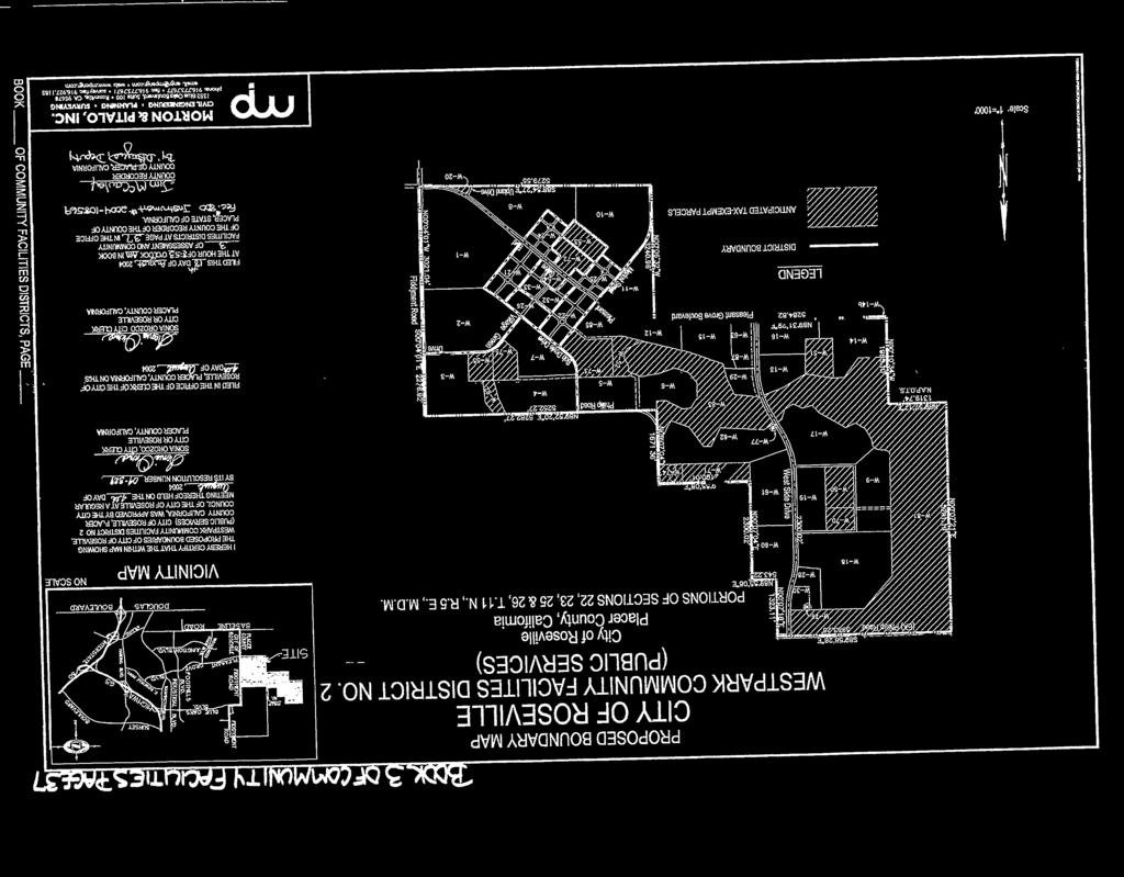
47
EXHIBIT B COUNTY OF SACRAMENTO COMMUNITY FACILITIES DISTRICT NO (NORTH VINEYARD STATION NO. 1)
") EXHIBIT B COUNTY OF SACRAMENTO COMMUNITY FACILITIES DISTRICT NO. 2005-2 (NORTH VINEYARD STATION NO. 1) AMENDED RATE AND METHOD OF APPORTIONMENT OF SPECIAL TAX A Special Tax applicable to each Assessor
EXHIBIT B COUNTY OF SACRAMENTO COMMUNITY FACILITIES DISTRICT NO. 2005-2 (NORTH VINEYARD STATION NO. 1) AMENDED RATE AND METHOD OF APPORTIONMENT OF SPECIAL TAX A Special Tax applicable to each Assessor
EXHIBIT C. Assessor s Parcel or Parcel means a lot or parcel shown in an Assessor s Parcel Map with an assigned Assessor s Parcel number.
 EXHIBIT C COUNTY OF SACRAMENTO COMMUNITY FACILITIES DISTRICT NO. 2006-1 (COUNTY PARKS CFD) RATE AND METHOD OF APPORTIONMENT OF SPECIAL TAX A Special Tax applicable to each Assessor s Parcel in Community
SECOND AMENDED RATE AND METHOD OF APPORTIONMENT OF SPECIAL TAXES FOR TUSTIN UNIFIED SCHOOL DISTRICT COMMUNITY FACILITIES DISTRICT NO
 SECOND AMENDED RATE AND METHOD OF APPORTIONMENT OF SPECIAL TAXES FOR TUSTIN UNIFIED SCHOOL DISTRICT COMMUNITY FACILITIES DISTRICT NO. 07-1 (ORCHARD HILLS) A Special Tax shall be levied and collected within
REPORT OF SPECIAL TAX LEVY FOR THE CITY OF LAKE ELSINORE. CITY OF LAKE ELSINORE CFD NO (West Lake Elsinore Public Improvements)
") REPORT OF SPECIAL TAX LEVY FOR THE CITY OF LAKE ELSINORE CITY OF LAKE ELSINORE CFD NO. 88-3 (West Lake Elsinore Public Improvements) Fiscal Year 2002-03 Submitted to: City of Lake Elsinore Riverside County,
REPORT OF SPECIAL TAX LEVY FOR THE CITY OF LAKE ELSINORE CITY OF LAKE ELSINORE CFD NO. 88-3 (West Lake Elsinore Public Improvements) Fiscal Year 2002-03 Submitted to: City of Lake Elsinore Riverside County,
TRUCKEE FIRE PROTECTION DISTRICT ORDINANCE
 TRUCKEE FIRE PROTECTION DISTRICT ORDINANCE 01-2017 AN ORDINANCE OF THE BOARD OF DIRECTORS OF THE TRUCKEE FIRE PROTECTION DISTRICT LEVYING SPECIAL TAXES WITHIN COMMUNITY FACILITIES DISTRICT NO. 2017-01
RATE AND METHOD OF APPORTIONMENT FOR CASITAS MUNICIPAL WATER DISTRICT COMMUNITY FACILITIES DISTRICT NO (OJAI)
") RATE AND METHOD OF APPORTIONMENT FOR CASITAS MUNICIPAL WATER DISTRICT COMMUNITY FACILITIES DISTRICT NO. 2013-1 (OJAI) A Special Tax shall be levied on all Assessor s Parcels of Taxable Property in Casitas
RATE AND METHOD OF APPORTIONMENT FOR CASITAS MUNICIPAL WATER DISTRICT COMMUNITY FACILITIES DISTRICT NO. 2013-1 (OJAI) A Special Tax shall be levied on all Assessor s Parcels of Taxable Property in Casitas
SPECIAL TAX AND BOND ACCOUNTABILITY REPORT
 SPECIAL TAX AND BOND ACCOUNTABILITY REPORT FOR IMPROVEMENT AREA A OF COMMUNITY FACILITIES DISTRICT NO. 6 OF THE POWAY UNIFIED SCHOOL DISTRICT November 14, 2003 SPECIAL TAX AND BOND ACCOUNTABILITY REPORT
Community Facilities District Report. Jurupa Unified School District Community Facilities District No. 13. September 14, 2015
 Community Facilities District Report Jurupa Unified School District Community Facilities District No. 13 September 14, 2015 Prepared For: Jurupa Unified School District 4850 Pedley Road Jurupa Valley,
RATE AND METHOD OF APPORTIONMENT OF A SPECIAL TAX FOR COMMUNITY FACILITIES DISTRICT NO OF THE TUSTIN UNIFIED SCHOOL DISTRICT
 RATE AND METHOD OF APPORTIONMENT OF A SPECIAL TAX FOR COMMUNITY FACILITIES DISTRICT NO. 97-1 OF THE TUSTIN UNIFIED SCHOOL DISTRICT The Board of Education of the Tustin Unified School District (the Board)
REPORT OF SPECIAL TAX LEVY FOR THE CITY OF LAKE ELSINORE. CITY OF LAKE ELSINORE CFD (Rosetta Canyon Public Improvements) Fiscal Year
 Fiscal Year") REPORT OF SPECIAL TAX LEVY FOR THE CITY OF LAKE ELSINORE CITY OF LAKE ELSINORE CFD 2004-3 (Rosetta Canyon Public Improvements) Fiscal Year 2006-07 Submitted to: City of Lake Elsinore Riverside County,
REPORT OF SPECIAL TAX LEVY FOR THE CITY OF LAKE ELSINORE CITY OF LAKE ELSINORE CFD 2004-3 (Rosetta Canyon Public Improvements) Fiscal Year 2006-07 Submitted to: City of Lake Elsinore Riverside County,
POWAY UNIFIED SCHOOL DISTRICT ADMINISTRATION REPORT FISCAL YEAR 2017/2018 IMPROVEMENT AREA NO. 1 OF COMMUNITY FACILITIES DISTRICT NO.
 POWAY UNIFIED SCHOOL DISTRICT ADMINISTRATION REPORT FISCAL YEAR 2017/2018 IMPROVEMENT AREA NO. 1 OF COMMUNITY FACILITIES DISTRICT NO. 2 JUNE 29, 2017 PREPARED FOR: Poway Unified School District Planning
RESOLUTION NO Adopted by the Sacramento City Council. December 11, 2018
 RESOLUTION NO. 2018-0480 Adopted by the Sacramento City Council December 11, 2018 Resolution of Intention to Establish Territory as a Future Annexation Area to the Sacramento Services Community Facilities
Administration Report Fiscal Year 2016/2017. Hesperia Unified School District Community Facilities District No June 20, 2016.
 Administration Report Fiscal Year 2016/2017 Hesperia Unified School District Community Facilities District No. 2006-2 June 20, 2016 Prepared For: Hesperia Unified School District 15576 Main Street Hesperia,
REPORT OF SPECIAL TAX LEVY FOR THE CITY OF LAKE ELSINORE. CITY OF LAKE ELSINORE CFD 98-1 (Summerhill Public Improvements) Fiscal Year
 Fiscal Year") REPORT OF SPECIAL TAX LEVY FOR THE CITY OF LAKE ELSINORE CITY OF LAKE ELSINORE CFD 98-1 (Summerhill Public Improvements) Fiscal Year 2004-05 Submitted to: City of Lake Elsinore Riverside County, California
REPORT OF SPECIAL TAX LEVY FOR THE CITY OF LAKE ELSINORE CITY OF LAKE ELSINORE CFD 98-1 (Summerhill Public Improvements) Fiscal Year 2004-05 Submitted to: City of Lake Elsinore Riverside County, California
RESOLUTION NO. (ANNEXATION AREA NO. 2)
") RD:EEH:LCP 4-6-16 RESOLUTION NO. A RESOLUTION OF INTENTION OF THE COUNCIL OF THE CITY OF SAN JOSE TO ANNEX TERRITORY INTO COMMUNITY FACILITIES DISTRICT NO. 8 (COMMUNICATIONS HILL) AND TO AUTHORIZE THE
RD:EEH:LCP 4-6-16 RESOLUTION NO. A RESOLUTION OF INTENTION OF THE COUNCIL OF THE CITY OF SAN JOSE TO ANNEX TERRITORY INTO COMMUNITY FACILITIES DISTRICT NO. 8 (COMMUNICATIONS HILL) AND TO AUTHORIZE THE
RESOLUTION NO
 RESOLUTION NO. 2007-28 A RESOLUTION OF THE CITY COUNCIL OF THE CITY OF ELK GROVE DECLARING ITS INTENTION TO ANNEX TERRITORY TO COMMUNITY FACILITIES DISTRICT No. 2006-1 (MAINTENANCE SERVICES) AND TO LEVY
REPORT OF SPECIAL TAX LEVY FOR THE CITY OF LAKE ELSINORE. CITY OF LAKE ELSINORE CFD 91-2 (Summerhill Public Improvements) Fiscal Year
 Fiscal Year") REPORT OF SPECIAL TAX LEVY FOR THE CITY OF LAKE ELSINORE CITY OF LAKE ELSINORE CFD 91-2 (Summerhill Public Improvements) Fiscal Year 2002-03 Submitted to: City of Lake Elsinore Riverside County, California
REPORT OF SPECIAL TAX LEVY FOR THE CITY OF LAKE ELSINORE CITY OF LAKE ELSINORE CFD 91-2 (Summerhill Public Improvements) Fiscal Year 2002-03 Submitted to: City of Lake Elsinore Riverside County, California
REPORT OF SPECIAL TAX LEVY FOR THE CITY OF LAKE ELSINORE
 REPORT OF SPECIAL TAX LEVY FOR THE CITY OF LAKE ELSINORE REDEVELOPMENT AGENCY OF THE CITY OF LAKE ELSINORE CFD 90-2 (Tuscany Hills Public Improvements) Fiscal Year 2004-05 Submitted to: City of Lake Elsinore
ORDINANCE NUMBER 1154
 ORDINANCE NUMBER 1154 AN ORDINANCE OF THE CITY COUNCIL OF THE CITY OF PERRIS ACTING AS THE LEGISLATIVE BODY OF COMMUNITY FACILITIES DISTRICT NO. 2005-1 (PERRIS VALLEY VISTAS) OF THE CITY OF PERRIS AUTHORIZING
City of Roseville Community Facilities Districts. February 13, 2018
 City of Roseville Community Facilities Districts February 13, 2018 Council Policies 1. New growth areas must be fiscally neutral at buildout 2. New growth areas cannot rely on existing general fund for
Table of Contents. Sections. Tables. Appendices
 - Table of Contents Sections Section 1. Bond Profile 1 Section 2. Fund Information 2 Section 3. Special Tax Information 3 Section 4. Owner and Development Status Information 4 Section 5. Payment History
NOTICE OF SPECIAL TAX LIEN CITY OF ALAMEDA COMMUNITY FACILITIES DISTRICT NO (ALAMEDA LANDING MUNICIPAL SERVICES DISTRICT)
") Quint & Thimmig LLP 12/9/13 RECORDING REQUESTED BY AND RETURN TO: CITY CLERK CITY OF ALAMEDA 2263 Santa Clara Avenue, Room 380 Alameda, CA 94501 EXEMPT FROM RECORDER S FEES Pursuant to Government Code
Quint & Thimmig LLP 12/9/13 RECORDING REQUESTED BY AND RETURN TO: CITY CLERK CITY OF ALAMEDA 2263 Santa Clara Avenue, Room 380 Alameda, CA 94501 EXEMPT FROM RECORDER S FEES Pursuant to Government Code
New Home Tax Disclosure Report
 New Home Tax Disclosure Report This report satisfies the seller s obligation, pursuant to Civil Code Section 1102.6b, to disclose all special tax and/or assessment districts affecting the subject property
TRUCKEE FIRE PROTECTION DISTRICT
 PUBLIC HEARING REPORT COMMUNITY FACILITIES DISTRICT NO. 2017-01 (PLACER COUNTY NEW DEVELOPMENT) MARCH 2017 ADMINISTRATIVE DRAFT REPORT PREPARED FOR: BOARD OF DIRECTORS PREPARED BY: 4745 MANGELS BOULEVARD
CHICO/CARD AREA PARK FEE NEXUS STUDY
 REVISED FINAL REPORT CHICO/CARD AREA PARK FEE NEXUS STUDY Prepared for: City of Chico and Chico Area Recreation District (CARD) Prepared by: Economic & Planning Systems, Inc. December 2, 2003 EPS #12607
RATE AND METHOD OF APPORTIONMENT FOR COMMUNITY FACILITIES DISTRICT NO. 3 (SEABRIDGE AT MANDALAY BAY) OF THE CITY OF OXNARD
 OF THE CITY OF OXNARD") RATE AND METHOD OF APPORTIONMENT FOR COMMUNITY FACILITIES DISTRICT NO. 3 (SEABRIDGE AT MANDALAY BAY) OF THE CITY OF OXNARD A Special Tax as hereinafter defined shall be levied on all Assessor s Parcels
RATE AND METHOD OF APPORTIONMENT FOR COMMUNITY FACILITIES DISTRICT NO. 3 (SEABRIDGE AT MANDALAY BAY) OF THE CITY OF OXNARD A Special Tax as hereinafter defined shall be levied on all Assessor s Parcels
CORDOVA RECREATION & PARK DISTRICT MEASURE J
 CORDOVA RECREATION & PARK DISTRICT MEASURE J J Safe, Clean, Accessible Neighborhood Parks Measure. To provide clean and safe neighborhood parks; reduce homelessness and drug use in parks; improve park
RESOLUTION NO Adopted by the Sacramento City Council. April 14, 2015
 RESOLUTION NO. 2015-0088 Adopted by the Sacramento City Council April 14, 2015 RESOLUTION OF INTENTION TO PROVIDE FOR FUTURE ANNEXATION OF TERRITORY TO THE SACRAMENTO MAINTENANCE SERVICES COMMUNITY FACILITIES
SPECIAL TAX AND BOND ACCOUNTABILITY REPORT
 SPECIAL TAX AND BOND ACCOUNTABILITY REPORT FOR IMPROVEMENT AREA A OF COMMUNITY FACILITIES DISTRICT NO. 10 OF THE POWAY UNIFIED SCHOOL DISTRICT November 14, 2003 SPECIAL TAX AND BOND ACCOUNTABILITY REPORT
RESOLUTION NUMBER 3992
 RESOLUTION NUMBER 3992 A RESOLUTION OF THE CITY COUNCIL OF THE CITY OF PERRIS AUTHORIZING THE CHANGES TO THE SPECIAL TAXES WITHIN COMMUNITY FACILITIES DISTRICT NO. 2006-3 (ALDER) OF THE CITY OF PERRIS;
CITY OF ELK GROVE CITY COUNCIL STAFF REPORT
 CITY COUNCIL STAFF REPORT AGENDA ITEM NO. 8.9 AGENDA TITLE: Adopt resolutions declaring intention to: 1) annex territory to Community Facilities District No. 2003-2 (Police Services) and to levy a special
RESOLUTION NO Adopted by the Sacramento City Council. May 19, 2015
 RESOLUTION NO. 2015-0130 Adopted by the Sacramento City Council May 19, 2015 RESOLUTION ESTABLISHING THE FUTURE ANNEXATION AREA FOR THE SACRAMENTO MAINTENANCE COMMUNITY FACILITIES DISTRICT NO. 2014-04
4. Parks and Recreation Fee Facility Needs and Cost Estimates Fee Calculation Nexus Findings 24
 TABLE OF CONTENTS CHAPTER PAGE 1. Introduction and Summary of Calculated Fees 1 1.1 Background and Study Objectives 1 1.2 Organization of the Report 2 1.3 Calculated Development Impact Fees 2 2. Fee Methodology
RESOLUTION NUMBER 3968
 RESOLUTION NUMBER 3968 A RESOLUTION OF THE CITY COUNCIL OF THE CITY OF PERRIS, COUNTY OF RIVERSIDE, STATE OF CALIFORNIA, AS THE LEGISLATIVE BODY OF COMMUNITY FACILITIES DISTRICT NO. 2001-1 (MAY FARMS)
POWAY UNIFIED SCHOOL DISTRICT
 POWAY UNIFIED SCHOOL DISTRICT CONTINUING DISCLOSURE ANNUAL REPORT FISCAL YEAR ENDING JUNE 30, 2016 IMPROVEMENT AREA C OF COMMUNITY FACILITIES DISTRICT NO. 6 SPECIAL TAX REFUNDING BONDS, SERIES 2016 BASE
RATE AND METHOD OF APPORTIONMENT FOR COMMUNITY FACILITIES DISTRICT NO. 4 - MAINTENANCE OF THE CITY OF MORENO VALLEY
 CFD No. 4 Maintenance Page 1 RATE AND METHOD OF APPORTIONMENT FOR COMMUNITY FACILITIES DISTRICT NO. 4 - MAINTENANCE OF THE CITY OF MORENO VALLEY A Special Tax as hereinafter defined shall be levied on
RESOLUTION NUMBER 3970
 RESOLUTION NUMBER 3970 A RESOLUTION OF THE CITY COUNCIL OF THE CITY OF PERRIS, COUNTY OF RIVERSIDE, STATE OF CALIFORNIA, AUTHORIZING THE CHANGES TO THE FACILITIES AND SPECIAL TAXES WITHIN IMPROVEMENT AREA
NORTH POINTE SPECIFIC PLAN RIPON, CALIFORNIA PUBLIC FACILITIES FINANCING PLAN
 NORTH POINTE SPECIFIC PLAN RIPON, CALIFORNIA PUBLIC FACILITIES FINANCING PLAN FINAL ADOPTED BY THE CITY COUNCIL ON MARCH 8, 2016 555)University)Ave,)Suite)280) )Sacramento,)CA)95825 Phone:)l916p)561-0890)
POWAY UNIFIED SCHOOL DISTRICT
 POWAY UNIFIED SCHOOL DISTRICT ADMINISTRATION REPORT FISCAL YEAR 2017/2018 IMPROVEMENT AREA D OF COMMUNITY FACILITIES DISTRICT NO. 10 June 29, 2017 PREPARED FOR: Poway Unified School District Planning Department
Harris Ranch Community Infrastructure District No. 1. Feasibility Report Special Assessment Bonds (Assessment Area One)
") Harris Ranch Community Infrastructure District No. 1 Feasibility Report Special Assessment Bonds (Assessment Area One) September 21, 2010 Submitted By: Mr. Doug Fowler Lenir, Ltd. 4940 East Mill Station
Harris Ranch Community Infrastructure District No. 1 Feasibility Report Special Assessment Bonds (Assessment Area One) September 21, 2010 Submitted By: Mr. Doug Fowler Lenir, Ltd. 4940 East Mill Station
RD17 Area: Interim Urban Level of Flood Protection Levee Impact Fee
 2450 Venture Oaks Way, Suite 240 Sacramento, CA 95833 RD17 Area: Interim Urban Level of Flood Protection Levee Impact Fee NEXUS STUDY Adopted by City of Lathrop Ordinance No. 17-374 (Fee Effective April
Goals and Policies Concerning Use of MELLO-ROOS COMMUNITY FACILITIES ACT OF 1982
 Goals and Policies Concerning Use of MELLO-ROOS COMMUNITY FACILITIES ACT OF 1982 Section TABLE OF CONTENTS Page Introduction 1 1 Policy & Goals 1 2 Definitions 2 3 Eligible Public Facilities 3 4 Value-to-Lien
RESOLUTION NUMBER 3928
 RESOLUTION NUMBER 3928 RESOLUTION OF CONSIDERATION OF THE CITY COUNCIL OF THE CITY OF PERRIS, COUNTY OF RIVERSIDE, STATE OF CALIFORNIA, ACTING AS THE LEGISLATIVE BODY OF COMMUNITY FACILITIES DISTRICT NO.
CITY OF PAIMDALE REPORT TO THE MAYOR AND MEMBERS OF THE CITY COUNCIL FROM THE CITY MANAGER. DATE: January 9, 2013
 CITY OF PAIMDALE REPORT TO THE MAYOR AND MEMBERS OF THE CITY COUNCIL FROM THE CITY MANAGER DATE: January 9, 2013 SUBJECT: Consideration of Alterations to CFD 93-1 Rifler Ranch ISSUING DEPARTMENT: Finance
CIMARRON HILLS PUBLIC IMPROVEMENT DISTRICT SERVICE AND ASSESSMENT PLAN 2012 UPDATE
 CIMARRON HILLS PUBLIC IMPROVEMENT DISTRICT SERVICE AND ASSESSMENT PLAN 2012 UPDATE Introduction Sections 372.013 372.014 of Chapter 372 of the Local Government Code known as the Public Improvement District
Triple Creek Community Development District
 1 Triple Creek Community Development District http://triplecreekcdd.com Adopted Budget for Fiscal Year 2018/2019 Presented by: Rizzetta & Company, Inc. 9428 Camden Field Parkway Riverview, Florida 33578
CAPISTRANO UNIFIED SCHOOL DISTRICT COMMUNITY FACILITIES DISTRICT
 DAVID TAUSSIG & Associates, Inc. CAPISTRANO UNIFIED SCHOOL DISTRICT COMMUNITY FACILITIES DISTRICT NO. 94-1 August 10, 2012 Public Finance Facilities Planning Urban Economics Newport Beach Fresno Riverside
2011 ANNUAL REPORT. 1. The Audited Financial Statements of the Capistrano Unified School District June 30, 2011.
 $49,675,000 COMMUNITY FACILITIES DISTRICT NO. 90-2 OF THE CAPISTRANO UNIFIED SCHOOL DISTRICT (TALEGA) (IMPROVEMENT AREA NO. 2002-1) SERIES 2003 SPECIAL TAX BONDS 2011 ANNUAL REPORT This continuing disclosure
MOUNTAIN HOUSE COMMUNITY SERVICES DISTRICT To provide responsive service to our growing community that exceeds expectations at a fair value
 MOUNTAIN HOUSE COMMUNITY SERVICES DISTRICT To provide responsive service to our growing community that exceeds expectations at a fair value STAFF REPORT AGENDA TITLE: Approval of Shea Homes Annexation
City of Palm Bay Stormwater Assessment Program. March 30, 2017
 City of Palm Bay Stormwater Assessment Program March 30, 2017 What is a Stormwater Assessment? A charge imposed against real property to pay for stormwater services provided by the City. 2 Case Law Requirements
ORDINANCE NO
 ORDINANCE NO. 2016-23 AUTHORIZING THE CREATION OF THE BALLPARK VILLAGE MUNICIPAL IMPROVEMENT DISTRICT; PROVIDING FOR THE FINANCING OF IMPROVEMENTS WITHIN THE BALLPARK VILLAGE MUNICIPAL IMPROVEMENT DISTRICT
CHAPTER REAL PROPERTY DEVELOPMENT FEES. Sections:
 17.16.010 CHAPTER 17.16 REAL PROPERTY DEVELOPMENT FEES Sections: 17.16.010 Definitions. 17.16.020 Applicability, Payment and Tracking of Fees 17.16.030 Garbage collection capital fee. 17.16.040 Fee for
County of El Dorado CFD Series 2002 and 2005 Special Tax Bonds. Continuing Disclosure Annual Report. Fiscal Year Ending: June 30, 2014
 County of El Dorado CFD 2001-1 Series 2002 and 2005 Special Tax Bonds Continuing Disclosure Annual Report Fiscal Year Ending: June 30, 2014 Main Office 32605 Temecula Parkway, Suite 100 Temecula, CA 92592
4.1 Overview. 4.2 Land Use Plan
 4.1 Overview The Sierra Vista Specific Plan provides for a mix of land uses to achieve the desired community form and Plan Area objectives. These land use designations include low-, medium-, and high-density
SACRAMENTO COUNTY WATER AGENCY ORDINANCE NO. WA0-0089
 SACRAMENTO COUNTY WATER AGENCY ORDINANCE NO. WA0-0089 AN ORDINANCE OF THE SACRAMENTO COUNTY WATER AGENCY CODE RELATING TO THE NORTH VINEYARD STATION SUPPLEMENTAL DRAINAGE FEE The Board of Directors of
CAMERON PARK COMMUNITY SERVICES DISTRICT PARK IMPACT FEE NEXUS STUDY BOARD OF DIRECTORS
 PARK IMPACT FEE NEXUS STUDY NOVEMBER 2015 FINAL REPORT PREPARED FOR: BOARD OF DIRECTORS PREPARED BY: SCIConsultingGroup 4745 MANGELS BOULEVARD FAIRFIELD, CALIFORNIA 94534 PHONE 707.430.4300 FAX 707.430.4319
RESOLUTION NO Adopted by the Sacramento City Council. March 21, 2017
 RESOLUTION NO. 2017-0105 Adopted by the Sacramento City Council March 21, 2017 RESOLUTION OF FORMATION ESTABLISHING SACRAMENTO STREETCAR COMMUNITY FACILITIES DISTRICT NO. 2017-01, CITY OF SACRAMENTO, COUNTY
CALIFORNIA TAX DISCLOSURE REPORT
 JCP Report No.: 2005012800004 Page: 1 of 8 CALIFORNIA TAX DISCLOSURE REPORT Property Address: 49 MINERVA ST, SAN FRANCISCO Assessors Parcel Number: 7094-047 Table of Contents Description of Property Tax
Preliminary Analysis
 City of Manhattan Beach May 21, 2014 Rate Analysis Feasibility Report APPENDIX A DRAFT Preliminary Analysis for the For the City of Manhattan Beach June 18, 2014 Preliminary Analysis Introduction The City
STAFF REPORT. Mike Webb, Director of Community Development & Sustainability. Cannery Request for Community Facilities District (CFD) Formation
 Formation") STAFF REPORT DATE: February 17, 2015 TO: FROM: SUBJECT: City Council Mike Webb, Director of Community Development & Sustainability Cannery Request for Community Facilities District (CFD) Formation Recommendation
STAFF REPORT DATE: February 17, 2015 TO: FROM: SUBJECT: City Council Mike Webb, Director of Community Development & Sustainability Cannery Request for Community Facilities District (CFD) Formation Recommendation
Affordable Housing Plan
 Affordable Housing Plan CORDOVA HILLS SPECIAL PLANNING AREA 1 Proposed Project Conwy LLC is the master developer ( Master Developer ) of that certain real property in the County of Sacramento ( County
City Council Report. 915 I Street, 1 st Floor Sacramento, CA File ID: October 23, 2018 Consent Item 02
 City Council Report 915 I Street, 1 st Floor Sacramento, CA 95814 www.cityofsacramento.org File ID: 2018-01402 October 23, 2018 Consent Item 02 Title: Initiate Formation Proceedings for Greenbriar Community
POWAY UNIFIED SCHOOL DISTRICT
 POWAY UNIFIED SCHOOL DISTRICT ADMINISTRATION REPORT FISCAL YEAR 2017/2018 IMPROVEMENT AREA B COMMUNITY FACILITIES DISTRICT NO. 8 June 29, 2017 PREPARED FOR: Poway Unified School District-Planning Department
An Introduction to Community Facilities District Financing. City of Dixon City Council Workshop May 29, 2013
 An Introduction to Community Facilities District Financing City of Dixon City Council Workshop May 29, 2013 Terminology Community Facilities District ( CFD ) Special Tax Tax-exempt bonds Land-secured Value-to-lien
RESOLUTION NUMBER 4779
 RESOLUTION NUMBER 4779 RESOLUTION OF INTENTION OF THE CITY COUNCIL OF THE CITY OF PERRIS TO ESTABLISH COMMUNITY FACILITIES DISTRICT NO. 2014-1 (AVELINA) OF THE CITY OF PERRIS AND TO AUTHORIZE THE LEVY
SERVICE AND ASSESSMENT PLAN CITY OF HASLET PUBLIC IMPROVEMENT DISTRICT NO. 2 SERVICE AND ASSESSMENT PLAN August 3, \ v
 SERVICE AND ASSESSMENT PLAN CITY OF HASLET PUBLIC IMPROVEMENT DISTRICT NO. 2 SERVICE AND ASSESSMENT PLAN August 3, 2015 CITY OF HASLET PUBLIC IMPROVEMENT DISTRICT NO. 2 SERVICE AND ASSESSMENT PLAN Table
CASTROVILLE COMMUNITY PLAN - FINANCING COMMUNITY PLAN IMPROVEMENTS
 CASTROVILLE COMMUNITY PLAN - FINANCING COMMUNITY PLAN IMPROVEMENTS INTRODUCTION As described in the other sections of this community plan, implementation of the Plan will require various site, infrastructure
Town of North Topsail Beach
 Town of North Topsail Beach Build-Out and Non-Conforming Lot Study In Coordination with The Eastern Carolina Council of Governments February 2010 Introduction The Town of North Topsail Beach has conducted
Ordinance Page 1
 ORDINANCE NO. 671 (AS AMENDED THROUGH 671.20) AN ORDINANCE OF THE COUNTY OF RIVERSIDE AMENDING ORDINANCE NO. 671 ESTABLISHING CONSOLIDATED FEES FOR LAND USE AND RELATED FUNCTIONS The Board of Supervisors
CITY OF SACRAMENTO DEVELOPMENT FEE FINANCING PROGRAM FOR COMMERCIAL, INDUSTRIAL, AND RESIDENTIAL DEVELOPMENT PROJECTS
 CITY OF SACRAMENTO DEVELOPMENT FEE FINANCING PROGRAM FOR COMMERCIAL, INDUSTRIAL, AND RESIDENTIAL DEVELOPMENT PROJECTS TABLE OF CONTENTS Page Introduction... 2 Definitions... 3 Project Eligibility... 4
Drainage Impact Fee AB 1600 Nexus Study Update to the Thermalito Master Drainage Plan
 Prepared for The City of Oroville and Butte County Prepared by Keyser Marston Associates, Inc. May 2010 I. INTRODUCTION This Nexus Study presents the maximum development impact fees related to the Update
ORDINANCE NO
 AN ORDINANCE OF THE CITY OF SANTA CRUZ AMENDING TITLE 24 OF THE SANTA CRUZ MUNICIPAL CODE, THE ZONING ORDINANCE, BY AMENDING CHAPTER 24.16 PART 3, DENSITY BONUS PROVISIONS FOR RESIDENTIAL UNITS BE IT ORDAINED
Chapter 14C - INCLUSIONARY HOUSING [42]
![Chapter 14C - INCLUSIONARY HOUSING [42]](/thumbs/82/86417632.jpg "Chapter 14C - INCLUSIONARY HOUSING [42]") Chapter 14C - INCLUSIONARY HOUSING [42] (42) Editor's note Ord. No. 91-49, 1, adopted Oct. 23, 1991, repealed former Ch. 14C which pertained to similar provisions and derived from Ord. No. 82-49, 1, adopted
Chapter 14C - INCLUSIONARY HOUSING [42] (42) Editor's note Ord. No. 91-49, 1, adopted Oct. 23, 1991, repealed former Ch. 14C which pertained to similar provisions and derived from Ord. No. 82-49, 1, adopted
Property Development Standards All Zones. Property Development Standards Commercial and Industrial. Property Development Standards Mixed Use
 Division 17.50 Development Standards Chapter 17.51 Property Development Standards All Zones Chapter 17.53 Chapter 17.55 Chapter 17.57 Property Development Standards Commercial and Industrial Property Development
ORDINANCE NO. AN ORDINANCE OF THE CITY COUNCIL OF THE CITY OF DALY CITY REPEALING AND REPLACING CHAPTER RE: INCLUSIONARY HOUSING
 ORDINANCE NO. AN ORDINANCE OF THE CITY COUNCIL OF THE CITY OF DALY CITY REPEALING AND REPLACING CHAPTER 17.47 RE: INCLUSIONARY HOUSING The City Council of the City of Daly City, DOES ORDAIN as follows:
Engineer's Report. City of Santa Clarita Drainage Benefit Assessment Area No (Golden Valley Ranch Commercial) For. Fiscal Year
 For. Fiscal Year") Engineer's Report For City of Santa Clarita Drainage Benefit Assessment Area No. 2008-2 (Golden Valley Ranch Commercial) Fiscal Year 2008-09 Submitted To: City of Santa Clarita, California Prepared By:
Engineer's Report For City of Santa Clarita Drainage Benefit Assessment Area No. 2008-2 (Golden Valley Ranch Commercial) Fiscal Year 2008-09 Submitted To: City of Santa Clarita, California Prepared By:
Capital Improvement Plans and Development Impact Fees
 Capital Improvement Plans and Development Impact Fees City of Submitted to: City of September 29, 2011 Prepared by: 4701 Sangamore Road Suite S240 Bethesda, Maryland 20816 800.424.4318 www.tischlerbise.com
CITY OF MENIFEE RIVERSIDE COUNTY, CALIFORNIA REQUEST FOR PROPOSALS SPECIAL DISTRICTS ADMINISTRATION SERVICES
 CITY OF MENIFEE RIVERSIDE COUNTY, CALIFORNIA REQUEST FOR PROPOSALS SPECIAL DISTRICTS ADMINISTRATION SERVICES CITY OF MENIFEE Engineering Department 29714 Haun Road Menifee, CA 92586 (951) 672-6777 ATTN:
QUARTERPATH COMMUNITY DEVELOPMENT AUTHORITY CITY OF WILLIAMSBURG, VIRGINIA SPECIAL ASSESSMENT REPORT. Prepared By: MuniCap, Inc.
 QUARTERPATH COMMUNITY DEVELOPMENT AUTHORITY CITY OF WILLIAMSBURG, VIRGINIA SPECIAL ASSESSMENT REPORT Prepared By: MuniCap, Inc. October 25, 2011 QUARTERPATH COMMUNITY DEVELOPMENT AUTHORITY CITY OF WILLIAMSBURG,
Orange Water and Sewer Authority Water and Sewer System Development Fee Study
 Orange Water and Sewer Authority Water and Sewer System Development Fee Study March 6, 2018 March 6, 2018 Mr. Stephen Winters Director of Finance and Customer Service 400 Jones Ferry Road Carrboro, NC
CHAPTER V: IMPLEMENTING THE PLAN
 CHAPTER V: IMPLEMENTING THE PLAN A range of resources is available to fund the improvements included in the Action Plan. These resources include existing commitments of County funding, redevelopment-related
Cedar Hammock Fire Control District
 Cedar Hammock Fire Control District FY 2015 Fire/Rescue Impact Fee Study February 24, 2016 Prepared by: February 24, 2016 Mr. Jeff Hoyle Fire Chief 5200 26 th St W Bradenton, FL 34207 Re: FY 2015 Impact
SOUTH DAVIS METRO FIRE AGENCY FIRE IMPACT FEE FACILITIES PLAN (IFFP) AND IMPACT FEE ANALYSIS (IFA)
 AND IMPACT FEE ANALYSIS (IFA)") SOUTH DAVIS METRO FIRE AGENCY FIRE IMPACT FEE FACILITIES PLAN (IFFP) AND IMPACT FEE ANALYSIS (IFA) JULY 2012 PREPARED BY LEWIS YOUNG ROBERTSON & BURNINGHAM, INC. IMPACT FEE FACILITIES PLAN AND IMPACT FEE
SOUTH DAVIS METRO FIRE AGENCY FIRE IMPACT FEE FACILITIES PLAN (IFFP) AND IMPACT FEE ANALYSIS (IFA) JULY 2012 PREPARED BY LEWIS YOUNG ROBERTSON & BURNINGHAM, INC. IMPACT FEE FACILITIES PLAN AND IMPACT FEE
CITY AND COUNTY OF HONOLULU DEPARTMENT OF BUDGET & FISCAL SERVICES ADMINISTRATIVE GUIDELINES FOR COMMUNITY FACILITIES DISTRICTS
 Working Draft of May 14, 2004 Working Draft of August 11, 2004 Working Draft of September 8, 2004 CITY AND COUNTY OF HONOLULU DEPARTMENT OF BUDGET & FISCAL SERVICES ADMINISTRATIVE GUIDELINES FOR COMMUNITY
RIVER DANCE RV PARK ANNEXATION AND DEVELOPMENT IMPACT REPORT TOWN OF GYPSUM - SEPTEMBER RPI Consulting LLC.
 RIVER DANCE RV PARK ANNEXATION AND DEVELOPMENT IMPACT REPORT TOWN OF GYPSUM - SEPTEMBER 2017 RPI Consulting LLC Durango, Colorado TABLE OF CONTENTS Table of Contents 2 Introduction 3 Summary of Findings
Felicia Newhouse, Public Works Administrative Manager Russ Thompson, Public Works Director SUBJECT: WILDWOOD GLEN LANDSCAPING ASSESSMENT DISTRICT C-91
 STAFF REPORT MEETING DATE: May 19, 2015 TO: FROM: City Council Felicia Newhouse, Public Works Administrative Manager Russ Thompson, Public Works Director 922 Machin Avenue Novato, CA 94945 (415) 899-8900
TOWN OF BROOKLINE, NEW HAMPSHIRE
 TOWN OF BROOKLINE, NEW HAMPSHIRE BUILDOUT ANALYSIS DECEMBER, 2003 Prepared by the Nashua Regional Planning Commission TABLE OF CONTENTS Introduction... 1 I. Methodology... 1 A. PARCEL REVIEW... 1 B. DEVELOPMENT
CITY OF PETALUMA, CALIFORNIA ANNUAL DEVELOPMENT IMPACT FEE REPORT FISCAL YEAR
 Attachment 2 CITY OF PETALUMA, CALIFORNIA ANNUAL DEVELOPMENT IMPACT FEE REPORT FISCAL YEAR 2013-14 Background City of Petaluma Annual Development Impact Fee Report Fiscal Year 2013-14 The Mitigation Fee
THREE RIVERS LEVEE FEE NEXUS STUDY
 HEARING REPORT THREE RIVERS LEVEE FEE NEXUS STUDY Prepared for: Yuba County Prepared by: Economic & Planning Systems, Inc. April 25, 2006 Fee Adopted May 16, 2006, as Amended by Ordinances and County Counsel
Treasury Regulations 1.42
 Treasury Regulations 1.42 1.42-1 [Reserved] 1.42-1T Limitation on low-income housing credit allowed with respect to qualified lowincome buildings receiving housing credit allocations from a State or local
VAN BUREN SEWER PROJECT COMMUNITY ENGAGEMENT MEETING APRIL 20, 2017
 VAN BUREN SEWER PROJECT COMMUNITY ENGAGEMENT MEETING APRIL 20, 2017 1 HISTORY Areas of commercial and retail development over the years. Van Buren Boulevard has become a major transportation arterial road
RESOLUTION NO
 RESOLUTION NO. 074532 BOARD OF SUPERVISORS, COUNTY OF SAN MATEO, STATE OF CALIFORNIA * * * * * * RESOLUTION ESTABLISHING RATES FOR AN AFFORDABLE HOUSING IMPACT FEE PROGRAM FOR NEW RESIDENTIAL AND NON-RESIDENTIAL
PRELIMINARY PROJECT PLAN AND REINVESTMENT ZONE FINANCING PLAN FOR PROPOSED TAX INCREMENT REINVESTMENT ZONE NO. 1, CITY OF OAK RIDGE NORTH
 PRELIMINARY PROJECT PLAN AND REINVESTMENT ZONE FINANCING PLAN FOR PROPOSED TAX INCREMENT REINVESTMENT ZONE NO. 1, CITY OF OAK RIDGE NORTH DECEMBER 15, 2014 TABLE OF CONTENTS 1. Overview 1.1 Background...
CHAPTER IV IMPLEMENTATION
 CHAPTER IV IMPLEMENTATION Chapter Outline IV. Implementation Page A. Public Works Projects/Public Infrastructure IV-1 1. Facilities Master Plan Overview IV-1 2. Facilities Master Plan Service Standards
PINELLAS COUNTY, FLORIDA FINAL SURFACE WATER RATE RESOLUTION
 PINELLAS COUNTY, FLORIDA FINAL SURFACE WATER RATE RESOLUTION ADOPTED SEPTEMBER 10, 2013 TABLE OF CONTENTS Page SECTION 1. AUTHORITY.... 2 SECTION 2. DEFINITIONS.... 3 SECTION 3. CONFIRMATION OF INITIAL
North Richmond Annexation. Fiscal Impact Analysis. June 13, Administrative Draft Report
 North Richmond Annexation Fiscal Impact Analysis Administrative Draft Report June 13, 2017 This page intentionally left blank. Table of Contents EXECUTIVE SUMMARY... 1 Background and Study Objectives 1
Information Only. WHEREAS, the collection of development fees will assist the Township in meeting its affordable housing obligations; and
 ORDINANCE O-08-34 AN ORDINANCE AMENDING ORDINANCE O-08-32 ENTITLED AN ORDINANCE AMENDING CHAPTER 90 OF THE CODE OF THE TOWNSHIP OF SOUTH HARRISON TO AMEND THE MANDATORY DEVELOPMENT FEE REQUIREMENTS TO
SQUAW VALLEY PUBLIC SERVICE DISTRICT
 EXHIBIT # F-3 15 pages SQUAW VALLEY PUBLIC SERVICE DISTRICT Financial Projections The Village at Squaw Project DATE: September 30, 2014 TO: FROM: SUBJECT: District Board Members Tom Campbell, Finance /
Town of Lincoln Development Charges Background Study
 Town of Lincoln Development Charges Background Study May 17, 2018 Contents Page Executive Summary... i 1. Introduction... 1-1 1.1 Purpose of this Document... 1-1 1.2 Summary of the Process... 1-1 1.3
CITY OF OAKLAND IMPACT FEE ANNUAL REPORT FOR: Fiscal Year Ended June 30, 2018
 CITY OF OAKLAND IMPACT FEE ANNUAL REPORT FOR: AFFORDABLE HOUSING, JOBS/HOUSING, TRANSPORTATION, & CAPITAL IMPROVEMENTS IMPACT FEES Fiscal Year Ended June 30, 2018 December 18, 2018 TABLE OF CONTENTS I.