ST. TAMMANY PARISH PLANNING COMMISSION MEETING AGENDA 6:00PM TUESDAY, NOVEMBER 13, 2018 ST
|
|
|
- Henry Shaw
- 5 years ago
- Views:
Transcription
1 ROLL CALL ST. TAMMANY PARISH PLANNING COMMISSION MEETING AGENDA 6:00PM TUESDAY, NOVEMBER 13, 2018 ST. TAMMANY PARISH GOVERNMENT COMPLEX PARISH COUNCIL CHAMBERS KOOP DRIVE, MANDEVILLE, LOUISIANA PUBLIC ANNOUNCEMENTS Phones and Pagers Appeals Speaker Cards Public Speaking - Ten (10) minutes each side and five (5) minutes for rebuttal Please exit the building INVOCATION AND PLEDGE OF ALLEGIANCE APPROVAL OF THE OCTOBER 9, 2018 MINUTES PUBLIC HEARINGS: REQUEST FOR POSTPONEMENTS: ENTERING PARISH RIGHTS-OF-WAY, SERVITUDES, EASEMENTS Entering the Parish Right of Way (Warner Lane/LA HWY 59) Ward 4, District 5 Request: Relocation of Monument Sign Debtor: P&W Industries, L.L.C./Parish Concrete, L.L.C. General Location: Intersection Warner Lane and LA HWY 59 Parish Council District Rep.: Hon. Rykert Toledano ENTERING THE TAMMANY TRACE MINOR SUBDIVISIONS PETITIONS/REQUESTS REVOCATION/CLOSINGS REVIEW RESUBDIVISION REVIEW DORMANT SUBDIVISION REVIEW TENTATIVE SUBDIVISION REVIEW PRELIMINARY SUBDIVISION REVIEW PP Ashton Parc, 4th & 5th Filing, Ward 8, District 8 Developer/Owner: First Horizon, Inc. Engineer: Benchmark Group, Inc. Parish Council District Representative: Hon. Chris Canulette POSTPONED FROM THE OCTOBER 9, 2018 MEETING 1
2 AGENDA ST. TAMMANY PARISH PLANNING COMMISSION NOVEMBER 13, PP Guste Island Parcel I, Ward 1 District 4 Developer/Owner: McInt, Inc. Engineer: Kelly McHugh and Associates, Inc. Parish Council District Representative: Hon. Michael Lorino PP Bedico Creek Parcel 14, Ward 1 District 1 Developer/Owner: Kelly McHugh and Associates Engineer: Kelly McHugh and Associates, Inc. Parish Council District Representative: Hon. Marty Dean PP Rigolets Estates 3A-1, Ward 8 District 13 Developer/Owner: Succession of Fredrick J. Sigur Engineer: GEC, Inc. Parish Council District Representative: Hon. Michele Blanchard FINAL SUBDIVISION REVIEW FP Southern Oaks, Phase 1, Ward 1, District 4 Developer/Owner: Yanin, LLC Engineer: Kyle Associates, LLC Parish Council District Representative: Hon. Michael Lorino POSTPONED FROM THE OCTOBER 9, 2018 MEETING FP Money Hill Plantation, Phase 7B-1, Ward 6, District 6 Developer/Owner: Money Hill Plantation, LLC Engineer: J.V. Burkes and Associates, Inc. Parish Council District Representative: Hon. Richard Tanner AMENDMENTS TO CHAPTER SUBDIVISION REGULATIONS OLD BUSINESS MSP A minor subdivision of a 4.07-acre parcel into Parcels A, B, C & D, Ward 9, District 11 Owner: The Rose Mary Gunn and Willie Gunn Revocable Trust Surveyor: Land Surveying, LLC Parish Council District Representative: Hon. Steve Stefancik Postponed indefinitely at the June 12, 2018 Meeting, request to be placed on the December 11, 2018 Agenda 2
3 AGENDA ST. TAMMANY PARISH PLANNING COMMISSION NOVEMBER 13, PP The Preserve at Goodbee Lakes, Ward 1, District 3 Developer/Owner: D.R. Horton, Inc. - Gulf Coast Engineer: Quality Engineering and Surveying, LLC Parish Council District Representative: Hon. James Thompson Postponed indefinitely at the October 9, 2018 Meeting, request to be placed on the December 11, 2018 Agenda AOC The Preserve at River Chase Phase 1A & 1B, Ward 1, District 1 Surveyor: Southern Lifestyle Development Parish Council District Representative: Hon. Marty Dean Request to amend the width of a drainage servitude NEW BUSINESS ADJOURNMENT 3
4 MINUTES ST. TAMMANY PARISH PLANNING COMMISSION MEETING 6:00PM TUESDAY, OCTOBER 9, 2018 ST. TAMMANY PARISH GOVERNMENT COMPLEX PARISH COUNCIL CHAMBERS KOOP DRIVE, MANDEVILLE, LOUISIANA ROLL CALL Present: Cazaubon, Lorren, Richardson, Richard, Willie, Davis, Fitzmorris, Doherty, Randolph, Bagert Absent: Drumm Staff Present: Cara Bartholomew, Chris Tissue, Jay Watson, Shelby Vorenkamp, Mike Sevante, Jennifer Lange PUBLIC ANNOUNCEMENTS Phones and Pagers Appeals Speaker Cards Public Speaking - Ten (10) minutes each side and five (5) minutes for rebuttal Please exit the building INVOCATION - Randolph presented the Invocation. PLEDGE OF ALLEGIANCE - Cazaubon presented the Pledge of Allegiance. APPROVAL OF THE AUGUST SEPTEMBER 11, 2018 MINUTES Lorren moved to approve, second by Randolph. Yea: Cazaubon, Lorren, Richardson, Richard, Willie, Davis, Fitzmorris, Doherty, Randolph, Bagert Nay: Abstain: ELECTION OF CHAIRMAN AND VICE CHAIRMAN James Davis, Chairman - David Doherty, Vice Chairman Fitzmorris moved to approve, second by Randolph. Yea: Cazaubon, Lorren, Richardson, Richard, Willie, Davis, Fitzmorris, Doherty, Randolph, Bagert Nay: Abstain: REQUESTS FOR POSTPONEMENT PP - POSTPONED INDEFINITLY *see NEW BUSINESS The Preserve at Goodbee Lakes, Ward 1, District 3 Developer/Owner: D.R. Horton, Inc. Gulf Coast Engineer: Quality Engineering and Surveying Parish Council District Representative: Hon. James Thompson POSTPONED FROM THE JUNE 12, 2018 MEETING POSTPONED FROM THE JULY 10, 2018 MEETING POSTPONED FROM THE AUGUST 14, 2018 MEETING POSTPONED FROM THE SEPTEMBER 11, 2018 MEETING A Public Hearing was opened for discussion of this case and the following individual(s) provided testimony in favor of this request: Jeff Schoen Opposition: John Martin, David Lee Campbell, Matthew Allen Cazaubon moved to approve, second by Randolph. 1
5 OCTOBER 9, 2018 MINUTES ST. TAMMANY PARISH PLANNING COMMISSION Yea: Cazaubon, Lorren, Richardson, Richard, Willie, Davis, Fitzmorris, Doherty, Randolph, Bagert Nay: Abstain: PP - POSTPONED FOR TWO MONTHS Providence Parks Ph. 1, Ward 1, District 3 Developer/Owner: Providence Parks, LLC Engineer: SLD Engineering and Surveying Parish Council District Representative: Hon. James Thompson POSTPONED FROM THE JULY 10, 2018 MEETING POSTPONED FROM THE AUGUST 14, 2018 MEETING POSTPONED FROM THE SEPTEMBER 11, 2018 MEETING A Public Hearing was opened for discussion of this case and the following individual(s) provided testimony in favor of this request: Paul Mayronne Opposition: John Martin, David Lee Campbell, Matthew Allen Doherty moved to approve, second by Randolph. Yea: Cazaubon, Lorren, Richardson, Richard, Willie, Davis, Fitzmorris, Doherty, Randolph, Bagert Nay: Abstain: PP - POSTPONE FOR ONE MONTH Ashton Parc, 4th & 5th Filing Developer/Owner: First Horizon, INC Engineer: Benchmark Group, INC Parish Council District Representative: Hon. Chris Canulette A Public Hearing was opened for discussion of this case and the following individual(s) provided testimony in favor of this request: Carlos Mansfield Opposition: None Doherty moved to approve, second by Fitzmorris. Cazaubon, Lorren, Richardson, Richard, Willie, Davis, Fitzmorris, Doherty, Randolph, Bagert Nay: Abstain: FP Southern Oaks, Phase 1, Ward 1, District 4 Developer/Owner: Yanin, LLC Engineer: Kyle Associates, LLC Parish Council District Representative: Hon. Michael Lorino POSTPONED FROM THE SEPTEMBER 11, 2018 MEETING A Public Hearing was opened for discussion of this case and the following individual(s) provided testimony in favor of this request: Paul Mayronne Opposition: None Fitzmorris moved to approve, second by Willie. Cazaubon, Lorren, Richardson, Richard, Willie, Davis, Fitzmorris, Doherty, Randolph, Bagert Nay: Abstain: 2
6 OCTOBER 9, 2018 MINUTES ST. TAMMANY PARISH PLANNING COMMISSION PUBLIC HEARINGS ENTERING PARISH RIGHTS-OF-WAY, SERVITUDES, EASEMENTS MINOR SUBDIVISIONS MSP - APPROVED WITH WAIVERS A minor sub of a acre parcel into Plot 7-A & Plot 7-B Meiners Rd, Mandeville W4 D7 Owner/Petitioner: Linda & Normans Meiners Surveyor: Turner Surveys, LLC Parish Council District Rep.: Hon. Jacob B Groby III A Public Hearing was opened for discussion of this case and the following individual(s) provided testimony in favor of this request: Linda Meiners Opposition: None Cazaubon moved to approve, second by Willie. Cazaubon, Lorren, Richardson, Richard, Willie, Davis, Fitzmorris, Doherty, Randolph, Bagert Nay: Abstain: PETITIONS/REQUESTS Dove Park Subdivision, Sq. 1 Lot 16, W4, D5 - APPROVED Surveyor: H. C Sanders & Associates, Inc. Parish Council District Rep.: Hon. Rykert Toledano Request to build on substandard lot of record. POSTPONED FROM THE SEPTEMBER 11, 2018 MEETING A Public Hearing was opened for discussion of this case and the following individual(s) provided testimony in favor of this request: None Opposition: None Cazaubon moved to approve, second by Fitzmorris. Yea: Cazaubon, Lorren, Richardson, Richard, Willie, Davis, Fitzmorris, Doherty, Randolph, Bagert Nay: Abstain: Richardson missed voting window ENTERING THE TAMMANY TRACE REVOCATION/CLOSINGS REVIEW RESUBDIVISION REVIEW DORMANT SUBDIVISION REVIEW TENTATIVE SUBDIVISION REVIEW PRELIMINARY SUBDIVISION REVIEW 3
7 OCTOBER 9, 2018 MINUTES ST. TAMMANY PARISH PLANNING COMMISSION PP - APPROVED Bedico Creek, Parcel 6 & 7 Developer/Owner: Bedico Creek Preserve, LLC Engineer: Kelly McHugh & Associates, LLC Parish Council District Representative: Hon.Marty Dean A Public Hearing was opened for discussion of this case and the following individual(s) provided testimony in favor of this request: Paul Mayronne Opposition: None Doherty moved to approve, second by Lorren. Cazaubon, Lorren, Richardson, Richard, Willie, Davis, Fitzmorris, Doherty, Randolph, Bagert Nay: Abstain: FINAL SUBDIVISION REVIEW OLD BUSINESS NEW BUSINESS Mr. Shoen requested The Preserve at Goodbee Lakes to be on the November 13, 2018 agenda under Old Business to be placed under Preliminary for the December 11, 2018 agenda. ADJOURNMENT Mr. James Jimmie Davis, III Chairman 4
8 ENTERING THE PARISH RIGHTS-OF-WAY, SERVITUDES AND EASEMENTS


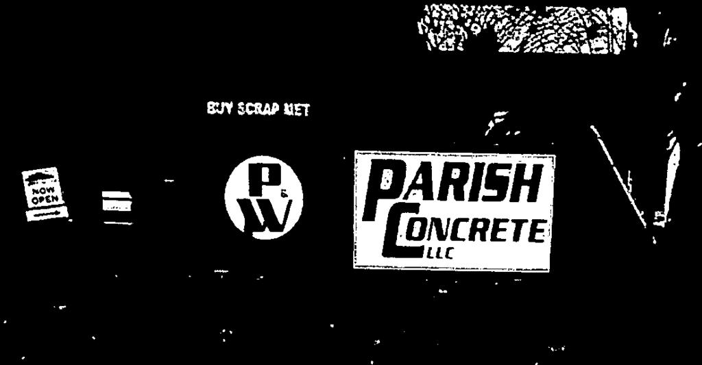
9 Warner.pjjft *II* November 6, 2018 ST. TAMMANY PARISH PATRICIA P. BRISTER PARISH PRESIDENT St. Tammany Parish Planning Commission P.O. Box 628 Covington, LA Re: Enter the Parish ROW. - Lane Monument Sign for P & W Industries, LLC/Parish Concrete, LLC Honorable Commissioners, The existing monument sign is located within the median of Warner Lane, a roadway within the Parish Maintenance System. Due to proposed improvements to LA HWY #59, the existing monument sign needs to be relocated. Subsequent to approval by the Planning Commission, additional approval will be required by the Parish Council to continue to allow this advertising sign to remain within the Parish roadway right of way. The Department of Planning and Development has no objection to the relocation of this advertising sign. Sincerely, FI Engineer xc: Honorable RykertToledano Mr. Sidney Fontenot Ms. Erin Stair Mr. Shannon Davis Mr. Earl J. Magner Mr. Chris Tissue, P.E. Mr. Theodore Reynolds, El. Ms. Cara Bartholomew Mr. Jeff Schoen, Jones Fussell, LLP JAY B. WATSON. P.E.. PARISH ENGINEER I DEPARTMENT OF PLANNING & DEVELOPMENT I I P.O. BOX 62 COVINGTON, LOUISIANA JWATSON@STPGOV.ORG 9X
(iSTRIES, LLC/PARISII CONCRETE, LLC To ENTER PARISH IW;IIT-OF-WAY.")
10 (DR/iLl DATE NOVEMBER 6, 20/8) ST. TAMMANY PARISH PLANNING COMMISSION R ES0LU IION RESOLUTION PLANNING COMMISSION SERIES NO. TITLE: A RESOLUTION AI.JTIIORIZINC P & W INI)(iSTRIES, LLC/PARISII CONCRETE, LLC To ENTER PARISH IW;IIT-OF-WAY. SUB-TITLE: A RESOL[JTION GRANTING PERMISSION To P & W INDUSTRIES, EEC/PARISH CONCRETE, EEC, 6866() LA HWY #59, MANDEVILLE, LOUISIANA TO ENTER PARISh RIGHT-OF-WAY, SPECIFICALLY THE MEDIAN OF WARNER LANE, FOR THE PURPOSE OF RELOCATIN(; A MONUMENT SIGN. WARD 4, DISTRICT 5. NOW. TI-IEREFORE, I3E IT RESOLVEI), by the St. Tammany Parish Planning Commission that t hereby grants periiiission to the alorement oned petitioner to enter Parish right o f way I or he atorenient ioned purposes. subject to the following conditions: That I lie i mprovenients that w II he ii ndertaken will he at the sole cx pense of the petit ioner. 2. That 1 lie petitioner agrees to accept lull responsi h ii ily. Financial and all 01 icr. I or the damage and br relocation of uti Ii ties currently located with in Parish right o I way. 3. That the petitioner shall su h lilt plans prepared h y a lice ii sed engineer to t lie Depart me it of Engineering br ic view and approval. Upon approval of plans an ci speci ications by t lie Di rector 01 Engineering, the pet tioner must noti I y 1lie Depart nient of Engineering prior to t lie com inc nec inc it of any activity. 4. That sliou Id the petitioner coin inence work thereon, petitioner by such act acquiesces and acknowledges therehy that he will hold tins Parish, its olheials, agents. servants, and employees free and harm less from any liability or responsi hi Ii ty whatsoever in connection with the construction of the pioject. Petitioner will provide copy of Liability Insurance Policy, including the nain i ng of the Pan sli as an insured party. The insurance will reniai ii in effect Lint I the Parish takes over the maintenance. 5. Fhat nothing herein shall be construed as a revocation of the dedication of I lie a borenien Ii onecl ri gin of way. 6. That no maintenance nor inane ial nor niaterial nor assistance slial I be provided by I lie Pan sh for the project nor the maintenance thereo I, except Ion the inspect ion (if the plans and specifications by the Department of Engineering to insure the construction coniplies with Parish specifications. 7. That the petit loner and any assignees submit a I-Iol d I-I arm less Agreement iii connection w iii t lie construe lion oft lie project. S. That I lie pet it loner subin it as built diawi ngs certifying that the protect was completed in diccordl ance wit Ii I lie approved plans. 9. That the petitioner sub ni it all doe a i nen tat ion req Lii red wit lii n ON 13(I) year fro ni date of adopt ion, additionally petitioner has two (2) years Ii) complete all work on this pmject, if not completed w i tli in two (2) years. approval of this work will be voided and petitioner will be ieq Li red to reapp Iy br permission. THIS RESOLUTION HAVING BEEN SUBM IFED TO A VOTE. THE VOTE THEREON WAS AS FOLLOWS:
 THIS RESOLUTION WAS DECLARFI) I)ULY ADOPTED ON THE DAY OF 20 AT A REGULAR")
11 (/)RAI I DA /i NOVEMBER 6, 20/N) RESOLUTION P.C. NO. PAGENO. 20F2 MOVED FOR ADOPTION BY BY FOLLOW ING: SECONDED A VOTE i I IEREON RESULTED IN THE YEA: NAY: ABSTAIN: ABS EN I: ANI) THIS RESOLUTION WAS DECLARFI) I)ULY ADOPTED ON THE DAY OF 20 AT A REGULAR MEETING OF TFIE PLANNING COMMISSION. A QUORUM OF TI-IE MEMBERS BEING PRESENT. JAMES JIMMIE DAVIS III. CI-IAIRMAN ST. TAMMANY PARISH PLANNING COMMISSION ATTEST: SIDNEY FONTENOT. SECRETARY ST. TAMMANY PARISH ILANNING COMMISSION Rei i.ved 01/251/S


12 :. C -r I,,

 Ci, CO")
 0 D CD")
 r J (5-3 -D 0")
 0, (j ) m")
13 .: 0 - CD Co (0 Co Co - a. 0 Co (0 C) 0 3 CD C,, CD C) Ci, CO CD Co C, CD C 0 C C ) 0 D CD 0 I C) C) () r J C) r J (5-3 -D 0 Cr, C CD > CII I I r ) 0, (j ) m rj) Co C-)
 I Ui > 0 I Ui NEW SIGN CONC. DR. \r.. Id \i!")

14 I,çl I I - - N I p SIGN 6.1 (14.5 X 2 ) I Ui > 0 I Ui NEW SIGN CONC. DR. \r.. Id \i! I Co -4 a, a 0 0 z II 0 CD II 0 q a, II 0 c 0 a, Co ci, 0 C%2 0 0 a I I 18 RPVCCp, : 0 0 Ii p S W
15 PRELIMINARY SUBDIVISION REVIEW
16 PRELIMINARY SUBDIVISION STAFF ANALYSIS REPORT (As of November 6, 2018) CASE NO.: PP SUBDIVISION NAME: Ashton Parc, 4th & 5th Filing DEVELOPER: First Horizon, Inc Causey Boulevard Baton Rouge, LA ENGINEER/SURVEYOR: SECTION: 26 TOWNSHIP: 8 South RANGE: 14 East Benchmark Group, LLC Pennywood Avenue Baton Rouge, LA WARD: 8 PARISH COUNCIL DISTRICT: 8 TYPE OF DEVELOPMENT: X URBAN (Residential lots less than 1 acre) SUBURBAN (Residential lots between 1-5 acres) RURAL (Residential Farm Tract lots 5 acres plus) OTHER (Multi family, commercial or industrial)(pud) GENERAL LOCATION: The property is located on the south side of Haas Road, east of U. S. Highway 11 and north of North Queens Drive, north of Slidell, LA. TOTAL ACRES IN DEVELOPMENT: NUMBER OF LOTS: 156 AVERAGE LOT SIZE: Varies SEWER AND WATER SYSTEMS: Central PROPOSED OR EXISTING ZONING: PUD FLOOD ZONE DESIGNATION: C TENTATIVE or PUD APPROVAL GRANTED: May 9, 2006 STAFF COMMENTARY: Department of Planning and Development The Preliminary plans and hydrologic study have been reviewed by this office and an inspection was made of the site. It is recommended that Preliminary submittal be approved subject to the following: 1
17 General Comments: 1. The developer has requested a waiver of the driveways on corner lots not being located closer than 60' from a corner of said property closest to the intersection as measured from the property lines on the corner of the property where the said two street rights-of-way intersect, for lots #250 and #335 only. Should the request for waiver of said regulation be granted, Lot #250 will be restricted to have its driveway located on Castine Cove and Lot # 335 will be restricted to have its driveway located on Ridgefield Drive; 2. Contact 911 addressing to lock in the proposed road names and receive addresses. Road names are subject to change until they have been verified by 911; 3. Provide written approval from the utility company of the water and sewer plans for this development; 4. LDH approval of the water distribution lines and sewer collection lines is required. Informational Items: No funded Maintenance Obligation is required since this is an extension of a private subdivision. Mandatory Developmental Fees will be required at Final Submittal in accordance with St. Tammany Code of Ordinances, Part II Land Development Code, Chapter 125 Subdivision Regulations, since no public hearing was held prior to January 1, The developer is hereby advised that upon application for final subdivision approval, the engineer of record for this development shall certify in writing that all aspects of construction have been completed in accordance with the approved plan(s) and Parish Ordinances. If any construction activity is proposed that is not in substantial compliance with the approved plan(s) and Parish Ordinances, the engineer of record for this development shall notify in writing, the Department of Development prior to beginning said construction activity. The developer and/or the engineer of record shall obtain written approval from the Department of Development prior to beginning any proposed construction activity that is not in substantial compliance with the approved plan(s) and Parish Ordinances. Revised drawings will not be accepted prior to the November 13, 2018 Planning Commission Meeting to ensure that any additional comments at the meeting can be incorporated into the revised plans. 2
18 PRELIMINARY SUBDIVISION STAFF ANALYSIS REPORT (As of November 6, 2018) CASE NO.: PP SUBDIVISION NAME: Guste Island, Parcel I DEVELOPER: McInt, LLC 845 Galvez Street Mandeville, LA ENGINEER/SURVEYOR: SECTION: 20 and 37 TOWNSHIP: 7 South RANGE: 10 East Kelly McHugh and Associates, Inc. 845 Galvez Street Mandeville, LA WARD: 1 PARISH COUNCIL DISTRICT: 4 TYPE OF DEVELOPMENT: X URBAN (Residential lots less than 1 acre) SUBURBAN (Residential lots between 1-5 acres) RURAL (Residential Farm Tract lots 5 acres plus) OTHER (Multi family, commercial or industrial)(pud) GENERAL LOCATION: The property is located east LA HWY 1085 and south of LA HWY 22 at Guste Island Road, west of the Town of Madisonville. TOTAL ACRES IN DEVELOPMENT: NUMBER OF LOTS: 77 AVERAGE LOT SIZE: 8400 Square Foot SEWER AND WATER SYSTEMS: Central PROPOSED OR EXISTING ZONING: PUD FLOOD ZONE DESIGNATION: C PUD APPROVAL GRANTED: October 13, 2004 STAFF COMMENTARY: Department of Planning and Development The Preliminary plans and hydrologic study have been reviewed by this office and an inspection was made of the site. It is recommended that Preliminary submittal be approved subject to the following: 1
19 General Comments: 1. The fill and grading statement must be revised to further identify which lots in Parcel I will be graded by the developer and which lots will be the responsibility of the individual home builder; Preliminary Plat: 2. The drainage servitude at the rear of lots must be a public servitude as all drainage in the subdivision is Parish maintained. Revise the width of the drainage servitude to meet Parish requirements; 3. Signage within Guste Island is privately maintained. Therefore, include a note on the plat indicating that the HOA will own and maintain all traffic control signs and posts; 4. LDH approval of the water distribution lines and sewer collection lines is required; Paving and Drainage Plan: 5. Revise the cross culvert at the intersection of White Dove Dr. and Fox Sparrow Loop so that the culvert crosses the road at a 90-degree angle. Informational Items: A funded Maintenance Obligation in the amount of $10,000 is required in accordance with St. Tammany Code of Ordinances, Part II Land Development Code, Chapter 125 Subdivision Regulations, funded letters of credit for existing Parish roads to ensure the repair of any damage to the Parish roads resulting from construction in connection with the subdivision. No Mandatory Developmental fee is required at Final Submittal in accordance with St. Tammany Code of Ordinances, Part II Land Development Code, Chapter 125 Subdivision Regulations, since a public hearing was held prior to January 1, The developer is hereby advised that upon application for final subdivision approval, the engineer of record for this development shall certify in writing that all aspects of construction have been completed in accordance with the approved plan(s) and Parish Ordinances. If any construction activity is proposed that is not in substantial compliance with the approved plan(s) and Parish Ordinances, the engineer of record for this development shall notify in writing, the Department of Development prior to beginning said construction activity. The developer and/or the engineer of record shall obtain written approval from the Department of Development prior to beginning any proposed construction activity that is not in substantial compliance with the approved plan(s) and Parish Ordinances. Revised drawings will not be accepted prior to the November 13, 2018 Planning Commission Meeting to ensure that any additional comments at the meeting can be incorporated into the revised plans. 2
20 CASE NO.: PP PRELIMINARY SUBDIVISION STAFF ANALYSIS REPORT (As of November 6, 2018) SUBDIVISION NAME: Bedico Creek, Parcel 14 DEVELOPER: Bedico Creek Preserve, LLC 3520 Holiday Drive; Suite 100 New Orleans, LA ENGINEER/SURVEYOR: SECTION: 31 and 6 TOWNSHIP: 6 South 7 RANGE: 10 East 10 Kelly McHugh and Associates 845 Galvez Street Mandeville, LA WARD: 1 PARISH COUNCIL DISTRICT: 1 TYPE OF DEVELOPMENT: X URBAN (Residential lots less than 1 acre) SUBURBAN (Residential lots between 1-5 acres) RURAL (Residential Farm Tract lots 5 acres plus) OTHER (Multi family, commercial or industrial)(pud) GENERAL LOCATION: The property is located south of I-12, west of LA Highway #1085 and west of Madisonville. TOTAL ACRES IN DEVELOPMENT: NUMBER OF LOTS: 56 AVERAGE LOT SIZE: Varies SEWER AND WATER SYSTEMS: Central PROPOSED OR EXISTING ZONING: PUD FLOOD ZONE DESIGNATION: A TENTATIVE or PUD APPROVAL GRANTED: May 14, 2013 STAFF COMMENTARY: Department of Planning and Development The Preliminary plans and hydrologic study have been reviewed by this office and an inspection of the site was made. It is recommended that Preliminary submittal be approved subject to the following: 1
21 General Comments: 1. The fill and grading statement must be revised to further identify which lots in Parcel 14 will be graded by the developer and which lots will be the responsibility of the individual home builder; 2. It appears that some of the downstream culverts outlined in the drainage design table did not account for sub-basin #4. Revise the design table to include this area and verify that all pipes are sized correctly. Revise pipe sizes as needed; Preliminary Plat: 3. LDH approval of the water distribution lines and sewer collection lines is required; 4. Include a north arrow and scale on the plat; 5. Show a permitted driveway area on the eastern side of lot 881. A driveway connection to the end of the T-turnaround will not be permitted; Paving and Drainage Plan: 6. Paving work is indicated outside of the footprint of the subdivision near the intersection of Kelly Lake Lane and Audubon Parkway. Construction in this area was included as part of Parcel 15. Revise the paving and drainage plan to remove this area from Parcel 14. Informational Items: No funded Maintenance Obligation is required since this is an extension of a private subdivision. No Mandatory Developmental fee is required at Final Submittal in accordance with St. Tammany Code of Ordinances, Part II Land Development Code, Chapter 125 Subdivision Regulations, since a public hearing was held prior to January 1, The developer is hereby advised that upon application for final subdivision approval, the engineer of record for this development shall certify in writing that all aspects of construction have been completed in accordance with the approved plan(s) and Parish Ordinances. If any construction activity is proposed that is not in substantial compliance with the approved plan(s) and Parish Ordinances, the engineer of record for this development shall notify in writing, the Department of Development prior to beginning said construction activity. The developer and/or the engineer of record shall obtain written approval from the Department of Development prior to beginning any proposed construction activity that is not in substantial compliance with the approved plan(s) and Parish Ordinances. Revised drawings will not be accepted prior to the November 13, 2018 Planning Commission Meeting to ensure that any additional comments at the meeting can be incorporated into the revised plans. 2
22 PRELIMINARY SUBDIVISION STAFF ANALYSIS REPORT (As of November 6, 2018) CASE NO.: PP SUBDIVISION NAME: Rigolets Estates, Phase 3A-1 DEVELOPER: Succession of Frederick J. Sigur, Frederick J. Sigur, Jr., Executor P.O. Box 59 Arabi, LA ENGINEER/SURVEYOR: G.E.C., Inc North Causeway Boulevard Metairie, LA SECTION: 37 TOWNSHIP: 10 South RANGE: 14 East 13 WARD: 8 PARISH COUNCIL DISTRICT: 13 TYPE OF DEVELOPMENT: X URBAN (Residential lots less than 1 acre) SUBURBAN (Residential lots between 1-5 acres) RURAL (Residential Farm Tract lots 5 acres plus) OTHER (Multi family, commercial or industrial)(pud) GENERAL LOCATION: The property is located west of LA HWY 90, south of LA HWY 433 and just north of the Rigolets Pass. TOTAL ACRES IN DEVELOPMENT: NUMBER OF LOTS: 35 AVERAGE LOT SIZE: Varies SEWER AND WATER SYSTEMS: Central PROPOSED OR EXISTING ZONING: PUD FLOOD ZONE DESIGNATION: V15, Elev. 15 & V15, Elev. 14 REVISED PUD APPROVAL GRANTED: October 16, 2018 STAFF COMMENTARY: Department of Planning and Development The Preliminary plans and hydrologic study have been reviewed by this office and an inspection was made of the site. 1
23 The following comments must be addressed before a work order is issued: General Comments: 1. At the time that the Rigolets Estates, Phase 3 PUD was approved, the existing phases of Rigolets Estates were a private subdivision. Therefore, the staff had no objection to the cul-de-sac at the east end of Dolphin Street instead of a connecting road. Now that all phases of Rigolets Estates will be in the Parish Maintenance System, the Dept. of Development Engineering recommends that this cul-de-sac be eliminated and have Phase 3A-1 tie-in to the existing phase. This will improve traffic flow and provide an additional outlet for Phase 3A-1, while also eliminating a dead end situation in the existing phase; 2. Rigolets Estates PUD was originally approved in 1986, however, since that time two (2) Major Amendments to the PUD have been granted by the Zoning Commission. At the time of amendment approval, the 25% greenspace requirement was in place. Therefore, the PUD must adhere to those regulations per Sec PUD - General standards and criteria. Rigolets Estates, Phase 3A- 1 as currently proposed does not meet the 25% greenspace requirement and must be revised; 3. There is a 35ft servitude across the rear of Lots 1-8 that spans the entirety of the rear yards. The rear yard setback is also 35ft. Therefore, no construction of any kind will be permitted in these backyards; 4. Contact 911 addressing to lock in the proposed road names and receive addresses. Road names are subject to change until they have been verified by 911; 5. A complete traffic study for the entirety of Rigolets Estates, Phase 3 PUD must be submitted for review and approval in accordance with Chapter 125 Subdivision Regulations, Article VI Traffic Impact Analysis; 6. DOTD approval of the TIA and a DOTD driveway permit for all Hwy 433 connections associated with this PUD is required; 7. Utility company approval of the water distribution lines and sewer collection lines is required; 8. Remove the Parcel 1 reference from the title sheet and plat; 9. Provide the geo-technical report, including the roadway design and pavement sections that will be used; 10. LDH approval of the water distribution lines and sewer collection lines is required; Preliminary Plat: 11. Revise the dedication statement to state who will be responsible for ownership and maintenance of all traffic control signs and posts; 2
24 Master Paving and Drainage Plan: 12. Provide the proposed grades for the entrance boulevard and existing ditch grades to the east and west of the entrance along Hwy 433; Master Sewer and Water Plan: 13. Show the existing water and sewer lines within the subdivision and include an existing lines to be removed note; Signage and Pavement Marking Plan: 14. Add All-Way plaques under the stop signs at the intersection of Dolphin St. and Redfish Drive, and include a typical signage installation detail on this sheet. Informational Items: Since this project is within tidal range, no detention will be required. However, the developer is required to provide fee in lieu of detention in the amount of acres x $1,500/acre = $53, No funded Maintenance Obligation is required since this subdivision fronts on a state highway. No Mandatory Developmental fee is required at Final Submittal in accordance with St. Tammany Code of Ordinances, Part II Land Development Code, Chapter 125 Subdivision Regulations, since a public hearing was held prior to January 1, The developer is hereby advised that upon application for final subdivision approval, the engineer of record for this development shall certify in writing that all aspects of construction have been completed in accordance with the approved plan(s) and Parish Ordinances. If any construction activity is proposed that is not in substantial compliance with the approved plan(s) and Parish Ordinances, the engineer of record for this development shall notify in writing, the Department of Development prior to beginning said construction activity. The developer and/or the engineer of record shall obtain written approval from the Department of Development prior to beginning any proposed construction activity that is not in substantial compliance with the approved plan(s) and Parish Ordinances. Revised drawings will not be accepted prior to the November 13, 2018 Planning Commission Meeting to ensure that any additional comments at the meeting can be incorporated into the revised plans. 3
25 FINAL SUBDIVISION REVIEW
26 FINAL SUBDIVISION STAFF ANALYSIS REPORT (As November 6, 2018) CASE NO.: FP SUBDIVISION NAME: Southern Oaks, Phase 1 DEVELOPER: Yanin, LLC Seymour Meyers Boulevard; Suite 18 Covington, LA ENGINEER/SURVEYOR: Kyle Associates, LLC Kelly McHugh and Associates 638 Village Lane North 845 Galvez Street Mandeville, LA Mandeville, LA SECTION: 16 TOWNSHIP: 7 SOUTH RANGE: 10 EAST TYPE OF DEVELOPMENT: X WARD: 1 PARISH COUNCIL DISTRICT: 4 URBAN (Residential lots less than 1 acre) SUBURBAN (Residential lots between 1-5 acres) RURAL (Residential Farm Tract lots 5 acres plus) OTHER (Multi family, commercial or industrial)(pud) GENERAL LOCATION: The property is located south of LA HWY 22, east of LA HWY 1085, west of Trepagnier Road and west of Madisonville. TOTAL ACRES IN DEVELOPMENT: NUMBER OF LOTS: 58 AVERAGE LOT SIZE: Varies SEWER AND WATER SYSTEMS: Central ZONING: PUD FLOOD ZONE DESIGNATION: C STAFF COMMENTARY: Department of Planning and Development - Engineering This project was postponed at the September 11, 2018 and the October 09, 2018 Planning Commission meetings. Periodic inspections have been made by this office during construction and the final inspection was made on October 25, The inspection disclosed that all of the concrete roads are constructed, road shoulders are constructed, and the roadside ditches are functioning. 1
27 The following uncompleted items existed at the time of the final inspection and must be completed before the plats are signed: General Comments: 1. A letter of acceptance and responsibility from the utility provider for the perpetual maintenance and operation of the water and sewer system infrastructure is required; 2. A negative bacteriological report relative to the construction of the project s water system is required; 3. Multiple hydrants were installed below grade. All fire hydrant elevations must be checked and raised where required. 4. Certification from DOTD that construction of the left turn lane on Hwy 22 is satisfactory is required; 5. The fill and grading statement indicated that the individual homebuilder would be responsible for grading the lots in accordance with the as-built drainage plan. However, many of the lots within the subdivision will require the removal of up to 2ft of material. This amount of grading is excessive and will greatly increase the likelihood of multiple drainage issues during home construction. Design revisions are recommended in order to bring the existing lot and ditch elevations into alignment with the proposed grades; Final Plat: 6. Provide another benchmark as the current benchmark is located on a residential lot; 7. Revise the dedication statement to state the H.O.A. will own and maintain all traffic control signage and mounting poles; 8. Add a restrictive covenant stating the H.O.A. or Developer will own and maintain the greenspace; 9. Revise restrictive covenant #13 to reference Chapter 125 instead of Ord. 499; As-built Drainage Plan: 10. Provide ditch invert elevations to the east and west of the subdivision entrance to verify that the roadside drainage along Hwy 22 is functioning properly; 11. Remove the garden home lots from the driveway culvert table as subsurface drainage is being provided in this area; 12. The driveway culvert table must be updated to reflect the as-built invert elevations of the ditches. 13. The as-built plan does not show positive flow in the ditches in many locations. Regrade the ditches and provide revised as-built plans showing positive flow; 14. Additional survey data is required around the entire detention pond at regularly spaced intervals to verify the correct top of bank elevation of 18ft is being met; 2
28 15. The outfall ditch section does not appear to be constructed according to the previously approved preliminary plans. Verify that the required ditch capacity is being provided and install the 24" outfall pipe at the south end of the ditch; 16. The as-built plan indicates that the green space between the lots will be a highpoint. Additional survey data or design elevations are required. If grading work is required in green space areas to conform with the as-built drainage plan, indicate who will be responsible for performing this work; 17. The proposed elevations along lots abutting green space show that there is a difference of approximately 1.5ft. How will this difference in grade be accommodated? 18. Provide an as-built cross-section for the new subsurface section along Moss Point Lane; As-built Sewer Plan: 19. Provide additional invert elevations for SMH #7 showing all four sewer line connections; 20. Provide invert elevations for the connection to the sewer lift station; As-built Signage Plan: 21. Add speed limit signs along Oak Bend Lane in accordance with the approved preliminary plans; Informational Items: Should the Planning Commission approve the request for final approval a Warranty Obligation will be required for the infrastructure in the amount of 3,095 linear feet x $25.00 per linear foot = $77,400 for a period of two (2) years. Mandatory Developmental Fees are required as follows: Road Impact Fee = $ per lot x 58 lots = $62, Drainage Impact Fee = $ per lot x 58 lots = $64,612 Fees are due before subdivision plats can be signed. This subdivision is within the AUrban Growth Boundary Line@. Revised drawings will not be accepted prior to the November 13, 2018 Planning Commission meeting to ensure that any additional comments established at the meeting can be incorporated into the revised plans. 3
29 FINAL SUBDIVISION STAFF ANALYSIS REPORT (As of November 6, 2018) CASE NO.: FP SUBDIVISION NAME: Money Hill Plantation, Phase 7B-1 DEVELOPER: Money Hill Plantation, LLC 100 Country Club Drive, Abita Springs, LA ENGINEER/SURVEYOR: J. V. Burkes and Associates, LLC 1805 Shortcut Highway Slidell, LA SECTION: 12 TOWNSHIP: 6 SOUTH RANGE: 12 EAST WARD: 6 PARISH COUNCIL DISTRICT: 6 TYPE OF DEVELOPMENT: X URBAN (Residential lots less than 1 acre) SUBURBAN (Residential lots between 1-5 acres) RURAL (Residential Farm Tract lots 5 acres plus) OTHER (Multi family, commercial or industrial)(pud) GENERAL LOCATION: The property is located north of LA HWY #435 and east of Abita Springs. TOTAL ACRES IN DEVELOPMENT: NUMBER OF LOTS: 23 AVERAGE LOT SIZE: Varies SEWER AND WATER SYSTEMS: Central ZONING: PUD FLOOD ZONE DESIGNATION: C STAFF COMMENTARY: Department of Planning and Development - Engineering Periodic inspections have been made by this office during construction and the final inspection was made on October 31, The inspection disclosed that all of the asphalt roads and shoulders are constructed and that the roadside ditches are constructed and functioning properly. The following uncompleted items existed at the time of the final inspection and will be completed before the plats are signed: 1
30 General Comments: 1. A letter of acceptance and responsibility from the utility provider for the perpetual maintenance and operation of the water and sewer system infrastructure is required; 2. Section states that all lots within new subdivision must have either a public or private street or road frontage constructed for the full lot frontage. Therefore, a waiver of the regulations is required since Camphill Dr. does not extend across the entire length of lot 407; Final Plat: 3. Provide clarification for the purpose of the 50ft buffer at the rear of lots This buffer was previously labeled as a 50ft maintenance servitude on the approved preliminary plans; 4. Remove the under construction note as the lift station has been constructed; 5. Remove the driveway culvert schedule from the plat and include this information on the as-built drainage plan; 6. Revise restrictive covenant #9 to state that the park area and traffic signage will also be owned and maintained by the HOA; As-built Drainage Plan: 7. A fill and grading statement must be provided to this office and the final plat and/or the as-built drainage plan must be updated accordingly; 8. Provide drainage arrows on all lots; 9. Remove the drainage note and replace this information with the culvert table from the final plat; 10. Lot 419 appears to be at the highpoint of the ditch section. Verify that a culvert is required at this location. If no culvert is required, then revise the culvert table accordingly; 11. The bold print invert elevations on this sheet are the design elevations, not the as-built elevations. Revise the as-built data is bold note accordingly. As-built Sewer Plan: 12. Replace the design sewer slopes with as-built sewer slopes; 13. The bold print invert elevations on this sheet are the design elevations, not the as-built elevations. Revise the as-built data is bold note accordingly. 14. The minimum recommended slope of 0.4% was not achieved for the sewer main between manholes 4 & 5 and manholes 11 & 12. Provide verification that a minimum clearing velocity of 2ft/sec can be 2
31 achieved with the existing slope. As-built Signage Plan: 15. Revise this sheet to include the end-of-roadway signage and speed limit signs that are installed. Informational Items: Should the Planning Commission approve the request for final approval a Warranty Obligation will be required for the infrastructure in the amount of 2596 linear feet x $22.00 per linear foot = $57,100 for a period of two (2) years. The staff recommends approval of the proposed final subdivision request subject to the developer complying with all comments and no plats to be signed until all items are satisfactorily completed. No Mandatory Development fees are required since a public hearing was held prior to January 1, This subdivision is not within the AUrban Growth Boundary Line.@ Revised drawings will not be accepted prior to the November 13, 2018 Planning Commission meeting to ensure that any additional comments established at the meeting can be incorporated into the revised plans. 3
32 OLD BUSINESS


33 November 7, 2018 St. Tammany Parish Planning Commission P.O. Box 628 Covington, LA ST. TAMMANY PARISH PATRICIA P. BRISTER PARISH PRESIDENT Old Business November 13, 2018 Re: MSP Minor Subdivision Honorable Commissioners, The above captioned Minor Subdivision was postponed indefinitely at the June 12, 2018 meeting due the petitioner having to go through the zoning change process. The zoning changed has been approved and the minor subdivision can now be reviewed. The petitioner has requested to be placed on the December 11, 2018 Planning Commission agenda. )lomew CARA BARTHOLOMEW., PARISH PLANNER DEPARTMENT OF PLANNING & DEVELOPMENT P.O. BOX 628 L COVINGTON, LOUISIANA I QLBARTHOLOMEW(a STPGOV.ORG


34 Gulf November 6, 2018 St. Tammany Parish Planning Commission P.O. Box 628 Covington, LA ST. TAMMANY PARISH PATRICIA P. BRISTER PARISH PRESIDENT Old Business November 13, 2018 Re: The Preserve at Good bee Lakes Honorable Commissioners, The above captioned subdivision was postponed indefinitely at the October 9, 2018 Planning Commission meeting. At the meeting, Mr. Schoen verbally requested this subdivision be placed on the November 13, 2018 Planning Commission Agenda under Old Business. Should the Commission approve Mr. Schoen s request, The Preserve at Goodbee Lakes will be placed on the December 11, 2018 Planning Commission agenda under Preliminary. Sincerely, }%f. Watson, P.E. (aa!ish Engineer xc: Honorable James Thompson Mr. Sidney Fontenot Ms. Erin Stair Mr. Earl J. Magner Mr. Chris Tissue, P.E. Mr. Theodore Reynolds, E.I. Ms. Cara Bartholomew Mr. Jeff Vallee, D.R. Horton, Inc. - Coast Mr. Jeff Schoen, Jones Fussell, LLP JAY B. WATSON. P.E., PARISH ENGINEER DEPARTMENT OF PLANNING & DEVELOPMENT P0. BOX 62X COVINGTON. LOUISIANA 7fl434 JWATSON@STPGOV.ORG


35 *f November 6, 2018 St. Tammany Parish Planning Commission P.O. Box 628 Covington, LA ST. TAMMANY PARISH PATRICIA P. BRISTER PARISH PRESIDENT Old Business November 13, 2018 Re: Preserve at River Chase, Phase 1A and lb Act of Amendment Honorable Commissioners, The above captioned Act of Amendment has been reviewed by the Department of Development - Engineering and no objection is offered. Therefore, it is recommended that the Act of Amendment be approved to amend the width of the PSOP in Phase 1A and 18 along lots #1-#16 and #43 from 27 to 22 and to amend the lot width of lots #1-1*10 in Phase 1A. Sincerely, E. Pan h Engineer Enclosure: Act of Amendment, Recorded Plat for Phase 1A and Phase lb. and Exhibit A xc: Honorable Marty Dean Mr. Sidney Fontenot Ms. Erin Stair Mr. Earl J. Magner Mr. Chris Tissue, P.E. Mr. Theodore Reynolds, E.l. Ms. Cara Bartholomew Mr. Jeff Schoen, Jones Fussell, LLP JAY B. WATSON. PP., PARISH ENGINEER DEPARTMENT OF PLANNING & DEVELOPMENT P0. BOX 628 COVINGTON. LOUISIANA JWATSON@STPGOV.ORG I

36 ACT OF AMENDMENT OF SUBDIVISION PLAT UNITED STATES OF AMERICA STATE OF LOUISIANA PARISH OF ST. TAMMANY BEFORE ME, the undersigned Notary Public, duly commissioned and qualified in and for the State of Louisiana, and the Parish of St. Tammany, PERSONALLY CAME AND APPEARED: Barry J. Bleichner, P.E., P.L.S. 4422, REGISTERED PROFESSIONAL LAND SURVEYOR Who begin first duly sworn by me, did depose and state that: After further examination of the official subdivision plats for The Preserve at River Chase Subdivision Phases 1-A & 1-B recorded July 30, 2018 and November 02, 2018, respectively, filed as Map File Nos and 5800, respectively, in the Clerk of Court, St. Tammany Parish, Louisiana, it was discovered that an amendment needs to be made to said plats. On lots 1 through 10 and on lots X-1 and 43 in Phase 1-A and on lots 11 through 16 in Phase 1- B, areas designated as PSOP & Utility Serv. or Alley PSOP & Utility Serv. along the rear of the lots is feet wide. Lots 1 through 10 and lot X-1 in Phase 1-A are dimensioned as shown on the final plat as referenced in this document. In order to amend the recorded Subdivision Plats, the undersigned does hereby amend the subdivision plat for The Preserve at River Chase Phases 1-A & 1-B as follows: On lots 1-A through 10-A and on lots X-1-A and 43 in Phase 1-A and on lots 11 through 16 in Phase 1-B, areas designated as PSOP & Utility Serv. or Alley PSOP & Utility Serv. along the rear of the lots is feet wide. Lots 1 through 10 and lot X-1 in Phase 1-A are to be subdivided and designated as lots 1-A through 10-A and lot X- 1-A. Lots 1-A through 10-A and lot X-l-A in Phase 1-A are to be dimensioned as shown on Exhibit A attached hereto and made a part of this document. Affiant does hereby authorize and request the Clerk of Court of St. Tammany Parish, Louisiana to make mention on the face of the Subdivision Plat recorded in Clerks Map File Nos and 5800), to serve as the occasion may require.


37 THUS DONE AND PASSED at undersigned competent witnesses and me, Notary, on the Louisiana, in the presence of the day of WITNESS Barry J. Bleichner, P.E., P.L.S. PROFESSIONAL LAND SURVEYOR Louisiana Registered, P.L.S WITNESS Notary Public Notary ID/Bar No. (As Applicable): Louisiana My commission expires:

38 THUS DONE AND PASSED at undersigned competent witnesses and me, Notary, on the Louisiana, in the presence of the day of ST. TAMMANY PARISH GOVERNMENT WITNESS BY: PATRICIA P. BRISTER PARISH PRESIDENT WITNESS Notary Public Notary I.D.IBar No. (As Applicable): Louisiana My commission expires:


39 te


40 ( I1i t A j Al V - _L_J J L NO3CI : - WNVlSIflO I HUNWd AMWWWVL IS.LOIUlSlfl SIWi W9SSN33SD 315U tl.l SVHd COd SlAIli LW =- j2 - - a: N- r r -v-- -1?-1-- j: _E OW0011d ,or ill a ö g 1öTrtTh aiw 4s.p100laGHzu? lvld ;----t Z:LfN -z\ I: 4 ;. a- / JSHd4Ut 3095W ( ooil202) 0-1 CiEi1HX)3b
 r? ft!")


D - S SN N S 4 11 THE")

41 V F VIC/NI Up MAP SCALE U2,OOO B OYL/1 SWR?l 10T 0 Ar) r? ft! / THE PRESERVE AT RICOH CHASE PUS PHASES IA & RB SECTION 47,T T S, RIlE ONEENSEURS LAND DISTRICT ST TANCIHAI1Y PARISH, LOUISIANA WAY :1 - I, /L; PLACE I4 oil \ rim - C W001r toe-1 - COH1ACENTUL CR011 ISO SOW) I It -, - h.. -.L -: OW taco I OW) OEL\ N 1, U ACt1/4FTh)D - S SN N S 4 11 THE PRESER VEATRIVER CHASE PHASES IA & lb ACTOFAMENDMENT IXHIBU A LOCATED IN SECT10N47 T-7-S, R-II-N OLD. ST TAMMANYPAR!SN, LOUISIANA
ST. TAMMANY PARISH COUNCIL RESOLUTION RESOLUTION TO ESTABLISH WARRANTY AND PERFORMANCE OBLIGATIONS
 ST. TAMMANY PARISH COUNCIL RESOLUTION RESOLUTION COUNCIL SERIES NO: C-5008 COUNCIL SPONSOR: BLANCHARD/BRISTER PROVIDED BY: ENGINEERING RESOLUTION TO ESTABLISH WARRANTY AND PERFORMANCE OBLIGATIONS WHEREAS,
AGENDA ST. TAMMANY PARISH PLANNING COMMISSION MEETING 6:00 P.M. - TUESDAY, NOVEMBER 14, 2006 ST. TAMMANY PARISH LA HWY
 ROLL CALL AGENDA MEETING 6:00 P.M. - TUESDAY, ST. TAMMANY PARISH LA HWY. 59 - KOOP DRIVE COMPLEX 21490 KOOP DRIVE, PARISH COUNCIL CHAMBERS PUBLIC ANNOUNCEMENTS - Phones and Pagers - Appeals - Speaker Cards
AGENDA ST. TAMMANY PARISH PLANNING COMMISSION MEETING 6:00 P.M. - TUESDAY, OCTOBER 10, 2006 ST. TAMMANY PARISH LA HWY
 MEETING 6:00 P.M. - TUESDAY, ST. TAMMANY PARISH LA HWY. 59 - KOOP DRIVE COMPLEX 21490 KOOP DRIVE, PARISH COUNCIL CHAMBERS DRAFT ROLL CALL PUBLIC ANNOUNCEMENTS - Phones and Pagers - Appeals - Speaker Cards
AGENDA ST. TAMMANY PARISH PLANNING COMMISSION MEETING 6:00 P.M. - TUESDAY, APRIL 11, 2006 ST. TAMMANY PARISH LA HWY
 MEETING 6:00 P.M. - TUESDAY, ST. TAMMANY PARISH LA HWY. 59 - KOOP DRIVE COMPLEX 21490 KOOP DRIVE, PARISH COUNCIL CHAMBERS DRAFT ROLL CALL PUBLIC ANNOUNCEMENTS - Phones and Pagers - Appeals - Speaker Cards
ST. TAMMANY PARISH COUNCIL RESOLUTION A RESOLUTION TO ESTABLISH PERFORMANCE AND WARRANTY OBLIGATIONS
 ST. TAMMANY PARISH COUNCIL RESOLUTION RESOLUTION COUNCIL SERIES NO: C-4891 COUNCIL SPONSOR: STEFANCIK/BRISTER PROVIDED BY: ENGINEERING A RESOLUTION TO ESTABLISH PERFORMANCE AND WARRANTY OBLIGATIONS WHEREAS,
AGENDA ST. TAMMANY PARISH PLANNING COMMISSION MEETING 6:00 P.M. - TUESDAY, JULY 13, 2004 ST. TAMMANY PARISH LA HWY
 ROLL CALL AGENDA MEETING 6:00 P.M. - TUESDAY, ST. TAMMANY PARISH LA HWY. 59 - KOOP DRIVE COMPLEX 21490 KOOP DRIVE, PARISH COUNCIL CHAMBERS DRAFT INVOCATION PLEDGE OF ALLEGIANCE APPROVAL OF THE JUNE 8,
ST. TAMMANY PARISH PATRICIA P. BRISTER PARISH PRESIDENT
 TENTATIVE SUBDIVISION APPROVAL CHECK SHEET Revised October 5, 2018 The Developer shall submit a request for Tentative Plan Review to the Department of Planning & Development in the appropriate format.
PUBLISHED JANUARY 27, POSTED AT PARISH COMPLEX FEBRUARY 1, 2005 AGENDA ST. TAMMANY PARISH COUNCIL MEETING
 Page 1 of 8 Link to original Document here PUBLISHED JANUARY 27, 2005 - POSTED AT PARISH COMPLEX FEBRUARY 1, 2005 AGENDA ST. TAMMANY PARISH COUNCIL MEETING THURSDAY, FEBRUARY 3, 2005 AT 6:00 P.M. ST. TAMMANY
ENTERING PARISH RIGHT-OF-WAY, SERVITUDES, EASEMENTS & TAMMANY TRACE
 ROLL CALL AGENDA ST. TAMMANY PARISH PLANNING COMMISSION MEETING 6:00PM TUESDAY, JANUARY 8, 2019 ST. TAMMANY PARISH GOVERNMENT COMPLEX PARISH COUNCIL CHAMBERS 21490 KOOP DRIVE, MANDEVILLE, LOUISIANA PUBLIC
SUBDIVISION APPLICATION
 SUBDIVISION APPLICATION Preliminary Plat Minor Plat Final Plat Amended Plat Applicant Name: Owner (if different from applicant) Name: Company: Company: Address: Address: City, State, Zip City, State, Zip
SUBDIVISION PLAT CHECKLIST. The following information shall be include on the plat:
 SUBDIVISION PLAT CHECKLIST Subdivision Name: Land Surveyor: Owner/Developer: Date Submitted: The following information shall be include on the plat: The plat shall be drawn at a scale of one inch equals
FINAL PLAT APPLICATION
 FINAL PLAT APPLICATION (Page 1 of 3) LEGAL OWNER(s): NAME: STREET ADDRESS OWNER(s): CITY, STATE, ZIP CODE: PHONE NUMBER: BILLING ADDRESS: NAME OF ENGINEER/SURVEYOR: Engineer/Surveyor Address, Phone: PROPERTY
SUBMITTAL REQUIREMENTS: The number indicates the number of copies for submittal (if applicable).
.") Office Use Only Preliminary Long Plat Long Subdivision Applicant Checklist PLANNING, COMMUNITY, & ECONOMIC DEVELOPMENT DEPARTMENT PRELIMINARY LONG PLAT LONG SUBDIVISION CHECKLIST Mailing Address: P.O.
Office Use Only Preliminary Long Plat Long Subdivision Applicant Checklist PLANNING, COMMUNITY, & ECONOMIC DEVELOPMENT DEPARTMENT PRELIMINARY LONG PLAT LONG SUBDIVISION CHECKLIST Mailing Address: P.O.
CITY OF DECATUR, TEXAS
 Final Plat or Amending Plat / Replat Checklist A submittal of a complete application will facilitate a timely review. Failure of the applicant to provide required information or obtain a waiver from the
Lake County Planning, Building and Development Department
 SUBMISSION CHECKLIST FOR SUBDIVISION FINAL PLAT Lake County Planning, Building and Development Department 500 W. Winchester Rd. Unit 101 Libertyville, Illinois 60048-1331 Telephone (847) 377-2600 E-mail:
TOWN OF LEWISTON PLANNING BOARD APPLICATION
 TOWN OF LEWISTON PLANNING BOARD APPLICATION DESCRIPTION OF PROPOSED REQUEST: Name of Property Owner: Phone #: Name of Applicant:Phone #: Address or Location of Proposal:_SBL# Size of Parcel or Structure:Existing
CITY OF STRONGSVILLE PLANNING COMMISSION APPLICATION CLUSTER SUBDIVISION
 CITY OF STRONGSVILLE PLANNING COMMISSION APPLICATION CLUSTER SUBDIVISION After meeting with City Planner, George Smerigan (if necessary) regarding zoning requirements, submit the following: An application
Residential Minor Subdivision Review Checklist
 Residential Minor Subdivision Review Checklist Plan Submittal Requirements: 2 full sets of stamped plans Electric submittal - all plans contained in a single PDF 3 full sets if commercial kitchen or dining
SUBMITTAL REQUIREMENTS: The number indicates the number of copies for submittal (if applicable).
.") Office Use Only Preliminary Long Plat Long Subdivision Applicant Checklist PLANNING, COMMUNITY, & ECONOMIC DEVELOPMENT DEPARTMENT FINAL LONG PLAT LONG SUBDIVISION CHECKLIST Mailing Address: P.O. Box 547,
Office Use Only Preliminary Long Plat Long Subdivision Applicant Checklist PLANNING, COMMUNITY, & ECONOMIC DEVELOPMENT DEPARTMENT FINAL LONG PLAT LONG SUBDIVISION CHECKLIST Mailing Address: P.O. Box 547,
Memphis City Council Summary Sheet. S.D Roland Road Street Right-of-Way Dedication
 Memphis City Council Summary Sheet S.D. 16-01 Roland Road Street Right-of-Way Dedication Resolution requesting a Street Dedication south of U.S. Hwy 64 at the southern terminus of Roland Road to extend
SUBDIVISION APPLICATION
 SUBDIVISION APPLICATION City of Horn Lake Planning Department 3101 Goodman Road, W Horn Lake, MS 38637 662-342-3559 Fax: 662-342-3485 Applications due the 1st working day of the month. Submit application
Rick Keeler Bonney Ramsey Melissa Ballard Jim Phillips Rodney Bell
 A regular meeting of the Planning & Zoning Commission of the City of Waxahachie was held on Tuesday, at 7:00 p.m. in the Council Chamber at 401 S. Rogers, Waxahachie, Texas. Members Present: Member Absent:
SUBDIVISION DESIGN PRINCIPLES AND STANDARDS
 SECTION 15-200 SUBDIVISION DESIGN PRINCIPLES AND STANDARDS 15-201 STREET DESIGN PRINCIPLES 15-201.01 Streets shall generally conform to the collector and major street plan adopted by the Planning Commission
A-3(Suburban District), I-1(Industrial District) & I-2 (Industrial District)
, I-1(Industrial District) & I-2 (Industrial District)") AGENDA ST. TAMMANY PARISH ZONING COMMISSION MEETING MANDEVILLE, LA ROLL CALL CALL TO ORDER ANNOUNCEMENTS Phones and Pagers Appeals Speaker Cards Public Speaking - Ten (0) minutes each side and five (5)
AGENDA ST. TAMMANY PARISH ZONING COMMISSION MEETING MANDEVILLE, LA ROLL CALL CALL TO ORDER ANNOUNCEMENTS Phones and Pagers Appeals Speaker Cards Public Speaking - Ten (0) minutes each side and five (5)
CONCEPT PLAN APPLICATION Meeting with Staff Commercial Projects
 COMMUNITY DEVELOPMENT City of South Salt Lake Community Development Department 220 E. Morris Avenue South Salt Lake City, Utah 84115 Phone (801) 483-6011 Fax (801) 483-6060 CONCEPT PLAN APPLICATION Meeting
APPLICATION PROCEDURE
 ANTRIM PLANNING BOARD P. O. Box 517 Antrim, New Hampshire 03440 Phone: 603-588-6785 FAX: 603-588-2969 APPLICATION FORM AND CHECKLIST FOR MINOR OR MAJOR SITE PLAN REVIEW File Date Received By APPLICATION
BOSSIER CITY PARISH METROPOLITAN PLANNING COMMISSION 620 Benton Rd. Bossier City, LA Phone: Fax: PRELIMINARY PLAT
 (OFFICE USE ONLY) Application Fee: Paid: Date: CASE # Project Information BOSSIER CITY PARISH METROPOLITAN PLANNING COMMISSION 620 Benton Rd. Bossier City, LA 71111 Phone: 318-741-8824 Fax: 318-741-8827
SUBDIVISION AND LAND DEVELOPMENT. 185 Attachment 20
 185 Attachment 20 APPENDIX S Plat No. Date of Submission Twp. Fee $ Dauphin Co. Fee $ TOWNSHIP OF DERRY SUBDIVISION OR LAND DEVELOPMENT PLAN SUBMISSION APPLICATION This block for Twp. use only 1. Title
MINOR PLAT. The following documents are provided as required by the City of Conroe for use in the above titled platting submittals:
 Public Works - Engineering Division CITY OF CONROE MINOR PLAT The following documents are provided as required by the City of Conroe for use in the above titled platting submittals: Submittal Questionnaire
ST. TAMMANY PARISH COUNCIL ORDINANCE
 ST. TAMMANY PARISH COUNCIL ORDINANCE ORDINANCE CALENDAR NO: 5969 COUNCIL SPONSOR: BLANCHARD/BRISTER ORDINANCE COUNCIL SERIES NO: PROVIDED BY: LEGAL DEPARTMENT INTRODUCED BY: SECONDED BY: ON THE 5 DAY OF
LYON COUNTY COMMUNITY DEVELOPMENT DEPARTMENT
 LYON COUNTY COMMUNITY DEVELOPMENT DEPARTMENT B UILDING D EVELOPMENT E NGINEERING P LANNING 27 S. MAIN S TREET Y ERINGTON, NEVADA 89447 (775) 463-6591 F AX: (775) 463-5305 34 LAKES B OULEVARD D AYTON, NEVADA
RLCEIVED. -4 %-z. p=6
 St Tammany Parish Government Dcprtment of DvIopmerit P 0. Box 628 Covington, LA 70434 Phone: (985) 898-2529 Fax: (985) 898-3003 e-mail: planning@stpgov.org Pat Brister Parish President THE PETITIONER OR
FINAL PLAT CHECKLIST
 FINAL PLAT CHECKLIST Project Name: Tax ID #: Project Number: Date: _ Reviewed By: Telephone: Please address all items marked with an "X" Please return redline comments with corrected plan, original mylar,
PLANNING COMMISSION Thursday, September 5, :00 p.m. Council Chambers, Administration Building 100 Ribaut Road, Beaufort, South Carolina
 PLANNING COMMISSION Thursday, September 5, 2013 6:00 p.m. Council Chambers, Administration Building 100 Ribaut Road, Beaufort, South Carolina In accordance with South Carolina Code of Laws, 1976, Section
MAJOR RESIDENTIAL AND NONRESIDENTIAL SUBDIVISIONS
 Lawrence-Douglas County MAJOR RESIDENTIAL AND NONRESIDENTIAL SUBDIVISIONS Preliminary Plats The applicant shall schedule a Pre-Application meeting with Planning Staff at least seven (7) working days prior
Residential Major Subdivision Review Checklist
 Residential Major Subdivision Review Checklist Plan Submittal Requirements: 2 full sets of stamped plans Electric submittal - all plans contained in a single PDF 3 full sets if commercial kitchen or dining
CITY OF SARALAND FINAL SUBDIVISION PLAT REVIEW
 CITY OF SARALAND FINAL SUBDIVISION PLAT REVIEW Application Number: Date Plat Submitted: Name of Subdivision: Name of Owner: Owner Address: (Street or P.O. Box) Telephone #: (City) (State) (Zip) E-mail:
ARTICLE 900 PLAT AND PLAN REQUIREMENTS
 ARTICLE 900 PLAT AND PLAN REQUIREMENTS SEC. 900.1 ITEMS TO BE SHOWN ON PLAT OR PLAN General (1) Property lines of all property owners adjacent to the exterior boundaries of the project shall be located
ACTION SHEET PLANNING BOARD PORTSMOUTH, NEW HAMPSHIRE CITY HALL, MUNICIPAL COMPLEX, 1 JUNKINS AVENUE 7:00 P.M. NOVEMBER 17, 2016
 ACTION SHEET PLANNING BOARD PORTSMOUTH, NEW HAMPSHIRE CITY HALL, MUNICIPAL COMPLEX, 1 JUNKINS AVENUE 7:00 P.M. NOVEMBER 17, 2016 MEMBERS PRESENT: ALSO PRESENT: MEMBERS ABSENT: John Ricci, Chairman; Elizabeth
UPPER ALLEN TOWNSHIP PLANNING COMMISSION REGULAR MEETING August 27, :00 P.M.
 UPPER ALLEN TOWNSHIP PLANNING COMMISSION REGULAR MEETING August 27, 2018 7:00 P.M. PC MEMBERS TOWNSHIP OFFICIALS - PRESENT R. Wayne Willey, Chairperson Jennifer Boyer, Comm. Dev. Director Philip Cerveny,
CITY OF STRONGSVILLE PLANNING COMMISSION APPLICATION SINGLE FAMILY SUBDIVISION
 CITY OF STRONGSVILLE PLANNING COMMISSION APPLICATION SINGLE FAMILY SUBDIVISION After meeting with City Planner, George Smerigan (if necessary) regarding zoning requirements, submit the following: Pursuant
ARTICLE 15. RULES, REGULATIONS AND DEFINITIONS
 ARTICLE 15. RULES, REGULATIONS AND DEFINITIONS Section 1. Interpretation and Construction: The following rules and regulations regarding interpretation and construction of the Ulysses-Grant County, Kansas,
BRIDGETON SUBDIVISION APPLICATION CHECKLIST
 APPLICATION NAME AND # CHECKLIST COMPLETED BY: DATE: Signature and printed name BRIDGETON SUBDIVISION APPLICATION CHECKLIST TO SUBDIVISION APPLICANTS: The attached checklist is to assist you in the submission
ELK RAPIDS TOWNSHIP ANTRIM COUNTY, MICHIGAN ORDINANCE NO
 ELK RAPIDS TOWNSHIP ANTRIM COUNTY, MICHIGAN ORDINANCE NO. 3-2011 AN ORDINANCE TO REPLACE THE SUBDIVISION CONTROL ORDINANCE WITH A NEW SUBDIVISION DEVELOPMENT ORDINANCE, IN ACCORD WITH THE LAND DIVISION
City of Ferndale CITY COUNCIL STAFF REPORT
 SUBJECT: Final Plat Approval DATE: January 19, 2016 FROM: Haylie Miller, Assistant Planner PRESENTATION BY: Haylie Miller City of Ferndale CITY COUNCIL STAFF REPORT MEETING DATE: January 19, 2016 AGENDA
FINAL PLAT GUIDE TO SUBDIVIDING PROPERTY. Background
 FINAL PLAT GUIDE TO SUBDIVIDING PROPERTY Background A final plat is the second step in the process of subdividing land into separate parcels for future sale or lease. Once a preliminary plat has been approved
The purpose of this Chapter is to establish rules, regulations, standards and procedures for approval of subdivisions of land to promote and ensure:
 CHAPTER 7 SUBDIVISION SECTION 7.1 PURPOSE The purpose of this Chapter is to establish rules, regulations, standards and procedures for approval of subdivisions of land to promote and ensure: A. Conformity
SUMNER COUNTY PLANNING COMMISSION MINUTES NOVEMBER 27, :00 P.M.
 SUMNER COUNTY PLANNING COMMISSION MINUTES 5:00 P.M. SUMNER COUNTY ADMINISTRATION BUILDING BETHEL BROWN COUNTY CHAMBERS 355 N. BELVEDERE DRIVE GALLATIN, TN. 37066 MEMBERS PRESENT: LUTHER BRATTON, CHAIRMAN
MINOR SUBDIVISION PLAT CHECKLIST
 MINOR SUBDIVISION PLAT CHECKLIST Project Name: Tax ID #: Project Number: Date: _ Reviewed By: Telephone: NOTES: All lots on septic systems must comply with the Fulton County Health Department requirements
A. CONSIDERATION OF THE UNAPPROVED MINUTES OF NOVEMBER 13, 2018
 I. CALL TO ORDER OFFICIAL AGENDA PLANNING & ZONING COMMISSION CITY OF STARKVILLE, MISSISSIPPI MEETING OF TUESDAY, DECEMBER 11, 2018 1ST FLOOR CITY HALL COURT ROOM 110 WEST MAIN STREET AT 5:30 PM II. III.
Chapter 22 LAND USE* Article III. Subdivisions
 Chapter 22 LAND USE* Article III. Subdivisions Sec. 22-256. Authority to Regulate. Sec. 22-257. Scope; plat required. Sec. 22-258. Definitions. Sec. 22-259. Interpretations and Meanings. Sec. 22-260. Procedure
FINAL SUBDIVISION AND LAND DEVELOPMENT PLAN CHECKLIST. Plan Name. Applicant's Name:
 TOWNSHIP OF UPPER ST. CLAIR FINAL SUBDIVISION AND LAND DEVELOPMENT PLAN CHECKLIST Date Filed Plan Name PLC Applicant's Name: Phone Filing Date for Final Application Final Plat 114.22. FINAL APPLICATION
STATE OF MICHIGAN COUNTY OF BERRIEN ORONOKO CHARTER TOWNSHIP PRIVATE ROAD ORDINANCE ORDINANCE NO. 65
 STATE OF MICHIGAN COUNTY OF BERRIEN ORONOKO CHARTER TOWNSHIP PRIVATE ROAD ORDINANCE ORDINANCE NO. 65 AN ORDINANCE TO REQUIRE THAT ALL LOTS OR PARCELS OF LAND WHICH DO NOT ABUT PUBLIC STREETS ABUT A PRIVATE
City of Prior Lake APPLICATION FOR COMBINED PRELIMINARY AND FINAL PLAT
 Case File No. Property Identification No. City of Prior Lake APPLICATION FOR COMBINED PRELIMINARY AND FINAL PLAT Requested Action Brief description of proposed project (Please describe the proposed amendment,
-MENDOCINO COUNTY PLANNING AND BUILDING SERVICES- DIVISION OF LAND REGULATIONS TITLE 17
 ARTICLE VI -- GENERAL REGULATIONS AND PROVISIONS Sec. 17-50. Sec. 17-51 General Plan. Sec. 17-52 Lot and Block Design and Configuration. Sec. 17-53 Lot Access. Sec. 17-54 Private Roads. Sec. 17-55 Water
Preliminary Subdivision Application (Minor) (Three (3) lots or less)
 (Three (3) lots or less)") Gunnison City Offices www.gunnisoncity.org 38 West Center Gunnison, Utah 84634 (435) 528 7969 Date of Application: Preliminary Subdivision Application (Minor) (Three (3) lots or less) APPLICANT INFORMATION
Gunnison City Offices www.gunnisoncity.org 38 West Center Gunnison, Utah 84634 (435) 528 7969 Date of Application: Preliminary Subdivision Application (Minor) (Three (3) lots or less) APPLICANT INFORMATION
PLANNING COMMISSION REPORT REGULAR AGENDA. PC Staff Report 08/25/10 ITEM NO 6: PRELIMINARY PLAT; HALLMARK ADDITION; ACRES; 151 MCDONALD DR (MKM)
") PP-6-6-10 Item No. 6-1 PLANNING COMMISSION REPORT REGULAR AGENDA PC Staff Report 08/25/10 ITEM NO 6: PRELIMINARY PLAT; HALLMARK ADDITION; 5.252 ACRES; 151 MCDONALD DR (MKM) PP-6-6-10: Consider a Preliminary
PP-6-6-10 Item No. 6-1 PLANNING COMMISSION REPORT REGULAR AGENDA PC Staff Report 08/25/10 ITEM NO 6: PRELIMINARY PLAT; HALLMARK ADDITION; 5.252 ACRES; 151 MCDONALD DR (MKM) PP-6-6-10: Consider a Preliminary
Township of Little Egg Harbor Planning Board 665 Radio Road Little Egg Harbor, New Jersey Phone: ext. 221 Fax:
 BLOCK(S) LOT(S) Township of Little Egg Harbor Planning Board 665 Radio Road Little Egg Harbor, New Jersey 08087 Phone: 609-296-7241 ext. 221 Fax: 609-294-3040 Development Application Amended Development
THE CI FY OF MOBILE, ALABAMA
 THE CI FY OF MOBILE, ALABAMA LETTER OF DECISION DewberryiPreble-Rish 9949 Bellaton Avenue Daphne, AL 36526 Re: Area bounded by Foxtail Drive, Lace Bark Drive and Whitebark Drive Council District 6 SUB-000323-2017
E L M E R B O R O U G H L A N D U S E B O A R D APPLICATION COVER SHEET (to be completed for all applications and appeals)
") E L M E R B O R O U G H L A N D U S E B O A R D APPLICATION COVER SHEET (to be completed for all applications and appeals) 1. Name(s): 2. Address: 3. Telephone Number(s): 4. E-mail: 5. Owner Name(s) (if
E L M E R B O R O U G H L A N D U S E B O A R D APPLICATION COVER SHEET (to be completed for all applications and appeals) 1. Name(s): 2. Address: 3. Telephone Number(s): 4. E-mail: 5. Owner Name(s) (if
MINOR SUBDIVISION FINAL PLAT APPLICATION Town of Apex, North Carolina
 MINOR SUBDIVISION FINAL PLAT APPLICATION Town of Apex, North Carolina This document is a public record under the North Carolina Public Records Act and may be published on the Town s website or disclosed
MINUTES AND WRITTEN DECISIONS PLANNING COMMISSION DECEMBER 13, Meeting was called to order by Chairman Matthew Pryor.
 The below minutes and written decisions are taken from the meeting to represent items addressed and actions taken by this board. All meetings are recorded with video and audio for our records. In the event
REPORT TO THE PLANNING COMMISSION
 Agenda Number: PC14-50 MEETING DATE: February 5, 2015 REPORT TO THE PLANNING COMMISSION SUBJECT: Villas of Tara Oaks Request approval of a Preliminary Subdivision Plat for 29 lots, on 9.14 acres located
Plan and Zoning Commission Review Process
 . Village of Northfield Plan and Zoning Commission Review Process.......... Department of Community Development and Building Village of Northfield Department of Community Development and Building 361 Happ
CERTIFICATION OF THE APPROVAL OF WATER AND SEWERAGE SYSTEMS
 ARTICLE 9 FORMS AND CHECK LISTS 9.100 On preliminary layout & final subdivision plat CERTIFICATION OF THE APPROVAL OF WATER AND SEWERAGE SYSTEMS I hereby certify that the (...type: private or pubic...)
City of Duluth Development Regulations
 ARTICLE 10 PLAN AND PLAT SPECIFICATIONS 10.1 CONCEPT PLAN SPECIFICATIONS The following paragraphs outline the required elements of both the required and optional plans and plats mentioned throughout these
SUBMITTAL REQUIREMENTS
 PRELIMINARY PLAT APPLICATION ***A PRE-APPLICATION MEETING WITH CITY STAFF IS REQUIRED FOR THIS APPLICATION*** DATE STAMP FOR CITY USE ONLY PROJECT NAME (if any): TO BE FILLED OUT BY APPLICANT PROJECT STREET
Staff Report to the North Ogden City Council
 Staff Report to the North Ogden City Council SYNOPSIS / APPLICATION INFORMATION Application Request: Consideration and action on an administrative application to provide comments on the preliminary plan
ARTICLE 900 PLAT AND PLAN REQUIREMENTS
 Final SEC. 900.01 ARTICLE 900 PLAT AND PLAN REQUIREMENTS General provisions. (a) Scale. The scale of all plats and plans shall be a minimum of 1 to 100 ft. (b) Size. The minimum page size for all plats
ST. TAMMANY PARISH PATRICIA P. BRISTER PARISH PRESIDENT
 revised Completed Permit Application REQUIREMENTS FOR RESIDENTIAL PLAN REVIEW Swimming Pools Assessment # / Parcel #(10 digit number from Assessor s Office 985-809-8180 www.stpao.org) Legal Description
Preliminary Plat Application & Submittal Checklist
 Planning & Community Development Department 550 Landa Street New Braunfels, Texas 78130 (830) 221-4050 www.nbtexas.org Preliminary Plat Application & Submittal Checklist Applicant Name: *Signature. * By
Staff Report: Date: Applicant: Property Identification: Acreage of Request: Current Zoning of Requested Area: Requested Action: Attached:
 Staff Report: Completed by Jeff Palmer Director of Planning & Zoning Date: November 7, 2018, Updated November 20, 2018 Applicant: Greg Smith, Oberer Land Developer agent for Ronald Montgomery ET AL Property
Village of Glenview Plan Commission
 Village of Glenview Plan Commission STAFF REPORT October 14, 2014 TO: Chairman and Plan Commissioners CASE #: P2014-074 FROM: Community Development Department CASE MANAGER: Michelle House, Planner SUBJECT:
URBANDALE PLANNING AND ZONING COMMISSION MINUTES. November 2, 2015
 URBANDALE PLANNING AND ZONING COMMISSION MINUTES The Urbandale Planning and Zoning Commission met in regular session on Monday,, at the Urbandale City Hall, 3600 86 th Street. Chairperson Julie Roethler
Staff Report to the North Ogden Planning Commission
 Staff Report to the North Ogden Planning Commission SYNOPSIS / APPLICATION INFORMATION Application Request: Consideration and action on an administrative application for final approval for the Legacy North
AGENDA URBAN COUNTY PLANNING COMMISSION SUBDIVISION ITEMS. May 14, 2015
 AGENDA URBAN COUNTY PLANNING COMMISSION SUBDIVISION ITEMS May 14, 2015 I. CALL TO ORDER - The meeting will be called to order at 1:30 p.m. in the Council Chambers, Urban County Government Building, 200
City of Prior Lake APPLICATION FOR REGISTERED LAND SURVEY
 Case File No. Property Identification No. City of Prior Lake APPLICATION FOR REGISTERED LAND SURVEY Requested Action Brief description of proposed project (Please describe the proposed amendment, project,
PLANNING & ZONING COMMISSION MEETING THURSDAY, NOVEMBER 10, 2016 AT 6:30 P.M. JUSTIN CITY HALL 415 NORTH COLLEGE STREET JUSTIN, TEXAS 76247
 PLANNING & ZONING COMMISSION MEETING THURSDAY, NOVEMBER 10, 2016 AT 6:30 P.M. JUSTIN CITY HALL 415 NORTH COLLEGE STREET JUSTIN, TEXAS 76247 I. Call To Order: Invocation and Pledge of Allegiance. II. Public
Draft - June 24,
 CALL TO ORDER ANNOUNCEMENTS Phones and Pagers Appeals Speaker Card Ten (10) minutes of each side and five (5) minutes for rebuttal Please exit the building INVOCATION PLEDGE OF ALLEGIANCE ROLL CALL APPROVAL
This Ordinance is adopted under the authority and provisions of the General Statutes of North Carolina, Article 6, Chapter 153A 121.
 Section 74, Regulations Governing Manufactured Home Parks 1. Purpose The purpose of these regulations to be known and cited as the Madison County Manufactured Home Park Ordinance is to regulate and guide
Subdivision of existing two lots into three lots.
 PP-15-00189 Item No. 4-1 PC Staff Report 06/22/2015 PLANNING COMMISSION REPORT NON PUBLIC HEARING ITEM PUBLIC HEARING ON THE VARIANCE ONLY ITEM NO 4: PRELIMINARY PLAT FOR DEERFIELD WOODS SUBDIVISION NO.
City of Suwanee Development Regulations ARTICLE 10 PLAN AND PLAT SPECIFICATIONS
 ARTICLE 10 PLAN AND PLAT SPECIFICATIONS 10.1 CONCEPT PLAN SPECIFICATIONS The following paragraphs outline the required elements of both the required and optional plans and plats mentioned throughout these
A Final Plat will be reviewed concurrently with any other development review application(s) that is required.
 that is required.") RELATED FACTS TO KNOW: Adams County Recording Requirements, Annexation, Common Wall Subdivision, Development Plan (PUD Development Permit), Fees, Helpful Contact Information, Lot Line Adjustment, Neighborhood
RELATED FACTS TO KNOW: Adams County Recording Requirements, Annexation, Common Wall Subdivision, Development Plan (PUD Development Permit), Fees, Helpful Contact Information, Lot Line Adjustment, Neighborhood
Application for Preliminary Plat Checklist
 Application for Preliminary Plat Checklist Note: No portion of an existing parcel may be sold or transferred to another party without first legally subdividing the property according to the City of Richmond
ST. TAMMANY PARISH COUNCIL ORDINANCE
 ST. TAMMANY PARISH COUNCIL ORDINANCE ORDINANCE CALENDAR NO: 492 COUNCIL SPONSOR: GOULD/BRISTER INTRODUCED BY: MR. STEFANCIK ORDINANCE COUNCIL SERIES NO: PROVIDED BY: DEVELOPMENT SECONDED BY: MR. BELLISARIO
RE: File No. LD 1516 Certified Survey Map Tradewinds Parkway (B-R Enterprises of Madison, LLC)
") Department of Planning & Community & Economic Development Planning Division Katherine Cornwell, Director Madison Municipal Building, Suite LL-100 215 Martin Luther King, Jr. Boulevard P.O. Box 2985 Madison,
Department of Planning & Community & Economic Development Planning Division Katherine Cornwell, Director Madison Municipal Building, Suite LL-100 215 Martin Luther King, Jr. Boulevard P.O. Box 2985 Madison,
FINAL PLAT. Community Development Department 8101 Ralston Road Arvada, Colorado 80002
 FINAL PLAT Community Development Department 8101 Ralston Road Arvada, Colorado 80002 September 2015 FINAL SUBDIVISION PLAT Final Subdivision Plat Review Applications for a Final Plat shall be submitted
MASTER SUBDIVISION FINAL PLAT APPLICATION Town of Apex, North Carolina
 MASTER SUBDIVISION FINAL PLAT APPLICATION Town of Apex, North Carolina This document is a public record under the North Carolina Public Records Act and may be published to the Town s website or disclosed
Township of Collier 2418 Hilltop Road Presto, PA 15142
 Township of Collier 2418 Hilltop Road Presto, PA 15142 Fees: Major: 2 checks $600 + $50 per lot & $1700 Escrow) APPLICATION FOR SUBDIVISION major FINAL only Plans must be folded Rolled plans will not be
RESIDENTIAL CLUSTER DEVELOPMENT DISTRICT SPECIAL PERMIT RULES AND REGULATIONS OF THE PLANNING BOARD OF THE TOWN OF COHASSET, MASSACHUSETTS
 RESIDENTIAL CLUSTER DEVELOPMENT DISTRICT SPECIAL PERMIT RULES AND REGULATIONS OF THE PLANNING BOARD OF THE TOWN OF COHASSET, MASSACHUSETTS Attached: Residential Cluster Development District Special Permit
1. Name of Property Owner Phone Address. 2. Name of Surveyor. Phone Address. 3. Lots, Block, Section. Subdivision
 MINOR LAND SUBDIVISION PLAN APPLICATION TO COMBINE ADJACENT LOTS WITHIN RECORDED SUBDIVISIONS COOLBAUGH TOWNSHIP 5550 MEMORIAL BOULEVARD TOBYHANNA, PA 18466 570-894-8490 ****************************************************************************************************
PLANNING & ZONING DEPARTMENT 401 South Rogers Street Waxahachie, Texas (469)
") ZONING APPLICATION Select Application Type: Zoning Change Specific Use Permit (SUP) PD Concept Plan PD Detailed Plan PD Amendment Site Plan The following items shall be included in the application submittal:
ZONING APPLICATION Select Application Type: Zoning Change Specific Use Permit (SUP) PD Concept Plan PD Detailed Plan PD Amendment Site Plan The following items shall be included in the application submittal:
DRAFT ROLL CALL PUBLIC ANNOUNCEMENTS INVOCATION PLEDGE OF ALLEGIANCE APPROVAL OF THE MAY 12, 2015 MINUTES PUBLIC HEARINGS
 ROLL CALL AGENDA ST. TAMMANY PARISH PLANNING COMMISSION MEETING 6:00 P.M. - TUESDAY, JUNE 9, 2015 ST. TAMMANY PARISH GOVERNMENT COMPLEX PARISH COUNCIL CHAMBERS 21490 KOOP DRIVE, MANDEVILLE, LOUISIANA DRAFT
COMMUNITY DEVELOPMENT DEPARTMENT
 COMMUNITY DEVELOPMENT DEPARTMENT SUBDIVISION APPLICATION - PRELIMINARY FOR CITY USE ONLY Date Received: Date Determined Complete: Fees Paid: PC Meeting: CC Meeting: $250 + $25 per lot; plus all applicable
ORDINANCE NO. Be it ordained by the City Council of the City of Abilene, Texas:
 ORDINANCE NO. An ordinance repealing Chapter 23, Subpart B of the Code of the City of Abilene, Texas, entitled Mobile Homes and Vacation Travel Trailers; stating the authority; setting forth the scope
MAJOR SUBDIVISION FINAL PLAN WELLINGTON, COLORADO 2008 TOWN OF WELLINGTON
 MAJOR SUBDIVISION FINAL PLAN WELLINGTON, COLORADO 2008 TOWN OF WELLINGTON FINAL PLAN APPLICATION AND DECISION RECORD A. Final Plan Submission Requirements. FOR A MAJOR SUBDIVISION 1. Applicant s name Address
REQUIREMENTS FOR COMPLETING TEMPORARY LAND USE PERMIT APPLICATION COBB COUNTY, GEORGIA
 REQUIREMENTS FOR COMPLETING TEMPORARY LAND USE PERMIT APPLICATION COBB COUNTY, GEORGIA Application must be submitted in person to the Zoning Division, located at 1150 Powder Springs Street, Suite 400,
STONE COUNTY PRELIMINARY PLAT CHECKLIST. Note: Applications need to be in the office by 2 p.m. on the cutoff day.
 STONE COUNTY PRELIMINARY PLAT CHECKLIST Note: Applications need to be in the office by 2 p.m. on the cutoff day. JOY WILSON, DIRECTOR Return form to: Planning & Zoning Administrator PO Box 301, Galena,
City of Forest Hill Minor Plat Application
 City of Forest Hill Minor Plat Application APPLICANT NAME: DATE: SUB-DIVISION NAME: LEGAL DESCRIPTION: ACRES: CURRENT ZONING: PROPOSED ZONING: BEING PLATTED AS: LOTS: BLOCKS: PHASES: OWNER OF RECORD: ADDRESS:
610 LAND DIVISIONS AND PROPERTY LINE ADJUSTMENTS OUTSIDE A UGB
 ARTICLE VI: LAND DIVISIONS AND PROPERTY LINE ADJUSTMENTS VI-21 610 LAND DIVISIONS AND PROPERTY LINE ADJUSTMENTS OUTSIDE A UGB 610-1 Property Line Adjustments (Property Line Relocation) A property line