CITY COUNCIL AGENDA Workshop Meeting: Tuesday, June 27, 2017
|
|
|
- Sophia Robinson
- 5 years ago
- Views:
Transcription

1 1

2 2
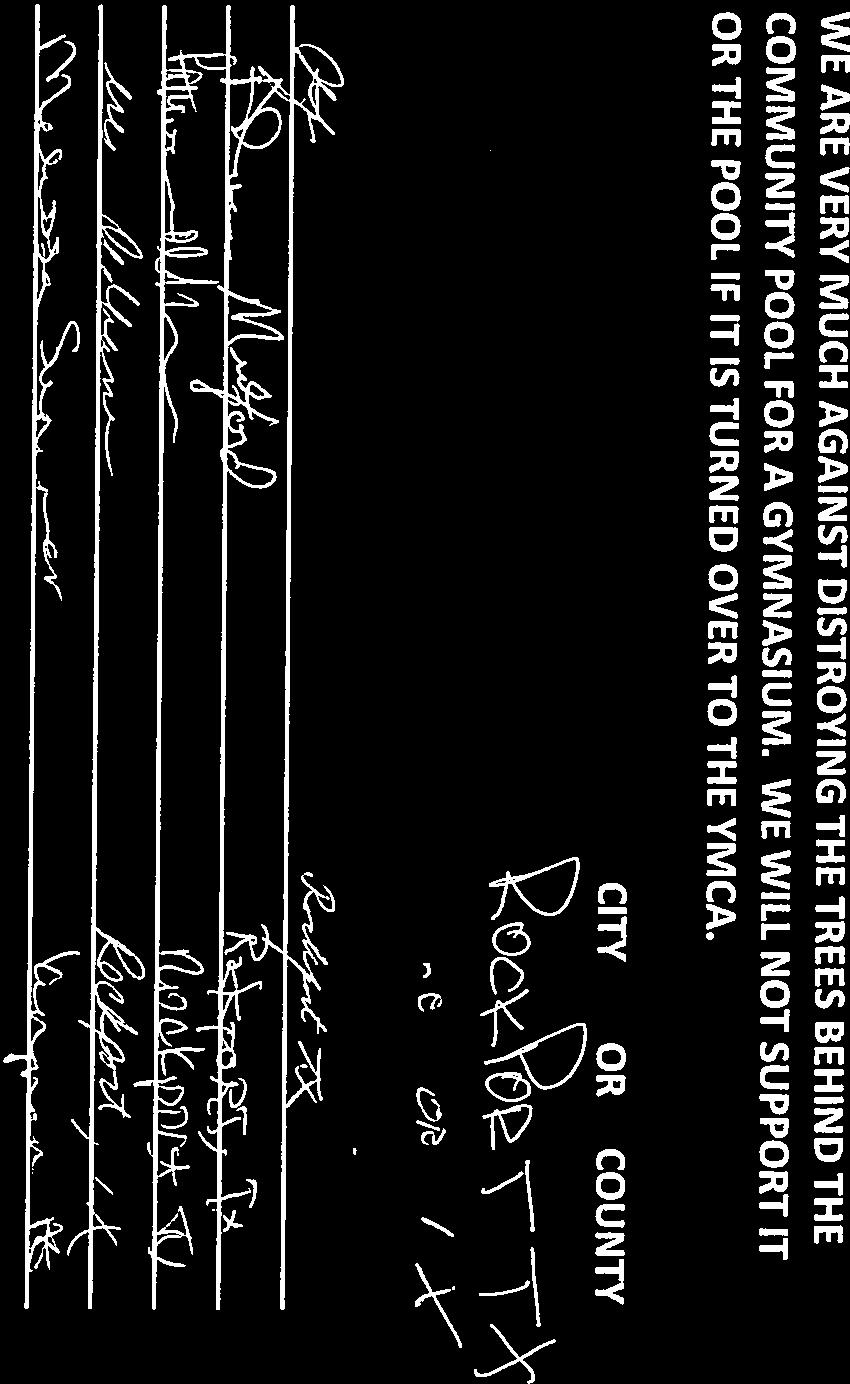
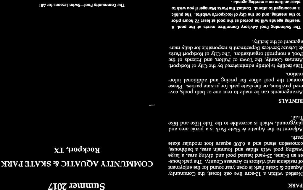
3 3 CITY COUNCIL AGENDA Workshop Meeting: Tuesday, June 27, 2017 AGENDA ITEM: 3 Hear and deliberate on Community Aquatic Center s interface with YMCA. SUBMITTED BY: Linda Valdez APPROVED FOR AGENDA: PKC BACKGROUND: Ms. Linda Valdez, on behalf of several citizens concerned about the aquatic center, has asked to address the Council with concerns about how the Aquatic Center will interface with the proposed YMCA. The YMCA Committee and Rob Wiggins with the YMCA of the Coastal Bend will also attend the meeting. Please see the accompanying memo and list of supporters for additional information. FISCAL ANALYSIS: N/A RECOMMENDATION: Not an action item.

4 4

5 5

6 6

7 7

8 8

9 9


10 10


11 11


12 12

13 13


14 14


15 15

16 16


17 17

18 18


19 19


20 20


21 21
22 22 CITY COUNCIL AGENDA Workshop Meeting: Tuesday, June 27, 2017 AGENDA ITEM: 6 Conduct a Joint Public Hearing with the Planning & Zoning Commission to consider a request to rezone and a Conditional Use Permit for newly annexed property located at 652 State Highway 35 Bypass, Rockport, Aransas County, Texas, currently zoned R-1 (1st Single Family Dwelling District), to B-1 (General Business District) and Conditional Use Permit, to allow expansion of a recently annexed RV park. SUBMITTED BY: Community Planner Amanda Torres APPROVED FOR AGENDA: PKC BACKGROUND: Ray and Susie Loxterman have submitted an application seeking approval for a rezone and Conditional Use Permit for property located at 652 State Highway 35 Bypass, Rockport, Aransas County, Texas, currently zoned R-1 (1st Single Family Dwelling District), to B-1 (General Business District) and Conditional Use Permit, to allow expansion of a recently annexed RV park. Please see the accompanying conditional use permit application and Section of Code of Ordinances for more detailed information. FISCAL ANALYSIS: N/A. RECOMMENDATION: No action required. Public hearing only.
23 23 STAFF REPORT Building & Development Services Amanda Torres, Community Planner 2751 SH 35 Bypass, Rockport, TX Phone: (361) , x PROPERTY ADDRESS/LOCATION 652 State Highway 35 Bypass PUBLIC HEARING DATE Tuesday, June 27, 2017 BRIEF SUMMARY OF REQUEST P&Z DATE Tuesday, June 27, 2017 APPLICANT/PROPERTY OWNER Ray and Susie Loxterman CITY COUNCIL DATE(S) 1 st Hearing - Tuesday, June 27, nd Hearing - Tuesday, July 11, 2017 The property in question was recently annexed by the City of Rockport last December. Because this property was incorporated into the city as part of an annexation, this and surrounding properties were designated as R-1 (1st Single Family Dwelling District) in accordance to the City s zoning policy for newly annexed territory (City of Rockport Code of Ordinances, Chapter 118 Zoning, Article 5 Newly Annexed Territory). Property owners Ray and Susie Loxterman would like to expand their current operation of their existing RV park, Blue Moon RV Park. A public notice regarding this item was published in The Rockport Pilot in the Saturday, June 10, 2017 edition and mailed out to seven property owners within a 200-foot radius of the property. No letters of opposition were received. MAP SOURCE: Pictometry EXISTING ZONING R-1 1 st Single Family Dwelling District EXISTING LAND USE Recreational vehicle park and undeveloped SURROUNDING ZONING & LAND USE North: R-1 1 st Single-Family Dwelling, undeveloped East: R-1 1 st Single-Family Dwelling, undeveloped South: R-1 1 st Single-Family Dwelling, RV Park West: R-1 1 st Single-Family Dwelling, undeveloped SITE IMPROVEMENTS None SIZE OF PROPERTY acres STAFF RECOMMENDATION APPROVE APPROVE WITH CONDITIONS DENY COMPATIBILITY with the ZONING ORDINANCE & FUTURE LAND USE MAP Current structures and land uses are considered existing non-conforming. Any future development will meet all setback requirements of the B-1 General Business District if approved. This land use is compatible with the land use associated with this area as indicated in the Future Land Use Map. PROPERTY HISTORY Compatibility with the planned development (or other controlling documents); traffic/parking; public works/utilities; engineering/flood plain/soil; building code/fire or design The property in question was recently annexed by the City of Rockport last December. Because this property was incorporated into the city as part of an annexation, this and surrounding properties were designated as R-1 (1st Single Family Dwelling District) in accordance to the City s zoning policy for newly annexed territory (City of Rockport Code of Ordinances, Chapter 118 Zoning, Article 5 Newly Annexed Territory). The rezoning and Conditional Use Permit request is to allow for expansion of the current RV park. RV parks are a specific land use requiring a Conditional Use Permit per the Zoning Ordinance (Section ). ATTACHMENTS (CIRCLE) SUBMITTED PLANS PUBLIC HEARING PETITION/ APPLICATION FORM LEGAL NOTICE LEGAL DESCRIPTION PUBLIC COMMENTS AGENCY COMMENTS RESPONSE TO STANDARDS OTHER (DESCRIBE) Conditional Use Permit criteria, site plan draft, site maps; zoning ordinance language


24 24

25 25

26 26

27 27

28 28

29 29


30 30
31 31 STAFF PRELIMINARY PREVIEW Date: 6/27/2017 TYPE OF REQUEST: CUP/Rezone to B-1 LOCATION: 652 State Highway 35 Bypass, Rockport, TX OWNER/AGENT: PROJECT DESCRIPTION: Ray and Susie Loxterman acres to expand current RV park (Blue Moon RV Park) APPLICATION DOCUMENTS NEEDED: Areas of Concern: ARTICLE 23-CONDITIONAL USE PERMIT REVIEW CRITERIA: 1. That such use is necessary or desirable and provides a service or facility that contributes to the general well-being of the surrounding area. 2. That such use shall not adversely affect adjacent properties. 3. That such use is compatible with the existing or allowable uses of adjacent properties. 4. That such use can demonstrate that adequate public facilities, including roads, drainage, potable water and sanitary sewer, and police and fire protection exist or will exist to serve the requested use at the time such facilities are needed. 5. That such use can demonstrate adequate provision for maintenance of the use in question along with any associated structures. 6. That such use has minimized, to the degree possible, adverse effects on the natural environment. 7. That such use will not create undue traffic congestion. 8. That such use will not adversely affect the public health, safety or welfare. 9. That such use conforms to all applicable provisions of this Code. 10. That such use is consistent with all applicable provisions of the comprehensive plan. NOTES:

32 32


33 33

34 34

35 35


36 36
37 1/5/2017 z2codes.franklinlegal.net/franklin/printviewer.jsp?printcollection=0 37 Article I. Zoning Ordinance* Sec B 1 General Business District Use Regulations. The purpose of this district is to provide suitable locations for a wide variety of business and mercantile uses. In addition to the previous listed uses in R 1 through R 7 districts, land and premises may be used for: 1. Restaurants, cafes, food catering services. 2. Offices, banks, libraries, museums, etc. 3. Service stations, car washes, laundromats. 4. Malls, shopping centers, retail stores. 5. Shops (butcher shops, shoe shops, shell shops, etc., including pawn shops that have been licensed to transact business by the Consumer Credit Commissioner under Chapter 371, Finance Code). 6. Grocery stores, convenience stores, markets. 7. Retail markets (seafood/meat) and bait stands. 8. Entertainment facilities (theaters, bowling alleys, pool halls, clubs and lounges, etc. 9. Sales, service and repair shops (radio, television, shoe repair, tool repair and rental, lawn mower repair, auto and boat repair shops, etc). 10. Personal service shops (beauty salons, barber shops, tailoring and dressmaking shops, etc). 11. Storage buildings, auto storage yards. 12. Animal hospitals, boarding kennels and grooming shops. 13. Mortuaries and funeral homes. 14. Agricultural services, greenhouses and landscaping services. 15. Outdoor welding, fabricating operations, by CUP. 16. Permanent or long term (more than 30 days) public entertainment facilities or uses, by CUP. Such uses may include, but not be limited to, amusement parks, carnivals, circuses, marine life shows, dance/theatrical productions and natatoriums. 17. Fish houses, seafood processing plants, by CUP. 18. Adult entertainment, by CUP Area and Yard Regulations Area of the Lot. None required for non dwelling uses. For dwelling uses, See [section ] Table /2
38 1/5/2017 z2codes.franklinlegal.net/franklin/printviewer.jsp?printcollection= Width of the Lot. The minimum width of the lot shall be fifty (50) feet. See [section ] Table Area of the Building. For a primary use structure, the minimum floor area shall be five hundred (500) square feet. See [section ] Table Yard Area and Building Setbacks. See [section ] Table Height of the Building. No building shall exceed forty five (45) feet in height. See Article 3 [section 118 3] Definitions and Article 20 [section ] Parking Regulations. Parking regulations for permitted uses as contained in Article 21 [section ] Accessory Use Regulations. Accessory uses, which are auxiliary or incidental to the primary use of a building or premises, as contained in Article 22 [section ]. (Ord. No. 1027, art. 15, ) /2
39 1/5/2017 z2codes.franklinlegal.net/franklin/printviewer.jsp?printcollection=0 39 Article I. Zoning Ordinance* Sec Conditional use permit General. A Conditional Use Permit (CUP) shall be obtained for certain uses, which would become harmonious or compatible with neighboring uses through the application and maintenance of qualifying conditions and located in specific locations within a zone, but shall not be allowed under the general conditions of the zone as stated in this Code. The granting of a CUP has no effect on the uses permitted as of right and does not waive the regulations of the underlying zoning district. The CUP requirement for a use in a district does not constitute an authorization or an assurance that the use will be permitted. Uses requiring a CUP are listed within a zoning district and in subsection of this article. Uses not listed within a zoning district that may be eligible for a CUP shall be administered through this article Applications. All CUP applications shall be submitted to the code official on a form provided by the city consistent with the provisions herein. All applications shall be accompanied by maps, drawings, statements or other documents in support of the request. An application fee shall be collected at the time of submittal. Said fee shall be: One Hundred Dollars and no cents ($100.00) for the first acre of land or fraction thereof, plus Ten Dollars and no cents ($10.00) per acre or fraction thereof over the first acre Public Hearing. Prior to the approval, approval with conditions or denial of a CUP, public hearings shall be held in accordance with the provisions of Article 26 of this ordinance [section of this Code]. Upon the completion of said proceedings, the Commission shall render a recommendation(s) to the City Council. Decisions of the City Council shall be final Review Criteria. An application for a CUP shall be permitted to be approved, approved with conditions or denied. Each application for a CUP shall be submitted with enough data and information to be consistent with the criteria listed below: 1. That such use is necessary or desirable and provides a service or facility that contributes to the general well being of the surrounding area. 2. That such use shall not adversely affect adjacent properties. 3. That such use is compatible with the existing or allowable uses of adjacent properties. 4. That such use can demonstrate that adequate public facilities, including roads, drainage, potable water and sanitary sewer, and police and fire protection exist or will exist to serve the requested use at the time such facilities are needed. 5. That such use can demonstrate adequate provision for maintenance of the use in question along with any associated structures. 6. That such use has minimized, to the degree possible, adverse effects on the natural environment. 7. That such use will not create undue traffic congestion. 8. That such use will not adversely affect the public health, safety or welfare. 9. That such use conforms to all applicable provisions of this Code. 10. That such use is consistent with all applicable provisions of the comprehensive plan. 1/3
40 1/5/2017 z2codes.franklinlegal.net/franklin/printviewer.jsp?printcollection= Expiration. A CUP shall be considered exercised when the use has been established. When such CUP is not exercised, or is abandoned, or is discontinued for a period of 1 year from the date of granting thereof, it shall be considered expired and shall not be reestablished unless authorized by the City Council with recommendation(s) from the Planning & Zoning Commission Annual Review. Subsequent to the issuance of a CUP, a review shall be conducted annually by the Code Official to determine that the terms of the CUP are being met Revocation. A CUP shall be revoked when the applicant fails to comp1y with conditions imposed by the permit. Said CUP shall not be reestablished unless authorized by the City Council with recommendation(s) from the Planning & Zoning Commission Existing Conditional Use Permit. Any amendment sought to an existing CUP shall be considered as a new application and shall comply with this article Existing Special Permit. Any amendment sought to an existing Special Permit existing prior to (date of amending ordinance inserted here), shall be considered as a new application and shall comply with this article as a CUP. Such amendment(s) may not preclude or nullify the conditions to any Special Permit previously issued unless requested by the applicant. Annual review shall be in accordance with subsection Specific uses requiring a CUP. The following listed uses will require a CUP approval prior to issuance of a building permit. These uses are also listed within their respective zoning district. 1. Permanent or long term (more than 30 days) public entertainment facilities or uses. Such facilities or uses shall include, but not be limited to, amusement parks, carnivals, animal shows, marine life shows, dance/theatrical productions or natatoriums. This provision is listed in a B 1 district). 2. Private, child nurseries or pre kindergarten schools in R 1 through R 7 districts. 3. Retail shops, restaurants, clubs and lounges in R 6 and R 7 districts when not built within a hotel or office building. 4. Meat, fish or shellfish processing plant in a B 1 district. 5. Penal institutions and detention centers in R 7 districts only. A listed use out right in a B 1 district. 6. Bed and Breakfast accommodations in R 1 through R 3 districts. 7. The keeping and raising of farm animals in all districts pursuant to the city's animal control ordinance. Agricultural land annexed into the city as R 1 zoning is exempt where such uses are existing uses. 8. Radio, television or communications tower in an R 7 district, provided Federal Communications Commission and Federal Aviation Administration permit requirements are met (refer to Article 24 [section ] for Special Conditions). 9. Outdoor welding operations when located in a B district only. 10. Recreational Vehicle/Manufactured Housing Parks in any district when complying with recreational vehicle/manufactured housing park standards addressed in Article 24 of this ordinance [section of this Code]. 11. Adult entertainment in B and I districts. 2/3 40
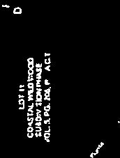
41 41 CITY COUNCIL AGENDA Workshop Meeting: Tuesday, June 27, 2017 AGENDA ITEM: 7 Conduct a Joint Public Hearing with the Planning & Zoning Commission to consider a request to rezone property located at 1117 Sixteenth Street, also known as Lot 70-C, Block 256, Swickheimer Subdivision, 1 acre, Rockport, Aransas County, Texas, currently zoned R-1 (1 st Single Family Dwelling District), to R-6 (Hotel/Motel District, to allow development of short-term cottage rentals. SUBMITTED BY: Community Planner Amanda Torres APPROVED FOR AGENDA: PKC BACKGROUND: Richard James has submitted an application seeking approval for a rezone and Conditional Use Permit for property located at 1117 Sixteenth Street, also known as Lot 70-C, Block 256, Swickheimer Subdivision, 1 acre, Rockport, Aransas County, Texas, currently zoned R-1 (1 st Single Family Dwelling District), to R-6 (Hotel/Motel District, to allow development of short-term cottage rentals. Please see the accompanying rezone application and Section of Code of Ordinances for more detailed information. FISCAL ANALYSIS: N/A. RECOMMENDATION: No action required. Public hearing only.
 PUBLIC HEARING DATE Tuesday, June 27, 2017 BRIEF SUMMARY OF REQUEST P&Z DATE To be determined APPLICANT/PROPERTY")
42 42 STAFF REPORT Building & Development Services Amanda Torres, Community Planner 2751 SH 35 Bypass, Rockport, TX Phone: (361) , x PROPERTY ADDRESS/LOCATION 1117 Sixteenth Street (Lot 70-C, Block 256, Swickheimer) PUBLIC HEARING DATE Tuesday, June 27, 2017 BRIEF SUMMARY OF REQUEST P&Z DATE To be determined APPLICANT/PROPERTY OWNER Steven Olivarez/Richard James CITY COUNCIL DATE(S) 1 st Hearing To be determined 2 nd Hearing To be determined The applicant is requesting a change of zoning to R-6 Hotel/Motel District in order to allow development of short-term cottage rentals. A public notice regarding this item was published in The Rockport Pilot in the Saturday, June 10, 2017 edition and mailed out to property owners within a 200-foot radius of the property. No letters of opposition were received. MAP SOURCE: Pictometry EXISTING ZONING R-1 1 st Single Family Dwelling District EXISTING LAND USE Undeveloped SURROUNDING ZONING & LAND USE North: Out of city limits, RV park site East: R-1 1 st Single-Family Dwelling, undeveloped South: R-1 1 st Single-Family Dwelling, singlefamily residences West: R-1 1 st Single-Family Dwelling, undeveloped STAFF RECOMMENDATION None SITE IMPROVEMENTS 1 acre SIZE OF PROPERTY APPROVE APPROVE WITH CONDITIONS DENY COMPATIBILITY with the ZONING ORDINANCE & FUTURE LAND USE MAP Any proposed developments built on the property would meet all setback requirements of the R-6 General Business zoning district, if approved. This land use is compatible with land uses within proximity of the site. The Future Land Use Map designates this area as low density residential. PROPERTY HISTORY Compatibility with the planned development (or other controlling documents); traffic/parking; public works/utilities; engineering/flood plain/soil; building code/fire or design The subject property is currently on one acre and would be developed into ten short-term rental cottages if the change of zoning request is approved. Land uses in this area are a mix of undeveloped, commercial, residential, and short-term rental. The proposed development would be serviced by City water and a septic system. The developer would provide a private 25 foot drive for access to each cottage. Ten feet of separation would be required between buildings per the City s building code. Parking and landscaping requirements will be in accordance to its requested land use. The property is within a flood hazard area, and construction must comply with standards as indicated in Chapter 50 (Floods) of the Code of Ordinances. All required drainage and detention would be provided as per the City s drainage design standards. ATTACHMENTS (CIRCLE) SUBMITTED PLANS PUBLIC HEARING PETITION/ APPLICATION FORM LEGAL NOTICE LEGAL DESCRIPTION PUBLIC COMMENTS AGENCY COMMENTS RESPONSE TO STANDARDS OTHER (DESCRIBE) Proposed site drawing; site maps; zoning ordinance language


43 43

44 44
45 45


46 46
47 47

48 48
49 6/19/2017 z2codes.franklinlegal.net/franklin/printviewer.jsp?printcollection=0 49 Article I. Zoning Ordinance* Sec R 6 Hotel/Motel District Use Regulations. The purpose of this district is to provide suitable locations for hotels and motels. Land and premises may be used for: 1. Uses listed for an R 5 district. 2. Hotels and Motels. 3. Retail shops, restaurants, clubs and lounges when not established within a hotel/motel building, by CUP Area and Yard Regulations Area of the Lot. Does not apply for hotel/motel use only. The minimum area of the lot for single family dwellings shall be the same as required in an R 2 district. See Article 20 [section ] Width of the Lot. The minimum width of the lot shall be fifty (50) feet. See [section ] Table Area of Hotel/Motel Rooms. The minimum living area of the rooms shall be one hundred fifty (150) square feet per room. See [section ] Table Yard Areas and Building Setback. Where a hotel/motel abuts a Residential District, a side and/or rear yard must be provided along the boundary line but shall not be less than ten (10) feet. For hotels/motels, egress and ingress must be provided from a main street. Five percent (5%) of the square footage of the site must be left free of structures to be used for beautification/landscaping. See [section ] Table Height of the Building. No building shall exceed forty five (45) feet in height. See Article 3 [section 118 3] Definitions and Article 20 [section ] Parking Regulations. Parking regulations for permitted uses as contained in Article 21 [section ] Accessory Use Regulations. Accessory uses, which are auxiliary or incidental to the primary use of a building or premises, as contained in Article 22 [section ]. (Ord. No. 1027, art. 13, ) 1/1
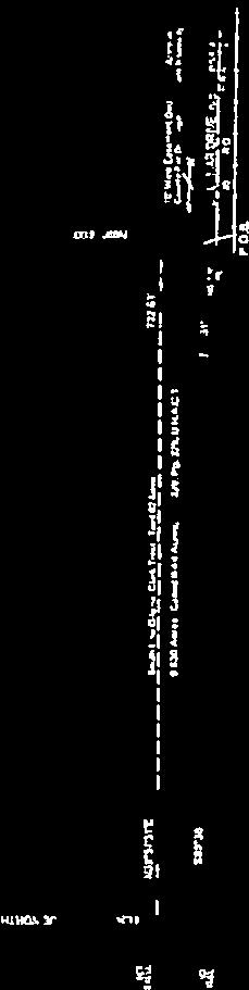
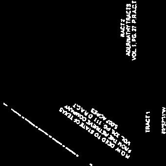
50 50 CITY COUNCIL AGENDA Workshop Meeting: Tuesday, June 27, 2017 AGENDA ITEM: 8 Conduct a Joint Public Hearing with the Planning & Zoning Commission to consider a request to rezone property located at State Highway 35 Bypass, also known as TT Williamson Survey A-219, 17.3 acres, Rockport, Aransas County, Texas, currently zoned R-1 (1st Single Family Dwelling District), to B-1 (General Business District), to subdivide property into several tracts for resale for commercial use. SUBMITTED BY: Building & Development Department APPROVED FOR AGENDA: PKC BACKGROUND: Jim Guidry has submitted an application seeking approval for a rezone and Conditional Use Permit for property located at State Highway 35 Bypass, also known as TT Williamson Survey A-219, 17.3 acres, Rockport, Aransas County, Texas, currently zoned R-1 (1st Single Family Dwelling District), to B-1 (General Business District), to subdivide property into several tracts for resale for commercial use. Please see the accompanying rezone application and Section of Code of Ordinances for more detailed information. FISCAL ANALYSIS: N/A. RECOMMENDATION: No action required. Public hearing only.

51 51 STAFF REPORT Building & Development Services Amanda Torres, Community Planner 2751 SH 35 Bypass, Rockport, TX Phone: (361) , x PROPERTY ADDRESS/LOCATION State Highway (T.T. Williamson Survey A-219, 17.3 acres) PUBLIC HEARING DATE Tuesday, June 27, 2017 BRIEF SUMMARY OF REQUEST P&Z DATE To be determined APPLICANT/PROPERTY OWNER Jim Guidry CITY COUNCIL DATE(S) 1 st Hearing To be determined 2 nd Hearing To be determined The applicant is requesting a change of zoning to B-1 General Business in order to subdivide the property into several tracts and sell each for commercial use. A public notice regarding this item was published in The Rockport Pilot in the Saturday, June 10, 2017 edition and mailed out to property owners within a 200-foot radius of the property. No letters of opposition were received. EXISTING ZONING R-1 1 st Single Family Dwelling District EXISTING LAND USE Undeveloped SURROUNDING ZONING & LAND USE North: R-1 1 st Single-Family Dwelling, undeveloped East: R-1 1 st Single-Family Dwelling, undeveloped South: R-1 1 st Single-Family Dwelling, singlefamily residences West: R-1 1 st Single-Family Dwelling, undeveloped STAFF RECOMMENDATION None SITE IMPROVEMENTS MAP SOURCE: Pictometry SIZE OF PROPERTY 17.3 acres APPROVE APPROVE WITH CONDITIONS DENY COMPATIBILITY with the ZONING ORDINANCE & FUTURE LAND USE MAP Any proposed developments built on the property would meet all setback requirements of the B-1 General Business zoning district, if approved. This land use is compatible with the land use associated with this area as indicated in the Future Land Use Map. PROPERTY HISTORY Compatibility with the planned development (or other controlling documents); traffic/parking; public works/utilities; engineering/flood plain/soil; building code/fire or design The subject property is currently on 17.3 acres and would likely be re-platted into smaller tracts if the change of zoning request is approved. Land uses along this corridor are mostly undeveloped land. The proposed development is within distance of City public utilities. It will need to comply with TxDOT driveway requirements. Parking and landscaping requirements will be in accordance to its requested land use. The property is not within a flood hazard area, and all required detention would be provided on-site of any proposed developments. ATTACHMENTS (CIRCLE) SUBMITTED PLANS PUBLIC HEARING PETITION/ APPLICATION FORM LEGAL NOTICE LEGAL DESCRIPTION PUBLIC COMMENTS AGENCY COMMENTS RESPONSE TO STANDARDS OTHER (DESCRIBE) Proposed plat drawing; site maps; zoning ordinance language


52 52

53 53


54 54


55 55


56 56


57 57

58 58
59 59

60 60
61 1/5/2017 z2codes.franklinlegal.net/franklin/printviewer.jsp?printcollection=0 61 Article I. Zoning Ordinance* Sec B 1 General Business District Use Regulations. The purpose of this district is to provide suitable locations for a wide variety of business and mercantile uses. In addition to the previous listed uses in R 1 through R 7 districts, land and premises may be used for: 1. Restaurants, cafes, food catering services. 2. Offices, banks, libraries, museums, etc. 3. Service stations, car washes, laundromats. 4. Malls, shopping centers, retail stores. 5. Shops (butcher shops, shoe shops, shell shops, etc., including pawn shops that have been licensed to transact business by the Consumer Credit Commissioner under Chapter 371, Finance Code). 6. Grocery stores, convenience stores, markets. 7. Retail markets (seafood/meat) and bait stands. 8. Entertainment facilities (theaters, bowling alleys, pool halls, clubs and lounges, etc. 9. Sales, service and repair shops (radio, television, shoe repair, tool repair and rental, lawn mower repair, auto and boat repair shops, etc). 10. Personal service shops (beauty salons, barber shops, tailoring and dressmaking shops, etc). 11. Storage buildings, auto storage yards. 12. Animal hospitals, boarding kennels and grooming shops. 13. Mortuaries and funeral homes. 14. Agricultural services, greenhouses and landscaping services. 15. Outdoor welding, fabricating operations, by CUP. 16. Permanent or long term (more than 30 days) public entertainment facilities or uses, by CUP. Such uses may include, but not be limited to, amusement parks, carnivals, circuses, marine life shows, dance/theatrical productions and natatoriums. 17. Fish houses, seafood processing plants, by CUP. 18. Adult entertainment, by CUP Area and Yard Regulations Area of the Lot. None required for non dwelling uses. For dwelling uses, See [section ] Table /2
62 1/5/2017 z2codes.franklinlegal.net/franklin/printviewer.jsp?printcollection= Width of the Lot. The minimum width of the lot shall be fifty (50) feet. See [section ] Table Area of the Building. For a primary use structure, the minimum floor area shall be five hundred (500) square feet. See [section ] Table Yard Area and Building Setbacks. See [section ] Table Height of the Building. No building shall exceed forty five (45) feet in height. See Article 3 [section 118 3] Definitions and Article 20 [section ] Parking Regulations. Parking regulations for permitted uses as contained in Article 21 [section ] Accessory Use Regulations. Accessory uses, which are auxiliary or incidental to the primary use of a building or premises, as contained in Article 22 [section ]. (Ord. No. 1027, art. 15, ) /2
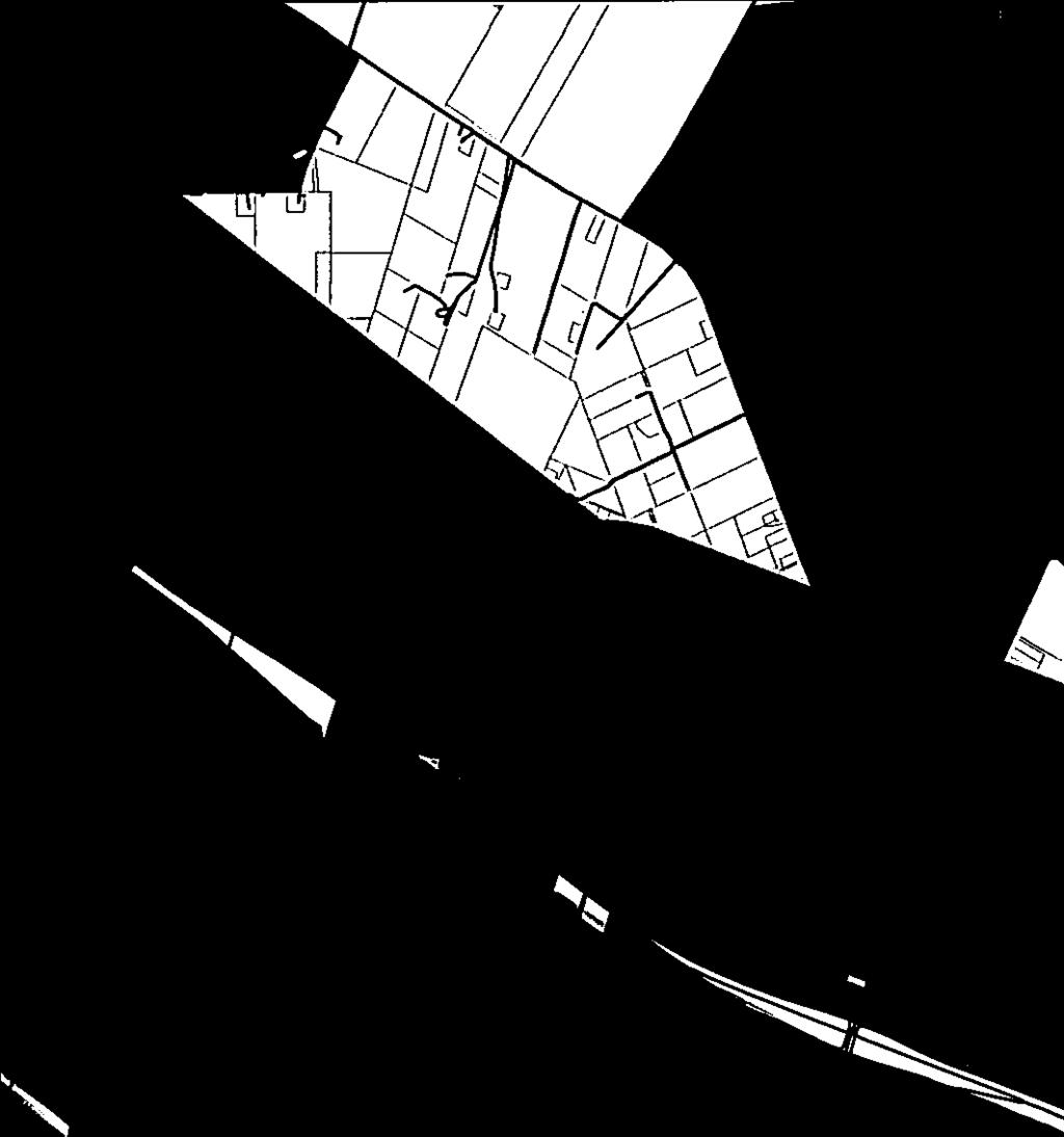
63 63 CITY COUNCIL AGENDA Workshop Meeting: Tuesday, June 27, 2017 AGENDA ITEM: 10 Conduct first Public Hearing on proposed annexation by the City of Rockport, Texas, of 107 acres of land, more or less, along Market Street between Kelly Lane and Verne Street, being out of portions of the John Smith Survey A-187, the T.B. Reeves Survey, A-323, the T. Green Survey, A-72, and the T.T. Williamson Survey, A-222. SUBMITTED BY: Community Planner Amanda Torres APPROVED FOR AGENDA: PKC BACKGROUND: This is the first Public Hearing for the proposed Market Street B annexation. The next steps in the annexation process include: 1. June 27, Second public hearing at regular council meeting. 2. July 21, 2017 Post notice of annexation ordinance adoption under Open Meetings Act. 3. July 25, 2017 First reading of annexation ordinance. 4. August 8, 2017 Second reading and adoption of annexation ordinance. Please see the accompanying metes and bounds description, Municipal Annexation Service Plan, and Annexation Profile Summary for detailed information. FISCAL ANALYSIS: See the accompanying 2017 Annexation Profile Summary for an estimate of the revenue and expenses from annexing this area. RECOMMENDATION: Not an action item.
64 64 Area to be Annexed MUNICIPAL ANNEXATION SERVICE PLAN FOR AREA MARKET STREET B (107 Acres) Being approximately 107 acres of land, more or less, out of portions of the John Smith Survey A-187, the T.B. Reeves Survey, A-323, the T. Green Survey, A-72, and the T.T. Williamson Survey, A-222, with said 107 acres, more or less, being more particularly described by metes and bounds on Field Notes show in Exhibit A and map in Exhibit B. Introduction In accordance with the directives of the City Council of the City of Rockport, Texas, the City's Comprehensive Plan, and the requirements of Subsection of the Texas Local Government Code, the following service plan for the area hereinafter referred to as Area Market Street B and as shown on the accompanying map that has been prepared. The proposed plan may be amended as a result of the public hearing process in accordance with Subsection of the most current edition of the Texas Local Government Code. This service plan shall become a part of an annexation ordinance submitted to the City Council for consideration and action, if any. The following services will be provided on the effective date of the annexation of the area according to Subsection of the most current edition of the Texas Local Government Code regarding services to newly annexed areas: 1. Animal Control Existing Services: Animal control services for this area are currently provided by the Aransas County Animal Control Department. Services to be Provided: The Aransas County Animal Control Department will continue the enforcement of the City of Rockport s animal control ordinances on the effective date of the annexation. Such services can be provided with current Animal Control personnel and within the current budget appropriation. 2. Capital Improvements Construction of capital improvements shall be considered by the City in the future as the needs dictate on the same basis as such capital improvements are considered throughout the city. 3. Building Inspections
65 65 Existing Services: Existing building inspection services are provided in this area by the City of Rockport when required by applicable building codes. Services to be Provided: The Building & Development Department will provide Code Enforcement and Building Inspection Services upon annexation. This includes issuing building, electrical and plumbing permits for any new construction and remodeling, and enforcing all other applicable codes which regulated building construction within the City of Rockport. These services can be provided within the department s current budget. 4. Emergency Medical Services Existing Services: Emergency medical services are currently provided under contract with Aransas County by Allegiance Ambulance from their facility located at 400 Enterprise in Rockport. Services to be Provided: Annexation of the proposed area will not alter the response times, service sectors, or the existing interagency agreements. 5. Fire Existing Services: Existing services are typically provided as outside city limits response by the Rockport Volunteer Fire Department, Inc. Services to be Provided: Fire suppression will be available to the area upon annexation and will be provided by the Rockport Volunteer Fire Department, Inc. There are fire stations currently located at 902 Henderson Street, 212 Gagon Street, 1608 West Terrace Boulevard and 119 Freeze Lane. Annexation of the proposed area will not alter the response times, service sectors or the existing interagency agreements. 6. Health Code Enforcement Existing Services: Public health services for this area are currently provided by the Aransas County Environmental Health Department. Services to be Provided: The Aransas County Health Department will implement the enforcement of the City of Rockport s health ordinances and regulations on the effective date of the annexation. Such services can be provided with current Health Department Personnel and within the current budget appropriation. 7. Parks Existing Services: Library services are provided by the Aransas County Public Library. City parks are currently open to non-city residents.
66 66 Services to be Provided: Library services will still be provided by the Aransas County Public Library under the same terms. Annexation will not result in any changes in the availability of parks and library facilities to residents of the area. 8. Planning and Zoning Existing Services: This area falls within the Extraterritorial Jurisdiction (ETJ) of the City of Rockport. Platting and land subdivision activities are currently co-administered by Aransas County and the City of Rockport. The City s zoning and land use ordinances, however, are not applicable outside of the existing city limits. Services to be Provided: The Building and Development Department s responsibility for regulating development and land use through the administration of the City of Rockport Zoning Ordinance will extend to this area on the effective date of the annexation. The property will solely be regulated under the requirements of the City of Rockport Subdivision Ordinance. These services can be provided within the department s current budget. 9. Police Existing Services: Sheriff s Office. Existing services are primarily provided by the Aransas County Services to be Provided: The Rockport Police Department will initiate full police and law enforcement services to this proposed annexed area at the effective date. Both divisions of the police department will coordinate this service plan. 1. The Patrol Division will provide active patrol services in the proposed area. These services will include accident investigation and preventative patrol to deter violations of statutes and local ordinances. The Patrol Division will also assist other emergency-related agencies responding within this proposed area. The Patrol Division will provide further service to our customers by initiating and monitoring vacation/property checks for residences and businesses requesting such programs during their absence. 2. The Criminal Investigation Division will provide for active investigation services to be implemented in the proposed area. These services include crime scene search and the related analysis and investigation leading to the identification of suspects, issuance of arrest warrants and the apprehension of suspected offenders; preparation and submission of cases to the appropriate agency for prosecution and/or presentation to a Grand Jury; and response to citizen requests for crime prevention and security inspections of their real property. A review of the ongoing criminal investigations will be conducted to determine which (if any) cases should be transferred to the Rockport Police Department Investigation Division: The Criminal Investigation Division will assist in the development of
67 67 neighborhood watch programs and conduct certified residential and business security surveys upon request. Annexation of this area would require an increase of approximately 694 patrol labor hours, 694 criminal investigation labor hours, and 694 administration labor hours. The Rockport Police Department will coordinate with the proper governmental agencies to ensure that 911 map sheets will be updated related to 911 calls within the specified zone. 10. Sanitary Sewer Service Existing Services: Existing sanitary sewer service in this area is provided by either the City of Rockport or by on-site sewage facilities. Services to be Provided: Sanitary sewer service to the area of proposed annexation will be provided in accordance with applicable codes and city policy. When property develops in the adjacent areas, sanitary sewer service shall be provided in accordance with the present extension ordinance and as requested by developers. Extension of service shall comply with applicable codes and ordinances. 11. Solid Waste Collection Existing Services: There is currently no dedicated solid waste disposal service for this area. Residents may contract individually with available service providers. Services to be Provided: Solid Waste Collection will be provided by the City's contractor, Republic Services, Inc. Service shall comply with existing City policies, beginning with occupancy of structures. As provided for by Section (n) of the Texas Local Government Code, residents may continue to use their existing solid waste collection service for up to two years following the effective date of annexation. At the end of the two-year period or termination of existing service by the customer (whichever is sooner), the City s contractor will begin providing service. 12. Street Lighting Existing Services: Existing streetlights in the area are provided by the Texas Department of Transportation. Services to be Provided: The City of Rockport will coordinate any requests for improved street lighting with the local electric provider in accordance with standard policy. 13. Street Maintenance Existing Services: Existing street maintenance services for this area are provided by Aransas County Road and Bridge Department.
68 68 Services to be Provided: Maintenance to the street facilities will be provided by the City upon the effective date of the annexation. This service can be provided within the current budget appropriation. All streets within the area proposed for annexation are currently paved. Annexation of this area would require an increase of approximately 694 street maintenance labor hours. 14. Storm Water Management Existing Services: Drainage and storm water management within this area is currently provided by Aransas County. Services to be Provided: Developers will provide storm water drainage at their own expense and will be inspected by the City Engineers at time of completion. The City will assume maintenance of the developer s drainage facilities upon acceptance from the developer. 15. Water Service Existing Services: Existing water utility services to this area is provided by the City of Rockport and includes both potable water and fire protection. Services to be Provided: Water service to the area will continue to be provided by the City of Rockport in accordance with the applicable codes and departmental policy. When other property develops in the adjacent area, water service shall be provided in accordance with extension ordinances and as requested by developers. Extension of service shall comply with City codes and ordinances. Water utility rates will be based on a lower Inside City Limits customer classification as opposed to the Outside City Limits customer classification. Miscellaneous All other applicable municipal services will be provided to the area in accordance with the City of Rockport s established policies governing extension of municipal services to newly annexed areas. All City codes shall be in effect upon annexation. Uniform Level of Services May Not Be Required Nothing in this plan shall require the city to provide a uniform level of full municipal services to each area of the city, including the annexed areas, if different characteristics of topography, land use, and population density are considered a sufficient basis for providing different levels of services. Term This service plan shall be valid for a term of ten (10) years.
69 Amendments The plan shall not be amended unless public hearings are held in accordance with V.C.T.A., Local Government Code, Section
70 70 EXHIBIT A FIELD NOTE DESCRIPTION 107 ACRES TO BE ANNEXED BY CITY OF ROCKPORT, ARANSAS COUNTY, TEXAS APRIL 27, 2017 BEING THE DESCRIPTION OF 107 ACRES OF LAND, MORE OR LESS, OUT OF PORTIONS OF THE JOHN SMITH SURVEY A-187, THE T.B. REEVES SURVEY, A-323, THE T. GREEN SURVEY, A-72, AND THE T.T. WILLIAMSON SURVEY, A-222, WITH SAID 107 ACRES, MORE OR LESS, BEING MORE PARTICULARLY DESCRIBED BY METES AND BOUNDS AS FOLLOWS: BEGIN, at a point in the at the intersection of the Southerly R.O.W. of Texas State F.M. Road No (also known as Market Street) and the East R.O.W. line of Kelly Lane, and being the Northwest corner of a 4.09 acre tract out of the J. Smith Survey, A-187, as described in a deed of record to Rockport Self Storages, LLC, under Clerks File Number , Official Public Records of Aransas County, Texas, with said point being an INTERIOR corner and PLACE OF BEGINNING of this description; THENCE, in a Northwesterly, crossing said Market Street, a distance of approximately 135 feet to a point for the Southwest corner of Block B, Bellevue Addition, according to the plat recorded in Volume 1, Page 92, Plat Records of Aransas County, Texas, and being in the East R.O.W. line of Steart Street, and being an EXTERIOR corner of this description; THENCE, in a Northerly direction, along and with the East R.O.W. line of Steart Street, a distance of approximately 183 feet to a point in the centerline of Liberty Street, closed and abandoned by Aransas County Commissioner s Court, and being the UPPER NORTHWEST corner of this description; THENCE, in an Easterly direction, along and with the centerline of Liberty Street, closed and abandoned, a distance of approximately 256 feet to a point of intersection of the centerline of Liberty Street with the West R.O.W. line of Traylor Avenue, and being an angle point and EXTERIOR corner of this description; THENCE, in a Southeasterly direction, crossing said Traylor Avenue, a distance of approximately 99 feet to a point in the centerline of Liberty Street, closed and abandoned, located between Blocks 13 and 18, of said Bellevue Addition, and being an INTERIOR corner of this description; THENCE, in an Easterly direction, along and with the centerline of Liberty Street, closed and abandoned, located between Blocks 13, 18, 12 and 19, of said Bellevue Addition, an approximate distance of 588 feet, to a point of intersection of the centerline of Liberty Street, with the West R.O.W. line of Burton Street, as platted, and being an EXTERIOR corner of this description; THENCE, in a Southerly direction, along and with the West R.O.W. line of Burton Street, as platted, a distance of approximately 30 feet to a point for the original Northeast corner of Block 12, of said Bellevue Addition, and being an INTERIOR corner of this description; THENCE, in an Easterly direction, crossing Burton Street, as platted, to the Northwest corner of Lot 1, Block 11, of said Bellevue Addition, along the North boundary line of said Lot 1, Block 11, crossing Lorena Street, a distance of approximately 389 feet to a point in the West boundary line of Lot 1, of a Replat of the Guy Epps Subdivision, according to t the plat recorded in Volume 2, Page 69, Plat Records of Aransas County, Texas, and being an INTERIOR corner of this description; THENCE, in a Northerly direction, along and with the East R.O.W. line of Lorena Street and the West boundary line of said Lot 1, of a Replat of Guy Epps Subdivision, a distance of approximately 24 feet to the Northwest corner of said Lot 1, of a Replat of Guy Epps Subdivision, and being in the South boundary line of Lot B, of Guy Epps Subdivision, according to the plat recorded in Volume 2, Page 51, Plat Records of Aransas County, Texas, and being an EXTERIOR corner of this description; THENCE, in an Easterly direction, along and with the South boundary line of said Lot B, Guy Epps Subdivision and the North boundary line of Lot 1, of said Replat of Guy Epps Subdivision, a distance of approximately 128 feet to a point in the Westerly boundary line of Lot 7, Block 101, Smith and Wood Division, according to the plat recorded in Volume E, Pages , Deed Records of Aransas County, Texas, and being an INTERIOR corner of this description; THENCE, in a Northerly direction, along and with the common boundary line of said Guy Epps Subdivision and Block 101, of said Smith and Wood Division, a distance of approximately 44 feet to a point for the
71 71 Northwest corner of Lot 1, of said Block 101 and being in the South R.O.W. line of Mimosa Street and being an EXTERIOR corner of this description; THENCE, in an Easterly direction, along and with the South R.O.W. line of Mimosa Street, a distance of approximately 128 feet to a point for the Northeast corner of said Block 101, of said Smith and Wood Division, and being an angle point and EXTERIOR corner of this description; THENCE, in a Southeasterly direction, along and with the South R.O.W. line of Mimosa Street, crossing Hood Street, a distance of approximately 65 feet to a point for the Northwest corner of Block 100, of said Smith and Wood Division, and being an angle point and INTERIOR corner of this description; THENCE, in an Easterly direction, along and with the South R.O.W. line of Mimosa Street, a distance of approximately 256 feet to a point for the Northeast corner of said Block 100, and being at the point of intersection of the South R.O.W. line of Mimosa Street and the West R.O.W. line of Terry Street and being an EXTERIOR corner of this description; THENCE, in a Southerly direction, along and with the West R.O.W. line of Terry Street, a distance of approximately 256 feet to the point of intersection of the West R.O.W. line of Terry Street and the North R.O.W. line of Concho Street, and being an INTERIOR corner of this description; THENCE, in an Easterly direction, along and with the North R.O.W. line of Concho Street, a distance of approximately 416 feet to a point of intersection of the North R.O.W. line of Concho Street with the East R.O.W. line of Doughty Street, and being the Southwest corner of Block 98, of said Smith and Wood Division, and being an EXTERIOR corner of this description; THENCE, in a Southerly direction, crossing said Concho Street, a distance of approximately 73 feet to a point of intersection of the South R.O.W. line of Concho Street and the East R.O.W. line of Doughty Street, and being the Northwest corner of Block 87, of said Smith and Wood Division, and being an angle point and INTERIOR corner of this description; THENCE, in a Southerly direction, along and with the East R.O.W. line of Doughty Street, a distance of approximately 160 feet to a point for the common corner of Lots 13 and 14, of said Block 87, and being an INTERIOR corner of this description; THENCE, in an Easterly direction, along and with the common boundary line of Lots 13 and 14, and Lots 3 and 4, of said Block 87, crossing Kossuth Street, a distance of approximately 340 feet to a point in the East R.O.W. line of Kossuth Street, and being in the West boundary line of Block 88, of said Smith and Wood Division, and being an EXTERIOR corner of this description; THENCE, in a Southerly direction, along and with the East R.O.W. line of Kossuth Street, a distance of approximately 104 feet to a point of intersection of the East R.O.W. line of Kossuth Street with the North R.O.W. line of Cornwall Street, and being the Southwest corner of said Block 88, and being an INTERIOR corner of this description; THENCE, in an Easterly direction, along and with the North R.O.W. line of Cornwall Street, crossing Verne Street, a distance of approximately 594 feet to a point for the Southeast corner of Block 89, of said Smith and Wood Division, and being the NORTHEAST corner of this description; THENCE, in a Southerly direction, crossing said Cornwall Street, and along the East boundary line of Block 68, of said Smith and Wood Division, crossing North Street, closed and abandoned by Commissioner s Court of Aransas County, a distance of approximately 459 feet to a an angle point and being the Northeast corner of Fractional Lot 1, Block 152, Doughty and Mathis Division, according to the plat recorded in Volume 1, Page 101 and Volume 2, Page 29, Plat Records of Aransas County, Texas, and being an angle point and EXTERIOR corner of this description; THENCE, in a Southwesterly direction, along and with the East boundary line of said Block 152, Doughty and Mathis Division, a distance of approximately 290 feet to a point in the centerline of Market Street, and being an EXTERIOR corner of this description; THENCE, in a Northwesterly direction, along and with the centerline of Market Street, a distance of approximately 350 feet to a point in the centerline of Verne Street, and being an INTERIOR corner of this description;
72 72 THENCE, in a Southwesterly direction, along and with the centerline of Verne Street, a distance of approximately 550 feet to a point of intersection of the centerline of Verne Street and the South R.O.W. line of Bay Street, and being the SOUTHEAST corner of this description; THENCE, in a Northwesterly direction, along and with the South R.O.W. line of Bay Street, crossing Kossuth Street, Doughty Street, Terry Street, and Hood Street (as platted, called Burton Street on the ground), a distance of approximately 1800 feet to an angle point in fractional Block 241, of said Doughty and Mathis Division and being in the South boundary line of a called acre tract out of the J. Smith Survey, A-187, as described in a deed of record to Clarence Christensen under Clerks File Number , Real Property Records of Aransas County, Texas, and being an angle point and INTERIOR corner of this description; THENCE, in Westerly direction, along and with the common boundary line of said Fractional Block 241 and said acre tract, a distance of approximately 164 feet to a point for the Southwest corner of said acre tract, and being the Northwest corner of said Fractional Block 241, and being the Northeast corner of a acre tract described in a deed of record to Christopher Crowley, et ux, under Clerk s File No , Official Public Records, Aransas County, Texas, and being an INTERIOR corner of this description; THENCE, in a Southerly direction, along and with the Easterly boundary line of said acre tract, a distance of approximately 747 feet to a point for the Southeast corner of said acre tract and being the Northeast corner of a called acre tract out of the J. Smith Survey, A-187, as described in a deed of record to Christopher Crowley, et ux, under Clerks File Number , Official Public Records of Aransas County, Texas, and being an EXTERIOR corner of this description; THENCE, in a Westerly direction, along and with the common boundary line of said acre tract and said called acre tract, a distance of approximately 1467 feet to a point in the West boundary line of a 60 foot drainage easement to Aransas County, and being in the East boundary line of a 1.4 acre tract out of the J. Smith Survey, A-187, as described in a deed of record to Carolyn Langston under Clerks File Number , Deed Records of Aransas County, Texas, and being the SOUTHWEST corner of this description; THENCE, in a Northerly direction, along and with the East boundary line of said 1.4 acre tract, and the East boundary line of West Terrace Acres Subdivision, according to the plat recorded in Volume 2, Page 102, Plat Records of Aransas County, Texas, a distance of approximately 815 feet to a point in the centerline of a platted 100 foot wide roadway out of said West Terrace Acres Subdivision, and being the LOWER NORTHWEST corner of this description; THENCE, in an Easterly direction, crossing said 60 foot wide drainage ditch and along the North boundary line of said acre tract, a distance of approximately 755 feet to a point in the East R.O.W. line of Kelly Lane and being the Southwest corner of said 4.09 acre tract, and being an INTERIOR corner of this description; THENCE, along and with the East R.O.W. line of Kelly Lane, a distance of approximately 735 feet to the PLACE OF BEGINNING and containing approximately 107 acres or 4,639,764 square feet of land, more or less Field Notes/Market Street APRIL 2017 Annex
73 73
74 Annexation Profile Summary Area 1 Area 3 Area 11 Area 12 Category Market Street B Area "D" Gap 35 Pearl Street Total Expenses & Data Misecellaneous Population Acres Development Type Single Family Multi-Family Commercial Unimproved Property Valuation Total Market Valuation $ 2,801,170 $ 9,122,260 $ 3,661,900 $ 5,855,830 $ 21,441,160 Average Value (excluding exempt) $ 69,813 $ 29,811 $ 69,346 $ 37,778 Median Value (excluding exempt) $ 27,715 $ 7,680 $ 43,860 $ 24,930 Average Homestead Value $ 96,932 $ 74,021 $ 97,716 $ 92,324 Infrastructure Current Street Miles Annual Street Maintenance Cost $ 18,833 $ 19,149 $ 3,591 $ 9,612 $ 51, New Streetlights Streetlight Installation Cost $ 18,000 $ 16,000 $ 2,000 $ 7,000 $ 43, Streetlight Electrical Cost $ 3,381 $ 3,423 $ 645 $ 1,726 $ 9, Total Capital Expense $ 18,000 $ 16,000 $ 2,000 $ 7,000 $ 43,000 Total Annual O&M Expense $ 22,214 $ 22,573 $ 4,236 $ 11,338 $ 60,361 Services New Police Labor Hours - Patrol , New Police Labor Hours - CID , New Police Labor Hours - Admin New Building Inspector Hours New Code Enforcement Officer Hours New Parks Labor Hours New Street Labor Hours ,773.33
75 75 Area 1 Area 3 Area 11 Area 12 Category Market Street B Area "D" Gap 35 Pearl Street Total New Water Labor Hours New Wastewater Labor Hours Total Water Customers Total Sewer Customers Total Gas Customers Total Sanitation Customers Total New Labor Hours 2, , , , , Personnel Costs (includes salary and benefits at step 11; equipment and onboarding costs excluded) Police - Patrol $ 19, $ 19, $ 19, $ 19, $ 77, Police - CID $ 20, $ 20, $ 20, $ 20, $ 81, Police - Admin $ 16, $ - $ - $ - $ 16, Building Inspector $ - $ - $ - $ - $ - Code Enforcement Officer $ - $ - $ - $ - $ - Parks Maintenance Techs (0.5) $ - $ - $ - $ - $ - Street Maintenance Techs $ 13, $ 13, $ 13, $ 13, $ 52, Water Maintenance Techs $ - $ - $ - $ - $ - Wastewater Maintenance Techs $ - $ - $ - $ - $ - Total Personnel Expense $ 69, $ 53, $ 53, $ 53, $ 228, Revenue New Ad Valorem Revenue $ 10, $ 33, $ 13, $ 21, $ 78, New Sales Tax Revenue individual sales tax revenue info not available $ - Difference in Water Revenue $ (11,114.88) $ (23,582.40) $ - $ (23,582.40) $ (58,279.68) Difference in Sewer Revenue $ (2,095.92) $ (7,920.00) $ - $ (7,920.00) $ (17,935.92) Difference in Gas Revenue $ - $ - $ - $ - $ - Difference in Sanitation Revenue $ $ 2, $ $ $ 4, Total Revenue $ (2,147) $ 4,235 $ 13,786 $ (9,182) $ 6,691 Net Revenue/Expense Total Capital Expense $ 18,000 $ 16,000 $ 2,000 $ 7,000 $ 43,000 Total Annual O&M Expense $ 22,214 $ 22,573 $ 4,236 $ 11,338 $ 60,361 Total Personnel Expense $ 69, $ 53, $ 53, $ 53, $ 228,878
76 76 Area 1 Area 3 Area 11 Area 12 Category Market Street B Area "D" Gap 35 Pearl Street Total Total Expense $ 110,022 $ 91,596 $ 59,260 $ 71,362 $ 332,240 Total Revenue $ (2,147) $ 4,235 $ 13,786 $ (9,182) $ 6,691 Net Revenue/Expense $ (112,169) $ (87,362) $ (45,474) $ (80,543) $ (325,548)
77 77
78 78
79 79 CITY COUNCIL AGENDA Workshop Meeting: Tuesday, June 27, 2017 AGENDA ITEM: 11 Conduct first Public Hearing on proposed annexation by the City of Rockport, Texas, of 38 acres of land, more or less, along Ann Street between Litron Street and 128 feet east of Pearl Street, being out of a portion of the T.T. Williamson Survey A-221. SUBMITTED BY: Community Planner Amanda Torres APPROVED FOR AGENDA: PKC BACKGROUND: This is the first public hearing for the proposed Pearl Street annexation. The next steps in the annexation process include: 1. June 27, Second public hearing at regular council meeting. 2. July 21, 2017 Post notice of annexation ordinance adoption under Open Meetings Act. 3. July 25, 2017 First reading of annexation ordinance. 4. August 8, 2017 Second reading and adoption of annexation ordinance. Please see the accompanying metes and bounds description, Municipal Annexation Service Plan, and Annexation Profile Summary for detailed information. FISCAL ANALYSIS: See the accompanying 2017 Annexation Profile Summary for an estimate of the revenue and expenses from annexing this area. RECOMMENDATION: Not an action item.
80 80 Area to be Annexed MUNICIPAL ANNEXATION SERVICE PLAN FOR AREA PEARL STREET (38 Acres) Being approximately 38 acres of land, more or less, out of a portion of the T.T. Williamson Survey A-221, with said 38 acres, more or less, being more particularly described by metes and bounds on Field Notes show in Exhibit A and map in Exhibit B. Introduction In accordance with the directives of the City Council of the City of Rockport, Texas, the City's Comprehensive Plan, and the requirements of Subsection of the Texas Local Government Code, the following service plan for the area hereinafter referred to as Area Pearl Street and as shown on the accompanying map that has been prepared. The proposed plan may be amended as a result of the public hearing process in accordance with Subsection of the most current edition of the Texas Local Government Code. This service plan shall become a part of an annexation ordinance submitted to the City Council for consideration and action, if any. The following services will be provided on the effective date of the annexation of the area according to Subsection of the most current edition of the Texas Local Government Code regarding services to newly annexed areas: 1. Animal Control Existing Services: Animal control services for this area are currently provided by the Aransas County Animal Control Department. Services to be Provided: The Aransas County Animal Control Department will continue the enforcement of the City of Rockport s animal control ordinances on the effective date of the annexation. Such services can be provided with current Animal Control personnel and within the current budget appropriation. 2. Capital Improvements Construction of capital improvements shall be considered by the City in the future as the needs dictate on the same basis as such capital improvements are considered throughout the city. 3. Building Inspections
81 81 Existing Services: Existing building inspection services are provided in this area by the City of Rockport when required by applicable building codes. Services to be Provided: The Building & Development Department will provide Code Enforcement and Building Inspection Services upon annexation. This includes issuing building, electrical and plumbing permits for any new construction and remodeling, and enforcing all other applicable codes which regulated building construction within the City of Rockport. These services can be provided within the department s current budget. 4. Emergency Medical Services Existing Services: Emergency medical services are currently provided under contract with Aransas County by Allegiance Ambulance from their facility located at 400 Enterprise in Rockport. Services to be Provided: Annexation of the proposed area will not alter the response times, service sectors, or the existing interagency agreements. 5. Fire Existing Services: Existing services are typically provided as outside city limits response by the Rockport Volunteer Fire Department, Inc. Services to be Provided: Fire suppression will be available to the area upon annexation and will be provided by the Rockport Volunteer Fire Department, Inc. There are fire stations currently located at 902 Henderson Street, 212 Gagon Street, 1608 West Terrace Boulevard and 119 Freeze Lane. Annexation of the proposed area will not alter the response times, service sectors or the existing interagency agreements. 6. Health Code Enforcement Existing Services: Public health services for this area are currently provided by the Aransas County Environmental Health Department. Services to be Provided: The Aransas County Health Department will implement the enforcement of the City of Rockport s health ordinances and regulations on the effective date of the annexation. Such services can be provided with current Health Department Personnel and within the current budget appropriation. 7. Parks Existing Services: Library services are provided by the Aransas County Public Library. City parks are currently open to non-city residents. Services to be Provided: Library services will still be provided by the Aransas County Public Library under the same terms. Annexation will not result in any changes in the
82 82 availability of parks and library facilities to residents of the area. Annexation of this area would require an increase of approximately 1,040 parks maintenance labor hours. 8. Planning and Zoning Existing Services: This area falls within the Extraterritorial Jurisdiction (ETJ) of the City of Rockport. Platting and land subdivision activities are currently co-administered by Aransas County and the City of Rockport. The City s zoning and land use ordinances, however, are not applicable outside of the existing city limits. Services to be Provided: The Building and Development Department s responsibility for regulating development and land use through the administration of the City of Rockport Zoning Ordinance will extend to this area on the effective date of the annexation. The property will solely be regulated under the requirements of the City of Rockport Subdivision Ordinance. These services can be provided within the department s current budget. 9. Police Existing Services: Sheriff s Office. Existing services are primarily provided by the Aransas County Services to be Provided: The Rockport Police Department will initiate full police and law enforcement services to this proposed annexed area at the effective date. Both divisions of the police department will coordinate this service plan. 1. The Patrol Division will provide active patrol services in the proposed area. These services will include accident investigation and preventative patrol to deter violations of statutes and local ordinances. The Patrol Division will also assist other emergency-related agencies responding within this proposed area. The Patrol Division will provide further service to our customers by initiating and monitoring vacation/property checks for residences and businesses requesting such programs during their absence. 2. The Criminal Investigation Division will provide for active investigation services to be implemented in the proposed area. These services include crime scene search and the related analysis and investigation leading to the identification of suspects, issuance of arrest warrants and the apprehension of suspected offenders; preparation and submission of cases to the appropriate agency for prosecution and/or presentation to a Grand Jury; and response to citizen requests for crime prevention and security inspections of their real property. A review of the ongoing criminal investigations will be conducted to determine which (if any) cases should be transferred to the Rockport Police Department Investigation Division: The Criminal Investigation Division will assist in the development of neighborhood watch programs and conduct certified residential and business security surveys upon request.
83 83 Annexation of this area would require an increase of approximately 694 patrol labor hours and 694 criminal investigation labor hours. The Rockport Police Department will coordinate with the proper governmental agencies to ensure that 911 map sheets will be updated related to 911 calls within the specified zone. 10. Sanitary Sewer Service Existing Services: Existing sanitary sewer service in this area is provided by either the City of Rockport or by on-site sewage facilities. Services to be Provided: Sanitary sewer service to the area of proposed annexation will be provided in accordance with applicable codes and city policy. When property develops in the adjacent areas, sanitary sewer service shall be provided in accordance with the present extension ordinance and as requested by developers. Extension of service shall comply with applicable codes and ordinances. 11. Solid Waste Collection Existing Services: There is currently no dedicated solid waste disposal service for this area. Residents may contract individually with available service providers. Services to be Provided: Solid Waste Collection will be provided by the City's contractor, Republic Services, Inc. Service shall comply with existing City policies, beginning with occupancy of structures. As provided for by Section (n) of the Texas Local Government Code, residents may continue to use their existing solid waste collection service for up to two years following the effective date of annexation. At the end of the two-year period or termination of existing service by the customer (whichever is sooner), the City s contractor will begin providing service. 12. Street Lighting Existing Services: Existing streetlights in the area are provided by the Texas Department of Transportation. Services to be Provided: The City of Rockport will coordinate any requests for improved street lighting with the local electric provider in accordance with standard policy. 13. Street Maintenance Existing Services: Existing street maintenance services for this area are provided by Aransas County Road and Bridge Department. Services to be Provided: Maintenance to the street facilities will be provided by the City upon the effective date of the annexation. This service can be provided within the current budget appropriation. All streets within the area proposed for annexation are currently
84 84 paved. Annexation of this area would require an increase of approximately 694 street maintenance labor hours. 14. Storm Water Management Existing Services: Drainage and storm water management within this area is currently provided by Aransas County. Services to be Provided: Developers will provide storm water drainage at their own expense and will be inspected by the City Engineers at time of completion. The City will assume maintenance of the developer s drainage facilities upon acceptance from the developer. 15. Water Service Existing Services: Existing water utility services to this area is provided by the City of Rockport and includes both potable water and fire protection. Services to be Provided: Water service to the area will continue to be provided by the City of Rockport in accordance with the applicable codes and departmental policy. When other property develops in the adjacent area, water service shall be provided in accordance with extension ordinances and as requested by developers. Extension of service shall comply with City codes and ordinances. Water utility rates will be based on a lower Inside City Limits customer classification as opposed to the Outside City Limits customer classification. Miscellaneous All other applicable municipal services will be provided to the area in accordance with the City of Rockport s established policies governing extension of municipal services to newly annexed areas. All City codes shall be in effect upon annexation. Uniform Level of Services May Not Be Required Nothing in this plan shall require the city to provide a uniform level of full municipal services to each area of the city, including the annexed areas, if different characteristics of topography, land use, and population density are considered a sufficient basis for providing different levels of services. Term This service plan shall be valid for a term of ten (10) years. Amendments The plan shall not be amended unless public hearings are held in accordance with V.C.T.A., Local Government Code, Section
85 85 EXHIBIT A FIELD NOTE DESCRIPTION 38 ACRES TO BE ANNEXED BY CITY OF ROCKPORT, ARANSAS COUNTY, TEXAS APRIL 27, 2017 BEING THE DESCRIPTION OF 38 ACRES OF LAND, MORE OR LESS, OUT OF A PORTION OF THE T.T. WILLIAMSON SURVEY A-221, WITH SAID 38 ACRES, MORE OR LESS, BEING MORE PARTICULARLY DESCRIBED BY METES AND BOUNDS AS FOLLOWS: BEGIN, at a point in the South R.O.W. line of Linden Street, and being the common corner of Lots 8 and 9, of Block 244, Smith and Wood Division, according to the plat recorded in Volume E, Pages , Deed Records of Aransas County, Texas, and being the NORTHEAST corner and PLACE OF BEGINNING of this description; THENCE, in a Southerly direction, crossing said Block 244, Alamito Street, and a portion of Block 209 of said Smith and Wood Division, a distance of approximately 751 feet to a point for the common corner of Lots 3, 4, 13 and 14, of said Block 209, and being an EXTERIOR corner of this description; THENCE, in a Westerly direction, along and with the common boundary line of Lots 13 and 14, of said Block 209, a distance of approximately 128 feet to a point for the common corner of said Lots 13 and 14, and being in the East R.O.W. line of Texas State F.M. Road 2165, also called Pearl Street, and being an INTERIOR corner of this description; THENCE, in a Southerly direction, along and with the East R.O.W. line of Pearl Street, a distance of approximately 150 feet to the point of intersection of the East R.O.W. line of Pearl Street and the North R.O.W. line of Cedar Street, and being the Southwest corner of said Block 209 and being an INTERIOR corner of this description; THENCE, in an Easterly direction, along and with the North R.O.W. line of Cedar Street, and the South boundary line of said Block 209, a distance of approximately 128 feet to a point for the common corner of Lots 1 and 16, of said Block 209 and being an EXTERIOR corner of this description; THENCE, in a Southerly direction, crossing Cedar Street, and Block 194 of said Smith and Wood Division, a distance of approximately 548 feet to a point in the centerline of Sabinal Street, and being the SOUTHEAST corner of this description; THENCE, in a Westerly direction, along and with the centerline of Sabinal Street, crossing Pearl Street, Ann Street, and Gagon Street, a distance of approximately 1157 feet to a point of intersection of the centerline of Sabinal Street and the East R.O.W. line of Litron Street and being the SOUTHWEST corner of this description; THENCE, in a Northerly direction, along and with the East R.O.W. line of Litron Street, along the West boundary line of Block 191 of said Smith and Wood Division, crossing the Clearman Tract, crossing Alamito Street, and along the West boundary line of Block 241 of said Smith and Wood Division, a distance of approximately 1468 feet to the point of intersection of the East R.O.W. line of Litron Street and the South R.O.W. line of Linden Streetn and being the Northwest corner of Block 241, of said Smith and Wood Division, and being the NORTHWEST corner of this description; THENCE, in an Easterly direction, along and with the South R.O.W. line of Linden Street, a distance of approximately 256 feet to an angle point and being the Northeast corner of said Block 241, and being an EXTERIOR corner of this description; THENCE, in a Southeasterly direction, crossing said Gagon Street, a distance of approximately 76 feet to a point of intersection of the South R.O.W. line of Linden Street and the East R.O.W. line of Gagon Street, and being the Northwest corner of Block 242, of said Smith and Wood Division, and being an INTERIOR corner of this description; THENCE, in an Easterly direction, continuing along and with the South R.O.W. line of Linden Street, crossing Ann Street and Pearl Street, a distance of approximately 827 feet to the PLACE OF BEGINNING and containing approximately 38 acres or 1,665,656 square feet of land, more or less Field Notes/Pearl Street APRIL 2017 Annex
86 86
87 Annexation Profile Summary Area 1 Area 3 Area 11 Area 12 Category Market Street B Area "D" Gap 35 Pearl Street Total Expenses & Data Misecellaneous Population Acres Development Type Single Family Multi-Family Commercial Unimproved Property Valuation Total Market Valuation $ 2,801,170 $ 9,122,260 $ 3,661,900 $ 5,855,830 $ 21,441,160 Average Value (excluding exempt) $ 69,813 $ 29,811 $ 69,346 $ 37,778 Median Value (excluding exempt) $ 27,715 $ 7,680 $ 43,860 $ 24,930 Average Homestead Value $ 96,932 $ 74,021 $ 97,716 $ 92,324 Infrastructure Current Street Miles Annual Street Maintenance Cost $ 18,833 $ 19,149 $ 3,591 $ 9,612 $ 51, New Streetlights Streetlight Installation Cost $ 18,000 $ 16,000 $ 2,000 $ 7,000 $ 43, Streetlight Electrical Cost $ 3,381 $ 3,423 $ 645 $ 1,726 $ 9, Total Capital Expense $ 18,000 $ 16,000 $ 2,000 $ 7,000 $ 43,000 Total Annual O&M Expense $ 22,214 $ 22,573 $ 4,236 $ 11,338 $ 60,361 Services New Police Labor Hours - Patrol , New Police Labor Hours - CID , New Police Labor Hours - Admin New Building Inspector Hours New Code Enforcement Officer Hours New Parks Labor Hours New Street Labor Hours ,773.33
88 88 Area 1 Area 3 Area 11 Area 12 Category Market Street B Area "D" Gap 35 Pearl Street Total New Water Labor Hours New Wastewater Labor Hours Total Water Customers Total Sewer Customers Total Gas Customers Total Sanitation Customers Total New Labor Hours 2, , , , , Personnel Costs (includes salary and benefits at step 11; equipment and onboarding costs excluded) Police - Patrol $ 19, $ 19, $ 19, $ 19, $ 77, Police - CID $ 20, $ 20, $ 20, $ 20, $ 81, Police - Admin $ 16, $ - $ - $ - $ 16, Building Inspector $ - $ - $ - $ - $ - Code Enforcement Officer $ - $ - $ - $ - $ - Parks Maintenance Techs (0.5) $ - $ - $ - $ - $ - Street Maintenance Techs $ 13, $ 13, $ 13, $ 13, $ 52, Water Maintenance Techs $ - $ - $ - $ - $ - Wastewater Maintenance Techs $ - $ - $ - $ - $ - Total Personnel Expense $ 69, $ 53, $ 53, $ 53, $ 228, Revenue New Ad Valorem Revenue $ 10, $ 33, $ 13, $ 21, $ 78, New Sales Tax Revenue individual sales tax revenue info not available $ - Difference in Water Revenue $ (11,114.88) $ (23,582.40) $ - $ (23,582.40) $ (58,279.68) Difference in Sewer Revenue $ (2,095.92) $ (7,920.00) $ - $ (7,920.00) $ (17,935.92) Difference in Gas Revenue $ - $ - $ - $ - $ - Difference in Sanitation Revenue $ $ 2, $ $ $ 4, Total Revenue $ (2,147) $ 4,235 $ 13,786 $ (9,182) $ 6,691 Net Revenue/Expense Total Capital Expense $ 18,000 $ 16,000 $ 2,000 $ 7,000 $ 43,000 Total Annual O&M Expense $ 22,214 $ 22,573 $ 4,236 $ 11,338 $ 60,361 Total Personnel Expense $ 69, $ 53, $ 53, $ 53, $ 228,878
89 89 Area 1 Area 3 Area 11 Area 12 Category Market Street B Area "D" Gap 35 Pearl Street Total Total Expense $ 110,022 $ 91,596 $ 59,260 $ 71,362 $ 332,240 Total Revenue $ (2,147) $ 4,235 $ 13,786 $ (9,182) $ 6,691 Net Revenue/Expense $ (112,169) $ (87,362) $ (45,474) $ (80,543) $ (325,548)
90 90
91 91
92 92 CITY COUNCIL AGENDA Workshop Meeting: Tuesday, June 27, 2017 AGENDA ITEM: 12 Conduct first Public Hearing on proposed annexation by the City of Rockport, Texas, of 176 acres, more or less, along Maple Street between Steart Street and 128 feet east of Pearl Street, being out of portions of the Thomas Green Survey A-72, John W. Paup Survey A-179 and A-180, T.T. Williamson Survey A-221, T.B. Reeves Survey A-323 and the John G. Smith Survey A-239. SUBMITTED BY: Building and Development Staff APPROVED FOR AGENDA: PKC BACKGROUND: This is the first Public Hearing for the proposed Area D annexation. The next steps in the annexation process include: 1. June 27, Second public hearing at regular council meeting. 2. July 21, 2017 Post notice of annexation ordinance adoption under Open Meetings Act. 3. July 25, 2017 First reading of annexation ordinance. 4. August 8, 2017 Second reading and adoption of annexation ordinance. Please see the accompanying metes and bounds description, Municipal Annexation Service Plan, and Annexation Profile Summary for detailed information. FISCAL ANALYSIS: See the accompanying 2017 Annexation Profile Summary for an estimate of the revenue and expenses from annexing this area. RECOMMENDATION: Not an action item.
93 93 Area to be Annexed MUNICIPAL ANNEXATION SERVICE PLAN FOR AREA D (176 Acres) Being approximately 176 acres of land, more or less, with said 176 acres being out of portions of the Thomas Green Survey A-72, John W. Paup Survey A-179 and A-180, T.T. Williamson Survey A-221, T.B. Reeves Survey A-323 and the John G. Smith Survey A-239, with said 176 acres of land, more or less, being more particularly described by metes and bounds on Field Notes show in Exhibit A and map in Exhibit B. Introduction In accordance with the directives of the City Council of the City of Rockport, Texas, the City's Comprehensive Plan, and the requirements of Subsection of the Texas Local Government Code, the following service plan for the area hereinafter referred to as Area D and as shown on the accompanying map that has been prepared. The proposed plan may be amended as a result of the public hearing process in accordance with Subsection of the most current edition of the Texas Local Government Code. This service plan shall become a part of an annexation ordinance submitted to the City Council for consideration and action, if any. The following services will be provided on the effective date of the annexation of the area according to Subsection of the most current edition of the Texas Local Government Code regarding services to newly annexed areas: 1. Animal Control Existing Services: Animal control services for this area are currently provided by the Aransas County Animal Control Department. Services to be Provided: The Aransas County Animal Control Department will continue the enforcement of the City of Rockport s animal control ordinances on the effective date of the annexation. Such services can be provided with current Animal Control personnel and within the current budget appropriation. 2. Capital Improvements Construction of capital improvements shall be considered by the City in the future as the needs dictate on the same basis as such capital improvements are considered throughout the city.
94 94 3. Building Inspections Existing Services: Existing building inspection services are provided in this area by the City of Rockport when required by applicable building codes. Services to be Provided: The Building & Development Department will provide Code Enforcement and Building Inspection Services upon annexation. This includes issuing building, electrical and plumbing permits for any new construction and remodeling, and enforcing all other applicable codes which regulated building construction within the City of Rockport. These services can be provided within the department s current budget. 4. Emergency Medical Services Existing Services: Emergency medical services are currently provided under contract with Aransas County by Allegiance Ambulance from their facility located at 400 Enterprise in Rockport. Services to be Provided: Annexation of the proposed area will not alter the response times, service sectors, or the existing interagency agreements. 5. Fire Existing Services: Existing services are typically provided as outside city limits response by the Rockport Volunteer Fire Department, Inc. Services to be Provided: Fire suppression will be available to the area upon annexation and will be provided by the Rockport Volunteer Fire Department, Inc. There are fire stations currently located at 902 Henderson Street, 212 Gagon Street, 1608 West Terrace Boulevard and 119 Freeze Lane. Annexation of the proposed area will not alter the response times, service sectors or the existing interagency agreements. 6. Health Code Enforcement Existing Services: Public health services for this area are currently provided by the Aransas County Environmental Health Department. Services to be Provided: The Aransas County Health Department will implement the enforcement of the City of Rockport s health ordinances and regulations on the effective date of the annexation. Such services can be provided with current Health Department Personnel and within the current budget appropriation. 7. Parks Existing Services: Library services are provided by the Aransas County Public Library. City parks are currently open to non-city residents.
95 95 Services to be Provided: Library services will still be provided by the Aransas County Public Library under the same terms. Annexation will not result in any changes in the availability of parks and library facilities to residents of the area. Annexation of this area would require an increase of approximately 1,040 parks maintenance labor hours. 8. Planning and Zoning Existing Services: This area falls within the Extraterritorial Jurisdiction (ETJ) of the City of Rockport. Platting and land subdivision activities are currently co-administered by Aransas County and the City of Rockport. The City s zoning and land use ordinances, however, are not applicable outside of the existing city limits. Services to be Provided: The Building and Development Department s responsibility for regulating development and land use through the administration of the City of Rockport Zoning Ordinance will extend to this area on the effective date of the annexation. The property will solely be regulated under the requirements of the City of Rockport Subdivision Ordinance. These services can be provided within the department s current budget. 9. Police Existing Services: Sheriff s Office. Existing services are primarily provided by the Aransas County Services to be Provided: The Rockport Police Department will initiate full police and law enforcement services to this proposed annexed area at the effective date. Both divisions of the police department will coordinate this service plan. 1. The Patrol Division will provide active patrol services in the proposed area. These services will include accident investigation and preventative patrol to deter violations of statutes and local ordinances. The Patrol Division will also assist other emergency-related agencies responding within this proposed area. The Patrol Division will provide further service to our customers by initiating and monitoring vacation/property checks for residences and businesses requesting such programs during their absence. 2. The Criminal Investigation Division will provide for active investigation services to be implemented in the proposed area. These services include crime scene search and the related analysis and investigation leading to the identification of suspects, issuance of arrest warrants and the apprehension of suspected offenders; preparation and submission of cases to the appropriate agency for prosecution and/or presentation to a Grand Jury; and response to citizen requests for crime prevention and security inspections of their real property. A review of the ongoing criminal investigations will be conducted to determine which (if any) cases should be transferred to the Rockport Police Department Investigation Division: The Criminal Investigation Division will assist in the development of
96 96 neighborhood watch programs and conduct certified residential and business security surveys upon request. Annexation of this area would require an increase of approximately 694 patrol labor hours and 694 criminal investigation labor hours. The Rockport Police Department will coordinate with the proper governmental agencies to ensure that 911 map sheets will be updated related to 911 calls within the specified zone. 10. Sanitary Sewer Service Existing Services: Existing sanitary sewer service in this area is provided by either the City of Rockport or by on-site sewage facilities. Services to be Provided: Sanitary sewer service to the area of proposed annexation will be provided in accordance with applicable codes and city policy. When property develops in the adjacent areas, sanitary sewer service shall be provided in accordance with the present extension ordinance and as requested by developers. Extension of service shall comply with applicable codes and ordinances. 11. Solid Waste Collection Existing Services: There is currently no dedicated solid waste disposal service for this area. Residents may contract individually with available service providers. Services to be Provided: Solid Waste Collection will be provided by the City's contractor, Republic Services, Inc. Service shall comply with existing City policies, beginning with occupancy of structures. As provided for by Section (n) of the Texas Local Government Code, residents may continue to use their existing solid waste collection service for up to two years following the effective date of annexation. At the end of the two-year period or termination of existing service by the customer (whichever is sooner), the City s contractor will begin providing service. 12. Street Lighting Existing Services: Existing streetlights in the area are provided by the Texas Department of Transportation. Services to be Provided: The City of Rockport will coordinate any requests for improved street lighting with the local electric provider in accordance with standard policy. 13. Street Maintenance Existing Services: Existing street maintenance services for this area are provided by Aransas County Road and Bridge Department.
97 97 Services to be Provided: Maintenance to the street facilities will be provided by the City upon the effective date of the annexation. This service can be provided within the current budget appropriation. All streets within the area proposed for annexation are currently paved. Annexation of this area would require an increase of approximately 694 street maintenance labor hours. 14. Storm Water Management Existing Services: Drainage and storm water management within this area is currently provided by Aransas County. Services to be Provided: Developers will provide storm water drainage at their own expense and will be inspected by the City Engineers at time of completion. The City will assume maintenance of the developer s drainage facilities upon acceptance from the developer. 15. Water Service Existing Services: Existing water utility services to this area is provided by the City of Rockport and includes both potable water and fire protection. Services to be Provided: Water service to the area will continue to be provided by the City of Rockport in accordance with the applicable codes and departmental policy. When other property develops in the adjacent area, water service shall be provided in accordance with extension ordinances and as requested by developers. Extension of service shall comply with City codes and ordinances. Water utility rates will be based on a lower Inside City Limits customer classification as opposed to the Outside City Limits customer classification. Miscellaneous All other applicable municipal services will be provided to the area in accordance with the City of Rockport s established policies governing extension of municipal services to newly annexed areas. All City codes shall be in effect upon annexation. Uniform Level of Services May Not Be Required Nothing in this plan shall require the city to provide a uniform level of full municipal services to each area of the city, including the annexed areas, if different characteristics of topography, land use, and population density are considered a sufficient basis for providing different levels of services. Term This service plan shall be valid for a term of ten (10) years.
98 Amendments The plan shall not be amended unless public hearings are held in accordance with V.C.T.A., Local Government Code, Section
99 99 EXHIBIT A FIELD NOTE DESCRIPTION AREA D BEING THE DESCRIPTION OF 176 ACRES OF LAND, MORE OR LESS, WITH SAID 176 ACRES BEING OUT OF PORTIONS OF THE THOMAS GREEN SURVEY A-72, JOHN W. PAUP SURVEY A- 179 AND A-180, T. T. WILLIAMSON SURVEY A-221, T. B. REEVES SURVEY A-323 AND THE JOHN G. SMITH SURVEY A-239, WITH SAID 176 ACRES OF LAND, MORE OR LESS, BEING MORE PARTICULARLY DESCRIBED BY METES AND BOUNDS AS FOLLOWS: BEGIN at the point of intersection of South R.O.W. line of Alamito Street and the West R.O.W. line of Terry Street, for the Northeast corner of Block 220, Smith and Wood Division, as shown by plat of record in Volume E, Pages , Deed Records of Aransas County, Texas, and being the most SOUTHERLY SOUTHEAST corner and PLACE OF BEGINNING of this description; THENCE, in a Northerly direction along and with the West R.O.W. line of Terry Street, a distance of approximately 500 feet to a point in the South R.O.W. line of Linden Street, and being the Northeast corner of Block 233, of said Smith and Wood Division, and being an INTERIOR corner of this description; THENCE, in an Easterly direction along and with the South R.O.W. line of Linden Street, a distance of approximately 3,560 feet to a point in the existing Rockport City Limits line and being the common corner of Lots 8 and 9, Block 244, of said Smith and Wood Division and being the most EASTERLY SOUTHEAST corner of this description; THENCE, in a Northerly direction, following the existing Rockport City Limits line, crossing Linden Street and up the mid Block line of Blocks 262, 297, and fractional Block 321, of said Smith and Wood Division, a distance of approximately 1,220 feet to a point in the North boundary line of said fractional Block 321 and being the NORTHEAST corner of this description; THENCE, in a Westerly direction, following the existing Rockport City Limits line, and along and with the North boundary line of fractional Blocks 321, 322, and 323, of said Smith and Wood Division, a distance of approximately 725 feet to a point in the Northeasterly R.O.W. line of Texas State F.M. Road No (Pearl Street) and being an EXTERIOR corner of this description; THENCE, in a Southeasterly direction, following the existing Rockport City Limits line, along and with the Northeasterly R.O.W. line of Texas State F.M. Road No. 2165, a distance of approximately 762 feet to a point on the existing Rockport City Limits line at the intersection of the Northerly R.O.W. line of Cherry Street with the Northeasterly R.O.W. line of Texas State F.M. Road No (Pearl Street) for an INTERIOR corner of this description; THENCE, in a Westerly direction, following the existing Rockport City Limits line, and along and with the North R.O.W. line of Cherry Street, a distance of approximately 875 feet to a point in the East R.O.W. line of Litron Street and being an INTERIOR corner of this description; THENCE, in a Northerly direction, following the existing Rockport City Limits line, along and with the East R.O.W. line of Litron Street, a distance of approximately 605 feet to a point in the South boundary line of a acre tract, called Memorial Park, to a point for an EXTERIOR corner of this description; THENCE, in a Westerly direction, following the existing Rockport City Limits line, along and with the South boundary line of said acre tract, a distance of approximately 1,065 feet to point in the West R.O.W. line of Fuqua Street and being in the East boundary line of fractional Block 328, of said Smith and Wood Division, and being an INTERIOR corner of this description; THENCE, in a Northerly direction, following the existing Rockport City Limits line, along and with the West R.O.W. line of Fuqua Street, a distance of approximately 171 feet to a point for the Northeast corner of said fractional Block 328, and being an EXTERIOR corner of this description; THENCE, in a Westerly direction, following the existing Rockport City Limits line, an along and with the North boundary line of said fractional Block 328, a distance of approximately 86 feet to a point in the Easterly boundary of a 10.0 acre tract conveyed to the City of Rockport, as described under Clerk s File Number , Public Records of Aransas County, Texas, and being an INTERIOR corner of this description; THENCE, in a Northerly direction, following the existing Rockport City Limits line, along and with the Easterly boundary of said 10.0 acre tract, a distance of approximately 667 feet to a point for the Northeast corner of said 10.0 acre tract, and being in the South boundary line of the C.H. Moore Subdivision, as shown on plat of record in Volume 1, Page 22, Plat Records of Aransas County, Texas, and being an EXTERIOR corner of this description; THENCE, in a Westerly direction, following the existing Rockport City Limits line, along and with the South boundary line of said C.H. Moore Subdivision, a distance of approximately 1,230 feet to a point for an INTERIOR corner of this description;
100 100 THENCE, in a Northerly direction, following the existing Rockport City Limits line, along and with the South boundary line of said C.H. Moore Subdivision, a distance of approximately 172 feet to a point for an EXTERIOR corner of this description; THENCE, in a Westerly direction, following the existing Rockport City Limits line, along and with the South boundary of said C.H. Moore Subdivision, a distance of approximately 1332 feet to a point in the West boundary of Block 11 of the North Bellevue Subdivision, according to the plat recorded in Volume 1, Page 26, Plat Records of Aransas County, Texas, and being an EXTERIOR corner of this description; THENCE, in a Southerly direction, along and with the Westerly boundary of Block 11 of said North Bellevue Subdivision, a distance of approximately 170 feet to a point in the East R.O.W. line of Traylor Street and being an INTERIOR corner of this description; THENCE, in a Westerly direction along the South boundary line of said C. H. Moore Subdivision and North boundary of the North Bellevue Subdivision a distance of approximately 465 feet to a point on the Northerly terminus of Steart Street and Northeast corner of Fractional Block 9 of said North Bellevue Subdivision, and being the NORTHWEST corner of this description; THENCE, in a Southerly direction, along and with the Westerly R.O.W. line of Steart Street a distance of approximately 388 feet to a point in the South R.O.W. line of Bay View Street, and being the Northeast corner of Block 2 of the North Bellevue Subdivision and an EXTERIOR corner of this description; THENCE, in an Easterly direction, along and with the South R.O.W. line of Bay View Street, a distance of approximately 332 feet to a point for the Northeast corner of Block 3 of the North Bellevue Subdivision and being on the Westerly R.O.W. line of Traylor Street for an INTERIOR corner of this description; THENCE, in a Southerly direction along and with the common East Boundary of Block 3 of the North Bellevue Subdivision and the Westerly R.O.W. line of Traylor Street a distance of approximately 500 feet to a point for the Southeast corner of said Block 3 and being the intersection of the Northerly R.O.W. line of Novice Street with the Westerly R.O.W. line of Traylor Street for an EXERIOR corner of this description; THENCE, in an Easterly direction along and with the Northerly R.O.W. line of Novice Street a distance of approximately 735 feet to a point on the Easterly R.O.W. line of Burton Street (as it exists on the ground) and being on the Westerly boundary of a acre tract conveyed to the City of Rockport under Clerk s File No , Property Records of Aransas County, Texas, with said point being an INTERIOR corner of this description; THENCE, in a Southerly direction and following the common Easterly line of Burton Street (as it exists on the ground) with the Westerly boundary of said acre tract a distance of approximately 717 feet to a point for the Southwest corner of said acre tract and being an EXTERIOR corner of this description; THENCE, in an Easterly direction along and with the Southerly boundary of said acre tract a distance of approximately 300 feet to a point for the most Southerly Southeast corner of said acre tract and being an INTERIOR corner of this description; THENCE, in a Southerly direction along and with the Westerly boundary of Fractional Block 274, a/k/a Block L and Fractional Block 232, a/k/a Block K a distance of approximately 998 feet to a point on the Southerly R.O.W. line of Alamito Street with said point being also the Northwest corner of Fractional Block 221, a/k/a Block J of the Smith and Wood Division with said point being the most SOUTHERLY SOUTHWEST corner of this description; THENCE, in an Easterly direction along and with the Southerly R.O.W. line of Alamito Street a distance of approximately 460 feet to the PLACE OF BEGINNING and containing approximately 176 acres or 7,679,270 square feet of land more or less Field Notes/Area_D.doc
101 101 NOTICE OF PUBLIC HEARING Notice is hereby given that the first and second public hearing of a proposed annexation area described below will be held by the City Council of the City of Rockport, Texas, at 1:30 p.m. and 6:30 p.m. on Tuesday, June 27, 2017, in the Rockport City Hall Council Chambers, located at 622 E. Market, Rockport, Texas for all persons interested in the proposed annexation. All persons and interested parties shall have the right to appear and be heard at said time and place. This will be the first and second of two public hearings as required by Texas Local Government Code Section The purpose of the public hearing is to consider the proposed annexation of the following described territory. The proposed annexation boundary is as described herein and as depicted on Exhibit B : DESCRIPTION OF 176 ACRES OF LAND, MORE OR LESS, WITH SAID 176 ACRES BEING OUT OF PORTIONS OF THE THOMAS GREEN SURVEY A-72, JOHN W. PAUP SURVEY A-179 AND A-180, T. T. WILLIAMSON SURVEY A-221, T. B. REEVES SURVEY A-323 AND THE JOHN G. SMITH SURVEY A-239, WITH SAID 176 ACRES OF LAND, MORE OR LESS, BEING MORE PARTICULARLY DESCRIBED BY METES AND BOUNDS AS FOLLOWS: BEGIN at the point of intersection of South R.O.W. line of Alamito Street and the West R.O.W. line of Terry Street, for the Northeast corner of Block 220, Smith and Wood Division, as shown by plat of record in Volume E, Pages , Deed Records of Aransas County, Texas, and being the most SOUTHERLY SOUTHEAST corner and PLACE OF BEGINNING of this description; THENCE, in a Northerly direction along and with the West R.O.W. line of Terry Street, a distance of approximately 500 feet to a point in the South R.O.W. line of Linden Street, and being the Northeast corner of Block 233, of said Smith and Wood Division, and being an INTERIOR corner of this description; THENCE, in an Easterly direction along and with the South R.O.W. line of Linden Street, a distance of approximately 3,560 feet to a point in the existing Rockport City Limits line and being the common corner of Lots 8 and 9, Block 244, of said Smith and Wood Division and being the most EASTERLY SOUTHEAST corner of this description; THENCE, in a Northerly direction, following the existing Rockport City Limits line, crossing Linden Street and up the mid Block line of Blocks 262, 297, and fractional Block 321, of said Smith and Wood Division, a distance of approximately 1,220 feet to a point in the North boundary line of said fractional Block 321 and being the NORTHEAST corner of this description;
102 102 THENCE, in a Westerly direction, following the existing Rockport City Limits line, and along and with the North boundary line of fractional Blocks 321, 322, and 323, of said Smith and Wood Division, a distance of approximately 725 feet to a point in the Northeasterly R.O.W. line of Texas State F.M. Road No (Pearl Street) and being an EXTERIOR corner of this description; THENCE, in a Southeasterly direction, following the existing Rockport City Limits line, along and with the Northeasterly R.O.W. line of Texas State F.M. Road No. 2165, a distance of approximately 762 feet to a point on the existing Rockport City Limits line at the intersection of the Northerly R.O.W. line of Cherry Street with the Northeasterly R.O.W. line of Texas State F.M. Road No (Pearl Street) for an INTERIOR corner of this description; THENCE, in a Westerly direction, following the existing Rockport City Limits line, and along and with the North R.O.W. line of Cherry Street, a distance of approximately 875 feet to a point in the East R.O.W. line of Litron Street and being an INTERIOR corner of this description; THENCE, in a Northerly direction, following the existing Rockport City Limits line, along and with the East R.O.W. line of Litron Street, a distance of approximately 605 feet to a point in the South boundary line of a acre tract, called Memorial Park, to a point for an EXTERIOR corner of this description; THENCE, in a Westerly direction, following the existing Rockport City Limits line, along and with the South boundary line of said acre tract, a distance of approximately 1,065 feet to point in the West R.O.W. line of Fuqua Street and being in the East boundary line of fractional Block 328, of said Smith and Wood Division, and being an INTERIOR corner of this description; THENCE, in a Northerly direction, following the existing Rockport City Limits line, along and with the West R.O.W. line of Fuqua Street, a distance of approximately 171 feet to a point for the Northeast corner of said fractional Block 328, and being an EXTERIOR corner of this description; THENCE, in a Westerly direction, following the existing Rockport City Limits line, an along and with the North boundary line of said fractional Block 328, a distance of approximately 86 feet to a point in the Easterly boundary of a 10.0 acre tract conveyed to the City of Rockport, as described under Clerk s File Number , Public Records of Aransas County, Texas, and being an INTERIOR corner of this description; THENCE, in a Northerly direction, following the existing Rockport City Limits line, along and with the Easterly boundary of said 10.0 acre tract, a distance
103 103 of approximately 667 feet to a point for the Northeast corner of said 10.0 acre tract, and being in the South boundary line of the C.H. Moore Subdivision, as shown on plat of record in Volume 1, Page 22, Plat Records of Aransas County, Texas, and being an EXTERIOR corner of this description; THENCE, in a Westerly direction, following the existing Rockport City Limits line, along and with the South boundary line of said C.H. Moore Subdivision, a distance of approximately 1,230 feet to a point for an INTERIOR corner of this description; THENCE, in a Northerly direction, following the existing Rockport City Limits line, along and with the South boundary line of said C.H. Moore Subdivision, a distance of approximately 172 feet to a point for an EXTERIOR corner of this description; THENCE, in a Westerly direction, following the existing Rockport City Limits line, along and with the South boundary of said C.H. Moore Subdivision, a distance of approximately 1332 feet to a point in the West boundary of Block 11 of the North Bellevue Subdivision, according to the plat recorded in Volume 1, Page 26, Plat Records of Aransas County, Texas, and being an EXTERIOR corner of this description; THENCE, in a Southerly direction, along and with the Westerly boundary of Block 11 of said North Bellevue Subdivision, a distance of approximately 170 feet to a point in the East R.O.W. line of Traylor Street and being an INTERIOR corner of this description; THENCE, in a Westerly direction along the South boundary line of said C. H. Moore Subdivision and North boundary of the North Bellevue Subdivision a distance of approximately 465 feet to a point on the Northerly terminus of Steart Street and Northeast corner of Fractional Block 9 of said North Bellevue Subdivision, and being the NORTHWEST corner of this description; THENCE, in a Southerly direction, along and with the Westerly R.O.W. line of Steart Street a distance of approximately 388 feet to a point in the South R.O.W. line of Bay View Street, and being the Northeast corner of Block 2 of the North Bellevue Subdivision and an EXTERIOR corner of this description; THENCE, in an Easterly direction, along and with the South R.O.W. line of Bay View Street, a distance of approximately 332 feet to a point for the Northeast corner of Block 3 of the North Bellevue Subdivision and being on the Westerly R.O.W. line of Traylor Street for an INTERIOR corner of this description;
104 104 THENCE, in a Southerly direction along and with the common East Boundary of Block 3 of the North Bellevue Subdivision and the Westerly R.O.W. line of Traylor Street a distance of approximately 500 feet to a point for the Southeast corner of said Block 3 and being the intersection of the Northerly R.O.W. line of Novice Street with the Westerly R.O.W. line of Traylor Street for an EXERIOR corner of this description; THENCE, in an Easterly direction along and with the Northerly R.O.W. line of Novice Street a distance of approximately 735 feet to a point on the Easterly R.O.W. line of Burton Street (as it exists on the ground) and being on the Westerly boundary of a acre tract conveyed to the City of Rockport under Clerk s File No , Property Records of Aransas County, Texas, with said point being an INTERIOR corner of this description; THENCE, in a Southerly direction and following the common Easterly line of Burton Street (as it exists on the ground) with the Westerly boundary of said acre tract a distance of approximately 717 feet to a point for the Southwest corner of said acre tract and being an EXTERIOR corner of this description; THENCE, in an Easterly direction along and with the Southerly boundary of said acre tract a distance of approximately 300 feet to a point for the most Southerly Southeast corner of said acre tract and being an INTERIOR corner of this description; THENCE, in a Southerly direction along and with the Westerly boundary of Fractional Block 274, a/k/a Block L and Fractional Block 232, a/k/a Block K a distance of approximately 998 feet to a point on the Southerly R.O.W. line of Alamito Street with said point being also the Northwest corner of Fractional Block 221, a/k/a Block J of the Smith and Wood Division with said point being the most SOUTHERLY SOUTHWEST corner of this description; THENCE, in an Easterly direction along and with the Southerly R.O.W. line of Alamito Street a distance of approximately 460 feet to the PLACE OF BEGINNING and containing approximately 176 acres or 7,679,270 square feet of land more or less. Any questions concerning this matter should be directed to Amanda Torres, Community Planner, at (361) or communityplanner@cityofrockport.com.

105 105
106 Annexation Profile Summary Area 1 Area 3 Area 11 Area 12 Category Market Street B Area "D" Gap 35 Pearl Street Total Expenses & Data Misecellaneous Population Acres Development Type Single Family Multi-Family Commercial Unimproved Property Valuation Total Market Valuation $ 2,801,170 $ 9,122,260 $ 3,661,900 $ 5,855,830 $ 21,441,160 Average Value (excluding exempt) $ 69,813 $ 29,811 $ 69,346 $ 37,778 Median Value (excluding exempt) $ 27,715 $ 7,680 $ 43,860 $ 24,930 Average Homestead Value $ 96,932 $ 74,021 $ 97,716 $ 92,324 Infrastructure Current Street Miles Annual Street Maintenance Cost $ 18,833 $ 19,149 $ 3,591 $ 9,612 $ 51, New Streetlights Streetlight Installation Cost $ 18,000 $ 16,000 $ 2,000 $ 7,000 $ 43, Streetlight Electrical Cost $ 3,381 $ 3,423 $ 645 $ 1,726 $ 9, Total Capital Expense $ 18,000 $ 16,000 $ 2,000 $ 7,000 $ 43,000 Total Annual O&M Expense $ 22,214 $ 22,573 $ 4,236 $ 11,338 $ 60,361 Services New Police Labor Hours - Patrol , New Police Labor Hours - CID , New Police Labor Hours - Admin New Building Inspector Hours New Code Enforcement Officer Hours New Parks Labor Hours New Street Labor Hours ,773.33
107 107 Area 1 Area 3 Area 11 Area 12 Category Market Street B Area "D" Gap 35 Pearl Street Total New Water Labor Hours New Wastewater Labor Hours Total Water Customers Total Sewer Customers Total Gas Customers Total Sanitation Customers Total New Labor Hours 2, , , , , Personnel Costs (includes salary and benefits at step 11; equipment and onboarding costs excluded) Police - Patrol $ 19, $ 19, $ 19, $ 19, $ 77, Police - CID $ 20, $ 20, $ 20, $ 20, $ 81, Police - Admin $ 16, $ - $ - $ - $ 16, Building Inspector $ - $ - $ - $ - $ - Code Enforcement Officer $ - $ - $ - $ - $ - Parks Maintenance Techs (0.5) $ - $ - $ - $ - $ - Street Maintenance Techs $ 13, $ 13, $ 13, $ 13, $ 52, Water Maintenance Techs $ - $ - $ - $ - $ - Wastewater Maintenance Techs $ - $ - $ - $ - $ - Total Personnel Expense $ 69, $ 53, $ 53, $ 53, $ 228, Revenue New Ad Valorem Revenue $ 10, $ 33, $ 13, $ 21, $ 78, New Sales Tax Revenue individual sales tax revenue info not available $ - Difference in Water Revenue $ (11,114.88) $ (23,582.40) $ - $ (23,582.40) $ (58,279.68) Difference in Sewer Revenue $ (2,095.92) $ (7,920.00) $ - $ (7,920.00) $ (17,935.92) Difference in Gas Revenue $ - $ - $ - $ - $ - Difference in Sanitation Revenue $ $ 2, $ $ $ 4, Total Revenue $ (2,147) $ 4,235 $ 13,786 $ (9,182) $ 6,691 Net Revenue/Expense Total Capital Expense $ 18,000 $ 16,000 $ 2,000 $ 7,000 $ 43,000 Total Annual O&M Expense $ 22,214 $ 22,573 $ 4,236 $ 11,338 $ 60,361 Total Personnel Expense $ 69, $ 53, $ 53, $ 53, $ 228,878
108 108 Area 1 Area 3 Area 11 Area 12 Category Market Street B Area "D" Gap 35 Pearl Street Total Total Expense $ 110,022 $ 91,596 $ 59,260 $ 71,362 $ 332,240 Total Revenue $ (2,147) $ 4,235 $ 13,786 $ (9,182) $ 6,691 Net Revenue/Expense $ (112,169) $ (87,362) $ (45,474) $ (80,543) $ (325,548)
109 109 Date Name Type of Visit Contact Information Inquiry 5/19/2017 Helen Salas Voic Annexation of property 5/18/2017 Iris Rubin Voic Annexation of property on Moline St. Don't understand. Taxpayer there. 5/18/2017 Debra Gilliland Voic Received annexation letter and needs some explanations. 5/18/2017 Frances Devine-Weiss Voic Certified letter about property I own in Rockport. 5/17/2017 Phil Peters Voic /16/2017 Ashley Voic 499 W Goathill Rd N. Terry; Letter received. Has mail service but doesn't know what letter is in regards to. Property I own: 316 Doughty. Trying to find out when this is held. Notes from public hearing since she won't be able to attend 5/15/2017 Mr. Hall Voic Letter from annexation. Get information on it. 930 Litron considered to be annexed. What does annexation 5/15/2017 John Nguyen Voic mean? 5/15/2017 Barbara Hall Voic Letter from annexation. Explain what it's about. 5/15/2017 Elissa Galindo Voic Cornwall. Questions about annexation. 5/15/2017 Candace Stuart Voic Letter about annexation. What are the changes gonna be? Bought lot on Market. 309 Market. Have put an RV on it. How 5/15/2017 Dorian Calvis Voic does annexation hurt me? 5/15/2017 Helen Salas Voic Questions about annexation. 5/12/2017 Carina Diaz Voic Annexation letter received. Ask questions. 5/12/2017 Nedra James Voic ICMA. 5/19/2017 Helen Salas Voic Access to trash.
110 110 5/19/2017 Gene & Vicki Peterson Voic No longer are owner on N. Verne. Check and mail to new owner. 5/19/2017 Dan Urban Voic /19/2017 Fred Franklin Voic Certified letter about annexation. Property behind me. 901 Church St. You sent me letter. Utilities along my lot. Other reason that I need to be involved? 209 N. Doughty. Letter about annexation. I'd like to know about taxes and kind of properties you have in it. 5/23/2017 Alvaro Caldera Phone Call Lives at 1212 N. Doughty. Question about annexation. 5/23/2017 Mr. Tellez Voic Letter I received from the City; property I own on Market. 5/25/2017 Gloria Caba Voic Received letter about annexation. Please tell me about letter. 5/26/2017 Ruby Carbajal Voic Annexation of property at 205 N. Kossuth; please explain what this is about 5/26/2017 Cynthia Waring Phone Call Gagon - Has a manufactured housing property and may sell it. Does existing nonconforming use? Two RV pads in addition; 3 lots in addition to as RV pads 5/30/2017 Tanya Torres Phone Call Received a letter about annexation. Asked if we could r . 5/31/2017 Forrest Cagle Phone Call Property at 1330 N. Terry. Asked about letter, city taxes, etc. 6/14/2017 Dan Curtin Phone Call Asked what annexation meant. 6/15/2017 Stewart Title Phone Call Asked when annexation would be finalized.


111 111


112 112

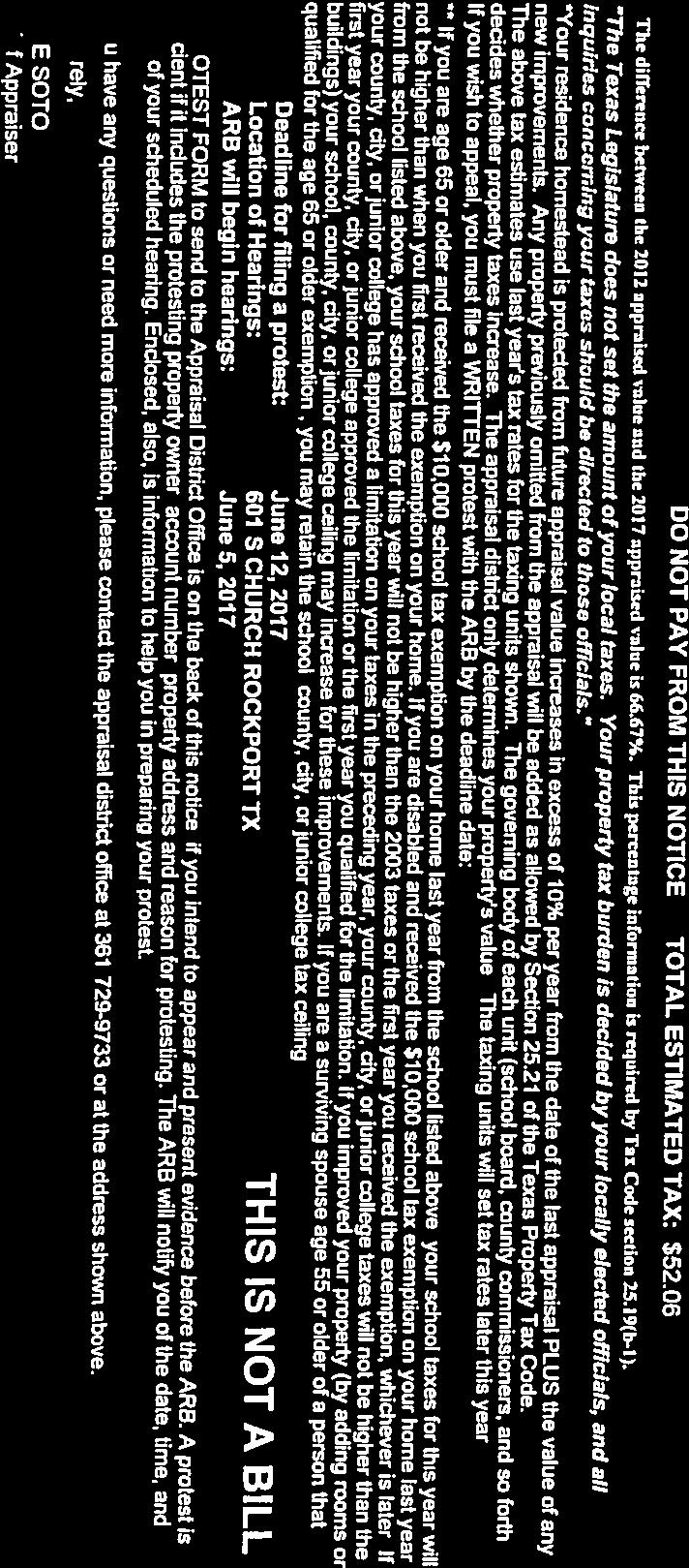
113 113


114 114


115 115


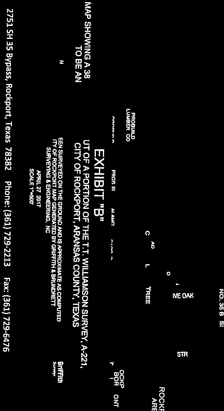
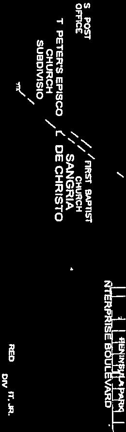


116 116

117 117
118 118
119 119
120 120 CITY COUNCIL AGENDA Workshop Meeting: Tuesday, June 27, 2017 AGENDA ITEM: 13 Conduct first Public Hearing on proposed annexation by the City of Rockport, Texas, of 182 acres of land, more or less, along State Highway 35 Bypass between 214 feet north of Holly Road and 1030 feet southwest of Eighteenth Street, being out of portions of the Paul McCombs Survey, A- 317, the C.W. Egery Survey, A-63 and the Samuel Highland Survey, A-73. SUBMITTED BY: Building and Development Staff APPROVED FOR AGENDA: PKC BACKGROUND: This is the first Public Hearing for the proposed Gap 35 annexation. The next steps in the annexation process include: 1. June 27, Second public hearing at regular council meeting. 2. July 21, 2017 Post notice of annexation ordinance adoption under Open Meetings Act. 3. July 25, 2017 First reading of annexation ordinance. 4. August 8, 2017 Second reading and adoption of annexation ordinance. Please see the accompanying metes and bounds description, Municipal Annexation Service Plan, and Annexation Profile Summary for detailed information. FISCAL ANALYSIS: See the accompanying 2017 Annexation Profile Summary for an estimate of the revenue and expenses from annexing this area. RECOMMENDATION: Not an action item.
121 121 Area to be Annexed MUNICIPAL ANNEXATION SERVICE PLAN FOR AREA GAP 35 (182 Acres) Being approximately 182 acres of land, more or less, out of portions of the Paul McCombs Survey, A-317, the C.W. Egery Survey, A-63, and the Samuel Highland Survey, A-73, with said 182 acres, more or less, being more particularly described by metes and bounds on Field Notes show in Exhibit A and map in Exhibit B. Introduction In accordance with the directives of the City Council of the City of Rockport, Texas, the City's Comprehensive Plan, and the requirements of Subsection of the Texas Local Government Code, the following service plan for the area hereinafter referred to as Area Gap 35 and as shown on the accompanying map that has been prepared. The proposed plan may be amended as a result of the public hearing process in accordance with Subsection of the most current edition of the Texas Local Government Code. This service plan shall become a part of an annexation ordinance submitted to the City Council for consideration and action, if any. The following services will be provided on the effective date of the annexation of the area according to Subsection of the most current edition of the Texas Local Government Code regarding services to newly annexed areas: 1. Animal Control Existing Services: Animal control services for this area are currently provided by the Aransas County Animal Control Department. Services to be Provided: The Aransas County Animal Control Department will continue the enforcement of the City of Rockport s animal control ordinances on the effective date of the annexation. Such services can be provided with current Animal Control personnel and within the current budget appropriation. 2. Capital Improvements Construction of capital improvements shall be considered by the City in the future as the needs dictate on the same basis as such capital improvements are considered throughout the city. 3. Building Inspections
122 122 Existing Services: Existing building inspection services are provided in this area by the City of Rockport when required by applicable building codes. Services to be Provided: The Building & Development Department will provide Code Enforcement and Building Inspection Services upon annexation. This includes issuing building, electrical and plumbing permits for any new construction and remodeling, and enforcing all other applicable codes which regulated building construction within the City of Rockport. These services can be provided within the department s current budget. 4. Emergency Medical Services Existing Services: Emergency medical services are currently provided under contract with Aransas County by Allegiance Ambulance from their facility located at 400 Enterprise in Rockport. Services to be Provided: Annexation of the proposed area will not alter the response times, service sectors, or the existing interagency agreements. 5. Fire Existing Services: Existing services are typically provided as outside city limits response by the Rockport Volunteer Fire Department, Inc. Services to be Provided: Fire suppression will be available to the area upon annexation and will be provided by the Rockport Volunteer Fire Department, Inc. There are fire stations currently located at 902 Henderson Street, 212 Gagon Street, 1608 West Terrace Boulevard and 119 Freeze Lane. Annexation of the proposed area will not alter the response times, service sectors or the existing interagency agreements. 6. Health Code Enforcement Existing Services: Public health services for this area are currently provided by the Aransas County Environmental Health Department. Services to be Provided: The Aransas County Health Department will implement the enforcement of the City of Rockport s health ordinances and regulations on the effective date of the annexation. Such services can be provided with current Health Department Personnel and within the current budget appropriation. 7. Parks Existing Services: Library services are provided by the Aransas County Public Library. City parks are currently open to non-city residents.
123 123 Services to be Provided: Library services will still be provided by the Aransas County Public Library under the same terms. Annexation will not result in any changes in the availability of parks and library facilities to residents of the area. 8. Planning and Zoning Existing Services: This area falls within the Extraterritorial Jurisdiction (ETJ) of the City of Rockport. Platting and land subdivision activities are currently co-administered by Aransas County and the City of Rockport. The City s zoning and land use ordinances, however, are not applicable outside of the existing city limits. Services to be Provided: The Building and Development Department s responsibility for regulating development and land use through the administration of the City of Rockport Zoning Ordinance will extend to this area on the effective date of the annexation. The property will solely be regulated under the requirements of the City of Rockport Subdivision Ordinance. These services can be provided within the department s current budget. 9. Police Existing Services: Sheriff s Office. Existing services are primarily provided by the Aransas County Services to be Provided: The Rockport Police Department will initiate full police and law enforcement services to this proposed annexed area at the effective date. Both divisions of the police department will coordinate this service plan. 1. The Patrol Division will provide active patrol services in the proposed area. These services will include accident investigation and preventative patrol to deter violations of statutes and local ordinances. The Patrol Division will also assist other emergency-related agencies responding within this proposed area. The Patrol Division will provide further service to our customers by initiating and monitoring vacation/property checks for residences and businesses requesting such programs during their absence. 2. The Criminal Investigation Division will provide for active investigation services to be implemented in the proposed area. These services include crime scene search and the related analysis and investigation leading to the identification of suspects, issuance of arrest warrants and the apprehension of suspected offenders; preparation and submission of cases to the appropriate agency for prosecution and/or presentation to a Grand Jury; and response to citizen requests for crime prevention and security inspections of their real property. A review of the ongoing criminal investigations will be conducted to determine which (if any) cases should be transferred to the Rockport Police Department Investigation Division: The Criminal Investigation Division will assist in the development of
124 124 neighborhood watch programs and conduct certified residential and business security surveys upon request. Annexation of this area would require an increase of approximately 694 patrol labor hours and 694 criminal investigation labor hours. The Rockport Police Department will coordinate with the proper governmental agencies to ensure that 911 map sheets will be updated related to 911 calls within the specified zone. 10. Sanitary Sewer Service Existing Services: Existing sanitary sewer service in this area is provided by either the City of Rockport or by on-site sewage facilities. Services to be Provided: Sanitary sewer service to the area of proposed annexation will be provided in accordance with applicable codes and city policy. When property develops in the adjacent areas, sanitary sewer service shall be provided in accordance with the present extension ordinance and as requested by developers. Extension of service shall comply with applicable codes and ordinances. 11. Solid Waste Collection Existing Services: There is currently no dedicated solid waste disposal service for this area. Residents may contract individually with available service providers. Services to be Provided: Solid Waste Collection will be provided by the City's contractor, Republic Services, Inc. Service shall comply with existing City policies, beginning with occupancy of structures. As provided for by Section (n) of the Texas Local Government Code, residents may continue to use their existing solid waste collection service for up to two years following the effective date of annexation. At the end of the two-year period or termination of existing service by the customer (whichever is sooner), the City s contractor will begin providing service. 12. Street Lighting Existing Services: Existing streetlights in the area are provided by the Texas Department of Transportation. Services to be Provided: The City of Rockport will coordinate any requests for improved street lighting with the local electric provider in accordance with standard policy. 13. Street Maintenance Existing Services: Existing street maintenance services for this area are provided by Aransas County Road and Bridge Department.
125 125 Services to be Provided: Maintenance to the street facilities will be provided by the City upon the effective date of the annexation. This service can be provided within the current budget appropriation. All streets within the area proposed for annexation are currently paved. Annexation of this area would require an increase of approximately 694 street maintenance labor hours. 14. Storm Water Management Existing Services: Drainage and storm water management within this area is currently provided by Aransas County. Services to be Provided: Developers will provide storm water drainage at their own expense and will be inspected by the City Engineers at time of completion. The City will assume maintenance of the developer s drainage facilities upon acceptance from the developer. 15. Water Service Existing Services: Existing water utility services to this area is provided by the City of Rockport and includes both potable water and fire protection. Services to be Provided: Water service to the area will continue to be provided by the City of Rockport in accordance with the applicable codes and departmental policy. When other property develops in the adjacent area, water service shall be provided in accordance with extension ordinances and as requested by developers. Extension of service shall comply with City codes and ordinances. Water utility rates will be based on a lower Inside City Limits customer classification as opposed to the Outside City Limits customer classification. Miscellaneous All other applicable municipal services will be provided to the area in accordance with the City of Rockport s established policies governing extension of municipal services to newly annexed areas. All City codes shall be in effect upon annexation. Uniform Level of Services May Not Be Required Nothing in this plan shall require the city to provide a uniform level of full municipal services to each area of the city, including the annexed areas, if different characteristics of topography, land use, and population density are considered a sufficient basis for providing different levels of services. Term This service plan shall be valid for a term of ten (10) years.
126 Amendments The plan shall not be amended unless public hearings are held in accordance with V.C.T.A., Local Government Code, Section
127 127 EXHIBIT A FIELD NOTE DESCRIPTION 182 ACRES TO BE ANNEXED BY CITY OF ROCKPORT, ARANSAS COUNTY, TEXAS APRIL 27, 2017 BEING THE DESCRIPTION OF 182 ACRES OF LAND, MORE OR LESS, OUT OF PORTIONS OF THE PAUL MCCOMBS SURVEY, A-317, THE C.W. EGERY SURVEY, A-63 AND THE SAMUEL HIGHLAND SURVEY, A-73, WITH SAID 182 ACRES, MORE OR LESS, BEING MORE PARTICULARLY DESCRIBED BY METES AND BOUNDS AS FOLLOWS: BEGIN, at a point in the West R.O.W. line of Holly Road and being the common corner of Lots 39 and 40, of the Sartain and Montgomery Subdivision, according to the plat recorded in Volume 1, Page 34, Plat Records of Aransas County, Texas, and being the UPPER NORTHEAST corner and PLACE OF BEGINNING of this description; THENCE, in a Southerly direction, along and with the West R.O.W. line of Holly Road, a distance of approximately 214 feet to a point for the Southeast corner of Lot 41, of said Sartain and Montgomery Subdivision, and being an angle point and INTERIOR corner of this description; THENCE, in a Southeasterly direction, crossing said Holly Road, a distance of approximately 42 feet to a point in the Northwesterly R.O.W. line of Texas State Highway No. 35 Relief Route, and being the Northeast corner of a called 5.87 acre tract out of the Paul McCombs Survey, A-317, as described in a deed of record to Thomas Edwards under Clerks File Number , Real Property Records of Aransas County, Texas, and being an INTERIOR corner of this description; THENCE, in a Southeasterly direction, crossing said Texas State Highway No. 35 Relief Route, a distance of approximately 621 feet to a point in the Northeasterly R.O.W. line of said Texas State Highway No. 35 Relief Route and being the Northwest corner of a acre tract out of the Paul McCombs Survey, A-317, as described in a deed of record to Rockne Moseley under Clerks File Number , Official Public Records of Aransas County, Texas, and being the LOWER NORTHEAST corner of this description; THENCE, in a Southwesterly direction, along and with the Northeasterly R.O.W. line of said Texas State Highway No. 35 Relief Route, a distance of approximately 2347 feet to an angle point in Fractional Tract 82 of the Foor and Swickheimer Subdivision, according to the plat recorded in Volume 1, Page 28, Plat Records of Aransas County, Texas, and being an INTERIOR corner of this description; THENCE, continuing in a Southeasterly direction, along and with the Northeasterly R.O.W. line of said Texas State Highway No. 35 Relief Route, a distance of approximately 2471 feet to a point in the common boundary line of Fractional Tract 119, lying East of Texas State Highway No. 35 Relief Route, of said Foor and Swickheimer Subdivision, and Fractional Tract 33 of the Abernathy Tracts, according to the plat recorded in Volume 1, Page 27, Plat Records of Aransas County, Texas, and being the Southwest corner of a 0.39 acre tract out of said Fractional Tract 119, as described in a deed of record to High Tide Partners, Ltd., under Clerks File Number , Official Public Records of Aransas County, Texas, and being the Northwest corner of a acre tract out of said Tracts 33 and 34, of said Abernathy Tracts, as described in a deed of record to J.F. Brazos Enterprises, under Clerks File Number , Official Public Records of Aransas County, Texas, and being the SOUTHEAST corner of this description; THENCE, in a Westerly direction, crossing said Texas State Highway No. 35 Relief Route, along and with the North boundary line of said Abernathy Tracts, and the South boundary line of said Sartain and Montgomery Subdivision, a distance of approximately 1014 feet to a point in the West R.O.W. line of Kluge Trail, and being the Southeast corner of Lot 70, of said Sartain and Montgomery Subdivision, and being the Southeast corner of a called acre tract out of a portion of said Lot 70, and the C.W. Egery Survey, A-63, as described in a deed of record to John Cooling under Clerks File Number , Official Public Records of Aransas County, Texas, and being the SOUTHWEST corner of this description; THENCE, in a Northeasterly direction, along and with the West R.O.W. line of said Kluge Trail, a distance of approximately 3173 feet to a point in the North R.O.W. line of Sixteenth Street, and being in the South boundary line of Brier Patch Acres, according to the plat recorded in Volume 4, Page 54, Plat Records of Aransas County, Texas, and being the LOWER NORTHWEST corner of this description; THENCE, in an Easterly direction, along and with the North R.O.W. line of Sixteenth Street, a distance of approximately 526 feet to an angle point and EXTERIOR corner of this description; THENCE, continuing in an Easterly direction, along and with the North R.O.W. line of Sixteenth Street, a distance of approximately 333 feet to a point for the Southeast corner of Lot 10, of said Brier Patch Acres, and being an INTERIOR corner of this description;
128 128 THENCE, in a Northeasterly direction, along and with the East boundary line of said Lot 10, Brier Patch Acres, a distance of approximately 339 feet to a point for the Northeast corner of said Lot 10, and being in the South boundary line of Lot 20, of Peninsula Oaks, Unit 6, according to the plat recorded in Volume 3, Page 36, Plat Records of Aransas County, Texas, and being an EXTERIOR corner of this description; THENCE, in a Southeasterly direction, along and with the common boundary line of said Brier Patch Acres and Peninsula Oaks Subdivision, Unit 6, a distance of approximately 180 feet to a point in the West R.O.W. line of Poinciana Drive, and being the Southeast corner of said Lot 20, and being an INTERIOR corner of this description; THENCE, in a Northeasterly direction, along and with the West R.O.W. line of said Poinciana Drive, a distance of approximately 1204 feet to a point in the East boundary line of Lot 22, of said Peninsula Oaks, Unit 6, and being the UPPPER NORTHWEST corner of this description; THENCE, in an Easterly direction, crossing said Poinciana Drive, and along the common boundary line of Lots 16 and 17, of said Peninsula Oaks, Unit 6, a distance of approximately 588 feet to a point for the Northeast corner of said Lot 17, and being in the West boundary line of Lot 39, of said Sartain and Montgomery Subdivision, and being an EXTERIOR corner of this description; THENCE, along and with the common boundary line of said Lot 17, Peninsula Oaks, Unit 6, and Lot 39, of said Sartain and Montgomery Subdivision, a distance of approximately 12 feet to a point for the common corner of Lots 39 and 40, of said Sartain and Montgomery Subdivision, and being an INTERIOR corner of this description; THENCE, in an Easterly direction, along and with the common boundary line of Lots 39 and 40, of said Sartain and Montgomery Subdivision, a distance of approximately 815 feet to the PLACE OF BEGINNING and containing approximately 182 acres or 7,918,195 square feet of land, more or less Field Notes/35 Bypass APRIL 2017 Annex


129 129
130 Annexation Profile Summary Area 1 Area 3 Area 11 Area 12 Category Market Street B Area "D" Gap 35 Pearl Street Total Expenses & Data Misecellaneous Population Acres Development Type Single Family Multi-Family Commercial Unimproved Property Valuation Total Market Valuation $ 2,801,170 $ 9,122,260 $ 3,661,900 $ 5,855,830 $ 21,441,160 Average Value (excluding exempt) $ 69,813 $ 29,811 $ 69,346 $ 37,778 Median Value (excluding exempt) $ 27,715 $ 7,680 $ 43,860 $ 24,930 Average Homestead Value $ 96,932 $ 74,021 $ 97,716 $ 92,324 Infrastructure Current Street Miles Annual Street Maintenance Cost $ 18,833 $ 19,149 $ 3,591 $ 9,612 $ 51, New Streetlights Streetlight Installation Cost $ 18,000 $ 16,000 $ 2,000 $ 7,000 $ 43, Streetlight Electrical Cost $ 3,381 $ 3,423 $ 645 $ 1,726 $ 9, Total Capital Expense $ 18,000 $ 16,000 $ 2,000 $ 7,000 $ 43,000 Total Annual O&M Expense $ 22,214 $ 22,573 $ 4,236 $ 11,338 $ 60,361 Services New Police Labor Hours - Patrol , New Police Labor Hours - CID , New Police Labor Hours - Admin New Building Inspector Hours New Code Enforcement Officer Hours New Parks Labor Hours New Street Labor Hours ,773.33
131 131 Area 1 Area 3 Area 11 Area 12 Category Market Street B Area "D" Gap 35 Pearl Street Total New Water Labor Hours New Wastewater Labor Hours Total Water Customers Total Sewer Customers Total Gas Customers Total Sanitation Customers Total New Labor Hours 2, , , , , Personnel Costs (includes salary and benefits at step 11; equipment and onboarding costs excluded) Police - Patrol $ 19, $ 19, $ 19, $ 19, $ 77, Police - CID $ 20, $ 20, $ 20, $ 20, $ 81, Police - Admin $ 16, $ - $ - $ - $ 16, Building Inspector $ - $ - $ - $ - $ - Code Enforcement Officer $ - $ - $ - $ - $ - Parks Maintenance Techs (0.5) $ - $ - $ - $ - $ - Street Maintenance Techs $ 13, $ 13, $ 13, $ 13, $ 52, Water Maintenance Techs $ - $ - $ - $ - $ - Wastewater Maintenance Techs $ - $ - $ - $ - $ - Total Personnel Expense $ 69, $ 53, $ 53, $ 53, $ 228, Revenue New Ad Valorem Revenue $ 10, $ 33, $ 13, $ 21, $ 78, New Sales Tax Revenue individual sales tax revenue info not available $ - Difference in Water Revenue $ (11,114.88) $ (23,582.40) $ - $ (23,582.40) $ (58,279.68) Difference in Sewer Revenue $ (2,095.92) $ (7,920.00) $ - $ (7,920.00) $ (17,935.92) Difference in Gas Revenue $ - $ - $ - $ - $ - Difference in Sanitation Revenue $ $ 2, $ $ $ 4, Total Revenue $ (2,147) $ 4,235 $ 13,786 $ (9,182) $ 6,691 Net Revenue/Expense Total Capital Expense $ 18,000 $ 16,000 $ 2,000 $ 7,000 $ 43,000 Total Annual O&M Expense $ 22,214 $ 22,573 $ 4,236 $ 11,338 $ 60,361 Total Personnel Expense $ 69, $ 53, $ 53, $ 53, $ 228,878
132 132 Area 1 Area 3 Area 11 Area 12 Category Market Street B Area "D" Gap 35 Pearl Street Total Total Expense $ 110,022 $ 91,596 $ 59,260 $ 71,362 $ 332,240 Total Revenue $ (2,147) $ 4,235 $ 13,786 $ (9,182) $ 6,691 Net Revenue/Expense $ (112,169) $ (87,362) $ (45,474) $ (80,543) $ (325,548)

133 133

134 134
ORDINANCE N0.18-ll6. WHEREAS, City has prepared a Service Plan for said tract which is attached as Exhibit "A" to this ordinance; &
 c: 0 ORDINANCE N0.18-ll6 AN ORDINANCE ANNEXING THE HEREINAFTER DESCRIBED TERRITORY TO THE CITY OF FORT STOCKTON, PECOS COUNTY, TEXAS, AND EXTENDING THE BOUNDARY LIMITS OF SAID CITY SO AS TO INCLUDE SAID
TOWN OF EPPING, NH ZONING ORDINANCES
 TOWN OF EPPING, NH ZONING ORDINANCES 2017 Contents ARTICLE 1: Preamble, Title & Purpose 3 ARTICLE 2: Zoning 4 1. Highway-Commercial 7 2.Residential-Commercial 11 3. West Epping Commercial Business Zone
Day care centers: Such uses shall require a Special Permit under the terms of Article VIII of this chapter.
 Page 1 of 12 DIVISION 1. - R-1 RESIDENTIAL ZONE Sec. 38-41. - Permitted uses. Single-family dwellings, excluding factory manufactured homes constructed as a single selfcontained unit and mounted on a single
FOR SALE COMMERCIAL BEACHSIDE LOT
 FOR SALE COMMERCIAL BEACHSIDE LOT 1100 South Patrick Dr., Satellite Beach, Florida 32937.69 Acres, Zoning C-Commercial Lot is Cleared Numerous Allowable Intended Uses (see zoning on next page) High Visibility
The minimum useable open space required for multi-family dwellings in this district shall be twenty-five (25) percent.
 percent.") Sec. 9.10. Minimum useable open space. The minimum useable open space required for multi-family dwellings in this district shall be twenty-five (25) percent. Sec. 9.11. Finish. All structures, including
Sec. 9.10. Minimum useable open space. The minimum useable open space required for multi-family dwellings in this district shall be twenty-five (25) percent. Sec. 9.11. Finish. All structures, including
Planning & Zoning Commission Meeting Date: 02/07/2018 Submitted By: Janice Pokrant, Engineering Department. 4.a. Information SUBJECT:
 Planning & Zoning Commission Meeting Date: 02/07/2018 Submitted By: Janice Pokrant, Engineering Department 4.a. SUBJECT: Information Conduct a Public Hearing and Consider a Request For Plat 18-01 by Abner
13. Automobile maintenance service, but not commercial truck maintenance service
 SECTION 60 B-3 COMMUNITY BUSINESS DISTRICT 60.01 General Description: This business district is intended for the conduct of personal and business services and retail business of the community. Traffic
GC General Commercial District
 Section 712. GC General Commercial District 712.1 Intent of District. It is the intent of this section that the GC Zoning District be developed and reserved for general business purposes. The regulations
ARTICLE 535. PD 535. C.F. Hawn Special Purpose District No. 3
 ARTICLE 535. PD 535. C.F. Hawn Special Purpose District No. 3 SEC. 51P-535.101. LEGISLATIVE HISTORY. PD 535 was established by Ordinance No. 23988, passed by the Dallas City Council on August 25, 1999.
Planned Residential Development Zone
 SECTION 55 Planned Residential Development Zone 55.0 [Reserved] 55.1 General The Planned Residential Development (PRD) Zone is a class of zone in addition to and overlapping a portion or portions of the
Chapter 100 Planned Unit Development in Corvallis Urban Fringe
 100.100 Scope and Purpose. Chapter 100 Planned Unit Development in Corvallis Urban Fringe (1) All applications for land divisions in the Urban Residential (UR) and Flood Plain Agriculture (FPA) zones within
UPPER MOUNT BETHEL TOWNSHIP NORTHAMPTON COUNTY, PENNSYLVANIA
 UPPER MOUNT BETHEL TOWNSHIP NORTHAMPTON COUNTY, PENNSYLVANIA JOINDER DEED / LOT CONSOLIDATION TOWNSHIP REVIEW PROCESS When accepting proposed Joinder Deeds / Lot Consolidations, review the Joinder Deed
Road frontage 287 Sewer and Well Propane Central Air
 FOR SALE/LEASE FOR SALE $149,900 FOR LEASE $13.75/sf Modified Net 1027 Voluntown Rd., Griswold 1,440sf+/- commercial bldg. with full basement (total 2,880sf) 0.96 acre Zone C-1 15 parking spaces John Jensen,
ACTION FORM BRYAN CITY COUNCIL
 ACTION FORM BRYAN CITY COUNCIL DATE OF COUNCIL MEETING: July 8, 2014 DATE SUBMITTED: June 17, 2014 DEPARTMENT OF ORIGIN: Development Services SUBMITTED BY: Maggie Dalton MEETING TYPE: CLASSIFICATION: ORDINANCE:
ARTICLE 383. PD 383.
 ARTICLE 383. PD 383. SEC. 51P-383.101. LEGISLATIVE HISTORY. PD 383 was established by Ordinance No. 21928, passed by the Dallas City Council on December 8, 1993. Ordinance No. 21928 amended Ordinance No.
SECTION CLASSIFICATION OF ZONES For the purpose of this Code the following primary land use zoning districts are hereby established:
 ARTICLE 4 ZONING DISTRICTS SECTION 4.010 CLASSIFICATION OF ZONES For the purpose of this Code the following primary land use zoning districts are hereby established: Primary Zones Abbreviated Designation
ARTICLE 428. PD 428.
 ARTICLE 428. PD 428. SEC. 51P-428.101. LEGISLATIVE HISTORY. PD 428 was established by Ordinance No. 22560, passed by the Dallas City Council on September 27, 1995. Ordinance No. 22560 amended Ordinance
Chapter AGRICULTURAL DISTRICT A-1
 Chapter 18.20 AGRICULTURAL DISTRICT A-1 Sections: 18.20.010 Permitted uses. 18.20.020 Conditional uses. 18.20.010 Permitted uses Permitted uses in the A-1 district are: Single-family residence General
4.2 RESIDENTIAL ZONING DISTRICTS
 4.2 RESIDENTIAL ZONING DISTRICTS A. Purpose: To define regulations and standards for each residential zoning district in the City. The following sections identify uses, regulations, and performance standards
CHAPTER CC (COMMUNITY COMMERCIAL) ZONE
 ZONE") CHAPTER 17.143 CC (COMMUNITY COMMERCIAL) ZONE Section Title Page 17.143.010 Purpose 1 17.143.020 Permitted Uses 1 17.143.030 Conditional Uses 3 17.143.040 Approval Standards for Conditional Uses 3 17.143.050
CHAPTER 17.143 CC (COMMUNITY COMMERCIAL) ZONE Section Title Page 17.143.010 Purpose 1 17.143.020 Permitted Uses 1 17.143.030 Conditional Uses 3 17.143.040 Approval Standards for Conditional Uses 3 17.143.050
CHAPTER 18 SITE CONDOMINIUM PROJECTS
 15.1800 CHAPTER 18 SITE CONDOMINIUM PROJECTS 15.1801 SECTION 18.01 PURPOSE AND SCOPE GRAND HAVEN CHARTER TOWNSHIP Site condominium projects are condominium developments in which each condominium unit consists
(if more than one, give square footage for each) ANNEXATION LOT LINE Adjustments PRE/FINAL PLAT SPECIAL USE PERMIT
 ANNEXATION LOT LINE Adjustments PRE/FINAL PLAT SPECIAL USE PERMIT") Planning Commission Application Building & development office 915 Third ST. Rawlins WY ph. 307-328-4599 fax. 307-328-4590 PROJECT REVIEW: GENERAL INFORMATION Project name: OFFICE USE ONLY Site address
Planning Commission Application Building & development office 915 Third ST. Rawlins WY ph. 307-328-4599 fax. 307-328-4590 PROJECT REVIEW: GENERAL INFORMATION Project name: OFFICE USE ONLY Site address
Kitsap County Department of Community Development. Administrative Staff Report
 Kitsap County Department of Community Development Administrative Staff Report Report Date: Application Complete Date: March 15, 2018 Application Submittal Date: March 12, 2018 Project Name: Nikki Lee Salon
SHOPPING CENTER DISTRICT (Zone BSC)
") Sec. 3-27. SHOPPING CENTER DISTRICT (Zone BSC) (a) (b) Area. All land designated as Zone BSC is subject to the regulations of this Section and Sec. 20.3-10. Such areas are established to provide for planned
Sec. 3-27. SHOPPING CENTER DISTRICT (Zone BSC) (a) (b) Area. All land designated as Zone BSC is subject to the regulations of this Section and Sec. 20.3-10. Such areas are established to provide for planned
ARTICLE 598. PD 598.
 ARTICLE 598. PD 598. SEC. 51P-598.101. LEGISLATIVE HISTORY. PD 598 was established by Ordinance No. 24683, passed by the Dallas City Council on August 8, 2001, and was amended on the same day by Ordinance
acres total $3,500,000
 Development Land Pequot Commercial F O R Lisbon Landing shopping LISBON GRISWOLD S A L E 134.77 acres total 29 & 31 Barber Rd., Griswold CT Zone C-1 Village Commercial District Only 0.45 miles to I-395
AGENDA. a. Carol Crews Special Exception Hair Salon (Continued from February) b. James Barber Special Exception Horse
 b. James Barber Special Exception Horse") Baker County Land Planning Agency (LPA) Thursday, April 23, 2015 Baker County Administration Building 55 North Third Street Macclenny, FL 32063 (904) 259-3354 AGENDA 5:OO P.M. LDR Mining Workshop A. Draft
Baker County Land Planning Agency (LPA) Thursday, April 23, 2015 Baker County Administration Building 55 North Third Street Macclenny, FL 32063 (904) 259-3354 AGENDA 5:OO P.M. LDR Mining Workshop A. Draft
Farming & Livestock related activities Y Y Y Y Y Y. Commercial Type Animal Facility Y Y Y
 ( = Permitted) TABLE A PERMITTED USES B DISTRICT MU MU2 CC MH/ RV Agricultural Uses (Light) Agricultural Uses (Heavy) Residential Uses Recreational and Institutional Uses RM R C LI MI HI A Farming & Livestock
ARTICLE 15 - PLANNED UNIT DEVELOPMENT
 Section 15.1 - Intent. ARTICLE 15 - PLANNED UNIT DEVELOPMENT A PUD, or Planned Unit Development, is not a District per se, but rather a set of standards that may be applied to a development type. The Planned
1.0 REQUEST. SANTA BARBARA COUNTY ZONING ADMINISTRATOR Coastal Zone Staff Report for Vincent New Single-Family Dwelling & Septic System
 SANTA BARBARA COUNTY ZONING ADMINISTRATOR Coastal Zone Staff Report for Vincent New Single-Family Dwelling & Septic System Hearing Date: February 26, 2007 Supervisorial District: First Staff Report Date:
DIVISION FIVE COMMERCIAL ZONES. 1. Permitted Uses of Land, Buildings, and Structures
 DIVISION FIVE - COMMERCIAL ZONES 501 GENERAL COMMERCIAL ZONE () 1. Permitted Uses of Land, Buildings, and Structures Subject to the provisions of Divisions Three and Four of this bylaw, the following uses
PART 1 JURISDICTION, ZONING DISTRICTS, AND LAND USES
 PART 1 JURISDICTION, ZONING DISTRICTS, AND LAND USES ARTICLE 1 TITLE, PURPOSE, JURISDICTION, AND APPLICABILITY Division 1-1.1 Title and Reference Sec. 1-1.1.1 Title This Ordinance shall be known as "The
DU PAGE COUNTY ZONING BOARD OF APPEALS JACK T. KNUEPFER ADMINISTRATION BUILDING 421 NORTH COUNTY FARM ROAD, WHEATON, ILLINOIS 60187/
 DU PAGE COUNTY ZONING BOARD OF APPEALS JACK T. KNUEPFER ADMINISTRATION BUILDING 421 NORTH COUNTY FARM ROAD, WHEATON, ILLINOIS 60187/ 630-407-6700 M E M O R A N D U M TO: FROM: DuPage County Board DuPage
ARTICLE SINGLE FAMILY SITE CONDOMINIUM DEVELOPMENT STANDARDS
 ARTICLE 28.00 SINGLE FAMILY SITE CONDOMINIUM DEVELOPMENT STANDARDS Section 28.01 PURPOSE The purpose of this Article is to recognize that conventional single family developments, traditionally developed
Pleasant Hill, IA Code of Ordinances
 Print Pleasant Hill, IA Code of Ordinances 167.08 C 1 NEIGHBORHOOD/LOCAL COMMERCIAL DISTRICT. 1. Statement of Intent. The C 1 District is intended to provide for the orderly development of central shopping
BARROW COUNTY, GEORGIA
 BARROW COUNTY, GEORGIA Application For Rezoning, Special Use, and Change in Conditions BARROW COUNTY DEPARTMENT OF PLANNING AND DEVELOPMENT 30 North Broad Street Winder, Georgia 30680 770-307-3034 APPLICATION
CITY OF HENDERSON TABLE OF CONTENTS. Section 101: Purpose... 1 Section 102: Authority... 1 GENERAL REGULATIONS APPLIED TO ALL DISTRICTS
 TABLE OF CONTENTS ARTICLE 100: PURPOSE AND AUTHORITY Section 101: Purpose... 1 Section 102: Authority... 1 ARTICLE 200: GENERAL REGULATIONS APPLIED TO ALL DISTRICTS Section 201: Jurisdiction and Zoning
ARTICLE 24 SITE PLAN REVIEW
 ARTICLE 24 SITE PLAN REVIEW 24.1 PURPOSE: The intent of these Ordinance provisions is to provide for consultation and cooperation between the land developer and the Township Planning Commission in order
VILLAGE OF ORLAND PARK
 14700 Ravinia Avenue Orland Park, IL 60462 www.orlandpark.org Ordinance No: File Number: 2016-0865 ORDINANCE REZONING CERTAIN REAL ESTATE FROM E-1 ESTATE RESIDENTIAL DISTRICT TO COR MIXED USE DISTRICT
KLICKITAT COUNTY CODE Chapter RECREATIONAL VEHICLE PARKS
 KLICKITAT COUNTY CODE Chapter 22.08 - RECREATIONAL VEHICLE PARKS 22.08.010 - Applicability. Every recreational park in the unincorporated area of the county shall be located, constructed, altered, expanded
ARTICLE 426. PD 426.
 ARTICLE 426. PD 426. SEC. 51P-426.101. LEGISLATIVE HISTORY. PD 426 was established by Ordinance No. 22741, passed by the Dallas City Council on April 24, 1996. Ordinance No. 22741 amended Ordinance No.
CITY OF DEL RIO PLANNING & ZONING COMMISSION COUNCIL CHAMBERS - CITY HALL 109 WEST BROADWAY ST. WEDNESDAY, MAY 20, :30 P.M.
 CITY OF DEL RIO PLANNING & ZONING COMMISSION COUNCIL CHAMBERS - CITY HALL 109 WEST BROADWAY ST. WEDNESDAY, MAY 20, 2015 5:30 P.M. AGENDA 1. CALL TO ORDER 2. ROLL CALL 3. APPROVAL OF MINUTES a. Approve
2-1 TITLE 4 ZONING CODE 2-2
 2-1 TITLE 4 ZONING CODE 2-2 Chapter 2 RESIDENTIAL ZONING DISTRICTS Sec. 2-1: Sec. 2-2: Sec. 2-3: Sec. 2-4: Sec. 2-5: Sec. 2-6: Sec. 2-7: Sec. 2-8: Purpose Agriculture/Forestry Zoning District (AF) Farm,
ARTICLE 24 PRIVATE ROAD, SHARED PRIVATE DRIVEWAY AND ACCESS EASEMENT STANDARDS
 ARTICLE 24 PRIVATE ROAD, SHARED PRIVATE DRIVEWAY AND ACCESS EASEMENT STANDARDS SECTION 24.00 INTENT AND PURPOSE The standards of this Article provide for the design, construction and maintenance of private
CITY OF SANDSTONE PLANNING COMMISSION July 11, Steve Palmer, Andrew Spartz, Randy Riley, Reese Frederickson
 CITY OF SANDSTONE PLANNING COMMISSION July 11, 2018 CALL TO ORDER Members present: Members absent: Staff present: Others: Steve Palmer, Andrew Spartz, Randy Riley, Reese Frederickson Cassie Gaede, Rene
Ferry County Ordinance #89-04 BINDING SITE PLAN ORDINANCE
 Ferry County Ordinance #89-04 BINDING SITE PLAN ORDINANCE AN ORDINANCE providing for an alternate method of subdividing property for the purpose of allowing tracts of land having more than one residence
A favorable recommendation to the City Council is requested.
 To: Sycamore Plan Commission From: Brian Gregory, City Manager Date: October 8, 2015 Re: October 12, 2015 Plan Commission Meeting The Plan Commission has two action items. A. Consideration of a request
TOWN OF WATERVILLE VALLEY NEW HAMPSHIRE SITE PLAN REVIEW REGULATIONS
 TOWN OF WATERVILLE VALLEY NEW HAMPSHIRE Effective date March 17, 1981 Revised March 16, 1982 Revised March 13, 1986 Revised March 10, 1987 Revised March 14, 2013 Revised March 8, 2016 TOWN OF WATERVILLE
ARTICLE 7 R-1 ONE FAMILY RESIDENTIAL DISTRICT
 ARTICLE 7 R-1 ONE FAMILY RESIDENTIAL DISTRICT SECTION 700 STATEMENT OF PURPOSE This district classification is designed to be the most restrictive of the residential districts intended to encourage an
ORDINANCE NO. 41. PRIVATE ROAD ORDINANCE As Amended Through April 10, 2008
 ORDINANCE NO. 41 PRIVATE ROAD ORDINANCE As Amended Through April 10, 2008 An Ordinance to protect the health, safety, and general welfare of the inhabitants of Port Sheldon Township. The Township of Port
NOTICE OF PUBLIC HEARINGS CITY OF LIVE OAK, CALIFORNIA
 NOTICE OF PUBLIC HEARINGS CITY OF LIVE OAK, CALIFORNIA NOTICE IS HEREBY GIVEN that public hearings by the Live Oak City Council will be held to receive public comments at 7:00 PM on Wednesday, December
Public Review Draft. Fortuna Municipal Code. Title 17: Zoning Regulations. Fortuna Planning Commission Review Copy. June 28, 2011
 Public Review Draft Fortuna Municipal Code Title 17: Zoning Regulations Fortuna Planning Commission Review Copy June 28, 2011 This document is subject to revision and updating. Key to Text Color Code Original
State Law reference Extraterritorial jurisdiction, V.T.C.A., Local Government Code et seq.
 ARTICLE I. - IN GENERAL Sec. 126-1. - Definitions. The following words, terms and phrases, when used in this chapter, shall have the meanings ascribed to them in this section, except where the context
ADUs and You! Common types of ADUs include mother-in-law suite, garage apartments and finished basements.
 ADUs and You! Accessory Dwelling Units Town of Lyons Accessory Dwelling Units (ADUs) are a form of housing that can be an important tool for diversifying and increasing the local housing stock. Lyons lost
PLANNING AND ZONING COMMISSION ZONE CHANGE
 PLANNING AND ZONING COMMISSION ZONE CHANGE DOÑA ANA COUNTY COMMUNITY DEVELOPMENT DEPARTMENT Doña Ana County Government Center 845 N. Motel Blvd. Las Cruces, New Mexico 88007 Telephone: (575) 647-7350 MEETING
ARTICLE 533. PD 533. C.F. Hawn Special Purpose District No. 1
 ARTICLE 533. PD 533. C.F. Hawn Special Purpose District No. 1 SEC. 51P-533.101. LEGISLATIVE HISTORY. PD 533 was established by Ordinance No. 23780, passed by the Dallas City Council on February 10, 1999.
City of Shenandoah Development Package
 Upon completion return application to Development@shenandoahtx.us City of Shenandoah Development Package Documentation includes the following: Fee Schedule Platting Development Check List & Outline Development
ARTICLE 1 GENERAL PROVISIONS
 ARTICLE 1 GENERAL PROVISIONS SECTION 100 TITLE This Ordinance shall be known and cited as the "Rice Township Subdivision and Land Development Ordinance." SECTION 101 AUTHORITY Rice Township is empowered
This is a conditional use permit request to establish a commercial wind energy conversion system.
 Public Works 600 Scott Boulevard South Hutchinson, Kansas 67505 620-694-2976 Road & Bridge Planning & Zoning Noxious Weed Utilities Date: March 28, 2019 To: From: Reno County Planning Commission Russ Ewy,
TEMPORARY USE APPLICATION Sec and Temporary Housing
 Temporary Use Application Page 1 of 6 Receipt Date Stamp CITY OF CARLSBAD Planning, Engineering, and Regulation Department PO Box 1569, Carlsbad, NM 88221 Phone (575) 885-1185 Fax (575) 628-8379 TEMPORARY
ARTICLE XIV - PERMANENT MOBILE HOME/MANUFACTURED HOME PARKS 41. and/or manufactured home park. The permit shall be for a year, and shall be
 ARTICLE 41 14-1 APPLICATION FOR PERMIT A permit shall be required to establish, maintain and operate a mobile home and/or manufactured home park. The permit shall be for a year, and shall be renewed during
The intent of Business District B 1 is to provide an area for local and neighborhood shopping where
 CODE OF THE COUNTY DIVISION 9. BUSINESS DISTRICT B 1 Botetourt County, Virginia, Code of Ordinances Page 71 DIVISION 9. BUSINESS DISTRICT B 1 Sec. 25 221. Purpose. Sec. 25 222. Permitted uses. Sec. 25
TOWNSHIP OF SOLON COUNTY OF KENT, MICHIGAN. Members: Robert Ellick, Fred Gunnell, Mark Hoskins, Mary Lou Poulsen
 As recommended by Planning Commission at its December 27, 2017 meeting TOWNSHIP OF SOLON COUNTY OF KENT, MICHIGAN At a regular meeting of the Township Board of the Township of Solon, Kent County, Michigan,
-MENDOCINO COUNTY PLANNING AND BUILDING SERVICES- DIVISION OF LAND REGULATIONS TITLE 17
 ARTICLE VI -- GENERAL REGULATIONS AND PROVISIONS Sec. 17-50. Sec. 17-51 General Plan. Sec. 17-52 Lot and Block Design and Configuration. Sec. 17-53 Lot Access. Sec. 17-54 Private Roads. Sec. 17-55 Water
ARTICLE XI CSC COMMUNITY SERVICE COMMERCIAL DISTRICT
 ARTICLE XI CSC COMMUNITY SERVICE COMMERCIAL DISTRICT SECTION 11.01 PURPOSE This district is intended to provide areas where retail trades and service outlets can be located that are convenient to the residents
CHAPTER 14 PLANNED UNIT DEVELOPMENTS
 9-14-1 9-14-1 CHAPTER 14 PLANNED UNIT DEVELOPMENTS SECTION: 9-14-1: Purpose 9-14-2: Governing Provisions 9-14-3: Minimum Area 9-14-4: Uses Permitted 9-14-5: Common Open Space 9-14-6: Utility Requirements
Division S-19. PD Subdistrict 19.
 Division S-19. PD Subdistrict 19. SEC. S-19.101. LEGISLATIVE HISTORY. PD Subdistrict 19 was established by Ordinance No. 23022, passed by the Dallas City Council on February 12, 1997. Ordinance No. 23022
Waseca County Planning and Zoning Office
 Waseca County Planning and Zoning Office 300 North State Street Waseca, Minnesota 56093 Phone: 507-835-0650 Fax: 507-837-5310 Form no. PZ 081009 Web Site: www.co.waseca.mn.us FEES: 1) CUP FEE- $400.00
Article 9 Home Occupations
 9.1 Intent. Home Occupations shall be defined under Article 4. The purpose of this Article is to: 9.1-1 Maintain the residential character, look and feel of residential areas from the adverse impacts of
ARTICLE 800 PLANNED UNIT DEVELOPMENTS
 ARTICLE 800 PLANNED UNIT DEVELOPMENTS Sec. 00 Applicability of Planned Development regulations. Any owner of land within the jurisdiction of the City of Bentonville seeking approval of a Planned Unit Development
ARTICLE 5 AG AGRICULTURAL AND RURAL DISTRICT Updated
 ARTICLE 5 AG AGRICULTURAL AND RURAL DISTRICT Updated 2-24-14 Sec. 5.01 DESCRIPTION AND PURPOSE. This zone is intended for tracts of land within the township that are best suited and located for agricultural
1 st Hearing: 2 nd Hearing: Publication Dates: Notices Mailed: Rezone, Special Exception and Variance APPLICANT INFORMATION PROPERTY INFORMATION
 City of Okeechobee General Services Department 55 S.E. 3 rd Avenue, Room 101 Okeechobee, Florida 34974-2903 Phone: (863) 763-3372, ext. 218 Fax: (863) 763-1686 1 Name of property owner(s): 2 Owner mailing
ORDINANCE NO. Be it ordained by the City Council of the City of Abilene, Texas:
 ORDINANCE NO. An ordinance repealing Chapter 23, Subpart B of the Code of the City of Abilene, Texas, entitled Mobile Homes and Vacation Travel Trailers; stating the authority; setting forth the scope
CHAPTER 2 GENERAL PROVISIONS
 CHAPTER 2 GENERAL PROVISIONS 200 ZONING DISTRICTS ESTABLISHED 201 SUPPLEMENTAL DISTRICTS ESTABLISHED 202 OFFICIAL ZONING MAP ESTABLISHED 203 DISTRICT BOUNDARY DESCRIPTION and INTERPRETATION 204 LIMITATION
C HAPTER 15: N ONCONFORMITIES
 SECTION 15.1: PURPOSE AND APPLICABILITY The purpose of this Chapter is to regulate and limit the continued existence of uses and structures established prior to the effective date of this Code (or any
CITY OF NORTH LAS VEGAS MEMORANDUM
 CITY OF NORTH LAS VEGAS MEMORANDUM TO: FROM: SUBJECT: Planning Commission Community Development and Compliance Department # 28 ) AMP-03-15; Coleman Airpark II & III - Comprehensive Plan Amendment (Public
1. Roll Call. 2. Minutes a. September 24, 2018 Special Joint Meeting with Clay County Planning Commission. 3. Adoption of the Agenda
 1. Roll Call City of Vermillion Planning Commission Agenda 5:30 p.m. Regular Meeting Tuesday, October 9, 2018 City Council Chambers 2 nd Floor City Hall 25 Center Street Vermillion, SD 57069 2. Minutes
RO-1 HIGH DENSITY RESIDENTIAL-PROFESSIONAL OFFICE DISTRICT
 6.12 - RO-1 HIGH DENSITY RESIDENTIAL-PROFESSIONAL OFFICE DISTRICT 6.12.1 PERMITTED USES: Within the RO-1 High Density Residential- Professional Office District the following uses are permitted: 6.12.1.1
MOBILE HOME PARKS. MOBILE HOME: A manufactured, relocatable dwelling unit which may not meet the minimum requirements of the Uniform Building Code.
 Title 10 Zoning Ordinance Definitions: MOBILE HOME PARKS MOBILE HOME: A manufactured, relocatable dwelling unit which may not meet the minimum requirements of the Uniform Building Code. MOBILE HOME COURT:
STAFF REPORT And INFORMATION FOR THE HEARING EXAMINER
 KITSAP COUNTY DEPARTMENT OF COMMUNITY DEVELOPMENT 614 DIVISION STREET MS-36, PORT ORCHARD WASHINGTON 98366-4682 Louisa Garbo, Director (360) 337-7181 FAX (360) 337-4925 HOME PAGE - www.kitsapgov.com/dcd/
Town of Windham Land Use Ordinance Sec. 400 Zoning Districts SECTION 400 ZONING DISTRICTS
 Town of Windham Land Use Ordinance Sec. 400 Zoning Districts Sections SECTION 400 ZONING DISTRICTS SECTION 400 ZONING DISTRICTS 4-1 401 Districts Enumerated 4-2 402 Location of districts; Zoning Map 4-2
Town of Lake George. Area Variance Review Application
 Town of Lake George 20 Old Post Road Lake George, NY 12845 Direct 518 668-5131/Fax 668-0269 Email: pzclerk@lakegeorgetown.org Review Process: Area Variance Review Application 1. Applicant and/or agent
PUD Ordinance - Cascade Lakes Plat #10 of 1995
 PUD Ordinance - Cascade Lakes Plat #10 of 1995 CASCADE CHARTER TOWNSHIP Ordinance #10 of 1995 AN ORDINANCE TO AMEND THE CASCADE CHARTER TOWNSHIP ZONING ORDINANCE AND ZONING MAP TO ESTABLISH THE CASCADE
ARTICLE 406. PD 406.
 ARTICLE 406. PD 406. SEC. 51P-406.101. LEGISLATIVE HISTORY. PD 406 was established by Ordinance No. 22201, passed by the Dallas City Council on September 28, 1994. Ordinance No. 22201 amended Ordinance
PLANNED RESIDENTIAL DEVELOPMENT (PRD)
") PLANNED RESIDENTIAL DEVELOPMENT SECTION 10. PLANNED RESIDENTIAL DEVELOPMENT (PRD) 10.1 Purpose Planned Residential Development allows by special permit from the Board an alternative pattern of residential
PLANNED RESIDENTIAL DEVELOPMENT SECTION 10. PLANNED RESIDENTIAL DEVELOPMENT (PRD) 10.1 Purpose Planned Residential Development allows by special permit from the Board an alternative pattern of residential
(b) The location of principal and accessory buildings on the lot and the relationship of each structure to the other.
 The location of principal and accessory buildings on the lot and the relationship of each structure to the other.") ARTICLE XIX SITE PLAN Sec. 20-1900 Site Plan Review Procedure - Intent The site plan review procedures are instituted to provide an opportunity for the Township Planning Commission to review the proposed
ARTICLE XIX SITE PLAN Sec. 20-1900 Site Plan Review Procedure - Intent The site plan review procedures are instituted to provide an opportunity for the Township Planning Commission to review the proposed
ARTICLE V AGRICULTURAL PRESERVATION AND RURAL RESIDENTIAL DISTRICT
 ARTICLE V AP AGRICULTURAL PRESERVATION AND RURAL RESIDENTIAL DISTRICT Section 500. PURPOSE It is the purpose of the AP, Agricultural Preservation and Rural Residential District, to foster the preservation
13-2 SUBDIVISION PLANS AND PLATS REQUIRED EXCEPTIONS Subdivision Plats Required To be Recorded
 ARTICLE XIII SUBDIVISIONS 13-1 INTENT AND PURPOSE 13-1-1 Intent: It is the intent of the County Commission through the adoption of this Article to more fully avail itself of the power granted under 17-27-601
ARTICLE VII. NONCONFORMITIES. Section 700. Purpose.
 ARTICLE VII. NONCONFORMITIES. Section 700. Purpose. The purpose of this chapter is to regulate and limit the development and continued existence of legal uses, structures, lots, and signs established either
AGENDA UPDATE ECONOMIC DEVELOPMENT & FINANCE STANDING COMMITTEE MEETING MONDAY, AUGUST 10, 2015 III. COMMITTEE AGENDA
 AGENDA UPDATE ECONOMIC DEVELOPMENT & FINANCE STANDING COMMITTEE MEETING MONDAY, AUGUST 10, 2015 III. COMMITTEE AGENDA REVISED ITEM NO. 4 150217.ORDINANCE: VACATION VILLAGE AREAS 1 AND 2A Synopsis: A revised
City of Sanibel. Planning Department STAFF REPORT
 City of Sanibel Planning Department STAFF REPORT Planning Commission Meeting: July 23, 2013 Planning Commission Agenda Item: No 7b. Application Number: 13-7438DP Applicant Name: Attorney Beverly Grady
Planning & Zoning Commission Meeting Date: 11/14/2018 Submitted By: Janice Pokrant, Engineering Department. 3.a. Information SUBJECT:
 Planning & Zoning Commission Meeting Date: 11/14/2018 Submitted By: Janice Pokrant, Engineering Department 3.a. SUBJECT: Information Conduct a Public Hearing and Consider a Request for Zoning Change Appeal
Box Elder County Land Use Management & Development Code Article 3: Zoning Districts
 Chapter 3-6 Mobile Homes, Mobile Home Subdivisions, & Recreational Vehicle Parks Box Elder Zoning Ordinance as Adopted October 2007 Sections. 3-6-010. Purpose and Intent. 3-6-020. Conditional Use Permit
ARTICLE 14 PLANNED UNIT DEVELOPMENT (PUD) DISTRICT
 DISTRICT") ARTICLE 14 PLANNED UNIT DEVELOPMENT (PUD) DISTRICT Section 14.01 Intent. It is the intent of this Article to allow the use of the planned unit development (PUD) process, as authorized by the Michigan Zoning
ARTICLE 14 PLANNED UNIT DEVELOPMENT (PUD) DISTRICT Section 14.01 Intent. It is the intent of this Article to allow the use of the planned unit development (PUD) process, as authorized by the Michigan Zoning
ARTICLE 2: General Provisions
 ARTICLE 2: General Provisions 2-10 Intent The basic intent of the Town of Orange s Zoning Ordinance is to implement the goals and objectives of the adopted Town of Orange Comprehensive Plan, hereafter
AAAA. Planning and Zoning Staff Report Lake Shore Land Holdings, LLC CU-PH Analysis
 AAAA Planning and Zoning Staff Report Lake Shore Land Holdings, LLC CU-PH2016-28 Hearing Date: April 21, 2016 Development Services Department Applicant: BRS Architects/Cindy Huebert Staff: Kyle McCormick,
Glades County Staff Report and Recommendation REZONING
 Glades County Staff Report and Recommendation REZONING CASE NUMBER: RZ15-01 DATE: October 2, 2015 CASE TYPE: Application for Rezoning REQUEST: J.J. Wiggins Memorial Trust is requesting a rezoning of 22.1±
Article 2. Zoning Districts and Regulations
 Article 2. Zoning Districts and Regulations Section 2.01 Zoning Districts, Map, Boundaries and changes Section 2.01.1 - Districts For the purpose of this Ordinance, the following Zoning Districts shall
Chapter 21 MOBILE HOME PARK REGULATIONS.
 Chapter 21 MOBILE HOME PARK REGULATIONS. Sec. 21.1 SCOPE. For the preservation of the interests of various types of residential developments which should be permitted in every community and for the protection
ARTICLE 8 R-2 MULTIPLE FAMILY RESIDENTIAL DISTRICT
 ARTICLE 8 R-2 MULTIPLE FAMILY RESIDENTIAL DISTRICT SECTION 800 STATEMENT OF PURPOSE This district classification is designed to permit the greatest density of residential uses allowed within the Township,