Chair Thiesse, Planning Commission Members Jessica Loftus, City Administrator Jeremy Barnhart, Community Development Director
|
|
|
- Rosamund Osborne
- 5 years ago
- Views:
Transcription

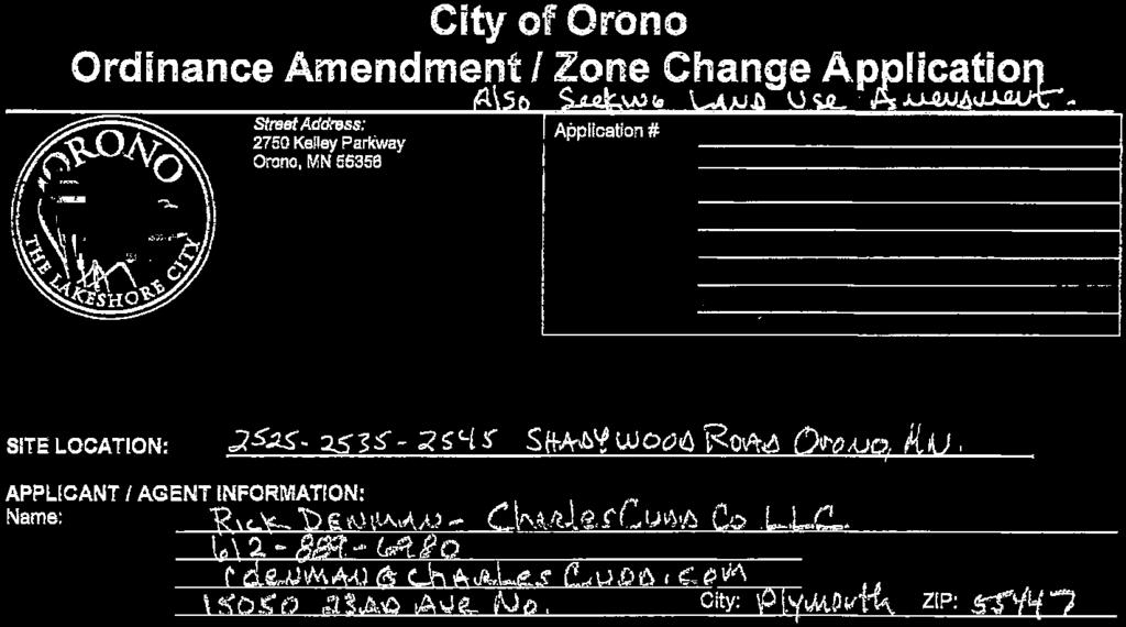
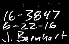
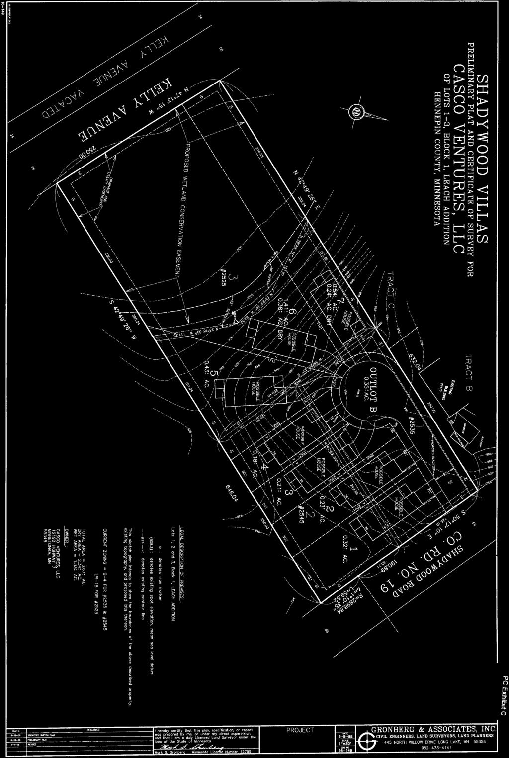
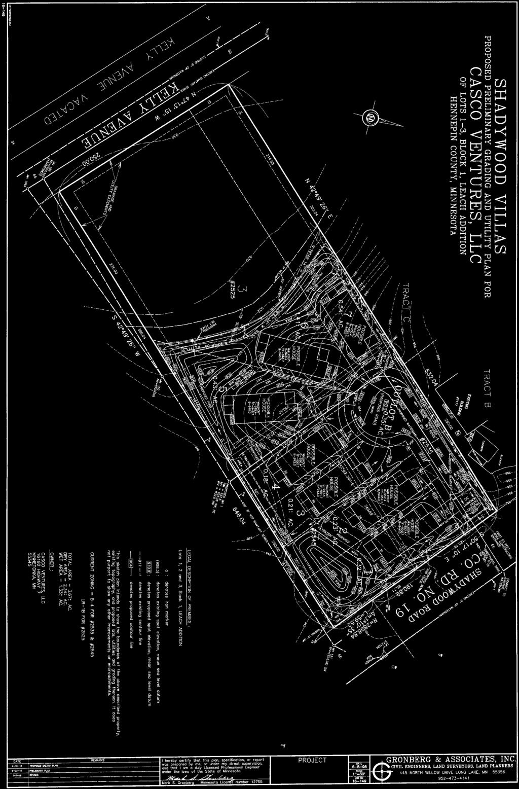
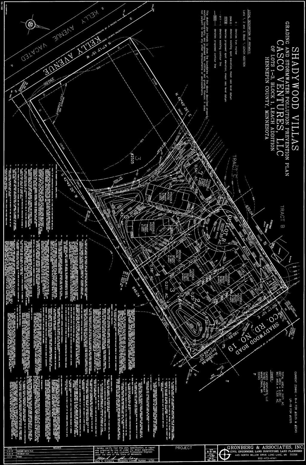
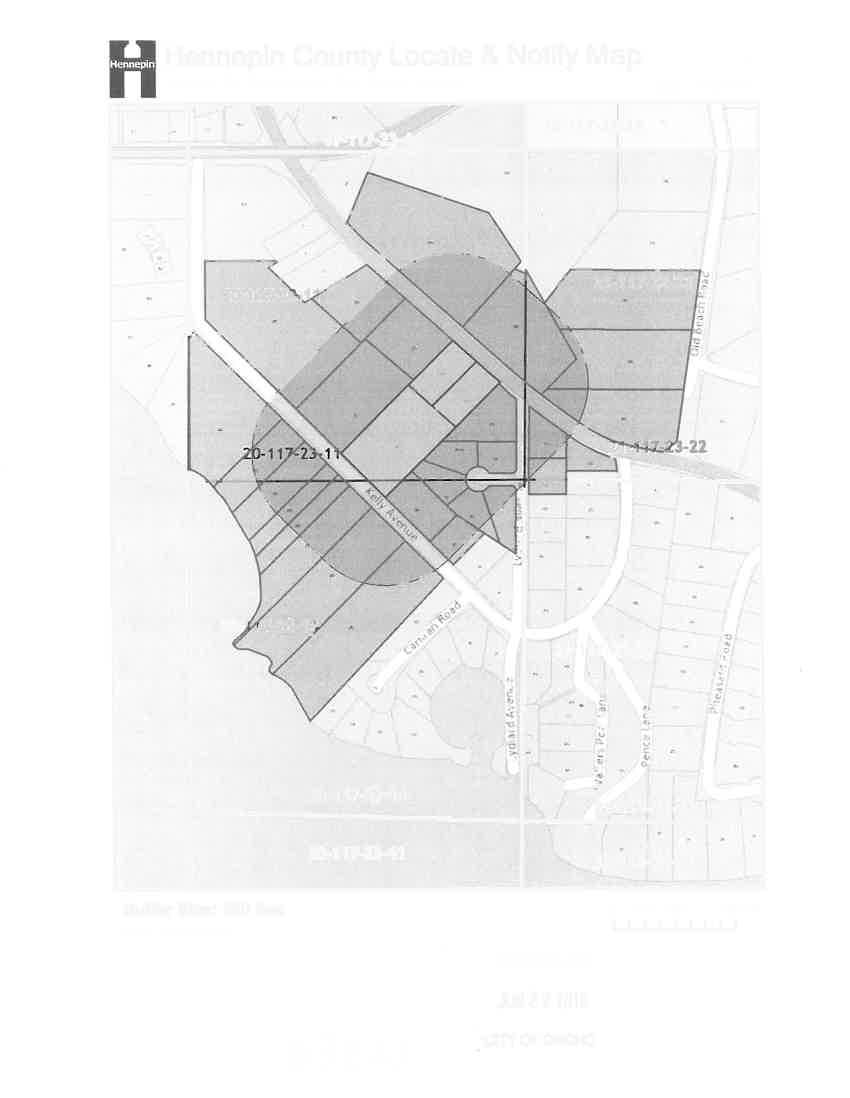
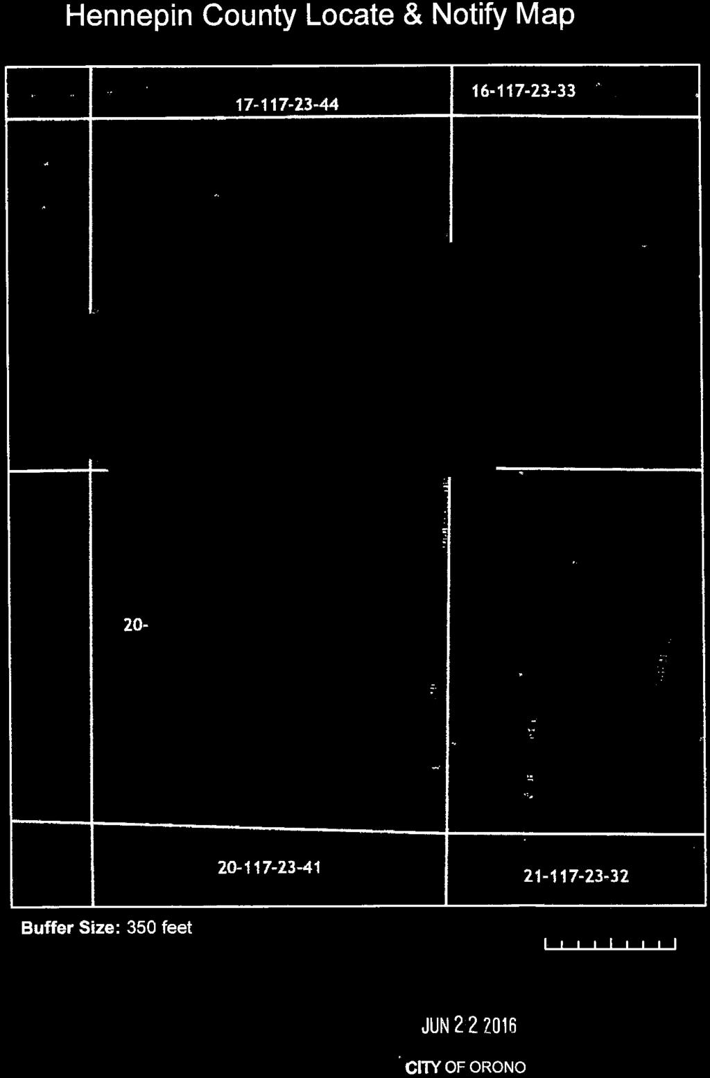
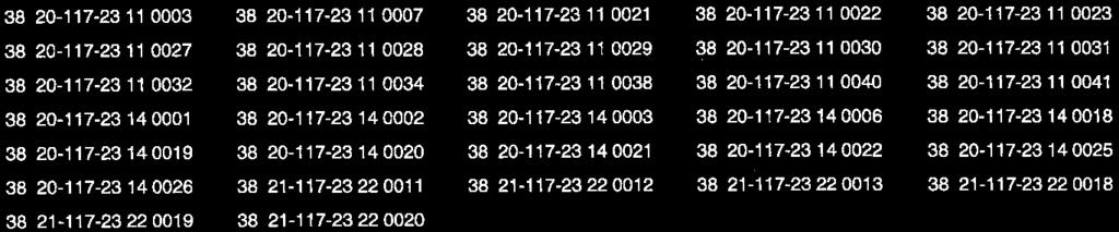
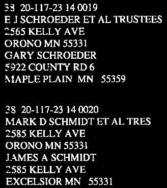
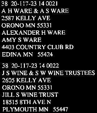
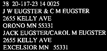
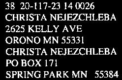
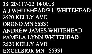
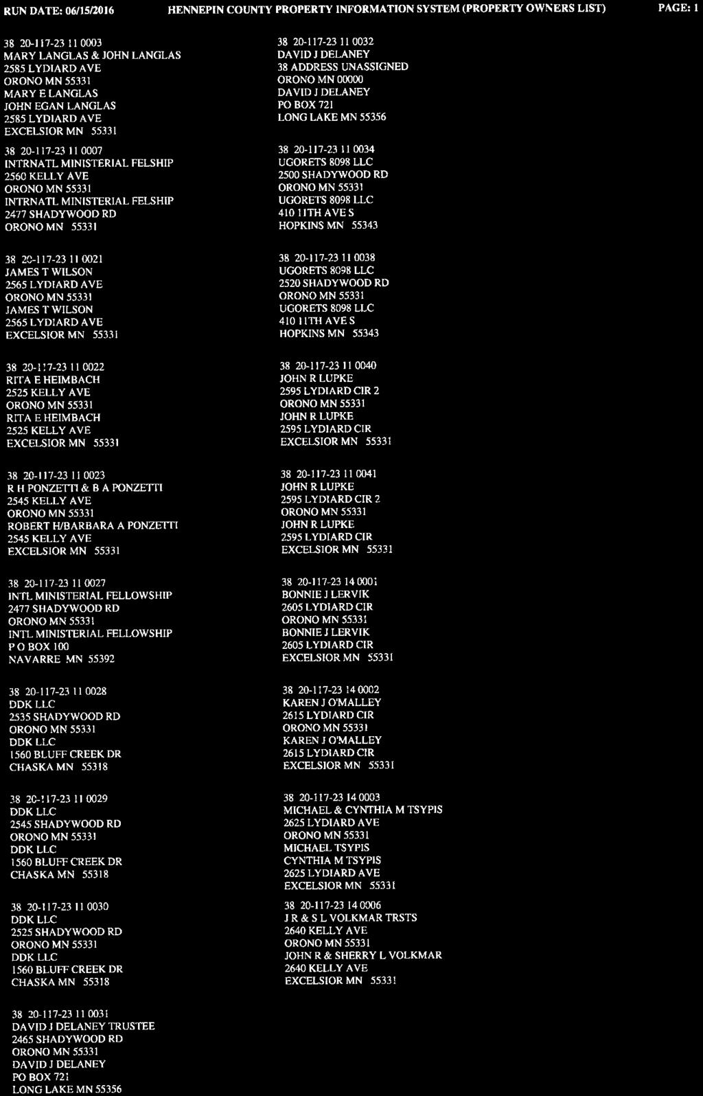
1 Date Application Received: 6/22/16 Date Application Considered as Complete: Incomplete CMP Amdmt. 60-Day Review Period Expires: 120-Day Subdivision Review Period Expires: To: From: Date: July 18, 2016 Subject: Chair Thiesse, Planning Commission Members Jessica Loftus, City Administrator Jeremy Barnhart, Community Development Director Rick Denman (Charles Cudd Co, LLC, for DDK, LLC Owner , 2535, and 2545 Shadywood Road - Comprehensive Plan Amendment - Preliminary Plat - Rezoning from B-4 and LR-1B to RPUD - Public Hearing Summary of Request: Applicant requests the following approvals for a proposed 7-lot singlefamily residential development: 1) Amendment of the Orono Comprehensive Plan (Community Management Plan or CMP ) to allow development of the property at a density of approximately 3 units per acre for this property which is guided in the CMP for development at a density of 2-3 units per acre (back half) and 4-15 units per acre (front half); 2) Preliminary plat approval for a 7-lot single-family residential subdivision; and 3) Rezoning to Residential Planned Unit Development (RPUD). Parcels Involved: PID & Address Owner of Record Shadywood Rd. DDK, LLC 1560 Bluff Creek Dr., Chaska MN Shadywood Rd Same Shadywood Rd Same Zoning and Land Use: PID & Address Existing Zoning Proposed Zoning Existing Land Use 2525 Shadywood Rd. LR-1B RPUD Low Density Residential 2-3 units per acre 2535 Shadywood Rd B-4 RPUD Mixed Use 2545 Shadywood Rd B-4 RPUD Mixed Use Proposed Land Use No change Low Density Residential 2-3 units per acre Low Density Residential 2-3 units per acre
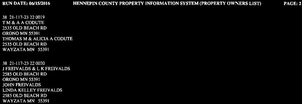
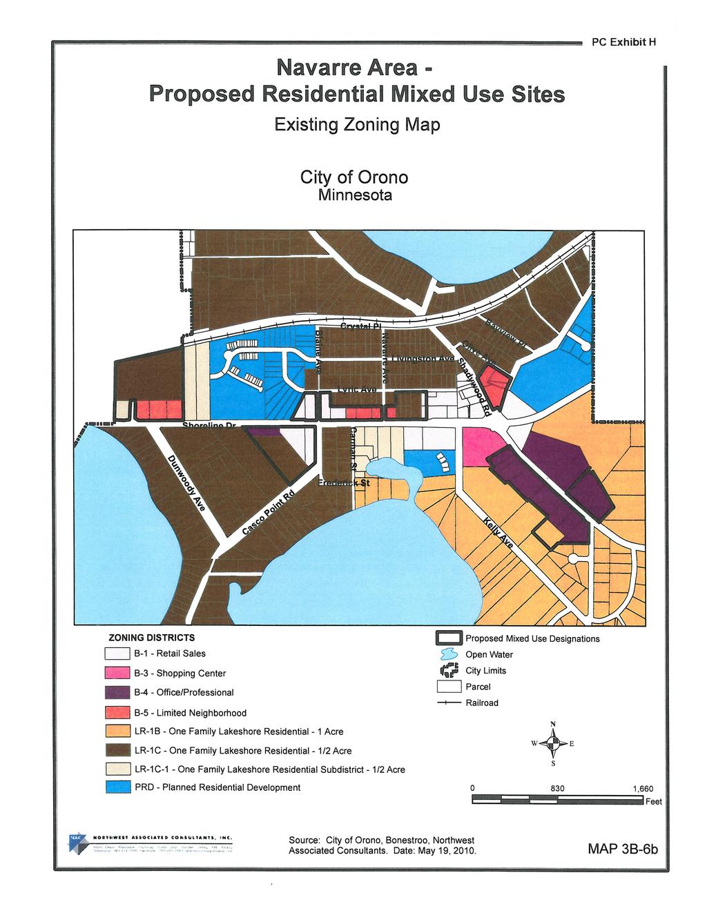
2 Page 2 Shadywood Villas July 18, 2016 Parcel Area: Gross Site Area 3.67 ac. Delineated Wetland ac. Proposed/MCWD-Required Wetland Buffers* ac. Net Buildable Area ac. *Met Council guidelines allow wetland buffers to be excluded from net developable acreage calculations. Proposed Net Density: 7 units on buildable acres = 3.28 units per acre Proposed Area of New Public Roads 0.35 acres Proposed Area in SFR Lots (including wetlands & buffers) 3.32 acres Range in SFR Lot Areas (including wetlands & buffers) 0.18 ac ac. Average SFR Lot Area (including wetlands & buffers) 0.47 ac. (20,660 s.f. + ) List of Exhibits A Subdivision Application B Submittal Narrative C Preliminary Plans (3 Sheets) D Wetland Delineation Notice of Application E Conservation Design Executive Survey F Representative Home Style Options - Elevation Views - House Plan Layouts G Plat Map & Property Owners List H Comprehensive Plan Excerpts I RPUD District Standards J Minutes from Sketch Plan Reviews K Density Analysis Worksheet L Correspondence received to date M Tree Stand Map N County Comments 1. COMPREHENSIVE PLAN AMENDMENT Community Management Plan. The proposed development incorporates 3 different parcels. These three parcels are guided differently; the two eastern lots are guided mixed use, and the western lot is guided low density residential. The developer proposes to guide all three parcels low density residential, though the proposed development is slightly higher in density than suggested by that classification (3.28 units/ acre versus 3.0 units per acre). The proposed development density represents a reduction in proposed gross density from the approved Comprehensive Plan. 4 units/ acre on the east side to 3.28 units an acre (the western lot remains the same). The actual density drops from units planned in the guide plan to 7 units. Impacts of Plan Amendment. Met Council guidelines require an overall new sewered development density of at least 3 units per acre. The proposed project, with detached single family homes is near the lowest density where the Met Council is likely to approve sanitary sewer service. To achieve the 4 units an acre envisioned by the CMP, attached residential units would be expected
3 Page 3 Shadywood Villas July 18, 2016 and could include townhomes or apartments/ condominiums. In recent conversations with Met Council staff, it has become clear that developing this specific site (and others nearby guided similarly) at densities lower than the current CMP guided densities, triggers a formal amendment of the CMP and an expectation that other developable properties be reguided for higher density to offset the decrease. An analysis of Orono s current status as a result of the applicant s proposal is attached as Exhibit K. The applicants presented a sketch plan to the Planning Commission in May 2016 and City Council in June for a 7 unit development at this site. It appears there is some degree of support at the Council level for the type and density of development proposed by the applicant, while development at a higher density in the area has not gained much traction. Issues for Consideration. In reviewing the amendment, Planning Commission should attempt to set aside the details of the proposed development and look at the broader picture, consider the following: 1) Does the amendment further the City s goals for development of higher density housing? 2) Are there specific aspects of this site that support a reduction of the density from the current guided density? 3) Are there any negative aspects to reguiding this site for lower density? 4) Are there specific conditions that should be established as part of an approval of the reguiding? 2. REZONING It has been the City s practice to formally rezone properties as part of an approved project, at the time of Final Plat. It is also recognized that the city s zoning ordinance must be consistent with the Comprehensive Plan. The applicant propose to rezone the subject parcels to Residential Planned Unit Development, or RPUD. The RPUD District contains detailed development standards with regards to lot size and setbacks; building design; landscaping, screening and buffering; and trails and recreation; all of which will be addressed in the following pages. The RPUD District also offers flexibility as a planned unit development process, such that approved departures from the standards are considered as elements of the RPUD zoning rather than as variances. Note that the property does not meet the minimum size requirement of 5 acres, but does meet the location standards to be eligible for RPUD rezoning. 3. PRELIMINARY PLAT REVIEW Conformity with Zoning District Standards In relation to the RPUD standards, there are specific guidelines for detached single family development in Zoning Code Section (8) - see Exhibit I. The RPUD standards as written for detached single family use do not accommodate the type of smaller, narrow lot style of development that is proposed. However, the concept of a planned unit development process is to allow flexibility in design. Section (16) provides for flexibility in RPUD standards, as
4 Page 4 Shadywood Villas July 18, 2016 follows: (16) Flexibility. The uniqueness of each RPUD requires that specifications and standards for streets, utilities, public facilities and subdivisions may be subject to modification from the city ordinances ordinarily governing them. The city council may therefore approve streets, utilities, public facilities and land subdivisions which are not in compliance with usual specifications or ordinance requirements, if it finds that strict adherence to such standards or requirements is not required to meet the intent of this section or to protect the health, safety or welfare of the residents of the RPUD, the surrounding area or the city as a whole. This proposed development concept will require a significant departure (flexibility) from the RPUD district lot standards for individual homesites. The table below identifies specific standards which would require flexibility: RPUD District Minimum SFR Standard Proposed Lot Standards Flexibility Required? Minimum project size: 5 acres 2.34 acres Yes Minimum lot size: 15,000 square feet 7,800 s.f. 61,400 s.f. Yes (incl. wetlands) 4 of 7 lots < 15,000 s.f. Minimum lot width at setback line: 90 feet 50 min and typical/ 70 ft Yes widest Minimum lot depth: 125 feet Varies - all No Minimum front building setback: 25 feet 20 feet min. (25 to Shadywood) Yes Minimum side yard setback: 10 feet Side 1: 7 feet Yes Minimum rear yard setback: Lesser of 40 or Lesser of 40 or 20% of lot depth (30 feet) 20% of lot depth No Maximum FAR: (assumes 1400 sq ft single story home) No Wetland building setback: Greater of 35 feet or 35 feet (Lot 6) MCWD buffer plus 10 feet Yes Private Recreational Area: 10% of gross project area 0% proposed Yes Building height: Maximum of 30 feet (Not defined) No All dwelling units, including manufactured homes, shall have a depth of at least 20 feet for at least 50 percent of their width. All dwelling units, including manufactured homes, shall have a No width of at least 20 feet for at least 50 percent of their depth. Relationship to Surrounding Development The subject parcel in many ways represents a transition between the commercial and institutional uses along Shadywood and the residential uses on Lydiard Circle/ Avenue to the south, and Kelly Avenue to the west. The proposed development will have little to no interaction with the adjacent residential neighborhoods as there are no vehicular connections or trails out of the property to the south, north, or west. The portion of the project adjacent to Kelly Avenue is currently a wetland, there are no plans to impact this wetland, other than mitigation of invasive plant material. Conservation Design The applicants have submitted a Conservation Development report prepared by ISG pursuant to the City s Conservation Design ordinances. The executive summary is attached (Exhibit E), a full copy is available on the cities website. Key elements of the report include a review of the
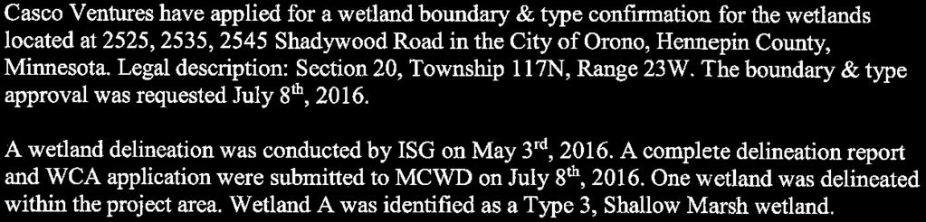
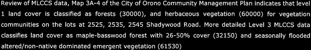
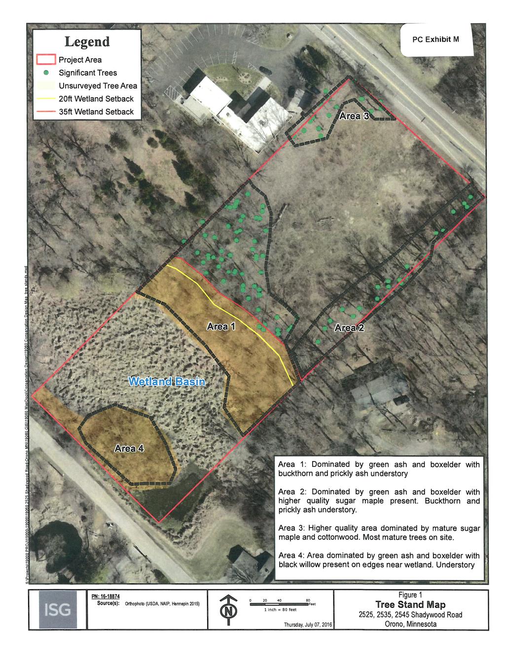
5 Page 5 Shadywood Villas July 18, 2016 Rural Oasis Study of which this site is an Edged Enclosure Corridor; Natural Resources Inventory including review of the MLCCS Land Cover Classification data, wetland delineations (to be approved by the MCWD), tree inventory, and review of existing drainage patterns. Wetlands on Site and/or Impacted The western 1/3 of the project area is a Manage 3 wetland, which requires a 20 foot buffer. There are no plans to impact this wetland other than mitigate the invasive reed canary grass. A 35 buffer setback is proposed greater than the minimum required 20 foot = 10 foot additional buffer. The City will require a Conservation and Flowage Easement over the wetlands being preserved. Tree and/or Woodland Impacts A significant portion of the eastern half of the project area was clear cut in Remaining trees can be found along the edges of the project area, and on the slope above the wetland. Volunteer shrubs or plants can be found in the center of the development area. The developer proposes to preserve existing significant trees to the extent possible (see Tree Stand Map Inventory, Exhibit M), the best trees are generally in the NE corner of the site, to be impacted by the planned road connection. The grading plan and the tree preservation plan will need to be carefully analyzed to ensure they are compatible and consistent. Archaeological Site Proximity Staff is unaware of any archaeological sites within the property; the applicant should contact the State Historic Preservation Office (SHPO) to confirm. Lot Layout and Lot Standards The layout of the site is dictated by a number of factors, including: - location of wetlands; - collector roadway on the east side; - the need to locate road access points in a location to benefit adjacent parcels and efficiently use the subject property The applicants have proposed a plan that takes into account these factors. The result is a site layout with one road off of Shadywood Road. No accesses are proposed onto Kelly Avenue. Staff has suggested that access control be deeded to Hennepin County and shown on the plat, to further inform the buyer of Lot 1 that no driveway will be permitted. Rear Yard Setbacks. The rear yards range in depth from 25 feet to over 280 feet, with the lots closer to existing residential ranging from 25 to 87 feet. Landscaping/berming is expected along the frontage of these lots to provide for buffering of the residences. Lot Widths and Side Yard Setbacks. The lots range in width from 50 to 70 feet wide, allowing for the house and 7 foot setbacks on either side. Lots 1-4 show 14 feet between the houses, with greater separation provided between the houses on lots 5-7. Front Setbacks. Front yard setbacks as measured from the front lot line are proposed at 20 feet (lots 1-4 and 7) and 58 and 33 for lots 5 and 6, respectively. No sidewalks are proposed. The 20 foot minimum provides space for cars (1 deep) to be parked on the driveway and not encroach into the street.
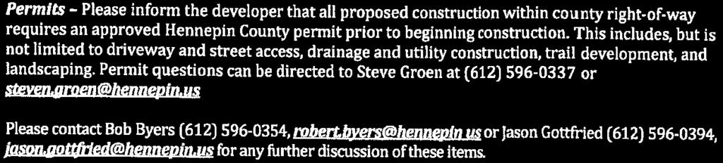
6 Page 6 Shadywood Villas July 18, 2016 Lot Coverage vs. Floor Area Ratio (FAR). Zoning Code Section establishes the 15% Lot Coverage limit for lots less than 2 acres in area all zoning districts; it doesn t make an exception for RPUD. However, the RPUD District does not specifically establish a Lot Coverage by Structures limit. Instead, the RPUD standards limit individual lots to 50% hardcover and an individual lot Floor Area Ratio (FAR = gross area of all floors divided by gross lot area) of 0.5. This means a 14,000 s.f. lot is allowed 7,000 s.f. of total floor space. The proposed single level homes in a 37 x 70 footprint (2500 sq ft) on the proposed lots would yield a range of FAR from.04 (lot 6) to 0.32 (lot 4), all meeting the 0.50 FAR limit. Hardcover. By virtue of the RPUD zoning, per (4)(a) the property is assigned to Hardcover Protection Tier 4, which allows up to 50% hardcover of the gross lot area. Only the smallest of the proposed lots would appear to approach that limit. Site Grading The development area is generally flat, with highest elevations in the northeast corner, and lowest at the wetland along Kelly Avenue. The majority of the development is proposed to occur on the eastern side of the property. Homes are proposed to be walkouts; excavation and filling will be necessary. The City Engineer s review will need to include grading impacts to adjacent properties, and trees to be preserved. Road Layout and Standards The internal road serving the development is proposed to be public. This is in line with the provisions of the CMP Transportation Plan in Urban Transportation Policies, which states: 1. Local streets in the urban area will be owned and maintained by the City. Because the land use and street use density of the urban neighborhoods is relatively high, the City will provide public street access to all urban properties. City responsibility for proper maintenance levels will ensure passable, all-weather streets available at all times for emergency vehicles and for general public ingress and egress. The proposed road is approximately 220 feet long, terminating in a cul de sac. The County will need to approve the location of the drive, though preliminary discussions with the County support the proposed location. The preliminary plat has been forwarded to the Fire Chief for comment with regard to access for fire department vehicles, the cul de sac diameter is consistent with city ordinances. The proposed road is 28 in paved width (back-of-curb to back-of-curb) located within a 50 platted corridor, meeting the City s standard for a public road system [Code Section (d)(2)]. The developer will pay all costs of road construction and utility installation/ connection. County Road Improvements and/or Easements The county has provided comments, included as Exhibit N. No turns lanes are required nor proposed. Based on the number of lots, staff does not believe a traffic study is necessary, thought the Planning Commission and Council could require one. The County requests additional right of way for a future trail and Shadywood road improvements. This additional right of way will impact the configuration of the project. Lastly, the County desires verification of adequate site distance to the left.
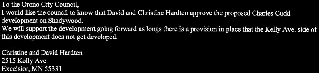
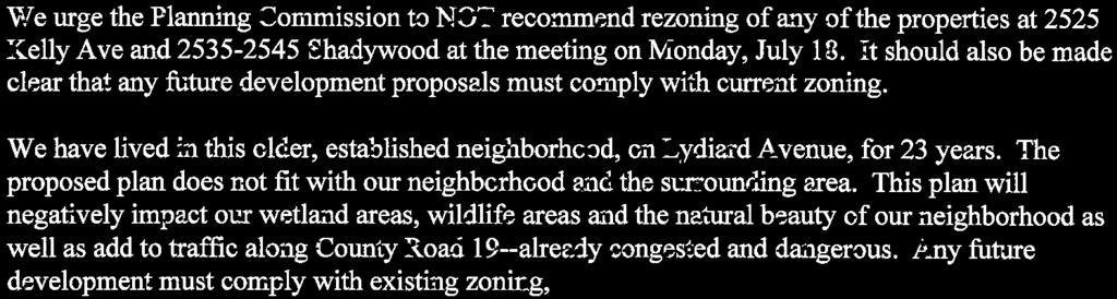
7 Page 7 Shadywood Villas July 18, 2016 Standard perimeter drainage and utility easements around all property boundaries as well as conservation and flowage easements over the delineated wetlands will be required. A number of drainage easements are shown on the plat drawings as necessary to direct stormwater runoff. Existing easements will need to be vacated. Parks, Trails, Sidewalks As noted above, no trails or sidewalks are proposed with this development. The CMP suggests a future trail along Shadywood. Hennepin County and Three Rivers Park District have talked about adding trails along Shadywood, though plans have not progressed to suggest which side. 10% Private Recreation Area Requirement. RPUD standards require that 10% of the development site be provided as a private recreation area or open space to serve the residents of the development. The wetlands which encompass a significant portion of the development certainly act as open space, but they are not accessible for recreation purposes because the wetlands are placed within individual lots rather than as a separate commons area. The Planning Commission should discuss the need for a private recreational area. Park Dedication In addition to the creation of a private recreation area to serve the development residents, the City Code requires dedication of 8% of the land as public park, or payment of the equivalent value in cash. No Park Commission meeting is scheduled until September, after this item is expected to be reviewed by the Council, unless delayed. Assuming the City Council finds no need for a public park at this site, payment of the standard Park Dedication fee for 7 new building lots would be appropriate; the current fee ranges from a minimum of $3,250 and a maximum of $5,550 per lot, for a potential total fee of $22,750 to $38,850. The nearest public open space is the Lydiard beach area, south of the site. The Planning Commission should discuss the need for sidewalks within the development, and/ or connections to the public beach. RPUD Landscaping Requirements The proposed landscaping plans have not been received nor reviewed as to compliance with the very detailed RPUD landscaping requirements. This evaluation will proceed upon confirmation of a final site layout. The plan shows a fence along the berm on Lot 1, along Shadywood. A detail of the fence should be provided. Stormwater and Drainage Improvements & Fees Applicants have submitted detailed grading and drainage plans and calculations, which the City s consulting engineers are reviewing to ensure the City s requirements are met. A majority of the runoff will be directed to three stormwater ponding areas, two of which discharge to the wetland. The property will be subject to the Stormwater and Drainage Trunk Fee. Recent Council action to revise the Trunk Fee provisions would result in a fee (for development at 4.0 units per acre or less) of $7,275 per acre (2016 Fee Schedule), based on non-wetland acreage, for an estimated Trunk Fee of 2.34 acres x $7,275/acre = $17, The grading plan has not been reviewed in conjunction with the tree preservation plan to ensure that tree retention is maximized. Utility Locations/Availability/Assessments/Connection Fees
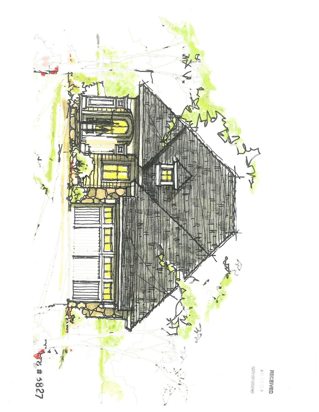
8 Page 8 Shadywood Villas July 18, 2016 A gravity sanitary sewer line runs along the south property line, feeding a lift station on the north side of Shadywood Road. Water is available, also on the north side of Shadywood Road. It appears that Sewer and Water connection charges have already been paid, though each unit will pay individual SAC charges at the time of building permit. City Engineer Comments The city engineer is currently reviewing the development plans and comments will be incorporated into the final preliminary platy. Style and Appearance of Proposed Homes The applicants have provided conceptual depictions of elevation views and floor plans for the proposed homes. Planning Commission should review these (Exhibit F) and determine whether there are any concerns. Public Comment To date staff has received written comments on the project, attached in Exhibit L. The developer also plans an open house with the neighborhood on Saturday, July 16 th. Staff will not attend this open house. Summary of Issues for Consideration Staff suggests that the primary focus for consideration and discussion by the Planning Commission should include the following topics: Comprehensive Plan Amendment 1. Applicants propose development at a density of 3.28 units per acre rather than the 4-15 units per acre for which the eastern half of the property is guided, and have requested a Comprehensive Plan Amendment to allow the lower density. - Should the City be striving for more density or less density at this location? - Is the single-family concept right for this area? Does it match the City s goals in terms of housing type and density? - Will the City benefit from a development, such as this? Should the entire property be developed in this manner, or should this site incorporate more than one style of houses? In general, the responses to these questions during prior reviews has been that the proposed development density is acceptable. If that is the case today, a Planning Commission recommendation for approval of the Comprehensive Plan Amendment is appropriate. Rezoning from B-4 and LR-1A to RPUD 2. Planning Commission should consider whether RPUD is the appropriate rezoning option for this development. Staff believes RPUD is the only viable option for development of this parcel in the manner proposed by the applicants and the CMP. Preliminary Plat Review 3. Is the Commission comfortable with the level of flexibility requested, recognizing that
9 Page 9 Shadywood Villas July 18, 2016 RPUD standards requires a significant level of development flexibility. Does Planning Commission have any concerns about the lot widths, setbacks or other RPUD standards for which flexibility is required in this proposal? 4. Is the Commission comfortable moving the project forward, recognizing that the landscaping plan, engineering and storm-water management plans have not been fully vetted. 5. Should trails or sidewalks be provided to connect this neighborhood with the community at large? 6. Is it imperative that 10% private open space be provided by the developer? 7. Are there any other issues or concerns with this application? Staff Recommendation This development proposal exhibits a significant level of refinement as a result of the developer s response to issues raised during the Sketch Plan Review process and primary Staff comments. Discussion of the above topics and any conclusions reached by the Planning Commission should provide applicant and staff with direction as to whether or how the proposed plat should be further revised. Any remaining topics left unaddressed to date should be brought up for discussion. The Planning Commission may recommend approval or denial of the three actions requested or any combination thereof. If denial is recommended, reasons should be given. The Planning Commission may also choose to table the application, allowing the developer and staff to address any issues raised. Should the Commission wish to approve the applications, the following conditions are suggested: Comprehensive Plan Amendment, with the direction that that the City should identify alternate sites for higher density development. Rezoning to RPUD, to be formally approved at the time of final plat approval. Preliminary plat approval subject to the following conditions: 1. Flexibility being granted for the lot area, width and setback standards of the RPUD District. Hardcover will be limited to the assigned Tier 4 level of 50% on each individual lot. The 0.50 FAR shall be adhered to on each individual lot. 2. Development shall be subject to adherence to the findings included in the Conservation Design report, also subject to removal of buckthorn on the site. 3. Significant trees to be preserved to the extent possible and as shown on the landscaping plans. 4. Applicant to confirm with SHPO that that there are no archaeological sites within the property. 5. Preliminary plat to be reviewed by Park Commission and Fire Chief for comments and recommendations prior to Council review of preliminary plat.
10 Page 10 Shadywood Villas July 18, % private recreational space requirement will not be enforced. 7. Park Dedication Fees and Storm Water & Drainage Trunk Fees, as well as municipal sewer and water connection charges, all as noted in staff memo, to be collected in full at the time of final plat approval. 8. Vacation of easements as appropriate through the site 9. Provision of drainage and conservation easement over wetland.


11
12
13
14
15
16


17


18

19

20


21


22


23

24


25


26
27
28
29 Sec Development standards. PC Exhibit I Within the RPUD district all development shall be in compliance with the following: (1) Minimum area; shoreland district limitation. Each site proposed for rezoning to RPUD shall have a minimum area of five acres, excluding areas within a designated wetland, floodplain or shoreland district or right-of-way, unless the council finds the existence of one of the following: a. Unusual physical features of the property itself or of the surrounding neighborhood such that development as a RPUD will conserve a physical or topographic feature of importance to the neighborhood or community. b. The property is directly adjacent to or across a public street from property which has been developed previously as a RPUD or planned residential development and will be perceived as and will function as an extension of that previously approved development. c. The property is located in an area where the proposed development provides a transition between a commercial or industrial area and an existing residential area or on an intermediate or principal arterial as defined in the comprehensive plan. d. The property contains steep slopes or a substantial number of significant trees that could be preserved through the clustering of buildings or other design techniques not generally allowed by the existing zoning district. No property located within 250 feet of the ordinary high water level (OHWL) of a protected lake or tributary as defined in article IX of this chapter shall be rezoned to RPUD. However, for a property that is partially located less than 250 feet from the OHWL and partially located more than 250 feet from the OHWL, the portion located more than 250 feet from the OHWL may be rezoned to RPUD at the discretion of the city council when all other requirements are met. (2) Uses. Each property rezoned to RPUD shall only be used for the use or uses for which the site is designated in the comprehensive plan, except that the city may permit rezoning to RPUD on a site designated for commercial use if the city council finds that such use is in the best interests of the city and is consistent with the requirements of this division. If a commercial site is to be rezoned to RPUD, the city may forward a copy of the request to the metropolitan council for review. (3) Sewer availability. A site proposed to be rezoned to RPUD with proposed density greater than one unit per two acres must be in the metropolitan urban services area (MUSA) and must be serviced by municipal sewer. (4) Density. Each development in the RPUD district shall have a density within the range specified in the comprehensive plan for the specific site. If the site is not designated in the comprehensive plan for residential use, the appropriate density shall be determined by the city based upon the city council's finding that such density is consistent with the intent of this division and of the comprehensive plan. Developments with proposed densities in excess of the densities contemplated in the comprehensive plan shall be allowed only on properties which are currently zoned and guided for commercial use, in order to maintain the character and integrity of the areas zoned and guided for residential use. (5) Incentives. The city may utilize incentives to encourage the construction of projects which are consistent with the city's housing goals. Incentives may include modification of density (only for properties currently zoned and guided for commercial use) and floor area ratio requirements for developments providing lifecycle housing and affordable and moderate cost housing. Incentives for affordable and moderate cost housing may be approved by the city only after the developer and city have entered into an agreement to ensure that the low and moderate cost units remain available to persons of low and moderate income for at least 20 years. (6) Floor area ratio. Floor area ratios (FARs) shall be limited per the following table: Page 1
30 Comprehensive Plan Designation Maximum Floor Area Ratio* Low or medium density residential (up to 50 and including 6.0 units per acre) 0.5 High density residential (in excess of 6.0 units per acre) 1.0 *FAR = Total Building Floor Area/Total Lot Area Individual lots within a development in the RPUD district may exceed these standards as long as the average meets these standards. (7) Development standards for attached and multifamily dwelling structures. Each site rezoned to RPUD and developed for attached or multiple-family dwelling uses shall be subject to the following standards: a. Setbacks and separation of uses. Within the RPUD district the setback for all attached and multifamily dwelling buildings and their accessory buildings from any bordering or abutting street line shall be 35 feet for local streets and 50 feet from railroad lines or collector or arterial streets, as designated in the comprehensive plan, except that in no case shall the setback be less than the height of the building. The setback for all buildings from exterior RPUD site lot lines not abutting a public street shall be 35 feet, except that in no case shall the setback be less than the height of the building. Building setbacks from internal public streets shall be determined by the city based on characteristics of the specific RPUD site. Parking lots and driving lanes shall be set back at least 20 feet from all exterior lot lines of a RPUD site. The setback for parking structures, including decks and ramps, shall be 35 feet from local streets and 50 feet from all other street classifications, except that in no case shall the setback be less than the height of the structure. Parking structure setbacks from external lot lines shall be 50 feet or the height of the structure, whichever is greater, when adjacent to residential properties; 35 feet, when adjacent to nonresidential properties. Parking structure setbacks from internal public or private streets shall be determined by the city based on characteristics of the specific RPUD site. Where industrial uses abut developed or platted single-family lots outside the RPUD site, greater exterior building and parking setbacks may be required in order to provide effective screening. The city council shall make a determination regarding the adequacy of screening proposed by the applicant. Screening may include the use of natural topography or earth berming, existing and proposed plantings and other features, such as roadways and wetlands, which provide separation of uses. Property rezoned to RPUD shall be considered a residential district for purposes of determining building and parking setback requirements on adjacent high density residential, commercial and industrial property outside the RPUD. b. Height limitations. For properties guided for residential use in the comprehensive plan, a building height limit of 30 feet shall apply. For properties currently zoned or guided in the comprehensive plan for commercial use, height may exceed 30 feet but shall not exceed three stories (not including underground parking level) and shall maintain a residential character by incorporating pitched or hipped roof structure. No mansard or flat roofed multiple-family building will be allowed. Page 2
31 c. Outside storage limitations. Building materials, recreational vehicles, boats, RV's, snowmobiles, and other items of personal property shall not be stored outside within any site used for attached or multifamily uses. (8) Development standards for single-family detached dwellings in the RPUD district. Each RPUD site developed for single-family detached dwellings at medium density (i.e., densities ranging from one unit per acre to six units per acre) shall be subject to the following standards: a. Permitted locations: in areas of the city where smaller single-family detached dwelling lots will allow for clustering to preserve significant natural features, or in areas where a mixture of higher density attached dwellings and lower density detached single-family dwellings will result in a development that does not exceed the overall guided density. b. Minimum SFR lot size: 15,000 square feet. c. Minimum lot width at the setback line: 90 feet. d. Minimum lot depth: 125 feet. e. Minimum front yard setback: 25 feet on internal streets within the RPUD site. On exterior or through streets a setback of 35 feet must be provided on local streets and a 50-foot setback on collector or arterial streets, as defined in the comprehensive plan. f. Minimum side yard setback: ten feet along interior lot lines; 15 feet on lot lines along the exterior of the RPUD site. Side yards abutting streets must meet the minimum front yard setbacks as noted in subsection (8)e of this section. Structures in side yards abutting another residential zoning district shall meet the side yard setback requirement of the adjacent zoning district. g. Rear yard setback: minimum of 40 feet or 20 percent of the depth of the lot, whichever is less. h. Building height: maximum of 30 feet. i. All dwelling units, including manufactured homes, shall have a depth of at least 20 feet for at least 50 percent of their width. All dwelling units, including manufactured homes, shall have a width of at least 20 feet for at least 50 percent of their depth. j. All dwellings shall have a permanent foundation in conformance with the state building code. k. Accessory structures shall conform to the setbacks established for principal structures, except as follows: 1. All accessory structures located more than ten feet from a principal structure may be located a minimum of ten feet from a rear or side lot line when that line does not abut a street right-of-way. 2. No accessory structure shall be located closer to the front lot line than the principal structure, regardless of the principal structure setback. l. No accessory structure shall occupy more than 30 percent of the side or rear yard in which it is located, nor exceed 1,000 square feet in area, nor exceed 12 feet in height. m. Off-street parking shall be provided for at least two vehicles for each single-family dwelling. A suitable location for a garage measuring at least 20 feet by 24 feet without a variance shall be provided and indicated as such on a survey or site plan to be submitted when applying for a building permit to construct a new dwelling or alter an existing garage. (9) More than one building allowed. More than one building may be placed on one platted or recorded lot in a RPUD site. (10) Single housing type permitted. Any RPUD development which involves a single housing type shall be permitted, provided that it is otherwise consistent with the objectives of this division and the comprehensive plan. Page 3
32 (11) Private recreational area. Each RPUD development shall provide a minimum of ten percent of the gross project area in private recreational uses for project residents. Such area shall be for active or passive recreational uses suited to the needs of the residents of the project, including swimming pools, trails, nature areas, picnic areas, tot lots and saunas. Private recreational area requirements are in addition to the standard park dedication requirements. (12) Ownership. All property to be included within a RPUD development shall be under unified ownership or control, or subject to such legal restrictions or covenants as may be necessary to ensure compliance with the approved master development plan and final site and building plan. (13) Signage. Signs shall be restricted to those which are permitted in a sign plan approved by the city and shall be regulated by permanent covenants. (14) Landscaping, screening and buffering. a. Landscape plan requirements. Landscape plans shall be prepared by a landscape architect or other qualified person acceptable to the city, drawn to the scale of not less than one inch equals 50 feet and shall show the following: 1. Boundary lines of the property with accurate dimensions; 2. Locations of existing and proposed buildings, parking lots, roads, trails and other improvements; 3. Proposed grading plan with two-foot contour intervals; 4. Location, approximate size and common name of existing trees and shrubs; 5. A planting schedule containing symbols, quantities, common and botanical names, size of plant materials, root condition and special planting instructions; 6. Planting details illustrating proposed locations of all new plant material; 7. Locations and details of other landscape features, including berms, fences and planter boxes; 8. Details of restoration of disturbed areas, including areas to be sodded and seeded; 9. Location and details of irrigation systems; and 10. Details and cross sections of all required screening. b. Minimum landscaping requirements. 1. All open areas of a lot which are not used or improved for required parking areas, drives, trails or storage shall be landscaped with a combination of deciduous and coniferous species, including overstory trees, understory trees, shrubs, flowers and groundcover materials. The plan for landscaping shall include ground cover, bushes, shrubbery, trees, sculpture, foundations, decorative walks or other similar site design features or materials in a quantity having a minimum value in conformance with the following table: Minimum Tree and Shrub Requirements Vegetation Type Size Quantity Overstory deciduous trees 2.5-inch bb (Caliper) One tree per 1,000 gross square feet of building footprint area or one tree per 40 lineal feet of site perimeter, whichever is greater. Page 4
33 Coniferous trees 6-foot height bb Minimum of 30 percent of required overstory trees must be coniferous Understory shrubs 3-gal. potted or 18-inch One shrub per 300 gross square feet of building footprint area or one shrub per 30 lineal feet of site perimeter, whichever is greater. Ornamental deciduous trees 1.5-inch bb (Caliper) Not required; but two ornamental deciduous trees may be substituted for one required overstory deciduous tree (maximum substitution equals 25 percent of required overstory deciduous trees) Credits for existing trees: The city council shall have sole discretion whether credit shall be granted for existing healthy trees In instances where healthy plant materials of acceptable species exist on a site prior to its development, the application of the standards in subsection (14)b of this section may be adjusted by the city to allow credit for such material, provided that such adjustment is consistent with the intent of this division. 2. A reasonable attempt shall be made to preserve as many existing trees as is practicable and to incorporate them into the site plan. 3. All new overstory trees shall be balled and burlapped or moved from the growing site by tree spade. Deciduous trees shall have a minimum caliper of 2½ inches. Coniferous trees shall be a minimum of six feet in height. Ornamental trees shall have a minimum caliper of 1½ inches. 4. All site areas not covered by buildings, sidewalks, parking lots, driveways, trails, patios, or similar hardcover shall be covered with sod or an equivalent ground cover approved by the city. This requirement shall not apply to site areas retained in a natural state. 5. In order to provide for adequate maintenance of landscaped areas, an underground sprinkler system shall be provided as part of each new development, except one- and two-family dwellings and additions to existing structures which do not at least equal the floor area of the existing structure. A sprinkler system shall be provided for all landscaped areas, except areas to be preserved in a natural state. 6. Not more than 50 percent of the required number of trees shall be composed of one species. The city shall maintain a list of prohibited species, which shall not be used for landscaping. c. Interior parking lot landscaping. 1. All parking lots containing over 100 stalls shall be designed to incorporate unpaved, landscaped islands in number and dimension as required by the city. All landscape islands shall contain a minimum of 180 square feet. Islands which are necessary to promote the safe and efficient flow of traffic shall not be subject to the 100-stall standard and shall be required by the city when warranted. 2. Parking lot landscape areas, including landscape islands, shall be reasonably distributed throughout the parking lot area so as to break up expanses of paved areas. Parking lot landscape areas shall be provided with deciduous shade trees, ornamental Page 5
34 or evergreen trees, plus ground cover, mulch and/or shrubbery as determined appropriate by the planning commission. Parking lot landscape trees shall be provided at the rate of one tree for each 15 surface parking spaces provided, or major fraction thereof. Parking lot landscaping shall be contained in planting beds bordered by a raised concrete curb or equivalent approved by the planning commission. d. Maintenance of landscaping. The owner, tenant and their respective agents shall be jointly and severally responsible for the maintenance of all landscaping in a condition presenting a healthy, neat and orderly appearance and free from refuse and debris. Plants and ground cover which are required by an approved site or landscape plan, and which have died, shall be replaced within three months of notification by the city. However, the time for compliance may be extended up to nine months by the city in order to allow for seasonal or weather conditions. e. Retaining walls. Retaining walls exceeding four feet in height, and staged walls which cumulatively exceed 16 feet in height or involve more than four tiers, must be constructed in accordance with plans prepared by a registered engineer or landscape architect. f. Landscaping performance security required. When screening, landscaping or other similar improvements to property are required by this division, a letter of credit shall be supplied by the owner in an amount equal to at least 1½ times the value of such screening, landscaping or other improvements. The letter of credit shall be conditioned upon reimbursement of all expenses incurred by the city for engineering, legal, contracting or other fees in connection with making or completing such improvements. The letter of credit shall be provided prior to the issuance of any building permit and shall be valid for a period of time equal to two full growing seasons after the date of installation of the landscaping. The city may accept some other form of security in lieu of a letter of credit in an amount and under such conditions that the city may determine to be appropriate. If construction of the project is not completed within the time prescribed by building permits and other approvals, the city may, at its option, complete the work required at the expense of the owner and the surety. The city may allow an extended period of time for completion of all landscaping, if the delay is due to conditions which are reasonably beyond the control of the developer. Extensions, which may not exceed nine months, may be granted due to seasonal or weather conditions. When an extension is granted, the city shall require such additional security as it deems appropriate. g. Screening and buffering. 1. The following uses shall be screened or buffered in accordance with the requirements of this section: i. Principal buildings and structures and any building or structure accessory thereto used for residential uses at a density of greater than four units per acre shall be buffered from residential lots located in any R district. ii. iii. iv. Off-street parking facilities containing six or more spaces shall be buffered from streets located within 50 feet. Parking facilities shall be buffered with landscape zones. Loading docks shall be screened from all lot lines and public roads. Trash storage facilities shall be screened from all lot lines and public roads. v. Access roads serving multifamily buildings shall be screened as necessary to eliminate the impact of vehicle headlights shining toward adjacent residential neighborhoods. 2. Required screening or buffering may be achieved with fences, walls, earth berms, hedges, or other landscape materials. All walls and fences shall be architecturally harmonious with the principal building. Earth berms shall not exceed a slope of 3:1. The screen shall be designed to employ materials which provide an effective visual barrier during all seasons. Page 6
35 3. All required screening or buffering shall be located on the lot occupied by the use, building, facility or structure to be screened. No screening or buffering shall be located on any public right-of-way or within eight feet of the traveled portion of any street or highway. 4. Screening or buffering required by subsection (14) of this section shall be of a height needed to accomplish the goals of subsection (14) of this section. Screening methods incorporating roofs over storage, trash or mechanical facilities to screen from higher adjacent properties or buildings may be required. Height of plantings required under subsection (14) of this section shall be measured at the time of installation. (15) Architectural standards. a. It is not the intent of the city to restrict design freedom unduly when reviewing project architecture in connection with a site and building plan. However, it is in the best interest of the city to promote high standards of architectural design and compatibility with surrounding structures and neighborhoods. Architectural plans shall be prepared by an architect or other qualified persons acceptable to the city and shall show the following for all structures other than single-family detached dwellings: 1. Elevations of all sides of the building. 2. Type and color of exterior building materials. 3. A typical floor plan. 4. Dimensions of all structures. 5. The location of trash and recycling containers and of heating, ventilation and air conditioning equipment. b. Unadorned prestressed concrete panels, concrete block and unfinished metal shall not be permitted as exterior materials for residential principal and accessory buildings. This restriction shall apply to all principal structures and to all accessory buildings. The city may, at its discretion, allow architecturally enhanced block or concrete panels. c. Accessory buildings shall be architecturally compatible with principal structures. d. All rooftop or ground-mounted mechanical equipment and exterior trash and recycling storage areas shall be fully enclosed or screened so as to be not visible with materials compatible with the principal structure. e. Underground utilities shall be provided for all new and substantially renovated structures (the term "substantially renovated" shall mean when the renovations exceed 30 percent of the prerenovation value of the structure). (16) Flexibility. The uniqueness of each RPUD requires that specifications and standards for streets, utilities, public facilities and subdivisions may be subject to modification from the city ordinances ordinarily governing them. The city council may therefore approve streets, utilities, public facilities and land subdivisions which are not in compliance with usual specifications or ordinance requirements, if it finds that strict adherence to such standards or requirements is not required to meet the intent of this section or to protect the health, safety or welfare of the residents of the RPUD, the surrounding area or the city as a whole. (17) Traffic studies. The city may require a traffic analysis to be prepared by a registered traffic engineer approved by the city to assess potential traffic impacts on local streets. If impacts on service levels of roadways and intersections are anticipated, the project will be approved only contingent upon a traffic management plan that adequately mitigates those impacts. The plan may include travel demand management strategies, use of transit facilities or other appropriate measures to reduce traffic generation, and necessary improvements to road systems. The developer shall have the responsibility to install all necessary road system improvements. Page 7
36 (18) Building permits. No building or other permit shall be issued for any work on property included within a proposed or approved RPUD development, nor shall any work occur unless such work is in compliance with the proposed or approved RPUD development. (19) General regulations applicability. The requirements contained in this division pertaining to general regulations for residential districts and performance standards shall apply to a RPUD development as deemed appropriate by the city. (20) Lighting standards. All RPUD developments shall be subject to the general performance standards for lighting in this chapter. (21) Trails. When any portion of the project is within 1,000 feet of a public trail system, pedestrian access shall be provided to the trail system by means of a public trail constructed at the developer's expense. Where public rights-of-way are available, at the city's discretion the trail may utilize the public right-of-way. Trails shall be of bituminous construction, or such other material as may be approved by the city and shall be not less than eight feet in width. (Ord. No nd series, 1(5), ; Ord. No. 94 3rd series, 2, ) Page 8
37 PC Exhibit J Planning Commission minutes excerpt May 16, # RICK DENMAN ON BEHALF OF DDK, LLC, 2525, 2535, AND 2545 SHADYWOOD ROAD, SKETCH PLAN, 6:38 P.M. 7:12 P.M. Rick Denman, Applicant, was present. Barnhart stated this is a sketch plan for a seven unit single-family residential development, with access provided by a new cul-de-sac off of County Road 19. The site currently consists of three lots. The proposed lots range in size from 0.16 acres to 0.39 acres. Outlot B is the cul-de-sac street, which will be eliminated, and Outlot A is shown protecting the wetland that is on the southern half of the lot facing Kelly Avenue. The property is currently zoned for business use. The Comprehensive Plan identifies this property, or at least the property adjacent to Shadywood, as mixed use, with a density range of 4-15 units per acre. The Comprehensive Plan also shows low-medium density residential along Kelly Avenue, primarily within the wetland. To allow this project, the property would need to be re-guided and rezoned. The proposed development is not consistent with the Comprehensive Plan s guidance for the property because the density is too low. The rezoning process would occur concurrently with preliminary plat review. The project will likely be developed as an RPUD, with several variances likely being required. The applicant is proposing single-family residential with a full basement and floor layouts are included in the Planning Commission s packets. One of the things Staff and the applicant are looking for is feedback on the concept plan. The Planning Commission had no questions for Staff. Rick Denman, Charles Cudd Company, indicated he would be able to answer any questions the Planning Commission may have. Schoenzeit asked what the price range of the homes will be. Denman indicated the homes would range between $650,000 and $750,000. Schoenzeit asked if there is a demand for this type of housing in Orono since it is not located on the lake. Schoenzeit noted there are a substantial number of homes in the same price range being built not far from this area. Denman stated they currently have a villa neighborhood that they are constructing in Medina and that he would welcome the Planning Commissioners to take a look at it. The design for this parcel is similar and is targeting the empty nester, which has a strong demand. Thiesse requested Staff discuss the Comprehensive Plan and the recommended changes to it. Barnhart stated the purpose of the Comprehensive Plan is a long-range vision for the area to look for appropriate projects that fit with those goals. The property currently is zoned business. The Navarre plan identified a potential for mixed use on this site in order to meet some density goals of the City. The idea was that these areas had the potential for redevelopment, which would call for mixed use. Barnhart stated the challenge is that mixed use generally requires higher density to accommodate the expense of acquisition, clearing of the land, and the different developments. This project does not have Page 1 of 6
38 those expenses. There are currently 27 or so acres in the Navarre mixed use area identified for 10 units per acre. Barnhart stated this proposal would not be meeting the City s goals based on the current plans but that he is comfortable the City can make up the three acres somewhere else. The question for the Planning Commission is whether this is an appropriate use for the property. Landgraver asked if the mixed use is specific to a certain portion of the site. Barnhart stated the City has identified a potential for redevelopment when it is listed as mixed use and that it could be commercial or something else. Leskinen noted a few years ago a memory care facility was discussed for this site, which was fitting for this location. Leskinen stated in her view seven homes crammed into a few acres does not meet the City s density goals and that she is not sure about changing the zoning for this particular property given the fact that there is a church next to this property and a couple of grocery stores nearby. Leskinen noted this area also has a substantial amount of traffic. Schoenzeit asked if this project is far enough along to ask Hennepin County about the access. Barnhart stated it is not but that Staff has been meeting with them on a couple of other projects and that they have informally indicated they would not be opposed to it. Thiesse stated the guided use is greater than what is being proposed and that he would be surprised if Hennepin County would be opposed to it. Barnhart stated as this segment of Shadywood develops or redevelops, the accesses for the church, the subject property, and the former Freshwater parcels will be consolidated and coordinated, which will help to reduce the turning movements in that stretch of roadway. Hennepin County is supportive of that coordination. The proposed access also closely lines up with a future shared access for the Freshwater properties. Landgraver asked if the applicant has considered increasing the density, such as having a townhome or two. Denman stated from an economic standpoint, the risk goes up when the homes are attached. Denman stated from a marketing and financial standpoint, it is easier to construct single-family homes. Thiesse asked how the stormwater would be treated before reaching the wetland. Denman indicated there would likely be a stormwater pond in the corner but that the engineering has not been completed at this point. Thiesse asked what zoning would apply if the lots are combined. Barnhart stated as part of the process, the platting, rezoning, and Comprehensive Plan amendment would all be done at the same time. Leskinen asked if this proposal would require approval by the Metropolitan Council. Barnhart indicated it is Staff s belief that it will. Barnhart stated the Metropolitan Council recognizes the market demands and that they just want to make sure the City provides the opportunity for higher density. Staff will be looking for other areas of the City that could be developed at a higher density. Page 2 of 6
39 Schoenzeit asked if there is any opportunity to include any of the neighboring property to avoid the orphaned sections. Denman stated the church is next door, with single-family residential next to that and does not connect due to the wetland. Denman stated he is not sure what property he could combine with it. Thiesse stated what he likes about this is the fact that there is residential to the south, with no entrances or exits on Kelly. Thiesse stated it seems to be a relatively good start to a compromised transition zone for this area. Schwingler indicated he is in agreement with that. Schwingler stated the issue of density has to be taken into account along with the traffic. Schwingler stated not hitting the density goal is a good thing in a way. Schwingler asked if finding the other three acres elsewhere in the City would be difficult. Barnhart stated in his view Staff would be able to find three acres elsewhere. Thiesse asked whether the applicant would like direction on any specific items. Denman stated they would like to construct a berm with fencing along County Road 19. Denman stated they do want to create a buffer zone along County Road 19 with landscaping and a fence. Leskinen asked if Charles Cudd would be the sole builder of the property. Denman stated that is their intention currently. Barnhart stated Staff would like to see some buffering to separate the living space from County Road 19. Denman stated this is a good location for the product. Denman stated if the Planning Commission has any concerns about small homes on small lots, he would encourage them to visit some of their other sites that they have developed. Denman stated on the west side of the Medina Country Club there are two model homes that are both villas that are on 55-foot lots. These are 50-foot lots but the setbacks are the same, with 14 feet between the buildings at a minimum. Thiesse noted since this is a sketch plan, a public hearing is not required. Barnhart noted the City did receive a comment that has been distributed to the Planning Commissioners. The first concern related to the wetland and the other concern related to the wildlife areas that will be impacted. At the time of preliminary plat, there will be a public hearing. Barnhart stated he expects an application in August, with the public hearing likely occurring in September. As part of that application there will be a rezoning request. Landgraver noted these units would likely not qualify for affordable housing. Landgraver asked whether the Planning Commission should discuss affordable housing. Barnhart indicated affordable housing is a goal of the Comprehensive Plan and that these homes would not be considered affordable homes. Barnhart stated if affordable housing is a goal of the Planning Commission, this would be the time to discuss that. Schoenzeit stated in his view whenever residents come to a meeting, they should have a chance to speak even if a public hearing is not required. Page 3 of 6
40 Thiesse asked whether anyone from the public would like to comment on this item. No public comments were received. The Planning Commission took no formal action on this item. Page 4 of 6
41 City Council minutes excerpt June 13, # RICK DENMAN/CHARLES CUDD, LLC, FOR OWNER DDK, LLC, 2525 KELLY AVENUE, 2535 AND 2545 SHADYWOOD ROAD, SKETCH PLAN Community Development Director Barnhart stated the applicant is seeking comments related to a sketch plan for a proposed subdivision of three separate parcels into seven building lots and two outlots. The project will ultimately require preliminary and final plat, Comprehensive Plan and zoning map amendments. The project includes seven single-family home sites ranging in size from 0.16 acres to 0.39 acres. Access for all lots will be via a new road off of Shadywood Road that will line up with a future access for the Freshwater parcel on the east side of Shadywood. No direct access will occur off of Kelly Avenue and the existing wetland on the lot fronting Kelly Avenue will not be impacted. The homes will be served by city water and sanitary sewer. The applicant has provided some elevation samples for a 1,400 square foot single-level home with a full basement. The layouts are tentative and are intended for discussion purposes. The developer has also provided a monument sample. The issue that Staff has is that the property is guided for mixed use/residential, with a guided density of four units per acre. The project proposes 2.99 units per acre, but the final density is expected to increase above three units when the wetland and buffer boundaries are better defined. The property is zoned B-4 Office/Professional, which does not allow residential uses. The units are proposed to be detached and are consequently lower than what is proposed in the Comprehensive Plan. The City Council should discuss whether single-family residential is appropriate on this site. Staff and the applicant are looking for direction as to the appropriateness of the proposal. Printup asked if the site is guided for mixed use. Barnhart indicated it is and that it is guided for four units per acre. Barnhart stated one of the things Staff looked at was along Shadywood. A number of comments have been received in the past about the traffic on Shadywood and that Staff and the MN Department of Transportation are attempting to look at long-term solutions to ease traffic in that area. One option is to consolidate some of the turning movements, with this parcel being one of those pieces being looked at for consolidation. Barnhart stated this application provides the City with the opportunity to combine all of those accesses into one area. The applicant has set this up so that when the Freshwater parcel develops, that access will line up and shift to the corner of that site and at some point the access to the church will be changed as well. Walsh stated a big office building will likely generate more traffic to this site. Walsh commented consolidating the accesses is a long-term vision and that he is in agreement that it is a tough area for traffic. Walsh stated hopefully the City can get that cleaned up at some point. Cornick stated it is critical to note that Staff feels that if the City goes ahead with this project, there are other areas where the City can increase the density. Page 5 of 6
42 Barnhart stated this represents one of the few green field areas for new growth and that those are typically the easiest to develop. Barnhart stated there are other opportunities but that they are limited, especially in the Navarre area, and that the City Council will need to discuss that component of it. Rick Denman, Charles Cudd, stated it is a unique piece of property. The site is bordered by single-family to the southeast side and is a transitional piece. Denman stated the property allows them to showcase a viable product for the site and that they have done a lot of luxury detached homes for empty nesters in other areas. Denman noted Mayor McMillan visited one of their sites in Medina and that he would invite the rest of the Council to visit it. Denman indicated they would like some feedback to see whether they should pursue this. Printup stated it makes sense overall to align the driveways. Printup noted the density issue was also raised during the Planning Commission meeting, which was good, and that he would like to hear from the neighbors. Andrew Whitehead, 2620 Kelly Avenue, stated single-family housing would be nice on this site since there is other single-family housing in the area. Whitehead stated he is assuming the pond will stay and that runoff might be their only concern since they have had water issues in the past. Whitehead stated he does not have a comment on how many houses should be on the site but that if it is too many, he is assuming there will be some complaints from the neighbors. Walsh asked what he thinks about mixed use for the site. Whitehead stated he likes the single-family and that he is not sure whether more businesses are required in that area. Whitehead stated he definitely prefers single-family housing versus an apartment building. Walsh commented he likes detached housing for this site and that from a commercial standpoint, given the location of the site, there would need to be a destination business to make it viable. Walsh stated he likes the direction the applicant is proposing from the direction of detached housing given the residential housing nearby. Whitehead stated if the homes could be nestled in that would be nice. Whitehead noted there is also a lot of wildlife in there as well. Printup noted the question regarding the size of the lots came up. Barnhart indicated the lots would range in size from 0.16 acres to 0.39 acres in size. Barnhart stated the challenge from the density question is where else the City can put higher density and that most of the areas in Navarre are established neighborhoods, which makes it difficult to increase the density on those sites or other nearby sites. Walsh commented those are good points and is something the Council needs to think about. Walsh stated when there is a good opportunity in front of the Council, they need to deal with that as well. Printup stated he likes the single-family concept as well. Cornick stated he also likes the concept. The City Council took no formal action on this item. Page 6 of 6
43 City of Orono Density & HH Calculation Log As approved as part of 2030 Comprehensive Plan Table 1. Density Table Change Density Range Category Min Max Net Acres Min Units Max Units Low Density (D, E) Med-High (A) High Density (A, B, C) Mixed Use (F) Plat Monitoring TOTALS Overall Density The above is the density table in the Council staff report for the City's Comprehensive Plan Update Table based on information found in supplemental materials received June 1, Adapted from text and information in Table 3B-4c, with specific locations identified on Map 3B-6a. PC Exhibit K As Approved, including Orono Preserve and Eisinger Meadows Change Density Range Category Min Max Net Acres Min Units Max Units Low Density (D, E) Medium Density Med-High (A) High Density (A, B, C) Mixed Use (F) Plat Monitoring TOTALS Overall Density Proposed impact of Shadywood Villas Change Density Range Category Min Max Net Acres Min Units Max Units Low Density (D, E) Medium Density Add acres, 7 actual dwelling units Med-High (A) High Density (A, B, C) Mixed Use (F) Remove 1.41 acres Plat Monitoring TOTALS Overall net acres have increased because Low-Med density not including in original calculation Overall Density Still at 3 units an acre


44


45


46

47

48
49

50

51


52
53
SECTION 16. "PUD" PLANNED UNIT DEVELOPMENT OVERLAY DISTRICT
 SECTION 6. "PUD" PLANNED UNIT DEVELOPMENT OVERLAY DISTRICT Subsection. Purpose. This district is established to achieve the coordinated integration of land parcels and large commercial and retail establishments
ARTICLE FIVE FINAL DRAFT
 ARTICLE FIVE 021218 FINAL DRAFT Sec. 503.6 Open Space Preservation Option Open Space Preservation Option Open Space Preservation developments may be approved in the AR, R-1, R-2 and R-3 zoning districts,
Chapter 22 PLANNED UNIT DEVELOPMENT.
 Chapter 22 PLANNED UNIT DEVELOPMENT. Sec. 22.1 INTENT. The use of land and the construction and use of buildings and other structures as Planned Unit Developments in Georgetown Township may be established
Proposed Overland Park Kansas Ordinance RE-1 Residential Estates Community
 18.171 RE-1 Residential Estate Community 18.171.010 Statement of intent. The zoning of property as RE-1, (Residential Estates Community, 1 dwelling unit per Gross acre density), is intended to provide
(a) Commercial uses on Laurel Avenue, abutting the TRO District to the
 Commercial uses on Laurel Avenue, abutting the TRO District to the") 32X Zoning Code 150.36 TRANSITIONAL RESIDENTIAL OVERLAY DISTRICT. (A) Intent and purpose. (1) It is the intent of the Transitional Residential Overlay District (hereinafter referred to as the "TRO District")
32X Zoning Code 150.36 TRANSITIONAL RESIDENTIAL OVERLAY DISTRICT. (A) Intent and purpose. (1) It is the intent of the Transitional Residential Overlay District (hereinafter referred to as the "TRO District")
Article 7: Residential Land Use and Development Requirements
 Article 7: Residential Land Use and Section 701: Statement of Intent (A) (B) (C) The intent of Article 7 is to develop certain land use and development requirements for the residential uses within Cumru
Cover Letter with Narrative Statement
 Cover Letter with Narrative Statement March 31, 2017 rev July 27, 2017 RE: Rushton Pointe Residential Planned Unit Development Application for Public Hearing for RPUD Rezone PL2015 000 0306 Mr. Eric Johnson,
UPPER MOUNT BETHEL TOWNSHIP NORTHAMPTON COUNTY, PENNSYLVANIA
 UPPER MOUNT BETHEL TOWNSHIP NORTHAMPTON COUNTY, PENNSYLVANIA JOINDER DEED / LOT CONSOLIDATION TOWNSHIP REVIEW PROCESS When accepting proposed Joinder Deeds / Lot Consolidations, review the Joinder Deed
SECTION 4: PRELIMINARY PLAT
 SECTION 4: PRELIMINARY PLAT After the completion of the sketch plan process, if submitted, the owner or developer shall file with the City an application for preliminary plat. The preliminary plat stage
AGENDA STATEMENT NO BUSINESS OF THE PLANNING COMMISSION City of Victoria, Minnesota STAFF REPORT. Casco Ventures (Developer)
") AGENDA STATEMENT NO. 17-1 BUSINESS OF THE PLANNING COMMISSION City of Victoria, Minnesota STAFF REPORT TO: Planning Commission PREPARED BY: Erin Smith, Senior Planner RE: Waterford Landing Project Rezoning
AGENDA STATEMENT NO. 17-1 BUSINESS OF THE PLANNING COMMISSION City of Victoria, Minnesota STAFF REPORT TO: Planning Commission PREPARED BY: Erin Smith, Senior Planner RE: Waterford Landing Project Rezoning
PLANNED DEVELOPMENT DISTRICT STANDARDS. Cadence Site
 PLANNED DEVELOPMENT DISTRICT STANDARDS Cadence Site A Planned Development District 1. Statement of General Facts, Conditions and Objectives Property Size: Approximately 57.51 Acres York County Tax Map
Condominium Unit Requirements.
 ARTICLE 19 CONDOMINIUM REGULATIONS Section 19.01 Purpose. The purpose of this Article is to regulate projects that divide real property under a contractual arrangement known as a condominium. New and conversion
DRAFT FOR PUBLIC HEARING (rev. March, 2016)
") Chapter 200. ZONING Article VI. Conservation/Cluster Subdivisions 200-45. Intent and Purpose These provisions are intended to: A. Guide the future growth and development of the community consistent with
Chapter 200. ZONING Article VI. Conservation/Cluster Subdivisions 200-45. Intent and Purpose These provisions are intended to: A. Guide the future growth and development of the community consistent with
CHAPTER XVIII SITE PLAN REVIEW
 CHAPTER XVIII SITE PLAN REVIEW Section 18.1 Section 18.2 Description and Purpose. The purpose of this chapter is to provide standards and procedures under which applicants would submit, and the Township
4.2 RESIDENTIAL ZONING DISTRICTS
 4.2 RESIDENTIAL ZONING DISTRICTS A. Purpose: To define regulations and standards for each residential zoning district in the City. The following sections identify uses, regulations, and performance standards
ARTICLE 6 PRELIMINARY PLAT
 ARTICLE 6 PRELIMINARY PLAT SECTION: 30-06-01: Preliminary Plat 30-06-02: Information Required for Preliminary Plat 30-06-03: Determination of Requirement for Environmental Review Documents 30-06-04: Additional
DEVELOPMENT DEPARTMENT STAFF REPORT THE PARK AT 5 TH
 DEVELOPMENT DEPARTMENT STAFF REPORT ARB Meeting Date: July 3, 2018 Item #: _PZ2018-293_ THE PARK AT 5 TH Request: Site Address: Project Name: Parcel Number: Applicant: Proposed Development: Current Zoning:
1. Cuyler-Brownsville planned neighborhood conservation (P-N-C) districtphase I (section ). (2) Single-family semiattached dwellings;
 districtphase I (section ). (2) Single-family semiattached dwellings;") Sec. 8-3035. Planned unit development multifamily (PUD-M). A. Purpose. The PUD-M district is intended to allow a variety of residential development including single-family residential, two-family residential,
Sec. 8-3035. Planned unit development multifamily (PUD-M). A. Purpose. The PUD-M district is intended to allow a variety of residential development including single-family residential, two-family residential,
A. Preserve natural resources as identified in the Comprehensive Plan.
 1370.08 Conservation Residential Overlay District. Subd. 1 Findings. The City finds that the lands and resources within the Conservation Residential Overlay District are a unique and valuable resource
AN ORDINANCE TO AMEND SECTION OF THE RAPID CITY MUNICIPAL CODE TO ALLOW FOR ADMINISTRATIVE DISSOLUTION OF PLANNED DEVELOPMENTS
 Ordinance No. 6231 AN ORDINANCE TO AMEND SECTION 17.50.050 OF THE RAPID CITY MUNICIPAL CODE TO ALLOW FOR ADMINISTRATIVE DISSOLUTION OF PLANNED DEVELOPMENTS WHEREAS, the City of Rapid City has adopted a
ARTICLE 5 GENERAL REQUIREMENTS
 5.1 SUITABILITY OF THE LAND ARTICLE 5 GENERAL REQUIREMENTS 5.1.1 Land subject to flooding, improper drainage or erosion, and land deemed to be unsuitable for development due to steep slope, unsuitable
The following regulations shall apply in the R-E District:
 "R-E" RESIDENTIAL ESTATE DISTRICT (8/06) The following regulations shall apply in the R-E District: 1. Uses Permitted: The following uses are permitted. A Zoning Certificate may be required as provided
ARTICLE 14 PLANNED UNIT DEVELOPMENT (PUD) DISTRICT
 DISTRICT") ARTICLE 14 PLANNED UNIT DEVELOPMENT (PUD) DISTRICT Section 14.01 Intent. It is the intent of this Article to allow the use of the planned unit development (PUD) process, as authorized by the Michigan Zoning
ARTICLE 14 PLANNED UNIT DEVELOPMENT (PUD) DISTRICT Section 14.01 Intent. It is the intent of this Article to allow the use of the planned unit development (PUD) process, as authorized by the Michigan Zoning
Washington County, Minnesota Ordinances
 Washington County, Minnesota Ordinances Ordinance No. 153 Text Amendment to the Washington County Development Code - Chapter One, Section 2 and Chapter Two, Part 1, Part 2, Part 3, of the Development Code
ARTICLE 15 - PLANNED UNIT DEVELOPMENT
 Section 15.1 - Intent. ARTICLE 15 - PLANNED UNIT DEVELOPMENT A PUD, or Planned Unit Development, is not a District per se, but rather a set of standards that may be applied to a development type. The Planned
EXHIBIT D. Planned Unit Development Written Description April 13, 2016 Rouen Cove Phase II PUD
 1 EXHIBIT D Planned Unit Development Written Description April 13, 2016 Rouen Cove Phase II PUD Development # 8986.001 Developer: Curtis L. Hart Hart Resources LLC 8051 Tara Lane Jacksonville, Florida
Chapter Planned Residential Development Overlay
 Chapter 19.29 Planned Residential Development Overlay Sections 010 Purpose 020 Scope 030 Definitions 030 Minimum Size 040 Allowable Uses 050 Minimum Development Standards 060 Density Bonus 070 Open Space
DIVISION 7. R-6 AND R-6A RESIDENTIAL ZONES* The purpose of the R-6 residential zone is:
 Date of Draft: March 6, 2015 DIVISION 7. R-6 AND R-6A RESIDENTIAL ZONES* Sec. 14-135. Purpose. The purpose of the R-6 residential zone is: (a) To set aside areas on the peninsula for housing characterized
CONDOMINIUM REGULATIONS
 ARTICLE 37 CONDOMINIUM REGULATIONS SECTION 37.01. Purpose The purpose of this Article is to regulate projects that divide real property under a contractual arrangement known as a condominium. New and conversion
ARTICLE 13 CONDOMINIUM REGULATIONS
 ARTICLE 13 CONDOMINIUM REGULATIONS Section 13.01 Purpose. The purpose of this Article is to regulate projects that divide real property under a contractual arrangement known as a condominium. New and conversion
Draft Model Access Management Overlay Ordinance
 Draft Model Access Management Overlay Ordinance This model was developed using the City of Hutchinson and the Trunk Highway 7 corridor. The basic provisions of this model may be adopted by any jurisdiction
CHAPTER34 PRUD - PLANNED RESIDENTIAL UNIT DEVELOPMENT
 CHAPTER34 PRUD - PLANNED RESIDENTIAL UNIT DEVELOPMENT 17-34-1 17-34-2 17-34-3 17-34-4 17-34-5 17-34-6 17-34-7 17-34-8 17-34-9 Purpose Planned Residential Unit Development Defined Planned Residential Unit
A. Location. A MRD District may be permitted throughout the County provided it meets the standards established herein.
 752. Multi-Residential District (MRD) The Multi-Residential (MRD) District is intended to provide opportunities for rural, suburban and urban density mixed-residential developments consistent with the
City of Midland Application for Site Plan Review
 City of Midland Application for Site Plan Review Submission Date: Property Owner: Mailing Address: Phone number: ( ) Cell phone: ( ) Email address: Fax: ( ) Owner s Signature: Applicant Name (if not owner):
TOWN OF ORO VALLEY PLANNING & ZONING COMMISSION MEETING DATE: December 6, 2011
 PLANNING & ZONING COMMISSION MEETING DATE: December 6, 2011 TO: FROM: SUBJECT: PLANNING & ZONING COMMISSION Matt Michels, Senior Planner mmichels@orovalleyaz.gov; tel. 229-4822 Public Hearing: Rancho de
** If your lot does not meet the requirements above, please read Sec below
 Sec. 13-1-60 Zoning District Dimensional Requirements. For the Zoning Dept To Issue a Land Use Permit The Following Dimensions are Required. Minimum Side and Rear Yards s Lakes Classification Minimum Class
Staff Report: Date: Applicant: Property Identification: Acreage of Request: Current Zoning of Requested Area: Requested Action: Attached:
 Staff Report: Completed by Jeff Palmer Director of Planning & Zoning Date: November 7, 2018, Updated November 20, 2018 Applicant: Greg Smith, Oberer Land Developer agent for Ronald Montgomery ET AL Property
ARTICLE 5.0 SCHEDULE OF REGULATIONS
 ARTICLE 5.0 SCHEDULE OF REGULATIONS Section 5.101 Table of Dimensional Standards by District. Dimensional Standards AG AG with sewer Districts Rural Residential Business Other SF SF with sewer R-1 R-1
Article Optional Method Requirements
 Article 59-6. Optional Method Requirements [DIV. 6.1. MPDU DEVELOPMENT IN RURAL RESIDENTIAL AND RESIDENTIAL ZONES Sec. 6.1.1. General Requirements... 6 2 Sec. 6.1.2. General Site and Building Type Mix...
Report to the Plan Commission February 4, 2013
 Report to the Plan Commission Legistar I.D. #28789 Conditional Use Requested Actions: Approval of a conditional use for a structure exceeding 10,0000 square feet of total floor area and an accessory building
NORMAN, OKLAHOMA OWNER: RCB BANK APPLICATION FOR 2025 PLAN CHANGE PLANNED UNIT DEVELOPMENT PRELIMINARY PLAT. 12 December 2011 Revised 5 January 2012
 THE VILLAGE AT OAKHURST ADDITION NORMAN, OKLAHOMA OWNER: RCB BANK APPLICATION FOR 2025 PLAN CHANGE PLANNED UNIT DEVELOPMENT PRELIMINARY PLAT 12 December 2011 Revised 5 January 2012 PREPARED BY: THE RIEGER
ZONING AMENDMENT & SUBDIVISION STAFF REPORT Date: November 3, 2016
 ZONING AMENDMENT & SUBDIVISION STAFF REPORT Date: November 3, 2016 APPLICANT NAME SUBDIVISION NAME David Shumer 5955 Airport Subdivision CITY COUNCIL DISTRICT District 6 5955 Airport Boulevard, 754 Linlen
CITY PLAN COMMISSION STAFF REPORT
 CITY PLAN COMMISSION STAFF REPORT SUBJECT: Request for a Change of Zoning and Preliminary Development Plan FROM: Mara Perry, Director of Planning & Development MEETING DATE: November 6, 2017 PETITION:
a. To insure compatible relationships between land use activities;
 PART B SECTION VIII INSTITUTIONAL DISTRICTS Article 1 Planned Institutional District 1. Purpose and Intent: It is the purpose and intent of this district to permit and encourage the orderly, cooperative
Financial Impact Statement There are no immediate financial impacts associated with the adoption of this report.
 STAFF REPORT Planning and Development Department Subject: Application by RYC Property to rezone a portion of lands on John Murray Dr. and Megan Lynn Dr. from R2 to R3 and to enter into a Development Agreement
-MENDOCINO COUNTY PLANNING AND BUILDING SERVICES- DIVISION OF LAND REGULATIONS TITLE 17
 ARTICLE VI -- GENERAL REGULATIONS AND PROVISIONS Sec. 17-50. Sec. 17-51 General Plan. Sec. 17-52 Lot and Block Design and Configuration. Sec. 17-53 Lot Access. Sec. 17-54 Private Roads. Sec. 17-55 Water
GRAND COUNTY Planning Commission May 11, :00 P.M. Regular Meeting Grand County Courthouse Council Chambers 125 E Center, Moab, Utah
 Type of Meeting: Facilitator: Attendees: Regular Meeting Dave Tubbs, Chair GRAND COUNTY Planning Commission May 11, 2016 6:00 P.M. Regular Meeting Grand County Courthouse Council Chambers 125 E Center,
January 7, Sarah Smith Community Development Director City of Mound 5341 Maywood Road Mound, MN Dear Ms. Smith,
 January 7, 2019 Sarah Smith Community Development Director City of Mound 5341 Maywood Road Mound, MN 55364 Dear Ms. Smith, We are pleased to present the enclosed concept plan and requisite attachments
Charter Township of Plymouth Zoning Ordinance No. 99 Page 208 Article 21: Residential Unit Developments Amendments: ARTICLE XXI
 Charter Township of Plymouth Zoning Ordinance No. 99 Page 208 ARTICLE XXI RESIDENTIAL UNIT DEVELOPMENTS PURPOSE The purpose of the Residential Unit Development (RUD) is to permit two (2) optional methods
ARTICLE 23 CONDOMINIUM STANDARDS
 ARTICLE 23 CONDOMINIUM STANDARDS Section 23.01 Intent. The intent of this Article is to provide regulatory standards for condominiums and site condominiums similar to those required for projects developed
Salem Township Zoning Ordinance Page 50-1 ARTICLE 50.0: PUD PLANNED UNIT DEVELOPMENT
 Salem Township Zoning Ordinance Page 50-1 ARTICLE 50.0 PLANNED UNIT DEVELOPMENT Section 50.01 Purpose The provisions of this Article provide enabling authority and standards for the submission, review,
MAJOR SUBDIVISION PRELIMINARY PLAT CHECKLIST
 TOWNSHIP OF EGG HARBOR PLANNING BOARD/ZONING BOARD OF ADJUSTMENT 3515 BARGAINTOWN ROAD EGG HARBOR TOWNSHIP, NJ 08234 MAJOR SUBDIVISION PRELIMINARY PLAT CHECKLIST The following checklist is designed to
DEVELOPMENT STANDARDS FOR RESIDENTIAL PROJECTS RESIDENTIAL BUILDING TYPES: APPROPRIATE ZONES AND DENSITIES 2-1
 2 DEVELOPMENT STANDARDS FOR RESIDENTIAL PROJECTS RESIDENTIAL BUILDING TYPES: APPROPRIATE ZONES AND DENSITIES 2-1 This Chapter presents the development standards for residential projects. Section 2.1 discusses
Glades County Staff Report and Recommendation Unified Staff Report for Small Scale Plan Amendment and Rezoning
 Glades County Staff Report and Recommendation Unified Staff Report for Small Scale Plan Amendment and Rezoning CASE NUMBERS: COMP17-02 and RZ17-02 DATE of STAFF REPORT: May 1, 2017 CASE TYPE: Application
1. Allow a workable, interrelated mix of diverse land uses;
 5-24 PUD Planned Unit Development 5-24.1 Purpose A. The Planned Unit Development (PUD) District is intended to encourage flexible and innovative design in the development of appropriate sites as integrated
EXCERPT Planned Residential Development (PRD)
") LAND DEVELOPMENT CODE ESTABLISHING ZONING DISTRICTS AND REGULATIONS FOR LAND DEVELOPMENT AND SUBDIVISION IN THE CITY OF HATTIESBURG, MISSISSIPPI ORDINANCE NO. 2330 ADOPTED DECEMBER 05, 1989 EXCERPT Planned
LAND DEVELOPMENT CODE ESTABLISHING ZONING DISTRICTS AND REGULATIONS FOR LAND DEVELOPMENT AND SUBDIVISION IN THE CITY OF HATTIESBURG, MISSISSIPPI ORDINANCE NO. 2330 ADOPTED DECEMBER 05, 1989 EXCERPT Planned
CHAPTER 14 PLANNED UNIT DEVELOPMENTS
 9-14-1 9-14-1 CHAPTER 14 PLANNED UNIT DEVELOPMENTS SECTION: 9-14-1: Purpose 9-14-2: Governing Provisions 9-14-3: Minimum Area 9-14-4: Uses Permitted 9-14-5: Common Open Space 9-14-6: Utility Requirements
SPECIAL ZONING DISTRICTS
 SPECIAL ZONING DISTRICTS 5.01 5.99 RESERVED 5.100 PLANNED DEVELOPMENTS: Purpose: This district is intended to accommodate unified design of residential, commercial, office, professional services, retail
Midwest City, Oklahoma Zoning Ordinance
 2010 Midwest City, Oklahoma Zoning Ordinance 9/2/2010 Table of Contents Section 1. General Provisions... 5 1.1. Citation... 5 1.2. Authority... 5 1.3. Purpose... 5 1.4. Nature and Application... 5 1.5.
ARTICLE IV DISTRICT REGULATIONS
 PART 1. RESIDENTIAL DISTRICTS 4-101. RS. Single-Family Residential Suburban District. The RS District is designed for single-family dwellings, and compatible uses, at a density no greater than one dwelling
Composition of traditional residential corridors.
 Page 1 of 7 St. Petersburg, Florida, Code of Ordinances >> PART II - ST. PETERSBURG CITY CODE >> Chapter 16 - LAND DEVELOPMENT REGULATIONS >> SECTION 16.20.060. CORRIDOR RESIDENTIAL TRADITIONAL DISTRICTS
New Zoning Ordinance Program
 City of Goleta New Zoning Ordinance Program Module 3: Regulations Applying to Multiple Districts General Site Regulations Landscaping Parking and Loading June 09, 2014 New Zoning Ordinance Program By:
ARTICLE 143. PD 143.
 ARTICLE 143. PD 143. SEC. 51P-143.101. LEGISLATIVE HISTORY. PD 143 was established by Ordinance No. 17685, passed by the Dallas City Council on February 2, 1983. Ordinance No. 17685 amended Ordinance No.
CHAPTER 3 PRELIMINARY PLAT
 10-3-1 10-3-3 SECTION: CHAPTER 3 PRELIMINARY PLAT 10-3-1: Consultation 10-3-2: Filing 10-3-3: Requirements 10-3-4: Approval 10-3-5: Time Limitation 10-3-6: Grading Limitation 10-3-1: CONSULTATION: Each
DIVISION 9. PLANNED URBAN DEVELOPMENT CLASSIFICATION BY SPECIAL USE FOR ALL ZONING DISTRICTS Sec Statement Of Purpose: (a) Planned
 Planned") DIVISION 9. PLANNED URBAN DEVELOPMENT CLASSIFICATION BY SPECIAL USE FOR ALL ZONING DISTRICTS Sec. 12-169. Statement Of Purpose: (a) Planned developments are such substantially different character from
DIVISION 9. PLANNED URBAN DEVELOPMENT CLASSIFICATION BY SPECIAL USE FOR ALL ZONING DISTRICTS Sec. 12-169. Statement Of Purpose: (a) Planned developments are such substantially different character from
Chair Theisse and Planning Commission Members. Mike Gaffron, Senior Planner Item #5
 Date Application Received: 4/20/16 Date Application Considered as Complete: 5/3/16 120-Day Review Period Expires: 7/2/16 To: Chair Theisse and Planning Commission Members From: Date: May 12, 2016 Mike
City of Sanibel. Planning Department STAFF REPORT
 City of Sanibel Planning Department STAFF REPORT Planning Commission Meeting: July 23, 2013 Planning Commission Agenda Item: No 7b. Application Number: 13-7438DP Applicant Name: Attorney Beverly Grady
City of Fraser Residential Zoning District
 City of Fraser Residential Zoning District The one-family districts are established to provide principally for one-family dwellings at varying densities. The specific interest of these districts is to
ARTICLE IV: DEVELOPMENT STANDARDS
 ARTICLE IV: DEVELOPMENT STANDARDS IV-53 409 PRIVATE STREETS A private street means any way that provides ingress to, or egress from, property by means of vehicles or other means, or that provides travel
CHAPTER 25 REVIEW AND APPROVAL OF SITE CONDOMINIUM AND CONDOMINIUM PROJECTS
 CHAPTER 25 REVIEW AND APPROVAL OF SITE CONDOMINIUM AND CONDOMINIUM PROJECTS Section 25.1. Purpose and Scope. 1. Tracts of land that are developed and sold as site condominium developments and condominium
9. REZONING NO Vicinity of the northwest corner of 143 rd Street and Metcalf Avenue
 9. REZONING NO. 2002-15 Vicinity of the northwest corner of 143 rd Street and Metcalf Avenue 1. APPLICANT: Andrew Schlagel is the applicant for this request. 2. REQUESTED ACTION: The applicant is requesting
PLANNED UNIT DEVELOPMENT & SUBDIVISION STAFF REPORT Date: November 17, 2016
 PLANNED UNIT DEVELOPMENT & SUBDIVISION STAFF REPORT Date: November 17, 2016 DEVELOPMENT NAME SUBDIVISION NAME LOCATION Autonation Ford of Mobile Autonation Ford of Mobile Subdivision 901, 909, and 925
PLANNED RESIDENTIAL DEVELOPMENT (PRD)
") PLANNED RESIDENTIAL DEVELOPMENT SECTION 10. PLANNED RESIDENTIAL DEVELOPMENT (PRD) 10.1 Purpose Planned Residential Development allows by special permit from the Board an alternative pattern of residential
PLANNED RESIDENTIAL DEVELOPMENT SECTION 10. PLANNED RESIDENTIAL DEVELOPMENT (PRD) 10.1 Purpose Planned Residential Development allows by special permit from the Board an alternative pattern of residential
Site Plan Application
 Site Plan Application City of St. Pete Beach Community Development Department 155 Corey Avenue St. Pete Beach, Florida 33706 (727) 367-2735 www.stpetebeach.org Case Number: PROPERTY OWNER: Name: Address:
ARTICLE 3: RESIDENTIAL DISTRICTS
 ARTICLE 3: RESIDENTIAL DISTRICTS SECTION 2.3.010 DISTRICTS 1) Purpose Roseburg s residential Zoning Districts are primarily intended to create, maintain and promote a variety of housing opportunities for
APPLICATION PACKET ADMINISTRATIVE SITE PLAN REVIEW
 APPLICATION PACKET ADMINISTRATIVE SITE PLAN REVIEW COMMUNITY DEVELOPMENT DEPARTMENT CHARTER TOWNSHIP OF PLYMOUTH 9955 N. Haggerty Road Plymouth, MI 48170 Fees Revised 9.13.2017 APPLICATION PACKET ADMINISTRATIVE
COMMUNITY DEVELOPMENT DEPARTMENT 333 Broadalbin Street SW, P.O. Box 490 Albany, OR 97321
 COMMUNITY DEVELOPMENT DEPARTMENT 333 Broadalbin Street SW, P.O. Box 490 Albany, OR 97321 Ph: 541-917-7550 Fax: 541-917-7598 www.cityofalbany.net STAFF REPORT Application for Site Plan Review SP-07-18 and
SITE PLAN REVIEW PROCEDURES SECTION DEVELOPMENTS REQUIRING SITE PLAN APPROVAL
 SECTION 22.01 PURPOSE ARTICLE XXII PROCEDURES The purpose of this Article is to establish uniform requirements of procedure for all developments in the Township. Certain specific types of minor development
the conditions contained in their respective Orders until January 1, 2025, at the discretion of the Director of Planning, Property and Development.
 Part 4: Use Regulations Temporary Uses and Structures Purpose the conditions contained in their respective Orders until January 1, 2025, at the discretion of the Director of Planning, Property and Development.
Cluster Development Princeton Township, Mercer County
 Cluster Development Princeton Township, Mercer County Division 9 Residential Clusters Section 10B-189 Statement of purposes. The township committee to implement the goals and objectives of the Princeton
Exhibit A-1. Piney Creek Bend Planned Development
 Exhibit A-1 Piney Creek Bend Planned Development A. Purpose and Intent The Piney Creek Bend PD is composed of approximately 90.91 acres, as described in Exhibit D (Field Notes). The development of this
AN ORDINANCE AMENDING THE CITY ZONING ORDINANCE AND THE OFFICIAL CODE OF THE CITY OF CLARKSVILLE RELATIVE TO CLUSTER OPTION DEVELOPMENTS
 ORDINANCE 74-2012-13 AN ORDINANCE AMENDING THE CITY ZONING ORDINANCE AND THE OFFICIAL CODE OF THE CITY OF CLARKSVILLE RELATIVE TO CLUSTER OPTION DEVELOPMENTS BE IT ORDAINED BY THE CITY COUNCIL OF THE CITY
Chapter 100 Planned Unit Development in Corvallis Urban Fringe
 100.100 Scope and Purpose. Chapter 100 Planned Unit Development in Corvallis Urban Fringe (1) All applications for land divisions in the Urban Residential (UR) and Flood Plain Agriculture (FPA) zones within
PLANNED UNIT DEVELOPMENT & SUBDIVISION STAFF REPORT Date: April 18, 2019
 PLANNED UNIT DEVELOPMENT & SUBDIVISION STAFF REPORT Date: April 18, 2019 DEVELOPMENT NAME SUBDIVISION NAME Springhill Village Subdivision Springhill Village Subdivision LOCATION 4350, 4354, 4356, 4358,
ARTICLE 50. PD 50. Unless otherwise stated, the definitions and interpretations in Chapter 51 apply to this
 ARTICLE 50. PD 50. SEC. 51P-50.101. LEGISLATIVE HISTORY. PD 50 was established by Ordinance No. 13428, passed by the Dallas City Council on November 8, 1971. Ordinance No. 13428 amended Ordinance No. 10962,
PRELIMINARY PLATS. The following documents are provided as required by the City of Conroe for use in the above titled platting submittals:
 Public Works Engineering Division CITY OF CONROE PRELIMINARY PLATS The following documents are provided as required by the City of Conroe for use in the above titled platting submittals: Submittal Questionnaire
ARTICLE V PRELIMINARY PLAN SUBMISSION
 ARTICLE V PRELIMINARY PLAN SUBMISSION 501. Plan Requirements a. On or before the 25 th day of the month prior to a regularly scheduled meeting of the Planning Commission, the applicant shall submit two
Report to the Plan Commission August 20, 2012
 Report to the Plan Commission Legistar I.D. #27376 5692-5696 Monona Drive Conditional Use Requested Action: Approval of a conditional use for an outdoor eating area for a restaurant and an accessory parking
Staff Report: Date: Applicant: Property Identification: Acreage of Request: Current Zoning of Requested Area: Requested Action: Attached:
 Staff Report: Completed by Jeff Palmer Director of Planning & Zoning Date: November 7, 2018 Applicant: Greg Smith, Oberer Land Developer agent for Ronald Montgomery ET AL Property Identification: Frontage
ARTICLE I ZONE BASED REGULATIONS
 ARTICLE I ZONE BASED REGULATIONS RZC 21.08 RESIDENTIAL REGULATIONS 21.08.290 Cottage Housing Developments A. Purpose. The purpose of the cottage housing requirements is to: 1. Provide a housing type that
Bowie Marketplace Residential Detailed Site Plan Statement of Justification January 13, 2017 Revised February 2, 1017
 Bowie Marketplace Residential Detailed Site Plan Statement of Justification January 13, 2017 Revised February 2, 1017 Submitted on behalf of: BE Bowie LLC 5410 Edson Lane, Suite 220 Rockville, MD 20852
8.5.1 R1, Single Detached Residential District
 8.5.1 R1, Single Detached Residential District The purpose of this district is to provide for residential development in the form of single detached dwellings. Dwelling, Single Detached Home Business,
ARTICLE 94. PD 94. Unless otherwise stated, the definitions and interpretations in Chapter 51 apply to this
 ARTICLE 94. PD 94. SEC. 51P-94.101. LEGISLATIVE HISTORY. PD 94 was established by Ordinance No. 15580, passed by the Dallas City Council on August 17, 1977. Ordinance No. 15580 amended Ordinance No. 10962,
Medical Marijuana Special Exception Use Information
 Medical Marijuana Special Exception Use Information The Special Exception Use information below is a modified version of the Unified Development Code. It clarifies the current section 5:104 Special Exceptions
CITY OF OCOEE LAND DEVELOPMENT CODE SUFFICIENCY TABLE WITH NOTES
 CITY OF OCOEE LAND DEVELOPMENT CODE SUFFICIENCY TABLE WITH NOTES The Sufficiency Table is a checklist to help identify the types of information and documentation needed for various types of projects. The
ARTICLE 8C SITE CONDOMINIUM DEVELOPMENT ORDINANCE
 ARTICLE 8C SITE CONDOMINIUM DEVELOPMENT ORDINANCE SECTION 8C.01 PURPOSE It is the purpose of this Ordinance to insure that plans for development within Oceola Township proposed under the provisions of
City of Valdosta Land Development Regulations
 Chapter 206 Section 206-1 Base Zoning Districts Standards for Uses, Structures, and Property Development (B) (C) Principal Uses and Structures. Principal uses and structures permitted in each base zoning
Approved 58 Unit Residential Condo Development for Sale. For Sale: Price Upon Request
 Approved 58 Unit Residential Condo Development for Sale 185 Thorpe Street Fairfield, 06824 For Sale: Price Upon Request u u u u Approved 58 Unit Residential Condo Development For Sale on 6.7 Acres in Fairfield
R e z o n i n g A p p l i c a t i o n S u b m i s s i o n R e q u i r e m e n t s
 H O R R Y C O U N T Y P L A N N I N G & Z O N I N G 1 3 0 1 2 N D A V E., S U I T E 1 D - 0 9 C O N W A Y, S. C. 2 9 5 2 6 P H O N E : 8 4 3. 9 1 5. 5 3 4 0 F A X : 8 4 3. 9 1 5. 6 3 4 1 R e z o n i n
EAST GOSHEN TOWNSHIP CHESTER COUNTY, PENNSYLVANIA ORDINANCE NO.
 EAST GOSHEN TOWNSHIP CHESTER COUNTY, PENNSYLVANIA ORDINANCE NO. AN ORDINANCE AMENDING THE EAST GOSHEN TOWNSHIP ZONING ORDINANCE OF 1997, AS AMENDED, WHICH IS CODIFIED IN CHAPTER 240 OF THE EAST GOSHEN