Council Communication October 20, 2015, Business Meeting
|
|
|
- Scott Lloyd
- 5 years ago
- Views:
Transcription

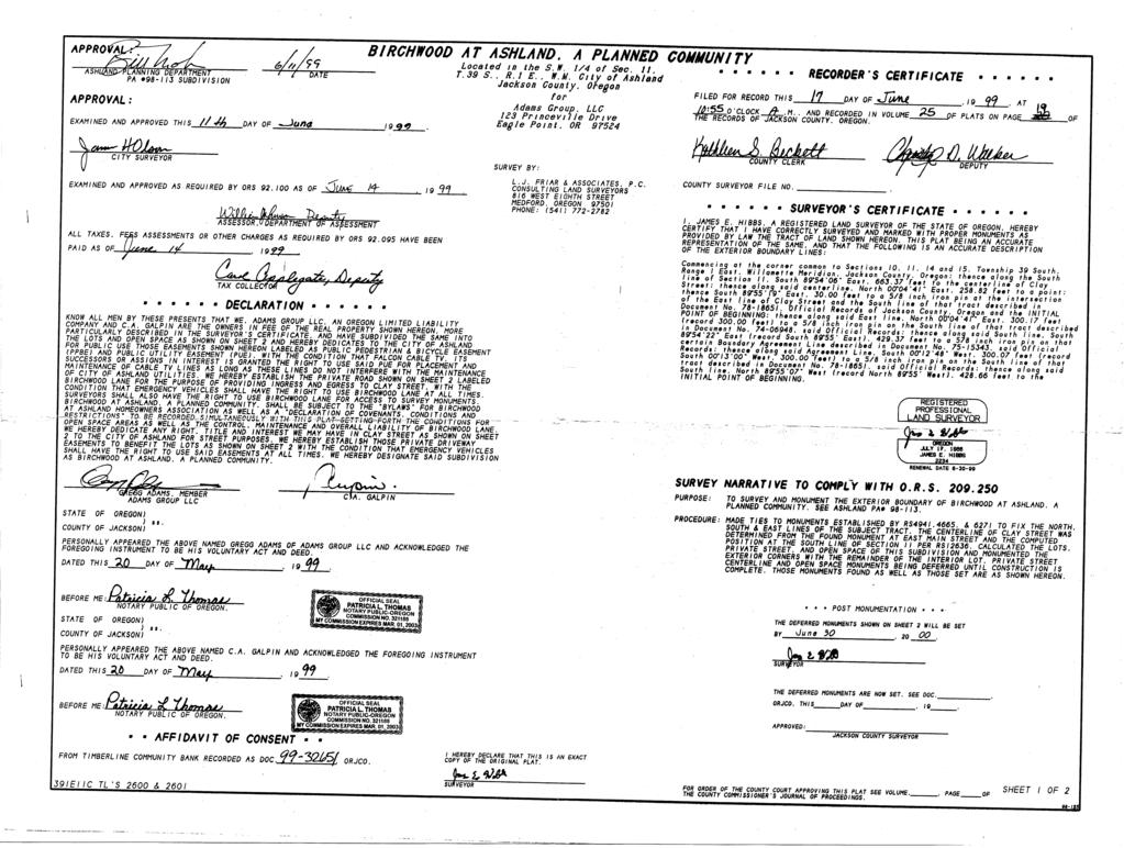
1 Council Communication October 20, 2015, Business Meeting Approval of Quitclaim Deeds to Terminate Public Pedestrian Access Easements FROM: Scott A. Fleury, Engineering Services Manager, Public Works, SUMMARY The Council is asked to approve quitclaim deeds in order to remove existing pedestrian access easements across three residential properties and the Birchwood subdivision open space. As required by ORS the City Council must approve relinquishment of any deed restrictions in favor of the public. BACKGROUND AND POLICY IMPLICATIONS: Engineering staff was contacted by the property owners for 400, 410 and 420 Clay St. respectively to consider terminating an existing pedestrian access easement across their properties. The easement is ten feet wide and was dedicated on officially recorded Partition Plat, P Staff discussed the option of removing the pedestrian easement via quitclaim with the Planning Department in order to determine the proper steps for removal of a planning requirement. The pedestrian easement was a requirement of previous planning action approval for the partition plat at 400 Clay St. The Planning Department determined the appropriate steps were to file for removal of the pedestrian easement as a new planning action. In the discussion it was also determined that planning would work with the Birchwood homeowners association in order to combine their pedestrian easement quitclaim into one planning action. The Birchwood pedestrian easement is dedicated on the Birchwood planned community map, survey number in the office of the Jackson County Surveyor. This type 1 planning action was reviewed by staff, publicly noticed for public comment and subsequently approved by the Planning Director on December 12, The notice of final decision and findings and orders that approved removal of the pedestrian easements are included with this staff report as an attachment. In addition to working with the Planning Department, staff contacted specific members of other city departments to garner their opinion of terminating the easement. No opposition to removal of the pedestrian easement was generated. It was determined the existing sidewalk along Clay St. connects to Ashland St. creating a continuous pedestrian walkway for residents of that section of Clay St. There is also an existing pedestrian connection to McCall Dr. from Birchwood Lane for pedestrians to utilize as well and a future alley connection between McCall Dr. and to the intersection of Engle and Villard streets, providing overall adequate pedestrian and bicycle facilities in that area. Page 1 of 2
2 FISCAL IMPLICATIONS: There are no fiscal implications of this action other than expended staff time. All document preparation and recording fees will be borne by the property owners. STAFF RECOMMENDATION AND REQUESTED ACTION: Staff recommends approval of the attached quitclaim deeds which would remove the pedestrian access easement that was dedicated to the City, on partition plat P and SUGGESTED MOTION: Move to approve the four attached quitclaim deeds which will terminate a public pedestrian access easement granted to the City in 2013, on partition plat P and ATTACHMENTS: 1. Planning Commission Notice of Final Decision, December 12, Trunnell Quitclaim Deed 3. Siple Quitclaim Deed 4. Wildman Quitclaim Deed 5. Birchwood s at Ashland Homeowners Quitclaim Deed 6. Partition Plat Map P Birchwood Planned Community Map Page 2 of 2
3
4
5

6
7
8
9 Until a change is requested, all tax statements shall be sent to: Adrienne & Gregg Trunnell 400 Clay St. Ashland, OR After recording return to: Adrienne & Gregg Trunnell 400 Clay St. Ashland, OR STATUTORY QUITCLAIM DEED City of Ashland, a municipal corporation, Grantor, releases and quitclaims toadrienne and Gregg Trunnell, as to an undivided 100% Grantees, all right, title and interest in and to the following described real property: All that portion of the 10 foot public pedestrian easement granted to the City of Ashland by dedication on that certain Land Partition Survey, Partition Plat No. P , recorded February 27, 2002, in Record of Partition Plats in Jackson County, Oregon, and filed as Survey No , in the Office of the County Surveyor, lying within that tract of land currently owned by Grantees, which tract of land owned by Grantees in Parcel 1 shown on Partition Plat No. P referred to above. BEFORE SIGNING OR ACCEPTING THIS INSTRUMENT, THE PERSON TRANFERRING FEE TITLE SHOULD INQUIRE ABOUT THE PERSON S RIGHTS, IF ANY, UNDER ORS , AND TO AND SECTIONS 5 TO 11, CHAPTER 424, OREGON LAWS THIS INSTRUMENT DOES NOT ALLOW USE OF THE PROPERTY DESCRIBED IN THIS INSTRUMENT IN VIOLATION OF APPLICABLE LAND USE LAWS AND REGULATIONS. BEFORE SIGNING OR ACCEPTING THIS INSTRUMENT, THE PERSON ACQUIRING FEE TITLE TO THE PROPERTY SHOULD CHECK WITH THE APPROPRIATE CITY OR COUNTY PLANNING DEPARTMENT TO VERIFY THAT THE UNIT OF LAND BEING TRANSFERRED IS A LAWFULLY ESTABLISHED LOT OR PARCEL, AS DEFINED IN ORS OR , TO VERIFY THE APPROVED USES OF THE LOT OR PARCEL, TO DETERMINE ANY LIMITS ON LAWSUITS AGAINST FARMING OR FOREST PRACTICES AS DEFINED IN ORS AND TO INQUIRE ABOUT THE RIGHTS OF NEIGHBORING PROPERTY OWNERS, IF ANY, UNDER ORS , AND TO AND SECTIONS 5 TO 11 CHAPTER 424, OREGON LAWS The true consideration for this conveyance is $ DATED this day of July, GRANTOR City of Ashland, a municipal corporation STATE OF OREGON ) )ss. County of Jackson ) John Stromberg, Mayor The foregoing instrument was acknowledged before me this day of July, 2015, by John Stromberg, as Mayor of City of Ashland, a municipal corporation, on behalf of Grantor. Notary Public for Oregon My commission expires: Page 1 of 1
10 Until a change is requested, all tax statements shall be sent to: Kathleen Kim Siple, Trustee, and Gary Bruce Dittler, Trustee 1968 Treewood Lane San Jose, CA After recording return to: Kathleen Kim Siple, Trustee, and Gary Bruce Dittler, Trustee 1968 Treewood Lane San Jose, CA STATUTORY QUITCLAIM DEED City of Ashland, a municipal corporation, Grantor, releases and quitclaims to Kathleen Kim Siple, Trustee of the Kathleen Kim Siple 2000 Living Trust dated October 5, 2000 as to an undivided 90.7% interest and Gary Bruce Dittler, Trustee of the Gary Bruce Dittler 2003 Living Trust dated February 3, 2003 as to an undivided 9.3% interest as tenants in common, Grantees, all right, title and interest in and to the following described real property: All that portion of the 10 foot public pedestrian easement granted to the City of Ashland by dedication on that certain Land Partition Survey, Partition Plat No. P , recorded February 27, 2002, in Record of Partition Plats in Jackson County, Oregon, and filed as Survey No , in the Office of the County Surveyor, lying within that tract of land currently owned by Grantees, which tract of land owned by Grantees in Parcel 2 shown on Partition Plat No. P referred to above. BEFORE SIGNING OR ACCEPTING THIS INSTRUMENT, THE PERSON TRANSFERRING FEE TITLE SHOULD INQUIRE ABOUT THE PERSON S RIGHTS, IF ANY, UNDER ORS , AND TO AND SECTIONS 5 TO 11, CHAPTER 424, OREGON LAWS 2007, SECTIONS 2 TO 9 AND 17, CHAPTER 855, OREGON LAWS 2009, AND SECTIONS 2 TO 7, CHAPTER 8, OREGON LAWS THIS INSTRUMENT DOES NOT ALLOW USE OF THE PROPERTY DESCRIBED IN THIS INSTRUMENT IN VIOLATION OF APPLICABLE LAND USE LAWS AND REGULATIONS. BEFORE SIGNING OR ACCEPTING THIS INSTRUMENT, THE PERSON ACQUIRING FEE TITLE TO THE PROPERTY SHOULD CHECK WITH THE APPROPRIATE CITY OR COUNTY PLANNING DEPARTMENT TO VERIFY THAT THE UNIT OF LAND BEING TRANSFERRED IS A LAWFULLY ESTABLISHED LOT OR PARCEL, AS DEFINED IN ORS OR , TO VERIFY THE APPROVED USES OF THE LOT OR PARCEL, TO DETERMINE ANY LIMITS ON LAWSUITS AGAINST FARMING OR FOREST PRACTICES, AS DEFINED IN ORS , AND TO INQUIRE ABOUT THE RIGHTS OF NEIGHBORING PROPERTY OWNERS, IF ANY, UNDER ORS , AND TO AND SECTIONS 5 TO 11, CHAPTER 424, OREGON LAWS 2007, SECTIONS 2 TO 9 AND 17, CHAPTER 855, OREGON LAWS 2009, AND SECTIONS 2 TO 7, CHAPTER 8, OREGON LAWS The true consideration for this conveyance is $ DATED this day of July, GRANTOR City of Ashland, a municipal corporation STATE OF OREGON ) ) ss. County of Jackson ) John Stromberg, Mayor The foregoing instrument was acknowledged before me this day of July, 2015, by John Stromberg, as Mayor of City of Ashland, a municipal corporation, on behalf of Grantor. Notary Public for Oregon My commission expires: Page 1 of 1
11 Until a change is requested, all tax statements shall be sent to: Robert Wildman and Allison Wildman 420 Clay St. Ashland, OR After recording return to: Robert Wildman and Allison Wildman 420 Clay St. Ashland, OR STATUTORY QUITCLAIM DEED City of Ashland, a municipal corporation, Grantor, releases and quitclaims to Robert and Allison Wildman, as to an undivided 100% Grantees, all right, title and interest in and to the following described real property: All that portion of the 10 foot public pedestrian easement granted to the City of Ashland by dedication on that certain Land Partition Survey, Partition Plat No. P , recorded February 27, 2002, in Record of Partition Plats in Jackson County, Oregon, and filed as Survey No , in the Office of the County Surveyor, lying within that tract of land currently owned by Grantees, which tract of land owned by Grantees in Parcel 3 shown on Partition Plat No. P referred to above. BEFORE SIGNING OR ACCEPTING THIS INSTRUMENT, THE PERSON TRANSFERRING FEE TITLE SHOULD INQUIRE ABOUT THE PERSON S RIGHTS, IF ANY, UNDER ORS , AND TO AND SECTIONS 5 TO 11, CHAPTER 424, OREGON LAWS 2007, SECTIONS 2 TO 9 AND 17, CHAPTER 855, OREGON LAWS 2009, AND SECTIONS 2 TO 7, CHAPTER 8, OREGON LAWS THIS INSTRUMENT DOES NOT ALLOW USE OF THE PROPERTY DESCRIBED IN THIS INSTRUMENT IN VIOLATION OF APPLICABLE LAND USE LAWS AND REGULATIONS. BEFORE SIGNING OR ACCEPTING THIS INSTRUMENT, THE PERSON ACQUIRING FEE TITLE TO THE PROPERTY SHOULD CHECK WITH THE APPROPRIATE CITY OR COUNTY PLANNING DEPARTMENT TO VERIFY THAT THE UNIT OF LAND BEING TRANSFERRED IS A LAWFULLY ESTABLISHED LOT OR PARCEL, AS DEFINED IN ORS OR , TO VERIFY THE APPROVED USES OF THE LOT OR PARCEL, TO DETERMINE ANY LIMITS ON LAWSUITS AGAINST FARMING OR FOREST PRACTICES, AS DEFINED IN ORS , AND TO INQUIRE ABOUT THE RIGHTS OF NEIGHBORING PROPERTY OWNERS, IF ANY, UNDER ORS , AND TO AND SECTIONS 5 TO 11, CHAPTER 424, OREGON LAWS 2007, SECTIONS 2 TO 9 AND 17, CHAPTER 855, OREGON LAWS 2009, AND SECTIONS 2 TO 7, CHAPTER 8, OREGON LAWS The true consideration for this conveyance is $ DATED this day of July, GRANTOR City of Ashland, a municipal corporation STATE OF OREGON ) ) ss. County of Jackson ) John Stromberg, Mayor The foregoing instrument was acknowledged before me this day of July, 2015, by John Stromberg, as Mayor of City of Ashland, a municipal corporation, on behalf of Grantor. Notary Public for Oregon My commission expires: Page 1 of 1
12 Until a change is requested, all tax statements shall be sent to: The Birchwood's at Ashland Homeowners Association 2117 Birchwood Lane Ashland, OR After recording return to: The Birchwood's at Ashland Homeowners Association 2117 Birchwood Lane Ashland, OR STATUTORY QUITCLAIM DEED City of Ashland, a municipal corporation, Grantor, releases and quitclaims to The Birchwood's at Ashland Homeowners Association, as to an undivided 100% Grantees, all right, title and interest in and to the following described real property: The Public Pedestrian and Bicycle Easement granted to the City of Ashland by dedication on that certain Birchwood At Ashland, A Planned Community Plat, recorded June 17, 1999 in Volume 25 of Plats on Page 19 of the Records of Jackson County, Oregon, and filed as Survey No in the office of the Jackson County Surveyor. Beginning at the Southeast corner of Lot 5 of said plat, thence South East, 8.00 feet to the Southwest corner of Lot 6 said plat, thence North East, feet to the Northwest corner Lot 6 said plat, thence North West, 8.00 feet to the Northeast corner Lot 5 said plat, thence South West, feet to the Southeast corner Lot 5 said plat, also being the Point of Beginning, containing 744 Sq.Ft. more or less. BEFORE SIGNING OR ACCEPTING THIS INSTRUMENT, THE PERSON TRANSFERRING FEE TITLE SHOULD INQUIRE ABOUT THE PERSON S RIGHTS, IF ANY, UNDER ORS , AND TO AND SECTIONS 5 TO 11, CHAPTER 424, OREGON LAWS 2007, SECTIONS 2 TO 9 AND 17, CHAPTER 855, OREGON LAWS 2009, AND SECTIONS 2 TO 7, CHAPTER 8, OREGON LAWS THIS INSTRUMENT DOES NOT ALLOW USE OF THE PROPERTY DESCRIBED IN THIS INSTRUMENT IN VIOLATION OF APPLICABLE LAND USE LAWS AND REGULATIONS. BEFORE SIGNING OR ACCEPTING THIS INSTRUMENT, THE PERSON ACQUIRING FEE TITLE TO THE PROPERTY SHOULD CHECK WITH THE APPROPRIATE CITY OR COUNTY PLANNING DEPARTMENT TO VERIFY THAT THE UNIT OF LAND BEING TRANSFERRED IS A LAWFULLY ESTABLISHED LOT OR PARCEL, AS DEFINED IN ORS OR , TO VERIFY THE APPROVED USES OF THE LOT OR PARCEL, TO DETERMINE ANY LIMITS ON LAWSUITS AGAINST FARMING OR FOREST PRACTICES, AS DEFINED IN ORS , AND TO INQUIRE ABOUT THE RIGHTS OF NEIGHBORING PROPERTY OWNERS, IF ANY, UNDER ORS , AND TO AND SECTIONS 5 TO 11, CHAPTER 424, OREGON LAWS 2007, SECTIONS 2 TO 9 AND 17, CHAPTER 855, OREGON LAWS 2009, AND SECTIONS 2 TO 7, CHAPTER 8, OREGON LAWS The true consideration for this conveyance is $ DATED this day of July, GRANTOR City of Ashland, a municipal corporation STATE OF OREGON ) ) ss. County of Jackson ) John Stromberg, Mayor The foregoing instrument was acknowledged before me this day of July, 2015, by John Stromberg, as Mayor of City of Ashland, a municipal corporation, on behalf of Grantor. Notary Public for Oregon My commission expires: Page 1 of 1

13
14

15
TO AUTHORIZE THE SALE OF SURPLUS COUNTY OWNED REAL PROPERTY FOR $9,000 TO MEHRAN SEPEHRI AND CAROL MILLS, MAP NO.
 Memorandum Date: January 9, 2017 Agenda Date: January 24, 2017 ====================================================================== TO: Board of County Commissioners DEPARTMENT: Public Works PRESENTED
David L. Brown, Construction Services Manager
 Memorandum Date: 2/02/2013 Order Date: 2/27/2013 TO: DEPARTMENT: PRESENTED BY: AGENDA ITEM TITLE: Board of County s Public Works David L. Brown, Construction Services Manager In the Matter of Authorizing
COUNCIL AGENDA MEMO ITEM NO. III - #1
 COUNCIL AGENDA MEMO ITEM NO. III - #1 FROM: Anton Jelinek, Director of Utilities MEETING: October 24, 2017 SUBJECT: PRESENTER: Permanent Utility and Right-of-Way Easement Anton Jelinek Discussion: At the
LAND SALE CONTRACT Josephine County, Oregon
 LAND SALE CONTRACT Josephine County, Oregon This Agreement is made by and between JOSEPHINE COUNTY, a political subdivision of the State of Oregon, hereinafter called COUNTY, and, hereinafter called PURCHASER.
BILL NO (Emergency Measure) ORDINANCE NO. 5072
 ORDINANCE NO. 5072") BILL NO. 5210 (Emergency Measure) ORDINANCE NO. 5072 AN ORDINANCE AUTHORIZING THE MAYOR TO EXECUTE WITH MICHELSON-HADLEY HEIGHTS DEVELOPMENT, LLC, A CONTRACT AND QUIT CLAIM DEED CONVEYING CERTAIN PROPERTIES
BILL NO. 5210 (Emergency Measure) ORDINANCE NO. 5072 AN ORDINANCE AUTHORIZING THE MAYOR TO EXECUTE WITH MICHELSON-HADLEY HEIGHTS DEVELOPMENT, LLC, A CONTRACT AND QUIT CLAIM DEED CONVEYING CERTAIN PROPERTIES
A G E N D A C O V E R M E M O R A N D U M
 A G E N D A C O V E R M E M O R A N D U M Memorandum Date: February 17, 215 Aenda Date: March 3, 215 ====================================================================== TO: Board of County Commissioners
COUNCIL ACTION FORM Meeting Date: September 13, 2012 Staff Contact: John Sullivan, Public Works Director
 COUNCIL ACTION FORM Meeting Date: September 13, 2012 Staff Contact: John Sullivan, Public Works Director Agenda Item: Consider vacation of a Landscape Easement granted to the City of Westwood for the construction
RESOLUTION NO A RESOLUTION ACCEPTING THE FOLLOWING RIGHT-OF-WAY DEDICATION: Pur ose
 RESOLUTION NO. 6538 A RESOLUTION ACCEPTING THE FOLLOWING RIGHT-OF-WAY DEDICATION: Grantor Richard D. Hews and Sharon F. Hews Pur ose A variable -width right-of-way dedication for the north half of the
QUITCLAIM OF EASEMENT DEED R/WNo APN: &
 City of Los Angeles When recorded mail To: Los Angeles County Metropolitan Transportation Authority Attn: Roger Mohere, Chief Real Property Management & Development One Gateway Plaza Los Angeles, CA 90012
RESTRICTIVE COVENANT NON-REMONSTRANCE AGREEMENT (PURSUANT TO CITY OF OREGON CITY ORDINANCE NO )
") AFTER RECORDING RETURN TO: City Recorder City of Oregon City P.O. Box 3040 Oregon City, Oregon 97045-0304 Map No.: Tax Lots : Planning No.: Grantor: RESTRICTIVE COVENANT NON-REMONSTRANCE AGREEMENT (PURSUANT
AFTER RECORDING RETURN TO: City Recorder City of Oregon City P.O. Box 3040 Oregon City, Oregon 97045-0304 Map No.: Tax Lots : Planning No.: Grantor: RESTRICTIVE COVENANT NON-REMONSTRANCE AGREEMENT (PURSUANT
Board Summary Report
 BoCC Consent Agenda: July 22, 2014 Consent Agenda Item#: Board Summary Report Date: July 8, 2014 To: Through: Through: From: Arapahoe County Board of County Commissioners David M. Schmit, PE, Director
RESOLUTION NO Purpose. NOW, THEREFORE, BE IT RESOLVED by the Albany City Council that it does hereby accept this
 RESOLUTION NO. 6567 A RESOLUTION ACCEPTING THE FOLLOWING EASEMENT: Grantor Purpose Hope Church ( AKA First Assembly of God A 2 foot by 2 foot easement for public sidewalk Albany) and pedestrian crosswalk
30.00 $11.00 $17.00 $10.00 $20.00 $
 RECORDING COVER SHEET (Please Print or Type) This cover sheet was prepared by the person presenting the instrument for recording. The information on this sheet is a reflection of the attached instrument
FIFTH AMENDMENT OF DECLARATION OF DEED RESTRICTIONS AND DEDICATIONS FOR PINEHURST ESTATES (A Clatsop County, Oregon Subdivision)
") After Recording Return To: W. Louis Larson 990 Astor Street Astoria, OR 97103 FIFTH AMENDMENT OF DECLARATION OF DEED RESTRICTIONS AND DEDICATIONS FOR PINEHURST ESTATES (A Clatsop County, Oregon Subdivision)
After Recording Return To: W. Louis Larson 990 Astor Street Astoria, OR 97103 FIFTH AMENDMENT OF DECLARATION OF DEED RESTRICTIONS AND DEDICATIONS FOR PINEHURST ESTATES (A Clatsop County, Oregon Subdivision)
BEFORE THE BOARD OF COMMISSIONERS OF LANE COUNTY, OREGON
 BEFORE THE BOARD OF COMMISSIONERS OF LANE COUNTY, OREGON ORDER NO: 18-04-03-04 IN THE MATTER OF AUTHORIZING THE SALE OF COUNTY OWNED REAL PROPERTY FOR $25,500 PURSUANT TO A LAND SALES CONTRACT TO LOIS
NOW, THEREFORE, BE IT RESOLVED by the Albany City Council that it does hereby accept this right -of way - dedication deed.
 RESOLUTION NO. 6226 A RESOLUTION ACCEPTING THE FOLLOWING RIGHT -OF -WAY DEDICATION: Grantor City of Albany Purpose Converting a 25 foot wide tract of land into Street and Utility Right -of way, - to provide
City Commission Agenda Cover Memorandum
 City Commission Agenda Cover Memorandum Originating Department: Mayor/Admin (MA) Meeting Type: Regular Agenda Date: 12/05/2016 Advertised: Required?: Yes No ACM#: 21161 Subject: Resolution No. 321-16 declaring
The City Council of the City of Sulphur, Louisiana, met in special session at its
 July 12, 2018 The City Council of the City of Sulphur, Louisiana, met in special session at its regular meeting place in the Council Chambers, Sulphur, Louisiana, on July 12, 2018 at 5:00 p.m., after full
In order to help you facilitate this verification process, the City offers two methods for you to choose from to make this verification.
 The City of Siloam Springs requires that you verify that you have a clear title for your property. This is because if the City accepts a dedication of land, i.e. for a utility easement, access easements,
GENERAL WARRANTY DEED
 PROJECT. # 89008160 TRACT NO.:10 PARCEL ID NO.:PL199032200000001003 OWNERS NAME: Park Hill School District SITUS ADDRESS:5520 N. Northwood: KANSAS CITY, MISSOURI MAILING ADDRESS:7703 NW Barry Rd. Kansas
Ordinance No. 94-~ AN ORDINANCE APPROVING THE PURCHASE OF BICYCLE PATH EASEMENTS
 m Ordinance No. 94-~ AN ORDINANCE APPROVING THE PURCHASE OF BICYCLE PATH EASEMENTS BE IT ORDAINED BY THE PRESIDENT AND BOARD OF TRUSTEES OF THE VILLAGE OF CHATHAM, SANGAMON COUNTY, ILLINOIS, AS FOLLOWS:
NOW, THEREFORE, BE IT ORDAINED BY THE CITY OF SAN ANGELO:
 AN ORDINANCE PROVIDING FOR ABANDONMENT AND CLOSING OF THE FOLLOWING IMPROVED ALLEY SEGMENT, TO WIT: 6,125 SQUARE FEET OF THE IMPROVED PUBLIC RIGHT-OF-WAY (ALLEY) LYING BETWEEN LOTS 5-11, BLOCK 1 IN THE
DEED AND DEDICATION FOR PUBLIC RIGHT OF WAY
 TO : BOARD OF DIRECTORS FROM : GARY PLATT, EXEC. DIRECTOR BUSINESS AND OPERATIONS SUBJECT : CITY OF STANWOOD CONSTRUCTION EASEMENT AND RIGHT-OF-WAY DEDICATION DATE : MARCH 17, 2009 TYPE : ACTION NEEDED
TAFFREPORT. Steven A. Preston, FAICP, City Manager. Jennifer Davis, Community Development Director W trm-?f>
 Community Development Department TAFFREPORT Date: To: From: January 07, 2014 Steven A. Preston, FAICP, City Manager Jennifer Davis, Community Development Director W trm-?f> By: Daren Grilley, PE, City
CITY MANAGER MEMORANDUM
 CITY MANAGER MEMORANDUM To: The Honorable Mayor Kelley and City Commissioners Through: Joyce A. Shanahan, City Manager From: Ric Goss, AICP, Planning Director Date: July 14, 2011 Subject: 17 Foxfords Chase,
Regular Agenda / Public Hearing for Board of Commissioners meeting September 24, 2014
 John S. Franden, President Mitchell A. Jaurena, Vice President Rebecca W. Arnold, Commissioner Sara M. Baker, Commissioner Jim D. Hansen, Commissioner TO: FROM: ACHD Board of Commissioners & Bruce S. Wong,
Utility Easement from Suncoast Community Health Centers Inc Release of Easement
 0 YLANi AGENDA REPORT 5T FLORID DATE 10 24 11 TO FROM SUBJECT City Commission Gregory Horwedel City Manager Utility Easement from Suncoast Community Health Centers Inc Release of Easement RECOMMENDATION
DRAINAGE AND UTILITY EASEMENT. That Bruce Conrad, a single adult, hereinafter referred to as Grantor for good and
 DRAINAGE AND UTILITY EASEMENT KNOW ALL PERSONS BY THESE PRESENTS: That Bruce Conrad, a single adult, hereinafter referred to as Grantor for good and valuable consideration, the receipt and sufficiency
CITY OF ELK GROVE CITY COUNCIL STAFF REPORT
 CITY OF ELK GROVE CITY COUNCIL STAFF REPORT AGENDA ITEM NO. 8.22 AGENDA TITLE: Adopt resolution granting the Sacramento Area Sewer District (SASD) an easement for sewer and incidental purposes over City-owned
REVIEWED BY: Administrator Counsel Program Mgr.: Tiffany Schaufler Board Committee Engineer Other
 Minnehaha Creek Watershed District REQUEST FOR BOARD ACTION MEETING DATE: May 11, 2017 TITLE: Authorization to Grant a Temporary Easement to the City of Minnetrista RESOLUTION NUMBER: 17-034 PREPARED BY:
PARTITIONING OF PROPERTY WITHIN TILLAMOOK COUNTY
 PARTITIONING OF PROPERTY WITHIN TILLAMOOK COUNTY ALLOW AT LEAST 10 TO 30 DAYS FOR THE REVIEW PROCESS TO BE COMPLETED (1) PROPERTY OWNER --Proposes to create not more than 3 parcels within a calendar year
City of Edmonds TEMPORARY CONSTRUCTION EASEMENT
 City of Edmonds TEMPORARY CONSTRUCTION EASEMENT Madrona Elementary Walkway Property Address: 9300 236 th St SW. Edmonds, WA 98020 Assessor s Property Tax Parcel No.: 27033600404600 Property Owner: Edmonds
WARRANTY DEED INFORMATION PACKET
 WARRANTY DEED INFORMATION PACKET This information can be provided to our customers with the following statement: THERE MAY BE LEGAL AND/OR TAX IMPLICATIONS ONCE THESE FORMS ARE FILED. WE RECOMMEND YOU
EASEMENT AGREEMENT. WHEREAS, Ferguson is the 100% owner of the property described on Exhibit B attached hereto (the Williams Property );
;") EASEMENT AGREEMENT THIS EASEMENT AGREEMENT ( Agreement ) is entered into as of this day of, 2016, by and between CRAIG FERGUSON ( Ferguson ), and MAMIE DAVIS and JERRY MOORE ( Davis & Moore ), whose legal
EASEMENT AGREEMENT THIS EASEMENT AGREEMENT ( Agreement ) is entered into as of this day of, 2016, by and between CRAIG FERGUSON ( Ferguson ), and MAMIE DAVIS and JERRY MOORE ( Davis & Moore ), whose legal
Cross Reference: Instrument No. A State Parcel No Parcel: TEMPORARY CONSTRUCTION EASEMENT AGREEMENT
 Cross Reference: Instrument No. A199500066899 Project: 92TU000128 State Parcel No. 49-07-18-107-004.000-801 Parcel: 8033304 Date: Version: TEMPORARY CONSTRUCTION EASEMENT AGREEMENT THIS TEMPORARY CONSTRUCTION
SIDEWALK ACCESS EASEMENT AGREEMENT
 SIDEWALK ACCESS EASEMENT AGREEMENT THIS SIDEWALK ACCESS EASEMENT AGREEMENT ( Agreement ) is made by and among WATERWALK PLACE OWNERS ASSOCIATION, a Kansas non-profit corporation ( WWP ), FOUR-G, LLC, a
PLANNING DIRECTOR. Approved by the Planning Director on this day of, A.D. 20. day of, A.D. 20. Approved by the Fire Chief on this
 Located in a portion of the West Half of Section 19, Township 5 South, Range 1 East, Salt Lake Base and Meridian. SURVEYOR'S CERTIFICATE I, the undersigned surveyor, do hereby certify that I am a registered
PRELIMINARY TITLE SEARCH REPORT
 PRELIMINARY TITLE SEARCH REPORT Prepared By: Security 1 st Title 727 N. Waco, Suite 300 Wichita, KS 67203 Phone: (316) 267-8371 Fax: (316) 267-8115 Contact: David Herd Email: dherd@security1st.com Prepared
Sketch & Legal Description of Mitigation Bank and Ingress/Egress Access Easements
 Appendix H: Sketch & Legal Description of Mitigation Bank and Ingress/Egress Access Easements Tippen Bay Wetland Mitigation Bank DeSoto County, Florida Prepared by: September, 2017 Original file
NOW, THEREFORE, BE IT RESOLVED by the Albany City Council that it does hereby accept this right -of way - dedication deed.
 RESOLUTION NO. 6031 A RESOLUTION ACCEPTING THE FOLLOWING RIGHT OF WAY DEDICATION DEED: Grantor Purpose The First Church of God, Albany, Oregon, an A 60 -foot wide street right -of way - dedication for
MEMORANDUM. Mayor and City Council. Warren Hutmacher, City Manager. Date: February 11, 2013
 MEMORANDUM To: From: Mayor and City Council Warren Hutmacher, City Manager Date: February 11, 2013 Subject: Approval of an Intergovernmental agreement by and between the City of Dunwoody and DeKalb County
SOUTH DAKOTA BOARD OF REGENTS. Budget and Finance ******************************************************************************
 SOUTH DAKOTA BOARD OF REGENTS Budget and Finance AGENDA ITEM: 7 U DATE: October 4-6 ****************************************************************************** SUBJECT: SDSU 6 th Street Land Sale for
Philip Garber, Chief Gas Engineer. Release of Portion of Gas Line Easement in Lochlyn Hills Subdivision
 CITY OF CHARLOTTESVILLE, VIRGINIA CITY COUNCIL AGENDA Agenda Date: September 15, 2014 Action Required: Presenter: Staff Contacts: Title: Approval of Ordinance (1 st reading) after Public Hearing Lauren
HONORABLE MAYOR AND MEMBERS OF THE CITY COUNCIL TITO HAES, ASSISTANT CITY MANAGER/PUBLIC WORKS DIRECTOR
 CONSENT ITEM D-16 TO: FROM: VIA: HONORABLE MAYOR AND MEMBERS OF THE CITY COUNCIL TITO HAES, ASSISTANT CITY MANAGER/PUBLIC WORKS DIRECTOR JAMES MAKSHANOFF, CITY MANAGER DATE: JUNE 16, 2014 SUBJECT: RESOLUTIONS
GREENWAY EASEMENT AGREEMENT
 GREENWAY EASEMENT AGREEMENT This greenway access easement is entered into by and between the Laramie County School District Number One ( Grantor ), a corporate body organized under the laws of the State
Thomas E. Barzee, Jr., City Counselor
 N6RTH KANSAS CITY Virtually Urbon. Supremely Suburban. 2010 Howell NORTH KANSAS CITY, MO 64116 TEL: ( 816) 274-6000 FAX: ( 816) 421-5046 www.nkc.org MEMORANDUM To: FROM: RE: Mayor and City Council Thomas
E. 140TH AVE. VICINITY MAP SCALE: 1"=600' LAND USE TABLE NET AREA 599,946 SQFT AC. GROSS AREA 741,420 SQFT AC.
 SHEET OF PURPOSE STATEMENT: THIS PLAT IS INTENDED TO SUBDIVIDE. ACRES INTO SINGLE FAMILY ATTACHED LOTS, TRACTS, DEDICATE AND GRANT EASEMENTS. LEGAL DESCRIPTION: THE UNDERSIGNED BEING THE OWNER(S) OF A
Exhibit A: REAL ESTATE TRANSFER AGREEMENT
 Exhibit A: REAL ESTATE TRANSFER AGREEMENT This agreement is made between the City of Urbana, Illinois, a municipal corporation of the State of Illinois (the Seller ), and Homestead Corporation of Champaign-Urbana,
RESOLUTION NO. A RESOLUTION GRANTING AND ACCEPTING THE FOLLOWING STREET AND UTILITY. purpose
 RESOLUTION NO. 6627 A RESOLUTION GRANTING AND ACCEPTING THE FOLLOWING STREET AND UTILITY RIGHT-OF-WAY DEDICATION: Grantor City of Albany purpose Converting a variable width area of City property into street
for the Logan Golf and Country Club; and
 CITY OF LOGAN ORDINANCE NO. 16-01 AN ORDINANCE VACATING PUBLIC RIGHTS-OF-WAY INCLUDING 700 NORTH AND 900 NORTH FROM 1600 EAST TO THE EASTERN CITY BOUNDARY, 2000 EAST FROM 700 NORTH TO 900 NORTH AND A BROAD
III. After Recording Return To: City of Albany City Clerk. Recording Cover Sheet All Transactions, ORS:
 RESOLUTON NO. 6454 A RESOLUTON ACCEPTNG THE FOLLOWNG EASEMENT: Grantor Purpose Glorietta Bay, LLC A variable -width sanitary sewer and storm drainage easement over existing sewer and storm drainage lines.
Conditional Use Petition No
 Conditional Use Petition No. 18-06 (2027 Stacy Street) Staff Report Bren Daiss Director Planning, Development & Codes City Commission Public Hearing September 5, 2018 Table of Contents Requested Conditional
ARAPAHOE COUNTY WATER AND WASTEWATER AUTHORITY CONVEYANCE AND ACCEPTANCE OF UTILITY LINES AND FACILITIES (NAME OF DEVELOPMENT)
") ARAPAHOE COUNTY WATER AND WASTEWATER AUTHORITY CONVEYANCE AND ACCEPTANCE OF UTILITY LINES AND FACILITIES (NAME OF DEVELOPMENT), hereinafter called "GRANTOR" for and in consideration of the covenants and
ARAPAHOE COUNTY WATER AND WASTEWATER AUTHORITY CONVEYANCE AND ACCEPTANCE OF UTILITY LINES AND FACILITIES (NAME OF DEVELOPMENT), hereinafter called "GRANTOR" for and in consideration of the covenants and
VILLAGE BOARD MEETING STAFF REPORT
 Meeting: Village Board Meeting Date: 10/24/16 Agenda Item: 6h Mission Statement To provide our residents with a safe, friendly, attractive and active community by aggressively pursuing innovative ways
Road Easement Vacation Instructions
 Road Easement Vacation Instructions A road easement vacation removes a public right of way easement from the property of the adjoining owners. It is the County's duty to ensure that vacating a public easement
MUNICIPAL QUITCLAIM DEED
 DRAFT MUNICIPAL QUITCLAIM DEED The INHABITANTS OF THE TOWN OF WARREN, a body corporate and politic, located at Warren, Knox County, Maine, for consideration paid, Release to, whose mailing address is,
RESOLUTION NO. RD:EEH:LCP
 RESOLUTION NO. A RESOLUTION OF THE COUNCIL OF THE CITY OF SAN JOSE CONDITIONALLY VACATING A PORTION OF MERIDIAN AVENUE, SOUTH OF FRUITDALE AVENUE, AND RESERVING A PUBLIC SERVICE EASEMENT OVER THE VACATED
MINUTES OF A REGULAR PLANNING COMMISSION MEETING HELD, TUESDAY, OCTOBER 11, :30 P.M. ROCKVILLE CITY HALL
 28 MINUTES OF A REGULAR PLANNING COMMISSION MEETING HELD, TUESDAY, OCTOBER 11, 2011 6:30 P.M. ROCKVILLE CITY HALL The meeting was called to order by Chair Toni Honer. Roll call was taken and the following
BEFORE THE BOARD OF COUNTY COMMISSIONERS OF LANE COUNTY, OREGON
 BEFORE THE BOARD OF COUNTY COMMISSIONERS OF LANE COUNTY, OREGON ORDER NO. 15-11-03-03 IN THE MATTER OF VACATING AN UNNAMED PUBLIC ROAD, LOCATED WITHIN WATT'S ADDITION TO BLUE RIVER CITY, WITHOUT A PUBLIC
Scale 1" = 100' PLAT OF DEDICATION. Sheet 1 of 9 LEGAL DESCRIPTION. Areas of Dedication. Areas of Access Easement
 LEGAL DESCRIPTION PART OF LOTS 2, 4, 6 AND 7 IN GNAS MIXED USE RETAIL CENTER, BEING A SUBDIVISION OF PART OF THE WEST HALF OF SECTION 27, TOWNSHIP 42 NORTH, RANGE 12, EAST OF THE THIRD PRINCIPAL MERIDIAN,
STATEMENT OF CONDITIONS FOR USE OF
 STATEMENT OF CONDITIONS FOR USE OF WATER FACILITY EASEMENT GRANTEE: PORTLAND WATER BUREAU of the CITY OF PORTLAND, a municipal corporation of the State of Oregon LEGAL DESCRIPTION: (Attached hereto) SITE
CITY OF ROHNERT PARK CITY COUNCIL AGENDA REPORT
 Meeting Date: February 12, 2013 Mission Statement We Care for Our Residents by Working Together to Build a Better Community for Today and Tomorrow. CITY OF ROHNERT PARK CITY COUNCIL AGENDA REPORT ITEM
NOW, THEREFORE, BE IT RESOLVED by the Albany City Council that it does hereby accept this easement.
 RESOLUTION NO. 5991 A RESOLUTION ACCEPTING THE FOLLOWING EASEMENT: Grantor Albany Industrial Properties, LLC Purpose A 40 -foot wide easement over a new deep trunk sewer main east of I -5 as part of the
3 Ordinance ordering the street vacation of James Alley, generally bounded by
 FILE NO. 160153 ORDINANCE NO. 56-16 1 [Street Vacation - James Alley - Chinese Hospital Improvements] 2 3 Ordinance ordering the street vacation of James Alley, generally bounded by 4 Assessor's Block
ADMINISTRATIVE HEARING STAFF REPORT Country Club Acres Second Amended Subdivision Amendment PLNSUB E Parkway Avenue December 12, 2013
 ADMINISTRATIVE HEARING STAFF REPORT Country Club Acres Second Amended Subdivision Amendment PLNSUB2013-00925 2167 E Parkway Avenue December 12, 2013 Planning Division Department of Community & Economic
SPECIAL WARRANTY DEED. THIS DEED, made this day of, 2005, between
 SPECIAL WARRANTY DEED Owner s Last Name THIS DEED, made this day of, 2005, between [Owner #1 Full Name] and [Owner #2 Full Name] ( Grantors ) and ARAPAHOE COUNTY WATER AND WASTEWATER AUTHORITY, 13031 East
DEPARTMENT OF TRANSPORTATION VACANT LAND FOR SALE 7,769 SQUARE FEET
 DEPARTMENT OF TRANSPORTATION VACANT LAND FOR SALE 7,769 SQUARE FEET LOCATED I-94 at N Howell St., St. Paul, MN Conveyance 2016-0076 C.S.: 6282 (94=392) 903 Parcel: 1 and 47 AVAILABLE FOR PURCHASE AT THE
APARTMENT DEED WITH COVENANTS
 LAND COURT SYSTEM Return by Mail Pickup To: REGULAR SYSTEM TITLE OF DOCUMENT: APARTMENT DEED WITH COVENANTS PARTIES TO DOCUMENT: GRANTOR: 3702 LOWER HONOAPIILANI, LLC, a Colorado limited liability company
DECLARATION OF COVENANTS, CONDITIONS AND RESTRICTIONS BENNETT FARMS SUBDIVISION MADISON COUNTY, IOWA
 DECLARATION OF COVENANTS, CONDITIONS AND RESTRICTIONS BENNETT FARMS SUBDIVISION MADISON COUNTY, IOWA We, Corkrean Homes, Inc., hereinafter referred to as ADeclarant@, are now the fee simple owners and
PROCEDURE FOR CLOSING STREETS AND ALLEYS UNDER N.C.G.S. 160A-299 CITY OF GASTONIA, LEGAL DEPT., P. O. BOX 1748, GASTONIA, NC ( )
") PROCEDURE FOR CLOSING STREETS AND ALLEYS UNDER N.C.G.S. 160A-299 CITY OF GASTONIA, LEGAL DEPT., P. O. BOX 1748, GASTONIA, NC 28053 (866-6735) 1. Applicant requests closing of street or alley through the
PROCEDURE FOR CLOSING STREETS AND ALLEYS UNDER N.C.G.S. 160A-299 CITY OF GASTONIA, LEGAL DEPT., P. O. BOX 1748, GASTONIA, NC 28053 (866-6735) 1. Applicant requests closing of street or alley through the
NOW, THEREFORE, BE IT RESOLVED by the Albany City Council that it does hereby accept this
 RESOLUTON NO. 6614 A RESOLUTON ACCEPTNG THE FOLLOWNG EASEMENT: Grantor Purpose Koos Family, LLC A 10 foot by 23. 8 foot easement for public storm drainage as part of the Somerset Subdivision development.
ORDINANCE NO.:
 ORDINANCE NO.: 2013-098 Authorizing the City Manager to execute a Limited Warranty Deed conveying the improvements (an approximate 300 space parking garage) known as the Bell South Parking Garage constructed
EXHIBIT 1. PRIVATE ROAD ACCESS EASEMENT and SHARED ROAD MAINTENANCE AGREEMENT for KENNEDY SHORES LANE. Auction Tracts 1-8
 EXHIBIT 1 PRIVATE ROAD ACCESS EASEMENT and SHARED ROAD MAINTENANCE AGREEMENT for KENNEDY SHORES LANE Auction Tracts 1-8 This Private Road Access Easement and Shared Road Maintenance Agreement for Kennedy
AMENDMENT TO QUITCLAIM DEED AND GRANT OF EASEMENT RECITALS
 RECORDED REQUESTED BY AND WHEN RECORDED MAIL TO: Clerk of the Board of Supervisors County of San Luis Obispo 1055 Monterey Street San Luis Obispo, CA 93408 APN 076-213-009 AND 076-215-012 SPACE ABOVE THIS
BEFORE THE BOARD OF COUNTY COMMISSIONERS OF LANE COUNTY, OREGON
 BEFORE THE BOARD OF COUNTY COMMISSIONERS OF LANE COUNTY, OREGON ORDER NO: 14-04-22-02 IN THE MATTER OF RELEASING, DEDICATING, AND ACCEPTING PARCEL "A" OF THE PLAT OF LEE VILLA, AS RIGHT OF WAY FOR LARALEE
AGREEMENT RECITALS: Draft 3/26/2015
 AGREEMENT This Agreement is entered into this day of April, 2015, by and between the SCHOOL BOARD OF BREVARD COUNTY, FLORIDA (the "School Board") and THE CITY OF MELBOURNE, a Florida municipal corporation
SOUTH DAKOTA BOARD OF REGENTS. Budget and Finance ******************************************************************************
 SOUTH DAKOTA BOARD OF REGENTS Budget and Finance AGENDA ITEM: 6 K DATE: October 2-4, 2018 ****************************************************************************** SUBJECT USD Discovery District:
PURCHASE AND SALE AGREEMENT
 PURCHASE AND SALE AGREEMENT THIS PURCHASE AND SALE AGREEMENT is entered into this day of November, 2008, by and between DRRAM Ashland Limited Partnership ( DRRAM ), The City of Ashland ( CITY ), and The
AN ACT. The General Assembly of the Commonwealth of Pennsylvania hereby enacts as follows:
 CONVEYANCES - COMMONWEALTH PROPERTY IN LIGONIER BOROUGH, WEST MORELAND COUNTY; CITY OF CONNELLSVILLE, FAYETTE COUNTY; CITY OF ALLENTOWN, LEHIGH COUNTY; BENSALEM TOWNSHIP, BUCKS COUNTY, AND SUSQUEHANNA
CHECKLIST FOR CUSTOMER Lawful Lot Determination
 CHECKLIST FOR CUSTOMER Lawful Lot Determination (LDO Section 10.2.1A) The following material must be submitted with a request for a lawful lot determination. Check off each item that you have included
I. PARCEL MAP STATEMENTS II. FINAL MAP STATEMENTS III. GENERAL NOTES ON PARCEL/FINAL MAPS FOR CONDOMINIUMS IV. RECORD OF SURVEY STATEMENTS
 These statements are compiled for the convenience of the reader and are not meant to redefine or conflict with applicable California State Law. In the event of a conflict, the applicable law shall prevail.
CONVEYANCE - COMMONWEALTH PROPERTY IN THE BOROUGH OF EAST STROUDSBURG, MONROE COUNTY Act of Jul. 1, 2016, P.L., No. 65 Cl.
 CONVEYANCE - COMMONWEALTH PROPERTY IN THE BOROUGH OF EAST STROUDSBURG, MONROE COUNTY Act of Jul. 1, 2016, P.L., No. 65 Cl. 85 An Act Authorizing the Department of General Services, with the approval of
RESOLUTION TO ACCEPT DEED OF DEDICATION FOR A RELOCATED UTILITY EASEMENT AS SHOWN ON APPROVED SUBDIVISION PLAN FOR THE LOWER MERION HIGH SCHOOL
 Exhibit D RESOLUTION TO ACCEPT DEED OF DEDICATION FOR A RELOCATED UTILITY EASEMENT AS SHOWN ON APPROVED SUBDIVISION PLAN FOR THE LOWER MERION HIGH SCHOOL WHEREAS, the Board of Commissioners of the Township
RECORD OF ORDINANCES
 RECORD OF ORDINANCES Ordinance No. 2016-8 August 8, 2016 City of Bellbrook Ordinance No. 2016-8 An Ordinance Granting an Easement to the State of Ohio, Department of Transportation for Improvements to
OHIO DEPARTMENT OF TRANSPORTATION ACQUISITION 104 August 2018 CASE STUDY 3. Student Case Study
 OHIO DEPARTMENT OF TRANSPORTATION ACQUISITION 104 August 2018 CASE STUDY 3 Student Case Study Use the following information to answer questions 1 through 4. Parcel: Project: Title Report: Compensation:
CITY OF TEXARKANA, ARKANSAS STREET AND DRAINAGE EASEMENT
 CITY OF TEXARKANA, ARKANSAS STREET AND DRAINAGE EASEMENT STATE OF ARKANSAS COUNTY OF MILLER FOR and in consideration of the sum often dollars ($10.00) in hand paid by the City of Texarkana, Arkansas, the
BOONE COUNTY, MISSOURI RESOURCE MANAGEMENT DEPARTMENT (573)
") STORMWATER MANAGEMENT/BMP FACILITIES MAINTENANCE AGREEMENT FOR ON-SITE FACILITIES BOONE COUNTY, MISSOURI RESOURCE MANAGEMENT DEPARTMENT (573)-886-4330 THIS agreement made and entered into this Day of 20,
STORMWATER MANAGEMENT/BMP FACILITIES MAINTENANCE AGREEMENT FOR ON-SITE FACILITIES BOONE COUNTY, MISSOURI RESOURCE MANAGEMENT DEPARTMENT (573)-886-4330 THIS agreement made and entered into this Day of 20,
CONSENT ACTION BY THE BOARD OF DIRECTORS OF VENETO IN MIRAMAR CONDOMINIUM ASSOCIATION, INC.
 CONSENT ACTION BY THE BOARD OF DIRECTORS OF VENETO IN MIRAMAR CONDOMINIUM ASSOCIATION, INC. The undersigned, being all of the members of the Board of Directors of Veneto in Miramar Condominium Association,
CITY OF INDIANAPOLIS GRANT OF PERPETUAL DRAINAGE EASEMENT AND RIGHT-OF-WAY
 CROSS REFERENCE TO DEED#: PROJECT #: DRN - INSTRUMENT NO.: PARCEL #: CITY OF INDIANAPOLIS GRANT OF PERPETUAL DRAINAGE EASEMENT AND RIGHT-OF-WAY THIS INDENTURE made this day of, 20, by and between, ("GRANTOR")
RESOLUTION NO. RESOLUTION APPROVING ZONING PETITION 84-71, Special Exception. WHEREAS, the Board of County Commissioners, as the governing
 /. ;C- C, i RESOLUTION NO. R-@+-l2?8 RESOLUTION APPROVING ZONING PETITION 84-71, Special Exception WHEREAS, the Board of County Commissioners, as the governing body, pursuant to the authority vested in
Klamath County Property Sales Listing Page 1 of 14
 NOTICE OF SALE OF TAX FORECLOSED PROPERTIES In accordance with ORS 275 and by Order of the Board of County Commissioners dated Tuesday, August 8, 2017, I shall at 9 a.m. to 12 noon & 1 p.m. to 4 p.m. on
PIPELINE RIGHT-OF-WAY EASEMENT
 PIPELINE RIGHT-OF-WAY EASEMENT THIS RIGHT-OF-WAY EASEMENT made this day of March, 2014, by the City of Rochester Hills, a municipal corporation in the State of Michigan,, having an address at 1000 Rochester
PUBLIC RECORD REPORT FOR NEW SUBDIVISION OR LAND PARTITION
 1225 Crater Lake Ave, Ste 101 Medford, OR 97504 Phn - (541)779-7250 Fax - (866)400-2250 PUBLIC RECORD REPORT FOR NEW SUBDIVISION OR LAND PARTITION THIS REPORT IS ISSUED BY THE ABOVE-NAMED COMPANY ("THE
City of Stevenson Planning Department
 City of Stevenson Planning Department (509)427-5970 7121 E Loop Road, PO Box 371 Stevenson, Washington 98648 TO: City Council FROM: Ben Shumaker DATE: January 16 th, 2014 SUBJECT: Bridging Byways Trail
Adopt the attached resolution accepting the grant of pathway easement.
 AGENDA TEM #4.M TOWN OF LOS ALTOS HLLS Staff Report to the City Council September 21, 2017 SUBJECT: FROM: GRANT OF PATHWAY EASEMENT LANDS OF HENG AND P AREGS 25383 LA RENA LANE Allen Chen, Public Works
IMPACT FEE DEFERRAL APPLICATION
 CITY OF TUMWATER Community Development Department 360-754-4180 Monday Friday 8:00am 5:00pm IMPACT FEE DEFERRAL APPLICATION APPLICANT: PROJECT NAME: OWNER INFORMATION NAME: Unit # PERMIT NO: PARCEL NO:
78th OREGON LEGISLATIVE ASSEMBLY Regular Session. House Bill 2510 SUMMARY
 th OREGON LEGISLATIVE ASSEMBLY--0 Regular Session Sponsored by Representative CLEM (Presession filed.) House Bill 0 SUMMARY The following summary is not prepared by the sponsors of the measure and is not
JOEL ROJAS, COMMUNITY DE'WPfiENT DIRECTOR ACCEPTANCE OF A SEWER EASEMENT DEED TO PROVIDE ADDITIONAL EASEMENT AREA TO ALLOW
 CITY OF RANCHO PALOS VERDES COMMUNITY DEVELOPMENT DEPARTMENT MEMORANDUM TO: FROM: DATE: SUBJECT: HONORABLE MAYOR & CITY COUNCIL MEMBERS u - JOEL ROJAS, COMMUNITY DE'WPfiENT DIRECTOR JUNE 3, 2014 ACCEPTANCE
Honorable Mayor Bill Agan and members of the Richland Hills City Council. Final Plat Richland Hills, Lots 1 & 2, Block 1 Brumlow Addition
 2B - 1 Memorandum To: From: Date: Subject: Honorable Mayor Bill Agan and members of the Richland Hills City Council Jason Moore, Assistant City Manager January 17, 2017 Final Plat Richland Hills, Lots
Regular Agenda / Public Hearing for Board of Commissioners meeting May 4, 2016
 Kent Goldthorpe, President Paul Woods, Vice President Rebecca W. Arnold, Commissioner Sara M. Baker, Commissioner Jim D. Hansen, Commissioner TO: FROM: ACHD Board of Commissioners & Bruce S. Wong, Director