APPRAISAL REPORT OF THE STATE OF SOUTH DAKOTA PROPERTY A ACRE SITE LOCATED AT 1501 US HIGHWAY 14 BYPASS BROOKINGS, SOUTH DAKOTA
|
|
|
- Samson Bennett
- 5 years ago
- Views:
Transcription
1 APPRAISAL REPORT OF THE STATE OF SOUTH DAKOTA PROPERTY A ACRE SITE LOCATED AT 1501 US HIGHWAY 14 BYPASS BROOKINGS, SOUTH DAKOTA CONTROL NUMBER CLIENT SOUTH DAKOTA OFFICE OF SCHOOL AND PUBLIC LANDS ATTN: MR. RYAN BRUNNER 500 EAST CAPITOL AVENUE PIERRE, SOUTH DAKOTA DATE OF VALUE NOVEMBER 20, 2018 BY SHAYKETT APPRAISAL COMPANY, INC. 601 NORTH MINNESOTA AVENUE, SUITE 100 SIOUX FALLS, SOUTH DAKOTA (605)
2 Shaykett Appraisal Company, Inc. 601 N. Minnesota Avenue, Suite 100 Sioux Falls, South Dakota Phone (605) Fax (605) Travis E. Shaykett Steven C. Shaykett, MAI George P. Stavrenos State Certified General Appraiser State Certified General Appraiser State Certified General Appraiser December 10, 2018 South Dakota Office of School and Public Lands Attn: Mr. Ryan Brunner 500 East Capitol Avenue Pierre, South Dakota RE: Appraisal Report of the State of South Dakota Property A Acre Site Located At 1501 US Highway 14 Bypass Brookings, South Dakota Control # Dear Mr. Brunner: In accordance with your request, we have prepared an Appraisal Report of the above referenced property. Purpose of the appraisal is to estimate the as is fee simple estate market value of the subject property as of November 20, Intended use of the appraisal is to assist in the disposal of the property. After viewing the subject property on November 20, 2018, as well as completing research and analysis necessary for the appraisal of the property, it is our opinion that the as is fee simple estate market value of the subject property as of November 20, 2018 was $1,860,000. ONE MILLION EIGHT HUNDRED SIXTY THOUSAND DOLLARS Analysis of the subject property and the data on which the appraisers opinions are based are set forth in the following report. Appraisal has been made in conformity with generally accepted appraisal practices in compliance with the Uniform Standards of Professional Appraisal Practice (USPAP). Appraisal is subject to all assumptions, limiting conditions, and other special limiting conditions as set forth in this report, or as specifically presented below, if any.
3
4 LIMITING CONDITIONS This appraisal report and the letter of transmittal and the certification of value are made expressly subject to the following limiting conditions, and any special limiting conditions contained elsewhere which are incorporated herein by reference. 1. This appraisal is subject to the accuracy of the legal description furnished the appraisers; however, we can assume no responsibility for matters legal in nature, nor can we render an opinion as to the title. 2. The distribution of the total valuation between land and improvements applied only under the existing program of utilization. The separate valuations for land and improvements must not be used in conjunction with any other appraisal and are invalid if so used. 3. We believe the information which was furnished to us by others is reliable, but we assume no responsibility for its accuracy. The comparable data relied upon in this appraisal is believed to be from reliable sources. However, it was not possible to view the comparables completely and it was necessary to rely on the information furnished by others as to said data. Therefore, the value conclusions are subject to the correctness of said data. 4. Unless otherwise indicated, all existing liens and encumbrances have been disregarded and the property is appraised as though it were free and clear of any such impediments that might affect value. The property is appraised as though it were under responsible ownership and competent management. 5. Subsurface rights (minerals and oil) were considered as they may contribute to the value of the surface rights unless otherwise indicated. 6. All furnishings and equipment, except those specifically indicated, have been disregarded by the appraisers. Only the real estate has been considered. 7. The appraisers have viewed, as far as possible, by observation, the land and the improvements thereon and have reported damage, if any, by termites, dry rot, wet rot, or other infestations as a matter of information. However, it was not possible to personally observe conditions beneath the soil or hidden structural components within the improvements. Viewing by the appraisers does not guarantee the lack of the presence of any hazardous materials, gases, or other materials which could be considered to pollute the environs of the subject property. Therefore, no representations are made herein as to these matters and unless specifically considered in the report, our value estimate is subject to any such conditions that could cause a loss in value. 8. Any sketches in this report are included to assist the reader in visualizing the property. We have made no survey of the property and assume no responsibility in connection with such matters.
5 LIMITING CONDITIONS 9. We are not required to give testimony or to appear in court by reason of this appraisal with reference to the property in question unless arrangements have been previously made therefore. 10. Possession of this report or a copy thereof does not carry with it the right of publication. Neither all nor any part of the contents of this report shall be conveyed to the public through advertising, public relations, news, sales or other media, nor for any purpose, without the written consent and approval of the appraisers, particularly as to valuation conclusions, the identity of the appraisers or firm with which they are connected, or any reference to the Appraisal Institute or to the MAI designation. 11. It is assumed that there is full compliance with all applicable federal, state and local environmental regulations and laws unless non-compliance is stated, defined and considered in the appraisal report. 12. The appraisers are not aware of the presence of soil contamination on the subject property, unless otherwise noted in this appraisal report. The effect upon market value, due to contamination was not considered in this appraisal, unless otherwise stated. 13. The appraisers are not aware of the presence of asbestos or other toxic contaminants in the building(s), unless otherwise noted in this report. The effect upon market value, due to contamination was not considered in this appraisal, unless otherwise stated. 14. Unless otherwise stated in this report, the existence of hazardous material, which may or may not be present on the property, was not observed by the appraisers. The appraisers have no knowledge of the existence of such materials on or in the property. The appraisers, however, are not qualified to detect such substances. The value estimate is predicated on the assumption that there is no such material on or in the property that would cause a loss in value. No responsibility is assumed for any such conditions, or for any expertise or engineering knowledge required to discover them. The client is urged to retain an expert in this field, if desired. 15. The appraisal is subject to any proposed improvements or additions being completed as set forth in the plans, specification, and representations referred to in the report, and all work being performed in a good and workmanlike manner. The appraisal is further subject to the proposed improvements or additions being constructed in accordance with the regulations of the local, county, and state authorities. The plans, specifications, and representations referred to are an integral part of the appraisal report when new construction or additions, renovation, refurbishing, or remodeling applies.
6 LIMITING CONDITIONS 16. The limit of liability of the appraisers or Shaykett Appraisal Company, Inc. is limited to the client only. Further there is no accountability, obligation or liability to any third party. If this report is placed in the hands of anyone other than the client, the client shall make such party aware of all limiting conditions and assumptions of this assignment. The appraisers are also in no way responsible for the costs to correct any physical, economic, legal or any other deficiencies of the property. In the case of any third party actions brought against the client, the client will hold the appraisers completely harmless. 17. The Americans with Disabilities Act ("ADA") became effective January 26, The appraisers have not made a specific compliance survey and analysis of this property to determine whether or not it is in conformity with the various detailed requirements of the ADA. It is possible that a compliance survey of the property, together with a detailed analysis of the requirements of the ADA, could reveal that the property is not in compliance with one or more of the requirements of the Act. If so, this fact could have a negative effect upon the value of the property. Since the appraisers have no direct evidence relating to this issue, possible noncompliance with the requirements of ADA in estimating the value of the property has not been considered. 18. Provision of an Insurable Value by the appraisers does not change the intended user or the intended purpose of the appraisal. The appraisers assume no liability for the Insurable Value estimate provided and do not guarantee that any estimate or opinion will result in the subject property being fully insured for any possible loss that may be sustained. The appraisers recommend that an insurance professional be consulted. The Insurable Value estimate may not be a reliable indication of replacement or reproduction cost for any date other than the effective date of this appraisal due to changing costs of labor and materials and due to changing building codes and governmental regulations and requirements.
7
8
9 SUMMARY OF IMPORTANT FACTS AND CONCLUSIONS Location: 1501 US Highway 14 Bypass Brookings, South Dakota Latitude & Longitude: Approximate Center of Property (Decimal Degrees) , Owner of Record: Property Rights Appraised: Land Area: Description of the Property: Zoning: State of South Dakota Fee Simple Estate Acres The property is predominately unimproved agricultural land, used by South Dakota State University for fruit tree research and various other agricultural research throughout the past twenty plus years. Improvements consist of one cold storage building and several other older storage buildings. Agricultural District, A Effective Date of Value: November 20, 2018 Highest and Best Use: Subdivision development ****** VALUATION SUMMARY ****** Fee Simple Estate Market Value: Indicated by the Cost Approach N/A Income Capitalization Approach N/A Sales Comparison Approach $1,860,000 Final Estimate of Market Value: $1,860,000
10 TABLE OF CONTENTS LETTER OF TRANSMITTAL LIMITING CONDITIONS APPRAISER CERTIFICATIONS SUMMARY OF IMPORTANT FACTS AND CONCLUSIONS IDENTIFICATION OF THE PROPERTY 1 CLIENT AND INTENDED USER 1 PURPOSE AND INTENDED USE OF THE APPRAISAL 1 PLAT MAP 2 GRAPE RESEARCH SURVEY 3 APPRAISAL REPORT OPTION 4 DATE OF VALUE AND DATE OF THE REPORT 4 DEFINITION OF MARKET VALUE 4 PROPERTY RIGHTS APPRAISED 4 PERSONAL PROPERTY 4 INTANGIBLE PROPERTY 5 HYPOTHETICAL CONDITION 5 EXTRAORDINARY ASSUMPTION 5 SCOPE OF WORK 6 AREA DATA 8 STATE MAP 9 NEIGHBORHOOD DATA 15 FUTURE LAND USE PLAN 18 NEIGHBORHOOD MAP 19 NEIGHBORHOOD AERIAL 20 MARKET CONDITIONS 21
11 TABLE OF CONTENTS ZONING 24 ASSESSMENT INFORMATION AND TAX DATA 25 PROPERTY DESCRIPTION 26 PROPERTY AERIAL 29 HIGHEST AND BEST USE 31 SALES COMPARISON APPROACH 33 RECONCILIATION AND FINAL ESTIMATE OF MARKET VALUE 37 COMPARABLE SALES MAP(S) COMPARABLE LAND SALE WRITE-UPS EXHIBITS: 1 Zoning Regulations 2 Photographs of Subject Property 3 Floodplain Map ****** ADDENDA ******
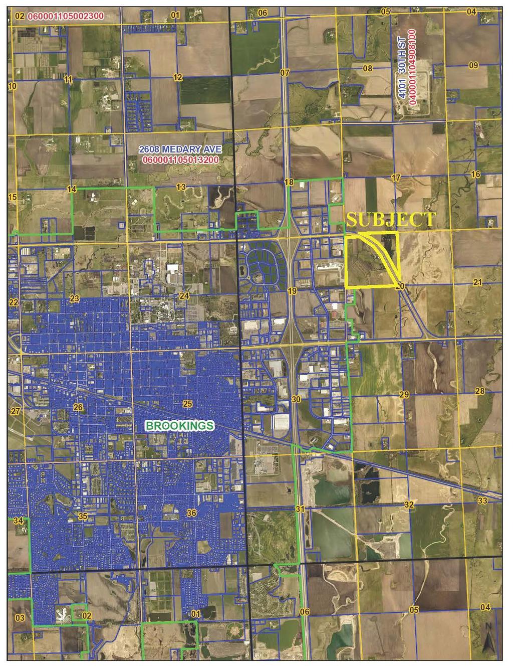
12 IDENTIFICATION OF THE PROPERTY APPRAISAL REPORT LEGAL DESCRIPTION: Legal description of the subject property, as compiled by the appraisers, is as follows. The Northwest Quarter except Lot H-1 and H-2 of Section 20, Township 110 North, Range 49 West of the 5th P.M. A plat map from the Brookings County website can be found on the following page with subject shaded in yellow. LOCATION: Subject property is located at 1501 US Highway 14 Bypass, Brookings, South Dakota. The property is not located within the City of Brookings. Site will be discussed in greater detail in later sections SITE AND IMPROVEMENTS: The property is predominately unimproved agricultural land, used by South Dakota State University for fruit tree research and various other agricultural research throughout the past twenty plus years. Improvements consist of one cold storage building and several other older storage buildings. OWNERSHIP AND HISTORY: Subject property has been under the ownership of the State of South Dakota for in excess of three years. South Dakota State University has used the property for agricultural research for the past twenty plus years. According to William Gibbons, PhD, with South Dakota State University, the university would continue to do research on the 7.5 acre parcel currently being used for grape research, which could last up to 10 years. If the property was to be sold, South Dakota State University would lease the 7.5 acre site for the duration of research, terms of the potential lease would have to be part of the negotiation of the price for the property. This will be discussed further, later in the report. A copy of the survey identifying the 7.5 acres can be found on page 3. Subject property is not listed for sale on the open market to the knowledge of the appraisers. CLIENT AND INTENDED USER Client and intended user of the appraisal is Mr. Ryan Brunner and South Dakota Office of School and Public Lands. PURPOSE AND INTENDED USE OF THE APPRAISAL Purpose of the appraisal is to estimate the as is fee simple estate market value of the subject property as of November 20, Intended use of the appraisal is to assist in the disposal of the property. 1

13 PLAT MAP 2
14 GRAPE RESEARCH SURVEY 3
15 APPRAISAL REPORT OPTION Appraisal is presented in an Appraisal Report format in compliance with the Uniform Standards of Professional Appraisal Practice (USPAP). DATE OF VALUE AND DATE OF THE REPORT Effective date of value is November 20, 2018, the date the subject property was viewed by Mr. Travis E. Shaykett, State Certified General Appraiser. Date of the appraisal report is the date stated on the Appraiser Certifications. DEFINITION OF MARKET VALUE Definition of market value, as used in this report, is taken from The Dictionary of Real Estate Appraisal, 6 th Edition, published in 2015 at page 141, and reads as follows: Market Value. The most probable price, as of a specified date, in cash, or in terms equivalent to cash, or in other precisely revealed terms, for which the specified property rights should sell after reasonable exposure in a competitive market under all conditions requisite to a fair sale, with the buyer and seller each acting prudently, knowledgeably, and for self-interest, and assuming that neither is under undue duress. PROPERTY RIGHTS APPRAISED Property rights appraised are fee simple estate. Outstanding liens, mortgages, easements or other types of encumbrances are considered, but not separately addressed, unless stated elsewhere in the report. Definition of fee simple estate, as used in this report, is taken from The Dictionary of Real Estate Appraisal, 6 th Edition, published in 2015 at page 90. Fee Simple Estate. Absolute ownership unencumbered by any other interest or estate, subject only to the limitations imposed by the governmental powers of taxation, eminent domain, police power, and escheat. PERSONAL PROPERTY Typically, personal property is not included in the value of real estate. Definition of personal property is as follows: Personal Property. Identifiable tangible objects that are considered by the general public as being "personal" - for example, furnishings, artwork, antiques, gems and jewelry, collectibles, machinery and equipment; all tangible property that is not classified as real estate. (USPAP, Edition) There is no personal property included in the final value estimate. 4
16 INTANGIBLE PROPERTY Typically, intangible property is not included in the value of real estate. Definition of intangible property is as follows: Intangible Property (Intangible Assets). Nonphysical assets, including but not limited to franchises, trademarks, patents, copyrights, goodwill, equities, securities, and contracts as distinguished from physical assets such as facilities and equipment. (USPAP, Edition) There is no intangible property included in the final value estimate. HYPOTHETICAL CONDITION Hypothetical conditions are contrary to what exists. Definition of hypothetical conditions is as follows: Hypothetical Condition. A condition, directly related to a specific assignment, which is contrary to what is known by the appraiser to exist on the effective date of the assignment results, but is used for the purpose of analysis. (USPAP, Edition) Comment: Hypothetical conditions are contrary to known facts about physical, legal, or economic characteristics of the subject property; or about conditions external to the property, such as market conditions or trends; or about the integrity of data used in an analysis. There are no hypothetical conditions in this appraisal report. EXTRAORDINARY ASSUMPTION Extraordinary assumptions presume uncertain information to be factual. Definition of extraordinary assumptions is as follows: Extraordinary Assumption. An assignment-specific assumption, as of the effective date regarding uncertain information used in an analysis, which, if found to be false, could alter the appraiser s opinions or conclusions. (USPAP, ed.) Comment: Uncertain information might include physical, legal, or economic characteristics of the subject property; or conditions external to the property, such as market conditions or trends; or the integrity of data used in an analysis. There are no extraordinary assumptions in this appraisal. 5
17 SCOPE OF WORK As mentioned earlier, the University wants to continue to occupy the 7.5 acres currently devoted to grape production research. This would include the buildings at subject. Also, perimeter 6 foot high chain link fence would need to be maintained, to keep the wild life out. For the University to continue use of the 7.5 acres the issues of who would be responsible for maintaining the buildings and the fence, or installing proper fence around the 7.5 acres, as well as reasonable rent would need to be part of the purchase negotiations. This could even be some type of discount of the purchase price. Since, the actual terms of a lease or a property price discount are yet to be determined the appraisers will appraise the property as unencumbered and without any benefit of or discount for the existing vineyard. Also, in the opinion of the appraisers, due to the age, condition and design of the existing buildings would have some interim use, but they do not contribute to the highest and best use of property. The estimate of market value of a property usually calls for the employment of three approaches to value. These approaches to value are identified as follows: Cost Approach Income Capitalization Approach Sales Comparison Approach In the Cost Approach, the appraisers estimate the new replacement cost of the improvements. A deduction is made for depreciation due to wear and tear, design and plan, and neighborhood defects. The value of the land, which is estimated by direct comparison with similar vacant sites, is then added to the depreciated cost of the improvements. In the Income Capitalization Approach, the appraisers estimate the market rent, sometimes known as economic rent, from rents found in the market from similar properties. Next, there is a deduction for operating expenses to arrive at the net operating income. The net operating income is then capitalized into a value indication by means of one or more capitalization methods with data taken from the market. In the Sales Comparison Approach, the appraisers compare the subject property on a similar unit of comparison with similar sale properties. Adjustments are made for all factors of dissimilarity recognized by the market. All known sales were considered and used to develop market adjustments; however, the appraisers relied on only those considered to be most similar to the property appraised. After a thorough analysis, the data is then correlated into a final value estimate by this approach. The appraisers then correlate the indicated value estimates of the three approaches into a final value estimate. Consideration is given to the relative strengths and weaknesses of each approach, giving the most weight to the approach most commonly used by typical purchasers for the type of property appraised. Scope of work for this appraisal assignment includes the development of the Sales Comparison Approach only, since the subject property buildings are considered interim use only, so is appraised is vacant land. 6
18 SCOPE OF WORK As part of this appraisal, the appraisers have made a number of independent investigations and analysis specific to this appraisal based on data developed during the appraisal and also on data files maintained in the appraisers office and updated on an ongoing basis. Mr. Travis E. Shaykett, State Certified General Appraiser, viewed the subject property and completed most of the research, writing of the report, and development of the approaches to value. Mr. Steven C. Shaykett, MAI, State Certified General Appraiser, reviewed the appraisal as co-appraiser. Research undertaken and the major data sources used are discussed in the following paragraphs. Property Description and Analysis: Appraisers obtained pertinent information from the client, the City of Brookings, and the Brookings County Assessor s Office relating to the subject property as needed. Brookings County Courthouse records were reviewed by the appraisers for a history of transactions relating to the subject property for a period in excess of three years. Subject property was viewed by Mr. Travis E. Shaykett on November 20, 2018 along with 2 South Dakota State University employees Ms. Missy Vande Weerd, Assistant to the Director South Dakota Agricultural Experiment State at SDSU and Mr. Brett Owens, instructor of horticulture. Photographs of the subject property and the surrounding area were taken on that day. Market Data Program: Appraisers obtained data on comparable sales by researching sales occurring within the last three years which were similar in use and located in the subject area. Due to the size of subject no highly similar properties were found in this market. Research did develop sales in the Brookings area that were considered and relied upon, even though smaller in size. Search for comparable sales was expanded to other eastern South Dakota communities to assist in developing the Sales Comparison Approach. Appraisers obtained copies of deeds from the county courthouses and attempted to contact the buyers, sellers, or others knowledgeable, to verify transaction data. Details of the verified sales are included in the Addenda. Correlation and Final Value Estimate: Upon completion of all the steps to gather and analyze data, a review of the value indications is made and a final value estimate conclusion. 7
19 AREA DATA Area data is based on the intended user of the report already having a basic understanding of the economic, social, and governmental forces affecting the real estate market. Purpose of the area and neighborhood analysis is to review information on the social, governmental, and economic forces of the local economy and the expectations for the future. Data and conclusions are based on and from research maintained in the appraisers file. Appraisers have made a review of relevant data for Brookings, Brookings County, and South Dakota. Comparison will include a review of relevant demographic and economic data for similar sized cities and counties in the general region, including Aberdeen (Brown County), Watertown (Codington County), Mitchell (Davison County), Huron (Beadle County), and Yankton (Yankton County). A map of South Dakota can be found on the following page. TABLE 1 POPULATION COMPARISONS (%) CHANGE (%) CHANGE (%) CHANGE Brookings 13,717 14,951 16,270 18,504 22, % 13.73% 19.20% Brookings County 22,158 24,332 25,207 28,220 31, % 11.95% 13.27% Aberdeen 26,476 25,851 24,927 24,658 26, % -1.08% 5.81% Brown County 36,920 36,962 35,580 35,460 36, % -0.34% 3.02% Watertown 13,388 15,649 17,592 20,237 21, % 15.04% 6.15% Codington County 19,140 20,885 22,698 25,897 27, % 14.09% 5.14% Mitchell 13,425 13,916 13,798 14,558 15, % 5.51% 4.78% Davison County 17,319 17,820 17,503 18,741 19, % 7.07% 4.07% Huron 14,299 13,000 12,448 11,893 12, % -4.46% 5.88% Beadle County 20,877 19,195 18,253 17,023 17, % -6.74% 2.20% Yankton 11,919 12,011 12,703 13,528 14, % 6.49% 6.85% Yankton County 19,039 18,952 19,252 21,652 22, % 12.47% 3.63% South Dakota 665, , , , , % 8.45% 7.86% SOURCE: U.S. Census Bureau From 2000 to 2010, the city of Brookings and Brookings County showed the greatest population growth, at percent and percent respectively. The comparison cities were led by Yankton at 6.85 percent, Watertown at 6.15 percent, and Huron at 5.88 percent. The state as a whole experienced population growth of 7.86 percent. According to the U.S. Census Bureau the estimated 2017 population for Brookings is 29,938, which is an increase of percent from

20 STATE MAP 9
21 AREA DATA Table 2 shows the breakdown of population within a specific age bracket and Table 3 shows the median age. A majority of the population in the city of Brookings and Brookings County is made up of the younger population. POPULATION BY AGE CITY OF BROOKINGS TABLE 2 POPULATION BY AGE % OF POPULATION TABLE 3 MEDIAN AGE BROOKINGS COUNTY % OF POPULATION > 20 7, % 10, % , % 4, % , % 4, % , % 6, % , % 2, % , % 3, % TOTAL 22, % 31, % SOURCE: U.S. Census Bureau, 2010 Census BROOKINGS 23.5 BROOKINGS CO ABERDEEN 36.4 BROWN CO HURON 39.8 BEADLE CO MITCHELL 36.8 DAVISON CO WATERTOWN 36.6 CODINGTON CO YANKTON 40.4 YANKTON CO SOUTH DAKOTA 36.9 SOURCE: U.S. Census Bureau, 2010 Census 10
22 AREA DATA TABLE 4 LEADING EMPLOYERS BROOKINGS EMPLOYER # OF EMPLOYEES South Dakota State University 4,463 Daktronics 1,600 3M 1,100 Larson Manufacturing 557 Brookings Health System 500 Walmart 425 Aramark 405 Brookings School District 400 Hy-Vee Food Store 450 Twin City Fan 299 Bel Brands 290 City of Brookings 282 Fishback Financial Corporation 239 Brookings Municipal Utilities 230 United Living Community 215 Swiftel Communications 213 Falcon Plastics 193 Boys and Girls Club 180 SOURCE: Brookings Economic Development Corporation U.S. Department of Housing and Urban Development compiles the median family income for all counties in South Dakota on an annual basis. A history of median family income is provided below in Table 5. Brookings County experienced a 34.2 percent increase in median family income from 2000 to 2016, and sets the low end of the range, but still shows positive growth. TABLE 5 MEDIAN FAMILY INCOME % CHANGE ANNUAL % CHANGE BROOKINGS COUNTY $46,800 $65,400 $65,700 $62, % 2.1% BROWN COUNTY $44,000 $59,900 $66,900 $66, % 3.2% CODINGTON COUNTY $45,900 $61,200 $65,500 $64, % 2.6% DAVISON COUNTY $42,200 $60,400 $67,600 $64, % 3.2% BEADLE COUNTY $43,800 $55,300 $60,600 $59, % 2.3% YANKTON COUNTY $44,400 $59,400 $71,900 $69, % 3.6% SOUTH DAKOTA $43,500 $58,900 $64,700 $62, % 2.8% SOURCE: U.S. Dept of Housing and Urban Development 11
23 AREA DATA Table 6 illustrates the new construction building permits for single family and multi-family units for the past 13 years. Number of housing starts is affected by growth, the affordability of the cost of mortgage money, and the supply of existing homes. All these factors are generally reflective of the health of a local economy. The number of housing starts is generally a good barometer of the expansion of the local economy. TABLE 6 BUILDING PERMITS YEAR SINGLE FAMILY MULTI-FAMILY- UNITS TOTAL SOURCE: SOCDS Table 7 shows the gross retail sales. This table indicates that all comparisons, except for Aberdeen, have increased in retail sales from 2011 to TABLE 7 RETAIL SALES ($000) % CHANGE ANNUAL CHANGE BROOKINGS $467,881 $480,079 $528,771 $502,766 $516,684 $547,153 $536, % 2.1% ABERDEEN $1,754,010 $1,893,199 $2,334,767 $1,802,250 $1,493,706 $1,418,252 $1,573, % -1.5% WATERTOWN $746,894 $858,419 $878,984 $891,417 $862,466 $817,140 $850, % 2.0% MITCHELL $657,014 $692,963 $715,426 $731,513 $721,371 $687,772 $667, % 0.2% HURON $407,373 $478,106 $427,403 $407,683 $434,016 $426,131 $1,258, % 29.9% YANKTON $468,738 $436,174 $459,513 $457,862 $467,593 $457,329 $472, % 0.1% SOUTH DAKOTA $25,742,464 $29,215,473 $25,122,436 $27,848,227 $27,394,724 $27,574,118 $27,553, % 1.0% SOURCE: SD Department of Revenue and Regulation 12
24 AREA DATA Appraisers have reviewed unemployment statistics for the past eight years on a local level and a state level. Table 8 shows the unemployment rates for selected South Dakota micropolitan statistical areas, as well as the state. For all comparisons, the unemployment rates have decreased from 2010 to Brookings unemployment rate for 2017 at 3.2 percent is lower than the state average. Typically, an unemployment rate around 5.0 percent is indicative of a healthy economy. TABLE 8 NON SEASONALLY ADJUSTED UNEMPLOYMENT RATE 2010 Average 2011 Average 2012 Average 2013 Average 2014 Average 2015 Average 2016 Average 2017 Average Brookings MiSA 4.7% 4.4% 3.9% 3.4% 3.1% 2.9% 2.6% 3.2% Aberdeen MiSA 3.8% 3.8% 3.5% 3.2% 2.8% 2.7% 2.5% 3.0% Watertown MiSA 5.2% 4.6% 3.9% 3.6% 3.3% 3.1% 2.9% 3.4% Mitchell MiSA 4.5% 4.1% 3.5% 3.3% 2.9% 2.7% 2.4% 3.1% Huron MiSA 4.1% 3.6% 3.3% 3.5% 3.1% 2.7% 2.8% 2.9% Yankton MiSA 5.1% 4.6% 3.8% 3.5% 3.0% 2.6% 2.4% 3.0% South Dakota 5.0% 4.7% 4.3% 3.8% 3.4% 3.1% 2.8% 3.3% SOURCE: SD Department of Labor Area Data Conclusion: Brookings and Brookings County have experienced positive, strong population growth from 1980 to 2010, at a pace higher than the state. Economic capacity of the population is increasing at a rate similar to the comparable counties. Median family income is towards the low end of the comparison counties and the state, but has shown growth. A combination of steady population growth and an increasing buying capacity has made an atmosphere of stable economic growth. Economic growth is reflected in the number of building permits issued and retail sales growth. Brookings had shown growth in both single and multi-family building permits over the past few years but shows a decline in 2017, and retail sales have increased from 2011 to However, the close proximity of Brookings to Sioux Falls, the major retail trade center in the region, may influence this factor. Currently the unemployment rate for Brookings is below the state average and is estimated to continue at this same level. Overall, the economy of Brookings has slowed, but still continues to grow at a similar pace experienced in the recent past. The ability of the local economy and population to grow will be in direct correlation to growth in the local employment sector. There are no known factors that would indicate a significant change will occur in the near future in the local economy in either a positive or negative direction in any way that is more significant than any other community in the state. 13
25 AREA DATA Educational services provide a substantial portion of the local employment. Attraction of new businesses and industries, as well as the expansion of existing businesses and industries in the market, could significantly expand the city's economy. Development of a new Multi-Plex Center was expected to increase economic activity through events held. However, this has taken longer than expected to spur economic activity. Brookings added a dairy manufacturing operation on the east side of town, which created over 200 additional jobs. The 3M Company is in the second phase of an expansion project that is anticipated to add 60 new jobs to the facility by Novita Nutrition, LLC is building a $70 million feed processing plant on the edge of Aurora and will create 34 jobs at the plant and 10 jobs at the corporate headquarters in Brookings. Overall, socioeconomic growth in Brookings has been slow for over the last 20 years. This slow growth is expected to continue in the near future and over the long term. The capacity for expansion of the socioeconomic base will be in direct relationship to the number of new businesses and industries that can be attracted to the city. Slow growth generally tends to keep demand for all types of real estate low, which in turn generally keeps real estate values at a slow growth, and at a price level commensurate with economic activity levels. 14
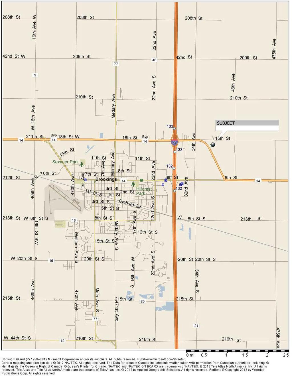
26 NEIGHBORHOOD DATA Subject property is located along the US Highway 14 Bypass south of 18 th Street and east of 34 th Street. Location of subject property northeast of Brookings just outside the city limits. U.S. Highway 14 runs east of Brookings to the Minnesota state line and to the west of Brookings continues approximately 330 miles until it connects with Interstate 90 near Wall, South Dakota. US Highway 14 Bypass runs east and west along the northern edge of the city limits. Interstate 29 is several blocks west of subject property. Interstate 29 is the primary access to Brookings and connects to Sioux Falls approximately 48 miles to the south and Fargo, North Dakota approximately 185 miles to the north. Brookings has one high school, one middle school, and three elementary schools. There are recreational amenities located within one mile of the subject neighborhood, including a golf course, shopping centers, and extensive walking and bike paths. Centers of employment are found mainly at the commercial uses along 6 th Street and industrial uses in the southeast and southwest quadrants of Brookings. Access to other parts of the city is average; however, all areas of the city can be accessed within 5 to 10 minutes driving time from the subject neighborhood. Appraisers have also reviewed the enrollment of South Dakota State University (SDSU), a land grant heritage university that was founded in According to South Dakota State University enrollment for the year was 12,107 students which was down slightly from the previous year, by 420 students. However, SDSU has been able to maintain an enrollment over 12,000 students for more than of 10 years. Although subject property is not within the city limits of Brookings, subject s neighborhood is considered to be the entire town, since all areas are dependent on goods and service providers throughout the community without overlap of primary services, such as schools, hospitals, government services, and infrastructure. Immediate neighborhood is the commercial area east of Interstate 29. A neighborhood map and aerial photograph can be found at the end of this section. Subject s immediate neighborhood and surrounding uses consist of industrial, manufacturing uses and agricultural uses. Subject neighborhood has average convenience to schools and shopping, as does most areas of the city. The commercial growth of Brookings has been around 6 th Street and Interstate 29. This neighborhood has been the primary area of commercial growth for Brookings consisting of businesses such as Lowes, Runnings Farm and Fleet, Wal-Mart, Daktronics, ProBuild, hotels, restaurants, and convenience stores. The Lowe s retail center was built in 2005, just north of 6 th Street and to the west of Interstate 29. A Super Wal-Mart opened in 2005 near the northwest quadrant of Interstate 29 and 6 th Street replacing a smaller store on 6 th Street, which is now a Runnings Farm and Fleet Store. Within the last several years, three franchise fast food restaurants have opened, and a strip mall was built along 6 th Street west of Interstate 29, other recent openings include a Taco Bell just north of Lowe s along with a Comfort Suites hotel. Commercial development east of Interstate 29 has been slower then development west of Interstate 29. Within the last several years on the east side of Interstate 29 one franchise restaurant has opened along with a new hotel. Also located in this neighborhood east of the interstate is the Swiftel Event Center and Larson Ice Center. 15
27 NEIGHBORHOOD DATA The 3M Company is in the second phase of a $70 million expansion of its plant that will be completed in phases through 2018 and is anticipated to create almost 90 new jobs. Falcon Plastics completed a 60,000 square foot addition in early Bell Brands opened a $120 million cheese manufacturing plant on the east side of Interstate 29 and south of the U.S. Highway 14 bypass intersection in October Bell Brands makes Laughing Cow Cheese. This created more than 200 jobs in 2014, and a second phase could bring an additional 200 jobs if the market demand is favorable for expansion. Novita Nutrition, LLC in 2015 completed a $70 million livestock feed processing plant on the edge of Aurora and that created 34 jobs at the plant and 10 jobs at the corporate headquarters in Brookings. Majority of the commercial and industrial development for Brookings over the last 30 years has been in the corridor with Interstate 29 on the west and 34 th Avenue on the east. Area south of 6 th Street in this corridor is fully developed, however there are several redevelopment projects that have been completed or are in the process. Area north of 6 th Street and South of 18 th Street, also known as, US Highway 14 Bypass, is nearly fully developed. Subject s location east of 34 th Avenue and along US Highway 14 Bypass is the logical expansion of this commercial/industrial district. Subject and the large vacant tract to the south of subject down to 6 th Street represent a size equal to about half the size of the corridor that has been developed over the last 30 years. However, much of the area south of subject is within the floodplain. Areas east of Interstate 29 typically have not experienced residential growth, as majority of residential development has been to the south end of Brookings. However, development in southern Brookings is nearing capacity. Appraisers reviewed the Brookings Comprehensive Plan, Planning for 2040, as adopted April Based on a review of this plan, the city of Brookings has limited direction of growth due to floodplains on all sides of the city and South Dakota State University to the north. However, there is some areas to the northeast and northwest of the city that are not within the floodplain or development could jump the floodplain. New developments in other parts of the city will begin transition to development land as developments in the south part of the city near capacity. A future land use map within this study indicates subject property west of Highway 14 Bypass would be best suited for Urban Medium Intensity while subject property east of Highway 14 Bypass is indicated to be Urban Reserve. Urban Medium Intensity would include single-family dwellings district; townhouse district; office district; local retail district; mixed use residential/business. Appraisers could find no explanation for Urban Reserve within the study. But is assumed to be long range residential. A copy of the future land use plan can be found at the end of this section. Appraisers also interviewed Mr. Mike Struck, Community Development Direct for the City of Brookings, about the comprehensive plan. According to Mr. Struck, if growth continues at similar trends as current, the need for development north of Highway 14 is anticipated to be 15 to 20 years. However, there is a trend of redevelopment within the current city limits that could extend the time frame of expansion past 20 years. According to Mr. Struck, future use of subject property would most likely be commercial development due to existing neighborhood uses and limited access from Highway 14 Bypass road. Existing neighborhood uses consist of Bel Brands which can create an occasional odor due to the cheese manufacturing process, other uses consist of implement dealerships, Swiftel Center, and other industrial and commercial uses. Additionally, according to Mr. Struck the City of Brookings and SD DOT have had conversations about limiting access along this portion of the Highway 14 Bypass due to the 16
28 NEIGHBORHOOD DATA curve and large amount of truck traffic. This would limit the access to 34 th Street, which is also access to the commercial areas directly to the west of subject. The South Dakota Department of Transportation recently completed a redevelopment of 6 th Street. Redevelopment was from the east city limits to just west of 22 nd Avenue and consisted of building a seven-lane road with a center median and new overpass over Interstate 29. Conclusion: Subject neighborhood is in the northeast section of Brookings, east of Interstate 29 along US Highway 14 Bypass. A future land use map indicates future use of subject to be mixed use with residential and low intensity commercial, however according to the community development director the most likely use would be commercial, due to existing neighborhood uses. Current commercial growth is along 6 th Street west of Interstate 29 and current residential growth is in the south end of the city but anticipated residential growth north of Highway 14 is 15 to 20 years or greater. Subject area is a mix of commercial and industrial uses transitioning to agricultural uses. Accessibility to and from the site is good from outside of the city, as well as to the residential areas of the city. 17

29 FUTURE LAND USE PLAN 18
30 NEIGHBORHOOD MAP 19
31 NEIGHBORHOOD AERIAL 20
32 MARKET CONDITIONS General overall economic conditions were discussed and summarized in the Area Data and Neighborhood Data sections of the report. This section relates specifically to the commercial/industrial real estate segment and to the subject properties as relating to exposure time and marketing period. Following paragraphs are taken directly from Advisory Opinion AO-7 of the Uniform Standards of Professional Appraisal Practice, 2018 Edition. These paragraphs help explain marketing time and methods to estimate. The reasonable marketing time is an opinion of the amount of time it might take to sell a real or personal property interest at the concluded market value level during the period immediately after the effective date of an appraisal. Marketing time differs from exposure time, which is always presumed to precede the effective date of an appraisal. Rationale and Method for Developing a Marketing Time Opinion The development of a marketing time opinion uses some of the same data analyzed in the process of developing a reasonable exposure time opinion as part of the appraisal process and is not intended to be a prediction of a date of sale or a one-line statement. It is an integral part of the analyses conducted during the appraisal assignment. The opinion may be a range and can be based on one or more of the following: * Statistical information about days on market, * Information gathered through sales verification, * Interviews of market participants, and * Anticipated changes in market conditions. Related information garnered through this process includes other market conditions that may affect marketing time, such as the identification of typical buyers and sellers for the type of real or personal property involved and typical equity investment levels and/or financing terms. The reasonable marketing time is a function of price, time, use, and anticipated market conditions, such as changes in the cost and availability of funds, and is not an isolated opinion of time alone. Exposure Time: Exposure time is presumed to precede the effective date of the appraisal. Exposure time relative to subject is estimated at 12 months or less. Basis for this estimated exposure time is conversation with brokers, as well as County and City personnel who track movement of sites and commercial/industrial properties in this market. Sales of commercial/industrial properties in Brookings, as evidenced by the sales reviewed by the appraisers, have remained at a steady pace over the past several years. Broker conversations indicated if the property was correctly priced, average marketing time is typically under 12 months. 21

33 MARKET CONDITIONS Appraisers reviewed a recent auction of 2,600 acres, that were sold in 18 tracts, of which four were similar locations as subject, the remaining properties were agricultural land in Brookings County. This auction was by private sealed bid due by November 7, 2018 with a private auction of the highest five bidders on November 16, According to the Clay Anderson broker representing the seller, the four tracts that had similar location to subject were not sold at the live auction due to auction prices not meeting the seller s expectations and several buyers not completing the due diligence in time for the auction, therefore they were unable to bid. These four tracts were identified as Tracts 13, 14, 15, and 16 for the sale. Tract 13 is located one half mile north of subject and is currently listed for $9,750 per acre. Tract 14 is located on the east side of Interstate 29 and one half mile north of Highway 34 and is currently listed for sale at $12,500 per acre. Tract 15 is located directly south of subject and is currently listed for $8,000 per acre. Tract 16 is located on the east side of 34 th Street and one-half mile south of 6 th Street and is currently listed for $6,500 per acre. Tract 14 is most similar to subject, as the most likely future use is commercial/industrial, while Tract 13 is long term residential. Tracts 15 and 16 are located within the 100-year flood plain and the wellhead protection area and are not indicated as being any future development potential. The map below shows the location of the four tracts that are now listed for sale and the current asking price. 22
34 MARKET CONDITIONS Appraisers also reviewed several development land sales in the south side of Brookings. Sale 1 consists of acres that sold in June of 2016 to a local developer for $1,575,000. Based on interview with the buyer, the sale included a house and three acres that they parceled out for his personal residence. The buyer indicated they valued the remaining development land at around $36,000 per acre. The development land was within the immediate growth pattern of Brookings; therefore, the buyer was able to annex into city limits, had immediate access to utilities, and commenced residential development shortly after purchase. The second sale reviewed by the appraisers consists of acres that sold in August of 2017 to a local development group, Advantage Investments Group. Sale price was $970,000, which is $29,016 per acre. This sale is located adjacent to a new public school on the south end of the city and had good access to public utilities and was located within the city limits. Both of these sales occurred in the south end of the city where residential growth is the most predominate. Both sales had access to utilities and were in or could be annexed within the city limits immediately. Additionally, both of these sales are some of the last vacant development land in this part of the city. Also, these sales are considerably smaller than the subject property, which typically smaller sales sell for greater price per unit. It is difficult to estimate the exposure time of commercial/industrial properties in the Brookings market without a central service that tabulates this type of information. However, research by the appraisers and broker conversations support the conclusion that the subject market exposure time would be under 12 months. Appraisers have estimated that subject, properly priced and advertised, would have an exposure time of less than one year. Marketing time reflects the period after the value date required to sell the property at market value. This is heavily influenced by historical exposure time, but tempered by current economic conditions and by the pricing of the property. Brookings market area has maintained a stable real estate market, with current conditions reasonably similar to the last 12 months. Interest rates have remained low and are expected to favorably affect the feasibility of most projects. Demand appears to remain good in most areas of the market. Appraisers estimate the marketing time for subject at one year or less. The City of Brookings has had an increasing population for over twenty years. The Brookings market has well established manufacturing base and has continued to attract new employers over the past several years. Subject property is located in a community with a diversified economic base that will likely support stable to increasing demand for all types of real estate, which helps to maintain or increase rental rates and values. Subject s immediate neighborhood has experienced growth in commercial and residential demand in recent years and is expected to continue at similar trends. Overall, the subject neighborhood is considered to have average marketability for the area. 23
35 ZONING According to information obtained from the Brookings County Planning and Zoning Office, the subject property is not within the city limits Brookings and is zoned Agricultural District, A. Location of subject is within the Brookings County and City of Brookings Joint Jurisdiction Area; therefore, any zoning change would require approval by the City of Brookings and Brookings County. A copy of the zoning regulations can be found in the Addenda as Exhibit 1. Agricultural District, A allows predominately agricultural uses and a few commercial uses allowed by special exception. A complete list of allowable uses can be found in the Addenda as Exhibit 1. In the course of this appraisal, the appraisers have not been provided with or acquired on their own a legal opinion as to the zoning and private restrictions at the subject property. Interpretations of the zoning ordinance are based upon an examination of the zoning ordinance as applied to the subject property by the appraisers, and should not be construed to represent a legal opinion of the zoning ordinance as applied to the subject property. Also, the appraisers review of the courthouse records should not be construed to represent a legal opinion of the private restrictions at the subject property. Such legal opinions could be obtained by consulting an attorney, and such consultation is recommended by the appraisers. Conclusion: Current use is an allowed use within current zoning. Any development of subject consistent with existing neighborhood uses and trends would require a change in zoning. 24
36 ASSESSMENT INFORMATION AND TAX DATA Subject property is owned by a state agency, so is not subject to real estate taxes, and therefore shows no assessed values in the Brookings County Assessor s Office. However, if subject were sold for private development it would be subject to taxation. 25
37 PROPERTY DESCRIPTION Subject property is an irregular shaped site of acres, according to public records. The property is divided by US Highway 14 Bypass. An aerial photograph of the subject property can be found at the end of this section. Photographs of subject property can be found in the Addenda as Exhibit 2. Sizes shown below are estimated by appraisers based on aerial maps. Property east of highway acres Property west of highway acres Total Property Size acres The property on each side of the highway has access from one drive-way approach from US Highway 14 Bypass. The east property also has one drive-way approach from 211 th Street. General access to the neighborhood is from Interstate 29, 6 th Street also known as US Highway 14 and 18 th Street also known as US Highway 14 Bypass. The property on the west side of the highway has approximately 3,745 feet of frontage along US Highway 14 Bypass. This property also has about half mile of frontage on 34 th Avenue. This provides good access and exposure to the existing commercial/industrial district. The property on the east side of the highway has 3,170 feet along US Highway 14 Bypass and 1,975 feet of frontage along the south side of 211 th Street. All of these streets and highways are hard surfaced and would provide sites with developed street frontage at no cost to a developer. Appraisers have not been provided with a copy of the soil tests for the subject site, but other developments in the area show typical site preparation. This area has generally flat topography, with some mature trees and small rolling hills. Topography of the subject is fairly level to gently rolling, generally sloping towards the southeast. As described earlier the property has been used by South Dakota State University for agricultural research for 20 plus years. Research done on the property ranged from fruit tree studies to row crop studies. Within the west property are areas with mature dense tree groves used for various studies, trees range from fruit trees, other deciduous type trees, and coniferous type trees. The trees have not been used for research for several years and have had minimal pruning and maintenance. The perimeter of the west property is lined with mature coniferous type trees. Based on aerial maps there is approximately 30 acres of trees on the west property. Cropland research plots ranged from less than one acre up to five acres. On the east side of the highway the property has one large tree grove that consists of dense mature coniferous type trees and several smaller pockets with similar type trees, approximately 15 acres of the east property is trees. The balance of the east property is used as hay land. Currently the only research being done on the property is grape research on the west property. As shown on page 3 the vineyard and building site has been surveyed. As part of the potential sale of the property South Dakota State University would lease back the 7.5 acre surveyed area for up to 10 years, however research could be completed in a shorter time. According to a review of available flood maps from Site to Do Business, approximately acres on the west property and 0.65 acres on the east property are located within Zone A, which is an area inundated by 100 year flooding. A copy of the floodplain map is located in the Addenda as Exhibit 3. Map number for the subject property is 46011C0455C. 26
38 PROPERTY DESCRIPTION Improvements: The improvements at subject are limited to three buildings. Building 1 is a storage/office building with a walk-in cooler attached. Buildings 2 and 3 are wood post frame storage buildings. Actual age of the buildings is unknown, but effective age is estimated by the appraisers. Building 1: Use & Size: Storage/Office: 48x40=1,920 square feet Cooler Storage: 20x28= 560 square feet Total Size: 2,480 square feet Estimated Effective Age: 20 Years Expected Life: 35 Years Height: Storage/Office 12 feet eve height Cooler Storage: 12 foot side walls Construction: Storage/Office: Steel Frame Cooler Storage Stainless Steel Panels Description: Storage/Office Exterior walls are prefinished steel panels with similar roof. Interior of the storage/office area consists of shop space, office area, bathrooms, and storage. Shop space consists of concrete floor and walls and ceilings have exposed insulation and steel framing. The office area is less than 10 percent of the total size, the walls and ceilings of the office area and bathroom are painted panels walls and ceilings. The bathroom consists of 2 fixtures and one shower stall. The storage area is an old refrigerator storage that does not work. The storage/office area is heated by a fuel oil furnace. There is one 12 foot wide by 10 foot high overhead door on the south side of the building and a similar overhead door to the cooler. Cooler Storage The cooler storage is attached to the storage/office area by an enclosed walk way that is not heated. The cooler storage is on a concrete foundation. Walls and ceilings are stainless steel panel construction typical of most walk-in coolers. The cooler does have the ability to set to freeze also. Building 2: Use & Size: Storage 29x24= 696 square feet Shop 35x24= 840 square feet Total Size: 1,536 square feet Estimated Effective Age: 20 Years Expected Life: 20 Years Height: 10 feet eve height Construction: Wood Post Description: Exterior of the building is galvanized steel panels. The roof is galvanized panels with gable ends. The shop area has concrete floor and plywood walls and ceiling. There is one 10 foot by 10 foot overhead door. The shop area is heated by reznor heater suspended from the ceiling. The storage area consists of dirt floor and exposed framing. Access to the storage area is from sliding doors. 27
39 PROPERTY DESCRIPTION Building 3: Use & Size: Storage 64x30=1,920 square feet Estimated Effective Age: 20 Years Expected Life: 20 Years Height: 10 feet eve height Construction: Wood Post Description: Exterior of the building is galvanized steel panels. The roof is galvanized panels with gable ends. The interior area consists of dirt floor and exposed framing. Access to the storage area is from sliding doors. Based on conversation with maintenance personnel, there is one well that has been filled in with concrete and one well that is used to irrigate research plots. There is an unknown feet of irrigation pipe underground that supplies approximately 19 irrigation risers throughout the property. A map provided by the client can be found at the end of this section showing the approximate location of irrigation well and irrigation risers. Utilities: Water and Sewer - Natural Gas - Electricity - Telecommunications - Private well and septic system Northwestern Energy - None at site Sioux Valley Swiftel Communications- None at site According to personnel with Brookings Utilities office city water and sewer are located in 34 th Avenue, which runs along the west property line. Information regarding utilities is provided as general information, and not as a statement of fact. Only a detailed evaluation by a qualified person would determine adequacy and acceptability for the development of a property of this size. Conclusion: Subject property is located in a transitional area northeast of Brookings. Location of subject has good frontage along US Highway 14 Bypass, which is also known as 18 th Street in Brookings, and is located less than one mile from Interstate 29. Eighteenth Street and 6 th Street are the only roads that have overpasses over Interstate 29. This provides easy access to the rest of the city street network, and to center of employment and shopping. Total size of subject is acres, but is divided by US Highway 14 Bypass. Both sides are adequate size for development. Public utilities are available in the neighborhood. Topography of the property is typical to most development land in the area. Subject site has approximately 45 acres of dense mature trees, which is not typical to most development sites. Site preparation cost could be greater than most development sites in the area due to the number and size of trees on the property, additionally removal of irrigation system would increase cost. Improvements on the property consist of three storage buildings as described above. Building 1 is newer than Buildings 2 and 3, however overall usefulness of the buildings would be minimal to most developers and would contribute minimal value to the overall property. Additionally, the buildings are within the area that would be leased by the State of South Dakota for grape research. 28

40 PROPERTY AERIAL 29

41 IRRIGATION SYSTEM MAP 30
42 HIGHEST AND BEST USE Real estate is appraised in its highest and best use. In concluding a highest and best use of a property, consideration must be given to the land as if vacant and then considering the improvements and land together as the improved property. First, it is necessary to define highest and best use. In this appraisal, the appraisers have relied on the definition of highest and best use as defined in The Dictionary of Real Estate Appraisal, 6 th Edition, published in 2015 at page 109. Highest and Best Use. The reasonably probable use of property that results in the highest value. The four criteria that the highest and best use must meet are legal permissibility, physical possibility, financial feasibility, and maximum productivity. Legal Permissibility: Analysis of the legal permissibility, in relation to the highest and best use, examines those legal factors which could preclude the development of certain uses of the subject site or improvements. Development of the subject site or property to its highest and best use can be limited by long term leases, zoning, private deed restrictions, building codes, historic district controls, or environmental regulations. Physical Possibility: Physical possibility in relationship to the highest and best use examines the physical features of the subject site or improvements, which can preclude development of certain uses of the subject site or improvements. Development of the subject site to its highest and best use can be limited by the size, configuration, location and availability of utilities, and terrain of the site. Development of the subject improvements to their highest and best use can be limited by the size, design, type, and condition of the improvement(s). Financial Feasibility: In evaluating the financially feasible uses of the subject site or improvement, the analysis considers those applications to the subject site which would yield a positive return on investment in consideration of the constraints of legal permissibility and physical possibilities of the subject site or improvements. To estimate if potential developments of the vacant site or uses of the existing improvements provide for a market acceptable return on investment, an analysis is completed of the demand and supply in a neighborhood for the indicated physically possible and financially feasible uses. For a vacant site, the demand and supply of a given use must be at an equilibrium price level adequate enough to provide for returns that would be market acceptable to be financially feasible. For a developed property, the financially feasible uses are those uses which provide for a positive economic income stream to the property. Maximum Productivity: In the evaluation of the maximum productive uses of the subject site or improvements, the utilization which produces the greatest return is considered to be the highest and best use of the improved site. HIGHEST AND BEST USE OF THE SUBJECT PROPERTY: Subject property is within the Agricultural District, A zoning as defined by Brookings County. Zoning allows for a wide range of commercial uses and other uses, as stated in the Zoning section. A complete list of uses can be found in the Addenda as Exhibit 1. However, given the location subject is within the joint jurisdiction, so City of Brookings essentially controls future 31
43 HIGHEST AND BEST USE use. Also, it is assumed that subject would be annexed into the city and would be developed under the appropriated mixed use zoning to maximize potential of subject. There are no other private restrictions that would further restrict use, beyond the zoning, to the knowledge of the appraisers. Physical possibility considerations are those presented in the Property Description section. Subject property is located along US Highway 14 Bypass northeast of Brookings. US Highway 14 Bypass is known as 18 th Street within Brookings and location is less than a mile from Interstate 29. Subject location provides average access to all areas of the city. Subject site is divided by the highway, however both sides have acceptable size and site preparation. There are no legally permissible uses that would be restricted by physical features of the property. As described earlier subject property has been used for agricultural research for 20 plus years. The site consists of nearly 32 percent of mature trees that are a mix of fruit trees, coniferous trees and deciduous trees. These could either be removed, or become part of a well-planned attractive mixed use development park. Current zoning limits the use of the property to agricultural use or single family use. Due to the size of the trees and number of tree groves on both properties typical row crop farming would not be feasible due to the overall poor farmability. The fruit trees could provide potential economic return as an orchard, however not all the trees are fruit trees and the trees have not been maintained for fruit production for several years. Additionally, is speculative if the return from an orchard use would be greater than an alternative use. As described in the market conditions, the Brookings market has experienced good growth over the past several years. The growth has been attributed the Brookings market being able to maintain large manufacturing business and draw new business to the community along with the growth of South Dakota State University, all of which have created new jobs and have created new development. The appraisers have not made a detailed survey of the area, but based on discussion with real estate professionals there is demand for development land, especially east of Interstate 29. Timing of development is difficult to estimate and beyond the scope of work for this report. Compared to farmland that is purchased for future development purchases, subject site provides minimal alternative uses that provide an economic return during the holding period due the trees, irrigation system, and lease of 7.5 acres to South Dakota State University to complete grape research. This element could potentially have a negative effect on value if it does not provide acceptable return to the purchaser. Frontage along 34 th Avenue could provide competitive sites in a short time to help with holding cost. According to flood maps approximately acres west of the highway and 0.65 acres on the east side of the highway are located within the 100-year floodplain. Overall, this is a small portion of the site, as there is adequate area not in the floodplain and these areas can be incorporated into the design of the development. Market has demonstrated demand for development land and for this type of location at a fairly consistent price level, even for a wide range of uses. Due to location of subject property to the City of Brookings and physical features, the highest and best use of the subject property is considered to be subdivision development with interim agricultural use. 32
44 SALES COMPARISON APPROACH In the Sales Comparison Approach to value, the subject property is compared to sales of similar properties. Sales Comparison Approach is based upon the premise that the value of a property is directly correlated to the price paid for similar properties in the market. In estimating the market value of the subject property by the Sales Comparison Approach to value, the appraisers have made a search of the market for recent sales of similar properties in the Brookings market. Due to limited number of sales of similar size and similar development potential the appraisers expanded their research to include similar communities. From the review of these sales, the appraisers have selected three sales for direct comparison which best represent the range of value potential for the subject property. UNIT OF COMPARISON: Unit of comparison is the measure utilized in the market to compare properties. Based upon discussions with individuals involved in the sale of the comparable properties, the method that was most often utilized to compare development land for a purchase or sale decision was the price per acre, price per square foot, or the price per unit. Based upon this, the appraisers have compared the subject property to the comparable sales based upon price per acre due to the size. A write-up of each of the comparable sales can be found in the Addenda, as well as a map showing the location of the sales. Although the comparable sales are considered equivalent to the subject property in many aspects, adjustments to the sales were required to utilize these sales for direct comparison. Grid analysis for this comparison can be found on the following page. A discussion of the subject property and the adjustments made to the sale properties to provide an indicated value for subject is as follows. In making the comparison of subject to the sales, the following elements of comparison are considered and shown in the sequential order of their application: 1. Property Rights Conveyed 2. Financing 3. Conditions of Sale 4. Market Conditions (Time) 5. Location 6. Physical Characteristics 7. Income Characteristics Property Rights Conveyed: Subject property is appraised in fee simple estate. All of the sales were fee simple estate equivalent at sale time. No adjustment has been made for property rights conveyed. Financing: All of the sales were sold for cash, so were at terms considered equivalent to cash. No adjustment has been made for financing. 33
45 LAND SALE GRID Control Number Subject Land Sale 1 Land Sale 2 Land Sale 3 File Number LS-SD-133 LS-SD-131 LS-SD-149 Sale Date 11/20/2018 4/30/2014 7/10/2015 8/7/2017 Location 1501 US HIGHWAY 14 BYPASS TBD-SEE COMMENTS AND MAP TBD W. CITY LIMITS ROAD NORTH SIDE OF WILLOW STREET AND WEST SIDE OF CLIFF AVENUE BROOKINGS, SD VERMILLION, SD YANKTON, SD HARRISBURG, SD Site Size - Acres Sale Price $1,000,000 $553,000 $2,601,390 Price Per Acre $22,222 $17,839 $16,300 Zoning AGRICULTURAL, A PLANNED DEVELOPMENT SINGLE FAMILY A-1, AGRICULTURAL Real Property Rights FEE SIMPLE FEE SIMPLE FEE SIMPLE FEE SIMPLE Adjustment $0 $0 $0 Adjusted Sale Price $22,222 $17,839 $16,300 Financing Terms MARKET MARKET MARKET MARKET Adjustment $0 $0 $0 Adjusted Sale Price $22,222 $17,839 $16,300 Conditions of Sale MARKET MARKET MARKET MARKET Adjustment $0 $0 $0 Adjusted Sale Price $22,222 $17,839 $16,300 Time Differential (Years) Annual Time Adjustment Factor 3.00% 3.00% 3.00% 6.00% Adjustment $3,250 $1,890 $1,304 Adjusted Sale Price $25,472 $19,729 $17,605 Market Conditions CURRENT SIMILAR SIMILAR SIMILAR Adjustment $0 $0 $0 Adjusted Sale Price $25,472 $19,729 $17,605 Location AVERAGE SUPERIOR SUPERIOR SIMILAR Dollar Adjustment -$5,000 -$1,000 $0 Adjusted Sale Price $20,472 $18,729 $17,605 Physical Features AVERAGE SUPERIOR SUPERIOR SUPERIOR Adjustment -$2,000 -$2,000 -$2,000 Adjusted Sale Price $18,472 $16,729 $15,605 Size AVERAGE SUPERIOR SUPERIOR SIMILAR Dollar Adjustment -$4,000 -$4,000 $0 Adjusted Sale Price $14,472 $12,729 $15,605 Utility/Other AVERAGE SIMILAR SIMILAR SIMILAR Dollar Adjustment $0 $0 $0 Adjusted Sale Price $14,472 $12,729 $15,605 INDICATED VALUE $14,472 $12,729 $15,605 34
46 SALES COMPARISON APPROACH Conditions of Sale: Adjustments for conditions of sale usually reflect the motivation of the buyers and sellers. There are no unusual conditions of sale known to the appraisers for any of the sales. As best the appraisers can determine, the sales were negotiated between a knowledgeable buyer and seller, often represented by real estate professionals, with circumstances common to this market. No adjustment has been made for conditions of sale. Market Conditions (Time): Date of sale for the comparable sales is from April 2014 to August Historically, commercial land sales in Brookings and similar communities similar to Brookings have shown slow appreciation over time. Appraisers have made a plus 3.0 percent annual adjustment to Sales 1 and 2. Sale 3 is located in a community that is affected by the growth of Sioux Falls, which has shown greater appreciation than Brookings, therefore a 6 percent adjustment was made for time to Sale 3. Location: Through the analysis of the sales, the market generally recognizes some differences in location. Location of subject is an area of commercial growth of Brookings. Sale 1 is located along the western edge of the Vermillion city limits. Location of Sale 1 offers a mix of development features, such as residential development with good views along a bluff and potential commercial development along a frontage street. Additionally, Sale 1 has utilities readily available to the site. Overall location of Sale 1 is considered superior to subject, therefore a minus $5,000 per acre adjustment was made to Sale 1 for these elements. Sale 2 is located along the western edge of the city limits of Yankton. Location of Sale 2 is within the city limits in a developing residential neighborhood. Sale 2 is considered superior to subject due to location within the city limits and access to utilities. A minus adjustment of $1,000 per acre was made to Sale 2 for this element. Sale 3 is located at the corner of Cliff Avenue and Willow Street. Location of Sale 3 was not within the city limits of Harrisburg at time of sale but was annexed in shortly after. Overall location of Sale 3 is considered similar to subject and no adjustment was made for location to Sale 3. Physical Characteristics: Adjustments for physical features include factors such as size, shape, topography, frontage, accessibility, utilities, and physical features. Any adjustment for size will be presented separately. Subject property is a large tract that would require special consideration in the development of the property. Topography of the property ranges from fairly level to gently rolling. The sales were adjusted for accessibility and utilities in the location adjustment. As described in the property description section approximately 45 acres of the property is covered in trees. Additionally, there is an underground irrigation system throughout the property. All of the comparables were vacant farm land at time of sale with a fairly level topography. Additionally, all the comparables were one tract, whereas the subject property is divided by US Highway 14 Bypass. All of the comparables are superior to subject due to the cost of removing all the trees, irrigation system, and general clean-up of the site and the site being divided by the highway. A minus $2,000 per acre adjustment was made for these elements. A small portion of subject property is located within the floodplain, however all the comparables either have areas within the floodplain or areas that have similar design challenges. 35
47 SALES COMPARISON APPROACH Size: Typically, smaller sites sell for more on a per acre basis; however, not all sales follow this trend. A minus adjustment of $4,000 per acre adjustment was made to Sales 1 and 2 for this element. Sales 3 is considered similar size as subject and no adjustment is required for size. Utility/Other: Subject property has several storage buildings on the property. Improvements are one storage building with cooler storage and two older storage buildings. None of the sales have a similar improvement as subject; however, due to age and use of the improvements no adjustment was made for these elements. Additionally, the improvements would be within the 7.5 acre lease to South Dakota State University for grape research and would not be able to be used by the new buyer until lease has expired. No other adjustments have been made to any of the comparable sales. Conclusion: After adjustments, the sales indicate a range in value from $12,729 per acre up to $15,605 per acre. Sales shown are the best comparables available in the market. These sales provide a range of market demonstrated prices. Appraisers have not placed more emphasis on one sale versus another in estimating value. Subject s large property size limits the number of potential users in the Brookings market, so would be purchased for mixed use subdivision development. Appraisers have not made a detailed survey of existing developments within Brookings, but general search indicates there is adequate land in both finished sites and undeveloped land west of Interstate 29, but minimal development land east of Interstate 29. In consideration of the sales relied upon and other sales known to the appraisers, it is the judgment of the appraisers that the data indicates a value for the subject property at $13,000 per acre, which is $1,857,960, rounded to $1,860,
48 RECONCILIATION AND FINAL ESTIMATE OF MARKET VALUE Correlation of the data and the indicated value estimate is the final step in the appraisal process. Sufficient data has been assembled and analyzed for the purpose of judging the reactions of typical purchasers in the market place. Purpose of the appraisal was to estimate the as is fee simple estate market value of the subject property, and to that end the data was studied and processed by the use of one of the three approaches to value. Value estimate indicated is as follows: Cost Approach N/A Income Capitalization Approach N/A Sales Comparison Approach $1,860,000 In the correlation process, the greatest weight should be given to that approach to value most commonly used by typical purchasers for the type of property being appraised. Consideration is given to that approach to value in which the appraisers have the highest degree of confidence and which has been processed with a minimum of assumptions. Also important is the reasonableness of the data and the reliability of that data. In consideration of the above, and for the reasons and conclusions contained in this report, sole weight is given to the Sales Comparison Approach. It is the opinion of the appraisers that the as is fee simple estate market value of the subject property located in Brookings, South Dakota as of November 20, 2018 was $1,860,
49 APPRAISER QUALIFICATIONS STEVEN C. SHAYKETT, MAI EDUCATION: College: B.S. Degree, University of South Dakota, 1975 Appraisal Education: Completed required 165 hours of educational instruction, appraisal experience and comprehensive examination to be awarded Member Appraisal Institute (MAI) from the Appraisal Institute in May Continuing Education: Complete listing found at the end of this section SPECIALIZED EDUCATION: - Successfully completed the Valuation of Conservation Easements Certificate Program - Successfully completed the Appraisal Institute s Fundamentals of Separating Real Property, Personal Property and Intangible Business Assets Course for Small Business Administration (SBA) Appraisals ASSOCIATION MEMBERSHIP: Appraisal Institute - MAI Member # North Star Chapter President 2012 State Certified General Appraiser - State of South Dakota (#155CG-2019) - State of Iowa (#CG01446) - State of Minnesota (# ) Licensed Real Estate Broker - State of South Dakota Appraisers Advisory Council Member - South Dakota Appraisers Certification Program to 2001 EXPERIENCE: Mr. Shaykett has been owner of Shaykett Appraisal Company, Inc. since 1979, which was located in Prairie Village, Kansas from August 1979 to June 1984, and since June 1984 in Sioux Falls, South Dakota. Mr. Shaykett was also a partner in the firm of Shaykett Agency in Miller, South Dakota from August 1979 to June 1984, when the two offices were consolidated. Mr. Shaykett has been qualified as an expert valuation witness in a number of Circuit Courts in South Dakota, as well as Johnson County, Kansas; Cass County, Missouri; and in Federal District Court, Western Division of Missouri. 38
50 APPRAISER QUALIFICATIONS STEVEN C. SHAYKETT, MAI From May 1975 to August 1979, Mr. Shaykett was an associate appraiser with Appraisal Associates of Kansas City, Missouri. Appraisal assignments completed by the appraiser during that employment include rural, urban fringe and commercial properties, as well as a number of special use properties in the Kansas City Metro Area and throughout Missouri and Kansas. From May 1971 to May 1975, Mr. Shaykett was associated on a part-time basis with Shaykett Agency in Miller, South Dakota. During this time, the appraiser assisted in real estate sales and management, and appraisal work throughout South Dakota. Principal clients served include private industry, banks and attorneys, including US Bank, Wells Fargo Bank, Great Western Bank, Plains Commerce Bank, First National Bank, First Premier Bank, CorTrust Bank, First Midwest Bank - Deerfield Branch, Marquette Bank, Citicorp, Security Bank, Frontier Bank, Security National Bank, and Firstar of Sioux City. Governmental agencies served include the Department of Justice; U.S. Corps of Engineers; South Dakota Department of Transportation; City of Sioux Falls; City of Yankton; City of Mitchell; City of Kansas City, Missouri; Federal Aviation Administration; Department of Energy; Federal Deposit Insurance Corporation; U.S. Forest Service; City of Independence, Missouri; and the City of Maryville, Missouri. Mr. Shaykett has been involved in the appraisal of a number of rock mining operations, including the Carthage Marble Mining and Storage Operation in Carthage, Missouri; Alrok Quarries and Underground Development in Kansas City, Missouri. Other specialty assignments include North American University, National Foods 1.2 million bird egg laying facility, Nor-Am Cold Storage, Western Mall, Kmart, other large retail, daycare centers, assisted living centers, nursing homes, country clubs, churches, mobile home parks, hotels and motels. General assignments have included the appraisal of grain facilities, wildlife hunting clubs, fast food restaurants, industrial properties, office buildings, apartment projects, commercial properties, multi-family developments, and valuation of full and partial acquisition for detention basins for flood control. Appraisals for leasehold value have also been completed. Rural properties appraised include farms in South Dakota, North Dakota, Montana, Nebraska, Kansas and Missouri. Mr. Shaykett has completed many appraisal assignments for full or partial acquisition for flowage easement or conservation easements. Mr. Shaykett has completed multiple tract appraisal projects. During late 1979 and early 1980, Mr. Shaykett was one of two appraisers hired by the Department of Energy to appraise 260 farm tracts for right-of-way acquisition for a 230 KV transmission line in Montana and South Dakota. In 1983, Mr. Shaykett completed 38 farm appraisals for acquisition for the 3,000 acre Mozingo Creek Watershed Project. Also completed are a number of multi-tract appraisal projects for street widening and detention basins. As of the date of this appraisal, Steven C. Shaykett has completed the requirements of the Continuing Education Program of the Appraisal Institute. 39
51 CONTINUING EDUCATION - Since 2008: APPRAISER QUALIFICATIONS STEVEN C. SHAYKETT, MAI DATE COURSE DESCRIPTION Essential Elements of Disclosures and Disclaimers Work File Documentation for Appraisers Hour National USPAP Update Course FHA Appraising for Valuation Professionals: FHA Single Family Housing Appraisal Requirements Property Management Dealing with Disclosure Business Practices and Ethics Appraisal of Self-Storage Facilities Land and Site Valuation Introduction to Legal Description Valuation of Donated Real Estate Including Conservation Easements Hour National USPAP Update A New Economy: A Guide for Real Estate Professionals Hour National Uniform Standards of Professional Appraisal Practice A Walk Through the Minnesota Property Tax System Fundamentals of Separating Real Property, Personal Property and Intangible Business Social Media th Annual Real Estate Trends Seminar Hour National USPAP Equivalent Course Appraising the Appraisal: Appraiser Review - Residential Critical Rules th Annual Real Estate Trends Seminar Residential Report Writing: More than Forms Understanding the Uniform Mortgage Data Program and the Uniform Appraisal Data Set Appraising the Appraisal: Appraisal Review - General Multi-Family Housing USPAP 7 Hour Course Update Training Course for Supervising Appraisers Residential Writing Report Responsible Broker Course USPAP Update Your Promise of Professionalism - The Code of Ethics Valuation of Conservation Easements Appraising Convenience Stores 40
52 APPRAISER QUALIFICATIONS TRAVIS E. SHAYKETT EDUCATION College: South Dakota State University, Bachelor s Degree in Construction Management Appraisal Education: Completed 300 hours of educational instruction and comprehensive examination to be South Dakota State Certified General Appraiser. Appraisal Institute (AI): Basic Appraisal Procedures 30 Hrs Basic Appraisal Principles 30 Hrs 15 Hr-National USPAP 15 Hrs General Appraiser Report Writing & Case Studies 30 Hrs Real Estate Finance Statistics & Valuation Modeling 15 Hrs General Appraisal Income Approach 1 & 2 60 Hrs General Appraiser Market Analysis and Highest & Best Use 30 Hrs Advanced Income Capitalization 35 Hrs American Society of Farm Mangers and Rural Appraisers (ASFMRA): Sales Comparison Approach for General Appraisers Cost Approach for General Appraisers McKissock: Residential Sales Comparison and Income Approach 30 Hrs 30 Hrs 30 Hrs Continued Education: 7 Hr- Update USPAP Course-01/11/2016- (AI) 7 Hrs 7 Hr- Update USPAP Course-12/09/2013- (AI) 7 Hrs Appraising the Appraisal: Appraisal Review Residential- (AI) 7 Hrs 2014 IRS Seminar- Valuation of Donated Real Estate Including Conservation Easements (AI) 8 Hrs Appraising Natural Resources- (ASFMRA) 8 Hrs Farmland Drainage and Drain Tile Seminar- (ASFMRA) 7 Hrs Business Practices & Ethics- (AI) 7 Hrs Mr. Travis E. Shaykett is working towards the MAI Designation through the Appraisal Institute. Courses listed above are the continuing education courses completed, along with qualifying education courses. ASSOCIATION MEMBERSHIP State Certified General Appraiser: State of South Dakota 1162CG-2019 Appraisal Institute: Candidate for Designation # ASFMRA: Associate #
53 APPRAISER QUALIFICATIONS TRAVIS E. SHAYKETT EXPERIENCE Mr. Shaykett was employed at Shaykett Development and Construction Company, Inc. from January 2007 to July 2009 as a project manager. As project manager he supervised the design and construction of a 28-unit town home complex and management of 76 apartment units. From July 2009 to March 2010 Mr. Shaykett was employed as a research assistant for Shaykett Appraisal Company, Inc. During this time, Mr. Shaykett assisted in research of market data, sales data, and rental data of commercial properties, retail properties, office properties, industrial properties, multi-family properties, new construction, and agricultural properties throughout South Dakota and Minnesota. From March 2010 to October 2014 Mr. Shaykett worked as a trainee and research assistant under Mr. Steven C. Shaykett, MAI. Travis E. Shaykett received his State Certified General Appraiser in October 2014 and received his primary education through the Appraisal Institute and American Society of Farm Managers and Rural Appraisers. Mr. Shaykett continues to be employed at Shaykett Appraisal Company, Inc. As of the date of this report, Mr. Travis E. Shaykett has completed the Standards and Ethics Education requirement of the Appraisal Institute for Associate Members. Mr. Shaykett is an Associate member of the American Society of Farm Managers and Rural Appraisers and has not completed required testing and education for accreditation. 42
54 ADDENDA
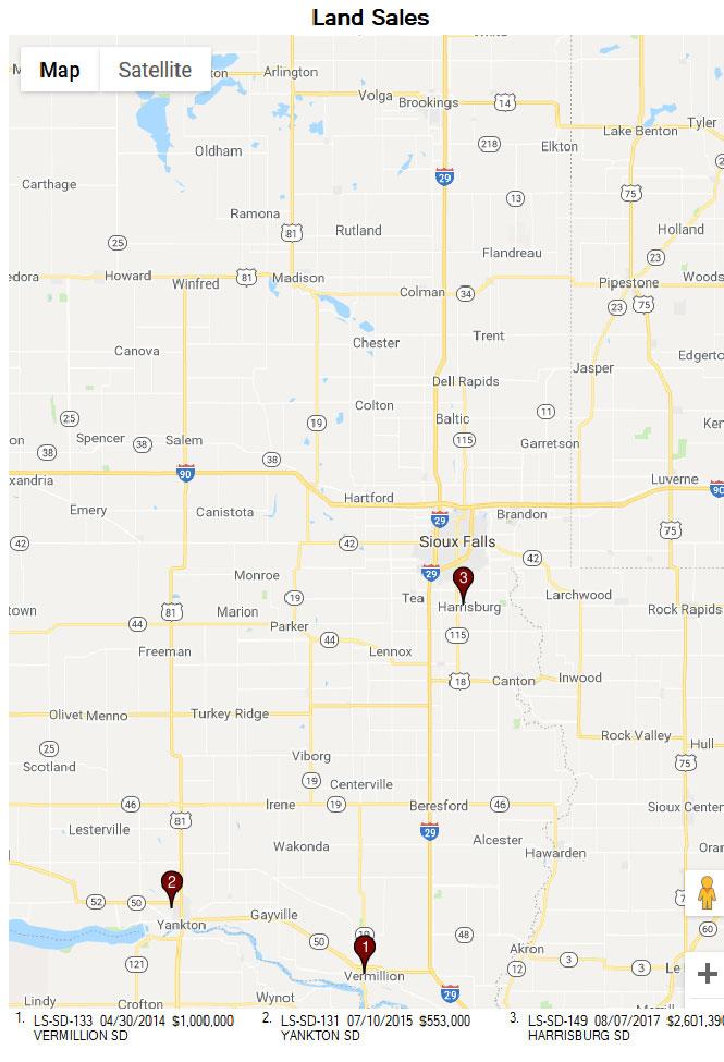
55
56 Land Sale 1 Sale Id LS-SD-133 Sale Date 4/30/2014 Location Information: State County Municipality Address Descriptive Location Legal Description Addition SD CLAY VERMILLION TBD-SEE COMMENTS AND MAP WEST SIDE OF STANFORD STREET BETWEEN HIGHWAY 19 AND MAIN STREET FULL LEGAL MAINTAINED IN FILE, AERIAL PHOTO SHOWS APPROXIMATE LOCATION Sale Information: Verified Price $1,000, Grantor(s) BLISS Grantee(s) VERMILLION AREA CHAMBER & DEVELOPMENT COMPANY Verification By PUBLIC RECORDS & BUYER Type Of Transfer WARRANTY DEED Transfer Fee $1, Book 78 Page 15 Easements TYPICAL Restrictive Covenants UNKNOWN Site Information: Square Feet 1,960,200 Price Per Square Foot $0.51 Acres Price Per Acre $22, Zoning PLANNED DEVELOPMENT Topography NEARLY LEVEL TO ROLLING Configuration IRREGULAR Latest Use Before Sale VACANT-FARM LAND Intended Use DEVELOPMENT Highest And Best Use RESIDENTIAL Percent Usable 90 Primary Frontage STANFORD STREET Primary Feet 1000 Secondary Frontage NONE Secondary Feet 0 Soil Preparation Required TYPICAL Improvements NONE Improvements Razed NONE Depth - Feet 1800 Depth Ratio 0.56 Cost Of Removal $0.00 Utilities Serving Site ALL COMMON Neighborhood Information: Neighborhood Access HIGHWAY 19 Neighborhood Type RESIDENTIAL Neighborhood Trends STABLE Percent Built-Up 75 Comments: THE PROPERTY SOLD TO THE LOCAL ECONOMIC DEVELOPMENT CORPORATION, WITH THE INTENTION TO DEVELOP THE SITE AS A RESIDENTIAL SUB-DIVISION.

57 Land Sale 1
58 Land Sale 2 Sale Id LS-SD-131 Sale Date 7/10/2015 Location Information: State County Municipality Address Descriptive Location Legal Description Addition SD YANKTON YANKTON TBD W. CITY LIMITS ROAD WEST SIDE OF W. CITY LIMITS ROAD AND NORTH OF W. 23RD STREET MAINTAINED IN FILE Sale Information: Verified Price $553, Grantor(s) BOB LAW, INC. Grantee(s) YANKTON AREA PROGRESSIVE GROWTH, INC. Verification By PUBLIC RECORDS Type Of Transfer WARRANTY DEED Transfer Fee $ Book 524 Page 488 Easements TYPICAL Restrictive Covenants UNKNOWN Site Information: Square Feet 1,350,360 Price Per Square Foot $0.41 Acres Price Per Acre $17, Zoning SINGLE FAMILY Topography NEARLY LEVEL WITH GRADE AT STREET Configuration REGULAR Latest Use Before Sale VACANT Intended Use RESIDENTIAL Highest And Best Use RESIDENTIAL Percent Usable 100 Primary Frontage W. CITY LIMITS Primary Feet 2082 Secondary Frontage NONE Secondary Feet 0 Soil Preparation Required TYPICAL Improvements SEE COMMENTS Improvements Razed NONE Depth - Feet 650 Depth Ratio 3.2 Cost Of Removal $0.00 Utilities Serving Site ALL COMMON Neighborhood Information: Neighborhood Access W. CITY LIMITS ROAD Neighborhood Type MIXED USE Neighborhood Trends STABLE Percent Built-Up 50 Comments: THE PROPERTY HAS BEEN IMPROVED WITH A RESIDENTIAL DEVELOPMENT.

59 Land Sale 2
60 Land Sale 3 Sale Id LS-SD-149 Sale Date 8/7/2017 Location Information: State County Municipality Address Descriptive Location SD LINCOLN HARRISBURG NORTH SIDE OF WILLOW STREET AND WEST SIDE OF CLIFF AVENUE Legal Description THE SE1/4 EXCEPT LOT H-1 Addition Sale Information: Verified Price $2,601, Grantor(s) PAMELA SWASON, LUCINDA KNUTSON, AND LAWRENCE THORNTON Grantee(s) CREEKSIDE PLACE, LLC Verification By PUBLIC RECORDS, LISTING Type Of Transfer WARRANTY DEED Transfer Fee $2, Book 123 Page 1942 Easements TYPICAL Restrictive Covenants UNKNOWN Site Information: Square Feet 6,951,740 Price Per Square Foot $0.37 Acres Price Per Acre $16, Zoning A-1, AGRICULTURAL Topography FAIRLY LEVEL Configuration REGULAR Latest Use Before Sale AGRICULTURAL Intended Use MIXED USE DEVELOPMENT Highest And Best Use MIXED USE DEVELOPMENT Percent Usable 100 Primary Frontage CLIFF AVENUE AND WILLOW STREET Primary Feet 2640 Secondary Frontage NONE Secondary Feet 0 Soil Preparation Required SEE COMMENTS Improvements NONE Improvements Razed Depth - Feet 2640 Depth Ratio 1 NONE Cost Of Removal $0.00 Utilities Serving Site ALL COMMON Neighborhood Information: Neighborhood Access CLIFF AVENUE AND WILLOW STREET Neighborhood Type MIXED USE Neighborhood Trends GROWTH Percent Built-Up 60 Comments: THE PROPERTY WAS LISTED WITH BENDER COMMERCIAL FOR LESS THEN TWO YEARS. THE SELLER HAD COMPLETED A CONCEPT PLAN SHOWING POTENTIAL DEVELOPMENT AND PROPOSED ZONING DISTRICTS, WHICH INCLUDED RESIDENTIAL AND COMMERCIAL USES. THE PROPERTY WAS ANNEXED INTO THE CITY OF HARRISBURG AFTER PURCHASE. HARRISBURG TRIBUTARY RUNS NORTH AND SOUTH THROUGH THE MIDDLE OF THE PROPERTY. APPROXIMATELY 61 ACRES OF THE PROPERTY IS WITHIN THE FLOOD PLAIN OF WHICH 14 ACRES IS WITHIN THE FLOODWAY.

61 Land Sale 3
62
63 AGRICULTURAL DISTRICTS ARTICLE AGRICULTURAL DISTRICTS Section A Agricultural District Purpose This district is established to maintain and promote farming and related activities within an environment which is generally free of other land use activities. Residential development will be discouraged to minimize conflicts with farming activities and reduce the demand for expanded public services and facilities. Covenants/Waivers A RIGHT TO FARM Covenant shall be filed with Register of Deeds on all property to be used as a site for a newly constructed residence (farm and nonfarm) or church prior to issuance of a building permit and to all new subdividing of property by platting. Such Right to Farm covenant shall be in the form as set forth in Addendum 1 to this Ordinance. (Ord , ) Permitted Uses 1. Agricultural activities and farm related buildings, including Class E but excluding Classes A, B, C and D Concentrated Animal Feeding Operations. 2. Established residence. 3. Residential dwelling not within 1,320 feet of a Concentrated Animal Feeding Operation unless waiver registered on deed. 4. Single family residences including manufactured, mobile and modular homes on less than 35 acre lots provided that such residences are on an established farm building site, abandoned school site, or are lots of record and further provided that the proposed site has established road access, the lot has clearly delineated boundaries and the site can meet minimum water and sewer standards. 5. Fisheries services and game propagation areas; 6. Orchards, tree farms, truck gardening, nurseries and greenhouses; 7. Public parks and recreation areas; 8. Home occupations. Brookings County Zoning Ordinance Revised
64 AGRICULTURAL DISTRICTS 9. Accessory buildings of 120 square feet or less are not required to have a building permit. Conditional Uses 1. Airports and airstrips; 2. Church or cemetery; 3. Golf course, golf driving range; 4. Sand, gravel or quarry operation, mineral exploration and extraction; 5A. Rock Crushers (Ord , ); 5B. Concrete Mixing Plant (Ord , ) 5C. Asphalt Mixing Plant (Ord , ); 6. Contractors shops and yards; 7. Sanitary landfills provided: a. The site meets the requirements of the State Department of Water and Natural Resources. b. A site plan is provided indicating the following information: (1) Present topography, soil types, depth to groundwater. (2) Location of existing water drainage, existing buildings, existing shelterbelts. (3) Identification of roads leading to the site. (4) Proposed changes at the site such as new shelterbelts, new buildings, changes in topography, new fence lines. (5) Proposed monitoring wells, etc. c. A minimum of 1,320 feet from the landfill property line to the nearest residence; excluding the residence of the landfill operator. Brookings County Zoning Ordinance Revised
65 AGRICULTURAL DISTRICTS 8. Institution farms, including religious farming communities; 9. Sewage treatment plants; 10. Fur farms; 11. Class A, B, C, and D Concentrated Animal Feeding Operations. See Section Stables, dog/cat kennels; 13. Veterinary clinics; 14. Junk/salvage/recycling yards, provided that they meet the following minimum requirements and other restrictions that the County Planning Commission may deem appropriate: a. Storage for junk/salvage/recycling yards shall be set back a minimum of two hundred (200) feet from any adjoining road right-of-way. b. Junk/salvage/recycling yards shall be screened on all sides by a solid wall at least two (2) feet above the highest stock pile or by a shelterbelt of shrubs and trees as approved by the Planning Commission; screening must be maintained in good repair. c. No junk/salvage/recycling yards will be allowed within one thousand three hundred twenty (1,320) feet of any residence other than that of the owner of the land. d. All junk/salvage/recycling yards must have a minimum lot of ten (10) acres. 15. Water pumping stations, elevated tanks and similar essential public utilities and service structures. 16. One manufactured or mobile home as a secondary residence, on an established farmstead to be used for the occupancy of a farm employee, or by parents, grandparents, children or brothers and sisters of the occupant of the land, provided that said home is removed within ninety (90) days of the vacation there from by the qualified occupant or occupants, (Ord , ) 17. Commercial radio and TV towers; Brookings County Zoning Ordinance Revised
66 AGRICULTURAL DISTRICTS 18. Commercial public entertainment enterprises not normally accommodated in commercial areas, including but not limited to, the following: music concerts, rodeos, tractor pulls, and animal and vehicle races; 19. Seasonal retail stands, excluding garden produce but including fireworks stands; 20. Home extended business; 21. Caretaker residences associated with public or private enterprise; 22. Lodging house. 23. Agricultural processing plants. 24. Spreading of manure with irrigation system. 25. Wind Energy Systems (WES) 26. The County Zoning Commission may permit other uses which, in its opinion, are not detrimental to other uses and are in the general character of the Agricultural District. (Ord , ) Area Regulations All buildings must be set back from road right-of-way lines and must be lot line to comply with the following yard requirements: 1. Lot Size: All lots for purposes of residential use unless otherwise provided for in this ordinance, shall be a minimum of thirty five (35) acres, except as provided in Item 7 below. 2. Front Yard: The minimum depth of the front yard shall be one hundred (100) feet. A corner lot will have two front yards. 3. Side Yard: The minimum width of a side yard shall be twenty-five (25) feet. 4. Rear Yard: The minimum depth of a rear yard shall be fifty (50) feet. 5. Maximum Lot Coverage: Dwellings and buildings accessory thereto shall cover not more than twenty-five (25) percent of the lot area. 6. Shelterbelts. (See Article ) Brookings County Zoning Ordinance Revised
67 AGRICULTURAL DISTRICTS 7. The County Zoning Commission may allow a smaller minimum lot size for the "A Agricultural District under the following condition: a. Where a second single family home is requested on an established farmstead, so long as it is immediately connected to the existing farming operation. b. Single family residences legally built under these ordinances shall be considered an established farm building site after it has existed ten (10) years. c. The County Zoning Commission may deny any request for a smaller minimum lot size if it is determined to be an attempt to circumvent the intent or requirements of this ordinance. d. Conditional use permitting of a Religious farming community will include the authorization to construct or utilize an existing building as a church and to construct multiple single family dwelling units. A detailed site plan will be required, and all federal, state, and local laws will be strictly enforced. If a confined animal feeding operation (CAFO) or any other conditional use permitted uses are planned a separate application will be required. In the event that a Religious farming community ceases to exist all single family dwelling units will be required to be removed. (Ord , ) 8. Non-conforming lots of record that are allowed to develop must meet the following setbacks: Per Unit Min. Lot Min. Lot Min. Min. Min. Min. Density Area Area Lot Front Side Rear Sq. Ft Sq. Ft. Sq. Ft. Width Yard Yard Yard Well Rural Water Single Family Dwelling 20,000 43,560 20, Other Allowable Uses 20,000 20,000 20, ' 50 Brookings County Zoning Ordinance Revised
68 AGRICULTURAL DISTRICTS Height Regulations No main buildings shall exceed two and one-half (2 1/2) stories or thirty-five (35) feet in height. Exceptions include the following: 1. Agricultural buildings; 2. Chimneys, smokestacks, cooling towers; 3. Radio and TV towers; 4. Water tanks; 5. Elevators; 6. Others, providing that they are not used for human occupancy. 7. Wind Energy Systems (WES) Brookings County Zoning Ordinance Revised
69


70 PHOTOGRAPHS OF SUBJECT PROPERTY STREET SCENE LOOKING NORTH ALONG HIGHWAY 14 BYPASS STREET SCENE LOOKING SOUTH ALONG HIGHWAY 14 BYPASS 1


71 PHOTOGRAPHS OF SUBJECT PROPERTY STREET SCENE LOOKING NORTH ALONG 34 TH STREET STREET SCENE LOOKING EAST ALONG HIGHWAY 14 BYPASS 2


72 PHOTOGRAPHS OF SUBJECT PROPERTY STREET SCENE LOOKING EAST ALONG 211 TH AVENUE STREET SCENE LOOKING WEST ALONG 211 TH AVENUE 3


73 PHOTOGRAPHS OF SUBJECT PROPERTY VIEW OF COLD STORAGE BUILDING VIEW OF COLD STORAGE BUILDING 4


74 PHOTOGRAPHS OF SUBJECT PROPERTY INTERIOR OF COLD STORAGE BUILDING INTERIOR OF COLD STORAGE 5


75 PHOTOGRAPHS OF SUBJECT PROPERTY INTERIOR OF COLD STORAGE INTERIOR OF COLD STORAGE 6


76 PHOTOGRAPHS OF SUBJECT PROPERTY STORAGE BUILDING INTERIOR OF STORAGE BUILDING 7


77 PHOTOGRAPHS OF SUBJECT PROPERTY STORAGE BUILDING INTERIOR OF STORAGE BUILDING 8


78 PHOTOGRAPHS OF SUBJECT PROPERTY VIEW OF SUBJECT PROPERTY VIEW OF SUBJECT PROPERTY 9


79 PHOTOGRAPHS OF SUBJECT PROPERTY VIEW OF SUBJECT PROPERTY VIEW OF SUBJECT PROPERTY 10


80 PHOTOGRAPHS OF SUBJECT PROPERTY VIEW OF WELL AND PUMP VIEW OF WELL AND PUMP 11


81 PHOTOGRAPHS OF SUBJECT PROPERTY VIEW OF SUBJECT ON THE WEST SIDE OF HIGHWAY 14 BYPASS VIEW OF SUBJECT FROM HIGHWAY 14 BYPASS AND 34 TH STREET 12


82 PHOTOGRAPHS OF SUBJECT PROPERTY VIEW OF SUBJECT FROM 34 TH STREET VIEW OF SUBJECT ON THE EAST SIDE OF HIGHWAY 14 BYPASS 13


83 PHOTOGRAPHS OF SUBJECT PROPERTY VIEW OF PROPERTY ON THE EAST SIDE OF HIGHWAY 14 BYPASS VIEW OF PROPERTY ON THE EAST SIDE OF HIGHWAY 14 BYPASS 14
84


85 OTHER AREAS OF FLOOD HAZARD OTHER AREAS GENERAL STRUCTURES OTHER FEATURES MAP PANELS 0.2% Annual Chance Flood Hazard, Areas of 1% annual chance flood with average depth less than one foot or with drainage areas of less than one square mile Zone X Future Conditions 1% Annual Chance Flood Hazard Zone X Area with Reduced Flood Risk due to Levee. See Notes. Zone X Area with Flood Risk due to Levee Zone D NO SCREEN Area of Minimal Flood Hazard Zone X B Effective LOMRs Area of Undetermined Flood Hazard Zone D Channel, Culvert, or Storm Sewer Levee, Dike, or Floodwall Cross Sections with 1% Annual Chance 17.5 Water Surface Elevation Coastal Transect Base Flood Elevation Line (BFE) Limit of Study Jurisdiction Boundary Coastal Transect Baseline Profile Baseline Hydrographic Feature Digital Data Available No Digital Data Available Unmapped Ü The pin displayed on the map is an approximate point selected by the user and does not represent an authoritative property location. National Flood Hazard Layer FIRMette 44 19'32.68"N Legend SEE FIS REPORT FOR DETAILED LEGEND AND INDEX MAP FOR FIRM PANEL LAYOUT 96 44'52.90"W SPECIAL FLOOD HAZARD AREAS Without Base Flood Elevation (BFE) Zone A, V, A99 With BFE or Depth Zone AE, AO, AH, VE, AR Regulatory Floodway Feet ,000 1,500 2,000 USGS The National Map: Orthoimagery. Data refreshed October :6, '6.94"N 96 44'15.44"W This map complies with FEMA's standards for the use of digital flood maps if it is not void as described below. The basemap shown complies with FEMA's basemap accuracy standards The flood hazard information is derived directly from the authoritative NFHL web services provided by FEMA. This map was exported on 12/10/2018 at 1:19:54 PM and does not reflect changes or amendments subsequent to this date and time. The NFHL and effective information may change or become superseded by new data over time. This map image is void if the one or more of the following map elements do not appear: basemap imagery, flood zone labels, legend, scale bar, map creation date, community identifiers, FIRM panel number, and FIRM effective date. Map images for unmapped and unmodernized areas cannot be used for regulatory purposes.
APPRAISAL REPORT OF THE STATE HISTORICAL SOCIETY PROPERTY ACRES OF AGRICULTURAL LAND LOCATED IN NORTHWEST SULLY COUNTY, SOUTH DAKOTA
 APPRAISAL REPORT OF THE STATE HISTORICAL SOCIETY PROPERTY 97.50 ACRES OF AGRICULTURAL LAND LOCATED IN NORTHWEST SULLY COUNTY, SOUTH DAKOTA CONTROL NUMBER 16-83 CLIENT SOUTH DAKOTA SCHOOL AND PUBLIC LANDS
EvaluePro Real Estate Restricted Appraisal Report
 EvaluePro Real Estate Restricted Appraisal Report EvaluePro Highlights Property Street: 1000 Main Street City: Anytown State: NC Zip: 12345 Property Owner: Mr. & Mrs. Property Owner Estimated Market Value:
APPRAISAL REPORT OF ACRES OWNED BY STATE OF SOUTH DAKOTA LOCATED AT 209 EXPERIMENT FARM ROAD HIGHMORE, SOUTH DAKOTA CONTROL NUMBER
 APPRAISAL REPORT OF 113.89 ACRES OWNED BY STATE OF SOUTH DAKOTA LOCATED AT 209 EXPERIMENT FARM ROAD HIGHMORE, SOUTH DAKOTA CONTROL NUMBER 18-107 CLIENT SOUTH DAKOTA OFFICE OF SCHOOL AND PUBLIC LANDS ATTN:
RESTRICTED APPRAISAL REPORT
 Restricted Use Appraisal Report Thomas J. Schulte & Associates Page #1 RESTRICTED APPRAISAL REPORT SUBJECT ASSIGNMENT Property City: Zip Code: County: Legal Description: Assessor's Parcel #: Tax Year:
A Demonstration Appraisal Report. Of a. Located at. Date of Appraisal. Prepared for. Prepared by
 A Demonstration Appraisal Report Of a Located at Date of Appraisal Prepared for Prepared by International Association of Assessing Officers Professional Designation Subcommittee 314 West 10 th Street Kansas
A Demonstration Appraisal Report. Of a. Located at. Date of Appraisal. Prepared for. Prepared by
 A Demonstration Appraisal Report Of a Located at Date of Appraisal Prepared for Prepared by International Association of Assessing Officers Professional Designation Subcommittee 314 W. 10 th Street Kansas
How to Read a Real Estate Appraisal Report
 How to Read a Real Estate Appraisal Report Much of the private, corporate and public wealth of the world consists of real estate. The magnitude of this fundamental resource creates a need for informed
Appraisal Stream Restricted Use Residential Appraisal Report
 Appraisal Stream Restricted Use Residential Appraisal Report File No. 769kemplin This report is limited to the sole and exclusive use of the client. The appraiser's opinions and conclusions set forth in
To all Appraisers: Brief Overview:
 To all Appraisers: As the appraisal industry continues to change, the demand for alternative valuation solutions grows. That is why is excited to announce the addition of a new product - the Desktop Appraisal
Anatomy Of An Appraisal
 Anatomy Of An Appraisal Leslie A. Fields The most important thing to know about an appraisal report is how to review and critique it. Leslie A. Fields a partner with the Law Firm of Faegre & Benson LLP,
Guide Note 6 Consideration of Hazardous Substances in the Appraisal Process
 Guide Note 6 Consideration of Hazardous Substances in the Appraisal Process Introduction The consideration of environmental conditions along with social, economic, and governmental conditions is fundamental
Guide Note 15 Assumptions and Hypothetical Conditions
 Guide Note 15 Assumptions and Hypothetical Conditions Introduction Appraisal and review opinions are often premised on certain stated conditions. These include assumptions (general, and special or extraordinary)
As Of: Prepared For: Prepared By:
 of 216 SW 131st St As Of: 06/11/11 Prepared For: Prime Pacific Bank 2502 196th St SW Lynnwood WA 98036 Prepared By: Cynthia A. Nagle, CREA 922 N Cedar St Tacoma, WA 98406 RESTRICTED APPRAISAL REPORT Restriction
ILLINOIS HOUSING DEVELOPMENT AUTHORITY APPRAISAL SCOPE AND GUIDELINES December 2015
 ILLINOIS HOUSING DEVELOPMENT AUTHORITY APPRAISAL SCOPE AND GUIDELINES December 2015 As part of the Common Application for Multifamily Financing, the Illinois Housing Development Authority (IHDA) requires
RAINS COUNTY APPRAISAL DISTRICT
 RAINS COUNTY APPRAISAL DISTRICT 2017 MASS APPRAISAL SUMMARY REPORT mass appraisal report 2017 uspap_appr_report RAINS COUNTY APPRAISAL DISTRICT 2017 MASS APPRAISAL SUMMARY REPORT Identification of Subject:
Across-the-Fence Value and Hostage Occupancy Agreements
 Across-the-Fence Value and Hostage Occupancy Agreements EUCI Conference: Electric Transmission Projects San Diego, California September 19, 2016 John T. Schmick Shenehon Company 2 What is the goal of valuation
SUBJECT: The Appraisal of Real Property That May Be Impacted by Environmental Contamination
 1 ADVISORY OPINION 9 (AO-9) 1 2 3 4 This communication by the Appraisal Standards Board (ASB) does not establish new standards or interpret existing standards. Advisory Opinions are issued to illustrate
FIRST AMENDMENT TO LEASE
 Attachment 1 FIRST AMENDMENT TO LEASE THIS FIRST AMENDMENT TO LEASE, dated, 2013 ( First Amendment ), by and between the State of California, acting by and through its Department of General Services, (hereinafter
Demonstration Appraisal Report Utilizing a Form Report
 Demonstration Appraisal Report Utilizing a Form Report National Association of Independent Fee Appraisers 330 North Wabash Avenue, Suite 2000 Chicago, IL 60611 Phone: (312) 321-6830 Fax: (312) 673-6652
Industrial and Commercial Real Estate Appraisal Procedures
 Property Valuation Thought Leadership Industrial and Commercial Real Estate Appraisal Procedures John C. Ramirez The application of the asset-based approach to business valuation often involves the appraisal
Restricted Use Appraisal Report Residential
 Client File #: Appraisal File #: Restricted Use Appraisal Report Residential Appraisal Company: Address: Form 200.04* Phone: Fax: Website: Appraiser: Co-Appraiser: AI Membership (if any): SRA MAI SRPA
Appraisal and Market Analysis of Indoor Waterpark Resorts
 Appraisal and Market Analysis of Indoor Waterpark Resorts By David J. Sangree, MAI, CPA, ISHC An appraisal of an indoor waterpark resort is similar to other appraisals in that it is a professional appraiser
Individual Cooperative Interest Appraisal Report
 PURPOSE Individual Cooperative Interest Appraisal Report The purpose of this appraisal report is to provide the client with a credible opinion of the defined value of the subject property, given the intended
Land, Agricultural Improvements, CAFO, Rural Residence, Farm
 *--FSA Appraisal Guidelines Land, Agricultural Improvements, CAFO, Rural Residence, Farm The following information elements and content descriptions are provided as guidelines to assist lenders and appraisers
REED APPRAISAL COMPANY REAL PROPERTY APPRAISERS AND CONSULTANTS
 REAL PROPERTY APPRAISERS AND CONSULTANTS 100 SOUTH KENTUCKY AVENUE #230 ip.o. BOX 1645 ilakeland, FLORIDA 33802-1645 OFFICE: (863) 688-6718 ifax: (863) 688-5993iEMAIL: stan@reedappraisalco.com TO: Henry
Is Across-the-Fence Value Equal to Market Value?
 Is Across-the-Fence Value Equal to Market Value? IRWA Educational Conference San Diego, California June 16, 2015 John T. Schmick Shenehon Company 2 What is the goal of valuation assignments? Market Value
RevuPro Appraisal Review
 RevuPro Appraisal Review Getting It Right ELLIOTT introduces its flagship review product RevuPro, as an independent appraisal review service. Q. What is it and what does it do? A. RevuPro is a fast, economical
2. Is the information in the contract section complete and accurate? Yes No Not Applicable If Yes, provide a brief summary.
 The purpose of this appraisal field review report is to provide the lender/client with an opinion on the accuracy of the appraisal report under review. Property Address City State Zip Code Borrower Owner
concepts and techniques
 concepts and techniques S a m p l e Timed Outline Topic Area DAY 1 Reference(s) Learning Objective The student will learn Teaching Method Time Segment (Minutes) Chapter 1: Introduction to Sales Comparison
AN APPRAISAL OF Acre Residential Site Northwest Corner Pleasant View Road & Gaar Road Richmond, Indiana 47374
 AN APPRAISAL OF 3.75 Acre Residential Site Northwest Corner Pleasant View Road & Gaar Road Richmond, Indiana 47374 American United Appraisal Company, Inc. Real Estate Appraisers Jay E. Allardt, SRA August
Restricted Use Appraisal Report Residential
 Client File #: Appraisal File #: Restricted Use Appraisal Report Residential Form 200.04 * Appraiser: AI Membership (if any): SRA MAI SRPA AI Affiliation (if any): Candidate for Designation Practicing
Summary of Assignment. Identification of Property and Appraisal
 Summary of Assignment My assignment is to review an appraisal of the Athow Property owned by Lewis and Janice Athow. The property is located near the mouth of the Dungeness River in Clallam County, Washington
VALUE FINDING APPRAISAL REPORT
 RE 90 Rev. 01-2014 VALUE FINDING APPRAISAL REPORT (Compensation not to exceed $65,000) COUNTY John Doe 2880 Lancaster-Newark Rd. (SR 37), Pleasant Twp., 43030 Owner Mailing Address of Owner East side of
619 STANDARD 2: REAL PROPERTY APPRAISAL, REPORTING
 619 STANDARD 2: REAL PROPERTY APPRAISAL, REPORTING 620 In reporting the results of a real property appraisal, an appraiser must communicate each analysis, 621 opinion, and conclusion in a manner that is
APPRAISAL REPORT. Vacant Commercial Land SW 268 th Street Miami, FL Cruz Appraisals, Inc SW 72 nd Street, Suite 263 Miami, FL 33173
 APPRAISAL REPORT Prepared for Mr Jorge Palomeras Jpal Marketing Corporation Property Appraised Vacant Commercial Land 12711 SW 268 th Street Miami, FL 33032 Date of Valuation October 6, 2017 Prepared by
Copyright, 1999, 2002, 2004, Freddie Mac. All Rights Reserved.
 Page 1 of 13 Engineering Requirements/Chapter 12: Appraiser and Appraisal Requirements/12.1: General requirements 12.1: General requirements For all multifamily purchase programs and products, the Seller/Servicer
APPRAISAL OF REAL PROPERTY LOCATED AT: FOR: AS OF: BY:
 APPRAISAL OF REAL PROPERTY LOCATED AT: 489 MEADOWS EDGE COURT DEED BOOK 2896, PAGE 2759 CLEMMONS, NC 27012 FOR: ESTATE OF WILLIAM C. McINTOSH % BAILEY & THOMAS P.O. BOX 52 WINSTON-SALEM, NC 27102 AS OF:
OHIO DEPARTMENT OF TRANSPORTATION OFFICE OF REAL ESTATE
 OHIO DEPARTMENT OF TRANSPORTATION OFFICE OF REAL ESTATE DATE: April 3, 2017 TO: FROM: RE: Users of the Real Estate Manual Jared Miller, Manager Appraisal Unit Changes and Updates to the Real Estate Manual
Uniform Agricultural Appraisal Report
 File No. Uniform Agricultural Appraisal Report Prepared For: Intended User: Prepared By: Date Prepared: UAAR Agri management Uniform Agricultural Appraisal Report File No # Property Identification Owner/Occupant:
Chapter 1: Appraisal Terminology. While USPAP does not define the term competency, it does contain a COMPETENCY RULE.
 - 22 - Chapter 1: Appraisal Terminology Competency While USPAP does not define the term competency, it does contain a COMPETENCY RULE. The COMPETENCY RULE states that in all cases, the appraiser must perform
FOR SALE 605 Industry Ave DISTRIBUTION WAREHOUSE FACILITY Asking $395,000
 FOR SALE 605 Industry Ave DISTRIBUTION WAREHOUSE FACILITY Asking $395,000 For Additional Information and To View the Property Please Contact Sandy Hoff - Office Phone 218-722-5556 shoff@fisalter.com AREA
MARKET VALUE BASIS OF VALUATION
 4.2 INTERNATIONAL VALUATION STANDARDS 1 MARKET VALUE BASIS OF VALUATION This Standard should be read in the context of the background material and implementation guidance contained in General Valuation
Contents Lists of Figures and Tables xi About the Author xiii Foreword xv Acknowledgments xvi Part I Introduction
 CHAPTER # Contents Lists of Figures and Tables... xi About the Author... xiii Foreword...xv Acknowledgments...xvi Part I Introduction... 1 1 Overview of Land Valuation Assignments and Adjustment Procedures...
Tax Implications Of The Intellectual Property Valuation Process
 Tax Implications Of The Intellectual Property Valuation Process Robert F. Reilly Robert F. Reilly is a managing director of Willamette Management Associates. He is a Certified Public Accountant, Accredited
Mike Dalton Jr. and Associates. Christina Adams INVOICE NUMBER Mike Dalton Jr. and Associates 8191 Wethersfield Drive. PB125 Germantown, TN 38138
 Mike Dalton Jr. and Associates FROM: INVOICE Christina Adams INVOICE NUMBER Mike Dalton Jr. and Associates 8191 Wethersfield Drive Germantown, TN 38138 DATE 08/14/2016 Telephone Number: (901) 674-0239
Real Property Appraisal Summary Report of an Existing Office Condominium Unit
 Real Property Appraisal Summary Report of an Existing Office Condominium Unit Located at: Morlake Executive Suites Condominium Complex 114 Morlake Drive, Suite 202 Mooresville, Iredell County, North Carolina,
METHODOLOGY GUIDE VALUING LANDS IN TRANSITION IN ONTARIO. Valuation Date: January 1, 2016
 METHODOLOGY GUIDE VALUING LANDS IN TRANSITION IN ONTARIO Valuation Date: January 1, 2016 August 2017 August 22, 2017 The Municipal Property Assessment Corporation (MPAC) is responsible for accurately assessing
UPDATED MARKET VALUE APPRAISAL. Day Care/Senior Center Property and Excess Parcel Governors Drive Olympia Fields, Illnois.
 J _,i UPDATED MARKET VALUE APPRASAL Day Care/Senior Center Property and Excess Parcel 20080 Governors Drive Olympia Fields, llnois _ as of: March 16, 2007 Prepared for: Mr. Steve Townsend, Vice President
5. The cost of buildings includes all necessary costs related to the purchase or construction
 CHAPTER REVIEW Plant Assets 1. (S.O. 1) Plant assets are tangible resources that are used in the operations of a business and are not intended for sale to customers. Plant assets are subdivided into four
Prepared by: Alex Socratous For My High School Students
 Prepared by: Alex Socratous For My High School Students CHAPTER 2 CAPITAL ASSETS DEPRECIATION CAPITAL ASSETS Capital assets are long-lived assets that are used in the operations of a business and are not
MODULE 7-A: APPRAISALS, BPOS AND USPAP
 MODULE 7-A: APPRAISALS, BPOS AND USPAP LEARNING OBJECTIVES One of the most challenging aspects of the real estate business is the development of prices or values of the rights to real estate. Buyers and
Special Purpose Properties. Special Valuation Considerations
 Special Purpose Properties Special Valuation Considerations 2017 Case Study in Ottawa: New Automobile Dealership Many brand-specific specialties Cost: $4,000,000 (including land and a developer fee) Sales
Appraisal Review: Analyzing the 1004
 Appraisal Review: Analyzing the 1004 1 LIVE ONLINE PARTICIPANT GUIDE Version: 8.12 Table of Contents The Purpose of the Appraisal... 3 Define Market Value... 3 Scenario 1 (John Johnson report) - 1004 Uniform
Uniform Residential Appraisal Report (URAR) Model Appraisal
 Model Appraisal") Basic Appraisal Procedures Residential Applications & Model Appraisals 15-13 Uniform Residential Appraisal Report (URAR) Model Appraisal On the following pages are examples of a completed Fannie Mae/Freddie
Basic Appraisal Procedures Residential Applications & Model Appraisals 15-13 Uniform Residential Appraisal Report (URAR) Model Appraisal On the following pages are examples of a completed Fannie Mae/Freddie
LAND AUCTION.
 LAND AUCTION 919+/- Acre Farm Charles Mix County, South Dakota Offered in Eight Tracts! Friday, December 7, 2018 1:30 PM at the National Guard Armory Building 610 East SD Highway 46, Wagner, South Dakota
Appraisal Review & Advisory Opinion 20 Controversy. Presenter: Lisa Kimbro, MAI, AI-GRS
 Appraisal Review & Advisory Opinion 20 Controversy Presenter: Lisa Kimbro, MAI, AI-GRS Practicing appraisers know USPAP, and appraisers that complete review work know USPAP s Standard 3. But what about
Uniform Agricultural Appraisal Report
 File No. Uniform Agricultural Appraisal Report Prepared For: Intended User: Prepared By: Date Prepared: Uniform Agricultural Appraisal Report Executive Summary USE OF APPRAISAL CLIENT/OWNER INSPECTION
APPRAISAL OF 1117 MONROE STREET, VICKSBURG, MS 39180
 APPRAISAL OF 1117 MONROE STREET, VICKSBURG, MS 39180 CLIENT/INTENDED USER: GLENN TRIPLETT INTENDED USE/USER: TO ASSIST THE CLIENT IN MAKING A PURCHASING DECISION. THIS REPORT IS NOT INTENDED FOR ANY OTHER
APPRAISAL REVIEW REPORT. April 7, Yasmi Govin, Director of Business and Property Management Broward County Aviation Department
 Public Works Department Facilities Management Division REAL PROPERTY SECTION 115 S. Andrews Avenue, Room 501 Fort Lauderdale, Florida 33301 954-357-6808 FAX 954-357-6292 APPRAISAL REVIEW REPORT April 7,
Presented by Appraisal Institute Canada & Appraisal Institute
 VALUATION BEYOND BORDERS 2017 INTERNATIONAL CONFERENCE Presented by Appraisal Institute Canada & Appraisal Institute 1 LITIGATION SUPPORT REVIEW CASE Subject s Basic Factors: Community: Vital, growing
AG-AMERICA COMMERCIAL FARM AND RANCH COLLATERAL VALUATION GUIDE
 AG-AMERICA COMMERCIAL FARM AND RANCH COLLATERAL VALUATION GUIDE Table of Contents CHAPTER CV101 COLLATERAL VALUATION STANDARDS AND GUIDES... 1 CV101.1 Overview... 1 General Guidance on Terms:... 1 CHAPTER
UNDERSTANDING HOW USPAP APPLIES TO REAL PROPERTY APPRAISAL PRACTICE USPAP Matrix
 UNDERSTANDING HOW USPAP APPLIES TO REAL PROPERTY APPRAISAL PRACTICE - 2014-2015 USPAP Matrix This matrix assumes an Appraisal Report Format under S. R. 2-2(a). *Last updated 9/11/14* GENERAL Violation
Valuation Report. Property Address. Prepared by. Surveyors Name Trafford Surveyors Ltd. On behalf of: Clients Name
 Valuation Report On Prepared by Surveyors Name Trafford Surveyors Ltd On behalf of: Clients Name CONTENTS Instruction...2 Basis of Valuation... 2 Executive Summary... 3 Location (Appendix 2 Location Plan)...
SELF-STORAGE REPORT VIEWPOINT 2017 / COMMERCIAL REAL ESTATE TRENDS. By: Steven J. Johnson, MAI, Senior Managing Director, IRR-Metro LA. irr.
 SELF-STORAGE REPORT VIEWPOINT 2017 / COMMERCIAL REAL ESTATE TRENDS By: Steven J. Johnson, MAI, Senior Managing Director, IRR-Metro LA The Self Storage Story The self-storage sector has been enjoying solid
Address Southeast Quadrant of U.S. Highway 41 and Sumter Boulevard City. North Port State. FL Zip Code County
 SUBJECT AERIAL LOCATION LAND AREA THREE-YEAR OWNERSHIP HISTORY OF SUBJECT Address Southeast Quadrant of U.S. Highway 41 and Sumter Boulevard City North Port State FL Zip Code 34287 County Sarasota Nearest
BUSI 352 Learning Objectives
 BUSI 352 Learning Objectives Purpose and Scope of the Course The Case Studies in Residential Appraisal course (BUSI 352) explores the depth and breadth of knowledge around the valuation of residential
Chapter 6: Auto and RV Dealership Asset Valuation (Equipment)
") Chapter 6: Auto and RV Dealership Asset Valuation (Equipment) Knowing how much the dealership s furniture, fixtures and equipment are worth will determine the amount of goodwill that is being paid as part
Chapter 6: Auto and RV Dealership Asset Valuation (Equipment) Knowing how much the dealership s furniture, fixtures and equipment are worth will determine the amount of goodwill that is being paid as part
Guide to Appraisal Reports
 Guide to Appraisal Reports What is an appraisal? An appraisal is an independent valuation of real property prepared by a qualified Appraiser and fully documented in a report. Based on a series of appraisal
AHDC. THA Affordable Housing Development Corp. Board of Directors Meeting
 AHDC THA Affordable Housing Development Corp. Board of Directors Meeting November 19, 2014 AHDC Meeting Agenda THA Affordable Housing Development Corp. November 19, 2014 I. CALL TO ORDER II. MINUTES FROM
Training the Next Generation of Appraisers The S.T.A.R.T. Program - Standards to Assure Responsible Training:
 Training the Next Generation of Appraisers The S.T.A.R.T. Program - Standards to Assure Responsible Training: An Industry Solution to the Declining Number of Appraisers Entering the Profession and Practical
L. LAND USE. Page L-1
 L. LAND USE 1. Purpose This section discusses current and likely future land use patterns in Orland. An understanding of land use trends is very important in determining Orland's ability to absorb future
First Exposure Draft of proposed changes for the edition of the Uniform Standards of Professional Appraisal Practice
 TO: FROM: RE: All Interested Parties Sandra Guilfoil, Chair Appraisal Standards Board First Exposure Draft of proposed changes for the 2012-13 edition of the Uniform Standards of Professional Appraisal
PINECREST ACADEMY OF NEVADA
 NOTICE OF PUBLIC MEETING of the Board of Directors of PINECREST ACADEMY OF NEVADA tice is hereby given that the Board of Directors of Pinecrest Academy of Nevada, a public charter school, will conduct
TECHNICAL INFORMATION PAPER - MARKET VALUE OF PROPERTY, PLANT & EQUIPMENT IN A BUSINESS
 TECHNICAL INFORMATION PAPER - MARKET VALUE OF PROPERTY, PLANT & EQUIPMENT IN A BUSINESS Please view the video for this Technical Information Paper Reference ANZVTIP 2 Effective 1 st July 2015 Owner National
BUSI 452 Case Studies in Appraisal II
 BUSI 452 Case Studies in Appraisal II PURPOSE AND SCOPE The Case Studies in Appraisal II course (BUSI 452) is a continuation of BUSI 442. This course is intended to introduce further practical applications
Index of Examples. Chapter 1 Letter of Transmittal Chapter 2 General Assumptions and Limiting Conditions... 19
 Index of Examples Chapter 1 Letter of Transmittal... 1 Example 1A Detailed Letter of Transmittal... 2 Example 1B Detailed Letter of Transmittal with Risk Factors and Assumptions... 6 Example 1C Brief Letter
All Interested Parties. Rick Baumgardner, Chair Appraisal Practices Board. Date: September 9, Background
 TO: FROM: RE: All Interested Parties Rick Baumgardner, Chair Appraisal Practices Board Concept Paper Valuation Issues in Separating Tangible and Intangible Assets Date: September 9, 2013 Background Those
January 11, 2017 MEMORANDUM. Issue. Background. Commissioner s Recommendation
 State Board of Regents Board of Regents Building, The Gateway 60 South 400 West Salt Lake City, Utah 84101-1284 TAB Q Phone 801.321.7101 Fax 801.321.7199 TDD 801.321.7130 www.higheredutah.org January 11,
MARKET RENTAL ANALYSIS OF A: MEDICAL OFFICE SPACE LOCATED AT XXXXXXXX SUITE XXXX NEW YORK, NEW YORK DATE OF RENTAL VALUE: DECEMBER 3, 2014
 MARKET RENTAL ANALYSIS OF A: MEDICAL OFFICE SPACE LOCATED AT XXXXXXXX SUITE XXXX NEW YORK, NEW YORK 10017 DATE OF RENTAL VALUE: DECEMBER 3, 2014 DATE OF REPORT: DECEMBER 10, 2014 PREPARED FOR: XXXXXXXXXXXXXX
Following is an example of an income and expense benchmark worksheet:
 After analyzing income and expense information and establishing typical rents and expenses, apply benchmarks and base standards to the reappraisal area. Following is an example of an income and expense
 Page 1 of 5 STANDARD 3: APPRAISAL REVIEW, DEVELOPMENT AND REPORTING In performing an appraisal review, an appraiser acting as a reviewer must develop and report a credible opinion as to the quality of
Appraisers and Assessors of Real Estate
 http://www.bls.gov/oco/ocos300.htm Appraisers and Assessors of Real Estate * Nature of the Work * Training, Other Qualifications, and Advancement * Employment * Job Outlook * Projections Data * Earnings
STANDARD FORM OF HOTEL PURCHASE AGREEMENT Annotated with Introduction. K.C. McDaniel K.C. McDaniel PLLC New York K.C.
 STANDARD FORM OF HOTEL PURCHASE AGREEMENT -- 2007 Annotated with Introduction By K.C. McDaniel K.C. McDaniel PLLC New York K.C. McDaniel 2007 Current Issues in the Negotiation of Hotel Purchase Agreements
REPORTING GUIDELINES FOR REAL ESTATE APPRAISAL REPORTS
 Property Tax Valuation Reporting REPORTING GUIDELINES FOR REAL ESTATE APPRAISAL REPORTS Robert F. Reilly and Robert P. Schweihs 43 INTRODUCTION Appraisal reports become important documents in property
APPRAISAL OF REAL PROPERTY
 Home Appraisals, Inc. (866) 533-7173 APPRAISAL OF REAL PROPERTY File # LOCATED AT Field Review Form Sample FOR OPINION OF VALUE 35, AS OF 11/1/7 TABLE OF CONTENTS One-Unit Field Review... 1 General Text
Pizza Hut - NPC International
 Pizza Hut - NPC International OFFERING MEMORANDUM SITE PHOTO CONFIDENTIALITY AND DISCLAIMER The information contained in the following Marketing Brochure is proprietary and strictly confidential. It is
Chapter 7. Valuation Using the Sales Comparison and Cost Approaches. Copyright 2010 by The McGraw-Hill Companies, Inc. All rights reserved.
 Chapter 7 Valuation Using the Sales Comparison and Cost Approaches McGraw-Hill/Irwin Copyright 2010 by The McGraw-Hill Companies, Inc. All rights reserved. Decision Making in Commercial Real Estate Centers
BUSI 398 Residential Property Guided Case Study
 BUSI 398 Residential Property Guided Case Study PURPOSE AND SCOPE The Residential Property Guided Case Study course BUSI 398 is intended to give the real estate appraisal student a working knowledge of
APPRAISAL REVIEW REPORT
 APPRAISAL REVIEW REPORT REVIEW OF APPRAISALS BY BECCARIA & WEBER, INC. RE: BUENA VISTA MOBILE HOME PARK PALO AL TO, CALIFORNIA REVIEWED BY JAMES BRABANT, MAI PREPARED FOR Law Foundation of Silicon Valley,
Real Estate Appraisal Professional Standards
 Real Estate Appraisal Professional Standards Summary This proposal is to amend the Florida Administrative Code (FAC) to allow a Certified Residential Appraiser or a Certified General Appraiser to use standards
Integra Realty Resources Metro LA. In Association with Valbridge Property Advisors Hulberg and Associates, Inc. Appraisal Of Real Property
 Integra Realty Resources Metro LA In Association with Valbridge Property Advisors Hulberg and Associates, Inc. Appraisal Of Real Property An Office Building 900 H Street Modesto, Stanislaus County, California
PREPARATION OF THE DEMONSTRATION APPRAISAL REPORT
 PREPARATION OF THE DEMONSTRATION APPRAISAL REPORT INTRODUCTION The preparation of the demonstration appraisal report is one of the critical components of the accreditation process. The objective of the
INTANGIBLE VALUE FACT OR FICTION
 1 Define Intangible OUTLINE Outline Appraisal Concepts, Definitions and Issues Examine Legal Framework Examine Case Study Provoke Debate Declare Winning Argument (But the points don t matter) 2 One of
Existing Land Use. Typical densities for single-family detached residential development in Cumberland County: 1
 Existing Land Use A description of existing land use in Cumberland County is fundamental to understanding the character of the County and its development related issues. Economic factors, development trends,
Exposure Draft of Proposed Changes to ADVISORY OPINION 21 (AO-21), USPAP Compliance
, USPAP Compliance") TO: FROM: RE: All Interested Parties Barry J. Shea, Chair Appraisal Standards Board Exposure Draft of Proposed Changes to ADVISORY OPINION 21 (AO-21), USPAP Compliance DATE: February 22, 2013 The goal
TO: FROM: RE: All Interested Parties Barry J. Shea, Chair Appraisal Standards Board Exposure Draft of Proposed Changes to ADVISORY OPINION 21 (AO-21), USPAP Compliance DATE: February 22, 2013 The goal
Dear Valuation Professional
 Dear Valuation Professional First American Mortgage Solutions LLC has a new product offering that we would like you to consider adding to your list of services with us - (Property Assessment Collateral
Chapter 35. The Appraiser's Sales Comparison Approach INTRODUCTION
 Chapter 35 The Appraiser's Sales Comparison Approach INTRODUCTION The most commonly used appraisal technique is the sales comparison approach. The fundamental concept underlying this approach is that market
ZELL & ASSOCIATES Real Estate Appraisers and Counselors
 ZELL & ASSOCIATES Real Estate Appraisers and Counselors A Complete Appraisal Report of: 7.47 Acres of Land Known as the: SE Division Property Located At: 15004 SE Division Street Portland OR, 97236 Prepared
EN Official Journal of the European Union L 320/373
 29.11.2008 EN Official Journal of the European Union L 320/373 INTERNATIONAL FINANCIAL REPORTING STANDARD 3 Business combinations OBJECTIVE 1 The objective of this IFRS is to specify the financial reporting
Swisher County Appraisal District 2017 Mass Appraisal Report
 Swisher County Appraisal District 2017 Mass Appraisal Report Prepared Pursuant to Standard 6 of the Uniform Standards of Professional Appraisal Practice 1 TABLE OF CONTENTS Introduction 3 Listing of Taxing