GATED COMMUNITIES AND NEIGHBORHOOD LIVABILITY IN DOHA
|
|
|
- Gabriel Stone
- 5 years ago
- Views:
Transcription
1 QATAR UNIVERSITY COLLEGE OF ENGINEERING GATED COMMUNITIES AND NEIGHBORHOOD LIVABILITY IN DOHA BY AYLA AL SHAWISH A Thesis Submitted to the Faculty of College of Engineering in Partial Fulfillment of the Requirements for the Degree of Master of Science in Urban Planning and Design June Ayla Al Shawish. All Rights Reserved.
2 COMMITTEE PAGE The members of the Committee approve the thesis of Ayla Al Shawish defended on May 17 th, Prof. Attilio Petruccioli Thesis Supervisor Dr. Anna Grichting Committee Member Dr. Yasser Mahgoub Committee Member Dr. Raffaello Furlan Committee Member Dr. Marco Trisciuogli Committee Member Approved: Dr. Khalifa Nasser M N Al-Khalifa, Dean, College of Engineering ii
3 ABSTRACT Gated communities are a widespread phenomenon now found in many regions around the world. A gated community is mainly characterized by a focus on physical security measures such as gates, walls, guards, and closed circuit surveillance cameras. For the past 50 years, there has been growing criticism about their negative impact on the livability of neighborhoods. Nevertheless, this phenomenon remains popular in the emerging cities of the Arabian Gulf region that are adopting this residential development strategy in their urban growth patterns. More than 454 residential gated communities were located in Doha, the capital of the state of Qatar, as per the 2014 census (Qatar map, 2014), and their numbers are growing. Currently, there is a movement taking place in Qatar to restructure its urban planning principles in order to achieve a transformative move towards a more livable urban form. Therefore, the consistent emergence of such gated communities has become a stimulating piece of inquiry, as academics, engineers, and urban planners continue to question the suitability and potential impacts of gated communities as some of the most persistent and popular residential developments in Doha s neighborhoods. This study investigates residential gated communities in Doha and their relation to a neighborhood s livability, focusing on the Al Waab neighborhood as a case study. Site analysis, observation, morphological analysis, focus group iii
4 interviews, and a questionnaire survey were adopted as suitable methodological tools for the investigation of the study area. The analysis is grounded in a perspective that recognizes the phenomenon of gated communities, the notion of livability and its associated principles found in existing literature and contemporary urban planning movements. Additionally, the analysis looks to studies of best practice gated communities policies and planning responses from South Africa, Canada, and UK. The results of the study illuminate a livability deficiency in the study area, finding that gated developments negatively impact density and diversity of land use, connectivity, and accessibility within the neighborhood, as well as discourage walkability adaptations, social interaction, and co-presence. The results also show that people are motivated to move into gated communities for security reasons mainly related to reduced traffic and a safer environment for their children. The conclusions on the livability disparity of the study area and gated communities are used to propose recommendations to better adapt the gated communities into the urban fabric and make sure that they are more livable and better integrated into the existing city. Certainly, this case study can be applied to similar gated community situations that share the same characteristics of gated enclaves, ultimately contributing to further discussion on the overall livability of gated communities in general and specific cases such as Doha. iv
5 TABLE OF CONTENTS LIST OF FIGURES... ix LIST OF TABLES... xiv ACKNOWLEDGMENTS... xv ABBREVIATIONS... xvi CHAPTER ONE: INTRODUCTION Problem and Rationale Aims and Scope of the Research Research Questions Research Hypotheses Structure of the Research Project Limitations of the Study CHAPTER TWO: BACKGROUND The Emergence of Gated Communities in the Gulf Region Setting the Scene: Residential Development and Gated Communities in Doha From Fereej to Gated Community Problem Identification Factors Extensive Expatriate Influx and Migration v
6 Transient Working Contracts Urban Planning Approach Current Initiatives Conclusions CHAPTER THREE: LITERATURE REVIEW AND DEFINITIONS Gated Communities Gated Communities Definition Gated Communities Types Arguments For and Against Gated Communities Advertising for Gated Communities Neighborhood Livability The Notion of City Livability The Notion of Neighborhood Livability Principles and Indicators of Livability Adopted Livability Principles for Gated Communities in Doha Planning and Gated Communities Cape Town Gated Development Policy Planning Responses to Gated Communities in Canada Gated Communities Way Forward vi
7 3.4. Conclusions CHAPTER FOUR: RESEARCH METHODOLOGY Case Study Selection and Gathered Data Data Collection Tools Site Analysis Observations Morphological Analysis Resident Surveys and Focus Group Interviews Population and Sampling Conclusion CHAPTER FIVE: ANALYSIS AND RESULTS Site Analysis Location and Context Land Use Building Heights Demography Compound Type Public Realm Transportation vii
8 5.2. Observations Morphological Analysis Interviews Questionnaire Survey Conclusion CHAPTER SIX: CONCLUSIONS ON ANALYSIS AND RECOMMENDATIONS Answers to Research Questions Based on Analytical Conclusions Recommendations for Improvement of the Livability of Gated Communities Conclusion Limitations of the Proposal and Recommendations for Future Study 181 REFERENCES Appendix A: Questionnaire Survey Form Appendix B: Residential Compounds Regulations Appendix C: Survey Results viii
9 LIST OF FIGURES Figure 1: Map of Doha showing the distribution of gated communities over the city (Qatar map, 2012)... 3 Figure 2: QNDF policy for livable neighborhood to manage urban growth (QNDF, 2014)... 5 Figure 3: The location of the study area in the city of Doha... 7 Figure 4: Satellite image for the study area. (Source: MMUP)... 8 Figure 5: Photo for the merchants compounds on the sea front of Doha back in 1950 (Lockerbie, 2005) Figure 6: Al- Hitmi compound, in the north-west of Doha, a photo taken in 1960 (Lockerbie, 2005) Figure 7: Aerial view of speculative residential complexes in Doha where many high-skilled European expatriates live during 1970s. (Al-Buainain, 1999) Figure 8: Privately rented housing complexes (modern villa type) (Al-Buainain, 1999) Figure 9: Ariel photos of a traditional fereej in Doha on the left, and a contemporary gated community on the right Figure 10: Hierarchy of centers (QNDF, 2014) Figure 11: Map of mega projects including Lusial and Musheireb (Salama & Wiedmann, 2013) Figure 12: On the left Mushiereb down town Doha in the heart of Doha City. On the right Lusial City development 15 km north of Doha City ix
10 Figure 13: Blakely and Snyder s general typology of gated communities (Blakely & Snyder, 1997; Grant & Mittelsteadt, 2004) Figure 14: Grant and Mittellsteadt s typology of gated communities (Grant & Mittelsteadt, 2004) Figure 15: An example of Developers Company s advertisement of gated living in Doha Figure 16: Breaking down the large gated developments into smaller parcels to ensure spatial integration Figure 17: The distribution of gated developments to ensure the quality of the urban fabric Figure 18: The canyon effect and possible solutions Figure 19: Breaking up the enclosed walls into pockets shall enhance the connectivity with the surrounding streets Figure 20: Transparent orientation to open spaces Figure 21: Gated developments integration possibilities Figure 22: Creating a visual interaction between gated development and the surroundings Figure 23: Passive surveillance by orienting the building interface to adjacent spaces Figure 24: The way forward is embedded in our past: urban blocks in old European cities. Whereas the access to a bounded courtyard is regularly controlled and banned, the small plots occupied by the border buildings x
11 contribute to the well-defined, dense streets (above). While public services are flourishing in the front (bottom left), the semi-private space behind the building is sociable and safe, working well for the entire community of the block (bottom right) (Xu & Yang, 2008) Figure 25: Housing developments in London include large areas of public space, but use contrasting materials and plants to deter visitors from private yards. (Norwood, 2013) Figure 26: Study area location and context (Open street map, edited by the author) Figure 27: Al Waab Neighborhood Urban Evolution Timeline (Source: Google Earth) Figure 28: Al Waab City Main Districts (City, 2012) Figure 29: Al Waab City Vision for the northern district (City, 2012) Figure 30: Satellite image for the location of the study area (Source: MMUP) Figure 31: Land use map (Source: MMUP) Figure 32: The locations and names of the residential compounds inside the study area (Qatar Map, 2014, edited by the author) Figure 33: Examples of the vacant lots that are located inside the study area (Source: Author) Figure 34: Map of the study area shows the building heights (Source: Author) xi
12 Figure 35: Population by Gender and Zone, Figure 36: Gated communities type in the study area adopted from (Town, 2007) Figure 37: The security measures at the entrance of one of the compounds inside the study area (Source: Author) Figure 38: Map of Palm City gardens compound located inside the study area, which shows the different types of villas provided Figure 39: The lack of proper sidewalks inside the study area in-between of the gated communities (Source: Author) Figure 40: The deserted public realm inside the study area. (Source: Author) Figure 41: Al Waab Main Street Figure 42: Bus stations located in the study area (Source: Google Maps) Figure 43: Doha Metro: Phase One, Gold Line (Kovessy, 2013) Figure 44: Metro lines and stations nearby the study area (Source: MMUP) Figure 45: Detailed land use map for the study area (Source: Author) Figure 46: Walls and entrances of the gated developments in the study area (Source: Author) Figure 47: Map shows the right of way in the study area (Source: Author). 127 Figure 48: Gated developments and the internal private/public spaces (Source: Author) xii
13 Figure 49: Aerial photo of Doha traditional downtown with Al Asmakh neighborhood in the bottom left (Boussaa, 2013) Figure 50: Morphological Analysis: The Al Waab and The Al Asmakh neighborhoods (Source: Author) Figure 51: Plan showing the first phase recommended interventions in the study area. (Source: Author) Figure 52: Site plan for the first phase of the proposal. (Source: Author) Figure 53: Map showing the possible connections between the study area and its surrounding. (Source: Author) Figure 54: Street section and layout for the first stage proposal. (Source: Author) Figure 55: Site plan for the second stage proposal. (Source: Author) Figure 56: Street section and layout for the second stage proposal. (Source: Author) Figure 57: Concept diagram for the transition from gated community to a more livable one. (Source: Author) xiii
14 LIST OF TABLES Table 1: Definitions of Gated Communities Table 2: Burke Typology of Gated Communities; adopted from (Burke, 2001) Table 3: Adapted Livability Principles and Indicators from Selected Literature Table 5: Tools Used in Data Collection Table 6: Observations Checklist Used to Evaluate the Livability of the Study Area Table 7: List of Interviewees, Their Positions, Affiliations, and Date and Venue of the Interview Table 8: Observations Checklist Results Table 9: Information From the Interviews Table 10: Questionnaire Survey Results Table 11: Questionnaire Survey Results, continued Table 12: Questionnaire Survey Results, continued Table 13: Questionnaire Survey Results, continued Table 14: Questionnaire Survey Results, continued Table 15: Questionnaire Survey Results, continued xiv
15 ACKNOWLEDGMENTS Completing this thesis was the result of many long hours and nights spent compiling information, forming drafts, and making what seemed like endless changes. However, none of it would have been possible without the aid and support of those around me. First and foremost, I would like to thank my thesis supervisor Professor Attilio Petruccioli. I cannot express my gratitude enough for the time and effort he spent aiding me in this process. Because of his fruitful critiques and everlasting guidance, I was able to produce a report of which I am proud. Furthermore, my thanks also go out to Dr. Anna Grichting for providing me with constructive criticism, her views regarding the topic, and the motivation to keep challenging myself throughout the entire process. Finally, a most special thanks goes out to my family for being there for me through every step of the way. I express gratitude to my husband, for his continued moral support and love, to my parents, for their encouragement and consolation, and to my daughter, for her precious love and compassion. xv
16 ABBREVIATIONS GC Gated Communities QNDF 2032 Qatar National Development Framework 2032 QNV Qatar National Vision GSAS Global Sustainability Assessment System MMUP Ministry of Municipality and Urban Planning QU Qatar University DAUP Department of Architecture and Urban Planning MOT Ministry Of Transport SG Smart Growth NU New Urbanism CNU Congress of New Urbanism CCTV Closed-Circuit Television xvi
17 CHAPTER ONE: INTRODUCTION 1.1. Problem and Rationale More than 454 residential gated communities are located in Doha as per 2014 census (Qatar map, 2014), and their numbers are growing. Whereas, a movement is taking place in Qatar to restructure its urban planning principles in order to achieve a transformative move towards a more livable urban form. There is a perception that these gated communities negatively impact the livability of Doha City the capital of the state. Currently, major parts of the city s urban fabric are comprised of gated communities, which relate poorly to its contextual urban fabric, mainly because clear boundaries create the effect of a no man s land in-between. Thus, the city more and more is being split up into gated enclaves and neglected rest. These gated enclaves divide the urban fabric of Doha s neighborhoods into scattered parcels of land. These parcels are filled with housing blocks that have single and inefficient land use, unlike some traditional compact neighborhoods of the Doha City, itself. Moreover, current gated developments in Doha are not products of the community, in most cases. They are the products of private developers and real estate companies who mostly focus on profit concerns, ignoring the livability principles and the integration of these gated communities with the surrounding urban fabric. These gated enclaves in the emerging city of Doha are mostly rented by other companies for their employees, expatriate 1
18 professionals most of whom are on annual contracts subject to extension. Thus, having limited community involvement due to instable, short-term engagement. The present attempt of Doha to become a global city necessitates the emergence of livable, integrated communities that are capable of driving the development and that are attached to Doha as a choice of residence. Therefore, the needs of livable neighborhoods that encourage the emergence of such communities must gain more influence on Doha s spatial developments. In the Al Waab district, residential gated communities are clustered together. With their inward orientation, they meet the streets with blank walls and security gates that prevent entrance except by residents, leaving large private areas closed off from the public access. Hence, truncating the neighborhood and diminishing the accessibility, connectivity, and vitality of its streets at the micro scale. At the same time, they contribute to urban and social fragmentation and consequently lead to the non-livable city of Doha at the macro scale. Together with the absence of an official city-wide regulation addressing this matter, these reasons motivate the author to investigate this case study specifically, and the case of Doha City at a large level. 2
 1.2. Aims and Scope of the Research This study aims to contribute to, through investigation of existing gated communities urban conditions, the recurrent discussion on the urbanization patterns")
19 Figure 1: Map of Doha showing the distribution of gated communities over the city (Qatar map, 2012) 1.2. Aims and Scope of the Research This study aims to contribute to, through investigation of existing gated communities urban conditions, the recurrent discussion on the urbanization patterns in Doha City and its future vision of becoming a global city. This study focuses on residential gated communities that are mainly occupied by white collar expatriate and it does not intervene with blue collar labor camps conditions. The research addresses particularly the spatial conditions of the residential gated communities in the Al Waab neighborhood of Doha and its 3
20 potential adverse impact on the livability of its contextual area and the overall city. This research will also compare it to other traditional, more organicallygrown neighborhoods within the city, which although they were walled or gated during some periods of history, maintained a good integrated, connected urban fabric. The investigation will be undertaken basically on two levels: first is the discourse of gatedness, secondly, the quality of the resulting urban fabric and its cumulative impact on the city s livability. The recently published Qatar National Development Framework 2032 for spatial development of the city refers to the negative impacts of gated communities on the city s urban fabric and it is addressed as one of the key issues in the housing sector; mega project developments have tended to concentrate on higher income groups and have produced gated communities and compounds, which fragment the urban fabric and destroy the livability of the city (QNDF, 2014). As well, gated communities are addressed as a crucial issue in the pattern of urbanization in Doha City; rapid urbanization has been accompanied by a deteriorating public realm quality, with the creation of large housing compounds interspersed with numerous vacant plots and characterized by a lack of parks and green spaces (QNDF, 2014). Correspondingly, a number of objectives and policies have been developed to address these issues and support the spatial development of Qatar to One of the policies calls for livable neighborhoods (Figure 2) with high-quality 4
.")

21 mixed use, mixed densities, open and integrated residential areas structured around a hierarchy of centers; in Doha, there will be significant urban development of some residential areas to create vibrant and accessible neighborhoods. Neighborhoods will be characterized by diversity and mix of uses, public open space, a high quality public realm and walkable streets (QNDF, 2014). Figure 2: QNDF policy for livable neighborhood to manage urban growth (QNDF, 2014) However, the development framework does not cover the current situation of gated areas and how they can meet these livability factors and become more connected to the city. Thus, this research aims to work on this point of gated communities transformation to meet the required principles of neighborhood livability set in the future vision of QNDF. 5
22 The rationale is to see if this research can recommend ways to better adapt these communities into the urban fabric and to give recommendations to ensure they are more livable and better integrated into the city. Certainly this case study can be applied to similar cases that share the same characteristics of gated enclaves which will subsequently contribute to the overall livability of Doha. Furthermore, despite the growing popularity of gated phenomena in the Arabian Gulf region, surprisingly, the Gulf experience has not been welldocumented or studied, with the exception of a few studies in Saudi Arabia. The proposed research attempts to fill this gap in the gated communities literature. The Al Waab neighborhood is located approximately 10 kilometers from the Corniche, in the southwest of metropolitan Doha. The neighborhood witnessed remarkable growth beginning in the mid-2000s, resulting in the construction of several residential compounds, villas, and a few medical and commercial developments. Thus, the neighborhood predominately includes modern family compounds with a variety of amenities included, mainly accommodating the expatriate population, in addition to free-standing villas and a number of other facilities. The area is surrounded by main arterial roads and is in close proximity to a number of the city s premium schools such as the American School of Doha, the sporting facilities of Aspire Zone, Villagio Mall and the under-construction mix development project of Al Waab City. 6

23 Figure 3: The location of the study area in the city of Doha 7
24 Figure 4: Satellite image for the study area. (Source: MMUP) The neighborhood with its predominating residential gated development, is an example of the recently-built neighborhoods that have re-morphed the periphery of Doha city into isolated islands, embedding a disconnected public realm and privatization strategies. The study area highlighted number of urban incapacities such as; high rent prices, the large deficiency of gated communities in the Al Waab to provide well-structured accessible spaces, and lack of complementary urban qualities, such as pedestrian-oriented street network and street-level retail and commercial activities. The existence of these urban incapacities reveals the lack of research into the livability parameter of 8
25 gated development that places the foundations for spatial and social integration necessary for their emergence. Thus, the objective of this research is to investigate the impact of gated community clusters on the livability of this neighborhood specifically and its cumulative impact on the overall city of Doha. It will also take into account the gated communities spatial conditions that have insistently shaped Doha s difficulty in structuring livable neighborhoods. Here held as the overlay of potentials for density and diversity of land use, connectivity and accessibility, walkability, and the provision for opportunities for social interaction and copresence. These aspects are regarded and adapted in this research as essentials for the neighborhood livability to overcome the physical and social fragmentation. The analysis of gated communities spatial and functional conditions will be set against an analysis of best practices of gated communities policies and planning responses from South Africa, Canada, and UK to assess their planning logic of overcoming the negative impacts and achieving urban livability. In outlining the solutions of these successful planning responses, the research will adopt several points that regard the formation of livable neighborhood in the study area, which can be applied to similar situations in Doha City. Finally, this research will draw recommendations and conclusions for optimizing the livability parameters needed in gated neighborhoods and as 9
26 a result, confirming Doha as a livable city, as envisioned by Qatar National Vision (QNV) Research Questions The conditions of gated communities in Doha raise many questions about the viability of this housing option and its impacts on the livability of the city, which arguably impact connectivity, accessibility, diversity and density to such an extent as to quantify and shape the interactions, co-presence and social activities that highlight the sustenance of livable communities. The following research questions intend to examine these spatial and social variants and discover their impact on the performance of Doha s gated neighborhoods as a hindrance to livability in comparison to other organic neighborhoods in the city. How do gated communities affect neighborhood livability? - What is the impact of gated communities on the density and diversity of land uses within the neighborhood? - Does the presence of gated communities affect the connectivity of street network and the accessibility to public spaces? - Do gated communities encourage walkability? - Do gated communities promote social interaction and copresence of diverse groups? 10
27 How the gated communities neighborhood of the Al Waab compare in a morphological analysis with other traditional more organic neighborhood within the city of Doha? What is residents motivation behind choosing to live in a gated community? 1.4. Research Hypotheses To solve the research problem, the following hypotheses have been set and will be tested in the case study analysis. Gated communities planning provides density and diversity of land usage inside the neighborhood. Gated communities ensure the connectivity of streets and public spaces networks. Gated communities maximize accessibility within the neighborhood. Walkability is likely to be increased within gated communities and their surrounding contextual fabric. Gated communities have the capacity to increase social interaction and co-presence of diverse groups of people. The urban morphology of gated communities neighborhoods is similar to other traditional more organic neighborhoods within the city of Doha. People in Doha are motivated to live in gated developments due to security concerns. 11
28 1.5. Structure of the Research Project This research will continue henceforth with a Background chapter (2.0), which will describe the historical evolution of gated communities in the Gulf region and Doha in particular, spanning from the early recorded gated urban settlements in the 1940 s until the present. The background will also underline the reasons behind its recent fast spreading. After that, a Literature Review and Definitions chapter (3.0) will present a review of the relevant definitions and studies on the nature of gated communities and their different types, on the notion of livability and its principles, and the role of livable neighborhoods in sustaining city livability. This chapter will also offer examples of gated communities polices as a tool for solving the research problem. Chapter (4.0) Research Methodology will illuminate in detail the methods used to collect and analyze pertinent data. Following that, chapter (5.0) Analysis and Results will record the processing and results of the former data. The last chapter (6.0) Conclusions and Recommendations will present conclusions from the prior analysis and will give answers to the study questions and hypothesis posed initially. Moreover, it will offer recommendations for ways to better adapt these gated developments into the urban fabric and how to improve its impact on livability of the city through design and policy interventions. 12
29 1.6. Limitations of the Study The nature of privacy and security of the gated communities and the difficulty to enter them for observation and data collection, Limited published work that addresses the problem of gated communities in the Gulf region and how to approach the solution, Inaccessibility of up-to-date geographic information system (GIS) and demographic data. Moreover, the land use data available mostly refer to condition of
30 CHAPTER TWO: BACKGROUND In order to contextualize the gated communities phenomenon in the region, and for a better understanding of the basis of its existence in Qatar, a historical overview of their emergence is introduced in this chapter, along with the contemporary reasons that led to gated communities extensive spread in the state. The review traces the first gated settlements documented in aerial photos and literature and the relation between the fereej (which is the traditional Qatari neighborhood or community) and modern gated developments, with an objective to shed light on the urban past complexities, which are missing in modern planning schemes The Emergence of Gated Communities in the Gulf Region The transformation of the Gulf states from small traditional tribal or coastal settlements to wealthy oil-exporting nation states irrevocably changed the structure and fabric of societies, economies, and the overall built environments within a few short decades (Salama & Wiedmann, 2013). In the late 1930s, the oil discovery and exploitation by western oil companies, led to a massive influx of western professional workers to the Arab Peninsula region, thus creating a heavy demand for housing. American and British oil companies introduced a new type of housing when they built the first settlements for their employees. Companies like the Kuwait Oil Company (KOC), the Bahrain Petroleum Company (BAPCO), and in Saudi 14
31 Arabia the Arab American Oil Company (ARAMCO) reacted to the increasing demand for housing by constructing residential compounds for their employees, starting around the 1940s. The ARAMCO oil settlement in the eastern province of Saudi Arabia, established in 1938, marks the first gated development in its modern design. The general typology used was the detached one or two-story villa on a square plot within an orthogonal grid of streets, organized so as to provide each house with access to the grid by car (Glasze & Alkhayyal, 2002; Glasze, 2006; Salama & Wiedmann, 2013). Later, these developments were promoted by government s policy, where the foreign companies with more than 50 employees were obliged to provide housing for their workforces, in order to control and limit their cultural influence on the local society. On a broad level, there are three types of compounds for expatriates, where the skill level and the marital status played the biggest roles in defining the compound type. These ranged from basic accommodations in constructed prefabricated units for unskilled or semi-skilled workers to single semi-professional compounds with minimal amenities. At the higher scale, there were well-maintained, landscaped compounds with a range of lifestyle amenities for married expatriate professionals with their families (Glasze, 2006). 15
32 Most of the complexes that remained and continue to be popular, and which this research in particular is focusing on, represent the third type: houses for high income expatriate professionals who are, in most cases, provided with accommodation as part of their working contracts. The compounds are gated and monitored by security guards and closed-circuit television (CCTV) systems. Access is strictly limited to residents and their visitors. Maintenance and administration are provided through on-site management. Rental value in these gated communities is high and approximately more than double the value for an equivalent non-gated development Setting the Scene: Residential Development and Gated Communities in Doha Doha City is the main urban area where the greater part of Qatar population, both nationals and expatriates, resides and works. From a broad perspective, the residential units types in Doha can be distinguished as follows: nationals living in privately constructed individual villas located in older established areas of the city or on the periphery; expatriates housed in both low-rise and high-rise apartment buildings and tower blocks in the inner city neighborhoods; villas, both attached and detached, in gated residential compounds throughout the city (Al-Buainain, 1999) or in newly built gated enclaves such as the Pearl. The public housing strategy in Qatar provided nationals with free replacement of their properties, which were located in the old Qatari neighborhood, with government allocated plots to construct their houses, supporting them with 16
33 interest-free loans or financial compensation. Moreover, the public sector workers of expatriates also were supplied with suitable housing units (Nagy, 1997). This was emphasized by Khaled Adham: the government s policy was to supply every Qatari with a plot of land and an interest-free loan for building a house. The expatriate workers also usually received free housing as part of their work contract. (Adham, 2008). Most of the newly designated plots were in the peripheries of Doha and in newly planned suburbs, far from the old neighborhoods in the city center where people formerly used to reside. This housing strategy had a critical impact on the way the social and urban structure of Doha developed, which involved the demolition of older, more cohesive neighborhoods of nationals and the constructing of new, modern but more socially and physically detached ones that mainly took the form of gated communities (Salama & Wiedmann, 2013; Adham, 2008). Going back to the history of gated communities in Doha, according to Mahgoub, Khalfani, and Lockerbie, the first compounds or gated residential developments found in Qatar were developed by merchants families like Darwish and Al Manna in the early-to mid-1940s (Figure 5). Then the idea started to flourish in the inner city, and a number of walled residential developments appeared inside the different fereej (Mahgoub & Khalfani, 2012; Lockerbie, 2005). 17
34 For instance, Fereej Al Salata and Fereej Al Hitmi, as shown in aerial photos (Figure 6) were a group of one-story residential compounds on the outskirts of these fereejs with relatively spacious and well-developed structure. In the late of 1950s, Qatar witnessed the arrival of foreign oil companies and a migration of the work force. The accommodation of the expatriate population was provided mainly with gated communities as a housing type. As well, the oil companies were settled within newly developed gated settlements supplied with all the utilities, as the city was not established enough back then to handle the increasing numbers of the population. Thus, gated communities were developed in the desert or remote areas to house employees working on energy projects, which were mostly isolated communities created for the sole purpose of the ongoing project. However these communities grew rapidly on some projects. For example, the Ras Laffan Project reached a total of roughly 200,000 residents. Influenced by this experience, the merchants took the opportunity to expand their work and make more profit by supplying the accommodation, which regarding the diversity of the newly comers, took the shape of gated communities. With the economic growth of the state and increase of businesses that involved the migration of expatriates to Qatar, and especially to Doha as the sole center of development, gated communities spread among the districts of the city. Furthermore, construction companies and real estate markets contributed by 18
35 building and enlarging the numbers of these residential developments in order to make a profit (Mahgoub & Khalfani, 2012; Lockerbie, 2005; Shawish, 2015). This was reinforced by the distinguished Qatari architect, Mohammed Al Buainain, who stated that, as a result of the enormous need to house the growing expatriate population, many national citizens invested in construction and real estate of gated compounds in various parts of the city. Gated communities are speculatively built by private Qatari companies and wealthy people, [these] are mostly rented by the state to house a sizeable proportion of western expatriates who are working for the public sector. This type of rental housing is by far the most expensive type of housing in the whole country (Al- Buainain, 1999). This might have shed light on the historical initial reason behind gated communities presence in Doha as a housing option; however, it is crucial to point out the more current reasoning which fueled their presence and caused them to widely spread all over the city. 19


36 Figure 5: Photo for the merchants compounds on the sea front of Doha back in 1950 (Lockerbie, 2005) Figure 6: Al- Hitmi compound, in the north-west of Doha, a photo taken in 1960 (Lockerbie, 2005) 20


37 Figure 7: Aerial view of speculative residential complexes in Doha where many high-skilled European expatriates live during 1970s. (Al-Buainain, 1999) Figure 8: Privately rented housing complexes (modern villa type) (Al-Buainain, 1999) 21
38 2.3. From Fereej to Gated Community The notion of gated communities in the Arab world is not new. The traditional settlements used to be surrounded by a ring of walls. A number of secured large gates were erected on different sides of the settlement for defensive and security reasons as they were the only entry/exit points of the settlement. Many of the traditional Arab cities were based on an enclosed form of social and economic solidarity and were closely-knit and homogeneous communities (Shawish, 2015). Several scholars claimed that this same ancient urban type began to re-emerge in modern settlements in the shape of gated communities. Glaze and Alkhayyal interpreted their analysis in two points of view. First, the modern, small extended-family compounds, which can be found in most of the Gulf cities, represent a reappearance of certain socio-spatial settings in the old city where extended families lived nearby around one cul-de-sac. Their second point was that the new compounds for western foreigners and expatriates can be seen in the principle of spatial seclusion of social groups that have different religious and cultural backgrounds, which was a common principle of sociospatial organization of the Arab old town (Glasze & Alkhayyal, 2002). Similarly, Samer Bagaeen stated that the roots of the modern gated community in the Middle East can be traced back to the formal and control mechanisms prevalent in the traditional settlements (Bagaeen, 2010). Here those mechanisms such as kinship and social solidarity basically gave rise to the form of the traditional cities historically associated with the Middle East. 22
39 This is supported by Salama and Wiedmann, who indicated the traditional neighborhoods locally known as fereej can be regarded as urban cells; they were developed by a system of branching side streets, which ended in a cellular arrangement of houses of related clans and kinsfolk. In some cases, certain more exclusive, neighborhoods were even protected by secondary gates from the rest of the settlement, to some extent curiously anticipating the preference for the gated communities of today. Thus, traditional oasis towns were strongly segregated according to tribal and clan or kinship differences and affiliation (Salama & Wiedmann, 2013). These arguments properly situate the gated phenomenon within a broader historical context of the Middle East urban evolution. However, one can argue that the discourse of gatedness, the construction of barriers, and segregation are as old as urbanism, itself. But the problem lies in the contemporary product condition of this gated phenomenon. The old town had cellular organic urban patterns consisting of the courtyard house as a core cell multiplied in clusters to form the neighborhoods, which were connected with winding streets to the central backbone of the town, the mosque, and the market. Even though some of these neighborhoods were walled and gated, that did not affect the quality of the connections or the complexity of pattern articulation. Nowadays, gated developments have broken away from the traditional neighborhood pattern of organic courtyard houses and been replaced with modern walled houses, which stand on identical rectangular or square plots 23

40 accessed by an orthogonal grid of roads, planned so as to provide car access from the road grid to each house (Salama & Wiedmann, 2013). This is supported by Al Buainain, who described the case of Doha urban transformation as follows: With the income derived from oil exports in the emerging oil sector in the 1950s, entire neighborhoods were bulldozed and redeveloped in order to make traditionally narrow lanes into roads wide enough to accommodate ever-increasing automobile traffic (Al-Buainain, 1999). The new gated design clearly shows differences in the hierarchy, mix of functions, quality of connections and spaces. There is a complex articulation of that ancient settlement which does not exist in the contemporary one. Figure 9: Ariel photos of a traditional fereej in Doha on the left, and a contemporary gated community on the right. 24
41 2.4. Problem Identification Factors The contemporary examples of gated communities are shaped by global socioeconomic changes, marketing strategies of developers, spatial transformation that happened in many cities around the world in the last few decades, and the spreading of architectural concepts and lifestyles by international migration. (Levent & Gulumser, 2007; Webster, 2002; Blakely & Snyder, 1997). Gated communities are a global phenomenon and they are developing now in many countries all around the world, although they differ between countries with reference to their characteristics, and principally with respect to the different causes of their development, such as: security, ethnicity, and prestige (Levent & Gulumser, 2007). However, gated communities existence has been mostly associated with the fear of crime, and security and safety concerns, for instance in the US and South Africa, where gated communities are most popular (Low, 2001; Quintal, 2006). While Qatar is considered one of the safest countries in the world, ranked on factors such as crime rates and national police presence (Khatri, 2015), gated developments continue to be dominant in Doha City. Thus, most likely the safety issue is not the reason behind their popularity. Then, why gated communities in Doha? What are the factors that encourage its spreading? The economic transformation of the state coupled with the oil wealth and the resulted construction boom are the root causes that have reshaped urban physical and social morphologies in Doha City from its 25
42 traditional status. Gated developments were largely fueled by a number of factors which are described in the following section Extensive Expatriate Influx and Migration Qatar has become an attractive destination for people from a range of different cultures and backgrounds to work and live. These people are mainly attracted by the abundance of job opportunities, relatively high salaries, and tax-free living. The massive influx of expatriates has caused the urban population of Qatar to witness an exponential growth that has resulted in shaping economically and ethnically diverse and fragmented demographics of different cultures, with a diverse variety of needs and requirements. According to Salama and Wiedmann, the population is composed of large groups of expatriate Arabs and Asians, in addition to smaller groups of Europeans and North Americans; these expatriate groups represent a major workforce community of skilled professionals and semi-skilled or unskilled laborers from over sixty countries (Salama & Wiedmann, 2013). This diversity and uncertainty of who will live in the same neighborhood next to another makes people prefer to isolate their culture in order to give the possibility for themselves to preserve various levels of freedom within these gated developments. This same situation can be found in Saudi Arabia, where gated communities provide their expat inhabitants with the same lifestyle that exists in their homelands. So they can freely practice their daily activities, which are prohibited outside the gates because they contradict local traditions or are 26
43 simply against the laws of the land (Touman, 2002). However, this has resulted in social destruction and deserted urban areas as these gated shells were often built by developers without integrating them with their surroundings, and without taking into consideration the different lifestyles and needs of the various social groups Transient Working Contracts The aforementioned massive expatriate influx, generally built on the basis of interim working contracts, gave rise to segregated temporal societies that frequently change and move. These unsettled populations scarcely ever develop attachments to their neighboring environments (Salama & Wiedmann, 2013). Equally, they do not perceive the cities as homes, do not really establish long-term relationships with these locales, and subsequently are not creating a long-term economy to sustain a viable urbanized community. Through their transient working contracts, typically most employees receive company arranged housing where they are provided with certain privileges as part of their contracts. Gated communities are a suitable, manageable solution to have these services as part of the package, and the advantages of which are offered through the contract exclusively to certain groups of people (Shawish, 2015). 27
44 Urban Planning Approach Doha as an emerging city competing to join the club of global cities, faced the pressure to accelerate and facilitate its real estate development and construction growth of spectacle projects within a very short time. Thus, due to this high demand of expanding the city and its infrastructure and the variety of service sectors that public investments must deal with, government in many cases was forced to decentralize and privatize urban development by selling state-owned land to investors and developers. This sell-off and decentralization of planning caused the rising of influence of private developers, who originated master-plan developments that took the form of exclusionary and exclusive man-made islands, eye-catching new peripheral districts and mixed-use enclaves or cities within the major city (Salama & Wiedmann, 2013; Adham, 2008). These developers, whose interest was solely based on profit concerns and market logic, found in the gated developments a trump card. They planned for the accommodation aspect and housing demand without considering the livability principles and the residents needs, for example, of having some of the essential services such as commercial and recreational facilities within walking distance from their residences. The developers approach, along with the lack of integrative development and regulation within the urban areas and the laissez-faire mechanisms, has resulted in divided urban fabric, long driving distances, and traffic jamming. This situation has become even worse because 28
45 of the insufficient public transport system and the absence of integrated, welldistributed public amenities on the level of the single neighborhood structure and the overall major city Current Initiatives An introduction of Doha City as an emerging global hub has taken place in the QNV 2030 and the accompanied development framework of 2032 which is expected to be the main leading agenda to guide Doha s spatial development. It calls for the establishment of a hierarchy of centers, encourages mix and integration of uses, and promotes livable neighborhoods. This confirms to Salama and Wiedmann, who stated... the evolution of urbanism in Doha is now at a turning point that will lead to a new spatial transformation that will, in turn, shape a built environment that adequately reflects its inhabitants needs rather than being an imposed urban shell containing them (Salama & Wiedmann, 2013). To meet future demand, the provision of community facilities; government and commercial services and supporting amenities will be located within urban centers (Figure 10) which are strongly related to the existing centers of economic activity. These urban centers will be highly accessible via existing and proposed transportation networks. 29


46 Figure 10: Hierarchy of centers (QNDF, 2014) However, along with the introduction of this vision, a number of innovative development strategies were launched, their approach largely emphasizing novel ideas to achieve livability, quality of life and sustainability of the built environment. In an effort to enhance the city urban planning schemes and to 30
47 ensure their sustainability, new programs and assessment tools were introduced such as the Global Sustainability Assessment System (GSAS). One of the GSAS schemes concerns districts and neighborhoods, working on weighting methodology of preset categories in an attempt to resolve measurable and technical matters of a particular neighborhood (GSAS, 2014). Unfortunately, these new assessment programs currently lack specific qualitative measures required to enhance the livability of residential neighborhoods. As they focus on developing calculations and technical standards in preference of providing genuine spatial and social solutions for the residents. Nevertheless, currently in Qatar there are undergoing experiments for new ways of living like the mega projects of Mushiereb down town Doha and Lusial city (Figure 12) where they are trying to build more livable residential communities which are not gated. Both projects have a promising vision to achieve livability within their developments although, their integration with the surrounding urban fabric is still unclear. 31


48 Figure 11: Map of mega projects including Lusial and Musheireb (Salama & Wiedmann, 2013) Figure 12: On the left Mushiereb down town Doha in the heart of Doha City. On the right Lusial City development 15 km north of Doha City. 32
49 2.6. Conclusions The gated communities in Doha and the region have been contextualized in a historical overview of their emergence and the patterns of urbanization that accompanied their growth. The first example of gated communities was the merchant compounds by the sea, followed by the arrival of the oil companies that took the form of gated development as a residence for their employees. During this time, the gated developments spread all over the city in order to accommodate the increasing numbers of expats who were attracted by the availability of job opportunities that resulted from the Doha construction boom. Later, a more in-depth historical review showed that the concept of gated communities existed in the traditional Arab cities but the contemporary form lacked the complexity of the old city pattern. Finally, the factors that caused the spread of the new gated communities have been identified in this chapter. In addition, there was a brief review of the current planning initiatives taking place in Qatar to address the livability and sustainability issues. 33
50 CHAPTER THREE: LITERATURE REVIEW AND DEFINITIONS The following review will propose several related definitions that will be used in this study as parameters to examine the studied urban area of gated communities. It will also offer theoretical backgrounds on the origin of the gated communities and the different classifications and types found in the literature. The chapter will define the notion of city and neighborhood livability and related principles, as well as identify specific suitable livability principles that can be adapted as tools to give rise to a socially vital, livable neighborhood. Additionally, the review looks to studies of best practice gated communities policies and planning responses from South Africa, Canada, and UK Gated Communities Gated Communities Definition There is no comprehensive definition of gated communities since it is a diverse phenomenon. However, common aspects center around having closed, isolated, privatized areas of the city that serve as residential plots with aboveaverage amenities. The term gated community will be referred to in this research as gated development, settlement, and residential compounds. In gated community literature, researchers present different definitions of this phenomenon. However, most definitions share common features. The following definitions introduced in this study are based on their relevance to the 34
51 types of gated communities and compounds (in local terms) spread throughout the city of Doha. Table 1: Definitions of Gated Communities Definition Gated communities can be defined as walled and gated residential developments that restrict public access. (Atkinson & Flint, 2004) Gated communities are housing developments on private roads that are closed to general traffic by a gate across the primary access. These developments may be surrounded by fences, walls or other natural barriers that further limit public access. (Grant, 2013) Gated communities are residential areas with restricted access such that normally public spaces have been privatized. (Blakely & Snyder, 1997) Physical privatized areas with restricted entrance where outsiders and insiders exist. (Blakely & Snyder, 1997) The Gated Community is an urban settlement surrounded by walls with several entrances. These entrances are controlled by gates and they are guarded by security agents. Sometimes these gates are under video surveillance. The access to these settlements is strictly reserved, generally, to the residents and their visitors. (Touman, 2002) In physical terms, a gated community is a fenced or walled residential area, to which access by non-residents is either restricted or controlled by CCTV and/or security staff. A gated community is served by private internal roads, and may include facilities such as a gym for the use of residents only. In legal terms: residents of a gated community are tied into a common code of conduct, and there is generally a degree of selfmanagement of the development by the residents. (Atkinson, Blandy, Flint, & Lister, 2003) Source R. Atkinson & J. Flint in 2004 in the Housing Studies Journal J. Grant in 2003 in a book titled Gated Communities: International Perspectives Blakey & Snyder in 1997 in their book titled Fortress America: Gated Communities in the United States Touman in 2002 in a journal paper titled Gated Communities: Physical Construction or Social Destruction Tool? Atkinson et al, 2003 in England Newhorizon project definition of gated communities 35
52 Gated Communities Types The classification of gated communities provides an important foundation for the subject s theoretical development and provides a better understanding of gated community subtypes. Recent urbanization has witnessed the rise in popularity of private residential, commercial, industrial, and educational spaces. However, in academic literature the term gated communities has been mostly related to residential gated developments. This residential gated communities category can be classified into different types according to different scholars who have spent decades studying gated communities. Scholars have established their own typologies, most commonly on the basis of reason for development, consequences from development, and major implications of gated communities including issues like income, ethnicity, and exclusion (Levent & Gulumser, 2007; Blakely & Snyder, 1997; Grant & Mittelsteadt, 2004). In the reviewed literature, there are four main approaches used to classify gated communities. A summary of each of the four approaches is outlined in this section Blakely and Snyder Typology It is useful to first highlight the three main types of gated communities found in Blakely s division of gated communities, noting that many of their studies are rooted in North American urban experiences. During their research, they identified a key commonality in gated communities even across diverse housing markets: the presence of security guards. 36
53 Each type of gated community has an access control system, but varies significantly in how they deal with the development of community consciousness within their walls (Levent & Gulumser, 2007). The first type includes lifestyle communities where gates and walls mark off and defend an area where civil authorities are deemed unable to sufficiently protect the population from dangerous and armed groups. The second is the prestige community that feeds on exclusionary popular ambitions and the desire to differentiate. The third includes security zones where community safety is the primary goal (Blakely & Snyder, 1997). Nine sub-types are derived from these three main types, as explained in Figure
 3.1.2.")
54 Figure 13: Blakely and Snyder s general typology of gated communities (Blakely & Snyder, 1997; Grant & Mittelsteadt, 2004) Grant and Mittelsteadt Typology The typology of Grant and Mittelsteadt (2004) is grounded from the perspective of Blakely and Snyder with additional reflections on the level of enclosure and the characteristics of facilities and amenities, the type of residential housing patterns and security features, and the level of affluence. 38
55 While the typology of Blakely and Snyder was based principally on function, in their typology, Grant and Mittelsteadt suggest that eight factors should be taken into consideration when trying to categorize the physical form of gated communities: the security features and barriers employed, the functions of enclosure, the facilities and amenities included, tenure type, the types of inhabitants accommodated, size, location, and the policy context (Grant & Mittelsteadt, 2004). Via these eight characteristics, Grant and Mittelsteadt propose a nuanced classification typology that focuses on the type of enclosure and use of the term gated. They classify gated communities in eight types as shown in Figure 14. The classification shows the degree of enclosure recognized in gated developments. The gated communities in this study area fall into the last type with restricted entry, guarded areas surrounded by walls that have gates with controlled access, and security guards. In fact, most of the gated enclaves in Doha fall into the last two types, whether they are in inner city areas or in the suburban areas. 39
56 Figure 14: Grant and Mittellsteadt s typology of gated communities (Grant & Mittelsteadt, 2004) 40
57 Burke Typology Five types of gated communities are defined by Burke (2001). Burke uses social and physical characteristics of various communities in Great Britain, the United States, and Australia to create a classification system that also considers geographic location. Both new, built, and existing gated communities were included in Burke s five classification types (see Table 2). In the case of Doha, most gated communities fall into the third type: secure suburban estate. In this category, they share the same characteristics of residential facilities and housing types, while remaining a separate entity compared to the surrounding urban areas of Doha. Notably, these secure suburban estates could have been mixed use or dense neighborhoods. Also, some gated communities of Doha fall into the type of secure resort communities, such as the lagoon compounds in the West Bay that have the features of resort style living. 41
58 Table 2: Burke Typology of Gated Communities; adopted from (Burke, 2001) Type Urban security zones Secure apartment complexes Secure suburban estates Secure resort communities Secure rural-residential estates Characteristics Current communities that are gated for the purpose of social problem reduction, vehicular traffic, and unwanted pedestrian limitation Block vehicular and pedestrian access of non-residents; there are no open spaces, communal outdoors area, or amenities available inside the community Developed in the suburbs, mostly contains townhouses or low-rise villas with a gymnasium or small communal pool Contain some lifestyle structures such as lagoon, lake, or golf course; also include features of resort style living, i.e. pathways, gardens, or decorative lighting Mostly located at the edge of rural peripheral of major centers; consist of peripheral residential subdivisions, eliminating the lifestyle features and incorporating the rural landscape with some resort-style living features Luymes Typology Another classification of gated communities has been created by Luymes (1997). In his classification, he focused on the access control and the solidification of gated communities perimeters. He acquired the data from market information reviews and field surveys. For Luymes, the physical control typology in contemporary residential enclaves is associated with the existence of socio-economic differentiation. The most prosperous gated communities have an extensive security system with a 42
59 guarded entrance that is monitored day and night. Another group of enclaves includes the retirement and resort communities, which also have guarded gate access with surrounding walls. Luymes observed that upper-middle class ghettos favor a gated but unguarded entrance. The difference is clearer in master-planned developments where affluent houses are within guarded developments, while abstract houses are built in unguarded but only gated developments (Luymes, 1997). In Doha, most of the compounds, regardless of class, are designed with a gate house but differ in security measures, some restricting public access and mandating identification information upon entering Arguments For and Against Gated Communities Around the world, the development of gated communities is growing vastly, contributing to spatial and social transformation in a substantial way. Consequently, gated communities are having a great impact on urban development and the way that cities transform. Landman captures the influence of gated communities, stating In many instances the urban future is shaped by specific and powerful ideas. Gated communities is one such an idea, which has the potential to radically transform the urban environment in the 21st century. (Landman, 2000) The impact of gated communities on urban development has aroused a widespread discussion among scholars and observers about their validity as a 43
60 housing development strategy. According to an international review of gated communities (CSIR, 2009), debate was raised around several issues, such as the: Legal inferences about the enclosure of public space; Property values within the walled area; Urban fragmentation and the privatization of public utilities; Fallback of connection and social interaction; Efficiency of territorial control to inaugurate a sense of community, and Perception of security versus real reports of crime declining in these areas (CSIR, 2009). Advocates claim that gated communities represent the ambition of security, satisfy the demand of consumers looking for a sense of identity and community, offer developers a significant marketing strategy in a competitive setting, increase property values, keep outside the unwelcome, and often come supplementary with attractive facilities. (Levent & Gulumser, 2007; Webster, 2002; Grant & Mittelsteadt, 2004; Blakely & Snyder, 1997). Supporters of this development type reveal that, due to the calm traffic environment, increased vehicle and pedestrian safety is provided inside the compound. Thus, residents feel safer letting their young children play on the roads or the provided playground with their fellow neighbors. 44
61 Moreover, from an economic point of view, Foldavry (1997) argues that gated communities are a more efficient mode of urban development because they allow collectively consumed goods to be supplied by the market (Webster, 2002). Foldavry s argument claims that people have the right to get the best of what the market offers in terms of investment value and quality of life. For him, gates encourage such social and economic satisfaction. On the other side of the debate, the counter-position focuses on the social and economic costs of the phenomenon of gated communities. For instance, Blakely and Snyder in Fortress America state that this phenomenon has created many problems physically and socially in urban areas, such as exclusion which has led to fragmentation and segmentation (Blakely and Snyder, 1997). In like manner, Mike Davis, in his book City of Quartz, notes that gated communities are viewed as just such a form of ultimate segregation and militarization of public space (Davis, 1990). In addition, they seem to divide the city s urban fabric into single land-use islands. They create lifeless, walled streets between each other that limit what people experience in a city, leading to a loss of public life, consequently resulting in high social inequality. Low, in his article about gated communities and the discourse of urban fear, asserts that these safeguarded enclaves with walls and gates threatens public access to open space, and creates yet another barrier to social interaction, 45
62 building of social networks, as well as increased tolerance of diverse cultural/racial/social groups (Low S. M., 2001). As a result, this phenomenon has evident physical and social impact on the contextual urban fabric, and on the overall city at the macro scale, resulting in an effect known as the divided city Advertising for Gated Communities Gated living has been advertised by residential real estate developers as offering the very best of urban life, focusing on images about private engagement with family and friends, achieving a life you have always dreamed about. Developers are selling a new signature lifestyle to homebuyers and renters, including a sense of security and community in a private neighborhood fully surrounded by walls and gates. These master-planned communities offer three Ps: prestige, peace, and perfect vistas (Bagaeen, 2010). Available residential purchasing data demonstrates that there is a marked increase in purchases and rentals of this land type (Bagaeen, 2010). The appeal is apparent in the developers' advertisements: guarantees of a sense of community that "provides the foundation for a true neighborhood experience", recreational amenities including a clubhouse that will become the "social center of your life", carefully shaped settings, and gates that provide security and feelings of remoteness and privacy (Damstra, 2001). 46

63 Figure 15: An example of Developers Company s advertisement of gated living in Doha 3.2. Neighborhood Livability The Notion of City Livability The idea of a livable city is by no means a contemporary innovation and is actually grounded in the traditional model of the European village and hamlet (Newton, 2009). However, over the last century people have mistreated cities to the degree that the functionality of cities has been damaged through urban policies that prefer conformity over difference and sprawl over density. Such policies have also sparked the rise of ecologically unsustainable gated communities and reinforced disparities by building walls between racial, ethnic and class groups (Ouroussoff, 2009). Fixing these harms, and restoring the city to its basic role which, according to Lewis Mumford, is a theater of social action, and an aesthetic symbol of collective unity (Mumford, 1986) will involve a fundamental alteration to the urban growth approach used today. 47
64 Before cities can be drastically changed for equitable social, public, and community life, it is essential to first recognize precisely what principles constitute this notion of livability. Suzanne and Henry Lennard claim that there is a definite security and comfort that occur from social associations, which are satisfying and pleasant, bringing individuals into a community. They stated that, a livable city provides occasions and places for such good experiences (Lennard & Lennard, 1987). Similarly, Mumford has said that, for the city to meet its traditional role as a supporter of diverse human contact and cultural diffusion, it must permit and, indeed, encourage the greatest possible number of meetings, encounters, [and] challenges between various persons and groups (Mumford, 1986). Moreover, livable cities offer varied groups of people the chance to participate in the urban experience by endorsing an infrastructure of facilities, different housing options, and job opportunities in close proximity (Newton, 2009). This close-grained diversity of uses that increases interaction among multiple urban components is seen as the main producer of urban vitality (Talen, 2008). Connectivity is the generator of city life (Dupuy, 1991). Salingaros, in his article Connecting the Fractal City, believes that the life of a city is directly reliant on its matrix of connections and substructure because the geometry of the city either encourages or discourages people's movements and interactions (Salingaros, 2004). 48
65 For such connections to develop naturally, they require an enormous variety of nodes in close mixing. According to Salingaros s thinking, monofunctional zoning prevents life in a city. For him, a neighborhood is a piece of a city and must contain sufficient variety within itself to become partially self-sufficient and contribute to the dynamism of the city. Salingaros defines the concept of a fractal city as the difference between a living city and an un-living city. The key idea is the existence of linked structures at all scales in a hierarchy, from very large to the very small. Fractals have another key property: that of coherence and self-similarity. He argues that the spaces between buildings are a fractal structure on the scale of the city itself. Enlarging block size and constructing smooth walls without entrances are antifractal actions (Salingaros, 2004). Moving to Jane Jacobs (1961) The Death and Life of Great American Cities, there emerges a notion that neighborhoods that worked best had no beginnings or ends. A major part of their success depends on their overlapping and interweaving (Jacobs, 1961). She questioned the use of borders, criticizing that borders can make a neighborhood but not the activities going on in the streets. Borders often create barriers and defeat exchanges that occur across or between neighborhoods and districts (Ghonimi, El Zamly, Khairy, & Soilman, 2011). 49
66 Jane Jacobs adds and describes the four necessary physical conditions for dynamic urban life: multifunctional neighborhoods, short blocks and connected street systems, varied-age residential areas, and a high concentration of people (Jacobs J., 2007). Most gulf cities do not align with these principles, and sometimes actively discourage them through the separation of commercial, residential, and employment activities, as well as the physical separation of neighborhoods by walls, gates, and highways, and the planning of buildings without any relation or connection to each other, or to the greater city as a whole The Notion of Neighborhood Livability A group of livable neighborhoods will cumulatively form a livable city. The American livable city initiative states that a livable city is a network of livable neighborhoods. Each neighborhood should have a distinct character, but each should be complete, supporting living, working, commerce, and culture. (Initiative, 2008). Lewis Mumford said, for communication, the entire planet is becoming a village and, as a result, the smallest neighborhood or precinct must be planned as a working model of the larger world. (Mumford, 1986). That means in order to achieve a more livable world, we must use a bottom up approach and focus first on the neighborhood, the district, the city, and then the region as a working model for livable communities (Newton, 2009). Hence, it is imperative to start 50
67 working at the neighborhood level as a means to consequently create more livable cities. The neighborhood as an intermediary level of analysis was selected for the purposes of this research for several reasons. First, it is relative in its scale to gated communities, where gated communities are considered a type of neighborhood development, but sometimes expand in scale to constitute a full gated neighborhood, community, or district. Second, the neighborhood is a focal point in people s everyday lived experience, as it serves as a link between city and home in people s perception of the livability of their residential environment (Bhonsle & Adane, 2013). Third, neighborhoods have the ability to serve as an elementary unit for successful urban development (Newton, 2009). Additionally, it is important to consider the role and importance of neighborhoods within the structure of traditional Islamic cities. Janet Abu- Lughod in her article The Islamic City states that the neighborhood served as a crucial building block in the Arab world during medieval and even later times (Abu-Lughod, 1987). These vicinal units composed of socially related people had vicinal functions that have strengthened the role of the neighborhood even more. For her, one of the most important ways that shaped the Arabo-Islamic city was through 51
68 encouraging the vitality of sub-state functional units, one such sub-state functional unit being the residential neighborhood (Abu-Lughod, 1987). In the literature, scholars have focused their analysis of neighborhood livability on a variety of factors. Christopher Alexander in his book A Pattern Language creates a language of 253 patterns that address architecture, urban design, and community livability on different levels, starting from geographic characteristics of a region down to interior spaces of buildings and construction details. The patterns define a problem, then provide a solution. It gives a timeless way to improve or design our built environment, depending mainly on the idea of connection and integration between the various patterns and scales in order for the language to become complete. The language works as a network that connects the patterns together. At the scale of the neighborhood, it is especially useful for the purpose of this study. This study will consider the neighborhood as a pattern identified by Alexander. This pattern describes neighborhoods as small human groups that generate character and energy to bring a larger community to life. People need an identifiable spatial unit to belong to (Alexander, Ishikawa, & Silverstein, 1977). Helping people to define the neighborhood they live in is important as it: Gives the neighborhood some level of autonomy, keep major roads outside the neighborhood, mark the neighborhood by Main 52
69 Gateways wherever main paths enter, and by modest boundaries of non-residential land between neighborhoods Neighborhood Boundary. Within these boundaries keep major roads Parallel Roads, give the neighborhood a visible center, a common or a green Accessible Green or a Small Public Square, and arrange houses and workshops within the neighborhood in clusters House Cluster with building density of -Four-Story Limit- which provide a -Household Mix-. The boundary land of the neighborhood should encourage the formation of local center and it may contain major roads, green and parks, Small Parking Lots and Work Community for health, education, industry, etc, or anything which forms a natural edge unlike the edges of the blank walls of gated communities. These boundaries could also include meeting points which invite the residents to interact, a playground, a pedestrian Shopping Street, and Public Outdoor Room. A well connected Web of Public Transportation that could be reached by walking should be supported for every local community. Walkability is a priority which has to be supplemented with properly marked Road Crossing. Furthermore, to enhance 53
70 the livability of neighborhoods Street Café and Corner Grocery provide a unique setting, encourage walking, and help to create the natural identity of the neighborhood (Alexander, Ishikawa, & Silverstein, 1977). The presented patterns are useful for achieving neighborhood livability and integration with the surrounding urban fabric. With this in mind, the case study presented in this research will examine one neighborhood s gated development and recommend an approach towards improving it to become a more livable community Principles and Indicators of Livability Nowadays, the notion of livability has become associated with the principles of smart growth (1995) and the ideals of the Congress for New Urbanism (1993). Both movements became crucial in the history of planning theory. Although they were developed in the United States, their impact was remarkable on the urban planning ideas and approaches all over the world. In addition, these shifts in policy dramatically altered professional approaches, most notably in influential organizations and institutions such as the Center for Livable Cities and Urban Land Institute in Singapore and The American Institute of Architects (AIA). Each of these movements and institutions has a set of livability principles, which will be presented and summarized, after which a suitable extracted set will be adopted for the purpose of this study. 54
71 Smart growth 10 principles of livable, great neighborhoods Smart growth (SG) emerged as a widely adopted tool to implement livability and develop sustainable communities (NARC, 2012). The smart growth network developed a set of ten basic principles to create and maintain livable, great neighborhoods (SGA, 2015). 1. Mix Land Uses: Every neighborhood has a mixture of homes, retail, businesses, and recreational opportunities. 2. Take Advantage of Compact Building Design: Residents can choose to live, work, shop, and play in close proximity. People can easily access daily activities, transit is viable, and local businesses are supported. 3. Create a Range of Housing Opportunities and Choices: People in different family types, life stages, and income levels can afford a home in the neighborhood of their choice. 4. Create Walkable Neighborhoods 5. Foster Distinctive, Attractive Communities with a Strong Sense of Place 6. Preserve Open Space, Farmland, Natural Beauty and Critical Environmental Areas 7. Strengthen and Direct Development Towards Existing Communities 8. Provide a Variety of Transportation Choices: Residents have the option to walk, cycle, take public transportation, or drive as they go about their business. 55
72 9. Make Development Decisions Predictable, Fair, and Cost-Effective 10. Encourage Community and Stakeholder Collaboration in Development Decisions New Urbanism Essential Principles of Livable Neighborhood Development New urbanism (NU) also appeared as another common strategy for creating livability within communities (NARC, 2012). According to the Congress for New Urbanism (CNU) in the charter of NU, they assert 27 principles to guide development practice, public policy, urban planning and design on three levels: the region, including the metropolis, city, and town; the neighborhood, including the district, and the corridor; and the block, including the street and the building. The following principles were set for the intermediate scale of the neighborhood as an essential element of development (Urbanisim, 2001; CNU, 2001). 1. Walkability: Neighborhoods should be pedestrian-friendly and many activities of daily living should occur within walking distance. 2. Connectivity: Hierarchy of interconnected networks of streets reduce the number and length of automobile trips and encourage walking. 3. Mixed-Use: A mix of shops, offices, and housing are onsite. Businesses have mixed uses in the neighborhood, block, and within the single building. 56
73 4. Mixed Housing and Diversity: This includes a broad range of housing types, sizes and price levels within the neighborhood, and can encourage people of diverse ages, cultures, races, and income levels to interact, strengthening the personal and civic bonds essential to a livable community. 5. Quality Architecture and Urban Design: Human scale architecture with special placement of civic uses, institutional, and commercial activity should be embedded within the neighborhood, not isolated in remote, single-use complexes. 6. Traditional Neighborhood Structure: distinct center and edge, public space at the center, quality of public realm, range of uses and densities within a 10-minute walk. 7. Increased density of buildings and services closer together for ease of walking to create a more convenient place to live. 8. Green Transportation: a network of high-quality public transport with adequate distribution of transit stops, permitting the public transit to become a viable alternative to the automobile. 9. Sustainability: eco-friendly developments, energy efficiency with minimal impact on the environment. 10. Green Areas: a range of parks, from larger size to the community gardens, should be distributed within neighborhoods. 57
74 Singapore s 10 principles for livable cities During 2012 workshops held by The Center for Livable Cities and Urban Land Institute in Singapore, ten principles of livability were developed and widely circulated. The joint workshops brought together more than 62 experts, leaders, and practitioners from diverse disciplines related to urban planning and development who discussed factors that contribute to city livability. The following principles were formulated (ULI & CLC, 2013): 1. Plan for long-term growth and renewal: a combination of long-term planning, responsive land policies, development control and good design 2. Embrace diversity and foster inclusiveness through encouraging greater interaction. 3. Draw nature closer to people by providing the city with green spaces that improve the air quality and mitigate heat from the sun. 4. Develop affordable and mixed-use neighborhoods to deliver compact, self-contained neighborhoods that are more cost-effective as they provide common amenities. 5. Make public spaces work harder by making all spaces including infrastructural spaces serve multiple uses and users, maximizing the potential of parcels of land. 58
75 6. Prioritize green transport and building options by developing an efficient public transport system and well-connected walkways to give city dwellers transport alternatives to driving. 7. Relieve density with variety and add green boundaries by combining high-rise with low-rise buildings, creating a skyline with more character, and reducing the sense of being in a crowded space. 8. Activate spaces for greater safety by improving the visual access to spaces so the community can collectively be the eyes on the street, helping to keep neighborhoods safe. 9. Promote innovative and non-conventional solutions by often looking at non-traditional solutions to overcome the challenges. 10. Forge 3P (people, public, private) partnerships where the city government and all stakeholders need to work together to ensure they are not taking actions that would reduce the quality of life for others (ULI & CLC, 2013) AIA Vocabulary for Building Livable Communities The AIA shared a common vocabulary with the citizens in order to create a sustainable framework for building more livable communities. The result is the AIA s 10 Principles for Livable Communities. The application of the these principlies improves livability and makes conventional strip development pedestrian-friendly (AIA, 2005). The principles are as follows: 59
76 1. Design on a Human Scale: Compact, pedestrian-friendly communities allow residents to walk and can reduce traffic congestion and benefit people's health. 2. Provide Choices: variety in housing, shopping, recreation, transportation, and employment. 3. Encourage Mixed-Use Development: Integrating different land uses and varied building types creates vibrant, pedestrian-friendly, and diverse communities. 4. Preserve Urban Centers: In order to help limit sprawl and promote neighborhood stability, it is helpful to restore urban centers, take advantage of existing streets, services, and buildings, and avoid the need for new infrastructure. 5. Vary Transportation Options: Having the option of walking, biking, using public transit, and driving reduces traffic congestion, protects the environment, and encourages physical activity. 6. Build Vibrant Public Spaces: Well-defined public places stimulate faceto-face interaction and encourage civic participation. 7. Create a Neighborhood Identity: A "sense of place" gives neighborhoods a unique character, which enhances walkability and generates pride in the community. 8. Protect Environmental Resources: through a well-designed balance of nature and development. 60
77 9. Conserve Landscapes: Open space, farms, and wildlife habitat are essential for environmental, recreational, and cultural reasons. 10. Design Matters: Design excellence is the foundation of successful and healthy communities (AIA, 2005) Adopted Livability Principles for Gated Communities in Doha After reviewing the different principles of livability, an analysis of their applicability to Doha has resulted in a proposal of a set of points that can address the specific problems in this case study, primarily related to the identity and context of Doha. The following points represent the extracted and adapted principles related to the scope of this particular research. These principles were incorporated into the methodologies, whereby neighborhood walkthroughs, survey questions, and livability guidelines actively considered these principles. 1. Promote compatible mixed-use developments with a diversity of land uses in close proximity, including residential facilities. 2. Create a mix of housing types, sizes, and price levels within the neighborhood, which will bring diverse groups of people together. 3. Increase density of buildings and services closer together for ease of walking and to create convenient places to live. 61
78 4. Ensure connectivity and accessibility of street networks that comprise different modes of transportation, from public transportation to private cars, walking, and cycling. 5. Establish a pedestrian-friendly public realm with a human-scaled, wellconnected public space. 6. Create a public realm that encourages social interaction and embraces diversity by offering wide choices of social activities, where everyone is welcomed without any kind of exclusion. 7. Provide pockets of accessible green spaces and parks inside urban areas. 8. Activate spaces for greater safety through improving the visual access to public spaces so the community can collectively have eyes on the street, helping to keep neighborhoods safe. 9. Create a Neighborhood Identity; a "sense of place" gives neighborhoods a unique character. The aforementioned adopted principles for this study, along with the highlighted ideas and language of Christopher Alexander, are compiled and synthesized into Table 3 for easy access and adaptation to the different methodologies employed during site analysis. 62
79 Table 3: Adapted Livability Principles and Indicators from Selected Literature Principle Density and Diversity of Land Uses Connectivity and Accessibility Walkability Social Interaction and Co-presence Indicator Mixed uses within neighborhood development (retail, commercial, housing, public facilities) Mixed uses within buildings (retail, commercial, apartments, public facilities) Density of land uses within close proximity Mixed sizes of building plots Mixed housing types Mixed price levels for housing Density of building with height alterations Diversity of households from all ages, income groups, and cultures Hierarchy of boulevards, streets, and alleys Interconnected street network to distribute traffic Interconnected pedestrian network Interconnected bicycle lanes Interconnected and accessible public transportation Well-connected public spaces Public amenities positioned within 5 to 10 minute walking distance Pedestrian-friendly, human-scaled public realm Car-free streets where possible Slow speed roads with traffic calming methods Small parking lots Buildings, stores, porches, and windows close to streets Marked road crossings Street-level stores and street cafés Choices of social activities Everyone is welcomed to public spaces No kind of exclusion Human-scaled public square Accessible green and parks Public playgrounds Public outdoor room Visual access to public spaces with eyes on the streets Sense of place and character 63
80 3.3. Planning and Gated Communities Due to the lack of existing case studies that address the transformation of a gated community into a more livable one, the case studies selected in this research concern best practices of planning responses to gated community development. They embody studies of gated community policy and regulation in the city of Cape Town and the planning responses to gated communities in Canada. Each case study represents a substantial effort and creative approach to solve unique research questions. Solutions and approaches from these studies will be extracted and translated to fit the context of the study area on the micro scale, as well as the entirety of Doha on macro scale. Overview Cape Town Gated Development Policy Cape Town came to be known as one of the first worldly cities that had a significantly higher than average number of gated communities woven into the urban fabric. This pattern mainly emerged due to safety and security concerns from apartheid law, which is a system of racial segregation that heavily influenced the number and role of gated communities in Cape Town, regardless of their market popularity. As a result, the city has experienced far-reaching consequences from the increased number of such developments, affecting the city s functionality and 64
81 layout. Recognizing the diverse cumulative impact of gated communities and the absence of a consistent development approach, the city issued a gated development policy to address the aforementioned concerns and to offer guidance to the developers on how to control such gated developments and where they should be allowed or disallowed, and guide the investors on alternative options. Thus, the development of gated communities is regulated to ensure that developers follow adequate standards and their potential negative impacts are mitigated or minimized. In developing the policy, the city council has followed a comprehensive approach by identifying policy gaps, conducting background research to detect all potential problems, compiling publically available policy drafts, seeking residents feedback, opinions, supporting the required amendment, and implementing the new policies. The Gated Development Policy covers the aspects of the newly built gated developments as well as the post-established conversion of areas from public to private use. Although the number of policies that have been set around the world concerning gated developments are quite few, this policy emerging out of the Cape Town council marks the most comprehensive, inspiring approach, full of professional graphics, detailed policy guidelines, and a unified reconceptualization of space. In comparison, other reports often rely on for elementary theoretical recommendations that are unspecific to the local urban conditions and lack the ability to make an impact. 65
82 Alternative (to Gating) Security Arrangements The policy starts with discussing possible alternative security measures as a replacement for gating. It lists a number of measures to choose from or combine, and they can all be implemented and thus increase security without the need to block access or have a full gating. The proposed options include the following: Vehicle, bicycle, or foot patrols and/or neighborhood watches Fortifying individual property boundaries, such as visually permeable fences, thief bars, domestic alarms, and improved outside lighting Space monitoring mechanisms, such as guards or CCTV surveillance systems Formation of City Development Districts (CIDs) as a law in the city council that includes strategies for preventing crime Establishment of residents associations with effective Community Policing Forums (CPFs) Propose Adopt a Park program through the city council, where community is responsible for the maintenance and ownership of public open spaces, which will encourage higher levels of safety Thus, every development initiative that involves a gated area should first consider one or more of the above alternative security measures. 66
83 The Policy Cape Town encourages the development of integrated, open, and accessible communities. It attempts to be explicitly sensitive to the negative impacts of gated developments on urban form and function. Thus, the city adopts a careful approach in handling proposals which involve communities with gates that might affect or block general access to public spaces. Such proposals are only premeditated when subject to certain criteria that can address impacts. To better integrate this policy in Cape Town planning practices, there should be public encouragement for firms and groups to follow the guidelines and defined mitigation measures. The following will list the policy assessment criteria and the requirements for each one them. 1. Conventional and alternative security measures: Take into account the aforementioned alternative security arrangements. 2. Access monitoring on public roads: The number, size and location of access points into monitored complexes should ensure direct and easy access to public areas Erecting gates or barriers to general public access is not permitted Subject to approval of design, signage, engineering, and building plan approvals 67
84 3. Access control on entirely private areas: Full access control is allowed on private roads Gates or barriers that are erected at the entrances should adhere to specific requirements to get approved Subject to approval of design, signage, engineering, and building plans 4. Location and scale: Large-scale enclosed areas are unacceptable, because they have a harmful impact on connectivity and city form. Hence, they should be broken down into smaller plots and entrenched within the surrounding urban fabric to make sure they do not affect access network or transect neighborhoods (Figure 16). Also, discourage the continuity of gated developments adjacent to each other, to avoid repetitive and tasteless urban environment (Figure 17). 68


85 Figure 16: Breaking down the large gated developments into smaller parcels to ensure spatial integration Figure 17: The distribution of gated developments to ensure the quality of the urban fabric 69
86 5. General public access and traffic implications: Security guards at the entrances may not force any person willing to enter the area to give personal information, as that information must be provided voluntarily It is not allowed for gated developments to compromise public access to natural resources (coastlines, wetlands, riversides, etc) It is unacceptable for gated developments to cause increase in travel time or diversions that might cause traffic congestion through the displacement of traffic flow to the surrounding areas All proposals are subject to engineering approvals 6. Pedestrian and other non-motorized movement: Provide convenient and continuous pedestrian access to public spaces and amenities located within the gated development The walking distance from the entrance to any inside area may not exceed a 15 minute walk Gated development should not compromise planned or existing pedestrian or cycling paths, or restrict access to natural resources. 70
87 7. Emergency services and law enforcement access: Unlimited law enforcement agency and emergency services staff access should be guaranteed even for fully private communities. 8. Layout: Layout of subdivisions should avoid creating a canyon effect by backing buildings onto main roads and enclosing them within high solid walls Gated communities should be impeded within smaller scale parcels that buffer them from the main street; alternatively, they should have more permeable surrounding walls (Figure 18). Breaking up the enclosed edge into pockets and intermediate opening within the enclosed parameter should also decrease the canyon effect and enhance the interaction between the city and such developments (Figure 19). Internal roads within the development, plot orientation, and open space layout should be integrated to facilitate the maximum community ownership and achieve defensible secure space. Here, houses should be oriented to face open spaces with minimum solid edges and maximum pedestrian entrances (Figure 20). 71
.")
88 The layout should also be integrated with the surrounding context, allowing the urban road pattern to pass through while protecting its privacy. The internal streets of the gated community should be an extension of the existing external routes (Figure 21). Figure 18: The canyon effect and possible solutions 72

89 Figure 19: Breaking up the enclosed walls into pockets shall enhance the connectivity with the surrounding streets Figure 20: Transparent orientation to open spaces 73
.")
90 Figure 21: Gated developments integration possibilities 9. Visual impact and interfaces (edges): The character of the area and visual amenities should be preserved. Avoid high solid walls or fences, which should be visually permeable for at least 50% of their length, to assure appropriate contextual environment (Figure 22). In order to maximize chances of passive surveillance, form active interfaces, and encourage interaction, houses within gated developments should create direct relations with nearby public streets and spaces. This can be achieved by orientating openings (doorways, windows, and porches) onto boundary edges of the public roads and 74

91 pedestrian paths as an attempt to ensure 24/7 surveillance. This approach avoids blank walls, excessive setback distances, and the nonhuman scale buildings (Figure 23). Entrance structures should avoid over-scaling in proportion to adjacent fabric. As large, visually dominant gateways create adverse perceptions of elitism and conflict with visual, spatial, and social integration. Figure 22: Creating a visual interaction between gated development and the surroundings 75

92 Figure 23: Passive surveillance by orienting the building interface to adjacent spaces 10. Services and infrastructure: Gated developments should not compromise planned or existing service infrastructure networks, or affect the continuity of normal functioning. Approval and agreements should be sought from the city council regarding any structure that affects public services Planning Responses to Gated Communities in Canada A research paper presented at the conference of Gated Communities: Building Social Division or Safer Communities? by Gill Grant (Grant, 2013) investigates the municipal planning responses to the widespread occurrence of gated developments in Canada. It explores the ways in which local planning 76
93 authorities deal with developers gated development proposals and which regulations and policies are implemented. At the time of Grant s writing, the issue of gated communities had already generated significant debate. These spatial, social, and economic concerns were identified in his paper, speculating that gated developments cause an increase in housing costs, add to ethnic and class segregation, privatize essential features of the public realm, and may endorse the fear of crime. The study reports the allocation of gated projects in Canada as well as the planning responses to them. The data were gathered via an survey to planners across Canada, site visits, and interviews with municipal authorities and planners. Responses and findings showed that planning municipalities use a range of principles to regulate and limit gated communities, including: Ensuring that gated projects are well-distributed throughout the city in order to prevent a concentration of enclosing walls without through access Designing smaller gated projects rather than large ones Exploiting design and landscape guidelines to avoid uninvited features Maintaining transportation and pedestrian links wherever possible. Requiring accessible street networks to prevent enclosure Requiring emergency access 77
94 Limiting fence height around projects, and ensuring their attractiveness and permeability to allow lines of sight inside and outside the project Restricting use of reverse frontage lots, or requiring front-loaded lots on all road types Using negotiated development permits to allow planners to discourage developers from gating and/or convincing them of other options Gated Communities Way Forward Besides the above-mentioned planning responses to gated communities, searching the academic work and planning systems in the UK and US reveals that there is no official planning policy concerning gated communities. However, in the US, there are some criteria for utilizing planning regulatory tools to limit them, whereby several municipalities have banned their development because of the significant impact of such development on city and citizens outside the walls. Other cities in the US consistently refuse development proposals with gates since they oppose policies and master plans (Gooblar, 2002). Nevertheless, there is a lack of policy that regulates gated communities beyond the municipality or city level (that is, state/nation). However, an international study done in the UK presents discussions of the gated communities from an urban design perspective. In this perception, there are proposed solutions to enhance the well-being of public space in the city. The author examines three main elements at the policy and design level to mitigate the adverse impacts of gated developments and ensure a quality 78
95 public realm between adjacent ones through physical manipulation (Xu & Yang, 2008). The authors see form and function in the gated communities, both limits and possibilities for modifying their impact on the urban neighborhood to achieve integrated urban form. Their study is centered on the gated developments and the public spaces or the streets around them and the type of interactions required to achieve an integrated urban form. Three elements are proposed to manipulate the relationship between them: land subdivision for enclosure, boundaries, and provision of public spaces and facilities in the local district (Xu & Yang, 2008). Land subdivision for enclosure The appropriate subdivision of land and applicable policies regulating the size of enclosures for gated communities could efficiently guide subsequent developments towards a mixed use and accessible urban form centered on local streets, where the fine-grain scale of enclosure plays an important role in the interaction of gated developments with the embedded urban neighborhood. The objective is to reduce their impact on permeability, smooth movement, and walkability. Also, the small size of the subdivisions will allow for diverse uses of the plots even when in close proximity, ideally enhancing walkability and vitality. Similarly, it will limit the number of amenities provided inside one compound 79
96 and consequently the residents will depend largely on local facilities outside their gated community, which will facilitate social interaction between the neighborhood residents. Boundaries The boundary characteristics of gated communities are essential in the interaction between them and their adjacent areas. This study suggests how to deal with boundaries via the following three methods: Fences or walls could be much friendlier to passersby by using seethrough materials, having lower heights, and incorporating greenery and adequate lighting. Buildings facing outward can provide diverse activities on adjacent streets and facilitate interaction between gated communities and the surrounding urban fabric. Natural or constructed areas for public use, such as squares or public parks, can function as mutually shared visual and physical areas between gated communities and the urban environment. 80
.")
97 Figure 24: The way forward is embedded in our past: urban blocks in old European cities. Whereas the access to a bounded courtyard is regularly controlled and banned, the small plots occupied by the border buildings contribute to the well-defined, dense streets (above). While public services are flourishing in the front (bottom left), the semi-private space behind the building is sociable and safe, working well for the entire community of the block (bottom right) (Xu & Yang, 2008). 81
98 Provision of public spaces and facilities Because gated communities are mainly the result of the public sector withdrawal and the deficient provision of facilities and public spaces, the spread of gated patterns could be significantly counteracted if the public sector exerted more effort to improve the conditions in the surrounding neighborhoods. The good distribution of facilities and public spaces ensures the quality of life in the district and subsequently attract people out from their residences to make use of these amenities and enjoy social interaction. Later, the boundaries can be gradually deserted and eventually dismantled if the provided public amenities are competitively decent. Recently, some planning initiatives in the UK are moving further away from gated estates to encourage greater open access developments while maintaining the security of the residents (Norwood, 2013). In central London, new housing projects were developed in a way to invite the public (Figure 25) after UK planners acknowledged the diverse impacts of the gated communities on the city. Thus, to maintain security in private spaces, planners are depending on soft landscaping, color-coded lighting, subtle mixes of paving, glass, and water, and height changes across open spaces to discourage trespassers. These schemes started to emerge in the UK with a number of other new projects that were clearly far from the traditional methods of ensuring safety though CCTV 82

99 systems. Soft landscaping and public spaces are a world away from the fortress mentality which existed until recently (Norwood, 2013). Figure 25: Housing developments in London include large areas of public space, but use contrasting materials and plants to deter visitors from private yards. (Norwood, 2013) It is important to note that the presented best practices of planning and urban design responses to the gated communities phenomenon are merely a few of the diverse answers. Nevertheless, in relation to Doha, they adequately addressed various approaches to integrate the enclaves with the surrounding 83
100 urban fabric, limit their negative impacts, and consequently achieve more livable communities and neighborhoods Conclusions Through this overview of the literature on the definitions and types of gated communities presented by scholars, and on the notion of livability and its principles, the nature of gated communities suggests that with the proper list of livability principles and a renewed vision, gated communities may have the capacity to afford a livable environment through the demand for density and diversity of land use, connectivity and accessibility, walkability, and the provision for social interaction and co-presence. Further, the studied best practices of planning responses for gated communities offer a theoretical and practical framework for achieving the potential of gated communities to structure a livable urban area that would generate livability on its local surrounding area and consequently on the city scale. 84
101 CHAPTER FOUR: RESEARCH METHODOLOGY Qualitative methodologies were employed for this research, as they satisfy the nature and goals necessary for the research design. This study involved a review of secondary data of past research and literature, as well as primary data obtained by a walkthrough and observations conducted by the author in the case study area. Morphological analysis compared the case study area to other organically grown neighborhoods within the city. In addition, surveys and semi-structured interviews were conducted by sampling different groups of focus groupstratified residents to further investigate the gated community phenomenon. Table 5 summarizes the data collection tools used in this research. 85
102 Table 4: Tools Used in Data Collection Method Site Analysis Observations Morphological Analysis Focus Groups Interviews Survey/ Questionnaire Intent Initial site visits to offer an overview of the current condition of the study area Using a checklist of livability principles to: Check the presence /absence of livability indicators in Al Waab neighborhood backed with photos that prove observations. Evaluate the effect of gated communities on the street level. Note the implications of urban design, block sizes, street networks, and connections between traditional neighborhoods and gated communities. Interviews with professionals to investigate the policies and actions that are taking place in MMUP towards the development of gated communities in Al Waab (and in Doha in general) and how they are dealing with them in the QNDF. Interviews with academics who are living in gated communities to get in-depth feedback about their living experience. Investigate people s lived experience in gated communities and their perception of its impacts as well as verify the absence/existence of some livability indicators through specific questions Case Study Selection and Gathered Data This in-depth case study examines one neighborhood in Doha that is made up of gated communities. The case study approach was used as a means to identify patterns of real practice, and to focus attention on a few instances of the potential impact of gated communities on the livability of Doha s neighborhoods. This will allow an evaluation of the gated community in Doha and draw conclusions of a practical nature. Specifically, the Al Waab neighborhood was 86
103 selected on the basis that it constitutes a cluster of 21 gated communities, each of them varying in scale, design, security features, and community facilities. It was essential to select a neighborhood that has a cluster of contrasting gated compounds in order to examine the variety of gated living experiences in Doha. For gathering data, population and demographic statistics were collected from Qatar Statistical Authority. Data were acquired for the whole of Zone 55, without any detailed information about the specific study area. An approximate estimation was done to calculate the population size through area measurements and by checking the population density outside Doha, resulting in a population estimate of 15,000 inhabitants. The following data were collected and interpolated as necessary. A detailed as-built map and parcel map were collected from MMUP, Lands and Survey Department. Land use map from the MMUP. Future metro lines and stations location map from the MMUP and Qatar Rail website. Google Earth aerial photos. Compound names from Qatar Map website. Several best practices of planning responses to gated developments were carefully chosen and studied in order to share similarities with the conditions of Al Waab. Internet browsing of real estate companies and developers websites 87
104 added to an understanding of the nature of their gated developments and provided information about their marketing strategies and advertisements. AutoCAD and Photoshop software were used for mapping and graphic illustrations. Further data were collected through tools described in details within the following section Data Collection Tools Site Analysis A primary site visit done by the researcher included a walkthrough assessment of the site to provide a general idea of the current condition of Al Waab neighborhood and to collect data that would assist in the site analysis. The walkthrough helped direct the scope of research and the nature of data needed for the site analysis. It also helped when formulating the research questions and hypothesis by providing a balance between the reviewed literature and the current situation of gated communities in real practice. In addition, the applicable principles of livability were selected to formulate the livability indicators checklist to be used in the next phase of data collection (i.e., the observations) Observations A number of site visits were made around gated communities throughout the Al Waab study area to observe their setting, type, locations, structure, size, 88
105 security measures, and provided facilities. The measures sought to discover: how people are using the neighborhood, the behavior of residents entry, and the amount of pedestrian and vehicular traffic observed. Photographs of the different site locations were taken to facilitate a visual analysis of the various communities and conditions. Notes were taken randomly by the researcher, informed via the use of the formulated livability checklist (Table 6) to check the presence/absence of each of the livability indicators. The studied area was visited multiple times during different times of the day in order to have a complete picture of the site condition. Notes were taken by the researchers, which helped formulate survey questions and provide a greater understanding of residents responses to the questionnaire and the personal interviews. 89
106 Table 5: Observations Checklist Used to Evaluate the Livability of the Study Area Principle Indicator Status Density and Diversity of Land Uses Connectivity and Accessibility Walkability Social Interaction and Co-presence Mixed uses within neighborhood development (retail, commercial, housing, public facilities) Mixed uses within buildings (retail, commercial, apartments, public facilities) Density of land uses within close proximity Mixed sizes of building plots Mixed housing types Mixed price levels of housing Density of building with height alterations Diversity of households from all ages, income groups, and cultures Hierarchy of boulevards, streets, and alleys Interconnected street network to distribute traffic Interconnected pedestrian network Interconnected bicycle lanes Interconnected and accessible public transportation Well-connected public spaces Public amenities positioned within 5 to 10 minutes walking distance Pedestrian-friendly, human-scaled public realm Car-free streets where possible Slow-speed roads with traffic calming methods Small parking lots Buildings, stores, porches and windows close to streets Marked road crossings Street level stores and street cafés Choices of social activities Everyone is welcomed to public spaces No kind of exclusion Human-scaled public square Accessible green and parks Public playgrounds Public outdoor room Visual access to public spaces eyes on the streets Sense of place and character 90
107 Morphological Analysis In order to identify the differences between the structures of the traditional organically-grown neighborhoods and the neighborhoods with larger clusters of compounds, a morphological analysis was necessary to note the implications of urban design, block sizes, street networks, and connections. Using satellite images, circulation tracks, and building form maps, this study compares the Al- Asmakh neighborhood and the Al Waab study area Resident Surveys and Focus Group Interviews Qualitative questionnaire surveys and interviews were undertaken to facilitate the gathering of detailed information in order to have a better understanding of gated living experiences. The alternative method of a quantitative survey would not have allowed the depth of understanding needed to address the objective of this thesis. Moreover, a qualitative approach is considered to be a more sensitive way of conducting research (Quintal, 2006). The interview technique applied in this research can be best reported as semistructured interviews of focus groups to support the evaluation of the interviewee experience and ideas. This technique enabled understanding and access to experiences, behaviors, and views, which were unattainable by the research through observation. The research surveyed residents of gated communities in the Al Waab neighborhood, as well as other gated communities in Doha when access was 91
108 available. Further, four academics of architecture and urban planning in Qatar University participated in a focus group of experts who live in a gated community. Their responses are considered expert because of their professional knowledge and lived experience. While a more diverse sample would have certainly benefited the research, a constraining factor was that group participants must live in gated communities. Resident survey participants in Al Waab were approached on the basis of contacts through family and friends, due to the nature of security of gated communities there. In addition, the questionnaire was posted online on social media groups living in Doha. The social groups are composed of diverse cultures, and the survey was addressed to people residing in compounds only. The online questionnaire survey was sent through s and Facebook messages for family members and friends who are living in compounds, who then used a branching technique to distribute it to a number of their neighbors. Additionally, the questionnaire was posted on four of the most popular social groups in Doha. The survey received 131 responses. This study interprets the high response rate as indicative of topical interest, as well as a desire for individuals to share their lived experience in order to seek further knowledge about the topic. It also highlights the importance of social media groups in discussing and communicating when critical issues arise. 92
109 The questionnaire survey addresses the related key themes of the research (gated living and neighborhood livability), the questions of the thesis, and the data needed to address the hypothesis proposed in the beginning of this study. The questions pertain to the following set of identified themes: The appeal of gated communities living and the motivations for moving there Land use, facilities, and housing types Walkability and accessibility Social interaction and sense of community Level of satisfaction and willingness to live in a non-gated community Nature of gated community demographics in terms of cultural background, age, and household structure These themes are addressed in the questionnaire through a total of 31 questions under two main titles: Gated Living and About the Interviewee. The questions were organized in a way that best communicated the objectives of the survey to the respondents so they could move from broader questions to more specific questions. The questions answers were designed in multiplechoice form, allowing for more than one answer to some questions. 93
110 In the case when the question involved the respondent s point of view, an other option was given to them as an open-ended response to add comments. This permitted residents a chance to state any needs or concerns that may have been unanticipated by the author within the series of the structured answers. The survey form is attached in (Appendix A). Focus group included interviews with academic professionals and development institution professionals: - Academic Professionals A copy of the extended proposal was submitted by hand to all the interviewees prior to the scheduled time of the interview. This enabled participants to become familiar with the scope of the research, the case study description, and the type of information needed. Three of the participants hold the position of Assistant Professor and one is a PhD student. They are all based in the Department of Architecture and Urban Planning in Qatar University. It is important to note that three of them reside in the Al Mirqab2 compound, which is situated inside the studied area. The remaining participant reside in a compound that is outside the study area. During the face-to-face semi-structured interviews, the participatns agreed to answer the questionnaire as well as offer additional views and comments on their lived experience and research approach. The interviews took place in participant offices inside the department of architecture in Qatar University. 94
111 - Development Institution Professionals In terms of understanding the rationale of gated communities development, as well as the planning policies that are followed and imposed on the developers, it was deemed important to interview representatives of the urban planning development institutions. Two interviews were conducted in the participants workplace. It is interesting to point out that both participants within the category of Development Institution Professional actually lived inside a gated community. Table 7 lists the initials and affiliations of all focus group participants, as well as the date and venue of each interview. 95
112 Table 6: List of Interviewees, Their Positions, Affiliations, and Date and Venue of the Interview Participant Affiliation Date and Venue Academic Professionals D. B. Assistant Professor Qatar University (QU), Department of Architecture and Urban Planning (DAUP) Monday, 15 th June 2015, 4:20 p.m., QU faculty offices, 1 st floor D. O. Assistant Professor QU, DAUP Monday, 15 th June 2015, 4:40 p.m., QU faculty offices, 1 st floor F. F. Assistant Professor L. B. PhD Student QU, DAUP Monday, 15 th June 2015, 4:00 p.m., QU faculty offices, 1 st floor QU, DAUP Thursday, 25 th June 2015, 1:30 p.m., QU faculty offices, 1 st floor Development Institutions Professionals E. S. Site Engineer A. T. Civil Engineer MMUP Urban Planning department MMUP Al Rayyan Municipality Sunday, 23 rd Aug 2015, 12:00 p.m., MMUP tower building, 10 th floor, West Bay Sunday, 25 th Oct 2015, 10:00 a.m., Al Rayyan Municipality building 4.3. Population and Sampling The study uses convenience sampling of different groups of people for survey responses, focus group composition, and selection of residents. The interviews of focus groups targeted academics and professionals, and the questionnaire 96
113 survey targeted residents of gated communities specifically in Al Waab and other gated communities in Doha. Since the questionnaire survey was one of multiple methodologies used in data collection for this research, the convenience sampling was suitable for providing the required data built on people s interest in the subject and willingness to engage in it. The provided data were used to crosscheck the author s observations, which helped in formulating a generality of views. Furthermore, another reason to choose the convenience sampling was the unavailability of the exact population size of the studied area. Although the authorities provided data for the whole zone, there was no clear number discernable for the target population. The questionnaire was meant to explore the living experience of gated community residents and the perception of livability Conclusion This chapter has described how the research was conducted. The case study was selected in the interest of providing a comprehensive understanding of the gated community in Doha. Qualitative questionnaire survey, semi-structured interviews, observations, site analysis, and morphological analysis were applied as data collection tools to ensure a deep understanding of the residents experience and potential impacts of gated community on the livability of the neighborhood. 97
114 A selection of secondary data sources were also examined, including academic literature. Along with collecting the targeted data through the application of the formerly stated methods, a site analysis and mapping exercise were carried out for the different layers of the urban fabric that relate to livability principles. 98
115 CHAPTER FIVE: ANALYSIS AND RESULTS 5.1. Site Analysis Al Waab site analysis was composed from various research stages. The first part is the site analysis, where the Al Waab neighborhood site was studied in terms of location, context and adjacent properties, land use and urban characteristics, demography, building type, and transport characteristics. Following these investigations, plans and strategies were developed with reference to earlier observations related to the present situation and potential impact of Al Waab gated communities on the four adopted dimensions of livability. An assessment table (checklist) was used to check the presence/absence of livability indicators. Later, the results of the morphological analysis, the focus group interviews, and the survey analysis were compiled and analyzed Location and Context Al Waab neighborhood is located in Zone 55 East, approximately 10 kilometers from the Corniche, in the southwest of Doha. It is situated outside the jurisdictions of the Doha municipality and is administered by the Al Rayyan municipality. It was once considered a periphery of the core traditional city, but now it is included as part of greater Doha. 99
116 Al Waab neighborhood is surrounded by the neighborhoods of Mehairja in the north, Al Soudan in the west, Abu Hamour and Ain Khaled in the south, and Al Rayyan to the east. The neighborhood has witnessed tremendous growth since the mid-2000s, resulting in the construction of numerous residential compounds to house expatriates, villas, and commercial and medical developments. The urban evolution of Al Waab is shown in the aerial photos below (Figure 27). They illustrate the urban growth from 2003 until Initially, Al Waab started with scattered compound developments as well as a small number of individual villas in the older sections, with an abundance of surrounding vacant land. Later, the compounds expanded in number and size to form their current cluster of today. Through the examination of aerial photos, the urban fabric of Al Waab is regarded as a regular grid system pattern that follows the divisions of land created by the government and other planning municipalities in order to allocate the plots to Qatari land owners. Key locations in and around the neighborhood include Doha Sports City (home to many of the venues of the 2006 Asian Games); Qatar's largest stadium, Khalifa Stadium; and Qatar's largest structure, Aspire Tower;as well as Qatar's largest and most famous mall, Villagio Mall, themed after the Italian city of Venice. 100

117 The neighborhood features a number of schools inside and around its boundary, including the Doha College, Newton British School, and the American School of Doha. Figure 26: Study area location and context (Open street map, edited by the author) 101


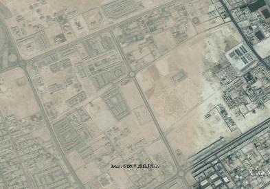
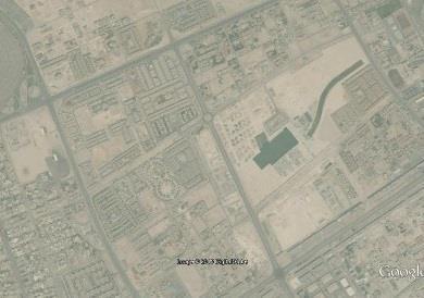


118


119

120 2015 Figure 27: Al Waab Neighborhood Urban Evolution Timeline (Source: Google Earth) Al Waab City, a large-scale residential development, is currently being constructed within the neighborhood boundaries over 1.25 square kilometers, being marketed as a lush landscaped city within a city project, carried out by a group of Qatari investors. The city has been advertised as a place to celebrate life. It will offer around 2,200 housing units, ranging in size from apartments to villas, accommodating over 8000 people. The city will offer a diverse mix of low-density, low-rise neighborhoods (northern, central, and southern districts) encompassing luxurious living, office accommodations, retail space, and parking spaces (City, 2012) (Figure 28). The concept of this development is an enlargement of the idea that a gated community can become a gated town, entirely self-contained. This type of 104

121 development has far-reaching impacts on the spatial urban fabric and the social life of the city. It is interesting to note that the completed parts of Al Waab city are walled and gated developments within the walls of larger gated communities, resulting in doubled-walled residential developments. The specific study area selected for the purpose of this research has a strategic location surrounded by main key roads, namely Al Waab Street, Sports City Street, and Wholesale Market Street (Figure 30). Figure 28: Al Waab City Main Districts (City, 2012) 105
")

122 Figure 29: Al Waab City Vision for the northern district (City, 2012) Figure 30: Satellite image for the location of the study area (Source: MMUP) 106
123 Land Use The land use map indicates that the area of study is dominated by residential use of single family attached/detached villas located inside the development of compounds, as well as a small number of individual villas with commercial uses located on Al Waab Main Street. In total, there are 21 gated developments (residential compounds) of various sizes and design. The rent varies between 14,000 and 18,000QR per month for a 3- or 4-bedroom villa on a compound with facilities. Some of the residential villas overlooking Al Waab Main Street have recently transformed into other uses such as medical, beauty, laboratory, and retail. A few villas located in the inner part of the neighborhood have been transformed into nurseries and another one is used as a short-term rental villa (offering an alternative to hotels). The area also comprises a number of on hold vacant lots which (Figure 33 ), according to the results of this study, might have a potential land use to enhance the livability of the study area. The study area also contains a number of housing amenities inside each compound that vary according to the development size and the level of luxury provided. Most of the compounds in the study area include a great number of amenities, which may be related to the large size of the compounds and the associated luxurious lifestyle. Compared to other gated communities, these amenities are 107

124 more varied than what is usually available in compounds in other areas of Doha. Specifically, these amenities include: clubhouse, swimming pool, gym, and playground. Some of the large compounds include one or more of the following: small mosque, supermarket, small nursery, green space, café, and tennis or basketball court. It is important to reiterate that all of these amenities are completely private, not connected, and located inside the compounds for use by the residents only. Figure 31: Land use map (Source: MMUP) 108

 Figure 33: Examples of")

125 Figure 32: The locations and names of the residential compounds inside the study area (Qatar Map, 2014, edited by the author) Figure 33: Examples of the vacant lots that are located inside the study area (Source: Author) 109

126 Building Heights The studied area is characterized by low-rise (up to two-story and penthouse in some cases) villas, whether seperate, free-standing or inside compounds. Thus, it is considered a low-density residential area. The low-rise urban fabric provides a rather human-scaled environment but only for the internal spaces of the compounds. Outside the compounds, people are delimited by blank walls and wide streets without any connection to the surrounding human infrastructure. Figure 34: Map of the study area shows the building heights (Source: Author) 110

127 Demography Major parts of the neighborhood were initially built to house the increased expatriate population and, until the date of this writing, Al Waab neighborhood is still one of the favorable locations among expatriate populations for Westerners (United States and Europe), Arabs, and Asians. The single land use with low rise villas has resulted in low population density. Data were provided from authorities about the total population of Zone 55 East, without any specific number for the population of Al Waab neighborhood by itself. Figure 35: Population by Gender and Zone, Compound Type According to the reviewed studies that classify gated community types in Chapter 3, the type of gated communities located in the study area can be 111

128 described as entirely private with private internal spaces and roads that have full access control (Figure 36). Guards at the gates completely restrict public entry except for pre-authorized visitors. They also fall into the type of prestige community that are mostly provided by companies to their highly-paid expatriate employees with few shared amenities and facilities. Figure 36: Gated communities type in the study area adopted from (Town, 2007) Housing type inside the compounds varies between attached and detached villas. Each compound provides villas with several floor plans to accommodate prospective tenants (Figure 38). The architecture styles of the villas differ from one compound to another; some are identified as modern design and others are rather traditional, going with whatever suits the designers and owners tastes and desires. 112
.")

129 Figure 37: The security measures at the entrance of one of the compounds inside the study area (Source: Author). Figure 38: Map of Palm City gardens compound located inside the study area, which shows the different types of villas provided 113
130 Public Realm The area is considered a luxury living neighborhood due to the high rents and the attractive names of the compounds, such as Beverly Hills Gardens and Champs Elyse Garden. However, the public realm in the area is very poor, deserted, and mostly empty. It is thought that the disparity between the two comes from the deliberate minimization of routes that connect non-public realms. Alleys between compounds are walled on both sides and lack sidewalks. These areas of public realm are not inviting for pedestrians and generate feelings of unease and invisibility. The compounds act as prestige islands of high-end living that are disconnected from the low-quality surrounding public realm. 114


131 Figure 39: The lack of proper sidewalks inside the study area in-between of the gated communities (Source: Author) 115


132 Figure 40: The deserted public realm inside the study area. (Source: Author) 116
133 There is a severe lack of public spaces in the area, where much of life takes place in restricted environments that require entry permit. They have hidden the life away from the city, leaving the streets empty from any kind of life except passing cars Transportation Currently, the area is accessed by several main roads, including Al Waab Street, which is distinguished by its street lamp design (Figure 41). It is a vital artery that ensures the area s connectivity with the inner city. It is also the same street that intersects after a short distance with Al Shamal expressway, one of the most important expressways in the city. The Sports City Street creates connectivity to the Aspire zone. The Wholesale Market Street connects the area with the major fresh food market and the southern parts of the city. The Al Tuwaim Street serves the site from the inside and connects it to the adjacent properties. Thus, the neighborhood has easy access to most of the major vehicular routes. High traffic is periodic according to school times and sports events held at the Aspire Zone. Cycling routes are featured in Al Waab Main Street on both sides of the road up until Villagio Mall. They are part of a city-wide initiative (Qatar National Master Plan) announced by MMUP in This will involve installing dedicated cycling facilities with each new road project, to encourage sports and activities and in an attempt to find a transportation alternative to cut down on 117
134 traffic jams and improve public health. However, the incorporated cycling lanes still will not perform as a transportation alternative since they are neither connected nor part of a well-established connectivity network. A similar disconnect exists in the case of pedestrian paths, as they exist on both sides of the main streets, but disappear when one reaches the inner roads of the urban fabric. The paths are merely a liner to the edge of the walls that overlook the main street, with no penetration points into the urban fabric except for the exclusive and gated main entrances. In regards to public transportation, bus services of Karwa for greater Doha are provided along Al Waab Main Street and Sports City Street with three bus stations located on the side of the study area (Figure 42). Current under construction Phase 1 of Doha metro has an East-West Gold Metro Line starting at Villagio Mall and running under Al Waab Street (Kovessy, 2013). It follows the road northward, then curves east, passing by a number of stations including Msheireb station, lastly turning south to reach Doha International Airport. Two metro stations are located near the study area. Villagio station is located in the western border of the area, opposite to Aspire Zone. Sports City station is located on Al Waab street within the border of Al Waab neighborhood. Figure 44 shows the metro lines going along Al Waab street and Salwa, with the projected stations. 118


135 Figure 41: Al Waab Main Street Figure 42: Bus stations located in the study area (Source: Google Maps) 119
 Figure")

136 Figure 43: Doha Metro: Phase One, Gold Line (Kovessy, 2013) Figure 44: Metro lines and stations nearby the study area (Source: MMUP) 120
137 5.2. Observations After conducting walkthrough visits to collect general data about the site, a significant amount of information was collected and used in the aforementioned site analysis. The observation technique of data collection was applied mainly by evaluating the site characteristics against the adopted livability dimensions in this research. The observed data for each dimension were mapped. The mapping discloses a specific image of gated communities potential impact on the neighborhood livability. The findings were further analyzed against a livability checklist to determine the status of each livability indicator. Density and diversity of land uses The whole territory of the study area tends to be organized into disconnected zones of mono-functional use for single-family residential accommodation, almost exclusively occupied by higher-income populations. The residential accommodations are designed to be located within gated developments and a small number of individual gate-free villas. Other uses in the area are limited to the newly converted liner plot on the main street of Al Waab for commercial use and one secondary school, the Newton British School. In addition, a few former inner villas have been converted to short accommodation services and nurseries. The housing is limited to twostory villa type, either attached or detached. 121
138 Facilities provided inside the compounds are completely private to the residents. One mosque (Masjid Al Mana) is located near the study area; however, it is mostly reached by car. The newly converted villas of small businesses are struggling due to incompatible designs that cannot accommodate such commercial use, and they face difficulty due to a lack of proper accessibility and parking spaces. Thus, there exists a markedly high risk of failure for these services. 122
")
139 Figure 45: Detailed land use map for the study area (Source: Author) 123
140 Connectivity and accessibility The cluster of gated developments in the study area has major consequences on the surrounding infrastructure, accessibility, and functionality of the study area, especially the extensive areas enclosed. Boundary physical barriers around developments limit access and create visual screening. The result is an exclusionary environment with large areas closed off to general public access, causing fragmentation of the urban and social fabric. These gated communities transform into isolated islands that sever the continuity of the urban fabric. The concentration of these gated settlements has reduced connectivity and accessibility through and within major parts of the area. This reduction in permeability has the effect of increasing trip lengths for all modes of travel. Moreover, the increased travel time and mobility of pedestrians becomes excessive. The right of way is limited to key roads that surround the gated development, where the internal street network is private and inward oriented, failing to offer continuity for the external routes. 124
")
141 Figure 46: Walls and entrances of the gated developments in the study area (Source: Author) 125
142 Walkability The constructed sidewalks in the study area are limited to the edges of the major streets, where they are a liner to walls and lack penetration points. These walking routes are poorly marked and make crossing the street a difficult process. The lack of signage does not provide a safe environment for pedestrians and does not facilitate their movement. These sidewalks are not connected to the internal secondary roads, and the internal secondary roads often lack sidewalks. If there are sidewalks, the walking spaces are sandy, unpaved areas between the compounds. The pedestrian behavior of residents is affected, whether within the walls or when traveling outside their compound, due to the permeability reduction and fortification of the development. Residents must make their way to the entry points before they head toward their destination, and outsiders have to travel around the gated community as they cannot walk directly through it. 126
")
143 Figure 47: Map shows the right of way in the study area (Source: Author) 127
144 Social interaction and co-presence According to the previous illustrated spatial conditions of inaccessible, isolated, single-use, and single housing types, the social interaction and co-presence have been drastically affected. Social segregation and social fabric discontinuity is taking place in these communities. While residents of the same gated community might interact with neighbors during their use of shared and exclusive amenities, the chance to interact with other residents from neighboring blocks (i.e., non-gated communities) is almost nonexistent. There are no chances for natural interactions to occur, as the lack of public spaces leads to social separation from the poor public realm. Moreover, the layout of the compounds with the low rise of the buildings, setbacks, inward orientation, and wide streets has decreased the shaded areas in the public realm and made it uninviting for public gathering. In addition, facilities of intense public interaction that exist outside the gated communities can be reached only by car. 128

145 Figure 48: Gated developments and the internal private/public spaces (Source: Author) The findings of these observations are further detailed according to the status of each indicator, as shown in Table
146 Table 7: Observations Checklist Results Principle Indicator Status Comments Density and Diversity of Land Uses Connectivity and Accessibility Mixed uses within neighborhood development (retail, commercial, housing, public facilities) Mixed uses within buildings (retail, commercial, apartments, public facilities) Density of land uses within close proximity Limited to small commercial uses in one edge of the area plus a secondary school No existing mixed-use buildings Dominant single land use of residential accommodation Mixed sizes of building plots The building plots inside each compound are approximately identical. Mixed housing types Only villas, but number of floor plans could be provided Mixed price levels of housing Only high-income groups paying a minimum of 14,000 QR/month Density of building with height alterations Diversity of households from all ages, income groups, and cultures Hierarchy of boulevards, streets, and alleys Interconnected street network to distribute traffic G+1 height for the whole area with few G+1+P Very small number of elderly as mostly rented by working contract; cultures differ but typically houses expatriate population Could exist in case the internal roads and alleys of gated communities not privatized Not considered as the gated developments block the access and increase traffic jams Interconnected pedestrian network Not considered Interconnected bicycle lanes Only on Al Waab main street Interconnected and accessible public transportation Karwa bus network with three stations in the study area, and the future metro line and stations are under construction Well-connected public spaces Scattered private public Public amenities positioned within 5 to 10 minutes walking distance spaces only Private amenities inside each compound only 130
147 Walkability Pedestrian-friendly, humanscaled Inside gated public realm developments only Car-free streets where possible Not considered Slow-speed roads with traffic calming methods Internal streets of gated developments provide calm traffic environment Small parking lots Not considered Buildings, stores, porches, and windows close to streets Inward orientation with walled boundary Marked road crossings Rarely exists Social Interaction and Copresence Street-level stores and street cafes Not considered Choices of social activities Limited to isolated social activities inside each compound Everyone is welcomed to public spaces Guards and barriers of compounds prevent public access No kind of exclusion Deliberate exclusionary infrastructure (walls, gates) Human-scaled public square Does not exist Accessible green and parks Privatized pockets of greens inside the compounds Public playgrounds Privatized playgrounds inside the compounds Public outdoor room No such spaces in the study area Visual access to public spaces eyes on the streets Not considered Sense of place and character Each compound has its unique character 5.3. Morphological Analysis The study area was compared with the Al Asmakh neighborhood, Zone 4, centrally located in the old part of Doha downtown near the western edge of Inner Doha, less than 0.5 kilometers south of Doha Bay (Figure 49). 131
148 The Al Asmakh neighborhood has a strategic location surrounded by main key roads, namely: Wadi Msheireb Street, the A Ring Road and Al Asmakh Street. The area is considered a traditional-built environment, which represents an important stage in Doha City development. The analysis shows major differences of urban form between the two sites. Looking at the urban morphology in both areas, one can see differences between the urban tissues. In Al Asmakh, the primary road network is tightly knitted with secondary roads that assure easy access between various points despite some dead-end street configurations. The old urban fabric of Al Alasmakh can be largely qualified as being permeable, as it is composed of narrow streets and small blocks. It was constructed on the human scale, where the design of narrow streets influences slower traffic flow, much like what is achieved with the traffic calming environment inside the gated development but without privatizing the spaces. Al Waab is clearly different. Comparably, the narrow roads and small block sizes found in Al Asmakh became exceedingly large at the Al Waab site, eventually transforming into massive gated residential compounds. Inside these gated compounds, there are only private and narrow roads. The large blocks and physical barriers restrict connectivity and negatively influence the relation between different points of the site. 132

149 The site shows low penetrability and is not reflective of greater Doha vernacular urban morphology or typo-morphology. Thus, the urban form of the gated developments offers a poor image for the Doha urban fabric, clearly differentiating itself from rich traditional fabrics like Al Asmakh. Although the urban fabric of the Al Asmakh neighborhood includes some relatively new construction interventions, especially in some parts near the edges, the internal older part is composed of fine-grained urban tissue with courtyard houses which provide compact, higher-density urban fabric than the villa type used in the gated development with the wide setbacks. Figure 49: Aerial photo of Doha traditional downtown with Al Asmakh neighborhood in the bottom left (Boussaa, 2013) 133
")
150 Figure 50: Morphological Analysis: The Al Waab and The Al Asmakh neighborhoods (Source: Author) 134
151 5.4. Interviews The topics and points of discussion with the focus group of Development Institution Professionals are summarized and analyzed in Table 9. Table 8: Information From the Interviews Interviewee Organization Date and Place Discussed Topics E. S. Site Designer Engineer MMUP Sunday 23 rd August 2015, 12:00 p.m., MMUP offices, 10 th floor, West Bay - Future plans for the situation of residential compounds Urban Planning Department A. T. Civil Engineer Development and Building Permits Department MMUP Al Rayyan Municipality Sunday, 25 th Oct 2015, 10:00 a.m., Al Rayyan Municipality building, 1 st floor - Existing regulations for residential compounds - Existing permitgranting process - Metro circulation map and stations in Al Waab area Discussion A number of initiatives have spots on the agenda of MMUP concerning the situation of residential compounds in Doha. The following are a few examples: 135
152 The possibility to sort the villas inside the residential compounds Thus, the owner has the ability to sell individual villas instead of having the whole compound take up an entire block. Conversion of the use of existing residential villas to service activities This setting is restricted for villas overlooking the street, according to specific planning regulations restricting the distance between the two services, the street width, and the number of cars needed to serve each activity. The planning regulation has been set in order to provide each district with the required services (selecting from the 11 activities allowed) and to avoid generating traffic jams. Conversion of existing residential complexes to a villa hotel complex in accordance with additional planning requirements and regulations The result would be a minimum area no less than 4 ha with maximum 25 villas in each hectare, including a main entrance street 30m in width, and a number of specific quality amenities inside the compound. There is an intention to take down or reduce the height of the residential compounds walls while maintaining security and privacy for first-row villa owners. This is a deliberate initiative to reduce the impact of walls on social movement and interaction, as it has been discussed in this survey that the existence of walls and their height disrupts the social fabric. 136
153 The above steps are being studied on a case-by-case approach; thus, the owner of the compound asks for transformation, and MMUP studies the request and offers an official agreement or disagreement. Each approved regulation will be optional for existing compounds and obligatory for future newly built ones. Currently the urban planning process in MMUP is responsible for making realtime instantaneous decisions to keep pace with the increase in population, and to address the urban development s situation under temporary qualifications conducive to development until the comprehensive vision of Qatar 2032 is approved and issued. MMUP regulation with connection to residential compound development The city of Doha has set regulations for residential compound development. Three criteria were established based on the compound size, which is divided into three categories: ha, ha, and ha. Each compound size is governed by the following constraints: maximum density, permitted use, minimum building setbacks, building size and number of units, built-up area, private yard requirements, building height, parking requirements, vehicular access, and common park and amenities. (See Appendix B). Each criterion is set accordingly: 137
154 Maximum density criteria have two limitations: (1) a maximum of 30 u/ha outside Greater Doha area, and (2) a maximum of 35 u/ha inside Greater Doha. This applies to the three compound sizes set by the regulatory body. Exceptions were made available for large developments of the third size, which permits up to 40 u/ha outside and 45 u/ha inside Greater Doha. Permitted use is also dependent on the compound size. However, villas and attached villas are common in all sizes. Whereas the smallest size of compounds is limited to these uses only, the second size contains (in addition to the villas) row houses and buildings with other uses (mosque, nursery, fitness and recreation facility, clubhouse, administration, and commercial). The largest size (size three) of the compound development has permitted uses of all of the previously mentioned uses plus G+1 to G+2 townhouse apartments. Notably, the minimum building setbacks are set similarly in all cases as per the following: from boundary 5m adjacent access road and 3m from other boundaries, front (façade-façade) 12-14m on internal roads, side (façade-façade) 6m with windows and 3m without windows, and the rear (façade-façade) is 6m. The building size has a fixed width for minimum 8m for all permitted housing types, while the length of the building is a maximum 50m for the 138
155 row houses and townhouse apartments. Buildings of other uses inside the compound are decided on a case-by-case basis. The maximum number of row houses inside the second and third size compounds should not exceed 50% of villas. The total number of apartment units cannot exceed 50% of total units in the compound. The number of building units have a maximum of 18 units G+1 or a maximum 20 units G+2. Built-up area minimum is 150sq.m/unit for the two smaller development sizes in both outside and inside greater Doha. For larger developments of the third size, there is a differential built-up area and it varies for outside and inside Greater Doha (outside is 200sq.m/unit and inside is 150sq.m/unit). Nonresidential developments are evaluated based on their intended design and use. Minimum of 25sq.m for yard size is required for each unit in all of the compound sizes, with the possibility to be partially covered up by the upper level. Villas, attached villas, and row houses are allowed for G+1+P (penthouse) in all compound sizes. However, townhouse apartment buildings in the large compounds are allowed G+1 and G+2. Parking requirements are fixed in all cases, with 1.25 stalls/unit on average plus 0.15 stalls/unit for visitors. 139
156 The number of vehicular access differs according to the size of the compound development. o First size is restricted to 1 main entrance with guard-house and a road of minimum 8.0m width. o Second size is allowed for 1 main entrance with guard-house and 1 emergency access, with a main road of 14m with sidewalks and median. Primary and local roads inside the development must have 8m width, with or without sidewalks. o Likewise, the third size has the same requirements of access points and hierarchy of roads with one exception for compounds greater than 8 ha, as they are required to have a minimum of two main entrances in addition to the emergency access. The size of common park and amenities is 5% of gross site area or 250sq.m for the small compound size, and 8% of gross site area for recreational park and minimum park size of 225msq.m. It can include one or more of the other uses mentioned earlier. Building coverage for compounds less than 4.0 ha is a maximum of 40% of the gross site. For compounds greater than 4.0 ha, 35% of the gross site is applicable when G+2 townhouse apartments are proposed. 140
157 Exceptions of approval are given for what are called semi-compounds (minimum 1600sq.m area size), provided that the main frontage is not less than 36m. The development permitting process Upon developers request, the design firm prepares and submits Design Concept 1 (DC1) to the corresponding municipality. This design concept will then be reviewed against the following guidelines: Zoning variation via Land Info System software, which will provide data pertaining to on-hold plots and future public works with the right of way. The file will then be forwarded for review by the Ministry of Transport (MOT), Civil Defense, and Qatar General Electricity and Water Corporation. MOT will evaluate medium and large compound developments in terms of the location of entry/exit points, the impact on surrounding traffic flow, and traffic movement within the development. Following that, layout and subdivision plans will be verified against the criteria of the previously mentioned residential compound development regulations. Upon granting approval for DC1 incorporating all areas of concern, the design firm will then submit Design Concept 2 (DC2) documents, which will also be reviewed by a number of public work authorities. Eventually, the permit will be issued based on the final DC2 document submittal, incorporating comments from concerned entities. 141
158 Going through the policy, it can be noticed that it mainly involves the architectural design of the buildings with minor contribution to the urban masterplan of the whole development. However, no regulations are set to determine the architecture style of the villas in a certain district or the height and design of border fences and walls, which play an important role in neighborhood character. Equally important, no regulations are set for gated development urban planning and design with connection to the surrounding context. As they are using the one design fits all approach, where they deal with the compound as an isolated unit with its own regulations that can be implemented anywhere, no consideration is given to the adjacent urban fabric Questionnaire Survey This survey offers an insight into the gated living experience by providing an avenue of analysis for participants responses according to a set of identified themes as per the following. (For more details, see Appendix C) 142
159 The appeal of gated communities living and the motivations for moving there Table 9: Questionnaire Survey Results Q No. Question Answers and proportion of responses No. responses Example comments 1. Is living in a gated community appealing to you? 3. What was your motivation to move into a gated community? 4. If the reason is safety and security, what does it concern? - Yes (66%) - No (7%) - It depends (28%) - Don't know - Working contract (35%) - Safety and security (48%) - Sense of community (31%) - Lifestyle and prestige (16%) - Traffic calming environment (14%) - Other (please specify) (20%) - Fear of crime (15%) - Fear of non-specified "others (13%) - Safe environment for your children to play (88%) - Other (please specify) (4%) Facilities, availability, good quality houses, no other choice, maintenanc e 92 Neighbors to help in emergency These questions were asked to explore residents feelings about living in gated communities and to address the motivations of residents who choose this form of housing. The findings reveal that a higher percentage show interest in living in a gated community as the idea of living in an exclusive area that is only accessible to some. 143
160 People s motivations converge with the highest percentage around safety and security followed by working contract and sense of community in a slightly lower percentage. These factors were cited as the respondents greatest influence for choice of residence. However, when residents were asked about their concern for safety and security, a significantly high percentage indicated that having a safe environment for their children to play in was very important. This explains the lack of proper neighborhood planning where the daily activities such as the neighborhood park or the kid s playground are not in close proximity of walking distance to every residential area. Outside the gated community, there is no hierarchy for streets, no safe streets, and no sidewalks. It is a car-dependent society, so cars are everywhere; as a result, people are not feeling safe, and they need gated communities to walk, and to have their children play safely. Moreover, in light of the inefficiency of public housing in Doha, gated communities represent the best of city living for families in terms of facilities, housing size, and affordability in comparison with standard individual villas. Thus, at the current moment, the housing market is more likely to have people reside inside compounds, but may decline when a competitive alternative is provided in the market. 144
161 Land use, facilities, and housing types Table 10: Questionnaire Survey Results, continued Q No. Question 6. What kind of local amenities do you have outside your compound within a radius of 1 km? Answers and proportion of responses - School (38%) - Supermarket (65%) - Grocery Store (53%) - Neighborhood Park (38%) - Other (please specify) (25%) No. of respon ses Example of comments 122 Compounds only, sports facilities, malls, petrol station, nothing 7. In case some or all of them exist. How do you reach these amenities? 12. What are the housing options available inside your compound? 13. Which of the following facilities is/are available inside your compound? 14. In your opinion, what kind of facilities are missing in your compound? - By car (96%) - By bus (1%) - By bicycle (5%) - On foot (30%) - Other (please specify) (4%) - Individual villas (54%) - Attached villas (56%) - Apartment buildings (30%) - Other (please specify) (1%) - Green area (37%) - Children playground (68%) - Clubhouse (80%) - Mosque (30%) - Swimming pool (93%) - Supermarket (37%) - Other (please specify) (24%) 121 Taxi Gym, spa, laundry, hairdresser, sports court (Open-ended answers) 97 Mini market, indoor children playground, coffee shop, green area 145
162 The previous questions were posed to investigate the density and diversity of land uses in and around the compound development and how people use the associated services. The housing types and provided facilities within the compound were questioned. For the surrounding amenities, the respondents gave approximately evenly distributed answer rates, with the highest percentage for the existing of nearby supermarket. This was expected with regard to the city s new policy that ensures the distribution of Al Meera and Al Forjan Markets inside each neighborhood. Nevertheless, the majority of residents stated that they use a car to reach the surrounding amenities. Although neighborhood schools existed at a slightly lower rate, comments by the respondents indicated that their kids are going to another far-reaching school due to nationality and type of required school. The dominant response for the housing types provided in each compound for villas falls into two types of attached and detached, whereas apartment buildings had a much lower rate. Inside the compound development, facilities reported by respondents were mainly swimming pool, clubhouse, and children s playgrounds with lower rates for green area, supermarket, and mosque. This explains the focus of developers on providing a lifestyle to attract people and accommodate the needs of the expatriate community. However, numbers of comments from the 146
163 respondents indicate the insufficient maintenance and poor cleaning condition of the pool and other facilities led to the resident(s) preferring not to use them. Walkability and accessibility Table 11: Questionnaire Survey Results, continued Q Question No. 5. How do you reach the city? 8. Do the walls and gates of your gated compound affect your connectivity with the surroundings? 9. Do you find it difficult to walk to a neighboring block? 19. What are the security measures provided at the compound main entrance? Tick all applicable. 20 When do gates or barriers open? 21. In case there are guards on the main entrance. Who is allowed to Answers and proportion of responses - By car (100%) - By bus (1%) - By bicycle (0%) - On foot (2%) - Other (please specify) (2%) - Yes (31%) - No (59%) - Don't know (11%) - Yes (36%) - No (47%) - Don't walk (17%) # If yes, why? Pl. mention: - Guards (91%) - CCTV (51%) - Gates (77%) - Barriers (54%) - Other (please specify (6%) - Upon entrance only (72%) - During the whole day (9%) - Day and night (20%) - Residents only (2%) - Residents and their guests (86%) - Open to public (12%) No. of respons es 130 Taxi 128 Example of comments 131 Because of the walls and gates, no proper pavement or footpath, long distance to walk 129 Razor wire on the walls, police
164 enter the compound? 22. What are visitors required to provide upon entry? - ID (68%) - Name and/or number of the resident s place (56%) - Nothing (21%) - Other (please specify) (1%) 131 Residents enter through card or face recognition Walkability and accessibility were explored at three levels: the city level, the contextual neighborhood, and the gated development. This section of the survey also examines the effect of the physical presence of gated boundary and security measures on the residents and non-residents travel behavior for either pedestrian or vehicular movement. Responses show that overwhelming percentages (100% of respondents) reach the city only by car. Similar rates were given to the impact of the walls and gates on the connectivity with the surrounding area and the ability to walk to a neighboring block. Comments on the difficulty of walking included: the lack of footpath, no proper pavement, no place to walk to, long distance for walking, and speeding cars that make it unsafe to cross the street. In the question about how the residents reach the outside facilities, a high rate of 96% responded that they use their car. Yet, the non-residents (public s) accessibility was addressed through three questions about the security measures provided at the main entrances. A large set of respondents reported having guards at the main entrance of their compound in addition to gates or 148
165 barriers that open upon one s entrance only. Respondents claimed in a high percentage that only residents and their guests are allowed to enter the compound. Residents usually enter by providing a card placed on the car windshield or through face recognition by the guards. Guests are subject to ID control and/or providing the the resident s address. These results show that the physical gating and the security measures negatively impact the walkability and accessibility for both residents and non-residents of gated developments, which limit the livability factor inside the neighborhoods and enhance spatial segregation. 149
166 Social interaction and sense of community Table 12: Questionnaire Survey Results, continued Q No. Question Answers and proportion of responses No. of respons es Example of comments 10. Do you consider the streets outside your gated community as vital streets? (In terms of human street level Interaction) 11. Do you interact with people living in your surrounding area outside your compound who can be reached within walking distance? 15. Do you interact with people living inside your compound? 16. If yes, where do you usually meet? 17. What is your perceived sense of community and identity within your compound? 18. What do you feel your compound lacks in terms of community identity? - Yes (21%) - Sometimes (21%) - No (45%) - Don't know (14%) - Yes (18%) - No (82%) - Yes (84%) - No (16%) - House visit (62%) - Street or main entrance (59%) - Clubhouse (31%) - Mosque (12%) - Other (please specify) (22%) - Non-existent (15%) - Not strong (37%) - Somewhat strong(33%) - Strong (12%) - Very strong (3%) - Community activities (68%) - Public spaces (35%) - Non-resident interaction (24%) - Safety (6%) - Other (please specify) (6%) Swimming pool, playground Multi-cultural interaction, better compound managemen t 150
167 The previously listed questions were asked in order to investigate the level of street vitality and social interaction. Also, they measure the perceived sense of community for the residents of one compound. Regarding the respondents community interaction, residents reported a high percentage (84%) for their interaction with other residents living inside the same compound. The most common way of interacting was house visits, followed by a slightly lower percentage for the outdoor space of internal streets and main entrances as places of social interaction. A significantly lower percentage of respondents interacted with non-residents of the compound within the same neighborhood. The mean response of overall perceived sense of community is not strong with a slightly lower rate for community being somewhat strong. The reasons described were the lack of community activities, public spaces, and non-resident interaction. However, providing a shared public realm is the most important factor to establish community and allow activity to occur and invite diverse groups of people to interact. 151
168 Level of satisfaction and willingness to live in a non-gated community Table 13: Questionnaire Survey Results, continued Q Question No. 23. How do you rate your satisfaction with your gated community? 24. If satisfied, what is the reason behind your satisfaction? 25. If unsatisfied, please mention the reason behind your dissatisfaction. Answers and proportion of responses - Very satisfied (16%) - Satisfied (46%) - Medium (28%) - Unsatisfied (8%) - Very unsatisfied (2%) - Appearance and quality of housing (62%) - Security (57%) - Availability of parking spaces (52%) - Facilities (51%) - Fellow residents (33%) - Other (please specify) No. of respo nses 130 Example of comments 103 Independence, Service, Rent is reasonable, Convenience (12%) (Open-ended answer) 26 No sense of community, parking spaces are limited, poor compound management, too much security for guests, no green area 26. Would you live in a non-gated community in the future? - Yes (25%) - No (24%) - Whatever is available (31%) - Don't know (20%) # If yes, why? Please mention 131 Searching for good community, It is safe to live anywhere in Doha 152
169 In order to learn from the success factors of gated communities, the level of satisfaction was addressed in three questions. Higher percentages of 46% for satisfied and 28% for medium satisfaction were conveyed respectively. The results show a generally even distribution of reasons behind residents satisfaction, with the higher rate for the appearance and quality of housing followed by a slightly lower rate for security, availability of parking spaces, and facilities. Conversely, a small set of unsatisfied respondents declared their dissatisfaction due to the absence of community sense and social life, the lack of green areas, the poor compound management, and the excessive security measures for the residents guests. 153
170 The nature of gated community demographics in terms of cultural background, age, and household structure Table 14: Questionnaire Survey Results, continued Q No. Question Answers and proportion of responses 27. Nationality - Qatari 1% - Arab 32% - European 30% - American 15% - Asian 12% - Other (please specify) 8% 28. Marital status - Single 5% - Married 32% - Married with college-age children 4% - Married with school kids 29. How many people currently live in your house 60% people 11% people 58% people 30% people 2% 30. Gender - Male 30% - Female 70% 31. Age % % % % - 60 and above 2% No. of responses Example of comments 130 Australian Canadian Pakistani African For general respondents characteristics, the main demographics are composed of expatriate populations, with the highest percentage for Arab and European followed by the American population with a lower rate. Only 1% of 154
171 the respondents were Qataris, as they usually prefer to live in individual villas rather than compounds. The largest group of respondents are married with a high percentage for families with school kids. Only 5% of respondents were single. A household size of 3 to 4 people was the highest group reported by the respondents, with a lower rate for 5 to 6 people living inside one house. The communities have residents of ages as the largest group followed by a slightly lower rate for groups of This is due to the large working group of expatriates in the city of Doha who are mostly residing in compound developments through their working contracts. Younger groups of single or newly married would prefer smaller size apartment living which is available in apartment buildings and residential towers Conclusion This chapter has presented the analysis done on the data collected for the study area. The case study analysis was an exploration of how physical gating affects the livability within a neighborhood development. It also provides insight into the condition of gated developments in the whole city of Doha especially that the survey included some responses from people residing in compounds outside the case study area. The results of the analysis offer grounds for a conclusion that the challenges of the Al Waab to provide for urban and social livability are due to the lack of 155
172 density and diversity of land uses, limited accessibility and connectivity, and absence of social interaction of diverse groups. Based on these findings, recommendations will be put forward in the following chapter in an effort to limit the negative impacts of physical gating and to integrate the gated development within the surrounding urban context. This can be achieved through the employment of the adapted livability principles with reference to the best practices of gated development policies in order to structure an urban pattern that would increase the neighborhood livability. The research recommendation will take into consideration future visions for Doha city set in the QNDF 2032, which aims to restructure the city into a compact, polycentric city with opportunities for mixed-use establishments so that urban developments would include elements to service all aspects of one s existence in urban space (QNDF, 2014). 156
173 CHAPTER SIX: CONCLUSIONS ON ANALYSIS AND RECOMMENDATIONS The following chapter offers a conclusion to the study and answers the research question and hypothesis set at the beginning of the study. It also presents a recommendation for enhancement of the livability of gated communities in the Al Waab neighborhood and finally closes with remarks about future research directions with regards to the emerging urbanization patterns in Doha Answers to Research Questions Based on Analytical Conclusions From the research methods, informative results have emerged supporting a number of the research hypotheses and have refuted others. How do gated communities affect neighborhood livability? After conducting the literature review, this question was divided into four sub-questions that address specifically each of the identified and adopted neighborhood livability principles as per the following: - What is the impact of gated communities on the density and diversity of land uses within the neighborhood? The results show that the gated communities provide a dominant residential land use with minimum private amenities provided for the residents only. The large area size of such developments result in a remarkably low density of land uses around them that 157
174 are hardly located within walking distance from the residential units. The cluster of gated communities in the study area presented a major negative impact on the distribution of services including open spaces and neighborhood parks. - Does the presence of gated communities affect the connectivity of street networks and the accessibility to public spaces? The results clarified the segregated nature of the gated communities that caused an isolated functional spatialization that negatively affects the permeability and connectivity in the adjacent areas. The physical presence of the perimeter compounds walls impedes the connectivity of street networks and interrupts the continuity of pedestrian paths. This decrease in connectivity results in an increased trip length for the different modes of transportation. The security measures located at the main entrances of gated developments block the public accessibility, as only residents and their guests are allowed to enter the private realm that exists behind the gates. - Do gated communities encourage walkability? The findings indicate that residents of gated communities in Doha reach the city and the surrounding facilities mainly by car. Even 158
175 though it shows that walkability is not affected by the presence of the walls and gates but rather because of the improper design of the public realm, the absence of sidewalks and pavements decreased connectivity within the neighborhoods. However, the inward orientation of gated developments with the solid blank interface of perimeter walls leaves deserted streets in the surroundings, walled from both sides with minimum openings limited to the secured entrances only. Moreover, open spaces are privatized inside the gated development. Thus, the public realm becomes limited to vehicular streets that do not invite pedestrians and give a sense of unease, as majority of people reported the surrounding streets as not vital in terms of human level interaction. - Do gated communities promote social interaction and copresence of diverse groups? Gated developments layouts exhibit very low potential for creating interface conditions between people moving on the street and compound residents, indicating lack of possibility for social exchange between gated compound residents and streetwalkers (if streetwalkers exist). 159
176 This lack is due to physical presence of perimeter walls, inward housing orientation, and the absence of public spaces that endanger social interaction and co-presence. Moreover, the results indicate that residents of gated communities usually interact with other fellow residents living inside the same compound, but rarely interact with non-residents living in their surroundings. Although, the residents reported their perceived sense of community as not strong and lacking community activities, public spaces, and non-resident interaction. Gated communities do not promote social interaction and copresence of diverse groups also because they do not provide a mix of housing types, sizes, or rent levels. How do the gated communities neighborhood of the Al Waab compare in a morphological analysis with other traditional more organic neighborhood within the city of Doha? The morphological analysis of Al Waab neighborhood and the traditional neighborhood of Al Asmakh in the core of the city shows major differences in urban form between the two sites. The central zone of Al Asmakh neighborhood retains grid intensity with fine grained, compact, well-connected urban fabric. In contrast, the recent planning of Al Waab study area offers regular, largely spaced, disconnected grid patterns, which seem incapable of structuring a livable neighborhood locality. 160
177 Thus, major morphological differences have been identified in the plot sizes, building density, type of blocks, and quality of connections and accessibility. The Al Waab study area exhibits large plot sizes for gated development with internal low building density; the large grid divisions translate to very low accessibility potential for pedestrians, as well as a poor distribution of land use. Further, the circulation track layout, which represents the public right of way in the study area, coupled with the privatization of large areas, contrasts with the more densely interconnected grid of the Al Asmakh neighborhood. What is residents motivation behind choosing to live in a gated community? The findings indicate that people in Doha are primarily motivated to move to gated communities for security reasons, as part of their working contract, and the package of dwelling and facilities. However, the security factor is defined as the primary reason for moving, alongside other exclusionary benefits such as reduced traffic and increased road safety, and thus suitability of the development for kids. Fear of crime was an uncommon factor for residents to live in a gated community. This is related to the high safety standards that are prevalent in the state of Qatar. Thus, the gated community in Doha is more sought- 161
178 after because of the insufficient planning of public housing and the inadequate provision of facilities and public spaces. Based on the above findings as related to the gated communities livability deficiencies, and in context of the increased popularity and proliferation of such communities, gated developments in their existing form should be discouraged, as they have negative impacts on the neighborhood livability. However, if they must be allowed in any way, then they should be controlled to ensure when permitted that they conform to acceptable standards and that potential adverse impacts are minimized or mitigated. Therefore, following are the research recommendations with reference to the adapted livability principles and best practices of policy and planning responses Recommendations for Improvement of the Livability of Gated Communities It has been shown that the study area lacks a number of neighborhood livability principles identified as important in this research, which are the foundation for neighborhood livability. In order to mitigate their negative impacts and better adapt the gated communities into the urban fabric, recommendations will be given to make sure that they are more livable and better integrated into the city. The recommendations will take into account the best practices of policies and the adapted livability principles described in the third chapter, to give solutions that address most adequately the livability disadvantages of the area. 162
179 The hypothetical proposal for the study area is a two-phase approach that responds to the research problem. The first phase comprises minor interventions that could be done in the near future. The second phase includes major interventions that could be applied later depending on economic feasibility. The first phase mainly considers pedestrian connections and takes into consideration any existing developments, only proposing intervention on vacant plots locating public facilities to give the possibility for neighborhood residents to reach them on foot. Figure 51 sketches out a conceptual urban design proposal that intends to provide pedestrian walkways to reach the public facilities, which are suggested on the vacant lots. The walkways will form a green network, planted with trees to provide shading and become more pedestrian-friendly. To ensure the continuity of the pedestrian access through the gated developments, the number of access points should be increased and welllocated to ensure direct and easy access. Thus, regulations should be appointed to guarantee public access to open space inside the development. However, public access to the compound open space does not give a right to use residents recreational amenities. Private use of recreational amenities could be preserved by the use of a pin code or a swipe card with lockable gates, which could be unlocked only by residents. 163
180 The proposed facilities in the vacant lots refer to the guidelines of QNDF regarding local area centers that should provide daily and weekly needs to new and existing communities in the district and local center scales based on a specific walking diameter of 250m-400m. These facilities include a district park, local park, school, mosque, supermarket and other retail, healthcare facilities, and community facilities. Figure 52 illustrates the proposed distribution and locations of the facilities on the vacant lots, where Land Number 1 is proposed to be a mixed-use development of four-story residential buildings with a mix of shops, offices, and health services on the ground level. Land Number 2 is proposed to have community facilities such as recreational facilities, a community center, and kindergarten. Land Number 3 is allocated for a mosque. Land Number 4 is proposed to be a district park and Land Number 5 would become a small local park with kids playground. All of the proposed facilities should be supplemented with an adequate number of ground-level small parking lots to serve the new uses, but large underground parking is encouraged to better optimize the ground floor area and preserve open, green spaces to provide a quality, pedestrian-friendly public realm. A number of the existing villas overlooking the newly proposed facilities are converted to other small retail buildings, catering activities or street cafés where enough parking spaces are provided across the street. 164
181 Connectivity to the nearby future transit station and existing bus stops is ensured through the continuity of pedestrian paths and by increasing the number of street-marked crossings, especially on Sport City Street. It is also recommend to have either a pedestrian-controlled signal to allow for foot traffic between communities on one side of the road and the future transit station on the other side; alternatively, a proposed pedestrian bridge or an underground pedestrian tunnel crossing the street. The first phase should include adjustments to the boundary walls to ensure visual permeability to public areas inside the compounds in order to limit the negative effect that results from the continuity of high solid walls facing onto the adjacent streets of the public realm. The perimeter wall or fence should be visually permeable where possible to maintain the visual integration and give a sense of safety for the surrounding public realm. An immediate option will be to implement a shade requirement along the boundary walls, which will be an easy and quick concept to introduce a shade system that will enable residents use of the space provided near boundary walls throughout the day and enhance the pedestrian experience. Another approach, which can be applied as a first step intervention for the boundary walls, is to make them green walls (hedges) especially when they overlook private areas inside the compound. 165
182 Figure 54 shows an example of the proposed green boundary wall, which is followed by a proper sidewalk maintained on both sides of the street and provided with tall landscape for shading. Cycling lanes are proposed on one side of the street and a linear parking lane on the other side. In addition, the figure illustrates the villas with converted uses to have porches and direct entrances from the sidewalk with no boundary walls in order to activate the public realm and enhance the accessibility. 166

183 Figure 51: Plan showing the first phase recommended interventions in the study area. (Source: Author) 167

184 Figure 52: Site plan for the first phase of the proposal. (Source: Author) 168

185 Figure 53: Map showing the possible connections between the study area and its surrounding. (Source: Author) 169

186 Figure 54: Street section and layout for the first stage proposal. (Source: Author) 170
187 The second phase proposes more serious interventions inside the study area (Fugure 55). It does not call for a complete alternative of gated living, rather it shows ways to limit the negative impacts of gated communities when planned, and make them more integrated within the surrounding urban fabric. It also takes into account the principles of livable neighborhoods for density and diversity of land uses, connectivity and accessibility, walkability, and social interaction and co-presence. In addition, the research findings with regard to people s preferred features of gated communities which highlight that neighborhood s design should provide security, privacy, sufficient traffic management, and desirable local amenities. Certainly, the kid-friendly environment and recreational facilities were highlighted as desirable factors by residents of the case study area, and this may indicate a need for the provision of traffic calming measures, safe sidewalks, and crossings and additional recreational facilities within neighborhoods. The urban design of the neighborhood should include places, spaces, and communities that encourage social interaction and cohesion. Efforts should be put on the public establishment of facilities, infrastructure, and services in order to reinstate confidence in the public realm. Building on this, the second phase proposal advocates smaller circulation tracks and block sizes for the area, based on considerations for pedestrian and 171
188 vehicular movement and accessibility. The smaller grid of the proposed scheme allows for an increase in building density and street frontage and allows for greater accessibility and pedestrian circulation opportunities. Plots parallel to the Al Waab main street should be designed as low- to midrise, mixed-use buildings arranged in clusters with mainly residential use, interspersed with offices and ground level commercial and catering activities to service the residents and create a street interface. This will form a natural edge to the neighborhood beside the major roads instead of the enclosed blank edges of the gated development. The large-scale gated development should be broken down into smaller plots allocated in the inner part of the area in the middle of the mixed use developments, thus limiting their impact on the surroundings and increasing the connectivity. Individual villa plots are maintained with a proposal to expand their area in order to have a diverse urban forms where different groups of people live in proximity to each other. A major green boulevard connecting the two sides of the area is also proposed. Along the boulevard, mixed-use buildings can be interspersed with gated communities in order to create a diverse building environment and avoid having gated developments adjacent to each other. 172
189 The vacant lots will continue to have the same proposed uses as in the first stage, trying to give the neighborhood a visible center with a small public square. This would provide a number of common green areas with playgrounds distributed within the neighborhood that are inviting for people to meet and interact. Residents will have a variety of transportation choices including walking, cycling, taking public transportation, or driving. Public transportation is provided through the available bus stops and the proposed future metro station, where a bus route will be assigned to service the adjacent neighborhood. The street section and layout in Figure 56 presents recommendations for improvement of interface and street condition along gated developments inbetween routes. These recommendations, coupled with the spatial advantages of the proposed smaller scale grid, give a more integrated platform of opportunities for neighborhood livability to generate. The figure shows having a front-loaded are with mixed buildings on one side of the street. The new development includes underground parking, a ground level retail commercial building, and residential apartments. 173

190 Figure 55: Site plan for the second stage proposal. (Source: Author) 174

191 Figure 56: Street section and layout for the second stage proposal. (Source: Author) 175
192 After viewing the two-stage recommended proposal for the study area, a general deduced approach to dealing with other similar situations of gated community planning in the city is offered through the following recommendations. - The cluster of gated developments should be avoided in order to prevent a concentration of enclosing walls without through access. Instead, small, individual gated communities should be located and distributed among other higher density built forms of development. The small subdivisions of land will allow for gated development and other diverse land uses to locate near each other, which will enhance walkability and vitality of the urban area. For example, small gated projects can be embedded within conventional residential fabric; this will limit their impact on permeability and provide a mix of housing types and sizes and consequently ensure the diversity of social groups. The small size of gated developments will also limit the number of amenities provided inside the compound. Thus, residents will depend on local public facilities provided outside their developments, which will enhance social interaction between the neighborhood residents. - The canyon effect created by the compound s walls on both sides of a public street should be avoided. This can be achieved through the design adjustments of the boundary walls so they allow lines of sight in 176
193 and out of the development, using transparent materials and lower height. Another method is to make sure that the gated interface facilitates positive identity and character to the neighborhood as a place of interaction by having intermediate openings within the enclosed parameter. Breaking up the enclosed edge into pockets of open space improves the main road interface and enhances the interaction between the city and such developments. This can be achieved also by facing a number of the houses outwards onto the adjacent boundary street and having windows and porches that look over public roads. Diverse activities are encouraged to take place in these buildings such as local stores, street cafés, or other retail uses. Thus, the chances for direct relations and human interaction are maximized, by applying the idea of eyes on the street to increase the safety of the public realm and raise the interaction between gated communities and the surrounding urban environment. - The layout of the residential compound should be integrated within the surrounding context. Street networks and pedestrian links should be maintained wherever possible to maximize connectivity and accessibility in the area. 177
194 The main internal streets of the gated community should be an extension of the external roads and allow for public access. All the facilities provided inside the compound can be located on this main road to create a vibrant public realm, while privacy can be protected for other secondary internal streets. This idea is similar to the condition found in the old traditional Islamic neighborhood where the market is located on what is considered to be the public space of the neighborhood, yet the pattern of cul-de-sac routes gives a sense of territory and privacy within the more private residential quarters. Thus, the hierarchy of streets plays a significant role in designing the privacy of the neighborhood spaces. - The public sector should ensure the provision of well-connected public places and facilities such as public parks, squares, accessible green, and public amenities to increase the quality of life in the neighborhood where everyone is welcomed without any kind of exclusion. - Well-distributed traffic and street hierarchies should also be of concern to the public sector, as they are important for slow speed roads with traffic calming methods and regular pedestrian crossing. This will result in a pedestrian-friendly, human-scaled public realm that competes with the gated development and consequently attracts people out of their enclaves to enjoy livability and social interaction. Subsequently, the gated living will be replaced with alternative, more viable living. 178

195 Based on the research findings, this approach ensures that gated communities, when planned, are more livable and better integrated with the surrounding urban fabric and the city. Figure 57: Concept diagram for the transition from gated community to a more livable one. (Source: Author) 179
196 6.3. Conclusion The recommendations for the enhancement of the gated communities in the Al Waab study area aim to address the challenge in creating a livable neighborhood that contains gated developments. The current livability deficiencies in the study area are addressed through a two-phase proposal. The first phase comprises minor interventions that could be applied instantly to the existing situation without requiring any large demolition. The interventions are mainly about pedestrian connections and access through the gated communities, proposing public land uses on the vacant lands, and enhancing the streetscape design by providing proper sidewalks, landscaping, and shading elements. Adjustments to the compounds boundary walls are proposed as well. The second phase involves major interventions that could be applied later, when large demolition is more feasible. A smaller subdivision of land is proposed as the small spatial grid reinforces the through movement potential in the area, increases the permeability and could efficiently guide developments towards a mixed-use and accessible urban form. Additional recommendations address the existing absence of interface settings between the compounds perimeter walls and streets. Diversity of ground level uses coupled with an increased density are proposed as the fundamental 180
197 modifications in the study area. The recommended redevelopment illustrates the effects of the small grid on integrating the local structure. The proposal is effective in defining neighborhood livability and enhancing upon the integration of gated communities with the surrounding urban fabric. The small land subdivisions knit the spatial grid into a constant, more permeable circulation network. The social viability factor has been addressed through accessibility and movement potentials, adequate public spaces provisions, and morphological permeability that would give a chance for dynamic movement that consequently leads to social interaction and co-presence. Later, the recommended proposals for the study area would extend to a generalized approach that could be applied on similar situations at the city level. Thus, the embeddedness of the proposed scheme will help to define a neighborhood structure where the negative impacts of gated communities are minimized and neighborhood livability is maximized. As a result, a group of livable neighborhoods will cumulatively to form a livable city Limitations of the Proposal and Recommendations for Future Study The recommendations of this research are limited to the enhancement of the livability conditions of gated communities and how to make them more integrated with the surrounding urban fabric. The recommendations of the Al 181
198 Waab study area are based on available data and current situation and do not consider specifics of master plans for the area, if any. Thus, the proposal is a conceptual input to the current discussion of how to plan and structure the neighborhood and gated communities within in order to achieve livability that addresses functional and social needs. Furthermore, it is a response specifically to the requirements of a competing global city that seeks urban livability mechanisms that increase social interaction and face-toface contact, which are the grounds for a more livable neighborhood. Therefore, more than a precise urban design solution, it is a scheme for constructing livable neighborhoods that would give the city of Doha its distinct spatial and social integration towards achieving its global vision. Given the description and character of the gated communities and the visions raised in QNV 2030, it is important for municipal planning authorities to develop a comprehensive framework that controls the development of such communities. A framework that addresses how to make the transition of gated developments to become more livable is necessary to achieve the city vision. Additionally, the proposal indicated in this study could possibly pave the way to reevaluate the gated communities development and ultimately lead to creative solutions for existing gated communities where more serious interventions should be addressed in future studies to consequently propose alternatives for gated development. 182
199 Therefore, for future studies, it is essential to conduct a wider range survey in order for a much deeper understanding of the reason behind people s motivation for choosing to live in a gated community. Thus, planners can address the issues and provide viable alternatives with improved residential environments provided to the wider community. Growing literature around the concept of gated communities is taking place in recent research studies. Samer Bageen and Ola Uduku in their book Beyond Gated Communities seek to contribute to the ongoing discourse on urban gated communities and their continuing role in the urban fabric of cities across the globe. They are taking a new approach to think beyond our usual conceptualization of urban gated communities, to a wider examination of the term gating with an analysis more grounded in contemporary issues. To do so, they think about space-gating that goes well beyond the facilities of today s gated communities by focusing on a far broader range of instances that constitute exclusion and inclusion in urban spaces within the globalized economies we engage with today (Bagaeen & Uduku, 2015). The contemporary conditions in which communities are conceptually gated as they relate to those actually gated urban contexts where they exist reveal the possibilities for a new direction for future research in Qatar. 183
200 REFERENCES Abu-Lughod, J. L. (1987). The Islamic City--Historic Myth, Islamic Essence, and Contemporary Relevance. International Journal of Middle East Studies, 19, Adham, K. (2008). Rediscovering the Island: Doha's Urbanity from Pearls to Spectacle. In Y. Elsheshtawy, The Evolving Arab City. Tradition, Modernity & Urban Development (pp ). United Kingdom: Routledge. AIA, T. A. (2005). Livability: What makes a Community Livable? Washington, DC: The American Institute of Architects. Al-Buainain, M. (1999). Urbanisation in Qatar : a study of the residential and commercial land development in Doha city, Salford: University of Salford. Alexander, C., Ishikawa, S., & Silverstein, M. (1977). A Pattern Language: Towns, Buildings, Construction. New York: Oxford University Press. Atkinson, R., & Flint, J. (2004, November). Fortress UK? Gated Communities, the Spatial Revolt of the Elites and Time-Space Trajectories of Segregation. Housing Studies, 19, Atkinson, R., Blandy, S., Flint, J., & Lister, D. (2003). Gated communities in England : final report of the gated communities in England 'New 184
201 Horizons' project. Glasgow: University of Glasgow, Department of Urban Studies. Bagaeen, S. (2010). Gated urban life or kinship and social solidarity: the rise of gated communities in the Middle East. In S. Bagaeen, & O. Uduku, Gated Communities: Social Sustainability in Contemporary and Historical Gated Developments (pp ). London: Earthscan. Bagaeen, S., & Uduku, O. (2015). Beyond Gated Communties. Andover: Routledge. Bhonsle, K. D., & Adane, V. (2013). Residential built environments: the importance of social capital. Journal of Humanities and Social Science, Blakely, E. J., & Snyder, M. G. (1997). Fortress America. Gated Communities in the United States. Washington, D. C: Brookings Institution Press + Cambridge/Mass. Boussaa, D. (2013). Old Doha in Qatar, What Future in a Global City? The European Conference on the Social Science. The International Academic Forum. Burke, M. (2001). The Pedestrian Behaviour of Residents in Gated Communities. Australia: Walking the 21st Century [Conference Procedings] (pp ). Perth, western Australia : WA Transport. 185
202 City, A. W. (2012). Retrieved September 9, 2015, from Al Waab City: CNU. (2001). Principles of Urbanisim. Retrieved September 6, 2015, from New Urbanisim: CSIR. (2009). Gated Communities: An International Review. Retrieved October 20, 2015, from CSIR: edcomsa/docs/international_review.pdf Damstra, R. (2001). Don't fence us out: The municipal power to ban gated communties and the federal takings clause. Valparasio University Law Review, 35, Davis, M. (1990). City of Quartz: Excavating the Future in Los Angeles. Verso. Ghonimi, I., El Zamly, H., Khairy, M., & Soilman, M. (2011). The Contributuion of Gated Communities to Urban Development in Greater Cairo Region, New Towns. Journal of al Azhar University- Engineering Sector. Glasze, G., & Alkhayyal, A. (2002). Gated housing estate in the Arab world: case studies in Lebanon and Riyadh, Saudi Arabia. Environmet and Planning B: Planning and Design, 29,
203 Gooblar, A. (2002). Outside the walls: Urban gated communities and their regulation within the British planning system. European Planning Studies, Grant, J. (2013). Planning responses to gated communities in Canada. In R. Atkinson, & S. Blandy, Gated Communities: International Perspectives (pp ). Routledge. Grant, J., & Mittelsteadt, L. (2004). Types of Gated Communities. Environments nad Plaaning B: Planning and Design, 31, GSAS. (2014). Global Sustainabiliy Assessment System. An Overview. Doha: GSAS trust academy intitute consult. Initiative, L. C. (2008). Livable Neighborhoods. Retrieved August 6, 2015, from Livable City: Jacobs, J. (1961). The Death and Life of Great American Cities. New York: Random House. Khatri, S. S. (2015, August 21). Qatar ranked world's sixth safest small country in new index. Retrieved September 9, 2015, from Doha News: Kovessy, P. (2013, December 10). Qatar Rail releases detailed route maps for upcoming rapid transit system. Retrieved October 16, 2015, from Doha 187
204 News: Landman, K. (2000). Gated Communities and Urban Sustainability: Taking a Closer Look at the Future. 2nd Southern African Conference on Sustainable Development in the Built Environment. Strategies for a Sustainable Environment, (pp. 1-7). Pretoria, South Africa. Lennard, S. H., & Lennard, H. (1987). Livable Cities People and Places: Social and Design Principles for the Future of the City. Southhampton: Gondolier Press. Levent, T. B., & Gulumser, A. A. (2007). Gated Communities in Istanbul: The New Walls of the City. Istanbul: Istanbul Technical University. Lockerbie, J. (2005). Old Qatar 01. Retrieved September 10, 2015, from Catnaps: Low, S. M. (2001). The Edge and the Cente: Gated Communities and the Discourse of Urban Fear. American Anthropologist, Low, S. M. (2001, March). The Edge and the Center: Gated Communities and the Discourse of Urban Fear. American Anthropologist, 103, Luymes, D. (1997). The Fortification of Suburbia: Investigating the Rise of Enclave Communities. Landscape and Urban Planning,
205 Mahgoub, Y., & Khalfani, F. (2012). Sustainability of Gated Communities in Developing Countries. Developing Country Studies, 2, Mumford, L. (1986). Lewis Mumford Reader. New York: Pantheon Books. Nagy, S. (1997). Social and Spatial Process: An Ethnographic Study of Housing in Qatar. Pennsylvania: University of Pennsylvania. NARC. (2012). Livability Literature Review: A Synthesis of Current Practice. Washingtion, DC: The National Association of Regional Councils. Newton, R. (2009). The promotion of Livable Neighborhoods within the Los Angeles Planning Process. A look at Highland Park andthe Ave.57 specific plan. Senior Comprehensive Project, Occidental College, Urban & Enviromental Policy. Norwood, G. (2013, May 31). London leads move away from gated housing schemes. Retrieved June 1, 2015, from The Financial Times. ft.: feab7de.html Ouroussoff, N. (2009, March 28). Reinventing America s Cities: The Time Is Now. The New York Times. QNDF. (2014). Qatar National Development Framework Doha: Qatar National Master Plan. 189
206 Quintal, D. (2006). Gated communities in Sydney: A search for security. New South Wales: The University of New South Wales, Faculty of the built environment. Salama, A. M., & Wiedmann, F. (2013). Demystifying Doha. On Architecture and Urbanism in an Emerging City. Doha: Ashgate. Salingaros, N. A. (2004). Connecting the Fractal City. PLANUM-- The European Journal of Planning On-line. SGA. (2015, March 16). What is Smart Growth? Retrieved September 9, 2015, from Smart Growth Online: Shawish, A. A. (2015). Evaluating the Impact of Gated Communities on the Physical and Social Fabric of Doha City. 12th Interbational Post- Graduate Research Conference Proceedings (pp ). Manchester: University of Salford. Talen, E. (2008). Design for Diversity Exploring Socially Mixed Neighbourhoods. New York: Architectural press. Touman, A. H. (2002). Gated Communities: Physical Construction or Social destruction tool? Grenoble: University Pierre Mendes France. ULI & CLC. (2013). 10 Principles for Liveable High Density Cities: Lessons from Singapore. Singapore : ULI & CLC. 190
207 Urbanisim, C. f. (2001). The Charter of the New Urbanisim. Retrieved September 6, 2015, from CNU: Webster, C. (2002). Property rights and the public realm: gates, green belts, and Gemeinschaft. Environment and Planning B: Planning and design, 29, Xu, M., & Yang, Z. (2008). Theoretical debate on gated communities: genesis, controversies, and the way forward. Urban Design International,
208 Appendix A: Questionnaire Survey Form 192
209 193
210 194
211 195
212 196
213 197
214 198
215 199

216 Appendix B: Residential Compounds Regulations 200

217 201
218 Appendix C: Survey Results 202
219 203
220 204
221 205
222 206
223 207
224 208
225 209

226 210
227 211
228 212
229 213
230 214
231 215
232 216
233 217
234 218

235 219
236 220
237 221
238 222
239 223
240 224

241 225
242 226
243 227
244 228

245 229
246 230
247 231
248 232
249 233

250 234
A Comparative Analysis of Affordable Housing in Saudi Arabia
 j A Comparative Analysis of Affordable Housing in Saudi Arabia By Dr. Adel S. Al-Dosary Presented To Low Cost Building Systems in Urban Settlement Symposium May 16-19, 2005,Amman, Jordan ١ Outline of Presentation
ASSESSMENT OF ACCESSIBILITY IN APARTMENT MIXED-USE HOUSING -IN THE CASE OF KABUL
 ASSESSMENT OF ACCESSIBILITY IN APARTMENT MIXED-USE HOUSING -IN THE CASE OF KABUL Naweed Ahmad Hashemi 1, Nobuyuki Ogura 2 Department of Civil Engineering and Architecture 1 University of the Ryukyus 2
Planning Rationale in Support of an Application for Plan of Subdivision and Zoning By-Law Amendment
 Planning Rationale in Support of an Application for Plan of Subdivision and Zoning By-Law Amendment The Kilmorie Development 21 Withrow Avenue City of Ottawa Prepared by: Holzman Consultants Inc. Land
PROCEEDINGS - AAG MIDDLE STATES DIVISION - VOL. 21, 1988
 SPATIAL DIFFERENTIATION OF POPULATION WITHIN A SOVIET CIlY Natalia B. Barbasho Department of GeographY Kutztown University Kutztown, PA 19530 The territory of the Soviet city is differentiated in terms
Planning Rationale. 224 Cooper Street
 Submitted by: Robertson Martin Architects Tel 613.567.1361 Fax 613.567.9462 216 Pretoria Ave, Ottawa, Ontario, K1S 1X2 Planning Rationale 224 Cooper Street Planning Rationale Application to City of Ottawa
Urban Design Brief Dundas Street. London Affordable Housing Foundation. November Zelinka Priamo Ltd.
 Urban Design Brief 1039-1047 Dundas Street London Affordable Housing Foundation November 2017 Zelinka Priamo Ltd. TABLE OF CONTENTS Page No. INTRODUCTION... 3 SECTION 1 LAND USE PLANNING CONTEXT... 3 1.1
DEVELOPMENT OF FLEXIBLE OPEN SPACES IN HOUSING CONCEPTS FOR YANGON REGARDING SOCIAL AND CULTURAL CONDITIONS IN MYANMAR
 O&SB2010 Open and Sustainable Building Chica, Elguezabal, Meno & Amundarain (Eds.) 2010, Labein -TECNALIA. ISBN 978-84-88734-06-8 DEVELOPMENT OF FLEXIBLE OPEN SPACES IN HOUSING CONCEPTS FOR YANGON REGARDING
Institutional Analysis of Condominium Management System in Amhara Region: the Case of Bahir Dar City
 Institutional Analysis of Condominium Management System in Amhara Region: the Case of Bahir Dar City Zelalem Yirga Institute of Land Administration Bahir Dar University, Ethiopia Session agenda: Construction
A project of Neighborhood Projects for Community Revitalization At the Center for Urban and Regional Affairs (CURA) University of Minnesota
 University of Minnesota") Affordable Housing Siting Opportunities in Minneapolis October 2008 Rachel C. Robinson, Author With assistance from Joel Larson A project of Neighborhood Projects for Community Revitalization At the Center
Affordable Housing Siting Opportunities in Minneapolis October 2008 Rachel C. Robinson, Author With assistance from Joel Larson A project of Neighborhood Projects for Community Revitalization At the Center
A Study of Experiment in Architecture with Reference to Personalised Houses
 6 th International Conference on Structural Engineering and Construction Management 2015, Kandy, Sri Lanka, 11 th -13 th December 2015 SECM/15/001 A Study of Experiment in Architecture with Reference to
Chapter 5: Testing the Vision. Where is residential growth most likely to occur in the District? Chapter 5: Testing the Vision
 Chapter 5: Testing the Vision The East Anchorage Vision, and the subsequent strategies and actions set forth by the Plan are not merely conceptual. They are based on critical analyses that considered how
Land Use. Land Use Categories. Chart 5.1. Nepeuskun Existing Land Use Inventory. Overview
 Land Use State Comprehensive Planning Requirements for this Chapter A compilation of objectives, policies, goals, maps and programs to guide the future development and redevelopment of public and private
White Paper of Manuel Jahn, Head of Real Estate Consulting GfK GeoMarketing. Hamburg, March page 1 of 6
 White Paper of Manuel Jahn, Head of Real Estate Consulting GfK GeoMarketing Hamburg, March 2012 page 1 of 6 The misunderstanding Despite a very robust 2011 in terms of investment transaction volume and
Generic Environmental Impact Statement. Build-Out Analysis. City of Buffalo, New York. Prepared by:
 Generic Environmental Impact Statement Build-Out Analysis City of Buffalo, New York 2015 Prepared by: TABLE OF CONTENTS 1.0 INTRODUCTION 1 2.0 METHODOLOGY 2 3.0 EXISTING LAND USE 3 4.0 EXISTING ZONING
Kingdom of Saudi Arabia CHANGING COMPOSITION
 Kingdom of Saudi Arabia CHANGING COMPOSITION Compound Sector Overview Ian Albert Regional Director Middle East and North Africa ian.albert@colliers.com Imad Damrah Managing Director Saudi Arabia imad.damrah@colliers.com
Flinders Avenue, Lara Planning Scheme Amendment Combined Application for Rezoning and Multi-Lot Subdivision Reference : Decembe
 143-179 Flinders Avenue, Lara Planning Scheme Amendment Combined Application for Rezoning and Multi-Lot Subdivision Reference: 14134-03 TGM Group Geelong Melbourne Ballarat 1/27-31 Myers Street (PO Box
The Heygate Masterplan Elephant and Castle. Outline Planning Application. Equalities Impact Statement
 The Heygate Masterplan Elephant and Castle Outline Planning Application Equalities Impact Statement Prepared for Lend Lease by Quod March 2012 Lend Lease is committed to the successful regeneration of
HOUSING AFFORDABILITY
 HOUSING AFFORDABILITY (RENTAL) 2016 A study for the Perth metropolitan area Research and analysis conducted by: In association with industry experts: And supported by: Contents 1. Introduction...3 2. Executive
Comparative Housing Market Analysis: Minnetonka and Surrounding Communities
 Comparative Housing Market Analysis: Minnetonka and Surrounding Communities Prepared by Mark Huonder, Eric King, Katie Knoblauch, and Xiaoxu Tang Students in HSG 5464: Understanding Housing Assessment
Ontario Rental Market Study:
 Ontario Rental Market Study: Renovation Investment and the Role of Vacancy Decontrol October 2017 Prepared for the Federation of Rental-housing Providers of Ontario by URBANATION Inc. Page 1 of 11 TABLE
The Relationship Between Micro Spatial Conditions and Behaviour Problems in Housing Areas: A Case Study of Vandalism
 The Relationship Between Micro Spatial Conditions and Behaviour Problems in Housing Areas: A Case Study of Vandalism Dr. Faisal Hamid, RIBA Hamid Associates, Architecture and Urban Design Consultants Baghdad,
Table of Contents. Appendix...22
 Table Contents 1. Background 3 1.1 Purpose.3 1.2 Data Sources 3 1.3 Data Aggregation...4 1.4 Principles Methodology.. 5 2. Existing Population, Dwelling Units and Employment 6 2.1 Population.6 2.1.1 Distribution
EXECUTIVE SUMMARY. Land Use Management and Democratic Governance in the City of Johannesburg. Case Study: Diepkloof
 EXECUTIVE SUMMARY Land Use Management and Democratic Governance in the City of Johannesburg Case Study: Diepkloof Authors: Fazeela Hoosen & Jonathan Mafukidze This study was funded by Ford and Urban Landmark,
Jasper 115 Street DC2 Urban Design Brief
 Jasper 115 Street DC2 Urban Design Brief Greenlong Construction Ltd. Stantec Consulting Ltd. 2017 Overview The proposed rezoning application supports the development of two mixed-use high-rise buildings
Course Number Course Title Course Description
 Johns Hopkins Carey Business School Edward St. John Real Estate Program Master of Science in Real Estate and Course Descriptions AY 2015-2016 Course Number Course Title Course Description BU.120.601 (Carey
Residential Design Guide Appendices
 Residential Design Guide Appendices Appendix 1 Thorndon Appendix 2 Mt Victoria Appendix 3 Aro Valley Appendix 4 Southern Inner Residential Areas Appendix 5 Oriental Bay Appendix 6 Residential Coastal Edge
Comparative Study on Affordable Housing Policies of Six Major Chinese Cities. Xiang Cai
 Comparative Study on Affordable Housing Policies of Six Major Chinese Cities Xiang Cai 1 Affordable Housing Policies of China's Six Major Chinese Cities Abstract: Affordable housing aims at providing low
Draft for Public Review. The Market and Octavia Neighborhood Plan
 Draft for Public Review The Market and Octavia Neighborhood Plan San Francisco Planning Department As Part of the Better Neighborhoods Program December 00 . Housing People OBJECTIVE.1 MIXED-USE RESIDENTIAL
2014 Charleston Tri-County Region
 2014 Tri-County Region OUR REGION + DENSITY + COST + TRANSPORTATION + CONSTRUCTION Produced for the community by: Trident Association of REALTORS South Carolina Community Loan Fund Research and analysis
Is there a conspicuous consumption effect in Bucharest housing market?
 Is there a conspicuous consumption effect in Bucharest housing market? Costin CIORA * Abstract: Real estate market could have significant difference between the behavior of buyers and sellers. The recent
Planning Justification Report for 324 York Street
 Planning Justification Report for 324 York Street June 1 2018 This Planning Justification Report demonstrates how the continued use of the subject lands as a commercial surface area parking lot accords
PLANNING RATIONALE 680 BRONSON AVENUE OTTAWA, ONTARIO PROPOSED ZONING BY-LAW AMENDMENT
 PLANNING RATIONALE 680 BRONSON AVENUE OTTAWA, ONTARIO PROPOSED ZONING BY-LAW AMENDMENT FRANK PARAVAN APRIL 2014 Planning Rationale Introduction FOTENN Consultants Inc. has been engaged by Frank and Michael
REPORT TO THE CHIEF ADMINISTRATIVE OFFICER FROM THE DEVELOPMENT AND ENGINEERING SERVICES DEPARTMENT
 REPORT TO THE CHIEF ADMINISTRATIVE OFFICER FROM THE DEVELOPMENT AND ENGINEERING SERVICES DEPARTMENT ON OFFICIAL COMMUNITY PLAN AMENDMENT APPLICATION NO. OCP00108 REZONING APPLICATION NO. REZ00578 900 MCGILL
CITY OF PORTSMOUTH. CITY COUNCIL POLICY No HOUSING POLICY
 CITY OF PORTSMOUTH CITY COUNCIL POLICY No. 2016-03 HOUSING POLICY WHEREAS, the goals of the City of Portsmouth, as expressed in its 2025 Master Plan, include encouraging walkable mixed-use development,
Upcoming Apartment Projects with No On-Site Parking Frequently Asked Questions June 2012
 Upcoming Apartment Projects with No On-Site Parking Frequently Asked Questions June 2012 Recent proposals to construct apartment buildings with no on-site parking along many of Portland s commercial streets
UNDERSTANDING DEVELOPER S DECISION- MAKING IN THE REGION OF WATERLOO
 UNDERSTANDING DEVELOPER S DECISION- MAKING IN THE REGION OF WATERLOO SUMMARY OF RESULTS J. Tran PURPOSE OF RESEARCH To analyze the behaviours and decision-making of developers in the Region of Waterloo
CITY OF WEST PARK PROPOSED TRANSIT ORIENTED CORRIDOR (TOC) EXPANSION WORKSHOP JUNE 15, 2016 FREQUENTLY ASKED QUESTIONS (FAQ)
 EXPANSION WORKSHOP JUNE 15, 2016 FREQUENTLY ASKED QUESTIONS (FAQ)") CITY OF WEST PARK PROPOSED TRANSIT ORIENTED CORRIDOR (TOC) EXPANSION WORKSHOP JUNE 15, 2016 FREQUENTLY ASKED QUESTIONS (FAQ) Q: Have you considered that people here love driving their cars and trucks,
CITY OF WEST PARK PROPOSED TRANSIT ORIENTED CORRIDOR (TOC) EXPANSION WORKSHOP JUNE 15, 2016 FREQUENTLY ASKED QUESTIONS (FAQ) Q: Have you considered that people here love driving their cars and trucks,
MEMORANDUM Planning Commission Travis Parker, Planning Director DATE: April 4, 2018 Lakewood Zoning Amendments Housing and Mixed Use
 MEMORANDUM TO: FROM: Travis Parker, Planning Director DATE: April 4, 2018 SUBJECT: Lakewood Zoning Amendments Housing and Mixed Use In August 2017, the Lakewood Development Dialogue process began with
DOWNTOWN BEAUMONT CENTRE-VILLE: PARKING MANAGEMENT REPORT
 DOWNTOWN BEAUMONT CENTRE-VILLE: PARKING MANAGEMENT REPORT Prepared for: Prepared by: Town of Beaumont Planning & Development Services WATT Consulting Group Our File: 3364.T01 Date: October 5, 2016 1.0
ACRE DEVELOPMENT SITE OFFERING MEMORANDUM PLAINFIELD, ILLINOIS UNIQUE INDUSTRIAL OR MIXED-USE DEVELOPMENT OPPORTUNITY
 235 CHARLES PLAINFIELD, ILLINOIS UNIQUE INDUSTRIAL OR MIXED-USE DEVELOPMENT OPPORTUNITY OFFERING MEMORANDUM ACRE DEVELOPMENT SITE GREG PACELLI Director Land Advisory Group Greg.Pacelli@colliers.com T +1
HOUSING ELEMENT GOALS, OBJECTIVES, AND POLICIES
 HOUSING ELEMENT GOALS, OBJECTIVES, AND POLICIES GOAL 1: To promote the preservation and development of high-quality, balanced, and diverse housing options for persons of all income levels throughout the
Downtown Revitalization Do s and Don ts. Most Common Mistakes ANd Factors Contributing to Success
 Downtown Revitalization Do s and Don ts Most Common Mistakes ANd Factors Contributing to Success By Freedman Tung + Sasaki Downtown Revitalization Do s and Don ts Downtown Revitalization Do s and Don ts.
Zoning Analysis. 2.0 Residential Use. 1.0 Introduction
 Zoning Analysis 1.0 Introduction For zoning to be an effective community development tool, it must recognize the unique land use characteristics of the various portions of the community. The Lawrence Zoning
Review of the Prices of Rents and Owner-occupied Houses in Japan
 Review of the Prices of Rents and Owner-occupied Houses in Japan Makoto Shimizu mshimizu@stat.go.jp Director, Price Statistics Office Statistical Survey Department Statistics Bureau, Japan Abstract The
Viability and the Planning System: The Relationship between Economic Viability Testing, Land Values and Affordable Housing in London
 Viability and the Planning System: The Relationship between Economic Viability Testing, Land Values and Affordable Housing in London Executive Summary & Key Findings A changed planning environment in which
D DAVID PUBLISHING. Mass Valuation and the Implementation Necessity of GIS (Geographic Information System) in Albania
 in Albania") Journal of Civil Engineering and Architecture 9 (2015) 1506-1512 doi: 10.17265/1934-7359/2015.12.012 D DAVID PUBLISHING Mass Valuation and the Implementation Necessity of GIS (Geographic Elfrida Shehu
Journal of Civil Engineering and Architecture 9 (2015) 1506-1512 doi: 10.17265/1934-7359/2015.12.012 D DAVID PUBLISHING Mass Valuation and the Implementation Necessity of GIS (Geographic Elfrida Shehu
WYNYARD CENTRAL HOUSING POLICY
 WYNYARD CENTRAL HOUSING POLICY 1 Policy objectives 1.1 To clarify the approach that Waterfront Auckland (WA) will take to delivering a thriving residential community. 2 Scope 2.1 Covers the approach to
Housing and Homelessness. City of Vancouver September 2010
 Housing and Homelessness City of Vancouver September 2010 1 Table of Contents Overview Key Housing Issues Homelessness Rental Housing Affordable Home Ownership Key Considerations 2 OVERVIEW 3 Overview
Institutional Arrangements In Geoinformation: Influence of Legal and Policy Issues **
 ADVANCE UNEDITED VERSION UNITED NATIONS E/CONF.103/24 ECONOMIC AND SOCIAL COUNCIL Tenth United Nations Regional Cartographic Conference for the Americas New York, 19-23, August 2013 Item 6 (a) of the provisional
APPENDIX C CHARACTERISTICS OF THE ENERGIZE PHOENIX CORRIDOR
 APPENDIX C CHARACTERISTICS OF THE ENERGIZE PHOENIX CORRIDOR BACKGROUND ON RESIDENTIAL AND COMMERCIAL BUILDINGS IN THE EP CORRIDOR The 10-mile EP corridor (Figure G1) is a highly diverse, mixed-use L-shaped
[Re. Docket No. FR 6123-A-01] Affirmatively Furthering Fair Housing: Streamlining and Enhancements (the Streamlining Notice )
![[Re. Docket No. FR 6123-A-01] Affirmatively Furthering Fair Housing: Streamlining and Enhancements (the Streamlining Notice )](/thumbs/92/107786342.jpg "[Re. Docket No. FR 6123-A-01] Affirmatively Furthering Fair Housing: Streamlining and Enhancements (the Streamlining Notice )") October 15, 2018 Regulations Division Office of General Counsel Department of Housing and Urban Development 451 7 th Street SW, Room 10276 Washington, DC 20410-0500 [Re. Docket No. FR 6123-A-01] Affirmatively
October 15, 2018 Regulations Division Office of General Counsel Department of Housing and Urban Development 451 7 th Street SW, Room 10276 Washington, DC 20410-0500 [Re. Docket No. FR 6123-A-01] Affirmatively
Terms of Reference for Town of Caledon Housing Study
 1.0 Introduction Terms of Reference for Town of Caledon Housing Study The Town of Caledon is soliciting proposals for a comprehensive Housing Study. Results of this Housing Study will serve as a guiding
Bridgeland-Riverside Area Redevelopment Plan (ARP)
") Bridgeland-Riverside Area Redevelopment Plan (ARP) The current Bridgeland-Riverside Area Redevelopment Plan (ARP) was approved in 1980. Since then, a lot of changes have taken place in the city and the
Bridgeland-Riverside Area Redevelopment Plan (ARP) The current Bridgeland-Riverside Area Redevelopment Plan (ARP) was approved in 1980. Since then, a lot of changes have taken place in the city and the
Appraisers and Assessors of Real Estate
 http://www.bls.gov/oco/ocos300.htm Appraisers and Assessors of Real Estate * Nature of the Work * Training, Other Qualifications, and Advancement * Employment * Job Outlook * Projections Data * Earnings
PLANNING COMMISSION STAFF REPORT
 PLANNING COMMISSION STAFF REPORT West Capitol Hill Zoning Map Amendment Petition No. PLNPCM2011-00665 Located approximately at 548 W 300 North Street, 543 W 400 North Street, and 375 N 500 West Street
Securing Land Rights for Broadband Land Acquisition for Utilities in Sweden
 Securing Land Rights for Broadband Land Acquisition for Utilities in Sweden Marija JURIC and Kristin LAND, Sweden Key words: broadband, land acquisition, cadastral procedure, Sweden SUMMARY The European
South African Council for Town and Regional Planners
 TARIFF OF FEES South African Council for Town and Regional Planners PLEASE NOTE : THE TARIFF OF FEES WAS APPROVED BY THE COUNCIL CHAPTER 10 : TARIFF OF FEES 10.1 INTRODUCTION 10.1.1 General This tariff
Community & Infrastructure Services Committee
 REPORT TO: DATE OF MEETING: September 12, 2016 Community & Infrastructure Services Committee SUBMITTED BY: Alain Pinard, Director of Planning, 519-741-2200 ext. 7319 PREPARED BY: Natalie Goss, Senior Planner,
Mark Napier, Remy Sietchiping, Caroline Kihato, Rob McGaffin ANNUAL WORLD BANK CONFERENCE ON LAND AND POVERTY
 Mark Napier, Remy Sietchiping, Caroline Kihato, Rob McGaffin ANNUAL WORLD BANK CONFERENCE ON LAND AND POVERTY RES4: Addressing the urban challenge: Are there promising examples in Africa? Tuesday, April
Developing a Consumer-Run Housing Co-op in Hamilton: A Feasibility Study
 Developing a Consumer-Run Housing Co-op in Hamilton: EXECUTIVE SUMMARY December, 2006 Prepared for: Hamilton Addiction and Mental Health Network (HAMHN): c/o Mental Health Rights Coalition of Hamilton
Planning Justification Report
 Planning Justification Report 101 Kozlov Street, Barrie, Ont. Destaron Property Management Ltd. November 2015 Revised February 2017 TABLE OF CONTENTS Page 1.0 INTRODUCTION... 1 2.0 DESCRIPTION OF SUBJECT
Urban Land Policy and Housing for Poor and Women in Amhara Region: The Case of Bahir Dar City. Eskedar Birhan Endashaw
 Urban Land Policy and Housing for Poor and Women in Amhara Region: The Case of Bahir Dar City Bahir Dar University, Institute Of Land Administration Eskedar Birhan Endashaw Session agenda: Land Policy
RESEARCH ON PROPERTY VALUES AND RAIL TRANSIT
 RESEARCH ON PROPERTY VALUES AND RAIL TRANSIT Included below are a citations and abstracts of a number of research papers focusing on the impact of rail transit on property values. Some of these papers
Place Type Descriptions Vision 2037 Comprehensive Plan
 Place Type Descriptions Vision 2037 Comprehensive Plan The Vision 2037 Comprehensive Plan establishes a range of place types for Oxford, ranging from low intensity (limited development) Rural and Natural
PLANNING 101. What architects think I do. the what s and how s of land use planning
 PLANNING 101 What architects think I do the what s and how s of land use planning PLANNING 101 Overview of Planning Why Plan? Land Use & Zoning Tools Legal Basics Special Planning Topics Funding Overview
Executive Summary of the Direct Investigation Report on Monitoring of Property Services Agents
 Executive Summary of the Direct Investigation Report on Monitoring of Property Services Agents Introduction As the Housing Authority ( HA ) s executive arm, the Housing Department ( HD ) is responsible
Customization of Public Housing Schemes in Abu Dhabi (United Arab Emirates)
") Proceedings ofcontinuous Cnstomization in Houshig 16-18 October 2000 Tokyo, Japan Customization of Public Housing Schemes in Abu Dhabi (United Arab Emirates) Dr Falah H. Mustapha, Buildinq Management Expert,
Proceedings ofcontinuous Cnstomization in Houshig 16-18 October 2000 Tokyo, Japan Customization of Public Housing Schemes in Abu Dhabi (United Arab Emirates) Dr Falah H. Mustapha, Buildinq Management Expert,
1. INTRODUCTION .., Since, Sri Lanka's economy turn in to!tee market economy policy, there has been a. 1.1 Background
 1 Since, Sri Lanka's economy turn in to!tee market economy policy, there has been a significant growth in the residential real estate industry in Sri Lanka. During the last As this booming of apartments
Modern Tower Blocks and Apartment Neighbourhoods: Toronto s Urban Asset
 Modern Tower Blocks and Apartment Neighbourhoods: Toronto s Urban Asset Toronto s heritage of modern residential towers is an important built legacy which distinguishes Toronto from other cities. While
METREX Expert Group Affordable Housing
 METREX Expert Group Affordable Housing METREX 125 West Regent Street GLASGOW G2 2SA Scotland UK T. +44 (0) 1292 317074 F. +44 (0) 1292 317074 secretariat@eurometrex.org http://www.eurometrex.org 1 METREX
Missing Middle Housing Types Showcasing examples in Springfield, Oregon
 Missing Middle Housing Types Showcasing examples in Springfield, Oregon MissingMiddleHousing.com is powered by Opticos Design Illustration 2015 Opticos Design, Inc. Missing Middle Housing Study Prepared
The URD II Plan, for example, drafted in 1991 recognized both the need and opportunity for affordable housing development stating on page 49:
 PROPOSAL TO MISSOULA REDEVELOPMENT AGENCY FOR AFFORDABLE HOUSING PROGRAM The lack of inventory and inaccessibility to affordable housing in Missoula are longrecognized and well-documented problems. Too
The New California Dream How Demographic and Economic Trends May Shape the Housing Market
 Voices on the Future The New California Dream How Demographic and Economic Trends May Shape the Housing Market A Land Use Scenario for 2020 and 2035 ARTHUR C. NELSON Executive Summary The New California
PART ONE - GENERAL INFORMATION
 Corrected Date: Page 7 Date of Submittal Changed to Coincide with Submittal Date on Page 5 PART ONE - GENERAL INFORMATION A. INTRODUCTION B. Background Miami Shores Village is soliciting responses to this
A. Land Use Relationships
 Chapter 9 Land Use Plan A. Land Use Relationships Development patterns in Colleyville have evolved from basic agricultural and residential land uses, predominate during the early stages of Colleyville
DRAFT FOR DISCUSSION PURPOSES ONLY. Port Credit Local Area Plan Built Form Guidelines and Standards DRAFT For Discussion Purposes
 Port Credit Local Area Plan Built Form Guidelines and Standards DRAFT For Discussion Purposes 1 Local Area Plan - Project Alignment Overview Directions Report, October 2008 (General Summary Of Selected
Research report Tenancy sustainment in Scotland
 Research report Tenancy sustainment in Scotland From the Shelter policy library October 2009 www.shelter.org.uk 2009 Shelter. All rights reserved. This document is only for your personal, non-commercial
SOCIAL HOUSING LINES OF THINKING
 May 2010 Introduction The housing sector requires constant attention in order to ensure that it evolves in harmony with the current social and economic situation. The shortage of affordable housing is
From Policy to Reality
 From Policy to Reality Updated ^ Model Ordinances for Sustainable Development 2000 Environmental Quality Board 2008 Minnesota Pollution Control Agency Funded by a Minnesota Pollution Control Agency Sustainable
1.0 INTRODUCTION PURPOSE OF THE CIP VISION LEGISLATIVE AUTHORITY Municipal Act Planning Act...
 April 2017 TABLE OF CONTENTS 1.0 INTRODUCTION... 1 2.0 PURPOSE OF THE CIP... 1 3.0 VISION... 1 4.0 COMMUNITY IMPROVEMENT PROJECT AREA..3 5.0 LEGISLATIVE AUTHORITY... 3 5.1 Municipal Act... 3 5.2 Planning
NEW TYPOLOGIES OF SKYSCRAPERS: THE CONTRAST OF CONCEPTS. Ufuk Uğurlar
 NEW TYPOLOGIES OF SKYSCRAPERS: THE CONTRAST OF CONCEPTS By Ufuk Uğurlar This paper submitted to the course of Issues in Contemporary Architecture, Department of Architecture, Faculty of Architecture Instructor
Fiscal Cadastral Reform and the Implementation of CAMA in Cape Town: financing transformation
 Fiscal Cadastral Reform and the Implementation of CAMA in Cape Town: financing transformation Jennifer WHITTAL, South Africa Mike BARRY, Canada Policies and Innovations Expert Group Meeting on Secure Land
HOUSING ISSUES REPORT
 HOUSING ISSUES REPORT 8, 12 & 14 HIGH PARK AVENUE AND 1908, 1910, 1914 & 1920 BLOOR STREET WEST CITY OF TORONTO PREPARED FOR: 619595 ONTARI O INC. February 2016 TABLE OF CONTENTS 1.0 INTRODUCTION 1 2.0
Mineral Rights Cadastre
 Mineral Rights Cadastre ------------- Global Lessons Learned PROMOTING TRANSPARENT ACESS TO MINERAL RESOURCES Washington, Thursday 5 th March 2009 EITI ++ CHAIN Access to Resources Monitoring of Operations
C Secondary Suite Process Reform
 2018 March 12 Page 1 of 9 EXECUTIVE SUMMARY On 2017 December 11, through Notice of Motion C2017-1249 (Secondary Suite Process Reform) Council directed Administration to implement several items: 1. Land
Aalborg Universitet. CLIMA proceedings of the 12th REHVA World Congress volume 7 Heiselberg, Per Kvols. Publication date: 2016
 Downloaded from vbn.aau.dk on: januar 22, 2019 Aalborg Universitet CLIMA 2016 - proceedings of the 12th REHVA World Congress volume 7 Heiselberg, Per Kvols Publication date: 2016 Document Version Publisher's
KLEIN BRAK-REEBOK-TERGNIET (population: Census 2011)
") 5.9 KLEIN BRAK-REEBOK-TERGNIET (population: + 4 411 Census 2011) Figure 5.9.1.1 Klein Brak-Reebok-Tergniet: Aerial photograph CNdV africa (Pty) Ltd DRAFT CONCEPTUAL DEVELOPMENT FRAMEWORK REPORT page 445
5.9 KLEIN BRAK-REEBOK-TERGNIET (population: + 4 411 Census 2011) Figure 5.9.1.1 Klein Brak-Reebok-Tergniet: Aerial photograph CNdV africa (Pty) Ltd DRAFT CONCEPTUAL DEVELOPMENT FRAMEWORK REPORT page 445
Urban Design Brief. Italian Seniors Project 1090, 1092, 1096 Hamilton Road City of London
 Urban Design Brief Italian Seniors Project City of London October 1, 2017 TABLE OF CONTENTS Page No. INTRODUCTION... 2 1.0 LAND USE PLANNING CONCEPT... 2 1.1 Subject Lands... 2 1.2 Official Plan and Zoning
R E Q U E S T F O R P R O P O S A L S
 P.O. Box 3209, Houghton, 2041 Block A, Riviera Office Park, 6-10 Riviera Road, Riviera R E Q U E S T F O R P R O P O S A L S M A R K E T S U R V E Y T O I N F O R M R E S I D E N T I A L H O U S I N G
DEFICIENT DUE DILIGENCE?
 DEFICIENT DUE DILIGENCE? A research report submitted to the Faculty of Commerce, Law and Management, University of the Witwatersrand, in partial fulfilment (50%) of the requirements for the degree of Master
DEPARTMENT OF COMMUNITY PLANNING, HOUSING AND DEVELOPMENT Planning Division
 DEPARTMENT OF COMMUNITY PLANNING, HOUSING AND DEVELOPMENT Planning Division #1 Courthouse Plaza, 2100 Clarendon Boulevard, Suite 700 Arlington, VA 22201 TEL 703.228.3525 FAX 703.228.3543 www.arlingtonva.us
Doha s Residential Market Market Performance, Trends and Affordability
 White Paper Residential Market and Affordability Levels Doha November 2014 Doha s Residential Market Market Performance, Trends and Affordability Introduction Ian Albert Regional Director Middle East Colliers
CPC CA 3 SUMMARY
 CPC-2009-3955-CA 2 CONTENTS Summary Staff Report Conclusion 3 4 7 Appendix A: Draft Ordinance A-1 Attachments: 1. Land Use Findings 2. Environmental Clearance 1-1 2-1 CPC-2009-3955-CA 3 SUMMARY Since its
Privatization of Urban Space
 Carin Thorstensson 1 Introduction Today, public life has become more closely connected to consumption and thus also more closely tied to private spaces within the city. The privatization of the urban environment
STRATEGIC PLANNING FOR RETAILING IN METROPOLITAN AREAS THE UK EXPERIENCE
 STRATEGIC PLANNING FOR RETAILING IN METROPOLITAN AREAS THE UK EXPERIENCE Paper by Max Cowan, Planning Consultant I have spent more than 30 years working with various local authorities in the West of Scotland,
LAND ISSUES AS A BARRIER TO THE SUPPLY OF AFFORDABLE HOUSING: A CASE STUDY OF MARBLE HALL
 LAND ISSUES AS A BARRIER TO THE SUPPLY OF AFFORDABLE HOUSING: A CASE STUDY OF MARBLE HALL By Maureen J. Ntshudisane A Dissertation submitted to the Faculty of Engineering and the Built Environment, University
WHAT IS AN APPROPRIATE CADASTRAL SYSTEM IN AFRICA?
 WHAT IS AN APPROPRIATE CADASTRAL SYSTEM IN AFRICA? Tommy ÖSTERBERG, Sweden Key words: ABSTRACT The following discussion is based on my experiences from working with cadastral issues in some African countries
NORTHWEST TERRITORIES HOUSING CORPORATION
 NORTHWEST TERRITORIES HOUSING CORPORATION OVERVIEW MISSION The mission of the Northwest Territories Housing Corporation (NWTHC) is to ensure, where appropriate and necessary, that there is a sufficient
EXECUTIVE SUMMARY. The following are the key recommendations of the neighborhood revitalization strategy:
 EXECUTIVE SUMMARY The primary goal of the neighborhood strategic plan is to create a diverse, pedestrian friendly, safe, and closely-knit neighborhood while maintaining the appropriate scale and design.
WRT. October 16, Arthur Collins President Collins Enterprises, LLC 2001 West Main Street, Suite 175 Stamford, CT 06902
 Planning & Design October 16, 2010 Arthur Collins President Collins Enterprises, LLC 2001 West Main Street, Suite 175 Stamford, CT 06902 Re: Review of The Landmark at Talbot Park Philadelphia Dallas Lake