CITY COUNCIL AGENDA MEMORANDUM
|
|
|
- Paulina Melina Lawson
- 5 years ago
- Views:
Transcription
 1.")
1 CTY COUNCL AGENDA MEMORANDUM City and County of Broomfield, Colorado To: Mayor and City Council From: George Di Ciero, City and County Manager Arne Carlson, Principal Planner Anna Bertanetti, Acting Planning Director Kevin Standbridge, Assistant City and County Manager for Community Development Meeting Date Agenda Category Agenda tem # July 24, 27 Council Business 9 (c) 1. Public Hearing on Proposed Columbine Meadows PUD Plan Amendment, Mountain Terrace Site Development Plan, Final Plat, Subdivision mprovement Agreement, and Comprehensive Plan Amendment Agenda Title: Property Location: Southeast Corner of Midway Blvd. and Lowell Blvd. Applicant: Canyon Creek Development, nc. Following and Subject to the Results of the Public Hearing 2. Consideration of Resolution No and No , Regarding the Application Summary The applicant requests approval of a Site Development Plan (SDP) for the development of a 9-Unit senior assisted living and memory care building and 26 senior independent living cottages on 7.41 acres (Lot 1). An amendment to the Columbine Meadows Planned Unit Development (PUD) is proposed to change the permitted uses from commercial to senior independent, assisted living, and memory care on the majority of the site. This would allow the development of additional independent senior units subject to future Council consideration of a SDP for Lot 2. The existing convenience retail center is not included in the application. A Comprehensive Plan Amendment to change the designation from Community Commercial to Neighborhood Center is proposed. The proposed Final Plat subdivides the property into three lots, dedicates additional right-of-way on Lowell Boulevard, and dedicates Tracts A and B for right-of-way, drainage, and open lands. The proposed Subdivision mprovement Agreement (SA) is a contract between Broomfield, the owner and developer of the property establishing a schedule of necessary improvements prior to issuance of certificates of occupancy for any buildings on the site. On April 9, 27, the Land Use Review Commission voted unanimously to recommend approval of the application with conditions: 1) That the applicant add the material list for the two-story buildings on the plat, 2) That the applicant meet all issues staff listed in the Key ssues of the Staff memorandum, 3) That the applicant add reference to the Broomfield Trail connection, 4) That additional information from the traffic report be considered regarding the deceleration lane from Midway Boulevard into the project. All conditions have been met. Proposed Resolution No would approve the proposed Comprehensive Plan Amendment. Proposed Resolution No would approve the proposed PUD Plan Amendment, SDP, FP, and SA. Prior Council Action The Amended Columbine Meadows PUD Plan and Preliminary Plat, covering the subject site, was approved in A Final Plat was approved in The concept plan for the project was reviewed at a City Council study session on February 21, 26. Financial Considerations The property is designated "Community Commercial." An amendment to the Broomfield Comprehensive Plan to a designation of Neighborhood Center is proposed. The proposed change in land use from commercial to senior living would reduce the projected ratio of revenues to expenditures at build-out from 1.1 to Alternatives Based on the testimony and evidence presented on the record at the public hearing: f the proposed application complies with applicable Broomfield Municipal Code (BMC) review standards and is consistent with the intent of the Comprehensive Plan: o Approval. f the proposed plans do not comply with applicable BMC review standards: o Remand the case to the Land Use Review Commission (LURC) for additional review and recommendations; o Postpone action on the resolution and continue the hearing to a date certain; or o Direct the City & County Attorney to draft findings to support denial. Proposed Actions/Recommendations Hold the scheduled public hearing. Following and subject to the results of the public hearing, if Council wishes to approve the applications, it is recommended That Resolution No and Resolution No be adopted.

2 Columbine Meadows PUD Plan Amd., Mountain Terrace SDP, FP, SA and Comp. Plan Amendment Page 2 BACKGROUND Property Location and Area Context The proposed development site is located at the southeast corner of Midway Boulevard and Lowell Boulevard. An existing convenience retail center is located south of the southeast corner of Midway Boulevard and Lowell Boulevard, but it is not included as part of the application. The existing convenience retail center is expected to remain unless a separate application for redevelopment of the retail center is submitted in the future. A gas station, car wash and convenience store are located at the northeast corner of the above intersection. The Westlake Townhomes, which are currently under construction, are located east of the gas station. The Westlake Village single-family residential area is located east of the townhomes. The Columbine Meadows singlefamily residential area and an open lands tract that was dedicated to Broomfield are located east of the subject property. The Crofton Park Townhomes are located south of Mountain Terrace. Located to the west are a single-family residence and undeveloped property designated for commercial uses. The following vicinity map shows the subject site and surrounding area. Midway Boulevard

3 Columbine Meadows PUD Plan Amd., Mountain Terrace SDP, FP, SA and Comp. Plan Amendment Page 3 n addition to the vicinity map, the following detail map shows the proposed development boundary over an aerial photograph. The aerial shows Midway Boulevard to the north, Columbine Meadows to the east, and Lowell Boulevard to the west. The existing commercial center in Columbine Meadows is also visible. Relationship to Comprehensive Plan Comprehensive Plan The Broomfield Comprehensive Plan designation for the site is Community Commercial." The Community Commercial areas are intended to provide convenienceoriented retail uses designed to serve the needs of several neighborhoods and providing a walking destination for nearby residents. Such centers are intended to be grocery-anchored and be accompanied by additional shops, banks, restaurants, and service type commercial uses. The map on the following page shows the portion of the Comprehensive Plan Land Use Plan that pertains to the subject property and surrounding area. A Comprehensive Plan Amendment to Neighborhood Center is proposed. Neighborhood Center areas are intended to create walking destinations for residents and cultural or social focal points for neighborhoods as well as providing some basic services such as neighborhood-focused retail, day care, elderly care, places of worship, mail/office service stores, restaurants, personal services, and transit stops.

4 Columbine Meadows PUD Plan Amd., Mountain Terrace SDP, FP, SA and Comp. Plan Amendment Page 4 Financial Plan An Amendment to the Broomfield Comprehensive Plan to change the designation of the property from Community Commercial to Neighborhood Center is proposed. The Neighborhood Center designation allows for the proposed elderly care, independent living, and commercial uses. The proposed change would decrease the projected ratio of revenues to expenditures at build-out from 1.1 to This is due to the reduction in the amount of retail uses proposed on the property. The estimated valuation of the project is $9, for the land and $4,, for the construction of the first phase of the project (SDP). Goals and Policies The Comprehensive Plan indicates that: "The number of elderly persons living in Broomfield is increasing due to the combination of increased life spans and in-migration of senior citien residents.(and that) currently there is a lack of assisted-living or adult care facilities in Broomfield." The proposed project would help meet the following Comprehensive Plan goals and policies: Goal HO-C - Encourage a diversity of populations by providing a variety of housing types that serve a broad spectrum of households.

5 Columbine Meadows PUD Plan Amd., Mountain Terrace SDP, FP, SA and Comp. Plan Amendment Page 5 Goal HO-D - ncrease the supply of housing that is accessible and functional for seniors. Policy LU-E-3 - Encourage building architecture and site design to be adaptable to changing uses over time. Policy LU-E-4 - Encourage commercial centers that provide opportunity for local businesses in Broomfield. Policy LU-E-7 - Maintain, enhance and expand shopping opportunities in Broomfield. Zoning and Prior Approved Plans The property was annexed in 1983 and oned B-2 (PUD). The site is within the Amended Columbine Meadows PUD Plan approved in 1987 and was most recently platted within the Columbine Meadows Filing No. 2, Replat A Final Plat approved in Approved PUD Plan Land Use Map The site is shown below within the approved PUD Plan for the area.
6 Columbine Meadows PUD Plan Amd., Mountain Terrace SDP, FP, SA and Comp. Plan Amendment Page 6 Concept Review The concept plan for the project was reviewed at a City Council study session on February 21, 26. Status of the Development The Columbine Meadows residential area was developed in the 198 s and includes 212 single-family residences, a neighborhood park and open lands. The Columbine Meadows commercial area was developed in the late 198 s and includes approximately 17, square feet of commercial space. Background Base Data CURRENT APPLCATON DETALED DESCRPTON AND STAFF REVEW 1. PROPERTY OWNERS Ciccarelli Enterprises, LLC 2. APPLCANT Canyon Creek Development, nc. 3. PROPERTY LOCATON Southeast Corner of Midway Blvd. & Lowell Blvd. 4. PROPERTY SZE Approximately 2.64 Acres 5. CURRENT ZONNG B-2 (PUD) 6. CURRENT LAND USE Undeveloped 7. PROPOSED LAND USE Neighborhood Center 8. COMPREHENSVE PLAN Community Commercial DESGNATON Project Description The proposed PUD Plan amends the existing Columbine Meadows PUD Plan to change the permitted uses from commercial uses to senior independent, assisted living, and memory care uses. Commercial uses would be retained in the southwest corner of the site adjacent to Lowell Boulevard. The PUD Plan proposes 9 assisted and memory care units and 26 independent living cottages on Lot 1, 1 independent apartments and 54 independent cottages on Lot 2, and 33,379 square feet of neighborhood commercial uses on Lot 3. The proposed Site Development Plan is for the first phase of the project on 9.49 acres in the northern portion of the site (Lot 1). The SDP includes 9 assisted living and memory care units in an 89,73 square foot, two story building on Lot 1 in the northeast portion of the site. Also included are 26 independent living cottages in the northwest corner of the lot. Separate Site Development Plans will be required prior to development of Lots 2 and 3.
 Mountain Terrace SDP")


7 Columbine Meadows PUD Plan Amd., Mountain Terrace SDP, FP, SA and Comp. Plan Amendment Page 7 The proposed Final Plat subdivides the property into three lots, consistent with the proposed PUD Plan. Plans submitted by the applicant and other documents attached to this memorandum include: ncluded with memorandum packet Subject Mountain Terrace PUD Plan (Two pages 11 x 17 ) Mountain Terrace SDP (Eight pages 11 x 17 ) Mountain Terrace Final Plat (Three pages 11 x 17 ) Property Ownership and Developer The owner of the property is Ciccarelli Enterprises, LLLP. Canyon Creek Development, nc., is the applicant and developer. Canyon Creek Development, nc. the development arm of Sunwest Management, nc. Sunwest manages over 25 retirement communities nationwide. They are based in Salem, Oregon. Land Use Summary The proposed independent senior living cottages are considered to be a residential use. The assisted living and memory care building is considered to be dependant care that is classified as a commercial use. The following table shows the Mountain Terrace Site Development Plan building, landscaping and parking areas. MOUNTAN TERRACE SDP COMPOSTE LAND USE SUMMARY Lot Sies Floor % Land Use Density Square Feet Area FAR Projected Selling Land Use Sq.Ft. Total Units DU/A Min Avg Max Min Avg Max Maximum Price Building Coverage 82, N/A N/A N/A N/A N/A 82, RENTAL UNTS Open Area 113, N/A N/A N/A Parking & Driveway 123, N/A N/A N/A Right-of-Way 4, Total 322, N/A N/A N/A Site Coverage Diagram Mountain Terrace
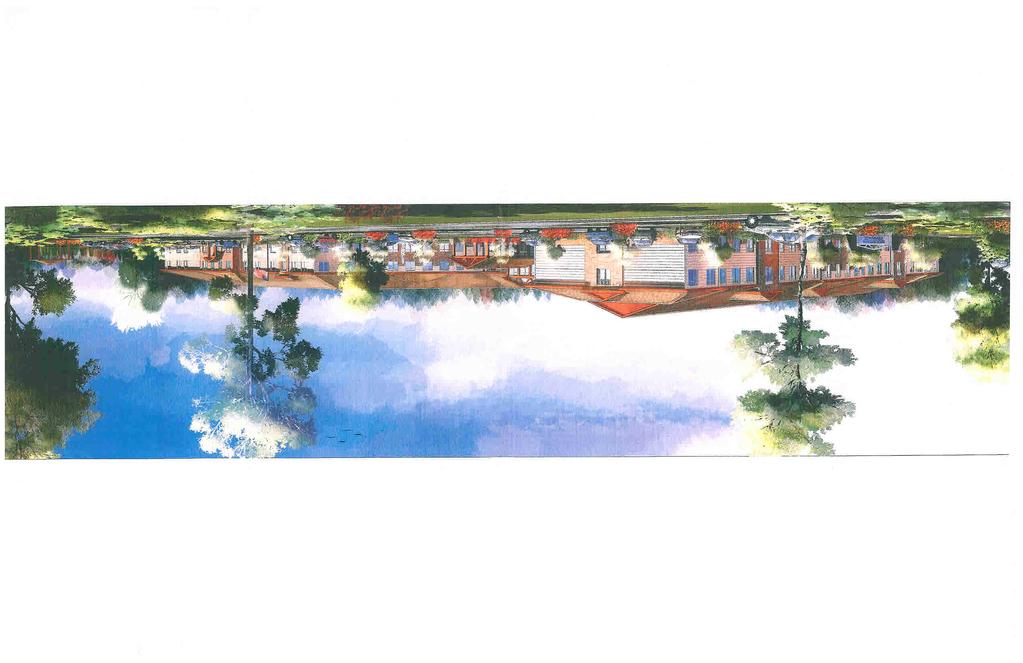
8 Columbine Meadows PUD Plan Amd., Mountain Terrace SDP, FP, SA and Comp. Plan Amendment Page 8 Surrounding Land Uses ADJACENT USE/ZONNG North Gas Station, Townhomes, & Single- Family Residential/Westlake Village/B-1 (PUD) & R(PUD) South Townhomes/Crofton Park PUD East Open Lands & Single-Family Residential/ Columbine Meadows PUD West Undeveloped & Single Family Residential/B-1(PUD) COMPREHENSVE PLAN DESGNATON Mixed-Use Commercial & Neighborhood Residential Neighborhood Residential Neighborhood Residential Neighborhood Center & Neighborhood Residential Existing Site Characteristics The site generally slopes from the northwest to the southeast. A large drainage channel is located along the north side of the property, adjacent to Midway Boulevard. This project proposes to reduce the width of the drainage easement by 17 feet (from 12 feet to 85 feet) and to dedicate the land to Broomfield for access, drainage, and open lands. A retaining wall with a maximum height of four feet is proposed on the south side of the northern drainage channel. A small drainage tract is located on the east side of the site. A retaining wall is also proposed on the northern portion of this drainage channel. Amendment to the PUD Plan The PUD Plan Amendment proposes the one key change. The proposed amendment will change the permitted uses from commercial to the following: o 26 ndependent living cottages, 9 assisted and memory care senior living uses on Lot 1. o 54 ndependent living cottages, 1 ndependent living senior apartments on Lot 2. o Commercial uses on Lot 3. Site Development Plan Page 2 of the SDP shows the layout of the proposed independent living cottages, the assisted living/memory care building, and the access points to the site. Three access drives are proposed. The primary access point is off Midway Boulevard to the north. Two secondary access points are proposed through the existing commercial center onto Lowell Boulevard to the west. Surface parking is provided around the assisted living/memory care building. Driveway and garage parking is proposed for the independent living cottages. The building setbacks are consistent with the proposed PUD Plan.
9 Columbine Meadows PUD Plan Amd., Mountain Terrace SDP, FP, SA and Comp. Plan Amendment Page 9 Two outdoor courtyard areas are shown for the center. The larger courtyard will be located on the west side of the assisted living/memory care building and will feature a fountain and seating areas. The second courtyard area is located on the southwest side of the building and features a gaebo, seating areas, and sidewalks. Architecture Building architecture is provided on Pages 6 and 7 of the SDP. The architecture incorporates stone veneer walls, composite shingles, and horiontal siding. The elevations for this building display a long unbroken roof line from north to south. The perspective drawing provides a better vision of how the building would actually appear. Trash/recycling enclosures and electrical transformers are proposed east of the building to ensure they are screened from the public streets. No roof mounted equipment is proposed. Parking Parking requirements for a senior assisted living/memory care facility are not addressed by the Columbine Meadows PUD or the Broomfield Municipal Code. The proposed parking for the assisted living/memory care building is 7 spaces. The parking ratio of.77 exceeds the number of spaces provided in other recently approved senior projects in Broomfield and the number of accessible spaces (6) complies with the Americans with Disabilities Act standards. The plan for the independent living cottages proposes to have one parking space in a garage and one in a driveway for each unit. All of these spaces are handicap accessible. This exceeds the typical requirements of one space per independent living unit. The parking and drive coverage proposed is 38%, which is consistent with the proposed PUD Plan. Transportation and Circulation Vehicular Access Two of the three access points were previously constructed with the adjacent commercial development. One new access point is provided to the north. A traffic analysis report that addresses the traffic impacts of the proposal, including the new access drive, was reviewed by the Broomfield Traffic Engineer. The access to Midway Boulevard is proposed as a full movement access. This requires that the median be reconfigured to allow for the left-in movement. The condition of the pavement in the existing commercial center has deteriorated over the years and is not considered sufficient for emergency vehicle access. The applicant proposes to resurface the northern access drive.
10 Columbine Meadows PUD Plan Amd., Mountain Terrace SDP, FP, SA and Comp. Plan Amendment Page 1 The 25 Broomfield Comprehensive Plan changed the classification of Lowell Boulevard, south of East Midway Boulevard from a minor arterial roadway to a major arterial roadway. This change from a three-lane roadway to a five-lane roadway requires approximately 2-feet of additional right-of-way on both sides of the street. The Broomfield Capital mprovements Program proposes to widen Lowell Boulevard from West 12 th Avenue to East Midway Boulevard in 28. The developer of this project proposes to complete the improvements on Lowell Boulevard, adjacent to Lot 1 in the fall of 27. Pedestrian and Bicycle Circulation and Transit Five-foot wide sidewalks are proposed around the assisted living/memory care building, adjacent to the private street in the independent living cottage area, and adjacent to the private driveway that runs north-south through the site. Crosswalks are provided throughout the site and provide continuous sidewalk connections through the site. An eight-foot wide concrete public trail connection from the south end of Lot 1 to Midway Boulevard on the north is proposed along the eastern portion of the site. This trail will be extended south to the public trail in Crofton Park concurrent with future development of Lot 2. Landscaping The proposed landscaping is shown on page four of the SDP. The landscaping provides for screening of the service areas on the east side of the assisted living/memory care building. The amount of open area proposed, (36%) is consistent with the provisions of the PUD Plan and the Broomfield Municipal Code. Signage Two proposed project identification signs are proposed. One is located in the island of the north access point off Midway Boulevard; the other is near the southern access point. The proposed signs are consistent with the provisions of the Broomfield Municipal Code. Open Lands The proposed SDP includes 9 assisted living/memory care units and 26 independent cottages. The assisted living units are considered a commercial use and the residents are not anticipated to use public amenities associated with a public land dedication and therefore a public land dedication is not required for those units. ndependent living units require a public land dedication or cash-in-lieu payment with the formal development plans. The Open Space, Parks, Recreation, and Trails Master Plan policy regarding public land dedication requires 24 acres of open land for every 1, residents. An analysis of the proposed public land dedication for the Mountain Terrace PUD Plan versus the policy contained in the Open Space, Parks, Recreation, and Trails Master Plan is provided below:
11 Columbine Meadows PUD Plan Amd., Mountain Terrace SDP, FP, SA and Comp. Plan Amendment Page 11 AREA PROPOSED REQURED DFFERENCE DEDCATON DEDCATON LOT LOT LOT TOTAL The applicant proposes more open lands than are required for the first phase of the project on Lot 1. The dedication proposed for Lot 2 is less than required; however, the applicant proposes to pay cash-in-lieu of land dedication with the development of Lot 2. The applicant proposes to construct an eight-foot wide concrete trail connection from the southeast corner of the PUD adjacent to Crofton Park that will extend north to Midway Boulevard. The proposed trail will allow Mountain Terrace residents to access the two Columbine Meadows Parks, Broomfield County Commons, and the park in Crofton Park. This proposed trail connection was also contemplated in the Crofton Park PUD and SDP plans. Drainage The Gay Reservoir drainage channel is located south of East Midway Boulevard. A 12-foot wide easement for drainage is currently in place. The applicant proposes to vacate the southern 17 feet of this drainage easement so as to reduce the width to 85 feet. This will require the construction of a retaining wall up to four feet high on the south side of the drainage channel. The drainage study submitted with the project supports this proposal. Currently this portion of the drainage way is in more of a natural state, in comparison with the eastern portion of the drainage way in Columbine Meadows and Willow Park, which is in a more manicured state. The eastern portion of the drainage way also has a concrete trickle channel. The Mountain Terrace development proposes to provide additional landscaping and maintenance of their portion of the drainage channel, but not to the level provided to the east. This is due to the requirement for approval from the Army Corps of Engineers to perform work such as landscaping in the drainage way. This is a lengthy process that would most likely not allow for a concrete trickle channel. Final Plat Council approved the Columbine Meadows Filing No. 2, Replat A in The proposed Mountain Terrace Filing No. 1 Final Plat reconfigures the undeveloped portion of the property into three lots. The Final Plat also dedicates Tracts A and B to Broomfield for access, drainage, and open lands. Tracts A and B will be maintained by the adjacent property owners.
12 Columbine Meadows PUD Plan Amd., Mountain Terrace SDP, FP, SA and Comp. Plan Amendment Page 12 Subdivision mprovement Agreement The SA provides for street improvements on Lowell Boulevard and East Midway Boulevard, including widening, sidewalk, curb and gutter, median improvements, and street lights. Water distribution, sanitary sewer system, and storm system improvements are also included in the agreement. An eight-foot wide concrete trail along the eastern portion of the Lot 1, Tract B is included in the agreement. This trail will connect to the trail in Crofton Park, with the development of Lot 2. The above ground utilities on the east side of Lowell Boulevard will be placed underground. Key Changes Since Concept Review After the concept review, the plan was expanded to include the remainder of the site for senior living and commercial uses. The proposed building in the SDP was expanded from one to two stories. The applicant has submitted a letter summariing the changes that have been made to the plan since concept review meeting (Attachment 1). STAFF REVEW OF KEY SSUES All of the key issues identified in the review process have been addressed by the applicant. APPLCABLE MUNCPAL CODE PROVSONS A public hearing is required. At the conclusion of the public hearing, the Land Use Review Commission reviews the application based on the following provisions of the BMC Master Plan; Procedure for adoption The city council may adopt the master plan as a whole by a single resolution or may by successive resolutions adopt successive parts of the plan, said parts corresponding with major geographical sections or divisions of the subject matter of the plan, and may adopt any amendment or extension thereof or addition thereto. Before the adoption of the plan or any such part, amendment, extension, or addition, the city council shall hold at least one public hearing theron, notice of the time and place of which shall be given in accordance with sections , , , , and , BMC. The adoption of the plan, any part, amendment, extension, or addition shall be by resolution of the city council. The resolution may refer expressly to the maps and descriptive and other matter intended by the city council to form the whole or part of the plan, and the action taken shall be recorded on the map and plan and descriptive matter by the identifying signature of the mayor or mayor pro tem and attested by the city clerk. A copy of the plan or part thereof shall be certified to each governmental body of the territory affected and shall be filed with the county clerk and recorder of each county wherein the territory is located.
13 Columbine Meadows PUD Plan Amd., Mountain Terrace SDP, FP, SA and Comp. Plan Amendment Page PUD Plan Review Standards. The recommendation of the land use review commission and the decision of the city council shall be based on whether the applicant has demonstrated that the proposed PUD plan meets the following standards: (A) The proposal should be consistent with the intent of this chapter as set forth in section (B) The proposal should be consistent with the master plan. (C) The proposal should identify and mitigate potential negative impacts on nearby properties, other areas of the city, and the city as a whole. (D) The proposal should identify and maximie potential positive impacts on nearby properties, other areas of the city, and the city as a whole. (E) The proposal should include adequate facilities for pedestrians, bicyclists, and motorists. (F) The proposal should include adequate public improvements (both on and off site) to be provided in a timely fashion. (G) The proposal should optimie conservation of energy, water, and other resources on a broad scale. (H) The land uses within the plan should be compatible with one another and with nearby properties. () The proposal should provide for open space at a rate of not less than forty percent of the developable site in residential areas and twenty-five percent in other areas as provided in section , below. (J) The proposal should adequately provide for an organiation for ownership and maintenance of any common areas. (K) The proposal should justify any proposed deviations from the Broomfield Municipal Code in terms of the overall quality of the plan. (Ord , 1987; Ord , 1995) Review standards The recommendation of the land use review commission and the decision of the city council shall be based on whether the applicant has demonstrated that the proposed site development plan meets the following standards: (A) The proposal should be consistent with the intent of this chapter as set forth in section (B) The proposal should identify and mitigate potential negative impacts on nearby properties. (C) The proposal should identify and maximie potential positive impacts on nearby properties. (D) The proposal should include adequate facilities for pedestrians, bicyclists, and motorists. (E) The proposal should include adequate public improvements (both on and off site) to be provided in a timely fashion. (F) The proposal should optimie conservation of energy, water, and other resources on a site-specific scale. (G) The land uses within the plan should be compatible with one another and with nearby properties. (H) The proposal should provide for open area at a rate of not less than forty percent of the developable site in residential areas and twenty-five percent in other areas as provided in section , below. () The proposal should include any common areas serving the site, and adequate provisions should be made for the ownership and maintenance of such areas. (J) The proposal should justify any proposed deviations from the Broomfield Municipal Code in terms of the overall quality of the plan. (K) The proposal should be consistent with the approved PUD plan. (L) For residential-use PUD plans and site development plans, the proposal should be consistent with adopted uniform standards Review Standards (Final Plat) The recommendation of the land use review commission and the decision of the city council shall be based on whether the applicant has demonstrated that the proposed final plat meets the standards set forth in section (Review Standards, reprinted below) and is generally consistent with an approved preliminary plat, if there is one. No final plat will be recommended by the land use review commission or approved by the city council until such maps, data, surveys, analyses, studies, reports, plans, designs, documents, and other supporting materials as may be required herein have been submitted and reviewed, and found to meet the planning, engineering, and surveying requirements of the city required; provided, however, that the city engineer may waive any final plat requirement for good cause shown.
14 Columbine Meadows PUD Plan Amd., Mountain Terrace SDP, FP, SA and Comp. Plan Amendment Page Review standards (Preliminary Plat) The recommendation of the land use review commission and the decision of the city council shall be based on whether the applicant has demonstrated that the proposed preliminary plat meets the following standards: (A) The project should not create, or should mitigate to the extent possible, negative impacts on the surrounding property. (B) The project should provide desirable settings for buildings, make use of natural contours, protect the view, and afford privacy and protection from noise and traffic for residents and the public. (C) The project should preserve natural features of the site to the extent possible. (D) The proposed traffic flow and street locations should be consistent with the city s master plan, should be in accordance with good engineering practice, and should provide for safe and convenient movement. (E) The lots and tracts should be laid out to allow efficient use of the property to be platted. (F) The proposed public facilities and services should be adequate, consistent with the city s utility planning, and capable of being provided in a timely and efficient manner. (G) The proposal should comply with the design standards of chapter (Design Standards, not included), the improvement requirements of chapter (mprovements, not included), and the standards and specifications of chapter 14-4 (Standard and Specifications, not included). (H) The proposal should be consistent with the need to minimie flood damage. () The proposal should have public utilities and facilities, such as sewer, gas, electrical, and water systems, located and designed to minimie flood damage. (J) The proposal should have adequate drainage provided to reduce exposure to flood damage Site development plan; scope. A site development plan may include one or more platted lots. A PUD plan and a final subdivision plat must be approved before, or together with, a site development plan. (Ord , 1987) Site development plan; format. (A) Site development plans shall be in black ink or photographic reproduction, on four-mil thickness Mylar (double matted polyester film). The scale shall ordinarily be 1 = 5'. A larger scale or a smaller scale (not less than 1 = 2') may be used with prior approval of the city manager or his or her designee. (B) The sie of the sheets shall be as required by the county where the site development plan is to be filed. (C) Plans of two or more sheets shall be referenced to an index map placed on the first sheet. (Ord , 1987) Site development plan; contents. The site development plan shall contain the following information: (A) Site plan showing the following: (1) Name of project; (2) Location and boundaries of site development plan, including a legal description; (3) Names, addresses, and signatures of the owner, subdivider, and surveyor (who shall be registered by the Colorado State Board of Registration for Professional Engineers and Land Surveyors); (4) Date of preparation and of any revisions, written and graphic scale, the north arrow (designated as true north); (5) Chart with each land use area listed showing the following information: a. Gross acreage; b. Floor area ratios (for commercial and industrial); c. Number of dwelling units (for residential); d. Dwelling units per acre (for residential); e. Minimum lot sies; f. Building coverage, parking and drive coverage, and open space area (all expressed in square feet); g. Minimum setbacks of principal, accessory buildings; h. Minimum floor areas (for residential); i. Maximum building height;
15 Columbine Meadows PUD Plan Amd., Mountain Terrace SDP, FP, SA and Comp. Plan Amendment Page 15 j. Principal and accessory uses; and k. A statement that any element of the construction, location, design, use, or operation of land or buildings not specifically shown on the approved site development plan in graphic or written form shall conform to the requirements of a specified one district (e.g., R-1, B-1, -1); (6) Location and dimensions of all existing and proposed streets and alleys (showing curb, gutter, and sidewalk location), and location and dimensions of all easements, rights-of-way, and lot lines; (7) Location and dimension of walks, trails, parking spaces, curb islands, and driveways (with direction of travel shown); (8) A list of any proposed deviations from the provisions of titles 14, 16, or 17, B.M.C.; and (9) Location and dimensions for all structures, including refuse and recycling facilities in accordance with section (B) Architectural elevations for each structure showing the following: (1) Overall exterior dimensions; (2) Materials; (3) Color scheme; (4) Signs; and (5) All faces of the structure, clearly labeled. (C) Landscape plan showing the following: (1) Location, species, and sie of existing trees; (2) Trees to be retained; (3) Location, species, and sie of new trees and shrubs; (4) Location and type of turf, ground cover, and planting areas; (5) Type and extent of irrigation; and (6) Retaining and decorative walls, fences, and similar structures. (D) Grading plan showing the following: (1) Existing and proposed topography at two-foot contour intervals, referenced to U.S.G.S. data; (2) Outline drawings of major structures and improvements (existing and proposed); and (3) Storm drainage improvements and appurtenances. (E) Site development plans for wireless communications towers shall include the criteria set forth in section and meet the requirements set forth in section (F) The location of any plugged and abandoned oil and gas well and its production site or any former oil and gas production sites located within the boundaries of the site development plan or within 2 feet of such boundaries on abutting property. Site development plans shall be subject to the provisions of chapter 17-56, B.M.C. (Ord , 1987; Ord. 75 7, 1987; Ord , 1994; Ord , 1996; Ord , 2; Ord , 22; Ord , 23) Site development plan; accompanying information. The site development plan shall be accompanied by: (A) Evidence of the existence and status of an organiation for ownership and maintenance of any common areas; and (B) Proof of ownership satisfactory to the city attorney, which may include a recently issued title commitment or title policy. (C) An earthen fill design report that addresses and mitigates any negative impacts of earthen fill materials. Such report shall be consistent with the uniform codes adopted in title 15 of the Broomfield Municipal Code and the standards and specifications adopted in chapter 14-4 of the Broomfield Municipal Code. (D) For plugged and abandoned oil and gas wells or former oil and gas production sites either within the boundaries of the site development plan or within 2 feet of such boundaries on abutting property, the Form 6, the well abandonment report, the plugging verification reports for such wells filed with the Colorado Oil and Gas Conservation Commission, and any Colorado Oil and Gas Conservation Commission reports regarding former oil and gas production sites. (Ord , 1987; Ord , 21; Ord , 22) Site development plan; hearing and notice; city council. The city council shall hold a public hearing on the site development plan. Notice shall be given in accordance with the provisions of chapter (Public Notice Requirements, not included).
16 Columbine Meadows PUD Plan Amd., Mountain Terrace SDP, FP, SA and Comp. Plan Amendment Page Site development plan; decision; city council; recording. (A) Within thirty days of the conclusion of its public hearing on the site development plan, the city council shall adopt a resolution of approval, disapproval, or referral back to the land use review commission for further study. (B) The site development plan shall include a legal description of the real property within the boundaries of the site development plan and a vicinity map showing the location in the city of the site development plan, which shall be recorded in the office of the director of recording, elections, and motor vehicles Review standards (Site Development Plan). The recommendation of the land use review commission and the decision of the city council shall be based on whether the applicant has demonstrated that the proposed site development plan meets the following standards: (A) The proposal should be consistent with the intent of this chapter as set forth in section (ntent, not included). (B) The proposal should identify and mitigate potential negative impacts on nearby properties. (C) The proposal should identify and maximie potential positive impacts on nearby properties. (D) The proposal should include adequate facilities for pedestrians, bicyclists, and motorists. (E) The proposal should include adequate public improvements (both on and off site) to be provided in a timely fashion. (F) The proposal should optimie conservation of energy, water, and other resources on a site-specific scale. (G) The land uses within the plan should be compatible with one another and with nearby properties. (H) The proposal should provide for open area at a rate of not less than forty percent of the developable site in residential areas and twenty-five percent in other areas as provided in section (Open Area Required, not included) below. () The proposal should justify any proposed deviations from the Broomfield Municipal Code in terms of the overall quality of the plan. (J) The proposal should be consistent with the approved PUD plan. (K) For residential-use PUD plans and site development plans, the proposal should be consistent with adopted uniform standards. LAND USE REVEW COMMSSON RECOMMENDATON On April 9, 27, the Land Use Review Commission (LURC) unanimously recommended approval of the proposed Site Development Plan and Final Plat with four conditions. Resolution LUR 27-7 Option B is included as Attachment 2. The LURC conditions and developer s response are listed below. 1. That the applicant add the material list for the two story buildings on the plat: The applicant labeled the building elevations on the Site Development Plan, as specified by the LURC recommendation. 2. That the applicant agreed to meet all the issues staff listed in the Key ssues of the Staff Memo. The applicant has addressed all of the key issues listed in the staff report.
17 Columbine Meadows PUD Plan Amd., Mountain Terrace SDP, FP, SA and Comp. Plan Amendment Page That the applicant add reference to the Broomfield Trail connection. The applicant has included the trail connection on the Site Development Plan and PUD Plan. 4. That additional information from the traffic report be considered regarding the deceleration lane from Midway Boulevard into the project. The applicant submitted a revised traffic report that indicates that a deceleration lane is not necessary on East Midway Boulevard.
18

19 RESOLUTON NO A RESOLUTON APPROVNG AN AMENDMENT TO THE COLUMBNE MEADOWS PUD PLAN, MOUNTAN TERRACE STE DEVELOPMENT PLAN, MOUNTAN TERRACE FLNG NO. 1 FNAL PLAT, AND AUTHORZNG THE SUBDVSON MPROVEMENT AGREEMENT THEREFOR BE T RESOLVED BY THE CTY COUNCL OF THE CTY AND COUNTY OF BROOMFELD, COLORADO: Section 1. Pursuant to the provisions of articles and ll of chapter Broomfield Municipal Code, Columbine Meadows PUD Plan Amendment, Mountain Terrace Site Development Plan, and Mountain Terrace Filing No. 1 Final Plat attached hereto, are hereby approved. Section 2. The Subdivision mprovement Agreement, attached hereto between The City and County of Broomfield, Canyon Creek Development, nc. and Ciccarelli Enterprises, is hereby approved. Section 3. The mayor or mayor pro tem is authoried to sign and the city clerk to attest, in form approved by the city & county attorney, a subdivision improvement agreement by and between the City and County of Broomfield, Canyon Creek Development, nc. and Cicccarelli Enterprises, LLLP. Section 4. This resolution is effective upon its approval by the City Council. APPROVED on July 24, 27. THE CTY AND COUNTY OF BROOMFELD, COLORADO ATTEST: Mayor City Clerk APPROVED AS TO FORM: AiL. City & County Attorney i 7//
20
, and CCC\ARELL ENTE\RPRSES, LLLP\,")
21 CTY AND COUNTY OF BROOMFELD SUBDVSON MPROVEMENT AGREEMENT FOR MOUNTAN TERRACE FLNG NO. 1 THS AGREEMENT, made and entered into this day of 2, by and between The CTY AND COUNTY OF BROOMFELD, a Colorado municipal corporation and county, \(the City\), and CCC\ARELL ENTE\RPRSES, LLLP\, \(th\e Owne\r\) and CANY\O\N CREE\K DEVE\LOPMENT, nc \(th\e Deve\loper\). WTN ESSETH: WHEREAS, Developer is the owner of a parcel of property \(the Property\) situated in The City and County of Broomfield, the description of which is set forth in Exhibit A, and is incorporated herein by this reference; and WHEREAS, Developer has designated the Property as MOUNTAN TERRACE FLNG NO. 1 and wishes to obtain the City s approval of a final plat, a copy of which is attached hereto as Exhibit B and is incorporated herein by this reference; NOW, THEREFORE, in consideration of the premises cited hereinabove and the mutual covenants and promises contained herein, the sufficiency of which is acknowledged, the parties hereto agree as follows: 1. mprovements. Developer shall furnish and install at its own expense, the improvements described on the Schedule of mprovements in Exhibit C \(the mprovements\), which is attached hereto and incorporated herein by this reference and hereinafter referred to as the "mprovements". 1.1 Design and Construction. Construction of the lniprovements shall be in strict conformance with the plans to be prepared by Developer and reviewed and accepted by the city engineer and with all policies, standards, and standards and specifications adopted by the City relating thereto. The city engineer s review and acceptance of the plans shall not limit or affect Developer s responsibility for design and construction. 1.2 Testing. Developer shall employ, at its own expense, a qualified testing company, previously approved by the City, to perform all testing of materials or construction that may be required by the City and shall furnish copies of test results to the city engineer. 1.3 nspection. At all times during construction of the mprovements, the City shall have the right, but not the duty, to inspect materials and workmanship, and all materials and work shall conform to the accepted plans and specifications. Any material or work not conforming to the accepted plans and the City and County of Broomfield Revised: 11/6/6 Subdivision mprovement Agreement - 3,d Party.doc
 shall promptly be removed or replaced to the satisfaction of the city engineer at the Developer s expense. 1.4 Utilities.")
22 Subdivision mprovement Agreement for Mountain Terrace Filing No. 1 Standards and Specifications \("Standards and Specifications"\) shall promptly be removed or replaced to the satisfaction of the city engineer at the Developer s expense. 1.4 Utilities. Developer shall furnish proof that proper arrangements have been made for the installation of water, sanitary sewer, gas, electric, cable television, and telephone services. 1.5 ComDletion of lmrovements. The obligations of the Developer provided for in this paragraph 1., including all subparagraphs hereof, shall be performed on or before July 1, 29, and proper application for acceptance of the mprovements shall be made by such date No mprovements shall be deemed to be completed until the city engineer has certified, in writing, that the mprovement has been completed in general conformance with the plans therefor as accepted by the City Developer shall provide the city engineer with a sworn affidavit, signed by the Developer s authoried representative, that the mprovements completed have been paid for, in full, by the Developer. The Developer shall be responsible for the information so provided. Said written certification will be reviewed by the City, but the City shall assume no responsibility or liability to any party regarding the veracity of the information so provided Before the City accepts the mprovements, Developer shall furnish to the City reproducible "as constructed" drawings, certified accurate by the engineer referred to in paragraph The mprovements within the Property may be constructed by the Developer in two or more phases as approved by the City and as more particularly described in Exhibit C. 1.6 Fees. Developer is responsible for all permit fees associated with the construction or installation of the improvements. These fees include but are not limited to Public/Private mprovement Permit fees, Grading Permit fees, Water License Fees, Water Tap and Meter fees, Building Permit fees and Contractor License fees. 2. Rights-of-way and Easements. Before commencing the construction of any mprovements herein agreed upon, the Developer shall acquire at its own expense good and sufficient title to streets and easements, free and clear of any liens or encumbrances, on all lands and facilities, if any, traversed by the proposed mprovements. All such streets and easements shall be dedicated or conveyed to the City and the documents of dedication or conveyance shall be furnished to the City for recording. A policy of title 2 Revised: 11/6/6 Subdivision mprovement Agreement - 3d Party.doc

23 Subdivision mprovement Agreement for Mountain Terrace Filing No. 1 insurance insuring title in the City may be required by the City, and the Developer shall pay the premium for such title insurance policy. 3. Engineering Services. Developer shall furnish, at its own expense, all engineering services required for the Property and the mprovements. 3.1 Engineering services shall be pertormed by a professional engineer registered in the State of Colorado. Such engineering services shall conform in all respects to the Standards and Specifications. 3.2 Engineering services shall consist of, but not be limited to, survey, designs, plans and profiles, estimates, construction supervision, and the furnishing of necessary documents in connection therewith. All engineering plans shall be submitted for review by, and be subject to the stamped acceptance by the city engineer. The city engineer s review and acceptance does not relieve Developer or Developer s engineer of the responsibility for design and construction. 4. Liability. 4.1 Release of Liability. Developer shall indemnify and hold harmless the City from any and all suits, actions, and claims of every nature and description caused by, arising from or on account of any act or omission of the Developer, or of any other person or entity for whose act or omission Developer is liable, with respect to such construction of the mprovements; and Developer shall pay any and all judgments rendered against the City as a result of any suit, action, or claim together with all reasonable expenses and attorney s fees incurred by the City in defending any such suit, action or claim. The Developer shall require that all contractors and other employees engaged in construction of mprovements shall maintain adequate workmen s compensation insurance and public liability coverage and shall comply with the provisions of the Federal Occupational Safety and Health Act. 4.2 Drainage Liability. The Developer shall indemnify and hold harmless the City for any liability the latter may have on account of any change in the nature, direction, quantity, or quality of historical drainage flow resulting from the development of this Property or from the construction of streets or storm sewers therein. n addition, the Developer promises to reimburse the City for any and all costs including, but not limited to, reasonable attorney s fees, which the City incurs in acquiring or condemning any rights-of-way or easements which the City is required to acquire or condemn or which the City is held to have acquired or condemned, for drainage as a result of the development of this Property. 4.3 Tax Liability. The Developer shall pay all property taxes on property dedicated to the City to the extent such taxes are due as of the date of dedication or 3 Revised: 11/6/6 Subdivision mprovement Agreement - 3rd Party.doc

24 Subdivision mprovement Agreement for Mountain Terrace Filing No. 1 conveyance, and the Developer shall indemnify and hold harmless the City for any such property tax liability. 5. AcceDtance. f the mprovements are satisfactorily completed, then upon written request of Developer, accompanied by documents required by the Standards and Specifications, the City shall accept the mprovements in accordance with then-applicable procedures. Upon acceptance, said mprovements shall become public facilities and property of the City, subject to repair and replacement as set forth in the Standards and Specifications. Until acceptance by the City Council, the Developer shall bear all risk of loss, damage, or failure to any of the mprovements. 5.1 f desired by the City, portions of the mprovements may be placed in service when completed, but such use shall not constitute an acceptance. Until the mprovements are accepted by the City, Developer shall be solely liable for any repairs or replacements which, in the opinion of the city engineer, shall become necessary. f, within thirty days after Developer s receipt of written notice from the City requesting such repairs or replacements, the Developer shall not have undertaken with due diligence to make same, the City may make such repairs or replacements at the Developer s expense and shall be entitled to draw upon the performance guarantee described in paragraph 7. either before undertaking to make such repairs or at any time thereafter. n case of emergency, such written notice shall be waived, and the City shall proceed as it deems necessary, at Developer s expense. 5.2 The City may, at its option, issue building permits for construction on lots for which the mprovements detailed herein have been started, but not completed. The City shall not issue certificates of occupancy or install water meters for lots unless \(1\) the mprovements serving those lots are completed and placed in service; \(2\) the progress of work on the mprovements throughout the Property is satisfactory to the City; and \(3\) all terms of this Agreement have been faithfully kept by the Developer. Any waiver of the terms of this Agreement by the City in any particular instance shall not be deemed a waiver of such terms in any subsequent instance. No delay in enforcement of the terms of this Agreement by the City shall be deemed a waiver of the City s rights hereunder. 6. Warranty. The Developer shall, at its own expense, make all needed repairs or replacements which, in the opinion of the city engineer, shall become necessary during the two-year warranty period. f, within thirty days after Developer s receipt of written notice from the City requesting such repairs or replacements, the Developer shall not have undertaken with due diligence to make same, the City may make such repairs or replacements at the Developer s expense and shall be entitled to draw upon the performance guarantee described in paragraph 7. either before undertaking to make such repairs or at any time thereafter. n case of emergency, such 4 Revised: 11/6/6 Subdivision mprovement Agreement - 3rd Party.doc

25 Subdivision mprovement Agreement for Mountain Terrace Filing No. 1 written notice shall be waived, and the City shall proceed as it deems necessary, at the Developer s expense. 7. Performance Guarantee. Before starting work on the mprovements and before any building permit is issued for any structure to be erected in the Property, the Developer shall furnish to the City, at Developer s expense, an irrevocable letter of credit, in a form and content satisfactory to the city attorney, in which the City is designated as the beneficiary of an amount equal to the total cost, for the items shown on the "Schedule of mprovements" \(Exhibit C\), o\f t\he \mprovements d\escribed i\n E\xhibit C\. T\he c\ity e\ngineer m\ay p\ermit t\he D\eveloper t\o f\urnish t\he C\ity w\ith a performance guarantee for each phase or any combination of phases within the Property for the mprovements described in Exhibit C. As provided in section of the Broomfield Municipal Code, the Developer may provide the City with fifteen percent of the cost of the mprovements on the condition that the City will not issue building permits until all improvements are installed, completed and accepted within the Property or within a phase of the Property. Letters of credit shall be substantially in the form and content set forth in Exhibit D, attached hereto and incorporated herein, and shall be subject to the review and approval of the city attorney. 7.1 The estimated cost of completion of the mprovements may increase in the future. Accordingly, the City reserves the right to review and adjust the cost estimates at any time in the future, before or after Developer provides a letter of credit. Adjusted cost estimates will be made according to changes in the Construction Cost ndex as published by the Engineering News Record. f the City adjusts cost estimates for the mprovements, the City shall give written notice to Developer. The Developer shall, within thirty days after receipt of said written notice, provide the City with a new or amended letter of credit in the amount of the adjusted cost estimates. f the Developer refuses or fails to so provide the City with a new or amended performance guarantee, the City may withhold building permits, water licenses, and certificate of occupancy within the Property. 7.2 Releases of the letter of credit shall be in accordance with the Standards and Specifications. 7.3 The letter of credit shall be maintained at an amount sufficient to fund all remaining improvements, said amount to be determined by the city engineer, until all improvements have been accepted by the City. Thereafter, the letter of credit shall be maintained at the amount required by the Standards and Specifications during the twoyear repair and replacement period referred to in paragraph f a letter of credit is to expire within fourteen calendar days and the Developer has not yet provided a satisfactory replacement, the City may draw on the 5 Revised: 11/6/6 Subdivision mprovement Agreement - 3rd Party.doc

26 Subdivision mprovement Agreement for Mountain Terrace Filing No. 1 letter of credit and either hold such funds as security for performance of this agreement, or spend such funds to finish improvements or correct problems within the Property, as the City deems appropriate. 8. Availability of Utilities. The City will use every reasonable means to plan for and provide water and sewer services for the Property. However, it is expressly understood by the Developer that the City cannot guarantee its ability to provide water or sewer services. The Developer, for itself, its heirs, successors, and assigns hereby acknowledges the municipal utility limitations of the City and agrees to accept and comply with all policies, ordinances, development criteria, and platting restrictions currently in effect or enacted in the future to allocate or regulate the use of the City s utility resources. 9. Breach of Agreement. f at any time this Agreement or any part hereof has been breached by the Developer or if satisfactory progress has not been made on the mprovements, the City may draw on the performance guarantee described in paragraph 7., may withhold approval of any or all building permits, certificates of occupancy, and water licenses applied for in the Property, and, until the breach has been corrected by the Developer, shall be under no obligation to approve or to issue any additional building permits, certificates of occupancy or water licenses for any area within the Property. f the City draws on the performance guarantee, it shall not be under obligation to complete the Property mprovements. The City may use the proceeds for engineering expenses, consultants fees and charges, legal fees and costs, the mprovements, reimbursements, or other expenses connected with the Property. Notwithstanding the rights guaranteed by this paragraph, the City may pursue whatever additional remedies it may have at law or in equity. f the City brings legal action against the Developer or the issuer of the letter of credit or of the bond, and if the City is substantially successful in such litigation, the Developer shall pay the City s costs and attorneys fees. The waiver of any one or more breaches of the Agreement shall not constitute a waiver of the remaining terms thereof. 1. Recording of Agreement. This Agreement shall be recorded and shall be a covenant running with the land herein described in Exhibit A so that prospective purchasers and other interested parties are on notice as to the terms and provisions hereof. 11. Binding Effect. This Agreement shall be binding upon the heirs, successors, and assigns of the parties hereto. 12. Transfer or Assignments. n the event of a sale or transfer from Owner to Developer, said sale or transfer shall be allowed, provided that an agreement satisfactory to the City, delineating and allocating between Owner and Developer the various rights and obligations under this agreement has been approved by the City Manager. 6 Revised: 11/6/6 Subdivision mprovement Agreement - 3rd Party.doc

27 Subdivision mprovement Agreement for Mountain Terrace Filing No. 1 n the event of any other sale or transfer of any part of the Property, except to a bona-fide home buyer, the seller or transferor and the buyer or transferee shall be jointly and severally liable for the performance of each of the obligations contained in this mprovement Agreement unless, prior to the transfer or sale, an agreement satisfactory to the City, delineating and allocating between Developer and buyer or transferee the various rights and obligations of Developer under this Agreement, has been approved by the City Council. 13. Title, Authority, and Recognition of Existing Obligations: The Owner, CCCARELL ENTERPRSES, LLLP, expressly warrants and represents to the City that it is the record owner in fee simple of the property constituting the Property. Owner and Developer represent that they intend to eventually transfer ownership of the Property to Developer. However, until such time as ownership is transferred to Developer and a statement of rights and responsibilities is issued by the City Manager as set forth in 12., Owner remains obligated to fulfill all of its obligations under this mprovement Agreement. Owner and Developer further represent and warrant that the undersigned individuals have full power and authority to enter into this mprovement Agreement. The Owner and Developer and the undersigned individuals understand that the City is relying on such representations and warranties in entering into this Agreement. 14. Special Provisions Tract A and B Public Trail mprovements. The Developer has agreed to construct the 8 concrete trail in Tract A and B prior to the issuance of the first building permits for the Subdivision Lowell Boulevard The Developer has agreed to construct the Lowell BouJevard improvements, ROW north of Columbine Meadows Filing No. 2 prior to the issuance of the first building permit for the Subdivision. Broomfield shall construct the portion of Lowell Boulevard adjacent to the property and south of Columbine Meadows Filing No 2. The Developer shall reimburse Broomfield for the cost to construct the eastern half of Lowell Boulevard adjacent to the property and south of Columbine Meadows Filing No 2. The reimbursement shall be made within 6 days of receiving a written request from Broomfield. Contractor s invoices for the work shall be included with the request. f Broomfield does not make the request within 2 years from the date of approval of this subdivision agreement, the developer shall make a cash-in-lieu payment for the listed improvements based on Broomfield s estimate to construct the southern portion of Lowell Boulevard adjacent to the property. Broomfield s estimate will be based on similar projects within Broomfield. 7 Revised: 11/6/6 Subdivision mprovement Agreement - 3 Party.doc

28 Subdivision mprovement Agreement for Mountain Terrace Filing No Midway Boulevard lmdrovements. The Developer has agreed to modify the Midway Boulevard Median. These modifications shall be completed prior to the issuance of the first building permit Underground Overhead Utilities. The Developer has agreed to underground the overhead utilities directly adjacent to the property north of Columbine Meadows Filing No. 2 in accordance with Broomfield s municipal code and the utility company requirements. These modifications shall be completed prior to the issuance of of the first building permit for the Subdivision. Broomfield shall underground the overhead utilities directly adjacent to the property south of Columbine Meadows Filing No 2. The Developer shall reimburse Broomfield for the cost to underground the utilities. The reimbursement shall be made within 6 days of receiving a written request from Broomfield. Contractor s invoices for the work shall be included with the request. f Broomfield does not make the request within 2 years from the date of approval of this subdivision agreement, the developer shall make a cash-in-lieu payment based on Broomfield s estimate to underground the utilities adjacent to the property south of Columbine Meadows. Broomfield s estimate will be based on similar projects within Broomfield. 8 Revised: 11/6/6 Subdivision mprovement Agreement - 3d Party.doc

29 Jul 19 7 O2:2lp Dan Terra JUL ;OOPM FROM-BROOMFELD COMMtJNTY EV p T-44 P2/2 F-654 Subdivision improvement Agreement for Mountain Terrace Filing No. 1 N WNESS WHEFEOF, the parties hereto have caused this Agreement to be executed on the day and year first above-written. CCCARELL1 ENTERPASS, LLLP a Colorado limited liabilfty company ATTEST: By 4dA Donn\a Cicc\arelli. Gene\ral Part\ner Antoflia Ciccareii, Limited Partner - STATE OF COLORADO COUNTYOF\)\) \)ss. The fore\going inst\rument was ackn\owledged befo\re as me this L!" day of 27, by 6Je -i2- as, Limited General Partner, Partner and of,l.l p My commission expires: ::j74 r WTNESS my hand and offica seal. 9 F\(evisd 1\6O S\uthv,sian J\n e\nei fl A9TfflW 3 Parly aoe
 COUNTY OF \) \) ss.")
30 Subdivision mprovement Agreement for Mountain Terrace Filing No. N WTNESS WHEREOF, the parties hereto have caused this Agreement to be executed on the day and year first above-written. CANYON CREEK DEVELOPMENT, nc ATTEST: By Steven ae, Vice President of Market Analysis/Construction Seeretay C. F c 1u7 STATE OF \) COUNTY OF \) \) ss. The foregoing instrument was acknowledged before me this id day of 27, by, asvepresident, and \(J -- 4?. F al, as Secretary-of LJt \( k Ci d My commission expires: OFFCAL SEAL DANE BEYER NOTARY PUBLC - OREGON COMMSSON NO MY CMMSS ON EXPRES SEPT. 4, 29 WTNESS my hand and official seal. Notry Public 1 Revised: 11/6/6 Subdivision mprovement Agreement - 3 Party.doc
 APPROE\DASTO FORM: // /// City & County Attorney STATE OF COLORADO \) \) ss.")
31 Subdivision mprovement Agreement for Mountain Terrace Filing No. 1 THE CTY AND COUNTY OF BROOMFELD, a Colorado municipal corporation and county Mayor ATTEST: City Clerk \(SEAL\) APPROE\DASTO FORM: // /// City & County Attorney STATE OF COLORADO \) \) ss. COUNTY OF BROOMFELD\) The foregoing instrument was acknowledged before me this day of 27, by Karen Stuart, as Mayor of The City and County of Broomfield, a Colorado municipal corporation and county. My commission expires: WTNESS my hand and official seal. Notary Public 11 Revised: 11/6/6 Subdivision mprovement Agreement - 3 Partydoc
32

33 EXHBT A LEGAL DESCRPTON A PORTON OF THE N1/2 F THENW 1/4, SECTON 32,11 S, R68W, OF THE 6TH P.M., CTY AND COUNTY OF BROOMFELD, STATE OF COLORADO. SAD PARCEL BEiNG THE REMANDER OF TRACT B, COLUMBNE MEADOWS AS RECORDED in THE ADAMS COUNTY CLERK AND RECORDERS OFFCE AT FLE 16, MAP 242, RECEPTON NUMBER B56578 AND ALL OF COLUMBNE MEADOWS FLNG NO.2- REPLAT "A" AS RECORDED in THE ADAMS COUNTY CLERK AND RECORDERS OFFCE AT FLE 16, MAP 83, RECEPTON NUMBER B866 SAD PARCEL BENG MORE PARTCULARLY DESCRBED AS FOLLOWS: COMMENCNG AT THE NORTHWEST CORNER OF THE NORTHWEST QUARTER OF SAD SECTON 32; THENCE S "B ALONG THE NORTH LNE SAD NORTHWEST 1/4 OF SECTON 32, A DSTANCE OF 74.1 FEET; THENCE S 25 39"W A DSTANCE OF 48. FEET TO THE NORTHWEST CORNER OF SAD TRACT B, COLUMBNE MEADOWS, SAD PONT ALSO BENG THE TRUE PONT OF BEG1NN1NG; THENCE S "E ALONG THE NORTH LNE OF SAD TRACT B, SAD LNE ALSO BENG THE SOUTH RGHT OF WAY LNE OF WEST 128TH AVENUE, A DSTANCE OF FEET TO THE NORTHEAST CORNER.. SAil\) TRAC\T B; THEN\CE S 3 47"W ALONG THE EASTERLY LiNE OF SAD TRACT B, A DSTANCE OF 51.6 FEET; THENCE N "W ALONG THE EASTERLY LNE OF SAD TRACT B, A DSTANCE OF 12. FEET; THENCE S 23 32"W ALONG THE EASTERLY LNE OF SAD TRACT B, A DSTANCE OF 77.2 FEET TO THE SOUTHEAST CORNER OF SAD TRACT B; THENCE N W ALONG THE SOUTH LNE OF SAD TRACT B, A DSTANCE OF FEET TO THE EAST RGHT OF LNE OF LOWELL BOULEVARD; THENCE N W ALONG SAD EAST RGHT OF WAY LNE OF LOWELL BOULEVARD AND SAD WEST LiNE OF TRACT B, A DSTANCE OF FEET TO THE SOUTHWEST CORNER OF SAD COLUMBNE MEADOWS FLNG NO. 2-REPLAT "A"; THENCE N W, CONTNUNG ALONG SAD EAST RGHT OF WAY LNE OF LOWELL BOULEVARD AND ALONG TlE WEST LNE OF SAD LOT 2 COLUMBNE MEADOWS, A DSTANCE OF 22. FEET TO THE NORTHWEST CORNER SAD LOT 2 COLUMBNE MEADOWS AT SAD EAST RGHT OF WAY LNE OF LOWELL BOULEVARD; THENCE THE FOLLOWNG THREE COURSES ALONG THE COMMON LNES BETWEEN LOT 2 AND LOT 3 OF SAD COLUMBNE MEADOWS FLiNG NO.2- REPLAT "A"; 1\) S "E, A DSTANCE OF FEET; 2\) N 25 12"E, A DSTANCE OF 27.2 FEET;
34 3\) N "W, A DSTANCE OF 15. FEET; THENCE THE FOLLOWNG THREE COURSES ALONG THE COMMON LNES BETWEEN LOT 2 AND LOT 1 OF SAD COLUMBNE MEADOWS FLNG NO.2- REPLAT "A"; 1\) N E, A DSTANCE OF 52.5 FEET; 2\) N "W, A DSTANCE OF FEET; 3\) N 25 2"E, A DSTANCE OF FEET TO THE NORTH LiNE OF SAD LOTS 2AND 1; THENCE N "W ALONG THE NORTH LNE OF SAD LOT 1, A DSTANCE OF FEET TO THE NORTHWEST CORNER OF SAl]\) FiL\NG NO. 2-RE\PLAT "At1\, SAD PONT ALSO BENG ON SAD EAST RGHT OF WAY LNE OF LOWELL BOULEVARD; THENCE NO 25 42"W ALONG THE WEST LNE SAD TRACT B, SAD LNE ALSO BENG THE EAST RGHT OF WAY LiNE OF LOWELL BOULEVARD, A DSTANCE OF FEET TO A PONT OF CURVATURE; THENCE ALONG A CURVE TO THE RGHT WTH A CENTRAL ANGLE OF ", A RADUS OF 25. FEET, AN ARC LENGTH OF FEET AND A CHORD OF N "E, FEET TO THE TRUE PONT OF BEGNMNG. SAD PARCEL CONTANNG ACRES, MORE OR LESS.

35 ill 7 Nyivw ala \(NT 1t AS1"4 W.lt. \. t - F L ft f!1- at LJ = U- nil 24&m i ljt_pef ihk q Li A27& g, ii ir r / j F _ M 7A -W?, T tato
36
 ASPHA\LT PAVEM\ENT 8 CONCR\ETE SDEW\ALK VERT\CAL CURB & GUTTE\R MEDA\N CURB AND GUTTE\R REMOV\E EXST\NG MEDA\N MEDA\N PAVER\S REMOV\E EXST\NG ASPHA\LT PAVEM\ENT QUANTTY UNT UNT COST TOTAL AMOUNT 3")
37 EXHBif C MOUNTAN TERRACE - LOT SUMMARY PUBLC MPROVEMENTS DESCRPTON STREET MPROVEMENTS \(LOWELL BLVD. AND E. MDWAY BLVD.\) ASPHA\LT PAVEM\ENT 8 CONCR\ETE SDEW\ALK VERT\CAL CURB & GUTTE\R MEDA\N CURB AND GUTTE\R REMOV\E EXST\NG MEDA\N MEDA\N PAVER\S REMOV\E EXST\NG ASPHA\LT PAVEM\ENT QUANTTY UNT UNT COST TOTAL AMOUNT 3 TONS $ 8. $ 24,. 28 LN. FT. $ 65. $ 18,2. 33 LN. FT. $ 12. $ 3, LN. FT. $ 12. $ 3,9. 16 LN.FT. $ 2. $ 3,2. 8 SQ. FT. $ 15. $ 12,. 1,5 SQ. FT. $ 1. $ 15,. WATER DSTRBUTON SYSTEM 1211 PVC WATER SYSTEM 25 LN. FT. $ 9. $ 225,. SANTARY SEWER SYSTEM 8" PVC SANTARY SEWER SYSTEM STORM SEWER SYSTEM 3 x6 BOX CULVERT W/ CONG. HEADWALL AND BEDDNG PUBLC TRAL 8 CONCRETE PUBLC TRAL mountain_terrace_exhjbjtc 3/9/27. Rev. 4123/27,51317,6121/ LN.FT. $ 16 un. FT. $ 77 LN.FT. $ GRAND TOTAL = 8. $ 154,. 15. $ 24,. 65. $ 5,5. $ 533,31.
38 EXHBT C MOUNTAN TERRACE - LOT PUBLC MPROVEMENTS STREET MPROVEMENTS \(LOWELL B LVD. & E. MDWAY BLVD. DESCRPTON QUANTTY UNT LOWELL BLVD. ASPHALT PAVEMENT 2 TONS 8 CONCRETE SDEWALK 28 UN. FT. VERTCAL CURB & GUTTER 33 LN. FT. E. MDWAY BLVD. MEDAN CURB AND GUTTER 325 LN. FT. REMOVE EXSTNG MEDAN 16 LN.FT. MEDAN PAyERS REMOVE EXSTNG ASPHALT PAVEMENT 8 1,5 SQ. FT. SQ. FT. ASPHALT PAVEMENT 1 TONS UNT COST TOTAL AMOUNT $ 8. $ 16,. $ 65. $ 18,2. $ 12. $ 3,96. $ $ $ $ $ 12. $ 3,9. 2. $ 3, $ 12,. 1. $ 15,. 8. $ 8,. STREET MPROVEMENTS SUBTOTAL $ 8,26. mountainjerrace_exhjbjtc " , Rev. 5/317.6/21/7

39 EXHBif C MOUNTAN TERRACE - LOT PUBLC MPROVEMENTS WATER DSTRBUTON SYST DESCRPTON WEST 127TH PLACE 12" PVC WATER SYSTEM JULAN PLACE 12" PVC WATER SYSTEM PRVATE DRVES 12" PVC WATER SYSTEM QUANTTY UNT UNT COST TOTAL AMOUNT 632 UN. FT. $ 9. $ 56, LN. FT. $ 9. $ 3, un. FT. $ 9. $ 137,88. WATER DSTRBUTON SYSTEM SUBTOTAL $ 225,. mountainjerrace_exhibitc "4/23/27. Rev. 5/3/7
40 EXHBT C MOUNTAN TERRACE - LOT PUBLC MPROVEMENTS SANTARY SEWER SYSTEM DESCRPTON WEST 127TH PLACE 8" PVC SANTARY SEWER SYSTEM QUANTTY UNT UNT COST TOTAL AMOUNT 423 LN. FT. $ 8. $ 33,84. JUUAN PLACE 8" PVC SANTARY SEWER SYSTEM PRVATE DRVES 8" PVC SANTARY SEWER SYSTEM 462 LN.FT. $ 215 LN. FT. $ 8. $ 36, $ 17,2. UTLTY EASEMENT TO CROFTON PARK 8" PVC SANTARY SEWER SYSTEM 825 UN. FT. $ 8. $ 66,. SANTARY SEWER SYSTEM SUBTOTAL $ 154,. mountain_terrace_exhibjtc " , Rev. 5/317, 6/21/7
41 EXHBT C MOUNTAN TERRACE - LOT PUBLC MPROVEMENTS STORM SEWER SYST DESCRPTON - JUJAN PLACE 3 x6 BOX CULVERT W/ CONC. HEADWALL AND BEDDNG QUANTTY UNT UNT COST TOTAL AMOUNT 16 LN. FT. $ 15. $ 24,. STORM SEWER SYSTEM SUBTOTAL $ 24,. mountain_terrace_exhibitc "4/23127
42 EXHBT C MOUNTAN TERRACE - LOT PUBLC MPROVEMENTS PUBLC TRAL DESCRPTON 8 CONCRETE PUBLC TRAL QUANTTY UNT 77 LN. FT UNT COST TOTAL AMOUNT $ 65. 5,5. PUBLC TRAL SUBTOTAL $ 5,5. mountainjerraceexhibitc "51317
.")
43 EXHBT D FORM - RREVOCABLE LETTER OF CREDT Date The City and County of Broomfield Attention: City & County Attorney and City Engineer One DesCombes Drive Broomfield, CO 82 RE: Letter of Credit No.: Dear Sir or Madam: We hereby establish our irrevocable Letter of Credit in your favor in the amount of $\(total i\mdrovements\). T\he p\urpose o\f t\his L\etter o\f C\redit i\s t\o s\ecure p\erformance o\f a Subdivision Agreement for \(name of subdivision\)\, dated, 2, between The City and County of Broomfield and \(DeveloDer\)\. You are hereby authoried to draw on sight on \(name of financial institution\)\, by drafts, up to the aggregate amount of $\(total i\mdrovemen\t\s\). T\he s\ole c\ondition f\or p\ayment o\f a\ny d\raft d\rawn a\gainst t\his L\etter o\f C\redit i\s t\hat t\he d\raft b\e a\ccompanie\d b\y a letter, on the City and County s letterhead, signed by the City Engineer to the effect that Developer is in default of Developer s obligations pursuant to the Subdivision Agreement. We hereby agree with drawers and endorsers, and bona fide holders of drafts negotiated under this Letter of Credit that the same shall be duly honored upon presentation and delivery of the documents as specified above. This rrevocable Letter of Credit shall expire 24 months after improvement completion date shown in the subdivision agreement provided that \(name of financial institution\) has given The City and County not less than 6 days nor more than 12 days prior written notice of the impending expiration. Signed this -- day of, 2_, on behalf of \(name of financial institution\) By \(Signature\) Title \(President or Vice President\) Waldo/Com\mDev/\Planning/Forms & templates\/lett\er of Credit.do\c Revised: 5/15/7
44


45 RESOLUTO\N NO A RESOLUTO\N APPROVNG AN AMENDMENT TO THE 25 COMPREHENSVE PLAN, FOR MOUNTAN TERRACE APPROXMATELY LOCATED AT THE SOUTHEAST CORNER OF SHERDAN BOULEVARD AND WEST 128TH AVENUE BE T RESOLVED BY THE CTY COUNCL OF THE CTY AND COUNTY OF BROOMFELD, COLORADO: Section 1. Pursuant to section , B.M.C., the 25 Comprehensive Plan of the City and County of Broomfield is hereby amended by replacing the City and County of Broomfield 25 Land Use Map \(Map 1\) o\n p\age 14 with the amended page attached hereto as Exhibit 1 and incorporated herein by reference. Section 2. This resolution is effective upon its approval by the City Council. APPROVED on July 24, 27. THE CTY AND COUNTY OF BROOMFELD, COLORADO Mayor ATTEST: City Clerk APPROVED AS TO FORM: // City & County Attorney
46


47 CTYAND COUNTY OF BROOMFELD 25 COMPREHENSVE PLAN - LAND USE MAP :\(T.. \ntegrating s\ub-area p\lans: 1-25 U.S.36 96th Street/NorthwestParkway Broo,nfield nterchange W. 12th Avenue Gateway Corridor EAAAA&EEECRWARSE_UAASP_CE?EEMEL_PRUDEXNE.ERMTh,Ed = Mies LEGEND SA BOUNDARY UNE - MAJORROADWAYS - CTYCOUNTY LMT ROARS - RU SHERDAN PARKWAY ViLLAGE RESDENTAL AREA CEMETERY 36 SEC11ON NUMBERS C1Y CENTER DSTRCT LAND USE DESGNATON ELMES TUERCBRRR REOEEALEOBUBPCA. SBDBSRAKWUS4TER r. - RLUNEROTRPRSESRBKWSREL Lii? 1 [i RURALRUN EBSRALEASSBRMEAE EASE MEtAl WEKOEWLEATYFAALRV - KWDASERO&EEARPL AURUSEVRACOeaARUEAAUMENE _J US ER S GADAASD. Rd SEAEGSHEAERA*MSEASASS*RSS,S
48

49 MOUNTAN TERRACE STATEMENT OF N1ENT: C..U?Qt-E AEADOWS PL.At#ED U?fT DEVELOP,ENT - FAST A&E1AENT PROPERTY DESCRPTtON LAND USE: RESDENTiAL ASSSTED UTHNG. MEMORY CARE AND NDEPENDENT UMNG UNTS. A PORTiON OF ThE N 1/2 OF ThE NW B- COMMERCAL 1/4 SECTiON 32, T7S R68W, OP ThE 6TH PM A PORTON OF THE Ni/2 F THE NW1/4. SECTiON 32. TS. R68W, OF ThE 6Th THE NTENT OF THE MOUNTAN TERRACE FACLTY S TO CREATE A COMMUNTY THAT PROVDES FOR P.M., CTY CTY A? COUNTY OP BROOMPEL.D, STATE OF CO_O4DC\) AND COUNTY OF BROONFTE\LD, STATE OF COLORADO\. SAD PARCEL BENG THE REMANDE\R SENOR CTZENS CARE, HOUSNG AND SUPPORT SERVCES. THE RESDENTAL UNTS WLl. PROVDE OF TRACT B, COLUMBNE MEADOWS AS RECORDED N THE ADAMS COUNTY CLERK AND HOUSNG FOR ASSSTED LVNG. MEMORY CARE AND NDEPENDENT CARE NEEDS. THE B-i ZONE S BENG COVER EET RECORDERS OFFCE Al FLE 16. MAP 242. RECEPTON CREATED TO PROVDE SHOPS THAT COULD PROVDE SERVCES TO SUPPORT THE NEEDS OF THE SENOR NUMBER AND ALL OF COLUMBNE MEADOWS RUNG NO. 2 - REPLAT COMMUNTY. THE BULDNG S NTEROR DESGN HAS COMMON AREAS FOR A VARETY OF USES, COMMON A AS RECORDED N THE ADAMS COUNTY 1 2 CLERK AND RECORDERS OFFCE AT FLE 16. MAP 83. RECEPTON NUMBER B866 SAD KTCHEN AND DNNG ROOM. CRAFTS AND MULTPURPOSE ROOMS. PARCEL BENG MORE PARTCULARLY DESCRBED AS FOLLOWS: OVERAU. DESGN CONCEPT: LOT 1: THE ASSSTED UVNG AND MEMORY CARE FACUTY LOCATED ON LOT S A TWO STORY 9 UNT FACLTY. THE ASSSTED LVNG PORTON S FOR SENORS WHO DO NOT REQURE THE SPECAUZED SERVCES OF A NURSNG HOME. THE MEMORY CARE PORTON S FOR SENORS THAT NEED CARE FOR MEMORY DSORDERS. BOTH FACUTES WLL. PROVDE SOME ASSSTANCE WTH DALY ROUTiNES. THE CONCEPT S DESGNED TO PROVDE SERVCES AND ACTV11ES AS WELL AS HOUSNG FOR SENORS. THERE ARE 26 NDEPENDENT COTTAGES LOCATED N LOT FOR SENORS WHO WANT TO AND ARE ABLE TO UVE NDEPENDENTLY BUT PREFER TO MANTAN A MORE NDEPENDENT UFE STYLE PROVDED BY A COTTAGE TYPE UNT. THE COTTAGES WLL BE OF COMMON WALL CONSTRUCTON AND BE 2 AND 4-PLEX UNTS. RESDENTS OF THE COTTAGE UNTS WLL HAVE FULL ACCESS TO THE AMENTES N THE CENTRAL NDEPENDENT LVNG FACUTY. LOT 2: NE NDEPENDENT LVNG FACLTY LOCATED ON LOT 2 S A TWO STORY 9 TO 1 UNT FACLTY. NDEPENDENT LVNG S FOR SENORS WlD WANT TO AND ARE ABLE TO UVE NDEPENDENTLY BUT DO NOT WANT TO MANTAN A HOME. MANY PEOPLE PREFER TO LVE N A COMMUNTY WTH OTHERS OF THE SAME AGE AND NTERESTS. AS N THE ASSSTED LVNG FACLTY, THE BULDNGS NTEROR DESGN HAS COMMON AREAS FOR A VARETY OF USES. COMMON KTCHEN AND DNNG ROOM. CRAFTS AND MULTPURPOSE ROOMS. THERE ARE 54 NDEPENDENT COTTAGES LOCATED N LOT 2 FOR SENORS WHO WANT TO AND ARE ABLE TO LVE NDEPENDENTLY BUT PREFER TO MANTAN A MORE NDEPENDENT LFE STYLE PROVDED BY A COTTAGE TYPE UNT. THE COTTAGES WLL BE OF COMMON WALL CONSTRUCTON AND BE 2 AND 4-PLEA UNTS. RESDENTS OF THE COTTAGE UNTS WLL HAVE FULL ACCESS TO THE AMENTES N THE CENTRAL NDEPENDENT LVNG FACLTY. LOT 3: THE 8- COMMERCAL WLL BE LOCATED N THE SOUTHWEST CORNER OF THE STE AND ACCESS LOWELL BOULEVARD. USES WLL BE ORENTED TOWARDS BUSNESS THAT CAN PROVDE FOR THE NEEDS OF THE SENORS AS WELL AS THE COMMUNTY. SU- AS. BEAUTY SALON & HAR CARE 81< STORE. CLEANERS. AND DAY CARE OR PRE-SCHOOL FACLTY, ET LOTS 1 AND 2 TYPE, STYLE AND ARCHTECTURAL DESGN OF BULDNGS: TilE PROPOSED BULDNG ELEMENTS WLL CONSST OF A VARETY OF NATURAL NATVE STONEWORK AND SDNG AND/OR BRCK VENEER \(COLORS ARE PROPOSED TO BE EARTH TONES\) 94TH AN ARCH\ECTJRAL HGH PROF\LE SLATE COLORED ASPHALT SHNGLE ON THE ROOF. THE ENTRANCE TO THE ASSSTED UVNT/MEMORY CARE FACLTY WLL HAVE A COVERED DRVE THROUGH AND WLL HAVE A TWO STORY VAULTED CELNG WTH A SKY WALK BRDGE WALKWAY OVERLOOKNG THE TWO STORY LOBBY AND TWO STORY DNNG ROOM. THE ASSSTED LVNG UNTS WLL HAVE THER OWN K1TCHENETTES FOR NDVDUAL USE. THE THEME OF THE ENTRE COMPLEX WLL BE N KEEPNG PATH THE NATURAL BEAUTY OF THE BROOMFELO COMMUNTY. THE NDEPENDENT CARE BULDNG N LOT 2 WLL BE OF SMLAR ARCHTECTURAL STYLE AND TlE NDEPENDENT LViNG COTTAGES WLL COMPLEMENT THE TWO MAN BULDNGS N BOTH ARCHTECTURAL STYLE AND COLORNG. LOT 3 TYPE, STYLE AND ARCHTECTURE: THE PROPOSED BULDNG ELEMENTS WLL CONSST OF NATVE STONE WORK AND CLASS ON THE STORE FRONTS WTH STUCCO SDE AND REAR FNSHES. COLORS AND STYLES OF ALL BULDNG MATERALS SHALL COMPLEMENT THE ARCHTECTURAL ST Y.E OF THE ASSSTED CARE BULDNGS AND NDEPENDENT COTTAGES. ALL MECHANCAL EQUPMENT PLL BE ORENTED TOWARDS THE REAR OF THE BULDNGS AND WLL BE SCREENED FROM PUBLC VEW. PROJECT PHASNG PLAN: THE TWO-STORY ASSSTED LVNG AND MEMORY CARE FACLTY AND THE NDEPENDENT CARE COTTAGES N LOT WLL BE CONSTRUCTED AS PHASE 1 N 27. THE NDEPENDENT LVNG FACLTY AND THE REMANDER OF THE NDEPENDENT COTTAGES N LOT 2 WLL BE CONSTRUCTED N THE SECOND PHASE. THE COMMERCAL BULDNGS N LOT 3 WLL BE BULT N PHASES AS THE NEEDS OF THE COMMUNTY ARSE. UNQUE FEATURES OF THE STE: THS STE S WELL SUTED FOR THE PROPOSED USES. THE STE HAS A GENTLE SLOPE TO THE SOUTHEAST WHCH WLL ALLOW FOR AT GRADE CONSTRUCTON THROUGHOUT THE STE. ThE PROPOSED USES FiT WELL WTH THE EXSTNG SNGLE FAMLY RESDENTAL AND TOWFHOMES TO THE EAST AND SOUTH OF THE STE. ThE COMMERCAL USE S ADJACENT TO LOWELL BOULEVARD AND WLL BE BUFFERED FROM THE TOWNHOMES TO THE SOUTH BY THE PROPOSED NDEPENDENT COTTAGES. HAVNG THS STE DEVELOPED N TS ENTRETY WLL ENHANCE THE OVERALL COMMUNTY FEEL OF THE AREA. NOTES: 1. THE DEVELOPER PROPOSES TO MEET PUBLC LAND DEDCATON REQUREMENTS THRU THE DEDCATON OF TRACTS A & B FOR THE DEVELOPMENT PROPOSED ON LOT. ADDTONAL PUBLC LAND & CASH-N-LEU WLL BE PROVDED WTH THE DEVELOPMENT OF LOTS 2 AND ALL PRVATE SDEWALKS ARE AVE FEET \(5 \) WDE\. 3. ANY ELEM\ENT OF THE CONS\TRUCTON. LOCA\TON. DES\GN, USE. OR OPERATON OF LAND OR BULDNGS NOT SPECF1CALLY SHOWN ON ThE APPROVED STE DEVELOPMENT PLAN N GRAPHC OR WRTTEN FORM SHALL CONFORM TO THE REQUREMENTS OF THE R-5 AND B- ZONE DSTRCTS. 4. AN EGHT \(8 \) FOOT WDE CONCRETE PUBLC TRAL WLL BE PROVDED ALONG THE EASTERN AND SOUTHERN EDGES OF THE PROPERTY. - LAND USE REMEW COMMSSON CER11F1CATE: THS PLANNED UNT DEVEt.OPMENT PLAN S RECOMMENDED FOR APPROVAL BY THE CTY AND COUNTY OF BROOMFELD LAND USE REVEW COMMSSON THS_._DAY OF CHARMAN CTY COUNCL CER11FCATE: SECRETARY THS PLANNED UNT DEVELOPMENT PLAN S HEREBY APPROVED BY THE CTY COUNCL OF THE CTY AND COUNTY OF BROOMFEU\), COLORADO. ON THS... J\)AY OF._...\ CNTY MAP NOT TO SCALE STE DATA LOT -ASSSSTED LMNG/MEMORY CA1 & NDEPENDENT COTTAGES AREA CALCULATONS: TOTAL STE: 7.41 ACRES 322,619 SQ. FT 1.% ASSSTED LVNG/MEMORY CARE BULDNG: MAN FLOOR: \(BULDNG COVERAGE\) 46,848 SO. FT. 14.5% SECOND FLOOR: SQ. FT. TOTAL AREA: 89,73 SQ. FT. 26 NDEPEND\ENT LVNG COTTAGES\: SQ. FT..fl,Q5. TOTAL LOT 1 BULDNG COVERAGE: 82,528 SQ. FT. 25.5% PRVATE STREETS & DRVES & PARKNG SQ. FT. 38.1% OPEN AREA: RGHT-OF-WAY DEDCATON 113,9 SQ. FT. 4,138 SO. FT. 35.1% 1.% \(PEN LAND DFDCATON SQ. FT. PARKNG PROVDED: ASSSTED LVNG/MEMORY CARE BULDNG: MNMUM OF.5 PARKNG STALLS PER UNT \(.5 X 9 UNTS 45\) TO\TAL AM\OUNT PR\OVDED 7\ N\DEPENDENT L\VNG CO\TTAGES: \(26 UNTS\) 1 N GARAG\E, N DRVE\WAY 52 TOTAL 122 NCLUDES A TOTAL OF 6 HANDCAP PARKNG LOT 2 - MEEPENDENT LVNG BUiLDNG & COTTAGES AREA CALCULATONS: TOTAL STE: 8.61 ACRES 374,534 SQ. FT 1.% NDEPENDENT LVNG BULDNG: MAN FLOOR. \(BULDNG COVERAGE\) 44, SQ. FT. 11.8% SECOND FLOOR: 44, SQ. FT. TOTAL AREA. 88, SG. FT. 54 NDEPEND\ENT LVNG COTTAGES\: 74.1 SQ. FT. 19.2% TOTAL LOT 2 BULDNG COVERAGE: 118,1 SQ. FT. 31.5% PRVATE STREETS & DRVES & PARKNG SQ. FT. 22.3% OPEN AREA: PROPOSED OPEN LAND DEDCATON: 154, FT. 18,279 SO. FT. 41.2% 5%,.% PARKNG PROVDED: NDEPENDENT LVNG BULDNG: MiNMUM OF.5 PARKNG STALLS PER UNT \(.5 X 1 UNTS = 45\) TO\TAL AM\OUNT PR\OVDED 74\ N\DEPENDENT L\VNG CO\TTACES \(54 UNTS\) 1 N GARAG\E. N DRVE\WAY 18 NOTE: All COTACES ARE HANDCAP ACCESSABLE - TOTAL 182 NCLUDES A TOTAL OF 6 HANDCAP PARKNG FOR NDEPENDENT LVNG BULDNG PNNACLE ARCHTECTURE P.O. BOX 187 MATHEWS. NC LOT 3 - COMMERCA AREA CALCULATONS: TOTAL STE: 2.55 ACRES 111,258 SQ. FT 81 COMMERCAL MAXMUM BULDNG COVERAGE: SQ. FT. PARKNG: 3B,3B SQ. FT. OPEN AREA: 22,245 SQ. FT. PROPOSED RGHT-OF-WAY DEDCATON 12.3 SQ. FT. PROPOSED OPEN LAND DEDCATON: 5,565 SQ. FT. LQ11 MNMUM BULDNG SETBACKS: FRONT: E. MDWAY BOULEVARD 85 FEET TO NTERNAL STREETS 15 FEET REAR: TR. A COLUMBNE MEADOWS 25 FEET NTERNAL & COMMERCAL 15 FEET E. MDWAY BOULEVARD 8 FEET LOWELL BOULEVARD 2 FEET SDE: MNMUM SEPARATON 1 FEET PRVATE STREET 1 FEET MAXMUM BULDNG HEGHT: LQLZ MNMUM BULDNG SE1BACKS: FRONT: TO NTERNAL STREETS REAR: TR A. COLUMBNE MEADOWS NTERNAL & COMMERCAL CROFTON PARK SDE: MNMUM SEPARATON PRVATE STREET MAXMUM BULDNG HEGHT: QL MNMUM BULDNG SETBACKS: FRONT: TO LOWELL BL\4\). RE\A\R: S\D\E: M\N\MUM SE\P\ARATON MA\X\MUM BU\\LDNG HE\\GHT: 35 FEET 15 FEET 15 FEET 15 FEET 35 FEET 1 FEET 1 FEET 35 FEET 25 FEET 25 FEET 1 FEET 25 FEET AREA PROPOSED REQURED DFFERENCE DEDCATON DEDCATON LOT ACRES.936 ACRES 1.T44 ACRES LOT ACRES 3.88 ACRES ACRES LOT ACRES. ACRES.127 ACRES ENGNEER: SURVEYOR: COMMENCNG AT ThE NORTHWEST CORNER OF TilE NORTHWEST QUARTER OF SAD SECTON 32; THENCE S E ALONG THE NORTH LNE SAD NORTHWEST 1/4 OF SECTON 32, A DSTANCE OF 74.1 FEET: THENCE W A DSTANCE OF 48. FEET TO THE NORTHWEST CORNER OF SAD TRACT 8, COLUMBNE MEADOWS, SAD PONT ALSO BENG T-E TRUE PONT OF BEGNNNG; THENCE S i E ALONG THE NORTH LNE OF SAD TRACT B, SAD LNE ALSO BENG ThE SOUTH RGHT OF WAY LNE OF WEST 128TH AVENUE. A DSTANCE OF FEET TO THE NORTHEAST CORNER SAD TRACT 8; THENCE SOO3O 47W ALONG THE EASTERLY LNE OF SAD TRACT B. A DSTANCE OF 51.8 FEET; THENCE N8944 3GW ALONG THE EASTERLY LNE OF SAD TRACT B. A DSTANCE OF 12. FEET THENCE S W ALONG THE EASTERLY LNE OF SAD TRACT B. A DSTANCE OF 77.2 FEET TO THE SOUTHEAST CORNER OF SAD TRACT B; THENCE N W ALONG THE SOUTH LNE OF SAD TRACT B, A DSTANCE OF FEET TO THE EAST RGHT OF LNE OF LOWELL BOULEVARD; THENCE NO2542"W ALONG SAD EAST RGHT OF WAY LNE OF LOWELL BOULEVARD AND SAD WEST LNE OF TRACT B. A DSTANCE OF FEET TO THE SOUTHWEST CORNER OF SAD COLUMBNE MEADOWS FLNG NO. 2-REPLAT AS: THENCE THE FOLLOWNG THREE COURSES ALONG SAD COLUMBNE MEADOWS FLNG ND. 2-REPLAT A: 1\) S E, A DSTANCE OF FEET; 2\) N\OE25 i2e, A DSTANCE OF 38. FEET: - 3\) N W, A DSTANCE OF 4854T FEET TO ThE NORTHWEST CORNER DP SAD FLNG NO. 2-REPLAT VA", SAD PONT ALSO BENG ON SAD EAST RGHT OF WAY LNE OF LOWELL BOULEVARD; THENCE N W ALONG THE WEST LNE SAD TRACT B, SAD LNE ALSO BENG THE EAST RGHT OF WAY LNE OF LOWELL BOULEVARD. A DSTANCE OF FEET TO A PONT OF CURVATURE: THENCE ALONG A CURVE TO TilE RGHT WTH A CENTRAL ANGLE OF , A RADUS OF 25. FEET, AN ARC LENGTH OF FEET AND A CHORD OF N E FEET TO THE TRUE PONT OF BEGNNNG. SM\) PA\RCEL CO\NTANNG 2\.64 AC\RES, MO\RE OR LESS. OWNER: CCCARELU ENTERPRSES, LLLP., A COLORADO LMTED LABLTY COMPANY BY: NOTARY: 1.% STATE OF COLORADO COUNTY OF BROOMFELD 3.% 342% THE FOREGONG NSTRUMENT WAS ACKNOWLEDGED BEFORE ME THS.DAY 2.% OF..._..._ 2... BY AS OF T.8% CCCAREW ENTERPRSES, LLLP. 1.% WESTERN RESEARCH AND DEVELOPMENT FALCON 9URVYNO. NC 595 YELLOWSTONE ROAD, SUTE B 37 WEST 25TH AVENUE CHEYENNE. WY 829 LAKEWOOD, CO SUBDVDER/DEVELOPER: CANYON CREEK DEVELOPMENT, NC. BY: NOTARY: STATE OF COLORADO COUNTY OF BROOMFELD WThESS MY HAND AND OFFCAL SEAL MY COMMSSON EXPRES NOTARY PUBLC \)SS THE FOREGONG NSTRUMENT WAS ACKNOWLEDGED BEFORE ME THS...DAY OF, 2... BY.. AS _._ OF CANYON CREEK DEVELOPMENT, NC. WTHESS MY HAND AND OFFCAL SEAL MY COMMSSON EXPRES NOTARY PUBLC SURVEYOR S CERTiFCATE: - RECEVE,.EFFERY A MACKENNA, A REGSTERED LAND SURVEYOR N THE STATE OF COLO,VADT, DO HEREBY CERTFY THAT THE SURVEY OF MOUNTAN TERRACE WAS MADE BY ME OR DRECTLY UNDER MY SUPERVSON AND THAT THE ACCOMPANYNG MAP ACCURATELY AND PROPERLY SHOWS SAD SUBDVSON AND THE SURVEY ThEREOF. DATE:,EFFERY A MACKENNA - SB.QRAbQ RE91tNo ANO SURVEYOR MD EET NDEX. COVER SHEET 2. PLANNED UNT DEVELOPMENT PLAN 3-1,1 _lq.. L,sp.J WY La U, k BoS _ Ẉ 1 Tii!\) -.\..\-

50 MO\(WTAV4 TE\RRACE ca\le LE\ADOWS PL4M tnt VaOPkJT - BTAAJT - A POR74 17-E N 1/2 71 NW 1/4 C77 32 T R68W OF ThE 6TH PM NSTALL NEW CURB AND CUTlER CTYA1D COLWfl OP OC*fD, STAlE OFCOLORADO,, 1 EDGE EXS11NG ASPHALT ASPHALT WDE}BNG R: L9.6 FOUND1LNRANGEDOX!,2S? Ft68W.E1HP.M. NGEBOXMAEDASWATER 3 L: PT REND - -.[., TRACT A CROFTON PARK FLNG NO. 1 REPLAT A ZONE - PUD PROPOSED OPEN LAND DEDCA11ON LOT SQ. Fr ACRES NDEPENDENT UW4G BULDNG AND NDEPENDENT COTTAGES S \_ \1 p COMMERCAL SHOPS :., \ Llj EXSNG ASPHALT DRVEWAY, ll 7 ESTLAKE VLLAGE "< F ZONE-POD ED8 C ir- El > F.; \. :X, 4AN S -- "/ - pasting CURB VGU rter \ N4717i8"E-" \ ASSS1ED UWG,4lEMORY CARE BULDNG AND NDEPENDENT COTTAGES LOT SQ. FT ACRES, /6 TR 1.2 REMOVE A PORTiON OF THE LiP EXSTNG RASED MEDAN \(DASHED\) i.. AND NSTALL NEW RASED MEDAN -t.,jefj\ur\n LANE. - S23 3rW TTA-\(Sj!C\) 1RL 186 CC*ECTED TO CRB:D B NEXT PHASE OF DEWLOPMENT kL_\L JUUA\N STRE\ET n TRACT TRACT B.619 SQ. F L27i ACRES c COUTOURS CO1UMBNE MEADOWS i S -- LEGEND FELL B UliUi y P ONERHEAD U111JTY LNES CHfrJNUN< FENCE G DECDUOUS 16EE CONFEROUS ThEE :: lii -J - w a. hi hi hi C\) 1\! r

51 STATEMENT OF NTENT: LOT 1. MOUNTAN TERRACE. FLNG NO. 1 LAND USE: RESDENTAL ASSSTED LVNG, MEMORY CARE AND NDEPENDENT UVNG UNTS. ThE NTENT OF THE MOUNTAN TERRACE ASSSTED UVNG FACLTY S TO CREATE A COMMUNTY THAT PROVDES FOR SENOR CTiZENS CARE, HOUSNG AND SUPPORT SERVCES. THE RESDENTAL UNTS WLL PROVDE HOUSNG FOR ASSSTED LVNG, MEMORY CARE AND NDEPENDENT CARE NEEDS. THE BULDNG S NTEROR DESGN HAS COMMON AREAS FOR A VARETY OF USES, COMMON KTCHEN AND DNNG ROOM. CRAFTS AND MULTiPURPOSE ROOMS. OVERALL DESGN CONCEPT: TlE ASSSTED UVNG AND MEMORY CARE FACLTY LOCATED N THE NORTHEAST PORTiON OF THE STE S A TWO STORY 9 UNT FACUTY. THE ASSSTED UVNG PORTiON S FOR SENORS 1111 DO NOT REQURE THE SPECAUZED SERVCES OF A NURSNG HOME. THE MEMORY CARE PORTiON S FOR SENORS THAT NEED CARE FOR MEMORY DSORDERS. BOTH FACUTES WLL PROVDE SOME ASSSTANCE WTH DALY ROUTiNES. THE CONCEPT S DESGNED TO PROVDE SERVCES AND ACTViTES AS WELL AS HOUSNG FOR SENORS. THERE 26 NDEPENDENT COTTAGES LOCATED N ThE NORTHERN PORTON OF THE STE ARE FOR SENORS WHO WANT TO AND ARE ABLE TO LVE NDEPENDENTLY BUT PREFER TO MANTAN A MORE NDEPENDENT LFE STYT.E PROVDED BY A COTTAGE TYPE UNT. THE COTTAGES WLL BE OF COMMON WALL CONSTRUCTON AND BE 2 AND 4-PLEX UNTS. RESDENTS OF THE COTTAGE UNTS WLL HAVE FULL ACCESS TO THE AMENTES N THE CENTRAL NDEPENDENT LVNG FACUTY. THERE ARE A TOTAL OF 26 NDEPENDENT COTTAGES. ALL COTTAGES ARE ADA ACCESSBLE. TYPE, STYLE AND ARCHTECTURAL. DESGN OF BULDNGS: THE PROPOSED BULDNG ELEMENTS WLL CONSST OF A VARETY OF NATURAL NATVE STONEWORK AND SDNG AND/OR BRCK VENEER \(COLORS ARE PROPOSED TO BE EARTH TONES\) WTH AN ARCH\TECTURAL HGH PROF\LE SLATE COLORED ASPHALT SHNGLE ON THE ROOF. THE ENTRANCE TO THE ASSSTED UVNG/MEMORY CARE FACLTY WLL HAVE A COVERED DRVE THROUGH AND WLL HAVE A TAO STORY VAULTED CELNG WTH A SKY WALK BRDGE WALKWAY OVERLOOKNG THE TWO STORY LOBBY AND TWO STORY CENTRAL DNNG ROOM. THE ASSSTED LVNG UNTS WLL HAVE THER OVAl KTCHENETTES FOR NDVDUAL USE. THE THEME OF THE ENTiRE COMPLEX WLL BE N KEEPNG WTH THE NATURAL BEAUTY OF THE BROOMFELD COMMUNTY. TlE NDEPENDENT UVNG COTTAGES WLL COMPLEMENT THE MAN BULDNG N BOTh ARCHTECTURAL STYLE AND COLORNG. UNQUE FEATURES OF THE STE: THS STE S WELL SUTED FOR THE PROPOSED USES. THE STE HAS A GENT_E SLOPE TO THE SOUTHEAST WHCH WLL ALLOW FOR AT GRADE CONSTRUCTON THROUGHOUT. THE PROPOSED USES FT WELL WTH THE EXSTNG SNGLE FAMLY RESDENTAL AND 62 COMMERCAL TO THE EAST AND SOUTH OF THE STE. HAVNG THS STE DEVELOPED WLL ENHANCE THE OVERALL COMMUNTY FEEL OF THE AREA. NOTES;. PRVATE DRVES. STREETS AND COMMON AREAS ARE FOR ACCESS, LANDSCAPNG. STORM DRANAGE AND UTLTES. 2. TRACT A 5 DEDCATED TO THE CTY AND COUNTY OF BROOMF1ELD FOR ACCESS. OPEN LANDS. AND DRANAGE. LANDSCAPNG WTHN TRACT A WLL BE MANTANED BY THE ACJACENT PROPERTY OWNER. MANTENANCE OF THE 8 CONCRETE TRAL WLL BE BY NC CTY AND COUNTY OF BROOMFELD. 3. TRACT 9 S DEDCATED TO THE CTY AND COUNTY OF BROOMFELD FOR ACCESS, OPEN LANDS AND DRANAGE. LANDSCAPNG WTHN TRACT B WLL BE MANTANED BY THE ADJACENT PROPERTY OWNER. MANTENANCE OF THE 8 TRAL WLL BE BY TlE CTY AND COUNTY OF BROOMFTELD. 4. ANY ELEMENT OF THE CONSTRUCTON, LOCATON, DESGN. USE. OR OPERATON OF LAND OR BULDNGS NOT SPECFCALLY SHOWN ON THE APPROVED STE DEVELOPMENT PLAN N GRAPHC OR WRTTEN FORM SHALL CONFORM TO THE REQUREMENTS OF R-5 ZONE DSTRCT. 5. FRE LANE SGNAGE HALL BE N CONFORMANCE WTH FRE DSTRCT REQUREMENTS ON ALL PRVATE STREETS AND DRVEWAYS, NCLUDNG THE TWO EXSTNG PRVATE DRVES THROUGH THE EXSTNG COMMERCAL STE. 6. MPROVEMENTS TO EXSTNG DRANAGE CHANNEL ADJACENT TO MDWAY BOULEVARD WLL BE MADE FROM PROPERTY UNE NEXT TO MDWAY BOULEVARD TO SOUTH UNE OF DRANAGE EASEMENT. 7. ALL DAMAGED SDEWALK ALONG E. MDWAY BOULEVARD WLL BE REPLACED. 8. MANTENANCE OF THE DTCH, DTCH CROSSNG AND -EADWALLS AND DETENTON POND WLL BE BY THE OWNER/DEVELOPER OF MOUNTAN TERRACE. LAND USE RE.EW COMMSSON CER11FCATE: THS STE DEVELOPMENT PLAN S RECOMMENDED FOR APPROVAL BY THE CTY AND COUNTY OF BROOMFELD LAND USE REVEW COMMSSON THS..._...DAY OF CHARMAN CTY COUNCL CER11F1CATE: SECRETARY THS STE DEVELOPMENT PLAN S HEREBY APPROVED BY THE CTY COUNCL OF THE CTY AND COUNTY OF BROOMFTELD, COLORADO, ON THS_...DAY OF... 2_. MAYOR CTY CLERK MOUNTAN TERRACE STE DEiELOPMENT PLAN A PORTON OF THE N 1/2 OF THE NW 1/4 SECTON 32. ThS, R68W, OF ThE 6TH PM CTY AND COUNTY OF BROOMFELD, STATE OF COLORADO COVER SHEET SHEET 1F8 - VCNTY NOT TO SCALE STE MAP DATA L.QL1. STE AREA CALCULA11ONS ASSSTED UVNG AND MEMORY CARE TOTAL STE; 7.41 ACRES 322,819 SQ. FT TOTAL UNTS SD NDEPENDENT LVNG COTTAGES ASSSTED LVNG/MEMORY CARE BULDNG: UNTS MAN FLOOR: \(BULDNG COVERAGE\) SQ. FT. - SECOND FLOOR; 42,882 SQ. FT. MNMU%U\LDNG SETBACKS\: TOTAL AREA: 89,73 SQ. FT. 26 NDEPEND\ENT LVNG COTTAGES\: 35,88 SQ. FT. FRONT: MDWAY BOULEVAR\D 85 FEET TO NTERNAL STREETS 15 FEET TOTAL LOT BULDNG COVERAGE; 82,528 SO. FT. REAR: COLUMBNE MEADOWS 25 FEET PRVATE STREETS & DRVES & PARKNG 123,191 SQ. FT. NTERNAL & COMMERCAL 15 FEET MDWAY BOULEVARD 8 FEET OPEN AREA: SQ. FT. LOWELL BOULEVARD 2 FEET RGHT-OF-WAY DEDCATON SQ. FT. SDE; MNMUM SEPARATON 1 FEET OPEN LAND DEDCATON SQ. FT. PRVATE STREET 1 FEET MAXMUM BULDNG HEGHT: 35 FEET PARKNG PROVDED: ASSSTED LVNG/MEMORY CARE BULDNG; MNMUM OF.5 PARKNG STALLS PER UNT \(.5 X 9 UNTS - 45\) TO\TAL AM\OUNT PR\OVDED - 7O NDEPENDENT LVNG COTTAGES: \(26 UNTS\) 1111 GARAG\E. N DRVE\WAY 52 TOTAL 122 NCLUDES A TOTAL OF 6 HANDCAP PARKNG ARCHTECT: ENGNEER: OWNER: WESTERN RESEARCH AND DEVELOPMENT CCCAREW ENTERPRSES PNNACLE ARCTEC1T.RE 595 YELLOWSTONE ROAD, SUTE B 11 PKEVEW STREET P.O. BOX 187 CHEYENNE. WY 829 LAKEW, CO 8O2T5 MATHEWS, NC FALCON SURVEYNG. NC CANYON CREEK DEVELOPMENT, NC WEST AVENUE 3723 FARVEW NDUSTRAL DRVE SE LAKEWOOD, CO 8215 SALEM, OR C 14.5% 1.% 25.5% 38.1% 35.1% T.3% 1.% PROPERTX DESCRPTON A PORTON OF THE Nl/2 F THE 4WU/4. SECTON , R6BW. OF THE 6TH P.M.. CTY AND COUNTY OF BROOMF1ELD, STATE OF COLORADO. SAD PARCEL BENG THE REMANDER OF TRACT B. COLUMBNE MEADOWS AS RECORDED N THE ADAMS COUNTY CLERK AND RECORDERS OFFiCE AT RECEPTON NUMBER SAD PARCEL BENG MORE PARTiCULARLY DESCRBED AS FOLLOWS: COMMENCNG AT THE NW CORNER OF NE NW/4 SAD SECTON 32; THENCE S TTE ALONG THE NORTH UNE SAD NW1/4 SECTON 32. A DSTANCE OF 74.1 FEET; THENCE SOO25 39"W, 48. FEET TO ThE NORTHWEST CORNER TRACT B. COLUMBNE MEADOWS AS RECORDED N ADAMS COUNTY CLERK AND RECORDERS OFFCE AT RECEPTON NUMBER SAD PONT ALSO BENG THE TRUE PONT OF BEGNNNG: THENCE S TE ALONG THE NORTH LNE SAD TRACT B, SAD LNE ALSO BENG THE SOUTH RGHT-OF-WAY WEST 128Th AVENUE, A DSTANCE OF FEET TO THE NORTHEAST CORNER SAD TRACT B; THENCE S 3D 47 W ALONG THE EASTERLY LNE SAD TRACT B. A DSTANCE OF 51.6 FEET; THENCE N OW ALONG THE EASTERLY LNE SAD TRACT 8, A DSTANCE OF 12. FEET; THENCE SOO 32 32"W ALONG THE EASTERLY LNE SAD TRACT B, A DSTANCE OF T32.23 FEET; THENCE N9 OYOO W. A DSTANCE OF FEET; THENCE S W, A DSTANCE OF FEET, THENCE N9 OO OOW, A DSTANCE OF FEET; SO 25 12W, A DSTANCE OF 8.59 FEET; THENCE NB "W. A DSTANCE OF FEET; THENCE NO 44 3TE, A DSTANCE OF 38. FEET TO A PONT ON THE SOUTH LNE SAD TRACT B; THENCE N W ALONG THE SOUTH LNE SAD TRACT 8, A DSTANCE OF 484.T2 FEET TO THE SOUTHWEST CORNER SAD TRACT B, SAD PONT ALSO BENG ON THE EAST RGHT-OF-WAY LOWELL BOULEVARD; THENCE NOO W ALONG THE VEST LNE SAD TRACT B, SAD LNE ALSO BENG THE EAST RGHT-OF-WAY LOWELL BOULEVARD. A DSTANCE OF FEET TO A PONT OF QURVATURE. THENCE ALONG A CURVE TO THE RGHT 111TH A CENTRAL ANGLE OF 9 5T 2V. A RADUS OF 25. FEET, AN ARC LENGTH OF 39,64 FEET AND A CHORD OF N E, FEET TO THE TRUE PONT OF BEGNNNG. SAD PARCEL CONTANNG 413,638 SQUARE FEET OR 9,49 ACRES, MORE OR LESS OWNER: CCCAREW ENTERPRSES. LLL.P., A COLORADO LMTED LABLTY COMPANY BY: NOTARY: STATE OF COLORADO COUNTY OF BROOMFELD \)SS NE FOREGONG NSTRUMENT WAS ACKNOW.EDGEO BEFORE ME THS...J\)AY OF_._...\ BY.... AS OF CCCARELL ENTERPRSES, LLLP. SURVEYOR S CER flfcate: V,TRESS MY HAND AND OFFCAL SEAL MY COMMSSON EXPRES NOTARY PUBLC, JEFFERY MACKENNA. A REGSTERED LAND SURVEYOR N THE STATE OF COLORADO. DO HEREBY CERTFY THAT THE SURVEY OF MOUNTAN TERRACE WAS MADE BY ME OR DRECTLY UNDER MY SUPERVSON AND THAT THE ACCOMPANYNG MAP ACCURATELY AND PROPERLY SHOWS SAD SUBDVSON AND THE SURVEY THEREOF. DATE:_ JEFFERY J. MAC\(ENNA COLO\RADO REG\STERED LAND SURVEYOR NO SHEET NDEX 1, COVER SHEET - - CE1VE 2. STE DEVELOPMENT PLAN 3. GRADNG PLAN - 4N N 1 N 4. & 5 LANDSCAPE PLAN 6 & 7 ARCHTECTURAL ELEVATONS AND DETALS 8. LGHTiNG PLAN lu u - i >u 4 lii 14 C U, U, > U, U, h C, R \(US 1._ < >- - Ui a- - Ui Lii Lii U\)j a\;: o 2 a_

52 NSTALL NEW CURB AND GUTTER AND 8 DETACHED SDEWAU<.& ASPHALT WDENNG. REMOVE EXSTiNG CURB, GUTTER AND SDEWAU< AS SHOWN. RELOCATE TRAFFC CONTROL DEViCES AS REQURED. MOUNTAN TERRACE WEDET AN A PORTON OP 71E N 1/2 OP ThE NW 1/4 C11ON 3& 7 S, R68W OP ThE 6711 PM CTY AAD COLWTY OP OO_D, STAlE OP COLORADO WE AN T 2 OP 8 o tj O \ STREET LGHT ON EXSTiNG H \ TRAFFC POLE ji \ // \, aj,ir - t A-9o.8l,;l., REMOVE A PORTON OF THE.. EXSTNG RASED MEDAN \(DASHED\) EXSTiNG CURB "f., AND NSTALL NEW RASED MEDAN - E. MDWAY BOULEVARD SED MEDAN \(WEST 128TH AVENUE\) // -.,_-\_-. CD o Z C, /2 7 - EWSTNG i? flj., CONCRETE RETANNG WALL LE / FACED WTTH S STNG CURB,-., - 2 STONE TO MATCH B SDEWALK DENTFCATiON J BULDNGS. MASMUM 4 HOGHT SGN //NDEPENDENT UV1NG COTTAGES \(TYPCAL\) T A , u DSCAP\E SLAN 12\ UT\UTy & DRA\NAGE EAS\EMENT. SOU\l\)\) 17 TO BE VACAT\E\D BY SEPAR\A\TE NSTRUMENT. SNOW STORAGE AREA o SOERALK MAXMUM 4 HEGHT o ST 127N PCE \(PRVATE DRVE\) STORY ASSSTED U NG / MEMORY CARE 24 M 89,73 SF TOTAL UNTS 9 MAN FLOOR: 46, FT. f1 SECOND FLOOR: 42,882 SQ. FT. 135 C/, LOT LOT Li - LUNT\S EXST\iNG - -STR\EETUGHT 8 SOF WALK POSER POLE ST1NG CURB. GUTTER 4 UNTS UTS ALGN EXSTiNG DRVE- 114TH NEW DRVE 4t 6 SDEWALK N FRONT -, OF BULDNG Qt,., S 24 LOT CO > U 6/ STREET UGHT NOTE: E\)SS1TNG C\ONCRETE D\RVEWAY T\O B\E j. RESURFACED AS PANT OF LOT 1, MOUNTAN TERRACE CONSTRUCTiON. -- EXST\)NO CONCR\ETE DRVE AY UT a. U\) - UJ p.- TYPCAL PARKNG /. AREA LOT 5 LOT 6 NOTES: 1. SEE GRADNG AND LANDSCAPE PLANS FOR LOCATON AND SZE OF PROPOSED RETANNG WALLS. 1< LOT4 \ \( EMPTY BULDNG COLUMBNE MEADOW NO. 2 REPLAT CAR WASH FLNG PHASE ACCESS C\ONCRETE D\RVEWAY-" L\) L\OT2 A\UGN E\)ST1NG O\R\) V\E\- W\T\h N\E\W D\R\VE C\O\LORED S\T\AMPED C\O\NCRETE C\R\OSSWALK \(T\YPCAL\) 6 SDEWAJ< MEMORY U, U, N9 O W 1.9 NOTE: LOT 2 ACCESS TRAL TO BE CONNECTED TO PROJECT TRAL N CROFTON DENTFCATON PARK N NEXT SGN PHASE OF DEVELOPMENT. * N V EXSTNG TREES H- LOT 28 LOT 27 LOT 26 / WDTHVARESSEEFNALPLAT j PRVATE ACCESS DRVE AND UTLiTY & DRANAGE EASEMENT 14Th VARES. SEE STE PLAN 8 VERTCAL CORB AND GUTTER 2% DEWALK NOTE: SEE PLAN FOR LOCATON UT STREET SECTiON THCKNESS ALL SDEWALKS ARE 5 144, AS PER SOLS REPORT.< Z C RECOMMENDATiONS 2 PRVATE L HS DRVE SECTON j w O _ - Li Z < 6/ \) - CD..

53 / C\) c DTCH CROSSNG HEADWALL HS. NSTALL NEW CURB AND GUTTER AND 8 DETACHED SDEWALK.& MOUNTAN TERRACE STE DEVELOPMENT PLAN A POff1ON OF THE N 1/2 OF THE NW 1/4, SEC77ON 32, T1S R68W, OF THE 6TH PM CTY AND COUNTY OF BROOMFELD, STATE OF COLORADO GRADNG PLAN ASPHALT WDENNG. REMOVE SHEET 3 OF 8 EXSTNG CURB, GUTTER AND SDEWALK AS SHOWN. RELOCATE TRAFFC CONTROL DE1CES AS REMOVE A PORTON OF THE EWSTNG RASED MEDAN \(DASHED\) b,no NSTALL NEW RASED MEDAN LEFT TJRN LANE LONON TO DETEONH\ED VETO FOAL. DEOLFO RSTAJMNG WALL ELEVATON,ooo o 2 LDTFVEEMD FOLD OHO via PEDJEED OH OHM t COTMES OF PHOFOWO S*UCLLFOS t\jcafoc 1\,R i CD S g,et >- W9 PJVER.. L " ; CD V GRADNG TO HE DETERMNED TRAL 5232 OU - \(\)RErA1NNG WA\LL DE\TAL A- 11Z2\) N..\H. OEO.\,LLG WALL\. LOT CHAN\NEL RE REL\OCATED \(/\) \(T\) TA\FLNG WAL\L LOT 2 LiJ o LOT -.- LU LOT > Ed CA OT PROPOSED CHANNEL LOT --, 6 NO\V W 52\) CATS ia HT TO CVOLCA 3. P.\) 1-5 7L4 LOT - 28 LiJ w -. // TH\STOEET\) - - O7T - J \(d\i / \(\)flne GR\ADNG DE\TAiL L\T.O e -
 -\. tu i U SYMBOL DESCRPTON QUANTTY SZE DECRUOS SHADE TREES- TYPCAL BUT NOT UNTES T. 64 2.5 Cullpao EollN, Oak, UNit. k. Wnataon llekbeo. Rod Suvont Mapla. Gl.nl.v.e Lindan. O DECDUOUS ORNNESOT.")

54 LEGEND MOU\NTAN TER\RACE COL\UM!NE MEA\DOWS PLA\NNED UN\T DEV\ELOPMEN\T - RRS\T AME\NDMENT A POR\TON OP THE N 1/2 OP THE NW 1/4, SECTON 3& TS, R68W, OP 11-E 6TH P.M. CTY AND COUNTY OP BROOMRELD, STATE OP COLORADO LANDSCAPE PLAN SHEET 4 OF 8 C.\) -\. tu i U SYMBOL DESCRPTON QUANTTY SZE DECRUOS SHADE TREES- TYPCAL BUT NOT UNTES T Cullpao EollN, Oak, UNit. k. Wnataon llekbeo. Rod Suvont Mapla. Gl.nl.v.e Lindan. O DECDUOUS ORNNESOT.AL trees- TYPCAL Bill NOT LUTED TO: Floeoln Croboppl.. Chanlicleer Pa.,. Eoatem Redbud, 4 25 CoUpe, Tha,eleoo Haatksoe. Na.paot Plum. cp.96. EEROREEN TREES- TYPCAL BUT NOT ndted T AlGAe Pfroe, Cule,ndo Spoons, Roinllsssna Pink, Saulboonotom UNite Pin.. SuntaN Pine haight DECDUOUS 519US$- TYPCAl. BUT NOT UURTED TO: 614 o TmuG Spirns. Denof Fragrant Sumac. Alpne Currant, l5ti DeSnood, Petentita, Dwarf Sooddnnn\)r. Dwarf Uloc. 5 9a1 o 5 Torn\lotbarr y Hao.yttukl a. Common ol n. th.rc. Psoglaln\af Phoa, ToOhedge Sunkthano. Coed dana, bloplo, w \(5 - tao, C\) \,wan -\ W\attS TAERGREEO4 ShRUBS- TYPCAl. BUT NOT LMTEG TO: Upright ond Spreading.lunip.na. Spanish Gold 6,aorn, Dwarf Mute Plan. 91. ACCENT P1M4TNGS- TOPCAl. BUT NOT UMSED TO: Anesal & painalo. Mald.n5aa uanintino. P.\(6w Roa\d SO S gal Groan. Bk,. damn. Groan. Dwarf Fawetsia,,5. Hns Metal 5.11 roe.. GROUND COVES- TYPCAl. BUT NOT JOMTED 1: 495 gal. Purploloel Wlnlarnreopo,. lueplaat. Sootellora. RRSATED TURF- Caoudloo Bloof Feoun. bloorob Canadian Bluegnose Feanow, Creoplog Rae Foam,.. Hood Famun nodded nod Chasing Peace. \(a, app,d.91\). NON-\RRGATED TURF- C,a.led Wlnnatgruoo, Owed Psonnalal RytgraBlunOmnada Rlungraao. chasing. Fsono. NOTES 1. Sis plan is schematic and is meant to portray a landscape character. A final detailed londscope planting plan will be submitted upon approval of all preliminary site and landscape plans. 2. All plans wit comply with the City and County of Broomfield londscape requirements. 27 EditiOn rrigation will be a fully automotic, underground system. turf areas wilt be enoterad with rotor or spray heads and bed plantings will be watered with low-gallonage emitters. Controllers will be equipped with wind and rain sensors. 4. Planting beds will be mulched with 3-4 depth rock or wood fiber mulches. 5. All sidewalks shall be 5 nidb minimum SGALE1=5 NORTh 25 5 log PLABP9O& LAABCApE 17LFdeTo.di DecUNeadeESO fesb2o4y3 LAJ C\) 2: i: Ui - - :2 Ui \- Ui -J Ui CC O_ \(\) o Z U2 > Z < < -i RTO
 - SE\:2.")
55 MOUNTAN TERRACE COLUMBNE MEADOWS PLANNED UNT DEVELOPMENT - FRST AMENDMENT A POR17ON OF THE N 1/2 OF THE NW 1/4, SECTON 32, T1S, R68W, OF THE 6TH PM. Cffl AND COUNTY OF BROOMFELD, STATE OF COLORADO LANDSCAPE PLAN Sf-fEET 5 OF 8 \(\) - SE\:2.\ioijDT D 3j\, E B J CD HNDRRL SEE - HRCHECS1$1M, DSAWODS FNSH ERODE AT DRFOEWAY OR REOD OF COTDOES _ ii TW EDRE ii,. / TP. B DCE RETMNO WM, TO MATCH BJ FiNSHED ERODE ON DTCH SDE L.. d- W C \(S COPSRETE WHJ. 4 RE8m 18",..JL>;y\ / #4 SESPR 12" o.e. T lp" 4 RE8OR 18".. D - \ \, SHOWN \)5X ": CONCEDE > \ - :\-. FO\OoNO. ";\,-. DD\LS DA\S EN\O1EER \ \ 1 RE\TANNG WA\LL DE\TAL NO\T TO SCALE 5\) S\E 3 BRCK FENCE DETAL ELEVATON NOT TO SCALE R\ETANNG W\ALL E\LEVATON N\OT T\O S\CALE P\LANNNG B LANDSCAPE ARCHTECThRE Oi.mp Dhligi. cci.i.ny S733SOBhlRSHMA Di.Hhr, CH1OBHD 821 A ,463 the 282,473 LJ
 COUNTY OF BROOMF\ELD, STATE OF COLORAD\O ARCHTE\CTURAL ELEVAT\ONS SHEET6O\F8 OrTO TOP OP 5155.. E1E/. O-O S_El. EO O POO P.=. 1l-O S_EV. PRT PWOR PP. OATU 1 T r TflTTTT L 1TTT Js -.")
 A GALt 1/lb 1- d - too - - C.\) 7 151= < SThThETG ST_EGO TOP OP STL S_EV..2O-O ELE1. 5CONO POOR F.P..11- ELE /. PEST PLOOE PP. PA11JM.")
56 . MOUNTAN TERRACE STE DFJ/ELOPME/VT PLAN A PORTON OF THE N 1/2 OF THE NW 1/4, SECTON 32, TJS, R68W, OF THE 6TH PM. CTYANE\) COUNTY OF BROOMF\ELD, STATE OF COLORAD\O ARCHTE\CTURAL ELEVAT\ONS SHEET6O\F8 OrTO TOP OP E1E/. O-O S_El. EO O POO P.=. 1l-O S_EV. PRT PWOR PP. OATU 1 T r TflTTTT L 1TTT Js -. 5 VOO/9TS NATU STONE OLJNS \(5, 1 OPOSE_FRONT ELEVATON_\(rEST\) A GALE 1/W 1- AU* GLO U F- - si,oth U TOP OP S1SEL51S.O -O SE. SS:ONP rwop pp..l1.o EL_El. PEST PLOOE OAT 2 PROPOSEP P=1P1AY OULEVARP ELEVATON \(NORTH\) A GALt 1/lb 1- d - too - - C.\) 7 151= < SThThETG ST_EGO TOP OP STL S_EV..2O-O ELE1. 5CONO POOR F.P..11- ELE /. PEST PLOOE PP. PA11JM.-, - NATSNA STONE SONS AES CLAD P.OPOSED REAR ELEVATON \(EAST\) A5 GAL 11W = 1- n 5.5 ThNG TOP OP STEELS\S/...-O ELEl. SEOONP PLOOP PP U-O Ei_E PLOPF.DA. NATUEAL STONE SONS AUt.4554 CLAD P51 S 4 F1ROPOSEP R&HT ELEVATON \(SOUTH\) A C.AL: 1/lb 1- - SLAtE SEO5TML5 \ 5, EL LETSE1NG 1... =..... NAfl* STOPS 95 :..H - ROPOSEP 516N ELEVATON,5.5 GALE: 1/4 1-" --i-i E<cO 5
 A51 1/ 1-\" 1\AL i N- x 3-,, ; - U -: +NLE 1O 4ATC+4 MM4 LZ NG METAL FACM STOM!TOMATCH MAN.\)LD*4 j FRONT EL!V. \(TRASH/sEc.YC.L\E/ GENERATOR SC.")
 A5.1 SCALE 1/5 = 1-1 LN LU U\) 1 Ui FRONT ELEVAT\ON \(DUPLE\X\) A5.1 SCALE: 1/S = 1-2 REAR ELEVATO\N \(PUPLEX\) AS.")
57 MOUNTA\N TERRACE STE DEVELOPMENT PLAN A PORTON OF THE N 1/2 OF THE NW 1/4, SECTON 32, T1S, R68W, OF THE 6TH P.M. C11YAND COUNTY OF BROOMFELD, STATE OF COLORADO ARCHTECTURAL ELEVATONS SHEET 7 OF 8 g P SDE EL.EV. \(TRASH / REC. rc.le / q csenesator SCREEN\) A51 1/ 1-" 1\AL i N- x 3-,, ; - U -: +NLE 1O 4ATC+4 MM4 LZ NG METAL FACM STOM!TOMATCH MAN.\)LD*4 j FRONT EL!V. \(TRASH/sEc.YC.L\E/ GENERATOR SC.REEN\) A5.1 CALE 1/S 1-" \(T" REAR ELEV. \(TRASH\/RECYC.L\E/ GENERAT\OR SC.REEN\) GAL! 1/s" = 1- o:ve1m GL.QMN CE\) NAT,4,\M\. ETNE A.ME?,M4MapNP, FRONT ELEVATON \(LJRAPLEX\) A5.1 SCALE: 1/S = 1- U d u Uri, U d - o l-: AJ 5 REAR ELEVAT\ON \(UAR,P\LEx\) A5.1 SCALE 1/5 = 1-1 LN LU U\) 1 Ui FRONT ELEVAT\ON \(DUPLE\X\) A5.1 SCALE: 1/S = 1-2 REAR ELEVATO\N \(PUPLEX\) AS.1 SCA,LE: 1/5 = 1-C 1 SDE ELEVAflON \(PUPLEX\) A5.l SCALE: 1/5 1- \(no :\O U A5.1
 -13-.JWL - \". O.O \"..O _oin...... U.Q 1J.U U.U 1 E1JTh \"&o-o. u. :. c \"o. o Z 6 ROUND S161 P1...O \"o.o. O.O.O.Q O.O \"..O Q \"..O.O \". \"..O \". b.o.o \". D.O.O \". O.O i1 \".")
58 . MOUNTAN 7ERRACE WEDET PLAN A PORTON OP ThEN V2 OP ThE NW V4 C 7ON 32, 779, R68W, OP 77 6TH PM OTY MC OOUVTY OP OO.FELD, STATE OP COLORADO WE OC PLAN o F TP APA.-5-\Ol 81..J... \.,. \ E. MDWAY BOULEVARD \(WEST 128TH AVENUE\) -13-.JWL - ". O.O "..O _oin U.Q 1J.U U.U 1 E1JTh "&o-o. u. :. c "o. o Z 6 ROUND S161 P1...O "o.o. O.O.O.Q O.O "..O Q "..O.O ". "..O ". b.o.o ". D.O.O ". O.O i1 ".1 b.2 O.2 O.1 O.l o.o o.o ". b.q b.o *Q o O.O.O ".. b.o. O.O to O.O O.O "..O.O. ".. ia. 8,+ 8. o.o"o.o t.o o.o o.o"o.o ". O.O 8b.o,.o+o - CD OS BASE / U GROUt RRNFORCED CONcREE -.-- FXTURE TYPES "A" & "AA" TW PA o.o.o A o.o8b.o1 o.o o.o o "..O. OO.O.O.O ".1 D.3 t..8 LO O.5 D "3.3 "1.6 t.2 D.Z.7 "2.6 " O "1. t.2.1 ". D.O 3.O 1.OOO O_O OO :; O.1O8 6 " SUNTS :: i OQ bo 8b d O4 1 O1 \( WEST 127TH PLACE...O.1 O.,.8 "1.8 b..3 " "1.2 t.3 ".1 t.i TR T, O "1 O.1 D.o O.O +o.. 4 u_ - w q PVCmh D :ii,s Mh.ma.co UND 1 S U * FXTURE TYPE "C" NOR rpe 4P*--Ol WALL 8 8 LOT o "o o o fin no 17 7 "7 "2 i 9 5 " 19 " " A ".o.o. o".i.o o.i"o.\o"o.o".o".o".o.o8.o.o.o".o.o o"o.ot..o.".o.ot.\o.oi ".6.6.9"7".8".9"1.B, "12"9&.7 L,""2.3"2. t.5.2.l - -#- \.\,. - "..8. o.o.o.o.o".o"o.o.o.o.o.o".o.o.o.o. "2"1 1. S"1.2" o".o"o. TiO - Afl.O".O"O..O".O".O.O.O".O.O"O.O".O.O"O.O.O"O. ". ".",o.o.o"o..81 "8"2.8"1.7.5"1,,. B o "oo " " " o " o o "co " " " "co "ac to o "ci 6 "7 7 " 5 6 B "2 "2 "4 2 " S "oo "co "cc oo " "co " cc " " o " " "cc " " " " "co " "1 7 "2i "2 1. "p5 2 "2 4 "2 " +1: 4A26 \. \). 1 ".9 \.7 "1. "1.4 / <3,. ".4 ".1 "Oo LUMNARE SCHEDULE --.-,.;.- 5obo L6l Oly.8115 #,168 C.toQ 81,818 D8sson L.mp L881n LLP W8 \.."l 1 "i.e 9"L2"1...9 t.9"1.. 3"1. "11 1.9"1,4". "c.i o.l "o.c ; - ;_ A op Mow-i s.1781ah- FULL-CUTOFF VSO8JRE VLFO.SES FLAT DECORATVE \(1\) 172\W 81 \. \). 1 ".6 2 4". 1O"1.1 " ".3"O.5"1.2".7>1.4"..i".c c LUMKN WTH TYPE 3 - OPTCS-SNOLE. f POLE -.-. / U l MON- r3-iissso*j. FUWCUTOPF \..c 1 "1.2 8"18". ".6"c.9 "c. "L1]. "1. 3.3".2"2.1"1. "o.o"c.o ".o VSOAJRE VLFG-SEG FLAT DECORATVE \(1\)7EWMN LUMN8E " A _OB[ WTH TYPES OPTCS.1\).6.16 POLE. \) "27"1. "8"2.._ *_2.J "1.2""1.3..2"o.2 "o.1 ".1 ".1 " > 6\) S\E o ft5o, 81 FXTURE #1 BUO W.86 TYPE "W" B W R42-SLR. OCENBSWABJ\( VOONOURE 1MW CAST 8.. BOLLARD 4FA G VSOHARE MON-1-13-EEM- PULL.1TOPP VLFG-EEG FOAl DECORATVE W 4 LENS LUMNNREWTHrYPE3 11> 1 8 OPTCS.581\) ll ASO \(1\) 1\W MS Fi-GuTO\PP MON- 13-1M\W DECORAT\VE NARE VLFG-8813 FAT \(1\) LUMRARE WTH TYPE ioo\wulo LEN\S 3 OPT18-SNQLE.lfPOLE D o 2 NFNTY MHSQ2P-EO-C- RECESSED 5166 MOD DOW?&OT NCANOPY \(1\) ON\S MN OREENLEE OA-PL-BRZ.G N-GRADE MW P1.USNTATSGNAOE NOTE: ALl. LMNpASRES HAVE BEEN CALCU.ATEDATO.72 LLP POSY MA7NO SECUR 1.ANO UVSBU.TY.. \)c l "1.1 2"1.6"1.6".9.i.9. b.i".i.o.o"b.o"c.c ".c.o.o c lb o. c 1 " c.6 9 ".4.7 " L3 ".8 " L " 7.2, " 1.2. ".2.1 "c.c " c.o.to ".O ". "a.c. o 1"d t ".6.; "1 "oo"o.o".c".o "c.o t.c "c. L SifE PHOTOMETRC PLAN. SCALE: 4O 4 -, C.\)

59 DEDCATiON AND OWNERSHP: MOUNTAN TERRACE FLiNG NO. 1 FNAL. PLAT A REPLAT OF TRACT B, COLUMBNE MEADOWS AND LOT Z COLUMBNE MEADOWS RUNG NO. 2-REPLAT A A PORTON OF ThE N 1/2 OF T-E NW 1/4 SECTON 32, TS, R68W, OF NE 6TH PM CrY AND COUN1Y OF BROOMFELD, STATE OF COLORADO SHEET1OF3 BY THESE PRESENTS. THE UNDERSGNED. BONG THE OWNER OF: A POR11ON OF THE N1/2 F THE NW1/4, SEC11ON 32, TS, R68W, OF THE 6TH P.M.. CTY AND COUNTY OF BROOMFELD, STATE OF COLORADO. SAD PARCEL BENG ins REMAiNDER OF RACT B. COLUMBNE MEADOWS AS RECORDED N THE ADAMS COUNTY CSR\( AND RECOR\DERS OFFC\E AT FLE 16, MAP 242, RECEP\TiON NUMBE\R AND ALL OF COLUMBNE MEADOWS FJNG NO. 2 - REPEAT A AS RECORDED N THE ADAMS COUNTY CLERK AND RECORDERS OFFCE AT FLE 16, MAP 83, RECEPTiON NUMBER 8866 SAiD PARCEL BENG MORE PARTCULARLY DESCRBED AS FOLLOWS: COMMENCNG AT THE NORTHWEST CORNER OF THE NORTHWEST QUARTER OF SAD SECTiON 32; THENCE S "E ALONG THE NORTH UNE SAD NORTHWEST 1/4 OF SECTON 32. A DSTANCE OF 74,1 FEET; THENCE SO 2539"W A DSTANCE OF 48. FEET TO THE NORTHWEST CORNER OF SAD TRACT B. COLUMBNE MEADOWS. SAiD PONT ALSO BENG THE TRUE PONT OF BEGNNNG: THENCE S E ALONG THE NORTH UNE OF SAD TRACT B, SAD LNE ALSO BENG THE SOUTH RGHT OF WAY UNE OF WEST 128TH AVENUE. A DSTANCE OF FEET TO THE NORTHEAST CORNER SAD TRACT B; THENCE SD 3 47 W ALONG THE EASTERLY UNE OF SAiD TRACT B. A DSTANCE OF 51.6 FEET THENCE N W ALONG THE EASTERLY UNE OF SAD TRACT B, A DSTANCE OF 12. FEET; THENCE SD23 32 W ALONG THE EASTERLY UNE OF SAD TRACT B, A DSTANCE OF 77.2 FEET TO THE SOUTHEAST CORNER OF SAD TRACT B; THENCE NBB 4O 17 W ALONG THE SOUTH LNE OF SAD TRACT B, A DSTANCE OF FEET TO THE EAST RGHT OF LNE OF LOWELL BOULEVARD; THENCE N25 48 W ALONG SAD EAST RGHT OF WAY UNE OF LOWELL BOULEVARD AND SAD WEST UNE OF TRACT B. A DSTANCE OF FEET TO THE SOUTHWEST CORNER OF SAD COLUMBNE MEADOWS FlUNG NO. 2-REPLAT A ; THENCE NO 2542W, CON1NUNG ALONG SAD EAST RGHT OF WAY UNE OF LOWELL BOULEVARD AND ALONG THE WEST LNE OF SAD LOT 2 COLUMBNE MEADOWS. A DSTANCE OF 22. FEET TO THE NORTHWEST CORNER SAD LOT S COLUMBNE MEADOWS AT SAD EAST RGHT CF WAY UNE OF LOWELL BOULEVARD; THENCE THE FOLLOWNG THREE COURSES ALONG THE COMMON UNES BETWEEN LOT 2 AND LOT 3 OF SAD COLUMBNE MEADOWS RUNG NO. 2-REPLAT "A ; 1\) S\B E. A DSTANCE OF FEET; 2\) N E, A DSTANCE OF 27.2 FEET; 3\) N "W, A DSTANCE OF 15. FEET; THENCE THE FOLLOWNG THREE COURSES ALONG THE COMMON UNES BETWEEN LOT 2 AND LOT OF SAD COLUMBNE MEADOWS HUNG NO. 2-REPEAT A ; 1\) N O E. A DSTANCE OF 52.5 FEET; 2\) N W, A DSTANCE OF FEET; 3\) N25 2"E A DSTANCE OF FEET TO THE NORTH UNE OF SAD LOTS 2 AND 1; THENCE N W ALONG THE NORTH UNE OF SAiD LOT 1, A DSTANCE OF FEET TO THE NORTHWEST CORNER OF SAD FlUNG NO. 2-REPLAT "A, SAD PONT ALSO BENG ON SAD EAST RGHT OF WAY UNE OF LOWELL BOULEVARD: THENCE NO W ALONG THE WEST UNE SAD TRACT B, SAD LNE ALSO BENG THE EAST RGHT OF WAY UNE OF LOWELL BOULEVARD. A DSTANCE OF FEET TO A PONT OF CURVATURE; THENCE ALONG A CURVE TO THE RGHT WTH A CENTRAL ANGLE OF , A RADUS OF 25. FEET, AN ARC LENGTH OF FEET AND A CHORD OF N44T9 58 E, FEET TO THE TRUE PONT OF BEGNNNG. SAD PARCEL CONTANNG ACRES. MORE OR LESS. HAS LAD OUT. PLATTED. AND SUBDMDED THE ABOVE DESCRBED LAND. UNDER TlE NAME AND STYLE OF MOUNTAN TERRACE; AND BY THESE PRESENTS DEDCATES. GRANTS AND CONVEYS N FEE SMPLE TO THE CTY AND COUNTY OF BROOMFELD FOR PUBUC USE THE RGHT-OF-WAY AND OPEN LANDS AND DRANAGE TRACTS A AND B AND GRANTS TO THE CTY AND COUNTY OF BROOMFELD ALL EASEMENTS AS SHOWN OR NOTED ON THE PLAT FOR PUBUC AND MUNCPAL USES AND FOR USE BY FRANCHSEES OF THE CTY AND COUNTY AND FOR USE 81 PUBUC AND PRVATE UT1UT1ES. OWNER: CCCARELU ENTERPRSES, LLLP.. A COLORADO LMTED UABLTY COMPANY BY: NOTARY: STATE OF COLORADO COUNTY OF BROOMF1ELD \)SS THE FOREGONG NSTRUMENT WAS ACKNOWlEDGED BEFORE ME THS,.DAY OF_ -, 2... BY -. AS.... OF CCCARELU ENTERPRSES, LLL.P. WTNESS MY HAND AND OFFCAL SEAL MY COMMSSON EXPRES NOTARY PUBUC NOTES: VCNTY MAP NOT TO SCALE 1. BEARNGS ARE BASED ON CTY OF BROOMFELD G.P.S. CONTROL PONTTi GPS NO. 6 AND D CERO. SOUTH EAST. AS SHOWN ON SHEET 2 OF FiRST AMERCAN 1111,5 NSURANCE COMPANY. COMMTMENT NO. NCS OR2. DATED MAY AT 7:3 A.M. WAS ENTRELY REUED UPON FOR RECORDED RGHTS-OF-WAY, EASEMENTS AND ENCUMBRANCES N THE PREPARATON OF THS SURVEY. 3. NOTCE: ACCORDNG TO COLORADO LAW YOU MUST COMMENCE ANY LEGAL ACTON BASED UPON ANY DEFECT N THS SURVEY WTHN THREE YEARS AFTER YOU FRST DSCOVER SUCH DEFECT. N NO EVENT, NAY ANY ACTON BASED UPON ANY, DEFECT N THS SURVEY BE COMMENCED MORE THAN TEN YEARS FROM THE DATE OF CER1FCA lon SHOWN HEREON. 4. ANY PERSON WHO KNOWNGLY REMOVES, ALTERS OR DEFACES ANY PUBLC LAND SURVEY MONUMENT OR LAND BOUNDARY MONUMENT OR ACCESSORY COMMTS A CLASS TAG \(2\) MS\DEMEANOR PUR\SUANT TO STA\TE STA\TUTE , C.R.S. 5. BENCHMARK; CTY OF BROOMF1ELD G.P.S. CONTROL PONT No 6, ELEVATON: 531D.O8 DATUM; N.A.V.D THE COLORADO COORDNATE SYSTEM SHOWN HEREDN S DEFNED AS ORDER C 2-1, 1:5. AS DEFNED N THE GEODETiC ACCURACY STANDARDS AND SPECFCATONS FOR USNG DSP RELATVE POSTONNG TECHNQUES AND/OR STANDARDS AND SPECFCATONS FOR GEODETiC CONTROL NETWORKS BY THE FEDERAL GEODETC CONTROL COMMTTEE. 7. AS REQURED BY THE CTY AND COUNTY OF BROOMFELD THE BEARNGS FOR THS PLAT ARE BASED OH CTY GS LAND POSTONS No. 6 AND "D CERO AS BEARNG SOUTH EAST. THE COMBNED MODFCATON FACTOR USED FOR THS PLAT S FLOOD NFORMATON: STE UES WTHN ZONES AS AND ZONE X AS SHOWN HEREON. AS PER F..R.M F REMSED AUGUST AND F..R.M. 8O573OQ92F RE.SED AUGUST ZONES SHOWN HEREON WERE DGTZED FROM THE ABOVE MENTONED MAPS AND LOCATONS ARE APPROXMATE. ZONE AE AREAS WHERE BASE FLOOD ELEVATONS ARE DETERMNED. ZONE X \(SHADED-OTHER FLOOD AREAS\) AREAS OF.2% ANNUAL CHANCE FLOOD; AREAS OF 1% ANNUAL CHANCE FLOOD WTH AVERAGE DEPTHS OF LESS SAN 1 FOOT OR WTH DRANAGE AREAS LESS THAN 1 SQUARE MLE; AND AREAS PROTECTED BY LEVEES FROM 1% ANNUAL CHANCE FLOOD. ZONE X \(UNSHADED-OTHER AREAS\) - AREAS DETERMNED TO BE OUTSDE THE.2% ANNUAL CHANCE FLOODPLAN. 9. TRACT A S DEDCATED TO THE CTY AND COUNTY OF BROOMF1ELD FOR ACCESS, OPEN LANDS. AND DRANAGE. LANDSCAPNG WTHN TRACT A WLL BE MANTANED BY THE ACJACENT PROPERTY OWNER. MANTENANCE OF THE 8 CONCRETE TRAL WLL BE BY THE CTY AND COUNTY OF BROOMFELD. 1. TRACT B S DEDCATED TO THE CTY AND COUNTY OF BROOMF1ELD FOR ACCESS. OPEN LANDS AND DRANAGE. LANDSCAPNG WTHN TRACT B WLL. BE MANTANED BY THE ADJACENT PROPERTY OWNER, MANTENANCE OF THE 8 TRAL WLL BE BY THE CTY AND COUNTY OF BROOMFELD. SURVEYOR S CERTEFCATE:,., A REGSTERED LAND SURVEYOR N THE STATE OF COLORADO, DO HEREBY CERTFY THAT THE SURVEY OF MOUNTAN TERRACE WAS MADE BY ME OR DRECTLY UNDER MY SUPERVSON AND THAT THE ACCOMPAN,NG MAP ACCURATELY AND PROPERLY SHOWS SAD SUBDVSON AND THE SURVEY THEREOF. DATE: JEFFERY.L. MACRENNA COLORADO REGSTERED LAND SURVEYOR NO LAND USE REVEW COMMSSON ER11FCATE: THS FNAL PLAT RECOMMENDED FOR APPROVAL BY THE CTY AND COUNTY OF BROOMFELD LAND USE REViEW COMMSSON THS_._DAY OF..._...,.., _.. CHARMAN CTY COUNCL CERTFCATE: SECRETARY THS FNAL PLAT S HEREBY APPROVED BY THE CTY COUNCL OF isle CTY AND COUNTY OF BROOMFELD, COLORADO. ON THS..._...DAY OF,. 2,... MAYOR CTY CLERC NNNV1c OO T ifli SHEE1 index 1. COVER SHEET 2. GEODETC SURVEY PONTS 2. FNAL PLAT MAP PREPARES 1/1/6 REViSONS: 2/2/7. 3/3/7, 5/31/7 6/21/7

60 MOUNTAN TERRACE RUNG NO. 1 RNAL PLAT A REPLAT OF TRACT B, COLUMBNE MEADOWS AND LOT Z COLUMBNE MEADOWS RUNG NO. 2-REPLAT A A POflTON OF THE N 1/2 OF THE NW 1/4, SEC11ON 32, TS, R68W, OF THE 6TH PM crr AND COUN1Y OF BROO\(FELD, STAT\E OF COLO\RADO PACE 2 OF 3 FOUND NW CORNER OF THE CTY AND NW% SECTON 32 ts. R68W. COUNTY OF BROOMF1E.D GPS PONT: No. 6 1 AXLE 1N RANGE BOX FOUND 3% ALUM. CAP STAMPED LATTuDE: N CTY OF BROOUEELD GPS LONGJDE: W FOUND N% CORNER OF THE COORD1NATE& LATTUDE: 39T N SECTON 32 T1S, R68W, GRD N; O31 LONGTUDE: W ALUM. CAP.- N GRASS MEDAN W GRD E: COORDNATES: STAMPED FRANK R. DREXEL 2149 GROUND N: GRD N: GROUND E: GRD E: LATTUDE: 39T N GROUND N: LONGTUDE: 15 O W GROUND E; COORONATES GRD N: GRD E: GROUND N: GROUND 6: E.MDWULEVARD\(ST128thANUE\) S E Z NORTrUNENW14SEC7ON3ZTs\,R58W S "E BASS OF BEARNGS \... - J FOUND PN CAP, \(LLEGBLE\) - LATTUDE: 39T N LONGTUDE: W COORDNATES: LOT 1 - CTYANDCOUNTYOFBROOMFELD GRD N: / GPS PONT: D CERO GD E: / * F\OUND 3\% A\LUM. C\AP S\TAMPED GROUND N; / \CTY O\F B\RDOMR. D\ G\ERO. N\o. 14 GROUND E: FOUND PN & CAP \(a. P.LS LATTUDE: N LONGTUDE: 15T W COORDNATES: 3 GRD N / _ " - OLUMBNE MEADOWS GRD E LOT -... TRACT B - - GROUND N: FiLE 16. MAP 242 GROUND E: / / 5o >-, - COLUMBNE MEADOWS FLNG NO. 2-REPLAT "A < FL.E16,MAP8O REC. NO LOT4 LOT3 J LOT4 LOT NOTES FOUND PN AND 2" ALUMNUM CAP 1\) B\ASS O\F B\EARNGS: G\TY O\F O\ROOMAEW G\.P.S. C\ONTROL P\ONTS, G\PS N\o. 6 AND D 84. \(LLEGBLE\) SOUTH EAST, AS SHOWN HEREON. LATTUDE: " N 2\) H\ORZONTAL D\ATUM: N\AG 83/92-H.A.R.N. BASED S.P.C.S. LONGTUDE: W \(COLORADO NORTH ZONE 51 U.S. SURVEY FEET\) \( COOR\DNATES: \ GRD N: \) A\LL GRD E: D\STANCES S\HOWN A\RE M\ODFED S\TATE P\LANE D\STANCES. c OUNDRN4BROKEi GROUND N: c \(ugble\) GROUND 6: 3T \) C\OMBNED S\CALE F\ACTOR: \ \(MODFED STATE PLANE TO STATE PLANE\) \ 121 * 113 LOT2 GRAPHC SCALE 214 ALUM. CAP N RANGE BOX CROFTON PARK FlUNG NO. 1 REPLAT D \(D Pr\) th\ah = 1 t PREPARED: REMSONS 3/3/7,

61 - FOUND NEC11C4S 31 & 32 11$, R68W _S UUM. OW RUlNE BOX C\) S. -o 7 C 2 p > -4 C\) " \(B \) >.. Cc EMPORARY -ACCESS EASEMENT FLE 16. MAP Lfl1U1Y Uo t- --- RRGATiON EASEMENT FLE 16. MAP 242 r 12,3 SJ. RGHT-O\F-WAY DEDCAT\iON NOO W LOT SQ. FT ACRES 61 EAST LNE LOT 2 COLUMBNE 1146 REPLAT R 1 FLE N, 114? 697 U SQ. FT. NO ACRES FOUND PN MOUNTAN TERRACE FLNO NO. 1 FNAL FLAT A REPLAT OF TRACT B COLUMENE MEADOWS AND LOT 2, COLEt!E MEADOWS RuG NO. 2-REPLAT A A PORTON OF ThE N 1/2 OF ThE NW 1/4b SECTiON 32, TS, R68W, CF ThE 6TH PAt Cli? AND COUNTY OF EROOMRB.D, STATE OF COLORADO S-T3OF3 LOWELL BOULEVARD S E R=25.OO,L=3964 CH=N4459*58NE,35.62 WSST UNE NW 1/4 SECTON 32, T1S, R6BW S.F. RGHT-.OF-WAY,1 DEDCATON NOO 25 42W i : L FOUND PN 1, CfrD_/Z j OLEX&E\) ER / \( i APPROXUA\A1E LOCATON OF CO /,!\ 5 WDE NWGA1Q4 A to 2 DTCH EASEMENT & LOT 4.=17516 EASEMENT BOOK 3341 b \(84 COLUMBNE MEADONS TYPCAL\) COWMNNEMEAXOWS 7 \(NOT AFFECTE\D\) \(NOT AFFECTE\D. P. 1 S l o, S 25 12"W, S E, ACCESS. U11UTY ORAS4ACE 22 3 N rW EASEMENT L=11 36 R-35Q. O ,5Z. \ R R=2.D L-32 D6 L16485 \ N81248 \ _S R32.O -911 O4 Ol, L R=23.O.= q R-11B 1=35.9 R-52.5 L=1 67:58 L S " E. 12.2B - S47 l 7 1"W h COLUMBNE MEADO 2:o 48 ROW FLNG NO. 2-REPLAT A 4 N "W L t:7 iif d [; : 1 Xlo U1UY EASEMENTS xlo WATER JJMETER 7\) A D UTNJTY E.18E3447 FlEE 1, Ll? " \. 2 \ -Pr Z \ LOT 4 "\ \\ \ TR\ACT A 69\,631 5\. FT\. 2.6 ACRES CQLUMB4E?EADOWS FOUND PN & OW -. FLNG NO. 2-REPLAT A \P.LS _ - - NO OW LLSQ.TN fi W Li HOC 79\.72 SQ\. FT\. U 1..\) 1.82 ACRES m CS NOO 44 3"E \..,...T.,=9oTo oo"..go oo od N ;.:o--j \ 25.O L39.27 i\ \i 1 W N OO OO W " to OO 22 O5i -f 5. u. o 4J4 F OO W.3 13E ACCESS. UT1UTY. DRANAGE & EMERGENCY ACCESS EASEMENT b N451 15E &oo oo, \) 53f 7Z6 " T / R25.O, Z..8LL.1J NO OO OO W / 111., N52 EASEMENT LOT 1 318,851 SQ. Fr ACRES r -. ZN :..\) &-4!99.. L L 93.6 b FOUND NW CORNER OF DE /WJ.32ETSRNDW 12 JT\(L\(TY AND DRANA\GE EASEME\NT FLE 6, MAP 242 SOUTH 17 TO BE VACATE\D BY SEPARA\TE DOCUME\NT NOTE REGARD\NG FLOOD ZONE NFORM\ATON FLOOD NFORM\ATON\) BTE UES 16114W ZONES *6 *14 ZONE US SHOW\) HERE\ON. AS PER FEOE\RUL EMER\GENCY MN4A\GEMENT AGEN\CY LETT\ER OF MAP 96\)6814. CA\SE NU\MBER 3\-8-22?\. DA\TED 6\PEMNER 3\. 24. ZONES 846\) HEREC\N FRED.OCAON OF THE GAY RESERVOR C-NNE_ ZONE US. S CONTANED *1 SAD CHMNE. FOUND PN & 8? E.MJ\( _S. - - GET PN L 4?, P.LS COLUMBNE MEADOWS \(UNLESS NOTED \) Z TRACTA FLE 16. MAP REC. NO. B q LOT 2 LOT 21 LOT 22 LOT 23 LOT 24 LOT 25 LOT 26 LOT 27 LOT 25 "- 5 xso WATER METER EASEMENT N45 OO OO E r?.?. N41Y9R P7 TRACT B-1 11,619 SQ. FT..27 ACRES \ N41 49 DOW O \ NOO 3\ 4DE -\ /,, GRAPHC SCALE \(RONEr\) ot,-r\o OR. LOT 15 LOTS \ BLOCK 9 JJLAN STREET FOLOR\) PN L 2. ALUM. CAP 9LLEQBL\) SOO 3O\ 47W 52.1 \(PTtD\) \_ TRACT A SET PN & CM. P.1_S. \_ -- - \(UNLES\S LOT NOTED OlER LOT 2 FOUND Nl CORNER OF THE SECTON 32 TS. 568W, 24 ALUM, CAP, 6\) G\RASS M\EDAl\) F\R*N\( \. 661\ L6 LOTS OTA LOT 3 BLOCK 5 PREPUR\ED: REVTSONS: 2/2/7 1/1/81 JCM DEVELOPMENT, LLC 4/2/7 LAND DEVELOPMENT / ENGNEERNG 5/31/7 CONSTRUCTON MANAGEMENT 6/21/7 83 GARLAND DRVE PHONE: l2bldow&\fpotl.dwg ARVAOA. CO 85 FAX
CITY AND COUNTY OF BROOMFIELD SUBDIVISION IMPROVEMENT AGREEMENT FOR (PROPERTY NAME - ALL CAPS)
") CITY AND COUNTY OF BROOMFIELD SUBDIVISION IMPROVEMENT AGREEMENT FOR (PROPERTY NAME - ALL CAPS) THIS AGREEMENT, made and entered into this day of, 20, by and between The CITY AND COUNTY OF BROOMFIELD, a
CITY AND COUNTY OF BROOMFIELD SUBDIVISION IMPROVEMENT AGREEMENT FOR (PROPERTY NAME - ALL CAPS) THIS AGREEMENT, made and entered into this day of, 20, by and between The CITY AND COUNTY OF BROOMFIELD, a
City and County of Broomfield, Colorado
 City and County of Broomfield, Colorado CITY COUNCIL AGENDA MEMORANDUM To: From: Mayor and City Council George Di Ciero, City and County Manager Teri Malies, Principal Planner Terrance Ware, Planning Director
PLANNING AND ZONING COMMISSION AGENDA MEMORANDUM
 City and County of Broomfield, Colorado PLANNING AND ZONING COMMISSION AGENDA MEMORANDUM To: Planning and Zoning Commission From: John Hilgers, Planning Director Anna Bertanzetti, Principal Planner Meeting
CITY COUNCIL AGENDA MEMORANDUM
 City and County of Broomfield, Colorado CITY COUNCIL AGENDA MEMORANDUM To: Mayor and City Council From: George Di Ciero, City and County Manager Prepared by: Anna Bertanzetti, Principal Planner David Shinneman,
PLANNING AND ZONING COMMISSION AGENDA MEMORANDUM
 To: Planning and Zoning Commission From: John Hilgers, Planning Director Anna Bertanzetti, Principal Planner Meeting Date Agenda Category Agenda Item # June 23, 2014 Commission Business 4.a 1. Public Hearing
CITY COUNCIL AGENDA MEMORANDUM
 City and County of Broomfield, Colorado CITY COUNCIL AGENDA MEMORANDUM To: Mayor and City Council From: Charles Ozaki, City and County Manager Prepared by: Anna Bertanzetti, Principal Planner David Shinneman,
PLANNING AND ZONING COMMISSION AGENDA MEMORANDUM
 To: From: Planning and Zoning Commission John Hilgers, Planning Director Anna Bertanzetti, Principal Planner City and County of Broomfield, Colorado PLANNING AND ZONING COMMISSION AGENDA MEMORANDUM Meeting
To: Planning and Zoning Commission Anna Bertanzetti, Planning Director Alice Hanson, Senior Planner
 To: Planning and Zoning Commission From: Anna Bertanzetti, Planning Director Alice Hanson, Senior Planner Meeting Date Agenda Category Agenda Item # June 26, 2017 Business 4.b 1. Public Hearing on a Proposed
CITY COUNCIL AND BURA AGENDA MEMORANDUM
 City and County of Broomfield, Colorado CITY COUNCIL AND BURA AGENDA MEMORANDUM To: From: Prepared by: Agenda Title: Mayor, City Council, and Broomfield Urban Renewal Authority Charles Ozaki, City and
PLANNING AND ZONING COMMISSION AGENDA MEMORANDUM
 To: From: Planning and Zoning Commission John Hilgers, Planning Director Alice Hanson, Senior Planner Meeting Date Agenda Category Agenda Item # September 26, 2016 Commission Business 4.b 1. Public Hearing
FINAL SPUD APPLICATION
 The Planning & Development Services Department is here to assist you with your development application pursuant to the Community Development Code (CDC). This publication outlines the Final SPUD Development
CHAPTER 3 PRELIMINARY PLAT
 10-3-1 10-3-3 SECTION: CHAPTER 3 PRELIMINARY PLAT 10-3-1: Consultation 10-3-2: Filing 10-3-3: Requirements 10-3-4: Approval 10-3-5: Time Limitation 10-3-6: Grading Limitation 10-3-1: CONSULTATION: Each
VARIANCE PROCESS APPLICATION
 The Department is here to assist you with your development application pursuant to the Community Development Code (CDC). This publication outlines the Variance Process Development Application process of
I. Requirements for All Applications. C D W
 108-16.1. Application checklists. Checklist for Required Submissions to the Planning Board or Zoning Board of Adjustment of Monroe Township All required submissions are to be made to the Administrative
Operating Standards Attachment to Development Application
 Planning & Development Services 2255 W Berry Ave. Littleton, CO 80120 Phone: 303-795-3748 Mon-Fri: 8am-5pm www.littletongov.org Operating Standards Attachment to Development Application 1 PLANNED DEVELOPMENT
MINOR SUBDIVISION INFORMATION
 A. POINTS OF CONTACT: MINOR SUBDIVISION INFORMATION Surveyor: Address: Phone #: Fax # E-Mail Address: Representative (If different from applicant): Address: Phone #: Fax # E-Mail Address: B. GENERAL INFORMATION:
Submittal Requirements: Subdivision Plat (Final)
") s Planning and Zoning Submittal Requirements: Subdivision Plat (Final) 1. Application form, APO fees, and filing fee. Transportation Development Review Fee please contact Engineering at (970) 221-6605
s Planning and Zoning Submittal Requirements: Subdivision Plat (Final) 1. Application form, APO fees, and filing fee. Transportation Development Review Fee please contact Engineering at (970) 221-6605
PLANNING AND ZONING COMMISSION AGENDA MEMORANDUM
 PLANNING AND ZONING COMMISSION AGENDA MEMORANDUM City and County of Broomfield, Colorado To: Planning and Zoning Commission From: John Hilgers, Planning Director Prepared by: Michael Sutherland, Planner
CITY OF GROVER BEACH COMMUNITY DEVELOPMENT DEPARTMENT Tentative Map Checklist
 CITY OF GROVER BEACH COMMUNITY DEVELOPMENT DEPARTMENT Tentative Map Checklist The following list includes all of the items you must submit for a complete application. Some specific types of information
Chapter 100 Planned Unit Development in Corvallis Urban Fringe
 100.100 Scope and Purpose. Chapter 100 Planned Unit Development in Corvallis Urban Fringe (1) All applications for land divisions in the Urban Residential (UR) and Flood Plain Agriculture (FPA) zones within
Guide to Combined Preliminary and Final Plats
 Guide to Combined Preliminary and Final Plats Introduction The Douglas County is committed to providing open, transparent application processes to the public. This Guide is provided to assist anyone interested
MAJOR SUBDIVISION APPLICATION
 Revised 2.26.18 The Department is here to assist you with your development application pursuant to the Community Development Code (CDC). This publication outlines the Major Subdivision Development Application
ARTICLE IX.1. PRIVATE STREETS
 ARTICLE IX.1 PRIVATE STREETS PAGE 43 ARTICLE IX.1. PRIVATE STREETS SECTION A. GATED COMMUNITIES. (Entire Article Established by Ord. 2524, 06/06/00) 1. Residential subdivisions may be developed with private
CITY OF SARALAND PRELIMINARY SUBDIVISION PLAT REVIEW
 PRELIMINARY SUBDIVISION PLAT REVIEW Application Number: Date Plat Submitted: Name of Subdivision: Name of Owner: Owner Address: (Street or P.O. Box) Telephone #: (City) (State) (Zip) E-mail: Name of Authorized
CHAPTER XVIII SITE PLAN REVIEW
 CHAPTER XVIII SITE PLAN REVIEW Section 18.1 Section 18.2 Description and Purpose. The purpose of this chapter is to provide standards and procedures under which applicants would submit, and the Township
CITY COUNCIL STUDY SESSION MEMORANDUM
 City and County of Broomfield, Colorado To: From: Prepared by: Owner Applicant Property Size Property Location: CITY COUNCIL STUDY SESSION MEMORANDUM Mayor and City Council Charles Ozaki, City and County
LAND USE APPLICATION
 LAND USE APPLICATION File Name: File No(s).: Receipt No.: Receipt Date: Received By: Amount.: $ Instructions for Applicants Please read and follow all instructions on your application carefully. If you
CITY OF OCOEE LAND DEVELOPMENT CODE SUFFICIENCY TABLE WITH NOTES
 CITY OF OCOEE LAND DEVELOPMENT CODE SUFFICIENCY TABLE WITH NOTES The Sufficiency Table is a checklist to help identify the types of information and documentation needed for various types of projects. The
CITY OF SARALAND FINAL SUBDIVISION PLAT REVIEW
 CITY OF SARALAND FINAL SUBDIVISION PLAT REVIEW Application Number: Date Plat Submitted: Name of Subdivision: Name of Owner: Owner Address: (Street or P.O. Box) Telephone #: (City) (State) (Zip) E-mail:
CHAPTER 26 PLANNING AND ZONING ARTICLE VII. MOBILE HOMES AND RECREATIONAL VEHICLE (RV) PARKS. Recreational Vehicle (RV) Park Development Standards
 PARKS. Recreational Vehicle (RV) Park Development Standards") CHAPTER 26 PLANNING AND ZONING ARTICLE VII. MOBILE HOMES AND RECREATIONAL VEHICLE (RV) PARKS. Section 26-VII-1. Section 26-VII-2. Section 26-VII-3. Section 26-VII-4. Section 26-VII-5. Purpose Permitted
CHAPTER 26 PLANNING AND ZONING ARTICLE VII. MOBILE HOMES AND RECREATIONAL VEHICLE (RV) PARKS. Section 26-VII-1. Section 26-VII-2. Section 26-VII-3. Section 26-VII-4. Section 26-VII-5. Purpose Permitted
SITE DEVELOPMENT PLAN REQUIREMENTS CHECKLIST
 SITE DEVELOPMENT PLAN REQUIREMENTS CHECKLIST Completed DRC Application for Review Required for Application Process DRC Processing Fee 1 Commercial $2,500.00 Fire Department Review Fee 150.00 Total $2,650.00
Guide to Replats. Step 1. Step 2. Step 3. Step 4. Step 5. Step 6. Step 7. Step 8. Step 9. Step 10
 Guide to Replats Introduction Douglas County is committed to providing open, transparent application processes to the public. This Guide is provided to assist anyone interested in the procedures and expectations
PLANNED UNIT DEVELOPMENT (PUD) AREA PLAN/REZONING REVIEW PROCEDURE
 AREA PLAN/REZONING REVIEW PROCEDURE") PLANNED UNIT DEVELOPMENT (PUD) AREA PLAN/REZONING REVIEW PROCEDURE Professional inquiries will be made to our Township Planning Consultant, Township Engineer, and Township Attorney to get their opinions
PLANNED UNIT DEVELOPMENT (PUD) AREA PLAN/REZONING REVIEW PROCEDURE Professional inquiries will be made to our Township Planning Consultant, Township Engineer, and Township Attorney to get their opinions
MAJOR SUBDIVISION FINAL PLAN WELLINGTON, COLORADO 2008 TOWN OF WELLINGTON
 MAJOR SUBDIVISION FINAL PLAN WELLINGTON, COLORADO 2008 TOWN OF WELLINGTON FINAL PLAN APPLICATION AND DECISION RECORD A. Final Plan Submission Requirements. FOR A MAJOR SUBDIVISION 1. Applicant s name Address
II. What Type of Development Requires Site Plan Review? There are five situations where a site plan review is required:
 I. What is a Site Plan Review? Site Plan Review is a process where the construction of new buildings, new additions, and certain types of canopies and/or tax-exempt institutions are reviewed by the City
Guide to Minor Developments
 Guide to Minor Developments Introduction The Douglas County (DCD) is committed to providing open, transparent application processes to the public. This Guide is provided to assist anyone interested in
WRITTEN DECISION OF THE HAYDEN CITY COUNCIL REGARDING MAPLE GROVE PRELIMINARY SUBDIVISION APPLICATION (SUB-0013) HAYDEN SIGNATURE, LLC
 HAYDEN SIGNATURE, LLC") WRITTEN DECISION OF THE HAYDEN CITY COUNCIL REGARDING MAPLE GROVE PRELIMINARY SUBDIVISION APPLICATION (SUB-0013) HAYDEN SIGNATURE, LLC Application of Hayden Signature, LLC, an Idaho limited liability company,
WRITTEN DECISION OF THE HAYDEN CITY COUNCIL REGARDING MAPLE GROVE PRELIMINARY SUBDIVISION APPLICATION (SUB-0013) HAYDEN SIGNATURE, LLC Application of Hayden Signature, LLC, an Idaho limited liability company,
FINAL PLAT. Community Development Department 8101 Ralston Road Arvada, Colorado 80002
 FINAL PLAT Community Development Department 8101 Ralston Road Arvada, Colorado 80002 September 2015 FINAL SUBDIVISION PLAT Final Subdivision Plat Review Applications for a Final Plat shall be submitted
CITY OF SPRINGDALE, OHIO SPRINGDALE BUILDING DEPARTMENT SPRINGFIELD PIKE SPRINGDALE, OHIO TELEPHONE: (513)
") CITY OF SPRINGDALE, OHIO SPRINGDALE BUILDING DEPARTMENT 11700 SPRINGFIELD PIKE SPRINGDALE, OHIO 45246 TELEPHONE: (513) 346-5730 SUBMISSION REQUIREMENTS AND INSTRUCTIONS FOR FINAL PUD/TRANSITION DISTRICT
CITY OF SPRINGDALE, OHIO SPRINGDALE BUILDING DEPARTMENT 11700 SPRINGFIELD PIKE SPRINGDALE, OHIO 45246 TELEPHONE: (513) 346-5730 SUBMISSION REQUIREMENTS AND INSTRUCTIONS FOR FINAL PUD/TRANSITION DISTRICT
(voice) (fax) (voice) (fax) Site Plan Review
 (fax) (voice) (fax) Site Plan Review") Town of South Boston PO Box 417 455 Ferry Street South Boston Virginia 24592 Planning Department Public Works Department (Engineering) 434.575.4241 (voice) 434.575.4275 (fax) 434.575.4260 (voice) 434.575.4275
Town of South Boston PO Box 417 455 Ferry Street South Boston Virginia 24592 Planning Department Public Works Department (Engineering) 434.575.4241 (voice) 434.575.4275 (fax) 434.575.4260 (voice) 434.575.4275
CHAPTER 14 PLANNED UNIT DEVELOPMENTS
 9-14-1 9-14-1 CHAPTER 14 PLANNED UNIT DEVELOPMENTS SECTION: 9-14-1: Purpose 9-14-2: Governing Provisions 9-14-3: Minimum Area 9-14-4: Uses Permitted 9-14-5: Common Open Space 9-14-6: Utility Requirements
Residential Major Subdivision Review Checklist
 Residential Major Subdivision Review Checklist Plan Submittal Requirements: 2 full sets of stamped plans Electric submittal - all plans contained in a single PDF 3 full sets if commercial kitchen or dining
MINOR SUBDIVISION PLAT
 MINOR SUBDIVISION PLAT Community Development Department 8101 Ralston Road Arvada, Colorado 80002 MINOR SUBDIVISION PLAT Subdivisions consisting of five (5) or fewer lots are eligible for the minor subdivision
ARTICLE SINGLE FAMILY SITE CONDOMINIUM DEVELOPMENT STANDARDS
 ARTICLE 28.00 SINGLE FAMILY SITE CONDOMINIUM DEVELOPMENT STANDARDS Section 28.01 PURPOSE The purpose of this Article is to recognize that conventional single family developments, traditionally developed
MINOR SUBDIVISION PLAT
 MINOR SUBDIVISION PLAT Community Development Department 8101 Ralston Road Arvada, Colorado 80002 September 2015 MINOR SUBDIVISION PLAT Subdivisions consisting of five (5) or fewer lots are eligible for
CITY OF SPRINGDALE, OHIO SPRINGDALE BUILDING DEPARTMENT SPRINGFIELD PIKE SPRINGDALE, OHIO TELEPHONE: (513)
") CITY OF SPRINGDALE, OHIO SPRINGDALE BUILDING DEPARTMENT 11700 SPRINGFIELD PIKE SPRINGDALE, OHIO 45246 TELEPHONE: (513) 346-5730 SUBMISSION REQUIREMENTS AND INSTRUCTIONS FOR MINOR REVISIONS TO PUD/TRANSITION
CITY OF SPRINGDALE, OHIO SPRINGDALE BUILDING DEPARTMENT 11700 SPRINGFIELD PIKE SPRINGDALE, OHIO 45246 TELEPHONE: (513) 346-5730 SUBMISSION REQUIREMENTS AND INSTRUCTIONS FOR MINOR REVISIONS TO PUD/TRANSITION
Proposed Overland Park Kansas Ordinance RE-1 Residential Estates Community
 18.171 RE-1 Residential Estate Community 18.171.010 Statement of intent. The zoning of property as RE-1, (Residential Estates Community, 1 dwelling unit per Gross acre density), is intended to provide
City of Melissa, Texas Plat Dedication Language
 City of Melissa, Texas Plat Dedication Language [INCLUDE THE FOLLOWING DEDICATION LANGUAGE FOR INDIVIDUALS (MODIFY APPROPRIATELY TO REFLECT EXACTLY AS SHOWN ON PROPERTY DEED)]: NOW THEREFORE, KNOW ALL
CITY COUNCIL AND BURA AGENDA MEMORANDUM
 City and County of Broomfield, Colorado CITY COUNCIL AND BURA AGENDA MEMORANDUM To: From: By: Agenda Title Mayor, City Council, and Broomfield Urban Renewal Authority Charles Ozaki, City and County Manager
ARTICLE 15 - PLANNED UNIT DEVELOPMENT
 Section 15.1 - Intent. ARTICLE 15 - PLANNED UNIT DEVELOPMENT A PUD, or Planned Unit Development, is not a District per se, but rather a set of standards that may be applied to a development type. The Planned
APPLICATION PROCEDURE
 ANTRIM PLANNING BOARD P. O. Box 517 Antrim, New Hampshire 03440 Phone: 603-588-6785 FAX: 603-588-2969 APPLICATION FORM AND CHECKLIST FOR MINOR OR MAJOR SITE PLAN REVIEW File Date Received By APPLICATION
City of Colleyville Community Development Department. Subdivision Application Packet
 Community Development Department Subdivision Application Packet 1 Development Application Fees 100 Main Street Colleyville TX 76034 817.503.1050 Zoning Zoning Change $ 500 + $5 per acre Planned Unit Development
FINAL PLAT APPLICATION
 FINAL PLAT APPLICATION (Page 1 of 3) LEGAL OWNER(s): NAME: STREET ADDRESS OWNER(s): CITY, STATE, ZIP CODE: PHONE NUMBER: BILLING ADDRESS: NAME OF ENGINEER/SURVEYOR: Engineer/Surveyor Address, Phone: PROPERTY
APPLICATION for MINOR SUBDIVISION REVIEW for CONCEPT and FINAL PLAT within COALVILLE CITY. Project Name: Project Address or Area: Name of Owner:
 APPLICATION for MINOR SUBDIVISION REVIEW for CONCEPT and FINAL PLAT within COALVILLE CITY For Office Use Only: Application #: Application Date: PC Approval Date: CC Approval Date: Community Development
PLANNED UNIT DEVELOPMENTS (Ordinance No.: 3036, 12/3/07; Repealed & Replaced by Ordinance No.: 4166, 10/15/12)
") 159.62 PLANNED UNIT DEVELOPMENTS (Ordinance No.: 3036, 12/3/07; Repealed & Replaced by Ordinance No.: 4166, 10/15/12) A. PURPOSE 1. General. The Planned Unit Development (PUD) approach provides the flexibility
159.62 PLANNED UNIT DEVELOPMENTS (Ordinance No.: 3036, 12/3/07; Repealed & Replaced by Ordinance No.: 4166, 10/15/12) A. PURPOSE 1. General. The Planned Unit Development (PUD) approach provides the flexibility
BY THE CITY COMMISSION ORDINANCE NO.:
 BY THE CITY COMMISSION ORDINANCE NO.: 2005-0868 AN ORDINANCE BY THE CITY COMMISSION OF THE CITY OF DADE CITY, FLORIDA CREATING A DEVELOPMENT REVIEW PROCEDURES ORDINANCE; PROVIDING FOR INTENT, PURPOSE,
ARTICLE 900 PLAT AND PLAN REQUIREMENTS
 ARTICLE 900 PLAT AND PLAN REQUIREMENTS SEC. 900.1 ITEMS TO BE SHOWN ON PLAT OR PLAN General (1) Property lines of all property owners adjacent to the exterior boundaries of the project shall be located
Guide to Preliminary Plans
 Guide to Preliminary Plans Introduction The Douglas County is committed to providing open, transparent application processes to the public. This Guide is provided to assist anyone interested in the procedures
A G E N D A CITY OF BUENA PARK ZONING ADMINISTRATOR
 A G E N D A CITY OF BUENA PARK ZONING ADMINISTRATOR September 2, 2016 COMMUNITY DEVELOPMENT CONFERENCE ROOM 10:00 a.m. Members of the public who wish to discuss an item should fill out a speaker identification
Conditional Use Sketch Plan Application Non-Residential Zone
 For Office Use Only Fees received by: Date of submittal: Amount Paid: Receipt #: Initial Review, all of the required supporting materials have been provided: Sketch Plan Meeting Date: Conditional Use Sketch
SECTION 7000 LAND DEVELOPMENT REQUIREMENTS
 SECTION 7000 LAND DEVELOPMENT REQUIREMENTS 7000 LAND DEVELOPMENT REQUIREMENTS... 1 7001 LEGISLATIVE AUTHORITY... 1 7001.1 LAND DEVELOPMENT... 1 7001.1.1 Title 40, Idaho Code... 1 7001.1.2 Idaho Code 40-1415
CHAPTER FINAL AND PARCEL MAPS
 CHAPTER 19.48 FINAL AND PARCEL MAPS Section Page 19.48.010 General... IV-25 19.48.020 Phasing... IV-25 19.48.030 Survey Required... IV-26 19.49.040 Form... IV-26 19.48.050 Contents... IV-27 19.48.060 Preliminary
Preliminary Plat/Final Plat Application
 Melissa Municipal Center 3411 Barker Avenue Melissa, Texas 75454 Phone: (972) 838-2036 Applicant: Date: Address: Phone: Contact: Fax: E-mail: Propose Addition Name: Acres: Existing Zoning: Propose Zoning:
BYRON TOWNSHIP ZONING APPLICATION
 BYRON TOWNSHIP ZONING APPLICATION Phone: (616) 878-9104 * Fax: (616) 878-3980 * Website: www.byrontownship.org This application will not be accepted if incomplete. APPLICATION FOR & REQUIRED COPIES Private
SECTION 23 PLANNED RESIDENTIAL DEVELOPMENT FOR ELDERLY PERSONS
 SECTION 23 PLANNED RESIDENTIAL DEVELOPMENT FOR ELDERLY PERSONS 23.1 General: In order to provide for the special needs of elderly and handicapped persons who may require multifamily type living accommodations,
-MENDOCINO COUNTY PLANNING AND BUILDING SERVICES- DIVISION OF LAND REGULATIONS TITLE 17
 ARTICLE VI -- GENERAL REGULATIONS AND PROVISIONS Sec. 17-50. Sec. 17-51 General Plan. Sec. 17-52 Lot and Block Design and Configuration. Sec. 17-53 Lot Access. Sec. 17-54 Private Roads. Sec. 17-55 Water
Residential Minor Subdivision Review Checklist
 Residential Minor Subdivision Review Checklist Plan Submittal Requirements: 2 full sets of stamped plans Electric submittal - all plans contained in a single PDF 3 full sets if commercial kitchen or dining
PLANNED UNIT DEVELOPMENT & SUBDIVISION STAFF REPORT Date: April 18, 2019
 PLANNED UNIT DEVELOPMENT & SUBDIVISION STAFF REPORT Date: April 18, 2019 DEVELOPMENT NAME SUBDIVISION NAME Springhill Village Subdivision Springhill Village Subdivision LOCATION 4350, 4354, 4356, 4358,
City of Leavenworth DEPARTMENT OF DEVELOPMENT SERVICES MAJOR SUBDIVISION APPLICATION 1
 Proposed Name of Subdivision: City of Leavenworth DEPARTMENT OF DEVELOPMENT SERVICES MAJOR SUBDIVISION APPLICATION 1 FOR PRELIMINARY SUBDIVISION APPROVAL This application must be filled out legibly, in
PLANNING AND ZONING DEPARTMENT
 Town of Minturn Development Review Process: Guide To Planned Unit Developments (Concept Plan) This guide describes the Planned Unit Development Process. This guide should be utilized in conjunction with
PLANNED UNIT DEVELOPMENT (East), PLANNED UNIT DEVELOPMENT (West) STAFF REPORT Date: September 18, 2014
, PLANNED UNIT DEVELOPMENT (West) STAFF REPORT Date: September 18, 2014") PLANNED UNIT DEVELOPMENT (East), PLANNED UNIT DEVELOPMENT (West) STAFF REPORT Date: September 18, 2014 DEVELOPMENT NAME LOCATION McGowin Park, LLC PLANNED UNIT DEVELOPMENT (East) 1401 Satchel Paige Drive
PLANNED UNIT DEVELOPMENT (East), PLANNED UNIT DEVELOPMENT (West) STAFF REPORT Date: September 18, 2014 DEVELOPMENT NAME LOCATION McGowin Park, LLC PLANNED UNIT DEVELOPMENT (East) 1401 Satchel Paige Drive
CONDOMINIUM REGULATIONS
 ARTICLE 37 CONDOMINIUM REGULATIONS SECTION 37.01. Purpose The purpose of this Article is to regulate projects that divide real property under a contractual arrangement known as a condominium. New and conversion
TOWN OF EASTCHESTER BUILDING AND PLANNING DEPARTMENT PLANNING BOARD APPLICATION PACKAGE SUBDIVISIONS
 TOWN OF EASTCHESTER BUILDING AND PLANNING DEPARTMENT 40 Mill Road (914) 771-3317 building@eastchester.org Eastchester, NY 10709 (914) 771-3322 Fax www.eastchester.org TABLE OF CONTENTS PLANNING BOARD APPLICATION
ARTICLE III GENERAL PROCEDURES, MINOR PLANS AND FEE SCHEDULES
 ARTICLE III GENERAL PROCEDURES, MINOR PLANS AND FEE SCHEDULES 301. Prior to Submission a. Copies of this Ordinance shall be available on request, at cost, for the use of any person who desires information
SUBDIVISION, PLANNED UNIT DEVELOPMENT, ZONING AMENDMENT, & SIDEWALK WAIVER STAFF REPORT Date: July 19, 2018
 SUBDIVISION, PLANNED UNIT DEVELOPMENT, ZONING AMENDMENT, & SIDEWALK WAIVER STAFF REPORT Date: July 19, 2018 NAME SUBDIVISION NAME LOCATION West Mobile Properties, LLC U.S. Machine Subdivision 556, 566,
B. The proposed parcel(s) of land shall be in compliance with the current zoning requirements.
 of land shall be in compliance with the current zoning requirements.") SECTION 14-900 SUBDIVISION EXEMPTION 14-901 INTENT To establish criteria and a review process whereby the Board of County Commissioners may grant Exemptions from the definition of the terms subdivision
SECTION 14-900 SUBDIVISION EXEMPTION 14-901 INTENT To establish criteria and a review process whereby the Board of County Commissioners may grant Exemptions from the definition of the terms subdivision
RESOLUTION NO CITY OF MAPLE GROVE
 RESOLUTION NO. 18-122 CITY OF MAPLE GROVE RESOLUTION GRANTING PLANNED UNIT DEVELOPMENT CONCEPT STAGE PLAN, PLANNED UNIT DEVELOPMENT - DEVELOPMENT STAGE PLAN, AND PRELIMINARY PLAT FOR TERRITORIAL GREENS
E L M E R B O R O U G H L A N D U S E B O A R D APPLICATION COVER SHEET (to be completed for all applications and appeals)
") E L M E R B O R O U G H L A N D U S E B O A R D APPLICATION COVER SHEET (to be completed for all applications and appeals) 1. Name(s): 2. Address: 3. Telephone Number(s): 4. E-mail: 5. Owner Name(s) (if
E L M E R B O R O U G H L A N D U S E B O A R D APPLICATION COVER SHEET (to be completed for all applications and appeals) 1. Name(s): 2. Address: 3. Telephone Number(s): 4. E-mail: 5. Owner Name(s) (if
E. 140TH AVE. VICINITY MAP SCALE: 1"=600' LAND USE TABLE NET AREA 599,946 SQFT AC. GROSS AREA 741,420 SQFT AC.
 SHEET OF PURPOSE STATEMENT: THIS PLAT IS INTENDED TO SUBDIVIDE. ACRES INTO SINGLE FAMILY ATTACHED LOTS, TRACTS, DEDICATE AND GRANT EASEMENTS. LEGAL DESCRIPTION: THE UNDERSIGNED BEING THE OWNER(S) OF A
McGowin Park, LLC. B-3, Community Business District
 # 10, 11, 12 SUB2014-00024 ZON2014-00500 ZON2014-00501 SUBDIVISION, PLANNED UNIT DEVELOPMENT (East), PLANNED UNIT DEVELOPMENT (West) STAFF REPORT Date: April 3, 2014 DEVELOPMENT NAME LOCATION McGowin Park,
SUBDIVISION APPLICATION CHECKLIST SKETCH PLAN PRELIMINARY PLAT FINAL PLAT
 RECEIVED STAMP SUBDIVISION APPLICATION CHECKLIST SKETCH PLAN PRELIMINARY PLAT FINAL PLAT A checklist of background information and submission requirements for processing of a sketch plan, preliminary plat
UTILITY EASEMENT AGREEMENT
 THIS INSTRUMENT PREPARED BY AND RETURN TO: Roy K. Payne, Esq. Chief Assistant City Attorney 400 S. Orange Avenue Orlando, FL 32801 Roy.Payne@CityofOrlando.Net UTILITY EASEMENT AGREEMENT THIS UTILITY EASEMENT
Salem Township Zoning Ordinance Page 50-1 ARTICLE 50.0: PUD PLANNED UNIT DEVELOPMENT
 Salem Township Zoning Ordinance Page 50-1 ARTICLE 50.0 PLANNED UNIT DEVELOPMENT Section 50.01 Purpose The provisions of this Article provide enabling authority and standards for the submission, review,
CITY OF SPRINGDALE, OHIO SPRINGDALE BUILDING DEPARTMENT SPRINGFIELD PIKE SPRINGDALE, OHIO TELEPHONE: (513)
") CITY OF SPRINGDALE, OHIO SPRINGDALE BUILDING DEPARTMENT 11700 SPRINGFIELD PIKE SPRINGDALE, OHIO 45246 TELEPHONE: (513) 346-5730 SUBMISSION REQUIREMENTS AND INSTRUCTIONS FOR MAJOR CHANGE TO A PRELIMINARY
CITY OF SPRINGDALE, OHIO SPRINGDALE BUILDING DEPARTMENT 11700 SPRINGFIELD PIKE SPRINGDALE, OHIO 45246 TELEPHONE: (513) 346-5730 SUBMISSION REQUIREMENTS AND INSTRUCTIONS FOR MAJOR CHANGE TO A PRELIMINARY
Preliminary Subdivision Application (Minor) (Three (3) lots or less)
 (Three (3) lots or less)") Gunnison City Offices www.gunnisoncity.org 38 West Center Gunnison, Utah 84634 (435) 528 7969 Date of Application: Preliminary Subdivision Application (Minor) (Three (3) lots or less) APPLICANT INFORMATION
Gunnison City Offices www.gunnisoncity.org 38 West Center Gunnison, Utah 84634 (435) 528 7969 Date of Application: Preliminary Subdivision Application (Minor) (Three (3) lots or less) APPLICANT INFORMATION
BOARD OF COUNTY COMMISSIONERS ARCHULETA COUNTY, COLORADO RESOLUTION 2018-
 BOARD OF COUNTY COMMISSIONERS ARCHULETA COUNTY, COLORADO RESOLUTION 2018- ARCHULETA COUNTY IMPROPERLY DIVIDED PARCELS EXEMPTION INTERIM RESOLUTION - A RESOLUTION ADDRESSING PARCELS UNDER THE SIZE OF 35
SUBMITTAL REQUIREMENTS
 PRELIMINARY PLAT APPLICATION ***A PRE-APPLICATION MEETING WITH CITY STAFF IS REQUIRED FOR THIS APPLICATION*** DATE STAMP FOR CITY USE ONLY PROJECT NAME (if any): TO BE FILLED OUT BY APPLICANT PROJECT STREET
Medical Marijuana Special Exception Use Information
 Medical Marijuana Special Exception Use Information The Special Exception Use information below is a modified version of the Unified Development Code. It clarifies the current section 5:104 Special Exceptions
FINAL PLAT GUIDE TO SUBDIVIDING PROPERTY. Background
 FINAL PLAT GUIDE TO SUBDIVIDING PROPERTY Background A final plat is the second step in the process of subdividing land into separate parcels for future sale or lease. Once a preliminary plat has been approved
CITY OF SPRINGDALE, OHIO SPRINGDALE BUILDING DEPARTMENT SPRINGFIELD PIKE SPRINGDALE, OHIO TELEPHONE: (513)
") CITY OF SPRINGDALE, OHIO SPRINGDALE BUILDING DEPARTMENT 11700 SPRINGFIELD PIKE SPRINGDALE, OHIO 45246 TELEPHONE: (513) 346-5730 SUBMISSION REQUIREMENTS AND INSTRUCTIONS FOR REVISIONS TO APPROVED DEVELOPMENT
CITY OF SPRINGDALE, OHIO SPRINGDALE BUILDING DEPARTMENT 11700 SPRINGFIELD PIKE SPRINGDALE, OHIO 45246 TELEPHONE: (513) 346-5730 SUBMISSION REQUIREMENTS AND INSTRUCTIONS FOR REVISIONS TO APPROVED DEVELOPMENT
UPPER MOUNT BETHEL TOWNSHIP NORTHAMPTON COUNTY, PENNSYLVANIA
 UPPER MOUNT BETHEL TOWNSHIP NORTHAMPTON COUNTY, PENNSYLVANIA JOINDER DEED / LOT CONSOLIDATION TOWNSHIP REVIEW PROCESS When accepting proposed Joinder Deeds / Lot Consolidations, review the Joinder Deed
AGENDA ITEM SUMMARY BUSINESS OF THE CITY COUNCIL CITY OF GOLDEN, COLORADO. Quasi Judicial Matter
 AGENDA ITEM SUMMARY BUSINESS OF THE CITY COUNCIL CITY OF GOLDEN, COLORADO Quasi Judicial Matter MEETING DATE: July 10, 2014 REPORT DATE: June 30, 2014 CASE NO: PC 14-26 DEPT. OF ORIGIN: Community and Economic
Request for Action form is also defined as an application to be considered by the Planning Commission.
 CITY OF NORTH RIDGEVILLE INSTRUCTIONS FOR FILING REQUEST FOR ACTION APPLICATIONS WITH THE PLANNING COMMISSION (Please read the full instruction as it will help in providing a full complete application)
ARTICLE 15. RULES, REGULATIONS AND DEFINITIONS
 ARTICLE 15. RULES, REGULATIONS AND DEFINITIONS Section 1. Interpretation and Construction: The following rules and regulations regarding interpretation and construction of the Ulysses-Grant County, Kansas,
Approved 58 Unit Residential Condo Development for Sale. For Sale: Price Upon Request
 Approved 58 Unit Residential Condo Development for Sale 185 Thorpe Street Fairfield, 06824 For Sale: Price Upon Request u u u u Approved 58 Unit Residential Condo Development For Sale on 6.7 Acres in Fairfield
CONCEPT PLAN SUBMISSION REQUIREMENTS:
 STAFF STRONGLY RECOMMENDS A PRE-DEVELOPMENT MEETING BEFORE THE SUBMITTAL OF ANY APPLICATION FOR ZONING, REZONING, CONDITIONAL USE PERMIT (CUP), OR FOR A TEXT AMENDMENT TO A PROVISION(S) OF THE ZONING ORDINANCE.
CITY OF FAYETTEVILLE, ARKANSAS FINAL PLAT FOR STAFF USE ONLY FINAL PLAT FEE: $ $ Date Application Submitted: Date Accepted as Complete:
 CITY OF FAYETTEVILLE, ARKANSAS FINAL PLAT FOR STAFF USE ONLY FINAL PLAT FEE: $200.00-$800.00 Date Application Submitted: Date Accepted as Complete: Project Number: Public Hearing S-T-R: PP#: Zone: Please
Town of Bristol Rhode Island
 Town of Bristol Rhode Island Subdivision & Development Review Regulations Adopted by the Planning Board September 27, 1995 (March 2017) Formatted: Highlight Formatted: Font: 12 pt Table of Contents TABLE
CITY OF SPRINGDALE, OHIO SPRINGDALE BUILDING DEPARTMENT SPRINGFIELD PIKE SPRINGDALE, OHIO TELEPHONE: (513)
") CITY OF SPRINGDALE, OHIO SPRINGDALE BUILDING DEPARTMENT 11700 SPRINGFIELD PIKE SPRINGDALE, OHIO 45246 TELEPHONE: (513) 346-5730 SUBMISSION REQUIREMENTS AND INSTRUCTIONS FOR DEVELOPMENT PLAN APPROVAL An
CITY OF SPRINGDALE, OHIO SPRINGDALE BUILDING DEPARTMENT 11700 SPRINGFIELD PIKE SPRINGDALE, OHIO 45246 TELEPHONE: (513) 346-5730 SUBMISSION REQUIREMENTS AND INSTRUCTIONS FOR DEVELOPMENT PLAN APPROVAL An
PRELMINARY PLAT CHECKLIST
 PRELMINARY PLAT CHECKLIST A. All preliminary plat submitted for approval shall be prepared by a Registered Professional Land Surveyor. B. Preliminary plats must be drawn to a scale of XXX with such accuracy