PLANNING COMMISSION PACKET
|
|
|
- Brook McDaniel
- 5 years ago
- Views:
Transcription
1 PLANNING COMMISSION PACKET July 28, 2016 Hello All, Enclosed please find your packet for the meeting of August 1, We have: One Resurvey (combining of 3 lots into 1 lot, and a lot line adjustment) Two adjoining subdivisions resulting in a total of 16 new lots One clean-up resurvey If you receive any citizen inquiries regarding these cases the plans may be viewed by going to: Government Other Meeting Agendas Planning Commission 2016-Aug-1 Planning Commission Agenda If you have any questions about these cases please don t hesitate to give me a call at or send me an at hazend@mtnbrook.org. Looking forward to seeing you on Monday! Dana
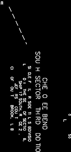
2 MEETING AGENDA CITY OF MOUNTAIN BROOK PLANNING COMMISSION AUGUST 1, 2016 PRE-MEETING: (ROOM A106) 5:00 P.M. REGULAR MEETING: (ROOM A108) 5:30 P.M. CITY HALL, 56 CHURCH STREET, MOUNTAIN BROOK, AL Call To Order 2. Approval of Agenda 3. Approval of Minutes: July 5, Case P-16-17: Resurvey of Lot 47 & W ½ of Lot 48 Mountain Brook Estates as recorded in Map Book 16, Page 76, in the office of the Judge of Probate, Jefferson County, Alabama; situated in the NE ¼ of the SE ¼ of Section 8, Twp-18S, R-2W, and the SW ¼ of the NW ¼ and the NW ¼ the SW ¼ of Section 9, Twp-18S, R-2W, all in Jefferson County, Alabama Southwood Road James Ratliff 5. Case P-16-18: Request for approval of a preliminary plat for Cherokee Bend South Sector, Third Addition, a single family residential subdivision located in the SE ¼ of Section 36, Twp-17S, R-2W, Jefferson County, Alabama. - extension of Rock Creek Trail - Paul and Betty Gilliam, and Duncan & Gilliam Construction 6. Case P-16-19: Request for approval of a preliminary plat for Cherokee Bend South Sector, Fourth Addition, a single family residential subdivision located in the SE ¼ of Section 36, Twp-17S, R-2W, Jefferson County, Alabama. extension of Cherry Brook Run - Paul and Betty Gilliam, and Duncan & Gilliam Construction 7. Case P-16-20: Resurvey of Lots 225 thru 228 Block 15 of Redmont Park New Country Club Sector as recorded in Map Book 15, Page 99, in the Office of the Judge of Probate, Jefferson County, Alabama; situated in the SW ¼ of the NW ¼ of Section 5, Twp-18S, R-2W, Jefferson County, Alabama 3240 and 3242 Salisbury Road Joey Pierson 8. Next Meeting: September 6, Adjournment
3 Minute Book 19 MINUTES CITY OF MOUNTAIN BROOK PLANNING COMMISSION JULY 5, 2016 CITY HALL, 56 CHURCH STREET, MOUNTAIN BROOK, AL The meeting of the Planning Commission of the City of Mountain Brook, Alabama, was held in the City Hall Council Chamber on Monday, July 5, 2016, at 5:30 p.m. The roll was marked as follows: Members Present: Fred Murray, Chairman Absent: Jamie Gregory Susan Swagler, Vice Chairman Alice Williams, Secretary Cay Alby Philip Black Jack Carl Also present: Dana Hazen, Director of Planning, Building and Sustainability Glen Merchant, Building Official Whit Colvin, City Attorney Tammy Graham, Administrative Assistant 1. Call to Order: Chairman Murray called the meeting to order at 5:30 p.m., there being a quorum present. 2. Approval of Agenda: Motion: Second: Vote: Mrs. Williams, to approve as printed. Mrs. Alby Unanimous approval. 3. Approval of Minutes: June 6, 2016 Motion: Second: Vote: Mrs. Williams, to approve as amended. Mrs. Swagler Unanimous approval. 4. Case P Cahaba Road Mountain Brook Board of Education EXHIBIT 1 City of Mountain Brook Parks and Recreation Consideration of a development plan of the Mountain Brook Elementary School field for the installation of a restroom and scoreboard (revised locations from Case P approved in May, 2016). Shanda Williams, Superintendent of Parks and Recreation, presented the revised application. As the representative for the Parks Board, she asked for approval of the proposed installation locations for the restroom and scoreboard at the sports field at Mountain Brook Elementary. There were no questions from the Commission or the public. V:\Minutes & Agendas\PC\Minutes\2016\ July 5, 2016
4 Minute Book 19 Motion: Mr. Black, to approve the installation of a restroom and scoreboard at the revised locations at Mountain Brook Elementary School field. Second: Mr. Carl Vote: Ayes: Fred Murray Susan Swagler Alice Williams Cay Alby Jack Carl Philip Black Nays: None Motion approved by a 6-0 vote. Ray Weygand, Weygand Surveyors, presented the plat for signatures. Glen Merchant, Building Official, brought to the attention of the Commission that Mr. Weygand had generously provided additional services for this project. The City appreciates his contribution. 5. Case P Overton Road - The City of Mountain Brook EXHIBIT 2 Rami Achdut Cahaba River Park Survey, being a resurvey of Rami Subdivision as recorded in Map Book 210, Page 24, in the office of the Probate Judge of Jefferson County, Alabama, and acreage situated in the N ½ of the NE ¼ of Section 11, Twp-18S, R-2W, in the City of Mountain Brook, Jefferson County, Alabama. Ray Weygand, Weygand Surveyors, presented the resurvey application for consideration. There were no questions from the Commission or the public. Motion: Mrs. Williams, to approve the resurvey as requested. Second: Mrs. Swagler Vote: Ayes: Fred Murray Susan Swagler Alice Williams Cay Alby Jack Carl Philip Black Nays: None Resurvey approved by a 6-0 vote. 6. Next Meeting: August 1, Adjournment: There being no further business, the meeting stood adjourned at 5:14 p.m. Tammy Graham, Administrative Assistant V:\Minutes & Agendas\PC\Minutes\2016\ July 5, 2016
5 P Planning Commission Application PART I Address of Subject Property Zoning Classification Proiect Data 27x7 ~ OUT~UUO~O & REX, o~ - u r,a L 7 NameofPropertyOwner(s) 3 ~ 1 7 ~ I( s L/ fzl(ru,-~ A JR. Name of Representative Agent (if applicable) Phone Number &A - a qg fiedkr@&f)r~n~~~~~f. &/7 [X) Property owner or representative agent must be present at hearing Plans B See applicable Section of the Zoning Ordinance for submittal requirements pertaining to your particular application. Applicable Code Section may be found in Part 11, list of application types. Contact City Planner with any specific questions as to required plans submittal.
6 Zoning Legend Clustered Residential Community Shopping Estate Residence District Local Business District MXD 2920 Office Park District Professional District PUD 3196 Residence A District Residence B District 3 WATKINS RD OVERHILL RD RD CANTERBURY HEATHERMOOR RD CAMBRIDGE RD WATKIN S LN MONTEVALLO RD WATKINSCIR CAHABA RD UNNAMED RD SURREY RD U SHADESCREEK PL SHADES CREEK PKWY CANTERBURY LN EASY ST BALMORAL RD HASTINGS RD S 1 2 VIRGIN GUILFORDRD 2832 IA RD PINE HAVEN DR OLDMILL LN 2836 P Zoning 2840 MAYFAIR RD SOUTHWOOD RD MOUNTAIN BROOK PKWY CHE ROKEE RD Residence C District Residence D District Residence E District 2921 Residence F District Residence G District Recreation District RID Rec
7 P Resurvey in existing Residence A zoning Clean-up resurvey May be approved as a final plat; the following corrections for the final plat are required by the Subdivision Regulations, and are suggested as conditions of approval: 1) note zoning district (Residence A) on plat; 2) indicate all required building setbacks; Meets the Zoning Regulations for the Residence A district. Overall layout is acceptable, with the final plat to fully comply with all applicable requirements of the Mountain Brook Subdivision Regulations. No floodplain present. No relevant history or prior cases. Project Data: NAME: Resurvey of Mountain Brook Estates CURRENT ZONING: Residence A OWNER: James Ratcliff LOCATION: 2737 Southland Road


8


9


10 P Aerial OVERHILL RD SOUTHWOOD RD OLD MILL LN GUILFORD RD Source: Esri, DigitalGlobe, GeoEye, Earthstar Geographics, CNES/Airbus DS, USDA, USGS, AEX, Getmapping, Aerogrid, IGN, IGP, swisstopo, and the GIS User Community
11 P Cherokee Bend South 3rd Sector Planning Commission Application PART I Proiect Data Address of Subject Property I) 3833 Rock Creek Trail; 2) 3640 Cheny Brook Run; 3) 3650 Cherry Brook Run Zoning Classification R-A Name of Property Owner(s) Phone Number ) Paul & Betty Gilliam; 2 & 3) Duncan & Gilliarn Const. NIA Name of Representative Agent (if applicable) JR Adarns Phone Number jradamshp@gmail.com Property owner or representative agent must be present at hearing Plans D See applicable Section of the Zoning Ordinance for submittal requirements pertaining to your particular application. Applicable Code Section may be found in Part 11, list of application types. Contact City Planner with any specific questions as to required plans submittal.
12 P GONZALEZ - STRENGTH & ASSOCIATES, INC. CIVIL ENGINEERING - TRAFFIC & TRANSPORTATION ENGINEERING - LAND SURVEYING LAND PLANNING Ms. Dana Hazen Planning Department City of Mountain Brook 56 Church Street Mountain Brook, AL Re: Cherokee Bend South Sector Third Addition Job #16BETOI Dear Ms. Hazen: We are requesting the approval of the preliminary plat for a 6 lot residential subdivision. The development will consist of extending Rock Creek Trail with associated utilities to create 6 new residential lots. The development plans and are being submitted as well for your review. David Rawson, P.E Parkway Lake Drive, Hoover, Alabama Fax:
13 CYPRESS CV COLD HARBOR LN 3504 GREAT OAK CIR NOTTINGHAM LN MILL SPRINGS RD 3509 ROCK BROOK LN STONE MILL RD COLD HARBOR CIR R OCK OLD GAP RD ROCK CREEK WAY WENDOVER DR COLD HARBOR DR CREEK TRL ROCK CREEK DR SPRING ROCK RD BRANCH MILL CIR P Zoning I459 S I459 N BRANDYWOOD DR BRANDYWOOD CIR BRANCH MILL RD TERRY CIR GRAND ROCK RD CHERRY BROOKRUN Zoning Legend RAVINE RD Clustered Residential Community Shopping Estate Residence District Local Business District MXD Office Park District Professional District PUD Residence A District GUMWOOD RD Residence B District Residence C District Residence D District Residence E District Residence F District Residence G District Recreation District RID Rec-2 HAGBUSH RD
14 P lot Subdivision in existing Residence A zoning May be approved as a preliminary plat; the following corrections for the final plat are required by the Subdivision Regulations, and are suggested as conditions of approval: 1) Tie proposed plat to the nearest corner of the USGS. Sidewalks The preliminary plat indicates 5-foot sidewalks along one side of the road (as required by the City s Subdivision Regulations). However there are no sidewalks on any streets in the surrounding area, so it may make sense to waive this requirement, as allowed under Section of the Subdivision Regulations. Plans and profiles have been submitted to the Building Official and Fire Marshal for review; plans shall be revised in accordance with minor corrections noted. Meets the Zoning Regulations for the Residence A district. Overall layout is acceptable, with the final plat to fully comply with all applicable requirements of the Mountain Brook Subdivision Regulations. No floodplain present. No relevant history or prior cases. Project Data: NAME: Cherokee Bend South Sector, Third Addition CURRENT ZONING: Residence A OWNERS: Paul and Betty Gilliam Duncan & Gilliam Construction LOCATION: Extension of west end of Rock Creek Trail


15

16 P Aerial BRANCH MILL RD ROCK CREEK TRL TERRY CIR CHERRY BROOK RUN ROCK CREEK DR I459 S I459 N Source: Esri, DigitalGlobe, GeoEye, Earthstar Geographics, CNES/Airbus DS, USDA, USGS, AEX, Getmapping, Aerogrid, IGN, IGP, swisstopo, and the GIS User Community

 3662 Cheny Brook Run Zoning Classification R-A Name of Property")

 Property owner or representative agent must be present at")


17 0 Cherokee Bend South 4th Sector P J-b '1911' Planning Commission Application PART I Proiect Data Address of Subject Property I) 3833 Rock Creek Trail; 2) 3640 Cheny Brook Run; 3) 3650 Cheny Brook Run 4) 3662 Cheny Brook Run Zoning Classification R-A Name of Property Owner(s) 1) Paul & Betty Gilliarn; 2,3, & 4) Duncan & Gilllam Const. Phone Number MA Name of Representative Agent (if applicable) JR Adarns Phone Number * jradarnshp@gmail.com [X) Property owner or representative agent must be present at hearing Plans ID See applicable Section of the Zoning Ordinance for submittal requirements pertaining to your particular application. Applicable Code Section may be found in Part 11, list of application types. Contact City Planner with any specific questions as to required plans submittal.,d


18 P GONZALEZ - STRENGTH & ASSOCIATES, INC. CIVIL ENGINEERING - TRAFFIC & TRANSPORTATION ENGINEERING - LAND SURVEYING LAND PLANNING Ms. Dana Hazen Planning Department City of Mountain Brook 4%xktK&a#L--- Mountain Brook, AL Re: Cherokee Bend South Sector Fourth Addition Job #16BETOl Dear Ms. Hazen: We are requesting the approval of the preliminary plat for a 10 lot residential subdivision. The development will consist of extending Cherry Brook Run with associated utilities to create 10 new residential lots. The development plans and are being submitted as well for your review David Rawson, P.E Parkway Lake Drive, Hoover, Alabama Fax:
19 CYPRESS CV COLD HARBOR LN 3504 GREAT OAK CIR NOTTINGHAM LN MILL SPRINGS RD 3509 ROCK BROOK LN STONE MILL RD COLD HARBOR CIR R OCK OLD GAP RD ROCK CREEK WAY WENDOVER DR COLD HARBOR DR CREEK TRL ROCK CREEK DR SPRING ROCK RD BRANCH MILL CIR P Zoning I459 S I459 N BRANDYWOOD DR BRANDYWOOD CIR BRANCH MILL RD TERRY CIR GRAND ROCK RD CHERRY BROOKRUN Zoning Legend RAVINE RD Clustered Residential Community Shopping Estate Residence District Local Business District MXD Office Park District Professional District PUD Residence A District GUMWOOD RD Residence B District Residence C District Residence D District Residence E District Residence F District Residence G District Recreation District RID Rec-2 HAGBUSH RD
20 P lot Subdivision in existing Residence A zoning May be approved as a preliminary plat; the following corrections for the final plat are required by the Subdivision Regulations, and are suggested as conditions of approval: 1) Tie proposed plat to the nearest corner of the USGS. 2) Lot 9 must have a rear setback of 40 feet instead of the two side 15-foot setbacks shown. 3) Since the proposed subdivision does not tie in to Cherry Brook Run (to the west, in the City of Irondale), rename the proposed street to something other than Cherry Brook Run. Stub Street in City of Irondale - As may be seen on the attached plat, the proposed street does not tie into the terminus of Cherry Brook Run (to the west, in the City of Irondale). The City s Subdivision Regulations do not require the streets to be connected. According to the project engineer, this same subdivision was presented to the City of Mountain Brook s Planning Commission many years ago, and the plat proposed at that time had the streets connected. Apparently there was neighborhood opposition, from both the Mountain Brook and the Irondale sides of Cherry Brook Run, to the streets being connected. The case was eventually withdrawn. Sidewalks The preliminary plat indicates 5-foot sidewalks along one side of the road (as required by the City s Subdivision Regulations). However there are no sidewalks on any streets in the surrounding area, so it may make sense to waive this requirement, as allowed under Section of the Subdivision Regulations. Maximum Street Length Section of the City s Subdivision Regulations indicates a maximum cul-de-sac street length of 1000 feet. The proposed length of Cherry Brook Run is 112 feet. The applicant requests a variance from the Subdivision Regulations for this requirement. The Fire Marshal has indicated that additional fire hydrants (locations to be approved by the City s Fire Department) will mitigate the additional 12 feet. Plans and profiles have been submitted to the Building Official and Fire Marshal for review; plans shall be revised in accordance with minor corrections noted. Meets the Zoning Regulations for the Residence A district.
21 Overall layout is acceptable, with the final plat to fully comply with all applicable requirements of the Mountain Brook Subdivision Regulations. No floodplain present. Project Data: NAME: Cherokee Bend South Sector, Fourth Addition CURRENT ZONING: Residence A OWNERS: Paul and Betty Gilliam Duncan & Gilliam Construction LOCATION: Extension of west end of Cherry Brook Run
22

23


24 P Aerial BRANCH MILL RD ROCK CREEK TRL TERRY CIR CHERRY BROOK RUN ROCK CREEK DR I459 S I459 N Source: Esri, DigitalGlobe, GeoEye, Earthstar Geographics, CNES/Airbus DS, USDA, USGS, AEX, Getmapping, Aerogrid, IGN, IGP, swisstopo, and the GIS User Community
25 P Planning Commission Application PART I Proiect Data Address of Subject Property ye[i 5 b Roc, a Zoning Classification R-t?sF / Name of Property Owner(s) -weq?rer;ioq Name of Representative Agent (if applicable) I Phone Number Property owner or representative agent must be present at hearing Plans IS See applicable Section of the Zoning Ordinance for submittal requirements pertaining to your particular application. Applicable Code Section may be found in Part 11, list of application types. Contact City Planner with any specific questions as to required plans submittal.
26 P Zoning OXFORD RD CARLISLE RD SALISBURY RD STERLING RD RIDGE DR ROCKLEDGE RD Zoning Legend COUNTRY CLUB RD Clustered Residential 3234 Community Shopping 3238 Estate Residence District Local Business District MXD Office Park District Professional District PUD Residence A District Residence B District Residence C District Residence D District Residence E District Residence F District Residence G District Recreation District RID Rec-2
27 P Resurvey in existing Residence A zoning The case involves the combining of lots 225, 226 and 227 into one lot (226A) and a lot line adjustment between the new Lot 226A and Lot 228A, adding a 6-foot strip to Lot 228A for a wider lot (in conjunction with a proposed new single family dwelling). Lot 228 is an existing non-conforming lot, with respect to minimum lot size, but will increase in size. May be approved as a final plat; the following corrections for the final plat are required by the Subdivision Regulations, and are suggested as conditions of approval: 1) note zoning district (Residence A) on plat; 2) indicate all required building setbacks; Meets the Zoning Regulations for the Residence A district. Overall layout is acceptable, with the final plat to fully comply with all applicable requirements of the Mountain Brook Subdivision Regulations. No floodplain present. No relevant history or prior cases. Project Data: NAME: Resurvey of Redmont Park CURRENT ZONING: Residence A OWNER: Joey Pierson LOCATION: 3240 and 3242 Salisbury Road


28


29 P Aerial CARLISLE RD COUNTRY CLUB RD STERLING RD SALISBURY RD OXFORD RD ROCKLEDGE RD Source: Esri, DigitalGlobe, GeoEye, Earthstar Geographics, CNES/Airbus DS, USDA, USGS, AEX, Getmapping, Aerogrid, IGN, IGP, swisstopo, and the GIS User Community

30 City of Mountain Brook SUBDIVISION REGULATIONS Adopted: March 4, 2013
31
32 ROSTER MAYOR Lawrence T. "Terry" Oden CITY MANAGER: Sam S. Gaston CITY COUNCIL Virginia C. Smith, President William S. "Billy" Pritchard, III, President Pro-Tem Jack Carl Lloyd Shelton Alice Womack PLANNING COMMISSION: Frederick W. Murray, Jr., Chairman Susan Swalger, Vice-Chairman Phillip E. Black Alice Williams, Secretary Cay Alby Jamie Gregory Jack Carl, Council Liaison Dana Hazen, Advisory Member STAFF Dana Hazen, Director of Planning, Building & Sustainability Glen Merchant, Building Official Ronald Vaughn, Public Works Director Tammy Graham, Administrative Assistant Whit Colvin, City Attorney
33
34 MOUNTAIN BROOK SUBDIVISION REGULATIONS TABLE OF CONTENTS ARTICLE 1 GENERAL PROVISIONS Enactment and Authority Jurisdiction Purpose Enforcement, Violations, and Penalties Effect of Preliminary Plat Approval Effect of Final Plat Approval Variance and Exceptions Conflicts of Interest Prohibited ARTICLE 2 DEFINITIONS Usage Definitions Abbreviations ARTICLE 3 SUBMISSION, APPROVAL PROCEDURE, PLAT REQUIREMENTS Pre Design Conference Overall Procedures Preliminary Plat Improvements Construction Plans Construction and Inspection of Improvements, Bonding Final Plat Small Subdivisions ARTICLE 4 SUBDIVISION DESIGN PRINCIPLES, STANDARDS General Suitability of Land Conformity to Comprehensive Plan Name of Subdivision and Streets Subdivisions to Have Public Access Reserve Strips Easements Design Standards for Blocks and Lots Non-residential Subdivisions ARTICLE 5 DESIGN STANDARDS FOR STREETS, RIGHTS-OF-WAY General Standards Minimum Design Requirements for Streets i
35 ARTICLE 6 DESIGN REQUIREMENTS FOR PUBLIC DRAINAGE AND STORM SEWERS General Design Criteria Gutters and Open Channels Culverts Drainage Structures Erosion and Sediment Control ARTICLE 7 SANITARY SEWER AND WATER FACILITIES Sanitary Sewer Water Facilities ARTICLE 8 REQUIREMENTS FOR SUBDIVISIONS SUBJECT TO FLOODING General Streams Depicted on Flood Boundary and Floodway Map Channelization by Variance ARTICLE 9 AMENDMENTS AND LEGAL CONSIDERATIONS Amendments Saving Clause Interpretation by the Planning Commission Regulations to be Minimum Standards Separability Effective Date and Repealer ii
36 ARTICLE 1 GENERAL PROVISIONS 1.1. Enactment and Authority. Under the provisions of Title 11, Chapter 52 of the Code of Alabama of 1975, which provisions are hereby made a part thereof, these regulations governing the subdivisions of land are hereby adopted by the Mountain Brook City Planning Commission, hereafter referred to as the Commission. A copy of these regulations shall have been certified to the Office of the Probate Judge of Jefferson County, hereinafter referred to as the Probate Office, and copies are available from the City Clerk and the City Manager Jurisdiction. On and after their effective date, these regulations shall govern each and every subdivision of land within the corporate limits and within the jurisdiction of the Commission as the same now exists or may hereafter be altered Purpose. The regulations are adopted for the following purposes: To protect and provide for the public health, safety, and general welfare of the City and its environs To guide the future growth and development of the City in accordance with plans and policies adopted pursuant to the comprehensive planning process To provide for adequate light, air and privacy, to secure safety from fire, flood, and other dangers, and to prevent overcrowding of the land and undue congestion of population To encourage the orderly and beneficial development of the City and its environs, To preserve the unique qualities of the community and to protect and conserve the value of land throughout the City and its environs and the value of buildings and improvements upon the land To guide public and private policy and action in order to provide adequate and efficient transportation, utilities, schools, parks, playgrounds, recreation, and other public services and facilities To provide the most beneficial relationship between the uses of land and buildings and the circulation of traffic throughout the city, having particular regard to the avoidance of congestion in the streets and highways, and the pedestrian traffic movements appropriate to the various uses of land, and to provide for the proper location and width of streets To establish reasonable standards of design and procedures for subdivisions and resubdivisions, in order to further the orderly layout and use of land; and to ensure proper legal descriptions and monumentation of subdivided land. 1-1
37 General Provisions To ensure that public utilities and facilities are available and will have sufficient capacity to serve the proposed subdivision To prevent the pollution of air, streams, and ponds; to assure the adequacy of drainage facilities; to safeguard water tables; and to encourage the wise use and management of natural resources throughout the community To preserve the natural beauty and topography of the Mountain Brook area and to ensure appropriate development with regard to these natural features To provide for open spaces through the most efficient design and layout of the land, including the use of average density in providing for minimum width and area of lots, while preserving the density of land as established in the Zoning Ordinance of the City of Mountain Brook Enforcement, Violations, and Penalties Enforcement. It shall be the duty of the Subdivision Official to enforce these regulations by bringing to the attention of the City Manager and City Attorney any violations, or lack of compliance herewith Violations and Penalties. Whoever, being the owner or agent of the owner, of any land located within a subdivision as defined herein, transfers or sells such land without first recording an approved plat in the Probate Office until such subdivision plat shall have been approved by the Commission and such approval entered in writing on the face of the final plat as evidenced by the signature of the Chairman and the Secretary of the Commission, shall forfeit and pay a penalty of one hundred dollars ($100.00) for each lot or parcel so transferred or sold. The City may also enjoin such transfer or sale or agreement by action for injunction brought in any court of equity jurisdiction or may recover the same penalty by a civil action in any court of competent jurisdiction Effect of Preliminary Plat Approval. Receipt of the approved copy of the preliminary plat by the subdivider is authorization, subject to the taking of proper permits, to proceed with the construction of any improvements to the subdivision under the direction and supervision of the Subdivision Official, and/or other supervisory personnel required by the City and subject to the approved plans and profiles, and to proceed with the staking of streets and lots in preparation for the final plat Effect of Final Plat Approval. Receipt of the approved copy of the final plat by the subdivider is authorization to record the plat in the Probate Office, to transfer lots in the subdivision, and to seek a building permit for structures to be erected on any lot. No building permit shall be issued for any structure in any subdivision that has not received final approval and been recorded in the Probate Office. Further, No building permit shall be issued for any structure in any subdivision, other than a legally nonconforming subdivision, that does not fully comply with these regulations. 1-2
38 1.7. Variance and Exceptions. Whenever the shape or topography of a parcel to be subdivided is so unusual that the strict application of these regulations would result in substantial and unreasonable hardship to the developer, the Commission may vary or modify the requirements of these regulations so that the developer is allowed to develop the parcel in a reasonable manner; provided, that any such variance must not be contrary to the public welfare or the public interest of the City, and the parcel must be developed in a manner which is consistent with the general intent and spirit of these regulations. The Commission may make any such variance subject to such conditions as will, in its judgment, substantially secure the objectives of the standards or requirements so varied. Any variance thus authorized, and the reason(s) therefore, must be entered, in writing, in the minutes of the Commission Conflicts of Interest Prohibited. Any member of the Commission, or its secretary, or any other employees of, or technical consultants to the Commission shall, in no case, review or enter into deliberations or vote on any matter in which they may have any conflict of interest whatsoever in regard to these regulations. 1-3
39 General Provisions This page intentionally left blank. 1-4
40 ARTICLE 2 DEFINITIONS 2.1. Usage Certain terms used in these Regulations shall have the meanings provided herein. Terms not defined herein shall have the meaning provided in the Zoning Ordinance, the City Code, or Sections through of the 1975 Code of Alabama, as amended. Otherwise, the conventional meaning of such term shall apply Words used or defined in one tense or form shall include other tenses and derivative forms. Words in the singular shall include the plural; and words in the plural shall include the singular. The masculine gender shall include the feminine; and the feminine gender shall include the masculine. The word "shall" is mandatory. The word "may" is permissive. A "person" includes an individual, a corporation, a partnership, a limited liability company, and an incorporated association of persons such as a club; a "building" includes a "structure"; a "building" or "structure" includes any part thereof; "used" or "occupied" as applied to any land or building shall be construed to include the words "intended, arranged, or designed to be used or occupied." In case of any conflict between the text of these Regulations and any caption, illustration, figure, or other graphic material, the text shall govern Definitions Adjoining Property Owner or Owners. The person owning property adjoining the tract of land proposed for subdivision development. If the owner of such adjoining property is a corporation, the term shall apply to the officers and agents of such corporation who shall be identified on preliminary plats as adjoining property owners. Owners of property located across streets, alleys, water courses, drainage easements and other rights-of-way adjoining the proposed subdivision are, for the purposes of this regulation, adjoining property owners and shall be so identified on all preliminary plats Alley. A public right-of-way designed to provide access to the side or rear of properties Approved Plat. A plat conforming to the requirements of these regulations which has received the approval of the Commission and has the signature of those officials authorized to sign the plat under the requirements of these regulations Base Flood Elevation. The water surface elevation corresponding to a flood having a one percent probability of being equaled or exceeded in a given year and as shown on the applicable Flood Insurance Rate Map (FIRM) Block. A unit of land bounded by streets or a combination of streets, public land (excluding alleys), public parks, cemeteries, railroad rights-of-way, watercourses, or any other barrier to the continuity of development. 2-1
41 Definitions Building. A roofed structure built for the shelter, housing, or enclosure of persons or property Building Official. The head of the Building Inspections Division of the Department of Planning, Building & Sustainability of the City of Mountain Brook City. The City of Mountain Brook, Alabama City Engineer. A professional engineer registered with the State of Alabama Board of Registration for Professional Engineers and Surveyors, whether on staff or contract, designated by the City of Mountain Brook to administer the applicable provisions of these regulations City Manager. The City Manager of the City of Mountain Brook Developer. The person, firm, or corporation who owns or controls a tract of land proposed for subdivision, and at whose direction plans and surveys for such subdivisions are prepared. The term developer also means "subdivider" Developer's Engineer. The engineer or engineering firm responsible for preparing plans and surveys of a proposed subdivision on behalf of the developer Development. A subdivision, including land-lease developments and condominiums, whether or not plats or deeds are to be recorded; the construction, reconstruction, conversion, structural alteration, relocation, or enlargement of any buildings; any condominium development; any use or change in use of any buildings or land; any extension of any use of land or any clearing, grading, or other movement of land, for which an approved development plan is required pursuant to these Regulations or other codes and ordinances of the City. Excluded from this definition are areas to be cleared of trees and other vegetation not exceeding one (1) acre in size, provided that no more than one such area is created on any lot of record Easement. Authorization by a property owner of the use by another and for a specified purpose of any designated part of that owner s property. These Regulations recognize only those easements created through valid legal instruments and recorded in the Office of the Probate Judge and those established by the City through continuous and historic use Engineer. A Registered Professional Engineer in good standing with the State Board of Registration in Alabama Final Plat. A finished drawing of all or a portion of a subdivision, and any accompanying materials, compiled in accordance with and presented for final approval as required in these regulations Fire Code. The latest version of the International Fire Code as adopted by the City of Mountain Brook. 2-2
42 Flood Boundary and Floodway Map. That certain map of the City of Mountain Brook and environs entitled "Flood Insurance Rate Map" issued by the Federal Emergency Management Agency and as adopted by the City of Mountain Brook, as amended Floodway Fringe. That area of the floodplain lying outside the floodway, but still subject to inundation by waters of the base flood Half Street. An existing street that does not meet the right-of-way or pavement width requirements in these Regulations Lot. A parcel of land designated as a separate piece of land (lot) by a map or plat recorded in the Probate Office. The term "lot" shall also include condominium units when such units are laid out, delineated, subdivided, and sold or intended to be sold as the functional equivalent of a typical or traditional subdivision lot Lot, Corner. A lot abutting upon two or more streets at their intersection Lot, Through. A lot other than a corner lot, abutting upon two or more streets Major Street Plan. The official plan of the Commission showing the location of existing and planned roadways designed to service the City of Mountain Brook and its environs Master Plan. The comprehensive plan of the City of Mountain Brook and environs and any amendment thereto duly adopted by the Commission Open Space. Any parcel or area of land or water, either publicly or privately owned, set aside, dedicated, designated, or reserved for the private use or enjoyment of owners or occupants of land adjoining such open space, or for the public at large Parcel. Any piece of land, including, but not limited to, a lot Planning Commission. The City of Mountain Brook Planning Commission Preliminary Plat or Proposed Development Plan. A drawing of the proposed design of a subdivision compiled in accordance with all of the requirements of these regulations Probate Office. The Office of the Judge of Probate of Jefferson County, Alabama Reserve Strip. A parcel of land located usually at the edge of a subdivision for the purpose of restricting access from the end or side of a street Resubdivision. A combination, recombination, or splitting of previously recorded lots or tracts of contiguous land for the purpose of creating additional lots or enlarging existing ones Right-of-way. A strip of land used or intended to be used for passage of the general public, and occupied or intended to be occupied by a street, road, pedestrian passage, 2-3

43 Definitions bicycle path, crosswalk, utilities, railroad or similar facility; and dedicated to the City in fee simple, or by other legal means such as prescription Setback. The distance between a building or other structure and the property lines of a parcel upon which such building or structure is located as are required by these regulations or the Zoning Ordinance Sight Distance, Intersection. The sight distance required within the corners of intersections to safely allow a variety of vehicular maneuvers based on the type of traffic control at the intersection. Required intersection sight distances are based on factors including design speed, topography, and similar conditions in accordance with AASHTO standards. See also Sight Triangle, Clear Sight Triangle, Clear. An area of unobstructed vision at an intersection defined by a line of sight between points at a given distance from the intersection of the street centerlines. See also Intersection Sight Distance Small Subdivision. Any one of the following: 1. the subdivision or the resubdivision of one or more existing lots into no more than two lots; 2. the consolidation of two or more existing lots into fewer lots; or 3. the relocation or reconfiguration of one or more boundaries of existing lots on a map or plat intended or required to be filed for record (also known as a resurvey ) provided said relocation or reconfiguration does not result in the creation of a greater number of lots than previously existed Stopping Sight Distance. The distance required by a motorist to stop a vehicle traveling at or near the design speed of a thoroughfare before reaching a traffic-controlled intersection or stationary object in their path. Required stopping sight distances are based on AASHTO standards Street. The entire platted or proposed public way for vehicular and pedestrian traffic, whether designated as an arterial, collector street, minor street, or however otherwise designated by the City, excepting, however, an alley. For the purposes of these regulations, streets are classified as follows: 1. Arterial, Minor. A major street intended to mainly carry through traffic and to connect major activity centers in the City. 2. Arterial, Principal. An expressway, freeway or highway intended to mainly carry regional traffic between communities at higher speeds. 2-4
44 3. Collector Street. A street that primarily serves as a means of moving traffic between arterials and minor streets. Direct access to abutting properties is a secondary function. 4. Cul-de-Sac Street. A minor street permanently having no outlet at one end. 5. Major Street. Any arterial or collector street. 6. Marginal Access Street or Frontage Street. A street that runs parallel to a major street, generally an arterial; its purpose being to separate through traffic from local traffic and to provide access to abutting properties. 7. Minor Street. A street primarily for access to abutting properties and as interconnection between abutting properties and other streets Subdivision. The division of a lot, tract, or other parcel of land into two (2) or more lots, plats, sites or other divisions of land, whether described by metes and bounds or by any other description, for the purpose, whether immediate or future, of sale or of building development. It includes resubdivision and, when appropriate to the context, relates to the process of subdividing or to the land or territory subdivided. For the purposes of these Regulations, all Subdivisions are considered Developments, see Development. See also Small Subdivision Subdivision Official. The Director of Planning, Building & Sustainability, Building Official, or other official designated by the City Council to administer these regulations including his/her designee Subdivision Regulations or These Regulations. The Subdivision Regulations of the City of Mountain Brook, Alabama together with all applicable design and construction standards promulgated by the City Public Works Department Submission. The presentation of a plat or plan, prepared in strict conformity to these regulations, on or before the date required by these regulations Surveyor. A qualified Registered Land Surveyor in good standing with the State Board of Registration of Alabama Swale. A constructed watercourse shaped or graded in earth materials and stabilized with vegetation, for the conveyance and water quality improvement of storm runoff Temporary Cul-De-Sac. A cul-de-sac to give access to future subdivisions adjoining the subdivision property Tier. In reference to blocks and lots, a row of lots along the same block frontage. A double-tiered block contains two tiers of lots, with each tier fronting on opposite streets. A single-tiered block contains one tier of through lots Variance. A modification of the strict application of the provisions of these regulations which may be granted by the Commission in accordance with the provisions of 1.7 of these regulations. 2-5
45 Definitions Watercourse. A permanent or intermittent stream, river, brook, run, creek, channel, swale, pond, lake or other body of surface water, carrying or holding surface water, whether natural or manmade Zoning Officer. The Director of Planning, Building & Sustainability, or his/her designee, for the City of Mountain Brook Zoning Ordinance. The duly adopted comprehensive zoning ordinance and all amendments thereto as officially adopted by the City Council of Mountain Brook Abbreviations AASHTO American Association of State Highway and Transportation Officials ALDOT Alabama Department of Transportation FIRM Flood Insurance Rate Map MSL Mean Sea Level SCS Soil Conservation Service USGS United States Geological Survey. 2-6
46 ARTICLE 3 SUBMISSION, APPROVAL PROCEDURE, PLAT REQUIREMENTS 3.1. Pre Design Conference. Before commencing the design of a subdivision, the developer's engineer shall confer with the Subdivision Official to ascertain the existence of any plans, policies or projects which would affect the design of the subdivision. Representatives of other departments of the City may participate in such conference if the Subdivision Official considers it appropriate Overall Procedures To obtain approval of a proposed subdivision, the developer shall submit to the Commission a preliminary and final plat prepared by a Registered Land Surveyor and plans and profiles of proposed improvements prepared by a Registered Engineer, and documents required by 3.3.2, 3.4, and 3.6.2, as appropriate, of these regulations. No developer may sell, contract for the sale of, or convey, a portion of a parcel until the final plat for such parcel has been approved by the Commission and recorded in the Probate Office. No developer may commence the construction of subdivision improvements or other improvements upon any parcel until he has obtained preliminary plat approval and the necessary permits from the City. However, proposed subdivisions involving no public improvements shall require Final Plat submission and approval only In order to promote compliance with these regulations and facilitate enforcement thereof, the Commission may condition the approval of any preliminary or final plat on the applicant's executing or entering into such agreements, covenants, bonds, or like undertakings as would, in the judgment of the Commission, be sufficient to assure compliance with requirements or conditions that may be imposed by these regulations, municipal ordinances, other legal mandates, and/or by the Commission; provided, however, that the precise nature, scope, and temporal duration of any condition, requirement, or obligation shall be: 1. within the Commission's statutory authority, 2. of a type that is customarily applied by governing bodies under similar circumstances, 3. clearly specified and/or described by the Commission, and 4. only imposed or required after first affording the applicant an opportunity to propose for the Commission's consideration reasonable alternatives for satisfying the objectives of the Commission Preliminary Plat Procedure. 1. The subdivider shall submit four (4) copies of the preliminary plat to the Subdivision Official at least twenty-four (24) days prior to a regularly scheduled meeting of the Commission in order for the plat to be considered at said meeting. For resubdivisions and small subdivisions submitted under 3.7, the plat must also be submitted twentyfour (24) days prior to the next meeting of the Commission. Revised plats for cases 3-1
47 Submission, Approval, Procedure, Plat Requirements which are heard by the Commission and then carried-over to the next regular meeting of the Commission, whether at the request of the Commission or the applicant, must be submitted at least seventeen (17) days before the date of the hearing at which the Commission is requested to hear the revised case. An electronic version of the preliminary plat shall be provided to the Subdivision Official if so requested. 2. Variances. The subdivider shall submit seventeen (17) copies of any requests for variance(s) from any article or section of these regulations along with material to support the claim for relief from appropriate sections or articles. 3. Fee. To help defray the cost of processing subdivision applications, reviewing plans, and otherwise administering the subdivision regulations, the applicants shall pay to the City a fee, the amount of which shall be determined by the City Council from time to time. The fee shall be due upon the filing of the application. In addition, at the time of filing such application, the applicant shall pay to the City an amount equal to the cost of the postage for sending notices to the parties who are entitled to notice of the application. 4. Notice. The subdivider and the owners of the land immediately adjoining the proposed subdivision shall be given prior notice by mail at least ten (10) days before the hearing on the preliminary plat, in accordance with the provisions of Section of Title 11, 1975 Code of Alabama. 5. Commission action. The Commission shall approve, approve conditionally or disapprove such preliminary plat within thirty (30) days after the submission thereof at its regular meeting, unless the subdivider consents to an extension of this period. If approved conditionally, the conditions and reasons therefore shall be stated in the minutes of the Commission. If any of the requirements are modified or waived, the reasons for such shall be specified in the minutes of the Commission. If the Commission should disapprove the preliminary plat, the reasons for such action shall be stated in the minutes, and if possible, recommendations made on the basis of which the proposed subdivision may be approved. 6. Disapproval. A preliminary plat that has been disapproved shall not be reconsidered by the Commission for a period of one (1) year from the time of the ruling disapproving the plat, unless all such reasons for disapproval, as recorded, have been properly resolved, as determined by the Subdivision Official. 7. Effect of approval. The approval of a preliminary plat shall not be deemed as final acceptance, but rather an expression of approval of the layout as submitted on the preliminary plat, and shall allow the developer to proceed according to 1.5. Preliminary approval of a proposed subdivision shall lapse at the end of one (1) year, unless an extension, not to exceed sixty (60) days, is granted by the Commission prior to the expiration of said one-year period. An extension of approval shall require demonstration by the subdivider of good cause Requirements. All preliminary plats presented to the Commission shall contain, at a minimum: 1. Name and address of owners and the designer of the plat. Said designer shall be a Land Surveyor registered to practice in the State of Alabama. 3-2
48 2. Names and addresses of current record (as per the Tax Assessor's records) of adjoining property owners. 3. Date of the plat, north arrow, scale of not less than one (1) inch equals one hundred (100) feet amount of acreage contained in the plat and a statement as to the remaining adjoining acreage the developer or subdivider owns, has an option on or leases. 4. Contours shown at an interval of not more than five (5) feet for slopes over fifteen (15)% and for slopes less than fifteen (15)% contours shall be shown at an interval of not more than two (2) feet. All contours shall be based on the USGS-MSL datum. No assumed datum will be accepted. A note on the plat shall indicate which Benchmark (B.M.) was used. 5. Proposed lot layout showing the following: a) Lot dimensions, building lines, front, rear and side setback lines, lot and block numbers, and proposed street names. b) Location and width of proposed rights-of-way, easements, and alleys. c) Proposed subdivision boundaries, with dimensions and tie to nearest corner of the United States government survey and the section, township and range within which the property is located. d) Any pertinent topographic features existing on the site. e) Proposed size and location of all storm drains, storm water detention facilities, and sanitary sewers. f) Location and dimensions of existing storm and sanitary sewers. 6. A statement as to the current and proposed zoning (if applicable); or a statement of the allowable use of each lot. 7. A vicinity sketch showing location of proposed site in relation to existing streets and their rights-of-way and all existing parcels and subdivisions abutting the site. 8. Width of all proposed paving from back to back of curb. 9. Evidence that every lot has frontage on a public street, or where permitted in accordance with 4.4 and the Zoning Ordinance, a private street. 10. The names, locations, widths, and other dimensions of existing or proposed parks, playgrounds, open spaces or other public property. 11. The locations of existing and proposed property lines and existing buildings, water courses, railroads, power lines, bridges, culverts, and drainpipes on the land to be subdivided and abutting land. 12. Street cross-section(s), showing proposed construction and statements concerning type of material to be used in construction. 13. Location of proposed sidewalks. 14. If any portion of the land included in, or immediately adjacent to, the proposed subdivision is located within the floodway or the 100-year flood boundary of a stream or river, as depicted on the Flood Boundary and Floodway Map, or is located in a 3-3
49 Submission, Approval, Procedure, Plat Requirements "Special Flood Hazard Area", as depicted on a Flood Hazard Boundary Map, then such floodway, boundary, or flood hazard area shall be indicated on the preliminary plat as accurately as possible Improvements Construction Plans Two (2) sets of the plans and profiles of proposed improvements shall be presented to the Subdivision Official and to the Commission, if so requested for review and approval prior to commencement of construction on the proposed subdivision. The Subdivision Official shall review all plans and profiles of subdivisions granted preliminary approval by the Commission within twenty (20) days of the receipt of the plans and notify the developer's engineer of any discrepancies requiring correction. In the event the Commission requests a copy of the plans and profiles for review and approval, a reasonable extension of the approval date shall be established by the Commission The plans and profiles shall conform to all applicable requirements of these regulations except those expressly waived by the Commission. Construction drawings of proposed improvements shall be prepared by a Registered Professional Engineer and shall include plans and profiles of streets, drainage and storm water detention structures and facilities, and erosion control measures to be used during construction of the subdivision as required by City regulations regarding erosion and sedimentation control and any other drawings and information as may be necessary to determine compliance with these regulations. Construction drawings shall also include the location of all proposed traffic control signs and devices. Where the proposed subdivision abuts an existing street, the location of any intersecting streets on the other side of the abutting street shall be depicted and any existing traffic control signs and devices along said streets. Street design shall conform to the provisions of these regulations and such other specifications as may be promulgated by the City. The plans and profiles of drainage and storm water detention facilities and features shall contain sufficient data, including calculations of pipe diameters, runoff velocity in open gutters, and down stream erosion to permit the City to verify the design's conformity to these regulations and applicable city ordinances Plans and profiles of sanitary sewer shall be approved by the Jefferson County Department of Environmental Services. Permits and/or other evidence of approval shall be submitted to the Subdivision Official prior to construction. Copies of such approved plans and profiles shall be provided to the Subdivision Official upon request Construction and Inspection of Improvements, Bonding Construction of Improvements. 1. Subdivision improvements shall be constructed under the supervision of a Registered Professional Engineer employed by the developer. Construction of subdivision 3-4
50 improvements may begin only after the plans and profiles have been approved, and the developer has purchased construction permits from the City. The fees for such permits shall be as prescribed by ordinance. Quality control during construction shall be maintained as follows: a) The developer shall employ a qualified testing laboratory to perform compaction tests on street subbase and base before placement of the mat. The results of these tests may be transmitted to the Subdivision Official by any convenient means. The plans and profiles shall be submitted in a form acceptable to the Subdivision Official. b) The developer's engineer shall ensure that a qualified inspector, experienced in water, street and sewer construction, conducts an inspection not less frequently than once daily during construction of improvements. The inspector shall maintain a logbook of all inspections, which shall be furnished to the Subdivision Official for review upon completion of construction. 2. The developer's engineer or representative shall notify the Subdivision Official before work begins on each of the following steps at least twenty-four (24) hours in advance: a) Clearing and grading; b) Placing of subbase; c) Laying of sanitary, storm pipe or water pipe; d) Pouring curb and gutter; e) Placing of base; f) Putting down mat; and g) Putting down asphalt. 3. Upon completion of construction, a set of "as built" construction plans shall be delivered to the Subdivision Official. These plans shall show all public improvements as constructed. "As-built" plans shall be referenced to subdivision corners, the Public Land System, or State Plane Coordinates. The developer's engineer shall ensure that the developer furnishes and places electronic location markers of a type approved by the Subdivision Official over all sewer stubs and wyes Improvements, Bonding. Approval of the final plat will not be given until the Commission is notified by the Subdivision Official that either: 1. All required and approved improvements have been installed and completed by the subdivider and all as-built plans submitted as required by these rules; OR 2. A bond in an amount equal to one and one-half (1-1/2) times the estimated cost of all such subdivision improvements and approved by the Subdivision Official and the City Attorney has been filed with the City Clerk. The bond shall be issued by a surety company duly licensed in, and authorized to issue surety bonds by, the State of Alabama. As an alternative, the developer may file with the City Clerk an irrevocable letter of credit, in the aforesaid amount, issued by a bank which is authorized to do 3-5
51 Submission, Approval, Procedure, Plat Requirements business in the State of Alabama and which letter of credit shall be subject to the approval of the Subdivision Official and the City Attorney No streets, drainage structures, or other improvements will be accepted for maintenance by the City until the same shall have been approved by the Subdivision Official and the acceptance thereof authorized by the City Council in the form of a resolution Maintenance Bond. The subdivider or contractor undertaking the construction work for the subdivider, shall file a bond with the City in an amount equal to ten (10) percent of the construction costs of the subdivision improvements. Payment of the proceeds of such bond or any portion thereof shall be to the order of the City as directed by the Subdivision Official for reimbursements of all costs incurred by or on behalf of the City necessary to maintain the streets, sanitary sewers, drainage structures and other improvements for a period of one (1) year following the completion and acceptance of all the improvements in the subdivision by the City. Not less than thirty (30) days before the expiration of the one year period referred to in the above paragraph, the City shall inspect the improvements covered by the ten (10) percent bond. If the inspection reveals deficiencies beyond normal wear and tear, the Subdivision Official shall notify the developer or the contractor and shall afford them reasonable opportunity to correct the deficiencies before releasing the bond. The term "bond" as used in this Section shall be deemed to include the deposit of cash with the City Clerk in the appropriate amount required under this Section; the delivery of a standby letter of credit in favor of the City issued by a financial institution licensed to do business in the State of Alabama. Said bond shall also include such other forms of cash collateral or obligations of insurance companies as may be approved as to form and substance by the City Attorney, City Manager and approved by the Commission from time to time Final Plat Procedure. 1. A final plat will be considered by the Commission once approval to all segments of the preliminary plat have been certified by appropriate agencies. The subdivider shall file four (4) copies of the final plat with the zoning officer at least twenty-four (24) days prior to the date of the meeting of the Commission at which it is to be submitted and considered. Twenty-four (24) days are also required for resubdivisions and small subdivisions. Revised plats for cases which are heard by the Commission and then carried-over to the next regular meeting, whether at the request of the Commission or the applicant, must be submitted at least seventeen (17) days before the date of the hearing at which the Commission is requested to hear the revised case. 2. Approval or disapproval of the final plat shall take place within thirty (30) days after the date of its submission to the Commission at its regular meeting unless the subdivider agrees to an extension at that time. If the final plat is disapproved, the grounds for refusal shall be stated in the minutes of the Commission. 3-6
52 3. The Commission may approve the final plat at any of its meetings, provided the pertinent requirements of these regulations have been complied with. Final approval of the plat shall be evidenced by the signatures of the Chairman and the Secretary of the Commission on the final plat, which shall not be placed on the plat until all other necessary parties have signed the plat. 4. When application is made for final plat approval, the subdivider shall pay an additional fee to defray the expenses of investigation, hearing, and acting upon the final plat. Said fee shall be established by City Council. 5. In any case where a proposed final plat differs substantially, as determined by the Commission, from the previously approved preliminary plat, in street layout, in the handling of surface water drainage, or in lot size, then the Commission may require an additional preliminary submission either before or as a condition to approval of the final plat. 6. Within sixty (60) days of final approval, the final plat shall be filed for record in the Probate Office along with any restrictive covenants which the developer agreed to place upon the land being subdivided. The Subdivision Official shall be furnished with two (2) copies of the final plat showing the Probate Judge's recording stamp and the plat book and page number where the final plat is recorded Final Plat Requirements. The final plat shall be an original drawing on mylar or other high quality reproducible material and shall be tied to an accepted corner based on the U.S. Government Survey. An electronic version shall be provided to the Subdivision Official. This plat shall also show the following: 1. Tract boundary lines; rights-of -way; property lines with accurate dimensions, bearings, or deflection angles, radii, arcs, central angles of all curves; and front building lines and front, rear and side setback lines. 2. Name/number and right-of-way of each street and other rights-of-way. 3. Locations, dimensions, and purposes of any easements. 4. Number to identify each lot or building site, approved street name(s) and street address of each lot. 5. Purpose for which sites, other than residential lots, are dedicated or reserved. 6. Location of monuments. 7. Reference to recorded subdivision plats of adjoining platted land by Plat Book and Page Number. 8. Title, graphic scale, north arrow, name and registration number of subdivision engineer, and date, together with the quarter section(s) in which the subdivision is located and the total acreage for the subdivision, as well as the area in square feet for the platted lots. 9. Space for the approval of the Chairman and the Secretary of the Commission, County Environmental Services, the County Health Department, and any other official or agency whose approval of the plat is appropriate. 3-7
53 Submission, Approval, Procedure, Plat Requirements 10. Certificates and acknowledgments for designer and owner as required in Section , Title 11, Code of Alabama, The designer shall further execute the following certification: "I hereby certify that all parts of this survey and drawing have been completed in accordance with the requirements of the Minimum Technical Standards for the Practice of Land Surveying in Alabama". 11. Final plat drawn to a scale acceptable to the Subdivision Official appropriate to the size and complexity of the subdivision, such that it will be suitable for recording in the Probate Office. 12. A statement to the fact that the plat designer has closed each lot or parcel and that each lot or parcel mathematically closes to a closure of not less than one (1) to five thousand (5000). 13. Proper identification and notations of any areas subject to flood as required by Article 9 of these regulations. The developer's engineer shall include a statement on the plat if none of the development is located in a flood hazard area. 14. If applicable, the following statement included upon the final plat and executed by the Director of Environmental Services of Jefferson County: Jefferson County Environmental Services hereby approves this record map for sanitary sewer purposes only. Any change in any right-of-way or easement boundaries after this date may void this approval Submission of Final Recorded Plat. Upon recording of the Final Plat in the Probate Office, an electronic copy of the Final Plat, as recorded, shall be provided to the Subdivision Official Small Subdivisions. If the proposed small subdivision meets the requirements of the Zoning Ordinance and no subdivision improvements are required, and the proposed small subdivision presents no other design or engineering problems in the opinion of the Commission and the Subdivision Official, the preliminary plat procedure may be omitted, and the final plat procedure shall take effect. If, in accordance with Section of the Zoning Ordinance, two or more lots-of-record or combination of such lots and portions thereof with continuous frontage in single ownership are used to satisfy area and dimensional requirements for the purposes of development, said lots and any portions thereof shall be resurveyed so as to create one conforming lot as a requirement to final plat approval. 3-8
54 ARTICLE 4 SUBDIVISION DESIGN PRINCIPLES, STANDARDS 4.1. General Suitability of Land. Land subject to flooding, improper drainage, or severe erosion, or that is for topographical or other reasons unsuitable for development, and where such problems cannot be solved by sound engineering design shall not be platted for development of any use that will continue or increase the danger to health, safety, or property destruction Conformity to Comprehensive Plan All proposed subdivisions shall conform to any city, county, or regional plan and to the City Zoning Ordinance. Whenever a tract to be subdivided embraces any part of a highway, major street or minor street, so designated on any city, county, or regional plan, such part of such proposed public way shall be platted by the subdivider in the same location and at the same or greater width as indicated on such city, county, or regional plan Whenever a plat proposes the dedication of land to public use that the Commission finds not suitable for such public use, the Commission may disapprove the plat Name of Subdivision and Streets. The names of subdivision and streets shall be subject to the approval of the Commission, which shall have the sole authority over such names. Subdivision names, or the names of streets in subdivisions, shall not duplicate or closely approximate the name of any other existing subdivision or street in the city. Streets, which are continuations of existing streets, shall bear the same name as the existing street Subdivisions to Have Public Access. Access to every lot in a subdivision shall be provided by means of a public street which has been dedicated to the public and has been accepted for maintenance by resolution of the City Council. However, upon review and approval by the Commission, private streets may be used to provide access to lots only in Cluster, RID, PUD, Residence D, F and G and Estate Zoning Districts. For approved private streets, gates or barriers shall be in accordance with the Fire Code. Private streets shall conform to the design standards for public streets established in these Regulations Reserve Strips. Reserve strips controlling access to street, alleys, and public grounds shall not be permitted unless their control is placed in the hands of the governing body under conditions approved by the governing body Easements. Easements having a minimum width of twenty (20) feet (ten (10) feet off of each adjoining lot), and located along lot lines shall be provided, as determined necessary by the City for utility lines, underground mains and cables, or for municipal purposes. In addition, storm drainage easements, 4-1
55 Subdivision Design Principles, Standards including offsite easements, will be required when determined necessary by the City for the control of surface drainage. Each final plat shall contain the following marginal note: "NOTE: ALL EASEMENTS SHOWN ON THIS PLAT ARE FOR PUBLIC UTILITIES, SANITARY SEWERS, STORM SEWERS, AND STORM DITCHES AND MAY BE USED FOR SUCH PURPOSES TO SERVE PROPERTY BOTH WITHIN AND WITHOUT THIS SUBDIVISION. NO PERMANENT STRUCTURE OR OTHER OBSTRUCTION SHALL BE LOCATED, EXCEPT BY THE PUBLIC WORKS DEPARTMENT, WITHIN THE LIMITS OF A DEDICATED EASEMENT." Where a subdivision is traversed by a water course, drainage way, channel or stream, there shall be provided a storm water, drainage and/or access easement of adequate width. Parallel streets or walkways may be required by the Commission in connection therewith. Where the subdivider owns land adjacent to the site, drainage or other easements crossing said adjacent lands, necessary to serve the site, shall be indicated on the preliminary plat and the Commission may require dedication of such easements at the time of approval of the final plat Design Standards for Blocks and Lots Block Length and Widths. Block lengths and widths shall be as follows: 1. Blocks shall be no greater than 1,200 feet nor less than 400 feet in length. 2. Blocks shall be wide enough to provide two tiers of lots of adequate depth to meet zoning requirements. 3. Where deemed necessary by the Commission to provide pedestrian access, one or more improved pedestrian passages, not less than ten (10) feet in clear width, shall be provided and shall entirely cross blocks that are more than 800 feet long. The location of such passages shall be as approved by the Commission Lot sizes and configurations shall be made with due regard to topographic conditions, contemplated use, and the surrounding area. A resubdivision shall be compatible in size and lot configuration with the surrounding neighborhood or as may be otherwise recommended in a plan adopted by the City. In all cases, lot area and widths shall meet or exceed minimum zoning and Health Department requirements for the area in which the property is located Through Lots in New Subdivisions. Through lots shall be avoided in new subdivisions except where essential to provide separation of a residential development from principal arterials or to overcome specific disadvantages of topography. For residential development abutting other arterials, the Commission may approve through lots as needed for access management purposes. This shall not apply to Small Subdivisions. A reserve strip in the form of a vegetative buffer at least ten (10) feet in depth and extending across the width of the lot, and across which there shall be no right of access, shall be provided along the line of lots abutting such arterial or other disadvantageous 4-2
56 condition. The buffer shall be planted and maintained according to the instructions of a licensed landscape architect or other qualified person in the field to constitute, at maturity, an effective physical and visual vegetative buffer between the lot and the arterial to which there is to be no access. Adequate covenants shall be executed by the owner and recorded in the Probate Office to ensure that access will be prohibited across said buffer Monuments and Markers. 1. Each subdivision shall have as a minimum, all corners of platted lots marked by 1/2 inch diameter pipe eighteen (18) inches long, which may not extend above finished grade. Location of Points of Curvature (P.C.s) and Points of Tangency (P.T.s) for street centerlines shall be marked with a monument pipe identical with those used to identify lot corners. P.C. and P.T. Markers shall be placed on each boundary of the right-of-way. 2. Permanent concrete monuments, approved by a Registered Land Surveyor, meeting the following minimum standards may be used in lieu of pipes. Such concrete monuments shall be at least four (4) inches square or five (5) inches in diameter and at least two (2) feet in length. Said monuments shall extend no higher than six (6) inches above the finished grade and shall be marked on top with a cross, brass plug, iron rod, or other durable material securely embedded Non-residential Subdivisions If a proposed subdivision is zoned for non-residential uses, the layout of the subdivision shall be designed to suit the anticipated building types, vehicular traffic, parking demand and other characteristics. In addition to the principles and standards in these regulations, which are appropriate to the planning of all subdivisions, the applicant shall demonstrate to the satisfaction of the Commission that the street, parcel, and block pattern proposed is specifically adapted to the uses anticipated and takes into account other uses in the vicinity. Non-residential subdivisions shall be consistent with good land planning practices, including but not limited to the following: Parcels shall be suitable in area and dimensions to the types of uses anticipated Street rights-of-way and pavement shall be adequate to accommodate the type and volume of traffic anticipated to be generated thereupon Special requirements may be imposed by the Commission with respect to street, curb, gutter, and sidewalk design and construction Special requirements may be imposed by the Commission with respect to the installation of public utilities, including water, sewer, and storm water drainage Every effort shall be made to protect adjacent residential areas from potential nuisance from proposed commercial or industrial subdivision, including the provision of extra depth in parcels backing up on existing or potential residential development and 4-3
57 Subdivision Design Principles, Standards provisions for a permanently landscaped buffer strip when deemed necessary by the Commission Extensions of streets carrying nonresidential traffic, especially truck traffic, to the boundaries of adjacent existing or potential residential areas shall be avoided. Where such extensions are deemed appropriate by the Commission, a transition to a lesser street classification, in accordance with the design standards in Article 5, may be required Site Plan application shall be required for all nonresidential developments within the planning jurisdiction for approval of all City and County agencies as appropriate prior to the issuing of building permits Site plans shall meet the applicable requirements of these regulations, the Zoning Ordinance, and Building Permit and Site Plan requirements issued by the Building Official. 4-4

58 ARTICLE 5 DESIGN STANDARDS FOR STREETS, RIGHTS-OF-WAY 5.1. General Standards Continuation of Existing Street. Existing streets shall be continued at the same width unless such continuation is approved by the City for a lesser classification, but in no case less than the required width of right-of-way and pavement specified in these regulations Topography. All streets shall be platted along contour elevations to provide minimum grades and greater visibility wherever practical, with consideration given to the anticipated use of the land Intersections. 1. There shall be a minimum spacing, from centerline to centerline, of 150 feet between adjacent street intersections. 2. Street intersections shall be as nearly at right angles as possible. No street intersections shall be at an angle of less than 70 degrees, unless required by unusual circumstances and approved by the Commission. Intersections of minor streets with principal arterials shall be minimized Dead End Streets. 1. Except by variance where topographic or other conditions make a greater length unavoidable, dead end streets shall not be greater in length than 1,000 feet and no less in length than 200 feet. Length shall be measured from the centerline of the intersecting street to the center of the cul-de-sac. 2. For all approved, permanent dead end streets longer than 150 ft, cul-de-sacs shall be provided at the closed end with a turn-around having a property line radius of at least 55 feet with an outside pavement radius of at least 48 feet. See Figure 5-1. Alternatives, such as hammerheads, may be approved by the Commission after a recommendation by the Fire Marshal. Figure 5-1 Cul-de-sac 3. To encourage a decrease in stormwater runoff, a planted circle may be installed with a mountable curb and low maintenance plants at the center of the cul-de-sac. Where a planted circle is provided, the cul-de-sac shall be designed to accommodate a 20 ft wide driving surface at the front (open end) of the cul-de-sac and a 25 ft wide driving surface at the back (closed end). See Figure Development Along Principal Arterials and Limited-Access Highways. Where a subdivision abuts or contains a principal arterial or a limited-access highway, the 5-1


59 Design Standards for Streets, Rights-of-Way Commission may require a street approximately parallel to and on each side of such right-of- way either as a marginal access street or, at a suitable distance, for an appropriate use of the intervening land. Due regard should be given to requirements for approach grades and future grade separations in determining distances. Lots shall have no direct access to principal arterials or limited access highways. Reserve strips may be required by the Commission to prohibit direct access to said arterial and ensured by adequate covenants Alleys. Alleys may be required at the rear of all lots used for medium-density and highdensity residential (as described in 5.2), commercial or mixed-use developments but shall not be provided in low density residential developments unless the subdivider provides evidence satisfactory to the Commission of the need for alleys. All alleys shall have a minimum right-of-way of twenty (20) feet in width, and shall be paved to a minimum width of fifteen (15) feet. Where an alley is designated as a fire apparatus access road by the Fire Marshal, the minimum pavement width shall be twenty (20) ft Half Streets. Half-streets shall be prohibited, except where essential to the reasonable development of the subdivision in conformity with other requirements of these regulations; and where the Commission finds it will be practical to require dedications of the other half when the adjoining property is subdivided. Whenever such is the case a half street shall be platted within such tract Access Management. The purposes of this subsection are to promote the overall safety of motorists, bicyclists, and pedestrians; to reduce interference with through traffic by vehicles entering, leaving, and crossing streets; to assure safe access to and from streets by emergency vehicles; and to preserve traffic capacity of streets. For all developments and changes in use, the City Engineer shall make a recommendation to the Commission regarding requests for access using the guidelines herein. See also Figure 5-2. Discouraged Figure 5-2 Access Management Patterns Recommended 1. Access to streets shall be provided to lots either by means of shared access (alleys or shared driveways), frontage roads, or direct, unshared access and shall be separated from other access points as required in Table 5-1. No curbs or rights-of-way shall be 5-2
60 cut, paved, or otherwise altered until approval for the access has been secured from the City and/or any other governmental agency controlling the street right-of-way. 2. Accesses existing, as of the effective date of these Regulations, are approved for the existing use only. Accesses approved under this Subsection shall be approved for the proposed use only. Except for shared driveways, existing driveways that do not comply with this Subsection shall be closed and a new, conforming means of access shall be approved when either of the following two circumstances occurs: 1) an application for a change of use requires a zoning change, or 2) a site plan requiring approval is submitted. A closed driveway shall be graded and landscaped to conform to adjacent land, and any curb cut shall be filled in with curb and gutter per the standards of the City and the Alabama Department of Transportation (ALDOT), as applicable. 3. Notwithstanding any other provisions of this Subsection, any access that demonstrates a potential threat or danger to the public and/or could affect the safe, efficient flow of traffic, may be denied following a recommendation from the City Engineer, based on commonly accepted and applied traffic engineering principles. 4. Access to a corner lot should be provided along the street of lesser classification or lower average daily traffic, unless otherwise specified herein. 5. Minimum recommended separation distance, as shown in Table 5-1, may be reduced when the following conditions exist: shared access is not possible; exceptional topographic or site conditions exist at the driveway location (such as in-place utility or drainage features), which would make compliance exceptionally and/or practically difficult or unduly harsh; or application of this subsection would conflict with other provisions of these regulations; and where, in the opinion of the Commission, a reduction would not constitute a threat or danger to the safe and efficient flow of traffic. 6. For a subdivision, change in use or redevelopment of property, the Commission may require shared access easements or other conditions that require multiple lots to have shared access to higher classed major streets such as through the use of alleys, crossaccess and shared driveways, or frontage or access roads. a) Shared access easements should be provided wherever it is possible to construct a continuous access drive or alley connecting one street to another. In such cases, the access drive or alley shall be constructed by the developer and may be considered for maintenance by the City. Where it is not feasible to create such an easement, the Commission may require a private access easement as described below. b) Where private access easements are used, the subdivision plat shall state that the easements run with the land and that transfer of lots shall be subject to the provision of such easements, which shall provide for a guaranteed, unrestricted, right of access to all other owners providing such easements and that the owners of lots subject to private access easements shall execute an agreement acceptable to the City specifying responsibility for construction and maintenance of the drive(s). The agreement shall specify that the parties thereto shall hold the City 5-3

61 Design Standards for Streets, Rights-of-Way harmless from liabilities resulting from unsafe conditions on private access easements. Copies of the agreements shall be filed with the City Clerk. Construction on private access easements shall not commence until all agreements are filed. Copies of all subsequent amendments to the agreements shall be filed with the City Clerk. Figure 5-3 Throat Length 7. For non-residential and multi-family developments, there shall be 150 feet minimum throat length for entering and exiting vehicles at the intersection of a driveway and a principal arterial, as measured from the pavement edge (see Figure 5-3). The required length may be modified by the Commission, if in the opinion of the City Engineer the impact to traffic safety and movement will be acceptable. In areas where significant pedestrian/bicycle travel is expected, as determined by either the City or the ALDOT, the ingress and egress lanes shall be separated by a 4 ft to 10 ft wide median with a pedestrian refuge area. 8. Access to major streets. Approval of access to major streets may be conditioned upon the provision of left- or right-turn storage lanes and/or acceleration/deceleration lanes. The requirement and design of such lanes shall be determined based on commonly accepted and applied traffic engineering principles and/or from a traffic study, all as approved by the City Engineer. a) Provision of turn lanes may require the dedication of additional right-of-way on existing streets or proposed streets. b) Continuous two-way left-turn lanes are discouraged. Where practicable, medians should be provided to control access between intersections. Minimum spacing between median openings shall be determined by the City Engineer. Medians shall be a minimum of 5 ft wide, as measured from back of curb to back of curb, or from edge-of-pavement to edge-of-pavement, as applicable. 5-4
62 Use and Street Type Principal Arterials All Uses Minor Arterials Nonresidential, Multifamily and Attached residential Single-family and Duplex residential Collectors Nonresidential, Multifamily and Attached residential Single-family and Duplex residential Minor Streets Nonresidential and Multifamily residential Attached and Detached Singlefamily and Duplex residential Table 5-1 Access Management Criteria No. of accesses permitted 1 1 per lot if frontage < 600 ft 1 per lot if frontage < 300 ft 2 1 per lot if frontage < 50 ft 1 per lot if frontage < 200 ft 2 1 per lot if frontage < 50 ft 1 per lot if frontage < 125 ft from intersections Minimum required spacing between driveways on same lot on separate lots 250 ft 250 ft 250 ft 200 ft 150 ft 150 ft 100 ft 3 50 ft 4 50 ft 150 ft 100 ft 100 ft 75 ft 3 50 ft 4 50 ft 100 ft 75 ft 75 ft 1 access per lot 75 ft 3 50 ft 10 ft 1 Lots with frontages as indicated in column 2 may have a second driveway, provided that the Commission approves such additional driveway based on trip generation or topography, and it is determined by the City Engineer that the impact to traffic safety and movement on the street will be acceptable. For Nonresidential and Multifamily subdivisions with greater frontage than indicated, additional driveways shall be permitted provided they meet the minimum spacing requirements. 2 Attached residential lots shall not have individual, direct access to a major street. For attached residential subdivisions, access to a major street shall be limited to shared access, which shall be in accordance with the spacing requirements herein. 3 A corner lot may have a driveway with less than the above required distance from the intersecting street, if, in the opinion of the City Engineer, the driveway will not adversely affect traffic safety and movement on the streets. Where the lot fronts on streets of different classification (i.e., an arterial and a minor street), access shall be provided along the street of lesser classification. 4 Requires review and approval by the Subdivision Official Minimum Design Requirements for Streets The street design requirements herein are based on the use context and the design speed of the street to be developed. For the purposes of this 5.2, residential subdivisions, or portions thereof, shall be categorized in accordance with the densities established in the City Zoning Ordinance as follows: 1) low density Estate and Residence A Districts; 2) medium density Residence B and Residence C Districts; 3) high density Residence D and Residence E Districts Street Right-of-Way Widths. 5-5
63 Design Standards for Streets, Rights-of-Way 1. Right-of-way width shall be the distance across a street from property line to property line. Minimum street right-of-way widths shall be as provided in Table Rights-of-way shall be graded to their full width so as to produce proper drainage, a pleasing appearance, reasonable grades for driveways, and a sidewalk grade that conforms to these regulations. The minimum slope shall be 1/4" per foot. 3. Where the periphery of a proposed subdivision abuts an existing street which is not improved substantially in accordance with these regulations, the developer shall install curb and gutter and shall perform all grading and drainage work otherwise required on that half of said street which directly abuts his subdivision, provided however that such half-street improvement shall produce a street with a total paving width of not less than 21 feet Travelway Width. Travelway widths shall be in accordance with Table 5-2. Generally, narrower travelway widths are recommended to support traffic calming; however, wider travelway widths may be approved or required along street segments with horizontal curves Sidewalks. 1. The subdivider shall install sidewalks as required in Table 5-2. However, in the case of cul-de-sacs the Commission may lessen or waive sidewalk requirements but may require a fee-in-lieu for sidewalk improvements on existing streets in the area surrounding the proposed subdivision. Such fee-in-lieu shall be equal to the cost of sidewalk improvements that would otherwise have been required. The Commission may employ this process for other proposed minor streets where it finds that sidewalks on said streets would be of less benefit than sidewalk improvements within the surrounding area. 2. Except where greater widths are required by the Zoning Ordinance, all sidewalks shall be a minimum of five (5) feet in width, four (4) inches in thickness, of three thousand pound (3,000 lb.) concrete, and conforming to the concrete specifications of the Subdivision Official. Each sidewalk shall have a minimum cross drainage slope of 1/4 inch per foot and shall meet ADA requirements. Curb ramps shall be provided at all intersections to meet ADA requirements. A planting strip, as specified in Table 5-2 shall separate all sidewalks from adjacent curbs Curb and Gutter; Valley Gutter. All streets shall be provided with concrete or granite curb and gutters or a concrete valley gutter as provided in Table 5-2 and as follows. 1. Curb and gutter shall be designed in accordance with Specification #1. 2. Valley gutters may be used by right along low density residential streets and, with specific approval of the Commission, along medium density residential streets. Valley gutters shall be designed in accordance with Specification #2. 3. All curbs and gutters constructed of concrete shall have a twenty-eight (28) day strength of not less than 3,000 psi. Strength tests shall be performed by a testing agency and a copy of the lab report shall be submitted to the Subdivision Official. 5-6
64 Table 5-2 Street Design Standards Specifications are based on two-lane road sections. The Commission, upon a recommendation by the City Engineer, may require a median, turn lanes, acceleration and deceleration lanes, or additional travel lanes where trips generated by anticipated uses or where City, County, or regional plans require increased design improvements (see also Figure 5-6). Street Type Low Density Residential Medium Density Residential Minor Collector/Minor Arterial Minor Collector Design Speed mph mph mph mph Curb Type/Width 30 ; valley gutter 1 30 ; valley gutter 1 18"; curb/gutter 18"; curb/gutter Min. Planting Strip 4 ft 1 4 ft 1 4 ft 5 ft Min. Sidewalk Width 5 ft 2 ; one side 5 ft 2 ; one side 5 ft; both sides 5 ft; both sides Parking Lane Width 2 none none 7 ft 7 ft Travel Lane Width ft ft ft ft Actual Curb Radius ft ft ft ft Effective Turning Radius ft ft ft ft Travelway Width ft ft ft ft Min. ROW 5 45 ft 45 ft 50 ft 50 ft Street Type High Density Residential, Mixed-Use or Non-Residential Minor Collector/Minor Arterial Frontage Road Design Speed mph mph mph Curb Type/Width 18 ; curb/gutter 18 ; curb/gutter 18 ; curb/gutter Min. Planting Strip/Tree Well 4 ft; both sides 4 ft; both sides 4 ft; developed side Min. Sidewalk Width 6 ft; both sides 6 ft; both sides 6 ft; developed side Parking Lane Width 2 7 ft 7 ft n/a Travel Lane Width ft ft ft Actual Curb Radius ft ft ft Effective Turning Radius ft ft ft Min. Travelway ft ft ft Min. ROW 5 50 ft 55 ft 45 ft 1 If specifically approved by the Commission, a vegetative swale with a minimum width of sixty-six (66) inches may be substituted for a valley gutter and planting strip. 2 On-street parking, where required or approved by the Commission, shall be parallel and may be placed on one or both sides. If placed on both sides of medium density residential streets, ROW width should be increased accordingly. Angled parking may be permitted by the Commission on mixed-use and non-residential streets. In such cases, minimum parking lane width shall be 18 ft and the travelway and ROW widths increased accordingly. 3 Effective turning radius is determined by adding the width of an adjacent parking lane, if present, to the corner curb radius. Where a bulb-out is provided, the effective turning radius is the same as the actual curb radius of the bulb-out. 4 Travelway width is measured: 1) where swales are used, from edge-of-pavement to edge-of-pavement, 2) where valley gutters are used, from centerline of valley to centerline of valley, and 3) where vertical curb/gutter is used, from face-ofcurb to face-of-curb. Widths shown do not include on-street parking. Where on-street parking, medians or additional travel lanes (including turn, acceleration, and deceleration lanes) are approved or required by the Commission, travelway widths shall be adjusted by adding such additional widths. 5 Additional ROW width may be required when swales, parking lanes, or medians are used, additional lanes are included, or when other design elements require a greater width. 5-7
65 Design Standards for Streets, Rights-of-Way Figure 5-4 Street Assemblies 5-8

66 Curb Radius. The curb radius at street intersections shall be in accordance with Table 5-2. Larger radii shall be required along streets with higher design speeds and at intersections where frequent turns by large vehicles are expected. On minor streets, the smallest curb radius should be used to slow vehicular turning movements (while still accommodating turning movements by emergency vehicles) and provide short crossing distances for pedestrians. 1. For streets with on-street parking, Figure 5-5 Effective Turning Radius an Effective Turning Radius, should govern rather than a long Actual Curb Radius. In the absence of on-street parking, the Actual Curb Radius shall be in the range specified for the Effective Turning Radius. See Figure Where the angle of street intersections is less than 90 degrees, a longer radius may be required by the Subdivision Official Medians. Medians shall have a minimum width of five (5) ft to allow for planting Parking Lanes. Lanes for on-street parking shall be provided on streets as required or as approved by the Commission in accordance with the requirements in Table 5-2 and the following. 1. Generally, on-street parking is recommended on streets serving non-residential, mixed-use, and high density residential streets. 2. Vertical curb and gutter should be used wherever on-street parking is provided. However, other designs may be permitted with specific approval of the Commission. 3. Parking lane width shall be measured from the face of curb. Where adjacent to a valley gutter, parking lane width shall be measured from the center of the valley gutter. When adjacent to a swale, parking lane width shall be measured from the edge of pavement Planting Strips. Planting strips shall be provided between the curb and sidewalk, or in the absence of sidewalk, between the curb and right-of-way line. Along residential streets, the planting strip shall be grassed or otherwise vegetative. Along mixed-use and nonresidential streets, the planting strip shall include regularly spaced street tree wells and an extension of the sidewalk to the curb. See Figure 5-4. With specific approval of the Commission, a grassed or vegetative planting strip may be used on mixed-use and nonresidential streets, such as where minimal pedestrian traffic is expected. 5-9

67 Design Standards for Streets, Rights-of-Way Street Grades. Maximum street grades shall be: 7.0% on arterials, 12.0% on collectors, and 16.0% on minor streets and alleys, with no grades exceeding the maximum for any length of street. Grades of dead end streets shall not exceed 5.0 % for the cul-de-sac bulb or hammerhead. To allow for proper drainage, no tangent street grade shall be less than one (1) percent. Table 5-3 Sight Distance and Street Curvature Street Design Speed (mph) Minimum centerline radius (ft) Stopping Sight Distance (ft) Intersection Sight Distance (ft) Distances are intended as a minimum guideline. Site conditions such as grades, traffic volumes, signalization types, etc. may warrant increases in desired sight distances. Figure 5-6 Stopping Sight Distance and Street Curvature Driveway Grades. Driveway grades shall be subject to the limitations as shown in Figure 5-7 and in Table 5-4. Any driveway grade which exceeds recommended grades shall require approval of the Fire Marshal. Within ten (10) feet of the curb line, or in the absence of a curb, the edge of pavement, the driveway grade shall not exceed six (6) percent. 5-10
201 General Provisions
 201 General Provisions 201.01 Title 201.09 Amendments 201.02 Purpose and Intent 201.10 Public Purpose 201.03 Authority 201.11 Variances and Appeals 201.04 Jurisdiction 201.12 Nonconformances 201.05 Enactment
ARTICLE 15. RULES, REGULATIONS AND DEFINITIONS
 ARTICLE 15. RULES, REGULATIONS AND DEFINITIONS Section 1. Interpretation and Construction: The following rules and regulations regarding interpretation and construction of the Ulysses-Grant County, Kansas,
ELK RAPIDS TOWNSHIP ANTRIM COUNTY, MICHIGAN ORDINANCE NO
 ELK RAPIDS TOWNSHIP ANTRIM COUNTY, MICHIGAN ORDINANCE NO. 3-2011 AN ORDINANCE TO REPLACE THE SUBDIVISION CONTROL ORDINANCE WITH A NEW SUBDIVISION DEVELOPMENT ORDINANCE, IN ACCORD WITH THE LAND DIVISION
ARTICLE 3 DEFINITIONS
 Sections: 3-1 Rules of Construction 3-2 Definitions ARTICLE 3 DEFINITIONS SECTION 3-1 RULES OF CONSTRUCTION 3-101. a. The language set forth in these regulations shall be interpreted in accordance with
CITY OF SAND SPRINGS CODE OF ORDINACES TITLE 16
 CITY OF SAND SPRINGS CODE OF ORDINACES TITLE 16 10/30/2018 TITLE 16 SUBDIVISIONS Chapters: 16.04 GENERAL PROVISIONS 16.08 DEFINITIONS 16.12 APPLICATION PROCESS 16.16 SPECIFICATIONS FOR DOCUMENTS 16.20
ARTICLE 1 GENERAL PROVISIONS
 ARTICLE 1 GENERAL PROVISIONS SECTION 100 TITLE This Ordinance shall be known and cited as the "Rice Township Subdivision and Land Development Ordinance." SECTION 101 AUTHORITY Rice Township is empowered
THE COUNTY BOARD OF SUPERVISORS OF THE COUNTY OF DOUGLAS DOES ORDAIN AS FOLLOWS:
 8.1 SUBDIVISION CONTROL ORDINANCE THE COUNTY BOARD OF SUPERVISORS OF THE COUNTY OF DOUGLAS DOES ORDAIN AS FOLLOWS: SECTION I. GENERAL INTERPRETATION This ordinance shall not repeal, impair or modify private
VILLAGE OF SOUTH RUSSELL SUBDIVISION RULES. Revised
 VILLAGE OF SOUTH RUSSELL SUBDIVISION RULES Revised 7 2 96 1 TABLE OF CONTENTS CHAPTER 1: TITLE AND SCOPE Page 1.00 Title 1 1.01 Jurisdiction 1 1.02 Objectives 1 1.03 Interpretation 1 1.04 Separability
ENTERPRISE SUBDIVISION REGULATIONS. Recommended to the City of Enterprise. Enterprise Subdivision Regulations Draft Printed 1/17/2007 1
 ENTERPRISE SUBDIVISION REGULATIONS Recommended to the City of Enterprise Enterprise Subdivision Regulations Draft Printed 1/17/2007 1 ENTERPRISE SUBDIVISION REGULATIONS TABLE OF CONTENTS ARTICLE I: GENERAL
ORDINANCE NO. 42 AS AMENDED BY ORDINANCES NO. 57 SUBDIVISION ORDINANCE
 PAGE 1 ORDINANCE NO. 42 AS AMENDED BY ORDINANCES NO. 57 SUBDIVISION ORDINANCE AN ORDINANCE REGULATING THE SUBDIVISION OF LAND IN SUPERIOR TOWNSHIP; REQUIRING AND REGULATING THE PREPARATION AND PRESENTATION
Appendix A. Definitions
 Definitions 1. Terms Defined. Words contained in this are those having a special meaning relative to the purposes of this Ordinance. Words not listed in this section shall be defined by reference to: (1)
SECTION 7000 LAND DEVELOPMENT REQUIREMENTS
 SECTION 7000 LAND DEVELOPMENT REQUIREMENTS 7000 LAND DEVELOPMENT REQUIREMENTS... 1 7001 LEGISLATIVE AUTHORITY... 1 7001.1 LAND DEVELOPMENT... 1 7001.1.1 Title 40, Idaho Code... 1 7001.1.2 Idaho Code 40-1415
PLANNING COMMISSION PACKET
 PLANNING COMMISSION PACKET November 2, 2017 Hello All, Enclosed please find your packet for the meeting of November 6, 2017. We have: Resurvey combining 1 lot with adjoining acreage Subdivision of 1 lot
White County Subdivision Control Ordinance TABLE OF CONTENTS
 Table of Contents TABLE OF CONTENTS CHAPTER 1: PURPOSE, AUTHORITY, AND JURISDICTION 1.0 Title... 1.1 1.1 Purpose and Authority... 1.1 1.1.1 Purpose... 1.1 1.1.2 Authority... 1.2 1.2 Policy... 1.2 1.2.1
ARTICLE 8C SITE CONDOMINIUM DEVELOPMENT ORDINANCE
 ARTICLE 8C SITE CONDOMINIUM DEVELOPMENT ORDINANCE SECTION 8C.01 PURPOSE It is the purpose of this Ordinance to insure that plans for development within Oceola Township proposed under the provisions of
A. Appropriate agency responsible for transportation review for the subject property.
 7.8.10 Procedure Any person desiring to create a minor subdivision shall submit to the Commission for approval an application on forms provided by the Division, and a record plat in conformance with the
Town of Shorter Subdivision Regulations
 Town of Shorter Subdivision Regulations Proposed Amendments: July 12, 2007 TABLE OF CONTENTS Resolution of Adoption Article 1: General Provisions... 1 1.1 Title... 1 1.2 Authority... 1 1.3 Effective Date...
City of Russellville, Arkansas. Land Subdivision and Development Code
 City of Russellville, Arkansas Land Subdivision and Development Code Ordinance No.1789 Adopted by Russellville City Council June, 15, 2003 Amended by Ordinance 1993 October 25, 2007 Amended by Ordinance
PLANNING COMMISSION PACKET
 PLANNING COMMISSION PACKET November 29, 2017 Hello All, Enclosed please find your packet for the meeting of December 4, 2017. We have: Three Clean-up Resurveys Residential Solar Panel System If you receive
CHAPTER 22 SUBDIVISION AND LAND DEVELOPMENT. Part 1 General Provisions. Part 2 Application Procedure and Approval Process
 CHAPTER 22 SUBDIVISION AND LAND DEVELOPMENT Part 1 General Provisions 101. Title 102. Policy 103. Purposes 104. Authority 105. Jurisdiction 106. Interpretation, Conflict and Separability 107. Municipal
FINAL PLAT APPLICATION
 FINAL PLAT APPLICATION (Page 1 of 3) LEGAL OWNER(s): NAME: STREET ADDRESS OWNER(s): CITY, STATE, ZIP CODE: PHONE NUMBER: BILLING ADDRESS: NAME OF ENGINEER/SURVEYOR: Engineer/Surveyor Address, Phone: PROPERTY
Memorandum: October 13, 2008 REVISED To: Trowbridge Township Planning Commission From: P. Hudson, AICP Re: Suggested New Ordinance
 1 Memorandum: October 13, 2008 REVISED 2-11-09 To: Trowbridge Township Planning Commission From: P. Hudson, AICP Re: Suggested New Ordinance Because of changes in both the Michigan Planning Enabling Act
LAND DEVELOPMENT AND SUBDIVISION ORDINANCE
 LAND DEVELOPMENT AND SUBDIVISION ORDINANCE (CHAPTER 18 OF THE MUNICIPAL CODE OF ORDINANCES) TO BE IMPLEMENTED BY: THE CITY OF FLORENCE July 2007 TABLE OF CONTENTS ARTICLE I: IN GENERAL... 1 1.1 Title...
SUBDIVISION CONTROL ORDINANCE. LaPorte County City of LaPorte City of Michigan City
 SUBDIVISION CONTROL ORDINANCE LaPorte County City of LaPorte City of Michigan City Adopted January 7, 2012 Table of Contents Table of Contents Article 01 Basic Provisions 01.01 Preamble and Enacting Clause
ARTICLE SINGLE FAMILY SITE CONDOMINIUM DEVELOPMENT STANDARDS
 ARTICLE 28.00 SINGLE FAMILY SITE CONDOMINIUM DEVELOPMENT STANDARDS Section 28.01 PURPOSE The purpose of this Article is to recognize that conventional single family developments, traditionally developed
CITY OF HOBBS ORDINANCE NO..
 CITY OF HOBBS ORDINANCE NO.. AN ORDINANCE TO AMEND TITLE 16 OF THE HOBBS MUNICIPAL CODE IN ITS ENTIRETY. BE IT ORDAINED BY THE GOVERNING BODY OF THE CITY OF HOBBS, NEW MEXICO, that the following Chapter
M-43 CORRIDOR OVERLAY ZONE
 ARTICLE 26.00 M-43 CORRIDOR OVERLAY ZONE Section 26.01 Findings A primary function of the M-43 state highway is to move traffic through the Township and to points beyond. As the primary east-west arterial
Application for Preliminary Plat Checklist
 Application for Preliminary Plat Checklist Note: No portion of an existing parcel may be sold or transferred to another party without first legally subdividing the property according to the City of Richmond
610 LAND DIVISIONS AND PROPERTY LINE ADJUSTMENTS OUTSIDE A UGB
 ARTICLE VI: LAND DIVISIONS AND PROPERTY LINE ADJUSTMENTS VI-21 610 LAND DIVISIONS AND PROPERTY LINE ADJUSTMENTS OUTSIDE A UGB 610-1 Property Line Adjustments (Property Line Relocation) A property line
ARTICLE 15 - PLANNED UNIT DEVELOPMENT
 Section 15.1 - Intent. ARTICLE 15 - PLANNED UNIT DEVELOPMENT A PUD, or Planned Unit Development, is not a District per se, but rather a set of standards that may be applied to a development type. The Planned
13-2 SUBDIVISION PLANS AND PLATS REQUIRED EXCEPTIONS Subdivision Plats Required To be Recorded
 ARTICLE XIII SUBDIVISIONS 13-1 INTENT AND PURPOSE 13-1-1 Intent: It is the intent of the County Commission through the adoption of this Article to more fully avail itself of the power granted under 17-27-601
ADOPTED: December 12, 2006 Planning Commission Members: Rodney Huffman, Chairman Clint Brown Lionell Burris Cliff Christopher Gina Garth George Hardy
 2006 ADOPTED: December 12, 2006 Planning Commission Members: Rodney Huffman, Chairman Clint Brown Lionell Burris Cliff Christopher Gina Garth George Hardy Venard Hendrex William R. Marks Caryl Shaw Gail
SUBDIVISION DESIGN PRINCIPLES AND STANDARDS
 SECTION 15-200 SUBDIVISION DESIGN PRINCIPLES AND STANDARDS 15-201 STREET DESIGN PRINCIPLES 15-201.01 Streets shall generally conform to the collector and major street plan adopted by the Planning Commission
CITY OF COZAD DAWSON COUNTY, NEBRASKA
 CITY OF COZAD DAWSON COUNTY, NEBRASKA SUBDIVISION REGULATIONS ADOPTED BY THE CITY OF COZAD, NEBRASKA Prepared By TABLE OF CONTENTS ARTICLE 1: TITLE, PURPOSE, AND DEFINITIONS... 1 SECTION 1.01 NAME AND
TABLE OF CONTENTS ARTICLE I
 TABLE OF CONTENTS Section Page ARTICLE I General Provisions 1-1 Title 1 1-2 Authority 1 1-3 Jurisdiction 1 1-4 Purpose and Intent 1 1-5 Interpretation, Conflict, and Severability 3 1-5.1 Interpretation
BEAR CREEK TOWNSHIP EMMET COUNTY, MICHIGAN. PRIVATE ROAD ORDINANCE Ordinance No. 11A-99. (to replace prior Private Road Ordinance No.
 BEAR CREEK TOWNSHIP EMMET COUNTY, MICHIGAN PRIVATE ROAD ORDINANCE Ordinance No. 11A-99 (to replace prior Private Road Ordinance No. 11-99) An Ordinance to protect the health, safety, and general welfare
SUBDIVISION REGULATIONS
 SUBDIVISION REGULATIONS Adopted the 14th day of January, 1970 Updated through December 2015 Article I. - Purpose and Title Sec. 1. Purpose. Sec. 2. Title. Article II. - Authority and Jurisdiction Sec.
CHAPTER 18 SUBDIVISION AND PLATTING ORDINANCE OF THE TOWN OF OSCEOLA CODE OF ORDINANCES
 TOWN OF OSCEOLA POLK COUNTY WISCONSIN ORDINANCE # 18-03-03 CHAPTER 18 SUBDIVISION AND PLATTING ORDINANCE OF THE TOWN OF OSCEOLA CODE OF ORDINANCES 18.01 Purpose Adopted 3/08/99, Amended 5/12/03, 7/9/07,
ARTICLE 23 CONDOMINIUM STANDARDS
 ARTICLE 23 CONDOMINIUM STANDARDS Section 23.01 Intent. The intent of this Article is to provide regulatory standards for condominiums and site condominiums similar to those required for projects developed
THE UNINCORPORATED AREA OF CLARKE COUNTY, IOWA TABLE OF CONTENTS
 ORDINANCE #11 THE UNINCORPORATED AREA OF CLARKE COUNTY, IOWA TABLE OF CONTENTS ARTICLE I:-------------------------------------------------------------------------GENERAL PROVISIONS ARTICLE II:--------------------------------------------------------------------------------------DEFINITIONS
AMENDED AGENDA BLUFFDALE CITY BOARD OF ADJUSTMENT. January 24, 2017
 AMENDED AGENDA BLUFFDALE CITY BOARD OF ADJUSTMENT January 24, 2017 Notice is hereby given that the Bluffdale City Board of Adjustment will hold a public meeting Tuesday, January 24, 2017, at the Bluffdale
SUBDIVISION ORDINANCE CITY OF DES MOINES, IOWA
 SUBDIVISION ORDINANCE CITY OF DES MOINES, IOWA SUBDIVISION REGULATIONS CITY OF DES MOINES, IOWA NOTICE This is an unofficial and annotated copy of excerpts from the Municipal code of the City of Des Moines,
BY THE CITY COMMISSION ORDINANCE NO.:
 BY THE CITY COMMISSION ORDINANCE NO.: 2005-0868 AN ORDINANCE BY THE CITY COMMISSION OF THE CITY OF DADE CITY, FLORIDA CREATING A DEVELOPMENT REVIEW PROCEDURES ORDINANCE; PROVIDING FOR INTENT, PURPOSE,
Short Title. This title shall be known as the "subdivision ordinance" of the City of Denver, Iowa. (Ord (part), 1992)
, 1992)") Title 19 PLATS AND SUBDIVISIONS Chapters: 19.01 General Provisions 19.02 Minor Plats 19.03 Preliminary Plats 19.04 Final Plats 19.05 Standards and Specifications 19.06 Other Provisions Chapter 19.01 GENERAL
Title 19 PLATS AND SUBDIVISIONS Chapters: 19.01 General Provisions 19.02 Minor Plats 19.03 Preliminary Plats 19.04 Final Plats 19.05 Standards and Specifications 19.06 Other Provisions Chapter 19.01 GENERAL
DAUPHIN CREEK ESTATES SUBDIVISION
 # 12 SUB-000076-2017 DAUPHIN CREEK ESTATES SUBDIVISION Engineering Comments: FINAL PLAT COMMENTS (should be addressed prior to submitting the FINAL PLAT for review and/or signature by the City Engineer):
TOWNSHIP OF BORDENTOWN LAND DEVELOPMENT APPLICATION CHECKLIST. General Requirements for all Applications
 TOWNSHIP OF BORDENTOWN LAND DEVELOPMENT APPLICATION CHECKLIST This CHECKLIST has been adopted in accordance with Section 25:807 of the Land Development Ordinance of the Township of Bordentown and will
The purpose of this Chapter is to establish rules, regulations, standards and procedures for approval of subdivisions of land to promote and ensure:
 CHAPTER 7 SUBDIVISION SECTION 7.1 PURPOSE The purpose of this Chapter is to establish rules, regulations, standards and procedures for approval of subdivisions of land to promote and ensure: A. Conformity
Town of Fayette. Subdivision of Land Regulations. Adopted September 11, 2008
 Town of Fayette Subdivision of Land Regulations Adopted September 11, 2008 Adopted September 11, 2008 2 SUBDIVISION OF LAND ARTICLE 1 General Regulations Section 100 Title; compliance required. These rules
CITY OF LAKE CHARLES
 CITY OF LAKE CHARLES SUBDIVISION REGULATIONS UPDATED 04-06-05 AS AMENDED BY RESOLUTION 79-1 FEBRUARY 19, 1979 EXHIBIT A SUBDIVISION REGULATIONS CITY OF LAKE CHARLES, LOUISIANA TABLE OF CONTENTS PAGE SECTION
BRIDGETON SUBDIVISION APPLICATION CHECKLIST
 APPLICATION NAME AND # CHECKLIST COMPLETED BY: DATE: Signature and printed name BRIDGETON SUBDIVISION APPLICATION CHECKLIST TO SUBDIVISION APPLICANTS: The attached checklist is to assist you in the submission
ARTICLE 100 SUBDIVISION APPLICATION PROCEDURE AND APPROVAL PROCESS
 ARTICLE 100 SUBDIVISION APPLICATION PROCEDURE AND APPROVAL PROCESS 100.01 General Procedure 100.02 Exempt Subdivision 100.03 Administrative Subdivision 100.04 Major Subdivision 100.05 Signing and Recording
SUBDIVISION APPLICATION CHECKLIST SKETCH PLAN PRELIMINARY PLAT FINAL PLAT
 RECEIVED STAMP SUBDIVISION APPLICATION CHECKLIST SKETCH PLAN PRELIMINARY PLAT FINAL PLAT A checklist of background information and submission requirements for processing of a sketch plan, preliminary plat
SUBDIVISION REGULATIONS
 CHAPTER 41 SUBDIVISION REGULATIONS 41.01 Short Title 41.17 Presentation to Commission or Board of Supervisors 41.02 Purpose 41.18 Subdivision Classified 41.03 Application 41.19 Plats Required 41.04 Recording
CHAPTER 5. Subdivisions Regulations
 CHAPTER 5 Subdivisions Regulations 10-5-1 Introduction and Purpose 10-5-2 Definitions 10-5-3 General Provisions 10-5-4 Procedure for Submitting Subdivisions 10-5-5 Design Standards; Streets and Lots 10-5-6
ARTICLE 1: GENERAL PROVISIONS
 ARTICLE 1 GENERAL PROVISIONS AN ORDINANCE REGULATING THE SUBDIVISION OF LAND PRESCRIBING STANDARDS FOR SUBDIVISIONS AND FOR THE IMPROVEMENT THEREOF, PRESCRIBING PROCEDURES FOR THE REVIEW OF PROPOSED SUBDIVISION
APPLICATION PROCEDURE
 ANTRIM PLANNING BOARD P. O. Box 517 Antrim, New Hampshire 03440 Phone: 603-588-6785 FAX: 603-588-2969 APPLICATION FORM AND CHECKLIST FOR MINOR OR MAJOR SITE PLAN REVIEW File Date Received By APPLICATION
Draft Model Access Management Overlay Ordinance
 Draft Model Access Management Overlay Ordinance This model was developed using the City of Hutchinson and the Trunk Highway 7 corridor. The basic provisions of this model may be adopted by any jurisdiction
PAUPACK TOWNSHIP WAYNE COUNTY, PENNSYLVANIA. Subdivision and Land Development Ordinance
 PAUPACK TOWNSHIP WAYNE COUNTY, PENNSYLVANIA Subdivision and Land Development Ordinance 100-1 Title 100-2 Authority and Jurisdiction 100-3 Purposes 100-4 Interpretation 100-5 Township Liability 100-6 Separability
CITY OF SARALAND PRELIMINARY SUBDIVISION PLAT REVIEW
 PRELIMINARY SUBDIVISION PLAT REVIEW Application Number: Date Plat Submitted: Name of Subdivision: Name of Owner: Owner Address: (Street or P.O. Box) Telephone #: (City) (State) (Zip) E-mail: Name of Authorized
Midwest City, Oklahoma Code of Ordinances Chapter 38: Subdivision Regulations
 2012 Midwest City, Oklahoma Code of Ordinances Chapter 38: Subdivision Regulations Adoption Date: 8/14/2012 Table of Contents Article I. General Provisions... 5 Section 38-1. Preamble... 5 Section 38-2.
Amendments to Subdivision Ordinance Regulations #3
 Amendments to Subdivision Ordinance Regulations #3 DATE SECTION/TITLE ORDINANCE # 07/06/81 Driveways 1164 06/05/84 Fees 1216 Sec. V General Design Standards 06/12/90 Sec. VI Required Improvements 1076B
Subdivision Ordinance. Adopted December 2, 2010 *Article III Amended June 6, 2013 TABLE OF CONTENTS
 Subdivision Ordinance Adopted December 2, 2010 *Article III Amended June 6, 2013 TABLE OF CONTENTS ARTICLE I INTRODUCTORY PROVISIONS Page Section 1-1 Title I-1 Section 1-2 Purpose I-1 Section 1-3 Authority
Planning and Zoning Code
 2014 Planning and Zoning Code City of Defiance, Ohio December 2014 Planning and Zoning Code City of Defiance, Ohio CHAPTER 1161. General Provisions... 7 1161. 01. Title... 7 1161. 02. Purpose... 7 1161.
I. Requirements for All Applications. C D W
 108-16.1. Application checklists. Checklist for Required Submissions to the Planning Board or Zoning Board of Adjustment of Monroe Township All required submissions are to be made to the Administrative
City of Waukegan Subdivision Ordinance
 City of Waukegan Subdivision Ordinance Table of Contents ARTICLE 1 TITLE... 5 ARTICLE 2 POLICY... 6 ARTICLE 3 PURPOSE... 7 ARTICLE 4 JURISDICTION... 8 ARTICLE 5 INTERPRETATION AND SEPARABILITY... 9 5.1
HAWLEY BOROUGH WAYNE COUNTY, PENNSYLVANIA
 HAWLEY BOROUGH WAYNE COUNTY, PENNSYLVANIA Subdivision and Land Development Ordinance 100-1 Title 100-2 Authority and Jurisdiction 100-3 Purposes 100-4 Interpretation 100-5 Borough Liability 100-6 Separability
ORDINANCE NO. 41. PRIVATE ROAD ORDINANCE As Amended Through April 10, 2008
 ORDINANCE NO. 41 PRIVATE ROAD ORDINANCE As Amended Through April 10, 2008 An Ordinance to protect the health, safety, and general welfare of the inhabitants of Port Sheldon Township. The Township of Port
SUBDIVISION ORDINANCE
 SUBDIVISION ORDINANCE TOWN OF DOBSON, NORTH CAROLINA Adopted November 29, 2007 Table of Contents Sections Page Number Section 1.1 Purpose and Applicability 1 Section 1.2 Definitions and Rules of Construction
-MENDOCINO COUNTY PLANNING AND BUILDING SERVICES- DIVISION OF LAND REGULATIONS TITLE 17
 ARTICLE VI -- GENERAL REGULATIONS AND PROVISIONS Sec. 17-50. Sec. 17-51 General Plan. Sec. 17-52 Lot and Block Design and Configuration. Sec. 17-53 Lot Access. Sec. 17-54 Private Roads. Sec. 17-55 Water
TOWN OF LEWISTON PLANNING BOARD APPLICATION
 TOWN OF LEWISTON PLANNING BOARD APPLICATION DESCRIPTION OF PROPOSED REQUEST: Name of Property Owner: Phone #: Name of Applicant:Phone #: Address or Location of Proposal:_SBL# Size of Parcel or Structure:Existing
TITLE 18 Subdivisions
 TITLE 18 Subdivisions ADMINISTRATION: 18.02 General Provisions 2 18.04 Definitions 6 18.06 Exceptions to Requirements 12 18.08 Enforcement 14 DIVISIONS OF LAND: 18.20 Tentative Parcel Maps 15 18.22 Tentative
CITY OF SARALAND FINAL SUBDIVISION PLAT REVIEW
 CITY OF SARALAND FINAL SUBDIVISION PLAT REVIEW Application Number: Date Plat Submitted: Name of Subdivision: Name of Owner: Owner Address: (Street or P.O. Box) Telephone #: (City) (State) (Zip) E-mail:
FREQUENTLY USED PLANNING & ZONING TERMS
 City Of Mustang FREQUENTLY USED PLANNING & ZONING TERMS Abut: Having property lines, street lines, or zoning district lines in common. Accessory Structure: A structure of secondary importance or function
City of Concord, NH. Subdivision Regulations
 City of Subdivision Regulations Adopted: December 15, 2010 Revised: October 5, 2011 April 17, 2013 July 18, 2016 City of Concord Planning Board Planning Division Community Development Department Foreword
SECTION 11 PLANNING & ZONING. SUBDIVISION CONTROL Ord. No. 176 Adopted: December 10, 1969
 SUBDIVISION CONTROL Ord. No. 176 Adopted: December 10, 1969 An ordinance enacted under Act 288, Public Acts of 1967, as amended, of the State of Michigan establishing regulations governing the subdivision
NICHOLS HILLS SUBDIVISION REGULATIONS TABLE OF CONTENTS
 NICHOLS HILLS SUBDIVISION REGULATIONS TABLE OF CONTENTS ARTICLE I. GENERAL Section 1.1 Title. Section 1.2 Purposes. Section 1.3 Scope and jurisdiction. Section 1.4 Policy. Section 1.5 Authority. ARTICLE
SECTION 10.7 R-PUD (RESIDENTIAL PLANNED UNIT DEVELOPMENT) ZONE
 ZONE") Article X Zones 10-20 SECTION 10.7 R-PUD (RESIDENTIAL PLANNED UNIT DEVELOPMENT) ZONE A. PURPOSE AND INTENT: The R-PUD Residential PUD Zone is intended to provide alternative, voluntary zoning procedures
Article X Zones 10-20 SECTION 10.7 R-PUD (RESIDENTIAL PLANNED UNIT DEVELOPMENT) ZONE A. PURPOSE AND INTENT: The R-PUD Residential PUD Zone is intended to provide alternative, voluntary zoning procedures
This Ordinance is adopted under the authority and provisions of the General Statutes of North Carolina, Article 6, Chapter 153A 121.
 Section 74, Regulations Governing Manufactured Home Parks 1. Purpose The purpose of these regulations to be known and cited as the Madison County Manufactured Home Park Ordinance is to regulate and guide
Chapter 22 LAND USE* Article III. Subdivisions
 Chapter 22 LAND USE* Article III. Subdivisions Sec. 22-256. Authority to Regulate. Sec. 22-257. Scope; plat required. Sec. 22-258. Definitions. Sec. 22-259. Interpretations and Meanings. Sec. 22-260. Procedure
TOWN OF LOXLEY, ALABAMA
 TOWN OF LOXLEY, ALABAMA SUBDIVISION REGULATIONS Adopted July 8, 1991 With Amendments Through June 27, 2013 Subdivision Regulations for the Town of Loxley, Alabama TABLE OF CONTENTS PAGE NUMBER ARTICLE
CITY OF VESTAVIA HILLS SUBDIVISION REGULATIONS. Adopted by the Planning and Zoning Commission of the City of Vestavia Hills, Alabama on
 CITY OF VESTAVIA HILLS SUBDIVISION REGULATIONS Adopted by the Planning and Zoning Commission of the City of Vestavia Hills, Alabama on April 8, 2010 Amended December 12, 2013 Amended July 9, 2015 i SUBDIVISION
Section Preliminary Plat Checklist and Application Forms
 Section 201 - Preliminary Plat Checklist and Application Forms PRELIMINARY SUBDIVISION PLAT REVIEW PROCESS CHART PRELIMINARY SUBDIVISION PLAT APPLICATION PRELIMINARY PLAT REVIEW CHECKLIST CITY OF NAMPA
Town of Deerpark Orange County, New York
 Orange County, New York SUBDIVISION REGULATIONS Prepared by: Planning Board This project is made possible in part, with funds from the County of Orange and the Orange County Planning Department This project
SUBDIVISION APPLICATION
 SUBDIVISION APPLICATION Preliminary Plat Minor Plat Final Plat Amended Plat Applicant Name: Owner (if different from applicant) Name: Company: Company: Address: Address: City, State, Zip City, State, Zip
Planning Grant Contract No. SC P-8 (G) South Carolina State Development Board Division of Community Planning of the Development and Research Center
 South Carolina State Development Board Division of Community Planning of the Development and Research Center") SUBDIVISION REGULATIONS Prepared for: Planning and Zoning Commission Anderson, South Carolina The preparation of this report was financed in part through an Urban Planning grant from the Department of
SUBDIVISION REGULATIONS Prepared for: Planning and Zoning Commission Anderson, South Carolina The preparation of this report was financed in part through an Urban Planning grant from the Department of
Subdivision Ordinance. Town of Navassa Brunswick County, North Carolina
 Subdivision Ordinance Town of Navassa Brunswick County, North Carolina Adopted March 19, 2009 Amended October 15, 2009 Amended December 16, 2010 Amended May 19, 2011 Town Council Eulis Willis, Mayor, Michael
Administration. Subdivision Application; Procedure and Approval Process
 Section General Provisions CHAPTER 151: SUBDIVISION REGULATIONS 151.001 Title 151.002 Policies 151.003 Purpose 151.004 Authority 151.005 Jurisdiction 151.006 Interpretation; conflict 151.007 Definitions
MAJOR SUBDIVISION PRELIMINARY PLAT CHECKLIST
 TOWNSHIP OF EGG HARBOR PLANNING BOARD/ZONING BOARD OF ADJUSTMENT 3515 BARGAINTOWN ROAD EGG HARBOR TOWNSHIP, NJ 08234 MAJOR SUBDIVISION PRELIMINARY PLAT CHECKLIST The following checklist is designed to
APPLICATION FOR SUBDIVISION APPROVAL OF A SKETCH PLAN with checklist
 Prior to filing any application for SUBDIVISION approval, the applicant shall request in writing that the zoning administrator schedule a pre-submission conference. APPLICATION TO THE PLANNING BOARD TOWN
TITLE XV: LAND USAGE
 TITLE XV: LAND USAGE Chapter 150. BUILDING REGULATIONS 151. SUBDIVISIONS APPENDIX: ROAD STANDARDS 152. ZONING CODE 153. WATER RESOURCE MANAGEMENT CALCULATIONS APPENDIX A: VOLUME AND WATER QUALITY APPENDIX
TITLE 11 SUBDIVISIONS
 TITLE 11 SUBDIVISIONS Subject Chapter In General................................... 1 Administration And Enforcement................. 2 Procedure................................... 3 Design Standards.............................4
ORDINANCE NO. Be it ordained by the City Council of the City of Abilene, Texas:
 ORDINANCE NO. An ordinance repealing Chapter 23, Subpart B of the Code of the City of Abilene, Texas, entitled Mobile Homes and Vacation Travel Trailers; stating the authority; setting forth the scope
4. No subdivision shall contain a lot that is less than the minimum dimensions set out in the applicable zoning district regulations.
 Article 8 Subdivisions Part 1 Major and Minor Subdivisions Section 161: Purpose The intent of these regulations is to protect the public health, safety and welfare by providing for the orderly growth and
SUBDIVISION REGULATIONS
 SUBDIVISION REGULATIONS BRISTOL, TENNESSEE SUBDIVISION REGULATIONS PREPARED BY THE BRISTOL, TENNESSEE PLANNING COMMISSION BRISTOL, TENNESSEE APRIL 2017 SUBDIVISION REGULATIONS TABLE OF CONTENTS ARTICLE
STATE OF MICHIGAN COUNTY OF BERRIEN ORONOKO CHARTER TOWNSHIP PRIVATE ROAD ORDINANCE ORDINANCE NO. 65
 STATE OF MICHIGAN COUNTY OF BERRIEN ORONOKO CHARTER TOWNSHIP PRIVATE ROAD ORDINANCE ORDINANCE NO. 65 AN ORDINANCE TO REQUIRE THAT ALL LOTS OR PARCELS OF LAND WHICH DO NOT ABUT PUBLIC STREETS ABUT A PRIVATE
BE IT ORDAINED BY THE CITY COUNCIL OF THE CITY OF BIG SPRING, TEXAS:
 ORDINANCE NO. AN ORDINANCE OF THE CITY OF BIG SPRING, TEXAS, AMENDING CHAPTER 15 OF THE BIG SPRING CITY CODE BY CHANGING THE TITLE TO SUBDIVISION REGULATIONS; AND INCORPORATING THE SUBDIVISION REGULATIONS
Subdivision Regulations. Thurmont, Maryland
 PLANNING COMMISSION PUBLIC HEARING DRAFT Subdivision Regulations Thurmont, Maryland February 2019 TABLE OF CONTENTS Page ARTICLE I JURISDICTION AND ADMINISTRATION OF REGULATIONS 2 ARTICLE II DEFINITIONS
TOWN OF WATERVILLE VALLEY NEW HAMPSHIRE SITE PLAN REVIEW REGULATIONS
 TOWN OF WATERVILLE VALLEY NEW HAMPSHIRE Effective date March 17, 1981 Revised March 16, 1982 Revised March 13, 1986 Revised March 10, 1987 Revised March 14, 2013 Revised March 8, 2016 TOWN OF WATERVILLE
STATE OF MICHIGAN COUNTY OF MARQUETTE, TOWNSHIP OF NEGAUNEE LAND DIVISION, SUBDIVISION AND CONDOMINIUM ORDINANCE
 STATE OF MICHIGAN COUNTY OF MARQUETTE, TOWNSHIP OF NEGAUNEE LAND DIVISION, SUBDIVISION AND CONDOMINIUM ORDINANCE Adopted: August 8 th, 2008 Effective: August 28 th, 2008 Sec.100. Title ARTICLE I GENERAL
Initial Subdivision Applications Shall Include the Following:
 Initial Subdivision Applications Shall Include the Following: 1) Subdivision Application Form: completely filled out (12 copies) 2) Plat: The Plat must adhere to the requirements set forth in the Town