SUBDIVISION CONTROL ORDINANCE. LaPorte County City of LaPorte City of Michigan City
|
|
|
- Paul Bennett
- 5 years ago
- Views:
Transcription
1 SUBDIVISION CONTROL ORDINANCE LaPorte County City of LaPorte City of Michigan City Adopted January 7, 2012
2
3 Table of Contents Table of Contents Article 01 Basic Provisions Preamble and Enacting Clause Title Defined Words Authority Policy Purpose Applicability Classification of Subdivisions Article 02 Administrative Subdivision Review and Approval Procedures Applicability Review process Submittal materials Administrative subdivision requirements Article 03 Minor Subdivision Review and Approval Procedures Purpose Concept plan review Primary plat Status and length of primary approval Secondary plat Secondary plat length of approval Recording of secondary plat Minor subdivision composition Minor subdivision supporting data required Minor subdivision subdivision design principles and standards Article 04 Major Subdivision Review and Approval Procedures Purpose Concept plan review Primary plat Status and length of primary approval Page i
4 Table of Contents Approval of construction plans prior to secondary plat approval Secondary plat Public improvement installation guarantees Secondary plat length of approval Recording of secondary plat As-built plans Article 05 Major Subdivision Plat Composition Requirements Concept plan Primary plat Construction plans Secondary plat Phased subdivisions Surveys Article 06 Design Standards Intent Blocks Lots Streets Sidewalks and nonmotorized systems Flood hazard area Stormwater management Soil erosion Water system Sanitary sewage disposal Easements and utilities Landscaping and greenbelts Grading and seeding Open spaces and public sites Street names Street signs Monuments and markers Benchmarks Additional standards for non-residential and multifamily subdivisions Page ii
5 Table of Contents Article 07 Improvements Construction Subdivision improvement agreement Inspection Public Improvement Installation As-built plans Acceptance of improvements Article 08 Modifications and Waivers Modifications Modification criteria Planned unit development Article 09 Re-Subdivision and Vacation of Plats Re-subdivision of land Vacation of plats Article 10 Administration and Enforcement Plat approval authority Amendments to ordinance Interpretation Plat validity Revision of plat after approval Record of plats Sale of land within subdivisions Fees Effect of conflicting provisions Appeal Violation, remedies and enforcement Severability Article 11 Definitions Definitions Page iii
6 Table of Contents Appendix A: Secondary Plat Certificates Page iv
7 Basic Provisions Article 01 Article 01 Basic Provisions Section Preamble and Enacting Clause AN ORDINANCE ESTABLISHING SUBDIVISION REGULATIONS FOR La PORTE COUNTY, INDIANA, INCLUDING THE INCORPORATED CITIES OF La PORTE AND MICHIGAN CITY, PROVIDING FOR THE ADMINISTRATION AND PENALTIES FOR VIOLATION THEREOF, AND FOR THE REPEAL OF ALL CONFLICTING ORDINANCES. NOW, THEREFORE, BE IT ORDAINED by the County Board of Commissioners of La Porte County, Indiana, the Common Council of La Porte, Indiana, and the Common Council of Michigan City, Indiana, under the authority of I.C , et seq., as amended, General Assembly of the State of Indiana, and all acts amendatory thereto, that the County and Municipal codes be amended as follows: The La Porte County Code, La Porte Municipal Code and the Michigan City Municipal Code are hereby amended by adding a new chapter to be known and cited as the. Section Title This Ordinance shall be known and may be cited as the " for La Porte County, the city of La Porte and the city of Michigan City, this Ordinance, the Ordinance, or phrased in similar fashion. In all cases, such terms and phrases shall refer to the for La Porte County, the city of La Porte and the city of Michigan City. Section Defined Words Words used in a special sense in this Ordinance are defined in article 11. All other words shall have the meaning inferred from their context in this Ordinance or their ordinarily accepted definitions. Section Authority This Ordinance is adopted pursuant to the authority under the laws of the State of Indiana, et seq. to Indiana Code, , and all amendments thereto. Whenever codes cited in this Ordinance refer to Indiana Code which has been amended or superseded, this Ordinance shall be deemed amended in reference to the new or revised Indiana Code. Section Policy (a) The subdivision of land and subsequent development of the subdivision plat shall be subject to the control of the county or city pursuant to the County Land Development Plan for the orderly, efficient, and economical development of the community. (b) Land to be subdivided shall be of a character that can be used safely for building purposes without danger to health or peril from fire, flood, or other menace, and land shall not be subdivided until available public facilities and improvements exist and proper provision has been made for drainage, water, sewerage, and capital improvements such as schools, parks, recreation facilities, transportation facilities, and improvements. Page 1
8 Article 01 Basic Provisions (c) The existing and proposed public improvements shall conform to and be properly related to the proposals shown in the County Land Development Plan. It is intended that these regulations shall supplement and facilitate the enforcement of the provisions and standards contained in the building and housing codes, County Land Development Plan and capital budget and program. Section Purpose This ordinance is adopted for the following purposes: (a) To protect and provide for the public health, safety, and general welfare of the county and cities; (b) To guide the future growth and development of the county and cities in accordance with the County Land Development Plan; (c) To establish reasonable standards of design and procedures for subdivisions and resubdivisions, in order to further the orderly layout and use of land; and to insure proper legal descriptions and monumenting of subdivided land; (d) To provide for necessary public facilities in new subdivisions, in an amount and size commensurate with the size of the subdivision and intensity of the land uses; (e) To provide for the safety and comfort of those who occupy any new development and enjoy related open spaces; (f) To secure suitable sites for building purposes and protect the property values for that site and other properties in the vicinity; (g) To protect the compatibility, character, economic stability and orderliness of development through reasonable design standards; (h) To encourage prevention of the pollution of air, streams, and ponds; to assure the adequacy of drainage facilities; to safeguard the water table; (i) To encourage the wise use and management of natural resources throughout the county and cities in order to preserve the integrity, stability, and beauty of the community and the value of the land; (j) To preserve the natural beauty and topography of the county and cities and to insure appropriate development with regard to these natural features; (k) To ensure that future plats, subdivisions and dedications will be improved in accordance with established public policy; (l) To ensure the proper arrangement of streets or highways in relation to existing or planned streets and encourage street connectivity to create a comprehensive, integrated, connected street network; (m) To ensure that streets are designed to accommodate mobility of all users, including all ages and abilities, and accommodate all modes of transportation, including pedestrians, bicyclists, transit, trucks and automobiles; (n) To ensure that new subdivisions will complement the context of the community; (o) To protect agricultural areas from encroachment by uncontrolled urban sprawl; (p) To avoid the congestion of population; and the establishment of standards for the construction of any and all improvements as required in this ordinance; (q) To facilitate adequate provision for transportation, water, sewerage, schools, parks, playgrounds, and other public facilities to support the population; Page 2
9 Basic Provisions Article 01 (r) To ensure adequate and convenient open spaces for traffic, utilities and access for firefighting apparatus, recreation, light and air; and (s) To coordinate development policy with future development as determined by the County Land Development Plan through the laying out of public ways, structures, utilities and other services for the county and cities. Section Applicability This Ordinance shall apply to all land within the La Porte County, including the incorporated areas of the cities of La Porte and Michigan City. This Ordinance shall apply to all land within the jurisdiction of the La Porte County plan commission, the city of La Porte plan commission and the city of Michigan City plan commission, consistent with the provisions of IC This ordinance shall be administered by the designated enforcement official and plan commission of the jurisdiction in which a proposed subdivision is located. (a) Subdivision of Land. Approval under the terms of this ordinance shall be required for any subdivision or resubdivision of any buildable lot, tract, or parcel of land. (b) Streets and Utilities. Approval under the terms of this ordinance shall be required to lay out, construct, operate, or dedicate for public use or travel any street, sanitary sewer, storm water management system, or water main. At a minimum these improvements must be in place for that part of a subdivision for which safe access to the building(s) for the occupants and emergency vehicles is needed. (c) Sale or Development of Lot. No lot in a subdivision shall be sold, nor shall a permit to erect, alter, or repair any building upon land in a subdivision be issued, nor any building erected in a subdivision, unless or until a subdivision plan has been approved and recorded, and until the required improvements have either been constructed or guaranteed, as herein provided. For subdivisions recorded after a financial guarantee is posted for the improvements, no building shall be occupied until all required street and utility improvements are in place. (d) Redivision. commission. A subdivision may not be redivided unless replatted and approved by the plan (e) Minimum Requirements. In their interpretation and application, the provisions of these regulations shall be held to be the minimum requirements for the promotion of the public health, safety, and general welfare. (f) Public Provisions. These regulations are not intended to interfere with, abrogate, or annul any other ordinance, rule or regulation, statute, or other provision of law. Where provisions of this ordinance conflict with restrictions imposed by any other provision of these regulations or any other ordinance, rule, regulation, or other provision of law, those provisions that are more restrictive or impose higher standards shall control. (g) Private Provisions. These regulations are not intended to abrogate any easement, covenant, or any other private agreement or restriction, provided that where the provisions of these regulations are more restrictive or impose higher standards or restrictions than the easement, covenant, or other private agreement or restriction, the requirements of these regulations shall govern. Where the provisions of the easement, covenant, or private agreement or restriction impose more restrictive duties and obligations, or establish higher standards than the requirements of these regulations, these regulations shall not abrogate the private restrictions. However, the county and cities shall not be responsible for enforcing any private provision. Page 3
10 Article 01 Basic Provisions Section Classification of Subdivisions (a) Classification of Subdivision. All divided land shall be categorized into one of the following classes of land division as defined by this Ordinance: (1) Administrative Subdivisions. Administrative subdivisions shall apply to the following: a. A re-subdivision that involves only the removal of interior lot lines, with the outside perimeter of the property remaining unchanged, resulting in fewer parcels than were contained in the original parcel (i.e. combination of lots); b. A re-subdivision that involves only the removal or relocation of easements on the property, subject to approval of any utility authority having interest in the easement; c. A re-subdivision that involves only the changing of notations written on the plat or correction of errors thereon; d. A division of land pursuant to an allocation of land by court decree; e. The division of land into cemetery plots; f. A re-subdivision to correct errors in an existing legal description, provided that no additional building lots are created; g. A division of land for the sale or exchange of tracts between adjoining land owners, provided that no additional building sites are created; or h. A division or re-subdivision of land for the acquisition by the public or by a utility for street right-of-way or easement. (2) Minor Subdivisions. Minor subdivisions shall include any subdivision that meets all of the following criteria: a. Number of Lots. No more than three (3) new lots may be created from a single tract of land by means of a minor subdivision. The three (3) new lots shall be in addition to the parent tract. b. Access. All lots in the subdivision and adjacent land will have adequate ingress and egress without the construction of any new streets or substantial improvement to existing streets. 1. No new streets or public ways shall be provided. A major subdivision is required if a new street is necessitated to provide more efficient traffic flow or increased safety due to topography, natural or man-made features, or other conditions relating to the property. 2. Adequate ingress and egress to the remainder of the parcel and surrounding properties will be retained. Frontage on limited access streets on which driveways cannot open shall not constitute legal access. Land adjacent to the property involved in the subdivision also will have adequate access according to the criteria contained in this Section. 3. Streets must be suitable for vehicular traffic, be in good repair, and exhibit geometry suitable for the expected volume of traffic. Approval as a major subdivision shall be required if substantial improvement to existing streets is required. 4. Driveway locations will provide for adequate sight distance. c. Utilities and Drainage. 1. Sanitary Sewer. All lots shall be served by public sanitary sewer, or other sewerage system approved by the Indiana Department of Health and the County Health Department. A major subdivision shall be required if an extension of public sewer is a feasible alternative and desirable because of soil conditions, topography, lot sizes, or Page 4
11 Basic Provisions Article 01 other factors. Public sewer shall be required to be extended to serve any subdivision that is within 500 feet of existing sewer service by means of public right of way or easement access. 2. Water. All lots shall be served by a public or quasi-public water system or shall be capable of having a well that complies with all requirements of the Indiana Department of Health and the County Health Department. Public water shall be required to be extended to serve any subdivision that is within 500 feet of existing public water service by means of public right of way or easement access. 3. Drainage. All lots shall be provided with drainage improvements complying with the requirements of section d. Suitability. All lots in the subdivision will provide suitable building sites for the purposes for which the land is to be used and in compliance with existing zoning requirements. e. Orderly Development. The subdivision will not adversely affect the remainder of the parcel or impede orderly development of land or the provision of public services and improvements in accordance with the County Land Development Plan and zoning ordinance. (3) Major Subdivision. Any subdivision that does not qualify as an administrative or minor subdivision shall be considered a major subdivision, including any subdivision that creates more than three (3) new lots (in addition to the parent tract), requires construction, or reconstruction of streets or requires construction or extension of public sewer, or water. (b) Determining Classification. The enforcement official shall designate the class of subdivisions prior to application for review. The subdivider is encouraged to discuss the proposed subdivision and its classification with the enforcement official prior to filing an application. Page 5
12 Article 01 Basic Provisions (This page intentionally left blank) Page 6
13 Administrative Subdivision Review and Approval Procedures Article 02 Article 02 Administrative Subdivision Review and Approval Procedures Section Applicability The provisions of this article apply only to administrative subdivisions, as determined in section 01.08(a)(1). Section Review Process All administrative subdivisions shall be reviewed according to the following process. (a) Application. An application for approval shall be filed with the enforcement official together with all required materials. (b) Filing fee. A filing fee, as set under the provisions of this ordinance, shall be paid at the time of the filing. (c) Administrative Review. The enforcement official will first review the application for completeness and compliance with this ordinance and the lot size and setback requirements of the zoning ordinance. (d) Written Notice. Written notice of the application s compliance with the criteria for an administrative subdivision will be sent to the subdivider within 10 working days. If the application is deficient, the notice shall state the reasons for its rejection. (e) Signature. If the subdivision complies with this ordinance the enforcement official shall sign the drawing. (f) Recording. The subdivision and any deeds shall be recorded together in the county recorder s office within 120 days of approval by the enforcement official. If not recorded within this time the subdivision and certification shall be null and void. Section Submittal Materials The application for an administrative subdivision shall include the following materials, unless specifically waived by the enforcement official: (a) A completed application form signed by the owner(s) of record of all property involved in the subdivision; (b) A sketch plan, meeting the requirements of section 02.04, showing the property, the area of each lot or parcel in square feet or acres for parcels more than one (1) acre, the configuration of the property, and any easements (prior to and after approval). This drawing is not required for the following types of applications: (1) For removal of platted easements, provided signed and notarized letters from all parties having an interest in the easements are submitted approving the proposed action. For drainage easements any neighboring property owners affected by the easements shall be included and a certified survey of the drainage easement shall be provided. Any vacated easement shall be noted on the plan; (2) An explanation of the reason(s) for changes in the notations on a previously approved subdivision. The enforcement official may require approval by the plan commission if it finds that the changes have a significant effect on the subdivision; Page 7
14 Article 02 Administrative Subdivision Review and Approval Procedures (3) Where the purpose is to resolve a boundary dispute or to establish a mutually agreed-upon boundary line. An affidavit stating the purpose of the subdivision shall be included and signed by all affected property owners ; or (4) Division required by court action, provided a copy of the decree for divisions required by a court is provided with legal descriptions of the divided land. (c) A legal description, drawing and additional materials shall be submitted under the following circumstances with an application for changes to an approved administrative subdivision: (1) A certification by a registered land surveyor that monuments have been set to indicate the relocated property lines. If land involved in the subdivision has not been previously monumented, then no monumentation is required. (2) An application for the addition and division requested as a result of a sale or exchange of adjoining land where one or both affected parcels are platted. (3) Where the purpose is to resolve a boundary dispute or to establish a mutually agreed-upon boundary line, an affidavit signed by all affected property owners, stating the purpose of the subdivision, shall be included. (4) An application shall include quitclaim or warranty deed(s) containing the legal description for each parcel of property for which ownership is transferred within and by the administrative subdivision. (5) For corrections of legal descriptions, an affidavit signed by the affected owners shall be submitted, stating that the description was in error. A corrected legal description shall also be provided and recorded. An appropriate notation shall be placed on the recorded plat. (6) A legal description dedicating or granting easements for purposes other than access. The easements shall be recorded, and an appropriate notation shall be placed on the recorded plat. (7) A legal description and a drawing showing the parcels and the location of the right-of-way or easement shall be included for dedicated rights-of-way or access easements. In addition, for rightof-way dedication, certification shall be provided by a registered land surveyor that monuments have been set indicating the relocated property lines. (8) For combination of interior lots, a legal description of the property and new lot number(s); (9) For a cemetery, a cemetery plan shall be submitted showing the layout of the cemetery including private drives, parking areas, and the sizes of burial lots. The plat shall comply with the requirements of I.C and any amendment thereto; Section Administrative Subdivision Requirements Requirements below apply for monumentation, certificates and drafting. (a) Subdivisions may be drawn on standard size white paper not smaller than 8½ x 11, at a scale of not more than 400 feet to one inch (1 = 400 ). The drawing shall contain a vicinity map, scale, and north arrow, and the name of the owner(s) and drafters of the subdivision. (b) Monumentation (1) For previously platted areas, a note shall be added to the most recent recorded plat indicating that a change has been made and a drawing indicating the change shall be recorded. The plat must contain a certification by a registered land surveyor that monuments have been or will be set to indicate relocated property lines. Page 8
15 Administrative Subdivision Review and Approval Procedures Article 02 (2) If the land involved in the subdivision has not previously been monumented, no monumentation is required. In this case, the source of the property description shall be indicated in the surveyor's certificate. (c) The plat shall contain a legal description of property to be added to or subtracted from each lot involved. (d) The submitted application shall include a quitclaim or warranty deed(s) containing the legal description for each parcel of property for which ownership is transferred within and by the subdivision. (e) Any lot included in an administrative subdivision must meet the minimum lot size and setback requirements of the zoning district in which it is located. Page 9
16 Article 02 Administrative Subdivision Review and Approval Procedures (This page intentionally left blank) Page 10
17 Minor Subdivision Review and Approval Procedures Article 03 Article 03 Minor Subdivision Review and Approval Procedures Section Purpose The purpose of a minor subdivision is to permit a simplified procedure for certain subdivisions of land, as determined in section 01.08(a)(2). Any resubdivision or replat that meets the conditions of minor subdivisions shall also be considered under the terms of this article. Section Concept Plan Review Prior to submitting any of the materials required by this ordinance, the subdivider or their representative is encouraged to discuss the nature of the proposed land division with the enforcement official. The enforcement official may provide the subdivider a preliminary opinion as to the classification of the subdivision and shall inform the subdivider as to the application and review procedure. Section Primary Plat (a) Application and Fees. The application and supporting material, as listed in section 03.08, shall be filed with the enforcement official. The fee, as set under the provisions of this ordinance, shall be paid at the time of the filing. (b) Administrative Review. The enforcement official will review the application for technical conformity with the standards specified in this ordinance. The enforcement official shall request a review of the plat by any departments deemed necessary under the circumstances to review the plat including, as applicable, but not limited to, the county highway engineer, or city engineer, county surveyor, fire department, health department, water department, and sewer department. Prior to the plat being considered by the plan commission, all technical requirements required of the departments must be addressed. The enforcement official will send a copy of its written analysis of the proposal, along with the recommendations from other departments, based upon compliance with the requirements of this ordinance, to the plan commission and subdivider. (c) County Plat Committee Review. For a minor subdivision located in an unincorporated area of the county outside of a city, the subdivision shall be reviewed by the county plat committee. Prior to the plat being considered by the plan commission, all technical requirements required by the plat committee must be addressed. After the plat committee is satisfied that all technical requirements of the plat have been met, the plat committee shall make a recommendation to the county plan commission, based upon compliance with the requirements of this ordinance. For a minor subdivision located in the cities of La Porte or Michigan City, the subdivision shall be submitted directly to the city plan commission. (d) Plan Commission Review. The plan commission shall review the plat for compliance with this ordinance, and may, by majority vote of the membership, take one of the following actions: (1) Approve the application upon a determination that the application complies with this ordinance; or (2) Approve the application subject to certain modifications that would bring the application into compliance; or (3) Deny the application on the grounds that the application does not comply with this ordinance. Page 11
18 Article 03 Minor Subdivision Review and Approval Procedures (e) Compliance with Standards of Ordinance. The plan commission shall determine if the subdivision plat qualifies for primary approval under the standards prescribed by this ordinance, including standards for: (1) Minimum width, depth, and area of lots in the subdivision; (2) Adequacy of existing public way widths, grades, and curves; and (3) The availability of any necessary water, sewer, and municipal services. (f) Conditions of Approval. As a condition of primary approval of a plat, the commission may specify: (1) Provision for water, sewage, and other utility services; (2) Provision for lot size, number, and location; (3) Provision for drainage design; and (4) Provision for other services as specified in this ordinance. (g) Action. The action taken by the plan commission and the reasons for that action shall then be transmitted by the enforcement official to the subdivider. Section Status and Length of Primary Approval Primary approval shall be valid for 120 days. The approval shall become null and void if the plat does not meet all the requirements for and receive secondary approval within that time. Section Secondary Plat (a) Application. An application for secondary review may be filed with the enforcement official on forms provided, together with any supporting documents to demonstrate that all conditions of primary approval have been satisfied. (b) Determination of Conformance. The enforcement official will review the application to determine if the subdivision complies with the primary approval and all conditions. (c) Signature and Seal. Secondary approval shall be given by the enforcement official after the enforcement official has determined that the subdivision complies with the conditions of approval of the plan commission and all county or city departments. Section Secondary Plat Length of Approval Secondary approval of a minor subdivision shall be valid for a period of one (1) year from the date of approval. Section Recording of Secondary Plat If the secondary plat is not recorded in the county recorder s office prior to the expiration date it shall be null and void. Section Minor Subdivision Composition Page 12
19 Minor Subdivision Review and Approval Procedures Article 03 (a) The plat shall be a reproducible drawing, no larger than 36 x 24 at a scale of 50 feet to the inch or larger (1 = 50 ). The subdivider shall submit the number of prints of the plat specified by the code administrator, including the following information, prepared by a land surveyor licensed to practice in Indiana. General Legal description of the minor subdivision Graphic scale, north point and date Tax certificate Vicinity map Lots Lot numbers, dimensions, location of monuments, and area for each lot. A general notation shall be provided on the plat stating that the plat complies with zoning ordinance requirements for minimum lot area, width and frontage Existing and proposed block and lot lines Infrastructure Location(s) of any existing building(s) street(s), driveway(s), sidewalk(s) or utility structure(s) on or adjoining the site Right-of-way widths as established by the master thoroughfare plan Available community facilities and utilities Easements (existing or proposed, including but not limited to utility easements, drainage easements, access easements, etc.), legal drains, and easements to be vacated by the subdivision with notations regarding the vacation Natural features Regulated drains Subsurface conditions on the tract, location and results of soil percolation tests if individual sewerage disposal systems are proposed Boundary lines of floodway and floodway fringe areas on each lot as scaled from the flood insurance rate map Wetland boundaries as delineated by a professional scientist. For subdivisions containing land with a slope of 10% or greater, as determined by the soil survey of La Porte County, the topography as shown on the USGS quad sheets. Topography may be shown on a separate print, provided it is shown at a scale no larger than 1 = 300 Certifications Land surveyor's certificate Owner's certificate Notary seal Approval certificate Public works department certificate when required (b) Required certifications, as noted, are described in Appendix A. (c) If there is a parent tract remainder that qualifies as an administrative subdivision under the terms of this ordinance, the land shall be shown on the drawing. Section Minor Subdivision Supporting Data Required In addition to the plat, the subdivider shall submit the following: (a) One executed application, as provided by the enforcement official; (b) The names and address of all interested parties; (c) Evidence that a sewerage permit can be obtained from the county health department or evidence that other acceptable sewer and/or water service is available to all building lots in the subdivision; Page 13
20 Article 03 Minor Subdivision Review and Approval Procedures (d) Erosion control plan to comply with the design standards of section 6.08 of this ordinance and the laws of the State of Indiana; (e) Drainage report, to comply with the design standards of section 6.07 of this ordinance and the laws of the State of Indiana; (f) If there is a parent tract remainder, a drawing showing the property involved in the petition and the remainder. The drawing should include average and percentage dimensions on the remainder; (g) Any covenants or other restrictions applying to the subdivision that will run with the land; (h) Evidence that a driveway permit can be issued by the Indiana Department of Transportation for any lot in a minor subdivision that has its access from a state highway. Section Minor Subdivision Subdivision Design Principles and Standards All minor subdivisions and associated improvement shall conform to the requirements and specifications of article 06. Page 14
21 Major Subdivision Review and Approval Procedures Article 04 Article 04 Major Subdivision Review and Approval Procedures Section Purpose The purpose of reviewing primary plats is to allow the general public to comment on the technical merits of a major subdivision plat, as determined in section 01.08(a)(3), and to provide a formal review of the plan for development. The review process includes submission of a concept plan, primary plat, construction plans, and a secondary plat. The submission and application requirements for major subdivisions are in article 05. Page 15
22 Article 04 Major Subdivision Review and Approval Procedures Section Concept Plan Review The subdivider is required to submit a concept plan and consult with the enforcement official prior to the submission of a major plat. This review allows the enforcement official and plan commission to provide general comment on compliance with standards of this ordinance and to discuss alternatives prior to preparation of a detailed primary plat. (a) Application and Filing Fee. The concept plan prepared in accordance with section shall be accompanied by the required application forms, as provided by the enforcement official, along with a filing fee, as set under the provisions of this ordinance. The required number of copies of the plat shall be specified by the enforcement official. (b) Administrative Review. The enforcement official will review the concept plan. The enforcement official may request comments from other departments. The enforcement official will discuss the plan and provide guidance to the subdivider as to the suitability of the land for subdivision and the design and layout of proposed lots and improvements. Section Primary Plat Following submission, review, and report on the concept plan application, the subdivider may file for approval of a primary plan. This submission shall include: (a) Application and Fees. The application and supporting material shall be filed with the enforcement official. The fee, as set under the provisions of this ordinance, shall be paid at the time of filing. The required number of copies of the plat shall be specified by the enforcement official. (b) Administrative Review. The enforcement official will review the application for technical conformity with the standards specified in this ordinance. The enforcement official shall request a review of the plat by any departments deemed necessary under the circumstances to review the plat including, as applicable, but not limited to, the county highway engineer, or city engineer, county surveyor, fire department, health department, water department, and sewer department. Prior to the plat being considered by the plan commission, all technical requirements required of the departments must be addressed. The enforcement official will send a copy of its written analysis of the proposal, along with the recommendations from other departments, based upon compliance with the requirements of this ordinance, to the plan commission and subdivider prior to the public hearing. (c) Placement on the Plan Commission Agenda. Only complete applications for primary approval will be docketed for a public hearing before the plan commission. The subdivider will be notified of the time and place of the hearing. (d) Public Notice. After receiving the complete application, the enforcement official shall establish a date for a hearing before the plan commission. The petitioner shall provide public notice setting forth the time and place, given at least 10 days before the date of the hearing in a newspaper of general circulation. Notification shall also be provided by at least 10 days before the date of the hearing to all adjacent property owners with a certificate of mailing. At the public hearing, the petitioner shall provide proof that he or she has complied with this requirement. (e) Public Hearing. At the public hearing, the request will be presented, and all those present will be given an opportunity to be heard regarding the proposal. (f) Action. After the public hearing, the plan commission will make a decision regarding the application. The plan commission shall make findings of fact as to the compliance of the subdivision request with the terms of this ordinance. Any decision shall be signed by the enforcement official and a copy provided to the subdivider. The plan commission may take action by majority vote of the membership, which shall: Page 16
23 Major Subdivision Review and Approval Procedures Article 04 (1) Approve the application upon a determination that the application complies with this ordinance; or (2) Approve the application subject to certain modifications that would bring the application into compliance; or (3) Deny the application on the grounds that the application does not comply with this ordinance. (g) Compliance with Standards of Ordinance. The plan commission shall determine if the subdivision plat qualifies for primary approval under the standards prescribed by this ordinance, including standards for: (1) Minimum width, depth, and area of lots in the subdivision; (2) Public way widths, grades, curves, and the coordination of subdivision public ways with current and planned public ways; (3) The extension of water, sewer, and other municipal services; and (4) Allocation of areas to be used as public ways, parks, schools, public and semipublic buildings, homes, businesses and utilities. (h) Conditions of Approval. As a condition of primary approval of a plat, the commission may specify: (1) The manner in which public ways shall be laid out, graded, and improved; (2) Provision for water, sewage, and other utility services; (3) Provision for lot size, number, and location; (4) Provision for drainage design; and (5) Provision for other services as specified in this ordinance. (i) Approval Certificate. The enforcement official and the president and secretary of the plan commission shall sign the approved plat. Section Status and Length of Primary Approval (a) Status of Approval. (1) Approval of a primary plat shall serve as the approval of the lot layout, vehicular and pedestrian circulation plans and utility plans for the subdivision, as a guide to the preparation of the secondary plat. Secondary plats shall be in substantial conformance with the approved primary plat. (2) Additional approvals will be required for the detailed improvement plans pertaining to water supply, storm drainage, sewerage, grading and gradients, roadway widths and surfaces. (b) Length of Approval. (1) The primary plat approval shall be valid for two (2) years after the date of approval by the plan commission. If the primary plat expires, then a new primary plat application must be submitted for public hearing by the plan commission and review as a new application. (2) The enforcement official may approve a single one (1) year extension of primary plats upon a written request from the property owner, provided that the proposal complies with any ordinance provisions adopted after primary plat approval. (3) The primary plat shall remain in effect with no expiration when both of the following occur: Page 17
24 Article 04 Major Subdivision Review and Approval Procedures a. The public improvements in the subdivision have been completed and approved or financial guarantees have been provided; and b. A secondary plat has been recorded for the first phase of the development. Section Approval of Construction Plans Prior To Secondary Plat Approval (a) Submission Procedure and Requirements. Approval of the secondary plat shall only be given following approval of construction plans. Application for review of construction plans shall be filed with the enforcement official prior to any work on improvements approved in the primary plat. The application shall be filed on a form provided by the enforcement official, along with three (3) sets of detailed construction plans and applicable specifications for the improvements. (b) Review Process. The enforcement official will refer the plans and specifications to the applicable engineering and utility departments and all other affected agencies for their review and comment. (c) Performance Bonds. Copies of required performance bonds to guarantee completion of all required subdivision and off-site public improvements shall accompany the application, in a form satisfactory to the county or city attorney, such as a bond, cash deposit or certified check. The amount of the bond shall be established by the plan commission upon recommendation of the county highway engineer or city engineer. The performance bond must be provided prior to commencing construction. (d) Installation of Improvements. Inspection of improvements shall be under the direction of the county highway engineer, or city engineer and the water and sewer departments. Section Secondary Plat (a) Secondary Plat. After receiving approval of the primary plat, the subdivider shall request secondary plat approval. The secondary plat shall substantially conform to the approved primary plat and shall incorporate all required changes. (b) Phasing. The secondary plat may consist of all or any portion of the approved primary plat. The plan commission shall consider the effect of secondary platting a portion of the entire development and may require additional areas to be included in the secondary plat. (c) Application and Fees. The application and supporting material, as listed in section 05.06, shall be filed with the enforcement official. The fee, as set under the provisions of this ordinance, shall be paid at the time of filing. The required number of copies of the plat shall be specified by the enforcement official. (d) Review. The enforcement official shall review the plat for compliance with the primary plat and conditions, if any. The enforcement official shall request a review of the plat by any departments deemed necessary under the circumstances including, as applicable, but not limited to, the county highway engineer, or city engineer, county surveyor, fire department and water and sewer departments. If the submission is complete and conforms to this ordinance, the enforcement official shall place the application on the plan commission agenda and provide a recommendation for secondary approval. (e) County Plat Committee Review. For a subdivision located in an unincorporated area of the county, the subdivision shall be reviewed by the county plat committee. The plat committee shall make a recommendation to the county plan commission, based upon compliance with the requirements of this ordinance. For a subdivision located in the cities of La Porte or Michigan City, the subdivision shall be submitted directly to the city plan commission. Page 18
25 Major Subdivision Review and Approval Procedures Article 04 (f) Plan Commission Approval. The plan commission shall make findings of fact as to the compliance of the secondary plat with the primary plat and the terms of this ordinance. Any decision shall be signed by the enforcement official and a copy provided to the subdivider. The plan commission may take action by majority vote of the membership, which shall: (1) Approve the application upon a determination that the application complies with the primary plat and this ordinance; or (2) Approve the application, subject to certain modifications that would bring the application into compliance; or (3) Deny the application on the grounds that the application does not comply with the primary plat or this ordinance. (g) County Board of Commissioners Approval. For a subdivision located in an unincorporated area of the county, the subdivision shall be forwarded to the county board of commissioners for approval following plan commission approval. County board of commissioners approval shall be based upon the findings of the plan commission and conformance with the primary plat and the terms of this ordinance. (h) City Board of Public Works Approval. For a subdivision located in the cities of La Porte or Michigan City, the subdivision shall be forwarded to the city board of public works for approval following plan commission approval. City board of public works approval shall be based upon the findings of the plan commission and conformance with the primary plat and the terms of this ordinance. Section Public improvement Installation Guarantees Guarantees that all required improvements will be constructed according to approved plans, in accordance with article 07, shall be a prerequisite to the recording of a secondary plat. Approval of a secondary plat shall be subject to the improvements being constructed and accepted for dedication or the appropriate financial guarantee being posted with the county or city, in accordance with article 07, before recording. Copies of these agreements shall be on file at the treasurer's office. Section Secondary Plat Length of Approval The secondary plat shall be approved for a period of one (1) year from the date of approval of the plan commission or county commissioners. Any approved secondary plat that is not recorded within that one (1) year period shall be void and not be entitled to recording without re-approval by the plan commission. Re-approval shall follow the same procedures as new application. Section Recording of Secondary Plat (a) Signatures. The designated official shall sign the reproducible mylar, plus two (2) prints, of the subdivision plat. Upon being signed, the prints shall be returned to the subdivider and their engineer or surveyor. (b) Digital. In addition to the plat prepared for recording, the subdivider shall submit a computerreadable file, in a form specified by the county or city, which shall provide a true and complete display of the recorded secondary plat, excepting the surveyor s seal or signature. Files shall be consistent with the La Porte County geographic information system (GIS) coordinate system and asbuilt prints must be provided on CD in PDF file format. Page 19
26 Article 04 Major Subdivision Review and Approval Procedures (c) Recording. It shall be the responsibility of the subdivider to file the plat with the county recorder within one (1) year from the date of secondary approval. Failure to record the plat within this time frame will result in expiration of the plat approval, as provided in section Section As-Built Plans After completion of all public improvements and prior to the release of the performance bond on the improvements, the subdivider shall provide as-built plans in accordance with section Page 20
27 Major Subdivision Plat Composition Requirements Article 05 Article 05 Major Subdivision Plat Composition Requirements Section Concept Plan The subdivider shall submit a concept plan for discussion prior to requesting primary approval. The subdivider shall submit the number of prints specified by the code administrator. The concept plan shall have an approximate scale no larger than one inch equals 200 feet (1 =200 ), with approximate 10-foot contours and include the following information: General Proposed name of the subdivision North arrow and date Site boundary Existing land use and zoning on the site and in the surrounding area within one-half mile of the perimeter of the site Subdivision Areas proposed for development, proposed uses, areas reserved for future development, and tentative street layout. This drawing shall show all contiguous land holdings of the owner with an indication of the portion that is proposed to be subdivided Areas reserved for open space or recreation Infrastructure Existing traffic and circulation pattern Natural features Soil classifications and existing drainage patterns Any significant natural, cultural or other features of the site as defined in article 22 of the zoning ordinance, such as streams, ponds, wetlands, floodplains, wooded areas, historic sites, existing utilities or structures Section Primary Plat (a) Primary Plat Composition. The subdivider shall submit the primary plat drawn to a scale of 50 feet to one inch (1 = 50 ), or 100 feet to one inch (1 = 100 ). The enforcement official may approve a smaller scale if the resulting drawing would be over 36 inches in the shortest dimension. The subdivider shall submit the number of prints specified by the code administrator. The plat shall, at a minimum, include the following information: General Proposed name of subdivision Location by township, range and section, and legal description Name and address of subdivider Name and address of surveyor Scale, north point and date Boundary line of subdivision Boundary lines of adjacent tracts showing ownership Section and municipal corporation lines Existing zoning of proposed subdivision and adjacent tracts Subdivision The layout to scale of all proposed and existing lots, numbered in sequential order, with appropriate dimensions and the minimum area in square feet for each lot and proposed front, side and rear yard setback lines Delineation of the phases, if any, of the development, indicating the lots and improvements to be included in each phase Parcels of land intended to be dedicated or temporarily reserved for public use or set aside for use of property Page 21
28 Article 05 Major Subdivision Plat Composition Requirements owners in the subdivision Infrastructure All existing permanent fixtures that may influence the design of the subdivision, such as: existing buildings, power transmission towers, sewers, water mains, storm sewers, county ditches or drains, dry wells, utility lines and fire hydrants. The location and pipe size of any water mains, sanitary sewers, storm sewers and natural gas mains that exist on the site shall be noted in their approximate location. The direction of the flow shall be noted for sanitary sewers and storm sewers Locations, dimensions and names of all existing or prior platted streets or other public ways, railroad and utility rights-of-way, parks and other public open spaces, permanent buildings and structures within and adjoining the proposed plat Layout, dimensions and proposed materials of all proposed streets, sidewalks, non-motorized paths, crosswalks, easements and rights-of-way; The proposed location, size and grade of all sanitary sewers and the location of all manholes and service connections; The proposed location and size of all water mains and the location of all fire hydrants and valves; The proposed location and size of all storm sewers, drainage structures and stomwater management facilities. Typical street cross-sections for each proposed street type in the subdivision; Natural features Topographic contours at vertical intervals of two (2) feet, if the general slope of the site and adjacent roadways is less than 10%. Topographic contours at vertical intervals of five (5) feet will be permitted where the general slope is greater than or equal to 10%; All existing natural fixtures that may influence the design of the subdivision, such as: water courses, regulated drains, tree groves, wetlands, floodplains, outstanding natural topographic features, scenic or historic areas Certifications All applicable certificates and notations as required in Appendix A. (b) Primary Plat Supporting Data. In addition to the primary plat, the subdivider shall submit the following: (1) The names and addresses of all interested parties as defined by this ordinance, keyed to a map; (2) A description of the protective or private restrictions or covenants to be incorporated in the plat of the subdivision that will run with the land; (3) A landscape plan, specifying the type, size and location of all plants and other landscape materials; (4) Specifications for any required improvements to existing roads; (5) Erosion control plan; (6) Sewage disposal plan; (7) Water supply plan; (8) Stormwater management plan; (9) Street lighting plan; (10) A plan for the provision, ownership, maintenance and financing of improvements or systems that are to be owned and/or maintained by the home owners association; (11) An identification of the nearest public water and sewer mains and an analysis of the estimated cost and feasibility of connecting to public water and sewer (12) Sewage system approval: a. If the development is to contain individual subsurface disposal systems, the subdivider must show that the design criteria in Article 06 are met, and that each lot has a certificate from the county health department indicating that a system can be installed on the property and Page 22
29 Major Subdivision Plat Composition Requirements Article 05 detailing any required conditions. These conditions shall be recorded as part of the approved subdivision. b. If the development is to be served by a public or community sewer system, the subdivider must provide evidence that the system has the capacity and capability to serve the development and guarantee a sufficient number of hook-ups to serve all lots in the subdivision. c. If the development is to be served by a private system, the subdivider must provide evidence that the system design has been approved by the Indiana Department of Environmental Management, that there are guarantees to ensure continued operation and maintenance of the system and that the system has or will have sufficient capacity and number of hook-ups to serve all lots in the subdivision. (13) Land suitability summary, containing the following information: a. For lots that will be served by individual subsurface sewerage disposal systems, the number of acres or square feet of contiguous land with limitations for septic systems in accordance with the Indiana State Board of Health 410 IAC Rule 8.1. b. The number of acres or square feet of land located in a floodway, floodway fringe, flood zone A district (with each type of flood hazard area calculated separately), and the amount of land that is not located in a flood hazard area. (14) A stormwater management plan for the drainage of the parcel to be subdivided shall be submitted showing: a. The delineation of the drainage area in which the subdivision is located and the location of drainage courses and surface water flow within the drainage area. b. The existing on-site drainage facilities and a plan for storm water drainage for the parcel showing a method of dispersion or retention in accordance with section c. Plans must show all off-site upstream watershed contribution. Drainage facilities shall be provided to allow drainage of water runoff from all of the upstream drainage area and from all areas within the proposed subdivision to a place adequate to receive such runoff. All upland stormwater must be accounted for in terms of rates and volume and plans must demonstrate that downstream water conveyances within the watershed are hydraulically adequate to accept the designed stormwater release rates to the ultimate outlet. Section Construction Plans The subdivider shall submit construction plans drawn to a scale of 50 feet to one inch (1 = 50 ). The subdivider shall submit the number of prints specified by the code administrator. The construction plans shall, at a minimum, include the following information: Title page The subdivider shall provide a title page showing the following: Subdivision name Location of the subdivision in reference to county roads Physical features such as wooded areas, swamps, wetlands, and marshes Future access plans of the entire property which is being subdivided Existing elementary and high schools, parks, and playgrounds serving the area proposed to be subdivided, and other community facilities Title, scale, north point, and date Location of any existing recorded subdivision plats within one mile of the proposed subdivision Page 23
30 Article 05 Major Subdivision Plat Composition Requirements Names and lengths of proposed roads Name and address of subdivider Name and stamp of registered land surveyor Plan and profile A detailed plan and profile of all proposed roads and drainage improvements shall be filed along with the primary plat, showing the layout and gradients, on standard plan and profile sheets, with a plan scale of 20 feet to one (1) inch and a profile scale of five (5) feet to one (1) inch, or on computer generated sheets to match these scales. Plan sheets shall include: North arrow Curve data for all curves (horizontal and vertical) Lot lines and numbers Street names Easement dimensions and locations Right-of-way lines Monument locations Scale Sign type and location All water supply, storm, and sewage piping Water supply and sewage disposal report The subdivider shall provide a water supply and sewage disposal report showing the following information: Distance and location of existing public sewer and water mains if these facilities exist within a 2 mile radius of the proposed subdivision Natural Resource Conservation Service soil information with soil boundaries, soil identification codes, and soil names, clearly marked on the primary plat Types of public or private water supply systems to be used Types of public or private sewage disposal systems to be used Watershed map The subdivider shall provide a watershed map showing the following information: Location of the subdivision within the watershed Intermediate streams, drainage courses, and reaches within the total watershed Delineation of the watershed flowing into the proposed subdivision and the number of acres within the watershed Delineation of the watershed flowing out of the proposed subdivision and the number of acres within the watershed Floodplains and floodways as shown on maps published by the Federal Emergency Management Administration Wetland maps of the site, as delineated by a professional wetland scientist. Design calculations for piping and basins If the subdivision falls within a designated flood hazard area, the staff shall forward the proposal to the Department of Natural Resources for review and comment. The staff shall review the proposal to assure that it is consistent with the need to minimize flood hazards; that all public utilities and facilities are located, elevated, and constructed so as to minimize or alleviate flood damage; and that adequate drainage is provided so as to reduce hazards Roadway design calculations Using latest American Association of State Highway and Transportation Officials (AASHTO) methods, design calculations shall be shown for road pavement or show minimum section used Section Secondary Plat (a) The subdivider shall submit the application for secondary plat approval drawn at a maximum scale of 50 feet to one (1) inch. When necessary, the secondary plat may be on several sheets. The particular number of the sheet shall be clearly indicated by a small key map on each sheet. All sheets shall be 24 Page 24
31 Major Subdivision Plat Composition Requirements Article 05 inches by 36 inches. The subdivider shall submit the number of prints specified by the code administrator. The following minimum information shall be shown: General Name of the subdivision Name and address of the owner and subdivider North point, scale and date Vicinity map Restrictions of all types that will run with the land and become covenants in the deeds for lots Source of title of the subdivider to the land as shown by the last entry in the books of the county records Subdivision Boundary lines, with dimensions and angles, or bearings that provide a legal description of the tract, closing with an error of no more than one (1) foot in 10,000 feet Distances and directions to the nearest established street corners or official monuments. Reference corners shall be accurately described on the plat Distances and angles or bearings from an established monument or property corner to the subdivision benchmark(s) Lot numbers, dimensions and size in square feet Dimensions for any property to be dedicated or reserved for public, semi-public or community use Location, type, material and size of all monuments and lot markers Streets and easements Locations of all existing and recorded streets intersecting the boundaries of the tract Street lines with accurate dimensions to hundredths of feet, with angles, or bearings, to street, alley and lot lines Complete curve notes for each curve including the following: delta, radius, tangent distance, arc length and chord distance Street names Locations of easements for utilities, drainage, regulated drains, and any limitations on semi-public or community use Certifications Certification by a registered land surveyor; Owner's certificate; Approval certificate; Certificate for approval by the public works department; County treasurer's certificate; Recording notations; (b) All certificates required under the laws of the State of Indiana, et seq. shall appear on all plats as listed in Appendix A. Section Phased Subdivisions Secondary plats shall be submitted for each phase as the improvements are completed. (a) Phases. A secondary plat and construction plans for a subdivision to be developed in phases shall indicate improvements to be completed with each phase and that each phase shall be capable of operating independently. (b) Improvements. The improvements in each phase shall be adequate to serve the lots to be developed in that phase. Right-of-ways or easements may need to be dedicated on land intended for future phases to ensure that infrastructure can be completed to function independently of future phases. (c) Non-completion of subdivision. The plan commission shall attempt to ensure that each phase of the subdivision will conform to this ordinance in the event that some future phases are not completed. Page 25
32 Article 05 Major Subdivision Plat Composition Requirements Section Surveys All surveys conducted and graphically represented under the terms of this ordinance shall comply with the minimum standards contained herein. (a) Positional Tolerance. The true horizontal distance between any 2 points whose positions are stated relative to each other shall be in accordance with State of Indiana surveying standards. (b) Point of Beginning. The point of beginning shall be called out in the description and on the drawing. (c) Source of Bearing System. The source of the bearing system shall be stated in the description by the bearing on the face of the plat. (d) Area of Tract. The calculated area of the tract in square feet or acres shall be included in the description. (e) Ties. All surveys of unplatted ground shall be tied to at least 2 section corners on file in the La Porte County Surveyors Office. Surveys of platted ground shall be tied to previously platted and monumented points. Page 26
33 Design Standards Article 06 Article 06 Design Standards Section Intent (a) The subdivision design standards set forth in this article are conditions for approval of minor or major plats. (b) No plat shall be approved unless the plan commission finds that all of the conditions described in this article exist or will exist on or before the date that land in the proposed development will be occupied. (c) The design standards contained in this article are minimum requirements; the plan commission may impose higher standards where conditions warrant or where recommended by the plat committee. These conditions include, but are not limited to, topography, traffic volumes, traffic patterns and drainage. When the plan commission imposes a higher standard, it shall state the reasons for doing so. Section Blocks (a) Configuration. The lengths, widths and shapes of blocks shall be determined with due regard to the provision of building sites suitable to the needs of the use contemplated, and the zoning ordinance requirements as to lot sizes and dimensions. (b) Length. Blocks shall be no longer than 1,300 feet, and no shorter than 500 feet. Wherever practical, blocks along major thoroughfare and collector streets shall not be less than 1,000 feet in length. (c) Width. Blocks shall have sufficient width to provide for two (2) tiers of lots in appropriate depths. Exceptions to this prescribed block width shall be permitted in blocks adjacent to major streets, railroads and waterways. (d) Shape. Irregularly shaped blocks, those intended for cul-de-sacs or loop streets, and those containing interior parks or playgrounds, may be approved by the plan commission if properly designed and located and if the maintenance of interior public places is assured by agreements. (e) Nonresidential Blocks. In addition to all of the above, blocks intended for business and industrial use should be specifically designed for such purposes with adequate space set aside for off-street parking and loading facilities. Section Lots (a) Arrangement. The lot arrangement and design shall provide satisfactory building sites, properly related to topography and the character of surrounding development. Each lot shall be capable of providing safe, useable driveway access. (b) Lot Area. Lot dimensions and areas shall be no less than required by the zoning ordinance for the zoning district where the subdivision is located. Where the lots in a subdivision will rely on either a private water or sewer system and the use of such system(s) requires additional area, those lots shall have sufficient area to accommodate a private water system and/or sewer system. (c) Street Frontage. Each lot shall have its full frontage on a dedicated public street. The minimum frontage shall be as specified in the zoning ordinance. Lots shall have a front-to-front relationship across all streets where possible. Page 27
 Shape. Lots shall be designed to provide suitable building sites and related yard areas.")
34 Article 06 Design Standards (d) Depth to Width Ratio. The depth-to-width ratio of a lot shall be a maximum of three to one (3:1). This ratio shall not apply to unusable area of the rear portion of a lot occupied by wetland or floodplain. (e) Shape. Lots shall be designed to provide suitable building sites and related yard areas. Irregularly shaped lots may be permitted by the plan commission where it deems the pattern to be more appropriate to the site conditions than regular shapes. (f) Side Lot Lines. Side lines of lots shall be at approximately right angles to straight streets and on radial lines on curved streets. Some variation from this rule is permissible, but pointed or very irregular lots should be avoided. (g) Corner Lot. Corner lots in single-family plats shall be provided with an additional 10 feet of width beyond the minimum required by the zoning ordinance to permit the maintenance of the minimum front building setback lines on both the front and side street lines. Access for corner lots shall be from the lesser traveled roadway. (h) Double Frontage Lots. (1) Residential Lots. The creation of double frontage residential lots with frontage on two (2) parallel streets shall be avoided, except where lots back up to a major thoroughfare or collector road. In such case, a restriction shall be recorded for the lot that prohibits direct driveway access to the major thoroughfare or collector road and a landscape buffer strip shall be provided in accordance with subsection (i) below. (2) Nonresidential Lots. Nonresidential lots with frontage on 2 parallel streets are acceptable. In order to accommodate a landscape buffer that creates a visual screen and prevents vehicular access, the plan commission may require a 10-foot deep strip along one of the street frontages. (i) Major Thoroughfare, Limited Access Highway and Railroad Right-of-Way Treatment. Where a proposed major subdivision with residential lots backs up to a major thoroughfare, limited access highway or railroad right-of-way, the design shall provide for at least an additional 20 feet of depth to accommodate a planting strip adjacent to the major thoroughfare, highway or railroad, in addition to the normal lot depth. A landscape buffer area shall be provided in the planning strip to create a visual screen, in accordance with section This strip shall be a part of the platted lots but shall have the following restriction lettered on the face of the plat: "this strip is reserved for the planting of trees and shrubs; buildings, parking or structures are prohibited." Where this condition exists, the minimum building setback for that yard, as specified in the zoning ordinance, shall be increased by the added 20 feet. (j) Lots Fronting Major Thoroughfare or Collector Roads. (1) Whenever possible, a major subdivision that abuts major thoroughfare, or collector roads shall be designed so all lots are provided access through interior local subdivision streets and not directly to the abutting major streets. (2) Where driveway access from the major thoroughfare or collector road is the only possible means of access to several adjoining lots, the plan commission may require that the lots be served by a combined marginal access street or shared driveway in order to limit the possible traffic hazards from multiple access to the streets. Access points shall be spaced in accordance with Indiana Department of Transportation standards. (3) The plan commission may require that driveways be designed and arranged to avoid the necessity of vehicles backing into traffic or maneuvering on major thoroughfare or collector streets. Page 28
35 Design Standards Article 06 (k) Lots Fronting Watercourse. Lots abutting upon a watercourse, lake, drainageway, channel, or stream shall have an additional depth or width, as required by the plan commission, in order to provide acceptable building sites. (l) Submerged Land. Where a subdivision plat that contains lakes, the area of the lakes below the average normal water level or, where not established, then the ordinary high water mark shall not be included in any portion of a platted lot, nor calculated as a portion of the minimum lot area or density required by the zoning ordinance. (m) Setbacks. All setbacks and building lines shall be in accordance with the zoning ordinance requirements for the district where the subdivision is located. Section Streets All streets shall conform to the standards of design set forth in this section. The arrangement, character, extent, width and location of major thoroughfares or highways shall conform to the thoroughfare plan for the county or city and the provisions of these regulations. All subdivision streets shall be designed to accommodate all modes of transportation, including automobile, pedestrians and bicyclists. (a) Improvements. (1) New Streets. When subdividing property that involves the construction of new streets, the subdivider shall be required to install all improvements specified by the plan commission in accordance with this ordinance. (2) Existing Streets. a. When a subdivider proposes to subdivide property on one (1) side of an existing street, the subdivider shall be required to install improvements specified by the plan commission, in accordance with this ordinance, for that half of the street and right-of-way width. As an alternative, the petitioner may post a bond for the street improvements to the city or county, which shall hold the bond until such time as additional subdivision development along street allow for a coordinated improvement to the street. b. The plan commission may require additional improvements it deems necessary to make the existing street suitable for the safe movement of traffic to be generated by the proposed subdivision. (b) Arrangement. (1) Natural Topography. Grades of streets shall conform, as closely as possible, to the original topography to minimize grading and land changes and to allow for efficient drainage and utility systems. Where appropriate to the topography, streets shall be arranged so as to provide building sites that are at or above the grades of the streets to the maximum practical extent. Minimum and maximum street grades shall be in accordance with the Indiana Department of Transportation Design Manual. (2) Integrated with the Thoroughfare System. All streets shall be properly integrated with the existing and planned thoroughfare system. (3) Collector Streets. Collector streets shall be provided for in larger subdivisions or subdivisions containing uses that generate large volumes of traffic as follows: a. In a residential subdivision containing more than 100 lots; b. In any subdivision where an existing or planned collector street in an adjacent subdivision will be extended; and Page 29


36 Article 06 Design Standards c. In any subdivision containing industrial, commercial, office or institutional uses. (c) Connections. (1) Connections Between Subdivisions. Streets shall be designed to provide connections between neighboring subdivisions. The plan commission shall require appropriate streets to be extended to the property boundary line to facilitate future connections. Proposed streets shall be extended to the boundary lines of the tract to be subdivided, unless the plan commission determines the further extension of that street is unlikely to occur due to excessive topography, wetlands, existing land uses, or other relevant factors affecting the adjoining land. (2) Future Extensions. When an adjoining parcel is not platted, the new streets shall be extended to the boundary line of the tract to make provision for the future connections, unless waived by the plan commission in accordance with section 6.04(b)(4). The subdivider shall demonstrate that the proposed stub street is in a reasonable location for extension into the adjacent lands, in consideration of factors such as grades, water bodies, wetlands and lot configuration. (3) Number of Extensions. For new subdivisions bordering an un-subdivided parcel at least one (1) stub street shall be constructed for each 660 feet of boundary where required to provide adequate access to adjoining un-subdivided parcels. The plan commission may increase spacing to not less than one (1) stub road for each 1,320 feet where adjacent land uses, natural features or the configuration of parcel do not allow for closer spacing of street connections. (4) Temporary Turn-Around. A temporary cul-de-sac shall be provided unless the stub street only abuts one lot on either side. A hammerhead turn around may be permitted where the stub street abuts no more than five (5) lots. A sign shall be placed at the end of the stub-street or cul-de-sac with a sign face on both sides stating future street extension. (5) Connection to Extensions. Land subdivided adjacent to tracts where extensions have been provided shall have street patterns which connect to these extensions. Page 30
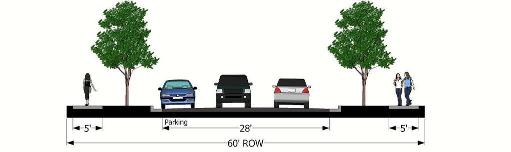
37 Design Standards Article 06 (d) Right-of-Way and Streets. The minimum right-of-way of all proposed streets shall be as specified by the city or county thoroughfare plan; or if no width is specified therein, the minimum right-of-way widths shall conform to the requirements of Table 06.04(d). It shall be the property owner s responsibility to dedicate any additional right-of-way needed for street widening, continuance or alignment to comply with the minimum standards for right-of-way where that property is to be subdivided along an existing street. The street pavement widths shall meet the minimum requirements of Table 06.04(d). Table (d) Minimum Right-of-way and Street Width Type of Street (2) ROW Pavement Width Width (1) Parking Commercial streets and major thoroughfares Major thoroughfares (3) 110 feet In accordance with Indiana Department Secondary thoroughfares (3) 90 feet of Transportation Design Manual Frontage roads (not in thoroughfare ROW) 40 feet 24 feet No parking Collector streets 80 feet 48 feet Parking on both sides 41 feet Parking on one side 34 feet No parking Minor/local streets 60 feet 28 feet Parking on one side Alleys 25 feet 24 feet No parking Residential streets Collector streets 72 feet 34 feet Parking on both sides 28 feet Parking on one side Minor/local streets 50 feet 24 feet Parking on one side Cul-de-sac streets (4) 50 feet 24 feet Parking on one side Low density residential/pud (5) 50 feet 22 feet No parking One-way residential streets(6) 40 feet 18 feet Parking on one side Alleys 20 feet 12 feet No parking (1) Pavement width dimensions are measured between outer edges of pavement, not including curb and gutter. Curb and gutter required under section 06.04(k) shall be in addition to width specified in the table. (2) If the subdivision is determined to create additional traffic and change the existing road classification, the new classification will govern the amount of right-of-way required. (3) Greater minimum right-of-way widths for major and secondary thoroughfares that are federal, state or county roads shall be provided, if required by governmental authorities having jurisdiction. (4) Cul-de-sacs shall have a circular terminus meeting the requirements of subsection (e) below. (5) The street pavement width may be reduced to 22 feet wide, plus curbing or gravel shoulder as required by subsection (k), for minor residential streets and cul-de-sacs in any one of the following instances: a. Low density residential developments where all lots are at least 24,000 square feet in area or the overall subdivision density is less than 1.8 dwelling units per acre; b. Residential developments where garages are access by rear alleys; or c. Planned unit developments (PUDs). (6) Only permitted by action of the plan commission based upon existence of conditions that do not allow for development of a two-way street. Page 31


38 Article 06 Design Standards Typical Residential Street Cross Sections Residential collector streets with parking on both sides Residential collector streets with parking on one side Minor residential streets & cul-de-sacs Low density residential streets Pavement dimensions do not include curb and gutter Page 32


39 Design Standards Article 06 Typical Commercial Street Cross Sections Commercial collector streets with parking on both sides Commercial collector streets with parking on one side Commercial collector streets with no parking Minor commercial streets Pavement dimensions do not include curb and gutter Page 33

40 Article 06 Design Standards (e) Cul-de-Sac Turn-Around. Permanent dead-end streets shall not be permitted. Cul-de-sacs shall be required at the ends of all roads. (1) Maximum Length. The maximum length of a cul-de-sac or other single point of access road shall be 600 feet. This may be increased to a maximum of 1300 feet where there are no more than 20 lots or dwelling units fronting on the cul-de-sac. (2) Outside Radius. The minimum outside radius and approach radius of the cul-de-sac turnaround area shall be 50 feet, measured from the back of the outside of curb or outside edges of roadway pavement. The minimum outside radius of the right-of-way at the turnaround shall be 60 feet. (3) Temporary Turn-Around. Temporary dead-end streets with temporary turn-arounds shall be permitted only as part of a continuing street plan, as provided for in section 06.04(c)(4) above. The minimum outside radius of a temporary turn-around shall be 50 feet. (f) Horizontal curves. Horizontal visibility on curved streets and vertical visibility on all streets shall be in accordance with the current edition of the Indiana Department of Transportation Design Manual, Part 5, Road Design (g) Street Grades. Gradients of streets shall be in accordance with the current edition of the Indiana Design Manual, Part 5, Road Design. (h) Alleys. Alleys may be developed as secondary access to lots, particularly in traditional urban neighborhoods, high-density residential or commercial areas. Alleys may also be developed in commercial and industrial districts for off-street loading and service access. (1) Alleys shall be designed to accommodate refuse disposal vehicles, including adequate turning radii. (2) Dead-end alleys shall not be approved. (3) Alleys shall not connect directly to a major thoroughfare. (i) Intersection Design. (1) The center lines of streets should intersect as nearly at right angles as possible; in no instance shall an acute angle of less than 70 degrees be accepted. (2) The number of streets converging at one (1) intersection shall be no more than two (2). (3) Street jogs with centerline offsets of less than 150 feet shall be prohibited except where natural features or the configuration of existing streets or parcels necessitate a lesser offset. (4) Minor streets intersecting thoroughfares or collector streets shall be directly aligned with streets on the opposite side of the thoroughfare or collector street or be offset at least 300 feet of each other, measured along the centerline of the thoroughfare or collector street. (5) When subdivision streets intersect with collector or major thoroughfare streets, the subdivider may be required to install deceleration and/or passing lanes or other improvements along the major street. Page 34
41 Design Standards Article 06 (j) Pavement Construction. Minimum pavement requirements for streets shall be as follows: (1) Streets and alleys (where provided) shall be completed to grades shown on plans, profiles, and cross-sections that are in accordance with the standard specifications of the Indiana Design Manual, except as otherwise specified by this ordinance. (2) The streets and alleys shall be surfaced, and improved to the specifications stated in the city or county engineering standards. (3) Prior to placing the street and alley surfaces, an adequate drainage conveyance system, as recommended by the county highway engineer or city engineer, shall be installed. (k) Curbs and Gutters. (1) Combined concrete curb and gutter shall be constructed along all roads within a subdivision, except as follows: a. For residential streets, the requirement for a vertical or sloping curb may be replaced with a concrete ribbon curb where part of an overall low impact development stormwater management plan for the subdivision. b. For minor residential streets and cul-de-sacs in residential developments where all lots are at least 24,000 square feet in area and the proposed streets will not intersect with existing streets with curb and gutter, the curb and gutter requirement may be waived and gravel shoulders with engineered drainage swales may be allowed. Ribbon curbs shall be provided along the outside edges of the pavement in accordance with paragraph a above. c. The requirement for curb and gutter shall not apply to roads in existence prior to the development of a subdivision. (2) The curb and gutters shall be of the construction type specified in the Indiana Design Manual. (l) Half Streets. Half streets shall be prohibited, except where the plan commission finds it will be practicable to require the dedication of the other half when the adjoining property is subdivided, such as where a subdivision boundary follows a section line. (1) The width of a half street shall be one-half the required right-of-way width of the street. (2) A roadway pavement not less than 20 feet in width shall be installed, in accordance with standards herein. The plan commission may allow the subdivider to provide a financial guarantee to construct half of the roadway when the other half is subdivided. (3) Wherever an existing dedicated half street abuts a tract to be subdivided, the other half of the street shall be platted within the subdivision. (4) A half street shall be graded in accordance with cross section design standards and profile grades applicable to the entire street width. When the other half of an existing half street is developed, it shall conform to such established cross section design and profile grades. (m) State Highways. If any subdivision abuts a state highway, evidence of compliance with all applicable regulations of the Indiana Department of Transportation shall be required. (n) Major Thoroughfare and Highway Protection. Whenever the proposed subdivision contains or is adjacent to a major thoroughfare or highway, the subdivision shall be designed to provide adequate protection of residential properties, limit vehicular access and separate through and local traffic by the use of reversed frontage lots, with screen planting contained in a no-access strip along the rear of the property line, or by the installation of frontage roads paralleling the major street. Page 35
42 Article 06 Design Standards (o) Traffic Control. All traffic control devices, including regulatory, warning and guide signs, and pavement markings (if necessary) shall conform to the most recent edition of the Indiana Manual on Uniform Traffic Control Devices. (p) Private Roads. All roadways within subdivisions shall be publicly dedicated streets. The city or county may allow subdivisions being developed as PUDs to have private roads where all of the following are met: (1) The plan commission shall determine that dedication of the road as a public street is not necessary for continuity in the public street system and will not be necessary to offer access to adjacent undeveloped land. Private roads shall provide for connections to adjacent streets and parcels in accordance with section 6.04(c). The terms of the private road easement shall provide that the city or county may require that future abutting private roads or public streets be connected to the private road and shall provide for cross access easements with adjacent developments. (2) Private roads shall be designed and constructed to meets the requirements of section 6.04, except the plan commission may permit modifications from the requirements of section 6.04, based upon the recommendation of the city engineer or county highway engineer. Any modifications shall be consistent with the design criteria outlined in the most recent edition of the American Association of State Highway and Transportation Officials (AASHTO) Manual A Policy on Geometric Design of Streets and Highways. (3) Continued maintenance of private roads shall be the responsibility of the property owners served by the road. A private road maintenance agreement shall be filed with the County Recorder that addresses all of the following prior to issuance of improvement location permits for development of any lots served by the private road: a. The maintenance agreement shall acknowledge that the road surface and easement are privately owned and therefore all construction improvements and maintenance within the easement will be contracted and paid for by the signatories to the agreement. b. Private roads shall be maintained in a condition suitable for travel at the design speed and passable for emergency vehicles. The maintenance agreement shall outline a maintenance schedule indicating intervals for road inspection. c. The maintenance agreement shall describe the method by which maintenance and improvement costs will be apportioned among the owners. Section Sidewalks and Nonmotorized Systems (a) General. Sidewalks shall be required in all subdivisions except administrative and minor subdivisions or where not required in subsection 06.03(b) below. (b) Requirement. Sidewalks shall be installed in the following locations: (1) Along all public and private street frontages within the incorporated boundaries of cities; (2) Along all public and private street frontages within the unincorporated areas of the county when the subdivision lies within one (1) mile of the borders of the cities of La Porte and Michigan City and the subdivision has lots that are less than 24,000 square feet in area. (c) Sidewalks. Sidewalks shall be a minimum of five (5) feet wide. (d) Multimodal Pathways. Ten (10) foot wide multi-modal pathways may be required along major thoroughfare and collector streets where they will connect to existing or planned multi-modal pathways or where the plan commission determines that there will be bicycle traffic. A combination Page 36
 foot from the right-of-way line, but may meander within the right-of-way.")
43 Design Standards Article 06 of five (5) foot wide sidewalks and five (5) foot wide bike lanes on both sides of the street may be provided instead of 10 foot wide pathways. (e) Location. All sidewalks and pathways shall be located in the street right-of-way with the edge of the sidewalk approximately one (1) foot from the right-of-way line, but may meander within the right-of-way. Where the applicable road agency determines that there is not sufficient right-of-way for sidewalks, the sidewalks shall be installed in pedestrian easements adjacent to the rightof-way. (f) Construction Materials. All sidewalks shall be constructed of Portland Cement Concrete or pervious concrete meeting applicable construction standards and be a minimum of four (4) inches in thickness, except at driveway and alley crossings where they shall be six (6) inches thick. The county highway engineer or city engineer may approve alternative materials such as rubber pavement systems that are of equal durability and comply with accessibility requirements. Multi-modal pathways may be constructed of asphalt or concrete meeting the above thickness specifications or as specified by the county highway engineer or city engineer. (g) Parkway. A landscaped parkway strip at least four (4) feet in width shall be provided between the sidewalk and curb or pavement edge. Street trees planted within this area shall be of a variety appropriate to their locations, considering factors such as presence of and effects on utility lines, effect on visibility, resistance to environmental conditions (such as road salt), and effect of root systems on pavements. The area between the sidewalk and curb or pavement edge shall be maintained by the adjacent property owner as a landscaped area. Commercial streets with on-street parking may have sidewalk up to the road curb with street trees provided in tree grates or planting areas. (h) Accessibility. All public sidewalks shall comply with state and federal accessibility requirements. Ramps meeting Americans with Disabilities Act standards shall be provided at all corners and any other locations where sidewalks intersect with streets. Section Flood Hazard Area No subdivision of lots located in a flood hazard area shall be approved unless all of the following requirements are met: (a) The 100 year flood elevation is shown on the plat; (b) Improvement plans are submitted detailing the required lowest floor elevations; (c) All requirements of the floodplain regulations contained in article 21 of the zoning ordinance, the Indiana Department of Natural Resources (IDNR) and the Federal Emergency Management Administration (FEMA) are met; and (d) If necessary, a permit is obtained from the Indiana Department of Natural Resources to construct. Subdivisions in flood hazard areas shall include a notation on the face of the plat indicating that the subdivision includes floodplain area and the base flood elevation. Section Stormwater Management All subdivisions shall make provision for the installation and maintenance of an adequate storm water drainage system for the management of all storm and surface water drainage and the control of flood runoff to provide for the proper drainage of the subdivision. All such facilities are to control peak flow Page 37
I. Requirements for All Applications. C D W
 108-16.1. Application checklists. Checklist for Required Submissions to the Planning Board or Zoning Board of Adjustment of Monroe Township All required submissions are to be made to the Administrative
201 General Provisions
 201 General Provisions 201.01 Title 201.09 Amendments 201.02 Purpose and Intent 201.10 Public Purpose 201.03 Authority 201.11 Variances and Appeals 201.04 Jurisdiction 201.12 Nonconformances 201.05 Enactment
CHAPTER 22 SUBDIVISION AND LAND DEVELOPMENT
 CHAPTER 22 SUBDIVISION AND LAND DEVELOPMENT 22-101. Title 22-102. Legislative Intent Part 1 General Provisions 22-201. Development Permits Part 2 Administration 22-301. Fee Schedule Part 3 Fee Schedule
Preliminary Subdivision Application (Minor) (Three (3) lots or less)
 (Three (3) lots or less)") Gunnison City Offices www.gunnisoncity.org 38 West Center Gunnison, Utah 84634 (435) 528 7969 Date of Application: Preliminary Subdivision Application (Minor) (Three (3) lots or less) APPLICANT INFORMATION
Gunnison City Offices www.gunnisoncity.org 38 West Center Gunnison, Utah 84634 (435) 528 7969 Date of Application: Preliminary Subdivision Application (Minor) (Three (3) lots or less) APPLICANT INFORMATION
CHAPTER 22 SUBDIVISION AND LAND DEVELOPMENT. Part 1 General Provisions. Part 2 Application Procedure and Approval Process
 CHAPTER 22 SUBDIVISION AND LAND DEVELOPMENT Part 1 General Provisions 101. Title 102. Policy 103. Purposes 104. Authority 105. Jurisdiction 106. Interpretation, Conflict and Separability 107. Municipal
APPLICATION PROCEDURE
 ANTRIM PLANNING BOARD P. O. Box 517 Antrim, New Hampshire 03440 Phone: 603-588-6785 FAX: 603-588-2969 APPLICATION FORM AND CHECKLIST FOR MINOR OR MAJOR SITE PLAN REVIEW File Date Received By APPLICATION
Preliminary Subdivision Application (Major) (Four (4) lots or more)
 (Four (4) lots or more)") Gunnison City Offices www.gunnisoncity.org 38 West Center Gunnison, Utah 84634 (435) 528 7969 Date of Application: Preliminary Subdivision Application (Major) (Four (4) lots or more) APPLICANT INFORMATION
Gunnison City Offices www.gunnisoncity.org 38 West Center Gunnison, Utah 84634 (435) 528 7969 Date of Application: Preliminary Subdivision Application (Major) (Four (4) lots or more) APPLICANT INFORMATION
ARTICLE SINGLE FAMILY SITE CONDOMINIUM DEVELOPMENT STANDARDS
 ARTICLE 28.00 SINGLE FAMILY SITE CONDOMINIUM DEVELOPMENT STANDARDS Section 28.01 PURPOSE The purpose of this Article is to recognize that conventional single family developments, traditionally developed
APPLICATION FOR MAJOR SUBDIVISION APPROVAL (PRELIMINARY PLAT)
") 209 S. Main Street Marysville, Ohio 43040 Phone: (937) 645-7350 Fax: (937) 645-7351 www.marysvilleohio.org APPLICATION FOR MAJOR SUBDIVISION APPROVAL (PRELIMINARY PLAT) *** IMPORTANT INFORMATION ~ Please
209 S. Main Street Marysville, Ohio 43040 Phone: (937) 645-7350 Fax: (937) 645-7351 www.marysvilleohio.org APPLICATION FOR MAJOR SUBDIVISION APPROVAL (PRELIMINARY PLAT) *** IMPORTANT INFORMATION ~ Please
ARTICLE 15 - PLANNED UNIT DEVELOPMENT
 Section 15.1 - Intent. ARTICLE 15 - PLANNED UNIT DEVELOPMENT A PUD, or Planned Unit Development, is not a District per se, but rather a set of standards that may be applied to a development type. The Planned
APPLICATION REVIEW CHECKLISTS
 APPLICATION REVIEW CHECKLISTS The following must be submitted with and are part of each application. No application is complete until all required documentation has been submitted to the Community Development
White County Subdivision Control Ordinance TABLE OF CONTENTS
 Table of Contents TABLE OF CONTENTS CHAPTER 1: PURPOSE, AUTHORITY, AND JURISDICTION 1.0 Title... 1.1 1.1 Purpose and Authority... 1.1 1.1.1 Purpose... 1.1 1.1.2 Authority... 1.2 1.2 Policy... 1.2 1.2.1
CHAPTER 3 PRELIMINARY PLAT
 10-3-1 10-3-3 SECTION: CHAPTER 3 PRELIMINARY PLAT 10-3-1: Consultation 10-3-2: Filing 10-3-3: Requirements 10-3-4: Approval 10-3-5: Time Limitation 10-3-6: Grading Limitation 10-3-1: CONSULTATION: Each
SUBDIVISION ORDINANCE CITY OF DES MOINES, IOWA
 SUBDIVISION ORDINANCE CITY OF DES MOINES, IOWA SUBDIVISION REGULATIONS CITY OF DES MOINES, IOWA NOTICE This is an unofficial and annotated copy of excerpts from the Municipal code of the City of Des Moines,
TOWN OF ROXBURY PLANNING BOARD
 UPDATED: APRIL 2011 TOWN OF ROXBURY PLANNING BOARD Applicant s Guide for Subdivision Review The Town Planning Board administers the subdivision review process. This guide has been prepared in order to
FINAL PLAT APPLICATION
 FINAL PLAT APPLICATION (Page 1 of 3) LEGAL OWNER(s): NAME: STREET ADDRESS OWNER(s): CITY, STATE, ZIP CODE: PHONE NUMBER: BILLING ADDRESS: NAME OF ENGINEER/SURVEYOR: Engineer/Surveyor Address, Phone: PROPERTY
ARTICLE 5 MINOR SUBDIVISION/LAND DEVELOPMENT
 ARTICLE 5 MINOR SUBDIVISION/LAND DEVELOPMENT SECTION 501 ONLY FINAL PLAN REQUIRED The classification of a proposed subdivision as a "Minor Subdivision" shall only require the submission, review and approval
13-2 SUBDIVISION PLANS AND PLATS REQUIRED EXCEPTIONS Subdivision Plats Required To be Recorded
 ARTICLE XIII SUBDIVISIONS 13-1 INTENT AND PURPOSE 13-1-1 Intent: It is the intent of the County Commission through the adoption of this Article to more fully avail itself of the power granted under 17-27-601
Midwest City, Oklahoma Code of Ordinances Chapter 38: Subdivision Regulations
 2012 Midwest City, Oklahoma Code of Ordinances Chapter 38: Subdivision Regulations Adoption Date: 8/14/2012 Table of Contents Article I. General Provisions... 5 Section 38-1. Preamble... 5 Section 38-2.
BRIDGETON SUBDIVISION APPLICATION CHECKLIST
 APPLICATION NAME AND # CHECKLIST COMPLETED BY: DATE: Signature and printed name BRIDGETON SUBDIVISION APPLICATION CHECKLIST TO SUBDIVISION APPLICANTS: The attached checklist is to assist you in the submission
A.3. ARTICLE 7 PLAN REQUIREMENTS FOR MINOR SUBDIVISION AND/OR LAND DEVELOPMENT
 700. 701.A.3. ARTICLE 7 PLAN REQUIREMENTS FOR MINOR SUBDIVISION AND/OR LAND DEVELOPMENT SECTION 700 PURPOSE The purpose of this Article is to set forth a streamlined set of Plan Requirements for minor
Zone Lapel. Ancillary Regulations Subdivision Control Ordinance Planned Unit Development (PUD) Standards Building Code
 Standards Building Code") Town of Lapel Unified Development Code Zone Lapel Ancillary Regulations Subdivision Control Ordinance Planned Unit Development (PUD) Standards Building Code Volume 12 of 12 Ancillary Regulations Subdivision
Town of Lapel Unified Development Code Zone Lapel Ancillary Regulations Subdivision Control Ordinance Planned Unit Development (PUD) Standards Building Code Volume 12 of 12 Ancillary Regulations Subdivision
ARTICLE 24 SITE PLAN REVIEW
 ARTICLE 24 SITE PLAN REVIEW 24.1 PURPOSE: The intent of these Ordinance provisions is to provide for consultation and cooperation between the land developer and the Township Planning Commission in order
ARTICLE 1 GENERAL PROVISIONS
 ARTICLE 1 GENERAL PROVISIONS SECTION 100 TITLE This Ordinance shall be known and cited as the "Rice Township Subdivision and Land Development Ordinance." SECTION 101 AUTHORITY Rice Township is empowered
The purpose of this Chapter is to establish rules, regulations, standards and procedures for approval of subdivisions of land to promote and ensure:
 CHAPTER 7 SUBDIVISION SECTION 7.1 PURPOSE The purpose of this Chapter is to establish rules, regulations, standards and procedures for approval of subdivisions of land to promote and ensure: A. Conformity
610 LAND DIVISIONS AND PROPERTY LINE ADJUSTMENTS OUTSIDE A UGB
 ARTICLE VI: LAND DIVISIONS AND PROPERTY LINE ADJUSTMENTS VI-21 610 LAND DIVISIONS AND PROPERTY LINE ADJUSTMENTS OUTSIDE A UGB 610-1 Property Line Adjustments (Property Line Relocation) A property line
MINOR SUBDIVISION INFORMATION
 A. POINTS OF CONTACT: MINOR SUBDIVISION INFORMATION Surveyor: Address: Phone #: Fax # E-Mail Address: Representative (If different from applicant): Address: Phone #: Fax # E-Mail Address: B. GENERAL INFORMATION:
Residential Major Subdivision Review Checklist
 Residential Major Subdivision Review Checklist Plan Submittal Requirements: 2 full sets of stamped plans Electric submittal - all plans contained in a single PDF 3 full sets if commercial kitchen or dining
Waseca County Planning and Zoning Office
 Waseca County Planning and Zoning Office 300 North State Street Waseca, Minnesota 56093 Phone: 507-835-0650 Fax: 507-837-5310 Form no. PZ 081009 Web Site: www.co.waseca.mn.us FEES: 1) CUP FEE- $400.00
-MENDOCINO COUNTY PLANNING AND BUILDING SERVICES- DIVISION OF LAND REGULATIONS TITLE 17
 ARTICLE VI -- GENERAL REGULATIONS AND PROVISIONS Sec. 17-50. Sec. 17-51 General Plan. Sec. 17-52 Lot and Block Design and Configuration. Sec. 17-53 Lot Access. Sec. 17-54 Private Roads. Sec. 17-55 Water
SUBDIVISION APPLICATION CHECKLIST SKETCH PLAN PRELIMINARY PLAT FINAL PLAT
 RECEIVED STAMP SUBDIVISION APPLICATION CHECKLIST SKETCH PLAN PRELIMINARY PLAT FINAL PLAT A checklist of background information and submission requirements for processing of a sketch plan, preliminary plat
Town of Bargersville, Indiana Subdivision Control Ordinance
 Town of Bargersville, Indiana Subdivision Control Ordinance This page is intentionally left blank Chapters Chapter I Chapter II Chapter III Chapter IV Chapter V Chapter VI Chapter VII Chapter VIII General
PRELIMINARY PLAT CHECK LIST
 PRELIMINARY PLAT CHECK LIST Name of Proposed Subdivision: The following items must be included with the initial submittal of a Preliminary Plat: Application, filled out completely Project Narrative Pre-application
MAJOR SUBDIVISION PRELIMINARY PLAT CHECKLIST
 TOWNSHIP OF EGG HARBOR PLANNING BOARD/ZONING BOARD OF ADJUSTMENT 3515 BARGAINTOWN ROAD EGG HARBOR TOWNSHIP, NJ 08234 MAJOR SUBDIVISION PRELIMINARY PLAT CHECKLIST The following checklist is designed to
ELK RAPIDS TOWNSHIP ANTRIM COUNTY, MICHIGAN ORDINANCE NO
 ELK RAPIDS TOWNSHIP ANTRIM COUNTY, MICHIGAN ORDINANCE NO. 3-2011 AN ORDINANCE TO REPLACE THE SUBDIVISION CONTROL ORDINANCE WITH A NEW SUBDIVISION DEVELOPMENT ORDINANCE, IN ACCORD WITH THE LAND DIVISION
MINOR PLAT AMENDMENT APPLICATION CHECK APPLICABLE PERMIT ATTACHMENT:
 240 East Gammon Road Vineyard, Utah 84058 (801) 226-1929 MINOR PLAT AMMENDMENT APPLICATION Please Note: Attachment of request specific documents is required prior to processing your application. APPLICATION
CITY OF SARALAND PRELIMINARY SUBDIVISION PLAT REVIEW
 PRELIMINARY SUBDIVISION PLAT REVIEW Application Number: Date Plat Submitted: Name of Subdivision: Name of Owner: Owner Address: (Street or P.O. Box) Telephone #: (City) (State) (Zip) E-mail: Name of Authorized
APPLICATION FOR 555 Washington Street Tentative Map Red Bluff, CA Subdivision Map (530) ext Parcel Map.
 ext Parcel Map.") City of Red Bluff Community Development Department Application No. APPLICATION FOR 555 Washington Street Tentative Map Red Bluff, CA 96080 Subdivision Map (530) 527-2605 ext. 3059 Parcel Map Applicant
City of Red Bluff Community Development Department Application No. APPLICATION FOR 555 Washington Street Tentative Map Red Bluff, CA 96080 Subdivision Map (530) 527-2605 ext. 3059 Parcel Map Applicant
ARTICLE 8C SITE CONDOMINIUM DEVELOPMENT ORDINANCE
 ARTICLE 8C SITE CONDOMINIUM DEVELOPMENT ORDINANCE SECTION 8C.01 PURPOSE It is the purpose of this Ordinance to insure that plans for development within Oceola Township proposed under the provisions of
Residential Minor Subdivision Review Checklist
 Residential Minor Subdivision Review Checklist Plan Submittal Requirements: 2 full sets of stamped plans Electric submittal - all plans contained in a single PDF 3 full sets if commercial kitchen or dining
SUBDIVISION PROCEDURES AND REGULATIONS. for the Town of Stratford, New Hampshire
 SUBDIVISION PROCEDURES AND REGULATIONS for the Town of Stratford, New Hampshire TABLE OF CONTENTS Page A. PRE-APPLICATION 2 B. PRELIMINARY PLAN REQUIREMENTS 3 C. PRELIMINARY PLAN REVIEW 5 Site Plan Review
MAJOR RESIDENTIAL AND NONRESIDENTIAL SUBDIVISIONS
 Lawrence-Douglas County MAJOR RESIDENTIAL AND NONRESIDENTIAL SUBDIVISIONS Preliminary Plats The applicant shall schedule a Pre-Application meeting with Planning Staff at least seven (7) working days prior
CHAPTER 18 SUBDIVISION AND PLATTING ORDINANCE OF THE TOWN OF OSCEOLA CODE OF ORDINANCES
 TOWN OF OSCEOLA POLK COUNTY WISCONSIN ORDINANCE # 18-03-03 CHAPTER 18 SUBDIVISION AND PLATTING ORDINANCE OF THE TOWN OF OSCEOLA CODE OF ORDINANCES 18.01 Purpose Adopted 3/08/99, Amended 5/12/03, 7/9/07,
ARTICLE 100 SUBDIVISION APPLICATION PROCEDURE AND APPROVAL PROCESS
 ARTICLE 100 SUBDIVISION APPLICATION PROCEDURE AND APPROVAL PROCESS 100.01 General Procedure 100.02 Exempt Subdivision 100.03 Administrative Subdivision 100.04 Major Subdivision 100.05 Signing and Recording
Town of Norwich, Vermont SUBDIVISION REGULATIONS
 Town of Norwich, Vermont SUBDIVISION REGULATIONS Adopted: August 6, 2002 Amended: February 8, 2006 Prepared by Norwich Planning Commission with the assistance of: Burnt Rock Inc. A ssociates in Community
ARTICLE 3 DEFINITIONS
 Sections: 3-1 Rules of Construction 3-2 Definitions ARTICLE 3 DEFINITIONS SECTION 3-1 RULES OF CONSTRUCTION 3-101. a. The language set forth in these regulations shall be interpreted in accordance with
Township of Little Egg Harbor Planning Board 665 Radio Road Little Egg Harbor, New Jersey Phone: ext. 221 Fax:
 BLOCK(S) LOT(S) Township of Little Egg Harbor Planning Board 665 Radio Road Little Egg Harbor, New Jersey 08087 Phone: 609-296-7241 ext. 221 Fax: 609-294-3040 Development Application Amended Development
ARTICLE III GENERAL PROCEDURES, MINOR PLANS AND FEE SCHEDULES
 ARTICLE III GENERAL PROCEDURES, MINOR PLANS AND FEE SCHEDULES 301. Prior to Submission a. Copies of this Ordinance shall be available on request, at cost, for the use of any person who desires information
E L M E R B O R O U G H L A N D U S E B O A R D APPLICATION COVER SHEET (to be completed for all applications and appeals)
") E L M E R B O R O U G H L A N D U S E B O A R D APPLICATION COVER SHEET (to be completed for all applications and appeals) 1. Name(s): 2. Address: 3. Telephone Number(s): 4. E-mail: 5. Owner Name(s) (if
E L M E R B O R O U G H L A N D U S E B O A R D APPLICATION COVER SHEET (to be completed for all applications and appeals) 1. Name(s): 2. Address: 3. Telephone Number(s): 4. E-mail: 5. Owner Name(s) (if
TOWNSHIP OF BORDENTOWN LAND DEVELOPMENT APPLICATION CHECKLIST. General Requirements for all Applications
 TOWNSHIP OF BORDENTOWN LAND DEVELOPMENT APPLICATION CHECKLIST This CHECKLIST has been adopted in accordance with Section 25:807 of the Land Development Ordinance of the Township of Bordentown and will
City of Prior Lake APPLICATION FOR COMBINED PRELIMINARY AND FINAL PLAT
 Case File No. Property Identification No. City of Prior Lake APPLICATION FOR COMBINED PRELIMINARY AND FINAL PLAT Requested Action Brief description of proposed project (Please describe the proposed amendment,
Certified Survey Review Instructions
 DEARBORN COUNTY PLAN COMMISSION County Administration Building, 165 Mary St., Lawrenceburg, IN 47025 Phone (812) 537-8821 Fax (812) 532-2029 Website: www.dearborncounty.org/planning Certified Survey Review
Memorandum: October 13, 2008 REVISED To: Trowbridge Township Planning Commission From: P. Hudson, AICP Re: Suggested New Ordinance
 1 Memorandum: October 13, 2008 REVISED 2-11-09 To: Trowbridge Township Planning Commission From: P. Hudson, AICP Re: Suggested New Ordinance Because of changes in both the Michigan Planning Enabling Act
Subdivision Ordinance. Adopted December 2, 2010 *Article III Amended June 6, 2013 TABLE OF CONTENTS
 Subdivision Ordinance Adopted December 2, 2010 *Article III Amended June 6, 2013 TABLE OF CONTENTS ARTICLE I INTRODUCTORY PROVISIONS Page Section 1-1 Title I-1 Section 1-2 Purpose I-1 Section 1-3 Authority
CONDOMINIUM REGULATIONS
 ARTICLE 37 CONDOMINIUM REGULATIONS SECTION 37.01. Purpose The purpose of this Article is to regulate projects that divide real property under a contractual arrangement known as a condominium. New and conversion
CHAPTER XVIII SITE PLAN REVIEW
 CHAPTER XVIII SITE PLAN REVIEW Section 18.1 Section 18.2 Description and Purpose. The purpose of this chapter is to provide standards and procedures under which applicants would submit, and the Township
SUBDIVISION PLAT CHECKLIST. The following information shall be include on the plat:
 SUBDIVISION PLAT CHECKLIST Subdivision Name: Land Surveyor: Owner/Developer: Date Submitted: The following information shall be include on the plat: The plat shall be drawn at a scale of one inch equals
Sketch Plan 2018 Bargersville Plan Commission Application Kit
 Sketch Plan 2018 Bargersville Plan Commission Application Kit For Commercial, Industrial, and Residential Developments At least 31 days prior to the intended filing of the Primary Plat or Development Plan
ARTICLE 7: PLOT PLANS AND SITE PLAN REQUIREMENTS AND REVIEW
 ARTICLE 7: PLOT PLANS AND SITE PLAN REQUIREMENTS AND REVIEW Section 7.0 - Purpose The purpose of this article is to specify the documents and/or drawings required for a Site Plan Review or a Plot Plan
SUBMITTAL REQUIREMENTS: The number indicates the number of copies for submittal (if applicable).
.") Office Use Only Preliminary Long Plat Long Subdivision Applicant Checklist PLANNING, COMMUNITY, & ECONOMIC DEVELOPMENT DEPARTMENT PRELIMINARY LONG PLAT LONG SUBDIVISION CHECKLIST Mailing Address: P.O.
Office Use Only Preliminary Long Plat Long Subdivision Applicant Checklist PLANNING, COMMUNITY, & ECONOMIC DEVELOPMENT DEPARTMENT PRELIMINARY LONG PLAT LONG SUBDIVISION CHECKLIST Mailing Address: P.O.
DEVELOPMENT PLAN ORDINANCE
 DEVELOPMENT PLAN ORDINANCE CITY OF GLASGOW Ordinance No. 2026 SECTION A. Section 1. INTENT AND PURPOSE The purpose of this Ordinance is to establish and define development plans, which may be utilized
SUBDIVISION APPLICATION
 SUBDIVISION APPLICATION Community Planning and Economic Development Development Services Division 250 South 4 th Street, Room 300 Minneapolis MN 55415-1316 612-673-3000 This application packet is used
Major Subdivision Application Packet. Revised June 2018
 Major Subdivision Application Packet Revised June 2018 Caroline County Department of Planning and Community Development 233 West Broaddus Avenue Bowling Green, VA 22427 www.co.caroline.va.us Phone: 804-633-4303
MINOR SUBDIVISION PLAT
 CHECKLIST HANCOCK COUNTY AREA PLAN COMMISSION A subdivider shall submit to the Plan Commission office an application and an accompanying plat for a minor subdivision. The plat shall be based on a boundary
SUBMITTAL REQUIREMENTS: The number indicates the number of copies for submittal (if applicable).
.") Office Use Only Preliminary Long Plat Long Subdivision Applicant Checklist PLANNING, COMMUNITY, & ECONOMIC DEVELOPMENT DEPARTMENT FINAL LONG PLAT LONG SUBDIVISION CHECKLIST Mailing Address: P.O. Box 547,
Office Use Only Preliminary Long Plat Long Subdivision Applicant Checklist PLANNING, COMMUNITY, & ECONOMIC DEVELOPMENT DEPARTMENT FINAL LONG PLAT LONG SUBDIVISION CHECKLIST Mailing Address: P.O. Box 547,
Lake County Planning, Building and Development Department
 SUBMISSION CHECKLIST FOR SUBDIVISION FINAL PLAT Lake County Planning, Building and Development Department 500 W. Winchester Rd. Unit 101 Libertyville, Illinois 60048-1331 Telephone (847) 377-2600 E-mail:
BOROUGH OF JESSUP SUBDIVISION AND LAND DEVELOPMENT ORDINANCE
 BOROUGH OF JESSUP SUBDIVISION AND LAND DEVELOPMENT ORDINANCE 1993 Amended May 1995 Reenacted May 2000 Amended February 9, 2004 Amended May 7, 2007 SUBDIVISION AND LAND DEVELOPMENT ORDINANCE BOROUGH OF
WEBSTER TOWNSHIP LAND DIVISION ORDINANCE. Summary Table of Amendments
 WEBSTER TOWNSHIP LAND DIVISION ORDINANCE Ordinance No. 2012 02 As Adopted 04-17-12 Summary Table of Amendments Adoption Date Affected Sections Summary October 10, 3 Added definition of Township Engineer
BY THE CITY COMMISSION ORDINANCE NO.:
 BY THE CITY COMMISSION ORDINANCE NO.: 2005-0868 AN ORDINANCE BY THE CITY COMMISSION OF THE CITY OF DADE CITY, FLORIDA CREATING A DEVELOPMENT REVIEW PROCEDURES ORDINANCE; PROVIDING FOR INTENT, PURPOSE,
WOOD COUNTY SUBDIVISION REGULATIONS WOOD COUNTY, OHIO
 WOOD COUNTY SUBDIVISION REGULATIONS WOOD COUNTY, OHIO EFFECTIVE DATE : AUGUST 6, 2014 Table of Contents ARTICLE 1 - GENERAL PROVISIONS... 1 1.00 Title... 1 1.01 Policy... 1 1.02 Purpose... 1 1.03 Authority...
Chapter 22. Subdivision and Land Development
 Chapter 22 Subdivision and Land Development Part 1 Short Title, Authority and Purpose 22-101. Short Title 22-102. General Legislative Authority 22-103. Activities to Be Regulated 22-104. Exemptions from
Chapter 100 Planned Unit Development in Corvallis Urban Fringe
 100.100 Scope and Purpose. Chapter 100 Planned Unit Development in Corvallis Urban Fringe (1) All applications for land divisions in the Urban Residential (UR) and Flood Plain Agriculture (FPA) zones within
STATE OF MICHIGAN COUNTY OF MARQUETTE, TOWNSHIP OF NEGAUNEE LAND DIVISION, SUBDIVISION AND CONDOMINIUM ORDINANCE
 STATE OF MICHIGAN COUNTY OF MARQUETTE, TOWNSHIP OF NEGAUNEE LAND DIVISION, SUBDIVISION AND CONDOMINIUM ORDINANCE Adopted: August 8 th, 2008 Effective: August 28 th, 2008 Sec.100. Title ARTICLE I GENERAL
TOWN OF LEWISTON PLANNING BOARD APPLICATION
 TOWN OF LEWISTON PLANNING BOARD APPLICATION DESCRIPTION OF PROPOSED REQUEST: Name of Property Owner: Phone #: Name of Applicant:Phone #: Address or Location of Proposal:_SBL# Size of Parcel or Structure:Existing
Application for Preliminary Plat Checklist
 Application for Preliminary Plat Checklist Note: No portion of an existing parcel may be sold or transferred to another party without first legally subdividing the property according to the City of Richmond
Subchapter 16 Subdivisions.
 Subchapter 16 Subdivisions. Sections: 35.16.1 Authority. 35.16.2 Purpose. 35.16.3 Jurisdiction. 35.16.4 Application. 35.16.5 Compliance and Enforcement. 35.16.6 Approval of Plat Required. 35.16.7 Lots,
CITY OF SAND SPRINGS CODE OF ORDINACES TITLE 16
 CITY OF SAND SPRINGS CODE OF ORDINACES TITLE 16 10/30/2018 TITLE 16 SUBDIVISIONS Chapters: 16.04 GENERAL PROVISIONS 16.08 DEFINITIONS 16.12 APPLICATION PROCESS 16.16 SPECIFICATIONS FOR DOCUMENTS 16.20
The following regulations shall apply in the R-E District:
 "R-E" RESIDENTIAL ESTATE DISTRICT (8/06) The following regulations shall apply in the R-E District: 1. Uses Permitted: The following uses are permitted. A Zoning Certificate may be required as provided
STATE OF MICHIGAN COUNTY OF BERRIEN ORONOKO CHARTER TOWNSHIP PRIVATE ROAD ORDINANCE ORDINANCE NO. 65
 STATE OF MICHIGAN COUNTY OF BERRIEN ORONOKO CHARTER TOWNSHIP PRIVATE ROAD ORDINANCE ORDINANCE NO. 65 AN ORDINANCE TO REQUIRE THAT ALL LOTS OR PARCELS OF LAND WHICH DO NOT ABUT PUBLIC STREETS ABUT A PRIVATE
Subdivision Regulations of Athens County, Ohio
 Subdivision Regulations of Athens County, Ohio ADOPTED NOVEMBER 21, 2000 Amended September 18, 2001 1 TABLE OF CONTENTS Article 1 GENERAL PROVISIONS 100 Title 9 101 Policy 9 102 Purpose 9 103 Authority
(c) County board of commissioners means 1 of the following, as applicable: (ii) In all other counties, 1 of the following:
 County board of commissioners means 1 of the following, as applicable: (ii) In all other counties, 1 of the following:") TOWNSHIP PLANNING Act 168 of 1959, as amended, (including 2001 amendments, 2006 amendments) AN ACT to provide for township planning; for the creation, organization, powers and duties of township planning
TOWNSHIP PLANNING Act 168 of 1959, as amended, (including 2001 amendments, 2006 amendments) AN ACT to provide for township planning; for the creation, organization, powers and duties of township planning
THE COUNTY BOARD OF SUPERVISORS OF THE COUNTY OF DOUGLAS DOES ORDAIN AS FOLLOWS:
 8.1 SUBDIVISION CONTROL ORDINANCE THE COUNTY BOARD OF SUPERVISORS OF THE COUNTY OF DOUGLAS DOES ORDAIN AS FOLLOWS: SECTION I. GENERAL INTERPRETATION This ordinance shall not repeal, impair or modify private
UPPER MOUNT BETHEL TOWNSHIP, NORTHAMPTON COUNTY, PA MINOR SUBDIVISION FINAL PLAN CHECKLIST* YES** NO
 UPPER MOUNT BETHEL TOWNSHIP, NORTHAMPTON COUNTY, PA MINOR SUBDIVISION FINAL PLAN CHECKLIST* YES** NO GENERAL SUBMISSION ITEMS Does the submission include: 1. Seven (7) copies of completed Application Form?
APPENDIX B TOWN OF LITTLE COMPTON, RHODE ISLAND INSTRUCTIONS AND CHECKLIST FOR MINOR SUBDIVISION
 APPENDIX B TOWN OF LITTLE COMPTON, RHODE ISLAND INSTRUCTIONS AND CHECKLIST FOR MINOR SUBDIVISION These Instructions and Checklist apply to Minor Subdivisions a residential subdivision resulting in five
TOWN OF WATERVILLE VALLEY NEW HAMPSHIRE SITE PLAN REVIEW REGULATIONS
 TOWN OF WATERVILLE VALLEY NEW HAMPSHIRE Effective date March 17, 1981 Revised March 16, 1982 Revised March 13, 1986 Revised March 10, 1987 Revised March 14, 2013 Revised March 8, 2016 TOWN OF WATERVILLE
TOWNSHIP OF HARTLAND ORDINANCE NO. 57-1, AN ORDINANCE AMENDING THE LAND DIVISION ORDINANCE
 TOWNSHIP OF HARTLAND ORDINANCE NO. 57-1, AN ORDINANCE AMENDING THE LAND DIVISION ORDINANCE An ordinance to amend the Land Division Ordinance enacted pursuant to but not limited to the State Land Division
Planning and Zoning Code
 2014 Planning and Zoning Code City of Defiance, Ohio December 2014 Planning and Zoning Code City of Defiance, Ohio CHAPTER 1161. General Provisions... 7 1161. 01. Title... 7 1161. 02. Purpose... 7 1161.
CERTIFICATION OF THE APPROVAL OF WATER AND SEWERAGE SYSTEMS
 ARTICLE 9 FORMS AND CHECK LISTS 9.100 On preliminary layout & final subdivision plat CERTIFICATION OF THE APPROVAL OF WATER AND SEWERAGE SYSTEMS I hereby certify that the (...type: private or pubic...)
WESTON COUNTY FINAL PLAT APPLICATION
 WESTON COUNTY FINAL PLAT APPLICATION Property Owner: Mailing Address of owner: Telephone Number(s) of owner: Property Owner: Mailing Address of owner: Telephone Number(s) of owner: (If subdivider/applicant
SUBDIVISION AND LAND DEVELOPMENT ORDINANCE THE TOWNSHIP OF UPPER TULPEHOCKEN BERKS COUNTY, PENNSYLVANIA
 SUBDIVISION AND LAND DEVELOPMENT ORDINANCE OF THE TOWNSHIP OF UPPER TULPEHOCKEN BERKS COUNTY, PENNSYLVANIA JULY, 1975 As Amended SEPTEMBER 12, 1994 As Amended DECEMBER 13, 2005 TABLE OF CONTENTS ARTICLE
Town of Lincolnville Subdivision Ordinance
 Town of Lincolnville Subdivision Ordinance November 8, 2005 Amended: 06-10-2008---Article 4, Section 4.4.1 Conceptual Plan 06-11-2015---Article 5, Section 5.2.3.i., Article 6.2.3.l., Article 8 & 12 Access
TOWNSHIP OF SPRINGBROOK SUBDIVISION AND LAND DEVELOPMENT
 TOWNSHIP OF SPRINGBROOK SUBDIVISION AND LAND DEVELOPMENT ORDINANCE JULY, 1995 with Revisions to January, 2001 SUBDIVISION AND LAND DEVELOPMENT ORDINANCE TOWNSHIP OF SPRINGBROOK LACKAWANNA COUNTY, PENNSYLVANIA
Chapter 22 LAND USE* Article III. Subdivisions
 Chapter 22 LAND USE* Article III. Subdivisions Sec. 22-256. Authority to Regulate. Sec. 22-257. Scope; plat required. Sec. 22-258. Definitions. Sec. 22-259. Interpretations and Meanings. Sec. 22-260. Procedure
Conditional Use Permit / Standard Subdivision Application
 Conditional Use Permit / Standard Subdivision Application Name of Proposed Subdivision: Total Area (Acres) Is Proposed Subdivision to be built in phases? Number of Lots If yes, how many phases? Applicant/Owner
MUNICIPALITY OF THE DISTRICT OF CLARE SUBDIVISION BY-LAW
 MUNICIPALITY OF THE DISTRICT OF CLARE SUBDIVISION BY-LAW 1 Table of Contents PART 1 - TITLE... 4 PART 2 - INTERPRETATION... 4 PART 3 - DEFINITIONS... 4 PART 4 - PROCEDURE FOR APPROVAL OF PLANS OR INSTRUMENTS
Guide to Preliminary Plans
 Guide to Preliminary Plans Introduction The Douglas County is committed to providing open, transparent application processes to the public. This Guide is provided to assist anyone interested in the procedures
PLANNED UNIT DEVELOPMENT (PUD) AREA PLAN/REZONING REVIEW PROCEDURE
 AREA PLAN/REZONING REVIEW PROCEDURE") PLANNED UNIT DEVELOPMENT (PUD) AREA PLAN/REZONING REVIEW PROCEDURE Professional inquiries will be made to our Township Planning Consultant, Township Engineer, and Township Attorney to get their opinions
PLANNED UNIT DEVELOPMENT (PUD) AREA PLAN/REZONING REVIEW PROCEDURE Professional inquiries will be made to our Township Planning Consultant, Township Engineer, and Township Attorney to get their opinions
SECTION 2. PROCEDURES FOR FILING AND REVIEW
 SECTION 2. PROCEDURES FOR FILING AND REVIEW Subdivision 2.01 Sketch Plan 2.02 Preliminary Plat 2.03 Final Plat 2.04 Certification Required 2.05 Denial of Plat 2.06 Administrative Subdivision 2.01 SKETCH
SITE DEVELOPMENT PLAN REQUIREMENTS CHECKLIST
 SITE DEVELOPMENT PLAN REQUIREMENTS CHECKLIST Completed DRC Application for Review Required for Application Process DRC Processing Fee 1 Commercial $2,500.00 Fire Department Review Fee 150.00 Total $2,650.00
SUBDIVISION AND LAND DEVELOPMENT ORDINANCE. For ENACTED: DECEMBER 12, 1991
 SUBDIVISION AND LAND DEVELOPMENT ORDINANCE For COLUMBIA COUNTY PENNSYLVANIA ENACTED: DECEMBER 12, 1991 EFFECTIVE: JANUARY 1, 1992 Prepared by COLUMBIA COUNTY PLANNING COMMISSION COLUMBIA COUNTY PLANNING