West Fargo Planning & Zoning Commission Agenda Tuesday, August 14, West Fargo City Hall 5:30 p.m.
|
|
|
- Solomon Simpson
- 5 years ago
- Views:
Transcription

1 Tim Solberg, AICP, Director of Planning and Zoning Larry M. Weil, Community Development Director Lisa Sankey, Planner 1. Call to Order West Fargo Planning & Zoning Commission Agenda Tuesday, August 14, West Fargo City Hall 5:30 p.m. 2. Approval of Minutes - July 10, Public Hearing A18-35 Charleswood 33 rd Addition, Replat of Lots 4 & 5, Block 1 of Charleswood 29 th Addition, City of West Fargo, North Dakota and Planned Unit Development Amendment for a Dental Office - Roers 4. Public Hearing A18-36 Southdale 2 nd Addition, Replat and Rezoning from R-3: Multiple Dwellings to PUD: Planned Unit Development of Block 2 & 3 of Southdale Addition, City of West Fargo, North Dakota - Housing Authority of Cass County 5. Public Hearing A18-37 Maple Ridge at the Preserve 6 th Addition, Replat of Lots 25 & 35, Block 1 of Maple Ridge at the Preserve 2 nd Addition, City of West Fargo, North Dakota and Rezoning from P: Public Facilities to R-1A: Single Family Dwellings part of Lot 35, Block 1 of Maple Ridge at the Preserve 2 nd Addition, City of West Fargo, North Dakota 6. A18-34 The Wilds 11 th Addition proposed Zoning Change 7. Review Building Construction Standards of the Corridor Overlay District at nd Avenue West 8. Continued - Public Hearing A18-2 Tehar 2 nd Addition, Replat of Lot 1, Block 1 of Tehar Subdivision, Subdivision property in the SE¼ of Section 18, T139N, R49W, City of West Fargo, North Dakota and Rezoning from A: Agricultural to PUD: Planned Unit Development Graham 9. North Dakota Planning Association (NDPA) Conference Thursday, September 13 th at Alerus Center Grand Forks 10. Non-agenda 11. Adjournment th Avenue East Suite 1 West Fargo, ND Fax
2 Larry M. Weil, Community Development Director Tim Solberg, AICP, Director of Planning and Zoning Lisa Sankey, Planner West Fargo Planning and Zoning Commission July 10, 2018 at 5:30pm West Fargo City Hall Members Present: Members Absent: Others Present: Joe Kolb Eric Dodds Tom McDougall Shane LeBahn Dave Gust April Walker Jana Reinke Scott Diamond Larry Weil, Tim Solberg, Lisa Sankey, John Shockley, Courtney Williams, Dustin Scott, Jessica Berg, Jonathan Youness The meeting was called to order by Chair McDougall at 5:30pm. Commissioner Gust made a motion to approve the June 12, 2018 corrected meeting minutes as printed and mailed. Commissioner Kolb seconded the motion. No opposition. Motion carried. Commissioner McDougall opened Public Hearing - A18-27 Conditional Use Permit for Home Occupation (Chiropractic Office) at 837 Albert Drive West (Lot 50, Block 1 of The Wilds 7th Addition), City of West Fargo, North Dakota. Lisa discussed the following: The application is to accommodate the ability of the applicant to run a home based occupation, which has customers coming to the site. The applicant intends to operate a chiropractic practice by appointment only. The applicant does not intend to change the outward appearance of the home to reflect the business. In regards to the criteria used for granting a conditional use, staff does not note any concerns. Property owners within 350 were notified. We did receive a call with concerns regarding increased traffic. Staff recommends approval provided that: 1. Applicant meet all requirements set forth in the provisions for home occupations found in Section of the City Ordinances. 2. Adequate parking for both the home occupation and the residence be maintained th Avenue East Suite 1 West Fargo, ND Fax
3 West Fargo Planning and Zoning Commission July 10, Page 2 3. A Signed Conditional Use Permit Agreement is received. There were no comments from the public. The hearing was closed. Commissioner Kolb asked if the signage was covered, to which Lisa responded yes, it is covered in the ordinance. Commissioner Gust asked what the difference is between the applicant s business and a previous applicant for a home eyeglasses business, to which Larry responded that the difference is there was no Conditional Use Permit required at the time, and that the number of customers in and out at any given time will be different. The eyeglasses business was more of a retail establishment and suited for a commercial location, whereas this will be by appointment. Commissioner Gust moved and Commissioner LeBahn seconded to approve the application with the three recommendations. Listed. No opposition. Motion carried. Commissioner McDougall opened Public Hearing A18-28 Conditional Use Permit for accessory building at th Ave E (Lot 1, Block 1 of McMahon Estates 4th Subdivision), City of West Fargo, North Dakota. Lisa discussed the following: This application was received in order to accommodate the ability to construct an accessory building greater than the permitted 1,000 square feet in an R-1E: Rural Estate District. The R-1E District allows for larger structures as a conditional use provided it is in character with the development pattern of the subdivision (meaning that it fits within the neighborhood). The applicant is proposing a 1,619 square foot structure, constructed of materials similar in color and construction of the primary structure. In regards to criteria for granting a conditional use permit, staff does not note any concerns. Property owners within 350 were notified and no comments have been received to date. Staff recommends approval with the conditions that: 1. The accessory building is constructed of the same color and materials as the primary residential structure. 2. A Signed Conditional Use Permit Agreement is received. There were no comments from the public, the hearing was closed. Commissioner LeBahn asked if this kind of application is common for the area, to which Lisa replied yes, there have been previous approvals for two structures of about the same size, and a smaller one. Commissioner Gust moved and Commissioner Kolb seconded to approve the application with the two recommendations. No opposition. Motion carried. Commissioner McDougall opened Public Hearing A18-29 Conditional Use Permit for accessory building nd Ave W (Lot 4, Block 2 of Nelson Acres 3rd Addition), City of West Fargo, North Dakota.
4 West Fargo Planning and Zoning Commission July 10, Page 3 Lisa discussed the following: This application was received to allow for an accessory building to be constructed in the Rural Residential District. The district standards allow for up to a 1,600 square foot accessory building to be permitted by right and larger structures as a conditional use. The applicant is proposing a building that will be 36 x 70 or 2,520 square feet. With regard to the criteria for granting a conditional use permit, staff does not note any concerns. Property owners within 350 were notified, no comments have been receive to date. Staff recommends approval provided that: 1. The accessory building is constructed to be complimentary to the primary residential structure. 2. Use of the accessory building meet the requirements of the R-R District Standards and section 4-448: Provisions of Home Occupations. 3. A Signed Conditional Use Permit Agreement is received. There were no comments from the public, the hearing was closed. Commissioner McDougall asked if the documentation related to home occupation included in the agenda packet for a specific reason, to which Lisa stated it is consistently included in packets for this type of application because the structures are so large. Commissioner Kolb added that it doesn t allow for misinterpretation. Lisa stated that the conditional use permit is for the structure, which is intended for personal storage. If the property changes hands, and the new owners propose some sort of home based business, they will have to apply for a new Conditional Use Permit for home occupations. Commissioner Kolb moved and Commissioner Dodds seconded to approve the application with the three recommended conditions listed. No opposition. Motion carried. Commissioner McDougall opened Public Hearing A18-30 Conditional Use Permit for a Laser Tag Facility in a LI: Light Industrial Zoning District at th St NW (Lot 8, Block 1 of Butler s 1st Addition), City of West Fargo, North Dakota. Tim discussed the following: The purpose of this application is to allow for an existing building to provide for a laser tag facility as a commercial use in a LI: Light Industrial District. The LI: Light Industrial zoning district allows for eating and drinking establishments, indoor personal training facilities and commercial/professional office buildings as a conditional use. The property is currently developed with a 10,230 square foot shop/office along the north side of the property. The applicant would like to be able to operate a laser tag facility from the location. The area is developed with a mix of heavy commercial and light industrial uses. The approval of a conditional use permit could potentially affect neighboring property owners within the LI: Light Industrial District from developing large above ground fuel storage as a conditionally permitted use. It may be appropriate to make clear in the conditional use permit that any nuisance affects from existing and/or
5 West Fargo Planning and Zoning Commission July 10, Page 4 future neighboring uses which are already zoned LI: Light Industrial are acceptable to ensure that existing and future development on this property is clearly informed that they will be operating in close proximity to heavier uses. It is recommended that the City approve the proposed application on the basis that it is consistent with City plans and ordinances with recommended conditions of approval as follows: 1. Applicant be made aware through the signing of the conditional use permit that the neighboring properties are currently zoned LI: Light Industrial and that their permitted uses be not considered a nuisance when lawfully undertaken. 2. A Signed Conditional Use Permit Agreement is received. There was no Public Comment. The Public Hearing was closed. Commissioner Dodds moved and Commissioner LeBahn seconded to approve the application with the two conditions listed. No opposition. Motion carried. Commissioner McDougall opened Public Hearing A18-31 Zoning Ordinance Amendment to Section of the A: Agricultural Zoning District Regulations. Tim discussed the following: The purpose of this application is for an Amendment to Section of the A: Agricultural Zoning District Regulations. The current ordinance provides for non-farm single family dwellings on newly created lots of 40 acres or more as a conditional use. At the discussion and recommendation of the Planning Commission made at their June 12, 2018 meeting, staff has prepared proposed changes. A proposed amendment would offer a change to allow for lot sizes to as little as 2.5 acres with conditions that the property is platted in accordance with the subdivision regulations of the City of West Fargo; that the property is developed at a minimum of 2.5 acres in area with a larger plot size required by the City if necessary for the safe operation of individual wells; and that for any lot less than forty (40) acres in size, the property must deed restrict the surrounding quarter, quarter section of land or legal lot of record. A deed restriction will be in a form as approved by the City Planner, City Attorney, and President of the Board of City Commissioners with release to occur only at the time of rezoning accompanied by an area plan or release of the property from the zoning authority of the City of West Fargo. Staff believes that the proposed amendment would reduce the requests by those seeking non-farm single family dwellings in land which is currently zoned A: Agricultural to seek rezoning to zoning districts such as R-R: Rural Residential or R-1E: Rural Estate and therefore help to prevent premature development which is not within a serviceable area of the City. Following the public hearing and obtaining public comments, consider recommending approval of the ordinance amendments. City Attorney John Shockley advised of the changes to the zoning ordinance in Section 3 and Section 5. Shockley also stated that this is the first draft of the revised ordinance. Larry stated that these amendments provide an opportunity to look at smaller lots.
6 West Fargo Planning and Zoning Commission July 10, Page 5 There was no other Public Comment. The Public Hearing was closed. Commissioner Gust asked what motion was needed from the Commission, to which Tim answered that a First Reading would take place at the Commission meeting, so the Planning & Zoning Commission would need to recommend the approval of the amendment. Commissioner Gust moved and Commissioner Kolb seconded to recommend approval of the zoning ordinance amendment. Commissioner McDougall opened Public Hearing A18-32 JB Subdivision, Subdivision and Conditional Use Permit located in the NE¼ SE¼ of Section 33, T140N, R50W, County of Cass, State of North Dakota. Tim discussed the following: The purpose of this application is a Plat to allow for a single family dwelling in an agriculturally zoned district. The property is located in the City s extraterritorial (ET) area about two miles northwest of West Fargo. The proposed use of a non-farm single family dwelling is considered a conditional use within the Agricultural District subject to the property being platted. Additional conditions are being proposed as an amendment to the A: Agricultural District as Item A18-31 which if approved would allow for a lot size of less than 40 acres if the surrounding ¼, ¼ section or legal lot of record is deed restricted to prevent development until the area is annexed and city services are extended to the area. The area is within a Special Flood Hazard Area (SFHA) Zone A however a preliminary flood map has been released which appears currently to indicate the area will be in SFHA Zone AE with a base flood elevation (BFE) of The new building will be required to meet all applicable Federal, State, and Local regulations and may be required to perform a flood study prior to building if preliminary maps have not been adopted at the time of seeking a building permit. City of West Fargo Floodplain Development Regulations will require the applicant to construct the home at 2.5 above BFE which does not appear to be an issue as the site grading plan show elevations ranging from to Access at times of flooding is necessary and the applicant should provide sufficient evidence prior to final consideration by the City Commission that access is available at a 1% chance flooding event in the area. The county health department indicated this appears to be farmland, and isn t affected by any nearby surface water which would impact the placement of the septic. Since the proposed subdivision is over 40,000 square feet, there should be no issues with placing a septic system on the lot. The owners will need to obtain a soil sample and apply for their system construction prior to building. It is recommended that the City approve the proposed application on the basis that it is consistent with City plans and ordinances with recommended conditions of approval as follows: 1. Applicant will need to obtain a soil sample and apply for their system construction prior to building. 2. Applicant provide sufficient evidence prior to final consideration by the City Commission that access to the site is available at a 1% chance flooding event in the area. 3. Proposed text amendment allowing lots less than 40 acres with deed restriction be considered and approved by the City Commission. 4. Signed deed restriction as approved by City Attorney, City Planner, and City Commission be received.
7 West Fargo Planning and Zoning Commission July 10, Page 6 5. Signed Conditional Use Permit Agreement is received. 6. A drainage plan is received and approved by the City Engineer. 7. An Attorney Title Opinion to the City of West Fargo is received. 8. Signed Final Plat is received with any necessary easements. 9. A certificate is received showing taxes are current. Tim stated that there has been talks with the Water Resource District. Commissioner McDougall asked where the property is located on the flood map, to which Tim stated it is in Section 33 in Zone AE. Applicant Jessica Berg appeared before the Commission and stated that her grandmother wants to give her the land to build a house, and that they will complete all the requirements as approved by the Commission. There was no other Public Comment. The Public Hearing was closed. Commissioner Kolb stated that this application is why there is an amendment change, because it makes sense to allow for it. Commissioner Dodds moved and Commissioner Gust seconded to approve the applications with the recommendations listed. No opposition. Motion carried. Commissioner McDougall opened Public Hearing A18-33 Halverson s Industrial Park 3rd Addition, Replat and Rezoning from LI: Light Industrial to P: Public Facilities Lots 8-14, Block 2; Lots 7-14, Block 3, Halverson's Industrial Park Addition; Lot 2, Block 1, Halverson's Industrial Park 2nd Addition, And Auditor's Lot 4 In SW¼ of Section 6, T139N, R49W, City of West Fargo, North Dakota. Tim discussed the following: The purpose of this application is to combine lots and replat for City storm water retention pond. The applicant is proposing to combine several vacant lots into four. Lot 2 is intended to be used as a regional storm water retention pond, which the City is currently developing. The proposed lot sizes will adequately meet yard requirements for development in the LI: Light Industrial zoning district. It is recommended that the City approve the proposed application on the basis it is consistent with City plans and ordinances with recommended conditions of approval as follows: 1. An updated drainage plan is approved by the City Engineer. 2. An Attorney Title Opinion to the City of West Fargo is received. 3. Signed Final Plat is received with any necessary easements. 4. A certificate is received showing taxes are current. There was no Public Comment. The Public Hearing was closed. Commissioner Kolb moved and Commissioner Gust seconded to approve the application with the four recommendations. No opposition. Motion carried.
8 West Fargo Planning and Zoning Commission July 10, Page 7 Commissioner McDougall opened Public Hearing A18-34 The Wilds 11th Addition, Subdivision and Rezoning from A: Agricultural to R-1: One & Two Family Dwellings, R-2: Limited Multiple Dwellings and P: Public Facilities of property located in part of Government Lots 3-5 in the NW¼ of Section 6, T138N, R49W, City of West Fargo, North Dakota, City of West Fargo, North Dakota. Tim discussed the following: The purpose of this application is to plat and zone land for residential development. The applicant has submitted an application, preliminary plat and area plan. The area plan is proposing the majority of the area to develop as single-family residential with some R-2 residential (medium density). When the Wilds 8 th Addition was considered in September 2016, the developer and Park District came to agreement with regards to park plans north of 52 nd Avenue West, as well as south of 52 nd Avenue West. The applicant is proposing single-family and twin home lot residential development with R-1: One and Two Family Dwellings and R-2: Limited Multiple Dwellings. The developer is also proposing one larger lot to be zoned R-2: Limited Multiple Dwelling. Right-of-way widths for local streets on the preliminary plat are provided and should be to 62 unless the applicant is able to provide an amenities plan that can demonstrate how the wider streets will benefit the development. There is no means of east-west connection to arterial roadways in this area; therefore, staff believes the connections to 64th Avenue South on the south side of the previous plat (The Wilds 9 th ) are important to provide access to more than just one arterial roadway. Road right of way exists in Horace to make a connection; however, this right of way is not improved and needs to be considered. The agreements for The Wilds 8 th Addition and The Wilds 9 th Addition provided that the developer would work with the City of Horace to establish a schedule for constructing the streets which will be coordinated with the development of the Wilds development. In the event that the City of Horace fails to make improvements to 78 th Street South and 79 th Street South, the developer may be responsible for the costs of developing roadways to ensure access to 64 th Avenue South. 9th Street West will be an important major collector for this area. As of the date of application, the City currently has 1,211 residential serviced lots which are vacant. Of those lots, 747 are zoned for smaller single family housing (R-1, R-1SM, and PUD). This inventory would service the City under its current rates of absorption for approximately 3-5 years. There are peaks and valleys to the City s building permit rates, however Staff feels it is important to note the amount of inventory of homes in relation to the consideration of the proposed development. The City does not currently have serviced multiple family lots available and the vacancy reports provided show a slight decline indicating that the proposed multiple family dwellings would be absorbed in a reasonable time. The mix of housing types and increased densities of the R-2 lots will increase the diversity of the neighborhood housing stock consistent with goals of the Comprehensive Plan s Action Plan Big Idea to Strengthen Neighborhoods and Expand Housing Choice It is recommended that the City approve the proposed application on the basis that it is consistent with City plans and ordinances with recommended conditions of approval as follows: 1. Consideration be given by City Commission on inventory of serviced residential lots and the current rate of absorption in the City of West Fargo and within the metropolitan area.
9 West Fargo Planning and Zoning Commission July 10, Page 8 2. A signed subdivision agreement is received. 3. A signed and updated park dedication agreement is received. 4. A drainage plan is received and approved by the City Engineer. 5. Final Plat is received with any necessary easements. 6. A certificate is received showing taxes are current. Commissioner Gust asked if the project would be done in multiple phases. Jonathan Youness appeared before the Commission and stated that it makes sense to do the project in two phases. There was no other Public Comment. The Public Hearing was closed. Commissioner Kolb asked if there was a connection to Horace planned with the project, to which Youness answered yes, and there will be further discussions with the West Fargo city staff and Horace staff. Commissioner McDougall asked if there was a street connection to the west, to which Youness responded that there have been meetings with the adjacent property owner for connection locations, and a location was requested and there is now a platted connection through Wilds 11 th to their property. Tim read an from Matt Marshall recommending approval, but requesting there be commercial space as well as residential. Commissioner Gust asked if it was a good location for retail/commercial space, to which Youness stated that the residential demand is strong, commercial goes in waves and there is not much demand, they would have platted and zoned for commercial if there was a large demand. Commissioner Dodds moved and Commissioner Gust seconded to approve the application with the six recommendations listed. No opposition. Motion carried. Commissioner McDougall continued Public Hearing A18-2 Tehar 2nd Addition, Replat of Lot 1, Block 1 of Tehar Subdivision, Subdivision property in the SE¼ of Section 18, T139N, R49W, City of West Fargo, North Dakota and Rezoning from A: Agricultural to PUD: Planned Unit Development. There were no non-agenda items. Commissioner Gust made a motion to adjourn, and Commissioner LeBahn seconded the motion. No opposition. Meeting adjourned.
10 CITY OF WEST FARGO PLANNING AND COMMUNITY DEVELOPMENT STAFF REPORT A18-35 REPLAT AND PLANNED UNIT DEVELOPMENT AMENDMENT Charleswood 33 rd Addition Lots 4 & 5, Block 1 of Charleswood 29 th Addition, City of West Fargo, North Dakota Owner: CIG Investments Fargo LLP/9 th Street Staff Contact: Tim Solberg, AICP Properties, LLC Applicant: Roers Development Planning & Zoning Commission Introduction: Public Hearing: City Commission Final Approval: PURPOSE: Replat to split lot and allow for development of a dental office in approved Planned Unit Development. STATEMENTS OF FACT: Land Use Classification: G-2 Sub-Urban Growth Sector Existing Land Use: Parking Lot Current Zoning District(s): PUD: Planned Unit Development Zoning Overlay District(s): CO: Corridor Overlay; CO-I: Interstate Corridor Overlay Proposed Zoning District(s): PUD: Planned Unit Development Proposed Lot size(s) or range: L1, B1: 86,102 ft 2 ; L2, B1: 28,621 ft 2 Total area size: 114,723 ft 2 Adjacent Zoning Districts: North - P: Public Facilities South - Interstate Right of Way East and West - PUD: Planned Unit Development Adjacent street(s): 9 th St E (arterial); 19 th Ave E (collector) Adjacent Bike/Pedestrian Facilities: Existing Sidewalk on 19 th Ave E (6 ) Available Parks/Trail Facilities: Burlington, Arbor Woods, and Maplewood Parks within ½ mile with sidewalk access. Park Dedication Requirements: Provided with previous subdivision. DISCUSSION AND OBSERVATIONS: The applicant has submitted a preliminary plat, site, elevation and floor plans for a 5,300 ft 2 building finished with EIFS, Stone, and other materials which would house a dental office and additional office tenant space. The existing development on proposed Lot 1, Block 1 meets the yard and open space requirements of the CO: Corridor Overlay and CO-I: Interstate Corridor Overlay districts. Property access will be limited and only available on existing private drive via 19 th Ave E. In 2015, a PUD Amendment was approved on this site to construct a 105-space parking lot for additional parking for the Blarney Stone to the north. At the time, the restaurant site plan showed 88 parking spaces on site, which exceeded the required 75; however, they saw the need for additional parking. 1 P a g e
11 CITY OF WEST FARGO PLANNING AND COMMUNITY DEVELOPMENT STAFF REPORT The applicant is showing 28 parking spaces for the proposed dental office based on general office space requirements of one space per 200 square feet of gross floor area. Under the Off- Street Parking and Loading Requirements, Medical Offices and Clinics require five spaces per doctor, plus one space per employee on the largest shift. At first occupancy, there will be one doctor and six employees. A shared parking agreement will be developed with the adjacent property to the north to accommodate additional parking needs when a third doctor is added. Within the CO district when the property abuts the designated streets (i.e. 9th St E) a minimum of 20 feet of landscaped open space is required to separate parking areas and the front lot line, which was provided with the previous application. Trees were also placed on the east boundary of the parking lot, with the previous application. The site plan shows additional trees and landscaping for the property, which follow A. Landscaping Standards. A 35 high pylon sign and an off-premise monument sign for the development is shown on the NE corner of the property and should follow section Sign Regulations. Construction is anticipated to begin on September 10, 2018 and expected to be completed by April 1, NOTICES: Sent to: Property owners within 150 and applicable agencies and departments Comments Received: The Sanitation Manager has asked for a detailed drawing/measurement of the dumpster enclosure for this building and is in discussions with the applicant. CONSISTENCY WITH COMPREHENSIVE PLAN AND OTHER APPLICABLE CITY PLANS AND ORDINANCES: The underlying land use classification of this property is G-2 Sub-Urban Growth Sector. The Sub- Urban Growth Sector includes existing residential neighborhoods and developed commercial areas that are not likely to see much change in the next decades. There may be a few undeveloped tracts of land still available for development. Maintaining compatibility with surrounding uses will provide consistency with City Plans and Ordinances. Increasing employment opportunities within this district is consistent with the Comprehensive Plan. RECOMMENDATIONS: It is recommended that the City approve the proposed application on the basis that it is consistent with City plans and ordinances with recommended conditions of approval as follows: 1. Development of Lot 2, Block 1 will be subject, but not limited to CO: Corridor Overlay, Supplementary District Regulations, A. Landscaping Standard, Off-Street Parking and Loading Requirements, and Sign Regulations. 2. A signed PUD Agreement is received. 3. An Attorney Title Opinion is received. 4. An updated drainage plan is received and approved by the City Engineer. 5. A signed Final Plat is received with any necessary easements. 6. A certificate is received showing taxes are current. 2 P a g e
12 9TH ST E 18TH AVE E HUNTINGTON CT HUNTINGTON LN 12TH ST E A18-35 Proposed Subdivision E BEATON DR 19TH AVE E QUEENS WAY BROADWAY WAY 9TH ST E VETERANS BLVD VETERANS BLVD I94 I
13 9TH ST E 18TH AVE E HUNTINGTON CT HUNTINGTON LN 12TH ST E A18-35 Proposed Subdivision E BEATON DR 19TH AVE E QUEENS WAY BROADWAY WAY 9TH ST E VETERANS BLVD VETERANS BLVD I94 A: Agricultural C: Light Commercial C-PUD: PUD in General Commercial C-OP: Commercial Office Park C-OP-PUD: PUD in Office Park HC: Heavy Commercial LI: Light Industrial CM-PUD: PUD in Light Industrial M: Heavy Industrial P: Public P-PUD: PUD in Public R-L1A: Large Lot Single Family Dwelling R-1A: Single Family Dwelling R-1: One and Two Family Dwelling R-1SM: Mixed One and Two Family Dwelling R-2: Limited Multiple Dwelling R-3: Multiple Dwelling R-4: Mobile Home R-5: Manufactured Home Subdivision R-1E: Rural Estate R-R: Rural Residential R-PUD: PUD in Residential I
14
15 N01 05'53"W FT N88 54'07"E FT 10'-0" 10'-0" MONUMENT SIGN 35'-0" MAX 10'-0" 25'-0" 15'-0" DENTAL OFFICE (150 SF MAX SIGN AREA) 10'-0" MAX 2'-0" 8'-6" MAX 6'-6" DENTAL OFFICE 1918 TENANT TENANT 10'-0" FOUNDATION MAX 2'-5" 2'-5" 2'-5" W N S E FT FT 19' " 35'-0" 3'-95 8 " BLOCK 1 N88 54'07"E FT LOT 1 86,102 SF 1-STORY Building 5,300sf OFFICE ZONING requires 1 stall/200sf 5,300/200 = 27 parking stalls req'd; 28 stalls provided SITE AREA LOT 2: 28,621 SF 8,755 SF LANDSCAPE / 28,621 SF = 30% LANDSCAPED LOT 2 PERIMETER = LF / 50' = 15 TREES REQ'D & (4) PROVIDED 19'-0" 4 35' BUILDING SETBACK 5'-0" 20' " 18 10' BUILDING SETBACK 13' " 102'-0" DENTAL OFFICE 5,300sf 2'-0" 12'-0" 100' " LANDSCAPED WDW WELL LOT 2 28,621 SF 470 SF PARKING LOT ISLAND 3' " 7 S03 44'02"W FT FT 35' HT PYLON SIGN 9TH ST EAST SECTION LINE 2 A1.0 PYLON & OFF-PREMISE MONUMENT SIGN SCALE: 1/8" = 1'-0" 20'-0" 10' BUILDING SETBACK S73 19'29"E FT 11 60' BUILDING SETBACK FT 1 A1.9 SITE PLAN SCALE: 1" = 40'-0" Building success. DENTAL OFFICE TH STREET EAST West Fargo, ND
16 PREFINISHED METAL CANOPY ARCHITECTURAL WOOD PANEL PREFINISHED METAL PARAPET CAP EIFS#2 EIFS#1 (80 SF MAX SIGN AREA) DENTAL OFFICE A4.0 WEST ELEVATION SCALE: 1/8" = 1'-0" 3 A4.0 EAST ELEVATION SCALE: 1/8" = 1'-0" PREFINISHED METAL PARAPET CAP EIFS#1 EIFS#2 SIMULATED STONE 2 A4.0 SOUTH ELEVATION SCALE: 1/8" = 1'-0" ARCHITECTURAL WOOD PANEL ARCHITECTURAL WOOD PANEL PREFINISHED METAL PARAPET CAP EIFS#1 SIMULATED STONE EIFS#2 (80 SF MAX SIGN AREA) DENTAL OFFICE 1 A4.0 NORTH ELEVATION SCALE: 1/8" = 1'-0" Building success. DENTAL OFFICE TH STREET EAST West Fargo, ND
17 102' 24' 10' 26'-8" N2O/O2 50'-8" 92' 12' 104' 1 A3.0 FLOOR PLAN - 5,300 SF SCALE: 1/8" = 1'-0" Building success. DENTAL OFFICE TH STREET EAST West Fargo, ND
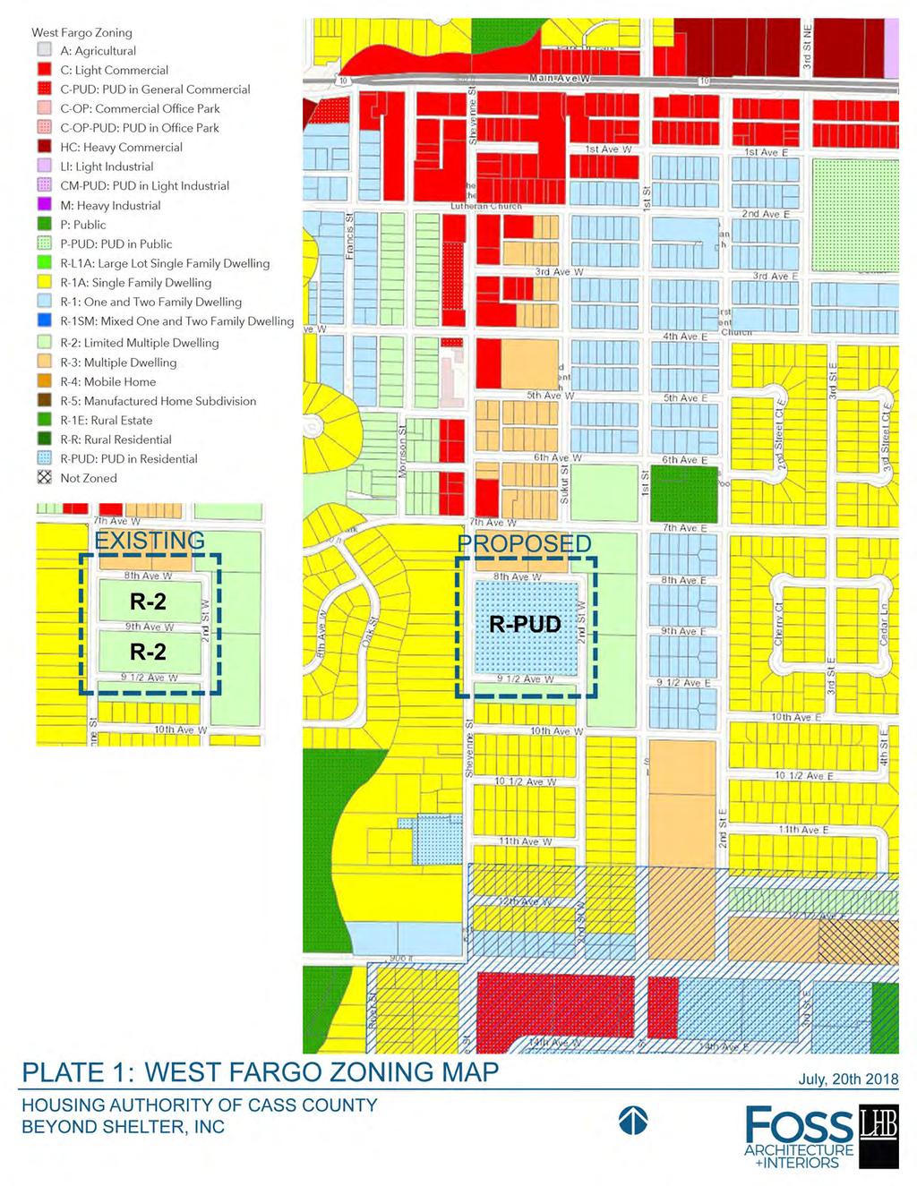
18 CITY OF WEST FARGO PLANNING AND COMMUNITY DEVELOPMENT STAFF REPORT A18-36 REPLAT AND REZONING Southdale 2 nd Addition Block 2 and Block 3 of Southdale Addition, City of West Fargo, North Dakota Owner/Applicant: Cass County Housing Authority Staff Contact: Tim Solberg, AICP Planning & Zoning Commission Introduction: Public Hearing: Detailed Development Plans: City Commission Introduction: Public Hearing & 1 st Reading: 2 nd Reading and Final Plat Approval: PURPOSE: Replat to redevelop site with a mix of multiple family dwellings and offices associated with the Cass County Housing Authority. STATEMENTS OF FACT: Land Use Classification: Existing Land Use: Current Zoning District(s): Zoning Overlay District(s): Proposed Zoning District(s): Proposed Lot size(s) or range: Total area size: Adjacent Zoning Districts: Adjacent street(s): Adjacent Bike/Pedestrian Facilities: Available Parks/Trail Facilities: Park Dedication Requirements: G-4A Core Retrofit Growth Area Medium Density Multiple Dwelling units R-2: Limited Multiple Dwelling CO-R: Redevelopment Corridor Overlay PUD: Planned Unit Development 168,556 ft² and 168,567 ft² 7.74 Acres North R-3: Multiple Dwellings; West R-1A: Single Family Dwellings; South & East R-2: Limited Multiple Dwellings 8th Avenue West (Local); 9 th Avenue West (Local to be vacated); 9 ½ Avenue West (Local); Sheyenne Street (Arterial) Adjacent Sidewalks South Elementary, Herb Tintes Park, and Veteran s Memorial Pool within ¼ mile. The area is developed. DISCUSSION AND OBSERVATIONS: The applicant has submitted an application, preliminary plat, site plan and area plan. The property was developed with mix of multiple family dwellings as part of the Cass County Housing authority. The plat is providing two lots and is proposing to vacate 9 th Avenue West to accommodate private internal drives and public easements for sanitary, water, and storm improvements associated with the redevelopment of this site. There is potential for regional storm water benefits to which the City Engineer is considering and will provide future comments. 1 P a g e
19 CITY OF WEST FARGO PLANNING AND COMMUNITY DEVELOPMENT STAFF REPORT The development currently serves an important need in the community of affordable housing. Presentations before the City s Economic Development Advisory Committee have occurred and staff has requested additional comment from the Community Development Director regarding the need for additional affordable housing opportunities in West Fargo and the region. The applicant proposes rezoning the property to Planned Unit Development (PUD), which would allow for offices and other uses associated with the housing authority, such as a childcare facility. Lot 1 is proposed to be developed with two, four-story, 40 & 44-unit senior living housing structures which would be accessed off 8th Avenue West and Sheyenne Street as part of Phase 1 & 2. This also includes HACC offices. A potential daycare structure is also shown on this lot. Lot 2 is proposed as approximately 45 units within both townhome style and big house residential structures as Phase 3. NOTICES: Sent to: Property owners within 150 and applicable agencies and departments. The applicant also held a neighborhood meeting on August 6, 2018 at the West Fargo High Rise Community Room with just one person attending. No comments were made at that meeting, just interest in what is happening. Comments Received: None received by staff to date. CONSISTENCY WITH COMPREHENSIVE PLAN AND OTHER APPLICABLE CITY PLANS AND ORDINANCES: This project invests in older neighborhoods, supports the growing senior population, improves the neighborhood design, and is consistent with goals of the Comprehensive Plan s Action Plan Big Idea to Strengthen Neighborhoods and Expand Housing Choice. Redevelopment and reinvestment in the site to align with the Core-Retrofit Growth Sector will positively impact the City s downtown core area while maintaining affordable housing options for our residents. The applicant has partnered with urban designers who have included City staff in their design process to achieve consistency with the City s Downtown Framework Study, Sheyenne Street Corridor Study, and design elements found in West Fargo 2.0. RECOMMENDATIONS: It is recommended that the City approve the proposed application in concept on the basis that it is consistent with City plans and ordinances with recommended conditions of approval as follows: 1. Due to the proposed zone change in both density and building type, additional comment should be sought from the Community Development Director regarding the need for increased affordable housing in the City. 2. Detailed Development Plans will be subject, but not limited to Supplementary District Regulations, Off-Street Parking and Loading Requirements, and Sign Regulations. 2 P a g e
20 SHEYENNE ST SUKUT ST 2ND ST W 7TH AVE W A18-36 Proposed Subdivision 8TH AVE W 9TH AVE W 9 1/2 AVE W 10TH AVE W I
21 SHEYENNE ST SUKUT ST 2ND ST W 7TH AVE W A18-36 Proposed Subdivision 8TH AVE W 9TH AVE W 9 1/2 AVE W 10TH AVE W A: Agricultural C: Light Commercial C-PUD: PUD in General Commercial C-OP: Commercial Office Park C-OP-PUD: PUD in Office Park HC: Heavy Commercial LI: Light Industrial CM-PUD: PUD in Light Industrial M: Heavy Industrial P: Public P-PUD: PUD in Public R-L1A: Large Lot Single Family Dwelling R-1A: Single Family Dwelling R-1: One and Two Family Dwelling R-1SM: Mixed One and Two Family Dwelling R-2: Limited Multiple Dwelling R-3: Multiple Dwelling R-4: Mobile Home R-5: Manufactured Home Subdivision R-1E: Rural Estate R-R: Rural Residential R-PUD: PUD in Residential I
22
23 SHEYENNE ST. 8TH AVE. W 91/2 AVE. W High Density Residential Park/Recreation Utility PLATE 2: LAND USE HOUSING AUTHORITY OF CASS COUNTY BEYOND SHELTER, INC July, 20th
24 SHEYENNE ST. 8TH AVE. W 91/2 AVE. W Private R.O.W Public R.O.W PLATE 3: PUBLIC/PRIVATE STREETS HOUSING AUTHORITY OF CASS COUNTY BEYOND SHELTER, INC July, 20th
 Public Open Space/ Stormwater PLATE 4: OPEN SPACE")
25 SHEYENNE ST. 8TH AVE. W 91/2 AVE. W Common Open Space Park Areas (Non-dedicated) Public Open Space/ Stormwater PLATE 4: OPEN SPACE HOUSING AUTHORITY OF CASS COUNTY BEYOND SHELTER, INC July, 20th

 3- Family")
 5- Pontential")

26 SHEYENNE ST. Phase 1 8TH AVE. W /2 AVE. W 1- Senior Units: 44 (Phase 1) 2- Senior Units: 40 (Phase 2) 3- Family Townhouse: 20 (Phase 3) 4- Family Big House: 25 (Phase 3) 5- Pontential Daycare Building PLATE 5: PROPOSED STRUCTURES HOUSING AUTHORITY OF CASS COUNTY BEYOND SHELTER, INC July, 20th


27 SHEYENNE ST. 8TH AVE. W 91/2 AVE. W PLATE 6: PEDESTRIAN NETWORK HOUSING AUTHORITY OF CASS COUNTY BEYOND SHELTER, INC July, 20th
 C. Stormwater (If Needed) D.")
 F.")

28 SHEYENNE ST. 8TH AVE. W A B G C D E F E 91/2 AVE. W A. Senior Building (Phase 1) B. Senior Building (Phase 2) C. Stormwater (If Needed) D. Stormwater (Future Phase) E. Family Townhouses and Big Houses (Phase 3) F. Park & Playground G. Potential Daycare Building PLATE 7: ILLUSTRATIVE PLAN HOUSING AUTHORITY OF CASS COUNTY BEYOND SHELTER, INC July, 20th


 C.")

29 SHEYENNE ST. 8TH AVE. W A B D B C 91/2 AVE. W A. HACC Office: 3800 SF (24 Parking Spaces B. Senior Units: 44 (44 Parking Spaces) C. Park Area with Pavilion D. Storage/Maintenance Building PLATE 8 PHASE 1 PLAN HOUSING AUTHORITY OF CASS COUNTY BEYOND SHELTER, INC July, 20th
30 FILE LOCATION: R:\Civil 3D Projects\20389\SURVEY\DRAWINGS\20389-SOUTHDALE SECOND ADDITION - AREA PLAN.dwg AREA PLAN: SOUTHDALE SECOND ADDITION SOUTHWEST QUARTER SECTION 8-T139N-R49W WEST FARGO, NORTH DAKOTA N W E S Scale in Feet PROJECT No DATE: REVISED: _ DRAFTER: REVIEWER: MPL ###
31 0 60 Scale in Feet
32 CITY OF WEST FARGO PLANNING & COMMUNITY DEVELOPMENT STAFF REPORT A18-37 Replat/Rezoning Maple Ridge at the Preserve 6 th Addition Lots 25 & 35, Block 1 of Maple Ridge at the Preserve 2 nd Addition, City of West Fargo, North Dakota Applicant: City of West Fargo Staff Contact: Tim Solberg, AICP Owners: Jason & Michelle Metzger/City of West Fargo Planning & Zoning Commission Introduction: Public Hearing: City Commission Introduction: Public Hearing & 1 st Reading: 2 nd Reading and Final Plat Approval: PURPOSE: To replat and rezone to bring an existing single-family property into conformance with the rear yard requirements of the R-1A: Single Family Dwelling district standards. STATEMENTS OF FACT: Land Use Classification: Existing Land Use: Current Zoning District(s): Zoning Overlay District(s): Proposed Zoning District(s): Total area size: Adjacent Zoning Districts: Adjacent street(s): G-4A Core Retrofit Growth Area Single Family Dwelling and Retention Pond R-1A: Single Family Dwelling & P: Public Facilities CO: Corridor Overlay District R-1A: Single Family Dwellings Approximately 15,345 ft² North, East & West R-1A: Single Family Dwellings South P: Public Facilities & R-1A: Single Family Dwellings East A: Agricultural West M: Heavy Industrial 32 nd Ave E (Arterial); 31 st Ave E (Local); Claire Dr E (Local); Sheyenne River Way (Private Drive) DISCUSSION AND OBSERVATIONS: The property was platted in 2012 and a single family dwelling constructed in Recently it was determined that the home did not meet the rear yard setback requirements of 30 at the time of permitting. Although the home does not conform to the zoning requirements of the R-1A District, because the City issued a permit, it could be determined that the property is a legal non-conforming structure. Legal non-conforming structures are regulated under Section of City Ordinances which state: Such structure may be continued so long as it remains otherwise lawful, subject to the following provisions: 1. No such nonconforming structure may be enlarged or altered in any way which increases its nonconformity, but any structure or portion thereof may be altered to decrease it nonconformity. 1 P a g e
33 CITY OF WEST FARGO PLANNING & COMMUNITY DEVELOPMENT STAFF REPORT 2. Should such nonconforming structure or nonconforming portion of structure be destroyed by any means to the extent of more than 50 percent of its replacement cost at time of destruction, it shall not be reconstructed except in conformity with the provisions of this Ordinance. 3. Should such structure be moved for any reason for any distance whatever, it shall thereafter conform to the regulations for the district in which it is located after it is moved. Although the property can continue, banks will not typically lend for a property which is legal nonconforming because the second clause which does not allow the property to be rebuilt if damaged. A remedy for the situation exists which is to subdivide additional property from the City, to plat and rezone to bring the property into compliance. The City would maintain the property in an easement so no structure would be able to be constructed on the land and the City could maintain the retention needs of the pond, but the house would now be in compliance with the yard requirements of the R-1A zoning district standards. NOTICES: Sent to: Property owners within 150 and applicable agencies and departments Comments Received: None to date. CONSISTENCY WITH COMPREHENSIVE PLAN AND OTHER APPLICABLE CITY PLANS AND ORDINANCES: The proposed application would ensure the structure becomes consistent with the City plans and ordinances. The Comp Plan includes this area in the Core Retrofit Growth Area, however it is due to proximity and the subdivision is not anticipated to be retrofitted due to the minor lot line change. RECOMMENDATIONS: It is recommended that the City approve the proposed application on the basis that it is consistent with City plans and ordinances with recommended conditions of approval as follows: 1. An Attorney Title Opinion is received. 2. A signed vacation of the previous plat is received. 3. Signed Final Plat is received with any necessary easements. 4. A certificate is received showing taxes are current. 2 P a g e
34 CLAIRE DR E A18-37 Proposed Subdivision 31ST AVE E SHEYENNE RIVER WAY 32ND AVE E I
35 CLAIRE DR E A18-37 Proposed Subdivision 31ST AVE E SHEYENNE RIVER WAY 32ND AVE E A: Agricultural C: Light Commercial C-PUD: PUD in General Commercial C-OP: Commercial Office Park C-OP-PUD: PUD in Office Park HC: Heavy Commercial LI: Light Industrial CM-PUD: PUD in Light Industrial M: Heavy Industrial P: Public P-PUD: PUD in Public R-L1A: Large Lot Single Family Dwelling R-1A: Single Family Dwelling R-1: One and Two Family Dwelling R-1SM: Mixed One and Two Family Dwelling R-2: Limited Multiple Dwelling R-3: Multiple Dwelling R-4: Mobile Home R-5: Manufactured Home Subdivision R-1E: Rural Estate R-R: Rural Residential R-PUD: PUD in Residential I
36 0 60 Scale in Feet
37 FILE LOCATION: R:\Civil 3D Projects\20429\SURVEY\DRAWINGS\20429-MAPLE RIDGE AT THE PRESERVE SIXTH ADDITION - AREA PLAN.dwg N W E S Scale in Feet AREA PLAN: MAPLE RIDGE AT THE PRESERVE SIXTH ADDITION SOUTHWEST QUARTER 20-T139N-R49W PROJECT No. DATE: REVISED: DRAFTER: MPL REVIEWER: CDH WEST FARGO, NORTH DAKOTA engineering, inc _ moore
38 CITY OF WEST FARGO PLANNING & COMMUNITY DEVELOPMENT STAFF REPORT A18-34 SUBDIVISION/REZONING The Wilds 11 th Addition Part of Government Lots 3-5 in the NW¼ of Section 6, T138N, R49W, City of West Fargo, North Dakota, Applicant: Eagle Ridge Development LLC, Staff Contact: Tim Solberg, AICP Jonathan Youness Owner: Westport Investments, LLC Planning & Zoning Commission Introduction: Public Hearing: Approval City Commission Introduction: Public Hearing st Reading: 2 nd Reading & Final Plat Approval PURPOSE: Plat and zone land for residential development. STATEMENTS OF FACT: Land Use Classification: Existing Land Use: Current Zoning District(s): Zoning Overlay District(s): Proposed Zoning District(s): Proposed Lot size(s) or range: Total area size: Adjacent Zoning Districts: Adjacent street(s): Adjacent Bike/Pedestrian Facilities: Available Parks/Trail Facilities: Land Dedication Requirements: G-2: Sub-Urban Growth Sector Vacant A: Agricultural CO: Corridor Overlay District R-1: One & Two Family Dwellings; R-2: Limited Multiple Dwellings; P: Public Facilities 125 R-1 Lots, 48 R-2 Lots, 2 Public lots for retention Acres North R-1A: Single Family Dwellings South & West A: Agricultural East R-1: One & Two Family Dwellings & P: Public Facilities 52 nd Ave W (Arterial); 9 th Street W (Collector); 10 th St W (Local); 11 th St W (Local); Cathy Dr (Local); Ashley Ln W (Local); Unnamed Local Streets Bike path adjacent to 9 th Street West; Proposed Bike path along 52 nd Ave W and through development. Legacy Elementary and adjacent park property as well as trail connections to parks within ¼ mile. Park plan has been approved by West Fargo Park District and will be required to be updated with the proposed development. 1 P a g e
39 CITY OF WEST FARGO PLANNING & COMMUNITY DEVELOPMENT STAFF REPORT DISCUSSION AND OBSERVATIONS: The applicant has submitted an application, preliminary plat and area plan. The area plan is proposing the majority of the area to develop as single-family residential with some R-2 residential (medium density). When the Wilds 8 th Addition was considered in September 2016, the developer and Park District came to agreement with regards to park plans north of 52 nd Avenue West, as well as south of 52 nd Avenue West. The applicant is proposing single-family and twin home lot residential development with R-1: One and Two Family Dwellings and R-2: Limited Multiple Dwellings. The developer is also proposing one larger lot to be zoned R-2: Limited Multiple Dwelling. Right-of-way widths for local streets on the preliminary plat are provided and should be to 62 unless the applicant is able to provide an amenities plan that can demonstrate how the wider streets will benefit the development. There is no means of east-west connection to arterial roadways in this area; therefore staff believes the connections to 64th Avenue South on the south side of the previous plat (The Wilds 9 th ) are important to provide access to more than just one arterial roadway. Road right of way exists in Horace to make a connection; however, this right of way is not improved and needs to be considered. The agreements for The Wilds 8 th Addition and The Wilds 9 th Addition provided that the developer would work with the City of Horace to establish a schedule for constructing the streets which will be coordinated with the development of the Wilds development. In the event that the City of Horace fails to make improvements to 78 th Street South and 79 th Street South, the developer may be responsible for the costs of developing roadways to ensure access to 64 th Avenue South. 9th Street West will be an important major collector for this area. As of the date of application, the City currently has 1,211 residential serviced lots which are vacant. Of those lots, 747 are zoned for smaller single family housing (R-1, R-1SM, and PUD). This inventory would service the City under its current rates of absorption for approximately 3-5 years. There are peaks and valleys to the City s building permit rates, however Staff feels it is important to note the amount of inventory of homes in relation to the consideration of the proposed development. o To illustrate the rate of absorption, the City permitted the following number of single family homes in corresponding five year time periods below: 276 in 2017; 402 in 2016; 392 in 2015; 428 in 2014; 437 in in 2012; 163 in 2011; 166 in 2010; 158 in 2009; 117 in in 2007; 244 in 2006; 421 in 2005; 626 in 2004; 501 in 2003 The City does not currently have serviced multiple family lots available and the vacancy reports provided show a slight decline indicating that the proposed multiple family dwellings would be absorbed in a reasonable time. NOTICES: Sent to: Property owners within 150 and applicable agencies and departments Comments Received: None to date. 2 P a g e
40 CITY OF WEST FARGO PLANNING & COMMUNITY DEVELOPMENT STAFF REPORT CONSISTENCY WITH COMPREHENSIVE PLAN AND OTHER APPLICABLE CITY PLANS AND ORDINANCES: The mix of housing types and increased densities of the R-2 lots will increase the diversity of the neighborhood housing stock consistent with goals of the Comprehensive Plan s Action Plan Big Idea to Strengthen Neighborhoods and Expand Housing Choice RECOMMENDATIONS: It is recommended that the City approve the proposed application on the basis that it is consistent with City plans and ordinances with recommended conditions of approval as follows: 1. Consideration be given by City Commission on inventory of serviced residential lots and the current rate of absorption in the City of West Fargo and within the metropolitan area. 2. A signed subdivision agreement is received. 3. A signed and updated park dedication agreement is received. 4. A drainage plan is received and approved by the City Engineer. 5. Final Plat is received with any necessary easements. 6. A certificate is received showing taxes are current. PLANNING AND ZONING RECOMMENDATION: At their July 10, 2018 meeting, the Planning and Zoning Commission approved the subdivision and rezoning, subject to the six conditions listed above. UPDATE: The developer is requesting a change in the advertised zoning for a portion of the proposed R-2 lots to be changed to R-1SM to accommodate some variation of lot sizes for the previously proposed twinhome lots within the R-2 cul-de-sac. It is advised that a first reading be deferred to allow the Planning Commission to review the change and submit a revised recommendation. 3 P a g e
 46.")
 60.")
41 LEGEND 36 Lot( 24) Lot( 6) 51 Lot( 7) Lot( 4)
42 Larry M. Weil, Director of Community Development Tim Solberg, AICP, Director of Planning and Zoning Lisa Sankey, Assistant Planner - Memorandum - TO: FROM: RE: West Fargo Planning Commission Tim Solberg, AICP, Director of Planning and Zoning Item #6 of March 12, 2018 Planning & Zoning Commission Agenda DATE: August 10, 2018 The CO: Corridor Overlay District standards require a higher construction standard than other areas of the City (section ). In areas of the Corridor Overlay District, which is zoned Light Commercial, any exposed metal or fiberglass on all buildings shall be limited to no more than thirty (30) percent of any wall which fronts on a public street, provided that it is coordinated into the architectural design. Seventy percent (70%) of any wall (facade area) which fronts on a public street shall be constructed of glass, brick, wood, stone, architectural concrete cast in place or precast concrete panels, or, as approved by the Commission(s), other integrated materials per the architectural design. Building plans have been submitted for review to the City for a Dollar General located along the south side of 32 nd Ave W at nd Ave W. The building is faced with HardiePlank Lap Siding with a Cedarmill finish on two elevations, and simple metal panel on the other two elevations. Staff believes Commission consideration is required because the proposed siding type is not identified within the requirements stated above. HardiePlank lap siding is more typical of residential structures, and staff does not feel it is a material included in the requirements of the CO district standards. This is the company s first revision to the original permit. The previous submittal was faced primarily with metal panel and was returned by staff to be revised. Staff is seeking a motion regarding the interpretation and would forward to the City Commission for their consideration. TPS enclosures th Avenue East West Fargo, ND Fax
43 XOH XOH XOH XOH XOH XOH XOH XOH XOH XOH XOH XOH XOH XOH XOH XOH XOH XOH XOH XOH XOH XOH XOH XOH XOH XOH XOH XOH XOH XOH XOH XOH XOH XOH XOH XOH XOH XOH XOH XOH XOH XOH XOH XOH XOH XOH XOH XOH XOH XOH XOH XOH XOH XOH XOH XOH XOH XOH XOH XOH XSTORM GAS XUE XUE XOH XOH XOH XOH XOH XOH XOH XOH XOH XOH XOH XOH XOH XOH XOH XOH XOH XOH XOH XOH XOH XOH XOH XOH XOH XOH XOH XOH XOH XOH XOH XOH XOH XOH XOH XOH XOH XOH XOH XOH XOH XOH XOH XOH XOH XOH XOH XOH XOH XOH XOH XOH XOH XOH XOH XOH XOH XOH XOH XOH XSTORM GAS XUE XUE XCATV XW XW XW XW XW XW XW XW XSTORM XSTORM XSTORM XSTORM XSTORM XSTORM XSTORM XSTORM XCATV XCATV XCATV XW XW STORM XUE XUE XCATV XCATV XCATV XUE XFIBER XFIBER XFIBER XFIBER XFIBER XFIBER XFIBER XF XUE XUE XUE XUE XUE XUE XUE XUE XUE XW GAS GAS GAS GAS GAS OH utility line easement 130' x 70' 9100 SF Prototype E With Vestibule HVAC On Roof STORM STORM STORM STORM STORM 902 UE W SAN SAN XCATV XW XW XW XW XW XW XW XW XSTORM XSTORM XSTORM XSTORM XSTORM XSTORM XSTORM XSTORM TELE TELE TELE TELE TELE TELE TELE STORM E SAN SAN SAN XCATV XCATV XCATV XW XW XUE XUE XCATV XCATV XCATV XUE UE TELE XW XW XW XW XW XW XW XW XW XW XW XW XW XW XW XW XW XW XFIBER XFIBER XFIBER XFIBER XFIBER XFIBER XFIBER XFIB XUE XUE XUE XUE XUE XUE XUE XUE XUE XW OH utility line easement 130' x 70' 9100 SF Prototype E With Vestibule HVAC On Roof 108'-0" 20'-0" 25'-0" 20'-0" 25'-0" 9'-6" 20'-0" 13'-0" 13'-0" 108'-0" 9'-6" 5'-0" 9'-6" 9'-6" 45'-0" 95'-0" 5'-0" 25'-0" 52'-0" '-0" R1'-6" W SAN SAN R1'-6" TELE TELE TELE TELE TELE TELE TELE UE STORM 17'-2" 3'-6" R5'-0" R3'-0" 9'-6" R3'-0" R15'-0" R25'-0" STORM R12'-0" GAS GAS GAS GAS GAS R3'-0" 9'-0" E STORM STORM STORM STORM STORM SAN SAN SAN UE TELE 20'-6" R3'-0" R3'-0" R3'-0" 3'-0" 3'-0" 3'-0" 4'-0" Landscape Schedule Key Common Name Botanical Name Qty Size Cond. ARM Maple - Amur Acer ginnala FCA Crabapple - Flowering Malus Hybrids 3 1.5" caliper 2 1.5" caliper SHJ Juniper - Sky High Juniperus scopulorum 'Bailigh' 27 2 gallon CFR Campfire Rose Rosa 'CA 29' 37 2 gallon LDP Leadplant Amorpha canescens 43 2 gallon GLJ Juniper - Gold Lace Juniperus chinensis 'Gold Lace' 33 12" - 18" high Ball & Burlap Ball & Burlap Potted Potted Potted Potted Kentucky Bluegrass Poa pratensis Seed / Sod Mulch Trees Flowering Crab Apple Amur Maple Shrubs Leadplant Campfire Rose Gold Lace Juniper Skyrocket Juniper HLH/MLA Project # DATE May 18, 2018 revisions 1 July 09, 2018 north 1 Landscaping Plan 1 Prototype changed to "E" & added additional plantings as requested by City. 1" = 20'-0" C 2018 Abeln & Associates Architects, P.A. SHEET NUMBER SP-3 Landscaping & Dimension Plans 9'-6" 20'-6" 20'-6" W. 112th Street Suite 102 Overland Park Kansas A b e l n & A s s o c i a t e s nd Ave. W A r c h i t e c t s, P. A. West Fargo, North Dakota (913) DOLLAR GENERAL 16 10'-0" 1/4" = 1'-0" Monument Sign 5'-0" x 10'-0" lighted monument sign, black letters on yellow background per Dollar General specs Concrete block, typ. Landscape Calculations Units Required: 42,700/1,000 = 42.7 x 4 = units possible units provided Small, Deciduous Tree 7 35 (20%) Shrubs (80%) Total Provided Dimension Plan 1 Prototype changed to "E", and site plan updated accordingly. 1" = 20'-0" '-0" 5'-0"

44 General Notes 1. All exterior metal shall be primed and painted, including gas piping, steel bollards, dock bumpers, doors and frames, handrails, guardrails, electrical boxes and conduits, vents, etc. Color by Architect. 2. "T" at Storefront indicates Tempered Plate Glass per local ordinance. 3. No exposed metal fasteners allowed per city Vent for bathroom exhaust. HVAC units mounted on roof. Refer to mechanical drawings Gutter and DS to conc. trench in sidewalk, typ. - Refer to mechanical for for additional information. See finishes for color additional information Metal panel, typ. 13'-4" 26'-0" 26'-0" 26'-0" 26'-0" 13'-4" Outside air temp. Sensor mounted over receiving 8'-0" A.F.F '-0" Size Building Sign Weight # of Circuits Amps Voltage 3'-9" x 26'-0" box 441 lbs (1) 15 A Size Pylon Sign Weight # of Circuits Amps Voltage 5'-0" x 10'-0" 375 lbs (1) 15 A *Standard signs shown, sign size subject to change at Dollar General's discretion. 18'-0" 18'-0" 10'-0" 8'-0" 10'-0" 18'-0" 1 2 HVAC units mounted on roof. Refer to mechanical drawings for additional information. HardiePlank Lap Siding, 6'-9" 13'-2" 25'-9" 26'-1" 6'-9" Cedarmill finish, typ. A B C D T T T T HardiePlank Lap Siding, Cedarmill finish, typ. 22'-0" 6'-4" 1 2" dia. x 6" long stainless steel eye bolts (closed) with 1" dia. openings. Drill and epoxy into block wall. 4 bolts to be located as shown ea. side of entry, total of 8 bolts. T T T T Down-directional light. Refer to electrical drawings for additional information, typ. of 5 HVAC units mounted on roof. Refer to mechanical drawings for additional information. 12'-0" 4'-0" 4'-0" 4 Elevation Sign furnished and installed by DG with circuit as noted on electrical plan. Sign to be centered on front of building. Contractor is to provide adequate blocking as required by sign manufacturer to support sign weight of up to 1,400 lbs. Exterior canopy sign shall be supported by the face of the canopy. Coordinate the proper signage to be used with DG. Down-directional light. Refer to electrical drawings for additional information, typ. of 5 3 Elevation Down-directional light. Refer to electrical drawings for additional information, typ. of 2 15'-0" Sign furnished and installed by DG with circuit as noted on electrical plan. Sign to be centered on front of building. Contractor is to provide adequate blocking as required by sign manufacturer to support sign weight of up to 1,400 lbs. Exterior canopy sign shall be supported by the face of the canopy. Coordinate the proper signage to be used with DG. 14'-0" D C B A Standing Seam metal roof. Galvalume finish. 3/8 12 4'-0" 4'-0" 12'-0" 6'-4" T T Metal panel, typ. T T T T T 1 2" dia. x 6" long stainless steel eye bolts (closed) with 1" dia. openings. Drill and epoxy into block wall. 4 bolts to be located as shown ea. side of entry, total of 8 bolts. HVAC units mounted on roof. Refer to mechanical drawings for additional information. T 14'-0" Door buzzer. Refer to electrical drawings for additional information. 2 Elevation 1 Elevation 1 1/8" = 1'-0" 1/8" = 1'-0" 1/8" = 1'-0" 1/8" = 1'-0" 8'-0" 10'-0" 18'-0" 18'-0" W. 112th Street Suite 102 Overland Park DOLLAR GENERAL Kansas A b e l n & A s s o c i a t e s nd Ave. W A r c h i t e c t s, P. A. West Fargo, North Dakota (913) HLH/MLA EXTERIOR FINISHES EXTERIOR FINISHES ARE TO MATCH OR BE EQUAL TO VP METAL BUILDING SYSTEM'S FINISH SELECTION. GUTTERS DOWN SPOUTS PRE-ENGINEERED METAL BUILDING VENDOR SIDE AND REAR METAL PANELS "A" & TRIM, RECEIVING & EMERGENCY EXIT DOORS VP BUILDINGS ATTN: DAVID ENGLISH (901) COOL EGYPTIAN WHITE COOL DARK BRONZE BRONZE COOL COTTON WHITE GALVALUME STAR BUILDING SYSTEMS ATTN: RODNEY BURT (800) LIGHTSTONE MEDIUM BRONZE KYNAR 500 BRONZE POLAR WHITE GALVALUME NUCOR BUILDING SYSTEMS ATTN: BOB BARRY (315) (260) LIGHTSTONE MEDIUM BRONZE KYNAR 500 BRONZE POLAR WHITE GALVALUME BIG BEE STEEL BUILDINGS, INC. ATTN: KEVIN BUSLER (800) SANDSTONE BURNISHED SLATE BRONZE POLAR WHITE GALVALUME CHIEF BUILDINGS ATTN: ERIN SULLIVAN (308) (308) PARCHMENT ANTIQUE BRONZE BRONZE POLAR WHITE GALVALUME FINISH NOTES: 1. REFER TO SHEET T-1 FOR ADDITIONAL INFORMATION ON RECOMMENDED NATIONAL ACCOUNT VENDORS. 2. NATIONAL ACCOUNT AND CONTACT INFORMATION SUBJECT TO CHANGE. 3. IF ALTERNATE IS REQUIRED FOR "LIGHT STONE" COLOR, SW 6149 ' RELAXED KHAKI" SHALL BE USED FOR PINNACLE BUILDINGS & SW 7051 "ANALYTICAL GRAY" SHALL BE USED FOR VP BUILDINGS AS ALLOWED BY AHJ. 4. IF ALTERNATE MATERIAL IS REQUIRED FOR "DARK BRONZE" PANEL COLOR IT SHALL BE PAINTED TO MATCH SW 7055 "ENDURING BRONZE" FOR PINNACLE BUILDINGS & SW7020 "BLACK FOX" SHALL BE USED FOR VP BUILDINGS AS ALLOWED BY AHJ. METAL BUILDING NOTES: PRE-ENGINEERED METAL BUILDING NOTES 1. THE PRE-MANUFACTURED METAL BUILDING STRUCTURE, CONCRETE FOUNDATION, AND INTERIOR CONCRETE SLAB SHALL BE DESIGNED, DETAILED, FABRICATED, AND CONSTRUCTED IN ACCORDANCE WITH ALL APPLICABLE CODES, STANDARDS AND REGULATIONS. THE MOST STRINGENT REQUIREMENTS APPLY WHERE INCONSISTENCIES OCCUR BETWEEN THE APPLICABLE STANDARDS. IN THE ABSENCE OF OTHER CRITERIA, LOADINGS SHALL CONFORM TO THE EDITION OF THE INTERNATIONAL BUILDING CODE LISTED ON THE COVER SHEET T1. 2. THE SCOPE OF THE PRE-MANUFACTURED METAL BUILDING STRUCTURE SHALL INCLUDE THE DESIGN, ENGINEERING, FABRICATION, DELIVERY, AND ERECTION OF THE COMPLETE STRUCTURAL STEEL FRAMING AND EXTERIOR SKIN PACKAGE. THE METAL BUILDING MANUFACTURER SHALL BE CERTIFIED BY AMERICAN INSTITUTE OF STEEL CONSTRUCTION (AISC) METAL BUILDING CERTIFICATION PROGRAM. 3. THE FRONT FASCIA SHALL HAVE (3) 12" PURLINS (MOUNTED VERTICALLY SO THAT THE 12" FACE IS AGAINST THE BUILDING METAL SIDING. THESE PURLINS SHALL BE CENTERED OVER THE ENTRANCE AND SPACED 96" APART TO PROVIDE ADEQUATE SUPPORT FOR SIGNAGE WHICH MAY WEIGH UP TO 1,400 LBS. SIGN SPECIFICATIONS 1. BUILDING SIGNS: PROVIDE CONDUIT FROM ELECTRICAL PANEL TO THE CENTER OF THE SIGN CANOPY. THE CONDUIT IS TO BE 1" AND HAVE ONE SET OF 10/2 WIRE WITH GROUND. BUILDING CANOPY MUST BE SUFFICIENTLY BUILT TO SUPPORT THE DOLLAR GENERAL SIGN OF UP TO 1400 LBS. NOTE: IF THE LEASE SPECIFIES A 5'-0" X 40'-0" BUILDING SIGN OR 24" LETTER SET (OR LARGER), 2 qty. - 10/2 WIRE WITH GROUND. MONUMENT SIGNS: PROVIDE CONDUIT FROM ELECTRICAL PANEL TO LOCATION OF THE SIGN BASE. BURY CONDUIT UNDER PARKING AREA. THE CONDUIT IS TO BE 1" AND HAVE ONE SET OF 10/2 WIRE WITH GROUND. ROVIDE CONCRETE MONUMENT SIGN BASE 6" WIDER THAN SIGN IN ALL DIRECTIONS, AND 42" DEEP. 2. FINAL ELECTRICAL CONNECTIONS FOR SIGN SHALL BE THE G.C. RESPONSIBILITY AFTER SIGNS ARE INSTALLED. Project # DATE May 18, 2018 revisions 1 July 09, 2018 FLAT METAL SOFFIT AT STOREFRONT VESTIBULE AREA METAL PANEL "R", REVERSE RIB VESTIBULE STOREFRONT SYSTEM STANDING SEAM METAL ROOF PANELS ROOF NOTES: 1. METAL ROOF MUST BE A STRUCTURAL STANDING SEAM METAL ROOF WITH MECHANICALLY ROLLED SEAMS. SEAMS TO BE A MINIMUM 1 1/2" HIGH. ALL FASTENERS TO BE CONCEALED. 2. ROOF PANELS TO BE A MINIMUM 24 GAUGE. 3. METAL ROOF SYSTEM TO BE EQUAL TO VP BUILDING SSR ROOF. 4. CONDENSATE FROM HVAC UNITS TO BE PIPED TO GUTTERS. 3. SIGN PERMITS TO BE APPLIED FOR AND OBTAINED BY DOLLAR GENERAL. SHEET NUMBER A-301 LINER PANELS (INTERIOR SALES FLOOR AND RECEIVING) C 2018 Abeln & Associates Architects, P.A. Elevations

45 2018 Annual Conference Thursday, September 13 th Alerus Center, Grand Forks Keynote Update on Medical Marijuana Regulation Rights of Way: The good, the Bad and the Ugly. A Brownfield Redevelopment Case Study: Surly Brewing Company Leveraging Federal Resources to Address Flood Risk Resolving Land Use Conflicts between Energy Infrastructure and Military Operations: A Department of Defense Grant Opportunity for North Dakota ND Moves - Statewide Pop Ups Panel Planning at the City Edge and Beyond Lessons Learned: Redevelopment of Temporary Pocket Parks Top 10 Things to Know About Governor Burgum s Main Street Hunger in North Dakota Key Indicators, Demographic Trends and Population Projections: North Dakota & Preparing Your Community for Census 2020 Poster Presentations: Compass Points: North Dakota Demographics at a Glance The Past, Present, and Probable Future of Economic Development Districts Downtown Tour Redevelopment & Historical Sites Social Event Greenway Takeover Festival (Live Music & Food Trucks!) Mark Schill Praxis Strategy Group Donald Kress Planning Coordinator, City of Fargo Planning & Development Department Nancy MH Simpson Planning & Zoning Administrator, Ward County Dan Fetter Vice President, Barr Engineering Company Rachel Shoemaker CFM, ND Silver Jackets Coordinator, US Army Corps of Engineers Kevin Seegmiller Director of Program Management, Delta Environmental Sciences Ben Ehreth, Assistant Division Director, Planning/Asset Management Division, NDDOT Will Hutchings, Planner, City of Bismarck Other panel members TBD Scott Harmstead, Senior Associate Planner with SRF Consulting Group, Inc. Natalie Pierce, Planning & Zoning Director for Morton County, John Van Dyke, Principal Planner for City of Mandan Ryan Brooks Deputy City Planner, City of Grand Forks Ben Ehreth Assistant Division Director for the Planning/Asset Management Division, NDDOT Melissa Sobolik, Director of Ending Hunger2.0, a new initiative of the Great Plains Food Bank, Kevin C. Iverson, Manager, Census Office, North Dakota Dept. of Commerce Nancy Hodur, Director for the Center for Social Research, NDSU Ina Cernusca, Research Specialist, North Dakota Compass/Center for Social Research at North Dakota State University Mitch Calkins, Program Manager, Lake Agassiz Development Group City of Grand Forks Planning Staff & Grand Forks Historic Preservation Commission
Marion County Board of County Commissioners
 Marion County Board of County Commissioners Date: 12/29/2015 P&Z: 12/28/2015 BCC: 1/12/2016 Item Number 160113Z Type of Application Rezoning Request From: A-1 (General Agriculture) To: PUD (Planned Unit
Staff Report: Date: Applicant: Property Identification: Acreage of Request: Current Zoning of Requested Area: Requested Action: Attached:
 Staff Report: Completed by Jeff Palmer Director of Planning & Zoning Date: November 7, 2018, Updated November 20, 2018 Applicant: Greg Smith, Oberer Land Developer agent for Ronald Montgomery ET AL Property
1. Roll Call. 2. Minutes a. September 26, 2016 Regular Meeting. 3. Adoption of the Agenda. 4. Visitors to Be Heard
 1. Roll Call City of Vermillion Planning Commission Agenda 5:30 p.m. Regular Meeting Tuesday, October 11, 2016 Large Conference Room 2 nd Floor City Hall 25 Center Street Vermillion, SD 57069 2. Minutes
CITY OF APPLE VALLEY PLANNING COMMISSION MINUTES DECEMBER 7, 2016
 PLANNING COMMISSION MINUTES DECEMBER 7, 2016 1. CALL TO ORDER The City of Apple Valley Planning Commission meeting was called to order by Chair Melander at 7:01 p.m. Members Present: Tom Melander, Ken
COMMUNITY DEVELOPMENT. Staff Report. Site Plan Review. SP June 19, 2018
 COMMUNITY DEVELOPMENT 333 Broadalbin Street SW, PO Box 490, Albany, Oregon 97321-0144 BUILDING 541-917-7553 PLANNING 541-917-7550 Staff Report Site Plan Review SP-18-18 June 19, 2018 Summary On May 1,
ARTICLE VII. NONCONFORMITIES. Section 700. Purpose.
 ARTICLE VII. NONCONFORMITIES. Section 700. Purpose. The purpose of this chapter is to regulate and limit the development and continued existence of legal uses, structures, lots, and signs established either
Town of Waxhaw Board of Commissioners. Waxhaw Police Department Community Meeting Room Tuesday January 12, 2016
 Town of Waxhaw Board of Commissioners Waxhaw Police Department Community Meeting Room Tuesday January 12, 2016 Petition RZ-003994-2015 A request by the Town of Waxhaw Planning & Community Development Department,
CITY OF ALBERT LEA PLANNING COMMISSION ADVISORY BOARD
 CITY OF ALBERT LEA PLANNING COMMISSION ADVISORY BOARD 9/1/2015, 5:30 p.m. City Council Chambers AGENDA A. CALL TO ORDER AND ROLL CALL B. APPROVAL OF THE AGENDA C. APPROVAL OF MINUTES 1. PC Minutes from
TOWN OF ORO VALLEY PLANNING & ZONING COMMISSION MEETING DATE: December 6, 2011
 PLANNING & ZONING COMMISSION MEETING DATE: December 6, 2011 TO: FROM: SUBJECT: PLANNING & ZONING COMMISSION Matt Michels, Senior Planner mmichels@orovalleyaz.gov; tel. 229-4822 Public Hearing: Rancho de
PLANNED UNIT DEVELOPMENT & SUBDIVISION STAFF REPORT Date: April 18, 2019
 PLANNED UNIT DEVELOPMENT & SUBDIVISION STAFF REPORT Date: April 18, 2019 DEVELOPMENT NAME SUBDIVISION NAME Springhill Village Subdivision Springhill Village Subdivision LOCATION 4350, 4354, 4356, 4358,
Staff Report: Date: Applicant: Property Identification: Acreage of Request: Current Zoning of Requested Area: Requested Action: Attached:
 Staff Report: Completed by Jeff Palmer Director of Planning & Zoning Date: November 7, 2018 Applicant: Greg Smith, Oberer Land Developer agent for Ronald Montgomery ET AL Property Identification: Frontage
Faribault Place 3 rd Addition Preliminary Plat, Final Plat, & PUD
 Faribault Small Town Pride Big City Opportunities! December 5, 2016 Planning Commission Public Hearing Faribault Place 3 rd Addition Preliminary Plat, Final Plat, & PUD Location Maps Faribault 2 Requests
Meeting Minutes New Prague Planning Commission Wednesday, June 27, 2018
 Meeting Minutes New Prague Planning Commission Wednesday, 1. Call Meeting to Order The meeting was called to order at 6:30 p.m. by Member Bob Gilman with the following members present: Amy Jirik, Matt
Rapid City Planning Commission
 Rapid City Planning Commission Initial Planned Development Overlay Project Report March 9, 2017 Item #15 Applicant Request(s) Case # 17PD007 Initial Planned Development Overlay to allow a residential development
ALPINE TOWNSHIP PLANNING COMMISSION REGULAR MEETING August 17, 2017
 Page 1 of 9 ALPINE TOWNSHIP PLANNING COMMISSION REGULAR MEETING 17-37 CALL TO ORDER / APPROVAL OF THE REGULAR MEETING MINUTES OF JULY 20, 2017 AND THE / PUBLIC COMMENT ON NON-AGENDA ITEMS The Alpine Township
APPLICATION FOR PRELIMINARY PLAT RESIDENTAIL. FILING FEE: $ for the first 20 lots; $10.00 for each additional lot over 20
 COMMUNITY PLANNING & DEVELOPMENT TELEPHONE.* (816) 331-4331 FAX * (816) 331-6973 CITY HALL ANNEX 520 MAIN STREET BELTON, MISSOURI 64012 WEBSITE * www.belton.org APPLICATION FOR PRELIMINARY PLAT RESIDENTAIL
MINUTES JOINT MEETING LINCOLN COUNTY and SIOUX FALLS PLANNING COMMISSIONS 7:00 pm July 14, 2010
 MINUTES JOINT MEETING LINCOLN COUNTY and SIOUX FALLS PLANNING COMMISSIONS 7:00 pm July 14, 2010 Commissioners Room - Lincoln County Court House A joint meeting of Lincoln County and Sioux Falls Planning
Planning Justification Report - Update Castlegrove Subdivision, Gananoque Draft Plan of Subdivision and Class III Development Permit
 Planning Justification Report - Update Castlegrove Subdivision, Gananoque Draft Plan of Subdivision and Class III Development Permit by IBI Group Table of Contents Executive Summary... 1 1 Introduction...
CITY OF BELLEVIEW PLANNING & ZONING BOARD AGENDA
 CITY OF BELLEVIEW PLANNING & ZONING BOARD AGENDA BELLEVIEW CITY HALL COMMISSION ROOM 5:30 PM IF A PERSON SHOULD DESIRE TO APPEAL ANY DECISION MADE BY THE BOARD, A VERBATIM RECORD OF THE PROCEEDINGS WHICH
Watertown City Council
 City of Watertown Watertown City Council 2/14/2017 Agenda Item: Riverpointe Subdivision 2 nd Replat Request for Action: Sketch Plan Department: Planning Request for Action Request: Paxmar, LLC (Applicant)
ARTICLE Encourage well planned, efficient development.
 ARTICLE 14.00 PD PLANNED SECTIONS: 14.01 Intent 14.02 Procedure 14.03 Initial Development Plan 14.04 Final Development Plan 14.05 Amendments 14.06 Planned Development Districts PD-1 Willow Run PD PD-2
SUBJECT PARCEL(S) Property Owner(s) TMS Number Approximate Acreage Carolina Park Development, LLC
 Property Owner(s) TMS Number Approximate Acreage Carolina Park Development, LLC") Staff Report Special Planning Commission Meeting November 19, 2014 For reference, the Zoning Code and Land Development Regulations are available online. AGENDA ITEM 5c. SKETCH PLAN APPROVAL REQUEST: Request
Staff Report Special Planning Commission Meeting November 19, 2014 For reference, the Zoning Code and Land Development Regulations are available online. AGENDA ITEM 5c. SKETCH PLAN APPROVAL REQUEST: Request
LETTER OF APPLICATION
 Description of Proposed Land Division: LETTER OF APPLICATION The proposed land division would split a 1.94 acres rectangular lot into two lots. The general configuration would have one lot in front of
4.2 RESIDENTIAL ZONING DISTRICTS
 4.2 RESIDENTIAL ZONING DISTRICTS A. Purpose: To define regulations and standards for each residential zoning district in the City. The following sections identify uses, regulations, and performance standards
ZONING AMENDMENT & SUBDIVISION STAFF REPORT Date: November 3, 2016
 ZONING AMENDMENT & SUBDIVISION STAFF REPORT Date: November 3, 2016 APPLICANT NAME SUBDIVISION NAME David Shumer 5955 Airport Subdivision CITY COUNCIL DISTRICT District 6 5955 Airport Boulevard, 754 Linlen
Subchapter 5 Zoning Districts and Limitations
 Subchapter 5 Zoning Districts and Limitations 35.5.1 Rural Districts Sections: 35.5.1.1 Purpose. 35.5.1.2 Permitted Uses. 35.5.1.3 General Regulations. 35.5.1.1 Purpose. The purpose of a Rural District
PUBLIC NOTICE & AGENDA PLAN COMMISSION City Hall Forum State Street, Beloit, WI :00 PM Wednesday, November 07, 2018
 PUBLIC NOTICE & AGENDA PLAN COMMISSION City Hall Forum - 100 State Street, Beloit, WI 53511 7:00 PM Wednesday, November 07, 2018 1. CALL TO ORDER AND ROLL CALL 2. MINUTES 2.a. Consideration of the Minutes
SAGINAW CHARTER TOWNSHIP PLANNING COMMISSION SAGINAW CHARTER TOWNSHIP HALL DECEMBER 2, Members Present Members Absent Others Present
 SAGINAW CHARTER TOWNSHIP PLANNING COMMISSION SAGINAW CHARTER TOWNSHIP HALL DECEMBER 2, 2015 Members Present Members Absent Others Present S. McGraw J. (excused) B. Smith, Planner B. Gombar C. Edlinger,
MINUTES JOINT MEETING LINCOLN COUNTY and SIOUX FALLS PLANNING COMMISSIONS 7:00 pm August 10, 2011
 MINUTES JOINT MEETING LINCOLN COUNTY and SIOUX FALLS PLANNING COMMISSIONS 7:00 pm August 10, 2011 Commissioners Room - Lincoln County Court House A joint meeting of the Lincoln County and Sioux Falls Planning
Action Recommendation: Budget Impact:
 City of Fayetteville Staff Review Form 2018-0477 Legistar File ID 9/18/2018 City Council Meeting Date - Agenda Item Only N/A for Non-Agenda Item Garner Stoll Submitted By 8/28/2018 Submitted Date Action
SECTION 16. "PUD" PLANNED UNIT DEVELOPMENT OVERLAY DISTRICT
 SECTION 6. "PUD" PLANNED UNIT DEVELOPMENT OVERLAY DISTRICT Subsection. Purpose. This district is established to achieve the coordinated integration of land parcels and large commercial and retail establishments
A favorable recommendation to the City Council is requested.
 To: Sycamore Plan Commission From: Brian Gregory, City Manager Date: November 9, 2017 Re: November 13, 2017 Plan Commission Meeting The Plan Commission has one action item and three workshop items. I.
Special Use Permit - Planned Unit Development Checklist. Property Address:
 Special Use Permit - Planned Unit Development Checklist Special Use Permit Number. Parcel Code/s #28-11- - - Property Address: Applicant: ARTICLE VIII Ordinance Reference - Section 8.1.2 Permit Procedures:
AN ORDINANCE TO CREATE THE ALDEN RIDGE PUD As Recommended to the Lowell Township Board by the Lowell Township Planning Commission January 11, 2016
 CHARTER TOWNSHIP OF LOWELL COUNTY OF KENT, MICHIGAN AN ORDINANCE TO CREATE THE ALDEN RIDGE PUD As Recommended to the Lowell Township Board by the Lowell Township Planning Commission January 11, 2016 At
1. Roll Call. 2. Minutes a. September 24, 2018 Special Joint Meeting with Clay County Planning Commission. 3. Adoption of the Agenda
 1. Roll Call City of Vermillion Planning Commission Agenda 5:30 p.m. Regular Meeting Tuesday, October 9, 2018 City Council Chambers 2 nd Floor City Hall 25 Center Street Vermillion, SD 57069 2. Minutes
AGENDA PLANNING COMMISSION Tuesday, April 18, :00 PM City Council Chambers 125 East Avenue B, Hutchinson, Kansas
 AGENDA PLANNING COMMISSION Tuesday, April 18, 2017 5:00 PM City Council Chambers 125 East Avenue B, Hutchinson, Kansas 1. ROLL CALL Macklin Woleslagel Bisbee (Chair) Hamilton Peirce Vacant Carr Hornbeck
NOTICE OF A REGULAR MEETING OF THE ENID-GARFIELD COUNTY METROPOLITAN AREA PLANNING COMMISSION
 NOTICE OF A REGULAR MEETING OF THE ENID-GARFIELD COUNTY METROPOLITAN AREA PLANNING COMMISSION Notice is hereby given that the Enid-Garfield County Metropolitan Area Planning Commission will meet in regular
PROPOSED AMENDMENTS TO THE DERBY ZONING REGULATIONS AUGUST 12, 2008
 ARTICLE II Definitions and word usage 195-7. Definitions and word usage. Modify the following: HOUSING FOR THE ELDERLY OLDER PERSONS Housing in accordance with and as defined in the United States Fair
Washington County, Minnesota Ordinances
 Washington County, Minnesota Ordinances Ordinance No. 153 Text Amendment to the Washington County Development Code - Chapter One, Section 2 and Chapter Two, Part 1, Part 2, Part 3, of the Development Code
EDMOND PLANNING COMMISSION 20 S. Littler, Edmond, Oklahoma Tuesday, May 6, :30 p.m.
 City of Edmond NOTICE OF PUBLIC MEETING The City of Edmond encourages participation from all its citizens. If participation at any Public meeting is not possible due to a disability, notification to the
BEFORE THE HEARING EXAMINER FOR THURSTON COUNTY
 COUNTY COMMISSIONERS Cathy Wolfe District One Diane Oberquell District Two Robert N. Macleod District Three HEARING EXAMINER BEFORE THE HEARING EXAMINER FOR THURSTON COUNTY In the Matter of the Application
VILLAGE OF DOWNERS GROVE PLAN COMMISSION VILLAGE HALL COUNCIL CHAMBERS 801 BURLINGTON AVENUE. June 2, :00 p.m. AGENDA
 VILLAGE OF DOWNERS GROVE PLAN COMMISSION VILLAGE HALL COUNCIL CHAMBERS 801 BURLINGTON AVENUE June 2, 2014 7:00 p.m. AGENDA 1. Call to Order 2. Roll Call a. Pledge of Allegiance 3. Approval of Minutes April
Planning Commission Application Summary
 Planning Commission Application Summary Project Name: Ballard Property Rezone Address: 12773 & 12775 South 300 East, 415 East Pheasant View Dr. Current Zoning: RA1 (Residential 40,000 sq. ft. minimum)
A. Consideration of the unapproved December 8, 2015 minutes B. Consideration of the unapproved January 12, 2016 minutes
 OFFICIAL AGENDA PLANNING & ZONING COMMISSION CITY OF STARKVILLE, MISSISSIPPI MEETING OF TUESDAY, April 12, 2016 CITY HALL - COURT ROOM, 110 West Main Street, 5:30 PM I. CALL TO ORDER II. III. IV. PLEDGE
SITE PLAN REVIEW ADMINISTRATIVE REVIEW. Please Note: Once submitted to the County, all application materials become a matter of public record.
 200 W. Oak Street, 3rd Floor Fort Collins, CO 80521 (970) 498-7683 / larimer.org/planning SITE PLAN REVIEW ADMINISTRATIVE REVIEW The submittal requirements listed in this packet are intended to collect
STAFF REPORT. Guttman Development Group, LLC. PUD-R (Residential Planned Unit Development Plan)
") P a g e 1 STAFF REPORT CASE: APPLICANT: LOCATION: ZONED: REQUEST: ZC09-2017 Guttman Development Group, LLC 4990 Wilmington Pike PUD-R (Residential Planned Unit Development Plan) A Major Change to an Approved
P a g e 1 STAFF REPORT CASE: APPLICANT: LOCATION: ZONED: REQUEST: ZC09-2017 Guttman Development Group, LLC 4990 Wilmington Pike PUD-R (Residential Planned Unit Development Plan) A Major Change to an Approved
The Morton County Planning & Zoning Commission Agenda for January 25, 2018
 The Morton County Planning & Zoning Commission Agenda for January 25, 2018 Planning and Zoning meeting beginning at 5:30pm, located in the Morton County Commission room in the County Courthouse, 210 2
City of Poulsbo PLANNING COMMISSION
 City of Poulsbo PLANNING COMMISSION Tuesday, April 5, 2016 MINUTES Members Present James Thayer (JT), Bob Nordnes (BN), Ray Stevens (RS), Kate Nunes (KN) Members Absent Shane Skelley (SS), Gordon Hanson
PLANNING COMMISSION REPORT Regular Agenda - Public Hearing Item
 Z-15-00469 Item No. 6A- 1 PLANNING COMMISSION REPORT Regular Agenda - Public Hearing Item PC Staff Report 11/16/15 ITEM NO. 6A GPI, RM12, & RS40 TO RM12; 14.756 ACRES; 5200 & 5300 CLINTON PKWY (SLD) Z-15-00469:
Letter of Intent May 2017 (Revised November 2017)
") THE BEACH AT WOODMOOR LETTER OF INTENT MAY 2017 (REVISED NOVEMBER 2017) OWNER/APPLICANT: CONSULTANT: Lake Woodmoor Holdings LLC N.E.S. Inc. 1755 Telstar Drive, Suite 211 619 North Cascade Avenue Colorado
THE BEACH AT WOODMOOR LETTER OF INTENT MAY 2017 (REVISED NOVEMBER 2017) OWNER/APPLICANT: CONSULTANT: Lake Woodmoor Holdings LLC N.E.S. Inc. 1755 Telstar Drive, Suite 211 619 North Cascade Avenue Colorado
PLANNED UNIT DEVELOPMENT & SUBDIVISION STAFF REPORT Date: July 20, 2017
 PLANNED UNIT DEVELOPMENT & SUBDIVISION STAFF REPORT Date: July 20, 2017 DEVELOPMENT NAME SUBDIVISION NAME LOCATION Rangeline Crossing III Subdivision Rangeline Crossing III Subdivision 5289 Halls Mill
RECOMMENDATION REPORT
 SARPY COUNTY PLANNING & BUILDING DEPARTMENT RECOMMENDATION REPORT CHANGE OF ZONE (CZ 18-005) PRELIMINARY PLAT (PP 18-007) FINAL PLAT (FP 18-008) SCHOLTING ESTATES APPLICANT: DIANE SCHOLTING PLANNING COMMISSION
TOTTENHAM SECONDARY PLAN
 TOTTENHAM SECONDARY PLAN AMENDMENT NO. 11 TO THE OFFICIAL PLAN OF THE TOWN OF NEW TECUMSETH The following text and schedules to the Official Plan of the Town of New Tecumseth constitute Amendment No. 11
Draft Model Access Management Overlay Ordinance
 Draft Model Access Management Overlay Ordinance This model was developed using the City of Hutchinson and the Trunk Highway 7 corridor. The basic provisions of this model may be adopted by any jurisdiction
STAFF REPORT. Community Development Director PO Box 4755 Beaverton, OR 97076
 STAFF REPORT HEARING DATE: July 7, 2010 TO: Planning Commission STAFF: Jana Fox, Assistant Planner PROPOSAL: Southeast Beaverton Office Commercial Zoning Map Amendment (ZMA2010-0006) LOCATION: The subject
CITY OF SILOAM SPRINGS PLANNING COMMISSION AGENDA
 I. Planning Commission CITY OF SILOAM SPRINGS PLANNING COMMISSION (Special-Called) Tuesday, March 24, 2015 at 4:00 p.m. City Administration Building 400 N. Broadway AGENDA A. Call to Order B. Roll Call
Village of Glenview Plan Commission
 Village of Glenview Plan Commission STAFF REPORT October 14, 2014 TO: Chairman and Plan Commissioners CASE #: P2014-074 FROM: Community Development Department CASE MANAGER: Michelle House, Planner SUBJECT:
ZONING AMENDMENT & SUBDIVISION STAFF REPORT Date: March 1, 2018
 #13 SUB-000406-2018 & ZON-000407-2018 ZONING AMENDMENT & SUBDIVISION STAFF REPORT Date: March 1, 2018 NAME SUBDIVISION NAME LOCATION Creekside @ Kooiman Dairy Creekside @ Kooiman Dairy Subdivision (South
Appendix J - Planned Unit Development (PUD)
") Appendix J - Planned Unit Development (PUD) Intent and Purpose The purpose of the PUD is: 1. To provide development that is consistent with the Comprehensive Land Use Plan and promote the goals and objectives
Appendix J - Planned Unit Development (PUD) Intent and Purpose The purpose of the PUD is: 1. To provide development that is consistent with the Comprehensive Land Use Plan and promote the goals and objectives
PLANNING COMMISSION REPORT Regular Agenda Public Hearing Item
 PC Staff Report 11/12/12 Item No. 2B- 1 PLANNING COMMISSION REPORT Regular Agenda Public Hearing Item ITEM NO. 2B: A TO GPI; 110 ACRES; E OF K-10 & N OF W 6 TH ST (MKM) : Consider a request to rezone approximately
RECOMMENDATION REPORT
 SARPY COUNTY PLANNING & BUILDING DEPARTMENT RECOMMENDATION REPORT CHANGE OF ZONE (CZ 18-003) PRELIMINARY PLAT (PP 18-005) FINAL PLAT (FP 18-004) NIELSEN ADDITION APPLICANT: RODNEY AND MAUREEN NIELSEN PLANNING
YELLOWSTONE COUNTY BOARD OF PLANNING FINDINGS OF FACT
 YELLOWSTONE COUNTY BOARD OF PLANNING FINDINGS OF FACT The City-County Planning staff has prepared the Findings of Fact for the Aspen Ridge Subdivision, 2 nd Filing. These findings are based on the preliminary
MEMORANDUM. DATE: November 9, 2016 PC Agenda Item 3.C
 MEMORANDUM DATE: November 9, 2016 PC Agenda Item 3.C TO: FROM: SUBJECT: Planning Commission Eric Zweber, AICP, Interim City Planner Planning Case #16-029 Public Hearing Required Applicant: Bremer Bank,
CHARTER TOWNSHIP OF GRAND RAPIDS COUNTY OF KENT, MICHIGAN. At a regular meeting of the Township Board of the Charter Township of Grand Rapids, held
 For second reading by Township Board on 9/15/15 CHARTER TOWNSHIP OF GRAND RAPIDS COUNTY OF KENT, MICHIGAN At a regular meeting of the Township Board of the Charter Township of Grand Rapids, held in the
RE: 6. GILL/GREEN COMPREHENSIVE PLAN AMENDMENT, REZONING AND PRELIMINARY PLAT
 commission memo DATE: Thursday - August 9, 2018 TO: Marion Planning & Zoning Commission FROM: David N. Hockett, AICP Principal Planner RE: 6. GILL/GREEN COMPREHENSIVE PLAN AMENDMENT, REZONING AND PRELIMINARY
Town of Cary, North Carolina Rezoning Staff Report 12-REZ-27 Morris Branch Town Council Public Hearing January 24, 2013
 Town of Cary, North Carolina Rezoning Staff Report 12-REZ-27 Morris Branch Town Council Public Hearing January 24, 2013 REQUEST To amend the Town of Cary Official Zoning Map to rezone approximately 9.0
PLANNED UNIT DEVELOPMENT & SUBDIVISION STAFF REPORT Date: November 17, 2016
 PLANNED UNIT DEVELOPMENT & SUBDIVISION STAFF REPORT Date: November 17, 2016 DEVELOPMENT NAME SUBDIVISION NAME LOCATION Autonation Ford of Mobile Autonation Ford of Mobile Subdivision 901, 909, and 925
SUBDIVISION, PLANNED UNIT DEVELOPMENT, ZONING AMENDMENT, & SIDEWALK WAIVER STAFF REPORT Date: July 19, 2018
 SUBDIVISION, PLANNED UNIT DEVELOPMENT, ZONING AMENDMENT, & SIDEWALK WAIVER STAFF REPORT Date: July 19, 2018 NAME SUBDIVISION NAME LOCATION West Mobile Properties, LLC U.S. Machine Subdivision 556, 566,
Marion County Board of County Commissioners
 Marion County Board of County Commissioners Date: 12/2/2015 P&Z: 11/30/2015 BCC: 12/16/2015 Item Number 151210SU Type of Application Special Use Permit Request To establish a Clay Electric Co-Operative
ADA TOWNSHIP PLANNING COMMISSION MINUTES OF THE JUNE 15, 2017 MEETING
 ADA TOWNSHIP PLANNING COMMISSION MINUTES OF THE JUNE 15, 2017 MEETING A meeting of the was held on Thursday, June 15, 2017, 7:00 p.m. at the Ada Township Offices, 7330 Thornapple River Dr., Ada, MI. I.
Financial Impact Statement There are no immediate financial impacts associated with the adoption of this report.
 STAFF REPORT Planning and Development Department Subject: Application by RYC Property to rezone a portion of lands on John Murray Dr. and Megan Lynn Dr. from R2 to R3 and to enter into a Development Agreement
BUFFALO PLANNING COMMISSION AGENDA. Meeting: Monday, March 12, 2018 Place: Buffalo City Center Time: 7:00 p.m.
 BUFFALO PLANNING COMMISSION AGENDA Meeting: Monday, March 12, 2018 Place: Buffalo City Center Time: 7:00 p.m. 1. OPEN FORUM This is the time that residents or developers can bring items before the Planning
Cover Letter with Narrative Statement
 Cover Letter with Narrative Statement March 31, 2017 rev July 27, 2017 RE: Rushton Pointe Residential Planned Unit Development Application for Public Hearing for RPUD Rezone PL2015 000 0306 Mr. Eric Johnson,
Chapter Four Growth in the Next 20 years
 Chapter Four Growth in the Next 20 years Although the city of Fargo has pushed to the limits planned for in the original growth plan, the city still has substantial amounts of land available for growth.
PALM BEACH COUNTY PLANNING, ZONING AND BUILDING DEPARTMENT ZONING DIVISION
 PALM BEACH COUNTY PLANNING, ZONING AND BUILDING DEPARTMENT ZONING DIVISION Application No.: CA-2012-00688 Control No.: 2011-00552 Applicant: Garry Bernardo Owners: Garry Bernardo Agent: Frogner Consulting,
Planning and Zoning Commission STAFF REPORT
 TO: FROM: Planning and Zoning Commission STAFF REPORT CASA GRANDE PLANNING AND ZONING COMMISSION James Gagliardi, AICP, City Planner MEETING DATE: September 1, 2016 REQUEST AGENDA # Request by Marshall
City of Brooklyn Park Planning Commission Staff Report
 City of Brooklyn Park Planning Commission Staff Report Agenda Item: 6D Meeting Date: August 9, 2017 Originating Agenda Section: Public Hearing Department: Community Development Resolution: X Ordinance:
ARTICLE 15 - PLANNED UNIT DEVELOPMENT
 Section 15.1 - Intent. ARTICLE 15 - PLANNED UNIT DEVELOPMENT A PUD, or Planned Unit Development, is not a District per se, but rather a set of standards that may be applied to a development type. The Planned
Annexation Procedure
 Annexation Procedure Meet with Planning Department Staff - Recommended Figure 1.9 Submit petition for Annexation, w/ majority of property owner s signature, legal description of proposed property, lot
APPLICANT NAME SUBDIVISION NAME DEVELOPMENT NAME LOCATION. CITY COUNCIL DISTRICT Council District 4 PRESENT ZONING PROPOSED ZONING
 SUBDIVISION, PLANNED UNIT DEVELOPMENT, PLANNING APPROVAL, ZONING AMENDMENT, & SIDEWALK WAIVER REQUEST STAFF REPORT Date: February 17, 2010 APPLICANT NAME SUBDIVISION NAME DEVELOPMENT NAME LOCATION David
Larimer County Planning Dept. Procedural Guide for 1041 PERMITS
 - Larimer County Planning Dept. Procedural Guide for 1041 PERMITS PLEASE NOTE: A PRE-APPLICATION CONFERENCE IS REQUIRED PRIOR TO SUBMITTING THIS APPLICATION. PURPOSE: State Statutes allow local governments
PIN , Part 1, Plan SR-713 in Lot 2, Concession 5, Township of McKim (1096 Dublin Street, Sudbury)
") STAFF REPORT Applicant: Dalron Construction Limited Location: PIN 02124-0103, Part 1, Plan SR-713 in Lot 2, Concession 5, Township of McKim (1096 Dublin Street, Sudbury) Official Plan and Zoning By-law:
STAFF REPORT Applicant: Dalron Construction Limited Location: PIN 02124-0103, Part 1, Plan SR-713 in Lot 2, Concession 5, Township of McKim (1096 Dublin Street, Sudbury) Official Plan and Zoning By-law:
COMMUNITY DEVELOPMENT DEPARTMENT 333 Broadalbin Street SW, P.O. Box 490 Albany, OR 97321
 COMMUNITY DEVELOPMENT DEPARTMENT 333 Broadalbin Street SW, P.O. Box 490 Albany, OR 97321 STAFF REPORT Application for Site Plan Review (SP-02-18) Residential Accessory Building Ph: 541-917-7550 Fax: 541-917-7598
ZONING AMENDMENT, PLANNED UNIT DEVELOPMENT & SUBDIVISION STAFF REPORT Date: August 8, 2013
 ZONING AMENDMENT, PLANNED UNIT DEVELOPMENT & SUBDIVISION STAFF REPORT Date: August 8, 2013 NAME SUBDIVISION NAME PV-Magnolia, LLC Twelve Trees Subdivision LOCATION 2860, 2862 and 2866 Pleasant Valley Road
Tuss and Lisa Taylor. Agriculture
 ZONE CHANGE STAFF REPORT CCPC City-County Planning Commission warrenpc.org (270) 842-1953 1141 State Street Bowling Green, KY 42101 DOCKET/CASE/APPLICATION NUMBER 2018-29-Z-CO PUBLIC HEARING DATE July
PLANNING AND ZONING DEPARTMENT
 Town of Minturn Development Review Process: Guide To Planned Unit Developments (Concept Plan) This guide describes the Planned Unit Development Process. This guide should be utilized in conjunction with
CITY OF PAPILLION PLANNING COMMISSION STAFF REPORT MAY 31, 2017 AGENDA SHADOW LAKE 2 FINAL PLAT FP
 I. GENERAL INFORMATION CITY OF PAPILLION PLANNING COMMISSION STAFF REPORT MAY 31, 2017 AGENDA SHADOW LAKE 2 FINAL PLAT FP-17-0006 A. APPLICANT: Shadow Lake 2, LLC 15950 West Dodge Road, Suite 300 Omaha,
MINUTES OF THE TOWN OF LADY LAKE REGULAR PLANNING AND ZONING BOARD MEETING LADY LAKE, FLORIDA. May 8, :30 p.m.
 MINUTES OF THE TOWN OF LADY LAKE REGULAR PLANNING AND ZONING BOARD MEETING LADY LAKE, FLORIDA May 8, 2017 5:30 p.m. The Planning and Zoning Board Meeting was held in the Town Hall Commission Chambers at
MINTO COMMUNITIES INC. AVALON WEST STAGE 4 PLANNING RATIONALE. July Prepared for:
 MINTO COMMUNITIES INC. AVALON WEST STAGE 4 PLANNING RATIONALE July 2015 Prepared for: MINTO COMMUNITIES INC. 200 180 Kent Street Ottawa, Ontario K1P 0B6 Prepared by: J.L. RICHARDS & ASSOCIATES LIMITED
ZONING ORDINANCE PETITION REVIEW REPORT Amended Site Development Plan
 ZONING ORDINANCE PETITION REVIEW REPORT Amended Site Development Plan Petition Number: Z14-02 Petitioner: Agent: Project Name: Location: Kenn Grasse 2187 White Lane Dr. Chesterfield, MO 63017 314-952-6005
ALPINE TOWNSHIP PLANNING COMMISSION REGULAR MEETING June 15, 2017
 Page 1 of 6 ALPINE TOWNSHIP PLANNING COMMISSION REGULAR MEETING 17-26 CALL TO ORDER / APPROVAL OF THE REGULAR MEETING MINUTES OF MAY 18, 2017 AND THE / PUBLIC COMMENT ON NON-AGENDA ITEMS The Alpine Township
CITY OF NAPLES STAFF REPORT
 Meeting of 11/9/16 Subdivision/Replat Petition 16-SD3 CITY OF NAPLES STAFF REPORT To: Planning Advisory Board From: Planning Department Subject: Subdivison/Replat Petition 16-SD3 Petitioner: Matthew Grabinski,
RP-2, RP-3, RP-4, AND RP-5 PLANNED RESIDENTIAL DISTRICTS
 6.10 - RP-2, RP-3, RP-4, AND RP-5 PLANNED RESIDENTIAL DISTRICTS 6.10.1 GENERAL DESCRIPTION: 6.10.1.1 The regulations established in this Section are intended to provide optional methods of land development
ARTICLE SCHEDULE OF REGULATIONS
 ARTICLE 16.00 SCHEDULE OF REGULATIONS Section 16.01 Schedule of Regulations Yard Requirements 11 R-1 Single Family Single Family 12,000 sq. ft. 2 80 feet 25 6 8 40 2 ½ 35 1,200 20 R-2 Single Family Single
RECOMMENDATION Following the public hearing, consider Zoning Case PD14-16, with a Development Plan.
 Staff Report Zoning Case PD14-16 (Helzer Tract) Planning and Zoning Meeting Date: 12-17-14 Document Being Considered: Ordinance RECOMMENDATION Following the public hearing, consider Zoning Case PD14-16,
CITY OF TYLER CITY COUNCIL COMMUNICATION
 CITY OF TYLER CITY COUNCIL COMMUNICATION Agenda Number: Z-2 Date: January 23, 2019 Subject: PD18-035 FAIR NANCY WOOD (2801 AND 2835 SOUTH BROADWAY AVENUE) Request that the City Council consider approving
ARTICLE FIVE FINAL DRAFT
 ARTICLE FIVE 021218 FINAL DRAFT Sec. 503.6 Open Space Preservation Option Open Space Preservation Option Open Space Preservation developments may be approved in the AR, R-1, R-2 and R-3 zoning districts,
Chapter 100 Planned Unit Development in Corvallis Urban Fringe
 100.100 Scope and Purpose. Chapter 100 Planned Unit Development in Corvallis Urban Fringe (1) All applications for land divisions in the Urban Residential (UR) and Flood Plain Agriculture (FPA) zones within
Bethel Romanian Church - Rezone, RZ
 / Planning and Zoning Staff Report Bethel Romanian Church - Rezone, RZ2018-0023 Hearing Date: November 15, 2018 Development Services Department Owners: Bethel Romanian Church, Corp. Applicant: Viorel Botos
Action Recommendation: Budget Impact:
 City of Fayetteville Staff Review Form 2018-0744 Legistar File ID 1/3/2019 City Council Meeting Date - Agenda Item Only N/A for Non-Agenda Item Garner Stoll 12/14/2018 CITY PLANNING (630) Submitted By