STAFF REPORT CDP STANDARD JULY 26, 2017
|
|
|
- Jacob Logan
- 5 years ago
- Views:
Transcription

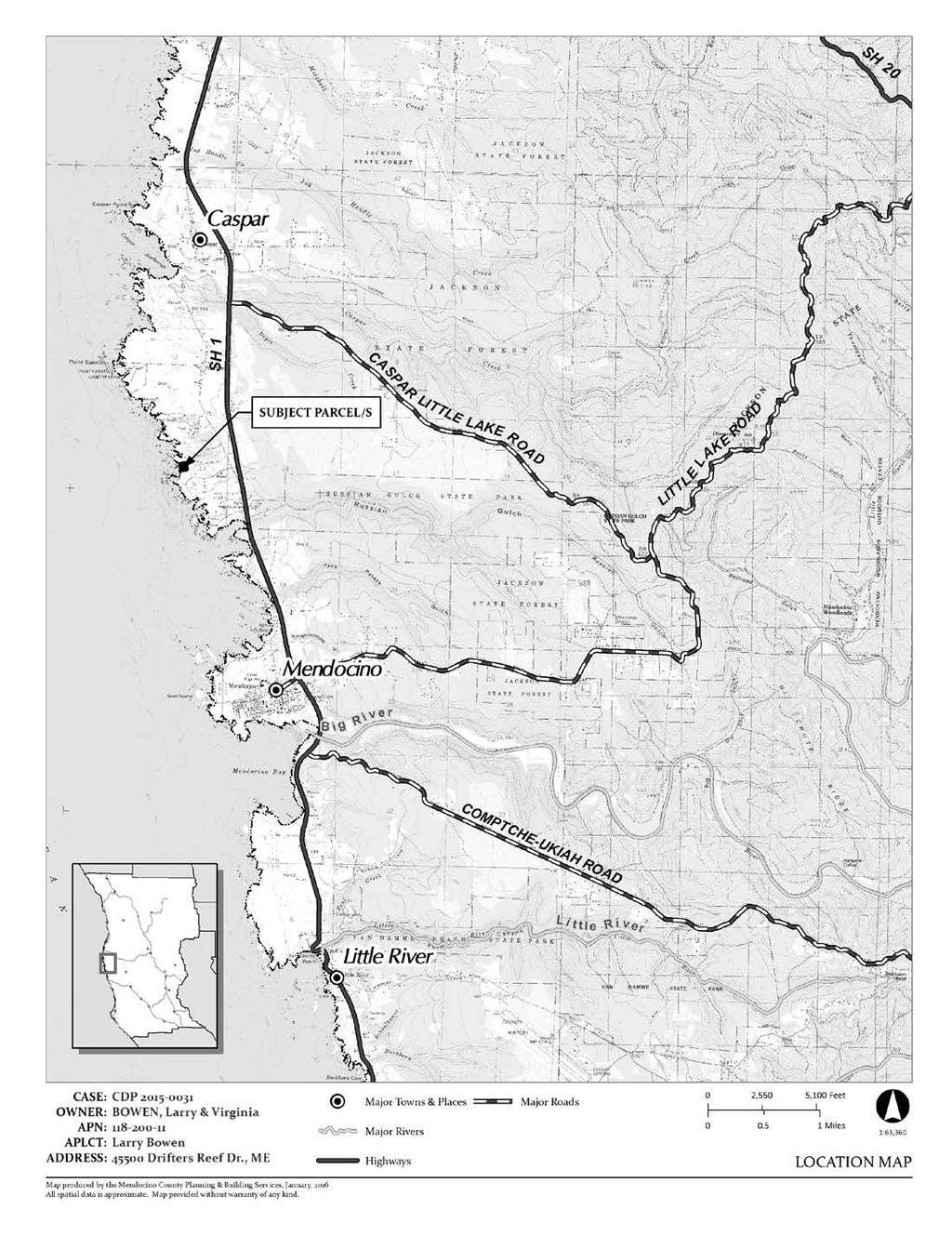
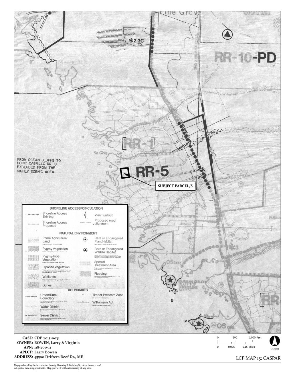
1 COASTAL PERMIT ADMINISTRATOR STAFF REPORT CDP STANDARD JULY 26, 2017 SUMMARY OWNER/APPLICANT: AGENT: REQUEST: LARRY AND VIRGINIA BOWEN 384 EAGLE TRACE DRIVE HALF MOON BAY, CA BLAIR FOSTER, WYNN COASTAL PLANNING 703 NORTH MAIN STREET FORT BRAGG, CA Standard Coastal Development Permit to install a 3' tall redwood fence, with 2" cedar grape stake infill, along the eastern property line; install freestanding 4' tall redwood posts, 6' on center, along the western and southern property lines. DATE DEEMED COMPLETE: March 25, 2016 LOCATION: TOTAL ACREAGE: GENERAL PLAN: ZONING: In the Coastal Zone, 2± miles north of the Town of Mendocino, lying on the north side of Drifters Reef Drive (private road), approximately 1/2-mile west of its intersection with Point Cabrillo Drive at Drifters Reef Drive Mendocino (APN: ) 1.41± acres RR5(1) (Rural Residential, 5-acre minimum with variable density) RR:5 (Rural Residential, 5-acre minimum) SUPERVISORIAL DISTRICT: 4 ENVIRONMENTAL DETERMINATION: Categorically Exempt per CEQA Section 15303(e) new construction of accessory structures, including fences. RECOMMENDATION: STAFF PLANNER: Approve with conditions ROBERT DOSTALEK BACKGROUND The project is the result of Zoning Violation #ZC , whereby fencing and freestanding posts were installed on the subject property without benefit of permit. A Standard Coastal Development Permit is required for the proposed development because the property is located between the sea and the first public road paralleling the sea (Public Resources Code California Coastal Act). PROJECT DESCRIPTION: The applicant proposes to install a 3' tall redwood fence with 2" cedar grape stake infill along the eastern property line and freestanding 4' tall redwood posts (6' on center) along the western and southern property lines. The purpose is to create a visual barrier, discourage public vehicular access and demarcate the parcel boundary. Both fence and freestanding posts would extend to, but not beyond, the 50' ESHA buffer around the identified wetland. The project also includes the installation of native landscaping along the eastern and western property lines within the 50 ESHA buffer to the limit,
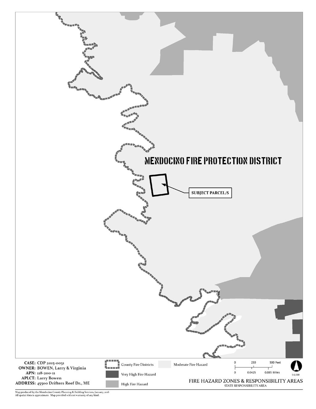
2 COASTAL PERMIT ADMINISTRATOR STAFF REPORT FOR CDP STANDARD PAGE 2 but not beyond, the identified Carex obnupta. RELATED APPLICATIONS: Zoning Violation #ZC (installation of fence and fence posts without benefit of Coastal Development Permit). Coastal Development Permit Exclusion #CE (authorized a single family residence, well, septic system and curtain drain). SITE CHARACTERISTICS: The project site is situated near the terminus of Drifters Reef Drive, one parcel east of the commonly owned blufftop parcel of the Drifters Reef Subdivision. Following clearance of Coastal Development Permit Exclusion #CE on November 1, 1993, a well and curtain drain were installed on the property during the 1990 s. However, a residence and septic system were never constructed, and since that time, environmentally sensitive habitat areas (ESHAs) have been identified on and around the subject parcel. A zoning violation case (#ZC ) was opened in 2015 to address unauthorized construction of a redwood fence along the eastern property boundary and freestanding posts along the southern property boundary. This application serves to validate the existing unpermitted development and authorize the newly proposed fence and post installations. A subsequent modified or new Coastal Development Permit will be required for future developments on the site. SURROUNDING LAND USE AND ZONING: GENERAL PLAN ZONING LOT SIZES USES NORTH RR5(1) RR:5 8.9± Residential EAST RR5(1) RR:5 1.3± Residential SOUTH RR5(1) RR:5 1.3± Vacant WEST RR5(1) RR:5 1.9± Residential PUBLIC SERVICES: ACCESS: DRIFTERS REEF DRIVE (PRIVATE) FIRE DISTRICT: MENDOCINO FIRE PROTECTION DISTRICT WATER DISTRICT: N/A (PRIVATE WELL) SEWER DISTRICT: N/A SCHOOL DISTRICT: MENDOCINO UNIFIED AGENCY COMMENTS: REFERRAL AGENCY RESPONSE COMMENTS ATTACHED ON FILE Department of No comment 3/29/16 Transportation Building - FB No comment 6/17/16 Environmental Health No comment 3/31/16 Planning FB No comment 4/11/16 CA Dept. Fish & Wildlife Comments Reduce ESHA impacts Review landscape palette 4/15/17 12/29/16 Coastal Commission Comments ESHA and coastal access 2/10/17 CalFire No comment 4/6/16 Assessor No response - Sherwd. Valley Pomo No response - Redwd. Vly Rancheria No response - Cloverdale Rancheria No response - Mendo. Fire Prot. Dist. No response -
3 COASTAL PERMIT ADMINISTRATOR STAFF REPORT FOR CDP STANDARD PAGE 3 KEY ISSUES 1. General Plan and Zoning Consistency: The subject parcel is zoned Rural Residential, 5-acre minimum (RR:L-5) as depicted on the attached zoning display map. A Coastal Development Permit Exclusion #CE was approved on November 1, 1993 which authorized development of a singlefamily residence, a well, septic system and curtain drain. Following the approval of #CE 25-93, the well and curtain drain were installed on the property. The Categorical Exclusion (#CE 25-93) expired on November 1, 1996, and to date, a single family residence and septic system have not been constructed. On July 16, 2015, a Zoning Violation case (#ZC ) was opened on the property for the installation of fencing, freestanding posts without benefit of a Coastal Development Permit. The applicant now pursues validation of the development to rectify the violation. The project proposal includes additional fencing to that identified in the violation case. Mendocino County Code (MCC) (B) allows construction of an accessory structure prior to construction of a dwelling on the premises. However, the free-standing posts on the south portion of the property were positioned within the required corridor preservation setback (CPS). MCC states: There is hereby established a corridor preservation setback. A corridor preservation setback shall apply to all lots or parcels that abut a publicly maintained street or highway. A corridor preservation setback shall be in addition to front yard setbacks prescribed elsewhere in this Division and shall apply in districts that prescribe no front-yard setback. Corridor preservation setbacks shall be measured perpendicular from the center line of the existing right-of-way of record or, where no recorded right-of-way exists, from the center of the physical road. Further, MCC Section (C) states: If a roadway easement or access easement serves, or has the potential to serve, more than four (4) lots or parcels, said easement shall be considered a street for the purpose of establishing a front-yard setback or corridor preservation setback. Accordingly, Drifters Reef Drive constitutes a local road for the purpose of establishing a CPS. Local roads require a 25-foot CPS, measured in accordance with the provision above. This setback is in addition to the 20-foot front yard setback. Structural development is prohibited in the CPS. However, nonview obscuring fences are allowed in the front yard setback. The proposed site plan illustrates that the centerline of the 40-foot easement for Drifters Reef Drive corresponds with the southern property line of the subject parcel (see Drifters Reef Tract Map attached). Accordingly, Condition #9 requires the applicant to submit a revised site plan to demonstrate the fencing and freestanding posts will be positioned outside the required corridor preservation setback (i.e. 25 feet from the centerline of the easement of record for Drifters Reef Drive). 2. Environmentally Sensitive Habitat Areas: A Biological Scoping Survey and Reduced Buffer Analysis were prepared for the project by NCRM (dated November 4, 2015). However, pursuant to California Department of Fish & Wildlife protocol, the surveys conducted for the report were not seasonally appropriate. Therefore, a subsequent Biological Report of Compliance and Wetland Delineation dated October 26, 2016 was prepared for the project by Wynn Coastal Planning. The biological surveys in 2015 and 2016 confirmed the presence of wetland ESHA on the northern portion of the property. Within the boundary of the Coastal Act Wetland, two additional ESHA types were observed: Carex obnupta herbaceous alliance (G4 S3) and Hosackia gracilis (CNPS rank 4.2). Though Hosackia gracilis is CNPS rank 4.2, it will be treated as ESHA as it is believed to be a larval food plant of the Federally Endangered lotis blue butterfly (Lycaeides argyrognomon ssp. lotis). The majority of the parcel is non-native grassland. However, the California Department of Fish and Wildlife considers any plant communities ranked as S3 or lower, such as the Carex obnupta alliance, as ESHA. The Carex obnupta (Slough sedge swards) herbaceous alliance is ESHA and has been recorded
4 COASTAL PERMIT ADMINISTRATOR STAFF REPORT FOR CDP STANDARD PAGE 4 along the northern coast of California. On this parcel, this alliance is found along the entire length of the northern boundary, extending approximately 29 feet into the parcel along the westerly boundary and 8 feet into the parcel along the easterly boundary. Carex obnupta dominates this community (> 70 %) and is considered an obligate wetland plant by the USFWS Wetland Inventory (2016) Other species observed throughout this plant community include Oenanthe sarmatosa (water parsley), Gallium aparine (common bedstraw), Carex tumelicola (foothill sedge), Symphotrichium chillense (California aster), Carex hartfordii (Hartford's sedge), Juncus brewerii (Brewer's rush), Juncus bufonius (toad rush) and Rubus ursinus (California blackberry). The project includes a request to reduce the required 100-foot ESHA buffer to 50 feet. CDFW reviewed the biological report and is amenable to the buffer reduction to 50 feet (see s in file dated December 29, 2016 and May 5, 2017 from CDFW staff). The biological assessment includes a reduced buffer analysis component. Condition #10 requires the incorporation of the recommendations of the Biological Report dated October 26, 2016 into project construction. 3. Environmental Protection: The project is Categorically Exempt from the California Environmental Quality Act (CEQA), Class 3, Section 15303(e). This exemption consists of: Accessory (appurtenant) structures including garages, carports, patios, swimming pools and fences. The proposed project is for installation of a fence and free-standing posts only. Therefore, the Class 3 exemption would appropriately apply to this project. RECOMMENDATION By resolution, accept the Categorical Exemption and grant the Coastal Development Permit for the Project, as proposed by the applicant, based on the facts and findings and subject to the conditions of approval. DATE ROBERT DOSTALEK Appeal Period: 10 Days Appeal Fee: $1, EXHIBIT A: RESOLUTION AND CONDITIONS OF APPROVAL EXHIBIT B: STAFF ANALYSIS OF THE EVIDENCE SUPPORTING THE REQUIRED FINDINGS ATTACHMENTS: A. Location Map B. Aerial Map C. Site Plan D. Zoning Display Map E. General Plan Designations Map F. LCP Land Use Map 15: Caspar G. Adjacent Parcels Map H. Fire Hazard Zones and Responsibility Areas Map I. Drifters Reef Tract Map
5 ATTACHMENT A

6 ATTACHMENT B
7 ATTACHMENT C
8 ATTACHMENT D
9 ATTACHMENT E
10 ATTACHMENT F
11 ATTACHMENT G
12 ATTACHMENT H
13 ATTACHMENT I
14 EXHIBIT A RESOLUTION AND CONDITIONS OF APPROVAL COASTAL PERMIT ADMINISTRATOR STANDARD CDP PAGE 5 Resolution Number County of Mendocino Ukiah, California CDP (Bowen) RESOLUTION OF THE COASTAL PERMIT ADMINISTRATOR, COUNTY OF MENDOCINO, STATE OF CALIFORNIA, FINDING THE PROJECT CATEGORICALLY EXEMPT FROM THE CALIFORNIA ENVIRONMENTAL QUALITY ACT AND GRANTING A COASTAL DEVELOPMENT PERMIT FOR FENCING AND FREESTANDING POSTS. WHEREAS, the applicant, Larry and Virginia Bowen, filed an application for a standard Coastal Development Permit with the Mendocino County Department of Planning and Building Services to authorize installation of fencing and free-standing posts. In the Coastal Zone, 2± miles north of the Town of Mendocino, lying on the north side of Drifters Reef Drive (private road), approximately 1/2-mile west of its intersection with Point Cabrillo Drive at Drifters Reef Drive, Mendocino (APN: ); RR5(1) General Plan classification; RR:5 Zoning; Supervisorial District 4; (the Project ); and Whereas, pursuant to the California Environmental Quality Act of 1970, and State and County Guidelines thereto, this project has been found to be Categorically Exempt from environmental review; and WHEREAS, in accordance with applicable provisions of law, the Coastal Permit Administrator held a public hearing on, July 26, 2017, at which time the Coastal Permit Administrator heard and received all relevant testimony and evidence presented orally or in writing regarding the Categorical Exemption and the Project. All interested persons were given an opportunity to hear and be heard regarding the Categorical Exemption and the Project; and WHEREAS, the Coastal Permit Administrator has had an opportunity to review this Resolution and finds that it accurately sets forth the intentions of the Coastal Permit Administrator regarding the Categorical Exemption and the Project. NOW, THEREFORE, BE IT RESOLVED, that based on the evidence and analysis in Exhibit B of the Coastal Permit Administrator Staff Report attached hereto, the Coastal Permit Administrator makes the following findings; 1. The proposed development is in conformity with the certified Local Coastal Program; and 2. The proposed development will be provided with adequate utilities, access roads, drainage and other necessary facilities; and 3. The proposed development is consistent with the purpose and intent of the applicable zoning district, as well as all other provisions of Division II, and preserves the integrity of the zoning district; and 4. The proposed development, if constructed in compliance with the conditions of approval, will not have any significant adverse impacts on the environment, and meets the criteria for a Categorical Exemption pursuant to Section 15303(e) of the California Environmental Quality Act; and 5. The proposed development will not have any adverse impacts on any known archaeological or paleontological resource; and
15 EXHIBIT A RESOLUTION AND CONDITIONS OF APPROVAL COASTAL PERMIT ADMINISTRATOR STANDARD CDP PAGE 6 6. Other public services, including but not limited to, solid waste and public roadway capacity have been considered and are adequate to serve the proposed development; and ADDITIONAL FINDING FOR DEVELOPMENT LOCATED BETWEEN THE FIRST PUBLIC ROAD AND THE SEA OR THE SHORELINE OF ANY BODY OF WATER: 7. The proposed development is in conformity with the public access and public recreation policies of Chapter 3 of the California Coastal Act and the Coastal Element of the General Plan. BE IT FURTHER RESOLVED that the Coastal Permit Administrator hereby grants the requested standard Coastal Development Permit, subject to the Conditions of Approval in Exhibit A, attached hereto. BE IT FURTHER RESOLVED that the Coastal Permit Administrator designates the Secretary as the custodian of the document and other material which constitutes the record of proceedings upon which the decision herein is based. These documents may be found at the office of the County of Mendocino Planning and Building Services, 860 North Bush Street, Ukiah, CA BE IT FURTHER RESOLVED that the Coastal Permit Administrator action shall be final on the 11 th day after the date of the Resolution unless an appeal is taken. I hereby certify that according to the Provisions of Government Code Section delivery of this document has been made. ATTEST: VICTORIA DAVIS Commission Services Supervisor By: BY: IGNACIO GONZALEZ MARY LYNN HUNT Interim Director Coastal Permit Administrator
16 EXHIBIT A RESOLUTION AND CONDITIONS OF APPROVAL COASTAL PERMIT ADMINISTRATOR STANDARD CDP PAGE 7 CONDITIONS OF APPROVAL: 1. This action shall become final on the 11 th day following the decision unless an appeal is filed pursuant to Section of the Mendocino County Code. The permit shall become effective after the ten working day appeal period to the Coastal Commission has expired and no appeal has been filed with the Coastal Commission. The permit shall expire and become null and void at the expiration of two years after the effective date except where construction and use of the property in reliance on such permit has been initiated prior to its expiration. 2. The use and occupancy of the premises shall be established and maintained in conformance with the provisions of Division II of Title 20 of the Mendocino County Code. 3. The application, along with supplemental exhibits and related material, shall be considered elements of this permit, and that compliance therewith is mandatory, unless an amendment has been approved by the Coastal Permit Administrator. 4. This permit shall be subject to the securing of all necessary permits for the proposed development from County, State and Federal agencies having jurisdiction. 5. The applicant shall secure all required building permits for the proposed project as required by the Building Inspection Division of the Department of Planning and Building Services. 6. This permit shall be subject to revocation or modification upon a finding of any one or more of the following: a. The permit was obtained or extended by fraud. b. One or more of the conditions upon which the permit was granted have been violated. c. The use for which the permit was granted is conducted so as to be detrimental to the public health, welfare or safety, or to be a nuisance. d. A final judgment of a court of competent jurisdiction has declared one or more conditions to be void or ineffective, or has enjoined or otherwise prohibited the enforcement or operation of one or more such conditions. 7. This permit is issued without a legal determination having been made upon the number, size or shape of parcels encompassed within the permit described boundaries. Should, at any time, a legal determination be made that the number, size or shape of parcels within the permit described boundaries are different than that which is legally required by this permit, this permit shall become null and void. 8. If any archaeological sites or artifacts are discovered during site excavation or construction activities, the applicant shall cease and desist from all further excavation and disturbances within one hundred (100) feet of the discovery, and make notification of the discovery to the Director of the Department of Planning and Building Services. The Director will coordinate further actions for the protection of the archaeological resources in accordance with Section of the Mendocino County Code.
17 EXHIBIT A RESOLUTION AND CONDITIONS OF APPROVAL COASTAL PERMIT ADMINISTRATOR STANDARD CDP PAGE 8 SPECIAL CONDITIONS: 9. Prior to issuance of a Coastal Development Permit, the applicant shall submit a revised site plan which illustrates and/or identifies the following: A. The centerline of the existing roadway easement for Drifters Reef Drive. B. The extent of the corridor preservation setback which extends 25 feet north of the centerline of the roadway easement for Drifters Reef Drive. C. The new location of the freestanding posts and fence to be positioned outside the 25-foot corridor preservation setback. The relocation of the freestanding posts and fencing positioned within the corridor preservation setback shall be removed or relocated prior to commencement or installation of any new freestanding posts or fencing. The relocation or removal shall occur no later than ninety (90) days following Coastal Development Permit issuance. Should the applicant fail to secure an issued Coastal Development Permit within ninety (90) days following the Coastal Permit Administrator s decision, the case shall be referred back to Code Enforcement for elevated enforcement procedures. 10. Construction/installation and ongoing maintenance of the fencing and freestanding posts shall adhere to all recommended avoidance and protective measures contained on page 24 of the Biological Report of Compliance and Wetland Delineation prepared by Wynn Coastal Planning dated October 26, Prior to installing or repositioning any new freestanding posts or fencing, the portion of fencing on which extends into the delineated 50-foot ESHA buffer shall be removed. 11. Prior to issuance of a Coastal Development Permit, a Final Landscaping Plan shall be submitted to the Department of Planning and Building Services. Said plan shall be subject to review and approval by the Coastal Permit Administrator and the California Department of Fish and Wildlife. The Final Landscaping Plan shall consist of locallysourced native plant species compatible with adjacent plant communities and shall not include any invasive plants. 12. The 50-foot buffer established for the three identified EHSAs on the property (Coastal wetland, Hosakia gracilis and Carex obnupta) shall remain in a natural and undisturbed state. Mowing, trimming, removal of vegetation and/or soil disturbance within the delineated 50-foot ESHA buffers shall be prohibited. Maintenance, pruning and replacement of approved landscaping within the 50-foot buffer shall be permissible.
18 EXHIBIT B ANALYSIS OF EVIDENCE SUPPORTING REQUIRED FINDINGS COASTAL PREMIT ADMINISTRATOR STANDARD CDP PAGE 9 STAFF ANALYSIS OF THE EVIDENCE SUPPORTING REQUIRED FINDINGS Required Findings: To approve this project, the Coastal Administrator must determine that the applicants submitted evidence in support of making required findings 1 through 7 in the analysis below: Finding 1: The proposed development is in conformity with the certified Local Coastal Program. The Local Coastal Program sets goals and policies for managing resource protection and development activity in the Coastal Zone of Mendocino County, an area that extends from the Humboldt County line to the Gualala River. The Local Coastal Program addresses topics such as shoreline access and public trails; development in scenic areas, hazardous areas, and coastal bluff tops; environmentally sensitive habitat areas; cultural resources; transportation; public services; and more. The Local Coastal Program serves as an element of the General Plan and includes Division II of Title 20 of the Mendocino County Code (MCC), and its policies must be consistent with the goals of the California Coastal Act. Various aspects of the Local Coastal Program are specifically addressed by separate Required and Supplemental Findings for Coastal Development Permits, including utilities, transportation, zoning, CEQA, archaeological resources, public services, coastal access, and resource protection. The following is a discussion of elements of the Local Coastal Program not specifically addressed elsewhere in this checklist. General Plan Land Use Rural Residential: The subject parcel is classified Rural Residential, which is intended to encourage local small scale food production (farming) in areas which are not well suited for large scale commercial agriculture, defined by present or potential use, location, mini-climate, slope, exposure, etc. The Rural Residential classification is not intended to be a growth area and residences should be located as to create minimal impact on agricultural viability (Chapter 2.2 of the County of Mendocino General Plan Coastal Element). The subject parcel is positioned within the Drifters Reef Subdivision and is poised for future residential development as it is improved with an existing well and curtain drain. The proposed project is therefore consistent with the Rural Residential land use classification of the Coastal Element of the Mendocino County General Plan. Public Access: See discussion in Finding 7 below. Hazards: The proposed development would be located on slopes which are less than 20% and the development does not present any issues relative to erosion and/or slope failure. There are no known faults, landslides or other geologic hazards in close proximity to the proposed development. A project referral was sent to CalFire and a no comment response was received on April 6, Visual Resources: Coastal Element Policy 3.5-1of the Mendocino County General Plan states: State Highway 1 in rural areas of the Mendocino County coastal zone shall remain a scenic two-lane road. The scenic and visual qualities of Mendocino County coastal areas shall be considered and protected as a resource of public importance. Permitted development shall be sited and designed to protect views to and along the ocean and scenic coastal areas, to minimize the alteration of natural land forms, to be visually compatible with the character of surrounding areas and, where feasible, to restore and enhance visual quality in visually degraded areas. New development in highly scenic areas designated by the County of Mendocino Coastal Element shall be subordinate to the character of its setting. The project site is not located in a designated Highly Scenic Area or prominently visible from public view areas. Adjacent parcels to the east and southeast are residentially developed. As such, the proposed 3-4 foot high, natural redwood and cedar perimeter fencing and free-standing posts would not adversely affect visual resources.
19 COASTAL PERMIT ADMINISTRATOR STAFF REPORT FOR CDP STANDARD PAGE 10 Natural Resources: A Biological Scoping Survey and Reduced Buffer Analysis were prepared for the project by NCRM (dated November 4, 2015). However, pursuant to California Department of Fish & Wildlife protocol, the surveys conducted for the report were not seasonally appropriate. Therefore, a subsequent Biological Report of Compliance and Wetland Delineation dated October 26, 2016 were prepared for the project by Wynn Coastal Planning. The biological surveys in 2015 and 2016 confirmed the presence of wetland elements considered to be ESHAs per the Mendocino County Local Coastal Program on the northern portion of the property. Within the boundary of the Coastal Act Wetland, two additional ESHA types were observed: Carex obnupta herbaceous alliance (G4 S3) and Hosackia gracilis (CNPS rank 4.2). Though Hosackia gracilis is CNPS rank 4.2, it will be treated as ESHA as it is believed to be a larval food plant of the Federally Endangered lotis blue butterfly (Lycaeides argyrognomon ssp. lotis). The majority of the parcel is non-native grassland. However, the California Department of Fish and Wildlife considers any plant communities ranked as S3 or lower, such as the Carex obnupta alliance, as ESHA. The Carex obnupta (Slough sedge swards) herbaceous alliance is ESHA and has been recorded along the northern coast of California. On this parcel, this alliance is found along the entire length of the northern boundary, extending approximately 29 feet into the parcel along the westerly boundary and 8 feet into the parcel along the easterly boundary. Carex obnupta dominates this community (> 70 %) and is considered an obligate wetland plant by the USFWS Wetland Inventory (2016) Other species observed throughout this plant community include Oenanthe sarmatosa (water parsley), Gallium aparine (common bedstraw), Carex tumelicola (foothill sedge), Symphotrichium chillense (California aster), Carex hartfordii (Hartford's sedge), Juncus brewerii (Brewer's rush), Juncus bufonius (toad rush) and Rubus ursinus (California blackberry). The project includes a request to reduce the required 100-foot ESHA buffer to 50 feet for the above identified resources (the biological assessment includes a reduced buffer analysis component). Staff referred the project to the California Department of Fish and Wildlife (CDFW). CDFW reviewed the biological report and is amenable to the buffer reduction to 50 feet (see s in file dated December 29, 2016 and May 5, 2017 from CDFW staff). Condition #10 is recommended to require the incorporation of the Biological Report recommendations, dated October 26, 2016, into project construction. Groundwater Resources: The proposed perimeter fencing and free-standing posts are not a type of development which would require water service. However, an existing well is situated on the northern third of the parcel which was authorized by Categorical Exclusion #35-93 and Environmental Health well permit #7394-F. Finding 2: The proposed development will be provided with adequate utilities, access roads, drainage and other necessary facilities. The parcel is located in the Drifters Reef Tract subdivision which was recorded with the County Recorder on June 11, The project site is developed with an existing well and curtain drain to facilitate a future on-site wastewater disposal system. Drifters Reef Drive provides vehicular access to the parcel and electricity has been extended to adjacent parcels in the subdivision. However, the proposed development is for fencing and freestanding posts only which would not place significant demand on utilities, roads, drainage or other utilities. Therefore, this finding can be made. Finding 3: The proposed development is consistent with the purpose and intent of the applicable zoning district, as well as all other provisions of Division II, and preserves the integrity of the zoning district. The subject parcel is zoned Rural Residential, 5-acre minimum (RR:L-5) as depicted on the attached zoning display map. A Coastal Development Permit Exclusion #CE was approved on November 1, 1993 which authorized development of a single-family residence, a well, septic system and curtain drain. Following the approval of #CE 25-93, the well and curtain drain were installed on the property. The
20 COASTAL PERMIT ADMINISTRATOR STAFF REPORT FOR CDP STANDARD PAGE 11 Categorical Exclusion (#CE 25-93) expired on November 1, 1996, and to date, a single family residence and septic system have not been constructed. On July 16, 2015 a Zoning Violation case (#ZC ) was opened on the property for the installation of fencing and grading without benefit of a Coastal Development Permit. The applicant now pursues validation of the development to rectify the violation. The proposal also includes additional fencing and freestanding post installation to that identified in the violation case. Mendocino County Code (MCC) (B) allows construction of an accessory structure prior to construction of a dwelling on the premises. MCC (E) provides general provisions for height, type and location of fencing it states: Fences in rear or side yards not having street frontage may not exceed eight (8) feet (Fences over six feet require building permits). Fences and hedges in front yards and any rear or side yards having street frontage, where vehicle access is maintained, may not exceed three and one-half (3½) feet. The above fence height limitations shall apply to view obstructing fences such as board fences and picket fences. Fences for the containment of animals, such as barbed wire, chicken wire, hog wire, and similar loose-meshed wire fences or non-view-obscuring fences such as cyclone fences shall not be subject to the above fence height restrictions. The provided site plan incorrectly illustrates the southernmost extent of the proposed 3-foot tall fencing (along the east property line) as being positioned 27 feet north of the south property line. Photo documentation from the violation case and page 25 of the biological report shows the existing fencing extending to, or nearly to, the southern property boundary. Neither the fence nor the freestanding posts would be view obstructing. Therefore, as it relates to height and location, the proposed structures would comply with the general fence provision above. However, the fence and free-standing posts on the south portion of the property were positioned within the required corridor preservation setback (CPS). MCC states: There is hereby established a corridor preservation setback. A corridor preservation setback shall apply to all lots or parcels that abut a publicly maintained street or highway. A corridor preservation setback shall be in addition to front yard setbacks prescribed elsewhere in this Division and shall apply in districts that prescribe no front-yard setback. Corridor preservation setbacks shall be measured perpendicular from the center line of the existing right-of-way of record or, where no recorded right-of-way exists, from the center of the physical road. Further, MCC Section (C) states: If a roadway easement or access easement serves, or has the potential to serve, more than four (4) lots or parcels, said easement shall be considered a street for the purpose of establishing a front-yard setback or corridor preservation setback. Accordingly, Drifters Reef Drive constitutes a local road for the purpose of establishing a CPS. Local roads require a 25-foot CPS, measured in accordance with the provision above. This setback is in addition to the 20-foot front yard setback. Structural development is prohibited in the CPS. The centerline of the easement for Drifters Reef Drive corresponds with the southern property boundary of the subject parcel. Accordingly, Condition #9 requires the applicant to submit a revised site plan to demonstrate the fencing and posts will be positioned outside the required corridor preservation setback. Otherwise, the project would be consistent with the purpose and intent of the RR:L-5 zone district and all other provisions of Division II of Title 20 of the MCC.
21 COASTAL PERMIT ADMINISTRATOR STAFF REPORT FOR CDP STANDARD PAGE 12 Finding 4: The proposed development, if constructed in compliance with the conditions of approval, will not have any significant adverse impacts on the environment, and meets the criteria for Categorical Exemption Class 3 within the meaning of the California Environmental Quality Act (CEQA). The proposed project is found Categorically Exempt from CEQA pursuant to Section 15303(e) [Class 3]. Class 3 consists of construction and location of limited numbers of new, small facilities or structures including accessory structures such as fences. Finding 5: The proposed development will not have any adverse impacts on any known archaeological or paleontological resource. For small development projects such as remodels, additions and small outbuildings (i.e. projects with minimal earthwork), Mendocino County Department of Planning and Building Services (PBS) procedure is to not refer these types of projects to either California Historic Resource Information System (CHRIS) or the Mendocino County Archaeological Commission. PBS procedure (as detailed in a staff memorandum) was reviewed by the Mendocino County Archaeological Commission in 2005 and again in 2014 and was determined to be an appropriate guidance document for what projects should require archaeological review. The proposed project consists of fencing and free-standing posts that are placed directly into the ground, without a permanent foundation. County staff determined that due to the small scale of the proposed development and nominal ground disturbance, no archaeological review would be required. At such time more substantial development and earthwork is proposed for the parcel (e.g., a single family residence), an archaeological survey may be required as a component of the project analysis. Notwithstanding, Standard Condition Number 8 is recommended, advising the applicant of the requirements of the County s Archaeological Ordinance (Chapter of the Mendocino County Code) in the event that archaeological or cultural materials are unearthed during site preparation or construction activities. Finding 6: Other public services, including but not limited to, solid waste and public roadway capacity have been considered and are adequate to serve the proposed development. The parcel is accessed by, and near the terminus of, Drifters Reef Drive a private road. The proposed development is for perimeter fencing and free-standing posts only. According to the applicant, an objective of the fencing and posts is to deter vehicular trespass from occurring on the subject parcel. The scope of development, as described immediately above, would not require or place demand on any public service, including: water, sewer, solid waste, police and fire protection or roadways. Therefore this finding can be made. Finding 7: The proposed development is in conformity with the public access and public recreation policies of Chapter 3 of the California Coastal Act and the Coastal Element of the General Plan. The applicant has indicated the purpose of the proposed project is to deter purported pedestrian and vehicular trespass on the subject parcel. The subject parcel is located in the Jug Handle Creek to Russian Gulch Planning Area per the Coastal Element of the General Plan. Pages 177 and 178 of the Coastal Element of the General Plan provide analysis and policies for the Jug Handle Creek to Russian Gulch Planning Area. Specifically, the Russian Gulch Headlands Area subheading includes the following commentary: Several property owners have been required to make access offers of dedication as a condition of permit approval. Offers by Bower, Kibbee, Ferrero and Barham have been recorded; agreements with Powers, Hansen, Davies and Bergin have not yet been signed and recorded. The Land Use Plan recommends that all offers of dedication be relinquished. The area between Indian Shoals Subdivision and Russian Gulch State Park
22 COASTAL PERMIT ADMINISTRATOR STAFF REPORT FOR CDP STANDARD PAGE 13 will not be needed for a blufftop trail; the bluffs themselves are fragile and a trail could not be completed using dedication offers because key parcels have been developed without dedication offers. Further, Policy of the Coastal Element states: All offers of dedication which have been recorded for public access required as a condition of permit approval within the Russian Gulch Headlands area shall be relinquished finding that there is sufficient access at Caspar Cove and Russian Gulch and that access has been requested at Point Cabrillo. The area between Point Cabrillo and Russian Gulch is already parcelled out into several subdivisions and partially developed. Public testimony has established the fragility of the area. Pursuant to the above discussion, the proposed project would not adversely affect coastal access. Therefore, this finding can be made.
STAFF REPORT FOR COASTAL DEVELOPMENT CDP# STANDARD PERMIT June 11, 2013 CPA-1. Victor Suarez Fern Drive Mendocino, CA 95460
 CPA-1 OWNER/APPLICANT: REQUEST: ENVIRONMENTAL DETERMINATION: RECOMMENDATION: LOCATION: APPEALABLE AREA: PERMIT TYPE: TOTAL ACREAGE: GENERAL PLAN: Victor Suarez 45130 Fern Drive Mendocino, CA 95460 Construct
COASTAL PERMIT ADMINISTRATOR JANUARY 26, 2017
 COASTAL PERMIT ADMINISTRATOR JANUARY 26, 2017 STAFF REPORT- CDP_STANDARD CDP_2016-0025 SUMMARY OWNER/APPLICANT/AGENT: GEBB CHESTER S & ANNE J HARRIS 5245 WIKIUP BRIDGEWAY SANTA ROSA, CA 95404 REQUEST:
COASTAL PERMIT ADMINISTRATOR AUGUST 25, 2016
 COASTAL PERMIT ADMINISTRATOR AUGUST 25, 2016 STAFF REPORT- CDP_STANDARD CDP_2015-0029 SUMMARY OWNERS: ERNEST & CORINNE EGGER LIVING TRUST PO BOX 1033 MENDOCINO, CA 95460 ISHVI BENZVI AND NANCY SUSAN LEBRUM
1.0 REQUEST. SANTA BARBARA COUNTY ZONING ADMINISTRATOR Coastal Zone Staff Report for Vincent New Single-Family Dwelling & Septic System
 SANTA BARBARA COUNTY ZONING ADMINISTRATOR Coastal Zone Staff Report for Vincent New Single-Family Dwelling & Septic System Hearing Date: February 26, 2007 Supervisorial District: First Staff Report Date:
Jack & Eileen Feather (PLN030436)
") MIKE NOVO ZONING ADMINISTRATOR COUNTY OF MONTEREY STATE OF CALIFORNIA RESOLUTION NO. 030436 A. P. # 008-462-008-000 In the matter of the application of Jack & Eileen Feather (PLN030436) FINDINGS & DECISION
MIKE NOVO ZONING ADMINISTRATOR COUNTY OF MONTEREY STATE OF CALIFORNIA RESOLUTION NO. 030436 A. P. # 008-462-008-000 In the matter of the application of Jack & Eileen Feather (PLN030436) FINDINGS & DECISION
SANTA BARBARA COUNTY ZONING ADMINISTRATOR STAFF REPORT August 30, 2007
 SANTA BARBARA COUNTY ZONING ADMINISTRATOR STAFF REPORT August 30, 2007 PROJECT: Detrana Entry Gates HEARING DATE: October 22, 2007 STAFF/PHONE: Sarah Clark, (805) 568-2059 GENERAL INFORMATION Case No.:
COASTAL CONSERVANCY. Staff Recommendation August 2, 2012 HARE CREEK BEACH COASTAL ACCESS TRAIL. Project No Project Manager: Lisa Ames
 COASTAL CONSERVANCY Staff Recommendation August 2, 2012 HARE CREEK BEACH COASTAL ACCESS TRAIL Project No. 08-001-02 Project Manager: Lisa Ames RECOMMENDED ACTION: Authorization to disburse up to $60,000
CANNABIS APPLICATION CHECKLIST
 COUNTY OF MENDOCINO DEPARTMENT OF PLANNING AND BUILDING SERVICES 860 NORTH BUSH STREET UKIAH CALIFORNIA 95482 120 WEST FIR STREET FORT BRAGG CALIFORNIA 95437 IGNACIO GONZALEZ, INTERIM DIRECTOR PHONE: 707-234-6650
Residential Project Convenience Facilities
 Standards for Specific Land Uses 35.42.220 E. Findings. The review authority shall approve a Land Use Permit in compliance with Subsection 35.82.110.E (Findings required for approval) or a Conditional
COUNTY OF SAN MATEO PLANNING AND BUILDING DEPARTMENT
 COUNTY OF SAN MATEO PLANNING AND BUILDING DEPARTMENT DATE: October 20, 2016 TO: FROM: Zoning Hearing Officer Planning Staff SUBJECT: Consideration of a Non-Conforming Use Permit, pursuant to Sections 6135
STAFF REPORT FOR COASTAL DEVELOPMENT USE PERMIT #CDU June 14, 2006 Page PC - 1
 STAFF REPORT FOR COASTAL DEVELOPMENT USE PERMIT #CDU 12-2005 June 14, 2006 Page PC - 1 OWNER: REQUEST: LOCATION: TOTAL ACREAGE: ZONING: TREGONING BROTHERS 345 N. FERNDALE AVE. MILL VALLEY, CA 94941 Coastal
Napa County Planning Commission Board Agenda Letter
 Agenda Date: 9/20/2017 Agenda Placement: 8C Napa County Planning Commission Board Agenda Letter TO: FROM: Napa County Planning Commission Charlene Gallina for David Morrison - Director Planning, Building
A. Preserve natural resources as identified in the Comprehensive Plan.
 1370.08 Conservation Residential Overlay District. Subd. 1 Findings. The City finds that the lands and resources within the Conservation Residential Overlay District are a unique and valuable resource
SANTA BARBARA COUNTY ZONING ADMINISTRATOR STAFF REPORT November 20, 2015
 SANTA BARBARA COUNTY ZONING ADMINISTRATOR STAFF REPORT November 20, 2015 PROJECT: Acquistapace Tentative Parcel Map HEARING DATE: December 7, 2015 STAFF/PHONE: Dana Eady, (805) 934-6266 GENERAL INFORMATION
CHAPTER 3 REGULATIONS INSIDE THE COASTAL ZONE
 CHAPTER 3 REGULATIONS INSIDE THE COASTAL ZONE Organization. Chapter 3 contains the regulations which apply exclusively within the California Coastal Zone in Humboldt County and is organized as follows:
ATTACHMENT A: FINDINGS
 ATTACHMENT A: FINDINGS 1.0 CEQA FINDINGS 1.1 ENVIRONMENTAL IMPACT REPORTS Findings pursuant to public resources code Section 21081 and the California Environmental Quality Act Guidelines Sections 15090
The City of Carlsbad Planning Division A REPORT TO THE PLANNING COMMISSION. Item No. P.C. AGENDA OF: March 16, 2011 Project Planner: Shannon Werneke
 The City of Carlsbad Planning Division A REPORT TO THE PLANNING COMMISSION Item No. 2 Application complete date: January 24, 2011 P.C. AGENDA OF: March 16, 2011 Project Planner: Shannon Werneke Project
DOUGLAS COUNTY ZONING RESOLUTION Section 4 LRR - Large Rural Residential District 3/10/99. -Section Contents-
 SECTION 4 LRR LARGE RURAL RESIDENTIAL DISTRICT -Section Contents- 401 Intent... 4-2 402 Principal Uses... 4-2 403 Accessory Uses... 4-3 404 Uses Permitted by Special Review... 4-4 405 Land Dedication...
EL DORADO COUNTY DEVELOPMENT SERVICES ZONING ADMINISTRATOR STAFF REPORT VARIANCE
 EL DORADO COUNTY DEVELOPMENT SERVICES ZONING ADMINISTRATOR STAFF REPORT Agenda of: August 6, 2008 Item No.: Staff: 4.d. Robert Peters VARIANCE FILE NUMBER: V08-0004 APPLICANT: Joseph and Ingrid Herrick
City of San Juan Capistrano Agenda Report
 City of San Juan Capistrano Agenda Report TO: Zoning Administrator FROM: Reviewed by: Sergio Klotz, AICP, Assistant Development Services DirctJ. o ~ Prepared by: Laura Stokes, Housing Coordinator I Assistant
RESOLUTION NO. B. The proposed amendment would not be detrimental to the public interest, health, safety, convenience, or welfare of the City; and
 RESOLUTION NO. RESOLUTION OF THE PLANNING COMMISSION OF THE CITY OF SANTA ROSA RECOMMENDING TO CITY COUNCIL REZONING TO MODIFY THE EXISTING POLICY STATEMENT AND ADOPT THE BAY VILLAGE HOMES DEVELOPMENT
The following regulations shall apply in the R-E District:
 "R-E" RESIDENTIAL ESTATE DISTRICT (8/06) The following regulations shall apply in the R-E District: 1. Uses Permitted: The following uses are permitted. A Zoning Certificate may be required as provided
SANTA BARBARA COUNTY ZONING ADMINISTRATOR STAFF REPORT January 11, 2008
 SANTA BARBARA COUNTY ZONING ADMINISTRATOR STAFF REPORT January 11, 2008 PROJECT: Gerrity Parking in Side Setback and Gerrity Student Housing Addition HEARINGDATE: January 28, 2008 STAFF/PHONE: J. Ritterbeck,
FINAL DRAFT 12/1/16, Rev. to 7/18/17
 FINAL DRAFT 12/1/16, Rev. to 7/18/17 (As Adopted 8/8/17 Effective 9/1/17) SHELTON PLANNING AND ZONING COMMISSION Proposed Amendments to Zoning Regulations I. Amend Section 23 PERMITTED USES by inserting
Larimer County Planning Dept. Procedural Guide for 1041 PERMITS
 - Larimer County Planning Dept. Procedural Guide for 1041 PERMITS PLEASE NOTE: A PRE-APPLICATION CONFERENCE IS REQUIRED PRIOR TO SUBMITTING THIS APPLICATION. PURPOSE: State Statutes allow local governments
Planning Commission Report
 ~BER~9 Beverly Hills Planning Division 455 N. Rexford Drive Beverly Hills, CA 90210 TEL. (310) 458-1140 FAX. (310) 858-5966 Planning Commission Report Meeting Date: April 10, 2014 Subject: 1801 Angelo
EL DORADO COUNTY PLANNING AND BUILDING DEPARTMENT ZONING ADMINISTRATOR STAFF REPORT VARIANCE
 EL DORADO COUNTY PLANNING AND BUILDING DEPARTMENT ZONING ADMINISTRATOR STAFF REPORT Agenda of: April 18,2018 Item No.: Staff: 5.a. Emma Carrico VARIANCE FILE NUMBER: APPLICANT: REQUEST: LOCATION: V17-0003/La
DRAFT FOR PUBLIC HEARING (rev. March, 2016)
") Chapter 200. ZONING Article VI. Conservation/Cluster Subdivisions 200-45. Intent and Purpose These provisions are intended to: A. Guide the future growth and development of the community consistent with
Chapter 200. ZONING Article VI. Conservation/Cluster Subdivisions 200-45. Intent and Purpose These provisions are intended to: A. Guide the future growth and development of the community consistent with
TOWN OF LOS ALTOS HILLS January 11, 2018 Staff Report to the Planning Commission
 ITEM #3.2 TOWN OF LOS ALTOS HILLS Staff Report to the Planning Commission SUBJECT: FROM: REQUEST FOR APPROVAL OF A CONDITIONAL DEVELOPMENT AND SITE DEVELOPMENT PERMITS FOR A NEW 2,831 SQUARE FOOT, TWO
Guide to Combined Preliminary and Final Plats
 Guide to Combined Preliminary and Final Plats Introduction The Douglas County is committed to providing open, transparent application processes to the public. This Guide is provided to assist anyone interested
SANTA BARBARA COUNTY MONTECITO PLANNING COMMISSION Staff Report for Klink Lot Line Adjustment and Modification
 SANTA BARBARA COUNTY MONTECITO PLANNING COMMISSION Staff Report for Klink Lot Line Adjustment and Modification Deputy Director: Steve Chase Staff Report Date: May 5, 2006 Staff Contact: Alice Daly Case
ZONING ADMINISTRATOR 6/9/2016 STAFF REPORT- VARIANCE_INLAND
 ZONING ADMINISTRATOR 6/9/2016 STAFF REPORT- VARIANCE_INLAND V_2016-0001 SUMMARY OWNER: APPLICANT: AGENT: REQUEST: SPRINGFIELD PROPERTY LLC 8069 LENO DR WINDSOR, CA 95492 IN & OUT BURGER, INC 13502 HAMBURGER
Conduct a hearing on the appeal, consider all evidence and testimony, and take one of the following actions:
 AGENDA ITEM #4.A TOWN OF LOS ALTOS HILLS Staff Report to the City Council SUBJECT: FROM: APPEAL OF PLANNING COMMISSION DENIAL OF A CONDITIONAL DEVELOPMENT PERMIT AND SITE DEVELOPMENT PERMIT FOR A NEW 3,511
MONTEREY COUNTY ZONING ADMINISTRATOR
 MONTEREY COUNTY ZONING ADMINISTRATOR Meeting: June 28, 2007 Time: 1:45pm Agenda Item No.: 4 Project Description: Combined Development Permit including after-the-fact permits to allow a 138 square foot
STAFF REPORT and INFORMATION FOR THE HEARING EXAMINER. Project: Westphal Accessory Dwelling Unit (ADU)
") KITSAP COUNTY DEPARTMENT OF COMMUNITY DEVELOPMENT 614 DIVISION STREET MS-36, PORT ORCHARD WASHINGTON 98366-4682 LARRY KEETON, DIRECTOR (360) 337-7181 FAX (360) 337-4925 HOME PAGE - www.kitsapgov.com STAFF
KITSAP COUNTY DEPARTMENT OF COMMUNITY DEVELOPMENT 614 DIVISION STREET MS-36, PORT ORCHARD WASHINGTON 98366-4682 LARRY KEETON, DIRECTOR (360) 337-7181 FAX (360) 337-4925 HOME PAGE - www.kitsapgov.com STAFF
That the Planning Commission finds and advises EBMUD that the proposed disposal of property is in conformance with the County General Plan.
 STAFF ANALYSIS JUNE 19, 2006 GPC 2006-02 DISPOSAL OF PROPERTY EAST BAY MUNICIPAL UTILITY DISTRICT PROPOSED SALE OF EAST BAY MUNICIPAL UTILITY DISTRICT S SYDNEY RESERVOIR PROPERTY: Request by the Real Estate
COUNTY OF SANTA BARBARA PLANNING AND DEVELOPMENT MEMORANDUM. Santa Barbara County Planning Commission
 COUNTY OF SANTA BARBARA PLANNING AND DEVELOPMENT MEMORANDUM TO: FROM: HEARING DATE: RE: Santa Barbara County Planning Commission Florence Trotter-Cadena, Planner III North County Development Review October
PONDS. A. Definitions.
 A. Definitions. PONDS For purposes of this section, the following terms shall have the following meanings: 1. Application means all documents, forms and other information that the Department may require
CITY OF PALMDALE COUNTY OF LOS ANGELES, CALIFORNIA RESOLUTION NO. CC
 CITY OF PALMDALE COUNTY OF LOS ANGELES, CALIFORNIA RESOLUTION NO. CC 2011-118 A RESOLUTION OF THE CITY COUNCIL OF THE CITY OF PALMDALE, CALIFORNIA, UPHOLDING THE PLANNING COMMISSION APPROVAL OF CONDITIONAL
SANTA BARBARA COUNTY ZONING ADMINISTRATOR Staff Report for Coleman SFD Addition Coastal Development Permit with Hearing
 SANTA BARBARA COUNTY ZONING ADMINISTRATOR Staff Report for Coleman SFD Addition Coastal Development Permit with Hearing Supervisorial District: First Staff Report Date: August 10, 2005 Staff: Lisa Hosale
A G E N D A CITY OF BUENA PARK ZONING ADMINISTRATOR
 A G E N D A CITY OF BUENA PARK ZONING ADMINISTRATOR December 13, 2017 COMMUNITY DEVELOPMENT CONFERENCE ROOM 3:00 p.m. Members of the public who wish to discuss an item should fill out a speaker identification
HOW TO APPLY FOR A USE PERMIT
 HOW TO APPLY FOR A USE PERMIT MENDOCINO COUNTY PLANNING AND BUILDING SERVICES What is the purpose of a use permit? Throughout the County, people use their properties in many different ways. They build
PALM BEACH COUNTY PLANNING, ZONING AND BUILDING DEPARTMENT ZONING DIVISION ZONING COMMISSION VARIANCE STAFF REPORT 06/07/2012
 PALM BEACH COUNTY PLANNING, ZONING AND BUILDING DEPARTMENT ZONING DIVISION ZONING COMMISSION VARIANCE STAFF REPORT 06/07/2012 APPLICATION NO. CODE SECTION REQUIRED PROPOSED VARIANCE ZV-2009-03300 Variance
Meiners Oaks Water District Public Ut lityyard and Bu lding
 I I ary 22, 2018 Planning Commission Hearing Meiners Oaks Water District Public Ut lityyard and Bu lding Cose No. PL I 7-009 5 Resource Management Agency, Planning Division Franca A. Rosengren, Case Planner
PALM BEACH COUNTY PLANNING, ZONING AND BUILDING DEPARTMENT ZONING DIVISION ZONING COMMISSION VARIANCE STAFF REPORT 06/05/2014
 PALM BEACH COUNTY PLANNING, ZONING AND BUILDING DEPARTMENT ZONING DIVISION ZONING COMMISSION VARIANCE STAFF REPORT 06/05/2014 APPLICATION NO. ZV-2013-03120 CODE SECTION REQUIRED PROPOSED VARIANCE (V1)
IRS FORM 8283 SUPPLEMENTAL STATEMENT DONATION OF CONSERVATION EASEMENT
 Name(s) shown on income tax return Identifying Number Robert T. Landowner 021-34-1234 Susan B. Landowner 083-23-5555 IRS FORM 8283 SUPPLEMENTAL STATEMENT DONATION OF CONSERVATION EASEMENT On November 12,
CITY OF BONITA SPRINGS ZONING ORDINANCE NO
 CITY OF BONITA SPRINGS ZONING ORDINANCE NO. 06-05 A ZONING ORDINANCE OF THE CITY OF BONITA SPRINGS, FLORIDA; APPROVING A REQUEST BY NAPITA HOLDINGS, LLC IN REFERENCE TO BONITA ROAD LOCKUP CPD; TO REZONE
Planning Commission Report
 cjly City of Beverly Hills Planning Division 455 N. Rexford Drive Beverly Hills, CA 90210 TEL. (310) 285-1141 FAX. (370) 858-5966 Planning Commission Report Meeting Date: April 28, 2016 Subject: Project
City of Placerville Planning Commission STAFF REPORT
 Placerville, a Unique Historical Past Forging into a Golden Future City of Placerville STAFF REPORT SUBJECT: Consideration of a request to operate the automobile brokerage business in the Highway Commercial
SANTA BARBARA COUNTY ZONING ADMINISTRATOR STAFF REPORT February 15, 2013
 SANTA BARBARA COUNTY ZONING ADMINISTRATOR STAFF REPORT February 15, 2013 PROJECT: Galbraith Lot Line Adjustment HEARING DATE: March 4, 2013 STAFF/PHONE: J. Ritterbeck, (805) 568-3509 GENERAL INFORMATION
Conservation Design Subdivisions
 Conservation Design Subdivisions An excerpt from the Rules and Regulations Governing Division of Land in Sheridan County, Wyoming, November 5, 2010 Sheridan County Public Works Department 224 S. Main Street
Cover Letter with Narrative Statement
 Cover Letter with Narrative Statement March 31, 2017 rev July 27, 2017 RE: Rushton Pointe Residential Planned Unit Development Application for Public Hearing for RPUD Rezone PL2015 000 0306 Mr. Eric Johnson,
A G E N D A CITY OF BUENA PARK ZONING ADMINISTRATOR
 A G E N D A CITY OF BUENA PARK ZONING ADMINISTRATOR September 2, 2016 COMMUNITY DEVELOPMENT CONFERENCE ROOM 10:00 a.m. Members of the public who wish to discuss an item should fill out a speaker identification
PLANNING & COMMUNITY DEVELOPMENT DEPARTMENT STAFF REPORT
 PLANNING & COMMUNITY DEVELOPMENT DEPARTMENT STAFF REPORT DATE: TO: Hearing Officer SUBJECT: Minor Variance #11876 LOCATION: APPLICANT: ZONING DESIGNATION: GENERAL PLAN DESIGNATION: CASE PLANNER: STAFF
Draft Zoning Changes for the 2nd Planning Board Public Hearing, January 22, 2018.
 Draft Zoning Changes for the 2nd Planning Board Public Hearing, January 22, 2018. No changes were made at the 1st Public Hearing. Proposed wording for the 1 st Public Hearing in red, eliminated text in
Letter of Intent May 2017 (Revised November 2017)
") THE BEACH AT WOODMOOR LETTER OF INTENT MAY 2017 (REVISED NOVEMBER 2017) OWNER/APPLICANT: CONSULTANT: Lake Woodmoor Holdings LLC N.E.S. Inc. 1755 Telstar Drive, Suite 211 619 North Cascade Avenue Colorado
THE BEACH AT WOODMOOR LETTER OF INTENT MAY 2017 (REVISED NOVEMBER 2017) OWNER/APPLICANT: CONSULTANT: Lake Woodmoor Holdings LLC N.E.S. Inc. 1755 Telstar Drive, Suite 211 619 North Cascade Avenue Colorado
ZONING ORDINANCE: OPEN SPACE COMMUNITY. Hamburg Township, MI
 ZONING ORDINANCE: OPEN SPACE COMMUNITY Hamburg Township, MI ARTICLE 14.00 OPEN SPACE COMMUNITY (Adopted 1/16/92) Section 14.1. Intent It is the intent of this Article to offer an alternative to traditional
CITY OF FORT COLLINS NATURAL AREAS AND CONSERVED LANDS EASEMENT POLICY
 CITY OF FORT COLLINS NATURAL AREAS AND CONSERVED LANDS EASEMENT POLICY Adopted January 3, 2012 PURPOSE: The purpose of the policy statement is to clarify the policies and procedures of the City of Fort
RESOLUTION NO
 RESOLUTION NO. 2005- A RESOLUTION OF THE MARIN COUNTY BOARD OF SUPERVISORS DENYING THE PETER PAPPAS APPEAL AND SUSTAINING THE PLANNING COMMISSION S ACTION BY DENYING THE PAPPAS DESIGN REVIEW CLEARANCE
Project Location 1806 & 1812 San Marcos Pass Road
 SANTA BABARA COUNTY PLANNING COMMISSION Staff Report for Staal Lot Line Adjustment and Rezone Deputy Director: Dave Ward Staff Report Date: June 19, 2009 Division: Development Review - South Case Nos.:
STAFF REPORT. Permit Number: Porter. Kitsap County Board of Commissioners; Kitsap County Planning Commission
 STAFF REPORT Permit Number: 15 00461 Porter DATE: November 9, 2015 TO: FROM: Kitsap County Board of Commissioners; Kitsap County Planning Commission Katrina Knutson, AICP, Senior Planner, DCD and Jeff
CITY OF LAGUNA BEACH COMMUNITY DEVELOPMENT DEPARTMENT STAFF REPORT
 CITY OF LAGUNA BEACH COMMUNITY DEVELOPMENT DEPARTMENT STAFF REPORT AGENDA ITEM: No. 10 DATE: 1211 0108 TO: 1 PLANNING CONIMISSION CASE: APPLICANT: LOCATION: ENVIRONMENTAL STATUS: PREPARED BY: Tentative
BOUNDARY LINE ADJUSTMENT
 DEPARTMENT OF COMMUNITY DEVELOPMENT 621 Sheridan Street, Port Townsend, WA 98368 Tel: 360.379.4450 Fax: 360.379.4451 Web: www.co.jefferson.wa.us/communitydevelopment E-mail: dcd@co.jefferson.wa.us BOUNDARY
PALM BEACH COUNTY PLANNING, ZONING AND BUILDING DEPARTMENT ZONING DIVISION
 PALM BEACH COUNTY PLANNING, ZONING AND BUILDING DEPARTMENT ZONING DIVISION Application No.: CA-2012-00688 Control No.: 2011-00552 Applicant: Garry Bernardo Owners: Garry Bernardo Agent: Frogner Consulting,
ARTICLE FIVE FINAL DRAFT
 ARTICLE FIVE 021218 FINAL DRAFT Sec. 503.6 Open Space Preservation Option Open Space Preservation Option Open Space Preservation developments may be approved in the AR, R-1, R-2 and R-3 zoning districts,
BEFORE THE HEARING EXAMINER FOR THURSTON COUNTY
 COUNTY COMMISSIONERS Cathy Wolfe District One Diane Oberquell District Two Robert N. Macleod District Three HEARING EXAMINER BEFORE THE HEARING EXAMINER FOR THURSTON COUNTY In the Matter of the Application
COUNTY OF SAN MATEO PLANNING AND BUILDING DEPARTMENT
 COUNTY OF SAN MATEO PLANNING AND BUILDING DEPARTMENT DATE: April 16, 2015 TO: FROM: Zoning Hearing Officer Planning Staff SUBJECT: Consideration of a Coastal Development Permit and Planned Agricultural
BY BOARD OF COUNTY COMMISSIONERS AN ACT TO BE ENTITLED
 BY BOARD OF COUNTY COMMISSIONERS ORDINANCE NO. AN ACT TO BE ENTITLED AN ORDINANCE AMENDING THE PASCO COUNTY LAND DEVELOPMENT CODE, ARTICLE 700, BY REPEALING EXISTING SECTION 702, ENVIRONMENTALLY SENSITIVE
MINOR SUBDIVISION COMMITTEE COUNTY OF MONTEREY, STATE OF CALIFORNIA
 MINOR SUBDIVISION COMMITTEE COUNTY OF MONTEREY, STATE OF CALIFORNIA RESOLUTION NO. 05010 In the matter the application GIANNINI FAMILY LIMITED PARTNERSHIP (PLN040273) APN# 113-071-006-000 FINDINGS & DECISION
Trio Petroleum, Inc. (PLN010302)
") LYNNE MOUNDAY ZONING ADMINISTRATOR STATE OF CALIFORNIA COUNTY OF MONTEREY RESOLUTION NO. 010302 A.P.# 424-091-021-000 In the matter of the application of Trio Petroleum, Inc. (PLN010302) FINDINGS & DECISION
LYNNE MOUNDAY ZONING ADMINISTRATOR STATE OF CALIFORNIA COUNTY OF MONTEREY RESOLUTION NO. 010302 A.P.# 424-091-021-000 In the matter of the application of Trio Petroleum, Inc. (PLN010302) FINDINGS & DECISION
SUBJECT: CUP ; Conditional Use Permit - Telegraph Road Vehicle Sales / Storage
 2 Board of Supervisors Robert Bob Thomas, Jr., Chairman Laura A. Sellers, Vice Chairman Meg Bohmke Jack R. Cavalier Wendy E. Maurer Paul V. Milde, III Gary F. Snellings August 24, 2016 Anthony J. Romanello,
Chapter 100 Planned Unit Development in Corvallis Urban Fringe
 100.100 Scope and Purpose. Chapter 100 Planned Unit Development in Corvallis Urban Fringe (1) All applications for land divisions in the Urban Residential (UR) and Flood Plain Agriculture (FPA) zones within
1 November 13, 2013 Public Hearing APPLICANT & PROPERTY OWNER: HOME ASSOCIATES OF VIRGINIA, INC.
 1 November 13, 2013 Public Hearing APPLICANT & PROPERTY OWNER: HOME ASSOCIATES OF VIRGINIA, INC. STAFF PLANNER: Carolyn A.K. Smith REQUEST: Conditional Change of Zoning (AG-1 & AG-2 Agricultural Districts
REPORT TO PLANNING AND DESIGN COMMISSION City of Sacramento
 REPORT TO PLANNING AND DESIGN COMMISSION City of Sacramento 915 I Street, Sacramento, CA 95814-2671 www.cityofsacramento.org 9 PUBLIC HEARING December 10, 2015 To: Members of the Planning and Design Commission
ARTICLE 15 - PLANNED UNIT DEVELOPMENT
 Section 15.1 - Intent. ARTICLE 15 - PLANNED UNIT DEVELOPMENT A PUD, or Planned Unit Development, is not a District per se, but rather a set of standards that may be applied to a development type. The Planned
ARTICLE 5 GENERAL REQUIREMENTS
 5.1 SUITABILITY OF THE LAND ARTICLE 5 GENERAL REQUIREMENTS 5.1.1 Land subject to flooding, improper drainage or erosion, and land deemed to be unsuitable for development due to steep slope, unsuitable
SANTA BARBARA COUNTY PLANNING COMMISSION Staff Report for Ranch Monte Alegre Lot Line Adjustment
 SANTA BARBARA COUNTY PLANNING COMMISSION Staff Report for Ranch Monte Alegre Lot Line Adjustment Hearing Date: August 2, 2006 Deputy Director: Steve Chase Staff Report Date: July 21, 2006 Division: Development
CHAPTER Committee Substitute for Committee Substitute for Senate Bill No. 2188
 CHAPTER 2004-372 Committee Substitute for Committee Substitute for Senate Bill No. 2188 An act relating to land development; amending s. 197.502, F.S.; providing for the issuance of an escheatment tax
Planning Commission recommends APPROVAL of the amendment to Article 4, Article 7, and Article 14 as presented by Staff on 6/19/17.
 DATE: June 20, 2017 TO: FROM: SUBJECT: Mayor and City Council Planning Director Zoning Ordinance Amendment Article 4, Article 7, and Article 14 related to accessory uses, fences, walls, and administrative
APPLICATION. Telephone Fax Address. Telephone Fax Address FOR MARTIN COUNTY USE ONLY
 APPLICATION PRESERVE AREA MANAGEMENT PLAN/ ABBREVIATED PRESERVE AREA MANAGEMENT PLAN Growth Management Department Environmental Division PART 1: Applicant Information A. Land Owner(s) Name Title and Company
Guide to Preliminary Plans
 Guide to Preliminary Plans Introduction The Douglas County is committed to providing open, transparent application processes to the public. This Guide is provided to assist anyone interested in the procedures
b) Tangerine Corridor Overlay District 1) Tangerine Corridor District Regulations
 Tangerine Corridor Overlay District 1) Tangerine Corridor District Regulations") Attachment 1 Tangerine Road Corridor Overlay District Section 27.10.D.3.f.vi.b Initiation of Code Amendment September 2, 2014, Planning and Zoning Commission b) Tangerine Corridor Overlay District 1) Tangerine
Attachment 1 Tangerine Road Corridor Overlay District Section 27.10.D.3.f.vi.b Initiation of Code Amendment September 2, 2014, Planning and Zoning Commission b) Tangerine Corridor Overlay District 1) Tangerine
ORDINANCE NO. _4.06 AN ORDINANCE TO ESTABLISH BUILDING SITE REGULATIONS SECTION A PURPOSE AND INTENT
 ORDINANCE NO. _4.06 AN ORDINANCE TO ESTABLISH BUILDING SITE REGULATIONS SECTION A PURPOSE AND INTENT This Ordinance provides minimum regulations, provisions and requirements for safe, aesthetically pleasing
CHAPTER 14 PLANNED UNIT DEVELOPMENTS
 9-14-1 9-14-1 CHAPTER 14 PLANNED UNIT DEVELOPMENTS SECTION: 9-14-1: Purpose 9-14-2: Governing Provisions 9-14-3: Minimum Area 9-14-4: Uses Permitted 9-14-5: Common Open Space 9-14-6: Utility Requirements
Community Development Department Planning Division 1600 First Street + P.O. Box 660 Napa, CA (707)
") Community Development Department Planning Division 1600 First Street + P.O. Box 660 Napa, CA 94559-0660 (707) 257-9530 PLANNING COMMISSION STAFF REPORT MARCH 3, 2016 AGENDA ITEM # 7.B. File No. 15-0158
Community Development Department Planning Division 1600 First Street + P.O. Box 660 Napa, CA 94559-0660 (707) 257-9530 PLANNING COMMISSION STAFF REPORT MARCH 3, 2016 AGENDA ITEM # 7.B. File No. 15-0158
In the matter of the application of FINDINGS & DECISION Daniel & Charmaine Warmenhoven (PLN020333)
") LYNNE MOUNDAY ZONING ADMINISTRATOR STATE OF CALIFORNIA COUNTY OF MONTEREY 020333 RESOLUTION NO. 000 A.P.# 243-031-002- In the matter of the application of FINDINGS & DECISION Daniel & Charmaine Warmenhoven
LYNNE MOUNDAY ZONING ADMINISTRATOR STATE OF CALIFORNIA COUNTY OF MONTEREY 020333 RESOLUTION NO. 000 A.P.# 243-031-002- In the matter of the application of FINDINGS & DECISION Daniel & Charmaine Warmenhoven
PC RESOLUTION NO. 15~11-10~01 CONDITIONAL USE PERMIT (CUP)
") PC RESOLUTION NO. 15~11-10~01 CONDITIONAL USE PERMIT (CUP) 15-005 A RESOLUTION OF THE PLANNING COMMISSION OF THE CITY OF SAN JUAN CAPISTRANO, CALIFORNIA APPROVING A MUSIC EDUCATION FACILITY IN EXISTING
PC RESOLUTION NO. 15~11-10~01 CONDITIONAL USE PERMIT (CUP) 15-005 A RESOLUTION OF THE PLANNING COMMISSION OF THE CITY OF SAN JUAN CAPISTRANO, CALIFORNIA APPROVING A MUSIC EDUCATION FACILITY IN EXISTING
FOR OFFICE USE ONLY Date Submitted Received By Fees Paid $ Receipt No. Received By Application No. Application Complete Final Action Date
 COMMERCIAL, INDUSTRIAL, & MANUFACTURING SITE PLAN (CIM) APPLICATION Mariposa County Planning Department 5100 Bullion Street, P.O. Box 2039 Mariposa, CA 95338 Telephone (209) 966-5151 FAX (209) 742-5024
R E S O L U T I O N. 2. Development Data Summary:
 R E S O L U T I O N WHEREAS, the Prince George s County Planning Board has reviewed Special Permit Application No. SP-170001, Mama s Care Assisted Living Facility, requesting to expand an existing congregate
STAFF REPORT And INFORMATION FOR THE HEARING EXAMINER
 KITSAP COUNTY DEPARTMENT OF COMMUNITY DEVELOPMENT 614 DIVISION STREET MS-36, PORT ORCHARD WASHINGTON 98366-4682 Louisa Garbo, Director (360) 337-7181 FAX (360) 337-4925 HOME PAGE - www.kitsapgov.com/dcd/
Thurston County Planning Department PUBLIC HEARING DRAFT. AMENDMENTS TO THE CRITICAL AREAS REGULATIONS Chapter /18/2011 GENERAL PROVISIONS
 Thurston County Planning Department PUBLIC HEARING DRAFT AMENDMENTS TO THE CRITICAL AREAS REGULATIONS Chapter 24.01 11/18/2011 Chapter 24.01 GENERAL PROVISIONS GENERAL PROVISIONS Sections: 24.01.005 Short
City of San Juan Capistrano Supplemental Agenda Report
 City of San Juan Capistrano Supplemental Agenda Report TO: FROM: DATE: SUBJECT: Planning Commission Development Services Department... / Submitted by: Charles View, Development Services Dire ct~.. J,J._
Proposed 2.53 Acres Park Plan Designation: Regional Activity Center: See attached comments from the Planning Council.
 Page 1 of 17 Board of County Commissioners, Broward County, Florida Environmental Protection and Growth Management Department Planning and Development Management Division DEVELOPMENT REVIEW REPORT PROJECT
MAJOR SUBDIVISION PRELIMINARY PLAT CHECKLIST
 TOWNSHIP OF EGG HARBOR PLANNING BOARD/ZONING BOARD OF ADJUSTMENT 3515 BARGAINTOWN ROAD EGG HARBOR TOWNSHIP, NJ 08234 MAJOR SUBDIVISION PRELIMINARY PLAT CHECKLIST The following checklist is designed to
CHAPTER 2 RELATIONSHIP WITH OTHER LAWS.
 CHAPTER 2 General Provisions 12-2-1 Minimum Requirements 12-2-2 Relationship with Other Laws 12-2-3 Effect on Existing Agreements 12-2-4 Scope of Regulations 12-2-5 Building Permit 12-2-6 Nonconforming
MONTECITO PLANNING COMMISSION Coastal Zone Staff Report for Klein Appeal of the Hughes Addition and Remodel Coastal Development Permit
 MONTECITO PLANNING COMMISSION Coastal Zone Staff Report for Klein Appeal of the Hughes Addition and Remodel Coastal Development Permit Staff Report Date: September 28, 2017 Case No.: 17APL-000000-00007
STAFF REPORT. City of Ormond Beach Department of Planning. Exception for Outdoor Activity
 STAFF REPORT City of Ormond Beach Department of Planning DATE: March 7, 2019 SUBJECT: Lucky s Market, 101 East Granada Boulevard: Special Exception for Outdoor Activity APPLICANT: Wendy L. Petrillo-Rundle,
Community Development Department Planning Division 1600 First Street + P.O. Box 660 Napa, CA Napa (707)
") Community Development Department Planning Division 1600 First Street + P.O. Box 660 Napa, CA 94559-0660 Napa (707) 257-9530 PLANNING COMMISSION STAFF REPORT JUNE 16, 2016 AGENDA ITEM # 6.B. 16-0056-EXT;
Community Development Department Planning Division 1600 First Street + P.O. Box 660 Napa, CA 94559-0660 Napa (707) 257-9530 PLANNING COMMISSION STAFF REPORT JUNE 16, 2016 AGENDA ITEM # 6.B. 16-0056-EXT;
MS MINOR SUBDIVISION TREVITHICK
 MS-02-015 341.12 MINOR SUBDIVISION TREVITHICK A request by Danny Trevithick for a one-lot Minor Subdivision on five acres. The property is zoned A-35 (Agricultural) District and is located ¼ mile south
Kitsap County Department of Community Development. Staff Report and Administrative Decision
 Kitsap County Department of Community Development Report Date: Staff Report and Administrative Decision Application Complete Date: March 19, 2018 Application Submittal Date: March 19, 2018 To: Seth Hanson,