CITY OF LAKE GENEVA 626 GENEVA STREET LAKE GENEVA, WI PLAN COMMISSION MEETING MONDAY, AUGUST 20, :00 PM COUNCIL CHAMBERS, CITY HALL.
|
|
|
- Darrell Carson
- 5 years ago
- Views:
Transcription
1 CITY OF LAKE GENEVA 626 GENEVA STREET LAKE GENEVA, WI PLAN COMMISSION MEETING MONDAY, AUGUST 20, :00 PM COUNCIL CHAMBERS, CITY HALL Agenda 1. Meeting called to order by Tom Hartz. 2. Roll Call. 3. Approve Minutes of the July 16 th Plan Commission meeting as distributed. 4. Comments from the public as allowed by Wis. Stats (2), limited to items on this agenda, except for public hearing items. Comments will be limited to five (5) minutes. 5. Acknowledgment of Correspondence. 6. Downtown Design Review: a. Application filed by Thomas George, for a request to install an awning on the building, located in the Central Business (CB) zoning district at 741 W. Main Street, Tax Key No. ZOP b. Application filed by Venture Investment Partners LLP, 751 Lake Geneva Pkwy, Lake Geneva, WI 53147, for a request to install an awning on the building, located in the Central Business (CB) zoning district at 201 Broad Street, Tax Key No. ZOP c. Application filed by Carrie Casper, 483 W. South Street, Lake Geneva, WI 53147, for a request to install on building signage, located in the Central Business (CB) zoning district at 647 W. Main Street, Tax Key No. ZOP d. Application filed by Mellisa Todd W1385 Oakwood Rd Genoa City WI 53128, for a request to install an on building sign, located in the Central Business (CB) zoning district at 253 Center Street Suite #700 for the Geneva Hair Lounge, Tax Key No. ZOP Public Hearing and Recommendation of a Conditional Use Permit filed by Lake Geneva LLC, 3000 Dundee Rd #408, Northbrook, IL 60062, for the proposed Indoor Commercial Entertainment Land Use that would allow for the Mod Pizza to be located at
2 281 Edwards Blvd, Unit C, in the Planned Development (PD) zoning district Tax Key No. ZA Comprehensive Plan Application & Amendment Process: a. 120 Properties LLC, request to change the Future Land Use Map (Maps 5a Full Planning Area View and 5b Central City View) to designate Tax Key No. ZYUP00198 from the Rural Holding Land Use category, to the Planned Mixed Use Land Use category which can be found in the 2011 Lake Geneva Comprehensive Plan; for the property located on the north side of Town Line Road, west of Edwards Boulevard. b. Plan Commission Recommends Setting Public Hearing by Council. 9. Conceptual Plan request for the property located at Tax Key No. ZYUP00198 for 120 Properties LLC & Roger Wolff to improve approximately 12 acres of Tax Key No. ZYUP00198, for Copper Circle Apartment Homes that would allow the installation of 15 6-unit dwellings. The conceptual plan review that has been submitted is the preliminary site plan for a future request. 10. Conceptual Plan request for the property located at Tax Key No. ZSUM0001 & ZSUM0002. The conceptual plan request is for the Summerhaven Development of Phases II & III. This would allow for the construction and buildout of the remaining new Single Family dwelling units for the property located in the Planned Development (PD) zoning district, located on Lake Geneva Boulevard. The conceptual plan review is the step 2 of the Planned Development Process. 11. Adjournment. QUORUM OF CITY COUNCIL MEMBERS MAY BE PRESENT Requests from persons with disabilities, who need assistance in order to participate in this meeting, should be made to the City Clerk's office, in order for appropriate Accommodations. Posted 8/15/2018
3 PLAN COMMISSION MEETING MONDAY, JULY 16, :00 PM COUNCIL CHAMBERS, CITY HALL Mayor Hartz called the meeting to order at 6:00 p.m. Roll Call. Present: Mayor Hartz, Alderman Doug Skates, John Gibbs, Sarah Hill, Ted Horne, Ann Esarco, Michael Krajovic. Also Present: City Planner Slavney, City Attorney Draper, City Administrator Oborn, Building and Zoning Administrator Walling, Building & Zoning Administrative Assistant Follensbee. Approve Minutes of the June 18 th Plan Commission meeting as distributed. Esarco/Krajovic motion to approve. Motion carried unanimously. Comments from the public as allowed by Wis. Stats (2), limited to items on this agenda, except for public hearing items. Comments will to be limited to 5 minutes. Speaker #1: Jeremy Kinsey, clarified his address, 928 Clover Street, for agenda item #8. Acknowledgement of Correspondence. Correspondence was received from Jeffrey and Beverly Leonard, Delaney Street Mercantile, 905 W Main St, Lake Geneva, in favor of the Public Library Conditional Use Permit for a monument sign with LED messaging display. Correspondence has been distributed to the Plan Commission and the City Council. Downtown Design Review 6.a. Application filed by Crown Dominion Properties LLC, for a request to install siding on the exterior of the newly renovated business, at 623 W. Main Street, located in the Business Central (BC) zoning district, Tax Key No. ZOP Pete Juergens, N2689 Sunset Blvd, representing Crown Dominion, presented the request and brought samples for the Plan Commission s review. Skates/Horne motion to approve the installation of siding and include all staff recommendations and fact finding. Roll Call: Hartz, Skates, Gibbs, Hill, Horne, Esarco, Krajovic voting yes. Motion carried unanimously. 6.b. Application filed by Mohammad Kaid, 313 W. Summerhill Pl., Oak Creek, WI 53154, requests the sign installations for a Fro Zone business at 270 Broad St, located in the Central Business (CB) zoning district, Tax Key No. ZOP Mohammad Kaid, 313 W Summerhill Place, Oak Creek, presented his request. Zoning Administrator Walling said the sign is designed with corporate colors which are exempt from the Downtown Historic colors and the sign meets all standards of the City. Hill/Horne motion to approve sign installations, contingent on the approval of item #9 and include all staff recommendations and fact finding. Roll Call: Hartz, Skates, Gibbs, Hill, Horne, Esarco, Krajovic voting yes. Motion carried unanimously. 7. Review and Recommendation of a Site Plan Review filed by Jim and Lynette Heimann, 2429 Ridgewood Ct., Aurora, IL 60502, to renovate an existing lakeshore landscaped area in conjunction with the newly constructed home at 620 S. Lake Shore Dr., located in the Estate Residential (ER-1) zoning district, Tax Key No. ZA Joe Valentine, 342 Dean St, Woodstock, IL, on behalf of Midwest Arbor Corp, landscaping company, presented the request. Skates asked if there would be an impact on people using the lakeshore path. Mayor Hartz asked if low or no phosphorous fertilizers could be used in regards to the water quality. Skates/Horne motion to approve the Site Plan Review and include all staff recommendations and fact finding. Roll Call: Hartz, Skates, Gibbs, Hill, Horne, Esarco, Krajovic voting yes. Motion carried unanimously. July 16, 2018 Plan Commission Minutes 1 of 4
4 8. Review and Recommendation of a Land Division filed by Jeremy Kinsey, 928 Clover St., Lake Geneva, WI 53147, to create a Certified Survey Map (CSM) for the property located at 401 Host Dr. and to generate two individual lots for the property in the Planned Business (PB) zoning district, Tax Key No. ZA Jeremy Kinsey, 928 Clover St, presented his request for the property at 401 Host Dr. Gibbs/Hill motion to approve the CSM Land Division and include all staff recommendations and fact finding. Roll Call: Hartz, Skates, Gibbs, Hill, Horne, Esarco, Krajovic voting yes. Motion carried unanimously. 9. Public Hearing and Recommendation of a Conditional Use Permit filed by Mohammad Kaid, 313 W. Summerhill Pl., Oak Creek, WI 53154, to utilize the property as Indoor Commercial Entertainment, for a Fro Zone business at 270 Broad St, located in the Central Business (CB) zoning district Tax Key No. ZOP Mohammad Kaid, 313 W Summerhill Pl, Oak Creek, presented his request. Aldermen Skates asked how product would be delivered. Kaid stated deliveries would be to the front door. Hill/Horne motion to close the Public Hearing. Motion carried unanimously. Hill/Gibbs motion to approve the Conditional Use Permit and include all staff recommendations and fact finding. Roll Call: Hartz, Skates, Gibbs, Hill, Horne, Esarco, Krajovic voting yes. Motion carried unanimously. 10. Continuation of a Public Hearing and Recommendation of a Conditional Use Permit filed by Robert D. Larson Trust, 2403 Comstock Ct., Naperville, IL 60564, for the demolition and new construction of a single family residence and requests to utilize the Single Family 4 (SR-4) zoning, at 905 Bayview Dr., which is located within the Estate Residential 1 (ER-1) zoning district, Tax Key No. ZGB Anthony Osnotch, 340 Frost Dr, Williams Bay & Troy Wise, 938 George St, South Shore Custom Homes, on behalf of Robert Larson, presented the request. Wise stated the aggregate side setbacks are slightly reduced and the 2 nd driveway will be eliminated from their proposed plan. Planner Slavney stated the red line on the plan represents the 100 setback requirement from the lake and all improvements will be done outside of the 100 setback. Walling said the elevation height of 34 is within the guidelines for this property. Krajovic/Skates motion to close the Public Hearing. Motion carried unanimously. Krajovic/Esarco motion to approve the Conditional Use Permit and include all staff recommendations and fact finding. Roll Call: Hartz, Skates, Gibbs, Hill, Horne, Esarco, Krajovic voting yes. Motion carried unanimously. 11. Continuation of a Public Hearing and Recommendation of a Conditional Use Permit filed by Robert D. Larson Trust, 2403 Comstock Ct., Naperville, IL 60564, for the installation and addition of a 100 pier located at 905 Bayview Dr. Property, located within the Estate Residential 1 (ER-1) zoning district, Tax Key No. ZGB Michele Batz, Reed s Construction, 2080 Ridge Dr, on behalf of Robert Larson, presented the request. Walling said their DNR approval has already be received. Krajovic/Skates motion to close the Public Hearing. Motion carried unanimously. Esarco/Krajovic motion to approve the Conditional Use Permit and include all staff recommendations and fact finding. Roll Call: Hartz, Skates, Gibbs, Hill, Horne, Esarco, Krajovic voting yes. Motion carried unanimously. 12. Public Hearing and Recommendation of a Conditional Use Permit filed by Lawrence & Pamela Frankel, 1240 Dolphin Bay Apt. 402, Sarasota, FL , for the demolition and new construction of a single family residence, and requests to utilize the Single Family 4 (SR-4) zoning, at 75 Hillside Dr., located within the Estate Residential 1 (ER-1) zoning district, Tax Key No. ZYUP00094E. Jeff Leeson, 2831 Ware Road, Rockford, IL, representing the Lawrence & Pamela Frankel, presented the request. Walling stated this property is not part of the Manor Association and does not fall under the architectural review July 16, 2018 Plan Commission Minutes 2 of 4
5 guidelines of the Association. Slavney verified the roof height and said the proposed home fits the height requirements of the City. Speaker #1: Cully Pillman, N1445 State Hwy 120, Lake Geneva, said the neighbor views will be impacted and asked how the ER-1 zoning can be changed so easily to SR-4 zoning. Slavney stated prior to the late 1990 s, all lake front properties were zoned for a minimum lot size of 9000 square ft. and SR-4 setbacks. In the late 1990 s, all lake front lots were zoned as 1 acre lots but allowed rezoning back to the previous setbacks and heights with a Conditional Use Permit. Speaker #2: Walter Goes, 1504 W Main St, directly north of the Frankel s home, shared his opposition of the Conditional Use and zoning change to SR-4 setbacks. Speaker #3: Dr. Donald Adams, 1506 W Main St, shared his opposition of the Conditional Use Permit & height of 35. Slavney stated the 35 requirement is the maximum height in all single family districts so the proposed Conditional Use does not affect the 35 height which is being proposed. Walling said the 35 height is measured to the mean elevation and not the ridge of the house as shown on the plans, which is lower than what is permitted. Attorney Draper stated the Ordinance authorizes the use of SR-4 zoning for ER-1 districts. There is no need to show hardship. Speaker #4: Mary Farwell-Goes, 1504 W Main, shared her opposition of the Conditional Use Permit and asked if the house could be moved 15 towards the street. Hill/ Esarco motion to close the Public Hearing. Motion carried unanimously. Skates recommended the neighbors should communicate with each other. Walling had concerns about the request to move the new house back 15. Draper shared the new State mandate, stating if an applicant complies with conditions for the Conditional Use and there is no substantial evidence against the particular application, the city is required to approve it. Esarco/Skates motion to approve the Conditional Use Permit and include all staff recommendations and fact finding. Roll Call: Hartz, Skates, Gibbs, Hill, Horne, Esarco, Krajovic voting yes. Motion carried unanimously. 13. Public Hearing and Recommendation of a Conditional Use Permit filed by Lake Geneva Public Library, 918 W. Main St., to install a new Community Information Sign for the property located in the Estate Residential - 1 (ER-1) zoning district, Tax Key No. ZOP Emily Kornak, Library Director of the Lake Geneva Public Library, presented the request. Walling stated a Conditional Use Permit is needed for a changeable sign in the central business zoning district. Walling said the sign falls within the guidelines and will be a great informational sign for the community. Krajovic/Skates motion to close the Public Hearing. Motion carried unanimously. Gibbs/Skates motion to approve the Conditional Use Permit and include all staff recommendations and fact finding. Roll Call: Hartz, Skates, Gibbs, Hill, Horne, Esarco, Krajovic voting yes. Motion carried unanimously. 14. Annual Comprehensive Plan schedule and review of applications requesting amendments to the Comprehensive Plan. Slavney explained the annual Comprehensive Plan process and time frame. Slavney said the Future Land Use Map shows the possibilities for future development. Applicants seeking Zoning Map Amendments have to be consistent with the Future Land Use Map. July 16, 2018 Plan Commission Minutes 3 of 4
6 a. 120 Properties LLC, request to change the Future Land Use Map (Maps 5a Full Planning Area View and 5b Central City View) to designate a portion of Tax Key No. ZYUP00198 from the Planned Neighborhood land Use category to the Multi-Family Residential land use category; for property located on the north side of Town Line Road, west of Edwards Boulevard. Slavney stated this parcel is currently zoned for Planned Neighborhood Land Use which requires a minimum of 60% of units to be Single-Family, a maximum of 25% of units to be Multi-Family and a maximum of 15% of units to be Two-Family. The request is to designate a portion of the parcel to be Multi-Family Residential Land Use. The Plan Commission will continue to discuss this project at the August and September Plan Commission meetings. b. Plan Commission recommends approval of the Public Participation Plan process. Draper discussed the Public Participation Plan process and suggested having a workshop with the public and the developer to discuss the application before the Public Hearing. Slavney suggested using this particular request to understand how the residential balance policy is designed to work in detail and if there is a desire to adjust the residential balance policy, it could be a focus point for the 10 year Plan Update, giving the city a year to consider amendments or significant changes to the policy. Skates/Hill motion to approve the Public Participation Plan process, including a direction for the City Planner to adopt a Resolution for the City Council which includes the elements from the 2014 Public Participation Plan memo and to include at least one Public Participation Workshop. Roll Call: Hartz, Skates, Gibbs, Hill, Horne, Esarco, Krajovic voting yes. Motion carried unanimously. 15. Adjournment. Hill/Horne motion to adjourn at 8:06 pm. Motion carried unanimously. /s/ Brenda Follensbee, Building & Zoning Administrative Assistant THESE ARE NOT OFFICIAL MINUTES UNTIL APPROVED BY THE PLAN COMMISSION July 16, 2018 Plan Commission Minutes 4 of 4
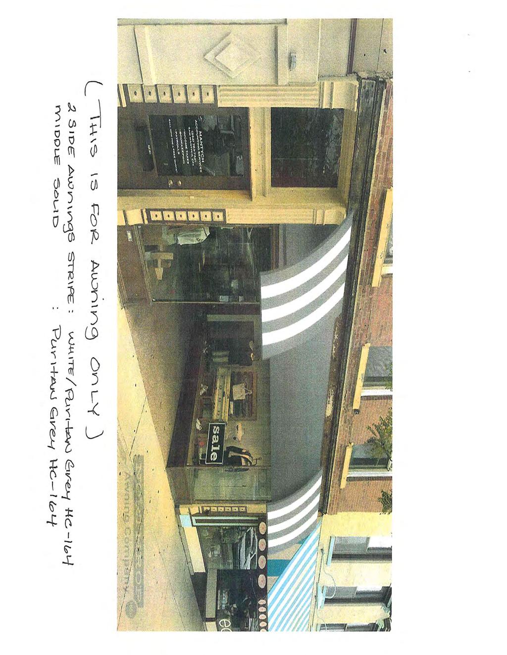
7 STAFF REPORT To Lake Geneva Plan Commission Meeting Date: August 20, 2018 Agenda Item #6A Applicant: Thomas George 3389 South Shore Dr Delavan, WI Request: 741 W. Main Street Downtown Design Review for Awning installation Tax Key No. ZOP00272 Description: The applicant is submitting an application for Downtown Design Review for the request to install an Awning to the exterior of the building above the public right of way at 741 W. Main Street Tax Key No. ZOP The City reviews all exterior alteration in the CB zoning district to confirm that they conform to the Downtown Design standards, particularly quantity, size, and color requirements. Proposed colors correspond within the permitted downtown guidelines. Staff Recommendations: The colors submitted have been reviewed and comply with the Historic Colors of the Sherwin Williams color palette. Staff recommends approval of the Awning installation request as submitted. 1
8
9
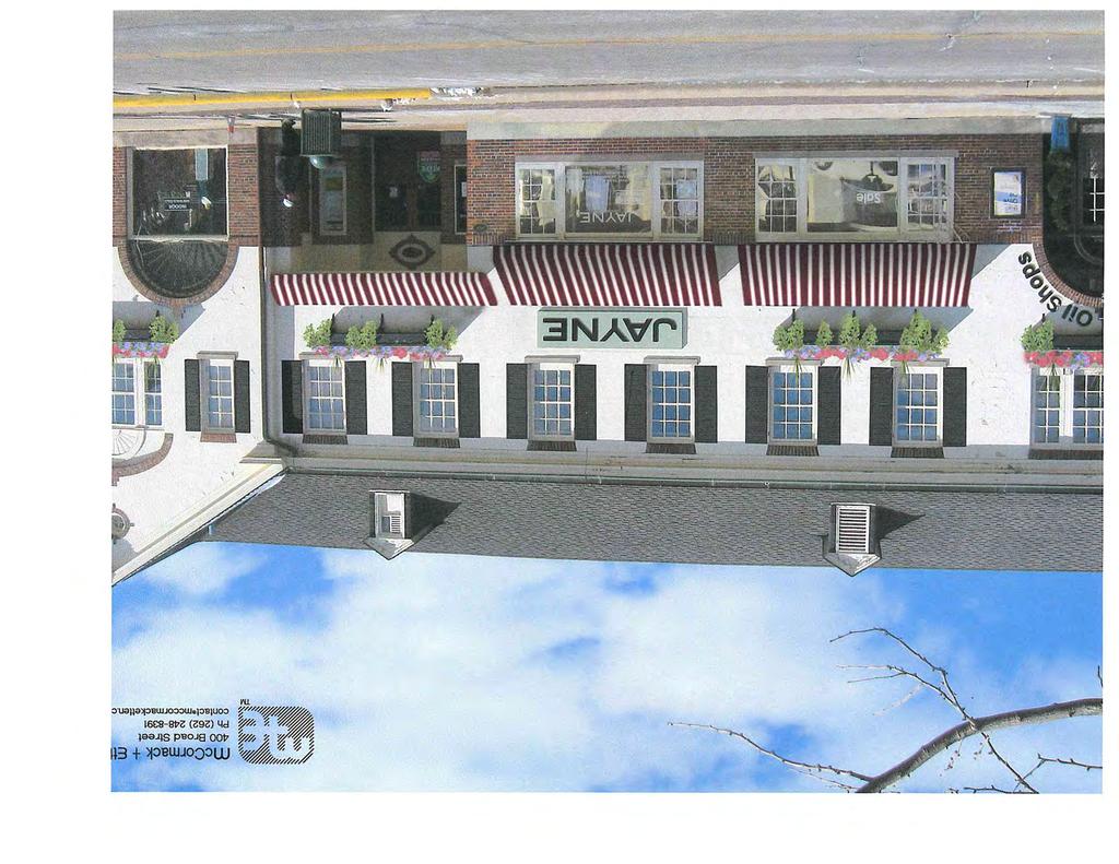
10 STAFF REPORT To Lake Geneva Plan Commission Meeting Date: August 20, 2018 Agenda Item #6B Applicant: Venture Investment Partners LLP 751 Lake Geneva Parkway Lake Geneva WI Request: 201 Broad Street Downtown Design Review for Awning & Window Shutter installation Tax Key No. ZOP00267 Description: The applicant is submitting an application for Downtown Design Review for the request to install Shutters & Awnings to the exterior of the building above the public right of way at 201 Broad Street Tax Key No. ZOP The City reviews all exterior alteration in the CB zoning district to confirm that they conform to the Downtown Design standards, particularly quantity, size, and color requirements. Proposed colors correspond within the permitted downtown guidelines. Staff Recommendations: The colors submitted have been reviewed and comply with the Historic Colors of the Sherwin Williams color palette. Staff recommends approval of the Shutter & Awning installation request as submitted. 1
11

12
13
14 STAFF REPORT To Lake Geneva Plan Commission Meeting Date: August 20, 2018 Agenda Item #6C Applicant: Carrie Casper 483 W. South Street Lake Geneva, WI Request: 647 W. Main Street Downtown Design Review for Signage installation Tax Key No. ZOP00287 Description: The applicant is submitting an application for Downtown Design Review for the request to install two on building signs to the exterior of the building above the public right of way at 647 W. Main Street, Tax Key No. ZOP The City reviews all exterior alteration in the CB zoning district to confirm that they conform to the Downtown Design standards, particularly quantity, size, and color requirements. Proposed sizes & colors correspond within the permitted downtown guidelines. Staff Recommendations: The colors submitted have been reviewed and comply with the Historic Colors of the Sherwin Williams color palette. Staff recommends approval of the installation of the two sign requests as submitted. 1
15
16

17
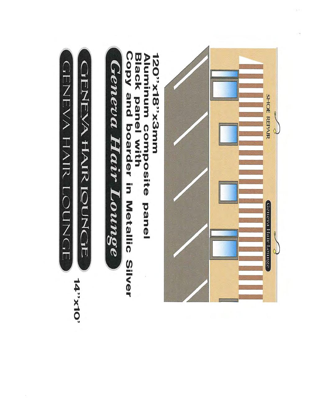
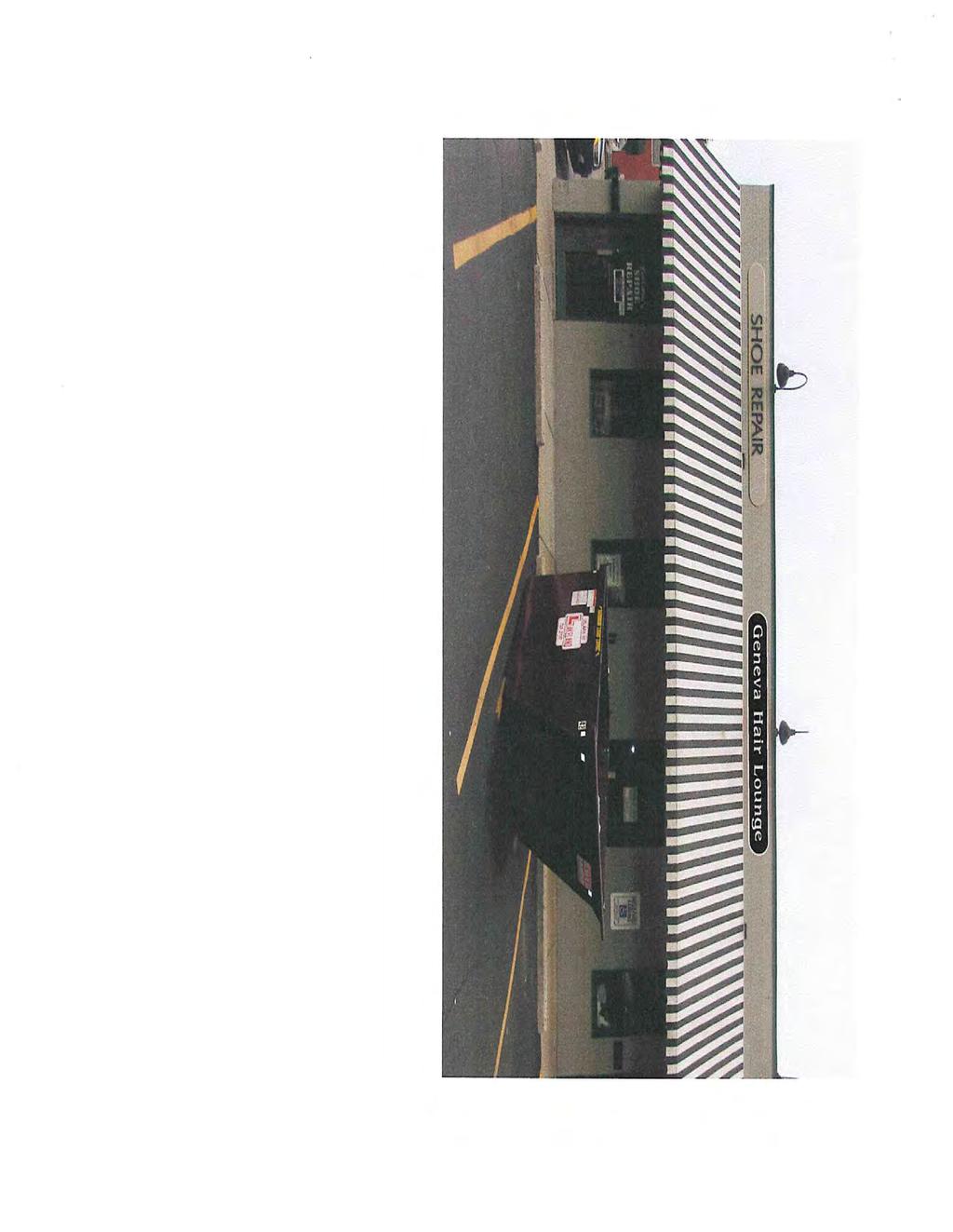
18 STAFF REPORT To Lake Geneva Plan Commission Meeting Date: August 20, 2018 Agenda Item #6D Applicant: Melissa Todd W1385 Oakwood Rd Genoa City, WI Request: 253 Center Street Suite #700 Downtown Design Review for Signage installation Tax Key No. ZOP00282 Description: The applicant is submitting an application for Downtown Design Review for the request to install an on building sign to the exterior of the building above the public right of way at 253 Center Street, Suite #700 Tax Key No. ZOP The City reviews all exterior alteration in the CB zoning district to confirm that they conform to the Downtown Design standards, particularly quantity, size, and color requirements. Proposed sizes & colors correspond within the permitted downtown guidelines. Staff Recommendations: The colors submitted have been reviewed and comply with the Historic Colors color palette. Staff recommends approval of the installation of the sign requests as submitted. 1
19
20
21
22 STAFF REPORT To Lake Geneva Plan Commission Meeting Date: August 20, 2018 Agenda Item: 7 Applicant: Lake Geneva LLC 3000 Dundee Rd #408 Northbrook, IL Request: Mod Pizza Conditional Use Permit Indoor Commercial Entertainment 281 Edwards Blvd, Unit C Lake Geneva, WI Tax Key No. ZA Description of Proposed Conditional Uses: The applicant is submitting a Conditional Use Permit (CUP) to allow for the request to conduct a Mod Pizza facility at 281 Edwards Blvd, Unit C, which is an Indoor Commercial Entertainment land use. The City reviews all Conditional Use Permits for this land use. The applicants have also submitted a request for the downtown review of the signage earlier on the agenda for this property. Action by the Plan Commission: Recommendation to the Common Council on the proposed Conditional Use Permit (CUP): As part of the consideration of the requested CUP, the Plan Commission is required to: Provide the Common Council with a recommendation regarding the proposed CUP; Include findings required by the Zoning Ordinance for CUPs; and, Provide specific suggested requirements to modify the project as submitted. Staff Review: The proposed conditional use is fully consistent with the requirements of the Municipal Ordinance. Required Plan Commission Findings on the CUP for Recommendation to the Common Council: A proposed CUP must be reviewed by the standards, below: A. If, after the public hearing, the Commission wishes to recommend approval, then the appropriate fact finding would be all of the following: 1. In general, the proposed conditional use is in harmony with the purposes, goals, objectives, policies and standards of the City's Comprehensive Plan, Zoning Ordinance, and any other plan, program, or ordinance adopted, or under consideration pursuant to official notice by the City. 2. Specific to this site, the proposed conditional use is in harmony with the purposes, goals, objectives, policies and standards of the City's Comprehensive Plan, Zoning Ordinance, and any other plan, program, or ordinance adopted, or under consideration pursuant to official notice by the City. 1
23 3. The proposed conditional use in its proposed location, and as depicted on the required site plan does not result in a substantial or undue adverse impact on nearby property, the character of the neighborhood, environmental factors, traffic factors, parking, public improvements, public property or rights-of-way, or other matters affecting the public health, safety, or general welfare, either as they now exist or as they may in the future be developed as a result of the implementation of the provisions of the Zoning Ordinance, the Comprehensive Plan or any other plan, program, map, or ordinance adopted or under consideration pursuant to official notice by the City or other governmental agency having jurisdiction to guide development. 4. The proposed conditional use maintains the desired consistency of land uses, land use intensities, and land use impacts as related to the environs of the subject property. 5. The proposed conditional use is located in an area that will be adequately served by, and will not impose an undue burden on any improvements, facilities, utilities or services provided by public agencies serving the subject property. 6. The potential public benefits of the proposed conditional use outweigh all potential adverse impacts of the proposed conditional use after taking into consideration the Applicant s proposal and any requirements recommended by the Applicant to ameliorate such impacts. B. If, after the public hearing, the Commission wishes to recommend denial, then the appropriate fact finding would be one or more of the following: 1. In general, the proposed conditional use is not in harmony with the purposes, goals, objectives, policies and standards of the City's Comprehensive Plan, Zoning Ordinance, and any other plan, program, or ordinance adopted, or under consideration pursuant to official notice by the City. 2. Specific to this site, the proposed conditional use is not in harmony with the purposes, goals, objectives, policies and standards of the City's Comprehensive Plan, Zoning Ordinance, and any other plan, program, or ordinance adopted, or under consideration pursuant to official notice by the City. 3. The proposed conditional use in its proposed location, and as depicted on the required site plan does result in a substantial or undue adverse impact on nearby property, the character of the neighborhood, environmental factors, traffic factors, parking, public improvements, public property or rights-of-way, or other matters affecting the public health, safety, or general welfare, either as they now exist or as they may in the future be developed as a result of the implementation of the provisions of the Zoning Ordinance, the Comprehensive Plan or any other plan, program, map, or ordinance adopted or under consideration pursuant to official notice by the City or other governmental agency having jurisdiction to guide development. 4. The proposed conditional use does not maintain the desired consistency of land uses, land use intensities, and land use impacts as related to the environs of the subject property. 5. The proposed conditional use is not located in an area that will be adequately served by, and will impose an undue burden on any of the improvements, facilities, utilities or services provided by public agencies serving the subject property. 6. The potential public benefits of the proposed conditional use do not outweigh all potential adverse impacts of the proposed conditional use after taking into consideration the Applicant s proposal and any requirements recommended by the Applicant to ameliorate such impacts. 2
24 Staff Recommendation: 1. Staff recommends that the Plan Commission recommend approval of the proposed conditional use as submitted, with the findings under A.1-6., above. 2. Staff recommends the Plan Commission adopt the affirmative set of findings provided above. 3

25
26
27
28
29

30
31

32

33

34
35

36
37
38

39
40
41
42
43
44

45
46

47

48

49
50 City of Lake Geneva 2018 Annual Comprehensive Plan Amendment Process Activity May June July August Sept. Oct. Plan Commission Announces the Opening of the Plan Amendment Process, and Reviews the Draft Public Participation Plan City Clerk Accepts Plan Amendment Applications Plan Commission Recommends Adoption of the Public Participation Plan Council Adopts Public Participation Plan Plan Commission Reviews Plan Amendment Applications (Requests & Staff Analysis included in Plan Comm. Packet.) Plan Commission Recommends Setting Public Hearing by Council Council Sets Public Hearing (applications frozen) City Clerk Distributes Requested Plan Amendments to Surrounding and Overlapping Jurisdictions Public Review Period (Newspaper published Wed.) Joint City Council and Plan Commission Meeting 1. Council Holds Public Hearing 2. Plan Commission Adopts Resolution Recommending Plan Amendments Council Adopts Ordinance on Recommended Plan Amendments City Clerk Distributes Amended Plan to Surrounding and Overlapping Jurisdictions May 21 May 22 - June 29 June 18 June 25 July 16 Aug. 20 Aug. 20 Aug. 27 Aug. 29 Sept. 5 - Oct. 14 Oct. 15 Oct. 22 After Adoption May 17, 2017 Page 2
51 STAFF REPORT To Lake Geneva Plan Commission Meeting Date: August 20, 2018 Agenda Item #9 Applicant: Roger Wolff 751 Lake Geneva Pkwy Lake Geneva, WI Request: Preliminary Conceptual Review Copper Circle 15-6-unit Development Tax Key No. ZYUP00198 Description: The applicant is submitting the conceptual renditions for a proposed development for the south western portion of Tax Key No. ZYUP This parcel is located on the north side of Townline Rd and west of Edwards Blvd. The project would utilize approximately 12 acres to include the construction of 15 6-unit buildings and amenities for storm water, clubhouse with pool, and easements to allow for bike/pedestrian trails along the entire west property line and a proposed east connection to the undeveloped remainder of land. The development is being proposed entirely as a private road for this project. The applicant have met with staff for an initial review in which staff identified items of concerns for ingress and egress due to the topography which may require a right in right out only as what was required on the south of the Townline Rd for Cumberland Tr. Staff Recommendations: Staff does not have recommendations at this time; this is a conceptual review submittal by the applicant. 1
52 STORM WATER POND 10 9 STORM WATER POND EXISTING WOODED AREA BOUNDARY STORM WATER POND 13 POTENTIAL AREA FOR GUEST PARKING TYP. - WISCONSIN HIGHWAY EDWARDS BLVD. - -PARK DRIVE- SITE SUMMARY AMENITY CLUBHOUSE / LEASING OFFICE AND PARKING 14 +/ TOTAL ACRES 15, 6 UNIT BUILDINGS 90 APARTMENT UNITS TOTAL 1 GARAGE SPACE PER UNIT PARKING SPACE IN DRIVEWAY APRON PER UNIT 2+ PARKING SPACES/UNIT -TOWNLINE ROAD- +/-40 GUEST PARKING SPACES ISSUED: Lake Geneva, WI 0 100' 200' 400'
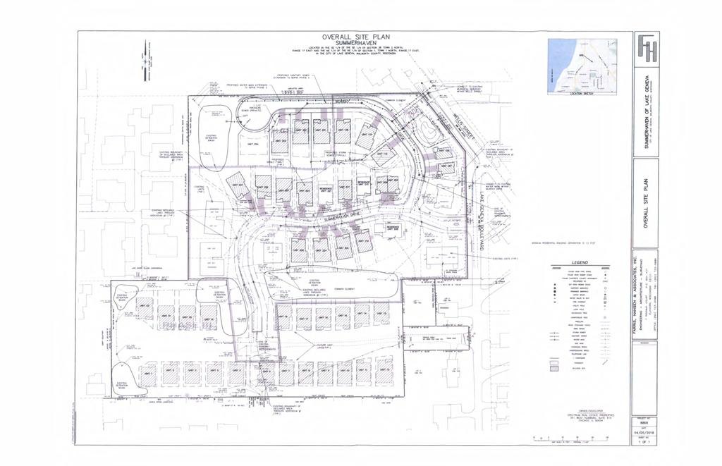
53 STAFF REPORT To Lake Geneva Plan Commission Meeting Date: August 20, 2018 Agenda Item #10 Applicant: McMurr II, LLC 351 W. Hubbard, Suite 610 Chicago, WI Request: Planned Development Step 2 Conceptual Review Summerhaven Phase II & III Development Tax Key No. ZSUM0001 & ZSUM0002 Description: The applicant is submitting the conceptual renditions for a proposed development for the remainder of the property for Phases II & III of Tax Key No. ZSUM0001 & ZSUM0002. This parcel is located on the west side of Lake Geneva Blvd. The project would finish the proposed development and the construction of single family homes and amenities for storm water, pool house with pool, and easements to allow utility connections. The development is being proposed entirely as a private road for this project. The applicant have met with staff for an initial review in which staff identified items of concerns for easements and connections to also address abandonment of existing extra water connections. Staff Recommendations: Staff does not have recommendations at this time; this is a conceptual review submittal by the applicant. 1
54
55 CITY OF LAKE GENEVA PROCEDURAL CHECKLIST FOR: PLANNED DEVELOPMENT REVIEW AND APPROVAL (Per Section ) This form should be used by the Applicant as a guide to submitting a complete application for a planned development and by the City to process said application. Parts II, III, V, and VII should be used by the Applicant to submit a complete application; Parts I - VIII should be used by the City as a guide when processing said application. I. RECORDATION OF ADMINISTRATIVE PROCEDURES Pre-submittal staff meeting scheduled: Date of Meeting: Time of Meeting: Date: by: Follow-up pre-submittal staff meetings scheduled for: Date of Meeting: Time of Meeting: Date: by: Date of Meeting: Time of Meeting: Date: by: Date of Meeting: Time of Meeting: Date: by: Date of Meeting: Time of Meeting: Date: by: Application form filed with Zoning Administrator: Date: by: Application fee of $ received by Zoning Administrator: Date: by: Reimbursement of professional consultant costs agreement executed: Date: by: II. APPLICATION SUBMITTAL PACKET REQUIREMENTS PD PROCESS STEP 1: PRE-APPLICATION Step 1 does not require the submittal of an application packet; however, Steps 2-4 do require submittal of all draft and final application packets to the Zoning Administrator prior to Plan Commission review. A. Contact the Zoning Administrator to place an informal discussion item for the PD on the Plan Commission agenda. No details beyond the name of the Applicant and the identification of the discussion item as a PD is required to be given in the agenda. B. Engage in an informal discussion with the Plan Commission regarding the potential PD. Appropriate topics may include: location, project themes and images, general mix of dwelling unit types and/or land uses being considered, approximate residential densities, and non-residential intensities, general treatment of natural features, general relationship to nearby properties and public streets, and relationship to the Comprehensive Plan. NOTE: Points of discussion and conclusions reached in this stage of the process shall in no way be binding upon the Applicant or the City, but should be considered as the informal, nonbinding basis for proceeding to the next step.
56 APPLICATION SUBMITTAL PACKET REQUIREMENTS PD PROCESS STEP 2: CONCEPT PLAN Prior to submitting the 20 complete applications as certified by the Zoning Administrator, the Applicant shall submit 5 initial draft application packets for staff review, followed by one revised draft final application packet based upon staff review and comments. Initial Packet (5 Copies to Zoning Administrator) Date: by: Draft Final Packet (1 Copy to Zoning Administrator) Date: by: A. Provide Zoning Administrator with draft PD Concept Plan Submittal Packet for determination of completeness prior to placing the proposed PD on the Plan Commission agenda for Concept Plan review. The submittal packet shall contain all of the following items: (1) A location map of the subject property and its vicinity at 11" x 17", as depicted on a copy of the City of Lake Geneva Land Use Plan Map; (2 ) A general written description of proposed PD including: General project themes and images; The general mix of dwelling unit types and/or land uses; Approximate residential densities and non-residential intensities as described by dwelling units per acre, floor area ratio and impervious surface area ratio; The general treatment of natural features; The general relationship to nearby properties and public streets; The general relationship of the project to the Master Plan; An initial draft list of zoning standards which will not be met by the proposed PD and the location(s) in which they apply and, a complete list of zoning standards which will be more than met by the proposed PD and the location(s) in which they apply. Essentially, the purpose of this listing shall be to provide the Plan Commission with information necessary to determine the relative merits of the project in regard to private benefit versus public benefit, and in regard to the mitigation of potential adverse impacts created by design flexibility; and, (3) A written description of potentially requested exemption from the requirements of the underlying zoning district, in the following order: 1. Land Use Exemptions; 2. Density and Intensity Exemptions; 3. Bulk Exemptions; 4. Landscaping Exceptions; 5. Parking and Loading Requirements Exceptions; (4) A conceptual plan drawing (at 11" x 17") of the general land use layout and the general location of major public streets and/or private drives. The Applicant may submit copies of a larger version of the plan in addition to the 11" x 17" reduction.
57 FINAL APPLICATION PACKET INFORMATION PD PROCESS STEP 2: CONCEPT PLAN Receipt of 5 full scale copies in blueline or blackline of complete Final Application Packet by Zoning Administrator: Receipt of 20 reduced (8.5" by 11" text and 11" x 17" graphics) copies of complete Final Application Packet by Zoning Administrator: A digital copy of Final Application Packet shall be ed to the Building and Zoning Department upon submittal deadline. Certification of complete Final Application Packet and required copies to the Zoning Administrator by City Clerk: Date: by: Date: by: Date: by: Date: by:
58 APPLICATION SUBMITTAL REQUIREMENTS PD STEP 3: GENERAL DEVELOPMENT PLAN (GDP) Prior to submitting the 20 complete applications as certified by the Zoning Administrator, the Applicant shall submit 5 initial draft application packets for staff review, followed by one revised draft final application packet based upon staff review and comments. Initial Packet (5 Copies to Zoning Administrator) Date: by: Draft Final Packet (1 Copy to Zoning Administrator) Date: by: A. Provide Zoning Administrator with a draft GDP Submittal Packet for determination of completeness prior to placing the proposed PD on the Plan Commission agenda for GDP review. The submittal packet shall contain all of the following items: (1) A location map of the subject property and its vicinity at 11" x 17", as depicted on a copy of the City of Lake Geneva Land Use Plan Map; (2) A map of the subject property for which the PD is proposed: Showing all lands within 300 feet of the boundaries of the subject property; Referenced to a list of the names and addresses of the owners of all lands on said map as the same appear on the current records of the Register of Deeds of Walworth County (as provided by the City of Lake Geneva); Clearly indicating the current zoning of the subject property and its environs, and the jurisdiction(s) which maintains that control; Map and all its parts clearly reproducible with a photocopier; Map size of 11" x 17" and map scale not less than one inch equals 800 feet; All lot dimensions of the subject property provided; Graphic scale and north arrow provided. (3) A general written description of proposed PD including: General project themes and images; The general mix of dwelling unit types and/or land uses; Approximate residential densities and non-residential intensities as described by dwelling units per acre, floor area ratio and impervious surface area ratio; The general treatment of natural features; The general relationship to nearby properties and public streets; The general relationship of the project to the Master Plan, A statement of Rationale as to why PD zoning is proposed. This shall identify barriers that the Applicant perceives in the form of requirements of standard zoning districts and opportunities for community betterment the Applicant suggests are available through the proposed PD zoning.
59 A complete list of zoning standards which will not be met by the proposed PD and the location(s) in which they apply and a complete list of zoning standards which will be more than met by the proposed PD and the location(s) in which they apply shall be identified. Essentially, the purpose of this listing shall be to provide the Plan Commission with information necessary to determine the relative merits of the project in regard to private benefit versus public benefit, and in regard to the mitigation of potential adverse impacts created by design flexibility. A written description of potentially requested exemption from the requirements of the underlying zoning district, in the following order: 1. Land Use Exemptions; 2. Density and Intensity Exemptions; 3. Bulk Exemptions; 4. Landscaping Exceptions; 5. Parking and Loading Requirements Exceptions. (4) A General Development Plan Drawing at a minimum scale of 1"=100' (11" x 17" reduction shall also be provided by Applicant) of the proposed project showing at least the following information in sufficient detail to make an evaluation against criteria for approval: A conceptual plan drawing (at 11" x 17") of the general land use layout and the general location of major public streets and/or private drives. The Applicant may submit copies of a larger version of the plan in addition to the 11" x 17" reduction; Location of recreational and open space areas and facilities and specifically describing those that are to be reserved or dedicated for public acquisition and use; Statistical data on minimum lot sizes in the development, the approximate areas of large development lots and pads, density/intensity of various parts of the development, floor area ratio, impervious surface area ratio and landscape surface area ratio of various land uses, expected staging, and any other plans required by the Plan Commission or City Council; and Notations relating the written information provided in (3), above to specific areas on the GDP Drawing. (5) General conceptual landscaping plan for subject property, noting approximate locations of foundation, street, yard and paving, landscaping, and the compliance of development with all landscaping requirements of this Ordinance (except as noted in the listing of exceptions) and the use of extra landscaping and bufferyards; (6) A general signage plan for the project, including all: Project identification signs; Concepts for public fixtures and signs (street light fixtures and/or poles or street sign faces and/or poles) which are proposed to vary from City standards or common practices;
60 (7) Written justification for the proposed Planned Development. (See Section for requirements of the conditional use procedure.) FINAL APPLICATION PACKET INFORMATION PD STEP 3: GENERAL DEVELOPMENT PLAN (GDP) The process for review and approval of the PD shall be identical to that for conditional use permits per Section of the Zoning Ordinance and (if land is to be divided) to that for preliminary and final plats of subdivision per the Municipal Code. All portions of an approved PD/GDP not fully developed within five years of final City Council approval shall expire, and no additional PD-based development shall be permitted. The City Council may extend this five years period by up to five additional years via a majority vote following a public hearing. Receipt of 5 full scale copies in blueline or blackline of complete Final Application Packet by Zoning Administrator: Receipt of 20 reduced (8.5" by 11" text and 11" x 17" graphics) copies of complete Final Application Packet by Zoning Administrator: A digital copy of Final Application Packet shall be ed to the Building and Zoning Department upon submittal deadline. Certification of complete Final Application Packet and required copies to the Zoning Administrator by City Clerk: Date: by: Date: by: Date: by: Date: by: Class 2 Legal Notice sent to official newspaper by City Clerk: Date: by: Class 2 Legal Notice published on and by: APPLICATION SUBMITTAL REQUIREMENTS PD STEP 4: PRECISE IMPLEMENTATION PLAN (PIP) Prior to submitting the 20 complete applications as certified by the Zoning Administrator, the Applicant shall submit 5 initial draft application packets for staff review, followed by one revised draft final application packet based upon staff review and comments. Initial Packet (5 Copies to Zoning Administrator) Date: by: Draft Final Packet (1 Copy to Zoning Administrator) Date: by: A. After the effective date of the rezoning to PD/GDP, the Applicant may file an application for the proposed PIP with the Plan Commission. This submittal packet shall contain the following items, prior to its acceptance by the Zoning Administrator and placing the item on the Plan Commission agenda for PIP review. (1) A location map of the subject property and its vicinity at 11" x 17", as depicted on a copy of the City of Lake Geneva Land Use Plan Map;
61 (2) A map of the subject property for which the PD is proposed: Showing all lands within 300 feet of the boundaries of the subject property; Referenced to a list of the names and addresses of the owners of all lands on said map as the same appear on the current records of the Register of Deeds of Walworth County (as provided by the City of Lake Geneva); Clearly indicating the current zoning of the subject property and its environs, and the jurisdiction(s) which maintains that control; Map and all its parts clearly reproducible with a photocopier; Map size of 11" by 17" and map scale not less than one inch equals 800 feet; All lot dimensions of the subject property provided; Graphic scale and north arrow provided. (3) A general written description of proposed PIP including: Specific project themes and images; The specific mix of dwelling unit types and/or land uses; Specific residential densities and non-residential intensities as described by dwelling units per acre, floor area ratio and impervious surface area ratio; The specific treatment of natural features; The specific relationship to nearby properties and public streets. A Statement of Rationale as to why PD zoning is proposed identifying perceived barriers in the form of requirements of standard zoning districts and opportunities for community betterment through the proposed PD zoning. A complete list of zoning standards which will not be met by the proposed PIP and the location(s) in which they apply and a complete list of zoning standards which will be more than met by the proposed PIP and the location(s) in which they apply shall be identified. Essentially, the purpose of this listing shall be to provide the Plan Commission with information necessary to determine the relative merits of the project in regard to private benefit versus public benefit, and in regard to the mitigation of potential adverse impacts created by design flexibility. (4) A Precise Implementation Plan Drawing at a minimum scale of 1"=100' (and reduced to 11" x 17") of the proposed project showing at least the following information in sufficient detail: (See following page) A PIP site plan conforming to all requirements of Section (3). If the proposed PD is a group development (per Section ) also provide a proposed preliminary plat or conceptual plat; Location of recreational and open space areas and facilities specifically describing those that are to be reserved or dedicated for public acquisition and use; Statistical data on minimum lot sizes in the development, the precise areas of all development lots and pads, density/intensity of various parts of the development, floor area ratio, impervious surface area ratio
62 and landscape surface area ratio of various land uses, expected staging, and any other plans required by the Plan Commission or City Council; and Notations relating the written information (3), above to specific areas on the GDP Drawing. (5) A Property Site Plan drawing which includes: A title block which indicates the name, address and phone/fax number(s) of the current property owner and/or agent(s) (developer, architect, engineer, planner) for project; The date of the original plan and the latest date of revision to the plan; A north arrow and a graphic scale (not smaller than one inch equals 100 feet); A reduction of the drawing at 11" x 17"; A legal description of the subject property; All property lines and existing and proposed right-of-way lines with bearings and dimensions clearly labeled; All existing and proposed easement lines and dimensions with a key provided and explained on the margins of the plan as to ownership and purpose; All required building setback lines; All existing and proposed buildings, structures, and paved areas, including building entrances, walks, drives, decks, patios, fences, utility poles, drainage facilities, and walls; The location and dimension (cross-section and entry throat) of all access points onto public streets; The location and dimension of all on-site parking (and off-site parking provisions if they are to be employed), including a summary of the number of parking stalls provided versus required by the Ordinance; The location and dimension of all loading and service areas on the subject property and labels indicating the dimension of such areas; The location of all outdoor storage areas and the design of all screening devices; The location, type, height, size and lighting of all signage on the subject property to include a photometric plan; The location, height, design/type, illumination power and orientation of all exterior lighting on the subject property including the clear demonstration of compliance with Section ; All engineering requirements for utilities, site designs, etc; The location and type of any permanently protected green space areas; The location of existing and proposed drainage facilities for storm water;
63 In the legend, data for the subject property on: Lot Area; Floor Area; Floor Area Ratio (b/a); Impervious Surface Area; Impervious Surface Ratio (d/a); Building Height. (6) A landscaping plan for subject property, specifying the location, species, and installed size of all trees and shrubs. Include a chart which provides a cumulative total for each species, type and required location (foundation, yard, street, paved area or bufferyard) of all trees and shrubs. (7) A series of building elevations for the entire exterior of all buildings in the PD, including detailed notes as to the materials and colors proposed. (8) A general signage plan including all project identification signs, concepts for public fixtures and signs (such as street light fixtures and/or poles or street sign faces and/or poles), and group development signage themes which are proposed to vary from City standards or common practices. (9) A general outline of the intended organizational structure for a property owners association, if any; deed restrictions and provisions for private provision of common services, if any. (10) A written description which demonstrates the full consistency of the proposed PIP with the approved GDP. (11) A written description of any and all variations between the requirements of the applicable PD/GDP zoning district and the proposed PIP development; and, (12) Proof of financing capability pertaining to construction and maintenance and operation of public works elements of the proposed development. FINAL APPLICATION PACKET INFORMATION PD STEP 4: PRECISE IMPLEMENTATION PLAN (PIP) The process for review and approval of the PD shall be identical to that for conditional use permits per Section of the Zoning Ordinance and (if land is to be divided) to that for preliminary and final plats of subdivision per the Municipal Code. All portions of an approved PD/PIP not fully developed within five years of final City Council approval shall expire, and no additional PD-based development shall be permitted. The City Council may extend this five years period by up to five additional years via a majority vote following a public hearing. Receipt of 5 full scale copies in blueline or blackline of complete Final Application Packet by Zoning Administrator: Receipt of 20 reduced (8.5" by 11" text and 11" x 17" graphics) copies of complete Final Application Packet by Zoning Administrator: Date: by: Date: by:
64 A digital copy of Final Application Packet shall be ed to the Building and Zoning Department upon submittal deadline. Certification of complete Final Application Packet and required copies to the Zoning Administrator by City Clerk: Date: by: Date: by: Class 2 Legal Notice sent to official newspaper by City Clerk: Date: by: Class 2 Legal Notice published on and by:
65 EXHIBIT A SUMMERHAVEN PHASES II & III CONCEPT PLAN LEGAL DESCRIPTION OF PHASE II PARCEL 1: THAT PART OF THE SOUTHEAST 1/4 OF THE SOUTHEAST 1/4 OF SECTION 36, TOWN 2 NORTH, RANGE 17 EAST, CITY OF LAKE GENEVA, WALWORTH COUNTY, WISCONSIN, DESCRIBED AS FOLLOWS: COMMENCING AT THE NORTHWEST CORNER OF LOT 1 OF CERTIFIED SURVEY MAP NO. 754, RECORDED AS DOCUMENT NO OF WALWORTH COUNTY CERTIFIED SURVEYS, SAID POINT LOCATED S 89DEG 31MIN 36SEC W, FEET FROM THE SOUTHEAST CORNER OF SAID SECTION 36 (T2N, R17E); THENCE N 89DEG 38MIN 40SEC E, FEET; THENCE N 89DEG 37MIN 23SEC E, FEET TO THE WEST LINE OF LAKE GENEVA BOULEVARD; THENCE N 01DEG 34MIN 47SEC W, FEET ALONG SAID BOULEVARD TO THE SOUTHWEST LINE OF WELLS STREET; THENCE N 37DEG 55MIN 32SEC W, ALONG SAID STREET, FEET; THENCE S 89DEG 18MIN 48SEC W, FEET TO THE POINT OF BEGINNING; THENCE S 00DEG 41MIN 12SEC E, FEET; THENCE S 01DEG 55MIN 11SEC E, FEET; THENCE S 89DEG 31MIN 07SEC W, FEET; THENCE S 01DEG 12MIN 03SEC E, FEET; THENCE S 88DEG 41MIN 15SEC W, FEET; THENCE N 86DEG 27MIN 48SEC W, FEET; THENCE S 88DEG 58MIN 07SEC W, FEET TO THE EAST LINE OF LAKE SHORE VILLAGE CONDOMINIUM; THENCE ALONG SAID CONDOMINIUM, N 00DEG 11MIN 05SEC W, 6.62 FEET; THENCE CONTINUE, N 00DEG 47MIN 32SEC W, FEET; THENCE N 89DEG 18MIN 48SEC E, FEET TO THE POINT OF BEGINNING. CONTAINING 76,247 SQUARE FEET (1.75 ACRES) OF LAND, MORE OR LESS (end of legal description). Property Index Number: ZSUM 00001
66 EXHIBIT B SUMMERHAVEN PHASES II & III CONCEPT PLAN LEGAL DESCRIPTION OF PHASE III THAT PART OF THE NORTHEAST 1/4 OF THE NORTHEAST 1/4 AND PART OF THE NORTHWEST 1/4 OF THE NORTHEAST 1/4 OF SECTION 1, TOWN 1 NORTH, RANGE 17 EAST, CITY OF LAKE GENEVA, WALWORTH COUNTY, WISCONSIN, DESCRIBED AS FOLLOWS: COMMENCING AT THE NORTHWEST CORNER OF LOT 1 OF CERTIFIED SURVEY MAP NO. 754, RECORDED AS DOCUMENT NO OF WALWORTH COUNTY CERTIFIED SURVEYS, SAID POINT LOCATED S 89DEG 31MIN 36SEC W, FEET FROM THE SOUTHEAST CORNER OF SAID SECTION 36 (T2N, R17E); THENCE S 01DEG 33MIN 07SEC E, ALONG THE WEST LINE OF SAID LOT 1 CSM 754, FEET TO THE SOUTHWEST CORNER OF SAID LOT 1 AND THE POINT OF BEGINNING; THENCE S 01DEG 35MIN 49SEC E, FEET ALONG SAID CSM 754 TO AN IRON PIPE STAKE FOUND MARKING THE NORTHWEST CORNER OF LOT 3 OF SAID CSM 754; THENCE S 01DEG 31MIN 43SEC E, TO AN IRON PIPE STAKE FOUND AT THE SOUTHWEST CORNER OF SAID CSM 754, FEET, SAID POINT BEING ON THE NORTH LINE OF CERTIFIED SURVEY MAP NUMBER 4098; THENCE ALONG THE NORTH LINE OF SAID CSM 4098, N 89DEG 51MIN 07SEC W, FEET TO AN IRON PIPE STAKE AT THE NORTHWEST CORNER OF SAID CSM 4098 AND THE NORTHEAST CORNER OF CERTIFIED SURVEY MAP NO. 2820; THENCE ALONG THE NORTH LINE OF SAID CSM 2820, N 89DEG 57MIN 18SEC W, FEET TO THE NORTHWEST CORNER OF SAID CSM 2820 AND THE NORTHEAST CORNER OF LOT 14 OF GENEVA WOODS SUBDIVISION; THENCE ALONG THE NORTH LINE OF GENEVA WOODS SUBDIVISION, S 89DEG 26MIN 58SEC W, FEET TO AN IRON PIPE STAKE FOUND MARKING THE NORTHWEST CORNER OF LOT 11 OF SAID GENEVA WOODS SUBDIVISION; THENCE ALONG THE NORTH LINE OF GENEVA WOODS SUBDIVISION, S 89DEG 00MIN 57SEC W, FEET TO A FOUND IRON REBAR STAKE; THENCE N 00DEG 46MIN 30SEC W, FEET TO A FOUND IRON REBAR STAKE ON THE SOUTH LINE OF LAKE SHORE VILLAGE CONDOMINIUM; THENCE N 89DEG 53MIN 53SEC E, FEET TO AN IRON PIPE STAKE FOUND MARKING THE SOUTHEAST CORNER OF SAID LAKE SHORE VILLAGE CONDOMINIUM; THENCE N 89DEG 55MIN 25SEC E, FEET; THENCE S 06DEG 43MIN 55SEC E, FEET; THENCE S 89DEG 41MIN 51SEC E, FEET; THENCE N 04DEG 56MIN 22SEC W, FEET; THENCE N89DEG 38MIN 02SEC E, FEET; THENCE S 01DEG 33MIN 07SEC E, FEET; THENCE N 89DEG 40MIN 56SEC E, FEET TO THE POINT OF BEGINNING. CONTAINING 201,115 SQUARE FEET (4.62 ACRES) OF LAND, MORE OR LESS (end of legal description). Property Index Number: ZSUM AND LOT 1 OF CERTIFIED SURVEY MAP NO. 754, SAID SURVEY BEING A PART OF THE NORTHEAST ¼ OF SECTION 1, T1N, R17E, CITY OF LAKE GENEVA, WALWORTH
67 COUNTY, WISCONSIN, AND RECORDED IN VOL. 3 OF CERTIFIED SURVEYS AT PAGE 275 AS DOCUMENT NO WALWORTH COUNTY RECORDS (end of legal description). Property Index Number: ZA
68 SUMMERHAVEN OF LAKE GENEVA PHASES II & III PLANNED DEVELOPMENT - CONCEPT PLAN Applicant: McMurr II, LLC, an Illinois limited liability company July 13, 2018 T:\M\McMurr, LLC\Summerhaven\2018 phase 2\off copy\pd-p 2 & 3\off copy\concept plan app - phases 2 & 3-5.docx Page 1
69 EXHIBIT A SUMMERHAVEN PHASES II & III CONCEPT PLAN NARRATIVE INTRODUCTION: McMurr II, LLC, an Illinois limited liability company ( McMurr II ), is the Successor Declarant of the Summerhaven development ( Summerhaven ), the owner of ten (10) of the units in Phase I thereof ( Phase I ), and all the lands composing Summerhaven s second and third phases. McMurr II has cleared Summerhaven of the piles of broken asphalt resulting from the demolition of a parking lot by an earlier developer, has cleaned out the storm water management ponds to restore their capacity, has altered the storm water drainage to avoid flooding neighboring property on the north boundary of Summerhaven, and has extended Summerhaven Drive to Lake Geneva Boulevard, paving the access for emergency vehicles to Summerhaven. Phase I, approximately 8.04 acres, is zoned by the City of Lake Geneva ( City ) as PD, Planned Development Zoning District, under a Precise Implementation Plan that has been amended in 2014, 2017, and 2018 by McMurr II. Phase I is under condominium ownership, subject to the Declaration of Condominium and the Plat of Condominium of Summerhaven of Lake Geneva Condominium, as amended by recorded amendments and addenda thereto (collectively, Summerhaven of Lake Geneva Condominium ). In Phase I, ten (10) duplex dwellings in five (5) buildings have been constructed, as well as three (3) single-family dwellings, with additional single-family units under construction. Under the 2017 amendment to the PD for Phase I, McMurr II has committed to install the incomplete public and private infrastructure for the balance of Phase I, to construct the pool promised by the original developer of Summerhaven, as well as a pool house, and to install the final lift of asphalt for the Phase I private roads. The public infrastructure (e.g., municipal water and sanitary sewer mains) and the private infrastructure (e.g., storm water management system, private streets, and public utilities) have been designed and almost fully installed with sufficient capacity to accommodate not only the thirty-seven (37) units originally approved for Phase I, now reduced to twenty-eight (28) units, but also to accommodate an additional forty-seven (47) units originally approved for the second and third phases of Summerhaven. The PD, Planned Development Zoning District, zoning for Phases II and III of Summerhaven has expired, and the City has rezoned the phases to TR-6, Two-family Zoning District, which allows single-family dwellings as a permitted use. Under the City s Comprehensive Master Plan, the phases are planned as Two-Family/Townhouse Residential, for which the TR-6, Two-family Zoning District is recommended. The ten (10) year period during which Phases II and III could be added to the Summerhaven of Lake Geneva Condominium as expansion units under the Wisconsin Condominium Ownership Act has expired. T:\M\McMurr, LLC\Summerhaven\2018 phase 2\off copy\pd-p 2 & 3\off copy\concept plan app - phases 2 & 3-5.docx Page 2
70 To restore the original vision for Summerhaven, to broaden the base of financial support for Summerhaven s extensive private infrastructure, including, without limitation, the roads, the storm water management facilities, the pool and the pool house, and to provide quality infill development, McMurr II proposes to rezone Phase II of Summerhaven, more particularly described in the attached Exhibit B incorporated herein ( Phase II ), and Phase III of Summerhaven, more particularly described in the attached Exhibit C incorporated herein ( Phase III ), from TR-6, Two-family Zoning District, to PD, Planned Development Zoning District, using the TR-6, Two-family Zoning District as the base district under the Planned Development for both phases. Phase II will be under condominium ownership, pursuant to a Declaration of Condominium and Plat of Condominium of Summerhaven of Lake Geneva II, consisting of four (4) single-family site condominium units, with Phase III designated as Expansion Area for up to twenty-three (23) additional single-family units ( Condominium of Summerhaven of Lake Geneva II ). McMurr II proposes a cross-easement agreement between the condominium associations of the Condominium of Summerhaven of Lake Geneva and the Condominium of Summerhaven of Lake Geneva II, to share, maintain, repair and replace the private roads, the storm water management facilities, the pool and pool house, and other common amenities and private infrastructure used by all. The properties surrounding Phases II and III are zoned PB, Planned Business Zoning District, to the north and east, principally along Wells Street; MR-8, Multi-family Residential-8 Zoning District, and SR-4, Single-family Residential-4 Zoning District, to the south. The single-family use and the proposed density should fit well within the neighboring properties. CONCEPT PLAN REQUIREMENTS: 1. Location map: A Location Map, showing the location of Phases II and III on the City s Land Use Plan Map, is attached as Exhibit D and incorporated herein. 2. General description of proposed PD: a. General project themes and images: A Site Plan of Phases II and III is attached as Group Exhibit E and incorporated herein. Sample elevations and floor plans for one-story residences for Phases II and III are attached as Group Exhibit F and incorporated herein. Two-story residences are planned, as well for Phases II and III. The landscaping, signage, lighting, organizational structure, and the consistency of the GDP and the PIP for Phases II and III will not materially differ from those for Phase I, to make an integrated community. b. General mix of dwelling unit types and/or land uses: Only single-family residences are proposed for Phases II and III. T:\M\McMurr, LLC\Summerhaven\2018 phase 2\off copy\pd-p 2 & 3\off copy\concept plan app - phases 2 & 3-5.docx Page 3
71 c. Approximate residential densities: (i) Dwelling units per gross acre: Phase II, less than 2.3 units/acre; Phase III, approximately 4.7 units/acre; Phases II and III combined, approximately 4.1 units per acre; (ii) floor area ratio: 25%; (iii) impervious surface area ratio: 40%. d. General treatment of natural features: Phase II and Phase III include detention ponds that will serve not only their improvements, but the Phase I improvements, as well. Open space in Phase II and Phase III will be treated much as open space is treated in Phase I. e. General relationship to nearby properties and public streets: Access to Phase II and Phase III will be through the existing entrance to Phase I from Lake Geneva Boulevard. Access may also be had through the current emergency vehicles exit/entrance also on Wells Street, which McMurr II proposes to construct and convert to a street in Summerhaven, and on which the Phase III residences will front. The single-family residences of Phases II and III will relate well to the Phase I development, as well as the single-family development to the south, which has lots of nine thousand (9,000) square feet. f. General relationship of the project to the Master Plan: The proposed single-family dwellings in a Planned Development with a TR-6, Two-family Zoning District, base, fits the Master Plan s Two-family/Townhouse planned use for Phases II and III, with lower density. g. Initial draft list of zoning standards which will not be met by the proposed PD and the location(s) in which they apply and, a complete list of zoning standards which will be more than met by the proposed PD and the location(s) in which they apply, to determine the relative merits of the project in regard to private benefit versus public benefit, and in regard to the mitigation of potential adverse impacts created by design flexibility: McMurr II requests the following flexibilities from land use and bulk regulations for Phases II and III, the most significant of which have been granted in Phase I, to promote uniformity of development with Phase I, and to accommodate the number of single-family units sufficient to support the private infrastructure of Summerhaven: a. Maximum gross density of up to 5.45 dwelling units per acre; b. Fifty (50) foot-wide easements for the private streets (Ordinance: minimum 66- foot width); c. Cul-de-sac length of seven hundred twenty (720) feet (Ordinance maximum: 400 feet); d. Minimum front and rear eave width of six (6) inches for side of gables (Ordinance: 18 inches); e. Side of front porch to side of adjacent front porch of twelve (12) feet, minimum side yard of six (6) feet (Ordinance: minimum dwelling unit separation of 12 feet, minimum side yard of 6 feet); f. Units in Phase II and Phase III will range in size from approximately five thousand two hundred (5,200) square feet to approximately nine thousand sixty-five (9,065) square feet, to accommodate single-family dwellings in place of the duplex structures permitted under the TR-6, Two-family Zoning District. By comparison, some units in Phase I are below seven thousand (7,000) square feet in size. (Ordinance: 9,000 square foot minimum); g. Minimum Landscape Surface Ratio (LSR): 45% (Ordinance: 50%); h. Maximum Building Coverage: 45% (Ordinance: 40%); i. Minimum Lot Width: fifty (50) feet (Ordinance: 75 feet); T:\M\McMurr, LLC\Summerhaven\2018 phase 2\off copy\pd-p 2 & 3\off copy\concept plan app - phases 2 & 3-5.docx Page 4
72 j. Total of Both Sides, Lot Lines to House/Garage: twelve (12) feet (Ordinance: 15 feet or 0 ft. along common wall); and k. Rear Lot Line to House or Garage: fifteen (15) feet (Ordinance: 30 feet). 3. A written description of potentially requested exemption from the requirements of the underlying zoning district, in the following order: a. Land Use Exemptions: None. b. Density and Intensity Exemptions: See 2(g), above. c. Bulk Exemptions: See 2(g), above. d. Landscaping Exceptions: None applicable; residential only. e. Parking and Loading Requirements Exceptions: None applicable; residential only. 4. Conceptual plan drawing: See Group Exhibit E. If Phases II and III are zoned PD with a TR-6 Two-family base district, Phases II and III will need the following TR-6 Two-family Zoning District uses thereunder and will meet the following TR-6 Two-family Zoning District standards: a. Land Uses Permitted by Right: (per Section (2)) Single-Family - 9,000 sf lot: Only single-family units are planned, with units in Phase II and Phase III ranging in size from approximately five thousand two hundred (5,200) square feet to approximately nine thousand sixty-five (9,065) square feet. Selective Cutting (per Section (2)(f)) Passive Outdoor Public Recreation (per Section (3)(a)) Active Outdoor Public Recreation (per Section (3)(b)) Public Services and Utilities (per Section (3)(e)) b. Land Uses Permitted as Conditional Use: (per Section (4)) Clear Cutting (per Section (2)(g)) c. Land Uses Permitted as Accessory Uses: (per Section (5)) 1) Land Uses Permitted by Right: Private Residential Garage or Shed (per Section (8)(c)) Home Occupation (per Section (8)(j)) Family Day Care Home (per Section (8)(k)) Private Residential Recreational Facility (per Section (8)(o)) Drainage Structure (per Section (8)(r)) Filling (per Section (8)(s)) Lawn Care (per Section (8)(t)) Exterior Communication Devices (per Section (8)(v)) 2) Land Uses Permitted as Conditional Use: None are requested. d. Land Uses Permitted as Temporary Uses: (per Section (6)) Contractor's Project Office (per Section (9)(c)) Contractor's On-Site Equipment Storage (per Section (9)(d)) On-Site Real Estate Sales Office (per Section (9)(f)) 3. Regulations Applicable to Residential Uses: a. Residential Density and Intensity Requirements: 1) Conventional Development T:\M\McMurr, LLC\Summerhaven\2018 phase 2\off copy\pd-p 2 & 3\off copy\concept plan app - phases 2 & 3-5.docx Page 5
73 Minimum Zoning District Area: 9,000 square feet: Units in Phase II and Phase III will range in size from approximately five thousand two hundred (5,200) square feet to approximately nine thousand sixty-five (9,065) square feet, to accommodate single-family dwellings in place of the duplex structures permitted under the TR-6, Two-family Zoning District. By comparison, some units in Phase I are below seven thousand (7,000) square feet in size. Maximum Gross Density (MGD): 6.00 du/acre Minimum Landscape Surface Ratio (LSR): 50% 45% Maximum Building Coverage: 40% 45% Maximum Accessory Building Coverage: 10% b. Residential Bulk Requirements: A: Minimum Lot Area: 9,000 square feet (except for twin homes at 6,000 sq ft): Units in Phase II and Phase III will range in size from approximately five thousand two hundred (5,200) square feet to approximately nine thousand sixty-five (9,065) square feet, to accommodate single-family dwellings in place of the duplex structures permitted under the TR-6, Two-family Zoning District. By comparison, some units in Phase I are below seven thousand (7,000) square feet in size. B: Minimum Lot Width: 75 feet Fifty (50) feet C: Minimum Street Frontage: 50 feet Minimum Setbacks: (Note L: below, along zoning district boundaries.) E: Front or Street Lot Line to House: 25 feet, 40 feet for a lot adjacent to a street with an Officially Mapped right-of-way equal to or exceeding 100 feet F: Front or Street Lot Line to Garage: 25 feet, 40 feet for a lot adjacent to a street with an Officially Mapped right-of-way equal to or exceeding 100 feet G: Side Lot Line to House or Garage: 6 ft or 0 ft along common wall H: Total of Both Sides, Lot Lines to House/Garage: 15 feet or 0 ft along common wall Twelve (12) feet I: Rear Lot Line to House or Garage: 30 feet Fifteen (15) feet J: Side Lot Line to Accessory Structure: 3 ft from property line, 5 ft from alley K: Rear Lot Line to Accessory Structure: 3 ft from property line, 5 ft from alley L: Peripheral Setback: See (4)(b) along zoning district boundary M: Minimum Paved Surface Setback: 5 feet from side or rear; 10 feet from street N: Minimum Dwelling Unit Separation: 12 feet or 0 feet along common wall O: Maximum Height of Dwelling Unit: 35 feet P: Maximum Height of Accessory Structure: 15 feet Q: Minimum Number of Off-Street Parking Spaces Required on the Lot (Includes garage, drives, & all designated parking surfaces): 3 R: Minimum Dwelling Core Dimensions: 24 feet by 40 feet S: Minimum Roof Pitch: 3 : 12 T: Minimum Eave Width: 18 inches: Minimum front and rear eave width of six (6) inches for side of gables c. Residential Landscaping Requirements: Not applicable for single-family. See Nonresidential Landscaping Requirements for Multi-family Residential: Not applicable single family residential only. d. Residential Performance Standards: (See Article VII) e. Residential Signage Regulations: (See Article VIII) T:\M\McMurr, LLC\Summerhaven\2018 phase 2\off copy\pd-p 2 & 3\off copy\concept plan app - phases 2 & 3-5.docx Page 6
74 McMurr II is preparing to submit the General Development Plan for Phases II and III and the Precise Implementation Plan for Phase II. McMurr is also preparing to submit an Application for Land Division and a Declaration of Condominium and Plat of Condominium for the Condominium of Summerhaven of Lake Geneva II, as outlined above. The PIP for Phase III will require further engineering and planning, and will be submitted later. McMurr II will provide proof of financing capability, in the form of a performance bond, letter of credit or other surety, for the construction of additional public improvements to complete the public infrastructure for the balance of Phase I and for Phase II, if Phase II and Phase III are rezoned and developed as a PD, Planned Development Zoning District, through the General Development Plan and the Precise Implementation Plan for Phase II, and a General Development Plan for Phase III. McMurr II believes that the rezone of Phases II and III to Planned Development will make Summerhaven a more viable and improved in-fill development for the City. T:\M\McMurr, LLC\Summerhaven\2018 phase 2\off copy\pd-p 2 & 3\off copy\concept plan app - phases 2 & 3-5.docx Page 7
75 EXHIBIT B SUMMERHAVEN PHASES II & III CONCEPT PLAN LEGAL DESCRIPTION OF PHASE II PARCEL 1: THAT PART OF THE SOUTHEAST 1/4 OF THE SOUTHEAST 1/4 OF SECTION 36, TOWN 2 NORTH, RANGE 17 EAST, CITY OF LAKE GENEVA, WALWORTH COUNTY, WISCONSIN, DESCRIBED AS FOLLOWS: COMMENCING AT THE NORTHWEST CORNER OF LOT 1 OF CERTIFIED SURVEY MAP NO. 754, RECORDED AS DOCUMENT NO OF WALWORTH COUNTY CERTIFIED SURVEYS, SAID POINT LOCATED S 89DEG 31MIN 36SEC W, FEET FROM THE SOUTHEAST CORNER OF SAID SECTION 36 (T2N, R17E); THENCE N 89DEG 38MIN 40SEC E, FEET; THENCE N 89DEG 37MIN 23SEC E, FEET TO THE WEST LINE OF LAKE GENEVA BOULEVARD; THENCE N 01DEG 34MIN 47SEC W, FEET ALONG SAID BOULEVARD TO THE SOUTHWEST LINE OF WELLS STREET; THENCE N 37DEG 55MIN 32SEC W, ALONG SAID STREET, FEET; THENCE S 89DEG 18MIN 48SEC W, FEET TO THE POINT OF BEGINNING; THENCE S 00DEG 41MIN 12SEC E, FEET; THENCE S 01DEG 55MIN 11SEC E, FEET; THENCE S 89DEG 31MIN 07SEC W, FEET; THENCE S 01DEG 12MIN 03SEC E, FEET; THENCE S 88DEG 41MIN 15SEC W, FEET; THENCE N 86DEG 27MIN 48SEC W, FEET; THENCE S 88DEG 58MIN 07SEC W, FEET TO THE EAST LINE OF LAKE SHORE VILLAGE CONDOMINIUM; THENCE ALONG SAID CONDOMINIUM, N 00DEG 11MIN 05SEC W, 6.62 FEET; THENCE CONTINUE, N 00DEG 47MIN 32SEC W, FEET; THENCE N 89DEG 18MIN 48SEC E, FEET TO THE POINT OF BEGINNING. CONTAINING 76,247 SQUARE FEET (1.75 ACRES) OF LAND, MORE OR LESS (end of legal description). Property Index Number: ZSUM T:\M\McMurr, LLC\Summerhaven\2018 phase 2\off copy\pd-p 2 & 3\off copy\concept plan app - phases 2 & 3-5.docx Page 8
76 EXHIBIT C SUMMERHAVEN PHASES II & III CONCEPT PLAN LEGAL DESCRIPTION OF PHASE III THAT PART OF THE NORTHEAST 1/4 OF THE NORTHEAST 1/4 AND PART OF THE NORTHWEST 1/4 OF THE NORTHEAST 1/4 OF SECTION 1, TOWN 1 NORTH, RANGE 17 EAST, CITY OF LAKE GENEVA, WALWORTH COUNTY, WISCONSIN, DESCRIBED AS FOLLOWS: COMMENCING AT THE NORTHWEST CORNER OF LOT 1 OF CERTIFIED SURVEY MAP NO. 754, RECORDED AS DOCUMENT NO OF WALWORTH COUNTY CERTIFIED SURVEYS, SAID POINT LOCATED S 89DEG 31MIN 36SEC W, FEET FROM THE SOUTHEAST CORNER OF SAID SECTION 36 (T2N, R17E); THENCE S 01DEG 33MIN 07SEC E, ALONG THE WEST LINE OF SAID LOT 1 CSM 754, FEET TO THE SOUTHWEST CORNER OF SAID LOT 1 AND THE POINT OF BEGINNING; THENCE S 01DEG 35MIN 49SEC E, FEET ALONG SAID CSM 754 TO AN IRON PIPE STAKE FOUND MARKING THE NORTHWEST CORNER OF LOT 3 OF SAID CSM 754; THENCE S 01DEG 31MIN 43SEC E, TO AN IRON PIPE STAKE FOUND AT THE SOUTHWEST CORNER OF SAID CSM 754, FEET, SAID POINT BEING ON THE NORTH LINE OF CERTIFIED SURVEY MAP NUMBER 4098; THENCE ALONG THE NORTH LINE OF SAID CSM 4098, N 89DEG 51MIN 07SEC W, FEET TO AN IRON PIPE STAKE AT THE NORTHWEST CORNER OF SAID CSM 4098 AND THE NORTHEAST CORNER OF CERTIFIED SURVEY MAP NO. 2820; THENCE ALONG THE NORTH LINE OF SAID CSM 2820, N 89DEG 57MIN 18SEC W, FEET TO THE NORTHWEST CORNER OF SAID CSM 2820 AND THE NORTHEAST CORNER OF LOT 14 OF GENEVA WOODS SUBDIVISION; THENCE ALONG THE NORTH LINE OF GENEVA WOODS SUBDIVISION, S 89DEG 26MIN 58SEC W, FEET TO AN IRON PIPE STAKE FOUND MARKING THE NORTHWEST CORNER OF LOT 11 OF SAID GENEVA WOODS SUBDIVISION; THENCE ALONG THE NORTH LINE OF GENEVA WOODS SUBDIVISION, S 89DEG 00MIN 57SEC W, FEET TO A FOUND IRON REBAR STAKE; THENCE N 00DEG 46MIN 30SEC W, FEET TO A FOUND IRON REBAR STAKE ON THE SOUTH LINE OF LAKE SHORE VILLAGE CONDOMINIUM; THENCE N 89DEG 53MIN 53SEC E, FEET TO AN IRON PIPE STAKE FOUND MARKING THE SOUTHEAST CORNER OF SAID LAKE SHORE VILLAGE CONDOMINIUM; THENCE N 89DEG 55MIN 25SEC E, FEET; THENCE S 06DEG 43MIN 55SEC E, FEET; THENCE S 89DEG 41MIN 51SEC E, FEET; THENCE N 04DEG 56MIN 22SEC W, FEET; THENCE N89DEG 38MIN 02SEC E, FEET; THENCE S 01DEG 33MIN 07SEC E, FEET; THENCE N 89DEG 40MIN 56SEC E, FEET TO THE POINT OF BEGINNING. CONTAINING 201,115 SQUARE FEET (4.62 ACRES) OF LAND, MORE OR LESS (end of legal description). Property Index Number: ZSUM AND LOT 1 OF CERTIFIED SURVEY MAP NO. 754, SAID SURVEY BEING A PART OF THE NORTHEAST ¼ OF SECTION 1, T1N, R17E, CITY OF LAKE GENEVA, WALWORTH T:\M\McMurr, LLC\Summerhaven\2018 phase 2\off copy\pd-p 2 & 3\off copy\concept plan app - phases 2 & 3-5.docx Page 9
77 COUNTY, WISCONSIN, AND RECORDED IN VOL. 3 OF CERTIFIED SURVEYS AT PAGE 275 AS DOCUMENT NO WALWORTH COUNTY RECORDS (end of legal description). Property Index Number: ZA T:\M\McMurr, LLC\Summerhaven\2018 phase 2\off copy\pd-p 2 & 3\off copy\concept plan app - phases 2 & 3-5.docx Page 10
78 EXHIBIT D SUMMERHAVEN PHASES II & III CONCEPT PLAN LOCATION MAP See attached. T:\M\McMurr, LLC\Summerhaven\2018 phase 2\off copy\pd-p 2 & 3\off copy\concept plan app - phases 2 & 3-5.docx Page 11

79
80 GROUP EXHIBIT E SITE PLAN See attached. T:\M\McMurr, LLC\Summerhaven\2018 phase 2\off copy\pd-p 2 & 3\off copy\concept plan app - phases 2 & 3-5.docx Page 12
81
82

83
84 GROUP EXHIBIT F SAMPLE ELEVATIONS & FLOOR PLANS See attached. T:\M\McMurr, LLC\Summerhaven\2018 phase 2\off copy\pd-p 2 & 3\off copy\concept plan app - phases 2 & 3-5.docx Page 13
85
86
87
88
89
90
For office use only:
 VILLAGE OF COTTAGE GROVE SITE PLAN REVIEW APPLICATION APPLICANT: APPLICANT ADDRESS: TELEPHONE: FAX: EMAIL ADDRESS: ***************************************************** LOCATION OF SITE: PROPOSED USE OF
CITY OF LAKE GENEVA PLAN COMMISSION MEETING MONDAY, JUNE 16, :30 PM COUNCIL CHAMBERS, CITY HALL. A g e n d a
 1. Meeting called to order by Mayor Connors. 2. Roll Call. CITY OF LAKE GENEVA PLAN COMMISSION MEETING MONDAY, JUNE 16, 2014-6:30 PM COUNCIL CHAMBERS, CITY HALL A g e n d a 3. Approve Minutes of May 19,
CITY OF LAKE GENEVA PLAN COMMISSION MEETING MONDAY, MARCH 21, :30 PM COUNCIL CHAMBERS, CITY HALL. A g e n d a
 1. Meeting called to order by Mayor Connors. 2. Roll Call. CITY OF LAKE GENEVA PLAN COMMISSION MEETING MONDAY, MARCH 21, 2016-6:30 PM COUNCIL CHAMBERS, CITY HALL A g e n d a 3. Approve Minutes of February
STAFF REPORT To Lake Geneva Plan Commission Meeting Date: November 20, 2017
 STAFF REPORT To Lake Geneva Plan Commission Meeting Date: November 20, 2017 Agenda Item 6 17.a. Applicant: Mark Larkin 500 Stone Ridge Dr. Lake Geneva, WI 53147 Request: Certified Survey Map (CSM) to divide
CONDITIONAL USE PERMIT (CUP)
") CONDITIONAL USE PERMIT (CUP) LAND DEVELOPMENT APPLICATION FORM DEPARTMENT OF PLANNING 300 East Main Street, Sun Prairie, WI 53590-2227 (608)825-1107 FAX (608)825-1194 Applications will not be processed
CONDITIONAL USE PERMIT (CUP) LAND DEVELOPMENT APPLICATION FORM DEPARTMENT OF PLANNING 300 East Main Street, Sun Prairie, WI 53590-2227 (608)825-1107 FAX (608)825-1194 Applications will not be processed
CITY OF LAKE GENEVA PLAN COMMISSION MEETING. A g e n d a. 3. Approve Minutes of January 19, 2015 Plan Commission meeting as distributed.
 1. Meeting called to order by Mayor Connors. 2. Roll Call. CITY OF LAKE GENEVA PLAN COMMISSION MEETING MONDAY, FEBRUARY 16, 2015-6:30 PM COUNCIL CHAMBERS, CITY HALL A g e n d a 3. Approve Minutes of January
TOWN OF RIB MOUNTAIN
 TOWN OF RIB MOUNTAIN Application for Site Plan or Special Use Review / Approval PETITIONER: MAILING ADDRESS: TELEPHONE NUMBER: SIGNATURE DATE PROPERTY OWNER: * MAILING ADDRESS: TELEPHONE NUMBER: SIGNATURE
Special Use Permit Application to Allow Short Term Rental
 Planning & Community Development Department Planning Division 550 Landa St. New Braunfels, Tx 78130 (830) 221-4050 www.nbtexas.org CC/Cash/Check No.: Amount Recd. $ Receipt No.: Case No.: Submittal date
Staff Report: Date: Applicant: Property Identification: Acreage of Request: Current Zoning of Requested Area: Requested Action: Attached:
 Staff Report: Completed by Jeff Palmer Director of Planning & Zoning Date: November 7, 2018, Updated November 20, 2018 Applicant: Greg Smith, Oberer Land Developer agent for Ronald Montgomery ET AL Property
City of Verona Plan Commission Meeting Agenda City Hall 111 Lincoln Street Verona, WI Monday March 7, :30 P.M.
 City of Verona Plan Commission Meeting Agenda City Hall 111 Lincoln Street Verona, WI 53593-1520 Monday March 7, 2016 6:30 P.M. www.ci.verona.wi.us 1. Call to Order. 2. Roll Call 3. Approval of minutes
PLANNED DEVELOPMENTS
 Department of Development Customer Services PLANNED DEVELOPMENTS PUBLIC HEARING APPLICATION PACKET Contact Information: Department of Development Customer Services Craig Failor, Village Planner (708)358-5418
II. What Type of Development Requires Site Plan Review? There are five situations where a site plan review is required:
 I. What is a Site Plan Review? Site Plan Review is a process where the construction of new buildings, new additions, and certain types of canopies and/or tax-exempt institutions are reviewed by the City
SPECIAL USE FOR A PLANNED UNIT DEVELOPMENT (P.U.D.), REZONING, and COMPREHENSIVE PLAN AMENDMENT APPLICATION PACKET
, REZONING, and COMPREHENSIVE PLAN AMENDMENT APPLICATION PACKET") SPECIAL USE FOR A PLANNED UNIT DEVELOPMENT (P.U.D.), REZONING, and COMPREHENSIVE PLAN AMENDMENT APPLICATION PACKET VILLAGE OF HANOVER PARK DEVELOPMENT COMMISSION Village of Hanover Park Department of Community
SPECIAL USE FOR A PLANNED UNIT DEVELOPMENT (P.U.D.), REZONING, and COMPREHENSIVE PLAN AMENDMENT APPLICATION PACKET VILLAGE OF HANOVER PARK DEVELOPMENT COMMISSION Village of Hanover Park Department of Community
Operating Standards Attachment to Development Application
 Planning & Development Services 2255 W Berry Ave. Littleton, CO 80120 Phone: 303-795-3748 Mon-Fri: 8am-5pm www.littletongov.org Operating Standards Attachment to Development Application 1 PLANNED DEVELOPMENT
AN ORDINANCE TO AMEND SECTION OF THE RAPID CITY MUNICIPAL CODE TO ALLOW FOR ADMINISTRATIVE DISSOLUTION OF PLANNED DEVELOPMENTS
 Ordinance No. 6231 AN ORDINANCE TO AMEND SECTION 17.50.050 OF THE RAPID CITY MUNICIPAL CODE TO ALLOW FOR ADMINISTRATIVE DISSOLUTION OF PLANNED DEVELOPMENTS WHEREAS, the City of Rapid City has adopted a
PLANNING AND ZONING COMMISSION AGENDA MEMORANDUM
 City and County of Broomfield, Colorado PLANNING AND ZONING COMMISSION AGENDA MEMORANDUM To: Planning and Zoning Commission From: John Hilgers, Planning Director Anna Bertanzetti, Principal Planner Meeting
Application for Sketch Plan Review
 Town of Standish 175 Northeast Road Standish, ME - 04084 Phone: (207)642-3461 Fax: (207) 642-5181 Application for Sketch Plan Review Applicant & Owner Information 1) Name of Applicant: Address: Phone:
Town of Cumberland Town Council Neighborhood Meeting Notice Monday, December 12, 2016 at 5:30 P.M. Town Council Chambers
 Town of Cumberland Town Council Neighborhood Meeting Notice Monday, December 12, 2016 at 5:30 P.M. Town Council Chambers The Cumberland Town Council invites you to a neighborhood meeting on Monday, December
Staff Report: Date: Applicant: Property Identification: Acreage of Request: Current Zoning of Requested Area: Requested Action: Attached:
 Staff Report: Completed by Jeff Palmer Director of Planning & Zoning Date: November 7, 2018 Applicant: Greg Smith, Oberer Land Developer agent for Ronald Montgomery ET AL Property Identification: Frontage
Medical Marijuana Special Exception Use Information
 Medical Marijuana Special Exception Use Information The Special Exception Use information below is a modified version of the Unified Development Code. It clarifies the current section 5:104 Special Exceptions
CITY OF SPRINGDALE, OHIO SPRINGDALE BUILDING DEPARTMENT SPRINGFIELD PIKE SPRINGDALE, OHIO TELEPHONE: (513)
") CITY OF SPRINGDALE, OHIO SPRINGDALE BUILDING DEPARTMENT 11700 SPRINGFIELD PIKE SPRINGDALE, OHIO 45246 TELEPHONE: (513) 346-5730 SUBMISSION REQUIREMENTS AND INSTRUCTIONS FOR DEVELOPMENT PLAN APPROVAL An
CITY OF SPRINGDALE, OHIO SPRINGDALE BUILDING DEPARTMENT 11700 SPRINGFIELD PIKE SPRINGDALE, OHIO 45246 TELEPHONE: (513) 346-5730 SUBMISSION REQUIREMENTS AND INSTRUCTIONS FOR DEVELOPMENT PLAN APPROVAL An
SEE PAGE 4 FOR 2018 CALENDAR OF MEETINGS CITY OF BROOKFIELD PLAN COMMISSION AND PLAN REVIEW BOARD PROCEDURES AND APPLICATION CHECKLIST
 SEE PAGE 4 FOR 2018 CALENDAR OF MEETINGS CITY OF BROOKFIELD PLAN COMMISSION AND PLAN REVIEW BOARD PROCEDURES AND APPLICATION CHECKLIST Procedures Form PLN-60; Rev. 2-6-18 All individuals requesting to
Plan Commissioners present: Roll call: Trustee Prudden, F.J. Frazier, Bob Grant, Bob Kirkland, Sarah Lobdell, Trustee Petersen
 VILLAGE OF FONTANA ON GENEVA LAKE WALWORTH COUNTY, WISCONSIN (Official Minutes) MONTHLY MEETING of the VILLAGE OF FONTANA PLAN COMMISSION Monday, February 26, 2018 Chairman Dave Prudden called the monthly
ARTICLE 14 PLANNED UNIT DEVELOPMENT (PUD) DISTRICT
 DISTRICT") ARTICLE 14 PLANNED UNIT DEVELOPMENT (PUD) DISTRICT Section 14.01 Intent. It is the intent of this Article to allow the use of the planned unit development (PUD) process, as authorized by the Michigan Zoning
ARTICLE 14 PLANNED UNIT DEVELOPMENT (PUD) DISTRICT Section 14.01 Intent. It is the intent of this Article to allow the use of the planned unit development (PUD) process, as authorized by the Michigan Zoning
ZONING & LAND USE APPLICATION
 City of Maple Plain 5050 Independence St P.O. Box 97 Maple Plain, MN 55359 Office: (763) 479-0515 Fax: (763) 479-0519 ZONING & LAND USE APPLICATION APPLICANT INFORMATION Applicant Name Company, if applicable
MEMORANDUM. HEARING DATE: November 14, 2017 CASE NUMBER: PC N2271 Willow Way W LaCrosse, WI Cardinal Point Trail Verona, WI 53593
 MEMORANDUM TO: FROM: PREPARED BY: Plan Commission Technical Review Committee Sarah Sauer Planner DATE DISTRIBUTED: November 8, 2017 HEARING DATE: November 14, 2017 CASE NUMBER: PC17-2519 SUBJECT: Background
Village of Glenview Plan Commission
 Village of Glenview Plan Commission STAFF REPORT May 13, 2014 TO: Chairman and Plan Commissioners CASE #: P2014-037 FROM: Community Development Department CASE MANAGER: Tony Repp, Planner SUBJECT: Final
AAR SUBMITTAL CHECKLIST
 VILLAGE OF ROYAL PALM BEACH PLANNING and ZONING 1050 Royal Palm Beach Boulevard Royal Palm Beach, FL 33411 (561) 790-5131 DEVELOPMENT APPLICATION AAR SUBMITTAL CHECKLIST Application Date Submitted: Application
CHAPTER XVIII SITE PLAN REVIEW
 CHAPTER XVIII SITE PLAN REVIEW Section 18.1 Section 18.2 Description and Purpose. The purpose of this chapter is to provide standards and procedures under which applicants would submit, and the Township
SPECIAL ZONING DISTRICTS
 SPECIAL ZONING DISTRICTS 5.01 5.99 RESERVED 5.100 PLANNED DEVELOPMENTS: Purpose: This district is intended to accommodate unified design of residential, commercial, office, professional services, retail
Phone Fax Phone Fax. Owner/Agent Signature (Agents must provide written proof of authorization) OFFICE USE ONLY
 OFFICE USE ONLY") www.appleton.org APPLICATION FOR SPECIAL USE PERMIT Community and Economic Development Department 100 N. Appleton St. PH: 920-832-6468 Appleton, WI 54911 FAX: 920-832-5994 Stamp date received PROPERTY
www.appleton.org APPLICATION FOR SPECIAL USE PERMIT Community and Economic Development Department 100 N. Appleton St. PH: 920-832-6468 Appleton, WI 54911 FAX: 920-832-5994 Stamp date received PROPERTY
CITY OF EL MIRAGE DEVELOPMENT APPLICATION PROCESS
 DEVELOPMENT APPLICATION PROCESS I. Technical Advisory Committee (TAC) 1. Submit TAC Review Application (See Page 3 for TAC Review Application Requirements) 2. Review of TAC Review Application by Technical
This is a conditional use permit request to establish a commercial wind energy conversion system.
 Public Works 600 Scott Boulevard South Hutchinson, Kansas 67505 620-694-2976 Road & Bridge Planning & Zoning Noxious Weed Utilities Date: March 28, 2019 To: From: Reno County Planning Commission Russ Ewy,
CITY OF SPRINGDALE, OHIO SPRINGDALE BUILDING DEPARTMENT SPRINGFIELD PIKE SPRINGDALE, OHIO TELEPHONE: (513)
") CITY OF SPRINGDALE, OHIO SPRINGDALE BUILDING DEPARTMENT 11700 SPRINGFIELD PIKE SPRINGDALE, OHIO 45246 TELEPHONE: (513) 346-5730 SUBMISSION REQUIREMENTS AND INSTRUCTIONS FOR MINOR REVISIONS TO PUD/TRANSITION
CITY OF SPRINGDALE, OHIO SPRINGDALE BUILDING DEPARTMENT 11700 SPRINGFIELD PIKE SPRINGDALE, OHIO 45246 TELEPHONE: (513) 346-5730 SUBMISSION REQUIREMENTS AND INSTRUCTIONS FOR MINOR REVISIONS TO PUD/TRANSITION
PLANNING AND PUBLIC WORKS DEPARTMENT CHANGE OF NONCONFORMING USE (Requires Public Hearing)
") INTRODUCTION PLANNING AND PUBLIC WORKS DEPARTMENT CHANGE OF NONCONFORMING USE (Requires Public Hearing) This informal material provides a basic outline of the City s requirements. Interested parties should
INTRODUCTION PLANNING AND PUBLIC WORKS DEPARTMENT CHANGE OF NONCONFORMING USE (Requires Public Hearing) This informal material provides a basic outline of the City s requirements. Interested parties should
PLANNED UNIT DEVELOPMENT (PUD) AREA PLAN/REZONING REVIEW PROCEDURE
 AREA PLAN/REZONING REVIEW PROCEDURE") PLANNED UNIT DEVELOPMENT (PUD) AREA PLAN/REZONING REVIEW PROCEDURE Professional inquiries will be made to our Township Planning Consultant, Township Engineer, and Township Attorney to get their opinions
PLANNED UNIT DEVELOPMENT (PUD) AREA PLAN/REZONING REVIEW PROCEDURE Professional inquiries will be made to our Township Planning Consultant, Township Engineer, and Township Attorney to get their opinions
ZONING VARIANCES - ADMINISTRATIVE
 Planning Department 200 W. Oak Street 3 rd Floor Fort Collins, CO 80521 970-498-7683 www.larimer.org/planning ZONING VARIANCES - ADMINISTRATIVE The submittal requirements listed in this packet are intended
1 N. Prospect Avenue Clarendon Hills, Illinois
 1 N. Prospect Avenue Clarendon Hills, Illinois 60514 630.286.5412 ZONING BOARD OF APPEALS/PLAN COMMISSION MEETING AGENDA Thursday, May 17, 2018 at 7:30 pm Board Room, Village Hall 1 N Prospect Avenue,
City of Fayetteville, Arkansas Page 1 of 3
 City of Fayetteville, Arkansas 113 West Mountain Street Fayetteville, AR 72701 (479) 575-8323 Legislation Text File #: 2018-0144, Version: 1 ADM 18-6094 (AMEND UDC 164.19/ACCESSORY DWELLING UNITS): AN
CITY OF SPRINGDALE, OHIO SPRINGDALE BUILDING DEPARTMENT SPRINGFIELD PIKE SPRINGDALE, OHIO TELEPHONE: (513)
") CITY OF SPRINGDALE, OHIO SPRINGDALE BUILDING DEPARTMENT 11700 SPRINGFIELD PIKE SPRINGDALE, OHIO 45246 TELEPHONE: (513) 346-5730 SUBMISSION REQUIREMENTS AND INSTRUCTIONS FOR REVISIONS TO APPROVED DEVELOPMENT
CITY OF SPRINGDALE, OHIO SPRINGDALE BUILDING DEPARTMENT 11700 SPRINGFIELD PIKE SPRINGDALE, OHIO 45246 TELEPHONE: (513) 346-5730 SUBMISSION REQUIREMENTS AND INSTRUCTIONS FOR REVISIONS TO APPROVED DEVELOPMENT
Article 6: Planned Unit Developments
 LUDC 2013 GARFIELD COUNTY, COLORADO Article 6: Planned Unit Developments ARTICLE 6 PLANNED UNIT DEVELOPMENTS TABLE OF CONTENTS DIVISION 1. GENERAL.... 1 6-101. GENERAL PROVISIONS.... 1 A. Purpose....
PLANNING COMMISSION AGENDA PACKET
 City of Litchfield PLANNING COMMISSION AGENDA PACKET Monday, December 11 th, 2017 City of Litchfield Planning Commission AGENDA Monday, December 11, 2017 5:30 P.M. Held in the Council Chambers of City
PLANNED DEVELOPMENT DISTRICT STANDARDS. Cadence Site
 PLANNED DEVELOPMENT DISTRICT STANDARDS Cadence Site A Planned Development District 1. Statement of General Facts, Conditions and Objectives Property Size: Approximately 57.51 Acres York County Tax Map
PUD Preliminary Plan/Plat Information & Application Packet
 Village of Lemont 418 Main Street Lemont, Illinois 60439 phone 630-257-1595 fax 630-257-1598 PUD Preliminary Plan/Plat Information & Application Packet Introduction This information packet was created
TOWN OF MELBOURNE BEACH 2016 DEVELOPMENT APPLICATION
 TOWN OF MELBOURNE BEACH 2016 DEVELOPMENT APPLICATION I. SUBMITTAL REQUIREMENTS: 1. Fees per current schedule. 2. Deed to property. 3. Pre-Application meeting is mandatory. Contact the Building Official
APPLICATION REVIEW CHECKLISTS
 APPLICATION REVIEW CHECKLISTS The following must be submitted with and are part of each application. No application is complete until all required documentation has been submitted to the Community Development
CONDITIONAL USE PERMIT
 CITY OF LANCASTER PLANNING DEPARTMENT 44933 Fern Avenue, Lancaster, California 93534 (661) 723-6100 Proposed Use Within An Existing Building Alcohol and Entertainment (TYPE A1) Purpose The purpose of regulating
Understanding the Conditional Use Process
 Understanding the Conditional Use Process The purpose of this document is to explain the process of applying for and obtaining a conditional use permit in the rural unincorporated towns of Dane County.
City and County of Broomfield, Colorado
 City and County of Broomfield, Colorado CITY COUNCIL AGENDA MEMORANDUM To: From: Mayor and City Council George Di Ciero, City and County Manager Teri Malies, Principal Planner Terrance Ware, Planning Director
R e z o n i n g A p p l i c a t i o n S u b m i s s i o n R e q u i r e m e n t s
 H O R R Y C O U N T Y P L A N N I N G & Z O N I N G 1 3 0 1 2 N D A V E., S U I T E 1 D - 0 9 C O N W A Y, S. C. 2 9 5 2 6 P H O N E : 8 4 3. 9 1 5. 5 3 4 0 F A X : 8 4 3. 9 1 5. 6 3 4 1 R e z o n i n
1. Roll Call. 2. Minutes a. September 24, 2018 Special Joint Meeting with Clay County Planning Commission. 3. Adoption of the Agenda
 1. Roll Call City of Vermillion Planning Commission Agenda 5:30 p.m. Regular Meeting Tuesday, October 9, 2018 City Council Chambers 2 nd Floor City Hall 25 Center Street Vermillion, SD 57069 2. Minutes
NOTICE OF STATE MANDATED FEE! Approx. = $900 per Acre to Rezone A-1 Land
 NOTICE OF STATE MANDATED FEE! Approx. = $900 per Acre to Rezone A-1 Land STATE OF WISCONSIN MANDATED FARMLAND PRESERVATION ZONE DISTRICT REZONE CONVERSION FEE Beginning January 1, 2010, the State of Wisconsin
Action Recommendation: Budget Impact:
 City of Fayetteville Staff Review Form Garner Stoll Submitted By 2018-0144 Legistar File ID 4/17/2018 City Council Meeting Date - Agenda Item Only N/A for Non-Agenda Item 3/22/2018 Submitted Date Action
Village of Glenview Plan Commission
 Village of Glenview Plan Commission STAFF REPORT June 24, 2014 TO: Chairman and Plan Commissioners CASE #: P2014-026 FROM: Community Development Department CASE MANAGER: Tony Repp, Planner SUBJECT: Final
Special Land Use. SLU Application & Review Standards
 review and approval is needed for certain uses of property that have the potential to impact adjacent properties and the neighborhood. The application and review procedure is intended to ensure that the
PUBLIC NOTICE & AGENDA PLAN COMMISSION City Hall Forum State Street, Beloit, WI :00 PM Wednesday, November 07, 2018
 PUBLIC NOTICE & AGENDA PLAN COMMISSION City Hall Forum - 100 State Street, Beloit, WI 53511 7:00 PM Wednesday, November 07, 2018 1. CALL TO ORDER AND ROLL CALL 2. MINUTES 2.a. Consideration of the Minutes
PLANNING COMMISSION Thursday, September 5, :00 p.m. Council Chambers, Administration Building 100 Ribaut Road, Beaufort, South Carolina
 PLANNING COMMISSION Thursday, September 5, 2013 6:00 p.m. Council Chambers, Administration Building 100 Ribaut Road, Beaufort, South Carolina In accordance with South Carolina Code of Laws, 1976, Section
SPECIAL USE (ALCOHOLIC BEVERAGE PERMIT) (WAIVER REQUIRED)
 (WAIVER REQUIRED)") SPECIAL USE (ALCOHOLIC BEVERAGE PERMIT) (WAIVER REQUIRED) IMPORTANT INSTRUCTIONS TO ALL APPLICANTS: You must schedule an appointment to submit this application. To request an appointment please call 813-272-5600.
SPECIAL USE (ALCOHOLIC BEVERAGE PERMIT) (WAIVER REQUIRED) IMPORTANT INSTRUCTIONS TO ALL APPLICANTS: You must schedule an appointment to submit this application. To request an appointment please call 813-272-5600.
Paper copies & an electronic copy (pdf) of the following drawings or plans: 1 full size scalable certified survey and 1 (11 x 17) copy
 of the following drawings or plans: 1 full size scalable certified survey and 1 (11 x 17) copy") CITY OF DEEPHAVEN FILING REQUIREMENTS VARIANCE Unless waived by the Zoning Coordinator you must provide all of the following items with this application that apply to your request. Incomplete applications
CITY OF DEEPHAVEN FILING REQUIREMENTS VARIANCE Unless waived by the Zoning Coordinator you must provide all of the following items with this application that apply to your request. Incomplete applications
ZONING VARIANCES ADMINISTRATIVE
 200 W. Oak Street, 3rd Floor Fort Collins, CO 80521 (970) 498-7683 / larimer.org/planning ZONING VARIANCES ADMINISTRATIVE The submittal requirements listed in this packet are intended to collect all of
SUBJECT PARCEL(S) Property Owner(s) TMS Number Approximate Acreage Carolina Park Development, LLC
 Property Owner(s) TMS Number Approximate Acreage Carolina Park Development, LLC") Staff Report Special Planning Commission Meeting November 19, 2014 For reference, the Zoning Code and Land Development Regulations are available online. AGENDA ITEM 5c. SKETCH PLAN APPROVAL REQUEST: Request
Staff Report Special Planning Commission Meeting November 19, 2014 For reference, the Zoning Code and Land Development Regulations are available online. AGENDA ITEM 5c. SKETCH PLAN APPROVAL REQUEST: Request
Your Homeowners Association Property Improvement Handbook
 Your Homeowners Association Property Improvement Handbook Table of Contents INTRO PIM-1 PIM-2 PIM-3 PIM-4 PIM-5 PIM-6 PIM-7 PIM-8 PIM-9 PIM-10 PIM-11 PIM-12 PIM-13 PIM-14 PIM-15 What You Should Know About
INFORMATION & PROCEDURES FOR CHANGE OF ZONING REQUESTS AND CONDITIONAL USE PERMITS
 INFORMATION & PROCEDURES FOR CHANGE OF ZONING REQUESTS AND CONDITIONAL USE PERMITS The applicant is strongly encouraged to attend a pre-application meeting for the project prior to submittal of a zoning
PRELIMINARY PLAT CHECK LIST
 PRELIMINARY PLAT CHECK LIST Name of Proposed Subdivision: The following items must be included with the initial submittal of a Preliminary Plat: Application, filled out completely Project Narrative Pre-application
All of the following must be submitted before the Planning Department can process the application:
 CITY OF WEST COVINA PLANNING DEPARTMENT Instructions for filing for a Conditional Use Permit All of the following must be submitted before the Planning Department can process the application: 1. Application
ARTICLE VII. NONCONFORMITIES. Section 700. Purpose.
 ARTICLE VII. NONCONFORMITIES. Section 700. Purpose. The purpose of this chapter is to regulate and limit the development and continued existence of legal uses, structures, lots, and signs established either
TOWN OF LANTANA. Preserving Lantana s small town atmosphere through responsible government and quality service.
 TOWN OF LANTANA Preserving Lantana s small town atmosphere through responsible government and quality service. SPECIAL EXCEPTION APPLICATION INFORMATION *Must have pre-application with Community Planner-
City of East Orange. Department of Policy, Planning and Development LAND USE APPLICATION & SITE PLAN REVIEW CHECKLIST
 Department of Policy, Planning and Development LAND USE APPLICATION & SITE PLAN REVIEW CHECKLIST COMPLETE: Applicant Information: Type of Proposal: OFFICE USE ONLY: New Residential Case #: Date: New Accessory
VILLAGE OF DOWNERS GROVE PLAN COMMISSION VILLAGE HALL COUNCIL CHAMBERS 801 BURLINGTON AVENUE. January 7, :00 p.m. AGENDA
 VILLAGE OF DOWNERS GROVE PLAN COMMISSION VILLAGE HALL COUNCIL CHAMBERS 801 BURLINGTON AVENUE January 7, 2019 7:00 p.m. 1. Call to Order AGENDA 2. Roll Call a. Pledge of Allegiance 3. Approval of Minutes
HISTORIC PRESERVATION BOARD BOARD AGENDA
 HISTORIC PRESERVATION BOARD BOARD AGENDA Historic Preservation Board Regular Meeting - Monday, November 24, 2014-6:00 p.m. City Hall - City Commission Chambers, 100 North U.S. #1, Fort Pierce, Florida
City of Oshkosh Zoning Update
 City of Oshkosh Zoning Update The Zoning Rewrite Process Commenced in June of 2013 with selection of Vandewalle and Associates as zoning rewrite consultants. Consultants, City Staff, Plan Commission, and
UPPER MOUNT BETHEL TOWNSHIP NORTHAMPTON COUNTY, PENNSYLVANIA
 UPPER MOUNT BETHEL TOWNSHIP NORTHAMPTON COUNTY, PENNSYLVANIA JOINDER DEED / LOT CONSOLIDATION TOWNSHIP REVIEW PROCESS When accepting proposed Joinder Deeds / Lot Consolidations, review the Joinder Deed
DRAFT PARK COUNTY US HIGHWAY 89 SOUTH EAST RIVER ROAD OLD YELLOWSTONE TRAIL ZONING DISTRICT REGULATIONS
 Formatting: Changes recommended by the Board and accepted by the County Commission are formatted in RED: Changes made by the Park County Commission are formatted in YELLOW highlight: and changes made by
Chair to close public hearing. Review Deadline: 60 Days: 8/18/ Days: 10/17/2017
 Planning Commission Meeting Date: July 19, 2017 Agenda Item 3A 3A The Elmwood Major Amendment to Section 36-268-PUD 8 Case No.: Location: Applicant: Owner: Recommended Action: 17-21-PUD 5605 West 36 th
APPLICATION FOR CONDITIONAL USE PERMIT
 Receipt No. Fee Date Date Permit Issued: Certificate of Compliance: Date DOOR COUNTY LAND USE SERVICES 421 Nebraska Street Door County Government Center Sturgeon Bay, Wisconsin 54235 (920) 746-2323 - FAX
A GUIDE TO PROCEDURES FOR: SUBDIVISIONS & CONDOMINIUM CONVERSION
 A GUIDE TO PROCEDURES FOR: SUBDIVISIONS & CONDOMINIUM CONVERSION A GUIDE TO PROCEDURES FOR: SUBDIVISIONS (TENTATIVE MAPS) PURPOSE Definition: A subdivision is defined as the division of any improved or
Village of Cazenovia Zoning Board of Appeals August 12, 2014
 Village of Cazenovia Zoning Board of Appeals August 12, 2014 FINAL - 1 - Village of Cazenovia Zoning Board of Appeals August 12, 2014 5 10 Members Present: Phil Byrnes, Chair; Sally Ryan; William Keiser;
PLANNING & ZONING DEPARTMENT 401 South Rogers Street Waxahachie, Texas (469)
") ZONING APPLICATION Select Application Type: Zoning Change Specific Use Permit (SUP) PD Concept Plan PD Detailed Plan PD Amendment Site Plan The following items shall be included in the application submittal:
ZONING APPLICATION Select Application Type: Zoning Change Specific Use Permit (SUP) PD Concept Plan PD Detailed Plan PD Amendment Site Plan The following items shall be included in the application submittal:
NEW BUSINESS APPLICATION
 NEW BUSINESS APPLICATION Information Packet City of Delafield Clerk s Office 500 Genesee Street Delafield WI 53018 262-646-6220 www.cityofdelafield.org The steps to opening a business in Delafield are thorough
Rapid City Planning Commission
 Rapid City Planning Commission Initial Planned Development Overlay Project Report March 9, 2017 Item #15 Applicant Request(s) Case # 17PD007 Initial Planned Development Overlay to allow a residential development
CITY OF BELLE GLADE. 110 Dr. Martin Luther King Jr. Blvd., West Belle Glade, FL Telephone (561) Fax (561)
 Fax (561)") CITY OF BELLE GLADE 110 Dr. Martin Luther King Jr. Blvd., West Belle Glade, FL 33430 Telephone (561)992-1630 Fax (561)993-1811 www.bellegladegov.com SITE PLAN APPROVAL APPLICATION Please refer to the appropriate
CITY OF BELLE GLADE 110 Dr. Martin Luther King Jr. Blvd., West Belle Glade, FL 33430 Telephone (561)992-1630 Fax (561)993-1811 www.bellegladegov.com SITE PLAN APPROVAL APPLICATION Please refer to the appropriate
TOWN OF LANTANA. Preserving Lantana s small town atmosphere through responsible government and quality service.
 TOWN OF LANTANA Preserving Lantana s small town atmosphere through responsible government and quality service. Application Fee: $250.00 HEIGHT EXCEPTION APPLICATION INFORMATION Number of Copies: Please
Umatilla County Department of Land Use Planning
 Umatilla County Department of Land Use Planning 216 SE 4 th ST, Pendleton, OR 97801, (541) 278-6252 PROCESSING TYPE I & III APPLICATIONS Land Division, Type I - IV Supplemental Application & Information
SITE PLAN REVIEW ADMINISTRATIVE REVIEW. Please Note: Once submitted to the County, all application materials become a matter of public record.
 200 W. Oak Street, 3rd Floor Fort Collins, CO 80521 (970) 498-7683 / larimer.org/planning SITE PLAN REVIEW ADMINISTRATIVE REVIEW The submittal requirements listed in this packet are intended to collect
Guide to Replats. Step 1. Step 2. Step 3. Step 4. Step 5. Step 6. Step 7. Step 8. Step 9. Step 10
 Guide to Replats Introduction Douglas County is committed to providing open, transparent application processes to the public. This Guide is provided to assist anyone interested in the procedures and expectations
Village of Glenview Plan Commission
 Village of Glenview Plan Commission STAFF REPORT May 13, 2014 TO: Chairman and Plan Commissioners CASE #: P2014-020 FROM: Community Development Department CASE MANAGER: Jeff Brady, Director of Planning
ARTICLE 15 - PLANNED UNIT DEVELOPMENT
 Section 15.1 - Intent. ARTICLE 15 - PLANNED UNIT DEVELOPMENT A PUD, or Planned Unit Development, is not a District per se, but rather a set of standards that may be applied to a development type. The Planned
EDGERTON CITY HALL PLANNING COMMISSION MEETING REGULAR SESSION March 12, 2019
 EDGERTON CITY HALL PLANNING COMMISSION MEETING REGULAR SESSION The met in regular session with Chair John Daley calling the meeting to order at 7:00 p.m. All present participated in the Pledge of Allegiance.
CITY OF MONTEBELLO Community Development Department Planning Division 1600 W. Beverly Boulevard Montebello CA
 CONDITIONAL USE PERMIT APPLICATION FOR ALCOHOL SALES CITY OF MONTEBELLO Community Development Department Planning Division 1600 W. Beverly Boulevard Montebello CA 90640 www.cityofmontebello.com This checklist
CITY OF OCOEE LAND DEVELOPMENT CODE SUFFICIENCY TABLE WITH NOTES
 CITY OF OCOEE LAND DEVELOPMENT CODE SUFFICIENCY TABLE WITH NOTES The Sufficiency Table is a checklist to help identify the types of information and documentation needed for various types of projects. The
ARTICLE 24 PRIVATE ROAD, SHARED PRIVATE DRIVEWAY AND ACCESS EASEMENT STANDARDS
 ARTICLE 24 PRIVATE ROAD, SHARED PRIVATE DRIVEWAY AND ACCESS EASEMENT STANDARDS SECTION 24.00 INTENT AND PURPOSE The standards of this Article provide for the design, construction and maintenance of private
TOWN OF ORO VALLEY PLANNING & ZONING COMMISSION MEETING DATE: December 6, 2011
 PLANNING & ZONING COMMISSION MEETING DATE: December 6, 2011 TO: FROM: SUBJECT: PLANNING & ZONING COMMISSION Matt Michels, Senior Planner mmichels@orovalleyaz.gov; tel. 229-4822 Public Hearing: Rancho de
VILLAGE OF DOWNERS GROVE PLAN COMMISSION VILLAGE HALL COUNCIL CHAMBERS 801 BURLINGTON AVENUE. June 2, :00 p.m. AGENDA
 VILLAGE OF DOWNERS GROVE PLAN COMMISSION VILLAGE HALL COUNCIL CHAMBERS 801 BURLINGTON AVENUE June 2, 2014 7:00 p.m. AGENDA 1. Call to Order 2. Roll Call a. Pledge of Allegiance 3. Approval of Minutes April
ZONING ADMINISTRATOR AGENDA
 COMMUNITY DEVELOPMENT SERVICES PLANNING SERVICES ZONING ADMINISTRATOR AGENDA July 8, 2015 CITY HALL, COUNCIL CHAMBERS 3:00 PM 1. 1455 Veterans Boulevard (Redwood Trading Post) Use Permit application (UP2015-08)
A G E N D A CITY OF BUENA PARK ZONING ADMINISTRATOR
 A G E N D A CITY OF BUENA PARK ZONING ADMINISTRATOR September 2, 2016 COMMUNITY DEVELOPMENT CONFERENCE ROOM 10:00 a.m. Members of the public who wish to discuss an item should fill out a speaker identification
PLANNED UNIT DEVELOPMENTS (Ordinance No.: 3036, 12/3/07; Repealed & Replaced by Ordinance No.: 4166, 10/15/12)
") 159.62 PLANNED UNIT DEVELOPMENTS (Ordinance No.: 3036, 12/3/07; Repealed & Replaced by Ordinance No.: 4166, 10/15/12) A. PURPOSE 1. General. The Planned Unit Development (PUD) approach provides the flexibility
159.62 PLANNED UNIT DEVELOPMENTS (Ordinance No.: 3036, 12/3/07; Repealed & Replaced by Ordinance No.: 4166, 10/15/12) A. PURPOSE 1. General. The Planned Unit Development (PUD) approach provides the flexibility
TOWN OF ROXBURY PLANNING BOARD
 UPDATED: APRIL 2011 TOWN OF ROXBURY PLANNING BOARD Applicant s Guide for Subdivision Review The Town Planning Board administers the subdivision review process. This guide has been prepared in order to
A Final Plat will be reviewed concurrently with any other development review application(s) that is required.
 that is required.") RELATED FACTS TO KNOW: Adams County Recording Requirements, Annexation, Common Wall Subdivision, Development Plan (PUD Development Permit), Fees, Helpful Contact Information, Lot Line Adjustment, Neighborhood
RELATED FACTS TO KNOW: Adams County Recording Requirements, Annexation, Common Wall Subdivision, Development Plan (PUD Development Permit), Fees, Helpful Contact Information, Lot Line Adjustment, Neighborhood
SPECIAL USE PERMIT (SUP) APPLICATION
 APPLICATION") This Section (Office Use Only) Case: PZ: Sign/s Picked Up By: CC: SPECIAL USE PERMIT (SUP) APPLICATION Owner/s (name): Company Name: Mailing Address: Work #: Cell #: E-Mail: Owner Signature (Owner/s Must
This Section (Office Use Only) Case: PZ: Sign/s Picked Up By: CC: SPECIAL USE PERMIT (SUP) APPLICATION Owner/s (name): Company Name: Mailing Address: Work #: Cell #: E-Mail: Owner Signature (Owner/s Must
Bowie Marketplace Residential Detailed Site Plan Statement of Justification January 13, 2017 Revised February 2, 1017
 Bowie Marketplace Residential Detailed Site Plan Statement of Justification January 13, 2017 Revised February 2, 1017 Submitted on behalf of: BE Bowie LLC 5410 Edson Lane, Suite 220 Rockville, MD 20852