CHEBOYGAN COUNTY PLANNING COMMISSION
|
|
|
- Claud Mathews
- 5 years ago
- Views:
Transcription
1 CHEBOYGAN COUNTY PLANNING COMMISSION 870 SOUTH MAIN ST. PO BOX 70 CHEBOYGAN, MI PHONE: (231) FAX: (231) CHEBOYGAN COUNTY PLANNING COMMISSION MEETING & PUBLIC HEARING WEDNESDAY, NOVEMBER 18, 2015 AT 7:00 PM ROOM 135 COMMISSIONERS ROOM CHEBOYGAN COUNTY BUILDING, 870 S. MAIN ST., CHEBOYGAN, MI AGENDA Revised 11/12/15 CALL TO ORDER PLEDGE OF ALLEGIANCE ROLL CALL APPROVAL OF AGENDA APPROVAL OF MINUTES PUBLIC HEARING AND ACTION ON REQUESTS 1.) Nature View LLC - Requests a Special Use Permit for a Cabin colony for construction of six (6) new cabins (Section ). The property is located at 10316, Mackinaw Township, parcel # and parcel # The area of the property where the new cabins are proposed is zoned Lake and Stream Protection District (P- LS). 2.) Lawrence Ginop on behalf of Lawrence E. Ginop Trust and Ginop Sales Inc. - Requests a rezoning from Agriculture & Forestry Management District (M-AF) and Lake and Stream Protection District (P-LS) to Commercial Development District (D-CM) limiting the uses allowed under the Commercial Development District (D-CM) regulations to only the following uses; Equipment and farm machinery sales, repair, rental and washing under Section of the Cheboygan County Zoning Ordinance #200 Indoor storage facilities under Section of the Cheboygan County Zoning Ordinance #200 The properties to be rezoned are: Part of parcel # THE SLY FT. OF PARCEL DESC AS: PT OF NE1/4, SEC 7, T35N, R3W, DESC AS: COM AT E1/4 COR OF SEC 7, T35N,R3W; TH N 84D 34M 13S W ALG E & W 1/4 LI FT TO POB; TH N 84D 34M 13S W; CONT TH FT; TH N 3D 00M 20S E FT TO CAP; TH N 82D 04M 40S W 31.74FT TO CAP ON E 1/8 LI; TH N 1D 28M 22S E ALG SD 1/8 LI FT TO N 1/8 LI; TH S 84D 30M 21S E ALG SD 1/8 LI FT TO CAP; TH S 1D 28M 08S W FT TO CAP; TH N 84D 15M 09S W 85.32FT TO CAP; TH S 1D 28M 08S W FT TO POB. Parcel # COM AT E 1/4 COR OF SEC 7, T35N,R3W; TH N 84D 34M 13S W ALG E & W 1/4 LI; TH N 84D 34M 13S W FT TO POB; TH N 84D 34M 13S W FT; TH N 3D 00M 20S E FT TO CAP; TH S 82D 04M 40S E FT TO CAP; TH S 3D 00M 20S W FT TO POB. Parcel #
2 CHEBOYGAN COUNTY PLANNING COMMISSION 870 SOUTH MAIN ST. PO BOX 70 CHEBOYGAN, MI PHONE: (231) FAX: (231) PT OF NE1/4, SEC 7, T35N,R3W, DESC AS: COM AT N1/4 COR OF SEC 7, T35N,R3W; TH S 1D 29M 20S W ALG N - S 1/4 LI FT TO N 1/8 LI; TH S 84D 30M 20S E ALG SD 1/8 LI FT TO 1/2" BAR; TH S 43D 22M 53S E 63.33FT TO 1/2" BAR; TH S 1D 34M 16S W FT TO 1/2" BAR TO POB; TH S 47D 16M 42S E FT; TH S 8D 09M 07S E FT; TH N 82D 04M 40S W FT; TH S 3D 00M 20S W FT TO NLY ROW LI OF HWY M-68; TH N 84D 37M 00S W ALG SD ROW LI FT; TH N 1D 29M 20S E FT TO 1/2" BAR; TH S 84D 34M 13S E FT TO 1/2" BAR; TH N 5D 25M 47S E FT TO A 1/2" BAR; TH S 84D 34M 13S E FT TO 1/2" BAR; TH N 5D 25M 47S E FT TO 1/2" BAR; TH N 61D 40M 20S E FT TO 1/2" BAR & POB. Parcel # COM AT SW COR OF NE1/4, SEC 7, T35N,R3W; TH N 20RDS; TH E 16RDS; TH S 20RDS; TH W 16RDS TO POB. Part of parcel # THE SLY FT OF PROPERTY DESC AS: PT OF NE1/4, SEC 7, T35N,R3W, COM AT N 1/4 COR OF SEC 7, T35N,R3W; TH S 1D 29M 20S W ALG N & S 1/4 LI FT TO N 1/8 LI & POB; TH S 84D 30M 20S E ALG SD 1/8 LI FT TO 1/2" BAR; TH S 43D 22M 53S E 63.33FT TO 1/2" BAR; TH S 1D 34M 16S W FT TO 1/2" BAR; TH S 61D 40M 20S W FT TO 1/2" BAR; TH S 5D 25M 47S W FT TO 1/2" BAR; TH N 84D 34M 13S W FT TO 1/2" BAR; TH S 5D 25M 47S W FT TO 1/2" BAR; TH N 84D 34M 13S W FT TO 1/2" BAR; TH CONT N 84D 34M 13S W 264FT TO N & S 1/4 LI; TH N 1D 29M 20S E ALG SD 1/4 LI FT TO POB 3.) Cheboygan County Recreation Plan UNFINISHED BUSINESS 1.) Discussion Regarding Residential Zoning In Section 31, Beaugrand Township 2.) Review Of Planned Unit Development Ordinance Amendment. NEW BUSINESS STAFF REPORT PLANNING COMMISSION COMMENTS PUBLIC COMMENTS ADJOURN
3 CHEBOYGAN COUNTY PLANNING COMMISSION 870 SOUTH MAIN ST., ROOM 103 PO BOX 70 CHEBOYGAN, MI PHONE: (231) TDD: (800) CHEBOYGAN COUNTY PLANNING COMMISSION MEETING WEDNESDAY, OCTOBER 21, 2015 AT 7:00 P.M. ROOM 135 COMMISSIONER S ROOM - CHEBOYGAN COUNTY BUILDING PRESENT: ABSENT: STAFF: GUESTS: Bartlett, Freese, Kavanaugh, Croft, Ostwald, Lyon, Churchill, Jazdzyk Borowicz Scott McNeil Carl Muscott, Bob Lyon, Tony Matelski, Jim O Donnell, John Moore The meeting was called to order by Chairperson Croft at 7:00pm. PLEDGE OF ALLEGIANCE Chairperson Croft led the Pledge of Allegiance. APPROVAL OF AGENDA The meeting agenda was presented. Motion by Mr. Freese, seconded by Mr. Churchill, to approve the agenda as presented. Motion carried. 8 Ayes (Bartlett, Freese, Kavanaugh, Croft, Ostwald, Lyon, Churchill, Jazdzyk), 0 Nays, 1 Absent (Borowicz) APPROVAL OF MINUTES The October 7, 2015 Planning Commission minutes were presented. Motion by Mr. Churchill, seconded by Mr. Kavanaugh, to approve the meeting minutes as presented. Motion carried. 8 Ayes (Bartlett, Freese, Kavanaugh, Croft, Ostwald, Lyon, Churchill, Jazdzyk), 0 Nays, 1 Absent (Borowicz) PUBLIC HEARING AND ACTION ON REQUESTS James O Donnell - Requests a site plan review amendment for construction of an accessory storage building (60ft. x 40ft.). The property is located at 1436 S. Straits Hwy., Tuscarora Township, Section 12, parcel # The parcel is zoned Commercial Development (D-CM). Ms. Croft asked for public comments. There were no public comments. Public comment closed. Mr. McNeil referred to a site plan with a 30 x 60 storage building that the Planning Commission approved in November of Mr. McNeil stated the only change is that the storage building size has been increased to 40 x 60 which exceeds the size that can be approved administratively. Mr. Kavanaugh asked for the distance between the drain field and the building. Mr. O Donnell stated he does not have the answer to this question. Mr. O Donnell asked for the minimum distance requirement. Mr. Kavanaugh stated 10ft. Mr. O Donnell stated 10ft. will not be a problem. Ms. Croft asked for public comment. There were no public comments. Public comment closed. Motion by Mr. Freese, seconded by Mr. Bartlett, to grant the topography waiver request. Motion carried. 8 Ayes (Bartlett, Freese, Kavanaugh, Croft, Ostwald, Lyon, Churchill, Jazdzyk), 0 Nays, 1 Absent (Borowicz) The Planning Commission reviewed and approved the General Findings. The Planning Commission reviewed and approved the Specific Findings of Fact Under Section Motion by Mr. Freese, seconded by Mr. Kavanaugh, to approve the site plan based on the General Findings and the Specific Findings of Fact Under Section with the stipulation that Department of Building Safety requirements and District Health Department #4 requirements on the setback for the drain field be met. Motion carried. 8 Ayes (Bartlett, Freese, Kavanaugh, Croft, Ostwald, Lyon, Churchill, Jazdzyk), 0 Nays, 1 Absent (Borowicz) UNFINISHED BUSINESS No comments. NEW BUSINESS Discussion of proposed amendment of Article 19, Planned Unit Development. Mr. McNeil stated that reviewing the PUD ordinance is a Master Plan goal for Mr. McNeil stated this amendment would permit a mixture of uses that are allowed across the various zoning districts. Mr. McNeil stated this amendment provides for a method of Page 1 of 2
4 approval which may include a pre-application conference with staff and the Planning Commission. Mr. McNeil stated that at the preapplication conference it would be general discussion only and no decision would be made. Mr. McNeil stated this amendment also provides criteria and procedure for preliminary plan approval and final plan approval by the Planning Commission and Cheboygan County Board of Commissioners. Mr. McNeil explained that the amendment provides for expiration and renewal of preliminary plan approvals and also amendments of an approved final plan. Mr. Freese referred to the table under Section 19.3 and stated under uses there are residential, residential and/or non-residential and industrial. Mr. Freese stated that there may be a misunderstanding due to Section 19.3.a.2. Mr. Freese stated he talked to Mr. McNeil who said that only industrial uses would be approved in an already zoned industrial area. Mr. Freese stated this should be made clearer. Mr. McNeil stated language could be added to make this clearer. Mr. McNeil stated that definitions may have to be added for the purposes of this section. Mr. Freese stated he is concerned that once a PUD is approved and the property is rezoned that the procedure for completing a project could result in certain things being done first and then the project is not completed. Mr. Freese stated he would like to see language included that the Planning Commission could determine the phases that are done first. Mr. Freese explained that this would help prevent a use that would not have been allowed by itself but was approved as a whole package with a PUD. Mr. Freese stated this has happened in the past. Mr. Kavanaugh agreed with Mr. Freese. Mr. McNeil agreed with Mr. Freese and stated he will work on the language. Mr. Jazdzyk explained that PUD s were written in Agenda 21. Mr. Jazdzyk stated that originally PUD s were to be handled on the local level but in the long term it was noted there will be state and federal controls. Mr. Jazdzyk referred to a future request and stated that it kind of looks like a PUD. Mr. Kavanaugh referred to 19.2.c and stated sewer should be changed to sewage disposal. Mr. Kavanaugh asked when the preliminary plan may be waived. Mr. McNeil stated if the Planning Commission believes that the plan is simple they would be able to waive the preliminary plan and move it to the final plan stage. Mr. McNeil noted that there are criteria for the Planning Commission to review when waiving the preliminary plan. Mr. Churchill asked Mr. McNeil to explain why we should have PUD s. Mr. McNeil stated a PUD allows a mixture of uses across most zoning districts. Mr. McNeil stated a PUD is a way for a developer who has a parcel zoned Agriculture/Forestry and wants to have a use that is allowed in Commercial. Discussion was held. Mr. Churchill asked if there is a reason why we are tackling this amendment now. Mr. McNeil stated no and noted that the existing PUD ordinance allows for open space and some flexibility but it does not allow for any other uses that are not allowed in the zoning district. STAFF REPORT Mr. McNeil stated there has been some feedback in regards to the Lake and Stream rezoning. Mr. McNeil stated there is a mile stretch from Hill Road (located by Wollungar Road and Levering Road) west that is zoned Residential but everything around it is zoned Agricultural. Mr. McNeil stated that Mr. Beethem was surprised that his property is zoned Residential. Mr. McNeil noted that this area is shown on the Future Land Use Map as Agricultural. Mr. McNeil stated this is a stretch of four fairly large parcels in this area that is zoned Residential. Mr. McNeil stated he had contact with two of the four property owners regarding this issue. Ms. Croft noted that this may be a carry-over from when Beaugrand handled their own zoning and it has never been changed. Mr. McNeil stated that he mentioned to the property owners that he would present this information to the Planning Commission to see if they believe a rezoning under the direction of the Planning Commission would be in order. Mr. Freese stated Mr. McNeil should contact the other property owners and have them request a rezoning if they are in agreement. PLANNING COMMISSION COMMENTS Ms. Croft stated that the next Planning Commission meeting is on November 4, 2015 at the Cheboygan High School Auditorium. PUBLIC COMMENTS No comments. ADJOURN Motion by Mr. Kavanaugh to adjourn. Motion carried. Meeting was adjourned at 7:37pm. Charles Freese Planning Commission Secretary Page 2 of 2
5
6
7
8
9
10
11

12
13

14

15
16
17
18
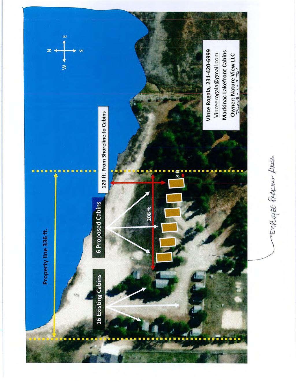
19 CHEBOYGAN COUNTY COMMUNITY DEVELOPMENT DEPARTMENT CHEBOYGAN COUNTY BUILDING 870 S. MAIN STREET, PO BOX 70 CHEBOYGAN, MI PHONE: (231) FAX: (231) STAFF REPORT Item: Nature View LLC. Special Use Permit for additional cabins to existing cabin colony Date: November 6, 2015 Prepared by: Scott McNeil Expected Meeting Date: September 16, 2015 GENERAL INFORMATION Applicant: Nature View LLC Contact person: Vince Rogala Phone: Requested Action: Approve a special use permit to allow construction of six (6) new cabins (20 feet wide 38 ft deep each) to an existing cabin colony. BACKGROUND INFORMATION The current zoning of the subject property is Lake and Stream Protection District (P-LS) within 500 feet of the designated high water mark of Lake Huron, and Agriculture and Forestry Management District (M-AF) beyond 500 feet from the high water mark. The subject site contains approximately 11.5 acres and 355 lineal feet of frontage on Lake Huron. The existing ca The applicant is seeking approval of a special use permit to construct six (6) new cabins at an existing cabin colony with 17 cabins currently on the site. Each new cabin is proposed to be 20 ft. x 38 ft. The new cabins are proposed to be placed where camp sites currently exist. The site also contains an 8 unit motel with a managers residence. The motel is located in the M-AF zoning district and is a nonconforming use. Public Utilities The property is served by existing sewer facilities, water, and electric utilities. Current Zoning The current zoning is Lake and Stream Protection District (P-LS) within 500 feet of the designated high water mark of Lake Huron, and Agriculture and forestry Management District (M-AF) beyond 500 feet from the high water mark.
20 Surrounding Land Uses Surrounding land use to the south is forestland. To the west is residential at the north and commercial at the south. To the east is vacant. Lake Huron lies to the north. Environmentally Sensitive Areas: (steep slopes, wetlands, woodlands, stream corridor, floodplain) The subject property is located on Lake Huron. No other sensitive areas have been identified. Historic buildings/features There are no known historic buildings or features on this, or immediately-surrounding properties. Traffic implications The applicant is proposing to construct six (6) additional cabins at an existing cabin colony in a location where 5 campsites currently exist. No change to traffic conditions is anticipated as a result. Parking: There are no parking requirements for cabin colonies under section One parking space is provided for users at each new cabin. The applicant indicates that there are 4 employees. Section requires 1 parking space per 2 employees. An employee parking is provided on the first detail drawing large enough for 2 parking spaces. The Planning Commission will need to make an adequate parking determination per section Access and street design: (secondary access, pedestrian access, sidewalks, residential buffer, ROW width, access to adjacent properties) Ingress and egress is provided by a roadway to the cabin colony from US-23. Signs: There are no changes to the signage being proposed. Fence/Hedge/Buffer: There are no changes in fencing being proposed. Lighting: No new lighting is proposed. Stormwater management: The applicant proposed drainage swales between each new cabin. No other changes to stormwater managements is proposed. A permit under the Cheboygan County Soil Sedimentation and Stormwater Control Ordinance will be required. Review or permits received from other government entities: Permits from the Department of Building Safety will be required A permit under the Cheboygan County Soil Sedimentation and Stormwater Control Ordinance will be required. Review by the Health Department is recommended.
21 CHEBOYGAN COUNTY PLANNING COMMISSION SPECIAL USE PERMIT REQUEST Wednesday, November 18, :00 PM Applicant Nature View LLC/Vince Rogala PO Box 658 Mackinaw City, MI Owner Same Parcel US-23 Highway Mackinaw Township GENERAL FINDINGS 1. The property is located in both the Lake and Stream Protection District (P-LS, within 500 of the lake) and the Agriculture and Forestry Management (M-AF) district elsewhere. 2. The applicant is seeking a special use permit to construct 6 additional cabins at an existing cabin colony. 3. The cabins are proposed to be located in a portion of the campground zoned P-LS. 4. Cabin colony is a use which requires a special use permit in the P-LS zoning district per section The applicant requires waiver of the topographic survey requirement 6. The applicant requires a waiver of the site plan minimum scale requirement FINDINGS OF FACT UNDER SECTION 18.7 OF THE ZONING ORDINANCE The Planning Commission makes the following findings of fact as required by section 18.7 of the Zoning Ordinance for each of the following standards listed in that section: a. The property subject to the application is located in a zoning district in which the proposed special land use is allowed. 1. Property within 500-feet of shore is located in the P-LS district which allows cabin colony as a use by special land use permit per section The applicant is seeking a special use permit to construct six (6) additional cabins at an existing cabin colony. (see exhibit 3and 4) Standard has been met. Or, Standard has not been met. b. The proposed special land use will not involve uses, activities, processes, materials, or equipment that will create a substantially negative impact on the natural resources of the County or the natural environment as a whole. 1. The applicant is seeking a special use permit to construct six (6) additional cabins at an existing cabin colony. (see exhibit 3and 4) 2. The use would not involve uses, activities, processes, materials, or equipment that would create a substantially negative impact on the County s natural resources or natural environment. This use would be compatible with the surrounding land uses Standard has been met. Or, Standard has not been met.
22 c. The proposed special land use will not involve uses, activities, processes, materials, or equipment, or hours of operation that will create a substantially negative impact on other conforming properties in the area by reason of traffic, noise, smoke, fumes, glare, odors, or the accumulation of scrap material that can be seen from any public or private highway or seen from any adjoining land owned by another person. 1. The applicant is seeking a special use permit to construct six (6) additional cabins at an existing cabin colony. (see exhibit 3and 4) 2. The proposed use would not involve equipment or processes which would generate noise or traffic which is incompatible with the surrounding land uses. No smoke, glare, fumes, or odors would be produced Standard has been met. Or, Standard has not been met. d. The proposed special land use will be designed, constructed, operated, and maintained so as not to diminish the opportunity for surrounding properties to be used and developed as zoned. 1. The applicant is seeking a special use permit to construct six (6) additional cabins at an existing cabin colony. (see exhibit 3 and 4) 2. The proposed use will not diminish the opportunities for surrounding properties to develop as zoned Standard has been met. Or, Standard has not been met. e. The proposed special land use will not place demands on fire, police, or other public resources in excess of current capacity nor increase hazards from fire or other dangers to the subject property or adjacent properties. 1. The applicant is seeking a special use permit to construct six (6) additional cabins at an existing cabin colony. (see exhibit 3 and 4) 2. The use and would not place additional demands on police or other public resources in excess of current capacity Standard has been met. Or, Standard has not been met. f. The proposed special land use shall not increase traffic hazards or cause congestion on the public or private highways and streets of the area in excess of current capacity. Adequate access to the site shall be furnished either by existing roads and highways or proposed roads and highways. Minor residential streets shall not be used to serve as access to uses having larger area-wide patronage. Signs, buildings, plantings, or other elements of the proposed project shall not interfere with driver visibility or safe vehicle operation. Entrance drives to the use and to off-street parking areas shall be no less than 25 feet from a street intersection (measured from the road right-of-way) or from the boundary of a different zoning district. 1. Access to the site is provided by a driveway from US-23 Highway.(see exhibit 4) Standard has been met. Or, Standard has not been met.
23 g. The proposed special land use will be adequately served by water and sewer facilities, and refuse collection and disposal services. 1. The site is adequately served by on-site water and sewer facilities as well as refuse collection and disposal.(see exhibit 3 and 4) Standard has been met. Or, Standard has not been met. h. The proposed special land use will comply with all specific standards required under this Ordinance applicable to it. 1. The special land use will comply with all relevant standards required under the ordinance. (see exhibit 3 and 4) Standard has been met. Or, Standard has not been met. SPECIFIC FINDINGS OF FACT UNDER SECTION OF THE ZONING ORDINANCE The Planning Commission makes the following findings of fact as required by section of the Zoning Ordinance for each of the following standards listed in that section: a. The site plan shall be designed so that there is a limited amount of change in the overall natural contours of the site and shall minimize reshaping in favor of designing the project to respect existing features of the site in relation to topography, the size and type of the lot, the character of adjoining property and the type and size of buildings. The site shall be developed so as not to impede the normal and orderly development or improvement of surrounding property for uses permitted in this Ordinance. 1. The applicant is seeking a special use permit to construct six (6) additional cabins at an existing cabin colony. (see exhibit 3and 4) 2. There will be no change in natural contours of the site and the proposed structure addition will not impede the normal and orderly development or improvement of surrounding property Standard has been met. Or, Standard has not been met. b. The landscape shall be preserved in its natural state, insofar as practical, by minimizing tree and soil removal, and by topographic modifications which result in smooth natural appearing slopes as opposed to abrupt changes in grade between the project and adjacent areas. 1. The applicant is seeking a special use permit to construct six (6) additional cabins at an existing cabin colony. (see exhibit 3and 4) 2. There will no change in slope or grade between the campground property and adjacent properties. The property s natural state relative to adjacent properties would be preserved Standard has been met. Or, Standard has not been met.
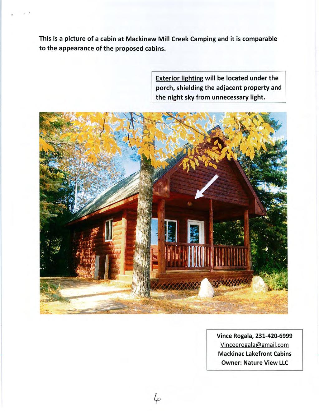
24 c. Special attention shall be given to proper site drainage so that removal of storm waters will not adversely affect neighboring properties. 1. The applicant is seeking a special use permit to construct six (6) additional cabins at an existing cabin colony. (see exhibit 3 and 4) 2. Stormwater drainage would not be diverted to neighboring properties. (see exhibit 3and 5) Standard has been met. Or, Standard has not been met. d. The site plan shall provide reasonable, visual and sound privacy for all dwelling units located therein. Fences, walls, barriers and landscaping shall be used, as appropriate, for the protection and enhancement of property and for the privacy of its occupants. 1. Not applicable. No dwellings are on the site. e. All buildings or groups of buildings should be so arranged as to permit emergency vehicle access by some practical means. 1. The site plan provides full access by emergency vehicles to all structures and campsites.(see exhibit 4) Standard has been met. Or, Standard has not been met. f. Every structure or dwelling unit shall have access to a public street, walkway or other area dedicated to common use. 1. Access to the public street would be maintained by the main driveway to US-23 Highway.(see exhibit 4) Standard has been met. Or, Standard has not been met. g. For subdivision plats and subdivision condominiums, there shall be a pedestrian circulation system as approved by the Planning Commission. 1. Not applicable. No subdivision plats or subdivision condominiums are proposed. h. Exterior lighting shall be arranged as follows: a. It is deflected away from adjacent properties, b. It does not impede the vision of traffic along adjacent streets and c. It does not unnecessarily illuminate night skies. 1. No new lighting is proposed. (see exhibit 3 and 4) Standard has been met. Or, Standard has not been met.
25 i. The arrangement of public or common ways for vehicular and pedestrian circulation shall respect the pattern of existing or planned streets and pedestrian or bicycle pathways in the area. Streets and drives which are part of an existing or planned street pattern which serves adjacent development shall be of a width appropriate to the traffic volume they will carry and shall have a dedicated right-of-way equal to that specified in the Master Plan. 1. Vehicle traffic would continue to use the driveway/private road system and established circulation pattern. Pedestrians and bicyclists also use the internal private road system. (see exhibit 3 and 4) Standard has been met. Or, Standard has not been met. j. Site plans shall conform to all applicable requirements of state and federal statutes and the Cheboygan County Master Plan, and approval may be conditioned on the applicant receiving necessary state and federal permits. 1. The proposed use conforms with the Cheboygan County Master Plan goals, and meets the provisions of the Zoning Ordinance as an allowable use through the special use permit process. (see exhibit 3 and 4) Standard has been met. Or, Standard has not been met. DECISION TIME PERIOD FOR JUDICIAL REVIEW State law provides that a person having an interest affected by the zoning ordinance may appeal a decision of the Planning Commission to the Circuit Court. Pursuant to MCR any appeal must be filed within twenty-one (21) days after this Decision and Order is adopted by the Planning Commission. DATE DECISION AND ORDER ADOPTED Wednesday, November 18, 2015 Patty Croft, Chairperson Charles Freese, Secretary
26
27
28
29
30

31
32
33
34
35 CHEBOYGAN COUNTY COMMUNITY DEVELOPMENT DEPARTMENT CHEBOYGAN COUNTY BUILDING 870 S. MAIN STREET, PO BOX 70 CHEBOYGAN, MI PHONE: (231) FAX: (231) To: Cheboygan County Planning Commission From: Scott McNeil Re: STAFF REPORT relative to conditional rezoning application by Lawrence Ginop Date: November 9, 2015 Introduction The owner of the subject properties has requested a conditional rezoning under Section 4065 of the Michigan Zoning Enabling Act, MCL (P.A. 110 of 2006). The subject properties are currently in the Agriculture and Forestry Management (M-AF) and Lake and Stream Protection (P-LS) zoning districts. The applicant requests a conditional rezoning to Commercial Development (D-CM) limiting the uses allowed to the following; Equipment and farm machinery sales, repair, rental and washing per section Indoor Storage per section Indoor storage in a use which is allowed with a special use permit in the M-AF zoning district with additional conditions provided in Section of the zoning ordinance. Indoor storage is not an allowed use in the P- LS zoning district. Equipment and farm machinery sales, repair, rental and washing is not allowed use in M-AF or P-LS zoning districts. Equipment and farm machinery sales, repair, rental and washing use requires site plan review approval by the Planning Commission under Article 20 of the Cheboygan County Zoning Ordinance #200 and Indoor Storage use requires a special use permit approval by the Planning Commission under Article 18 of the zoning ordinance should the conditional rezoning application be approved. Also, included with this report is the standard rezoning document with draft findings of fact and draft finding to the rezoning factors.

36 Figure 1 Subject parcels and existing zoning Brown = Agriculture and Forestry Management (M-AF) Blue = Lake and Stream Protection (P-LS) Figure 1 shows the parcels which is are desired to be conditionally rezoned outlined in yellow and the zoning of the subject property and the surrounding area. General Facts 1. Subject Parcels The subject area includes three parcels, and a portion of two others. The area requested to be conditionally rezoned is 14.3 acres and is currently zoned M-AF and P-LS. The subject area contains an existing machinery sales and service business, two (2) single family dwellings and a billboard structure. 2. Site Conditions The site is relatively flat. The site is comprised entirely of upland. The property currently has two residential structures, an existing bill board structure and existing farm equipment sales and service business. The parcels have access from West M-68 Highway. 3. Neighboring Parcels Existing land uses on neighboring parcels lying to north, west and south are mostly agriculture. Neighboring parcels to the east and south are improved with single family dwellings with most of the land is zoned M-AF. Neighboring parcels include on residential use parcel of.9 acres. Others range in land area from 410 acres to 130 acres. There is a seasonal farm market located on one of neighboring parcels on the south side of M-68.
37 4. Comparisons in the zoning setback and area requirements M-AF (existing) P-LS (existing) D-CM (proposed) Minimum Dwelling Floor Area Site plan Minimum Dwelling Width No minimum 24 Site plan Minimum Lot Area 1 acre 15,000 S.F. Site plan Minimum Lot Width Site plan Minimum Front Setback (water front) 25 Minimum Side Setback Minimum Rear Setback Maximum Structure Height Uses allowed in the existing M-AF zoning district SECTION 9.2. PERMITTED USES Single and two family homes Farm dwellings, barns, stables, silos, housing for farm labor, and accessory buildings, structures and uses customarily incidental to any of the foregoing permitted uses Agricultural, horticultural, dairy farming, cattle raising, poultry raising, livestock raising, forestry and other similar enterprises excluding however, rendering plants, commercial fertilizer production, garbage feeding or disposal activities Greenhouses and nurseries Markets for the sale of products grown or produced upon the premises together with incidental products related thereto not grown or produced upon the premises but which are an unsubstantial part of said business Home occupations as defined in this ordinance Essential services Cemeteries Private aircraft landing strips Temporary mobile homes and travel trailers maintained in sound running condition with a current vehicle license. (See SECTION 17.7) Tree farms, forest production and forest harvesting operations including portable sawmills, log storage yards and related activities Hunting grounds, fishing sites and wildlife preserves Private hunting and fishing cabins. (Rev. 04/28/00, Amendment #14) Agricultural Building, Private Storage / Workshop Building, and Agricultural / Private Storage / Workshop Building (Rev. 04/12/07, Amendment #67) SECTION 9.3. USES REQUIRING SPECIAL LAND USE PERMITS See ARTICLE 17, SUPPLEMENTAL REGULATIONS for standards and conditions for special uses and ARTICLE 18, SPECIAL LAND USE (SLU) PERMIT PROCEDURES AND STANDARDS for instructions on applying for permits Automobile repair and service and gasoline stations Churches and parish houses, schools and educational institutions and other municipal buildings, structures and uses Community buildings, public parks and recreational areas, playgrounds and campgrounds Entertainment and eating establishments Commercial Hunting and fishing cabins. (Rev. 04/28/00, Amendment #14) Golf courses, country clubs and sportsmen s associations or clubs.
38 Grocery and party stores Resorts, resort hotels, recreation farms, vacation lodges, motor inns, motels and other tourist lodging facilities Slaughter houses and meat packing plants Travel trailer courts, tenting areas and general camping grounds Public airports and landing fields, with appurtenant facilities Non-essential public utility and service buildings Nursing or convalescent homes Animal feedlots or piggeries Earth removal, quarrying, gravel processing, mining and related mineral extraction businesses Kennels, pet shops and veterinary hospitals Junk yards, salvage yards, and waste disposal sites. (Rev. 04/26/08, Amendment #75) Commercial composting (Rev. 04/28/00, Amendment #14) Contractor s Yards, provided all of the following requirements are met: (Rev. 12/24/03, Amendment #26) Public and private wind generation and anemometer towers. (Rev. 06/17/04, Amendment #31) Uses which are not expressly authorized in any zoning district, either by right or by special use permit, or uses which have not been previously authorized by the Planning Commission pursuant to this subsection or corresponding subsections in other zoning districts may be allowed in this zoning district by special use permit if the Planning Commission determines that the proposed use is of the same general character as the other uses allowed in this zoning district, either by right or by special use permit, and the proposed use is in compliance with the applicable requirements of the Cheboygan County Comprehensive Plan for this zoning district. 6. Uses allowed in the existing P-LS zoning district SECTION PERMITTED USES Single family dwellings Gardening, not to include the raising of animals except dogs and/or cats as household pets. Raising, stabling or sheltering or other animals, unless authorized by a Special Land Use Permit, shall be a violation of this ordinance Home occupations as defined in Section Private storage buildings, subject to the requirements of Section SECTION USES REQUIRING SPECIAL LAND USE PERMITS Campgrounds, camps and clubs for recreational use Cabin colonies Retail stores and shops Boat liveries, marinas and launching ramps Golf courses, driving ranges and country clubs Motels and hotels Duplexes, multi-family and apartment buildings Schools, libraries, churches and municipal structures Housing of any animals other than pet dogs and/or cats Use of any parcel of waterfront property as a common use area for access to the water by one (1) or more non-waterfront single family dwelling(s) Public access sites Restaurant/Bar Bed & Breakfasts


39 7. Review of Master Plans When evaluating this property for a possible conditional rezoning it should be evaluated based on several factors which include its compatibility with surrounding land uses and conformance with the land use goals established in the County s Master Plan. Tuscarora Township also chooses to do planning at a more local level. The County s Plan recognizes the importance of local level planning and recommends referring to the Tuscarora Township Plan when making decisions on land use and zoning changes within the township. This report will highlight how this property is categorized by each plan. The future land use map in the Cheboygan County Master Plan and the Tuscarora Township Master Plan determines the recommended land uses in Tuscarora Township and throughout the county respectively. These plans are intended to be a guide for future zoning ordinance amendments, which include and zoning map amendments. 2 Cheboygan County Master Plan Future Land Use Map. Figure The map in figure 2 shows the portion of the Cheboygan County Master Plan Future Land Use Map for the subject area to be in the Rural Commercial Node category which is described in the County Comprehensive Plan as follows: Rural Commercial Nodes Rural Commercial Node includes land, often at road intersections, which serve as nodes for the surrounding rural community. These areas have a mix of small-scale mixed uses. There would be usually no more than a few of these uses at any intersection due to traffic safety. Larger clustering of such commercial uses would be more appropriate in one of the other Commercial and Village Center future land use areas. Rural Commercial Nodes each have their own unique character and any rezoning must take into consideration the existing uses and uses that are compatible with the existing uses. Although these are commercial areas, they are not necessarily in need of rezoning to the Commercial


40 zoning district. It is more likely that a new and unique zoning district or overlay zoning may be more appropriate. The following uses may be appropriate for some Rural Commercial Nodes: assembly halls, institutional uses such as fire stations, township halls, recycling centers, schools, community centers, small scale commercial uses such as retail, restaurants, and bars. Alverno is an example of a Rural commercial node. The parcels subject to this conditional rezoning request are located in Tuscarora Township. Tuscarora Township has adopted a Master Plan. The Cheboygan County Master Plan recommends that Tuscarora s adopted Master Plan be utilized for land use planning and decision making as follows: Township Level Land Use Planning In Michigan, Townships have the authority to conduct planning and zoning activities. In Cheboygan County, Burt Township has enacted its own Township-level master plan and zoning ordinance. Because Burt Township has acted, their zoning will take priority and the County has no zoning jurisdiction there. The situation in Tuscarora Township is somewhat different. While Tuscarora Township has formed a Township Planning Commission and adopted a township-level master plan, Tuscarora has not adopted its own zoning ordinance. County zoning is, therefore, still in effect for Tuscarora Township. According to Michigan statute, zoning must be based on a plan in order to be legally valid. Because Tuscarora Township has undertaken its own master plan, it is recommended that the Tuscarora Township master plan be utilized by Cheboygan County for developing land use and zoning recommendations for that community. The most recently adopted Township future land use map should take the place of more general recommendations developed for the County as a whole. As additional Townships become active in land use and zoning matters, the County should continue to incorporate Township-level land use recommendations into the County planning process. Figure 3 Tuscarora Township Master Plan Future Land Use Map of the subject area.
41 The map in figure 3 shows the portion of the Tuscarora Township Master Plan Future Land Use Map for the subject area to be in the Agricultural Forestry category which is described in the Tuscarora Township Master Plan as follows: This category is intended to preserve the rural character of the western one-third of the Township. A total 4,844 acres (18%) are devoted to this classification. Farming and related agricultural activities and rural housing are the principal uses. Central water and sanitary sewer facilities are not currently available and are not intended to be available during the planning period. The Agricultural/Forestry area is designed to conserve, stabilize, enhance, and develop farming and related natural resource based activities; to minimize conflicting uses of parcels, lots, buildings, and structures detrimental to, or incompatible with these activities; and to prohibit uses of parcels, lots, buildings, and structures which require streets, drainage, and other public facilities and services of a different type and quantity than those that currently exist. The district, in preserving area for agricultural use, is also designed to prevent proliferation of residential subdivision and urban sprawl. Agricultural properties may be used for general and specialized farming, including the raising or growing of crops, livestock, poultry, bees, and other farm animals and product. Buildings or structures may be located which are used for the day-to-day operation of such activities. Any lot that is kept as idle cropland should be managed to prevent soil erosion by wind or water and should be free of excessive weeds and shrubs. Single-family homes that are compatible with the agricultural use and rural character of the district are encouraged. Setting a maximum lot area of one or two acres for each residential unit would help preserve the majority of land in the agricultural area for farm and forest use, and should be considered. Clustering of residential units is another recommended technique to preserve farmland and open space. Within this future land use category, limited use outdoor recreation/event facilities may be compatible when located on parcels 40 acres in size or greater depending on the specific use and with site specific conditions required to address potential issues such as site access, traffic, noise, lights, etc. and provide safeguards to protect the neighboring property owners. Allowing for such a use could take the form of a property owner initiated conditional rezoning; a Planned Unit Development; or a Special Land Use if allowed for in the Zoning District. The pursuit of this type of use should be explored with the Cheboygan County Department of Planning and Zoning (in coordination with Tuscarora Township) in consideration of the Cheboygan County Zoning Ordinance. 8. Summary The Cheboygan County Master Plan provides for consideration of land use planning at the township level states in part as follows; Because Tuscarora Township has undertaken its own master plan, it is recommended that the Tuscarora Township master plan be utilized by Cheboygan County for developing land use and zoning recommendations for that community. The Tuscarora Township Master Plan and future land use map provide for an Agricultural/Forestry future land category for the subject parcels.
42 . The Cheboygan County Master Plan Future Land Use map indicates the subject area as Rural Commercial Node. The subject property is located on a state highway (W. M-68) with an existing machinery sales and service business Many of the surrounding properties are residential or agriculture in use. Many of these parcels are vacant. There is a seasonal farm market on a neighboring parcel located on the south side of M-68. This proposed conditional rezoning appears inconsistent with most surrounding uses and is in consistent with the Tuscarora Township Master Plan Future Land Use Map.
43 DRAFT CHEBOYGAN COUNTY PLANNING COMMISSION Lawrence Ginop Conditional Rezoning Applicant: Lawrence Ginop Kings Point Road Alanson, MI Owners: Lawrence Ginop Trust and Ginop Sales Inc Kings Point Road Alanson, MI Parcel: Hearing Date: Section 7, Tuscarora Township Parcel Nos , , , part of and part of Wednesday November 18, 2015 at 7:00 p.m. PROPERTY DESCRIPTION The property of Owners is described more fully as: Situated in the Township of Tuscarora, County of Cheboygan and State of Michigan. Part of parcel # THE SLY FT. OF PARCEL DESC AS: PT OF NE1/4, SEC 7, T35N, R3W, DESC AS: COM AT E1/4 COR OF SEC 7, T35N,R3W; TH N 84D 34M 13S W ALG E & W 1/4 LI FT TO POB; TH N 84D 34M 13S W; CONT TH FT; TH N 3D 00M 20S E FT TO CAP; TH N 82D 04M 40S W 31.74FT TO CAP ON E 1/8 LI; TH N 1D 28M 22S E ALG SD 1/8 LI FT TO N 1/8 LI; TH S 84D 30M 21S E ALG SD 1/8 LI FT TO CAP; TH S 1D 28M 08S W FT TO CAP; TH N 84D 15M 09S W 85.32FT TO CAP; TH S 1D 28M 08S W FT TO POB. Parcel # COM AT E 1/4 COR OF SEC 7, T35N,R3W; TH N 84D 34M 13S W ALG E & W 1/4 LI; TH N 84D 34M 13S W FT TO POB; TH N 84D 34M 13S W FT; TH N 3D 00M 20S E FT TO CAP; TH S 82D 04M 40S E FT TO CAP; TH S 3D 00M 20S W FT TO POB. 1
44 Parcel # PT OF NE1/4, SEC 7, T35N,R3W, DESC AS: COM AT N1/4 COR OF SEC 7, T35N,R3W; TH S 1D 29M 20S W ALG N - S 1/4 LI FT TO N 1/8 LI; TH S 84D 30M 20S E ALG SD 1/8 LI FT TO 1/2" BAR; TH S 43D 22M 53S E 63.33FT TO 1/2" BAR; TH S 1D 34M 16S W FT TO 1/2" BAR TO POB; TH S 47D 16M 42S E FT; TH S 8D 09M 07S E FT; TH N 82D 04M 40S W FT; TH S 3D 00M 20S W FT TO NLY ROW LI OF HWY M-68; TH N 84D 37M 00S W ALG SD ROW LI FT; TH N 1D 29M 20S E FT TO 1/2" BAR; TH S 84D 34M 13S E FT TO 1/2" BAR; TH N 5D 25M 47S E FT TO A 1/2" BAR; TH S 84D 34M 13S E FT TO 1/2" BAR; TH N 5D 25M 47S E FT TO 1/2" BAR; TH N 61D 40M 20S E FT TO 1/2" BAR & POB. Parcel # COM AT SW COR OF NE1/4, SEC 7, T35N,R3W; TH N 20RDS; TH E 16RDS; TH S 20RDS; TH W 16RDS TO POB. Part of parcel # THE SLY FT OF PROPERTY DESC AS: PT OF NE1/4, SEC 7, T35N,R3W, COM AT N 1/4 COR OF SEC 7, T35N,R3W; TH S 1D 29M 20S W ALG N & S 1/4 LI FT TO N 1/8 LI & POB; TH S 84D 30M 20S E ALG SD 1/8 LI FT TO 1/2" BAR; TH S 43D 22M 53S E 63.33FT TO 1/2" BAR; TH S 1D 34M 16S W FT TO 1/2" BAR; TH S 61D 40M 20S W FT TO 1/2" BAR; TH S 5D 25M 47S W FT TO 1/2" BAR; TH N 84D 34M 13S W FT TO 1/2" BAR; TH S 5D 25M 47S W FT TO 1/2" BAR; TH N 84D 34M 13S W FT TO 1/2" BAR; TH CONT N 84D 34M 13S W 264FT TO N & S 1/4 LI; TH N 1D 29M 20S E ALG SD 1/4 LI FT TO POB Hereinafter referred to as the Property. APPLICATION The Applicants seeks a conditional rezoning to D-CM (Commercial Development District) for the following uses: 1. Equipment and farm machinery sales, repair, rental and washing per section Indoor Storage Facilities per section No other uses are proposed for consideration or the conditional rezoning. 2
45 The Planning Commission having considered the Application, the Planning Commission having heard the statements of the Applicants, the Planning Commission having considered letters submitted by members of the public and comments by members of the public and written evidence and exhibits on the record, and the Planning Commission having reached a decision on this matter, states as follows: GENERAL FINDINGS OF FACT 1. The Planning Commission finds that the applicant proposes conditional rezoning of certain real property in the application from Agricultural and Forest Management District (M-AF) and Lake and Stream Protection District (P-LS) to Commercial Development District (D-CM) for the following uses: a. Equipment and farm machinery sales, repair, rental and washing per section b. Indoor Storage Facilities per section See exhibit The Planning Commission finds that the application is made by Lawrence Ginop. See exhibit The Planning Commission finds that the legal description of the property at issue, including the proposed property to be rezoned, is attached to the application. See exhibit The Planning Commission finds that the Cheboygan County Master Plan Future Land Use Map designates the area with the proposed rezoning as being offered as Rural Commercial Node. See exhibit 7 5. The Planning Commission finds that the Cheboygan Tuscarora Township Master Plan Future Land Use Map designates the area with the proposed rezoning as being offered as Agricultural Forestry. See exhibit 7 6. The Planning Commission finds that 7. The Planning Commission finds that 3
46 REZONING FACTORS 1. Is the proposed rezoning reasonably consistent with surrounding uses? WILL SUPPORT THE FACTOR A. The Planning Commission finds that based upon the information provided in the staff report which includes the Cheboygan County Master Plan Future Land Use Map which indicates that the property is in the Rural Commercial Node land use category. See exhibit 7 figure 2. B. The Planning Commission finds that upon review of the specific nature of the property, which includes an existing equipment and farm machinery sales and repair business, that the conditional rezoning would not create a negative impact on surrounding property. C. The Planning Commission finds WILL NOT SUPPORT THE FACTOR A. The Planning Commission finds that many of the surrounding land uses are residential and agricultural in nature. Thus, the Planning Commission finds that the proposed conditional rezoning is not reasonably consistent with surrounding uses. See exhibit 7. B. The Planning Commission finds that This standard has/has not been m et 4
47 2. Will there be an adverse physical impact on surrounding properties? WILL SUPPORT THE FACTOR A. The Planning Commission finds that there is no evidence that the proposed rezoning would result in an adverse physical impact on surrounding properties as a farm machinery sales and repair use currently exists in the area. Activities which could occur if the subject property is rezoned would not physically disturb the properties surrounding the land proposed for the conditional rezoning. See exhibit 3. B. The Planning Commission finds that, as per the adopted Cheboygan County Master Plan, the future land use categories for surrounding properties may very well better describe the desired Rural Commercial Node future land use on any given parcel, there is support in the Master Plan that this proposed conditional rezoning would allow land uses which would be compatible with surrounding properties and meet the County s land use goals. See exhibit 2. C. The Planning Commission finds that WILL NOT SUPPORT THE FACTOR A. The Planning Commission finds that there is evidence that the proposed rezoning in and of itself would result in adverse physical impact on surrounding properties as the activities which could occur in the subject area were conditionally rezoned would physically disturb the properties surrounding the land proposed for the conditional rezoning. See exhibits. B. The Planning Commission finds that most of the surrounding properties are currently agricultural or residential in use. See exhibit 7 C. The Planning Commission finds that This standard has/has not been m et. 5
48 3. Will there be an adverse effect on property values in the adjacent area? WILL SUPPORT THE FACTOR A. The Planning Commission finds that there is no evidence in the form of an appraisal or other document study which shows, that if the conditional rezoning is granted, there would be an adverse effect on property values in the area. B. The Planning Commission finds that C. The Planning Commission finds that WILL NOT SUPPORT THE FACTOR A. The Planning Commission finds that information has been submitted regarding the impact on neighboring property values and the evidence presented proves that if conditional rezoning is granted that there would be an adverse impact on property values in the area. See exhibit. B. The Planning Commission finds that This standard has/has not been m et. 4. Have there been changes in land use or other conditions in the immediate area or in the community in general which justify rezoning? WILL SUPPORT THE FACTOR A. The Planning Commission finds that seasonal farm market has been established in the area. See exhibit 7 B. The Planning Commission finds that future development along and adjacent to this area by viable business consistent with the Rural Commercial Node future land use is a viable justification for the conditional rezoning. C. The Planning Commission finds that WILL NOT SUPPORT THE FACTOR A. The Planning Commission finds that changes which have occurred in the vicinity of the property have trended towards residential and agricultural uses as opposed to commercial uses. As such, the changes that have occurred, albeit they have been slow over the past few years, do not favor the proposed conditional rezoning. B. The Planning Commission finds that there is property available for development which is currently zoned Commercial Development. See exhibit 1 This standard has/has not been m et. 6
49 5. Will rezoning create a deterrent to the improvement or development of adjacent property in accordance with existing regulations? WILL SUPPORT THE FACTOR A. The Planning Commission finds that given the size, the existing machinery sales and service use as well as surrounding properties which are not subject to the rezoning application, there is no evidence that the conditional rezoning would deter the improvement or development of adjacent property in accordance with existing regulations, much less future land use plans as proposed in Cheboygan County s future land use map. See exhibits 1, 2 and 7. B. The Planning Commission finds that WILL NOT SUPPORT THE FACTOR A. The Planning Commission finds that there is evidence that the proposed conditional rezoning would deter the improvement or development of adjacent property in accordance with existing regulations since most properties are agricultural and residential uses. See exhibits 1, 2, 7 and B. The Planning Commission finds that This standard has/has not been m et. 7
50 6. Will rezoning grant a special privilege to an individual property owner when contrasted with other property owners in the area or the general public (i.e. will rezoning result in spot zoning)? WILL SUPPORT THE FACTOR A. The Planning Commission finds that the property contains an existing machinery sales and service business. As such, the proposed conditional rezoning does not create a special privilege or result in spot zoning. See exhibit 7. B. The Planning Commission finds that Indoor storage facilities is a use which is allowed with a special use permit in the Agriculture and Forestry Management zoning district. C. The Planning Commission finds that WILL NOT SUPPORT THE FACTOR A. The Planning Commission finds that conditionally rezoning the property will result in commercial use extending into existing M-AF zoned property. The Planning Commission further finds that given the residential uses in the surrounding are that the conditional rezoning will result in the granting of a special privilege to the applicant for uses not available for development by surrounding property owners. See exhibit 2 future land use map and exhibit 6 figure 1. B. The Planning Commission finds that This standard has/has not been m et. 8
51 7. Are there substantial reasons why the property cannot be used in accordance with its present zoning classifications? WILL SUPPORT THE FACTOR A. The Planning Commission finds a unique use of a large portion of the property as Equipment and farm machinery sales and repair use which is currently a nonconforming use. B. The Planning Commission finds that given the Master Plan and future land use map, the conditional rezoning would be more in line with uses allowed under the future land use designation for the area. See exhibit 2. B. The Planning Commission finds that WILL NOT SUPPORT THE FACTOR A. The Planning Commission finds that although the property has an existing Equipment and farm machinery sales and repair use, given the other existing uses and the current surrounding land uses, the property can be used for all purposes listed under its current zoning classification. See exhibit 2 B. The Planning Commission finds that This standard has/has not been m et. 9
52 8. Is the rezoning in conflict with the planned use for the property as reflected in the master plan? WILL SUPPORT THE FACTOR A. The Planning Commission finds that the County s Master Plan depicts the future use of the property as being in the Rural Commercial Node category. See exhibit 2 future land use map and exhibit 8 figure 2. B. The Planning Commission finds that, as per the adopted Cheboygan County Master Plan, and Future Land Use Map, the future land use categories for surrounding properties may very well better describe the desired future land use on any given parcel and there is support in the Master Plan that this proposed rezoning would allow land uses which would be compatible with surrounding properties and meet the County s land use goals. See exhibit 2. C. The Planning Commission finds that WILL NOT SUPPORT THE FACTOR A. The Planning Commission finds that that the Tuscarora Township s Master Plan depicts the future use of the property as being in the Agriculture Forestry category. See exhibit 2 future land use map and exhibit 8 figure 3. B. The Planning Commission finds that the County s Master Plan provides in part as follows; Because Tuscarora Township has undertaken its own master plan, it is recommended that the Tuscarora Township master plan be utilized by Cheboygan County for developing land use and zoning recommendations for that community. C. Planning Commission further finds that the proposed conditional rezoning is in conflict with the plan use in the Tuscarora Township Master Plan. See exhibit 7. D. The Planning Commission finds that the County s Master Plan depicts the future use of the property as being in the Rural Commercial Node category which is described as follows: Rural Commercial Node includes land, often at road intersections, which serve as nodes for the surrounding rural community. These areas have a mix of small-scale mixed uses. There would be usually no more than a few of these uses at any intersection due to traffic safety. Larger clustering of such commercial uses would be more appropriate 10
53 in one of the other Commercial and Village Center future land use areas. Rural Commercial Nodes each have their own unique character and any rezoning must take into consideration the existing uses and uses that are compatible with the existing uses. Although these are commercial areas, they are not necessarily in need of rezoning to the Commercial zoning district. It is more likely that a new and unique zoning district or overlay zoning may be more appropriate. E. Planning Commission further finds that the proposed conditional rezoning is in conflict with the plan use in the Cheboygan County Master Plan. See exhibit 2. This standard has/has not been m et. 9. Is the site served by adequate public facilities or is the applicant able to provide them? WILL SUPPORT THE FACTOR A. The Planning Commission finds that the site is or will be served by adequate public and private facilities by the applicant considering the type of uses which may be permitted on the property. See exhibit 3. B. The Planning Commission finds that WILL NOT SUPPORT THE FACTOR A. The Planning Commission finds that the applicant has not sufficiently proven that that the property is or will be served by adequate public and private facilities. See exhibit 3. B. The Planning Commission finds that This standard has/has not been met. 11
54 10. Are there sites nearby already properly zoned that can be used f or the intended purposes? WILL SUPPORT THE FACTOR A. The Planning Commission finds that the applicant has indicated a use for Equipment and farm machinery sales, repair, rental and washing and there are no sites nearby which can be used for that purpose. See exhibit 1 B. The Planning Commission finds that WILL NOT SUPPORT THE FACTOR A. The Planning Commission finds that, with respect to the proposed rezoning, nearby land is available for Indoor storage facilities which is allowed with a special use permit in the Agriculture and Forestry Management district per section of the zoning ordinance. See exhibit 1 B. The Planning Commission finds that the existing Equipment and farm machinery sales and repair use may remain as a nonconforming use. This standard has/has not been met. 12
55 DECISION In considering the foregoing, it is important to recognize that the considerations are general in nature, may overlap somewhat, and that there may be other factors not listed. When pondering the above questions, the decision maker must also give due consideration to (a) the general character of the area in which the subject property is located, (b) the property itself and its attendant physical limitations and suitability to particular uses, (c) the general desire to conserve property values and, (d) the general trend and character of population development. The community should evaluate whether other local remedies are available. The decision maker should not focus on any one concern among the various factors to be taken into consideration when passing upon a rezoning request. Motion made by, supported by that based upon the general findings of fact and the rezoning factors that the applicant s request to conditional rezone the property indentified in the aforementioned property description in this document is hereby recommended to be denied/approved. Ayes: Nays: DATE DECISION AND ORDER ADOPTED November 18, 2015 Date Chair, Patty Croft Secretary, Charles Freese 13

56 MEMO CHEBOYGAN COUNTY COMMUNITY DEVELOPMENT DEPARTMENT CHEBOYGAN COUNTY BUILDING 870 S. MAIN STREET, PO BOX 70 CHEBOYGAN, MI PHONE: (231) FAX: (231) Date: November 9, 2015 To: From: Re: Planning Commissioners Steve Schnell, Community Development Director Recreation Plan In your packets are two letters of public input which were received since releasing the recreation plan for public review. The plan will have been out for public review for 30 days by the November 18 th meeting and public hearing. This is the time to gather public input on the plan prior to making a recommendation for adoption to the County Board of Commissioners. You can make your recommendation for approval for the county material only and allow the townships to make recommendations for their information (Goals, Objectives, and Action Plan). If this is ready for your recommendation for approval, here is a suggested motion: Recommend to the County Board of Commissioners to approve Cheboygan County s Recreation Plan and the County s Goals, Objectives, and County Action Plan with the understanding that the Township-specific information is the product of those respective townships. The next steps are for the Board of Commissioners to review the plan and act on whether to adopt the plan for the county. The townships are holding their own public hearings and making their own resolutions for adoption, probably with similar language that adopts the general elements and then only their portions of the action items. If any township does not adopt the plan in the required timeframe that data will simply be removed from the plan upon final submittal to the DNR.
57
58
59
60 NOTICE OF PUBLIC REVIEW DRAFT CHEBOYGAN COUNTY RECREATION PLAN TO ALL INTERESTED AGENCIES, GROUPS AND PERSONS: On October 7, 2015, the Cheboygan County Planning Commission reviewed the Draft Cheboygan County Recreation Plan. During the meeting it was indicated that the plan should be distributed to the public for public review for no less than 30 days. It is available at the County s website at and at the Cheboygan Public Library, Mackinaw City Public Library, Indian River Public Library, and the Wolverine Public Library. Comments on the plan may be directed in writing or via phone to the Community Development Director, Steve Schnell, at or via at steve@cheboygancounty.net. A Public Hearing will be held to listen to public input. The hearing will be held on Wednesday, November 18 th, at 7:00 pm. The hearing will be held at a regular meeting of the Cheboygan County Planning Commission at the Cheboygan County Building, Commissioners Room, 870 South Main Street, Cheboygan, Michigan.
61 CHEBOYGAN COUNTY RECREATION PLAN Including specific plans for the following townships within Cheboygan County: Aloha Township Beaugrand Township Benton Township Grant Township Inverness Township Mackinaw Township PLANNING COMMISSION Patty Croft, Chairperson Harold Borowicz, Vice Chairperson Charles Freese, Secretary Stuart Bartlett Stephen Churchill John Jazdzyk Michael Kavanaugh Sharon Lyon Charles Ostwald Adopted DRAFT latest revision August 29,
62 Table of Contents Contents Chapter 1 Intro to Recreation Plan and the Planning Process... 4 Chapter 2 Benefits of Recreation Activity for a Community... 5 Chapter 3 Cheboygan County s and Townships Administrative Structure... 6 School District Involvement... 7 Relationship with other public agencies and private organizations... 7 Volunteer Involvement... 8 Chapter 5 Recreation Vision - Goals and Objectives Chapter 6 Action Programs Cheboygan County Action Program Cheboygan s County s Action program General Basis for Action Program Aloha Township Action Program Beaugrand Township Action Program Benton Township Action Program Grant Township Action Program Inverness Township Action Program Mackinaw Township Action Program Chapter 7 Existing Recreational Assets of Cheboygan County Parks & Trails Trails Trail Towns WATER TRAILS MOTORIZED TRAILS Inventory of Recreation Facilities US 23 Heritage Route Inventory of Trail Organizations Serving Cheboygan County DRAFT latest revision August 29,
63 Recreational Opportunities Outside of Cheboygan County The following is an inventory of Recreational Assets within Cheboygan County: Chapter 8 Recreation Planning Process Chapter 9 Public Notices Chapter 10 Budgets Chapter 11 Grant History for Cheboygan County Chapter 12 Description of the Public Input Process Notice of the Availability of the Draft Plan for Public Review and Comment Notice for the Public Meeting held after the One Month Public Review Period, Before Plan s Adoption Copy of the Minutes from the Public Review Period Chapter 13 Plan Adoption Documentation Official resolution of adoption Copy of letter transmitting adopted plan to County Planning Agency Copy of letter transmitting adopted plan to Regional Planning Agency Chapter 14 Other plans within Cheboygan County related to recreation planning TABLE OF FIGURES Figure 1 - Map of Cheboygan County Recreational Assets Figure 2 - Aloha Township Figure 3 - Beaugrand Township Figure 4 - Benton Township Figure 5 - Grant Township Figure 6 - Inverness Township Figure 7 - Mackinaw Township Figure 8 - Burt Lake Trail Plan Draft Figure update to regional non-motorized transportation plan DRAFT latest revision August 29,
64 Chapter 1 Intro to Recreation Plan and the Planning Process What is a Recreation Plan and why do we have one? Recreation opportunities enhance a community s quality of life and these opportunities abound in Cheboygan County. Residents and visitors of Cheboygan County have access to many acres of public land which include over 400 miles of trails, campgrounds, hunting and fishing areas. The schools of Cheboygan County provide many organized sports and recreational activities for the students. The area is served by many recreational user groups such as sportsman s clubs, trail user groups, and natural resource observers clubs. Cheboygan County and its municipal units are just some of the many partners that make Cheboygan County a great place to recreate. This Recreation Plan is intended to guide decision makers in the future development and improvement of the variety of recreation opportunities throughout the county. Since so many opportunities naturally exist in Cheboygan County, the primary emphasis of this plan is to encourage coordination of efforts of the various entities who manage the recreational resources. These entities which need to be at the table when recreational resource planning occurs include the DNR, DEQ, Army Corps of Engineers, County, Townships, City, Villages, land conservancies, and commercial entities. What do we have? What do we want? How do we get there? The Recreation Plan includes an inventory of the existing recreational assets, sets a vision for what recreational amenities should exist in the County in the future, suggests goals to achieve that vision, and then provides a plan for how goals can be achieve. Why should people be involved? The success of the County s recreational assets in raising the quality of life for all residents depends on partnerships and efficient use of resources. As more people get involved, better decisions can be made. For more information, visit the County s website: DRAFT latest revision August 29,
65 Chapter 2 Benefits of Recreation Activity for a Community Public recreation areas such as parks and trails are deeply ingrained in the fabric of our society. They have been around since the early to middle 1800 s. Around the year 1830 there were no public parks per se. There were no public art museums or public botanical gardens. The only large open spaces that the public could utilize were cemeteries. Cemeteries were built with manicured gardens, winding roads, and beautiful views. They were popular places where many people had picnics and even held carriage races. About the same time that cemeteries became popular as public parks, more interest was also being focused on creating national parks. People were exploring places like Yosemite and Yellowstone. Artists shared their drawings of these magnificent places with the rest of the country and with it there became a shared idea of a national park system to protect these natural resources. In the later 1800 s the National Park Service was conceived and the first National Park was created in Yellowstone. Northern Michigan was the location of the second national park, Mackinac National Park on Mackinac Island. Mackinac National Park was established in 1875 and later turned over to the state in 1895, becoming Mackinac Island State Park, the first state park in Michigan. Parks and recreation areas have grown to fill a wide range of public interests and, therefore, they take many forms. They may be natural areas with no man-made features. They may also be complete paved with many structures. Municipalities have created tennis courts, basketball courts, ice rinks, skateboard parks and ball fields of all sorts as well as natural areas for simply observing nature. Communities are both social and economic entities. Parks serve both the social and economic needs of a community. Private and public places intertwine providing a mix of assets that raise the residents quality of life. Parks are public spaces that provide a means for people to exercise and socialize, improving their health. Parks are also assets for the community to gain economic health. More recently, studies have been conducted which quantify the economic benefits of parks and recreation amenities. The National Recreation and Parks Association (NRPA) as well as the Trust for Public Land (TPL) have outlined in separate reports scientific proof of the intuitive benefits of park facilities to the health of a community and its residents. Although not all benefits can be measured, some major factors can be. Property value, tourism, health, clean water, and clean air can all be measured. Public parks are an opportunity for people of all income levels to be able to enjoy free parkland and free recreational opportunities. The proximity of a home close to a park has been proven to have a higher value compared to a home away from park land. The activities that parks provide have also proven to improve the health and well-being of residents, thereby lowering health care costs. DRAFT latest revision August 29,
 Maintenance Dept.")
66 Chapter 3 Cheboygan County s and Townships Administrative Structure Cheboygan County's recreational activities are under the direct supervision of the Cheboygan County Board of Commissioners as shown in the chart below: Cheboygan County Board of Commissioners Fair Board County Administrator Waterways Commission (Advisory to Marina) Maintenance Dept. (Fairgrounds & Park Property) Marina Community Development Dept. (Recreation Planning, Capital Improvement Planning) In addition to this general recreation administrational structure, two specialized functions are handled by separate boards. The County Fair and County Fairgrounds are overseen by the Cheboygan County Fair Board, which is under the County Board of Commissioners and has County Board representation. The County Fair Grounds are used for a variety of recreational activities in addition to the annual County Fair. These include soccer, baseball and horse-shoes. There are also many organized recreational activities at the Fair Grounds including handicapped horseback riding and a community garden, initiated and maintained by area 4-H youth. The County Marina is operated by County staff. The Cheboygan County Waterways Commission provides input on operation and capital improvement objectives. The Waterways Commission is a 7-member board appointed by the County Board of Commissioners. DRAFT latest revision August 29,
67 Recreation matters are also discussed at meetings of various committees and informal forums. There is a group of three townships, the city of Cheboygan, and the county of Cheboygan that meet periodically as the Northern Cheboygan County Intermunicipality Planning Committee. This group has included some discussion of recreational goals as part of their planning activity. Also, the County Community Development Department hosts a Cheboygan County Trails Forum every 4 th Wednesday of the month to share trails-related information with various county leaders. Capital improvements planning, as required under the Planning Enabling Act (PA 33 of 2008), occurs annually under the guidance of the Community Development Department through the County Planning Commission finally being submitted to the County Board of Commissioners. This process includes parks improvements by the Fair Board as well as improvements to the County Marina. STAFF DESCRIPTION The County has staff that has many planning related duties including recreation planning. The Community Development Department staff who provide recreation planning services include the Community Development Director, Community Planner, and Department Clerk. The Director provides long-term planning services and zoning guidance. The County also supports township efforts to do trails planning. The Director coordinates and facilitates multi-jurisdictional trail planning efforts and hosts a monthly trails forum for township officials and both motorized and non-motorized trails user groups. The Community Planner provides support for the County Planning Commission and their annual Capital Improvement Planning. The County Marina has a Harbormaster and the general operations are guided by the Waterways Commission. The County Fairgrounds are maintained by Fairground employees. School District Involvement Local school districts have been included at the County level. During the County Master Planning process as well as the Recreation Planning process, the local school district leaders were invited to participate in various public input workshops. Master Plan meetings touched on recreation opportunities in the county and the meetings were held at the local schools. Focus group meetings were also held with students at the schools. Their input was very valuable in establishing the Recreation Plan s goals and objectives. Relationship with other public agencies and private organizations Cheboygan County partners with Northeast Michigan Council of Governments (NEMCOG) on many projects including the Up North Trails project. The County provides guidance and participates in the data gathering and Trail Town programming. Indian River, Topinabee, and Mackinaw City have all completed Trail Town Plans. Cheboygan values the many miles of trails within its boundaries. There are many other organizations which represent trail users of all types. These trail organizations are valuable partners in recreational asset development in Cheboygan County and are listed on page 37 in Chapter 6 Existing Recreational Assets in Cheboygan County. DRAFT latest revision August 29,
68 Volunteer Involvement Volunteers provide guidance to many efforts throughout the county. Since there is no Recreation department within the government structures at the county and township levels, they are relied upon to provide input on project plans as well as maintenance of facilities. Some townships subcontract for a maintenance person to handle restroom cleaning at public parks, but that is very limited activity. Local rail-trails on property owned by the DNR include volunteers in many aspects of trail maintenance. For summer use by bicyclists and hikers, the trails use volunteer trail captains to handle minor maintenance issues. To prepare for winter activities on these trails the DNR utilizes a club program for snowmobile trail grooming needs. These clubs have an agreement with the DNR which includes some reimbursement. The club members do brushing and trail clearing efforts in exchange. Volunteers also do some trail grooming efforts at Black Mountain Recreation Area for winter cross-country skiing activities. Aloha Township Structure Aloha Township has no staff for recreational activities. Township recreation is handled by the Township Board. For 2015, the individuals involved in recreational activities are as follows: 2015 ALOHA TOWNSHIP BOARD Chuck Maziasz, Supervisor Barb Hall, Clerk Charles Veneros, Treasurer Steve Crusoe, Trustee Scott Eno, Trustee Beaugrand Township Structure Beaugrand Township has no staff for recreational activities. Township recreation is handled by the Township Board. For 2015, the individuals involved in recreational activities are as follows: 2015 BEAUGRAND TOWNSHIP BOARD Marcia Rocheleau, Supervisor Terri Sarrault, Clerk Robin Westfall, Treasurer Ed Barr, Trustee John Wanke, Trustee Benton Township Structure Benton Township has no staff for recreational activities. Township recreation is handled by the Township Board. For 2015, the individuals involved in recreational activities are as follows: 2015 BENTON TOWNSHIP BOARD Andrew Archambo, Supervisor Maureen Engle, Clerk Ann M. Couture, Treasurer DRAFT latest revision August 29,
69 Charles Beckwith, Trustee Jayne Passeno, Trustee Grant Township Structure Grant Township has no staff for recreational activities. Township recreation is handled by the Township Board. For 2015, the individuals involved in recreational activities are as follows: 2015 GRANT TOWNSHIP BOARD Gil Archambo, Supervisor Judi Chimner, Clerk Rachael Vallance, Treasurer Kathleen Hart, Trustee Recent resignation of one trustee Inverness Township Structure Inverness Township has no staff for recreational activities. Township recreational activities are under the direct supervision of the Township Board. For 2015, the individuals involved in recreational activities are as follows: 2015 INVERNESS TOWNSHIP BOARD Ronald J. Neuman, Supervisor Jean Beethem, Clerk Kathy Spray, Treasurer Tim Borowicz, Trustee Bernard Schramm, Trustee Mackinaw Township Structure Mackinaw Township has no staff for recreational activities. Township recreation is handled by the Township Board. For 2015, the individuals involved in recreational activities are as follows: 2015 MACKINAW TOWNSHIP BOARD Donna Falor, Supervisor Jack Keck, Clerk Janice Welch, Treasurer Charles Brew, Trustee Kevin Ostwald, Trustee DRAFT latest revision August 29,
70 Chapter 5 Recreation Vision - Goals and Objectives The following are goals and objectives formed directly from input gathered from Cheboygan County stakeholders. The following is a list of Goals and Objectives for recreation activity in Cheboygan County. It is not meant to indicate a ranking of their importance. 1. Create opportunities for Cheboygan County residents and visitors to live a healthy, active lifestyle. Objectives: A. Improve existing local (township, city, etc.) parks; create parks in those communities with no nearby facilities; coordinate placement of parks. i. Support local acquisition of property and develop public access sites and road ends for boating and fishing. ii. Coordinate park planning with street layout and design to integrate city centers with park facilities and trails. iii. Locate parks near downtowns to enhance those areas where people already gather. iv. Encourage parks that allow youth to gather out of doors in a safe environment. B. Ensure the walk-ability and accessibility within the community and to the recreational opportunities in all public places. C. Support trail connectors between parks, schools and other community resources. i. Support east/west rail-trail improvements that connect the primarily north/south existing rail-trails. 2. Communicate the economic and health benefits of the recreational activities and recreational assets in Cheboygan County. Objectives: A. Create awareness of recreational opportunities through county websites and other economic development communications. B. Coordinate and communicate better the existing recreational opportunities for all citizens of all ages and abilities, especially opportunities for the County s youth and elderly. C. Communicate the quality of life benefits that results from having extensive recreational resources. D. Encourage appropriate use of our recreational resources for economic development opportunities. E. Encourage efforts to raise awareness of the boat launches, harbors, and other water trails ( blueways ) especially along the Lake Huron coast and Inland Waterway. F. Emphasize the health care benefits of a strong recreation system. G. Continue to distribute the County s recreational trails map with thorough and accurate information on the off-road vehicle opportunities and ordinances. H. Create opportunities and support rule or policy changes which allow for additional signage beneficial to trail and park users and local businesses. DRAFT latest revision August 29,
71 3. Encourage coordination of park programs and park or trail development projects within Cheboygan County including city, village, township, county, and the state of Michigan. Objectives: A. Encourage coordination of recreation facility planning with historic destinations. Lighthouses can be paddling destinations. Historic Mill Creek experienced an increase in visitors by adding recreation amenities such as a zip line, climbing wall, and adventure course and now calls itself the Historic Mill Creek Discovery Park. B. Host forums for recreation stakeholders to coordinate and cooperatively promote activities and events. C. Facilitate communication and cooperative promotion of DNR recreation facilities (state parks, trails, etc.) along with the gateway communities. D. Encourage coordination of public transit system with recreational programs to transport community members to recreational events/facilities. E. Include recreational activities information from a variety of providers on county website. F. Integrate and create better access between recreation facilities and schools, commercial areas, residential areas, libraries and other destinations. Encourage safe routes of transportation between parks and schools and centers of civic activity. G. Encourage infill development of public parkland where inholdings exist (private lands which are surrounded by public lands). H. Encourage those who control the recreational assets in the County to share access to those facilities for recreational or other public purposes. I. Support appropriate development in communities near a trail to service trails users. i. Recognize that goods and services that are good for trail users will be appealing to other tourists and residents. ii. Trail and park users should be accommodated both physically and socially within the community. iii. Allow for trailhead amenities through local ordinances and community plans. iv. Provide for adequate wayfinding and off-premise signs to and from the community and the trail or park. J. Support Trail Town objectives for communities near a trail or park. i. Provide specially-tailored economic development support (such as economic gardening or a façade program) for business providing services to trail and park users. ii. Promote a Gateway Moment which is a physical feature indicating to trail or park users that they have entered the community. iii. Create a sense of place by promoting the unique asset or attributes of that trail town or central business district. iv. Establish the right mix of services appropriate for users of the nearby park or trail. v. Promote trail-oriented events. DRAFT latest revision August 29,
72 4. Encourage trail projects for all trail users, including motorized and non-motorized uses as well as providing for accessibility. Objectives: A. Promote the use of designated trails for a variety of activities, including walking, bicycling, ORV/ATV riding, motorcycle riding, cross country skiing, and horseback riding. B. Encourage appropriate transportation system improvements which accommodate users of all abilities to improve access to trails and other recreation amenities. i. Improvements could include bike racks on transit buses, wheelchair lifts, longer crosswalk signals, safer routes to schools. DRAFT latest revision August 29,
73 Chapter 6 Action Programs ACTION PROGRAMS, CAPITAL IMPROVEMENT SCHEDULES & RATIONALES Good planning is essential to ensure that taxpayer dollars are spent appropriately. Based on the previously outlined goals and objectives, action programs have been created by the county as a whole and each township participating in this Recreation Plan. Presented here are those action programs and capital improvement programs which outline how, if funding becomes available, each entity plans to implement their recreation goals and objectives. Please note that the following action programs and accompanying rationale are presented by each partnering jurisdiction and is a reflection of only that jurisdiction s choices. Although coordinated planning is a goal of this effort, each jurisdiction determines and endorses only its own action program and rationale. Local control and responsibility of these programs is of utmost importance. Cheboygan County Action Program The County is blessed with many State owned recreational facilities and the major communities, such as the City of Cheboygan, Mackinaw City and Tuscarora Township also own and operate many recreational facilities and programs which serve the public. Cheboygan County provides opportunities for the various local government entities within its borders to work together to provide quality recreational opportunities in an efficient and effective manner. For instance, the County hosts a monthly Trails Forum for all people and local government representatives with an interest in recreation trails to share challenges, successes, events, and resources related to trails. This collaboration improves understanding amongst all trail users, both motorized and non-motorized. The County seeks to establish other linkages between all entities that provide and manage recreational opportunities within Cheboygan County. In addition, Cheboygan County works very closely with DNR staff to discuss how our existing recreational resources can be used most effectively. Periodic meetings of County and DNR staff provide opportunities to share resources and work toward shared goals. Cheboygan s County s Action program for recreation is as follows: Coordinate efforts with municipalities or other appropriating partners, to enhance existing parks and recreation offerings or implement new ones. Support the expansion of area trails in order to encourage appropriate and increased usage and appreciation of the area s natural resources. Ensure that county sponsored recreational facilities and activities are open and accessible for all members of the public, regardless of residency, age, race, handicap, etc. Create better visitor experiences at the County fairgrounds. Increase awareness of the County s unique water-based recreational resources such as the Inland Waterway, the Lake Huron shoreline, and the many inland lakes. Provide more opportunities for the general public to enjoy the Cheboygan County Fairgrounds yearround. County Marina DRAFT latest revision August 29,
74 o Upgrade facilities at the Cheboygan County Marina. Reconstruct gas dock, replace fuel tanks, provide access walk to waterfront and complete landscaping improvements. o Monitor water depth and dredge if necessary. o Consider providing additional finger piers to meet future demand. o Annually review maintenance needs. Annually the County reviews the needs of the facilities including how well the current capacity meets the demand, fluctuations in demand, depth of water, and maximum draw of visiting boats. Capital Improvements for the Marina are included in the county-wide Capital Improvement Program (CIP) and reviewed annually by the County Planning Commission and County Board of Commissioners. Harbormaster completes these reviews and continuously reviews as needed with the County Administrator and County Waterways Commission. Site furnishings and improvements to signs at Veterans Park. Support for parkland near and complimentary to the Cheboygan County Fairgrounds. Complimentary park facilities would take advantage of existing underutilized recreational assets at the fairgrounds. General Basis for Action Program There is a lot that should influence decision makers when developing recreational opportunities in Cheboygan County. The basis for taking action to create recreational opportunities is: 1. The health of the community improves when recreational opportunities are readily available for all residents. Increased health of the community also means lower health care costs, thereby improving the economy. The Michigan Recreation and Parks Association (MRPA) estimated the costs of various health issues for a township in Michigan and found that for a township of 16,025 people, obesity cost approximately $6.6 million based on estimates from the Center for Disease Control. They also estimate that enhanced access to places for physical activity led to a 25.6% increase in the number of people exercising 3+ days per week. 2. The residents of the county are aging but remaining more active later in life. The proportion of the county s residents who are between 60 and 64 years of age increased by 30.9% between 2000 and More pathways with crosswalks, harder surfaces, and recreational opportunities for our older population are needed for this growing market. 3. The age group of Cheboygan County residents between the ages of 25 and 34 decreased in size by 22.6% between 2000 and This generation chooses their place of residence based on the quality of life offered in a community. Quality of life for many of this generation is determined by the recreational and adventure opportunities offered. The recreational amenities of Cheboygan County can help attract and keep young people in Cheboygan County. 4. Cheboygan County has great pride in the beauty of its natural resources and rural character and providing appropriate accessibility to its residents and visitors. For instance, there are some valuable trout streams which must be both protected and enjoyed. The balance between use and protection is a major challenge but an important process. 5. Parks and recreation systems are a significant economic engine for any region, especially in areas that already have a strong travel and tourism economy. Cheboygan County has a stronger economy during the summer season. Parks and Recreation amenities for all seasons are needed to create more economic development in the other seasons. More DRAFT latest revision August 29,
75 year-round opportunities will also build on the quality of life attractiveness for all ages and make Cheboygan County an even more desirable year-round destination. Cheboygan County y Capital Improvement Program Year Acquisition, Development or Improvement Five-Year Action Program Develop plan for Fair Grounds upgrade to year round, multi-use recreation facility open to the general public Fairgrounds construction of restrooms and showers for recreational field users and for fairground activities 2018 Develop plan for County owned 40 acre parcel of lake frontage for multi-use recreational purposes in consultation with Mullet Township Ongoing Ongoing Seeking Support the development of multi-use trails, especially east/west connectors to existing rail/trails (both motorized and non-motorized) Reconstruct gas dock; replace fuel tanks, access walk to waterfront and landscaping improvements to County Marina. Improve and expand public access to area lakes and rivers Cost and Funding Source $10,000 Municipal, State, & Donations $200,000 Municipal, State & Donations $10,000 Municipal, State, & Donations TBD Municipal, State, & Donations TBD Municipal, State TBD Municipal, State, & Donations Cheboygan County Rationale Project Fair Grounds Basis for need The year-round increase in use of the County Fair Ground facilities necessitates the enhancement of the facilities and grounds to provide a more user friendly and handicap accessible venue. The County desires to provide more opportunities for the general public to use portions of the fairgrounds as a recreational resource all year long. 40 Acre Park Provide park amenities, programs and handicap accessibility to an area of the County where parks and recreation deficiency exists. Trails Improvement Provide for an environmentally and pedestrian safe recreation opportunity. The County wants to create opportunities through efficient use of existing resources. Linking two existing trails to create a loop exponentially increases the viability of attracting users to those trails. DRAFT latest revision August 29,
76 County Marina Improvements Access Expansion Provide for a safe and convenient service for boaters. Current gas dock and tanks are approaching their engineered lifespan. This project is essential for environmental protection as well as a critical component of the operation of the marina. Public access to the waterfront and landscaping provides access to the general public as well as a welcoming environment and improves natural resources on the property. Provide equal opportunity for recreational water usage. Aloha Township Action Program Aloha Township has good access to the area s lakes and rivers for outdoor recreational activities, but has very little township developed recreational facilities available. Aloha Township is very interested in expanding the amount and types of recreational facilities within the township to better meet the needs of its residents. Aloha Township Capital Improvement Program Five-Year Action Program Project Year Acquisition, Development or Improvement Establish Township Park on Hiawatha Drive and Landscape Purchase and install playground equipment at Township Park Construct handicap accessible restrooms, put in well, electrical and septic Fence and lights around park and construct pavilion Senior recreation area shuffle board, horseshoes, etc. Cost and Anticipated Funding Source $10,000 (Local, DNR, Private) $8,000 (Local, DNR, Private) $30,000 (Local, DNR, Private) $90,000 (Local, DNR, Private) $10,000 (Local, DNR, Private) Aloha Township Rationale Project Basis for Need 1 Addition of Township Park will enhance recreational uses in Township and allow more residents the opportunity to enjoy nature and socialization. 2 Adding playground equipment will expand the Park s facilities for children. 3 Adding restrooms will make the park more comfortable for public use for all the residents in the Township. DRAFT latest revision August 29,
77 4 The addition of fencing and lighting will add security to the park for children and senior citizens. Addition of a Pavilion will enhance the use of the Park and attract more visitors. 5 Adding senior recreations will welcome our senior population to enjoy the Township Park. Beaugrand Township Action Program Beaugrand Township has good access to the area s lakes and rivers for outdoor recreational activities, but has no township developed recreational facilities available. Beaugrand Township is interested in developing some type of recreational facilities within the township to better meet the needs of its residents. Beaugrand Township Action program is as follows: Pursue recreational activities which are not currently available within the township. Seek property to be used for a township park. This park would be preferably near the shoreline. Larger property inland would also be considered. Encourage and support the possibility of a future recreational facility. Ensure any future sponsored recreational facilities and activities by the township are open and accessible to all member of the public, regardless of age, race, handicap, etc. Beaugrand Township Capital Improvement Program Year Acquisition, Development or Improvement Cost and Anticipated Funding Source TBD Acquire land for public park, preferably waterfront or near the water. Pursue recreational opportunities which are not currently available within the township Beaugrand Township Rationale Basis for Need To be determined To be determined To have available recreational opportunities for the township residents. Public access to Lake Huron and the large amount of water front in the township would ensure that the public would be able to enjoy the natural resources available to them. Benton Township Action Program Benton Township has good access to the area s lakes and rivers for outdoor recreational activities. Benton Township has 40 acres of land that is developed into a township park. The Benton Township Park has a walking path, picnic area, bathrooms, pavilion, tennis courts, basketball court, and volleyball court.. Benton Township is interested in expanding the amount and types of recreational facilities within the township in order to better meet the needs of its residents. Benton Township s Action Program for recreation is as follows: Pursue improvements to recreational opportunities which are not currently available within the township Encourage and support the construction and maintenance of community facilities equipped to offer a wide variety of educational, recreation and social activities. DRAFT latest revision August 29,
78 Encourage community-wide craft and recreational programs, designed for all age groups, as an opportunity for seasonal, permanent residents and tourists. Support the expansion of access to the area lakes and rivers in order to encourage managed usage and appreciation of the area s natural resources. Ensure that township sponsored recreational facilities and activities are open and accessible to all member of the public, regardless of age, race, handicap, etc. Benton Township Capital Improvement Program The Capital Improvement Schedule found below describes what recreational improvement Benton Township would like to pursue of the next seven years. Possible Project # Year Project Est Cost Funding Gazebo $ 50,000 Local, DNR, Private Donations Expand Walking Path $92,000 Local, DNR, Private Donations Ball field Development $50,000 Local, DNR, Private Donations Local, Complete fence installation around Twp DNR, $20,000 Park Private Donations Improvements to public access to area lakes & Rivers for swimming, picnicking, etc. $10,000 Local, DNR, Private Donations Benton Township Rationale Project # Justification A pavilion would bring people to the park for parties or concerts. The tennis, 1 basketball and volleyball have been completed and are used just about every day. The current walking path is very popular expansion would provide the public with a 2 longer walk 3 Improving and development of ball fields will add to the number of park users. 4 Constructing a fence around the Township Park will add security to the facility. Improving the access and facilities at the lakes and rivers will ensure that the waterfront can be enjoyed by all. The township continues to make improvements to 5 public access points within the township to area lakes and rivers. Improvements continue to the road ends within Benton Township by mowing, waste removal, and beach cleaning. DRAFT latest revision August 29,
79 Grant Township Action Program Grant Township's Action Program for recreation is as follows: Promote our park system and recreational opportunities in the township. Pursue improvements to recreational opportunities which are not currently available within the township. Encourage and support the construction and maintenance of community facilities equipped to offer a wide variety of educational, recreation and social activities. Encourage community-wide craft and recreational programs, designed for all age groups, as an opportunity for seasonal, permanent residents and tourists. Support the expansion of access to Black Lake in order to encourage managed usage and appreciation of the area's natural resources. Ensure that township sponsored recreational facilities and activities are open and accessible to all members of the public, regardless of age, race, handicap, etc. Grant Township Capital Improvement Program Project # Year Project Est. Cost Possible Funding Development of Township Park/land cleaning, fill work, etc. Construct rest rooms at Township Park Construct picnic area at Township Park Purchase & install additional playground equipment at Township Park Improvements to public access to Black Lake, Black River and surrounding lakes for boating, swimming, picnicking, etc. Construct walking path at the Township Park Fence around Township Park TBD TBD TBD TBD Under Investigation Under Investigation TBD Local, DNR, Private Donations Local, DNR, Private Donations Local, DNR, Private Donations Local, DNR, Private Donations Local, DNR, Private Donations Local, DNR, Private Donations Local, DNR, Private Donations DRAFT latest revision August 29,
80 Grant Township Rationale Project # Basis for Need 1 Results of community survey show a high degree of support and interest in constructing a park within the township. 2 Adding rest room to the Township Park will make the facility much more comfortable for public use, especially those with young children. 3 Constructing a picnic area with picnic tables and grills will expand the park s facilities for all residents. 4 Adding additional playground equipment to the Township Park will expand the parks facilities for families and children. 5 Improvements to all public access to Black Lake, Black River and surrounding lakes will insure that all the public accesses will be readily available for all residents to use and enjoy. 6 Constructing a walking path at the Township Park will increase the park s recreational use for all township residents. 7 Constructing a fence around the Township Park will add security to the facility. Inverness Township Action Program As shown in Inverness Township recreation inventory, the township has access to the northwest area of Mullet Lake and access to the Cheboygan River, giving residents direct link to the Inland Waterway. Developed recreational facilities such as parks, playgrounds, ball fields, etc. are necessary and the township is interested in expanding recreational facilities within the township. Inverness Township s Action Program for recreation is as follows: Pursue improvements to recreational opportunities which are not currently available within the township. Encourage and support the construction and maintenance of community facilities equipped to offer a wide variety of educational, recreational and social activities. Encourage community-wide craft and recreational programs, designed for all age groups, as an opportunity for seasonal, permanent residents and tourists. Support the expansion of access to Mullet Lake and Cheboygan River in order to encourage managed usage and appreciation of the area s natural resources. Ensure that township-sponsored recreational facilities and activities are open and accessible to all members of the public, regardless of age, race, handicap, etc. Inverness Township Capital Improvement Program The Capital Improvement Schedule found below describes what recreational improvements Inverness Township would like to pursue over the next ten years. Project Year Project Est. Cost Possible Funding # Source(s) Construct restrooms at $50,000 Local, DNR, Private DRAFT latest revision August 29,
81 Township Park(s) Donations Fence around Township Park(s) $20,000 Local, DNR, Private Donations Purchase and install playground equipment at $10,000 Local, DNR, Private Donations Township Park(s) Paving at Township Park(s) $10,000 Local, DNR, Private Donations Improvements to public access for swimming, picnics, etc $10,000 Local, DNR, Private Donations Purchase property abutting existing township property at Polish Line Beach $75,000 Local, DNR, Private Donations Inverness Township Rationale Project # Basis for Need 1 Adding restrooms to the Township Park(s) will make the facilities much more comfortable for public use, especially for those with young children 2 Constructing a fence around the Township Park(s) will add security to those facilities 3 Adding playground equipment to the Township Park(s) will increase the number of park users 4 Paving the parking area(s) at the Township Park(s) will increase the number of park users 5 Improving access and facilities will ensure that the waterfront can be enjoyed by all 6 Providing more and better opportunities for waterfront recreation and public access to the water, our very valuable recreational resource. Mackinaw Township Action Program Approximately half of the village of Mackinaw City is in Mackinaw Township which has a variety of recreational facilities, but there are no recreational facilities available in the rural portion of the township. Mackinaw Township s Action Program for recreation is as follows: Phase #1 Ascertain availability of public access Road (or view) to Lake Huron from US 23 in Mackinaw Township Pursue improvements to recreational opportunities which are not currently available within the township. Approximately half of the village of Mackinaw City is in Mackinaw Township which has a variety of recreational facilities but there are no recreational facilities available in the rural portion of the township. The township plan lays out the procedure for determining the availability of public access areas to the Straits of Mackinaw along the US 23 corridor along the Lake Huron Bluff in order to develop a roadside view area including managed recreational usage such as nature trails, picnic area and appreciation of the area's natural resources. The US 23Lake Huron Bluff would be an ideal location for such a recreational concept we propose. DRAFT latest revision August 29,
82 Ensure that township sponsored recreational facilities and activities are open and accessible to all members of the public, regardless of age, race, handicap, etc. Phase #2 If no public access available research possible private land for purchase or gift of suitable property Mackinaw Township Capital Improvement Program Project Year Project Est. Cost Possible Funding Phase Phase Determine if available Lake Huron Public road access (includes title search). Evaluate cost of planning and developing public access right-of-way. Search for suitable land along US-23 Lake Huron Bluff to establish recreational site. If suitable site found, find funding sources for land site development. $3,500 Township, State & Private Sources $4,000 Township, State & Private Sources $5,000 Township, State & Private Sources Under Investigation Township, State & Private Sources Mackinaw Township Rationale Project Phases 1 and 2 Basis for Need The Lake Huron Bluff would be an ideal location for such a recreational concept we are proposing. The recreational area proposed will improve the public view and increase enjoyment of the natural beauty of Lake Huron South Channel, the passing ships as well as the view of Bois Blanc Island and Mackinac Island. DRAFT latest revision August 29,

83 Chapter 7 Existing Recreational Assets of Cheboygan County The following map shows generally how the various recreational assets are distributed around the county: Figure 1 - Map of Cheboygan County Recreational Assets DRAFT latest revision August 29,

84 PARKS AND CAMPGROUNDS MAPS, by Township Figure 2 - Aloha Township DRAFT latest revision August 29,

85 Figure 3 - Beaugrand Township DRAFT latest revision August 29,

86 Figure 4 - Benton Township DRAFT latest revision August 29,

87 Figure 5 - Grant Township DRAFT latest revision August 29,

88 Figure 6 - Inverness Township DRAFT latest revision August 29,

89 Figure 7 - Mackinaw Township DRAFT latest revision August 29,
90 Parks & Trails Recreational use of land is an important part of the economic health of our economy and physical health of our people. Planning for adequate long-term maintenance of this land is an important part of land use planning. Trails Trails are considered linear parks of which there are over 400 miles in Cheboygan County. These trails serve all users including those who enjoy ORV/ATV s, snowmobiles and bicycles, cross country skiing, hiking, snowshoeing, and horseback riding. Many of these linear parks are owned by the State of Michigan through the Department of Natural Resources (DNR). Recent activity in trail development include the resurfacing in 2009 of the North Central State Trail which extends from Gaylord in Otsego County through Wolverine, Indian River, Topinabee, Cheboygan, and ending in Mackinaw City along a former railroad right of way. A similar trail development, called the North Eastern State Trail, was completed in October of 2011, extends from the city of Cheboygan to the south and east through Onaway and on to Alpena. Rail trail development has been extensive in Cheboygan County. These rail trails are on property owned by the Michigan DNR and were railroad rights of way many years ago. These have been used for quite a while as snowmobile trails in the winter and were able to be used by hikers in the summer. More recently they have been improved with crushed limestone in order to be used in the summer by bicyclists. Most of these rail trails run north and south. There is a need expressed by trails organizations for east-west connectors to create looped trails. Burt Township has a trail committee which is working on one such connector. A section of the Burt Lake Trail was built along a road right of way in More sections are in the planning stages. There is a plan to eventually connect two rail trails: the North Central State Trail primarily in Cheboygan County with the North Western State Trail which is primarily in Emmet County, each being north-south trails. See Figure 8 - Burt Lake Trail Plan Draft. DRAFT latest revision August 29,

91 Figure 8 - Burt Lake Trail Plan Draft Cheboygan County, in early 2011, created maps that represent the recreational trail system in Cheboygan County. In 2009 the county passed an ordinance that allows for ORV s to travel on the side of the road. The County used these new maps to properly show the roads where this type of travel is allowed and where it isn t. These maps used information gathered and mapped by Northeast Michigan Council of Governments (NEMCOG). In late 2014 updates were made to the Regional Non-motorized Transportation Plan, produced for the 8-county region of the Northeast Michigan Council of Governments (NEMCOG). This regional plan was expiring so an update was made to this plan for the area of Cheboygan County. Public meetings were held and included the Cheboygan County Trails Forum. This is a group of township officials and various trail users who gather informally at the County building every month to share trail updates. The group consists of representatives of all user groups, both motorized and non-motorized. These meetings include township officials and are open to the public. A draft update was developed with this group s guidance which included east-west routes that connect the rail-trails which run primarily north-south. The updated plan was approved by the Cheboygan County Road Commission on November 13, DRAFT latest revision August 29,


92 The following map shows the preferred non-motorized transportation routes, which can also serve as recreational routes for bicyclists and other non-motorized users: Figure update to regional non-motorized transportation plan DRAFT latest revision August 29,
93 Trail Towns A trail town is a community which understands the importance of the local trail(s) in the economic, social, and human health benefits to their community members. Trails can have a significant impact on the local economy. A Trail Town Manual was created for the communities along the North Central State Trail in late The Manual outlined how these communities can utilize the trail to support future business and economic development opportunities. When creating a Trail Town concept for a community, it is suggested in the Manual that a community create a blueprint for future marketing efforts, capital improvement projects and community involvement strategies that take full advantage of the local trail(s). As stated in the Manual, while the goals may vary between communities, it is suggested that five components of a Trail Town effort include: Provide a gateway moment This could be a physical feature that lets the visitor arriving by trail know that they have entered the trail town. Create a sense of place Emphasize those features unique to that town that will be remembered by the trail visitor. Develop a welcoming atmosphere Make sure that the downtown is safe for trail travelers, who are usually hikers, bikers, snowmobilers, and horseback riders. Establish the right mix of services Know your market and know the needs of your trail visitors. Cyclists, for instance, will need food, drink, and ice cream on a hot day of trail use. Horses will need a place to water their animals. Promote trail-oriented events Events that are unique to the community s historic or cultural history should be emphasized to make the visit a memorable one. Return visitors is a primary goal. The Trail Town Manual for the North Central State Trail also includes specific and unique recommendations for each of the towns along the trail as to how they can improve the trail users experience. WATER TRAILS There are many miles of waterways throughout Cheboygan County both inland and along Lake Huron. A water trail is a mapped and suggested scenic route for all types of boat travel. Resources along the various water trails are currently being mapped under a Coastal Zone Management grant funded project. Resources exist for motorized boat travel, sailboats, and human powered watercraft. Inland Waterway The Inland Waterway is over 38 miles long and is Michigan s longest chain of lakes and rivers. This water trail begins in Emmet County and passes through two lock and one swing-bridge, through the Indian River and Cheboygan communities, and ending in Lake Huron. Boat launches, restaurants, museums, and campgrounds are convenient stops along the way for all travelers. Lake Huron shore Along Lake Huron s water trail are scenic lighthouses, views of Mackinac and Bois Blanc islands, and forested shores of Cheboygan County. The route ends at the Straits of Mackinac to the north and views of the Mackinac Bridge. DRAFT latest revision August 29,
94 MOTORIZED TRAILS Tomahawk Trail System This trail system is designed for motorcycles and the three loops include over 90 miles of trails. The trail system extends into neighboring Emmet and Charlevoix Counties and is managed by the Michigan Department of Natural Resources. Black Mountain Recreation Area This unique area includes the only scramble area in northern lower Michigan. This is designed for ATV s, motorcycles, and some narrower UTV s. Snowmobile Trails These trails run mostly along the rail-trails of both the North Central State Trail and North Eastern State Trail. There are over 100 miles of trails which are groomed by volunteers under an arrangement with the Michigan Department of Natural Resources. Inventory of Recreation Facilities Back in 2007, Cheboygan County completed a Recreation Plan which includes an inventory of recreation facilities in the County. All townships in the county were mailed the old recreation inventory list to update. The townships updated their portions and the county updated their public recreation facility information. Important to a recreation inventory is the accessibility evaluation of each facility. Accessibility is rated using the following numerical system. 1=none of the facilities/park areas meet accessibility guidelines 2=some of the facilities/park areas meet accessibility guidelines 3=most of the facilities/park areas meet accessibility guidelines 4=the entire park meets accessibility guidelines 5=the entire park was developed/renovated using the principals of universal design Cheboygan County owns the County Fairgrounds, the Soccer Fields, and the County Marina, which are located in the city of Cheboygan. Part of the Boy Scout Camp in Mullett Township is still owned by Cheboygan County. A description of each follows along with an accessibility assessment of each site. Boy Scout Camp The 80 acre Boy Scout Camp is located at 2863 Boy Scout Road. The camp is classified as a special use park. Part of the park was sold for $1 to Mullett Township by the County in 2010 in order to provide the township more opportunities for grant funding of improvements. The township-owned portion of the park s service area is the community with a pavilion and picnic area. The bathrooms are not handicap accessible. Accessibility evaluation is #2. Cheboygan County Marina County Marina is located at 1080 N. Huron Street, Cheboygan, and its 7.8 acres include 84 slips with gas and electrical hook-up, pump-out, laundry, showers, telephones, grocery and beverage delivery, fresh water. This is a special use park for the county and visitors. Accessibility evaluation is #5. DRAFT latest revision August 29,
95 County Fairgrounds & Soccer Fields The County Fairgrounds is a 23 acre facility located in Cheboygan. It is a community park offering restrooms and showers. The Soccer Fields are located at 780 Garfield. This 22 acre parcel is open for leagues and the general public. Accessibility evaluation is #3. Aloha Township Hall The Aloha Township Hall is located at Mann Road and M-33. It is a 0.8 acre mini-park serving the township residents. Accessibility evaluation of #4. Unimproved Lots There are two unimproved lots owned by the township. One is on Long Lake and one is on Black River Road with an accessibility evaluation of #1 for both lots. Benton Township Park Benton Township Park is a community park situated on 40 acres of land serving visitors and residents from around the township. It offers a walking path, picnic area, playground and recently completed volley ball and basketball courts. Accessibility evaluation of #5. Grant Township Hall Grant Township Hall property is 4.2 acres and offers a picnic area that is considered a mini-park serving primarily township residents. The area is handicap accessible. Accessibility evaluation of #4. Foote Road Beach Foote Road Beach is located on Mullet Lake in Inverness Township. It is a 0.6 acre community park offering a public outhouse serving beach visitors and area residents. Accessibility evaluation of #2. Polish Line Beach Polish Line Beach is a small beach area that is 0.03 acres on Mullet Lake with a service area including beach visitors, area residents and township residents. It is a neighborhood park. Accessibility evaluation of #1. Afton Softball Field Afton Softball Field is on 6 acres. It is a neighborhood park that offers one field and no restrooms. Accessibility evaluation of #1. Sturgeon River Roadside Park West Branch of the Sturgeon River Roadside Park is a small neighborhood park approximately 4 acres with a pavilion, picnic tables, benches, outhouse, swings, merry-go-round, sandbox and grills. Accessibility evaluation of #2. US 23 Heritage Route Each county along the US 23 Heritage Route s 200 mile span has its own team of volunteers which implements projects in its county with the assistance of the Northeast Michigan Council of Governments. In addition, the Cheboygan County Team participates in the US 23 Management Council which provides the overall organizational direction and structure to coordinate efforts along the route. The Cheboygan Heritage Route Team consists of representation from Chambers of Commerce, townships, city/villages, Cheboygan County, and interested citizens. The Team DRAFT latest revision August 29,
96 has developed a national award-winning tourism website ( which promotes recreational facilities in the region as well as along US 23 from Standish to Mackinaw City. There are also brochures distributed throughout the state which highlight recreational attractions in Cheboygan County. Straits of Mackinac Underwater Preserve The 148 square miles of the Straits of Mackinac Underwater Preserve host a variety of underwater attractions: not the least of which are excellent shore dives in East Moran Bay in St. lgnace Harbor. The St. Ignace Harbor serves the third oldest city in the United States. One harbor dive site is found at the northernmost point of the bay at the end of Hazelton Street. Divers can enter here and swim toward the end of the old mill slip to find discarded tools, machinery, household items, and wreckage from an unknown vessel. The Straits of Mackinac Underwater Preserve also has its share of shipwrecks. Among them is the Cedarville, which was a 588 foot self-unloading freighter that sank with a load of limestone in The Cedarville was heading west and approaching the Straits of Mackinac in a fog when it was struck by another ship. The Cedarville is in about 110 feet of water with the hull of the vessel within 35 feet of the surface. The ship's superstructure and cabins, lie at 75 feet and provide exciting exploration opportunities. Another popular dive site in this preserve is the wreck of the Sandusky. This 110-foot sailing vessel had two masts and a square stem. It sank in a gale in September 1856 and is remarkably preserved. It sits upright in 90 feet of water and is among the few shipwrecks in the Great Lakes to sport a figurehead. Divers will find a kedge anchor, pin rail, wheel and tiller. Recently, a team of divers discovered an unusual rock formation just a few hundred yards east of Mackinac Island. The formation resembles an underwater maze and is called the "Rock Maze." It offers excellent photography opportunities as well as a chance to see large schools of fish and protection from westerly winds. This site is buoyed but boaters should be cautious about entering the area because of rock formations nearby. Another site that is quickly gaining popularity is the C.H. Johnson, which can be reached from shore off Gros Cap Road west of St. Ignace. The C.H. Johnson, was a schooner that ran aground in a storm in It was carrying large sandstone blocks, which are found on the wreck site. Divers enjoy this site because it is protected from most storms and many small artifacts, such as tools, can be found. Large fish generally hide between and under large stone blocks. The C.H. Johnson is in 10 to 15 feet of water and makes an interesting dive for divers of all skill levels. Other popular dive sites include the wrecks of the William H. Barnum, in 65 feet of water and a wooden barge in 45 feet of water. These sites, and many other wrecks in this area, are served by dive charter services in the area. DRAFT latest revision August 29,
97 Visibility in this preserve ranges from 2 to 20 feet, depending upon currents that are sometimes found here. Generally, however, visibility is greater than 10 feet and divers are able to enjoy one of the finest shipwreck collections in the world comfortably. Boaters also enjoy the underwater preserve because shipwreck mooring buoys have information attached to them about the shipwreck below. This makes an exciting "water trail" where boaters can learn about our maritime heritage. Inventory of Trail Organizations Serving Cheboygan County Michigan DNR The DNR owns the rail trails and much of the land that the various trails run through. They also play a role in the management of the water resources that make up the blueways. They own almost all of the trails and recreational land in the county. They set the rules for trail use, access rights, and signage. They have a trail plan called the SCORP (State Comprehensive Outdoor Recreation Plan) which outlines the DNR s goals and objectives for outdoor recreation on their land. The DNR s SCORP outlines the supply and demand for outdoor recreation and provides an implementation plan for trails. They state that they are in partnership with the Michigan DOT and many other partners to develop a specific trails plan call Michigan Trails at the Crossroads: A Vision for Connecting Michigan. The SCORP executive summary states that the plans tout the economic, health, recreational, and transportation benefits of trail systems and the need for connectivity among existing trail segments and entities. In May of 2013, the DNR published the Michigan Comprehensive Trails Plan. This is a 5-year plan as required by PA 45 of 2010 and was completed with the guidance of various trail user groups and the Michigan Snowmobile and Trails Advisory Council (MSTAC). The plan encourages positioning Michigan as the Trails State and recognizing the many miles of trails. Top of Michigan Trails Council (TOMTC) The TOMTC is a regional (eight counties including Cheboygan) non-profit trails advocacy organization. The organization has a board of 14 members and a full time executive director. They facilitate trail development, organize events, and coordinate local volunteers in support of trail development and maintenance. There is a system of volunteers who are called trail captains who assist with trail maintenance along the North Central State Trail in Cheboygan County. Michigan Trails and Greenways Alliance Statewide organization that fosters and facilitates the creation of an interconnected statewide system of trails and greenways for environmental/cultural preservation purposes. They sponsor the Michigander bike tour that often comes through our county. They have a trailsfinder function on their website, Top of Michigan Mountain Biking Association (TOMMBA) This non-profit serves mountain biking trails in the region including Cheboygan County. They work to maintain existing trails such as the High Country Pathway, work to create new and sustainable mountain bike trails, as well as build broad support and enjoyment of the sport of mountain biking for all ages. DRAFT latest revision August 29,
98 Burt Lake Trail Committee This is a committee of the township of Burt in Cheboygan County with the purpose of creating more trails in their township which would also serve as an east/west non-motorized link between the North Central State Trail to the east and the Petoskey to Mackinaw DNR-owned trail to the west. City, Village, and Township Recreation Committees - There are some townships which have set up their own recreation committees and manage their own parks. Some have recreation plans approved by the DNR and are, therefore, capable of applying for and receiving grants from the Michigan Natural Resources Trust Fund (MNRTF). Burt Lake Yacht Club A sailing club that organizes races and promotes sailing as a sport. Cheboygan Yacht Club A member-based organization that encourages the sport of boating and science of seamanship. Events include boating along the water trail that is the Inland Waterway. Thunder Bay Trails Association - The mission of the Thunder Bay Trails Association is to promote and protect non-motorized trail systems in Alpena county and adjoining areas and reflect their recreational significance for the enjoyment, education and adventure to area citizens. They handle trail grooming efforts through a partnership with the DNR for trails in the Black Mountain area. Sporting goods retailers There are businesses in the county which sell ATV s, boats, motorcycles, and other sporting goods. At this time there is a lack of dedicated shops within the county for people interested in the silent sports such as biking, cross-country skiing, and kayaking/canoeing. Mud Brothers of the North ATV Club This non-profit club serves the ATV/UTV community to advance the general welfare and safety of ATV/UTV recreation. They host charity rides and promote community among owners of all-terrain vehicles and to gain access to trails. Great Lakes ORV Club (GLORV) There is a group of ORV users in Cheboygan and Emmet Counties that meet periodically to organize events and discuss ORV trail issues. Pigeon River Country Advisory Council - The Advisory Council is advisory and supportive. Its responsibility is to consider plans, programs and activities proposed or conducted within or affecting the Pigeon River Country, and to advise the Director of the Department of Natural Resources by written report of their views in regard to these matters. One of their primary roles is to develop public support and local cooperation for programs adopted for this unit. Cheboygan County Waterways Commission This commission of the county s oversees the county s marina in the City of Cheboygan. Cheboygan County Marina located in the City of Cheboygan, this facility has full time staff in the boating season and provides docking and boat launch facilities to boaters on the Great Lakes and the Cheboygan River. DRAFT latest revision August 29,
99 Mackinaw City Marina located in Mackinaw City, the village operates a marina that provides docking and boat launch facilities to boaters on the Great Lakes. DNR boating facilities The DNR operates many boat launch facilities and a marina in Mackinaw City. Indian River Snowmobile Grooming Club This group organizes the grooming of the snowmobile trails in Cheboygan County. Top of Michigan Outboard Racers Club (TOMORC) This group organizes an annual race of small outboard motorboats through the inland waterway. Indian River Striders This group organizes running races around Indian River and along the North Central State Trail. Municipalities with Recreation Plans The DNR provides grant funding for recreation projects and a prerequisite is that the entity applying for the grant have a DNR-approved recreation plan. The following entities within the county have such recreation plans, in addition to the County and those townships which are partners in this Recreation Plan: - Burt Township - Cheboygan, City of - Inverness Township - Mackinaw City - Mullett Township - Tuscarora Township Recreational Opportunities Outside of Cheboygan County The counties which are adjacent to Cheboygan County are Emmet, Otsego and Presque Isle. In many respects these three counties have very similar recreational opportunities as Cheboygan County; a large amount of public lands for hunting and fishing, public water access for boating, fishing, swimming, etc., and various public parks, campgrounds, playgrounds, ball fields, etc. The types of public recreational facilities that these counties have which are not available in Cheboygan County are as follows: Indoor Swimming Pool, Harbor Springs Sportsplex, Gaylord (indoor swimming pool and hockey rink) Downhill Skiing (various ski resorts in both Emmet and Otsego Counties) Although these facilities are frequently used by residents of Cheboygan County, the driving distance is quite far, especially for those living in the eastern and northern portions of the county. DRAFT latest revision August 29,
100 The following is an inventory of Recreational Assets within Cheboygan County: PARKS Aloha State Park Black Mountain Forest Rec Area Boy Scout Camp Picnic Are Burt Lake State Park Cheboygan State Park Historic Mill Creek State Park Mullet Township Park Munro Township Picnic Grounds Nine Mile Point State Roadside Park (US23) "Point Nipigon" State Roadside Park (US23) Topinabee Beach Park Topinabee Park Village of Wolverine Park Gordon Turner Park, Straits of Mackinac, Cheboygan Washington Park, Main St. and Cheboygan River, Cheboygan Kiwanis Park Playground, Mackinaw Ave., Cheboygan Veterans Memorial Park, Court St., Cheboygan Major City Park, Cleveland Ave., Cheboygan James Felix Merchant Neighborhood Park, Eastern Ave., Cheboygan Indian Pathways Park, Mackinaw City Alexander Henry Waterfront Park, Mackinaw City Sinclair Park, Mackinaw City Depeyster Park, Mackinaw City Scherf Park, Mackinaw City Wawatam Park, Mackinaw City Old School Park, Mackinaw City Arnold Line Playground Park, Mackinaw City Conkling Heritage Park, Mackinaw City McRae Nature Park, Mackinaw City Co-Operation Park, Indian River CAMPGROUNDS Aloha State Park Black Lake State Forest Campground Black Lake Trail Camp Bluffs Resort Burt Lake State Park Campground Cheboygan State Park DRAFT latest revision August 29, 2015 Dunn s Fishing Camp East Mullett Campground Elkwood Campground Gossards Pigeon Bay Campground Haackwood State Forest Campground Indian River RV Resort and Campground Mackinaw City KOA Campground Mackinaw Mill Creek Mackinaw City Campground (Valot s) Maple Bay State Forest Campground Pine Grove State Forest Campground Pigeon River Country Horse Camps Roberts Landing Stoney Creek Trail Camp Sturgeon River Campground Tee Pee Campground Twin Lakes State Forest Campground(closed as of 2011) UAW Walter & May Reuther Family Waterways Campground Weber Lake State Forest Campground Yogi Bears Jellystone Park Camp BOAT ACCESS SITES Aloha State Park Black Lake Black Lake State Forest Campground Stewarts Beach & Co. Line Rd. Black River Neuman Rd. Kuras Dr. Klieber Rd., Black River at Klieber Pond Burt Lake Plymouth Beach Rd. White Goose Rd. Lawless Lane Greenman's Point Rd. Plymouth Beach Rd. Shawnee Ave. Wahbee Ave. Ellinger Rd., King's Point Maple Bay State Forest Campground 40
101 Roberts Rd. Curve of Chippewa Beach Rd. E. Fisher Rd. King Rd. Rotter Rd. N. Hamilton Dr. & Resort Rd. Hamilton Rd. & N. Hamilton Dr. Woodmonsee Rd. Hardwood Rd. Mundt Rd. Brutus Rd. Needles Rd. Hoppie's Launch Cheboygan River Paully Rd., Cheboygan/Black Rivers McRae Rd., Cheboygan/Black Rivers Cheboygan River, Cheboygan Beebe Rd., S. Cheboygan River S. Cheboygan River, Cheboygan Cochran Lake Dr., Cochran Lake Cornwall Lake Rd., Cornwall Lake Oshmun Rd., Dog Lake Douglas Lake Near Ingleside Resort N. Wilson Rd. Bently Point Dr. Ashton Bay Rd. Young Rd. Van Rd. Douglas Lake Rd. S. Pell's Island Dr. Chippewa And Straits Hwy, Indian River Klieber Pond Shanty Rapids Rd. Twin School Rd. Klieber Rd. Koepke and W. Lancaster Lake Rd., Lancaster Lake Lake Land Rd., Long Lake Mackinaw Area Mackinaw City Freedom Rd. & US23, Straits of Mackinac Mullett Lake Dorvia Beach Rd. Bowersocks Camp DNR Boat Access, N. of Boy Scout Camp Coedy Trail Mullett Lake Rd. McDonald & Orchard Beach Rd. Mullett Lake Woods Rd. Cater and McDonads Rd. Bayshore Dr. Island Route Dr. Mullett Lake Dr. Beebe Rd. & Gower Ln. Lakeside Dr. & Parrott Point Dr. Devereaux Lake Rd. (Kayak, canoe only) S. Gradview Beach & Pleasant Beach Woodruff St. M-27 Red Bridge Rd. Silver Beach Rd. Zolner Rd. Taylor Rd. Corbat Rd. Birch Ridge Rd. Brandau Rd., Munro Lake Osmun Rd., Osmun Lake Munro Lake Brandau Rd. Pigeon River Hazard & Afton Rd. Eddy Rd. Big Sky Tr. & Skiera Rd. Webb Rd. Shady Trail Campsite Rd. Abrahamson Rd., Puncan Bay Roberts Lake Rd., Roberts Lake Stoney Creek Rd., Stoney Creek Flooding Sturgeon River White Rd. S. Straits Hwy. & Hackwood Rd. Scott Rd. Fisher Woods Rd. DRAFT latest revision August 29,
102 Tower Pond Co-Op and E. Tower Rd. Co-Op Rd. & Barkely Ave. M33/M68 Twin Lake Forest Campground Upper Black River S. Black River Rd. & Dixon Hwy. Clark Bridge Rd. Weber Lake State Forest Campground Wildwood Lake Wurns Rd. Island Dr. PUBLIC FISHING ACCESS SITES Brady & Waveland Rd., Stoney Creek Onaway Dump Rd., Upper Black River Black River Rd., Upper Black River Wigglesworth Rd., Upper Black River Section 36, Upper Black River Fisherman's Landing, South St. and Lincoln Ave., Cheboygan Fishing and Observation Pier, Mackinaw City MARINAS, HARBORS, FERRY SERVICE Cheboygan City Marina Cheboygan County Marina Ferry to Bois Blanc Island, Cheboygan Harbor, city of Cheboygan Harbor, Mackinaw City DNR Marina, Mackinaw City Johnson Marine, Main St., Cheboygan Walstrom Marine, State St., Cheboygan Duncan Bay Boat Club, Harrison Ave., Cheboygan WILDLIFE FLOODING AREAS Cornwall Lake State Wildlife Flooding Dingman Marsh State Wildlife Flooding Dog Lake State Wildlife Flooding Stoney Creek State Wildlife Flooding DRAFT latest revision August 29, 2015 TRAILHEADS Black Mountain Pathway Trailhead, Dorvia Beach Rd. Black Mountain Pathway Trailhead, Black Mountain Rd. Bummer's Roost Motorcycle Trailhead Lost Tamarack Trailhead, Weber Lake State Forest Campground Indian Waterway Trailhead Tomahawk Motorcycle Trailhead, Wilson Rd. Wildwood Hills Pathway Trailhead Health Path & Exercise Trail, Major City Park, Cheboygan SCHOOLS Bishop Baraga Elementary Black River Elementary Cheboygan High School Inland Lakes Schools Inverness Elementary School Junior High School, Cheboygan Smith School West Side Elementary School Wolverine Elementary School Wolverine High School BALL FIELDS AND COURTS Soccer Fields, Gordon Turner Park, Cheboygan Volleyball Court, Gordon Turner Park, Cheboygan Shuffleboard Courts, Washington Park, Cheboygan Softball Fields, Major City Park, Cheboygan Outdoor Basketball Courts, Major City Park, Cheboygan Softball Fields, Mackinaw City Recreation Complex Tennis Courts, Mackinaw City Recreation Complex Basketball Court, Mackinaw City Recreation Complex Softball Fields, village of Wolverine Softball & Soccer Fields, Basketball & Tennis Courts, Co-Operation Park, Indian River Softball Fields, Afton Softball Fields, Topinabee Tennis Courts, Topinabee 42
103 ICE RINKS Indoor Ice Rink in Major City Park, Cheboygan Indoor Ice Rink, Mackinaw City Recreation Complex Outdoor Ice Rink & Warming House, Cooperation Park, Indian River OTHER Bowling Alley "Spare Time Lanes", Cheboygan Straits of Mackinac Bottomland Preserve Cheboygan Golf and Country Club Cheboygan County Fairgrounds, Lincoln Ave., Cheboygan Cheboygan Opera House, Cheboygan US Coast Guard Base, Coast Guard Dr., Cheboygan Cheboygan Dam and Locks, Lincoln Ave., Cheboygan Indoor Racket Ball Court, Cheboygan Cheboygan Youth Center, Cheboygan Cheboygan Public Library DRAFT latest revision August 29,
104 Chapter 8 Recreation Planning Process Cheboygan County undertook an extensive planning process from 2012 through 2014 to write an all-new County Master Plan. The County conducts planning and zoning activities for 18 of the 19 townships in the county. Therefore, extensive public input was sought for this process in all of the townships. The background information for Cheboygan County as well as public input contributed to the basic layout and content of this plan. In addition, a number of public meetings were held to focus specifically on Recreation Planning. The County s Planning Commission with help of the County Community Development staff coordinated this effort. There were two primary methods used to gather public input. The first of which was a community workshop that included township leaders from the 9 townships as well as Planning Commissioners, members of the public, recreational trail user groups, as well as representatives of the Michigan Department of Natural Resources. This meeting was held on September 23 rd, 2013, to review the initial draft of the County s Recreation Goals and Objectives as drafted by the County Planning Commission and staff. Input received emphasized a desire to lower the barriers that keep more people from using public recreational resources. Clearly, the people of Cheboygan County would like to see more information sharing so that people simply knew about the resources. It is apparent that there is a lack of awareness to the location of recreational resources, the laws which govern these resources, and the benefits of these resources. The public notice for this first meeting was shared with a county trails forum (motorized and non-motorized), the county s Economic Development Corporation, local paper, on the county s website, local chambers, and township leaders throughout the county. The notice was as follows: CHEBOYGAN COUNTY PUBLIC NOTICE PUBLIC INPUT NEEDED ON RE-WRITING OF THE COUNTY RECREATION PLAN The Cheboygan County Recreation Plan is being rewritten and residents are asked to help do their part in rewriting the county Recreation Plan. The public is invited to the Cheboygan County Recreation Plan Input Session, a meeting to hear new ideas as well as reactions to draft goals and objectives as well as action plans for the county. The meeting will be held at the Cheboygan County Building, Commissioners Room, at 7:00 PM, Monday, September 23 rd, 870 S. Main Street in Cheboygan. Draft goals and objectives will be presented at the meeting. Although it is not required, please RSVP your attendance so that enough chairs can be arranged. RSVP to Steve Schnell, Cheboygan County Community Development Director, at steve@cheboygancounty.net or by calling DRAFT latest revision August 29,
105 The following is a brief summary of comments received at the first public input session: Comments received What is your favorite recreation in Cheboygan County? - The wide variety of recreational opportunities - Camping - Hunting - Fishing - Animal/wildlife observation - Family fun, both motorized and nonmotorized - More fishing with the family - ORV riding - Township parks - Inland water route - Hiking, biking, cross country skiing - Water sports - Snowmobiling - Star gazing/dark sky - Walking - Outdoor sports (tennis, baseball, soccer) - Fishing - Hunting - Equestrian - Swimming - Parks/camping - Geo-caching What recreation facilities in Cheboygan County do you value the most? - Township parks - Inland water route - Ice rinks, both indoor and outdoor - Paved/asphalt trails - Road end parks/water access - Black Mountain Trails - Camping/Parks (state parks and state forest) - Rivers - Boating access sites - State forest & natural features i.e. views wildlife, berries, mushrooms, artists - Value the variety - Water and public access - ORV/ATV access on public roads - Boating facilities, esp. overnight - More Snowmobiling trails are desired What would you like to be able to do for recreation in Cheboygan County that you can t do right now? - Community activity center (not schools) - Communication/publicity of events & programs - Consistent grooming of cross country ski trails - More public access to lakes and rivers - More ATV/ORV access to public land - More camping opportunities (more locations) - Motorcycle track is desired - Restrooms on trails, better maps to facilities - Playgrounds & fields (with fences for children) - Fewer restrictions on legitimate use of public land - Less complicated rules/laws regarding use of state land (laws are so complex they discourage use of the natural resources) - Recreation grant writing assistance is needed. Emily Meyerson, a DNR contract worker and independent DRAFT latest revision August 29,
106 consultant, was in attendance and offered assistance. - Coordination of grant applications - More overnight boating opportunities needed - West Ostrander Road should be added to the list of boat access sites for the Pigeon River. - A couple of updates to Koehler Township s Capital Improvement list were made. The next phase of the planning process involved drafting the final Recreation Plan. The input received in the meeting outlined above as well as information from the recently adopted County Master Plan, which included significant input from the townships, was included in the draft Recreation Plan. (include description of final plan review here once complete) DRAFT latest revision August 29,
107 Chapter 9 Public Notices Public notices for the final public hearings, once published, will be included here DRAFT latest revision August 29,
108 Chapter 10 Budgets The following tables show the budgets for the County and each participating township. Recreation related line items are included for those entities where they exist. Cheboygan County 2015 Projected Expenditures Recreation-related items Fair Grounds $218,982 Marina $562,800 Veteran s Park $10,900 Total Expenditures $11,629,504 Aloha Township 2015 Projected Expenditures Recreation/Parks Dept. $2,000 Rails to Trails $1,000 General Fund Budget $192,894 Beaugrand Township 2015 Projected Expenditures Parks & Recreation Dept. NA General Fund Budget $154,030 DRAFT latest revision August 29,
109 Benton Township 2015 Projected Expenditures Parks and Recreation Department Township Custodian #2 $2,000 Supplies Park $1,000 Utilities Park $1,000 Repairs $1,500 Twp Grounds Project Cost $1,000 Capital Outlay $50,000 TOTAL Rec Dept. Appr. $56,500 TOTAL Budget Appropriations $702,236 Grant Township 2015 Projected Expenditures Recreation/Parks Dept. NA General Fund Budget $255,507 Inverness Township 2015 Projected Expenditures Parks & Recreation Dept. Salaries $0 Supplies $1,000 Repairs & Maintenance $3,000 Insurance $1,000 Bldgs, Additions $5,000 SUBTOTAL Parks/Rec Dept. $10,000 General Fund Budget $938,800 Mackinaw Township 2015 Projected Expenditures Recreation/Parks Dept. $2,000 General Fund Budget $164,875 DRAFT latest revision August 29,
110 Chapter 11 Grant History for Cheboygan County The table on the following pages lists the MNRTF grant history for all entities within Cheboygan County since the inception of the program. DRAFT latest revision August 29,
111 Project Title Grantee Location TF # Project Type Grant Amount Description Application Year Colonial Point Forest Storey Lake Tract Black River Ranch-Ph.II Pigeon River Country State Forest Pigeon RiverCountry State Forest-Small Inholdings Pigeon River Country State Forest - Small Inholdings University Of Michigan DNR - Forest Resources Division DNR - Forest Resources Division DNR - Forest Resources Division DNR - Forest Resources Division DNR - Forest Resources Division Burt Township Wilmot Township TF1036 Acquisition $435,000 Acquisition of 283 acres on Douglas Lake. TF474 Acquisition $900,000 To acquire land on Storey Lake. TF476 Acquisition $1,000,000 Second phase to acquire the 8,760 acre Black River Ranch, with 5.8 miles on the Black River mainstream, 4.8 miles on the East Branch of the Black River, and 5,000 feet of Stewart Creek. TF546 Acquisition $500,000 To acquire an 800 acre tract of upland aspen forest and lowland conifer swamp in the Pigeon River Country State Forest. TF547 Acquisition $100,000 To acquire inholdings in the Pigeon River State Forest. Acquired 240 acres. TF679 Acquisition $100,000 To acquire small inholdings as available within the dedicated boundaries of the Pigeon River State Forest DRAFT latest revision August 29,
112 Project Title Grantee Location TF # Project Type Grant Amount Description Application Year Black Mountain Recreation Area Pigeon River State Forest Small Inholdings DeVoe Park Burt Lake Reese's Swamp-Burt Lake Major City Park Expansion Mackinaw City Pier DNR - Forest Resources Division DNR - Forest Resources Division Tuscarora Township Burt Township City of Cheboygan Village of Mackinaw City Tuscarora Township Burt Township Mackinaw City TF894 Acquisition $85,000 Acquisition of 125 acres of Black Mountain, a series of high, steep hills on the northeast side of Black Lake. TF895 Acquisition $200,000 To acquire small inholdings as available within the dedicated boundaries of the Pigeon River Country State Forest. TF1033 Acquisition $135,000 To purchase 1.3 acres of land at the mouth of the Indian River with 120 feet of frontage and 480 feet of frontage along the shore of Burt Lake. TF1037 Acquisition $100,000 To purchase a portion of a 256 acre parcel with 3,300 feet on shorline on Burt Lake, which drops back to a cedar TF TF swamp wetlands. Acquisition $45,000 To acquire approximately six acres of hilly vacant land of the east bank of the Cheboygan River containing 1,000 feet of river frontage, adjacent to the existing Major City Park. Development $257,700 DRAFT latest revision August 29, 2015 To construction an 800-ft. fishing and observation pier through renovation of existing
113 Project Title Grantee Location TF # Project Type Grant Amount Description Application Year pier. Black Mountain Forest Recreation Gordon Turner Park Restroom Cheboygan- Gaylord Trail Corridor - Phase I Cheboygan- Gaylord Trail- Phase II Polish Line Beach Expansion Project DNR - Forest Resources Division City of Cheboygan DNR - Forest Resources Division DNR - Forest Resources Division Inverness Township City of Cheboygan Inverness Township TF TF TF TF TF Development $142,000 Construction of trails, parking, signage, scramble area, and erosion control. Development $45,800 Construction of restroom facilities at Gordon Turner Park. Acquisition $1,000,000 To assist in the acquisition of the first phase of the Cheboygan-Gaylord Trail Corridor, a 47-mile inactive railroad corridor to be used as a multi-purpose trail. Acquisition is expected to proceed from north to south. Acquisition is contingent on prior Acquisition $1,500,000 Acquire in fee simple the second segment of 47-mile inactive railroad corridor for trail use and Mullett Lake access. 540 total acres acquired for phased project. Acquisition $75,000 Acquisition in fee simple terms of les than one acre with 42 feet of frontage on Mullett Lake in order to DRAFT latest revision August 29,
114 Project Title Grantee Location TF # Project Type Grant Amount Description Application Year expand the public access to the existing beach and picnic area. Cheboygan- Gaylord Trail: Phase III Major City Park Riverfront Improvement Cheboygan- Gaylord Trail - Phase 5 Cheboygan- Gaylord Trail- Phase 6 Tuscarora Township Park Acquisition DNR - Forest Resources Division City of Cheboygan DNR - Forest Resources Division DNR - Forest Resources Division Tuscarora Township Mullet Township City of Cheboygan Mullet Township Tuscarora Township TF TF TF TF TF Acquisition $1,275,000 Acquire in fee simple terms of the third segment of 45-mile inactive railroad corridor for trail use and Mullett Lake access. 540 total acres acquired for phased project. Development $266,200 Construction of a boat launch/fishing platform and parking to provide access to the Cheboygan River. Acquisition $1,275,000 Acquire in fee simple the fifth segment of 45-mile inactive railroad corridor for trail use and Mullett Lake access. 540 total acres acquired for phased project. Acquisition $1,250,000 Acquire in fee simple last of six segments of a 45-mile inactive railroad corridor for trail use and Mullett Lake access. 540 total acres acquired for phased project. Acquisition $1,184,000 Acquisition in fee simple of five acres with approximately 1,200 feet of frontage on Indian and Little Sturgeon DRAFT latest revision August 29,
115 Project Title Grantee Location TF # Project Type Grant Amount Description Application Year Major City Park Riverfront Improvements Wolverine Lumberman's Memorial Park Development Lee Grande Ranch Conservation Easement - Phase I Old Mackinac Point Light Station Improvements City of Cheboygan Village of Wolverine DNR - Forest Resources Division DNR - Mackinac Island State Park City of Cheboygan Wolverine Koehler Township Mackinaw City Rivers for a community park with access to the Inland Waterway and Gaylord- CheboyganTrail. Development $317,900 Project will provide improvements to Cheboygan Major City Park, including barrier-free fishing and viewing piers, walkways, lighting and shoreline stabilization. Development $15,000 To develop Lumbermens Memorial Park located on the Sturgeon River in the Village of Wolverine with pathway, picnic areas, parking, restrooms and play area. Acquisition $2,750,000 First of two phases to acquire a conservation easement (including public access) on approximately 2,560 acres of land that is almost entirely surrounded by state forest land. Property contains excellent wildlife habitat and hunting opportunities. Development $189,000 Development of parking, signage, lighting, and park amenities at Old Mackinac Point Light Station along TF TF TF TF DRAFT latest revision August 29,
116 Project Title Grantee Location TF # Project Type Grant Amount Description Application Year Commission Lake Huron at Michilimackinac State Park. Lee Grande Ranch Conservation Easement Hackett Lake Acquisition (formerly Conservation Easement) Pigeon River Country Acquisition Initiative DNR - Forest Resources Division DNR - Forest Resources Division DNR - Forest Resources Division Koehler Township Nunda Township Forest Township TF TF TF Acquisition $2,750,000 Acquisition of a conservation easement including public access on 2,560 acres of land that is almost entirely surrounded by state forest land. Phase 2 of a two-phase project at $2.75 million, requesting a total of $5.5 million. Purchased in fee simple. Acquisition $2,600,000 Acquisition of a 640-acre parcel within the Pigeon River Country State Forest dedicated boundary containing Hackett Lake and various creeks for hunting, fishing, boating, and other outdoor recreational opportunities. Acquisition $1,000,000 Acquisition of various properties within the Pigeon River Country State Forest, as well as parcels that provide a habitat buffer to the State Forest DRAFT latest revision August 29,
117 Project Title Grantee Location TF # Project Type Grant Amount Description Application Year Indian River Pathway Development Little Pigeon River Property Acquisition Conkling Heritage Park Improvements Burt Lake Non- Motorized Trail Development Veterans Pier Development Tuscarora Township DNR - Forest Resources Division Village of Mackinaw City Burt Township Tuscarora Township Tuscarora Township Nunda Township Mackinaw City Burt Township Tuscarora Township TF TF TF TF TF Development $393,400 Development to include a one- half mile, non-motorized pathway connecting the Gaylord- Cheboygan Trail to the Burt Lake State Park entrance and a pedestrian crossing and outlook over the Sturgeon River. Acquisition $1,800,000 Acquisition of fee simple interest in approximately 1,060 acres of land adjacent to Pigeon River Country, including over 6,600 feet of Little Pigeon River. Development $74,900 Development to include restroom facility. Development $398,500 Development includes 2.9 miles of 10' wide separated non-motorized aggregate trail along W. Burt Lake Road from Maple Bay Campground to N. Raver Road. Development $384,900 Development to include construction of a universally accessible fishing pier at DeVoe Beach Park DRAFT latest revision August 29,
118 Project Title Grantee Location TF # Project Type Grant Amount Description Application Year Pigeon River Property Acquisition Topinabee Lakeside Park Improvements Marina Park Trailhead Development Gary R. Williams Park Extension DNRE - Forest Management Division Mullett Township Tuscarora Township Village of Mackinaw City Ellis Township Mullet Township Tuscarora Township Mackinaw City TF TF TF TF Cheboygan State Park DNR - Parks & Rec. Div. City of Cheboygan TF Lumberman Village of Village of Park Dev. Wolverine Wolverine Cheboygan Total $26,645,900 Acquisition $1,000,000 Acquisition of 480 acres located adjacent to the Pigeon River Country State Forest. Development $280,000 Development to include site preparation, observation plaza, signage and furniture, plantings, fencing, well/drinking fountain, retaining wall, ADA fishing/viewing deck and ADA play apparatus. Development $250,900 Development of trailhead for North Central State Trail: parking, trail gateway, landscaping, lighting, benches, trash receptacles, bike rack and upgrading bathrooms for accessibility. Acquisition $241,200 Acquisition of.19 acres of Lake Huron waterfront property to extend the Gary R. Williams Park. Acquisition $40,000 Acquisition of property within Cheboygan State Park. Development 289,500 Improvements to Lumberman Park and Trailhead DRAFT latest revision August 29,
119 Chapter 12 Description of the Public Input Process Cheboygan County undertook an extensive planning process from 2012 through 2014 to write an all-new County Master Plan. The County conducts planning and zoning activities for 18 of the 19 townships in the county. Therefore, public input was sought for this process in all of the townships. The background information for Cheboygan County as well as public input contributed to the basic layout and content of this plan. In addition, a number of public meetings were held to focus specifically on Recreation Planning. The County s Planning Commission with help of the County Community Development staff coordinated this effort. There were two primary methods used to gather public input. The first of which was a community workshop that included township leaders from the 9 townships as well as Planning Commissioners, members of the public, recreational trail user groups, as well as representatives of the Michigan Department of Natural Resources. This meeting was held on September 23 rd, 2013, to review the initial draft of the County s Recreation Goals and Objectives as drafted by the County Planning Commission and staff. Input received emphasized a desire to lower the barriers that keep more people from using public recreational resources. Clearly, the people of Cheboygan County would like to see more information sharing so that people simply knew about the resources. It is apparent that there is a lack of awareness to the location of recreational resources, the laws which govern these resources, and the benefits of these resources. The public notice for this first meeting was shared with a county trails forum (motorized and non-motorized), the county s Economic Development Corporation, Planning Commission and Board of Commissioners, local paper, on the county s website, local chambers, and township leaders throughout the county. The notice was as follows: CHEBOYGAN COUNTY PUBLIC NOTICE PUBLIC INPUT NEEDED ON RE-WRITING OF THE COUNTY RECREATION PLAN The Cheboygan County Recreation Plan is being rewritten and residents are asked to help do their part in rewriting the county Recreation Plan. The public is invited to the Cheboygan County Recreation Plan Input Session, a meeting to hear new ideas as well as reactions to draft goals and objectives as well as action plans for the county. The meeting will be held at the Cheboygan County Building, Commissioners Room, at 7:00 PM, Monday, September 23 rd, 870 S. Main Street in Cheboygan. Draft goals and objectives will be presented at the meeting. Although it is not required, please RSVP your attendance so that enough chairs can be arranged. RSVP to Steve Schnell, Cheboygan County Community Development Director, at steve@cheboygancounty.net or by calling DRAFT latest revision August 29,
120 The following is a brief summary of comments received at the first public input session: On the evening of Monday, September 23 rd, a public input meeting was held to gather information about residents recreation interests and desires as well as get feedback on the draft goals and objectives. Time was also spent providing information on the purpose of a recreation plan and how recreation activities impact our economy and our health. There were 21 people in attendance including township leaders, a county planning commissioner, residents, business owners, DNR employees, and a couple people from neighboring Presque Isle County. Participants were asked some questions to get ideas on how people in Cheboygan County enjoy the recreational assets that are in the County. The questions were also designed to find out more about what people want to improve upon and see more of in the County. Comments received What is your favorite recreation in Cheboygan County? - The wide variety of recreational opportunities - Camping - Hunting - Fishing - Animal/wildlife observation - Family fun, both motorized and nonmotorized - More fishing with the family - ORV riding - Township parks - Inland water route - Hiking, biking, cross country skiing - Water sports - Snowmobiling - Star gazing/dark sky - Walking - Outdoor sports (tennis, baseball, soccer) - Fishing - Hunting - Equestrian - Swimming - Parks/camping - Geo-caching What recreation facilities in Cheboygan County do you value the most? - Township parks - Inland water route - Ice rinks, both indoor and outdoor - Paved/asphalt trails DRAFT latest revision August 29, Road end parks/water access - Black Mountain Trails - Camping/Parks (state parks and state forest) - Rivers - Boating access sites - State forest & natural features i.e. views wildlife, berries, mushrooms, artists - Value the variety - Water and public access - ORV/ATV access on public roads - Boating facilities, esp. overnight - More Snowmobiling trails are desired What would you like to be able to do for recreation in Cheboygan County that you can t do right now? - Community activity center (not schools) - Communication/publicity of events & programs - Consistent grooming of cross country ski trails - More public access to lakes and rivers - More ATV/ORV access to public land - More camping opportunities (more locations) - Motorcycle track is desired - Restrooms on trails, better maps to facilities - Playgrounds & fields (with fences for children) 60
121 - Fewer restrictions on legitimate use of public land - Less complicated rules/laws regarding use of state land (laws are so complex they discourage use of the natural resources) - Recreation grant writing assistance is needed. Emily Meyerson, a DNR contract worker and independent consultant, was in attendance and offered assistance. - Coordination of grant applications - More overnight boating opportunities needed Misc. - West Ostrander Road should be added to the list of boat access sites for the Pigeon River. - A couple of updates to Koehler Township s Capital Improvement list were made. DRAFT latest revision August 29,
122 The next phase of the planning process involved drafting a version of the Recreation Plan. This was presented to township leaders on March 3 rd, 2014, for review. No changes were suggested and it was prepared for final release to the public. Additional public meetings were held in October and November of 2014 to update the Cheboygan County portion of the soon-to-expire regional non-motorized transportation plan. This plan update identified preferred east-west connector routes between the existing rail-trails, which run mostly north-south. Stakeholder Involvement This plan involved stakeholders throughout Cheboygan County as well as specific townships which participated as partners. Those townships would eventually use this plan to support their individual recreation goals and objectives. The County s efforts were conducted by the Community Development staff with input from the County s Planning Commission. The Planning Commission was conducting a concurrent Master Planning process, which finished in early Information about recreation goals and objectives were incorporated into this process also. Many members of the public were invited and participated in the Recreation Planning process over many months. The first public meetings on the topic occurred in early Later in 2013 a draft of the recreation plan goals and objectives were reviewed by stakeholders. Early in 2014 some additional work was done to update the inventory of trails, parks, rivers, and streams. This was completed in September of The draft plan was updated during 2015 with new information for the participating townships and County Marina March 25 th An introductory meeting was held with the partner townships and the County s Planning Commission to outline the recreation planning process and the roles of each partner. It was explained that the planning process would be led by the County s Community Development staff. The township officials would help by supplying supporting documents and assisting with the marketing to gain participation in the public input processes. April 3 rd The County Planning Commission held discussion of the recreation planning process and their Master Planning process. The previous goals and objectives and adopted plan were reviewed. The Planning Commission provided comments which were incorporated into draft goals and objectives and action plan for the County. April 17 th The County Planning Commission reviewed recreation projects as part of the annual Capital Improvement Program planning. May-August Townships gathered information at their respective township board meetings to refine the list of projects and action items. At the County level the Community Development staff, with input from the County s GIS department, DNR, NEMCOG, and other stakeholders, updated the recreation asset list and maps.
 were invited to participate.")
123 September 23 rd A public input session was held to gather information from stakeholders. Stakeholders from trail user groups were sought out. The marina staff and county fair stakeholders were invited. Also, the township officials, local residents, and representatives from partner agencies (DNR, NEMCOG, etc.) were invited to participate. Many attendees were older residents and township officials. Partner agency representatives also attended. Public notices as well as an article in the local newspaper preceded the public input gathering session. The following is a copy of the article in the local paper: The following is a memo summarizing the input received at the meeting: MEMO Date: November 5, 2013 To: Planning Commissioners, Township Recreation Planning Partners From: Steve Schnell Re: Results of public input meeting (Sept. 23 rd ) Following the latest public input meeting in late September, staff has been proceeding with a draft of the County Recreation Plan. We ve taken into account the input received and will be contacting various recreation entities for more information as needed. Near the end of November a draft will be available for more input. Summary of 9/23/13 Public Input Session On the evening of Monday, September 23 rd, a public input meeting was held to gather information about residents recreation interests and desires as well as get feedback on the draft goals and objectives. Time was also spent providing information on the purpose of a recreation plan and how recreation activities impact our economy and our health. There were 21 people in attendance including township leaders, a county planning commissioner, residents, business owners, DNR employees, and a couple people from neighboring Presque Isle County. Participants were asked some questions to get ideas on how people in Cheboygan County enjoy the recreational assets that are in the
124 County. The questions were also designed to find out more about what people want to improve upon and see more of in the County. The following were responses received to the various questions: What is your favorite recreation in Cheboygan County? - The wide variety of recreational opportunities - Camping - Hunting - Fishing - Animal/wildlife observation - Family fun, both motorized and non-motorized - Fishing with the family - ORV riding - Township parks - Inland water route - Hiking, biking, cross country skiing - Water sports - Snowmobiling - Star gazing/dark sky - Walking - Outdoor sports (tennis, baseball, soccer) - Fishing - Hunting - Equestrian - Swimming - Parks/camping - Geo-caching What recreation facilities in Cheboygan County do you value the most? - Township parks - Inland water route - Ice rinks, both indoor and outdoor - Paved/asphalt trails - Road end parks/water access - Black Mountain Trails - Camping/Parks (state parks and state forest) - Rivers - Boating access sites - State forest & natural features i.e. views wildlife, berries, mushrooms, artists - Value the variety - Water and public access - ORV/ATV access on public roads - Boating facilities, esp. overnight - More Snowmobiling trails are desired What would you like to be able to do for recreation in Cheboygan County that you can t do right now? - Community activity center (not schools) - Communication/publicity of events & programs - Consistent grooming of cross country ski trails
125 - More public access to lakes and rivers - More ATV/ORV access to public land - More camping opportunities (more locations) - Motorcycle track is desired - Restrooms on trails, better maps to facilities - Playgrounds & fields (with fences for children) - Fewer restrictions on legitimate use of public land - Less complicated rules/laws regarding use of state land (laws are so complex they discourage use of the natural resources) - Recreation grant writing assistance is needed. Emily Meyerson, a DNR contract worker and independent consultant, was in attendance and offered assistance. - Coordination of grant applications - More overnight boating opportunities needed Misc. - West Ostrander Road should be added to the list of boat access sites for the Pigeon River. - A participant wanted to let people know about a couple of updates to Koehler Township s Capital Improvement list that have been made January 15 th The Planning Commission adopts the County s Master Plan which includes recreation elements. February thru September Staff works with Up North Trails project to compile trails inventory and roll out to promote trail amenities in the region. Staff initiates update to regional non-motorized transportation plan. November Public meetings held to update the Cheboygan County portion of the non-motorized transportation plan. Preferred routes along existing county roads for non-motorized transportation were identified (see Figure 3.) January thru May County Marina updates considered and plan updated. August Recreation Plan updated and township information updated. October, November Final public hearings held at County and Township levels
126 Notice of the Availability of the Draft Plan for Public Review and Comment INSERT NOTICE HERE Notice for the Public Meeting held after the One Month Public Review Period, Before Plan s Adoption INSERT NOTICE HERE Copy of the Minutes from the Public Review Period INSERT MINUTES HERE
127 Chapter 13 Plan Adoption Documentation Official resolution of adoption INSERT HERE Copy of letter transmitting adopted plan to County Planning Agency INSERT HERE Copy of letter transmitting adopted plan to Regional Planning Agency INSERT HERE
128 Chapter 14 Other plans within Cheboygan County related to recreation planning - Cheboygan County Master Plan (2014) - North Central State Trail s Trail Town Plan (2010) - Topinabee Trail Town Plan (2013) - Mackinaw City Trail Town Plan (2013) - Mackinaw City Recreation Plan (2014) Cheboygan County Non-motorized Transportation Plan update

129 CHEBOYGAN COUNTY COMMUNITY DEVELOPMENT DEPARTMENT CHEBOYGAN COUNTY BUILDING 870 S. MAIN STREET, PO BOX 70 CHEBOYGAN, MI PHONE: (231) FAX: (231) Date: November 10, 2015 To: Planning Commissioners From: Scott McNeil Re: Consideration rezoning of area currently zoned Residential Development to Agriculture and Forestry Management. Here are some maps regarding the area discussed briefly at a previous meeting following concerns expressed relative to four (4) different parcels in with existing Residential zoning in Section 31 of Beaugrand Township. The parcels are owned by three different members of the same family. Property owners by parcel tax code number are as follows; # and , William and Margret Beethem # , Lowell and Jean Beethem # , Bernard and Lyndal Beethem The following image shows the existing zoning for the subject area. The zoning is as follows: yellow = Residential zoning, brown = Agriculture and Forestry zoning, blue = Lake & Stream (recommended to be rezoned at previous meeting)
 shows Forest/Agriculture future land use in yellow for the subject area. The green in this image is Public Interest Land projected use.")
130 The rezoning that was approved by the Planning Commission on October 7 th to remove the Lake & Stream zoning is shown in blue and replaced with the neighboring Residential Development zoning. The Future Land Use Plan (below) shows Forest/Agriculture future land use in yellow for the subject area. The green in this image is Public Interest Land projected use. Your review regarding recommending a rezoning for the subject area is appreciated. Please let me know if you have any questions.
CHEBOYGAN COUNTY PLANNING COMMISSION
 CHEBOYGAN COUNTY PLANNING COMMISSION 870 SOUTH MAIN ST. PO BOX 70 CHEBOYGAN, MI 49721 PHONE: (231)627-8489 FAX: (231)627-3646 CALL TO ORDER CHEBOYGAN COUNTY PLANNING COMMISSION MEETING & PUBLIC HEARING
CHEBOYGAN COUNTY PLANNING COMMISSION
 CHEBOYGAN COUNTY PLANNING COMMISSION 870 SOUTH MAIN ST. PO BOX 70 CHEBOYGAN, MI 49721 PHONE: (231)627-8489 FAX: (231)627-3646 CHEBOYGAN COUNTY PLANNING COMMISSION MEETING & PUBLIC HEARING WEDNESDAY, FEBRUARY
CHEBOYGAN COUNTY PLANNING COMMISSION
 CHEBOYGAN COUNTY PLANNING COMMISSION 870 SOUTH MAIN ST. PO BOX 70 CHEBOYGAN, MI 49721 PHONE: (231)627-8489 FAX: (231)627-3646 CHEBOYGAN COUNTY PLANNING COMMISSION MEETING & PUBLIC HEARING WEDNESDAY, MARCH
CHEBOYGAN COUNTY PLANNING COMMISSION
 CHEBOYGAN COUNTY PLANNING COMMISSION 870 SOUTH MAIN ST. PO BOX 70 PHONE: (231)627-8489 FAX: (231)627-3646 CALL TO ORDER PLEDGE OF ALLEGIANCE ROLL CALL APPROVAL OF AGENDA APPROVAL OF MINUTES CHEBOYGAN COUNTY
CHEBOYGAN COUNTY ZONING BOARD OF APPEALS
 CALL TO ORDER PLEDGE OF ALLEGIANCE APPROVAL OF AGENDA APPROVAL OF MINUTES CHEBOYGAN COUNTY ZONING BOARD OF APPEALS CHEBOYGAN COUNTY ZONING BOARD OF APPEALS MEETING & PUBLIC HEARING WEDNESDAY, DECEMBER
Special Use Permit - Planned Unit Development Checklist. Property Address:
 Special Use Permit - Planned Unit Development Checklist Special Use Permit Number. Parcel Code/s #28-11- - - Property Address: Applicant: ARTICLE VIII Ordinance Reference - Section 8.1.2 Permit Procedures:
CHEBOYGAN COUNTY ZONING BOARD OF APPEALS
 CHEBOYGAN COUNTY ZONING BOARD OF APPEALS 870 SOUTH MAIN ST. PO BOX 70 CHEBOYGAN, MI 49721 PHONE: (231)627-8489 FAX: (231)627-3646 CHEBOYGAN COUNTY ZONING BOARD OF APPEALS MEETING & PUBLIC HEARING WEDNESDAY,
CHEBOYGAN COUNTY ZONING BOARD OF APPEALS
 CHEBOYGAN COUNTY ZONING BOARD OF APPEALS 870 SOUTH MAIN ST. PO BOX 70 CHEBOYGAN, MI 49721 PHONE: (231)627-8489 FAX: (231)627-3646 CHEBOYGAN COUNTY ZONING BOARD OF APPEALS MEETING & PUBLIC HEARING WEDNESDAY,
UPPER MOUNT BETHEL TOWNSHIP NORTHAMPTON COUNTY, PENNSYLVANIA
 UPPER MOUNT BETHEL TOWNSHIP NORTHAMPTON COUNTY, PENNSYLVANIA JOINDER DEED / LOT CONSOLIDATION TOWNSHIP REVIEW PROCESS When accepting proposed Joinder Deeds / Lot Consolidations, review the Joinder Deed
301. Zoning Districts. C-D A-1 R-1 R-V B-1 I-1
 301. Zoning Districts. The Township is divided into the districts set forth by this chapter and as shown by the district boundaries on the Official Zoning District Map. The zoning districts are: C-D Conservation
ARTICLE 7: PLOT PLANS AND SITE PLAN REQUIREMENTS AND REVIEW
 ARTICLE 7: PLOT PLANS AND SITE PLAN REQUIREMENTS AND REVIEW Section 7.0 - Purpose The purpose of this article is to specify the documents and/or drawings required for a Site Plan Review or a Plot Plan
CHEBOYGAN COUNTY PLANNING COMMISSION
 CHEBOYGAN COUNTY PLANNING COMMISSION 870 SOUTH MAIN ST. PO BOX 70 CHEBOYGAN, MI 49721 PHONE: (231)627-8489 FAX: (231)627-3646 CHEBOYGAN COUNTY PLANNING COMMISSION MEETING & PUBLIC HEARING WEDNESDAY, MARCH
ARTICLE 7. SPECIFIC USE STANDARDS
 ARTICLE 7. SPECIFIC USE STANDARDS Section 7.1 Applicability The following standards apply to specified uses in all zoning districts in which such uses are allowed. Section 7.2 Accessory Apartments (A)
TOWNSHIP OF SOLON COUNTY OF KENT, MICHIGAN. Members: Robert Ellick, Fred Gunnell, Mark Hoskins, Mary Lou Poulsen
 As recommended by Planning Commission at its December 27, 2017 meeting TOWNSHIP OF SOLON COUNTY OF KENT, MICHIGAN At a regular meeting of the Township Board of the Township of Solon, Kent County, Michigan,
4.2 RESIDENTIAL ZONING DISTRICTS
 4.2 RESIDENTIAL ZONING DISTRICTS A. Purpose: To define regulations and standards for each residential zoning district in the City. The following sections identify uses, regulations, and performance standards
ARTICLE 7 R-1 ONE FAMILY RESIDENTIAL DISTRICT
 ARTICLE 7 R-1 ONE FAMILY RESIDENTIAL DISTRICT SECTION 700 STATEMENT OF PURPOSE This district classification is designed to be the most restrictive of the residential districts intended to encourage an
TABLE OF CONTENTS. Township of Clyde i
 TABLE OF CONTENTS ARTICLE 1 - TITLE, PURPOSE, SCOPE, AND LEGAL BASIS... 1-1 1.01 TITLE...1-1 1.02 PURPOSE... 1-1 1.03 SCOPE AND INTERPRETATION...1-1 1.04 THE EFFECT OF ZONING... 1-2 1.05 LEGAL BASIS...1-2
1.300 ZONING DISTRICT REGULATIONS
 1.205 VACANT LOT SPECIAL REQUIREMENTS: On lots less than 1.5 acres, only one garage allowed with a maximum size of 672 square feet in area. 1.300 ZONING DISTRICT REGULATIONS 1.301 ESTABLISHMENT OF DISTIRCTS:
TABLE OF CONTENTS. Article / Section. Article 1 Administration and Enforcement
 TABLE OF CONTENTS Preamble How To Use This Ordinance Article / Section Page Article 1 Administration and Enforcement... 1-1 Sec. 1.01 Short Title... 1-1 Sec. 1.02 Intent... 1-1 Sec. 1.03 Scope... 1-1 Sec.
LAGRANGE TOWNSHIP BOARD OF ZONING APPEALS REQUEST FOR HOME OCCUPATION/CONDITIONAL PERMIT NEW
 LAGRANGE TOWNSHIP BOARD OF ZONING APPEALS REQUEST FOR HOME OCCUPATION/CONDITIONAL PERMIT NEW I AM REQUESTING A CONDITIONAL ZONING PERMIT FOR A HOME OCCUPATION. PRESENT ZONING DISTRICT: DATE: DESCRIPTION
SAGINAW CHARTER TOWNSHIP PLANNING COMMISSION SAGINAW CHARTER TOWNSHIP HALL FEBRUARY 18, Members Present Members Absent Others Present
 SAGINAW CHARTER TOWNSHIP PLANNING COMMISSION SAGINAW CHARTER TOWNSHIP HALL FEBRUARY 18, 2015 Members Present Members Absent Others Present B. Gombar B. Smith, Planner B. Nelson M. Mahlberg, Attorney C.
CHAPTER 7 WR WATERFRONT RESIDENTIAL DISTRICT
 SECT ION 7.01 SECT ION 7.02 SECT ION 7.03 SECT ION 7.04 CHAPTER 7 WR WATERFRONT RESIDENTIAL DISTRICT DESCRIPTION AND PURPOSE This District is intended for medium density single family residential development
(B) On lots less than 1.5 acres, accessory buildings shall have a maximum size of 672 square feet in area.
 On lots less than 1.5 acres, accessory buildings shall have a maximum size of 672 square feet in area.") Setbacks in Commercial Districts: (1) Downtown Business District: Setbacks from State Highways 70 and 155 shall be the lesser of a minimum of 100 feet or the footprint of the present principal building
Setbacks in Commercial Districts: (1) Downtown Business District: Setbacks from State Highways 70 and 155 shall be the lesser of a minimum of 100 feet or the footprint of the present principal building
Lane Code CHAPTER 10 CONTENTS
 Lane Code CHAPTER 10 CONTENTS AGRICULTURAL LAND DISTRICT (A-2) 10.107-05 Purpose. 10.107-10 Uses. 10.107-12 Review Process. 10.107-20 Land Division Requirements. 10.107-30 Land s. 10.107-40 Setback Requirements.
Chapter 210 CONDITIONAL USES
 Chapter 210 CONDITIONAL USES 210.01 Purpose 210.02 Authorization 210.03 Process Type 210.04 Determination of Major or Minor Conditional Use Review 210.05 Approval Criteria 210.06 Conditions of Approval
ARTICLE C. ZONING TEXT, DISTRICT CLASSIFICATIONS AND BOUNDARIES
 ARTICLE C. ZONING TEXT, DISTRICT CLASSIFICATIONS AND BOUNDARIES Sec. 10-2054. ZONING TEXT, DISTRICT CLASSIFICATIONS AND BOUNDARIES. In order to regulate the location of structures, the height and bulk
Moore Township Planning Commission 2491 Community Drive, Bath, Pennsylvania Telephone: FAX: Rev:12/23/2013
 2491 Community Drive, Bath, Pennsylvania Telephone: 610-759-9449 FAX: 610-759-9448 Rev:12/23/2013 APPLICATION FORM FOR A SITE PLAN PER MOORE TOWNSHIP ZONING ORDINANCE SECTION 200-58.1 NORTHAMPTON COUNTY,
ARTICLE 5 AG AGRICULTURAL AND RURAL DISTRICT Updated
 ARTICLE 5 AG AGRICULTURAL AND RURAL DISTRICT Updated 2-24-14 Sec. 5.01 DESCRIPTION AND PURPOSE. This zone is intended for tracts of land within the township that are best suited and located for agricultural
2-1 TITLE 4 ZONING CODE 2-2
 2-1 TITLE 4 ZONING CODE 2-2 Chapter 2 RESIDENTIAL ZONING DISTRICTS Sec. 2-1: Sec. 2-2: Sec. 2-3: Sec. 2-4: Sec. 2-5: Sec. 2-6: Sec. 2-7: Sec. 2-8: Purpose Agriculture/Forestry Zoning District (AF) Farm,
ARTICLE V AGRICULTURAL PRESERVATION AND RURAL RESIDENTIAL DISTRICT
 ARTICLE V AP AGRICULTURAL PRESERVATION AND RURAL RESIDENTIAL DISTRICT Section 500. PURPOSE It is the purpose of the AP, Agricultural Preservation and Rural Residential District, to foster the preservation
Understanding the Conditional Use Process
 Understanding the Conditional Use Process The purpose of this document is to explain the process of applying for and obtaining a conditional use permit in the rural unincorporated towns of Dane County.
ARTICLE PERMISSIVE USES. A building or premises shall be permitted to be used for the following purposes in the A-1 Agricultural District:
 ARTICLE 3.00 A-1 AGRICULTURAL SECTIONS: 3.01 Intent 3.02 Permissive Uses 3.03 Permitted Special Uses 3.04 Conditional Uses 3.05 Accessory Uses 3.06 Parking Regulations 3.07 Sign Regulations 3.08 Density,
Article 2. Zoning Districts and Regulations
 Article 2. Zoning Districts and Regulations Section 2.01 Zoning Districts, Map, Boundaries and changes Section 2.01.1 - Districts For the purpose of this Ordinance, the following Zoning Districts shall
SECTION 817 "AL" - LIMITED AGRICULTURAL DISTRICT
 SECTION 817 "AL" - LIMITED AGRICULTURAL DISTRICT The "AL" District is a limited agricultural district. It is intended to protect the general welfare of the agricultural community by limiting intensive
Inside the Proposed Ordinance Creating the Shoreland General Development 3 -- Route One South -- SG3 District
 Inside the Proposed Ordinance Creating the Shoreland General Development 3 -- Route One South -- SG3 District GOAL: To allow the Ogunquit Playhouse to accomplish need-based improvements to ensure its long-term
ARTICLE 14 PLANNED UNIT DEVELOPMENT (PUD) DISTRICT
 DISTRICT") ARTICLE 14 PLANNED UNIT DEVELOPMENT (PUD) DISTRICT Section 14.01 Intent. It is the intent of this Article to allow the use of the planned unit development (PUD) process, as authorized by the Michigan Zoning
ARTICLE 14 PLANNED UNIT DEVELOPMENT (PUD) DISTRICT Section 14.01 Intent. It is the intent of this Article to allow the use of the planned unit development (PUD) process, as authorized by the Michigan Zoning
CHAPTER 1268 R-1, R-2 AND R-3 RESIDENTIAL DISTRICTS
 CHAPTER 1268 R-1, R-2 AND R-3 RESIDENTIAL DISTRICTS 1268.01 PURPOSE. Residential districts and their regulations are established in order to achieve, among others, the following purposes: (a) To regulate
ARTICLE IV DISTRICT REGULATIONS
 PART 1. RESIDENTIAL DISTRICTS 4-101. RS. Single-Family Residential Suburban District. The RS District is designed for single-family dwellings, and compatible uses, at a density no greater than one dwelling
2. Second dwellings and medical hardships per Article 10.
 Article 7: Zoning Districts and Zoning Map Section 135: NON-URBAN ZONING DISTRICT (NU) A. Purpose The intent of this district is to allow agricultural, recreational, wildlife, forestry, open space, farming
CHAPTER XVIII SITE PLAN REVIEW
 CHAPTER XVIII SITE PLAN REVIEW Section 18.1 Section 18.2 Description and Purpose. The purpose of this chapter is to provide standards and procedures under which applicants would submit, and the Township
19.12 CLUSTER RESIDENTIAL DISTRICT
 Chapter 19.12 CLUSTER RESIDENTIAL DISTRICT (Adopted 12/22/2003; Ordinance #0061970). Amended 7/3/17, Ordinance #079100. Section 19.12.010 - Declaration of Intent. The Cluster Residential District provides
ORDINANCE NO. 5 CASE NO. ORA THIRD SET OF OMNIBUS AMENDMENTS TO THE KOOTENAI COUNTY LAND USE AND DEVELOPMENT CODE
 ORDINANCE NO. 5 CASE NO. ORA18-0003 THIRD SET OF OMNIBUS AMENDMENTS TO THE KOOTENAI COUNTY LAND USE AND DEVELOPMENT CODE AN ORDINANCE OF KOOTENAI COUNTY, IDAHO, A POLITICAL SUBDIVISION OF THE STATE OF
Part 4, C-D Conservation District
 The Township is divided into the districts set forth by this chapter and as shown by the district boundaries on the Official Zoning District Map. The zoning districts are: C-D Conservation District A-1
CHAPTER 10 Planned Unit Development Zoning Districts
 CHAPTER 10 Planned Unit Development Zoning Districts Section 10.1 Intent and Purpose The Planned Unit Development (PUD) districts are intended to offer design flexibility for projects that further the
ARTICLE III: LAND USE DISTRICTS AGRICULTURE AND FOREST DISTRICT (AF-10)
") ARTICLE III: LAND USE DISTRICTS III-153 346 AGRICULTURE AND FOREST DISTRICT (AF-10) 346-1 Intent and Purpose The AF-10 District is intended to retain an area s rural character and conserve the natural
ARTICLE III: LAND USE DISTRICTS III-153 346 AGRICULTURE AND FOREST DISTRICT (AF-10) 346-1 Intent and Purpose The AF-10 District is intended to retain an area s rural character and conserve the natural
Code of Ordinances, Town of Chincoteague, VA Abstracted March CHAPTER 2.
 Code of Ordinances, Town of Chincoteague, VA Abstracted March 2016 http://www.chincoteague-va.gov/pdf/town-code2010.pdf CHAPTER 2. POWERS OF TOWN Sec. 1. Generally. 15. To acquire, establish, enter, open,
CHEBOYGAN COUNTY PLANNING COMMISSION
 CHEBOYGAN COUNTY PLANNING COMMISSION 870 SOUTH MAIN ST. PO BOX 70 CHEBOYGAN, MI 49721 PHONE: (231)627-8489 FAX: (231)627-3646 CHEBOYGAN COUNTY PLANNING COMMISSION MEETING & PUBLIC HEARING WEDNESDAY, JANUARY
CASCADE CHARTER TOWNSHIP
 CASCADE CHARTER TOWNSHIP Ordinance #11 of 2002 Amended by Ordinance # 1 of 2008 Amended by Ordinance # 2 of 2011 Amended by Ordinance #1 of 2017 Amended by Ordinance #6 of 2017 AN ORDINANCE TO AMEND THE
Township of Lanark Highlands Zoning By-law No
 7.0 RESIDENTIAL LOW DENSITY (R1) No person shall use any land or erect, alter or use any building or structure in the Residential Low Density - R1 zone except in accordance with the provisions of this
CCC XXX Rural Neighborhood Conservation (NC)
") CCC 33.10.XXX Rural Neighborhood Conservation (NC) Purpose: Maintain low density rural residential areas and associated uses commonly found in rural areas consistent with the local character of the distinctive
CCC 33.10.XXX Rural Neighborhood Conservation (NC) Purpose: Maintain low density rural residential areas and associated uses commonly found in rural areas consistent with the local character of the distinctive
CHAPTER 5A A-1 AGRICULTURAL CONSERVATION DISTRICT
 CHAPTER 5A A-1 AGRICULTURAL CONSERVATION DISTRICT SECTION 5A.01 DESCRIPTION AND PURPOSE. It is recognized that the public health and welfare of the citizens of Salem Township, Allegan County, the state
Multiple Use Forest District (MUF)
") This district is defined as Multiple Use Forest District with a minimum lot size of 20 acres. 11.15.2162 Purposes The purposes of the Multiple Use Forest District are to conserve and encourage the use
This district is defined as Multiple Use Forest District with a minimum lot size of 20 acres. 11.15.2162 Purposes The purposes of the Multiple Use Forest District are to conserve and encourage the use
APPLICANT NAME SUBDIVISION NAME DEVELOPMENT NAME LOCATION. CITY COUNCIL DISTRICT Council District 4 PRESENT ZONING PROPOSED ZONING
 SUBDIVISION, PLANNED UNIT DEVELOPMENT, PLANNING APPROVAL, ZONING AMENDMENT, & SIDEWALK WAIVER REQUEST STAFF REPORT Date: February 17, 2010 APPLICANT NAME SUBDIVISION NAME DEVELOPMENT NAME LOCATION David
15.02 PERMITTED USES: The following uses and no other shall be deemed Residential, R-1, uses and permitted in all R-1 districts:
 Amended October 3, 1994, Effective November 3, 1994 Revised effective November 16, 1995, Revised effective 12/1/04, Revised effective 7/06/06, Revised effective 7/18/07, Revised effective 9/03/09, Revised
ARTICLE FIVE FINAL DRAFT
 ARTICLE FIVE 021218 FINAL DRAFT Sec. 503.6 Open Space Preservation Option Open Space Preservation Option Open Space Preservation developments may be approved in the AR, R-1, R-2 and R-3 zoning districts,
CHAPTER 50 LAND USE ZONES ARTICLE 50 BASIC PROVISIONS
 CHAPTER 50 LAND USE ZONES ARTICLE 50 BASIC PROVISIONS 50.010 - PURPOSE The purposes of this chapter are to establish land use zones required to implement the goals and policies of the Klamath County Comprehensive
Town of Windham Land Use Ordinance Sec. 400 Zoning Districts SECTION 400 ZONING DISTRICTS
 Town of Windham Land Use Ordinance Sec. 400 Zoning Districts Sections SECTION 400 ZONING DISTRICTS SECTION 400 ZONING DISTRICTS 4-1 401 Districts Enumerated 4-2 402 Location of districts; Zoning Map 4-2
ARTICLE 24 SITE PLAN REVIEW
 ARTICLE 24 SITE PLAN REVIEW 24.1 PURPOSE: The intent of these Ordinance provisions is to provide for consultation and cooperation between the land developer and the Township Planning Commission in order
LAND USE ORDINANCE, TOWN OF RICHMOND, MAINE TABLE OF CONTENTS
 LAND USE ORDINANCE, TOWN OF RICHMOND, MAINE TABLE OF CONTENTS ARTICLE 1. GENERAL A. TITLE... 1 B. PURPOSES... 1 C. BASIC REQUIREMENTS... 1-2 D. ADMINISTRATION & ENFORCEMENT... 2-3 E. VALIDITY AND SEVERABILITY...
Conditional Use Permit / Standard Subdivision Application
 Conditional Use Permit / Standard Subdivision Application Name of Proposed Subdivision: Total Area (Acres) Is Proposed Subdivision to be built in phases? Number of Lots If yes, how many phases? Applicant/Owner
(b) The location of principal and accessory buildings on the lot and the relationship of each structure to the other.
 The location of principal and accessory buildings on the lot and the relationship of each structure to the other.") ARTICLE XIX SITE PLAN Sec. 20-1900 Site Plan Review Procedure - Intent The site plan review procedures are instituted to provide an opportunity for the Township Planning Commission to review the proposed
ARTICLE XIX SITE PLAN Sec. 20-1900 Site Plan Review Procedure - Intent The site plan review procedures are instituted to provide an opportunity for the Township Planning Commission to review the proposed
Multiple Use Agriculture (MUA-20)
") Multiple Use Agriculture (MUA-20) 11.15.2122 Purposes The purposes of the Multiple Use Agriculture District are to conserve those agricultural lands not suited to full-time commercial farming for diversified
Multiple Use Agriculture (MUA-20) 11.15.2122 Purposes The purposes of the Multiple Use Agriculture District are to conserve those agricultural lands not suited to full-time commercial farming for diversified
Salem Township Zoning Ordinance Page 50-1 ARTICLE 50.0: PUD PLANNED UNIT DEVELOPMENT
 Salem Township Zoning Ordinance Page 50-1 ARTICLE 50.0 PLANNED UNIT DEVELOPMENT Section 50.01 Purpose The provisions of this Article provide enabling authority and standards for the submission, review,
ARTICLE 8 R-2 MULTIPLE FAMILY RESIDENTIAL DISTRICT
 ARTICLE 8 R-2 MULTIPLE FAMILY RESIDENTIAL DISTRICT SECTION 800 STATEMENT OF PURPOSE This district classification is designed to permit the greatest density of residential uses allowed within the Township,
ZONING ORDINANCE: OPEN SPACE COMMUNITY. Hamburg Township, MI
 ZONING ORDINANCE: OPEN SPACE COMMUNITY Hamburg Township, MI ARTICLE 14.00 OPEN SPACE COMMUNITY (Adopted 1/16/92) Section 14.1. Intent It is the intent of this Article to offer an alternative to traditional
(1) Single-family dwellings, including customary accessory uses. Accessory structures, subject to the following:
 Single-family dwellings, including customary accessory uses. Accessory structures, subject to the following:") Sec. 3-14. COUNTRY ESTATES DISTRICT (Zone AR-1) (a) Intent. All land designated as Zone AR-1 is subject to the regulations of this Section as well as Sec. 20.3-10. Such areas have been established in order
Sec. 3-14. COUNTRY ESTATES DISTRICT (Zone AR-1) (a) Intent. All land designated as Zone AR-1 is subject to the regulations of this Section as well as Sec. 20.3-10. Such areas have been established in order
AGENDA. a. Carol Crews Special Exception Hair Salon (Continued from February) b. James Barber Special Exception Horse
 b. James Barber Special Exception Horse") Baker County Land Planning Agency (LPA) Thursday, April 23, 2015 Baker County Administration Building 55 North Third Street Macclenny, FL 32063 (904) 259-3354 AGENDA 5:OO P.M. LDR Mining Workshop A. Draft
Baker County Land Planning Agency (LPA) Thursday, April 23, 2015 Baker County Administration Building 55 North Third Street Macclenny, FL 32063 (904) 259-3354 AGENDA 5:OO P.M. LDR Mining Workshop A. Draft
Chapter 8 The Residential District Requirements
 Chapter 8 The Residential District Requirements ECTION: 9-8-1 General Purpose tatement 9-8-2 General Cross-reference Guide for Additional Regulations. 9-8-3 Residential District Regulations 9-8-4 E-1 Estate
4. facilitate the construction of streets, utilities and public services in a more economical and efficient manner;
 PVPC MODEL BYLAW BY-RIGHT CLUSTER ZONING BYLAW Prepared by Pioneer Valley Planning Commission Revised: October 2001 1.00 Development 1.01 Development Allowed By Right Development in accordance with this
SECTION 817 "AL" - LIMITED AGRICULTURAL DISTRICT
 SECTION 817 "AL" - LIMITED AGRICULTURAL DISTRICT The "AL" District is a limited agricultural district. It is intended to protect the general welfare of the agricultural community by limiting intensive
SECTION 500 RURAL RESIDENTIAL DISTRICTS VERY LOW DENSITY RESIDENTIAL DISTRICTS (VLDR-5, VLDR-2 ½, VLDR-1) [Last Amended 5/24/12; Ord.
 [Last Amended 5/24/12; Ord.") This section and related information is available at www.co.yamhill.or.us/plan/planning/ordinance/zoning_toc.asp SECTION 500 RURAL RESIDENTIAL DISTRICTS 502. VERY LOW DENSITY RESIDENTIAL DISTRICTS (VLDR-5,
This section and related information is available at www.co.yamhill.or.us/plan/planning/ordinance/zoning_toc.asp SECTION 500 RURAL RESIDENTIAL DISTRICTS 502. VERY LOW DENSITY RESIDENTIAL DISTRICTS (VLDR-5,
NOTICE OF PUBLIC HEARING.
 NOTICE OF PUBLIC HEARING. In accordance with Tennessee Code Annotated Section 13-7- 105, the Board of County Commissioners of Blount County, Tennessee, will convene and hold public hearing on August 12,
RURAL RESIDENTIAL FARMIFOREST 5 ACRES (RRFF-5) (6126/03)
 (6126/03)") CLACKAMAS COUNTY WNING AND DEVELOPMENT ORDINANCE 309 309.01 RURAL RESIDENTIAL FARMIFOREST 5 ACRES (RRFF-5) (6126/03) PURPOSE A. To provide areas for rural living where this type of development is compatible
CLACKAMAS COUNTY WNING AND DEVELOPMENT ORDINANCE 309 309.01 RURAL RESIDENTIAL FARMIFOREST 5 ACRES (RRFF-5) (6126/03) PURPOSE A. To provide areas for rural living where this type of development is compatible
Glades County Staff Report and Recommendation REZONING
 Glades County Staff Report and Recommendation REZONING CASE NUMBER: RZ15-01 DATE: October 2, 2015 CASE TYPE: Application for Rezoning REQUEST: J.J. Wiggins Memorial Trust is requesting a rezoning of 22.1±
PUD Ordinance - Cascade Lakes Plat #10 of 1995
 PUD Ordinance - Cascade Lakes Plat #10 of 1995 CASCADE CHARTER TOWNSHIP Ordinance #10 of 1995 AN ORDINANCE TO AMEND THE CASCADE CHARTER TOWNSHIP ZONING ORDINANCE AND ZONING MAP TO ESTABLISH THE CASCADE
SECTION SIX PERMITTED USES
 70 SECTION SI PERMITTED S 6.1 S Uses which are permitted in the following Zones are identified on the following Permitted Use Tables: CATEGORY TABLE SECTION Zones Table One Section 6.2 Zones Table Two
ARTICLE III: LAND USE DISTRICTS 348 AGRICULTURE AND FOREST DISTRICT (AF 5)
") ARTICLE III: LAND USE DISTRICTS III 159 348 AGRICULTURE AND FOREST DISTRICT (AF 5) 348 1 Intent and Purpose The AF 5 District is intended to retain an area s rural character and conserve the natural resources
ARTICLE III: LAND USE DISTRICTS III 159 348 AGRICULTURE AND FOREST DISTRICT (AF 5) 348 1 Intent and Purpose The AF 5 District is intended to retain an area s rural character and conserve the natural resources
H18. Future Urban Zone
 H18. Future Urban Zone H18.1. Zone description The Future Urban Zone is applied to greenfield land that has been identified as suitable for urbanisation. The Future Urban Zone is a transitional zone. Land
PICKENS COUNTY UNIFIED DEVELOPMENT STANDARDS ORDINANCE. Organization of the Ordinance
 PICKENS COUNTY UNIFIED DEVELOPMENT STANDARDS ORDINANCE Organization of the Ordinance Article 1. Article 2. Article 3. Article 4. Article 5. Article 6. Article 7. Adoption, Applicability and Interpretation
SECTION 10.7 R-PUD (RESIDENTIAL PLANNED UNIT DEVELOPMENT) ZONE
 ZONE") Article X Zones 10-20 SECTION 10.7 R-PUD (RESIDENTIAL PLANNED UNIT DEVELOPMENT) ZONE A. PURPOSE AND INTENT: The R-PUD Residential PUD Zone is intended to provide alternative, voluntary zoning procedures
Article X Zones 10-20 SECTION 10.7 R-PUD (RESIDENTIAL PLANNED UNIT DEVELOPMENT) ZONE A. PURPOSE AND INTENT: The R-PUD Residential PUD Zone is intended to provide alternative, voluntary zoning procedures
151. Licensee: A person holding a state operating license issued under the Medical Marihuana Facilities Licensing Act, MCL et seq.
 Definitions to be added/removed: 131. Grower: A licensee that is a commercial entity located in the state that cultivates, dries, trims, or cures and packages marihuana for sale to a processor or provisioning
Town of Berlin, Vermont Zoning Regulations. March 6, 1973
 Town of Berlin, Vermont Zoning Regulations March 6, 1973 Revised August 1980 Revised March 1985 Revised March 1987 Revised March 1988 Revised March 1989 Revised March 1998 Revised March 2002 Revised October
ARTICLE 15 - PLANNED UNIT DEVELOPMENT
 Section 15.1 - Intent. ARTICLE 15 - PLANNED UNIT DEVELOPMENT A PUD, or Planned Unit Development, is not a District per se, but rather a set of standards that may be applied to a development type. The Planned
Area Affected MCC.2202 through.2230 shall apply to those lands designed RR on the Multnomah County Zoning Map.
 Rural Residential 11.15.2202 Purposes The purposes of the Rural Residential District are to provide areas for residential use for those persons who desire rural living environments; to provide standards
> Electric: Shenandoah Valley. > Gas: No underground gas available; > Potential Uses: Retirement, Business Convention,
 Washington, DC Property Overview > Area: Luray, Virginia Page County > Improvements: 4,000 SF Clubhouse 2 Tennis Courts 18-Hole Golf Course > Parcel Size: 331 acres > Price: $9,000,000 > Water/Sewer: Town
PUD Ordinance - Caravelle #2 of 2002
 PUD Ordinance - Caravelle #2 of 2002 CASCADE CHARTER TOWNSHIP Ordinance # 2 of 2002 AN ORDINANCE TO AMEND THE CASCADE CHARTER TOWNSHIP ZONING ORDINANCE AND ZONING MAP TO ESTABLISH THE Caravelle Village
Sec HC - Highway commercial district.
 Sec. 36-422. - HC - Highway commercial district. (1) Purpose. This district is intended for commercial uses which depend upon high visibility, generate high traffic volumes, or cater to the traveling public.
ARTICLE 3 DEFINITIONS
 Sections: 3-1 Rules of Construction 3-2 Definitions ARTICLE 3 DEFINITIONS SECTION 3-1 RULES OF CONSTRUCTION 3-101. a. The language set forth in these regulations shall be interpreted in accordance with
EXCERPTS FROM HALIFAX REGIONAL MUNICIPALITY CHARTER
 EXCERPTS FROM HALIFAX REGIONAL MUNICIPALITY CHARTER Municipal planning strategy 227 The Council may adopt a municipal planning strategy for all, or part, of the Municipality and there may be separate strategies
ARTICLE XI CONDITIONAL USE PERMITS
 ARTICLE XI CONDITIONAL USE PERMITS 11.1 Purpose. The City of Hailey recognizes that certain uses possess unique and special characteristics with respect to their location, design, size, method of operation,
CHAPTER URBAN TRANSITION - UT ZONE
 CHAPTER 16.13 URBAN TRANSITION - UT ZONE Section Title Page 16.13.000 Purpose 1 16.13.010 Uses 1 16.13.020 Conditional Uses 2 16.13.030 Conditional Use Criteria 3 16.13.040 Prohibited Uses 4 16.13.100
(1) Single-family or mobile home dwelling with their customary accessory uses.
 Single-family or mobile home dwelling with their customary accessory uses.") Sec. 3-13. AGRICULTURAL/RESIDENTIAL DISTRICT (Zone AR) (a) (b) Intent. All land designated as Zone AR is subject to the requirements of this Section as well as the appropriate density and intensity in
Sec. 3-13. AGRICULTURAL/RESIDENTIAL DISTRICT (Zone AR) (a) (b) Intent. All land designated as Zone AR is subject to the requirements of this Section as well as the appropriate density and intensity in
GC General Commercial District
 Section 712. GC General Commercial District 712.1 Intent of District. It is the intent of this section that the GC Zoning District be developed and reserved for general business purposes. The regulations
Prince Edward County Zoning Ordinance. Effective October 1, 2007
 Prince Edward County Zoning Ordinance Effective October 1, 2007 ARTICLE I GENERAL PROVISIONS...6 SEC. 1-100 TITLE AND AUTHORITY...6 SEC. 1-102 JURISDICTION...6 SEC. 1-104 PURPOSE...6 SEC. 1-106 EFFECTIVE
TABLE OF CONTENTS MORAN TOWNSHIP ZONING ORDINANCE
 TABLE OF CONTENTS MORAN TOWNSHIP ZONING ORDINANCE INTRODUCTION ARTICLE ONE ARTICLE TWO ARTICLE THREE ARTICLE FOUR TITLE PREAMBLE ENACTING CLAUSE SHORT TITLE & THE ORDINANCE PROGRAM DEFINTIONS Sec.2.01
SUBDIVISION, PLANNED UNIT DEVELOPMENT, PLANNING APPROVAL, ZONING AMENDMENT, & SIDEWALK WAIVER REQUEST STAFF REPORT Date: February 17, 2010
 SUBDIVISION, PLANNED UNIT DEVELOPMENT, PLANNING APPROVAL, ZONING AMENDMENT, & SIDEWALK WAIVER REQUEST STAFF REPORT Date: February 17, 2010 APPLICANT NAME SUBDIVISION NAME DEVELOPMENT NAME LOCATION David
SECTION 8 - GENERAL RURAL DISTRICT
 SECTION 8 - GENERAL RURAL DISTRICT Subdivision 1. Purpose The purpose of the General Rural District is to provide locations for agriculture, agriculturallyrelated development, and housing on lots without
Farming & Livestock related activities Y Y Y Y Y Y. Commercial Type Animal Facility Y Y Y
 ( = Permitted) TABLE A PERMITTED USES B DISTRICT MU MU2 CC MH/ RV Agricultural Uses (Light) Agricultural Uses (Heavy) Residential Uses Recreational and Institutional Uses RM R C LI MI HI A Farming & Livestock
AGENDA ITEM SUMMARY GLADES COUNTY BOARD OF COUNTY COMMISSIONERS
 AGENDA ITEM SUMMARY GLADES COUNTY BOARD OF COUNTY COMMISSIONERS SUBJECT: Case Number COMP17-01, Legend Moto LLC This is a Legislative Hearing. DEPARTMENT REQUEST: The Community Development Department requests
C.R. 802 Country Residential Zone (C.R.) 1. Permitted Uses of Land, Buildings, and Structures
 1. Permitted Uses of Land, Buildings, and Structures") 802 Country Residential Zone (.) 1. Permitted Uses of Land, Buildings, and Structures Subject to the provisions of Divisions Three and Four of this bylaw, the following uses and no others shall be permitted
802 Country Residential Zone (.) 1. Permitted Uses of Land, Buildings, and Structures Subject to the provisions of Divisions Three and Four of this bylaw, the following uses and no others shall be permitted