PLANNING BOARD AGENDA
|
|
|
- Chester Warner
- 5 years ago
- Views:
Transcription
1 PLANNING BOARD AGENDA Members: Chairman: Stephen Upton (Town) Vice-Chairman: Mark Lane (ETJ) Teresa Daughtry (Town) Oliver Johnson (Town) Michael Johnson (Town) Ashley Spain (ETJ) Leslie Lazarus (Town) Alisa Bizzell (Town Alt) Stephen Wensman, AICP, ALA, Planning Director Mark Helmer, AICP, CZO, Senior Planner Julie Edmonds, Administrative Assistant Meeting Date: Thursday, November 1, 2018 Meeting Time: 6:00 p.m. Meeting Place: Council Chambers, Smithfield Town Hall
2 AGENDA PLANNING BOARD REGULAR MEETING NOVEMBER 1, 2018 MEETING TIME: 6:00 PM TOWN HALL Call to Order. Identify voting members if an absence occurs Approval of the agenda. Approval of the minutes for October 4, 2018 Swearing in of new members Leslie Lazarus and Alisa Bizzell Nomination to Planning Board subcommittee for the study of UDO Amendments New Business Old Business S East River Subdivision: The applicant is requesting preliminary subdivision approval of a lot residential Planned Unit Development on a acre tract of land. The property is located at 1899 Buffalo Road approximately 700 feet north of its intersection with M. Durwood Stephenson Highway. The property is further identified as Johnston County Tax ID# Administrative Actions report Land Use Permit Report for August, 2018 Board Actions Report for August, 2018 SP Dupree Strip Center SP O Reilly Auto Parts expansion SP Frank Lee Warehouse Complex Adjournment
3 Draft Smithfield Planning Board Minutes Thursday, October 4, :00 P.M., Town Hall, Council Chambers Members Present: Chairman Stephen Upton Michael Taylor Teresa Daughtry Oliver Johnson Mark Lane Staff Present: Mark Helmer, Senior Planner Shannan Parrish, Town Clerk Members Absent: Ashley Spain Staff Absent: Stephen Wensman, Director Julie Edmonds, Administrative Support Specialist CALL TO ORDER Chairman Stephen Upton asked the Planning Board members to identify themselves and he identified Town staff. APPROVAL OF THE AGENDA WITH AMENDMENTS Michael Johnson made a motion, seconded by Dr. Oliver Johnson, to amend the agenda as follows: Remove swearing in of new members due to their absence Nomination of Board Chairman and Board Vice Chairman Move RZ Johnston County to the first case to be heard by the Planning Board. Unanimously approved. APPROVAL OF MINUTES from September 6, 2018 Mark Lane made a motion, seconded by Teresa Daughtry, to approve the minutes as written. Unanimously approved NEW BUSINESS RZ Johnston County: The applicant was requesting to rezone a acre tract of land from R-20A (Residential-Agriculture) and B-3 (Highway Entrance Business) zoning districts to the O/I (Office/Institutional) zoning district. Portions of the property considered for rezoning were located on northwest and southwest quadrant of the intersection of a US Hwy 70 Business East and Yelverton Grove Road and another portion is located on the east side of Yelverton Grove Road approximately 790 feet north of its intersection with US Hwy 70 Business East. The property was further identified as Johnston County Tax ID# 15L Senior Planner Mark Helmer addressed the members of the Planning Board on a request made by Johnston County to rezone a acre tract of land from the R-20A (Residential- 1
4 Agriculture) and B-3 (Highway Entrance Business) zoning districts to the O/I (Office/Institutional) zoning district. The current use was farm land. The proposed use, as stated by the applicant, will be a Government Institution, Safety Center. Mr. Helmer explained the property considered for rezoning had a single parcel number but could really be thought of as three distinct tracts of land that were created by default when the right-of-ways of US 70 Business and Yelverton Grove Road were originally recorded. The largest tract being approximately acres in area with approximately 768 feet of road frontage on US Highway 70 Business East and 300 feet of road frontage along Yelverton Grove Road. The portion of property located on the northwest quadrant of US Hwy 70 Business and Yelverton Grove is approximately 5.23 acres in size. It was a corner lot with access to both US Hwy 70 Business and Yelverton Grove Road. The smallest portion of the parcel was located on the southeast quadrant of US Hwy 70 Business and Yelverton Grove approximately 2.31 acres in size. If the property was rezoned to OI (Office / Institutional) zoning district, all permitted uses allowed in the OI zoning district could be considered for future approval. This would include governmental buildings, governmental uses such as fire, police, sheriff offices, parks, recreational facilities and restaurants which are all uses by right and can be administratively approved. Mr. Helmer further explained the Future Land Use Map identifies the property as guided for low density residential land uses. However, the area was zoned for mix of R-20A and B-3, of which, the B-3 zoning district is not consistent with the land use plan. Adjacent properties within this corridor were currently zoned and developed as commercial so the use of this site for non-residential is contextually consistent and appropriate. The rezoning would be consistent with the Town of Smithfield Unified Development Ordinance as all existing land uses on the subject property are permitted in the O/I (Office / Institutional) and, all future land uses would be permitted in accordance with Article 6 of the Town of Smithfield Unified Development Ordinance. The property considered for a rezoning was immediately adjacent to B-3 (Highway Entrance Business) zoned properties. Compatibility issues were unlikely provided that any future redevelopment in the area is non-residential in nature. The Planning Department found the application to be consistent with applicable adopted plans, policies and ordinances and recommended approval of the rezoning request. The Planning Board was asked to review the application for rezoning and make a recommendation to Town Council whether to approve or deny the request with a statement declaring its consistency with the Town of Smithfield Comprehensive Growth Management Plan and whether it s reasonable and in the public interest. Chairman Upton reminded the members of the Planning Board the action needed was to review the application for rezoning. The final decision would be made by Town Council on November 6, Rezoning was not applicable for one type of use but all permitted uses within the zoning district. Mark Lane asked for an explanation of how the petition was reasonable and in the public interest. Mr. Helmer responded the request was deemed reasonable based on Town policy which had occurred over the years. When the Town of Smithfield extended its Extraterritorial 2
5 Jurisdiction (ETJ), this area was already zone by Johnston County for commercial uses. The Town simply adopted the zoning already in place by the County. Mr. Lane asked for clarification on what was meant by in the public interest. Mr. Helmer responded the petition was in the public interest because it was fair and just and in accordance with the Town s policy and procedures which had been in place since the property was brought into the Town s ETJ. Teresa Daughtry questioned if approving this rezoning would put this area in a donut hole. Mr. Helmer responded the Town could accept as much satellite annexation as it wished. There was a possibility that in the future, some properties could be annexed into the Town while others would not. Mrs. Daughtry further questioned if, in the future, there would be issues with spot zoning. Mr. Helmer responded that this corridor was in a transition phase and it was reasonable that the corridor would be open to more commercial and mix uses. Mr. Lane questioned if conditions could be placed on the request. Mr. Helmer responded no conditions could be placed on the request. Mr. Lane further questioned if the Planning Board could make a recommendation to the Council to place conditions on the request. Mr. Helmer responded that straight rezonings could not be conditionalized. Mr. Lane stated the Planning Board used to be able to make a recommendation to the Council to require the applicant to conduct a traffic study. Mr. Helmer responded zoning does not generate traffic; only future development generated traffic. The Planning Board must look at the table of permitted uses and if the board felt these uses were inappropriate for the area, and then they should vote accordingly. Chairman Upton questioned if there was anyone in the audience that wished to speak on the matter. Dan Simmons of McGill and Associates informed the members of the Planning Board that his firm had conducted the preliminary investigation of the land for Johnston County. Mr. Simmons pointed out that the wooded area on the property was delineated as wetlands and could not be disturbed. Mr. Simmons explained there have been preliminary discussions with NCDOT. Once developed, NCDOT would require a left turn lane on US Highway 70 East as far from the intersection as possible. Should there be any connectivity to Yelverton Grove Road; it would be discussed with NCDOT when a site plan was completed. Mr. Simmons stated since Johnston County does not pay taxes, it would not be advantageous for the Town of Smithfield to request satellite annexation of the property. Mr. Lane questioned why this property was chosen instead of the property across the street. Mr. Simmons responded the County could only purchase property for sale. Mr. Lane questioned how the building would be constructed on the property. Mr. Simmons responded there were preliminary lay-outs, but nothing definitive at this time. The building would have to be constructed behind the delineated woodland area. Mr. Lane questioned if the driveway would be constructed off US Highway 70 East or Yelverton Grove Road. Mr. Simmons responded it would be constructed off US Highway 70 East. Mr. Lane asked Mr. Simmons to elaborate on 3
6 NCDOT s statements concerning traffic on that particular portion of roadway. Mr. Simmons responded there were approximately 7,000 cars per day traveling on that portion of roadway. The North Carolina General Statutes mandate a left turn lane requirement when the roadway exceeds 4,000 cars per day. Mr. Simmons further stated that 7,000 car per day was not a large number. Mr. Lane responded he lived on Yelverton Grove Road and it was difficult getting off of or onto US Highway 70 East at 8:30 am and 5:30 pm. Mr. Lane further questioned the amount of people that would be employed at this facility. Mr. Simmons stated he could not answer that question. Chairman Upton questioned if the facility would be located behind the wooded area. Mr. Simmons responded in the affirmative. Chairman Upton further quested if there would be an ingress and egress on Yelverton Grove Road. Mr. Simmons responded it was too early in the planning stage to answer that question, but stated they would comply with NCDOT s mandates. Mr. Lane stated his only concern was the traffic and congestion in the area. Mr. Simmons responded if there was substantial traffic and congestion, NCDOT may require in the future the installation of a stop light at the intersection. Mrs. Daughtry stated the Planning Board had already discussed that this area was going to be a major thoroughfare for O/I and commercial uses. The Town would be servicing the area with water, sewer and electric at out of Town rates. As for traffic, NCDOT would determine what was best for the area. Mr. Lane asked that consideration be made for the high volume traffic times of 7:00 am 8:30 am and 5:00 5:30 pm Chairman Upton recognized Johnston County officials in attendance. Teresa Daughtry made a motion, seconded by Dr. Oliver Johnson, to make a recommendation to the Town Council to approve rezoning request RZ with a statement declaring its consistency with the Town of Smithfield Comprehensive Growth Management Plan and that it s reasonable and in the public interest. Unanimously approved. ZA Stephenson General Contractors: The applicant was requesting an amendment to the Town of Smithfield Unified Development Ordinance, Article 6, Section 6.5 Tables of Uses and Activities, to allow for Licensed Facilities: Child Care Facilities as a special use with supplemental standards in the O/I (Office/Institution) zoning district. Senior Planner Mark Helmer informed the members of the Planning Board that Mr. Stephenson would not be in attendance for tonight s meeting due to a medical condition. Senior Planner Mark Helmer addressed the members of the Planning Board on a request made by Durwood Stephenson for an amendment to the Unified Development Ordinance (UDO) Article 6, Section 6.5 Table of Uses and Activities to allow licensed child care centers in the 4
7 Office/Institutional zoning district as special uses with supplementary standards. Mr. Helmer explained that currently the list of permitted uses in the O/I zoning district included: adult daycare facilities, medical offices and financial institutions. Staff believes child care facilities were omitted in the O/I zoning district in error because over the years, there have been quite a few requests for child care facilities in the O/I zoning district. Also, there tended to be more suitable buildings for child care facilities in the O/I zoning district. By approving the O/I zoning district to child care facilities, it would allow more space to become available in the B-3 zoning district for retail type uses since child care facilities are approved by right in the B-3 zoning district. Planning Staff recommended approval of this text amendment. Teresa Daughtry stated it seemed the Planning Board was recommending amendments to the UDO every time a meeting was held. Mr. Helmer responded this request was different in that it was citizen driven and not staff driven. As a property owner, Mr. Stephenson had a right to request an amendment to the zoning map or text. The Town Council and the Town Manager were trying to determine the best way to move forward with staff suggested amendments to the UDO. Mr. Daughtry stated that while she did not have any issues with this request, she was concerned about not moving forward with the proposed meetings for correcting and amending the UDO. She further stated the Planning Board and Town Council should begin the process of reviewing and amending the UDO as soon as possible. Chairman Upton stated the UDO Committee spent their time correcting the previous UDO and now the Planning Board and Town Council were being faced with an excessive amount of amendments. He requested staff to expedite the process and to provide an agenda of how to proceed with reviewing and revising the current UDO. Mr. Lane suggested that only text amendment requests from citizens be brought before the board for consideration. All staff driven requests should be tabled until meetings with the Planning Board and Town Council could be conducted. Chairman Upton asked if there were any additional questions or comments. There were none. Mark Lane made a motion, seconded by Teresa Daughtry, to recommend to the Town Council to approve ZA amending the Town of Smithfield Unified Development Code, Article 6, Section 6.5 Table of Uses and Activities to allow licensed child care centers in the O/ I zoning district as a special use with supplemental standards, finding the amendment consistent with the Town of Smithfield Comprehensive Growth Management Plan and other adopted plans, and that the amendment was reasonable and in the public interest. Unanimously approved. S Last Investment LLC: The applicant was requesting preliminary subdivision approval of a 110 lot residential development on approximately 100 acres of land located within an R-20A (Residential-Agricultural) zoning district. The property considered for preliminary subdivision 5
8 approval is located on southwest side of the intersection of Swift Creek Road and Cleveland Road and further identified as Johnston County Tax ID# 15I Mr. Helmer explained the review of preliminary subdivision plats was new for the Planning Board and he intended to be thorough. Senior Planner Mark Helmer addressed the members of the Planning Board on a request made by Last Investments, LLC for approval of a Preliminary Subdivision Plat for Swift Creek Road Tract, a proposed 110 lot single-family detached residential development on a acre parcel in the R-20A zoning district located at 1337 Cleveland Road. Mr. Helmer explained water would be provided by the Town of Smithfield, sewer would be on-site septic systems and the electric provided would be Duke Energy Progress. The property was currently located in the ETJ and there was no request for voluntary annexation. The developer had not specifically identified a phasing plan, but had indicated the first phase would likely consist of about 20 lots. Mr. Helmer explained the property generally sloped away from Swift Creek and Cleveland Roads towards a riparian area at the southwest property line. In addition, a drainage ditch crosses near the center the property in an east-west direction. A second riparian area existed near the south-eastern corner of the property near Swift Creek Road. The property was mostly open farm field with some wooded area near the edges and in low areas. A small cemetery was shown on the survey about 750 feet south of Cleveland Road on the west property line. Access to the cemetery was shown to be from Cleveland Road over a 30 ft. wide access easement centered on the west property line. The applicant was proposing a preliminary plat of 110 detached single-family residential homes on the acre parcel with a gross density of 1.13 units per acre. The lots ranged in size from 0.46 acres to 1.72 acres in size. The UDO Article 10, Section required a minimum lot size of 20,000 sq. ft. (0.46 acres) for on-site septic. All lots met this requirement. The minimum lot dimensions were 100 ft. x 200 ft. Lot 86 is slightly less than 200 ft. long, but met the requirements otherwise. Lots 92 and 93 do not meet the Town s lot requirements. UDO Section stated that lot size, shape, and location shall be made with due consideration to topographic conditions, contemplated use, and the surrounding area. Staff believed the hook shapes would be an issue for surrounding properties. These areas would be difficult to maintain and may not be maintained appropriately so nearly detached from the main parcel. In addition, the County does not enforce nuisance complaints, so the hook lots were likely going to be an enforcement issue for the surrounding homeowners. UDO Section requires side lot lines to be substantially at right angles or radial to street lines. The hook lots do not conform to this code provision. The minimum frontage for cul-de-sacs was 25. All the cul-de-sac lots conform to this requirement. The development property contained a low wetland area on the southwest corner of the property and a blue line stream near the southeast corner of the property. The required 50 ft. riparian buffer was shown on the preliminary plans. There was also an existing ditch crossing the property in a north-south direction with an area of poor draining soils. There were several lots in the development that appear to be located on poorly draining soils that may not be 6
9 suitable for on-site septic. The applicant has not yet conducted soil borings to verify adequate septic sites for each lot. It is likely that the applicant will lose some lots once the soils investigations are complete. There was a cemetery on the north edge of the property. Access to the cemetery was shown to be over a 30 ft. wide easement centered on the property line. Planning Staff did receive comments from a member of the Avera family claiming the 30 access easement was not properly executed. Staff researched the County recorder s files for the easement and could not find a recorded deed of easement. A recommended condition of approval was to require the developer to provide documentation of a legal easement to the cemetery. The development would be served by Town of Smithfield water with a master meter on the County s water line as an out-of-town customer. Each lot would have on-site septic systems to treat sewage. Electricity would be provided by Duke Energy Progress (DEP). The proposed road access to the development was from a single access on Sift Creek Road about 525 feet north of the Swift Creek Road and Cleveland Road intersection. According to the applicant, NCDOT preferred the single entrance in that location because of safety considerations. NCDOT was conducting a traffic count on Swift Creek Road to determine whether a turn lane would be needed to help mitigate the traffic the future development was expected to generate. An NCDOT access permit would be needed for the road access. The threshold for a traffic impact study was 800 cars per day. The proposed development was very near that threshold, but none will be required by Planning Staff. The NCDOT was conduction its own traffic counts and would most likely require turn lanes. A traffic impact study was unnecessary. The applicant was proposing 8,031 lineal feet of public street. The road surface would be 20 ft. wide public streets with drainage swales and a 5 ft. public sidewalk on one side of the street in a 60 ft. right-of-way consistent with UDO requirements. Five ft. sidewalks would also be constructed along Swift Creek and Cleveland Roads. The preliminary plat, when first submitted, showed lateral access to both the north and south sides of the plat as required. The lateral access on the south side led to a blue line stream. Staff had this access removed from the plans. The entire south edge of the plat appears to be wet lowland and the adjacent area most likely unbuildable The lateral access to the north will provide an appropriate access to the adjacent property should it develop in the future. The adjacent property to the north is outside the Town s ETJ. The proposed preliminary plat showed acres of open space containing the wetland and mostly within the 100 year flood elevation. The open space would be owned in common by a homeowner s association. A provided access strip was 20 feet wide shown between Lots 25 and 26. The developer has not provided any HOA documents for review by the Town Attorney as required. A condition of approval has been added to the recommendation requiring submittal of HOA documents for Town Attorney review. 7
10 The applicant had submitted a sediment and erosion control plan with proposed grading. A sediment and erosion control permit would be required from the NCDEQ. The applicant submitted a stormwater management plan indicating the development would be exempt from stormwater retention because the impervious area will be under the 15% impervious threshold. The applicant would be required to purchase nitrogen credits in lieu of managing stormwater quality on site. The individual lots would be limited to 3,803.8 sq. ft. of impervious surface (home, driveway, sidewalk, patio and shed, etc.). There were no specific landscaping and tree preservation standards for single family residential development. No landscaping or tree preservation plans have been provided. Mark Lane questioned if that was the standard for landscaping for subdivisions. Mr. Helmer responded there were no landscaping or buffer requirements for subdivisions in the UDO. Mr. Helmer further explained that no lighting plan had been provided. A lighting plan was required to comply with the UDO. The applicant had not proposed any subdivision entrance signs. Such signs would require a sign permit prior to construction and would need to comply with the Town of Smithfield UDO. Mr. Lane asked for an explanation on the phasing plan. Mr. Helmer responded that a lot of time, the developer would build a portion of houses, sell those houses to determine the future development of the subdivision. The Town s subdivision regulations required for the phase plan to be shown on that plat so staff would know which phases would be built in which order. Mr. Lane further questioned what the developer could do with the property should the phases not be built out. Mr. Helmer responded minor changes could be made in the future with a revised plan, but any major changes would have to come back to the Planning Board for review and consideration. Teresa Daughtry questioned if the nitrogen credit would be done during the phases. Mr. Helmer responded it was the Town s requirement that each phase stand on its own. Mrs. Daughtry further questioned if the applicant had addressed the seven proposed conditions. Mr. Helmer responded these conditions were typical and had yet to be addressed. Mrs. Daughtry asked if this subdivision would likely be annexed into the Town. Mr. Helmer responded it was unlikely. Mr. Helmer stated the Planning Department s recommendation to the Planning Board was to recommend approval of the preliminary plat of the Swift Creek Tract (S-18-02) with the following conditions: 1. That the suitability for on-site septic be proven for each lot prior to final plat. 2. That the preliminary plat be revised to eliminate the hook lots, Lots 93 and 94. 8
11 3. That the open space be either owned in common by a homeowners association with community access or broken up into private ownership by extending the lot lines of lot That HOA documents be submitted for review by the Town Attorney prior to final plat approval. 5. That a lighting plan be submitted for Town review prior to construction. 6. That a phasing plan be provided. 7. That the applicant obtains a NCDOT Permit for the access to Swift Creek Road prior to construction. 8. That the applicant provides proof of legal access to the cemetery. Mrs. Daughtry questioned if a recommendation would be made to have utilities stubbed out between lots 18 and 19 for future development. Mr. Helmer responded staff could make a recommendation that this be completed during future revisions to the plan. Mr. Helmer reiterated that the open space shown on the plan would either be owned in common by a homeowner s association with a community access or by private ownership by extending the lot lines. After speaking with the engineer, they were working on the HOA documents and Mr. Helmer assumed the open space would be managed by the HOA Dr. Oliver Johnson inquired why the Planning Department would recommend one condition that appeared to be inclusive and one condition that appeared to be exclusive. Mr. Helmer responded that in regards to open space, it has to be managed by the HOA or the property owner. Dr. Johnson stated the better option would be to have it managed by the HOA. Mr. Helmer agreed. Mrs. Daughtry questioned the sole entrance into the subdivision expressing safety concerns in the event of an emergency. Mr. Helmer responded it was a good policy to have two entrances, but the requirement was not currently in the UDO. Mr. Lane questioned if the Town of Smithfield s Fire Chief would have to review the plan. Mr. Helmer responded the Fire Chief would review the plan and typically was an advocate for two entrances. Mr. Helmer further responded the Planning Board could make a recommendation that another entrance be required. Mrs. Daughtry stated if the Town was to be business friendly, then recommendations should be made before the developer spends funds developing plans. Chairman Upton informed the members the Planning Board was requested to review the preliminary plat application and make a recommendation to the Town Council. He stated for the record that landscaping and buffering be brought to the attention of the Planning Department for their finalization. Richie Hines of 638 Parkway, Fuquay Varina, Engineer for the Project addressed the members of the Planning Board as the representative for the developers. Mr. Hines explained a lot of 9
12 work had already been completed for the preliminary plat and construction drawings were currently being reviewed by the different agencies responsible for approval. Mr. Hines explained the Johnston County Health Department would be responsible for review of each lot for suitable soil for septic and repair. Preliminary soil testing was completed and the results determined the layout of the subdivision. Mr. Hines stated there was a recommendation to eliminate hook lots 93 and 94. He asked the Planning Board to allow the developer to revisit the request once the soil investigation had been completed. Mr. Hines explained that a HOA agreement was being drafted and would be submitted to the Town Attorney for review. The developer utilized a management company to enforce the rules of the HOA. Mrs. Daughtry questioned if the HOA would be in existence for only 25 years or would it automatically renew. The developer responded, the HOA agreement would automatically renew. Mr. Hines explained the open space was in the 100 year flood plain and the Planning Director did not feel comfortable recommending the area to be considered as open space. Mr. Hines proposed for the area to remain as a protected undisturbed area, but it would not be considered open space. The reason for leaving the area undisturbed would be part of the storm water plan/ nutrient strategy. The strategy allowed the developer to avoid nitrogen offset payments. There would be an access space and right of way maintained by the HOA. Mr. Hines explained he would not submit any layout of the subdivision to Duke Energy Progress (DEP) until they knew exactly where the lot line would be located. The lot lines would be determined once the Johnston County Health Department completed their review. Once the lot lines had been defined, Mr. Hines will send a plan to DEP and their engineers with develop a lighting plan. If he sent the plan in now and the lot lines changed, he would be incur a charge from DEP which he wished to avoid. Mr. Hines explained that since the height of construction season had passed, the developer had proposed the first phase of construction to be homes. The phase would be determined based on a marketing and building stand point. Mr. Hines explained he had applied for an NCDOT permit. After taking more recent traffic counts, NCDOT would require a turn lane for the entrance. Mr. Hines was beginning the design work for the turn lane. Mr. Hines further explained why a second entrance was not proposed. It was because there was not space for another entrance. The farther one moved down Swift Creek Road and away from the Cleveland School Road intersection, the vertical alignment and the horizontal alignment makes areas where you would lose sight of a vehicle. NCDOT required feet between entrances; therefore, there wasn t a safe location where another access could be developed. 10
13 Mr. Lane questioned if the engineer was familiar with a crash gate. This would be a dedicated access for emergency vehicles to utilize in emergency situations. Mrs. Daughtry expressed her concerns about the safety of the residents with only one access. Mr. Hines responded they may be able to consider an emergency access as long as it wasn t a full access. Mr. Hines informed the Planning Board he had already received some utility comments and expected to receive comments from the Fire Department. Mr. Hines explained that proof of legal access to the cemetery was being discussed. Mr. Lane questioned if there was any thoughts to protecting the cemetery. Mr. Hines responded there was currently a fence protecting the cemetery. Mr. Hines explained the utilities would be constructed to the property line. Stopping utilities feet short would make it easier for the next developer to tie into the lines. Chairman Upton inquired if there were any plans for landscaping even though it was not required. Mr. Hines responded there would be just enough to meet the certificate of occupancy. Mr. Helmer stated there were landscape requirements in the previous version of the UDO, but those requirements were removed during the revision. Mrs. Daughtry questioned if the developer would have to come to the Planning Department for the construction of a subdivision entrance sign. Mr. Helmer responded it was a different permitting process, but having a sign was not a requirement in the code. Mrs. Daughtry further questioned if there was a proposed sign in the plan. The developer responded no sign was being proposed. Teresa Daughtry made a motion, seconded by Mark Lane to recommend approval of the preliminary plat of the Swift Creek Tract (S-18-02) with the following conditions: 1. That the suitability for on-site septic be proven for each lot prior to final plat. 2. That the preliminary plat be revised to eliminate the hook lots, Lots 93 and That the open space be either owned in common by a homeowners association with community access or broken up into private ownership by extending the lot lines of lots That HOA documents be submitted for review by the Town Attorney prior to final plat approval. 5. That a lighting plan be submitted for Town review prior to construction. 6. That a phasing plan be provided. 7. That the applicant obtains a NCDOT Permit for the access to Swift Creek Road prior to construction. 8. That the applicant provides proof of legal access to the cemetery. 9. Second driveway be reviewed and investigated If a second entrance is not feasible then a crash gate be investigated. Unanimously approved. 11
14 Mrs. Daughtry stated since landscaping was required for commercial development it should also be required for residential subdivisions. Also, it should be a requirement that all residential subdivisions have a monument sign at the entrance. Chairman Upton responded the Planning Board could discuss these issues, but nothing would be finalized until the Planning Department takes heed and brings recommendations to the Planning Board. The process of reviewing and amending the UDO needs to be expedited. Nomination of Chairman and Vice Chairman Chairman Chairman Upton asked for a nomination for the Planning Board Chairman. Dr. Oliver Johnson made a motion, seconded by Teresa Daughtry, to nominate Stephen Upton to serve as the Planning Board s chairman. Unanimously approved. Vice Chairman Chairman Upton asked for nominations for the Planning Board Vice Chairman Michael Johnson made a motion, seconded by Dr. Oliver Johnson, to nominate Mark Lane to serve as the Planning Board s Vice Chairman. Unanimously approved. Old Business There was none Adjournment Being no further business, Dr. Oliver Johnson made a motion seconded by Teresa Daughtry to adjourn the meeting. Unanimous approved. The meeting adjourned at approximately 7:52 pm. Respectfully Submitted, Shannan L. Parrish Town Clerk 12
15 Request for Planning Board Action Agenda Item: S Date: 11/1/18 Subject: Preliminary Subdivision Plat Department: Planning Presented by: Stephen Wensman, Planning Director Presentation: Business Item Issue Statement Adams and Hodge Engineering, PC is requesting a Preliminary Subdivision Plat for East River, a proposed lot residential Planned Unit Development at 1899 Buffalo Road. Financial Impact The Town will benefit by an increase in property tax base. Action Needed To review the Preliminary Subdivision Plat and make a recommendation to the Town Council. Recommendation Approved: Town Manager Town Attorney Attachments: 1. Staff report 2. Application 3. Approved Master Plan 4. Preliminary Plat and Plans
16 Staff Report Agenda Item: S Application Number: S Project Name: East River TAX ID number: Town Limits/ETJ: ETJ/Petitioning for Annexation Applicant: Adams and Hodge Engineering, PC Property Owner: Buffalo Road LLC Agents: Donnie Adams, Adams and Hodge Engineering, PC LOCATION: 1899 Buffalo Road (north of M.Durwood Stephenson Highway). REQUEST: Adams and Hodge Engineering, PC is requesting a Preliminary Subdivision Plat for East River, a proposed lot residential Planned Unit Development on acres. SITE/DEVELOPMENT DATA: Address: 1899 Buffalo Road Tax ID: Acreage: acres Present Zoning: R-8 Single, Two and Multi-Family Residential District, and WS IV- PA Water Supply Watershed Protection Overlay District Existing Uses: Agricultural/Residential Proposed Use: Single-family residential/residential townhome PUD development. Fire Protection: Town of Smithfield School Impacts: Potentially adding students to the schools. Parks and Recreation: Additional trails and parkland. Access: Buffalo Road Water and Sewer Provider: Town of Smithfield with Annexation Electric Provider: Town of Smithfield with Annexation ADJACENT ZONING AND LAND USES: Zoning Existing Use North R20-A Residential/Agriculture Agriculture/Residential South R20-A Residential/Agriculture/B-3 Business East R-10 Single-Family Residential Vacant Agriculture/Residential/Credit Union West R20-A Residential/Agriculture Agriculture/Residential Page 2
17 PROJECT HISTORY/DESCRIPTION: On April 3, 2018, the property was rezoned to Planned Unit Development with an approved master plan. The master plan was approved with the following conditions: 1) That a Traffic Impact Study be conducted and the PUD Master Plan be updated to reflect any recommended internal circulation design, site access location and design, external roadway and intersection design and improvements, traffic signal installation and operation including signal timing, and transit service improvements. 2) That the applicants submit a request for voluntary annexation prior to subdivision application if connection to Town water, sewer and electricity are to be requested with the subdivision. 3) That the developer obtains a NCDOT Right-of-Way Permit for the street accesses onto Buffalo Road. 4) That there be no single-family attached units located in the first or second phases of the development. 5) That any area to be dedicated for public parks or trails be identified on the PUD master plan. 6) That all changes resulting from Town review of the required subdivision and construction plan review process, including, but not limited to utility, tree preservation, landscaping, lighting, stormwater management, grading and erosion control plans will be incorporated into the PUD master plan and resubmitted for final approval by Town staff. 7) Any material change to the plan such as moving roads and lots deemed a material changes as result of the subdivision process will require a new PUD rezoning with an amended master plan. Of these conditions, conditions 1 and 5 have been completed. Condition 2 will be completed prior to final plat approval. Condition 3 will be required prior to construction approval. On July 9, the applicant made application for Preliminary Plat. Upon review, Staff identified a number of incomplete items, items needed to provide a complete review. The plans were resubmitted on September 26th and deemed complete. EXISTING CONDITIONS: The proposed development site is divided east-west by Buffalo Road. The west side consists of open farm land that slopes toward the Neuse River. The west side is surrounded by the Neuse River on the west, and agricultural/residential properties to the north and south. The east side of the development site is surrounded by a smaller residential property to the north, a vacant forested site to the east, and a smaller residential property and the SCEC Credit Union site to the south. A gas line easement crosses along the north boundary of the property. A drainage way, blue line stream, crosses the southwest boundary of the site within the tree line near the Neuse River. The low land and steeper slopes near the Neuse River are covered with a mostly deciduous forest. There is a drainage way that flows from the home site across the open field towards a small pond/wetland near the Neuse River in the forested area. Near Buffalo Road, surrounded by open field is a single family home with a few smaller accessory buildings and large trees. The portion of the site east of Buffalo Road consists of mixed forest with a smaller area of farm fields and another smaller residential site with mature trees. Within the forested area is a small wetland-pond. The site slopes away from Buffalo Road towards the northeast and the pond. Page 3
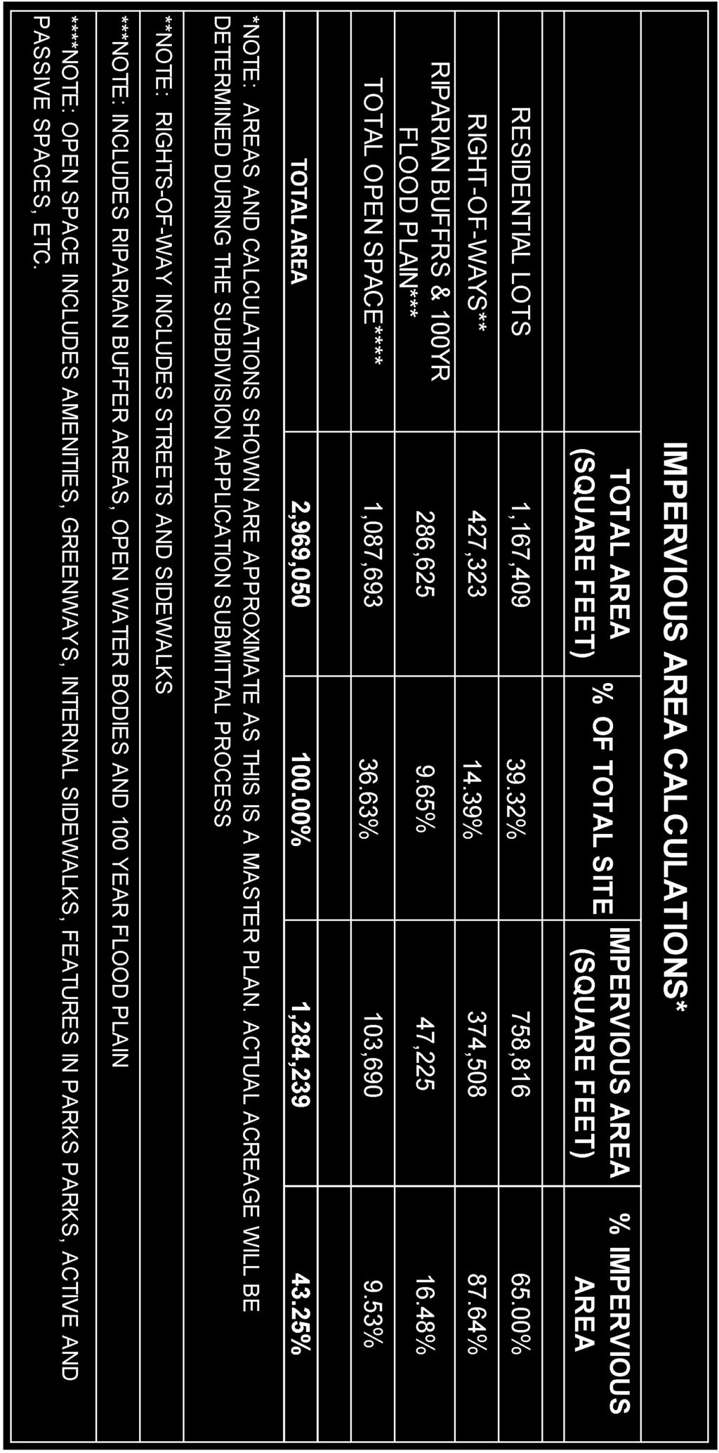
18 PRELIMINARY PLAT/PLANS ANALYSIS: The applicant has submitted the following required drawings/documents for review: Existing Conditions PD01 Adjacent Owners PD02 Master Plan PD03 Pedestrian and Vehicular Routing PD04 Phasing Plan PD05 Preliminary Plat PD06 and PD07 Preliminary Utility Plan PD08 and PD09 Preliminary Grading Plan PD10 Preliminary Tree Preservation Plan Preliminary Lighting Plan PD11 and PD12 Preliminary Plat Regulatory Standards PD13 Stormwater Management Plan Unit Type/Density. Consistent with the approved master plan for the PUD, the proposed development will be a mix of single family detached residential and attached single family residential (townhomes); triplex and row houses. There will be up to 280 single family homes of which up to 76 of them may be attached units (triplexes). There will be up to 35 townhouse units on the east side of Buffalo Road. With the master plan approval, the developer reserved the right to replace the detached single family units with the townhome units with each phase, except for phases 1 and 2. The Town Council placed a condition on the development that the attached single family units are prohibited in the first and second phases of the development. The master identified typical details for each type of unit on a typical lot, but did not identify specific locations for the attached single family (triplex). The developer indicated that the price of the finished homes will range from $150,000-$200,000. Environmental. The proposed development site is outside of the floodplain and there should be no environmental threats. The Neuse River and a blue line stream on the south edge of the site will require buffering. As a result of being in the WS IV-PA Water Supply Watershed Protection Overlay District and utilizing the high density option, the buffers are increased from 50 feet to 100 feet. The proposed greenway trail along the Neuse River is proposed to cross the blue line stream along the southern property boundary near the Twisdale property. Water Supply Watershed Protection Overlay District. Much of the proposed PUD development is within the WS IV-PA Overlay District. This overlay district provides an extra layer of regulation intended to protect the water supply watershed from pollution caused primarily from stormwater runoff. Within the WS IV-PA lot sizes are limited to ½ acre lots, unless cluster subdivision standards are followed (UDO Section 7.34). Impervious surfaces are limited to 24% unless the High Density Option is utilized (UDO Section ). With the High Density Option, higher level of stormwater management controls is required. The proposed development is proposing lots smaller than ½ acre in size and will be utilizing the cluster subdivision standards, although modified through the PUD. Cluster Subdivision Standards. The proposed development is subject to the Supplementary Standards for Cluster Subdivision (UDO Section 7.34) with some exceptions. The development is in compliance with the cluster requirements. Required open space is 1,167,409 sq. ft., less the stormwater management and lift station areas is equal or greater to the reduction of the lot sizes from the underlying zoning district requirements. Page 4
19 Under the Cluster regulations, lot size cannot be less than 4,800 sq. ft. (60% of 8,000) (UDO Section ). Many of the lots are under 4,800 sq. ft. in size: o o o Single-family Detached 3,145 sq. ft. Single family attached (tri-plex) units 2,000 sq. ft. Townhome units 1,400 sq. ft. The Council approved this deviation from the cluster provisions with the approval of the PUD master plan. Minimum lot width and lot frontage cannot be less than 40 feet. Many of the lots are less than 40 feet wide (UDO Section ) (UDO Section ): o o o Single-family detached 37 ft. Single family attached (tri-plex) units 25 ft. Townhome units 17.5 ft. The Council approved this deviation from the cluster provisions with the approval of the PUD master plan. The side yard setbacks cannot be less than 6 feet. If a zero lot line lot, the other setback is required to be 12 feet. A zero lot line cannot be more than one side of the lot. The development proposes: o o o Single-family detached 5 ft. Single family attached (tri-plex) units 0 ft. on two sides/6 ft. Townhome units 0 ft. on two sides/6 ft. The Council approved this deviation from the cluster provisions with the approval of the PUD master plan. The building separation minimum is 12 ft. The proposed development is proposing a 10 ft. building separation (UDO Section ). The Council approved this deviation from the cluster provisions with the approval of the PUD master plan. State Road Dedication and Access. The proposed development takes access off of Buffalo Road in two locations on the west side and one on the east side. The Buffalo Road R/W is presently 60 feet wide. The developer is showing dedication of additional 100 feet. The master plan does not show any proposed improvements such additional travel lanes, turn lanes or pedestrian facilities in the NCDOT R/W. These improvements will be undertaken by NCDOT and the improvements have not yet been designed. NCDOT has reviewed the preliminary plat and has no objections. They will perform a more in depth review with the application for a NCDOT Access Permit. Traffic Impact Study. A traffic impact study was conducted by Ramey-Kemp & Associates and studied the potential traffic impacts of the development. The study concluded that all the study area intersections (including the proposed site driveways) are expected to operate at acceptable levelsof-service under existing and future year conditions. The report provided recommendations for turn lanes and traffic control throughout the study area. Streets. The subdivision shows a mix of 50 foot and 60 foot wide public R/W. The outer loop road on the west side of the development is shown as a 60 foot R/W, whereas, the remainder of the R/W is proposed to be 50 feet wide. The streets appear to be 24 wide with mountable valley curb. The west side of subdivision consists of three long streets running in a north-south direction and two running east-west from the intersections on buffalo road. There are two cul-de-sacs, one identified in the first phase of the development and another in the sixth phase. The east side of the subdivision consists of a looped road surrounding an open green space and a private road leading to the row-type single-family attached townhouses. Page 5
20 Sidewalks. Sidewalks are shown on both sides of each street throughout the development. The UDO only requires sidewalks on one side. Sidewalks are required along Buffalo Road; however the developer is proposing a 10 trail rather than a sidewalk that weaves in and out of the Buffalo Road right-of-way along both frontages. Sidewalk crosswalks are shown as being striped for pedestrian safety throughout the development. Trails. The preliminary plat shows private and public trails. The public trails parallel the Neuse River in open space, and along both sides of Buffalo Road. There is also a trail running perpendicular to Buffalo Road connecting the Neuse River Trail to the Buffalo Road trail through the center of the development. The plan is configured such that either the trail along the Neuse River or Buffalo road can be designated as the Mountains to Sea Greenway. The preliminary plat shows the public trail along the Neuse River as accessing the Street D cul-desac, then continuing as a shared sewer pump station access road. Public Utilities, Parks and Planning are uncomfortable with this configuration because utility trucks will block greenway when maintaining lift station and because the configuration invites pedestrians, bikes and strollers to pump station which is a security risk and uninviting as a trail feature. The public trail along the Neuse River does not extend to the north and south boundaries of the site, however, a public trail easement does. If in the future the Mountains to Sea Trail reaches this development, the missing trail segments can be constructed at that time within the provided public trail easements. The trail easement on the south will cross a blue line stream and associated buffer area. The trail easement on the north side will cross a Piedmont Natural Gas easement which will require a permit from the gas company prior to constructing the trail segment. The developer is proposing that these trails would be public, but maintained by the HOA. Trail street crossings are shown as being striped for pedestrian safety throughout the development. Trails in the Right of Way of Buffalo Road will require an NCDOT permit. Parks Dedication. According to Park Dedication Requirements of the UDO, Section , at least one fifty-seventh of an acre (1/57) shall be dedicated for each dwelling unit planned or provided for in the subdivision plan, or a fee in lieu of park land dedication. No parkland has been identified in the comprehensive plan for this area, and no parkland has been proposed. For 298- units, fee in lieu of 5.22 acres of dedication or fee in lieu will be required. If the number of units increases, the fee will increase correspondingly. The fee in lieu will be due prior to recording the final plat, based on the number of lots within each platted phase. Private Park Facilities. The PUD narrative mentions the development of pocket parks within the common open space. The proposed pocket parks are shown as long green strips between rows of homes. The developer indicates that the pocket parks will include paved pedestrian trails and attractive landscaping that may be used for soccer, football, cornhole, horseshoes, fire pits and cook outs. Public Utilities. The applicant is planning to petition for Town annexation. With annexation, the development would have Town water, sewer and electrical service. The developer is estimating waste water flow for the development to be 113,400 gallons per day. According to the developer, the development is expected to be completed in 9 phases with phases 1, 2, 7, 8 & 9 to be serviceable by connection to the existing gravity sewer line along Buffalo Rd. The remaining phases are anticipated to require a wastewater pump station located just beyond the Street D cul-de-sac in Phase 6. The wastewater pump station will be required to meet Town standards with appropriate public access for maintenance. The access to the pump station is shown as shared with the public trail. Staff has conditioned the approval on having a separation of the trail and the pump station access (see Trails above). Page 6
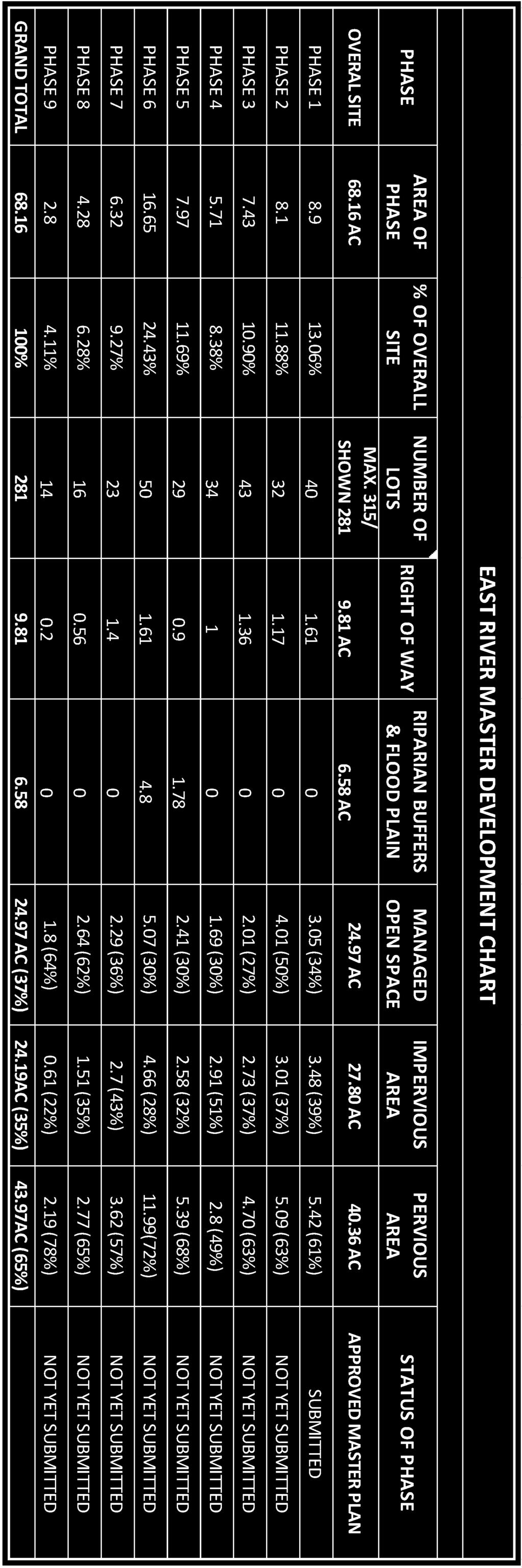
21 Public water is available to the site via an existing 12 water main along Buffalo Rd. Connections to the existing 12 main will be made and extended throughout the development. This level of innerconnectivity shall provide for adequate domestic water as well appropriate fire protection flow. Stormwater Management. The applicant has indicated that the High Density Option for development within the WS-IV-PA requiring enhance stormwater management. Stormwater runoff control measures are required to address peak flow reduction and nitrogen reduction. The developer intends to utilize the existing pond near the Neuse River as a stormwater management feature. The developer intends to utilize the existing pond without modification until construction of Phase 3 of development. As part of the Phase 3 development, the developer plans to modify the existing pond to meet the design requirements of DEQ and the Town. Staff does not agree that the existing pond can be used at the Phase 1 and Phase 2 development stage without improvement unless the actual recorded property at each phase of development yields an impervious surface computation of 15% or less. This issue remains in discussion with the applicant. Pond maintenance access meeting Town standards and an executed Operations and Maintenance Agreement are required. Landscaping. There are no specific landscaping standards for residential development. No landscape plan has been provided. The master plans shows, very conceptually, that landscaping will be provided within the common open space. The master plan indicates the development will include a +/-50 perimeter landscaped Type A buffer. The road section details show street trees in the R/W. Street trees are not permitted over utility lines and any trees in the public right of way will be the responsibility of the HOA for maintenance, removal or replacement. Trees are not permitted within the PSNC gas line easement along the north edge of the development. Parking. Single family residential requires 2 parking stalls per unit. This requirement will easily be accommodated with the garages and driveways. The Multifamily dwellings require 1.5 spaces per 1 bedroom units, 1.75 spaces per unit for 2 bedroom units, and 2 spaces for 3 or more bedroom units. The 30 townhomes shown in phases 8 and 9 have 55 parking stalls. The exact number of bedrooms in each unit is unknown. Parking requirements will be determined when the townhomes are proposed for construction. Throughout the development overflow parking for guests will be limited given the narrow lots and frequency of driveways. Lighting. A preliminary lighting plan has been provided. Phasing. The developer proposes to construct the subdivision over 9 phases (approximately 40 units per phase), one phase per year depending on the market. The approximate phase lines were shown on the approved master plan but are subject to change based on market conditions. As proposed, the replacement of single family detached units with single family attached will also be with each phase will also depend on the market with the restriction that no townhome units be constructed within phase 1 or 2. The necessary infrastructure is proposed to be constructed as needed for each phase and designed for build-out. Homeowners Association Documents. The development will be a maintenance free development with the HOA responsible for maintenance of yards and shared open space and amenities. Submittal of deed restrictions and covenants will be required with this development to address among other items, a statement of compliance with state local and federal regulations, and operation and maintenance of shared open space, amenities and stormwater management facilities. These documents have not been provided as required. They will require Town Attorney review prior to recordation. Page 7
22 Signs. The applicant is proposing entrance signs at all three entrances to the subdivision. Any new signs shall be permitted in accordance with the Town of Smithfield Unified Development Ordinance prior to construction and will require a separate sign permit from the Planning Department. PLANNING DEPARTMENT RECOMMENDATIONS: The Planning Department recommends approval of the preliminary plat for the East River PUD subdivision with the following conditions: 1) That the final plat be contingent on the execution of an annexation agreement with the Town of Smithfield. 2) That the developer obtains a NCDOT Right-of-Way Permit for the street access onto Buffalo Road prior to construction approval. 3) That the developers dedicate additional right-of-way for Buffalo Road as required by NCDOT. 4) That Homeowners Association deed restrictions and covenants will be submitted for Town Attorney review to address among other items, a statement of compliance with state local and federal regulations, and operation and maintenance of shared open space, amenities and stormwater management facilities. These documents will require Town Attorney approval prior to recordation. 5) That there be no attached single family residential units within phases 1 or 2 as identified on the approved master plan phasing plan. 6) That a park dedication fee in lieu of parkland be paid prior to recording the final plat approval of each phase of the development consistent with Article 10, Section ) That the public trail be constructed and easements be dedicated for trails adjacent to each phase with the final plat of that phase consistent with the preliminary plat. 8) That the public trail in the cul-de-sac of Street D be modified such that it is independent of the sanitary sewer pump station access way. 9) The utilities shall be designed such that that extension can be made conveniently and without undue burden or expense to serve future adjacent development. RECOMMENDED ACTION: Staff and the applicant respectfully request that the Planning Board review the Preliminary Subdivision Plat and make a recommendation to the Town Council. Page 8

23
24

25


26 PHASE 7 PHASE 5 PHASE 6 PHASE 3 PHASE 4 PHASE 2 PHASE 1 PHASE 8 PHASE 9 PRELIMINARY 10:49 am, Sep 26, 2018
27 Permit Issued for September 2018 Town of Smithfield Planning Department 350 E. Market St Smithfield, NC P.O. Box 761, Smithfield, NC Phone: Fax: Permit Fees Permits Issued Site Plan Major Site Plan Site Plan Minor Site Plan $ Zoning Land Use $ Zoning Sign $ Report Period Total: $1, Fiscal YTD Total: $5, SP Site Plan Major Site Plan Smithfield Assisted Living 200 Kellie Drive SP Site Plan Minor Site Plan Weaver Homes/ Bella Square/Lot Bella Square SP Site Plan Minor Site Plan McDonald's Restaurant Modifications 1209 North Brightleaf Blvd Z Zoning Land Use One Stop/Convenience Store 600 South Brightleaf Blvd Z Zoning Land Use Fancy Paws 1270-C North Brightleaf Blvd Z Zoning Sign Barbeque Provision Company 1025 Outlet Center Dr SP Site Plan Minor Site Plan 36' x 16' Accessory Structure 320 Dogwood Street Z Zoning Land Use Classic Care Homes 101 Annie Parker Circle Z Zoning Sign Burney's Sweets & More 517 Outlet Center Drive SP Site Plan Minor Site Plan Single Family Dwelling 2203 Brogden Road SP Site Plan Minor Site Plan Single Family Dwelling 2225 Brogden Road Z Zoning Sign Texas Steakhouse 235 Outlet Center Drive Z Zoning Sign Emerge Ortho 100 Kellie Drive SP Site Plan Minor Site Plan Automotive Repair Facility Addition 440 East Market Street Z Zoning Land Use SAC Wireless 110 South Fifth Street Z Zoning Land Use SAC Wireless 110 South Fifth Street Z Zoning Land Use SAC Wireless 110 South Fifth Street Z Zoning Land Use SAC Wireless 110 South Fifth Street Z Zoning Land Use Twisted Sister Restaurant & Bar 709 South Third Street SP Site Plan Minor Site Plan New Construction/SFD 2249 Brogden Road Z Zoning Land Use Barbeque Provision Company 1025 Outlet Center Drive Z Zoning Land Use Fieldale Apartments 2 Fieldale Drive Z Zoning Land Use Sunbelt Rentals, Inc West Market Z Zoning Land Use Galiz Apparel 414-C South Brightleaf Blvd
28 Town of Smithfield Planning Department 350 E. Market St Smithfield, NC P.O. Box 761, Smithfield, NC Phone: Fax: BOARD ACTIONS REPORT Town Council September Calendar Year to date Zoning Map Ammendments 0 6 Special Use Permit 1 10 Zoning Ordinance Amendments 2 8 Major Subdivisions 0 0 Annexations 0 0 Special Events 0 14 Site Plan 0 0 Planning Board Zoning Map Amendments 1 7 Zoning Ordinace Ammendments 1 11 Major Subdivisions 0 0 Board of Adjustment Variance 0 4 Admin Appeal 0 0 Historic Properties Commission Certificate of Appropriateness 0 0 Historic Landmarks 0 0
 Pg - 16 5' O.C. Po Vi - 34 15\" O.C. Sj - 6 Bb - 31 15' O.C. Bb - 65 15\" O.C. 5' CONC. SIDEWALK Aj - 9 Hh - 10 Gl Bb - 39 15' O.C. Hh - 5 Fh - 3 Vl - 60 15\" O.C. Tg - 5 Vl - 65 15\" O.")
29 LANDSCAPE CALCULATION Nc ' O.C. Zz - 2 5' O.C. Si ' O.C. Cp - 12 Pg ' O.C. SYMBOL QTY. CANOPY TREES Po BOTANICAL NAME 10'X70' SIGHT DISTANCE TRIANGLE Aj ' O.C. 8.5' STREET YARD (50%) Pg ' O.C. Po Vi " O.C. Sj - 6 Bb ' O.C. Bb " O.C. 5' CONC. SIDEWALK Aj - 9 Hh - 10 Gl Bb ' O.C. Hh - 5 Fh - 3 Vl " O.C. Tg - 5 Vl " O.C. Po Vl " O.C. Zz - 9 5' O.C. Ch - 48 Nc - 7 5' O.C. 50' O.C. Bb " O.C. Vl - 97 Bb " O.C. Hh ' STREET YARD Ch ' O.C. LANDSCAPE PLANT LIST COMMON NAME COMMENTS Po 7 QUERCUS PALUSTRIS PIN OAK - 10'-12' MIN. 4-6' B&B Gl 5 TILIA CORDATA GREENSPIRE LINDEN - 10'-12' MIN. 4-6' B&B UNDERSTORY Fh Nc 5 19 SHRUBS ILEXATTENUATA 'FOSTERII' LAGERSTROEMIA INDICA FAURIEI FOSTER HOLLY NATCHEZ CRAPE MYRTLE Cp 18 BERBERIS THUNBERGI ATROPURPUREA CRIMSON PIGMY BARBERRY - 15'-18' MIN. - 3 GAL Pg 34 CORTADERIA SELLOANA PAMPUS GRASS Tg 10 GARDENIA JASMINOIDES 'RADICANS' TRAILING GARDENIA Ch 72 ILEX CORNUTA 'CARISSA' CARISSA HOLLY - Hh 58 ILEX CRENATA 'HELLERI' HELLER HOLLY - Si 48 ILEX GLABRA 'SHAMROCK' SHAMROCK INKBERRY HOLLY - HEIGHT - 6'-8' MIN. - 6'-8' MIN. - - WIDTH 3-4' 3-4' ROOT B&B B&B 18-24" MIN. - 5 GAL " 3 GAL 18-24" MIN. - 5 GAL 15"-18" MIN - 3GAL 18"-24" MIN - 5 GAL Hh - 6 Po Zz ' O.C. Hh - 9 Vl - 97 Bb " O.C. Vl " O.C. Fh - 2 Tg - 4 Vl - 45 Vl " O.C. Po Hh - 5 Aj - 6 Gl Gl Bb " O.C. Bb " O.C. Vi " O.C. Gl Bb " O.C. Cp - 3 Hh - 6 Sj - 6 Plant Symbol Key TILIA CORDATA AREA LIGHTS (TOTAL OF 4) BY THE TOWN OF SMITHFIELD (METAL POLES W/FULL CUT OFF FIXTURES, NO FLOOD LIGHTS) CANOPY TREE: SAW TOOTH OAK Aj ' O.C. 8.5' STREET YARD (50%) 17.5' SIDE STREET SETBACK (50%) Sj - 6 Po Po Si ' O.C. NATCHEZ CRAPE MYRTLE Si ' O.C. Nc - 8 5' O.C. Pg - 8 5' O.C. 10'X70' SIGHT DISTANCE TRIANGLE Nc ' O.C. FOSTER HOLLY A. STREET YARD (ART ONE UNDERSTORY TREE 1/50 FT; 20 SHRUBS/100FT - ADJUSTED FOR SIGHT TRIANGLES AND DRIVES) DESCRIPTION REQ'D PROV'D 1. OLD GOLDSBORO RD (317') - UNDERSTORY TREES SHRUBS DOGWOOD ST (217.04' - 24' DRIVE = ) - UNDERSTORY TREES SHRUBS E. MARKET ST. (149.52') - UNDERSTORY TREES SHRUBS PINE STREET (232.28' - 36' OF DRIVES = ') - UNDERSTORY TREES SHRUBS B. PARKING (ART AREA OF LANDSCAPE ISLAND MUST EQUAL 9% OF THE PARKING AREA (19,876 SF); EACH LANDSCAPE ISLAND MUST CONTAIN ONE CANOPY TREE AND SIX SHRUBS.) DESCRIPTION REQ'D PROV'D LANDSCAPE AREA ISLAND AREA SF SF CANOPY TREES SHRUBS C. FOUNDATION PLANTINGS (ART AREA OF FOUNDATION PLANTING MUST EQUAL 12% OF WALL AREA 4320 SF OF BUILDING FACING PARKING /DRIVE.) DESCRIPTION REQ'D PROV'D 4320 SF X 12% = SF 519 SF 1884 SF 10:11 am, Aug 14, 2018 NOT RELEASED FOR CONSTRUCTION 314 EAST MAIN STREET CLAYTON, NC donnie@adamsandhodge.com FIRM # C-4187 ADAMS & HODGE E NGINEERING, PC TOWN OF SMITHFIELD, NORTH CAROLINA LANDSCAPE PLAN DUPREE TRACT Sj 18 JUNIPERUS CONFERTA SHORE JUNIPER " 3 GAL Aj 35 JUNIPERUS HORIZONTALIS PLUMOSA COMPACTA YOUNGSTOWN - Zz 24 LOROPETALUM CHINESE RUBRUM 'ZHUZHOU' LORPETALUM " 3 GAL 18"-24" MIN - 5 GAL GROUNDCOVERS Bb 382 LIRIOPE MUSCARI 'BIG BLUE' BIG BLUE LIRIOPE 5-7 BIBS CLUMP DIVISION 15"-18" MIN - 1 GAL Vl 550 LIRIOPE MUSCARI 'VARIEGATA' VARIEGATA MONKEY GRASS 5-7 BIBS CLUMP DIVISION GAL 1. THE LANDSCAPE CONTRACTOR IS RESPONSIBLE FOR VERIFYING PLANT QUANTITIES AND IS TO NOTIFY THE CONTRACTOR ASAP OF ANY DISCREPANCIES BETWEEN THE PLANT LIST AND THE PLAN 2. THE LANDSCAPE CONTRACTOR SHALL ADJUST ANY BUFFER PLANTING AS NEEDED TO MAINTAIN REQUIRED CLEARANCES AROUND TRANSFORMERS, GENERATORS, DRAINAGE FACILITIES, AND OTHER UTILITIES THAT REQUIRE CLEARANCES FOR ACCESS PAMPUS GRASS ZHUZHOU LOROPETALUM SHAMROCK INKBERRY HOLLY OR CARISSA HOLLY HELLER HOLLY YOUNGSTOWN C6
Draft Smithfield Planning Board Minutes Thursday, November 1, :00 P.M., Town Hall, Council Chambers
 Draft Smithfield Planning Board Minutes Thursday, November 1, 2018 6:00 P.M., Town Hall, Council Chambers Members Present: Chairman Stephen Upton Vice Chairman Mark Lane Oliver Johnson Ashley Spain Leslie
DRAFT Smithfield Planning Board Minutes Thursday, May 7, :00 P.M., Town Hall, Council Room
 DRAFT Smithfield Planning Board Minutes Thursday, May 7, 2015 6:00 P.M., Town Hall, Council Room Members Present: Chairman Eddie Foy Vice-Chairman Stephen Upton Daniel Sanders Gerald Joyner Mark Lane Jack
Final Smithfield Planning Board Minutes Thursday, February 1, :00 P.M., Town Hall, Council Chambers
 Final Smithfield Planning Board Minutes Thursday, February 1, 2018 6:00 P.M., Town Hall, Council Chambers Members Present: Chairman Stephen Upton Oliver Johnson Michael Taylor Eddie Foy Teresa Daughtry
MINOR SUBDIVISION FINAL PLAT APPLICATION Town of Apex, North Carolina
 MINOR SUBDIVISION FINAL PLAT APPLICATION Town of Apex, North Carolina This document is a public record under the North Carolina Public Records Act and may be published on the Town s website or disclosed
Cover Letter with Narrative Statement
 Cover Letter with Narrative Statement March 31, 2017 rev July 27, 2017 RE: Rushton Pointe Residential Planned Unit Development Application for Public Hearing for RPUD Rezone PL2015 000 0306 Mr. Eric Johnson,
Staff Report: Date: Applicant: Property Identification: Acreage of Request: Current Zoning of Requested Area: Requested Action: Attached:
 Staff Report: Completed by Jeff Palmer Director of Planning & Zoning Date: November 7, 2018, Updated November 20, 2018 Applicant: Greg Smith, Oberer Land Developer agent for Ronald Montgomery ET AL Property
M-43 CORRIDOR OVERLAY ZONE
 ARTICLE 26.00 M-43 CORRIDOR OVERLAY ZONE Section 26.01 Findings A primary function of the M-43 state highway is to move traffic through the Township and to points beyond. As the primary east-west arterial
APPENDIX B. SUBMISSION REQUIREMENTS
 Master Major Site Minor Site Landscape Section B.1 Table of /Plat Requirements Proposed or approved name of development, project, subdivision, and/or phase. Location, including township, county, and state.
DAUPHIN CREEK ESTATES SUBDIVISION
 # 12 SUB-000076-2017 DAUPHIN CREEK ESTATES SUBDIVISION Engineering Comments: FINAL PLAT COMMENTS (should be addressed prior to submitting the FINAL PLAT for review and/or signature by the City Engineer):
MAJOR SUBDIVISION PRELIMINARY PLAT CHECKLIST
 TOWNSHIP OF EGG HARBOR PLANNING BOARD/ZONING BOARD OF ADJUSTMENT 3515 BARGAINTOWN ROAD EGG HARBOR TOWNSHIP, NJ 08234 MAJOR SUBDIVISION PRELIMINARY PLAT CHECKLIST The following checklist is designed to
ALPINE TOWNSHIP PLANNING COMMISSION REGULAR MEETING June 15, 2017
 Page 1 of 6 ALPINE TOWNSHIP PLANNING COMMISSION REGULAR MEETING 17-26 CALL TO ORDER / APPROVAL OF THE REGULAR MEETING MINUTES OF MAY 18, 2017 AND THE / PUBLIC COMMENT ON NON-AGENDA ITEMS The Alpine Township
MASTER SUBDIVISION FINAL PLAT APPLICATION Town of Apex, North Carolina
 MASTER SUBDIVISION FINAL PLAT APPLICATION Town of Apex, North Carolina This document is a public record under the North Carolina Public Records Act and may be published to the Town s website or disclosed
AGENDA STATEMENT NO BUSINESS OF THE PLANNING COMMISSION City of Victoria, Minnesota STAFF REPORT. Casco Ventures (Developer)
") AGENDA STATEMENT NO. 17-1 BUSINESS OF THE PLANNING COMMISSION City of Victoria, Minnesota STAFF REPORT TO: Planning Commission PREPARED BY: Erin Smith, Senior Planner RE: Waterford Landing Project Rezoning
AGENDA STATEMENT NO. 17-1 BUSINESS OF THE PLANNING COMMISSION City of Victoria, Minnesota STAFF REPORT TO: Planning Commission PREPARED BY: Erin Smith, Senior Planner RE: Waterford Landing Project Rezoning
c) Stub streets shall be required as follows:
 Stub streets shall be required as follows:") Sec. 7.2.1 / Streets 7.2 DESIGN STANDARDS 7.2.1 Streets A) Interconnectivity 1) Conformity with Apex Transportation Plan. The subdivision s street system shall conform to the Apex Transportation Plan.
Sec. 7.2.1 / Streets 7.2 DESIGN STANDARDS 7.2.1 Streets A) Interconnectivity 1) Conformity with Apex Transportation Plan. The subdivision s street system shall conform to the Apex Transportation Plan.
Appendix J - Planned Unit Development (PUD)
") Appendix J - Planned Unit Development (PUD) Intent and Purpose The purpose of the PUD is: 1. To provide development that is consistent with the Comprehensive Land Use Plan and promote the goals and objectives
Appendix J - Planned Unit Development (PUD) Intent and Purpose The purpose of the PUD is: 1. To provide development that is consistent with the Comprehensive Land Use Plan and promote the goals and objectives
Courtyards at Kinnamon Park Sketch Plan
 Courtyards at Kinnamon Park Sketch Plan Courtyards at Kinnamon Park Sketch Plan Staff Analysis PART 1: PROJECT SUMMARY Applicant: EPCON Communities Property Owner: Johnsie M. Kinnamon Heirs, Douglas and
Dennis Bordeaux Inspections Manager NOTICE OF PUBLIC HEARING NEW HANOVER COUNTY PLANNING BOARD MARCH 7, 2013
 NEW HANOVER COUNTY PLANNING & INSPECTIONS DEPARTMENT 230 GOVERNMENT CENTER DRIVE, SUITE 110 WILMINGTON, NORTH CAROLINA 28403 TELEPHONE (910) 798-7165 FAX (910) 798-7053 Chris O Keefe, AICP Planning & Inspections
Staff Report: Date: Applicant: Property Identification: Acreage of Request: Current Zoning of Requested Area: Requested Action: Attached:
 Staff Report: Completed by Jeff Palmer Director of Planning & Zoning Date: November 7, 2018 Applicant: Greg Smith, Oberer Land Developer agent for Ronald Montgomery ET AL Property Identification: Frontage
TOWN OF WELLS, MAINE PLANNING BOARD
 1 0 1 0 1 TOWN OF WELLS, MAINE PLANNING BOARD Meeting Minutes Monday, June,, :00 P.M. Littlefield Meeting Room, Town Hall Sanford Road CALL TO ORDER AND DETERMINATION OF QUORUM Chairman Chuck Millian called
ARTICLE 14 PLANNED UNIT DEVELOPMENT (PUD) DISTRICT
 DISTRICT") ARTICLE 14 PLANNED UNIT DEVELOPMENT (PUD) DISTRICT Section 14.01 Intent. It is the intent of this Article to allow the use of the planned unit development (PUD) process, as authorized by the Michigan Zoning
ARTICLE 14 PLANNED UNIT DEVELOPMENT (PUD) DISTRICT Section 14.01 Intent. It is the intent of this Article to allow the use of the planned unit development (PUD) process, as authorized by the Michigan Zoning
O-I (Office-Institutional) and AG-1(Agricultural)
 and AG-1(Agricultural)") PROPERTY INFORMATION ADDRESS 3503 and 3505 Bethany Bend DISTRICT, LAND LOTS 2/1 973 and 974 OVERLAY DISTRICT State Route 9 PETITION NUMBERS EXISTING ZONING O-I (Office-Institutional) and AG-1(Agricultural)
PROPERTY INFORMATION ADDRESS 3503 and 3505 Bethany Bend DISTRICT, LAND LOTS 2/1 973 and 974 OVERLAY DISTRICT State Route 9 PETITION NUMBERS EXISTING ZONING O-I (Office-Institutional) and AG-1(Agricultural)
ATTENDING THE MEETING Robert Balogh, Vice-Chairman Sonia Stopperich, Supervisor Marcus Staley, Supervisor Bob Ross, Supervisor
 SPECIAL HEARING - TUESDAY, APRIL 12, 2016 PAGE 1 The North Strabane Township Board of Supervisors held a Special Meeting- Conditional Use Hearing, Tuesday, April 12, 2016, at approximately 6:30 P.M., at
ZONING AMENDMENT, PLANNED UNIT DEVELOPMENT & SUBDIVISION STAFF REPORT Date: August 8, 2013
 ZONING AMENDMENT, PLANNED UNIT DEVELOPMENT & SUBDIVISION STAFF REPORT Date: August 8, 2013 NAME SUBDIVISION NAME PV-Magnolia, LLC Twelve Trees Subdivision LOCATION 2860, 2862 and 2866 Pleasant Valley Road
Special Use Permit - Planned Unit Development Checklist. Property Address:
 Special Use Permit - Planned Unit Development Checklist Special Use Permit Number. Parcel Code/s #28-11- - - Property Address: Applicant: ARTICLE VIII Ordinance Reference - Section 8.1.2 Permit Procedures:
LABEL PLEASE NOTE: ALL APPLICATIONS AND SITE PLANS MUST BE COMPLETED IN BLACK OR BLUE INK ONLY Intake by:
 STAFF USE ONLY Thurston County Resource Stewardship 2000 Lakeridge Dr. S.W. Olympia, WA 98502 (360)786-5490 / (360)754-2939 (Fax) TDD Line (360) 754-2933 Email: permit@co.thurston.wa.us Supplemental Application
City of Lake Elmo Planning Commission Meeting Minutes of January 14, 2013
 City of Lake Elmo Planning Commission Meeting Minutes of January 14, 2013 Chairman Williams called to order the workshop of the Lake Elmo Planning Commission at 7:00pm COMMISSIONERS PRESENT: Fliflet, Obermueller,
PLANNED UNIT DEVELOPMENT & SUBDIVISION STAFF REPORT Date: April 18, 2019
 PLANNED UNIT DEVELOPMENT & SUBDIVISION STAFF REPORT Date: April 18, 2019 DEVELOPMENT NAME SUBDIVISION NAME Springhill Village Subdivision Springhill Village Subdivision LOCATION 4350, 4354, 4356, 4358,
The following information is for use by the Lincoln County Planning Board at their meeting/public hearing on February 3, 2014.
 LINCOLN COUNTY PLANNING & INSPECTIONS DEPARTMENT 302 NORTH ACADEMY STREET, SUITE A, LINCOLNTON, NORTH CAROLINA 28092 704-736-8440 OFFICE 704-736-8434 INSPECTION REQUEST LINE 704-732-9010 FAX To: Planning
Final Plats for Major Residential and Commercial Subdivisions Checklist
 Project Name: : This form is a checklist of Zoning Ordinance requirements for major residential and commercial subdivision plats to assist the applicant in their submittal. It is not intended to be a comprehensive
4. facilitate the construction of streets, utilities and public services in a more economical and efficient manner;
 PVPC MODEL BYLAW BY-RIGHT CLUSTER ZONING BYLAW Prepared by Pioneer Valley Planning Commission Revised: October 2001 1.00 Development 1.01 Development Allowed By Right Development in accordance with this
Planning Board. TOWN OF BRUNSWICK 336 Town Office Road Troy, New York MINUTES OF THE PLANNING BOARD MEETING HELD FEBRUARY 21, 2019
 Planning Board TOWN OF BRUNSWICK 336 Town Office Road Troy, New York 12180 MINUTES OF THE PLANNING BOARD MEETING HELD FEBRUARY 21, 2019 PRESENT were RUSSELL OSTER, CHAIRMAN, DAVID TARBOX, DONALD HENDERSON,
MONTGOMERY COUNTY PLANNING DEPARTMENT THE MARYLAND-NATIONAL CAPITAL PARK AND PLANNING COMMISSION
 MONTGOMERY COUNTY PLANNING DEPARTMENT THE MARYLAND-NATIONAL CAPITAL PARK AND PLANNING COMMISSION MCPB Item No.: Date: 06-21-12 The Plantations, Preliminary Plan -120090240 Benjamin Berbert, Senior Planner,
WESTMINSTER PARK PLACE SUBDIVISION
 WESTMINSTER PARK PLACE SUBDIVISION Engineering Comments: FINAL PLAT COMMENTS (should be addressed prior to submitting the FINAL PLAT for review and/or signature by the City Engineer): A. Provide all of
REGULAR FINAL PLAT SUBDIVISION APPLICATION
 REGULAR FINAL PLAT SUBDIVISION APPLICATION Name of Subdivision (Subdivision Name must be approved by at 856-6216) ( )Cluster Subdivision ( )Lot-by-Lot Subdivision ( )Open Space Subdivision Name of Subdivision
Report to the Plan Commission December 19, 2011
 Report to the Plan Commission Legistar I.D. #24825, Extraterritorial Certified Survey Map Requested Action: Consideration of a two-lot Certified Survey Map (CSM) of the Keryluk-Wee property located at,,
Chapter 100 Planned Unit Development in Corvallis Urban Fringe
 100.100 Scope and Purpose. Chapter 100 Planned Unit Development in Corvallis Urban Fringe (1) All applications for land divisions in the Urban Residential (UR) and Flood Plain Agriculture (FPA) zones within
Section Preliminary Plat Checklist and Application Forms
 Section 201 - Preliminary Plat Checklist and Application Forms PRELIMINARY SUBDIVISION PLAT REVIEW PROCESS CHART PRELIMINARY SUBDIVISION PLAT APPLICATION PRELIMINARY PLAT REVIEW CHECKLIST CITY OF NAMPA
ARTICLE 3 DEFINITIONS
 Sections: 3-1 Rules of Construction 3-2 Definitions ARTICLE 3 DEFINITIONS SECTION 3-1 RULES OF CONSTRUCTION 3-101. a. The language set forth in these regulations shall be interpreted in accordance with
MEMORANDUM. DATE: November 9, 2016 PC Agenda Item 3.C
 MEMORANDUM DATE: November 9, 2016 PC Agenda Item 3.C TO: FROM: SUBJECT: Planning Commission Eric Zweber, AICP, Interim City Planner Planning Case #16-029 Public Hearing Required Applicant: Bremer Bank,
Planning Department Oconee County, Georgia
 Planning Department Oconee County, Georgia STAFF REPORT REZONE CASE #: 6985 DATE: October 31, 2016 STAFF REPORT BY: Andrew C. Stern, Planner APPLICANT NAME: Williams & Associates, Land Planners PC PROPERTY
ARTICLE 15 - PLANNED UNIT DEVELOPMENT
 Section 15.1 - Intent. ARTICLE 15 - PLANNED UNIT DEVELOPMENT A PUD, or Planned Unit Development, is not a District per se, but rather a set of standards that may be applied to a development type. The Planned
E L M E R B O R O U G H L A N D U S E B O A R D APPLICATION COVER SHEET (to be completed for all applications and appeals)
") E L M E R B O R O U G H L A N D U S E B O A R D APPLICATION COVER SHEET (to be completed for all applications and appeals) 1. Name(s): 2. Address: 3. Telephone Number(s): 4. E-mail: 5. Owner Name(s) (if
E L M E R B O R O U G H L A N D U S E B O A R D APPLICATION COVER SHEET (to be completed for all applications and appeals) 1. Name(s): 2. Address: 3. Telephone Number(s): 4. E-mail: 5. Owner Name(s) (if
Staff Report for Town Council
 Staff Report for Town Council Meeting Date: June 22, 2017 16-REZ-24 Trimble Avenue Residential Rezoning Purpose: Consider action on proposed rezoning request Prepared by: Katie Drye, Planning Speaker:
Residential Major Subdivision Review Checklist
 Residential Major Subdivision Review Checklist Plan Submittal Requirements: 2 full sets of stamped plans Electric submittal - all plans contained in a single PDF 3 full sets if commercial kitchen or dining
Article 7: Residential Land Use and Development Requirements
 Article 7: Residential Land Use and Section 701: Statement of Intent (A) (B) (C) The intent of Article 7 is to develop certain land use and development requirements for the residential uses within Cumru
-MENDOCINO COUNTY PLANNING AND BUILDING SERVICES- DIVISION OF LAND REGULATIONS TITLE 17
 ARTICLE VI -- GENERAL REGULATIONS AND PROVISIONS Sec. 17-50. Sec. 17-51 General Plan. Sec. 17-52 Lot and Block Design and Configuration. Sec. 17-53 Lot Access. Sec. 17-54 Private Roads. Sec. 17-55 Water
ARTICLE FIVE FINAL DRAFT
 ARTICLE FIVE 021218 FINAL DRAFT Sec. 503.6 Open Space Preservation Option Open Space Preservation Option Open Space Preservation developments may be approved in the AR, R-1, R-2 and R-3 zoning districts,
TILDEN TOWNSHIP PLANNING COMMISSION
 TILDEN TOWNSHIP PLANNING COMMISSION Tuesday, Regular Meeting The Tilden Township Planning Commission met in the Township Municipal Building on Tuesday, with the following present: Dale Keener, Sharon Enevoldson,
TOWNSHIP OF SALISBURY LEHIGH COUNTY, PENNSYLVANIA. PLANNING COMMISSION MEETING MINUTES September 12, 2017 START TIME 7:30 PM
 TOWNSHIP OF SALISBURY LEHIGH COUNTY, PENNSYLVANIA PLANNING COMMISSION MEETING MINUTES September 12, 2017 START TIME 7:30 PM The regularly scheduled public meeting of the Salisbury Township Planning Commission
Staff Report to the North Ogden Planning Commission
 Staff Report to the North Ogden Planning Commission SYNOPSIS / APPLICATION INFORMATION Application Request: Consideration and action on an administrative application for final approval for the Legacy North
Initial Project Review
 Pierce County Department of Planning and Land Services, 2401 South 35th Street, Tacoma, WA (253) 798-7037 Initial Project Review Major Amendment to Preliminary Plat: Hawks Ridge Division 1 Application
WESTMINSTER PARK SUBDIVISION
 WESTMINSTER PARK SUBDIVISION Engineering Comments: FINAL PLAT COMMENTS (should be addressed prior to submitting the FINAL PLAT for review and/or signature by the City Engineer): A. Provide all of the required
SECTION 10.7 R-PUD (RESIDENTIAL PLANNED UNIT DEVELOPMENT) ZONE
 ZONE") Article X Zones 10-20 SECTION 10.7 R-PUD (RESIDENTIAL PLANNED UNIT DEVELOPMENT) ZONE A. PURPOSE AND INTENT: The R-PUD Residential PUD Zone is intended to provide alternative, voluntary zoning procedures
Article X Zones 10-20 SECTION 10.7 R-PUD (RESIDENTIAL PLANNED UNIT DEVELOPMENT) ZONE A. PURPOSE AND INTENT: The R-PUD Residential PUD Zone is intended to provide alternative, voluntary zoning procedures
A favorable recommendation to the City Council is requested.
 To: Sycamore Plan Commission From: Brian Gregory, City Manager Date: November 9, 2017 Re: November 13, 2017 Plan Commission Meeting The Plan Commission has one action item and three workshop items. I.
EDGERTON CITY HALL PLANNING COMMISSION MEETING REGULAR SESSION March 12, 2019
 EDGERTON CITY HALL PLANNING COMMISSION MEETING REGULAR SESSION The met in regular session with Chair John Daley calling the meeting to order at 7:00 p.m. All present participated in the Pledge of Allegiance.
CITY OF ST. FRANCIS ST. FRANCIS, MN PLANNING COMMISSION MINUTES APRIL 19, 2006
 CITY OF ST. FRANCIS ST. FRANCIS, MN PLANNING COMMISSION MINUTES APRIL 19, 2006 1. Call to Order: The Planning Commission meeting was called to order at 7:00 pm by Chairman Rich Skordahl. 2. Roll Call:
Community Development
 Land Use Petition RZ-16-002 Date of Staff Recommendation Preparation: April 15, 2016 (CEL) Date of Planning Commission Recommendation: May 3, 2016 PROJECT LOCATION: DISTRICT/SECTION/LANDLOT(S): ACREAGE
a. provide for the continuation of collector streets and thoroughfare streets between adjacent subdivisions;
 Section 7.07. Intent The requirements of this Section are intended to provide for the orderly growth of the Town of Holly Springs and its extra-territorial jurisdiction by establishing guidelines for:
SUBDIVISION, PLANNING APPROVAL, & REZONING STAFF REPORT Date: June 4, 2015
 SUBDIVISION, PLANNING APPROVAL, & REZONING STAFF REPORT Date: June 4, 2015 APPLICANT NAME SUBDIVISION NAME DEVELOPMENT NAME LOCATION Board of Water & Sewer Commissioners of the City of Mobile MAWSS MLK
PLANNED DEVELOPMENT DISTRICT STANDARDS. Cadence Site
 PLANNED DEVELOPMENT DISTRICT STANDARDS Cadence Site A Planned Development District 1. Statement of General Facts, Conditions and Objectives Property Size: Approximately 57.51 Acres York County Tax Map
TOWN OF MINNESOTT BEACH PLANNING BOARD MEETING August 6, 2009
 TOWN OF MINNESOTT BEACH PLANNING BOARD MEETING August 6, 2009 MEMBERS PRESENT: Tim Fowler, Buddy Belangia, Bill Schmidt, Dave Gaskins, and Mac Rubel via telephone. Valerie Calcavecchia arrived after the
DEVELOPMENT DEPARTMENT STAFF REPORT THE PARK AT 5 TH
 DEVELOPMENT DEPARTMENT STAFF REPORT ARB Meeting Date: July 3, 2018 Item #: _PZ2018-293_ THE PARK AT 5 TH Request: Site Address: Project Name: Parcel Number: Applicant: Proposed Development: Current Zoning:
FRANKLIN COUNTY PLANNING BOARD. April 12, 2016
 FRANKLIN COUNTY PLANNING BOARD April 12, 2016 The Franklin County Planning Board held its regular monthly meeting on Tuesday, April 12, 2016 in the Franklin County Administration Building, Commissioners
Staff Report to the North Ogden City Council
 Staff Report to the North Ogden City Council SYNOPSIS / APPLICATION INFORMATION Application Request: Consideration and action on an administrative application to provide comments on the preliminary plan
I. Requirements for All Applications. C D W
 108-16.1. Application checklists. Checklist for Required Submissions to the Planning Board or Zoning Board of Adjustment of Monroe Township All required submissions are to be made to the Administrative
SECTION 16. "PUD" PLANNED UNIT DEVELOPMENT OVERLAY DISTRICT
 SECTION 6. "PUD" PLANNED UNIT DEVELOPMENT OVERLAY DISTRICT Subsection. Purpose. This district is established to achieve the coordinated integration of land parcels and large commercial and retail establishments
9. REZONING NO Vicinity of the northwest corner of 143 rd Street and Metcalf Avenue
 9. REZONING NO. 2002-15 Vicinity of the northwest corner of 143 rd Street and Metcalf Avenue 1. APPLICANT: Andrew Schlagel is the applicant for this request. 2. REQUESTED ACTION: The applicant is requesting
REPORT TO THE SHELBY COUNTY PLANNING COMMISSION From the Department of Development Services Planning Services. February 4, 2019
 REPORT TO THE SHELBY COUNTY PLANNING COMMISSION From the Department of Development Services Planning Services February 4, 2019 Case No. Request for Rezoning Approval From E-1 to E-2 SD This is a request
Enclosed are amended PUD documents for The Grove at Shoal Creek Proposed by
 Enclosed are amended PUD documents for The Grove at Shoal Creek Proposed by The Bull Creek Road Coalition (BCRC) was formed in 2012 and is made up of residents in the six neighborhoods surrounding the
ARTICLE 23 CONDOMINIUM STANDARDS
 ARTICLE 23 CONDOMINIUM STANDARDS Section 23.01 Intent. The intent of this Article is to provide regulatory standards for condominiums and site condominiums similar to those required for projects developed
Section 1: US 19 Overlay District
 Section 1: US 19 Overlay District Section 1.1 Intent and Purpose The purpose of the US Highway 19 Overlay District is to manage access to land development along US Highway 19 in a manner that preserves
ZONING AMENDMENT & SUBDIVISION STAFF REPORT Date: November 3, 2016
 ZONING AMENDMENT & SUBDIVISION STAFF REPORT Date: November 3, 2016 APPLICANT NAME SUBDIVISION NAME David Shumer 5955 Airport Subdivision CITY COUNCIL DISTRICT District 6 5955 Airport Boulevard, 754 Linlen
STAFF REVIEW MARCH 13, Preliminary Consent - Major Subdivision. Showfield, LLC Davis, Bowen & Friedel, Inc. R-2, Residential Low Density
 STAFF REVIEW MARCH 13, 2019 Application Title Application Type Owner Engineer Showfield City Preliminary Consent - Major Subdivision Showfield, LLC Davis, Bowen & Friedel, Inc. Tax Map and Parcel 335-8.00-46.00
APPLICATION PROCEDURE
 ANTRIM PLANNING BOARD P. O. Box 517 Antrim, New Hampshire 03440 Phone: 603-588-6785 FAX: 603-588-2969 APPLICATION FORM AND CHECKLIST FOR MINOR OR MAJOR SITE PLAN REVIEW File Date Received By APPLICATION
PRELIMINARY PLAT CHECK LIST
 PRELIMINARY PLAT CHECK LIST Name of Proposed Subdivision: The following items must be included with the initial submittal of a Preliminary Plat: Application, filled out completely Project Narrative Pre-application
FINAL DRAFT 12/1/16, Rev. to 7/18/17
 FINAL DRAFT 12/1/16, Rev. to 7/18/17 (As Adopted 8/8/17 Effective 9/1/17) SHELTON PLANNING AND ZONING COMMISSION Proposed Amendments to Zoning Regulations I. Amend Section 23 PERMITTED USES by inserting
ZONING & LAND USE APPLICATION
 City of Maple Plain 5050 Independence St P.O. Box 97 Maple Plain, MN 55359 Office: (763) 479-0515 Fax: (763) 479-0519 ZONING & LAND USE APPLICATION APPLICANT INFORMATION Applicant Name Company, if applicable
CITY OF OCOEE LAND DEVELOPMENT CODE SUFFICIENCY TABLE WITH NOTES
 CITY OF OCOEE LAND DEVELOPMENT CODE SUFFICIENCY TABLE WITH NOTES The Sufficiency Table is a checklist to help identify the types of information and documentation needed for various types of projects. The
ARTICLE 13 CONDOMINIUM REGULATIONS
 ARTICLE 13 CONDOMINIUM REGULATIONS Section 13.01 Purpose. The purpose of this Article is to regulate projects that divide real property under a contractual arrangement known as a condominium. New and conversion
FINAL DRAFT 10/23/06 ARTICLE VI
 FINAL DRAFT 10/23/06 ARTICLE VI 185-41.1. Planned Residential Development A. Purpose and Intent. The purposes of the Planned Residential Development (PRD) bylaw are to maintain the rural character of Dover,
SUBJECT: Application for Planned Unit Development and Rezoning 1725 Winnetka Road
 TO: FROM: CHAIRMAN BILL VASELOPULOS AND MEMBERS OF THE PLAN & ZONING COMMISSION STEVE GUTIERREZ DIRECTOR OF COMMUNITY DEVELOPMENT MEETING DATE: September 5, 2017 SUBJECT: Application for Planned Unit Development
MINUTES OF THE LAKE COUNTY PLANNING COMMISSION July 31, 2007
 MINUTES OF THE LAKE COUNTY PLANNING COMMISSION July 31, 2007 The Lake County Planning Commission hereby finds and determines that all formal actions were taken in an open meeting of this Planning Commission
Condominium Unit Requirements.
 ARTICLE 19 CONDOMINIUM REGULATIONS Section 19.01 Purpose. The purpose of this Article is to regulate projects that divide real property under a contractual arrangement known as a condominium. New and conversion
MINUTES OF THE WORK STUDY MEETING OF THE QUEEN CREEK PLANNING AND ZONING COMMISSION AGENDA
 November 14, 2012, Page 1 of 5 MINUTES OF THE WORK STUDY MEETING OF THE QUEEN CREEK PLANNING AND ZONING COMMISSION WHEN: WEDNESDAY, NOVEMBER 14, 2012 WHERE: TOWN HALL COUNCIL CHAMBERS TIME: 6:00 p.m. Pursuant
CHECKLIST FOR DEVELOPMENT REVIEW
 CHECKLIST FOR DEVELOPMENT REVIEW Petitions and related documents and plans for land development or other proposals regulated by Title 16 of the Municipal Code (Development Ordinance) and Title 17 of the
STAFF REPORT. Arthur and Kathleen Quiggle 4(b)
") STAFF REPORT Application: Requests related to the construction of a 28' x 41' dwelling and 6' wrap-around open deck to replace an existing 24' x 32' cabin and wrap-around open deck and the installation
STAFF REPORT Application: Requests related to the construction of a 28' x 41' dwelling and 6' wrap-around open deck to replace an existing 24' x 32' cabin and wrap-around open deck and the installation
AGENDA. EDMOND PLANNING COMMISSION 20 S. Littler, Edmond, Oklahoma Tuesday, February 18, :30 p.m. CITY COUNCIL WORKSHOP
 City of Edmond NOTICE OF PUBLIC MEETING The City of Edmond encourages participation from all its citizens. If participation at any Public meeting is not possible due to a disability, notification to the
THE REDEVELOPMENT PLAN
 PAGE 37 THE REDEVELOPMENT PLAN FUTURE LAND USE The Silver Terrace Redevelopment Area is currently designated as Redevelopment Area #4 on the City of Delray Beach Future Land Use Map (FLUM). This designation
ZONING AMENDMENT & SUBDIVISION STAFF REPORT Date: March 1, 2018
 #13 SUB-000406-2018 & ZON-000407-2018 ZONING AMENDMENT & SUBDIVISION STAFF REPORT Date: March 1, 2018 NAME SUBDIVISION NAME LOCATION Creekside @ Kooiman Dairy Creekside @ Kooiman Dairy Subdivision (South
Individual Well Individual Septic. Community Well 19. What is the proposed method of sewage disposal? Public. None
 Please Answer the Following Questions: (attach sheet if needed). What type of facility is being proposed? Campground Recreational Vehicle (RV) Park Both 2. What is the total acreage of the proposed facility?
PLANNED UNIT DEVELOPMENTS (Ordinance No.: 3036, 12/3/07; Repealed & Replaced by Ordinance No.: 4166, 10/15/12)
") 159.62 PLANNED UNIT DEVELOPMENTS (Ordinance No.: 3036, 12/3/07; Repealed & Replaced by Ordinance No.: 4166, 10/15/12) A. PURPOSE 1. General. The Planned Unit Development (PUD) approach provides the flexibility
159.62 PLANNED UNIT DEVELOPMENTS (Ordinance No.: 3036, 12/3/07; Repealed & Replaced by Ordinance No.: 4166, 10/15/12) A. PURPOSE 1. General. The Planned Unit Development (PUD) approach provides the flexibility
UPPER MOUNT BETHEL TOWNSHIP NORTHAMPTON COUNTY, PENNSYLVANIA
 UPPER MOUNT BETHEL TOWNSHIP NORTHAMPTON COUNTY, PENNSYLVANIA JOINDER DEED / LOT CONSOLIDATION TOWNSHIP REVIEW PROCESS When accepting proposed Joinder Deeds / Lot Consolidations, review the Joinder Deed
City of Grande Prairie Development Services Department
 City of Grande Prairie Development Services Department COUNTRYSIDE SOUTH OUTLINE PLAN Prepared by: GPEC Consulting Ltd. #202, 10712-100th Street Grande Prairie, AB Council Resolution of August 20, 2001
Community Development
 Land Use Petition RZ-15-010 Concurrent Variance VC-15-010-01 Date of Staff Recommendation Preparation: August 14, 2015 Date of Planning Commission Recommendation: September 1, 2015 PROJECT LOCATION: DISTRICT/SECTION/LANDLOT(S):
EXHIBIT D. Planned Unit Development Written Description April 13, 2016 Rouen Cove Phase II PUD
 1 EXHIBIT D Planned Unit Development Written Description April 13, 2016 Rouen Cove Phase II PUD Development # 8986.001 Developer: Curtis L. Hart Hart Resources LLC 8051 Tara Lane Jacksonville, Florida
REPORT TO THE PLANNING COMMISSION
 Agenda Number: PC14-50 MEETING DATE: February 5, 2015 REPORT TO THE PLANNING COMMISSION SUBJECT: Villas of Tara Oaks Request approval of a Preliminary Subdivision Plat for 29 lots, on 9.14 acres located
EDMOND PLANNING COMMISSION MEETING. Tuesday, October 5, 2004
 124 EDMOND PLANNING COMMISSION MEETING Tuesday, 5:30 P.M. The Edmond Planning Commission Meeting was called to order by Chairperson David Woods at 5:30 p.m., Tuesday,, in the City Council Chambers at 20
PLANNING COMMISSION Thursday, September 5, :00 p.m. Council Chambers, Administration Building 100 Ribaut Road, Beaufort, South Carolina
 PLANNING COMMISSION Thursday, September 5, 2013 6:00 p.m. Council Chambers, Administration Building 100 Ribaut Road, Beaufort, South Carolina In accordance with South Carolina Code of Laws, 1976, Section
Planned Residence District (PR) To review a plan to construct 11 single family homes on approximately 4.01 acres.
 To review a plan to construct 11 single family homes on approximately 4.01 acres.") STAFF REPORT PLANNING & ZONING COMMISSION Village Green Municipal Building, Council Chambers 47 Hall Street Wednesday, March 13, 2019 7:00 P.M. 1. FINAL DEVELOPMENT PLAN REVIEW Applicant: Romanelli and
STAFF REPORT PLANNING & ZONING COMMISSION Village Green Municipal Building, Council Chambers 47 Hall Street Wednesday, March 13, 2019 7:00 P.M. 1. FINAL DEVELOPMENT PLAN REVIEW Applicant: Romanelli and
BYRON TOWNSHIP ZONING APPLICATION
 BYRON TOWNSHIP ZONING APPLICATION Phone: (616) 878-9104 * Fax: (616) 878-3980 * Website: www.byrontownship.org This application will not be accepted if incomplete. APPLICATION FOR & REQUIRED COPIES Private