HALF-DROWNED OR HALF-BAKED ESSAYS IN THE HISTORY OF NORTH FITZROY
|
|
|
- Shanon Reed
- 5 years ago
- Views:
Transcription


1 HALF-DROWNED OR HALF-BAKED ESSAYS IN THE HISTORY OF NORTH FITZROY 3 December 2017
2 cover illustration Rudolf Jenny s etching is looking south from Queens Parade in about The swamp in the foreground was rehabilitated by the Reilly Street Drain, and the Gasometer Hotel (still standing) identifies its proximity to the Gas Works in North Fitzroy. (courtesy Gil Langfield)
3 HALF-DROWNED OR HALF-BAKED ESSAYS IN THE HISTORY OF NORTH FITZROY proceedings of a seminar at North Fitzroy, 3 December 2017 editor: Miles Lewis Fitzroy History Society The support of the City of Yarra and Officeworks, Fitzroy, is gratefully acknowledged ISBN
4
5 CONTENTS Miles Lewis Planning of North Fitzroy 9 Mike Moore North from Holden Street 39 Terence Nott Made in North Fitzroy 57 Meg Lee Milk in North Fitzroy 77 Peter Woods Yan Yean Pipeline and St Georges Road 93 Tim Gatehouse Howe Street Subdivision 105 Gil Langfield Rags to Riches 123 Miles Lewis The J H Porter Building 129 PREFACE Half-Drowned or Half-Baked is a collection of research projects carried out by members of the Fitzroy History Society in The title comes from The Chronicles of early Melbourne by Garryowen [Edmund Finn], published in 1888, and refers to the area north of the Reilly Street drain. These essays relate to that area. North Fitzroy has not had the same attention from historians as the southern part of the suburb, though less than twenty years separate the two areas, and it is older than most other suburbs of Melbourne. It is hoped that this publication will encourage research on other topics relating to North Fitzroy.
6
7
8
, the")
9 THE PLANNING OF NORTH FITZROY Miles Lewis Negative planning The planning of North Fitzroy is in a sense defined by its absence. From the outset the suburb was formed by fortuitous or extrinsic factors the road to Heidelberg, the swampy land in which the Reilly Street drain was constructed (the line of Alexandra Parade), the quarries, the Yan Yean pipe track, the gasworks, and the railway. Any sort of visionary planning was restricted to the proposed suburb of Merriville, which never came to fruition. The suburb did not grow because it attracted residents but because - ultimately - the pressure for development forced them in. As Garryowen said: It was for a long time surmised that building enterprise would never penetrate to any extent beyond the sickly Reilly Street drain. This due northern region was the most unpleasant of the surroundings of Melbourne; the cold north wind in winter and the hot wind in summer, produced climatic variations anything but agreeable. One was either half-drowned or half-baked, and between mud and dust, and wet and heat, you could hardly dream that homes and hearths could have an abiding place there. 1 Hoddle's plan showing the establishment of the town reserve, completed 25 March Map M/8 Sydney. 2 1 Garryowen, Chronicles of Early Melbourne, vol 1, p Daley, South Melbourne, facing p 7: see also Historical Records of Victoria, V, p 44, for a less satisfactory copy.
10 10 planning of North Fitzroy There is a sort of historical anomaly about North Fitzroy in that even after what is now South Fitzroy became a separate municipality, the north, though almost cut off from its parent, remained a part of Melbourne. And even after Fitzroy was extended to incorporate this northern area, those reserves which had been previously established the Corporation Quarries and the Corporation Storeyard, remained under Melbourne control. The Aboriginal occupation of the land has left no trace in the current plan, but a certain amount is known of it. The site of the Old Colonists Homes on the Merri Creek is believed to have been a favourite Aboriginal camping place. 3 Towards the end of 1844 the young William Kyle witnessed a tribal fight, which resulted in a number of fatalities, in the vicinity of the the Nicholson Street and Alexandra Parade intersection. 4 On 1 January 1849 the Merri Creek School for Aborigines was opened near the junction with the Yarra, where the Eastern Freeway now crosses. 5 However, the attractive theory that John Batman had camped with the natives on the north side of the Merri Creek, near what is now the foot of McLachlan Street, Northcote, can now be dismissed. It was thought that he may then have proceeded with them on the next day, 6 June 1835, to Rucker s Hill in Northcote to execute the treaty by which he purported to buy much of the land in the Port Phillip district from the Aboriginal chieftains. 6 Andrew Lemon has now debunked the theory that this was the location, though a clear alternative has not been established. 7 The survey In 1837 the surveyor Robert Hoddle had established the Melbourne town reserve by running a line one mile north from Batman's Hill, then a line at right angles two miles to the east and one to the west. This meant that it was three miles across, and that line is now Victoria Street / Victoria Parade. The east boundary is now Hoddle Street / Punt Road, and the west boundary was through swampland, though its northern extension is now Boundary Road, Flemington. The reserve was bounded on the south by the Yarra, an average of about one mile below Victoria Street, so the area was roughly three miles by one, which was common colonial practice. The survey of the Yarra upstream was carried out by W W Darke in September 1837, 8 but though it extends past Clifton Hill, it shows no features on either side. 9 3 Swift, History of Northcote, p Lemon, The Northcote Side of the River, p Lemon, The Northcote Side of the River, p Swift, History of Northcote, pp Lemon, The Northcote Side of the River, pp Cannon & MacFarlane, Historical Records of Victoria, V, p Cannon & MacFarlane, Historical Records of Victoria, V, p 137.
![half-drowned or half-baked 11 Robert Hoddle Roll Plan 104, showing lands surveyed north of Melbourne, 1837 [?1838].](/docs-images/89/97515569/images/11-0.jpg "At the bottom can be seen the Melbourne town reserve, a rectangle with Victoria Street at the top and the Yarra at the bottom. To its right is the subdivision of Richmond as first proposed.")
11 half-drowned or half-baked 11 Robert Hoddle Roll Plan 104, showing lands surveyed north of Melbourne, 1837 [?1838]. At the bottom can be seen the Melbourne town reserve, a rectangle with Victoria Street at the top and the Yarra at the bottom. To its right is the subdivision of Richmond as first proposed. North from this Hoddle has surveyed a basically one square mile grid, defining parishes and within each parish a half square mile village reserve Pentridge, Warringal [Heidelberg], unnamed [Templestowe], [Keon Park], [Broadmeadows], [Morang] Port Phillip 104: from a photographic print held at the former School of Architecture, University of Melbourne. Also published in Cannon & MacFarlane, Historical Records of Victoria, V, pp Hoddle sent this plan to Sydney in February 1838: Hoddle to S A Perry, 8 February 1838, in Cannon & MacFarlane, p 127. Perry replied in May that the land near Melbourne was to be divided into smaller portions. This affected only the Parish of Jika Jika, which would require to be almost entirely remarked. Suburban allotments were to be in portions of about 25 acres. The land from the Melbourne reserve boundary two miles north was to be reserved and to remain

12 12 planning of North Fitzroy Before the end of 1837 Hoddle had completed a survey extending 18 miles (29 km) north of the Yarra. His instructions had been to survey parishes, each of 25 square miles, with some possible variation to give suitable boundaries. Every parish was to be divided into sections of a mile square OR portions fronting water. 11 The portions fronting the water were generally very much smaller and were subdivided within the one mile grid. In many parts this one mile grid was modified by later surveys, but nearly always by cutting up further within the surveyed grid lines. Hoddle followed this especially in areas close to Melbourne, which might be suitable for market gardening &c Fitzroy, Collingwood and Richmond, and, on the other side of the river, parts of Kew, Hawthorn and Prahran. Plan of the Town and Suburbs of Melbourne, published by W W Howe c , State Library of NSW, Mitchell Map Collection Z/M /1843/1. 12 One of the parishes created by Hoddle was Jika Jika, which included the areas that were to become Fitzroy and North Fitzroy. In accordance with the established practice, Hoddle s square mile sections in Jika Jika were surveyed into halves, quarters and eighths by W E Darke in about October work which would turn out to be wasted. An eighth of a section was 80 acres or 32 hectares, a size suitable for agricultural purposes or a gentleman s estate though neither use was particularly likely in Jika Jika. Meanwhile the surveyor made himself comfortable Robert Hoddle found a man of the name of Tims [actually George Timms] building a hut for Darke at the unnumbered and undivided [this is effectively the extension of the town reserve]. The next range was to be divided into eighths, the next in quarters, and the next in halves. Perry to Hoddle, 22 May 1838, in ibid, p Historical Records of Victoria, III, p The State Library estimates the date at c 1843, but internal evidence suggests late 1839-early 'List of Maps in the Surveyor General s Office at Melbourne, September 1839 in Cannon & Macfarlane, Historical Records of Victoria, V, p 416.
13 half-drowned or half-baked 13 junction of Merri Creek and the Yarra, and instructed Darke to return him [Timms] to the road gang. 14 The government soon recognised that the demand for suburban land made it inappropriate to sell farm-sized allotments close to town. In May 1838 Hoddle was instructed to reduce the size of allotments near town to about 25 acres and to reserve from sale the remaining land in the northern two miles of the Parish of Jika Jika - up to the line of the present Brunswick Road. 15 But large lots were being surveyed northwards through Northcote, Brunswick and Coburg, and the area which is North Fitzroy became a sort of no-man s land, with development proceeding all around it (or at least on three sides of it). This would allow it be more closely subdivided in future, and reservations to be made within it for public purposes. This overall approach was soon to be codified by the establishment of a clear distinction between town, suburban and country allotments, and in 1842 by the formal extension of the town reserve two miles northwards as the Parish of North Melbourne, as well as a variable distance southwards to Port Phillip Bay as the Parish of South Melbourne. 14 Hoddle s field book, in Cannon & Macfarlane, Historical Records of Victoria, V, p S A Perry to Robert Hoddle, 22 May 1838, Cannon & Ian Macfarlane, Historical Records of Victoria, VI p 381; See also Lemon, The Northcote Side of the River, p 7, quoting Hoddle to La Trobe, 20 January 1840, no 40/7 in the Melbourne Survey Office letter book, p 158 Public Record Office.
14 14 planning of North Fitzroy The Heidelberg and Northcote Roads A comparison of Hoddle s approach in 1837 (left) and about 1840 (right) when sections 4 and 5 are still unsold, and the line of the Heidelberg Road has been rationalised.
![half-drowned or half-baked 15 Kemp s proposed line of road to Warringal [Heidelberg], detail of D M Kemp, A Plan of he new line of road from the N E corner of Hughes & Hosking s Allotment No.](/docs-images/89/97515569/images/15-0.jpg "85 to the Village of Warringal, also to the Village Reserve in the Parish of Nillum Bik [1840], map known as Old Roads W5.")
15 half-drowned or half-baked 15 Kemp s proposed line of road to Warringal [Heidelberg], detail of D M Kemp, A Plan of he new line of road from the N E corner of Hughes & Hosking s Allotment No. 85 to the Village of Warringal, also to the Village Reserve in the Parish of Nillum Bik [1840], map known as Old Roads W5. 16 It seems that D M Kemp, a surveyor under Robert Hoddle, had conducted a survey of the Merri Creek by 1839, and in 1840 he sketched a proposed line of road to Warringal [Heidelberg] which was not implemented. 17 This meant that the first actual government contribution to the planning of North Fitzroy was Townsend s survey of the Heidelberg Road. The demand for the road arose from the fact that Heidelberg had already become a significant farming area, as well as home to some of the major colonial gentry. The land there was so desirable that the first large allotments, in sizes from 795 to 1260 acres [321 to 510 ha], were sold on 12 September 1838 even before those of Newtown [South Fitzroy] which immediately adjoined the town of Melbourne. Warringal, the village reserve, was sold in small lots from 1845 onwards. 18 Both the Heidelberg and Northcote roads were toll roads. 19 In the suburban areas there was to be established a primitive form of local government in the form of roads boards, which were essentially committees of local landowners empowered to build roads and bridges and to levy rates or tolls to pay for them. The Heidelberg Road preceded these provisions, but similar principles applied. Firstly landowners subscribed voluntarily for the construction of a bridge over the Darebin, which was completed by February Secondly, on 22 July 1840 a meeting of landholders was held at the Lamb Inn, in Melbourne, to promote the formation of a road from the town to the Plenty River by way of Heidelberg. 16 Cannon & Macfarlane, Historical Records of Victoria, V, pp 'List of Maps in the Surveyor General s Office at Melbourne, September 1839 in Cannon & Macfarlane, Historical Records of Victoria, V, p Garden, Heidelberg, p Swift, History of Northcote, pp 2-3.
. This survey was completed by T S Townsend, who introduced what became Upper Heidelberg Road, which made use of the existing Darebin bridge.")
16 16 planning of North Fitzroy In August 1840 the Melbourne Survey Office was instructed to survey a road from the allotments in what are now South Fitzroy and Collingwood to the village reserve in the Parish of Nillumbik (now Eltham). This survey was completed by T S Townsend, who introduced what became Upper Heidelberg Road, which made use of the existing Darebin bridge. The road was approved and gazetted as a parish road on 18 November 1840, and had been opened by May After this records become scarce. Donald Garden surmises that a road trust was created under the Parish Roads Act of September 1840, but if so it apparently lapsed, and the issue was raised de novo in The branch road to Northcote followed much later. The first land in Northcote was sold on 3 October 1839 and the line of High Street was established, but there was little development until the gold rush expansion of the 1850s encouraged Northcote owners to begin subdividing their estates. The Government, too, subdivided the village of Northcote [now Westgarth] in 1852 on the north-east side of Merri Creek, and sold it in small allotments between 1853 and 'Northcote No. 54', presumably for the first sale of the Township of Northcote, 19 October 1853: Vale Collection, State Library of Victoria. There was no roads board in Jika Jika, and none in Northcote until 1864, when it became part of the Epping Roads District. 21 The Merri Creek was crossed by a ford until the first low log bridge 22 leading to High Street, Northcote, was built by the government itself in as a precursor to the Northcote village land sale. Similarly its more substantial replacement, was constructed not by local initiative but by the Central Roads Board, in This bridge in turn had became unsafe by 1869 when the Shire of Epping, within which Northcote now fell, moved to replace it. The project was frustrated by a legal action, and it fell to the new Shire of Jika Jika to initiate a major bridge project. This was to be funded largely by the shire s income from the tolls on the road, and the 20 Garden, Heidelberg, pp 56, Swift, History of Northcote, p Swift, History of Northcote, p Lemon, The Northcote Side of the River, p Lemon, The Northcote Side of the River, p 47.

17 half-drowned or half-baked 17 boroughs of Fitzroy and Collingwood, which received shares of the tolls, agreed to contribute these towards the cost of the bridge. 25 However In September 1876 the Victorian government legislated to abolish all toll gates on public highways, so that without the toll money from Fitzroy and Collingwood, Jika Jika was left to pay the entire cost of the bridge. 26 The quarries Thomas Ham s map of Melbourne in 1854, 27 detail. The area was a source of bluestone, and within the unsold land quarries were established by the Government, by the Melbourne Municipal Corporation, and by private entrepreneurs. The Government Stockade was on the west or Carlton side of Nicholson Street, and seems to have acted not only as a source of stone but as a labour depot for government works in the vicinity. Prisoners from the stockade reportedly cleared the trees in part of Clifton Hill and the south part of Northcote Lemon, The Northcote Side of the River, p Lemon, The Northcote Side of the River, p Plan of the city of Melbourne embracing Collingwood, South Melbourne and Sandridge, shewing part of Richmond, Prahran & St. Kilda compiled under the direction of Thomas Ham, published by Cyrus Mason 1854, State Library of Victoria. 28 Swift, History of Northcote, pp 2-3.
![18 planning of North Fitzroy M Callander. District Surveyor, Allotments in the Boroughs of Brunswick, Fitzroy and East Collingwood, Department of Lands and Survey, 16 January 1871 [detail].](/docs-images/89/97515569/images/18-0.jpg "The Melbourne Corporation was from 1842 the local governnmet authority for the area, and it established the Melbourne Corporation Quarries in what is now Clifton Hill, on the north side of Ramsden")
18 18 planning of North Fitzroy M Callander. District Surveyor, Allotments in the Boroughs of Brunswick, Fitzroy and East Collingwood, Department of Lands and Survey, 16 January 1871 [detail]. The Melbourne Corporation was from 1842 the local governnmet authority for the area, and it established the Melbourne Corporation Quarries in what is now Clifton Hill, on the north side of Ramsden Street to the east of Yambla Street, on what is now parkland. The private quarries were scattered around it, but the individual proprietors cannot be identified, because their sites would have been licensed or leased rather than bought from the Crown. The lots south of Ramsden Street were largely occupied by quarrymen like Samuel Ramsden and Henry Groom, and some of their bluestone houses survive amongst what is generally much later development. But there is no evidence that these allotments were the sites of the quarries themselves.

19 half-drowned or half-baked 19 Victorian Lands and Survey Department current record plan, detail of part of North Fitzroy, with the quarry allotments to the left, bounded by Nicholson, Church and Rae Streets. In the same way, quarry allotments were sold east of the Government Stockade, on the Fitzroy side, but they seem to have been conceived as residential allotments convenient to the quarries rather than as sites to be themselves quarried. The sites seem individually too small for quarries. The one known exception is on the location of the present Brooks Crescent, where there is known to have been a quarry, spanning more than one allotment. Within the stockade however a number of rectangular allotments are indicated, which may may suggest that private quarrymen had access to them, perhaps using prison labour.
![20 planning of North Fitzroy Victorian Lands and Survey Department current record plan, close detail of the Brooks Crescent area with purchasers and dates transcribed [predominantly 25 March 1851].](/docs-images/89/97515569/images/20-0.jpg "In point of fact very few of the sold allotments were bought by quarrymen.")
20 20 planning of North Fitzroy Victorian Lands and Survey Department current record plan, close detail of the Brooks Crescent area with purchasers and dates transcribed [predominantly 25 March 1851]. In point of fact very few of the sold allotments were bought by quarrymen. The closest approach were probably Girvin & Roberts, contractors, who had excavated the east end of Collins Street by blasting, in A number of others were involved in the building industry. George Annand was a pioneering ironfounder, 30 James Linacre was (with his brother Abraham) a leading builder, 31 and G B Hailes was a timber merchant. 32 But others must have been simply investors. John Yewers was a caterer 33 and confectioner, who claimed to have discovered gold in the Plenty Ranges in no doubt true, as he soon bought a major St Kilda hotel. 35 He was probably buying the Fitzroy land as an investment. The Reilly Street Drain The history of the Reilly Street drain is somewhat problematic, because sources of information are dispersed. It appears that the swampy ground towards the east end of what is now Alexandra Parade was a serious enough impediment for the government itself to tackle it rather than simply leave it to the City of Melbourne or the new Municipality of East Collingwood and Borough of Fitzroy. In this it was probably motivated by plans to sell land to the north. The original Newtown as sold by the government was bounded on the north by what was known logically enough as the North Government Road or equally logically as it led to the bridge over 29 Garryowen, Chronicles of Early Melbourne, I, p Garryowen, Chronicles of Early Melbourne, II, p Cannon, Melbourne after the Gold Rush, p Garryowen, Chronicles of Early Melbourne, II, p Garryowen, Chronicles of Early Melbourne, II, p Garryowen, Chronicles of Early Melbourne, II, p Cannon, Melbourne after the Gold Rush, p 300.
21 half-drowned or half-baked 21 the Darebin - as Darebin Street. When the Melbourne City Council set about naming streets in 1851 it was called Reilly Street after Councillor Francis Reilly. 36 In September 1857 the drain, which at this time extended from the junction of Smith Street eastwards to the Yarra, was reported to be on the eve of completion. 37 But this was unduly optimistic. Not only was further expenditure required, but early in 1859 the government increased the appropriation for completion of the drain from 4000 to However T P Edwards, the contractor for the work, was lucky enough to discover a deposit of magnesian limestone or dolomite suitable for the manufacture of hydraulic cement. He established the Victoria Patent Cement and Lime Company in Collingwood, and in April 1861 called tenders on its behalf for the extraction of cement and limestone. 39 The Reilly Street Drain and its bridges: detail of Melbourne and Metropolitan Board of Works plan no 29, 160 ft = 1 inch, The completed drain took the form of an open channel running down the centre of Alexandra Parade where in what is now the green median strip, 40 and by the early twentieth century extended right along the Fitzroy as well as the Collingwood portion of the Parade. It seems to have continued to require attention. A bridge which was built over the Collingwood portion in collapsed shortly after construction Garryowen, Chronicles of Early Melbourne, I, p 302; Dance 'Street Names in Fitzroy', p Age [Melbourne], 20 September 1857, p Argus [Melbourne], 5 February 1859, p Argus[Melbourne], 12 April 1861, p McConville, On the Street, p Lewis, Concrete in Australia, pp

22 22 planning of North Fitzroy The gasworks Detail of 'Allotments in the City of Collingwood and Borough of Fitzroy', 1864: State Library of Victoria. The City of Melbourne, just as it had established the Corporation Quarries in Clifton Hill, appears to have established the Corporation Store Yard on the triangle of land between Reilly Street [Alexandra Parade], Heidelberg Road [Queens Parade] and Gore Street. 42 This is not marked on early maps, and it was probably still Crown land, occupied on a permissive basis. Most of the block to the east of this was to be made available to the Collingwood Gasworks, which later extended onto part of the Corporation triangle as well. 42 It may well have extended to Smith Street and included what was to become the gasworks site, given that that there is a Council Street immediately to the east of that.

23 half-drowned or half-baked 23 Detail of Melbourne Metropolitan Board of Works Detail Plan 1213, 1900, showing the original Gasworks site on the right, between Gore and Smith Streets, and the extension of the Gasworks west to George Street below the Corporation Depot: State Library of Victoria [rotated]. A directory of 1876 shows no entries at all for this section of the south side of Heidelberg Road (now Queens Parade). A Lands Department map of 1882 shows the site now permanently reserved for municipal purposes. A Melbourne and Metropolitan Board of Works map of 1900 shows the site as Corporation Store Yard, with a complex of buildings. At some time between 1900 and 1906 the site must have been transferred to the City of Fitzroy, for it is listed in a 1906 directory, under Queens Parade, as Fitzroy Council Yards. It is therefore clear that the site passed over time from the Melbourne to the Fitzroy to the Yarra Council, and it seems certain that the Melbourne occupation would have been established when the site fell within the council s area, probably prior to the severance of the Fitzroy in 1858, and certainly prior to the northward extension in The Collingwood Gas Company came before Parliament in May 1860, and met unexpected opposition from the Melbourne company Argus [Melbourne], 5 May 1860, p 7.

24 24 planning of North Fitzroy Merrriville The sole example of visionary planning in North Fitzroy was the proposed suburb of Meriville, which never came to fruition. It was the brainchild of the Surveyor-General of Victoria, Andrew Clarke. Clarke was an ambitious military engineer who had been in the Tasmanian civil service, when in 1853 he was invited to become Surveyor-General of Victoria in place of Robert Hoddle. Hoddle had been criticised both for failing to bring enough land onto the market, and for his unimaginative planning. The impact of Clarke s appointment can be gauged from a description by William Kelly, who discussed what had happened in 1853 in comparison with what had came out of it by 1857: the town boundary was [in 1853] extended away into the Bush, and imaginative parks, and parades, and gardens without number, mapped and duly staked off. But the daydream has [by 1857] turned out a reality, for these remote parks and pleasure-grounds are now being bounded by extensions of the original streets, lined with stately dwellings and magnificent terraces... surrounded with smiling parterres It was in this spirit that Clarke designed the suburb of Merriville late in Kearney s map of Melbourne, prepared in the Survey Department under Clarke in 1855, shows much of this new planning, 45 though nothing else as grand as Merriville. Unexecuted design for the proposed suburb of Merriville (now North Fitzroy and Clifton Hill), 29 November 1854, Clement Hodgkinson, District Surveyor, map M/41 Sydney. 44 Kelly, Life in Victoria, 1, p Lincoln and Argyle Squares are shown in Carlton, as they still are today, but in North Melbourne there is a circular place which never got built, on about the location of the present Chapman Street, and likewise a long space further to the west.
, Robert Reid s New Town (north), and James Gleeson s design for the Moray Estate (west).")

.")
25 half-drowned or half-baked 25 Plan of the City of Edinburgh, 1820, updated to 1823 by John Wood: detail with James Craig s town (centre), Robert Reid s New Town (north), and James Gleeson s design for the Moray Estate (west). Moray Place Edinburgh, view and detail: Miles Lewis. In Merriville there are two round places, or circuses, on what is now the location of Hodgkinson Street, Clifton Hill, which were never built; also three axially aligned ones - a small semi-circular one off Heidelberg Road, or the present Queen s Parade, and two larger ones to the north (all a little east of the present Edinburgh Gardens). There can be little doubt that this was based upon James Gleeson s design for the Moray Estate in the New Town of Edinburgh (c 1820), and Clarke probably envisaged similar buildings in Merriville.

![4254, 1877: State Library of Victoria [detail].](/docs-images/89/97515569/images/26-1.jpg "Although Merriville lay in abeyance there was now quite a lot of development of one sort or another, but it was uncoordinated, and there was a void at the centre.")
26 26 planning of North Fitzroy The evolution of government subdivision Detail of the Kearney plan, 1854, with the toll gate, Northcote Arms, and Scotch Thistle marked. Allotments in the Boroughs of Brunswick, Fitzroy and East Collingwood [M Callander Disrict Surveyor, Department of Lands and Survey map L.4254, 1877: State Library of Victoria [detail]. Although Merriville lay in abeyance there was now quite a lot of development of one sort or another, but it was uncoordinated, and there was a void at the centre. The subdivision of the village of Northcote for sale in 1853 had been accompanied by two blocks to the south of Merri Creek, the northernmost block between Queens Parade and McKean Street (section 15), and the tongue of
27 half-drowned or half-baked 27 land between Queens Parade and Heidelberg Road, in what is now Clifton Hill (section 16). But these two blocks were not immediately sold, and when the surrounding parts of what is now North Fitzroy were surveyed they were re-numbered. triangle now bounded by Queens Pde, Heidelberg Rd & the Hoddle St extension rectangle now bounded by Queens Pde, Rushall Crescent, McKean St & Brennand St 15 irregular shape now bounded by Queens Pde, Michael St, McKean St & Rushall Crescent 1853 Northcote subdivision 16 (of Northcote) (of Northcote) by 1877, map L (?of East (of Fitzroy) Collingwood) current record plan (of Fitzroy) The blocks bounded by Michael Street, Plenty Road, McKean St and Brennand St were sold in 1855, and formed the second node of settlement in North Fitzroy. In section 48 there were twenty quarter acre [0.1 ha] allotments, on two of which were built hotels, the Scotch Thistle and the Northcote Arms, and at the top of what is now the Queens Parade, was the Plenty Road toll gate. 46 By 1864 the next two blocks south along Queens Parade (14 and 13, between Grant and Michael Streets) had been subdivided ready for sale. 47 By 1867 the present plan around the Edinburgh Gardens had been established (in place of Clark s Merriville) and the surrounding land, and indeed most of the balance of the suburb, subdivided ready for sale The Northcote Arms building is now a shop and residences, while the Scotch Thistle is now the Terminus Hotel, and carries a plaque giving the construction date of 1854: Pritchard and Fraser, 150 Years Ago, p Allotments in the City of Collingwood and Borough of Fitzroy, Department of Lands and Survey map [?5433], surveyed by P McGolbrick, 25 April 1864, State Library of Victoria. 48 Allotments in the boroughs of Fitzroy and Brunswick, Department of Lands and Survey map L 3186, M Callander Assistant Surveyor, 17 October 1867, State Library of Victoria.

28 28 planning of North Fitzroy 'Alarming Buggy Accident on the Yan Yean Road': Police News no 18, 1 January 1876.

29 half-drowned or half-baked 29 Plan of allotments in the eastern part of North Fitzroy, detail showing first purchasers of Following the sale of the first two blocks on Queens Parade, the neighbouring blocks were sold between 1865 to and The North Fitzroy Streets were named after councillors, 49 and are nothing to do with who owned or developed property in each street, though some of the names are the same. The main purchaser was Mark Moss, who had acquired the entire block bounded by Rushall Crescent, Falconer, Michael and Rowe Streets, by In addition he had allotments in the two blocks bounded by Reid, Rae, Scotchmer and Fergie Sts and Alfred Crescent. 49 Garryowen, Chronicles of Early Melbourne, I, p 29.

30 30 planning of North Fitzroy Great Sale of Freehold Land, poster issued by Henry Fergie: National Library of Australia: nla map-room-1640c-s2-e. Henry Fergie must also have bought a large amount of land, and an advertisement put out by him, probably about 1875, offers much of it for sale, now subdivided into smaller allotments. 50 The subdivision of allotment 11, section 15 and part of allotments11 and 12, section 21: State Library of Victoria [reformatted] 50 Also reproduced in Pritchard and Fraser, 150 Years Ago, p 7. A date of about 1875 is suggested, p 5.
31 half-drowned or half-baked 31 The resubdivision plan for allotments 15-21, section 16: State Library of Victoria [cropped]. Private speculators could not of course effect much change to the overall street pattern, but only subdivide the land into smaller allotments and insert lanes. However David Henry proposed a resubdivided of allotments in section 16 to insert an axial street, Howe Street, aas discussed below by Tim Gatehouse. Due to the fact that so much building development in this area took place in the 1880s and 1890s one tends to look at North Fitzroy as being late in date, but quite a lot of earlier material remains. One house, 47 Delbridge Street, North Fitzroy, is persuasively reported to have been imported from Sweden in the 1870s. Another, at 5 Tranmere Street, is the product of the Californian maker William Elford, and probably dates from the 1880s. The Old Colonists Association was granted its site on the banks of the Merri Creek by the government in about 1869 to provide homes for necessitous old colonists, and in July 1870 the foundation stone of the first semi-detached pair of cottages was laid by Judge Pohlman, the president of the association. Another, the Founder's Cottage, was to be built at the expense of G S Coppin, the theatrical entrepreneur. 51 In 1867 further allotments began to be sold near the original quarry subdivision to the west, and the Wesleyan Methodists typically enough, had a site reserved there at the corner of Church St, close to the homes of the workers, whereas the Anglicans and Roman Catholics chose more valuable land in Reilly Street (Alexandra Parade). In 1882, when the reservation was converted to freehold the eighteen Wesleyan trustees consisted of eight blue collar workers, five white collar workers, four retailers and one person described as a gentleman there were no professionals amongst them. Although the design is officially by Terry & Oakden, it is clearly the work of Percy Oakden, who had introduced this polychrome style in 1871 (in the competition-winning designs for 51 Argus [Melbourne], 16 July 1870, supplement p 1.

32 32 planning of North Fitzroy Wesleyan Church in Brunswick and the Congregational Church, Victoria Parade. The construction of the St Georges Road bridge over the Merri Creek in 1886 stimulated development in this rather quiet corner of the suburb, but still more so in Northcote, on the opposite side, a district said in 1886 to be at present almost unsettled, but where even before the bridge was complete terraces, villas and business premises were being constructed. 52 The twentieth century Alexandra-parade, Fitzroy. Portion of an existing parkway through industrial and C class residential areas: Metropolitan Town Planning Commission, Plan of General Development Melbourne (Government Printer, Melbourne 1929), p 117. North Fitzroy, unlike its southern sibling, escaped the attentions of the first slum reformers, and it received little attention in the Metropolitan Town Planning Commission report of One of the very few references was to what was formerly Reilly Street with its notorious drain: this was now the Alexandra Parade Parkway (a fashionable American term) and an example for other suburbs to follow. It was the same story in : North Fitzroy offered neither problems nor opportunities worth the attention of planners. 52 Argus [Melbourne], 16 July 1870, supplement p 1.

33 half-drowned or half-baked 33 MMBW plan of 1900 showing the buildings in the quarry area, Brooks Crescent at the centre.


34 34 planning of North Fitzroy Brooks Crescent: Miles Lewis. Stop Housing Commission Wrecking Good Homes poster, c In 1970 however the Housing Commission of Victoria, which was in an energetic phase of realigning and expanding its activities, discovered around Brooks Crescent, North Fitzroy, an area which it considered was in need of reclamation. The houses were older and the allotments smaller than elsewhere in the suburb, because these were the original quarry allotments sold in , and at Brooks Crescent itself was a small park apparently formed on the site of former quarry. It is difficult today to understand why these houses should have been singled out, still less why an area with its own park should be seen as a problem. On the other hand the Commission probably anticipated no problems in an obscure backwater which had no obstreperous middle class residents. They were wrong. The Housing Commission passed a resolution in February 1970 to declare this a slum reclamation area. Immediately a North Fitzroy Residents Action Committee (NFRAC) was formed, led by Andrew Burbage, and very soon found support from the Melbourne-wide resident action movement, represented principally by the Committee for Urban Action. In fact there were four factors which caused the Housing Commission s Donnybrook: the unexpected level of local resistance the external support of the new resident action movement the existence of a property owner with the will and resources to mount a legal challenge expert analysis which challenged the Commission s reasoning The property owner in question was Paddle shoes, of 4 Reid Street, and on 17 February 1971 Mr Justice Newton issued a restraining order pending trial in the matter of Paddle Shoes & Ors v the Housing Commission. The expert critique came from the staff and students of the School of Architecture, University of Melbourne, and from the Victorian Chapter of the Royal Australian Institute of Architects (RAIA). The present writer was involved in both.

35 half-drowned or half-baked 35 Brooks Crescent area survey by John Hancock & Thurley Brayne. Brooks Crescent: North Fitzroy Resident Action Committee proposal. The university students, supervised by George Tibbits, surveyed the quality of the housing in the area, showing that very little was seriously substandard, and on the basis of this NFRAC prepared an alternative proposal involving minimum intervention. The RAIA reported not only upon the area in question but upon reclamation objectives in general. It examined the costs of different densities of redevelopment and compared these with the cost of simple rehabilitation. There was a long stand-off before the Commission abandoned the reclamation proposal in about 1977 and instead began making modest improvements to those houses which it had acquired or whose owners concurred in the process, much as had been proposed by NFRAC. The significance of this battle went well beyond the immediate issue, because opponents of the Commission continued to subject its proposals to critical analysis, especially when it attempted what it now called urban renewal. The Commission was a bureaucratic behemoth which lacked both the agility and the intellect for such battles. It entered what has been described as a period of collapse as both slum clearance and high-rise building came to a halt Tibbits, The Enemy within our Gates, p 162.
 Michael Cannon & Ian Macfarlane [eds], Historical Records of Victoria Volume 5 Surveyors Problems and")
36 36 planning of North Fitzroy The Eastern Freeway barricade, 1977: Miles Lewis. References Michael Cannon, Melbourne after the Gold Rush (Loch Haven, Main Ridge [Victoria] 1993) Michael Cannon & Ian Macfarlane [eds], Historical Records of Victoria Volume 5 Surveyors Problems and Achievements (Victorian Government Printing Office, Melbourne 1988) Michael Cannon & Ian Macfarlane [eds], Historical Records of Victoria Volume 6 The Crown, the Land and the Squatter (Melbourne UP, Melbourne 1991) Suzanne Dance, Possible Origins of Some Street Names in Fitzroy, in June Senyard et al [eds], Fitzroy: Melbourne s First Suburb (Hyland House, Melbourne 1989), pp D S Garden, Heidelberg: the Land and its People (Melbourne UP, Melbourne 1972). Garryowen [Edmund Finn], The Chronicles of Early Melbourne 1835 to 1852, Historical, Anecdotal and Personal (Fergusson & Mitchell, 2 vols, Melbourne 1888). G A Gibbs, Water Supply Systems of the Melbourne and Metropolitan Board of Works (Melbourne and Metropolitan Board of Works, Melbourne 1915). William Kelly, Life in Victoria in 1853 and Victoria in 1858 (2 vols, Chapman & Hall, London 1860). Jacobs Lewis Vines, North Fitzroy Conservation Study (South Yarra [Victoria] 1978) Andrew Lemon, The Northcote Side of the River (Hargreen, North Melbourne 1983) [Miles Lewis], 1.4 Historical Background the Development of North Fitzroy in Jacobs Lewis Vines, North Fitzroy Conservation Study, (South Yarra [Victoria] 1978), pp Miles Lewis The First Suburb, in June Senyard et al [eds], Fitzroy: Melbourne s First Suburb (Hyland House, Melbourne 1989), pp Miles Lewis, Fitzroy s Northern Renaissance' [public lecture] 31 July Miles Lewis, Two Hundred Years of Concrete in Australia (Concrete Institute, Sydney 1988) Chris McConville On the Street, in June Senyard et al [eds], Fitzroy: Melbourne s First Suburb (Hyland House, Melbourne 1989), pp
37 half-drowned or half-baked 37 Metropolitan Town Planning Commission, Melbourne. Plan of General Development: Melbourne. Melbourne Graeme Pritchard & Trudy Fraser, 150 Years Ago: the Transformation of the Quarries District into North Fitzroy, Fitzroy History Society [newsletter], June 2010, pp 3-7. R C Seeger, The History of Melbourne s Water Supply Part 2, Victorian Historical Magazine, 22, 1 (June 1947), pp 23-, W G Swift, The History of Northcote from Its First Settlement to a City (Leader Publishing, Northcote [Victoria] 1928) George Tibbits, The Enemy within our Gates Slum Clearance and High-Rise Flats, in Renate Howe [ed], New Houses for Old: Fifty Years of Public Housing in Victorfa (Ministry of Housing & Construction, Melbourne 1988), pp Miles Lewis is an architectural historian and urban activist, and has lived in South Fitzroy since 1978.
38

39 NORTH FROM HOLDEN STREET TO GLENLYON ROAD Mike Moore Introduction For the area north of Holden Street, I will describe the history of its changing locality names and municipal boundaries, followed by a description of several historical places across the area from Glenlyon Road to Holden Street. Locality Names and Municipal Boundaries The area around Holden Street near the Merri Creek was referred to as West Northcote from 1853 or earlier, then became part of Brunswick from 1857, and finally part of North Fitzroy from The West Northcote era from 1853 to 1857 Extracts from 'De Gruchy & Leigh's plan of the parishes in and around Melbourne' 1 This plan originated in about 1848, and includes later additions such as the Yan Yean water supply route of the 1850s. It shows the early villages of Pentridge and Northcote, before any evidence of Brunswick. The Melbourne town boundary was at the northern edge of Royal Park on the alignment of the present Park Street. Sydney Road divided the area between the Merri Creek and the Moonee Ponds Creek. The map also shows High Street, two miles east of Sydney Road, extending north from the village of Northcote. North of the town boundary, the land on each side of Sydney Road was first sold in long narrow lots extending to the two creeks from Sydney Road. On the east towards the Merri Creek, the southern lots, each 10 chains wide, were - Rucker's Lot 96, of about 116 acres (47 hectares), - Sandeman's Lot 93, of 124 acres (50 hectares), - H W Mason's Lot 90, of 132 acres (53 hectares). 1

40 40 north from Holden Street Henry Ward Mason purchased his Lot 90 in October 1840, but by 1844 he was insolvent. After a series of dealings involving George Urquhart, James Atkinson and William Easey, William Jackson Thomas, on behalf of his father William Thomas, acquired land in Lot 90 on 18 Nov 1848 for 73/19/9, bounded by the Town Reserve on the south, on the north by a road 50 links wide, 107 chains 56 links east of Sydney Road, then 3094 links to Merri Creek. 2, 3 Five years later, on 21 December 1853, Thomas advertised to sell part of his land at the Village of West Northcote: 4 ". it is situated on an eminence far superior to the Government township of Northcote commanding a view of Newtown, Richmond, the various ranges, and villas on the Merri Creek to the north and east. It is but 15 minutes walk, or 5 minutes ride, from Melbourne. This spot in its pristine state was a series of rocks, but has been, after years of toil and expense, brought into cultivation. For the past four years the plough has passed through the whole of it, and splendid crops have rewarded the industrious farmer. The purchasers, however, may find below the spade sufficiency of stone to erect their buildings, much of the fine bluestone in the public buildings of Melbourne having come from this spot. The beautiful village of West Northcote is bounded on the east by the Merri Creek and the township of Northcote within two miles of Melbourne. That experienced surveyor, Mr Russell, who surveyed this spot fifteen years back, is preparing the plan." Map of the Township of West Northcote, 1854: State Library of Victoria, Vale map collection. 5 The Government Road in Russell's plan of 1854 was also named Westgarth Street West, then later Brunswick Road, and Holden Street since Sydney Street was later renamed Barkly Street in honour of Sir Henry Barkly, Governor of Victoria from 1856 to The north-south streets were named after Thomas's children: - Emily Eliza, born c1834, married to Robert Pilkington, - William Jackson Thomas, born c1820, died 1909, - Mary Ann, born c1830, married to William Lansdown, a farmer from Pentridge, in Octobert1849. Thomas Street and Lansdowne Street were not constructed and were replaced very soon after by the Yan Yean water pipeline and later St Georges Road. Pilkington Street, only 100 metres long, remains today, and dating from 1854, is probably the oldest street name in North Fitzroy. 2 Registrar-General's Office (RGO), index book 16, pp 17 & RGO, Memorial G 66, 18 November Argus [Melbourne], 23 December 1853, p
41 half-drowned or half-baked 41 West Brunswick was used as a locality address by Robert Russell in his 1854 map, by William Thomas in his 1856 journal, 6 in 1857 newspaper references for an election notice to William Thomas and for a Pilkington birth notice. Later newspaper references to the Thomas and Pilkington families dropped the West Northcote locality, using instead just Merri Creek as their locality. The Brunswick era from1857 to 1881 After a petition by 211 Brunswick householders on 12 December 1856, a counter-petition by 259 householders on 7 January 1857, and a later petition by 382 householders on 5 June, the Municipal District of Brunswick was proclaimed on 29 September 1857, with its eastern boundary being the Merri Creek and its southern boundary being the alignment of Park Street which was the northern boundary of Royal Park. 7 William Thomas and his son, each a landowner, were both counterpetitioners, possibly because of their proximity to Northcote and distance from central Brunswick. On 30 July 1860, following a petition by 48 citizens on 24 June , a counter-petition by 1231 on 29 July , and a second petition by 64 on 31 January , North Fitzroy was proclaimed by annexation of the area from Reilly Street northwards to the Brunswick boundary at Park Street. 11 The North Fitzroy era from 1881 to now In 1879 'a majority of Brunswick residents in the area north of Park Street' petitioned 12 that their area be transferred to Fitzroy because - their interests were more immediately connected with the city of Fitzroy than with the borough of Brunswick; - they resided nearer to Fitzroy than to Brunswick; - the annexation would benefit them in every way. On 12 January , the Government approved the annexation to Fitzroy of the area bounded by Merri Creek, Park Street, Nicholson Street and the northern boundary of portion 93, which aligns with the southern side of present-day May Street. 6 Journal of William Thomas, 15 December Victorian Government Gazette [VGG], 29 September VGG, 1859, p VGG, 1859, pp VGG, 1860, p VGG, 1860, p VGG, 1880, p VGG, 1881, p 90.


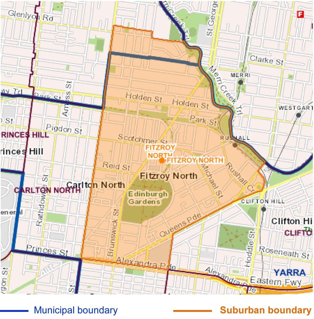
42 42 north from Holden Street This 1882 Jika Jika Parish map of northern North Fitzroy shows the original land sales of Lot 93 (to Sandiman, 124 acres), Lot 90 (to Mason, 132 acres), and the 60 smaller lots south of Holden Street which were sold over 1870 to 1877 when the rest of North Fitzroy was originally subdivided and sold. The Government Road that was called Westgarth Street West in Russell's 1854 map and then Brunswick Road, had become Holden Street, named after builder James Holden who was mayor of Fitzroy in 1881 and a councillor for 23 years from From 1881 to 1940, the northern boundary of Fitzroy was near May Street. After an unsuccessful petition in ,15, there have been later incremental changes in and resulting in the existing municipal boundary along May Street. Current Locality of Fitzroy North Municipal and Locality boundaries VICNAMES is the official Register of Geographic Names throughout Victoria. 18 VICNAMES maintains a register of places defined by their Locality and by their Municipality. These are available on-line In this area of Fitzroy North, the municipal boundary corresponds closely to the northern boundary of the original Lot 93, along the alignment of May Street about 250 metres south of Glenlyon Road. The locality of Fitzroy North however extends north into the City of Moreland at Glenlyon Road, and includes all the properties on the north side of Glenlyon Road and east of Nicholson Street. 14 VGG, 1891, page VGG, 1891, page VGG, 1940, page VGG, 1993, page

43 half-drowned or half-baked 43 Fitzroy North Suburban Boundary (as shown in the official map of City of Yarra, Suburb Names and Boundaries 21 ) Historical features north of Holden Street Many of the historical features north of Holden Street are readily discoverable using the MMBW maps dated 1905, 22 the Sands & McDougall's Directory for 1904, and the newspaper archives of that era data/assets/pdf_file/0022/56533/ Yarra_V43.pdf. 22 The MMBW maps are on line at the State Library of Victoria (SLV) by searching the SLV catalogue for: "MMBW Fitzroy 1936" for the area north of Miller Street; "MMBW Fitzroy 1933" for the area west of Rae Street; "MMBW Fitzroy 1934" for the area from Rae Street to Melville Street; "MMBW Fitzroy 1935" for the area from Melville Street to St Georges Road; "MMBW Fitzroy 1942" for the area east of St Georges Road. 23 The newspaper archives can be searched at


44 44 north from Holden Street Location of selected historical features north of Holden Street. North of Miller Street This MMBW map, No 1936 of 26 March 1906, shows Miller Street across the bottom, Glenlyon Road across the top, and the municipal boundary line across the middle. Two quarries are near the corner of Nicholson Street and Glenlyon Road, and the edge of another quarry south of Miller Street. South of the boundary line is the Fitzroy Garbage Destructor, bounded by Miller Street, King Street and Queen Street. North of the boundary line is the Glass Bottle Works. Fitzroy Quarries There were quarries in Fitzroy's far north, and nearby in Brunswick and along the Merri Creek. They provided 'bluestone' basalt for buildings and for road-making. The MMBW maps indicate that


45 half-drowned or half-baked 45 quarries in this area were about 15 feet deep, and there were newspaper reports of fishing and drownings in these water-filled quarries. 24,25 A remnant of these northern quarries is evident at the church and sunken schoolyard opposite Clauscen Street on the Brunswick side of Nicholson Street. North Fitzroy, south of Park Street, was known as the 'Quarries District' when the residents there petitioned in 1860 for the area to be severed from Melbourne and annexed by Fitzroy. 26 The Collingwood Stockade, located at the site of the Lee Street school in Carlton over , provided labour for a Carlton quarry at the present site of Curtain Square, and for other quarries at Fitzroy. These Fitzroy quarries in the 'Quarries District' were being filled in during Moonee Valley Glass Works In early 1897 John Dunne established the Moonee Valley Glass Works on 4 acres at the corner of King Street and Glenlyon Road, in order to supply bottles for his nearby cordial factory. The glass furnace had four working holes, a smelting capacity of ten tons, and was surmounted by a stack 70 feet high. He imported the plant and the skilled bottle makers 'from the home countries', erecting eight dwellings for them on the site. The manager's "most handsome balconied and towered residence" still stands at the corner of Glenlyon Road and King Street. 28 plan of glass works bottle the manager's residence today (author's photo) Fitzroy Destructor The garbage destructor was built in 1893 for the Fitzroy Council in Miller Street between King and Queen Streets very close to the Brunswick boundary line. It was controversial, and after a short trial the Council notified the contractor to remove it within three months. 29,30 The 180 feet chimney was eventually removed in 1937, 31 and the land was subdivided. 32 The corner house opposite at 103 Miller Street and many of the terrace houses opposite in Queen Street from 1906 still remain. 24 Argus [Melbourne], 12 November 1877, p Age [Melbourne], 11 January 1881, p VGG, 31 January 1860, p Leader [Melbourne], 2 December 1871, p Sportsman, 2 March 1897, p Brisbane Courier, 27 February 1994, p Senyard, Fitzroy, pp 44, Age [Melbourne], 28 July 1937, p Age [Melbourne], 18 November 1937, p 4.


46 46 north from Holden Street The Destructor. MMBW plan. View: Fitzroy Library photo collection, FL226. South of Miller Street MMBW 1933 MMBW 1934 MMBW 1935 These MMBW maps of show the quarry at Miller Street, the Cordial & Aerated Water Factory extending from Miller Street to Clauscen Street, the former Mersey Street now the western end of Clauscen Street, the Moran & Cato grocery & stables at the corner of Rae & Holden Streets, the terraces houses of pre-1891, the 2 acre site of the future St Joseph's School, the Barbed Wire & Nail Factory, Pilkington Street and the Tram Sheds at the corner of Holden Street & St Georges Road. Cordial and Aerated Water Factory The Moonee Valley Cordial and Aerated Water Co was established by John Dunne in 1890 at what is now 9 Birkenhead Street.


47 half-drowned or half-baked 47 9 Birkenhead Street Advertisement for Moonee Valley Co 33 (City of Yarra Heritage Database) By 1894 the business had expanded to 36 acres at North Fitzroy northwards from Clauscen Street. By 1897 he employed 70 hands and had stabling for 60 horses. 34 In early 1897 he established the Moonee Valley Glass Works on 4 acres at the corner of King Street and Glenlyon Road. In 1898 his range of soft drinks then included the increasingly popular 'Horonda', an alcohol-free beer based on Horehound, a flowering plant which he grew at his Yan Yean and Diamond Creek farms. The output of his factories was 200 dozen bottles per hour, and 40 wagons were needed for deliveries. By 1900 he employed 600 men in his North Fitzroy industries, and his 126 horses grazed on the vacant land around his Miller Street factory. 35 On 29 July 1910 the business was advertised for sale under the name of Voxall's Moonee Valley Water, Cordials and Horonda Factory. 36 Presumably John Dunne had sold the business by then. This factory extended from Miller Street to Clauscen Street, and was opposite the Moonee Valley Company s offices which still stand at 131 Miller Street. souvenir jug with image of factory 37 former Head Office, now 131 Miller St (City of Yarra Heritage Database) 33 Mercury & Weekly Courier [Fitzroy], 20 January 1899, p Sportsman, 2 March 1897, p Fitzroy City Press, 10 October 1900, p Argus [Melbourne], 29 July 1910, p


48 48 north from Holden Street (Land Sale maps held at the Fitzroy Library, Local History map collection) Life of John Dunne and his wife Abigail John was born in 1862 to Patrick Dunn, a quarryman, and Bridget, nee Barrett, who lived at 4 Leicester Street, Fitzroy over the period 1868 to 1888 when Patrick died there. Nearby at 10 Leicester Street lived Edmund Finn who was also known as the author 'Garryowen'). In 1893 John Dunne married Abigail, the second daughter of Timothy and Eliza Leahy who were publicans then at the Liverpool Arms Hotel at the corner of Johnston Street and Brunswick Street. John and Abigail's only two children died in infancy in 1894 and In 1896 John and Abigail returned from an 18 month trip to Ireland, Scotland, England and the Continent. 38 Abigail died of bronchitis, aged 23, on 9 September 1896 at their residence in the Aberdeen Hotel. 39, 40 Her probate documents record that her assets then included two wooden cottages in Leicester Street ( 400), land at Miller Street upon which is erected a cordial manufactory (66ft x 307ft, 2500), the plant of the manufactory ( 2500), 28 horses and 13 wagons ( 300), and many trading transactions associated with the cordial business. John was her sole beneficiary and executor Sportsman, 20 October 1896, p Australasian [Sydney], 19 September 1896, p Sportsman, 15 September 1896, p Public Records Office Victoria (PROV), VPRS 28/P2/unit 471.


49 half-drowned or half-baked 49 John Dunne was a brewer's traveller at Carlton Brewery from 1888, proprietor of the Moonee Valley Cordial Company for 20 years from 1890, and hotel broker from With his farm and orchard at Diamond Creek, he was a councillor at the Shire of Heidelberg in He lived over many years at the Aberdeen Hotel and died at Ferntree Gully in 1926, leaving an estate of 91,000 to family members and charities. 43 Moran & Cato Grocery and Stables This grocery business had its central warehouse at 277 Brunswick Street and 80 branches across Melbourne, including at this corner adjacent to its central stables. We went over to the stables at the corner of Rae and Holden streets. The stalls for the horses are large and roomy: indeed, they have more space than in many cases is devoted to two, with comfortable, clean beds eighteen inches deep, and everything spotlessly clean. There is accommodation here for forty-five horses, also an infectious diseases ward, and foot baths, conveniently made, so that the horse can be tied up standing in them. In this manner they can be treated with hot or cold water or clay, or whatever else is necessary. 44 Terrace houses The MMBW maps of show early rows of terrace housing in Barkly Street and Clauscen Street all of which are now still standing. The rate book and postal directory of 1892 indicate that all these terrace houses were erected before then. 42 Mercury and Weekly Courier [Fitzroy], 23 December 1898, p Age [Melbourne], 23 December 1926, p Melbourne Punch, 18 January 1906.
 Clauscen Street was owned by James Ryan who had previously been the owner/licensee of the nearby Railway Hotel in Nicholson Street.")
50 50 north from Holden Street and Barkly Street Clauscen Street Barkly Terrace at Barkly Street was owned by the Premier Permanent Building Society. The terrace at (now ) Clauscen Street was owned by James Ryan who had previously been the owner/licensee of the nearby Railway Hotel in Nicholson Street. When he died in 1891 he was a contractor, and also owned about 4 acres of land and several cottages in East Brunswick fronting Victoria Street, Nicholson Street and Ryan Street PROV, VPRS 28/P2/unit574.


51 half-drowned or half-baked 51 St Joseph's School The large two acre site bounded by Holden Street, Dean Street & Barkly Street had been donated to Father O'Hea of Coburg, and on his death in 1903 was valued at In 1911 the new St Mary's church-school was opened for the increasing population of North Fitzroy and East Brunswick. By 1938 they moved to their new church and school across Nicholson Street, and were replaced here by the Marist Brothers' St Joseph's school which soon expanded to include Year 12 by St Joseph's school closed in 1999, and has been succeeded there since 2008 by the Deutsche Schule Melbourne with its 100 students. Original St Mary's church-school of : Noone, Going to St Joe's. Jackson's Wire & Nail Factory Adjacent to the school site in Barkly Street, Albert Jackson registered his wire and nail factory in October In February 1897 six males were employed there, and his wire fencing, staples and nails were being sold interstate through to the 1900s. The site is now occupied by modern terrace houses at Barkly Street. Pilkington Street Dating from 1853, this street only 100 metres long is named after the family of Robert Pilkington, the son-in-law of William Thomas who owned the area from The street appears in a map produced by surveyor Robert Russell in Noone, Going to St Joe's. 47

52 52 north from Holden Street Tram Sheds The North Fitzroy cable tramway was opened on 2 October 1886, a year after the first route to Richmond. The route along Brunswick Street and St Georges Road terminated at Barkly Street. The trams were housed in sheds adjacent. When the route was extended and electrified the land was sold in Shops were soon built along St Georges Road, and villa units were built on the other streets. East of St Georges Road 48 Age [Melbourne], 3 October 1939, p 6.
 at the corner of Kerr Street and Fitzroy Street. He was a Fitzroy councillor for 15? years from 1875, and mayor in 1877 when Fitzroy was proclaimed a city.")
53 half-drowned or half-baked 53 'Bangalore' villa, owned and built in 1885 by Robert Showers Robert Showers was a Fitzroy builder ( ), a farmer at Northcote ( ), then builder and publican at the West of England Hotel ( ) at the corner of Kerr Street and Fitzroy Street. He was a Fitzroy councillor for 15? years from 1875, and mayor in 1877 when Fitzroy was proclaimed a city. In 1885 he built his home on a large site (250' x 400') opposite Clauscen Street between St Georges Road and the Merri Creek. The two storey brick residence "is named Bangalore after the place of his nativity, and is the finest dwelling-house yet erected in Fitzroy. Its immediate surroundings are excellent, the edifice itself can be seen from a great distance, and the internal arrangements reminds one of a modern English baronial mansion on a small scale, while the views from the balconies are extended and pleasing." Our Local Men of the Times, Fitzroy Library LH 32/15.

54 54 north from Holden Street Aberdeen Hotel Aberdeen Hotel: Fitzroy Library photo collection, item FL650. The Aberdeen Hotel, with 45 rooms, was built on the south-east corner of St Georges Road and Holden Street in 1889, soon after the new tram route terminated nearby from October Early publicans were James Davoren ( ) and James Dunne ( ), brother of John Dunne who was a long time resident there. Owners included Wm Byrne (1890 and 1891), and Carlton Brewery ( ). This place is sumptuously furnished and there are several large rooms which would not be out of place in Government House. 50 James Davoren, Hotel Keeper, died on 25 Aug The inventory included in his probate records provides a detailed listing and valuation of the furniture and fittings of the bar, two bar parlours, billiard room, kitchen and pantry, sitting room and the 30 bedrooms. The stock in trade included whiskey (32 bottles and 3 gallons), brandy (14 bottles), other spirits (21 bottles), wines (39 bottles), beer (150 bottles and 200 gallons of draught) and 17 dozen cigars Mercury & Weekly Courier [Fitzroy], 23 December 1898, p PROV, VPRS 28/P0 unit 639, item 50/486.

55 half-drowned or half-baked 55 William Thomas' family's houses near the Merri Creek Pilkington houses Merriville Lodge Merrivale Cottage Pilkington houses at 183 and 193 Holden Street Robert Pilkington and Emily, nee Thomas, had about 10 children born over the 1850s and 1860s. Initially they lived at Merriville Lodge to 1867, and from then at the new Merrivale Cottage. By 1881, a brick and wooden house of 6 rooms had been built at 193 Holden Street. Robert was the occupant there until his death, aged 53, in Emily was the next occupant and owner until her death in 1896.Their spinster daughter Sarah was the next occupant there. By 1890 a brick house of 5 rooms had been erected at 183 Holden Street. It was owned and occupied by the Pilkington's eldest son William, a plumber. He died in 1928, aged 75, having been the official scorer of the Fitzroy Cricket Club for 30 years without missing a match. "Scoring was a religion with him." 52 Merriville Lodge at 217 Holden Street (and 262 Barkly Street) William Thomas was a protector and guardian of Aborigines from 1839 until his death in He purchased this land extending from the Merri Creek to Pilkington Street in 1848, and advertised the planned sale of part of it in 1854 before the Yan Yean pipeline and St Georges Road soon traversed it. In his journal on December 1842 he refers to it as his son's farm. 54 He lived here from before 1863 until his death in Later owners/occupants were draper J C Wilson (to 1878) and hoteliers Edward & Catherine Poole (to 1910). It was described as a double fronted bluestone villa, slate roof, 6 rooms & scullery & washhouse, with 2 small attic rooms. 55 It has been replaced by the apartments now at 262 Barkly Street, but originally it had a frontage to Holden Street (No 217) and the rear stables were at Barkly Street. 52 Australasian [Sydney], 6 October 1928, p Journal of William Thomas, 15 December Argus [Melbourne], 27 June 1878, p 2.

56 56 north from Holden Street Melville Lodge Merrivale Cottage Merrivale Cottage at 243 Holden Street This was a wooden house of 7 rooms facing towards the Merri Creek, at the present site of 243 Holden Street. Thomas' daughter Eliza, her husband Robert Pilkington and their large family lived here from Later occupants here were Robert Carrington, gentleman, from 1881, Samuel Lang in 1890, and civil servant John Mactaggart in References Val Noone, Going to St Joe's: a Marist school in East Brunswick and North Fitzroy (Spectrum Publications, Richmond [Victoria], 1999). June Senyard et al [eds], Fitzroy: Melbourne s First Suburb (Hyland House, Melbourne 1980). William Thomas, The Journal of William Thomas: assistant protector of the Aborigines of Port Phillip & guardian of the Aborigines of Victoria 1839 to 1867 (Victorian Aboriginal Corporation for Languages, Melbourne 2014). Victoria, Registrar-General's Office (RGO), Index Books and Memorials. Victorian Government Gazette, available on-line at Wills and Probate files, Public Records Office Victoria, (PROV), available on-line at: Mike Moore is a retired engineer and has been a member of the Fitzroy History Society for two decades. He enjoys researching the rich history of Fitzroy and its early settlement, buildings and people. 56 Argus [Melbourne], 30 June 1868, p 4.
57 MADE IN NORTH FITZROY Terence Nott Four former manufacturing industries in North Fitzroy Following on from the development of Fitzroy, the land north of the Reilly Street drain was subdivided into housing lots from the 1860 s and by the late 1870 s housing covered most of the southern and central parts of North Fitzroy. The establishment of manufacturing followed in a somewhat unplanned fashion with industries often buying up residential lots to build their factories, in many cases demolishing the houses to make way. The construction of the Inner Circle (a contemporary description) railway line and the branch line to the Fitzroy Goods yard and station together with the proximity of the Heidelberg Road, leading north and south, encouraged the establishment of industries in the southern part of North Fitzroy. In 1949 the City of Fitzroy commissioned the Report on Reclamation of an Industrial Suburb: A Municipal Rating Study of Fitzroy. In this Study, Fitzroy was ranked sixth of the twenty eight municipalities in the metropolitan area. As the smallest of these municipalities, these figures clearly underestimated the physical extent of Fitzroy s industrialization. In terms of the numbers of people employed per acre, Fitzroy was ranked fourth, behind the giants of industry, Richmond, Collingwood and Melbourne. 1 A broad description of the early development of North Fitzroy is included in the section by Miles Lewis. Over 150 years later all of these manufacturing industries have disappeared along with the Inner Circle Railway line and the branch line to the Fitzroy Goods yard. In some cases such as with the former Gas and Fuel site there is very little trace of the original buildings. In other cases such as several shoe factories, there are tangible remnants of the original buildings remaining. In this section, four very different manufacturing industries were selected to study. The common features are the proximity to Queens Parade, the former Fitzroy Goods yard and to other former industries in Fitzroy. The limited amount of research available for each industry revealed that a great range of manufactured items was made in North Fitzroy. From anti-tank gun carriers to brass buttons for the American military and from Olympic Games medals to cork platform shoes. Over time the owners of each industry studied changed. The names of each business also changed as they expanded or restructured. For the sake of brevity the description title names of each of the former industries described are based on how they are now commonly referred to today. 1 City of Fitzroy, Municipal Rating Study of Fitzroy, 1949.

58 58 made in Fitzroy Fitzroy Gas Works, Queens Parade, North Fitzroy. The site is bounded by Alexandra Parade, Smith Street, Queens Parade and George Street. Early residents of Melbourne relied on oil lamps for illumination. In the 1840s some shopkeepers installed small coal gas plants to illuminate their shops. Those proved to be a great success and attracted much custom. In 1850 the City of Melbourne Gas and Coke Company was formed. Because of continuing delays at the Company s works at Batman s Hill (West Melbourne), coal gas was not supplied until With the increase in demand, new gas companies were formed. The Collingwood, Fitzroy and District Gas and Coke Co was established in It was a joint venture between the local council and private investors. Gas supply commenced from its gas works in North Fitzroy in May After four years of bitter competition with the South Melbourne Gas Co., the two companies were amalgamated to form the Metropolitan Gas Co. in Gas lighting remained the mainstay and gas cookers, water heaters and fires grew in popularity during the 1870 s and 1880 s. By 1900 there were 50 gasworks in Victoria and 16 in Greater Melbourne. 2 Detail of MMBW plan North Fitzroy, dated The coloured outline shows the extent of the former gas works site. Note that in 1894, Gore Street extended north to Queens Parade. By the late 1880 s electricity was replacing gas for street lighting lamps and in 1894 the streets of Melbourne were first illuminated by electricity from the MCC Spencer Street Power Station. Ironically the power was generated using coke from the gas works of the Metropolitan Gas Company works. In 1919 the company commenced using electric arc welding for the construction 2 Allom Lovell and associates Fitzroy Urban Conservation Study Review, 1992
59 half-drowned or half-baked 59 of steel structures instead of the standard riveting practice. The success with the company s important structures was, within a few years, followed by others in Australia and overseas. The original three gasholders were re-built in the late 1920s by the Construction Department of the Company. The smallest of these new holders was the first holder to be built by the Gas Company s staff. The largest of these, capable of holding two and three quarter million cubic feet of gas, was the first completely electrically welded structure of its kind. The third holder was also electrically welded. 3 These holders are featured in the aerial photo of 1928 which also shows the workshop, layout yard, stores and offices of the Construction Department. From the gasholders the gas passed to the valve house and was then distributed to the northern and central districts of Melbourne. The Fitzroy Gas Works was disadvantaged by its distance from the port and the production of gas ceased in The site continued to be used as a workshop and a gas storage facility until its closure. Coal Gas manufacture diagram, The Profession of Home Making, (American School of Economics 1911) From 1940 to December 1944 defence work carried out by the company reached a value of 1,034,256. The advent of hostilities not only demanded the production of weapons of defence, but well known by-products of the gas Industry had to be diverted for use in the war effort. New products were called for. Prior to the war, by-product ammonia was largely converted to sulphate for agriculture. During 1944, 334,000lbs were produced for explosives production. Special solvents for synthetic resins used for coating aircraft and the reclamation of rubber were also produced. 4 3 Metropolitan Gas Co, Jubilee, : a historical sketch. 4 Metropolitan Gas Company , Production of Munitions.

60 60 made in Fitzroy Aerial view of the Fitzroy Works from the north-west. Queens Parade in foreground, Alexandra Parade in background: Metropolitan Gas Company Jubilee , no page. By 1939 the Construction Department had reached maturity and the board of directors in May 1940 placed the Construction Department and its facilities at the disposal of the Director-General of Munitions. The Company s first order was for the fabrication and construction of 370 Machine Gun Carriers. This was later increased to 450. This order was completed in April To complete this order it was necessary to carry out extensions to buildings and plant and to increase staff. The workshop annexes referred to and pictured in the Company s Production of Munitions booklet were progressively built in the north eastern part of the works. In September 1940, 160 men were employed excluding drawing office and clerical staff and working 44 hours per week. By 1943 the number had risen to 883 men. At this stage 15 or more carriers were being produced per week. In 1942, soon after the completion of the order for the Machine Gun Carriers, work commenced on orders for Tank Attack Carriers, using as many parts as possible as were used in the Machine Gun Carriers. These were fitted with two pounder guns. 200 of these Carriers were built. In October 1942, the 3 inch mortar Carrier came into production and by May 1943 the order of 400 of these carriers was completed. On the 31 st of May, 1943, the Chairman of the Board handed over to the Minister for Munitions, the 1000 th carrier produced by the company. At the cessation of the carrier production the Company was kept busy with a wide range of general munitions products. This included over one million spare carrier parts. Also machinery work on guns and diesel engines, gantries and platforms, rifle grenade dischargers and hydraulic jacks for the RAAF. The Company also produced 100 pontoon bridge trailers for the US Army, and mobile field laundries for the Australian and US Armies as well as a large number and variety of mobile cranes. 5 5 Metropolitan Gas Company Production of Munitions.

61 half-drowned or half-baked 61 2-pounder Tank Attack Carrier in travelling position: Australian War Memoria PO of these were produced by the Metropolitan Gas Company in 1942 and The gas works were closed in the 1970s and most of the buildings, including the perimeter brick wall, were removed. The gasholders were dismantled in Very little now remains to indicate the extent of the original works. The only obvious remaining structure is the red brick valve house at the corner of Alexandra Parade and George Street.

62 62 made in Fitzroy Extract from Production of Munitions by the Metropolitan Gas Company. A range of military vehicles is shown. A gasholder is visible in the background of one image. K G Luke, 26 Queens Parade, North Fitzroy In 1921 Kenneth Luke became a partner in a small metal spinning and silverware business in Carlton. By 1925 he was its proprietor and employer of seven. In 1929 he bought a larger factory in Queens Parade, North Fitzroy, doubled his staff and introduced new lines. At the outbreak of World War 2 production was again stepped up and Luke became an honorary adviser to the Dept. of Supply and Shipping. 6 The Age newspaper reported in July 1946 that after a long break when their workshops were used for the production of war essentials, K G Luke Pty Ltd had resumed manufacture of silverware, and that many ex-serviceman are engaged in this work. 7 On 16 April 1953 the Advertiser (Adelaide) reported that K G Luke Ltd were to register in Melbourne as a public company in the next day or so. It went on to report that the company would float with an issue of 203,046 ordinary shares of ten shillings each. 8 By 1959 the company had about 650 staff and was manufacturing an ever-increasing range of products including silverware, stainless steel surgical equipment, plated goods and glass washing machines. The company s name changed to Luke Ltd in 1976 and it was taken over by National Consolidated Ltd in City of Yarra, K. G. Luke Pty Ltd Statement of Significance (2014). 7 Age [Melbourne], 3 July Advertiser [Adelaide], 16 April 1953.

63 half-drowned or half-baked 63 Detail of MMBW plan of North Fitzroy, The coloured outline generally defines the sites later occupied by the K G Luke factory In 1894 at the time of the above MMBW plan the land later occupied by K.G. Luke consisted of houses and vacant property on the north side of Queens Parade. The Fitzroy station platform and Goods yard were operational and the Metropolitan Gas Co. was producing coal gas at its premises opposite and between Queens Parade and Alexandra Parade. The MMBW plan of 1901 shows houses on the north of the site. These are shown blank in The remains of a bluestone base of a cast iron picket fence belonging to one of the demolished houses are still visible in Queens Parade. A recent image of the former K.G. Luke factory at Queens Parade, North Fitzroy: unknown source.

64 64 made in Fitzroy Once established at Queens Parade the output of the factory continued to increase in the quality and range of products. Existing buildings were altered and extended and new buildings erected. The Heritage Report prepared by Lovell Chen, Heritage Architects, describes in some detail the sequence of the building process. By the end of the 1960s the buildings covered most of the site. The most prominent part of the building is the front façade. Despite the current inappropriate paint colour of the façade, the building is regarded as significantly important for its heritage value. The City of Yarra Heritage citation includes the description - An unusual Art Deco (or Modern style) factory/warehouse that has a very intact façade of architectural merit especially in its parapet detail. Part of the description in the publication Decoration and Glass 1938, is summarized as follows. The administrative section is situated on the first floor and offices and show room are panelled in Queensland walnut flush panel veneer. Counter top screens with curved glass in metal frames, terrazzo staircase and rubber flooring provide a cohesive modern interior. As well as the electro plate and cutlery show room there was a separate showroom devoted to hospital fittings and equipment. The whole of the ground floor was left clear for production. The textured surface bricks used on the facade featured between the cement work. The firm s name appeared in large letters on the parapet as well as a description of its main products. 9 The new K G Luke building; architect, Eric H J Ziebell; builder, Pollard Brothers: Decoration and Glass, April Decoration and Glass, April 1938.

65 half-drowned or half-baked 65 K G Luke manufactured medals for the 1956 Melbourne Olympic Games to the design of the Melbourne sculptor Andor Meszaros ( ). Meszaros was born in Budapest, Hungary and studied engineering in Vienna and sculpture in Paris. In 1939 he emigrated to Melbourne where he worked as an architect before concentrating on sculpture. In 1949 he travelled to England to work. Returning to Australia he produced many works in stone and bronze for churches and public buildings. Between bigger commissions, Meszaros turned his hand to designing medallions, producing more than one thousand different designs. He won Spanish and Italian awards for his work as well as local recognition. He is said to have regarded medals as the chamber music of the arts Olympic Games Participation bronze medal, designed by Melbourne sculptor, Andor Meszaros and manufactured by K G Luke. Ltd, North Fitzroy: National Gallery of Victoria. Souvenirs for the Coronation of Queen Elizabeth were also manufactured, with bright and varied designs for cups and medallions being distributed to retail stores. K.G. Luke also produced a variety of medals for football clubs and the VFL. 10 Kelman Semmens, 'Andor Mészáros, ( )', Australian Dictionary of Biography, National Centre of Biography, Australian National University, [2000], accessed online 21 November 2017.


66 66 made in Fitzroy Silver brevet with a broach fitting for a RAAF gunner. Sterling silver, marked K.G. Luke. MELB Seals Museum of RAAF memorabilia. Button produced by K.G.Luke for the US first Marine Division. This style of button is known as a Great Seal button. From 1935 to 1945 the company made brass, copper, oxidised and white metal buttons for military needs. It also made brooches, badges, buckles and identity disks, as well as heated food trolleys. During the war years the company s workshops concentrated on the production of war essentials. The Commonwealth Gazette of 24 June 1943, listing contracts accepted, reports that K G Luke of North Fitzroy have been awarded a contract for 11,015 buttons for the U.S Army for the cost of 345 and 12 shillings. Paramount Ware was the most popular range of silver ware produced by K G Luke. It included tea pots, cake serving plates and other table ware. Another popular line was the Carousel range of cutlery.

67 half-drowned or half-baked 67 Advertisement from the Australian Women s Weekly, Paramount was K G Luke s trademarked silverware. National Can Industries, Jamieson Street, North Fitzroy The founders of National Can, Harry Tyrrell and Leslie Whitcroft were experienced executives in the packaging industry. In 1954 they pooled resources and commenced business in a disused shed at the north end of the Fitzroy Goods yard. This building had previously been used to produce straw envelopes to protect filled beer bottles. A lease was secured from the Victorian Railways. This building is shown on the MMBW plan of The first can was produced in December Used can making machines were acquired in 1955 and the first of many building extensions was built in The year s sales in 1957 topped 200,000.


68 68 made in Fitzroy The tin shed adjacent the railway line in the Fitzroy Goods Yard. National Can made their first can here in 1954: Here s to National Can. The business grew rapidly and new building extensions were built to house litho presses and a warehouse. Deliveries of rolls of tin plate and other material were made via the entrance at the corner of Jamieson Street (formerly named Groom Street) and Alfred Crescent. National Can acquired its Dalson Ware subsidiary in 1960 and expanded interstate. The acquisition of this kitchenware brand enabled the company to expand its range of products into plastics. Extract from the National Can publication from 1974, celebrating 20 years of National Can. Copies of this small booklet were cleverly rolled up and sealed in ring top cans which were decorated on the outside with logos of the National Can product brands.

69 half-drowned or half-baked 69 In 1962 the first consignment of Australian made tinplate was received and can prices decreased because of the cheaper locally made product. 11 During the 1970 s and 80 s the company came under pressure to improve its pollution problems. Fume incinerators were installed in 1975 and other measures were progressively taken to reduce the emissions and smells, but the problems persisted. The site was becoming very restricted with the increase in the size of the delivery vehicles and the amount of activity. Parking was also a problem with cars needing to be parked on the adjacent railway land which was being gradually vacated. With the closure of the Inner Circle Line and the branch line to Fitzroy, the State Government with the involvement of Melbourne, Brunswick and Fitzroy Councils, prepared plans for public housing and park land along the length of the disused line. In 1987 a new plant was completed in Northcote. In 1996 the gates of the North Fitzroy plant were closed for the last time and can making operations commenced at the new plant in Preston. The buildings in North Fitzroy were demolished and the site cleared and then progressively returned to the Edinburgh Gardens. The off-the-leash dog area in the southern part of the Gardens now generally defines the extent of the site that was occupied by the factory and yards. There is now no trace of the former factory. Display of tins and cans produced at the National Can factory in North Fitzroy. National Can Industries publication Alan Gregory Here s to National Can (1994).

70 70 made in Fitzroy Aerial photo of the southern part the Edinburgh Gardens showing the full extent of the National Can Industries buildings and yards running north south. Note the only entrance is from the Jamieson Street and Alfred Crescent corner. This image shows the extent of industries which occupied the former Fitzroy Goods yard. The Branch Line and the footbridge are also clearly shown. The location of the Boot Factory in McKean Street, described next, is also indicated in this photo. Photo Terence Nott collection, source unknown. The date is assumed to be the early 1990s.

71 half-drowned or half-baked 71 Boot Factory, McKean Street, North Fitzroy Following the establishment of boot and shoe factories in Fitzroy, many new factories were established in North Fitzroy and Clifton Hill and in the suburbs beyond. In 1910 a group of terrace houses known as the Fitzroy Cottages were located between nos 36 and 48 McKean Street, and occupied by several people, including L Kearns, bootmaker. In 1920 H Harrison, boot manufacturer, occupied all of this property, having erected a substantial factory and ancillary buildings. In 1930 it was occupied by Lynn Shoes Pty Ltd, boot manufacturers. Sasha Shoes later occupied all of the buildings on the site. Detail of the MMBW plan of North Fitzroy, dated The coloured outline shows the general extent of the boot factory built c There were originally three separate buildings. The large building facing McKean Street is mainly two storeys with a three storey section at the rear. This building was remodelled as apartment units after being divided up and sold off as individual shells. The separate two storey building set back behind the current car park and No. 50 McKean Street has also been divided into apartments. It features prominent raised curved roof lanterns for natural light. Most of the fabric of these two buildings has been retained intact. The original opening in the front wall, used for leather and other deliveries, has unfortunately been bricked in. A narrow laneway separated the main building from two long narrow buildings that housed equipment, stores and garages. These were removed to make way for the car park for the apartments. They have been replaced by an inappropriate brick fence and steel gates. The original roof line of the main building has been altered to accommodate the upper levels and roof decks of the apartments. The apartment building is now numbered 42, 44 and 46 McKean Street. By 1950 Griffin was the leading brand made by Lynn Shoes, named after the owner Mr. Griffin. Over the years Lynn Shoes gradually became known as Griffin Shoes which in turn gave way to Sasha Shoes. Lynn/Griffin Shoes produced a variety of brands and styles of footwear, including shoes for lawn bowls, children, casual and formal ladies. Play Slax, Sbicca and Friar John were three of the brands names marketed by Lynn/Griffin Shoes. Styles were often given names such as Marti, Lorna, Havana, Dotti, Tampa, Port-Ho and Canto so as to distinguish them from each other.

72 72 made in Fitzroy Sasha Shoes, McKean Street, North Fitzroy, formerly Harris Boot factory and then Lynn Shoes Pty Ltd: Gary Vines, Northern Factory Study 1992, City of Moreland. The Northern Suburbs Study of 1992 refers to the buildings as being in good original condition. It lists the buildings as being of local significance as a substantially intact inter war boot factory.

73 half-drowned or half-baked 73 The Clicking Room at Whybrows Shoe factory, Collingwood.c.1920 This picture illustrates the typical working conditions at the time. The arrangement at the Harris Boot factory was similar. Clicking apparently refers to the making of the shoe uppers. In 1997, at the time of closing down the business and before redevelopment into apartment shells, the author and his daughter took photos of the exterior and interior of the main building and the building at the rear. At this time the equipment, furniture and fittings were being assembled for removal. It is of interest that the factory buildings and grounds were used for the filming of the 9 part ABC television series tilted I can jump puddles. This was screened in 1981.The series is based on the life story of Alan Marshall, writer, who contracted poliomyelitis as a boy and who grew up and worked in Melbourne. The series features many images of the buildings and grounds of the factory.

74 74 made in Fitzroy Finished shoes on steel rack, Sasha Shoes: photo, Birgit Nott, From the 1980 s onwards there was a huge decline in the number of clothing, textiles and footwear factories. North Fitzroy was not spared from the exodus. The Gas and Fuel Corporation was broken up into three divisions and sold off in National Consolidated Ltd, the business that took over K G Luke, was delisted in There is no available record of the fate of Sasha Shoes. National Can Industries Packaging, as the company is now called, has its headquarters in Preston and is still making metal and plastic tins, pails and drums. They contract to big brands such as Dulux and Haymes paints, and have operations in Australia, New Zealand, Fiji and Papua New Guinea.
.")
75 half-drowned or half-baked 75 Poster issued by the Textiles, Clothing and Footwear Union References Alan Gregory, Here s to National Can: A History of National Can Industries (National Can, Clifton Hill [Victoria] 1994). Metropolitan Gas Company Jubilee : an historical sketch (Metropolitan Gas, Melbourne 1928). Metropolitan Gas Company Production of Munitions by the Metropolitan Gas Company (Metropolitan Gas, Melbourne 1944). K.G. Luke, Medal and Trophy Makers, Melbourne, Victoria (Museums Victoria Collection) National Can, When National Can started 20 years ago, nobody guessed how fast we d grow. (National Can, 1974) Gary Vines, Northern Factory Study 1992 (City of Moreland 1992) City of Yarra, K.G. Luke Pty. Ltd. electro plate manufacturers factory, former (part) Statement of Significance, Terence Nott has been a resident of North Fitzroy since He established his architectural practice in North Fitzroy in 1980 and is still practising. He was the City of Fitzroy s representative on the Inner Circle Railway Working Group. He has been a member
76 76 made in Fitzroy of the Fitzroy History Society for many years and researched and compiled the Self Guided Fitzroy Railway Walk which was launched in 2015.

77 MILK AND HOW IT CHANGED THE LANDSCAPE Meg Lee with Alison Hart Introduction How many of you can remember the days of the horse drawn cart and the echoed clink of milk bottles in the early morning air? In my childhood from s this was the sound of milk being delivered to our front door. First, in a metal billy placed outside in the shade, on the evening prior to the milk delivery in the early hours when no one is awake. The scare of germs and disease meant greater vigilance on ways and means of milk provision. With improvements from the 1890s and legislative changes in requirements for increased hygiene, care in milk production and delivery methods, the physical landscape altered accordingly. This paper describes changes in the built environment due to improving quality of milk and delivery methods for households from the 1880s to the late 1940s. Background In the early Port Phillip district, most small homesteaders had a house cow to provide fresh milk, cream,butter and cheese, if the women of the house were skilful and knowledgeable. Milk was easily contaminated in the dairy and the mark of a good dairywoman was her cleanliness. 1 Many women were listed as proprietors of dairies. Early maps of South Fitzroy show the Labour in Vain Hotel in Brunswick Street with cow sheds marked at the rear. As city growth spread out, and agriculturasl land was subsumed, cows often came to be depastured on reserves or town commons established for the purpose. By the 1880s fresh milk was supplied twice daily to Melbourne from dairy farms in the fertile foothills of the Dandenong Ranges, while farmers to Melbourne's west, in area such as Werribee, focused on butter production. 2 Up until the 1880s, dairying had remained a local industry, with dairy products such as cream, milk, butter and cheese being produced on the farm. The lack of refrigeration meant that dairy products could not be transported and distributed over great distances. In the early days it was neighbouring farmers that supplied milk to the towns and cities. Before the 1890s each independent dairy Argus [Melbourne], 20 October 1893, p 6. operation was supervised and monitored by the local municipal council. This was a time when milk would arrive at the door-step of most town residential dairy properties, where it was decantered from galvanized lidded, sealed and labelled steel drums into individual householders billy cans. 3 The Central Board of Health complained in 1859 that local councils failed to ensure even a tolerable degree of cleanliness in establishments. 4 In 1864 Victoria enacted the first Australian legislation to prevent the adulteration of eatables and drinkables. 1 Penney & Brown-May, Dairying and Milk Supply, 2 Penney & Brown-May,, Dairying and Milk Supply. 3 Antique bottles, Australian Dairy Collectables. 4 M J Lewis The people s health: public health in Australia , Westport, CT, London, Praeger, 2003, p.138.


78 78 milk in North Fitzroy The problems of supervision and quality control continued well after legislation was passed to improve the safe delivery of milk, as can be seen from this typical example from the Argus of compromised dairy products. Age [Melbourne], 2 March 1897, p 6. The general health acts of 1883 and 1889 addressed regulations for abattoirs, butchers shops, dairy farms and milk shops. 5 However, throughout the 1880s and 1890s The Central Board of Health complained of the apathy of the local authorities in formulating and maintaining high quality products according to regulations. The 1871 census in Fitzroy shows 26 dairymen in residence. 6 These may have been in employ of dairies or dairy owners. However, there were no dairy traders recorded in Sands and McDougall in North Fitzroy at this time. In 1894, the report from the Fitzroy Council, Health Committee listed 71 dairies registered in Fitzroy. 7 At a Fitzroy Council meeting in 1903, the Health Department drew attention to the insanitary conditions of some dairies in Fitzroy with the situation being referred to the Health and Public Works Department. Newspaper stories such as this from The Fitzroy City Press in 1903 appeared, describing unsanitary conditions. In this case the defendant claimed that sewerage works had made it impossible to cart the manure away. She was subsequently fined 5 shillings. 8 By 1900, the Melbourne and Metropolitan Board of Works (MMBW) maps of North Fitzroy, show large areas of residential housing with low proportions of industry or services. Householders would no doubt have purchased their comestibles most likely in South Fitzroy and surrounding locations. North of Holden Street was privately owned agricultural land, with no doubt dairy farms. Subsequently the authorities, instead of relying on prosecutions, decided it was better to define the appropriate composition of foodstuffs. This food control was stated in the Milk and Dairy Supervision Act of Essentially control was transferred from local councils to a special branch of the Agriculture Department. 5 Lewis The people s health. 6 June Senyard et al [eds], Fitzroy: Melbourne s First Suburb (Hyland House, Melbourne 1989). 7 Fitzroy City Press, 9 February Fitzroy City Press, 28 February 1903.

79 half-drowned or half-baked 79 It is interesting to observe the relative value to Fitzroy Council of dairy provisions for the populace via their forward estimates in Below is the record of revenue from milk provision, relative to the value from pets and publicans. The 1903 Fitzroy Council Program for Forward estimates cites the following: 9 Registrations or Licenses Annual Estimates of Income to Council (in Pounds) Publicans 2280 Dairies 51 Dogs 265 North Fitzroy Dairies 1900 In the 1890s to early 1900s we have evidence of at least five dairies operating in North Fitzroy. These were: J Ashton Dairy, at 242 Scotchmer St. The house is called Carnforth (see below). 10 The dairy operated from the rear with stables, yards and cool-stores. Traffic in and out of the dairy would be via the back lane. J Ashton Dairy, at 242 Scotchmer St, Rosehill Dairy in Reference has been made to Hopton s Dairy in Grant Street North Fitzroy In 1903, 441 Brunswick Street was a dairy operated by Maria Sharp Fitzroy City Press, 4 December City of Yarra Library picture collection; resource no Argus [Melbourne[, 11 May 1893, p Fitzroy City Press, 21 March 1902, p 3.

80 80 milk in North Fitzroy o In 1890, Charles J Barnfield operated a dairy in McKean Street North Fitzroy. o Also, a dairy was built for J. Ashton at 227 McKean Street in Improvements in supply from 1900 The introduction of a Victorian Milk Supervision Bill in 1905 tightened control and safety in the emerging milk industry 13. For example, it gave councils the power to stipulate the keeping and grazing of cows within certain distances from living quarters; all dairymen had to label, seal and mark milk receptacles as registered or licensed ; all dairymen were now required to have their cattle examined by a veterinary surgeon and obtain a certificate of such; all plans and renovations were now required to be submitted for approval. These plans needed to include plans, construction, lighting, ventilation, drainage, mode of disposal and drainage of water, paving of the yards; and invite inspections at any time by an officer of Health Department or police. 14 Pasteurisation of milk also contributed to greater hygiene in the distribution of milk, allowing expansion of the domestic milk market. With the construction of the railway system, it also became possible to quickly transport fresh milk to the cities from the country. In the metropolis, the Lady Talbot Milk Institute developed standard conditions for production, storage and distribution of milk. The Institute was established to ensure young infants received quality milk in their first years of life from registered dairies such as Larcher & Sons (see below). 15 Woman Voter [Melbourne], 6 December 1917, 4. New directions in public health included environmental sanitation, greater knowledge of bacteriology and other major diseases. Diseases commonly conveyed through milk included tuberculosis, typhoid fever, diphtheria, scarlet fever, as well as diarrheal conditions. The proportion of udder tuberculosis in cows to total tuberculosis fell from 72% to 6% by While the Dairy Produce Act 1919 introduced new measures for milk testing, grading, pricing and inspection, the 'Milk Question' was hotly debated into the 1920s. There were still regular outbreaks of disease - scarlet fever in Essendon abd bovine tuberculosis in privately owned cows in Brighton - and the backyard cow was widely condemned Report of the Milk Board on the regulation and control of the supply of milk to Melbourne presented to both Houses of Parliament by command of his excellency the Lieutenant- Governor Euroa Advertiser, 6 October 1903, p Penney and Brown-May, emelbourne. 16 Lewis The people s health. 17 Penney and Brown-May, emelbourne.

81 half-drowned or half-baked 81 Below is a snapshot of improvements: 1900 Introduction of Milking Machines into Australia Introduction of Milk Supervision Bill 1908 Lady Talbot Milk Institute established to ensure quality milk for infants % of Melbourne's milk was pasteurised 1958 Milk Cartons introduced, and Milk Pasteurization Act passed 1975 Old one-pint milk bottle replaced by 600ml bottle And home deliveries began to cease. 19 In 1920 dairy cows in Melbourne were still being depastured in Fawkner Park, Yarra Park, Royal Park and Princes Park (with fees paid to the Melbourne City Council), as well as the grounds of the University of Melbourne, some railway reserve and vacant land in Kensington, and Melbourne Harbor Trust land in Dynon Road, West Melbourne. Delivery by horse and cart limited the breadth of the area which could be supplied. 20 Thereafter most milk came from dairies 60 km or more distant. With an emphasis on improved hygiene, model suburban dairies developed from the 1920s. Regulation limited the resale of milk to select grocers and confectioners and bottled milk became more common in successive decades. 21 There were 759 milk shops, and 823 carts employed at 401 dairies across the metropolitan area itself. These were in suburbs such as Essendon where there were 38, in Brunswick 35, in Prahran 29, in Richmond 23, in Hawthorn 21, in South Melbourne 21, in Caulfield 20, in Fitzroy 27, and in Collingwood Cans for milk delivery. Dairy buildings improvements On file in the Local History Collection at Fitzroy Branch of City of Yarra Library is a pictorial record of two dairies in North Fitzroy applying for improvements to meet new legislation on higher standards for dairies. 18 Australian Bureau of Statistics the History of Milk Production in Australia, 65?Open 19 Penney and Brown-May, emelbourne. 20 Penney and Brown-May, emelbourne. 21 Penney and Brown-May, emelbourne. 22 Penney and Brown-May, emelbourne.


82 82 milk in North Fitzroy Rosehill Dairy Below are recent photos of the still existing building of Rosehill Dairy at 242 Scotchmer Street and plans from 1937 for dairy buildings on the site. The rear of the stables at Carnforth or Rosehill Dairy, 242 Scotchmer Street. The property was undergoing restoration at the time. Plans for Rosehill Dairy at 242 Scotchmer Street, 23 October1937: Fitzroy Branch f the City of Yarra Library, box 02 no

83 half-drowned or half-baked 83 Ridge s Dairy, 848 Nicholson Street Street view of 848 Nicholson Street as it appears today. The dairy at 848 Nicholson Street was listed in 1936 as being licenced to Ridge The Sands and McDougal directory of 1931 lists a WF Tucker selling dairy produce from the same adress. The site still has the original building on it today, though somewhat altered. Below are plans for the Nicholson Street dairy, dated 1934

84 84 milk in North Fitzroy Dairy at 848 Nicholson Street: Local Collection, Fitzroy Branch of the City of Yarra Library, box 02, no Growth of Dairies in North Fitzroy As can be seen from the table below, in 1936 there were 13 dairies licensed in North Fitzroy, by 1945 this number had dropped to eight, and remained at that number in In earlier years some other dairies located in North Fitzroy included one at 45 Delbridge Street, with the listed operator in 1896 as G. Robertson. Also, F. Lenter s dairy is reported to have been on the corner of Delbridge and McKean Street.
. Based on a Google map.")
85 half-drowned or half-baked Map showing the location of dairies in North Fitzroy over three snapshots in time: 1936, 1945 and 1950 (for dairy addresses and proprietors, see table below). Based on a Google map. Legend: Dairies delivering in 1936 Dairies delivering in 1945 Dairies delivering in 1950 Prior to 1932 the liquid milk supply to Melbourne and other city markets was via individual licensed dairies operating independently. The Milk Board Act 1932 made provision for the appointment of a board for reporting and making recommendations as to the regulation of milk supplies to the city. It was also charged with the promotion of a better and more economic collection, transport, treatment and
86 86 milk in North Fitzroy distribution of milk, including the regulation of the price paid to producers and the prices paid by consumers. 23 The Government Gazette of 1936 lists 20 dairies registered in the area for delivery. 24 Thirteen in North Fitzroy. There were other dairies licensed to sell, but not deliver such as two in Best Street at nos. 49 and 70. These dairies which could deliver are recorded as registered in the following years: Licence Holder Location W. J. Blouchard 55 Rowe St 2 Malcolm Boyd 49 Delbridge Street 3 Dennis Walter 53 McKean St 4 Henry Joyce 22 Ivan St 5 Ridge 848 Nicholson St 6 Garnet Marsh 558 Rae St 7 Mrs Lily Parker 242 Scotchmer St Angus Lowden 8 W. A. E. Stuchberry 89 Holden St Brookes Crescent 40 Scotchmer St 11 O. J Grieg 45 Kneen St 12 T.J. Kinsella 52 Woodside St 13 C. H. Timmins 79 Best Street 14 Wm T. Collins 37 Barkly St Total By 1945 and 1950 the number of dairies stabilised down to 8 and 7 respectively. Competition must have been fierce. New Dairies Built in in 1936, the dairy at 40 Scotchmer Street, Dunell R. & Sons, later called All Saints Dairy is on the Heritage Register for the City of Yarra (H.O.327) According to the heritage description it is significant for its integrity to original design with the modern style brick and render with clinker brick patterns and front porch features. Below are current front and rear views. The two storey extension means that this dairy most likely manufactured cream and butter from milk received. It was however, not always an honorable operation. 23 Victorian Dairy Industry Authority (formerly Victorian Milk Board ) Public Record Office Victoria, research data Australia Victoria, Government Gazette, 18 August 1936.


87 half-drowned or half-baked 87 Front view of present-day 40 Scotchmer Street, formerly All Saints Dairy. Rear view of present-day 40 Scotchmer Street, formerly All Saints Dairy ; Pure Milk Laws. The proprietor, Richard Dunell seems to have been a dairyman from at least We know this because he was charged in that year for failing to comply with the standards. His milk sold was found to be deficient of 2% solids and 4% in non- fatty materials. He was fined 10 shillings and ordered to pay costs of 6/6. 25 This was not the first time he had dealings with the law. Previously, in the Avoca Warden s Court he had been found to be in breach of Mining Board by-laws in Raggedy Gully. 26 Further, in 1927 an article in the Age (see above) reported that he was charged 25 Age [Melbourne], 26 April.1917, p Avoca Mail, 18 November 1871, p 2.

88 88 milk in North Fitzroy with selling adulterated milk, 14% below the approved non-fatty solids standard, and was fined 2 (his fourth conviction), and that on a previous occasion, when his wife had broken the seal on one of the cans to give the inspector a sample, they had been fined By 1936 he was not the registered dairyman of 40 Scotchmer Street, as it is by then registered in the name of W A E Stuchberry. Glass superseded metal The glass milk bottle was invented in 1884, it meant milk could be stored for several days without spoilage because bottles could be sterilised, and pasteurised milk (quickly heated and cooled) restricted bacterial contamination. 28 The advent of the glass bottle solved issues such as those of contaminated and rusty cans, referred to in the news story below. 29 The bottling of milk became more prevalent in subsequent decades. Dairy branding on a bottle had a double purpose, not just advertising, but one would know where the milk was purchased and could return the branded bottle to the correct dairy, allowing that Dairy to re-use the bottles hundreds of times. 30 Bottles would be lost and returned to incorrect dairies or destroyed. The need for a bulk supply was partly solved in Melbourne when the Melbourne Bottle Recovery company ordered thousands of branded bottles from the glass works and leased these bottles out to individual dairies. This method was adopted in other cities and even in other industries. 31 The changes to milk containers meant greater flexibility in consumers receiving their milk hygienically and promptly and led to the creation of the modern-day milk-bar. 27 Age, [Melbourne]24 June, 1927, p Steven Scales, Some milk bottle history, pdf. 29 Age [Melbourne] 21 June 1923, p Antique bottles. 31 Antique bottles.
.")


89 half-drowned or half-baked 89 How quaint is the Imperial half pint milk bottle from the Gilchrist Dairy, Fitzroy. It was in use between 1930 and 1959 and is now an exhibit in Melbourne Museum (Exhibit no. HT 14148).Images: left, Cherie McKeich; right, Eloise Coccoli: Museum Victoria. The one pint milk bottle was replaced in 1975 with the 600 ml bottle. Around this time most home deliveries had ceased. 32 Of interest is the fact that the Pure Pak sealed cardboard containers, not introduced until 1958, were patented by John van Wormer in 1915 and manufactured by machine. 33 However, it was not until the 1960s that a spout was added, and it then became more acceptable as a milk vessel. Availability of dairy produce Corner store in Michael St; General Store in McKean St in the 1950s. 32 Penney and Brown-May, emelbourne. 33 Econocorp Inc, The history and development of the food carton industry,
90 90 milk in North Fitzroy While the stables and home delivery establishments began to disappear, we witness the emergence of the local store or milk bar. The portability of milk supply to the home simplified its availability. The transformations included corner stores such as this one in Michael Street today. As noted above, home milk deliveries for most of us ceased in 1970s and nowadays we go to the corner store, milk bar or supermarket to buy our milk supply. The corner store, or local milk bar was still a prominent feature in the later part of the last century in North Fitzroy, with many on street corners in the 1960s, 1970s and 1980s. With gentrification, rising property prices and the dominance of supermarkets, they are slowly disappearing as they are converted into inner-city homes. In the image above, the dairy produce supply and general store in McKean Street can be seen in the background of this photo of a couple of local personalities returning home from rabbiting, proudly showing off their catch for the photographer. Below are the fond recollections of two North Fitzroy sisters childhood visits to their local milk bars in the 1970s. It is interesting to note that in 1896 there was a dairy registered at 45 Delbridge Street. Margaret Pullen s children, Joanna and Naomi visit the local dairy/milk bar: At 45 Delbridge Street North Fitzroy there was a Milk Bar with an intriguing difference. The entrance was by a narrow sideway running down the side of the house, which was flush to the street, to a space with a somewhat makeshift feel. Really, I think a skillion roof added at the back for the previous dairy. So down there in the 1970s our children remember going with their pocket money to spend. Behind the counter was Therese; we called the milk bar Therese's. She had quite a small figure, and was always kindly and patient as the children made the big decisions about their purchases. Naomi remembers the Milk Bar near the high school as Maxi's and the one on the corner of Falconer and Delbridge Street we didn t visit very much. We bought lollies; musk sticks (2 cents or 4 cents), mates (very expensive at 2 cents each!), mint leaves (4 per 1 cent and the cheapest available) Sherbies, (my favourite at 1 cent each) and bullets (2 for 1 cent). I remember spending 25 cents and getting enough. Joanna remembers buying frozen Sunny Boys, the red version, called Razzs, and there were green ones and the cola one, maybe Mr. Kool? They were so great. I remember if there was yellow writing on the inside of the foil lining you got a free one. I don't think I ever did [get a free one], but I saw someone else get one once, so it was real!


91 half-drowned or half-baked 91 Some examples of local milk bars Milk Bars, Queens Parade and corner Nicholson Street and Park St, North Fitzroy: Alan Jordan. The Bucks Head Hotel turned Milk Bar Corner Napier and Condell Street Fitzroy: State Library of Victoria.
92 92 milk in North Fitzroy References Antique bottles, Australian Dairy Collectables, Australian Bureau of Statistics The History of Milk Production in Australia, Open Econocorp Inc, The History and Development of the Food Carton Industry, M J Lewis The People s Health: Public Health in Australia (Greenwood Press, Westport [Connecticut], 2003). Jan Penney & Andrew Brown-May, Dairying and Milk Supply, emelbourne, the city past and present. School of Historical & Philosophical Studies, University of Melbourne, July S C Scales, Some milk bottle history. June Senyard et al [eds], Fitzroy: Melbourne s First Suburb (Hyland House, Melbourne 1989). Victoria Parliament. Report of the Milk Board on the regulation and control of the supply of milk to Melbourne. Presented to both Houses of Parliament by command of his Excellency the Lieutenant-Governor,1933. Victorian Dairy Industry Authority (formerly Victorian Milk Board ), research data Australia, Public Record Office Victoria, Meg Lee has been a member of the Fitzroy History Society since 1993 and Convenor for several years. Her professional career was in education. An interest in history and research has led to the publication and web site of her family tree and of this article.

93 YAN YEAN PIPELINE AND ST GEORGES ROAD Melbourne s early water supply Peter Woods From the inception of the settlement of Melbourne on the Yarra River by John Batman in 1835, the supply of good quality drinking water was an issue. Initially water was taken from the Yarra near the foot of Elizabeth Street. At low tide, the reef of rock at the site of the later Falls Railway Bridge formed a natural barrier to prevent the brackish water from the sea from contaminating the fresh water upstream. Some effort was expended to raise the level of this barrier to prevent the salt water crossing the reef at high tide, but had limited success. The quality of the water varied according to the amount of water flowing down the river, and at times of low flow, water quality was poor. Over time, stormwater runoff from the increasing residential and industrial development upstream reduced the quality of water even further. Romantic view of early water delivery in Melbourne: Garryowen, Chronicles of Early Melbourne, II, p 560. As water quality deteriorated, various schemes were proposed between 1843 and 1847, including taking water from the Yarra above Dight s Falls and pumping it, using the power of a water-wheel at the falls, to holding tanks on the hills of Flagstaff Gardens and Eastern Hill. None progressed beyond the discussion of the ideas. In the meantime a line of pumps was established at intervals along the north side the riverbank, from which the water was discharged into barrels mounted on carts and delivered to households and businesses at a price varying from three shillings to ten shillings per barrel. The growing population of Melbourne, which had reached 7000 persons in 1840, created an increasing demand for a reliable supply of fresh water.

94 94 Yan Yean & St Georges Road James Blackburn ( ) was a civil engineer, surveyor and architect. He was employed as an inspector for the Commissioners of Sewers for the London districts of Holborn and Finsbury, and was sentenced to transportation for life to Tasmania for forgery of a cheque. Following his input into extensive works in the Tasmanian Department of Works he sought more substantial enterprises, and in 1849 he relocated to Melbourne and was soon after appointed City Surveyor. Within a short period he was instrumental in improving the regular supply and quality of water for the growing town. He sank a well near the intersection of Elizabeth and Flinders Streets and installed a steam engine to pump the water from the well into an extensive reservoir overhead, from which a number of hoses were connected, and from which water carts were supplied. The cost of water to the carriers was at the low figure of one penny per load. The best feature in the new arrangement was that all the water delivered at the reservoir passed through a large tank filled with charcoal and sand, enabling filtering of much of the impurities and sediment. Water tank erected at Eastern Hill in 1854: Balassone, Yan Yean Water Supply System. In July 1854 water was pumped from the Yarra at the extension of Spring Street into a cast iron water tank of 680,000 litres which was constructed on a bluestone base at Eastern Hill, the highest point within the developed Melbourne area. This allowed a more certain supply at all times. A piped reticulation system was laid from the tank to central Melbourne and Newtown. It was superseded when the Yan Yean supply was connected, and in 1892 was removed and rebuilt at the Werribee sewage farm, where it stands today.

95 half-drowned or half-baked 95 Water from Yan Yean Plan of the Melbourne Waterworks as originally proposed by Mr. Blackburn together with the line of pipe proposed to be substituted in lieu of the open Aqueduct, c 1853: State Library of Victoria. In 1850 Blackburn was appointed to produce designs for a permanent and dependable water supply. He rejected several options which had been proposed, most of which included a dam on the Yarra above Dight s Falls with water pumped to elevated tanks prior to distribution. Instead he proposed the damming of the Plenty River and several side creeks at Plenty. The dam would flood an extensive swamp to become what was then one of the largest created lakes in the world. Despite the high estimated cost, Parliament in 1853 approved of the construction of the Yan Yean reservoir, and the pipeline from the reservoir to Melbourne, together with the establishment of a Sewerage and Water Commission to manage the construction and operation of the supply of water. 1 In December of that year a ceremony was held on site for the turning the first sod for the 1 Argus [Melbourne], 5 November 1853.


96 96 Yan Yean & St Georges Road construction of the reservoir. The reservoir is located within the Wolworung tribal area, and the name Yan Yean has been variously translated as young man, or haunt of water birds. 2 The latter interpretation seems the more likely, as the reservoir flooded what had been a large swampy area. James Blackburn, anonymous portrait: courtesy Joel Blackburn. M B Jackson by Nicholas Chevalier: Illustrated Melbourne News, 16 January However Blackburn had suffered a serious fall from his horse early in 1852 and two years later, in March 1854, he died of typhoid, one of the diseases his water supply was meant to combat. 3 His role in the construction was taken over by Mathew Bullock Jackson, who continued the design development and ensured the design was carried out to satisfactory completion. The Yan Yean Pipeline In 1854, Blackburn, in considering how to get the water from Yan Yean into Melbourne, produced two alternatives; an aqueduct which would follow the contouring of the land, and a pipeline which could be more direct, and accepting variations in level which would produce small changes in pressure within the pipe. The Melbourne Waterworks plan below shows both options. He chose the pipe option, on a generally falling grade for its entire length, which therefore required no pumping. That section running in a south-west direction was later to become the line of St Georges Road, and the north-south section entered the urban area along Nicholson Street. For the full length of the pipeline, the land required was repurchased from private holdings only twenty years after being sold in the New South Wales land sales. 2 Garryowen, Chronicles of Early Melbourne, II, p Harley Preston, James Blackburn ( )', Australian Dictionary of Biography, National Centre of Biography, Australian National University, accessed online 22 November 2017.

97 half-drowned or half-baked 97 The construction of the pipeline to the service reservoir at Reservoir and then to Melbourne took four years, by which time (1857) Melbourne s population had reached 100,000. The size of the cast-iron pipes for conveying the water to Melbourne varied according to location with 30 inch (760 mm) diameter at Yan Yean, 27 inch (685 mm) at the edge of Melbourne, and 24 inch (600 mm) to the intersection of Nicholson and Gertrude Streets. The Yan Yean tramway The cast iron pipes for conveying the water were manufactured in England and shipped to Melbourne. In May 1854, advertisements were placed in newspapers for the carting of the pipes which were approximately 3 metres long, from where they were unloaded from ships on the Yarra River and the required location on site. At Queen s and Cole s wharves dozens of huge iron pipes were scattered in all directions, waiting to be taken to the Yan Yean waterworks; these pipes afforded a cheap night s lodging for many a waif and stray in this modern El Dorado. 4 The cartage of the heavy pipes over unmade and often muddy roads beyond the town s street system presented huge problems for those entrusted with delivering the pipes to the required location. The solution was a wooden railway or tramway constructed alongside the proposed pipeline, at a cost of 5000 per mile. 5 The northern limit of the tramway was just short of the reservoir at Yan Yean while the location of the southern terminus, where the pipes were loaded onto the carriages for transportation to the site was on the west side of Nicholson Street, Carlton, north of the Carlton Gardens. Plan of ground off Nicholson Street acquired as terminus for tramway &c : Public Records Office of Victoria VPRS 8609 P0035, unit 216. The tramway was formed of transverse logs about three metres long, laid down as they were cut from trees near the pipe trench, onto which were fixed timber rails. Timber was used in lieu of steel rails on all but the steepest section due to the protracted delay that would have occurred until steel 4 Argus [Melbourne], March Victoria, Legislative Assembly, Votes & Proceedings, 7 September 1860.
98 98 Yan Yean & St Georges Road tracks could be supplied from Europe. The material for the rails was stringybark and redgum 70 mm wide by 200 mm deep and held in place on the slotted sleepers by wedges. For the majority of the 32 km length the line was not ballasted, the sleeper logs being laid directly on the ground, so the tramway followed the natural surface of the ground. 6 The gauge of the tramway is unknown, although as it appears on an 1882 plan of Railways in Victoria, it is unlikely that it would vary from the Victorian broad gauge of 1600 mm [5 ft 3 in]. Tenders were called in December 1854 for the transportation of the pipes, trenching, laying and jointing of the pipes, and the fencing of the first section of the pipeline from Yan Yean. 7 The successful tenderer for the longest section was Thomas Reilly. While there are no illustrations of the vehicles or wagons upon which sections of pipe were slung, the pipes were seen everywhere on the move, slung to what looked like skeletons of mammoth carts 8 The vehicles were pulled either by three horses or two bullocks, although one reference stated that the gauge of the tramway on which the vehicles ran was insufficient for two bullocks to be harnessed abreast. 9 Safety in operating the wagons was poorly considered for both personnel and draught animals. In 1856 a worker fell from a loaded wagon in Nicholson Street and was killed when the wagon passed over him. 10 References mention that a number of horses were maimed due to the animals being required to step between the often large sleepers, where a stumble could result in a broken leg. Several horses were lamed or destroyed during operation of the tramway. Carting and installation of the pipes in the trench between the Yan Yean reservoir and Melbourne commenced in 1854 with the majority of the work completed in An advertisement in November 1856 called for Fifty Pick and Shovel men on the Yan Yean Pipe Track, beside Irish Town. Tent, wood, and water found. Apply on the works. 11 An advertisement for two jointers followed a week later. 12 The tramway proved such a success that following completion of the pipelaying, it was retained and much debate followed as to the possible use of the tramway as a permanent passenger and freight rail line beyond the reservoir, to Whittlesea and possibly to Bendigo and even to the Murray River. However by the time of completion of construction of the water main, the tramway and in particular the rails were severely worn, generally damaged and in poor condition and in no state for commercial use. On 29 January 1859 an article appeared in the Mount Alexander Mail comparing the cost of construction of a road between Melbourne and Castlemaine and that of the Yan Yean tramway. The article suggested that the cost per mile of the road was 10,000 as against 5,000 for the tramway. The writer of the article suggested that the tramway should have been extended to Castlemaine instead of the road, thus providing a safer and far cheaper mode of transport. An advertisement by the Sewerage and Water Commission in the Argus in April 1859, called tenders to lease the TRAMWAY to Yan Yean for a period of 14 years. 13 The tender was won by Gilbert Handyside in 1860 for sixteen years at a yearly rate of 250 per annum. 14 The existence of the tramway was a substantial selling point for land in the 1860s as well as defining the location of land that was for sale. In addition, the availability of a reticulated system of fresh water was a great benefit in land sales. If the reticulated system passed close to a section of land for sale, it was included in advertising of that land as connected to Yan Yean Water, or just connected to the Yan Yean rather than connected to St Georges Road. The tramway was a notable feature in the developing North Fitzroy, and advertisements for public meetings appeared in the Age in September and October 1871 to be held at Bakers Tramway Hotel at the corner of 6 Portland Guardian, 11 February Portland Guardian, 11 February Dingle & Doyle, History of Melbourne s Early Water Supply, p 15; Argus [Melbourne], 21 September 1855, p 5. 9 Argus [Melbourne] 15 August 1856, p Argus [Melbourne], 15 August 1856, p Argus [Melbourne], 12 November 1856, p Argus [Melbourne], 19 November 1856, p Argus [Melbourne], 5 March 1859, p Argus [Melbourne], 13 April 1861, p 6.
99 half-drowned or half-baked 99 Rae and Church Streets (just off St Georges Road). 15 The naming of the hotel is due to the Yan Yean tramway and not the cable tram, which was constructed only in The hotel remains to this day as Tramway Hotel. St Georges Road Access for early settlers from Northcote and Thornbury to the city was available across Merri Creek by the High Street bridge (a brick multi-arch structure) from an earlier date, but the steep section up Ruckers Hill presented many difficulties, particularly for horse-drawn vehicles. Years of public agitation for a new north-south road link and a second bridge across Merri Creek continued until 1886 when the bridge was finally constructed with the pipeline sharing the same piers and abutments as the bridge. A newspaper article details the interaction between the road, the bridge, and the pipeline: ST. GEORGES-ROAD BRIDGE. At the meeting of the Fitzroy Council on Tuesday, it was decided that a pier stone of the above bridge be officially laid by the Mayor on its completion, which is rapidly approaching. The bridge spans the Merri Creek in a line with St George s Road, and is a substantial iron structure, with brick abutments, and providing twenty feet carriage way and six feet of footpaths. It was designed by Messrs. Wight and Lucas, civil engineers, who were successful in a public competition.... Very little now remains to be done and it is expected that the bridge will be open for traffic about the middle of next month.... It is expected that the opening ceremony will be of an interesting character, for the bridge will exercise a considerable influence over the progress of Fitzroy, as well as open up an extensive district on the opposite side of Merri Creek, in Northcote, at present almost unsettled. Northcote in fact may be considered extremely fortunate in getting a new avenue, to the cost of which it has, so far contributed nothing. St George s-road occupies a peculiar position. It was originally the pipe track leading out to Yan Yean, and down it come the principal mains through which Melbourne receives its water supply. The Fitzroy Council merely has a permissive occupancy of its surface as a highway, and through this some trouble arose, when the bridge was first mooted over a section intervening between the formed portion of the road and the proposed site of the bridge. On this section were erected several valve houses, and as the Water Supply Department also intended to bring a new 30 inch main over the creek in a line with the road the authorities objected that a bridge would seriously interfere with their intentions. This difficulty was overcome by provision being made in the piers and abutments of the bridge for the pipe, and the road on the Fitzroy side is now made right up to the bridge; in fact the tramway is laid to within a few yards of the approach. On the Northcote side however, the road is still unmade, except a small portion, which was metalled some years ago by the Council. A league was recently formed for the purpose of securing the opening up of this part of the thoroughfare Due to difficulties in the supply of steel rails for the St Georges Road tramway by Broken Hill Proprietary, construction across the bridge and through Northcote did not proceed for a year following, while construction of the tramway proceeded over and north of Merri Creek Age [Melbourne], 31 October 1871, p Age [Melbourne], 23 June 1886, p Argus [Melbourne], 7 March 1887.

100 100 Yan Yean & St Georges Road New Bridge over Merri Creek St George s Road, N Fitzroy : from a postcard, undated courtesy Glenys Hall. A photograph of the newly completed bridge shows and the original aqueduct still in existence behind it. With the bridge in place, the new roadway was constructed above the pipeline, which was suspended beneath, and the aqueduct was removed. As described in the Argus article above, the maintenance authority for the pipeline, the Water Supply Department had to be convinced that the construction of a roadway on top of their water main would not cause damage to the pipeline, and would allow them access to the pipe and control valves for maintenance purposes. The bridge was substantially widened in 1962, and the six metres [20 ft] of carriageway is now fifteen metres. One can only conjecture about the naming of St Georges Road. The first occasion at which the name St Georges was used in Australia was the naming of a geographical feature, a high point on the east coast of Australia, by Captain James Cook on 23 April 1770 as the Endeavour sailed past. As 23 April is known as St Georges Day, the connection is obvious. The feature has been variously named since as St Georges Head or Cape St George. Several southern suburbs of Sydney lying on a river of that name have the general name of St George, and a town in southern Queensland, 500 km west of Brisbane on the Balonne River is named St George. That town was named by the explorer Major Thomas Mitchell who crossed the Balonne River on St George s Day, 23 April There is no connection between either of those places and Victoria or Melbourne. St Georges Road in North Fitzroy is first mentioned in the Argus on 23 January 1871 and the Sands & McDougall directory in 1872, long after completion of the first Yan Yean water main. This late appearance in the Sands & McDougall directory is possibly because that was the first time any residence or commercial premises was established on that road; the naming having taken place sometime prior to that date. St Georges Road north of Merri Creek in Brunswick is first mentioned in Sands & McDougall in There is no obvious reason for the name. Life of the tramway following completion of the pipe laying From 1859 to 1866 Parliament on several occasions debated the possible northward extension of the tramway, either in its original form or with steel rails replacing the now very worn timber rails. The debates included questions as to why the tramway had been allowed to fall into disuse. In a further debate it was suggested that the tramway would be a convenient method of transporting the night soil of Melbourne to an unnamed location out of the city. 18 In 1869 Mathew Green, a middle- 18 Argus [Melbourne], 15 June 1867, p 6

101 half-drowned or half-baked 101 aged and apparently respectable man was charged with having removed a number of timber sleepers from the tramway. Despite his plea of not guilty of removing valueless pieces of timber, he was found guilty and sentenced to three months hard labour. 19 It could be assumed from this event that the tramway was no longer operating at this time. References to the Yan Yean tramway continued to be made in the Melbourne press generally until 1880 in defining the location for land sales. It can be surmised that the tramway ceased operation as a system by 1865 or 1866 but that it remained a feature on the landscape until 1880 simply as a convenient and identifiable feature. Development of the land above and alongside the pipeline was obviously not permitted, as protection of the pipeline and access to it for maintenance was necessary. In 1890 the Sewerage and Water Commission was replaced by the Melbourne and Metropolitan Board of Works (MMBW), a public utility board set up to provide water supply, sewerage and sewage treatment functions for the city. It was established under an Act passed by the Victorian Parliament in December This Act also made the MMBW responsible for the Government debt incurred in the building of the Yan Yean water supply, an amount then in excess of 2 million. The Act empowered the MMBW to impose a Metropolitan General Rate for water supply and sewerage on properties in the city and suburbs. The earliest MMBW maps (1897) show no indication of the tramway or its terminus. Conclusion Opening of the Yan Yea Waterworks, Illustrated Melbourne News, 9 January 1858, p 20, With completion of the Yan Yean Reservoir and the laying of the trunk mains to Melbourne, in late 1857 a permanent high-quality water supply was finally available. A public ceremony was held on 31 December 1857 at the intersection of Elizabeth Street and Flinders Street, where a large crowd gathered to celebrate Melbourne s permanent supply. 19 Argus [Melbourne], 3 November 1869, p 4.
102 102 Yan Yean & St Georges Road The weather was very hot and sweltering policemen pushed and shoved about in order to provide the Chairman of the Water Commission who was fighting desperately for room to work the lever with which to set the water playing. Elbow room being obtained, the first jet D eau was squirted into a carriage filled with ladies, who in their innocent confidence had driven up to get a sight of the first water to be set in motion in the capital city of the southern hemisphere. In a moment they were drenched from head to foot. 20 Fountains sprayed water high into the air much to the delight of thousands of excited Melbournians. 21 The construction of a reservoir and transporting of water at some distance from a city in the 1850s is almost unique in the world. For many of the major cities in Europe, such a high quality and dependable supply of water was not available for decades. While Melbourne s health improved considerably with a clean and permanent water supply, the other service which contributes greatly to community health, a sewerage system, would not be operational for another thirty-five years. As Melbourne grew, the demand for drinkable water required that additional works to the line. As daytime water consumption became greater than the capacity of the main pipes from Yan Yean, a holding reservoir was constructed at Reservoir, so that it could be refilled during the night, and later duplication of the pipes was carried out alongside the original. The reservation for the pipeline that was established in 1853 that had an input to the layout of Fitzroy North, now carries several pipelines which play an integral part in Melbourne s water supply. References Paul Balassone, Yan Yean Water Supply System (Melbourne Water, Melbourne 2014 unpaginated). Tony Dingle & Helen Doyle, A History of Melbourne s Early Water Supply (Public Record Office, Victoria, Melbourne 2003). Garryowen [Edmund Finn], The Chronicles of Early Melbourne 1835 to 1852, Historical, Anecdotal and Personal (Fergusson & Mitchell, 2 vols, Melbourne 1888). Payne, Chapter 7. Report of the Sewerage and Water Supply Commissioners, 1856, V.P.P Jackson Report to Parliament, 5 June 1854 Minutes of Evidence, in Report from Select Committee on Yan Yean Tram Road, VPP 1866 (2nd session) Vol 1 question 141. R C Seeger, The History of Melbourne's Water Supply-Part 1, Victorian Historical Magazine, vol 19, no 3, June 1942, pp and vol 19, no 4, Dec 1942, pp R C Seeger, The History of Melbourne's Water Supply-Part 2, Victorian Historical Magazine, vol 22, no 1, June 1947, pp Victoria, Legislative Assembly, Votes & Proceedings, 7 September Peter Woods is a retired civil engineer and has become interested in local and family history over the last ten years. He is currently Convenor of the Fitzroy History Society. 20 Age, [Melbourne] 1 January Illustrated Melbourne News, 9 January 1858.
103
104
105 HOWE STREET SUBDIVISION OF NORTH FITZROY Tim Gatehouse Introduction Howe Street, North Fitzroy is a small cul-de-sac running off Michael Street between, and parallel to Queen s Parade and McKean Street. Two narrow lanes run from the south side of Howe Street, one from half way along its length, and one from the eastern end. These facilitated the collection of nightsoil from the outside toilets which backed onto the lanes, before Melbourne was sewered. The relevant area of land covers less than two acres, and is comprised in the four crown allotments numbered 18, 19, 20 and 21, Section 16 at Fitzroy, Parish of Jika Jika, County of Bourke. The properties created by the subdivision are the Clifton Hill Presbyterian Church at the intersection of Michael and McKean Streets and the houses at numbers 2, 4, 6 and 8 Howe Street, 4, 6, 8, 12 and 14 Michael Street, and 214, 216, 218, 220, 224, 228 and 230 McKean Street. The following is an account of how this small area was transformed from bare paddocks into part of an inner suburban community of Melbourne in the late nineteenth and early twentieth centuries. All dates relating to property ownership are derived from the titles of those properties held in the Land Titles Office of Victoria. Geological foundations The modern usage of the land has been profoundly influenced by its terrain, so to appreciate the development of North Fitzroy we have to back to its geological origins. These occurred approximately 800,000 years ago when volcanic eruptions centred on Mount Fraser, today a volcanic cone near the township of Beveridge forty kilometres to the north of Melbourne, resulted in huge volumes of lava pouring down the valleys of the Darebin and Merri Creeks. The lava flowed across much of north western Melbourne, including North Fitzroy, filling depressions and creating a level plain. Gradually the creeks cut new channels through the lava, the thickness of which can be seen in the banks of the Merri Creek near Rushall Railway Station. The surface of the basalt plain eventually weathered to form a thick, highly reactive clay. 1 Despite its perils for foundations, the flat surface of the plain lent itself to housing development. Aboriginal occupation Aboriginal occupation dates back approximately 40,000 years, and at the time of European settlement North Fitzroy was part of the territory of the Woiwoirung people, for whom the Merri Creek and its adjacent woodlands were a prolific source of food. 2 However, back from the creek banks, the descriptions of the open plain were less flattering, windy and hot in summer, windy and cold in winter. 1 Presland, The Place for a Village, p Senyard, Fitzroy: Melbourne s First Suburb, p 2.
106 106 Howe Street subdivision Early development of North Fitzroy After the founding of Melbourne in 1835 settlement gradually expanded from the original town limits. The first sales of suburban land in Fitzroy and Collingwood took place in Sydney in February Fitzroy developed rapidly in the 1840 s and 1850 s with the rapid increase in population resulting from the goldrush, and became a separate municipality in The absence of controls on subdivision, wherein each speculative purchaser further subdivided his land into ever smaller lots led to an unsatisfactory pattern of narrow, uncoordinated streets and congested substandard housing. 3 Eventually the congestion of Fitzroy and lack of recreation space led to agitation for the annexation of 480 acres to the north which was controlled by the corporation of Melbourne. In 1860 the new suburb of North Fitzroy was gazetted, and became part of the municipality of Fitzroy. So as not to replicate the planning problems in Fitzroy caused by unregulated subdivision, crown land designated for sale in North Fitzroy was to be surveyed first, so that the width of the streets and the size of building allotments would thus be regulated by the survey, not left to the whim of private developers. A tentative plan for a new suburb to be called Merriville had been drawn up by the then surveyor general, Captain Andrew Clarke, for the area encompassing most of the present North Fitzroy and Clifton Hill. Based on the plan of the New Town of Edinburgh, it was a complicated geometrical design, which was possibly the reason it was not implemented, due to the expense of the surveying involved. The subsequent construction of the Yan Yean pipeline through the subdivision would also have made it impracticable. However in 1858 Andrew Clarke was succeeded as surveyor general by Clement Hodgkinson who favoured the grid street pattern, which he used for many of the inner suburbs and some country towns. Although not as attractive as the plan of Merriville, grid plans had practical advantages for flat terrains. They facilitated subdivision into regularly shaped house sites, and the extension of built up areas simply by lengthening existing streets. Hodgkinson s plan for North Fitzroy incorporated a grid of exceptionally wide streets angled on Heidelberg Road, which by gentle curves at the western ends, managed to interface with the north-south grid of the narrower streets to the west. St. George s Road, whose alignment was dictated by the Yan Yean pipeline which ran beneath it, was of necessity superimposed on the grid, crossing it diagonally. 4 The later establishment of the Edinburgh Gardens in the lower lying areas through which a small water course ran may have been intended as compensation for the loss of the many smaller garden areas in Clarke s plan, and provided North Fitzroy with the breathing space that Fitzroy lacked. Almost the only exceptions to the government subdivisions were the small private subdivisions on what had been the sites of bluestone quarries sold by the crown in Brookes Crescent, running off Nicholson Street, is one of these. Another of the private subdivisions was Howe Street, but it did not originate as a quarry site. Its history is more complex. After the sales of the quarry sites, the next land sales took pace in These were blocks bounded by Heidelberg Road (Queen s Parade), Rushall Crescent, McKean Street and Brennand Street. Here where the road crossed the Merri Creek to Northcote two hotels were built for the convenience of travellers. In the 1860s other allotments between the 1855 subdivision and Heidelberg Road were gradually sold. In some cases very large areas were purchased by investors like Mark Moss, who purchased the whole block bounded by Rushall Crescent, Falconer, Rowe and Michael Streets. The creation of Howe Street The crown allotments on which Howe Street was subsequently developed were sold to separate purchasers. Running from west to east, these were numbered 21, 20, 19 and 18. The westernmost allotment, 21, on the corner of McKean and Michael Streets was purchased on 21 September Lewis, Brunswick Street Lost and Found, p 2. 4 James Kearney, Map of Melbourne and Suburbs 1855, State Library of Victoria.
107 half-drowned or half-baked 107 by Joseph Avery for Avery was a builder who lived in Smith Street, Collingwood. By the 1890s he had moved to 248 Queen s Parade. Crown allotments 19 and 20 were not sold until 25 November 1870, when they were purchased by Joseph Tarry for 70 each. Tarry is a rather elusive character. In the early 1870s he was sharing premises at 257 Lygon Street Carlton 5 with his brother-in-law Frederick Illingworth and an accountant named James Swift. Illingworth was one of the most notorious of the land speculators of the boom. He was a member of Parliament and a property developer. He eventually went bankrupt for several hundred thousand pounds, fled to Western Australia where he also became a member of Parliament, and even after his delinquencies in Victoria were disclosed, continued his political career to become treasurer of Western Australia. 6 The full extent of Tarry s involvement in Illingworth s activities is not known, but by the 1880 s he was living in obscurity at Heidelberg. Crown allotment 18 was also sold on 25 November 1870, to David Henry, for the sum of On that date David Henry also purchased the next allotment, number 17, for the sum of , but this allotment did not form part of the Howe Street development (see map 2). David Henry was a watchmaker, jeweller and money-lender, living in Albert Street, East Melbourne, with his business premises in Collins Street. He was also an extensive property developer in association with Aaron Waxman, particularly in North Melbourne in the 1870s. The crown allotments purchased by Henry were subdivided into smaller blocks and sold many times before being built on. Despite North Fitzroy being planned so as to create a spacious, well ordered suburb, there were no restrictions placed on the further sub-division of the allotments, risking the replication of the problems already experienced in Fitzroy. In April 1871 David Henry purchased lot 21 from Joseph Avery, and in May 1871 he purchased lots 19 and 20 from Joseph Tarry. Since he already owned lot 18, by 1871 David Henry was the owner of all the land which is the subject of this study. He was now in a position to have Howe Street surveyed and the land subdivided for sale. McKean Street was named after John McKean, a real estate agent and property developer who was a Fitzroy councillor from 1864 to 1868 and Michael Street was named after John Michael, also a Fitzroy councillor from 1862 to 1870, and mayor in There is however no obvious candidate as the eponym of Howe Street. There was a family of builders of that name living in London Terrace, Langridge Street, Collingwood, who may have been active in North Fitzroy and have been honoured by having one of the smallest streets in Melbourne named after them. It is equally likely that it resulted from a misinterpretation of the name of a later owner of some of the land in Howe Street, George Lowe, whom we will meet shortly. 5 Sands & McDougall, Directory of Melbourne, Cannon, The Landboomers, pp Senyard, Fitzroy, p 335.
108 108 Howe Street subdivision First land sales After Howe Street was surveyed, smaller blocks created by subdivision were sold for building houses. The first block sold was on the corner of McKean and Michael Streets, being part of the land now occupied by the Clifton Hill Presbyterian Church and Sunday School. It had a frontage of 35 feet to Michael Street and 80 feet to McKean Street. A 10 feet wide laneway connected the rear of the block to Howe Street. It was sold in July 1871 to William Curtis, a miner of Eaglehawk Road, Maldon. The next block sold was the block adjoining Curtis s, now number 14 Michael Street, although it was many years before a house was built there. It was sold in August 1874 to John Brendel, a tailor of 76 Victoria Street, Richmond. In May 1872 the block on which the house at 214 McKean Street now stands was sold to John Joseph Walker Hayward, of Johnston Street, East Collingwood, a cigar maker. This block had a frontage of 17 feet to McKean Street and a depth of 72 feet. In January 1873 the block where number 8 Howe Street now stands was sold to Mary Ann Goodman. No occupation for her is noted on the title. She is merely described as being the wife of Henry Goodman, bricklayer, of 6 Kerr Street, Fitzroy. This was also a small block, measuring 17 feet to Howe Street, with a depth of 60 feet. The fact that none of these blocks was built on, all being purchased as investments by small tradesmen (or their wives), is an indication of the growing prosperity of Victoria. The speculative nature of such purchases helped fuel the land boom a decade later. In October 1874 David Henry disposed of the land remaining in the four crown allotments he had purchased, other than the four blocks already sold to William Curtis, John Brendel, John Hayward and Mary Ann Goodman (see Map 3). George Godfrey and Henry Raphael The purchasers were George Godfrey and Henry Raphael. George Godfrey was a Melbourne solicitor, company director, property developer, and a member of Parliament. 8 After the boom he became well known as a liquidator of many of the land boom companies and as an investigator of their promoters. Henry Raphael had many occupations draper, grocer, estate agent and property developer. He was one of Victoria s first settlers, having arrived in Melbourne in He returned to England in 1851 in order to marry and subsequently returned to Melbourne with his wife Caroline to resume his commercial career. Raphael was an active member of the Hebrew Congregation and a founder of the East Melbourne Synagogue. 9 They were to own the land for only a little over a year. On 15 January 1876, Godfrey and Raphael sold the western portion of their land to George Bernard Lowe, a butcher, whose shop was in Heidelberg Road (now Queen s Parade). Lowe also owned other property in North Fitzroy. In all likelihood, it was Lowe after whom Howe Street was intended to be named, but a surveyors spelling 8 Cannon, The Landboomers, p Levi, These Are the Names, p248.
109 half-drowned or half-baked 109 error decreed otherwise. The land Lowe purchased comprised the sites of numbers 2, 4 and 6 Howe Street, the sites of numbers 4, 6 and 8 Michael Street, and the site of number 12 Michael Street on the corner of Howe Street and Michael Street (see Map 4). On 5 May 1876 George Godfrey purchased Henry Raphael s interest in the remainder of their property, comprising the site of 212 McKean Street and the land in crown allotments 17, 18 and 19. Godfrey then sold the land to various purchasers over a period of time. On 26 May 1876 Godfrey sold the site of 212 McKean Street to Elizabeth Norman. This was a large block, with a frontage of 37 feet to McKean Street, and a depth of 72 feet, running back to Howe Street. A four-roomed double fronted brick house was built on it in , first occupied by William Lindsay, a plumber. This was the first house to be built in McKean Street, between Michael Street and the Merri Creek, and the first to be built in the Howe Street subdivision (see Map 5). The second house built was next door to Lindsay s at 214 McKean Street, on the block purchased by John Hayward in On 1 June 1880 Hayward had sold the land to William Mather, a carpenter then living at Kew. On this block, with a frontage of 17 feet to McKean Street and a depth of 72 feet running back to Howe Street, Mather built a single storey, single fronted brick house of three rooms. In August 1883 George Lowe purchased the site of 14 Michael Street from John Brendel, so that Lowe now owned the sites of both 12 and 14 Michael Street as well as the land fronting Michael and Howe Streets. In that year Lowe built a terrace of three houses on the portion of his land fronting Michael Street, on the corner of Howe Street. These houses were built of solid brick on blue stone foundations with slate roofs. Because most buildings in North Fitzroy were constructed after the introduction of more stringent building regulations, they were generally of a higher standard than those built at an earlier date in Fitzroy. Lowe was typical of the small businessmen whose property developments led to the expansion of Melbourne in the 1880 s. In 1887 the cable tramline was extended along Queen s Parade to Hoddle Street, making North Fitzroy more accessible and consequently more desirable as a residential area.

110 110 Howe Street subdivision Terrace built by George Lowe in Michael Street, 1883: Tim Gatehouse. Having bought out Raphael s interest in their land in May 1876, Godfrey, in December 1877, sold the site of 228 McKean Street, the remaining land in crown allotment 18, and part of crown allotment 19, to William Mason of Young Street, Fitzroy. The site of 228 McKean Street had at this stage not been subdivided from the larger area. This occurred in 1882, when Mason sold it to the Fourth Victoria Permanent Property Building and Investment Society. The block had a frontage of 22 feet to McKean Street and a depth of 155 feet (see Map 6). William Mason sold the balance of his land to William Frederick Opie in January This land was later subject to the complex transactions that led to the creation of the sites of 216, 218, 220 and 224 McKean Street. In July 1884 Opie sold the land comprising the sites of these properties to John Brown, a butcher of Hanover Street, Fitzroy. In January 1886 Brown sold the site of 224 McKean Street to John Carroll, but retained the sites of numbers 216, 218 and 220 McKean Street. On 29 November 1887 Carroll sold the site of 224 to Samuel Lazarus (see map 7 below). John Sallery and John Henry Sallery On 3 June 1886 Brown sold the sites of 216, 218 and 220 McKean Street to a father and son described on the title as John Sallery the elder and John Henry Sallery the younger, both of Heidelberg Road, North Fitzroy, contractors John Sallery was also recorded as a mason, with a brick shop owned and occupied by him in Heidelberg Road (now 350 Queen s Parade). By 1889 he was recorded as being a stationer. He also owned another shop in Heidelberg Road which he rented to a fancy goods dealer (see Map 8) below.
111 half-drowned or half-baked 111 Sallery the elder and John Henry Sallery, to the sole ownership of John Henry Sallery. After these tortuous transactions John Henry Sallery built a house for himself at 216 McKean Street, a double fronted brick house with a bay window, set back from the street behind an iron picket fence. John Sallery the elder continued to live above the shop at 350 Heidelberg Road, and they conducted their monumental masons business from the yard at the rear of 216, 218 and 220 McKean Street. In 1890 two houses were built on the land transferred from John Sallery the elder to his wife Rosina. These were the narrow sites of 218 and 220 McKean Street. They are of the same design but stepped back from the street in order to fit them onto the narrow awkwardly shaped block. They have a cramped appearance, squeezed in between their more spacious neighbours at 216 and 224 McKean Street. 218 remained in Rosina s name until 1900 and 220 until A complex subdivision now commenced with this land which had a depth of 160 feet running back from McKean Street to a laneway connecting with the eastern end of Howe Street. First, the depth of this block was reduced to 104 feet, thereby creating at the rear an extra irregularly shaped block measuring approximately 80 by 40, which backed onto the lane running off the eastern end of Howe Street. This became the Sallery s stonemason s yard. On the remainder of the block fronting McKean Street, the site of 216 McKean Street was given a frontage of 29 feet 8 inches, and two narrow sites which became 218 and 220 McKean Street were created on the remainder of the land. A narrow right of way was created between the stonemason s yard and the rear of 216 and 218 to provide rear access to these properties (see Map 9 below). On 19 March 1887 the sites of 218 and 220 McKean Street were transferred from John Sallery the elder to his wife Rosina Jane Sallery. The site of 216 and the block recently created at the rear of 216, 218 and 220 McKean Street were transferred from the joint names of John George Northey As we have seen, the Fourth Victoria Permanent Property Building and Investment Society purchased the site of 228 McKean Street from William Mason in 1882, and sold it to George Northey in December The site of 230 McKean Street was also part of the land once owned by George Godfrey and Henry Raphael, and subsequently solely by Godfrey. On 1 April 1879 Godfrey sold it to Rosalie Henry, described on the title as gentle woman of Acland Street, St Kilda. The site measured 14 feet by
112 112 Howe Street subdivision 155 feet deep. In February 1882 Rosalie Henry sold it to Robert Barnett, who had the curious address of Clifton Hill East Collingwood. He kept it until December 1883, when he sold it to George Northey, who thus became the owner of the adjoining sites of 228 and 230 McKean Street. In 1887 Northey built the pair of double storey rendered brick houses, which occupy the sites today. At a later date the double storey verandahs were added, the windows on the first floor being lengthened to give access to the balconies. George Northey and his wife Margaret lived in 228 McKean Street, and rented out 230. Amongst the tenants of 230 were the Misses Maria (Isabel) and Jessie Westgarth who conducted their well-known girls school Westleigh there in 1887 and A number of boarding students lived there with the Westgarth family, so lack of space must have prompted the move to 5 Michael Street in In 1890 when George Northey wished to sell 230 McKean Street, an unforeseen problem arose. The pair of houses he built on the sites of 228 and 230 had a combined frontage to McKean Street of 36 feet, each house being 18 feet wide. However, the frontages of the sites were not equal. 228 was 22 feet wide and 230 was 14 feet wide. It was therefore necessary to carry out a further plan of sub-division to adjust the title boundary to the position of the party wall dividing the two houses. This resulted in 228 being given a frontage of 17 feet 11 inches and 230 a frontage of 18 feet 1 inch. Having adjusted the title boundary, Northey was then able to sell 230 McKean Street, the purchaser being Peter Redding Dyall, described on the title as a merchant. Sale by George Lowe In 1888, perhaps to take advantage of the high prices as the boom approached its zenith, George Lowe disposed of his holdings in Michael and Howe Streets. On 25 April 1888 he sold the sites of 12 and 14 Michael Streets to John Dennis, a blacksmith. Dennis had been living at 3 (now 8) Michael Street, one of George Lowe s terrace houses, since His forge was then in Heidelberg Road. Having purchased the two vacant blocks, Dennis then built a weatherboard shoeing forge at 12 Michael Street, providing for the needs of the local horse-drawn traffic. His other block at 14 Michael Street remained vacant until On 1 June 1888 Lowe sold his three terrace houses in Michael Street and the vacant land behind them which had a frontage to Howe Street to Jeremiah Ryan. The vacant land was not built on immediately. Samuel Lazarus In 1889 Samuel Lazarus built the substantial double storey polychrome brick house on the site he purchased at 224 McKean Street in Built on a double block on the crook of McKean Street, with its unusual gabled addition at the side, it remains a local landmark. Samuel Lazarus was born in 1836 in Liverpool, England. His parents, Joshua and Hannah were born in Russia, but emigrated to England in Although of Jewish descent they were converted to Christianity and by the time Samuel was born, his father was a missionary to the Jews. Samuel

113 half-drowned or half-baked 113 Lazarus emigrated to Victoria in 1852 when he was only 16 years old. He may have initially tried his luck on the diggings, but by 1854 he was the schoolmaster at Bulla, near Sunbury, and later at Tullamarine. In December 1858 he married Fanny Cassidy, a governess. Samuel Lazarus s sister Elizabeth also emigrated, and married Fanny Cassidy s brother Mark, who took over the school at Bulla when Samuel Lazarus went to Tullamarine. In 1870 Elizabeth was involved in a major scandal when she eloped with Thomas Harris, the Bulla shire secretary, who stole the shire s funds to finance their journey to a new life in America. They were apprehended as they tried to leave New Zealand. Harris was later tried in Melbourne and sentenced to two years imprisonment for embezzlement. By this date Samuel Lazarus had moved to Melbourne, where after one more teaching appointment he began a new life as a dairyman in Carlton, first in Keppel Street, and later in Canning Street. 224 McKean Street, built for Samuel Lazarus in 1889 Tim Gatehouse In 1880 he was selected for the jury at the trial of Ned Kelly, and elected the foreman. He was described by the Argus newspaper as a small dark man from Carlton. By 1886 Lazarus had made yet another career change and moved to 74 Adderley Street, West Melbourne, where he was described as a financier. This was the polite euphemism for a money lender. After building the house at 224 McKean Street which was named Hatherlie in 1889, Samuel operated his business from there. His son Julius, a civil engineer, also practised from the same address during the 1890 s. Fanny Lazarus died in In 1912 Samuel bought 220 McKean Street, as one of his many real estate investments and in 1920 sold 224 McKean Street. The prosperous community which had developed in North Fitzroy was, like most of Melbourne, devastated by the depression of the 1890s. Many of the large houses like the Lazarus s became lodging houses and those who could afford to do so moved to the more salubrious eastern suburbs. Samuel Lazarus, his unmarried daughter Frances, his once married but now separated daughter Elizabeth, Elizabeth s daughter Muriel, and his niece Laura Harris, the daughter of his sister Elizabeth and her second husband Thomas Harris, moved to a spacious villa in Camberwell, also named Hatherlie. Samuel Lazarus was killed in a traffic accident in Jeremiah and Timothy Ryan It was now the turn of the vacant land fronting Howe Street, behind the Michael Street terrace to be developed. As we have seen the Michael Street terrace was sold by George Lowe to Jeremiah Ryan in Jeremiah Ryan was a property developer and investor, who by 1888 was having a considerable impact on the building development of North Fitzroy. He was born in Tipperary in Gatehouse, Samuel Lazarus, pp 7-34.

114 114 Howe Street subdivision and came to Australia in He settled on a small farm at Bacchus Marsh in At that stage still a bachelor, Ryan was requested by an illiterate neighbour to write a proposal of marriage to a widow, Bridget McNamara, the owner of a neighbouring farm. Ryan wrote the proposal, but on his own behalf, rather than Costello s, and his offer was accepted. 11 Ryan became a very successful farmer eventually accumulating 1200 acres. He won the prize awarded by Sir William Clarke for the best managed farm in Victoria. In 1881 Ryan sold his farm to Henry Money Miller for 17,000. Miller was also one of Victoria s wealthiest citizens, hence his sobriquet. He was a member of Parliament, landowner founder of the Bank of Victoria and the Victorian Life and General Insurance Company. With the proceeds of the sale of the farm, Ryan proceeded to buy real estate in North Fitzroy, purchasing existing buildings as well as vacant land to develop. In his biographical entry in Victoria and Its Metropolis, 1888 (for which those mentioned paid to be included), he stated that he was his own architect and clerk of works. Amongst the properties he built was a row of twelve shops in Heidelberg Road (Queen s Parade), still bearing the name Ryan s Buildings, Ballydavid Terrace on the corner of Michael and McKean Streets, St. Patrick s Terrace and the Shamrock Store, both in Delbridge Street, and the three house terrace he had bought from George Lowe in In Ryan built three small single fronted, single storey terrace houses on the vacant land behind the Michael Street terrace. These are numbers 2, 4 and 6 Howe Street. A 10 feet wide laneway was created between the rear of the terrace, built by George Lowe facing Michael Street, and the side of the new terrace facing Howe Street, to facilitate access by the night cart to the outside toilets backing onto the lane. Jeremiah Ryan: Bacchus Marsh Shire Council. 11 Weekly Times, 13 June 1973, Melbourne.

115 half-drowned or half-baked 115 Terrace built for Jeremiah Ryan in Howe Street : Tim Gatehouse. Ryan retired to Bacchus Marsh, living the life of a country gentleman at The Manor, the most imposing house in the town, built by its founder Captain Henry Bacchus. When Ryan died in 1894, he left all his property to his elder son Timothy Bernard Ryan. 12 Timothy Ryan was a doctor, and from 1892 to 1900 lived and practised at 3 Michael Street, another of his father s properties. Sale of the Ryan Properties In 1905 Timothy Ryan sold the Howe Street and Michael Street terraces. The Howe Street terrace was purchased by Albert Charles Watts, a clerk of East St Kilda in November 1905, and the Michael Street terrace by Francis Donahoe of 640 Station Street, North Carlton in December When the estate of Albert Charles Watts sold the Howe Street terrace in 1951 it was purchased by the tenants who had been living there for many years. Harold Turnbull, his wife Agnes and their son Ronald had rented 2 Howe Street since William Trevers had rented 4 Howe Street since Together Harold and Ronald Turnbull, and William Trevers purchased the 3 houses in the terrace and then subdivided them into separate titles. Harold Turnbull purchased number 2, William Trevers purchased number 4 and Ronald Turnbull purchased number 6.. Timothy Bernard Ryan: courtesy Peter Ryan. 12 Will of Jeremiah Ryan, 8 February 1893.
116 116 Howe Street subdivision Francis Donahoe, who purchased the Michael Street terrace, died in 1908 and in 1914 his wife Elizabeth Louisa, who had by then moved to Grey Street, East Melbourne, sold the terrace to George Richard St. Paul, the owner of the Coburg Hotel. He then sold it in 1919 to Jane Boyle of 888 Drummond Street, North Carlton. She died in 1951, after which separate titles were created for each of the three houses in the terrace, and sold to individual purchasers in To recapitulate, by 1891 the following buildings had been constructed: Numbers 212 (subsequently demolished), 214, 216, 218, 220, 224, 228 and 230 McKean Street. Numbers 4, 6, and 8 Michael Street, and John Dennis s forge (subsequently demolished) on the corner of Michael and Howe Streets. Numbers 2, 4 and 6 Howe Street. The only vacant blocks were at 8 Howe Street, 14 Michael Street, and the block on the south-east corner of Michael and McKean Streets. This corner block was part of the land purchased by David Henry in 1871, the year Howe Street was surveyed and the first subdivision for house blocks carried out. It was purchased from Henry in July 1871 by William Curtis, a miner from Maldon, who sold it in September 1881 to a carpenter from Carlton named John William Oldfield. In August 1888 Oldfield sold it to an estate agent named Thomas Rogers of St. George s Street (now road) North Fitzroy. Rogers only kept it for three months, before selling it in November 1888 to one of his St George s Street neighbours, James Walsh. In 1892 this block came to the attention of the building committee of the newly formed Clifton Hill Presbyterian congregation, which was seeking a site for the construction of a new church. Clifton Hill Presbyterian Church The church was established in 1891 at the instigation of six local businessmen to provide for the increasing numbers of Presbyterians in the rapidly growing suburbs of Clifton Hill and North Fitzroy. The closest Presbyterian church, St. George s, in Collingwood, was considered to be too far away to meet their requirements. Throughout 1891 committees of ministers and male members of the congregation established the church infrastructure and set about raising money to build a new church. Church and Sunday School services were initially held in the hall of Westleigh School in Michael Street. 13 It was unfortunate that the decision to construct the church was taken just as the land boom collapsed and the ensuing depression commenced. After a long search for a suitably located site at a price they could afford, the Building Committee eventually purchased the block on the southeast corner of McKean and Michael Streets. The land was owned by James Walsh, then living in Nicholson Street, North Carlton. It had a frontage of 35 feet to Michael Street, 95 feet to McKean Street, and a rather awkward dog-leg extension with a frontage of 17 feet to Howe Street. The fact that the only affordable block of land was found on the North Fitzroy side of Queen s Parade has led to the anomaly that the Clifton Hill Presbyterian Church is situated in North Fitzroy. 14 The purchase price was 560, payable by a deposit of 50, a further 90 in three months, and the balance in two years at 6% interest. A considerable proportion of this sum had already been raised. The initial plan to construct a wooden church was prohibited by the Fitzroy Council, so a larger sum needed to be raised for one of brick. There were no wealthy donors to assist, and due to the depression the Presbyterian Church of Victoria had no available funds, but did consent to the land being mortgaged in order to secure a loan. The architect selected by the committee was Evander McIver. He was born at Assynt, Scotland in 1835, and died in Melbourne in Originally apprenticed as a stonemason, his talent was 13 Harwood, Clifton Hill Presbyterian Church: the First Hundred Years, pp Harwood, Clifton Hill Presbyterian Church, 80 th Anniversary Booklet (unpaginated).

117 half-drowned or half-baked 117 recognised by the manager of the Duke of Sutherland s estates, who facilitated his architectural studies. After emigrating to Melbourne in 1865 he established a practice as an architect, engineer and surveyor, specialising in churches. Amongst those he designed were the Presbyterian churches at North Melbourne, Kew, Brighton and Camperdown. 15 A devout Presbyterian, McIver reduced his usual fee by one third, but that did little to alleviate the fundraising problems. Eventually a loan of 700 for three years at 7% interest was obtained from Mrs Louisa Burton of Kew, whose family owned a livery stable and coach building business in La Trobe Street. Further delays were caused by the difficulties in obtaining finance and modifications to the plans in an attempt to reduce costs. However in July 1892 the tender of builders Kirkbride and Davies of Brunswick for was accepted and by early August construction had commenced. It was sufficiently advanced for the foundation stone to be laid on 29 August 1892 by Sir James MacBain (whose name was incorrectly spelt on the stone as McBain ). MacBain was active in public life, a leading Presbyterian layman, businessman and member of Parliament. Construction continued so rapidly that the first service was held on 21 November 1892, but payment of the construction costs proved to be a heavy burden on the congregation throughout the depression years. Clifton Hill Presbyterian Church and houses at 14 and 12 Michael Street: Tim Gatehouse. The design was a departure from McIver s usual Gothic style, and lent heavily towards the Romanesque, seemingly derived from the work of Henry Hobson Richardson in the United States. The main features of this style at Clifton Hill are the comparatively low pitch of the roof, the semicircular heads to the door and window openings, the triple window in the Michael Street window, with Corinthian capitals to the columns and the corner finials and pyramidal roof (now demolished) on the tower. The white painted walls and polished woodwork of the interior maintain the traditional simplicity of Scottish Presbyterian churches. The floor slopes gently from the rear to the front to improve visibility, and the original cathedral glass windows have been replaced over the years by memorial stained glass windows by artists William Kerr-Morgan, of Brooks Robinson and Company and Alan Sumner. Some of the original cathedral glass windows remain in the Michael street wall. 16 When completed in 1892, the church would have been a more prominent landmark than it is today. The church only occupied about half of its block of land. The nearest building in McKean Street 15 Selmon, Evander McIver. 16 Selmon, Evander McIver.
118 118 Howe Street subdivision was number 212, the double fronted cottage later bought by the church and demolished, to make way for the new Sunday school. The two houses at 12 and 14 Michael Street between the church and Howe Street had not been built, the site being occupied by John Dennis s black-smith s forge. The Sunday school had originally been conducted in the church building, which had been constructed with the east end built of weatherboard to allow for future extension. However, when the congregation increased, it was decided in 1905 to build a new Sunday School rather than extend the church. To the Health Department s objection that the doors of the new building opened inwards rather than outwards, the excuse offered was that the carpenter came from Euroa. 17 It was at this time that the right of way running north from Howe Street, dividing the rear extension of the church property from John Dennis s forge was divided between them by mutual agreement to avoid the cost of paving it. Although the original church building was apparently large enough for church services, the numerous weatherboard extensions used by the Sunday school and the other related activities of the church were proving inadequate by the late 1920s. This had been foreseen by a member of the congregation, A Armour, who in 1924 purchased the house at 212 McKean Street, next to the rear boundary of the church. This was the double fronted four-roomed brick house built in 1880, the first house built in McKean Street between Michael Street and the Merri Creek. Under the terms of his will, Armour, who died in 1928, gave the church the option to purchase this house for half its value. The option was accepted, and after managing to raise the necessary funds in yet another depression period, the house was demolished in 1933 to allow the construction of a new Sunday school. 18 The plans were drawn by the architect Lawrence Warner. The new building had seating for 300 in a large hall with a stage, and also a classroom and office. The existing kindergarten and vestry were remodelled. Warner specialised in church architecture. Other examples of his work are the Melbourne Apostolic Church in Punt Road and the Ivanhoe Baptist Church. The Health Department was concerned that the proposed building took up the entire width of the site and restricted ventilation by limiting the availability of windows. To rectify this problem the width of the hall was reduced to leave a 0.9 metre gap between the hall and the house, and thus allow for the inclusion of windows. 19 The foundation stone was laid on Saturday 3 February 1934 by John Howie. He owned a chain of grocery shops and lived at 103 Rushall Crescent from 1898 until 1920 when he moved to Canterbury. However he still retained his links with the Clifton Hill church after he moved, providing the Sunday school prizes until his death. Despite threats of prosecution from the Health Department for non-compliance with its directions, by the end of 1934 the building was complete. It was the most up to date Sunday school building in the state and blended harmoniously with the existing church in both style and building materials. In 1957 the small spire on the tower was removed due to the cost of maintenance. A carillon was installed in 1962, but is no longer operative. Since then, no major building works have been carried out. When the Uniting Church of Australia was formed in 1977, the Clifton Hill congregation voted to remain with the continuing Presbyterian Church. Remaining Vacant Land After the church had been built in 1892, there remained only two vacant building blocks on the four crown allotments whose story we have been following. These were at 8 Howe Street and 14 Michael Street. 14 Michael Street was owned by the blacksmith, John Dennis, and was situated between the church and his other block 12 Michael Street, on the corner of Howe Street, on which his forge was constructed. In 1906 John Dennis built a house at 14 Michael Street. Because he owned 12 Michael 17 Correspondence between Health Department of Victoria and Church Building Committee, Public Record Office of Victoria. 18 Harwood, Clifton Hill Presbyterian Church: the First Hundred Years. 19 Architect s drawings for the Clifton Hill Presbyterian Church Sunday School, 1933, Public Record Office of Victoria.
119 half-drowned or half-baked 119 Street as well he did not need to have rear access to 14, so it was mutually convenient for him and the church, as mentioned earlier, to divide the right-of-way between them. The house he built was a five-roomed single fronted double storey house of brick, with an elaborate cement rendered parapet and a double storey cast-iron verandah. Despite being built in 1906 its style is that of 20 years earlier. In 1910 John Dennis transferred 12 and 14 Michael Street into the names of himself and his son Francis (Frank) James Dennis. When John Dennis died in March 1925 Frank became the sole owner of the house and the forge. He and his mother continued to live at 14 Michael Street until she died in Frank then retired, and rented the forge to another blacksmith, Leslie Horner. The new title issued to Frank Dennis for 12 and 14 Michael Street in 1927 described him as being of no occupation rather than giving him courtesy title of gentleman which was usually applied to proprietors who were retired. However, by the time Emily Stevenson died in 1939, leaving her house at 216 McKean Street to him, Frank had evidently attained this status, and was referred to as such on the title. The increasing use of motor transport gradually made the blacksmith s forge redundant. In 1935 Frank Dennis had it demolished and built on the site a single storey brick house of four rooms, into which he then moved. He rented out number 14 to Alfred Silverwood. Frank Dennis died in 1955 and numbers 12 and 14 Michael Street passed to the ownership of Frances Dorothy Hewitt. In 1963 the titles were separated and the properties sold to individual purchasers, although in later transactions, they both became the property of the same owner. By 1915 the only vacant block was the site of 8 Howe Street. It had been purchased in January 1873 by Mary Ann Goodman, and was one of the four blocks that David Henry had sold from the first subdivision of his land, before selling the balance to George Godfrey and Henry Raphael in In March 1875 Mary Ann Goodman mortgaged it to Mark Marks. She may not have been able to make the necessary payments, because only four months later, he was the owner. In July 1875 Mark Marks transferred the property to Bernard Marks, of Albert Street, East Melbourne. He did not build on it, but sold it in July 1889 to John Henry Sallery. Sallery was by this date living in his new house at 216 McKean Street, and carrying on his business as a builder and mason from the yard at the rear of 216, 218 and 220 McKean Street. The purchase of 8 Howe Street consolidated the Sallery family s land holdings in the area, as it was directly behind John Sallery s premises at 350 Queen s Parade, and adjacent to the other family properties at 216, 218 and 220 McKean Street and their stonemason s yard behind these houses. They did not build on it, probably because it provided easy access between the rear entrances of their houses and business premises. John Sallery (senior) died on 3 August His executors, who included his widow Adeline, held the property until 1914 when it was sold to a builder from Clifton Hill named Ernest Brewer. In 1915 he built the single-fronted brick house of four rooms which stands at 8 Howe Street today, its gabled roof contrasting with the horizontal parapets of the three house terrace adjacent to it, built by Jeremiah Ryan in With the last house having been built in 1915 and the Presbyterian Sunday School having been completed in 1935, the neighbourhood assumed its present appearance. However, a major alteration in property boundaries occurred during the 1980 s when the land which had been John Sallery s stonemason s yard at the rear of 216, 218 and 220 McKean Street was subdivided and incorporated into the back gardens of these properties, creating the boundaries which exist today. The Residents Who were the people who lived in this neighbourhood? The original purchasers of the crown allotments, Joseph Avery, Joseph Tarry and David Henry did not live here and probably never intended to. They treated the land solely as a speculation, in the hope of future profit. Having become the owner of the four crown allotments, David Henry enhanced their value by having Howe Street surveyed to facilitate further subdivision into small house lots, as had happened in Fitzroy thirty years earlier. George Godfrey and Henry Raphael continued this process. As individual house blocks were sub-divided and sold, they were also purchased by investors, but on a smaller scale than Henry, Godfrey and Raphael. The first two house blocks were sold to
120 120 Howe Street subdivision tradesmen, William Brendel, a tailor and John Hayward, a cigar marker, both of whom lived in other parts of inner suburban Melbourne. The first houses built were owned and occupied by tradesmen. William Lindsay, a plumber built 212 McKean Street in 1879, and William Mather, a carpenter built 214 McKean Street in The first houses built by a developer were numbers 4, 6 and 8 Michael Street, the terrace built by the butcher George Lowe in In 1890 Lowe s tenants included a picture frame maker, a cigar maker and a labourer. That workers such as these could afford to live in such solid spacious houses is an indication of the prosperity of Melbourne before the collapse of the boom. The builder-developer has long been a feature of property development of Melbourne, an example of whom was George Northey, a builder by occupation who built the double-storey pair of houses at McKean Street in The Northey family lived in one, the other being rented. The Sallery family developed their large land holding in McKean Street for residential, investment and business purposes. John Henry Sallery built 216 McKean Street as his home, while numbers 218 and 220 McKean Street were built as investment properties for the family. Their stone-masons business was conducted from the yard at the rear of 216, 218 and 220 McKean Street. These properties were adjacent to John Sallery s building contractors business at 350 Queen s Parade and the vacant block they owned behind it at 8 Howe Street. For Jeremiah Ryan the Howe Street neighbourhood was just a small portion of his property developments in North Fitzroy. After purchasing George Lowe s Michael Street terrace in 1888 he utilised it to its full potential by squeezing the Howe Street terrace into the vacant land behind it. The three small houses were occupied by people of similar means, the first residents being a brickmaker, a gate-keeper and surprisingly, for a short time, Jeremiah himself. Subsequently, the houses were occupied by workers in the boot factories in Collingwood and Fitzroy, and in the tramways which had a depot near the junction of Queen s Parade and Hoddle Street. The exception to the general pattern of occupation was number 224 McKean Street, an imposing house owned and occupied by a successful financier Samuel Lazarus, whose profits were invested in other inner suburban real estate. As with the Sallery family, John Dennis utilised his two blocks in Michael Street for his business, the forge at number 12, with his home next door at number 14. When he retired from operating the forge, he utilised the site to build a new house for himself. The economic fluctuations of the neighbourhood are reflected in the council valuations recorded in the rate books. For example in 1891 number 2 Howe Street, a three room brick house was assessed at an annual rental value of 22. By 1900 it had dropped to 11, reaching 22 again in 1920 and 44 in It dropped to 23 in 1932, another depression year. By contrast, number 218 McKean Street, a seven room double storey brick house had an annual value of 48 in By 1900 its value had dropped to only 28, but recovered to 40 by The depression of the 1890 s to a large extent turned a recently created prosperous neighbourhood into a community which struggled to survive, and those who could afford to do so moved from North Fitzroy. Jeremiah Ryan retired to the Manor House at Bacchus Marsh, the local boy made good. The more salubrious eastern suburbs became the destination for many. Jeremiah s son Timothy moved to a spacious house in Barkers Road Hawthorn, cutting his connections with North Fitzroy by selling the properties he inherited from his father. Samuel Lazarus moved to a Victorian villa in Alma Road, Camberwell. John Howie, benefactor of the Presbyterian Sunday school moved to Mont Albert, and David Spence one of the original trustees of the church, moved to Canterbury. Those who remained tended to work in the factories in Collingwood and Fitzroy, and in the tramways. Drivers and conductors lived in the small houses in Howe Street, and inspectors lived in the larger houses in McKean Street. As the houses aged and the rents failed to justify the costs of maintenance the terraces were sold by the landlords to individual owners. In Howe Street the three houses in the terrace were
121 half-drowned or half-baked 121 purchased by the tenants who had been renting them for years, in an interesting demonstration of neighbourly co-operation in a close-knit community. Other houses were purchased by Greek and Italian migrants in the 1950 s and 1960 s. Since the 1980s the advantages of inner suburban living and enthusiasm for restoring Victorian houses has again made North Fitzroy a desirable place to live. Although the original intention in the planning of North Fitzroy was to provide more spacious living conditions with wide regularly laid out streets, this aim only partially succeeded in the Howe Street neighbourhood. Michael Street and McKean Street fulfilled this vision, but the same could not be said for Howe Street, a short cul-de-sac with narrow winding lanes running off it. It replicated the problems of Fitzroy which the new policy of survey before sale was designed to prevent. This was largely due to the absence of regulations preventing the further subdivision of the crown allotments by the creation of new streets. Similarly, lack of regulation led to the toleration of light industry in the neighbourhood. The Sallery family s stonemasons and builders yard and the Dennis family s shoeing forge must have been noisy intrusions in the residential areas. References Michael Cannon, The Landboomers: the Complete Illustrated History (Lloyd O Neill, South Yarra [Victoria] 1986 [1966]). June Senyard et al [eds], Fitzroy: Melbourne s First Suburb (Hyland House, Melbourne 1989) Tim Gatehouse, Samuel Lazarus: Foreman of the Jury at Ned Kelly s Trial: His Life and His Family (author, North Fitzroy [Victoria] 2016). Jean Harwood, Clifton Hill Presbyterian Church, 80 th Anniversary Booklet (Clifton Hill Presbyterian Church, Melbourne 1971). Jean Harwood, Clifton Hill Presbyterian Church, The First Hundred Years (Clifton Hill Presbyterian Church, Melbourne 1991). J S Levi, These Are the Names, Jewish Lives in Australia (Miegunyah Press, Melbourne 2006). Miles Lewis [ed], Brunswick Street Lost and Found (Fitzroy History Society, Fitzroy [Victoria] 2012). Gary Presland, The Place for a Village: how nature shaped the city of Melbourne (Museum of Victoria, Melbourne 2008). Julie Selmon, Evander McIver (BArch undergraduate thesis, University of Melbourne 1987). Victoria, Health Department. Correspondence with the Clifton Hill Presbyterian Church Building Committee. Public Record Office of Victoria. Tim Gatehouse is a retired solicitor with interests in historical research and archaeology, and a member of the Fitzroy History Society. His family has had associations with Fitzroy and North Fitzroy since the 1880s. His great-grandfather had a tailoring business in Brunswick Street and lived in Clauscen Street, North Fitzroy.
122
123 RAGS TO RICHES NORWICH, ENGLAND TO FREEMAN STREET, FITZROY Gil Langfield Emma Elizabeth (Maria) Bagshaw Emma Elizabeth Bagshaw was born early in 1852 in Norwich, England, the daughter of Abraham Bagshaw and Esther Rhoda Mace. Her father died very soon after her birth and the 1861 UK Census has her mother as the head of the family in Church Alley, looking after her five remaining children. Emma remained in Norwich but moved out of the family home to nearby Distillery Yard where in the 1871 UK Census she was living, probably in very crowded conditions, with three other women and four small children. Emma is listed as aged 19 and working as a brush maker, and has two-year old Abraham Bagshaw with her. 1 Distillery Yard was one of the Norwich Yards developed in the open spaces between and behind ageing properties which lined the narrow streets of the city. Many of these yards would have started life as part of fine houses, often as courtyards, however, they became Norwich s slums. A visitor to one of the yards wrote: This Norwich Yard is approached through a very narrow entrance and has a labyrinth of passages and openings leading from it. On the wall of the house opposite the pump from which the water supply is derived there were marks of an accumulation of filth two feet high. At the time of the visit there was refuse and decaying matter around the pump and dirty water standing about round the drain, in at least half a dozen places... In the middle of the passage was a drain blocked with refuse 2 I cannot find Emma s arrival in Melbourne but it must have been between the UK census date of April 1871 and December At Sandridge Police Court on Monday 11 December 1876, a certain Peter Giband was summoned by Emma Bagshaw for using insulting words in a public place and fined twenty shillings plus costs of five shillings. 3 Peter Giband was very probably Peter James Gibaud, another brush maker with whom Emma would continue to be involved. At some time before her first marriage in 1877 to James Henry Alexander Carter, Emma Elizabeth changed her style to Emma Maria. 4 Carter claimed in the marriage record to be a labourer and to have been born in Petersburg, Virginia, USA. He gave his current address as Sandridge [now Port Melbourne] and Emma s as Emerald Hill [South Melbourne]. where the marriage was celebrated. The marriage did not last long because Carter died of heart disease at Bay Street, Sandridge in May 1879 at the age of On the death certificate, Emma gave Carter s profession at the time of death as a groom. A year later in 1880, Emma was living in Marion Street, Fitzroy, according to the City of Fitzroy Rate Book. I have not found any Victorian probate documents for James Carter. Emma Maria Carter first appears in Freeman Street in the 1881 Fitzroy Rate Book as a widow, the owner and occupier of house number 66. In 1882, the rate book shows that she is also the owner of the land on which houses with numbers 76 and 78 were to be built in In 1884, she has bought and moved into the bigger house at number 68, but still owns the houses on 66, 76 and 78. In 1885 she owned in addition the land in between her other houses, namely numbers 72 and 74. Where did she get the money to make all of these purchases? She had come from very humble beginnings and her first husband, son of a US carpenter and described as a labourer or groom, did not have enough money even to justify the probate process. Emma lived at number 68 Freeman Street until 1886 when she moved out of the Fitzroy North area, probably because in 1887 she married again, this time to Fred Asher Walker, a tram employee and another American, from Michigan. 1 The birth of Abraham Denny Bagshaw is listed in the UK GRO Birth indexes in the June Quarter of Record and Emerald Hill and Sandridge Advertiser, 15 December 1876, p 3. 4 Marriage Certificate, Births Deaths Marriages Victoria. 5 Death Certificate, Births Deaths Marriages Victoria.

124 124 rags to riches The six houses or parcels of land remained in her Carter name in 1887 and then were registered under her Walker name until 1894, although she sold number 66 to William Montgomery in The properties may have been mortgaged; I have the title documents only for number 72 which show that this property was mortgaged several times between 1891 and Freeman Street c : detail of an aerial photograph by C D Pratt, State Library of Victoria, H91.160/1758. The end of Emma Maria s second marriage is described in the Divorce Court pages of the Argus in May In this case Emma Maria Walker petitioned for dissolution of her marriage with Fred. Asher Walker, on the ground of desertion. The petitioner, who has an income of her own, married the responded [sic], then employed in the Tramway Company s service, on 18 August 1887, and the parties lived together at first at North Fitzroy. Subsequently she purchased a farm at Drouin and gave him a half share in it, which, however, he sold. He had various considerable sums of money from her, but finally left her in June, He had once written to her from San Francisco, and she had answered the letter, asking him to come back, but he had made no reply. Acts of ill-treatment were also alleged. Mr. Woolf (instructed by Mr. Jordan) appeared for the petitioner, and a decree nisi was granted. 6 Peter James Gibaud Peter James Gibaud was baptised in the Old Church of St Pancras, Holborn, London on 21 November 1841, and married Emma Smellie in London in Gibaud arrived in Victoria at some time between 1871 and his court appearance with Emma Bagshaw, mentioned above, in December He is at Lovett s Buildings, Sandridge in and there is mention in an 1879 newspaper of Porteous, Robottom & Gibaud, brushmakers, of Melbourne. 8 Gibaud is again close to Emma Carter in 1881 and 1882 when the City of Fitzroy Rate Books have him living in Newry Street, Fitzroy North near its intersection with Brunswick Street, while Emma is at 66 Freeman Street, the next parallel street to the north. 6 Argus [Melbourne], 11 May 1894, p Sands & McDougall s Melbourne Directory Argus [Melbourne], 27 December 1879, p 5.
125 half-drowned or half-baked 125 The Argus reported in November 1882 that the partnership of Porteous & Gibaud had been dissolved by mutual consent, 9 and in December 1882 that Porteous had been put into the Inebriate Asylum. 10 In February 1983, the debts of the former partnership were found to be 7, In 1890 it was reported that Gibaud: has had a large practical experience in some of the largest factories in the Rhine Provinces of Germany, also at several English factories, of which he had the management. 12 While I cannot find Gibaud s immigration details, his wife Emma Gibaud, née Smellie, and four children, arrived in March Another child was born in Fitzroy in The relationship of the parents broke down and Peter sought a divorce in The case came to the Divorce Court of Melbourne on Tuesday 27 June and was reported as follows: 14 : THE DIVORCE COURT. Tuesday, JUNE 27. (Before Mr. Justice A'Beckett.) GIBAUD V. GIBAUD This was a petition by Peter James Gibaud of Victoria street Fitzroy, brush manufacturer, for a dissolution of his marriage with Emma Gibaud now of Wallan, on the ground that for three years and upwards she had been an habitual drunkard and had habitually neglected her household duties. The parties were married at St Paul s Church, Camden Town, London on the 15th January Respondent by her answer denied the offences charged and submitted that even if she had been guilty of them, the petitioner had by his own habits and conduct induced or contributed to it, and had frequently condoned it. She alleged that the petitioner had been guilty of repeated acts of cruelty, and had on many occasions committed adultery with Mrs Emily Jackson at the conjugal residence. Mr Woolf (instructed by Mr Gillman) appeared for the petitioner and Mr. Jones for the respondent. Mr Justice A'Beckett said the evidence showed that the respondent had been an habitual drunkard but the evidence as to the neglect of her household duties was not sufficient to justify him in granting the petition. A woman who was an habitual drunkard could not discharge her household duties as efficiently as she would otherwise be able to do but in order that her husband should obtain a divorce he must show that she had for three years and upwards as a consequence of her drinking habits habitually neglected and disregarded her household duties in such a way that they had to be performed by others. In this case there was evidence that Mrs Gibaud had not been habitually unable to look after the household affairs. The petition was therefore dismissed with costs. Peter Gibaud lost the battle but won the war, because Emma died the following year in Collingwood, and Peter married Emma Maria Walker on 17 June 1895 at St Mark s, Fitzroy. 15 In the 1890s, Gibaud stood for Fitzroy Council several times without success, claiming to be the largest employer of labour in Fitzroy. 9 Argus [Melbourne], 9 November 1882, p Argus [Melbourne], 8 March 1883, p Age [Melbourne], 13 February 1883, p Mercury and Weekly Courier, 7 August 1890, p Public Record Office, Victoria, Index to Unassisted Inward Passenger Lists Argus [Melbourne], 28 June 1893, p Argus [Melbourne], 20 June 1895, p 1.

126 126 rags to riches The Gibaud & Sons brush factory: Collingwood and Fitzroy illustrated Directory and Handbook, 1905 After only five years of marriage to his second wife, Peter Gibaud died on 24 May The Argus 16 contains two death notices, one apparently inserted by his wife, Emma Maria, and the other by his four sons, suggesting some distance between them. This may be explained by the terms of his will, made only a month before his death, which left real estate (the Brush Factory and attached residence only) worth 4,250 (mortgaged to 3,100) and personal estate worth 5,630 to his wife, Emma Maria, with no mention of his children. This would seem rather strange given that the business was called Gibaud & Sons and that the sons carried on the business after their father s death. 17. Certainly, one or two of Gibaud s sons seemed to be in and out of the local courts almost continually including one or two cases of assaulting Gibaud senior, so perhaps he had reasons for keeping them out of his will. Emma Maria was living at 121 Young Street (the two-storey house at the left of the factory in the picture above 18 ) but moved to 33 Barclay Street, Mordialloc at some time before she died at that address on 30 April Her real estate at her death was valued at 4,073 and her personal estate at 56, 19 quite a drop from the amount received on her third husband s death, and not considering the real estate held in Freeman Street before her third marriage. 16 The Argus, Friday 25 May 1900, page The State Library of Victoria holds a Gibaud and Son 87-page catalogue of brushes and brooms dated The 1900 MMBW map shows clearly Young Street, Fitzroy 19 The Argus, Thursday 28 August 1930, page 6

127 half-drowned or half-baked 127 Emma Maria left no will. The Victorian probate process found: At the time of her death, as well as the house in Barkly Street, Mordialloc, she still owned Freeman Street, Fitzroy North. What happened to the Freeman Street Houses after Emma s Death? Alfred Bagshaw Carter s death certificate of 1944, presumably completed by his wife, Mary Clarke Ralph, stated that he had been born in England in about 1869, had married there in about 1900 and come to Victoria at about the same time. The birth date corresponds with the information given above and the entries in the 1871 England Census. Alfred/Abraham cannot be found in the 1881 England Census under any of his many name combinations but he is there as Alfred Carter in the 1891 England Census in Dudley, Staffordshire, a steam engine fitter, living with his grandmother, Rhoda Bagshaw. Alfred was married by licence as Frank Carlton (son of John Carlton, deceased) to Mary Clarke Ralph in Liverpool on the 8 October The Carlton surname appears again at the birth of Jane Isabella Ralph Carlton on 30 September. 1899, registered in Tranmere, Birkenhead, just across the river from Liverpool 20 There is a possibility that Alfred had been adopted by a family headed by John Carlton. Some of the confusion over Alfred/Abraham s names can be resolved by looking at his probate documents 21 in which his wife declared that he frequently told her:... that he disliked the name of Abraham and had adopted and used the name of Alfred Bagshaw Carter. That one of the reasons for his dislike of the name Abraham was that when he was a boy his schoolmates tormented him on account of this name and that when he was able to do so he abandoned the name of Abraham and assumed in lieu thereof the name of Alfred. Alfred probably arrived in Melbourne on the Persic in February 1900, his wife and infant Jane Isabella arriving in the same vessel in August of that year. Was it a coincidence that 1900 was also the year of the death of Peter Gibaud? As stated above, Alfred died in 1944 and his wife, Mary Clarke, also known as Minnie Clark, died only eight months later on 8 May, When Alfred died, his estate included the same three Freeman Street titles that his mother left him in 1930, numbers 68, 72/74 and 76/78. When Mary Clarke died, her estate included the same Freeman Street properties. 22 Their only child, Jane Isabella Carter, also known as Jenny Isobel married Randall Chesney in 1927 and died on 28 May The Freeman Street properties were not included in her estate GRO UK. 21 PROV, VPRS 28/P3, unit 4026 and VPRS 7591/P2, unit PROV, VPRS 28/P3, unit 4159 and VPRS 7591/P2, unit PROV, VPRS 28/P5, unit 253 and VPRS 7591/P4, unit 29.
128 128 rags to riches Jenny Isobel Chesney s death record 24 confirms her father as Alfred Carter and mother Mary Ralph. It also records a birth date of 1901 and birthplace of Birkenhead, England. Gil Langfield is a retired engineer and a long-standing member of the Fitzroy History Society, and has dabbled in family history. He lives in Freeman Street, Fitzroy North. 24 At Armadale, Victoria: Death Certificate, Births Deaths Marriages, Victoria
, plate 24.")
129 THE J H PORTER BUILDING Miles Lewis The Porter Building One type of 3-ton Tractor Crane, with the Porter building visible at right: Production of Munitions by the Metropolitan Gas Company (Metropolitan Gas, Melbourne 1944), plate 24. In the Yarra Council depot in Queens Parade, Fitzroy, is a building of international significance: the only known standing structure in the world by John Henderson Porter, a British engineer of considerable significance in the history of corrugated iron, galvanizing, prefabrication and lighthouse construction. How it got there is not entirely clear, but it was not on the present site in 1928; 1 it seems to be visible in an aerial view of c , 2 and there is a clear photograph of it in about An aerial photo showing the site without it is in Metropolitan Gas Company Jubilee : an historical sketch (Metropolitan Gas, Melbourne 1928), no page. 2 Sporting oval and tennis courts in city, Charles Daniel Pratt photographer, State Library of Victoria H91.160/ Production of Munitions by the Metropolitan Gas Company (Metropolitan Gas, Melbourne 1944), plate 24.


130 130 the Porter building The Yarra Council building, 111 Queens Parade, Fitzroy, Victoria, north-east view and interior: Miles Lewis. The Yarra Council building, head and foot of a stanchion: Miles Lewis. It is a simple arch-roofed shed with walls clad in vertical corrugated iron, but it is no shanty: the components are solid and well made. There are two surviving cast iron stanchions or columns of cruciform section, which are shaped so as to provide for the possible connection of horizontal girts at three levels. The wall on one side has been removed, leaving only the heads of the two stanchions on that side, and in the present state of the building there are no stanchions at the corners, though it appears that there have been the past The inwardly flared base of the stanchion is a useful diagnostic of Porter s buildings.

![brand on a stanchion [rotated]: Miles](/docs-images/89/97515569/images/131-1.jpg "Lewis.")


131 half-drowned or half-baked 131 The Yarra Council building, J H Porter brand on a stanchion [rotated]: Miles Lewis. The Yarra Council building, Porter Brothers & Stuart brand on a window head: Miles Lewis. The Yarra Council building, west end, exterior of south window and interior of north window: Miles Lewis.


132 132 the Porter building The Yarra Council building, west end, exterior and interior of door: Miles Lewis. The cladding is 135 mm [5 1 /4 inch] corrugated iron, two cast iron sash windows in one end elevation are fitted with sheet iron shutters, and a wide door is sheeted in corrugated iron. The buildng lacks the circular ventilators and conical skylights of the now demolished Geelong building discussed below, which more completely exemplified Porter s system. One of the stanchions is branded 'J.H.PORTER BIRMINGHAM', and the top of each of the window frames is marked on the outside 'PORTER BROTHERS & STUART BIRMINGHAM', which dates the building rather precisely to Despite the absence of one wall and all the corner stanchions, and the disruption to the lower parts caused by the moving of the building, it is a strikingly good specimen. The castings are sharp, there is little rust on the corrugated iron, and elements like the corrugated iron door, cast iron window sashes and sheet iron shutters are of great interest - especially the shutters, as it was only quite recently that the engineer William Fairbairn had advocated the use of these in Britain. Porter s career John Henderson Porter ( ), began his career as assistant to his father at Southwark. 4 Porter senior had been established already for some time as a manufacturer of wirework and associated products, and in 1839 he advertised from 82 Upper Thames Street and Dowgate Dock (between London and Southwark bridges) that he could supply iron fences, hurdles, bedsteads, wirework, portable reclining chairs, and especially 'Porter's Improved Iron Fence, now so generally used in this country, and from its portability and other peculiar advantages so suitable to South Australia, Sydney, &c.' Not only does this indicate that he was showing an interest in the colonial 4 Minutes of the Proceedings of the Institution of Civil Engineers, vol 124, January 1896, p 441.
133 half-drowned or half-baked 133 market, but there is one other item in his advertisement that foreshadows his son s later activity as a prefabricator - 'portable iron pheasantries', which he seemed to believe would prove useful to emigrants to South Australia. 5 In 1840 it seems that his most important products for emigrants to the Australian colonies and New Zealand were bedsteads and portable iron fences. 6 Porter junior at first worked as an assistant to his father, whose forename is not known, so it is not easy to distinguish his independent work in the early years. However the market house for San Fernando, referred to below, is attributed to J H Porter of Southwark, so unless the father had the same initials, we can assume that the son was operating indepently by It appears that the two operated separate businesses until J H succeeded to his father s one, and his obituary indicates that this immediately preceded his move to Birmingham. J H Porter, the son, is reported to have taken a great interest in galvanized iron, to have studied the process in Paris, and in 1842 to have brought skilled French workmen to England to establish a factory. 7 As he would have been aged eighteen at the time it seems likely that he was acting on behalf of his father. But is seems to have been the son who managed, even if he did not own, the business for it is reported that he launched his enterprise by dipping the first sheet with his own hands. In March 1843 the Patent Galvanized Iron Works was established at Farnham Place, Gravel Lane, Southwark, with exclusive licences from the owners of several patents taken out on Sorel's process in each of the united kingdoms and the colonies, and advertised that it was prepared to galvanize wrought or cast iron, and to supply galvanized sheet iron for roofing, gutters and pipes. Enquiries were to be made to Porter at Farnham Place and at 77 Cornhill, 8 while in another advertisement not long afterwards Porter or perhaps his father - advertised from the Grove Iron Fence Works at Southwark and 77 Cornhill, that in addition to his usual iron fences he could supply a variety of work galvanized by Sorel's process. 9 Porter junior was, it seems, the first man after Walker to hold himself out on any scale as a prefabricator of corrugated iron buildings, as opposed merely to roofs. With the expiration in 1843 of Walker s patent on the application of corrugated iron Porter became a great exponent of its use in galvanised form. 10 The exclusivity of the galvanizing licences can have been for a period of months only, because before the end of the year a new company seems to have become proprietor of the same patents, and to have commenced galvanizing, 11 without in any obvious way affecting Porter, who in 1845 was still using 'the Patent Process of Galvanizing Iron as first introduced into this country', but with 'many improvements in its application to Roofs, Buildings, &c.' 12 In July 1843 Porter for the first time advertised 'Galvanised iron buildings, roofs, &c., fixed in any part of the kingdom, or prepared for shipment to the East or West Indies &c.' 13 In 1844 he despatched a corrugated iron dwelling and warehouse fo a merchant in Hong Kong, iron roofs to the West Indies and Ceylon, and one to St Petersburg. In 1846 he supplied a cottage and warehouse to a merchant emigrating to the Cape of Good Hope. He also developed a considerable 5 Stephens, Land of Promise, Advertising Sheet, no page. 6 South Australian Record [Adelaide],III, 1 (4 July 1840), p Minutes of the Proceedings of the Institution of Civil Engineers, vol 124, January 1896, p Civil Engineer and Architect's Journal, VI (March 1843), p 106; Builder, I, 8 (1 April 1843), p 100; 19 (17 June 1843), advertisements, no page. 9 Ibid, 33 (15 July 1843), advertisements, no page. 10 Minutes of the Proceedings of the Institution of Civil Engineers, vol 124, January 1896 p The new company was the British Galvanization of Metals Company, which was ultimately wound up and taken over by Tupper and Carr in See my 'Tradition and Innovation in Victorian Building ' (3 vols, PhD, University of Melbourne 1972), II, pp Builder, III, 148 (6 December 1845), p Builder, I, 23 (15 July 1843), no page.
, pp 207, 224-5 & pl xx [detail].")
![Iron market house for San Fernando, Trinidad, by J H Porter, 1848, sectional elevation & details Practical Mechanic's Journal, I (1848-9), pp 207, 224-5 & pl xx [details].](/docs-images/89/97515569/images/134-1.jpg "In 1848 Porter supplied a corrugated iron market house for San Fernando, Trinidad, with a corrugated iron roof and corrugated iron cladding up to sill height.")
134 134 the Porter building trade in railway, industrial, and agricultural building in England and Wales. 14 necessarily all of his buildings during this phase were of corrugated iron. Some but not Iron market house for San Fernando, Trinidad, by J H Porter, 1848, side elevation: Practical Mechanic's Journal, I (1848-9), pp 207, & pl xx [detail]. Iron market house for San Fernando, Trinidad, by J H Porter, 1848, sectional elevation & details Practical Mechanic's Journal, I (1848-9), pp 207, & pl xx [details]. In 1848 Porter supplied a corrugated iron market house for San Fernando, Trinidad, with a corrugated iron roof and corrugated iron cladding up to sill height. Above this the whole wall area was of fixed iron louvres. The main stanchions were square cast iron pillars of an H-section to 14 Herbert, Pioneers of Prefabrication, pp 193-4, notes
135 half-drowned or half-baked 135 allow panels to fit in either side. At points where a good bearing was required, patent tarred felt was placed between the iron components. 15 In March 1848 Porter took an English patent for Improvements in iron girders, beams, trusses and supports for buildings, bridges and other structures, and in rendering the floors of buildings fire proof by the use of iron. 16 It appears that this embraced two matters - firstly iron girders, and secondly the use of arched corrugated iron filled with concrete for roofs and floors and of horizontal plates of corrugated to special form, also for flooring. 17 A Scotch patent for the same subject matter followed May He is said to have used both forms of flooring in iron bridges and cotton mills which he supplied to foreign governments. 19 He now styled himself a 'manufacturer of Iron roofs and Buildings' and advertised that he had taken out a patent on a new use of corrugated iron in beams and in fireproof floors. 20 The firm of Walkers and Holland reacted with an advertisement to the effect that they were the patentees and manufacturers of corrugated girders, roofs and doors, 21 probably referring to their now expired patent of It appears that Porter's beams used corrugated iron in the web only, for one of them subjected to testing in 1849 consisted of 'top and bottom frames... of 4 in. x 4 in. [102 x 102 mm] T-iron, and the base ½ in. [13 mm] thick, the plates of corrugated iron forming the beam being of no.16 gauge [1.6 mm], and the bands 1½ in. x ½ in. [38 x 13 mm] thick.' This beam was 450 mm deep, weighed 430 kg, and was tested over a clear span of 6.15 m with 225 mm bearing at each end. It broke under 25 tonnes nett load. Porter claimed that such beams weighed only a half or five-eighths as much as cast iron beams for the same loads, and could be made for 21 per tonne. 22 J H Porter s patent for portable buildings, 5 November 1852: Practical Mechanic s Journal, vol 5 (April March 1853), p Practical Mechanic's Journal, I (1848-9), pp 207, & pls xxi, xxii. Herbert, Pioneers of Prefabrication, p 44, reproduces a perspective illustration from J H Porter, Examples of Iron Building and Roofing (London, no date [c 1850], in the then RIBA Library. 16 Practical Mechanic's Journal, I (1848-9), p According to his obituary, Minutes of the Proceedings of the Institution of Civil Engineers, vol 124, January 1896, p 442, though this incorrectly refers to two separate patents. 18 Practical Mechanic's Journal, I (1848-9), p 48, p 72; also reported in the Repertory of Arts, 12, p Minutes of the Proceedings of the Institution of Civil Engineers, vol 124, January 1896, p Builder, VI, 96 (7 October 1848), p 490; 301 (11 November 1848), p 553; 304 (12 December 1848), p Builder, VII, 318 (10 March 1849), p Builder, 312 (27 January 1849), p 45.
136 136 the Porter building It is not known whether Porter sent any buildings to California, though it would be surprising if he did not, but in 1852 he did supply iron railway stations of considerable size for the Rio de Janeiro Railway. 23 In 1850 he had transferred his works to Birmingham, 24 and it appears that this was in some way connected with the fact that he had now succeeded to his father s business. 25 In 1852 he appears in the Birmingham directory as having an iron building and roofing works at Gas Street and Berkely Street, [off] Broad Street, as well as an office at 34 Cornhill, London. 26 Also in 1852 Porter took out a rather surprising patent for a portable building system quite in contrast to his known work. The posts were of timber, not of iron. The outer edge was curved to the shape of a corrugation, and a vertical strip of corrugated iron, about 1½ corrugations wide, was attached to it. 27 This seems to have been intended to simplify the attachment of the actual corrugated cladding, but it is difficult to see how it would have helped. Moreover the spacing of the studs or posts must have been limited to the width of a sheet, less overlap, and the lack of horizontal support would have left the corrugated sheet rather drummy. No example of this construction has been reported, but this proves nothing for it would probably not be recognised as significant even if it were found. In July 1853 the London ironmongers Richards and Co. were advertising as sole agents for Porter's patent iron houses, 28 which suggests that he had by now removed his activities entirely to Birmingham. It was here that Bishop Charles Perry of Melbourne approached him to give a price for supplying to the Melbourne Diocese with iron churches (which in the event were obtained from Samuel Hemming). 29 Porter then seems to have entered into a short-lived partnership, for lithographs of buildings in 1853, discussed below, bear the name of Porter Brothers & Stuart, and in 1854 that firm is listed at Gas Street (next to the gasworks) and the Spring Hill works. 30 In 1855 Francis Morton & Co of Liverpool bought the corrugated iron machinery of Porter Brothers & Stuart, and although the circumstances are unclear this probably marks the demise of that firm. Porter himself seems to sink into relative obscurity, for neither he nor the partnership appear in the directory of 1856, and in 1858 he is not in the alphabetical section, though he can be found in the street listing for Gas Street. 31 However Porter s obituary indicates that he was engaged for some years at Birmingham in manufacturing iron roofs, bridges, dock gates and lighthouses. These included cast iron lighthouses for the Russian government and wrought iron framed ones for the Spanish government, including the major one at Buda. In 1862 his firm constructed the Lambeth Suspension Bridge London, to the design of Peter Barlow Hitchcock, Early Victorian Architecture, I, p Builder, VIII, 387 (6 July 1850), p Minutes of the Proceedings of the Institution of Civil Engineers, vol 124, January 1896 p Slater's General and Classified Directory of Birmingham, and its Vicinities for (Manchester 1852), pp 106, Practical Mechanic s Journal, vol 5 (April March 1853), p The Times, 11 July 1853, p Turner to Bishop Perry, printed in the Church of England Messenger, 1853, p 189; quoted Lewis and Lloyd, 'Portable Buildings', p 12, and see also p Post Office Directory of Birmingham, with Warwickshire, Worcestershire and Staffordshire, &c (London 1854), pp 24, 875, General and Commercial Directory of the Borough of Birmingham, &c (Sheffield 1858), p 547; Post Office Directory of Birmingham, &c (London 1858), p 50. In 1860 listing in both sections resumes: Post Office Directory of Birmingham, &c (London 1860), pp 50, Minutes of the Proceedings of the Institution of Civil Engineers, vol 124, January 1896 p 442.
 : Revista de Obras Públicas, here via Wikipedia, sv Lucio del Valle. Three lighthouses were built by the Spanish government at the mouth of the Ebro.")

137 half-drowned or half-baked 137 Buda lighthouse, Spain, designed by Pedro Pérez de la Sala and fabricated by J H Porter of Birmingham in 1861: Ribera, Puentes de Hierro, pl 13. Faro de Buda (Tarragona) : Revista de Obras Públicas, here via Wikipedia, sv Lucio del Valle. Three lighthouses were built by the Spanish government at the mouth of the Ebro. They were designed by the brilliant Spanish engineer Lucio del Vallé y Arana ( ) and manufactured in England by Porter. The principal or leading light on the island of Buda was on nine screw piles, each weighing three tonnes, driven nine metres into the sandy soil at the peak of the island. On these were eight wrought iron pillars and the lighthouse pillar proper at the centre, linked by puddled steel girders produced by the Mersey Steel-Iron Company, which was surely a pioneering use of the material. The height, 45 metres, was greater than the British Eddystone, Bell Rock or Skerryvore lighthouses. 33 It is also the most innovative aesthetic statement of any nineteenth century lighthouse design, expressed in the abstract geometry of Romantic Classicism. The inverted cone below the keepers quarters is a traditional lighthouse element, but has no functional justification in a lighthouse built on dry land. The hemispherical dome above lacks even the justification of precedent, and is a purely geometrical exercise. 33 Porter, Buda Wrought Iron Lighthouse, passim. Builder, XIX, 944 (9 March 1861), p 1868; Ironmonger and Metal Trades Advertiser, III, 23 (30 March 1866), p 88. Ribera seems to give Pedro Pérez de la Sala as the designer.
138 138 the Porter building Spanish lighthouses at La Baña (first scheme and adopted design) and Fangal [Fangar] (first scheme and adopted design): J E Ribera, Puentes de Hierro Economicos Muelles y Faros (Bailly- Bailliere é Hijos, Madrid 1895), plate 13, details. Associated with the Buda light were the two small fixed lights of La Bana and Fangal [Fangar], which were by the same designer and the same fabricator, and which had their own aeshetic significance. As first proposed each was an ordinary tower rising out of a hexagonal keepers quarters building, but when redesigned as elevated structures on raking piles they acquired the grace and poise of elegant insects. Precisely what now befell the firm is unclear, but in 1864 Robert Porter of J H Porter & Co was at Ragley House, Harborne, but J H Porter is not mentioned, and no premises are now listed for the company in Gas Street. 34 From 1867 to 1875 J H Porter was engaged with James Duncan in the ultimately unsucessful manufacture of beet sugar. Then, as a consulting engineer in London, he was active in the softening and purification of water by the Clark process, patenting his own improvements from 1876 onwards. It became known as the Porter-Clark process, and it occupied him until his death Corporation Directory for Birmingham and its Environs (Birmingham 1864), p Minutes of the Proceedings of the Institution of Civil Engineers, vol 124, January 1896 p 442.

139 half-drowned or half-baked 139 Victorian examples Corrugated iron warehouse by Porter Brothers & Stuart, Birmingham, or J H Porter, 1853, apparently for Edmund Westby & Co, Melbourne. Lithograph by Day & Co. State Library of Victoria, H Apart from the Fitzoy example two former buildings in Victoria and one isolated fragment bear, or bore, the mark 'J.H. Porter, Birmingham'. There also exists a very fine lithograph of a building made on precisely the same basic system, which dates from 1853, and is labelled as the work of Porter Brothers and Stuart of Birmingham. 36 A second version of the same lithograph is credited only to Porter of Birmingham. 37 Edmund Westby was a prominent Melbourne timber merchant. Another lithograph of similar quality shows J H Hood's druggist's store in Melbourne, as the work of Porter Brothers and Stuart, but subsequently corrected to give the credit to Porter alone. The Porter Brothers and Stuart building shown in the first lithograph is a two-storeyed structure measuring, according to the caption, 150 by 40 feet [45 x 12 m], and with an arched roof. The corrugated iron runs vertically, and the framing, which is exposed on the outer face, seems to consist of stanchions one storey high and provided with rudimentary caps, doubtless of cast iron. On each of these rests the base of a similar member, though rather than having the same cap it appears to fit in some way to what looks like a cast iron spouting at the edge of the roof. Spanning between the caps of the lower stanchions there are also beams. Both the door and window openings have flat segmental arched tops and the windows, which are somewhat wider than they are high, and appear to be divided into four panes. In the rounded gable end of the building is a ventilator or some such circular opening. The same lithograph shows adjacent buildings, one of which is a two-storeyed gable-roofed structure, with the same vertical corrugated iron and exposed framing, but with what appear to be paned double-hung sash windows, a panelled door, and a solid brick or stone chimney. 36 The illustration is labelled 'Corrugated Iron Warehouse 150 ft x 40 ft. Constructed by Porter Brothers & Stuart. Birmingham, 1853' and is signed by Day & Son, lithographers to the Queen. Historical Collection, La Trobe Library, SLV. 37 National Library of Australia, Rex Nan Kivell collection, NK 478: the catalogue details incorrectly refer to Nixon [for Messrs ] E Westby & Co.


140 140 the Porter building A cast iron stanchion of the Porter type also survives, or survived into modern times, at Yarram in Gippsland, probably a fragment from the Port Albert school discussed below. A corrugated iron wall ending in a column of this type, possibly from the same school, is attached to the kitchen of the house 'Wood Cot Park' near Tarraville, in the same area. This is a corner column with the outer faces flat, rather than a cruciform one. 38 Iron store at 71 Little Malop Street, Geelong, prior to its demolition in 1971: Victorian Heritage Register VHR H2248. The components of the building from 71 Little Malop Street, Geelong, as stored at Sovereign Hill, Ballarat: Miles Lewis. 38 Inspected 2001 and This is thought to have been originally a detached structure, and has been said to have been imported in 1841, though this can be discounted. A timber sub-frame supports the cladding. Historic Buildings Council file 83/35211, 'Wood Cot Park', Myrtle Point.

141 half-drowned or half-baked 141 The other building upon which Porter's name appeared was at 71 Little Malop Street, Geelong, but it was threatened with demolition and was dismantled and stored by the Geelong Historical Society in 1971 pending its re-erection on a new site - a now unlikely eventuality. When last seen the components were at the Sovereign Hill Museum, Ballarat, but ownership had passed to Adam Mornement. It is linked with the building of the lithograph by its arched-topped windows, circular gable ventilators, and cast iron frame. The building appears to have been originally owned by the merchant William Roope, whose property appears in the council valuer's book with the note 'At rear, Stone cellar and Galvanised Iron store.' 39 It is of course of corrugated iron, placed vertically, with an arched roof, and it measures 11.6 by m. The roof is basically of the same type as that first used by Palmer, the original patentee of structural corrugated iron, at the London Docks more than twenty years earlier, but that at the Fitzroy Council building it is supported at the edge by a separate wrought iron angle rather than by the gutter itself. Detail of a stanchion from 71 Little Malop Street, Geelong, now at Sovereign Hill, Ballarat: Miles Lewis. The cast iron stanchions from Little Malop Street are of the same cruciform type as the Fitzroy Council building, and again marked, 'J.H. PORTER, BIRMINGHAM'. There are wrought iron girts, one of which is stamped with the word 'EAGLE', and the whole framework is on the inner side of the corrugated sheeting, like that of the Fitzroy Council building but unlike that of the Porter Brothers and Stuart building as illustrated. The system appears to be suitable for open-sided structures, as the girts and cladding are not structurally necessary. Porter is not known to have used 'Eagle' as a brand, and the presence of the word may indicate that some or all of the wrought iron was obtained locally the late Peter Alsop suggested the Eagle Foundry in Cavendish Street, Geelong. 40 There might equally well have been some connection between Porter and E T Bellhouse's Eagle Foundry, Manchester. 39 P L Brown, then President of the Geelong Historical Society, referred to the Villamanta Ward Valuation Book of , and gave me this information in a letter of 28 May As iron buildings first appear in the Melbourne rate books in 1854, there seems no reason in this case to suppose that any other owner preceded Roope. 40 P F B Alsop to P L Brown, President, Geelong Historical Society, 7 February 1971 (mimeographed letter), p 7.


142 142 the Porter building Obverse and reverse of ventilators from 71 Little Malop Street, Geelong, now at Sovereign Hill, Ballarat: Miles Lewis. The building had the same circular ventilator in the gable end as appears in the Porter Brothers and Stuart lithograph, but the windows, though of similar proportions and with the shallow segmental arch at the top, were not glazed. They were closed simply by shutters consisting of an angle iron frame with a corrugated iron infill, which opened outwards, and when closed were locked in place by placing a horizontal shutter bar across the inside of the opening, resting in cleats attached to the sash frames. Two further store buildings by Porter were put up in Melbourne. One was the architecturally elaborate one apparently bespoke by John Hood, which will be discussed below. The other we know only from an advertisement of 1886, when it was offered for removal. It was at 39 Flinders Lane East and 'Minohan's Lane' - apparently the present Monahan [originally Monaghan] Place. This puts it on the north side of Flinders Lane, a little west of Swanston Street. It was two storeyed, of cast, wrought and corrugated iron, on a stone base, and measured thirty by sixty-five feet [9 x 19.5 m]. As it was described as being made by J H Porter of Birmingham, it presumably bore his brand Argus [Melbourne], 8 May 1886, p 37. The address would put it just west of Monaghan Place, but the store of W H Rocke & Co, immediately to the east (as indicated in the 1876 directory) seems a more promising candidate.

143 half-drowned or half-baked 143 Hood s store John Hood s Store, Russell Street, Melbourne, by J H Porter : La Trobe Collection, State Library of Victoria. It remains to discuss John Hood's druggist's store, of Russell Street, Melbourne, which has little to link it with the other Porter buildings beyond the facts that the corrugated iron runs vertically, and that there is a circular ventilator in the gable end. The building appears in an elegant lithograph which, to judge by the lettering of the caption, is from the same source as that of the two-storeyed warehouse already discussed. The caption as printed reads 'A Galvanized Corrugated Iron Drug Store 73 ft. x 40 ft. Constructed by Porter Brothers and Stuart, Birmingham, For Mr John Hood of Melbourne', but the words 'Brothers and Stuart' have been ruled out, and the date 1853 inserted after 'Birmingham'. 42 The building can be identified from both the building permit and the rate book. In March 1854 R & A Porter applied to erect a stone and iron store for John Hood. 43 It appears in the 1854 La Trobe Ward rate book in Hood's name, as a two-storey iron store with a cellar in Little Flinders Street (the address was apparently 125 Russell Street, at the corner of Flinders Lane), valued at 1, Hood's store has a gabled roof, but along the ridge runs a strip of curved roofing, perhaps as much as 2.5 metres wide, and possibly serving as some sort of a ventilating ridge, as its edges appear to be some few centimetres above the ordinary roof surface where they overlap. The long side of the building shows five sash windows on each floor, and is plain but for a band at first floor level and a close-set line of vertical modillions or scrolls supporting what may be taken as a simple cornice or an elaborate spouting. At the gable end the triangular pediment is deformed by the segmental end of the ventilating ridge, surmounted by a flamboyant finial, but on either side a raking cornice runs down to the corners. In the tympanum is the circular vent, and across its base is a moulding supported by a continuation of the line of modillions from the side. Below this the wall at first floor level contains three sash windows, but is not elaborated except for a plain pilaster strip at each corner. 42 La Trobe Collection, SLV. 43 MCC application no 539, 16 March For the rate book entry see Lewis and Lloyd, 'Portable Buildings', addenda.
144 144 the Porter building The ground floor level is punctuated by four pairs of slender pilasters without bases, and with capitals only minimally defined by horizontal mouldings. The spaces between the pairs consist of a fairly narrow central doorway with a plain semi-circular fanlight above it, and two nearly square shop windows, each three panes high by four panes wide. Above the windows and right across the face runs an entablature, brought forward slightly above each pair of pilasters to provide an emphasis. This is rather unsatisfactorily resolved by placing on it a shallow block surmounted by two small tongue-like protuberances more reminiscent of a Moslem merlon than of any classical element - these at a point where one would except to find a further pair of pilasters or columns. Hood's building stood until 1901, when a two storey iron store at the corner of Russell Street and Flinders Lane was advertised for removal. 45 Melbourne agents J H Porter was represented in Melbourne, at least by the end of 1853, by the firm of R & A Porter of Collins and William Streets, who advertised corrugated iron houses and stores for sale. 46 It seems possible that R & A Porter were the brothers referred to in the partnership of Porter Brothers and Stuart, and moreover a Robert Porter seems to have been in charge of the Birmingham business by Be this as it may, it was with R & A Porter of Melbourne that the National Schools Board placed an order in December 1853 for six school houses in three sizes, designed by the Melbourne architect A E Johnson. It was R & A Porter, as we have seen, who applied to put up Hood's store, and they applied on the same day to build another two storey store, of iron and wood, at the corner of Spencer and Lonsdale Streets, owned by Mr Justice Williams. 48 By March 1854 they were located further north in William Street, opposite Government House, meaning La Trobe s town office, and they were offering not only to supply, but to construct their buildings, in town or country. 49 There was a firm in Bourke Street called Porter, Buchanan & Co, which had some dealings in iron buildings, but as their period overlaps with R & A Porter they are probably unconnected. On 27 January 1854 they obtained a permit to build an iron Store in Brunswick Street, Fitzroy. 50 In April and August the firm was offering iron stores and houses for sale. 51 In August 1854 the Melbourne engineering contractor and importer, A Porter, presumably the remaining local partner, offered the Colonial Architect of New South Wales: 45 Argus [Melbourne], 5 October 1901, p 6. It is described as an imported iron store of two floors and a basement. The advertisement was inserted by the architects H W & F B Tompkins, whose Harvey Metcalfe building was put up at the east angle of the intersection in The store had previously been advertised for removal in 1886, and described in more detail as a two storey store of cast, wrought and corrugated iron, by J H Porter of Birmingham, and measuring 30 by 66 feet [9 x 20 m], with wooden partitions and on a stone base: Argus, 8 May 1886, p 3. A reference in the files of the Historic Buildings Council suggests that John Hood occupied a two storey iron store at Port Albert made by Porter Brothers & Stuart of Birmingham, and that this was used as a temporary immigration depot, but this is presumably the result of some confusion: Historic Buildings Council file 83/35211, 'Wood Cot Park', Myrtle Point. 46 Argus, 30 December 1853, p Corporation Directory for Birmingham and its Environs (Birmingham 1864), p MCC application no 539, 16 March Argus [Melbourne], 28 March 1854, p Burchett index, no 319, Henderson & Hailes, builder, iron store, Brunswick Street near Victoria Parade for Porter Buchanan & Co, owner, 27 January Mike Moore, 17 May Moore has identified in the 1854 rate book what appears to be this building, owned by a Mrs Bowler and occupied by John Porter. The same owner and occupier had another iron store in this location but fronting Victoria Parade. 51 Argus [Melbourne], 1 April 1854, p 5; 3 August 1854, p 8.
145 half-drowned or half-baked 145 three iron Buildings suitable for Stores or Workshops - being framed with cast and wrought iron in a most substancial manner and thoroughly ventilated in the same method usually adopted for the West Indies and other tropical climates. One of the buildings measured sixty by thirty feet by eleven feet high [18 x 9 x 3.3 m] and was said to be strongly framed, clad in galvanized corrugated iron of unusual strength, and with 'massive cast-iron front and wrought shutters, and would cost 630. The other two buildings had arched instead of pitched roofs, and the front not framed in cast iron. The width was only 7.7 m but the other dimensions were the same, and the buildings were offered 500 each. 52 It is unclear whether the offer was accepted, and where the buildings were finally erected is certainly not known. Porter s schools The schools began to arrive on 30 October 1854, but were not the first, for as early as February 1854 a school designed by Johnson had been completed at Sale, and in May another at Bulla. There were problems with the latter, for by September 1856 the papered canvas lining above the wainscoting was coming away, the roof was leaking profusely because of poor riveting, the roof sheeting was in danger of lifting off, and the spouting had already been replaced with wooden gutters. 53 In January 1855 Johnson called tenders for the erection of an iron school building for the Board at Sandridge [Port Melbourne]. 54 A circular from the National Education Office, Melbourne, in March 1855, advised the Boards of Patrons of proposed national schools that the Commissioners of National Education had received some iron schoolhouses from England and could supply them at cost price, while subsidising the total cost including erection to the extent of 75%. Four buildings were said to be available: two of them (described as class A) each consisted of two schoolrooms measuring 20 feet by 17 [6 x 5.1 m], two classrooms measuring 11 ft 3 in by 12 ft [3.4 x 3.6 m], and two living rooms for teachers measuring 11 ft 6 in by 12 ft, and 11 ft by 12 ft respectively [3.5 x 3.6 m; 3.3 x 3.6 m]. The cost of these was 480, to which would be added a sum for cartage, and about 400 for erection. The other two schools (class B) consisted of the same rooms, except that the schoolrooms measured only 17 ft 6 in by 16 ft [5.3 x 4.8 m], and cost 380 plus an estimated 300 for erection. 55 It is clear that Porter s buildings played a significant role in Victoria, and it is fortunate that one still stands. 52 A Porter to the Colonial Architect, NSW, 26 August 1854, cited in Brummelaar, 'Prefabricated Buildings of the Eighteen Fifties', no page, and with some variations in Gregors, 'Prefabrication in Australia', p Burchell, Victorian Schools, p 32; [Burchell], 'Iron School-Houses, p Argus [Melbourne], 2 January 1855, p A copy of the circular is bundled with correspondence received by the National Schools Board from the Alberton National School, Public Record Office.

146 146 the Porter building Cast iron stanchion by J H Porter at Port Albert, Victoria, believed to be from the Alberton National School: Miles Lewis. There survives a sketch plan of the Port Albert Schools by a local architect, dated September 1856, and showing what appears to be one of the B class buildings. It is a long building with two wings projecting forward slightly at either end of the front elevation, and a small projecting porch at the centre. The body of the building consists of the two schoolrooms, each opening off the porch, and each provided with a fireplace placed back-to-back on the common wall. The left hand wing consists of the two classrooms, one behind the other, and each opening off the left hand schoolroom. The right hand wing consists of a living room, entered from the right hand schoolroom, and behind it a bedroom: each of these rooms also contained a fireplace placed back-to back. 56 The Port Albert building, due to all sorts of local difficulties, was not finally completed until January Loc cit, in connection with letter 56/1893. See the axonometric drawing in Burchell, Victorian Schools, p 34.

147 half-drowned or half-baked 147 Common School No 207, Clarendon Street, South Melbourne, photographed in This was originally the National School and was probably made by Porter to the design of the Melbourne architect A E Johnson. Local History Collection, Albert Park Library, reproduced in Susan Priestley, South Melbourne: a History (Melbourne 1995), p 78 [cropped]. The other of the smaller schools went to Bacchus Marsh, where, so far as is known, there were no comparable difficulties. One of the larger or class C schools was built at South Melbourne and the other was intended for Port Melbourne. 57 We know where five of the iron schools were located, those already mentioned at Bacchus Marsh, Port Albert, South Yarra and Sandridge, plus another in South Melbourne, 58 apparently that at the corner of Clarendon and Bank Streets, which was of large pitch iron as would be expected. 59 The fate of the sixth school is unknown. References Helga ten Brummelaar, 'Prefabricated Buildings of the Eighteen Fifties' (BArch report, University of New South Wales 1976). [Lawrence Burchell], 'Iron School-Houses: a Nineteenth Century Experiment in Emergency Accommodation', Australia and New Zealand History of Education Journal, April Lawrence Burchell, Victorian Schools (Melbourne UP, Melbourne 1980). Gatis Gregors, 'Prefabrication in Australia ' (2 vols, BArch, Sydney University 1981). Gilbert Herbert, Pioneers of Prefabrication (Johns Hopkins UP, Baltimore 1978). H R Hitchcock, Early Victorian Architecture in Britain (2 vol, Da Capo Press, New York 1972). Institution of Civil Engineers, Minutes of the Proceedings, vol 124, January Clare Lewis & Mary Lloyd, 'Portable Buildings' (BArch, University of Melbourne, 1959). 57 Burchell, Victorian Schools, p So I was advised by Reg Macey of Middle Park, who has done considerable work on the history of the area, and on prefabricated buildings generally. 59 Priestley, South Melbourne: a History, p 78.
Fitzroy History Society
 Fitzroy History Society 31 July 2010 Fitzroy s Northern Renaissance John Falconer s house, 34 Napier St, Fitzroy Miles Lewis Falconer Terrace, 36-50 Napier St, Fitzroy, 1870-1884 Miles Lewis 76-82 Falconer
ABPL90089 AUSTRALIAN ARCHITECTURE. the foundation of Melbourne
 ABPL90089 AUSTRALIAN ARCHITECTURE the foundation of Melbourne COMMONWEALTH OF AUSTRALIA Copyright Regulations 1969 Warning This material has been reproduced and communicated to you by or on behalf of the
Beginnings MELBOURNE AND WALLAN
 The Kelly Story starts three blocks from this historic exhibition at St Francis Church, Lonsdale Street. There, on Monday November 18, 1850, Father Gerald Ward married Ned Kelly s parents, John Red Kelly
HO327 North Fitzroy Heritage Overlay Area
 CECIL YORK MARY NEWRY CHURCH BROOKS REID PARK CLAUSCEN BARKLY MILLER PL NEWRY CECIL BARKLY CLAUSCEN RAILWAY MILLER La CLAUSCEN BARKLY PARK TAIT IDA BARKLY CLARKE NOONE CLARKE CHARLES BRIDGE UNION NORTH
THE SECRET AGENT REPORT VOLUME 21 - JULY 2014 CAR PARKS
 THE SECRET AGENT REPORT VOLUME 21 - JULY 2014 CAR PARKS WWW.SECRETAGENT.COM.AU CONTENTS VOLUME 21 - JULY 2014 3 CAR PARKS Cosmo McIntyre & Richard Rossmann Table 1 Apartment Block Study - Car Park Value:
EXECUTIVE SUMMARY. Land Use Management and Democratic Governance in the City of Johannesburg. Case Study: Diepkloof
 EXECUTIVE SUMMARY Land Use Management and Democratic Governance in the City of Johannesburg Case Study: Diepkloof Authors: Fazeela Hoosen & Jonathan Mafukidze This study was funded by Ford and Urban Landmark,
OPINION OF SENIOR COUNSEL FOR GLASGOW ADVICE AGENCY (HOUSING BENEFIT AMENDMENTS
 OPINION OF SENIOR COUNSEL FOR GLASGOW ADVICE AGENCY (HOUSING BENEFIT AMENDMENTS 1. By email instructions of 9 February 2013, I am asked for my opinion on questions relative to the imminent introduction
Australian home size hits 22-year low
 Australian home size hits 22-year low CommSec Home Size Trends Report Economics November 16 2018 The average floor size of an Australian home (houses and apartments) has fallen to a 22-year low. Data commissioned
HOW TO MAKE POSITIVE CHANGE AROUND YOUR APARTMENT BUILDING
 HOW TO MAKE POSITIVE CHANGE AROUND YOUR APARTMENT BUILDING YOU HAVE A SAY IN WHAT HAPPENS AROUND YOUR APARTMENT If you own, rent or work within an apartment building you should know that there are things
SOUTH CAMBRIDGESHIRE DISTRICT COUNCIL. S/1744/05/F Thriplow House and Garage on land Adjacent 22 Middle Street for S Hurst
 SOUTH CAMBRIDGESHIRE DISTRICT COUNCIL REPORT TO: Development and Conservation Control Committee 2 nd November 2005 AUTHOR/S: Director of Development Services S/1744/05/F Thriplow House and Garage on land
Biographical Family Report for Albert PURCHAS 1 (1 of 10)
") Biographical Family Report for Albert PURCHAS 1 (1 of 10) Husband Albert PURCHAS Born Abt 1825 Chepstowe, Monmouthshire, Wales Died 26 Sep 1909 Kew, Victoria, Australia 1 27 Sep 1909 Boroondara Cemetery,
Biographical Family Report for Albert PURCHAS 1 (1 of 10) Husband Albert PURCHAS Born Abt 1825 Chepstowe, Monmouthshire, Wales Died 26 Sep 1909 Kew, Victoria, Australia 1 27 Sep 1909 Boroondara Cemetery,
The Public Land Survey Records for Minnesota It s a square world. Déjà vu - Again
 The Public Land Survey Records for Minnesota It s a square world Déjà vu - Again Presentations 2007 MSPS. The Past as Prolog: Public Land Survey Records for Minnesota Mn/DOT. A Partial Inventory of the
George Geoffrey Lavater (Narrogin Observer, 11 April 1984, p.5)
") George Geoffrey Lavater (Narrogin Observer, 11 April 1984, p.5) George Geoffrey Lavater (1870-1938) was born on 2 February 1870 in Carlisle Street, St Kilda, Melbourne, the youngest son of Swiss-born George
George Geoffrey Lavater (Narrogin Observer, 11 April 1984, p.5) George Geoffrey Lavater (1870-1938) was born on 2 February 1870 in Carlisle Street, St Kilda, Melbourne, the youngest son of Swiss-born George
realestateview.com.au housing sentiment report
 realestateview.com.au housing sentiment report MARCH 2014 ABOUT THE HOUSING sentiment report Commissioned by realestateview.com.au in March 2014, a survey was conducted with 1,216 Australians via an online
BOUNDARY SURVEYS RE-SURVEYS
 BOUNDARY SURVEYS RE-SURVEYS One of the difficult tasks for a surveyor is the re-surveying of lands, the re-location of the boundary lines between privately-owned lands or the re-location of the boundary
IS THERE A FUTURE FOR COMMONHOLD? James Driscoll
 IS THERE A FUTURE FOR COMMONHOLD? James Driscoll Introduction In a recently published consultation paper on residential long lease reform the Government has also invited suggestions on ways in which Commonhold
Possessory Title in the Context of Aboriginal Claimants
 Possessory Title in the Context of Aboriginal Claimants Brady Pohle* To the present day, no court in Australia has decided a case of possessory title being claimed by Aboriginal claimants. In the landmark
SYSTEMS OF PROPERTY DESCRIPTION
 SYSTEMS OF PROPERTY DESCRIPTION Interpretation of Common Real Property Descriptions INTRODUCTION Land surveying includes 1. Surveying operations involved in original surveys to locate and monument the
Australian home size hits 20-year low
 Australian home size hits 20-year low CommSec Home Size Trends Report Economics November 17 2017 The average floor size of an Australian home (houses and apartments) has fallen to a 20-year low. Data commissioned
Edwin Summerhayes. (Battye, J.S., Cyclopedia of Western Australia, Vol.1, 1912, p.625)
") Edwin Summerhayes (Battye, J.S., Cyclopedia of Western Australia, Vol.1, 1912, p.625) Edwin Summerhayes (1868-1944) was born in London on 6 March 1868. Educated at Christ College, London, at sixteen years
Edwin Summerhayes (Battye, J.S., Cyclopedia of Western Australia, Vol.1, 1912, p.625) Edwin Summerhayes (1868-1944) was born in London on 6 March 1868. Educated at Christ College, London, at sixteen years
Grantham Cemetery, Grantham, Lincolnshire. War Graves
 Grantham Cemetery, Grantham, Lincolnshire War Graves Lest We Forget World War 1 515 PRIVATE W. B. JOHNSON AUST. MACHINE GUN CORPS 16TH MARCH, 1917 The Lord Gave The Lord Hath Taken Away Willie Banon JOHNSON
PLANNING & BUILDING REGULATIONS
 SCANDIA-HUS FACT SHEET NO. 10 PLANNING & BUILDING REGULATIONS DATE: 1 ST JANUARY 2018 ISSUE NO: 4 THE PLANNING SYSTEM Scandia-Hus will, as part of the service, handle all aspects of design, planning and
2. THAT and Farina Road be readdressed as and Auguston Parkway East effective January 1,2014;
 ====~A ABBOTSFORD Report No.EDP070-2013 May 31,2013 File Nos: R11-013 and S11-014 COUNCIL REPORT Executive Committee To: From: Subject: Mayor and Council D. Wayne Gordon, Approving Officer/Senior Planner
Amendment C230 to the Greater Geelong Planning Scheme
 [5768061: 8147751_1] Amendment C230 to the Greater Geelong Planning Scheme Jetty Road Urban Growth Area Stage 1 Development Contributions Statement to the Planning Panel by Matt Ainsaar, Managing Director
2.2.2 The Land Use Setting
 2-6 Planning Area pearance varies dramatically from season to season. The absence of significant topographic or man-made features within the District contributes to a very open visual character that allows
HOUSE ME LONDON PLEASE READ ME & THEN SHARE ME #HOUSEMELONDON
 HOUSE ME LONDON PLEASE READ ME & THEN SHARE ME #HOUSEMELONDON Where will my family live? Will I ever own a home? HOUSING is the most important issue for Londoners. The average Londoner thinks it s more
Urbis report U rbis report
 Urbis report 2016. OUTLOOK A CONTEXT ON BUSINESS, CULTURE, LIFESTYLE AND RESIDENTIAL APRIL 2016 ACCESSIBILITY & AMENITY is home to the High Street retail strip which forms the Activity Centre, as well
History of Spruce Hill. The history of West Philadelphia s Spruce Hill neighborhood roughly bordered
 Lauren Pinsker October 11, 2005 Hist 204.402 / Urbs 227.402 History of Spruce Hill The history of West Philadelphia s Spruce Hill neighborhood roughly bordered by Walnut Street to the north, 41 st Street
OBITUARIES. PROFESSOR W. C. KERNOT, M.A.,M.C.E., PAST PRESIDENT V.I.E. Born 1815, died OBITUARIES. 39
 OBITUARIES. 39 South Australia. One gunboat, one small torpedo boat, both over zo years old. Western Australia. Nil. Tasmania. Nil. The torpedo boats mentioned are not large enough to take part in an action
A Householder s Guide To Planning and the other permissions you may need before building.
 A Householder s Guide To Planning and the other permissions you may need before building. An Englishman s home may be his castle, but there s no end to the bodies who have a say in the look and construction
Key findings from an investigation into low- and medium-value property sales. National Audit Office September 2017 DP
 from an investigation into low- and medium-value property sales National Audit Office September 207 DP 557-00 from an investigation into low- and medium-value property sales Contents 3 4 5 6 7 8 9 0 2
L. LAND USE. Page L-1
 L. LAND USE 1. Purpose This section discusses current and likely future land use patterns in Orland. An understanding of land use trends is very important in determining Orland's ability to absorb future
Information contained
 Strata Schemes Legislation Amendment Act 2001 What is the reason for the Act? The Act is designed to remove a number of technical anomalies and restrictions which frustrate and hinder the creation and
AHURI Research & Policy Bulletin
 AHURI Research & Policy Bulletin Issue 88 July 2007 ISSN 1445-3428 Where do low-income private renters live? Low-income private renters are increasingly to be found in the middle and outer suburbs of Sydney,
IFA submission to the Law Reform Commission of Ireland s review of the current law on compulsory acquisition of land.
 IFA submission to the Law Reform Commission of Ireland s review of the current law on compulsory acquisition of land. The Irish Farm Centre Bluebell Dublin 12 February 2018 Introduction The Issues Paper
St Gabriel s Churchyard, Middleton Junction, Lancashire. War Grave
 St Gabriel s Churchyard, Middleton Junction, Lancashire War Grave Lest We Forget World War 1 7112 DRIVER A. WADSWORTH AUST. ARMY SERVICE CORPS 6TH NOVEMBER, 1918 Arthur WADSWORTH Arthur Wadsworth was born
Surveyors and phone masts
 Journal of Building Survey, Appraisal & Valuation Volume 2 Number 1 Surveyors and phone masts Michael Watson Received: 18th December, 2012 Shulmans LLP, 120 Wellington St, Leeds LS1 4LT, UK. Tel: +44 (0)113
P.F. WOOD, APPELLANT, V. C. MANDRILLA, RESPONDENT. SAC. NO SUPREME COURT
 Supreme Court of California,Department Two. 167 Cal. 607 {Cal. 1914) WOOD V. MANDRILLA P.F. WOOD, APPELLANT, V. C. MANDRILLA, RESPONDENT. SAC. NO. 2089. SUPREME COURT OF CALIFORNIA,DEPARTMENT TWO. APRIL
Volume Title: Well Worth Saving: How the New Deal Safeguarded Home Ownership
 This PDF is a selection from a published volume from the National Bureau of Economic Research Volume Title: Well Worth Saving: How the New Deal Safeguarded Home Ownership Volume Author/Editor: Price V.
4027 and 4031 Ellesmere Road Zoning Amendment and Draft Plan of Subdivision Applications - Request for Direction Report
 STAFF REPORT ACTION REQUIRED 4027 and 4031 Ellesmere Road Zoning Amendment and Draft Plan of Subdivision Applications - Request for Direction Report Date: August 22, 2013 To: From: Wards: Reference Number:
Miranda 39 Alexandra Street Hunters Hill
 Miranda 39 Alexandra Street Hunters Hill No. 39 is a two storey brick bald-faced shop and residence on a corner on the peninsula in Hunters Hill. The building is Heritage listed as a property of some significance.
10 Fatal Traps in Selling Your Property
 10 Fatal Traps in Selling Your Property Nigel Heaven Managing Director of PMM Real Estate with over 21 years real estate experience and involved in over 2000 sales. I love real estate and hate to write
THE CASE FOR SUBSIDISED HOUSING FOR LOU-INCOME FAMILIES. This report has been prepared and published to direct attention to the need
 THE CASE FOR SUBSIDISED HOUSING FOR LOU-INCOME FAMILIES This report has been prepared and published to direct attention to the need for providing adequate housing for low-income and large families at rents
Boutique Webster Square Route 139 Marshfield, MA
 Ze@l Boutique Webster Square Route 139 Marshfield, MA 02050 781 507 3480 Business Proposal for Jacqueline Doherty Financial Proposal for Ze@l Boutique To be Submitted to Citizens Bank Jacqueline Doherty
Benchmarking Cadastral Systems Results of the Working Group 7.1
 Benchmarking Cadastral Systems Results of the Working Group 7.1 Jürg KAUFMANN, Switzerland Key words: ABSTRACT In 1998, FIG-Commission 7 launched three new working groups for the period 1998-2002. Working
Swinburne Research Bank
 Swinburne Research Bank http://researchbank.swinburne.edu.au Jackson, Simon. (2005). Global influences shape professional design bodies. Curve. (11). Copyright 2005 (Please consult author). This is the
MONTHLY RESEARCH BULLETIN SEPTEMBER 2016
 MONTHLY RESEARCH BULLETIN SEPTEMBER 2016 ABOUT REIV The Real Estate Institute of Victoria has been the peak professional association for the Victorian real estate industry since 1936. Over 2,000 real estate
Exeter Higher Cemetery, Devon. War Graves
 Exeter Higher Cemetery, Devon War Graves Lest We Forget World War 1 8476 LEADING STOCKER F. A. HARDING ROYAL NAVY Temporary Attachment to ROYAL AUSTRALIAN NAVY H.M.A.S. SYDNEY 28TH FEBRUARY, 1919 Age 27
Laying the Foundations
 Laying the Foundations A Submission from the Community Housing Federation of Victoria Thank you for the opportunity to input into this important exercise in setting the objectives and identifying the needs
The Land Division Amendments to the Subdivision Control Act
 Staff Paper The Land Division Amendments to the Subdivision Control Act Kurt J. Norgaard Visiting Assistant Professor and David E. Pierson McClelland & Anderson, L.L.P. Staff Paper No. 98-9 May 998 Department
NEW ZEALAND PROPERTY SURVEY SEPTEMBER 2015
 NEW ZEALAND PROPERTY SURVEY SEPTEMBER 2015 We asked New Zealanders what they really thought about property. What challenges Kiwis faced when selling or buying and how they felt about the property market.
Methods of Legal Description Metes and Bounds The Rectangular Survey System Recorded Plat Method Describing Elevation
 9 Legal Descriptions Methods of Legal Description Metes and Bounds The Rectangular Survey System Recorded Plat Method Describing Elevation METHODS OF LEGAL DESCRIPTION There are many common ways of describing
THINKING OUTSIDE THE TRIANGLE TAKING ADVANTAGE OF MODERN LAND MARKETS. Ian Williamson
 THINKING OUTSIDE THE TRIANGLE TAKING ADVANTAGE OF MODERN LAND MARKETS Ian Williamson Professor of Surveying and Land Information Head, Department of Geomatics Director, Centre for Spatial Data Infrastructures
ORDINANCE NO. 41. PRIVATE ROAD ORDINANCE As Amended Through April 10, 2008
 ORDINANCE NO. 41 PRIVATE ROAD ORDINANCE As Amended Through April 10, 2008 An Ordinance to protect the health, safety, and general welfare of the inhabitants of Port Sheldon Township. The Township of Port
NATIONAL ASSOCIATION OF REALTORS Code of Ethics Video Series. Article 4 and Related Case Interpretations
 Article 4 and Related Case Interpretations Article 4 REALTORS shall not acquire an interest in or buy or present offers from themselves, any member of their immediate families, their firms or any member
A M H E R S T
 Town of TOWN HALL 4 Boltwood Avenue Amherst, MA 01002-2351 A M H E R S T Massachusetts PLANNING DEPARTMENT (413) 259-3040 (413) 259-2410 [Fax] planning@amherstma.gov April 7, 2015 Memo To: From: Subject:
TOP 10 COMMON LAW DRAINAGE PROBLEMS BETWEEN RURAL NEIGHBOURS H. W. Fraser, P.Eng. and S. Vander Veen, P.Eng.
 ORDER NO.98-015 APRIL 1998 AGDEX 752 TOP 10 COMMON LAW DRAINAGE PROBLEMS BETWEEN RURAL NEIGHBOURS H. W. Fraser, P.Eng. and S. Vander Veen, P.Eng. INTRODUCTION It has often been said that good drainage
Papers The Digital Economy Act : What surveyors need to know about changes to the law on telecommunications equipment
 Journal of Building Survey, Appraisal & Valuation Volume 6 Number 3 Papers The Digital Economy Act : What surveyors need to know about changes to the law on telecommunications equipment Michael Watson
Couple Transforms Wasted Basement Space into Independent Living Quarters for Older Family Members
 NEWS RELEASE For more information, contact John O Reilly LNC Communications 815-469-9100 John@LNCmail.com Couple Transforms Wasted Basement Space into Independent Living Quarters for Older Family Members
Settlement Pattern & Form with service costs analysis Preliminary Report
 Settlement Pattern & Form with service costs analysis Preliminary Report Prepared for Regional Planning Halifax Regional Municipality by Financial Services, HRM May 15, 2004 TABLE OF CONTENTS INTRODUCTION...
Draft Neighbourhood Plan for the former Land Settlement Association Estate at Great Abington March 2017
 Draft Neighbourhood Plan for the former Land Settlement Association Estate at Great Abington March 2017 1 Neighbourhood Plan Contents 1 Why a Neighbourhood Plan for the former Abington Land Settlement
An Ethnography of Street-community, a Space Study: How an Old-shantytown Neighborhood Changes under the Impact of Urbanization
 An Ethnography of Street-community, a Space Study: How an Old-shantytown Neighborhood Changes under the Impact of Urbanization Lin Ye I. The Subject and the Question of the project 1. The Study Location
INTRODUCTION This application is brought before committee as Councillor Howell has submitted a red card due to residents concerns.
 APPLICATION NO. APPLICATION TYPE SITE ADDRESS APP/15/00608/F Full 41 Green Road, Poole, BH15 1QH PROPOSALS Alterations and extensions to form a flat unit REGISTERED 13 May, 2015 APPLICANT DWP Housing Partnership
Edward Doran Davison Sr. The Lumber King
 Edward Doran Davison Sr. The Lumber King Edward Doran Davison Senior was born in 1819 at Mill Village, Queens County. Growing up under the guidance of his maternal Aunt Catherine Doran, a woman with savvy
Local Government Area Statistics Report Suburban Melbourne
 Generated by: Investors Choice Mortgages Australian Credit Licence # 391985 VIC Contact Details Jane Slack Smith Local Government Area Statistics Report Suburban Melbourne Mobile: 0432 687 560 Ph: 1800
Northern Territory Property Report January 2014
 Northern Territory Property Report National Overview This quarter we look around the nation to identify affordable properties with the potential to deliver healthy long term gains suitable for first home
Victoria Property Report April 2015
 Victoria Property Report National Overview This quarter, we asked Herron Todd White property experts to identify the hidden gems of Australia s residential property market locations that combine affordability
January 22 to 25, Auckland, New Zealand. Residential sales by auction: A property type or geographic consideration
 12 th Pacific Rim Real Estate Society Conference January 22 to 25, 2005 Auckland, New Zealand Residential sales by auction: A property type or geographic consideration Dr Chris Eves, University Western
CASS COUNTY MASTER PLAN July 1, Appendix C LAND USE
 Appendix C LAND USE Introduction Existing land use and development patterns in Cass County are important considerations in the development of policies addressing future growth and land use. Existing land
Chairman and Members of the Planning and Development Committee. Thomas S. Mokrzycki, Commissioner of Planning and Building
 Exhibit 1 Port Credit DATE: TO: FROM: SUBJECT: Chairman and Members of the Planning and Development Committee Thomas S. Mokrzycki, Commissioner of Planning and Building Proposed Heritage Conservation District
Strata Plan Fast Facts
 December 2015 ISSN: 2201-4292 Title: Strata Plan Fast Facts ISSN: 2201-4292 Land and Property Information www.lpi.nsw.gov.au Copyright Crown in right of New South Wales through Land and Property Information
Dec. 13, 2007 PL Ontario Municipal Board Commission des affaires municipales de l Ontario
 ISSUE DATE: Dec. 13, 2007 PL070645 Ontario Municipal Board Commission des affaires municipales de l Ontario IN THE MATTER OF subsection 45(12) of the Planning Act, R.S.O. 1990, c. P. 13, as amended Applicant
ATTACHMENT 2: CONSULTATION UPDATE NO. 3 PART 3 LANDOWNER ENGAGEMENT
 ATTACHMENT 2: CONSULTATION UPDATE NO. 3 PART 3 LANDOWNER ENGAGEMENT TABLE OF CONTENTS 1.0 INTRODUCTION... 1 Page 1.1 Purpose of Update... 1 1.2 Program Scope (May 1 to December 31, 2014)... 1 2.0 COMPONENTS
What are Urban Landuse Zones?
 Urban Landuse Zones What are Urban Landuse Zones? Urban = Landuse = Zones = a city or densely populated area. is the function of land or what it is used for. land use varies from area to area. These are
Western Australia Property Report April 2015
 Western Australia Property Report National Overview This quarter, we asked Herron Todd White property experts to identify the hidden gems of Australia s residential property market locations that combine
Meruelo Maddux Properties
 Meruelo Maddux Properties Key milestones for senior management in 2007 Meruelo Maddux Properties, Inc. is a self-managed, full-service real estate company that develops, redevelops and owns commercial
Minutes. Village Planning Board. March 23, 2004
 Minutes March 23, 2004 A meeting of the Village of Horseheads Planning Board was held on the above date at 6:00 p.m. Present were Chairman Bob Skebey, Board Members,,, and, Alternate Members Denis Kingsley
ARLA Members Survey of the Private Rented Sector
 Prepared for The Association of Residential Letting Agents ARLA Members Survey of the Private Rented Sector Second Quarter 2014 Prepared by: O M Carey Jones 5 Henshaw Lane Yeadon Leeds LS19 7RW June, 2014
10 IONIA NW PROJECT INTRODUCTION
 10 IONIA NW PROJECT INTRODUCTION The Hinman Company ( Hinman ) owns the 11,040 square-foot, triangle-shaped property commonly known as 10 Ionia Avenue NW, Grand Rapids, Michigan (the 10 Ionia property
ASX LISTING RULES Guidance Note 23
 QUARTERLY CASH FLOW REPORTS The purpose of this Guidance Note The main points it covers To assist listed entities subject to the quarterly cash flow reporting regime in Listing Rules 4.7B and 5.5 and Appendices
Victoria Property Report October 2015
 Victoria Property Report National Overview Media headlines regularly focus on the challenges first home buyers face finding affordable property, and yes, in many state capitals residential property is
RESOLUTION NO ( R)
") RESOLUTION NO. 2013-06- 088 ( R) A RESOLUTION OF THE CITY COUNCIL OF THE CITY OF McKINNEY, TEXAS, APPROVING THE LAND USE ASSUMPTIONS FOR THE 2012-2013 ROADWAY IMPACT FEE UPDATE WHEREAS, per Texas Local
RESOLUTION NO. 2013-06- 088 ( R) A RESOLUTION OF THE CITY COUNCIL OF THE CITY OF McKINNEY, TEXAS, APPROVING THE LAND USE ASSUMPTIONS FOR THE 2012-2013 ROADWAY IMPACT FEE UPDATE WHEREAS, per Texas Local
Queensferry Cemetery, Edinburgh, Scotland, War Graves
 Queensferry Cemetery, Edinburgh, Scotland, War Graves Lest We Forget World War 1 STOKER 3988 THEODORE GORDON JENNINGS WARD H.M.A.S. AUSTRALIA ROYAL AUSTRALIAN NAVY 12TH MAY, 1915 Age 19 Erected By His
SUPREME COURT OF QUEENSLAND
 SUPREME COURT OF QUEENSLAND CITATION: Re: Browne [2018] QSC 297 PARTIES: FRANCIS CLAUDE BROWNE (applicant) FILE NO: BS12029 of 2018 DIVISION: PROCEEDING: Trial Division Originating application DELIVERED
VIC MAGAZINE RATES AND SPECIFICATIONS
 ARTWORK PDF files only, preferably version 1.3 (Acrobat 4). Acrobat Distiller specs available on adcentre.com.au All fonts must be imbedded and subset. CID fonts are not accepted All images must be CMYK.
A brief history of Virginia House. By Virginia House History Project Lead By Kris McKie
 A brief history of Virginia House By Virginia House History Project Lead By Kris McKie Summary Originally the home of the influential Cruddas family, Virginia House (formally known as Dene House or Elswick
PLATTE COUNTY PLANNING AND ZONING FEBRUARY 12, 2014
 PLATTE COUNTY PLANNING AND ZONING FEBRUARY 12, 2014 Chairman Marty Shepard called the Platte County Planning and Zoning Commission meeting to order at 7:00 P.M. Commission members present were Bob Brockman,
ANOKA PLANNING COMMISSION REGULAR MEETING ANOKA CITY HALL TUESDAY, MAY 16, :00 P.M.
 ANOKA PLANNING COMMISSION REGULAR MEETING ANOKA CITY HALL TUESDAY, MAY 16, 2017 7:00 P.M. CALL TO ORDER: The regular meeting of the Anoka Planning Commission was called to order at 7:00 p.m. ROLL CALL:
CASA 672 NICHOLSON STREET, FITZROY NORTH
 CASA 672 NICHOLSON STREET, FITZROY NORTH Great cities have great neighbourhoods, each with their own distinctive character and Tokyo Paris style. Think New York, London, Rome and so on Melbourne. 672 Nicholson
Ford Park Cemetery, Plymouth, Devon. War Graves
 Ford Park Cemetery, Plymouth, Devon War Graves Lest We Forget World War 1 J/36937 BOY TELEGRAPHIST J. GRIFFIN ROYAL NAVY ON LOAN TO H.M.A.S. MELBOURNE, R.A.N. 10TH APRIL, 1917 Age 17 John GRIFFIN John
Chapter Five Drainage 2017 final Law.docx 1
 Chapter Five Drainage Law One of the realities of living in Iowa is our abundant rainfall making it possible for us to farm and produce crops. But anyone who owns land knows that too much (or too little)
Review of Strata Legislation in NSW. Submission by the. Owners Corporation Network of Australia Limited. Part 3. OCN Strata Renewal Model.
 Review of Strata Legislation in NSW Submission by the Owners Corporation Network of Australia Limited Part 3 OCN Strata Renewal Model May 2012 Prepared by Ted Rofe PO Box Q933, Queen Victoria Building,
Representation re: Sullivans Cove Planning Scheme /2015 Amendments - Macquarie Point Site Development: Affordable housing
 General Manager, Hobart City Council, GPO Box 503, Tas 7001 16 November, 2015 Representation re: Sullivans Cove Planning Scheme 1997-2/2015 Amendments - Macquarie Point Site Development: Affordable housing
May 2012 Professional (Cadastral) Examination
 Examination") Page 1 of 6 Question 1 a) Name five (5) types of plans for which the limits may be un-dimensioned. (5 marks) b) Name five (5) types of plans that create geographic fabric. (5 marks) Question 2 A client
Page 1 of 6 Question 1 a) Name five (5) types of plans for which the limits may be un-dimensioned. (5 marks) b) Name five (5) types of plans that create geographic fabric. (5 marks) Question 2 A client
Feasibility Study Report for the establishment of a rural community for Campobello Island.
 Feasibility Study Report for the establishment of a rural community for Campobello Island. February 2010 Table of Contents Proposed Rural Community for Campobello Island Feasibility Study Report Cover
St. George s Churchyard, Fovant, Wiltshire. War Graves
 St. George s Churchyard, Fovant, Wiltshire War Graves Lest We Forget World War 1 18994 PRIVATE R. A. WHITTON AUST. ARMY MEDICAL CORPS 25TH OCTOBER, 1918 Age 38 He Lives With Us In Memory Still And Will
Australian Building Analysis
 702675 Australian Building Analysis cement & concrete COMMONWEALTH OF AUSTRALIA Copyright Regulations 1969 Warning This material has been reproduced and communicated to you by or on behalf of the University
Existing Land Use. Typical densities for single-family detached residential development in Cumberland County: 1
 Existing Land Use A description of existing land use in Cumberland County is fundamental to understanding the character of the County and its development related issues. Economic factors, development trends,
LINCOLN COUNTY CODE TITLE 8 - HEALTH AND SAFETY
 LINCOLN COUNTY CODE TITLE 8 - HEALTH AND SAFETY Chapter 8.40 - E 911 Addressing System ADOPTED APRIL 19, 2004 Lincoln County Planning Services 27234 SR 25 N Davenport, WA 99122 (509) 725-7041 www.co.lincoln.wa.us
We contacted all RNOs in the area to come to their meetings and personally explain the draft, and take questions. Four RNOs took us up on the offer,
 1 2 3 At the last TTF meeting at the end of April, the TTF reached a consensus recommendation on the draft zoning and directed staff to put it out in a draft for public review and feedback. I m going to