Alameda Depot Neighborhood Plan
|
|
|
- Dora Rice
- 5 years ago
- Views:
Transcription


1 Alameda Depot Neighborhood Plan City of Las Cruces Community Development Department Adopted by the City Council April 27, 2009
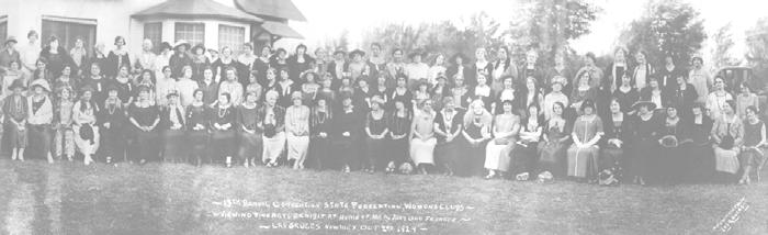
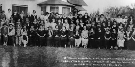
2 Table of Contents INTRODUCTION Purpose... 1 Study Area... 1 NEIGHBORHOOD PLAN GOALS AND POLICIES ONE: Neighborhood Character... 4 TWO: Non-Conforming Structures and Properties... 6 THREE: Appropriate Land Use... 8 ADMINISTRATION AND IMPLEMENTATION...14 APPENDICES Appendix A: Neighborhood History...15 Appendix B: Planning Process...16 Appendix C: Glossary...20 Appendix D: List of Historic Properties...22 MAPS AND FIGURES Map 1 Alameda Depot Neighborhood Boundaries... 2 Map 2 Historic Designations... 3 Map 3 Current Land Uses... 9 Map 4 Current Zoning Districts...10 Map 5 Areas within Alameda Depot Neighborhood...12 Figure 1 Zoning and Land Use Comparison... 8 Figure 2 Comprehensive Planning Framework...18 ON THE COVER (from top): Las Cruces Depot, 1901 (Rio Grande Archives at NMSU); Las Cruces Women Improvement Association members at the New Mexico Federation of Woman's Clubs convention, 1924 (Collection of the City of Las Cruces Museum System); Hendrix Methodist Episcopal Church on Alameda Blvd., circa 1900 (St. Paul's United Methodist Church); Urban Renewal, Downtown Las Cruces and the Alameda Neighborhood, circa 1970 (City of Las Cruces); A conceptual neighborhood with various planning elements, such as streetscapes, building heights, setbacks, and pedestrian amenities (Congress for the New Urbanism).
3 PURPOSE The Alameda Depot Neighborhood Plan is intended to maintain the character of one of Las Cruces oldest neighborhoods by providing the policy basis for creating an Overlay, or Special Zoning District. The Alameda Depot Neighborhood, along with the Mesquite Historic District and the Central Business District, form the historic heart of Las Cruces. In recent years, several factors have impacted the city s center: downtown revitalization; renewed interest in protecting historic properties; and movement from the suburbs back to the urban core. Theses factors have created a gradual change in the types of land uses in the Alameda Depot neighborhood, primarily from residential to office and commercial uses. Anticipated public and private investment in the downtown area will no doubt have further impact. For example, new city and federal government buildings and expansion of the county judicial complex create the potential for even more office and multifamily residential land uses. Also, as the downtown is redeveloped, two- way traffic on Main, Church and Water Streets will be restored. As a result, changing pedestrian, public transit and automobile traffic flow patterns will have an impact on the neighborhood and should be planned for. The Alameda Depot neighborhood, with its rich history, diverse architecture and peaceful environment, is an important part of Las Cruces life. As it is impacted by change and the downtown continues to grow and expand, neighborhood residents want to protect the unique nature of the neighborhood and preserve these characteristics. This plan was created with these challenges in mind. Introduction The Plan includes measures to preserve historic structures, recommended development standards that provide greater flexibility for historic properties, policies governing land use conversions and the preservation of the residential core of the neighborhood, and suggestions to enhance the aesthetics of the neighborhood s public areas. These guidelines are provided for residents, property owners, City Staff, and elected officials for use in making land use and development-related decisions. STUDY AREA The Alameda Depot Neighborhood comprises approximately 260 acres and is located west of the Central Business District (Main Street and downtown Las Cruces). The Neighborhood boundaries are roughly based on boundaries described by the New Mexico State Historic Preservation Office and the National Register of Historic Places, but extend to include adjacent areas that contribute to the character of the neighborhood, and may be designated as historic in the future. In general, the neighborhood is bounded by Alameda Boulevard and Main Street on the east, the railroad tracks on the west, Parker Road and Chestnut Avenue to the north and Amador Avenue to the south. Specific boundaries are shown in Map 1. The following principles were used in determining the boundaries: 1) properties within the Central Business District (CBD) Overlay and the North Main Street corridor were excluded to avoid potential zoning conflicts; 2) other properties on the State or Federal Historic register were included; 3) properties with similar aesthetic qualities whose owners have participated in neighborhood groups where included; and 4) linear features were followed to create more regular boundaries. 1


4 Map 1 Alameda Depot Neighborhood Boundaries 2

5 Map 2 Historic Designations 3
6 Neighborhood Plan Goals and Policies The Alameda Depot area is one of Las Cruces oldest residential neighborhoods and is comprised of over 500 properties individually designated as historic on the State and National Registers (Map 2). Of these properties, 403 are designated Contributing and 121 are designated as Non-Contributing. While not listed on the National or State Registers, many homes adjacent to historic structures also contribute to the overall ambiance and character of the neighborhood. In addition, an update of the historical survey may determine that structures outside the current boundaries of the district are eligible to be registered. A number of homes designated as historic by the Federal and State Registers have been demolished over the years. Their loss equates to the loss of neighborhood character and a part of Las Cruces history. Designation as a State historic structure qualifies the property owner for tax credits for restoration activities, provided that the restoration follows State historic preservation guidelines. Tax credits may also be an incentive for restoration rather than demolition. The unique architecture, along with the presence of large lots and mature landscaping, make the Alameda Depot streetscape quite distinct from other neighborhoods. The area, particularly near Pioneer Women s Park, has a high degree of pedestrian activity and attracts recreational walkers from other parts of town. Further enhancement of the district s public spaces in a neighborhood-appropriate way is of interest to area property owners. The following policies provide safeguards against demolition of historic properties and encourage their re-use, suggest creating public spaces that complement the unique architecture of the area, offer methods to enhance the pedestrian-friendly aspect of the neighborhood, and encourage property owners to take ONE: NEIGHBORHOOD CHARACTER advantage of state and federal voluntary tax credit programs. GOAL 1: Preserve and Enhance the Unique Character of the Alameda Depot Neighborhood Policy 1.1 The Neighborhood Plan boundaries should include those properties found in Map 1. Policy 1.2 The City and the Alameda Depot Neighborhood residents should coordinate efforts to update the Historic Building Inventory. Policy 1.3 The City should establish a 60-day delay on demolition of designated Contributing historic structures, to begin the day that a demolition permit is applied for. The delay should include a process to notify the public when the demolition permit has been sought. The delay allows time for the neighborhood and concerned parties to discuss alternatives to demolition with the property owner or to make counter-proposals should they so choose. Policy 1.4 Encourage infill and adaptive re-use to create, restore, and maintain structures to further enhance the character of the existing neighborhood. a. The reuse of historic structures is strongly encouraged to reduce frequency of demolition to the greatest extent possible. b. New development and redevelopment should conform to the allowed land uses in the Area in which they are located (see Goal 3). 4
7 Policy 1.5 Provide cohesive design and aesthetic unity to the historic neighborhood via its parks and streetscapes. a. Develop a streetscape plan for the district that addresses bus stops, benches, street signs, lighting, etc. b. Pursue funding for the acquisition of streetlights throughout the Alameda Depot neighborhood that compliment the historic character of the area. Include mid-block lighting where necessary to contribute to the overall safety and security of the neighborhood. c. Consider distinctive street signage and markers to enhance the historic character of the neighborhood, while remaining compliant with federal guidelines. d. Integrate existing design elements, such as those found at the train depot and in Pioneer Women s Park, into future streetscape design in other parts of the neighborhood. Policy 1.6 To create a safe and comfortable pedestrian environment, the City should make traffic calming measures in the neighborhood a priority, including but not limited to: a. Conducting a traffic analysis after Water and Church Streets open to 2-way traffic, to determine if a road diet for South Alameda may be appropriate. b. Incorporating such tools as signalized and marked crosswalks at selected intersections. c. Adding textured pavers between the transverse lines of the crosswalks at major intersections. Policy 1.7 The neighborhood associations should take the lead in creating a voluntary resource guide that property owners may use as a reference that would cover such topics as: a. architectural styles and techniques for repairing, restoring, and preserving historic buildings; b. tax credit programs for historic preservation; c. property tax relief, revolving loans, and/or low interest loans for those property owners who seek to rehabilitate historic structures. Policy 1.8 Develop guidelines for signage in the Overlay ordinance that are compatible with the character of the neighborhood. Policy 1.9 The neighborhood associations are encouraged to participate in efforts to revitalize the downtown area, in order to create attractive transition areas between the Overlay and the Central Business District.
8 TWO: NONCONFORMING STRUCTURES AND PROPERTIES The age of the Alameda Depot neighborhood means that many structures in the area pre-date the establishment of the first development standards set forth in the 1955 Las Cruces Zoning Ordinance, 1 and are considered nonconforming. These include setbacks, lot size, wall heights, additional dwelling units, etc. This neighborhood plan acknowledges that these inconsistencies exist and should be accommodated by creating development standards for the neighborhood that correspond to the existing situation. There are currently four main processes for dealing with deviations to the Zoning Code or development standards. The first is the granting of Legal Non-Conforming Status. This is an administrative process that is used when a property was legally developed before a regulation went into effect, to allow the existing use to continue as is. This process restricts the types of modifications that can be done to a grandfathered property before the Legal Non-Conforming Status is lost. The second process is the Flexible Development Standard. This is also an administrative process for allowing deviations to planning-related development standards that are considered minor or insignificant. This process requires the notification of adjacent property owners, but does not require a public hearing, unless a notified party objects. The third process is the Variance, which is applicable to a physical characteristic unique to the property that significantly limits development options. This process requires a public hearing at the Planning and Zoning Commission, which is the decision making body. Variances may be granted for planningrelated deviations to the Zoning Code that are numeric in nature (e.g., asking for a 10-foot setback when a 20-foot setback is required). The fourth process is a zone change, which can completely change what uses are allowed on a property and the standards to which it must be developed. This is the most involved process, as it requires an ordinance change by City Council. It also requires a public hearing in which the Planning and Zoning Commission makes a recommendation to City Council. The objective of this section is to establish policies that, when implemented by way of an Overlay for the neighborhood, will streamline the process of Zoning Code conformity for long-developed parcels that are undergoing improvements or minor modifications 1 The first Zoning Ordinance was in 1939, but it only established allowed uses in residential districts and did not provide development standards. 6
9 GOAL 2: Develop standards to accommodate properties that do not conform to the current Zoning Code. Policy 2.1 Expand the use of administrative Flexible Standards within the Alameda Depot Neighborhood to deal with deviations to development standards. Policy 2.2 Adopt reduced setback and lot size requirements which can accommodate small and irregularly shaped lots and reflect the character of existing development in the neighborhood, to eliminate the need for many variances to development standards. Policy 2.3 Create flexible parking standards in the Overlay that are in scale with the architecture, landscaping and purpose of construction, and are in keeping with neighborhood character or the historical appearance of the property. a. The City may allow reduction in number of off-street spaces required by giving greater allowance to on-street parking where practical. b. Shared parking agreements among neighboring properties are encouraged and will count toward off-street parking requirements. c. When properties are redeveloped, the number of existing off-street spaces should be preserved unless a reduction in parking demand can be demonstrated. d. Parking areas for non-residential and multi-family uses should be located toward the side or back of the subject property when possible and screened or buffered when visible from the street. e. Encourage different types of surfacing materials to enhance aesthetics of parking lots while maintaining ADA compliance and emergency vehicle accessibility. f. Parking provisions should minimize destruction of mature landscaped areas that contribute to the overall character of the property. Policy 2.4 The City should adopt the 2006 International Existing Building Code, which contains provisions that facilitate code conformity for historic structures while still protecting occupant health and safety. The IEBC acknowledges that a certain amount of flexibility is necessary when repairing, remodeling or adding on to an existing building, that wouldn t ordinarily be allowed for new construction. It also provides some flexibility for renovation of historic buildings. 7
10 Over the years, there has been a gradual change in the types of land uses in the Alameda Depot area, primarily from residential to office and commercial uses. Map 3 shows how the land is being used, while Map 4 shows the zoning districts. A graphic analysis of this information compares current land uses with the uses that would be allowed under current zoning (Figure 1). It indicates that a significant number of new conversions would be allowed by right. The current Comprehensive Planning policy discourages commercial development along Alameda Boulevard north of Picacho Avenue (Appendix B, Comprehensive Plan Land Use Element, Policy ). However, no specific policy exists which deals with non-residential conversions to the south of the Picacho Avenue and Alameda Boulevard intersection. This plan offers policies on land use conversions as a whole so that the residential character of the neighborhood is maintained to the greatest extent possible. This will be especially important should the current Doña Ana County Judicial Complex, located at the corner of Picacho Avenue and Alameda Boulevard, be expanded. THREE: APPROPRIATE LAND USE Mixed land use has traditionally existed in the Alameda Depot area, but similar land uses have tended to cluster near one another. As a result, land use Areas within the district have been identified. Roadway classifications have also been a major factor in determining Area boundaries. Arterials such as Alameda Boulevard and Picacho Avenue are appropriate for higher intensity commercial use, with intensity diminishing as one travels closer to residential areas. Local streets such as Las Cruces Avenue and Reymond Street were designed and intended for low traffic volume, rather than for heavier traffic usually found in commercial areas. As a historic area, and one in which land uses have changed continually in the past hundred years, commercial and industrial structures, as well as residential, may be registered historic properties. Hence the need for integrating land use with historic preservation, and an interest in preserving the residential feel of the neighborhood, regardless of types of land uses. Alameda Depot Neighborhood Zoning and Land Use Comparison in the Alameda Depot Neighborhood 60% 50% 40% 30% 20% Use Zoning 10% 0% Single Family Residential Multi-Family Residential Commercial & Office Industrial & Warehouse Other (Public/ Institutional Space) Figure 1. This figure illustrates that although single family detached housing is currently the dominant land use overall, existing zoning would allow a significant increase in both multi-family residential and commercial/office uses. Were this increase to take place, it would most likely be at the expense of single family residential uses. By defining areas in the overlay where such land use transitions are preferable and where they are not, residents have greater assurance that the character of the neighborhood will be maintained into the future. 8

11 Map 3 Current Land Uses 9

12 Map 4 Current Zoning Districts 10
13 GOAL 3: Maintain a reasonable balance between the development of non-residential uses and existing/new residences in the Alameda Depot Neighborhood. Policy 3.1 Establish an Alameda Depot Neighborhood Overlay zone district, with boundaries as shown on Map 1. Policy 3.2 New zoning designations should be established as part of the Overlay, as shown on Map 5. Regarding land uses, all Areas, except Area 3, should allow a mix of uses as outlined in subsequent policies. In Area 3, the existing zoning, as stated in the 2001 Zoning Code as amended, should remain with respect to allowed uses and densities, but new development standards should be defined in the Overlay. The Areas are as follows: Area 1: The Alameda Boulevard Corridor Area 2: The Griggs Avenue/Organ Avenue Area Area 3: The Residential Core Area 4: The Picacho Avenue Corridor Area 5: The Amador Avenue Corridor Area 6: The Mesilla Street/Railroad Track Corridor Policy 3.3 Area 1, the Alameda Boulevard corridor from Picacho Avenue to Amador Avenue, and Area 2, the Griggs Avenue/Organ Avenue corridor, should allow similar uses. Uses in these corridors should include single family residential, multi-family residential up to 20 units/acre, low-intensity office and commercial uses, and public/institutional uses that generate relatively little traffic or parking. The residential and historic character of the neighborhood should be retained as closely as possible. a. All office and commercial uses are intended to be low intensity and small scale. b. Both these Areas can serve as transition zones between higher intensity uses in the Downtown and the predominantly residential uses of the Neighborhood. c. Although Doña Ana County is not subject to City zoning requirements, the County should consider the character of the neighborhood in any decisions they make regarding the potential expansion of the judicial complex. Policy 3.4 Area 3, the Residential Core, is intended to accommodate detached single-family dwelling units, to maintain and protect a low-density residential character of development, and to maintain the historic appearance of this central area of the neighborhood as closely as possible. a. In Area 3, the existing zoning, as stated in the 2001 Zoning Code as amended, should remain with respect to allowed uses and densities. b. Area 3 would allow for already existing accessory buildings, traditional guest houses and rental units (both attached and detached). It would also provide some flexibility for future conversions of this nature. c. Introduction of low-intensity office and neighborhood commercial uses should be allowed if a residential component of the property is retained, for example, home occupation or live-work units as described in Section of the 2001 Zoning Code as amended. 11
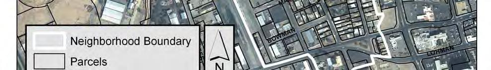
14 Map 5 Areas within Alameda Depot Overlay 12
15 Policy 3.5 Allowed uses in Area 4, the Picacho Avenue corridor, and Area 5, the Amador Avenue corridor, should include single family housing, multi-family housing (up to 20 units/acre), and non-residential uses ranging from low to medium intensity office and commercial uses that may generate greater traffic volumes than those allowed in Areas 1 and 2. a. All office and commercial uses are intended to be low and medium intensity, and serve as transition zones between higher intensity uses in the Downtown and the predominantly residential uses of the Neighborhood. Policy 3.6 Area 6, the Mesilla Street/Railroad Track corridor, should continue to exist as a mixed use environment allowing low intensity manufacturing, office, medium intensity commercial uses and residential. Additional multi-family residential uses should be considered on a case-by-case basis. Additional single family detached residential uses are discouraged. Policy 3.7 These guidelines should be amended to allow for transit-oriented development if passenger rail service comes to Las Cruces via the existing rail line. Policy 3.8 No land uses should be introduced which generate unreasonable noise levels or noxious odors. Policy 3.9 Avoid uses that would create heavy truck traffic in the neighborhood to the greatest extent possible. Said uses should be limited to areas where conflicts with residential uses are minimized, such as on Picacho Avenue, Amador Avenue, and Mesilla Street. a. The prohibition against truck traffic on Alameda Boulevard north of Picacho should be retained. b. The Public Works Department should continue to monitor the flow of truck traffic throughout the neighborhood and attempt to identify opportunities for limiting such traffic. Policy 3.10 Create an additional use called secondary residences, which include kitchens and bathrooms and may be rented out, as an allowed use within all Areas of the Overlay. Policy 3.11 Maximum building height should be 35 feet within the Neighborhood. Policy 3.12 To help preserve neighborhood scale, a maximum of four (4) attached dwelling units should be allowed. Policy 3.13 The intensity of non-residential uses in each Area should be controlled by limiting the square footage of non-residential space in the building, through the Overlay Ordinance. Policy 3.14 Mobile homes should not be permitted in any Area of the neighborhood. 13
16 ADMINISTRATION AND IMPLEMENTATION OF THIS PLAN This plan is intended to create a general guiding philosophy for land use and development decisions in the Alameda Depot Neighborhood. As such, this plan shall be considered by residents, property owners, City staff, and decision-making bodies when making proposals, recommendations, and/or taking final action regarding neighborhood character issues, development standards, and land use related requests. The Policies in this Plan will be administered and implemented by the City of Las Cruces and the neighborhood associations as follows: A. The Planning Section of the Community Development Department will begin the process of adopting an Overlay by Ordinance for the Alameda Depot Neighborhood immediately after approval of this Plan by City Council. The process will include drafting of the Ordinance, at least one neighborhood meeting to review it, and a recommendation from the Planning and Zoning Commission at a public hearing prior to adoption by City Council. This process is expected to take less than one year. B. In addition, the Permitting and Inspections Section of the Community Development Department will work toward adoption of the 2006 International Existing Building Code by City Council as soon as possible. C. The Public Works Department will take the lead in determining the feasibility of restricting truck traffic on Alameda Boulevard south of Picacho Avenue. After two-way traffic is restored on Main, Church and Water Streets, a traffic study should be undertaken to determine the degree to which Alameda Boulevard is used by heavy trucks for accessing the downtown area, and assess the implications of redirecting this traffic to other roadways. D. The neighborhood associations will take the lead on developing, securing funding for, and implementing a Streetscape Plan, as per Policy 1.6. The level of City assistance will be determined by availability of staff and resources throughout the process. E. The neighborhood associations will take the lead on developing, securing funding for, and creating a voluntary Resource Guide for Property Owners, as per Policy 1.8. The level of City assistance will be determined by availability of staff and resources throughout the process. 14
17 APPENDICES APPENDIX A: Neighborhood History Prior to the arrival of the railroad in 1881, the Alameda Depot Neighborhood consisted primarily of large farms and associated farmhouses. The railroad provided a link with the rest of the nation, and the small community of Las Cruces gained importance as a center for the exchange of material goods. As the new commercial center grew and developed, so did the area around the railroad. As noted in The Las Cruces Historic Buildings Survey, Las Cruces Avenue, originally called Depot Avenue, was the first paved street in town, so that people arriving on the train would receive a good impression and clean entrance to Las Cruces. 2 One result of the increased development due to the railroad was the subdivision of these large tracts of farmland into both warehousing directly across from the depot and large residential lots beyond it. Another effect of the railroad was the increased accessibility of building materials not typically found in the area. As a result of this accessibility, an assortment of housing styles became available. Examples of this variety include Queen Anne, Bungalow, Tudor Revival, and Mediterranean architectural styles mixed with the more familiar Spanish-Pueblo, New Mexico Vernacular, and Territorial designs. As time passed and the need for servants quarters and carriage houses lessened, residential lots were further subdivided. This allowed for the construction of newer residences intermixed throughout the area with the older ones. In more recent years, property owners have also created guest cottages and rental units from these structures. Though the Alameda Depot Neighborhood is centered near the railroad depot, it also extends along Alameda Boulevard north of Picacho Avenue. The architecture of this area combines a variety of eastern American types with the more traditional southwestern styles. This area has become what is possibly the most complex and varied neighborhood in New Mexico. 3 It is this eclectic style and character that area residents wish to protect. 2 Doña Ana County Historical Society. The Las Cruces Historic Buildings Survey [text by Mary -M. Steeb, Michael Romero Taylor, Anthony C. Pennock]. Las Cruces, N.M: Doña Ana County Historical Society, ibid. 15
18 APPENDIX B: Planning Process Overview The Alameda Depot Neighborhood Plan is a fourth level planning document under the City s Comprehensive Planning Framework, Figure 2. The Plan is primarily a policy-oriented document for a specific geographic area. Its policies comply with the Comprehensive Plan, which is the City s primary planning document. Although it is not mandated that policies in a fourth level planning document carry out Comprehensive Plan policies, valid reasons should be shown why they would vary. In general, a Neighborhood Plan is created to: Clearly describe what the neighborhood wants accomplished Provide the policy framework for zoning and other land use decisions Give direction to the City regarding capital improvements appropriate to the neighborhood Offer residents, developers, and businesses a clear picture of the type of development and land uses that are desired by the neighborhood Provide guidelines for the design of new development so it will compliment the existing neighborhood. The Neighborhood Plan is generally implemented through an Overlay Zone District which is an Ordinance, or law, passed by the local government that regulates the size, type, structure and use of land or buildings within a specific geographic area. The Overlay Ordinance is drafted only after the adoption of the Neighborhood Plan and it too, is a publicly reviewed process. Sequence 1. Neighborhood Plan written by City staff and neighborhood stakeholders 2. Draft reviewed by neighborhood at a public meeting 3. Draft revised by City staff, and revisions are reviewed by neighborhood 4. Plan presented at a public meeting to Planning and Zoning Commission for a recommendation to City Council 5. Plan presented to City Council for final action at a public meeting 6. If plan is adopted by City Council, staff and stakeholders write the Overlay Ordinance, repeating the public review process as above 1999 Comprehensive Plan The following policies, excerpted verbatim from the 1999 Las Cruces Comprehensive Plan, are intended to guide land use, urban design, and historic preservation and are relevant to the Alameda Depot Neighborhood. The majority of the concepts and policies presented in this Alameda Depot Neighborhood Plan are consistent with the Comprehensive Plan which serves as the conceptual policy foundation for all City plans and planning efforts. However, several of the existing Comprehensive Plan policies cited may not be suitable for this neighborhood. In fact, neither the designation of a Local Historic District nor the establishment of architectural design standards is called for in this Neighborhood Plan (See Neighborhood Planning Efforts, below). Land Use Element, Goal 1 (Land Uses) Residential neighborhoods shall not be divided and/or redeveloped for non residential uses unless it can be shown that demand for housing in a neighborhood is diminishing or that a need for a more compatible land use relationship can be demonstrated The City shall permit only residential uses which front the North Alameda Corridor beyond the northeastern and northwestern 16
19 corner lots from the intersection of Picacho Avenue and North Alameda Boulevard to Three Crosses Avenue. The City shall, therefore, not permit commercial and/or office uses which front the North Alameda Corridor beyond the northeastern and northwestern corner lots from the intersection north of Picacho Avenue and North Alameda Boulevard to Three Crosses Avenue The Alameda Depot area and the Old Town/Mesquite St. area shall be designated as local historic districts Overlay zones shall be created in the historic districts as a means of providing flexible standards to address historical considerations Specific land use and urban design policy for local historic districts shall be established in fourth level planning documents. Issues addressed will include, but not be limited to: permitted land uses, setbacks, lot size, accessory buildings, and design issues. This policy shall be reflected in the Zoning Code where appropriate The Land Use Element and historic district policy shall observe City infill policy for development standards within the historic districts Infill development shall be compatible with the existing architecture, landscaping, and character of the surrounding neighborhood. Overlay zones shall be created in the historic districts as a means of providing flexible standards to address historical considerations. Issues addressed will include, but not be limited to: permitted land uses, setbacks, lot size, accessory buildings, and design issues. This policy shall be reflected in the Zoning Code where appropriate. Urban Design Element Encourage districts and/or neighborhoods (commercial or residential) throughout the community to establish themes for their respective neighborhood or district. Themes and styles should be called out in a neighborhood/district plan, in accordance with the Land Use Element Seek a local historic district designation to enhance national and state historic districts and create an Historic Preservation Board who will deal with those issues pertaining to designated historic districts Neighborhood/district overlay zones should be created for those areas that come under an historic district designation to establish specific guidelines concerning new development and redevelopment. Each overlay zone should be written in the form of a neighborhood/district plan and shall address such issues as permitted land uses and architectural requirements Development or redevelopment should be required to be compatible with the character of that historic district The City should provide incentives to those interested in restoring historic buildings. Incentives should include, but are not limited to: Property Tax Relief, Property Tax Abatement, Property Tax Credit, Property Tax Freeze, Revolving Loan Fund, Low Interest Loans New development or redevelopment should be required to utilize local and/or regional architectural styles and design elements in the downtown area, historic districts, gateways and designated corridors which are compatible with existing structures Support a policy of mixed land uses as discussed in the Land Use Element. Land uses which are not traditionally considered compatible may be located next to one another depending upon design features and compatibility with the adjacent area as a result of a mixed land use policy. Those uses with lower intensities must be protected from any negative impacts from adjacent uses with higher intensities in order to protect a desirable quality of life within the City. 17

20 Figure 2 Comprehensive Planning Framework 18
21 Neighborhood Planning Efforts Due to neighborhood interest in establishing guidelines to preserve the character of the Alameda Depot area, the City of Las Cruces Community Development Department held two public meetings during the summer of The department proposed to amend the City s Comprehensive Plan land use policy to specifically address land use issues in the Alameda Depot area. The issue of historic preservation arose during these meetings and strong feelings toward historic preservation were expressed. In April 2000, the Community Development Department created a survey to gauge property owner interest in the creation of a neighborhood plan dealing with topics limited to historic preservation and land use. The results of the survey were mixed. A strong majority of respondents said they favored the creation of a local historic district. However, in subsequent discussions it became clear that many misinterpreted the meaning of the term local historic district and instead favored a special zoning district, or Overlay. A local historic district by definition would have architectural design standards and a review board to enforce them. The responses also indicated that, although architectural integrity is important to the community, about half objected to architecturally related restrictions on their own property. The general opinion seemed to be that the architecture of the neighborhood is too eclectic for any architectural design standards to be viable. With regard to land use conversions, the respondents were split on the issue of whether prohibitions on conversions from residential to non-residential uses should be enacted, but two-thirds said that if such conversions did occur, they should be the types of businesses that serve the local neighborhood, rather than the region as a whole. Using the survey responses and results of public meetings, the Community Development Department then developed a draft neighborhood plan document and held public input meetings on August 17, 2000 and April 25, 2001 to review the draft. Smaller, more informal meetings were also organized in the interim. However, this draft was not approved by City Council. There continued to be strong commitment for a plan among neighborhood residents and between 2003 and 2005, continuous meetings were held that led to the submittal in 2005 of a document that had the support of both community groups: the Alameda Depot Civic Association and the Alameda Depot Neighborhood Organization. Community Development staff used the 2005 document as the basis for a revised draft plan in early Public input meetings were held on April 7 and July 23. Based on the comments received at the meeting, written comments submitted afterwards, and meetings between Community Development staff and neighborhood association leadership throughout 2008, the Plan was revised to its current form. 19
22 APPENDIX C: Glossary Contributing Property In the law regulating historic districts in the US, a contributing property is any property, structure or object that adds to the historical integrity or architectural qualities that make the historic area significant. For the Registration of the properties in the Alameda Depot neighborhood, the national definition of a contributing property was used. In general, a contributing property is key to a historic district's historic associations, historic architectural qualities, or archaeological qualities. A historic district is generally a group of one of two types of property: contributing and non-contributing. A Property can change from contributing to non-contributing and vice versa if significant alterations take place. A contributing property, such as a 19th Century mansion, helps make a historic district historic; a non contributing property, such as a modern medical clinic, does not. Grandfather Clause refers to a use, structure, etc. that was established legally under the Zoning Code in place at the time, but does not conform to the current code i.e., it is legally nonconforming. Historic District is a group of buildings, properties or sites that have been designated by one of several government entities as historically or architecturally significant. At the State level, buildings, structures, objects and sites within a historic district are divided into two categories, Contributing and Non- Contributing. Districts greatly vary in size, some having hundreds of structures while others have just a few. Infill Development refers to an Overlay District within the core of the City where land use and development policies specify provisions with incentives for development of vacant parcels. The boundaries are Interstate 25, the north boundary of the University Avenue Corridor Overlay District, Valley Drive, Hoagland Road, North Alameda Boulevard, Three Crosses and North Main Street. Local Historic Districts are generally administered by the county or municipal government and are typically subject to design guidelines and a policy-making/review board for historic preservation. This governing body is created by ordinance and is comprised of members appointed for their accomplishments and recognition in their field in the American Southwest with specialized knowledge of New Mexico, Las Cruces and its surrounding history, architecture and prehistoric archaeology. The Alameda Depot Neighborhood has NOT been designated a Local Historic District, and that will not change with this plan. Manufactured home is a manufactured or modular home that is a single-family dwelling with a heated area of at least thirty-six (36) feet by twenty-four (24) feet and at least eight hundred sixty-four (864) square feet and constructed in a factory to the standards of the United States Department of Housing and Urban Development, the National Manufactured Housing Construction and Safety Standards Act of 1974 and the Housing and Urban Development Zone Code 2 or the Uniform Building Code, as amended to the date of the unit s construction, and installed consistent with the Manufactured Housing Act and with the regulations made pursuant to that act. (Article VI, Sec of the 2001 Zoning Code as amended). The City may not prohibit the placement of manufactured/modular homes on a location where site-built homes are allowed, according to State Law. The City may regulate the aesthetics of manufactured/modular homes, provided that all homes in a given area, including site-built homes, are subject to the same aesthetic 20
23 standard, and compliance with the standard does not impact the original construction of the manufactured/modular home or require placement on an excavated site. Mobile home is a moveable or portable housing structure larger than forty (40) feet in body length, eight (8) feet in width or eleven (11) feet in overall height, designed for and occupied by no more than one family for living and sleeping purposes, but does not include structures built to the standards of any municipal building code and other technical codes. (Article VI, Sec of the 2001 Zoning Code as amended). National Historic District is an area that the U.S. federal government designates through the U.S. Department of Interior, under the auspices of the National Park Service. Federally designated historic districts are listed on the National Register of Historic Places. The Alameda Depot Neighborhood contains a National Historic District. Overlay and Special Zoning District are synonymous and are defined boundaries around an area that has a set of unique or unusual characteristics. Overlays and Special Zoning Districts have a special purpose as defined in an accompanying plan, and may alter general residential, office, commercial or industrial zoning districts or replace them entirely. State Historic District is an area that is designated by the State which follows criteria similar to the federal standards. State listings can have similar benefits to federal designation, such as qualification for grants and tax incentives. Designation of a district is through a review process at the State Historic Preservation Office. New Mexico s Register of Historic Places lists districts and individual properties. The Alameda Depot Neighborhood contains a State Historic District. 21
24 2009 Appendix D: List of Historic Properties CLASSIFICATION STATE/ ADDRESS BUILDING DATE DATE NOTES ( Survey) NATIONAL GENERAL NOTES 1005 N ALAMEDA BLVD Main Building circa 1915 CONTRIBUTING BOTH 1005 N ALAMEDA BLVD Garage 1915? R NON-CONTRIBUTING BOTH 1008 N ALAMEDA BLVD Main Building circa 1925 CONTRIBUTING BOTH 1008 N ALAMEDA BLVD Garage 1925? R NON-CONTRIBUTING BOTH 101 W FLEMING AV Main Building 1930 CONTRIBUTING NATIONAL (attached to 1145 N MAIN ST) /2 N ALAMEDA BLVD Main Building NG CONTRIBUTING BOTH 1015 N ALAMEDA BLVD Main Building NG CONTRIBUTING BOTH 1028 N ALAMEDA BLVD Main Building circa 1915 CONTRIBUTING BOTH 1029 N ALAMEDA BLVD Main Building 1915 (picture pre-1912) CONTRIBUTING BOTH 1029 N ALAMEDA BLVD Rear NG CONTRIBUTING BOTH 1036 N ALAMEDA BLVD Main Building circa 1930 CONTRIBUTING BOTH 1036 N ALAMEDA BLVD Garage NG CONTRIBUTING BOTH 106 S MIRANDA ST Main Building 1927 CONTRIBUTING BOTH 106 S MIRANDA ST Baptist Church 1955 NON-CONTRIBUTING BOTH 106 W HADLEY AV Main Building CONTRIBUTING NATIONAL 1100 N ALAMEDA BLVD Main Building circa 1925 CONTRIBUTING BOTH 1100 N ALAMEDA BLVD Garage 1925? CONTRIBUTING BOTH 1101 N ALAMEDA BLVD Main Building circa 1915 (picture pre-1912) CONTRIBUTING BOTH 1103 N ALAMEDA BLVD Main Building circa 1905 CONTRIBUTING BOTH 1103 N REYMOND ST Main Building NG CONTRIBUTING STATE 1107 N REYMOND ST Main Building and growing CONTRIBUTING STATE 1121 N REYMOND ST Main Building circa 1915 CONTRIBUTING STATE 1137 N ALAMEDA BLVD Main Building circa 1915 CONTRIBUTING BOTH 114 N MESILLA ST Main Building circa 1930 CONTRIBUTING BOTH 1143 N MAIN ST Main Building circa 1930 CONTRIBUTING NATIONAL 1145 N ALAMEDA BLVD Main Building circa 1925 CONTRIBUTING BOTH 1145 N MAIN ST Main Building circa 1930 CONTRIBUTING NATIONAL 1147 N ALAMEDA BLVD Main Building circa 1925 CONTRIBUTING BOTH 117 S MIRANDA ST Main Building circa 1905 addition CONTRIBUTING BOTH 120 W GREENING AV Main Building circa 1928 CONTRIBUTING NATIONAL 1201 N ALAMEDA BLVD Main Building circa 1925 CONTRIBUTING BOTH 1203 N ALAMEDA BLVD Main Building circa 1925 NON-CONTRIBUTING BOTH 1203 N ALAMEDA BLVD Garage NG CONTRIBUTING BOTH 1209 N ALAMEDA BLVD Main Building circa 1910 CONTRIBUTING BOTH 1209 N ALAMEDA BLVD Garage-Apt. NG CONTRIBUTING BOTH 121 W GREENING AV Main Building circa 1928 CONTRIBUTING NATIONAL 127 S MIRANDA ST Main Building circa 1905 CONTRIBUTING BOTH 127 W GREENING AV Main Building circa 1928 CONTRIBUTING NATIONAL 127 W GREENING AV Garage NG CONTRIBUTING NATIONAL 129 S MIRANDA ST Main Building circa 1905 CONTRIBUTING BOTH 129 S REYMOND ST Main Building circa 1910 r CONTRIBUTING BOTH 130 W GREENING AV Main Building circa 1925 CONTRIBUTING NATIONAL 130B W GREENING AV Main Building NG CONTRIBUTING NATIONAL 133 W LUCERO AV Main Building circa 1910 CONTRIBUTING BOTH 137 S MIRANDA ST Main Building circa 1910 CONTRIBUTING BOTH 138 W LUCERO AV Main Building circa 1920 CONTRIBUTING BOTH 138 W MOUNTAIN AV Main Building circa 1925 CONTRIBUTING BOTH 140 W GREENING AV Main Building circa 1930 CONTRIBUTING NATIONAL D-1 22
25 141 W LUCERO AV Main Building circa 1910 CONTRIBUTING BOTH 142 S MIRANDA ST Main Building CONTRIBUTING BOTH 143 W LUCERO AV Main Building circa 1910 CONTRIBUTING BOTH 145 W MOUNTAIN AV Main Building circa 1915 r CONTRIBUTING BOTH 147 W GREENING AV Main Building circa 1930 CONTRIBUTING NATIONAL 149 W GREENING AV Main Building circa 1930 r. circa 1940 CONTRIBUTING NATIONAL 150 N MIRANDA ST Main Building BOTH (see 570 et al., W GRIGGS) 150 W WILLOUGHBY AV Main Building circa 1915 CONTRIBUTING NATIONAL 154 W MOUNTAIN AV Main Building circa 1925 CONTRIBUTING BOTH 159 W GREENING AV Main Building circa 1915 CONTRIBUTING NATIONAL 160 W GREENING AV Main Building circa 1925 CONTRIBUTING NATIONAL 160 W MOUNTAIN AV Main Building circa 1925 CONTRIBUTING BOTH 165 W LUCERO AV Main Building circa 1940 CONTRIBUTING BOTH 165 W LUCERO AV Garage 1940? CONTRIBUTING BOTH 167 W LUCERO AV Main Building circa 1910 CONTRIBUTING BOTH 167 W LUCERO AV Garage NG CONTRIBUTING BOTH 167 W WILLOUGHBY AV Main Building circa 1903 CONTRIBUTING NATIONAL 168 W WILLOUGHBY AV Main Building circa 1915 r CONTRIBUTING NATIONAL 169 W GREENING AV Main Building circa 1915 CONTRIBUTING NATIONAL 169 W GREENING AV Apt Cherry NG CONTRIBUTING NATIONAL 170 W GREENING AV Main Building circa 1915 CONTRIBUTING NATIONAL 174 W WILLOUGHBY AV Main Building circa 1903 addition 1994 CONTRIBUTING NATIONAL addition is NON-CONTRIBUTING 201 S MIRANDA ST Main Building circa CONTRIBUTING BOTH 201 W GREENING AV Main Building circa 1910 CONTRIBUTING BOTH (faces Cherry) 201 W LUCERO AV Main Building circa 1918 CONTRIBUTING BOTH 202 N MIRANDA ST Main Building 1908 CONTRIBUTING BOTH 203 N REYMOND ST Main Building circa 1925 CONTRIBUTING BOTH 206 N REYMOND ST Main Building circa 1908 CONTRIBUTING BOTH 206 N REYMOND ST Garage NG CONTRIBUTING BOTH 206 W WILLOUGHBY AV Main Building NG r , r. 1940's CONTRIBUTING BOTH 206 W WILLOUGHBY AV Garage ? CONTRIBUTING BOTH 207 N REYMOND ST Main Building circa 1925 CONTRIBUTING BOTH 208 N MIRANDA ST Main Building 1908 CONTRIBUTING BOTH 208 W LUCERO AV Main Building NG CONTRIBUTING STATE 209 W MOUNTAIN AV Main Building circa 1920 r CONTRIBUTING BOTH 209 W WILLOUGHBY AV Main Building circa 1925 R CONTRIBUTING BOTH 210 W LUCERO AV Main Building NG CONTRIBUTING STATE 211 S MIRANDA ST Main Building circa R CONTRIBUTING BOTH 212 W GREENING AV Main Building circa 1920 CONTRIBUTING BOTH 212 W LUCERO AV Main Building NG CONTRIBUTING STATE 213 N ARMIJO ST Main Building circa 1900 rear addition 1930 CONTRIBUTING BOTH 213 N REYMOND ST Main Building circa 1925 CONTRIBUTING BOTH 213 W WILLOUGHBY AV Main Building circa 1940 CONTRIBUTING BOTH 213 W WILLOUGHBY AV Garage 1940? CONTRIBUTING BOTH 214 N ARMIJO ST Main Building NG r CONTRIBUTING BOTH (see 331 W LAS CRUCES) 214 S REYMOND ST Main Building circa 1925 CONTRIBUTING BOTH 214 W LUCERO AV Main Building NG CONTRIBUTING STATE 214 W MOUNTAIN AV Main Building circa 1910 r CONTRIBUTING BOTH 215 S REYMOND ST Main Building circa 1915 CONTRIBUTING BOTH 215 W GREENING AV Main Building circa 1925 CONTRIBUTING BOTH 217 N REYMOND ST Main Building circa 1925 CONTRIBUTING BOTH D-2
26 220 W LUCERO AV Main Building NG CONTRIBUTING STATE 221 N MELENDRES ST Main Building circa 1925 CONTRIBUTING BOTH 221 N MELENDRES ST Garage NG CONTRIBUTING BOTH 221 S MIRANDA ST Main Building 1912 CONTRIBUTING BOTH 221 S MIRANDA ST Garage-Apt. NG CONTRIBUTING BOTH 221 W GREENING AV Main Building circa 1930 CONTRIBUTING BOTH 221 W MOUNTAIN AV Main Building circa 1925 CONTRIBUTING BOTH 222 W GREENING AV Main Building circa 1930 r CONTRIBUTING BOTH 222 W LUCERO AV Main Building NG CONTRIBUTING STATE 223 N MELENDRES ST Main Building circa 1930 CONTRIBUTING BOTH 223 N MELENDRES ST Garage 1930? CONTRIBUTING BOTH 223 S REYMOND ST Main Building circa 1915 CONTRIBUTING BOTH 223 W GREENING AV Main Building circa 1930 r CONTRIBUTING BOTH 224 S REYMOND ST Main Building circa 1925 r CONTRIBUTING BOTH 224 S REYMOND ST Garage-Apt. NG CONTRIBUTING BOTH 224 W HADLEY AV Main Building circa 1925 CONTRIBUTING BOTH 224 W MOUNTAIN AV Main Building circa 1925 CONTRIBUTING BOTH 225 N MELENDRES ST Main Building circa 1950 CONTRIBUTING BOTH 225 W WILLOUGHBY AV Main Building circa 1940 CONTRIBUTING BOTH 226 W LUCERO AV Main Building NG CONTRIBUTING STATE 226 W PICACHO AV Main Building 1937 CONTRIBUTING BOTH 226 W PICACHO AV Service Building 1937 CONTRIBUTING BOTH 226 W WILLOUGHBY AV Main Building circa 1910 CONTRIBUTING BOTH 226 W WILLOUGHBY AV Garage NG CONTRIBUTING BOTH 228 N MIRANDA ST Main Building circa 1915 CONTRIBUTING BOTH 228 W LUCERO AV Main Building NG CONTRIBUTING STATE 228 W MOUNTAIN AV Main Building circa 1910 r CONTRIBUTING BOTH 230 N MELENDRES ST Main Building circa 1925 CONTRIBUTING BOTH 230 N MOUNTAIN AV Main Building circa 1910 r CONTRIBUTING BOTH 230 W LUCERO AV Main Building NG CONTRIBUTING STATE 232 W LUCERO AV Main Building NG CONTRIBUTING STATE 233 S MIRANDA ST Main Building addition CONTRIBUTING BOTH 233 S MIRANDA ST Garage NG CONTRIBUTING BOTH 237 S REYMOND ST Main Building circa 1911 CONTRIBUTING BOTH 240 S REYMOND ST Main Building circa 1925 CONTRIBUTING BOTH 241 S REYMOND ST Main Building circa 1930 CONTRIBUTING BOTH 242 W HADLEY AV Main Building circa 1925 CONTRIBUTING BOTH 242 W WILLOUGHBY AV Main Building circa 1920 CONTRIBUTING BOTH 244 S MIRANDA ST Main Building circa 1915 CONTRIBUTING BOTH 245 S REYMOND ST Main Building circa 1930 CONTRIBUTING BOTH 245 W LUCERO AV Main Building circa 1925 CONTRIBUTING BOTH 246 S REYMOND ST Main Building circa 1930 CONTRIBUTING BOTH 247 S REYMOND ST Main Building circa 1925 CONTRIBUTING BOTH 248 S REYMOND ST Main Building circa 1925 CONTRIBUTING BOTH 249 S MIRANDA ST Main Building 1904 additions 1925 CONTRIBUTING BOTH 249 S MIRANDA ST Garage-Barn, Cow Shed, Chicken Coop CONTRIBUTING BOTH 250 W COURT AV Main Building circa 1880 CONTRIBUTING BOTH 250 W HADLEY AV Main Building circa 1925 CONTRIBUTING BOTH 255 W HADLEY AV Main Building circa 1930 CONTRIBUTING STATE 258 W HADLEY AV Main Building circa 1920 CONTRIBUTING BOTH 266 W COURT AV Main Building 1884 CONTRIBUTING BOTH D-3
Appendix A: Guide to Zoning Categories Prince George's County, Maryland
 Appendix A: Guide to Zoning Categories Prince George's County, Maryland RESIDENTIAL ZONES 1 Updated November 2010 R-O-S: Reserved Open Space - Provides for permanent maintenance of certain areas of land
APPENDIX D: DEFINITIONS
 D APPENDIX D: DEFINITIONS Terms used throughout the 2040 Comprehensive Plan should be interpreted using the definitions provided in this appendix. For interpretation of any term not defined, defer to the
ARTICLE 3: Zone Districts
 ARTICLE 3: Zone Districts... 3-1 17.3.1: General...3-1 17.3.1.1: Purpose and Intent... 3-1 17.3.2: Districts and Maps...3-1 17.3.2.1: Applicability... 3-1 17.3.2.2: Creation of Districts... 3-1 17.3.2.3:
Implementation. Approved Master Plan and SMA for Henson Creek-South Potomac 103
 Implementation Approved Master Plan and SMA for Henson Creek-South Potomac 103 104 Approved Master Plan and SMA for Henson Creek-South Potomac Sectional Map Amendment The land use recommendations in the
13 Sectional Map Amendment
 13 Sectional Map Amendment Introduction This chapter reviews land use and zoning policies and practices in Prince George s County and presents the proposed zoning in the sectional map amendment (SMA) to
TOTTENHAM SECONDARY PLAN
 TOTTENHAM SECONDARY PLAN AMENDMENT NO. 11 TO THE OFFICIAL PLAN OF THE TOWN OF NEW TECUMSETH The following text and schedules to the Official Plan of the Town of New Tecumseth constitute Amendment No. 11
GENERAL PLAN UPDATE SPECIFIC AREAS OF THE CITY
 GENERAL PLAN UPDATE SPECIFIC AREAS OF THE CITY Background There are a total of 14 specific areas that are being reviewed as part of the update of the General Plan. Requests to review these areas came from
ARTICLE VII. NONCONFORMITIES. Section 700. Purpose.
 ARTICLE VII. NONCONFORMITIES. Section 700. Purpose. The purpose of this chapter is to regulate and limit the development and continued existence of legal uses, structures, lots, and signs established either
Residential Intensification in Established Neighbourhoods Study (RIENS)
") Residential Intensification in Established Neighbourhoods Study (RIENS) EXECUTIVE SUMMARY In December 2015, the City of Kitchener retained Meridian Planning Consultants to undertake the Residential Intensification
Residential Intensification in Established Neighbourhoods Study (RIENS) EXECUTIVE SUMMARY In December 2015, the City of Kitchener retained Meridian Planning Consultants to undertake the Residential Intensification
Town Centre Community Improvement Plan
 2012 Town Centre Community Improvement Plan City of Greater Sudbury Growth and Development Department 1.0 PLAN BACKGROUND 1.1 Introduction The following Community Improvement Plan (CIP) has been prepared
Draft Model Access Management Overlay Ordinance
 Draft Model Access Management Overlay Ordinance This model was developed using the City of Hutchinson and the Trunk Highway 7 corridor. The basic provisions of this model may be adopted by any jurisdiction
Village of Port Jefferson Urban Renewal Plan
 Urban Renewal Plan Village of Port Jefferson Urban Renewal Plan Port Jefferson, New York PREPARED FOR Village of Port Jefferson Village Board 121 West Broadway Port Jefferson, NY 11777 631.473.4724 PREPARED
Questions and Answers about Neighborhood Conservation Districts
 Questions and Answers about Neighborhood Conservation Districts NEIGHBORHOOD CONSERVATION Planning Department Housing and Neighborhood Services NCD@townofchapelhill.org (919) 968-2728 Questions about Neighborhood
Bunker Hill Part II Urban Design. Specific Plan. Case No. CPC SP TABLE OF CONTENTS
 Bunker Hill Part II Urban Design Specific Plan Case No. CPC-2011-684-SP TABLE OF CONTENTS Section 1. Section 2. Section 3. Section 4. Section 5. Section 6. Section 7. Section 8. Section 9. Section 10.
Future Land Use Categories & Nodes December 23, Future Land Use Categories
 Future Land Use Categories & Nodes December 23, 2015 A note regarding nodes: Descriptions for nodes are located in the general recommendations handout. Node locations are set in part by the Auburn Interactive
MEMORANDUM Planning Commission Travis Parker, Planning Director DATE: April 4, 2018 Lakewood Zoning Amendments Housing and Mixed Use
 MEMORANDUM TO: FROM: Travis Parker, Planning Director DATE: April 4, 2018 SUBJECT: Lakewood Zoning Amendments Housing and Mixed Use In August 2017, the Lakewood Development Dialogue process began with
PUBLIC REVIEW DRAFT OF OFF-STREET PARKING PROPOSAL CITY OF OAKLAND PLANNING DEPARTMENT OCTOBER 2015
 PUBLIC REVIEW DRAFT OF OFF-STREET PARKING PROPOSAL CITY OF OAKLAND PLANNING DEPARTMENT OCTOBER 2015 1. Downtown Parking Minimums Problem: The current regulations do not prescribe a minimum amount of required
GEORGE / GROSVENOR AREA STUDY RECOMMENDATIONS PLANNING CITY OF LONDON DEPARTMENT OF. MAY 1985 r----q
 GEORGE / GROSVENOR AREA STUDY RECOMMENDATIONS CITY OF LONDON DEPARTMENT OF PLANNING MAY 1985 r----q PREFACE On April 9, 1985, the Planning Committee held a public meeting regarding the St. George/Grosvenor
Annotated Outline of a New Zoning Ordinance... 1
 Contents Annotated Outline of a New Zoning Ordinance... 1 Article 1: General Provisions... 1 Title and Effective Date... 1 Purpose... 1 Implementation of Comprehensive Plan... 1 Official Zoning Map...
ARTICLE B ZONING DISTRICTS
 ARTICLE B ZONING DISTRICTS Sec. 8-3021 Established. In order to protect the character of existing neighborhoods; to prevent excessive density of population in areas which are not adequately served with
CPC CA 3 SUMMARY
 CPC-2009-3955-CA 2 CONTENTS Summary Staff Report Conclusion 3 4 7 Appendix A: Draft Ordinance A-1 Attachments: 1. Land Use Findings 2. Environmental Clearance 1-1 2-1 CPC-2009-3955-CA 3 SUMMARY Since its
Historic Preservation Ordinance Draft- 6/3/16 Page 1
 Chapter 25.45 - HISTORIC PRESERVATION 25.45.002 Intent and purpose. 25.45.004 Definitions. 25.45.006 Properties listed on the historic register. 25.45.008 Procedures for the alteration of historic register
Land Use Code Streamlining 2012
 City of Tacoma Planning Commission Land Use Code Streamlining 2012 FINDINGS AND RECOMMENDATIONS TACOMA PLANNING COMMISSION August 1, 2012 A. SUBJECT: Streamlining the Land Use Regulatory Code to reduce
Salem HNA and EOA Advisory Committee Meeting #6
 Salem HNA and EOA Advisory Committee Meeting #6 Residential Land Policies Employment Land Policies Policy Discussions with the Committee Outcome of today s meeting Direction from this Committee on proposed
Town of Yucca Valley GENERAL PLAN 1
 Town of Yucca Valley GENERAL PLAN 1 This page intentionally left blank. 3 HOUSING ELEMENT The Housing Element is intended to guide residential development and preservation consistent with the overall values
PERMITTED USES: Within the MX-1 Mixed Use Neighborhood District the following uses are permitted:
 6.25 MX-1 - MIXED USE NEIGHBORHOOD 6.25.1 INTENT: The purpose of the MX-1 Mixed Use Neighborhood District is to accommodate the development of a wide-range of residential and compatible non-residential
Draft for Public Review. The Market and Octavia Neighborhood Plan
 Draft for Public Review The Market and Octavia Neighborhood Plan San Francisco Planning Department As Part of the Better Neighborhoods Program December 00 . Housing People OBJECTIVE.1 MIXED-USE RESIDENTIAL
Truax Park Apartments
 Truax Park Apartments Master Planning and Site Development Study Prepared by The Community Development Authority of the City of Madison In association with SMITH & SMITH ASSOCIATES, Inc CONSTRUCTION COST
An Introduction to the City of Winnipeg s New Zoning By-Law
 An Introduction to the City of Winnipeg s New Zoning By-Law Presentation To: APEGM PIDIM MAA April 30, 2008 1 The Planning Hierarchy Plan Winnipeg s Primary Purpose: To ensure that the use and development
Planning Rationale. 224 Cooper Street
 Submitted by: Robertson Martin Architects Tel 613.567.1361 Fax 613.567.9462 216 Pretoria Ave, Ottawa, Ontario, K1S 1X2 Planning Rationale 224 Cooper Street Planning Rationale Application to City of Ottawa
Poughkeepsie City Center Revitalization Plan
 Purpose and Need Purpose Increase job and educational opportunities for all residents Maximize fiscal productivity of downtown land uses Diversify retail mix Eliminate surface and building vacancies Create
3.1. OBJECTIVES FOR RESIDENTIAL LAND USE DESIGNATIONS GENERAL OBJECTIVES FOR ALL RESIDENTIAL DESIGNATIONS
 3. RESIDENTIAL LAND USE DESIGNATIONS INTRODUCTION The Residential land use designations provide for housing and other land uses that are integral to, and supportive of, a residential environment. Housing
ADUs and You! Common types of ADUs include mother-in-law suite, garage apartments and finished basements.
 ADUs and You! Accessory Dwelling Units Town of Lyons Accessory Dwelling Units (ADUs) are a form of housing that can be an important tool for diversifying and increasing the local housing stock. Lyons lost
Draft Zoning Changes for the 2nd Planning Board Public Hearing, January 22, 2018.
 Draft Zoning Changes for the 2nd Planning Board Public Hearing, January 22, 2018. No changes were made at the 1st Public Hearing. Proposed wording for the 1 st Public Hearing in red, eliminated text in
RECOMMENDATION REPORT
 DEPARTMENT OF CITY PLANNING RECOMMENDATION REPORT CITY PLANNING COMMISSION DATE: January 8, 2009 TIME: after 8:30 a.m.* PLACE: City Hall, 10 th Floor Room 1010 200 N. Spring Street Los Angeles, CA 90012
Zoning Code Amendments Completed and Proposed. November 2009 COMPLETED CODE AMENDMENTS. Parking Regulations Effective Sept 28, 2009 Ordinance No.
 Zoning Code Amendments Completed and Proposed COMPLETED CODE AMENDMENTS Amendment/Issue Parking Regulations Effective Sept 28, 2009 Ordinance No. 1454 Residential Density in Planned Developments Effective
CITY PLANNING COMMISSION COMPREHENSIVE PLAN AND REVIEW CRITERIA
 Page 3 CITY PLANNING COMMISSION COMPREHENSIVE PLAN AND REVIEW CRITERIA COMPREHENSIVE PLAN: The City Planning Commission uses the Comprehensive Plan as a guide in all land use matters. The Plan is available
b. providing adequate sites for new residential development
 DIVISION 2.200 SECTION 2.201 INTRODUCTION A. Purpose The purpose of the Housing Element is to establish the goal, objectives, and policies to guide housing development within Polk County over the next
4 LAND USE 4.1 OBJECTIVES
 4 LAND USE The Land Use Element of the Specific Plan establishes objectives, policies, and standards for the distribution, location and extent of land uses to be permitted in the Central Larkspur Specific
Staff Report PLANNED DEVELOPMENT. Salt Lake City Planning Commission. From: Lauren Parisi, Associate Planner; Date: December 14, 2016
 Staff Report PLANNING DIVISION COMMUNITY & NEIGHBORHOODS To: Salt Lake City Planning Commission From: Lauren Parisi, Associate Planner; 801-535-7932 Date: December 14, 2016 Re: 1611 South 1600 East PLANNED
LAND USE AND ZONING OVERVIEW
 OVERVIEW OF PLANNING POLICIES LAND USE AND ZONING OVERVIEW The Minneapolis Plan for Sustainable Growth and Other Adopted Plans Community Planning and Economic Development Development Services Division
Be linked by an internal circulation system (i.e., walkways, streets, etc.) to other structures within the IPUD;
 to other structures within the IPUD;") 2. HALIFAX ACTIVITY CENTER A. DESCRIPTIONS OF FUTURE LAND USE DESIGNATIONS Each of the future land use designations specified by Phase I of the Halifax Activity Center Plan, and the relationship of these
2. HALIFAX ACTIVITY CENTER A. DESCRIPTIONS OF FUTURE LAND USE DESIGNATIONS Each of the future land use designations specified by Phase I of the Halifax Activity Center Plan, and the relationship of these
HOUSING ELEMENT GOALS, OBJECTIVES, & POLICIES
 HOUSING ELEMENT GOALS, OBJECTIVES, & POLICIES GOAL H-1: ENSURE THE PROVISION OF SAFE, AFFORDABLE, AND ADEQUATE HOUSING FOR ALL CURRENT AND FUTURE RESIDENTS OF WALTON COUNTY. Objective H-1.1: Develop a
Montreal Road District Secondary Plan [Amendment #127, October 9, 2013]
![Montreal Road District Secondary Plan [Amendment #127, October 9, 2013]](/thumbs/72/66783104.jpg "Montreal Road District Secondary Plan [Amendment #127, October 9, 2013]") [Amendment #127, October 9, 2013] 1.0 General The following policies are applicable to the Montreal Road District as set out in Schedule 1. 1.1 District Objectives The objective of this Plan is to guide
[Amendment #127, October 9, 2013] 1.0 General The following policies are applicable to the Montreal Road District as set out in Schedule 1. 1.1 District Objectives The objective of this Plan is to guide
DRAFT FOR DISCUSSION PURPOSES ONLY. Port Credit Local Area Plan Built Form Guidelines and Standards DRAFT For Discussion Purposes
 Port Credit Local Area Plan Built Form Guidelines and Standards DRAFT For Discussion Purposes 1 Local Area Plan - Project Alignment Overview Directions Report, October 2008 (General Summary Of Selected
City of Valdosta Land Development Regulations
 Chapter 206 Section 206-1 Base Zoning Districts Standards for Uses, Structures, and Property Development (B) (C) Principal Uses and Structures. Principal uses and structures permitted in each base zoning
Bylaw No , being "Official Community Plan Bylaw, 2016" Schedule "A" DRAFT
 Bylaw No. 2600-2016, being "Official Community Plan Bylaw, 2016" Schedule "A" Urban Structure + Growth Plan Urban Structure Land use and growth management are among the most powerful policy tools at the
ORDINANCE NO. 15- Regulations (LDR) which would further the codification of TOD regulations that
 which would further the codification of TOD regulations that") 1 1 1 1 1 1 1 0 1 0 1 ORDINANCE NO. 1- AN ORDINANCE OF THE CITY OF BOYNTON BEACH, FLORIDA AMENDING THE LAND DEVELOPMENT REGULATIONS, CHAPTER 1, ARTICLE II, DEFINITIONS; CHAPTER, ARTICLE III, SECTION 1,
1 1 1 1 1 1 1 0 1 0 1 ORDINANCE NO. 1- AN ORDINANCE OF THE CITY OF BOYNTON BEACH, FLORIDA AMENDING THE LAND DEVELOPMENT REGULATIONS, CHAPTER 1, ARTICLE II, DEFINITIONS; CHAPTER, ARTICLE III, SECTION 1,
Section 1: US 19 Overlay District
 Section 1: US 19 Overlay District Section 1.1 Intent and Purpose The purpose of the US Highway 19 Overlay District is to manage access to land development along US Highway 19 in a manner that preserves
PUBLIC DRAFT May 2017 Zoning Districts Use Regulations Definitions (partial)
") PUBLIC DRAFT May 2017 Zoning Districts Use Regulations Definitions (partial) Table of Contents Subchapter 1: General Provisions... 1 Subchapter 2: Administration & Procedures... 3 Subchapter 3: Zoning
PUBLIC DRAFT May 2017 Zoning Districts Use Regulations Definitions (partial) Table of Contents Subchapter 1: General Provisions... 1 Subchapter 2: Administration & Procedures... 3 Subchapter 3: Zoning
HOUSING ELEMENT GOALS, OBJECTIVES, AND POLICIES
 HOUSING ELEMENT GOALS, OBJECTIVES, AND POLICIES GOAL 1: To promote the preservation and development of high-quality, balanced, and diverse housing options for persons of all income levels throughout the
Article Optional Method Requirements
 Article 59-6. Optional Method Requirements [DIV. 6.1. MPDU DEVELOPMENT IN RURAL RESIDENTIAL AND RESIDENTIAL ZONES Sec. 6.1.1. General Requirements... 6 2 Sec. 6.1.2. General Site and Building Type Mix...
Land Use, Transportation, and Infrastructure Committee of the Denver City Council FROM: Scott Robinson, Senior City Planner DATE: March 22, 2018 RE:
 Community Planning and Development Planning Services 201 W. Colfax Ave., Dept. 205 Denver, CO 80202 p: 720.865.2915 f: 720.865.3052 www.denvergov.org/cpd TO: Land Use, Transportation, and Infrastructure
BOARD OF ZONING ADJUSTMENT STAFF REPORT Date: July 9, 2018
 BOARD OF ZONING ADJUSTMENT STAFF REPORT Date: July 9, 2018 CASE NUMBER 6185/1339 APPLICANT NAME LOCATION VARIANCE REQUEST Branch Towers III, LLC 1857 Duval Street (South side of Duval Street, 560 + West
CASTLES OF CALEDON URBAN DESIGN REPORT
 CASTLES OF CALEDON URBAN DESIGN REPORT PROPOSED RESIDENTIAL DEVELOPMENT CALEDON, ONTARIO 10 JULY, 2015 TABLE CONTENTS: 1.0 DEVELOPMENT 4.0 CONCLUSION 1.1 Introduction 1.2 Castles of Caledon- Urban Design
b) Tangerine Corridor Overlay District 1) Tangerine Corridor District Regulations
 Tangerine Corridor Overlay District 1) Tangerine Corridor District Regulations") Attachment 1 Tangerine Road Corridor Overlay District Section 27.10.D.3.f.vi.b Initiation of Code Amendment September 2, 2014, Planning and Zoning Commission b) Tangerine Corridor Overlay District 1) Tangerine
Attachment 1 Tangerine Road Corridor Overlay District Section 27.10.D.3.f.vi.b Initiation of Code Amendment September 2, 2014, Planning and Zoning Commission b) Tangerine Corridor Overlay District 1) Tangerine
Indicates Council-recommended changes Introduced by: Mr. Tackett Date of introduction: June 14, 2016 SUBSTITUTE NO. 1 TO ORDINANCE NO.
 Indicates Council-recommended changes Introduced by: Mr. Tackett Date of introduction: June 14, 2016 SUBSTITUTE NO. 1 TO ORDINANCE NO. 16-067 TO AMEND NEW CASTLE COUNTY CODE CHAPTER 40 (ALSO KNOWN AS THE
PLANNING REPORT. Lot 5, SDR Lot 6 and 7 Concession 3 Township of Normanby Municipality of West Grey County of Grey
 PLANNING REPORT Dwelling Surplus to a Farm Operation Official Plan and Zoning By-law Amendment and Consent to Sever Lot 5, SDR Lot 6 and 7 Concession 3 Township of Normanby Municipality of West Grey County
Midwest City, Oklahoma Zoning Ordinance
 2010 Midwest City, Oklahoma Zoning Ordinance 9/2/2010 Table of Contents Section 1. General Provisions... 5 1.1. Citation... 5 1.2. Authority... 5 1.3. Purpose... 5 1.4. Nature and Application... 5 1.5.
Barbara County Housing Element. Table 5.1 Proposed Draft Housing Element Goals, Policies and Programs
 Table 5.1 Proposed Draft Housing Element Goals, Policies and Programs Goal 1: Enhance the Diversity, Quantity, and Quality of the Housing Supply Policy 1.1: Promote new housing opportunities adjacent to
Washington Boulevard + Kirkwood Road Special General Land Use Plan (GLUP) Study "Plus"
 Study Plus") Washington Boulevard + Kirkwood Road Special General Land Use Plan (GLUP) Study "Plus" Long Range Committee of the Planning Commission Meeting #4 May 18, 2017 Department of Community Planning, Housing
Washington Boulevard + Kirkwood Road Special General Land Use Plan (GLUP) Study "Plus" Long Range Committee of the Planning Commission Meeting #4 May 18, 2017 Department of Community Planning, Housing
REZONING GUIDE. Zone Map Amendment (Rezoning) - Application. Rezoning Application Page 1 of 3. Return completed form to
 - Application. Rezoning Application Page 1 of 3. Return completed form to") COMMUNITY PLANNING & DEVELOPMENT REZONING GUIDE Rezoning Application Page 1 of 3 Zone Map Amendment (Rezoning) - Application PROPERTY OWNER INFORMATION* PROPERTY OWNER(S) REPRESENTATIVE** CHECK IF POINT
COMMUNITY PLANNING & DEVELOPMENT REZONING GUIDE Rezoning Application Page 1 of 3 Zone Map Amendment (Rezoning) - Application PROPERTY OWNER INFORMATION* PROPERTY OWNER(S) REPRESENTATIVE** CHECK IF POINT
MEADOWBROOK FLATS SPECIAL USE PERMIT APPLICATION
 MEADOWBROOK FLATS SPECIAL USE PERMIT APPLICATION March 26, 2013 Submitted by: Bluestone Land, L.L.C. William N. Park, Manager 1821 Avon St. Suite 200 Charlottesville VA 22902 434-979-2900 wpark@pinnacleconstructionva.com
M-43 CORRIDOR OVERLAY ZONE
 ARTICLE 26.00 M-43 CORRIDOR OVERLAY ZONE Section 26.01 Findings A primary function of the M-43 state highway is to move traffic through the Township and to points beyond. As the primary east-west arterial
DEVELOPMENT DEPARTMENT STAFF REPORT STAFF REPORT EASTSIDE CHAMBLEE LINK DCI
 DEVELOPMENT DEPARTMENT STAFF REPORT Public Hearing Date: April 12, 2018 Item #: PZ-2018-248 STAFF REPORT EASTSIDE CHAMBLEE LINK DCI Request: Development of Community Compact (DCI), ten concurrent variances,
CITY OF COLD SPRING ORDINANCE NO. 304
 CITY OF COLD SPRING ORDINANCE NO. 304 AN ORDINANCE AMENDING THE CITY CODE OF COLD SPRING BY ADDING SECTIONS 555 AND 510 PERTAINING TO PAYMENT-IN-LIEU-OF-PARKING THE CITY COUNCIL OF THE CITY OF COLD SPRING,
Nassau County 2030 Comprehensive Plan. Housing Element (H) Goals, Objectives and Policies. Goal
 Goals, Objectives and Policies. Goal") (H) Goal Assist the private sector to provide and maintain an adequate inventory of decent, safe and sanitary housing in suitable neighborhoods at affordable costs to meet the need of the present and future
(H) Goal Assist the private sector to provide and maintain an adequate inventory of decent, safe and sanitary housing in suitable neighborhoods at affordable costs to meet the need of the present and future
PLANNING COMMISSION STAFF REPORT
 PLANNING COMMISSION STAFF REPORT West Capitol Hill Zoning Map Amendment Petition No. PLNPCM2011-00665 Located approximately at 548 W 300 North Street, 543 W 400 North Street, and 375 N 500 West Street
Municipal Council has directed staff to report annually on the nature of Variances granted by the Committee of Adjustment.
 Report to Planning and Environment Committee To: Chair and Members Planning & Environment Committee From: George Kotsifas, P. Eng. Managing Director, Development & Compliance Services and Chief Building
STAFF REPORT. Community Development Director PO Box 4755 Beaverton, OR 97076
 STAFF REPORT HEARING DATE: July 7, 2010 TO: Planning Commission STAFF: Jana Fox, Assistant Planner PROPOSAL: Southeast Beaverton Office Commercial Zoning Map Amendment (ZMA2010-0006) LOCATION: The subject
New Zoning Ordinance Update. Presentation to the Mayor and Aldermen City of Savannah August 16, 2018
 New Zoning Ordinance Update Presentation to the Mayor and Aldermen City of Savannah August 16, 2018 Discussion Background Benefits of NewZO Zoning Conversion Inclusion of Parking Matters Study Public Comment
8.5.1 R1, Single Detached Residential District
 8.5.1 R1, Single Detached Residential District The purpose of this district is to provide for residential development in the form of single detached dwellings. Dwelling, Single Detached Home Business,
Generic Environmental Impact Statement. Build-Out Analysis. City of Buffalo, New York. Prepared by:
 Generic Environmental Impact Statement Build-Out Analysis City of Buffalo, New York 2015 Prepared by: TABLE OF CONTENTS 1.0 INTRODUCTION 1 2.0 METHODOLOGY 2 3.0 EXISTING LAND USE 3 4.0 EXISTING ZONING
Article 11.0 Nonconformities
 Sec. 11.1 Generally The purpose of this Article is to establish regulations and limitations on the continued existence of uses, lots, structures, signs, parking areas and other development features that
THE REDEVELOPMENT PLAN
 PAGE 37 THE REDEVELOPMENT PLAN FUTURE LAND USE The Silver Terrace Redevelopment Area is currently designated as Redevelopment Area #4 on the City of Delray Beach Future Land Use Map (FLUM). This designation
REGULATING PLAN for the Plaza Saltillo TOD Station Area Plan (SAP)
") REGULATING PLAN for the Plaza Saltillo TOD Station Area Plan (SAP) Adopted: December 11, 2008 Effective: March 1, 2009 REGULATING PLAN for the Plaza Saltillo TOD Station Area Plan (SAP) CONTENTS BACKGROUND...iv
REGULATING PLAN for the Plaza Saltillo TOD Station Area Plan (SAP) Adopted: December 11, 2008 Effective: March 1, 2009 REGULATING PLAN for the Plaza Saltillo TOD Station Area Plan (SAP) CONTENTS BACKGROUND...iv
4.2 RESIDENTIAL ZONING DISTRICTS
 4.2 RESIDENTIAL ZONING DISTRICTS A. Purpose: To define regulations and standards for each residential zoning district in the City. The following sections identify uses, regulations, and performance standards
CHAPTER Committee Substitute for Committee Substitute for Senate Bill No. 2188
 CHAPTER 2004-372 Committee Substitute for Committee Substitute for Senate Bill No. 2188 An act relating to land development; amending s. 197.502, F.S.; providing for the issuance of an escheatment tax
DEVELOPMENT DEPARTMENT STAFF REPORT THE PARK AT 5 TH
 DEVELOPMENT DEPARTMENT STAFF REPORT ARB Meeting Date: July 3, 2018 Item #: _PZ2018-293_ THE PARK AT 5 TH Request: Site Address: Project Name: Parcel Number: Applicant: Proposed Development: Current Zoning:
DIVISION 1 PURPOSE OF DISTRICTS
 ARTICLE 2 ZONING DISTRICTS AND MAP DIVISION 1 PURPOSE OF DISTRICTS Section 2.101 Zoning Districts. For the purpose of this Ordinance, the City of Richmond is hereby divided into districts as follows: DISTRICT
DRAFT. Amendment to the Master Plan Land Use Element for Block 5002, Lot Township of Teaneck, Bergen County, New Jersey.
 DRAFT Amendment to the Master Plan Land Use Element for Block 5002, Lot 18.01 Township of Teaneck, Bergen County, New Jersey Prepared for: Township of Teaneck Planning Board Prepared by: Janice Talley,
Planning Justification Report
 Planning Justification Report Kellogg s Lands City of London E&E McLaughlin Ltd. June 14, 2017 Zelinka Priamo Ltd. Page i TABLE OF CONTENTS Page No. 1.0 2.0 2.1 2.2 3.0 4.0 5.0 5.1 5.2 5.3 5.4 5.5 5.6
Downtown Development Focus Area: I. Existing Conditions
 Downtown Development Focus Area: I. Existing Conditions The Downtown Development Focus Area is situated along Route 1, south of the train tracks, except for the existing Unilever property. It extends west
PART ONE - GENERAL INFORMATION
 Corrected Date: Page 7 Date of Submittal Changed to Coincide with Submittal Date on Page 5 PART ONE - GENERAL INFORMATION A. INTRODUCTION B. Background Miami Shores Village is soliciting responses to this
PIN , Part 1, Plan SR-713 in Lot 2, Concession 5, Township of McKim (1096 Dublin Street, Sudbury)
") STAFF REPORT Applicant: Dalron Construction Limited Location: PIN 02124-0103, Part 1, Plan SR-713 in Lot 2, Concession 5, Township of McKim (1096 Dublin Street, Sudbury) Official Plan and Zoning By-law:
STAFF REPORT Applicant: Dalron Construction Limited Location: PIN 02124-0103, Part 1, Plan SR-713 in Lot 2, Concession 5, Township of McKim (1096 Dublin Street, Sudbury) Official Plan and Zoning By-law:
GUIDELINES AND CRITERIA. For Granting Tax Abatement in the North Killeen Revitalization Area. Designated by the City of Killeen, Texas
 GUIDELINES AND CRITERIA For Granting Tax Abatement in the North Killeen Revitalization Area Designated by the City of Killeen, Texas Under Tax Code, Chapter 312 I. PURPOSE The designation of a Tax Abatement
C HAPTER 15: N ONCONFORMITIES
 SECTION 15.1: PURPOSE AND APPLICABILITY The purpose of this Chapter is to regulate and limit the continued existence of uses and structures established prior to the effective date of this Code (or any
Zoning Code Amendments Completed and Proposed As of September 2014
 Zoning Code Amendments Completed and Proposed As of September 2014 PROPOSED CODE AMENDMENTS High Priority Amendment/Issue Comments Exterior Lighting Standards Section 26-503 establishes states that exterior
Chairman and Members of the Planning and Development Committee. Thomas S. Mokrzycki, Commissioner of Planning and Building
 Exhibit 1 Port Credit DATE: TO: FROM: SUBJECT: Chairman and Members of the Planning and Development Committee Thomas S. Mokrzycki, Commissioner of Planning and Building Proposed Heritage Conservation District
CHAPTER 21.12: NONCONFORMITIES
 CHAPTER 21.12: NONCONFORMITIES 21.12.010 GENERAL PROVISIONS... 12-2 A. Purpose... 12-2 B. Authority to Continue... 12-2 C. Determination of Nonconformity Status... 12-3 D. Government Agency Property Acquisitions...
Planning Rationale in Support of an Application for Plan of Subdivision and Zoning By-Law Amendment
 Planning Rationale in Support of an Application for Plan of Subdivision and Zoning By-Law Amendment The Kilmorie Development 21 Withrow Avenue City of Ottawa Prepared by: Holzman Consultants Inc. Land
ZONING ORDINANCE: OPEN SPACE COMMUNITY. Hamburg Township, MI
 ZONING ORDINANCE: OPEN SPACE COMMUNITY Hamburg Township, MI ARTICLE 14.00 OPEN SPACE COMMUNITY (Adopted 1/16/92) Section 14.1. Intent It is the intent of this Article to offer an alternative to traditional
DEVELOPMENT DEPARTMENT STAFF REPORT STAFF REPORT MCDONALD S ZONING MAP AMENDMENT AND CONCURRENT VARIANCES
 DEVELOPMENT DEPARTMENT STAFF REPORT Meeting Date: October 12, 2017 Item #: _PZ2017-172_ STAFF REPORT MCDONALD S ZONING MAP AMENDMENT AND CONCURRENT VARIANCES Request: Rezone property from MU-BC to CC,
Request. Recommendation. Recommended Motion. Planning Division Department of Community and Economic Development
 PLANNING COMMISSION STAFF REPORT Legislative Item 900 South 900 East Rezone Zoning Map Amendment PLNPCM2010-00360 700 East 900 East, 700 South 900 South December 12, 2012 Applicant: City Council Luke Garrott
3. Minimum Width. Width regulations are as follows:
 17.13 Land Use Districts 17.13.010 Residential R1 5,000 (R1 5) District (Amended 07/31/2013, 05/27/2015) A. Purpose. The purpose of the Residential R1 5 district is to provide for low density singlefamily,
General Manager of Planning, Urban Design, and Sustainability in consultation with the Director of Legal Services
 POLICY REPORT DEVELOPMENT AND BUILDING Report Date: October 26, 2016 Contact: Anita Molaro Contact No.: 604.871.6479 RTS No.: 11689 VanRIMS No.: 08-2000-20 Meeting Date: November 15, 2016 TO: FROM: SUBJECT:
Chapter VI: Historic Resources
 Chapter VI: Historic Resources I. Why Preserve? Preservation of old buildings and neighborhoods enriches inhabitants and visitors alike by affording them more pleasant surroundings, and more importantly,
HOUSING ELEMENT I. GOALS, OBJECTIVES AND POLICIES
 HOUSING ELEMENT I. GOALS, OBJECTIVES AND POLICIES GOAL 1: IN ORDER TO ACHIEVE A BALANCED HOUSING SUPPLY (AND A BALANCED POPULATION AND ECONOMIC BASE), EVERY EFFORT SHOULD BE MADE TO PROVIDE A BROAD RANGE
Land Use. Land Use Categories. Chart 5.1. Nepeuskun Existing Land Use Inventory. Overview
 Land Use State Comprehensive Planning Requirements for this Chapter A compilation of objectives, policies, goals, maps and programs to guide the future development and redevelopment of public and private
PLANNING REPORT THE CORPORATION OF THE TOWN OF COBOURG
 THE CORPORATION OF THE TOWN OF COBOURG PLANNING REPORT TO: Planning & Sustainability Advisory Committee FROM: Desta McAdam, MCIP, RPP Planner I Development DATE OF MEETING: May 8 th, 2018. REPORT TITLE/SUBJECT: