Bridge Street Neck Zoning
|
|
|
- Grant Dalton
- 5 years ago
- Views:
Transcription


1 Bridge Street Neck Zoning Funding provided by the District Local Technical Assistance program Boston Region MPO Unified Planning Work Program 2012 Prepared for The City of Salem 120 Washington Street, Salem Mayor Kimberley Driscoll, Salem Prepared by Metropolitan Area Planning Council 60 Temple Place, 6 th Floor Boston, Massachusetts
2 Acknowledgements This document was produced with input from City of Salem residents and Department of Planning and Community Development staff. Professional technical assistance provided by the Metropolitan Area Planning Council: Sam Cleaves, AICP, Senior Regional Planner; Eric Halvorsen, AICP, Regional Planner; Sarah Kurpiel, Transportation Planner, Barry Fradkin, GIS Data Collection Specialist, MAPC Visualization Intern Jeanette Lin. This project was undertaken with funds from the District Local Technical Assistance program. MAPC wishes to express our thanks to the Governor and the members of the Legislature for their continued support and funding of this program. Metropolitan Area Planning Council Officers President Michelle Ciccolo Vice President Lynn Goonin Duncan Secretary Marilyn Contreas City of Salem Department of Planning and Community Development (DPCD) Director Lynn Goonin Duncan, AICP Staff Planner Danielle McKnight Treasurer Taber Keally Bridge Street Neck Working Group Members: Michael Sosnowski, Ward 2 Councilor Rob Liani, owner, business owner Helen Sides, Planning Board and Design Review Board member Bob Mitnik, Salem Redevelopment Authority and business owner Marlene Schaedle, Historic Salem, Inc. Kosta Prentakis, business owner Peter Kastrinakis, business owner Christine Ayube, Bridge St. Neck resident Doug Sabin, Bridge St. Neck resident Dorothy Hayes, Historic Salem, Inc. Rick Bettencourt, Bridge St. Neck resident Tim Kavanagh, Planning Board Rinus Oosthoek, Executive Director, Salem Chamber of Commerce
3 TABLE OF CONTENTS Contents Page Executive Summary I. Introduction and Background 1 II. Study Process 3 III. Zoning Recommendations 10 Figures Figure 1: Bridge Street Neck Existing Zoning and Area Map Figure 2: First Draft Proposed Village Mixed Use Overlay District Map 2 5 Figure 3: Bridge Street Neck Neighborhood District Map 8 Appendices Appendix One: Uses and Dimensional Descriptions Table of the Proposed Overlay District as Compared to Existing Zoning 12 Appendix Two: Village Mixed Use Overlay Building Model Table 21 Appendix Three: Sketch Up Mixed Use Models 24 Appendix Four: Bridge Street Neck Neighborhood District Draft Ordinances Appendix Five: Wholesale Automotive Conformity Table and Summary Appendix Six: Bridge Street Trip Generation with Brake and Clutch Redevelopment Summary
4 Executive Summary In 2012, Salem received a District Local Technical Assistance grant from the Metropolitan Area Planning Council for technical assistance in preparing new zoning for the neighborhood, with the basic recommendations from the 2009 Bridge Street Neck revitalization plan to be used as a starting point. As noted in the 2009 Bridge Street Neighborhood Revitalization Plan, the Bridge Street Neck neighborhood has both strengths and weaknesses: Strengths: The Bridge Street Neck neighborhood has significant strengths in its amenities, location, planned projects and existing assets and is well positioned for improving upon its already strong neighborhood character and resources. The neighborhood possesses an excellent location, adjacent to downtown Salem, with direct access to Beverly and an MBTA commuter rail station. Additionally, the planning area presents many positive such as open space recreation options, access to the waterfront, access to the City wide bicycle path, and a mixed use commercial district along Bridge Street. The Bridge Street Neck neighborhood is a densely developed, primarily residential neighborhood, mainly comprised by individually owned small parcels of land. The absence of large land parcels or individuals and entities owning multiple parcels of land in the neighborhood significantly reduces the likelihood of a major unwanted development. (2009 Bridge Street Neck Revitalization Plan, pg. A27) Weaknesses: The Bypass road project was successful in achieving its designated goal of eliminating the debilitating congestion that existed on Bridge Street. However it also removed a lot of the traffic that many of the Bridge Street businesses relied upon to generate business. (2009 Bridge Street Neck Revitalization Plan, pg. A28) In considering both the strengths and weaknesses of the Bridge Street Neck neighborhood, MAPC tried to contribute to the strengths of the neighborhood while mitigating its challenges as it developed zoning proposals for key commercial parcels within the study area. MAPC worked to match the tone of the 2009 neighborhood plan s recommended zoning change to enhance business compatibility with the neighboring residential areas (2009 Bridge Street Neck Revitalization Plan, pg. 27). To accomplish this, MAPC and Salem DPCD staff developed and introduced for discussion the following zoning options for the Bridge Street B-4 and other key parcels-brake and Clutch, Coffee Time, Mobil Gas and, in some scenarios, the Business Highway parcels on the northern end of Bridge Street: A. Rezone the B-4 parcels, and the R-2 Coffee Time, Mobil Gas, J&W Marine, and Brake and Clutch parcels to B-1 Business Neighborhood, which currently does not allow for mixed use, as suggested in the 2009 neighborhood revitalization plan. This approach would allow for the existing uses allowed under B-1 but would not allow for the mixed use buildings envisioned under the neighborhood plan.
5 B. Re-zone the B-4 parcels, and the R-2 Coffee Time, Mobil Gas, J&W Marine, and Brake and Clutch parcels to B-1 to remove incompatible Wholesale and Automotive underlying uses, then adopt the Mixed Use Village Overlay, including the Business Highway parcels on the north end of Bridge Street. C. Re-zone the B-4 parcels, and the R-2 Coffee Time, Mobil Gas, J&W Marine, and Brake and Clutch parcels to B-1 to remove incompatible Wholesale and Automotive underlying uses, then adopt the Mixed Use Village Overlay, but do not include the Business Highway district parcels. D. Rezone the B-4 parcels, and the R-2 Coffee Time, Mobil Gas, J&W Marine, and Brake and Clutch parcels to a newly created Bridge Street Neck Neighborhood zoning district. MAPC and DPCD staff also conducted a review of dimensional and allowed uses within the B-4 district of the Bridge Street Neck Neighborhood District. Finally, MAPC developed a before and after automobile trip generation scenario for one location within the Bridge Street corridor, shifting land uses from uses from land uses not expected to be common (vacant land, automotive center and warehousing) to those expected to be used more frequently under the overlay: retail and residential uses. MAPC worked closely with Salem DPCD staff to develop land use recommendations based on past studies, historic uses, field observations, Bridge Street Working Group input, and existing land use regulations within the Bridge Street Neck Neighborhood. Progress was made towards evaluating all of the options presented but the results were somewhat inconclusive as none of the options presented garnered strong support from the Working Group. In light of that fact, MAPC offers the following suggestions and recommendations as next steps to the work performed under this study: 1. Re-evaluate Business Neighborhood Zoning and consider changing the following: allowing first floor dwelling units above certain commercial uses; changing the allowed building height to thirty-five feet; Requiring site plan review for all projects involving a change of use and for all nonresidential projects of 2,000 square feet or greater. 2. Adopt the modified B-1 zoning for the Bridge Street Wholesale and Automotive B-4 parcels and the Coffee Time, Brake and Clutch, Mobil Gas and the J &W Marine R-2 parcels. If the City chooses not to modify existing B-1 zoning: 3. Complete and adopt the Mixed Use Village Overlay for the Bridge Street B-4 parcels, Coffee Time, Brake and Clutch, Mobil Gas and the J &W Marine R-2 properties, and the north Bridge Street Business Highway B-2 parcels. Do not change the underlying zoning prior to adopting the new overlay district.
6 4. Rezone the Bridge Street B-4 parcels, Coffee Time, Brake and Clutch, Mobil Gas and the J &W Marine R-2 properties to Business Neighborhood. Complete and adopt the Village Mixed Use Overlay District for these properties as well as the Business Highway parcels on at the northern of Bridge Street. Business Highway properties would not be rezoned to Business Neighborhood but would be included in the overlay district.
7 I. Introduction and Background Introduction In 2009, the City of Salem worked with the Cecil Group to complete a neighborhood revitalization plan for the Bridge Street Neck neighborhood. With the recent opening of the Bridge Street Bypass Road taking much of the pass-through traffic off of Route 1A/Bridge Street, and major roadway, infrastructure and streetscape improvements planned for the neighborhood, the City felt it was an important time to plan for the neighborhood s future development. After a series of well-attended public workshops, and nearly a year of study and input by a working group of stakeholders from the neighborhood, the master plan was complete. One of its key recommendations was to change the neighborhood s zoning from its current mix of zones for residential, automotive and other commercial uses to a more uniform zoning allowing a mix of residential and small-scale business, in response to input received during the working group and public meetings. Page 1

8 Figure 1-Bridge Street Neck Existing Zoning and Area Map Page 2
9 Study Goals Project goals included the development of: Draft zoning language to meet the goals expressed in the Bridge Street Neck Visioning Plan; Using SketchUp software, the illustration of the types and structures and streetscapes that would be possible under the proposed zoning and site design guidelines. Local Coordination and Public Outreach Throughout the study, MAPC staff actively coordinated with the Salem DPCD staff and the Bridge Street Neck Working Group. From the project initiation through development of recommendations, the City s planners and Salem residents played an essential role in guiding project work and development MAPC staff conducted a site visit to Bridge Street on June 20, In addition, MAPC worked with Salem Planning staff to conduct four publicly advertised meetings of the Bridge Street Neck Working Group. The Working Group met on May 24, July 26. September 24, and November 29. II. Study Process In 2012, the Salem Planning Department contacted MAPC about developing draft zoning language that could help to address the land use recommendations developed under the City s 2009 Bridge Street Neck Neighborhood Revitalization Plan. The plan built on the revitalization vision for the neighborhood, that of a mixed use, walkable neighborhood featuring infill residential and moderate-scale multi-family residential development, in conjunction with compatible business uses. The land selected under the plan for rezoning included those parcels zoned Wholesale and Automotive (B-4) along Bridge Street as well as the R-2 zoned Coffee Time bakery property, the Mobil gas station and the Brake and Clutch parcels zoned R-2. The Wholesale and Automotive district, which includes thirty seven parcels, was originally zoned prior to the creation of the Bridge Street Bypass Road in 2008, when Bridge Street was the primary entrance corridor from Beverly and the neighborhood experienced heavy traffic flows. The Wholesale and Automotive District does not allow primary residential uses such as single family, two-family or multi-family and is generally geared for automotive-related uses that require larger lots and open space for storage, repairs and trade. It also does not generally allow the smaller service, retail, restaurant and residential uses outlined in the 2009 neighborhood plan. Many of the uses in the B-4 District may no longer fit the longer term vision of appropriate uses for the Bridge Street Neck neighborhood and the creation of an overlay district was felt to be a good starting point as an alternative to existing zoning. Overlay districts allow for additional uses and development styles while allowing underlying uses to continue as zoned. Research conducted under the 2009 Plan identified market trends that indicate that both infill residential development and lighter commercial uses than currently allowed under B-4 zoning will become more desirable in the near future. Using an overlay district could allow a gradual migration of uses away from Wholesale and Automotive to more currently desired uses. Page 3
10 An overlay district, entitled the Village Mixed Use Overlay District (VMUOD) was drafted by MAPC and DPCD staff and included the Wholesale and Automotive District parcels, and the Coffee Time, Mobil Gas, and Brake and Clutch properties identified in the 2009 study. In addition, it also included the J and W Marine site at Bridge Street and the twenty-six lots on the northern end of Bridge Street zoned as Business Highway (B-2). Though the Bridge Street lot is currently split between R-2 and B-2 zoning, MAPC decided to include the parcel within the VMUOD for a potential mixed use area as the R-2 section of it is currently used for commercial uses (boat storage) and could be combined with the B-4 section of the lot which fronts on Bridge Street. Also, in order to simplify the draft overlay, only the first row of B-1 zoned lots fronting on Bridge Street between Webb Street and Beacon Street was included as several within the second row back from Bridge Street are split and zoned for both B-1 and R-2. The original thinking behind developing and implementing the overlay had been to apply it to the Bridge Street Neck areas described above as a starting point, and then modify the overlay as needed to match the needs and vision of the neighborhood. The allowable uses and dimensions of the VMUOD, as well which uses were to be allowed by-right or by special permit, were to be nearly matched to those of the Business Neighborhood District, with the primary difference being the introduction of a new allowable use in the VMUOD, Mixed Use Building. The draft VMUOD concept and proposed overlay district map was presented to the Bridge Street Neck Working Group on May 24. A two step zoning process was introduced as a way of achieving the goal of incorporating appropriately scaled mixed use along Bridge Street. The process would include the following: 1. Rezone the Wholesale and Automotive parcels, Business Highway properties, and Coffee Time, Mobil Gas, Brake and Clutch, and Bridge Street parcels to Business Neighborhood. 2. Adopt the Village Mixed Use Overlay District, which would include the properties named in Step 1. The overlay would function using the underlying Business Neighborhood zoning uses and incorporate new mixed use and design standards. In addition, MAPC discussed the option of extending B-1 zoning to the Wholesale and Automotive parcels outlined above (as recommended originally in the 2009 plan) but first amending it to include mixed used buildings. Under Massachusetts land use law, this change to B-1 would mean that mixed use buildings would be allowed in all other Business Neighborhood zoned areas of Salem as well. In either case, design review by the Design Review Board of the Salem Redevelopment Authority would be required for projects that trigger site plan review. Page 4

11 Figure 2: Proposed Village Mixed Use Overlay District Map Page 5
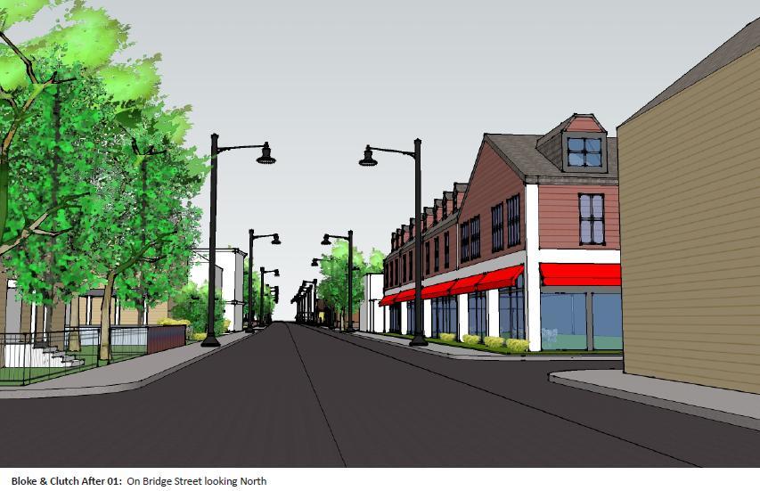
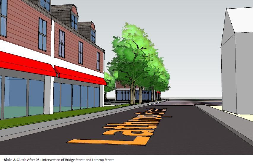
12 At the July 26 meeting of the BSN WG, MAPC presented a draft Village Mixed Use Design overlay outline table showing use and dimensions of the proposed district as well as abutting zoning districts. The decision to stay with the overlay model rather than switch directly to a modified Business Neighborhood zoning district that would include mixed use buildings was done to avoid impacting other Business Neighborhood zoned districts in Salem while still meeting the new vision for the neighborhood. The Business Highway parcels included in the first outline of the overlay district were not included in this iteration of the overlay as there were concerns that these areas should be preserved under current zoning to accommodate the need for travel and hospitality businesses at the northern end of the corridor, as originally indicated in the 2009 report. The new overlay would still retain many of the Business Neighborhood permitted dimensions, allowed uses and those uses permitted by special permit, but would allow building height to shift to a 40 foot maximum from B-1 s 30 foot maximum height and incorporate mixed uses. As drafted, the overlay allowed approximately 12 units of residential development per acre, a density similar to that found in the North River Canal Corridor district. See Appendix One for the complete Uses and Dimensional Descriptions Table of the Proposed Overlay District as Compared to Existing Zoning. In addition, MAPC presented digital models of what redevelopment might look using the Village Mixed Use Design Overlay by crafting mixed use scenarios for the following three sites: Current Brake and Clutch - four parcels combined: 2 nd and 3 rd Floor Residential, 1 st Floor Retail Bridge Street (current J &W) Marine: 2 nd and 3 rd Floor Residential, 1 st Floor Office 94 Bridge Street (current Mobil Gas): 2 nd and 3 rd Floor Residential, 1 st Floor Restaurant. All modeling was done incorporating the current parking requirements and setbacks for the B-1 district but allowing for a 40 foot maximum height. See Appendix Two for the Village Mixed Use Overlay Building Model Table. See Appendix Three for the Sketch Up Mixed Use Models. Working with DPCD staff and the Working Group after the July 26 BSN WG meeting, MAPC continued to modify and craft alternative zoning ideas for Bridge Street. Concerns were expressed about: The complexity of two-step zoning that would accompany a shift to B-1 zoning followed by the adoption of an overlay district such as the proposed Village Mixed Use overlay; residential density and building heights; dimensional and use non-conformity issues created if the Wholesale and Automotive parcels were shifted to B-1zoning. At the September 24 Working Group meeting, MAPC presented an alternative to the Mixed Use Village Overlay- a draft ordinance for a new, stand-alone zoning district entitled the Bridge Street Neck Neighborhood District (BSNND). See Appendix Four for the BSNND draft ordinances. As under the proposed overlay, B-1 uses and dimensional were largely maintained and the Business Highway parcels were excluded. Adopting a new Page 6
13 district to replace the B-4 zoning avoids the more complex two-step process discussed in conjunction with the Village Mixed Use Overlay model described above and also allows Bridge Street to adopt Business Neighborhood style zoning, including mixed use, without having to introduce mixed use to the other B-1 zoned neighborhoods in Salem. Other features of the first draft of the BSNND, in response to Working Group concerns, included: a reduction of allowed height from 40 to 35 feet under the Village Mixed Use Overlay, with three stories maximum; an eight unit per acre cap on the number of residential units allowed, reduced from 12 units under the Village Mixed Use Overlay- 5,000 square feet of lot area per unit required in BSNND; design review required for any project that triggers site plan review: 2,000 square feet non-residential space in the Highway Entrance Corridor, 10,000 square feet outside the HE Corridor and any project with four or more residential units; maximum lot coverage allowed would change from 40 % in B-1 to 50 % in the BSNND; BSNND would require a 10 foot minimum distance of buildings on the same lots while B-1 requires none; moving from a 15 foot front yard setback under B-1 to a zero foot setback under BSNND; all uses the same as B-1 except that BSNND would allow restaurants that serve alcohol and home occupations as special permit uses. A use and dimensional conformance study of the thirty seven Bridge Street B-4 parcels that would become non-conforming if zoned to Business Neighborhood style zoning was performed by DPCD staff. The results of that study indicated that nineteen (51%) of currently non-conforming uses under B-4 would become conforming uses and eight (22%) uses would become non-conforming under Business Neighborhood. Six of the eight uses that would become non-conforming are automobile repair businesses; one is a warehouse and the other is a construction business. Eighty-four percent of the parcels are already non-conforming dimensionally under B-4 zoning and while adding B-1 dimensions will add a new dimensional conformity for eighty-one percent of the parcels, none of the parcels will become dimensionally non-conforming that aren t already. See Appendix Five for Wholesale Automotive Conformity Table and summary. At the September meeting, MAPC also presented a mixed use automobile trip generation model scenario for the four Brake and Clutch parcels. MAPC transportation staff reconfigured the contiguous parcels, which total acres, from its current auto care designation by the Institute of Traffic Engineers (ITE) into retail and mixed use scenario to estimate the trips that could be expected using ITE average trip rates for a mix of apartments and retail on the four parcels. This type of modeling is often done prior to redevelopment projects to estimate overall traffic flows without conducting a full traffic study. Overall, the exercise indicated that under the new mixed use scenario, 157 new trips, an average of 6.5 new trips per hour would be created, with no increase in peak travel a.m. trips and a slight decrease in p.m. peak travel daily vehicle trips See Appendix Six for the Bridge Street Trip Generation with Brake and Clutch Site Redevelopment Scenario. Page 7
14 Figure 3- Proposed Bridge Street Neck Neighborhood District Map Page 8
15 After reviewing the comments and questions raised by the Working Group at its September 24 meeting, MAPC and City staff continued to refine the BSNND draft ordinance for further review at the fourth and final BSN WG meeting of November 29. Changes to the draft ordinance included the following: In response to concerns that changing uses from residential to commercial uses on the first floor of historic buildings could negatively impact historic properties within the BSNND area, language was included to ensure that all changes in use would require Site Plan Review by the Planning Board, as well as Design Review by the SRA Design Review Board. For properties 50 years or older, applications requiring the review of the Design Review Board will refer to the entire Section 3.3 of the Salem Downtown Renewal Plan rather than just Section as proposed under the first draft of the ordinance. Site Plan and Design Review were extended to all non-residential projects of 2,000 square feet or more outside of the Entrance Corridor Overlay District but in the BSNND. Eliminated Planned Unit Development as an allowed use in BSNND. Adjusted minimum side yard setback to be 10 feet. The first draft of the ordinance had used a setback derived from using the average side setbacks of nearby buildings. Page 9
16 Chapter Two: Zoning Recommendations MAPC worked closely with Salem planning staff to develop land use recommendations based on past studies, historic uses, field observations, Bridge Street Working Group input, and existing land use regulations within the Bridge Street Neck Neighborhood. Progress was made towards evaluating all of the options presented but the results were somewhat inconclusive as none of the options presented garnered strong support from the Working Group. In light of that fact, MAPC offers the following suggestions and recommendations as next steps to the work performed under this study. The proposed changes are designed to make the Bridge Street neighborhood more vibrant, livable and a better fit with its existing commercial, residential, historic and mixed use areas. 1) Re-evaluate Business Neighborhood Zoning. The 2009 neighborhood plan made the case for instituting moderately scaled, mixed use development within the Bridge Street neighborhood, calling for the substitution of the current Wholesale and Automotive B-4 zoning with Business Neighborhood B-1 zoning. As currently written, B-1 does not allow for a mixed use component. To enable mixed use in the BSN neighborhood will mean the adoption of an overlay district, or the adoption of a new zoning district that includes mixed use as an allowed use, either by right or by special permit. MAPC recommends that the City evaluate whether modifying and adding some type of mixed use component makes sense for Salem s B-1 neighborhoods, most of which consist of the same type of densely settled, smaller lot properties that are already a mix of preexisting residential, mixed use, and small commercial uses. If there is a decision to move forward to amend B-1 zoning, Salem may wish to consider the following steps in regard to making B-1 zoning more effective: Amend Business Neighborhood zoning to allow, By Right or Special Permit, Dwelling Units above First Floor Retail, Personal Service or Office Use. At present, only the Central Development district allows for the by-right use of a dwelling unit above first floor retail, personal service or office use. Allowing dwelling units in the city s Business Neighborhood areas would help to provide consistent customers for Business Neighborhood areas such as the North Street, Essex Street as well as the Bridge Street neighborhoods. Properly sited, additional residential units on upper floors can help build or keep an identity for the neighborhood as a great place to live and shop. There a number of pre-existing mixed used buildings along Bridge Street with residential uses located above first floor commercial uses. Prudent allowance of well designed mixed use buildings could help provide pedestrian oriented but commercially viable neighborhoods such as Bridge Street and other B-1 type neighborhoods. Increase the current thirty foot maximum building height in Business Neighborhood to thirty-five feet. The current height limit of thirty feet can lead to buildings that do not add to Bridge Street s historic foundation or fit well with the abutting and nearby residential neighborhoods. The maximum building heights for the Residential One Family (R1), Residential Two Family (R2), Residential Multi- Family (R3) and North River Canal Corridor (NRCC) districts are thirty five feet for R1 and R2, forty -five feet for R3 and fifty feet for the NRCC. Flat-roofed, single or two story buildings often do not provide the essential edge needed in this kind of setting and are often more on the periphery of suburban or rural settings. Page 10
17 Require site plan review and advisory Design Review Board review for all projects requiring a change of use and all non-residential project of 2,000 square feet or greater. Originating from community input received while MAPC was drafting the Bridge Street Neck Neighborhood Zoning District draft ordinance for this study, this recommendation makes sense for the Business Neighborhood district and could help preserve and enhance the historic nature of all the B-1 zoned areas, including Bridge Street, without causing undue permitting hardship for small residential and commercial projects. 2) Following these changes to B-1, adopt modified B-1 zoning for the B-4 parcels, and the R-2 Coffee Time, Mobil Gas, J&W Marine, and Brake and Clutch parcels. An enhanced B-1 district that could include mixed use, height and review modifications could better meet the needs envisioned by the Bridge Street 2009 neighborhood plan as well as potentially benefiting Salem s other Business Neighborhood zoned areas. Other recommendations, if the City prefers not to consider modifying B-1 zoning and adopting it for use along Bridge Street, include the following: 3) Move forward with completing and adopting the Mixed Use Village Overlay District for the B-4 parcels, Coffee Time, Mobil Gas, Brake and Clutch, J & W Marine, and Business Highway parcels included in the first draft of the VMUOD. Adopt the VMUOD as a first step but do not change the underlying B-4, R-2 or B-2 zoning to B-1. This land use configuration will provide the maximum amount of flexibility; providing mixed use overlay development options while allowing the underlying B-4, R-2 and Business Highway (B-2) underlying uses to remain in place for now. The City could consider letting the underlying zoning remain in place for a fixed amount of time, perhaps 2 years, to see what kind of development was using underlying zoning versus the overlay and then revisit the issue of rezoning some of the above parcels to B-1. Increasing land price valuations, as estimated by the 2009 revitalization plan, should draw uses gradually away from existing automotive uses under B-4 and allow moderately scaled mixed use development to occur as demand for it grows. Including the Business Highway District within the VMUOD while preserving its current B-2 zoning will allow the City to preserve the northern Bridge Street hospitality industry options as identified in the 2009 neighborhood plan as well as allow property owners the option to build mixed use development under the VMUOD. 4) Re-zone the B-4 parcels, and the R-2 Coffee Time, Mobil Gas, J&W Marine, and Brake and Clutch parcels to B-1 to remove incompatible Wholesale and Automotive underlying uses, then adopt the Mixed Use Village Overlay, including the Business Highway parcels on the north end of Bridge Street. The inclusion of B-4 parcels would allow flexibility of zoning and B-1 option if desired while still retaining B-2 hospitality and Planned Unit Development (PUD) possibilities for larger B-2 lots. Rezoning B-4 and R-2 lots to B-1 would strongly support the spirit of the 2009 neighborhood plan and would shift the Bridge Street Neck neighborhood more quickly towards the mixed use, pedestrian-scaled development envisaged by the plan. Page 11
18 Appendix One: Uses and Dimensional Descriptions Table of the Proposed Overlay Page 12
19 SALEM TABLE OF PRINCIPAL AND ACCESSORY USE REGULATIONS B4 (Wholesale & Automotive) B1 (Business Neighborhood) Draft Village Mixed Use Design Overlay Y = allowed N = prohibited BA = allowed by Special Permit from Zoning Board of Appeals PB = allowed by Special Permit from Planning Board PRINCIPAL USES A. RESIDENTIAL USES Dwelling, Single-family N Y Y Dwelling, Two-family N Y Y Dwelling, Multifamily N Y Y Cluster development N N N Dwelling unit(s) above first floor retail, personal service, restaurant, or office use N N Y or PB Dwelling unit in historic carriage house N BA BA Multifamily Development N N N Page 13
20 SALEM TABLE OF PRINCIPAL AND ACCESSORY USE REGULATIONS B4 (Wholesale & Automotive) B1 (Business Neighborhood) Draft Village Mixed Use Design Overlay Nursing or convalescent home N BA BA Planned unit development PB PB PB Rooming, boarding or lodging house N BA BA B. EXEMPT AND INSTITUTIONAL USES Child care facility Y Y Y Essential services BA BA BA Facilities for the sale of produce, and wine and dairy products, provided that during the months of June, July, August, and September of every year, or during the harvest season of the primary crop, the majority of such products for sale, based on either gross sales dollars or volume, have been produced by the owner of the land containing more than five acres in area on which the facility is located Y Y Y Hospital N N N Municipal facilities Y Y Y Use of land for the primary purpose of agriculture, horticulture, floriculture, or viticulture on a parcel of more than five acres in area Y Y Y Page 14
21 SALEM TABLE OF PRINCIPAL AND ACCESSORY USE REGULATIONS B4 (Wholesale & Automotive) B1 (Business Neighborhood) Draft Village Mixed Use Design Overlay Use of land or structures for educational purposes on land owned or leased by the commonwealth or any of its agencies, subdivisions or bodies politic or by a religious sect or denomination, or by a nonprofit educational corporation Y Y Y Use of land or structures for religious purposes Y Y Y C. COMMERCIAL USES Adult day care BA BA BA Agricultural use, nonexempt N N N Animal clinic or hospital; kennel BA BA BA Arts and crafts studios and workshops BA BA BA Bank, financial agency Y Y Y Bed and breakfast N BA BA Business or professional office, including medical Y Y Y Club or lodge, private N N N Commercial recreation, indoor BA N N Commercial recreation, outdoor BA N N Drive-through facilities; fast-food PB N N Page 15
22 SALEM TABLE OF PRINCIPAL AND ACCESSORY USE REGULATIONS B4 (Wholesale & Automotive) B1 (Business Neighborhood) Draft Village Mixed Use Design Overlay Drive-through facilities; other PB N N Educational use, nonexempt N N N Farm stand, nonexempt N N N Funeral home N BA BA Retail store, except department store, not elsewhere set forth Y Y Y General service establishment Y Y Y Golf course Y Y Y Historic buildings open to the public Y Y Y Hotel, motel, or inn BA N N Marina; waterfront boat yard or yacht club BA BA BA Motor vehicle general and body repair BA N N Motor vehicle light service Y BA BA Motor vehicle, trailer and boat sales, service and rental Y N N Museum Y Y Y Nonprofit outdoor recreational facilities N BA BA Page 16
23 SALEM TABLE OF PRINCIPAL AND ACCESSORY USE REGULATIONS B4 (Wholesale & Automotive) B1 (Business Neighborhood) Draft Village Mixed Use Design Overlay Personal service establishment Y Y Y Plumbing, carpentry and sheet metal shop Y N N Restaurant, with service of alcoholic beverages N N N Restaurant; drive-in or fast-food Y Y Y Restaurant; no service of alcoholic beverages Y Y Y Retail department store located within a shopping plaza N N N Retail-wholesale supply establishments, provided that the wholesale operation does not exceed 50% of the gross floor area N BA BA Sale and storage of building supplies Y N N Supermarket N N N Wind energy facility, commercial scale N N N Wind energy facility, residential scale PB PB PB Wireless Communications Facility PB PB PB D. INDUSTRIAL USES Page 17
24 SALEM TABLE OF PRINCIPAL AND ACCESSORY USE REGULATIONS B4 (Wholesale & Automotive) B1 (Business Neighborhood) Draft Village Mixed Use Design Overlay Assembly or packaging N N N Computer hardware development N N N Contractor's yard; landscaping business N N N Earth removal N N N Food and beverage manufacturing, bottling or processing facility N N N Junkyard or automobile graveyard N N N Light manufacturing N N N Livery facility, yard, or terminal N N N Manufacturing N N N Mini-storage warehouse facility BA N N Publishing and printing Y N N Research, laboratories, and development facilities N N N Transportation terminal N N N Wholesale, warehouse, or distribution facility Y N N Page 18
25 SALEM TABLE OF PRINCIPAL AND ACCESSORY USE REGULATIONS B4 (Wholesale & Automotive) B1 (Business Neighborhood) Draft Village Mixed Use Design Overlay E. ACCESSORY USES Adult day care N N N Customary agricultural, horticultural and floricultural operation N N N Family day care, large N N N Family day care, small N N N Home occupation N N N Private garages and other accessory structures N Y Y Rooming and boarding not more than 2 persons N N N Existing and Proposed Draft Dimensions Existing B4 (Wholesale & Automotive) Existing B1 (Business Neighborhood) Draft Village Mixed Use Design Overlay Minimum Lot Area-square feet 6,000 6,000 6,000 Minimum Lot Area per Dwelling Unit-square feet - - 3,500 Minimum Lot Frontage-feet Minimum Lot Width-feet Maximum Lot Coverage by all Buildings-% Page 19
26 Minimum Open Space Minimum Front Yard Setback Minimum Side Yard Setback Minimum Rear Yard Setback Maximum Height-feet Maximum Height-stories Page 20
27 Appendix Two: Village Mixed Use Overlay Building Model Table Page 21
28 Site Name Address(es) & Current Zoning Total Lot(s) Size: acres and square feet 1 st Floor Building Footprint: square feet *Residential Units (12/acre allowed) Office: square feet Restaurant: square feet # of Parking Spaces 10 % Open Space: square feet 2 nd and 3 rd Floors Residential 1 st Floor Retail Salem Brake and Clutch 9 Lathrop Street( R-2) 11 Lathrop Street(R-2) Four lots = acres 22,738 square feet 30 units/2.7 acre lot= 11 per acre 22,738 X Retail: 151 Residential:45 11, Bridge Street(B-4) 117,612 square feet 63 Bridge Street(R-2) 2 nd and 3 rd Floors Residential 1 st Floor Office J&W Marine Bridge Street (R-2) 0.98 acres 42,687 square feet 11,525 square feet 15 units/acre (more units due to office parking requirements 11,525 square feet X Office: 40 Residential:23 4,269 square feet 2 nd and 3 rd Floors Residential 1 st Floor Restaurant Mobil Gas 94 Bridge Street acres 21,954 square feet 2,634 square feet 4 units/acre (less units due to restaurant parking requirements) X 2,634 square feet Restaurant: 35 Residential: 6 2,195 square feet Page 22
29 * The number of units allowed by zoning per acre is based on requiring 3,500 square feet minimum lot area per dwelling unit. For one acre: 43,560 square feet/ 3500 = dwelling units, rounded down to 12 units per acre. Dwelling unit size = 1500 square feet used for models. Page 23
30 Appendix Three: Sketch Up Mixed Use Models Page 24


31 Page 25


32 Page 26

33 Page 27

34 Page 28

35 Page 29


36 Page 30

37 Page 31
38 Appendix Four: Bridge Street Neck Neighborhood District Draft Ordinances Page 32
39 Bridge Street Neck Neighborhood District First Draft September 17, 2012 The purpose of this district is to enhance the Bridge Street Neck neighborhood by promoting opportunities for local, small businesses and lower density housing, while serving as a transitional zone from abutting residential and commercial areas. Uses Permitted by Right The following uses are permitted by right, with the following conditions: As per Section 9.5 of this Ordinance, proposed nonresidential uses or premises within the Bridge Street Neck Neighborhood District that exceed 10,000 gross square feet or any residential development of 6 units or more shall be subject to Site Plan Review. As per Section 8.2 of this ordinance, all new nonresidential construction over 2,000 square feet located within the Entrance Corridor Overlay District shall be subject to Site Plan Review by the Planning Board. All measurements in square feet refer to Gross Floor Area as per Section 10 of the Salem Zoning Ordinance. Single-family Dwelling Two-family Dwelling Multi-Family Dwelling with up to 4 dwelling units Mixed Use Building with up to 4 dwelling units above first floor retail, general service, restaurant, or office uses Child care facility Municipal services Use of land for the primary purpose of agriculture, horticulture, floriculture, or viticulture on a parcel of more than five acres in area Use of land or structures for educational purposes on land owned or leased by the commonwealth or any of its agencies, subdivisions or bodies politic or by a religious sect or denomination, or by a nonprofit educational corporation Use of land or structures for religious purposes Bank, financial agency Business or professional office, including medical Page 33
40 Retail store, except department store, not elsewhere set forth General service establishment Golf course Historic buildings open to the public Museum Restaurant; drive-in or fast-food-keep Restaurant; with service of alcoholic beverages Ground floor uses In mixed-use buildings, ground floor uses will be reserved for retail, general service, restaurant and office uses except as specified below: Residential uses up to 2 dwelling units may be allowed on first floors of mixed-use buildings only where: the building is set behind another building which has frontage on the street; the residential portion of the first floor of a building is set behind street-front retail/office/restaurant uses within the same building; or where the Board determines that street-front residential uses will not have an adverse impact on the continuity of the commercial street-front uses. Procedures and Criteria for Review by Site Plan Review 1. Proposed uses subject to Site Plan Review shall be required to submit an application as per Section 9.5 of this ordinance. 2. The Site Plan shall be reviewed by the Design Review Board of the Salem Redevelopment Authority in regard to the design of the project. The Design Review Board shall make a recommendation to the Planning Board. The Design Review Board shall refer to the Salem Downtown Renewal Plan, specifically Section Design Criteria, Section Design Standards, and Appendix III City of Salem Commercial Design Guidelines (2005) when making its recommendation. Dimensional Requirements Minimum Lot Area 6,000 square feet Page 34
41 Minimum Frontage 60 feet Minimum Lot Width 60 feet Maximum Lot Coverage 50 percent This maximum lot coverage restriction shall not apply to any structures existing (date of adoption), even when such structures are modified, reconstructed or restored, so long as the lot coverage is not increased. Maximum number dwelling units 1 unit per 5,000 square feet lot area Maximum number of dwelling units per/acre 8 Maximum building height for construction or reconstruction 35 feet Maximum Number of Stories 3 Separation of Buildings 10 feet minimum between two buildings located on the same lot Page 35
42 Minimum Front Yard Setback 10 feet Maximum Front Yard Setback 20 feet or the average of the setbacks to buildings on the same side of the street or way within 200 feet of the lot in question, whichever is less. Minimum Side Yard Width 10 feet Minimum Rear Yard Depth 30 feet Parking As required by Section 5.0 of this Ordinance Special Permit in Salem Bridge Street Neck Neighborhood District In this District, a Special Permit may be granted by the Planning Board (PB) or the Zoning Board of Appeals (BA) for the following listed uses: Uses Allowed by Special Permit Dwelling Unit in Historic Carriage House (BA) Nursing or convalescent home (BA) Planned unit development (PB) Rooming, boarding or lodging house (BA) Essential Services (BA) Adult Day Care (BA) Animal Clinic or Hospital (BA) Page 36
43 Arts and crafts studios or workshops (BA) Bed and Breakfast (BA) Funeral home (BA) Marina; waterfront boat yard or yacht club (BA) Motor vehicle light service (BA) Nonprofit outdoor recreational facilities (BA) Retail-wholesale supply establishments, provided that the wholesale operation does not exceed 50% of the gross floor area Wind energy facility, residential scale (PB) Wireless communications facility (PB) Any residential or mixed used building containing more than 4 dwelling units (PB) Home occupation (BA) Procedures and Criteria for Review of Special Permits 1. The procedural criteria for approval of a Special Permit in the Bridge Street Neck Neighborhood District are through the submission of a Special Permit application under Section 9.4 of this ordinance and Massachusetts General Law Chapter 40 A. 2. All proposed uses subject to Special Permit approval shall also be required to file an application for Site Plan Review under Section 9.5 of this ordinance. 3. The Site Plan shall be reviewed by the Design Review Board of the Salem Redevelopment Authority in regard to the design of the project. The Design Review Board shall make a recommendation to the Planning Board. The Design Review Board shall refer to the Salem Downtown Renewal Plan, specifically Section Design Criteria, Section Design Standards, and Appendix III City of Salem Commercial Design Guidelines (2005) when making its recommendation. 4. The Special Permit Granting Authority shall issue a decision with findings and conditions as regulated under Section 9.4 of this zoning by-law, and M.G.L Chapter 40A. Prohibition of Nuisance in Bridge Street Neck Neighborhood District 1. All dust, fumes, odors, smoke, or vapor shall be effectively confined to the premises or disposed of to prevent intrusion on neighboring properties. Page 37
44 2. Any noise or vibration shall not be normally perceptible without at a distance of one hundred (100) feet from the source instruments (and shall not exceed Board of Health standards). BRIDGE STREET NECK NEIGHBORHOOD DISTRICT SECOND DRAFT NOVEMBER 20, 2012 The purpose of this district is to enhance the Bridge Street Neck neighborhood by promoting opportunities for local, small businesses and lower density housing, while serving as a transitional zone from abutting residential and commercial areas. Uses Permitted by Right Single-family Dwelling Two-family Dwelling Multi-Family Dwelling with up to 4 dwelling units Mixed Use Building with up to 4 dwelling units above first floor retail, general service, restaurant, or office uses Child care facility Municipal services Use of land for the primary purpose of agriculture, horticulture, floriculture, or viticulture on a parcel of more than five acres in area Use of land or structures for educational purposes on land owned or leased by the commonwealth or any of its agencies, subdivisions or bodies politic or by a religious sect or denomination, or by a nonprofit educational corporation Use of land or structures for religious purposes Bank, financial agency Business or professional office, including medical Retail store, except department store, not elsewhere set forth General service establishment Golf course Historic buildings open to the public Museum Restaurant; Page 38
45 Ground floor uses In mixed-use buildings, ground floor uses will be reserved for retail, general service, restaurant and office uses except as specified below: Residential uses up to 2 dwelling units may be allowed on first floors of mixed-use buildings only where: the building is set behind another building which has frontage on the street; the residential portion of the first floor of a building is set behind street-front retail/office/restaurant uses within the same building; or where the Board determines that street-front residential uses will not have an adverse impact on the continuity of the commercial street-front uses. Procedures and Criteria for Review by Site Plan Review 1. All new nonresidential construction over 2,000 square feet or any residential development of 4 units or more located within the Bridge Street Neck Neighborhood District shall be subject to Site Plan Review by the Planning Board. Any change of use within an existing building shall be subject to Site Plan Review by the Planning Board. 2. All measurements in square feet refer to Gross Floor Area as per Section 10 of the Salem Zoning Ordinance. 3. The Site Plan shall be reviewed by the Design Review Board of the Salem Redevelopment Authority in regard to the design of the project. The Design Review Board shall make a recommendation to the Planning Board. The Design Review Board shall refer to the Salem Downtown Renewal Plan, specifically Section 3.3 Design Review and Appendix III City of Salem Commercial Design Guidelines (2005) when making its recommendation. Dimensional Requirements Minimum Lot Area 6,000 square feet Minimum Frontage 60 feet Page 39
46 Minimum Lot Width 60 feet Maximum Lot Coverage 50 percent This maximum lot coverage restriction shall not apply to any structures existing (as of the date of adoption), even when such structures are modified, reconstructed or restored, so long as the lot coverage is not increased. Maximum number dwelling units 1 unit per 5,000 square feet lot area Maximum number of dwelling units per/acre 8 Maximum building height for construction or reconstruction 35 feet Maximum Number of Stories 3 Separation of Buildings 10 feet minimum between two buildings located on the same lot Minimum Front Yard Setback None Page 40
47 Maximum Front Yard Setback 10 Minimum Side Yard Width 10 feet Minimum Rear Yard Depth 30 feet Parking As required by Section 5.0 of this Ordinance Special Permit in Salem Bridge Street Neck Neighborhood District In this District, a Special Permit may be granted by the Planning Board (PB) or the Zoning Board of Appeals (BA) for the following listed uses: Uses Allowed by Special Permit Dwelling Unit in Historic Carriage House (BA) Nursing or convalescent home (BA) Rooming, boarding or lodging house (BA) Essential Services (BA) Adult Day Care (BA) Animal Clinic or Hospital (BA) Arts and crafts studios or workshops (BA) Bed and Breakfast (BA) Funeral home (BA) Marina; waterfront boat yard or yacht club (BA) Motor vehicle light service (BA) Nonprofit outdoor recreational facilities (BA) Retail-wholesale supply establishments, provided that the wholesale operation does not exceed 50% of the gross floor area (BA) Wind energy facility, residential scale (PB) Wireless communications facility (PB) Page 41
48 Any residential or mixed used building containing more than 4 dwelling units (PB) Home occupation (BA) Restaurant; with service of alcoholic beverages (BA) Procedures and Criteria for Review of Special Permits 1. The procedural criteria for approval of a Special Permit in the Bridge Street Neck Neighborhood District are through the submission of a Special Permit application under Section 9.4 of this ordinance and Massachusetts General Law Chapter 40 A. 2. All proposed uses subject to Special Permit approval shall also be required to file an application for Site Plan Review under Section 9.5 of this ordinance. 3. The Special Permit Granting Authority shall issue a decision with findings and conditions as regulated under Section 9.4 of this zoning by-law, and M.G.L Chapter 40A. Prohibition of Nuisance in Bridge Street Neck Neighborhood District 1. All dust, fumes, odors, smoke, or vapor shall be effectively confined to the premises or disposed of to prevent intrusion on neighboring properties. 2. Any noise or vibration shall not be normally perceptible without at a distance of one hundred (100) feet from the source instruments (and shall not exceed Board of Health standards). Page 42
Residential-1 District
 Residential-1 District City of Barnum, Minnesota Zoning District Information Sheet It is the purpose of the R-1 District to encourage the establishment and the preservation of residential neighborhoods
ARTICLE 7 R-1 ONE FAMILY RESIDENTIAL DISTRICT
 ARTICLE 7 R-1 ONE FAMILY RESIDENTIAL DISTRICT SECTION 700 STATEMENT OF PURPOSE This district classification is designed to be the most restrictive of the residential districts intended to encourage an
MONROE WARD REZONING SUMMARY. October 2018
 MONROE WARD REZONING SUMMARY October 2018 WHY IS THE CITY REZONING MONROE WARD? In July of 2017 Richmond City Council adopted The Pulse Corridor Plan, a corridor-long planning document that outlines steps
Chapter CC COMMUNITY COMMERCIAL ZONES REGULATIONS
 Effective April 14, 2011 Chapter 17.35 CC COMMUNITY COMMERCIAL ZONES REGULATIONS SECTIONS: 17.35.010 Title, Intent, and Description 17.35.020 Required Design Review Process 17.35.030 Permitted and Conditionally
4.2 RESIDENTIAL ZONING DISTRICTS
 4.2 RESIDENTIAL ZONING DISTRICTS A. Purpose: To define regulations and standards for each residential zoning district in the City. The following sections identify uses, regulations, and performance standards
CHAPTER COMMERCIAL ZONING DISTRICTS
 CHAPTER 27.10 - COMMERCIAL ZONING DISTRICTS 27.10.010 - Purpose of Chapter This Chapter lists the land uses that may be allowed within the commercial zoning districts established by Section 27.04.020 (Zoning
Chapter CN NEIGHBORHOOD CENTER COMMERCIAL ZONES REGULATIONS
 Chapter 17.33 - CN NEIGHBORHOOD CENTER COMMERCIAL ZONES REGULATIONS Sections: 17.33.010 - Title, intent, and description. 17.33.020 - Required design review process. 17.33.030 - Permitted and conditionally
COMMERCIAL ZONING DISTRICTS (Amended 11/13/14) Part I. C-1 Restricted Commercial District
 Part I. C-1 Restricted Commercial District") ARTICLE XI. COMMERCIAL ZONING DISTRICTS (Amended 11/13/14) Part I. C-1 Restricted Commercial District Section 152: Purpose This district is designed to accommodate commercial uses which act as a transition
ARTICLE XI. COMMERCIAL ZONING DISTRICTS (Amended 11/13/14) Part I. C-1 Restricted Commercial District Section 152: Purpose This district is designed to accommodate commercial uses which act as a transition
ARTICLE 3: Zone Districts
 ARTICLE 3: Zone Districts... 3-1 17.3.1: General...3-1 17.3.1.1: Purpose and Intent... 3-1 17.3.2: Districts and Maps...3-1 17.3.2.1: Applicability... 3-1 17.3.2.2: Creation of Districts... 3-1 17.3.2.3:
DIVISION 7. R-6 AND R-6A RESIDENTIAL ZONES* The purpose of the R-6 residential zone is:
 Date of Draft: March 6, 2015 DIVISION 7. R-6 AND R-6A RESIDENTIAL ZONES* Sec. 14-135. Purpose. The purpose of the R-6 residential zone is: (a) To set aside areas on the peninsula for housing characterized
Midwest City, Oklahoma Zoning Ordinance
 2010 Midwest City, Oklahoma Zoning Ordinance 9/2/2010 Table of Contents Section 1. General Provisions... 5 1.1. Citation... 5 1.2. Authority... 5 1.3. Purpose... 5 1.4. Nature and Application... 5 1.5.
Parking Challenges and Trade-Offs
 Parking Challenges and Trade-Offs What is the best way to balance competing interests and priorities while updating the City s off street parking regulations? Updating off street parking regulations can
CITY OF SALEM ZONING ORDINANCE. September 10, 2009
 CITY OF SALEM ZONING ORDINANCE September 10, 2009 CONTENTS SECTION 1.0 PURPOSE AND AUTHORITY... 1 1.1 PURPOSE... 1 1.2 AUTHORITY....1 1.3 SCOPE.... 1 1.4 APPLICABILITY... 1 1.5 AMENDMENTS.... 1 1.6 SEPARABILITY....
For the purpose of this Zoning Ordinance, the Village is hereby divided into five classes of zoning districts known as:
 Chapter 3 District Regulations SECTION 301. VILLAGE ZONING DISTRICTS. For the purpose of this Zoning Ordinance, the Village is hereby divided into five classes of zoning districts known as: R-1 Low-Density
CHAPTER COMMERCIAL AND INDUSTRIAL ZONING DISTRICTS
 Commercial and Industrial Zoning Districts 106.26.010 CHAPTER 106.26 - COMMERCIAL AND INDUSTRIAL ZONING DISTRICTS COMMERCIAL AND INDUSTRIAL ZONING DISTRICTS Sections: 106.26.010 - Purpose 106.26.020 -
Reviewing Mixed Use Proposals
 MIXED USE ZONING Citizens Guide Supplement 1 Things to Consider in Reviewing Mixed Use Proposals Using an Overlay District vs. Changing Underlying Zoning To achieve well-planned mixed use development,
ARTICLE 8 R-2 MULTIPLE FAMILY RESIDENTIAL DISTRICT
 ARTICLE 8 R-2 MULTIPLE FAMILY RESIDENTIAL DISTRICT SECTION 800 STATEMENT OF PURPOSE This district classification is designed to permit the greatest density of residential uses allowed within the Township,
2.110 COMMERICAL MIXED USE (CM)
") CITY OF KEIZER DEVELOPMENT BULLETIN 2.110.01 Purpose 2.110 COMMERICAL MIXED USE (CM) The Commercial Mixed Use (CM) zone is the primary commercial zone within the City. The zone is specifically designed
CITY OF KEIZER DEVELOPMENT BULLETIN 2.110.01 Purpose 2.110 COMMERICAL MIXED USE (CM) The Commercial Mixed Use (CM) zone is the primary commercial zone within the City. The zone is specifically designed
RAE EXCLUSIVE RESIDENTIAL ZONE A residential district exclusively for low density single family housing and accessory uses.
 KNOX COUNTY ZONING ORDINANCE DISTRICT SUMMARY REQUIREMENTS 2/11/2009 RAE EXCLUSIVE RESIDENTIAL ZONE A residential district exclusively for low density single family housing and accessory uses. 10,000 sq.
Subchapter 5 Zoning Districts and Limitations
 Subchapter 5 Zoning Districts and Limitations 35.5.1 Rural Districts Sections: 35.5.1.1 Purpose. 35.5.1.2 Permitted Uses. 35.5.1.3 General Regulations. 35.5.1.1 Purpose. The purpose of a Rural District
Staff Report PLANNED DEVELOPMENT. Salt Lake City Planning Commission. From: Lauren Parisi, Associate Planner; Date: December 14, 2016
 Staff Report PLANNING DIVISION COMMUNITY & NEIGHBORHOODS To: Salt Lake City Planning Commission From: Lauren Parisi, Associate Planner; 801-535-7932 Date: December 14, 2016 Re: 1611 South 1600 East PLANNED
May 12, Chapter RH HILLSIDE RESIDENTIAL ZONES REGULATIONS Sections:
 May 12, 2017 Chapter 17.13 RH HILLSIDE RESIDENTIAL ZONES REGULATIONS Sections: 17.13.010 Title, intent, and description. 17.13.020 Required design review process. 17.13.030 Permitted and conditionally
City of Valdosta Land Development Regulations
 Chapter 206 Section 206-1 Base Zoning Districts Standards for Uses, Structures, and Property Development (B) (C) Principal Uses and Structures. Principal uses and structures permitted in each base zoning
CHAPTER 1282 I-1 (WAREHOUSING AND ASSEMBLING)
") CHAPTER 1282 I-1 (WAREHOUSING AND ASSEMBLING) 1282.01 PURPOSE: The I-1 (Warehousing and Assembling) Zoning District has been established to permit warehousing; low to moderate intensity assembling, processing,
CHAPTER 1282 I-1 (WAREHOUSING AND ASSEMBLING) 1282.01 PURPOSE: The I-1 (Warehousing and Assembling) Zoning District has been established to permit warehousing; low to moderate intensity assembling, processing,
Appendix A: Guide to Zoning Categories Prince George's County, Maryland
 Appendix A: Guide to Zoning Categories Prince George's County, Maryland RESIDENTIAL ZONES 1 Updated November 2010 R-O-S: Reserved Open Space - Provides for permanent maintenance of certain areas of land
GC General Commercial District
 Section 712. GC General Commercial District 712.1 Intent of District. It is the intent of this section that the GC Zoning District be developed and reserved for general business purposes. The regulations
301. Zoning Districts. C-D A-1 R-1 R-V B-1 I-1
 301. Zoning Districts. The Township is divided into the districts set forth by this chapter and as shown by the district boundaries on the Official Zoning District Map. The zoning districts are: C-D Conservation
ARTICLE VIII. ZONING DISTRICTS DIVISION 1. PERMITTED USES
 Sec. 130-241. Use tables. ARTICLE VIII. ZONING DISTRICTS DIVISION 1. PERMITTED USES (a) Tables 1 and 2 list all use types and all zoning districts where the use type is permitted ( P ) or permitted with
Marcel Williams, MPC Project Planner
 TO: FROM: The Planning Commission MPC Staff DATE: SUBJECT: Petition to Rezone Property Heath Shelton, Owner Jay Maupin, Agent 2026 Habersham Street Aldermanic District: 2, Bill Durrence County Commission
CHAPTER 7 WR WATERFRONT RESIDENTIAL DISTRICT
 SECT ION 7.01 SECT ION 7.02 SECT ION 7.03 SECT ION 7.04 CHAPTER 7 WR WATERFRONT RESIDENTIAL DISTRICT DESCRIPTION AND PURPOSE This District is intended for medium density single family residential development
DEVELOPMENT STANDARDS
 Chapter 5 DEVELOPMENT STANDARDS 501 Residential Development Standards 502 Neighborhood Commercial Standards 503 Mixed Use Standards 504 Industrial Development Standards 505 Public Use Standards 506 Open
Coding For Places People Love Main Street Corridor District
 Coding For Places People Love Main Street Corridor District 1) Scope a) District boundaries are assigned according to the District Boundary Map. b) The Primary Retail Corridor is assigned according to
From Policy to Reality
 From Policy to Reality Updated ^ Model Ordinances for Sustainable Development 2000 Environmental Quality Board 2008 Minnesota Pollution Control Agency Funded by a Minnesota Pollution Control Agency Sustainable
SECTION CLASSIFICATION OF ZONES For the purpose of this Code the following primary land use zoning districts are hereby established:
 ARTICLE 4 ZONING DISTRICTS SECTION 4.010 CLASSIFICATION OF ZONES For the purpose of this Code the following primary land use zoning districts are hereby established: Primary Zones Abbreviated Designation
City of Oshkosh Zoning Update
 City of Oshkosh Zoning Update The Zoning Rewrite Process Commenced in June of 2013 with selection of Vandewalle and Associates as zoning rewrite consultants. Consultants, City Staff, Plan Commission, and
Revised Code of Ordinances, City of Hallowell (1997) SUBCHAPTER II RESIDENTIAL DISTRICTS DIVISION A (RESERVED)
 SUBCHAPTER II RESIDENTIAL DISTRICTS DIVISION A (RESERVED)") SUBCHAPTER II RESIDENTIAL DISTRICTS DIVISION A (RESERVED) [Derivation: Ord. No. 12-10, eff. 10/19/2012] SECTIONS 9-211 THROUGH 9-230 (Reserved) DIVISION B MEDIUM DENSITY RESIDENTIAL DISTRICT (R1) SECTION
SUBCHAPTER II RESIDENTIAL DISTRICTS DIVISION A (RESERVED) [Derivation: Ord. No. 12-10, eff. 10/19/2012] SECTIONS 9-211 THROUGH 9-230 (Reserved) DIVISION B MEDIUM DENSITY RESIDENTIAL DISTRICT (R1) SECTION
ARTICLE 6. GREER ZONES
 ARTICLE 6. GREER ZONES Section 601. Definitions and application of Greer Zones A. In this Article, unless otherwise specified: GA-2 means Greer Agricultural Zone GR-1 means Greer Residential Zone GC means
(B) On lots less than 1.5 acres, accessory buildings shall have a maximum size of 672 square feet in area.
 On lots less than 1.5 acres, accessory buildings shall have a maximum size of 672 square feet in area.") Setbacks in Commercial Districts: (1) Downtown Business District: Setbacks from State Highways 70 and 155 shall be the lesser of a minimum of 100 feet or the footprint of the present principal building
Setbacks in Commercial Districts: (1) Downtown Business District: Setbacks from State Highways 70 and 155 shall be the lesser of a minimum of 100 feet or the footprint of the present principal building
Part 9. Chatham Overlay District (CV)
") Part 9 Chatham Overlay District (CV) 27-901. District Boundaries on the Zoning Map. The Chatham Overlay District shall be located with the geographic area of the Township that is depicted on the map provided
Part 9 Chatham Overlay District (CV) 27-901. District Boundaries on the Zoning Map. The Chatham Overlay District shall be located with the geographic area of the Township that is depicted on the map provided
AMENDED ZONING BY-LAW ARTICLE SENIOR LIVING COMMUNITY
 AMENDED ZONING BY-LAW ARTICLE 13.5 - SENIOR LIVING COMMUNITY ARTICLE : To see if the Town will vote to amend the Zoning Bylaw as follows: 2. By deleting existing Section 13.5, Senior Living Community,
ARTICLE IV DISTRICT REGULATIONS
 PART 1. RESIDENTIAL DISTRICTS 4-101. RS. Single-Family Residential Suburban District. The RS District is designed for single-family dwellings, and compatible uses, at a density no greater than one dwelling
Goal 1 - Retain and enhance Cherry Creek North s unique physical character.
 Introduction This document summarizes the proposed new zoning for the area of roughly bordered by University Boulevard, Steele Street, 3rd Avenue, and 1st Avenue. It provides a high-level review of the
CITY OF CHARLOTTESVILLE DEPARTMENT OF NEIGHBORHOOD DEVELOPMENT SERVICES STAFF REPORT APPLICATION FOR A SPECIAL USE PERMIT
 CITY OF CHARLOTTESVILLE DEPARTMENT OF NEIGHBORHOOD DEVELOPMENT SERVICES STAFF REPORT APPLICATION FOR A SPECIAL USE PERMIT PLANNING COMMISSION AND CITY COUNCIL JOINT PUBLIC HEARING DATE OF HEARING: December
CITY OF BONITA SPRINGS ZONING ORDINANCE NO
 CITY OF BONITA SPRINGS ZONING ORDINANCE NO. 04-16 A ZONING ORDINANCE OF THE CITY OF BONITA SPRINGS, FLORIDA; APPROVING A REQUEST BY CUSSON S CPD TO REZONE FROM AGRICULTURE (AG-2) AND COMMERCIAL PLANNED
East Side Community Meeting
 East Side Community Meeting November 29, 2017 Pam Thompson, Senior Planner Sustainable Development and Construction City of Dallas Authorized Hearing Process City Plan Commission authorized a hearing to
Suburban Commercial Center ( CE-S ) Permitted Principal Uses and Structures
 Permitted Principal Uses and Structures") Division 12. Suburban Commercial Center ( CE-S ) 2.9.1 Purpose Suburban commercial centers provide regional commercial destinations with design and site elements compatible with suburban character. Dimensional
Division 12. Suburban Commercial Center ( CE-S ) 2.9.1 Purpose Suburban commercial centers provide regional commercial destinations with design and site elements compatible with suburban character. Dimensional
FOR LEASE. +/- 1,090 SF Office Condo West Park Professional Center St. Lucie West, FL. 540 NW University Blvd, #209-A, Port St.
 Kyle St. John (772) 288-6646 kyle@tccommercialre.com www.tccommercialre.com FOR LEASE +/- 1,090 SF Office Condo West Park Professional Center St. Lucie West, FL 540 NW University Blvd, #209-A, Port St.
general residential district shall be used only for the following purposes: Any use permitted in an R-1 low density residential district.
 Page 1 of 5 - R-2 general residential district. A. B. General description. This is a residential district to provide for medium population density. The principal uses of land may range from houses to low
WHEREAS, currently the R-2 zoning district does not have a minimum required density; and
 ORDINANCE NO. 1130 AN ORDINANCE OF THE CITY COUNCIL OF THE CITY OF GIG HARBOR, WASHINGTON, RELATING TO LAND USE AND ZONING, ADDING TRIPLEXES AND FOURPLEXES AS CONDITIONAL USES IN THE R-2 ZONING DISTRICT;
Oak Cliff Gateway District PD 468
 Oak Cliff Gateway District PD 468 August 21, 2014 2013 Authorized Hearing Authorized Hearing September, 2013 September 12, 2013 City Plan Commission expanded boundaries to represent current Oak Cliff Gateway
TABLE OF CONTENTS. Township of Clyde i
 TABLE OF CONTENTS ARTICLE 1 - TITLE, PURPOSE, SCOPE, AND LEGAL BASIS... 1-1 1.01 TITLE...1-1 1.02 PURPOSE... 1-1 1.03 SCOPE AND INTERPRETATION...1-1 1.04 THE EFFECT OF ZONING... 1-2 1.05 LEGAL BASIS...1-2
CCC XXX Rural Neighborhood Conservation (NC)
") CCC 33.10.XXX Rural Neighborhood Conservation (NC) Purpose: Maintain low density rural residential areas and associated uses commonly found in rural areas consistent with the local character of the distinctive
CCC 33.10.XXX Rural Neighborhood Conservation (NC) Purpose: Maintain low density rural residential areas and associated uses commonly found in rural areas consistent with the local character of the distinctive
MISSOULA COUNTY ZONING REGULATIONS Effective April 11, Chapter 2 Zoning Districts
 MISSOULA COUNTY ZONING REGULATIONS Effective April 11, 2017 Chapter 2 Zoning Districts 25 26 MISSOULA COUNTY ZONING REGULATIONS Effective April 11, 2017 SECTION 2.01 PURPOSES CHAPTER 2 ZONING DISTRICTS
ARTICLE VII. NONCONFORMITIES. Section 700. Purpose.
 ARTICLE VII. NONCONFORMITIES. Section 700. Purpose. The purpose of this chapter is to regulate and limit the development and continued existence of legal uses, structures, lots, and signs established either
Overview. Central Street Master Plan. Appendix B: Zoning
 Central Street Master Plan Overview The City of Evanston has 36 zoning districts, of which 11 are found in the Central Street Corridor Study Area (See Figures B.1 and B.2). They include: R1: Single-Family
17.13 RH HILLSIDE RESIDENTIAL ZONES REGULATIONS SECTIONS:
 Effective April 14, 2011 Chapter 17.13 RH HILLSIDE RESIDENTIAL ZONES REGULATIONS SECTIONS: 17.13.010 Title, Intent, and Description 17.13.020 Required Design Review Process 17.13.030 Permitted and Conditionally
Business Park District Zoning Text Amendment (PLNPCM ) ZONING TEXT AMENDMENT
 ZONING TEXT AMENDMENT") Staff Report PLANNING DIVISION COMMUNITY & ECONOMIC DEVELOPMENT To: Salt Lake City Planning Commission From: Maryann Pickering, Principal Planner (801) 535-7660 Date: June 10, 2015 Re: Business Park District
Staff Report PLANNING DIVISION COMMUNITY & ECONOMIC DEVELOPMENT To: Salt Lake City Planning Commission From: Maryann Pickering, Principal Planner (801) 535-7660 Date: June 10, 2015 Re: Business Park District
Article 04 Single Family Residential Districts
 Article 04 Article 04 Section 04.01 Intent (a) R1A Residence District. The R1A Single Family Residential District is established to include areas of low density single-family residences and limited agricultural
ARTICLE III: LAND USE DISTRICTS 304 R 9 DISTRICT
 ARTICLE III: LAND USE DISTRICTS III 23 304 R 9 DISTRICT (RESIDENTIAL 9 UNITS PER ACRE) 304 1 Intent and Purpose The R 9 District is intended to implement the policies of the Comprehensive Plan for areas
Permitted uses. Adult congregate living facility. Ambulance service. Animal clinics (outpatient care only and no overnight boarding)
") B-3, HIGHWAY SERVICE BUSINESS DISTRICT Intent. The B-3, Highway Service Business District is intended for application along highways carrying large volumes of traffic where establishments may locate to
B-3, HIGHWAY SERVICE BUSINESS DISTRICT Intent. The B-3, Highway Service Business District is intended for application along highways carrying large volumes of traffic where establishments may locate to
Glades County Staff Report and Recommendation Unified Staff Report for Small Scale Plan Amendment and Rezoning
 Glades County Staff Report and Recommendation Unified Staff Report for Small Scale Plan Amendment and Rezoning CASE NUMBERS: COMP17-02 and RZ17-02 DATE of STAFF REPORT: May 1, 2017 CASE TYPE: Application
FOR SALE COMMERCIAL BEACHSIDE LOT
 FOR SALE COMMERCIAL BEACHSIDE LOT 1100 South Patrick Dr., Satellite Beach, Florida 32937.69 Acres, Zoning C-Commercial Lot is Cleared Numerous Allowable Intended Uses (see zoning on next page) High Visibility
Planning Justification Report
 Planning Justification Report Kellogg s Lands City of London E&E McLaughlin Ltd. June 14, 2017 Zelinka Priamo Ltd. Page i TABLE OF CONTENTS Page No. 1.0 2.0 2.1 2.2 3.0 4.0 5.0 5.1 5.2 5.3 5.4 5.5 5.6
Financial Impact Statement There are no immediate financial impacts associated with the adoption of this report.
 STAFF REPORT Planning and Development Department Subject: Application by RYC Property to rezone a portion of lands on John Murray Dr. and Megan Lynn Dr. from R2 to R3 and to enter into a Development Agreement
TOWN OF EPPING, NH ZONING ORDINANCES
 TOWN OF EPPING, NH ZONING ORDINANCES 2017 Contents ARTICLE 1: Preamble, Title & Purpose 3 ARTICLE 2: Zoning 4 1. Highway-Commercial 7 2.Residential-Commercial 11 3. West Epping Commercial Business Zone
CITY OF CHARLOTTESVILLE DEPARTMENT OF NEIGHBORHOOD DEVELOPMENT SERVICES STAFF REPORT APPLICATION FOR A SPECIAL USE PERMIT
 CITY OF CHARLOTTESVILLE DEPARTMENT OF NEIGHBORHOOD DEVELOPMENT SERVICES STAFF REPORT APPLICATION FOR A SPECIAL USE PERMIT PLANNING COMMISSION AND CITY COUNCIL JOINT PUBLIC HEARING DATE OF HEARING: July
Omnibus Zoning Amendment (FILE # D ) Proposals
 Proposals") Omnibus Zoning Amendment (FILE # D02-02-17-0011) Proposals The Omnibus Zoning report will recommend amendments to modify the intent of certain provisions and to correct minor errors in the Zoning By-law.
Omnibus Zoning Amendment (FILE # D02-02-17-0011) Proposals The Omnibus Zoning report will recommend amendments to modify the intent of certain provisions and to correct minor errors in the Zoning By-law.
Metropolitan Planning Commission. DATE: April 5, 2016
 TO: FROM: Metropolitan Planning Commission MPC Staff DATE: April 5, 2016 SUBJECT: Petition of Nine Line Inc. Robert McCorkle, Agent PIN: 2-1034-01-002 380.5 Acres Aldermanic District: 5 (Shabazz) County
Article Optional Method Requirements
 Article 59-6. Optional Method Requirements [DIV. 6.1. MPDU DEVELOPMENT IN RURAL RESIDENTIAL AND RESIDENTIAL ZONES Sec. 6.1.1. General Requirements... 6 2 Sec. 6.1.2. General Site and Building Type Mix...
PLANNING COMMISSION WILLIAMSBURG, VIRGINIA WORK SESSION AGENDA Wednesday, May 23, 2012
 PLANNING COMMISSION WILLIAMSBURG, VIRGINIA WORK SESSION AGENDA Wednesday, May 23, 2012 The meeting will be called to order in the third floor Conference Room (Room 310), Williamsburg Municipal Building,
CITY OF NAPLES STAFF REPORT
 Meeting of 05/13/15 Conditional Use Petition 15-CU3 CITY OF NAPLES STAFF REPORT To: Planning Advisory Board From: Planning Department Subject: Conditional Use Petition 15-CU3 Petitioner: Hazelden Betty
Bylaw No , being "Official Community Plan Bylaw, 2016" Schedule "A" DRAFT
 Bylaw No. 2600-2016, being "Official Community Plan Bylaw, 2016" Schedule "A" Urban Structure + Growth Plan Urban Structure Land use and growth management are among the most powerful policy tools at the
R-1 SINGLE FAMILY RESIDENCE DISTRICT
 1001.12 R-1 SINGLE FAMILY RESIDENCE DISTRICT Subd 1. Purpose. The purpose of the R-1, Single Family Residence District is for low density single family dwelling development as an extension of existing
FOR SALE JENNINGS MILL Mill Street Occoquan, VA HIGHLIGHTS PRICE: $2,800,000
 . HIGHLIGHTS 1.05 Acres One-of-a-Kind Waterfront Site Heart of Occoquan s Old and Historic District 360 feet (+/-) of Frontage on Occoquan River Riverfront bulk-headed and includes boat launch 358 feet
CITY OF LEBANON RUSSELL DRIVE AREA MIXED USE NEIGHBORHOOD CENTER FINAL IMPLEMENTATION PLAN
 CITY OF LEBANON RUSSELL DRIVE AREA MIXED USE NEIGHBORHOOD CENTER FINAL IMPLEMENTATION PLAN TGM Contract 2G-01 #22425 Deliverable 15.5 Prepared by: Satre Associates, P.C. Planners, Landscape Architects,
Part 4, C-D Conservation District
 The Township is divided into the districts set forth by this chapter and as shown by the district boundaries on the Official Zoning District Map. The zoning districts are: C-D Conservation District A-1
1.300 ZONING DISTRICT REGULATIONS
 1.205 VACANT LOT SPECIAL REQUIREMENTS: On lots less than 1.5 acres, only one garage allowed with a maximum size of 672 square feet in area. 1.300 ZONING DISTRICT REGULATIONS 1.301 ESTABLISHMENT OF DISTIRCTS:
6A. In ALL Residence zones, no building or land shall be used and no building or structure shall be erected or altered except for the following uses:
 SECTION 6 - RESIDENCE ZONES 6A. In ALL Residence zones, no building or land shall be used and no building or structure shall be erected or altered except for the following uses: 6A.1 Single family detached
PERMITTED USES: Within the MX-1 Mixed Use Neighborhood District the following uses are permitted:
 6.25 MX-1 - MIXED USE NEIGHBORHOOD 6.25.1 INTENT: The purpose of the MX-1 Mixed Use Neighborhood District is to accommodate the development of a wide-range of residential and compatible non-residential
8Land Use. The Land Use Plan consists of the following elements:
 8Land Use 1. Introduction The Land Use Plan consists of the following elements: 1. Introduction 2. Existing Conditions 3. Opportunities for Redevelopment 4. Land Use Projections 5. Future Land Use Policies
C-2C1 District Schedule
 District Schedule 1 Intent The intent of this Schedule is to provide for a wide range of goods and services, to maintain commercial activities and personal services that require central locations to serve
Camp Washington Zoning Proposed Changes 11/30/2018
 Camp Washington Zoning Proposed Changes 11/30/2018 The Camp Washington Community Board was established in 1975 to help save houses in distress, build homeownership, and generally improve the quality of
DRAFT. Amendment to the Master Plan Land Use Element for Block 5002, Lot Township of Teaneck, Bergen County, New Jersey.
 DRAFT Amendment to the Master Plan Land Use Element for Block 5002, Lot 18.01 Township of Teaneck, Bergen County, New Jersey Prepared for: Township of Teaneck Planning Board Prepared by: Janice Talley,
PUBLIC DRAFT May 2017 Zoning Districts Use Regulations Definitions (partial)
") PUBLIC DRAFT May 2017 Zoning Districts Use Regulations Definitions (partial) Table of Contents Subchapter 1: General Provisions... 1 Subchapter 2: Administration & Procedures... 3 Subchapter 3: Zoning
PUBLIC DRAFT May 2017 Zoning Districts Use Regulations Definitions (partial) Table of Contents Subchapter 1: General Provisions... 1 Subchapter 2: Administration & Procedures... 3 Subchapter 3: Zoning
ATTACHMENT C. Development Requirements
 ATTACHMENT C Development Requirements Development Codes, also known as Municipal Codes, were reviewed for each station and compiled by jurisdiction. Only those zoning designations located within 0.5 mile
8.5.1 R1, Single Detached Residential District
 8.5.1 R1, Single Detached Residential District The purpose of this district is to provide for residential development in the form of single detached dwellings. Dwelling, Single Detached Home Business,
TOWNSHIP OF SOLON COUNTY OF KENT, MICHIGAN. Members: Robert Ellick, Fred Gunnell, Mark Hoskins, Mary Lou Poulsen
 As recommended by Planning Commission at its December 27, 2017 meeting TOWNSHIP OF SOLON COUNTY OF KENT, MICHIGAN At a regular meeting of the Township Board of the Township of Solon, Kent County, Michigan,
ZONING ORDINANCE: OPEN SPACE COMMUNITY. Hamburg Township, MI
 ZONING ORDINANCE: OPEN SPACE COMMUNITY Hamburg Township, MI ARTICLE 14.00 OPEN SPACE COMMUNITY (Adopted 1/16/92) Section 14.1. Intent It is the intent of this Article to offer an alternative to traditional
Zoning Articles Proposed for 2019 Annual Town Meeting
 February 19, 2019 Zoning Articles Proposed for 2019 Annual Town Meeting The proposed zoning changes described in this document have been submitted into the 2019 annual town meeting warrant. The Planning
C-2B District Schedule
 District Schedule 1 Intent The intent of this Schedule is to provide for a wide range of goods and services, to maintain commercial activities and personal services that require central locations to serve
95 Merchant Drive Unit B1, D&E Montrose, Colorado 81401
 95 Merchant Drive Unit B1, D&E 81401 COMMERCIAL LEASE INFORMATION PACKET John Renfrow * Joey Huskey Renfrow Realty Member of: www.rmcbrokers.com Page 1 Executive Summary Large Upstairs Office Space or
ZONE TITLE: RESIDENTIAL MEDIUM DENSITY (RMD)
") ZONE TITLE: RESIDENTIAL MEDIUM DENSITY (RMD) RMD USE CLASSIFICATIONS Permitted Use Classes (see Regulation 101) Single Dwelling, Recreational Open Space, Conservation (see Schedules A and B for definitions
ZONE TITLE: RESIDENTIAL MEDIUM DENSITY (RMD) RMD USE CLASSIFICATIONS Permitted Use Classes (see Regulation 101) Single Dwelling, Recreational Open Space, Conservation (see Schedules A and B for definitions
ORDINANCE NO. 5 CASE NO. ORA THIRD SET OF OMNIBUS AMENDMENTS TO THE KOOTENAI COUNTY LAND USE AND DEVELOPMENT CODE
 ORDINANCE NO. 5 CASE NO. ORA18-0003 THIRD SET OF OMNIBUS AMENDMENTS TO THE KOOTENAI COUNTY LAND USE AND DEVELOPMENT CODE AN ORDINANCE OF KOOTENAI COUNTY, IDAHO, A POLITICAL SUBDIVISION OF THE STATE OF
2-1 TITLE 4 ZONING CODE 2-2
 2-1 TITLE 4 ZONING CODE 2-2 Chapter 2 RESIDENTIAL ZONING DISTRICTS Sec. 2-1: Sec. 2-2: Sec. 2-3: Sec. 2-4: Sec. 2-5: Sec. 2-6: Sec. 2-7: Sec. 2-8: Purpose Agriculture/Forestry Zoning District (AF) Farm,
90+/-Acres D-19 Southwest corner of I-96 & D-19 Marion Township, Michigan
 90+/- Acres of Commercial Land 90+/-Acres D-19 Southwest corner of I-96 & D-19 Marion Township, Michigan F O R S A L E Exclusively listed by Mark W. Szerlag, CCIM Partner T: 248.476.3700 F: 248.476.3560
Town of Berlin, Vermont Zoning Regulations. March 6, 1973
 Town of Berlin, Vermont Zoning Regulations March 6, 1973 Revised August 1980 Revised March 1985 Revised March 1987 Revised March 1988 Revised March 1989 Revised March 1998 Revised March 2002 Revised October
SAGINAW CHARTER TOWNSHIP PLANNING COMMISSION SAGINAW CHARTER TOWNSHIP HALL FEBRUARY 18, Members Present Members Absent Others Present
 SAGINAW CHARTER TOWNSHIP PLANNING COMMISSION SAGINAW CHARTER TOWNSHIP HALL FEBRUARY 18, 2015 Members Present Members Absent Others Present B. Gombar B. Smith, Planner B. Nelson M. Mahlberg, Attorney C.
Chapter MIXED USE ZONING DISTRICTS
 Page 1 of 12 Page 1/12 Chapter 17.18 MIXED USE ZONING DISTRICTS Sections: 17.18.010 Purposes. 17.18.020 Permitted, conditional and prohibited uses. 17.18.030 Bulk, 17.18.010 Purposes. A. Mixed Use Districts.
Downtown Development Focus Area: I. Existing Conditions
 Downtown Development Focus Area: I. Existing Conditions The Downtown Development Focus Area is situated along Route 1, south of the train tracks, except for the existing Unilever property. It extends west
Staff Report Text Amendment
 Staff Report Text Amendment Case #: TA 2018 12 00014 Attachments: Staff Report, Defini ons Zoning Commission Public Hearing: Thursday, January 3, 2019 City Council Introduction: City Council Final: City