City of Surrey PLANNING & DEVELOPMENT REPORT File:
|
|
|
- Meghan Norton
- 5 years ago
- Views:
Transcription


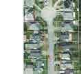
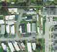
1 PROPOSAL: City of Surrey PLANNING & DEVELOPMENT REPORT File: Planning Report Date: October 3, 2016 OCP Amendment from Commercial to Multiple Residential NCP Amendment from Mixed Commercial/Residential Apartments and Creeks and Riparian Setback to Apartment/Townhouse Rezoning from CD (By-law No ) to CD (based on RM-45) Development Permit Development Variance Permit to permit the development of approximately 36 apartment units and 40 townhouse units. LOCATION: OWNER: 6388 King George Boulevard BC Ltd. ZONING: CD (By-Law No ) OCP DESIGNATION: NCP DESIGNATION: Commercial Mixed Commercial/Residential Apartments and Creeks and Riparian Setback
2 Staff Report to Council File: Planning & Development Report Page 2 RECOMMENDATION SUMMARY By-law Introduction and set date for Public Hearing for: o o Official Community Plan (OCP) Amendment; and Rezoning. Approval t0 reduce indoor amenity space. Approval to draft Development Permit. Approval for Development Variance Permit to proceed to Public Notification. DEVIATION FROM PLANS, POLICIES OR REGULATIONS The applicant is proposing an OCP amendment from Commercial to Multiple Residential and a Neighbourhood Concept Plan (NCP) amendment from Mixed Commercial/Residential Apartments and Creeks and Riparian Setback to Apartment/Townhouse. The applicant is seeking to reduce the required indoor amenity space from 228 square metres (2,450 sq.ft.) to 170 square metres (1,830 sq.ft.), and pay cash-in-lieu for the deficiency. The applicant is proposing to reduce the required streamside setback of Surrey Zoning By-law No RATIONALE OF RECOMMENDATION The proposed development will revitalize the southerly portion of the old Surrey Public Market site, which has sat vacant for many years. The Public Market building is proposed to be demolished and the existing concrete parking structure is proposed to be retained. The applicant is proposing to place apartment and townhouse units on top of the existing parkade structure. The proposal includes both OCP and NCP amendments for multi-family residential use and excludes the provision of any commercial uses which is considered appropriate for a variety of reasons. The site is a mid-block location and sits below the level of King George Boulevard, which will limit exposure for commercial tenants. Furthermore, access from King George Boulevard is not direct rather, the driveway on King George Boulevard will be located approximately 60 metres (200 ft.) to the north, and will be shared with the future access for the northerly portion of the old Surrey Public Market site, which is a separate legal parcel at 6396 King George Boulevard. The proposed townhouse and apartment units will support transit plans along the King George Boulevard by providing density along a future transit corridor. The intersection of King George Boulevard and 64 Avenue is envisioned as a future rapid transit stop.
3 Staff Report to Council File: Planning & Development Report Page 3 It is anticipated that the northerly portion of the old Surrey Public Market site (now a separate parcel at 6396 King George Boulevard) will be a mixed use site, and meet the intent of both the OCP and NCP through the provision of commercial space. This parcel has better exposure for commercial uses than does the subject site. The proposed NCP amendment also includes the deletion of the Creeks and Riparian Setback designation on the subject site. The riparian area to the north of the subject site was conveyed to the City for the purposes of riparian protection in 2014 as part of Development Application No The riparian protection area was established during the Environmental Review Committee (ERC) process, which included the Department of Fisheries and Oceans (DFO). The riparian area to the east of the site was conveyed to the City for $1.00 in 1985 for the protection of riparian habitat. The deficiency for the required indoor amenity space is supportable given that the reduced indoor amenity space will be functional, and with the remainder of the shortfall to be addressed through a cash-in-lieu contribution in accordance with City policy. The Surrey Public Market building was constructed in the early 1990s, and the applicant is proposing to retain the concrete parkade structure as part of the proposed redevelopment of the site. A variance to the recently adopted streamside setbacks is required to permit the retention of the existing parkade structure.
4 Staff Report to Council File: Planning & Development Report Page 4 RECOMMENDATION The Planning & Development Department recommends that: 1. a By-law be introduced to amend the OCP by redesignating the subject site in Development Application No from Commercial to Multiple Residential and a date for Public Hearing be set. 2. Council determine the opportunities for consultation with persons, organizations and authorities that are considered to be affected by the proposed amendment to the Official Community Plan, as described in the Report, to be appropriate to meet the requirement of Section 475 of the Local Government Act. 3. a By-law be introduced to rezone the subject site from "Comprehensive Development Zone" (CD) (By-Law No ) to "Comprehensive Development Zone (CD) and a date be set for Public Hearing. 4. Council approve Development Variance Permit No (Appendix X) varying the following, to proceed to Public Notification: (a) to reduce the minimum setback distance from the top of bank from a Class A stream from 30.0 metres (100 ft.) to 5.0 metres (16 ft.) at the closest point to allow for retention of the existing parkade structure and proposed multi-family building. 5. Council approve the applicant's request to reduce the amount of required indoor amenity space from 228 square metres (2,450 sq.ft.) to 170 square metres (1,830 sq.ft.). 6. Council authorize staff to draft Development Permit (No ) for Form and Character, for Hazard Lands, and for Sensitive Ecosystems generally in accordance with the attached drawings (Appendix II). 7. Council instruct staff to resolve the following issues prior to final adoption: (a) (b) (c) (d) (e) ensure that all engineering requirements and issues including restrictive covenants, dedications, and rights-of-way where necessary, are addressed to the satisfaction of the General Manager, Engineering; submission of a finalized tree survey and a statement regarding tree preservation to the satisfaction of the City Landscape Architect; submission of a landscaping plan and landscaping cost estimate to the specifications and satisfaction of the Planning and Development Department; demolition of existing buildings and structures, with the exception of the parkade structure, to the satisfaction of the Planning and Development Department; submission of an acoustical report for the units adjacent to King George Boulevard and registration of a Section 219 Restrictive Covenant to ensure implementation of noise mitigation measures;
5 Staff Report to Council File: Planning & Development Report Page 5 (f) (g) (h) (i) (j) registration of a Section 219 Restrictive Covenant to adequately address the City s needs with respect to public art, to the satisfaction of the General Manager Parks, Recreation and Culture; the applicant adequately address the impact of reduced indoor amenity space; completion of a Development Permit for Hazard Lands, including completion of a Development Feasibility Study to the satisfaction of the General Manager, Planning & Development Department; completion of the P-15 agreement associated with Development Application No ; and completion of a Sensitive Ecosystem Development Permit, including submission of an Ecosystem Development Plan to the satisfaction of the General Manager, Planning & Development Department. 8. Council pass a resolution to amend the South Newton NCP to redesignate the land from Mixed Commercial/Residential Apartments and Creeks and Riparian Setback to Apartment/Townhouse when the project is considered for final adoption. REFERRALS Engineering: School District: The Engineering Department has no objection to the project subject to the completion of Engineering servicing requirements as outlined in Appendix III. Projected number of students from this development: 16 Elementary students at North Ridge Elementary School 5 Secondary students at Panorama Ridge School (Appendix IV) The applicant has advised that the dwelling units in this project are expected to be constructed and ready for occupancy by January Parks, Recreation & Culture: Surrey Fire Department: No concerns. No concerns.
6 Staff Report to Council File: Ministry of Environment: Planning & Development Report Page 6 The site received a Certificate of Compliance dated October 15, The Certificate of Compliance states that a qualified environmental consultant must be available to identify, characterize and appropriately manage any environmental media that may be contaminated and may be encountered during any future subsurface work at the site. This will be a requirement of the Servicing Agreement, and the Building Permit, as applicable. SITE CHARACTERISTICS Existing Land Use: The site contains the old Surrey Public Market building, which is proposed to be demolished. The existing concrete parking structure is proposed to be retained and utilized as part of the proposed development. Adjacent Area: Direction Existing Use OCP/NCP Designation Existing Zone North: East: South: West (Across King George Boulevard): City-owned riparian parcel and a vacant parcel. City-owned riparian parcel. White Oak mobile home park. Commercial/ Creeks and Riparian Set-back and Mixed Com/Res Apartments Urban/ Creeks and Riparian Set-back Urban/Mixed Com/Res Apartments and Creeks and Riparian Set-back CD (By-law No ) RH-G CTA Commercial businesses. Urban C-8 and CD (Bylaw Nos and 18494) JUSTIFICATION FOR PLAN AMENDMENT The applicant is proposing an Official Community Plan (OCP) amendment from Commercial to Multiple Residential and an amendment to the South Newton Neighbourhood Concept Plan (NCP) from Mixed Commercial/Residential Apartments and Creeks and Riparian Setback to Apartment/Townhouse. The proposed development will revitalize the southerly portion of the old Surrey Public Market site, which has been vacant for many years. The Public Market building is proposed to be demolished and the existing concrete parking structure is proposed to be retained and utilized for parking. The applicant is proposing to place apartment and townhouse units on top of the existing parkade structure.
7 Staff Report to Council File: Planning & Development Report Page 7 The OCP and NCP amendments which will allow for multi-family residential uses while excluding any commercial uses is considered appropriate for a variety of reasons. The site is a mid-block location and sits below the level of King George Boulevard, which will limit exposure for commercial tenants. Furthermore, access from King George Boulevard is not direct rather, the driveway on King George Boulevard will be located approximately 60 metres (200 ft.) to the north, and will be shared with the future access for the northerly portion of the old Surrey Public Market site, which is a separate legal parcel at 6396 King George Boulevard. The proposed uses will support transit plans along the portion of the King George Boulevard by providing density along a future rapid transit corridor. It should also be noted that the intersection of King George Boulevard and 64 Avenue is envisioned as a future rapid transit stop. It is anticipated that the northerly portion of the old Surrey Public Market site (now a separate parcel at 6396 King George Boulevard) will be a mixed use site, and thus meet the intent of the OCP and NCP. This parcel has better exposure for commercial uses than does the subject site. The proposed NCP amendment also includes the deletion of the Creeks and Riparian Setback designation on the subject site. The riparian area to the north of the subject site was conveyed to the City for the purposes of riparian protection in 2014 as part of Development Application No The riparian protection area was established during the Environmental Review Committee (ERC) process, which included the Department of Fisheries and Oceans (DFO). The riparian area to the east of the site was conveyed to the City for $1.00 in 1985 for the protection of riparian habitat. No concerns were expressed by residents in the vicinity for the proposed OCP and NCP amendments and rezoning. PUBLIC CONSULTATION PROCESS FOR OCP AMENDMENT Pursuant to Section 475 of the Local Government Act, it was determined that it was not necessary to consult with any persons, organizations or authorities with respect to the proposed OCP amendment, other than those contacted as part of the pre-notification process. DEVELOPMENT CONSIDERATIONS Background and Proposal The subject 0.69-hectare (1.72 acres) site consists of one parcel located at 6388 King George Boulevard. The site is zoned "Comprehensive Development (CD) (By-law No ) and is designated Commercial in the OCP and Mixed Commercial/Residential Apartments in the South Newton NCP.
8 Staff Report to Council File: Planning & Development Report Page 8 The old Surrey Public market site was recently subdivided (File No ) in 2014 into 3 parcels: the subject site, the riparian parcel which is owned by the City, and the northerly parcel at the intersection of King George Boulevard and 64 Avenue (6396 King George Boulevard). As part of Development Application No , the riparian setbacks were established and the creek area was conveyed to the City. In addition, the old Public Market bridge structure over the creek was removed. The applicant is proposing: o o o o an OCP amendment from Commercial to Multiple Residential; an amendment to the South Newton NCP from Mixed Commercial/Residential Apartments and Creeks and Riparian Setback to Apartment/Townhouse; to rezone the site from CD By-law No to CD (based on the Multiple Residential 45 Zone [RM-45]); and a Development Permit to allow the development of 36 apartment units and 40 townhouse units (including 10 adaptable units), also including provisions for development in areas defined as Hazard Lands and Sensitive Ecosystems in the OCP. Proposed CD Zone The applicant is proposing a CD Zone for the site, which is based on the RM-45 Zone. The table below outlines the differences between the RM-45 Zone and the proposed CD Zone: RM-45 Zone Proposed CD Zone Maximum Floor Area Ratio (FAR) Lot Coverage 45% 65% Setbacks 7.5m (25 ft.) from all property lines. Front yard (west) 15.0m (49 ft.). Rear yard (east) 4.0m (13 ft.). Side yard (north) 3.0m (10 ft.). Side yard (south) 1.0m (3 ft.). Height 15m (50 ft.) 17m (56 ft.) The CD Zone proposes a slightly higher floor area ratio (FAR) of 1.34 than the 1.30 FAR permitted in the RM-45 Zone. The proposed density is within the density permitted by the proposed Multiple Residential OCP designation, and is appropriate along the King George Boulevard transit corridor. The proposed lot coverage of 65% results from the riparian dedications that were recently provided under Application No which significantly decreased the overall lot size. The applicant proposes to retain the existing parkade structure, and thus the footprint of the development is largely pre-determined. The proposed setback relaxations are also a reflection of the riparian area dedications recently provided and the utilization of the existing parking structure.
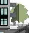
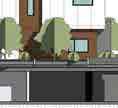
9 Staff Report to Council File: Planning & Development Report Page 9 Access, Pedestrian Circulation and Parking Vehicular access to the site from King George Boulevard and 64 Avenue will be from the property to the north (6396 King George Boulevard), and an access easement is in place to facilitate this. The site previously had direct access to King George Boulevard which has been eliminated. The previous access, if made operational again, would conflict with the parcel to the south s (6280 King George Boulevard) existing access due to the close proximity of both access points. The subject site and the property to the north (6396 King George Boulevard) were historically one parcel, and have always functioned together as a single development site. Two pedestrian connections to the sidewalk along King George Boulevard are proposed to facilitate pedestrian access and egress to the site. The applicant is proposing to provide 134 resident parking spaces and 15 visitor parking spaces, which meets the parking requirements of 149 parking spaces. With the exception of 3 proposed surface visitor parking spaces near the apartment lobby, all of the parking is proposed to be located in the existing parking structure. Amenity Space The Zoning By-law requires that 228 square metres (2,450 sq. ft.) of both indoor and outdoor amenity space be provided, based on 3 square metres (32 sq. ft.) per dwelling unit. The applicant is proposing to provide 170 square metres (1,830 sq. ft.) of indoor amenity space, which is less than the 228 square metres (2,450 sq. ft.) required under the Zoning By-Law. In accordance with City Policy, the applicant will be required to address the shortfall of indoor amenity space through a cash-in-lieu compensation. The deficit in the indoor amenity space is supportable given that the reduced indoor amenity space will be functional. The proposed indoor amenity space is proposed to be centrally located on the site, on the ground floor of the apartment building, adjacent to the outdoor amenity area. The proposed amenity space contains kitchen facilities, lounge areas and a games area. The mailbox area is proposed to be near the lobby to the apartment building. The applicant is proposing to provide a 231 square metres (2,490 sq. ft.) outdoor amenity space adjacent to the proposed indoor amenity area. This will be comprised of a children s play area including raised grass mounds, climbing logs, a slide, a sand pit and a tunnel. In addition, the applicant is proposing a landscaped seating area on the eastern portion of the development, close to the City-owned riparian area. Hazard Land Development Permit (Steep Slope) A Development Permit (DP) for Hazard Lands is required under the OCP due to the steep creek ravine slopes along the north and east boundaries of the site. In order to address this requirement, the applicant has submitted a geotechnical report.
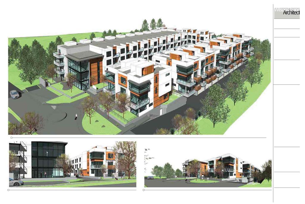
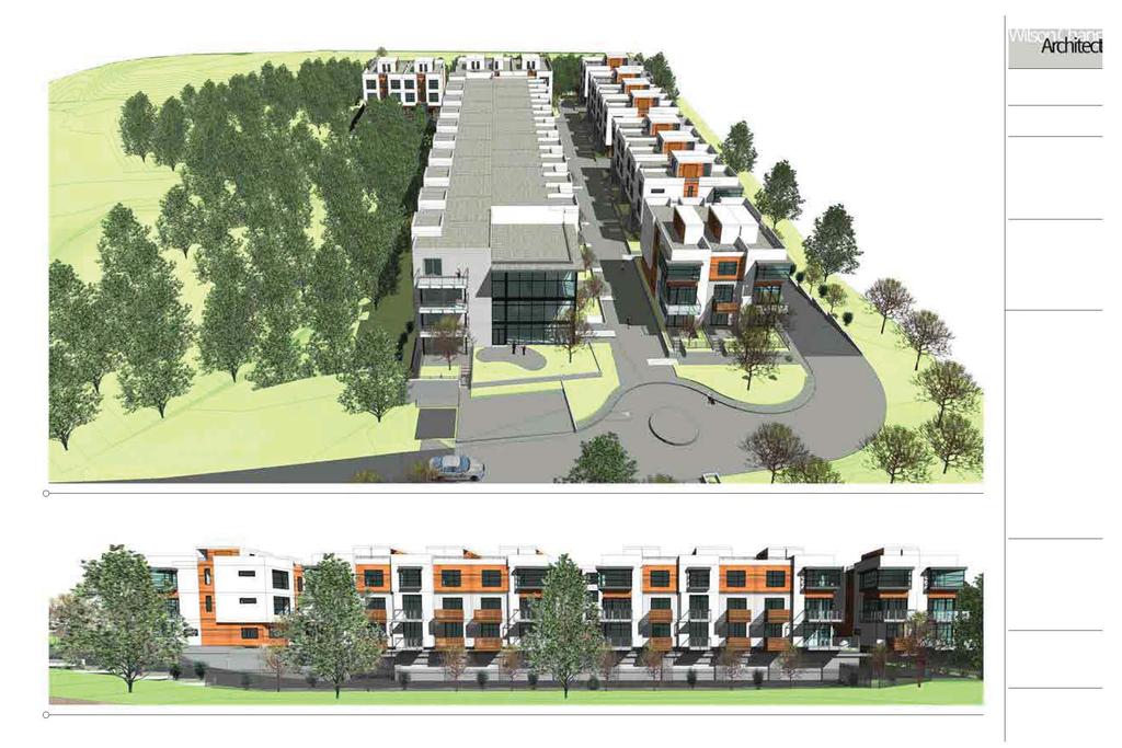
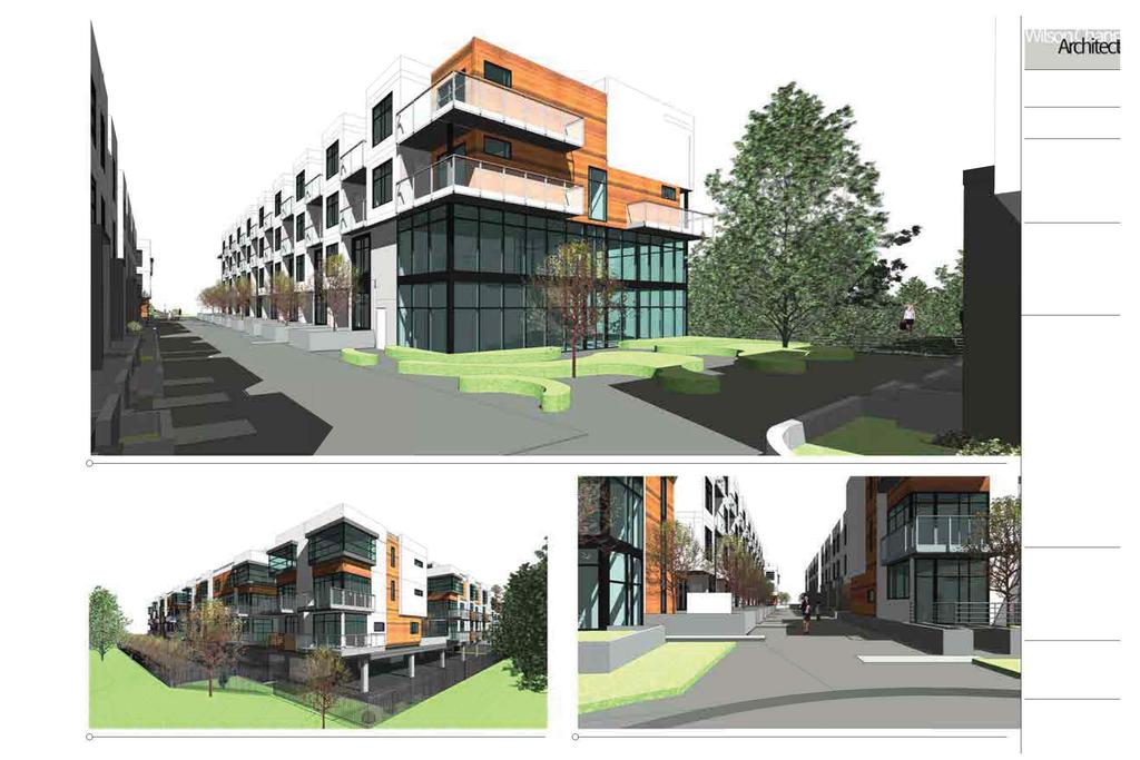
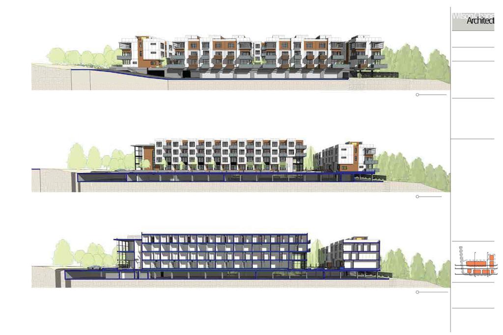
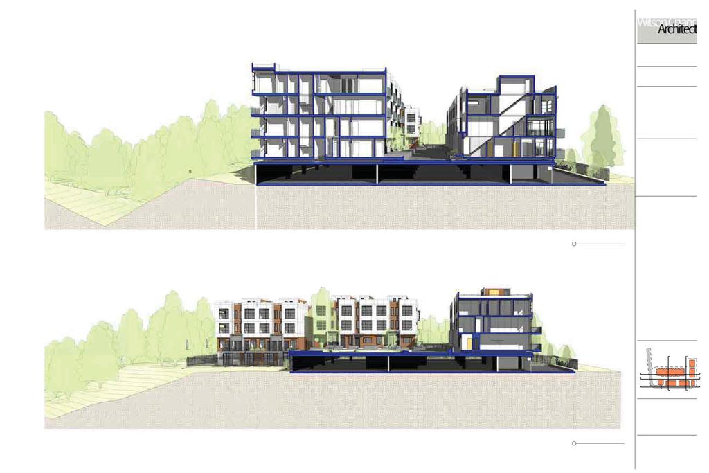
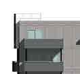
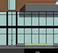
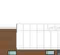
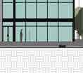
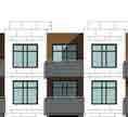
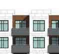
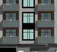
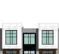
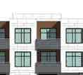
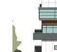
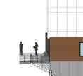
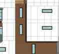
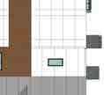
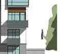
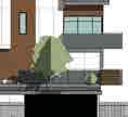
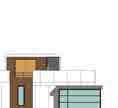
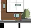
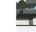
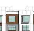
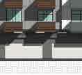
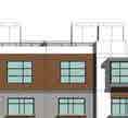
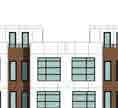
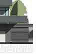
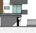
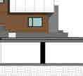
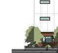
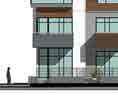
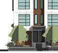
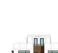
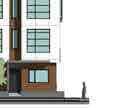
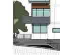
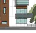
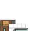
10 Staff Report to Council File: Planning & Development Report Page 10 The geotechnical report, prepared by Geopacific Consultants and dated September 6, 2016, with an addendum letter dated September 22, 2016, states that the site is considered safe for the continued support of the parkade structure and the proposed multi-family building. Staff have reviewed the geotechnical report, and found it to be generally acceptable, subject to the geotechnical engineer reviewing and accepting the final building designs. Upon approval of the documents associated with the Development Feasibility Study, they will be included in the finalized Hazard Land Development Permit. At Building Permit stage, the Building Division will require Letters of Assurance from a geotechnical engineer to ensure that building plans comply with the recommendations in the approved geotechnical report. Sensitive Ecosystem Development Permit On September 12, 2016, Council adopted amendments to the OCP to create a new Sensitive Ecosystem Development Permit Area. The subject site is located within the Sensitive Ecosystem Development Permit Area. The riparian area to the north of the subject site was conveyed to the City for the purposes of riparian protection in 2014 as part of Development Application No The riparian protection area was established following the Environmental Review Committee (ERC) process, which included the Department of Fisheries and Oceans (DFO). The riparian area to the east of the site was conveyed to the City for $1.00 in 1985 for the protection of riparian habitat. The Surrey Public Market building was constructed in the early 1990s, and the applicant is proposing to retain the concrete parkade structure as part of the proposed redevelopment of the site. A variance to the recently adopted streamside setbacks is required to allow the retention of the existing parkade structure and proposed multi-family building. Given the history of the various riparian protection mechanisms employed on the site previously and the existing parkade structure that will be retained, the Sensitive Ecosystem Development Permit will need to be adapted to fit the conditions of the site. The applicant will be required to complete an Ecosystem Development Plan which acknowledges the site s history, and which will then be incorporated into the Sensitive Ecosystem Development Permit. DESIGN PROPOSAL AND REVIEW Building and Site Design The applicant proposes to retain the existing concrete parking structure of the old Surrey Public market, and to place new buildings on top of this structure. The development will include one 4-storey apartment building containing 36 apartment units and six townhouse buildings containing 40 townhouse units. The apartment units will range in size from 107 square metres (1,160 sq.ft.) to 132 square metres (1,420 sq.ft.) and townhouse units will range in size from 102 square metres (1,095 sq.ft.) to 184 square metres (1,980 sq.ft.).
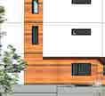
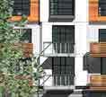
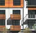
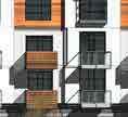
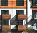
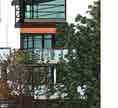
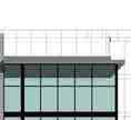
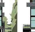
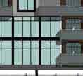
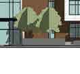
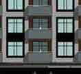
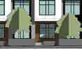
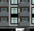
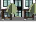
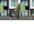
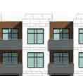
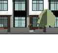
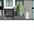
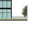
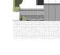
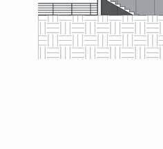
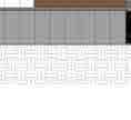
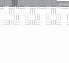
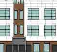
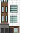
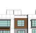
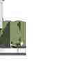
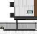
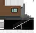
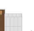
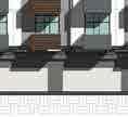
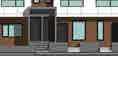
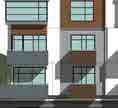
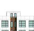
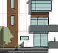
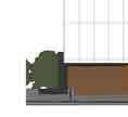
11 Staff Report to Council File: Planning & Development Report Page 11 The required residential parking for the proposed units is located in the existing parking structure, which is located under the units. This parking area will be accessible via stairs and an elevator in the apartment building. The buildings are organized around a central courtyard area containing hard landscaping, vegetation, seating areas and a children s play area. The hardscaped portion of the central courtyard also acts as a fire access lane, as there is no other at-grade access to the majority of the units, given that the units are located on top of the existing parking structure. The 3-storey townhouse units are proposed on the south side of the central courtyard, with the 4-storey apartment proposed on the north side, to maximize the sunlight penetration into the interior of the site. In addition, the location of the townhouse buildings has been designed to maximize views through the site to the surrounding City-owned riparian parcels. Apartment Design For the apartment building, the applicant is proposing a contemporary design utilizing clear lines and articulation along the building face. The proposed exterior materials include hardieplank siding (white, taupe, black), cedar siding, and glass guardrails. Extensive glazing is proposed at the corners of the building to enhance the visually prominent corner facades. A double height lobby with extensive glazing is proposed for the southwest corner of the apartment building. This location faces King George Boulevard and is also close to the visitor parking area in front of the building and allows for a landscaped entrance forecourt to the building. Townhouse Design For the townhouse buildings, the applicant is proposing a contemporary design utilizing clear lines and articulation along the building face. The proposed exterior materials include hardieplank siding (white, taupe, black), cedar siding, and glass guardrails. The applicant is proposing roof decks for each townhouse unit which will provide significant private outdoor amenity space for the residents. Landscaping Landscaping plans have been received and found to be generally acceptable. The landscaping includes a mix of trees, shrubs, and ground cover. Decorative paving is proposed extensively throughout the site, to enhance the aesthetics of building on top of an existing parking structure and due to the requirement for a fire lane through the centre of the proposed development. Various seating areas are provided throughout the site, and a large children s play area is also proposed, as discussed above.
12 Staff Report to Council File: Planning & Development Report Page 12 ADVISORY DESIGN PANEL This application was referred to the Advisory Design Panel (ADP) on August 6, 2015 and November 26, 2015 (Appendix VI). The ADP comments and suggestions have been satisfactorily addressed. TREES Peter Mennel, ISA Certified Arborist of Mike Fadum and Associates Ltd. prepared an Arborist Assessment for the subject property. The table below provides a summary of the tree retention and removal by tree species: Table 1: Summary of Tree Preservation by Tree Species: Tree Species Existing Remove Retain Deciduous Trees (excluding Alder and Cottonwood Trees) Oak Total (excluding Alder and Cottonwood Trees) Total Replacement Trees Proposed (excluding Boulevard Street Trees) Total Retained and Replacement Trees Contribution to the Green City Fund n/a The Arborist Assessment states that there are a total of 6 protected trees on the site, excluding Alder and Cottonwood trees. It was determined that 6 trees can be retained as part of this development proposal. The applicant is proposing 54 replacement trees, exceeding City requirements. The new trees on the site will consist of a variety of trees including katsura, spruce, dogwood and cherry trees. In summary, a total of 60 trees are proposed to be retained or replaced on the site. SUSTAINABLE DEVELOPMENT CHECKLIST The applicant prepared and submitted a sustainable development checklist for the subject site on June 22, The table below summarizes the applicable development features of the proposal based on the seven (7) criteria listed in the Surrey Sustainable Development Checklist. Sustainability Criteria Sustainable Development Features Summary
13 Staff Report to Council File: Sustainability Criteria 1. Site Context & Location (A1-A2) 2. Density & Diversity (B1-B7) 3. Ecology & Stewardship (C1-C4) 4. Sustainable Transport & Mobility (D1-D2) 5. Accessibility & Safety (E1-E3) 6. Green Certification (F1) 7. Education & Awareness (G1-G4) Planning & Development Report Sustainable Development Features Summary The site is located within the South Newton NCP area. Page 13 The proposal includes a mixture of townhouse and apartment units. The applicant is proposing to use dry swales. Recycling and organic waste pick-up will be made available. Bike parking will be provided. CPTED principles will be followed. 10 adaptable units are proposed. Playground equipment and both outdoor and indoor amenity space are proposed. n/a Pre-notification to area residents has occurred, in the form of a development proposal sign being erected on the property and prenotification letters being mailed out to area residents. PRE-NOTIFICATION Pre-notification letters were sent on January 20, 2016 and staff received no correspondence or phone calls. BY-LAW VARIANCES AND JUSTIFICATION (a) Requested Variance: To reduce the minimum setback distance from the top of bank from a Class A stream from 30.0 metres (100 ft.) to 5.0 metres (16 ft.) at the closest point to allow for retention of the existing parkade structure and proposed multi-family building. Staff Comments: The riparian area to the north of the subject site was conveyed to the City for the purposes of riparian protection in 2014 as part of Development Application No The riparian protection area was established during the Environmental Review Committee (ERC) process, which at the time included the Department of Fisheries and Oceans (DFO) as a member. The riparian area to the east of the site was conveyed to the City for $1.00 in 1985 for the protection of riparian habitat. The Surrey Public Market building was constructed in the early 1990s, and the applicant is proposing to retain the concrete parkade structure as part of the proposed redevelopment of the site.
14 Staff Report to Council File: Planning & Development Report Page 14 The application was in process when the proposed Streamside Protection regulations were adopted on September 12, 2016 (Corporate Report No. R188). Given the history of the various riparian protection mechanisms employed on the site in the past and the existing parkade structure that will be retained, staff support the proposed variance. INFORMATION ATTACHED TO THIS REPORT The following information is attached to this Report: Appendix I. Lot Owners, Action Summary and Project Data Sheets Appendix II. Proposed Site Plan, Building Elevations, Landscape Plans and Perspective Appendix III. Engineering Summary Appendix IV. School District Comments Appendix V. Summary of Tree Survey and Tree Preservation Appendix VI. ADP Comments and Applicant s Response Appendix VII. NCP Redesignation Map Appendix VIII. OCP Redesignation Map Appendix IX. Proposed CD By-law Appendix X. Development Variance Permit No original signed by Ron Hintsche KB/dk Jean Lamontagne General Manager Planning and Development
15 APPENDIX I Information for City Clerk Legal Description and Owners of all lots that form part of the application: 1. (a) Agent: Name: Wilson Chang, Wilson Chang Architect Inc. Address: 288 West 8 th Avenue Vancouver, BC V5Y 1N5 Tel: Properties involved in the Application (a) Civic Address: 6388 King George Blvd (b) Civic Address: 6388 King George Blvd Owner: BC Ltd. Director Information: Eddie Chiu Officer Information as at March 16, 2016: Eddie Chiu (Director) PID: Lot 2 Section 9 Township 2 New Westminster District Plan EPP Summary of Actions for City Clerk's Office (a) (b) (c) Introduce a By-law to amend the Official Community Plan to redesignate the property. Introduce a By-law to rezone the property. Proceed with Public Notification for Development Variance Permit No and bring the Development Variance Permit forward for an indication of support by Council. If supported, the Development Variance Permit will be brought forward for issuance and execution by the Mayor and City Clerk in conjunction with the final adoption of the associated Rezoning By-law.
16 DEVELOPMENT DATA SHEET Proposed Zoning: CD (based on RM-45) Required Development Data Minimum Required / Maximum Allowed LOT AREA* (in square metres) Gross Total Road Widening area Undevelopable area Net Total Proposed 6,948 sq.m. 6,948 sq.m. LOT COVERAGE (in % of net lot area) Buildings & Structures 65% 64% Paved & Hard Surfaced Areas Total Site Coverage SETBACKS ( in metres) Front (west) 15.0m 15.0m Rear (east) 4.0m 4.0m Side #1 (north) 3.0m 3.0m Side #2 (south) 1.0m 1.0m BUILDING HEIGHT (in metres/storeys) Principal 17.0m 17.0m Accessory 4.5m 4.5m NUMBER OF RESIDENTIAL UNITS Townhouse units 40 Apartment units 36 Total 76 FLOOR AREA: Residential 9882 sq.m. FLOOR AREA: Commercial Retail Office Total FLOOR AREA: Industrial FLOOR AREA: Institutional TOTAL BUILDING FLOOR AREA 9882 sq.m. * If the development site consists of more than one lot, lot dimensions pertain to the entire site.
17 Development Data Sheet cont'd Required Development Data Minimum Required / Maximum Allowed Proposed DENSITY # of units/ha /# units/acre (gross) # of units/ha /# units/acre (net) 111 uph/ 45 upa 111 uph/ 45 upa FAR (gross) FAR (net) AMENITY SPACE (area in square metres) Indoor 228 sq.m. 170 sq.m. Outdoor 228 sq.m. 231 sq.m. PARKING (number of stalls) Commercial Industrial Apartment Residential (3 bedroom) Townhouse Residential Residential Visitors Institutional Total Number of Parking Spaces Number of disabled stalls 1 1 Number of small cars Tandem Parking Spaces: Number / % of 15/10% 8/5% Total Number of Units Size of Tandem Parking Spaces width/length Heritage Site NO Tree Survey/Assessment Provided YES


18 Appendix II
19
20
21
22
23
24
25
26
27
28
29
30
31
32
33
34


35


36


37


38

39


40


41


42 c Copyright reserved. This drawing and design is the property of M2 Landscape Architects and may not be reproduced or used for other projects without their permission PROPERTY LINE A M E N I T Y B E N C H E S GRASS DRIFTS ORGANIC FORMS PROPERTY LINE # Lorne Mews New Westminster, British Columbia V3M 3L7 Tel: Fax: office@m2la.com PROPERTY LINE m BUFFER 4.00 m SETBACK T U N N E L PROPERTY LINE EXISTING SLAB EDGE C L I M B I N G L O G S S L I D E EXISTING SLAB EDGE PROPERTY LINE UP SCREENED ON 3 SIDES PROPERTY LINE DN PROPERTY LINE UP NO. DATE REVISION DESCRIPTION DR. SEAL: EXISTING SLAB EDGE PROJECT: PROPERTY LINE EXISTING SLAB EDGE % 15.0% 10.0% PROPERTY LINE PROPERTY LINE DRAWING TITLE: N DATE: SCALE: DRAWN: DESIGN: CHK'D: M2LA PROJECT NUMBER: DRAWING NUMBER:
43 c Copyright reserved. This drawing and design is the property of M2 Landscape Architects and may not be reproduced or used for other projects without their permission. ALL PLANT MATERIAL MUST BE PROVIDED FROM CERTIFIED DISEASE FREE NURSERY. PROVIDE CERTIFICATION UPON REQUEST. # Lorne Mews New Westminster, British Columbia V3M 3L7 Tel: Fax: FIRE ESCAPE ROUTE FROM PARKADE DISTANCE TO FURTHEST UNIT PATIO PATIO PATIO PATIO FENCE PATIO PATIO VENTATION OPENING WITH SECURITY METAL GRILLS PATIO PATIO UP UP ELECTRICAL ROOM 17'-2" RESIDENTIAL PARKING FLOOR OUTLINE ABOVE PROPERTY LINE NEW ADDITIONAL PARKING 5'-0" MECH. ROOM VISITOR PARKING 19'-0" 26'-2" NEW GATE EXISTING ROOM NO. DATE SEAL: REVISION DESCRIPTION DR. 1'-0" WATER ENTRY ROOM GARBAGE ROOM NEW GATE TANDEM PARKING TANDEM PARKING TANDEM PARKING TANDEM PARKING PROJECT: PARKING ENTRANCE FLOOR OUTLINE ABOVE EXISTING DRIVEWAY GATES LANDSCAPE DRAWING TITLE: PROPERTY LINE EXISTING WALL NEW WALL N DATE: SCALE: DRAWN: DESIGN: DRAWING NUMBER: CHK'D: M2LA PROJECT NUMBER:

44 c Copyright reserved. This drawing and design is the property of M2 Landscape Architects and may not be reproduced or used for other projects without their permission. # Lorne Mews New Westminster, British Columbia V3M 3L7 Tel: Fax: NO. DATE SEAL: REVISION DESCRIPTION DR. PROJECT: DRAWING TITLE: DATE: DRAWING NUMBER: SCALE: DRAWN: DESIGN: CHK'D: M2LA PROJECT NUMBER:
45
 for the elementary and secondary schools serving the proposed development. The North Ridge Elementary catchment is within the Panorama Ridge Secondary catchment.")
46 Appendix IV Wednesday, August 31, 2016 Planning THE IMPACT ON SCHOOLS School Enrolment Projections and Planning Update: The following tables illustrate the enrolment projections (with current/approved ministry capacity) for the elementary and secondary schools serving the proposed development. The North Ridge Elementary catchment is within the Panorama Ridge Secondary catchment. Enrolment at North Ridge is currently under capacity however in September 2014 a catchment change was implemented that moved part of the Woodward Hill catchment to North Ridge (across King George Blvd) that will slowly add to enrolment. There are some enrolment pressures at Panorama Ridge but a recent addition to increase the capacity from 1100 to 1475 (plus a Neighbourhood Learning Centre) has helped to reduce secondary space shortages. APPLICATION #: SUMMARY 36 Apartments The proposed 40 townhouse units North Ridge Elementary are estimated to have the following impact on the following schools: 500 Projected # of students for this development: Elementary Students: 16 Secondary Students: 5 September 2015 Enrolment/School Capacity North Ridge Elementary Enrolment (K/1-7): 42 K Capacity (K/1-7): 40 K Panorama Ridge Secondary Enrolment (8-12): 1551 Panorama Ridge Secondary Nominal Capacity (8-12): 1475 Functional Capacity*(8-12); Enrolment Capacity Projected cumulative impact of development Nominal Capacity (8-12): subject project) in the subject catchment areas: Elementary Students: 2 Secondary Students: 50 Total New Students: Enrolment Capacity Functional Capacity *Functional Capacity at secondary schools is based on space utilization estimate of 27 students per instructional space. The number of instructional spaces is estimated by dividing nominal facility capacity (Ministry capacity) by 25.
47 MIKE FADUM AND ASSOCIATES LTD. VEGETATION CONSULTANTS Tree Preservation Summary Surrey Project No: Address: 6388 King George Blvd, Surrey, BC Registered Arborist: Peter Mennel Appendix V On-Site Trees Number of Trees Protected Trees Identified (on-site and shared trees, including trees within boulevards and proposed streets 6 and lanes, but excluding trees in proposed open space or riparian areas) Protected Trees to be Removed 0 Protected Trees to be Retained 6 (excluding trees within proposed open space or riparian areas) Total Replacement Trees Required: - Alder & Cottonwood Trees Requiring 1 to 1 Replacement Ratio 0 X one (1) = All other Trees Requiring 2 to 1 Replacement Ratio 0 X two (2) = 0 Replacement Trees Proposed TBD 54 Replacement Trees in Deficit 0 Protected Trees to be Retained in Proposed [Open Space / Riparian Areas] NA Off-Site Trees Number of Trees Protected Off-Site Trees to be Removed 0 Total Replacement Trees Required: - Alder & Cottonwood Trees Requiring 1 to 1 Replacement Ratio 0 X one (1) = 0 - All other Trees Requiring 2 to 1 Replacement Ratio 0 X two (2) = Replacement Trees Proposed Replacement Trees in Deficit 0 TBD TBD Summary report and plan prepared and submitted by: Mike Fadum and Associates Ltd. Signature of Arborist: Date: May 27, 2016 Mike Fadum and Associates Ltd. #105, Street, Surrey, BC, V3W 0A6 Phone Fax
48 Appendix VI architecture + online collaboration t f A 68-unit apartment building and 34 townhouse units on top of existing 1 storey parkade (was the Newton Public Market site) File No Response to ADP comments from meeting on November 26 th, 2015 (Responses in bold italic) STATEMENT OF REVIEW COMMENTS The Panel considered the applicant responded positively to the previous recommendations by the Panel and commended the applicant for improvements to the project and the effort to reuse a structure and revitalize the site. The area of concern for the Panel was the landscape design. Site While the change to the site plan by flipping the townhouse/apartment blocks was commended, the landscape design and treatment of the fire access needed significant design development. Landscape design has been revised significantly (Please refer to L1 and A200) Changes include: Circular pattern and roll over curbs at entry Hardscape materials added at entry sequence Added larger, delineated entry path to main lobby Added removable bollards at entry Removal of wave pattern on interior road, replaced with linear pattern Added interior road sidewalks Added screening around the transformer Straightening out the entry path to the North West unit Eliminating any overlap onto the PL Added 3 benches at entry area Removed water features Developed amenity layout to better reflect child friendly/ usable spaces (integrated natural play) Developed amenity to incorporate much more green space and trees Added a short cut pathway from entry area to southern walkway Added entry signage Re-aligned lobby entry path Connected north/south brick pattern flanking both ends of interior road
49 Re-located retaining walls on western frontage units Added planting between visitor parking and retaining walls Added two social areas Expanded green area and reduced hardscape in the south eastern exit stairway location Extended all pathways to meet the new interior brick pattern continues line Building Form and Character Locating of the apartment building on the north and the townhouses on the south is the key to the overall improvement to the plan. It allows spaces between the buildings to the south to open up and provide some light to the fire access lane. Thank you. No changes required. The indoor amenity space needs further development with consideration of things to draw people in such as a fireplace, A/V, kitchen, etc. Programming and Furniture has been added to plans (Please refer to A210 and A211) Consider lowering the roofline above the indoor amenity to allow for more sun exposure in the outdoor amenity area. Roofline cannot be lowered without significant loss of floor area. However we believe the distance between the buildings 1 and 3, the north-south direction of the space and limited height of buildings 4-6 will ensure adequate sun exposure for the outdoor amenity area all year around (Please refer to A102 and A600) The larger units should be designed for families with storage and adequately sized living spaces. Storage areas have been added. Living spaces range from17.5 to 21 clear in length and should be adequate (Please refer to A500-A504) Storage seems to be lacking in the parkade. Due to the site constrain for parking area, storages cannot be added to the parkade. However we will included storage rooms within the units (Please refer to A500-A504) Landscaping Although the landscaping is described as playful, it is not engaging and the landscaping of the central courtyard along the fire access lane is incongruous. The amenity engagement question has been addressed by adding natural play forms to the mounds and significantly increasing the green space and reducing the hardscape areas.
50 More control is needed at the west end of the fire access which appears to be arbitrary. Recommend bollards (removable) are used to keep vehicles out day to day. Consider vehicular arrival such as an auto court drop off. Several changes were done at this location: Changes include: Circular pattern and roll over curbs at entry Hardscape materials added at entry sequence Added larger, delineated entry path to main lobby Added removable bollards at entry Removal of wave pattern on interior road, replaced with linear pattern Added interior road sidewalks Added screening around the transformer Straightening out the entry path to the North West unit Eliminating any overlap onto the PL Added 3 benches at entry area The water feature is not successful. Removed water feature Consider revisiting the surfacing of the fire lane to provide better scale such as panels rather than the curved feature. The stamped paving may not be smooth enough for stroller wheels etc. The circular paving pattern was replaced with a linear pattern, added sidewalk forms flanking either side of internal road and extended the entry pathway form to meet internal linear pattern. Also, added a social gathering area in that location. The development proposal has changed to accommodate families with more 3 4 bedroom units and the amount of useful open space should be proportional. In response to the development changes regarding family accommodation, Landscape design modifications include the following: Adding organic play structures to the whole amenity area Adding two social areas with benches and chairs. Expanding green space and reducing hardscape space Developing individual nodes for play, activity and contemplation, while developing layers of pedestrian flow to interact with each node. Maintaining the multi-functional amenity possibilities with the interior road while simultaneously softening the road feel Need to consider more opportunity for play for all age groups. The mounds may not be useful. Please see answers above CPTED No comments regarding CPTED. No changes required.
51 Accessibility Recommend 5% of apartment units be wheelchair accessible. Due to the nature of the 2 level apartment units we designated the 10 ground level townhouses as adaptable. (Please refer to A001 and A503) Recommend power doors at entrances. Will be included; Note added to plans (Please refer to A200/A201/A210) Recommend elevator call panels be horizontal. Will be included; Note added to plans (Please refer to A200/A201/A210) Recommend emergency call buttons in elevator lobby. Will be included; Note added to plans (Please refer to A200/A201/A210) Recommend wheelchair accessible washroom in indoor amenity space. Washroom has been added (Please refer to A210) Recommend wheelchair accessible parking underground. Accessible stall annotated underground. (Please refer to A201) Recommend providing good access to the amenity space. Amenity ground floor is designed barrier free (the smaller inaccessible upper portion has the same use) (Please refer to A200, A210 and A211) Regards, Sustainability Building elevation drawings don t clearly show operable windows; however, they are noted in the response to previous comments. Recommend maximizing these. Window opening sizes will be determined with Window supplier and will be maximised to ensure best liveability. Wilson Chang, ARCHITECT AIBC Wilson Chang Architect Inc


52 Proposed NCP Amendment: Appendix VII NCP amendment from Mixed Commercial/Residential Apartments and Creeks and Riparian Setback to Apartment/Townhouse

53 135A St 135A St King George Blvd 137 St 137A St URB Appendix VIII APPENDIX XI URB 64A Ave 136A St 64A Ave 137A St URB 64 Ave 64 Ave COM 63B Ave URB 63A Ave 63 Ave 62B Ave 62B Ave 135B St 62A Ave COM COM to RM URB 62A Ave 137B St 136 St 62 Ave URB RM URB OCP Amendment Proposed amendment from Commercial to Multiple Residential
54 CITY OF SURREY Appendix IX BYLAW NO. A by-law to amend Surrey Zoning By-law, 1993, No , as amended THE CITY COUNCIL of the City of Surrey ENACTS AS FOLLOWS: 1. Surrey Zoning By-law, 1993, No , as amended, is hereby further amended, pursuant to the provisions of Section 479 of the Local Government Act, R.S.B.C c. 1, as amended by changing the classification of the following parcels of land, presently shown upon the maps designated as the Zoning Maps and marked as Schedule "A" of Surrey Zoning By-law, 1993, No , as amended as follows: FROM: COMPREHENSIVE DEVELOPMENT ZONE (CD) (BY-LAW NO ) (SURREY ZONING BY-LAW, 1979, NO. 5942, AMENDMENT BY-LAW, 1990, NO ) TO: COMPREHENSIVE DEVELOPMENT ZONE (CD) Parcel Identifier: Lot 2 Section 9 Township 2 New Westminster District Plan EPP King George Boulevard (hereinafter referred to as the "Lands") 2. The following regulations shall apply to the Lands: A. Intent This Comprehensive Development Zone is intended to accommodate and regulate the development of medium density, multiple unit residential buildings, groundoriented multiple unit residential buildings and related amenity spaces which are to be developed in accordance with a comprehensive design. B. Permitted Uses The Lands and structures shall be used for the following uses only, or for a combination of such uses: 1. Multiple unit residential buildings and ground-oriented multiple unit residential buildings
55 2. Child care centres, provided that such centres: (a) (b) Do not constitute a singular use on the lot; and Do not exceed a total area of 3.0 square metres [32 sq.ft.] per dwelling unit. C. Lot Area Not applicable to this Zone. D. Density 1. The maximum density shall not exceed a floor area ratio of 0.1 or unit density of 2.5 dwelling units per hectare [1 u.p.a.]. The maximum density may be increased to that prescribed in Section D.2 of this Zone if amenities are provided in accordance with Schedule G of Surrey Zoning By-law, 1993, No , as amended. 2. (a) The floor area ratio shall not exceed 1.34; and (b) The unit density shall not exceed 111 dwelling units per hectare [45 u.p.a.]. 3. The indoor amenity space required in Sub-section J.1(b) of this Zone is excluded from the calculation of floor area ratio. E. Lot Coverage The lot coverage shall not exceed 65%. F. Yards and Setbacks Buildings and structures shall be sited in accordance with the following minimum setbacks: Setback Front Rear Side Side Yard Yard Yard Yard (South) Use (West) (East) (North) Principal Buildings and Accessory Buildings and Structures 15.0 m. [49 ft.] 3.5 m. [12 ft.] 3.0 m. [10 ft.] 1.0 m. [3 ft.] Measurements to be determined as per Part 1 Definitions of Surrey Zoning By-law, 1993, No , as amended
56 G. Height of Buildings Measurements to be determined as per Part 1 Definitions of Surrey Zoning By-law, 1993, No , as amended. 1. Principal buildings: The building height shall not exceed 17 metres [56 ft.]. 2. Accessory buildings and structures: The building height shall not exceed 4.5 metres [15 ft.]. H. Off-Street Parking 1. Resident, visitor and employee parking spaces shall be provided as stated in Part 5 Off-Street Parking and Loading/Unloading of Surrey Zoning By-law, 1993, No , as amended. 2. All required resident parking spaces shall be provided as underground parking or as parking within building envelope. 3. Tandem parking for ground-oriented multiple unit residential buildings shall be permitted as follows: (a) (b) For underground parking, a maximum of ten percent (10%) of all required resident parking spaces may be provided as tandem parking spaces; and Both tandem parking spaces must be held by the same owner. I. Landscaping 1. All developed portions of the lot not covered by buildings, structures or paved areas shall be landscaped including the retention of mature trees. This landscaping shall be maintained. 2. Along the developed sides of the lot which abut a highway, a continuous landscaping strip of not less than 1.5 metres [5 ft.] in width shall be provided within the lot. 3. The boulevard areas of highways abutting a lot shall be seeded or sodded with grass on the side of the highway abutting the lot, except at driveways. 4. Garbage containers and passive recycling containers shall be located within the underground parking or within a building. J. Special Regulations 1. Amenity space shall be provided on the lot as follows: - 3 -
Rezoning Development Permit Development Variance Permit
 City of Surrey PLANNING & DEVELOPMENT REPORT Rezoning Development Permit Development Variance Permit Proposal: Rezone from RA to RM-30 and DP to permit development of a 58-unit townhouse development. DVP
NCP Amendment Rezoning Development Permit
 City of Surrey PLANNING & DEVELOPMENT REPORT NCP Amendment Rezoning Development Permit Proposal: NCP Amendment from "Townhouses 15 upa max" to "Townhouses 20 upa max". Rezone from RA to CD and a DP to
City of Surrey PLANNING & DEVELOPMENT REPORT
 City of Surrey PLANNING & DEVELOPMENT REPORT File: 7915-0418-00 Planning Report Date: September 12, 2016 PROPOSAL: Development Permit Development Variance Permit to permit an expansion of the existing
City of Surrey PLANNING & DEVELOPMENT REPORT File:
 City of Surrey PLANNING & DEVELOPMENT REPORT File: 7907-0215-00 Planning Report Date: October 17, 2011 PROPOSAL: Rezoning a portion from IL-1 to CHI Development Permit Development Variance Permit in order
OCP Amendment Rezoning Development Permit Development Variance Permit
 City of Surrey PLANNING & DEVELOPMENT REPORT Files: 7906-0297-00 OCP Amendment Rezoning Development Permit Development Variance Permit Proposal: OCP Amendment of a portion from Commercial to Multiple Residential.
Rezoning. Rezone a portion of the property from CD to RF-9 to allow subdivision into approximately 8 small single family lots with rear lane access.
 City of Surrey PLANNING & DEVELOPMENT REPORT File: Rezoning Proposal: Rezone a portion of the property from CD to RF-9 to allow subdivision into approximately 8 small single family lots with rear lane
City of Surrey PLANNING & DEVELOPMENT REPORT File:
 City of Surrey PLANNING & DEVELOPMENT REPORT PROPOSAL: Partial LUC Discharge Planning Report Date: April 28, 2008 Rezoning from RF to RF-9 in order to allow subdivision into three small single family lots.
City of Surrey PLANNING & DEVELOPMENT REPORT File:
 City of Surrey PLANNING & DEVELOPMENT REPORT File: 7914-0376-00 Planning Report Date: November 16, 2015 PROPOSAL: Development Variance Permit to reduce the minimum front yard and south side yard setbacks
City of Surrey PLANNING & DEVELOPMENT REPORT File: Development Permit
 City of Surrey PLANNING & DEVELOPMENT REPORT File: 7909 0142 00 PROPOSAL: Development Permit Planning Report Date: October 19, 2009 Development Variance Permit in order to permit the development of two
Rezoning Development Permit
 City of Surrey PLANNING & DEVELOPMENT REPORT File: Rezoning Development Permit Proposal: Rezone from RF to RM-D in order to allow subdivision into 2 duplex lots. A Development Permit to allow development
City of Surrey PLANNING & DEVELOPMENT REPORT File: Rezoning from RA to RF in order to allow subdivision into 2 single family lots.
 City of Surrey PLANNING & DEVELOPMENT REPORT File: 7911-0033-00 Planning Report Date: April 23, 2012 PROPOSAL: Rezoning from RA to RF in order to allow subdivision into 2 single family lots. LOCATION:
City of Surrey PLANNING & DEVELOPMENT REPORT File:
 City of Surrey PLANNING & DEVELOPMENT REPORT PROPOSAL: Development Permit Planning Report Date: May 26, 2008 in order to permit the construction of a semi-truck and trailer repair building. LOCATION: OWNERS:
City of Surrey PLANNING & DEVELOPMENT REPORT File:
 City of Surrey PLANNING & DEVELOPMENT REPORT PROPOSAL: Planning Report Date: December 15, 2008 Development Permit Development Variance Permit in order to allow for an exterior renovation of an existing
City of Surrey PLANNING & DEVELOPMENT REPORT File:
 City of Surrey PLANNING & DEVELOPMENT REPORT PROPOSAL: Planning Report Date: January 28, 2008 Amending CD By-law No. 11151 Rezoning from CD (By-law Nos. 11151 & 14423) to CD (based on C-8) in order to
Rezoning Development Permit
 City of Surrey PLANNING & DEVELOPMENT REPORT Rezoning Development Permit Proposal: Rezone from RF to CD. Development Permit and consolidation of the properties to permit the development of a 4-storey apartment
City of Surrey PLANNING & DEVELOPMENT REPORT
 City of Surrey PLANNING & DEVELOPMENT REPORT File: 7911-0016-00 Planning Report Date: September 12, 2011 PROPOSAL: Rezoning from C-4 to CD (based on C-5) in order to permit additional commercial uses in
City of Surrey PLANNING & DEVELOPMENT REPORT File:
 City of Surrey PLANNING & DEVELOPMENT REPORT PROPOSAL: Planning Report Date: November 5, 2007 Rezoning from RA to RF in order to allow subdivision into approximately 12 single family residential lots.
Development Permit. Development Permit to permit a retail complex with banquet hall, auditorium and roof gardens. Approval to Proceed
 City of Surrey PLANNING & DEVELOPMENT REPORT File: 7903-0306-00 Development Permit Proposal: Development Permit to permit a retail complex with banquet hall, auditorium and roof gardens. Recommendation:
CITY OF SURREY BY-LAW NO A by-law to amend Surrey Zoning By-law, 1993, No , as amended...
 CITY OF SURREY BY-LAW NO. 17397 A by-law to amend Surrey Zoning By-law, 1993, No. 12000, as amended........................................................... THE CITY COUNCIL of the City of Surrey, in
Rezoning from IL-1 to IB-2
 City of Surrey PLANNING & DEVELOPMENT REPORT PROPOSAL: Rezoning from IL-1 to IB-2 Planning Report Date: June 27, 2011 to facilitate future industrial development in South Westminster. LOCATION: OWNER:
NCP Amendment Rezoning Development Variance Permit
 City of Surrey PLANNING & DEVELOPMENT REPORT File: NCP Amendment Rezoning Development Variance Permit Proposal: NCP amendment from "Single Family Residential" to "Single Family Residential Small Lots";
City of Surrey PLANNING & DEVELOPMENT REPORT File:
 City of Surrey PLANNING & DEVELOPMENT REPORT File: 7910-0279-00 Planning Report Date: June 13, 2011 PROPOSAL: Rezoning from RA to CD (based on RM-45) Development Permit in order to permit the development
Development Permit Development Variance Permit
 City of Surrey PLANNING & DEVELOPMENT REPORT File: Development Permit Development Variance Permit Proposal: Development Permit to allow the construction of two commercial buildings. Development Variance
City of Surrey PLANNING & DEVELOPMENT REPORT File:
 City of Surrey PLANNING & DEVELOPMENT REPORT PROPOSAL: Planning Report Date: June 15, 2009 Rezoning from C-4 to CD (based on C-5) in order to permit additional commercial uses in an existing non-conforming
Development Permit. Development Permit to permit the construction of an industrial building. Approval
 City of Surrey PLANNING & DEVELOPMENT REPORT Development Permit Proposal: Development Permit to permit the construction of an industrial building. Recommendation: Approval Location: 18485-53 Avenue Zoning:
CITY OF SURREY BY-LAW NO THE CITY COUNCIL of the City of Surrey, in open meeting assembled, ENACTS AS FOLLOWS:
 CITY OF SURREY BY-LAW NO. 16881 A by-law to amend Surrey Zoning By-law, 1993, No. 12000, as amended........................................................... THE CITY COUNCIL of the City of Surrey, in
CITY OF SURREY BY-LAW NO A by-law to amend Surrey Zoning By-law, 1993, No , as amended...
 CITY OF SURREY BY-LAW NO. 17420 A by-law to amend Surrey Zoning By-law, 1993, No. 12000, as amended........................................................... THE CITY COUNCIL of the City of Surrey, in
City of Surrey ADDITIONAL PLANNING COMMENTS File:
 City of Surrey ADDITIONAL PLANNING COMMENTS File: 7915-0183-00 Planning Report Date: October 24, 2016 PROPOSAL: Development Variance Permit to reduce the minimum streamside setback, in order to permit
City of Surrey PLANNING & DEVELOPMENT REPORT File:
 City of Surrey PLANNING & DEVELOPMENT REPORT PROPOSAL: Planning Report Date: February 9, 2009 Development Variance Permit in order to permit a reduced lot frontage to allow subdivision into two half-acre
Rezoning. Rezone from RA to RF to create 3 residential lots and a remainder lot in Fraser Heights. Approval to Proceed
 City of Surrey PLANNING & DEVELOPMENT REPORT Rezoning Proposal: Rezone from RA to RF to create 3 residential lots and a remainder lot in Fraser Heights. Recommendation: Approval to Proceed Location: 16156-112
Rezoning. Rezone from RA to RF-12 to allow subdivision into approximately 8 small single family lots. Approval to Proceed
 City of Surrey PLANNING & DEVELOPMENT REPORT File: 7904-0228-00 Rezoning Proposal: Rezone from RA to RF-12 to allow subdivision into approximately 8 small single family lots. Recommendation: Approval to
CITY OF SURREY BYLAW NO
 CITY OF SURREY BYLAW NO. 18649 A bylaw to amend "Surrey Zoning By-law, 1993, No. 12000", as amended........................................................... THE COUNCIL of the City of Surrey ENACTS AS
CITY OF SURREY BY-LAW NO A by-law to amend Surrey Zoning By-law, 1993, No , as amended...
 CITY OF SURREY BY-LAW NO. 17377 A by-law to amend Surrey Zoning By-law, 1993, No. 12000, as amended As amended by Bylaw No: 18399, 04/13/15; 18514, 09/28/15...........................................................
City of Surrey PLANNING & DEVELOPMENT REPORT File:
 City of Surrey PLANNING & DEVELOPMENT REPORT Planning Report Date: May 29, 2017 PROPOSAL: Development Permit Development Variance Permit to reduce the minimum streamside setback from a watercourse to facilitate
Development Variance Permit
 City of Surrey PLANNING & DEVELOPMENT REPORT 7906-0382-00 Development Variance Permit Proposal: Development Variance Permit to vary the minimum lot depth and the minimum front yard and rear yard setbacks
Development Variance Permit
 City of Surrey PLANNING & DEVELOPMENT REPORT File: Development Variance Permit Proposal: Development Variance Permit in order to allow for an existing free-standing sign. Recommendation: Approval to Proceed
City of Surrey PLANNING & DEVELOPMENT REPORT File:
 City of Surrey PLANNING & DEVELOPMENT REPORT PROPOSAL: Planning Report Date: January 14, 2008 Rezoning from RA to CD Development Permit in order to permit the development of a live/work development consisting
OCP Amendment NCP Amendment Rezoning Development Permit Development Variance Permit
 City of Surrey PLANNING & DEVELOPMENT REPORT File: 7905-0150-00 OCP Amendment NCP Amendment Rezoning Development Permit Development Variance Permit Proposal: Recommendation: Amend OCP from Suburban to
TO: Mayor & Council DATE: July 19, FROM: General Manager, Planning & Development FILE:
 CORPORATE REPORT NO: L002 COUNCIL DATE: July 24, 2017 REGULAR COUNCIL LAND USE TO: Mayor & Council DATE: July 19, 2017 FROM: General Manager, Planning & Development FILE: 5480 01 SUBJECT: Proposed Amendments
City of Surrey PLANNING & DEVELOPMENT REPORT File: Development Permit
 City of Surrey PLANNING & DEVELOPMENT REPORT File: 7910-0034-00 PROPOSAL: Development Permit Planning Report Date: June 13, 2011 Development Variance Permit to permit a renovation and on-site upgrades
City of Surrey PLANNING & DEVELOPMENT REPORT File:
 City of Surrey PLANNING & DEVELOPMENT REPORT File: 7911-0191-00 Planning Report Date: January 23, 2012 PROPOSAL: Partial Land Use Contract Discharge Rezoning from CHI to CD (based on IL) in order to permit
LOCATION: LUC AND UNDERLYING ZONING: OCP DESIGNATION:
 City of Surrey PLANNING & DEVELOPMENT REPORT File: 7916-0404-00 Planning Report Date: October 24, 2016 PROPOSAL: Terminate Land Use Contract No. 320 to permit the existing underlying Zone to come into
City of Surrey PLANNING & DEVELOPMENT REPORT File:
 City of Surrey PLANNING & DEVELOPMENT REPORT Planning Report Date: June 26, 2017 PROPOSAL: Development Variance Permit to vary the off-street parking requirements to permit the placement of three portable
OTY OF SURREY. BY-LAWN A by-law to amend "Surrey Zoning By-law, 1993, No "
 OTY OF SURREY BY-LAWN0.12658 A by-law to amend "Surrey Zoning By-law, 1993, No. 12000." The Council of the City of Surrey, in open meeting assembled, ENACTS AS FOLLOWS: 1. "Surrey Zoning By-law, 1993,
City of Surrey ADDITIONAL PLANNING COMMENTS File: Rezoning from RA to CD (based on IL) Development Permit
 Development Permit") City of Surrey ADDITIONAL PLANNING COMMENTS File: 7911-0186-00 Planning Report Date: December 12, 2011 PROPOSAL: Rezoning from RA to CD (based on IL) Development Permit in order to permit the development
City of Surrey ADDITIONAL PLANNING COMMENTS File: 7911-0186-00 Planning Report Date: December 12, 2011 PROPOSAL: Rezoning from RA to CD (based on IL) Development Permit in order to permit the development
CITY OF SURREY BY-LAW NO THE CITY COUNCIL of the City of Surrey, in open meeting assembled, ENACTS AS FOLLOWS:
 CITY OF SURREY BY-LAW NO. 14350 A by-law to amend Surrey Zoning By-law, 1993, No. 12000, as amended........................................................... THE CITY COUNCIL of the City of Surrey, in
City of Surrey ADDITIONAL PLANNING COMMENTS
 City of Surrey ADDITIONAL PLANNING COMMENTS File: 7906-0247-00 Planning Report Date: July 25, 2011 PROPOSAL: OCP Amendment from Industrial to Urban NCP Amendment on a portion from Business Park to Special
8.5.1 R1, Single Detached Residential District
 8.5.1 R1, Single Detached Residential District The purpose of this district is to provide for residential development in the form of single detached dwellings. Dwelling, Single Detached Home Business,
LUC AND UNDERLYING ZONING: OCP DESIGNATION:
 City of Surrey PLANNING & DEVELOPMENT REPORT File: 7916-0581-00 Planning Report Date: February 20, 2017 PROPOSAL: Terminate Land Use Contract No. 554 to permit the existing underlying RA and RF Zones to
Appendix1,Page1. Urban Design Guidelines. Back to Back and Stacked Townhouses. DRAFT September 2017
 Appendix1,Page1 Urban Design Guidelines DRAFT September 2017 Back to Back and Stacked Townhouses Appendix1,Page2 Table of Contents 1 Introduction 1 1.1 Purpose 1 1.2 Urban Design Objectives 1 1.3 Building
CI1Y OF SURREY BYLAW N A bylaw to amend "Surrey Zoning By-law, 1993, No , as amended
 CI1Y OF SURREY BYLAW N0.19102 A bylaw to amend "Surrey Zoning By-law, 1993, No. 12000 11, as amended THE COUNCIL of the City of Surrey ENACTS AS FOLLOWS: 1. "Surrey Zoning By-law, 1993, No. 12000", as
Urban Design Brief Dundas Street. London Affordable Housing Foundation. November Zelinka Priamo Ltd.
 Urban Design Brief 1039-1047 Dundas Street London Affordable Housing Foundation November 2017 Zelinka Priamo Ltd. TABLE OF CONTENTS Page No. INTRODUCTION... 3 SECTION 1 LAND USE PLANNING CONTEXT... 3 1.1
LIN AVE The applicant is proposing to construct a four-unit Lot A R.P
 Public Notice June 21, 2018 Subject Property: 125 Calgary Avenue Lot 4, District Lot 250, Similkameen Division Yale District, Plan 1164, Except Plan B5473 Application: Rezone PL2018-8261 The applicant
City of Surrey PLANNING & DEVELOPMENT REPORT File:
 City of Surrey PLANNING & DEVELOPMENT REPORT PROPOSAL: Development Permit Planning Report Date: May 12, 2008 Development Variance Permit in order to permit the development of a 4-storey mixed-use building
City of Surrey PLANNING & DEVELOPMENT REPORT File:
 City of Surrey PLANNING & DEVELOPMENT REPORT File: 7916-0064-00 Planning Report Date: April 11, 2016 PROPOSAL: Development Variance Permit to reduce the minimum front and rear yard setbacks to allow a
City of Surrey PLANNING & DEVELOPMENT REPORT File:
 City of Surrey PLANNING & DEVELOPMENT REPORT File: 7916-0009-00 Planning Report Date: October 24, 2016 PROPOSAL: Development Variance Permit to reduce the setbacks for a free-standing sign for an existing
ALL PLANS MUST BE IN METRIC ONLY
 SUBDIVISION DATA SHEET A Subdivision Data Sheet (attached) is required to be attached to each subdivision plan submitted. Each time a revised set of subdivision plans are submitted to the Planning & Development
City of Surrey PLANNING & DEVELOPMENT REPORT File:
 City of Surrey PLANNING & DEVELOPMENT REPORT Planning Report Date: July 10, 2017 PROPOSAL: Development Variance Permit to relax the front yard and flanking side yard setback requirements for five (5) single
TO: Mayor & Council DATE: March 22, FROM: General Manager, Planning and Development FILE:
 NO: L001 COUNCIL DATE: March 22, 2010 REGULAR COUNCIL LAND USE TO: Mayor & Council DATE: March 22, 2010 FROM: General Manager, Planning and Development FILE: 7906-0417-00 SUBJECT: Response to the Delegation
City of Surrey ADDITIONAL PLANNING COMMENTS File:
 City of Surrey ADDITIONAL PLANNING COMMENTS File: 7916-0106-00 Planning Report Date: October 24, 2016 PROPOSAL: TCP Amendment from Residential/Commercial and Parks/Open Space to Townhouses and modifications
CITY OF SURREY BY-LAW NO THE CITY COUNCIL of the City of Surrey, in open meeting assembled, ENACTS AS FOLLOWS:
 CITY OF SURREY BY-LAW NO. 16452 A by-law to amend Surrey Zoning By-law, 1993, No. 12000, as amended THE CITY COUNCIL of the City of Surrey, in open meeting assembled, ENACTS AS FOLLOWS: Surrey Zoning By-law,
Accessory Coach House
 Updated July 2018 Accessory Coach House Development Permit Guidelines 1 Accessory Coach House Development Permit Guidelines Zoning Bylaw, 1995 DIVISION VII C. Contents Part I General Reglations 1 Introduction
CITY OF KAMLOOPS BYLAW NO A BYLAW TO AMEND THE ZONING BYLAW OF THE CITY OF KAMLOOPS
 67 68 CITY OF KAMLOOPS BYLAW NO. 5-1-2796 A BYLAW TO AMEND THE ZONING BYLAW OF THE CITY OF KAMLOOPS The Municipal Council of the City of Kamloops, in open meeting assembled, enacts as follows: 1. This
The Corporation of Delta COUNCIL REPORT Regular Meeting
 E.02 The Corporation of Delta COUNCIL REPORT Regular Meeting To: Mayor and Council File No.: LU007986 From: Community Planning & Development Department Date: April 25, 207 Bylaw Nos.: 766 and 7662 Official
CITY OF VANCOUVER POLICY REPORT DEVELOPMENT AND BUILDING
 P2 CITY OF VANCOUVER POLICY REPORT DEVELOPMENT AND BUILDING Report Date: May 1, 2007 Author: Michael Naylor Phone No.: 604.871.6269 RTS No.: 06621 VanRIMS No.: 11-3600-10 Meeting Date: May 15, 2007 TO:
Address: 2025 Agassiz Road Applicant: Cristian Anca. RM5 Medium Density Multiple Housing
 REPORT TO COUNCIL Date: February 20, 2017 RIM No. 1250-30 To: From: City Manager Community Planning Department (TB) Application: Z16-0052 Owner: Exceling Investments Inc. No. BC1062096 Address: 2025 Agassiz
City of Surrey PLANNING & DEVELOPMENT REPORT File:
 City of Surrey PLANNING & DEVELOPMENT REPORT Planning Report Date: February 6, 2017 PROPOSAL: Development Variance Permit to reduce the required parking for an existing industrial building. LOCATION: OWNER:
66 Isabella Street Rezoning Application - Preliminary Report
 STAFF REPORT ACTION REQUIRED 66 Isabella Street Rezoning Application - Preliminary Report Date: November 15, 2010 To: From: Wards: Reference Number: Toronto and East York Community Council Director, Community
City of Surrey PLANNING & DEVELOPMENT REPORT File:
 City of Surrey PLANNING & DEVELOPMENT REPORT File: 7915-34- Planning Report Date: January 11, 216 PROPOSAL: Development Variance Permit to defer the works and services requirement of the Subdivision and
Jasper 115 Street DC2 Urban Design Brief
 Jasper 115 Street DC2 Urban Design Brief Greenlong Construction Ltd. Stantec Consulting Ltd. 2017 Overview The proposed rezoning application supports the development of two mixed-use high-rise buildings
Urban Design Brief. Italian Seniors Project 1090, 1092, 1096 Hamilton Road City of London
 Urban Design Brief Italian Seniors Project City of London October 1, 2017 TABLE OF CONTENTS Page No. INTRODUCTION... 2 1.0 LAND USE PLANNING CONCEPT... 2 1.1 Subject Lands... 2 1.2 Official Plan and Zoning
Urban Design Brief (Richmond) Corp. 1631, 1635, 1639, 1643 and 1649 Richmond Street City of London
 Corp. 1631, 1635, 1639, 1643 and 1649 Richmond Street City of London") Urban Design Brief 1635 (Richmond) Corp. 1631, 1635, 1639, 1643 and 1649 Richmond Street City of London Site Plan Control Application Holding Provision Application April 1, 2015 Prepared for: Rise Real
Urban Design Brief 1635 (Richmond) Corp. 1631, 1635, 1639, 1643 and 1649 Richmond Street City of London Site Plan Control Application Holding Provision Application April 1, 2015 Prepared for: Rise Real
Allowing for a 3 off-street parking stall reduction.
 DISTRICT OF SQUAMISH REPORT TO: Council FOR: Business PRESENTED: July 17 th, 2007 FILE: DP No. 268 FROM: SUBJECT: Planning Department Development Permit No. 268 38144 Cleveland Avenue Recommendation: THAT
Development Variance Permit
 City of Surrey PLANNING & DEVELOPMENT REPORT Development Variance Permit Proposal: Development Variance Permit to allow driveway access for two (2) single family lots from 34 Avenue rather than from a
Report to: Development Services Committee Report Date: April 21, 2015
 SUBJECT: Preliminary Report Applications for Draft Plan of Subdivision, Zoning By-law Amendment, Plan of Condominium and Site Plan Approval by Urbancorp Inc. 9064-9110 Woodbine Avenue File No s: SU/ZA/CU/SC
CITY OF SURREY BYLAW NO A bylaw to amend Surrey Zoning By-law, 1993, No , as amended...
 CITY OF SURREY BYLAW NO. 17404 A bylaw to amend Surrey Zoning By-law, 1993, No. 12000, as amended As amended by Bylaw No: 19273, 12/18/17........................................................... THIS
BYLAW NUMBER 159D2016
 CPC2016-164 ATTACHMENT 1 BEING A BYLAW OF THE CITY OF CALGARY TO AMEND THE LAND USE BYLAW 1P2007 (LAND USE ) * * * * * * * * * * * * * * * * * * * * * * * * * * * * * * * * WHEREAS it is desirable to amend
25 Leonard Avenue - Official Plan Amendment and Zoning Amendment Applications - Preliminary Report
 STAFF REPORT ACTION REQUIRED 25 Leonard Avenue - Official Plan Amendment and Zoning Amendment Applications - Preliminary Report Date: March 8, 2017 To: From: Wards: Reference Number: Toronto and East York
250, 252, 254 and 256 Royal York Road and 8 and 10 Drummond Street - Zoning By-law Amendment Application - Preliminary Report
 STAFF REPORT ACTION REQUIRED 250, 252, 254 and 256 Royal York Road and 8 and 10 Drummond Street - Zoning By-law Amendment Application - Preliminary Report Date: May 28, 2013 To: From: Wards: Reference
Introduction. General Development Standards
 Introduction The development standards will set the zoning regulations for the East Park development. This section will illustrate lot standards, approximate open space locations and road standards. The
Director, Community Planning, Scarborough District ESC 44 OZ & ESC 44 SB
 STAFF REPORT ACTION REQUIRED 6175, 6183 Kingston Road and 1, 2, 4, 5, 7,10 & 11 Franklin Avenue - Official Plan Amendment, Zoning Amendment and Draft Plan of Subdivision Applications Preliminary Report
1970 Victoria Park Avenue and 9 Clintwood Gate Zoning By-law Amendment Application Preliminary Report
 STAFF REPORT ACTION REQUIRED 1970 Victoria Park Avenue and 9 Clintwood Gate Zoning By-law Amendment Application Preliminary Report Date: September 23, 2013 To: From: Wards: Reference Number: North York
3.1. OBJECTIVES FOR RESIDENTIAL LAND USE DESIGNATIONS GENERAL OBJECTIVES FOR ALL RESIDENTIAL DESIGNATIONS
 3. RESIDENTIAL LAND USE DESIGNATIONS INTRODUCTION The Residential land use designations provide for housing and other land uses that are integral to, and supportive of, a residential environment. Housing
RM2 Low Density Row Housing RM3 Low Density Multiple Housing
 REPORT TO COUNCIL Date: May 30, 2017 RIM No. 0940-40 To: From: City Manager Community Planning Department (LK) Application: DP16-0014 & DVP16-0144 Owner: RA Quality Homes Ltd., INC. No.BC0647947 & 1052192
City of Surrey PLANNING & DEVELOPMENT REPORT File:
 City of Surrey PLANNING & DEVELOPMENT REPORT File: 7908-0170-00 Planning Report Date: July 23. 2012 PROPOSAL: OCP Text Amendment Rezoning from RF to CD (based on RM-70) Development Permit in order to permit
City of Surrey PLANNING & DEVELOPMENT REPORT File:
 City of Surrey PLANNING & DEVELOPMENT REPORT File: 7915-0154-00 Planning Report Date: May 30, 2016 PROPOSAL: Development Variance Permit to reduce lot depth and south rear yard setback requirements for
Director, Community Planning, North York District NNY 10 OZ and NNY 10 RH
 STAFF REPORT ACTION REQUIRED 847 873 Sheppard Avenue West - Official Plan Amendment and Zoning By-law Amendment and Rental Housing Demolition and Conversion Applications - Preliminary Report Date: April
Part 4.0 DEVELOPMENT REGULATIONS
 M A I N S T R E E T N O R T H Part 4.0 DEVELOPMENT REGULATIONS 4.1 Districts 4.2 Permitted and Prohibited Uses, Standards and Standard Specific Criteria and Other General Provisions 4.3 DPS REGULATIONS
P. H. Robinson Consulting Urban Planning, Consulting and Project Management
 PLANNING RATIONALE REPORT FOR SITE PLAN AND DRAFT PLAN OF CONDOMINIUM APPLICATIONS 73-75 HARVEY STREET CITY OF OTTAWA PREPARED BY: P H ROBINSON CONSULTING AUGUST 2012 1 This report has been prepared on
REPORT TO THE CHIEF ADMINISTRATIVE OFFICER FROM THE DEVELOPMENT, ENGINEERING, AND SUSTAINABILITY DEPARTMENT
 April 19, 2018 REPORT TO THE CHIEF ADMINISTRATIVE OFFICER FROM THE DEVELOPMENT, ENGINEERING, AND SUSTAINABILITY DEPARTMENT ON REZONING APPLICATION NO. REZ00631 DEVELOPMENT PERMIT APPLICATION NO. DPM00627
Regular Council - Land Use Minutes
 Regular Council - Land Use Minutes Council Chambers City Hall 13450-104 Avenue Surrey, B.C. MONDAY, JULY 23, 2018 Time: 5:18 p.m. Present: Mayor Hepner Councillor Gill Councillor Hayne Councillor LeFranc
SUBJECT: Official Plan and Zoning By-law Amendment Applications for 4853 Thomas Alton Boulevard
 Page 1 of Report PB-100-16 SUBJECT: Official Plan and Zoning By-law Amendment Applications for 4853 Thomas Alton Boulevard TO: FROM: Development and Infrastructure Committee Planning and Building Department
2. Rezone a portion of the lot from R2 (Small Lot Residential) to RD2 (Duplex: Housing Lane).
 to RD2 (Duplex: Housing Lane).") Public Notice September 6, 2018 Subject Property Subject Property: 337 Hastings Ave Lot 24, District Lot 1, Group 7, Similkameen Division Yale (Formerly Yale-Lytton) District, Plan 932 Application: The
Public Notice September 6, 2018 Subject Property Subject Property: 337 Hastings Ave Lot 24, District Lot 1, Group 7, Similkameen Division Yale (Formerly Yale-Lytton) District, Plan 932 Application: The
Schedule A to Bylaw No. 477, 2013 APPLICATION FEES 1. Official Community Plan Bylaw Amendment $ Zoning Bylaw Amendment $ Simultaneous Of
 Schedule A to Bylaw No. 477, 2013 APPLICATION FEES 1. Official Community Plan Bylaw Amendment $1000 2. Zoning Bylaw Amendment $1000 3. Simultaneous Official Community Plan and Zoning Bylaw Amendment $1500
City of Surrey PLANNING & DEVELOPMENT REPORT File:
 City of Surrey PLANNING & DEVELOPMENT REPORT File: 7916-0500-00 Planning Report Date: November 7, 2016 PROPOSAL: Development Variance Permit to reduce the required minimum front yard setback for a proposed
LITTLE MOUNTAIN ADJACENT AREA REZONING POLICY
 LITTLE MOUNTAIN ADJACENT AREA REZONING POLICY JANUARY 2013 CONTENTS 1.0 INTENT & PRINCIPLES...1 2.0 APPLICATION...2 3.0 HOUSING TYPES, HEIGHT & DENSITY POLICIES...3 3.1 LOW TO MID-RISE APARTMENT POLICIES...4
THE CORPORATION OF THE DISTRICT OF PEACHLAND BYLAW NUMBER 2065, A Bylaw to Amend Zoning Bylaw Number 1375, 1996
 THE CORPORATION OF THE DISTRICT OF PEACHLAND BYLAW NUMBER 2065, 2013 A Bylaw to Amend Zoning Bylaw Number 1375, 1996 WHEREAS the Council of the Corporation of the District of Peachland has adopted Zoning
City of Surrey PLANNING & DEVELOPMENT REPORT File:
 City of Surrey PLANNING & DEVELOPMENT REPORT PROPOSAL: Planning Report Date: January 14, 2008 Rezoning from CD to CD (based on RM-135) Development Permit in order to permit the development of 637 apartment
RM-8 and RM-8N Districts Schedule
 Districts Schedule 1 Intent The intent of this schedule is to encourage development of ground-oriented stacked townhouses or rowhouses, including courtyard rowhouses, while continuing to permit lower intensity
City of Surrey PLANNING & DEVELOPMENT REPORT File:
 City of Surrey PLANNING & DEVELOPMENT REPORT File: 7910-0151-00 PROPOSAL: Planning Report Date: December 13, 2010 Subdivision within ALR under Section 946 of the Local Government Act in order to allow