City of Surrey PLANNING & DEVELOPMENT REPORT File:
|
|
|
- Tamsyn Muriel Morgan
- 5 years ago
- Views:
Transcription

1 City of Surrey PLANNING & DEVELOPMENT REPORT File: Planning Report Date: June 13, 2011 PROPOSAL: Rezoning from RA to CD (based on RM-45) Development Permit in order to permit the development of a 4-storey apartment building. LOCATION: OWNERS: ZONING: OCP DESIGNATION: NCP DESIGNATION: Avenue Kenneth P Thiessen Debbie M Saito RA Urban Apartments 45 upa max
2 Staff Report to Council File: Planning & Development Report Page 2 RECOMMENDATION SUMMARY By-law Introduction and set date for Public Hearing for Rezoning. Approval to draft Development Permit. DEVIATION FROM PLANS, POLICIES OR REGULATIONS None. RATIONALE OF RECOMMENDATION Complies with OCP Designation. Complies with NCP Designation. The South Newton Neighborhood Concept Plan (NCP) designates the site for apartments at a maximum density of 45 upa. The proposed apartment building features high quality architectural design and materials. The project provides a substantial amount of outdoor amenity space in the form of an outdoor courtyard. The project addresses CPTED principles and features a variety of sustainable design elements.
3 Staff Report to Council File: Planning & Development Report Page 3 RECOMMENDATION The Planning & Development Department recommends that: 1. a By-law be introduced to rezone the subject site from "One-Acre Residential Zone (RA) (By-law No to "Comprehensive Development Zone (CD) (By-law No ) and a date be set for Public Hearing. 2. Council authorize staff to draft Development Permit No generally in accordance with the attached drawings (Appendix II). 3. Council instruct staff to resolve the following issues prior to final adoption: (a) (b) (c) (d) (e) (f) (g) (h) ensure that all engineering requirements and issues including restrictive covenants, dedications, and rights-of-way where necessary, are addressed to the satisfaction of the General Manager, Engineering; submission of a road dedication plan to the satisfaction of the Approving Officer; submission of a finalized tree survey and a statement regarding tree preservation to the satisfaction of the City Landscape Architect; submission of a finalized landscaping plan and landscaping cost estimate to the specifications and satisfaction of the Planning and Development Department; resolution of all urban design issues to the satisfaction of the Planning and Development Department; demolition of existing buildings and structures to the satisfaction of the Planning and Development Department; registration of a shared access easement with the neighboring property to the east ( Avenue) to accommodate shared driveway access to 60 Avenue when that property redevelops; submission of a financial contribution to cover one quarter of the cost of the future construction of the north-south road (143 Street) though the neighboring property to the west ( Avenue), as identified in the South Newton NCP. REFERRALS Engineering: The Engineering Department has no objection to the project subject to the completion of Engineering servicing requirements as outlined in Appendix III.
4 Staff Report to Council File: School District: Planning & Development Report Projected number of students from this development: Page 4 8 Elementary students at Woodward Hill Elementary School 4 Secondary students at Sullivan Heights Secondary School The applicant has advised that the dwelling units in this project are expected to be constructed and ready for occupancy by Fall (Appendix IV) Parks, Recreation & Culture: No concerns. SITE CHARACTERISTICS Existing Land Use: Single family dwelling to be demolished Adjacent Area: Direction Existing Use OCP/NCP Designation North (Across 60 Avenue): Single family Urban/Townhouses 15 dwellings and upa max and townhouses under Townhouses 20 upa construction max East: Single family Urban/Apartments 45 dwellings upa max South: Single family Urban/Mixed Com/Res West: dwellings Single family dwellings Apartments Urban/Apartments 45 upa max Existing Zone RA and CD RA RA RA DEVELOPMENT CONSIDERATIONS Background and Site Context The subject site is located on the south side of 60 Avenue, west of 144 Street. The site is designated "Urban" in the Official Community Plan (OCP) and "Apartments 45 upa max" in the South Newton Neighborhood Concept Plan (NCP), which was approved by Council in The total site area is approximately 0.47 hectares (1.15 acres). The site is currently zoned "One Acre Residential Zone" (RA) (By-law No ) and is occupied by a single family dwelling. The neighboring properties to the east, west and south of the site are also acreage properties designated for future apartments and mixeduse apartments at a density of 45 units per acre in the South Newton NCP. Neighboring properties to the north of the subject site, across 60 Avenue, are designated for future townhouses at a density of 15 to 20 upa in the South Newton NCP. There is a townhouse
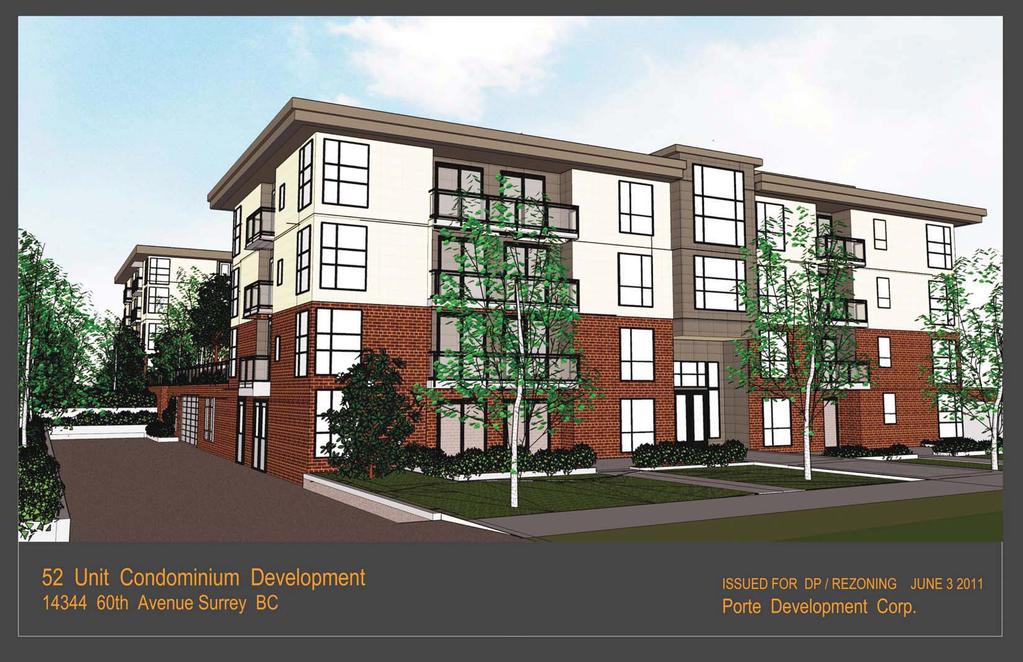
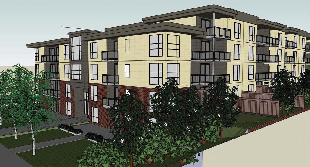
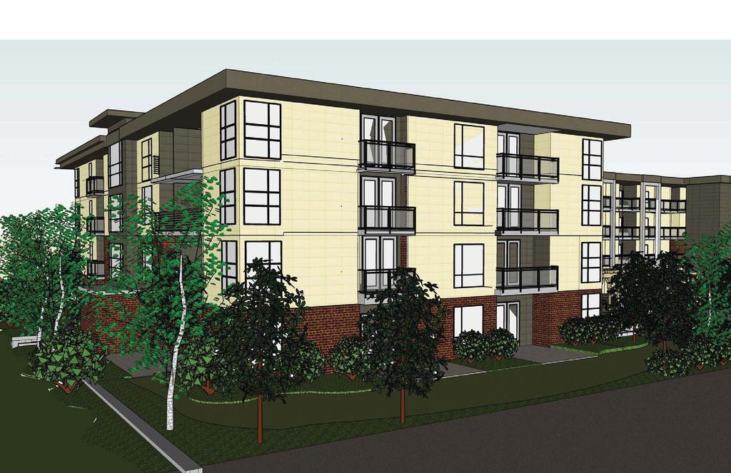
5 Staff Report to Council File: Planning & Development Report Page 5 project currently under construction to the northeast of the subject site at Avenue. Subject Proposal The applicant proposes to rezone the subject site from "One-Acre Residential Zone (RA)" to "Comprehensive Development Zone (CD)" to permit development of a 52-unit, 4-storey apartment building. Proposed CD Zone A CD Zone is proposed to accommodate the proposed apartment development. The proposed CD Zone is based on the RM-45 Zone, with some modifications as illustrated in the table below: Proposed CD Zone RM-45 Zone Permitted Uses Multiple unit residential buildings (child care centers permitted as an accessory use) Multiple unit residential buildings (child care centers permitted as an accessory use) Density (FAR) (based on sliding scale) Density (UPA) 130 uph/53 upa 81 uph/33 upa (based on sliding scale) Lot Coverage 45% 45% Principal Building 15 meters(50 ft.) 15 meters (50 ft.) Height Setbacks Ranges from 4.5 meters to 7.5 meters 7.5 meters from all lot lines The net area of the subject site, after road dedication, is 0.40 hectares (1 acre). As such, the resultant maximum density permitted under the sliding scale density of the RM-45 Zone (for sites less than 1.00 hectare/2.47 acres in size), is 0.94 floor area ratio (FAR) and 81 units per hectare(33 upa). The proposed density under the CD Zone is 1.15 FAR and 130 units per hectare (53 upa). The sliding scale density provisions of the RM-45 Zone are designed to promote land assembly and comprehensive development projects, by linking permissible density with lot area. The permissible density increases proportionally as the lot size increases to a maximum density of 1.30 FAR and 111 units per hectare (45 upa). The two neighboring properties to the east of the subject site ( Avenue and Street), as well as the neighboring property to the west of the subject site ( Avenue), are all designated for future apartment development. As such, ideally all of these properties would redevelop concurrently under one comprehensive development application. The applicant attempted to consolidate the properties to the east and west of the subject site but neither property owner is interested in developing at this time. As such, an analysis was undertaken to determine appropriate development potential for each of these properties developing on their own.
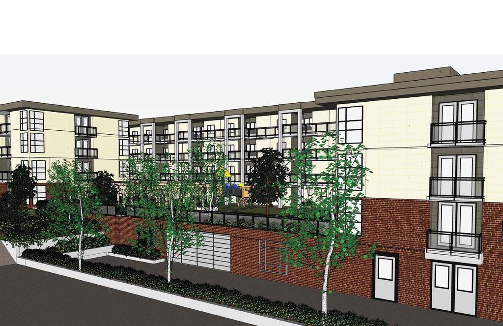
6 Staff Report to Council File: Planning & Development Report Page 6 The 4 neighboring properties are relatively equal in size and share an equal proportion of road dedication under the South Newton NCP. The only exception to this, is the property at Avenue, which will be required to dedicate an additional north-south half road for a future 143 Street. The applicant has volunteered to contribute ¼ of the cost of construction of this road. These funds will be held by the City until such time as the property at Avenue redevelops. It is expected that the two properties to the east will also contribute ¼ the cost of construction of this road when they proceed to redevelop such that the cost of this additional road dedication is shared equally among the four property owners. The proposed density of 1.15 FAR is considered appropriate for all 4 properties as it allows for a reasonably sized building for all of the properties but does not reach the full redevelopment potential achievable if all four properties were consolidated. The proposed unit density of 130 units per hectare (53 upa) is based on the net site area (after road dedication). The unit density based on the gross site area (before road dedication) is 111 units per hectare (45 upa), which is compliant with the South Newton NCP which designates the site for apartments at a maximum unit density of 45 upa. The proposed maximum lot coverage of 45% and maximum principal building height of 15 meters (50 ft.) are identical to the RM-45 Zone. The proposed building setbacks range from 4.5 meters (15 ft.) to 7.5 meters (25 ft.). The east and west yard setbacks are 7.5 meters (25 ft.), which meets the minimum 7.5 meter (25 ft.) setback required under the RM-45 Zone. The north yard setback has been reduced to 7.0 meters (23 ft.) to accommodate a building projection above the front entry. The remainder of the building is setback 7.5 meters (25 ft.) from the north property line. The building projection adds depth and visual interest to the building and highlights the entry. The south yard setback has been reduced to 4.5 meters (15 ft.) to accommodate a decorative wrought iron enclosure around an exit stairway from the underground parkade and a building projection above the rear building entry. The remainder of the building is setback 7.5 meters (25 ft.) from the south property line. The exit stair enclosure and building projection are decorative features that add to the architectural character and quality of the building. Unlike the RM-45 Zone, the proposed CD Zone allows two (2) visitor parking stalls to be located within the east yard setback. This is to accommodate two visitor parking stalls at the end of the entry drive aisle leading into the underground parkade. These two visitor parking stalls are provided for convenience purposes, all other visitor parking is located within the underground parkade. The two visitor stalls will be decoratively paved and screened by landscaping. Arborist Report and Tree Preservation The applicant retained Michael Mills (certified arborist) to conduct a tree survey and prepare an arborist report for the site. The report identifies 26 mature trees on the site and concludes that 24 will have to be removed. The table below provides a summary of the tree retention and removal on the subject site:
7 Staff Report to Council File: Planning & Development Report Page 7 Tree Species Total No. of Protected Trees Total Proposed for Retention Total Proposed for Removal Western Red Cedar Sawara Cypress Douglas Fir Big Leaf Maple Paper Birch English Oak Lombardy Poplar Shore Pine Purple Leaf Plum Lawson Cypress Butternut Fruiting Cherry Apple Ponderosa Pine Total Of the 24 trees proposed for removal, nine (9) are in poor health. The remaining 15 trees to be removed are located within the proposed building envelope or within areas of the site where substantial re-grading will be required. The two (2) trees to be retained (Butternut & Cypress) are located around the perimeter of the site. The applicant proposes approximately 49 replacement trees as part of the overall landscaping plan for the project. This exceeds the 48 replacement trees required under the Tree By-law. The City landscape architect has reviewed the tree survey and arborist report and found the information acceptable. PRE-NOTIFICATION Pre-notification letters were mailed on January 26, 2011 (31 total letters) and a development proposal sign was erected on the property. Staff received the following comments: Staff received 2 letters and 2 phone calls from neighboring property owners who shared the following concerns with the proposal: o o o o o o o building height and interface; traffic generation; noise generation; school impacts; environmental impacts; site drainage; and impacts on property values. (The proposed apartment development is consistent with the South Newton Neighborhood Concept Plan, approved by Council in 2004, which designates the site for apartments at a maximum density of 45 units per acre.)
8 Staff Report to Council File: Planning & Development Report Page 8 (The proposed building height of 15 metres (50 ft.) (4-storey) is the same as that permitted under the RM-45 Zone. The east and west yard setbacks, which are adjacent residential properties, are 7.5 meters (25 ft.), which is the same as that required under the RM-45 Zone. All yards are landscaped to provide a soft interface and to address screening and privacy). (The City s Transportation Engineer has reviewed the proposal and does not expect additional traffic to be generated beyond what was anticipated in the South Newton NCP.) (The Surrey School District has reviewed the proposal and anticipates that the project will generate approximately 8 elementary students at Woodward Hill Elementary School and 4 secondary students at Sullivan Heights Secondary School. The School District has no concerns with this increase.) (There are 24 mature trees identified on the site, nine (9) of which are considered in poor condition. Of the remaining 15 trees, thirteen (13) are located within the underground parkade or within areas of the site where substantial re-grading is required. To offset tree removal on the site, substantial replanting is proposed as part of the landscaping plan for the project, including 49 replacement trees.) (The City s Engineering Department will ensure that drainage impacts are addressed as part of the overall engineering servicing design/plan for the project.) (The proposal is not anticipated to negatively impact property values. The subject property and neighboring properties on the south side of 60 Avenue are designated for apartment development in the South Newton NCP.) DESIGN PROPOSAL AND REVIEW Architectural design, Access and Parking The proposed 4-storey apartment building provides 52 residential dwelling units all focused around a central landscaped courtyard. All of the 52 units are accessed by exterior covered walkways, which give the units a "townhouse-like" quality of individuality and allows for increased exterior light penetration and natural cross ventilation. All of the dwelling units include outdoor patios or balconies. All of the required residential parking and the majority of the required visitor parking is provided in an underground parkade. Two (2) visitor parking stalls are proposed outside the parkade at the end of the entry drive-aisle, for convenience purposes. A total of 78 resident stalls and 10 visitor stalls are provided which meets the requirements of the Zoning By-law based on the number of dwelling units proposed. Access to the underground parkade is from 60 Avenue via a single drive-aisle which will be shared with the neighboring property to the east ( Avenue) when that property develops. An access easement will be registered prior to final adoption of the rezoning by-law to accommodate the future shared access.
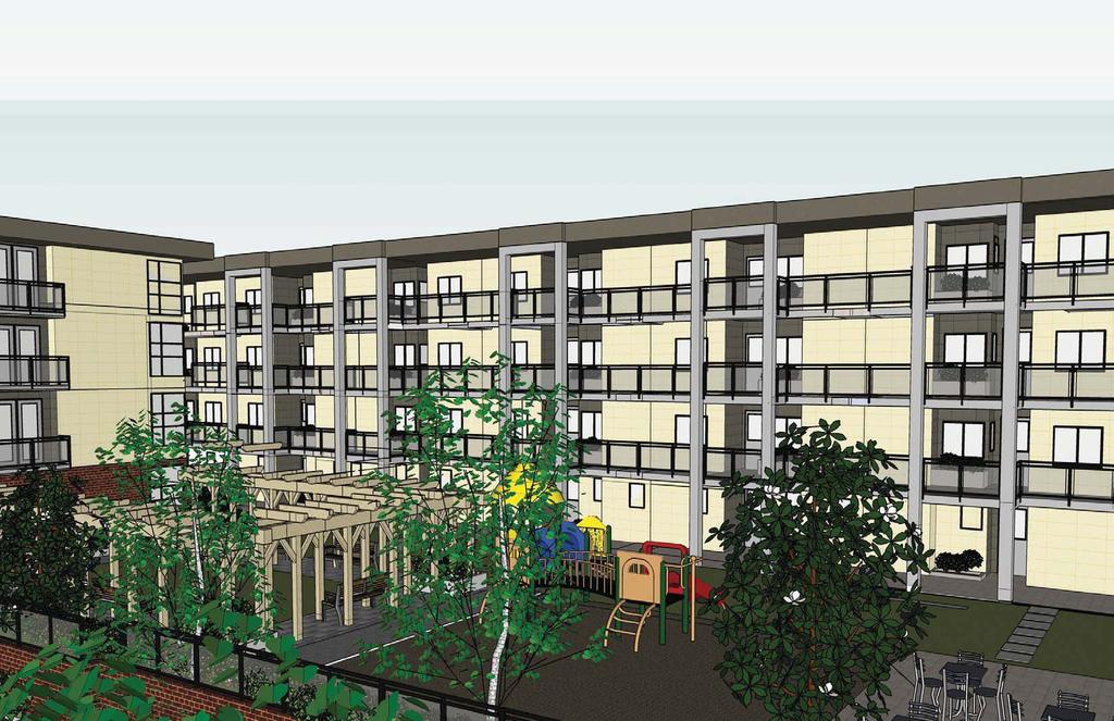
9 Staff Report to Council File: Planning & Development Report Page 9 The proposed building character is modern, with flat roofs, simplified massing and earth tone colors. The building features high quality materials including cement cladding and brick. The covered walkway areas are framed with aluminum guardrails with glazed balustrades. The proposed building will eventually front two streets; 60 Avenue to the north, and a future 59A Avenue to the south. The applicant will dedicate their portion of 59A Avenue as part of the subject development application but will provide cash-in-lieu of construction. The road will be constructed when the properties to the east, west, or south develop and the road can be connected through to 144 Street or 60 Avenue. The project architect has designed both the north and south sides of the building to appear as front facades in anticipation of the future double-fronting situation. Accessibility, CPTED and Sustainability Six (6) of the 52 units proposed are designed to be adaptable housing units as per the BC Building Code adaptable housing standards. Access to the lobby, parking, amenity areas, and all residential units, has been designed to accommodate wheelchairs and scooters. Handicapped parking stalls (2 provided) are located within close proximity of the elevators. The following Crime Prevention Through Environmental Design (CPTED) principals have been incorporated into the project: o o o Access to the courtyard area and all building entries will be though intercom, monitored by cameras; The entry doors into building lobbies are accessed by enterphone only; and The parking garage has controlled access and cameras in appropriate locations. The project addresses sustainability in the following ways: o o o o o o o All but two of the parking stalls are covered, reducing the heat island effect and providing more opportunities for landscaping on the site; The heat island effect of the project will be further reduced by providing a light colored (high albedo) roof; A community garden is proposed; Exterior building lighting will only be incorporated where necessary, and fixtures have been selected that minimize off site or upward illumination; A high efficiency irrigation system will be used to reduce potable water consumption; The garbage room, as well as each unit, will be provided with specialized recycling containers ; During the construction of the project, the contractor will reduce site waste, incorporate recycled content materials, and give preference to the use of regionally manufactured and wood based materials ;
10 Staff Report to Council File: Planning & Development Report Page 10 o o o o The provision of operable windows at either end of the dwelling units enhances the natural ventilation of the spaces ; Low emitting indoor finishes will be selected that minimize the impact on indoor air quality; Windows provided at either end of the dwelling units improve the natural day lighting of the homes; and The energy efficiency of the building is increased by using individual hot water tanks for each home rather than a central system for the building. Indoor Amenity Space Indoor amenity space includes an exercise room and lounge room. The total indoor amenity space of 156 square meters (1,680 sq.ft.) meets the zoning by-law requirements for the number of dwelling units proposed. Landscaping The landscaping plan for the project includes a generous combination of trees and shrubs in a variety of species. Plantings are particularly dense around the perimeter of the site to soften the edges, provide privacy, and address interface issues with adjacent properties. Ground floor residential units feature private yard areas delineated with privacy fencing and landscaping. Fencing includes a decorative picket fence along street fronting property lines and a solid cedar privacy fence along property lines adjacent neighboring residential properties. Pedestrian walkways and visitor parking stalls are delineated with decorative paving. Fifteen (15) private garden plots are proposed on the site for future use by residents. A decorative entry/building identification sign is proposed along the northern property line fronting 60 Avenue. The sign is 1.7 meters (5.5 ft.) in height and 2.3 meters (7.5 ft.) in width and meets the Sign By-law. The sign is framed in brick to match the building façade. Outdoor Amenity Space A large outdoor courtyard area is proposed, which includes a patio area, play area for children, and a seating area with decorative arbors. The proposed outdoor amenity area of 688 square meters (7,400 sq.ft.) exceeds the 156 square meters (1,680 sq.ft.) of outdoor amenity space required under the zoning by-law based on the number of dwelling units proposed. ADVISORY DESIGN PANEL The subject development proposal was presented to the Advisory Design Panel (ADP) on February 17, 2011 and April 28, The majority of the comments received from the panel have been addressed. The remaining minor issues and details will be addressed prior to final adoption of the rezoning by-law.
11 Staff Report to Council File: Planning & Development Report Page 11 INFORMATION ATTACHED TO THIS REPORT The following information is attached to this Report: Appendix I. Appendix II. Appendix III. Appendix IV Appendix V Appendix VI Appendix VII Appendix VIII Lot Owners, Action Summary and Project Data Sheets Proposed Site Plan, Building Elevations, Landscape Plans and Perspective Engineering Summary School District Comments Summary of Tree Survey and Tree Preservation ADP Comments NCP Plan Proposed CD By-law INFORMATION AVAILABLE ON FILE Complete Set of Architectural and Landscape Plans prepared by H.R. Hatch Architect Ltd. and DMG Landscape Architects, respectively, dated April 26, 2011 and June 3, original signed by Nicholas Lai Jean Lamontagne General Manager Planning and Development RG/kms \\file-server1\net-data\csdc\generate\areaprod\save\ doc. 6/8/11 4:24 PM
12 Page 1 APPENDIX I Information for City Clerk Legal Description and Owners of all lots that form part of the application: 1. (a) Agent: Name: Victor Setton, Porte Development Corp. Address: Unit 380, 1665 West Broadway Vancouver BC V6J 1X1 Tel: Fax: Properties involved in the Application (a) Civic Address: Avenue (b) Civic Address: Avenue Owners: Debbie Mae Kuniko Saito Kenneth Paul Thiessen PID: Lot 89 Section 9 Township 2 New Westminster District Plan Summary of Actions for City Clerk's Office (a) Introduce a By-law to rezone the property. \\file-server1\net-data\csdc\generate\areaprod\save\ doc. 6/8/11 4:24 PM
13 DEVELOPMENT DATA SHEET Page 2 Proposed Zoning: CD (based on RM-45) Required Development Data Minimum Required / Maximum Allowed Proposed LOT AREA* (in square meters) Gross Total 4,672 m 2 Road Widening area 575 m 2 Undevelopable area Net Total 4,097 m 2 LOT COVERAGE (in % of net lot area) Buildings & Structures 45% 44% Paved & Hard Surfaced Areas Total Site Coverage SETBACKS ( in meters) North 7.0 m 7.0 m South 4.5 m 4.5 m East 7.5 m 7.5m West 7.5m 7.5m BUILDING HEIGHT (in meters/storeys) Principal 15m/4 storey 15m/ 4 storey Accessory 4.5m 4.5m NUMBER OF RESIDENTIAL UNITS Bachelor One Bed Two Bedroom 14 Three Bedroom + 38 Total FLOOR AREA: Residential 4,730 m 2 4,730 m 2 FLOOR AREA: Commercial Retail Office Total FLOOR AREA: Industrial FLOOR AREA: Institutional TOTAL BUILDING FLOOR AREA 4,730 m 2 4,730 m 2 * If the development site consists of more than one lot, lot dimensions pertain to the entire site. \\file-server1\net-data\csdc\generate\areaprod\save\ doc. 6/8/11 4:24 PM
14 Development Data Sheet cont'd Page 3 Required Development Data Minimum Required / Maximum Allowed Proposed DENSITY # of units/ha /# units/acre (gross) 111 uph/45 upa 130 uph/ 53 upa # of units/ha /# units/acre (net) 130 uph/53 upa 130 uph/ 53 upa FAR (gross) 1.01 FAR (net) AMENITY SPACE (area in square meters) Indoor 156 m m 2 Outdoor 156 m m 2 PARKING (number of stalls) Commercial Industrial Residential Bachelor + 1 Bedroom 2-Bed Bed Residential Visitors Institutional Total Number of Parking Spaces Number of disabled stalls 1 2 Number of small cars 0 0 Tandem Parking Spaces: Number / % of Total Number of Units Size of Tandem Parking Spaces width/length Heritage Site NO Tree Survey/Assessment Provided YES \\file-server1\net-data\csdc\generate\areaprod\save\ doc. 6/8/11 4:24 PM
15
16
17
18
19
20
21
22
23
24
25
26
27
28 NO. DATE REVISION DESCRIPTION DR. SEAL: landscape architects A Partnership of J.D. Mitchell & Associates Ltd. Patricia Campbell Mills Consultants Ltd. Mary Chan Yip Consultants Ltd. Suite C Still Creek Drive Burnaby, British Columbia V5C 6G9 ph (604) ; fx PROJECT: DRAWING TITLE: DATE: DRAWING NUMBER: SCALE: DRAWN: DESIGN: CHK'D: DMG PROJECT NUMBER:
29 NO. DATE REVISION DESCRIPTION DR. SEAL: landscape architects A Partnership of J.D. Mitchell & Associates Ltd. Patricia Campbell Mills Consultants Ltd. Mary Chan Yip Consultants Ltd. Suite C Still Creek Drive Burnaby, British Columbia V5C 6G9 ph (604) ; fx PROJECT: DRAWING TITLE: DATE: DRAWING NUMBER: SCALE: DRAWN: DESIGN: CHK'D: DMG PROJECT NUMBER:
 437-3942; fx 437-8723 PROJECT: DRAWING TITLE: DATE: DRAWING NUMBER: SCALE: DRAWN: DESIGN: CHK'D: DMG PROJECT NUMBER:")
30 Entry Signage NO. DATE REVISION DESCRIPTION DR. SEAL: landscape architects A Partnership of J.D. Mitchell & Associates Ltd. Patricia Campbell Mills Consultants Ltd. Mary Chan Yip Consultants Ltd. Suite C Still Creek Drive Burnaby, British Columbia V5C 6G9 ph (604) ; fx PROJECT: DRAWING TITLE: DATE: DRAWING NUMBER: SCALE: DRAWN: DESIGN: CHK'D: DMG PROJECT NUMBER:
31 NO. DATE REVISION DESCRIPTION DR. SEAL: landscape architects A Partnership of J.D. Mitchell & Associates Ltd. Patricia Campbell Mills Consultants Ltd. Mary Chan Yip Consultants Ltd. Suite C Still Creek Drive Burnaby, British Columbia V5C 6G9 ph (604) ; fx PROJECT: DRAWING TITLE: DATE: DRAWING NUMBER: SCALE: DRAWN: DESIGN: CHK'D: DMG PROJECT NUMBER:
32
33
34
35
36
37
 for the elementary and secondary schools serving the proposed development.")


38 SCHOOL DISTRICT #36 (SURREY) Wednesday, February 16, 2011 Planning THE IMPACT ON SCHOOLS APPLICATION #: School Enrolment Projections and Planning Update: The following tables illustrate the enrolment projections (with current/approved ministry capacity) for the elementary and secondary schools serving the proposed development. A new elementary school (#212 Woodward Hill Elementary) opened in spring Regular and Early French enrolment from McLeod Road moved to the new Woodward Hill Elementary. McLeod Road Elementary was seismically upgraded and now accommodates a District K-7 Traditional Program. A new elementary school in the South Newton NCP Area, east of Sullivan Heights Secondary is the number two priority in the Five Year Capital Plan submitted to the province. The Capital plan also includes a proposed addition to Panorama Ridge Secondary to the west of King George Highway and the school district is considering various approaches to adress projected overcrowding at Sullivan Heights Secondary (i.e. possible enrolment moves or program change considerations). The proposed development will not have an impact on these projections. SUMMARY The proposed 52 townhouse units Woodward Hill Elementary are estimated to have the following impact on the following schools: 700 Projected # of students for this development: Elementary Students: 8 Secondary Students: Enrolment Capacity September 2010 Enrolment/School Capacity Woodward Hill Elementary Enrolment (K/1-7): 56 K Capacity (K/1-7): 40 K Sullivan Heights Secondary Enrolment (8-12): 1127 Sullivan Heights Secondary Capacity (8-12): Projected cumulative impact of development in the last 12 months (not including the subject project) in the subject catchment areas: Elementary Students: 0 Secondary Students: 196 Total New Students: Enrolment Capacity
39 APPENDIX TREE PRESERVATION SUMMARY Surrey Project # Project Location: th Ave, Surrey Register Landscape Architect / Arborist Michael Mills DMG Landscape Architects Detailed Assessment of the existing trees was prepared for this proposal on March 18 th The following is a summary of the tree assessment report for quick reference. 1. General Tree Assessment of the Subject Site a. The subject site is located close to the corner of 144 th Street on the south side of 60 th Ave. b. The site is approximately ½ hectare in size and presently contains a single family house with several small outbuildings and horse barns. c. The site is dominated with open lawn and fenced paddocks with the majority of the existing tree resource located close to the 60 th Ave. frontage. d. No individual specimens of unique character or heritage significance were identified. 2. Summary of Proposed Tree Removal and Replacement o Number of Protected Trees Identified 26 (A) o Number of Protected Trees declared to be hazardous due to natural causes 0 (B) o Number of Protected Trees to be Removed 24 (C) o Number of Trees to be Retained (A-B-C) 0 (D) o Number of Replacement Trees 2:1 48 (E1) o Number of Replacement Trees 1:1 0 (E2) o Total Number of Replacement Trees Required 48 (E3) o Number of Replacement Trees Proposed 49 (F) o Number of Replacement Trees in Deficit (E F) 0 (G) o Total Number of Protected and Replacement Trees (D+F) 51 (H) o Number of Lots Proposed in Project N/A (I) o Average Number of Trees / Lot (H/I) N/A 3. Tree Survey and Preservation Plan X Tree Survey and Replacement Plan is attached. This plan will be available before final adoption. Summary and plan prepared and submitted by: Michael J Mills ISA Certified Arborist #PN0392 DMG Landscape Architects March 18, 2011
40 DMG LANDSCAPE ARCHITECTS EXISTING TREE ASSESSMENT SUMMARY PLAN Proposed condominium Development th Ave. City of Surrey DMG File # March 18, 2011
41
42
43
44
45
46
47
48
49
50
51
52

53 SUBJECT SITE
54 CITY OF SURREY BY-LAW NO. A by-law to amend Surrey Zoning By-law, 1993, No , as amended THE CITY COUNCIL of the City of Surrey, in open meeting assembled, ENACTS AS FOLLOWS: 1. Surrey Zoning By-law, 1993, No , as amended, is hereby further amended, pursuant to the provisions of Section 903 of the Local Government Act, R.S.B.C c. 323, as amended by changing the classification of the following parcels of land, presently shown upon the maps designated as the Zoning Maps and marked as Schedule "A" of Surrey Zoning By-law, 1993, No , as amended as follows: FROM: ONE-ACRE RESIDENTIAL ZONE (RA) TO: COMPREHENSIVE DEVELOPMENT ZONE (CD) Parcel Identifier: Lot 89 Section 9 Township 2 New Westminster District Plan Avenue (hereinafter referred to as the "Lands") 2. The following regulations shall apply to the Lands: A. Intent This Comprehensive Development Zone is intended to accommodate and regulate the development of medium density, medium-rise, multiple unit residential buildings, ground-oriented multiple unit residential buildings and related amenity spaces, which are to be developed in accordance with a comprehensive design where density bonus is provided. B. Permitted Uses The Lands and structures shall be used for the following uses only, or for a combination of such uses: 1. Multiple unit residential buildings and ground-oriented multiple unit residential buildings. 2. Child care centres, provided that such centres: - 1 -
55 (a) (b) Do not constitute a singular use on the lot; and Do not exceed a total area of 3.0 square metres [32 sq.ft.] per dwelling unit. C. Lot Area Not applicable to this Zone. D. Density For the purpose of building construction: 1. The density shall not exceed a floor area ratio of 0.1 or building area of 300 square metres [3,230 sq. ft.] whichever is smaller. The maximum density may be increased to that prescribed in Sub-sections D.2 and D.3 of this Zone if amenities are provided in accordance with Schedule G of Surrey Zoning By-law, 1993, No , as amended. 2. Multiple Unit Residential Buildings: (a) (b) The floor area ratio shall not exceed 1.15; and The unit density shall not exceed 130 dwelling units per hectare [53 u.p.a.]. 3. Indoor Amenity Space: The amenity space required in Sub-section J.1(b) of this Zone, is excluded from the calculation of the floor area ratio. E. Lot Coverage The lot coverage shall not exceed 45%. F. Yards and Setbacks Buildings and structures shall be sited in accordance with the following minimum setbacks: Use Setback North South East West Yard Yard Yard Yard Principal and Accessory 7.0 m * 4.5 m 7.5 m 7.5 m Buildings and Structures [23 ft.] [15 ft.] [25 ft.] [25 ft.] Measurements to be determined as per Part 1 Definitions of Surrey Zoning By-law, 1993, No , as amended
56 * The north yard setback may be reduced to a minimum of 5.2 metres (17 ft.) for a canopy. G. Height of Buildings Measurements to be determined as per Part 1 Definitions of Surrey Zoning By-law, 1993, No , as amended. 1. Principal buildings: The building height shall not exceed 15 metres [50 feet]. 2. Accessory buildings and structures: The building height shall not exceed 4.5 metres [15 feet]. H. Off-Street Parking 1. Resident, visitor and employee parking spaces as stated in Table C.6, Part 5 Off-Street Parking and Loading/Unloading of Surrey Zoning By-law, 1993, No , as amended. 2. One-hundred percent (100%) of all required resident parking spaces shall be provided as underground parking or as parking within building envelope. 3. A maximum of 2 visitor parking spaces may be permitted within the required east yard setback. No other parking within the required setbacks is permitted. 4. No parking shall be permitted in the front of the main entrance of a multiple unit residential building, except for the purpose of short term drop-off or pick-up and parking for the disabled. 5. Tandem parking is not permitted. I. Landscaping 1. All developed portions of the lot not covered by buildings, structures or paved areas shall be landscaped including the retention of mature trees. This landscaping shall be maintained. 2. Along the developed sides of the lot which abut a highway, a continuous landscaping strip of not less than 1.5 metres [5 ft.] in width shall be provided within the lot. 3. The boulevard areas of highways abutting a lot shall be seeded or sodded with grass on the side of the highway abutting the lot, except at driveways. 4. Garbage containers and passive recycling containers shall be screened to a height of at least 2.5 metres [8 ft.] by buildings, a landscaping screen, a solid decorative fence, or a combination thereof
57 J. Special Regulations 1. Amenity space shall be provided on the lot as follows: (a) Outdoor amenity space, in the amount of 3.0 square metres [32 sq.ft.] per dwelling unit and shall not be located within the required setbacks; and (b) Indoor amenity space, in the amount of 3.0 square metres [32 sq.ft.] per dwelling unit, of which a maximum of 1.5 square metres [16 sq.ft.] per dwelling unit may be devoted to a child care centre. 2. Child care centres shall be located on the lot such that these centres: (a) (b) Are accessed from a highway, independent from the access to the residential uses permitted in Section B of this Zone; and Have direct access to an open space and play area within the lot. 3. Balconies are required for all dwelling units which are not ground-oriented and shall be a minimum of 5% of the dwelling unit size or 4.6 square metres [50 sq.ft.] per dwelling unit, whichever is greater. K. Subdivision Lots created through subdivision in this Zone shall conform to the following minimum standards: Lot Size Lot Width Lot Depth 3,000 sq. m. [0.75 acre] 40 metres [130 ft.] 70 metres [230 ft.] Dimensions shall be measured in accordance with Section E.21 of Part 4 General Provisions of Surrey Zoning By-law, 1993, No as amended. L. Other Regulations In addition to all statutes, by-laws, orders, regulations or agreements, the following are applicable, however, in the event that there is a conflict with the provisions in this Comprehensive Development Zone and other provisions in Surrey Zoning By-law, 1993, No , as amended, the provisions in this Comprehensive Development Zone shall take precedence: - 4 -
58 1. Definitions are as set out in Part 1 Definitions, of Surrey Zoning By-law, 1993, No , as amended. 2. Prior to any use, the Lands must be serviced as set out in Part 2 Uses Limited, of Surrey Zoning By-law, 1993, No , as amended and in accordance with the servicing requirements for the RM-45 Zone as set forth in the Surrey Subdivision and Development By-law, 1986, No. 8830, as amended. 3. General provisions are as set out in Part 4 General Provisions of Surrey Zoning By-law, 1993, No , as amended. 4. Additional off-street parking requirements are as set out in Part 5 Off-Street Parking and Loading/Unloading of Surrey Zoning By-law, 1993, No , as amended. 5. Sign regulations are as set out in Surrey Sign By-law, 1999, No , as amended. 6. Special building setbacks are as set out in Part 7 Special Building Setbacks, of Surrey Zoning By-law, 1993, No , as amended. 7. Building permits shall be subject to the Surrey Building By-law, 1987, No. 9011, as amended. 8. Building permits shall be subject to Surrey Development Cost Charge By-law, 2010, No , as may be amended or replaced from time to time, and the development cost charges shall be based on the RM-45 Zone. 9. Tree regulations are set out in Surrey Tree Protection By-law, 2006, No , as amended. 10. Development permits may be required in accordance with the Surrey Official Community Plan, 1996, By-law No , as amended
59 11. Provincial licensing of child care centres is regulated by the Community Care and Assisted Living Act R.S.B.C c. 75, as amended, and the Regulations pursuant thereto including without limitation B.C. Reg 319/89/ This By-law shall be cited for all purposes as "Surrey Zoning By-law, 1993, No , Amendment By-law,, No.." READ A FIRST AND SECOND TIME on the th day of, 20. PUBLIC HEARING HELD thereon on the th day of, 20. READ A THIRD TIME ON THE th day of, 20. RECONSIDERED AND FINALLY ADOPTED, signed by the Mayor and Clerk, and sealed with the Corporate Seal on the th day of, 20. MAYOR CLERK \\file-server1\net-data\csdc\generate\areaprod\save\ doc R 6/8/11 9:58 AM - 6 -
CITY OF SURREY BY-LAW NO A by-law to amend Surrey Zoning By-law, 1993, No , as amended...
 CITY OF SURREY BY-LAW NO. 17397 A by-law to amend Surrey Zoning By-law, 1993, No. 12000, as amended........................................................... THE CITY COUNCIL of the City of Surrey, in
NCP Amendment Rezoning Development Permit
 City of Surrey PLANNING & DEVELOPMENT REPORT NCP Amendment Rezoning Development Permit Proposal: NCP Amendment from "Townhouses 15 upa max" to "Townhouses 20 upa max". Rezone from RA to CD and a DP to
CITY OF SURREY BY-LAW NO THE CITY COUNCIL of the City of Surrey, in open meeting assembled, ENACTS AS FOLLOWS:
 CITY OF SURREY BY-LAW NO. 16881 A by-law to amend Surrey Zoning By-law, 1993, No. 12000, as amended........................................................... THE CITY COUNCIL of the City of Surrey, in
City of Surrey PLANNING & DEVELOPMENT REPORT
 City of Surrey PLANNING & DEVELOPMENT REPORT File: 7911-0016-00 Planning Report Date: September 12, 2011 PROPOSAL: Rezoning from C-4 to CD (based on C-5) in order to permit additional commercial uses in
Rezoning Development Permit Development Variance Permit
 City of Surrey PLANNING & DEVELOPMENT REPORT Rezoning Development Permit Development Variance Permit Proposal: Rezone from RA to RM-30 and DP to permit development of a 58-unit townhouse development. DVP
City of Surrey PLANNING & DEVELOPMENT REPORT File:
 City of Surrey PLANNING & DEVELOPMENT REPORT File: 7907-0215-00 Planning Report Date: October 17, 2011 PROPOSAL: Rezoning a portion from IL-1 to CHI Development Permit Development Variance Permit in order
City of Surrey PLANNING & DEVELOPMENT REPORT File:
 City of Surrey PLANNING & DEVELOPMENT REPORT PROPOSAL: Partial LUC Discharge Planning Report Date: April 28, 2008 Rezoning from RF to RF-9 in order to allow subdivision into three small single family lots.
City of Surrey PLANNING & DEVELOPMENT REPORT File: Rezoning from RA to RF in order to allow subdivision into 2 single family lots.
 City of Surrey PLANNING & DEVELOPMENT REPORT File: 7911-0033-00 Planning Report Date: April 23, 2012 PROPOSAL: Rezoning from RA to RF in order to allow subdivision into 2 single family lots. LOCATION:
City of Surrey PLANNING & DEVELOPMENT REPORT File:
 City of Surrey PLANNING & DEVELOPMENT REPORT File: 7914-0376-00 Planning Report Date: November 16, 2015 PROPOSAL: Development Variance Permit to reduce the minimum front yard and south side yard setbacks
CITY OF SURREY BY-LAW NO A by-law to amend Surrey Zoning By-law, 1993, No , as amended...
 CITY OF SURREY BY-LAW NO. 17420 A by-law to amend Surrey Zoning By-law, 1993, No. 12000, as amended........................................................... THE CITY COUNCIL of the City of Surrey, in
CITY OF SURREY BY-LAW NO A by-law to amend Surrey Zoning By-law, 1993, No , as amended...
 CITY OF SURREY BY-LAW NO. 17377 A by-law to amend Surrey Zoning By-law, 1993, No. 12000, as amended As amended by Bylaw No: 18399, 04/13/15; 18514, 09/28/15...........................................................
Rezoning Development Permit
 City of Surrey PLANNING & DEVELOPMENT REPORT File: Rezoning Development Permit Proposal: Rezone from RF to RM-D in order to allow subdivision into 2 duplex lots. A Development Permit to allow development
Rezoning from IL-1 to IB-2
 City of Surrey PLANNING & DEVELOPMENT REPORT PROPOSAL: Rezoning from IL-1 to IB-2 Planning Report Date: June 27, 2011 to facilitate future industrial development in South Westminster. LOCATION: OWNER:
City of Surrey PLANNING & DEVELOPMENT REPORT File: Development Permit
 City of Surrey PLANNING & DEVELOPMENT REPORT File: 7909 0142 00 PROPOSAL: Development Permit Planning Report Date: October 19, 2009 Development Variance Permit in order to permit the development of two
City of Surrey PLANNING & DEVELOPMENT REPORT
 City of Surrey PLANNING & DEVELOPMENT REPORT File: 7915-0418-00 Planning Report Date: September 12, 2016 PROPOSAL: Development Permit Development Variance Permit to permit an expansion of the existing
CITY OF SURREY BYLAW NO
 CITY OF SURREY BYLAW NO. 18649 A bylaw to amend "Surrey Zoning By-law, 1993, No. 12000", as amended........................................................... THE COUNCIL of the City of Surrey ENACTS AS
CITY OF SURREY BY-LAW NO THE CITY COUNCIL of the City of Surrey, in open meeting assembled, ENACTS AS FOLLOWS:
 CITY OF SURREY BY-LAW NO. 14350 A by-law to amend Surrey Zoning By-law, 1993, No. 12000, as amended........................................................... THE CITY COUNCIL of the City of Surrey, in
City of Surrey PLANNING & DEVELOPMENT REPORT File:
 City of Surrey PLANNING & DEVELOPMENT REPORT PROPOSAL: Planning Report Date: December 15, 2008 Development Permit Development Variance Permit in order to allow for an exterior renovation of an existing
Rezoning. Rezone a portion of the property from CD to RF-9 to allow subdivision into approximately 8 small single family lots with rear lane access.
 City of Surrey PLANNING & DEVELOPMENT REPORT File: Rezoning Proposal: Rezone a portion of the property from CD to RF-9 to allow subdivision into approximately 8 small single family lots with rear lane
OCP Amendment Rezoning Development Permit Development Variance Permit
 City of Surrey PLANNING & DEVELOPMENT REPORT Files: 7906-0297-00 OCP Amendment Rezoning Development Permit Development Variance Permit Proposal: OCP Amendment of a portion from Commercial to Multiple Residential.
City of Surrey PLANNING & DEVELOPMENT REPORT File:
 City of Surrey PLANNING & DEVELOPMENT REPORT PROPOSAL: Planning Report Date: January 28, 2008 Amending CD By-law No. 11151 Rezoning from CD (By-law Nos. 11151 & 14423) to CD (based on C-8) in order to
OTY OF SURREY. BY-LAWN A by-law to amend "Surrey Zoning By-law, 1993, No "
 OTY OF SURREY BY-LAWN0.12658 A by-law to amend "Surrey Zoning By-law, 1993, No. 12000." The Council of the City of Surrey, in open meeting assembled, ENACTS AS FOLLOWS: 1. "Surrey Zoning By-law, 1993,
Rezoning Development Permit
 City of Surrey PLANNING & DEVELOPMENT REPORT Rezoning Development Permit Proposal: Rezone from RF to CD. Development Permit and consolidation of the properties to permit the development of a 4-storey apartment
Development Permit. Development Permit to permit the construction of an industrial building. Approval
 City of Surrey PLANNING & DEVELOPMENT REPORT Development Permit Proposal: Development Permit to permit the construction of an industrial building. Recommendation: Approval Location: 18485-53 Avenue Zoning:
NCP Amendment Rezoning Development Variance Permit
 City of Surrey PLANNING & DEVELOPMENT REPORT File: NCP Amendment Rezoning Development Variance Permit Proposal: NCP amendment from "Single Family Residential" to "Single Family Residential Small Lots";
CI1Y OF SURREY BYLAW N A bylaw to amend "Surrey Zoning By-law, 1993, No , as amended
 CI1Y OF SURREY BYLAW N0.19102 A bylaw to amend "Surrey Zoning By-law, 1993, No. 12000 11, as amended THE COUNCIL of the City of Surrey ENACTS AS FOLLOWS: 1. "Surrey Zoning By-law, 1993, No. 12000", as
Development Permit Development Variance Permit
 City of Surrey PLANNING & DEVELOPMENT REPORT File: Development Permit Development Variance Permit Proposal: Development Permit to allow the construction of two commercial buildings. Development Variance
City of Surrey PLANNING & DEVELOPMENT REPORT File:
 City of Surrey PLANNING & DEVELOPMENT REPORT PROPOSAL: Planning Report Date: June 15, 2009 Rezoning from C-4 to CD (based on C-5) in order to permit additional commercial uses in an existing non-conforming
City of Surrey PLANNING & DEVELOPMENT REPORT File:
 City of Surrey PLANNING & DEVELOPMENT REPORT PROPOSAL: Planning Report Date: November 5, 2007 Rezoning from RA to RF in order to allow subdivision into approximately 12 single family residential lots.
City of Surrey PLANNING & DEVELOPMENT REPORT File:
 City of Surrey PLANNING & DEVELOPMENT REPORT PROPOSAL: Development Permit Planning Report Date: May 26, 2008 in order to permit the construction of a semi-truck and trailer repair building. LOCATION: OWNERS:
City of Surrey PLANNING & DEVELOPMENT REPORT File:
 City of Surrey PLANNING & DEVELOPMENT REPORT File: 7911-0191-00 Planning Report Date: January 23, 2012 PROPOSAL: Partial Land Use Contract Discharge Rezoning from CHI to CD (based on IL) in order to permit
City of Surrey ADDITIONAL PLANNING COMMENTS File: Rezoning from RA to CD (based on IL) Development Permit
 Development Permit") City of Surrey ADDITIONAL PLANNING COMMENTS File: 7911-0186-00 Planning Report Date: December 12, 2011 PROPOSAL: Rezoning from RA to CD (based on IL) Development Permit in order to permit the development
City of Surrey ADDITIONAL PLANNING COMMENTS File: 7911-0186-00 Planning Report Date: December 12, 2011 PROPOSAL: Rezoning from RA to CD (based on IL) Development Permit in order to permit the development
Development Permit. Development Permit to permit a retail complex with banquet hall, auditorium and roof gardens. Approval to Proceed
 City of Surrey PLANNING & DEVELOPMENT REPORT File: 7903-0306-00 Development Permit Proposal: Development Permit to permit a retail complex with banquet hall, auditorium and roof gardens. Recommendation:
Development Variance Permit
 City of Surrey PLANNING & DEVELOPMENT REPORT File: Development Variance Permit Proposal: Development Variance Permit in order to allow for an existing free-standing sign. Recommendation: Approval to Proceed
City of Surrey PLANNING & DEVELOPMENT REPORT File:
 City of Surrey PLANNING & DEVELOPMENT REPORT PROPOSAL: Planning Report Date: January 14, 2008 Rezoning from RA to CD Development Permit in order to permit the development of a live/work development consisting
Rezoning. Rezone from RA to RF to create 3 residential lots and a remainder lot in Fraser Heights. Approval to Proceed
 City of Surrey PLANNING & DEVELOPMENT REPORT Rezoning Proposal: Rezone from RA to RF to create 3 residential lots and a remainder lot in Fraser Heights. Recommendation: Approval to Proceed Location: 16156-112
Rezoning. Rezone from RA to RF-12 to allow subdivision into approximately 8 small single family lots. Approval to Proceed
 City of Surrey PLANNING & DEVELOPMENT REPORT File: 7904-0228-00 Rezoning Proposal: Rezone from RA to RF-12 to allow subdivision into approximately 8 small single family lots. Recommendation: Approval to
CITY OF SURREY BYLAW NO A bylaw to amend Surrey Zoning By-law, 1993, No , as amended...
 CITY OF SURREY BYLAW NO. 17404 A bylaw to amend Surrey Zoning By-law, 1993, No. 12000, as amended As amended by Bylaw No: 19273, 12/18/17........................................................... THIS
City of Surrey PLANNING & DEVELOPMENT REPORT File:
 City of Surrey PLANNING & DEVELOPMENT REPORT PROPOSAL: Planning Report Date: February 9, 2009 Development Variance Permit in order to permit a reduced lot frontage to allow subdivision into two half-acre
LOCATION: LUC AND UNDERLYING ZONING: OCP DESIGNATION:
 City of Surrey PLANNING & DEVELOPMENT REPORT File: 7916-0404-00 Planning Report Date: October 24, 2016 PROPOSAL: Terminate Land Use Contract No. 320 to permit the existing underlying Zone to come into
City of Surrey ADDITIONAL PLANNING COMMENTS File:
 City of Surrey ADDITIONAL PLANNING COMMENTS File: 7915-0183-00 Planning Report Date: October 24, 2016 PROPOSAL: Development Variance Permit to reduce the minimum streamside setback, in order to permit
City of Surrey PLANNING & DEVELOPMENT REPORT File:
 PROPOSAL: City of Surrey PLANNING & DEVELOPMENT REPORT File: 7915-0035-00 Planning Report Date: October 3, 2016 OCP Amendment from Commercial to Multiple Residential NCP Amendment from Mixed Commercial/Residential
LUC AND UNDERLYING ZONING: OCP DESIGNATION:
 City of Surrey PLANNING & DEVELOPMENT REPORT File: 7916-0581-00 Planning Report Date: February 20, 2017 PROPOSAL: Terminate Land Use Contract No. 554 to permit the existing underlying RA and RF Zones to
CITY OF SURREY BY-LAW NO THE CITY COUNCIL of the City of Surrey, in open meeting assembled, ENACTS AS FOLLOWS:
 CITY OF SURREY BY-LAW NO. 14136 A by-law to amend Surrey Zoning By-law, 1993, No. 12000, as amended........................................................... THE CITY COUNCIL of the City of Surrey, in
CITY OF SURREY BY-LAW NO THE CITY COUNCIL of the City of Surrey, in open meeting assembled, ENACTS AS FOLLOWS:
 CITY OF SURREY BY-LAW NO. 16452 A by-law to amend Surrey Zoning By-law, 1993, No. 12000, as amended THE CITY COUNCIL of the City of Surrey, in open meeting assembled, ENACTS AS FOLLOWS: Surrey Zoning By-law,
OCP Amendment NCP Amendment Rezoning Development Permit Development Variance Permit
 City of Surrey PLANNING & DEVELOPMENT REPORT File: 7905-0150-00 OCP Amendment NCP Amendment Rezoning Development Permit Development Variance Permit Proposal: Recommendation: Amend OCP from Suburban to
City of Surrey PLANNING & DEVELOPMENT REPORT File: Development Permit
 City of Surrey PLANNING & DEVELOPMENT REPORT File: 7910-0034-00 PROPOSAL: Development Permit Planning Report Date: June 13, 2011 Development Variance Permit to permit a renovation and on-site upgrades
TO: Mayor & Council DATE: March 22, FROM: General Manager, Planning and Development FILE:
 NO: L001 COUNCIL DATE: March 22, 2010 REGULAR COUNCIL LAND USE TO: Mayor & Council DATE: March 22, 2010 FROM: General Manager, Planning and Development FILE: 7906-0417-00 SUBJECT: Response to the Delegation
City of Surrey PLANNING & DEVELOPMENT REPORT File:
 City of Surrey PLANNING & DEVELOPMENT REPORT File: 7916-0064-00 Planning Report Date: April 11, 2016 PROPOSAL: Development Variance Permit to reduce the minimum front and rear yard setbacks to allow a
TO: Mayor & Council DATE: July 19, FROM: General Manager, Planning & Development FILE:
 CORPORATE REPORT NO: L002 COUNCIL DATE: July 24, 2017 REGULAR COUNCIL LAND USE TO: Mayor & Council DATE: July 19, 2017 FROM: General Manager, Planning & Development FILE: 5480 01 SUBJECT: Proposed Amendments
City of Surrey PLANNING & DEVELOPMENT REPORT File:
 City of Surrey PLANNING & DEVELOPMENT REPORT PROPOSAL: Development Permit Planning Report Date: May 12, 2008 Development Variance Permit in order to permit the development of a 4-storey mixed-use building
City of Surrey PLANNING & DEVELOPMENT REPORT File:
 City of Surrey PLANNING & DEVELOPMENT REPORT File: 7915-0284-00 Planning Report Date: September 28, 2015 PROPOSAL: Terminate Land Use Contract No. 339 to permit the existing underlying IL Zone for the
ALL PLANS MUST BE IN METRIC ONLY
 SUBDIVISION DATA SHEET A Subdivision Data Sheet (attached) is required to be attached to each subdivision plan submitted. Each time a revised set of subdivision plans are submitted to the Planning & Development
THE CORPORATION OF THE DISTRICT OF PEACHLAND BYLAW NUMBER 2065, A Bylaw to Amend Zoning Bylaw Number 1375, 1996
 THE CORPORATION OF THE DISTRICT OF PEACHLAND BYLAW NUMBER 2065, 2013 A Bylaw to Amend Zoning Bylaw Number 1375, 1996 WHEREAS the Council of the Corporation of the District of Peachland has adopted Zoning
City of Surrey PLANNING & DEVELOPMENT REPORT File:
 City of Surrey PLANNING & DEVELOPMENT REPORT Planning Report Date: June 26, 2017 PROPOSAL: Development Variance Permit to vary the off-street parking requirements to permit the placement of three portable
66 Isabella Street Rezoning Application - Preliminary Report
 STAFF REPORT ACTION REQUIRED 66 Isabella Street Rezoning Application - Preliminary Report Date: November 15, 2010 To: From: Wards: Reference Number: Toronto and East York Community Council Director, Community
City of Surrey ADDITIONAL PLANNING COMMENTS File:
 City of Surrey ADDITIONAL PLANNING COMMENTS Planning Report Date: October 5, 2009 PROPOSAL: Rezoning from A-1 to CD (based on A-1) Housing Agreement Non-farm use under Section 20(3) of the ALC Act. in
Development Variance Permit
 City of Surrey PLANNING & DEVELOPMENT REPORT 7906-0382-00 Development Variance Permit Proposal: Development Variance Permit to vary the minimum lot depth and the minimum front yard and rear yard setbacks
City of Surrey PLANNING & DEVELOPMENT REPORT File:
 City of Surrey PLANNING & DEVELOPMENT REPORT File: 7915-34- Planning Report Date: January 11, 216 PROPOSAL: Development Variance Permit to defer the works and services requirement of the Subdivision and
ONE-ACRE RESIDENTIAL ZONE (RA)
") CITY OF SURREY BY-LAW NO._17507 A by-law to amend Surrey Zoning By-law, 1993, No. 12000, as amended........................................................... THE CITY COUNCIL of the City of Surrey, in
CITY OF SURREY BY-LAW NO._17507 A by-law to amend Surrey Zoning By-law, 1993, No. 12000, as amended........................................................... THE CITY COUNCIL of the City of Surrey, in
8.5.1 R1, Single Detached Residential District
 8.5.1 R1, Single Detached Residential District The purpose of this district is to provide for residential development in the form of single detached dwellings. Dwelling, Single Detached Home Business,
City of Surrey PLANNING & DEVELOPMENT REPORT File:
 City of Surrey PLANNING & DEVELOPMENT REPORT File: 7913-0130-00 Planning Report Date: July 22, 2013 PROPOSAL: Temporary Use Permit in order to allow the continued operation of an auto repair, tire retail
 City of Surrey Mapping Online System 13192 16 Avenue The data pr ov ided is compiled from v arious sources and is NO T warranted as to its ac curacy or suffic ienc y by the City of Surrey. This information
City of Surrey PLANNING & DEVELOPMENT REPORT File:
 City of Surrey PLANNING & DEVELOPMENT REPORT File: 7910-0151-00 PROPOSAL: Planning Report Date: December 13, 2010 Subdivision within ALR under Section 946 of the Local Government Act in order to allow
City of Surrey PLANNING & DEVELOPMENT REPORT File:
 City of Surrey PLANNING & DEVELOPMENT REPORT Planning Report Date: July 10, 2017 PROPOSAL: Development Variance Permit to relax the front yard and flanking side yard setback requirements for five (5) single
CITY OF KAMLOOPS BYLAW NO A BYLAW TO AMEND THE ZONING BYLAW OF THE CITY OF KAMLOOPS
 67 68 CITY OF KAMLOOPS BYLAW NO. 5-1-2796 A BYLAW TO AMEND THE ZONING BYLAW OF THE CITY OF KAMLOOPS The Municipal Council of the City of Kamloops, in open meeting assembled, enacts as follows: 1. This
City of Surrey PLANNING & DEVELOPMENT REPORT File:
 City of Surrey PLANNING & DEVELOPMENT REPORT File: 7916-0009-00 Planning Report Date: October 24, 2016 PROPOSAL: Development Variance Permit to reduce the setbacks for a free-standing sign for an existing
City of Surrey PLANNING & DEVELOPMENT REPORT File:
 City of Surrey PLANNING & DEVELOPMENT REPORT File: 7912-0079-00 Planning Report Date: May 28, 2012 PROPOSAL: Development Variance Permit in order to permit driveway access for 7 single family small lots
The Corporation of Delta COUNCIL REPORT Regular Meeting
 E.02 The Corporation of Delta COUNCIL REPORT Regular Meeting To: Mayor and Council File No.: LU007986 From: Community Planning & Development Department Date: April 25, 207 Bylaw Nos.: 766 and 7662 Official
City of Surrey ADDITIONAL PLANNING COMMENTS
 City of Surrey ADDITIONAL PLANNING COMMENTS File: 7906-0247-00 Planning Report Date: July 25, 2011 PROPOSAL: OCP Amendment from Industrial to Urban NCP Amendment on a portion from Business Park to Special
City of Surrey PLANNING & DEVELOPMENT REPORT File:
 City of Surrey PLANNING & DEVELOPMENT REPORT File: 7915-0154-00 Planning Report Date: May 30, 2016 PROPOSAL: Development Variance Permit to reduce lot depth and south rear yard setback requirements for
Zoning Advisory Group Workshop. Corporation of Delta June 29, 2016
 Zoning Advisory Group Workshop Corporation of Delta June 29, 2016 Why Update the Zoning Bylaw? Existing Zoning Bylaw dates back to the 1970s Amendments over time = lack of cohesion Reflect current Provincial
Authority: Etobicoke York Community Council Item 25.2, as adopted by City of Toronto Council on April 6, 2009 Enacted by Council: April 30, 2009
 Authority: Etobicoke York Community Council Item 25.2, as adopted by City of Toronto Council on April 6, 2009 Enacted by Council: April 30, 2009 CITY OF TORONTO BY-LAW No. 501-2009 To amend Chapters 320
CITY OF VANCOUVER POLICY REPORT DEVELOPMENT AND BUILDING
 P2 CITY OF VANCOUVER POLICY REPORT DEVELOPMENT AND BUILDING Report Date: May 1, 2007 Author: Michael Naylor Phone No.: 604.871.6269 RTS No.: 06621 VanRIMS No.: 11-3600-10 Meeting Date: May 15, 2007 TO:
50 and 52 Finch Avenue East - Official Plan and Zoning By-law Amendment Applications - Preliminary Report
 STAFF REPORT ACTION REQUIRED 50 and 52 Finch Avenue East - Official Plan and Zoning By-law Amendment Applications - Preliminary Report Date: August 16, 2016 To: From: Wards: Reference Number: North York
This zone is intended to accommodate and regulate the development of medium density, high rise multiple family housing.
 PART XXVI - RM-3 MULTIPLE RESIDENTIAL ZONE THREE PART XXVI - RM-3 MULTIPLE RESIDENTIAL ZONE THREE A. INTENT This zone is intended to accommodate and regulate the development of medium density, high rise
City of Surrey PLANNING & DEVELOPMENT REPORT File:
 City of Surrey PLANNING & DEVELOPMENT REPORT Planning Report Date: February 6, 2017 PROPOSAL: Development Variance Permit to reduce the required parking for an existing industrial building. LOCATION: OWNER:
CD-1 (247) Riverside East By-law No (Being a By-law to Amend By-law 3575, being the Zoning and Development By-law)
 Riverside East By-law No (Being a By-law to Amend By-law 3575, being the Zoning and Development By-law)") Zoning and Development By-law Planning and Development Services, 453 W. 12th Ave Vancouver, BC V5Y 1V4 tel 604.873.7344 fa 604.873.7060 planning@vancouver.ca CD-1 (247) Riverside East By-law No. 6533 (Being
Zoning and Development By-law Planning and Development Services, 453 W. 12th Ave Vancouver, BC V5Y 1V4 tel 604.873.7344 fa 604.873.7060 planning@vancouver.ca CD-1 (247) Riverside East By-law No. 6533 (Being
City of Surrey PLANNING & DEVELOPMENT REPORT File:
 City of Surrey PLANNING & DEVELOPMENT REPORT Planning Report Date: May 29, 2017 PROPOSAL: Development Permit Development Variance Permit to reduce the minimum streamside setback from a watercourse to facilitate
DISTRICT OF SQUAMISH BYLAW NO. 1926, A bylaw to amend the District of Squamish Zoning Bylaw No. 1342, 1995
 DISTRICT OF SQUAMISH BYLAW NO. 1926, 2006 A bylaw to amend the District of Squamish Zoning Bylaw No. 1342, 1995 WHEREAS the District of Squamish deems it necessary and appropriate to amend Zoning Bylaw
P. H. Robinson Consulting Urban Planning, Consulting and Project Management
 PLANNING RATIONALE REPORT FOR SITE PLAN AND DRAFT PLAN OF CONDOMINIUM APPLICATIONS 73-75 HARVEY STREET CITY OF OTTAWA PREPARED BY: P H ROBINSON CONSULTING AUGUST 2012 1 This report has been prepared on
City of Surrey PLANNING & DEVELOPMENT REPORT File:
 City of Surrey PLANNING & DEVELOPMENT REPORT File: 7908-0170-00 Planning Report Date: July 23. 2012 PROPOSAL: OCP Text Amendment Rezoning from RF to CD (based on RM-70) Development Permit in order to permit
City of Surrey PLANNING & DEVELOPMENT REPORT File:
 City of Surrey PLANNNG & DEVELOPMENT REPORT File: 7914-0133-00 Planning Report Date: June 23, 2014 PROPOSAL: Development Variance Permit in order to vary the minimum 400 metre separation requirement between
25 Leonard Avenue - Official Plan Amendment and Zoning Amendment Applications - Preliminary Report
 STAFF REPORT ACTION REQUIRED 25 Leonard Avenue - Official Plan Amendment and Zoning Amendment Applications - Preliminary Report Date: March 8, 2017 To: From: Wards: Reference Number: Toronto and East York
Allowing for a 3 off-street parking stall reduction.
 DISTRICT OF SQUAMISH REPORT TO: Council FOR: Business PRESENTED: July 17 th, 2007 FILE: DP No. 268 FROM: SUBJECT: Planning Department Development Permit No. 268 38144 Cleveland Avenue Recommendation: THAT
CITY OF TORONTO. BY-LAW No (OMB)
") CITY OF TORONTO BY-LAW No. 999-2011(OMB) To amend Chapters 320 and 324 of the Etobicoke Zoning Code with respect to certain lands located on the north side of Lake Shore Boulevard West, west of Park Lawn
CITY OF TORONTO BY-LAW No. 999-2011(OMB) To amend Chapters 320 and 324 of the Etobicoke Zoning Code with respect to certain lands located on the north side of Lake Shore Boulevard West, west of Park Lawn
City of Surrey PLANNING & DEVELOPMENT REPORT File:
 City of Surrey PLANNING & DEVELOPMENT REPORT File: 7916-0500-00 Planning Report Date: November 7, 2016 PROPOSAL: Development Variance Permit to reduce the required minimum front yard setback for a proposed
250, 252, 254 and 256 Royal York Road and 8 and 10 Drummond Street - Zoning By-law Amendment Application - Preliminary Report
 STAFF REPORT ACTION REQUIRED 250, 252, 254 and 256 Royal York Road and 8 and 10 Drummond Street - Zoning By-law Amendment Application - Preliminary Report Date: May 28, 2013 To: From: Wards: Reference
REPORT TO THE CHIEF ADMINISTRATIVE OFFICER FROM THE DEVELOPMENT, ENGINEERING, AND SUSTAINABILITY DEPARTMENT
 April 19, 2018 REPORT TO THE CHIEF ADMINISTRATIVE OFFICER FROM THE DEVELOPMENT, ENGINEERING, AND SUSTAINABILITY DEPARTMENT ON REZONING APPLICATION NO. REZ00631 DEVELOPMENT PERMIT APPLICATION NO. DPM00627
City of Surrey ADDITIONAL PLANNING COMMENTS File:
 City of Surrey ADDITIONAL PLANNING COMMENTS File: 7916-0106-00 Planning Report Date: October 24, 2016 PROPOSAL: TCP Amendment from Residential/Commercial and Parks/Open Space to Townhouses and modifications
Development Variance Permit
 City of Surrey PLANNING & DEVELOPMENT REPORT Development Variance Permit Proposal: Development Variance Permit to allow driveway access for two (2) single family lots from 34 Avenue rather than from a
Urban Design Brief (Richmond) Corp. 1631, 1635, 1639, 1643 and 1649 Richmond Street City of London
 Corp. 1631, 1635, 1639, 1643 and 1649 Richmond Street City of London") Urban Design Brief 1635 (Richmond) Corp. 1631, 1635, 1639, 1643 and 1649 Richmond Street City of London Site Plan Control Application Holding Provision Application April 1, 2015 Prepared for: Rise Real
Urban Design Brief 1635 (Richmond) Corp. 1631, 1635, 1639, 1643 and 1649 Richmond Street City of London Site Plan Control Application Holding Provision Application April 1, 2015 Prepared for: Rise Real
Town of Qualicum Beach M E M O R A N D U M
 Town of Qualicum Beach M E M O R A N D U M TO: Advisory Planning Commission FOR: APC Meeting April 18, 2012 FROM: Luke Sales, Director of Planning RE: Land Use Bylaw and Official Community Plan Bylaw Amendments
City of Surrey PLANNING & DEVELOPMENT REPORT File:
 City of Surrey PLANNING & DEVELOPMENT REPORT PROPOSAL: Planning Report Date: October 4, 2010 Development Variance Permit in order to permit an identification sign on an existing commercial building. LOCATION:
City of Surrey PLANNING & DEVELOPMENT REPORT File: Terminate Land Use Contract No. 179
 City of Surrey PLANNING & DEVELOPMENT REPORT File: 7915-0329-00 Planning Report Date: November 2, 2015 PROPOSAL: Terminate Land Use Contract No. 179 to permit the existing underlying IL Zone to come into
Rezoning from CD (By-law No. 6405) to A-1
 to A-1") City of Surrey PLANNING & DEVELOPMENT REPORT PROPOSAL: Planning Report Date: February 6, 2012 Rezoning from CD (By-law No. 6405) to A-1 LOCATION: OWNER: 1122 and 1144-184 Street Randy Bishop and Gordon
City of Surrey PLANNING & DEVELOPMENT REPORT PROPOSAL: Planning Report Date: February 6, 2012 Rezoning from CD (By-law No. 6405) to A-1 LOCATION: OWNER: 1122 and 1144-184 Street Randy Bishop and Gordon
This zone is intended to accommodate and regulate the development of low rise multiple family housing.
 PART XXIV - RM-1 MULTIPLE RESIDENTIAL ZONE ONE PART XXIV - RM-1 MULTIPLE RESIDENTIAL ZONE ONE A. INTENT This zone is intended to accommodate and regulate the development of low rise multiple family housing.
City of Surrey PLANNING & DEVELOPMENT REPORT
 City of Surrey PLANNING & DEVELOPMENT REPORT File: 7914-0143-00 Planning Report Date: July 7, 2014 PROPOSAL: OCP Text Amendment Temporary Commercial Use Permit in order to allow for the temporary sale
Official Plan & Zoning By-law Amendment Application Preliminary Report
 STAFF REPORT ACTION REQUIRED 847 873 Sheppard Avenue West Official Plan & Zoning By-law Amendment Application Preliminary Report Date: January 13, 2010 To: From: Wards: Reference Number: North York Community
PLANNING REPORT Gordon Street City of Guelph. Prepared on behalf of Ontario Inc. March 17, Project No. 1507
 PLANNING REPORT 1131 Gordon Street City of Guelph Prepared on behalf of 1876698 Ontario Inc. March 17, 2016 Project No. 1507 423 Woolwich Street, Suite 201, Guelph, Ontario, N1H 3X3 Phone (519) 836-7526