Lambertville High School Redevelopment Plan
|
|
|
- Osborne Johnson
- 5 years ago
- Views:
Transcription

1 Lambertville High School Redevelopment Plan OCTOBER 26, 2018 City of Lambertville, Hunterdon County, New Jersey Clarke Caton Hintz 100 barrack street Trenton, NJ 08608
2 Lambertville High School Redevelopment Plan City of Lambertville, Hunterdon County, New Jersey Adopted by the Lambertville City Council on November 26, 2018 for the area designated as an Area in Need of Redevelopment (Condemnation) pursuant to N.J.S.A. 40A: 12-1, et. seq., The New Jersey Local Redevelopment and Housing Law. Prepared for City of Lambertville by: Clarke Caton Hintz Michael F. Sullivan, ASLA, AICP Emily Goldman, PP, AICP Principal Planner NJPP License #5153 NJPP License #6088 A signed and sealed copy is available at the municipal building.
3 CITY COUNCIL Hon. David M. DelVecchio, Mayor Wardell Sanders, Council President Elizabeth Beth Asaro Elaine Warner PLANNING BOARD Paul Kuhl, Chair John Miller, Vice Chair David M. DelVecchio, Mayor Wardell Sanders, Council President Kenneth Rogers, Construction Official Michael J. Biase Gina Fischetti, Environmental Commission Representative Filomena Hengst David Morgan Elaine Clisham, Alternate 1 Michelle Komie, Alternate 2 STAFF AND CONSULTANTS Cynthia Ege, City Clerk Philip J. Faherty, III, Esq., City Attorney Krista Heinrich, P.E., City Engineer Kevin Sheehan, Redevelopment Counsel Crystal Lawton, Planning Board Secretary Timothy Korzun, Esq., Planning Board Counsel Robert Clerico, P.E., Planning Board Engineer Emily Goldman, PP, AICP, Clarke Caton Hintz, City Planner
4 TABLE OF CONTENTS INTRODUCTION... 1 REDEVELOPMENT PLAN PROCESS... 1 REDEVELOPMENT PLAN GOALS AND OBJECTIVES... 4 LAND USES IN THE REDEVELOPMENT AREA... 4 GENERAL PROVISIONS... 6 Redevelopment Authority... 6 Redeveloper Selection... 6 Agreement... 6 Effect of Agreement... 8 Expiration... 8 Staff Employment... 8 Acquisition of Property... 8 Relocation Provisions... 8 Site Remediation... 9 REDEVELOPMENT REGULATIONS... 9 Mandatory Components... 9 Use Regulations... 9 Required Design Spatial Requirements Performance and Design Standards Public Improvements RELATIONSHIP TO PLANNING & OBJECTIVES City of Lambertville 2009 Reexamination of the Master Plan Hunterdon County 2007 Growth Management Plan State 2001 Development and Redevelopment Plan DEVELOPMENT PLAN REVIEW AND APPROVAL Escrow Fee Application for Development Consistency with Redevelopment Plan Planning Board Review Effects of Approval DEFINITIONS...25
5 INTRODUCTION The encompasses the entirety of a redevelopment area designated by the Lambertville City Council on June 19, 2018 (Resolution No: ). The Lambertville High School Redevelopment Area is composed of Block 1073, Lots 1, 3, 5, 6, 7, 8, 9, 10, 11, 32, 33 and 33.01; Block 1090, Lots 4 and 5; and Block 1091, Lots 1 and This document is the second step in the implementation of a plan for redevelopment that began with the investigation conducted by the Planning Board that resulted in a determination of an area in need of redevelopment by the Lambertville City Council. REDEVELOPMENT PLAN PROCESS The formal redevelopment process for the Lambertville High School Redevelopment Area began with the City Council s direction to the Planning Board to conduct a preliminary investigation of the area to determine if it met the statutory criteria for designation as a redevelopment area (Resolution No. R , adopted May 2, 2018). On June 11, 2018, the Planning Board held a public hearing on the findings of the preliminary investigation and recommended adoption of the Lambertville High School Redevelopment Area as an Area in Need of Redevelopment with the power of eminent domain to the City Council. Pursuant to Resolution No: , the Planning Board found that the statutory criteria for an area in need of redevelopment under N.J.S.A. 40A:12A-5 was met for the entirety of the area proposed to be designated for redevelopment. The City Council accepted the Planning Board s recommendation and designated the site as a redevelopment area on June 19, 2018 (Resolution No: ). Procedures for Adoption The has been prepared pursuant to the Local Redevelopment and Housing Law (N.J.S.A. 40A:12A-1 et seq. or LRHL ). As required under the statute, the plan includes the following components: Redevelopment Goals and Objectives; Proposed Land Uses and Design Concepts; Identification of property that may be acquired; Provisions for the relocation, as necessary, of residents; Redevelopment Regulations and Standards; and Relationship of the Redevelopment Plan to Other Plans. The governing body directs the City Planner to prepare a redevelopment plan; The governing body refers the redevelopment plan to the Planning Board for review and comment; The Planning Board has 45 days to review the proposed redevelopment plan and prepare a report offering its recommendations; The governing body holds a public hearing on the redevelopment plan, and taking the Planning Board s recommendations into consideration, may adopt the redevelopment plan. October 26, 2018 Page 1


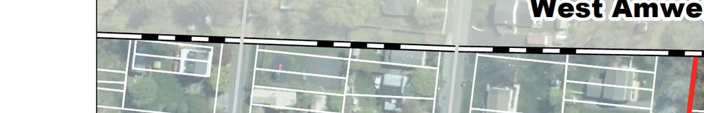
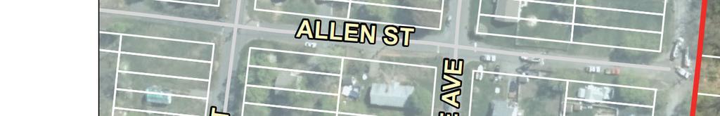
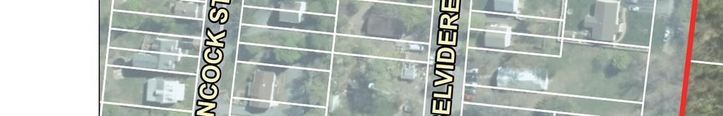
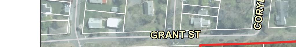
6 Delaware Township (/ 202 West Amwell Township Æ 179 Æ 29 Lambertville High School Redevelopment Area Æ Pennsylvania Æ 165 Æ ,400Ft Clarke Caton Hintz Architecture Planning Landscape Architecture Lambertville High School Redevelopment Area Location of Redevelopment Area LOCATION: DATE: Lambertville City, Hunterdon County, NJ October 2018


7
8 REDEVELOPMENT PLAN GOALS AND OBJECTIVES The is intended to provide a framework of regulations for the development of vacant and underutilized lands for the creation of affordable housing within the City of Lambertville. This Redevelopment Plan is intended to be guided by the following goals and objectives: 1. Encourage the sound utilization of land and promote a strong sense of community. 2. Provide for affordable housing to meet the needs and requirements of eligible families through the implementation of the City s Affordable Housing policies, plans and goals. 3. Preserve and protect steep slopes and bluffs from disturbances related to redevelopment. 4. Provide safe, efficient pedestrian and vehicular traffic circulation. 5. Integrate neighborhood-scaled open space within the redevelopment area with spatial and visual public access. 6. Provide cohesive circulation and land uses between the redevelopment area and adjacent tracts. 7. Ensure that the capacity of all utility systems serving the Redevelopment Area is adequate to support any proposed development. 8. Require comprehensive planning for redevelopment. 9. Use existing framework of public thoroughfares to connect the redevelopment area with the larger community. LAND USES IN THE REDEVELOPMENT AREA The Lambertville High School Redevelopment Area is located on Connaught Hill, which is a bluff on the eastern edge of the City. It is bounded by the Connaught Hill Commons neighborhood and Route 179 to the north, West Amwell Township to the east, Quarry Street to the south, and Washington Street and Route 29 to the west. The surrounding land uses include vacant land, residential, commercial, and government uses. A majority of the Redevelopment Area is vacant and wooded with the exception of one single-family detached dwelling, a shed, the remnants of the high school foundations, a stairway, and demolition debris. The Redevelopment Area contains two (2) unimproved, paper streets identified as Southard Street and Allen Street on the City s tax maps. Permitted land uses are directly related to meet the goal of creating affordable housing while still protecting the steep slopes along the perimeter of the redevelopment area. These include multifamily apartments and townhouses. October 26, 2018 Page 4

9 SWM 67 TOWNHOUSES 72 APARTMENTS ROUTE 179 GRANT AVE. CORNELL ROAD MULTIFAMILY APARTMENTS PARKING STEEP SLOPE PROTECTION AREA STEEP SLOPE PROTECTION AREA ALLEY SWM STREET QUARRY ST. SWM TOWNHOUSES (TYP.) LAMBERTVILLE HIGH SCHOOL REDEVELOPMENT AREA CONCEPT PLAN FOR MULTIFAMILY DEVELOPMENT WITH AFFORDABLE DWELLINGS
10 APPLICABILITY OF THE REDEVELOPMENT PLAN AND ITS RELATIONSHIP TO THE LAND DEVELOPMENT ORDINANCE The use, bulk, design and performance standards of this Redevelopment Plan shall supersede the zoning provisions of the City of Lambertville Land Use Ordinance for the redevelopment area. However, where the regulations and standards of the redevelopment plan are silent, the standards of the Land Use Ordinance and Design Guidelines shall apply to the redevelopment area as permitted by N.J.S.A. 40A:12A-7.a(2). The zoning map of the City of Lambertville shall be amended upon the adoption of this Plan in accordance with N.J.S.A. 40A:12A-7.c to reflect this new classification (see map following page). GENERAL PROVISIONS Redevelopment Authority The City Council shall act as the Redevelopment Authority pursuant to N.J.S.A. 40A-12A-4.c for purposes of implementing this Redevelopment Plan and carrying out redevelopment projects. In doing so, the City Council shall have the powers set forth in N.J.S.A. 40A-12A-8 to effectuate all of its duties and responsibilities in the execution and implementation of this Redevelopment Plan, with the use of all powers provided by the Legislature for use in a redevelopment areas including condemnation, pursuant to the provisions of the Eminent Domain Act of 1971, P.L. 1971, c.361 (C.20:3-1 et seq.). Redeveloper Selection The Redevelopment Authority may select a single redeveloper for the redevelopment of the entire redevelopment area. The Redevelopment Authority shall select the redeveloper based on the entity s experience as a developer of multifamily housing, including affordable housing, financial capacity, ability to meet deadlines, flexibility in meeting market demands within the framework of the Redevelopment Plan, and additional criteria that demonstrate the redeveloper s ability to implement the goals and objective of the plan. Agreement Once a redeveloper has been selected, the Redevelopment Authority shall enter into an agreement with the redeveloper that comports with the requirements of N.J.S.A. 40A:12A-9. Any development or The Agreement: Mandatory Provisions Section 9 in the LRHL requires the following provisions in any redevelopment agreement: The redeveloper must agree to construct the uses specified in the redevelopment plan; The agreement must include a date (schedule) by which construction of improvements will commence; The redeveloper shall not sell, lease, or transfer all or any part of the development rights to a redevelopment area or redevelopment project without the consent of the redevelopment authority; A certificate of completion must be issued by the redevelopment entity upon its determination that a redevelopment project is completed. construction within the redevelopment area shall be undertaken in accordance with the contractual agreement between the Redevelopment Authority and the municipally designated redeveloper. The October 26, 2018 Page 6
11 West Amwell Township QUARRY ST HANCOCK ST ALLEN ST R-1 BELVIDERE AVE R-L GRANT ST CORYELL RD R-L R-2 NJ 179 R-L LHSRA R-3 R-L WASHINGT ON ST R-2 R-L YORK ST N. FRANKLIN ST Clarke Caton Hintz Architecture Planning Landscape Architecture GRANTS AL 0 240Ft Lambertville High School Redevelopment Area Proposed Zoning Amendment LOCATION: Lambertville City, Hunterdon County, NJ C-2 DATE: October 2018 R-2
12 agreement shall be in full force and effect prior to the redeveloper making application to the Planning Board for any site plan or subdivision approval. Effect of Agreement The execution of the agreement shall convey the right to prepare a site plan or subdivision application for development to the City of Lambertville Planning Board in accordance with the terms of the agreement and Redevelopment Plan, among other rights that may be granted by the Redevelopment Authority. In addition, the execution of the agreement shall establish the period of time as such rights to develop under the terms and conditions of the Redevelopment Plan shall be granted. Nothing herein shall prevent the Redevelopment Authority and redeveloper from mutually agreeing to an amendment of the Redevelopment Plan as it affects the redeveloper s property from time to time or at any time. Expiration The Redevelopment Plan shall remain in full force and effect for thirty (30) years. Staff Employment The Redevelopment Authority may employ or contract for and fix compensation of such experts and other staff and services as it may deem necessary, including, but not limited to, architecture, economic forecasting, engineering, environmental, landscape architecture, legal, market analysis, planning, and transportation consulting services. The Redevelopment Authority, however, shall not authorize expenditures which exceed, exclusive of gifts, grants or escrow accounts, the amounts appropriated for its use. Acquisition of Property The City of Lambertville, pursuant to the LRHL, adopted an Area in Need of Redevelopment (Condemnation), with the power of eminent domain, on June 11, 2018 (Resolution No: ). Pursuant to the October 11, 2018 Court Order approving the City s Settlement Agreement with Fair Share Housing Center (FSHC), the City must prepare and adopt a Redevelopment Plan and take all necessary steps to effectuate the acquisition of the properties within the Redevelopment Area. All of the property within the Lambertville High School Redevelopment Area may be acquired by the City of Lambertville through condemnation pursuant to the provisions of the Eminent Domain Act of 1971, P.L. 1971, c.361 (C.20:3-1 et seq.). Relocation Provisions The redevelopment area is the subject of an approved Workable Relocation Assistance Program (WRAP). As the project moves forward, the Redeveloper is responsible to relocate all persons, as necessary, in accordance with an approved WRAP. The Lambertville High School Redevelopment Area does not currently include affordable housing units as defined under N.J.S.A. 52:27D-304 and therefore no replacement units are required pursuant to N.J.S.A. 40A:12A-7.a (6). October 26, 2018 Page 8
13 Site Remediation The Redeveloper shall be responsible for any environmental site remediation, as may be necessary, to residential standards pursuant to the New Jersey Department of Environmental Protection regulations. REDEVELOPMENT REGULATIONS Redevelopment, and any plan approved by the Planning Board depicting said redevelopment, shall be consistent with use regulations and design and performance standards included as part of this Redevelopment Plan. Variances may not be granted from Use Regulations or mandatory components of this plan (i.e. affordable housing). However, variances or design exceptions may be granted by the Planning Board from standards contained in the remaining sections, herein, or within the Land Use Ordinance. Consideration of variances shall be undertaken pursuant to requirements found at N.J.S.A. 40:55D- 70.c of the New Jersey Municipal Land Use Law. Consideration of exceptions shall be undertaken pursuant to requirements found at N.J.S.A. 40:55D-51. Consideration of submission waivers shall be undertaken pursuant to N.J.S.A. 40:55D Mandatory Components Redevelopment, and any plan approved by the Planning Board depicting said redevelopment, shall include the following mandatory components: 1. The entirety of the redevelopment area shall be redeveloped as a single planned project; 2. Compliance with the permitted principal uses; 3. Affordable Housing; 4. All development shall be served by public water and public sanitary sewer; and 5. Protection of the steep slopes along the exterior boundary of the redevelopment area to allow visual and spatial access to open space and prevent soil erosion, soil slippage, and surface water runoff to protect the health, safety, and welfare of the people and property within the City. Use Regulations Permitted Principal Uses No lot within the redevelopment area shall be used and no structure shall be erected, altered or occupied for any purpose except for the following permitted principal uses: 1. Townhouse Dwellings. A maximum of sixty-seven (67) townhouse (attached) dwelling units. The townhouses shall be rear lane-loaded with driveways and garages. A maximum of eight October 26, 2018 Page 9
14 (8) townhouse units shall be permitted per building. This Redevelopment Plan assumes the townhouse units will be located on individual fee simple lots. 2. Multifamily Apartment Dwellings. A maximum of seventy-two (72) multifamily rental apartment dwelling units may be permitted in up to four (4) multifamily buildings on one (1) lot. 3. Conservation areas, recreation, open space, and public purpose use. 4. Regional stormwater management basins may be located on their own lots as long as they serve the tract. Accessory Uses and Structures Permitted Any of the following accessory uses and structures shall be permitted in the redevelopment area when used in conjunction with a permitted principal use: 1. Private garages and off-street parking. 2. Patios and decks. 3. Fences and walls. 4. Signs. 5. Temporary sales and construction trailers. 6. Stormwater management and other utilities. 7. Accessory uses on the same lot and customarily incidental to a principal use. Affordable Housing Requirement 1. At least twenty percent (20%) of the residential units, but no less than twenty-eight (28) units, shall be affordable housing units. 2. All of the affordable dwellings shall be family rental units. 3. The affordable housing units shall be deed restricted as affordable housing for very-low-, low-, and moderate-income households in accordance with COAH s regulations, N.J.A.C. 5:93-1 et seq., and the Uniform Housing Affordability Controls (UHAC), N.J.A.C. 5: et seq., which govern the administration and affordability controls of affordable units in New Jersey. With the exception that at least 13% of the units shall be affordable to very-low-income households, 37% of the units shall be affordable to low-income households, and 50% of the units may be affordable to moderate-income households. An off number shall be split in favor of the lowincome units. 4. The Redeveloper s Agreement is required to establish low/moderate apportionment, very-lowincome requirement per N.J.S.A. 52:27D-329.1, bedroom distribution, unit size, etc. October 26, 2018 Page 10
15 5. In addition to addressing the requirements of COAH and UHAC noted above, the affordable units shall be developed in accordance with the following: Required Design a. The affordable units shall not be age-restricted units. b. The affordable units shall not be owner-occupied units. c. The bedroom distribution requirements pursuant to N.J.A.C. 5: and N.J.A.C. 5: (b). d. The unit distribution requirements pursuant to N.J.A.C. 5: e. The very-low income distribution requirements pursuant to the Fair Housing Act, N.J.S.A. 52:27D f. The phasing requirements pursuant to N.J.A.C. 5:93-5.6(d). g. The length of controls requirement and deed restriction pursuant to N.J.A.C. 5: h. The accessibility and adaptability requirements pursuant to N.J.A.C. 5: The required site design of the Redevelopment Area shall be substantially consistent with Concept Plan for Multifamily Development with Affordable Dwellings and included in the City s Settlement Agreement with Fair Share Housing Center, dated May 22, Variations to the Concept Plan may be permitted as long as the deviations do not thwart the principles of the Redevelopment Plan. Spatial Requirements Except as otherwise modified, the following regulations, area, yard, intensity, and coverage standards contained herein shall apply to all development in the Lambertville High School Redevelopment Area. Throughout this Redevelopment Plan, the term tract shall mean the entirety of the Redevelopment Area, including all lots and public street rights-of-way, presently existing or to be created, within the Redevelopment Area. The Planning Board may grant variances from these standards, pursuant to the procedure articulated in the New Jersey Municipal Land Use Law at N.J.S.A. 40:55D-70.c. 1. Tract Requirements a. Minimum tract size: The entirety of the redevelopment area (1) b. Minimum percentage of open space: 30% c. Minimum perimeter buffer: 30 feet (2) 2. Townhouse Lot Requirements a. Minimum lot size: 2,000 square feet b. Minimum lot frontage: 20 feet October 26, 2018 Page 11
16 c. Minimum lot depth: 100 feet d. Maximum building coverage: 70% e. Maximum lot coverage: 80% f. Minimum front yard: 10 feet g. Minimum side yard: 0 feet (interior unit) / 15 feet (end unit) (3) h. Minimum rear yard: 5 feet i. Maximum height: 3 stories / 40 feet (5) j. Maximum garage height: 1 story 3. Multifamily Apartment Requirements a. Minimum front yard: 20 feet b. Minimum side yard: 50 feet (4) c. Minimum rear yard: 50 feet d. Maximum height: 3 stories / 45 feet (5) e. Distance between buildings: i. Side-to-Side: 30 feet ii. Rear-to-Rear: iii. Side-to-Rear: 125 feet 30 feet Footnotes: (1) Portion(s) of the tract may be dedicated for public streets. (2) A perimeter buffer is not required on the tract boundary along Grant Avenue or Coryell Road. (3) Patios and decks on end units may not project more than five (5) feet beyond the Principal Building wall. (4) Balconies may encroach into a required minimum setback up to three (3) feet. (5) Except as modified by of the Zoning Ordinance, entitled Height Exceptions. October 26, 2018 Page 12
17 Performance and Design Standards The following performance and design standards shall be used in all development within the Lambertville High School Redevelopment Area. Shall is mandatory and should is permissive. The Planning Board may grant exceptions from these standards, pursuant to the procedure articulated in the New Jersey Municipal Land Use Law at N.J.S.A. 40:55D-51. Circulation and Parking 1. Streets. Streets shall be designed in accordance with the requirements for a New Jersey Residential Site Improvement Standards (RSIS), N.J.A.C. 5:21-1 et seq., classification Residential Neighborhood street. Streets shall have one-street parking on both sides. Sidewalks shall be provided on both sides. 2. Lanes/Alleys. Lanes/Alleys shall be designed in accordance with the Special Purpose Streets Alley (two-way) requirements in accordance with RSIS. 3. Pedestrian Connectivity. Pedestrian walkways connecting thoroughfares and the townhouse units and the building(s) containing the multifamily dwelling units shall be provided. Sidewalks shall be provided along both sides of the thoroughfares except for the lanes. Painted pedestrian crosswalks in accordance with the applicable governmental standards shall be provided at intersections. 4. Townhouse Dwellings. a. Townhouse units shall be accessed from rear lanes/alleys. No driveways shall be located in front of townhouse buildings. b. Townhouses shall provide at least one (1) on-site parking space within an enclosed garage located in the rear yard with access from a lane/alley. c. Parking may occur within the driveway leading to the garage, in which case said garage shall be set back no less than 20 feet from the curb or edge of pavement of the lane/alley to accommodate a vehicle without said vehicle projecting into the cartway of the lane/alley. d. Garages, driveways and parking areas shall have a minimum setback of two (2) feet from any side property line or side of a dwelling unit. An exception to the two-foot setback from the side property lines shall exist for townhouse lots to permit garages, driveways and parking areas that share a common wall on the common property line. e. Grade separations and retaining walls are not permitted between driveways unless the driveways are separated by at least ten (10) feet. f. Each dwelling units shall be provided a minimum number of parking spaces according to the provisions of RSIS or based upon historical data provided subject to City review. g. On-street parking shall count towards the required number of parking spaces. October 26, 2018 Page 13
18 h. Parking space sizes shall be provided pursuant to RSIS. i. See 509 of the Zoning Ordinance for additional standards. 5. Multifamily Dwellings. Architectural Design a. Parking lots are not permitted between a building(s) and a thoroughfare. b. Parking lots shall be a minimum of 30 feet from a side yard line, and 20 feet from a rear lot line. c. Parking lots shall be a minimum of 10 feet from the façade of a multifamily building. d. Each dwelling unit shall be provided a minimum number of parking spaces according to the provisions of RSIS or based upon historical data provided subject to City review. e. See 509 of the Zoning Ordinance for additional standards. The architectural design shall be substantially similar to the illustrative architectural exhibit, entitled Townhouses: Architectural Precedents, included herein. Where the architectural regulations and standards of the redevelopment plan are silent, the standards of the Design Guidelines shall apply. 1. Townhouse Dwellings. a. All townhouse house buildings shall be consistent with a unified architectural character for each building. b. The townhouse buildings should read as a single building with variations on the architectural theme containing different design features consisting of the following: i. Porches; ii. Porticos; iii. Columns; iv. Dormers; v. Accent windows; and vi. Door color. c. Townhouses shall have a brick front façade in which the brick is wrapped on the side facades on the corner lots and lots adjacent to open space is not required on the rear lane/alley elevations. October 26, 2018 Page 14

19 October 26, 2018 Page 15
20 e. Townhouse units on corner lots shall have wrapped porches. f. Eighty percent (80%) of the townhouse units shall be porches. g. The finished first floor elevation shall be a minimum of 18 inches and a maximum of 36 inches above the front sidewalk elevation. h. The garage roof facing the lane/alley shall be hipped, not gabled, at a maximum pitch of eight to twelve (8/12). i. Only end units may have four (4) bedrooms. Interior units are not permitted to have more than three (3) bedrooms. j. Habitable space is not permitted over the garage. k. A fence, wall, hedge, landscape edge, or some other element shall be provided within three (3) feet of the sidewalk to delineate the public sidewalk from the front yards of the townhouse units. The proposed treatment shall be consistent throughout the townhouse development area. 2. Multifamily Dwellings. Plantings and Buffers 1. Plantings. a. The multifamily building(s) shall be designed to be unified with the architecture of the townhouses in terms of materials, proportions, windows, roof planes, ornament and other exterior building elements. b. The buildings shall be designed with two (2) front facades when located around a central parking lot. c. Rooftop mechanical equipment shall be screened from visibility. a. All portions of the tract not utilized by buildings or paved surfaces shall be planted, utilizing combinations such as landscaped fencing, shrubbery, lawn area, ground cover, rock formations, contours, existing foliage, and the planting of conifers and/or deciduous trees native to the area in order to either maintain or reestablish the tone of the vegetation in the area and lessen the visual impact of the structures and paved areas. b. Foundation plantings plans for individual buildings shall be provided for review by the City. c. See 510 of the Zoning Ordinance for additional standards pertaining to plantings. 2. Buffers. October 26, 2018 Page 16
21 a. All perimeter buffer areas shall be reviewed by the approving authority and constructed by the developer of the Lambertville High School Redevelopment Area as part of its approval, with any existing vegetation augmented with additional landscaping as may be required by the Board at the time of the site plan review. b. The perimeter buffer areas shall have the plantings installed along a fence, a minimum four (4) feet in height, as approved by the City. Vinyl fences shall not be permitted. c. The following structures are hereby permitted within required perimeter buffer areas: i. Emergency access drives. ii. iii. iv. Sidewalks. Underground utility crossings, including sanitary sewer easements. Walls or fences that do not exceed six (6) feet in height. v. Stormwater management measures. vi. Public thoroughfares provided a minimum ten (10) foot perimeter buffer is provided. 3. Street Trees. The requirements for street trees are as follows: a. Shade trees shall be provided along new thoroughfares, excepting lanes/alleys, at a minimum spacing of 40 on center. b. The redeveloper shall be required to provide an easement for street trees on private land where the street right-of-way is not wide enough to contain the required street trees or where other mechanisms/conditions preclude plantings of trees. 4. Off-Street Parking, Loading Areas and Driveways. a. A screen planting, berm, fence, wall or combination thereof, no less than four (4) feet and nor more than seven (7) feet in height, shall be provided between the off-street parking lot areas and any lot line or street line except where a building intervenes or where the distance between such areas and the lot line or street line is greater than one hundred fifty (150) feet. b. Each off-street parking lot area shall have a minimum area equivalent to one (1) parking space per every thirty (30) spaces landscaped with approximately one-half (1/2) said area having shrubs no higher than three (3) feet and the other half having trees with branches no lower than seven (7) feet. Such landscaped areas shall be distributed throughout the parking area in order to break the view of parked cars in a manner not impairing visibility. 5. See 510 of the Zoning Ordinance for additional standards. October 26, 2018 Page 17
22 Steep Slopes 1. Given the increase in open space required for the Lambertville High School Redevelopment Area, and in consideration thereof, the maximum permitted disturbance of steep slopes shall be as follows: Extent of Slope Maximum Extent of Disturbance to Sloped Area 0 - < 15% No limit 15% - < 20% 35% (1) 20% - < 30% 15% 30% + 5% (1) May be increased to 40% as of right to permit conformance with the stormwater management standards of the Residential Site Improvement Standards, N.J.A.C. 5: Notwithstanding the steep slope limitations set forth above, to the extent that an application for development exceeds the standards for RSIS, pursuant to N.J.S.A. 5:21-3.6, for stormwater management (N.J.A.C. 5:21-7), the steep slope standards above shall be relaxed to the minimum extent necessary to allow such exceedances from the stormwater management standards of RSIS. 3. The following structures are hereby permitted within the Steep Slope Protection Area: Fences and Walls a. Underground utility crossings, including sanitary sewer easements. b. Walls or fences that do not exceed six (6) feet in height. c. Stormwater management measures. 1. Fences and walls shall be composed of materials, finishes, and design elements that are consistent with the architecture of the buildings. Vinyl fences shall not be permitted. 2. Unless specifically amended herein, the fences and walls requirements and regulations of 507 of the Zoning Ordinance are applicable to the Redevelopment Area. 3. Retaining walls greater than five (5) feet in height shall be stepped with plantings to mitigate the negative impacts on the viewshed. Lighting 1. A lighting plan shall be submitted for review and approval indicating: a. The location of the lighting fixtures; October 26, 2018 Page 18
23 b. The direction of illumination; c. The lamp type, wattage, lumens and isofootcandle detail for each fixture; d. Manufacturer-supplied specifications ( cut sheets ) that include photographs of the fixtures, indicating the certified cut off characteristics of the fixture, type of fixtures, including the cut off characteristics, indicating the manufacturers and model number(s) e. Mounting height (height of the light source, not the overall fixture height); f. Timing devices and other controls used to control the hours of illumination, as well as the proposed hours when each fixture will be operated; g. A point-by-point lighting plan shall be submitted, indicating in maintained horizontal footcandles. 2. Predicted illumination grid shall be extended out to the point where levels are anticipated to be zero (0) footcandles. 3. Individual areas to be illuminated shall be identified on an overall plan and calculated separately include: parking areas, streets/thoroughfares, pedestrian walkways/areas, and the tract boundary. 4. For each individual area in (3) above, a summary of the illumination characteristics shall be provided, including: a. Name/Identifier of the area b. Square footage of the area c. Minimum and Maximum footcandle values d. Average footcandle ratio e. Maximum-to-Minimum Ratio f. Average-to-Minimum Ratio 5. Street Lighting shall be provided pursuant to the standards identified in 511 of the Zoning Ordinance. 6. Site Lighting. a. Lighting fixtures shall not exceed a height of 20 feet. b. Lighting fixtures shall be LED, non-glare, full cut-off. October 26, 2018 Page 19
24 Signs c. Bollard lighting, not more than four (4) feet in height and appropriately shielded, may be provided along sidewalks and within open space areas. d. Lighting may be attached to a building, provided that such lighting is focused downward/full cut-off. 7. Illumination levels (horizontal footcandles): a. Tract boundary: 0.1 fc maximum except for intersections with streets/driveways. b. Vehicular intersections/entrances: 1.0 fc minimum. c. Streets: 0.3 fc minimum. d. Parking lots: 0.2 fc minimum, 1.0 fc average, and a maximum-to-minimum of 20:1. e. Pedestrian walkways/areas: 0.2 fc minimum, 5.0 fc maximum, and a maximum-tominimum of 20:1. 1. Residential Apartment Building Identification Signs: Each residential apartment building may have up to two (2) attached identification signs. The maximum sign area of each shall not exceed six (6) square feet. Such signs shall be appropriately integrated within the architecture of the building. 2. See 515 of the Zoning Ordinance for permitted temporary signs, additional standards, and the design requirements for signs. Trash and Recycling Requirements 1. The trash and recyclable material collection and pickup locations shall be provided either within the building being served or in nearby locations outside the building. 2. If located outside the building, the trash and recyclable materials area shall be totally enclosed, finished with materials used to construct the building(s) being served, up to a maximum of eight (8) feet in height, and located in a manner to be obscured from view from parking areas, streets and adjacent residential uses or zoning districts by a fence or wall. Landscaping, at least six (6) feet in height, shall be provided around any outdoor trash and recycling area. 3. Any outdoor area provided for the collection and pickup of trash and recyclable materials shall be well lit and shall be safely and easily accessible by trash and recycling personnel and vehicles. 4. Collection vehicles shall be able to access the trash and recycling area without interference from parked cars or other obstacles. Reasonable measures shall be taken to protect the trash and recycling area and the bins or containers placed therein against theft of trash and recyclable materials, bins or containers. October 26, 2018 Page 20
25 5. Any bins or containers which are used for the collection of trash and recyclable material, and which are located in an outdoor trash and recycling area, shall be equipped with a lid. 6. Individual bins or containers for the collection and pickup of recyclable materials shall be equipped with signs indicating the materials to be placed therein. Stormwater Management 1. The Redevelopment Plan will be designed to meet the requirements of the New Jersey Department of Environmental Protection (NJDEP) Stormwater Management Rules, N.J.A.C. 7:8-1 et seq., and Article XV Stormwater Management of the City s Zoning Ordinance. 2. Stormwater management for the townhouse and multifamily apartment units can be combined and is encouraged. Public Improvements The public improvements described herein are anticipated to be required and installed at the full expense of the designated redeveloper consistent with the design policies and standards that are contained within this Plan. The redeveloper is expected to install necessary public improvements on the property they control as well as abutting rights-of-way. There will be no municipal financial assistance in the form of contributions towards the construction of off-site and/or off-tract improvements necessitated by the future development. No recapture of off-site improvement expenses from future development should be anticipated. However, nothing contained herein shall be construed to preclude the ability of the municipality or redeveloper from obtaining any governmental programs, grants, loans, or other financial support or incentives for public infrastructure improvements or other construction, or from the municipality to consider a recapture provision in the redevelopment agreement. Utilities In addition to the requirements of 609 of the Land Subdivision Ordinance, the following specific requirements pertaining to development within the Lambertville High School Redevelopment Area: 1. Redeveloper shall obtain public wastewater allocation from the Lambertville Municipal Utilities Authority sufficient to serve the proposed development and shall construct the necessary infrastructure to convey the wastewater from the Redevelopment Area to the existing City wastewater conveyance elements/infrastructure. 2. Redeveloper shall be responsible for extension of public water supply to the Redevelopment area subject to the requirements of the water supply authority. October 26, 2018 Page 21
26 RELATIONSHIP TO PLANNING & OBJECTIVES City of Lambertville 2009 Reexamination of the Master Plan The 2009 Reexamination Report, adopted July 1, 2009, supports the goals, objectives and recommendations of the 1998 Master Plan and subsequent reexaminations, changes, modifications, refinements, and expansions through the 2001 Master Plan Reexamination Report. The 2009 Reexamination Report reaffirms the goals and objectives of the 1998 Land Use Plan Element portion of the Master Plan. The following is a list of goals identified in the 1998 Land Use Element that are applicable to this Redevelopment Plan: Facilitate access to a variety of housing to meet the income, aesthetic and other personal requirements of the City s present and future population. Preserve and protect environmentally sensitive areas, including but not limited to, flood plains, wetlands, and steep slopes. Strive to preserve the natural, scenic, historic, aesthetic aspects of the community and its environment. The 2009 Reexamination Report specifically identifies the former Lambertville High School Site and surrounding properties as a redevelopment opportunity for the City. The orientation of Lambertville s overall goals for the City align with the Redevelopment Area s objectives to provide an inclusionary development containing a mix of townhouse and multifamily apartment dwellings, including affordable family rental units, within the Redevelopment Area to facilitate access to a variety of housing. Additionally, the preservation of the steep slopes and bluffs along the perimeter of the Redevelopment Area will ensure the natural, scenic, and aesthetic aspects of the City and its environment is maintained. Hunterdon County 2007 Growth Management Plan The following is a list of policies identified in the 2007 Hunterdon County Growth Management Plan that are applicable to this Redevelopment Plan: Provide a range of housing options for existing and future county residents. Increase affordable housing options. Promote landowner stewardship practices that reduce nonpoint source pollutant loadings to surface and ground water resources. Implement stormwater management techniques that reduce pollutant loadings of Total Suspended Solids and nutrients. October 26, 2018 Page 22
27 State 2001 Development and Redevelopment Plan The State Development and Redevelopment Plan was adopted by the State Planning Commission on March 1, The plan is organized around eight policy goals for New Jersey s communities. Of particular importance to the Lambertville High School Redevelopment Area are the following goals: Goal 1 Revitalize the State s Cities and Towns Goal 2 Conserve the State s Natural Resources and Systems Goal 6 Provide Adequate Housing at a Reasonable Cost Goal 7 Preserve and Enhance Areas with Historic, Cultural, Scenic, Open Space and Recreational Value Goal 8 Ensure Sound Integrated Planning and Implementation Statewide This Redevelopment Plan directly supports these State Plan Policy Goals. The plan seeks to revitalize vacant and underutilized lands, to restore the integrity of natural systems throughout the area, to design for improved access to and protection of open space, and provide comprehensive land uses consistent with local, regional and state land use policies. DEVELOPMENT PLAN REVIEW AND APPROVAL Escrow Fee Redevelopers seeking input on a conceptual plan or approval of a project in the Redevelopment Area shall establish an escrow account with the Redevelopment Authority from which any consultants necessary for the review of the redevelopment project shall be paid. Such escrow account shall be in accordance with N.J.S.A. 40:55D The Redevelopment Authority shall adopt a fee schedule by resolution and may amend it from time to time as circumstances warrant. Application for Development The application for development shall include a major subdivision and/or site plan that shall be submitted in such form, and accompanied by such maps, documents, and materials as are prescribed in the Land Development Review Ordinance of the City of Lambertville and Development Application Checklists 1 through 4. Consistency with Redevelopment Plan The City Council (Redevelopment Authority) shall certify the consistency of an application for development with the Redevelopment Plan after submission by the redeveloper to the City of Lambertville Planning Board and prior to a determination of a complete application by the Planning Board. As a condition precedent to the filing of any application for development to the Planning Board for any property governed by this Redevelopment Plan, the Redevelopment Authority shall execute the October 26, 2018 Page 23
28 Agreement with the redeveloper. Any development approved by the Planning Board prior to the enactment of this plan pursuant to the Land Development Review Ordinance shall be deemed to be certified as consistent with this plan and shall not require a separate determination of consistency by the Planning Board. Planning Board Review 1. Site plan or subdivision review shall be conducted by the City of Lambertville Planning Board pursuant to N.J.S.A. 40:55D-1 et seq. 2. Variances may not be granted from the Use Regulations or mandatory components of the Redevelopment Plan. However, variances may be granted from standards contained in the remaining sections in accordance with the provisions of the New Jersey Municipal Land Use Law, N.J.S.A. 40:55D-60 and 70c. Furthermore, exceptions may be granted pursuant to N.J.S.A. 40:55D-51 and submission waivers pursuant to N.J.S.A. 40:55D An application requesting a deviation from the requirements of this Redevelopment Plan shall provide public notice of such application in accordance with the public notice requirement set forth in N.J.S.A. 40:55D-12a&b. 4. Any development approved by the Planning Board prior to the enactment of this plan pursuant to the Land Development Review Ordinance shall not require an additional, separate approval by the Planning Board. Effects of Approval The effects of any Planning Board approval shall be consistent with the rights granted by Municipal Land Use Law (N.J.S.A. 40:55D-1 et seq.) except to the extent they may be modified by an agreement with a redeveloper. October 26, 2018 Page 24
29 DEFINITIONS Accessory Building, Use or Structure A use or structure subordinate to the principal use, building, or structure on the same lot and serving a purpose customarily incidental to the use of the principal use, building or structure. Building Height The vertical distance measured from the average elevation of the finished grade at a point five (5) feet away from the front of the building to the top of the roof surface for flat and mansard roods, and to the vertical midpoint between the base of the roof and its peak for gable, hip, and gambrel roofs. Dwelling Unit A building or entirely self-contained portion thereof intended or designed for non-transient residential use by a single housekeeping units, (a) separated from all other spaces by lockable doors, (b) having access to the outside without crossing another dwelling, (c) having full kitchen and food refrigeration facilities, and (d) having sanitary facilities. A boarding or rooming house, convalescent home, fraternity or sorority house, hotel, nursing, or other similar home, or other similar structure shall not be deemed to constitute a dwelling unit. Dwelling Unit, Multifamily Apartment A building or portion thereof designed for occupancy by three (3) or more families living independently in which they may or may not share common entrances or other spaces. Dwelling Unit, Townhouse A single family dwelling unit in a row of three (3) or more such units separated from one another by an unpierced vertical wall from the ground to the roof. Income Restricted A dwelling that is deed restricted to an eligible very low, low or moderate income household as defined by the Fair Housing Act, N.J.S.A. 52:27D-301 et seq. and administrative rules promulgated under its authority. Lot, Corner A lot on the junction of and abutting on two (2) or more intersecting streets where the interior angle of intersection does not exceed one hundred thirty-five (135) degrees. Each corner lot shall be two (2) front yards, one (1) side yard and one (1) rear yard to be designated at the time of application for a construction permit. Lot Coverage The total area covered by impervious surfaces on a property, including but not limited to, buildings, surfaced or unsurfaced parking areas, driveways, sidewalks, patios, pools, and decks. Public Purpose Use The use of land or buildings by the governing body of the City or any officially created authority or agency thereof. Tract An area of land composed of one (1) or more lots adjacent to one another. The original land area may be divided by one (1) existing public streets, including paper streets, and still be considered one (1) tract. W:\5000's\Lambertville\Municipal\ LHS Reded\Redevelopment Plan\ _Draft_Redevelopment Plan.docx October 26, 2018 Page 25
Nelson Street Redevelopment Plan
 Nelson Street Redevelopment Plan MARCH 20, 2017 Readington Township, Hunterdon County, New Jersey Clarke Caton Hintz 1 0 0 b a r r a c k s t r e e t T r e n t o n, N J 0 8 6 0 8 Readington Township, Hunterdon
ML-4 MULTIFAMILY RESIDENTIAL ZONE. [Added by Ord. No ]
![ML-4 MULTIFAMILY RESIDENTIAL ZONE. [Added by Ord. No ]](/thumbs/90/103301433.jpg "ML-4 MULTIFAMILY RESIDENTIAL ZONE. [Added by Ord. No ]") 55-26. ML-4 MULTIFAMILY RESIDENTIAL ZONE. [Added 2-2-98 by Ord. No. 1998-1 2] The following regulations apply in the ML-4 Zone. A. Permitted Uses. (1) Garden apartments, together with accessory structures
55-26. ML-4 MULTIFAMILY RESIDENTIAL ZONE. [Added 2-2-98 by Ord. No. 1998-1 2] The following regulations apply in the ML-4 Zone. A. Permitted Uses. (1) Garden apartments, together with accessory structures
Article 7: Residential Land Use and Development Requirements
 Article 7: Residential Land Use and Section 701: Statement of Intent (A) (B) (C) The intent of Article 7 is to develop certain land use and development requirements for the residential uses within Cumru
UPPER MOUNT BETHEL TOWNSHIP NORTHAMPTON COUNTY, PENNSYLVANIA
 UPPER MOUNT BETHEL TOWNSHIP NORTHAMPTON COUNTY, PENNSYLVANIA JOINDER DEED / LOT CONSOLIDATION TOWNSHIP REVIEW PROCESS When accepting proposed Joinder Deeds / Lot Consolidations, review the Joinder Deed
May 12, Chapter RH HILLSIDE RESIDENTIAL ZONES REGULATIONS Sections:
 May 12, 2017 Chapter 17.13 RH HILLSIDE RESIDENTIAL ZONES REGULATIONS Sections: 17.13.010 Title, intent, and description. 17.13.020 Required design review process. 17.13.030 Permitted and conditionally
TOWNSHIP OF EVESHAM ORDINANCE NO
 TOWNSHIP OF EVESHAM ORDINANCE NO. 14-6-2018 ORDINANCE OF THE TOWNSHIP OF EVESHAM AMENDING CHAPTER 160, THE ZONING CODE OF THE TOWNSHIP OF EVESHAM TO CREATE A NEW ZONE TO BE KNOWN AS THE WORKFORCE AFFORDABLE
Condominium Unit Requirements.
 ARTICLE 19 CONDOMINIUM REGULATIONS Section 19.01 Purpose. The purpose of this Article is to regulate projects that divide real property under a contractual arrangement known as a condominium. New and conversion
Moore Township Planning Commission 2491 Community Drive, Bath, Pennsylvania Telephone: FAX: Rev:12/23/2013
 2491 Community Drive, Bath, Pennsylvania Telephone: 610-759-9449 FAX: 610-759-9448 Rev:12/23/2013 APPLICATION FORM FOR A SITE PLAN PER MOORE TOWNSHIP ZONING ORDINANCE SECTION 200-58.1 NORTHAMPTON COUNTY,
ARTICLE 24 SITE PLAN REVIEW
 ARTICLE 24 SITE PLAN REVIEW 24.1 PURPOSE: The intent of these Ordinance provisions is to provide for consultation and cooperation between the land developer and the Township Planning Commission in order
NOW, THEREFORE BE IT ORDAINED,
 ORDINANCE 2087 AN ORDINANCE OF THE BOROUGH OF SOUTH PLAINFIELD, COUNTY OF MIDDLESEX, AND STATE OF NEW JERSEY, AMENDING AND SUPPLEMENTING CHAPTER 540, ENTITLED ZONING, OF THE CODE OF THE BOROUGH OF SOUTH
17.13 RH HILLSIDE RESIDENTIAL ZONES REGULATIONS SECTIONS:
 Effective April 14, 2011 Chapter 17.13 RH HILLSIDE RESIDENTIAL ZONES REGULATIONS SECTIONS: 17.13.010 Title, Intent, and Description 17.13.020 Required Design Review Process 17.13.030 Permitted and Conditionally
Jacobs Landing Rehabilitation Plan
 Jacobs Landing Rehabilitation Plan Township of Woodbridge Prepared by: Township of Woodbridge Department of Planning & Development June 2015 ADOPTED by Township of Woodbridge Planning Board ADOPTED by
Charter Township of Plymouth Zoning Ordinance No. 99 Page 208 Article 21: Residential Unit Developments Amendments: ARTICLE XXI
 Charter Township of Plymouth Zoning Ordinance No. 99 Page 208 ARTICLE XXI RESIDENTIAL UNIT DEVELOPMENTS PURPOSE The purpose of the Residential Unit Development (RUD) is to permit two (2) optional methods
MAJOR SUBDIVISION PRELIMINARY PLAT CHECKLIST
 TOWNSHIP OF EGG HARBOR PLANNING BOARD/ZONING BOARD OF ADJUSTMENT 3515 BARGAINTOWN ROAD EGG HARBOR TOWNSHIP, NJ 08234 MAJOR SUBDIVISION PRELIMINARY PLAT CHECKLIST The following checklist is designed to
AN ORDINANCE OF THE CITY OF MINNEAPOLIS. By Palmisano
 AN ORDINANCE OF THE CITY OF MINNEAPOLIS By Palmisano Amending Title 20, Chapter 520 of the Minneapolis Code of Ordinances relating to Zoning Code: Introductory Provisions. The City Council of the City
E L M E R B O R O U G H L A N D U S E B O A R D APPLICATION COVER SHEET (to be completed for all applications and appeals)
") E L M E R B O R O U G H L A N D U S E B O A R D APPLICATION COVER SHEET (to be completed for all applications and appeals) 1. Name(s): 2. Address: 3. Telephone Number(s): 4. E-mail: 5. Owner Name(s) (if
E L M E R B O R O U G H L A N D U S E B O A R D APPLICATION COVER SHEET (to be completed for all applications and appeals) 1. Name(s): 2. Address: 3. Telephone Number(s): 4. E-mail: 5. Owner Name(s) (if
Composition of traditional residential corridors.
 Page 1 of 7 St. Petersburg, Florida, Code of Ordinances >> PART II - ST. PETERSBURG CITY CODE >> Chapter 16 - LAND DEVELOPMENT REGULATIONS >> SECTION 16.20.060. CORRIDOR RESIDENTIAL TRADITIONAL DISTRICTS
Salem Township Zoning Ordinance Page 50-1 ARTICLE 50.0: PUD PLANNED UNIT DEVELOPMENT
 Salem Township Zoning Ordinance Page 50-1 ARTICLE 50.0 PLANNED UNIT DEVELOPMENT Section 50.01 Purpose The provisions of this Article provide enabling authority and standards for the submission, review,
ARTICLE 15 - PLANNED UNIT DEVELOPMENT
 Section 15.1 - Intent. ARTICLE 15 - PLANNED UNIT DEVELOPMENT A PUD, or Planned Unit Development, is not a District per se, but rather a set of standards that may be applied to a development type. The Planned
FREQUENTLY USED PLANNING & ZONING TERMS
 City Of Mustang FREQUENTLY USED PLANNING & ZONING TERMS Abut: Having property lines, street lines, or zoning district lines in common. Accessory Structure: A structure of secondary importance or function
SITE PLAN REVIEW PROCEDURES SECTION DEVELOPMENTS REQUIRING SITE PLAN APPROVAL
 SECTION 22.01 PURPOSE ARTICLE XXII PROCEDURES The purpose of this Article is to establish uniform requirements of procedure for all developments in the Township. Certain specific types of minor development
The purpose of this Chapter is to establish rules, regulations, standards and procedures for approval of subdivisions of land to promote and ensure:
 CHAPTER 7 SUBDIVISION SECTION 7.1 PURPOSE The purpose of this Chapter is to establish rules, regulations, standards and procedures for approval of subdivisions of land to promote and ensure: A. Conformity
(a) Commercial uses on Laurel Avenue, abutting the TRO District to the
 Commercial uses on Laurel Avenue, abutting the TRO District to the") 32X Zoning Code 150.36 TRANSITIONAL RESIDENTIAL OVERLAY DISTRICT. (A) Intent and purpose. (1) It is the intent of the Transitional Residential Overlay District (hereinafter referred to as the "TRO District")
32X Zoning Code 150.36 TRANSITIONAL RESIDENTIAL OVERLAY DISTRICT. (A) Intent and purpose. (1) It is the intent of the Transitional Residential Overlay District (hereinafter referred to as the "TRO District")
The following regulations shall apply in the R-E District:
 "R-E" RESIDENTIAL ESTATE DISTRICT (8/06) The following regulations shall apply in the R-E District: 1. Uses Permitted: The following uses are permitted. A Zoning Certificate may be required as provided
PLANNED DEVELOPMENT DISTRICT STANDARDS. Cadence Site
 PLANNED DEVELOPMENT DISTRICT STANDARDS Cadence Site A Planned Development District 1. Statement of General Facts, Conditions and Objectives Property Size: Approximately 57.51 Acres York County Tax Map
PLANNED MIXED-USE DEVELOPMENT DISTRICT ( PMUD ) ZONING TEXT AMENDMENT
 ZONING TEXT AMENDMENT") PLANNED MIXED-USE DEVELOPMENT DISTRICT ( PMUD ) ZONING TEXT AMENDMENT Upon final approval of this PMUD zoning text amendment, development of the herein described property shall remain in strict compliance
PLANNED MIXED-USE DEVELOPMENT DISTRICT ( PMUD ) ZONING TEXT AMENDMENT Upon final approval of this PMUD zoning text amendment, development of the herein described property shall remain in strict compliance
CITY PLAN COMMISSION STAFF REPORT
 CITY PLAN COMMISSION STAFF REPORT SUBJECT: Request for a Change of Zoning and Preliminary Development Plan FROM: Mara Perry, Director of Planning & Development MEETING DATE: November 6, 2017 PETITION:
EAST GOSHEN TOWNSHIP CHESTER COUNTY, PENNSYLVANIA ORDINANCE NO.
 EAST GOSHEN TOWNSHIP CHESTER COUNTY, PENNSYLVANIA ORDINANCE NO. AN ORDINANCE AMENDING THE EAST GOSHEN TOWNSHIP ZONING ORDINANCE OF 1997, AS AMENDED, WHICH IS CODIFIED IN CHAPTER 240 OF THE EAST GOSHEN
ARTICLE XVII SCHEDULE OF REGULATIONS
 ARTICLE XVII SCHEDULE OF REGULATIONS SECTION 1700. LIMITING HEIGHT, BULK, DENSITY, AND AREA BY DISTRICT TYPE Use Minimum Size Lot Per Unit Maximum Height of Structures Minimum Yard Setback (Per Lot in
Midwest City, Oklahoma Zoning Ordinance
 2010 Midwest City, Oklahoma Zoning Ordinance 9/2/2010 Table of Contents Section 1. General Provisions... 5 1.1. Citation... 5 1.2. Authority... 5 1.3. Purpose... 5 1.4. Nature and Application... 5 1.5.
Title 17 MOBILE HOMES AND RECREATIONAL VEHICLES
 17.04 General Provisions Title 17 MOBILE HOMES AND RECREATIONAL VEHICLES 17.04.010 General provisions 17.04.020 Application 17.04.030 Interpretation 17.04.040 Mobile homes and recreational vehicles--location
SECTION 23 PLANNED RESIDENTIAL DEVELOPMENT FOR ELDERLY PERSONS
 SECTION 23 PLANNED RESIDENTIAL DEVELOPMENT FOR ELDERLY PERSONS 23.1 General: In order to provide for the special needs of elderly and handicapped persons who may require multifamily type living accommodations,
ARTICLE 13 CONDOMINIUM REGULATIONS
 ARTICLE 13 CONDOMINIUM REGULATIONS Section 13.01 Purpose. The purpose of this Article is to regulate projects that divide real property under a contractual arrangement known as a condominium. New and conversion
These design guidelines were adopted by: Knoxville-Knox County Metropolitan Planning Commission on August 10, 2000 Knoxville Historic Zoning
 Fort Sanders Neighborhood Conservation District Design Guidelines These design guidelines were adopted by: Knoxville-Knox County Metropolitan Planning Commission on August 10, 2000 Knoxville Historic Zoning
-MENDOCINO COUNTY PLANNING AND BUILDING SERVICES- DIVISION OF LAND REGULATIONS TITLE 17
 ARTICLE VI -- GENERAL REGULATIONS AND PROVISIONS Sec. 17-50. Sec. 17-51 General Plan. Sec. 17-52 Lot and Block Design and Configuration. Sec. 17-53 Lot Access. Sec. 17-54 Private Roads. Sec. 17-55 Water
PLANNED UNIT DEVELOPMENT (PUD) AREA PLAN/REZONING REVIEW PROCEDURE
 AREA PLAN/REZONING REVIEW PROCEDURE") PLANNED UNIT DEVELOPMENT (PUD) AREA PLAN/REZONING REVIEW PROCEDURE Professional inquiries will be made to our Township Planning Consultant, Township Engineer, and Township Attorney to get their opinions
PLANNED UNIT DEVELOPMENT (PUD) AREA PLAN/REZONING REVIEW PROCEDURE Professional inquiries will be made to our Township Planning Consultant, Township Engineer, and Township Attorney to get their opinions
Zoning Regulations of the Town of Redding Connecticut
 Zoning Regulations of the Town of Redding Connecticut Statutory zoning authority was adopted for the Town of Redding, and a Zoning Commission established as provided by law, at a Town Meeting held May
A. ARTICLE 16 - STEEP SLOPE CONSERVATION DISTRICT
 1600. 1601.A. ARTICLE 16 - STEEP SLOPE CONSERVATION DISTRICT SECTION 1600 PURPOSE The purpose of this Article is to expand upon the Community Development Objectives associated with environmental protection
City of Midland Application for Site Plan Review
 City of Midland Application for Site Plan Review Submission Date: Property Owner: Mailing Address: Phone number: ( ) Cell phone: ( ) Email address: Fax: ( ) Owner s Signature: Applicant Name (if not owner):
TOWNSHIP OF EVESHAM ORDINANCE NO
 TOWNSHIP OF EVESHAM ORDINANCE NO. 3-3-2015 ORDINANCE OF THE TOWNSHIP OF EVESHAM AMENDING CHAPTER 160, THE ZONING CODE OF THE TOWNSHIP OF EVESHAM TO MODIFY SECTION 160-63.1 MODERATE DENSITY RESIDENTIAL
ZONING BOARD OF ADJUSTMENT BOROUGH OF MOUNTAIN LAKES, NEW JERSEY. CHECKLIST Section 40-22
 ZONING BOARD OF ADJUSTMENT BOROUGH OF MOUNTAIN LAKES, NEW JERSEY CHECKLIST Section 40-22 1. Application Form - Original and 13 copies with all items completed. 2. Fee required by Land Use Ordinances, section
DEVELOPMENT STANDARDS FOR RESIDENTIAL PROJECTS RESIDENTIAL BUILDING TYPES: APPROPRIATE ZONES AND DENSITIES 2-1
 2 DEVELOPMENT STANDARDS FOR RESIDENTIAL PROJECTS RESIDENTIAL BUILDING TYPES: APPROPRIATE ZONES AND DENSITIES 2-1 This Chapter presents the development standards for residential projects. Section 2.1 discusses
SECTION 10.7 R-PUD (RESIDENTIAL PLANNED UNIT DEVELOPMENT) ZONE
 ZONE") Article X Zones 10-20 SECTION 10.7 R-PUD (RESIDENTIAL PLANNED UNIT DEVELOPMENT) ZONE A. PURPOSE AND INTENT: The R-PUD Residential PUD Zone is intended to provide alternative, voluntary zoning procedures
Article X Zones 10-20 SECTION 10.7 R-PUD (RESIDENTIAL PLANNED UNIT DEVELOPMENT) ZONE A. PURPOSE AND INTENT: The R-PUD Residential PUD Zone is intended to provide alternative, voluntary zoning procedures
I. Requirements for All Applications. C D W
 108-16.1. Application checklists. Checklist for Required Submissions to the Planning Board or Zoning Board of Adjustment of Monroe Township All required submissions are to be made to the Administrative
ARTICLE SCHEDULE OF REGULATIONS
 ARTICLE 21.00 SCHEDULE OF REGULATIONS FOOTNOTES TO ARTICLE 21.00 SCHEDULE OF REGULATIONS a. If one or both public sanitary sewers and/or public water supply are not available minimum lot size shall be
CHAPTER XVIII SITE PLAN REVIEW
 CHAPTER XVIII SITE PLAN REVIEW Section 18.1 Section 18.2 Description and Purpose. The purpose of this chapter is to provide standards and procedures under which applicants would submit, and the Township
CHAPTER 5 ZONING SECTION 5.1 PURPOSE
 CHAPTER 5 ZONING SECTION 5.1 PURPOSE The purpose of this Chapter is to regulate the nature and extent of uses of land, and of buildings and structures thereon, in order to promote the purposes of this
the conditions contained in their respective Orders until January 1, 2025, at the discretion of the Director of Planning, Property and Development.
 Part 4: Use Regulations Temporary Uses and Structures Purpose the conditions contained in their respective Orders until January 1, 2025, at the discretion of the Director of Planning, Property and Development.
FINAL SUBDIVISION AND LAND DEVELOPMENT PLAN CHECKLIST. Plan Name. Applicant's Name:
 TOWNSHIP OF UPPER ST. CLAIR FINAL SUBDIVISION AND LAND DEVELOPMENT PLAN CHECKLIST Date Filed Plan Name PLC Applicant's Name: Phone Filing Date for Final Application Final Plat 114.22. FINAL APPLICATION
FRONT YARD MP 35 FT 35 FT 10 FT A 20 FT A 2 35 FT 30% NOT PERMITTED NOT PERMITTED
 RESIDENTIAL/AGRICULTURAL COMMERCIAL/INDUSTRIAL ZONING DISTRICT Charter Township of Fort Gratiot Code of Ordinances Chapter 38-Zoning, Article III-District Regulations DIVISION 12. SCHEDULE OF DISTRICT
Ridge Road Elverson, PA
 2578 Ridge Road Elverson, PA Partnership. Performance. PERFECT OPPORTUNITY FOR COMMERCIAL OWNER OCCUPIER > 8.26 acre development site in Warwick Township > 8.321 VPD > Zoning: R2/B2 - Residential/Business
ANDOVER CODE. Checklist #5 Preliminary Site Plan Conditional Use
 ANDOVER CODE Checklist #5 Preliminary Site Plan Conditional Use Applicant: Block Lot File No. This checklist is for general reference only. Further information may be required by the reviewing authority.
Planned Residential Development Zone
 SECTION 55 Planned Residential Development Zone 55.0 [Reserved] 55.1 General The Planned Residential Development (PRD) Zone is a class of zone in addition to and overlapping a portion or portions of the
30% 10 FT 10 FT A 20 FT A 16 FT 35 FT 35 FT 10 FT A 20 FT A 2 35 FT PERMITTED PERMITTED NOT AN ACCESSORY STRUCTURE MAY NOT EXCEED THE.
 Charter Township of Fort Gratiot Code of Ordinances DIVISION 12. SCHEDULE OF DISTRICT REGULATIONS Section 38-441. Schedule of District Regulations ZONING DISTRICT MINIMUM FLOOR AREA OF STRUCTURE MINIMUM
Township of Little Egg Harbor Planning Board 665 Radio Road Little Egg Harbor, New Jersey Phone: ext. 221 Fax:
 BLOCK(S) LOT(S) Township of Little Egg Harbor Planning Board 665 Radio Road Little Egg Harbor, New Jersey 08087 Phone: 609-296-7241 ext. 221 Fax: 609-294-3040 Development Application Amended Development
Cluster Development Princeton Township, Mercer County
 Cluster Development Princeton Township, Mercer County Division 9 Residential Clusters Section 10B-189 Statement of purposes. The township committee to implement the goals and objectives of the Princeton
ARTICLE IV: DEVELOPMENT STANDARDS
 ARTICLE IV: DEVELOPMENT STANDARDS IV-53 409 PRIVATE STREETS A private street means any way that provides ingress to, or egress from, property by means of vehicles or other means, or that provides travel
City of Fraser Residential Zoning District
 City of Fraser Residential Zoning District The one-family districts are established to provide principally for one-family dwellings at varying densities. The specific interest of these districts is to
Appendix1,Page1. Urban Design Guidelines. Back to Back and Stacked Townhouses. DRAFT September 2017
 Appendix1,Page1 Urban Design Guidelines DRAFT September 2017 Back to Back and Stacked Townhouses Appendix1,Page2 Table of Contents 1 Introduction 1 1.1 Purpose 1 1.2 Urban Design Objectives 1 1.3 Building
4.2 RESIDENTIAL ZONING DISTRICTS
 4.2 RESIDENTIAL ZONING DISTRICTS A. Purpose: To define regulations and standards for each residential zoning district in the City. The following sections identify uses, regulations, and performance standards
CHAPTER 8. REVISION HISTORY
 CHAPTER 8. REVISION HISTORY CHAPTER 8. RESIDENTIAL DISTRICTS Ordinance # Plan Commission Town Council Approval Date Adoption Date Description 2002-14 09-24-02 11-14-02 Adoption of Chapter 8. 2010-20 09-27-10
SECTION 822 "R-1-A" AND "R-1-AH" - SINGLE FAMILY RESIDENTIAL DISTRICTS
 SECTION 822 "R-1-A" AND "R-1-AH" - SINGLE FAMILY RESIDENTIAL DISTRICTS The "R-1-A" and "R-1-AH" Districts are intended to provide for the development of single family residential homes at urban standards
FINAL DRAFT 12/1/16, Rev. to 7/18/17
 FINAL DRAFT 12/1/16, Rev. to 7/18/17 (As Adopted 8/8/17 Effective 9/1/17) SHELTON PLANNING AND ZONING COMMISSION Proposed Amendments to Zoning Regulations I. Amend Section 23 PERMITTED USES by inserting
ORDINANCE NO. O-5-10
 ORDINANCE NO. O-5-10 AN ORDINANCE OF THE TOWN COMMISSION OF THE TOWN OF PALM BEACH SHORES, FLORIDA, AMENDING THE TOWN CODE OF ORDINANCES AT APPENDIX A. ZONING. SECTION VI. DISTRICT B REGULATIONS BY AMENDING
FOR SALE > MULTIFAMILY/COMMERCIAL REDEVELOPMENT OPPORTUNITY
 FOR SALE > MULTIFAMILY/COMMERCIAL REDEVELOPMENT OPPORTUNITY 2220 W. Cary Street RICHMOND, VA 23220 CURRENT PROPERTY ILLUSTRATION CONCEPTUAL ONLY (NOT PROPOSED) Property Information Zoning: R-63, Multifamily
A. Appropriate agency responsible for transportation review for the subject property.
 7.8.10 Procedure Any person desiring to create a minor subdivision shall submit to the Commission for approval an application on forms provided by the Division, and a record plat in conformance with the
Approved 58 Unit Residential Condo Development for Sale. For Sale: Price Upon Request
 Approved 58 Unit Residential Condo Development for Sale 185 Thorpe Street Fairfield, 06824 For Sale: Price Upon Request u u u u Approved 58 Unit Residential Condo Development For Sale on 6.7 Acres in Fairfield
RE: 6. GILL/GREEN COMPREHENSIVE PLAN AMENDMENT, REZONING AND PRELIMINARY PLAT
 commission memo DATE: Thursday - August 9, 2018 TO: Marion Planning & Zoning Commission FROM: David N. Hockett, AICP Principal Planner RE: 6. GILL/GREEN COMPREHENSIVE PLAN AMENDMENT, REZONING AND PRELIMINARY
Division Development Impact Review.
 Division 51-4.800. Development Impact Review. SEC. 51-4.801. PURPOSE. The general objectives of this division are to promote and protect the health, safety, and general welfare of the public through the
ARTICLE V AGRICULTURAL PRESERVATION AND RURAL RESIDENTIAL DISTRICT
 ARTICLE V AP AGRICULTURAL PRESERVATION AND RURAL RESIDENTIAL DISTRICT Section 500. PURPOSE It is the purpose of the AP, Agricultural Preservation and Rural Residential District, to foster the preservation
2. The modification is consistent with the objectives of this chapter.
 DRAFT February 11, 2009 BMC 20.28 Infill Housing 20.28.010 Purpose. This chapter establishes special development regulations for a series of housing forms that are different than the traditional detached
Article 19: Southeastern San Diego Planned District ( Southeastern San Diego Planned District added by O N.S.)
") Article 19: Southeastern San Diego Planned District ( Southeastern San Diego Planned District added 3-27-2007 by O-19599 N.S.) Division 3: Zoning ( Zoning added 3-27-2007 by O-19599 N.S.) 1519.0301 Residential
Article 19: Southeastern San Diego Planned District ( Southeastern San Diego Planned District added 3-27-2007 by O-19599 N.S.) Division 3: Zoning ( Zoning added 3-27-2007 by O-19599 N.S.) 1519.0301 Residential
SECTION 827 "R-2" AND "R-2-A" - LOW DENSITY MULTIPLE FAMILY RESIDENTIAL DISTRICTS
 SECTION 827 "R-2" AND "R-2-A" - LOW DENSITY MULTIPLE FAMILY RESIDENTIAL DISTRICTS The "R-2" and "R-2-A" Districts are intended to provide for the development of low density multiple family residential
ORDINANCE NO The Town Council of the Town of Yucca Valley does ordain as follows:
 ORDINANCE NO. 141 AN ORDINANCE OF THE TOWN COUNCIL OF THE TOWN OF YUCCA VALLEY, CALIFORNIA, AMENDING TITLE 8, DIVISION 12, CHAPTER 1 RELATING TO DEFINITIONS AND TITLE 8, DIVISION 8, CHAPTER 3, RELATING
ARTICLE 9 SPECIFICATIONS FOR DOCUMENTS TO BE SUBMITTED
 ARTICLE 9 SPECIFICATIONS FOR DOCUMENTS TO BE SUBMITTED SECTION 950 GENERALLY All applications shall be properly signed and filed by the owner or, with the owner s specific written consent, a contract purchaser
CHAPTER MFR 22 Multi-Family Residential
 CHAPTER 19.28 MFR 22 Multi-Family Residential Sections: 19.28.010 PURPOSE 19.28.020 PERMITTED USES 19.28.030 USES SUBJECT TO A CONDITIONAL USE PERMIT 19.28.040 PERMITTED ACCESSORY USES 19.28.050 PROHIBITED
APPLICATION PROCEDURE
 ANTRIM PLANNING BOARD P. O. Box 517 Antrim, New Hampshire 03440 Phone: 603-588-6785 FAX: 603-588-2969 APPLICATION FORM AND CHECKLIST FOR MINOR OR MAJOR SITE PLAN REVIEW File Date Received By APPLICATION
CHAPTER 2 RELATIONSHIP WITH OTHER LAWS.
 CHAPTER 2 General Provisions 12-2-1 Minimum Requirements 12-2-2 Relationship with Other Laws 12-2-3 Effect on Existing Agreements 12-2-4 Scope of Regulations 12-2-5 Building Permit 12-2-6 Nonconforming
Section 7.22: Multifamily Assisted Housing in AA-30 Residential Zone (MAHZ) [Note: an additional line will be added to the Table in Article 3, 3.1.
 [Note: an additional line will be added to the Table in Article 3, 3.1.") Section 7.22: Multifamily Assisted Housing in AA-30 Residential Zone (MAHZ) [Note: an additional line will be added to the Table in Article 3, 3.1.1A] 7.22.1 Purpose The purpose of this Special Regulation
Section 7.22: Multifamily Assisted Housing in AA-30 Residential Zone (MAHZ) [Note: an additional line will be added to the Table in Article 3, 3.1.1A] 7.22.1 Purpose The purpose of this Special Regulation
Waseca County Planning and Zoning Office
 Waseca County Planning and Zoning Office 300 North State Street Waseca, Minnesota 56093 Phone: 507-835-0650 Fax: 507-837-5310 Form no. PZ 081009 Web Site: www.co.waseca.mn.us FEES: 1) CUP FEE- $400.00
TOWNSHIP OF BORDENTOWN LAND DEVELOPMENT APPLICATION CHECKLIST. General Requirements for all Applications
 TOWNSHIP OF BORDENTOWN LAND DEVELOPMENT APPLICATION CHECKLIST This CHECKLIST has been adopted in accordance with Section 25:807 of the Land Development Ordinance of the Township of Bordentown and will
Special Use Permit - Planned Unit Development Checklist. Property Address:
 Special Use Permit - Planned Unit Development Checklist Special Use Permit Number. Parcel Code/s #28-11- - - Property Address: Applicant: ARTICLE VIII Ordinance Reference - Section 8.1.2 Permit Procedures:
R3 (MULTIPLE-FAMILY RESIDENCE)
") Planning and Building Agency Planning Division 20 Civic Center Plaza P.O. Box 1988 (M-20) Santa Ana, CA 92702 (714) 647-5804 R3 (MULTIPLE-FAMILY RESIDENCE) Sec. 41-258. Sec. 41-258.5. Sec. 41-259. Purpose.
Planning and Building Agency Planning Division 20 Civic Center Plaza P.O. Box 1988 (M-20) Santa Ana, CA 92702 (714) 647-5804 R3 (MULTIPLE-FAMILY RESIDENCE) Sec. 41-258. Sec. 41-258.5. Sec. 41-259. Purpose.
Chapter 100 Planned Unit Development in Corvallis Urban Fringe
 100.100 Scope and Purpose. Chapter 100 Planned Unit Development in Corvallis Urban Fringe (1) All applications for land divisions in the Urban Residential (UR) and Flood Plain Agriculture (FPA) zones within
AN ORDINANCE AMENDING AND SUPPLEMENTING THE REVISED GENERAL ORDINANCES OF THE CITY OF BAYONNE THE, CHAPTER 33 PLANNING AND DEVELOPMENT REGULATIONS
 AN ORDINANCE AMENDING AND SUPPLEMENTING THE REVISED GENERAL ORDINANCES OF THE CITY OF BAYONNE THE, CHAPTER 33 PLANNING AND DEVELOPMENT REGULATIONS WHEREAS, pursuant to N.J.S.A. 40:48-2, the Legislature
BOROUGH OF MOUNT ARLINGTON ZONING PERMIT APPLICATION PROCEDURE 419 Howard Blvd., Mt. Arlington, NJ (973) ext. 14
 ext. 14") BOROUGH OF MOUNT ARLINGTON ZONING PERMIT APPLICATION PROCEDURE 419 Howard Blvd., Mt. Arlington, NJ 07856 (973) 398-6832 ext. 14 These rules shall be applicable to every development project that results
BOROUGH OF MOUNT ARLINGTON ZONING PERMIT APPLICATION PROCEDURE 419 Howard Blvd., Mt. Arlington, NJ 07856 (973) 398-6832 ext. 14 These rules shall be applicable to every development project that results
PLANNED RESIDENTIAL DEVELOPMENT (PRD)
") PLANNED RESIDENTIAL DEVELOPMENT SECTION 10. PLANNED RESIDENTIAL DEVELOPMENT (PRD) 10.1 Purpose Planned Residential Development allows by special permit from the Board an alternative pattern of residential
PLANNED RESIDENTIAL DEVELOPMENT SECTION 10. PLANNED RESIDENTIAL DEVELOPMENT (PRD) 10.1 Purpose Planned Residential Development allows by special permit from the Board an alternative pattern of residential
City of Dade City, Florida Land Development Regulations ARTICLE 5: DENSITY, INTENSITY & DIMENSIONAL STANDARDS
 City of Dade City, Florida Land Development Regulations ARTICLE 5: DENSITY, INTENSITY & DIMENSIONAL STANDARDS ADOPTED AUGUST 12, 2014 ARTICLE 5: DENSITY, INTENSITY & DIMENSIONAL STANDARDS SECTION 5.1 DIMENSIONAL
Residential Project Convenience Facilities
 Standards for Specific Land Uses 35.42.220 E. Findings. The review authority shall approve a Land Use Permit in compliance with Subsection 35.82.110.E (Findings required for approval) or a Conditional
PROPOSED AMENDMENTS TO THE DERBY ZONING REGULATIONS AUGUST 12, 2008
 ARTICLE II Definitions and word usage 195-7. Definitions and word usage. Modify the following: HOUSING FOR THE ELDERLY OLDER PERSONS Housing in accordance with and as defined in the United States Fair
A.3. ARTICLE 7 PLAN REQUIREMENTS FOR MINOR SUBDIVISION AND/OR LAND DEVELOPMENT
 700. 701.A.3. ARTICLE 7 PLAN REQUIREMENTS FOR MINOR SUBDIVISION AND/OR LAND DEVELOPMENT SECTION 700 PURPOSE The purpose of this Article is to set forth a streamlined set of Plan Requirements for minor
BE IT ORDAINED by the Township Council of the Township of West Windsor, County of
 ORDINANCE 2017-30 AN ORDINANCE AMENDING THE REDEVELOPMENT PLAN FOR PRINCETON JUNCTION BY MODIFYING PROVISIONS PERTAINING TO DISTRICT RP- 5 WHEREAS, by Resolution adopted on December 19, 2005, the governing
CONDOMINIUM REGULATIONS
 ARTICLE 37 CONDOMINIUM REGULATIONS SECTION 37.01. Purpose The purpose of this Article is to regulate projects that divide real property under a contractual arrangement known as a condominium. New and conversion
THE CITY COUNCIL OF NORTH ROYALTON, OHIO
 THE CITY COUNCIL OF NORTH ROYALTON, OHIO ORDINANCE NO. 16-113 INTRODUCED BY: Nickell, Kasaris, Antoskiewicz AN ORDINANCE AMENDING THE CODIFIED ORDINANCES OF THE CITY OF NORTH ROYALTON, PART 12 PLANNING
Site Plan Application
 Site Plan Application City of St. Pete Beach Community Development Department 155 Corey Avenue St. Pete Beach, Florida 33706 (727) 367-2735 www.stpetebeach.org Case Number: PROPERTY OWNER: Name: Address:
ARTICLE V Section Age Restricted Housing Community
 ARTICLE V Section 5-75 Age Restricted Housing Community Section 5-75.1 Purpose. This ordinance is established by the City of Westfield to achieve the following public purposes: to encourage the development
MIXED USE DEVELOPMENT AGREEMENT
 MIXED USE DEVELOPMENT AGREEMENT THIS MIXED USE DEVELOPMENT AGREEMENT (hereinafter "Agreement") made and entered into this day of, 2007, pursuant to Section 205-30 of the Zoning Ordinances of the City of
ARTICLE III ZONING DISTRICTS AND GENERAL REGULATIONS
 ARTICLE III ZONING DISTRICTS AND GENERAL REGULATIONS 3.1 Districts. The City of Wheaton, Illinois, is hereby divided into the following zoning districts. The following are general descriptions, but not
AN ORDINANCE TO AMEND SECTION OF THE RAPID CITY MUNICIPAL CODE TO ALLOW FOR ADMINISTRATIVE DISSOLUTION OF PLANNED DEVELOPMENTS
 Ordinance No. 6231 AN ORDINANCE TO AMEND SECTION 17.50.050 OF THE RAPID CITY MUNICIPAL CODE TO ALLOW FOR ADMINISTRATIVE DISSOLUTION OF PLANNED DEVELOPMENTS WHEREAS, the City of Rapid City has adopted a
ARTICLE 143. PD 143.
 ARTICLE 143. PD 143. SEC. 51P-143.101. LEGISLATIVE HISTORY. PD 143 was established by Ordinance No. 17685, passed by the Dallas City Council on February 2, 1983. Ordinance No. 17685 amended Ordinance No.