Department of Planning & Development Services
|
|
|
- Grant Garrison
- 5 years ago
- Views:
Transcription

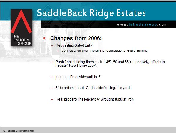
1 Department of Planning & Development Services S T A F F R E P O R T April 27, 2016 CASE NO: ZA PROJECT: REQUEST: Preliminary Plat for Saddleback Ridge Estates Spectra Land is requesting approval of a Preliminary Plat for Saddleback Ridge Estates on property described as Tracts 3, 4 and 4B, R.D. Rice Survey no. 992 and Lot 1, Block 1, Quail Oaks Addition and Tract 11, A. Robinson Survey no. 1131, an addition to the City of Southlake, Denton County, Texas and located at W Bob Jones Road and 4640 N White Chapel Boulevard, Southlake, Texas. Current Zoning: SF-1A Single Family Residential District. SPIN Neighborhood #1. Saddleback Ridge Estates was approved as a 32 lot SF-1A single family residential subdivision in June 2006 (Ordinance No ) Since that time, extensions to the Preliminary Plat (ZA06-030) have been approved by City Council nine times, and extensions to the Final Plat (ZA06-185) have been approved eight times. This Preliminary Plat varies from those approved for extension in that it proposes a private street as part of the plat. The previous plat was approved with a single public street providing access from W Bob Jones Road. The current plat carries over the overall layout of the 2006 plan, with 32 lots accessed by a single divided private street (Saddleback Lane). To address fire protection concerns relating to the proposed gated entry and proposed variance to cul-de-sac length (see next section), each home will be built with a sprinkler system. The gated entry feature is shown in attachment C. No guard house is initially planned by the developer, but space is allocated within the entry area for a future guard house. The perimeter of the development will be bounded by a 6 board on board cedar fence along the east and west sides with a 6 wrought tubular iron fence on the north (back) side of the property and a combination of dry stacked stone wall and brick pillars at the entry from W Bob Jones Road, with the remainder of the northern boundary enclosed with split rail fencing. These fence types replace the wrought iron fencing proposed with the previous plan. Within the development, a system of terraced walls will be installed to manage grade changes along the road. Other changes from the 2006 Preliminary Plat include the provision of a 5 sidewalk along both sides of Saddleback Lane, a tree conservation plan, and the provision of front platted setbacks which vary between 45 and 55 feet, depending on the lot (40 feet minimum is required in the SF-1A district). ZA
2 Proposed Preliminary Plat Zoning Land Use Designation Minimum Lot Size Maximum Density SF-1A Single Family Residential District Low Density Residential 1 acre 1 DU/acre Number of Proposed Lots 32 Number of Common Lots 4 (including street) Total Acreage Acreage of Residential Lots Gross Density Net Density of Residential Lots.76 DU/acre.92 DU/acre Existing Tree Canopy 34.4% Tree Canopy to Remain 60%-61.7% Variances Requested The original 2006 Preliminary Plat was approved with variances to allow a single point of access, cul-de-sac length in excess of maximum allowed length, and a cul-de-sac which serves in excess of 20 lots. The current submittal contains a request to allow a private street with Plat approval. Consideration of this variance cannot be applied to the previously-approved Preliminary Plat. Although the form of the plat proposed herein is substantially similar to the previously approved plat, it must be considered as a new application due to the proposal for a private street. Consequently, all variances previously granted with the 2006 application must again be requested and approved. The variances are summarized in the following requests: a. A variance from Ordinance 483, Section 5.01(C) to allow a single point of access. b. A variance from Section 5.03(I) to allow a cul-de-sac to serve more than 20 lots and exceed 1,000 feet. c. A variance from Section 5.03(J) to allow a street greater than 1,200 feet with no street stubs provided to adjoining properties. *Though they are part of City ordinance, these variances pertain to sections of the Subdivision Ordinance which allow for a certain level of discretion, with language containing should and generally rather than firm shall or must statements common in other section of Ordinance No In evaluating a variance from these sections, City Council is authorized to consider site context, topography, lot sizes, surrounding development and other factors in making a final determination of adequacy. ZA
3 d. A variance from Section 5.04(B), which does not permit private streets in new subdivisions in which fewer than 75% of the lots contain homeowner occupied structures, to allow the proposed street to be constructed as a private street. The variance request to allow a private street with Preliminary and Final Plat approval is more thoroughly analyzed in the Transportation Assessment found in Attachment A, along with considerations for variance from section 5.04(B). ACTION NEEDED: PZ ACTION: a) Conduct a public hearing b) Consider approval of Preliminary Plat At its April 7, 2016 meeting, the Planning and Zoning Commission voted 4-1 to deny the application. ATTACHMENTS: (A) Background Information (B) Vicinity Map (C) Plans and Support Information - Link to PowerPoint Presentation (D) Variance Exhibit (E) Review Summary No. 2 April 1, 2016 (F) Surrounding Property Owners Map and Responses (G) Full Size Plans (for Commission and Council Members Only) STAFF CONTACT: David Jones ( ) Ken Baker ( ) ZA
4 BACKGROUND INFORMATION OWNER: APPLICANT: PROPERTY SITUATION: LEGAL DESCRIPTION: LAND USE CATEGORY: CURRENT ZONING: REQUESTED ZONING: HISTORY: Spectra Land, LP Tom LaHoda, The LaHoda Group Constituent parcels are located at 330, 340, 350, and 360 W Bob Jones Rd and at 4640 N White Chapel Blvd Property described as Tracts 3, 4 and 4B, R.D. Rice Survey no. 992 and Lot 1, Block 1, Quail Oaks Addition and Tract 11, A. Robinson Survey no. 1131, City of Southlake, Denton County, Texas Low-Density Residential SF-1A Single-Family Residential District SF-1A Single-Family Residential District City Council approved a change of zoning from AG and RE to SF-1A on June 6, 2006 with an associated concept plan (ZA06-029). A Preliminary Plat (ZA06-030) was approved by City Council on June 6, A Final Plat (ZA06-185) was approved by the P& Z on January 18, A Preliminary Plat extension was approved until June 7, 2009 on January 15, A Final Plat extension was approved until January 19, 2009 on January 15, A Preliminary Plat extension was approved until June on November 18, A Final Plat extension was approved until January 19, 2010 on November 18, A Preliminary Plat extension was approved until June 7, 2011 on November 3, A Final Plat extension was approved until January 19, 2011 on November 3, A Preliminary Plat extension was approved until June 7, 2012 on January 4, A Final Plat extension was approved until January 19, 2012 on January 4, A Preliminary Plat extension was approved until June 7, 2013 on January 3, A Final Plat extension was approved until January 19, 2013 on January 3, A Preliminary Plat extension was approved until June 7, 2014 on January 15, A Final Plat extension was approved until January 19, 2014 on January 15, Attachment A ZA Page 1
5 A Preliminary Plat extension was approved until June 7, 2016 on January 20, A Final Plat extension was approved until January 19, 2016 on January 20, A Preliminary Plat extension was approved until June 7, 2017 on November 17, A Final Plat extension was approved until January 19, 2017 on November 17, CITIZEN INPUT: A SPIN Town Hall Forum was held February 9, The report can be found in Exhibit C. TRANSPORTATION ASSESSMENT: Sections 5.04 and 5.05 of the Subdivision Ordinance (Ordinance No. 483) regulate private streets such as the proposed Saddleback Lane. There is no provision in the Subdivision Ordinance for a residential street to be built as private; any such street must first be constructed to City standards and publically-dedicated until such time as 75% or more of the lots within the platted subdivision are owner-occupied ( 5.04A). At such time as 75% of lots within the platted subdivision are owner-occupied, a petition for previously-dedicated public streets to become private streets must be ratified by 100% of the owners within the subdivision for the street to become private. The City Council must then approve the change for the transfer to occur. The applicant requests a variance to allow initial construction of a private street (Saddleback Lane) with no dedication to the City, along with a variance from the requirement that 75% of lots within the subdivision be owner-occupied prior to petition for a private street. In its consideration of whether to grant an application for private streets, 5.04B requires the City Council to determine whether private streets would: 1. Negatively affect traffic circulation on public streets; 2. Impair access to or from properties of future developments either on-site or off-site to the subdivision; 3. Impair access to or from public facilities including schools or parks; 4. Delay the response time of emergency vehicles; 5. Replace streets shown on the adopted Thoroughfare Plan; 6. Impede or cross an existing or proposed street as shown on the City s Thoroughfare Plan or any approved Preliminary or Final Plats; 7. Disrupt an existing or proposed City public pedestrian pathway, hike and bike trail, equestrian trail, or park as shown on the City s most recent Park, Recreation and Open Space Master Plan or Trail System Master Plan; or 8. Negatively impact the continuity or sense of community in the City as a whole. The Thoroughfare Plan shows W Bob Jones Rd to be a 70 C2U Collector. An additional 30 feet of right of way for Bob Jones Rd is shown on the Preliminary Plat and will be dedicated with the Final Plat. Attachment A ZA Page 2


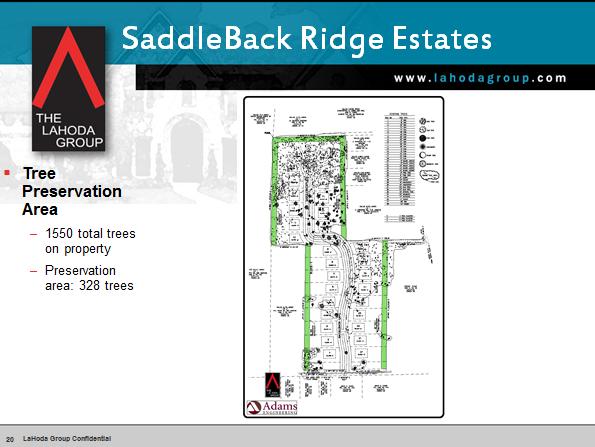
6 PATHWAYS MASTER PLAN: The Pathways Plan shows a future mixed use trail with a minimum 8 width running diagonally across the property between N White Chapel Blvd and W Bob Jones Road. The proposed plat indicates an 8 foot mixed use trail running across the south boundary of the property along Bob Jones Road 5 sidewalks are shown along Saddleback Lane within the development and will allow for public access from W Bob Jones Road. WATER & SEWER: Water: An 8 inch water line will be extended approximately 500 feet along the north boundary of W Bob Jones Road from an existing 12 inch water line at N White Chapel Blvd to the boundary of the property. An 8 inch water line will be extended into the subdivision along proposed Saddleback Lane. An 8 inch line will be looped back to the 12 inch line in N. White Chapel Boulevard about 1,200 feet into the subdivision. The 8 inch line will extend another 1000 feet as a dead end line with a fire hydrant at the terminus. Sanitary Sewer: Lots will be served by an 8 inch sanitary sewer line which will gravity flow to a lift station at the central eastern boundary of the subdivision and N White Chapel Boulevard. A 4 inch sanitary sewer force main will be extended from the lift station approximately 2,236 feet to the intersection of King Ranch Road and N White Chapel. Public Improvement Plans for Saddleback Ridge Estates were reviewed in conjunction with the rezoning to SF-1A (ZA06-029) and approved in To mitigate concerns with the longer cul-de-sac and gated entry, each home is proposed to be fitted with a sprinkler system. DRAINAGE ANALYSIS: TREE PRESERVATION: The southern 2/3 rd of the property drains to the east while the remaining 1/3 rd drains to the north onto Army Corps of Engineers property and ultimately to Grapevine Lake. Drainage from the Saddleback Ridge development will primarily drain to the proposed street and be piped to two on-site ponds on the east and west sides of the property. The previously-approved Preliminary and Final Plats were reviewed under Tree Preservation Ordinance No. 585-B. A 50 foot tree conservation area was shown around the perimeter of the property, but no other trees were proposed for conservation. Because the current proposal contains a major change from the original, it is now considered under Ordinance No. 585-D, which requires a tree survey and conservation plan. According to the applicant s survey, tree canopy coverage on the site is 34.4%. Under 585-D, the applicant is required to preserve at least 60% of the canopy. The applicant s Tree Conservation Plan preserves % of the existing canopy, with some trees shown as marginal. The highest concentration of existing and preserved trees lies within the northern portion of the property, which is designated as an area to be preserved on the City s 2015 Sustainability Master Plan (Ordinance No. 1104). Attachment A ZA Page 3
7 STAFF COMMENTS: Attached is Preliminary Plat Review #2, dated April 1, N:\Community Development\MEMO\2015 Cases\151 - PP - Saddleback Ridge Estates\Staff Report\CC Meeting\ZA Staff Report CC docx Attachment A ZA Page 4

8 Vicinity Map Attachment B ZA Page 1

9 Previously Approved Preliminary Plat Attachment C ZA Page 1

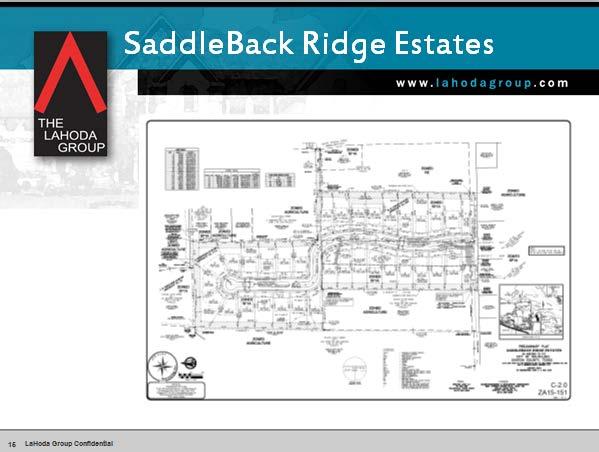
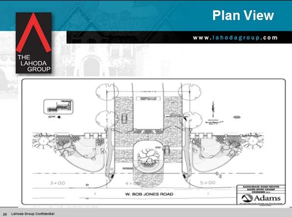
10 Proposed Preliminary Plat Attachment C ZA Page 2

11 Tree Conservation Plan Attachment C ZA Page 3

12 Property at existing Bob Jones Rd entrance Attachment C ZA Page 4

13 Attachment C ZA Page 5

14 Attachment C ZA Page 6

15 Attachment C ZA Page 7

16 Attachment C ZA Page 8
17 SPIN MEETING REPORT SPIN Item Number: SPIN Planning Case Number: ZA Project Name: Saddleback Ridge Estates SPIN Neighborhood: SPIN # 1 Meeting Date: February 9, 2016 Meeting Location: 1400 Main Street, Southlake, TX City Council Chambers Total Attendance: Thirty-five (35) Host: David Alexander, Community Engagement Committee Applicant(s) Presenting: Tom LaHoda, et al 3 City Staff Present: Lorrie Fletcher, Planner I City Staff Contact: David Jones, Principal Planner or djones@ci.southlake.tx.us Town Hall Forums can be viewed in their entirety by visiting and clicking on Learn More under Video On Demand; forums are listed under SPIN by meeting date. FORUM SUMMARY Property Situation: 32-one acre lots located at W. Bob Jones Rd. and 4640 N. White Chapel Blvd. Development Details: Saddleback Ridge Estates was approved as a 32-lot SF-1A single family residential subdivision in June Since that time, extensions to the Preliminary Plat and Final Plat have been approved multiple times in order to maintain their validity. The currently proposed Preliminary Plat varies from the previously approved in that it proposes a private street as part of the plat. The previous plat was approved with a single public street accessing from W Bob Jones Road. The current plan continues the overall layout of the 2006 plan, with 32 lots accessed by a single divided street with a gated entry feature. A guard house is not initially planned, but Attachment C ZA Page 9
 side of the property and a")
18 space is allocated within the entry area for a future guard house. The perimeter of the development will be bounded by a 6 board on board cedar fence along the east and west sides with a 6 wrought tubular iron fence on the north (back) side of the property and a combination of dry stacked stone wall and brick pillars at the entry from W Bob Jones Road, with the remainder of the northern boundary enclosed with split rail fencing. Average lot price estimated to be about $550,000 Exhibits presented at SPIN: Attachment C ZA Page 10
19 Attachment C ZA Page 11

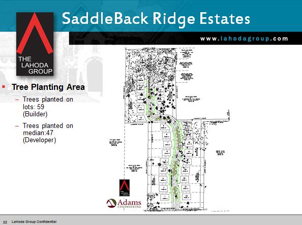
20 Attachment C ZA Page 12
21 Attachment C ZA Page 13

22 QUESTIONS / CONCERNS: I am concerned about the proposed City Land Use for 5-acre minimum lots. I have no issue with 1-acre development. It sounds like the 5-acre may get nixed or may reduce to 3. I don t want to see this changed everyone should be able to have 1 acre. What about drainage? o We have no plans to alter the previously approved drainage plan. We have a comprehensive master drainage plan that is over and above what the city required. Since the original SPIN meeting, property ownership has changed. You should reach out to folks that aren t here tonight. o I have sent s I will reach out again. Meeting adjourned 6:41 P.M. SPIN Meeting Reports are general observations of SPIN Meetings by City staff and SPIN Representatives. The report is neither verbatim nor official meeting minutes; rather it serves to inform elected and appointed officials, City staff, and the public of the issues and questions raised by residents and the general responses made. Responses as summarized in this report should not be taken as guarantees by the applicant. Interested parties are strongly encouraged to follow the case through the Planning and Zoning Commission and final action by City Council. Blackboard Connect Delivery Results for February 9, 2016 SPIN Meeting Attachment C ZA Page 14
23 Attachment C ZA Page 15
24 Attachment C ZA Page 16
25 Variance Exhibit Attachment D ZA Page 1
26 PLAT REVIEW SUMMARY : ZA Review No.: Two Date of Review: 04/01/16 Project Name: Preliminary Plat Saddleback Ridge Estates APPLICANT/OWNER: Tom LaHoda LEAD: Jimmy Fechter, PLA Spectra Land, LP Adams Engineering & Development Consultants PO Box Cypress Waters Boulevard Colleyville, Texas Dallas, Texas (817) (817) jimmy.fechter@adams-engineering.com CITY STAFF HAS REVIEWED THE ABOVE REFERENCED PROJECT RECEIVED BY THE CITY ON 03/21/16 AND WE OFFER THE FOLLOWING STIPULATIONS. THESE STIPULATIONS ARE HEREBY MADE CONDITIONS OF PRELIMINARY PLAT APPROVAL UNLESS SPECIFICALLY AMENDED BY THE CITY COUNCIL. IF YOU HAVE ANY QUESTIONS OR NEED FURTHER CLARIFICATION, PLEASE CONTACT THE APPROPRIATE STAFF MEMBER. David P. Jones, AICP djones@ci.southlake.tx.us Principal Planner Phone: (817) A Final Plat which conforms to the Preliminary Plat and underlying zoning district must be processed and recorded prior to conveyance of any lots or the issuance of any building permits. 2. The Southlake 2030 Pathways Master Plan adopted January 7, 2014 shows a future multi-use trail running diagonally across this property. A multi-use trail is intended to be no narrower than 8 in width. Staff recommends submitting an alternate plan which shows an access easement for the mixed-use trail to run across the property as shown. In lieu of an alternate plan, you must provide written justification for leaving the trail off of the proposed plat. 3. Private streets are only permitted in accordance with Ordinance No. 483, Section 5.04, which requires a street to be dedicated to the City unless and until 75% or more of the lots within the subdivision are owner-occupied. In order to build the private street as proposed, a variance is required which would allow a private street to be constructed prior to owner-occupancy of 75% or more of platted lots. The request for variance is confusingly worded and should request a variance from the requirement in Section 5.04 rather than in accordance with Section VARIANCE REQUESTED. 4. If the variance for private street is granted, the 110 private right of way (shown as lot 35) must be dedicated to a property or owners HOA as a Private Access, Emergency Access, Drainage and Utility Easement. 5. Amend sidewalk from 4 to 5. Attachment E ZA Page 1
27 Keith Martin Landscape Administrator Phone: (817) TREE CONSERVATION COMMENTS: Tree Conservation/Landscape Review 1. As on the previously approved plan, 50 Tree Preservation Buffers have been provided along the north, east, and west property boundary lines but existing trees are proposed to be removed within the Tree Preservation Buffers on Lots 11, 12, 27, and 28, for the construction of Detention/Retention ponds. The trees within designated tree preservation areas are required to be preserved during and after development of the property. 2. The hatching designating the Tree Preservation Buffer on Lots 27 and 28 is shown to be an additional 50 further into the lots. Unless an additional 50 of Tree Preservation Buffer is being proposed, keep the hatching consistent. 3. On the Tree Conservation Plan there is a note that references an SP Zoning Document for the tree preservation allowance. There is no SP Zoning Document to reference. * There is approximately 34.4% of existing tree cover on the site and 60% of that tree cover is required to be preserved. The applicant is proposing to preserve 61.7% of the existing tree cover and 1.7% of the tree cover is designated as marginal for removal. Except as provided by subsection 7.2.b. of the Tree Preservation Ordinance, a Tree Conservation Analysis or Tree Conservation Plan shall be approved if it will preserve existing tree cover in accordance with the percentage requirements established by Table 2.0. If the property has previously received a tree permit related to development, the percentage of existing tree cover at the time the first such permit was issued shall be used to calculate the minimum existing tree cover that must be preserved under this section. Table 2.0 Existing Tree Cover Preservation Requirements Percentage of existing tree cover on the entire site Minimum percentage of the existing tree cover to be preserved* 0% 20% 70% % 60% 40.1% - 60% 50% 60.1% - 80% 40% 80.1% - 100% 30% *The minimum percentage of existing tree cover to be preserved shall exclude any area in public rights-of-way as approved by City Council. * Please be aware that all existing trees shown to be preserved on the City Council approved Tree Conservation Plan must be preserved and protected during all phases and construction of the development. Alteration or removal of any of the existing trees shown to be preserved on the approved Tree Conservation Plan is a violation of the Tree Preservation Ordinance and the zoning as approved by the Southlake City Council. Please ensure that the layout of all structures, easements, utilities, structures grading, and any other structure proposed to be constructed do not conflict with existing trees intended to be preserved. Attachment E ZA Page 2
28 LANDSCAPE COMMENTS: 1. The previous council motion required that 4 inch caliper trees be provided on each lot, that the developer will provide 6 inch caliper trees within the Private Landscape Easement medians within the street right-of-way, and that Eastern Red Cedar were to be planted on the developing property adjacent to the southwest corner of Showtime Farms property (Lot 24 and Lot 25, Block 1). Please verify if these items are still proposed to be provided. * Indicates informational comment. # Indicates required items comment. Steven Anderson, P.E. Civil Engineer Phone: (817) sanderson@ci.southlake.tx.us Public Works/Engineering Review GENERAL COMMENTS: 1. New Requirement: Provide Stormwater Pollution Prevention Plan per TXR The plan must include all required elements in Part III, Section F of the permit. The City of Southlake especially reviews Part III, Section F, (1) (g), Maps. The review is for completeness of a plan to prevent pollution (especially sediment) to the Separate Storm Sewer System. It is highly recommended the project manager provide a series of maps for complex projects, including one map showing controls during mass grading and infrastructure, one map showing controls during vertical construction, and one map showing final stabilization (may be but not always equitable to the landscape plan). Please include timelines in relation to the project activities for installation and removal of controls. 2. NEW REQUIREMENT: Submit with Civil Construction Plans a Retaining Wall Layout sheet. 3. Retaining walls greater than 4-feet including the footing shall require structural plans prepared by a registered engineer in the State of Texas. Retaining walls shall require a permit from the Building Inspections Department prior to construction. 4. The sidewalk adjacent to the 100 L.F. Masonry Wall is somewhat irregular. Staff suggests the sidewalk meander in to the right of way towards back-of-curb in a more fluid fashion as opposed to a 90º angle. Sidewalk along back-of-curb shall be 5 feet wide. * A geotechnical report will be required for all private and public roadways. The geotechnical report shall include pavement design parameters for subgrade stabilization. * A Developer Agreement may be required for this development and may need to be approved by the City Council prior to any construction of public infrastructure. Construction plans for these improvements must be acceptable to Public Works prior to placing the Developer s Agreement on the City Council agenda for consideration. Attachment E ZA Page 3
29 * Any hazardous waste being discharged must be pretreated per Ordinance No * Public improvement plans were reviewed and approved in *=Denotes informational comment. Kelly Clements Assistant Fire Marshal Phone: (817) kclements@ci.southlake.tx.us GENERAL COMMENTS: Fire Department Review 1. Street name needs to be approved by the city prior to final plat. Submit proposed name and alternate name as soon as possible. 2. Developments of single family dwellings where the number of dwelling units exceeds 30 shall be provided with two separate and approved fire apparatus access roads. (Unless all dwelling units are equipped throughout with an approved automatic sprinkler system) 3. The gated entry, if approved, must be equipped with an Opticom or KS-2 switch for opening the gate electronically, as well as a means for manual opening. 4. Fire apparatus access needs to be designed and maintained to support the imposed loads of fire apparatus (A minimum of 85,000 lbs GVW). Fire access roads must be at least 31 ft. back of curb to back of curb. (Standard street width) (Plans do not indicate appropriate street widths; appear to be 24 feet wide) General Informational Comments * All sidewalks within a private lot or open space area need to be placed in a pedestrian access easement. * No review of proposed signs is intended with this site plan. A separate building permit is required prior to construction of any signs. * All mechanical equipment must be screened of view from right-of-ways and residential properties in accordance with the Zoning Ordinance No. 480, as amended. * All lighting must comply with the Lighting Ordinance No. 693, as amended. * All development must comply with the Drainage Ordinance No. 605 and the Erosion and Sediment Control Ordinance No. 946, as amended. * The applicant should be aware that prior to issuance of a building permit a Plat must be processed and filed in the County Plat Records, a fully corrected site plan, landscape plan, irrigation plan, and building plans, must be submitted for approval and all required fees must be paid. This may include but not be limited to the following fees: Park Fee, Perimeter Street Fee, Water & Sewer Impact and Tap Fees, and related Permit Fees. * Denotes Informational Comment Attachment E ZA Page 4

30 Surrounding Property Owners SPO # Owner Zoning Land Use Acreage Response 1. BASHIR, KAMRAN & MARLA SF1-A 4488 SODA RIDGE RD NR 2. BASHIR, KAMRAN & MARLA SF1-A 4488 SODA RIDGE RD NR 3. BOWER, KEVIN R SF1-A PO BOX NR 4. CARNEY, TOM P SF1-A 4492 SODA RIDGE RD NR Attachment F ZA Page 1
31 5. EMERY, MARTIN & MINDY K SF1-A 4527 N WHITE CHAPEL BLVD NR 6. EMMER, DANIEL P SF1-A 345 W BOB JONES RD F 7. EVANS, MARZELL F TR AG 9426 BRADDOCK RD NR 8. FLYNT, JASON & LINDSAY SF1-A 4440 N WHITE CHAPEL BLVD NR 9. JONES, ANDREW & KENLYN SF1-A 4680 N WHITE CHAPEL BLVD NR 10. LAMON, CHRISTOPHER R & JANE AG 4720 N WHITE CHAPEL BLVD NR 11. LAMON, CHRISTOPHER R & JANE SF1-A 4720 N WHITE CHAPEL BLVD NR 12. LEGACY LIMITED, LLC RE TH ST NR 13. LEGACY LIMITED, LLC AG TH ST NR 14. MAHONE, MATTHEW & LEIGH ANNE SF1-A 4000 N WHITE CHAPEL BLVD NR 15. MILANI, JOHN C & CHRISTEN AG 500 W BOB JONES RD NR 16. REISING, MAX AG 7007 LISMORE CT NR 17. ROBINSON, RALPH & WILMA AG CANDLEBROOK DR NR 18. ROBINSON, RALPH & WILMA AG CANDLEBROOK DR NR 19. SHOWTIME FARMS INC AG 4500 N WHITE CHAPEL BLVD U 20. SPECTRA LAND LP SF1-A PO BOX NR 21. SPECTRA LAND LP SF1-A PO BOX NR 22. SPECTRA LAND LP SF1-A PO BOX NR 23. SPECTRA LAND LP SF1-A PO BOX NR 24. SPECTRA LAND LP SF1-A PO BOX NR 25. WHITE, THOMAS W AG 600 W BOB JONES RD O 26. Superintendent of Carroll ISD NR 27. Superintendent of Grapevine NR Colleyville ISD 28. Superintendent of Northwest ISD NR 29. Superintendent of Keller ISD NR Responses: F: In Favor O: Opposed To U: Undecided NR: No Response Notices Sent: Twenty-one (21) Surrounding Property Owner Responses Responses Received: In favor: One (1) Opposed: One (1) Undecided: One (1) Attachment F ZA Page 2
32 Attachment F ZA Page 3

33 Attachment F ZA Page 4

34 Attachment F ZA Page 5
Department of Planning & Development Services
 Department of Planning & Development Services S T A F F R E P O R T February 9, 2015 CASE NO: PROJECT: EXECUTIVE SUMMARY: ZA14-154 Plat Revision for Lots 25R-1A, 25R-1B and 25R-1C, Block 1, Woodland Heights
Department of Planning & Development Services
 Department of Planning & Development Services S T A F F R E P O R T CASE NO: ZA15-116 November 10, 2015 PROJECT: Preliminary Plat for Kingdom Place EXECUTIVE SUMMARY: REQUEST DETAILS: DeOtte Inc. is requesting
Department of Planning & Development Services
 Department of Planning & Development Services S T A F F R E P O R T November 14, 2014 CASE NO: ZA14-132 PROJECT: Preliminary Plat for Edwards Park Addition Lots 1 and 2 EXECUTIVE SUMMARY: Clayton and Clayton
Department of Planning & Development Services
 Department of Planning & Development Services S T A F F R E P O R T May 16, 2014 CASE NO: PROJECT: EXECUTIVE SUMMARY: DETAILS: ZA14-047 Zoning Change and Development Plan for Fusella Property Four Peaks-RM,
Department of Planning & Development Services
 Department of Planning & Development Services S T A F F R E P O R T May 13, 2016 CASE NO: PROJECT: EXECUTIVE SUMMARY: DETAILS: ZA16-029 Zoning Change and Development Plan for the Carillon Corporate District
Department of Planning & Development Services
 Department of Planning & Development Services S T A F F R E P O R T December 30, 2015 CASE NO: PROJECT: EXECUTIVE SUMMARY: REQUEST DETAILS: ZA15-136 Site Plan for Ward Retail Building On behalf of Donnie
Department of Planning & Development Services
 Department of Planning & Development Services S T A F F R E P O R T June 9, 2015 CASE NO: ZA15-048 PROJECT: Preliminary Plat for Southlake Town Square Phase IV (Granite Place) EXECUTIVE SUMMARY: Cooper
Department of Planning & Development Services
 Department of Planning & Development Services S T A F F R E P O R T April 17, 2014 CASE NO: PROJECT: EXECUTIVE SUMMARY: DETAILS: ZA14-038 Site Plan for Abundant Grace Church Abundant Grace Church is requesting
Department of Planning & Development Services
 Department of Planning & Development Services S T A F F R E P O R T CASE NO: ZA15-042 May 29, 2015 PROJECT: Preliminary Plat for Moss Farms EXECUTIVE SUMMARY: REQUEST DETAILS: Horton Capital Partners is
M E M O R A N D U M. Planning and Zoning Commission. Daniel Turner, Planner I
 M E M O R A N D U M Meeting Date: Monday, April 10, 2017 Item No. F-4 To: From: Planning and Zoning Commission Daniel Turner, Planner I Subject: Consider a recommendation of a Preliminary Site Evaluation
Department of Planning & Development Services
 Department of Planning & Development Services STAFF REPORT March 14, 2014 CASE NO: PROJECT: EXECUTIVE SUMMARY: REQUEST: ZA13-137 Zoning Change and Site Plan for Feedstore BBQ William Lafavers, owner of
Department of Planning & Development Services
 Department of Planning & Development Services S T A F F R E P O R T December 30, 2015 CASE NO: PROJECT: REQUEST: DETAILS: ZA15-134 Preliminary Plat for Lots 2R1 & 2R2 H. Granberry No. 581 Addition (Option
Staff Report to the North Ogden Planning Commission
 Staff Report to the North Ogden Planning Commission SYNOPSIS / APPLICATION INFORMATION Application Request: Consideration and action on an administrative application for final approval for the Legacy North
Department of Planning & Development Services
 Department of Planning & Development Services S T A F F R E P O R T August 29, 2014 CASE NO: PROJECT: EXECUTIVE SUMMARY: DETAILS: ZA14-102 Zoning Change and Development Plan for the Carillon Corporate
Staff Report to the North Ogden City Council
 Staff Report to the North Ogden City Council SYNOPSIS / APPLICATION INFORMATION Application Request: Consideration and action on an administrative application to provide comments on the preliminary plan
Department of Planning & Development Services
 Department of Planning & Development Services S T A F F R E P O R T December 30, 2015 CASE NO: PROJECT: EXECUTIVE SUMMARY: REQUEST DETAILS: ZA15-136 Site Plan for Ward Retail Building On behalf of Donnie
M E M O R A N D U M. Planning and Zoning Commission. Daniel Turner, Planner I
 M E M O R A N D U M Meeting Date: April 27, 2015 Item No. E-1 To: From: Planning and Zoning Commission Daniel Turner, Planner I Subject: Consider approval of a Final Plat for Gean Estates, Phase I, a proposed
Department of Planning & Development Services
 Department of Planning & Development Services S T A F F R E P O R T October 27, 2015 CASE NO: PROJECT: EXECUTIVE SUMMARY: REQUEST DETAILS: ZA15-104 Zoning Change and Site Plan for Lowe s On behalf of Lowe
Department of Planning & Development Services
 Department of Planning & Development Services S T A F F R E P O R T July 11, 2014 CASE NO: PROJECT: EXECUTIVE SUMMARY: DETAILS: ZA14-070 Southlake Professional Park On behalf of Bootstrap Investments,
City of Colleyville City Council Agenda Briefing
 City of Colleyville City Council Agenda Briefing City Hall 100 Main Street Colleyville, Texas 76034 www.colleyville.com Agenda Number 5a Agenda Date 01/06/2015 Number Ordinance O-14-1942 Type Ordinance
Department of Planning & Development Services
 Department of Planning & Development Services S T A F F R E P O R T April 28, 2015 CASE NO: PROJECT: EXECUTIVE SUMMARY: REQUEST DETAILS: ZA14-131 Zoning Change and Development Plan for Edwards Park Addition
Department of Planning & Development Services
 Department of Planning & Development Services S T A F F R E P O R T December 10, 2013 CASE NO: PROJECT: EXECUTIVE SUMMARY: DETAILS: ZA13-126 Zoning Change and Concept Plan for Chesapeake Place Addition
City of Cedar Hill Gated Community, Private Street Development Guide
 City of Cedar Hill Gated Community, Private Street Development Guide Definitions: Private Street - A private vehicular access way shared by and serving two or more lots, which is not dedicated to the public
Exhibit A-1. Piney Creek Bend Planned Development
 Exhibit A-1 Piney Creek Bend Planned Development A. Purpose and Intent The Piney Creek Bend PD is composed of approximately 90.91 acres, as described in Exhibit D (Field Notes). The development of this
Department of Planning & Development Services
 Department of Planning & Development Services S T A F F R E P O R T November 13, 2013 CASE NO: PROJECT: EXECUTIVE SUMMARY: DETAILS: ACTION NEEDED: ZA13-128 Zoning Change and Site Plan for Kimball Lake
Condominium Unit Requirements.
 ARTICLE 19 CONDOMINIUM REGULATIONS Section 19.01 Purpose. The purpose of this Article is to regulate projects that divide real property under a contractual arrangement known as a condominium. New and conversion
9. REZONING NO Vicinity of the northwest corner of 143 rd Street and Metcalf Avenue
 9. REZONING NO. 2002-15 Vicinity of the northwest corner of 143 rd Street and Metcalf Avenue 1. APPLICANT: Andrew Schlagel is the applicant for this request. 2. REQUESTED ACTION: The applicant is requesting
ARTICLE IX.1. PRIVATE STREETS
 ARTICLE IX.1 PRIVATE STREETS PAGE 43 ARTICLE IX.1. PRIVATE STREETS SECTION A. GATED COMMUNITIES. (Entire Article Established by Ord. 2524, 06/06/00) 1. Residential subdivisions may be developed with private
WRITTEN DECISION OF THE HAYDEN CITY COUNCIL REGARDING MAPLE GROVE PRELIMINARY SUBDIVISION APPLICATION (SUB-0013) HAYDEN SIGNATURE, LLC
 HAYDEN SIGNATURE, LLC") WRITTEN DECISION OF THE HAYDEN CITY COUNCIL REGARDING MAPLE GROVE PRELIMINARY SUBDIVISION APPLICATION (SUB-0013) HAYDEN SIGNATURE, LLC Application of Hayden Signature, LLC, an Idaho limited liability company,
WRITTEN DECISION OF THE HAYDEN CITY COUNCIL REGARDING MAPLE GROVE PRELIMINARY SUBDIVISION APPLICATION (SUB-0013) HAYDEN SIGNATURE, LLC Application of Hayden Signature, LLC, an Idaho limited liability company,
LINCOLN COUNTY PLANNING & INSPECTIONS DEPARTMENT
 LINCOLN COUNTY PLANNING & INSPECTIONS DEPARTMENT 30 NORTH ACADEMY STREET, SUITE A, LINCOLNTON, NORTH CAROLINA 809 704-736-8440 OFFICE 704-736-8434 INSPECTION REQUEST LINE 704-73-900 FAX To: Board of Commissioners
August 13, ZA CASE NO: EXECUTIVEE. District to. Neighborhoo. d #3. DETAILS: (ZA14-045) (CP14-002). Plat Showing. largerr in size.
 (CP14-002). Plat Showing. largerr in size.") Department of Planning & Development Services S T A F F R E P O R T August 13, 20144 CASE NO: ZA14-044 PROJECT: Zoning Change and Concept Plan for 2101 N. Carroll Avenue EXECUTIVEE SUMMARY: K.M. Properties,
Department of Planning & Development Services S T A F F R E P O R T August 13, 20144 CASE NO: ZA14-044 PROJECT: Zoning Change and Concept Plan for 2101 N. Carroll Avenue EXECUTIVEE SUMMARY: K.M. Properties,
Section Preliminary Plat Checklist and Application Forms
 Section 201 - Preliminary Plat Checklist and Application Forms PRELIMINARY SUBDIVISION PLAT REVIEW PROCESS CHART PRELIMINARY SUBDIVISION PLAT APPLICATION PRELIMINARY PLAT REVIEW CHECKLIST CITY OF NAMPA
RECOMMENDATION Following the public hearing, consider Zoning Case PD14-16, with a Development Plan.
 Staff Report Zoning Case PD14-16 (Helzer Tract) Planning and Zoning Meeting Date: 12-17-14 Document Being Considered: Ordinance RECOMMENDATION Following the public hearing, consider Zoning Case PD14-16,
Development Plan DP13-3 (Arlington Lofts) Planning and Zoning Meeting Date: Document Being Considered: Ordinance
 Planning and Zoning Meeting Date: Document Being Considered: Ordinance") Staff Report Development Plan DP13-3 (Arlington Lofts) Planning and Zoning Meeting Date: 6-19-13 Document Being Considered: Ordinance RECOMMENDATION Following the public hearing, consider Development Plan
Staff Report Development Plan DP13-3 (Arlington Lofts) Planning and Zoning Meeting Date: 6-19-13 Document Being Considered: Ordinance RECOMMENDATION Following the public hearing, consider Development Plan
Residential Major Subdivision Review Checklist
 Residential Major Subdivision Review Checklist Plan Submittal Requirements: 2 full sets of stamped plans Electric submittal - all plans contained in a single PDF 3 full sets if commercial kitchen or dining
SUBDIVISION APPLICATION
 SUBDIVISION APPLICATION Preliminary Plat Minor Plat Final Plat Amended Plat Applicant Name: Owner (if different from applicant) Name: Company: Company: Address: Address: City, State, Zip City, State, Zip
Town of Cary, North Carolina Rezoning Staff Report 14-REZ-31 Cary Park PDD Amendment (Waterford II) Town Council Meeting January 15, 2015
 Town Council Meeting January 15, 2015") Town of Cary, North Carolina Rezoning Staff Report 14-REZ-31 Cary Park PDD Amendment (Waterford II) Town Council Meeting January 15, 2015 REQUEST To amend the Town of Cary Official Zoning Map by amending
Town of Cary, North Carolina Rezoning Staff Report 14-REZ-31 Cary Park PDD Amendment (Waterford II) Town Council Meeting January 15, 2015 REQUEST To amend the Town of Cary Official Zoning Map by amending
Initial Subdivision Applications Shall Include the Following:
 Initial Subdivision Applications Shall Include the Following: 1) Subdivision Application Form: completely filled out (12 copies) 2) Plat: The Plat must adhere to the requirements set forth in the Town
SUBJECT PARCEL(S) Property Owner(s) TMS Number Approximate Acreage Carolina Park Development, LLC
 Property Owner(s) TMS Number Approximate Acreage Carolina Park Development, LLC") Staff Report Special Planning Commission Meeting November 19, 2014 For reference, the Zoning Code and Land Development Regulations are available online. AGENDA ITEM 5c. SKETCH PLAN APPROVAL REQUEST: Request
Staff Report Special Planning Commission Meeting November 19, 2014 For reference, the Zoning Code and Land Development Regulations are available online. AGENDA ITEM 5c. SKETCH PLAN APPROVAL REQUEST: Request
a. provide for the continuation of collector streets and thoroughfare streets between adjacent subdivisions;
 Section 7.07. Intent The requirements of this Section are intended to provide for the orderly growth of the Town of Holly Springs and its extra-territorial jurisdiction by establishing guidelines for:
ARTICLE IV: DEVELOPMENT STANDARDS
 ARTICLE IV: DEVELOPMENT STANDARDS IV-53 409 PRIVATE STREETS A private street means any way that provides ingress to, or egress from, property by means of vehicles or other means, or that provides travel
Department of Planning & Development Services
 Department of Planning & Development Services S T A F F R E P O R T May 13, 2016 CASE NO: PROJECT: EXECUTIVE SUMMARY: REQUEST DETAILS: ZA16-008 Zoning Change and Site Plan for KLA School On behalf of Mani
SPECIAL ZONING DISTRICTS
 SPECIAL ZONING DISTRICTS 5.01 5.99 RESERVED 5.100 PLANNED DEVELOPMENTS: Purpose: This district is intended to accommodate unified design of residential, commercial, office, professional services, retail
Residential Minor Subdivision Review Checklist
 Residential Minor Subdivision Review Checklist Plan Submittal Requirements: 2 full sets of stamped plans Electric submittal - all plans contained in a single PDF 3 full sets if commercial kitchen or dining
Community Development Department 333 Broadalbin Street SW, P.O. Box 490 Albany, OR 97321
 SUMMARY Community Development Department 333 Broadalbin Street SW, P.O. Box 490 Albany, OR 97321 STAFF REPORT Application for Tentative Partition Plat Review Planning File PA-06-17 Phone: 541-917-7550
REPORT TO THE PLANNING COMMISSION
 Agenda Number: PC14-50 MEETING DATE: February 5, 2015 REPORT TO THE PLANNING COMMISSION SUBJECT: Villas of Tara Oaks Request approval of a Preliminary Subdivision Plat for 29 lots, on 9.14 acres located
PUD 42 - Warner Ranch PUD - Amend. 2 Item No. 4B ZONING ZON
 PUD 42 - Warner Ranch PUD - Amend. 2 Item No. 4B ZONING ZON1210-001 CASE PLANNER: Steve Hopkins REQUEST: Approval of PUD 42 - Warner Ranch PUD - Amend. 2 ZONING AT TIME OF APPLICATION: PUD 42 CURRENT USE
Planned Residential Development ( PRD ) Application
 Application") FOR PLANNING USE ONLY Application # PRD Application Fee $ Receipt No. Filing Date Completeness Date Planned Residential Development ( PRD ) Application A. PROJECT INFORMATION 1. Project Name: 2. Address
FOR PLANNING USE ONLY Application # PRD Application Fee $ Receipt No. Filing Date Completeness Date Planned Residential Development ( PRD ) Application A. PROJECT INFORMATION 1. Project Name: 2. Address
ARTICLE 24 SITE PLAN REVIEW
 ARTICLE 24 SITE PLAN REVIEW 24.1 PURPOSE: The intent of these Ordinance provisions is to provide for consultation and cooperation between the land developer and the Township Planning Commission in order
Staff Report: Date: Applicant: Property Identification: Acreage of Request: Current Zoning of Requested Area: Requested Action: Attached:
 Staff Report: Completed by Jeff Palmer Director of Planning & Zoning Date: November 7, 2018, Updated November 20, 2018 Applicant: Greg Smith, Oberer Land Developer agent for Ronald Montgomery ET AL Property
Department of Planning & Development Services
 Department of Planning & Development Services S T A F F R E P O R T August 27, 2014 CASE NO: ZA14-029 PROJECT: Zoning Change and Site Plan for Lots 5R1, 5R2 and 4, T. Easter No. 474 Addition EXECUTIVE
CITY OF FERNDALE HEARING EXAMINER
 CITY OF FERNDALE HEARING EXAMINER RE: Planned Unit Development ) 16001-PUD Preliminary Plat ) 16018-SE Plat Variance ) 16002-VAR Application by ) ) MD General, L.L.C. ) FINDINGS OF FACT, Malloy Heights
Planning Department st Avenue East Kalispell, MT Phone: (406) Fax: (406)
 Fax: (406)") Planning Department 201 1 st Avenue East Kalispell, MT 59901 Phone: (406) 758-7940 Fax: (406) 758-7739 www.kalispell.com/planning April 1, 2015 Doug Russell, City Manager City of Kalispell 201 1 st Ave
Planning Department 201 1 st Avenue East Kalispell, MT 59901 Phone: (406) 758-7940 Fax: (406) 758-7739 www.kalispell.com/planning April 1, 2015 Doug Russell, City Manager City of Kalispell 201 1 st Ave
STAFF REPORT FOR MAJOR SUBDIVISION
 STAFF REPORT FOR MAJOR SUBDIVISION FINAL PLAT CASE NO. FA-14-001 HEARING DATE: January 6, 2016 CASE NAME: Solterra Subdivision Filing No. 16 PROCEDURE: Planning Commission ADDRESS OF MAJOR SUBDIVISION
Department of Planning & Development Services
 Department of Planning & Development Services S T A F F R E P O R T May 10, 2016 CASE NO: PROJECT: EXECUTIVE SUMMARY: REQUEST DETAILS: ZA16-015 Zoning Change and Concept Plan / Site Plan for St. Laurence
ARTICLE 13 CONDOMINIUM REGULATIONS
 ARTICLE 13 CONDOMINIUM REGULATIONS Section 13.01 Purpose. The purpose of this Article is to regulate projects that divide real property under a contractual arrangement known as a condominium. New and conversion
Department of Planning & Development Services
 Department of Planning & Development Services STAFF REPORT January 13, 2015 CASE NO: PROJECT: EXECUTIVE SUMMARY: REQUEST: ZA14-140 Specific Use Permit to Allow a Tent for the Purpose of Promoting Retail
ARTICLE XVII SCHEDULE OF REGULATIONS
 ARTICLE XVII SCHEDULE OF REGULATIONS SECTION 1700. LIMITING HEIGHT, BULK, DENSITY, AND AREA BY DISTRICT TYPE Use Minimum Size Lot Per Unit Maximum Height of Structures Minimum Yard Setback (Per Lot in
MINUTES PLANNING AND ZONING COMMISSION FEBRUARY 9, 2016 REGULAR MEETING
 MINUTES PLANNING AND ZONING COMMISSION FEBRUARY 9, 2016 REGULAR MEETING The Planning and Zoning Commission conducted its February 9, 2016, Regular Meeting in the Council Chambers of City Hall (1900 Billy
PRIMUS TRACT MOUNT PLEASANT, SOUTH CAROLINA
 DEVELOPMENT GUIDELINES FOR PRIMUS TRACT MOUNT PLEASANT, SOUTH CAROLINA Date February 18, 2015 PLANNING COMMISSION SUBMITTAL Owner/Developer: American Star Development SC, LLC P.O. Box 211 Sullivans Island,
STAFF REPORT FOR MAJOR SUBDIVISION
 STAFF REPORT FOR MAJOR SUBDIVISION FINAL PLAT CASE NO. FA-13-001 HEARING DATE: November 6, 2013 CASE NAME: Solterra Subdivision Filing No. 14 PROCEDURE: Planning Commission ADDRESS OF MAJOR SUBDIVISION
ELK RAPIDS TOWNSHIP ANTRIM COUNTY, MICHIGAN ORDINANCE NO
 ELK RAPIDS TOWNSHIP ANTRIM COUNTY, MICHIGAN ORDINANCE NO. 3-2011 AN ORDINANCE TO REPLACE THE SUBDIVISION CONTROL ORDINANCE WITH A NEW SUBDIVISION DEVELOPMENT ORDINANCE, IN ACCORD WITH THE LAND DIVISION
ARTICLE 143. PD 143.
 ARTICLE 143. PD 143. SEC. 51P-143.101. LEGISLATIVE HISTORY. PD 143 was established by Ordinance No. 17685, passed by the Dallas City Council on February 2, 1983. Ordinance No. 17685 amended Ordinance No.
Department of Planning & Development Services
 Department of Planning & Development Services S T A F F R E P O R T May 31, 2016 CASE NO: PROJECT: EXECUTIVE SUMMARY: REQUEST DETAILS: ZA16-008 Zoning Change and Site Plan for KLA School On behalf of Mani
STAFF REPORT FOR MAJOR SUBDIVISION
 STAFF REPORT FOR MAJOR SUBDIVISION FINAL PLAT CASE NO. FA-12-003 HEARING DATE: November 6, 2013 CASE NAME: Solterra Subdivision Filing No. 13 PROCEDURE: Planning Commission ADDRESS OF MAJOR SUBDIVISION
Re: Case # ZP Preplanning Application for 8 townhomes at 1526 Ingalls Street in Lakewood, CO.
 Planning Department Civic Center North 480 South Allison Parkway Lakewood, Colorado 80226-3127 303.987.7505 303.987.7057 TTY/TDD Lakewood.org/Planning February 27, 2017 Nathan Taylor 601 S Jason Street
CHECKLIST FOR DEVELOPMENT REVIEW
 CHECKLIST FOR DEVELOPMENT REVIEW Petitions and related documents and plans for land development or other proposals regulated by Title 16 of the Municipal Code (Development Ordinance) and Title 17 of the
CITY OF OCOEE LAND DEVELOPMENT CODE SUFFICIENCY TABLE WITH NOTES
 CITY OF OCOEE LAND DEVELOPMENT CODE SUFFICIENCY TABLE WITH NOTES The Sufficiency Table is a checklist to help identify the types of information and documentation needed for various types of projects. The
Cover Letter with Narrative Statement
 Cover Letter with Narrative Statement March 31, 2017 rev July 27, 2017 RE: Rushton Pointe Residential Planned Unit Development Application for Public Hearing for RPUD Rezone PL2015 000 0306 Mr. Eric Johnson,
SECTION 4: PRELIMINARY PLAT
 SECTION 4: PRELIMINARY PLAT After the completion of the sketch plan process, if submitted, the owner or developer shall file with the City an application for preliminary plat. The preliminary plat stage
THE AREA PLAN COMMISSION OF ST. JOSEPH COUNTY, IN AGENDA
 THE AREA PLAN COMMISSION OF ST. JOSEPH COUNTY, IN AGENDA Tuesday, June 20, 2017 Fourth-Floor Council Chambers 3:30 p.m. County-City Building, South Bend, IN PUBLIC HEARINGS: 1. Rezonings: A. A combined
M E M O R A N D U M. Meeting Date: April 19, Item No. H-2. Mark Hafner, City Manager. Michele Berry, Planner II
 M E M O R A N D U M Meeting Date: April 19, 2016 Item No. H-2 To: From: Subject: Mark Hafner, City Manager Michele Berry, Planner II PUBLIC HEARING: Consider an ordinance approving a Specific Use Permit
O-I (Office-Institutional) and AG-1(Agricultural)
 and AG-1(Agricultural)") PROPERTY INFORMATION ADDRESS 3503 and 3505 Bethany Bend DISTRICT, LAND LOTS 2/1 973 and 974 OVERLAY DISTRICT State Route 9 PETITION NUMBERS EXISTING ZONING O-I (Office-Institutional) and AG-1(Agricultural)
PROPERTY INFORMATION ADDRESS 3503 and 3505 Bethany Bend DISTRICT, LAND LOTS 2/1 973 and 974 OVERLAY DISTRICT State Route 9 PETITION NUMBERS EXISTING ZONING O-I (Office-Institutional) and AG-1(Agricultural)
EXHIBIT D. Planned Unit Development Written Description April 13, 2016 Rouen Cove Phase II PUD
 1 EXHIBIT D Planned Unit Development Written Description April 13, 2016 Rouen Cove Phase II PUD Development # 8986.001 Developer: Curtis L. Hart Hart Resources LLC 8051 Tara Lane Jacksonville, Florida
M E M O R A N D U M. Meeting Date: October 23, Item No. F-1. Planning and Zoning Commission. Daniel Turner, Planner I
 M E M O R A N D U M Meeting Date: October 23, 2017 Item No. F-1 To: From: Subject: Planning and Zoning Commission Daniel Turner, Planner I PUBLIC HEARING: Consider a recommendation of a of Planned Development
Town of Windham. Planning Department 8 School Road Windham, ME voice fax
 Town of Windham Planning Department 8 School Road Windham, ME 04062 voice 207.894.5960 fax 207.892.1916 MEMO DATE: September 3, 2013 TO: Tony Plante, Town Manager FROM: Ben Smith, Assistant Town Planner
SUBDIVISION APPLICATION CHECKLIST SKETCH PLAN PRELIMINARY PLAT FINAL PLAT
 RECEIVED STAMP SUBDIVISION APPLICATION CHECKLIST SKETCH PLAN PRELIMINARY PLAT FINAL PLAT A checklist of background information and submission requirements for processing of a sketch plan, preliminary plat
Department of Planning & Development Services
 Department of Planning & Development Services S T A F F R E P O R T January 14, 2015 CASE NO: PROJECT: EXECUTIVE SUMMARY: REQUEST DETAILS: ZA14-131 Zoning Change and Concept Plan for Edwards Park Addition
APPLICATION PROCESS FOR PROJECT REVIEW
 APPLICATION PROCESS FOR PROJECT REVIEW 290 NORTH 100 WEST, LOGAN UT 84321 PHONE (435) 716-9021 FAX (435) 716-9001 www.loganutah.org THE PROJECT REVIEW PROCESS The application must be complete and submitted
Planned Unit Development (PUD). Sections:
. Sections:") Chapter 19.07. Planned Unit Development (PUD). Sections: 19.07.01. Purpose. 19.07.02. PUD Definition and Design Compatibility. 19.07.03. General PUD Standards. 19.07.04. Underlying Zones. 19.07.05. Permitted
Chapter 19.07. Planned Unit Development (PUD). Sections: 19.07.01. Purpose. 19.07.02. PUD Definition and Design Compatibility. 19.07.03. General PUD Standards. 19.07.04. Underlying Zones. 19.07.05. Permitted
Rapid City Planning Commission
 Rapid City Planning Commission Initial Planned Development Overlay Project Report March 9, 2017 Item #15 Applicant Request(s) Case # 17PD007 Initial Planned Development Overlay to allow a residential development
Division Development Impact Review.
 Division 51-4.800. Development Impact Review. SEC. 51-4.801. PURPOSE. The general objectives of this division are to promote and protect the health, safety, and general welfare of the public through the
City of Nogales Planning & Zoning Commission Rezoning Application
 City of Nogales Planning & Zoning Commission Rezoning Application REZONING APPLICATION PROCEDURES 1450 N. Hohokam Nogales, Arizona 85621 Office (520) 285-5747 FAX (520) 287-6946 T.D.D. (520) The following
(a) Commercial uses on Laurel Avenue, abutting the TRO District to the
 Commercial uses on Laurel Avenue, abutting the TRO District to the") 32X Zoning Code 150.36 TRANSITIONAL RESIDENTIAL OVERLAY DISTRICT. (A) Intent and purpose. (1) It is the intent of the Transitional Residential Overlay District (hereinafter referred to as the "TRO District")
32X Zoning Code 150.36 TRANSITIONAL RESIDENTIAL OVERLAY DISTRICT. (A) Intent and purpose. (1) It is the intent of the Transitional Residential Overlay District (hereinafter referred to as the "TRO District")
Request Conditional Rezoning (AG-1 & AG-2 Agricultural to Conditional R-10 Residential) Staff Recommendation Deferral. Staff Planner Jimmy McNamara
 Staff Recommendation Deferral. Staff Planner Jimmy McNamara") Applicants & Property Owners Public Hearing May 9, 2018 (Deferred by Planning Commission, 12/13/17) City Council Election District Princess Anne Agenda Item D2 Request Conditional Rezoning (AG-1 & AG-2
Applicants & Property Owners Public Hearing May 9, 2018 (Deferred by Planning Commission, 12/13/17) City Council Election District Princess Anne Agenda Item D2 Request Conditional Rezoning (AG-1 & AG-2
COMMERCIAL SITE PLAN & CONDITIONAL USE PERMIT REVIEW PROCESS & CHECKLIST
 Community Development 110 South Main Street Springville, UT 84663 COMMERCIAL SITE PLAN & CONDITIONAL USE PERMIT REVIEW PROCESS & CHECKLIST 801.491.7861 www.springville.org Prior to the issuance of a building
ARTICLE 24 PRIVATE ROAD, SHARED PRIVATE DRIVEWAY AND ACCESS EASEMENT STANDARDS
 ARTICLE 24 PRIVATE ROAD, SHARED PRIVATE DRIVEWAY AND ACCESS EASEMENT STANDARDS SECTION 24.00 INTENT AND PURPOSE The standards of this Article provide for the design, construction and maintenance of private
MINUTES. Council Members Present: Mayor Sears, Councilmen James Cobb, Tim Sack and Hank Dickson and Councilwomen Linda Hunt-Williams and Cheri Lee.
 Holly Springs Town Council Regular Meeting Sept. 2, 2014 MINUTES The Holly Springs Town Council met in regular session on Tuesday, Sept. 2, 2014 in the Council Chambers of Holly Springs Town Hall, 128
SUBDIVISION DESIGN PRINCIPLES AND STANDARDS
 SECTION 15-200 SUBDIVISION DESIGN PRINCIPLES AND STANDARDS 15-201 STREET DESIGN PRINCIPLES 15-201.01 Streets shall generally conform to the collector and major street plan adopted by the Planning Commission
Town of Cary, North Carolina Rezoning Staff Report 12-REZ-27 Morris Branch Town Council Public Hearing January 24, 2013
 Town of Cary, North Carolina Rezoning Staff Report 12-REZ-27 Morris Branch Town Council Public Hearing January 24, 2013 REQUEST To amend the Town of Cary Official Zoning Map to rezone approximately 9.0
Approved 58 Unit Residential Condo Development for Sale. For Sale: Price Upon Request
 Approved 58 Unit Residential Condo Development for Sale 185 Thorpe Street Fairfield, 06824 For Sale: Price Upon Request u u u u Approved 58 Unit Residential Condo Development For Sale on 6.7 Acres in Fairfield
M E M O R A N D U M. Meeting Date: May 1, Item No. H-4. Steve Polasek, Interim City Manager. David Hawkins, Senior Planner
 M E M O R A N D U M Meeting Date: May 1, 2012 Item No. H-4 To: From: Subject: Steve Polasek, Interim City Manager David Hawkins, Senior Planner PUBLIC HEARING: Consider an ordinance approving a planned
Planning and Zoning Division Department of Community Development. Applicant: Ivory Towns LLC
 ADMINISTRATIVE HEARING STAFF REPORT Trolley Place Condominiums New Preliminary Condominium 480-08-08 located at approximately 540 South Denver Street July 7, 2008 Planning and Zoning Division Department
PALM BEACH COUNTY PLANNING, ZONING AND BUILDING DEPARTMENT ZONING DIVISION
 PALM BEACH COUNTY PLANNING, ZONING AND BUILDING DEPARTMENT ZONING DIVISION Application No.: CA-2012-00688 Control No.: 2011-00552 Applicant: Garry Bernardo Owners: Garry Bernardo Agent: Frogner Consulting,
CONCEPT PLAN SUBMISSION REQUIREMENTS:
 STAFF STRONGLY RECOMMENDS A PRE-DEVELOPMENT MEETING BEFORE THE SUBMITTAL OF ANY APPLICATION FOR ZONING, REZONING, CONDITIONAL USE PERMIT (CUP), OR FOR A TEXT AMENDMENT TO A PROVISION(S) OF THE ZONING ORDINANCE.
CONDITIONAL USE PERMIT APPLICATION FOR AN EXCAVATION/BORROW PIT INSTRUCTIONS
 City of Chesapeake Department of Planning Post Office Box 15225 Chesapeake, Virginia 23328-5225 (757) 382-6176 FAX (757) 382-6406 CONDITIONAL USE PERMIT APPLICATION FOR AN EXCAVATION/BORROW PIT INSTRUCTIONS
ATTENDING THE MEETING Robert Balogh, Vice-Chairman Sonia Stopperich, Supervisor Marcus Staley, Supervisor Bob Ross, Supervisor
 SPECIAL HEARING - TUESDAY, APRIL 12, 2016 PAGE 1 The North Strabane Township Board of Supervisors held a Special Meeting- Conditional Use Hearing, Tuesday, April 12, 2016, at approximately 6:30 P.M., at
Request Conditional Rezoning (R-7.5 Residential to Conditional A-18 Apartment) Staff Recommendation Approval. Staff Planner Jimmy McNamara
 Staff Recommendation Approval. Staff Planner Jimmy McNamara") Applicants Property Owners Baker Villas, LLC; Ocean Rental Properties, LLC; James Edward Sollner; & Linda Susan Sollner Public Hearing November 8, 2017 City Council Election District Kempsville Agenda
Applicants Property Owners Baker Villas, LLC; Ocean Rental Properties, LLC; James Edward Sollner; & Linda Susan Sollner Public Hearing November 8, 2017 City Council Election District Kempsville Agenda
DEVELOPMENT DEPARTMENT STAFF REPORT THE PARK AT 5 TH
 DEVELOPMENT DEPARTMENT STAFF REPORT ARB Meeting Date: July 3, 2018 Item #: _PZ2018-293_ THE PARK AT 5 TH Request: Site Address: Project Name: Parcel Number: Applicant: Proposed Development: Current Zoning:
City of Ferndale CITY COUNCIL STAFF REPORT
 SUBJECT: Final Plat Approval DATE: January 19, 2016 FROM: Haylie Miller, Assistant Planner PRESENTATION BY: Haylie Miller City of Ferndale CITY COUNCIL STAFF REPORT MEETING DATE: January 19, 2016 AGENDA