DOCKET/CASE/APPLICATION NUMBER PUBLIC HEARING DATE. November 1, 2018 APPLICANTS/PROPERTY OWNER
|
|
|
- Angelica Mason
- 5 years ago
- Views:
Transcription
 842-1953 1141 State Street Bowling Green, KY 42101 DOCKET/CASE/APPLICATION NUMBER 2018-53-Z-CO PUBLIC HEARING DATE November 1, 2018 APPLICANTS/PROPERTY OWNER BRIEF SUMMARY OF REQUEST: The")
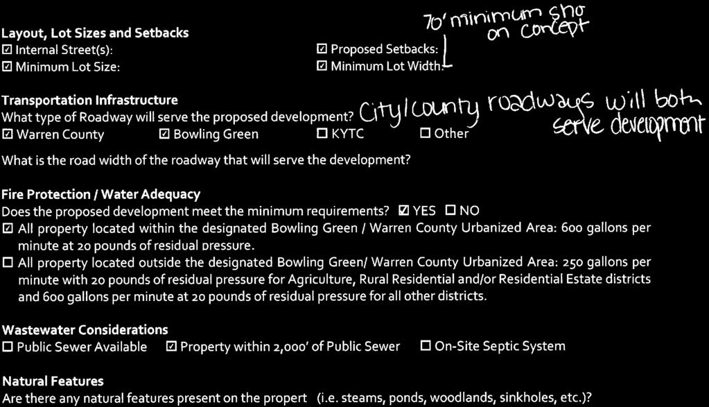
1 Z-CO Page 1 of 32 ZONE CHANGE STAFF REPORT CCPC City-County Planning Commission warrenpc.org (270) State Street Bowling Green, KY DOCKET/CASE/APPLICATION NUMBER Z-CO PUBLIC HEARING DATE November 1, 2018 APPLICANTS/PROPERTY OWNER BRIEF SUMMARY OF REQUEST: The applicants are proposing to rezone /- acres, located at 377 McLellan Road, from (Agriculture) to RS-1C (Single Family Residential) in order to develop a maximum of fortytwo (42) single family residential lots. Southside Development, LLC c/o Barrett Hammer (applicants) & Mary Louise Smith Family Limited Partnership No. 1 c/o Jeffrey Smith (property owners) PROPERTY ADDRESS/LOCATION 377 McLellan Road PRE-APP DATE August 22, 2018 PVA PARCEL NUMBER 030A-56 (portion) MAP SOURCE: CURRENT ZONING PROPOSED ZONING FUTURE LAND USE SIZE OF DEVELOPMENT OTHER INFORMATION CURRENT LAND USE Agriculture RS-1C PROPOSED LAND USE Single Family Residential Moderate Density Residential FLUM AMENDMENT Yes No /- Acres PROPOSED DENSITY 2.53 du/ac Development Plan Conditions General Development Plan Neighborhood Meeting Traffic Impact Study (TIS) Environmental Assessment Public Comments ZONING HISTORY: The property has been zoned (Agriculture) since zoning was established in Warren County in COMPATIBILITY with COMPREHENSIVE PLAN: The development is designated Moderate Density Residential on the FLUM. The proposed RS-1C zone is a potentially compatible zoning designation in the Moderate Density Residential FLUM category. The Planning Commission should determine if the proposal is compatible with the surrounding area. COMPATIBILITY with the SURROUNDING DEVELOPMENT: The development is located inside the Bowling Green urbanized area. A site characteristic review indicates that there are adequate facilities and infrastructure, available to support the proposed development. Portions of the property are heavily wooded, with other patches of mature vegetation also present on the property. There are also mature tree lines located around portions of the perimeter of the property, as well as part of a sinkhole and a wetland located on the property. Site design has been addressed in the General Development Plan and Development Plan Conditions, in conjunction with the requirements of the Zoning Ordinance. The proposed zoning map amendment may be appropriate if the Planning Commission deems the proposed development compatible with the surrounding area. POINTS TO CONSIDER: The proposal is less dense than what is outlined in the Moderate Density Residential FLUM category. The Planning Commission should determine if less density is appropriate in this location and compatible with the surrounding area. The proposed development complies with a majority of the site characteristics review criteria. The proposed General Development Plan complies with a majority of the review criteria for site design and compatibility, and meets the minimum requirements in the Zoning Ordinance. The existing home on the property was constructed in 1929.
2 Z-CO Page 2 of 32 Zone Change Staff Report Note: Please see attached pre-application information for FLUM category descriptions and other belowreferenced material. FUTURE LAND USE MAP and CATEGORY REVIEW FLUM Designation: Moderate Density Residential (please see the attached Future Land Use Map). Applicable Goals, Objectives and/or Actions Items Future Land Use: LU-1.1.1, LU-1.1.2, LU-1.1.3, LU-2, LU-2.1, LU-2.1.1, LU-2.1.4, LU-2.3.1, LU Transportation: TR-2.1 Community Facilities: N/A Parks and Recreation: PR-1.7 Natural and Cultural Resources: NCR-1.1, NCR-1.1.6, NCR-1.3, NCR-2.4.1, NCR-2.5, NCR Housing and Neighborhoods: HN-1, HN-1.3, HN-2.1, HN-2.3, HN-4 Economic Development: N/A The Moderate Density Residential land use designation encourages areas developed for higher density single family detached and attached (RS-1C & RS-1D), as well as semi-detached multi-family development such as duplexes and townhouses, apartment buildings, condominiums and mobile home parks. Densities in this land use should range between three and a half (3.5) and thirteen (13) dwelling units per acre. This proposal generally complies with LU and LU The Planning Commission should determine if the proposal is compatible with the area and therefore in compliance with LU The Planning Commission should determine if the proposal is a high quality development that includes design standards tailored to preserve the character of the area and if it complies with LU-2 and LU-2.1. The proposal does not comply with LU-2.1.1, which encourages increased open space standards to ensure that an adequate amount of such space is usable. The RS-1C zone the applicants are requesting requires a minimum of 30% open space. The applicants have not addressed any additional open space within the proposed development. The applicants have committed to preserving to the fullest extent practicable all trees located within eight feet of the perimeter property lines of the development with a caliper of 10 inches or greater, but did not address the trees located central to the development. The Planning Commission should determine compliance with LU-2.1.4, PR-1.7 and NCR The proposal complies with LU and TR-2.1. The applicants have stated in development plan condition #5 that the development will provide a stub street connecting to the remaining portion of the property that is not included with this rezoning application. The subdivision regulations also require that the proposed development connect with the existing stub streets on Cedar Trail Avenue and McIntyre Street, as depicted on the general development plan. The Planning Commission should determine if the proposal is an opportunity for revitalization and redevelopment, and therefore in compliance with LU The proposal may comply with NCR-1.1 and NCR-1.3. The applicants addressed the existing sinkhole in development plan condition #9, but they did not address the wetland located on the property. The proposal complies with NCR-2.4.1, as the development is proposed in an area where adequate infrastructure already exists and would not result in an increased amount of development pressure on the countryside. City-County Planning Commission warrenpc.org (270) State Street Bowling Green, KY 42101
3 Z-CO Page 3 of 32 Zone Change Staff Report The proposal does not comply with NCR-2.5 and NCR-2.5.3, as the applicants do not plan to incorporate the existing historical home located on the property as part of the development. The applicants however, have made a commitment in development plan condition #11 that prior to demolition of the existing residence on the Property, Habitat for Humanity ReStore and/or other similar non-profit organizations will be afforded an opportunity to inspect the residence and remove any items which might be reused. The proposal may comply with HN-1 and HN-1.3. The Planning Commission should determine if the proposed development is a compatible infill project that is preserves or enhances the character of the area. The proposal may comply with HN-2.1 and HN-4. The Planning Commission should determine if the location of the planned development is suitable for the proposed housing type, and if the proposed residences are believed to enhance the array of housing options available in the area SITE CHARACTERISTICS REVIEW Layout, lot sizes and setbacks: The development will be served by internal travelways and will be developed as shown on the attached preliminary development plan. Minimum lot size, lot width and setbacks will adhere to the RS-1C standards set forth in Zoning Ordinance. Transportation Infrastructure: The proposed development has frontage on McLellan Road, a City maintained urban local roadway with fifty (50) feet of right-of-way and twenty-four (24) feet of pavement width. The property also has frontage on Cedar Trail Avenue, a City maintained urban local roadway with fifty (50) feet of right-of-way and twenty-four (24) feet of pavement width. The property also has frontage on McIntyre Street, a County maintained urban local roadway with fifty (50) feet of right-of-way and twenty-four (24) feet of pavement width. If approved, the proposed subdivision will provide stub streets into the properties to the remaining portion of the property that is not subject to this rezoning application. Fire protection: This development is served by the Woodburn Fire Department. The applicants have agreed to coordinate fire hydrant locations and spacing with the Woodburn Fire Department in development plan condition #12. Water adequacy: This development is served by Warren County Water District (WCWD) and has adequate water flow to meet the fire protection requirements for Warren County. Wastewater adequacy: The proposed lot is within 2,000 feet of public sanitary sewer and will be required to connect if this application is approved. Natural features: Portions of the property are heavily wooded, with other patches of mature vegetation also present on the property. There are also mature tree lines located around portions of the perimeter of the property. There is also a portion of a sinkhole and a wetland located on the property. Prime farmland: The majority of the development contains a soil type that is classified as prime farmland. Soil suitability: N/A Flood plains and wetlands: There is a wetland located on the property. Cultural or historical features: The existing residence was constructed in This application complies with the majority of the items in the Site Characteristics Review. City-County Planning Commission warrenpc.org (270) State Street Bowling Green, KY 42101
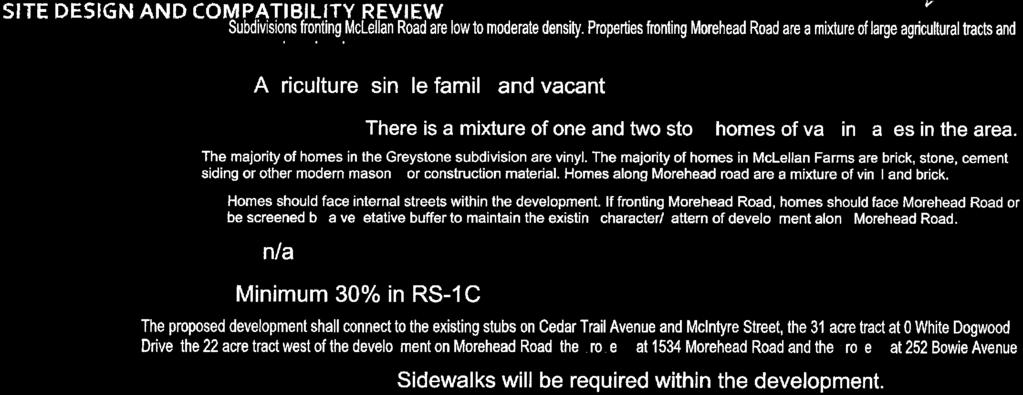
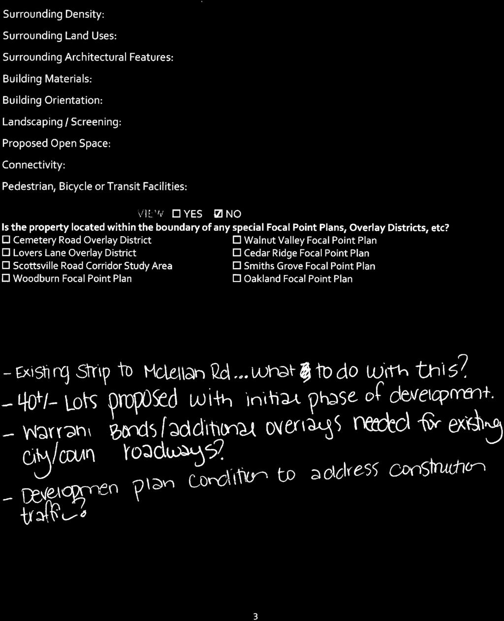
4 Z-CO Page 4 of 32 Zone Change Staff Report SITE DESIGN and COMPATIBILITY REVIEW Surrounding density: Subdivisions fronting McLellan Road are low to moderate density. Properties fronting Morehead Road are a mixture of large agricultural tracts and rural density residential properties. Densities of existing subdivisions in the area range from 0.21 du/ac to du/ac (see attached map). The density of the proposed development is 2.53 du/ac. Surrounding land uses: Please see the attached existing land use map. The surrounding area is mainly comprised of agricultural and single family residential uses. There is also a public and a commercial use located nearby. There are also several vacant tracts in the general vicinity. Surrounding architectural features: There is a mixture of one- and two-story homes of varying ages in the area. Building materials review: The majority of homes in the Greystone subdivision are vinyl. The majority of homes in McLellan Farms are brick, stone, cement siding or other modern masonry or construction material. Building orientation: Homes should face internal streets within the development. Landscaping and screening: N/A Proposed open space: The maximum allowable lot coverage in the RS-1C zone is 70%, meaning a minimum of 30% of the proposed lot will remain as open space. Connectivity: The proposed development shall connect to the existing stub streets on Cedar Trail Avenue and McIntyre Street, as well as provide a stub street to the remaining portion of the parent tract to the west. Pedestrian, bicycle or transit facilities: Sidewalks are required within the proposed development. AREA SPECIFIC POLICY REVIEW Applicable plan(s): There are no focal point plans or corridor studies applicable to this development. TRAFFIC IMPACT STUDY Section of the Zoning Ordinance requires the submission of a Traffic Impact Study (TIS) for any development that meets the thresholds identified by the Bowling Green Public Works Department (BGPW), Warren County Public Works Department (WCPW) or the Kentucky Transportation Cabinet (KYTC). Such TIS shall analyze the effect of the proposed project on the surrounding roadways and intersections. Such effect shall be measured against the existing level of service standard and circulation patterns for the roadways affected by the proposed development s impact. Exceptions to this requirement may be approved after consultation between the applicant and affected agencies (BGPW, WCPW and/or KYTC). When a project s traffic impact can be clearly anticipated without a study and all of the parties involved (transportation agency(ies) and applicant) are able to negotiate appropriate mitigation, a TIS may not be necessary. The applicant must provide documentation, in writing, from all affected agencies, exempting their particular development from the TIS requirement, along with a commitment in the form of a development plan condition(s). This documentation must be submitted as a part of an application (Zoning Map Amendment, Amendment to Development Plan Conditions, FLUM Amendment), in order for the application to be deemed complete. BGPW and WCPW waived a TIS in lieu of improvements. The applicants have committed in development plan condition #6 that existing County and City roads shall be improved with additional pavement overlays. City-County Planning Commission warrenpc.org (270) State Street Bowling Green, KY 42101
5 Z-CO Page 5 of 32 Zone Change Staff Report GENERAL DEVELOPMENT PLAN / DEVELOPMENT PLAN CONDITIONS The applicants have submitted the following Development Plan Conditions to help address compatibility with the surrounding area: 1) All service utility lines will be located underground. 2) The Property may be developed into a maximum of forty-two (42) single family dwelling units. 3) All exterior facades of principal structures located on the Property will be constructed of at least eighty percent (80%) stone, brick, lp smart siding EIFS or other cementitious or modern masonry materials. Plain-faced block shall be prohibited. Each residence shall have an attached two-car garage and a minimum of one thousand six hundred (1,600) square feet of heated living space exclusive of porches and garage. This Development Plan Condition shall remain a Development Plan Condition only until recordation of a Subdivision Plat of the Property or recordation of Restrictive Covenants applicable to the Property, after which this Development Plan Condition shall be included in such Plat and/or Restrictive Covenants and shall no longer be a Development Plan Condition. 4) The Property will be developed with uniform street lighting. 5) The Property will be developed with an internal system of streets and with a stub street connection to the remainder of the Mary Louise Smith Family Limited Partnership No. 1 property to the west of the property. 6) Existing County and City Roads shall be improved with additional pavement overlays as specified by the County Road Department and the City of Bowling Green Public Works Department. 7) Vehicular construction traffic to the Property will be restricted to access via Cedar Trail Avenue. 8) The Property will be developed and maintained to preserve to the fullest extent practicable all trees with a caliper of at least 10 inches located within eight feet of the perimeter property lines of the development. 9) Sinkholes detected on the Property prior to or during construction will be repaired or protected with a sinkhole structure using methods approved by the Warren County Department of Public Works Stormwater Management, depending upon whether such sinkholes are located in a proposed drainage area. 10) The Property will be developed with sidewalks on both sides of all interior streets. 11) Prior to demolition of the existing residence on the Property, Habitat for Humanity ReStore and/or other similar non-profit organizations will be afforded an opportunity to inspect the residence and remove any items which might be reused. 12) Fire hydrants will be located and spaced in cooperation with the Woodburn Fire Department. City-County Planning Commission warrenpc.org (270) State Street Bowling Green, KY 42101
6 Z-CO Page 6 of 32 Zone Change Staff Report 13) Prior to or simultaneous with the recordation of a Plat of the Property, a Declaration of Restrictive Covenants applicable to the Property will be recorded, which covenants shall provide for mandatory membership in a Homeowner s Association and for ownership of all common areas by the Homeowner s Association. The proposed General Development Plan meets a majority of the review criteria for site design and compatibility. Compatibility of the proposed development should be determined by the Planning Commission. The application will be subject to further review for compliance with Zoning Ordinance requirements at the building permit portion of the review process, if approved. STAFF REVIEW SUMMARY The applicants are proposing to rezone /- acres in order to construct a maximum of 42 single family residential lots. The proposed RS-1C zone may be appropriate given the proposed density of 2.53 du/ac and the Moderate Density Residential FLUM category. The proposal complies with a majority of the criteria assessed in the review process. The Planning Commission should determine if the proposal is compatible with the area and if it complies with the goals, objectives and action items outlined in the FOCUS 2030 Comprehensive Plan. City-County Planning Commission warrenpc.org (270) State Street Bowling Green, KY 42101
7 Z-CO Page 7 of 32 Zone Change Staff Report SUGGESTED MOTIONS I make the motion to APPROVE the proposed Zoning Map Amendment, together with and conditioned upon the General Development Plan, docket number Z-CO. Based upon the testimony and documents presented in this public hearing, the proposed Zoning Map Amendment is consistent with the adopted FOCUS 2030 Comprehensive Plan as demonstrated by its compliance with the objectives and action items presented in the staff report. (Compliance Summary Listed at Bottom of Page - Note Exceptions if Applicable) Therefore, the proposed Zoning Map Amendment is in agreement with the adopted Comprehensive Plan. Further, I request that this motion include the summary of evidence and testimony presented by the witnesses at this public hearing. I make the motion to DENY the proposed Zoning Map Amendment, docket number Z-CO. Based upon the testimony and documents presented in this public hearing, the proposed Zoning Map Amendment is not consistent with the adopted FOCUS 2030 Comprehensive Plan as demonstrated by its noncompliance with the objectives and action items presented in the staff report. (Compliance Summary Listed at Bottom of Page - Note Exceptions if Applicable) Therefore, the proposed Zoning Map Amendment is not in agreement with the adopted Comprehensive Plan. Further, I request that this motion include the summary of evidence and testimony presented by the witnesses at this public hearing. COMPLIANCE SUMMARY Items In Compliance: Items Not In Compliance LU-1.1.1* TR-2.1 HN-1* LU-1.1.1* PR-1.7* HN-1* LU-1.1.2* HN-1.3* LU-1.1.2* HN-1.3* LU-1.1.3* PR-1.7* HN-2.1* LU-1.1.3* NCR-1.1* HN-2.1* LU-2* HN-4* LU-2* NCR-1.3* HN-4* LU-2.1* NCR-1.1* LU-2.1* NCR-1.1.6* LU-2.1.4* NCR-1.3* LU NCR-2.5 LU NCR-1.1.6* LU-2.1.4* NCR LU-2.5.3* NCR *Denotes items in both the compliance and non-compliance columns. Planning Commission to determine compliance with these items. City-County Planning Commission warrenpc.org (270) State Street Bowling Green, KY 42101

8 Z-CO Page 8 of 32 CCTT NN LLAA EELL CCLL M M RRDD CCKK RROO EEYY GGRR DDRR CO UR T EE YYRR NNTT CCII M M W AY M CG LO CK LIN NN M LL EELLM RREEDD AARR CCEEDD EEEETT R R T T N SS RRUUN CH EL SA RR LLEE B B BB GGOO SSTT BO W IE AV EN UE AERIAL Z - CO Feet
9 LI BE Z-CO Page 9 of 32 TURKEY RUN DR RED CLOVER AVE HI BE HI BE HI BE HI BE CENTURY STREET HI BE CEDAR RUN STREET GREYROCK DR MCLELLAN RD HI BE HI BE GB BE GB BE MCINTYRE ST GB BE RS-1B BE RS-1B BE GB BE RM-4 RM-4 RM-4 RM-4 BOWIE AVENUE HB RM-4 P NASHVILLE ROAD EXISTING ZONING F Z - CO F F FNB PUD RM-4 RS-1C MOREHEAD RD CB F GB RM-4 HI LI MHP OP-C F OP-R RM-2 F P RM Feet RR RS-1A RS-1B RS-1D F
10 RE UN D R Z-CO Page 10 of 32 E OV CL TURKEY R D R E AV MAPLE RID R TU N CE R EE T EL N LA AR CED ST RU N ET CL M GE ST E TR S Y RD GR EY RO CK DR L LOCK MCG AY IN W YR NT CI M T ES BO W PI O NE ER IE AV E NU S NA ILL HV E AD O R E AV E RE MO EXISTING LAND USE Z - CO DR H EA D 400 RICULTURAL PUBLIC-INSTITUTIONAL COMMERCIAL MULTI-FAMILY RESIDENTIAL INDUSTRIAL SINGLE-FAMILY RESIDENTIAL PUBLIC VACANT Feet
11 Z-CO Page 11 of 32 TURKEY RUN DR RED CLOVER AVE Industrial Industrial Industrial CENTURY STREET MAPLE RIDGE ST CEDAR RUN STREET MCLELLAN RD Industrial GREYROCK DR Moderate Density Moderate Density MCGLOCKLIN WAY MCINTYRE ST Moderate Density BOWIE AVENUE NASHVILLE ROAD PIONEER AVE Low Density MOREHEAD RD FUTURE LAND USE Mixed Use - R 2018 Mixed Use R - Z - CO Rural Village High Density Residential Institutional / Governmental Low Density Agriculture Rural Mixed Density Use Residential - R Low Density Residential Mixed Use / Residential Open Space, Parks & Recreation Low Density Mixed Use / Commercial Cemetery Road Overlay Mixed Use - R Mixed Use - R Commercial Lovers Lane Overlay Low Density Moderate Density Residential Industrial Low Density
12 MALLARD ST TEAL STREET MANDERIN AVE THE SOUTHERN # OF UNITS: 275 (PER B. E.'S) SUM ACREE: DENSITY: UNITS/ACRE MOUNT EVEREST WAY DENSITY MAP Z - CO HUNTERS POINTE LN SUMMIT BLVD MOUNT EVEREST COURT BETTERSWORTH ROAD Z-CO Page 12 of 32 GREYSTONE (PLATTED PORTION) # OF LOTS: 559 SUM ACREE: MEAN ACREE: 0.40 DENSITY: 2.49 UNITS/ACRE WEST MCLELLAN RD PROGRESS AVE CENTURY STREET RED MAPLE STREET MAPLE RIDGE ST RED CLOVER AVE RED ELM LN MCLELLAN RD GREYROCK DR MCINTYRE ST NASHVILLE ROAD CHINA TREE WAY BOWIE AVENUE PIKES PEAK WAY DILLARD RD The information on this map is generated from a parcel layer that is based on platted subdivision information. The acreages on this map may not match neither the PVA nor the recorded plats. SYLVAN CIR The user understands that the entities which comprise the City - County Planning Commission of Warren County make no representations to the accuracy of the information in the mapping data or images contained on this map, but rather, provide said information as is. The user knowingly waives any and all claims for damages against any and all of the entities comprising the City-County Planning Commission of Warren County that might arise from the mapping data. This is not a legal document! MCLELLAN FARM # OF LOTS: 98 SUM ACREE: MEAN ACREE: 0.50 DENSITY: 1.98 UNITS/ACRE MOREHEAD RD PIONEER VILLE (EXCLUDING FIRE STATION) # OF LOTS: 28 SUM ACREE: MEAN ACREE: 1.23 DENSITY: 0.81 UNITS/ACRE PIONEER AVE VANMETER LOTS # OF LOTS: 6 SUM ACREE: 3.29 MEAN ACREE: 0.55 DENSITY: 1.82 UNITS/ACRE RHOADES # OF LOTS: 4 SUM ACREE: MEAN ACREE: 4.67 DENSITY: 0.21 UNITS/ACRE

 IRON PIN SET (IPS) DRAWN BY: RHM CHECKED BY: V&S JOB #: 18330 SURVEY DATE: 11-16-2017 PLOT DATE: 10-23-2018 LLS")
13 OWNER: MARY LOUISE SMITH ESTATE & MARY LOUISE SMITH FAMILY LIMITED PARTNERSHIP NO.1 P.O. BOX 356 BOWLING GREEN, KY REZONING PLAT FOR: THE SMITH FAMILY PROPERTY DEED BOOK 261, PE 302 AND A PORTION OF DEED BOOK 750, PE MCLELLAN ROAD & MOREHEAD ROAD WARREN COUNTY, KY VAN METER & SLAVEY, LLC PROFESSIONAL ENGINEERING - LAND SURVEYING 1015 Shive Lane - Bowling Green, KY P : F : E : lsslavey@att.net SW W E S SE NW NE 0' GENERAL LEGEND MONUMENT FOUND (AS DESCRIBED) IRON PIN SET (IPS) DRAWN BY: RHM CHECKED BY: V&S JOB #: SURVEY DATE: PLOT DATE: LLS SCALE: 1 = 200 SHEET: 1 OF 1 APPROX. 1,491-FT ± TO THE C/L OF NASHVILLE ROAD FLOOD NOTE: I HEREBY CERTIFY THAT THE PROPERTY AS SHOWN HEREON IS NOT IN A 100 YEAR FLOOD PLAIN AS LOCATED BY FLOOD INSURANCE RATE MAP #21227C0295E, AND DATED MAY 2, UTILITY NOTE: UTILITIES SHOWN HEREON WERE LOCATED FROM FIELD EVIDENCE AND OTHER AVAILABLE RECORDS. OTHER UTILITIES MAY EXIST THAT MAY NOT BE SHOWN. NO GUARANTEE IS EXPRESSED OR IMPLIED AS TO THE LOCATION OF THE UTILITIES. SS S SE E SW NE W NW N GREYSTONE 66-1 SUBDIVISION ROW CLOSING 54-1 PLAT BOOK 36, PE RUSH BRAY MCCAULEY GARDNER COTTINGHAM CITY OF BG PLAT BOOK 29, PE 199 GREYSTONE SUBDIVISION BOWLING GREEN, KY SITE VICINITY MAP NOT TO SCALE SE SW E NW NE N S GENERAL NOTES: 1. SOURCE OF TITLE: DEED BOOK 261, PE 302 AND A PORTION OF DEED BOOK 750, PE THIS SURVEY IS SUBJECT TO ALL FACTS THAT MAY BE DISCLOSED BY A FULL AND ACCURATE TITLE SEARCH. 3. SOURCE OF BEARING: NAD THE SURVEY AS SHOWN HEREON IS A RURAL SURVEY AND THE ACCURACY AND PRECISION OF SAID SURVEY MEETS ALL THE SPECIFICATIONS OF THIS CLASS. 5. THIS PLAT REPRESENTS A BOUNDARY SURVEY AND COMPLIES WITH 201 KAR 18: THE BEARINGS AND DISTANCES AS SHOWN HEREON ARE BASED ON AN UNADJUSTED RANDOM TRAVERSE. 7. UNADJUSTED CLOSURE 1:26, DATE OF FIELD SURVEY: NOVEMBER 16, ALL SET IRON PINS SHOWN ARE 5/8-INCH DIAMETER BY 18-INCHES LONG REBAR WITH YELLOW PLASTIC CAPS STAMPED "L SLAVEY KY 3922". W GREYSTONE SUBDIVISION SECTION XIII PLAT BOOK 41, PES MARY LOUISE SMITH FAMILY LIMITED PARTNERSHIP NO.1 DB. 750, P. 001 PVA# 030A-56 (ZONED ) GREYSTONE SUBDIVISION SECTION XII PLAT BOOK 40, PES BARN GREYSTONE SUBDIVISION SECTION XII PLAT BOOK 41, PE 88 GREYSTONE SUBDIVISION SECTION II PLAT BOOK 32, PE 165 MCINTYRE STREET (50-FT R/W - 24-FT PVM'T) CORPORATE LIMITS CORPORATE LIMITS BARN GREYSTONE SUBDIVISION PLAT BOOK 29, PE 199 CEDAR TRAIL AVENUE (50-FT R/W - 24-FT PVM'T) 377 MCLELLAN ROAD SHED GREYSTONE SUBDIVISION PLAT BOOK 29, PE 199 MCLELLAN ROAD (50-FT R/W - 24-FT PVM'T) CORPORATE LIMITS CORPORATE LIMITS WARREN COUNTY GRAU DEED BOOK 1068, PE 459 MCLELLAN FARMS SUBDIVISION SECTION I PLAT BOOK 38, PES MCLELLAN FARMS SUBDIVISION SECTION II PLAT BOOK 39, PES MCLELLAN FARMS SUBDIVISION SECTION II PLAT BOOK 40, PE 205 MCLELLAN FARMS SUBDIVISION SECTION II PLAT BOOK 39, PES WARREN COUNTY S 68 10'57" W 1,112.34' WARREN COUNTY N 68 09'28" E - 1,103.85' S 30 17'36" E WARREN COUNTY MOREHEAD RD DILLARD RD MOREHEAD RD NASHVILLE ROAD U.S. 31W MCLELLAN RD N 65 53'04" E ' FENCE POST S 41 20'44" E 25.70' 20.66' LOOP NO. 2 1/2-INCH IRON PIN "KY1859" 5/8-INCH IRON PIN "KY3111" S 68 46'01" W ' ' S 68 46'01" W S 41 54'28" E ' N 33 24'18" W 24.68' N 43 31'03" W ' EXISTING SANITARY MANHOLE RIM: INV.: S 68 46'01" W ' N 21 11'32" W ' ' N 40 39'42" E N 49 19'33" E 50.84' N 54 42'48" E 22.87' 55,932 S.F AC. MARY LOUISE SMITH DB. 261, P. 302 PVA# 030A-56 (ZONED ) S 41 54'28" E - 1,217.32' EXISTING SANITARY MANHOLE RIM: INV.: /8-INCH IRON PIN "KY3111" S 68 48'28" W ' MITCH MCONNELL WAY RED CLOVER AVE OLD NASHVILLE RD 5/8-INCH IRON PIN N 24 03'46" W ' ' N 33 42'55" W 50.72' N 35 19'27" W 84.12' S 65 56'14" W ' S 82 22'39" W 52.13' N 26 43'36" W 70.61' S 65 56'14" W ' S 27 59'09" E ' N 54 24'40" E ' S 05 27'31" W 95.86' ' N 41 50'54" W ' N 14 49'12" W ' N 13 31'54" E ' SELLS 5/8-INCH IRON PIN ROBEY TRACT 2 666,781 S.F AC. CORNELL POTTER MCGREGOR HENDERSON DECESARE CHAFFIN CANTERBURY HARRIS WOOLEY LAW ZONE CHANGE REQUEST TO RS-1C TOTAL: ACRES CROWDER GLASSCOCK ROEMER GOLUBOVIC HOLTS TRACT 1 DUGANDZIJA LOBB MCFADDEN OSSELLO HUCKABY MCLELLAN FARMS HOA CITY OF BG 2 MOLSHEIM HOLDINGS, LLC (HI) A. FRANKLIN BERRY JR. SUBDIVISION PLAT BOOK 42, PES HART MCGURL STOVALL JONES SALES HAMMER ALEBEEK HISKEY BACHMAN HASANOVIC CENTRAL AVE Z-CO Page 13 of 32
14 OWNER: MARY LOUISE SMITH ESTATE & MARY LOUISE SMITH FAMILY LIMITED PARTNERSHIP NO.1 P.O. BOX 356 BOWLING GREEN, KY REZONING EXHIBIT FOR: THE SMITH FAMILY PROPERTY DEED BOOK 261, PE 302 AND A PORTION OF DEED BOOK 750, PE MCLELLAN ROAD & MOREHEAD ROAD WARREN COUNTY, KY VAN METER & SLAVEY, LLC PROFESSIONAL ENGINEERING - LAND SURVEYING 1015 Shive Lane - Bowling Green, KY P : F : E : lsslavey@att.net SW W E S SE NW NE PRELIMINARY NOT FOR LAND TRANSFER FOR REVIEW ONLY 0' GENERAL LEGEND MONUMENT FOUND (AS DESCRIBED) IRON PIN SET (IPS) DRAWN BY: RHM CHECKED BY: V&S JOB #: SURVEY DATE: PLOT DATE: LLS SCALE: 1 = 200 SHEET: 1 OF 1 APPROX. 1,491-FT ± TO THE C/L OF NASHVILLE ROAD FLOOD NOTE: I HEREBY CERTIFY THAT THE PROPERTY AS SHOWN HEREON IS NOT IN A 100 YEAR FLOOD PLAIN AS LOCATED BY FLOOD INSURANCE RATE MAP #21227C0295E, AND DATED MAY 2, UTILITY NOTE: UTILITIES SHOWN HEREON WERE LOCATED FROM FIELD EVIDENCE AND OTHER AVAILABLE RECORDS. OTHER UTILITIES MAY EXIST THAT MAY NOT BE SHOWN. NO GUARANTEE IS EXPRESSED OR IMPLIED AS TO THE LOCATION OF THE UTILITIES. SS S SE E SW NE W NW N RUSH BRAY MCCAULEY GARDNER COTTINGHAM CITY OF BG PLAT BOOK 29, PE 199 GREYSTONE SUBDIVISION BOWLING GREEN, KY SITE VICINITY MAP NOT TO SCALE SE SW E NW NE N S GENERAL NOTES: 1. SOURCE OF TITLE: DEED BOOK 261, PE 302 AND A PORTION OF DEED BOOK 750, PE THIS SURVEY IS SUBJECT TO ALL FACTS THAT MAY BE DISCLOSED BY A FULL AND ACCURATE TITLE SEARCH. 3. SOURCE OF BEARING: NAD THE SURVEY AS SHOWN HEREON IS A RURAL SURVEY AND THE ACCURACY AND PRECISION OF SAID SURVEY MEETS ALL THE SPECIFICATIONS OF THIS CLASS. 5. THIS PLAT REPRESENTS A BOUNDARY SURVEY AND COMPLIES WITH 201 KAR 18: THE BEARINGS AND DISTANCES AS SHOWN HEREON ARE BASED ON AN UNADJUSTED RANDOM TRAVERSE. 7. UNADJUSTED CLOSURE 1:26, DATE OF FIELD SURVEY: NOVEMBER 16, ALL SET IRON PINS SHOWN ARE 5/8-INCH DIAMETER BY 18-INCHES LONG REBAR WITH YELLOW PLASTIC CAPS STAMPED "L SLAVEY KY 3922". W GREYSTONE SUBDIVISION SECTION XIII PLAT BOOK 41, PES MARY LOUISE SMITH FAMILY LIMITED PARTNERSHIP NO.1 DB. 750, P. 001 PVA# 030A-56 (ZONED ) GREYSTONE SUBDIVISION SECTION XII PLAT BOOK 40, PES BARN GRAU DEED BOOK 1068, PE 459 GREYSTONE SUBDIVISION SECTION XII PLAT BOOK 41, PE 88 MCLELLAN FARMS SUBDIVISION SECTION I PLAT BOOK 38, PES GREYSTONE SUBDIVISION SECTION II PLAT BOOK 32, PE 165 MCINTYRE STREET (50-FT R/W - 24-FT PVM'T) CORPORATE LIMITS CORPORATE LIMITS GREYSTONE SUBDIVISION ROW CLOSING PLAT BOOK 36, PE 14 GREYSTONE SUBDIVISION PLAT BOOK 29, PE 199 MCLELLAN FARMS SUBDIVISION SECTION II PLAT BOOK 39, PES CEDAR TRAIL AVENUE (50-FT R/W - 24-FT PVM'T) MCLELLAN FARMS SUBDIVISION SECTION II PLAT BOOK 40, PE 205 GREYSTONE SUBDIVISION PLAT BOOK 29, PE 199 MCLELLAN FARMS SUBDIVISION SECTION II PLAT BOOK 39, PES WARREN COUNTY WARREN COUNTY FENCE POST EXISTING SANITARY MANHOLE RIM: INV.: MCLELLAN ROAD (50-FT R/W - 24-FT PVM'T) MOREHEAD RD DILLARD RD MOREHEAD RD NASHVILLE ROAD U.S. 31W MCLELLAN RD LOOP NO. 2 1/2-INCH IRON PIN "KY1859" EXISTING SANITARY MANHOLE RIM: INV.: /8-INCH IRON PIN "KY3111" 5/8-INCH IRON PIN "KY3111" MITCH MCONNELL WAY RED CLOVER AVE OLD NASHVILLE RD 5/8-INCH IRON PIN SELLS ROBEY /8-INCH IRON PIN CORNELL 10 POTTER 9 8 MCGREGOR 7 6 HENDERSON DECESARE CHAFFIN CANTERBURY HARRIS WOOLEY LAW CROWDER GLASSCOCK ROEMER GOLUBOVIC HOLTS DUGANDZIJA LOBB MCFADDEN OSSELLO HUCKABY 43 MCLELLAN FARMS HOA CITY OF BG 2 MOLSHEIM HOLDINGS, LLC (HI) A. FRANKLIN BERRY JR. SUBDIVISION PLAT BOOK 42, PES HART MCGURL STOVALL JONES SALES HAMMER ALEBEEK HISKEY BACHMAN HASANOVIC CENTRAL AVE Z-CO Page 14 of 32


15 Z-CO Page 15 of 32

16 Z-CO Page 16 of 32


17 Z-CO Page 17 of 32


18 Z-CO Page 18 of 32


19 Z-CO Page 19 of 32

20 Z-CO Page 20 of 32


21 Z-CO Page 21 of 32

22 Z-CO Page 22 of 32

23 Z-CO Page 23 of 32


24 Z-CO Page 24 of 32

25 Z-CO Page 25 of 32


26 Z-CO Page 26 of 32

27 Z-CO Page 27 of 32


28 Z-CO Page 28 of 32

29 Z-CO Page 29 of 32
30 Z-CO Page 30 of 32 Rachel Hurt From: Rachel Hurt Sent: Tuesday, October 16, :44 PM To: Kevin Brooks Cc: 'Lucas Slavey'; 'BARRETT 'vall Ben Peterson; 'Tad Pardue' Subject: Staff Comments: Proposed Zone Change McLellan Road Attachments: Fire Department Comments.pdf Good Afternoon, In reviewing the application for the proposed rezoning a portion of the property located at 377 McLellan Road, staff has generated the following comments for your consideration: Development plan condition #3 outlines permitted building materials for the proposed development. Would you also consider prohibiting plain faced block as a visible finished material? Development plan condition #5 makes reference to a thirty one acre tract located at White Dogwood Drive, a twentytwo acre tract west of the property which adjoins Morehead Road, the property at 1534 Morehead Road and the property at 252 Bowie Avenue. The portion of the property subject to the rezoning application does not physically adjoin any of these properties/locations. Can you please revise development plan condition #5 accordingly? You may consider replacing this portion of the development plan condition with a reference to stub street connections being provided to the remaining portion of the parent tract to the west as shown on the preliminary development plan. Development plan condition #7 references construction traffic and states that it will be restricted to no more than two locations. There are only two points of ingress/egress into the development (Cedar Trail Avenue and McIntyre Street). Can you please clarify the intent of this development plan condition? Development plan condition #8 addresses preservation of a portion of the existing vegetation located on the property and references mature trees on the perimeter property lines. Would you consider clarifying the terms mature and perimeter? Perhaps defining trees of a certain caliper and also a specific distance/buffer width within the perimeter property lines? Development plan condition #10 states that sidewalks will be developed on all interior streets. Is it the intent of this development plan condition that sidewalks will be installed of both sides of all interior streets? Can you please clarify? LU of the FOCUS 2030 Comprehensive Plan encourages increased open space standards, to ensure that an adequate amount of such space is usable. The submitted preliminary lot layout does not appear to incorporate any type of open space other than a proposed drainage area. Would you consider incorporating additional open space within the development? NCR 1.1 and NCR 1.3 from the FOCUS 2030 Comprehensive Plan evaluate physical suitability of a particular development with existing natural features and the natural environment. Development plan condition #9 as submitted addresses sinkholes on the property. Would you consider an additional development plan condition to address the existing wetland that is also present on the site? According to PVA records, the existing residence located on the property was constructed in NCR 2.5 and NCR from the FOCUS 2030 Comprehensive Plan promote the preservation of historic resources and structures and state that these items should be considered in development plan review. Staff has noted that the existing residence was not addressed in your application or development plan conditions. Would you consider preserving the residence as part of the proposed development? Or perhaps consider donating any salvageable materials from the existing home to the Habitat for Humanity ReStore or similar organization? 1
31 The rezoning exhibit and preliminary lot layout have Cedar Trail Avenue labeled as Cedar Trail Drive. Can you please revise? Staff forwarded the preliminary lot layout to the Woodburn Fire Department for their review. I have attached an e mail from Bob Skipper, Department Chief. Would you consider incorporating their suggestion on hydrant spacing as a part of the development plan conditions? To ensure timely delivery of meeting materials to our Planning Commissioners, please submit any revisions you may have no later than Tuesday, October 23rd at 2:00 PM. Please note that failure to submit revisions prior to this deadline may result in postponement of your application to another hearing date and assessment of a $100 re advertising fee; OR the staff report will be sent out as is and it will be the responsibility of the applicant to address deficient items with the Planning Commission during the public hearing. Please let me know if you have any questions or concerns regarding the above comments. I am happy to assist however I can! Sincerely, Rachel Hurt Planner III Z-CO Page 31 of State Street Bowling Green, KY
32 Z-CO Page 32 of 32 Rachel Hurt From: Sent: To: Subject: Skipper, Bob Friday, October 12, :36 PM Rachel Hurt Re: Upcoming Rezoning Application on McLellan Road Rachel, We do not have an issue with the rezoning. However, when the timing is appropriate, we would like to see hydrants at a minimum of 800 feet apart. Would the line tie into the existing line at the DeCesare property? That would be great since we already have hydrants with flows of 1,000 gallons or more, which we would need on houses of that size. Thanks. Bob Bob Skipper Media Relations Director WKU Public Affairs 1906 College Heights Blvd. #11012 Bowling Green, KY "No person has the right to rain on your dreams. Dr. Martin Luther King Jr. From: Rachel Hurt <Rachel.Hurt@bgky.org> Date: Tuesday, October 9, 2018 at 2:44 PM To: Bob Skipper <bob.skipper Subject: Upcoming Rezoning Application on McLellan Road Chief Skipper, I have attached a conceptual layout for an upcoming rezoning application scheduled to be considered by the Planning Commission on Thursday, November 1st. The property is located at 377 McLellan Road. The applicant is proposing to develop a single family residential subdivision containing 40 building lots, with opportunity for additional phases in the future (to be rezoned at a later date). If approved, this development will be served by the Woodburn Fire Department. Please let me know if you have any comments or requests regarding the proposed development that you would like me to forward to the applicant. If you have any questions, please be sure to let me know. Sincerely, Rachel Hurt Planner III 1141 State Street Bowling Green, KY Rachel Hurt 1
Tuss and Lisa Taylor. Agriculture
 ZONE CHANGE STAFF REPORT CCPC City-County Planning Commission warrenpc.org (270) 842-1953 1141 State Street Bowling Green, KY 42101 DOCKET/CASE/APPLICATION NUMBER 2018-29-Z-CO PUBLIC HEARING DATE July
Z-CO & 2018-V-11. July 5, 2018
 2018-30-Z-CO & 2018-V-11 Page 1 of 34 ZONE CHANGE AND VARIANCE STAFF REPORT CCPC City-County Planning Commission warrenpc.org (270) 842-1953 1141 State Street Bowling Green, KY 42101 DOCKET/CASE/APPLICATION
DOCKET/CASE/APPLICATION NUMBER PUBLIC HEARING DATE
 2019-01-Z-BG Page 1 of 32 ZONE CHANGE STAFF REPORT CCPC City-County Planning Commission warrenpc.org (270) 842-1953 1141 State Street Bowling Green, KY 42101 DOCKET/CASE/APPLICATION NUMBER 2019-01-Z-BG
FUTURE LAND USE MAP AMENDMENT AND ZONE CHANGE STAFF REPORT
 2017-14-LUM & 2017-79-Z-CO / WB Page 1 of 12 UTURE LAND USE MAP AMENDMENT AND ZONE CHANGE STA REPORT Docket Numbers: 2017-14-LUM and 2017-79-Z-CO/WB Public Hearing Date: November 16, 2017 Pre-Application
FUTURE LAND USE MAP AMENDMENT AND ZONE CHANGE STAFF REPORT
 2017-16-FLUM & 2017-81-Z-BG Page 1 of 13 FUTURE LAND USE MAP AMENDMENT AND ZONE CHANGE AFF REPORT Docket Numbers: 2017-16-FLUM and 2017-81-Z-BG Public Hearing Date: December 21, 2017 Pre-Application Conference:
FLUM PUBLIC HEARING DATE
 2018-13-FLUM Page 1 of 30 FLUM AMENDMENT STAFF REPORT DOCKET/CASE/APPLICATION NUMBER CCPC City-County Planning Commission warrenpc.org (270) 842-1953 1141 State Street Bowling Green, KY 42101 2018-13-FLUM
Article 7: Residential Land Use and Development Requirements
 Article 7: Residential Land Use and Section 701: Statement of Intent (A) (B) (C) The intent of Article 7 is to develop certain land use and development requirements for the residential uses within Cumru
TELECOMMUNICATIONS TOWER AND VARIANCE STAFF REPORT
 TELECOMMUNICATIONS TOWER AND VARIANCE STAFF REPORT City County Planning Commission 1141 State Street Bowling Green, Kentucky 42101 (270) 842 1953 Summary: The applicants have filed an application for approval
EXHIBIT D. Planned Unit Development Written Description April 13, 2016 Rouen Cove Phase II PUD
 1 EXHIBIT D Planned Unit Development Written Description April 13, 2016 Rouen Cove Phase II PUD Development # 8986.001 Developer: Curtis L. Hart Hart Resources LLC 8051 Tara Lane Jacksonville, Florida
SUBJECT PARCEL(S) Property Owner(s) TMS Number Approximate Acreage Carolina Park Development, LLC
 Property Owner(s) TMS Number Approximate Acreage Carolina Park Development, LLC") Staff Report Special Planning Commission Meeting November 19, 2014 For reference, the Zoning Code and Land Development Regulations are available online. AGENDA ITEM 5c. SKETCH PLAN APPROVAL REQUEST: Request
Staff Report Special Planning Commission Meeting November 19, 2014 For reference, the Zoning Code and Land Development Regulations are available online. AGENDA ITEM 5c. SKETCH PLAN APPROVAL REQUEST: Request
Planning Department Oconee County, Georgia
 Planning Department Oconee County, Georgia STAFF REPORT REZONE CASE #: 6985 DATE: October 31, 2016 STAFF REPORT BY: Andrew C. Stern, Planner APPLICANT NAME: Williams & Associates, Land Planners PC PROPERTY
Department of Planning & Development Services
 Department of Planning & Development Services S T A F F R E P O R T February 9, 2015 CASE NO: PROJECT: EXECUTIVE SUMMARY: ZA14-154 Plat Revision for Lots 25R-1A, 25R-1B and 25R-1C, Block 1, Woodland Heights
Preliminary Subdivision Application (Minor) (Three (3) lots or less)
 (Three (3) lots or less)") Gunnison City Offices www.gunnisoncity.org 38 West Center Gunnison, Utah 84634 (435) 528 7969 Date of Application: Preliminary Subdivision Application (Minor) (Three (3) lots or less) APPLICANT INFORMATION
Gunnison City Offices www.gunnisoncity.org 38 West Center Gunnison, Utah 84634 (435) 528 7969 Date of Application: Preliminary Subdivision Application (Minor) (Three (3) lots or less) APPLICANT INFORMATION
Marion County Board of County Commissioners
 Marion County Board of County Commissioners Date: 12/2/2015 P&Z: 11/30/2015 BCC: 12/16/2015 Item Number 151210SU Type of Application Special Use Permit Request To establish a Clay Electric Co-Operative
ARTICLE 15 - PLANNED UNIT DEVELOPMENT
 Section 15.1 - Intent. ARTICLE 15 - PLANNED UNIT DEVELOPMENT A PUD, or Planned Unit Development, is not a District per se, but rather a set of standards that may be applied to a development type. The Planned
MASTER SUBDIVISION FINAL PLAT APPLICATION Town of Apex, North Carolina
 MASTER SUBDIVISION FINAL PLAT APPLICATION Town of Apex, North Carolina This document is a public record under the North Carolina Public Records Act and may be published to the Town s website or disclosed
City of Ferndale CITY COUNCIL STAFF REPORT
 SUBJECT: Final Plat Approval DATE: January 19, 2016 FROM: Haylie Miller, Assistant Planner PRESENTATION BY: Haylie Miller City of Ferndale CITY COUNCIL STAFF REPORT MEETING DATE: January 19, 2016 AGENDA
LINCOLN COUNTY PLANNING & INSPECTIONS DEPARTMENT
 LINCOLN COUNTY PLANNING & INSPECTIONS DEPARTMENT 30 NORTH ACADEMY STREET, SUITE A, LINCOLNTON, NORTH CAROLINA 809 704-736-8440 OFFICE 704-736-8434 INSPECTION REQUEST LINE 704-73-900 FAX To: Board of Commissioners
Preliminary Subdivision Application (Major) (Four (4) lots or more)
 (Four (4) lots or more)") Gunnison City Offices www.gunnisoncity.org 38 West Center Gunnison, Utah 84634 (435) 528 7969 Date of Application: Preliminary Subdivision Application (Major) (Four (4) lots or more) APPLICANT INFORMATION
Gunnison City Offices www.gunnisoncity.org 38 West Center Gunnison, Utah 84634 (435) 528 7969 Date of Application: Preliminary Subdivision Application (Major) (Four (4) lots or more) APPLICANT INFORMATION
Staff Report: Date: Applicant: Property Identification: Acreage of Request: Current Zoning of Requested Area: Requested Action: Attached:
 Staff Report: Completed by Jeff Palmer Director of Planning & Zoning Date: November 7, 2018, Updated November 20, 2018 Applicant: Greg Smith, Oberer Land Developer agent for Ronald Montgomery ET AL Property
PLANNING AND ZONING COMMISSION AGENDA MEMORANDUM
 To: Planning and Zoning Commission From: John Hilgers, Planning Director Anna Bertanzetti, Principal Planner Meeting Date Agenda Category Agenda Item # June 23, 2014 Commission Business 4.a 1. Public Hearing
SPECIAL ZONING DISTRICTS
 SPECIAL ZONING DISTRICTS 5.01 5.99 RESERVED 5.100 PLANNED DEVELOPMENTS: Purpose: This district is intended to accommodate unified design of residential, commercial, office, professional services, retail
Staff Report for Council Public Meeting
 Agenda Item 3.3 Staff Report for Council Public Meeting Date of Meeting: September 27, 2017 Report Number: SRPRS.17.134 Department: Division: Subject: Planning and Regulatory Services Development Planning
Watertown City Council
 City of Watertown Watertown City Council 2/14/2017 Agenda Item: Riverpointe Subdivision 2 nd Replat Request for Action: Sketch Plan Department: Planning Request for Action Request: Paxmar, LLC (Applicant)
(a) Commercial uses on Laurel Avenue, abutting the TRO District to the
 Commercial uses on Laurel Avenue, abutting the TRO District to the") 32X Zoning Code 150.36 TRANSITIONAL RESIDENTIAL OVERLAY DISTRICT. (A) Intent and purpose. (1) It is the intent of the Transitional Residential Overlay District (hereinafter referred to as the "TRO District")
32X Zoning Code 150.36 TRANSITIONAL RESIDENTIAL OVERLAY DISTRICT. (A) Intent and purpose. (1) It is the intent of the Transitional Residential Overlay District (hereinafter referred to as the "TRO District")
CONDITIONAL USE PERMIT APPLICATION FOR AN EXCAVATION/BORROW PIT INSTRUCTIONS
 City of Chesapeake Department of Planning Post Office Box 15225 Chesapeake, Virginia 23328-5225 (757) 382-6176 FAX (757) 382-6406 CONDITIONAL USE PERMIT APPLICATION FOR AN EXCAVATION/BORROW PIT INSTRUCTIONS
Marion County Board of County Commissioners
 Marion County Board of County Commissioners Date: 6/4/217 P&Z: 9/25/217 BCC Transmittal: 1/17/217 BCC Adopt: TBD Amendment No: 217-L6 Type of Application Large-Scale Comp Plan Amendment Request: Change
SECTION 10.7 R-PUD (RESIDENTIAL PLANNED UNIT DEVELOPMENT) ZONE
 ZONE") Article X Zones 10-20 SECTION 10.7 R-PUD (RESIDENTIAL PLANNED UNIT DEVELOPMENT) ZONE A. PURPOSE AND INTENT: The R-PUD Residential PUD Zone is intended to provide alternative, voluntary zoning procedures
Article X Zones 10-20 SECTION 10.7 R-PUD (RESIDENTIAL PLANNED UNIT DEVELOPMENT) ZONE A. PURPOSE AND INTENT: The R-PUD Residential PUD Zone is intended to provide alternative, voluntary zoning procedures
Residential Major Subdivision Review Checklist
 Residential Major Subdivision Review Checklist Plan Submittal Requirements: 2 full sets of stamped plans Electric submittal - all plans contained in a single PDF 3 full sets if commercial kitchen or dining
CHAPTER 32 SUBDIVISIONS SECTION TITLE PAGE NO.
 Page 1 of 46 CHAPTER 32 SUBDIVISIONS SECTION TITLE PAGE NO. SECTION 32-1 Purpose of Ordinance 3 SECTION 32-2 Definitions 3 SECTION 32-3 Staff Sketch Review 4 SECTION 32-4 Subdivision and PUD Plats Required
A. Location. A MRD District may be permitted throughout the County provided it meets the standards established herein.
 752. Multi-Residential District (MRD) The Multi-Residential (MRD) District is intended to provide opportunities for rural, suburban and urban density mixed-residential developments consistent with the
Zoning Regulations of the Town of Redding Connecticut
 Zoning Regulations of the Town of Redding Connecticut Statutory zoning authority was adopted for the Town of Redding, and a Zoning Commission established as provided by law, at a Town Meeting held May
CONCEPTUAL MASTER PLAN CHECKLIST Major Land Development Project
 CONCEPTUAL MASTER PLAN CHECKLIST Major Land Development Project To initiate the application, the applicant shall submit to the Administrative Officer: 1. The application review fee, as established by the
MINOR SUBDIVISION FINAL PLAT APPLICATION Town of Apex, North Carolina
 MINOR SUBDIVISION FINAL PLAT APPLICATION Town of Apex, North Carolina This document is a public record under the North Carolina Public Records Act and may be published on the Town s website or disclosed
Planning Commission Application Summary
 Planning Commission Application Summary Project Name: Creekside Estates Zone Change and Land Use Amendment Address: 571 West 11400 South Current Zoning: RA1 Hearing Date: July 14, 2016 Summary of Request
Form 11.A.9.17 INSTRUCTIONS FOR APPLICATION FOR PLAT WAIVER (Art. 11.A.8)
") Form 11.A.9.17 INSTRUCTIONS FOR APPLICATION FOR PLAT WAIVER (Art. 11.A.8) All questions in each part must be completed. When a question is not applicable to the property, enter "N/A" or other phrase indicating
Form 11.A.9.17 INSTRUCTIONS FOR APPLICATION FOR PLAT WAIVER (Art. 11.A.8) All questions in each part must be completed. When a question is not applicable to the property, enter "N/A" or other phrase indicating
MAJOR SUBDIVISION PRELIMINARY PLAT CHECKLIST
 TOWNSHIP OF EGG HARBOR PLANNING BOARD/ZONING BOARD OF ADJUSTMENT 3515 BARGAINTOWN ROAD EGG HARBOR TOWNSHIP, NJ 08234 MAJOR SUBDIVISION PRELIMINARY PLAT CHECKLIST The following checklist is designed to
SUBDIVISION APPLICATION
 SUBDIVISION APPLICATION Preliminary Plat Minor Plat Final Plat Amended Plat Applicant Name: Owner (if different from applicant) Name: Company: Company: Address: Address: City, State, Zip City, State, Zip
PRELIMINARY SUBDIVISION PLAN APPLICATION INSTRUCTIONS
 City of Chesapeake Department of Planning Post Office Box 15225 Chesapeake, Virginia 23328-5225 (757) 382-6176 FAX (757) 382-6406 PRELIMINARY SUBDIVISION PLAN APPLICATION INSTRUCTIONS PURPOSE A preliminary
O-I (Office-Institutional) and AG-1(Agricultural)
 and AG-1(Agricultural)") PROPERTY INFORMATION ADDRESS 3503 and 3505 Bethany Bend DISTRICT, LAND LOTS 2/1 973 and 974 OVERLAY DISTRICT State Route 9 PETITION NUMBERS EXISTING ZONING O-I (Office-Institutional) and AG-1(Agricultural)
PROPERTY INFORMATION ADDRESS 3503 and 3505 Bethany Bend DISTRICT, LAND LOTS 2/1 973 and 974 OVERLAY DISTRICT State Route 9 PETITION NUMBERS EXISTING ZONING O-I (Office-Institutional) and AG-1(Agricultural)
Planned Unit Development (PUD). Sections:
. Sections:") Chapter 19.07. Planned Unit Development (PUD). Sections: 19.07.01. Purpose. 19.07.02. PUD Definition and Design Compatibility. 19.07.03. General PUD Standards. 19.07.04. Underlying Zones. 19.07.05. Permitted
Chapter 19.07. Planned Unit Development (PUD). Sections: 19.07.01. Purpose. 19.07.02. PUD Definition and Design Compatibility. 19.07.03. General PUD Standards. 19.07.04. Underlying Zones. 19.07.05. Permitted
COMMUNITY DEVELOPMENT. Staff Report. Site Plan Review. SP June 19, 2018
 COMMUNITY DEVELOPMENT 333 Broadalbin Street SW, PO Box 490, Albany, Oregon 97321-0144 BUILDING 541-917-7553 PLANNING 541-917-7550 Staff Report Site Plan Review SP-18-18 June 19, 2018 Summary On May 1,
DIVISION 2 - CONSTRUCTION PLAN AND MISCELLANEOUS REQUIREMENTS
 DIVISION 2 - CONSTRUCTION PLAN AND MISCELLANEOUS REQUIREMENTS 2.1 Required Plan Sheets 2.2 Drawing Requirements 2.3 Graphic Standards 2.4 Easements 2.5 Utility Locations 2.6 Private Facility Locations
I. Requirements for All Applications. C D W
 108-16.1. Application checklists. Checklist for Required Submissions to the Planning Board or Zoning Board of Adjustment of Monroe Township All required submissions are to be made to the Administrative
610 LAND DIVISIONS AND PROPERTY LINE ADJUSTMENTS OUTSIDE A UGB
 ARTICLE VI: LAND DIVISIONS AND PROPERTY LINE ADJUSTMENTS VI-21 610 LAND DIVISIONS AND PROPERTY LINE ADJUSTMENTS OUTSIDE A UGB 610-1 Property Line Adjustments (Property Line Relocation) A property line
Special Use Permit - Planned Unit Development Checklist. Property Address:
 Special Use Permit - Planned Unit Development Checklist Special Use Permit Number. Parcel Code/s #28-11- - - Property Address: Applicant: ARTICLE VIII Ordinance Reference - Section 8.1.2 Permit Procedures:
FINAL SPUD APPLICATION
 The Planning & Development Services Department is here to assist you with your development application pursuant to the Community Development Code (CDC). This publication outlines the Final SPUD Development
PLAINFIELD CHARTER TOWNSHIP COMMUNITY DEVELOPMENT DEPARTMENT PLANNING, ZONING & BUILDING SERVICES MEMORANDUM
 PLAINFIELD CHARTER TOWNSHIP COMMUNITY DEVELOPMENT DEPARTMENT PLANNING, ZONING & BUILDING SERVICES 6161 BELMONT AVENUE N.E. BELMONT, MI 49306 PHONE 616-364-1190 FAX: 616-364-1170 www.plainfieldchartertwp.org
Deerfield Township Community Development Department
 STAFF REVIEW Deerfield Township Community Development Department To: From: Hayfaa Wadih, AICP Lois McKnight, AICP Meeting Date: October 20, 2014 Continued from October 13, 2014 Re: Major PUD Modification
PALM BEACH COUNTY PLANNING, ZONING AND BUILDING DEPARTMENT ZONING DIVISION
 PALM BEACH COUNTY PLANNING, ZONING AND BUILDING DEPARTMENT ZONING DIVISION Application No.: CA-2012-00688 Control No.: 2011-00552 Applicant: Garry Bernardo Owners: Garry Bernardo Agent: Frogner Consulting,
CHAPTER 26 PLANNING AND ZONING ARTICLE VII. MOBILE HOMES AND RECREATIONAL VEHICLE (RV) PARKS. Recreational Vehicle (RV) Park Development Standards
 PARKS. Recreational Vehicle (RV) Park Development Standards") CHAPTER 26 PLANNING AND ZONING ARTICLE VII. MOBILE HOMES AND RECREATIONAL VEHICLE (RV) PARKS. Section 26-VII-1. Section 26-VII-2. Section 26-VII-3. Section 26-VII-4. Section 26-VII-5. Purpose Permitted
CHAPTER 26 PLANNING AND ZONING ARTICLE VII. MOBILE HOMES AND RECREATIONAL VEHICLE (RV) PARKS. Section 26-VII-1. Section 26-VII-2. Section 26-VII-3. Section 26-VII-4. Section 26-VII-5. Purpose Permitted
City of Midland Application for Site Plan Review
 City of Midland Application for Site Plan Review Submission Date: Property Owner: Mailing Address: Phone number: ( ) Cell phone: ( ) Email address: Fax: ( ) Owner s Signature: Applicant Name (if not owner):
Marion County Board of County Commissioners
 Marion County Board of County Commissioners Date: 12/2/25 P&Z: 11/30/25 BCC: 12/16/25 Amendment No: (20)151209Z Type of Application Rezoning Request P-MH (Mobile Home Park) to B-2 (Community Business)
Parkland-Spanaway-Midland LUAC - Agenda
 1. 6:30 P.M. Parkland-Spanaway-Midland LUAC - Agenda Documents: 8 2 17 PSMAC Agenda.pdf 2. Parkland-Spanaway-Midland LUAC Initial Project Review Documents: Lincoln Court PP IPR PSMAC-RJ.pdf Department
Initial Subdivision Applications Shall Include the Following:
 Initial Subdivision Applications Shall Include the Following: 1) Subdivision Application Form: completely filled out (12 copies) 2) Plat: The Plat must adhere to the requirements set forth in the Town
MAJOR SUBDIVISION APPLICATION
 Revised 2.26.18 The Department is here to assist you with your development application pursuant to the Community Development Code (CDC). This publication outlines the Major Subdivision Development Application
City and County of Broomfield, Colorado
 City and County of Broomfield, Colorado CITY COUNCIL AGENDA MEMORANDUM To: From: Mayor and City Council George Di Ciero, City and County Manager Teri Malies, Principal Planner Terrance Ware, Planning Director
TOWN OF EASTCHESTER BUILDING AND PLANNING DEPARTMENT PLANNING BOARD APPLICATION PACKAGE SUBDIVISIONS
 TOWN OF EASTCHESTER BUILDING AND PLANNING DEPARTMENT 40 Mill Road (914) 771-3317 building@eastchester.org Eastchester, NY 10709 (914) 771-3322 Fax www.eastchester.org TABLE OF CONTENTS PLANNING BOARD APPLICATION
CONCEPT PLAN SUBMISSION REQUIREMENTS:
 STAFF STRONGLY RECOMMENDS A PRE-DEVELOPMENT MEETING BEFORE THE SUBMITTAL OF ANY APPLICATION FOR ZONING, REZONING, CONDITIONAL USE PERMIT (CUP), OR FOR A TEXT AMENDMENT TO A PROVISION(S) OF THE ZONING ORDINANCE.
Oakland County Michigan Register of Deeds Plat Engineering, GIS, & Remonumentation Dept. Ph: (248) Fax (248)
 Fax (248)") Oakland County Michigan Register of Deeds Plat Engineering, GIS, & Remonumentation Dept. Ph: (248)-858-1447 Fax (248)-858-7466 Requirements Needed for Final Plat Approval No. General Requirements. 1 Routing
Oakland County Michigan Register of Deeds Plat Engineering, GIS, & Remonumentation Dept. Ph: (248)-858-1447 Fax (248)-858-7466 Requirements Needed for Final Plat Approval No. General Requirements. 1 Routing
Planned Residence District (PR) To review a plan to construct 11 single family homes on approximately 4.01 acres.
 To review a plan to construct 11 single family homes on approximately 4.01 acres.") STAFF REPORT PLANNING & ZONING COMMISSION Village Green Municipal Building, Council Chambers 47 Hall Street Wednesday, March 13, 2019 7:00 P.M. 1. FINAL DEVELOPMENT PLAN REVIEW Applicant: Romanelli and
STAFF REPORT PLANNING & ZONING COMMISSION Village Green Municipal Building, Council Chambers 47 Hall Street Wednesday, March 13, 2019 7:00 P.M. 1. FINAL DEVELOPMENT PLAN REVIEW Applicant: Romanelli and
4.2 RESIDENTIAL ZONING DISTRICTS
 4.2 RESIDENTIAL ZONING DISTRICTS A. Purpose: To define regulations and standards for each residential zoning district in the City. The following sections identify uses, regulations, and performance standards
Approved 58 Unit Residential Condo Development for Sale. For Sale: Price Upon Request
 Approved 58 Unit Residential Condo Development for Sale 185 Thorpe Street Fairfield, 06824 For Sale: Price Upon Request u u u u Approved 58 Unit Residential Condo Development For Sale on 6.7 Acres in Fairfield
Cover Letter with Narrative Statement
 Cover Letter with Narrative Statement March 31, 2017 rev July 27, 2017 RE: Rushton Pointe Residential Planned Unit Development Application for Public Hearing for RPUD Rezone PL2015 000 0306 Mr. Eric Johnson,
Residential Subdivision Preliminary Plat Application
 WATER MODELING FEES Major : $650 or Minor : $550 # of lots x $35 per lot Residential Preliminary Plat Application Lots: 1-9 10-19 20-49 50-99 100-199 $300 $400 $475 $625 $825 200-349 350-499 500-499 700-999
Request Conditional Rezoning (AG-1 & AG-2 Agricultural to Conditional R-10 Residential & P- 1 Preservation District) Staff Recommendation Approval
 Staff Recommendation Approval") Applicant & Property Owner Public Hearing February 14, 2018 City Council Election District Princess Anne Agenda Item 7 Request Conditional Rezoning (AG-1 & AG-2 Agricultural to Conditional R-10 Residential
Applicant & Property Owner Public Hearing February 14, 2018 City Council Election District Princess Anne Agenda Item 7 Request Conditional Rezoning (AG-1 & AG-2 Agricultural to Conditional R-10 Residential
Chapter Planned Residential Development Overlay
 Chapter 19.29 Planned Residential Development Overlay Sections 010 Purpose 020 Scope 030 Definitions 030 Minimum Size 040 Allowable Uses 050 Minimum Development Standards 060 Density Bonus 070 Open Space
MONTGOMERY COUNTY PLANNING DEPARTMENT THE MARYLAND-NATIONAL CAPITAL PARK AND PLANNING COMMISSION
 MONTGOMERY COUNTY PLANNING DEPARTMENT THE MARYLAND-NATIONAL CAPITAL PARK AND PLANNING COMMISSION MCPB Item No. 8 Date: 03-07-13 Sonoma, Preliminary Plan, 120130040 Melissa Williams, Senior Planner, Melissa.williams@montgomeryplanning.org,
ARTICLE XVII SCHEDULE OF REGULATIONS
 ARTICLE XVII SCHEDULE OF REGULATIONS SECTION 1700. LIMITING HEIGHT, BULK, DENSITY, AND AREA BY DISTRICT TYPE Use Minimum Size Lot Per Unit Maximum Height of Structures Minimum Yard Setback (Per Lot in
RECOMMENDATION Following the public hearing, consider Zoning Case PD14-16, with a Development Plan.
 Staff Report Zoning Case PD14-16 (Helzer Tract) Planning and Zoning Meeting Date: 12-17-14 Document Being Considered: Ordinance RECOMMENDATION Following the public hearing, consider Zoning Case PD14-16,
City of Fayetteville, Arkansas Page 1 of 1
 City of Fayetteville, Arkansas 113 West Mountain Street Fayetteville, AR 72701 (479) 575-8323 Legislation Text File #: 2015-0400, Version: 1 RZN 15-5148 (402 E. 7TH ST./NIEDERMAN): AN ORDINANCE REZONING
Community Development Department 333 Broadalbin Street SW, P.O. Box 490 Albany, OR 97321
 SUMMARY Community Development Department 333 Broadalbin Street SW, P.O. Box 490 Albany, OR 97321 STAFF REPORT Application for Tentative Partition Plat Review Planning File PA-06-17 Phone: 541-917-7550
Palm Ave Hialeah Building Data Palm Avenue
 400-450 Palm Ave Hialeah Building Data Address 400-450 Palm Avenue City, State Hialeah, Florida County Miami Dade parcel # 04-3118-001-1950 and 1960 Zoning Retail Commercial - BU2 Land Size 13500 Type
Chapter 100 Planned Unit Development in Corvallis Urban Fringe
 100.100 Scope and Purpose. Chapter 100 Planned Unit Development in Corvallis Urban Fringe (1) All applications for land divisions in the Urban Residential (UR) and Flood Plain Agriculture (FPA) zones within
Staff Report: Date: Applicant: Property Identification: Acreage of Request: Current Zoning of Requested Area: Requested Action: Attached:
 Staff Report: Completed by Jeff Palmer Director of Planning & Zoning Date: November 7, 2018 Applicant: Greg Smith, Oberer Land Developer agent for Ronald Montgomery ET AL Property Identification: Frontage
Residential Minor Subdivision Review Checklist
 Residential Minor Subdivision Review Checklist Plan Submittal Requirements: 2 full sets of stamped plans Electric submittal - all plans contained in a single PDF 3 full sets if commercial kitchen or dining
MINOR SUBDIVISION PLAT CHECKLIST
 MINOR SUBDIVISION PLAT CHECKLIST Project Name: Tax ID #: Project Number: Date: _ Reviewed By: Telephone: NOTES: All lots on septic systems must comply with the Fulton County Health Department requirements
E L M E R B O R O U G H L A N D U S E B O A R D APPLICATION COVER SHEET (to be completed for all applications and appeals)
") E L M E R B O R O U G H L A N D U S E B O A R D APPLICATION COVER SHEET (to be completed for all applications and appeals) 1. Name(s): 2. Address: 3. Telephone Number(s): 4. E-mail: 5. Owner Name(s) (if
E L M E R B O R O U G H L A N D U S E B O A R D APPLICATION COVER SHEET (to be completed for all applications and appeals) 1. Name(s): 2. Address: 3. Telephone Number(s): 4. E-mail: 5. Owner Name(s) (if
APPLICATION PROCEDURE
 ANTRIM PLANNING BOARD P. O. Box 517 Antrim, New Hampshire 03440 Phone: 603-588-6785 FAX: 603-588-2969 APPLICATION FORM AND CHECKLIST FOR MINOR OR MAJOR SITE PLAN REVIEW File Date Received By APPLICATION
CARROLL COUNTY BUREAU OF DEVELOPMENT REVIEW OFF-CONVEYANCE SUBMITTAL CHECKLIST AND REVIEW FEE SHEET NOTICE: INCOMPLETE SUBMITTALS WILL BE RETURNED
 CARROLL COUNTY BUREAU OF DEVELOPMENT REVIEW OFF-CONVEYANCE SUBMITTAL CHECKLIST AND REVIEW FEE SHEET An off-conveyance submittal shall include all items as specified in Section 103-7 of the Code of Public
CITY OF FAYETTEVILLE, ARKANSAS FINAL PLAT FOR STAFF USE ONLY FINAL PLAT FEE: $ $ Date Application Submitted: Date Accepted as Complete:
 CITY OF FAYETTEVILLE, ARKANSAS FINAL PLAT FOR STAFF USE ONLY FINAL PLAT FEE: $200.00-$800.00 Date Application Submitted: Date Accepted as Complete: Project Number: Public Hearing S-T-R: PP#: Zone: Please
PLANNED DEVELOPMENT DISTRICT STANDARDS. Cadence Site
 PLANNED DEVELOPMENT DISTRICT STANDARDS Cadence Site A Planned Development District 1. Statement of General Facts, Conditions and Objectives Property Size: Approximately 57.51 Acres York County Tax Map
RP-2, RP-3, RP-4, AND RP-5 PLANNED RESIDENTIAL DISTRICTS
 6.10 - RP-2, RP-3, RP-4, AND RP-5 PLANNED RESIDENTIAL DISTRICTS 6.10.1 GENERAL DESCRIPTION: 6.10.1.1 The regulations established in this Section are intended to provide optional methods of land development
Recommend approval of the Variances identified and Rezone to Residential Multi-Family (RM) District with following conditions:
 District with following conditions:") City of Sugar Hill Planning Staff Report RZ 17-001 DATE: June 20, 2017: Updated 7/10/17 TO: Mayor and City Council FROM: Tim Schick, Administrative Staff SUBJECT: Rezoning RZ 17-001 Rezoning with Variances
City of Sugar Hill Planning Staff Report RZ 17-001 DATE: June 20, 2017: Updated 7/10/17 TO: Mayor and City Council FROM: Tim Schick, Administrative Staff SUBJECT: Rezoning RZ 17-001 Rezoning with Variances
The following regulations shall apply in the R-E District:
 "R-E" RESIDENTIAL ESTATE DISTRICT (8/06) The following regulations shall apply in the R-E District: 1. Uses Permitted: The following uses are permitted. A Zoning Certificate may be required as provided
ORDINANCE WHEREAS, the adoption of this Ordinance shall not be construed as an admission that the aforesaid claim has merit or is correct; and
 ORDINANCE 12-24 AN ORDINANCE OF THE CITY OF WINTER GARDEN, FLORIDA, REPEALING ORDINANCE 12-02 AND REPLACING IT WITH THE AMENDMENTS TO ARTICLE V OF CHAPTER 118 OF THE WINTER GARDEN CODE OF ORDINANCES CONTAINED
PLANNING AND ZONING DEPARTMENT
 Town of Minturn Development Review Process: Guide To Planned Unit Developments (Concept Plan) This guide describes the Planned Unit Development Process. This guide should be utilized in conjunction with
PRELIMINARY PLAN CHECKLIST Major Land Development Projects. To initiate the application, the applicant shall submit to the Administrative Officer:
 PRELIMINARY PLAN CHECKLIST Major Land Development Projects To initiate the application, the applicant shall submit to the Administrative Officer: 1. The application review fee, as established by the South
CHAPTER 3 PRELIMINARY PLAT
 10-3-1 10-3-3 SECTION: CHAPTER 3 PRELIMINARY PLAT 10-3-1: Consultation 10-3-2: Filing 10-3-3: Requirements 10-3-4: Approval 10-3-5: Time Limitation 10-3-6: Grading Limitation 10-3-1: CONSULTATION: Each
Planning Commission Application Summary
 Planning Commission Application Summary Project Name: Lone Peak Business Park Minor Subdivision request Address: 12044 South Lone Peak Pkwy. Current Zoning: CSD-LP (Lone Peak Commercial Special District)
Draft Zoning Changes for the 2nd Planning Board Public Hearing, January 22, 2018.
 Draft Zoning Changes for the 2nd Planning Board Public Hearing, January 22, 2018. No changes were made at the 1st Public Hearing. Proposed wording for the 1 st Public Hearing in red, eliminated text in
ARTICLE 900 PLAT AND PLAN REQUIREMENTS
 ARTICLE 900 PLAT AND PLAN REQUIREMENTS SEC. 900.1 ITEMS TO BE SHOWN ON PLAT OR PLAN General (1) Property lines of all property owners adjacent to the exterior boundaries of the project shall be located
DEVELOPMENT DEPARTMENT STAFF REPORT THE PARK AT 5 TH
 DEVELOPMENT DEPARTMENT STAFF REPORT ARB Meeting Date: July 3, 2018 Item #: _PZ2018-293_ THE PARK AT 5 TH Request: Site Address: Project Name: Parcel Number: Applicant: Proposed Development: Current Zoning:
Glades County Staff Report and Recommendation Unified Staff Report for Small Scale Plan Amendment and Rezoning
 Glades County Staff Report and Recommendation Unified Staff Report for Small Scale Plan Amendment and Rezoning CASE NUMBERS: COMP17-02 and RZ17-02 DATE of STAFF REPORT: May 1, 2017 CASE TYPE: Application
COMMUNITY DEVELOPMENT DEPARTMENT 333 Broadalbin Street SW, P.O. Box 490 Albany, OR 97321
 COMMUNITY DEVELOPMENT DEPARTMENT 333 Broadalbin Street SW, P.O. Box 490 Albany, OR 97321 STAFF REPORT Application for Site Plan Review (SP-02-18) Residential Accessory Building Ph: 541-917-7550 Fax: 541-917-7598
LINCOLN COUNTY PLANNING & INSPECTIONS DEPARTMENT
 LINCOLN COUNTY PLANNING & INSPECTIONS DEPARTMENT 302 NORTH ACADEMY STREET, SUITE A, LINCOLNTON, NORTH CAROLINA 28092 704-736-8440 OFFICE 704-736-8434 INSPECTION REQUEST LINE 704-732-9010 FAX To: Board
Condominium Unit Requirements.
 ARTICLE 19 CONDOMINIUM REGULATIONS Section 19.01 Purpose. The purpose of this Article is to regulate projects that divide real property under a contractual arrangement known as a condominium. New and conversion
SUBDIVISION APPLICATION: RECOMBINATION PLAT or EXEMPT PLAT
 SUBDIVISION APPLICATION: RECOMBINATION PLAT or EXEMPT PLAT Pursuant to Article 7, Section 155.706 of the Unified Development Code, an owner of land within the jurisdiction of the Town (or a duly authorized
APPENDIX B. SUBMISSION REQUIREMENTS
 Master Major Site Minor Site Landscape Section B.1 Table of /Plat Requirements Proposed or approved name of development, project, subdivision, and/or phase. Location, including township, county, and state.
PLANNING & DEVELOPMENT
 PLANNING & DEVELOPMENT STAFF REPORT Rezoning PETITION: APPLICANT: PROPERTY OWNER: TYPE OF REQUEST: SIZE OF TRACT: LOCATION: (#17-22) Rezone from A-PUD (Agri-Business Planned Unit Development) to A-PUD