NOTICE OF A SCHEDULED MEETING FOR THE CITY OF MIDLOTHIAN PLANNING AND ZONING COMMISSION TUESDAY, APRIL
|
|
|
- Rolf Giles George
- 5 years ago
- Views:
Transcription
1 NOTICE OF A SCHEDULED MEETING FOR THE CITY OF MIDLOTHIAN PLANNING AND ZONING COMMISSION TUESDAY, APRIL 15, 2014 Pursuant to the provisions of Chapter 551 VTCA Government Code, notice is hereby given of a scheduled Meeting of the Midlothian Planning and Zoning Commission, to be held in the Council Chambers of City Hall, 104 West Avenue E, Midlothian, Texas WORKSHOP / 6:00 PM ADMINSTRATIVE CONFERENCE ROOM Review technical issues with the items on April 15, 2014, Planning and Zoning Commission Agenda PLANNING AND ZONING COMMISSION MEETING / 7:00 PM CONSENT AGENDA 1. Consideration of Planning and Zoning Commission Minutes Dated: March 18, Consider and act upon a final plat of Springer Estates (Case No. FP ) and Septic Waiver (Case No. M ). Property contains ± acres in the James P. Laughlin Survey, Abstract 627 and located ± 600 feet south of the intersection of Springer Way and Springer Road, in the extraterritorial jurisdiction (ETJ) of the City of Midlothian, Texas 3. Consider and act upon a final plat of McAlpin Manor (Case No. PP ) and Septic Waiver (Case No. M ). Property contains ± acres in the E.A. Braly Survey, Abstract 284, J.P. Survey, Abstract 881, J. Poindexter Survey, Abstract 882 and the E. Sullivan Survey, Abstract 1012 and is located south of McAlpin road and 950 feet west of Kolter Lane, in the City of Midlothian, Texas (Case No. PP ) REGULAR AGENDA 4. Consider and act upon a final plat of Texanna Ranch, Phase Three. Property contains ± acres in the A.R. Newton Survey, Abstract 793 and located north of F.M and ±980 feet east of Bryson Lane in the City of Midlothian, Texas (Case No. FP ) 5. Consider and act upon the site plan, building elevations, and landscape plans for an addition to Gateway Church. Property is zoned PD-43 and contains ± acres, located at the northwest corner of the intersection of FM 1387 and Walnut Grove Road, in the City of Midlothian, Texas (Case No. SP ) 6. Consider and act upon the site plan and building elevations and for an office/apartment in MidTowne, Phase 1, Lot 1R-GA-1, Block 24. Property is zoned PD-42 and contains ± acres being located at the north side of George Hopper Lane and 70 feet east of Alex Lane, in the City of Midlothian, Texas (Case No. SP ) 7. Consider and act upon a preliminary plat of Hillstone Estates. Property contains ± acres in the Martha Brenan Survey, Abstract 43, and located on the east side of FM 663 and ± 480 feet south of Ashford Lane, in the City of Midlothian, Texas (Case No. PP ) 8. Consider and act upon a preliminary plat of The Aviary. Property contains ± acres in the John Crane Survey, Abstract No. 246 and the Samuel Fredrick Survey, Abstract No. 357 and located at the southeast intersection of Shiloh Road and Walnut Grove Road, in the extraterritorial jurisdiction (ETJ) of the City of Midlothian, Texas (Case No. PP ) 9. Consider and act upon a request for a driveway spacing variance for a counseling center at First Baptist Church Midlothian Addition Lot 1, Block 2. Property contains ± acres and is located east of South Midlothian Parkway approximately 225 feet north of Mt. Zion Road, in the City of Midlothian, Texas (Case No. M ) PUBLIC HEARING 10. Conduct a public hearing to consider and act upon an ordinance amending the City of Midlothian Zoning Ordinance , as amended, to rezone ± acres from the current Planned Development (PD-33) District (multi-family and retail uses) to a Planned Development District (PD) for residential use (townhomes). Property is located in the WM Hawkins Survey, Abstract 465, being located north of East Ridge Drive and ± 400 feet east of North 14 th Street, in the City of Midlothian, Texas (Case No. Z ) MISCELLANEOUS DISCUSSION Staff and Commissioner Announcements Adjourn I, Kevin Lasher, Director of Planning for the City of Midlothian, Texas, do hereby certify that this Notice of a Meeting was posted on the front window of City Hall, 104 West Avenue E, Midlothian, Texas, at a place readily accessible to the general public at all times, no later than the 11th day of April, 2014, at or before 6:00 P.M. Page 1 of 1
2 Tuesday March 18, 2014 MINUTES PLANNING AND ZONING COMMISSION TUESDAY, MARCH 18, 2014 The Planning and Zoning Commission for the City of Midlothian met on Tuesday evening, in the City Hall located at 104 West Avenue E, Midlothian, Texas. The following Commissioners were present: Robert Seeds Vice Chairman Vicki Collins Commissioner Lynda Johnson Commissioner Brett Kemp Commissioner James Koehler Commissioner The following Commissioners were absent: Ross Weaver Chairman Michael Griffith Commissioner The following staff member were present: Kevin Lasher Director of Planning Alberto Mares Planning Manager Marcos Narvaez Planner/GIS Coordinator Kathleen Hamilton Planning Assistant PLANNING AND ZONING COMMISSION MEETING Vice Chairman Seeds called the Planning and Zoning Commission Meeting to order at 7:08 PM and called the first item on the agenda. CONSENT AGENDA 1. Consideration of Planning and Zoning Commission Minutes Dated: March 18, 2014 Commissioner Collins moved to approve the Consent Agenda Item. Motion was seconded by Commissioner Kemp. Action Taken: (5-0) Approved Vice Chairman Seeds moved Agenda Item No. 2 to be heard as a Regular Agenda Item REGULAR AGENDA 2. Consider and act upon a final plat for Waters Edge. Property is currently zoned Single Family One (SF-1) District and Agricultural (A) District, containing ± (± acres zoned SF-1 and ± acres zoned A) and is generally located west of North Walnut Grove road and ± 1,680 feet north of Mockingbird Lane, in the City of Midlothian, Texas (Case No. FP ) Staff presented the agenda item and welcomed questions from the Commissioners. Commissioner Kemp moved to approve the final plat with the following conditions: 1) Waters Edge Drive shall be dedicated as a 60 private roadway and public utility easement that shall be maintain by a mandatory home owner s association and shall not be publicly maintained. The association shall own and be responsible for the maintenance of the private roadway and public utility easement, parks and other Homeowner Association appurtenances. 2) All private roadway gate installations shall be approved by the Directors of Engineering and Public Works prior to installation. A Knox device shall be installed at the gate in a manner approved by the Fire Chief or designee, and shall be tested prior to the City s acceptance of the subdivision improvements. Motion was seconded by Commissioner Johnson. Action Taken: (5-0) Approved 3. Consider and act upon a preliminary plat (Case No. PP ) and final plat (Case No. FP ) for Windermere Estates containing ± acres. Property being out of the Granville Kirk Survey, Abstract 604, the Benjamin Monroe Survey, Abstract 700 and the W. J. Ely Survey, Abstract 1333 and is currently zoned Single Family-Four (SF-4) District and is generally located north of FM 1387 and ± 460 feet west of Kensington Drive, in the City of Midlothian, Texas Page 1 of 4
3 Tuesday March 18, 2014 Staff presented the agenda item and asked that the Commissioners act separately regarding the Preliminary and Final Plats in this agenda item and welcomed questions from the Commissioners. Commissioner Kemp moved to approve the Preliminary Plat as presented. Motion was seconded by Commissioner Collins. Action Taken: (5-0) Approved Commissioner Collins moved to approve the Final Plat as presented. Motion was seconded by Commissioner Johnson. Action Taken: (5-0) Approved PUBLIC HEARING AGENDA 4. Consider and act upon an ordinance amending Ordinance No as amended, the Zoning Ordinance of the City of Midlothian, Texas, by rezoning ± acres from Agricultural (A) District to a Planned Development (PD) District for all uses allowed in the Single Family One (SF-1) District with amendments, said acreage being situated in the E.A. Braly Survey, Abstract 284, the J.P. Survey, Abstract 881, the J. Poindexter Survey, Abstract 882 and the E. Sullivan Survey, Abstract 1012, being located south of McAlpin Road and 950 feet west of Kolter Lane, in the City of Midlothian, Texas (Case No. Z ) Staff presented the agenda item and welcomed questions from the Commissioners. Vice Chairman Seeds addressed the audience for any input regarding this public hearing case. The following spoke in regards to this case: 1. Donald Shield 2. Max Seaton Commissioner Johnson moved to close the public hearing. Motion was seconded by Commissioner Kemp. Action Taken: (5-0) Closed Public Hearing Commissioner Johnson moved to approve this item with the following requirements that will be made a part of the Planned Development ordinance for this rezoning request: 1) Individual lot mailboxes shall be prohibited along Ledgestone. A consolidated mailbox kiosk will be required. 2) Lots that will directly access Ledgestone Lane will only be permitted one drive approach per lot, with circular drives being prohibited. 3) Only the following lots shall be permitted access from Ledgestone Lane: Lots 1 and 2 of Block A, Lots 1, 2 and 3 of Block B, Lots 13 of Block C, and Lots 1 thru 7 of Block D. 4) A temporary turnaround shall be required at the south end of Ledgestone Lane. 5) Updated roadway design details will apply for all roadway construction within the platted area. (i.e., thickened paving edge now required) 6) The Final Plat shall not be approved by the Planning and Zoning Commission until both the related annexation ordinance (under case file no. AX ) and a related PD zoning ordinance have been adopted by the City Council. 7) The right-of-way dedication of 90-feet in width for Ledgestone Lane shall be dedicated with the Final Plat, as shown in the attached site plan. 8) A minor collector with a 60-foot wide right-of-way running east-west that traverses the southeastern portion of the subject property shall be dedicated with the Final Plat, as shown in the attached site plan. 9) The developer shall provide 2 enhanced entryways with stamped and stained concrete onto Ledgestone Lane. 10) A developer's agreement shall be drafted and executed for the required infrastructure and roadway improvements. 11) Minimum architectural requirements and elements shall be required for this Planned Development District: Page 2 of 4
4 Tuesday March 18, 2014 Zoning Provision Minimum of 3 planes along the front elevation. Cannot repeat for a distance of 5 lots Elevations on either side of house or across street. 12) A 15-foot landscape easement shall be provided along Ledgestone Lane with street trees placed every 40 feet adjacent to a 6-foot high brick/masonry wall (per fence standards outlined in the Midlothian Zoning Ordinance). Said 6-foot high brick/masonry wall shall not be required for those lot approved for driveway access off Ledgestone Lane. 13) Such 6-foot high brick/masonry wall fence shall be maintained by the Mandatory HOA and contain a three (3) foot maintenance easement. If a fence is installed between interior residential lots, a wooden fence is required (per fence standards outlined in the Midlothian Zoning Ordinance). 14) Decorative street signs will be placed wherever two streets intersect and/or wherever a street changes names. Motion was seconded by Commissioner Koehler. Action Taken: (4-1) Approved Vice Chairman Seeds opposed. Requirement Minimum Lot Area 43,560 square feet Number of Lots 151 Minimum Lot Width 150 feet Minimum Lot Depth 250 feet Lot Requirements along Ledgestone Lane Driveways only permitted for 13 lots listed in paragraph 3) above. Lot Coverage 40% Minimum Masonry Coverage 100% First Floor 80% Second Floor Minimum House Size 3,000 square feet for a maximum of 50 lots. 2,400 square feet for remaining lots. Minimum Front Yard 40 feet Setback Minimum Side Yard Setback (interior/corner) 10 feet / 20 feet Minimum Rear Yard Setback 20 feet Garage orientation Side or rear orientation only. Front entry garages prohibited. HOA Mandatory HOA required Minimum Roof Pitch 8:12 pitch with multiple roof planes Roof Standards All laminate architectural shingles w/3-dimensional appearance and 30-year warranty. 5. Conduct a public hearing to consider and act upon an ordinance amending the City of Midlothian Zoning Ordinance , as amended, to rezone ± 1.0 acres from the current Single Family Four (SF-4) District to an Urban Village Planned Development (UVPD) District for residential and professional office uses. Property is addressed as 508 South 9 th Street, being located east of 9 th Street and ± 1,025 feet north of George Hopper Road, in the City of Midlothian, Texas (Case No.Z ) Staff presented the agenda item and welcomed questions from the Commissioners. Vice Chairman Seeds addressed the audience for any input regarding this public hearing case. The following spoke in regards to this case: 1. Karen Esberger 2. Stephen Hidlebaugh- Owner Page 3 of 4
5 Commissioner Koehler moved to close the public hearing. Motion was seconded by Commissioner Kemp. Action Taken: (4-0) Closed Public Hearing Tuesday March 18, 2014 Commissioner Collins moved to approve this item with the following requirements that will be made a part of the Planned Development ordinance for this rezoning request: 1. This proposed Planned Development shall be limited to owner-occupied residential and professional officetype uses only. Retail and other non-office uses are strictly prohibited. 2. Landscape plantings shall be native Texas species and drought-resistant and conform to the approved landscaping plan. 3. Any freestanding signage along 9 th Street (F.M. 663) shall be limited to a monument sign with a maximum height of four (4) feet and a maximum area of 15 square feet on a stone, fully landscaped base and maximum building signage of six (6) square feet. 4. Any exterior pole lighting on this property shall be shielded and be of an architecturally distinct/decorative nature. A lighting plan shall be submitted that satisfies the following design requirements: a. Fully shielded, downcast pole lighting in parking area, b. Pedestrian scale, decorative lampposts and all along pedestrian pathways in interior parking lot. c. Primary lighting in the parking lot shall be of a decorative design, subject to staff approval. 5. Any non-standard pavement surfaces must be approved by the Director of Engineering. 6. A total of six (6) parking spaces must be provided on site. 7. Decorative brick columns at the driveway entrance shall be setback 25 feet with a maximum height of six (6) feet. 8. Historic designation of the Trotter House with the Historic Preservation suffix H, as presented and subject to all provisions in Sections of the City of Midlothian Zoning Ordinance Motion was seconded by Commissioner Koehler Action Taken: (5-0) Approved 6. Conduct a public hearing to consider and act upon an ordinance amending the City of Midlothian Zoning Ordinance , as amended, to rezone ± acres from the current Planned Development (PD-33) District (multi-family and retail uses) to a Planned Development District (PD) for residential use (townhomes). Property is located in the WM Hawkins Survey, Abstract 465, being located north of East Ridge Drive and ± 400 feet east of North 14 th Street, in the City of Midlothian, Texas (Case No. Z ) Staff presented the agenda item and requested the Commissioners to table this rezone request to the next meeting of April 15, 2014 to allow the applicant time to submit additional information. Commissioner Kemp moved to table this rezone request case. Motion was seconded by Commissioner Collins. Action Taken: (5-0) Approved MISCELLANEOUS DISSCUSION Staff and Commissioner Announcements none Adjourn Vice Chairman Seeds moved to adjourn the meeting. Meeting Adjourned at 8:00 pm 04/15/2014 Page 4 of 4
6 AGENDA ITEM NO. 2 AGENDA CAPTION: Consider and act upon a final plat of Springer Estates (Case No. FP ) and Septic Waiver (Case No. M ). Property contains ± acres in the James P. Laughlin Survey, Abstract 627 and located ± 600 feet south of the intersection of Springer Way and Springer Road, in the extraterritorial jurisdiction (ETJ) of the City of Midlothian, Texas RECOMMENDATION: Staff recommends approval of this final plat, as presented, also Staff recommends approval of this request for a septic waiver with the following conditions: 1) The design of proposed septic system meets all Ellis County and TCEQ requirements 2) One septic system per lot 3) Connection to City sewer system is made within 18 months of availability to the site BACKGROUND INFORMATION: Purpose: The applicant, Terry Weaver, is seeking to preliminary plat 32 residential lots in the ETJ, with a minimum lot size of one acre (see Attachment 2 for details). Prior Action/History: On February 18, 2014, the Planning & Zoning Commission approved the preliminary plat, with the variance to the Subdivision Regulations, Section allowing Still Waters Court to have a 1,065-foot cul-de-sac length. This preliminary plat was also approved by the Ellis County Commissioners Court on March 14, ANALYSIS: Surrounding Zoning and Land Uses: Direction: Existing Land Use: Existing Zoning Classification: Future Land Use Classification Subject property Undeveloped ETJ Country Module North Residential ETJ Country Module South Residential ETJ Country Module East Residential ETJ Country Module West Residential ETJ Country Module Comprehensive Plan/Future Land Use Plan: The Comprehensive Plan s Future Land Use Plan shows this area designated as Country Module, where large residential lots are the primary land use. Thoroughfare Plan/Transportation: The Thoroughfare Plan shows no future thoroughfare roads within this proposed project. All proposed roads within the development will contain a right-of-way dedication of 60 feet. Water and Sanitary Sewer Services: As this property is located in the Sardis CCN, they will provide water to this site. In addition, as there is no sewer availability within this area, all septic inspections for the City are handled through the Texas Commission on Environmental Quality (TCEQ). Environmental Considerations: Although this property is not located within the FEMA-designated 100-year floodplain, any drainage plans must be reviewed by the Engineering Department to ensure compliance with storm water management regulations during the engineering plan review stage. Page 1 of 5
7 LEGAL REQUIREMENTS Section 212 of the Texas Local Government Code states all plats must be acted upon within 30 days of receiving a complete application. If a plat is not acted upon within those 30 days, the plat is automatically approved, unless otherwise waived. Also, if the plat meets all set requirements of the Subdivision Regulations, it must be approved. In addition, due to its location in the ETJ, it is subject to the Inter-local Agreement with Ellis County, requiring separate approvals of this final plat from both the City of Midlothian and Ellis County. The City s adopted Sewer Connection Policy states that a single family residence (not within a developed subdivision) must connect to sewer if it is located less than 300 feet away & a residential subdivision or nonresidential use must connect to sewer if it is located less than 2,000 feet away. Ellis County regulations require one acre of land, located outside to floodplain, for a septic system and only one is allowed per lot or tract of land. CONCLUSION: With the exception of the approved variance, this final plat meets all the requirements set forth in the Subdivision Regulations, also this request meets the requirements for approval of septic for this subdivision. RECOMMENDATION RECAP: Staff recommends that the Planning and Zoning Commission act separately on each case. Staff recommends approval of this final plat, as presented Staff recommends approval of this request for septic with the following conditions: 1) The design of proposed septic system meets all Ellis County and TCEQ requirements 2) One septic system per lot 3) Connection to City sewer system is made within 18 months of availability to the site ACTION NEEDED: 1. Approve the plat 2. Deny the plat 3. Approve this septic request 4. Deny this septic request ATTACHMENTS: 1. Location Map 2. Final plat SUBMITTED AND PRESENTED BY: Marcos Narvaez, Planner/GIS Coordinator, Tuesday, April 15, 2014, Planning & Zoning Commission Meeting REVIEWED BY: Alberto Mares, AICP, Planning Manager Tuesday, April 15, 2014, Planning & Zoning Commission Meeting REVIEWED AND APPROVED BY: Kevin J. Lasher, AICP, Director of Planning Tuesday, April 15, 2014, Planning & Zoning Commission Meeting Page 2 of 5

8 ATTACHMENT 1 Page 3 of 5
9 ATTACHMENT 2 Page 4 of 5
10 Page 5 of 5
11 AGENDA ITEM NO. 3 AGENDA CAPTION: Consider and act upon a final plat of McAlpin Manor (Case No. PP ) and Septic Waiver (Case No. M ). Property contains ± acres and is in the E.A. Braly Survey, Abstract 284, J.P. Survey, Abstract 881, J. Poindexter Survey, Abstract 882 and the E. Sullivan Survey, Abstract 1012 and is located south of McAlpin road and 950 feet west of Kolter Lane, in the City of Midlothian, Texas (Case No. PP ) RECOMMENDATION: Staff recommends approval of this final plat and Septic Waiver as directed in the Recap section. BACKGROUND INFORMATION: Purpose: The applicant, Mr. Bobby Glass, is seeking to final plat 151 residential lots in two phases with a minimum lot size of one acre. The City of Midlothian annexed the subject property on February 18, 2014 by adoption of Ordinance No Later that same evening on the 18 th, the Planning and Zoning Commission also recommended approval of the applicant s Preliminary Plat (Case No. PP ) with the condition that both the annexation and zoning requests be adopted by the City Council prior to Final Plat approval. The zoning request was adopted by the City Council on April 8, 2014 by adoption of Ordinance No (Case No. Z ). This property would not be subject to city water and sewer impact fees since it s served by Mountain Peak. Therefore, a 1-acre minimum would be required to meet the minimum lot size requirement for on-site septic systems. Furthermore, since the property is now inside the city limits, road impact fees can be utilized to participate in the cost of constructing Plainview Road/Ledgestone Lane. Prior Action/History: The subject property was annexed on February 18, 2014 by adoption of Ordinance No Also on February, 18, 2014, the Planning and Zoning Commission conditionally approved a Preliminary Plat (Case No. PP ) for this property with the condition that the Final Plat not be processed and recorded until the companion zoning case is approved by the City. Other conditions of approval made by the Commission included the requirements listed below. These requirements were also made a part of the approved Planned Development ordinance. 1) Individual lot mailboxes shall be prohibited along Ledgestone. A consolidated mailbox kiosk will be required. 2) Lots that will directly access Ledgestone Lane will only be permitted one drive approach per lot, with circular drives being prohibited. 3) Only the following lots shall be permitted access from Ledgestone Lane: Lots 1 and 2 of Block A, Lots 1, 2 and 3 of Block B, Lot 13 of Block C, and Lots 1 thru 7 of Block D. 4) A temporary turnaround shall be required at the south end of Ledgestone Lane. 5) Updated roadway design details will apply for all roadway construction within the platted area. (i.e., thickened paving edge now required). 6) The Final Plat shall not be approved by the Planning and Zoning Commission until both the related annexation ordinance (under case file no. AX ) and a related PD zoning ordinance have been adopted by the City Council. Page 1 of 5
12 On April 8, 2014, the City Council approved the city initiated zoning request for this property for a Planned Development (PD) District for all uses allowed in the Single Family One (SF-1) District with amendments (Case No. Z ). ANALYSIS: Surrounding Zoning and Land Uses: Direction: Existing Land Use: Existing Zoning Classification: Future Land Use Classification Subject property Undeveloped Agricultural (A) Rural Module North Residential ETJ Rural Module South Residential AG Rural Module East Residential AG Rural Module West Residential AG Rural Module Comprehensive Plan/Future Land Use Plan: The Comprehensive Plan s Future Land Use Plan shows this area designated as Rural Module, where large residential lots are the primary land use. Thoroughfare Plan/Transportation: The Thoroughfare Plan shows an un-named minor collector traversing the southeastern portion of the platted area. This thoroughfare would require a right-of-way dedication of 60 feet. Plainview Road/Ledgestone Lane is a proposed minor north-to-south arterial thoroughfare within a 90-foot wide right-of-way. Staff has agreed that approximately 13 lots may take access from Ledgestone Lane as noted above. The existence of these 13 lots will negate the need for a long expanse of opaque screening walls along Ledgestone Lane which will in-turn mitigate the visual scale of such walls along the thoroughfare. Water and Sanitary Sewer Services: As this property is located in the Mountain Peak CCN, they will provide water to this site. In addition, as there is no sewer availability within 2,000 feet of this area, all septic inspections for the City are handled through the Texas Commission on Environmental Quality (TCEQ). Environmental Considerations: This property is located within or adjacent to the FEMA-designated 100-year floodplain. Drainage plans have be submitted for review and approval by the Engineering Department to ensure compliance with the City s storm water management regulations during the engineering plan review stage. LEGAL REQUIREMENTS Section 212 of the Texas Local Government Code states all plats must be acted upon within 30 days of receiving a complete application. If a plat is not acted upon within those 30 days, the plat is automatically approved, unless otherwise waived. Also, if the plat meets all set requirements of the Subdivision Regulations, it must be approved. The City s adopted Sewer Connection Policy states that a single family residence (not within a developed subdivision) must connect to sewer if it is located less than 300 feet away & a residential subdivision or nonresidential use must connect to sewer if it is located less than 2,000 feet away. Ellis County regulations require one acre of land, located outside to floodplain, for a septic system and only one is allowed per lot or tract of land. Page 2 of 5
13 CONCLUSION: With the exception of the driveway access variance noted above, this final plat meets all the requirements set forth in the Subdivision Regulations. The requested variance is supported by staff and was approved by the Commission during its review of both the Preliminary Plat and zoning request, also this request meets the requirements for approval of septic for this subdivision. RECOMMENDATION RECAP: Staff recommends that the Planning and Zoning Commission act separately on each case. Staff recommends approval of this final plat with the following conditions: 1) Individual lot mailboxes shall be prohibited along Ledgestone. A consolidated mailbox kiosk will be required. 2) Lots that will directly access Ledgestone Lane will only be permitted one drive approach per lot, with circular drives being prohibited. 3) A temporary turnaround shall be required at the south end of Ledgestone Lane. 4) Updated roadway design details will apply for all roadway construction within the platted area. (i.e., thickened paving edge now required) 5) Only the following lots shall be permitted access from Ledgestone Lane: Lots 1 and 2 of Block A, Lots 1, 2 and 3 of Block B, Lots 13 of Block C, and Lots 1 thru 7 of Block D. Staff recommends approval of this request for septic with the following conditions: 1) The design of proposed septic system meets all Ellis County and TCEQ requirements 2) One septic system per lot 3) Connection to City sewer system is made within 18 months of availability to the site ACTION NEEDED: 1. Approve the plat 2. Deny the plat 3. Approve this septic request 4. Deny this septic request ATTACHMENTS: 1. Location Map 2. Final plat SUBMITTED AND PRESENTED BY: Kevin J. Lasher, AICP, Director of Planning Tuesday, April 15, 2014, Planning & Zoning Commission Meeting Page 3 of 5

14 ATTACHMENT 1 Page 4 of 5

15 ATTACHMENT 2 Page 5 of 5
16 AGENDA ITEM NO. 4 AGENDA CAPTION: Consider and act upon a final plat of Texanna Ranch, Phase Three. Property contains ± acres in the A.R. Newton Survey, Abstract 793 and located north of F.M and ±980 feet east of Bryson Lane in the City of Midlothian, Texas (Case No. FP ) RECOMMENDATION: Staff recommends approval of this final plat, with the following conditions as stated in the recap section. BACKGROUND INFORMATION: Purpose: The applicant, Terry Weaver, is requesting to final plat 38 residential lots in Planned Development District 39 (PD-39), the 3rd phase of Texanna Ranch. The lots in this phase have a different lot layout than the previous approved preliminary plat. Prior Action/History: On September 12, 2006, the City Council approved a rezone request on this property to a planned development under Ordinance The preliminary plat for Texanna Ranch was approved by the Planning and Zoning (P&Z) Commission on October 17, The final plat for Phase 1 was approved on May 15, 2007 and Phase 2 on April 15, On February 18, 2014, the P&Z Commission approved the preliminary plat for Phase 3, as presented. ANALYSIS: Surrounding Zoning and Land Uses: Direction: Subject prop. North South East West Existing Land Use: Undeveloped Residential Residential Undeveloped Scattered rural lot sites Existing Zoning Classification: Planned Development (PD-39) Extraterritorial Jurisdiction (ETJ) Planned Development (PD-39) Extraterritorial Jurisdiction (ETJ) Extraterritorial Jurisdiction (ETJ) Future Land Use Classification Country Module Country Module Country Module Country Module Country Module Comprehensive Plan/Future Land Use Plan: The Future Land Use element of the Comprehensive Plan shows the proposed development within the Country Module. The Country Module s primary land use is single-family residential on large lots with a limited amount of dense single family units. Overall, the Country Module ranges in density from 1-5 du/acre. The subject property has a density of 2.13 units per acre (38 developable units / acres), however, this development was approved prior to the adoption of the Comprehensive Plan. Thoroughfare Plan/Transportation: The Thoroughfare Plan indicates no future thoroughfare roads within this proposed development. All proposed streets will contain a right-of-way dedication of 50 feet. Currently, Texanna Trail Page 1 of 4
17 is the only access point within the development. The developer is proposing to use a 28-foot access fire lane easement as a secondary access point by extending Lone Star Way to Bryson Road. The secondary point of access will consist of a 20-foot wide concrete road and will only be used for emergency purposes. The Fire and Engineering department have reviewed the proposed second point of access and both agree with this arrangement. On April 17, 2007, the P&Z Commission approved a variance request allowing Lone Star Lane to meet the standards of the typical rural street section and that the edge of pavement be built to the standard of a typical alley section. The applicant is requesting the variance be amended to allow for a 20-foot wide concrete road, instead of a 28-foot wide rural street section. Since the secondary access point will only be used for emergency access only, staff supports this request. Water and Sanitary Sewer Services: City will provide sewer service and Sardis CCN will provide water to this site. Environmental Considerations: Although this property is not located within the FEMA-designated 100-year floodplain, any drainage plans must be reviewed by the Engineering Department to ensure compliance with the City s storm water management regulations during the engineering plan review stage. CONCLUSION: The preliminary plat meets all the requirements set forth in the Subdivision Regulations Ordinance 88-14, with the exception of the variance for Section (c). The variance for Section (c) is supported by staff. LEGAL REQUIREMENTS: Section 212 of the Texas Local Government Code states all plats must be acted upon within 30 days of receiving a complete application. If a plat is not acted upon within those 30 days, the plat is automatically approved, unless otherwise waived. Also, if the plat meets all set requirements of the Subdivision Regulations, it must be approved. RECOMMENDATION: Staff recommends approval of this final plat, with the amended variance as follows: foot wide concrete road in lieu of the 28-foot rural street section ACTION NEEDED: 1. Approve the plat 2. Deny the plat ATTACHMENTS: 1. Location Map 2. Final Plat SUBMITTED AND PRESENTED BY: Marcos Narvaez, Planner/GIS Coordinator Tuesday, April 15, 2014, Planning & Zoning Commission Meeting REVIEWED BY: Alberto Mares, AICP, Planning Manager Tuesday, April 15, 2014, Planning & Zoning Commission Meeting REVIEWED AND APPROVED BY: Kevin J. Lasher, AICP, Director of Planning Tuesday, April 15, 2014, Planning & Zoning Commission Meeting Page 2 of 4

18 ATTACHMENT 1 Page 3 of 4
19 ATTACHMENT 2 Page 4 of 4
20 AGENDA ITEM NO. 5 AGENDA CAPTION: Consider and act upon the site plan, building elevations, and landscape plans for an addition to Gateway Church. Property is zoned PD-43 and contains ± acres, located at the northwest corner of the intersection of FM 1387 and Walnut Grove Road, in the City of Midlothian, Texas (Case No. SP ) RECOMMENDATION: Staff recommends approval of the building elevation, site plan and landscaping plans, as presented. BACKGROUND INFORMATION: Purpose: Gateway Church is looking to expand their existing space by adding an additional structure (up to 13,200 square feet) to their site to serve as their new sanctuary building. This new space is Phase 2 of their plans. The existing building (approximately 9,000 square feet), which currently serves as a sanctuary building, will be converted to classroom and fellowship space. Prior Action/History: The PD zoning on this property was approved by the City Council under Ordinance , approved on August 14, A final plat on this property was filed with the Ellis County Clerk s Office on September 3, ANALYSIS: Zoning and Land Uses: Direction: Existing Land Use: Existing Zoning Classification: Future Land Use Classification Subject Property Church PD-43 Village Module North Residential use Agricultural (A) Suburban Module South Future HS SF-3 Village Module East Undeveloped Agricultural (A) Suburban & Village Module West Residential use Agricultural (A) Village Module Comprehensive Plan/Future Land Use Plan: The Future Land Use element of the Comprehensive Plan shows this property located in the Village Module. This use conforms to the adopted Comprehensive Plan. Thoroughfare Plan/Transportation: The Thoroughfare Plan shows Walnut Grove Road adjacent to this development requiring a total right-of-way dedication of 120 feet. The final plat approved in 2008 shows half the total amount dedicated. There are currently 2 drive cuts that connect to Walnut Grove Road which are located about 165 feet apart. Although these cuts do not meet the City s current spacing standards, they are deemed to be legal non-conforming (grandfathered) conditions. These existing drives will continue to serve as access points for this development. No additional drive cuts are planned for the future addition.. Page 1 of 6
21 Water and Sanitary Sewer Services: Both City water and sewer currently serve this property. Environmental Considerations: Although this property is not located within the FEMA-designated 100-year floodplain, any drainage plans must be reviewed by the Engineering Department to ensure compliance with the City s storm water management regulations during the engineering plan review stage. Architectural Design: The architecture for this new building will mimic the same design as the current building. It will consist of 100% masonry with mostly brick & some stone accent features throughout the building, meeting the masonry standards for this structure. Landscaping: Currently, the site plan shows a 15-foot landscape buffer along Walnut Grove Road and F.M. 1387, with a total of 21 live oaks running parallel to each road and within the parking lot and island. Indian Nandinas (114) will be planted at the entrance along the southern Walnut Grove Road drive and along the perimeter of the building. All landscaping plans provided meet the landscaping regulations for this use. Parking: Based on the City s Parking Regulations, the ratio for churches is 1 space for every 4 seats. Based on a projected seating capacity of 495 seats, a total of 162 parking spaces are required. The site plan is showing a total of 169 spaces with a total of 8 handicap spaces over both phases, exceeding the required minimum of parking spaces. Signage: Any signage provided shall be a ground/monument sign, landscaped with a stone base, and have a maximum height of five (5) feet and maximum area of 25 square feet. LEGAL REQUIREMENTS: A site plan that meets all the requirements set forth in the Zoning Ordinance and the adopted PD standards and Subdivision Regulations must be approved. CONCLUSION: This site plan, landscape plan and elevations meets all the requirements of set forth in Ordinance (establishing PD-43) as well as the City s Zoning Ordinance. RECOMMENDATION: Staff recommends approval of the building elevation, site plan and landscaping plans, with the following conditions: 1. Remove the existing southernmost drive cut and build a new drive cut further south unto South Walnut Grove Road that meets the City s spacing standards. This new drive cut must be approved by the City Engineer. ACTION NEEDED: 1. Approve the site plan 2. Deny the site plan based on noncompliance with zoning, subdivision rules or construction standards Page 2 of 6
22 ATTACHMENTS: 1. Location Map 2. Elevations 3. Site & Landscaping Plan SUBMITTED AND PRESENTED BY: Alberto Mares, AICP, Planning Manager Tuesday, April 15, 2014, Planning & Zoning Commission Meeting REVIEWED BY: Kevin J. Lasher, AICP, Director of Planning Tuesday, April 15, 2014, Planning & Zoning Commission Meeting Page 3 of 6

23 ATTACHMENT 1 Page 4 of 6

24 ATTACHMENT 2 Page 5 of 6

25 ATTACHMENT 3 Page 6 of 6
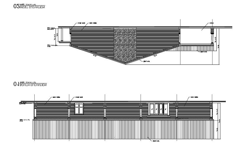
26 AGENDA ITEM NO. 6 AGENDA CAPTION: Consider and act upon the site plan and building elevations and for an office/apartment in MidTowne, Phase 1, Lot 1R-GA-1, Block 24. Property is zoned PD-42 and contains ± acres being located at the north side of George Hopper Lane and 70 feet east of Alex Lane, in the City of Midlothian, Texas (Case No. SP ) RECOMMENDATION: Staff recommends approval of the building elevation, site plan and landscaping plans, as presented. BACKGROUND INFORMATION: Purpose: This request is to approve the site plan, landscaping plan and building elevations for a proposed office building and apartment unit on a 2-story structure within MidTowne. Each floor contains approximately 1,200 square feet each for a total of 2,400 square feet of space. Prior Action/History: The PD zoning on this property was approved by the City Council under Ordinance , approved in March A replat on this property was filed with the Ellis County Clerk s Office in March ANALYSIS: Zoning and Land Uses: Direction: Existing Land Use: Existing Zoning Classification: Future Land Use Classification Subject Property Undeveloped PD-42 New Town Module North Yoga studio PD-42 New Town Module South Undeveloped PD-42 New Town Module East Undeveloped PD-42 New Town Module West Office use PD-42 New Town Module Comprehensive Plan/Future Land Use Plan: The Future Land Use element of the Comprehensive Plan shows this property located in the New Town Module. This use conforms to the adopted Comprehensive Plan. Thoroughfare Plan/Transportation: Although George Hopper Road is located on the south side, no additional right-of-way dedication is required for this major collector as the City obtained all the necessary right-of-way in 1999 when it was constructed as a bond-approved road. Water and Sanitary Sewer Services: Both City water and sewer currently serve this property. Environmental Considerations: Although this property is not located within the FEMA-designated 100-year floodplain, any drainage plans must be reviewed by the Engineering Department to ensure compliance with the City s storm water management regulations during the engineering plan review stage. Page 1 of 5
, the eastern portion has incorporated glass windows to maximize the use of natural light.")
27 Architectural Design: This building will be 100% brick throughout, except for the exposed area between 2 nd floor adjacent to the west building. As this building will be the last one on this row (due to a 14-foot green space), the eastern portion has incorporated glass windows to maximize the use of natural light. The apartment will be accessed through the rear of the building with stairs leading up to the second-story apartment unit. The design and materials meet the standards for this PD. Parking: Based on the City s Parking Regulations, the ratio for office uses are 1 space for every 300 square feet and 2 for an apartment. Based on a projected 1,200 square feet of each use, a total of 6 spaces are required for this building and 7 spaces are being provided. In addition, on-street parking spaces abutting the subject property line are allowed to count towards the overall parking calculations and the PD ordinance does allow for joint/shared parking. Signage: Building signage is limited to 60 total square feet based on the Sign Regulations that limit the size of signage to the width of the building. LEGAL REQUIREMENTS: A site plan that meets all the requirements set forth in the Zoning Ordinance and the adopted PD standards and Subdivision Regulations must be approved. CONCLUSION: This site plan, landscape plan and elevations meets all the requirements set forth in Ordinance as well as the City s Zoning Ordinance. RECOMMENDATION: Staff recommends approval of the building elevation, site plan and landscaping plans, as presented. ACTION NEEDED: 1. Approve the site plan 2. Deny the site plan based on noncompliance with zoning, subdivision rules or construction standards ATTACHMENTS: 1. Location Map 2. Elevations 3. Site Plan SUBMITTED AND PRESENTED BY: Alberto Mares, AICP, Planning Manager Tuesday, April 15, 2014, Planning & Zoning Commission Meeting REVIEWED BY: Kevin J. Lasher, AICP, Director of Planning Tuesday, April 15, 2014, Planning & Zoning Commission Meeting Page 2 of 5

28 ATTACHMENT 1 Page 3 of 5

29 ATTACHMENT 2 Page 4 of 5
30 ATTACHMENT 3 Page 5 of 5
31 AGENDA ITEM NO. 7 AGENDA CAPTION: Consider and act upon a preliminary plat of Hillstone Estates. Property contains ± acres in the Martha Brenan Survey, Abstract 43, and located on the east side of FM 663 and ± 480 feet south of Ashford Lane, in the City of Midlothian, Texas (Case No. PP ). RECOMMENDATION: Staff recommends conditional approval of this preliminary plat as described in the Recap section of this report. BACKGROUND INFORMATION: Purpose: The applicant, Mr. Kim Gill (prospective purchaser of the subject property), is seeking to preliminary plat forty-seven (47) residential lots, one (1) detention pond lot and two (2) commercial lots. The subject 16 acre tract has very narrow proportions. It measures feet in width along the frontage of FM 663, and is 2, feet deep extending in an eastward direction from FM 663. As shown in Attachment 2, the tract is only wide enough to accommodate one residential street right-of-way centered down the middle of the property. This proposed street (Street A ) would terminate in a cul-de-sac adjacent to a tract of land recorded to Daniel G. and Cathy Altman. The applicant has stated they have contacted the owner of this property for the purchase of additional land area so that the proposed subdivision can be extended to a projected alignment of 14 th Street which is projected along an existing north-to-south segment of Ashford Lane situated ± 1,030 feet to the east. The applicant has stated that a real estate transaction with the adjoining property owner cannot be negotiated at the present time. Therefore, in the absence of a connecting extension to future 14 th Steet to the east, the applicant has negotiated an agreement with the Midlothian Bible Church to the south for a second street connect to the proposed subdivision (shown as Street B ) to facilitate access for emergency response vehicles. The applicant has indicated they would still pursue an eastward connection to 14 th Street once a real estate contract can be consummated with the adjoining property owner. The location of Street B is approximately 965 feet from the planned cul-de-sac to the east. This distance is approximately 365 feet longer that the maximum permitted cul-de-sac length of 600 feet. Furthermore, Section b of the Subdivision Regulations states no more than 25 lots may be served by a cul-de-sac. All 47 residential lots proposed by this Preliminary Plat are deemed to be served by the cul-de-sac since Street B is not yet connected to an existing public right-ofway. Should this Preliminary Plat receive conditional approval from the Commission, the applicant will be required to secure the necessary zoning approvals from the Commission and City Council prior to the review of the Final Plat application. Prior Action/History: This property has no previous subdivision history. Page 1 of 5
32 ANALYSIS: Surrounding Zoning and Land Uses: Direction: Subject property Existing Land Use: Predominately Undeveloped Existing Zoning Classification: Future Land Use Classification 85% AG & 15% SF-1 75% Suburban & 25% Village Module North Residential 85% AG & 15% SF-1 30% Suburban & 70% Village Module South Church 85% AG & 15% SF-1 Suburban Module East Agricultural & Residential AG Suburban Module West Residential AG 50% Country & 50% Suburban Module Comprehensive Plan/Future Land Use Plan: The Comprehensive Plan s Future Land Use Map establishes a mix of Suburban, Village and Country module designations for this area. The 2025 Midlothian Comprehensive Plan defines these future land use modules as follows: Suburban Module - The predominant use is single-family detached housing with secondary uses being those that support the primary use. Secondary uses in this module include medium density residential as well as neighborhood office and retail facilities, which support the residential component by providing convenient access to daily goods and services. Community facilities such as schools, parks and churches are also included. Village Module - This module is intended to concentrate a grouping of commercial uses serving a larger region and incorporating residential uses around major transportation intersections, and provide services and employment opportunities for surrounding residential modules. Country Module - The primary use is single-family residential on large lots, with a limited amount of more dense single family residential and support office and retail uses. Thoroughfare Plan/Transportation: FM 663 is a three-lane undivided thoroughfare with a continuous left turn lane. It is dedicated within an ultimate 80-foot wide right-of-way. No additional right-of-way for FM 663 will be required for this proposed subdivision. As stated above, the applicant has contacted the owner of the property to the east for the purchase of additional land area so that the proposed subdivision may be extended to a future alignment of 14 th Street which is projected along an existing north-to-south segment of Ashford Lane situated ± 1,030 feet to the east. The absence of this connection is necessitating the appeals to the maximum cul-de-sac length of 600 feet, and to allow the cul-de-sac to serve 47 lots in lieu of the maximum permitted 25 lots. Water and Sanitary Sewer Services: The subject property is located in the Mountain Peak CCN who will provide water to this site. Sewer will be provided by the city of Midlothian. Environmental Considerations: This property is located within or adjacent to the FEMA-designated 100-year floodplain. During the Final Plat review, drainage plans shall be submitted for review and approval by the Engineering Department to ensure compliance with the City s storm water management regulations during the engineering plan review stage. Page 2 of 5
33 LEGAL REQUIREMENTS Section 212 of the Texas Local Government Code states all plats must be acted upon within 30 days of receiving a complete application. If a plat is not acted upon within those 30 days, the plat is automatically approved, unless otherwise waived. Also, if the plat meets all set requirements of the Subdivision Regulations, it must be approved. CONCLUSION: With the exception of the two requested appeals regarding the cul-de-sac design, this preliminary plat meets all the requirements set forth in the Subdivision Regulations. Staff does not object to the requested appeals, but feels the proposed subdivision would be better served by a publicly dedicated thoroughfare connection to 14 th Strreet to the east. RECOMMENDATION RECAP: Staff recommends approval of this preliminary plat, and the variance to the Subdivision Regulations Ordinance 88-14, as amended, SECTION b which states: b. Cul-de-Sacs, courts or places may be permitted where the form or contour of the land or the shape of the property makes such street design appropriate. Such cul-de-sacs, courts or places shall provide proper access to all lots and shall generally not exceed six hundred (600) feet in length from the centerline of the intersection to the radius point and no more than 25 lots may be served by a cul-de-sac. Conditions of approval shall also include: 1) The cul-de-sac length from the center line of Street B shall not exceed feet as measured to the center radius point of the cul-de-sac diameter. 2) No more than 47 lots shall be served by the cul-de-sac as depicted on the Preliminary Plat drawing revised dated April 1, ) The Final Plat shall not be reviewed by the Planning and Zoning Commission until the applicant secures required zoning designation approvals for the platted area from the Planning and Zoning Commission and City Council. 4) The Final Plat shall not be recorded until a cross access agreement with the property owner adjoining the southern boundary of the platted area has been consummated and recorded for the provision of access to Street B from FM ) All lot lines for the proposed commercial lots that adjoin a residentially zoned property will be required to be screened with a 6-foot high masonry fence in accordance with Section of the Midlothian Zoning Ordinance. Same lot lines would also be subject to a 20- foot building setback. ACTION NEEDED: 1. Approve the preliminary plat with variances 2. Deny the plat 3. Deny the plat without prejudice and request a new plat submittal that conforms to the City s Subdivision Regulations Ordinance ATTACHMENTS: 1. Location Map 2. Preliminary plat SUBMITTED AND PRESENTED BY: Kevin J. Lasher, AICP, Director of Planning Tuesday, April 15, 2014, Planning & Zoning Commission Meeting Page 3 of 5

34 ATTACHMENT 1 Page 4 of 5
35 ATTACHMENT 2 Page 5 of 5
36 AGENDA ITEM NO. 8 AGENDA CAPTION: Consider and act upon a preliminary plat of The Aviary. Property contains ± acres in the John Crane Survey, Abstract No. 246 and the Samuel Fredrick Survey, Abstract No. 357 and located at the southeast intersection of Shiloh Road and Walnut Grove Road, in the extraterritorial jurisdiction (ETJ) of the City of Midlothian, Texas (Case No. PP ) RECOMMENDATION: Staff recommends approval of this preliminary plat, as presented. BACKGROUND INFORMATION: Purpose: The applicant, Chris Turturro, is requesting to preliminary plat 21 lots with lot sizes of at least 1 acre each. Prior Action/History: There is no current zoning or subdivision history on this property. On April 1, 2014, the applicant made an application to voluntary annex this property into the City. ANALYSIS: Surrounding Zoning and Land Uses: Direction: Existing Land Use: Existing Zoning Classification: Future Land Use Classification Subject property Undeveloped n/a (ETJ) Country Module North Residential n/a (ETJ) Country Module South Residential n/a (ETJ) Country Module East Residential n/a (ETJ) Country Module West Residential/undeveloped Agricultural (A) Country Module Comprehensive Plan/Future Land Use Plan: The Future Land Use element of the Comprehensive Plan shows this proposed development in the Country Module, where the majority of development is slated for large lots. Thoroughfare Plan/Transportation: The Thoroughfare Plan shows 2 thoroughfares adjacent to this proposed development. Walnut Grove Road is a major thoroughfare requiring a total right-of-way dedication of 120 feet and Shiloh Road is a minor thoroughfare requiring a total right-of-way dedication of 90 feet. The plat is showing the half of the required dedication for both streets, 60 feet and 45 feet, respectively. Water and Sanitary Sewer Services: Service to this area will be provided by Sardis Lone Elm. No sewer is available to this site and will be served by septic tanks. A septic waiver will accompany the final plat. Environmental Considerations: A major portion of Lot 13 is in the designated floodplain, but it still has over a net acre outside the floodplain to place a structure on it. Any drainage plans must be reviewed by the Engineering Department to ensure compliance with the City s storm water management regulations during the engineering plan review stage. Page 1 of 4
37 LEGAL REQUIREMENTS Section 212 of the Texas Local Government Code states all plats must be acted upon within 30 days of receiving a complete application. If a plat is not acted upon within those 30 days, the plat is automatically approved, unless otherwise waived. Also, if the plat meets all requirements of the Subdivision Regulations, it must be approved. CONCLUSION: This plat meet all the requirements set forth in the Subdivision Regulations. ACTION NEEDED: 1. Approve the plat with conditions RECOMMENDATION RECAP: Staff recommends approval of this preliminary plat, as presented. ATTACHMENTS: 1. Location Map 2. Preliminary plat SUBMITTED AND PRESENTED BY: Alberto Mares, AICP, Planning Manager Tuesday, April 15, 2014, Planning & Zoning Commission Meeting REVIEWED BY: Kevin J. Lasher, AICP, Director of Planning Tuesday, April 15, 2014, Planning & Zoning Commission Meeting Page 2 of 4

38 ATTACHMENT 1 Page 3 of 4

39 ATTACHMENT 2 Page 4 of 4

40 AGENDA ITEM NO. 9 AGENDA CAPTION: Consider and act upon a request for a driveway spacing variance for a counseling center at First Baptist Church Midlothian Addition Lot 1, Block 2. Property contains ± acres and is located east of South Midlothian Parkway approximately 225 feet north of Mt. Zion Road, in the City of Midlothian, Texas (Case No. M ) RECOMMENDATION: Staff recommends approval of this request for an exemption from the driveway spacing standards found in Section of the Zoning Ordinance. Please see the recap section for details. BACKGROUND INFORMATION: Purpose: In October 2013, staff approved a site plan for a proposed counseling center for First Baptist Church Midlothian that met all the requirements. After engineering plans were reviewed, it was determined that an exemption from the City s driveway spacing standards was required as the proposed driveway location along South Midlothian Parkway is about 288 feet from the other drive cut to the south, falling short of the 330 feet required along major thoroughfares. Although the distance exemption is minimal, a curb inlet as well as topographical challenges and floodplain issues to the north of this site prevent the drive from being shifted to the north to meet the required minimum spacing. LEGAL CONSIDERATIONS: Section (subsection d) grants the Planning & Zoning Commission the authority to grant exemptions from driveway spacing requirements provided any exemption shall be in harmony with the purpose and intent of these requirements and shall not be considered until every feasible option for meeting the driveway spacing has been explored. CONCLUSION: Based on the criteria found in Section , the existing conditions found on this site, and the fact due to those existing conditions, another drive cut will likely align with the one coming out of the existing church parking lot (located about 1,100 feet from this proposed driveway), staff supports this driveway exemption request. RECOMMENDATION (recap): Staff recommends approval of this request for a driveway exemption request to allow this drive cut to be approximately 290 feet north of the existing drive cut that aligns with Mt. Zion Road with the following condition: 1) Any future drive cut along this property shall align with the existing church drive cut on the west side of South Midlothian Parkway (approximately 1,100 feet) ACTION NEEDED: 1. Approve this exemption request 2. Deny this exemption request Page 1 of 4
41 ATTACHMENTS: 1. Location Map 2. Survey Plat showing location of proposed driveway SUBMITTED AND PRESENTED BY: Alberto Mares, AICP, Planning Manager Tuesday, April 15, 2014, Planning & Zoning Commission Meeting REVIEWED BY: Kevin J. Lasher, AICP, Director of Planning Tuesday, April 15, 2014, Planning & Zoning Commission Meeting Page 2 of 4

42 Page 3 of 4 ATTACHMENT 1

43 Page 4 of 4 ATTACHMENT 2
44 AGENDA ITEM NO. 10 AGENDA CAPTION: Conduct a public hearing to consider and act upon an ordinance amending the City of Midlothian Zoning Ordinance , as amended, to rezone ± acres from the current Planned Development (PD-33) District (multi-family and retail uses) to a Planned Development District (PD) for residential use (townhomes). Property is located in the WM Hawkins Survey, Abstract 465, being located north of East Ridge Drive and ± 400 feet east of North 14 th Street, in the City of Midlothian, Texas (Case No. Z ) RECOMMENDATION: Staff recommends to continue this rezone request indefinitely to allow the applicant time to submit additional information. Staff will re-advertise when the case is ready to be brought back. BACKGROUND INFORMATION: Purpose: The applicant, Massey Shaw, is requesting to rezone this property into a planned development to create townhomes. Prior Action/History: This property was originally annexed under Ordinances 615 (March 13, 1984) and zoned to a Planned Development (PD-2) District for multi-family and commercial uses with Ordinance 621 (April 24, 1984), an amendment to Ordinance 621 imposing certain restrictions in the planned development (PD-2) District was granted by Ordinance 640 (August 14, 1984), on March 20, 2006 City Council approved a zoning change to the current Planned Development (PD-33) District allowing multi-family and retail uses on ± acres where the Timber Oaks Apartment Complex was developed. LEGAL REQUIREMENTS: Notifications were provided to the surrounding property owners within 200 feet as required by state law. A total of 24 letters to property owners within 200 feet of the subject site were mailed. To date, staff has not received any Notification Letters Response Forms regarding this request. ACTION NEEDED: 1. Close the public hearing and recommend approval of this rezone request 2. Close the public hearing and recommend denial of this rezone request 3. Continue this public hearing to another date 4. Close the public hearing and table this rezone request to another date RECOMMENDATION: Staff recommends to continue this rezone request indefinitely to allow the applicant time to submit additional information. Staff will re-advertise when the case is ready to be brought back. ATTACHMENTS: 1. Location Map SUBMITTED AND PRESENTED BY: Kevin J. Lasher, AICP, Director of Planning Tuesday, April 15, 2014, Planning & Zoning Commission Meeting Page 1 of 2

45 ATTACHMENT 1 Page 2 of 2
PLANNING AND ZONING COMMISSION MEETING / 7:00 PM COUNCIL CHAMBERS
 NOTICE OF A SCHEDULED MEETING FOR THE CITY OF MIDLOTHIAN PLANNING AND ZONING COMMISSION TUESDAY, OCTOBER 20, 2015 Pursuant to the provisions of Chapter 551 VTCA Government Code, notice is hereby given
PRELIMINARY PLATS. The following documents are provided as required by the City of Conroe for use in the above titled platting submittals:
 Public Works Engineering Division CITY OF CONROE PRELIMINARY PLATS The following documents are provided as required by the City of Conroe for use in the above titled platting submittals: Submittal Questionnaire
PLANNED DEVELOPMENT DISTRICT STANDARDS. Cadence Site
 PLANNED DEVELOPMENT DISTRICT STANDARDS Cadence Site A Planned Development District 1. Statement of General Facts, Conditions and Objectives Property Size: Approximately 57.51 Acres York County Tax Map
ARTICLE 23 CONDOMINIUM STANDARDS
 ARTICLE 23 CONDOMINIUM STANDARDS Section 23.01 Intent. The intent of this Article is to provide regulatory standards for condominiums and site condominiums similar to those required for projects developed
M E M O R A N D U M. Meeting Date: October 23, Item No. F-1. Planning and Zoning Commission. Daniel Turner, Planner I
 M E M O R A N D U M Meeting Date: October 23, 2017 Item No. F-1 To: From: Subject: Planning and Zoning Commission Daniel Turner, Planner I PUBLIC HEARING: Consider a recommendation of a of Planned Development
HERON LANDING SUBDIVISION
 HERON LANDING SUBDIVISION Engineering Comments: Per FEMA guidelines, any development greater than 5 acres in size or subdivision 50 lots in size, requires a flood study. Width of drainage easement to be
SUBDIVISION DESIGN PRINCIPLES AND STANDARDS
 SECTION 15-200 SUBDIVISION DESIGN PRINCIPLES AND STANDARDS 15-201 STREET DESIGN PRINCIPLES 15-201.01 Streets shall generally conform to the collector and major street plan adopted by the Planning Commission
Exhibit A-1. Piney Creek Bend Planned Development
 Exhibit A-1 Piney Creek Bend Planned Development A. Purpose and Intent The Piney Creek Bend PD is composed of approximately 90.91 acres, as described in Exhibit D (Field Notes). The development of this
ARTICLE 15. RULES, REGULATIONS AND DEFINITIONS
 ARTICLE 15. RULES, REGULATIONS AND DEFINITIONS Section 1. Interpretation and Construction: The following rules and regulations regarding interpretation and construction of the Ulysses-Grant County, Kansas,
Subdivision - Minor Plat Submittal
 Subdivision - Minor Plat Submittal This Checklist is intended to provide the information and data that is necessary to assess the merits of the project proposal. Please note that this Checklist is intended
MINOR PLAT. The following documents are provided as required by the City of Conroe for use in the above titled platting submittals:
 Public Works - Engineering Division CITY OF CONROE MINOR PLAT The following documents are provided as required by the City of Conroe for use in the above titled platting submittals: Submittal Questionnaire
(a) Commercial uses on Laurel Avenue, abutting the TRO District to the
 Commercial uses on Laurel Avenue, abutting the TRO District to the") 32X Zoning Code 150.36 TRANSITIONAL RESIDENTIAL OVERLAY DISTRICT. (A) Intent and purpose. (1) It is the intent of the Transitional Residential Overlay District (hereinafter referred to as the "TRO District")
32X Zoning Code 150.36 TRANSITIONAL RESIDENTIAL OVERLAY DISTRICT. (A) Intent and purpose. (1) It is the intent of the Transitional Residential Overlay District (hereinafter referred to as the "TRO District")
Section Preliminary Plat Checklist and Application Forms
 Section 201 - Preliminary Plat Checklist and Application Forms PRELIMINARY SUBDIVISION PLAT REVIEW PROCESS CHART PRELIMINARY SUBDIVISION PLAT APPLICATION PRELIMINARY PLAT REVIEW CHECKLIST CITY OF NAMPA
SUBJECT PARCEL(S) Property Owner(s) TMS Number Approximate Acreage Carolina Park Development, LLC
 Property Owner(s) TMS Number Approximate Acreage Carolina Park Development, LLC") Staff Report Special Planning Commission Meeting November 19, 2014 For reference, the Zoning Code and Land Development Regulations are available online. AGENDA ITEM 5c. SKETCH PLAN APPROVAL REQUEST: Request
Staff Report Special Planning Commission Meeting November 19, 2014 For reference, the Zoning Code and Land Development Regulations are available online. AGENDA ITEM 5c. SKETCH PLAN APPROVAL REQUEST: Request
SPECIAL ZONING DISTRICTS
 SPECIAL ZONING DISTRICTS 5.01 5.99 RESERVED 5.100 PLANNED DEVELOPMENTS: Purpose: This district is intended to accommodate unified design of residential, commercial, office, professional services, retail
The following information is for use by the Lincoln County Planning Board at their meeting/public hearing on February 3, 2014.
 LINCOLN COUNTY PLANNING & INSPECTIONS DEPARTMENT 302 NORTH ACADEMY STREET, SUITE A, LINCOLNTON, NORTH CAROLINA 28092 704-736-8440 OFFICE 704-736-8434 INSPECTION REQUEST LINE 704-732-9010 FAX To: Planning
ARTICLE 3 DEFINITIONS
 Sections: 3-1 Rules of Construction 3-2 Definitions ARTICLE 3 DEFINITIONS SECTION 3-1 RULES OF CONSTRUCTION 3-101. a. The language set forth in these regulations shall be interpreted in accordance with
PLANNING COMMISSION REPORT REGULAR AGENDA
 PP-4-4-11 Item No. 9-1 PLANNING COMMISSION REPORT REGULAR AGENDA PC Staff Report 06/22/11 ITEM NO 9: PRELIMINARY PLAT; KASOLD WATER TOWER ADDITION; SE OF TAM O SHANTER & KASOLD DR (MKM) PP-4-4-11: Consider
MINUTES HEATH CITY COUNCIL REGULAR MEETING 200 LAURENCE DRIVE- HEATH, TEXAS TUESDAY, MAY 8, :30 P.M.
 MINUTES HEATH CITY COUNCIL REGULAR MEETING 200 LAURENCE DRIVE- HEATH, TEXAS TUESDAY, MAY 8, 2018-6:30 P.M. ATTENDING: BRIAN, MAYOR KELSON ELAM, MAYOR PROTEM JOE RICH KRAUSE FRANK NEW PAUL RUFFO BRENT WEAVER
Cover Letter with Narrative Statement
 Cover Letter with Narrative Statement March 31, 2017 rev July 27, 2017 RE: Rushton Pointe Residential Planned Unit Development Application for Public Hearing for RPUD Rezone PL2015 000 0306 Mr. Eric Johnson,
M E M O R A N D U M. Planning and Zoning Commission. Daniel Turner, Planner I
 M E M O R A N D U M Meeting Date: Monday, April 10, 2017 Item No. F-4 To: From: Planning and Zoning Commission Daniel Turner, Planner I Subject: Consider a recommendation of a Preliminary Site Evaluation
PRIMUS TRACT MOUNT PLEASANT, SOUTH CAROLINA
 DEVELOPMENT GUIDELINES FOR PRIMUS TRACT MOUNT PLEASANT, SOUTH CAROLINA Date February 18, 2015 PLANNING COMMISSION SUBMITTAL Owner/Developer: American Star Development SC, LLC P.O. Box 211 Sullivans Island,
-MENDOCINO COUNTY PLANNING AND BUILDING SERVICES- DIVISION OF LAND REGULATIONS TITLE 17
 ARTICLE VI -- GENERAL REGULATIONS AND PROVISIONS Sec. 17-50. Sec. 17-51 General Plan. Sec. 17-52 Lot and Block Design and Configuration. Sec. 17-53 Lot Access. Sec. 17-54 Private Roads. Sec. 17-55 Water
Proposed Overland Park Kansas Ordinance RE-1 Residential Estates Community
 18.171 RE-1 Residential Estate Community 18.171.010 Statement of intent. The zoning of property as RE-1, (Residential Estates Community, 1 dwelling unit per Gross acre density), is intended to provide
City of Shenandoah Development Package
 Upon completion return application to Development@shenandoahtx.us City of Shenandoah Development Package Documentation includes the following: Fee Schedule Platting Development Check List & Outline Development
REPORT TO THE PLANNING COMMISSION
 Agenda Number: PC14-50 MEETING DATE: February 5, 2015 REPORT TO THE PLANNING COMMISSION SUBJECT: Villas of Tara Oaks Request approval of a Preliminary Subdivision Plat for 29 lots, on 9.14 acres located
a. provide for the continuation of collector streets and thoroughfare streets between adjacent subdivisions;
 Section 7.07. Intent The requirements of this Section are intended to provide for the orderly growth of the Town of Holly Springs and its extra-territorial jurisdiction by establishing guidelines for:
M E M O R A N D U M. Planning and Zoning Commission. Daniel Turner, Planner I
 M E M O R A N D U M Meeting Date: April 27, 2015 Item No. E-1 To: From: Planning and Zoning Commission Daniel Turner, Planner I Subject: Consider approval of a Final Plat for Gean Estates, Phase I, a proposed
ORDINANCE NO. Be it ordained by the City Council of the City of Abilene, Texas:
 ORDINANCE NO. An ordinance repealing Chapter 23, Subpart B of the Code of the City of Abilene, Texas, entitled Mobile Homes and Vacation Travel Trailers; stating the authority; setting forth the scope
M E M O R A N D U M. Meeting Date: May 1, Item No. H-4. Steve Polasek, Interim City Manager. David Hawkins, Senior Planner
 M E M O R A N D U M Meeting Date: May 1, 2012 Item No. H-4 To: From: Subject: Steve Polasek, Interim City Manager David Hawkins, Senior Planner PUBLIC HEARING: Consider an ordinance approving a planned
19 June 9, 2010 Public Hearing APPLICANT AND PROPERTY OWNER: KEMP ENTERPRISES, INC.
 19 June 9, 2010 Public Hearing APPLICANT AND PROPERTY OWNER: KEMP ENTERPRISES, INC. STAFF PLANNER: Karen Prochilo REQUEST: Change of Zoning District Classification, Conditional A-24 Apartment District
PLANNING BOARD AGENDA
 PLANNING BOARD AGENDA Public Hearing and Administrative Meeting Wednesday,, 1:30 P.M. Omaha/Douglas Civic Center 1819 Farnam Street Legislative Chamber DISPOSITION AGENDA This document states the disposition
Condominium Unit Requirements.
 ARTICLE 19 CONDOMINIUM REGULATIONS Section 19.01 Purpose. The purpose of this Article is to regulate projects that divide real property under a contractual arrangement known as a condominium. New and conversion
DAUPHIN CREEK ESTATES SUBDIVISION
 # 12 SUB-000076-2017 DAUPHIN CREEK ESTATES SUBDIVISION Engineering Comments: FINAL PLAT COMMENTS (should be addressed prior to submitting the FINAL PLAT for review and/or signature by the City Engineer):
STAFF REPORT. Guttman Development Group, LLC. PUD-R (Residential Planned Unit Development Plan)
") P a g e 1 STAFF REPORT CASE: APPLICANT: LOCATION: ZONED: REQUEST: ZC09-2017 Guttman Development Group, LLC 4990 Wilmington Pike PUD-R (Residential Planned Unit Development Plan) A Major Change to an Approved
P a g e 1 STAFF REPORT CASE: APPLICANT: LOCATION: ZONED: REQUEST: ZC09-2017 Guttman Development Group, LLC 4990 Wilmington Pike PUD-R (Residential Planned Unit Development Plan) A Major Change to an Approved
Chapter Plat Design (LMC)
") Chapter 18.14 Plat Design (LMC) Sections: 18.14.010 Lot width 18.14.020 Right-of-way requirements 18.14.030 Pipe stem lots 18.14.040 Division resulting in minimum lot sizes 18.14.050 Flood prone and bad
Chapter 18.14 Plat Design (LMC) Sections: 18.14.010 Lot width 18.14.020 Right-of-way requirements 18.14.030 Pipe stem lots 18.14.040 Division resulting in minimum lot sizes 18.14.050 Flood prone and bad
PLANNED UNIT DEVELOPMENT & SUBDIVISION STAFF REPORT Date: November 17, 2016
 PLANNED UNIT DEVELOPMENT & SUBDIVISION STAFF REPORT Date: November 17, 2016 DEVELOPMENT NAME SUBDIVISION NAME LOCATION Autonation Ford of Mobile Autonation Ford of Mobile Subdivision 901, 909, and 925
GWINNETT COUNTY CSO CONSERVATION SUBDIVISION OVERLAY DISTRICT REQUIREMENTS
 GWINNETT COUNTY CSO CONSERVATION SUBDIVISION OVERLAY DISTRICT REQUIREMENTS Section 1316. CSO Conservation Subdivision Overlay District. 1. Purposes. The purposes of this overlay district are as follows:
Planning Department Oconee County, Georgia
 Planning Department Oconee County, Georgia STAFF REPORT REZONE CASE #: 6985 DATE: October 31, 2016 STAFF REPORT BY: Andrew C. Stern, Planner APPLICANT NAME: Williams & Associates, Land Planners PC PROPERTY
PLANNING COMMISSION REPORT Regular Agenda Non Public Hearing Item
 PC Staff Report 3/23/15 FDP-14-00551 Item No. 2-1 PLANNING COMMISSION REPORT Regular Agenda Non Public Hearing Item PC Staff Report 3/23/15 ITEM NO. 2: FINAL DEVELOPMENT PLAN FOR HUTTON FARMS WEST PHASE
PLANNING COMMISSION REPORT Regular Agenda -Public Hearing Item
 PDP-13-00518 Item No. 3B- 1 PLANNING COMMISSION REPORT Regular Agenda -Public Hearing Item PC Staff Report 2/24/14 ITEM NO. 3B PRELIMINARY DEVELOPMENT PLAN FOR HERE @ KANSAS; 1101 INDIANA ST (SLD) PDP-13-00518:
Organized with a "core" curriculum (the first five modules) and "electives" (the remaining modules in the program.
 and electives (the remaining modules in the program.") Introduction Sponsored by The North Carolina Chapter - American Planning Association These materials are the result of an effort by volunteer members of the North Carolina Chapter of the American Planning
Introduction Sponsored by The North Carolina Chapter - American Planning Association These materials are the result of an effort by volunteer members of the North Carolina Chapter of the American Planning
CONDOMINIUM REGULATIONS
 ARTICLE 37 CONDOMINIUM REGULATIONS SECTION 37.01. Purpose The purpose of this Article is to regulate projects that divide real property under a contractual arrangement known as a condominium. New and conversion
ARTICLE 14 PLANNED UNIT DEVELOPMENT (PUD) DISTRICT
 DISTRICT") ARTICLE 14 PLANNED UNIT DEVELOPMENT (PUD) DISTRICT Section 14.01 Intent. It is the intent of this Article to allow the use of the planned unit development (PUD) process, as authorized by the Michigan Zoning
ARTICLE 14 PLANNED UNIT DEVELOPMENT (PUD) DISTRICT Section 14.01 Intent. It is the intent of this Article to allow the use of the planned unit development (PUD) process, as authorized by the Michigan Zoning
RE: 6. GILL/GREEN COMPREHENSIVE PLAN AMENDMENT, REZONING AND PRELIMINARY PLAT
 commission memo DATE: Thursday - August 9, 2018 TO: Marion Planning & Zoning Commission FROM: David N. Hockett, AICP Principal Planner RE: 6. GILL/GREEN COMPREHENSIVE PLAN AMENDMENT, REZONING AND PRELIMINARY
STAFF REPORT. To: Planning Commission Meeting date: January 11, 2017 Item: UN Prepared by: Marc Jordan. Schoolhouse Development, LLC
 STAFF REPORT # 9 ) UN-05-17 AMERICAN LEADERSHIP ACADEMY SPECIAL USE PERMIT CHARTER SCHOOL PUBLIC HEARING To: Planning Commission Meeting date: January 11, 2017 Item: UN-05-17 Prepared by: Marc Jordan GENERAL
Development Plan DP13-3 (Arlington Lofts) Planning and Zoning Meeting Date: Document Being Considered: Ordinance
 Planning and Zoning Meeting Date: Document Being Considered: Ordinance") Staff Report Development Plan DP13-3 (Arlington Lofts) Planning and Zoning Meeting Date: 6-19-13 Document Being Considered: Ordinance RECOMMENDATION Following the public hearing, consider Development Plan
Staff Report Development Plan DP13-3 (Arlington Lofts) Planning and Zoning Meeting Date: 6-19-13 Document Being Considered: Ordinance RECOMMENDATION Following the public hearing, consider Development Plan
ARTICLE 900 PLAT AND PLAN REQUIREMENTS
 ARTICLE 900 PLAT AND PLAN REQUIREMENTS SEC. 900.1 ITEMS TO BE SHOWN ON PLAT OR PLAN General (1) Property lines of all property owners adjacent to the exterior boundaries of the project shall be located
RESIDENTIAL DISTRICTS
 RESIDENTIAL DISTRICTS RESIDENTIAL DISTRICTS The residential district standards have been revised to reflect on-the-ground development conditions, while continuing to respect the use patterns established
Staff Report: Date: Applicant: Property Identification: Acreage of Request: Current Zoning of Requested Area: Requested Action: Attached:
 Staff Report: Completed by Jeff Palmer Director of Planning & Zoning Date: November 7, 2018, Updated November 20, 2018 Applicant: Greg Smith, Oberer Land Developer agent for Ronald Montgomery ET AL Property
4. No subdivision shall contain a lot that is less than the minimum dimensions set out in the applicable zoning district regulations.
 Article 8 Subdivisions Part 1 Major and Minor Subdivisions Section 161: Purpose The intent of these regulations is to protect the public health, safety and welfare by providing for the orderly growth and
1. Multi-family dwellings, including town homes, apartments, or condominiums.
 Sec. 4-6.67 Planned Unit Development (PUD-M). a. Definition. A planned multi-family zoning district of three acres or more, consisting of townhouses, apartments, condominiums, single-family detached, single-family
ARTICLE 13 CONDOMINIUM REGULATIONS
 ARTICLE 13 CONDOMINIUM REGULATIONS Section 13.01 Purpose. The purpose of this Article is to regulate projects that divide real property under a contractual arrangement known as a condominium. New and conversion
CITY OF FATE, TEXAS UNIFIED DEVELOPMENT ORDINANCE. Article VI Subdivision
 July 17, 2017 CITY OF FATE, TEXAS UNIFIED DEVELOPMENT ORDINANCE Article VI Subdivision 6.1 General Provisions 6.1.1 AUTHORITY, PURPOSE & APPLICABILITY (A) AUTHORITY The regulations of this Subdivision
Town of Cary, North Carolina Rezoning Staff Report 12-REZ-27 Morris Branch Town Council Public Hearing January 24, 2013
 Town of Cary, North Carolina Rezoning Staff Report 12-REZ-27 Morris Branch Town Council Public Hearing January 24, 2013 REQUEST To amend the Town of Cary Official Zoning Map to rezone approximately 9.0
1. APPLICANT: The City of Overland Park is the applicant for this request.
 8. UNIFIED DEVELOPMENT ORDINANCE AMENDMENT - ZRR 2590 - Residential Neighborhood District 1. APPLICANT: The City of Overland Park is the applicant for this request. 2. REQUESTED ACTION: The applicant is
CHAPTER 5. Subdivisions Regulations
 CHAPTER 5 Subdivisions Regulations 10-5-1 Introduction and Purpose 10-5-2 Definitions 10-5-3 General Provisions 10-5-4 Procedure for Submitting Subdivisions 10-5-5 Design Standards; Streets and Lots 10-5-6
NOTICE OF THE REGULAR MEETING OF THE PLANNING & ZONING COMMISSION Tuesday, August 4, 2015 REGULAR MEETING AGENDA 6:30 PM
 NOTICE OF THE REGULAR MEETING OF THE PLANNING & ZONING COMMISSION Tuesday, August 4, 2015 Notice is hereby given of the Regular Meeting of the Planning & Zoning Commission beginning at 6:30 p.m. Tuesday,
THE COUNTY BOARD OF SUPERVISORS OF THE COUNTY OF DOUGLAS DOES ORDAIN AS FOLLOWS:
 8.1 SUBDIVISION CONTROL ORDINANCE THE COUNTY BOARD OF SUPERVISORS OF THE COUNTY OF DOUGLAS DOES ORDAIN AS FOLLOWS: SECTION I. GENERAL INTERPRETATION This ordinance shall not repeal, impair or modify private
Washington County, Minnesota Ordinances
 Washington County, Minnesota Ordinances Ordinance No. 153 Text Amendment to the Washington County Development Code - Chapter One, Section 2 and Chapter Two, Part 1, Part 2, Part 3, of the Development Code
the conditions contained in their respective Orders until January 1, 2025, at the discretion of the Director of Planning, Property and Development.
 Part 4: Use Regulations Temporary Uses and Structures Purpose the conditions contained in their respective Orders until January 1, 2025, at the discretion of the Director of Planning, Property and Development.
CITY OF HOBBS ORDINANCE NO..
 CITY OF HOBBS ORDINANCE NO.. AN ORDINANCE TO AMEND TITLE 16 OF THE HOBBS MUNICIPAL CODE IN ITS ENTIRETY. BE IT ORDAINED BY THE GOVERNING BODY OF THE CITY OF HOBBS, NEW MEXICO, that the following Chapter
SUBDIVISION APPLICATION CHECKLIST SKETCH PLAN PRELIMINARY PLAT FINAL PLAT
 RECEIVED STAMP SUBDIVISION APPLICATION CHECKLIST SKETCH PLAN PRELIMINARY PLAT FINAL PLAT A checklist of background information and submission requirements for processing of a sketch plan, preliminary plat
Department of Development Agenda Item Ellis County Commissioners Court Tuesday, November 7, :00AM
 Department of Development Agenda Item Ellis County Commissioners Court Tuesday, November 7, 2017 10:00AM Agenda Item No. SP1 Agenda Item No. SP2 Agenda Item No. SP3 Agenda Item No. SP4 Agenda Item No.
TOWN OF LEWISTON PLANNING BOARD APPLICATION
 TOWN OF LEWISTON PLANNING BOARD APPLICATION DESCRIPTION OF PROPOSED REQUEST: Name of Property Owner: Phone #: Name of Applicant:Phone #: Address or Location of Proposal:_SBL# Size of Parcel or Structure:Existing
ZONING AMENDMENT, PLANNED UNIT DEVELOPMENT & SUBDIVISION STAFF REPORT Date: September 15, 2011
 ZONING AMENDMENT, PLANNED UNIT DEVELOPMENT & SUBDIVISION STAFF REPORT Date: September 15, 2011 NAME SUBDIVISION NAME LOCATION Stratford, L.L.C. Grelot Office Park Subdivision North side of Grelot Road,
Initial Project Review
 Pierce County Department of Planning and Land Services, 2401 South 35th Street, Tacoma, WA (253) 798-7037 Initial Project Review Major Amendment to Preliminary Plat: Hawks Ridge Division 1 Application
May 21, ACHD Board of Commissioners Stacey Yarrington, Planner II DRH /DRH
 Development Services Department May 21, 2013 TO: FROM: SUBJECT: ACHD Board of Commissioners Stacey Yarrington, Planner II DRH13-00106/DRH13-00108 Executive Summary: This is a design review application
ARTICLE 5.0 SCHEDULE OF REGULATIONS
 ARTICLE 5.0 SCHEDULE OF REGULATIONS Section 5.101 Table of Dimensional Standards by District. Dimensional Standards AG AG with sewer Districts Rural Residential Business Other SF SF with sewer R-1 R-1
A. Appropriate agency responsible for transportation review for the subject property.
 7.8.10 Procedure Any person desiring to create a minor subdivision shall submit to the Commission for approval an application on forms provided by the Division, and a record plat in conformance with the
AN ORDINANCE AMENDING THE CODE OF ORDINANCES OF THE TOWN OF TRYON. Chapter 156 Subdivision Ordinance
 AN ORDINANCE AMENDING THE CODE OF ORDINANCES OF THE TOWN OF TRYON Chapter 156 Subdivision Ordinance Chapter 156: Subdivision Regulations ARTICLE I GENERAL PROVISIONS Section 1.1 Title This Ordinance shall
CITY OF OCOEE LAND DEVELOPMENT CODE SUFFICIENCY TABLE WITH NOTES
 CITY OF OCOEE LAND DEVELOPMENT CODE SUFFICIENCY TABLE WITH NOTES The Sufficiency Table is a checklist to help identify the types of information and documentation needed for various types of projects. The
610 LAND DIVISIONS AND PROPERTY LINE ADJUSTMENTS OUTSIDE A UGB
 ARTICLE VI: LAND DIVISIONS AND PROPERTY LINE ADJUSTMENTS VI-21 610 LAND DIVISIONS AND PROPERTY LINE ADJUSTMENTS OUTSIDE A UGB 610-1 Property Line Adjustments (Property Line Relocation) A property line
MINOR SUBDIVISION FINAL PLAT APPLICATION Town of Apex, North Carolina
 MINOR SUBDIVISION FINAL PLAT APPLICATION Town of Apex, North Carolina This document is a public record under the North Carolina Public Records Act and may be published on the Town s website or disclosed
TOWN OF ORO VALLEY PLANNING & ZONING COMMISSION MEETING DATE: December 6, 2011
 PLANNING & ZONING COMMISSION MEETING DATE: December 6, 2011 TO: FROM: SUBJECT: PLANNING & ZONING COMMISSION Matt Michels, Senior Planner mmichels@orovalleyaz.gov; tel. 229-4822 Public Hearing: Rancho de
EDMOND PLANNING COMMISSION 20 S. Littler, Edmond, Oklahoma Tuesday, May 6, :30 p.m.
 City of Edmond NOTICE OF PUBLIC MEETING The City of Edmond encourages participation from all its citizens. If participation at any Public meeting is not possible due to a disability, notification to the
CLEARFIELD CITY COUNCIL AGENDA AND SUMMARY REPORT July 31, 2018 SPECIAL POLICY SESSION
 CLEARFIELD CITY COUNCIL AGENDA AND SUMMARY REPORT July 31, 2018 SPECIAL POLICY SESSION Meetings of the City Council of Clearfield City may be conducted via electronic means pursuant to Utah Code Ann. 52-4-207
SECTION 3.1 ZONING DISTRICTS ESTABLISHED
 ARTICLE 3. ZONING DISTRICTS SECTION 3.1 ZONING DISTRICTS ESTABLISHED The City of Cedar Hill, Texas is hereby divided into the following zoning districts. The use, height and area regulations as set out
EDMOND PLANNING COMMISSION MEETING. Tuesday, October 5, 2004
 124 EDMOND PLANNING COMMISSION MEETING Tuesday, 5:30 P.M. The Edmond Planning Commission Meeting was called to order by Chairperson David Woods at 5:30 p.m., Tuesday,, in the City Council Chambers at 20
APPLICATION PROCEDURE
 ANTRIM PLANNING BOARD P. O. Box 517 Antrim, New Hampshire 03440 Phone: 603-588-6785 FAX: 603-588-2969 APPLICATION FORM AND CHECKLIST FOR MINOR OR MAJOR SITE PLAN REVIEW File Date Received By APPLICATION
1. Roll Call. 2. Minutes a. September 26, 2016 Regular Meeting. 3. Adoption of the Agenda. 4. Visitors to Be Heard
 1. Roll Call City of Vermillion Planning Commission Agenda 5:30 p.m. Regular Meeting Tuesday, October 11, 2016 Large Conference Room 2 nd Floor City Hall 25 Center Street Vermillion, SD 57069 2. Minutes
C I T Y O F M c K I N N E Y PLANNING
 C I T Y O F M c K I N N E Y PLANNING 221 N. TENNESSEE STR EE T, McKI NNEY, TEXA S 75069 CONTENTS Approval Process Flowchart Letter of Intent Requirements Plat/Replat Submittal Checklist Plat/Replat Fee
E L M E R B O R O U G H L A N D U S E B O A R D APPLICATION COVER SHEET (to be completed for all applications and appeals)
") E L M E R B O R O U G H L A N D U S E B O A R D APPLICATION COVER SHEET (to be completed for all applications and appeals) 1. Name(s): 2. Address: 3. Telephone Number(s): 4. E-mail: 5. Owner Name(s) (if
E L M E R B O R O U G H L A N D U S E B O A R D APPLICATION COVER SHEET (to be completed for all applications and appeals) 1. Name(s): 2. Address: 3. Telephone Number(s): 4. E-mail: 5. Owner Name(s) (if
ARTICLE IV: DEVELOPMENT STANDARDS
 ARTICLE IV: DEVELOPMENT STANDARDS IV-53 409 PRIVATE STREETS A private street means any way that provides ingress to, or egress from, property by means of vehicles or other means, or that provides travel
UPPER MOUNT BETHEL TOWNSHIP NORTHAMPTON COUNTY, PENNSYLVANIA
 UPPER MOUNT BETHEL TOWNSHIP NORTHAMPTON COUNTY, PENNSYLVANIA JOINDER DEED / LOT CONSOLIDATION TOWNSHIP REVIEW PROCESS When accepting proposed Joinder Deeds / Lot Consolidations, review the Joinder Deed
DEVELOPMENT DEPARTMENT STAFF REPORT THE PARK AT 5 TH
 DEVELOPMENT DEPARTMENT STAFF REPORT ARB Meeting Date: July 3, 2018 Item #: _PZ2018-293_ THE PARK AT 5 TH Request: Site Address: Project Name: Parcel Number: Applicant: Proposed Development: Current Zoning:
ARTICLE 5. SUBDIVISION STANDARDS
 ARTICLE 5. SUBDIVISION STANDARDS 5.1. General 5.1.1. Applicability The requirements of this article shall apply to all development required to submit site plans or plats, unless expressly exempted by the
Meeting Minutes New Prague Planning Commission Wednesday, June 27, 2018
 Meeting Minutes New Prague Planning Commission Wednesday, 1. Call Meeting to Order The meeting was called to order at 6:30 p.m. by Member Bob Gilman with the following members present: Amy Jirik, Matt
Initial Subdivision Applications Shall Include the Following:
 Initial Subdivision Applications Shall Include the Following: 1) Subdivision Application Form: completely filled out (12 copies) 2) Plat: The Plat must adhere to the requirements set forth in the Town
Exhibit "A" have applied for a re-zoning and re-classification of that property from OPEN RURAL (OR) to that of a PLANNED UNIT DEVELOPMENT (PUD); and
 to that of a PLANNED UNIT DEVELOPMENT (PUD); and") I NSTR # 200632845 OR BK 61439 PGS 0728-0750 RECORDED 06/24/2066 12:25:50 PR JOHN Q. CRAWFOKD CLERK OF CIRCUIT COURT NASSAU COUNTY, FLORIDA RECORDING FEES 1.37.80 ORDINANCE NO. 2006-65 AN ORDINANCE AMENDING
I NSTR # 200632845 OR BK 61439 PGS 0728-0750 RECORDED 06/24/2066 12:25:50 PR JOHN Q. CRAWFOKD CLERK OF CIRCUIT COURT NASSAU COUNTY, FLORIDA RECORDING FEES 1.37.80 ORDINANCE NO. 2006-65 AN ORDINANCE AMENDING
Chapter 34 SUBDIVISION OF LAND Last updated December 2014
 Chapter 34 SUBDIVISION OF LAND Last updated December 2014 In General Sections: 34.010 Planning Commission 34.020 Purpose of Subdivision Regulations: Approval of Plats 34.030 Definitions 34.040 Procedure
SECTION 7000 LAND DEVELOPMENT REQUIREMENTS
 SECTION 7000 LAND DEVELOPMENT REQUIREMENTS 7000 LAND DEVELOPMENT REQUIREMENTS... 1 7001 LEGISLATIVE AUTHORITY... 1 7001.1 LAND DEVELOPMENT... 1 7001.1.1 Title 40, Idaho Code... 1 7001.1.2 Idaho Code 40-1415
EXHIBIT D. Planned Unit Development Written Description April 13, 2016 Rouen Cove Phase II PUD
 1 EXHIBIT D Planned Unit Development Written Description April 13, 2016 Rouen Cove Phase II PUD Development # 8986.001 Developer: Curtis L. Hart Hart Resources LLC 8051 Tara Lane Jacksonville, Florida
Subdivision and Development
 Subdivision and Development Code of Ordinances Chapter 21 City of Richardson, Texas Table of Contents City of Richardson Code of Ordinances Chapter 21: I. In General...1 21-1. Title...1 21-2. Definitions...1
Draft Model Access Management Overlay Ordinance
 Draft Model Access Management Overlay Ordinance This model was developed using the City of Hutchinson and the Trunk Highway 7 corridor. The basic provisions of this model may be adopted by any jurisdiction
Rick Keeler Bonney Ramsey Melissa Ballard Jim Phillips Rodney Bell
 A regular meeting of the Planning & Zoning Commission of the City of Waxahachie was held on Tuesday, at 7:00 p.m. in the Council Chamber at 401 S. Rogers, Waxahachie, Texas. Members Present: Member Absent:
PLANNED DEVELOPMENT DISTRICT A ACRE TRACT KNOWN AS GEAN ESTATES CITY OF KELLER, TARRANT COUNTY TEXAS
 PLANNED DEVELOPMENT DISTRICT A 105.026 ACRE TRACT KNOWN AS GEAN ESTATES CITY OF KELLER, TARRANT COUNTY TEXAS A. Exhibit A Development Regulations B. Exhibit B Legal Description C. Exhibit C Conceptual
ACTION FORM BRYAN CITY COUNCIL
 ACTION FORM BRYAN CITY COUNCIL DATE OF COUNCIL MEETING: July 8, 2014 DATE SUBMITTED: June 17, 2014 DEPARTMENT OF ORIGIN: Development Services SUBMITTED BY: Maggie Dalton MEETING TYPE: CLASSIFICATION: ORDINANCE:
Community Development Department 333 Broadalbin Street SW, P.O. Box 490 Albany, OR 97321
 SUMMARY Community Development Department 333 Broadalbin Street SW, P.O. Box 490 Albany, OR 97321 STAFF REPORT Application for Tentative Partition Plat Review Planning File PA-06-17 Phone: 541-917-7550
Department of Planning & Development Services
 Department of Planning & Development Services S T A F F R E P O R T February 9, 2015 CASE NO: PROJECT: EXECUTIVE SUMMARY: ZA14-154 Plat Revision for Lots 25R-1A, 25R-1B and 25R-1C, Block 1, Woodland Heights