`Chapter 24 SUBDIVISION REGULATIONS
|
|
|
- Jeffry Page
- 5 years ago
- Views:
Transcription
1 `Chapter 24 SUBDIVISION REGULATIONS Articles I. In General, II. Fees, III. Tentative Map--Procedure, IV. Tentative Map--Requirements, V. Parks and Recreation--Dedication and Fees, VI. Final Maps, VII. Parcel Maps, VIII. Adjustment Plats, IX. Boundary Surveys, X. Reversions to Acreage, XI. Enforcement Certificates of Compliance, Appendices A. Typical Subdivision Review Flowchart B. Imperial Irrigation District Project Processing and Flowchart 1
2 Sections: ARTICLE 1 IN GENERAL Subdivision Map Act mandates local compliance 24-1 Citation and a uthority 24-2 Definitions and terms 24-3 Prohibition 24-4 Extent of regulations 24-5 Application of Subdivision Map Act 24-6 Waiver of tentative map and final or parcel maps for condominium projects on a single parcel 24-7 Merger of parcels 24-8 Environmental impact analysis required 24-9 Report of conformity with general plan required Consistency with hazardous waste management plan required Sec Citation and authority. (a) This chapter is adopted to supplement and implement the Subdivision Map Act and may be cited as the Subdivision Ordinance of El Centro. with its provisions, such Subdivision Map Act provisions shall prevail within the city. To the extent that such provisions are permissive or allow local discretion, the provisions of this chapter shall prevail. Sec Definitions and terms. The definitions and terms of this chapter apply to the provisions of this chapter and do not affect other provisions of the city code. Whenever terms are used in this chapter that are not specifically defined herein, they shall have the same meaning as is given to them in the Subd ivision Map Act. Adjustment plat: A plat for the purpose of adjusting the boundary between two (2) or more adjacent parcels. Also known as a lot-line adjustment. (b) All land divisions in the city are subject to all of the applicable provisions of the Subdivision Map Act and this chapter. The Subdivision Map Act (Government Code Section et seq.) contains definitions, requirements and procedures applicable to subdividing of property and any reference thereto shall also mean as the law may be subsequently amended by the State of California. This chapter implements the Subdivision Map Act and includes by reference the de finitions, requirements and procedures stated therein. To the extent that the Advisory agency: Advisory agency shall be the Planning Commission designated as the official bod y charged with the duty of making investigations and reports on the design and improvement of proposed divisions of real property, the imposing of requirements or conditions thereon, and having the authority to appr ove, conditionally approve or disapprove maps in accordance with the Subdivision Map Act. Appeal board: The city council shall be charged with the duty of hearing and making determinations upon appeals with respect to the approval, conditional 2
3 approval or denial of divisions of real property. Certificate of compliance: A document describing a unit or contiguous units of real property that states that the subdivision thereof complies with the applicable provisions of the Subdivision Map Act and this chapter. City: The City of El Centro, a general law city, located in Imperial County, California. City Engineer: The city engineer of the City of El Centro. County Surveyor: (a) County Surveyor includes the county engineer, if there is no county surveyor of Imperial County. (b) A county engineer registered as a civil engineer after January 1, 1982, shall not be authorized to prepare, examine, or approve the surveying maps and documents. The examinations, certifications, and approvals of the surveying maps and documents shall only be performed by a person authorized to practice land surveying pursuant to the Professiona l Land Surveyors Act (Chapter 15, commencing with Section 8700 of Division 3 of the Business and Professions Code) or a person registered as a civil engineer prior to January 1, 1982, pursuant to the Professional Engineers Act (Chapter 7, commencing with Sections 6700 of Division 3 of the Business and Professions Code ). Final map: A map, except a parcel map as defined herein, prepared in accordance with the Subdivision Map Act and this chapter, for the purpose of showing the division of real prope rty, which is designed to be recorded in the office of the county recorder. Lot: (a) A parcel of land with a separate and distinct number or other designation shown on a plat recorded in the office of the County Recorder; a unit or tract of real property; or (b) A parcel of land delineated on an approved record of survey, lot split or sub-parceling map as filed in the office of the county recorder, and abutting at least one public street or right-of-way, or easement determined by the Planning Commission to be adequate for the purpose of access; or (c) A parcel of land containing not less area than required by the zone in which it is located in conformity with City zoning regulations, abutting at least one public street or right-of-way and held under separate ownership from adjacent property. Manager: The city manager of the City of El Centro. Network Administrator: The network administrator of the Imperial Valley Telecommunications Agency (I.V.T.A.). Parcel map: A map, prepared in accordance with the Subdivision Map Act and this chapter, for the purpose of showing the division of real property when a final map is not required, which is designed to be recorded in the office of the county recorder. Planning Director: The director of planning of the City of El Centro. 3
4 Recorder: The County Recorder of Impe rial County. Street: Includes state highway; county road or street; public road, street or alley; or public or private thoroughfare, road, street, alley or easement for ingress or egress. Subdivider: A person, firm, corporation, partnership or association that proposes to divide, divides or causes to be divided real property into a subdivision for themselves or others. Employees or consultants of such are not considered a subdivider. Subdivision: The division of any unit or units of improved or unimproved land, or any po rtion thereof, shown on the latest equalized county assessment roll as a unit or as contiguous units, for the purpose of sale, lease or financing, whether immediate or future, except for leases of agricultural land for agricultural purposes. Property shall be considered as contiguous units, even if it is separated by roads, streets, utility easements or railroad rights-of-way. Subdivision Map Act: The act set forth in Division 2 of Title 7 (Section et seq.) of the Government Code of the State of California. Tentative map: A map made for the purpose of showing the design of a proposed subdivision and the existing conditions in and around it, and need not be based upon an accurate or detailed final survey of the property. Vesting tentative map: A map which meets the requirements of Section of the Government Code, and this chapter. Zoning Ordinance: The zoning ordinance of the City of El Centro found in Chapter 29 of this code. Sec Prohibition. No person shall create a subdivision except in accorda nce with the provisions of the Subdivision Map Act and this chapter. Sec Extent of regulations. No real property, improved or unimproved, consisting of a single unit or two (2) or more contiguous units and owned by the same person or persons shall be divided into two (2) or more lots, including any lot retained by the owner, except in accordance with the provisions of the Subdivision Map Act and this chapter. Sec Application of Subdivision Map Act. (a) Except as otherwise expressly provided in this chapter, all of the provisions of the Subdivision Map Act which apply to subdivisions as defined in that act and all of the provisions of this chapter shall apply to subdivisions as defined in this chapter. (b) This chapter shall not apply to the exclusions cited in the Subdivision Map Act as presently approved or amended in the future. These exclusions include, but are not limited to: (1) The financ ing or leasing of apartments, offices, stores or similar space within apartment buildings, industrial 4
5 buildings, commercial buildings, mobilehome parks, or trailer parks. (2) Mineral, oil or gas leases. (3) Land dedicated for cemetery purposes under the Health and Safety Code. (4) A lot line adjustment between two (2) or more existing adjoining parcels, where the land taken from one parcel is added to an adjoining parcel, and where a greater number of parcels than originally existed is not thereby created, provided the lot line adj ustment is appr oved by the planning director. The planning director shall limit the ir review and approval to a determination of whether or not the parcels resulting from the lot line adjustment will conform to local zoning and building ordinances. The planning director shall not impose conditions or exactions on their approval of a lot line adjustment except to conform to local zoning and building ordinances, or except to facilitate the relocation of existing utilities, infrastructure or easements. No tentative map, parcel map or final map shall be required as a condition to the approval of a lot line adj ustment. The lot line adjustment shall be reflected in a deed or record of survey which shall be recorded. (5) Any separate assessment under Section of the Revenue and Taxation Code. (6) The leasing or licensing of a portion of a parcel, or the granting of an easement, use permit, or similar right on a portion of a parcel, to a telephone corporation as defined in Section 234 of the Public Utilities Code, exclus ively for the placement and operation of cellular radio transmission facilities, including, but not limited to, antennae support structures, microwave dishes, structures to house cellular communications transmission equipment, power sources, and other equipment incidental to the transmission of cellular communications, if the project is subject to discretionary action by the planning commission or city council. Sec Waiver of tentative map and final or parcel maps for condominium projects on a single parcel. 5
6 (a) (b) (c) Other provisions of this chapter to the contrary notwithstanding, the requirement for the filing of a tentative map and the preparation, filing and recording of a final or parcel map, for condominium projects on a single parcel, may be waived by the planning commission providing a finding is made that the proposed subdivision complies with the requirements as to area, improvement and design, flood and water drainage control, appropriate improved public roads, sanitary disposal facilities, water supply availability, environmental protection, and other requirements of this chapter and the Subdivision Map Act. An application for a waiver pursuant to this section shall contain sufficient information to enable the planning commission to make the findings required by this section. An applicant for a waiver pursuant to this section shall pay the fee as prescribed for tentative maps. Subdivisions wherein dedication or improvements would be required as a condition of approval are hereby deemed not to comply with the findings required by this section for waiver of tentative map and final parcel maps. Sec Merger of parcels. Notwithstanding the Subdivision Map Act definition of a subdivision, two (2) or more contiguous parcels or units of land which have been created unde r the provisions of this chapter or any prior law regulating the division of land or a local ordinance enacted pursuant thereto, or which were not subj ect to such provisions at the time of their creation, shall not merge by virtue of the fact that such contiguo us parcels or units are held by the same owner and no further proceeding under the provisions of the Subdivision Map Act or this chapter shall be required for the purpose of sale, lease or financing of such contiguous parcels or units of land; except that if any one of such contiguous parcels or units held by the same owner does not conform to standards for minimum parcel size to permit use or development under the zoning, subdivision or other ordinance of the city and at least one of such contiguous parcels or units is not developed with a building for which a permit has been issued by the city, o r which was build prior to the time such permits were required by the city, then such parcels shall be merged for the purpos es of this chapter. Sec Environmental impact analysis required. No tentative map filed pursuant to the provisions of this chapter shall be approved until an environmental impact analysis is prepared, processed and considered by the advi sor y agency, or an exempt ion for CEQA determined to be applicable. The subdivider shall provide such additional data and information; deposit and pay such fees as may be required for the preparation and processing of environmental review documents. Sec Report of conformity with general plan or specific plan required. (a) A report indicating conformity with the general plan required by Article 5 of Chapter 3 of 6
7 (b) Division 1 (commencing with Section 65300) of the Government Code, or any specific plan adopted pursuant to Article 8 of Chapter 3 of Division 1 (commencing with Section 65450) of the Government Code, and with the zoning ordinance of the city, shall be included as part of and at the same time as action is considered by the advisory agency or city council on the proposed division of land. Such a report is not required for proposes of subdivision (a) of Section of the Government Code which involves: (1) The dispos ition of the remainder of a larger parcel which was acquired and used in part for street purposes; (2) Acquisitions, dispositions and abandonments for street widening; or (3) Alignment projects. Management Plan (approved February 28, 1990), including any amendments to such plan, relating to siting and siting criteria for hazardous waste facilities. Nothing herein shall limit the ability of the city to attach appropriate conditions to the issuance of any such approval in order to protect the public health, safety or welfare nor to establish more stringe nt planning requirements or siting criteria than those specified in the County Hazardo us Waste Management Plan. Sections: ARTICLE II FEES Fee Schedule through Reserved. Sec Fee schedule. (a) Processing Fees. The city council shall adopt a processing fee schedule by resolution for the following: (1) Tentative maps. (2) Final maps. (3) Parcel maps. provided that the planning commission expressly finds that any such disposition for street purposes; acquisitions, dispositions, or abandonments for street widening; or alignment projects are minor in nature. Sec Consistenc y with hazardo us waste management plan required. Tentative tract maps, parcel maps and other subdivision approvals under this article shall be consistent with the por tions of the County of Imperial Hazardous Waste (b) (4) Reversions to acreage. (5) Adj ustment plats. (6) Certificates of compliance. (7) Environmental review of app lications pursuant to this chapter. Sanitary sewer and water fee. The city has prepared, adopted and approved a master sewer and water 7
8 operations plan. This master sewer and water plan outlines a projection of needs to provide for future growth and develop ment in the city. To implement and provide for the necessary additions to the plan and systems, the following program is necessary. A fee schedule will be set by resolut ion adopted by the city council based upo n equivalent dwelling unit (EDU). The de velope r/owner shall, at the time of obtaining building permit, pay to the city the abo ve-referenced fees in full. Upo n request, the developer/owner may enter into an agreement with the city which is recordable, is binding on successors in interest, and is approved by resolution of the city council to pay the fee with interest at the prime rate as published in the Wall Street Journal plus two (2) percent over a two-year period; provided that the fee to be paid is five thousand dollars ($5,000.00) or more. The city council may aut hor ize the City Manager and/or City Fina nce Director to execute any agreements or other documents for, and on behalf of the city, which agreements or documents shall be approved as to form by the city attorney. No building permit shall be issued until such fee is paid in full or until the developer/owner enters into an approved agreement to pay the fee over a two-year period as provided in this subsection. These fees shall also be paid before a building permit will be issued for any building or addition that creates an intensified use of the property over that which was previously (c) (d) existing on the building site. The city engineer is authorized, when substantiating documentation is submitted b y the de velope r/owner of prior number of bedrooms and/or square footage of building for commercial or industrial development, to credit the developer or owner for that prior usage against this sanitary sewer and water fee. Said intensified use is applicable to the scheduled fees and said intensified use is defined as a development for which a building permit must be issued and which will result in a net increase in occupa ncy and/or impact to the sewer and water system. The fees paid pursuant to this section shall be accounted for and used as provided in Section of the Government Code. Drainage fee. The subdivider shall, at the time of submitting a final map or parcel map, pay to the city a drainage fee as set by resolution adopted by the city council. No final map or parcel map shall be approved by the city until the drainage fee has been paid in full. Fees collected hereunder shall be segregated and deposited into a drainage facilities fund of the city. This fund and the interest accruing thereto shall be expended solely for the construction of the city s drainage facilities. Parks and recreation fee. The subdivider shall dedicate land to the city for park and recreational purposes or pay a fee in lieu thereof, or both, as provided in Article V of this chapter. 8
9 Sec Reserved. Sec Reserved. Sec Reserved. ARTICLE III TENTATIVE MAPS PROCEDURE Sections: Tentative map required Conformance to rules of advisory agency Preliminary development plan for remainder parcel Contents of tentative map Information to accompany tentative map Filing o f tentative map Map copies for county planning commission and district highway engineer Numbering of lots Names of streets Tentative map review process Grading and eros ion control Flood hazard or water quality violation Public hearing required Grounds for denial of tentative map Appeals Expiration of tentative map and time extensions through Reserved Sec Tentative map required. Except where a tentative map is waived by other provisions of this chapter, a tentative map shall be filed to create a subdivision of real prope rty pursuant to the Subd ivision Map Act and this chapter. The city shall not approve a final map or parcel map unless a tentative map of the subdivision has been previously filed and approved. Sec Conformance to rules of advi sor y agency. All tentative maps shall be in the form prescribed by the rules and procedures of the advisory agency and the planning director and shall be accompanied by the information specified by those rules and procedures. Whenever the advisor y agency finds that the real property to be subdivided is of such size or shape, is subject to such title limitations of record or is to be devoted to such a use that it is impo ssible or impractical for the subdivider to conform fully to the requirements of this chapter, it may waive or modify such requirements as it deems reasonable, provided however that any such waiver or mod ification of such requirements shall be in conformity with the intent and purpose of the Subdivision Map Act and this chapter. Sec Preliminary development plan for remainder parcel. (a) (b) When a subdivision, as defined herein, is a portion of any unit or units of improved or unimproved land, the subdivider may designate as a remainder that portion which is not divided for the purpose of sale, lease, or fina ncing. The designated remainder shall not be counted as a parcel for the purpose of determining whether a parcel map or final map is required. Prior to or concurrent with the filing of a tentative map which contains a remainder parcel or which is located adjacent to undeveloped land, the subdivider shall submit a preliminary development plan 9
10 (PDP) for such remainder parcel or adjacent undeveloped land. This PDP shall show how the landlocking of the remainder parcel will be prevented and thus allow continuity and the orderly development of adjacent land. The PDP shall indicate thereon the street designs, drainage plans, park and school locations and such other infor mation as may be necessary for the orderly and efficient development of the subject land. The appr oval of the PDP shall not bind either the subd ivide r or the city to the design of future tentative maps. Future tentative maps may deviate from the PDP if they do not violate the continuity of the street designs, improvement of the drainage system or other city requirements, as they are required. Approval of a PDP does not commit the city to any subs equent app rovals in conformity with concepts of the PDP without conducting required public hearings before both the planning commission and c ity council. Sec Contents of tentative map. All tentative maps shall be in the form prescribed by the advisory agency and planning director and shall contain the following: (1) Title of subdivision and description of property. (2) Name and address of owner and subdivider. (3) Name and address of person preparing map. (4) Approximate acreage. (5) North point. (6) Scale in engineering units. (7) Date. (8) Boundary line. (9) Location and name of streets. (10) Width of proposed streets. (11) Name, loc ation and widt h of adjacent streets. (12) Proposed street grades. (13) Street grades beyond tract boundaries. (14) Cross-section of proposed street improvements. (15) Width of alleys. (16) Width of easements. (17) Dimensions of reservations. (18) Existing structures and their disposition. (19) Location of existing and proposed public utilities. (20) Existing and proposed sewer lines. (21) Elevation of sewers at proposed connections. 10
11 (22) Existing and proposed water mains. (23) Existing and proposed fire hydrants. (24) Existing culverts and drain pipes. (25) Watercourses. (26) Land subject to overflow, inundation or flood hazard. (27) Railroads. (28) Proposed lot lines and approximate dimensions. (29) Approximate radius of curves. (30) Building setback lines. (31) Lands, parks and schools to be dedicated for public use. (32) Existing topographic cont ours at one-foot intervals. (33) Proposed land use, in conformity with existing zoning. a. Residential. b. Commercial. c. Manufacturing. d. Special/Other. e. Overlays. Sec tentative map. (34) Name and map number of adjoining subdivisions. (35) Existing use of property immediately surround ing the tract. (36) If tentative map is vesting tentative map, it shall have pr inted conspicuously on its face Vesting Tentative Map. (37) Proposed Traffic Calming Measures Information to accompany A tentative map filed as provided in this article shall be accompanied by reports and written statements from the subdivider giving essential information regarding the following matters: (1) Development plan. Subdivision development plan. (2) Water supply. Source, quality and an estimate of available quantity of domestic water supply. (3) Fire hydrants. Maximum interval not to exceed three hundred (300) feet, except in rural areas. (4) Street improvements, etc. Type of street improvements and utilities which the subdivider proposes to install. (5) Sewage disposal. Proposed method of sewage disposal. 11
12 (6) Storm water retention. Proposed storm water retention basin in accord with city adopted standards. (7) Storm sewers. Proposed storm water sewer (grade and size). (8) Trees. Proposed tree planting within public right-of-way. (9) Preliminary title report. Sec Filing of tentative map. A minimum of eighteen (18) copies of the tentative map shall be filed with the planning director and shall be processed in accordance with the Subdivision Map Act and the provisions of this chapter. The subdivider shall file as many additional copies of the tentative map as may be required by the planning director. Sec Map copies for county planning commission and district highway engineer. (a) (b) Upon the filing of the required number of copies of a tentative map with the planning director, one cop y thereof shall be immediately forwarded to the county planning commission. If a state highway is involved, the planning director shall forward a cop y of the tentative map to the district engineer of the state department of transportation. Sec Numbering of lots. Whenever the city, town or subdivision of land is platted or subdivided into lots or blocks, and whenever any add ition to the city, town or subdivision is laid out into lots or blocks for the purpose of sale or transfer, the city engi neer, under the direction and with the approval of the city council, may make an official map of the city, town or subdivision; giving to each block on the map a number, and to each lot or subdivision in the block a separate number or letter, and giving names to such streets, avenues, lanes, courts, schools or parks, as may be delineated on the official map. Sec Names of streets. The city engineer may compile the maps on file; resurvey, renumber or reletter the lots and blocks; or change the na mes of the streets. Sec Tentative map review process. The subdivider should confer with the city engineer and planning director before preparing a tentative map of the proposed subdivision. When a tentative map is filed as provided in this article, the review process shall be as follows: (a) Procedure for notification. A not ice of public hearing shall be given in all of the following ways: (1) Notice of the hearing shall be mailed or delivered at least ten (10) days prior to the hearing to the owner of the subject real property or the owner s duly authorized agent, and to the project applicant. (2) Notice of the hearing shall be mailed or delivered at least ten (10) days prior to the hearing to each local 12
13 (b) agency expected to provide water, sewage, street, roads, schools, or other essential facilities or services to the project, whose ability to provide those facilities and services may be significantly affected. (3) Notice of hearing shall be mailed at least ten (10) days prior to the hearing to all owners of real property shown on the latest equalized assessment roll within three hundred (300) feet of the real property that is the subject of the hearing, or more recent ownership information maintained by the county assessor or tax collector. (4) Published at least once in a newspaper of general circulation in the city not less than ten (10) days prior to t he da te of hearing. (5) If the proposed subdivision is a conversion of residential real property to a condominium project, community apartment project, or stock cooperative project, the notice shall also be given by mail to each tenant of the subj ect property, and shall also include notification of the tenant s right to appear and be heard. The city engineer and planning director shall make a detailed examina tion of the tentative map (c) (d) and the property as may be necessary to enable them to ascertain compliance with this chapter, other applicable ordinances and the Subd ivision Map Act. The planning director shall prepare a report incorporating input from the city engineer, health officer, fire marshal, other appropriate city and county departments, and public utility districts and companies with respect to the design of the proposed subdivision as well as the kind, nature, extent and timing of the proposed improvements, including but not limited to street, sewer, water, school and fire protection. The report shall include a recommendation of denial, approval or conditional approval. If the recommendation is for conditional approval, the report shall include recommendation of conditions of approval. A flowchart of the map app roval process is described in Appendix A at the end of this chapter. Sec Grading and erosion control. Every map approved pursuant to this chapter shall be conditioned on compliance with the requirements for grading, drainage and erosion control, including the prevention of sedimentation or damage to off-site property. Sec Flood hazard or water quality violation. (a) The planning commission may recommend disapproval of a tentative map because of flood hazard and inundation, and 13
14 (b) recommend protective improvements to be constructed as a condition of approval, should the map be approved by the city. The planning commission shall determine whether the discharge of waste from the propose subdivision into an existing community sewer system would result in violation of existing requirements prescribed by a California Regional Water Quality Control Board. In the event that the planning commission finds that the proposed waste discharge would result in or add to violation of requirements of such board, it may recommend disapproval of the tentative map. Sec Public hearing required. Following public notice as provided herein, all tentative maps shall require a public hearing as follows: (a) The planning commission shall approve, or recommend denial of all tentative maps of four (4) or fewer parcels, excluding any remainder parcels, for which a parcel map or certificate of compliance is to be recorded. (b) The planning commission shall recommend approval, conditional approval, or denial of all tentative maps of five (5) or more lots or parcels, excluding any remainder parcel. (c) The city council shall have final authority to approve, conditionally (d) approve, or deny all tentative maps of five (5) or more lots or parcels, excluding any remainder parcel; and to approve, conditionally approve or deny any tentative map for which an appeal has been made pursuant to this chapter. The city council shall have final authority to approve, conditionally approve, or deny all tentative maps for which the planning director or planning commission has recommended denial. Sec Grounds for denial of tentative map. (a) No tentative map shall be approved or conditionally approved unless the approval authority finds that the proposed subd ivision, together with the provisions for its design and improvement, is consistent with the general plan of the City or specific plan. (b) The planning director and planning commission shall recommend denial, and the city council shall deny approval of a tentative map, if it makes any of the following findings: (1) That the proposed map is not consistent with the applicable general and specific plans. (2) That the design or improvement of the proposed subdivision is not consistent with applicable general and specific plans. 14
15 Sec (3) That the site is not physically suitable for the type of development. (4) That the site is not physically suitable for the proposed density of development. (5) That the design of the subd ivision or the proposed improvements are likely to cause subs tantial environmental damage or substantially and avoidably injure fish or wildlife or their habitat. (6) That the design of the subdivision or type of improvements is likely to cause serious public health problems. (7) That the design of the subd ivision or the type of improvements will conflict with easements, acquired by the public at large, for access through or use of property within the proposed subdivision; provided, however, the city council may approve a map if it finds that alternate easements, for access or for use, will be provided, and that these will be substantially equivalent to ones previously acquired by the public. Appeals. The subdivider, any tenant of property proposed to be subdivided, in the case of a proposed conversion of residential real property to a condominium project, community apartment project, or stock cooperative project, or any interested person who filed a written protest prior to the close of the public hearing or who appeared at the public hearing and spoke on a matter at issue, may appeal any decision of the planning commission to the city council. Such appeal shall be in writing and be received by the city clerk within ten (10) days following the action of the planning commission. After the filing of an appe al, the city council shall set the matter for hearing within thirty (30) days. Not ice of such appe al hearing shall be give n by the city clerk in accordance with section 24-24(a) of this chapter. Sec Expiration of tentative map and time extensions. (a) Expiration. The approval or conditional approval of a tentative map shall expire twenty four (24 ) months from the date the map was approved or conditionally approved. (b) Extension. Prior to the expiration of the tentative map, the subdivider may request a time extension of the tentative map approval or conditional approval written application. Such application may be filed any time within ninety (90) days before the approval or conditional approval is due to expire. The application shall state the reasons for requesting the extension. 15
16 (c) Public hearing required. A request for time extension shall follow the same procedure for public notice and hearing as required for original tentative map approval. (d) Time limit on extensions. An extension or extensions of tentative map approval or conditional approval shall not exceed an additional twelve (12) mont hs from the expiration date of the original approval or conditional approval. (g) expiration. Modification of a tentative map after approval or conditiona l app roval shall not extend the time limits imposed by this section. Additional time pursuant to government code. To the extent that Government Code Section may confer, or hereafter be amended to confer, an add itional term of tentative map approvals or extensions of time, such shall be applicable to this chapter. (e) Additional time for off-site improvements. If the subdivider is subject to a requirement, as determined by the city engineer, of one hundred sevent y eight thousand dollars ($178,000.00) or more to construct, improve, or fina nce the construction or improvement of public improvements outside the boundaries of the tentative map, each filing of a final map shall extend the expiration of any remaining portion of the approved tentative map, by thirty-six (36) months from the date of its expiration, to a maximum of ten (10) years from the date of its original approval. Commencing January 1, 2005 and each calendar year thereafter, the amount of $178, shall be annually increased by operation of law according to the adjustment for inflation as provided in Government Code Section (f) Effect of map modification on (h) Vesting tentative map. The rights conferred by a vesting tentative map pursuant to the Subdivision Map Act shall last for an additional term of one year beyond recording of the final map. Sec Reserved. Sec Reserved. Sec Reserved. Sec Reserved. ARTICLE IV. TENTATIVE MAPS REQUIREMENTS Sections: Dedication and improvement required Except ion to design standards Design standards Waiver of direct access to streets Improvements; minimum requirements Additional improvements required 16

17 24-41 Supplemental improvements required to benefit others Hearing required for off-site supplemental improvements and Reserved Sec Dedication and improvement required. As a condition of appr oval of a tentative map, the subdivider shall dedicate or make an irrevocable offer of dedication of all parcels within the subdivision that are needed for streets, alleys, including access right and abutter s rights, drainage, public utility and cable television easements and other public easements. In add ition, the subdivider shall improve or agree to improve all streets, alleys, including access rights and abutter s rights, drainage, public utility and cable television easements, and other public easements. Sec Exception to design standards. Except in those cases where the approval aut hor ity finds that the size and shape of the real property, topographical conditions or proposed land use makes compliance therewith impractical, the standards of design shall be as provided in the section entitled design standards and other published s tandards of the city. Sec Design standards. In reviewing tentative maps, the planning director and city engineer shall review the following standards for subdivision design: (a) Dedications: Dedications of real property for streets, alleys, floodways and easements for: (1) Major streets and thoroughfares for opening or widening shall be as shown on the major street plan or the circulation element of the general plan. (2) Right-of-way shall be not less than sixt y-four (64) feet in width, or the balance needed to complete dedication to that widt h of previously dedicated portions of streets. Streets shall be designed to provide for drainage, have a minimum number of intersections with major streets or thoroughfares, and have blocks not less than six hundred (600) feet nor more tha n one thousand three hundred (1,300) feet in length. See Figure A.2, below. FIG A.2 Street Right-of-way (3) Cul-de-sac streets shall be not more than four hundred (400) feet in length and shall be terminated by a turnaround right-of-way area not less than one hundred (100) feet in diameter and shall be so arranged that all parts of any cul-de-sac street are visible from the through street from which it runs. Cul-de-sac streets more than two hundred fifty (250) feet in length, as measured from 17

, manufacturing and other uses requiring parcels of land of ten (10) or more acres, when such parcels front on public streets on all sides or when twenty (20) feet is")
18 the face of the curb of the cul-de-sac terminus and the center line of the through street, may require larger diameter waterlines or other measures to assure adequate water pressure to fire hydrants. A fire hydrant shall be located at the terminus of a cul-de-sac. See Figure A.3, below. FIG A.3 CUL-DE-SAC shall be shown in all commercially zoned areas, and may be required for multiple-family dwelling use. Alleys may be omitted for single-family residential, large shopping areas, P.U.D. s (planned unit developments), manufacturing and other uses requiring parcels of land of ten (10) or more acres, when such parcels front on public streets on all sides or when twenty (20) feet is dedicated for future alley use along such boundaries of such parcels not front ing on a public street (including railroad and canal rights-of-way). See Figure A.6, below. (4) Boundary line streets and half streets requiring paving less than thirty-two (32) feet wide shall be permitted for a local street only when such partial dedications are necessary for the carrying out of the major street plan or when assurances are presented in writing by the adjoining property owner of the streets completion when the abutting real property is subdivided. (5) Reservations shall be required for public uses. (6) Paved alleys, not less than twent y (20) feet in width (b) FIG A.6 PAVED ALLEY Easements. The subd ivide r shall grant easements not less than ten (10) feet in width for public utility, sanitary sewer, and drainage purpo ses along the rear or side lot lines, in planting strips or wherever necessary. Easements of lesser widths, but not less than five (5) feet, may be allowed after thirty (30) 18


19 (c) (d) days written notice to the affected utility company or companies, when at the determination of the city engineer, the purposes of the easement may be accomplished by easements of lesser width, and provided that in such determination, the city engineer shall prescribe the widt h of such easement. Upon receipt of notice, the affected utility company may present its objections or recommendations to the city engineer, whose decision on the matter will be final. Dedication of easements shall be for the purpose of installing utilities, planting strips or for other public purposes as may be ordered or directed by the city engineer. Parks, etc. Neighborhood parks or other public areas, as may be appropriate, based on the general plan. Curved streets. Curved streets shall have a minimum center-line radius of three hundred (300) feet. Centerline radius less than five hundred (500) feet shall be subject to approval by the city engineer. See Figure D, below. (cur ves serving as speed control points shall be subject to the requirements found in this chapter under Section (l) Traffic Calming), (e) Street corners. Street corners shall have a minimum curb radius of twelve (12) feet. See Figure E, below. FIG E STREET CORNER (f) Street connections. All street connections shall be at approximate right angles. Interior angles between 75 and 85 degrees shall require C ity Engineer approval. See Figure F, below. FIG F STREET CONNECTIONS FIG D CURVED STREET (g) Lots and blocks. Lot and bloc k dimensions shall conform to the applicable requirements of the zoning ordinance. In no case shall the lot area be less than six thousand 19
 Lot sizes in residential zones shall be not less than fifty (50) feet wide and one hundred (100) feet deep with a sixty-foot")
 The shapes and building locations of large lots may be required to be so established as to permit later practical subdivision.")
20 (6,000) square feet, unless the zoning ordinance provides for a smaller size pursuant to a specific plan or P.U.D. The following requirements shall be applicable to lots and blocks: (1) Lot sizes in residential zones shall be not less than fifty (50) feet wide and one hundred (100) feet deep with a sixty-foot minimum width for corner lots. Lots fronting on curved sections of streets, knuckles, or cul-de-sac shall also be not less than fifty (50) feet in width measured at the street right-of-way. See Figure G.1, below. FIG G.1 LOT SIZES (2) The shapes and building locations of large lots may be required to be so established as to permit later practical subdivision. (3) Blocks shall, wherever possible, be two (2) lots in width and not over one thousand three hundred (1,300) feet in length; (h) provided, however, that if blocks are shown at greater widt h, the city council may require easements, offers of dedication or other assurances to permit later practical subdivision. See Figure G.3, below. FIG G.3 BLOCKS Utilities. (1) Utility facilities for the purpose of supplying cable television, communication, electricity, gas, sewer, and water service to the subdivision, shall be constructed and installed within the subdivision boundary. (2) All communication and electrical distribut ion facilities installed within the subdivision boundary for the purpose of supplying any communication or electrical service in the subdivision, including all community antenna television distribution facilities installed for the purpose of supplying a community antenna television signa l service to a subdivision, shall be placed underground, except as follows: 20
21 (a) Transformers, pedestals, terminal boxes, meter cabinets, concealed ducts and other facilities necessarily app urtenant may be situated abo ve ground if they are used solely for the purpose of providing service within the subdivision and are used solely in connection with the unde rground distribution lines. (b) General transmission, subtransmission, long distance, trunk or feeder lines may be situated above the surface of the ground when such lines are not used as individual subdivision distribution lines. Location of such lines shall be approved by the serving utility and the city engineer. (c) Poles supporting streetlights, and the electricity lines within such po les, may be situated abo ve the ground. (d) The city engineer may waive all or part of the underground requirements of this section if he finds that topographical, soil or other conditions or circumstances make underground installation of such facilities unreasonable impracticable. or (e) In those cases where requirements for underground utilities have been waived, easements for overhead pole lines shall be provided at the rear of all lots, and/or alleys. (f) The waiver of the requirements of this section for one portion of a subdivision shall not affect the requirements for the balance of that subdivision. (i) Zoning compliance. A lot, p iece or parcel may be divided only if each parcel created thereby has an area, width and street frontage equal to the minimum requirements for lots in the zone in which such parcel is located. (j) Storm drainage retention. The subdivider, as a condition of approval of the tentative map, shall provide and install storm drainage and/or retention improvements in compliance with the policies and procedures of the Department of Public Works. (k) I.V.T.A. Conduit and fiber optics cable shall be provided and placed underground by the developer as follows: (1) The de velop er shall coordinate with I.V.T.A. s network administrator and city engineer to determine 21
22 (l). the most desirable path/route for the placement of the conduit and fiber optic cable. (2) The developer shall provide to the network administrator and city engineer a preliminary conduit layout with respect to other existing infrastructure systems. (3) The network administrator shall determine the size and number of conduits and the type and size of fiber optic cable required to adequately serve the I.V.T.A. needs. (4) The developer shall furnish all labo r, materials and equipment necessary for the excavation, backfill, placement of conduit, fiber optic cable and manholes and shall also obtain all required easements and permits. (5) The developer shall provide to the network administrator and city engineer a diagram as-built showing the conduit routing paths on paper and electronic data. Traffic Calming. The following regulations apply to all new residential and local streets. (1) Purpose. The purpos e of traffic calming regul ations is to design new residential and local streets in a manner that improves road safety through speed and volume reduction; which in turn can improve neighborhood livability and provide opportunities for landscaping and aesthetic improvements. (2) Design Speed. Local and residential streets shall be designed to encourage and maintain the prima facia speed of 25 mph. (3) Speed Control Points. The maximum road length between speed control points shall be 600 feet. Speed control points are considered any one of the following: (a) Horizontal curve. Curves serving as speed control points shall have a centerline radius of no more than 250 feet. (b) Traffic calming device. A traffic calming device is a physical element of the street design that compels drivers to slow down. (1) Recommended traffic calming devices (see appendix C, fig. A thr u G at the end of this chapter). (a) traffic circles (b) chicanes. (c) median islands. (d) pedestrian islands. 22
23 (e) intersection bulbouts. (f) mid-block chokers. (g) back-to-back culde-sacs. (2) The following traffic calming devices are typically used in existing streets, and are less desirable for new residential streets. (see appendix C, fig. 1 thr u 4 at the end of this chapter). (a) speed cushions. (b) speed humps. (c) speed tables. (d) raised intersection (4) Preferred Methods. The following traffic reducing techniques are encouraged when designing streets for the established design speed: (a) Curvilinear street form, while maintaining a grid pattern. (b) T-streets or 3-way intersections. (c) Traffic circles. (c) Short block lengths. 600 feet max. (d) Tree-lined streets. Street trees spaced at a distance of 25 to 35 feet apart are encouraged. (5) Cut Through Traffic. When Collector and/or Arterial streets bound a proposed residential subdivision, the possibility of cut through traffic may exist. In cases where possible cut through traffic may result: (a) The distance of travel through the subdivision shall exceed the distance around the subdivision by at least 25 percent (see appendix C, figure 5). (c) If a school exists within or adjacent to the subd ivision, then this distance shall be increased to 50 percent. (see appendix C, figure 6). (5) All traffic calming measures, including those not listed are subject to app roval by the City Engi neer. Further, the City Engineer may waive or modify traffic calming requirements, if deemed appropriate. Sec Waiver of direct access to streets. The appr oval authority may impos e a requirement that any dedication or offer of dedication of a street shall include a waiver of direct access rights to such street from any prope rty shown on a fina l map as abutting thereon, and that if the dedication 23
 for the purpose of controlling access")
24 is accepted such waiver shall become effective in accordance with the provisions of the waiver of direct access. In lieu of the waiver, the approval authority may require a holding strip not less than one foot wide to be dedicated to the city as a lot (not a building site) for the purpose of controlling access to abutting land. Said strip shall be included as part of the street dedication when the abutting property is subdivided. Direct access to residential lots from an arterial street (as defined in the general plan circulation element) shall be prohibited. Sec Improvements; minimum requirements. The subdivider shall improve or agree to improve all streets, highways, alleys, ways or easements in the subdivision as a condition precedent to acceptance thereof. Such improvement shall be installed on alignments and grades in accordance with standard specifications approved by the city engineer and shall include: (1) Streets, etc. Streets, curbs, gutters and sidewalks shall be improved to the width of and in accordance with city standards. (2) Disturbance of pavement. Services from public utilities where provided, shall be made available for each lot in such manner as will ob viate the necessity for disturbing the street pavement, gutter, curb and sidewalk when service connections are made. (3) Fire hydrants. Maximum interval shall not exceed three hundred (300) feet. See Figure , below. (4) Grading, etc. Grading, drainage and drainage structures necessary for prope r use and to t he public safety. (5) Monuments. Permanent subd ivision survey monuments shall be placed at corner of all lots in accordance with the section entitled Monum ents. (6) Installation of utility facilities. The subdivider is responsible for compliance with this chapter, and he shall be the subscriber and make all necessary arrangements with each serving utility (I.I.D, A.T. & T., S.C.G.C., C.A.T.V., I.V.T.A., water, sewer, etc.) for the installation of its facilities. The I.I.D. project approval process is described in Appe ndix B at the end of this chapter. (7) Parkways. A parkway of not less tha n six and one-half (6 ½) feet, measured from the face of the curb and to the outside edge of the sidewalk in residential districts. See Figure , below. 12' Total FIG FIRE HYDRANTS FIG RESIDENTIAL PARKWAY 24
25 (8) Sewage disposal. Sanitary sewer facilities and connections for each lot where in the opinion of the city engineer an outfall sewer is reasonably available. (9) Street lights. Street lights shall be installed according to city standards. (10) Trees. Street trees to city specifications as to type, size and location as required by the zoning ordinance. Sec Addi tiona l improvements required. In addition to the minimum improvements referred to in section 24-39, the app roval aut hor ity may require such add itional improvements and facilities as may be needed. Sec Supplemental improvements required to benefit others. to benefited developments, the subdivider may request a payback agreement (from future developers) to be reimbursed with annual interest for that portion of the cost of such improvements equal to the difference between the amount it would have cost the subdivider to install such improvements to serve the subd ivision only and the actual cost of such improvements, pursuant to the provisions of the Subdivision Map Act. Sec Hearing required for off-site supplemental improvements. No charge, area of benefit or local benefit district shall be established unless and until a public hearing in accordance with the provisions of the Subdivision Map Act and other pertinent provisions of state law is held thereon by the city council and finds that the fee or charge and the area of benefit or local benefit district is reasonably related to the cost of such supplemental improvements and the actual ultimate beneficiaries thereof. The subdivider may be required to install improvements for the benefit of the subdivision which may invo lve additional size, capacity, or number, which may in the future benefit property not within the subdivision, as a condition precedent to the approval of a tentative map, and thereafter to dedicate such improvements to the public. However, when service is provided Sec Reserved. Sec Reserved. ARTICLE V. PARKS AND RECREATION DEDICATION AND FEES Sections: Author ity Requirement to dedicate land, pay fee or both Standard for land dedication Standard for a fee in lieu of dedication Standard for both dedication of land and payment of fee Subdivisions not within the city limits Credit for private open space Procedure Sec Authority. 25
26 This chapter is enacted pursuant to the aut hor ity granted by Government Code Section The park and recreational facilities for which dedication of land and/or payment of a fee is required by this chapter are in accordance with the general plan and growth management plan of the city. Sec Requirement to dedicate land, pay fee or both. As a condition of approval of a tentative map, the subdivider shall dedicate land, pay a fee in lieu thereof or a combination of both, for park and recreational purposes according to the standards and formula contained in this chapter. (2) Topography, geology, access and location of land in the subdivision available for dedication; (3) Size and shape of the subd ivision and land available for dedication; (4) The feasibility of dedication; (5) Compa tibility of de dication with the general plan; and (6) Availability of previously acquired park property. Sec Standard for land dedication. (a) (b) With respect to subdivisions of fifty (50) or fewer residential parcels, only the payment of a fee shall be required, unless the subdivider offers to dedicate land in lieu thereof. In this event, the approving authority may decide to accept the dedication of land, require the payment of a fee or a combination of both. The approving authority shall consider the factors listed following paragraph (b) of this section in making their de cision. With respect to subdivisions of more than fifty (50) residential lots, the approving authority shall decide whether to require the dedication of land, payment of a fee or a combination of both. The approving authority shall conside r the factors listed below in making their de cision: (1) Public facilities element of the city s general plan; The amount of land to be dedicated shall be determined pursuant to the following standard and formula: (a) The formula for determining acreage per dwelling unit to be dedicated shall be as follows: Average Number of Persons/Unit Park Acreage Standard X 1,000 Population (Example for Single-Family DU) 3.5 p ersons per 3 acres.0105 acres dwelling unit X 1, 000 persons = dwelling unit (b) The average number of persons per unit used to calculate land dedication requirements shall be as follows: Dwelling Type Rural Single family Variable, mediumdensity dwellings Land Dedication Table Zoning District RXR RX1 RX2 Assumed Density 3.5 persons/du 3.0 persons/du Standard: Acres/DU.0105 Ac/DU.0090 Ac/DU 26
27 M ulti-family High density dwellings RX3 2.5 persons/du.0075 Ac/DU Sec Standard for a fee in lieu of dedication. (a) (b) If, in lieu of dedicating land, payment of a fee is required, the fee shall be equal to the fair market value (FMV) of the land required for dedication in section hereof. The FMV shall be determined by the city at the time of filing the tentative map. If the subdivider disagrees with the FMV as determined by the city, the subdivider and city shall agree upon a disinterested appraiser to reach an agreed-upo n FMV. The subd ivide r shall pa y the appraisal costs. Sec Standard for both dedication of land and payment of fee. If both dedication of land and payment of a fee is required, it shall be done in accordance with the following: When only a portion of land to be subdivided is required as the site for a park, such portion shall be dedicated for park and recreation purposes and a fee, computed pursuant to the provisions of section hereof, shall be paid for any additional land that would have been required to be dedicated pursuant to section hereof. Sec Subdivisions not within the city limits. Where the proposed subdivision lies within the sphere of influence, designated jointly by the city and the county, and is part of the general plan, the subd ivider shall dedicate land, pa y a fee in lieu thereof or a combination of bo th, in accorda nce with the adopted park and recreational principles and standards of the city general plan and in accordance with the provisions of this chapter. Sec Credit for private open space. (a) Partial credit. Where private open space for park and recreational purposes is provided in a proposed subdivision and such space is to be privately owned and maintained by an association of all future owners of the subdivided property, partial credit, not to exceed fifty (50) percent, may be given against the requirement of land dedication or payment of fees in lieu thereof if the city council finds that it is in the public interest to do so and that all the following standards are met: (1) Yards, court areas, setbacks, and other open areas required to be maintained by the zoning and building ordinances and regul ations shall not be included in the computation of such private open space. (2) The private ownership and maintenance of the ope n space is adequately provided for by recorded written agreement, conveyance, or restrictions. (3) The use of the private open space is restricted for park and recreational purposes by recorded covenant, which runs with the land in favor of the future owners of property 27
28 and which cannot be defeated or eliminated without the consent of the city or its successor. (4) The proposed private open space is reasonably adaptable for use for park and recreational purposes, taking into consideration such factors as size, shape, topography, geology, access, and location. that the remaining land dedication or in lieu fees are adequate to provide park facilities for the general public use. Sec Procedure. (a) The amount of land to be dedicated and/or fees to be paid by the subdivider shall be determined pursuant to section hereof at the time of approval of the tentative map. (5) Facilities proposed for the open space are in substantial accordance with the provisions of the public facilities element of the general plan. (6) The open space for which credit is given is a minimum of three (3) acres and provides all of the local park basic elements listed below or a combination of such and other recreational improvements that will meet the specific recreation needs of the fut ure reside nts of the subdivision: (b) (c) At the time of the filing of the final map, the subdivider shall dedicate the land as previously determined by the city council. If payment of a fee is required in lieu of, or in addition to, the dedication of land, said fee shall be due and payable prior to building permit issuance for any dwelling unit to be constructed on any lot of the tentative map. In lieu fee pa yment may be made on a lot-by-lot basis concurrent with building permit issuance unless an alternative fee payment schedule is required as a condition of the tentative map or a subdivision agreement. Acres a. Children s play apparatus area.50 to.75 b. Landscape park-like and.50 quiet areas to 1.00 c. Family picnic areas.25 to.75 d. Game court area.25 to.50 e. Turf playfie ld 1.00 to 3.00 (b) Prerequisite findings. Before credit is given, the city council shall find that the above standards are met and (d) Open space covenants for private park or recreational facilities shall be submitted to the city prior to approval of the final map and shall be recorded concurrently with the final map. Sec Reserved. Sec Reserved. ARTICLE VI. 28
29 FINAL MAPS Sections: Final map required Final maps to conform to requirements Approval of final maps Preparation of final map Documents to accompany final map Contents of map General requirements; improvement security Funds as substitute for improvement security Monuments Soil investigations Final map examination Final map copies through Reserved Sec Final Map required. Except when a parcel map may be filed, a final map shall be filed pursuant to a tentative map. Any failure to record a final map within the period prescribed by this chapter from the date of approval of the tentative map or an extension thereof granted by the appr oval authority, shall terminate all proceedings. Before a final map may thereafter be recorded, a new tentative map shall be submitted and approved in accordance with the Subdivision Map Act and this chapter. Sec Final maps to conform to requirements. All final maps shall conform to the requirements of the Subdivision Map Act and this chapter, as well as the design, requirements and conditions of approval of the tentative map. If a question arises as to conformance of the final map with the design, requirements or completion of the conditions of approval of the tentative map, the planning director shall make a recommendation to the city council as to whether the final map is in substantial conformance with the approved tentative map. Sec Approval of final maps. No final map shall be recorded in the office of the county recorder until it has been approved by the city council and bears the signatures of the city engi neer and c ity clerk. Sec Preparation of final map. (c) After approval or conditional approval of a tentative map, the subdivider may, prior to the expiration da te of such map, cause a final map to be prepared in accordance with the completed survey of the subdivision and in substantial compliance with the approved tentative map and in full compliance with the Subdivision Map Act and this chapter. (d) The final map shall comply with the following requirements: (2) Size, materials, etc. The requirements as to sizes, materials and related matters shall be as follows: a. The final map shall be clearly and legibly delineated upon tracing cloth or polyester base film of good quality. b. All lines, letters, figures, certificates, 29
30 acknowledgements and signatures shall be made on polyester base film, except that affidavits, certificates and acknowledgements may be legibly stamped or pr inted upo n the map with black opaque ink. c. The size of each sheet shall be eighteen (18) by twenty-six (26) inches. d. A marginal line shall be drawn completely around each sheet leaving an entirely blank margin of one (1) inch. e. The scale of the map shall be an engineering unit scale and large enough to show all details clearly and leaving an entirely blank margin of one (1) inch completely around the marginal line. f. Each sheet shall be numbered, the relation of one sheet to another clearly shown and the number of sheets used shall be set forth on each sheet. g. The tract number, scale, north point and sheet number shall be shown on each sheet of the final map. (2) Title sheets. The requirements as to title sheets shall be as follows: a. Below the title shall be a subtitle consisting of a general description of all the property being subdivided by reference to deeds, subdivisions, or to sectional surveys. b. References to tracts and subdivisions shall be spelled out and worded identically with original records, with complete reference to proper book and pa ge of the record. c. The title sheet shall show in addition the basis of bearings. d. Maps filed for the purpose of reverting subdivided land to acreage shall be conspicuously marked under the title The Purpose of this Map is a Reversion to Acreage. e. Certificate forms required by the Subd ivision Map Act and this chapter may be secured from the city engineer. (3) Surveying data. Generally, the requirements as to surveying data for lots shall be as follows: a. Sufficient data shall be shown to determine readily the bearing and length of each line. 30
31 b. Dimensions of lots shall be the net dimensions. c. No ditto marks shall be used. d. Lots containing one (1) acre or more shall show net acreage to nearest hundredth. (4) Further provisions as to surveys. Further, in reference to surveys and sur veying, the following provisions shall apply: a. There shall be shown the center lines of all streets, length, tangent, radius and central angle or radial bearings of all curves; and the bearing of radial lines, to each lot corner of a curve, the total width of existing dedications, and the width of each side of the center line, also the width of rights-of-way of railroads, flood control or drainage channels and any other easements appearing on the map. b. Surveys provided in connection with the preparation of subdivision maps shall be made in accordance with standard practices and principles for land surveying. c. A traverse of the boundaries of the subdivision and all lots and blocks shall close (5) Easements. within a limit of error of one (1) foot in ten thousand (10,000) feet of perimeter. a. The final map shall show the center line data, width and side line of all easements to which the lots are subject. b. If the easement is not definitely located of record, a statement as to the easement shall appear on the title sheet. c. Easements for storm drains, sewers and other purposes shall be denoted by broken lines. d. Distance and bearings on the side lines of the lots which are cut by an easement shall be shown as to indicate clearly the actual length of the lot line. e. The widt h of the easement and the length and bearings of the line thereof and sufficient ties to locate the easement definitely with respect to the subdivision shall be shown. f. The easement shall be clearly labeled and identified and if already of record, proper 31
32 reference to the records given. g. Easements being dedicated shall be so indicated in the certificate of dedication. (6) Existing monuments, etc. In reference to existing monuments and related matters, the following provisions shall apply: a. The final map shall show clearly what stakes, monuments or other evidence was found on the ground to determine the boundaries of the tract. b. The corners of adjoining subdivisions or portions thereof shall be identified and ties shown. (7) Street surveys. Wherever the county surveyor or city engineer has established the center line of a street or alley, that data shall be considered in making the surveys and in preparing the final map; and all monu ments found shall be indicated, and proper references made to field books, maps or public records, relating to the monuments. If the points were reset by ties, that fact shall be stated. (8) City or county boundaries. The final map shall show city and county boundaries crossing or adjoining the subdivision, which boundaries shall be clearly designated and tied in. (9) Numbering of lots. The lots shall be numbered consecutively, commencing with the num ber one, with no omissions or duplications; provided, that where the subdivision is a continuation of or an addition to an existing subdivision, the lot numbers may commence with the number immediately following the last or highest number of such existing subdivision and in all other respects shall be in clockwise direction. (10) Showing complete lot. Each lot shall be shown entirely on one sheet. (11) Annexation. No final map, based on such a tentative map, shall be approved as provided in this chapter until annexation of such property to the city has been completed. If annexation is not completed within the time specified or any extension thereof then the approval of such tentative map shall be null and void. Sec Documents to accompany final map. The final map shall be accompanied by: (a) Traverse and work sheets and work sheets showing the clos ure within allowable limits of error, of the 32
33 (b) exterior boundaries and of each irregular block and lot of the subdivision. Plans and specifications of proposed improvements. (c) Subdivision guarantee. A report from a title company certifying that the subdivider is the current property owner, and identifying all existing liens on the prope rty. Final maps filed as provided in this article shall delineate and indicate the following: (a) (b) (c) If more than three (3) sheets are used, an index showing the entire subdivision with blocks and lots numbered consecutively. Title, name of tract, date north point and scale. Description of land included. (d) (e) (f) Subdivision agreement. Improvement and monument bonds. Covenants. A cop y of the protective covenants to be recorded. (d) Location and manner, without abbreviations, of all: (1) Proposed streets and alleys. (2) Proposed public areas and easements. (3) Adjoining streets. (g) (h) Tax certificate. Memorandum. A memorandum in duplicate showing: (e) (f) Dimensions in feet and decimals of a foo t. Dimensions of all lots. (1) The total area of the subdivision. (2) The total area in streets. (3) The total area in lots. (i) Dedication. The area in parks, school sites or other lands offered for dedication or reserved for future public or quasi-public use. (j) (k) (l) A current title report; including all easements of record. Easements and certificates for offsite dedications. Soil report. Sec Contents of map. (g) (h) Center line data including bearings and d istances. Radius, tangent arc and central angle of curves. (i) Suitable primary survey control points. (j) Location of all permanent monuments. (k) (l) Ties to and names of adjacent subdivisions. Ties to any city or county boundary lines invo lved. (m) Required certifications and acknowledgements. 33
34 (n) Net acreage of all lots of one (1) acre or more. costs for bo nding purpo ses as issued by the Public Works Department. Sec General requirements; improvement security. When the subdivider enters into an agreement to construct required improvements, the subdivider shall deposit with the city clerk security as prescribed in subsections (a)(1), (a)(2), (a)(3), or (a)(4) of Section of the Government Code. The bond(s) as provided by Subsection (a)(1) of said Section shall be executed by a surety company authorized to transact business as a surety, and have an agent for service in California, together with an A policy holder s rating and a financial rating of at least V in compliance with the current Best s ratings. An instrument of credit as provided by Subsection (a)(3) of Government Code Section shall be in the amount set forth in section of this chapter. Performance of improvement requirements shall be guaranteed by a faithful performance subdivision improvement security and a labor and materials security, both securities set at one hundred (100) percent of the total estimated cost of improvements. Ninety (90) percent of the faithful performance subdivision improvements security shall be released upon completion and acceptance of the work requi red unde r the agreement for the guarantee and warranty of said work. The remaining ten (10) percent of the faithful performance subdivision improvement security shall continue in effect for a period of one year following the completion and acceptance of said work. In lieu of retaining ten (10 ) percent of the security, a new form of security as provided herein in an equivalent amount may be accepted, and the entire previous security may be released. The subdivider shall utilize current unit Sec Funds as substitute for improvement security. The subdivider may offer, or the city council may request, the deposit of funds, with either the city or a respo nsible escrow agent or trust company, instead of the aforementioned improvement securities. Said funds shall amount to one hundred twenty-five (125) percent of the cost of the improvements with a refund to the developer when the cost of installation, including administrative cost, finally computed, is less than the amount deposited. Sec Monuments. Monuments shall be set by a California licensed land surveyor or engineer as follows: (a) At the time of making the exterior boundary survey for the subdivision, the engineer or surveyor shall set sufficient permanent monuments not smaller than two (2) inch diameter iron pipe at least eighteen (18) inches long, with concrete core and disk stamped with surveyor or engineer number, at each corner, angle point, beginning and end points of all curves. Lead plug and copper identification disks shall be set in concrete sidewalks. Center-of-street monum ents in well boxes may also be required by the city engineer. See Figure A, below FIG A MONUMENTS 34
 inches long. See Figure 24-63.B, below. (2) Block corners, three-fourths (3/4) inch diameter iron pipe at least eighteen (18) inches long. See Figure 24-63.B, below. (c) All monuments necessary to establish the exterior boundaries of the subdivision shall be set or referenced.")
35 (b) Interior monuments shall be set, or certification and security provided pursuant to Government Code Section 66496, as follows: (1) Lot corners, one-half (1/2) inch diameter iron pipe at least eighteen (18) inches long. See Figure B, below. (2) Block corners, three-fourths (3/4) inch diameter iron pipe at least eighteen (18) inches long. See Figure B, below. (c) All monuments necessary to establish the exterior boundaries of the subdivision shall be set or referenced. Sec Soil investigations. If a preliminary soil report indicates the presence of critically expansive soils or other soil problems which, if not corrected, would lead to defects in structures erected thereon, a soil investigation of the subdivision shall be prepared by a California registered civil or soils engineer. Such investigation shall recommend corrective action which is likely to prevent structural damage to each dwelling proposed to be constructed on the expa nsive soil. The report shall be filed with the city engineer and building official. Any building permit issued for any dwelling proposed to be built in such subd ivision shall be conditioned upo n the incorpor ation of the appr oved recommended corrective action in the construction of each dwelling. Sec Final map examination. (3) Chip-cross in sidewalk at property line. See Figure B, below. (4) City monuments within the subdivision. FIG B MONUMENTS (a) (b) Upon payment of a fee or deposit as established by the city council for review of a final map, the city engineer shall examine the proposed final map as to sufficiency of affidavits and acknowledgements, correctness of surveying data, mathematical data and computations and such other matters as require checking to insure compliance with the provisions of the Subdivision Map Act and this chapter. If the final map is found to be in correct form, and in accordance with the approved tentative map, the city engineer shall endorse his approval thereon, together with plans and 35
36 specifications of proposed improvements and such other documents as are required to enable the city council to act on the final map. Sec Final map copies. Sec Reserved. Sec Reserved. Sec Reserved. Eighteen (18) copies of the final map shall be filed by the subd ivider with the city clerk immediately after recordation. ARTICLE VII. PARCEL MAPS Sections: Parcel map required Waiver of parcel map Parcel map filing Parcel map to create four or fewer parcels only Parcel map requirements Dedication and access Dedication procedure Acceptance procedure Parcel map report and guarantee required Required improvements Completion of improvements Secured agreement to improve Release of improvement requirements Monuments City engineer to approve parcel maps Filing of approved parcel map New lot lines after recordation Issuance of a building permit through Reserved Sec Parcel map required. Unless otherwise required by the Subdivision Map Act, a parcel map may be filed pursuant to an approved tentative map, in lieu of filing a final map, when any of the following conditions apply: (a) (b) (c) (d) (e) Four (4) or fewer parcels are created. The land before division abuts a maintained public street or highway and no dedications or improvements are required. Each parcel created by this division has a gross area of twenty (20) acres or more and has an approved access to a maintained public street or highway and no dedication is required. The land consists of a parcel or parcels of land having approved access to a public street or highway which comprises a tract of land zoned for industrial or commercial develop ment and which has the approval of the city council as to street alignments and widths and no dedication is required. Each parcel created by the division has a gross area of forty (40) acres or more. 36
37 Sec Waiver of parcel map. (a) Other provisions of this chapter to the cont rary not withstanding, the requirement that a parcel map be prepared and recorded may be waived provided a finding is made by the planning commission, or on appe al by the city council, that the proposed subdivision complies with the requirements as to area, improvement and design, flood and water drainage control, appropriate improved public roads, sanitary disposal facilities, water supply availability, environmental protection, and other requirements of this chapter and the Subdivision Map Act. (b) An applicant for a subdivision pursuant to this section shall pa y the fee prescribed for tentative maps and shall file a tentative map and a request for parcel map waiver which shall contain sufficient information in the op inion of the planning director to enable the planning commission, or on appeal the city council, to make the findings required by this section. The following types of subdivisions are hereby deemed to comply with the findings required by this section for waiver of the parcel map unless a showing is made in individual cases, upon substantial evidence, that public policy necessitates such a parcel map. (1) A minor subdivision of four (4) or fewer parcels wherein each resulting lot or parcel contains a gross area of forty (40) acres or more; or (2) A subd ivision for four (4) or fewer parcels only for the purpose of leasing the lots resulting from such subdivision. (c) Minor subdivisions wherein dedications or improvements are required by the planning commission, or on appeal the city council, as a condition of approval, are hereby deemed not to comply with the findings required by this section for waiver of the parcel map. Sec Parcel map filing. Ten (10) copies of each parcel map shall be filed with the city engineer. The parcel map shall conform with the requirements of the Subdivision Map Act and this chapter as well as the design, requirements and conditions of approval of the tentative map. Sec Parcel map to create four or fewer parcels only. No parcel map shall be filed or accepted by the city engineer that creates the circumstance that the applicant or owners of the parcel will create, cause to create, or have participated in the creation of more than four (4) parcels on contiguous property unless such parcels were created through a final map. For purposes of this section, participate shall mean having cooperated with or acted in a planning, coordinating or de cision-making capacity in any formal or informal association or partnership for the purpose of dividing real property. Prior to recommending approval of a parcel map, the city engineer shall determine that there is evidence that the applicant or owner of the parcel to be subdivided has not created, caused to be created, or participated 37
38 in the creation of more than four (4) parcels on contiguous property unless such parcels were created through a final map. The city engineer shall require documentation including but not limited to true copies of escrow instructions, grant deeds and offers to purchase real property to substantiate this finding. The city engineer may also require such statements under oath that the applicant or owner has acquired the parcel through a legitimate arms-lengt h transaction. Such statements shall cover matters such as adequacy of consideration for the transaction, whether the transfer was to a close relative or business associate, the retention of control or financial interest in the transaction, or any other matter necessary to establish that the transaction is not pa rt of a conspiracy or plan to evade the Subdivision Map Act or this chapter. Sec Parcel map requirements. The parcel map shall include the entire parcel of land to be divided and shall include the following information: (a) (b) (c) (d) The exact dimensions and bearings of each line within the parcel being subdivided. The exact area of each lot being created. The dimensions and area of lots within three hundred (300) feet of the perimeter of the parcel being subdivided. All improvements located on the parcel being subdivided, including existing and proposed utility services, existing and proposed drainage and proposed grading for each lot shown on the parcel map. Sec Dedication and access. No parcel map shall be approved that does not provide for access from a street that is dedicated and improved to city standards. (a) (b) (c) Streets that are proposed on a boundary of a subdivision shall provide for dedication and improvement to a minimum of 32 feet of paving or 44 feet of right of way. In the event that the offer of dedication is to be accepted prior to approval of the parcel map, a onefoot strip of land extending along the outer edge of the dedicated right-ofway, over which access rights are relinquished, may be required to be offered to the city. Offers of dedication for streets which will be accepted before approval of the parcel map and streets that are proposed to be terminated at the boundary of a subdivision may be required to include a one-foo t-wide strip of land extending across the street at its point of termination at said boundary, over which access rights are relinquished. Said strip shall be a part of the adjacent lots. All easements required for public utilities and drainage ways shall be offered for dedication according to the procedures described in this chapter when such offers of dedication are necessary to serve the subdivision and/or are a reasonable and logical extension of such facilities that exist in the vicinity. (d) All utility easements that are acquired after the approval of the parcel map shall be subordinated to any public dedication which are 38
39 required as a condition of said approva l with the exception of major transmission facilities, mains or line; as determined by the city engineer. Sec Dedication procedure. (a) All dedications or offers of dedication within the bo undary of the parcel map shall be made by certificate on the parcel map. Any such dedication or offer of dedication shall be free of any burden or encumbrance that would interfere with the purposes for which the dedication or offer of dedication is required. Dedications or offers of dedication within the boundary of a parcel map may be made by separate instrument when the city engi neer determines that such dedications or offers of dedication are not appropriate on the parcel map. (b) All dedications or offers of dedication outside the boundary of the parcel map shall be made by separate instrument which shall be recorded prior to filing of the parcel map and shall be included in the parcel map report. An offer of dedication shall be in a form as to be binding on the owners, their heirs, assigns or successors in interest; and such offer shall continue until it is accepted or a summary vacation pursuant to Division 9 Part 3, Chapter 4 (commencing with section 8330) of the Streets and Highways Code has been completed. Any such dedication or offer of dedication shall be free of any burde n or encumbrance that would interfere with the purposes for which the (c) dedication or offer of dedication is required. Easements for public utilities may be dedicated to and accepted by a public utility by certificate on the parcel map. Sec Acceptance procedure. (a) The parcel map shall contain a certificate, to be executed by the city, that the city has accepted subject to improvement or rejected any real property offered for dedication as right-of-way for road purposes or any other public purpose, in conformity with the terms of the offer of dedication. (b) Whenever drainage or flowage easements or access to drainage facilities are dedicated or offered for dedication, the parcel map shall contain a certificate, to be executed by the city, that the city has accepted subject to improvement or rejected any real property offered for dedication. (c) If any streets, paths, alleys, drainage easements, access to drainage facilities or any other offers of dedication are rejected by the city at the time a parcel map is recorded, the offer of dedication shall remain open and the city may, by resolut ion, at any later date, and without further action by the subdivider, rescind the action rejecting the offer of dedication and accept and open the streets, paths, alleys, drainage easements, access to drainage facilities or any other offers of dedication for public use. The resolution accepting the offer of 39
40 dedication shall be recorded in the office of the county recorder. Sec Parcel map report and guarantee required. (c) Install or agree to install all other improvements inc luding, but not limited to sewer, water, fire protection, drainage and floodcontrol improvements required by the tentative map. Provide evidence that potable water is available to serve each lot. A parcel map report, from a qualified title insurance company, that includes all appurtenant access easements shall be submitted with each parcel map. When the city engineer has reviewed the parcel map and parcel map report and is satisfied that the boundary and survey procedure is technically correct as shown on the parcel map, a parcel map guarantee, from a qualified title insurance company, that includes a legal description of the property which agrees with the parcel map shall be submitted to the city engineer. The parcel map guarantee shall ensure that the parties named therein are the only parties having any record title interest in the land being subdivided and that all record easements upon the property are included therein. Said easements shall be shown on the parcel map as directed by the city engineer. Every parcel map submitted to the city engineer shall state the name of the title company and the order number of the parcel map guarantee. Sec Required improvements. Prior to the approval of a parcel map the subdivider shall accomplish the following to the satisfaction of the city engineer: (a) (b) Improve or agree to improve all street right-of-way offered by the subdivider and accepted by the city. (d) (e) Provide evidence that adequate water supply is available to each required fire hydrant. Provide evidence that sewer lines and sewage treatment capacity adequate to serve each lot is available for each lot. Sec Completion of improvements Whenever improvements are required to be constructed, the subdivider shall either construct such improvements or enter into a secured agreement with the city to construct such improvements prior to any subsequent issuance of a permit or other grant of approval for development of the parcels created. Notice of any agreement to construct improvements shall be placed on the parcel map. Sec Secured agreement to improve. If the subdivider enters into an agreement to construct improvements, the subdivider shall provide improvement security as prescribed in section of this chapter sufficient to guarantee construction of the required improvements. The subdivider shall prepare and submit detailed plans and specifications of the improvements to be constructed. Such plans and specifications shall be a part of the secured agreement. Sec requirements. Release of improvement Upon satisfactory completion of the improvements as noted on the parcel map, a 40
41 request shall be made to have the city file a release of improvements. The subdivider shall request the release and provide satisfactory evidence that the improvements have been completed. Recordation of this release shall serve as evidence that the improvements have been completed and allow the issuance of building or other development permits. Sec Monuments. Every pa rcel map shall have monum ents set by a licensed surveyor or registered civil engineer in accordance with Section of this chapter. Sec City engineer to approve parcel maps. All parcel maps shall be submitted to the city engineer for review and approval prior to filing with the county recorder. The owner s certificate and subdivision guarantee, as well as the recording fee, shall be furnished to the city engineer. Sec Filing of approved parcel map. ARTICLE VIII. ADJUSTMENT PLATS Sections: Applicability Procedure Requirements Time limit to revise adjustment plat Appeal Sec Applicability. The procedure and requirements set forth in this article shall govern the approval of adjustment plats. Any adjustment plat may be filed pursuant to the provisions of this article to adjust the boundaries between two (2) or more adjacent parcels, where the land Upo n appr oval by the city engi neer, the parcel map shall be filed for recordation with the county recorder. The applicant shall file ten (10) copies of the recorded parcel map with the city engi neer. Sec New lot lines after recordation. After the recording of the map, all side yard, front yard and other area and setback requirements of this Code shall be computed from the new lot lines established on the map. Sec Issuance of a building permit. A building permit shall not be issued for any parcel of land created by contract or other process which has not also complied with the final or parcel map procedures set forth herein. Sec Sec Reserved. Reserved taken from one parcel is added to an adjacent parcel, and where a greater number of parcels than originally existed is not created. The planning director shall determine that the proposed boundary adjustment does not: (1) Create any new lots. (2) Include any lots or parcels created illegally, unless said lot or parcel has been issued a certificate of compliance pursuant to Article XI of this chapter. (3) Impair any existing access or create a need for new access 41
42 to any adjacent lots or parcels. (4) Impair any existing easements or create the need for any new easements serving any adjacent lots or parcels. (5) Require substantial alteration of any existing improvements or create the need for any new improvements. (6) Adjust the boundary between lots or parcels for which a secured agreement to complete improvements pursuant to a final map or parcel map exists and the improvements have not been completed. Sec Procedure. (a) (b) The applicant shall submit an application for approval of an adj ustment plat along with a reproducible adjustment plat, proof of prepayment of real property taxes to the county tax collector, and such additional information as may be required to implement the provisions of this article. Such information may inc lude but is not necessarily limited to title reports or lot book reports. Within fifteen (15) days after the application has been accepted, the planning director shall approve, conditionally approve or disapprove the adjustment plat. The applicant shall be notified of the decision by written notice. (c) If the planning director determines that the adjustment plat meets the requirements of this article, said director shall certify on the adjustment plat that it has been approved and file it in the office of the planning director. The planning director shall require a revised adjustment plat to be submitted when said director finds that the number or nature of the changes necessary for appr oval are such that they cannot be shown clearly or simply on the original plat. Sec Requirements. The planning director may prescribe the following requirements as conditions of appr ova l on an adjustment plat: (a) (b) (c) Relocation of lot lines to provide lots that meet the requirements of any applicable zoning regulations and conform to lot designs specified in section of this chapter. Provision of safe and adequate access to each lot or parcel within the adjustment plat. The add ition of a distinctive boundary line, clearly labeled, that delineates the limits of any area subject to flooding or inundation. The plat shall contain an appropriate note stating that the area indicated is subject to flooding or inundation. Sec Time limit to revise adjustment plat. 42
43 Failure to file a revised adjustment plat or comply with other conditions of approval within six (6) months from the date of conditional approval by the planning director shall terminate all proceedings. Sec Appeal. Any person dissatisfied with the decision of the planning director may appeal the decision to the city council. Any appeal shall be in writing and filed with the city clerk within ten (10) da ys of the planning director s decision. Not ice of such hearing shall be given by the city clerk in accordance with section 24-24(a) of this chapter. ARTICLE IX. BOUNDARY SURVEYS Sec Bounda ry surveys. When a map is submitted pursuant only to the requirements of the State Land Surveyors Act (Chapter 15, Division 3 o f the ARTICLE XI. ENFORCEMENT--CERTIFICATES OF COMPLIANCE Sections: Enforcement Notice of violation Development permits and approvals to be withheld Certificates of compliance Appeals Certificate of Compliance Public notice required and opportunity for hearing Sec Enforcement. Whenever the city engineer or any other city department finds that the provisions of the Business and Professions Code ), the city engineer shall check the latest adopted count y assessment roll to verify that the record of survey does not show the division of a unit or of contiguous units into additional parcels. If the record of survey does show such a division, the city engineer shall notify the surveyor or engi neer that the survey cannot be recorded until documentation is submitted that shows that the subdivision complies with the Subdivision Map Act and this chapter. If it appears that the provisions of the Subdivision Map Act or this chapter have been violated, the city engineer shall report such violation to the planning director for enforcement. ARTICLE X. REVERSIONS TO ACREAGE Sec Reversions to acreage. Reversions to acreage shall be in accordance with the provisions of the Subd ivision Map Act. Subd ivision Map Act or this chapter have been violated, they shall report such violation to the planning director. It shall be the duty of the planning director to investigate such report and enforce the provisions of the Subdivision Map Act and this chapter. Sec Notice of violation. Whenever the planning director has knowledge that the provisions of the Subd ivision Map Act or this chapter have been violated, he shall cause to be recorded with the county recorder a notice of intention to record a notice of violation. Such notice or intent ion shall describe the real property in violation, the owners thereof, the violation and the opportunity 43
44 that will be given the owner to present evidence that a notice of violation should not be recorded. The director of planning shall mail a copy of the notice of intention to the owner of the property and shall specify a time, date and place at which the owner may present evidence. If it is determined that there has been no violation after the owner has presented evidence, or if within sixty (60) days from the date specified for presenting evidence, the owner fails to inform the planning director of any objection to recording a notice of violation, the planning director shall record a notice of violation. Such recordation of a notice of violation shall be constructive notice of the violation to all successors in interest of such real property. shall notify the owner, setting forth the particulars of compliance or noncompliance. Sec Development permits and approvals to be withheld. No building permit, grading permit or any other permit or approval shall be granted that is necessary to develop any real property which has been divided, or which has resulted from a division, in violation of the Subdivision Map Act or this chapter, unless the city council finds that the granting of such permit or development approval is not contrary to the public health or the public safety. Sec Certificates of compliance. Any owner of real property or a potential purchaser of real property pursuant to a contract of sale may request in writing that the planning director make a determination whether such real prope rty complies with the Subdivision Map Act and this chapter. The planning director shall make a determination within forty-five (45) days after receipt of such request that the property either complies or does not comply with the Subdivision Map Act and this chapter and 44
45 Sec compliance Appeals Certificate of Any person dissatisfied with the decision of the planning director regarding a certificate of compliance may app eal the decision to the planning commission. Any appeal shall be in writing and filed with the planning director within ten (10) days of the decision. Sec Public notice required and opportunity for hearing. Public notice shall be provided to the owners of real prope rty shown on the latest equalized assessment role within three hundred (300) feet of the boundaries of the property for which a certificate of compliance is requested. Any interested party may request a hearing by the planning commission on the proposed certificate of compliance, by written request received by the planning director within ten (10) days of the date of public notice. Notice of the date and time of such hearing by the planning commission need be given only to the person or persons requesting t he hearing, the applicant and any other persons who have requested in writing that they be so notified. Add itional notice may be given at the discretion of the planning director or planning commission. 45
46 APPENDIX A 46
47
48 APPENDIX B
49 APPENDIX B The Imperial Irrigation District (IID) reviews projects that encroach or impact IID right-of-way and/or facilities in order to minimize, to the extent possible, public access from urban and commercial development adjoining and in the vicinity of IID right-of-way and facilities. The Aid s Project Request Process uses a four-phase approach to project completion consisting of planning, design, construction, and project close-out phases. This process applies to both modifications to existing IID owned facilities and facilities installed within the IID s right-ofway that will become an integral part of IID s system such as road crossings. The IID project processing flow chart schematically depicts the planning, design, and construction process associated with a development project. Appendix B provides a brief description of the project processing and a flow chart.
50
51 APPENDIX C
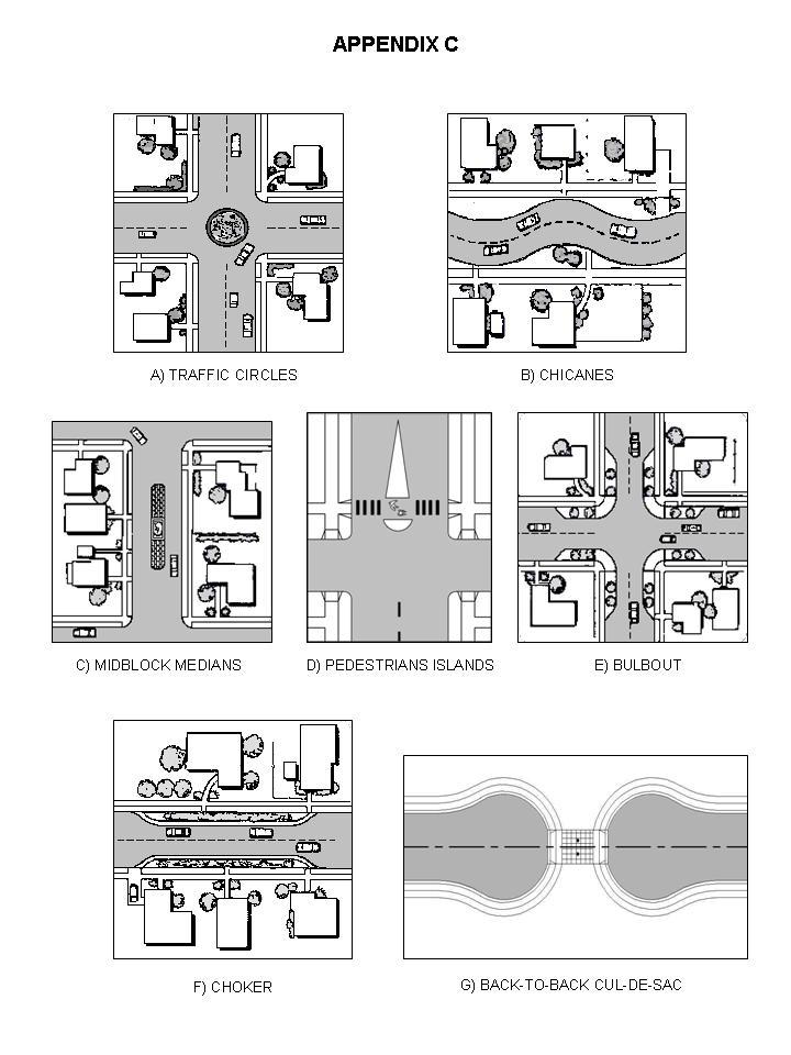
52
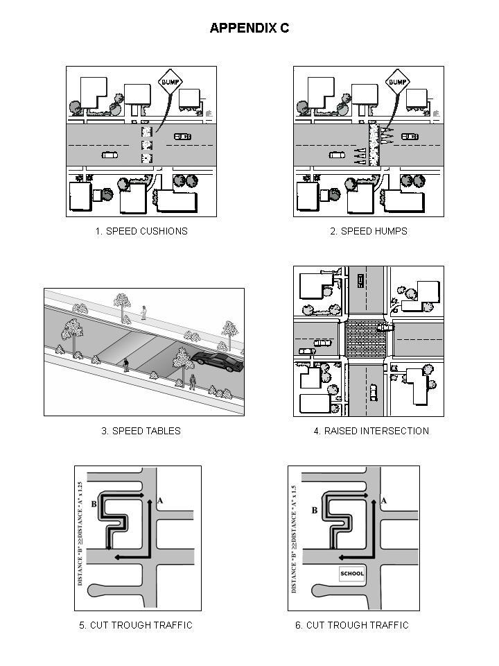
53
Chapter 24 SUBDIVISION REGULATIONS
 Chapter 24 SUBDIVISION REGULATIONS Articles I. In General, 24-1 24-9.1 II. Fees, 24-10 III. Tentative Map--Procedure, 24-11 24-26 IV. Tentative Map--Requirements, 24-27 24-34 V. Parks and Recreation--Dedication
-MENDOCINO COUNTY PLANNING AND BUILDING SERVICES- DIVISION OF LAND REGULATIONS TITLE 17
 ARTICLE VI -- GENERAL REGULATIONS AND PROVISIONS Sec. 17-50. Sec. 17-51 General Plan. Sec. 17-52 Lot and Block Design and Configuration. Sec. 17-53 Lot Access. Sec. 17-54 Private Roads. Sec. 17-55 Water
GOVERNMENT CODE - GOV
 GOVERNMENT CODE - GOV TITLE 7. PLANNING AND LAND USE [65000 66499.58] ( Heading of Title 7 amended by Stats. 1974, Ch. 1536. ) DIVISION 2. SUBDIVISIONS [66410 66499.38] ( Division 2 added by Stats. 1974,
CHAPTER SUBDIVISION MAPS
 CHAPTER 19.66 SUBDIVISION MAPS SUBDIVISION MAPS 19.66 Section Page 19.66.010 Purpose... IV-56 19.66.020 Application... IV-57 19.66.030 Exclusions... IV-57 19.66.040 Effect of Annexation... IV-57 19.66.050
610 LAND DIVISIONS AND PROPERTY LINE ADJUSTMENTS OUTSIDE A UGB
 ARTICLE VI: LAND DIVISIONS AND PROPERTY LINE ADJUSTMENTS VI-21 610 LAND DIVISIONS AND PROPERTY LINE ADJUSTMENTS OUTSIDE A UGB 610-1 Property Line Adjustments (Property Line Relocation) A property line
TITLE 18 Subdivisions
 TITLE 18 Subdivisions ADMINISTRATION: 18.02 General Provisions 2 18.04 Definitions 6 18.06 Exceptions to Requirements 12 18.08 Enforcement 14 DIVISIONS OF LAND: 18.20 Tentative Parcel Maps 15 18.22 Tentative
ELK RAPIDS TOWNSHIP ANTRIM COUNTY, MICHIGAN ORDINANCE NO
 ELK RAPIDS TOWNSHIP ANTRIM COUNTY, MICHIGAN ORDINANCE NO. 3-2011 AN ORDINANCE TO REPLACE THE SUBDIVISION CONTROL ORDINANCE WITH A NEW SUBDIVISION DEVELOPMENT ORDINANCE, IN ACCORD WITH THE LAND DIVISION
Chapter 100 Planned Unit Development in Corvallis Urban Fringe
 100.100 Scope and Purpose. Chapter 100 Planned Unit Development in Corvallis Urban Fringe (1) All applications for land divisions in the Urban Residential (UR) and Flood Plain Agriculture (FPA) zones within
ARTICLE 23 CONDOMINIUM STANDARDS
 ARTICLE 23 CONDOMINIUM STANDARDS Section 23.01 Intent. The intent of this Article is to provide regulatory standards for condominiums and site condominiums similar to those required for projects developed
SUBDIVISION ORDINANCE INDEX
 SUBDIVISION ORDINANCE INDEX - A - ACCESS Legal access required...16.28.190 Reserve strips for controlling access...16.28.180 Waiver direct street access...16.40.020 ACTION BY LOCAL AGENCY Advisory Agency,
Chapter 22 LAND USE* Article III. Subdivisions
 Chapter 22 LAND USE* Article III. Subdivisions Sec. 22-256. Authority to Regulate. Sec. 22-257. Scope; plat required. Sec. 22-258. Definitions. Sec. 22-259. Interpretations and Meanings. Sec. 22-260. Procedure
Title 16 SUBDIVISIONS
 Title 16 SUBDIVISIONS Chapters: 16.02 Basic Provisions 16.04 Definitions 16.06 Improvement Requirements 16.08 Tentative Maps 16.10 Vesting Tentative Maps 16.12 Merger of Parcels 16.14 Reversion to Acreage
ARTICLE 3 DEFINITIONS
 Sections: 3-1 Rules of Construction 3-2 Definitions ARTICLE 3 DEFINITIONS SECTION 3-1 RULES OF CONSTRUCTION 3-101. a. The language set forth in these regulations shall be interpreted in accordance with
This division may be cited as the Subdivision Map Act.
 CALIFORNIA CODES GOVERNMENT CODE SECTION 66410-66413.5 66410. This division may be cited as the Subdivision Map Act. 66411. Regulation and control of the design and improvement of subdivisions are vested
The purpose of this Chapter is to establish rules, regulations, standards and procedures for approval of subdivisions of land to promote and ensure:
 CHAPTER 7 SUBDIVISION SECTION 7.1 PURPOSE The purpose of this Chapter is to establish rules, regulations, standards and procedures for approval of subdivisions of land to promote and ensure: A. Conformity
13-2 SUBDIVISION PLANS AND PLATS REQUIRED EXCEPTIONS Subdivision Plats Required To be Recorded
 ARTICLE XIII SUBDIVISIONS 13-1 INTENT AND PURPOSE 13-1-1 Intent: It is the intent of the County Commission through the adoption of this Article to more fully avail itself of the power granted under 17-27-601
I. Requirements for All Applications. C D W
 108-16.1. Application checklists. Checklist for Required Submissions to the Planning Board or Zoning Board of Adjustment of Monroe Township All required submissions are to be made to the Administrative
CHAPTER XVIII SITE PLAN REVIEW
 CHAPTER XVIII SITE PLAN REVIEW Section 18.1 Section 18.2 Description and Purpose. The purpose of this chapter is to provide standards and procedures under which applicants would submit, and the Township
STATE OF MICHIGAN COUNTY OF MARQUETTE, TOWNSHIP OF NEGAUNEE LAND DIVISION, SUBDIVISION AND CONDOMINIUM ORDINANCE
 STATE OF MICHIGAN COUNTY OF MARQUETTE, TOWNSHIP OF NEGAUNEE LAND DIVISION, SUBDIVISION AND CONDOMINIUM ORDINANCE Adopted: August 8 th, 2008 Effective: August 28 th, 2008 Sec.100. Title ARTICLE I GENERAL
A GUIDE TO PROCEDURES FOR: SUBDIVISIONS & CONDOMINIUM CONVERSION
 A GUIDE TO PROCEDURES FOR: SUBDIVISIONS & CONDOMINIUM CONVERSION A GUIDE TO PROCEDURES FOR: SUBDIVISIONS (TENTATIVE MAPS) PURPOSE Definition: A subdivision is defined as the division of any improved or
WASCO COUNTY PRELIMINARY SUBDIVISION APPLICATION
 WASCO COUNTY PRELIMINARY SUBDIVISION APPLICATION DETAILED SPECIFIC WRITTEN REQUEST File Number: SDV- Number of Proposed Lots & their Dimensions: PRELIMINARY SUBDIVISION PLAN REQUIREMENTS The approval of
SUBDIVISION APPLICATION CHECKLIST SKETCH PLAN PRELIMINARY PLAT FINAL PLAT
 RECEIVED STAMP SUBDIVISION APPLICATION CHECKLIST SKETCH PLAN PRELIMINARY PLAT FINAL PLAT A checklist of background information and submission requirements for processing of a sketch plan, preliminary plat
E L M E R B O R O U G H L A N D U S E B O A R D APPLICATION COVER SHEET (to be completed for all applications and appeals)
") E L M E R B O R O U G H L A N D U S E B O A R D APPLICATION COVER SHEET (to be completed for all applications and appeals) 1. Name(s): 2. Address: 3. Telephone Number(s): 4. E-mail: 5. Owner Name(s) (if
E L M E R B O R O U G H L A N D U S E B O A R D APPLICATION COVER SHEET (to be completed for all applications and appeals) 1. Name(s): 2. Address: 3. Telephone Number(s): 4. E-mail: 5. Owner Name(s) (if
CHAPTER 5. Subdivisions Regulations
 CHAPTER 5 Subdivisions Regulations 10-5-1 Introduction and Purpose 10-5-2 Definitions 10-5-3 General Provisions 10-5-4 Procedure for Submitting Subdivisions 10-5-5 Design Standards; Streets and Lots 10-5-6
Short Title. This title shall be known as the "subdivision ordinance" of the City of Denver, Iowa. (Ord (part), 1992)
, 1992)") Title 19 PLATS AND SUBDIVISIONS Chapters: 19.01 General Provisions 19.02 Minor Plats 19.03 Preliminary Plats 19.04 Final Plats 19.05 Standards and Specifications 19.06 Other Provisions Chapter 19.01 GENERAL
Title 19 PLATS AND SUBDIVISIONS Chapters: 19.01 General Provisions 19.02 Minor Plats 19.03 Preliminary Plats 19.04 Final Plats 19.05 Standards and Specifications 19.06 Other Provisions Chapter 19.01 GENERAL
WARREN COUNTY, IOWA CHAPTER 46 CHAPTER 46 SUBDIVISION REGULATIONS
 TITLE V- PROPERTY AND LAND USE CHAPTER 46 SUBDIVISION REGULATIONS 46.01 Title and Jurisdiction 46.09 Subdivision Design Standards 46.02 Definitions 46.10 Preliminary Plat Requirements 46.03 Filing Process
TITLE 25. SUBDIVISIONS 1
 TITLE 25. SUBDIVISIONS 1 Sections: Chapter 25.01 General Provisions. Section 25.01.01 Short Title. Section 25.01.02 Purposes. Section 25.01.03 Final Plat Required Before Lots May be Sold. Section 25.01.04
THE COUNTY BOARD OF SUPERVISORS OF THE COUNTY OF DOUGLAS DOES ORDAIN AS FOLLOWS:
 8.1 SUBDIVISION CONTROL ORDINANCE THE COUNTY BOARD OF SUPERVISORS OF THE COUNTY OF DOUGLAS DOES ORDAIN AS FOLLOWS: SECTION I. GENERAL INTERPRETATION This ordinance shall not repeal, impair or modify private
BRIDGETON SUBDIVISION APPLICATION CHECKLIST
 APPLICATION NAME AND # CHECKLIST COMPLETED BY: DATE: Signature and printed name BRIDGETON SUBDIVISION APPLICATION CHECKLIST TO SUBDIVISION APPLICANTS: The attached checklist is to assist you in the submission
SUBDIVISION DESIGN PRINCIPLES AND STANDARDS
 SECTION 15-200 SUBDIVISION DESIGN PRINCIPLES AND STANDARDS 15-201 STREET DESIGN PRINCIPLES 15-201.01 Streets shall generally conform to the collector and major street plan adopted by the Planning Commission
APPLICATION FOR 555 Washington Street Tentative Map Red Bluff, CA Subdivision Map (530) ext Parcel Map.
 ext Parcel Map.") City of Red Bluff Community Development Department Application No. APPLICATION FOR 555 Washington Street Tentative Map Red Bluff, CA 96080 Subdivision Map (530) 527-2605 ext. 3059 Parcel Map Applicant
City of Red Bluff Community Development Department Application No. APPLICATION FOR 555 Washington Street Tentative Map Red Bluff, CA 96080 Subdivision Map (530) 527-2605 ext. 3059 Parcel Map Applicant
COUNTY OF INYO SUBDIVISION
 COUNTY OF INYO SUBDIVISION ORDINANCE TITLE 16 - SUBDIVISIONS TABLE OF CONTENTS Chapters: 16.04 Title and Purpose 16.08 General Provisions 16.12 Definitions 16.16 Standards and Design 16.20 Tentative Maps
FINAL PLAT APPLICATION
 FINAL PLAT APPLICATION (Page 1 of 3) LEGAL OWNER(s): NAME: STREET ADDRESS OWNER(s): CITY, STATE, ZIP CODE: PHONE NUMBER: BILLING ADDRESS: NAME OF ENGINEER/SURVEYOR: Engineer/Surveyor Address, Phone: PROPERTY
ARTICLE 24 PRIVATE ROAD, SHARED PRIVATE DRIVEWAY AND ACCESS EASEMENT STANDARDS
 ARTICLE 24 PRIVATE ROAD, SHARED PRIVATE DRIVEWAY AND ACCESS EASEMENT STANDARDS SECTION 24.00 INTENT AND PURPOSE The standards of this Article provide for the design, construction and maintenance of private
Memorandum: October 13, 2008 REVISED To: Trowbridge Township Planning Commission From: P. Hudson, AICP Re: Suggested New Ordinance
 1 Memorandum: October 13, 2008 REVISED 2-11-09 To: Trowbridge Township Planning Commission From: P. Hudson, AICP Re: Suggested New Ordinance Because of changes in both the Michigan Planning Enabling Act
CHAPTER FINAL AND PARCEL MAPS
 CHAPTER 19.48 FINAL AND PARCEL MAPS Section Page 19.48.010 General... IV-25 19.48.020 Phasing... IV-25 19.48.030 Survey Required... IV-26 19.49.040 Form... IV-26 19.48.050 Contents... IV-27 19.48.060 Preliminary
Application for Preliminary Plat Checklist
 Application for Preliminary Plat Checklist Note: No portion of an existing parcel may be sold or transferred to another party without first legally subdividing the property according to the City of Richmond
SECTION 11 PLANNING & ZONING. SUBDIVISION CONTROL Ord. No. 176 Adopted: December 10, 1969
 SUBDIVISION CONTROL Ord. No. 176 Adopted: December 10, 1969 An ordinance enacted under Act 288, Public Acts of 1967, as amended, of the State of Michigan establishing regulations governing the subdivision
CHAPTER 22 SUBDIVISION AND LAND DEVELOPMENT
 CHAPTER 22 SUBDIVISION AND LAND DEVELOPMENT 22-101. Title 22-102. Legislative Intent Part 1 General Provisions 22-201. Development Permits Part 2 Administration 22-301. Fee Schedule Part 3 Fee Schedule
Appendix A. Definitions
 Definitions 1. Terms Defined. Words contained in this are those having a special meaning relative to the purposes of this Ordinance. Words not listed in this section shall be defined by reference to: (1)
Preliminary Subdivision Application (Major) (Four (4) lots or more)
 (Four (4) lots or more)") Gunnison City Offices www.gunnisoncity.org 38 West Center Gunnison, Utah 84634 (435) 528 7969 Date of Application: Preliminary Subdivision Application (Major) (Four (4) lots or more) APPLICANT INFORMATION
Gunnison City Offices www.gunnisoncity.org 38 West Center Gunnison, Utah 84634 (435) 528 7969 Date of Application: Preliminary Subdivision Application (Major) (Four (4) lots or more) APPLICANT INFORMATION
ARTICLE 15 - PLANNED UNIT DEVELOPMENT
 Section 15.1 - Intent. ARTICLE 15 - PLANNED UNIT DEVELOPMENT A PUD, or Planned Unit Development, is not a District per se, but rather a set of standards that may be applied to a development type. The Planned
ARTICLE VI. SUBDIVISION STANDARDS, PUBLIC
 ARTICLE VI. SUBDIVISION STANDARDS, PUBLIC IMPROVEMENTS, AND DESIGN REQUIREMENTS ARTICLE VI. SUBDIVISION STANDARDS, PUBLIC IMPROVEMENTS, AND DESIGN REQUIREMENTS DIVISION 1. GENERAL PROVISIONS Sec. 21-6100.
ARTICLE 15. RULES, REGULATIONS AND DEFINITIONS
 ARTICLE 15. RULES, REGULATIONS AND DEFINITIONS Section 1. Interpretation and Construction: The following rules and regulations regarding interpretation and construction of the Ulysses-Grant County, Kansas,
SECTION 10.7 R-PUD (RESIDENTIAL PLANNED UNIT DEVELOPMENT) ZONE
 ZONE") Article X Zones 10-20 SECTION 10.7 R-PUD (RESIDENTIAL PLANNED UNIT DEVELOPMENT) ZONE A. PURPOSE AND INTENT: The R-PUD Residential PUD Zone is intended to provide alternative, voluntary zoning procedures
Article X Zones 10-20 SECTION 10.7 R-PUD (RESIDENTIAL PLANNED UNIT DEVELOPMENT) ZONE A. PURPOSE AND INTENT: The R-PUD Residential PUD Zone is intended to provide alternative, voluntary zoning procedures
CHAPTER 23 SUBDIVISIONS. Article 1. General Provisions. Article 2. Administration. Division 1. General Provisions.
 CHAPTER 23 SUBDIVISIONS Article 1. General Provisions. Section 23-1. Section 23-2. Section 23-3. Section 23-4. Section 23-5. Title. Scope of chapter. Definitions. Penalty. Appeals. Article 2. Administration.
CHAPTER 91. SUBDIVISIONS, PARTITIONS, and PROPERTY LINE ADJUSTMENTS (Short Title; Definitions)
") CHAPTER 91 SUBDIVISIONS, PARTITIONS, and PROPERTY LINE ADJUSTMENTS (Short Title; Definitions) 91.110. Short Title 91.120. Purpose 91.150 Definitions 91.200 Procedures for Subdivisions and Partitions 91.210
CHAPTER 91 SUBDIVISIONS, PARTITIONS, and PROPERTY LINE ADJUSTMENTS (Short Title; Definitions) 91.110. Short Title 91.120. Purpose 91.150 Definitions 91.200 Procedures for Subdivisions and Partitions 91.210
Section Preliminary Plat Checklist and Application Forms
 Section 201 - Preliminary Plat Checklist and Application Forms PRELIMINARY SUBDIVISION PLAT REVIEW PROCESS CHART PRELIMINARY SUBDIVISION PLAT APPLICATION PRELIMINARY PLAT REVIEW CHECKLIST CITY OF NAMPA
ARTICLE SINGLE FAMILY SITE CONDOMINIUM DEVELOPMENT STANDARDS
 ARTICLE 28.00 SINGLE FAMILY SITE CONDOMINIUM DEVELOPMENT STANDARDS Section 28.01 PURPOSE The purpose of this Article is to recognize that conventional single family developments, traditionally developed
SECTION 874 SITE PLAN REVIEW
 SECTION 874 SITE PLAN REVIEW When a site plan review is required by this Division or Chapters 17.72 or 17.30 of the Fresno County Ordinance Code, the following procedure shall apply: A. SITE PLAN The purpose
CITY OF COZAD DAWSON COUNTY, NEBRASKA
 CITY OF COZAD DAWSON COUNTY, NEBRASKA SUBDIVISION REGULATIONS ADOPTED BY THE CITY OF COZAD, NEBRASKA Prepared By TABLE OF CONTENTS ARTICLE 1: TITLE, PURPOSE, AND DEFINITIONS... 1 SECTION 1.01 NAME AND
Condominium Unit Requirements.
 ARTICLE 19 CONDOMINIUM REGULATIONS Section 19.01 Purpose. The purpose of this Article is to regulate projects that divide real property under a contractual arrangement known as a condominium. New and conversion
Preliminary Subdivision Application (Minor) (Three (3) lots or less)
 (Three (3) lots or less)") Gunnison City Offices www.gunnisoncity.org 38 West Center Gunnison, Utah 84634 (435) 528 7969 Date of Application: Preliminary Subdivision Application (Minor) (Three (3) lots or less) APPLICANT INFORMATION
Gunnison City Offices www.gunnisoncity.org 38 West Center Gunnison, Utah 84634 (435) 528 7969 Date of Application: Preliminary Subdivision Application (Minor) (Three (3) lots or less) APPLICANT INFORMATION
ARTICLE 8C SITE CONDOMINIUM DEVELOPMENT ORDINANCE
 ARTICLE 8C SITE CONDOMINIUM DEVELOPMENT ORDINANCE SECTION 8C.01 PURPOSE It is the purpose of this Ordinance to insure that plans for development within Oceola Township proposed under the provisions of
TOWN OF LEWISTON PLANNING BOARD APPLICATION
 TOWN OF LEWISTON PLANNING BOARD APPLICATION DESCRIPTION OF PROPOSED REQUEST: Name of Property Owner: Phone #: Name of Applicant:Phone #: Address or Location of Proposal:_SBL# Size of Parcel or Structure:Existing
Subdivision Ordinance Update
 Title 17-2010 Update Chapter Index Division I - General Provisions and Administration 17.04 General Provisions 17.08 Definitions 17.12 Maps Required 17.16 Enforcement, Remedies, Certificates of Compliance,
CITY OF GROVER BEACH COMMUNITY DEVELOPMENT DEPARTMENT Tentative Map Checklist
 CITY OF GROVER BEACH COMMUNITY DEVELOPMENT DEPARTMENT Tentative Map Checklist The following list includes all of the items you must submit for a complete application. Some specific types of information
DIVISION 2 - CONSTRUCTION PLAN AND MISCELLANEOUS REQUIREMENTS
 DIVISION 2 - CONSTRUCTION PLAN AND MISCELLANEOUS REQUIREMENTS 2.1 Required Plan Sheets 2.2 Drawing Requirements 2.3 Graphic Standards 2.4 Easements 2.5 Utility Locations 2.6 Private Facility Locations
CHAPTER 18 SUBDIVISION AND PLATTING ORDINANCE OF THE TOWN OF OSCEOLA CODE OF ORDINANCES
 TOWN OF OSCEOLA POLK COUNTY WISCONSIN ORDINANCE # 18-03-03 CHAPTER 18 SUBDIVISION AND PLATTING ORDINANCE OF THE TOWN OF OSCEOLA CODE OF ORDINANCES 18.01 Purpose Adopted 3/08/99, Amended 5/12/03, 7/9/07,
TOWN OF WATERVILLE VALLEY NEW HAMPSHIRE SITE PLAN REVIEW REGULATIONS
 TOWN OF WATERVILLE VALLEY NEW HAMPSHIRE Effective date March 17, 1981 Revised March 16, 1982 Revised March 13, 1986 Revised March 10, 1987 Revised March 14, 2013 Revised March 8, 2016 TOWN OF WATERVILLE
STATE OF MICHIGAN COUNTY OF BERRIEN ORONOKO CHARTER TOWNSHIP PRIVATE ROAD ORDINANCE ORDINANCE NO. 65
 STATE OF MICHIGAN COUNTY OF BERRIEN ORONOKO CHARTER TOWNSHIP PRIVATE ROAD ORDINANCE ORDINANCE NO. 65 AN ORDINANCE TO REQUIRE THAT ALL LOTS OR PARCELS OF LAND WHICH DO NOT ABUT PUBLIC STREETS ABUT A PRIVATE
ORDINANCE NO. 41. PRIVATE ROAD ORDINANCE As Amended Through April 10, 2008
 ORDINANCE NO. 41 PRIVATE ROAD ORDINANCE As Amended Through April 10, 2008 An Ordinance to protect the health, safety, and general welfare of the inhabitants of Port Sheldon Township. The Township of Port
CITY OF HOBBS ORDINANCE NO..
 CITY OF HOBBS ORDINANCE NO.. AN ORDINANCE TO AMEND TITLE 16 OF THE HOBBS MUNICIPAL CODE IN ITS ENTIRETY. BE IT ORDAINED BY THE GOVERNING BODY OF THE CITY OF HOBBS, NEW MEXICO, that the following Chapter
CHAPTER 32 SUBDIVISIONS SECTION TITLE PAGE NO.
 Page 1 of 46 CHAPTER 32 SUBDIVISIONS SECTION TITLE PAGE NO. SECTION 32-1 Purpose of Ordinance 3 SECTION 32-2 Definitions 3 SECTION 32-3 Staff Sketch Review 4 SECTION 32-4 Subdivision and PUD Plats Required
VERGENNES TOWNSHIP, KENT COUNTY, MICHIGAN ORDINANCE AMENDMENT Ordinance Adopted May 17, 2004
 VERGENNES TOWNSHIP, KENT COUNTY, MICHIGAN ORDINANCE AMENDMENT Ordinance 2004-8 Adopted May 17, 2004 Private Road Ordinance Amendments An ordinance to amend portions of Section 202.000 Private Roads. The
City Code Table of Contents, City Of Florence. Florence City Code
 City Code Table of Contents, City Of Florence Florence City Code The City of Florence has posted the City Code in PDF format. To view the City Code you will need Adobe Acrobat Reader. If you do not have
Chapter 157 SUBDIVISION OF LAND
 157.1. Purpose. 157.2. Definitions. Chapter 157 SUBDIVISION OF LAND ARTICLE I General Provisions 157.3. Filing of preliminary plan. 157.4. Submission of final plans. ARTICLE II Procedures for Approval
SUBDIVISION CONTROL, PLATTING OF LANDS, AND LAND DIVISION
 SUBDIVISION CONTROL, PLATTING OF LANDS, AND LAND DIVISION Section I. Title/Purpose. This Ordinance is entitled Subdivision Control and Platting of Lands. The purpose of this Ordinance is as follows: To
SUBDIVISION APPLICATION
 SUBDIVISION APPLICATION Preliminary Plat Minor Plat Final Plat Amended Plat Applicant Name: Owner (if different from applicant) Name: Company: Company: Address: Address: City, State, Zip City, State, Zip
APPLICATION SUBMITTAL REQUIREMENTS FOR Tentative Parcel or Subdivision Maps
 CITY OF EL CERRITO Community Development Department Planning and Building Division 10890 San Pablo Avenue, El Cerrito, CA 94530 (510) 215-4330 FA (510) 233-5401 planning@ci.el-cerrito.ca.us APPLICATION
SUBDIVISION STANDARDS BEDFORD COUNTY, TENNESSEE. Certified by the Bedford County Regional Planning Commission. November 20, 1997.
 SUBDIVISION STANDARDS OF BEDFORD COUNTY, TENNESSEE Certified by the Bedford County Regional Planning Commission November 20, 1997 Effective Date November 24, 1997 Page 1 of 39 TABLE OF CONTENTS ARTICLE
BEAR CREEK TOWNSHIP EMMET COUNTY, MICHIGAN. PRIVATE ROAD ORDINANCE Ordinance No. 11A-99. (to replace prior Private Road Ordinance No.
 BEAR CREEK TOWNSHIP EMMET COUNTY, MICHIGAN PRIVATE ROAD ORDINANCE Ordinance No. 11A-99 (to replace prior Private Road Ordinance No. 11-99) An Ordinance to protect the health, safety, and general welfare
SUBDIVISION AND LAND DEVELOPMENT ORDINANCE. For ENACTED: DECEMBER 12, 1991
 SUBDIVISION AND LAND DEVELOPMENT ORDINANCE For COLUMBIA COUNTY PENNSYLVANIA ENACTED: DECEMBER 12, 1991 EFFECTIVE: JANUARY 1, 1992 Prepared by COLUMBIA COUNTY PLANNING COMMISSION COLUMBIA COUNTY PLANNING
New Private Way Ordinance Westbrook Planning Board Workshop , Planning Board Public Hearing Definitions
 201 Definitions Private Right of Way; Private way A strip of land at least fifty feet wide, meeting the minimum standards for the construction of a gravel base for a public road, over which abutters may
TENTATIVE PARCEL MAP APPLICATION GUIDE TENTATIVE PARCEL MAP APPLICATION REQUIREMENTS
 TENTATIVE PARCEL MAP APPLICATION GUIDE SISKIYOU COUNTY PLANNING DIVISION 806 South Main Street, Yreka CA 96097 Phone: (530) 841-2100 / Fax: (530) 841-4076 TENTATIVE PARCEL MAP APPLICATION REQUIREMENTS
CHAPTER 3 PRELIMINARY PLAT
 10-3-1 10-3-3 SECTION: CHAPTER 3 PRELIMINARY PLAT 10-3-1: Consultation 10-3-2: Filing 10-3-3: Requirements 10-3-4: Approval 10-3-5: Time Limitation 10-3-6: Grading Limitation 10-3-1: CONSULTATION: Each
APPLICATION PROCEDURE
 ANTRIM PLANNING BOARD P. O. Box 517 Antrim, New Hampshire 03440 Phone: 603-588-6785 FAX: 603-588-2969 APPLICATION FORM AND CHECKLIST FOR MINOR OR MAJOR SITE PLAN REVIEW File Date Received By APPLICATION
MUNICIPALITY OF THE DISTRICT OF CLARE SUBDIVISION BY-LAW
 MUNICIPALITY OF THE DISTRICT OF CLARE SUBDIVISION BY-LAW 1 Table of Contents PART 1 - TITLE... 4 PART 2 - INTERPRETATION... 4 PART 3 - DEFINITIONS... 4 PART 4 - PROCEDURE FOR APPROVAL OF PLANS OR INSTRUMENTS
Chapter Plat Design (LMC)
") Chapter 18.14 Plat Design (LMC) Sections: 18.14.010 Lot width 18.14.020 Right-of-way requirements 18.14.030 Pipe stem lots 18.14.040 Division resulting in minimum lot sizes 18.14.050 Flood prone and bad
Chapter 18.14 Plat Design (LMC) Sections: 18.14.010 Lot width 18.14.020 Right-of-way requirements 18.14.030 Pipe stem lots 18.14.040 Division resulting in minimum lot sizes 18.14.050 Flood prone and bad
Subchapter 16 Subdivisions.
 Subchapter 16 Subdivisions. Sections: 35.16.1 Authority. 35.16.2 Purpose. 35.16.3 Jurisdiction. 35.16.4 Application. 35.16.5 Compliance and Enforcement. 35.16.6 Approval of Plat Required. 35.16.7 Lots,
Canyonville, OR Municipal Code Title 17 SUBDIVISIONS
 Title 17 SUBDIVISIONS Main Table of Contents Title 17 SUBDIVISIONS Chapter 17.04 PURPOSE--SCOPE Chapter 17.08 DEFINITIONS Chapter 17.10 GENERAL PROCEDURES AND PROCESSING Chapter 17.12 PRELIMINARY PLAT
ARTICLE 13 CONDOMINIUM REGULATIONS
 ARTICLE 13 CONDOMINIUM REGULATIONS Section 13.01 Purpose. The purpose of this Article is to regulate projects that divide real property under a contractual arrangement known as a condominium. New and conversion
VENTURA COUNTY SUBDIVISION ORDINANCE
 VENTURA COUNTY SUBDIVISION ORDINANCE DIVISION 8, CHAPTER 2 OF THE VENTURA COUNTY ORDINANCE CODE LAST AMENDED BY BOARD OF SUPERVISORS: 06-28-11 VENTURA COUNTY PLANNING DIVISION (This page intentionally
ARTICLE 100 SUBDIVISION APPLICATION PROCEDURE AND APPROVAL PROCESS
 ARTICLE 100 SUBDIVISION APPLICATION PROCEDURE AND APPROVAL PROCESS 100.01 General Procedure 100.02 Exempt Subdivision 100.03 Administrative Subdivision 100.04 Major Subdivision 100.05 Signing and Recording
Time Extension Staff Report
 Time Extension Staff Report Subdivision Name Therrin Subdivision File Number SUB06-00020 Approval Time Extension for Lead Agency Boise City Certification Signature of Boise City Engineer Annexation Date
SUBDIVISION REGULATIONS
 CHAPTER 41 SUBDIVISION REGULATIONS 41.01 Short Title 41.17 Presentation to Commission or Board of Supervisors 41.02 Purpose 41.18 Subdivision Classified 41.03 Application 41.19 Plats Required 41.04 Recording
Waseca County Planning and Zoning Office
 Waseca County Planning and Zoning Office 300 North State Street Waseca, Minnesota 56093 Phone: 507-835-0650 Fax: 507-837-5310 Form no. PZ 081009 Web Site: www.co.waseca.mn.us FEES: 1) CUP FEE- $400.00
PUD Ordinance - Cascade Lakes Plat #10 of 1995
 PUD Ordinance - Cascade Lakes Plat #10 of 1995 CASCADE CHARTER TOWNSHIP Ordinance #10 of 1995 AN ORDINANCE TO AMEND THE CASCADE CHARTER TOWNSHIP ZONING ORDINANCE AND ZONING MAP TO ESTABLISH THE CASCADE
City of Edwardsville, Kansas Special Benefit District Policy
 City of Edwardsville, Kansas Special Benefit District Policy Date Adopted: September 12, 2011 Section 1. Objective The objective is to establish a policy to finance public streets, sanitary sewers, water
ORDINANCE NO. Be it ordained by the City Council of the City of Abilene, Texas:
 ORDINANCE NO. An ordinance repealing Chapter 23, Subpart B of the Code of the City of Abilene, Texas, entitled Mobile Homes and Vacation Travel Trailers; stating the authority; setting forth the scope
LAND DEVELOPMENT AND SUBDIVISION ORDINANCE
 LAND DEVELOPMENT AND SUBDIVISION ORDINANCE (CHAPTER 18 OF THE MUNICIPAL CODE OF ORDINANCES) TO BE IMPLEMENTED BY: THE CITY OF FLORENCE July 2007 TABLE OF CONTENTS ARTICLE I: IN GENERAL... 1 1.1 Title...
Chapter 115 SUBDIVISION OF LAND
 Chapter 115 SUBDIVISION OF LAND [HISTORY: Adopted by the Town Board of the Town of Conklin 11-9-1999 by L.L. No. 2-1999. Amendments noted where applicable.] Planning Board See Ch. 33. Fire prevention and
ARTICLE 5 GENERAL REQUIREMENTS
 5.1 SUITABILITY OF THE LAND ARTICLE 5 GENERAL REQUIREMENTS 5.1.1 Land subject to flooding, improper drainage or erosion, and land deemed to be unsuitable for development due to steep slope, unsuitable
Keith W. Spencer PLS, CFedS
 GOVERNMENT CODE GOV TITLE 7. PLANNING AND LAND USE [65000-66499.58 ( Heading of Title 7 amended by Stats. 1974, Ch. 1536. ) DIVISION 2. SUBDIVISIONS [66410-66499.38] ( Division 2 added by Stats. 1974,
C H A P T E R AUTHORITY, PURPOSES, AND EFFECT OF THE LAND DIVISION ORDINANCE
 C H A P T E R 18.05 AUTHORITY, PURPOSES, AND EFFECT OF THE LAND DIVISION ORDINANCE SECTIONS: 18.05.010 CITATION 18.05.020 PURPOSES OF THE LAND DIVISION ORDINANCE 18.05.030 APPLICABILITY 18.05.040 EXCEPTIONS
This Ordinance is adopted under the authority and provisions of the General Statutes of North Carolina, Article 6, Chapter 153A 121.
 Section 74, Regulations Governing Manufactured Home Parks 1. Purpose The purpose of these regulations to be known and cited as the Madison County Manufactured Home Park Ordinance is to regulate and guide
ARTICLE 900 PLAT AND PLAN REQUIREMENTS
 ARTICLE 900 PLAT AND PLAN REQUIREMENTS SEC. 900.1 ITEMS TO BE SHOWN ON PLAT OR PLAN General (1) Property lines of all property owners adjacent to the exterior boundaries of the project shall be located
Washington County, Minnesota Ordinances
 Washington County, Minnesota Ordinances Ordinance No. 153 Text Amendment to the Washington County Development Code - Chapter One, Section 2 and Chapter Two, Part 1, Part 2, Part 3, of the Development Code
SUBDIVISION REGULATIONS
 Adopted October 1, 1963 ARTICLE I PREAMBLE AND TITLE SECTION 101. Preamble Whereas it is deemed necessary to promulgate certain regulations in order to improve and protect the interests of the Town of
SUBDIVISION REGULATIONS
 SUBDIVISION REGULATIONS KANAWHA COUNTY, WEST VIRGINIA KANAWHA COUNTY SUBDIVISION REGULATIONS TABLE OF CONTENTS PARAGRAPH PAGE SECTION I. AUTHORITY Purpose 101 2 Grant of Power 102 2 Effective Date 103