residential Way. January 24, 2017 District. Mon-Fri*
|
|
|
- Francis Williams
- 5 years ago
- Views:
Transcription

 482-3717 1-800-876-5831 E-Mail: info@rrpd.ca Website: www.rrpd.ca For more information please contact the Red River Planning District.")
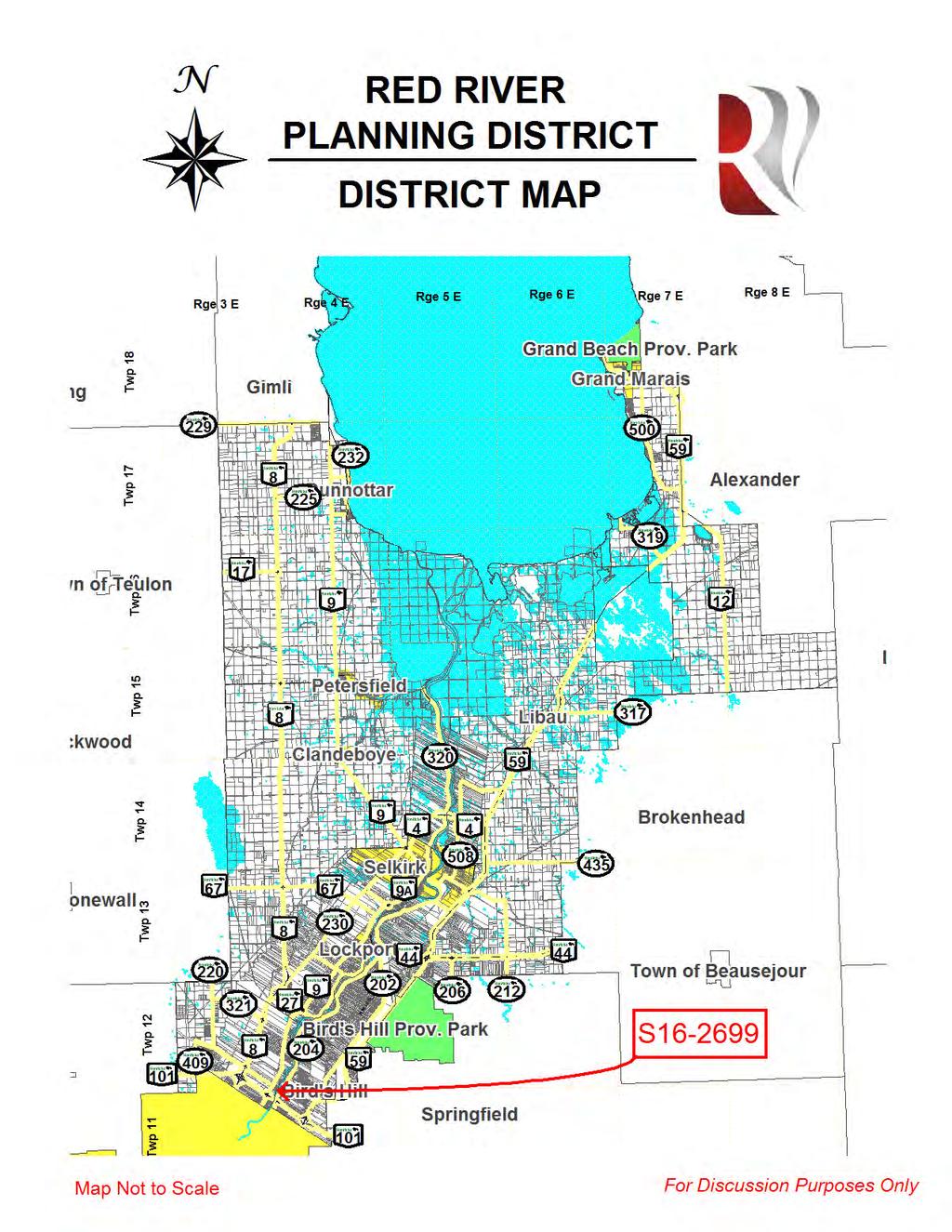
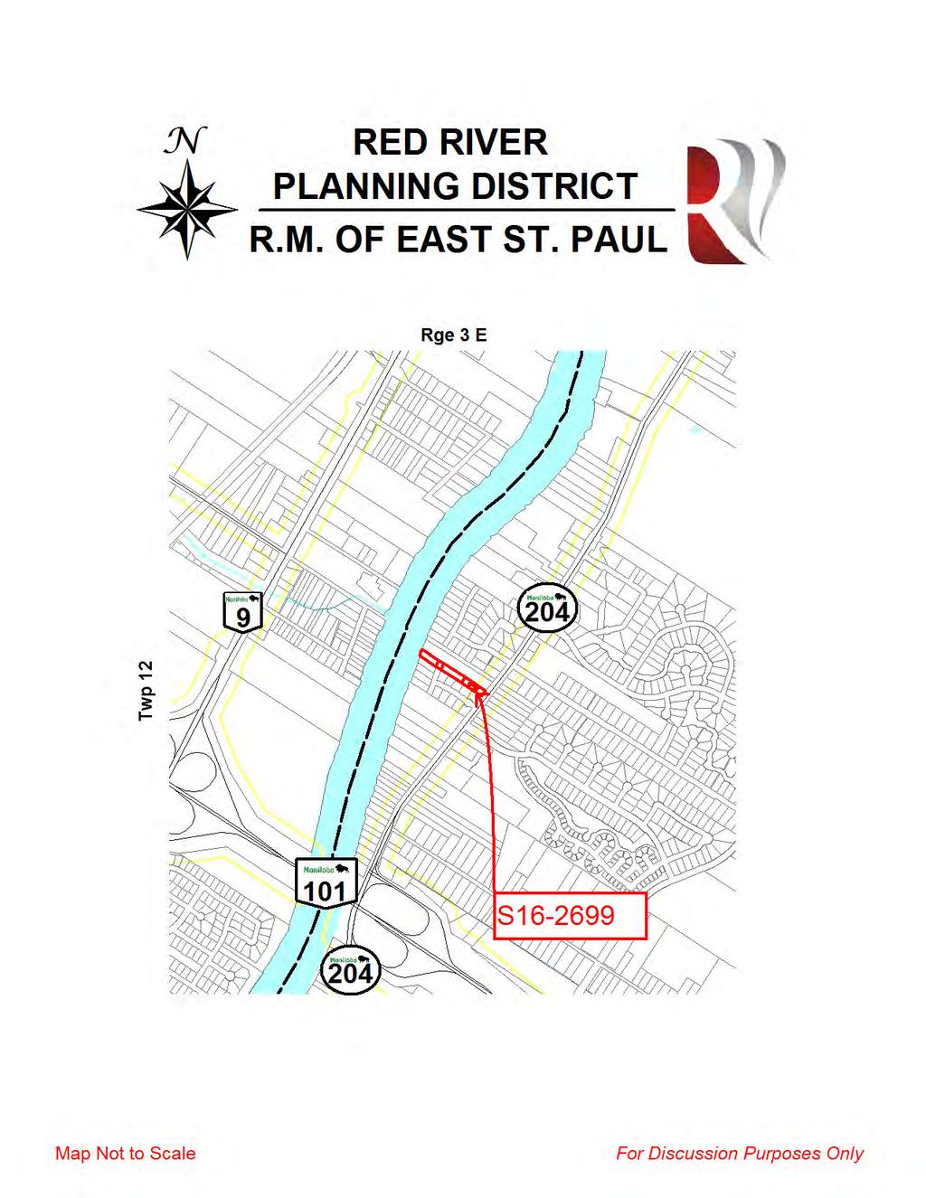
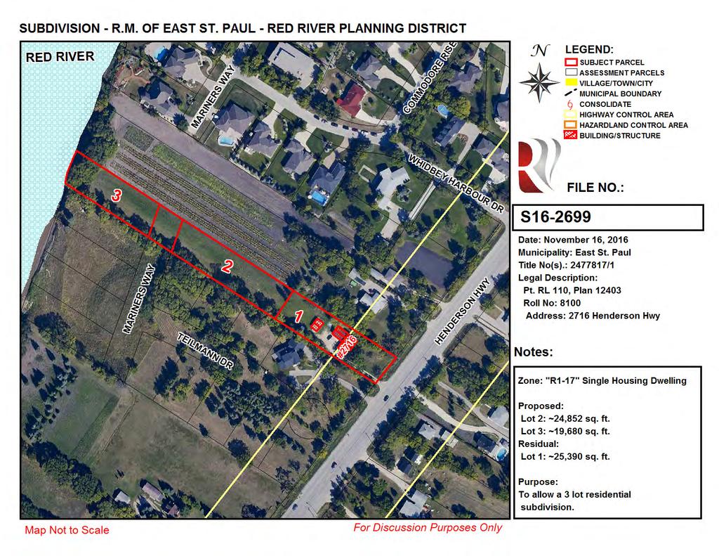
1 We are Listening. Public Hearing Tuesday, January 24, :30 PM Council Chambers 3021 Birds Hill Rd. East St. Paul, MB What is S about? To subdivide the property in order to make 2 new residential lots including an extension of Mariner s Way. Phone: (204) info@rrpd.ca Website: For more information please contact the Red River Planning District. Red River Planning District Mon-Fri* 806-A Manitoba Ave., Selkirk 8:30-4:15 *excludes all statutory holidays


2 806 A Manitoba Avenue Attention to: Bruce Schmidt, CAO R.M. of East St. Paul SUBDIVISION REPORT Date: January 10, 2017 File Number: S Collins ( Manitobaa Ltd.) Address: 2716 Henderson Hwy. Municipality: R.M. of East St. Paul Legal Description: Pt. RL 110, Plan 12403, Parish of St. Paul Roll Number: 8100 Report Prepared by: Jennifer Lim, MCIP, RPP, Community Planner Report Circulated for Comment to: CWS J. Froese, MAFRD - E. Gauer, MMG - O. Murray,WLTO - S. Dillabough, WS - D. Roberts, Canadaa Post - D. Crawford, Centra Gas - M. Wankling, Mb Hydro - T. Berg, MTS - K. Penner, School Division V. Mariani, Roadside Development, Natural Resources, WSP - M.Matview,CWS - Dan Roberts, MIT-WMPS - B.Allum Page 1 of 8
3 806 A Manitoba Avenue 1. Proposal Overview Current Site Area: 1.83 ac. Current Use of Site: Residential Proposed Number of New Lots: 2 Proposed Use of Site: Residential 2. Development Plan Compliance..In Compliance Development Plan By-law No Land Use Designation: SR1 - Serviced Residential 1 Applicable Policy Number: 5.1 A significant factor that makes the RM of East St. Paul such an attractive areaa to live in is that most serviced residential lots developed to date are a minimum of 15, 000 sq. ft. to 17,000 sq. ft. in size. This lot size creates a semi-urban environment as it provides greater separation between residences and allows the retention of native trees or the opportunity for more tree planting/landscaping. It is thee preferencee of Council that this living environment be promoted throughout most off the community and that single family lots located in the Servicedd Residential 1 area be an average of 17,000 sq. ft Lot size and density regulations for residential developments in the Serviced Residential 1 areas shall be regulated through the RM of East St. Paul Zoning By-Law and by the following criteria: (a) For single-family lots within new residential subdivisions in the Serviced Residential 1 area, the maximum density should not exceed two (2) residential lots per grosss acre For proposed residential subdivisions, the RM of East St. Paul shall consider the following criteria: (a) The development proponent s demonstration that the proposed development reflects the demographic and socio-economic characteristics of the area. (b) Local impacts regarding street relationships, pedestrian safety, traffic volumes and movements. (c) The adequacy of lighting andd noise attenuation measures. (d) The cost and feasibility of providing Municipal services. (e) Storm drainage patterns. (f) The protection or enhancement of existing treed or natural areas. (g) The proximity to, and availability of, public open space as well as recreational and educational facilities. (h) The use of transition space, including berms, walls, fencing, landscaping, plantings or a combination thereof, between adjacent or incompatible landd uses. 3. Secondary Plan Compliance.. Not Applicable Page 2 of 8
4 806 A Manitoba Avenue 4. Zoning By-Law Compliance In Compliance Zoning By-law No Land Use Zoning: R Single Housing Dwelling Zone Applicable Table: Single Housing Dwelling Site Area Required: 15,000 sq. ft. Proposed Lot 1 (Residual): ~25,390 sq.ft. In Compliance. Proposed Lot 2: ~24,582 sq. ft.. In Compliance Proposed Lot 3: ~19,680 sq. ft.. In Compliance Site Width Required: 80 ft. Proposed Lot 1 (Residual): ~82 ft. In Compliance Proposed Lot 2: ~82 ft.... In Compliance Proposed Lot 3: ~82 ft.... In Compliance 5. Proposed Servicing and Infrastructure Wastewater Services - Municipal Sewer As per Municipal By-Law No Drinking Water Requirements Individual Well & Municipal Water Proposed Lot 1 (Residual Lot): Individual Well, will be required to connect to Municipal Line as per Municipal By-Law No Proposed lots 2 & 3: As per Municipal By-Law No Road Standards Municipal and Provincial Standards Proposed Lot 1 (Residual Lot): As per the Province Proposed lots 2 & 3: As per the Municipality, Culvert (Driveway) access permit to be obtainedd through RM. Drainage Ditches and Storm Sewerr Proposed Lot 1 (Residual Lot): As per the Province Proposed lots 2 & 3: As per the Municipality. 6. Circulation to Government Agencies Conservation District (EICD/CCCD) Comment Received Manitoba Agriculture, Farming and Rural Initiatives (MAFRD) Comments Manitoba Municipal Government (MMG) Comments Manitoba Infrastructure and Transportation (MIT) objections. It should be noted thatt the access from the proposed lots via Mariners Way and Tielman Drive (RL 111) to PR 204 is to be considered temporary.statutory requirements apply (See Comments). Page 3 of 8
5 Manitoba Conservation Compliance and Enforcement (Cons.) concerns. Council should be advisedd that shouldd the proposed subdivision result in alterations to the municipality s public sewerage and/or water system, the municipality will be required as per Sections 6 and 7 of Manitoba Regulation P /88R --Water Works, Sewerage and Sewage Disposal Regulation, to prepare engineering data supporting the proposed sewer or water extension to obtain a public healthh certificate for the alteration. If the subdivision will result in the construction of a new water or sewer system, regulatory approval may be required Manitoba Conservation and Water Stewardship (MCWS) Comments Received Contact: NA Municipal Engineering (RM) Comments Natural Resources Canada (NRCAN) Comments Office of Drinking Water (ODW) concerns. It should bee noted that the existing water supply is a private well, while the proposed lots will connect to the RM of East St. Paul public water system supply. Please ensure there are no interwater connections between existing private wells and the proposed supply. - Water Management, Planning and Standards (WMPS-MIT) Comments Contact: N/A 806 A Manitoba Avenue Winnipeg Land Titles Office (WLTO) Comments: 3 lot plan of subdivision with public road is required. Please note signatures of encumbracers are required as to public road. Contact: Victor Castelli, Survey Examiner, (204) Circulation to Utilities and Other Services Manitoba Hydro (Mb Hydro) and Centra Gas Comments: Easements equired (Mb Hydro Only). Contact: Daniel Akerstream, ca, Ph: (204) Shaw/MTS Comments: 3..1m Easements Required. Contact: Grace Bushi, Access Provisioning- Ph: (204) Canada Post Page 4 of 8
6 806 A Manitoba Avenue Requirements. School Division Objection, provided that there is appropriate access and egress. Notes: there are no provisionss for sidewalks/walkways within the area, nor is there any indication that sidewalks are planned in and around the area. Pedestrian traffic is the responsibility off the developer and potential investors must be informed that the School Division will not assume responsibility for transportation of students because of lack of pedestrian walkways. Additionally, thee investors must be informed that the roadway does not allow for school bus traffic, and students would need to access school bus transportation, if needed, on Henderson Highway. Contact: V. Mariani, Sectretary Treasurer/CFO Ph: (204) Analysis This application for subdivision was received on November 10, 2016 and circulated for comments and advertised for Public Hearing as per The Planning Act. This application seeks to extend Mariner s Way and create two (2) new residential lots. The Residual Lot is developed with a single-family dwelling, connected to Municipal Sewer, and has related accessory structuress on-site. Access to the Residual Lot is gained off of Henderson Highway. This application is generally in keeping with the intent of the Development Plan and Zoning By-laws. The property has direct access to the Red River. As per the Water, Hazard Lands, Flooding and Erosion within the Development Plan, Policy No. (5): Development shall not be permitted within a horizontal distance of 350 ft. (107m) of the normal high water mark of the Red River or on the flood plain, whichever is greater, unless a detailed analysis of the specific site, prepared by a qualified engineer can ensure the development will be safe from flooding, erosion, and bank instability. Proposed Lot 3, in its entirety, the proposed extensionn of Mariner s Way, in its entirety, and approximately 40 ft. of the most western side of proposed lot 2 appear to be within 350 ft. of the edgee of the existing property. As per Policy No. (10): endeavours to establish and maintain a 100 ft. (30m) public reserve from the ordinary high water mark adjacent to all surface waters to protect or re-establish functioning riparian areas where they have been altered to help stabilize banks, provide aquatic and wildlife habitat, and protectt water quality. There does not appear to be any requirement for variance approval. The proposed subdivision does not appear to comply with sections 3 (c) I, (l), and (m) of Provincial Subdivision Regulation 137/2006. Provincial Subdivision Regulation 137/2006 restricts the overall length of roads ending in cul-de-sacs to and requires secondary access, even if temporary. The application will create an extensionn of Mariner s Way whichh will eventually connectt through to Whidbey Harbour Dr. Teilmannn Dr. is considered to have temporary access onto Henderson Hwy. Page 5 of 8


7 806 A Manitoba Avenue Commenting agencies have not expressed objection or concerns regarding the proposed subdivision at this time. Council should be advised that should the proposed subdivision result in alterations to the municipality s public sewerage and/or water system, the municipality will be required as per Sections 6 and 7 of Manitoba Regulation P /88R --Water Works, Sewerage and Sewage Disposal Regulation, to prepare engineering data supporting the proposed sewer or water extension to obtain a public health certificate forr the alteration. If the subdivision will result in the construction of a new water or sewer system, regulatory approval may be required The Map, (next page), appears to indicatedd that the sewer and water lines may require extension. There are easement requirement ts for Manitoba Hydro and MTS Utility Services. The School Division requires proper access and egress, further stating, there are no provisions for sidewalks/walkways within the area, nor is theree any indicationn that sidewalks are planned in and around the area. Pedestrian traffic is the responsibility of the developer and potential investors must be informed that the School Division will not assume responsibility forr transportation of students because of lack of pedestrian walkways. Additionally, the investors must be informed that the roadway does not allow for school bus traffic, and students would need to accesss school bus transportation, if needed, on Henderson Highway. Map of Municipal Services at 2716 Henderson Hwy. (Sewer is Red & Water is Blue) Page 6 of 8
8 806 A Manitoba Avenue 9. Options Under Section 125(1) of The Planning Act, 'where the council of a municipality receives an application pursuant to Section 124(2), it shall, after considering the application, by resolution (a) reject or refuse to approve the application for subdivision; or (b) approve the application for subdivision, without conditions or with conditions as set out in Section 135.' 10. Recommendations and Conditions Our office recommends that a Development Agreement between the Applicant / Owner and the Municipality be entered into too address items such as, but not necessarily limited to: (a) Road Development, including properr cul-de-sacc radius for access/egres ss of emergency vehicles, public transportation, and the like,. (b) Pedestrian sidewalk(s), if required, (c) Lighting,. (d) Municipal Services,such as Sewer and Water connection,and any studies related to the extension of those services, if required, (e) Drainage, (f) Hazardland Protection or Enhancement to address the restriction of Developmen nt and endeavour to establish a functioning riparian area within 100 ft. (30m) of the Ordinary High Water Mark of the Red River. (g) Public Amenity, such as the proximity to, and availability of, public open space. (h) Any other Standard deemed necessary by the Municipality. Based on the analysis, above, our office recommends approval of the application. Should Council wish to approve the application, our office recommends the following conditions be placed: 1. Applicant / owner submits confirmation inn writing from the Chief Administrative Officer of the Municipality that : taxes on the land to be subdividedd for the current year plus any arrears have been paid or arrangements satisfactory to Council have been made; any applicable capital development fees have been paid. 2. Manitoba Land Surveyor prepares a 3 lott plan of subdivision with a public road as proposed including lot area and width calculations, and confirmation that Crown land is not involved in the proposal. Please note signatures of encumbracers are required as 3. Applicant/owner enters into a Statutory Easement Agreement(s) with MTS and Mb Hydro/Centra Gas regarding existing and/or future facilities associated with the subdivision as set outt in the application. Page 7 of 8
9 806 A Manitoba Avenue 4. Applicant/owner enters into a Statutory Easement Agreement(s) with the Municipality regarding accesss to the Public Reserve associated with the subdivision as set out in the application. 5. Applicant/owner obtains an engineered drainage plan and geotechnical engineer s report for review and approvall by the Municipality. 6. Applicant/owner enters into a Development Agreement with the Municipality to address items such as, but not necessarily limited to: Road Developmen nt, including proper cul-de-sac radius for access/egress of emergency vehicles, public transportation, and the like,. Pedestrian sidewalk(s), if required, Lighting,. Municipal Services,such as Sewer and Water connection,and any studiess related to the extension of those services, if equired, Drainage, Hazardland Protection or Enhancement to address the restriction of Development and endeavour to establish a functioning riparian area within 100 ft. (30m) of thee Ordinary High Water Mark of the Red River. Public Amenity, such as the proximity to, and availability of, public open space. Any other Standard deemed necessary by the Municipality. 7. Applicant / owner obtains: joint easement agreement for existing and/or future Mb Hydro facilities associated with the subdivision; - plan of easement prepared by a Manitoba Land Surveyor as required by The Real Property Act. Cc: Applicant, WLTO, LG, MB Hydro, MTS, RETSD,, CWS Page 8 of 8
10
11
12
13
14
R.M. of St. Andrews S Hofer. Address:
 806 A Manitoba Avenue Selkirk, Manitoba R1A 2H4 Toll Free: 800 876 5831 Phone: 204 482 3717 Fax: 204 482 3799 Attention to: Andrew Weremy, CAO R.M. of St. Andrews SUBDIVISION REPORT Date: January 19, 2017
Analysis: Development Plan Designation = RA Resource and Agriculture Not In Compliance
 806-A Manitoba Avenue Selkirk, Manitoba R1A 2H4 Toll Free: 800-876-5831 Phone: 204-482-3717 Fax: 204-482-3799 Date: September 22, 2016 File: S16-2682 To: From: Location: Andrew Weremy, CAO Rural Municipality
We are Listening. Public Hearing
 We are Listening. Public Hearing Tuesday, September 12, 2017 4:00 PM Council Chambers 500 Railway Ave. Clandeboye, MB What is CU 32, 2017 about? This conditional use application seeks to allow a Garden
We are Listening. Public Hearing
 We are Listening. Public Hearing Tuesday, August 8, 2017 4:00 PM Council Chambers 500 Railway Ave. Clandeboye, MB What is VO 130, 2017 about? This variance seeks to allow a rear yard setback of 10 ft for
We are Listening. Public Hearing
 We are Listening. Public Hearing Thursday, June 14, 218 5: PM Council Chambers 355 Main Street West St. Paul, MB What is CU 12, 218 about? The purpose of this conditional use application is to allow a
We are Listening. Public Hearing
 We are Listening. Public Hearing Tuesday, September 11, 2018 4:00 PM Council Chambers 500 Railway St. Clandeboye, MB What is CU 27, 2018 about? This conditional use application seeks to allow a mobile
Red River Planning District
 Red River Planning District Meeting Minutes September 17, 2014 Regular Board Meeting 7:00 p.m. Members Present: R.M. of St. Andrews Don Forfar Kurtiss Krasnesky Laurie Hunt R.M. of St. Clements Steve Strang
PUBLIC HEARINGS. Variance 1916, 1918 and 1920 St. Mary s Road (St. Norbert Ward) File DAV /2013D [c/r DASZ 28/2013]
![PUBLIC HEARINGS. Variance 1916, 1918 and 1920 St. Mary s Road (St. Norbert Ward) File DAV /2013D [c/r DASZ 28/2013]](/thumbs/90/101595906.jpg "PUBLIC HEARINGS. Variance 1916, 1918 and 1920 St. Mary s Road (St. Norbert Ward) File DAV /2013D [c/r DASZ 28/2013]") Agenda Riel Community Committee January 13, 2014 PUBLIC HEARINGS Item No. 3 Variance 1916, 1918 and 1920 St. Mary s Road (St. Norbert Ward) File DAV 163360/2013D [c/r DASZ 28/2013] WINNIPEG PUBLIC SERVICE
Agenda Riel Community Committee January 13, 2014 PUBLIC HEARINGS Item No. 3 Variance 1916, 1918 and 1920 St. Mary s Road (St. Norbert Ward) File DAV 163360/2013D [c/r DASZ 28/2013] WINNIPEG PUBLIC SERVICE
EXCERPTS FROM HALIFAX REGIONAL MUNICIPALITY CHARTER
 EXCERPTS FROM HALIFAX REGIONAL MUNICIPALITY CHARTER Municipal planning strategy 227 The Council may adopt a municipal planning strategy for all, or part, of the Municipality and there may be separate strategies
Guide to Preliminary Plans
 Guide to Preliminary Plans Introduction The Douglas County is committed to providing open, transparent application processes to the public. This Guide is provided to assist anyone interested in the procedures
the conditions contained in their respective Orders until January 1, 2025, at the discretion of the Director of Planning, Property and Development.
 Part 4: Use Regulations Temporary Uses and Structures Purpose the conditions contained in their respective Orders until January 1, 2025, at the discretion of the Director of Planning, Property and Development.
Chapter Plat Design (LMC)
") Chapter 18.14 Plat Design (LMC) Sections: 18.14.010 Lot width 18.14.020 Right-of-way requirements 18.14.030 Pipe stem lots 18.14.040 Division resulting in minimum lot sizes 18.14.050 Flood prone and bad
Chapter 18.14 Plat Design (LMC) Sections: 18.14.010 Lot width 18.14.020 Right-of-way requirements 18.14.030 Pipe stem lots 18.14.040 Division resulting in minimum lot sizes 18.14.050 Flood prone and bad
Chair and Members Planning and Economic Development Committee
 TO: FROM: Chair and Members Planning and Economic Development Committee Melissa Halford Manager of Planning DATE: June 23, 2016 SUBJECT: Amendment No. 6 to Draft Approval Subdivision File No. S2006-3 (Loon
R.M. of WEST ST. PAUL Under The Planning Act CORRECTED - NOTICE OF PUBLIC HEARING Regarding Zoning By-law Plan Amendment No.
 R.M. of WEST ST. PAUL Under The Planning Act CORRECTED - NOTICE OF PUBLIC HEARING Regarding Zoning By-law Plan Amendment No. 208-04 P The Council of the R.M. of West St. Paul, under the authority of The
MINUTES OF THE REGULAR MEETING OF COUNCIL OF THE R.M. OF ST. ANDREWS HELD TUESDAY, JULY 8, 2014 AT CLANDEBOYE, MANITOBA
 MINUTES OF THE REGULAR MEETING OF COUNCIL OF THE R.M. OF ST. ANDREWS HELD TUESDAY, JULY 8, 2014 AT CLANDEBOYE, MANITOBA Attendance: Mayor Forfar, Councillor Ataman, Councillor Keryluk, Councillor Garvie,
Financial Impact Statement There are no immediate financial impacts associated with the adoption of this report.
 STAFF REPORT Planning and Development Department Subject: Application by RYC Property to rezone a portion of lands on John Murray Dr. and Megan Lynn Dr. from R2 to R3 and to enter into a Development Agreement
YELLOWSTONE COUNTY BOARD OF PLANNING FINDINGS OF FACT
 YELLOWSTONE COUNTY BOARD OF PLANNING FINDINGS OF FACT The City-County Planning staff has prepared the Findings of Fact for the Aspen Ridge Subdivision, 2 nd Filing. These findings are based on the preliminary
HEARINGS. Parcels D, F, G and J as shown on Misc. Plan No
 Agenda City Centre Community Committee April 13, 2017 HEARINGS Item No. 3 Closing Part of Winchester Street, Somerville Avenue and the Public Lane East of Fennell Street and Part of Waller Avenue, East
Members of the City of Brantford Committee of Adjustment. 1.0 TYPE OF REPORT Committee of Adjustment Decision Regarding an Application for Consent
 DATE: October 18 th 2017 REPORT NO. CD2017-168 TO: Members of the City of Brantford Committee of Adjustment FROM: Brandon Kashin, Current Development Planner 1.0 TYPE OF REPORT Committee of Adjustment
SUBDIVISION APPLICATION
 PLANNING AND DEVELOPMENT SERVICES 38106 Rge Rd 275, Red Deer County, AB T4S-2L9 Phone: (403) 350-2170 Fax: (403) 346-9840 For Office Use Only File # Roll # Fee Submitted Date Deemed Complete Reference
Home Based Business - Discretionary Use Application Form
 Home Based Business - Discretionary Use Application Form The Zoning Bylaws enforced within Corman Park provides for discretionary land use and development which are deemed by Council to have one or more
STAFF REPORT. Financial Impact Statement There are no immediate financial impacts associated with the adoption of this report.
 STAFF REPORT Planning and Development Department Subject: Cottage Country Unsubstantial Amendment to Development Agreement To: CAO for Planning Advisory Committee, December 13, 2016 Date Prepared: December
Preliminary Subdivision Application (Major) (Four (4) lots or more)
 (Four (4) lots or more)") Gunnison City Offices www.gunnisoncity.org 38 West Center Gunnison, Utah 84634 (435) 528 7969 Date of Application: Preliminary Subdivision Application (Major) (Four (4) lots or more) APPLICANT INFORMATION
Gunnison City Offices www.gunnisoncity.org 38 West Center Gunnison, Utah 84634 (435) 528 7969 Date of Application: Preliminary Subdivision Application (Major) (Four (4) lots or more) APPLICANT INFORMATION
CITY OF VALDEZ APPLICATION FOR SUBDIVISION
 CITY OF VALDEZ APPLICATION FOR SUBDIVISION The subdivision of any land within the city limits of the City of Valdez is regulated by Title 16 of the Valdez Municipal Code. 16.04.020 Definitions. Subdivision
Waseca County Planning and Zoning Office
 Waseca County Planning and Zoning Office 300 North State Street Waseca, Minnesota 56093 Phone: 507-835-0650 Fax: 507-837-5310 Form no. PZ 081009 Web Site: www.co.waseca.mn.us FEES: 1) CUP FEE- $400.00
SITE PLAN REVIEW ADMINISTRATIVE REVIEW. Please Note: Once submitted to the County, all application materials become a matter of public record.
 200 W. Oak Street, 3rd Floor Fort Collins, CO 80521 (970) 498-7683 / larimer.org/planning SITE PLAN REVIEW ADMINISTRATIVE REVIEW The submittal requirements listed in this packet are intended to collect
APPLICATION SUBMITTAL REQUIREMENTS FOR Tentative Parcel or Subdivision Maps
 CITY OF EL CERRITO Community Development Department Planning and Building Division 10890 San Pablo Avenue, El Cerrito, CA 94530 (510) 215-4330 FA (510) 233-5401 planning@ci.el-cerrito.ca.us APPLICATION
TOWN OF ELIOT PLANNING BOARD SUBDIVISION APPLICATION
 TOWN OF ELIOT PLANNING BOARD SUBDIVISION APPLICATION This application shall conform in all respects to the Land Subdivision Standards of Chapter 41 of the Planning Board of the Town of Eliot code of ordinances.
ARTICLE 15. RULES, REGULATIONS AND DEFINITIONS
 ARTICLE 15. RULES, REGULATIONS AND DEFINITIONS Section 1. Interpretation and Construction: The following rules and regulations regarding interpretation and construction of the Ulysses-Grant County, Kansas,
Guide to Combined Preliminary and Final Plats
 Guide to Combined Preliminary and Final Plats Introduction The Douglas County is committed to providing open, transparent application processes to the public. This Guide is provided to assist anyone interested
Chapter 100 Planned Unit Development in Corvallis Urban Fringe
 100.100 Scope and Purpose. Chapter 100 Planned Unit Development in Corvallis Urban Fringe (1) All applications for land divisions in the Urban Residential (UR) and Flood Plain Agriculture (FPA) zones within
Municipality of Northern Bruce Peninsula Planning Report Application: Minor Variance
 Municipality of Northern Bruce Peninsula Planning Report Application: Minor Variance File No.: A-05-2010.62 Date: June 14, 2010 -------------------------------------------------------------------------------------------------------------------------------------------------------
Paul D. Ralph, BES, RPP, MCIP, Commissioner, Development Services Department
 Public Report To: From: Report Number: Development Services Committee Paul D. Ralph, BES, RPP, MCIP, Commissioner, Development Services Department DS-16-50 Date of Report: April 14, 2016 Date of Meeting:
April 1, 2014 Municipal Planning Commission
 April 1, 2014 Municipal Planning Commission Tuesday, April 01, 2014 Start time 10:00 AM County of Grande Prairie No. 1 Community Services Building, 10808-100 Avenue, Clairmont, AB AGENDA 1. CALL TO ORDER
TOWN OF LEWISTON PLANNING BOARD APPLICATION
 TOWN OF LEWISTON PLANNING BOARD APPLICATION DESCRIPTION OF PROPOSED REQUEST: Name of Property Owner: Phone #: Name of Applicant:Phone #: Address or Location of Proposal:_SBL# Size of Parcel or Structure:Existing
Preliminary Subdivision Application (Minor) (Three (3) lots or less)
 (Three (3) lots or less)") Gunnison City Offices www.gunnisoncity.org 38 West Center Gunnison, Utah 84634 (435) 528 7969 Date of Application: Preliminary Subdivision Application (Minor) (Three (3) lots or less) APPLICANT INFORMATION
Gunnison City Offices www.gunnisoncity.org 38 West Center Gunnison, Utah 84634 (435) 528 7969 Date of Application: Preliminary Subdivision Application (Minor) (Three (3) lots or less) APPLICANT INFORMATION
For Vintages of Four Mile Creek Town of Niagara on the Lake, Ontario
 Planning Impact Analysis For Vintages of Four Mile Creek Town of Niagara on the Lake, Ontario Prepared by: Upper Canada Consultants 261 Martindale Road Unit #1 St. Catharines, Ontario L2W 1A1 Prepared
RURAL GENERAL RG 1. PERMITTED USES DISCRETIONARY USES
 RURAL GENERAL RG PURPOSE: To protect the agricultural land base of the municipality while allowing nonagricultural developments which complement the area's economy. 1. PERMITTED USES DISCRETIONARY USES
Conditional Use Permit / Standard Subdivision Application
 Conditional Use Permit / Standard Subdivision Application Name of Proposed Subdivision: Total Area (Acres) Is Proposed Subdivision to be built in phases? Number of Lots If yes, how many phases? Applicant/Owner
Town of Lisbon, Maine SUBDIVISION REVIEW APPLICATION
 Date Received: Fee Paid (amount): Applicant: Town of Lisbon, Maine SUBDIVISION REVIEW APPLICATION Subdivision Name/Title: This application must be received at the Town Office by close of business on the
A B. C Submission. Subdivision Application under The Planning Act C.C.S.M. c. P80
 under The Planning Act C.C.S.M. c. P80 A Before B Application You Start Meet with a planner at your local Community and Regional Planning office to discuss your proposed subdivision. Requirements C Submission
MUNICIPAL DISTRICT OF ROCKY VIEW NO. 44 ELBOW VALLEY WEST DIRECT CONTROL DISTRICT BYLAW C
 This document has been consolidated for convenience only. A current listing of any and all amendments can be obtained from the Municpal District Office Bylaw No. Date of Approval Amendment Type Bylaw C-6042-2005
Greenfield Development Requirements
 Greenfield Development Requirements Planning & Engineering Department City of Yorkton Saskatchewan 2014 Summary Greenfield Development refers to the development of raw land to a finished state as residential,
A Guide to the Municipal Planning Process in Saskatchewan
 A Guide to the Municipal Planning Process in Saskatchewan A look at the municipal development permit and the subdivision approval process in Saskatchewan May 2008 Prepared By: Community Planning Branch
Planning and Building Department
 Page 1 of Report PB-83-13 TO: Development and Infrastructure Committee Planning and Building Department SUBJECT: OP & Rezoning 5001 Corporate Drive Appleby Gardens LJM Developers Report Number: PB-83-13
COMPLETE AND SIGN LAND USE AMENDMENT APPLICATION FORM (attached) MUNICIPAL DISTRICT OF GREENVIEW NO. 16
 MUNICIPAL DISTRICT OF GREENVIEW NO. 16") LAND USE AMENDMENT APPLICATION PACKAGE Municipal District of Greenview 4806 36 Avenue, Box 1079, Valleyview AB T0H 3N0 T 780.524.7600 F 780.524.4307 Toll Free 1.866.524.7608 www.mdgreenview.ab.ca COMPLETE
LAND USE AMENDMENT APPLICATION PACKAGE Municipal District of Greenview 4806 36 Avenue, Box 1079, Valleyview AB T0H 3N0 T 780.524.7600 F 780.524.4307 Toll Free 1.866.524.7608 www.mdgreenview.ab.ca COMPLETE
Cover Letter with Narrative Statement
 Cover Letter with Narrative Statement March 31, 2017 rev July 27, 2017 RE: Rushton Pointe Residential Planned Unit Development Application for Public Hearing for RPUD Rezone PL2015 000 0306 Mr. Eric Johnson,
-MENDOCINO COUNTY PLANNING AND BUILDING SERVICES- DIVISION OF LAND REGULATIONS TITLE 17
 ARTICLE VI -- GENERAL REGULATIONS AND PROVISIONS Sec. 17-50. Sec. 17-51 General Plan. Sec. 17-52 Lot and Block Design and Configuration. Sec. 17-53 Lot Access. Sec. 17-54 Private Roads. Sec. 17-55 Water
Conditional Use Application
 Conditional Use Application City of St. Pete Beach Community Development Department 155 Corey Avenue St. Pete Beach, Florida 33706 (727) 367-2735 www.stpetebeach.org Case Number: PROPERTY OWNER: Name:
APPLICATION FOR SUBDIVISION APPROVAL Summary of Application Review & Approval Process and Application Form April 1, 2009
 Land Planning Branch, (K-320LP) Phone 667-8877 Fax 393-6340 APPLICATION FOR SUBDIVISION APPROVAL Summary of Application Review & Approval Process and Application Form April 1, 2009 THE SUBDIVISION APPLICATION,
Memorandum: October 13, 2008 REVISED To: Trowbridge Township Planning Commission From: P. Hudson, AICP Re: Suggested New Ordinance
 1 Memorandum: October 13, 2008 REVISED 2-11-09 To: Trowbridge Township Planning Commission From: P. Hudson, AICP Re: Suggested New Ordinance Because of changes in both the Michigan Planning Enabling Act
LIN AVE The applicant is proposing to construct a four-unit Lot A R.P
 Public Notice June 21, 2018 Subject Property: 125 Calgary Avenue Lot 4, District Lot 250, Similkameen Division Yale District, Plan 1164, Except Plan B5473 Application: Rezone PL2018-8261 The applicant
R-11. REPORT ON SUBDIVISION WITHIN THE AGRICULTURAL LANDRESERVE FILE NO. 212/2017 (Simpson) PEACE RIVER REGIONAL DISTRICT DEVELOPMENT SERVICES
 PEACE RIVER REGIONAL DISTRICT DEVELOPMENT SERVICES") PEACE RIVER REGIONAL DISTRICT DEVELOPMENT SERVICES REPORT ON SUBDIVISION WITHIN THE AGRICULTURAL LANDRESERVE FILE NO. 212/2017 (Simpson) OWNER: David A. Simpson DATE: October 19, 2017 AREA: Electoral Area
PEACE RIVER REGIONAL DISTRICT DEVELOPMENT SERVICES REPORT ON SUBDIVISION WITHIN THE AGRICULTURAL LANDRESERVE FILE NO. 212/2017 (Simpson) OWNER: David A. Simpson DATE: October 19, 2017 AREA: Electoral Area
Josephine County, Oregon
 Josephine County, Oregon PLANNING OFFICE 700 NW Dimmick Street, Suite C, Grants Pass OR 97526 (541) 474-5421 / Fax (541) 474-5422 E-mail: planning@co.josephine.or.us HOME OCCUPATION APPLICATION PRE-APPLICATION
APPLICATION FOR APPROVAL OF A PLAN OF SUBDIVISION OR CONDOMINIUM DESCRIPTION Under Section 51 of the Planning Act
 APPLICATION FOR APPROVAL OF A PLAN OF SUBDIVISION OR CONDOMINIUM DESCRIPTION Under Section 51 of the Planning Act Name of Approval Authority: THE CORPORATION OF THE COUNTY OF RENFREW 9 International Drive,
I. Requirements for All Applications. C D W
 108-16.1. Application checklists. Checklist for Required Submissions to the Planning Board or Zoning Board of Adjustment of Monroe Township All required submissions are to be made to the Administrative
REPORT TO PLANNING AND DESIGN COMMISSION City of Sacramento
 REPORT TO PLANNING AND DESIGN COMMISSION City of Sacramento 915 I Street, Sacramento, CA 95814-2671 www.cityofsacramento.org 9 PUBLIC HEARING December 10, 2015 To: Members of the Planning and Design Commission
WASCO COUNTY PRELIMINARY SUBDIVISION APPLICATION
 WASCO COUNTY PRELIMINARY SUBDIVISION APPLICATION DETAILED SPECIFIC WRITTEN REQUEST File Number: SDV- Number of Proposed Lots & their Dimensions: PRELIMINARY SUBDIVISION PLAN REQUIREMENTS The approval of
CHAPTER34 PRUD - PLANNED RESIDENTIAL UNIT DEVELOPMENT
 CHAPTER34 PRUD - PLANNED RESIDENTIAL UNIT DEVELOPMENT 17-34-1 17-34-2 17-34-3 17-34-4 17-34-5 17-34-6 17-34-7 17-34-8 17-34-9 Purpose Planned Residential Unit Development Defined Planned Residential Unit
Date Received: Application Complete? YES / NO
 OFFICE USE ONLY Section 22 (Official Plan Amendment) Section 34 (Zoning Amendment), Section 36 (Holding Zone Removal), Section 41 (Site Plan Approval) and Section 45 (Minor Variance) of the Planning Act
1.0 REQUEST. SANTA BARBARA COUNTY ZONING ADMINISTRATOR Coastal Zone Staff Report for Vincent New Single-Family Dwelling & Septic System
 SANTA BARBARA COUNTY ZONING ADMINISTRATOR Coastal Zone Staff Report for Vincent New Single-Family Dwelling & Septic System Hearing Date: February 26, 2007 Supervisorial District: First Staff Report Date:
LARAMIE COUNTY PLANNING & DEVELOPMENT DEPARTMENT
 LARAMIE COUNTY PLANNING & DEVELOPMENT DEPARTMENT Planning Building MEMORANDUM TO: FROM: Laramie County Planning Commission Brad Emmons, Planning Director DATE: March 22, 2018 TITLE: Review and recommendations
June 26, 2017 Page 1 of 6
 June 26, 2017 Page 1 of 6 FILES: B20/17 & A5/17 PLANNING SERVICES MEMO TO: Members of Committee of Adjustment FROM: Marc Bancroft, Senior Planner DATE: June 26, 2017 RE: APPLICATIONS FOR CONSENT AND MINOR
SUBDIVISION APPLICATION
 SUBDIVISION APPLICATION Community Planning and Economic Development Development Services Division 250 South 4 th Street, Room 300 Minneapolis MN 55415-1316 612-673-3000 This application packet is used
TOWNSHIP OF GEORGIAN BLUFFS APPLICATION FOR AMENDMENT TO THE ZONING BY-LAW
 TOWNSHIP OF GEORGIAN BLUFFS APPLICATION FOR AMENDMENT TO THE ZONING BY-LAW NOTE A PRECONSULTATION MEETING IS REQUIRED PRIOR TO THE SUBMISSION OF APPLICATIONS FOR A ZONING BY-LAW AMENDMENT OR REZONING.
CHAPTER 50 LAND USE ZONES ARTICLE 50 BASIC PROVISIONS
 CHAPTER 50 LAND USE ZONES ARTICLE 50 BASIC PROVISIONS 50.010 - PURPOSE The purposes of this chapter are to establish land use zones required to implement the goals and policies of the Klamath County Comprehensive
COUNTY OF BRANT DEVELOPMENT SERVICES DEPARTMENT COMMITTEE OF ADJUSTMENT. Chair and Members of the Committee of Adjustment
 COUNTY OF BRANT DEVELOPMENT SERVICES DEPARTMENT COMMITTEE OF ADJUSTMENT TO: FROM: Chair and Members of the Committee of Adjustment Ruchika Angrish, Senior Planner DATE: January 23, 2014 REPORT: CA-14-06
836 St Clair Ave W - Zoning Amendment Application - Preliminary Report
 STAFF REPORT ACTION REQUIRED 836 St Clair Ave W - Zoning Amendment Application - Preliminary Report Date: October 24, 2013 To: From: Wards: Reference Number: Toronto and East York Community Council Director,
ELK RAPIDS TOWNSHIP ANTRIM COUNTY, MICHIGAN ORDINANCE NO
 ELK RAPIDS TOWNSHIP ANTRIM COUNTY, MICHIGAN ORDINANCE NO. 3-2011 AN ORDINANCE TO REPLACE THE SUBDIVISION CONTROL ORDINANCE WITH A NEW SUBDIVISION DEVELOPMENT ORDINANCE, IN ACCORD WITH THE LAND DIVISION
CITY OF CORNING TENTATIVE MAPS
 CITY OF CORNING TENTATIVE MAPS APPLICANT S GUIDE TO PROCEDURES WHAT IS A TENTATIVE MAP? A division of land for the purpose of sale, lease, or finance requires submittal of a map for City approval showing
Draft Model Access Management Overlay Ordinance
 Draft Model Access Management Overlay Ordinance This model was developed using the City of Hutchinson and the Trunk Highway 7 corridor. The basic provisions of this model may be adopted by any jurisdiction
REGULAR FINAL PLAT SUBDIVISION APPLICATION
 REGULAR FINAL PLAT SUBDIVISION APPLICATION Name of Subdivision (Subdivision Name must be approved by at 856-6216) ( )Cluster Subdivision ( )Lot-by-Lot Subdivision ( )Open Space Subdivision Name of Subdivision
TOWN OF NORTHWOOD, NEW HAMPSHIRE
 TOWN OF NORTHWOOD, NEW HAMPSHIRE OFFICE OF THE PLANNING BOARD 818 First New Hampshire Turnpike, Northwood NH 03261 (603)942-5586 Extension 205 Facsimile: (603)942-9107 Major Subdivision Application Form
CITY OF FORT COLLINS NATURAL AREAS AND CONSERVED LANDS EASEMENT POLICY
 CITY OF FORT COLLINS NATURAL AREAS AND CONSERVED LANDS EASEMENT POLICY Adopted January 3, 2012 PURPOSE: The purpose of the policy statement is to clarify the policies and procedures of the City of Fort
Group Sewer Only** 80 Ft Frontage* 20,000 Sq. Ft. (.46 acre) Minimum** 120 Ft Frontage* 20,000 Sq. Ft. (.46acre) Minimum** 150 Ft Frontage*
 Minimum** 120 Ft Frontage* 20,000 Sq. Ft. (.46acre) Minimum** 150 Ft Frontage*") Residential Lots Minimum Chart The minimum lot size of any minor subdivision where there is no public sewers shall be as shown below or as required by township zoning and/or the Tuscarawas General Health
Residential Lots Minimum Chart The minimum lot size of any minor subdivision where there is no public sewers shall be as shown below or as required by township zoning and/or the Tuscarawas General Health
TOWN OF SIDNEY BYLAW 1390
 The contents of this Bylaw are produced and consolidated for convenience only. Every effort has been made to ensure the accuracy and completeness of the material, however, the Town cannot guarantee its
ARTICLE VI. SUBDIVISION STANDARDS, PUBLIC
 ARTICLE VI. SUBDIVISION STANDARDS, PUBLIC IMPROVEMENTS, AND DESIGN REQUIREMENTS ARTICLE VI. SUBDIVISION STANDARDS, PUBLIC IMPROVEMENTS, AND DESIGN REQUIREMENTS DIVISION 1. GENERAL PROVISIONS Sec. 21-6100.
Community Development Department 333 Broadalbin Street SW, P.O. Box 490 Albany, OR 97321
 SUMMARY Community Development Department 333 Broadalbin Street SW, P.O. Box 490 Albany, OR 97321 STAFF REPORT Application for Tentative Partition Plat Review Planning File PA-06-17 Phone: 541-917-7550
ORDINANCE NO. Be it ordained by the City Council of the City of Abilene, Texas:
 ORDINANCE NO. An ordinance repealing Chapter 23, Subpart B of the Code of the City of Abilene, Texas, entitled Mobile Homes and Vacation Travel Trailers; stating the authority; setting forth the scope
The following material is submitted in support of the Plan of Subdivision and Zoning By law Amendment applications:
 June 27, 2011 Mr. Colin White Program Manager Development Review Process (Suburban West) Infrastructure Services and Community Sustainability Planning and Growth Management Department City of Ottawa 110
City of Midland Application for Site Plan Review
 City of Midland Application for Site Plan Review Submission Date: Property Owner: Mailing Address: Phone number: ( ) Cell phone: ( ) Email address: Fax: ( ) Owner s Signature: Applicant Name (if not owner):
Planning Rationale in Support of an Application for Plan of Subdivision and Zoning By-Law Amendment
 Planning Rationale in Support of an Application for Plan of Subdivision and Zoning By-Law Amendment The Kilmorie Development 21 Withrow Avenue City of Ottawa Prepared by: Holzman Consultants Inc. Land
Planning Department Oconee County, Georgia
 Planning Department Oconee County, Georgia STAFF REPORT REZONE CASE #: 6985 DATE: October 31, 2016 STAFF REPORT BY: Andrew C. Stern, Planner APPLICANT NAME: Williams & Associates, Land Planners PC PROPERTY
INNOVATIVE PLANNING SOLUTIONS
 Reference Document 2 Committee of the Whole Item CCW 16-190 1 of 13 INNOVATIVE PLANNING SOLUTIONS Township of Springwater Planning Department 2231 Nursery Road Minesing, ON L0L 1Y2 Tuesday February 24
Sterling Meadow Subdivision
 Sterling Meadow Subdivision Proposal: A pre-application conference was held on November 7, 2017, with the applicant and City staff to discuss the development. The applicant took staff s recommendations
** If your lot does not meet the requirements above, please read Sec below
 Sec. 13-1-60 Zoning District Dimensional Requirements. For the Zoning Dept To Issue a Land Use Permit The Following Dimensions are Required. Minimum Side and Rear Yards s Lakes Classification Minimum Class
SUBDIVISION APPLICATION (CHECK THE BOX THAT APPLIES)
") GARFIELD COUNTY Building & Planning Department 108 8 th Street, Suite 401 Glenwood Springs, Colorado 81601 Telephone: 970.945.8212 Facsimile: 970.384.3470 www.garfield-county.com SUBDIVISION APPLICATION
GARFIELD COUNTY Building & Planning Department 108 8 th Street, Suite 401 Glenwood Springs, Colorado 81601 Telephone: 970.945.8212 Facsimile: 970.384.3470 www.garfield-county.com SUBDIVISION APPLICATION
Staff Report: Date: Applicant: Property Identification: Acreage of Request: Current Zoning of Requested Area: Requested Action: Attached:
 Staff Report: Completed by Jeff Palmer Director of Planning & Zoning Date: November 7, 2018 Applicant: Greg Smith, Oberer Land Developer agent for Ronald Montgomery ET AL Property Identification: Frontage
Staff Report. November 16, 2016 Page 1 of 6
 November 16, 2016 Page 1 of 6 Report No.: PDSD-P-62-16 Meeting Date: November 16, 2016 Submitted by: Subject: Ben Puzanov, RPP, Senior Planner Applications for Consent (B-21/16) and Zoning By-law Amendment;
CHAPTER 14: DRIVEWAYS, TOWN HIGHWAYS, AND PRIVATE ROADS
 CHAPTER 14: DRIVEWAYS, TOWN HIGHWAYS, AND PRIVATE ROADS TABLE OF CONTENTS CHAPTER 14: PRIVATE DRIVEWAYS, TOWN HIGHWAYS AND PRIVATE ROADS 14-1 14.0100 AUTHORITY... 14-1 14.0200 TITLE... 14-1 14.0300 REGULATION
Residential Major Subdivision Review Checklist
 Residential Major Subdivision Review Checklist Plan Submittal Requirements: 2 full sets of stamped plans Electric submittal - all plans contained in a single PDF 3 full sets if commercial kitchen or dining
UPPER MOUNT BETHEL TOWNSHIP NORTHAMPTON COUNTY, PENNSYLVANIA
 UPPER MOUNT BETHEL TOWNSHIP NORTHAMPTON COUNTY, PENNSYLVANIA JOINDER DEED / LOT CONSOLIDATION TOWNSHIP REVIEW PROCESS When accepting proposed Joinder Deeds / Lot Consolidations, review the Joinder Deed
APPLICATION FOR APPROVAL OF A PLAN OF SUBDIVISION OR CONDOMINIUM DESCRIPTION Under Section 51 of the Planning Act
 APPLICATION FOR APPROVAL OF A PLAN OF SUBDIVISION OR CONDOMINIUM DESCRIPTION Under Section 51 of the Planning Act Name of Approval Authority: THE CORPORATION OF THE COUNTY OF RENFREW 9 International Drive,
2. Rezone a portion of the lot from R2 (Small Lot Residential) to RD2 (Duplex: Housing Lane).
 to RD2 (Duplex: Housing Lane).") Public Notice September 6, 2018 Subject Property Subject Property: 337 Hastings Ave Lot 24, District Lot 1, Group 7, Similkameen Division Yale (Formerly Yale-Lytton) District, Plan 932 Application: The
Public Notice September 6, 2018 Subject Property Subject Property: 337 Hastings Ave Lot 24, District Lot 1, Group 7, Similkameen Division Yale (Formerly Yale-Lytton) District, Plan 932 Application: The
Staff Report: Date: Applicant: Property Identification: Acreage of Request: Current Zoning of Requested Area: Requested Action: Attached:
 Staff Report: Completed by Jeff Palmer Director of Planning & Zoning Date: November 7, 2018, Updated November 20, 2018 Applicant: Greg Smith, Oberer Land Developer agent for Ronald Montgomery ET AL Property
Conceptual Scheme SE W4
 December 2012 1. PURPOSE 1.1. The purpose of a Conceptual Scheme (CS) is as follows: a) To provide a framework for the subsequent subdivision and/or development of land within the Country Residential Policy
E L M E R B O R O U G H L A N D U S E B O A R D APPLICATION COVER SHEET (to be completed for all applications and appeals)
") E L M E R B O R O U G H L A N D U S E B O A R D APPLICATION COVER SHEET (to be completed for all applications and appeals) 1. Name(s): 2. Address: 3. Telephone Number(s): 4. E-mail: 5. Owner Name(s) (if
E L M E R B O R O U G H L A N D U S E B O A R D APPLICATION COVER SHEET (to be completed for all applications and appeals) 1. Name(s): 2. Address: 3. Telephone Number(s): 4. E-mail: 5. Owner Name(s) (if
MAJOR SUBDIVISION APPLICATION
 Revised 2.26.18 The Department is here to assist you with your development application pursuant to the Community Development Code (CDC). This publication outlines the Major Subdivision Development Application
COMPLETENESS OF APPLICATION:
 Community Development Department 50 Dickson Street, 3 rd Floor, P.O. Box 669 Cambridge ON N1R 5W8 Tel: (519) 621-0740 ext. 4289 Fax: (519) 622-6184 TTY: (519) 623-6691 MINOR VARIANCE Application for a
PUBLIC HEARINGS. Variance 887 Grosvenor Avenue (River Heights - Fort Garry Ward) File DAV /2018C [c/r DCU /2018C]
![PUBLIC HEARINGS. Variance 887 Grosvenor Avenue (River Heights - Fort Garry Ward) File DAV /2018C [c/r DCU /2018C]](/thumbs/87/97179995.jpg "PUBLIC HEARINGS. Variance 887 Grosvenor Avenue (River Heights - Fort Garry Ward) File DAV /2018C [c/r DCU /2018C]") Agenda Board of Adjustment June 13, 2018 PUBLIC HEARINGS Item No. 2 Variance 887 Grosvenor Avenue (River Heights - Fort Garry Ward) File DAV 124246/2018C [c/r DCU 124239/2018C] WINNIPEG PUBLIC SERVICE
Agenda Board of Adjustment June 13, 2018 PUBLIC HEARINGS Item No. 2 Variance 887 Grosvenor Avenue (River Heights - Fort Garry Ward) File DAV 124246/2018C [c/r DCU 124239/2018C] WINNIPEG PUBLIC SERVICE