Re: Case No. ZA , ENV MND Project at Sunset Blvd., Pacific Palisades, CA Hearing Date: January 21, 2015
|
|
|
- Jody Henderson
- 5 years ago
- Views:
Transcription
1 Amy J. R. Lundberg G. Andrew Lundberg Livorno Drive Pacific Palisades, California (310) January 9, 2015 West Los Angeles Planning Commission 200 North Spring Street, Room 272 Los Angeles, CA Re: Case No. ZA , ENV MND Project at Sunset Blvd., Pacific Palisades, CA Hearing Date: January 21, 2015 Honorable Commissioners: We are writing to further supplement our appeal of the decisions of the Zoning Administrator to approve the above-referenced Coastal Development Permit and Mitigated Negative Declaration (the Approval ). We incorporate by reference all of our prior letters to the City, found in the record of this matter, which articulate the details of the many serious violations of applicable law and unmitigated risks presented by this Project. Such issues are summarized on Exhibit 1 hereto. We urge you to exercise the authority granted under Los Angeles Municipal Code G.1. to disapprove this application for a Coastal Development Permit since this development is NOT in conformity with the California Coastal Act of As discussed in depth in our previous letters and outlined in Exhibit 1 hereto, this project violates numerous provisions of the Coastal Act itself, and numerous additional provisions of the Regional Interpretive Guidelines for Pacific Palisades. The Zoning Administrator makes many errors of fact and law in reaching his conclusion that the project complies with the Coastal Act. One noteworthy example of the Zoning Administrator s abuse of discretion is his analysis of the California Coastal Commission Regional Interpretive Guidelines residential density limit. The Zoning Administrator states on page 30 of the Approval, Because these are guidelines and were developed in the 1970 s and have not been updated, this Zoning Administrator believes that the 24 unit guideline would be better suited for projects on undeveloped sections of streets in the area, not on developments which are remainder lots on otherwise developed sections of the street. The Zoning Administrator also relies on the fact that adjacent properties already are developed in excess of the Guidelines density limit to justify his conclusion that this project s gross violation of the straightforward 24 unit per acre residential density limit set forth in the Guidelines. The Zoning Administrator s reasoning is flawed on many levels.
2 First, the Guidelines were adopted by the Coastal Commission on October 14, 1980, in response to overdevelopment in the Coastal Zone that was being allowed by the City of Los Angeles. The buildings adjacent to this project were built in the 1950s, long before the Coastal Act was passed in Accordingly, far from justifying the further development of the Coastal Zone as the Zoning Administrator suggests, they stand rather as vivid examples of just the kind of overdevelopment the Coastal Commission wanted to prevent when it adopted the Guidelines. Second, the fact that the Guidelines have not been updated since they were adopted does not mean that clear provisions contained in them can be ignored. There is no legal authority suggesting that older regulations are invalid or unenforceable simply because they have not been updated. The Coastal Commission makes frequent reference to the Guidelines in their decisions, and has not published any retraction of the Guidelines or any portion of them. Third, the Guidelines residential unit density limit is clearly stated at 24 units per acre gross. There is no argument about what that means, and no reason that this small parcel in a residential area, on a steeply-sloping coastal bluff, along a scenic highway and directly across from single-family homes, should be allowed with more than twice that number of units. Fourth, the Zoning Administrator s statement that the 24 unit guideline would be better suited for projects on undeveloped streets in the area is disingenuous: there are no such undeveloped streets in this area of the Coastal Zone of Pacific Palisades. The Zoning Administrator is simply choosing to completely disregard the 24 unit guideline. Another clear misstatement of law is made by the Zoning Administrator on Page 26 when he states, Currently there is no adopted Local Coastal Program for this portion of the Coastal Zone. In the interim, the adopted Brentwood-Pacific Palisades Community Plan serves as the functional equivalent. All parties agree that this project is in the dual permit jurisdiction area of the Coastal Zone. The project must comply with both City zoning and all Coastal Act restrictions. The Brentwood-Pacific Palisades Community Plan is part of the General Plan of the City of Los Angeles, and although many of its provisions are consistent with the Coastal Act and the Guidelines, it is not the functional equivalent of a Local Coastal Program. In any event, this project is NOT in conformity with the Brentwood-Pacific Palisades Community Plan, which provides that there is a "need to protect environmentally sensitive areas, scenic views and scenic corridors" in residential areas and there should be a limitation on residential development on hillsides having more than 15% slope. The record reflects that 42% of the project site consists of slopes in excess of 15%. The Community Plan also states, The scenic value of the natural landforms should be preserved, enhanced, and restored not further degraded. Since the Approval is rife with further errors, misstatements, and internal contradictions, the following is a page-by-page listing of some of these issues (all page references are to pages in the Approval): 2
3 Page 1: The project is described as 98,900 square feet, but later described on page 16 as 99,600 square feet. However, the Coastal Development Permit application states that the project is 122,784 square feet nearly 20% larger. Page 1: Neither the plot plan attached as Exhibit A, to the Approval, nor any other document submitted to the City, includes the location or dimensions of the retaining walls referenced in Note 13 of the Preliminary Grading Plan. This information must be considered by the decision-maker at this stage in order to determine whether or not the project conforms to the alteration of landform restrictions contained in the Coastal Act and the height limitations imposed by the City zoning code. The scenic value of the natural landforms should be preserved, enhanced, and restored. Wherever feasible, development should be integrated with and be visually subordinate to natural features and terrain. Please see the Coastal Commission Staff discussion of retaining walls in Exhibit 2 attached hereto. Page 8: k.2)a) diversion dikes to channel runoff around the site during rainy season construction would be catastrophic to the homes down slope of the project. Page 9: m.1) Proper geotechnical reports must be submitted and approved PRIOR to Coastal Development Permit approval, not just prior to the issuance of grading and building permits. In addition, these reports must conform to current seismic slope stability standards and study the entire site including the steeply sloping easternmost corner, which is adjacent to the old Bernheimer slide area. The Zoning Administrator does not address the complex hydrology issues of the project site. Page 13: The Zoning Administrator does not address the effect of this large project on the already strained electrical utilities in the area. Pages 16 and 17 (and further Q condition discussion on page 19): The summary of the text of the Q condition on page 16 is not accurate and implies that the 10 foot step-back of the second story applies only to the portion of any structure within 50 feet of a lot zoned R1 or more restrictive. As clearly discussed in our prior letters and indeed, as originally stated by the Zoning Administrator at the July 18, 2013 public hearing that is not a proper interpretation of the condition. The Q condition requires that the entire second story of any building with any portion within 50 feet or a lot zoned R1 or more restrictive must be stepped back 10 feet. This project violates this zoning restriction. 3
4 On page 17, the Zoning Administrator confuses the statements he made at the hearing in this regard. He never said at the hearing that the height limitation applied to the entire building. The clear statement made by the Zoning Administrator at the hearing is that the second story step back applied to the entire lower building of the project. He stood up, walked over to the visual representation of the project and motioned along the entire lower building, not just that portion located within 50 feet of a lot zoned R1 or more restrictive. At the time, the Zoning Administrator seemed be under the impression that there was a separation between the lower and upper portion of the building. The Zoning Administrator now acknowledges on page 17 that the project is one building, so the entire second story of this project must be stepped back 10 feet. On page 19, the Zoning Administrator further misstates what he said at the hearing. His answer addresses height, while the question was regarding the step-back of the second story. In addition, the questions raised at the hearing were regarding the step-back of the entire second story, not just that part within 50 feet of the R1 property. This project also violates the side-yard restrictions of the Q condition. The plans attached as Exhibit A to the Approval clearly show an 8-foot side yard in the area within 50 feet of a lot zoned R1 or more restrictive, when 10 feet is the required side yard in this area. The Zoning Administrator is incorrect on page 19 when he states that the project has been redesigned to provide this 10 foot side yard. The Zoning Administrator also cannot conclude that the project complies with the height limitations of the Zoning Code without the dimensions and locations of all retaining walls on the site. Page 17: The Zoning Administrator conditions the grant of the CDP approval on the Grading Division s issuance of a Geology and Soils Approval letter for the project. This is a grossly improper sequencing of approvals. Furthermore, on page 22, the Zoning Administrator states that all geology concerns have been satisfied for purposes of the MND since the project s soils report has been approved by the Department of Building and Safety. Page 20: It is not clear that the applicant has the right to construct a private sewer on the public utility easement when it will be the only party connecting to that sewer. The applicant does not have the right to use the existing private sewer easement. Page 21: Why did the applicant s traffic consultant only review reports of accidents occurring westerly of the property? In all events, the record reflects that the consultant failed to identify numerous traffic accidents at the site that are matters of public record. Page 26: Not all existing uncompacted fill will be removed from the site. All such fill down slope of the structure will remain after construction. 4
5 Page 27: As discussed previously and in our prior letters, the project does not comply with the Coastal Act or the Regional Interpretive Guidelines. Page The Zoning Administrator states that environmental clearance occurred on July 18, 2013 by stating that the revised MND for the project (dated June 17, 2013) was not formally responded to at the July 18, 2013 public hearing. This is not correct Jack Allen, Andrew Lundberg and others specifically pointed to issues in the MND both in written and oral submissions before and at the hearing. This is evidenced by the many letters in the City file for this project submitted prior to and at the July 18, 2013 hearing. * * * The proposed Project is grossly incompatible with the letter and the spirit of the Coastal Act and the zoning law. The Zoning Administrator s approval of it disregards public safety and the proper treatment of public resources. His determination should be reversed, and the Project disapproved. Thank you for your consideration of this matter. G. Andrew Lundberg Amy J.R. Lundberg cc: Charlie Rausch (via charlie.rausch@lacity.org) Darlene Navarette (via darlene.navarrete@lacity.org) Council Member Mike Bonin (via mike.bonin@lacity.org) Norm Kulla, Esq. Council Member Bonin s office (via norman.kulla@lacity.org) Debbie Dyner Harris, Esq. (via debbie.dynerharris@lacity.org) Tricia Keane, Esq. (via tricia.keane@lacity.org) Chris Robertson, Planning Deputy, CD11 (via chris.robertson@lacity.org) Chris Spitz Pacific Palisades Community Council (via ppfriends3@hotmail.com) Haldis Toppel Marquez Knolls Property Owners Ass n (via Hrtoppel@aol.com) Fred Gaines, Esq. (via fgaines@gaineslaw.com) 5
6 EXHIBIT 1
7 Sunset Boulevard Violations and Unmitigated Risks 1. VIOLATIONS OF LOS ANGELES ZONING LAW a. Second Story Set Back Violations: Project does not conform to the [Q] Condition requirement that the second story (and each story above the second story) along the entire down slope side of the building be stepped back 10 feet from the first story. b. Side Yard Violation: Project does not conform to the applicable 10-foot side yard requirement within 50 feet of a lot zoned R1 or more restrictive (i.e. Malibu Village) as it only has an 8-foot side yard on that section of its southerly side. c. Height Limit Violation: Project does not conform to the applicable height restrictions of the Los Angeles Zoning Code since retaining walls are documented in the project plans. See Note 13 of the Preliminary Grading Plan. These retaining walls are necessary to build up the finished grade of the project site. LA Zoning Manual Section requires that when retaining walls are used to build up finished grade, building height must be measured from the natural surface of the ground below the fill. d. Municipal Code Violation: The Project will hinder the development of a Local Coastal Program for this area since it does not comply with applicable Coastal Act regulations and Coastal Commission decision precedent (thereby violating Section of the Los Angeles Municipal Code). 2. CALIFORNIA COASTAL ACT VIOLATIONS a. The project contains more than twice the permissible density for any new residential development in Pacific Palisades, as it contemplates 49 units and only 24 units per acre are permitted by the Coastal Commission Regional Interpretive Guidelines. b. The project violates Section of the Coastal Act which requires that new development shall do all of the following: i. Minimize risk to life and property in areas of high geologic, flood and fire hazard. This project significantly increases the geologic risks (described below) to Sunset Boulevard and to the residents of Malibu Village. ii. Assure stability and structural integrity, and neither create nor contribute significantly to erosion, geologic instability, or the destruction of the site or the surrounding area or IN ANY WAY 1
8 require the construction of protective devices that would substantially alter natural landforms along bluffs and cliffs. This project completely destroys the existing natural bluff. c. The project violates the Alterations of Landforms Appendix of the Regional Interpretive Guidelines. i. The Guidelines provide that throughout the Coastal Zone Grading, cutting or filling that will alter natural landforms (bluffs, cliffs, ravines, etc.) should be prohibited. ii. This 49-unit project and the removal of 4,500 cubic yards of fill and soil will obliterate this entire bluff. d. The project violates Section of the Coastal Act, which requires that the project be visually compatible with the surrounding area (also required by Paragraph A.2.c. of the Guidelines). e. The project violates the requirement of Section of the Coastal Act that permitted development must be sited to protect public views of the ocean. i. This project eliminates the public view of the ocean from Marquez Avenue and could be redesigned to preserve this public ocean view from this busy intersection. ii. This requirement also is contained in Paragraph C.1. of the Regional Interpretive Guidelines. f. The project violates the bluff set back provisions of the Guidelines that require that proposed developments be set back at least 25 feet from the edge of any coastal bluff AND at least 10 feet from the edge of any canyon bluff. The project sits right on the bluff edge. g. The project also fails to comply with the Guidelines requirement of a cascading design for developments on coastal bluffs, since it cascades down the hill only by means of a second large mass and rises over 3 stories from the top of the bluff. 3. EASEMENTS NOT AUTHORIZED UTILITIES NOT ADEQUATE a. The Developer does NOT have the right to use the necessary sewer easements for this project. b. This non-conforming project will unnecessarily burden local electrical and water utilities, which are not sufficient for existing demands. 2
9 4. GEOLOGY RISKS a. The property has not been adequately or appropriately studied. b. The CDP approval was issued prior to receipt by the City of the required Soils and Geology Approval letter from the Department of Building and Safety s Grading Division c. The geological studies submitted do NOT include a study of the eastern portion of the property adjacent to the old Bernheimer slide area. d. The geological studies submitted do not comply with the City s slope stability standards that have been strictly enforced since January 1, 2012 (and which the City encouraged engineers to comply with on and after October 20, 2011). e. The presence of hydrogen sulfide gas has not been adequately addressed. f. The effects of jarosite on the stability of the site have not been studied. 5. TRAFFIC ISSUES a. The Zoning Administrator s approval of the Project disregards the significant traffic hazards at the site, which will be exacerbated by the Project. b. The Developer s claim (based upon a letter from Infrastructure Engineers dated August 9, 2013) that there were no accidents west of the Sunset/Marquez intersection in the preceding three years is false as shown by City data obtained by Jack Allen. 6. HYDROLOGY ISSUES a. The site sits on fill directly above an historical arroyo that drained the Marquez knolls and flats and channels groundwater directly toward the Project site. There is a very high groundwater table in the immediate area of the Sunset/Marquez intersection abutting the site. The Developer s own geotechnical engineer advised that a hydrogeology report be prepared to provide estimates for flow rates of groundwater at the site, but those rates were never calculated. Without them, the adequacy of the Project s design cannot be assessed. b. The Developer also has not analyzed or characterized the site during extended periods of high rainfall. 3
10 c. The portion of Sunset Boulevard that is adjacent to the site is built on fill. If the hydrology of the Project is not adequately studied, the stability of Sunset Boulevard (which is the only way in and out of the Marquez Knolls neighborhood) is placed in jeopardy, with potentially catastrophic losses resulting from its failure. d. The flow of water into the old canyon has not been proven to be unidirectional as the developer asserts. To the contrary, Dale Glenn states that water likely also is migrating through fractures in the bedrock. Indeed, E.D. Michael -- the Developer s own hydrologist -- stated in a 1987 letter, written to critique a prior proposed development on the same Sunset site here in issue, that a dewatering system for the Modelo Formation at the property would be a very difficult undertaking e. The groundwater on the site has not been tested for sulfuric acid (which is an issue with water in areas with high concentrations of jarosite). If not mitigated, the groundwater runoff generated by this project could adversely affect the ph balance of Santa Monica Bay. 7. RISKS TO MALIBU VILLAGE a. The Malibu Village homeowners were required by the City of Los Angeles and the California Coastal Commission to record documents against their properties acknowledging that their site may be subject to extraordinary hazard from landslides, erosion, and earthquake. b. Malibu Village did NOT assume the risk of the City approving a nonconforming project on the steep slope directly above their property. Malibu Village and neighboring homeowners will pursue all legal remedies against the City in the event the proposed Project is approved. c. It is unconscionable that the City would consider putting vulnerable citizens in harm s way in this manner, especially when this Project does not conform to City zoning, applicable Coastal Act restrictions and does not even meet the City s current seismic slope stability standards that have been in effect since REQUIRED AFFIDAVIT a. The Department of Building and Safety also has required prior to the issuance of any permits that the developer file a notarized affidavit with the County Recorder that the site is located in an area subject to landslides or unstable soils and they have knowledge that future distress may occur, and future mitigation measures may be required. This affidavit has not been approved and filed. 4
11 b. What assurances (and guarantees of performance) does such affidavit give the Malibu Village homeowners and the City of Los Angeles that the developer is responsible for all damages and loss of life that may result from the construction, or existence of this project, or from any failure by the developer to adequately perform any such future mitigation measures? 9. ENVIRONMENTAL APPROVAL INVALID a. The Zoning Administrator did NOT consider comments made by the community and experts after the revised MND was published. b. The Zoning Administrator also was mistaken when he said no comments were made on the MND at the hearing. c. An EIR is required as matter of law because proposed project has significant effects on environment that cannot be mitigated to a less than significant level. 5
12 EXHIBIT 2
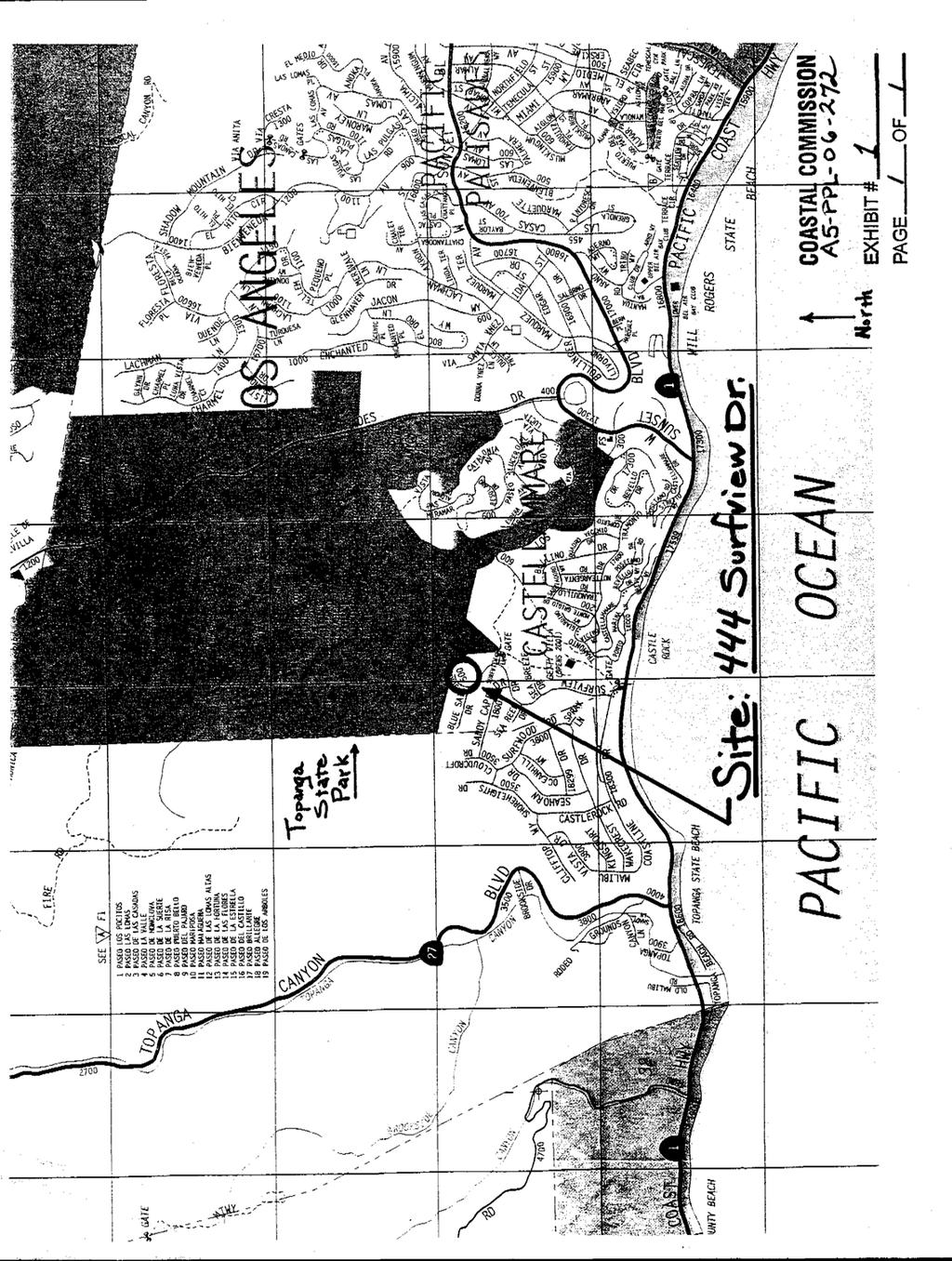
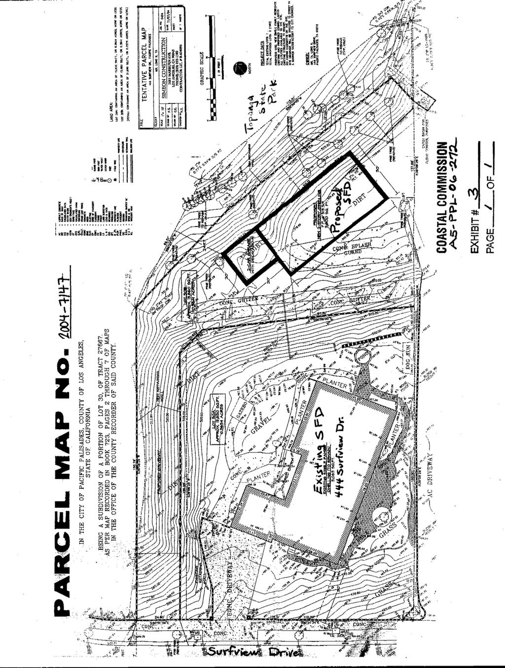
13 STATE OF CALIFORNIA - THE RESOURCES AGENCY CALIFORNIA COASTAL COMMISSION South Coast Area Office 200 Oceangate, Suite 1000 Long Beach, CA (562) W15b ARNOLD SCHWARZENEGGER, Governor Appeal Filed: 7/19/ th Day: 9/6/2006 Staff: Charles Posner - LB Staff Report: 8/24/2006 Hearing Date: September 13, 2006 Commission Action: STAFF REPORT: APPEAL SUBSTANTIAL ISSUE APPEAL NUMBER: LOCAL DECISION: A5-PPL Approval with Conditions APPLICANT: Long K. Ta AGENT: Susan McCabe APPELLANTS: PROJECT LOCATION: 1) Dr. Josh Leichtberg (Attn: Ronald D. Rosen, Attorney); and, 2) Dr. Walter O Brien and the Pacific View Estates Homeowners Association (Attn: John B. Murdock, Attorney). 444 Surfview Drive, Pacific Palisades, City of Los Angeles. PROJECT DESCRIPTION: Appeal of City of Los Angeles approval of Local Coastal Development Permit Application No. ZA , approved with conditions for a two-parcel single-family subdivision (Parcel Map No. AA ) and subsequent construction on Parcel B of one new single-family dwelling with garage. Lot Area 31,700 square feet (0.72 acre) Building Coverage 3,065 square feet (existing) Pavement Coverage 4,500 square feet (approx.) Landscape Coverage 24,135 square feet (approx.) Zoning RE15-1-H Plan Designation Single Family Residential Parking Spaces 4 Building Height 14 feet (existing one-story house) SUMMARY OF STAFF RECOMMENDATION The staff recommends that the Commission determine that a SUBSTANTIAL ISSUE EXISTS with respect to the City-approved project s conformance with the Chapter 3 policies of the Coastal Act because the local coastal development permit does not analyze or quantify the extent of landform alteration being approved for the development (i.e., grading, cutting or fill), or the height of retaining walls, nor does it consider whether the development protects Topanga State Park from the potential impacts of the development. See Page Five for the motion to make the substantial issue determination.
14 A5-PPL Page 2 SUBSTANTIVE FILE DOCUMENTS: 1. City of Los Angeles Local Coastal Development Permit No City of Los Angeles Parcel Map No. AA Brentwood-Pacific Palisades District Plan, City of Los Angeles Plan Case No , Coastal Commission Regional Interpretive Guidelines for Los Angeles County, I. APPELLANTS CONTENTIONS The Coastal Commission has received two appeals of the City of Los Angeles Planning Commission s action to approve Local Coastal Development Permit No (Exhibits #6&7). The local coastal development permit approves a two-parcel single-family subdivision (Parcel Map No. AA ) and subsequent construction on Parcel B of one new singlefamily dwelling (Exhibit #4). One single-family dwelling already exists on the portion of the project site that would become Parcel A (Exhibit #3). Both appeals raise the same issues. The grounds for the appeals are as follows: 1) The City failed to make specific written factual findings supporting the project s conformance with Coastal Commission Regional Interpretive Guidelines for Los Angeles County. 2) The City failed to analyze or quantify the extent of landform alteration being approved for the development (i.e., grading, cutting or fill), or the height of retaining walls. 3) The City-approved development does not conform with the Coastal Commission Regional Interpretive Guidelines for Los Angeles County, specifically, the limitations on landform alteration set forth by the Hillside Dwelling Unit Density Formula. 4) The City s approval of the development is inconsistent with the City s 1983 denial of Local Coastal Development Permit No (Parcel Map 5355) on the same site based on the lack of conformance with the Hillside Dwelling Unit Density Formula contained in the Coastal Commission Regional Interpretive Guidelines for Los Angeles County (Exhibit #7). 5) The City s approval of the development would result in increased density in a steep area and altered natural landforms and natural vegetation adjacent to open space (Topanga State Park). II. LOCAL GOVERNMENT ACTION On November 22, 2004, the applicant submitted to the City of Los Angeles Planning Department a Master Land Use Application requesting approval of a parcel map and a local coastal development permit for a proposed two-parcel subdivision and the construction of a two-story single-family residence with an attached garage (Exhibit #3).
15 A5-PPL Page 3 On June 15, 2005, the City held a public hearing for the parcel map and the local coastal development permit necessary for the proposed development. Four members of the public testified at the hearing, all in opposition to the proposed development. The opponents raised issues of hydrology, hillside stability, flag lot orientation, environmental sensitivity, and the legal obligation of the current owners of the property to adhere to the covenants and restrictions established for the neighborhood in 1965 by the Pacific View Estates Homeowners Association. On June 28, 2005, the Advisory Agency of the City Planning Department issued a letter of determination approving, with conditions, the proposed parcel map subdividing the property into two parcels, each about 15,800 square feet in area (Parcel Map No. AA ). On July 13, 2005, three appeals were filed objecting to the City s approval of Parcel Map No. AA The City record states that the West Los Angeles Area Planning Commission failed to act on the appeals within thirty days of the expiration of the appeal period, and the appeals were deemed denied by operation of law (Exhibit #4, p.15). Therefore, the City determined that the Advisory Agency s June 28, 2005 decision approving the subdivision was final. On October 6, 2005, the Office of Zoning Administration of the City Planning Department issued a letter of determination approving, with conditions, Local Coastal Development Permit No for the proposed development (Exhibit #4, p.8). The approved development is described as, a two-parcel single-family subdivision and subsequent construction on Parcel B of one new single-family dwelling with garage (Exhibit #4, p.8). On October 21, 2005, two appeals were filed at the City (by Dr. Josh Leichtberg and the Pacific View Estates Homeowners Association) objecting to the City s approval of Local Coastal Development Permit No for the proposed development (Exhibit #4, p.8). The local appeals raised the issues listed on page two of this report. At its meeting on May 17, 2006, the West Los Angeles Area Planning Commission denied the appeals and sustained the Zoning Administration s approval of the local coastal development permit authorizing the two-parcel subdivision and the construction of a single-family residence (Exhibit #4, p.2). The West Los Angeles Area Planning Commission also adopted Mitigated Negative Declaration No. ENV MND for the proposed development. The Planning Commission s action is attached to this report as Exhibit #4. The Planning Commission issued its decision on June 22, 2006, and its decision was not appealable to the City Council. On June 26, 2006, the Commission s South Coast District office in Long Beach received the City s Notice of Final Action for its approval of Local Coastal Development Permit No , and established the twenty-working day appeal period. The appeal by Dr. Josh Leichtberg was filed on July 19, 2006 (Exhibit #6). The appeal by Dr. Walter O Brien and the Pacific View Estates Homeowners Association was filed on July 24, 2006 (Exhibit #7). No other appeals were filed. On July 21 and July 27, 2006, Commission staff mailed notices of the appeals to the applicant and City Planning Department, and requested that the City provide the Commission staff with a copy of the local coastal development permit file.
16 A5-PPL Page 4 At the time the two appeals were filed, the next scheduled Commission meeting was planned for August 8-11, Commission staff listed the appeals on the Commission s August 2006 meeting agenda, to be heard on August 8. However, on August 8, 2006, the Commission had not received from the City a copy of the local coastal development permit file, as required by Section of the California Code of Regulations, Title 14. Accordingly, on August 8, 2006, at its meeting in San Pedro, the Commission opened and continued the public hearing for the appeal case. On August 9, 2006, Commission staff received from the City a copy of the local coastal development permit file. A public hearing for the appeals was then scheduled for the Commission s next meeting: September 13-15, 2006 in Eureka. III. APPEAL PROCEDURES Section 30600(b) of the Coastal Act provides that prior to certification of its Local Coastal Program (LCP), a local jurisdiction may, with respect to development within its area of jurisdiction in the coastal zone and consistent with the provisions of Sections 30604, and , establish procedures for the filing, processing, review, modification, approval or denial of a coastal development permit. Pursuant to this provision, the City of Los Angeles developed a permit program in 1978 to exercise its option to issue local coastal development permits. Sections of Title 14 of the California Code of Regulations provide procedures for issuance and appeals of locally issued coastal development permits. Section of the Coastal Act allows any action by a local government on a coastal development permit application evaluated under Section 30600(b) to be appealed to the Commission. The standard of review for such an appeal is the Chapter 3 policies of the Coastal Act. [Cal. Pub. Res. Code and ] After a final local action on a local coastal development permit application, the Coastal Commission must be noticed within five days of the decision. Once the Commission receives such a notice containing all the required information, a twenty working-day appeal period begins during which any person, including the applicant, the Executive Director, or any two members of the Commission, may appeal the local decision to the Coastal Commission. [Cal. Pub. Res. Code ] Any appeal of the local action is then analyzed to determine if a substantial issue exists as to the approved project s conformity with Chapter 3 of the Coastal Act (Sections ). [Cal. Pub. Res. Code 30625(b)(1).] Unless the Commission finds that the appeal raises no substantial issue, the Commission then holds a public hearing in which it reviews the coastal development permit application as a de novo matter. [Cal. Pub. Res. Code and 30625; Cal. Code Regs., Title 14, ] At this point, the Commission may decide that the appellant s contentions raise no substantial issue as to conformity of the approved project with Chapter 3 of the Coastal Act, in which case the action of the local government stands. Or, the Commission may find that a substantial issue exists with respect to the conformity of the action of the local government with Chapter 3 of the Coastal Act if it finds that the appeal raises a significant question regarding consistency with the Chapter 3 policies of the Coastal Act. If the Commission finds that a substantial issue exists, then the hearing will be continued as a de novo permit request. Section of the
17 A5-PPL Page 5 Coastal Commission regulations specifies that de novo actions will be heard according to the procedures outlined in Sections and of the Commission s regulations. IV. DUAL PERMIT JURISDICTION Within the areas specified in Section 30601, which is known in the City of Los Angeles permit program as the Dual Permit Jurisdiction area, the Coastal Act requires that any development which receives a local coastal development permit also obtain a second (or dual ) coastal development permit from the Coastal Commission. For projects located inland of the areas identified in Section (i.e., projects in the Single Permit Jurisdiction), the City of Los Angeles local coastal development permit is the only coastal development permit required. The project, in this case, is in the Single Permit Jurisdiction. However, because the local coastal development permit has been appealed to the Commission, the Commission nevertheless may, if it finds the appeal raises a substantial issue, be the permit issuing authority for this application. V. STAFF RECOMMENDATION ON SUBSTANTIAL ISSUE The staff recommends that the Commission determine that a substantial issue exists with respect to whether the local government s approval of the project is consistent with the provisions of Chapter 3 of the Coastal Act (commencing with Section 30200), pursuant to PRC Section 30625(b)(1). Staff recommends a NO vote on the following motion: MOTION: I move that the Commission determine that Appeal No. A-5-PPL raises no substantial issue with respect to conformity of the local approval with the policies of Chapter 3 of the Coastal Act. Failure of the motion will result in a de novo hearing on the application and adoption of the following resolution and findings. A majority of the Commissioners present is required to pass the motion. Resolution to Find Substantial Issue for Appeal A-5-PPL The Commission hereby finds that Appeal No. A-5-PPL presents a substantial issue with respect to conformity of the local government approval with the Chapter 3 policies of the Coastal Act.
18 A5-PPL Page 6 VI. FINDINGS AND DECLARATIONS FOR SUBSTANTIAL ISSUE The Commission hereby finds and declares: A. Project Description The proposed project involves the subdivision of a 31,700 square foot property into two parcels (Parcels A and B), each about 15,800 square feet in area. What would become Parcel A (444 Surfview Drive) is already developed (c.1965) with a one-story, 3,065 square foot single-family residence with an attached garage (Exhibit #3). In addition to the subdivision, the Cityapproval authorizes the construction of a two-story single-family residence with an attached garage on Parcel B. The project site, in the Pacific Palisades area of the Santa Monica Mountains, is a steep hillside lot with elevations between 480 and 530 feet above sea level. A paved two-lane public street (Coastline Drive and then Surfview Drive) provide vehicular access to the site, the surrounding single-family residential neighborhood and Topanga State Park from Pacific Coast Highway (Exhibit #1). The northern edge of the project site abuts the southern boundary of Topanga State Park (Exhibit #2). B. Factors to be Considered in Substantial Issue Analysis Section 30625(b)(1) of the Coastal Act states that the Commission shall hear an appeal of a local government action carried out pursuant to Section 30600(b) unless it finds that no substantial issue exists as to conformity with Chapter 3 of the Coastal Act. The term substantial issue is not defined in the Coastal Act or its implementing regulations. Section 13115(b) of the Commission s regulations simply indicates that the Commission will hear an appeal unless it finds that the appeal raises no significant question. In previous decisions on appeals, the Commission has been guided by the following factors. 1. The degree of factual and legal support for the local government s decision that the development is consistent or inconsistent with the relevant provisions of the Coastal Act; 2. The extent and scope of the development as approved or denied by the local government; 3. The significance of the coastal resources affected by the decision; 4. The precedential value of the local government s decision for future interpretations of its LCP; and, 5. Whether the appeal raises local issues, or those of regional or statewide significance. Staff is recommending that the Commission find that a substantial issue exists with respect to whether the local government action conforms with the provisions of Chapter 3 of the Coastal Act for the reasons set forth below. Even when the Commission chooses not to hear an appeal, appellants nevertheless may obtain judicial review of the local government s coastal development permit decision by filing petition for a writ of mandate pursuant to California Code of Civil Procedure, Section
19 A5-PPL Page 7 C. Substantial Issue Analysis As stated in Section III of this report, the grounds for an appeal of a coastal development permit issued by the local government prior to certification of its Local Coastal Program (LCP) are the Chapter 3 policies of the Coastal Act. Any such local government coastal development permit may be appealed to the Commission. The Commission shall hear an appeal unless it determines that the local government action raises no substantial issue as to conformity with Chapter 3 policies of the Coastal Act. In this case, staff has recommended that a substantial issue does exist in the local government s approval of the project. A substantial issue exists in regards to the City s approval of the local coastal development permit because does the City s approval does not analyze or quantify the extent of landform alteration being approved for the development (i.e., grading, cutting or fill), or the height of retaining walls, nor does it consider whether the development protects Topanga State Park from the potential impacts of the development (e.g. visual and habitat impacts). Section of the Coastal Act states: The scenic and visual qualities of coastal areas shall be considered and protected as a resource of public importance. Permitted development shall be sited and designed to protect views to and along the ocean and scenic coastal areas, to minimize the alteration of natural land forms, to be visually compatible with the character of surrounding areas, and, where feasible, to restore and enhance visual quality in visually degraded areas. New development in highly scenic areas such as those designated in the California Coastline Preservation and Recreation Plan prepared by the Department of Parks and Recreation and by local government shall be subordinate to the character of its setting. Section of the Coastal Act requires that visual qualities of coastal areas shall be considered and protected and the alteration of natural landforms be minimized. The City failed to analyze or quantify the extent of landform alteration being approved for the development (i.e., amount of grading, cutting or fill), or the height of retaining walls. The City approval acknowledges that a new house, with a new 150-foot long driveway, would be constructed on the newly created parcel with a 25% slope. The City also acknowledges that grading is necessary and at least two new retaining walls would need to be constructed for the approved development. But the City approval only requires that the grading be kept to a minimum without acknowledging what the minimum would be, or even how much grading the applicant s plan proposes. Therefore, the local government s approval raises a substantial issue as to conformity with Coastal Act Section because it does recognize the potential adverse impacts to the scenic and visual qualities of the Santa Monica Mountains and does not ensure the protection of natural landforms and visual resources. The appellants assert that the City failed to make specific written factual findings supporting the project s conformance with Coastal Commission Regional Interpretive Guidelines for Los Angeles County. In fact, the City s approval acknowledges that the proposed project does not conform with Coastal Commission Regional Interpretive Guidelines for Los Angeles County (Exhibit #4, p.18). The Commission s guidelines were adopted in 1980 to assist local governments, applicants and the Commission in determining how the Chapter 3 policies of the
20 A5-PPL Page 8 Coastal Act would be applied, based on the Commission s prior actions. The City approval acknowledges that, in 1983, the City denied Local Coastal Development Permit for a two-parcel subdivision on the project site because the proposed project did not conform with the Hillside Dwelling Unit Density Formula (Exhibit #7, p.4). The City also acknowledges that the currently proposed project also does not conform with the Hillside Dwelling Unit Density Formula set forth in the Coastal Commission Regional Interpretive Guidelines for Los Angeles County. The Hillside Dwelling Unit Density Formula limits the density of development on steep hillsides where overly dense development would have significant adverse impact on natural resources, natural landforms, public views and public safety. The Commission s Hillside Dwelling Unit Density Formula summarizes the Commission s past actions in the Santa Monica Mountains. The Hillside Dwelling Unit Density Formula was developed in the late 1970s by the City of Los Angeles when the Pacific Palisades Community Plan was being drafted in anticipation of the adoption City s future Pacific Palisades Local Coastal Program (LCP). The policy was developed in response to community concern about environmental effects of encroaching subdivisions into undeveloped hillsides of the Santa Monica Mountains. The policy was used by Commission staff as a tool for analyzing subdivisions in hillside areas and subsequently adopted in 1980 into the Commission s Regional Interpretive Guidelines. When the policy was being developed, the City faced major lawsuits about the loss of habitat and hazards (e.g. fire and landslides) caused by development in the mountains. While no LCP has yet been developed for Pacific Palisades, the relevant issues still persist. Therefore, fact that the City-approved development does not conform with the Commission s Hillside Dwelling Unit Density Formula raises a substantial issue as to conformity with Chapter 3 of the Coastal Act. Section of the Coastal Act requires that permitted development shall be sited and designed to protect views to and along the ocean. The northern edge of the project site abuts the southern boundary of Topanga State Park (Exhibit #2). The State Park property that abuts the northern edge of the project site is a flat graded pad, with immediate pedestrian access from Surfview Drive. The pad provides an expansive view of Santa Monica Bay and the Pacific Ocean. The construction of the City-approved house on the lot below this public viewing area would adversely affect the view of the ocean from the State Park because the second floor and roof of the house would extend above the highest point of the applicant s property and into the view. The ground floor level of the approved house is shown on the proposed plan at elevation 515, and the highest point of the property where it abuts the State Park is at elevation 532 (Exhibit #3). The local coastal development permit does not limit the height of the approved two-story residence to prevent it from obstructing the public s view from the State Park. Therefore, the local government s approval raises a substantial issue as to conformity with Coastal Act Section Section of the Coastal Act states: (a) Environmentally sensitive habitat areas shall be protected against any significant disruption of habitat values, and only uses dependent on such resources shall be allowed within such areas. (b) Development in areas adjacent to environmentally sensitive habitat areas and parks and recreation areas shall be sited and designed to prevent impacts which
21 A5-PPL Page 9 would significantly degrade such areas, and shall be compatible with the continuance of such habitat areas. The creation of a new parcel (Parcel B), and the construction of the approved house on Parcel B, within sixty feet of the State Park boundary, could also result in the destruction of natural habitat if the surrounding ground cover is thinned or cleared for fire safety. The City typically requires brush clearance and/or thinning within four hundred feet of habitable structures. A four hundred foot radius around the city-approved house would extend over three hundred feet into Topanga State Park.. Therefore, the local government s approval raises a substantial issue as to conformity with the habitat protection policies set forth in Section of the Coastal Act. Applying the five factors listed in the prior section further clarifies that the appeal raises a substantial issue with respect to Chapter 3. The first factor is the degree of factual and legal support for the local government s decision that the development is consistent with Chapter 3 of the Coastal Act. The findings for the City s approval of Local Coastal Development Permit No are found on Pages 16 through 19 of Exhibit #4 of this report. The City s findings do not provide an adequate degree of factual support for its conclusion that the approved development conforms with the Chapter 3 policies of the Coastal Act because the City did not analyze or quantify the extent of landform alteration being approved for the development (i.e., grading, cutting or fill), or the height of retaining walls. The findings also do not acknowledge or attempt to mitigate the proposed project s adverse impacts to the public views and natural resources in Topanga State Park, which abuts the project site. The second factor is the scope of the development approved by the local government. The approved development includes the subdivision of a 31,700 square foot project site, but the scope of the approved development is not entirely clear. The project description on Local Coastal Development Permit No (and in the applicant s permit application) is: a two-parcel single-family subdivision and subsequent construction on Parcel B of one new single-family dwelling with garage (Exhibit #4, p.8). A Zoning Administrator s letter to the Planning Commission (dated February 8, 2006, Exhibit #4, p.5), however, states that the house on Parcel B will need a second coastal development permit. Thus, the confusing Zoning Administrator s letter describing scope of the approved development supports a finding that the appeal raises a substantial issue. The third factor is the significance of the coastal resources affected by the decision. The proposed development abuts Topanga State Park. Public recreation and natural habitat areas in Topanga State Park are the main resources affected by the proposed project. Thus, the coastal resources affected are significant. The fourth factor is the precedential value of the local government s decision for future interpretations of its LCP. This is designed to avoid leaving decisions in place that could create a precedent for how the relevant provision of the LCP is to be interpreted, assuming the local government has a certified LCP. In this case, the City does not have a certified LCP for Pacific Palisades. Section 30604(a) of the Coastal Act provides that the Commission shall issue a coastal development permit only if the project will not prejudice the ability of the local government having jurisdiction to prepare a LCP which conforms with Chapter 3 policies of the Coastal Act. The subdivision of a steep hillside lot with an existing single-family residence, and the approval of a new house that does not conform with the Hillside Dwelling Unit Density
22 A5-PPL Page 10 Formula set forth in the Commission s Regional Interpretive Guidelines, sets a precedent that merits closer scrutiny by the Commission to ensure that the project will not prejudice the ability of the City to prepare an LCP. The final factor is whether the appeal raises local issues, or those of regional or statewide significance. The appeal raises a local issue related to the density of development in an existing Pacific Palisades neighborhood. However, the protection of a State Park that is a tourist destination for people all over the state (and beyond), and the precedential nature of the City s approval, rises to statewide significance.
23
24
25
26
27
28
29
30
31
PROPOSED FINIDINGS ZONE VARIANCE APPLICATION FOR HEIGHT VARIANCE
 PROPOSED FINIDINGS ZONE VARIANCE APPLICATION FOR HEIGHT VARIANCE (PURSUANT TO LOS ANGELES MUNICIPAL CODE SECTION 12.27) CONCERNING 10550 WEST BELLAGIO ROAD, LOS ANGELES, CA 90077 Pursuant to Charter Section
Jack & Eileen Feather (PLN030436)
") MIKE NOVO ZONING ADMINISTRATOR COUNTY OF MONTEREY STATE OF CALIFORNIA RESOLUTION NO. 030436 A. P. # 008-462-008-000 In the matter of the application of Jack & Eileen Feather (PLN030436) FINDINGS & DECISION
MIKE NOVO ZONING ADMINISTRATOR COUNTY OF MONTEREY STATE OF CALIFORNIA RESOLUTION NO. 030436 A. P. # 008-462-008-000 In the matter of the application of Jack & Eileen Feather (PLN030436) FINDINGS & DECISION
III. PROJECT DESCRIPTION
 III. PROJECT DESCRIPTION A. PROJECT APPLICANT The project applicant for the proposed is Palisades Landmark, LLC, 10600 Santa Monica Boulevard, Los Angeles, CA 90025. B. PROJECT LOCATION The project site
1.0 REQUEST. SANTA BARBARA COUNTY ZONING ADMINISTRATOR Coastal Zone Staff Report for Vincent New Single-Family Dwelling & Septic System
 SANTA BARBARA COUNTY ZONING ADMINISTRATOR Coastal Zone Staff Report for Vincent New Single-Family Dwelling & Septic System Hearing Date: February 26, 2007 Supervisorial District: First Staff Report Date:
Napa County Planning Commission Board Agenda Letter
 Agenda Date: 9/20/2017 Agenda Placement: 8C Napa County Planning Commission Board Agenda Letter TO: FROM: Napa County Planning Commission Charlene Gallina for David Morrison - Director Planning, Building
Draft Zoning Changes for the 2nd Planning Board Public Hearing, January 22, 2018.
 Draft Zoning Changes for the 2nd Planning Board Public Hearing, January 22, 2018. No changes were made at the 1st Public Hearing. Proposed wording for the 1 st Public Hearing in red, eliminated text in
Town of Bristol Rhode Island
 Town of Bristol Rhode Island Subdivision & Development Review Regulations Adopted by the Planning Board September 27, 1995 (March 2017) Formatted: Highlight Formatted: Font: 12 pt Table of Contents TABLE
VI. SAFETY ELEMENT I. INTRODUCTION A. PURPOSE B. AUTHORITY. 1. Safety
 AB 162 and SB 1241 Amendment to the Safety Element New sections are underlined, deleted sections are shown as strikethrough and the denotes text remaining in place. VI. SAFETY ELEMENT I. INTRODUCTION A.
Subdivision Map Act and CEQA Compliance:
 Subdivision Map Act and CEQA Compliance: Mechanisms for Success Under the Subdivision Map Act and How to Streamline the CEQA Process and Minimze Litigation Risks February 23, 2006 Presented by Gregory
Draft Ordinance: subject to modification by Town Council based on deliberations and direction ORDINANCE 2017-
 ORDINANCE 2017- Draft Ordinance: subject to modification by Town Council based on deliberations and direction AN INTERIM URGENCY ORDINANCE OF THE TOWN COUNCIL OF THE TOWN OF LOS GATOS ESTABLISHING A TEMPORARY
Residential Project Convenience Facilities
 Standards for Specific Land Uses 35.42.220 E. Findings. The review authority shall approve a Land Use Permit in compliance with Subsection 35.82.110.E (Findings required for approval) or a Conditional
The following regulations shall apply in the R-E District:
 "R-E" RESIDENTIAL ESTATE DISTRICT (8/06) The following regulations shall apply in the R-E District: 1. Uses Permitted: The following uses are permitted. A Zoning Certificate may be required as provided
Butte County Board of Supervisors
 Butte County Board of Supervisors PUBLIC HEARING January 12, 2016 Amendments to the General Plan and Zoning Ordinance AG-P5.3 (Agricultural Buffer) and Interim Agricultural Uses Butte County Department
The City of Carlsbad Planning Division A REPORT TO THE PLANNING COMMISSION. Item No. P.C. AGENDA OF: March 16, 2011 Project Planner: Shannon Werneke
 The City of Carlsbad Planning Division A REPORT TO THE PLANNING COMMISSION Item No. 2 Application complete date: January 24, 2011 P.C. AGENDA OF: March 16, 2011 Project Planner: Shannon Werneke Project
APPLICATION FOR 555 Washington Street Tentative Map Red Bluff, CA Subdivision Map (530) ext Parcel Map.
 ext Parcel Map.") City of Red Bluff Community Development Department Application No. APPLICATION FOR 555 Washington Street Tentative Map Red Bluff, CA 96080 Subdivision Map (530) 527-2605 ext. 3059 Parcel Map Applicant
City of Red Bluff Community Development Department Application No. APPLICATION FOR 555 Washington Street Tentative Map Red Bluff, CA 96080 Subdivision Map (530) 527-2605 ext. 3059 Parcel Map Applicant
A. ARTICLE 16 - STEEP SLOPE CONSERVATION DISTRICT
 1600. 1601.A. ARTICLE 16 - STEEP SLOPE CONSERVATION DISTRICT SECTION 1600 PURPOSE The purpose of this Article is to expand upon the Community Development Objectives associated with environmental protection
required findings for approval of the variance cannot be made
 RESOLUTION NO Rqg A RESOLUTION OF THE CITY COUNCIL OF THE CITY OF PISMO BEACH DENYING THE APPEAL OF MICHAEL SULLIVAN REGARDING 162 BLUFFS DRIVE AND APPROVING THE PERMITS FOR PROJECT NO 92 151 A On November
A. Maintenance. All legally established, nonconforming structures can be maintained (e.g., painting and repairs);
;") Chapter 24.50 NONCONFORMING USES, STRUCTURES AND LOTS Sections: 24.50.010 Nonconforming uses, structures, and lots Purpose. 24.50.020 Nonconforming uses, structures, and lots Alteration or expansion of
Chapter 24.50 NONCONFORMING USES, STRUCTURES AND LOTS Sections: 24.50.010 Nonconforming uses, structures, and lots Purpose. 24.50.020 Nonconforming uses, structures, and lots Alteration or expansion of
TOWN OF LOS ALTOS HILLS January 11, 2018 Staff Report to the Planning Commission
 ITEM #3.2 TOWN OF LOS ALTOS HILLS Staff Report to the Planning Commission SUBJECT: FROM: REQUEST FOR APPROVAL OF A CONDITIONAL DEVELOPMENT AND SITE DEVELOPMENT PERMITS FOR A NEW 2,831 SQUARE FOOT, TWO
Planning Commission Report
 cjly City of Beverly Hills Planning Division 455 N. Rexford Drive Beverly Hills, CA 90210 TEL. (310) 285-1141 FAX. (370) 858-5966 Planning Commission Report Meeting Date: April 28, 2016 Subject: Project
Salem Township Zoning Ordinance Page 50-1 ARTICLE 50.0: PUD PLANNED UNIT DEVELOPMENT
 Salem Township Zoning Ordinance Page 50-1 ARTICLE 50.0 PLANNED UNIT DEVELOPMENT Section 50.01 Purpose The provisions of this Article provide enabling authority and standards for the submission, review,
ATTACHMENT A: FINDINGS
 ATTACHMENT A: FINDINGS 1.0 CEQA FINDINGS 1.1 ENVIRONMENTAL IMPACT REPORTS Findings pursuant to public resources code Section 21081 and the California Environmental Quality Act Guidelines Sections 15090
CITY OF GROVER BEACH COMMUNITY DEVELOPMENT DEPARTMENT Tentative Map Checklist
 CITY OF GROVER BEACH COMMUNITY DEVELOPMENT DEPARTMENT Tentative Map Checklist The following list includes all of the items you must submit for a complete application. Some specific types of information
COUNTY OF SANTA BARBARA PLANNING AND DEVELOPMENT MEMORANDUM. Santa Barbara County Planning Commission
 COUNTY OF SANTA BARBARA PLANNING AND DEVELOPMENT MEMORANDUM TO: FROM: HEARING DATE: RE: Santa Barbara County Planning Commission Florence Trotter-Cadena, Planner III North County Development Review October
MONTECITO PLANNING COMMISSION Coastal Zone Staff Report for Klein Appeal of the Hughes Addition and Remodel Coastal Development Permit
 MONTECITO PLANNING COMMISSION Coastal Zone Staff Report for Klein Appeal of the Hughes Addition and Remodel Coastal Development Permit Staff Report Date: September 28, 2017 Case No.: 17APL-000000-00007
IN RE CLINTON TOWNSHIP, ) NEW JERSEY COUNCIL HUNTERDON COUNTY ) ON AFFORDABLE HOUSING
 NEW JERSEY COUNCIL HUNTERDON COUNTY ) ON AFFORDABLE HOUSING") IN RE CLINTON TOWNSHIP, ) NEW JERSEY COUNCIL HUNTERDON COUNTY ) ON AFFORDABLE HOUSING ) ) OPINION This matter arises as a result of an Order to Show Cause issued by the New Jersey Council on Affordable
IN RE CLINTON TOWNSHIP, ) NEW JERSEY COUNCIL HUNTERDON COUNTY ) ON AFFORDABLE HOUSING ) ) OPINION This matter arises as a result of an Order to Show Cause issued by the New Jersey Council on Affordable
CITY OF PISMO BEACH PLANNING COMMISSION AGENDA REPORT
 CITY OF PISMO BEACH PLANNING COMMISSION AGENDA REPORT DATE: October 27, 2015 TO: FROM: HONORABLE CHAIR AND MEMBERS OF THE PLANNING COMMISSION Jan Di Leo, Planner (805) 773-7088 jdileo@pismobeach.org APPLICATION:
Packet Contents: Page #
 CLEAR CREEK COUNTY PLANNING DEPARTMENT REQUIREMENTS FOR COMMERCIAL AND MULTI-FAMILY DEVELOPMENTS Prior to submitting a building permit application, the Planning staff will review the site plan and construction
A Guide to the Municipal Planning Process in Saskatchewan
 A Guide to the Municipal Planning Process in Saskatchewan A look at the municipal development permit and the subdivision approval process in Saskatchewan May 2008 Prepared By: Community Planning Branch
SANTA BARBARA COUNTY ZONING ADMINISTRATOR Staff Report for Coleman SFD Addition Coastal Development Permit with Hearing
 SANTA BARBARA COUNTY ZONING ADMINISTRATOR Staff Report for Coleman SFD Addition Coastal Development Permit with Hearing Supervisorial District: First Staff Report Date: August 10, 2005 Staff: Lisa Hosale
SANTA BARBARA COUNTY PLANNING COMMISSION Staff Report for Bosshardt Appeal of Planning and Development Denial of Land Use Permit 06LUP
 SANTA BARBARA COUNTY PLANNING COMMISSION Staff Report for Bosshardt Appeal of Planning and Development Denial of Land Use Permit 06LUP-00000-00245 Deputy Director: Zoraida Abresch Staff Report Date: October
Town of Scarborough, Maine
 Town of Scarborough, Maine Miscellaneous Appeal INFORMATION REQUIRED FOR ALL APPEALS Before any appeal can be processed, the following material must be submitted to the Code Enforcement Office: 1. A fee
ARTICLE III GENERAL PROCEDURES, MINOR PLANS AND FEE SCHEDULES
 ARTICLE III GENERAL PROCEDURES, MINOR PLANS AND FEE SCHEDULES 301. Prior to Submission a. Copies of this Ordinance shall be available on request, at cost, for the use of any person who desires information
COUNCIL ON AFFORDABLE HOUSING IN RE TOWNSHIP ) COAH DOCKET NO OF RIVER VALE ) MOTION DECISION
 COAH DOCKET NO OF RIVER VALE ) MOTION DECISION") COUNCIL ON AFFORDABLE HOUSING IN RE TOWNSHIP ) COAH DOCKET NO. 98-1009 OF RIVER VALE ) MOTION DECISION On September 18, 1998 the Township of River Vale, Bergen County ("River Vale" or "the Township") filed
COUNCIL ON AFFORDABLE HOUSING IN RE TOWNSHIP ) COAH DOCKET NO. 98-1009 OF RIVER VALE ) MOTION DECISION On September 18, 1998 the Township of River Vale, Bergen County ("River Vale" or "the Township") filed
Project Location 1806 & 1812 San Marcos Pass Road
 SANTA BABARA COUNTY PLANNING COMMISSION Staff Report for Staal Lot Line Adjustment and Rezone Deputy Director: Dave Ward Staff Report Date: June 19, 2009 Division: Development Review - South Case Nos.:
SANTA BARBARA COUNTY ZONING ADMINISTRATOR STAFF REPORT February 15, 2013
 SANTA BARBARA COUNTY ZONING ADMINISTRATOR STAFF REPORT February 15, 2013 PROJECT: Galbraith Lot Line Adjustment HEARING DATE: March 4, 2013 STAFF/PHONE: J. Ritterbeck, (805) 568-3509 GENERAL INFORMATION
PLANNING COMMISSION RESOLUTION NO
 Exhibit A PLANNING COMMISSION RESOLUTION NO. 2014-566 A RESOLUTION OF THE PLANNING COMMISSION OF THE CITY OF CALABASAS RECOMMENDING TO THE CITY COUNCIL APPROVAL OF FILE NO. 140000288, GENERAL PLAN AMENDMENTS
MONTEREY COUNTY STANDARD SUBDIVISION COMMITTEE
 MONTEREY COUNTY STANDARD SUBDIVISION COMMITTEE Meeting: May 11, 2006 Agenda Item: 1 Project Description: Standard Subdivision Amendment of recorded Markham Ranch Subdivision Map to relocate building envelope
RESOLUTION NO
 RESOLUTION NO. 2005- A RESOLUTION OF THE MARIN COUNTY BOARD OF SUPERVISORS DENYING THE PETER PAPPAS APPEAL AND SUSTAINING THE PLANNING COMMISSION S ACTION BY DENYING THE PAPPAS DESIGN REVIEW CLEARANCE
COASTAL PERMIT ADMINISTRATOR JANUARY 26, 2017
 COASTAL PERMIT ADMINISTRATOR JANUARY 26, 2017 STAFF REPORT- CDP_STANDARD CDP_2016-0025 SUMMARY OWNER/APPLICANT/AGENT: GEBB CHESTER S & ANNE J HARRIS 5245 WIKIUP BRIDGEWAY SANTA ROSA, CA 95404 REQUEST:
RESOLUTION NO
 ITEM 4 ATTACHMENT B RESOLUTION NO. 2014-1412 A RESOLUTION OF THE CITY COUNCIL OF THE CITY OF CALABASAS APPROVING GENERAL PLAN AMENDMENTS ASSOCIATED WITH THE WEST AGOURA ROAD TERRITORY IN CONFORMANCE WITH
DRAFT FOR PUBLIC HEARING (rev. March, 2016)
") Chapter 200. ZONING Article VI. Conservation/Cluster Subdivisions 200-45. Intent and Purpose These provisions are intended to: A. Guide the future growth and development of the community consistent with
Chapter 200. ZONING Article VI. Conservation/Cluster Subdivisions 200-45. Intent and Purpose These provisions are intended to: A. Guide the future growth and development of the community consistent with
ARTICLE 24 PRIVATE ROAD, SHARED PRIVATE DRIVEWAY AND ACCESS EASEMENT STANDARDS
 ARTICLE 24 PRIVATE ROAD, SHARED PRIVATE DRIVEWAY AND ACCESS EASEMENT STANDARDS SECTION 24.00 INTENT AND PURPOSE The standards of this Article provide for the design, construction and maintenance of private
SISKIYOU COUNTY PLANNING COMMISSION STAFF REPORT March 21, 2018
 SISKIYOU COUNTY PLANNING COMMISSION STAFF REPORT March 21, 2018 NEW BUSINESS - AGENDA ITEM No. 2: JOANNE RICHARDSON TENTATIVE PARCEL MAP (TPM-17-04) APPLICANT: PROPERTY OWNER: PROJECT SUMMARY: GENERAL
ORDINANCE NO. The Board of Supervisors of the County of Sonoma, State of California, ordains as follows:
 ORDINANCE NO. AN ORDINANCE OF THE BOARD OF SUPERVISORS OF THE COUNTY OF SONOMA, STATE OF CALIFORNIA, AMENDING THE TEXT OF CHAPTER 26C (COASTAL ZONING ORDINANCE) OF THE SONOMA COUNTY ZONING CODE TO: 1)
ARTICLE 1 GENERAL PROVISIONS
 ARTICLE 1 GENERAL PROVISIONS SECTION 100 TITLE This Ordinance shall be known and cited as the "Rice Township Subdivision and Land Development Ordinance." SECTION 101 AUTHORITY Rice Township is empowered
MIDWAY CITY Municipal Code
 MIDWAY CITY Municipal Code TITLE 9 ANNEXATION CHAPTER 9.01 PURPOSE CHAPTER 9.02 GENERAL REQUIREMENTS CHAPTER 9.03 PROPERTY OWNER INITIATION OF ANNEXATION CHAPTER 9.04 PROCEDURES FOR CONSIDERATION OF PETITION
Venice NeighborhoodCouncil PO Box 550, Venice CA / LAND USE AND PLANNING COMMITTEE STAFF REPORT
 Venice NeighborhoodCouncil PO Box 550, Venice CA 90294 /www.venicenc.org Email: info@venicenc.org, LAND USE AND PLANNING COMMITTEE STAFF REPORT *********** Submitted to LUPC November 2, 2011 Preliminary
Kitsap County Department of Community Development
 Kitsap County Department of Community Development Staff Report and Recommendation Annual Comprehensive Plan Amendment Process for 2018 George s Corner LAMIRD Boundary Adjustment Report Date 7/16/2018 Hearing
CHAPTER XVIII SITE PLAN REVIEW
 CHAPTER XVIII SITE PLAN REVIEW Section 18.1 Section 18.2 Description and Purpose. The purpose of this chapter is to provide standards and procedures under which applicants would submit, and the Township
Sven & Katrin Nauckhoff (PLN030156)
") MIKE NOVO ZONING ADMINISTRATOR STATE OF CALIFORNIA COUNTY OF MONTEREY RESOLUTION NO. 030156 A.P. # 007-281-001-000 In the matter of the application of Sven & Katrin Nauckhoff (PLN030156) FINDINGS & DECISION
MIKE NOVO ZONING ADMINISTRATOR STATE OF CALIFORNIA COUNTY OF MONTEREY RESOLUTION NO. 030156 A.P. # 007-281-001-000 In the matter of the application of Sven & Katrin Nauckhoff (PLN030156) FINDINGS & DECISION
4.2 LAND USE INTRODUCTION
 4.2 LAND USE INTRODUCTION This section of the EIR addresses potential impacts from the Fresno County General Plan Update on land use in two general areas: land use compatibility and plan consistency. Under
Article 6 Development Permits. Division 5: Site Development Permit Procedures (Added by O N.S.; effective
 Article 6 Development Permits Division 5: Site Development Permit Procedures (Added 12-9-1997 by O-18451 N.S.; effective 1-1-2000.) 126.0501 Purpose of the Site Development Permit Procedures The purpose
PLANNED DEVELOPMENT / CONDITIONAL USE PERMIT Application
 SUBMITTAL City of Camarillo Department of Community Development 601 Carmen Drive P.O. Box 248 Camarillo, CA 93011-0248 Phone: 805.388.5360; Fax: 805.388.5388 Email: comdevemail@cityofcamarillo.org City
TENTATIVE PARCEL MAP APPLICATION GUIDE TENTATIVE PARCEL MAP APPLICATION REQUIREMENTS
 TENTATIVE PARCEL MAP APPLICATION GUIDE SISKIYOU COUNTY PLANNING DIVISION 806 South Main Street, Yreka CA 96097 Phone: (530) 841-2100 / Fax: (530) 841-4076 TENTATIVE PARCEL MAP APPLICATION REQUIREMENTS
Special Use Permit - Planned Unit Development Checklist. Property Address:
 Special Use Permit - Planned Unit Development Checklist Special Use Permit Number. Parcel Code/s #28-11- - - Property Address: Applicant: ARTICLE VIII Ordinance Reference - Section 8.1.2 Permit Procedures:
RECOMMENDATION REPORT
 DEPARTMENT OF CITY PLANNING RECOMMENDATION REPORT City Planning Commission Date: August 27, 2009 Time: After 8:30 AM Place: City Hall 200 North Spring Street Los Angeles, CA 90012 Public Hearing: Completed
SANTA BARBARA COUNTY ZONING ADMINISTRATOR STAFF REPORT January 11, 2008
 SANTA BARBARA COUNTY ZONING ADMINISTRATOR STAFF REPORT January 11, 2008 PROJECT: Gerrity Parking in Side Setback and Gerrity Student Housing Addition HEARINGDATE: January 28, 2008 STAFF/PHONE: J. Ritterbeck,
Honorable Mayor and Members of the City Council
 Office of the City Manager ACTION CALENDAR June 11, 2013 To: From: Honorable Mayor and Members of the City Council Christine Daniel, City Manager Submitted by: Eric Angstadt, Director, Planning & Development
That the Planning Commission finds and advises EBMUD that the proposed disposal of property is in conformance with the County General Plan.
 STAFF ANALYSIS JUNE 19, 2006 GPC 2006-02 DISPOSAL OF PROPERTY EAST BAY MUNICIPAL UTILITY DISTRICT PROPOSED SALE OF EAST BAY MUNICIPAL UTILITY DISTRICT S SYDNEY RESERVOIR PROPERTY: Request by the Real Estate
DRAFT PARK COUNTY US HIGHWAY 89 SOUTH EAST RIVER ROAD OLD YELLOWSTONE TRAIL ZONING DISTRICT REGULATIONS
 Formatting: Changes recommended by the Board and accepted by the County Commission are formatted in RED: Changes made by the Park County Commission are formatted in YELLOW highlight: and changes made by
1.0 INTRODUCTION 1.1 OVERVIEW
 .0 INTRODUCTION 0 0 0. OVERVIEW The County of Santa Barbara prepared a Draft Environmental Impact Report (EIR) for the Paradiso del Mare Ocean Estates and Inland Estates Project and circulated the Draft
Dear Honorable Coastal Commission Staff and City of Marina,
 November 24, 2015 California Coastal Commission c/o Mr. Dan Carl Deputy Director Central Coast/North Central Coast Districts VIA EMAIL TO: Dan.Carl@coastal.ca.gov California Coastal Commission c/o Ms.
(a) Commercial uses on Laurel Avenue, abutting the TRO District to the
 Commercial uses on Laurel Avenue, abutting the TRO District to the") 32X Zoning Code 150.36 TRANSITIONAL RESIDENTIAL OVERLAY DISTRICT. (A) Intent and purpose. (1) It is the intent of the Transitional Residential Overlay District (hereinafter referred to as the "TRO District")
32X Zoning Code 150.36 TRANSITIONAL RESIDENTIAL OVERLAY DISTRICT. (A) Intent and purpose. (1) It is the intent of the Transitional Residential Overlay District (hereinafter referred to as the "TRO District")
ACCESSORY SECOND UNIT PERMIT Application Packet
 ACCESSORY SECOND UNIT PERMIT Application Packet Contents Description & List of Requirements Permit Application Draft Deed Restriction Municipal Code Section 16.333 ACCESSORY SECOND UNIT PERMIT Description
STAFF REPORT. Arthur and Kathleen Quiggle 4(b)
") STAFF REPORT Application: Requests related to the construction of a 28' x 41' dwelling and 6' wrap-around open deck to replace an existing 24' x 32' cabin and wrap-around open deck and the installation
STAFF REPORT Application: Requests related to the construction of a 28' x 41' dwelling and 6' wrap-around open deck to replace an existing 24' x 32' cabin and wrap-around open deck and the installation
CITY OF PISMO BEACH PLANNING COMMISSION AGENDA REPORT
 DATE: March 22, 2016 CITY OF PISMO BEACH PLANNING COMMISSION AGENDA REPORT TO: FROM: HONORABLE CHAIR AND MEMBERS OF THE PLANNING COMMISSION Jan Di Leo, Planner (805) 773-7088 jdileo@pismobeach.org THROUGH:
Chapter 100 Planned Unit Development in Corvallis Urban Fringe
 100.100 Scope and Purpose. Chapter 100 Planned Unit Development in Corvallis Urban Fringe (1) All applications for land divisions in the Urban Residential (UR) and Flood Plain Agriculture (FPA) zones within
APPENDIX C-1 DEVELOPING FINDINGS OF FACT & CONCLUSIONS OF LAW FOR PLANNING AND ZONING
 APPENDIX C-1 DEVELOPING FINDINGS OF FACT & CONCLUSIONS OF LAW FOR PLANNING AND ZONING Amended: 9/2011; 9/2014; Page! i DEVELOPING FINDINGS OF FACT, AND CONCLUSIONS OF LAW 1. Developing the following information
UPPER MOUNT BETHEL TOWNSHIP NORTHAMPTON COUNTY, PENNSYLVANIA
 UPPER MOUNT BETHEL TOWNSHIP NORTHAMPTON COUNTY, PENNSYLVANIA JOINDER DEED / LOT CONSOLIDATION TOWNSHIP REVIEW PROCESS When accepting proposed Joinder Deeds / Lot Consolidations, review the Joinder Deed
RESOLUTION OF THE BOARD OF SUPERVISORS OF ORANGE COUNTY, CALIFORNIA APPROVING VESTING TENTATIVE TRACT MAP December 13, 2016
 RESOLUTION OF THE BOARD OF SUPERVISORS OF ORANGE COUNTY, CALIFORNIA APPROVING VESTING TENTATIVE TRACT MAP 17522 December 13, 2016 WHEREAS, Yorba Linda Estates, LLC, OC 33, LLC and the Nicholas/Long Family
Applicant's Response to Appeal in Case No. CPC GPA-ZC-HD-MCUP-ZV-SPR
 CL Ul 633 W. 5th Street 32nd Floor Los Angeles, CA 90071.2005 213.694.3100 main 213.694.3101 fax AndrewJ. Brady 213.694.3108 direct abrady@linerlaw.com August 22, 2017 Honorable Members of the Planning
THE PEOPLE OF THE CITY OF LOS ANGELES DO ORDAIN AS FOLLOWS:
 ORDINANCE NO..1_, 8_'2_{_19_5 An ordinance amending Sections 11.01, 12.03, 12.24, 12.28, 13.03, 14.3.1, and 16.05 of the Los Angeles Municipal Code to update common findings for conditional uses, adjustments,
APPLICATION SUBMITTAL REQUIREMENTS FOR Tentative Parcel or Subdivision Maps
 CITY OF EL CERRITO Community Development Department Planning and Building Division 10890 San Pablo Avenue, El Cerrito, CA 94530 (510) 215-4330 FA (510) 233-5401 planning@ci.el-cerrito.ca.us APPLICATION
Oregon Statutes Relevant to Quiet Water Home Owners Association
 Oregon Statutes Relevant to Quiet Water Home Owners Association 1 1 1 1 0 1 0 1 0 1 PLANNED COMMUNITIES (General Provisions).0 Definitions for ORS.0 to.. As used in ORS.0 to.: (1) Assessment means any
RESOLUTION NO. B. The proposed amendment would not be detrimental to the public interest, health, safety, convenience, or welfare of the City; and
 RESOLUTION NO. RESOLUTION OF THE PLANNING COMMISSION OF THE CITY OF SANTA ROSA RECOMMENDING TO CITY COUNCIL REZONING TO MODIFY THE EXISTING POLICY STATEMENT AND ADOPT THE BAY VILLAGE HOMES DEVELOPMENT
WASCO COUNTY PRELIMINARY SUBDIVISION APPLICATION
 WASCO COUNTY PRELIMINARY SUBDIVISION APPLICATION DETAILED SPECIFIC WRITTEN REQUEST File Number: SDV- Number of Proposed Lots & their Dimensions: PRELIMINARY SUBDIVISION PLAN REQUIREMENTS The approval of
Staff Report. Planning Commission Public Hearing: October 17, 2007 Staff Recommendation: Denial
 COUNTY OF PRINCE WILLIAM 5 County Complex Court, Prince William, Virginia 22192-9201 PLANNING (703) 792-6830 Metro 631-1703, Ext. 6830 FAX (703) 792-4401 OFFICE Internet www.pwcgov.org Stephen K. Griffin,
MEETING DATE: 08/1/2017 ITEM NO: 16 TOWN OF LOS GATOS COUNCIL AGENDA REPORT DATE: JULY 27, 2017 MAYOR AND TOWN COUNCIL LAUREL PREVETTI, TOWN MANAGER
 TOWN OF LOS GATOS COUNCIL AGENDA REPORT MEETING DATE: 08/1/2017 ITEM NO: 16 TO: FROM: SUBJECT: MAYOR AND TOWN COUNCIL LAUREL PREVETTI, TOWN MANAGER ARCHITECTURE AND SITE APPLICATION S-13-090 AND VESTING
SANTA BARBARA COUNTY PLANNING COMMISSION Staff Report for County Sale of Cary Place Government Code Consistency Determination
 SANTA BARBARA COUNTY PLANNING COMMISSION Staff Report for County Sale of Cary Place Government Code 65402 Consistency Determination Deputy Director: Steve Chase Staff Report Date: June 22, 2006 Division:
5.03 Type III (Quasi-Judicial) Decisions
 Decisions") 5.03 Type III (Quasi-Judicial) Decisions 5.03 General Requirements A. The purpose of this Section is to identify what types of actions are considered Type III decisions. Type III decisions involve significant
5.03 Type III (Quasi-Judicial) Decisions 5.03 General Requirements A. The purpose of this Section is to identify what types of actions are considered Type III decisions. Type III decisions involve significant
Guidelines for the Consideration of Applications for the Demolition or Moving of Structures Within the Northville Historic District
 Guidelines for the Consideration of Applications for the Demolition or Moving of Structures Within the Northville Historic District A. RESPONSIBILITY OF THE HISTORIC DISTRICT COMMISSION The Northville
ARTICLE VII. NONCONFORMITIES. Section 700. Purpose.
 ARTICLE VII. NONCONFORMITIES. Section 700. Purpose. The purpose of this chapter is to regulate and limit the development and continued existence of legal uses, structures, lots, and signs established either
Plat Alteration request of Barkley North LLC re 3400 Sussex Drive (aka Village on the Green Division #5 Tract B) 08/26/2015
 08/26/2015") Hearing Examiner Summary and Decision Hearing Examiner No. Planning No. Incident No. Filing Date City Contact Hearing Date Description Decision Date Decision Summary HE-15-PL-022 SUB2015-00019 06/22/2015
Hearing Examiner Summary and Decision Hearing Examiner No. Planning No. Incident No. Filing Date City Contact Hearing Date Description Decision Date Decision Summary HE-15-PL-022 SUB2015-00019 06/22/2015
 EXHIBIT A: Proposed Ordinance CPC-2016-1245-CA May 12, 2016 Exhibit A CPC 2016 1245 CA ORDINANCE NO. An ordinance repealing Subsections 12.24.W.43 and 12.24.W.44 of Chapter 1 of the Los Angeles Municipal
PLANNING DEPARTMENT TRANSMITTAL TO THE CITY CLERK S OFFICE SUPPLEMENTAL CF
 PLANNING DEPARTMENT TRANSMITTAL TO THE CITY CLERK S OFFICE SUPPLEMENTAL CF 17-1053 CITY PLANNING CASE: ENVIRONMENTAL DOCUMENT: COUNCIL DISTRICT: CPC-2008-1553-CPU ENV-2008-1780-EIR 8, 9, 14, 15 PROJECT
MONTEREY COUNTY ZONING ADMINISTRATOR
 MONTEREY COUNTY ZONING ADMINISTRATOR Meeting: June 28, 2007 Time: 1:45pm Agenda Item No.: 4 Project Description: Combined Development Permit including after-the-fact permits to allow a 138 square foot
TENTATIVE PARCEL MAP TIME EXTENSION
 EL DORADO COUNTY DEVELOPMENT SERVICES ZONING ADMINISTRATOR STAFF REPORT Agenda of: October 15, 2008 Item No.: Staff: 4.a. Mel Pabalinas TENTATIVE PARCEL MAP TIME EXTENSION APPLICATION FILE NO.: APPLICANT:
Chapter Plat Design (LMC)
") Chapter 18.14 Plat Design (LMC) Sections: 18.14.010 Lot width 18.14.020 Right-of-way requirements 18.14.030 Pipe stem lots 18.14.040 Division resulting in minimum lot sizes 18.14.050 Flood prone and bad
Chapter 18.14 Plat Design (LMC) Sections: 18.14.010 Lot width 18.14.020 Right-of-way requirements 18.14.030 Pipe stem lots 18.14.040 Division resulting in minimum lot sizes 18.14.050 Flood prone and bad
820 BEL MARIN KEYS BOULEVARD, NOVATO ASSESSOR'S PARCEL * * * * * * * * * * * * * * * * * * * * * * * *
 ORDINANCE NO. ORDINANCE OF THE MARIN COUNTY BOARD OF SUPERVISORS AMENDING TITLE 22 OF THE MARIN COUNTY CODE, THEREBY APPROVING THE COUNTY-INITIATED REZONING (RZ 06-01) FOR THE BRAHMA KUMARIS WORLD SPIRITUAL
Thurston County Planning Department BOARD OF COUNTY COMMISSIONERS PUBLIC HEARING DRAFT AMENDMENTS TO THE CRITICAL AREAS REGULATIONS. Chapter 24.
 Thurston County Planning Department BOARD OF COUNTY COMMISSIONERS PUBLIC HEARING DRAFT AMENDMENTS TO THE CRITICAL AREAS REGULATIONS Chapter 24.01 GENERAL PROVISIONS Chapter 24.01 6/4/2012 GENERAL PROVISIONS
Staff Report PLANNED DEVELOPMENT. Salt Lake City Planning Commission. From: Lauren Parisi, Associate Planner; Date: December 14, 2016
 Staff Report PLANNING DIVISION COMMUNITY & NEIGHBORHOODS To: Salt Lake City Planning Commission From: Lauren Parisi, Associate Planner; 801-535-7932 Date: December 14, 2016 Re: 1611 South 1600 East PLANNED
COUNTY OF SAN MATEO PLANNING AND BUILDING DEPARTMENT
 COUNTY OF SAN MATEO PLANNING AND BUILDING DEPARTMENT DATE: October 20, 2016 TO: FROM: Zoning Hearing Officer Planning Staff SUBJECT: Consideration of a Non-Conforming Use Permit, pursuant to Sections 6135
Title 6 - Local Government Provisions Applicable to Special Purpose Districts and Other Political Subdivisions
 Title 6 - Local Government Provisions Applicable to Special Purpose Districts and Other Political Subdivisions CHAPTER 29. SOUTH CAROLINA LOCAL GOVERNMENT COMPREHENSIVE PLANNING ENABLING ACT OF 1994 1994
610 LAND DIVISIONS AND PROPERTY LINE ADJUSTMENTS OUTSIDE A UGB
 ARTICLE VI: LAND DIVISIONS AND PROPERTY LINE ADJUSTMENTS VI-21 610 LAND DIVISIONS AND PROPERTY LINE ADJUSTMENTS OUTSIDE A UGB 610-1 Property Line Adjustments (Property Line Relocation) A property line
PROTECTIVE COVENANTS DEED RESTRICTIONS SPENCER BUSINESS/INDUSTRIAL PARK August 11, 1999 Amended, March 3, 2014
 PROTECTIVE COVENANTS DEED RESTRICTIONS SPENCER BUSINESS/INDUSTRIAL PARK August 11, 1999 Amended, March 3, 2014 1. GENERAL PURPOSES and CONDITIONS The real property conveyed hereby, being part of the Spencer
Planning Commission Motion No HEARING DATE: FEBRUARY 9, 2012
 Subject to: (Select only if applicable) Inclusionary Housing (Sec. 315) Jobs Housing Linkage Program (Sec. 313) Downtown Park Fee (Sec. 139) First Source Hiring (Admin. Code) Child Care Requirement (Sec.
LAND USE AND ZONING OVERVIEW
 OVERVIEW OF PLANNING POLICIES LAND USE AND ZONING OVERVIEW The Minneapolis Plan for Sustainable Growth and Other Adopted Plans Community Planning and Economic Development Development Services Division
APPENDIX B COMPLIANCE WITH THE GOVERNMENT CODE
 APPENDIX B COMPLIANCE WITH THE GOVERNMENT CODE A. GENERAL PLAN AMENDMENT PROCEDURE In general, local governments may not amend any of the mandatory elements of the General Plan (e.g. Land Use, Open Space,
CITY OF FORT COLLINS NATURAL AREAS AND CONSERVED LANDS EASEMENT POLICY
 CITY OF FORT COLLINS NATURAL AREAS AND CONSERVED LANDS EASEMENT POLICY Adopted January 3, 2012 PURPOSE: The purpose of the policy statement is to clarify the policies and procedures of the City of Fort