LAND CONSERVATION AND ZONING COMMITTEE
|
|
|
- Jonas Townsend
- 5 years ago
- Views:
Transcription
1 LAND CONSERVATION AND ZONING COMMITTEE AGENDA Date & Time of Meeting: Tuesday, May 2, 2017 at 12:30 p.m. Meeting Location: Large Conference Room, 210 River Drive, Wausau Land Conservation and Zoning Committee Members: James Seefeldt - Chair; Jacob Langenhahn - Vice-chair; Jean Maszk, Sandi Cihlar, Rick Seefeldt, Chris Voll, Kelly King - FSA Member Marathon County Mission Statement: Marathon County Government serves people by leading, coordinating, and providing county, regional, and statewide initiatives. It directly or in cooperation with other public and private partners provides services and creates opportunities that make Marathon County and the surrounding area a preferred place to live, work, visit, and do business. Conservation, Planning and Zoning Department s Mission Statement: To protect our community's land and environment because the economic strength and vitality of our community is dependent on the quality of our resources. Through leadership, accountability, community engagement and collaborative partnerships we promote thoughtful and deliberate use of resources and innovative solutions to ensure Marathon County has healthy people, a healthy economy and a healthy environment today and tomorrow. 1. Call meeting to order 2. Request for silencing of cell phones and other electronic devices minute public comment 4. Transcript of Item 8A, February 7, 2017 LCZ Committee Minutes Approval of April 4, 2017 LCZ Committee minutes 5. Review and possible action, possible recommendation to County Board for consideration A. Cynthia Verfuerth G-A General Agriculture to R-R Rural Residential B. Dennis Gonnering G-A General Agriculture to R-R Rural Residential C. Mike Foley F-P Farmland Preservation to R-R Rural Residential D. Dennis Wengelski G-A General Agriculture to R-R Rural Residential E. Mike Reynolds G-A General Agriculture to R-R Rural Residential 6. Review and possible action, possible recommendation to County Board for consideration A. Town of Halsey Approval of Town Zoning Code and Map pursuant to 60.62(3) Wis. Stats.) B. Wengelski Acres County Plat Preliminary Approval Town of Knowlton Tim Vreeland 7. Policy discussion, and possible action A. Modification to zoning fee schedule 8. Educational presentations / outcome monitoring reports, and possible action A. Natural Resources Conservation Service (NRCS) and Farm Service Agency (FSA) B. Wildlife Damage Abatement and Claims (Tharman) C. Department of Natural Resources (DNR) D. Department Update 1) Board of Adjustments: vacancies 2) Nutrient management plan enforcement 3) Town Planning and Zoning Officials workshops 4) Fenwood Creek Watershed Updates 5) Royal Haven & Royal View Plat approvals 9. Announcements and Requests 10. Next meeting date, time & location; Agenda items/future topics: Future agenda items: Safe Water Project Next regular meeting: Tuesday, June 6, 2017, 12:30 p.m., 210 River Drive 11. Adjournment Any person planning to attend this meeting who needs some type of special accommodation in order to participate should call the County Clerk s Office at or infomarathon@mail.co.marathon.wi.us one business day before the meeting. FAXED TO: SIGNED News Dept. at Daily Herald ( ), City Pages ( ), Presiding Officer or Designee Midwest Radio Group ( ), Marshfield News ( ), TPP Printing ( ), CenterState Marketplace ( ) NOTICE POSTED AT COURTHOUSE: Date: April 28, 2017 Date: Time: 08:11 a.m. Time: a.m. / p.m. By: cek By: County Clerk
2
3
4
5
6
7
8
9
10
11
12
13
14
15
16
17
18
19
20
21
22
23
24
25
26
27
28
29
30
31
32
33
34
35
36
37
38
39
40
41
42
43
44
 Sandi Cihlar... X Kelly King... X Jean Maszk... X Rick Seefeldt... X Chris Voll.")
45 Marathon County Land Conservation And Zoning Committee Minutes Tuesday April River Drive, Wausau WI Attendance: Member Present Not present Chair James Seefeldt... X Vice-Chair Jacob Langenhahn X (excused) Sandi Cihlar... X Kelly King... X Jean Maszk... X Rick Seefeldt... X Chris Voll... X Also present: Rebecca Frisch, Paul Daigle, Dean Johnson, Loretta Schultz, Brenda Iczkowski, Amanda Schultz, Chris Fieri, Kirk Langfoss, Jeff Pritchard- CPZ; Scott Corbett Corporation Counsel; Arnie Schlei - County Board Supervisor; Jim Tharman - USDA-WS 1. Call to order Called to order by Chair Seefeldt at 12:29 p.m. at 210 River Drive, Wausau, WI 2. Request for silencing of all cellphones and other electronic devices minute public comment - None 4. Approval of February 7, 2017 minutes Motion / second by Maszk/ King to approve of the February 7, 2017 minutes with transcript of Section 8 A.1. Motion carried by voice vote, no dissent. Action: The minutes of Section 8 A.1 will be transcribed. Approval of March 7, 2017 minutes Motion / second by King/ R. Seefeldt to approve of the March 7, 2017 minutes. Motion carried by voice vote, no dissent. 5. Review and possible action, possible recommendation to County Board for consideration A.Town of Wausau Zone change pursuant to 60.62(3) Wis. Stats. (R ) Discussion: Town of Wausau is independently zoned and submitted a district amendment for a 2.9 acre area of a larger parcel that adjoins at the rear of the business commercial parcel located in the SE¼ NE ¼ Section 8 Township 29N Range 8E directly behind 5508 N 41 st Street from A-1/80 Agricultural to CM- Commercial District. Action: Motion / second by Maszk /R. Seefeldt to recommend approval to County Board of the Town of Wausau text amendment. Motion carried by voice vote, no dissent. Follow through: Forward to the County Board for action at their next regularly scheduled meeting. 7. Policy discussion and possible action No report 8. Educational presentations / outcome monitoring reports, and possible action A. Land Division Ordinance Education Discussion: Frisch, Decker, Pritchard, D. Johnson and Fieri reviewed the Land Division Ordinance code changes. A draft document is ready to be formatted and reviewed by surveyors and town officials. Fieri shared an educational power point presentation regarding land division and surveying regulations. Action: None, for informational purposes only. Follow through: None B. Farmland Preservation Implementation Update Discussion: Frisch introduced Amanda Schultz and Kirk Langfoss regarding Farmland Preservation Program status and updates; Areas outside Farmland Preservation zoning and Agricultural Enterprise Area (AEA) are not eligible for tax credits once the existing contracts expires. Past trends and future goals were presented. Action: None, for informational purposes only. Follow through: None C. Wisconsin Land and Water Conservation conference update Discussion: J. Seefeldt complimented A. Schultz and Loveland on their presentation at the Land Water Conservation Conference held in March. J. Seefeldt mentioned the upcoming conference sponsored by North Central Land and Water Conservation Association in Florence which will be held in May. Action: None, for informational purposes only. Follow through: None 1
46 Land Conservation and Zoning Committee Minutes April 4, 2017 D. County Land Conservation and Wisconsin Land and Water Conservation Association: Roles and responsibilities Discussion: The presentation was included in the packet which provided historical background and responsibilities for Land Conservation committee members and the department. Action: None, for informational purposes only. Follow through: None E. Wildlife Damage of Abatement and Claims Discussion: Tharman reviewed the fence proposal that was included in the packet. This was approved by the committee 8-10 years ago, but was unfunded through the state. The funds are available and will be resubmitted. The existing fence will be removed and replaced by the owner with woven wire fence; 75%/25% cost share; anticipated savings $11,098.62; the owner anticipates clearing land in NE section to enclose the entire area. Action: Motion / second by King /Cihlar to accept fence proposal and forward to state office for approval. Motion carried by voice vote, no dissent. F. Natural Resources Conservation Service (NRCS) and Farm Service Agency (FSA) no report G. Department of Natural Resources (DNR) no report H. Department Update- Town Officials Zoning Education D. Johnson working with UW- SP Center for Land Use Education (CLUE) will be offering 2 workshops May 17 at the Town of Reid Town Hall and May 23 at the Town of Wien. Workshops will cover planning and zoning 101. The cost of the workshops will be $15 per person. 2 handbooks will be provided to each participating municipality by CPZ. Easton adopted county administration of zoning. CPZ staff met with Town of Day officials last week and forwarded information that was requested. Discussed whether to continue Farmland Preservation through County or General Agriculture by town; Voting at April annual meeting. Town of Cleveland no updates; working to develop comprehensive plan; concern is to protect agriculture land not residential areas. 19 towns currently under county administered zoning with a goal to add 1-2 towns per year 9. Announcements and Requests Recruiting for positions; Repking received the Core Value for Diversity award; and staff will be recognized at the upcoming awards banquet for years of service. 10. Next meeting date, time & location; Agenda items/future topics: Tuesday, May 2, 2017, 12:30 p.m., 210 River Drive, Wausau. 11. Adjourn Motion / second by R.Seefeldt/Cihlar to adjourn at 2:40 p.m. Motion carried by voice vote, no dissent. Rebecca Frisch, CPZ Director for James Seefeldt, Chair cc: (via /web site) LCZ members; County Administrator; Deputy County Administrator; Conservation, Planning, & Zoning; Corporation Counsel; County Clerk; County Board Members, DATCP, DNR, FSA, NRCS, USDA/APHIS RF/cek O:\CPZ\LCZ_comte\Minutes\2017\LAND_ _Minutes.doc 2
 to Rural Residential (RR), on property described as part of the southwest quarter of the NW 1/4 of Section 20, Township")
47 Cynthia Verfuerth Petition to Rezone Land Conservation, Planning and Zoning Committee Decision Form Findings of Fact Request: The petition of Tim Vreeland on behalf of Cynthia Verfuerth to amend the Marathon County Zoning Ordinance to rezone lands from General Agriculture (GA) to Rural Residential (RR), on property described as part of the southwest quarter of the NW 1/4 of Section 20, Township 26 North, Range 2 East, Town of Spencer, Marathon County, WI. Also showen as Lot 1 on Proposed Certified Survey Map. Existing uses: G-A General Agricultural. The purpose of the G-A district is designed to foster the preservation and use of agricultural land related uses and to provide for limited residential uses in a rural environment but not the division of land as classified in 18.07(2) and (3) into 5 or more tracts, parcels or lots within a 5 year period. This district provides for limited residential development with modest densities that require relatively large land areas that are compatible with the surrounding rural land use activities. The district is intended to provide towns with multiple options to guide growth and development in concert with the comprehensive planning efforts. Proposed Uses R-R Rural Residential. The purpose of the R-R district is to accommodate single-family residential use along existing streets, to preserve the rural character while promoting open space single-family residential development (involving the extension of new streets), and to separate agricultural uses from other more extensive community development within the county. Limited agricultural activities are permitted in this district. These areas may or may not be serviced by municipal water and sanitary sewer. Surrounding Conditions The properties surrounding this area are zoned GA General Agricultural (gray), with some residential lots (Sand & Yellow Color). Trend looks to be residential properties along County Road V.


48 The future land use map shows the area mapped as cropland (White) This site was placed into the Farmland Preservation plan in Placing the property in the Farmland Preservation Plan designated that this was an area of strong agricultural practice. According to the applicant the area is old pasture land. On March 14, 2017 the Town of Spencer meet and recommended approval of the rezone, with no concerns. No other agencies have submitted comments to our office.


49 Property Airphoto Property Location Map Proposed CSM
50 Conclusions of Law Marathon County must consider all of the following standards in their decision. Please review and explain how the request does or does not meet each of these standards. To approve a rezoning, the county must answer agree to each of these standards. If the county recommends approval, but answered disagree to any of these questions, they should indicate plan/ordinance changes, and/or additional information required to satisfy the criteria. 1. The rezoning is consistent with the Marathon County and Town Comprehensive Plan. (Note how the proposal relates to the future land use map and the vision, goals, objectives, and policies of the plan). 2. The rezoning is substantially consistent with the Marathon County Farmland Preservation Plan. 3. The location of the proposed development minimizes the amount of agricultural land converted. 4. Adequate public facilities to serve the rezone are present or will be provided. (Note impacts on highways, streets, water, sewage, drainage, schools, emergency services, etc.). 5. Providing public facilities will not be an unreasonable burden to local government. 6. The applicant has demonstrated a need for the proposed development?
51 7. The rezoning will not cause unreasonable air and water pollution, soil erosion, or adverse effects on rare or irreplaceable natural areas. 8. The rezone will not substantially impair or limit current of future agricultural use of other protected farmland. 9. The Town has approved the proposed rezone of the property. 10. All concerns from other agencies on the proposed rezone have been addressed? (DNR, Highway, DOT) What are the concerns? Land Conservation and Zoning Committee Decision On the basis of the above findings of fact, conclusions of law, and the record in this matter, the Marathon County Land Conservation and Zoning Committee finds that the rezoning is: Approved Denied, for the following reasons Tabled for further consideration Specify reasons for denial, or additional information requested: An amendment to the county comprehensive plan is needed to approve this petition. An amendment to the county farmland preservation plan is needed to approve this petition. Describe recommended amendments: Signature: Chairman: Date:
 to Rural Residential (RR), on property described as Pt of the NW ¼ of Section 22, Town of Spencer.")
52 Dennis Gonnering Petition to Rezone Land Conservation, Planning and Zoning Committee Decision Form Findings of Fact Request: The petition of Tim Vreeland on behalf of Dennis Gonnering to amend the Marathon County Zoning Ordinance to rezone lands from General Agriculture (GA) to Rural Residential (RR), on property described as Pt of the NW ¼ of Section 22, Town of Spencer. Also shown as Lots listed as 2, 3 and 4 on the proposed certified survey map. Existing uses: G-A General Agricultural. The purpose of the G-A district is designed to foster the preservation and use of agricultural land related uses and to provide for limited residential uses in a rural environment but not the division of land as classified in 18.07(2) and (3) into 5 or more tracts, parcels or lots within a 5 year period. This district provides for limited residential development with modest densities that require relatively large land areas that are compatible with the surrounding rural land use activities. The district is intended to provide towns with multiple options to guide growth and development in concert with the comprehensive planning efforts. Proposed Uses R-R Rural Residential. The purpose of the R-R district is to accommodate single-family residential use along existing streets, to preserve the rural character while promoting open space single-family residential development (involving the extension of new streets), and to separate agricultural uses from other more extensive community development within the county. Limited agricultural activities are permitted in this district. These areas may or may not be serviced by municipal water and sanitary sewer. Surrounding Conditions The properties surrounding this area are zoned GA General Agricultural (gray), with some residential lots (Sand & Yellow Color).


53 The future land use map shows the area mapped as Commercial (Red), and Residential (Yellow). In the Comprehensive plan Town of Spencer identified that they would like to commercial along State Highway 13. This rezone would still proposed lot 1 as an industrial zoning allowing that business opportunities along State Highway 13. This site was NOT placed into the Farmland Preservation plan in Placing the property in the Farmland Preservation Plan designated that this was an area of strong agricultural practice. The surrounding area is residential. On April 11, 2017 the Town of Spencer met and approved a resolution recommending approval of the requested rezone. The Town specified that this was not active ag land and to rezone to Agriculture would not be conflicting with the Town s plan. No other agencies have submitted comments to our office.


54 Property Airphoto Property Location Map Proposed CSM
55 Conclusions of Law Marathon County must consider all of the following standards in their decision. Please review and explain how the request does or does not meet each of these standards. To approve a rezoning, the county must answer agree to each of these standards. If the county recommends approval, but answered disagree to any of these questions, they should indicate plan/ordinance changes, and/or additional information required to satisfy the criteria. 1. The rezoning is consistent with the Marathon County and Town Comprehensive Plan. (Note how the proposal relates to the future land use map and the vision, goals, objectives, and policies of the plan). 2. The rezoning is substantially consistent with the Marathon County Farmland Preservation Plan. 3. The location of the proposed development minimizes the amount of agricultural land converted. 4. Adequate public facilities to serve the rezone are present or will be provided. (Note impacts on highways, streets, water, sewage, drainage, schools, emergency services, etc.). 5. Providing public facilities will not be an unreasonable burden to local government. 6. The applicant has demonstrated a need for the proposed development?
56 7. The rezoning will not cause unreasonable air and water pollution, soil erosion, or adverse effects on rare or irreplaceable natural areas. 8. The rezone will not substantially impair or limit current of future agricultural use of other protected farmland. 9. The Town has approved the proposed rezone of the property. 10. All concerns from other agencies on the proposed rezone have been addressed? (DNR, Highway, DOT) What are the concerns? Land Conservation and Zoning Committee Decision On the basis of the above findings of fact, conclusions of law, and the record in this matter, the Marathon County Land Conservation and Zoning Committee finds that the rezoning is: Approved Denied, for the following reasons Tabled for further consideration Specify reasons for denial, or additional information requested: An amendment to the county comprehensive plan is needed to approve this petition. An amendment to the county farmland preservation plan is needed to approve this petition. Describe recommended amendments: Signature: Chairman: Date:

57
58
59
 to Rural Residential (RR), on property described as part of the southwest quarter of said section 14; Town of McMillan.")
60 Mike Foley Petition to Rezone Land Conservation, Planning and Zoning Committee Decision Form Findings of Fact Request: The petition of Tim Vreeland on behalf of Mike Foley to amend the Marathon County Zoning Ordinance to rezone lands from Farmland Preservation (FP) to Rural Residential (RR), on property described as part of the southwest quarter of said section 14; Town of McMillan. Also shown as Lot 1 on proposed Certified Survey Map. Existing uses: G-A General Agricultural. The purpose of the G-A district is designed to foster the preservation and use of agricultural land related uses and to provide for limited residential uses in a rural environment but not the division of land as classified in 18.07(2) and (3) into 5 or more tracts, parcels or lots within a 5 year period. This district provides for limited residential development with modest densities that require relatively large land areas that are compatible with the surrounding rural land use activities. The district is intended to provide towns with multiple options to guide growth and development in concert with the comprehensive planning efforts. Proposed Uses R-R Rural Residential. The purpose of the R-R district is to accommodate single-family residential use along existing streets, to preserve the rural character while promoting open space single-family residential development (involving the extension of new streets), and to separate agricultural uses from other more extensive community development within the county. Limited agricultural activities are permitted in this district. These areas may or may not be serviced by municipal water and sanitary sewer. Surrounding Conditions The properties surrounding this area are zoned FP Farmland Preservation (Teal). The Buildings have been removed off of the larger property using a different survey. This lot has no buildings and is old agriculture land.


61 The future land use map shows the area mapped as Farmland Preservation. This site was placed into the Farmland Preservation plan in Placing the property in the Farmland Preservation Plan designated that this was an area of strong agricultural practice. The surrounding properties do have active agricultural practices. The remaining acreage of the property is restricted by the river, wetlands and floodplain. On April 24, 2016 Dean Johnson & Chris Fieri attended a joint Town Board Meeting and Planning Committee Meeting for the Town of McMillan. The planning committee made a motion to approve the rezone but the motion died for a lack of a second. The Town Board then had a motion to approve the rezone which ended in a 2-2 tie and was referred back to the Planning Committee to review the proposal against their Comprehensive Plan. The Town Board requested an extension for a recommendation to the Land Conservation and Zoning Committee. No other agencies have submitted comments to our office.


62 Property Airphoto Property Location Map Proposed CSM
63 Conclusions of Law Marathon County must consider all of the following standards in their decision. Please review and explain how the request does or does not meet each of these standards. To approve a rezoning, the county must answer agree to each of these standards. If the county recommends approval, but answered disagree to any of these questions, they should indicate plan/ordinance changes, and/or additional information required to satisfy the criteria. 1. The rezoning is consistent with the Marathon County and Town Comprehensive Plan. (Note how the proposal relates to the future land use map and the vision, goals, objectives, and policies of the plan). 2. The rezoning is substantially consistent with the Marathon County Farmland Preservation Plan. 3. The location of the proposed development minimizes the amount of agricultural land converted. 4. Adequate public facilities to serve the rezone are present or will be provided. (Note impacts on highways, streets, water, sewage, drainage, schools, emergency services, etc.). 5. Providing public facilities will not be an unreasonable burden to local government. 6. The applicant has demonstrated a need for the proposed development?
64 7. The rezoning will not cause unreasonable air and water pollution, soil erosion, or adverse effects on rare or irreplaceable natural areas. 8. The rezone will not substantially impair or limit current of future agricultural use of other protected farmland. 9. The Town has approved the proposed rezone of the property. 10. All concerns from other agencies on the proposed rezone have been addressed? (DNR, Highway, DOT) What are the concerns? Land Conservation and Zoning Committee Decision On the basis of the above findings of fact, conclusions of law, and the record in this matter, the Marathon County Land Conservation and Zoning Committee finds that the rezoning is: Approved Denied, for the following reasons Tabled for further consideration Specify reasons for denial, or additional information requested: An amendment to the county comprehensive plan is needed to approve this petition. An amendment to the county farmland preservation plan is needed to approve this petition. Describe recommended amendments: Signature: Chairman: Date:
 to Rural Residential (RR), on property described commencing at the west quarter corner of said section 34; Town of")
65 Dennis Wengelski Petition to Rezone Land Conservation, Planning and Zoning Committee Decision Form Findings of Fact Request: The petition of Tim Vreeland on behalf of Dennis Wengelski to amend the Marathon County Zoning Ordinance to rezone lands from General Agriculture (GA) to Rural Residential (RR), on property described commencing at the west quarter corner of said section 34; Town of Knowlton. Also shown as lots 2-6 on the proposed Wengelski Acres County Plat. Existing uses: G-A General Agricultural. The purpose of the G-A district is designed to foster the preservation and use of agricultural land related uses and to provide for limited residential uses in a rural environment but not the division of land as classified in 18.07(2) and (3) into 5 or more tracts, parcels or lots within a 5 year period. This district provides for limited residential development with modest densities that require relatively large land areas that are compatible with the surrounding rural land use activities. The district is intended to provide towns with multiple options to guide growth and development in concert with the comprehensive planning efforts. Proposed Uses R-R Rural Residential. The purpose of the R-R district is to accommodate single-family residential use along existing streets, to preserve the rural character while promoting open space single-family residential development (involving the extension of new streets), and to separate agricultural uses from other more extensive community development within the county. Limited agricultural activities are permitted in this district. These areas may or may not be serviced by municipal water and sanitary sewer. Surrounding Conditions The properties surrounding this area are zoned residential lots (Sand & Yellow Color). Subdivisions are both to the west and south of this area.


66 The future land use map shows the area mapped as residential (Yellow/orange) This site was NOT placed into the Farmland Preservation plan in Placing the property in the Farmland Preservation Plan designated that this was an area of strong agricultural practice. The surrounding area is used for residential On April 10, 2017 Town of Knowlton met and approved by resolution to recommend approval of the rezone request. They had no concerns expressed within the resolution. Marathon County Highway Department had no objections.


67 Property Airphoto Property Location Map Proposed CSM
68 Conclusions of Law Marathon County must consider all of the following standards in their decision. Please review and explain how the request does or does not meet each of these standards. To approve a rezoning, the county must answer agree to each of these standards. If the county recommends approval, but answered disagree to any of these questions, they should indicate plan/ordinance changes, and/or additional information required to satisfy the criteria. 1. The rezoning is consistent with the Marathon County and Town Comprehensive Plan. (Note how the proposal relates to the future land use map and the vision, goals, objectives, and policies of the plan). 2. The rezoning is substantially consistent with the Marathon County Farmland Preservation Plan. 3. The location of the proposed development minimizes the amount of agricultural land converted. 4. Adequate public facilities to serve the rezone are present or will be provided. (Note impacts on highways, streets, water, sewage, drainage, schools, emergency services, etc.). 5. Providing public facilities will not be an unreasonable burden to local government. 6. The applicant has demonstrated a need for the proposed development?
69 7. The rezoning will not cause unreasonable air and water pollution, soil erosion, or adverse effects on rare or irreplaceable natural areas. 8. The rezone will not substantially impair or limit current of future agricultural use of other protected farmland. 9. The Town has approved the proposed rezone of the property. 10. All concerns from other agencies on the proposed rezone have been addressed? (DNR, Highway, DOT) What are the concerns? Land Conservation and Zoning Committee Decision On the basis of the above findings of fact, conclusions of law, and the record in this matter, the Marathon County Land Conservation and Zoning Committee finds that the rezoning is: Approved Denied, for the following reasons Tabled for further consideration Specify reasons for denial, or additional information requested: An amendment to the county comprehensive plan is needed to approve this petition. An amendment to the county farmland preservation plan is needed to approve this petition. Describe recommended amendments: Signature: Chairman: Date:
 to Rural Residential (RR), on property being part of the Northwest ¼ of the Northeast ¼ of Section 14, Town of Elderon")
70 Mike Reynolds Petition to Rezone Land Conservation, Planning and Zoning Committee Decision Form Findings of Fact Request: The petition of Daniel Higginbotham on behalf of Mike Reynolds to amend the Marathon County Zoning Ordinance to rezone lands from General Agriculture (GA) to Rural Residential (RR), on property being part of the Northwest ¼ of the Northeast ¼ of Section 14, Town of Elderon Also shown as Lot 1 on Proposed certified survey map. Existing uses: G-A General Agricultural. The purpose of the G-A district is designed to foster the preservation and use of agricultural land related uses and to provide for limited residential uses in a rural environment but not the division of land as classified in 18.07(2) and (3) into 5 or more tracts, parcels or lots within a 5 year period. This district provides for limited residential development with modest densities that require relatively large land areas that are compatible with the surrounding rural land use activities. The district is intended to provide towns with multiple options to guide growth and development in concert with the comprehensive planning efforts. Proposed Uses R-R Rural Residential. The purpose of the R-R district is to accommodate single-family residential use along existing streets, to preserve the rural character while promoting open space single-family residential development (involving the extension of new streets), and to separate agricultural uses from other more extensive community development within the county. Limited agricultural activities are permitted in this district. These areas may or may not be serviced by municipal water and sanitary sewer. Surrounding Conditions The properties surrounding this area are zoned GA General Agricultural (gray), north of the property is a mixture of residential and commercial/industrial. Area has history of a small hub of business and residential.


71 The future land use map shows the area mapped as Forested land (blue green). This site was placed into the Farmland Preservation plan in Placing the property in the Farmland Preservation Plan designated that this was an area of strong agricultural practice. The area being separated by survey is not taking out cropland. On March 7 th 2017, the Town of Elderon met and files a resolution for approval of the rezone request. The stated that there was no cropland being removed and it follows their comprehensive plan. No other agencies have submitted comments to our office.


72 Property Airphoto Property Location Map Proposed CSM
73 Conclusions of Law Marathon County must consider all of the following standards in their decision. Please review and explain how the request does or does not meet each of these standards. To approve a rezoning, the county must answer agree to each of these standards. If the county recommends approval, but answered disagree to any of these questions, they should indicate plan/ordinance changes, and/or additional information required to satisfy the criteria. 1. The rezoning is consistent with the Marathon County and Town Comprehensive Plan. (Note how the proposal relates to the future land use map and the vision, goals, objectives, and policies of the plan). 2. The rezoning is substantially consistent with the Marathon County Farmland Preservation Plan. 3. The location of the proposed development minimizes the amount of agricultural land converted. 4. Adequate public facilities to serve the rezone are present or will be provided. (Note impacts on highways, streets, water, sewage, drainage, schools, emergency services, etc.). 5. Providing public facilities will not be an unreasonable burden to local government. 6. The applicant has demonstrated a need for the proposed development?
74 7. The rezoning will not cause unreasonable air and water pollution, soil erosion, or adverse effects on rare or irreplaceable natural areas. 8. The rezone will not substantially impair or limit current of future agricultural use of other protected farmland. 9. The Town has approved the proposed rezone of the property. 10. All concerns from other agencies on the proposed rezone have been addressed? (DNR, Highway, DOT) What are the concerns? Land Conservation and Zoning Committee Decision On the basis of the above findings of fact, conclusions of law, and the record in this matter, the Marathon County Land Conservation and Zoning Committee finds that the rezoning is: Approved Denied, for the following reasons Tabled for further consideration Specify reasons for denial, or additional information requested: An amendment to the county comprehensive plan is needed to approve this petition. An amendment to the county farmland preservation plan is needed to approve this petition. Describe recommended amendments: Signature: Chairman: Date:
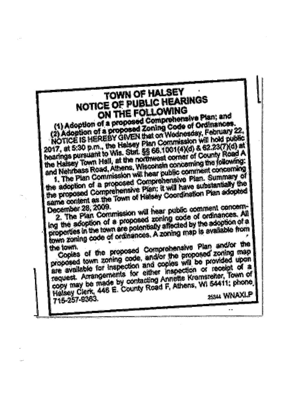
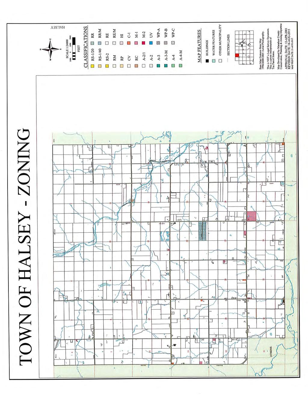
75 MEMORANDUM TO: FROM: Marathon County Land Conservation and Zoning Committee Dean Johnson, Marathon County Zoning Administrator DATE: April 26, 2017 SUBJECT: Submission of Town Zoning Ordinance and Map for Town of Halsey The Town of Halsey has submitted an Ordinance and Map for Town zoning authority. Per WI State Statue 60.62(3) any Town zoning ordinances and maps are required to be approved by County Board of Supervisors. The Town Board hosted a public hearing on their Comprehensive plan and Zoning Ordinance on February 22, 2017 and Town Board voted for approval at their March 13, 2017 monthly meeting. Following this memo is a copy of the public hearing posting, resolution, and town board minutes. Due to the length of the ordinance and map we have placed it on the County s Website at the following links to make it easier for individuals to view the ordinance and to reduce the size of the agenda packet. The links are as follows: Proposed Ordinance: Proposed Map:
76 STATE OF WISCONSIN ) MARATHON COUNTY ) TOWN OF HALSEY ) REPORT BY LAND CONSERVATION AND ZONING COMMITTEE TO COUNTY BOARD ON REQUEST TO APPROVE THE ZONING AMENDMENTS OF THE TOWN OF HALSEY TO THE COUNTY BOARD OF MARATHON COUNTY: The Marathon County Land Conservation and Zoning Committee, having considered the request to review amendments of the Town Zoning Ordinance filed by the Clerk of the Town of Halsey, and having heard comments in public session thereon, and being duly informed of the facts pertinent to the changes proposed, having reviewed the staff's recommendations, and duly advised of the wishes of the Town, hereby recommends that the County Board, pursuant to 60.62(3), approves the zoning ordinance and/or zoning map of the Town of Halsey as attached. Dated this 2 nd day of May, 2017 Marathon County Land Conservation and Zoning Committee James Seefeldt - Chairman M:\LCZ\IndepzonBB4.doc
77 STATE OF WISCONSIN ) COUNTY OF MARATHON ) SS TOWN OF HALSEY ) RESOLUTION WHEREAS, 60.62(3) Wis. Stats. provides that any Zoning Ordinance and/or map adopted by a Town Board and any amendment thereof shall be subject to the approval of the County Board in counties having a county zoning ordinance, and WHEREAS, the Town Board of the Town of Halsey has amended their zoning as shown on the attached report, and WHEREAS, the County Zoning Committee has duly considered the amendment in public session on Halsey and has recommended approval of the amendment. NOW, THEREFORE BE IT RESOLVED, that the Marathon County Board of Supervisors hereby approves the amendment to the Town of Halsey Zoning Ordinance and/or Zoning map as attached and made part of this record, all of which to be filed with the Marathon County Clerk. LAND CONSERVATION AND ZONING COMMITTEE M:\LCZ\IndepzonBB5.doc
78
79
80
81
82
83
84
MARATHON COUNTY ENVIRONMENTAL RESOURCES COMMITTEE AGENDA Note new location: 212 River Drive, Room 5, Wausau, WI
 April 11, 2018 1:30 P.M. MARATHON COUNTY ENVIRONMENTAL RESOURCES COMMITTEE AGENDA Note new location: 212 River Drive, Room 5, Wausau, WI Marathon County Mission Statement: Marathon County Government serves
Monday, February 23 Village of Marathon Community Room, Marathon City Tuesday, February 24 Town of Easton Town Hall Wednesday, February 25 Town of
 Monday, February 23 Village of Marathon Community Room, Marathon City Tuesday, February 24 Town of Easton Town Hall Wednesday, February 25 Town of Cleveland Town Hall Thursday, February 26 Town of Johnson
NOTICE FOR PUBLIC HEARING
 NOTICE FOR PUBLIC HEARING A public hearing as required by the General Code of Ordinances for Marathon County Chapter 17 Zoning Code will be held by the Marathon County Board of Adjustment at 9:00 a.m.,
ADMINISTRATIVE REPORT A HISTORY OF PRESERVING FARMLAND IN MARATHON COUNTY April Marathon County. Land Conservation & Zoning Committee
 ADMINISTRATIVE REPORT A HISTORY OF PRESERVING FARMLAND IN MARATHON COUNTY 1978-2010 April 2011 Marathon County Land Conservation & Zoning Committee 3 Land Conservation & Zoning Committee Committee Members
CHAPTER 4: STRATEGIES FOR PRESERVING FARMLAND
 CHAPTER 4: STRATEGIES FOR PRESERVING FARMLAND Increasing housing density in non-farmland preservation areas In 2013, Marathon County will begin the process of revising the Marathon County General Zoning
Town of Onalaska. A scale map depicting the portion of Pineview Drive to be officially laid out as a Town highway is attached hereto as Exhibit A.
 Town of Onalaska Special Meeting Minutes for March 31, 2011 The Town Board met on site of the Pineview Road and County OT in Onalaska for the purpose of viewing the lay out of the road as required by law.
Planning & Zoning Department GENERAL APPLICATION 400 DeWitt Street - Portage, WI Phone: Fax:
 Planning & Zoning Department GENERAL APPLICATION 400 DeWitt Street - Portage, WI 53901 Phone: 608-742-9660 Fax: 608-742-9817 www.@co.columbia.wi.us The applicant hereby authorizes access to the property
EDGERTON CITY HALL PLANNING COMMISSION MEETING REGULAR SESSION March 12, 2019
 EDGERTON CITY HALL PLANNING COMMISSION MEETING REGULAR SESSION The met in regular session with Chair John Daley calling the meeting to order at 7:00 p.m. All present participated in the Pledge of Allegiance.
PUD, HPUD, OSC Rezoning & Conceptual Plan Application (Planned Unit Development, Haggerty Road Planned Unit Development, Open Space Community)
") Township Use Only RZ #: Date: Hearing Date: Fee Paid: PUD, HPUD, OSC Rezoning & Conceptual Plan Application (Planned Unit Development, Haggerty Road Planned Unit Development, Open Space Community) Project
Township Use Only RZ #: Date: Hearing Date: Fee Paid: PUD, HPUD, OSC Rezoning & Conceptual Plan Application (Planned Unit Development, Haggerty Road Planned Unit Development, Open Space Community) Project
Zoning Map Amendment Application Packet for Areas within Farmland Preservation
 Zoning Map Amendment Application Packet for Areas within Farmland Preservation Zoning Map Amendment Packet Includes: Checklist Zoning Map Amendment Application Town Recommendation Form for Rezoning PRIOR
Farmland Preservation Plan
 WELCOME! Farmland Preservation Plan Douglas County, WI Kickoff Steering Committee Meeting Amnicon Town Hall Tuesday, February 9, 2016 1:30 pm to 3:30 pm Source: http://www.loc.gov/item/fsa2000044046/pp/
Rezoning Staff Report St. Croix County Community Development Committee Gerald & Joan Mellgren Hearing Date: July 16, 2015
 Rezoning Staff Report St. Croix County Community Development Committee Gerald & Joan Mellgren Hearing Date: Property Owners: Gerald & Joan Mellgren Agent: William Mellgren Site Address: 97 230 th Street
Working Lands Initiative
 Working Lands Initiative June 2010 Working Lands Initiative Overview Expands and modernizes the existing Farmland Preservation Program Establishes Agricultural Enterprise Areas Creates a Purchase of Agricultural
Dane County Land Use Handbook
 Dane County Land Use Handbook Dane County Board of Supervisors Prepared by The Office of the County Board Last revision 4/6/98 Summary September 15, 1997 Dane County has land area of 1,202 square miles,
STATE OF ALABAMA SHELBY COUNTY
 STATE OF ALABAMA SHELBY COUNTY Members Present: Members Absent: Staff Present: SHELBY COUNTY PLANNING COMMISSION MINUTES Regular Meeting March 6, 2017 6:00 PM Michael O Kelley, Chairman; Jim Davis, Vice
Township of Howick Special Meeting Agenda Tuesday August 7, 2018 at 5 pm Howick Council Chambers
 1. Call to Order Township of Howick Special Meeting Agenda Tuesday August 7, 2018 at 5 pm Howick Council Chambers 2. Public Meeting - to consider a proposed Zoning By-law Amendment under Section 34 of
Planner Ken Jaworski. Approval of Minutes: A. Approval of the minutes of the Wednesday, July 8 th, 2015 Regular Plan Commission Meeting.
 Approved 09/09/2015 TOWN OF CLAYTON Town Plan Commission Meeting Minutes 7:00 P.M. on Wednesday, August 12 th, 2015 Town Office Meeting Room, 8348 County Road T, Larsen, WI 54947 I. Call to Order: A. Notice
NOTICE OF A REGULAR MEETING OF THE ENID-GARFIELD COUNTY METROPOLITAN AREA PLANNING COMMISSION
 NOTICE OF A REGULAR MEETING OF THE ENID-GARFIELD COUNTY METROPOLITAN AREA PLANNING COMMISSION Notice is hereby given that the Enid-Garfield County Metropolitan Area Planning Commission will meet in regular
Bethel Romanian Church - Rezone, RZ
 / Planning and Zoning Staff Report Bethel Romanian Church - Rezone, RZ2018-0023 Hearing Date: November 15, 2018 Development Services Department Owners: Bethel Romanian Church, Corp. Applicant: Viorel Botos
CERTIFIED SURVEY MAPS
 Chapter 1 - INTRODUCTION CERTIFIED SURVEY MAPS Certified Survey Maps (CSMs) are one of the permitted methods of dividing land in the City of Muskego. CSMs are allowed when it is proposed to create four
Staff Report: Date: Applicant: Property Identification: Acreage of Request: Current Zoning of Requested Area: Requested Action: Attached:
 Staff Report: Completed by Jeff Palmer Director of Planning & Zoning Date: November 7, 2018 Applicant: Greg Smith, Oberer Land Developer agent for Ronald Montgomery ET AL Property Identification: Frontage
Transitioning from the Farmland Preservation Program to the Working Lands Initiative
 Transitioning from the to the The table below describes differences between the Department of Agriculture, Trade and Consumer Protection s (DATCP) previous and the new. Contact: DATCPWorkingLands@wisconsin.gov
Waupaca County Planning & Zoning
 Waupaca County Planning & Zoning Zoning Map Amendment Application Packet Zoning Amendment Packet Includes: Checklist Zoning Map Amendment Application Town Recommendation Form for Rezoning PRIOR TO SUBMITTING
Walworth County Farmland Preservation Plan Update, Chapter 1 Plan Summary (Cover Document)
") Background Walworth County Farmland Preservation Plan Update, 2012 Chapter 1 Plan Summary (Cover Document) For over 30-years, the Wisconsin Farmland Preservation Program has served to preserve Walworth
Background Walworth County Farmland Preservation Plan Update, 2012 Chapter 1 Plan Summary (Cover Document) For over 30-years, the Wisconsin Farmland Preservation Program has served to preserve Walworth
PLANNING & DEVELOPMENT COMMITTEE MINUTES
 Eau Claire County PLANNING & DEVELOPMENT COMMITTEE MINUTES Tuesday, 6:00 PM *Please note earlier start time* Eau Claire County Courthouse 721 Oxford Avenue Room 1277 Eau Claire, Wisconsin Members Present:
1293 Washington Ave, Cedarburg Date/Time: March 19, 2014 / 7:00PM Posted: March 14, 2014
 Meeting: Plan Commission Place: 1293 Washington Ave, Cedarburg Date/Time: March 19, 2014 / 7:00PM Web Page: www.town.cedarburg.wi.us Posted: March 14, 2014 Chairman Dave Valentine Town Administrator Jim
Rule 80. Preservation of Primary Agricultural Soils Revised and approved by the Land Use Panel during its public meeting on January 31, 2006.
 Rule 80. Preservation of Primary Agricultural Soils Revised and approved by the Land Use Panel during its public meeting on January 31, 2006. (A) Purpose. In accordance with 10 V.S.A. Sections 6025(b)
Staff Report: Date: Applicant: Property Identification: Acreage of Request: Current Zoning of Requested Area: Requested Action: Attached:
 Staff Report: Completed by Jeff Palmer Director of Planning & Zoning Date: November 7, 2018, Updated November 20, 2018 Applicant: Greg Smith, Oberer Land Developer agent for Ronald Montgomery ET AL Property
APPLICATION FOR SUBDIVISION APPROVAL OF A SKETCH PLAN with checklist
 Prior to filing any application for SUBDIVISION approval, the applicant shall request in writing that the zoning administrator schedule a pre-submission conference. APPLICATION TO THE PLANNING BOARD TOWN
AGENDA. EDMOND PLANNING COMMISSION 20 S. Littler, Edmond, Oklahoma Tuesday, February 18, :30 p.m. CITY COUNCIL WORKSHOP
 City of Edmond NOTICE OF PUBLIC MEETING The City of Edmond encourages participation from all its citizens. If participation at any Public meeting is not possible due to a disability, notification to the
MINUTES OF A REGULAR PLANNING COMMISSION MEETING HELD, TUESDAY, OCTOBER 11, :30 P.M. ROCKVILLE CITY HALL
 28 MINUTES OF A REGULAR PLANNING COMMISSION MEETING HELD, TUESDAY, OCTOBER 11, 2011 6:30 P.M. ROCKVILLE CITY HALL The meeting was called to order by Chair Toni Honer. Roll call was taken and the following
Amendment to the Zoning and Subdivision Ordinances; Consider Repeal Cluster Development Standards
 2 Board of Supervisors Meg Bohmke, Chairman Gary F. Snellings, Vice Chairman Jack R. Cavalier Thomas C. Coen L. Mark Dudenhefer Wendy E. Maurer Cindy C. Shelton February 28, 2018 Thomas C. Foley County
Town zoning: A good option for your town?
 Photo credit: Landslides Aerial Photography Town zoning: A good option for your town? Lynn Markham Town of Auburn May 27, 2015 Main points 1. Zoning is one tool to implement community plans 2. What does
/ Planning and Zoning Commission Staff Report Jay Walker- All Terra Consulting - RZ
 / Planning and Zoning Commission Staff Report Jay Walker- All Terra Consulting - Hearing Date: January 17, 2019 Development Services Department Applicant: Jay Walker All Terra Consulting Staff: Jennifer
MINUTE ORDER BONNER COUNTY COMMISSIONERS PUBLIC HEARING MINUTES AUGUST 6, 2015
 MINUTE ORDER BONNER COUNTY COMMISSIONERS PUBLIC HEARING MINUTES AUGUST 6, 2015 CALL TO ORDER: Chair Cary Kelly called the Bonner County Commissioners hearing to order at 1:00 p.m. in the 3rd floor meeting
REPORT TO THE SHASTA COUNTY PLANNING COMMISSION
 REPORT TO THE SHASTA COUNTY PLANNING COMMISSION PROJECT IDENTIFICATION: REGULAR AGENDA GENERAL PLAN AMENDMENT GPA18-0003 AND ZONE AMENDMENT ZA18-0004 AREA 3 - SOUTHWEST PALO CEDRO: GILBERT DRIVE CONTINUED
SECTION 3.1 Zoning Permit Required for Construction, Land Use and Development.
 CHAPTER 3 ADMINISTRATION, FEES AND ENFORCEMENT SECTION 3.1 Zoning Permit Required for Construction, Land Use and Development. A. Zoning Permit Required. A zoning permit is required for any of the following
Anyone speaking to the Planning Commission shall state their name and address for the record. Thank you.
 Blue Earth County Planning Commission Members: Chair Lyle Femrite, Kurt Anderson, Bill Anderson, Kip Bruender, Charles Grams, Barry Jacques and Joe Smentek. 1. CALL TO ORDER AGENDA Blue Earth County Planning
1. Roll Call. 2. Minutes a. September 26, 2016 Regular Meeting. 3. Adoption of the Agenda. 4. Visitors to Be Heard
 1. Roll Call City of Vermillion Planning Commission Agenda 5:30 p.m. Regular Meeting Tuesday, October 11, 2016 Large Conference Room 2 nd Floor City Hall 25 Center Street Vermillion, SD 57069 2. Minutes
MINUTES OF THE ST. MARY S COUNTY PLANNING COMMISSION MEETING ROOM 14 * GOVERNMENTAL CENTER * LEONARDTOWN, MARYLAND Monday, May 8, 2006
 MINUTES OF THE ST. MARY S COUNTY PLANNING COMMISSION MEETING ROOM 14 * GOVERNMENTAL CENTER * LEONARDTOWN, MARYLAND Monday, May 8, 2006 Members present were Joseph St. Clair, Chair; Steve Reeves, Vice Chair;
City Recorder s Office
 City Recorder s Office PUBLIC NOTICE Notice is Hereby Given that the Tooele City Council & Tooele City Redevelopment Agency will meet in a Work Session, on Wednesday, September 19, 2018 at the hour of
NOTICE OF STATE MANDATED FEE! Approx. = $900 per Acre to Rezone A-1 Land
 NOTICE OF STATE MANDATED FEE! Approx. = $900 per Acre to Rezone A-1 Land STATE OF WISCONSIN MANDATED FARMLAND PRESERVATION ZONE DISTRICT REZONE CONVERSION FEE Beginning January 1, 2010, the State of Wisconsin
ARTICLE 8C SITE CONDOMINIUM DEVELOPMENT ORDINANCE
 ARTICLE 8C SITE CONDOMINIUM DEVELOPMENT ORDINANCE SECTION 8C.01 PURPOSE It is the purpose of this Ordinance to insure that plans for development within Oceola Township proposed under the provisions of
SPECIAL USE FOR A PLANNED UNIT DEVELOPMENT (P.U.D.), REZONING, and COMPREHENSIVE PLAN AMENDMENT APPLICATION PACKET
, REZONING, and COMPREHENSIVE PLAN AMENDMENT APPLICATION PACKET") SPECIAL USE FOR A PLANNED UNIT DEVELOPMENT (P.U.D.), REZONING, and COMPREHENSIVE PLAN AMENDMENT APPLICATION PACKET VILLAGE OF HANOVER PARK DEVELOPMENT COMMISSION Village of Hanover Park Department of Community
SPECIAL USE FOR A PLANNED UNIT DEVELOPMENT (P.U.D.), REZONING, and COMPREHENSIVE PLAN AMENDMENT APPLICATION PACKET VILLAGE OF HANOVER PARK DEVELOPMENT COMMISSION Village of Hanover Park Department of Community
CHARLOTTE PLANNING COMMISSION FINDINGS OF FACT AND DECISION IN RE APPLICATION OF
 Background CHARLOTTE PLANNING COMMISSION FINDINGS OF FACT AND DECISION IN RE APPLICATION OF Henrietta Ober 2296 Greenbush Road and Stephen and Margaret Foster 1259 Lime Kiln Road Final Plan Review For
Town of Prairie du Sac Sauk County, WI. Land Division Ordinance 07-3
 Town of Prairie du Sac Sauk County, WI Land Division Ordinance 07-3 1.01 DISCLAIMER (1) Multiple Jurisdictions. All persons reviewing the provisions of this Ordinance should be aware that the Town of Prairie
CONDITIONAL USE PERMIT (CUP)
") CONDITIONAL USE PERMIT (CUP) LAND DEVELOPMENT APPLICATION FORM DEPARTMENT OF PLANNING 300 East Main Street, Sun Prairie, WI 53590-2227 (608)825-1107 FAX (608)825-1194 Applications will not be processed
CONDITIONAL USE PERMIT (CUP) LAND DEVELOPMENT APPLICATION FORM DEPARTMENT OF PLANNING 300 East Main Street, Sun Prairie, WI 53590-2227 (608)825-1107 FAX (608)825-1194 Applications will not be processed
Town of Norwich, Vermont SUBDIVISION REGULATIONS
 Town of Norwich, Vermont SUBDIVISION REGULATIONS Adopted: August 6, 2002 Amended: February 8, 2006 Prepared by Norwich Planning Commission with the assistance of: Burnt Rock Inc. A ssociates in Community
MIDWAY CITY Municipal Code
 MIDWAY CITY Municipal Code TITLE 9 ANNEXATION CHAPTER 9.01 PURPOSE CHAPTER 9.02 GENERAL REQUIREMENTS CHAPTER 9.03 PROPERTY OWNER INITIATION OF ANNEXATION CHAPTER 9.04 PROCEDURES FOR CONSIDERATION OF PETITION
CHARLOTTE PLANNING COMMISSION FINDINGS OF FACT AND DECISION IN RE APPLICATION OF. George R. Aube 1450 Dorset Street
 CHARLOTTE PLANNING COMMISSION FINDINGS OF FACT AND DECISION IN RE APPLICATION OF George R. Aube 1450 Dorset Street Final Plan Review For A Two-Lot Subdivision Application # PC-13-19 Background The Planning
(c) County board of commissioners means 1 of the following, as applicable: (ii) In all other counties, 1 of the following:
 County board of commissioners means 1 of the following, as applicable: (ii) In all other counties, 1 of the following:") TOWNSHIP PLANNING Act 168 of 1959, as amended, (including 2001 amendments, 2006 amendments) AN ACT to provide for township planning; for the creation, organization, powers and duties of township planning
TOWNSHIP PLANNING Act 168 of 1959, as amended, (including 2001 amendments, 2006 amendments) AN ACT to provide for township planning; for the creation, organization, powers and duties of township planning
Land Use. Existing Land Use
 8 Land Use 8.1 Land Use Chapter Purpose and Contents This element includes a brief summary of existing land use conditions and trends followed by a series of goals, objectives, and recommendations to guide
ORDINANCE NO. _4.06 AN ORDINANCE TO ESTABLISH BUILDING SITE REGULATIONS SECTION A PURPOSE AND INTENT
 ORDINANCE NO. _4.06 AN ORDINANCE TO ESTABLISH BUILDING SITE REGULATIONS SECTION A PURPOSE AND INTENT This Ordinance provides minimum regulations, provisions and requirements for safe, aesthetically pleasing
CITY OF BELLEVIEW PLANNING & ZONING BOARD AGENDA
 CITY OF BELLEVIEW PLANNING & ZONING BOARD AGENDA BELLEVIEW CITY HALL COMMISSION ROOM 5:30 PM IF A PERSON SHOULD DESIRE TO APPEAL ANY DECISION MADE BY THE BOARD, A VERBATIM RECORD OF THE PROCEEDINGS WHICH
ST. TAMMANY PARISH COUNCIL ORDINANCE ORDINANCE TO CREATE A NEW SECTION OF THE PARISH CODE OF ORDINANCES REGARDING TRANSFERABLE DEVELOPMENT RIGHTS.
 ST. TAMMANY PARISH COUNCIL ORDINANCE ORDINANCE CALENDAR NO: 4486 COUNCIL SPONSOR: MR. GOULD INTRODUCED BY: ORDINANCE COUNCIL SERIES NO: PROVIDED BY: COUNCIL ATTORNEY SECONDED BY: ON THE 6 DAY OF JANUARY,
TOWN OF ROXBURY PLANNING BOARD
 UPDATED: APRIL 2011 TOWN OF ROXBURY PLANNING BOARD Applicant s Guide for Subdivision Review The Town Planning Board administers the subdivision review process. This guide has been prepared in order to
FRANKLIN COUNTY PLANNING BOARD. April 12, 2016
 FRANKLIN COUNTY PLANNING BOARD April 12, 2016 The Franklin County Planning Board held its regular monthly meeting on Tuesday, April 12, 2016 in the Franklin County Administration Building, Commissioners
Urban Planning and Land Use
 Urban Planning and Land Use 701 North 7 th Street, Room 423 Phone: (913) 573-5750 Kansas City, Kansas 66101 Fax: (913) 573-5796 Email: planninginfo@wycokck.org www.wycokck.org/planning To: From: City Planning
SARPY COUNTY PLANNING COMMISSION MINUTES OF MEETING. December 18, 2018
 SARPY COUNTY PLANNING COMMISSION MINUTES OF MEETING l. CALL MEETING TO ORDER A meeting of the Planning Commission of Sarpy County, Nebraska was convened in open and public session at the call of Chairman
NOTICE OF MEETING. The City of Lake Elmo Planning Commission will conduct a meeting on Wednesday, November 14, 2012 at 7:00 p.m.
 3800 Laverne Avenue North Lake Elmo, MN 55042 (651) 777-5510 www.lakeelmo.org NOTICE OF MEETING The City of Lake Elmo Planning Commission will conduct a meeting on Wednesday, November 14, 2012 at 7:00
Planning Commission 16 February 4, 2014 EDMOND PLANNING COMMISSION MEETING. Tuesday, February 4, 2014
 Planning Commission 16 EDMOND PLANNING COMMISSION MEETING Tuesday, 5:30 P.M. The Edmond Planning Commission Meeting was called to order by Chairperson Barry K. Moore at 5:30 p.m., Tuesday,, in the City
Tracie & Dennis Jones Rezone, RZ
 / Planning and Zoning Staff Report Tracie & Dennis Jones Rezone, RZ2018-0014 Applicant: Tracie & Dennis Jones Staff: Deb Root, 454-7340 droot@canyonco.org Tax ID: R37886012 Current Zone: A (Agricultural)
MINUTE ORDER. BONNER COUNTY PLANNING and ZONING COMMISSION PUBLIC HEARING MINUTES NOVEMBER 5, 2015
 MINUTE ORDER BONNER COUNTY PLANNING and ZONING COMMISSION PUBLIC HEARING MINUTES NOVEMBER 5, 2015 CALL TO ORDER: Chair Temple called the Bonner County Planning and Zoning Commission hearing to order at
RESOLUTION NO CITY OF MAPLE GROVE
 RESOLUTION NO. 18-122 CITY OF MAPLE GROVE RESOLUTION GRANTING PLANNED UNIT DEVELOPMENT CONCEPT STAGE PLAN, PLANNED UNIT DEVELOPMENT - DEVELOPMENT STAGE PLAN, AND PRELIMINARY PLAT FOR TERRITORIAL GREENS
Guide to Minor Developments
 Guide to Minor Developments Introduction The Douglas County (DCD) is committed to providing open, transparent application processes to the public. This Guide is provided to assist anyone interested in
Mike & Sherry Dudley Rezone, RZ
 / Planning and Zoning Staff Report Mike & Sherry Dudley Rezone, RZ2019-0005 Hearing Date: April 18, 2019 Development Services Department Applicant: Mike & Sherry Dudley Staff: Deb Root, 454-7340 droot@canyonco.org
Zoning and Subdivision Regulations. Rebecca Roberts Center for Land Use Education UW Stevens Point/Extension
 Zoning and Subdivision Regulations Rebecca Roberts Center for Land Use Education UW Stevens Point/Extension Land Use Tools Comprehensive Plan describes the future vision of the community and how to achieve
SUBDIVISION AND / OR LAND DEVELOPMENT SUBMITTAL REQUIREMENTS
 SUBDIVISION AND / OR LAND DEVELOPMENT SUBMITTAL REQUIREMENTS Please review checklist prior to submittal. Incomplete submittals will delay the review process. Township 90-day time clock begins upon submission
, Assistant County Attorney. when the following proceedings, among others were had and done, to-wit: RESOLUTION NO.
 STATE OF COLORADO ) )ss County of Garfield ) At a regular meeting of the Board of County Commissioners for Garfield County, Colorado, held in the Commissioners' Meeting Room, Garfield County Administration
STAFF REPORT. Permit History:
 STAFF REPORT Application: Request to rezone property from General Agriculture (AG) to Suburban Residential (a) (R-2a) Applicant: Perry Puncochar Agenda Item: 4(g) Background Information: Proposal: The
COUNTY OF SONOMA PERMIT AND RESOURCE MANAGEMENT DEPARTMENT 2550 Ventura Avenue, Santa Rosa, CA (707) FAX (707)
 FAX (707)") COUNTY OF SONOMA PERMIT AND RESOURCE MANAGEMENT DEPARTMENT 2550 Ventura Avenue, Santa Rosa, CA 95403 (707) 565-1900 FAX (707) 565-1103 MEMO Date:, 1:05 p.m. To: Sonoma County Planning Commission From:
COUNTY OF SONOMA PERMIT AND RESOURCE MANAGEMENT DEPARTMENT 2550 Ventura Avenue, Santa Rosa, CA 95403 (707) 565-1900 FAX (707) 565-1103 MEMO Date:, 1:05 p.m. To: Sonoma County Planning Commission From:
Planning Justification Report
 Planning Justification Report, Township of Puslinch FARHI HOLDINGS CORPORATION Updated January 27, 2017 Zelinka Priamo Ltd. Page i TABLE OF CONTENTS Page No. 1.0 1.1 1.2 1.3 2.0 2.1 2.2 2.3 2.4 2.5 3.0
SKAMANIA COUNTY PLANNING COMMISSION
 SKAMANIA COUNTY PLANNING COMMISSION AGENDA Tuesday, November 13, 2018 @ 6:00 PM SKAMANIA COUNTY COURTHOUSE ANNEX, LOWER MEETING ROOM 170 NW VANCOUVER AVENUE, STEVENSON, WA 98648 I. CALL TO ORDER II. III.
FRANKLIN COUNTY PLANNING BOARD. May 8, 2018
 FRANKLIN COUNTY PLANNING BOARD May 8, 2018 The Franklin County Planning Board held its regular monthly meeting on Tuesday, May 8, 2018 in the Franklin County Administration Building, Commissioners Meeting
CLEARFIELD CITY COUNCIL AGENDA AND SUMMARY REPORT July 31, 2018 SPECIAL POLICY SESSION
 CLEARFIELD CITY COUNCIL AGENDA AND SUMMARY REPORT July 31, 2018 SPECIAL POLICY SESSION Meetings of the City Council of Clearfield City may be conducted via electronic means pursuant to Utah Code Ann. 52-4-207
TOWN OF PLEASANT SPRINGS DANE COUNTY, WISCONSIN RECORD OF THE JOINT PLAN COMMISSION & TOWN BOARD MEETING OF SEPTEMBER 5, 2018
 TOWN OF PLEASANT SPRINGS DANE COUNTY, WISCONSIN RECORD OF THE JOINT PLAN COMMISSION & TOWN BOARD MEETING OF SEPTEMBER 5, 2018 MEETING LOCATION: Town Hall, 2354 County Road N, Stoughton WI 53589 PLAN COMMISSION
RESOLUTION NO. R
 RESOLUTION NO. R-2009-0485 RESOLUTION APPROVING ZONING APPLICATION Z-2008-01745 (CONTROL NO. 2003-00062) OFFICIAL ZONING MAP AMENDMENT (REZONING) WITH A CONDITIONAL OVERLAY ZONE (COZ) APPLICATION OF Habitat
RC ; Reclassification The Garrison at Stafford Proffer Amendment (formerly Stafford Village Center)
") Board of Supervisors Robert Bob Thomas, Jr., Chairman Laura A. Sellers, Vice Chairman Meg Bohmke Jack R. Cavalier Wendy E. Maurer Paul V. Milde, III Gary F. Snellings Anthony J. Romanello, ICMA CM County
Board of Supervisors Robert Bob Thomas, Jr., Chairman Laura A. Sellers, Vice Chairman Meg Bohmke Jack R. Cavalier Wendy E. Maurer Paul V. Milde, III Gary F. Snellings Anthony J. Romanello, ICMA CM County
APPLICATION PACKET SINGLE FAMILY CLUSTER HOUSING OPTION REVIEW
 APPLICATION PACKET SINGLE FAMILY CLUSTER HOUSING OPTION REVIEW COMMUNITY DEVELOPMENT DEPARTMENT CHARTER TOWNSHIP OF PLYMOUTH 9955 N. Haggerty Road Plymouth, MI 48170 Fees Revised 7/01/2012 1. PURPOSE APPLICATION
APPLICATION PACKET SINGLE FAMILY CLUSTER HOUSING OPTION REVIEW
 APPLICATION PACKET SINGLE FAMILY CLUSTER HOUSING OPTION REVIEW COMMUNITY DEVELOPMENT DEPARTMENT CHARTER TOWNSHIP OF PLYMOUTH 9955 N. Haggerty Road Plymouth, MI 48170 Fees Revised 9.13.2017 1. PURPOSE APPLICATION
MINUTES JOINT MEETING LINCOLN COUNTY and SIOUX FALLS PLANNING COMMISSIONS 7:00 pm July 14, 2010
 MINUTES JOINT MEETING LINCOLN COUNTY and SIOUX FALLS PLANNING COMMISSIONS 7:00 pm July 14, 2010 Commissioners Room - Lincoln County Court House A joint meeting of Lincoln County and Sioux Falls Planning
AGENDA PLANNING COMMISSION Tuesday, April 18, :00 PM City Council Chambers 125 East Avenue B, Hutchinson, Kansas
 AGENDA PLANNING COMMISSION Tuesday, April 18, 2017 5:00 PM City Council Chambers 125 East Avenue B, Hutchinson, Kansas 1. ROLL CALL Macklin Woleslagel Bisbee (Chair) Hamilton Peirce Vacant Carr Hornbeck
Guide to Combined Preliminary and Final Plats
 Guide to Combined Preliminary and Final Plats Introduction The Douglas County is committed to providing open, transparent application processes to the public. This Guide is provided to assist anyone interested
STAFF REPORT. Planning and Zoning Case 16-20FP Staff: Michael Peterman, City Planner Date: May 23, 2016
 STAFF REPORT Planning and Zoning Case 16-20FP Staff: Michael Peterman, City Planner Date: May 23, 2016 GENERAL INFORMATION Application: Applicant: Location: Existing Land Use/Zoning: Future Land Use Designation:
Town of Marcellus Planning Board 24 East Main Street Marcellus, New York June 4, 2018
 Town of Marcellus Planning Board 24 East Main Street Marcellus, New York 13108 Present: Chris Christensen, Scott Stearns, Mark Taylor, Michelle Bingham, Kathy Carroll, Ron Schneider Absent: Chairperson
CHAPTER XVIII SITE PLAN REVIEW
 CHAPTER XVIII SITE PLAN REVIEW Section 18.1 Section 18.2 Description and Purpose. The purpose of this chapter is to provide standards and procedures under which applicants would submit, and the Township
INTEROFFICE MEMORANDUM
 HARLES COUNTY GOVERNMENT Department of Planning and Growth Management Melvin C. Beall, Jr., P.E., Director INTEROFFICE MEMORANDUM TO: Denise Ferguson, Clerk to the County Commissioners THRU: THRU: FROM:
Kitsap County Department of Community Development
 Kitsap County Department of Community Development Staff Report and Recommendation Annual Comprehensive Plan Amendment Process for 2018 George s Corner LAMIRD Boundary Adjustment Report Date 7/16/2018 Hearing
APPLICATION FOR CONDITIONAL USE PERMIT
 Receipt No. Fee Date Date Permit Issued: Certificate of Compliance: Date DOOR COUNTY LAND USE SERVICES 421 Nebraska Street Door County Government Center Sturgeon Bay, Wisconsin 54235 (920) 746-2323 - FAX
MINOR PLAT FILING APPLICATION
 FILING APPLICATION Date of PC Meeting: Date of BCC Meeting: Fee Paid: 1. APPLICANT: DAYTIME PHONE: MAILING ADDRESS: LANDOWNER: DAYTIME PHONE: MAILING ADDRESS: AUTHORIZED AGENT: MAILING ADDRESS: RELATIONSHIP
Farmland Preservation Agreements INSTRUCTIONS
 Wisconsin Department of Agriculture, Trade and Consumer Protection Division of Agricultural Resource Management P.O. Box 8911 Madison, WI 53708-8911 (608) 224-4633 Rev. (7/14) Farmland Preservation Program
when the following proceedings, among others were held and done, to-wit:
 STATE OF COLORADO ) COUNTY OF ADAMS ) At a regular meeting of the Board of County Commissioners for Adams County, Colorado, held at the Administration Building in Brighton, Colorado on the 2 nd day of
PLANNED DEVELOPMENT REVIEW Last Revised 8/15/17
 Community Development Department City Hall 222 E. 9 th Street, 2 nd Floor Lockport, IL 60441 (815) 838-0549, Option 4 www.lockport.org PLANNED DEVELOPMENT REVIEW Last Revised 8/15/17 Community Development
Magna Metro Township Council Meeting Public Meeting Agenda. Tuesday, July 18, :00 P.M.
 Planning and Development Services 2001 S. State Street N3-600 Salt Lake City, UT 84190-4050 Phone: (385) 468-6700 Fax: (385) 468-6674 www.pwpds.slco.org Magna Metro Township Council Meeting Public Meeting
Certified Survey Map (CSM) Submittal Updated: 6/29/18
 Submittal Updated: 6/29/18") Certified Survey Map (CSM) Submittal Updated: 6/29/18 Town of Middleton 7555 W. Old Sauk Road Verona, WI 53593-9700 Phone: 608-833-5887 Fax: 608-833-8996 info@town.middleton.wi.us The Town of Middleton
Certified Survey Map (CSM) Submittal Updated: 6/29/18 Town of Middleton 7555 W. Old Sauk Road Verona, WI 53593-9700 Phone: 608-833-5887 Fax: 608-833-8996 info@town.middleton.wi.us The Town of Middleton
ITEM 2. APPROVAL OF MINUTES A motion was made by Larson and seconded by Sogn to approve the Minutes for November 18, The motion was unanimous.
 MINUTES LINCOLN COUNTY PLANNING AND ZONING COMMISSION December 16, 2013 7:00 P.M. Regular Meeting, Commissioners Meeting Room Lincoln County Courthouse ROLL CALL The regular meeting of the Lincoln County
LARAMIE COUNTY PLANNING & DEVELOPMENT DEPARTMENT
 LARAMIE COUNTY PLANNING & DEVELOPMENT DEPARTMENT Planning Building MEMORANDUM TO: FROM: Laramie County Planning Commission Bryan Nicholas, Associate Planner DATE: April 11, 2019 TITLE: Review and action
LINN COUNTY BOARD OF SUPERVISORS CEDAR RAPIDS, LINN COUNTY, IOWA WEDNESDAY, APRIL 29, :00 A.M.
 LINN COUNTY BOARD OF SUPERVISORS CEDAR RAPIDS, LINN COUNTY, IOWA WEDNESDAY, APRIL 29, 2015 10:00 A.M. The Board met in session at the Linn County Jean Oxley Public Service Center. Present: Vice Chairperson
Residential Construction in Farmland Preservation Zoning Districts
 Updated Draft: October 25, 2009 Residential Construction in Farmland Preservation Zoning Districts 2009 Wis. Act 28 repealed and recreated Wisconsin s Farmland Preservation program under ch. 91, Stats.
Planning Commission Hearing Date: 2/21/2017 Board of County Commissioners Hearing Date: 3/8/2017
 COMMISSIONERS: DARRYL GLENN (PRESIDENT) MARK WALLER (PRESIDENT PRO TEMPORE) STAN VANDERWERF LONGINOS GONZALEZ PEGGY LITTLETON PLANNING AND COMMUNITY DEVELOPMENT DEPARTMENT CRAIG DOSSEY, EXECUTIVE DIRECTOR