CITY OF FINDLAY ZONING ORDINANCE. Hancock County, Ohio
|
|
|
- Susan Thomas
- 5 years ago
- Views:
Transcription

1 CITY OF FINDLAY ZONING ORDINANCE Hancock County, Ohio
2 TABLE OF CONTENTS TABLE OF CONTENTS... I CHAPTER 1101 GENERAL AUTHORITY PURPOSE SCOPE VALIDITY INTERPRETATION OF STANDARDS CONSTRUCTION OF LANGUAGE USES PROHIBITION VOTING PLACE...3 CHAPTER 1113 PLANNING COMMISSION RULES AND PROCEDURES CITY PLANNING COMMISSION AUTHORITY TO FILE APPLICATIONS PRE-APPLICATION FORM OF APPLICATION APPLICATION FILING FEES APPLICATION COMPLETENESS APPLICATION REQUIREMENTS FINAL SUBMITTAL MEETING LOCATION MEETING SCHEDULE AND SUBMISSION DEADLINES SPECIAL MEETINGS QUORUM ROBERTS RULES OF ORDER PUBLIC MEETINGS PUBLIC NOTICE ORDER OF BUSINESS CASE REVIEW PROCEDURE BURDEN OF PROOF OR PERSUASION WITHDRAWALS PLANNING COMMISSION ACTION CONDITIONS OF APPROVAL ISSUANCE OF ZONING PERMIT APPEALS STAFF STAFF REPORT CONSULTANTS CONDITIONS FOR REVIEWING APPLICATIONS FOR ZONING CHANGE & NON-CONFORMING USE SITE PLANS ADMINISTRATIVE REVIEW & ACTIONS DECISIONS BY STAFF MINOR CHANGES DEFINITION (SITE PLANS & PLATS) REPORT TO PLANNING COMMISSION APPEAL OF ADMINISTRATIVE DECISIONS APPEAL CRITERIA ACTION ON APPEAL OF A SITE PLAN APPROVAL PLUS VARIANCE REPETITIVE APPLICATIONS LAPSE OF APPROVAL CHAPTER 1115 BOARD OF ZONING APPEALS RULES & PROCEDURES CREATION AND MEMBERSHIP ORGANIZATION JURISDICTION VARIANCE GRANTING OF VARIANCE REQUIRED FINDINGS FOR ISSUANCE OF VARIANCES CONDITIONS TIME LIMIT ZONING DISTRICT MAP INTERPRETATION CHAPTER 1119 ESTABLISHMENT OF DISTRICTS CHAPTER CONTENTS DISTRICTS OVERLAY DISTRICTS ZONING DISTRICT MAP RESPECT TO OTHER LOCAL REGULATIONS INTERPRETATION OF DISTRICT BOUNDARIES ZONING OF VACATED AREAS CHAPTER 1121 R-1 SINGLE FAMILY LOW DENSITY -i-
3 RESIDENTIAL DISTRICT INTENT PERMITTED USE - CERTIFICATE REQUIRED CONDITIONAL USE REQUIRING PLANNING COMMISSION APPROVAL USES EXPRESSLY PROHIBITED REQUIRED BUILDING SETBACKS LOT REQUIREMENTS MINIMUM LIVING AREAS HEIGHT REQUIREMENTS APPLICABLE CHAPTERS PENALTIES...31 CHAPTER 1122 R-2 SINGLE-FAMILY MEDIUM DENSITY RESIDENTIAL DISTRICT INTENT PERMITTED USE - CERTIFICATE REQUIRED CONDITIONAL USE REQUIRING PLANNING COMMISSION APPROVAL USES EXPRESSLY PROHIBITED REQUIRED BUILDING SETBACKS LOT REQUIREMENTS MINIMUM LIVING AREAS HEIGHT REQUIREMENTS APPLICABLE CHAPTERS PENALTIES...35 CHAPTER 1123 R-3 SINGLE-FAMILY HIGH DENSITY RESIDENTIAL DISTRICT INTENT PERMITTED USE - CERTIFICATE REQUIRED CONDITIONAL USE REQUIRING PLANNING COMMISSION APPROVAL USES EXPRESSLY PROHIBITED REQUIRED BUILDING SETBACKS LOT REQUIREMENTS MINIMUM LIVING AREA HEIGHT REQUIREMENTS APPLICABLE CHAPTERS PENALTIES...39 CHAPTER 1124 R-4 DUPLEX/TRIPLEX HIGH DENISTY RESIDENTIAL DISTRICT INTENT PERMITTED USE - CERTIFICATE REQUIRED CONDITIONAL USE REQUIRING PLANNING COMMISSION APPROVAL USES EXPRESSLY PROHIBITED REQUIRED BUILDING SETBACKS LOT REQUIREMENTS MINIMUM LIVING AREA HEIGHT REQUIREMENTS APPLICABLE CHAPTERS PENALTIES CHAPTER 1125 M-1 MULTIPLE-FAMILY RESIDENTIAL DISTRICT INTENT PERMITTED USE - CERTIFICATE REQUIRED CONDITIONAL USE REQUIRING PLANNING COMMISSION APPROVAL USES EXPRESSLY PROHIBITED REQUIRED BUILDING SETBACKS LOT REQUIREMENTS MINIMUM LIVING AREA MINIMUM BUILDING SEPARATION MAXIMUM HEIGHT APPLICABLE CHAPTERS PENALTIES CHAPTER 1126 M-2 MULTIPLE-FAMILY RESIDENTIAL DISTRICT INTENT PERMITTED USE - CERTIFICATE REQUIRED CONDITIONAL USE REQUIRING PLANNING COMMISSION APPROVAL USES EXPRESSLY PROHIBITED REQUIRED BUILDING SETBACKS LOT REQUIREMENTS MINIMUM LIVING AREA HEIGHT REQUIREMENTS MINIMUM BUILDING SEPARATION APPLICABLE CHAPTERS PENALTIES CHAPTER 1127 CD CONDOMINIUM DISTRICT ii-
4 INTENT PERMITTED USE - CERTIFICATE REQUIRED CONDITIONAL USE REQUIRING PLANNING COMMISSION APPROVAL USES EXPRESSLY PROHIBITED REQUIRED BUILDING SETBACKS LOT REQUIREMENTS MINIMUM LIVING AREA HEIGHT REQUIREMENTS MINIMUM BUILDING SEPARATION MAXIMUM BUILDING SIZE APPLICABLE CHAPTERS PENALTIES...56 CHAPTER 1129 MH MOBILE HOME DISTRICT INTENT PERMITTED USE - CERTIFICATE REQUIRED CONDITIONAL USE REQUIRING PLANNING COMMISSION APPROVAL REQUIRED SETBACKS LOT REQUIREMENTS MINIMUM LIVING AREA MINIMUM BUILDING SEPARATION MINIMUM BUILDING SIZE HEIGHT REQUIREMENTS APPLICABLE CHAPTERS PENALTIES...60 CHAPTER 1131 O-1 INSTITUTIONS AND OFFICES DISTRICT INTENT PERMITTED USE - CERTIFICATE REQUIRED CONDITIONAL USES REQUIRED BUILDING SETBACKS LOT REQUIREMENTS MINIMUM BUILDING SEPARATION APPLICABLE CHAPTERS PENALTIES...64 CHAPTER 1133 C-1 LOCAL COMMERCIAL DISTRICT HEIGHT STANDARDS... ERROR! BOOKMARK NOT DEFINED INTENT PERMITTED USE - CERTIFICATE REQUIRED CONDITIONAL USES REQUIRED BUILDING SETBACKS REQUIRED LOT FRONTAGE HEIGHT STANDARDS OUTDOOR DISPLAY OF MERCHANDISE & OUTDOOR STORAGE SCREENING APPLICABLE CHAPTERS PENALTIES CHAPTER 1135 C-2 GENERAL COMMERCIAL DISTRICT INTENT PERMITTED USE - CERTIFICATE REQUIRED CONDITIONAL USE REQUIRED BUILDING SETBACKS REQUIRED LOT FRONTAGE HEIGHT STANDARDS OUTDOOR DISPLAY OF MERCHANDISE & OUTDOOR STORAGE APPLICABLE CHAPTERS PENALTIES CHAPTER 1137 C-3 DOWNTOWN BUSINESS DISTRICT INTENT USES PERMITTED PERMITTED USES, CONTINUED: CONDITIONAL USES PERMITTED LOT REQUIREMENTS APPLICABLE CHAPTERS PENALTIES CHAPTER1141 I-1 LIGHT INDUSTRIAL DISTRICT INTENT PERMITTED USE - CERTIFICATE REQUIRED CONDITIONAL USES REQUIRED BUILDING SETBACKS EXISTING SETBACKS REQUIRED LOT FRONTAGE HEIGHT REQUIREMENTS MINIMUM BUILDING SEPARATION iii-
5 APPLICABLE CHAPTERS PENALTIES...79 CHAPTER 1143 I-2 GENERAL INDUSTRIAL DISTRICT INTENT PERMITTED USES CERTIFICATE REQUIRED CONDITIONAL USES REQUIRED BUILDING SETBACKS USE OF EXISTING SETBACKS REQUIRED LOT FRONTAGE MINIMUM BUILDING SEPARATION HEIGHT REQUIREMENTS APPLICABLE CHAPTERS PENALTIES...82 CHAPTER 1147 P-O PARK & OPEN SPACE DISTRICT INTENT PERMITTED USES REQUIRED BUILDING SETBACKS HEIGHT REQUIREMENT...83 CHAPTER 1151 PLANNED RESIDENTIAL DEVELOPMENT (PRD) INTENT APPLICATIONS RE-ZONING PRELIMINARY DEVELOPMENT PLAN FINAL DEVELOPMENT PLAN ADDITIONAL INFORMATION PLATS REQUIRED DESIGN REQUIREMENTS STANDARDS COMMON OPEN SPACE REQUIREMENTS PERMITTED USES DESIGNATION AMENDMENTS DECISIONS BY CITY PLANNING COMMISSION APPEALS APPROVAL PERIOD PENALTIES...88 CHAPTER 1152 PLANNED MIXED USE DEVELOPMENT (PMUD) INTENT APPLICATIONS RE-ZONING PRELIMINARY DEVELOPMENT PLAN FINAL DEVELOPMENT PLAN ADDITIONAL INFORMATION PLAT REQUIRED DESIGN REQUIREMENTS AND STANDARDS STANDARDS COMMON OPEN SPACE PERMITTED USES DESIGNATION AMENDMENTS DECISIONS BY CITY PLANNING COMMISSION APPEALS APPROVAL PERIOD PENALTIES CHAPTER 1153 MOD MEDICAL OVERLAY DISTRICT INTENT PERMITTED USE - CERTIFICATE REQUIRED CONDITIONAL USE REQUIRING PLANNING COMMISSION APPROVAL REQUIRED BUILDING SETBACKS DESIGNATION AND/OR EXPANSION OF OVERLAY DISTRICT MINIMUM BUILDING SEPARATION PENALTIES CHAPTER 1154 UOD UNIVERSITY OVERLAY DISTRICT INTENT PERMITTED USES CONDITIONAL USES DEVELOPMENT CATEGORY DESIGN REQUIREMENTS PENALTIES CHAPTER 1155 RIPARIAN CORRIDOR OVERLAY DISTRICT iv-
6 PURPOSE INTENT RIPARIAN AREAS DEFINED PROHIBITED USES PROHIBITED ACTIVITIES AREA YARD AND HEIGHT REGULATIONS RIPARIAN SETBACK EXEMPTIONS STANDARDS AND REGULATIONS PERMITTED USES EXCEPTIONS PENALTIES CHAPTER 1161 DEVELOPMENT STANDARDS ACCESSORY STRUCTURES ACCESSORY STRUCTURES R-1, R-2, R-3 & R- 4 SINGLE FAMILY AND TWO-FAMILY RESIDENTIAL DISTRICTS ACCESSORY STRUCTURES CD, M-1, M-2 MULTI-FAMILY RESIDENTIAL DISTRICTS ACCESSORY STRUCTURES O-1 OFFICE, C- 1, C-2 & C-3 COMMERCIAL DISTRICTS ACCESSORY STRUCTURES I-1 & I-2 INDUSTRIAL DISTRICTS EASEMENTS ARCHITECTURAL STANDARDS PURPOSE TERMS ARCHITECTURAL STANDARDS R-1, R-2, R-3 & R-4 RESIDENTIAL DISTRICTS ARCHITECTURAL STANDARDS M-1 & M-2 MULTI-FAMILY DISTRICTS (NEW CONSTRUCTION ONLY) ARCHITECTURAL STANDARDS O-1, C-1, C-2 & C-3 COMMERCIAL DISTRICTS NEW CONSTRUCTION OR MAJOR CHANGES PER CHAPTER ADMINISTRATIVE REVIEW & ACTIONS ADDITIONAL CRITERIA ARCHITECTURAL MATERIALS FENCE AND WALL STANDARDS HEIGHT STANDARDS ALL DISTRICTS HEIGHT STANDARDS BY DISTRICT HOME OCCUPATION STANDARDS GENERAL STANDARDS HOME OCCUPATION LANDSCAPING STANDARDS GENERAL REQUIREMENTS M-1, M-2, M-3, O- 1, C-1, C-2, C-3, I-1,& I LANDSCAPING STANDARDS - M-1, M-2, O-1, C-1, C LANDSCAPING STANDARDS PARKING LOTS M-1, M-2, O-1, C-1, C-2, I-1, I LANDSCAPING STANDARDS PARKING LOTS C SCREENING STANDARDS GENERAL SCREENING STANDARDS M-1, M-2, O-1, C-1, C-2, I-1, I LEVEL 1 SCREENING REQUIREMENTS M-1, M- 2,,O-1, C-1, ABUTTING R-1, R-2, R LEVEL 2 SCREENING REQUIREMENTS R-1, R- 2, R-3, M-1, M-2, M-3, MH-1, O-1, C-1, C-2 ABUT R-1, R-2, R-3, CD, & I-1; OR I-2 ABUT C- 1, C-2, C LEVEL 3 SCREENING REQUIREMENTS M-1, M-2, O-1 ABUT R-1, R-2, R-3, R-4, CD; OR I- 1, & I-2 ABUT C-1, C-2, C REFUSE & DUMPSTER ENCLOSURES LANDSCAPING STANDARDS; INTERSTATE SCREENING R-1, R-2, R-3, M-1, M-2, O-1, C-1, C-2, I-1, I LIGHTING ORDINANCE PURPOSE APPLICABILITY EXCEPTIONS LIGHTING STANDARDS, ALL ZONING DISTRICTS LIGHTING ZONES RESERVED FOR ADOPTION LIGHTING CONTROL REQUIREMENTS HIGH INTENSITY AND SPECIAL PURPOSE LIGHTING COMPLEX AND NON-CONFORMING USES EXISTING LIGHTING OUTDOOR STORAGE STANDARDS OUTDOOR STORAGE; M-1, M-2, R-1, R-2, & -v-
7 R-3 & R-4 RESIDENTIAL DISTRICTS OUTDOOR STORAGE O-1, C-1, C-2, C-3, I-1, & I-2 DISTRICTS OUTDOOR DISPLAY OF MERCHANDISE O-1, C- 1, C-2, C-3, I-1, & I-2 DISTRICTS OUTDOOR STORAGE; INDUSTRIAL I-1 & I-2 DISTRICTS PARKING STANDARDS PARKING STANDARDS, GENERAL ALL ZONING DISTRICTS PARKING R-1, R-2, R-3 & R-4 SINGLE FAMILY RESIDENTIAL PARKING, M-1 & M-2 MULTI-FAMILY PARKING STANDARDS; O-1, C-1, C-2, I-1, I PARKING STANDARDS; REQUIRED NUMBER OF PARKING SPACES R-1, R-2, R-3, R-4, M-1, M- 2, M-3, O-1, C-1, C-2, I-1, I PARKING STANDARDS FOR THE C-3 DOWNTOWN COMMERCIAL DISTRICT GENERAL PARKING REQUIREMENTS TABLE SINGLE FAMILY DISTRICTS R-1, R-2, R MULTI-FAMILY DISTRICTS R-4, M-1, M O-1 INSTITUTIONS AND OFFICES DISTRICT C-1 LOCAL COMMERCIAL C-2 GENERAL COMMERCIAL C-3 DOWNTOWN COMMERCIAL I-1, I-2 INDUSTRIAL DISTRICTS PARKING REQUIREMENTS PER SPECIFIC USE SIGN STANDARDS PURPOSE EXEMPT SIGNAGE: R-1, R-2, R-3, M-1, M-2, O-1, C-1, C-2, I-1, I PROHIBITED SIGNS GENERAL REQUIREMENTS AND RESTRICTIONS: ALL ZONING DISTRICTS ILLUMINATED SIGNS PERMITS, APPLICATIONS AND FEES: SIGN STANDARDS; R-1, R-2, R-3, R-4, M-1, M-2, & M-3 RESIDENTIAL DISTRICTS: LOW PROFILE SIGNS; O-1, C-1, C-2, I-1, & I-2 DISTRICTS PYLON SIGNS: C-1, C-2, I-1 & I-2 DISTRICTS SIGNS IN DOWNTOWN DISTRICT (C-3) INTERSTATE HIGH-RISE SIGNS (C-1, C-2, PMUD, I-1, I-2) ELECTRONIC MESSAGE CENTERS C1, C-2, I-1, I ROOF SIGNS C-1, C-2, I-1, I SUBDIVISION ENTRYWAY SIGNAGE TEMPORARY SIGNS NO PERMIT REQUIRED; ALL ZONING DISTRICTS TEMPORARY SIGNS PERMIT REQUIRED OFF PREMISE SIGNS PERMIT REQUIRED AWNINGS AND BANNERS OTHER SIGNS INTERPRETATION PENALTIES RIGHT OF APPEAL COMMUNICATION STRUCTURES COMMUNICATION STRUCTURES - PURPOSE COMMUNICATION STRUCTURES PROHIBITED; R-1, R-2, R-3, R-4, M1, M-2, & M COMMUNICATION STRUCTURES SETBACKS; O-1, C-1, C-2, C-3, I-1, & I COMMUNICATION STRUCTURES REQUIRED FRONT YARD PROHIBITION COMMUNICATION STRUCTURES MINIMUM NUMBER OF CO-LOCATION SITES: COMMUNICATION STRUCTURES DESIGN REQUIREMENT: COMMUNICATION STRUCTURES BUFFER REQUIREMENTS COMMUNICATION STRUCTURES ACCESS TO SITE/STRUCTURE COMMUNICATION STRUCTURES DESIGN REQUIREMENTS COMMUNICATION STRUCTURES CO- LOCATION REQUIREMENTS COMMUNICATION STRUCTURES SITING REQUIREMENTS COMMUNICATION STRUCTURES CONSTRUCTION REQUIREMENTS COMMUNICATION STRUCTURES EXISTING STRUCTURES COMMUNICATION STRUCTURES REMOVAL OF ABANDONED TOWERS vi-
8 ALTERNATIVE ENERGY SMALL WIND TURBINES - INTENT SMALL WIND TURBINES PERMITTED ALL ZONING DISTRICTS SMALL WIND TURBINES - REQUIRED YARDS SMALL WIND TURBINES TOWER HEIGHT BY ZONING DISTRICT SMALL WIND TURBINES APPROVED TURBINES ALL DISTRICTS SMALL WIND TURBINES - COMPLIANCE WITH UNIFORM BUILDING CODE SMALL WIND TURBINES - COMPLIANCE WITH FAA REGULATIONS SMALL WIND TURBINES - UTILITY NOTIFICATION OTHER SOLAR POWER - PHOTOVOLTAIC (PV) CONDITIONAL USE REQUIREMENTS COMMON OPEN SPACE REQUIREMENTS PENALTIES CHAPTER 1162 NONCONFORMITY INTENT PRE-EXISTING CONDITIONS NONCONFORMING LOTS NONCONFORMING USES OF LAND NONCONFORMING STRUCTURES NONCONFORMING USES OF STRUCTURES USES UNDER EXCEPTION PROVISIONS, NOT NONCONFORMING USES CHANGE IN TENANCY RE-ESTABLISHMENT OF A NON-CONFORMING USE PENALTIES CHAPTER 1163 PERFORMANCE REQUIREMENTS NUISANCE DRAINAGE STORM WATER DISCHARGE CONTROL PLAN WETLANDS DETERMINATION TRAFFIC IMPACT STUDY GAS AND OIL WELLS TEMPORARY USE OF BUILDING, STRUCTURE OR LAND TEMPORARY USES CONSTRUCTION ENTRANCEWAY ENHANCEMENTS SUBDIVISION RULES AND REQUIREMENTS CORNER VISION CLEARANCE STANDARDS SWIMMING POOLS DEMOLITION REQUIREMENTS JUNKYARDS ENFORCEMENT PROVISIONS PENALTIES CHAPTER 1164 ADULT ENTERTAINMENT ESTABLISHMENTS/ADULT PURPOSE MITIGATING SECONDARY EFFECTS PERMITTED DISTRICTS/CONDITIONAL USE LOCATION REQUIREMENTS LOCATION REQUIREMENTS; RESIDENTIAL USES LOCATION REQUIREMENTS - OTHER ADULT USES LOCATION REQUIREMENTS CHURCHES/CEMETERIES LOCATION REQUIREMENTS - SCHOOLS LOCATION REQUIREMENTS RECREATION AREAS MEASURE OF DISTANCE NO VARIANCE SUBSEQUENT DEVELOPMENT WITHIN LOCATION STANDARDS NONCONFORMITY ESTABLISHMENT OF NONCONFORMITY STANDARDS FOR NONCONFORMANCE ADULT ENTERTAINMENT DEFINITIONS OPERATING PROVISIONS ENFORCEMENT APPEALS REGULATION OF OBSCENITY SUBJECT TO STATE LAW REGULATION OF MASSAGE ESTABLISHMENTS SUBJECT TO STATE LAW SEVERANCE CLAUSE vii-
9 PENALTIES CHAPTER 1165 ADMINISTRATION ENFORCEMENT ZONING PERMITS PERMIT REQUIRED PRIOR TO PERFORMING WORK MAINTAINING RECORDS CONDITIONS UNDER WHICH ZONING PERMITS ARE REQUIRED ZONING PERMITS AND CERTIFICATES CERTIFICATE OF ZONING COMPLIANCE FALSIFICATION ACCESSORY STRUCTURES ZONING ADMINISTRATOR DUTIES OF ZONING ADMINISTRATOR PENALTIES CHAPTER 1166 PROPERTY SKETCH PLAN REQUIREMENTS CHAPTER 1167 FOOTER LOCATION INSPECTIONS CHAPTER 1168 FINAL INSPECTIONS CHAPTER 1169 FEES SCHEDULE OF FEES TRIPLE FEE CHAPTER 1171 INTERPRETATION, PURPOSE AND CONFLICT CHAPTER 1172 AMENDMENTS AND CHANGES GENERAL APPLICATIONS FOR AMENDMENTS AND CHANGES APPLICATION FEES CHAPTER 1173 SEVERANCE CLAUSE CHAPTER 1174 DEFINITIONS CHAPTER 1199 VIOLATIONS, ENFORCEMENT, PENALTIES AND OTHER REMEDIES PROHIBITIONS VIOLATIONS EACH DAY A SEPARATE VIOLATION WHO MAY ENFORCE CORRECTIONS PUBLIC NUISANCE PER SE FINES DAMAGE TO CITY INFRASTRUCTURE FALSE STATEMENTS, REPRESENTATIONS OR CERTIFICATIONS RIGHTS AND REMEDIES, CUMULATIVE INDEX 268 -viii-
10 CHAPTER 1101 GENERAL Authority Purpose Scope Validity Interpretation of Standards CHAPTER CONTENTS Construction of Language Uses Prohibition Voting Place AUTHORITY The City Council of the City of Findlay, Hancock County, Ohio, pursuant to the authority conferred by Chapter 713 of the Ohio Revised Code, hereby provide as follows: PURPOSE This ordinance is adopted for the purpose of promoting and protecting the public health, safety, peace, comfort, convenience, and general welfare of the inhabitants of the City of Findlay, by protecting and conserving the character, social, and economic stability of the residential, commercial, industrial, and other use areas; by securing the most appropriate use of land; by preventing overcrowding of the land and undue congestion of population; by providing adequate light, air and reasonable access; and by facilitating adequate and economical provision of transportation, water, sewers, schools, recreation and other public requirements, and by other means, all in accordance with the City of Findlay Land Use Plan SCOPE The scope and purpose of this code is also to guide potentially contiguous development that will be under the city s review according to hard water policy and annexation agreements VALIDITY This Ordinance shall become effective from and after the date of its approval and adoption as provided by law INTERPRETATION OF STANDARDS In their interpretation and application, the provisions of this Ordinance shall be held to be minimum requirements. Where this Ordinance imposes a greater restriction than is imposed or required by other provisions of law or by other rules or regulations, the provisions of this Ordinance shall take precedence CONSTRUCTION OF LANGUAGE The following rules of construction apply to the text of the Ordinance: A. PARTICULAR VS GENERAL The particular shall control the general. B. TEXT VS ILLUSTRATION In case of any difference of meaning or implication between the text of this Ordinance and any caption or illustration, the text shall control. 1
11 C. SHALL The word "shall" is always mandatory and not discretionary. D. MAY The word "may" is permissive. E. TENSE AND NUMBER Words used in the present tense shall include the future; the words used in the singular number shall include the plural, and the plural the singular, unless the context clearly indicates the contrary. F. BUILDING OR STRUCTURE A "building" or "structure" includes any part thereof. G. USED FOR The phrase "used for" includes "arranged for," "maintained for," "designed for," "intended for," or "occupied for." H. PERSON The word "person" includes an individual, a corporation, a partnership, an incorporated association, or any other similar entity. I. AND, OR, EITHER OR Unless the context clearly indicates the contrary, where a regulation involves two (2) or more items, conditions, provisions, or events connected by the conjunction "and," "or," "either...or," the conjunction shall be interpreted as follows: 1. And" Indicates that all the connected items, conditions, provisions, or events shall apply. 2. "Or" Indicates that the connected items, conditions, provisions, or events may apply singly or in any combination. 3. Either...or" Indicates that the connected items, conditions provisions, or events shall apply singly but not in combination. J. UNDEFINED Terms not herein defined shall have the meaning customarily assigned to them. 2
12 USES A. PUBLIC UTILITIES The location, erection, construction, change, alteration, maintenance, reconstruction, removal, use or enlargement of any building or structure of any public utility or railroad, whether publicly or privately owned, or the use of land by any public utility herein defined shall be permitted in all districts established by this Ordinance except in platted subdivisions with lots less than five (5) acres whether residential or commercial. A Compliance Certificate, but no fee therefore, shall be required for any building or structure or for the use of land essential to the operations of a public utility or railroad and such buildings, structures, or use shall comply with all requirements of this Ordinance. B. ESSENTIAL SERVICES Essential services serving the City shall be permitted as authorized and regulated by law and other articles of this Ordinance. Examples include fire stations, police stations and or substations, utility lift stations, water towers, etc PROHIBITION No building or structure, or part thereof, shall hereafter be erected, constructed or altered and maintained, and no new use or change shall be made or maintained of any building, structure, or part thereof, except in conformity with the provisions of this Ordinance VOTING PLACE The provisions of this Ordinance shall not be so construed as to interfere with the temporary use of any property as a voting place in connection with a public election. 3
13 CHAPTER 1113 PLANNING COMMISSION RULES AND PROCEDURES City Planning Commission Authority to File Applications Pre-Application Form of Application Application Filing Fees Application Completeness Application Requirements Final Submittal Meeting Location Meeting Schedule and Submission Deadlines Special Meetings Quorum Roberts Rules of Order Public Meetings Public Notice Order of Business Case Review Procedure Burden of Proof or Persuasion Withdrawals Planning Commission Action CHAPTER CONTENTS Conditions of Approval Issuance of Zoning Permit Appeals Staff Staff Report Consultants Conditions for Reviewing Applications for Zoning Change & Non-Conforming Use Site Plans Administrative Review & Actions Decisions by Staff Minor Changes Definition (Site Plans & Plats) Report to Planning Commission Appeal of Administrative Decisions Appeal Criteria Action on Appeal of a Site Plan Approval Plus Variance Repetitive Applications Lapse of Approval CITY PLANNING COMMISSION Review Required All of the following shall be reviewed per Chapter 1113: A. SUBDIVISIONS As required per the City of Findlay Subdivision Rules and Regulations B. ALL SITE PLANS All new construction unless exempted per other sections of this ordinance. Any existing site proposing changes that would involve a change to: Building Square Footage of more than ten percent (10%) Required Parking Access from a public roadway Public water or sewer connections 4
14 7. 8. Impervious surface on the site Required Landscaping C. CONDITIONAL USES D. NON-CONFORMING USES E. ZONE CHANGE REQUESTS F. STREET & ALLEY VACATION REQUESTS G. ANY ELEMENT OF THIS CODE AS IDENTIFIED AUTHORITY TO FILE APPLICATIONS The person having legal authority to take action in accordance with the approval being sought must file an application for development review or approval under the Findlay Planning and Zoning Ordinance. Unless otherwise expressly stated, that person is presumed to be the record owner, option holder, or duly authorized agent of the record owner. City officials are authorized to require proof of legal authority to take the action sought PRE-APPLICATION Each applicant for development approval is encouraged to arrange a pre-application conference with Planning Commission staff. Planning Commission staff will provide assistance to applicants and ensure that the appropriate review agencies are involved in such meetings FORM OF APPLICATION Applications required under the Planning and Zoning Ordinance or Subdivision Rules and Regulations must be submitted via forms provided by the City of Findlay and available on the City s website. Applications shall be accompanied by only three (3) copies of information required for submittal, i.e. site plans. A letter of submittal shall accompany each application. In the letter, the applicant shall describe the intent of the project, i.e., this project is a beverage drive thru, or an adult care facility with 88 beds, etc. The letter shall clearly indicate how to contact the owners or applicant and any/all consultants involved with the project. Once Planning Commission staff has reviewed the application and supporting information for completeness, the applicant must submit the remainder of the required material per Chapter Final Submittal APPLICATION FILING FEES Applications must be accompanied by the fee amount that has been established by the City Council. Any fee refund resulting from the applicant s withdrawal is solely at the discretion of the Planning Commission Chairman APPLICATION COMPLETENESS An application will be considered complete and ready for processing only if it is submitted with the required form, includes all required information, and is accompanied by the required filing fee. The following steps will be taken 5
15 in order to ensure completeness, an orderly review process, and placement on the agenda of the Planning Commission: A. STAFF REVIEW Planning Commission staff will make a determination of application completeness within seven (7) working days of the application deadline. B. INCOMPLETE APPLICATIONS If an application is determined to be incomplete, Planning Commission staff will notify the applicant along with an explanation of the application's deficiencies. No further processing of the application will occur until the deficiencies are corrected within the time frame stated in the notice. C. DEFICIENCIES 1. Prior to Setting Meeting Agenda Deficiencies corrected within the time frame stated in the notice will not affect that item s opportunity to be placed on the next city planning agenda. 2. Unresolved Prior to Setting Meeting Agenda Applications with deficiencies requiring more time than stated in the notice will not be placed on the Planning Commission s agenda until such time as the required/requested information is received. 3. Unresolved within 60 Days Deficiencies not corrected by the applicant within 60 days will cause the application to be considered withdrawn APPLICATION REQUIREMENTS A. PRELIMINARY DEVELOPMENT PLAN Applications requiring Preliminary Development Plans shall contain information set forth in Chapter (C) General Information and (D) Development Plan Information and will be referred to various city agencies and utility providers for study. The approval of a Preliminary Development Plan shall be in effect for two (2) years to allow for the preparation and submission of the Final Development Plan. If the Final Development Plan has not been filed within this approval period, then the Preliminary Development Plan approval shall expire. B. FINAL DEVELOPMENT PLAN Only Preliminary Development Plans that have been approved by the City Planning Commission may apply for review as a Final Development Plan. The conditions for approval 6
16 must be reflected in the Final Development Plan. Any deficiencies on the Preliminary Development Plan must be corrected within the established time frame. C. GENERAL INFORMATION 1. Name, address and phone number of the applicant 2. Name and address of registered surveyor, engineer and/or landscape architect who prepared the plan 3. Legal description of the property 4. Present use of the property 5. Conceptual overview of the development 6. Proposed ownership and maintenance of common open space 7. Anticipated timing and phasing of the development 8. Names and addresses of property owners within and contiguous to and directly across the street from the subject parcel or parcels D. DEVELOPMENT PLAN INFORMATION 1. Vicinity/project location map 2. Location, type and density of development types 3. Conceptual drainage plan 4. Location and amount of open space(s) 5. Gross lot acreage, net lot acreage, maximum allowable density, proposed density with calculations indicated 6. Maximum site coverage 7. Topography at one-foot contour intervals 8. Base flood elevation data per Chapter (b) (3) (G). 9. Existing features of the development site, including major wooded areas, streets, easements, utility lines, and ponds, waterways, and land uses 10. Street layout and names 11. Existing buildings to remain or to be removed, and if the existing buildings remain, their proposed use 12. Proposed method of street lighting 13. Landscaping (if required as condition for approval) 14. Location, area, and dimensions of all lots, setbacks, and building envelopes 15. Required number of parking spaces and number of spaces proposed 16. All proposed signs excluding street signs (i.e. apartment signage) 7
17 17. Area identification (entrance) structure and/or signage 18. Any/all drainage and retention calculations 19. Proposed utility layout FINAL SUBMITTAL Once an application has been determined complete, or a notice of correction has been issued, the applicant must submit the material in the number and form as required per the application form. In addition the applicant shall submit the following: 1. An 11 x 17 reduction of the drawings to be considered at the Planning Commission Hearing. 2. A digital copy in pdf via compact disc or One (1) set of detention calculations or a written statement if detention is not required. 4. A letter of submittal, if revised from original MEETING LOCATION The meetings will be held in the Findlay City Council Chamber unless otherwise designated MEETING SCHEDULE AND SUBMISSION DEADLINES Planning Commission staff shall prepare an annual schedule of meetings and submission deadlines for the Planning Commission prior to the start of each calendar year. The Planning Commission shall review and adopt/amend the schedule at its last regular meeting each November SPECIAL MEETINGS The Planning Commission Chairman may call special meetings. It shall be the duty of the Chairman to call such a meeting when requested to do so by vote or in writing by a majority of the members of the Planning Commission QUORUM A majority of the entire membership of the Planning Commission shall constitute a quorum. This majority must be present at a meeting in order that the Planning Commission may conduct its business. A decision of the Commission is a majority of the quorum. A. MOTIONS Motions shall be restated by the Chairman or Clerk before a vote is taken. The names of the persons making the motion and its second shall be recorded. B. VOTING Voting shall be by roll call. C. MANNER OF VOTES Voting shall be recorded by yeas and nays upon the request of any member if so ordered by the Chairman. 8
18 ROBERTS RULES OF ORDER Except where otherwise specified, meetings shall be conducted according to Roberts Rules of Order PUBLIC MEETINGS All Planning Commission meetings shall be open to the general public. All statements and questions at meetings, either by Planning Commission members, staff or the general public, shall be addressed to the Chairman. Information presented during the meeting shall be recorded PUBLIC NOTICE Notice of applications shall be provided to adjacent property owners at least fourteen (14) days prior to the date of the meeting at which the request will be considered. The process for notification shall be as follows: 1. Applicant is to provide addressed envelopes with proper postage 2. Staff review shall verify adjacent property owners 3. Staff will mail out notices 4. Staff report will: i. Identify adjacent property owners ii. Indicate date of mailing notices ORDER OF BUSINESS The order of business at regular meetings shall be: A. ROLL CALL B. SWEARING IN C. APPROVAL OF MINUTES OF PREVIOUS MEETING D. CASES REQUIRING ACTION BY THE COMMISSION E. CASE REVIEW (SEE CHAPTER CASE REVIEW PROCEDURE) F. ADMINISTRATIVE APPROVALS G. OTHER BUSINESS H. ADJOURNMENT CASE REVIEW PROCEDURE Each request made before the Planning Commission shall be due the following process: A. SUMMARY The matter before the Commission may be presented in summary by the Chairman, or the staff. B. TESTIMONY The Chairman shall request the applicant and/or representative come forward and provide testimony. C. PUBLIC COMMENT The Chairman shall inquire if anyone is present with an interest in the case, and shall invite him 9
19 or her to the podium to provide testimony. D. PRIVILEGE OF FLOOR Parties of interest have the privilege of the floor, subject to the rules of the Chairman. E. AGENDA ORDER In consideration of other applicants and attendees present, the Chairman may change the order in which the cases are heard pending anticipation of lengthy deliberation about a particular case. F. RECORD OF SPEAKERS A record shall be kept of the names and addresses of those speaking before the Planning Commission BURDEN OF PROOF OR PERSUASION In all cases, the burden is on the applicant to show that an application complies with applicable review or approval criteria WITHDRAWALS A. PRIOR TO DEADLINE In order to withdraw an application prior to a Planning Commission meeting, the request must be received prior to the City Planning Commission Clerk mailing out the agenda packet to the Planning Commission members. The request for withdrawal must be in a letter form, addressed to the Planning Commission Clerk, and must state the reason for the request to withdraw. In general, agenda packets are mailed out the Friday prior to regularly scheduled Planning Commission meetings. B. POST DEADLINE Letters received after the mailing will be forwarded to the Planning Commission members for their consideration at the scheduled meeting. The members may approve or deny the request at the meeting. Application fees will not be refunded for withdrawals PLANNING COMMISSION ACTION In making their recommendation or decisions, the Planning Commission may take any of the following actions including: approval of the application; approval with modifications or conditions; denial of the application; or; tabling/deferring the application to another date. In the course of review and decision making, the Planning Commission: A. MAY APPLY CONDITIONS TO THE APPLICATION May apply conditions on the application if the effect is to: 1. Allow a less intensive use or zoning district than indicated in the application, 10
20 2. Reduce the impact of the development or; 3. Reduce the amount of land area included in the application. 4. Provide for the public s safety and general welfare. B. CANNOT EXPAND THE REQUEST May not approve a greater density of development, a more intensive use or a more intensive zoning district than was indicated in any notice. C. HAS DISCRETION Is not required to approve the maximum density or intensity of use allowed. D. EXPRESS ITS DECISION Should clearly state its reasons for reaching a decision. Example: Motion to approve the request because it complies with the site plan requirements for the zoning district or per the staff recommendations. E. ITEMIZE APPROVAL CONDITIONS Should enumerate and express all conditions for approval Example: Motion to approve... subject to the following five (5) conditions CONDITIONS OF APPROVAL When the Planning Commission approves applications with conditions, the conditions must relate to a situation created or aggravated by the proposed use or development and must be roughly proportional to the impact of the use or development. Projects found to be out of compliance with any conditions as approved by the Planning Commission can result in having their occupancy permit revoked until such time as the conditions are found to be in order ISSUANCE OF ZONING PERMIT Issuance of a zoning permit after a site plan has been approved by the Planning Commission is not automatic. In general, cases that involve a site plan are approved with conditions. These conditions may be enumerated in the form of a letter to the applicant. Site plans approved by the Planning Commission are to be reviewed for compliance by the City Engineer and Planning Director prior to issuing a zoning permit. Failing to comply with any conditions required per Planning Commission s site plan approval will result in a delay/denial of final approval by the Planning Director and/or City Engineer APPEALS Planning Commission decisions may be appealed to the Common Pleas Court per Ohio Revised Code STAFF The Planning Commission staff as referenced herein includes the City Engineer, HRPC Director, Fire Department Official and Planning Commission Clerk. 11
21 STAFF REPORT The Planning Commission staff will review each request in accordance with the requirements set forth in the Findlay Planning and Zoning Ordinance and Chapter Administrative Review & Actions herein. Based on the results of those reviews, the staff will provide the report to the Planning Commission and applicant CONSULTANTS The Planning Commission may employ expert consultants as it sees fit to aid the Commission in its work CONDITIONS FOR REVIEWING APPLICATIONS FOR ZONING CHANGE & NON- CONFORMING USE In reviewing and making decisions on proposed zoning map amendments, the Planning Commission shall consider at least the following factors: A. CONSISTENCY WITH PLANNING & ZONING Consistency of the proposed rezoning with the Comprehensive Plan and the stated purpose of Findlay s Planning & Zoning Ordinance per Chapter Purpose; B. EXISTING USES Existing land uses within the general vicinity of the subject property; C. EXISTING ZONING The zoning classifications of properties within the general vicinity of the subject property; D. PHYSICAL CHARACTERISTICS The physical suitability of the subject property for the uses permitted under the existing and proposed zoning classifications; E. EFFECT FROM CHANGE The extent to which rezoning will positively or detrimentally affect properties within the vicinity of the subject property; F. ERRORS AND/OR INCONSISTENCIES Whether the proposed amendment corrects an error or inconsistency in the Zoning Ordinance or meets the challenge of a changing condition; G. UTILITIES & SERVICES Whether the City and other service providers will be able to provide sufficient public safety, transportation, and utility facilities and services to the subject property, while maintaining sufficient levels of service to existing development; and H. IMPACT ON ENVIRONMENT Whether the proposed rezoning will have significant adverse impacts on the natural environment, including air, water, noise, storm water management, wildlife and vegetation. 12
22 SITE PLANS A. PURPOSE The purpose of requiring Site Plan Review and approval is to ensure compliance with the standards of Findlay s Planning and Zoning Ordinance; to minimize land use conflicts; and to encourage the compatible physical design of the proposal. This includes but is not limited to arrangement of buildings, off-street parking, lighting, on and off-site vehicular or pedestrian circulation, landscaping, drainage and all other utilities, and review of vehicle and pedestrian access, all in a manner that will promote public safety and convenience and will preserve property values. All of the above mentioned issues are subject to review and approval. B. CRITERIA In order to be approved, the submitted plan must comply with all of the following criteria: 1. Compliance All standards of the Planning and Zoning Ordinance, Planning Commission Rules & Procedures, and other codified ordinances and City policies; Example: Street naming ordinance 2. Prior Conditions All prior conditions for approval of previous cases pertaining to the subject parcel(s), site, building, etc. imposed by the City Planning Commission, Board of Zoning Appeals, or Findlay City Council must have been satisfied in order for a new application for the same parcel(s) to be eligible for submission. Parcel(s) not in compliance with said conditions must be brought into conformance before new applications can be accepted by the City of Findlay. 3. Permitted Use The proposed use must be allowed in the district in which it is located; 4. Vehicular Access Vehicular ingress and egress to and from the site and circulation within the site must provide for safe, efficient and convenient movement of traffic not only within the site but on adjacent roadways and developments as well; and 5. Pedestrian Access The plan must provide for the safe, efficient and convenient movement of pedestrians on the subject site. 13
23 ADMINISTRATIVE REVIEW & ACTIONS A. PURPOSE For the purpose of expediting the review and approval of requests of a routine nature, the Planning Commission may delegate to the staff the administrative review of such matters for approval. The decision shall rest with staff for the following requests subject to the provisions unless otherwise expressly stated in this article. B. ELIGIBLE APPLICATIONS 1. Home Occupations Must meet the zoning criteria required for approval; 2. Non-conforming uses New use must be less non-conforming than the currently established and unexpired nonconforming use; 3. Minor Changes Minor changes to site plan and plats as set forth in Chapter Minor Changes Definition (Site Plans & Plats); and 4. Building additions Cannot negatively impact/affect parking requirements, traffic circulation and/or access to roadways and satisfy other requirements as provided herein DECISIONS BY STAFF The staff will review each request for completeness within 10 days, and take one of the following actions: A. APPROVAL Approve the request as submitted; B. REVIEW & COMMENT Identify those revisions or modifications that would allow approval of the request; C. APPROVE THE REQUEST WITH CONDITIONS; Approve request as presented but subject to certain restrictions or conditions. D. DENIAL Deny the application for reason stated; or E. SEND TO PLANNING COMMISSION Forward the request to the Planning Commission for review and action. Staff reserves discretion to bring any application before the Planning Commission. 14
24 MINOR CHANGES DEFINITION (SITE PLANS & PLATS) Minor Changes include the following: A. BUILDING SIZE An increase in building footprint size or cumulative floor area: 1. 30% for buildings having less than 50,000 gross square feet: 2. 15% for building having 50,000 or greater gross square feet; B. BUILDING HEIGHT An increase in building height allowable by the Planning and Zoning Ordinance; C. HARD SURFACE Minimal increase in the cumulative impervious surface coverage (existing paved area) by less than 10 percent; D. ZONING Permitted in the zoning district which it is located; E. CIRCULATION Changes in the internal traffic circulation; F. OPEN SPACE Minor alterations in open space layout; G. PARKING Insignificant changes to the parking layout; H. BUILDING PLACEMENT Changes in the building/building envelope configurations that do not significantly change the coverage ratios, engineering calculations, parking layout, etc., and; I. AMENITIES Configuration of community recreational amenities, such as clubhouses, swimming pools, etc REPORT TO PLANNING COMMISSION Administrative actions by staff shall be reported to the Planning Commission at the next regular meeting APPEAL OF ADMINISTRATIVE DECISIONS Appeals of staff decisions may be taken to the Planning Commission by filing a notice of appeal with the Planning Commission Clerk. The notice shall comply with Chapter Appeal Criteria. Appeals must be filed within 10 days of the staff s decision APPEAL CRITERIA Any person aggrieved by an administrative decision as provided for in these rules and regulations may make an appeal to the Planning Commission. An appeal shall be accompanied by a written statement from the aggrieved 15
25 party and setting forth the grounds for the appeal ACTION ON APPEAL OF A SITE PLAN In the case of appeals, the Planning Commission must consider the original site plan submitted with the application. The procedure is to be the same as required of the original action before the Planning Commission staff APPROVAL PLUS VARIANCE If a development proposal requires both a site plan and a variance subject to Chapter Variance of Findlay s Zoning Ordinance, the Planning Commission may approve the project with the condition that it must also receive an approval from the Board of Zoning Appeals for any/all necessary waivers REPETITIVE APPLICATIONS The Planning Commission staff may not process another application for the same or similar request affecting the same property or a portion of it until the expiration of a 1-year period, extending from the date of denial by the Planning Commission or withdrawal by the applicant LAPSE OF APPROVAL If no work progresses on an approved application within one (1) year from the date of Administrative or Planning Commission approval, the approval shall lapse and become null and void. Issuance of permits and/ posting of construction bonds when required shall constitute work. The approval shall lapse if the permit expires prior to commencing the work. Example: The maximum time period to complete a project is two (2) years. This is assuming the applicant waits until the 365th day after approval to obtain a permit. Permits are valid for one (1) year. No additional permits will be issued regardless of a project s start date or completion status. 16
26 CHAPTER 1115 BOARD OF ZONING APPEALS RULES & PROCEDURES Creation and Membership Organization Jurisdiction Variance Granting of Variance CHAPTER CONTENTS Required Findings for Issuance of Variances Conditions Time Limit Zoning District Map Interpretation CREATION AND MEMBERSHIP A. CREATION A Board of Zoning Appeals, hereafter referred to as the "Board", shall be established. B. MEMBER COMPOSITION The Board shall consist of five (5) members and two (2) alternates, all of whom shall be electors of the City and who shall be appointed as follows: Five members of the Board and two alternates shall be appointed by the Mayor, with the consent and approval of Council. An alternate shall be considered a member when acting on behalf of a member who is absent or must abstain from voting. C. TERMS These members of the Board and alternates shall hold office for terms of four (4) years, and their terms shall be staggered so that not more than two shall expire in any one year. D. VACANCIES The Mayor shall appoint a new member or alternate to fill any vacancy for the unexpired term created by a resignation or otherwise, subject to the consent of Council. E. CONTINUITY All members or alternates shall serve until their successors are appointed and qualified. F. REMOVAL The Mayor shall have the power to remove any member or alternate of the Board for cause, after a public hearing before Council ORGANIZATION The Board is subject to the following: A. OFFICERS AND PROCEEDINGS The Board shall, within ten days after appointment, meet and organize by electing a chairman, a vice-chairman and a secretary from their membership. All meetings of the Board shall be 17
27 held at the call of the chairman, or on the written request to the chairman of two (2) members of the Board, and at such time and places as the chairman may determine. The chairman, or in his absence, the vice-chairman, may administer oaths and require the attendance of witnesses. All meetings of the Board shall comply with requirements of Ohio s open meeting laws. B. RECORD KEEPING The Board shall keep minutes of its proceedings, showing the vote of each member on each question, or if absent, or failing to vote, indicating such fact, and shall also keep records of its examination and other official actions. The Board may adopt its own rules of procedure. Every order, requirement, decision or determination of the Board shall be filed in the Zoning Office and shall become a public record. C. OPERATIONS In the performance of its duties, the Board may incur such expenditures as shall be authorized by Council. Each member of the Board shall serve without compensation. D. QUORUM A majority of the members of the Board shall constitute a quorum. No action of said Board shall be official unless such action be taken or authorized by a majority of the membership of the Board. Example: if only three of the five members are in attendance, then all decisions must be unanimous, such by a vote of JURISDICTION A. APPEALS The Board shall hear appeals from any order, requirement, decision or determination made by the Zoning Administrator. Such appeal shall be taken within such time as shall be prescribed by the Board in its rules, and by filing with the Zoning Office a notice of appeal, specifying the grounds thereof. The Zoning Office shall transmit to the Board all facts constituting the record on which the action of appeal is taken. B. STAY OF PROCEEDINGS An appeal shall stay all proceedings in furtherance of the action appealed from unless the Zoning Administrator from whom the appeal is taken certifies to the Board, after the notice of appeal is filed with him/her, that by reason of the facts stated in the certificate, a stay would cause imminent peril to life or property. In such case no stay shall be had, unless a restraining order to that effect shall be issued by the Court of Common Pleas of Hancock County, Ohio, after due notice given to the Zoning Administrator from whom the appeal is taken and for good 18
28 cause shown. C. SET MEETING The Board shall fix a time for the hearing of an appeal and give not less than seven (7) days notice thereof to the parties, in accordance with its rules of procedure, and decide the same within a reasonable time. At the hearing, any party may appear in person or by agent or attorney. D. BOARD ACTION The Board may reverse, affirm or modify the order, requirement, decision or determination as in its opinion shall seem just and fair, and to that end, the Board shall have all the powers of the officer from whom the appeal is taken. E. APPEAL OF BOARD ACTION After hearing as provided above, any person adversely affected by any order issued by the Board may appeal from the order of the Board to the Court of Common Pleas. Any party desiring to appeal shall file a notice of appeal with the Board setting forth the order appealed from and the grounds for appeal. A copy of such notice of appeal shall also be filed in the Court of Common Pleas by the party appealing. Such notice of appeal shall be filed within thirty days after the filing of a decision of the Board in the office of the Zoning Administrator. Such appeal may be on questions of law or on questions of law and fact. The filing of a notice of appeal in the office of the Board shall stay all proceedings appealed from until the Court of Common Pleas has rendered a decision on the matter. The provisions of the Ohio Revised Code shall further govern all appeals under the provisions of this Chapter VARIANCE A. VARIANCE DEFINED A variance is a modification of the literal provisions of this Zoning Ordinance granted when strict enforcement of the code would cause undue hardship owing to circumstances unique to the individual property on which the variance is granted. The crucial points of variance are: 1. Undue hardship, and 2. Unique circumstances applying to the property. 3. A variance is not justified unless both elements are present in the case. B. APPLYING STANDARDS The Board shall be permitted to grant variances as above defined in specific cases whereby such strict application would result in practical difficulty or unnecessary hardship that would deprive an owner of the reasonable use of the land or building involved. In review of a variance 19
29 request, nonconformities on adjacent lands in the same district may be considered when evaluating applications regarding structures or buildings. Such instances may be considered grounds for the issuance of a variance. C. PUBLIC NOTICE OF MEETING Notice of applications for variance shall be provided to all abutting property owners and published in a newspaper of general circulation at least fourteen (14) days prior to the date of the meeting at which the variance request will be considered. A second notice is required to be published at least seven (7) days prior to the same meeting. Holidays or other occasions that affect the notification schedule will be noted on the annual application deadline schedule presented at the beginning of each calendar year GRANTING OF VARIANCE No variance from the strict application of the standards of this Zoning Ordinance shall be granted by the Board of Appeals unless and until the applicant demonstrates to the Board's satisfaction all of the following: A. CONDITIONS AND CIRCUMSTANCES That special conditions and circumstances exist which are peculiar to the land, structure or building involved, and which are not applicable to other lands, structures or buildings in the same district. B. PROPERTY RIGHTS That the literal interpretation of the provisions of this Zoning Ordinance would deprive the applicant of property rights commonly enjoyed by other properties in the same district under the terms of this Zoning Ordinance. C. APPLICANT S DISREGARD That the special conditions and circumstances do not result from the actions of applicant, his agent and/or contractor to disregard or circumvent the Zoning Ordinance but are a result from the applicant s good faith attempts to improve the property, neighborhood and community without substantially infringing on the language and intent of the Zoning Ordinance. D. HARMONY WITH LOCALITY That the variance requested shall not alter the essential character of the locality nor substantially or permanently impair the appropriate use or development of adjacent properties. E. MAGNITUDE OF VARIANCE The category of variance is of little consequence to the ordinance but of great benefit to a property owner s usability. 20
30 A guideline for measuring magnitude is not more than ten (10) percent of any measureable criteria, such as a setback. Example: A property located near the flood plain is constrained by various zoning requirements. The lot is zoned R-3 Single Family, is traversed by the 100-year flood plain, and measures the minimum 3,500 square foot lot size as required. The property owner is seeking a variance to construct the minimum required 800 square foot home as a single story because the footprint cannot fit on the site. The building envelop is only 750 square feet. The front and side yard requirements are ten feet (10 ) and three feet (3 ) respectively. Solution 1: Solution 2: If balancing the site is not an option, the flood ordinance is of higher importance than the setback requirements. With such minimal setbacks the additional 50 square feet would encroach presents a larger magnitude variance than would allowing a 750 square foot structure. If possible, adding a second story to the structure would reduce the first floor footprint and eliminate the need for a variance. F. ALTERNATIVES Whether the applicant s predicament can be obviated through some method other than a variance. The applicant has presented and/or evaluated other alternatives but has concluded this request is the most feasible. G. SUBSTANTIAL JUSTICE Whether the spirit and intent behind the zoning requirement would be observed and substantial justice done by granting the variance REQUIRED FINDINGS FOR ISSUANCE OF VARIANCES No variance shall be granted by the Board of Zoning Appeals without consideration and resolve of the following standards. A. BURDEN OF PROOF In requests for variances, the burden of all required proofs shall be on the applicant. B. APPROPRIATE REQUEST Prior to approving any requested variance, the Board of Appeals shall make a determination that the reasons set forth in the application are valid and do justify the granting of the variance. C. MINIMAL DEVIATION The Board shall also determine if the variance is the minimum variance necessary to make possible the reasonable use of the land, building or structure. The Board's minutes shall include the basis on which the Board justifies the granting of any variance. 21
31 D. USE VARIANCES NOT ALLOWED Under no circumstances shall the Board of Appeals grant a variance which will permit a use which is not permitted in the district in which the property is located. E. PREEMPTIVE VARIANCES Under no circumstances shall the Board of Zoning Appeals grant a preemptive variance CONDITIONS The Board of Zoning Appeals may prescribe appropriate conditions and safeguards as it may determine necessary to protect the value and utility of properties adjoining those involved in variance requests. Failure to adhere to such conditions and safeguards shall be a violation of this Zoning Ordinance. In prescribing conditions, the Board shall, to the greatest extent possible, attach only those conditions which are visible from a building's exterior and are, therefore, enforceable by the Zoning Administrator TIME LIMIT When a variance from the strict application of the terms of this Code has been approved by the Board of Zoning Appeals, the Zoning Department may issue a zoning permit. If an applicant fails to secure the zoning permit within 60 days of the decision, such variance shall expire. If it deems a more restrictive time limit to be appropriate, the Board of Zoning Appeals shall have the authority to adjust the permit duration period. City of Findlay Zoning Permits are valid for one (1) year. The duration period can be reduced but not by less than three months. Permit duration can also be increased, but not by more than two (2) years. Example: The board may want to limit the zoning permit s period of validity from 1 year to 6 months for a particular reason, such as paving the parking lot now instead of waiting until spring ZONING DISTRICT MAP INTERPRETATION The Board shall also interpret the Zoning District Map which constitutes a part of the Zoning Ordinance. In the interpretation of such Zoning District Map, the Board shall consider that district boundaries are intended to follow the center lines of existing streets, highways, alleys or property lines, or extensions of same, or the banks of rivers, streams, creeks and open ditches, half-section or quarter-section lines, unless definite conditions are otherwise indicated on the Zoning District Map. 22
32 CHAPTER 1119 ESTABLISHMENT OF DISTRICTS Districts Overlay Districts Zoning District Map CHAPTER CONTENTS Respect to Other Local Regulations Interpretation of District Boundaries Zoning of Vacated Areas DISTRICTS The City is hereby divided into fourteen (14) Districts known as: A. "R-1" SINGLE-FAMILY LOW DENSITY RESIDENTIAL DISTRICT Area restricted primarily to low density residential development. B. "R-2" SINGLE-FAMILY MEDIUM DENSITY RESIDENTIAL DISTRICT Area restricted primarily to medium density residential development. C. "R-3" SINGLE-FAMILY HIGH DENSITY RESIDENTIAL DISTRICT Area restricted primarily to high density residential development on lots. This zoning district is designed to accommodate the many smaller, older lots within the City of Findlay. D. R-4 DUPLEX/TRIPLEX HIGH DENSITY RESIDENTIAL DISTRICT Area providing for high density residential development, including single family and two-family residential units. This zoning district is designed to accommodate the many smaller, older lots in the City s neighborhoods where it is desirable to encourage the development of two-family residential units. E. "M-1" MULTIPLE-FAMILY DISTRICT Area restricted primarily to multiple dwelling units with low density on single lots. F. "M-2" MULTIPLE-FAMILY DISTRICT Area restricted primarily to multiple dwelling units with high density on single lots. G. CD" CONDOMINIUM DISTRICT District for the development of residential condominiums. H. "MH" MOBILE HOME DISTRICT Areas designed for mobile home parks. I. "O-1" INSTITUTIONS AND OFFICES DISTRICT Area restricted primarily to office uses, both single building and campus type. J. "C-1" LOCAL COMMERCIAL DISTRICT Area designated for businesses of more local target market and under 15,000 square feet in 23
33 building footprint. K. "C-2" GENERAL COMMERCIAL DISTRICT Area designated for businesses of more regional target market and over 15,000 square feet in building footprint. L. "C-3" DOWNTOWN COMMERCIAL DISTRICT Area designated to represent the downtown business district M. "I-1" LIGHT INDUSTRIAL DISTRICT Area designed primarily for light industry and wholesaling. N. "I-2" GENERAL INDUSTRIAL DISTRICT Area designed for heavy industry, including food processing. O. PO PARK AND OPEN SPACE DISTRICT Special purpose district designed to preserve and enhance open space and recreational areas whether public or private OVERLAY DISTRICTS The City s zoning districts may be further defined through restrictions imposed by one or more of the following Overlay Districts: A. MOD MEDICAL OVERLAY DISTRICT The Medical Overlay District promotes medical and related uses associated with a primary care point such as a hospital. The district allows for a mix of uses supporting the primary care point while protecting the property in the vicinity from more intrusive uses allowable in other use districts. B. "PMUD" PLANNED MIXED USE DEVELOPMENT A voluntary district that provides for a mix of uses in one of two ways: residential and commercial; or commercial and industrial. The designation allows for innovative design, conservation of natural features, and requires open space areas in exchange for the deviation of certain requirements contained in the base zoning districts to achieve a balanced design. C. PRD PLANNED RESIDENTIAL DEVELOPMENT A voluntary district that encourages innovative residential design, conservation of natural features, and requires open space areas in exchange for deviation of certain requirements contained in the base zoning districts to achieve a balanced design. D. ROD RIPARIAN OVERLAY DISTRICT Setbacks along watercourses, including rivers, streams, major and minor tributaries to serve as 24
34 buffer areas. The District is prepared and adopted in preparation of the Flood Mitigation effort underway to minimize or reduce flooding of the Blanchard River and its tributaries. Once the mitigation effort is complete, the overlay district shall be designated on the zoning map. One example would be 75 setbacks both sides of the Blanchard River and 25 both sides of Eagle Creek. E. UOD UNIVERSITY OVERLAY DISTRICT The University Overlay District promotes educational and related uses associated with secondary education institutions such as a university or community college. The Overlay District permits educational institutions and their accessory uses, as well as a variety of local commercial uses typically associated with and nearby a university or college, to enhance the campus existence but protect the area from more intrusive uses allowable in commercial districts ZONING DISTRICT MAP The boundaries of zoning districts are shown upon the Zoning District Map which is made a part of this Zoning Ordinance, which is designated as the "Zoning District Map." The Zoning District Map and all notations, references and other information shown thereon are a part of this Ordinance and have the same force and effect as if the Zoning District Map and all the notations, references and other information shown thereon were fully set forth or described herein, of which the original Zoning District Map is properly attested and is on file with the City Council RESPECT TO OTHER LOCAL REGULATIONS The intent of this Zoning Ordinance is to coordinate, cross reference, and respect other local government regulations where they apply in specific instances as much as possible. The various regulations incorporated by reference herein include but may not be limited to: A. FINDLAY MUNICIPAL CODE CHAPTER 1351 FLOOD DAMAGE REDUCTION ORDINANCE Restricts or prohibits certain land uses within the 100-year flood plain as defined by the Flood Hazard Boundary Map, issued by the Federal Emergency Management Administration for the City of Findlay. B. FINDLAY MUNICIPAL CODE CHAPTER 1105 SUBDIVISION RULES AND REGULATIONS Establishes requirements for creating lots, or parcels and establishing the review and decisionmaking process. C. HANCOCK COUNTY ACCESS MANAGEMENT REGULATIONS Establishes policies for the unincorporated area of Hancock County to allow access onto county and township roadways. A county roadway classification system is identified along with related 25
35 distance requirements between access points INTERPRETATION OF DISTRICT BOUNDARIES Where uncertainty exists with respect to the boundaries of the various districts as shown on the Zoning District Map, the following rules shall apply: A. ROADWAYS Boundaries indicated as approximately following the centerlines of streets, highways or alleys, shall be construed to follow such centerlines. B. LOT LINES Boundaries indicated as approximately following platted lot lines shall be construed as following such lot lines. C. MUNICIPAL LIMITS Boundaries indicated as approximately following municipal limits shall be construed as following municipal limits. D. RAILROADS Boundaries indicated as following railroad lines shall be construed to be located in the centerline or the midway (if multiple) between the main tracks. E. SHORELINES Boundaries indicated as following shorelines shall be construed to follow the centerline of streams, rivers, lakes, or other bodies of water shall be construed to follow such centerlines and in the event of a natural change in the watercourse way shall be construed to follow such centerlines. F. MAP INTERPRETATIONS Boundaries indicated as parallel to or extensions of features indicated in subsections "A" through "E" above shall be so construed. Distances not specifically indicated on the official Zoning District Map shall be determined by the scale of the Map. G. INTERPRETATIONS & DISCREPANCIES Where physical or natural features existing on the ground are at variance with those shown on the official Zoning District Map, or in other circumstances not covered by subsections "A" through "F" above, the Board of Zoning Appeals shall interpret the District boundaries. H. EXTEND TO CENTERLINES Insofar as some or all of the various Districts may be indicated on the Zoning District Map by patterns which, for the sake of map clarity, do not cover public rights-of-way, it is intended that 26
36 such District boundaries do extend to the center of any public right-of-way ZONING OF VACATED AREAS Whenever any street, alley or other public way, within the incorporated area of the City of Findlay shall be vacated, such street, alley or other public way or portion thereof, shall automatically be classified in the same Zoning District as the property to which it attaches. 27
37 28
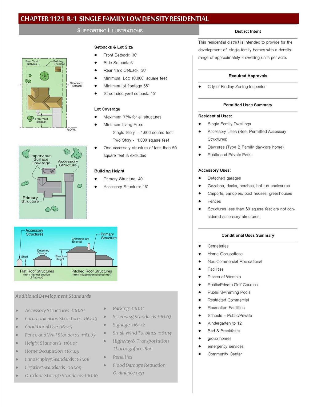
38 CHAPTER 1121 R-1 SINGLE FAMILY LOW DENSITY RESIDENTIAL DISTRICT Intent Permitted Use - Certificate Required Conditional Use Requiring Planning Commission Approval Uses Expressly Prohibited Required Building Setbacks CHAPTER CONTENTS Lot Requirements Minimum Living Areas Height Requirements Applicable Chapters Penalties INTENT The R-1 Single Family Districts are intended to provide for single family homes. The intent is to provide an environment of predominantly low density, single-family, detached dwellings, along with accessory buildings, which serve the residents of the District, and are for the purpose of providing low density housing PERMITTED USE - CERTIFICATE REQUIRED A. SINGLE FAMILY DWELLINGS B. ACCESSORY USES (SEE ACCESSORY STRUCTURES, PERMITTED ACCESSORY STRUCTURES) C. DAYCARES (TYPE B FAMILY DAY-CARE HOME) D. PUBLIC AND PRIVATE PARKS CONDITIONAL USE REQUIRING PLANNING COMMISSION APPROVAL A. CEMETERIES B. GOVERNMENT USES C. HOME OCCUPATIONS D. NON-COMMERCIAL RECREATIONAL FACILITIES E. PLACES OF WORSHIP F. PUBLIC/PRIVATE GOLF COURSES G. PUBLIC SWIMMING POOLS USES EXPRESSLY PROHIBITED A. PARKING, IDLING, OR STORAGE OF SEMI-CABS AND TRACTOR TRAILERS B. TAXI SERVICES C. TOWING SERVICES D. GARBAGE/REFUSE OPERATIONS REQUIRED BUILDING SETBACKS A. FRONT YARD SETBACK Thirty feet (30 ) H. GROUP HOMES I. RESTRICTED COMMERCIAL RECREATIONAL FACILITIES J. SCHOOLS PUBLIC/PRIVATE KINDERGARTEN TO 12 K. EMERGENCY SERVICES L. COMMUNITY CENTER 29
39 B. SIDE YARD SETBACK Five feet (5 ) C. REAR YARD SETBACK Thirty feet (30 ) D. STREET SIDE YARD SETBACK Fifteen feet (15 ) E. AVERAGE FRONT YARD SETBACK i. Where one or more lots are improved, the front depth shall equal the average depth of the front yards of the lots on either side or thirty feet (30 ), whichever is the lesser. In no case shall a front yard be less than twenty feet (20 ). ii. Where the lot is a corner lot, the depth of the front yards shall equal the front yard depth of the adjoining lots or thirty feet (30 ), whichever is less. In no case shall a corner lot have front yards less than twenty feet (20 ). F. OVERHANGS Overhangs may not encroach into any setbacks by more than two feet (2 ) LOT REQUIREMENTS A. MINIMUM REQUIRED LOT SIZE 10,000 square feet B. MINIMUM REQUIRED LOT FRONTAGE Sixty five feet (65 ) C. MAXIMUM PERCENT OF LOT COVERAGE 1. Maximum No lot shall exceed 33% in coverage for all roofed structures. 2. Exceptions: One accessory building containing fifty (50) square feet or less per site. Such buildings are not permitted in any front yard MINIMUM LIVING AREAS A. SINGLE STORY HOME Shall have a minimum of 1,600 square feet of living space excluding garages, porches, and basements. B. TWO STORY HOME Shall have a minimum of 1,800 square feet of living space 30
40 HEIGHT REQUIREMENTS A. PRIMARY STRUCTURE Shall not exceed forty feet (40 ) above grade B. ACCESSORY STRUCTURES Shall not exceed eighteen feet (18 ) above grade APPLICABLE CHAPTERS CHAPTER 1155 RIPARIAN CORRIDOR OVERLAY DISTRICT CHAPTER 1162 NONCONFORMITY CHAPTER 1163 PERFORMANCE REQUIREMENTS CHAPTER 1165 ADMINISTRATION CHAPTER 1351 FLOOD REDUCTION ORDINANCE PENALTIES A violation of any provision of this chapter shall be deemed a violation of this Ordinance and subject the violator to enforcement and penalty set forth in CHAPTER 1199 VIOLATIONS, ENFORCEMENT, PENALTIES AND OTHER REMEDIES. 31
41 32
42 CHAPTER 1122 R-2 SINGLE-FAMILY MEDIUM DENSITY RESIDENTIAL DISTRICT Intent Permitted Use - Certificate Required Conditional Use Requiring Planning Commission Approval Uses Expressly Prohibited Required Building Setbacks CHAPTER CONTENTS Lot Requirements Minimum Living Areas Height Requirements Applicable Chapters Penalties INTENT The R-2 Single Family Districts are intended to provide for single family homes on individual lots. The intent is to provide an environment of predominantly medium density, single-family, detached dwellings, along with other residentially related facilities, which serve the residents of the District, and are for the purpose of providing medium density housing PERMITTED USE - CERTIFICATE REQUIRED A. SINGLE FAMILY DWELLINGS B. ACCESSORY USES (SEE, PERMITTED ACCESSORY STRUCTURES) C. DAYCARES (TYPE B FAMILY DAY-CARE HOME) D. PUBLIC AND PRIVATE PARKS CONDITIONAL USE REQUIRING PLANNING COMMISSION APPROVAL A. CEMETERIES B. HOME OCCUPATIONS C. NON-COMMERCIAL RECREATIONAL FACILITIES D. PLACES OF WORSHIP E. PUBLIC/PRIVATE GOLF COURSES F. PUBLIC SWIMMING POOLS G. RESTRICTED COMMERCIAL USES EXPRESSLY PROHIBITED A. PARKING, IDLING, OR STORAGE OF SEMI-CABS AND TRACTOR TRAILERS B. TAXI SERVICES C. TOWING SERVICES D. GARBAGE/REFUSE OPERATIONS RECREATION FACILITIES H. SCHOOLS PUBLIC/PRIVATE KINDERGARTEN TO 12 I. BED & BREAKFASTS J. GROUP HOMES K. EMERGENCY SERVICES L. COMMUNITY CENTER 33
43 REQUIRED BUILDING SETBACKS A. FRONT YARD SETBACK: Twenty-five feet (25 ) B. SIDE YARD SETBACK: Five feet (5 ) C. REAR YARD SETBACK: Thirty feet (30 ) D. STREET SIDE YARD SETBACK: Fifteen feet (15 ) E. AVERAGE FRONT YARD SETBACK 1. Where one or more lots are improved, the front depth shall equal the average depth of the front yards of the lots on either side or twenty five feet (25 ), whichever is the lesser. In no case shall a front yard be less than fifteen feet (15 ). 2. Where the lot is a corner lot, the depth of the front yards shall equal the front yard depth of the adjoining lots or twenty five feet (25 ), whichever is less. In no case shall a corner lot have front yards less than fifteen feet (15 ). F. OVERHANGS Overhangs may not encroach into any setback by more than 2 feet LOT REQUIREMENTS A. MINIMUM: No lot size shall be less than 7,500 square feet. B. MINIMUM Minimum required lot frontage is fifty feet (50 ) C. MAXIMUM PERCENT OF LOT COVERAGE: Maximum No lot shall exceed 33% in coverage for all roofed structures Exceptions One accessory building containing fifty (50) square feet or less per site. Such buildings are not permitted in any front yard MINIMUM LIVING AREAS A. SINGLE STORY HOMES: 34
44 Shall have a minimum 1,300 square feet of living space B. TWO STORY HOMES: Shall have a minimum of 1,500 square feet of living space HEIGHT REQUIREMENTS A. PRIMARY STRUCTURE Shall not exceed forty feet (40 ) above grade B. ACCESSORY STRUCTURES Shall not exceed eighteen feet (18 ) above grade APPLICABLE CHAPTERS CHAPTER 1155 RIPARIAN CORRIDOR OVERLAY DISTRICT CHAPTER 1162 NONCONFORMITY CHAPTER 1163 PERFORMANCE REQUIREMENTS CHAPTER 1165 ADMINISTRATION PENALTIES A violation of any provision of this chapter shall be deemed a violation of this Ordinance and subject the violator to enforcement and penalty set forth in CHAPTER 1199 VIOLATIONS, ENFORCEMENT, PENALTIES AND OTHER REMEDIES. 35
45 36
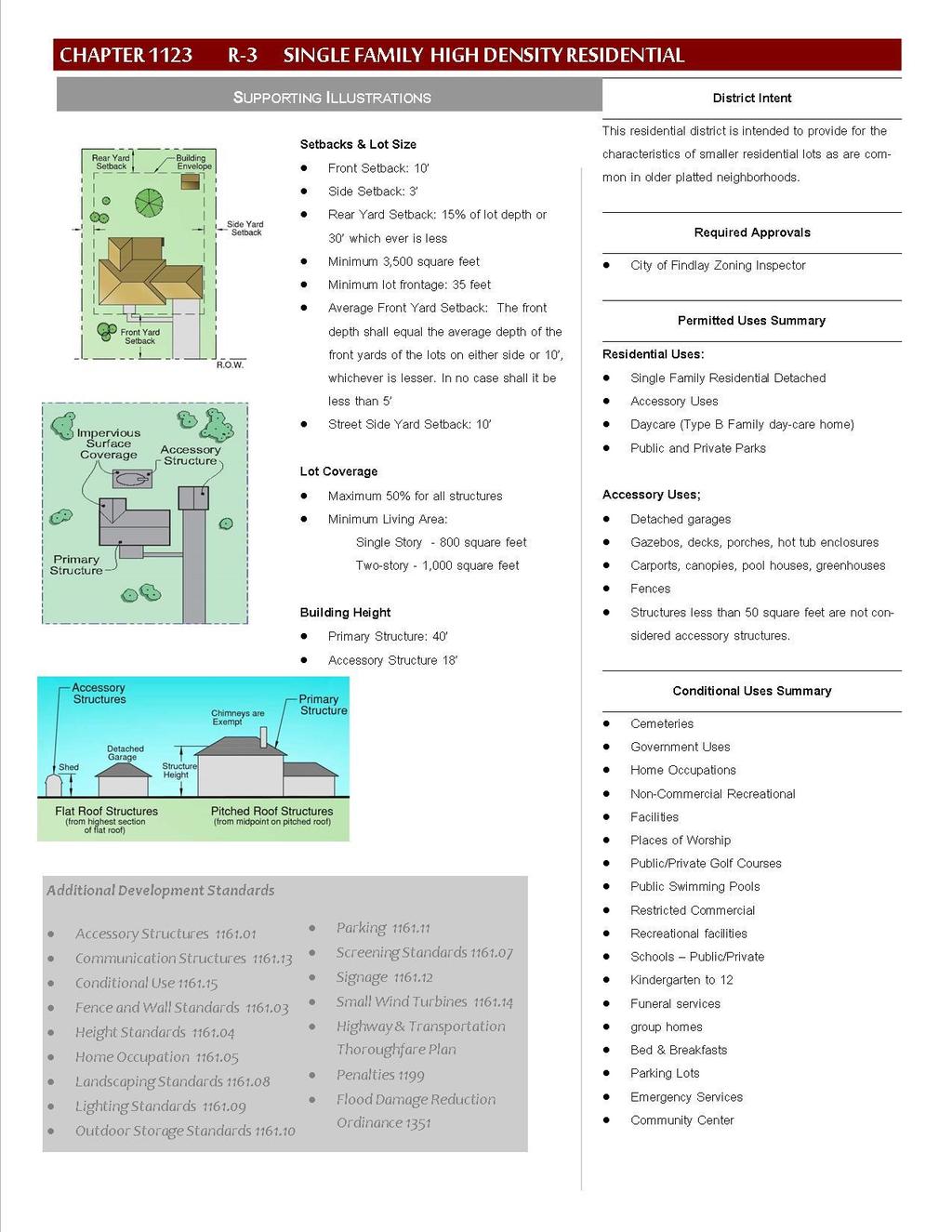
46 CHAPTER 1123 R-3 SINGLE-FAMILY HIGH DENSITY RESIDENTIAL DISTRICT Intent Permitted Use - Certificate Required Conditional Use Requiring Planning Commission Approval Uses Expressly Prohibited Required Building Setbacks CHAPTER CONTENTS Lot Requirements Minimum Living Area Height Requirements Applicable Chapters Penalties INTENT The R-3 Single Family Districts are intended to bring older neighborhoods into conformance with zoning regulations. The intent is to provide an environment of predominantly higher density, single-family, detached dwellings, along with other residentially related facilities, which serve the residents of the District. The R-3 District is designed to provide for the older, smaller lots that are common with older, platted neighborhoods PERMITTED USE - CERTIFICATE REQUIRED A. SINGLE FAMILY DWELLINGS B. ACCESSORY USES C. DAYCARES (TYPE B FAMILY DAY-CARE HOME) D. PUBLIC AND PRIVATE PARKS CONDITIONAL USE REQUIRING PLANNING COMMISSION APPROVAL A. CEMETERIES B. GOVERNMENT USES C. HOME OCCUPATIONS D. NON-COMMERCIAL RECREATIONAL FACILITIES E. PLACES OF WORSHIP F. PUBLIC/PRIVATE GOLF COURSES G. PUBLIC SWIMMING POOLS H. RESTRICTED COMMERCIAL RECREATIONAL FACILITIES I. SCHOOLS PUBLIC/PRIVATE KINDERGARTEN TO 12 J. FUNERAL SERVICES K. GROUP HOMES L. BED & BREAKFASTS M. PARKING LOTS N. EMERGENCY SERVICES O. COMMUNITY CENTER USES EXPRESSLY PROHIBITED A. PARKING, IDLING, OR STORAGE OF SEMI-CABS AND TRACTOR TRAILER B. TAXI SERVICES C. TOWING SERVICES D. GARBAGE/REFUSE OPERATIONS 37
47 REQUIRED BUILDING SETBACKS A. FRONT YARD SETBACK Ten feet (10 ) B. SIDE YARD SETBACK Three feet (3 ) C. STREET SIDE YARD SETBACK Ten feet (10 ) D. REAR YARD SETBACK Fifteen percent (15%) of the lot depth or thirty feet (30 ), whichever is less E. AVERAGE FRONT YARD SETBACK 1. Where one or more lots are improved, the front depth shall equal the average depth of the front yards of the lots on either side or ten feet (10 ), whichever is the lesser. In no case shall a front yard be less than five feet (5 ). 2. Where the lot is a corner lot, the depth of the front yards shall equal the front yard depth of the adjoining lots or ten feet (10 ), whichever is less. In no case shall a corner lot have front yards less than five feet (5 ). F. OVERHANGS Overhangs may not encroach into any setbacks by more than two feet (2 ) LOT REQUIREMENTS A. MINIMUM REQUIRED LOT SIZE The minimum lot size is 3,500 square feet. B. MINIMUM REQUIRED LOT FRONTAGE Thirty five feet (35 ) C. MAXIMUM PERCENT OF LOT COVERAGE Maximum: No lot shall exceed 50% in coverage for all roofed structures D. EXCEPTIONS INCLUDE: One accessory building containing fifty (50) square feet or less per site. Example 1: A lot in a R-3 District has 55% lot coverage. The residents are still able to erect an accessory building of 100 square feet. These are typically the kit sheds available at any home improvement store. The shed will still require a zoning permit. 38
48 Example 2: A lot in a R-3 District is 5,000 square feet and has 40% lot coverage (2000 sq. ft). It does not have a garage and owner would like to construct an 600 square foot garage. The owner is limited to 500 square feet before reaching the 50% maximum (2,500 sq. ft). Can the application for an accessory structure add the 100 square foot exemption to the permit? The answer is No. The 100 sq. ft. exemption is intended to provide for smaller shed type buildings, not as a bonus for larger roofed structures MINIMUM LIVING AREA A. SINGLE STORY HOMES Shall have a minimum 800 square feet of living space B. TWO STORY HOMES Shall have a minimum of 1,000 square feet of living space HEIGHT REQUIREMENTS A. PRIMARY STRUCTURE Shall not exceed forty feet (40 ) above grade B. ACCESSORY STRUCTURES Shall not exceed eighteen feet (18 ) above grade APPLICABLE CHAPTERS CHAPTER 1155 RIPARIAN CORRIDOR OVERLAY DISTRICT CHAPTER 1162 NONCONFORMITY CHAPTER 1163 PERFORMANCE REQUIREMENTS CHAPTER 1165 ADMINISTRATION PENALTIES A violation of any provision of this chapter shall be deemed a violation of this Ordinance and subject the violator to enforcement and penalty set forth in CHAPTER 1199 VIOLATIONS, ENFORCEMENT, PENALTIES AND OTHER REMEDIES. 39
49 40
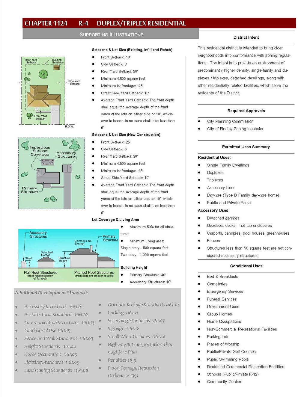
50 CHAPTER 1124 R-4 DUPLEX/TRIPLEX HIGH DENISTY RESIDENTIAL DISTRICT Intent Permitted Use - Certificate Required Conditional Use Requiring Planning Commission Approval Uses Expressly Prohibited Required Building Setbacks CHAPTER CONTENTS Lot Requirements Minimum Living Area Height Requirements Applicable Chapters Penalties INTENT The R-4 Duplex/Triplex District is designed to stabilize the older neighborhoods that are saturated with duplexes and triplexes. The R-4 classification exists to respect existing, legal conforming duplex/triplex properties. However, the district cannot be designated in a manner that would represent a spot zone. Therefore, areas with a significant number of duplexes and triplexes may be zoned R-4 overall, but each neighborhood will be evaluated for R-4 based on existing uses and zoning compliance. All zone change requests for R-4 Duplex/Triplex must meet all requirements of this chapter, including but not limited to lot size, coverage, off-street parking, etc PERMITTED USE - CERTIFICATE REQUIRED A. SINGLE FAMILY DWELLINGS B. DUPLEX C. TRIPLEX D. ACCESSORY USES E. DAYCARES (TYPE B FAMILY DAYCARE HOME) F. PUBLIC AND PRIVATE PARKS CONDITIONAL USE REQUIRING PLANNING COMMISSION APPROVAL A. CEMETERIES B. GOVERNMENT USES C. HOME OCCUPATIONS D. NON-COMMERCIAL RECREATIONAL FACILITIES E. PLACES OF WORSHIP F. PUBLIC/PRIVATE GOLF COURSES G. PUBLIC SWIMMING POOLS H. RESTRICTED COMMERCIAL RECREATION FACILITY I. SCHOOLS PUBLIC/PRIVATE KINDERGARTEN TO 12 J. FUNERAL SERVICES K. BED & BREAKFASTS L. PARKING LOT M. EMERGENCY SERVICES N. GROUP HOMES O. COMMUNITY CENTER 41
51 USES EXPRESSLY PROHIBITED A. PARKING, IDLING, OR STORAGE OF SEMI-CABS AND TRACTOR TRAILER B. TAXI SERVICES C. TOWING SERVICES D. GARBAGE/REFUSE OPERATIONS REQUIRED BUILDING SETBACKS A. EXISTING, INFILL, AND REHAB 1. FRONT YARD SETBACK Ten feet (10 ) 2. SIDE YARD SETBACK Three feet (3 ) 3. STREET SIDE YARD SETBACK Ten feet (10 ) 4. REAR YARD SETBACK Thirty feet (30 ) 5. AVERAGE FRONT YARD SETBACK i. Where one or more lots are improved, the front depth shall equal the average depth of the front yards of the lots on either side or ten feet (10 ), whichever is the lesser. In no case shall a front yard be less than five feet (5 ). ii. Where the lot is a corner lot, the depth of the front yards shall equal the front yard depth of the adjoining lots or ten feet (10 ), whichever is less. In no case shall a corner lot have front yards less than five feet (5 ). B. NEW CONSTRUCTION 1. FRONT YARD SETBACK Twenty five feet (25 ) 2. SIDE YARD SETBACK Five feet (5 ) 3. REAR YARD SETBACK Thirty feet (30 ) 4. AVERAGE FRONT YARD SETBACK 42
52 Where one or more lots are improved, the front depth shall equal the average depth of the front yards of the lots on either side or twenty five feet (25 ), whichever is the lesser. In no case shall a front yard be less than fifteen feet (15 ). Where the lot is a corner lot, the depth of the front yards shall equal the front yard depth of the adjoining lots or twenty five feet (25 ), whichever is less. In no case shall a corner lot have front yards less than fifteen feet (15 ). See Chapter 1174 Definitions LOT REQUIREMENTS A. MINIMUM REQUIRED LOT SIZE The minimum lot size is 4,500 square feet. B. MINIMUM REQUIRED LOT FRONTAGE Forty five feet (45 ) C. MAXIMUM PERCENT OF LOT COVERAGE Maximum: No lot shall exceed 50% in coverage for all roofed structures D. EXCEPTIONS INCLUDE: One accessory building containing fifty (50) square feet or less per buildable lot. See Chapter Lot Requirements for additional information MINIMUM LIVING AREA A. SINGLE STORY HOMES Shall have a minimum 800 square feet of living space B. TWO STORY HOMES Shall have a minimum of 1,000 square feet of living space HEIGHT REQUIREMENTS A. PRIMARY STRUCTURE Shall not exceed forty feet (40 ) above grade B. ACCESSORY STRUCTURES Shall not exceed eighteen feet (18 ) above grade 43
53 APPLICABLE CHAPTERS CHAPTER 1155 RIPARIAN CORRIDOR OVERLAY DISTRICT CHAPTER 1162 NONCONFORMITY CHAPTER 1163 PERFORMANCE REQUIREMENTS CHAPTER 1165 ADMINISTRATION PENALTIES A violation of any provision of this chapter shall be deemed a violation of this Ordinance and subject the violator to enforcement and penalty set forth in CHAPTER 1199 VIOLATIONS, ENFORCEMENT, PENALTIES AND OTHER REMEDIES. 44
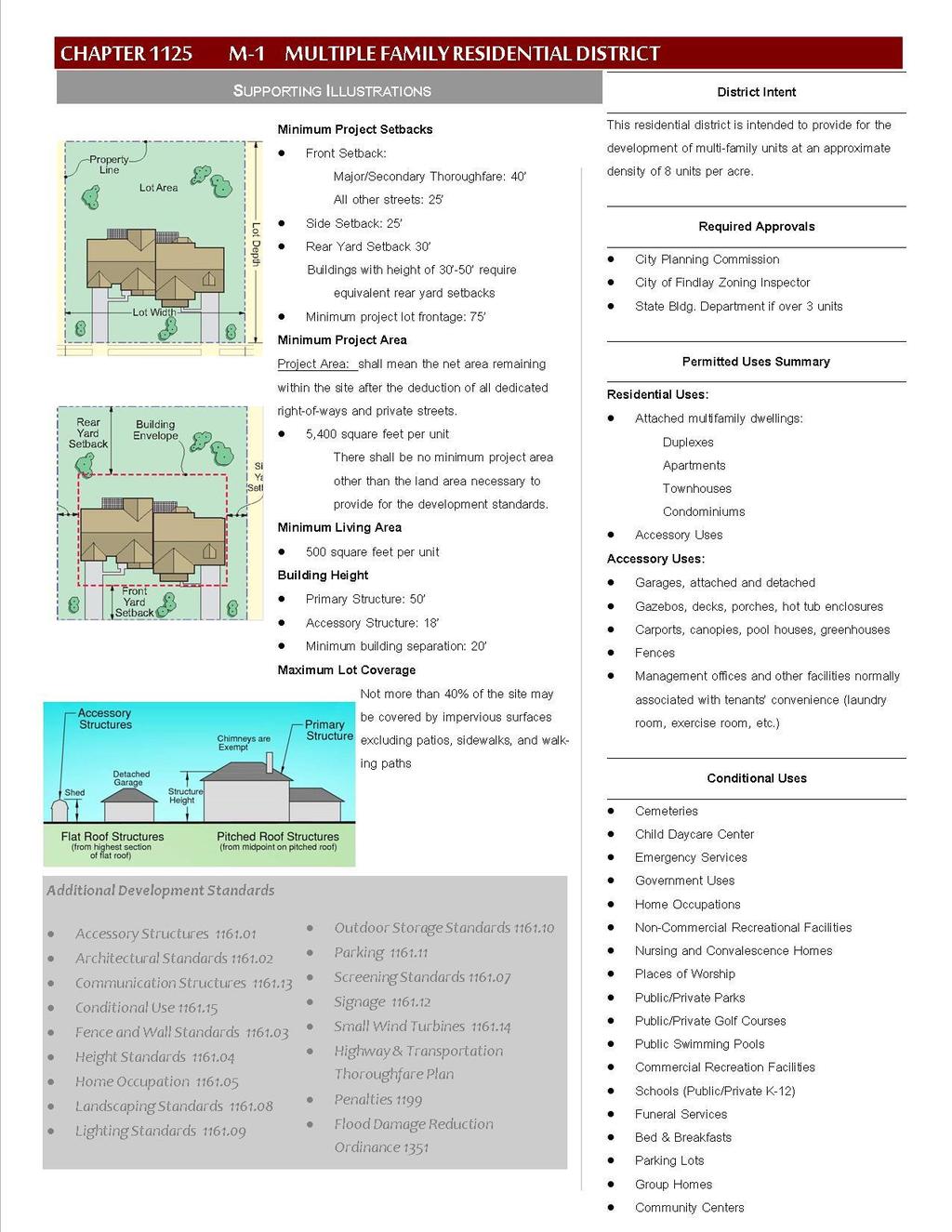
54 45
55 CHAPTER 1125 M-1 MULTIPLE-FAMILY RESIDENTIAL DISTRICT Intent Permitted Use - Certificate Required Conditional Use - Planning Commission Approval Uses Expressly Prohibited Required Building Setbacks CHAPTER CONTENTS Lot Requirements Minimum Living Area Minimum Building Separation Maximum Height Penalties INTENT The M-1 Multiple-Family Residential Districts are a higher density residential district (no more than 8.68 units per acre) and are designed to provide sites for multiple-family dwelling structures and related uses which will generally serve as zones of transition between non-residential districts and lower density R-1, R-2, and R-3 districts. The Multiple-Family Districts are further designed to serve the limited needs of apartment type units in an otherwise medium or low density single-family community. The M-1 District allows for less density than the M- 2 District PERMITTED USE - CERTIFICATE REQUIRED A. MULTIPLE-FAMILY DWELLINGS B. ACCESSORY USES C. TWO-FAMILY DWELLINGS D. APARTMENTS CONDITIONAL USE REQUIRING PLANNING COMMISSION APPROVAL A. CEMETERIES B. CHILD DAYCARE CENTER C. GOVERNMENT USES D. HOME OCCUPATIONS E. NON-COMMERCIAL RECREATIONAL FACILITIES F. NURSING AND CONVALESCENCE HOMES G. PLACES OF WORSHIP H. PUBLIC/PRIVATE PARKS I. PUBLIC/PRIVATE GOLF COURSES J. PUBLIC SWIMMING POOLS K. COMMERCIAL RECREATION FACILITY L. SCHOOLS PUBLIC/PRIVATE KINDERGARTEN TO 12 M. FUNERAL SERVICES N. BED & BREAKFASTS O. GROUP HOMES P. PARKING LOT Q. COMMUNITY CENTER R. EMERGENCY SERVICES 46
56 USES EXPRESSLY PROHIBITED A. PARKING, IDLING, OR STORAGE OF SEMI-CABS AND TRACTOR TRAILERS B. TAXI SERVICES REQUIRED BUILDING SETBACKS A. FRONT YARD SETBACK 1. Major & secondary thoroughfares: Forty feet (40 ) B. ALL OTHER STREETS: Twenty-five (25 ) LOT REQUIREMENTS A. MINIMUM LOT SIZE Ratio C. TOWING SERVICES D. GARBAGE/REFUSE OPERATIONS C. SIDE YARD SETBACK Twenty five feet (25 ) D. REAR YARD SETBACK Thirty feet (30 ) minimum. Buildings with heights between 30 and 50 require equivalent rear yard setbacks. The required minimum lot size shall be determined by the following ratio: square feet of lot size per living unit. B. EXCLUSIVE OF RIGHTS OF WAYS AND STREETS Dedicated and private streets do not count toward the required lot size. Example: A ten-unit apartment building would require a lot of 54,000 square feet, not including dedicated right-of-ways or private streets. (10 x 5,400 = 54,000) C. MINIMUM LOT FRONTAGE Seventy-five feet (75 ) D. MAXIMUM LOT COVERAGE Not more than 40% of the site may be covered by impervious surface excluding patios, sidewalks, and walking paths MINIMUM LIVING AREA 500 square feet per living unit MINIMUM BUILDING SEPARATION Twenty feet (20 ) MAXIMUM HEIGHT A. PRIMARY STRUCTURE Primary structures shall not exceed fifty feet (50 ) 47
57 B. ACCESSORY STRUCTURE Accessory structures shall not exceed eighteen feet (18 ) APPLICABLE CHAPTERS CHAPTER 1155 RIPARIAN CORRIDOR OVERLAY DISTRICT CHAPTER 1162 NONCONFORMITY CHAPTER 1163 PERFORMANCE REQUIREMENTS PENALTIES A violation of any provision of this chapter shall be deemed a violation of this Ordinance and subject the violator to enforcement and penalty set forth in CHAPTER 1199 VIOLATIONS, ENFORCEMENT, PENALTIES AND OTHER REMEDIES. 48
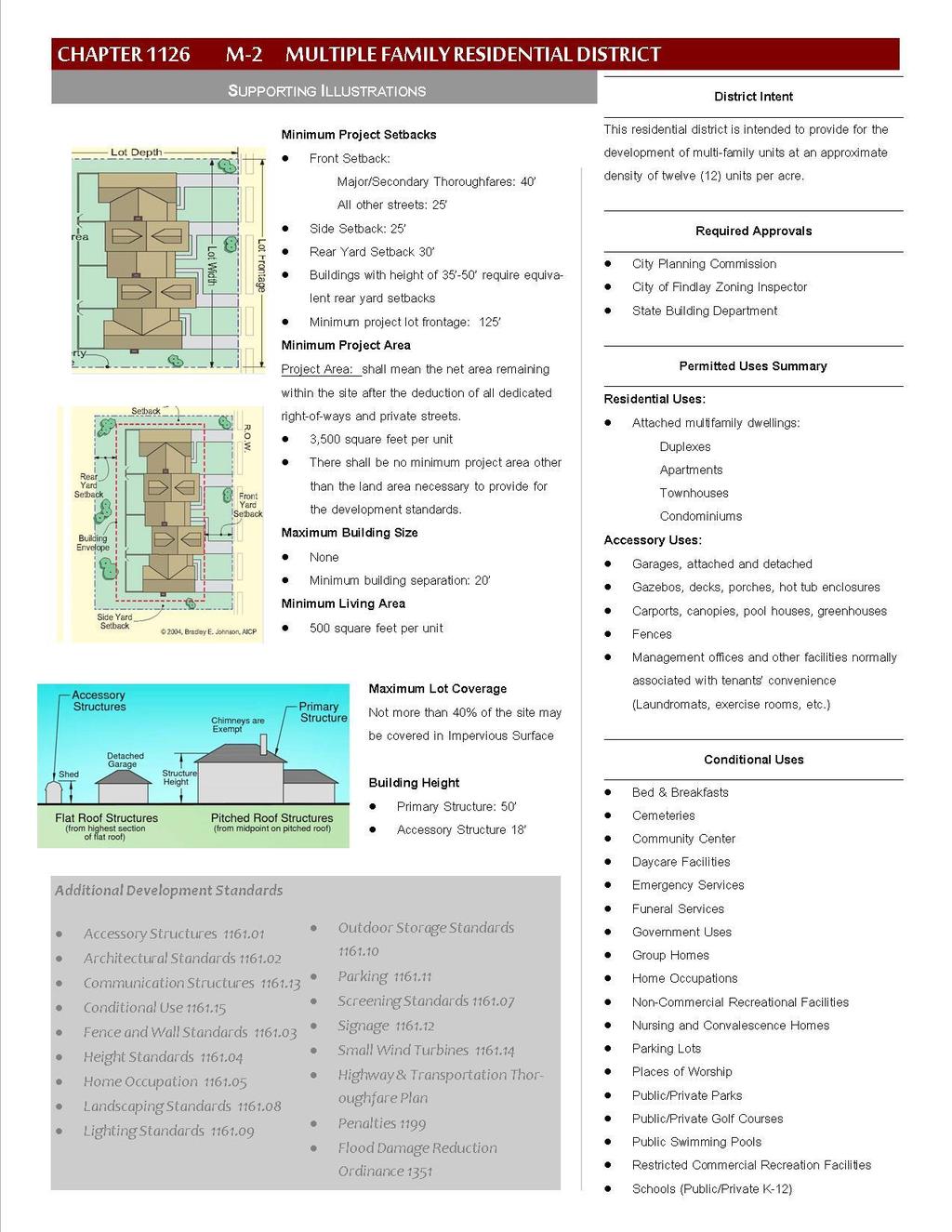
58 49
59 CHAPTER 1126 M-2 MULTIPLE-FAMILY RESIDENTIAL DISTRICT CHAPTER CONTENT Intent Permitted Use - Certificate Required Conditional Use Requiring Planning Commission Approval Uses Expressly Prohibited Required Building Setbacks Lot Requirements Minimum Living Area Height Requirements Minimum Building Separation Applicable Chapters Penalties INTENT The M-2 Multiple-Family Residential Districts are a higher density residential district and are designed to provide sites for multiple-family dwelling structures and related uses which will generally serve as zones of transition between non-residential districts and lower density R-1, R-2, and R-3 districts. The Multiple-Family Districts are further designed to serve the limited needs of apartment type units in an otherwise medium or low density singlefamily community. The M-2 District allows for a higher density than the M-1 District PERMITTED USE - CERTIFICATE REQUIRED A. MULTIPLE-FAMILY DWELLINGS B. TWO-FAMILY DWELLINGS C. APARTMENTS D. ACCESSORY USES CONDITIONAL USE REQUIRING PLANNING COMMISSION APPROVAL A. CEMETERIES B. DAYCARE FACILITIES C. GOVERNMENT USES D. HOME OCCUPATIONS E. NON-COMMERCIAL RECREATIONAL FACILITIES F. NURSING AND CONVALESCENCE HOMES G. PLACES OF WORSHIP H. PUBLIC/PRIVATE PARKS I. PUBLIC/PRIVATE GOLF COURSES J. PUBLIC SWIMMING POOLS K. RESTRICTED COMMERCIAL RECREATIONAL FACILITIES L. SCHOOLS PUBLIC/PRIVATE KINDERGARTEN TO 12 M. FUNERAL HOMES N. BED & BREAKFASTS O. PARKING LOT P. EMERGENCY SERVICES Q. COMMUNITY CENTER 50
60 USES EXPRESSLY PROHIBITED A. PARKING, IDLING, OR STORAGE OF SEMI-CABS AND TRACTOR TRAILERS B. TAXI SERVICES C. TOWING SERVICES D. GARBAGE/REFUSE OPERATIONS REQUIRED BUILDING SETBACKS A. FRONT YARD SETBACK Major & secondary thoroughfares: forty feet (40 ) All other streets: twenty-five feet (25 ) B. SIDE YARD SETBACK Twenty five feet (25 ) C. REAR YARD SETBACK Thirty feet (30 minimum. Buildings with heights between 35 and 50 require equivalent rear yard setbacks LOT REQUIREMENTS A. MINIMUM LOT SIZE Shall be determined by the following ratio: 3,500 square feet of lot size per living unit. Dedicated right-of-ways and private streets do not count toward the required lot size. Example: A ten-unit apartment building would require a lot of 35,000 square feet, not including dedicated rights-of-way or private streets. (10 x 3,500 = 35,000) B. MINIMUM LOT FRONTAGE One hundred and twenty-five feet (125 ). C. MAXIMUM LOT COVERAGE Not more than 40% of the site may be covered by impervious surface MINIMUM LIVING AREA A. MINIMUM LIVING AREA 500 square feet per living unit HEIGHT REQUIREMENTS A. PRIMARY STRUCTURE Shall not exceed fifty feet (50 ) B. ACCESSORY STRUCTURE Shall not exceed eighteen feet (18 ) 51
61 MINIMUM BUILDING SEPARATION A. MINIMUM Twenty feet (20 ) APPLICABLE CHAPTERS CHAPTER 1155 RIPARIAN CORRIDOR OVERLAY DISTRICT CHAPTER 1162 NONCONFORMITY CHAPTER 1163 PERFORMANCE REQUIREMENTS CHAPTER 1165 ADMINISTRATION PENALTIES A violation of any provision of this chapter shall be deemed a violation of this Ordinance and subject the violator to enforcement and penalty set forth in CHAPTER 1199 VIOLATIONS, ENFORCEMENT, PENALTIES AND OTHER REMEDIES. 52
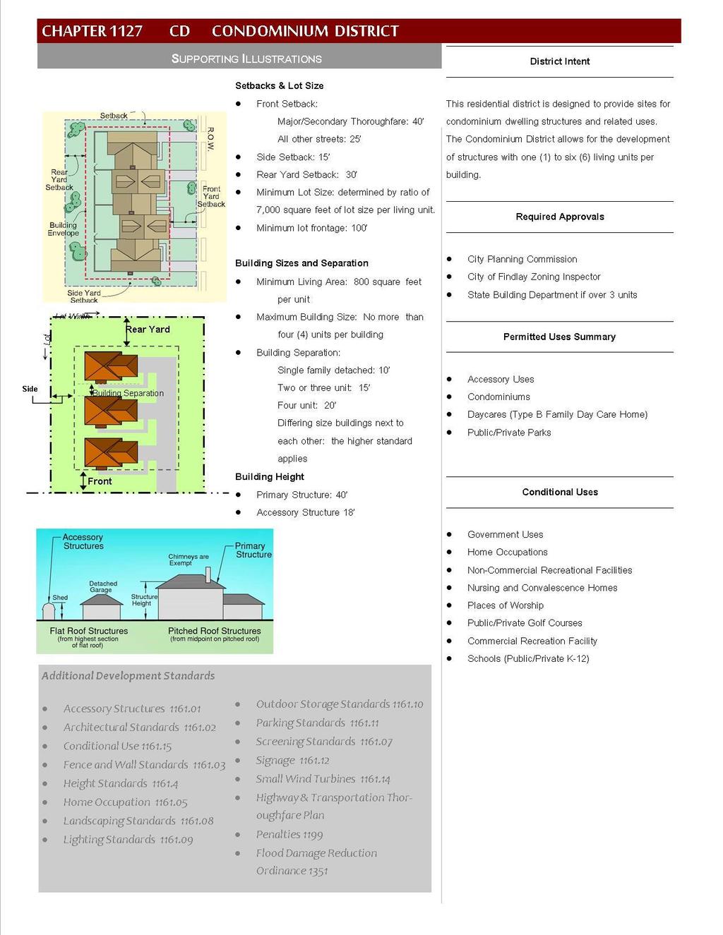
62 53
63 CHAPTER 1127 CD CONDOMINIUM DISTRICT Intent Permitted Use - Certificate Required Conditional Use Requiring Planning Commission Approval Uses Expressly Prohibited Required Building Setbacks Lot Requirements CHAPTER CONTENTS Minimum Living Area Height Requirements Minimum Building Separation Maximum Building Size Applicable Chapters Penalties INTENT The CD Condominium Districts are designed to provide sites for condominium dwelling structures and related uses. The Condominium Districts allow for the development of structures with one (1) to four (4) living units per building PERMITTED USE - CERTIFICATE REQUIRED A. CONDOMINIUMS B. ACCESSORY USES C. PUBLIC/PRIVATE PARKS CONDITIONAL USE REQUIRING PLANNING COMMISSION APPROVAL A. GOVERNMENT USES B. HOME OCCUPATIONS C. NON-COMMERCIAL RECREATIONAL FACILITIES D. NURSING AND CONVALESCENCE HOMES E. PLACES OF WORSHIP F. PUBLIC/PRIVATE GOLF COURSES G. COMMERCIAL RECREATIONAL FACILITIES H. SCHOOLS PUBLIC/PRIVATE KINDERGARTEN TO USES EXPRESSLY PROHIBITED A. PARKING, IDLING, OR STORAGE OF SEMI-CABS AND TRACTOR TRAILERS B. TAXI SERVICES C. TOWING SERVICES D. GARBAGE/REFUSE OPERATIONS REQUIRED BUILDING SETBACKS A. FRONT YARD SETBACK Major & secondary thoroughfares: forty feet (40 ) All other streets: twenty five feet (25 ) B. SIDE YARD SETBACK Fifteen feet (15 ) 54
64 C. REAR YARD SETBACK Thirty feet (30 ) LOT REQUIREMENTS A. MINIMUM LOT SIZE Shall be determined by the following ratio: 1. 7,000 square feet Minimum area of lot size per living unit. B. RIGHT OF WAYS Dedicated rights-of-ways and private streets do not count toward the required lot size. Example: A ten unit condominium development would require a lot of 70,000 square feet, not including dedicated rights-of-way or private streets. (10 x 7,000 = 70,000) C. MINIMUM FRONTAGE One hundred feet (100 ) MINIMUM LIVING AREA A. MINIMUM 800 square feet per living unit HEIGHT REQUIREMENTS A. PRIMARY STRUCTURE Shall not exceed forty feet (40 ) MINIMUM BUILDING SEPARATION A. SINGLE FAMILY DETACHED CONDOMINIUM Ten feet (10 ) B. TWO OR THREE UNIT CONDOMINIUM BUILDING Fifteen feet (15 ) C. FOUR UNIT CONDOMINIUM BUILDING B. ACCESSORY STRUCTURE Shall not exceed eighteen feet (18 ) D. DIFFERING SIZED CONDOMINIUMS In the case of adjacent but differing size condominiums, the project will be held to the more stringent separation (meaning the greater distance) Twenty feet (20 ) MAXIMUM BUILDING SIZE A. MAXIMUM No single condominium shall have more than four (4) living units per building. Example: The building s maximum size is limited by the lot size, setbacks, building height, maximum number of units, and the 7,000 sq. ft. of lot size per-unit requirement APPLICABLE CHAPTERS CHAPTER 1155 RIPARIAN CORRIDOR OVERLAY DISTRICT 55
65 CHAPTER 1162 NONCONFORMITY CHAPTER 1163 PERFORMANCE REQUIREMENTS CHAPTER 1165 ADMINISTRATION PENALTIES A violation of any provision of this chapter shall be deemed a violation of this Ordinance and subject the violator to enforcement and penalty set forth in CHAPTER 1199 VIOLATIONS, ENFORCEMENT, PENALTIES AND OTHER REMEDIES. 56
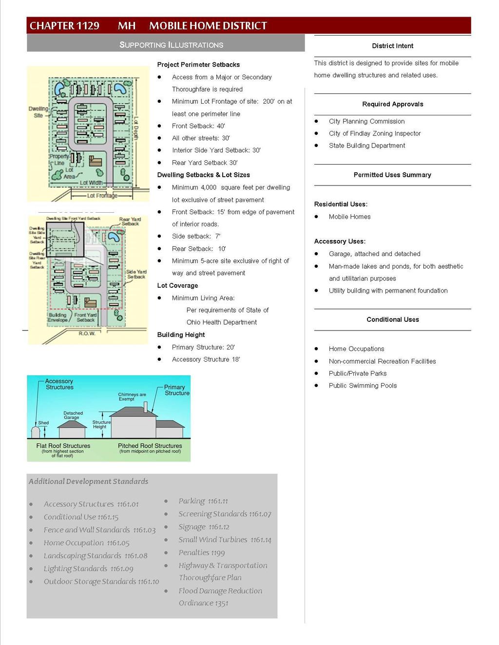
66 57
67 CHAPTER 1129 MH MOBILE HOME DISTRICT Intent Permitted Use - Certificate Required Conditional Use Requiring Planning Commission Approval Required Setbacks Lot Requirements Chapter Contents Minimum Living Area Minimum Building Separation Minimum Building Size Height Requirements Applicable Chapters Penalties INTENT The MH Mobile Home Districts are designed to provide sites for mobile home dwelling structures and related uses PERMITTED USE - CERTIFICATE REQUIRED A. MOBILE HOMES B. ACCESSORY USES CONDITIONAL USE REQUIRING PLANNING COMMISSION APPROVAL A. HOME OCCUPATIONS B. NON-COMMERCIAL RECREATIONAL FACILITIES REQUIRED SETBACKS A. PERIMETER SETBACK Major or secondary thoroughfare (Required) Forty feet (40 ) B. ALL OTHER STREETS: Thirty feet (30 ) C. INTERIOR -SIDE YARD Thirty feet (30 ) D. INTERIOR - REAR YARD Thirty feet (30 ) C. PUBLIC/PRIVATE PARKS D. PUBLIC SWIMMING POOL E. EMERGENCY SERVICES Example: Interior requirements, such as Side Yard and Rear Yard, are to be implemented in areas where a mobile home development abuts neighboring property that is not street frontage or another mobile home park development. E. FRONT SETBACK Fifteen feet (15 ) from edge of pavement 58
68 F. SIDE SETBACK Seven feet (7 ) G. REAR SETBACK Ten feet (10 ) LOT REQUIREMENTS A. MINIMUM DEVELOPMENT SIZE All new mobile home parks shall be a minimum of five (5) acres in size: 1. Exclusive of Rights-of-Way B. MINIMUM LOT SIZE Shall be determined by the following ratios: 1. 4,000 square feet per dwelling unit C. MINIMUM LOT FRONTAGE ENTIRE SITE At least one perimeter line of the lot shall measure 200 feet along an arterial street. D. MAXIMUM LOT COVERAGE Per requirements of the State of Ohio Health Department MINIMUM LIVING AREA Per State of Ohio Health Code MINIMUM BUILDING SEPARATION Per State of Ohio Health Code MINIMUM BUILDING SIZE Per State of Ohio Health Code HEIGHT REQUIREMENTS A. PRIMARY STRUCTURE Shall not exceed twenty feet (20 ) B. ACCESSORY STRUCTURE Shall not exceed eighteen feet (18 ) APPLICABLE CHAPTERS CHAPTER 1155 RIPARIAN CORRIDOR OVERLAY DISTRICT CHAPTER 1162 NONCONFORMITY CHAPTER 1163 PERFORMANCE REQUIREMENTS CHAPTER 1165 ADMINISTRATION 59
69 PENALTIES A violation of any provision of this chapter shall be deemed a violation of this Ordinance and subject the violator to enforcement and penalty set forth in CHAPTER 1199 VIOLATIONS, ENFORCEMENT, PENALTIES AND OTHER REMEDIES. 60
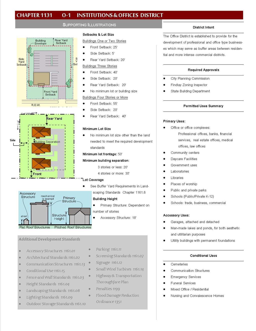
70 61
71 CHAPTER 1131 O-1 INSTITUTIONS AND OFFICES DISTRICT Intent Permitted Use - Certificate Required Conditional Uses Required Building Setbacks CHAPTER CONTENTS Lot Requirements Minimum Building Separation Applicable Chapters Penalties INTENT The Institutions and Offices district is established to provide for the development of professional and office type businesses which may serve as buffer areas between residential and more intense commercial districts PERMITTED USE - CERTIFICATE REQUIRED A. ACCESSORY USES B. GENERAL OFFICES C. GOVERNMENT USES D. FINANCIAL AND INSURANCE INSTITUTIONS E. LABORATORIES F. MEDICAL OFFICES G. LAW OFFICES H. PLACES OF WORSHIP I. PROFESSIONAL OFFICES J. PUBLIC/PRIVATE PARKS K. SCHOOLS PUBLIC/PRIVATE KINDERGARTEN TO 12 L. DAYCARE FACILITIES M. LIBRARIES N. COMMUNITY CENTERS O. SCHOOLS: TRADE, BUSINESS, COMMERCIAL CONDITIONAL USES A. NURSING AND CONVALESCENCE HOMES B. FUNERAL SERVICES C. CEMETERIES D. EMERGENCY SERVICES E. COMMUNICATION STRUCTURES F. MIXED USE OFFICE/RESIDENTIAL REQUIRED BUILDING SETBACKS Building setbacks are based on three categories of height: buildings one or two stories in height, buildings three stories in height or less, and; buildings in excess of three stories. A. BUILDINGS 1 OR 2 STORIES TALL 1. Front Yard Setback Twenty five feet (25 ) 62
72 2. Side Yard Setback Five feet (5 ) 3. Rear Yard Setback Twenty feet (20 ) B. BUILDINGS THREE STORIES TALL 1. Front Yard Setback: Forty feet (40 ). 2. Side Yard Setback: Twenty feet (20 ) 3. Rear Yard Setback: Twenty feet (20 ) C. BUILDINGS FOUR-STORIES TALL OR MORE Front Yard Setback Fifty five feet (55 ). Side Yard Setback Twenty feet (20 ) 3. Rear Yard Setback Forty Feet (40 ) LOT REQUIREMENTS A. MINIMUM LOT SIZE No minimum lot size other than the land that is needed to meet all the required development standards. B. MINIMUM LOT FRONTAGE Fifty feet (50 ) MINIMUM BUILDING SEPARATION A. BUILDINGS THREE STORIES TALL OR LESS Twenty feet (20 ) B. BUILDINGS FOUR STORIES TALL OR MORE Thirty feet (30 ) APPLICABLE CHAPTERS CHAPTER 1155 RIPARIAN CORRIDOR OVERLAY DISTRICT CHAPTER 1162 NONCONFORMITY CHAPTER 1163 PERFORMANCE REQUIREMENTS CHAPTER 1165 ADMINISTRATION 63
73 PENALTIES A violation of any provision of this chapter shall be deemed a violation of this Ordinance and subject the violator to enforcement and penalty set forth in CHAPTER 1199 VIOLATIONS, ENFORCEMENT, PENALTIES AND OTHER REMEDIES. 64
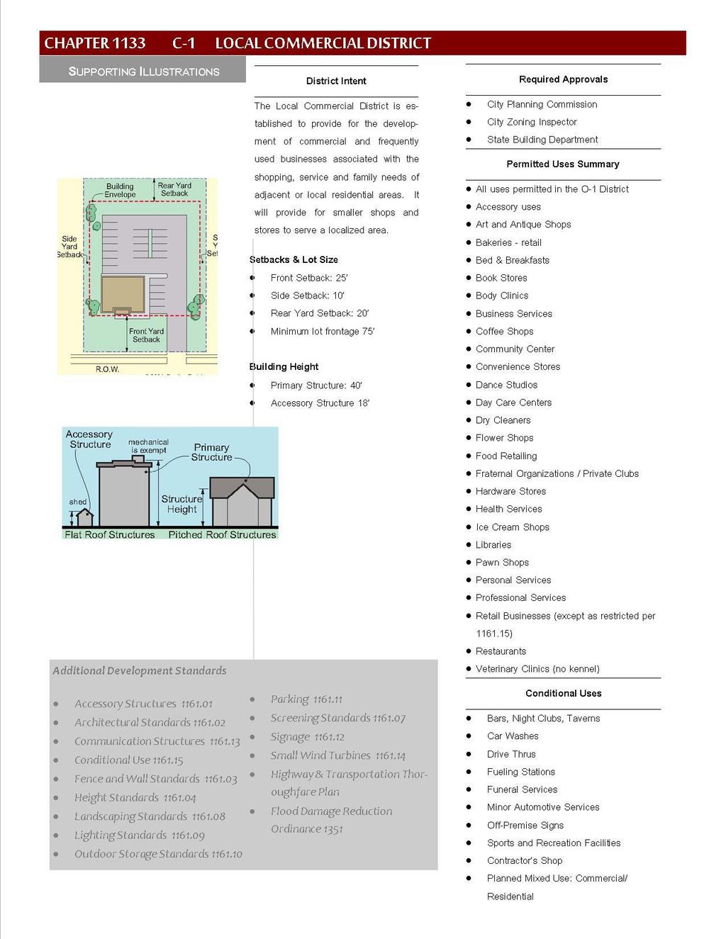
74 65
75 CHAPTER 1133 C-1 LOCAL COMMERCIAL DISTRICT Intent Permitted Use - Certificate Required Conditional Uses Required Building Setbacks Required Lot Frontage CHAPTER CONTENTS Height Standards Outdoor Display of Merchandise Screening Applicable Chapters Penalties INTENT The C-1 Neighborhood Commercial District is established to provide for the development of commercial and frequently used businesses associated with the shopping, service and family needs of adjacent or local residential areas. The C-1 Local Commercial zoning district is intended to provide for the establishment of smaller shops or stores serving a localized area rather than larger businesses serving regional areas PERMITTED USE - CERTIFICATE REQUIRED All uses permitted are permitted in this district, in addition to which the following uses are also permitted: Retail Business (except conditions per Chapter ). A. PROFESSIONAL SERVICES B. LIBRARIES C. RESTAURANTS D. ART AND ANTIQUE SHOPS E. BAKERIES RETAIL F. BED & BREAKFASTS G. BOOK STORES H. BUSINESS SERVICES I. COFFEE SHOPS J. CONVENIENCE STORES K. CRAFT SUPPLIES L. DANCE STUDIOS M. DAY CARE CENTERS (TYPE A & B) N. DRY CLEANERS O. FLOWER SHOPS P. FOOD RETAILING Q. HARDWARE STORES R. HEALTH SERVICES S. ICE CREAM SHOPS T. BEAUTY SALONS U. BARBER SHOPS V. BODY CLINICS W. VETERINARY CLINICS (NO KENNEL) X. PAWN SHOPS Y. ACCESSORY USES Z. PERSONAL SERVICES AA. COMMUNITY CENTER BB. FRATERNAL ORGANIZATIONS CC. PRIVATE CLUBS CONDITIONAL USES In addition to other requirements found in this Ordinance, uses stated below may be permitted or denied depending upon how well they can address various site issues. Common conditions for approving such uses are 66
76 located in Chapter A. SPORTS & RECREATIONAL FACILITIES B. BARS, NIGHT CLUBS, TAVERNS C. DRIVE THRUS D. CAR WASHES E. FUELING STATIONS F. FUNERAL SERVICES G. MINOR AUTOMOTIVE SERVICES H. OFF-PREMISE SIGNS I. CONTRACTOR S SHOP J. MIXED USE COMMECIAL/RESIDENTIAL REQUIRED BUILDING SETBACKS A. FRONT YARD SETBACK Twenty five feet (25 ) B. SIDE YARD SETBACK Ten feet (10 ) C. REAR YARD SETBACK Twenty feet (20 ) REQUIRED LOT FRONTAGE A. MINIMUM LOT FRONTAGE Minimum required lot frontage is seventy-five feet (75 ) HEIGHT STANDARDS Maximum forty feet (40 ) OUTDOOR DISPLAY OF MERCHANDISE & OUTDOOR STORAGE See Chapter Outdoor Storage Standards/ Chapter Outdoor Display SCREENING Screening is required of all areas that abut residentially zoned districts. Required screening shall be opaque, such as a board on-board fence, masonry walls or equivalent material deemed appropriate by the Zoning Administrator or Planning Commission. The screening standards can be found in Chapter Screening 67
77 APPLICABLE CHAPTERS CHAPTER 1155 RIPARIAN CORRIDOR OVERLAY DISTRICT CHAPTER 1162 NONCONFORMITY CHAPTER 1163 PERFORMANCE REQUIREMENTS CHAPTER 1165 ADMINISTRATION PENALTIES A violation of any provision of this chapter shall be deemed a violation of this Ordinance and subject the violator to enforcement and penalties set forth in Chapter
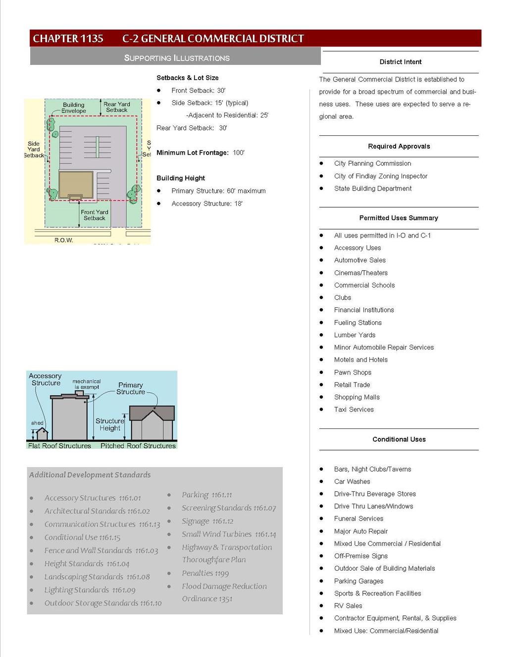
78 69
79 CHAPTER 1135 C-2 GENERAL COMMERCIAL DISTRICT Intent Permitted Use - Certificate Required Conditional Use Required Building Setbacks Required Lot Frontage CHAPTER CONTENTS Height Standards Outdoor Display of Merchandise & Outdoor Storage Applicable Chapters Penalties INTENT The C-2 Commercial District is established to provide for the development of a broad spectrum of commercial and business uses. These uses are expected to serve the commercial, business, and service needs of a regional area PERMITTED USE - CERTIFICATE REQUIRED This district permits all uses permitted in O-1 and C-1, in addition to the following uses: A. RETAIL TRADE B. AUTOMOTIVE SALES C. MOTELS AND HOTELS D. CINEMAS/THEATERS E. COMMERCIAL SCHOOLS F. CLUBS G. FINANCIAL INSTITUTIONS H. SHOPPING MALLS I. LUMBER YARDS J. PAWN SHOPS K. ACCESSORY USES L. TAXI SERVICES M. FUELING STATIONS N. MINOR AUTOMOBILE REPAIR SERVICES CONDITIONAL USE In addition to other requirements found in this Ordinance, uses stated below may be permitted or denied depending upon how well they can address various site issues. Common conditions for approving such uses conditionally are located in Chapter
80 A. SPORTS & RECREATIONAL FACILITIES B. BARS, NIGHT CLUBS, TAVERNS C. FUNERAL SERVICES D. OUTDOOR SALE OF BUILDING MATERIALS E. DRIVE-THRU BEVERAGE STORES F. CONTRACTOR EQUIPMENT, RENTAL, & SUPPLIES G. CAR WASHES H. DRIVE THRU LANES/WINDOWS I. PARKING GARAGES J. OFF PREMISE SIGNS K. RV SALES L. MAJOR AUTO REPAIR M. MIXED USE COMMERCIAL/RESIDENTIAL REQUIRED BUILDING SETBACKS A. FRONT YARD SETBACK Thirty feet (30 ) B. SIDE YARD SETBACK 1. Typical Fifteen feet (15 ) 2. Adjacent to Residential Use or Zoning Twenty five (25 ) C. REAR YARD SETBACK Thirty feet (30 ) REQUIRED LOT FRONTAGE Minimum required lot frontage is one hundred feet (100 ) HEIGHT STANDARDS Maximum sixty feet (60 ) OUTDOOR DISPLAY OF MERCHANDISE & OUTDOOR STORAGE Outdoor displays of, or merchandise for sale or otherwise shall be limited and shall adhere to the following requirements as set forth in Chapter Lighting, Outdoor Display & 1161 Outdoor Storage APPLICABLE CHAPTERS CHAPTER Architectural Standards CHAPTER Screening CHAPTER Lighting CHAPTER Outdoor Storage Standards CHAPTER Parking Standards 71
81 CHAPTER Sign Standards PENALTIES A violation of any provision of this chapter shall be deemed a violation of this Ordinance and subject the violator to enforcement and penalties as set forth in Chapter
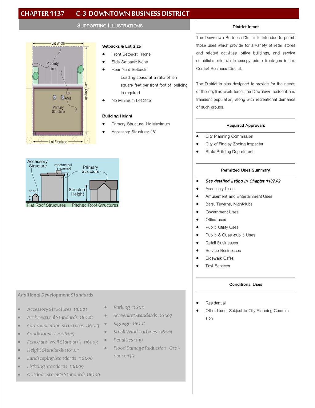
82 73
83 CHAPTER 1137 C-3 DOWNTOWN BUSINESS DISTRICT Intent Uses Permitted conditional uses permitted CHAPTER CONTENTS lot Requirements Penalties INTENT The C-3 Downtown Business District is designed to distinguish the area as unique from all other business district areas in the city. The unique characteristics include closer massing of buildings, taller buildings, pedestrianfriendly walkways; numerous uses to co-exist that are prohibited in other districts; using the City s rights-of-way for outdoor dining, sidewalk sales, and exhibits; lack of required setbacks, and; lack of parking requirements. The C-3 Downtown Business District is the most open zoning district and allows the mixing of uses that other zoning districts do not permit. Creative parking arrangements are encouraged but not required. Absent any parking requirements, there cannot be an expectation to provide ample curbside parking in front of each business door, nor can there be a code standard cited as reason for creating surface parking lots in place of existing buildings USES PERMITTED In the C-3 Downtown Business Districts the following principal uses shall be permitted: A. PROFESSIONAL SERVICES B. LIBRARIES C. RESTAURANTS D. ART AND ANTIQUE SHOPS E. BAKERIES RETAIL F. BED & BREAKFASTS G. BOOK STORES H. BARS, TAVERNS, NIGHT CLUBSBUSINESS SERVICES I. COFFEE SHOPS J. CONVENIENCE STORES K. CRAFT SUPPLIES L. DANCE STUDIOS M. DAY CARE CENTERS (TYPE A & B) N. DRY CLEANERS PERMITTED USES, CONTINUED: O. FLOWER SHOPS P. FOOD RETAILING Q. HARDWARE STORES R. HEALTH SERVICES S. ICE CREAM SHOPS T. BEAUTY SALONS U. BARBER SHOPS V. SIDEWALK CAFÉS (DEPENDENT ON APPROVAL FROM SAFETY SERVICE DIRECTOR). W. VETERINARY CLINIC (NO KENNEL) X. PAWN SHOPS Y. ACCESSORY USES Z. TAXI SERVICES 74
84 A. RETAIL TRADE B. AUTOMOTIVE SALES C. MOTELS AND HOTELS D. CINEMAS/THEATERS E. COMMERCIAL SCHOOLS F. CLUBS G. FINANCIAL INSTITUTIONS CONDITIONAL USES PERMITTED A. RESIDENTIAL USES B. OTHER USES Other uses are those which the City Planning Commission finds to be: H. SHOPPING MALLS I. PAWN SHOPS J. PARKING LOTS, RAMPS & DECKS K. ENTERTAINMENT USES L. GOVERNMENTAL USES M. PUBLIC AND QUASI-PUBLIC USES 1. Similar in character to one or more of the use groups indicated above. 2. Supports the high intensity nature of downtown including the pedestrian oriented goal LOT REQUIREMENTS A. FRONT & REAR YARD REQUIREMENTS No front or side yards are required in the C-3 Districts. B. REAR YARDS Loading spaces shall be provided in the ratio of at least ten (10) square feet per front foot of the building Where an alley exists or is provided at the rear of the buildings, the rear building setback and loading requirements may be computed from the center of said alley APPLICABLE CHAPTERS CHAPTER 907 Sidewalk Repair & Construction CHAPTER Screening CHAPTER Outdoor Storage Standards CHAPTER Parking Standards CHAPTER Sign Standards PENALTIES A violation of any provision of this chapter shall be deemed a violation of this Ordinance and subject the violator to enforcement and penalties as set forth in Chapter
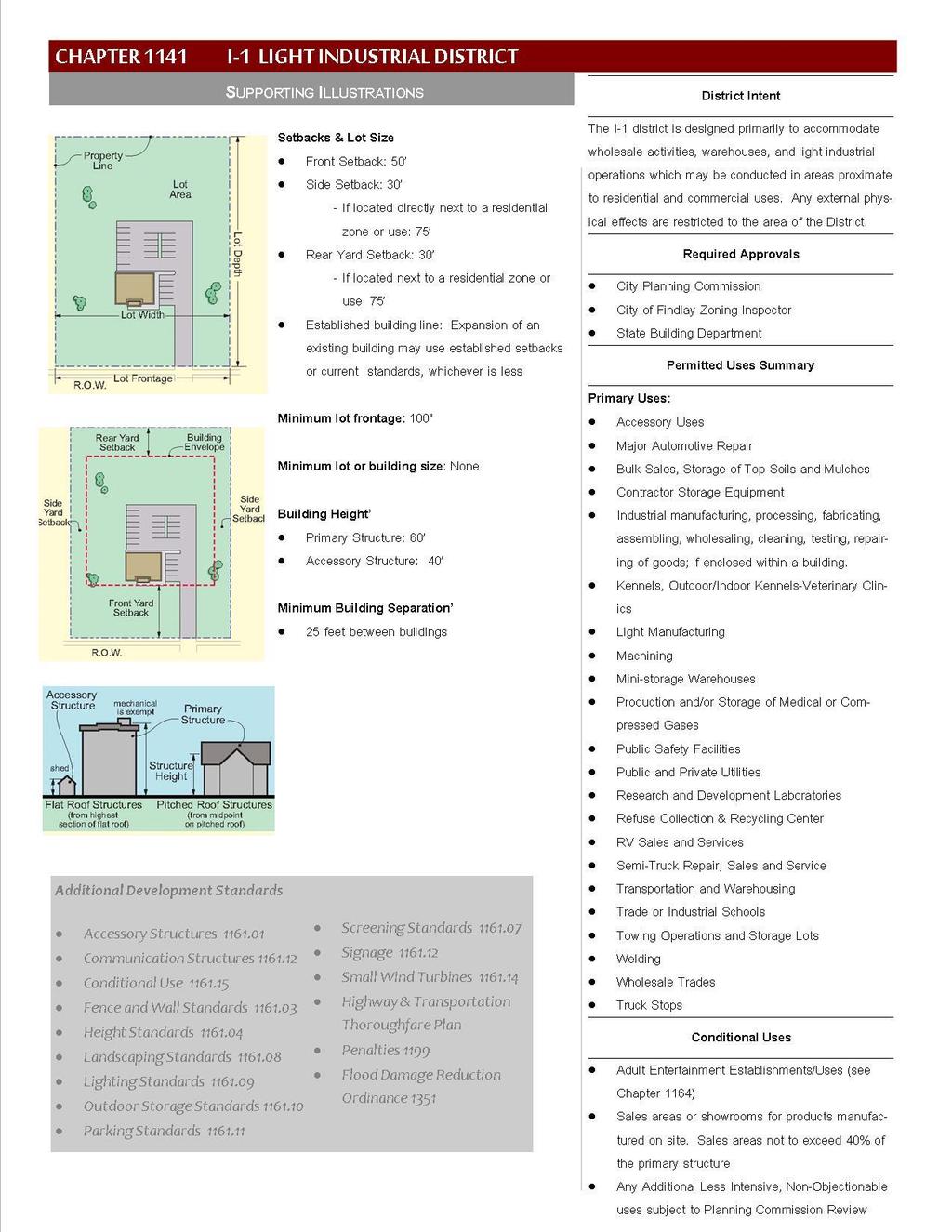
85 76
86 CHAPTER1141 I-1 LIGHT INDUSTRIAL DISTRICT Intent Permitted Use- Certificate Required Conditional Uses Required Building Setbacks Existing Setbacks CHAPTER CONTENTS Required Lot Frontage height requirements Minimum Building Separation Applicable Chapters Penalties INTENT The I-1 Light Industrial Districts are designed primarily to accommodate wholesale activities, warehouses, and light industrial operations which may be conducted in areas proximate to residential and commercial areas with attempts to provide as much isolation as possible and where external environmental and physical effects are restricted to the area of this District. No offensive or hazardous conditions shall be created by an industry. Disruptive activities shall be minimized to maintain tranquility if near commercial or residential areas and districts. These would include excessive traffic, dust, dirt, noxious gases, smoke, noise, fumes or vibrations. Permitted uses of this district exclude heavy industrial operations. The processing of raw material for shipment in bulk form to be used elsewhere is also prohibited, with the exception of agricultural products identified as North American Industrial Classification System Code Other Animal Food Manufacturing PERMITTED USE - CERTIFICATE REQUIRED A. INDUSTRIAL MANUFACTURING B. LIGHT MANUFACTURING C. WHOLESALE TRADE D. TRANSPORTATION & WAREHOUSING E. MACHINING F. WELDING G. MAJOR AUTOMOTIVE REPAIR H. SEMI-TRUCK REPAIR, SALES, AND SERVICE I. TRUCK STOPS J. RESEARCH & DEVELOPMENT LABORATORIES K. MINI-STORAGE WAREHOUSE L. TRADE OR INDUSTRIAL SCHOOLS M. PUBLIC SAFETY FACILITIES N. KENNELS OUTDOOR/INDOOR KENNELS-VETERINARY CLINICS O. REFUSE COLLECTION & RECYCLING CENTERS P. TOWING OPERATIONS & STORAGE LOTS Q. PRODUCTION AND/OR STORAGE OF MEDICAL OR COMPRESSED GASES R. RV SALES AND SERVICES S. CONTRACTOR STORAGE EQUIPMENT T. BULK SALES, STORAGE OF TOP SOILS & MULCHES, ETC. U. ACCESSORY USES 77
87 CONDITIONAL USES A. SALES AREAS OR SHOWROOMS FOR PRODUCTS MANUFACTURED ON-SITE Sales area not to exceed forty-percent (40%) of the primary structure B. ADULT ENTERTAINMENT ESTABLISHMENTS / ADULT ENTERTAINMENT USES (See CHAPTER 1164 ADULT ENTERTAINMENT ESTABLISHMENTS/ADULT) C. OUTDOOR DRIVE-IN MOVIE THEATERS D. ANY ADDITIONAL LESS INTENSIVE, NON-OBJECTIONABLE USES WHICH ARE SUBJECT TO PLANNING COMMISSION REVIEW REQUIRED BUILDING SETBACKS A. FRONT YARD SETBACK Fifty feet (50 ) B. SIDE YARD SETBACK 1. Thirty feet (30 ) 2. If adjacent to an area that is zoned or used for residential, the setback shall be seventy- five feet (75 ). C. REAR YARD SETBACK 1. Thirty feet (30 ) 2. If adjacent to an area that is zoned or used for residential, the setback shall be seventy- five feet (75 ) EXISTING SETBACKS A. INDUSTRIAL USES Expansion of existing industrial uses may use the established setbacks or the current standards, whichever is less REQUIRED LOT FRONTAGE A. MINIMUM LOT FRONTAGE Minimum required lot frontage is one hundred feet (100 ) HEIGHT REQUIREMENTS A. PRIMARY STRUCTURE Shall not exceed sixty feet (60 ) B. ACCESSORY STRUCTURE Shall not exceed forty feet (40 ) MINIMUM BUILDING SEPARATION A. MINIMUM SEPARATION Minimum distance between buildings twenty-five feet (25) 78
88 APPLICABLE CHAPTERS CHAPTER Screening CHAPTER Outdoor Storage Standards CHAPTER Parking Standards CHAPTER Sign Standards PENALTIES A violation of any provision of this chapter shall be deemed a violation of this Ordinance and subject the violator to enforcement and penalties as set forth in Chapter
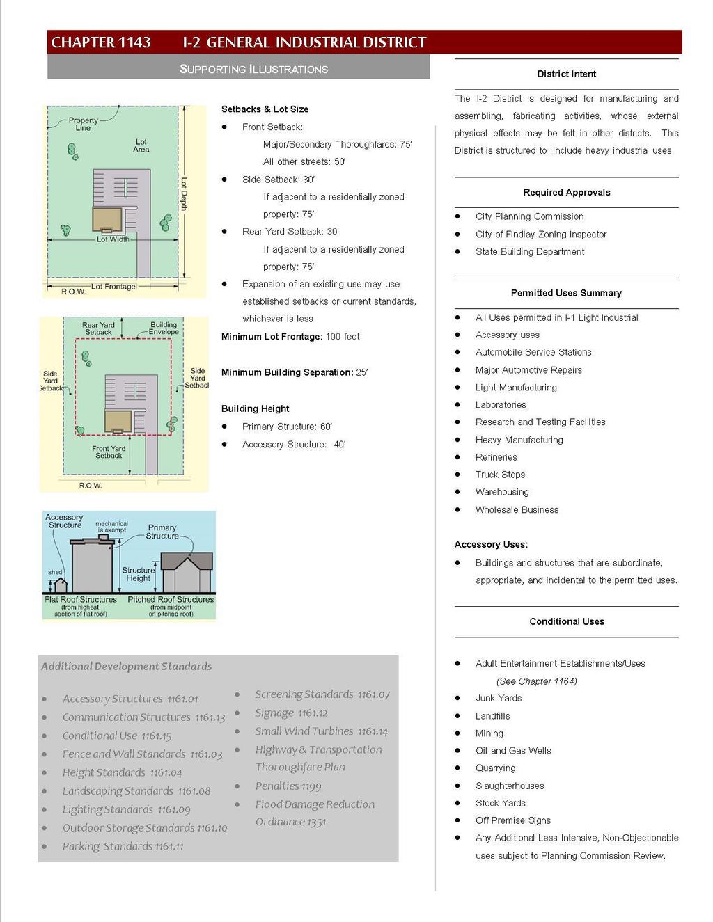
89 80
90 CHAPTER 1143 I-2 GENERAL INDUSTRIAL DISTRICT Intent Permitted Uses certificate REQUIRED Conditional Uses Required Building Setbacks Use of Existing Setbacks CHAPTER CONTENTS Required Lot Frontage Minimum Building Separation height requirements Applicable Chapters Penalties INTENT The I-2 General Industrial Districts are designed primarily for manufacturing and assembling, fabricating activities, including large scale and specialized industrial operations whose external physical effects may be felt in other districts. These Districts are structured to include heavy industrial use PERMITTED USES CERTIFICATE REQUIRED A. ALL USES PERMITTED IN I-1 B. LIGHT MANUFACTURING C. RESEARCH AND TESTING FACILITIES D. AUTOMOBILE SERVICE STATIONS E. MAJOR AUTOMOBILE REPAIR F. HEAVY MANUFACTURING CONDITIONAL USES A. JUNKYARDS B. STOCK YARDS C. SLAUGHTERHOUSE D. LANDFILLS E. OIL AND GAS WELLS F. ADULT ENTERTAINMENT ESTABLISHMENTS / ADULT G. ACCESSORY USES H. WHOLESALE BUSINESSES I. WAREHOUSING J. LABORATORIES K. TRUCK STOPS L. REFINERIES REQUIRED BUILDING SETBACKS A. FRONT YARD SETBACK 1. Major & secondary thoroughfares seventy-five feet (75 ) 2. All other streets fifty feet (50 ) ENTERTAINMENT USES G. MINING H. QUARRYING I. OFF PREMISE SIGNS J. ANY ADDITIONAL LESS INTENSIVE, NON- OBJECTIVE USES WHICH ARE SUBJECT TO PLANNING COMMISSION REVIEW. B. SIDE YARD SETBACK 1. Thirty feet (30 ); 2. If adjacent to an area that is zoned for residential, the setback shall be seventy-five feet (75 ). 81
91 C. REAR YARD SETBACK 1. Thirty feet (30 ); 2. If adjacent to an area that is zoned for residential, the setback shall be seventy-five feet (75 ) USE OF EXISTING SETBACKS Existing industrial operations with established setbacks less than required in this Chapter may be permitted to continue using the existing setback for current uses. Expansion of existing industrial uses may use the established setbacks or the current standards, whichever is less REQUIRED LOT FRONTAGE A. MINIMUM LOT FRONTAGE Minimum required lot frontage is one hundred feet (100 ) MINIMUM BUILDING SEPARATION A. MINIMUM SEPARATION Minimum distance between buildings twenty-five feet (25) HEIGHT REQUIREMENTS A. PRIMARY STRUCTURE Shall not exceed 60 feet (60 ) B. ACCESSORY STRUCTURE Shall not exceed forty feet (40 ) APPLICABLE CHAPTERS CHAPTER Screening CHAPTER Outdoor Storage Standards CHAPTER Parking Standards CHAPTER Sign Standards PENALTIES A violation of any provision of this chapter shall be deemed a violation of this Ordinance and subject the violator to enforcement and penalties as set forth in Chapter
92 CHAPTER Intent Permitted Uses Required Building Setbacks P-O PARK & OPEN SPACE DISTRICT CHAPTER CONTENTS Height Requirement INTENT The P-O Park & Open Space District is a Special Purpose zoning district intended to preserve and enhance major open space and recreational areas by protecting the natural amenities they possess and by accommodating development that is compatible with those natural amenities. The P-O district may also be applied to privately-owned open space areas within residential developments. Such a designation is an appropriate zoning classification for open space (non-development) parcels within subdivisions PERMITTED USES A. COMMUNITY RECREATION D. FESTIVALS & GATHERINGS B. PASSIVE RECREATION ACTIVITIES E. ACCESSORY STRUCTURES C. ACTIVE RECREATION ACTIVITIES REQUIRED BUILDING SETBACKS FRONT YARD SETBACK Front yard setbacks for any building, off-street parking area, playground, sport court or other active recreation area shall meet the requirements of the surrounding neighborhood front yard setbacks. In the case of multiple districts abutting, the most restrictive standards shall apply. SIDE AND REAR SETBACK Any building, off-street parking area, playground, sport court or other active recreation area must be set back at least 30 feet from any R-1, R-2, R-3 or R-4 district and at least 20 feet from any other residential or commercial district HEIGHT REQUIREMENT MAXIMUM BUILDING HEIGHT 35 FEET (35 ) 83
93 CHAPTER 1151 PLANNED RESIDENTIAL DEVELOPMENT (PRD) Intent Applications Re-Zoning Preliminary Development Plan Final Development Plan Additional Information Plats Required Design Requirements Standards CHAPTER CONTENTS Common Open Space Requirements Permitted Uses Designation Amendments Decisions by City Planning Commission Appeals Approval Period Penalties INTENT The Planned Residential Development (PRD) is a voluntary procedure that provides an overlay district that is intended to encourage innovative design, conservation of significant natural features, consolidation of open space, and provide for a mixture of residential uses with an integrated design in Residential zoning districts. The PRD allows greater design flexibility so that natural features and open space may be preserved and enhanced through the site s development in a coordinated and efficient manner. All proposals will be considered on their merits in relation to the following: adherence with the City of Findlay Comprehensive Land Use Plan; the context of the area in which the PRD is to be located; the adequacy and availability of public facilities and infrastructure; and the compatibility with the proposal s immediate surroundings. The City Planning Commission may require any reasonable condition or design accommodation to promote proper development in harmony to the community. It is not intended that the City Planning Commission automatically grant the maximum use or density APPLICATIONS Applicants are encouraged to meet with the local development officials, the Findlay City Engineer, Hancock County Engineer (if applicable) and the Hancock Regional Planning Commission. Applications for a PRD are made with the Findlay City Council and involve a preliminary and final review phase. Applicants must first submit an application for a Preliminary Review for Planned Residential Development Overlay along with a Preliminary Development Plan. If a project is approved in the preliminary phase, applicants may then make an application for a final review using a Request for Planned Residential Development Overlay. The application must be accompanied with a Final Development Plan. All applications must contain information required per Chapter Form of Application. 84
94 RE-ZONING Applications will only be considered for tracts of land zoned Residential. Petitions for a zoning change require a separate process PRELIMINARY DEVELOPMENT PLAN The Preliminary Development Plan shall contain information set forth in Chapter Application Requirements Preliminary Development Plan and B General Information. The request shall be referred to various agencies and utility providers for study. The City shall provide notice and publication of the Planning Commission s review. The proposal shall be reviewed with respect to its meeting the design requirements and standards as set forth in CHAPTERS Design Requirements and FINAL DEVELOPMENT PLAN Only Preliminary Development Plans that have been approved by the Planning Commission may apply for review as a Final Development Plan. The conditions for approval must be reflected in the Final Development Plan. Any deficiencies on the Preliminary Development Plan must be corrected ADDITIONAL INFORMATION The City Planning Commission may require additional information such as professionally prepared maps, survey drawings, studies or reports including environmental assessments, and/or traffic impact studies for the development. The expense of providing this information is the responsibility of the applicant PLATS REQUIRED A Planned Residential Development requires a plat map. Procedures for plat mat approval are set forth in the City of Findlay Subdivision Rules & Regulations. It is recommended that the platting process be initiated after the Preliminary Development Plan has been approved by the Planning Commission DESIGN REQUIREMENTS A. MINIMUM ACREAGE Minimum size tract of land must be twenty (20) acres. B. OPEN SPACE Ten percent (10%) of the gross parcel acreage shall be allocated to common open space and/or recreation areas. Up to 1/3 of the acreage may be comprised of retention areas, ponds, or flood areas. C. MAXIMUM IMPERVIOUS SURFACE No more than forty percent (40%) of the gross parcel acreage shall be devoted to coverage by buildings, street pavement, motor vehicle driveway pavement, and parking area pavement. 85
95 D. MINIMUM PERVIOUS SURFACE Not less than sixty percent (60%) of the gross parcel acreage shall be devoted to pervious surface, including yards, open space, common areas, water features, and new rights-of-way (i.e. boulevards and tree lawns). E. MAXIMUM DENSITY The maximum number of dwelling units permitted shall be 4.45 per net developable acre. For the purpose of this calculation, net residential acreage equals eighty percent of the gross parcel acreage. Gross parcel acreage is the total parcel area excluding existing public rights-of-way STANDARDS A. ADVERSE AFFECTS The property adjacent to the area included in the plan shall not be adversely affected by encroaching buildings, retention ponds or other drainage paths, vehicular circulation routes, location of refuse collection points, or the proximity of the entry of the new development on the public roadway. B. ZONING The plan must be consistent with the intent and purposes of The City of Findlay Zoning Ordinance to promote public health, safety, and general welfare. C. FLEXIBILITY The PRD approval may provide for such exceptions from the base district regulations governing lot size, configuration, location and height of buildings, yard requirements, and subdivision standards and regulations, as may be necessary or desirable to achieve the objectives of the proposed development. Such exceptions are to be designed: 1. To promote flexibility in design and permit planned diversity in the location of structures; 2. To promote the efficient use of land to facilitate a more economic arrangement of buildings, circulation systems, land use, and utilities; 3. To preserve to the greatest extent possible the existing landscape features and amenities and to utilize such features in a harmonious fashion; 4. To provide for more usable and suitably located recreational facilities and other public and common facilities than otherwise would be provided under conventional land development procedures; 5. To combine and coordinate architectural styles, building forms and building relationships within the planned residential development; 86
96 6. Appropriate setbacks for any one or group of structures and/or the total planned residential development COMMON OPEN SPACE REQUIREMENTS See Chapter Common Open Space Requirements PERMITTED USES A. USES PERMITTED IN THE BASE ZONING DISTRICTS DESIGNATION A. PUBLIC HEARING The Planning Commission shall hold a public hearing for Preliminary and Final Development Plans. B. PUBLIC NOTICE See Public Notice. C. ZONING MAP OVERLAY The Zoning Administrator shall cause the designation to be shown upon the official zoning map as an overlay without changing the underlying zoning. D. NOTIFICATION OF DESIGNATION Upon designation, the Planning Commission shall promptly notify the Zoning Office AMENDMENTS A. APPLICATION In the event that an applicant or owner who has obtained approval of a Final Development Plan wishes to change or modify said approved plan in any respect, he or she shall make a detailed written modification request, and file that request and fee with the Planning Commission. The application shall specifically detail the changes requested, and shall state the reasons for all changes requested. B. REVIEW & DETERMINATION The Planning Director shall review the amendment request and decide whether the application shall be treated as a major or minor change to the Final Development Plan using the criteria set forth in Chapter Minor Changes Definition (Site Plans & Plats). C. MAJOR CHANGE If the application is determined to be a major modification request, the matter shall be scheduled for a public hearing before the Planning Commission. The Planning Director shall provide written recommendations for the approval, modification, or the denial of the application to the Planning Commission. 87
97 DECISIONS BY CITY PLANNING COMMISSION Upon reaching a decision, the Planning Commission shall issue an oral decision followed by a written decision within seven (7) days after the date of the hearing, setting forth, with specificity, its findings and analyses APPEALS See Chapter Appeal of Administrative Decisions APPROVAL PERIOD A. CONSTRUCTION STARTED If construction of any phase of the approved Planned Residential Development begins within two (2) years after approval is granted, the approval shall be valid until the development is completed. B. NO CONSTRUCTION If no construction has begun within two (2) years after the approval is granted, the Planned Residential Development Overlay shall be void and the land shall revert to the district regulations in which it is located. The Planning Commission may approve an extension of the time limit. A project may not receive more than one extension. A maximum of ten (10) years to complete the project is permitted PENALTIES A violation of any provision of this chapter shall be deemed a violation of this Ordinance and subject the violator to enforcement and penalty as set forth in Chapter
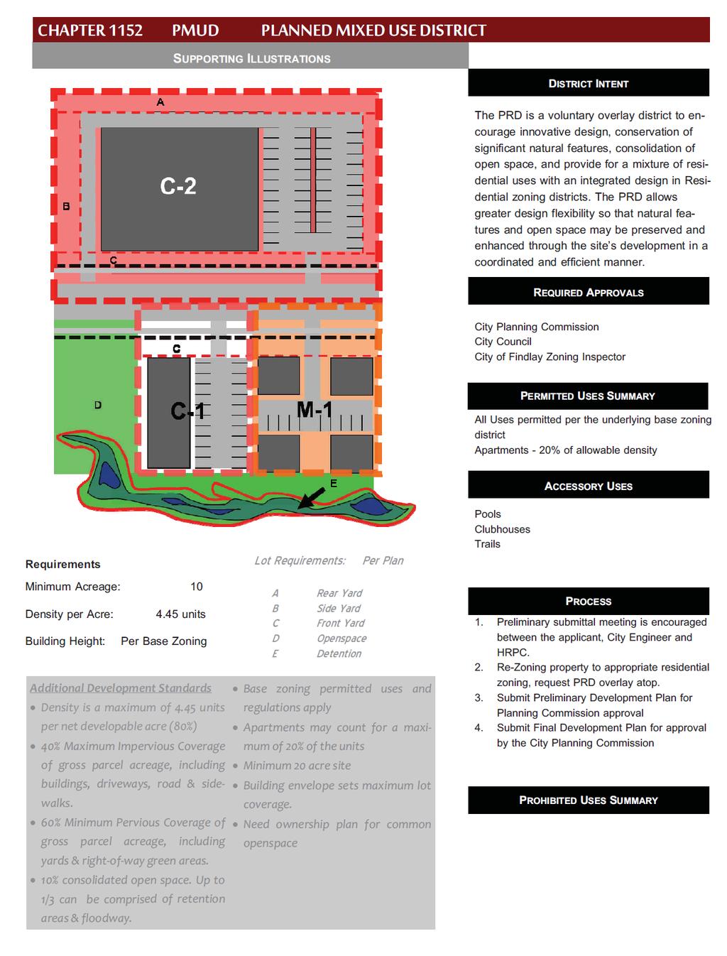
98 89
99 CHAPTER 1152 PLANNED MIXED USE DEVELOPMENT (PMUD) Intent Applications Re-zoning Preliminary Development Plan Final Development Plan Additional Information Plat Required Design Requirements and standards Standards CHAPTER CONTENTS Common Open Space Permitted Uses Designation Amendments Decisions by City Planning Commission Appeals Approval Period Penalties INTENT The Planned Mixed Use Development Overlay (PMUD) is a voluntary procedure that provides an overlay district that is intended to encourage innovative design, conservation of significant natural features, consolidation of open space, and to provide for a mixture of residential, commercial, and industrial uses with an integrated design. There are two types of PMUD overlays: Business-Residential and Business-Industrial. The zoning classifications allowable within a Business Residential PMUD include M Multi-Family Residential, O-1 Office, C-1 Local Business, and C-2 General Business. The zoning classifications allowable within a Business Industrial PMUD include O-1 Office Commercial, C-1 Local Business, C-2 General Business, and I-1 Light Industrial. The PMUD shall not provide for a mixture of residential and industrial uses. The PMUD allows greater design flexibility so that natural features and open space may be preserved and enhanced through the location and configuration of development while an array of uses may be integrated in a coordinated, efficient and compatible manner. All proposals will be considered on their merits in relation to the following: adherence with Findlay s Comprehensive Land Use Plan; the context of the area in which the PMUD is to be located; the adequacy and availability of public facilities and infrastructure; and the compatibility with the proposal s immediate surroundings. The City Planning Commission may require any reasonable condition or design accommodation to promote proper development in harmony with the community. It is not intended that the City Planning Commission automatically grant the maximum use or density APPLICATIONS Applicants are encouraged to meet with the city s development officials, including the city s engineering department and Hancock Regional Planning Commission. Applications for a PMUD are made with the City Planning Commission and involve a preliminary and final review phase. Applicants must first submit an application for a Preliminary Review for Planned Mixed Use Development Overlay along with a Preliminary 90
100 Development Plan. If a project is approved in the preliminary phase, applicants may then make an application for a final review using a Request for Planned Mixed Use Development Overlay. The application must be accompanied with a Final Development Plan RE-ZONING Applications will only be considered for tracts of land with a mixture of M-1 Multi-Family Residential, O-1 Office Commercial, C-1 Local Business, C-2 General Commercial and I-1 Light Industrial zoning districts. Petitions for a zoning change require a separate process. It is recommended that zoning changes be considered simultaneously with requests for PMUD Preliminary Development Plans and based on either the Business-Residential PMUD or Business-Industrial PMUD PRELIMINARY DEVELOPMENT PLAN The Preliminary Development Plan shall contain information set forth in Chapter Application Requirements Preliminary Development Plan and General Information, which will be referred to various city agencies and utility providers for study. The City shall provide notice and publication of the City Planning Commission review. The proposal shall be reviewed according to its meeting the design requirements and standards as set forth in Chapter and Chapter The approval of a Preliminary Development Plan shall be in effect for two (2) years to allow for the preparation and submission of the Final Development Plan. If the Final Development Plan has not been filed within this approval period, then the Preliminary Development Plan approval shall expire FINAL DEVELOPMENT PLAN Only Preliminary Development Plans that have been approved by the City Planning Commission may apply for review as a Final Development Plan. The conditions for approval must be reflected in the Final Development Plan. Any deficiencies on the Preliminary Development Plan must be corrected ADDITIONAL INFORMATION The City Planning Commission may require additional information such as professionally prepared maps, survey drawings, studies or reports including environmental assessments and/or traffic impact studies for the development. The expense of providing this information is the responsibility of the applicant PLAT REQUIRED A Planned Mixed Use Development will require a plat. Procedures for plat approval are set forth in Chapter 1109, Findlay s Subdivision Rules & Regulations. It is recommended the platting process be initiated after the Preliminary Development Plan has been approved by the City Planning Commission. Approved final plats shall be recorded within one (1) year after the approval of the final development plan. Plats not recorded within the one year period will expire and be of no force and effect. Bonds must be secured with the City prior to commencing any development. Plats must be recorded no later than 30 days after bonds are secured. 91
101 DESIGN REQUIREMENTS AND STANDARDS A. MINIMUM ACREAGE Minimum size tract of land must be ten (10) acres. B. OPEN SPACE Ten percent (10%) of the gross parcel acreage shall be allocated to common open space. Up to one third (1/3) may be comprised of retention areas, ponds, or flood areas. C. MAXIMUM IMPERVIOUS SURFACE No more than seventy percent (70%) of the gross parcel acreage shall be devoted to impervious coverage by buildings, street pavement, motor vehicle driveway pavement and parking area pavement. D. MINIMUM PERVIOUS SURFACE Not less than thirty percent (30%) of the gross parcel acreage shall be devoted to pervious surface, including yards, open space, common areas, water features, and new rights-of-way (i.e. boulevards and tree lawns). E. RESIDENTIAL DENSITY Residential may count for a maximum of forty percent (40%) of the net developable acreage of a Business/Residential PMUD. The maximum number of dwelling units permitted shall be six (6) units per acre with residential zoning. For the purpose of this calculation net residential acreage equals eighty percent of the gross parcel acreage zoned Multi-Family Residential Districts. Gross parcel acreage is the total parcel area excluding existing public rights-of-way. Additionally, residential uses located above commercial and office uses will not be counted toward the maximum density. See criteria in CHAPTER F. PUBLIC SERVICES All new principal buildings, structures and other uses shall be provided with public utilities and served by public streets. G. ACCESS Requires frontage on and direct access to, one or more dedicated and improved public arterial roads, or to an access road that runs parallel to an arterial road. Provision shall be included for future connections to other public roads as required by the City, the County Engineer and/or the Hancock Regional Planning Commission. H. COMMERCIAL SQUARE FOOTAGE Minimum commercial floor space requirements: as approved per development plan. 92
102 I. COMMON WALL RESIDENTIAL Residential standards for common wall/single-family attached dwelling, two-family dwellings, and multi-family dwellings: 1. Walkways and street trees- The City may require walkways to connect all dwelling areas with open space and to interconnect the open spaces. Where sidewalks or bike paths are required, they shall be separated from the paved street or parking lot surface by at least five feet (5') of landscaped or grassed tree lawn with street trees. 2. Yards and setbacks Approved per development plan. 3. Curbed street with enclosed drainage. 4. Underground utilities All utility lines constructed to service the proposed commercial uses shall be located underground. J. RESIDENTIAL USES IN C-1 AND C-2 Residential uses are permitted in C-1 and C-2 provided the residential uses meet the following requirements: 1. Located on second story or higher, above commercial and office uses excluding parking garages. 2. Minimum floor area of units to be 1,000 square feet. 3. Minimum lot width at the building line: as approved per final development plan. 4. Minimum side yards- for non-residential structures shall equal one-third (1/3) the sum of the height and depth of the structure, but in no case shall be less than one hundred (100 ) feet from any residential zoning district or Planned Residential District, or as approved per development plan. 5. Minimum Rear yard- for non-residential structures shall equal one-third (1/3) the sum of the height and width of the structure, but in no case shall be less than one hundred (100 ) feet from any residential zoning district or Planned Residential District, or as approved per plan. 6. Perimeter Area- No parking shall be constructed within twenty-five (25) feet of the lot line of an existing or proposed single family home or residentially zoned district. 93
103 K. WATER AND SEWER Centralized water and sewer service shall be provided unless otherwise approved per development plan. The appropriate agencies with jurisdiction shall indicate feasibility of water supply and wastewater disposal systems at the time of the preliminary development plan review. L. WALKWAYS AND STREET TREES The City may require walkways to connect parking areas with buildings. Where sidewalks or bike paths are required, they shall be separated from the paved street surface by at least five feet (5') of landscaping or grassed tree lawn with street trees that conform to City standards. M. ENVIRONMENTALLY SENSITIVE AREAS Jurisdictional wetlands, steep (over 20%) slopes, and/or 100-year floodplains shall be preserved to the greatest extent possible (note: city approval does not void requirement to comply with permitting and approvals from other required agencies, such as FEMA). N. BUILDING DESIGN The project shall give due regard to the intent of this chapter to integrate design and appearance within the planned area. Building footprints, building orientation, massing, roof shape and/or pitch shall respect the various elements of the project. The exterior materials should respect the context of the project area (i.e., adjacent to a historic building/neighborhood). O. BUILDING HEIGHT LIMITS As approved per plan. P. PARKING Off-street parking shall be provided, at the time of construction of the main structure or building, with adequate provisions for ingress and egress according to the development plan. In preparing and approving the parking plan, the parking provisions of Chapter shall be incorporated, or a divergence requested with approval based upon shared parking opportunities within the proposed development. Q. SIGNS Signs shall conform to provisions of this ordinance or a divergence shall be requested to be approved per plan. R. SUPPLEMENTAL CONDITIONS AND SAFEGUARDS The City Planning Commission and/or Council may impose additional conditions relating to the development with regard to the type and extent of the public improvements to be installed; landscaping; improvements and maintenance of open space areas; and other development 94
104 characteristics STANDARDS A. ADVERSE AFFECTS The property adjacent to the area included in the plan shall not be adversely affected by encroaching buildings, retention ponds or other drainage paths, vehicular circulation routes, location of refuse collection points, or the proximity of the entry to the new development on the public roadway. B. ZONING The plan is consistent with the intent and purposes of the Findlay Zoning Ordinance to promote public health, safety, and general welfare. C. FLEXIBILITY The planned residential development approval may provide for such exceptions from the base district regulations governing lot size, and configuration, location and height of buildings, yard requirements, and subdivision standards and regulations, as may be necessary or desirable to achieve the objectives of the proposed development. Such exceptions are to be designed: 1. To promote flexibility in design and permit planned diversity in the location of structures; 2. To promote the efficient use of land to facilitate a more economic arrangement of buildings, circulation systems, land use, and utilities; 3. To preserve to the greatest extent possible the existing landscape features and amenities and to utilize such features in a harmonious fashion; 4. To provide for more usable and suitably located recreational facilities and other public and common facilities than otherwise would be provided under conventional land development procedures; 5. To combine and coordinate architectural styles, building forms and building relationships within the planned residential development; and 6. To design appropriate setbacks for any one or group of structures and/or the total planned residential development COMMON OPEN SPACE See Chapter PERMITTED USES A. BUSINESS/RESIDENTIAL PMUD The Business/Residential uses include those provided for the Residential Districts, C-1 Local 95
105 Business and/or C-2 General Business District with the following exceptions: 1. Residential uses Permitted in C-1 Local Business District and C-2 General Business District according to the Design Requirements set forth in B. PROHIBITED USES The following uses shall not be permitted in the Business/Residential PMUD: a. Automobile Dealerships, new or used; b. Auto laundries; c. Lumber yards, contractor supply, etc. with outdoor display areas; d. Any use requiring outdoor storage/storage yards. C. BUSINESS/INDUSTRIAL PMUD The Business/Industrial uses include those provided for in C-1 Local Business District, C-2 Local Business District and I-1 Light Industry District with the following exceptions: Vehicle Sales- New or used; Sales operations for boats, campers, trailers, or other recreational vehicles. Commercial Kennels Auto laundries Trucking Operations Assembly Plants and similar operations Mini-storage warehouses Storage facilities for building materials, sand, gravel, brick, lumber, etc. Storage facilities for contractor s equipment and supplies. 10. Adult Uses D. TEMPORARY STRUCTURES Mobile homes and temporary buildings of a non-residential character may be used incidental to construction work on the premises or on adjacent public projects or during a period while the permanent structure is being constructed. The user of said structure shall obtain a permit for such temporary use, which permit shall be valid for six (6) months and may be renewed not more than one time. Renewal of the permit shall be at the discretion of the Zoning Administrator on finding of reasonable progress toward completion of the permanent structure or project. The Zoning Administrator may require provisions for 96
106 sanitary waste disposal, solid waste disposal and water supply, as are deemed necessary. The fees for such permit and renewals thereof shall be established by the Findlay City Council. Said temporary structure shall be removed no later than ten (10) days after expiration of said permit. No such temporary unit shall be occupied as a residence DESIGNATION A. PUBLIC HEARING The City Planning Commission shall hold a public hearing for Preliminary and Final Development Plans. B. PUBLIC NOTICE Notice shall be made in a newspaper of general circulation and notices mailed to property owners within and contiguous to and directly across the street from the subject parcel or parcels no less than two weeks prior to the public hearing. C. ZONING MAP OVERLAY The Planning Director shall cause the designation to be shown upon the official zoning map as an overlay without changing the underlying zoning. D. NOTIFICATION OF DESIGNATION Upon designation, the Planning Director shall promptly notify the Zoning Office AMENDMENTS A. APPLICATION In the event that an applicant or owner who has obtained approval of a Final Development Plan wishes to change or modify said approved plan in any respect, he or she shall make a detailed written modification request, and file that request and fee with the City Planning Commission. The application shall specifically detail the changes requested, and shall state the reasons for all changes requested. B. REVIEW AND DETERMINATION The Planning Director shall review the amendment request and decide whether the application shall be treated as a major or minor change to the Final Development Plan using the criteria set forth in CHAPTER Minor Changes Definition (Site Plans & Plats). C. MAJOR CHANGE If the application is determined to be a major modification request, the matter shall be scheduled for a public hearing before the City Planning Commission. The Planning Director shall provide written recommendations for the approval, modification, or denial of the application to the City Planning Commission. 97
107 DECISIONS BY CITY PLANNING COMMISSION Upon reaching a decision, the City Planning commission shall issue an oral decision followed by a written decision within seven (7) days after the date of the hearing, setting forth, with specificity, its findings and analyses APPEALS A. APPEALS OF ADMINISTRATIVE DECISIONS Applicants may appeal decisions by the Planning Director to the City Planning Commission. Notice of appeal shall be made within seven (7) days of the date of decision. The City Planning Commission shall consider the appeal at a regularly scheduled meeting within thirty days (30) of receipt of notice of the appeal. B. APPEALS OF PLANNING COMMISSION DECISIONS Decisions by the City Planning Commission shall be deemed final administrative orders for appellate purposes and shall be thereafter regulated by Chapter 2506 of the Ohio Revised Code APPROVAL PERIOD A. CONSTRUCTION BEGUN If construction of any phase of the approved Planned Mixed Used Development begins within two (2) years after approval is granted, the approval shall be valid until the development is completed up to a maximum approval period of ten (10) years from the approval date. B. NO CONSTRUCTION If no construction has begun within two (2) years after the approval is granted, the Planned Residential Development Overlay shall be void and the land shall revert to the district regulations in which it is located. The Planning Commission may approve an extension of the time limit. A project may not receive more than one extension. A maximum of ten (10) years to complete the project is permitted PENALTIES A violation of any provision of this chapter shall be deemed a violation of this Ordinance and subject the violator to enforcement and penalty as set forth in Chapter
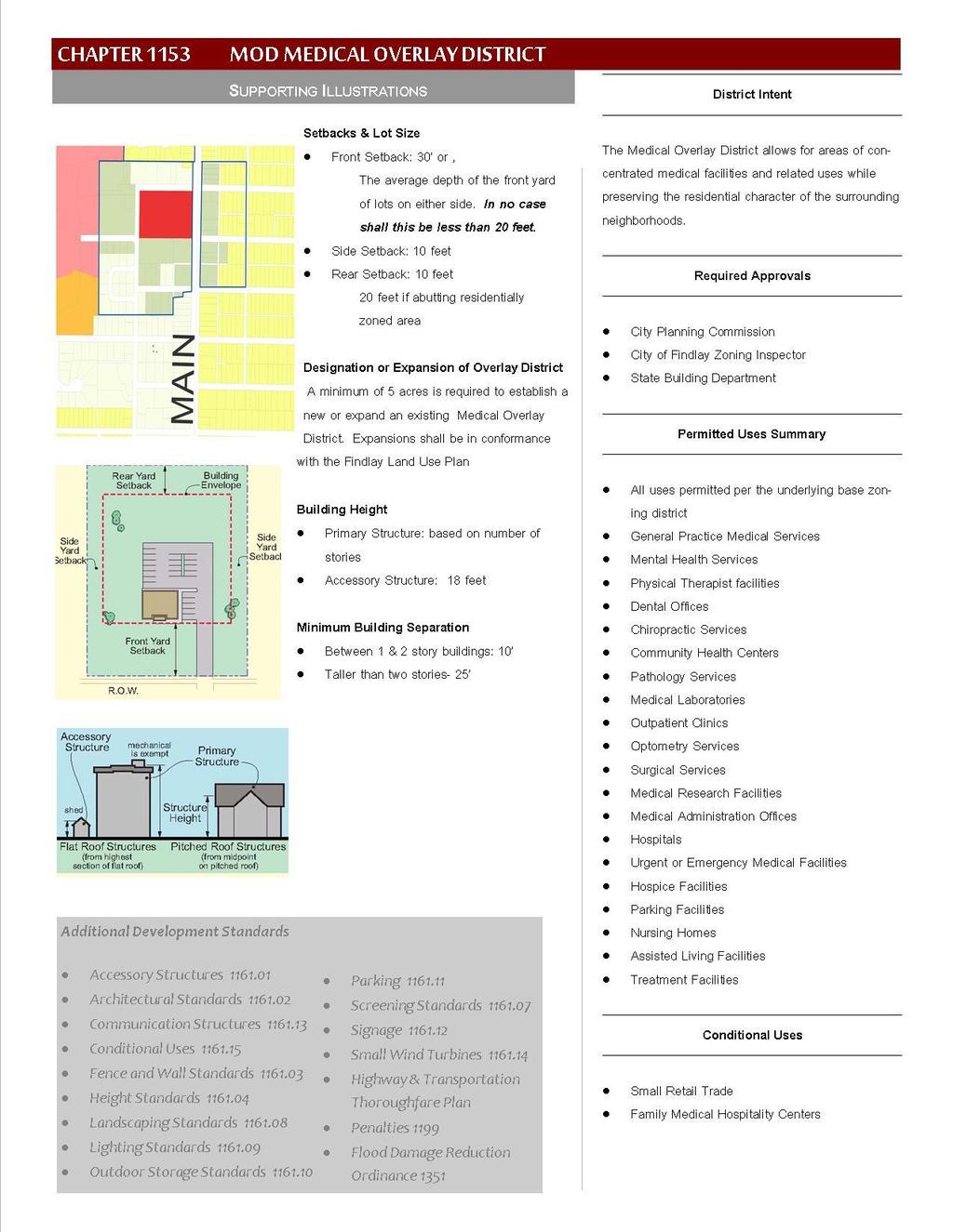
108 99
109 CHAPTER 1153 MOD MEDICAL OVERLAY DISTRICT Intent Permitted Use - Certificate Required Conditional Use Requiring Planning Commission Approval CHAPTER CONTENTS Required Building Setbacks Designation and/or Expansion of Overlay District Minimum Building Separation Penalties INTENT The purpose of the Medical Overlay is to allow for hospitals and areas around them to be developed with a concentration of medical facilities and related uses. The overlay will consider the character of the surrounding neighborhoods and business districts. The Medical Overlay District should have a campus-like atmosphere with pedestrian connections, landscaping, and compatible architecture. The Medical Overlay District is designated in conjunction with the underlying zoning classification. The Medical Overlay adds permitted and conditional uses to the underlying district. The conversion of existing homes to medical facilities is highly discouraged; rather the construction of new facilities is encouraged PERMITTED USE - CERTIFICATE REQUIRED The following uses are permitted in the Medical Overlay District in addition to those allowed per the underlying base zoning district: A. HEALTH CARE CLINICS B. HEALTH CARE OFFICES C. HOSPITALS D. URGENT CARE OR EMERGENCY CARE FACILITIES E. SURGERY CENTERS F. COMMUNITY HEALTH CENTERS G. ASSISTED LIVING FACILITIES H. NURSING HOME AND/OR CONVALESCENT HOMES I. HOSPICE FACILITIES J. MEDICAL-RELATED EDUCATION AND RESEARCH FACILITIES K. MEDICAL ADMINISTRATION OFFICES L. MEDICAL LABORATORIES M. PARKING FACILITIES CONDITIONAL USE REQUIRING PLANNING COMMISSION APPROVAL The following uses are permitted in the Medical Overlay District in addition to those allowed per the base zoning district subject to the following conditions: A. SMALL RETAIL TRADE 1. Must be ancillary or common to areas around medical facilities. Examples include but are not limited to: coffee shops, pharmacies, book stores, florists, medical supply stores, and retail banking. 2. All retail facilities shall have a maximum square footage of 4,000 square feet. 3. Buildings along South Main Street must be designed to face South Main Street and 100
110 circulation must be located behind the building. 4. Buildings located along South Main Street at intersections with W. Pearl Street, Wallace Street, and Highland Drive must address both streets as front yards. 5. Drive-thru operations are not permitted, with the exception of retail banking. See note (6) below. 6. Drive thru operations for retail banking shall not have more than two (2) drive thru lanes. Automated Teller Machines (ATM) may not add a third lane or drive, but are permitted in one of the other two lanes. It is encouraged that ATM s be located along a sidewalk to enhance the walkable character of the Hospital Overlay District., or 7. Signage shall be limited to ground and wall signs only. Low-profile signs shall not exceed six (6 ) feet in height and 36 square feet per side with a maximum of two sides. Any boundary with a residential use shall have the appropriate landscape buffer per the landscaping ordinance. Due to the campus atmosphere, wayfinding sign permitting per approval of zoning officer. B. FAMILY MEDICAL HOSPITALITY CENTERS 1. Limit of six (6) hospitality centers within the district. 2. The hospitality centers may be single family, duplex, or multi-family. 3. The duplex and multi-family units shall meet the standards for a multi-family living unit REQUIRED BUILDING SETBACKS A. FRONT YARD SETBACK The front yard setback shall be thirty feet (30 ), or the average depth of the front yard setback of the lots on either side; the lesser measurement shall be used. In no case shall the setback be less than twenty feet (20 ). B. SIDE YARD SETBACK The side yard setback requirement is ten feet (10 ) C. REAR YARD SETBACK Ten feet (10 ); Twenty feet (20 ) if abutting a residentially zoned district DESIGNATION AND/OR EXPANSION OF OVERLAY DISTRICT A. MINIMUM REQUEST A minimum of five (5) acres is required to establish or to expand a new or an existing overlay district. 101
111 B. LAND USE PLAN Expansions shall occur in conformance with the Findlay Land Use Plan MINIMUM BUILDING SEPARATION A. 1 & 2 STORY BUILDINGS Ten feet (10 ) B. BUILDINGS OVER 2 STORIES Twenty five feet (25 ) PENALTIES A violation of any provision of this chapter shall be deemed a violation of this Ordinance and subject the violator to enforcement and penalty as set forth in Chapter
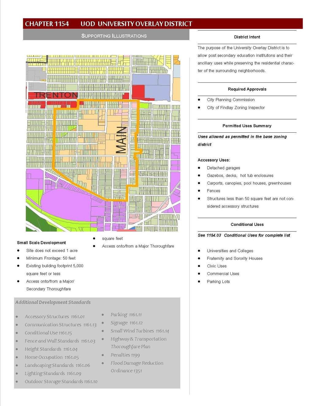
112 103
113 CHAPTER 1154 UOD UNIVERSITY OVERLAY DISTRICT Intent Permitted Uses Conditional Uses CHAPTER CONTENTS Development Category Design Requirements Penalties INTENT The purpose of the University Overlay District is to allow post-secondary education institutions and their ancillary uses while preserving the residential character of the surrounding neighborhoods. The university district shall have a campus-like atmosphere with pedestrian connections, landscaping, and compatible architecture. The University District is designated in conjunction with the underlying zoning classification. The University Overlay District adds permitted and conditional uses to the underlying district PERMITTED USES Uses permitted in the base zoning district CONDITIONAL USES The conditional uses permitted in the University Overlay District are subject to Chapter Development Category of the site for which it is proposed. The following uses are permitted subject to the associated conditions: A. UNIVERSITIES AND COLLEGES All universities, colleges, and schools are permitted, along with the associated support buildings and uses, on condition they are identified as part of a campus master plan that has been reviewed and adopted by the institution s board of directors and the Findlay City Planning Commission. Structures, buildings, and uses may include but are not limited to: 1. Education halls 2. Assembly halls 3. Concert halls 4. Athletic facilities and complexes 5. Student life centers 6. Dormitories and residence halls 7. Faculty housing B. FRATERNITY AND SORORITY HOUSES Subject to the following conditions: 1. Sanction by Parent Society 2. Approval of University Administration buildings Libraries Theaters Parking lots and garages Utility stations and infrastructure Maintenance facilities 104
114 C. CIVIC USES 3. Compliance with Off-Street Parking requirements per Chapter Parking Standards. Libraries and community centers, public or private Conditions include: a. Access via major or minor thoroughfare b. Hours of operation limited to between 6:00 a.m. and 11:00 p.m. D. PASSIVE AND ACTIVE RECREATIONAL PARKS Conditions include: a. Hours of operation limited to between 6:00 a.m. and 11:00 p.m. b. Parking requirements listed in University Overlay District Chapter Conditional Uses, Section H Parking Lots. E. THEATERS, ATHLETIC FACILITIES, AND SIMILAR PLACES OF ASSEMBLY, FOR BOTH INDOOR AND OUTDOOR USES SUBJECT TO: a. Access via major or minor thoroughfare b. Multiple access points for ingress-egress to site c. Clear passage stacking for a minimum of ten (10) vehicles on site, measuring from the access/right-of-way line. d. Low profile signage e. When abutting a residential zoning classification, it must meet screening requirements set forth in Chapter Screening. f. Waste disposal/trash collection areas may not be located within the base zoning s front, side, or rear yard setbacks. F. COMMERCIAL USES The following uses share the same conditions for approval. The conditions are listed in Chapter Conditional Uses, Section G Conditions for commercial uses Professional Offices Restaurants Day Care Centers Art and Antique Shops Bakery Retail Bed & Breakfasts Book Stores 8. Business Services 9. Coffee Shops 10. Convenience Stores 11. Banks, Financial Institutions 12. Craft Supplies 13. Dance Studios 105
115 14. Laundromats 19. Ice Cream Shops 15. Flower Shops 20. Beauty Salons 16. Food Retailing 21. Barber Shops 17. Hardware Stores 22. Boarding and lodging 18. Health Services houses G. CONDITIONS FOR COMMERCIAL USES IN THE UNIVERSITY OVERLAY DISTRICT a. Access via major or minor thoroughfare b. Hours of operation limited to between 6:00 a.m. and 11:00 p.m. c. Parking per Chapter Conditional Uses H Parking Lots d. Low profile signage A-Frames e. When abutting a residential zoning classification, it must meet screening requirements set forth in Chapter Screening. f. Waste disposal/trash collection areas may not be located within the base zoning s front, side, or rear yard setbacks. H. PARKING LOTS a. Parking must be illuminated b. Parking requirement may be reduced by fifty percent (50%) if the site is connected by dedicated walkway or trail to another park, civic space, or civic use facility (i.e. school, museum, university). A city sidewalk does not meet the criteria for the parking exemption. c. Parking lots shall be located away from non-university residential areas DEVELOPMENT CATEGORY All uses permitted by the University Overlay District in addition to those expressly permitted in the base zoning district shall be reviewed and approved using criteria established in two categories of development: Small Scale Development, and Large Scale Development. Building setbacks are based on three categories of height: buildings one or two stories in height, buildings three stories in height or less, and; buildings in excess of three stories. A. BUILDINGS LESS THAN 30 FEET TALL Front Yard Setback Twenty five feet (25 ) Side Yard Setback Five feet (5 ) Twenty feet (20 ) if adjacent to single family residential use 106
116 3. Rear Yard Setback Twenty feet (20 ) Thirty feet (30 ) if adjacent to single family residential use B. BUILDINGS 30 FEET TALL OR MORE Front Yard Setback Forty feet (40 ). Side Yard Setback: Twenty feet (20 ) Thirty (30 ) feet if adjacent to single family residential use Rear Yard Setback Twenty feet (20 ) Thirty (30 ) feet if adjacent to single family residential use DESIGN REQUIREMENTS 1. Low profile signage and A-Frames only 2. Screening requirements per Chapter Screening 3. Waste disposal/trash collection areas may not be located within the base zoning s front, side, or rear yard setbacks. 4. Parking: Parking Requirement may be reduced by 50% at the discretion of Planning Commission. 5. In no instance shall outdoor merchandise be displayed in a required front yard setback PENALTIES A violation of any provision of this chapter shall be deemed a violation of this Ordinance and subject the violator to enforcement and penalties as set forth in Chapter
117 CHAPTER 1155 RIPARIAN CORRIDOR OVERLAY DISTRICT Purpose Intent Riparian Areas Defined Prohibited Uses Prohibited Activities Area Yard and Height Regulations CHAPTER CONTENTS Riparian Setback Exemptions Standards and Regulations Permitted Uses Exceptions Penalties PURPOSE It is hereby determined that the system of rivers, streams, and other natural watercourses contributes to the health and safety of the residents of the City of Findlay. The specific purpose and intent of the Riparian Corridor Overlay District is to regulate land use and construction within riparian areas to: A. IMPACT REDUCTION Reduce flood impacts by absorbing peak flows, slowing the velocity of floodwaters, and regulating base flow. B. WATERCOURSE STABILIZATION Stabilize the banks of watercourses to reduce bank erosion and then downstream transport of sediments eroded from watercourse banks. C. POLLUTANT REDUCTION Reduction of pollutants in watercourses during periods of high flows by filtering, settling, and transforming pollutants in runoff before they enter watercourses. D. HABITAT Provide habitat to a wide array of wildlife by maintaining diverse and connected riparian vegetation. E. IMPROVE CITY ECONOMY Benefit the City economically by minimizing encroachment on watercourse channels and the need for costly engineering solutions such as dams, retention basins, and rip rap to protect structures by reducing property damage and threats to the safety of watershed residents, and by preserving the character and property values of the City INTENT It is the policy of City of Findlay to encourage the establishment of naturally vegetated riparian setbacks along watercourses. Property owners who own land beside watercourses are encouraged to assume responsibility for helping to maintain water quality and the environmental health of riparian systems within the City of Findlay. 108
118 Riparian setback requirements defined herein represent only minimal protection to water quality, and property owners are encouraged to do more to protect the ecological health of waterways. Setbacks along watercourses, including rivers, streams, major and minor tributaries, serve as buffer areas. The District has prepared and adopted plans in preparation of the Flood Mitigation effort underway to minimize or reduce flooding of the Blanchard River and its tributaries. Once the mitigation effort is complete, the overlay district should be designated on the zoning map. As an overlay zone, this zoning district imposes additional development standards for new construction beyond those of the underlying zoning district RIPARIAN AREAS DEFINED A. STREAMS Streams include rivers, creeks and ditches and appear on at least one of the following maps: USGS topographical map, or soils maps located in the Soil Survey for Hancock County, Ohio, USDA, and NRCS. B. 100 YEAR FLOODPLAIN The 100-year floodplain shall be defined by FEMA Flood Insurance Rate Map as adopted by City of Findlay. C. PERMITTED/CONDITIONALLY PERMITTED Permitted and conditionally permitted uses in the underlying zoning district(s) are allowed except for those identified as prohibited uses in Chapter and the PROHIBITED USES The following uses are expressly prohibited. Where there is a conflict in an underlying zoning district, this Chapter prevails. A. ASPHALT PLANTS B. DRY CLEANERS C. GASOLINE SERVICE STATIONS D. CAR WASHES E. JUNKYARDS F. LANDFILLS OR TRANSFER STATIONS G. RECYCLING CENTER H. QUARRIES & BORROW PITS I. PETROLEUM STORAGE, SALES AND DISTRIBUTION J. SAND AND GRAVEL EXTRACTION K. ROAD MAINTENANCE FACILITIES L. ROAD SALT STORAGE M. UNDERGROUND STORAGE TANKS N. USE OR STORAGE OF ANY CAUSTIC MATERIALS 109
119 PROHIBITED ACTIVITIES Additionally, the following activities are prohibited: A. CONSTRUCTION Construction of principal or accessory structures and placement of fill, except when constructing an approved stream crossing. B. PAVING The creation of new impervious surfaces, unless within a public right-of-way or approved private street constructed as part of a major residential subdivision. C. SUBSURFACE ACTIVITY There shall be no drilling for petroleum or mineral products, mining activity, altering, dumping, filling or removal of riverine materials or dredging (except as may be necessary as part of a stream restoration project or other similar activity carried out by a government agency or authorized organization). D. CLEAR-CUTTING Modification of the natural vegetation shall be limited to conservation maintenance that the landowner deems necessary to control noxious weeds; to such plantings as are consistent with these regulations; to such disturbances as are approved under these regulations; and to the passive enjoyment, access and maintenance of landscaping or lawns existing at the time of passage of these regulations AREA YARD AND HEIGHT REGULATIONS In addition to all area, yard and height regulations established in the underlying zoning district, the following development standards shall apply within the Riparian Corridor Overlay District and to all areas in the City of Findlay that meet the criteria per Chapter RIPARIAN SETBACK Widths of buffers are measured as horizontal map distance outward from the ordinary top of the bank on each side of a stream per Chapter The following shall apply to the riparian setback: A. DELINEATION The applicant shall be responsible for delineating the riparian setback and identifying this setback on all subdivisions, site plans, and/or zoning permit applications. This delineation shall be done at the time of application of the preliminary plans, or all plans that are required, or at the time of submission of any permit applications. This delineation may be subject to review and approval by the City of Findlay. As the result of this review, the City may require further studies from the applicant. 110
120 B. CONSTRUCTION FENCING Prior to any soil disturbing activity, the riparian setback shall be clearly delineated with construction fencing or other suitable material by the applicant on site, and such delineation shall be protected with silt fencing throughout soil-disturbing activities. The delineated area shall be maintained in an undisturbed state unless otherwise permitted by these regulations. Silt fencing shall be removed when a development project is completed and grass and vegetation area is established and stable. C. CONFORMANCE No approvals or permits shall be issued by the City of Findlay prior to the determination of the riparian setback in conformance with this ordinance. D. RECORDING Upon completion of an approved subdivision, the riparian setback shall be permanently recorded on the plat records for the County of Hancock. The riparian setback area shall be formally defined by a legal description defined by meets and bounds EXEMPTIONS The following are exempt from the terms and protection of these regulations: grassy swales, roadside ditches, drainage ditches created at the time of a subdivision to convey stormwater to another system, tile drainage systems, and stream culverts STANDARDS AND REGULATIONS All areas located within the riparian setbacks as set forth in this Chapter are subject to the standards and regulations. Alteration of this natural area is strictly limited. Except as otherwise provided in these regulations, the riparian setback shall be preserved in its natural state for rivers, creeks and ditches and their respective setbacks as follows: A. RIVERS 75 FROM TOP OF BANK ON EACH SIDE. B. CREEKS 25 FROM TOP OF BANK ON EACH SIDE PERMITTED USES Within the riparian setback, the following uses and activities are permitted: A. RECREATION TRAILS Construction of multiple use recreational trails provided such trails are located at least twenty feet (20 ) from the ordinary top of bank of the watercourse. B. MAINTENANCE The removal of individual trees that are in danger of falling and causing damage to structures or causing blockage to the stream flow. 111
121 C. TIMBER CUTTING Additionally, timber cutting is permitted when accomplished under the advice and guidance of an appropriate government agency and is necessary to preserve the forest from pest infestation, disease infestation, or fire threat. D. STREAM CROSSINGS (See City of Findlay s Flood Damage Reduction Ordinance). E. RE-VEGETATION AND/OR REFORESTATION Re-vegetation and reforestation of the riparian setback shall be allowed. Information pertaining to species of shrubs and vines recommended for stabilizing flood prone areas along streams may be obtained at the Hancock SWCD. F. BEST MANAGEMENT PRACTICES For stream bank stabilization or erosion control, Best Management Practices may be allowed if such practices are within permitted uses by the local, state, and federal government regulations and are ecologically compatible and with the emphasis on the use of natural materials and native plant species where practical and available. Such stream bank stabilization/erosion control practices shall only be undertaken upon approval of Stormwater Pollution Prevention Plan by the City of Findlay EXCEPTIONS The Planning Commission may authorize a variance from the above development standards. Such a variance may include: a reduction in the width of the riparian setback, or a modification of the requirements listed in Chapter As a condition for requesting a variance from these regulations, evidence shall be provided that the site and any construction to be done thereon have been reviewed by the City of Findlay. Such a variance may be found to be appropriate when it can be shown that strict application of these standards will result in the loss of a reasonable use of a property. Conditions on such variances may include other reasonable and necessary measures to adequately protect the riparian environment, such as erosion control measures and new plantings of native vegetation PENALTIES A violation of any provision of this chapter shall be deemed a violation of this Ordinance and subject the violator to enforcement and penalties as set forth in Chapter
122 CHAPTER 1161 DEVELOPMENT STANDARDS Accessory structures Architectural Standards Fence and Wall Standards Height Standards Home Occupation Standards Landscaping Standards Screening Standards Landscaping Standards; Interstate Screening Lighting ordinance CHAPTER CONTENTS Outdoor Storage Standards Parking Standards Sign Standards Communication Structures Alternative Energy Conditional Use Requirements Common Open Space Requirements Penalties ACCESSORY STRUCTURES ACCESSORY STRUCTURES R-1, R-2, R-3 & R-4 SINGLE FAMILY AND TWO-FAMILY RESIDENTIAL DISTRICTS The following standards shall apply to the following zoning districts: R-1, R-2, R-3, R-4 A. PERMITTED ACCESSORY STRUCTURES The following accessory structures shall be permitted and require a zoning permit: 1. Buildings or structures such as detached garages 2. Gazebos, decks, and hot tub enclosures 3. Carports, pool houses and greenhouses 4. Sheds, Swimming Pools 5. Fences B. PERMITTED NO ZONING PERMIT REQUIRED 1. Structures with a building footprint of fifty square feet (50 ) or less. No such structures are permitted in any front yard. 2. Wheel Chair ramps (Exempt from Chapter C (3)) Restricted in Front Yard. C. GENERAL REQUIREMENTS 1. Accessory structures shall comply with the following requirements: Relationship to Primary Use: Shall be customarily incidental, accessory and subordinate to, and commonly associated with the primary use and occupant of the same parcel. Owners of multiple, contiguous parcels that desire treatment as though they are a single lot must combine the parcels with a new legal description and deed 113
123 at the Hancock County Auditor s Office. Proof of a recorded deed must be provided as part of the application. Example: This requirement prevents a property owner of multiple parcels from erecting an accessory structure on a separate, vacant but recorded lot that could eventually be sold and thus become an illegal non-conforming use and lot under CHAPTER 1162 NONCONFORMITY Sections Maximum Floor Area: The combined building footprint of all accessory buildings on site shall not exceed nine hundred (900) square feet. One accessory building that is fifty square feet (50 sq. ft.) or less shall be exempt from this requirement. In no instance shall any separate accessory building be larger than nine hundred square feet (900 sq. ft.). Unless the lot equals or exceeds one (1) acre in size the maximum floor area cannot exceed twelve hundred square feet (1,200 sq. ft.) or eighty percent (80%) of the primary structure footprint whichever is less. All accessory buildings are subject to maximum lot coverage requirements as prescribed in each zoning district. The following stipulations apply to properties without attached garage: a. Any detached garage up to five hundred seventy-six square feet (576 sq. ft.) shall not count against the total allowable accessory building area. Any detached garage greater than five hundred seventy-six square feet (576 sq. ft.) will have that area in excess of five hundred seventy-six square feet (576 sq. ft.) deducted from the maximum allowable accessory building area. b. An existing primary garage less than five hundred seventy-six square feet (576 sq. ft.) can be increased in area so the total building area does not exceed five hundred seventy-six square feet (576 sq. ft.), even if the property contains other accessory buildings that exceed the nine hundred square foot (900 sq. ft.) limit. 3. Restricted in Front Yard Requirement: No accessory structure shall be permitted in the required front yard. 4. Conversions: Permanently attaching any accessory building to a primary building shall be considered a conversion and shall be subject to all required setbacks for primary structures. These connections must include a four feet (4 ) width building footprint, must be enclosed, have doorways on either side, and have a foundation. 114
124 D. SETBACKS Example: A detached garage on a street side yard is proposed to be attached to the primary building with a breezeway. The garage is located in R-3 Single Family and is five feet (5 ) from the property line. In this instance the conversion would violate the setback required for primary structures and applicant would not be issued a zoning permit. 1. Front Yard Setback - Accessory structures shall not encroach upon the required front setback of the lot on which they are located, except fences and decks. 2. Side and Rear Setbacks - Accessory structures may not be located closer than three feet (3 ) of the side yard and five feet (5 ) of the rear yard. 3. Screening - In no case shall an accessory structure encroach upon any required screening. E. OCCUPANCY: Accessory buildings shall not be occupied as a dwelling. F. HEIGHT: The maximum height allowed for an accessory building is eighteen feet (18 ) ACCESSORY STRUCTURES CD, M-1, M-2 MULTI-FAMILY RESIDENTIAL DISTRICTS A. PERMITTED ACCESSORY STRUCTURES The following accessory structures shall be permitted and require a zoning permit: 1. Buildings or structures such as detached garages 2. Gazebos, decks, porches, and hot tub enclosures 3. Carports, canopies, pool houses and greenhouses 4. Fences 5. Management offices and other facilities normally associated with tenants convenience, such as washing machine facilities, exercise facilities, etc. B. PERMITTED NO ZONING PERMIT REQUIRED 1. Building footprint of fifty square feet (50 sq. ft. ) or less 2. Wheel Chair ramps (Exempt from Chapter C (3)) Restricted in Front Yard. C. GENERAL REQUIREMENTS Accessory structures shall comply with the following requirements: 1. Relationship to Primary Use: Shall be customarily incidental, accessory and subordinate to, and commonly associated with the primary use of the lot. 115
125 D. SETBACKS 2. Ownership: Shall be operated and maintained under the same ownership as the primary structure. 3. Restricted in Front Yard Requirement: No accessory structure shall be permitted in the required front yard. 1. Front Yard Setbacks - Accessory structures, except fences shall not encroach upon the established front setback of the lot on which they are located. 2. Side and Rear Setbacks - Accessory structures, excluding fences may not be located closer than ten feet (10 ) to any lot line. 3. Screening - In no case shall an accessory structure encroach upon any required screening. 4. Street Side Yard Setback - Setbacks shall be fifteen feet (15 ). E. OCCUPANCY Accessory building shall not be occupied as a dwelling. F. HEIGHT The maximum height allowed for an accessory building is eighteen feet (18 ). G. DUMPSTER AND TRASH ENCLOSURES See Chapter Screening ACCESSORY STRUCTURES O-1 OFFICE, C-1, C-2 & C-3 COMMERCIAL DISTRICTS A. PERMITTED ACCESSORY STRUCTURES 1. Buildings or structures such as detached garages, carports, canopies, and patios for outdoor seating 2. Management offices and other facilities normally associated with the primary business. 3. Dumpster enclosures, mechanical equipment 4. Greenhouses Cart corrals 5. Similar accessory buildings or structures 6. Fences. B. PERMITTED NO ZONING PERMIT REQUIRED 1. Structures with a building footprint less than fifty (50) square feet 2. Wheel Chair Ramps C. GENERAL REQUIREMENTS Accessory structures shall comply with the following requirements: 116
126 D. SETBACKS 1. Relationship to Primary Use: Shall be customarily incidental, accessory and subordinate to, and commonly associated with the primary use of the parcel. 2. Ownership: Shall be operated and maintained under the same ownership as the primary structure. 1. Front Yard Setbacks - Accessory structures shall not encroach upon the established front setback of the lot on which they are located with exceptions being: a. Fences b. Outdoor seating/dining areas. 2. Side and Rear Setbacks: Accessory structures may encroach the side and rear setbacks, but may not be located closer than ten (10) feet to the lot line, except fences. 3. Screening - In no case shall an accessory structure encroach upon a defined buffer area. E. ENCLOSED BUILDING REQUIREMENT All uses and operations shall be conducted within completely enclosed buildings with the following exceptions: 1. Off-street parking 2. Drive-thru customer service windows 3. Outdoor dining areas, F. MAXIMUM FLOOR AREA The combined gross floor area of all accessory structures on site shall not exceed seventy five percent (75%) of the size of the primary structure. G. OCCUPANCY Accessory buildings shall not be occupied as a dwelling. H. HEIGHT The maximum height allowed for an accessory building is eighteen (18) feet. I. DUMPSTER AND TRASH ENCLOSURES See Chapter Screening ACCESSORY STRUCTURES I-1 & I-2 INDUSTRIAL DISTRICTS A. PERMITTED ACCESSORY STRUCTURES Buildings or structures which facilitate the primary structure, including maintenance buildings, 117
127 storage facilities, etc. B. PERMITTED NO ZONING PERMIT REQUIRED Structures with a building footprint of less than fifty square feet (50 ) C. GENERAL REQUIREMENTS Accessory structures shall comply with the following requirements: 1. Relationship to Primary Use: Shall be customarily incidental, accessory and subordinate to, and commonly associated with the primary use of the lot. 2. Ownership: Shall be operated and maintained under the same ownership as the primary structure Setbacks: a. Front Yard Setbacks Accessory structures shall not encroach upon the established front setback of the lot on which they are located, except fences. b. Side and Rear Setbacks: Accessory structures, except fences may encroach the side and rear setbacks, but may not be located closer than ten (10) feet to the lot line. c. In no case shall an accessory structure encroach upon a buffer yard. Height The maximum height for an accessory building is forty (40') in height. Occupancy: Accessory buildings shall not be occupied as a dwelling EASEMENTS The City is not responsible for researching recorded utility easements in the zoning permit review process. Any building or structure placed in a recorded utility easement becomes the risk and responsibility of the owner ARCHITECTURAL STANDARDS PURPOSE To promote the design and construction of new buildings that support and enhance character within the City of Findlay. The following standards are introductory minimums in comparison to standards adopted in many other communities with a high quality of living. The proposed standards should be viewed as a starting point for improving the architectural character of the city s commercial districts. The standards are only proposed for Multi- 118


128 Family Residential Districts, Office and Institutional Districts, and Local and General Business Districts. Standards are suggested herein to regulate rooflines on large buildings, to prescribe exterior materials, and to assure four sided architectural design. The standards will help to establish a community-wide architectural quality. Standards should continuously be developed later to establish architectural compatibility between new construction and the existing built environment TERMS To incorporate architectural standards, it is necessary to establish a few base terms in this zoning chapter: A. ARTICULATION Enhancements prescribed vertically or horizontally across a building façade or roof. B. BAYS A square unit of measurement used for designing architectural features and materials proportionate to building facades. C. PRIMARY FACADES The prominent façade is the building front and has a main entryway. It typically faces the main street that provides vehicular access to the site. Signage indicating the business name and entrance may or may not exist on this façade. Primary facades on all nonresidential buildings shall Figure Vertical Articulation Demarcation This secondary façade is visible from a public road. The articulation has been carried over from the primary façade and incorporates variation in building materials and colors as well as a belt course and other trim details to break-up the façade. Variation in wall height has also been employed. be articulated both vertically and horizontally to relate the structure to the human-scale. D. VISIBLE SECONDARY FAÇADES Visible secondary facades are visible from public rights-of-way, public areas or residential areas and shall have a clear base, middle, and top portion emphasized by the articulation to a human-scale. Visible secondary façades should incorporate a variety of Figure Vertical Articulation Roofing This primary façade is visible from a public road. The vertical articulation includes a staggered gable roof form with dormers and use of bays to uniformly divide and compose the retail space. 119


129 architectural design features, techniques, patterns, materials and colors in a coordinated manner that relate to the overall design of the structure. (See Figure ) E. SECONDARY FAÇADES Secondary facades face other secondary facades of nonresidential buildings and are not visible from adjacent residential or public areas. Secondary façades or portions of secondary façades completely screened from public or residential areas by dense landscaping or other structures shall not be required to include elements of articulation. F. VERTICAL ARTICULATION (FIGURE ) Vertical articulation is used to present the appearance of a clerestory, half-story, or multiple full stories through one of the following methods: 1. Exterior demarcation of the floors within, using a change in building materials, masonry patterns, or windows. (Figure Vertical Articulation Demarcation) 2. Shed, gabled, or hipped roof forms with dormers which have windows or vents. (Figure Vertical Articulation Roofing) 3. Vertical recess of wall plane to a depth of at least three percent of the building s depth, with window openings in the recessed wall indicating the presence of an upper-story. (Figure Vertical Articulation Recesses) G. HORIZONTAL ARTICULATION To break up wall planes on elevations measuring more than 60 in width using bays proportionate to the building dimensions and any two of the following: 1. Change in wall plane Figure Vertical Articulation Demarcation The building height is broken into multiple rows of windows placed at various heights including clerestory or transom windows in the case of a half-story. Figure Vertical Articulation Recess This side view of a front façade shows setbacks or changes in wall plane used to achieve horizontal articulation. The façade also incorporates variation in building materials, pilasters, and wall height to provide definition from one bay to another. Figure Vertical Articulation Recess This side view of a front façade shows how setbacks or changes in wall plane were used to achieve horizontal articulation. The façade also incorporates variation in building materials, pilasters, and wall height to provide definition from one bay to another. 120
130 Achieved using projections or recesses, the change in depth from one bay to the next shall be a minimum of three percent (3%) of the length of the façade. 2. Change in height of wall and/or variation in roof form. 3. Change in texture or masonry pattern. 4. Windows. 5. Other architectural elements and detailing such as pilasters ARCHITECTURAL STANDARDS R-1, R-2, R-3 & R-4 RESIDENTIAL DISTRICTS No Architectural Standards Apply. Reserved for Future ARCHITECTURAL STANDARDS M-1 & M-2 MULTI-FAMILY DISTRICTS (NEW CONSTRUCTION ONLY) A. FACADES The following designations are to be incorporated into the architectural design of primary structures and secondary structures, including detached garages and club houses. 1. Primary Facades Shall incorporate horizontal and vertical articulation and pronounced entry ways. 2. Visible Secondary Facades Applicable to primary structures, club houses, and parking structures. B. WINDOWS Windows are required on all sides of apartment buildings that are facing a street or common area C. DUMPSTER AND TRASH ENCLOSURES See Chapter Screening D. FOUNDATION No more than the lowest nine inches of a foundation wall shall be exposed to view on any side of a structure ARCHITECTURAL STANDARDS O-1, C-1, C-2 & C-3 COMMERCIAL DISTRICTS NEW 121
131 CONSTRUCTION OR MAJOR CHANGES PER CHAPTER ADMINISTRATIVE REVIEW & ACTIONS A. FACADES The following designations are to be incorporated into the architectural design of primary structures and secondary structures, including strip development, out parcels, and Planned Mixed Use Development Projects. 1. Primary Facades Shall incorporate horizontal and vertical articulation and pronounced entryways. 2. Visible Secondary Facades May incorporate horizontal or vertical articulation B. LINEAL/STRIP DEVELOPMENT Lineal strip developments shall incorporate variation in building height, building mass, roof forms and changes in wall planes. Parapet walls are encouraged to enhance the roofline and hide mechanical systems. See Figure Strip Developments ADDITIONAL CRITERIA A. ENTRANCES Pedestrian or customer entryways on primary facades shall be emphasized by using two (2) of the following elements: 1. Roofing i. Overhang in proportion to the entry ii. Change in roof pitch using a separate dormer style pronounciation 2. Vertical Articulation 3. Horizontal Articulation B. SCREENING 1. Mechanical equipment, refuse facilities, and loading docks All mechanical equipment, trash compactors, pallets, loading docks and the like shall be screened from view. Screening can be achieved through the use of landscape mounds, masonry walls, or fences. Screening enclosures shall be architecturally compatible with the primary structure. Chain-link fences are not permitted. 122

132 C. ROOF MOUNTED MECHANICAL EQUIPMENT Equipment mounted on the roof must be screened from ground-level view. The use of parapet walls or other roof structures may be used. The screening enclosures shall be architecturally compatible. Figure Lineal Strip Development The use of vertical articulation across the primary façade helps break up the bulk of the three buildings, adds variety of rooflines, yet maintains a six (6) bay approach on each façade to offer some uniformity and relationship to the buildings. 123
133 ARCHITECTURAL MATERIALS The following table indicates materials approved by façade type (primary, secondary, etc.) or by type of project. PP Permitted/Primary and Secondary Façades PS Permitted/Secondary Façade A/T Permitted as Accent C Conditionally Permitted EXTERIOR FINISH MATERIALS Unglazed red-tone brick Natural Stone Cut Stone C-2 PMUD PP 1, A/T PP, A/T PP, A/T C-1 PRD PP, A/T PP, M-1 M-2 PP 1, A/T TABLE ARCHITECTURAL MATERIALS Gas Station Canopies PP, A/T Large- Scale Office PP 1, A/T A/T PP, A/T PP, A/T PP, AT PP, A/T PP, A/T PP, A/T PP, AT PP, A/T PP, A/T Small Scale- Office PP, A/T PP, Civic & Institutional PP1, A/T Other PP 1, A/T A/T PP, A/T PP, A/T PP, A/T PP, A/T PP, A/T PP, A/T PP, A/T C Wood Clapboard PP, PP, Fiber Cement Siding A/T PP PP, A/T PP A/T PP PP C Cement Veneers C C Brick Veneers PP PP PP PP PP PP C Exterior Insulate Finish Systems PS, PP 2, PS, (EIFS) A/T A/T A/T A/T A/T A/T PS/AT C Decorative Concrete Masonry Units PS A/T PS A/T PP/AT C, A/T Tilt-Up Architectural Concrete PS PS PS C Decorative metal siding PS C Steel Sheet Siding C C Wood Trim, Moldings A/T A/T A/T A/T A/T A/T A/T A/T Fiber Cement Trim, Moldings A/T A/T A/T A/T A/T A/T A/T A/T Metallic Flashing or Trim (aluminum, steel, copper, brass) A/T A/T A/T A/T A/T A/T A/T A/T Vinyl Trim A/T A/T A/T A/T A/T A/T A/T A/T PVC Trim or Moldings A/T A/T A/T A/T A/T A/T A/T A/T Terra-Cotta Details or Tile A/T A/T A/T A/T A/T A/T A/T A/T White-Washed Brick A/T A/T A/T A/T A/T A/T A/T A/T Glazed Brick A/T A/T A/T A/T A/T A/T A/T A/T Glazed or Unglazed Decorative Tiles A/T A/T A/T A/T A/T A/T A/T A/T Cast or Wrought Metal A/T A/T A/T A/T A/T A/T A/T A/T 124
134 FENCE AND WALL STANDARDS A. THE FOLLOWING STANDARDS APPLY IN ALL DISTRICTS. PROPERTY LINE 1. Fences and walls, may be located up to the property line. 2. Fences and walls, shall not encroach upon the rights-of-way or the proposed rights-ofway indicated by the Thoroughfare Plan. B. HEIGHT 1. Fences located in the required front yard shall not exceed forty-eight inches in height and shall be fifty percent (50%) open. 2. Fences located in the side and rear yards shall not exceed eight feet (8 ) in height, unless they are adjacent to an interstate highway. 3. Fences located in the I-1 and I-2 Zoning Districts: a. May be ten feet (10 ) in height b. Fences exceeding forty-eight inches in height must maintain a five foot (5 ) setback from rights-of-ways. C. MATERIALS AND APPEARANCE 1. Non-Structural Face Outward a. Fences and walls shall present the non-structural face outward. 2. Security Fencing a. Fences and walls shall not incorporate barbed wire, security wire, sharpened top spikes, or similar prevention materials (I-1 Light Industrial and I-2 General Industrial are exempt from this requirement). b. Chain-link fences may only be erected in side or rear yards. c. Slats are prohibited in chain link fences. 3. Responsibility: The property owner is responsible for the location of the fence in regards to the property line, easements, and any other issues that may result. Exceptions: The following fences are exempt from the height requirements: a. Baseball Diamonds b. Tennis Courts c. Golf Driving Ranges d. Playgrounds e. Sports or activities requiring protective fencing 125
135 D. CORNER VISION CLEARANCE STANDARDS Fences, walls, shall meet all requirements of Chapter Standards. Corner Vision Clearance HEIGHT STANDARDS ALL DISTRICTS A. MEASUREMENT The height of a building shall be measured as the vertical distance from the ground level to the highest point of the roof. B. EXCEPTIONS 1. Fully Exempt The following types of structures or building features are exempt from the maximum height standard as stated: a. Church steeples, bell towers, and religious symbols. b. Parapet walls, cupolas, and other non-occupied architectural features. c. Silos. d. Bell towers. e. Smoke stacks where required to support the permitted use. 2. Partially Exempt The following types of structures or building features are exempt or partially exempt from the maximum structure height standard as stated: a. Chimneys are allowed to extend ten feet (10 ) above the roof's highest point. b. Mechanical equipment and elevator bulkheads, when mounted on a roof, are allowed to extend ten feet (10 ) above the roof's highest point, but shall be: i. Located such that they are not visible from adjacent private and public streets, or ii. Shielded from view with a parapet or other architectural feature such that they are not visible from adjacent private or public streets; or iii. Constructed with the same exterior building materials as the structure; or iv. Architecturally integrated into the building's designs as to not look like mechanical equipment or an elevator bulkhead. 126
136 c. Wind Turbines (See Chapter ) HEIGHT STANDARDS BY DISTRICT Refer to Use Districts for height standard requirements HOME OCCUPATION STANDARDS GENERAL STANDARDS HOME OCCUPATION The Home Occupation Standards apply to the R-1, R-2, R-3, M-1, M-2, M-3 zoning districts. Refer to Section Conditional Use Requirements LANDSCAPING STANDARDS GENERAL REQUIREMENTS M-1, M-2, M-3, O-1, C-1, C-2, C-3, I-1,& I-2 A. LANDSCAPE PLANS Landscape plans shall be submitted for approval with site plans and shall meet the following requirements of site plans: 1. Property lines 2. North arrow 3. Scale 4. Existing and proposed structures 5. Existing and proposed pavement 6. Rights-of-way 7. Easements 8. Topography (If available) 9. Utilities 10. Fences and walls 11. Existing wooded areas 12. Proposed plant material with: i. Identification ii. Caliper/size iii. Quantity iv. Planting details B. LANDSCAPE PLAN INSTALLATION EXTENSION Time Limit: Upon request, the City of Findlay may grant an extension of up to one hundred eighty (180) 127
137 days for the complete installation of landscaping materials due to seasonal or weather conditions which preclude the quality installation of plant materials. C. PERFORMANCE GUARANTEE As a condition of the extension, the Zoning Administrator shall require a performance bond, letter of credit, or other satisfactory assurance from the person requesting the extension LANDSCAPING STANDARDS - M-1, M-2, O-1, C-1, C-2 A. TREES 1. Lots over 15,000 square feet but less than 30,000 square feet must be planted with a minimum of one (1) canopy tree. 2. Lots 30,000 square but less than 45,000 square feet must be planted with a minimum of two (2) trees, one (1) of which must be a canopy tree. 3. Lots 45,000 square feet or more must be planted with three (3) trees plus one (1) more per every 15,000 square feet over 45,000 square feet. At least one-third (1/3) of all trees planted shall be canopy trees. 4. Deciduous trees must have 1 1/2 caliper at time of planting; or, evergreen trees shall be six feet (6 ) tall at the time of planting. B. FOUNDATION PLANTING 1. At least two (2) shrubs or ornamental trees shall be planted for every twelve (12) lineal feet of building circumference; or, foundation planting may be placed evenly distributed or clustered. Shrubs shall be at least 18 inches in height when planted or be a minimum of a two gallon container size LANDSCAPING STANDARDS PARKING LOTS M-1, M-2, O-1, C-1, C-2, I-1, I-2 A. PERIMETER LANDSCAPING Parking lots with six (6) or more spaces shall have the following perimeter plantings: 1. Screening Parking lots shall be screened from streets and adjacent lots using a combination of plant materials, decorative fences, and decorative walls. 2. Shrubs Shrubs shall be planted at a minimum ratio of one (1) shrub per five (5) lineal feet around the perimeter. Minimum size at planting shall be twenty-four (24) inches in height. A minimum of fifty percent (50%) of the shrubs shall be evergreen. 3. Walls & Fences 128
138 A wall or decorative fence may be used in lieu of shrubs. See Chapter (fencing) for applicable requirements. 4. Quantity a. One (1) deciduous tree per forty (40) feet of parking lot perimeter shall be planted within ten (10) feet of the parking lot edge. b. The trees may be clustered or arranged in various patterns. c. Drive aisles located along the property lines shall be required to have half of the above landscaping requirement. 5. Setback Landscape buffers are permitted within the setback from the lot line per Chapter B. INTERIOR PARKING LOTS- LANDSCAPING ISLANDS & BUMPOUTS Parking lots with twenty (20) or more parking spaces are required to have landscape islands. The standards for such are as follows: 1. One (1) landscape island or bumpout shall be provided per twenty (20) spaces 2. Islands and/or bumpouts shall be distributed equally throughout the parking lot. 3. Islands and bumpouts shall be at least one hundred sixty-two (162) square feet in size. 4. Each island or bumpout shall contain at least one (1) tree per one hundred eighty (180) square feet. 5. Each island or bumpout shall be bordered by a four inch or higher curb above the surface of the parking lot. 6. Islands and bumpouts shall not be filled with impervious surfaces. They shall be maintained with a combination of plants and mulch, grass, and or decorative landscaping stone LANDSCAPING STANDARDS PARKING LOTS C-3 A. PERIMETER LANDSCAPING MAIN STREET OR MAIN CROSS Parking lots with frontage on Main Street or Main Cross Street shall have the following perimeter screening. This includes: 1. Any newly constructed parking lot; 129
139 2. The expansion of an existing parking lot frontage by 25% or more within a two (2) year period; 3. The demolition and rebuilding of the site; 4. Major redevelopment of the site 1. Buffer a. Parking lots with frontage on Main Street or Main Cross Street shall have a minimum five (5) foot wide buffer area for a decorative wall or wall/fence combination for screening. b. Corner clearance standards do not apply to this section. c. If a parking lot has street frontage on Main Street or Main Cross Street and a secondary street, it will be required to continue a masonry wall or wall/fence combination on the secondary street until it intersects with a public right of way, such as a street or alleyway, or two hundred (200) feet whichever is less. The remainder of the frontage on a secondary street must be screened by landscaping. d. For areas that are not required to have a masonry wall, they are required to have landscape screening as required in Section B Landscaping Standards. 2. Walls a. A decorative wall or wall-fence combination that is a minimum of three and a half (3 ½) feet in height and no more than six (6) feet in height must be installed within the buffer area. b. The wall must not be blank and monotonous in appearance and must incorporate decorative patterns or architectural elements such as piers, pilasters or breaks in the wall. c. Decorative walls must not be more than fifty percent (50%) masonry above three and a half (3-1/2) feet. Smooth faced blocks, wire or chain link fencing, painted or stained wood screens, unpatterned or unpainted concrete or concrete blocks, or split faced block shall not be permitted. d. The decorative wall and primary structure should appear as a unified architectural statement. e. Decorative name plates or lettering encompassing no more than eight (8) square feet in size are permitted on wall space to identify the lot. i. Name plate or lettering shall not be internally lit ii. Back lighting or external lighting is permitted. f. The placement of the wall within the buffer area is left to the discretion of the owner. 130

 feet of masonry wall, masonry pillars with wrought iron or wrought iron like fencing and landscaping may be substituted for a")
140 g. At minimum one shrub shall be installed for every five (5) feet of masonry wall. At least fifty percent (50%) of shrubs must be evergreen. The layout and design of the shrubs is left to the discretion of the owner. The shrubs may be clustered or evenly spaced and or placed on either side of the wall. Figure A: Example of decorative wall and shrub line Figure B: A second example of decorative wall and shrub line 3. Fences a. For parking lots that are required to construct over one hundred (100) feet of masonry wall, masonry pillars with wrought iron or wrought iron like fencing and landscaping may be substituted for a complete masonry wall. For fence runs of one hundred to one hundred fifty ( ) feet, pillars should be placed twenty (20) feet apart. For fence runs one hundred fifty to two hundred ( ) feet, pillars should be placed thirty (30) feet apart. Fence runs over 131

141 two hundred (200) feet or more, pillars should be spaced fifty (50) feet apart. Pillars must be evenly spaced along the frontage. See Figure C. b. Landscaping shall be placed between pillars and designed to provide 100% opacity up to three (3) feet in height within two (2) years of planting. Figure C: An example of decorative pillar/wrought iron fence combination and shrub/tree line 4. Exceptions a. Parking lots with frontage on Main Street or Main Cross Street that are set back fifty (50) feet or more from the right of way are not required to construct a masonry wall or fence. However they are still required to meet the landscaping standards of a parking lot in C-3 that does not have frontage on Main Street or Main Cross Street. See Section B. b. Car dealerships are not required to screen parking lots that are for the display of vehicles for sale. Screening is still required for any parking lots that are used for purposes other than the display of vehicles for sale. B. PARKING LOTS WITHIN THE C-3 DISTRICT WITHOUT FRONTAGE ON MAIN STREET OR MAIN CROSS STREET Parking lots within the C-3 District without frontage on Main Street OR Main Cross Street shall have the following perimeter screenings: 1. Buffer Parking lots with frontage on all other streets in C-3 shall have a minimum three (3) feet wide buffer area for a landscaping screen. 132
142 2. Screening Parking lots shall be screened from streets using either plant materials or decorative walls. Parking lots directly adjacent to residential lots shall use opaque fencing or masonry walls for screening from the abutting residential use. 3. Shrubs Shrubs shall be planted at a minimum ratio of one (1) shrub per five (5) lineal feet around the perimeter. Minimum size at planting shall be twenty-four (24) inches in height. A minimum of fifty percent (50%) of the shrubs shall be evergreen. 4. Walls A masonry wall may be used in lieu of shrubs. See Chapter (fencing) for applicable requirements. Walls must be a minimum of three and a half feet in height SCREENING STANDARDS GENERAL SCREENING STANDARDS M-1, M-2, O-1, C-1, C-2, I-1, I-2 A. INTENT The intent of general screening standards if to soften the potential conflicts between uses in one zoning district from the uses in an adjacent zoning district by using distance, plantings, fences, walls, and mounds. The applicant should meet with the Planning Commission Staff to determine the extent of the buffering required between two zoning districts. It is the intent of this Chapter to screen the less intensive district from the effects of the more intensive district. B. APPLICABILITY Screening requirements only apply along the property lines (front, side, and rear property lines included) where incompatible zoning districts or uses meet. Buffer yards requirements supplement the required setbacks. C. ORDER OF RESPONSIBILITY FOR INSTALLATION 1. New Development Higher Intensity New development zoned for higher intensity uses than adjacent land shall meet the screening requirements as a condition for approval. 2. Expansion Re-Development Higher Intensity 133
143 Where a property is being expanded adjacent to another with a less intensive zoning district or use, the redevelopment must meet the current screening standards for the entire site. Any existing screening or vegetation will count towards the entire screening. 1. Buildings less than 50,000 gross square feet when expanding by 30% or more in size. 2. Buildings greater than 50,000 or greater gross square feet when expanding by 15% or more in size. D. EXISTING TREES Existing trees within the buffer yard can be applied toward the buffer yard requirements. In order for these trees to be credited, they must have a caliper of at least two (2) inches. However, the required ratio of evergreen and canopy trees must be met. Existing trees shall get a 1 for 1 credit LEVEL 1 SCREENING REQUIREMENTS M-1, M-2,,O-1, C-1, ABUTTING R-1, R-2, R-3 Level 1 screening is required where multifamily, nonresidential, institutional, office, or C-1 neighborhood commercial districts or uses abut a single-family use. Upon review of the site plan and in consideration of intensity of use and other site factors, Planning Commission will prescribe one of the three (3) different screening requirements which are outlined below: A. OPTION 1 Three (3) canopy trees and three (3) evergreen trees per one hundred lineal feet (100 ) of contiguous boundary within the conflicting zoning district or use. B. OPTION 2 Four (4) canopy trees, four (4) evergreen trees and 10 evergreen shrubs per one hundred lineal feet (100 ) of contiguous boundary with the conflicting zoning district or use. C. OPTION 3 Five (5) canopy trees and five (5) evergreen trees. In addition, one of the following: 1. Twenty (20) evergreen shrubs per 100 feet. 2. Six foot (6 ) in height privacy fence made of wood. 3. Four foot (4 ) in height decorative masonry wall. 134
144 LEVEL 2 SCREENING REQUIREMENTS R-1, R-2, R-3, M-1, M-2, M-3, MH-1, O-1, C-1, C-2 ABUT R-1, R-2, R-3, CD, & I-1; OR I-2 ABUT C-1, C-2, C-3 Level 2 screening is required where C-2 commercial district or use abut a single-family, multifamily, office, or institutional uses or districts. The screening is also required where commercial uses or districts abut industrial uses or districts. Upon review of the site plan and in consideration of intensity of use and other site factors, the City Planning Commission will be prescribed one of the three (3) different screening requirements which are outlined below. A. OPTION 1 Four (4) canopy trees and four (4) evergreen trees per one hundred lineal feet (100 ) of contiguous boundary with the conflicting zoning district or use. B. OPTION 2 Five (5) canopy trees and five (5) evergreen trees and ten (10) evergreen shrubs per one hundred lineal feet (100 ) of contiguous boundary with the conflicting zoning district or use. C. OPTION 3 Five (5) canopy trees and five (5) evergreen trees and twenty (20) evergreen shrubs per one hundred lineal feet (100 ) of contiguous boundary with the conflicting zoning district or use. In addition, a six-foot (6 ) in-height fence, masonry wall, or landscape mound shall be installed LEVEL 3 SCREENING REQUIREMENTS M-1, M-2, O-1 ABUT R-1, R-2, R-3, R-4, CD; OR I-1, & I-2 ABUT C-1, C-2, C-3 Level 3 screening is required where single-family, multifamily, or institutional uses or districts abut an industrial use or district. The following quantities are minimum requirements: A. OPTION 1 Four (4) canopy trees and four (4) evergreen trees and either ten (10) evergreen shrubs or a 135
145 six-foot (6 ) in-height landscaping mound, per one hundred lineal feet (100 ) of contiguous boundary with the conflicting zoning district or use. B. OPTION 2 Five (5) canopy trees and (5) evergreen trees and ten (10) evergreen shrubs per one hundred lineal feet (100 ) of contiguous boundary with the conflicting zoning district or use. Additionally a six (6 ) foot fence or a five (5 ) to eight (8 ) foot in-height landscaping mound shall be installed. C. OPTION 3 Five (6) canopy trees and (6) evergreen trees and twenty (20) evergreen shrubs per one hundred lineal feet (100 ) of contiguous boundary with the conflicting zoning district or use. Additionally, a six (6 ) foot fence or a five (5 ) to eight (8 ) foot in-height landscaping mound shall be installed. D. PLACEMENT All trees, shrubs, and screening shall be installed within the required setback. E. SECURITY FENCING Any security fencing necessary to the business or industry shall have a setback ten feet (10 ) from the property line REFUSE & DUMPSTER ENCLOSURES A. DUMPSTER ENCLOSURES 1. Screening Dumpsters, compactors and similar containers shall be screened on all sides by a fence or wall. 2. Height The height of the enclosure shall be six (6 ) feet tall (or higher if the height does not block the view of the dumpster, compactor, or similar container). 3. Required Yards For lots with single frontage, dumpsters, compactors or similar containers shall not be located in any required front yard and must be at least ten (10) feet from all other lot lines. For lots with multiple street frontage dumpsters, compactors, or similar containers cannot be in the required front yard. 136
146 LANDSCAPING STANDARDS; INTERSTATE SCREENING R-1, R-2, R-3, M-1, M-2, O-1, C-1, C-2, I-1, I-2 Properties that abut an Interstate shall install a minimum of one (1) canopy deciduous or evergreen tree per sixty (60 ) feet of property that is contiguous to the roadway. If the abutting property has more than five (5 ) feet and less than seventy-five (75 ) feet contiguous to the roadway, then a minimum of one (1) tree shall be planted LIGHTING ORDINANCE PURPOSE The purpose of the Lighting Ordinance is to provide regulations for outdoor lighting that will: 1. Permit reasonable uses of outdoor lighting for night-time safety, utility, security, productivity, enjoyment and commerce. 2. Minimize adverse offsite impacts including light trespass, and obtrusive light. 3. Curtail light pollution and improve the nighttime environment for astronomy. 4. Help protect the natural environment from the adverse effects of night lighting derived from gas or electric sources. 5. Conserve energy and resources to the greatest extent possible APPLICABILITY Except as described below, all outdoor lighting installed after the date of effect of this Ordinance shall comply with these requirements. This includes, but is not limited to, new lighting, replacement lighting, or any other lighting whether attached to structures, poles, the earth, or any other location, including lighting installed by any third party EXCEPTIONS The following are not regulated by this Ordinance 1. Lighting within public rights-of-way or easements for the principal purpose of illuminating streets or roads. No exemption shall apply to any lighting within the public right of way or easement when the purpose of the luminarie is to illuminate areas outside the public right of way or easement. 2. Lighting for public monuments and statuary. 3. Lighting solely for signs. Sign lighting is regulated by Chapter Sign Standards. 4. Temporary lighting for theatrical, television, performance areas, hazards, and construction sites. 5. Underwater lighting in swimming pools and other water features 137
147 6. Temporary lighting and seasonal lighting provided that individual lamps are less than 10 watts and 70 lumens. 7. Lighting that is only used under emergency conditions LIGHTING STANDARDS, ALL ZONING DISTRICTS A. GLARE REDUCTION All outdoor lighting in all Use Districts used to light the general area of a specific site or for external illumination of buildings or structures, shall be shielded and arranged to reduce glare and to reflect light away from all adjacent and neighboring persons, property or public roads and highways, and so as to not interfere with the vision of such persons or adjacent property. B. ADJACENT TO RESIDENTIAL ZONES For office, commercial, and industrial zones and any roadway adjacent to residential zones: 1. Shielding No light fixture shall be placed in such a manner that its light emitting surface is directed at any residential area or public/private roadway, walkway, trail or other public way when viewed at ground level. 2. Any luminaries on a pole, stand, or mounted on a building must have a shield, an adjustable reflector, and a non-protruding diffuser. 3. Maximum Intensity The level of lighting shall not exceed 0.5 foot candles at any residential property line or 1.0 foot candles at any non-residential property line. 4. Recessed Diffusers Required Any canopy structure used at a business location must have recessed lights with diffusers which do not extend below the surface of the canopy. 5. Enforcement: Measurements of light readings shall be taken vertically along any portion of a property line of the subject property with a light meter laid on the property line and facing the center of the property. 6. Maximum Elevation: Parking lot pole lights shall not exceed twenty-five (25) feet in height LIGHTING ZONES RESERVED FOR ADOPTION This Chapter is reserved for future use. The scope of this zoning code re-write is intended to address non-residential lighting glare and glow. In review of work by the Illuminating Engineering Society, outdoor residential lighting is as 138
148 pervasive a problem to the night sky as are non-residential uses. Therefore, the City of Findlay should consider establishing lighting zones per the Illuminating Engineering Society s Recommended Model Lighting Ordinance (MLO). As written, this Ordinance aims to minimize the effects of unwanted backlight, uplight, and glow in the city caused by nonresidential lighting. See the Definitions Chapter for more information on each LIGHTING CONTROL REQUIREMENTS A. AUTOMATIC SWITCHING REQUIREMENTS Controls shall be provided that automatically extinguish all outdoor lighting when sufficient daylight is available using a control device or system such as a photoelectric switch, astronomic time switch or equivalent functions from a programmable lighting controller, building automation system or lighting energy management system HIGH INTENSITY AND SPECIAL PURPOSE LIGHTING The following lighting systems are prohibited from being installed or used except by special use permit: 1. Temporary lighting in which any single luminaire exceeds 20,000 lumens or the total lighting load exceeds 160,000 lumens. 2. Aerial Lasers. 3. Searchlights. 4. Other very intense lighting defined as having a light source exceeding 200,000 lumens or an intensity in any direction of more than 2,000,000 candelas COMPLEX AND NON-CONFORMING USES 1. Upon special permit issued by the City, lighting not complying with the technical requirements of this ordinance but consistent with its intent may be installed for complex sites or uses or special uses including, but not limited to, the following applications: i. Sports facilities, including but not limited to unconditioned rinks, open courts, fields, and stadiums. ii. Construction lighting. iii. Lighting for industrial sites having special requirements, such as petrochemical manufacturing or storage, etc. iv. Parking structures. v. Urban parks vi. Decorative and architectural lighting of bridges, public monuments, and public buildings. 139
149 2. To obtain such a permit, applicants shall demonstrate that the proposed lighting installation: i. Has sustained every reasonable effort to mitigate the effects of light on the environment and surrounding properties, supported by a signed statement describing the mitigation measures. Such statement shall be accompanied by the calculations required for the Performance Method. ii. Employs lighting controls to reduce lighting at a Project Specific Curfew ( Curfew ) time to be established in the Permit. iii. Complies with the Performance Method after Curfew. 3. The Zoning Administrator shall review each such application. A permit may be granted if, upon review, the Administrator determines that the proposed lighting will not create unwarranted glare, sky glow, or light trespass EXISTING LIGHTING Lighting installed prior to the effective date of this ordinance shall comply with the following. A. AMORTIZATION On or before January 1, 2016, all outdoor lighting shall comply with this Code. B. NEW USES OR STRUCTURES, OR CHANGE OF USE Whenever there is a new use of a property (zoning change or variance) or the use on the property is changed, all outdoor lighting on the property shall be brought into compliance with this Ordinance before the new or changed use commences. C. ADDITIONS OR ALTERATIONS 1. Major Additions. If a major addition occurs on a property, lighting for the entire property shall comply with the requirements of this Code. For purposes of this Chapter, the following are considered to be major additions: i. Additions of 25 percent or more in terms of additional dwelling units, gross floor area, seating capacity, or parking spaces, either with a single addition or with cumulative additions after the effective date of this Ordinance. ii. Single or cumulative additions, modification or replacement of
150 percent or more of installed outdoor lighting luminaires existing as of the effective date of this Ordinance. 2. Minor Modifications, Additions, or New Lighting Fixtures - Non-residential and Multiple Dwellings i. All additions, modifications, or replacement of more than 25 percent of outdoor lighting fixtures existing as of the effective date of this Ordinance shall require the submission of a complete inventory and site plan detailing all existing and any proposed new outdoor lighting. ii. Any new lighting shall meet the requirements of this Ordinance. D. RESUMPTION OF USE AFTER ABANDONMENT If a property with non-conforming lighting is abandoned for a period of six months or more, then all outdoor lighting shall be brought into compliance with this Ordinance before any further use of the property occurs. Furthermore, zoning shall have the determination when to remove all outdoor lighting after six (6) months of abandonment OUTDOOR STORAGE STANDARDS OUTDOOR STORAGE; M-1, M-2, R-1, R-2, & R-3 & R-4 RESIDENTIAL DISTRICTS A. Recreational Vehicles and trailers Storage or parking of recreational vehicles or any trailer is subject to the following conditions: 1. Fixed Connections and Utilities Recreational equipment parked and stored shall not have fixed connections to electricity, water, or sanitary sewer facilities, and at no time shall this equipment be used for living or housekeeping purposes. 2. Rear or Side Yard Storage If camping or recreational equipment or any trailer is parked or stored outside of a garage, it shall be parked or stored to the rear of the front building line of the lot. The setback requirement on the side or rear yard shall be a minimum of three (3 ) feet. Parking surfaces may be permeable. 3. Terms for Appearance in District a. Recreational Vehicles Subject to the provisions of this Chapter, camping and recreational vehicles may be parked anywhere on the premises not sooner than April 1 nor later 141
151 than October 31 for not more than seventy-two (72) hours, but in no event shall the vehicle be parked, stored, or located on the premises for more than three (3) days out of a seven (7)-day period. For purposes of this Chapter, day shall mean any period of time, regardless of the duration, between 12:00 AM and 11:59 PM. For example, vehicles parked, stored, or located only three (3) hours one day, and four (4) hours the next, would constitute two (2) days. From November 1 to March 31, all recreational vehicles must be parked on a property as specified in Chapter Outdoor Storage Standards Recreational Vehicles. b. Utility Trailers and Mobile Service Vehicles i. Utility trailers or mobile service vehicles must be parked or stored to the rear of the front building line of the lot. ii. Utility trailers and mobile service vehicles must be parked on a hard iii. surface. No utility trailers or mobile service vehicles can be parked at the property address if the vehicle is operated by an employee or contractor that does not reside at the residence. c. Commercial vehicles Commercial vehicles, such as box trucks and dual axle vehicles, are not permitted to be parked in the residential district. E. FIREWOOD Storage shall be prohibited from the required front yard and confined to the rear or side yard, or setback beyond the front building face OUTDOOR STORAGE O-1, C-1, C-2, C-3, I-1, & I-2 DISTRICTS See Conditional Use section OUTDOOR DISPLAY OF MERCHANDISE O-1, C-1, C-2, C-3, I-1, & I-2 DISTRICTS Outdoor displays of, or merchandise for sale or otherwise shall be limited and shall adhere to the following requirements: A. SITES UNDER 3 ACRES Merchandise may not be located or displayed further than 10 beyond any front or side building 142
152 elevation. Where fueling station canopies are involved, the merchandise may be displayed around the supporting elements of the canopy and between the fuel pumps. However the outer dimensions of the canopy shall not be considered a building line for the purposes of this section. B. SITES 3 ACRES AND LARGER Merchandise may not be located or displayed in any required setback. In cases such as large box retailers, the display of spring gardening supplies, for example, may be in parking lots provided such display does not reduce the required parking. C. SITE INTERFERENCE In no instance shall outdoor displays interfere with any required parking, circulation aisles, or fire lanes. Parking areas must be paved. D. VEHICLE SALES The outdoor display, storage and parking of vehicles for sale shall be allowed, provided that all preparation, repair and maintenance of the vehicles shall be enclosed. A ten-foot (10 ) setback must be maintained from any rights-of-way. E. OUTDOOR STORAGE Unless a site meets requirements in Chapter Outdoor Display of Merchandise, the outdoor display, storage or parking of goods, materials, or the wholesaling, warehousing or distribution operations for said goods and materials is not allowed. F. DISPLAY AREA REQUIREMENTS 1. Surface Display areas shall have hard, dust free surfaces and shall be maintained in good condition. 2. Orderly Outdoor displays shall be arranged in an orderly manner. Examples include stacking, shelving, etc. A pile of products is not considered an orderly manner. 143
153 OUTDOOR STORAGE; INDUSTRIAL I-1 & I-2 DISTRICTS A. ENCLOSURE All storage of raw, processed, or finished materials shall be enclosed by a combination of landscaping, wall, fence, or mounding. See Conditional Use B. DISTANCING One shrub shall be installed for every ten feet (10 ) of fence and one tree shall be installed for every fifty feet (50 ) of fence PARKING STANDARDS PARKING STANDARDS, GENERAL ALL ZONING DISTRICTS The intent of this Parking Standards Chapter is to establish minimal parking standards to assure public health, safety and welfare; minimize risks to the natural environment; minimize conflicts: and promote vehicular and pedestrian safety along roadways by minimizing on-street parking. A. PAVING REQUIRED Impervious Surface All parking required in this zoning ordinance shall utilize a paved surface of concrete, asphalt, brick pavers, or the like. Under no circumstances shall gravel, stone, rock, dirt, sand or grass be permitted as parking areas. B. FRONT YARD RESIDENTIAL DISTRICTS Parking of motor vehicles is not permitted on lawns, gravel, or other pervious type surfaces in residential zoning districts. C. OFF-ALLEY ACCESS Drives used to access accessory buildings or detached garages are not required to be paved if they are accessed from a gravel or unpaved alley. Parking accessed from a gravel or unpaved alley is required to be paved. This is applicable for single-family, duplexes, and triplexes. D. EXPANSION OF LEGALLY NONCONFORMING PARKING AREAS The expansion of any existing gravel, stone, or rock parking area is subject to planning commission review and any subsequent conditions or requirements set by the board. E. INGRESS/EGRESS PAVED All ingress and egress points onto a driveway or into a parking area shall be paved. F. PARKING SPACE DIMENSIONS 1. Minimum Area: 144
154 Each parking space shall be a minimum of one hundred sixty-two (162) square feet in area. 2. Minimum Width: Each parking space shall be a minimum of nine feet (9 ) wide. 3. Minimum Length: Standard: Each parking space shall be a minimum of eighteen feet (18 ) long. G. PARKING AISLE WIDTHS Minimum parking aisle widths shall be as follows: H. ACCESS: 1. Ninety-degree (90º) angle space: Twenty-four-foot (24 ) wide parking aisle for one-or two way traffic. 2. Sixty-degree (60º) angle space: Eighteen-foot (18 ) wide parking aisle for one-way traffic. 3. Forty-five-degree (45º) angle space: Fourteen-foot (14 ) wide parking aisle for one-way traffic. 4. Parallel Twelve-foot (10 ) wide parking aisle for one-way traffic. Twenty-four feet wide parking aisle for two-way traffic. Off-street parking spaces must be accessed from a public or private right-of-way or a platted access easement. I. DRIVING LANES Driving lanes in parking lots that provide access to parking aisles shall be clearly striped and shall be curbed. J. PARKING LOT LAYOUT Where a Development Plan is required, or when a re-configuration of an existing parking lot is proposed; the Planning Commission shall review the parking lot layout to ensure: 1. Vehicular Circulation That vehicular circulation to and within the parking lot is managed in a manner that creates conditions favorable to health, safety, convenience, and harmonious development by confirming: 2. Access Points 145
155 That the design and location of proposed street and highway access points minimize safety hazards and congestion; 3. Capacity That the capacity of adjacent streets and highways is sufficient to safely and efficiently accept traffic that will be generated by the new development; 4. Compatibility That the entrances, streets, and internal traffic circulation facilities in the Development Plan are compatible with existing and planned streets and adjacent developments; and 5. Compliance with design and performance requirements of zoning code 1153 and Example: existing lot with 90 degree parking proposes 45 degree parking, narrowing the aisles to increase number of available parking spaces. The new layout would be required to comply with landscaping, bumpouts, etc. per the new code requirements. Cross Reference City of Findlay Standards and Specifications for the Construction of Curb Cuts and Drive Approaches K. PARKING LOT STRIPING Parking spaces in parking lots shall be striped so as to clearly show each parking space. The stripes shall be maintained in clearly visible condition. Re-striping for maintenance purposes will not require a zoning permit. However, the circulation and number of spaces provided may not be changed without a site plan review and approval. L. NUMBER OF PARKING SPACES REQUIRED 1. Per Zoning District Requirements: Unless a specific use is identified in Chapter , the number of required parking spaces shall be determined by the zoning district. 2. Excessive Parking: A parking lot that exceeds the minimum parking space requirements by more than ten percent (10%) shall also: a. Increase Bumpouts The number of landscape bumpouts (in single-aisle parking lots) or landscape bump-outs and islands (in multiple-aisle parking lots) shall increase by the same percentage of the parking overage. Descriptions for bumpouts and islands can be found in Chapter Landscaping Standards (B) Interior Parking Lots- Landscaping Islands. 146
156 [Example: If the number of parking spaces is increased by thirty percent (30%), then the area of landscape islands and/or bumpouts shall be increased by thirty percent (30%)] b. Installation Each additional landscape island and/or bumpout shall be installed according to the requirements of Chapter Landscaping Standards Interior Parking Lots- Landscaping Islands & Bumpouts. 3. Fire Department: Any parking space that is eliminated by the Fire Department for emergency access or parking shall not be counted toward the minimum required parking spaces and shall be relocated or accommodated for somewhere else on the site. 4. Storage: Any parking space that is used for a cart corral or similar use shall not be counted toward the minimum number of required parking spaces. M. SUBORDINATE ACCESSORY USE AREA: Where a structure incorporates subordinate accessory use areas that will not be used simultaneous to the primary use areas, or where such accessory use areas serve those utilizing the primary use areas of the structure, the Planning Commission may determine that the parking requirement for the primary use areas of the structure is adequate PARKING R-1, R-2, R-3 & R-4 SINGLE FAMILY RESIDENTIAL A. OFF-STREET PARKING SPACES 1. Two (2) per unit. A minimum of two (2) off-street parking spaces are required per single family dwelling unit. 2. Covered The parking spaces required may include spaces within car ports or garages. 3. Required parking is prohibited in the required front and side yards. B. RESIDENTIAL USE INCLUDED All residential uses located in other zoning districts shall adhere to this Chapter PARKING, M-1 & M-2 MULTI-FAMILY A. OFF-STREET PARKING SPACES A minimum of two and one-half (2 ½) off-street parking spaces are required per dwelling unit. B. VISITOR PARKING SPACES 147
157 C. EXCLUSION Requirement At least one (1) off-street space per two (2) units is required for visitor parking and shall be spread evenly throughout the development. Visitor parking spaces cannot include spaces in car ports, garages, or spaces that may block a carport or garage. D. CROSS DISTRICT STANDARD - MULTI-FAMILY USE INCLUDED All multi-family uses located in other zoning districts shall adhere to this Chapter PARKING STANDARDS; O-1, C-1, C-2, I-1, I-2 The standards as set forth are by zoning district. However, the standards will be applied to respective uses situated in another district as well. For example, a use grandfathered in a residential district but belonging in a C-1 Commercial District shall meet the parking requirements as set forth in the C-1 District to offset any issues that may already be affecting the surrounding properties. A. PARKING LOT ENCROACHMENT Setbacks 1. Parking lots may project into the minimum setbacks, but shall not project into or interfere with any screening requirements except as permitted in Landscaping Standards 2. A parking lot shall not be installed within five (5) feet of a side lot line or within ten (10) feet of a front or rear lot line, except when the parking lot is used as a shared parking lot as outlined below in (E)(3): Shared Parking. B. ENTRANCE AND EXIT DRIVEWAY ENCROACHMENT Entrance and exit driveways may transect landscape easements and buffer yards only when crossing them. C. MANEUVERING Parking areas shall be designed to prevent vehicles from maneuvering in the public right-ofway. D. DRAINAGE Parking areas shall be constructed and maintained to allow proper drainage. E. PARKING LOT CONNECTIVITY It is the intent of this Chapter to reduce the number of access points adjacent to each other along major thoroughfares. The following shall be required upon review of plats 148
158 and/or site plans and where it is determined there will be a need for more on-site circulation between several parcels. The Planning Commission shall require cross access easements to facilitate service connector roads to manage circulation, connect parking lots, and encourage shared parking arrangements among property owners to reduce impervious pavement. 1. Cross-access Easements: Where parking lots connect, or are laid out to be connected, a cross-access easement shall be established at the time of site plan review and/or the platting of land in accordance with procedures outlined in Chapter Conditions of Approval and as provided in the City of Findlay Subdivision Rules and Regulations. The specifications for cross access easements are: a. Minimum Width: Cross-access easements shall not be less than twenty feet (20 ) in width. b. Maximum Width: Cross-access easements shall not exceed thirty feet (30 ) in width. 2. Service Connector Roads Where there are more than two (2) parcels or anticipated growth adjacent on more than one (1) parcel 3. Shared Parking: A group of adjacent properties may provide a shared parking area if all of the following criteria are met: a. Minimum Number of Parking Spaces Required: The shared lot shall provide at least eighty percent (80%) of the cumulative total of parking spaces required for each use. 4. Reciprocal Parking Agreement: A written reciprocal parking agreement signed by all property owners involved is required and shall include provisions concerning at least the following items: i. Maintenance ii. Lawn/gardening care iii. Snow removal 149
159 5. iv. Utility payments for any lighting or landscaping/irrigation costs Ownership and liability The agreement shall be viewed and approved by the City Attorney. It shall be recorded in the County Recorder s office. A copy of the recorded agreement shall also be submitted to and be kept in City Engineering Office. 6. Outlet Required: All parking aisles shall have an outlet or turn-around. Dead-end parking aisles are prohibited. To avoid dead end parking, the final parking spot in the row is required to have a five foot turn radius into an empty parking stub that is ten feet (10 ) deep. See sketch 150
160 7. Cart Corrals: Cart corrals are required for all retail businesses that have more than 30,000 square feet of retail space and that provide shopping carts to their customers. Any single cart corral shall not be any larger than ten feet (10 ) by thirty-six feet (36 ) in area. 8. Institutional Uses: The portion of an institutional use of a parking lot used for bus circulation and staging is not required to install the landscape bumpouts and/or islands required in Chapter Screening. 9. Parking Access: Parking spaces that may be blocked by other parking spaces or other obstacles will not be counted toward the required parking. Example: For a commercial use, parking spaces located within a garage will not be counted. 10. Use Included All office, commercial, and industrial uses located in other zoning districts shall adhere to this Chapter PARKING STANDARDS; REQUIRED NUMBER OF PARKING SPACES R-1, R-2, R-3, R-4, M-1, M- 2, M-3, O-1, C-1, C-2, I-1, I-2 A. OFF-STREET PARKING REQUIREMENT To reduce traffic congestion and hazards along roadways and to provide orderly and accessible parking throughout the city, off-street parking shall be required in all zoning districts. The exception is C-3 Downtown Commercial District. The spaces required in the parking tables do not guarantee the quantity needed per use; only minimums are expressed. B. MINIMUM REQUIREMENTS The minimum number of parking spaces shall be determined by referencing Chapter Parking Standards. The parking is predominantly required by zoning district rather than by use. The exceptions are listed in Chapter Parking Requirements Per Specific Use. C. MULTIPLE ZONING DISTRICT DEVELOPMENTS In situations where a development has multiple zoning districts, such as the Planned Residential District or the Planned Mixed Use Development District, the total required spaces should be determined by adding up the spaces required for individual use for each 151
161 classification. D. DESIGNATION OF PARKING Businesses that keep automobiles or other motor vehicles in stock on the subject property shall clearly differentiate between parking areas for such stock and parking for employees and customers. This can be accomplished through the use of either clearly posted signage or differentiation in parking lot striping. Areas for customer and employee parking shall not be used for the storage of automobiles or other motor vehicles for sale PARKING STANDARDS FOR THE C-3 DOWNTOWN COMMERCIAL DISTRICT A. SCREENING Parking lots with frontage on Main Street or Main Cross Street are required to have a five foot (5 ) wide buffer that includes a low profile masonry wall or wall/fence combination. Surface parking lots with frontage on streets other than Main Street or Main Cross Street must include a landscape buffer. See Chapter Landscaping for C-3. B. ACCESS Parking lots with frontage on Main Street are required to have ingress/egress onto secondary streets or alleyways. Curb cuts onto Main Street are discouraged. 152
162 GENERAL PARKING REQUIREMENTS TABLE Zoning District Minimum Requirement SINGLE FAMILY DISTRICTS R-1, R-2, R-3 2 SPACES PER UNIT MULTI-FAMILY DISTRICTS R-4, M-1, M SPACES PER UNIT O-1 INSTITUTIONS AND OFFICES DISTRICT 1 SPACE PER 300 SQ. FT. C-1 LOCAL COMMERCIAL 1 SPACE PER 325 SQ. FT. C-2 GENERAL COMMERCIAL 1 SPACE PER 375 SQ. FT C-3 DOWNTOWN COMMERCIAL NO REQUIREMENT I-1, I-2 INDUSTRIAL DISTRICTS 1.1 SPACES PER EMPLOYEE ON LARGEST SHIFT 153
163 PARKING REQUIREMENTS PER SPECIFIC USE RESIDENTIAL USES PARKING REQUIREMENT OTHER REQUIREMENTS/ NOTES amenity area 1 space per employee on the largest shift 1 space per 300 sq. ft. of enclosed space; 1 space per 75 sq. ft. of water surface of competition pools; 1 space per 250 sq. ft. of water surface for noncompetition pools 1 space per 3 rooms assisted living facility 1 space per employee on the largest shift assisted living home 1 space per employee on the 1 space per 3 rooms largest shift bed and breakfast facility as per single-family standard 1 space per rented room child care institution/orphanage 1 space per employee on the 1 visitor space per 15 children largest shift transitional housing facility as per single-family standard 1 space per 4 persons living in facility group home 1 space per employee on the 1 space per 6 persons living in facility largest shift manufactured home park 2 spaces per unit 1 visitor space per 2 units nursing and convalescent home 1 space per employee on the 1 space per 3 occupancy rooms largest shift recreational facility 1 space per employee on the largest shift retirement community 1 space per employee on the largest shift 1 space per 300 sq. ft. of enclosed space; 1 space per 75 sq. ft. of water surface of competition pools; 1 space per 250 sq. ft. of water surface for noncompetition pools 1 space per non-assisted live-in room; 1 space per 3 assisted live-in rooms and/or nursing home rooms; and 1 visitor space per 8 rooms 154
164 RECREATIONAL USES PARKING REQUIREMENT OTHER REQUIREMENTS/ NOTES skate park 1 space per 1000 sq. ft. of skating surface skating rink 1.5 spaces per 1000 sq. ft. GFA sport fields 20 spaces per field or court swimming pool, public 1 space per 200 sq. ft. of pool surface nature center 1 space per 350 square feet nature preserve 1 space per mile of trail or 1 space per 3 acres park, active 1 space per acre; 10 spaces per sport court or field; and 1 space per 200 sq. ft. of water surface of pools park, passive 1 space per 1 acre of land recreation center, public 1 space per 1,000 gross sq. ft. 1 space per 3,000 gross sq. ft. For first 50,000 sq. ft. For area over 50,000 sq. ft. UTILITIES & SERVICES PARKING REQUIREMENT OTHER REQUIREMENTS/ NOTES communication facility, wireless 1 space per tower - water treatment plant 1 space per employee on the 2 spaces largest shift above-ground utility facility 1 space per facility airport, municipal - 1 space per 2 emplaning passengers bus station - 8 spaces per bus bay water treatment plant 1 space per employee on the 2 spaces above-ground utility facility 1 space per facility airport, municipal - 1 space per 2 emplaning passengers bus station - 8 spaces per bus bay 155
165 INSTITUTIONAL USES PARKING REQUIREMENT OTHER REQUIREMENTS/ NOTES school (P-12) 1 space per teacher, staff, Zoning Administrator 3 spaces per elementary or junior high classroom; 1 space per 10 high school student enrollment capacity; and 1 space per 4 seats in the largest assembly space in the school (based on occupancy capacity) school, trade or business 1 space per teacher, staff, 1 space per 3 students school, university or college - 1 space per 3 students community center - 1 space per 3 persons crematory 1 space per employee on the largest shift 5 visitor spaces drug or alcohol rehabilitation clinic 1 space per employee on the 2 spaces per 3 client capacity largest shift electrical generation plant 1 space per employee on the 2 spaces largest shift facility for developmentally 1 space per employee on the 1 space per 3 client capacity disabled largest shift facility for mentally ill 1 space per employee on the 1 space per 3 client capacity largest shift government office - 1 space per 500 gross sq. ft. or 1 per 2 seats in the largest assembly space capacity, whichever results in the largest number heliport, municipal - 1 space per 2 emplaning passengers hospital - 2 spaces per 1 bed jail 1 space per employee on the largest shift 1 visitor space per 8 cells 156
166 juvenile detention facility 1 space per employee on the 1 visitor space per 8 cells largest shift library - 1 space per 3 persons light rail station spaces per capacity of largest train museum - 1 space per 2.5 persons place of worship - 3 spaces per 7 seats police, fire or rescue station 1 space per employee - post office 1 space per employee on the largest shift 1 space per 150 sq. ft. accessible to the public prison (minimum security) 1 space per employee on the 1 visitor space per 15 cells largest shift prison (maximum security) 1 space per employee on the 1 visitor space per 15 cells largest shift recycling collection point 1 space per employee on the 1 space per collection bin largest shift recycling sorting/distribution 1 space per employee on the - largest shift OTHER USES PARKING REQUIREMENT OTHER REQUIREMENTS/ NOTES sexually oriented business, entertainment 1 space per 300 sq. ft.- 1 space per booth SIGN STANDARDS All signs shall comply with the Corner Vision Clearance Standards as provided for in Chapter Corner Vision Clearance Standards PURPOSE The purpose of this chapter is to encourage the effective use of signs as a means of communication in the city; to maintain the city s aesthetic environment by ensuring compatibility of signs with the area surrounding them; to encourage the use of signs appropriate to residential and commercial activities; to ensure the safety of vehicular and pedestrian traffic; and to encourage economic development within the city EXEMPT SIGNAGE: R-1, R-2, R-3, M-1, M-2, O-1, C-1, C-2, I-1, I-2 The following types of signs are exempted from the permit requirements of this chapter; however, they are still 157
167 subject to the General Requirements set forth in Chapter unless otherwise provided. A. PUBLIC SIGNS Signs of a noncommercial nature and in the public interest, erected by or on the order of an official of the city, county or state acting in the performance of his duty, such as safety signs, danger signs, trespassing signs, traffic signs, and memorial plaques. B. RESIDENTIAL NAMEPLATE A nameplate or wall sign which shall not exceed two (2) square feet on any dwelling. C. SANDWICH BOARDS 1. Permitted zoning districts a. C-1 b. C-2 c. O-1 2. Sandwich boards can be eight square feet (8 ) maximum 3. Sandwich boards and A frames must be located within fifteen feet (15 ) of the primary building entranceway. 4. All sandwich boards and A frames must be removed at the end of the business day PROHIBITED SIGNS A. GENERAL All signs are prohibited unless they are expressly permitted. B. RIGHTS-OF WAY & UTILITIES Unless with Council approval, no sign shall be placed within the public right-of-way of any public street. Within the C-3 district, temporary signs are permitted in the right of way. Permanent signs within the C-3 district must be approved by City Council. C. OBSTRUCTION OF STRUCTURAL OPENINGS No sign shall obstruct any window, door, fire escape, stairway, or any opening intended to provide air, egress or ingress for any building or structure. D. ADJACENT TO RESIDENTIAL ZONING Unless the property meets the screening per Chapter Screening Standards, no sign shall be located nearer to an adjacent residential district on the same side of the street per the following: 158
168 1. C-1 = C-2 = I-1 = I-2 = GENERAL REQUIREMENTS AND RESTRICTIONS: ALL ZONING DISTRICTS COMPLIANCE WITH CODE REGULATIONS All signs shall comply with the general rules, regulations, and requirements governing their placement, type, number, and size as outlined and contained in the provisions of this chapter. 1. OBSTRUCTION OF TRAFFIC SIGNS; MISLEADING OR CONFUSING SIGNS No sign or sign structure shall be erected at any location where it may interfere with, obstruct the view of, or be confused with any authorized traffic sign, signal or device. No rotating beam, beacon or flashing illumination resembling any emergency lights shall be used in connection with any sign display, nor shall any sign make use of the words Stop, Look, Danger or any other word, phrase, symbol or character in such a manner as to interfere with, mislead, or confuse traffic. No sign shall emit any form of sound or sounds. 2. OBSTRUCTION OF VISIBILITY No sign or sign structure shall be located or constructed within ten feet (10 ) of any street rightof-way unless provided for otherwise in another Chapter of this Ordinance. No sign shall be located or constructed in such a manner as to materially impede the view of any street or highway intersection, or in such a manner as to materially impede the view of the intersection of a street or highway with a railroad crossing. No sign shall be designed and placed so as to confuse traffic information for pedestrians or drivers of motor vehicles. The determination of the reasonableness of the location of a sign or sign structure taking into account the above shall be made by the Zoning Administrator whose decision shall be subject to appeal as provided herein to the Board of Zoning Appeals. See also Chapter Corner Vision Clearance Standards ILLUMINATED SIGNS A. SHIELDING The light from an illuminated sign shall be so shaded, shielded or directed that the light intensity or brightness will not be reasonably objectionable as determined by the Zoning Administrator considering those affected nearby. 159
169 B. EXPOSURE No exposed bulbs or fluorescent tubes, with the exception of neon lighting, shall be used on the exterior surface of any sign so as to directly expose the face of the bulb, light or tube to any public street or adjacent property PERMITS, APPLICATIONS AND FEES: A. PERMIT REQUIRED 1. All Sign Work No sign shall be erected, altered or relocated without a permit issued by the Zoning Administrator except as otherwise provided herein. 2. Breach of Permit When a sign permit has been issued, it shall be unlawful to change, modify, alter or otherwise deviate from the terms and conditions of said permit without prior approval of the Zoning Administrator. B. PERMIT APPLICATIONS: To obtain a permit for the purpose of erecting, constructing, altering or relocating a sign under the provisions of this chapter, an application shall be submitted to the Zoning Administrator which shall set forth in writing a complete description of the proposed sign including: a. General Information The name and address of the contractor or person responsible for the placement of the sign. b. Site Plan Two detailed site plan drawings indicating the placement, location, landscaping, and address of the sign. c. Elevation Two scaled elevation drawings indicating the size of the sign and sign structure. d. Signature Signature of the owner/tenant/sign company securing permit attesting to awareness and intent to comply with permit specifications. e. Permit Duration Sign permit shall become null and void if the sign for which the permit was issued has not been completed and erected within a period of one year after the date of issuance of the 160
170 C. FEES permit. Fees for sign permits shall be fixed by ordinance by the City Council and amended from time to time as necessary. D. EXCEPTIONS: The following operations shall not be considered as creating a sign, and, therefore, shall not require a sign permit: 1. Replacing copy The changing of the advertising copy or message on approved billboards, sandwich boards, theater marquees and similar approved signs which are specifically designed for the use of replaceable copy. 2. Maintenance Painting, repainting, cleaning and other normal maintenance and repair of a sign or a sign structure unless a change is made to the supporting structure, cabinet, frame, or footing SIGN STANDARDS; R-1, R-2, R-3, R-4, M-1, M-2, & M-3 RESIDENTIAL DISTRICTS: No signs are permitted other than those specified as being exempt in Chapter or as temporary in or as permanent as provided herein. Any non-residential use, as listed below, permitted in their residential districts shall be permitted one sign not to exceed 50 square feet in area with a maximum height of six (6) feet and a setback of ten (10) feet from all property lines. Exempt and temporary signage may not exceed fifty (50) square feet in area per sign face and may have a maximum of two (2) sign faces. 161
171 A. SCHOOLS (PUBLIC & PRIVATE) B. PLACES OF WORSHIP C. MUSEUMS D. COMMUNITY CENTERS (50) E. APARTMENT COMPLEXES F. GOVERNMENT G. EMERGENCY SERVICES H. FUNERAL HOMES I. PARK AND RECREATIONAL AREAS J. GOLF COURSES LOW PROFILE SIGNS; O-1, C-1, C-2, I-1, & I-2 DISTRICTS A. QUANTITY One low-profile sign with two sign faces, as defined herein, is permitted for business identification purposes for each site. Sites with less than 500 feet of frontage and two or more frontages on public or private through streets may be permitted one additional low-profile sign not exceeding 32 square feet. Sites with more than 500 feet of frontage on the same public or private through street may have two low-profile signs on one frontage not exceeding 32 square feet each, provided that there is 250 feet of separation between signs. In no instance shall any one site contain more than three low-profile signs. One pylon sign may be used in lieu of a permitted additional low profile sign for sites with over 500 feet of frontage or 5 acres in size. Outlots are limited to one low profile sign. B. DIMENSIONS A low-profile sign shall not exceed the following dimensions unless otherwise noted: 1. Height The maximum height shall be eight feet including the sign s base. 2. Sign area One-half (½) square foot per lineal foot of frontage C. LOCATION 1. Rights-of-Way Signs shall be located not closer than ten feet (10 ) from the street right-of-way and all property lines. 162
172 D. ON-PREMISE Signs shall be located on the property for which it identifies or promotes E. OBSTRUCTION OF VISION Site Identification Signs shall not block or interfere with site identification or traffic recognition. F. CORNER VISION CLEARANCE Permanent commercial and industrial low-profile signs shall not be placed so as to interfere with the corner vision clearance. (See Corner Vision Clearance Standards, Chapter ) G. LANDSCAPING 1. Footprint A landscaping area shall be provided around the low-profile sign equal to the square footage of one sign face. 2. Type The landscaping shall be at least 50% evergreen. 3. Plans Landscaping plans shall be included with the permit application. H. DIRECTIONAL 1. Private traffic directional Signs directing traffic movement onto a property zoned M-1, M-2, C-1, C-2, C-3, O-I, I-1, I-2 or within a premise shall not exceed four square feet in area for each sign, with a maximum height of three feet (3 ). Illumination of these signs shall be permitted in accordance with the provisions contained herein. Such signs placed within ten feet (10 ) of any rights-of-way shall be limited to two (2) square feet and a maximum height of two (2) feet. 2. Industrial directional Signs directing traffic movement onto and within Industrial Zoning districts may measure five feet (5 ) in height, fifteen (15) square feet in area, and at least 25 off the right-of-way. Industrial properties may utilize C or D. 3. Institutional Directional/Way finding Signs setting forth the name or any simple announcement for any public or private educational or religious institution located entirely within the premises of that institution, up 163
173 to an area of twenty-four (24) square feet and not illuminated. If building mounted, these signs shall be flat wall signs and shall not project above the roof line. If ground mounted, the top shall be no more than six feet above ground level and no closer than ten feet (10 ) to any right-of-way. I. EXCLUSIONS Developments that have a low-profile sign are not permitted to have a pylon sign PYLON SIGNS: C-1, C-2, I-1 & I-2 DISTRICTS A. QUANTITY One pylon sign as defined herein is permitted for business identification purposes. There shall not be more than one accessory sign per each site. The site must have public street frontage. Sites exceeding 1000 of uninterrupted road frontage on a single street in C-2, I-1 & I-2 Districts may be permitted additional signage. If the site has continuous, uninterrupted street frontage of 1000 or more, one additional freestanding sign shall be permitted per every 1000 of additional right-of-way frontage for sites five (5) acres or more. The additional signage shall only be permitted along the segment of the right-of-way frontage. Example 1: Where commercial uses are located on the same site with common features, such as Planned Shopping Centers, Planned Business Centers, Shopping Malls, Multi-tenant retail centers, etc., all such businesses shall be supported by only one free standing sign per site B. LOCATION A pylon sign must be located so that no portion of the sign or pylon lies within ten feet (10 ) of the property line or the right-of-way of a public or private street. 164

174 C. DIMENSIONS 1. Lots less than 100 of frontage Lots with less than 100 lineal feet of frontage shall be limited to a maximum sign area of 50 square feet. 165
175 2. Lots with 100 of frontage or more Lots with more than 100 lineal feet of frontage shall be calculated at a rate of one-half square feet of sign for each lineal foot of frontage. D. LIMITS 1. Sign Area In no instance shall the area of a pylon sign exceed 200 square feet. 2. Sign Height Signs shall not be higher than thirty feet (30 ) in height; 166


176 E. CORNER VISION & CLEARANCE Signs shall not have the bottom or embellishment of a sign less than eight feet above established grade. Example of embellishment includes sign skirting. In lieu of meeting the eight foot above grade, then Chapter Corner Vision Clearance Standards shall apply SIGNS IN DOWNTOWN DISTRICT (C-3) The downtown is of unique character apart from the rest of the city. The buildings are taller and closer to each other; building fronts are typically on the front lot line, with business doors opening into the right of way; vehicular traffic volumes are higher than in other areas of the city, and drivers of all ability and ages are offered parking that is parallel between a curb line and moving traffic; and the numerous signalized intersections, parking options, pedestrians, and businesses create significantly more vehicular obstacles and turning movements per lineal foot than anywhere else in the community. As such, the placement of signage to support a thriving downtown is just as important to the community s safety as it is to identify business locations. Downtown poses inherent constraints on signage design. The signs are: closer to the street; offer 167
177 shorter viewing distance/duration; more difficult to notice due to the proximity to the street and short building width, and the traffic speed relative to the more minimal street frontages mean that business owners will seek more unique signage than the typical pylon/box or monument style. The signage cannot impede the flow of pedestrian traffic, nor can it be placed at the curb line and impede driver visibility and maneuverability. Therefore, the following types of signage are permitted in C-3 Downtown Business District. A. WALL SIGNS: ALL WALL SIGNS SHALL BE PERMITTED EXCEPT: 1. Box Signs 2. Interior illuminated panel signs or box signs with translucent acrylic faces B. PROJECTING SIGNS feet from curbface from the leading edge of the sign. 10 clearance shall be provided between the baseline of any sign and the sidewalk. No sign shall flash or blink. External illumination is preferred. C. LOW PROFILE & PYLON SIGNS Pylon signs are not recommended in the downtown district because they are oriented to vehicular traffic. When buildings are set back on a lot in the downtown, a ground sign may be appropriate (although not preferred) when all of the following conditions are met: a. Other alternative types of signs do not provide adequate identification b. Scale and location of ground sign complements buildings in adjacent properties c. Integration into site landscaping so as not to create a site or visual obstruction. D. SANDWICH BOARD SIGNS The following rules and regulations pertain to sandwich boards and A Frames: 1. Size The maximum allowable size of the sandwich board sign is eight (8) square feet when close together for storage. 2. Location 168
178 The sandwich boards must be located in front of the business that it is advertising. It may not impede in the required 4 foot pathway between the curb and the Allowable Business Area, if such exists. It is preferred that the sandwich board either be placed in line with the permanent street furniture (benches, light poles, trash receptacles) or adjacent to the business entryway. 3. Duration Sandwich board signs must be taken inside at the close of business. 4. Number One sandwich board is allowed per store front INTERSTATE HIGH-RISE SIGNS (C-1, C-2, PMUD, I-1, I-2) One Interstate High-Rise Sign is permitted per site. The sign must be within 1,500 feet of Interstate 75 (I-75) rights-of-way. Interstate High Rise Signs are limited to 90 height and setbacks that measure at least one-half (1/2) the height of the sign. The sign shall not exceed 300 square feet in area and not have more than four (4) additional panels not exceeding 75 square feet each. To advertise additional tenants within the center see Chapter for Electronic Message Center requirements pertaining to Interstate High-Rise Signs ELECTRONIC MESSAGE CENTERS C1, C-2, I-1, I-2 The following requirements shall prevail over Electronic Message Centers, as defined: A. LOCATION 1. Shall only be placed on conforming accessory signs, or on Interstate High- Rise Signs, where permitted and as defined. 2. Shall not be permitted on any wall or fence. 169
 (3) and are subject to requirements set forth in 1161.12.10 Interstate High Rise Signs.")
179 B. SIZE 3. If an Electronic Message Center is erected as part of any freestanding conforming accessory sign, the overall height of the sign structure shall not exceed fifteen feet (15 ). Clearance requirements on corner lots shall still apply. 4. Interstate High Rise Signs are exempt from (a) (3) and are subject to requirements set forth in Interstate High Rise Signs. 5. Electronic Message Centers shall be at least 300 feet from any residential district. 6. Electronic Message Centers shall only be permitted in the C1-Local Business, C2-General Business, or University Overlay Districts, I1- Light Industrial and I2 General Industrial and shall not be permitted in any other zoning district, or overlay district. Electronic Message Centers shall not exceed twenty-five percent (25%) of the total approved sign area. 170
180 ROOF SIGNS C-1, C-2, I-1, I-2 For the purposes of this Ordinance, roof signs shall be considered as attached signs when determining the allowable square foot area and total square foot area of all permitted signs. 1. Height Roof signs cannot exceed the maximum building height allowable per district. 2. Erection Requirements for erection of a roof sign are as follows: a. No roof sign greater than 20 square feet shall be placed within five (5) feet of the roof edge; however, if the sign is less than twenty (20) square feet, it shall not be erected with the face thereof nearer than one (1) foot to the outside wall toward which the sign faces. b. Roof signs can be maximum of 100 square feet in size SUBDIVISION ENTRYWAY SIGNAGE Entrances to residential, commercial or industrial subdivisions may be identified by monument signage. Such signage shall not encroach into the requirements per Chapter Corner Vision Clearance Standards. The sign area shall not exceed seventy (70) square feet in sign area. Signage shall be allowed on both sides of the major entry ways into the subdivision, each being no larger than seventy (70) square feet in sign area TEMPORARY SIGNS NO PERMIT REQUIRED; ALL ZONING DISTRICTS Unless otherwise specified in this Ordinance, temporary signs identified herein shall be permitted anywhere within the city and are not required to have a permit. Temporary signs for commercial uses and in commercial zoning districts shall not be permitted within ten feet (10 ) of any street right-of-way. No temporary sign shall be placed so as to interfere with the corner vision clearance and must be placed on private property. All signs are subject to two (2) conditions set forth in A below. A. CONDITIONS FOR TEMPORARY SIGNS NOT REQUIRING SIGN PERMITS 1. Corner Clearance Temporary signs shall not be placed so as to interfere with the corner vision clearance and may not be located within center medians. 2. Private Property Signs shall not be displayed in Rights of Ways, on utility poles, bridges, or other publicly owned and maintained land unless approved by City Council or otherwise provided. 171
181 B. CONSTRUCTION SIGNS One construction sign shall be permitted which may include the future tenant, architect, engineer, contractor, lending institution and other individuals or firms involved with the construction of a specific building or project. Sign must be on the active construction site. The following guidelines shall apply: 1. Permitted Zoning Districts Construction signs are permitted in all districts 2. Maximum Size Maximum size of 64 square feet per sign face 3. Maximum Height Not to exceed 10 feet in height from grade 4. Location a. Setback The minimum setback shall be no less than five feet from the property line b. On-premise Construction signs shall be located on the site of the construction activity which it identifies 5. Removal Construction signs shall be promptly removed within 10 days of the conclusion of the construction activity. C. YARD SALE SIGNS 1. Quantity One yard or garage sale sign will be permitted for each property having a garage sale 2. Size Signs shall not exceed eight square feet in size 3. Location a. Prohibited 1) Signs shall not be displayed in Rights of Way, on utility poles, or other publicly owned and maintained land. 2) Private property of others 172
182 3) Signs shall be on-premise unless owners of other private parcels agree to sign placement on their property Example: corner lot owners 4. Duration Signs must be removed after one week of placement, or immediately after the sale ends, whichever is earlier. D. REAL ESTATE SIGNS IN RESIDENTIAL DISTRICTS On-premise real estate signs advertising the sale, rental or lease of property shall be permitted without a sign permit as follows: 1. Quantity One sign per street frontage 2. Size a. Area shall not exceed eight square feet in size. b. Height shall not exceed four feet in height. 3. Location Real estate signs shall only be located on the property which is to be sold, leased or rented. 4. Duration Signs shall be removed within 14 days after the sale, lease or rental of the property. E. REAL ESTATE SIGNS IN ALL OTHER DISTRICTS On-premise real estate signs within commercial and industrial districts shall be permitted without a sign permit so as to advertise the sale, rental or lease of commercial property as follows: 1. Quantity One Sign per street frontage Size a. Area shall not exceed 32 square feet in size b. Height shall not exceed six feet in height. Location a. On-Site 173
183 b. Shall be located on the property which is to be sold, leased or rented. 4. Vision Clearance Shall not be placed so as to interfere with the corner vision clearance. 5. Duration Shall be removed within fourteen (14) days after the closing of the sale of the property. F. SAIL SIGN BANNERS & INFLATABLE SIGNS Sail sign banners and inflatable signs are permitted subject to the following: 1. Permitted Zoning Districts a. M-2 Multi-Family Residential b. O-1 Offices & Institutions c. C-1 Local Commercial d. C-2 General Commercial e. C-3 Downtown Commercial f. I-1 Light Industrial g. I-2 General Industrial 2. Location a. Setback The minimum setback shall be no less than five feet from the property line b. On-premise Shall be located on the site where the activity or items for purchase are located G. POLITICAL SIGNS Political campaign signs announcing candidates seeking public offices and other data pertinent thereto 1. Quantity There is no limit to the number of political signs a private property may have. 2. Size: Signs are limited to a total area of 32 square feet per sign (one side) and a maximum height of eight (8) feet in size. 174
184 3. Location: a. Must be placed on private property b. Are not permitted in any public rights-of-way, such as tree lawns or at street intersections 4. Prohibited No signs shall be attached to utility poles, fences, trees, or any public or private sign structure. H. REPAIR-REMODEL CONTRACTOR SIGNS: 1. Quantity One sign is permitted which identifies the contractor repairing or remodeling a structure. 2. Size Maximum of eight (8) square feet, only during time of such repair or remodeling. No sign permit is required TEMPORARY SIGNS PERMIT REQUIRED The following temporary signs may be permitted within the city and are required to have a permit. A. TEMPORARY SUBDIVISION SIGNS Temporary subdivision signs are allowed by permit after a subdivision has received preliminary plat approval from the Planning Commission. The signs may only be used for subdivision identification and marketing purposes. 1. Quantity Subdivisions with more than one entrance from a public street may erect one temporary subdivision sign at each major entrance thereto Size a. Height The maximum height of a temporary subdivision sign shall be ten (10) feet. b. Area The maximum size of a temporary subdivision sign shall be sixty four (64) square feet. Duration Permits are valid for two (2) years. Extensions may be granted at one-year intervals. 175


185 B. PORTABLE SIGNS Portable signs with message boards advertising special products or prizes or otherwise promoting business, industry or individuals are not permitted, except as follows: 1. Must not be closer than 50 to any rights of way, or; 2. Must be within 10 of the primary building for which the advertisement is associated. 176


186 OFF PREMISE SIGNS PERMIT REQUIRED This section identifies two types of Off Premise Signs. Static signs, typically papered with a single image and rented over a period of time, shall be referred to as Billboards. The other type is referred to as Digital Boards, which are Light Emitting Diodes able to display multiple images. Both types are freestanding non-accessory signs offered as advertisements rather than used for site identification. In no instance shall an Off Premise Sign be permitted for use as any other type of sign, including onpremise identification. Off-premise signs are permitted in the following districts: C-1 Local Business District; C-2 General Business District; C-3 Downtown Business District; I-1 Light Industrial District, and; I-2 General Industrial District. A. NON-DIGITAL BILLBOARDS 1. Maximum size and faces Shall not exceed 300 square feet per sign face nor contain more than four sign faces on any single structure. 2. Setbacks a. Front Yard Twenty-five feet (25 ) b. Side Yard Ten feet (10 ) c. Rear Yard Thirty feet (30 ) 177
187 3. Prohibited Districts Are prohibited in any PMUD Planned Mixed Use Development, or PRD Planned Residential Development. 4. Required distance between billboard signs Locations for off premise signs shall be spaced no closer than 500 feet apart on either side of a street right of way. 5. Distance from residential districts Off-premise signs shall not be placed within 300 of a residential zoning district; provided, however that distance may be reduced to 125 for off-premise signs that are non-illuminated and do not exceed 30 in height. 6. Thoroughfare exemption The distance standard shall not apply to a residential district on the opposite site of a major thoroughfare. 7. Maximum height The maximum height shall be 40 feet (40 ) 8. Maintenance Off-premise signs must be maintained properly. 9. Conversion to Digital Billboard a. If converting one non-digital billboard into one digital billboard, the distance between that billboard and another digital billboard must be 1000 on the same side of the roadway and 500 from another non-digital billboard on the same side of the roadway. b. If converting 2 or more traditional billboards into one digital billboard, the distance from another billboards may be within 500 on the same side of the roadway. B. DIGITAL BILLBOARDS 1. Animation May not display images that include animated, flashing, scrolling, intermittent or full-motion video elements. 178
188 2. Fixed Message Each message or copy shall remain fixed for at least eight (8) seconds and the transition between images must be accomplished in no more than two (2) seconds. 3. Maximum Height The maximum height shall be forty feet (40 ) subject to the following exception in Chapter (B) (5) Proximity to Residential Areas. 4. Proximity to Residential Districts and Uses Digital Billboards shall not be placed within 300 of a residential zoning district with the following exception; Digital Billboards may be as close as 125 feet so long as the direction angle for a Digital Billboard sign face must be 300 from a residential district. Digital Billboards may be illuminated to a maximum level of 0.3 foot-candles as measured at vertical distance of 250 feet or to the Residential District or use during nighttime hours, or 0.24 foot candles ad measured vertical distance of 250 feet or to the Residential district or use during day time hours. Dual Digital Billboards may exist where they share the same structure and are placed backto-back or at an angle that is away from residential districts. In no instance shall a dual Digital Billboard be designed with a back to back placement that measures greater than 90 degrees from the back and facing a roadway. 5. Size Digital Billboards shall be no larger than one 300 square foot single faced panel. A single Billboard can be affixed to the back side of a Digital Billboard provided it does not exceed the dimensions of the Digital Billboard, Dual Digital Billboard Distance between Digital Billboards a. Digital Billboard or non-digital billboards shall not be placed within 1,000 feet of another Digital Billboard or non-digital billboard on either side of a roadway. b. Digital billboards shall not be placed within 500 feet of another non-digital billboard on either side of a roadway. Sign Default Message 179
189 Such advertising devices shall contain a default design that will freeze the device in one position if a malfunction occurs. 8. Conforming Signs Digital Billboards may only be utilized on new signs or existing signs that are able to conform with the requirements as set forth in this Chapter for off-premise signs. 9. Interference with Public Safety Digital Billboards giving public information such as, but not limited to, time, date, temperature, weather, or other similar information, and commercial Digital Billboards which function in the same manner as multiple message signs are permitted, provided such signs do not interfere with traffic safety and do not resemble or simulate traffic control or safety devices or signs. 10. Public Safety No off premise sign shall be located within forty feet (40') of a traffic signal so that when illuminated it interferes with the effectiveness of or obscures an official traffic sign, device or signal. 11. Maintenance Digital Billboards must be maintained properly AWNINGS AND BANNERS A. AWNINGS 1. Height of Awnings No person shall suspend or maintain over any public street, alley, sidewalk or public way within the corporate limits of the City any awning or any attachments or appendages at a height of less than six feet eight inches above the sidewalk or ground level, except that any rigid, permanently attached awning shall not be suspended or maintained less than seven feet six inches above the sidewalk or ground level. No awning projecting from a building or structure shall project beyond a point within three feet of a line drawn perpendicularly upward from the curb line. 2. Maintenance of Canopies, Marquees, and Awnings Canopies, marquees and awnings shall be maintained and kept in good order. B. TEMPORARY BANNERS OVER PUBLIC RIGHT-OF-WAY The Safety-Service Director is authorized to grant permission to religious, charitable and 180
190 C. PENALTIES nonprofit organizations to hang banners across Main Street within the City subject to the following terms, conditions and requirements (see City General Offenses Code): 1. Location Banners must be placed beyond ten feet (10 ) of the setback. The placement of banners shall be at a location approved by the Department of Engineering. 2. Duration Banners may be hung for a duration of a thirty (30) day limit. Prior permission shall be secured from the public utility owning the poles to which the banner is to be attached. Banners that need to hung for greater than thirty (30) days must seek re-approval. 3. Examples The following are all examples of banners: a. Stick signs b. Signs on private light poles and posts c. Signs on fences Whoever violates any provision of this Sec is guilty of a misdemeanor of the fourth degree. See Chapter CHAPTER 1199 VIOLATIONS, ENFORCEMENT, PENALTIES AND OTHER REMEDIES OTHER SIGNS A. NON-CONFORMING SIGNS Any sign lawfully existing on the effective date of this Chapter which does not conform to all the standards and regulations of the current Ordinance shall be deemed to be nonconforming. It is the intent of this Ordinance to amortize nonconforming signs as they are replaced for any reason. Only the replacement of sign face panels shall be permitted. The following rules govern non-conforming signs during the period in which they exist prior to their replacement; 1. Irreplaceable A nonconforming sign shall not be replaced by another nonconforming sign for any reason, including but not limited to fire, accidents, or weather related incidents. 2. Re-facing Permitted The substitution or interchanging of faces on nonconforming signs shall be permitted 3. Structural Modification Prohibited 181
191 No change is permitted in the basic structural supports or members, footing, cabinetry or anchoring of a nonconforming sign.. B. ILLEGAL SIGNS Any sign which is contrary to the requirements of this chapter, and which is not a nonconforming sign, shall be deemed to be an illegal sign. Signs which were illegally erected, established, or maintained with respect to applicable requirements of this chapter shall be removed or brought into compliance with these regulations. 1. Identification The Zoning Administrator shall determine whether an illegal sign constitutes a public nuisance or not. Those determined to be a public nuisance and/or endanger the public safety, such as a sign which has been abandoned, is illegal, is dangerous, or is materially, electrically, or structurally defective shall be cause for immediate removal without prior notification to the property-owner. For all other illegal signs, see step Issue Violation To cause removal of any illegal sign on private property, the Zoning Administrator shall first prepare and serve upon the owner of the sign or property a notice which describes the sign and specifies the violation involved. 3. Period for Removal The period for removal of illegal signs shall be determined by the Zoning Administrator, but generally shall be: a. Temporary signs One (1) day b. Permanent signs Thirty (30) days or less if the situation is deemed warranted by the Zoning Administrator due to the situation or urgency. 4. Encroachment Upon finding a sign or any portion thereof in the public right-of-way, the Zoning Administrator shall immediately cause for removal of the sign unless otherwise permitted in this Ordinance. 5. Fees 182
192 City Council may establish a fee to store all seized signage. The sign may be stored for a period of up to two (2) months from the date in which it was confiscated. After a period of two months the sign will be discarded. D. ABANDONED SIGNS & REMOVAL 1. Cause for Removal A sign shall be removed by the owner or lessee of the premises upon which the sign is located when the business which it advertises is no longer conducted on the premises. 2. Removal Period 30 Days - Owners of abandoned signs have thirty days to remove the violation after the Zoning Administrator issues a written citation indicating a sign has been abandoned. 3. Citation If the owner or lessee fails to remove the violation, the Zoning Administrator shall give notice to remove it. 4. Removal at Owner s Cost Upon failure to comply with this notice, the Zoning Administrator or his duly authorized representative may remove the sign at the cost of the owner. 5. Exception Where a successor to a defunct business agrees to maintain the sign structure as provided in this chapter, this removal requirement shall not apply INTERPRETATION Where there is any ambiguity or dispute concerning the interpretation of this chapter, the decision of the Zoning Administrator shall prevail subject to appeal as provided herein PENALTIES Failure to adhere to the requirements in this chapter shall be deemed a violation of this Ordinance and shall subject the property owner to enforcement and penalty under Chapter RIGHT OF APPEAL Any person aggrieved by any decision or order of the Zoning Administrator may appeal to the Board of Zoning Appeals. The Zoning Administrator shall take no further action on the matter pending the Board's decision, except for unsafe signs which present an immediate and serious danger to the public, as provided elsewhere in this chapter. 183
193 COMMUNICATION STRUCTURES COMMUNICATION STRUCTURES - PURPOSE The purpose of this Chapter is to provide for sensible and reasonable land use standards to allow for the provision of adequate and reliable public and private communication service; to maximize the use of any communication transmission towers in order to reduce the total number of towers needed to serve the communications needs of the area; and whereas; to minimize the adverse, undesirable visual effects of such communication towers; and to provide for the reasonable location of such towers in the City of Findlay COMMUNICATION STRUCTURES PROHIBITED; R-1, R-2, R-3, R-4, M1, M-2, & M-3 With the exception of HAM radio antenna, television antenna, and satellite dish, all other communication facilities are restricted from residential zoning districts. Television antennas and HAM radio antenna must be in the side and rear yard with a property line setback equal to one half (1/2) the height of the antenna. The maximum height of HAM radio antenna and television antenna is forty feet (40 ) COMMUNICATION STRUCTURES SETBACKS; O-1, C-1, C-2, C-3, I-1, & I-2 A. PROPERTY LINES All communication structures shall be set back from any property line a distance equal to at least eighty percent (80%) of the height of the tower; and B. RESIDENTIAL STRUCTURES A communication tower may not be placed closer than five hundred (500) feet to any residential structure COMMUNICATION STRUCTURES REQUIRED FRONT YARD PROHIBITION Communication structures are generally not permitted in required front yards, except where evidence provided by the petitioner demonstrates that placement in a required front yard would provide the best camouflage for the tower COMMUNICATION STRUCTURES MINIMUM NUMBER OF CO-LOCATION SITES: Minimum number of additional antenna sites to be provided on an eighty-foot (80 ) tower is two (2) COMMUNICATION STRUCTURES DESIGN REQUIREMENT: All communication towers shall be a monopole design COMMUNICATION STRUCTURES BUFFER REQUIREMENTS The location of the tower and equipment buildings shall comply with all local, State and Federal natural resource protection standards. The following buffer planting shall be located around the outermost perimeter or security fence of a communication facility: 184
194 A. FENCE OR WALL An eight-foot (8 ) high wood fence or brick masonry wall shall completely surround the entire communications facility, excluding guy wires. B. EVERGREEN SCREEN A live evergreen screen consisting of a hedge, planted five (5) feet on center maximum, or a row of evergreen trees planted a maximum of ten (10) feet on center shall be planted outside the fence around the entire communication facility and each of the guy wires and anchors, if used. The height of all plants at the time of planting shall be no less than five (5) feet; C. EXISTING VEGETATION Trees and shrubs shall be preserved to the maximum extent possible on the entire site. Evergreen vegetation outside the fence or wall may be counted toward the evergreen screen COMMUNICATION STRUCTURES ACCESS TO SITE/STRUCTURE Proposed communication towers and antennas shall meet the following access requirements: A. VEHICULAR ACCESS Vehicular access to the tower and equipment building shall be provided along any existing driveways, whenever feasible, and; B. AUTOMATION The communication structure shall be fully automated and unattended on a daily basis, and may be visited only for periodic maintenance, emergencies, installations or equipment removal COMMUNICATION STRUCTURES DESIGN REQUIREMENTS Proposed communication structures, towers, and antennas shall meet the following design requirements: A. OBSCURITY Communication towers and antennas shall be designed to blend into the surrounding environment through the use of color, camouflaging and architectural treatment, except in an instance where the color is dictated by federal or state authorities such as the Federal Aviation Administration (FAA). B. COMPATIBILITY The entire facility shall be aesthetically and architecturally compatible with its environment. The use of materials compatible with the surrounding environment such as wood, brick, or stucco is required for associated support structures, which shall be designed to match the architectural exterior of residential or commercial structures within the neighborhood or area. Only if the 185
195 facility will be one hundred percent (100%) screened during all seasons with an eight-foot (8 ) tall wood privacy fence and evergreen screen will other materials be approved. C. LIGHTING Only lighting that is for safety or security reasons, or required by the FAA or other federal or state authority is permitted. All required lighting shall be oriented inward so as not to project onto surrounding residential properties COMMUNICATION STRUCTURES CO-LOCATION REQUIREMENTS It is required that communication towers and their telecommunication companies mutually cooperate with respect to siting communication towers in Findlay. It is not desirable to have more towers than necessary to serve the city s single market area. Therefore, the following standards are to be agreed upon at the time of permit issuance: A. CONSTRUCTION FOR MULTIPLE USERS Any proposed communication tower shall be designed, and engineered structurally, electrically and in all other respects, to accommodate the number of additional users as required in this Zoning Ordinance. B. ANTICIPATING FUTURE NEEDS 1. Additional Infrastructure The site of the initial communication tower and communication facility shall be of sufficient area to allow for the location of one (1) additional communication tower and associated communication facility. 2. Future Rearrangement Communication towers shall be designed to allow for future rearrangement of cellular communication equipment and antennas upon the tower and to accept cellular communication equipment and antennas mounted at varying heights COMMUNICATION STRUCTURES SITING REQUIREMENTS A proposal for a new communication tower shall not be approved unless the petitioner submits verification that the communication equipment planned for the proposed tower cannot be accommodated on an existing or approved tower, building, or other structure due to two (2) or more of the following reasons: A. STRUCTURAL CAPACITY The planned communication equipment would exceed the structural capacity of the existing or approved towers, buildings, or structures as documented by a qualified and licensed 186
196 professional engineer; and the existing or approved towers, buildings or structures cannot be reinforced, modified, or replaced to accommodate the planned communication equipment at a reasonable cost. B. COMMUNICATION INTERFERENCE The planned communication equipment would cause interference impacting the usability of other existing communication equipment at the site if placed on existing structures. Supporting documentation, prepared by a qualified and licensed professional engineer, must be provided that indicates that the interference cannot be prevented at a reasonable cost. C. DESIGN REQUIREMENTS The existing or approved towers, buildings, or structures within the search radius cannot accommodate the planned communication equipment at a height necessary to function reasonably as documented by a qualified and licensed professional engineer. D. REASON(S) UNFORESEEN IN THIS ORDINANCE Other unforeseen reasons that make it unfeasible or impossible to locate the planned communication equipment upon an existing or approved tower, building, or structure. E. IMPASSE The petitioner has been unable to enter a commonly reasonable lease term with the owners of existing towers, buildings, or structures. Evidence of such must be presented to the Zoning Administrator. F. NO ACCOMMODATION Additional land area is not available at the base of existing towers, buildings, or structures to accommodate the proposed communication facility COMMUNICATION STRUCTURES CONSTRUCTION REQUIREMENTS All antennas, communication towers, accessory structures and any other wiring constructed within the City of Findlay s jurisdiction shall comply with the following requirements and all applicable provisions of this Zoning Ordinance and the Building Code of the State of Ohio, Federal Communications Commission (FCC) and the Federal Aviation Administration when applicable COMMUNICATION STRUCTURES EXISTING STRUCTURES Existing antennas, communication towers and communication equipment may continue in use for the purpose now used and as now existing, but may not be replaced or significantly structurally altered without complying in all respects to the requirements set out in this Zoning Ordinance. 187
197 COMMUNICATION STRUCTURES REMOVAL OF ABANDONED TOWERS A. CAUSE FOR REMOVAL A tower shall be removed by the owner(s) of the tower and/or land, their lessee s and/or assigns of the land upon which the tower is located when unused or left abandoned for six (6) months B. REMOVAL PERIOD - 30 DAYS Owners of abandoned towers and/or owners of the land upon which the towers are placed shall have thirty days for removal after the Zoning Administrator has cited in writing determining a sign has been abandoned. C. CITATION If the land owner and/or tower owner fails to remove it, the Zoning Administrator shall give notice to remove it. D. REMOVAL AT OWNERS COST Any communication tower shall be removed by the owner at his/her expense. Should the owner fail to remove the communication tower after thirty (30) days from the date a Notice of Violation is issued, the City may remove the communication tower and bill the land owner and/or tower owner for the costs of removal and cleanup of the site. Upon failure to comply with this notice, the Zoning Administrator or his duly authorized representative may remove the tower at the cost of the land owner ALTERNATIVE ENERGY SMALL WIND TURBINES - INTENT It is the purpose of this regulation to promote the safe, effective, and efficient use of small wind energy systems installed to reduce the on-site consumption of utility supplied electricity. (Add Definition in Back) SMALL WIND TURBINES PERMITTED ALL ZONING DISTRICTS Small wind energy systems shall be a permitted use in all zoning districts subject to certain requirements as set forth in this Chapter SMALL WIND TURBINES - REQUIRED YARDS 1. MINIMUM SETBACK FROM THE PROPERTY LINE All turbine towers shall be set back from any property line a distance equal to at least eighty percent (80%) of the height of the tower 2. PROXIMITY TO RESIDENTIAL STRUCTURES Small wind energy systems shall not be placed closer to any residential structure 188
198 than the height of the tower, or 25 whichever is greater. Roof mounting is permitted. 3. FRONT YARD PROHIBITION Small wind energy systems are not permitted in required front yards. 4. SETBACK No part of the wind system structure, including guy wire anchors, may extend closer than ten (10) feet to the property boundaries SMALL WIND TURBINES TOWER HEIGHT BY ZONING DISTRICT DISTRICT I-1, I-2 MAXIMUM HEIGHT No limit A. SMALL WIND TURBINES NOISE RESTRICTION ALL DISTRICTS For wind speeds in the range of 0-25 mph, small wind turbines shall not cause a sound pressure level in excess of 60 db(a), or in excess of 5dB(a) above the background noise, whichever is greater, as measured at the closest neighboring inhabited dwelling. This level, however, may be exceeded during short term events such as utility outages and severe wind storms SMALL WIND TURBINES APPROVED TURBINES ALL DISTRICTS Only wind turbines that have been certified by the Small Wind Certification Council will be permitted in Findlay. In early 2010 the Small Wind Certification Council (SWCC), an independent certification body, will begin certifying small wind turbines that meet or exceed the performance, durability, and safety requirements of the Small Wind Turbine Performance and Safety Standard. This certification will provide a common North American standard for reporting turbine energy and sound performance, and help small wind technology gain mainstream acceptance. The SWCC will issue certified turbines with easy-to-understand labels for SWCC Rated Annual Energy Output, SWCC Rated Power, and SWCC Rated Sound Level. The label will also confirm the turbine meets durability and safety requirements. SWCC s web directory will include Power Curves, Annual Energy Performance Curves, and Figure Small Wind Turbine 189
199 measured sound pressure levels for each model certified. For more information see the SWCC Web site at SMALL WIND TURBINES - COMPLIANCE WITH UNIFORM BUILDING CODE Zoning Permit applications for small wind turbines shall be accompanied by standard drawings of the wind turbine structure, including the tower, base, and footings. An engineering analysis of the tower showing compliance with the Uniform Building Code and certified by a licensed professional engineer shall also be submitted. This analysis is typically supplied by the manufacturer. Original drawings are not required SMALL WIND TURBINES - COMPLIANCE WITH FAA REGULATIONS Small wind turbines must comply with applicable FAA regulations, including any necessary approvals for installations close to the airport SMALL WIND TURBINES - UTILITY NOTIFICATION Zoning permit applications for small wind turbines will not be considered without evidence that the utility company has been informed of the applicant s intent to install an interconnected customer-owned generator. If the generator is not proposed to tie into the electrical grid, the applicant must submit an affidavit with the application which states the intent to erect a free-standing, off grid system OTHER Signs are not permitted on towers other than those related to safety SOLAR POWER - PHOTOVOLTAIC (PV) Accessory Solar Energy Systems are smaller systems that are commonly found as an accessory use to a residential or commercial use. Their purpose is mainly to add electricity to the site, but often generate extra for re-sale to the electric grid on which the site is located. Principal Solar Energy Systems are larger, more commercialized industry of Photovoltaic installations. These large solar energy production facilities exist primarily for the production of electricity for the resale onto the electric grid. A. PERMITTED ZONING DISTRICTS 1. Accessory Solar Energy Systems All districts 2. Principal Solar Energy Systems I1, I2 B. ACCESSORY SOLAR ENERGY SYSTEMS 1. Design and Installation a. Code Compliance 190
200 The Solar Energy System shall comply with all applicable Ohio building and construction codes. b. Conformance with Industry Standards The design and installation of accessory solar energy systems shall conform to applicable industry standards, including those of the American National Standards Institute (ANSI), Underwriters Laboratories (UL), the American Society for Testing and Materials (ASTM), or other similar certifying organizations, and shall comply with the Ohio Building Code and with all other applicable fire and life safety requirements. c. Manufacturer Specs The manufacturer specifications shall be submitted as part of the application. C. SITE REQUIREMENTS 1. Buried Lines All exterior electrical and/or plumbing lines must be buried below the surface of the ground and be placed in a conduit Building Mounted Whenever practical, all accessory solar energy systems shall be attached to a building, or located on an impervious surface. If not designed to be attached to the building, the applicant shall demonstrate by credible evidence that such systems cannot feasibly be attached to a building due to structural imitations of the building. Glare Control Accessory solar energy systems shall be designed and located in order to prevent reflective glare toward any inhabited structure on adjacent properties as well as adjacent street rights-of-way. Yard Requirements No portion of an accessory solar energy system shall be located within or above any front yard, along any street frontage, nor within any required setback of any property. Height Restrictions 191
201 6. Active solar energy systems must meet the following requirements: a. Building- or roof- mounted Solar energy systems shall not exceed the maximum allowed height in any zoning district. For purposes for the height measurement, solar energy systems other than building-integrated systems shall be considered to be mechanical devices and are restricted consistent with other building-mounted mechanical devices b. Ground- or pole-mounted solar energy systems Shall not exceed the minimum accessory structure height within the underlying district. Setback Active solar energy systems must meet the accessory structure setback for the zoning district and primary land use associated with the lot on which the system is located. a. Roof-mounted In addition to the building setback, the collector surface and mounting devices for roof-mounted solar energy systems shall not extend beyond the exterior perimeter of the building on which the system is mounted or built. Exterior piping for solar hot water systems shall be allowed to extend beyond the perimeter of the building on a side yard exposure. b. Ground-mounted Ground mounted solar energy systems may not extend into the sideyard or rear setback when oriented at minimum design tilt. D. PLAN APPROVAL REQUIRED All solar energy systems shall require administrative plan approval by the City of Findlay Zoning Officer. E. PLAN APPLICATIONS Plan applications for solar energy systems shall be accompanied by to-scale horizontal and vertical (elevation) drawings. The drawings must show the location of the system on the building or on the property for a ground-mount system, 192
202 including the property lines. Applicants must use an installer who is on the Ohio Public Utilities Commission approved list. 1. Pitched Roof Mounted Solar Energy Systems For all roof-mounted systems other than a flat roof the elevation must show the highest finished slope of the solar collector and the slope of the finished roof surface on which it is mounted. 2. Flat Roof Mounted Solar Energy Systems For flat roof applications a drawing shall be submitted showing the distance to the roof edge and any parapets on the building and shall identify the height of the building on the street frontage side, the shortest distance of the system from the street frontage edge of the building, and the highest finished height of the solar collector above the finished surface of the roof. a. Plan Approvals Applications that meet the design requirements of this ordinance, and do not require a conditional use permit, shall be granted administrative approval by the zoning official and shall not require Planning Commission review. Plan approval does not indicate compliance with the Ohio Building Code or Electric Code. b. Utility Notification The owner of the small solar energy system shall provide written authorization that the public utility company has been informed of the customer s intent to install an interconnected customer-owned generator and also approves of such connection. Off-grid systems shall be exempt from this requirement. F. PRINCIPAL SOLAR ENERGY SYSTEMS 1. Design and Installation: a. Underground Utilities All on-site utility and transmission lines shall, to the extent feasible, be placed underground. b. Avoid Reflective Glare 193
203 All Large solar energy production facilities shall be designed and located in order to prevent reflective glare toward any inhabited buildings on adjacent properties as well as adjacent street rights-of-way. G. SITE DESIGN 1. Signage A clearly visible warning sign concerning voltage must be placed at the base of all pad-mounted transformers and substations. 2. Proximity to airports The proposed solar energy project is not located adjacent to, or within, the control zone of any airport. 3. Building Mounted Whenever practical, all principal solar energy systems should be attached to a building; or if ground mounted and/or freestanding, the applicant shall demonstrate by credible evidence that a. the area proposed for the principal solar energy system does not predominantly consist of Class I, II and/or III soils, as identified in the soil survey, and is generally unsuitable for agricultural purposes: and 2)such facilities cannot feasibly be attached to a building due to structural limitations of the building. b. All mechanical equipment of principal solar energy systems including any structure for batteries or storage cells, shall be completely enclosed by a minimum eight (8) foot high fence with a self-locking gate, and provided with screening in accordance with the landscaping provisions of the municipal subdivision and land development ordinance. 4. Use of Public Roads The applicant has secured, or can secure, all necessary approvals from the local government or the State Highway Division of access points for project roads and parking areas at the project site. a. Liability Insurance There shall be maintained a current general liability policy covering bodily injury and property damage with limits of at least $1 million per occurrence and $1 million in the aggregate. 194
204 b. Decommissioning The applicant agrees to the following as conditions of the land use permit: i. If the applicant ceases operation of the energy project or begins, but does not complete, construction of the project, the applicant shall restore the site according to a plan approved by the City Planning Commission. ii. The Large Solar Energy Production Facility owner is required to notify the City of Findlay immediately upon cessation or abandonment of the operation. The owner shall be responsible for the removal of the facility within six (6) months from the date the applicant ceases use of the facility or the facility becomes obsolete. The owner shall then have twelve (12) months in which to dismantle and remove the Large Solar Energy Production Facility from the property. iii. At the time of issuance of the permit for the construction of the Large Solar Energy Production Facility, the owner shall provide financial security in form and amount acceptable to the City of Findlay to secure the expense of dismantling and removing said structures CONDITIONAL USE REQUIREMENTS In addition to other requirements found in this Ordinance, some special conditions which may often be imposed are stated herein. Uses may be permitted or denied depending upon how well they can address the following conditions: A. COMMUNITY NON-COMMERCIAL RECREATIONAL & COMMUNITY RECREATIONAL FACILITY Buildings located within 100 feet of a residential district or use shall incorporate a minimum of level 1 screening. This distance shall be measured from the building to the residential property line. A higher level of screening may be prescribed by the City Planning Commission depending on the intensity of use. B. BARS, NIGHT CLUBS, TAVERNS Not to exceed 2,500 gross square feet Outdoor patios and smoking areas 195
205 Not permitted on elevations facing residentially zoned districts, except when a 75 setback can be maintained between the district boundary and the outdoor patio edge. 3. Screening a. Additional screening and/or distance may be imposed to consider requests from establishments not able to meet proper setback or frontage requirements. b. Level 3 Screening when adjacent to residential zoned districts. C. HOME OCCUPATIONS Home Occupations are allowable in all residential zoning districts subject to the following conditions: 1. Restricted to Occupants No employees shall travel to the home for work related purposes. 2. No Signage 3. Limited Activity Home Occupations are to be conducted entirely within the home. This does not include the garage. Uses expressly prohibited as a home occupation include any type of welding, minor automotive repair, major automotive repair, etc. 4. Alterations There shall not be any additional or separate exterior entrances to the dwelling unit specifically used for the purpose of conducting business or to accommodate the home occupation. 5. Nuisance Determination Any activity or use determined to be a nuisance shall prevail over the owner s use as a home occupation. A nuisance can be evaluated based on the following: a. Traffic volume in excess of typically accepted standards for residential uses. b. Frequency of complaints from neighbors c. A police report citing a civil dispute resulting from or involving the home occupation d. A determination of illegal use by the Zoning Administrator D. DOMESTIC VIOLENCE SHELTERS Based on their services, domestic violence shelters are exempt from the public review and notification procedures. Their location is permitted in all zoning districts subject to the following: 196
206 1. Proof of Status The shelter must be run by a legitimate and non-profit organization. Articles of Incorporation and a tax identification number must be submitted confidentially to the mayor s office as a condition for location approval Location must be approved administratively by the Mayor, Police Chief, and Zoning Administrator. No further review requirements are necessary. E. GROUP HOMES AND TRANSIENT HOUSING 1. Owned by a Not-for-Profit Organization The operation must be run by a legitimate and non-profit organization. 2. Proof of Status A copy of the organization s Articles of Incorporation, tax identification number, and license required by the State of Ohio must be submitted in order to receive site approval. 3. On-site Management Required Each location must have a full-time person living on-site to manage the operation. 4. Zoning Requirements Group homes and transient housing must comply with all zoning requirements per the district in which it is located. In addition: a. Group homes: Each person living in the home must have his/her own bedroom. b. Transient housing: Each person living in the home must have his/her own living unit per the zoning district requirements. 5. Group Home Exception The maximum number of unrelated individuals may exceed three in the single family residential districts on condition that the number of bedrooms is equal to the number of individuals living at the residence. This number does not include the required 24 hour staff person 6. Floor plans must be submitted as part of the review and approval process. 197
207 Example 1: If a home is proposed for use as a transient home in the R-1 Single Family Residential District, then it must have 1,600 sq. ft (single story) or 1,800 sq. ft (two story) living area. Only one family or 3 unrelated individuals may live in the home in addition to the staff person required. Example 2: If a four (4) bedroom home is proposed for use as a group home in the R-3 Single Family Residential District, the maximum occupancy is four (4) individuals each having his/her own bedroom. See above Group Home Exception. F. BED AND BREAKFAST 1. Proof of Status The business must provide a tax i.d. number and/or proof of incorporation so as to distinguish it from other non-commercial types of housing. 2. On-Site Management Required Each location must have a full-time person living onsite to manage the operation. 3. Zoning Requirements Each location must comply with all zoning requirements per the district in which it is located. 4. Bed & Breakfast Exceptions a. Living Units Living units are defined below and may differ from the minimum living unit requirement per the zoning district. i. A bedroom available for rent constitutes a living unit. ii. A suite available for rent constitutes a living unit. b. Occupancy The maximum number of unrelated individuals may exceed three in the single family residential districts on condition they are not greater than the number of living units as defined in 4(a) above. This does not include the required 24-hour staff person. 5. Floor plans must be submitted as part of the review and approval process. Example 1: If a home is proposed for use as a bed and breakfast in the R-2 Single Family Residential District, then it must have 1,300 sq. ft (single story) or 1,500 sq. ft (two story) living area. 198
208 G. DRIVE THRU LANES & PICK UP WINDOWS H. CAR WASH Traffic circulation: a. Pedestrian crossings shall be available. b. Pedestrian crossings shall be clearly marked/enhanced where lanes bisect the building and required parking. 2. Lane Separation Parking lot circulation aisles must be separate from the drive-thru lane so as not to block vehicles parked in the lot Stacking a. Fast Food Drive-thru lane must provide for eight (8) stacked cars from point of ordering to the access point, measured to the right-of-way line. b. Pick up Window Pick up windows must provide for five (5) stacked cars from window to the access point, measured to the right-of-way line. Ingress/egress a. New Development Ingress/egress must be 250 from a signalized intersection b. Existing Development Ingress/egress must be located at the farthest point on the lot from the signal. c. Screening Per Chapter Screening Standards Noise Level Not to exceed 60 decibel at property line in C-1 and C-2 districts Vacuum Cleaners Vacuum cleaners over the 60 decibel limit shall be permitted only in locations with industrial district zoning classification unless next to a residential use or zoning, then the requirement remains 60 decibels at the property line 3. Hours of operation: 199
209 I. GAS STATIONS a. Unattended - 7:00 a.m. 11:00 p.m. b. Attended 24hr 4. Screening Per Chapter Screening Standards Level 2 1. Tank Access Access to sub-surface gas tanks shall be oriented toward the street and away from residential districts. 2. Screening Per Chapter Screening Standards, Level 2 J. FUNERAL SERVICES 1. Stacking It is not permitted to use major or minor thoroughfares, nor arterial, primary or secondary streets for procession readiness and vehicle stacking. 2. Crematoriums (Human or Animal) Crematoriums shall be located no closer than one hundred feet (100 ) to any residential use or zoning district as measured from the building housing the crematorium to the property line of a residential zone or use. K. CEMETERIES 1. Access Cemeteries must be accessed from a major or secondary thoroughfare. 2. Setback A ten-foot (10 ) side and rear yard setback is required when cemeteries abut any residential zoning district. L. NURSING/CONVALESCENT HOMES 1. Access These homes must be accessed from a major or minor thoroughfare, or be part of a larger development such as a Planned Residential District (PRD) or Planned Mixed Use Development (PMUD). 2. Minimum Lot Size Ratios 200
210 Ratios may be reduced if open space is accessible and useable to the residents based on one of the following criteria: a. The facility is part of a Planned Residential District (PRD) or Planned Mixed Used Development (PMUD) that has an open space component including a walking path or trail throughout the development. b. The facility is adjacent and connected to a public open space area or pathway. M. OUTDOOR STORAGE REQUIREMENTS 1. O-1, C-1, C-2, and C-3 Standards a. Outdoor storage is not permitted in the required front yard. b. All stored items must be located on a hard, dust free surface and shall be maintained in good condition. c. Outdoor storage areas must meet level 1, 2, or 3 screening requirements as prescribed by City Planning Commission or the Zoning Administrator. d. Required parking must be maintained. 2. I-1 and I-2 Standards a. Outdoor storage, display, or sale of materials, equipment or vehicles shall be prohibited in Front Yard Setback b. Outdoor storage areas may utilize permeable surfaces if the area is enclosed and screened. c. Screening standards per Chapter Screening Standards, Level 2 or 3. N. DRIVE-THRU BEVERAGE STORES Traffic Circulation Traffic must flow from rear of property forward through the building. Single Bay Buildings are limited to one (1) lane/bay. Screening Stacking Side and Rear Yards must be employ Level 2 Screening per Chapter Screening Standards 201
211 Must have stacking space for five (5) car lengths from the point of sale to the right-of-way. O. MINOR AUTOMOBILE SERVICE AND REPAIR Stacking a. No stacking/storage in front yard b. Vehicles must be stored in orderly fashion, such as striped parking bays. Indoor All work must be conducted indoors Hours of operation 6:00 a.m. 11:00 p.m. Screening Standards when adjacent to residential use or zoning See Chapter Screening Standards P. MAJOR AUTOMOBILE SERVICE AND REPAIR On-Site Storage All vehicles must be parked or stored on a hard dust free surface. Must be located three hundred feet (300 ) from lot line of residential zone or use. All automotive repairs and activities must be performed in an enclosed building. 4. No vehicle may be stored on site for more than thirty (30) days. Q. PARKING GARAGE If there is a controlled entry gate to facility, then provision shall be made to allow for three cars to be stacked between gate and rights-of way. R. OUTDOOR DRIVE-IN MOVIE THEATERS Outdoor movie theaters possess unique characteristics of being used only after darkness and since they develop a concentration of vehicular traffic in terms of ingress and egress from their parking area, they shall be permitted in "I-1" and "I-2" Districts only. Outdoor movie theaters shall further be subject to the following conditions: Site Approval The proposed internal design shall receive approval from the Zoning Administrator and the City Engineer as to adequacy of drainage, lighting, and other technical aspects. 202
212 Access Outdoor theaters shall abut a major thoroughfare and points of ingress and egress shall be available only from such major thoroughfare. Vehicular Stacking The facility entrance shall provide room for a minimum of ten (10) vehicles for off-street stacking space. Viewshed The area shall be so laid out as to prevent the movie screen from being viewed from residential areas or adjacent major thoroughfares. 6. Lighting All lighting used to illuminate the area shall be so installed as to be confined within, and directed onto, the premises or the outdoor theater site. See Chapter Lighting ordinance) S. EMERGENCY MEDICAL SERVICES Private emergency service companies shall be considered a C-2 General Business for evaluating site screening requirements per Chapter Screening Standards. T. MIXED OFFICE/RESIDENTIAL USE 1. C-1, C-2, and O-1 Districts a. Primary use is office or commercial b. Residential must be on second floor or higher c. Maximum two units or the residential square footage may not exceed 50% of the building square footage dedicated to office or commercial, whichever is greater. 2. C-3 District a. Buildings with frontage located on Main Street or Main Cross Street, may only have residential uses on the second story or higher. b. Residential in all other areas zoned C-3 shall be evaluated for appropriateness at the discretion of the City Planning Commission. c. The preservation of the downtown business core shall take precedent over residential use. 203
213 U. RV SALES 1. Display or storage of recreational vehicles is not permitted in the required front yard. 2. All vehicles must be located on a paved surface. 3. Outdoor storage areas must meet level 1, 2, or 3 screening requirements as prescribed by City Planning Commission. 4. The required number of parking spaces must be maintained. V. BEE KEEPING 1. Required Set Back All hives must be located at least 50 feet from any property line. 2. Required Lot Size a. Beehives shall not be permitted on lots less than 7,500 square feet. b. No more than four hives shall be kept on lots between 7,500 and 15,000 square feet. c. Additional hives may be added on lots greater than 15,000 square feet, at the rate of one additional hive per 5,000 square feet. 3. All colonies must be registered with the Ohio Department of Agriculture pursuant to ORC and/or all applicable state and other governmental agencies. The required number of parking spaces must be maintained. W. FITNESS CENTER Subject to planning commission review COMMON OPEN SPACE REQUIREMENTS The common open space shall be subject to the following additional criteria: A. DESIGN FACTORS The location, shape, size and character of common open space areas shall be conducive to residents of the Planned Residential Development (PRD) and Planned Mixed Use Development (PMUD) districts in relation to the location, number, and types of buildings it is intended to serve. All common open space areas shall be highly accessible to all residents or users of the planned development. B. OWNERSHIP 1. Public Authority 204
214 The proposed common open space may be conveyed to a public authority that will agree to maintain the common open space and any buildings, structures, or improvements contained therein. Public utility or other similar easements and rights-of-way for watercourses or other similar channels are not acceptable for common open space dedication unless such land or right-of-way is usable as a trail or for other similar purpose and approved by the authority to which the land is dedicated. 2. Homeowners Association Ownership of the proposed common open space may be conveyed to an owners association or similar organization formed for the maintenance of the planned development. The common open space must be conveyed with covenants approved by the Planning Commission. Such covenants shall restrict the common open space to the uses specified in the Development Plan and provide for the maintenance of common open space in a manner that protects its continuing use for its intended purpose. Membership in the owners association shall, by deed restriction, be mandatory for any owner within the planned development. 3. Fiduciary If the proposed common open space is not conveyed to a public authority or to an owners' association it must be deeded to a fiduciary which, for a fee, acts as a trustee for the benefit of all owners and occupants of the planned development. The trustee shall provide legal easements across the open space and respect the rights of all owners and occupants of the planned development to use the space and facilities. The trustee shall be provided the right to charge and lien each property of its proportionate share of costs for the maintenance and upkeep of the common space and facilities PENALTIES A violation of any provision of this chapter shall be deemed a violation of this Ordinance and subject the violator to enforcement and penalty as set forth in Chapter
215 CHAPTER 1162 NONCONFORMITY Intent Pre-Existing Conditions Nonconforming Lots Nonconforming Uses of Land Nonconforming Structures CHAPTER CONTENTS Nonconforming Uses of Structures Change in Tenancy Re-establishment of a non-conforming use Penalties INTENT It is the intent of this Ordinance to permit legal nonconforming lots, structures, or uses to continue until they are removed PRE-EXISTING CONDITIONS A. GRANDFATHER CLAUSE It is recognized that there exist within the Districts established by this Ordinance and its amendments, lots, structures and uses of land and structures which were lawful before this Ordinance was passed or amended, which would be prohibited, regulated, or restricted under the terms of this Ordinance or future amendments. B. NON-PRECEDENT Such uses are declared by this Ordinance to be incompatible with permitted uses in the Districts involved. It is further the intent of this Ordinance that nonconformities shall not be enlarged upon, expanded or extended, nor be used as grounds for adding other structures or uses prohibited elsewhere in the same District and shall be brought into conformity with this Ordinance as soon as practicable. C. CONTAINMENT A nonconforming use of a structure, a nonconforming use of land, or a nonconforming use of a structure and land shall not be extended or enlarged after passage of this Ordinance by attachment of a building or premises or additional signs intended to be seen from off the premises, or by addition of other uses of a nature which would not be permitted generally in the District involved. D. PROJECTS AT TIME OF CODE ADOPTION To avoid undue hardship, nothing in this Ordinance shall be deemed to require a change in the plans, construction, or designated use of any building for which a zoning permit was lawfully acquired prior to the effective date of adoption or amendment of this Ordinance. Actual 206
216 construction is hereby defined to include the placing of construction materials in permanent position and fastening each in a permanent manner; except that where demolition or removal of an existing building has been substantially begun preparatory to rebuilding, such demolition or removal shall be deemed to be actual construction, provided that the work (demolition and construction) shall be diligently carried on until completion of the building involved NONCONFORMING LOTS In any District, notwithstanding limitations imposed by other provisions of this Ordinance, principal and accessory buildings may be erected on any lot of record which exists at the effective date of this Ordinance s adoption or subsequent. This provision shall apply even though such lot fails to meet the requirements for area or width, or both, that are generally applicable in this District. However, the yard dimensions and other requirements not involving area or width (or both), of the lot shall conform to the regulations for the District in which such lot is located. Yard requirement variances may be obtained through approval of the Board of Zoning Appeals NONCONFORMING USES OF LAND Where a lawful use of land exists at the effective date of adoption or amendment of this Ordinance, that is made no longer permissible under the terms of this Ordinance as enacted or amended, such use may be continued so long as it remains otherwise lawful, subject to the following provisions: A. PROPORTION OF NONCONFORMITY No such nonconforming use shall be enlarged or increased after the effective date of adoption or amendment of this Ordinance. B. LOCATION OF NONCONFORMITY No such nonconforming use shall be moved in whole or in part to any other portion of the lot or parcel occupied by such use at the effective date of adoption or amendment of this Ordinance. C. EXTINCTION OF NONCONFORMITY If such nonconforming use of land ceases for any reason for a period of more than two (2) years, the nonconformity is thereafter considered extinct and any subsequent use of such land shall conform to the regulations specified by this Ordinance for the District in which such land is located NONCONFORMING STRUCTURES Where a lawful structure exists at the effective date of adoption or amendment of this Ordinance that could not be built under the terms of this Ordinance by reason of restrictions on area, lot coverage, height, yards, or other characteristics of the structure or its location on the lot, such structure may be continued so long as it remains otherwise lawful, subject to the following provisions: 207


217 A. PROPORTION OF NONCONFORMITY A non-conforming structure may be enlarged or altered provided the new construction complies with the requirements of this Ordinance. Example: new work may not increase the non-conformity, such as encroachment into the setbacks. B. NON-REPLACEMENT OF NONCONFORMITY Should such structure be destroyed by any means to an extent of more than seventy-five percent (75%) of its actual cash value, exclusive of the foundation, it shall be reconstructed only in conformity with the provisions of this Ordinance. Cash value may be determined by an appraisal or the Hancock County Auditor s value. C. LOCATION OF NONCONFORMITY Should such structure be moved for any reason for any distance whatever, it shall thereafter conform to the regulations for the District in which it is located after it is moved. This does not preclude the elevation of structures to comply with the flood damage reduction ordinance. Portions of non-conforming buildings such as porches, attached garages or other appurtenances may be replaced so long as the replacement does not increase the degree of nonconformity of the structure. D. ADDITIONS TO NON-CONFORMING STRUCTURES Additions to non-conforming structures must meet the applicable set-backs with the following exception: Infill construction as noted below will be permitted. YES E. HISTORICALLY SIGNIFICANT STRUCTURES Residential or commercial structures dating prior to 1955 that are considered contributing to the historic character of the surrounding area may be re-established or continued. The owners must document the eligibility of the structure using the U.S. Department of Interior Standards NO 208
CHAPTER XVIII SITE PLAN REVIEW
 CHAPTER XVIII SITE PLAN REVIEW Section 18.1 Section 18.2 Description and Purpose. The purpose of this chapter is to provide standards and procedures under which applicants would submit, and the Township
LAND USE AND ZONING OVERVIEW
 OVERVIEW OF PLANNING POLICIES LAND USE AND ZONING OVERVIEW The Minneapolis Plan for Sustainable Growth and Other Adopted Plans Community Planning and Economic Development Development Services Division
TABLE OF CONTENTS. 1.1 Official Title Effective date Authority
 Chapter 1: GENERAL PROVISIONS TABLE OF CONTENTS 1.1 Official Title... 1-1 1.2 Effective date... 1-1 1.3 Authority... 1-1 1.3.1 General Authority... 1-1 1.3.2 References to North Carolina General Statutes...
ARTICLE VII. NONCONFORMITIES. Section 700. Purpose.
 ARTICLE VII. NONCONFORMITIES. Section 700. Purpose. The purpose of this chapter is to regulate and limit the development and continued existence of legal uses, structures, lots, and signs established either
Planning and Zoning Code
 2014 Planning and Zoning Code City of Defiance, Ohio December 2014 Planning and Zoning Code City of Defiance, Ohio CHAPTER 1161. General Provisions... 7 1161. 01. Title... 7 1161. 02. Purpose... 7 1161.
Village of South Elgin, IL. CHAPTER 156: Unified Development Ordinance
 Village of South Elgin, IL CHAPTER 156: Unified Development Ordinance UNIFIED DEVELOPMENT ORDINANCE (UDO) EFFECTIVE DATE: October 1, 2018 1 TABLE OF CONTENTS SECTION 156.01: TITLE AND APPLICABILITY...4
ARTICLE 24 SITE PLAN REVIEW
 ARTICLE 24 SITE PLAN REVIEW 24.1 PURPOSE: The intent of these Ordinance provisions is to provide for consultation and cooperation between the land developer and the Township Planning Commission in order
ARTICLE 14 PLANNED UNIT DEVELOPMENT (PUD) DISTRICT
 DISTRICT") ARTICLE 14 PLANNED UNIT DEVELOPMENT (PUD) DISTRICT Section 14.01 Intent. It is the intent of this Article to allow the use of the planned unit development (PUD) process, as authorized by the Michigan Zoning
ARTICLE 14 PLANNED UNIT DEVELOPMENT (PUD) DISTRICT Section 14.01 Intent. It is the intent of this Article to allow the use of the planned unit development (PUD) process, as authorized by the Michigan Zoning
Article 6: Planned Unit Developments
 LUDC 2013 GARFIELD COUNTY, COLORADO Article 6: Planned Unit Developments ARTICLE 6 PLANNED UNIT DEVELOPMENTS TABLE OF CONTENTS DIVISION 1. GENERAL.... 1 6-101. GENERAL PROVISIONS.... 1 A. Purpose....
St. Mary s County Comprehensive Zoning Ordinance Article 1. GENERAL PROVISIONS
 0 0 0 0 ARTICLE. GENERAL PROVISIONS CHAPTER 0 TITLE, PURPOSE AND ORGANIZATION Sections: 0. Title. 0. Authority. 0. Purpose. 0. Organization of the Zoning Ordinance. 0. Official Zoning Map. 0. Applicability.
ARTICLE 1 GENERAL PROVISIONS
 ARTICLE 1 GENERAL PROVISIONS SECTION 100 TITLE This Ordinance shall be known and cited as the "Rice Township Subdivision and Land Development Ordinance." SECTION 101 AUTHORITY Rice Township is empowered
STATE OF MICHIGAN COUNTY OF BERRIEN ORONOKO CHARTER TOWNSHIP PRIVATE ROAD ORDINANCE ORDINANCE NO. 65
 STATE OF MICHIGAN COUNTY OF BERRIEN ORONOKO CHARTER TOWNSHIP PRIVATE ROAD ORDINANCE ORDINANCE NO. 65 AN ORDINANCE TO REQUIRE THAT ALL LOTS OR PARCELS OF LAND WHICH DO NOT ABUT PUBLIC STREETS ABUT A PRIVATE
ARTICLE 8C SITE CONDOMINIUM DEVELOPMENT ORDINANCE
 ARTICLE 8C SITE CONDOMINIUM DEVELOPMENT ORDINANCE SECTION 8C.01 PURPOSE It is the purpose of this Ordinance to insure that plans for development within Oceola Township proposed under the provisions of
SPECIAL EXCEPTION APPLICATION LEVY COUNTY, FLORIDA. Fee: (see fee schedule) Validation No.
 Validation No.") Filing Date Petition No. SE Fee: (see fee schedule) Validation No. TO THE LEVY COUNTY PLANNING COMMISSION: Special exceptions are intended to provide for land uses and activities not permitted by right
Filing Date Petition No. SE Fee: (see fee schedule) Validation No. TO THE LEVY COUNTY PLANNING COMMISSION: Special exceptions are intended to provide for land uses and activities not permitted by right
(a) Commercial uses on Laurel Avenue, abutting the TRO District to the
 Commercial uses on Laurel Avenue, abutting the TRO District to the") 32X Zoning Code 150.36 TRANSITIONAL RESIDENTIAL OVERLAY DISTRICT. (A) Intent and purpose. (1) It is the intent of the Transitional Residential Overlay District (hereinafter referred to as the "TRO District")
32X Zoning Code 150.36 TRANSITIONAL RESIDENTIAL OVERLAY DISTRICT. (A) Intent and purpose. (1) It is the intent of the Transitional Residential Overlay District (hereinafter referred to as the "TRO District")
Midwest City, Oklahoma Code of Ordinances Chapter 38: Subdivision Regulations
 2012 Midwest City, Oklahoma Code of Ordinances Chapter 38: Subdivision Regulations Adoption Date: 8/14/2012 Table of Contents Article I. General Provisions... 5 Section 38-1. Preamble... 5 Section 38-2.
CHAPTER 14 PLANNED UNIT DEVELOPMENTS
 9-14-1 9-14-1 CHAPTER 14 PLANNED UNIT DEVELOPMENTS SECTION: 9-14-1: Purpose 9-14-2: Governing Provisions 9-14-3: Minimum Area 9-14-4: Uses Permitted 9-14-5: Common Open Space 9-14-6: Utility Requirements
Deerfield Township Zoning Resolution
 Deerfield Township Zoning Resolution Effective August 5, 2011 Amended December 1, 2016 TABLE OF CONTENTS Article 1: General Provisions... 1-1 Section 1.01: Title... 1-1 Section 1.02: Purpose... 1-1 Section
BARROW COUNTY, GEORGIA
 BARROW COUNTY, GEORGIA Application For Rezoning, Special Use, and Change in Conditions BARROW COUNTY DEPARTMENT OF PLANNING AND DEVELOPMENT 30 North Broad Street Winder, Georgia 30680 770-307-3034 APPLICATION
(voice) (fax) (voice) (fax) Site Plan Review
 (fax) (voice) (fax) Site Plan Review") Town of South Boston PO Box 417 455 Ferry Street South Boston Virginia 24592 Planning Department Public Works Department (Engineering) 434.575.4241 (voice) 434.575.4275 (fax) 434.575.4260 (voice) 434.575.4275
Town of South Boston PO Box 417 455 Ferry Street South Boston Virginia 24592 Planning Department Public Works Department (Engineering) 434.575.4241 (voice) 434.575.4275 (fax) 434.575.4260 (voice) 434.575.4275
City of Xenia, Ohio Official Land Development Code
 City of Xenia, Ohio Official Land Development Code Effective July 9, 2016 Ordinance #16-26 Amendments Effective Date Ordinance # 9/23/2017 17-40 Table of Contents Chapter 1218: General Provisions... 1
Salem Township Zoning Ordinance Page 50-1 ARTICLE 50.0: PUD PLANNED UNIT DEVELOPMENT
 Salem Township Zoning Ordinance Page 50-1 ARTICLE 50.0 PLANNED UNIT DEVELOPMENT Section 50.01 Purpose The provisions of this Article provide enabling authority and standards for the submission, review,
This is a conditional use permit request to establish a commercial wind energy conversion system.
 Public Works 600 Scott Boulevard South Hutchinson, Kansas 67505 620-694-2976 Road & Bridge Planning & Zoning Noxious Weed Utilities Date: March 28, 2019 To: From: Reno County Planning Commission Russ Ewy,
Town of Truckee. Contents. Article I - Development Code Enactment and Applicability. Chapter Purpose and Effect of Development Code...
 Town of Truckee TITLE 18 - DEVELOPMENT CODE Article I - Development Code Enactment and Applicability Chapter 18.01 - Purpose and Effect of Development Code... I-3 18.01.010 - Title... I-3 18.01.020 - Purposes
In order to permit maximum applicability of the PUD District, PUD-1 and PUD-2 Districts are hereby created.
 ARTICLE III. PUD ned Unit Development Overlay District 205-128. Purpose. The PUD ned Unit Development Overlay District is intended to provide flexibility in the design of planned projects; to encourage
ARTICLE 2: General Provisions
 ARTICLE 2: General Provisions 2-10 Intent The basic intent of the Town of Orange s Zoning Ordinance is to implement the goals and objectives of the adopted Town of Orange Comprehensive Plan, hereafter
CONDITIONAL USE PERMIT (CUP)
") CONDITIONAL USE PERMIT (CUP) LAND DEVELOPMENT APPLICATION FORM DEPARTMENT OF PLANNING 300 East Main Street, Sun Prairie, WI 53590-2227 (608)825-1107 FAX (608)825-1194 Applications will not be processed
CONDITIONAL USE PERMIT (CUP) LAND DEVELOPMENT APPLICATION FORM DEPARTMENT OF PLANNING 300 East Main Street, Sun Prairie, WI 53590-2227 (608)825-1107 FAX (608)825-1194 Applications will not be processed
Town of Bristol Rhode Island
 Town of Bristol Rhode Island Subdivision & Development Review Regulations Adopted by the Planning Board September 27, 1995 (March 2017) Formatted: Highlight Formatted: Font: 12 pt Table of Contents TABLE
Public Hearing Draft Zoning Ordinance ARTICLE I Administration
 Administration ARTICLE I Public Hearing Draft Zoning Ordinance ARTICLE I Administration Adopted July, 2013 Administration ARTICLE I Table of Contents Chapter 18.02 Purpose and Applicability... I-1 Chapter
Chapter 22 PLANNED UNIT DEVELOPMENT.
 Chapter 22 PLANNED UNIT DEVELOPMENT. Sec. 22.1 INTENT. The use of land and the construction and use of buildings and other structures as Planned Unit Developments in Georgetown Township may be established
Medical Marijuana Special Exception Use Information
 Medical Marijuana Special Exception Use Information The Special Exception Use information below is a modified version of the Unified Development Code. It clarifies the current section 5:104 Special Exceptions
II. What Type of Development Requires Site Plan Review? There are five situations where a site plan review is required:
 I. What is a Site Plan Review? Site Plan Review is a process where the construction of new buildings, new additions, and certain types of canopies and/or tax-exempt institutions are reviewed by the City
Understanding the Conditional Use Process
 Understanding the Conditional Use Process The purpose of this document is to explain the process of applying for and obtaining a conditional use permit in the rural unincorporated towns of Dane County.
SPECIAL USE PERMIT (SUP) APPLICATION
 APPLICATION") This Section (Office Use Only) Case: PZ: Sign/s Picked Up By: CC: SPECIAL USE PERMIT (SUP) APPLICATION Owner/s (name): Company Name: Mailing Address: Work #: Cell #: E-Mail: Owner Signature (Owner/s Must
This Section (Office Use Only) Case: PZ: Sign/s Picked Up By: CC: SPECIAL USE PERMIT (SUP) APPLICATION Owner/s (name): Company Name: Mailing Address: Work #: Cell #: E-Mail: Owner Signature (Owner/s Must
201 General Provisions
 201 General Provisions 201.01 Title 201.09 Amendments 201.02 Purpose and Intent 201.10 Public Purpose 201.03 Authority 201.11 Variances and Appeals 201.04 Jurisdiction 201.12 Nonconformances 201.05 Enactment
HOW TO APPLY FOR A USE PERMIT
 HOW TO APPLY FOR A USE PERMIT MENDOCINO COUNTY PLANNING AND BUILDING SERVICES What is the purpose of a use permit? Throughout the County, people use their properties in many different ways. They build
ARTICLE 15 - PLANNED UNIT DEVELOPMENT
 Section 15.1 - Intent. ARTICLE 15 - PLANNED UNIT DEVELOPMENT A PUD, or Planned Unit Development, is not a District per se, but rather a set of standards that may be applied to a development type. The Planned
CITY OF HENDERSON TABLE OF CONTENTS. Section 101: Purpose... 1 Section 102: Authority... 1 GENERAL REGULATIONS APPLIED TO ALL DISTRICTS
 TABLE OF CONTENTS ARTICLE 100: PURPOSE AND AUTHORITY Section 101: Purpose... 1 Section 102: Authority... 1 ARTICLE 200: GENERAL REGULATIONS APPLIED TO ALL DISTRICTS Section 201: Jurisdiction and Zoning
CHARTER TOWNSHIP OF SUPERIOR WASHTENAW COUNTY, MICHIGAN PRIVATE ROAD ORDINANCE ORDINANCE NO. 163
 PAGE 163-1 CHARTER TOWNSHIP OF SUPERIOR WASHTENAW COUNTY, MICHIGAN PRIVATE ROAD ORDINANCE ORDINANCE NO. 163 AN ORDINANCE OF THE CHARTER TOWNSHIP OF SUPERIOR ESTABLISHING PROVISIONS FOR APPROVAL OF PRIVATE
CHAPTER 21.12: NONCONFORMITIES
 CHAPTER 21.12: NONCONFORMITIES 21.12.010 GENERAL PROVISIONS... 12-2 A. Purpose... 12-2 B. Authority to Continue... 12-2 C. Determination of Nonconformity Status... 12-3 D. Government Agency Property Acquisitions...
AN ORDINANCE TO AMEND SECTION OF THE RAPID CITY MUNICIPAL CODE TO ALLOW FOR ADMINISTRATIVE DISSOLUTION OF PLANNED DEVELOPMENTS
 Ordinance No. 6231 AN ORDINANCE TO AMEND SECTION 17.50.050 OF THE RAPID CITY MUNICIPAL CODE TO ALLOW FOR ADMINISTRATIVE DISSOLUTION OF PLANNED DEVELOPMENTS WHEREAS, the City of Rapid City has adopted a
DEVELOPMENT PLAN ORDINANCE
 DEVELOPMENT PLAN ORDINANCE CITY OF GLASGOW Ordinance No. 2026 SECTION A. Section 1. INTENT AND PURPOSE The purpose of this Ordinance is to establish and define development plans, which may be utilized
BY THE CITY COMMISSION ORDINANCE NO.:
 BY THE CITY COMMISSION ORDINANCE NO.: 2005-0868 AN ORDINANCE BY THE CITY COMMISSION OF THE CITY OF DADE CITY, FLORIDA CREATING A DEVELOPMENT REVIEW PROCEDURES ORDINANCE; PROVIDING FOR INTENT, PURPOSE,
ARTICLE 9: VESTING DETERMINATION, NONCONFORMITIES AND VARIANCES. Article History 2 SECTION 9.01 PURPOSE 3
 ARTICLE 9 VESTING DETERMINATIONS, NONCONFORMITIES, AND VARIANCES Table of Contents Article History 2 SECTION 9.01 PURPOSE 3 SECTION 9.02 LOT OF RECORD AND VESTING DETERMINATIONS FOR NONCONFORMING DEVELOPMENTS
Special Use Permit Application to Allow Short Term Rental
 Planning & Community Development Department Planning Division 550 Landa St. New Braunfels, Tx 78130 (830) 221-4050 www.nbtexas.org CC/Cash/Check No.: Amount Recd. $ Receipt No.: Case No.: Submittal date
13 NONCONFORMITIES [Revises Z-4]
![13 NONCONFORMITIES [Revises Z-4]](/thumbs/87/97238669.jpg "13 NONCONFORMITIES [Revises Z-4]") Dimensional Standards Building Design Standards Sidewalks Tree Protection & Landscaping Buffers & Screening Street Tree Planting Parking Lot Landscaping Outdoor Lighting Signs 13.1 PURPOSE AND APPLICABILITY
Dimensional Standards Building Design Standards Sidewalks Tree Protection & Landscaping Buffers & Screening Street Tree Planting Parking Lot Landscaping Outdoor Lighting Signs 13.1 PURPOSE AND APPLICABILITY
WAYNE COUNTY, UTAH SUBDIVISION ORDINANCE
 WAYNE COUNTY, UTAH SUBDIVISION ORDINANCE A LAND USE ORDINANCE OF WAYNE COUNTY As Adopted by the Wayne County Board of County Commissioners Effective January 01, 2011 Prepared by: PLANNING AND DEVELOPMENT
City of Harrisburg Variance and Special Exception Application
 City of Harrisburg Variance and Special Exception Application Note: The Planning Bureau will review all applications for completeness; incomplete applications may cause a delay in processing. Contact Ben
PUD, HPUD, OSC Rezoning & Conceptual Plan Application (Planned Unit Development, Haggerty Road Planned Unit Development, Open Space Community)
") Township Use Only RZ #: Date: Hearing Date: Fee Paid: PUD, HPUD, OSC Rezoning & Conceptual Plan Application (Planned Unit Development, Haggerty Road Planned Unit Development, Open Space Community) Project
Township Use Only RZ #: Date: Hearing Date: Fee Paid: PUD, HPUD, OSC Rezoning & Conceptual Plan Application (Planned Unit Development, Haggerty Road Planned Unit Development, Open Space Community) Project
SPECIAL EXCEPTION APPLICATION LEVY COUNTY, FLORIDA
 Filing Date Petition Number SE Fee (See fee schedule) Validation Number TO THE LEVY COUNTY PLANNING COMMISSION: Special Exceptions are intended to provide for land use and activities not permitted By Right
ZONING AMENDMENT & SUBDIVISION STAFF REPORT Date: November 3, 2016
 ZONING AMENDMENT & SUBDIVISION STAFF REPORT Date: November 3, 2016 APPLICANT NAME SUBDIVISION NAME David Shumer 5955 Airport Subdivision CITY COUNCIL DISTRICT District 6 5955 Airport Boulevard, 754 Linlen
CHAPTER 3 PERMITS, PLANS AND ANNEXATION
 CHAPTER 3 PERMITS, PLANS AND ANNEXATION SECTION: 10-3-1: General Regulations 10-3-2: Building Permit 10-3-3: Plans 10-3-4: Certificate of Compliance and Occupancy 10-3-5: Conditional Use Permits 10-3-6:
SITE PLAN REVIEW PROCEDURES SECTION DEVELOPMENTS REQUIRING SITE PLAN APPROVAL
 SECTION 22.01 PURPOSE ARTICLE XXII PROCEDURES The purpose of this Article is to establish uniform requirements of procedure for all developments in the Township. Certain specific types of minor development
ZONING & LAND USE APPLICATION
 City of Maple Plain 5050 Independence St P.O. Box 97 Maple Plain, MN 55359 Office: (763) 479-0515 Fax: (763) 479-0519 ZONING & LAND USE APPLICATION APPLICANT INFORMATION Applicant Name Company, if applicable
ARTICLE XI CONDITIONAL USE PERMITS
 ARTICLE XI CONDITIONAL USE PERMITS 11.1 Purpose. The City of Hailey recognizes that certain uses possess unique and special characteristics with respect to their location, design, size, method of operation,
Plans shall be drawn at a readable scale, signed, and sealed by a Florida Registered Engineer. The application package shall include:
 CHAPTER 400. SECTION 403. PERMIT TYPES AND APPLICATIONS SITE DEVELOPMENT 403.3. Preliminary Site Plans (PSP) A. Intent and Purpose PSPs are used to identify existing site conditions and demonstrate general
CONDOMINIUM REGULATIONS
 ARTICLE 37 CONDOMINIUM REGULATIONS SECTION 37.01. Purpose The purpose of this Article is to regulate projects that divide real property under a contractual arrangement known as a condominium. New and conversion
(b) The location of principal and accessory buildings on the lot and the relationship of each structure to the other.
 The location of principal and accessory buildings on the lot and the relationship of each structure to the other.") ARTICLE XIX SITE PLAN Sec. 20-1900 Site Plan Review Procedure - Intent The site plan review procedures are instituted to provide an opportunity for the Township Planning Commission to review the proposed
ARTICLE XIX SITE PLAN Sec. 20-1900 Site Plan Review Procedure - Intent The site plan review procedures are instituted to provide an opportunity for the Township Planning Commission to review the proposed
PERMITTED USES: Within the MX-1 Mixed Use Neighborhood District the following uses are permitted:
 6.25 MX-1 - MIXED USE NEIGHBORHOOD 6.25.1 INTENT: The purpose of the MX-1 Mixed Use Neighborhood District is to accommodate the development of a wide-range of residential and compatible non-residential
1 st Hearing: 2 nd Hearing: Publication Dates: Notices Mailed: Rezone, Special Exception and Variance APPLICANT INFORMATION PROPERTY INFORMATION
 City of Okeechobee General Services Department 55 S.E. 3 rd Avenue, Room 101 Okeechobee, Florida 34974-2903 Phone: (863) 763-3372, ext. 218 Fax: (863) 763-1686 1 Name of property owner(s): 2 Owner mailing
SECTION 16. "PUD" PLANNED UNIT DEVELOPMENT OVERLAY DISTRICT
 SECTION 6. "PUD" PLANNED UNIT DEVELOPMENT OVERLAY DISTRICT Subsection. Purpose. This district is established to achieve the coordinated integration of land parcels and large commercial and retail establishments
ZONING ORDINANCE: OPEN SPACE COMMUNITY. Hamburg Township, MI
 ZONING ORDINANCE: OPEN SPACE COMMUNITY Hamburg Township, MI ARTICLE 14.00 OPEN SPACE COMMUNITY (Adopted 1/16/92) Section 14.1. Intent It is the intent of this Article to offer an alternative to traditional
Charter Township of Plymouth Zoning Ordinance No. 99 Page 208 Article 21: Residential Unit Developments Amendments: ARTICLE XXI
 Charter Township of Plymouth Zoning Ordinance No. 99 Page 208 ARTICLE XXI RESIDENTIAL UNIT DEVELOPMENTS PURPOSE The purpose of the Residential Unit Development (RUD) is to permit two (2) optional methods
CHAPTER 30: SHORT TERM RENTALS (STR) AND RESIDENTIAL HOSTING FACILITIES (RHF)
 AND RESIDENTIAL HOSTING FACILITIES (RHF)") CHAPTER 30: SHORT TERM RENTALS (STR) AND RESIDENTIAL HOSTING FACILITIES (RHF) 30.1 SHORT TERM RENTAL (STR) PURPOSE: The purpose of Section 30.1 of this Chapter is to describe the process and set forth
CHAPTER 30: SHORT TERM RENTALS (STR) AND RESIDENTIAL HOSTING FACILITIES (RHF) 30.1 SHORT TERM RENTAL (STR) PURPOSE: The purpose of Section 30.1 of this Chapter is to describe the process and set forth
City of Haslet Zoning Ordinance. Created for Haslet by: KSA Engineers, Inc. and Livable Plans & Codes
 City of Haslet Zoning Ordinance Created for Haslet by: KSA Engineers, Inc. and Livable Plans & Codes Effective December 2, 2017 December 2, 2017 CITY OF HASLET, TEXAS ZONING ORDINANCE Table of Contents
PLANNED UNIT DEVELOPMENT (PUD)
") SECTION 38.01. ARTICLE 38 PLANNED UNIT DEVELOPMENT (PUD) Purpose The purpose of this Article is to implement the provisions of the Michigan Zoning Enabling Act, Public Act 110 of 2006, as amended, authorizing
SECTION 38.01. ARTICLE 38 PLANNED UNIT DEVELOPMENT (PUD) Purpose The purpose of this Article is to implement the provisions of the Michigan Zoning Enabling Act, Public Act 110 of 2006, as amended, authorizing
Appendix J - Planned Unit Development (PUD)
") Appendix J - Planned Unit Development (PUD) Intent and Purpose The purpose of the PUD is: 1. To provide development that is consistent with the Comprehensive Land Use Plan and promote the goals and objectives
Appendix J - Planned Unit Development (PUD) Intent and Purpose The purpose of the PUD is: 1. To provide development that is consistent with the Comprehensive Land Use Plan and promote the goals and objectives
ARTICLE 7: PLOT PLANS AND SITE PLAN REQUIREMENTS AND REVIEW
 ARTICLE 7: PLOT PLANS AND SITE PLAN REQUIREMENTS AND REVIEW Section 7.0 - Purpose The purpose of this article is to specify the documents and/or drawings required for a Site Plan Review or a Plot Plan
17.0 NONCONFORMITIES CHAPTER 17: NONCONFORMITIES Purpose and Applicability
 17.0 NONCONFORMITIES 17.1 Purpose and Applicability The purpose of this section is to regulate and limit the continued existence of uses and structures established prior to the effective date of this Ordinance
VERGENNES TOWNSHIP, KENT COUNTY, MICHIGAN ORDINANCE
 VERGENNES TOWNSHIP, KENT COUNTY, MICHIGAN ORDINANCE 2003-3 An ordinance to amend portions of Chapter 2 Definitions; Chapter 3 Zoning Districts; Chapter 4, Home Occupation, Home Occupation with an Accessory
Ordinance Page 1
 ORDINANCE NO. 671 (AS AMENDED THROUGH 671.20) AN ORDINANCE OF THE COUNTY OF RIVERSIDE AMENDING ORDINANCE NO. 671 ESTABLISHING CONSOLIDATED FEES FOR LAND USE AND RELATED FUNCTIONS The Board of Supervisors
SUBDIVISION, PLANNED UNIT DEVELOPMENT, ZONING AMENDMENT, & SIDEWALK WAIVER STAFF REPORT Date: July 19, 2018
 SUBDIVISION, PLANNED UNIT DEVELOPMENT, ZONING AMENDMENT, & SIDEWALK WAIVER STAFF REPORT Date: July 19, 2018 NAME SUBDIVISION NAME LOCATION West Mobile Properties, LLC U.S. Machine Subdivision 556, 566,
Elkhart County ZONING ORDINANCE
 Elkhart County ZONING ORDINANCE ADOPTED: December 15, 2014 EFFECTIVE: February 2, 2015 LAST AMENDED: N/A If you are viewing a digital version of this Zoning Ordinance, you may click on any cross-reference
Chapter 100 Planned Unit Development in Corvallis Urban Fringe
 100.100 Scope and Purpose. Chapter 100 Planned Unit Development in Corvallis Urban Fringe (1) All applications for land divisions in the Urban Residential (UR) and Flood Plain Agriculture (FPA) zones within
CITY OF XENIA, OHIO ORDINANCE NUMBER 16 26
 CITY OF XENIA, OHIO ORDINANCE NUMBER 16 26 ORDINANCE AMENDING PART TWELVE PLANNING AND ZONING CODE OF THE XENIA CODIFIED ORDINANCES TO ENACT A NEW LAND DEVELOPMENT CODE. WHEREAS, the City of Xenia completed
City of Dayton, Ohio Zoning Code
 City of Dayton, Ohio Zoning Code Effective August 1, 2006 (Ord. 30515-05) Amended August 23, 2006 (Ord. 30594-06) Amended October 4, 2006 (Ord. 30602-06) Amended March 21, 2007 (Ord. 30643-07) Amended
EXCERPTS FROM HALIFAX REGIONAL MUNICIPALITY CHARTER
 EXCERPTS FROM HALIFAX REGIONAL MUNICIPALITY CHARTER Municipal planning strategy 227 The Council may adopt a municipal planning strategy for all, or part, of the Municipality and there may be separate strategies
The following regulations shall apply in the R-E District:
 "R-E" RESIDENTIAL ESTATE DISTRICT (8/06) The following regulations shall apply in the R-E District: 1. Uses Permitted: The following uses are permitted. A Zoning Certificate may be required as provided
ARTICLE 8: SPECIAL LAND USES
 ARTICLE 8: SPECIAL LAND USES Section 8.0 - Purpose Special Land Use permits are required for proposed activities which are essentially compatible with other uses, or activities permitted in a zoning district,
CHAPTER 10 Planned Unit Development Zoning Districts
 CHAPTER 10 Planned Unit Development Zoning Districts Section 10.1 Intent and Purpose The Planned Unit Development (PUD) districts are intended to offer design flexibility for projects that further the
this page left intentionally blank DENVER ZONING CODE
 Article 1. GENERAL PROVISIONS this page left intentionally blank Contents ARTICLE 1. GENERAL PROVISIONS DIVISION 1.1 GENERAL...1.1-1 Section 1.1.1 Purpose...1.1-1 Section 1.1.2 Intent...1.1-1 Section 1.1.3
CHAPTER 27 ZONING PART 1 ADMINISTRATION
 CHAPTER 27 ZONING PART 1 ADMINISTRATION 27-101. Short Title; Applicability of this Chapter 27-102. Purposes and Community Development Objectives 27-103. Permits and Certificates 27-104. General Procedure
Town of Norwich, Vermont SUBDIVISION REGULATIONS
 Town of Norwich, Vermont SUBDIVISION REGULATIONS Adopted: August 6, 2002 Amended: February 8, 2006 Prepared by Norwich Planning Commission with the assistance of: Burnt Rock Inc. A ssociates in Community
ARTICLE 15. RULES, REGULATIONS AND DEFINITIONS
 ARTICLE 15. RULES, REGULATIONS AND DEFINITIONS Section 1. Interpretation and Construction: The following rules and regulations regarding interpretation and construction of the Ulysses-Grant County, Kansas,
DIVISION 9. PLANNED URBAN DEVELOPMENT CLASSIFICATION BY SPECIAL USE FOR ALL ZONING DISTRICTS Sec Statement Of Purpose: (a) Planned
 Planned") DIVISION 9. PLANNED URBAN DEVELOPMENT CLASSIFICATION BY SPECIAL USE FOR ALL ZONING DISTRICTS Sec. 12-169. Statement Of Purpose: (a) Planned developments are such substantially different character from
DIVISION 9. PLANNED URBAN DEVELOPMENT CLASSIFICATION BY SPECIAL USE FOR ALL ZONING DISTRICTS Sec. 12-169. Statement Of Purpose: (a) Planned developments are such substantially different character from
CHAPTER 21.11: NONCONFORMITIES...1
 0 0 TABLE OF CONTENTS CHAPTER.: NONCONFORMITIES.....0 General Provisions... A. Purpose... B. Authority to Continue... C. Determination of Nonconformity Status... D. Nonconformities Created Through Government
APPLICANT NAME SUBDIVISION NAME DEVELOPMENT NAME LOCATION. CITY COUNCIL DISTRICT Council District 4 PRESENT ZONING PROPOSED ZONING
 SUBDIVISION, PLANNED UNIT DEVELOPMENT, PLANNING APPROVAL, ZONING AMENDMENT, & SIDEWALK WAIVER REQUEST STAFF REPORT Date: February 17, 2010 APPLICANT NAME SUBDIVISION NAME DEVELOPMENT NAME LOCATION David
TOWN OF WATERVILLE VALLEY NEW HAMPSHIRE SITE PLAN REVIEW REGULATIONS
 TOWN OF WATERVILLE VALLEY NEW HAMPSHIRE Effective date March 17, 1981 Revised March 16, 1982 Revised March 13, 1986 Revised March 10, 1987 Revised March 14, 2013 Revised March 8, 2016 TOWN OF WATERVILLE
SECTION 10.7 R-PUD (RESIDENTIAL PLANNED UNIT DEVELOPMENT) ZONE
 ZONE") Article X Zones 10-20 SECTION 10.7 R-PUD (RESIDENTIAL PLANNED UNIT DEVELOPMENT) ZONE A. PURPOSE AND INTENT: The R-PUD Residential PUD Zone is intended to provide alternative, voluntary zoning procedures
Article X Zones 10-20 SECTION 10.7 R-PUD (RESIDENTIAL PLANNED UNIT DEVELOPMENT) ZONE A. PURPOSE AND INTENT: The R-PUD Residential PUD Zone is intended to provide alternative, voluntary zoning procedures
COMMERCIAL SITE PLAN & CONDITIONAL USE PERMIT REVIEW PROCESS & CHECKLIST
 Community Development 110 South Main Street Springville, UT 84663 COMMERCIAL SITE PLAN & CONDITIONAL USE PERMIT REVIEW PROCESS & CHECKLIST 801.491.7861 www.springville.org Prior to the issuance of a building
SUBDIVISION APPLICATION
 SUBDIVISION APPLICATION Community Planning and Economic Development Development Services Division 250 South 4 th Street, Room 300 Minneapolis MN 55415-1316 612-673-3000 This application packet is used
HUERFANO COUNTY SIGN REGULATIONS SECTION 14.00
 TABLE OF CONTENTS Section Title Page 14.01 SIGN CODE... 14-1 14.01.01 Intent and Purpose... 14-1 14.02 GENERAL PROVISIONS... 14-1 14.02.01 Title... 14-1 14.02.02 Repeal... 14-1 14.02.03 Scope and Applicability
CONDITIONAL USE PERMIT APPLICATION
 (847) 625-6878 Application is hereby made by: Full Name of Petitioner: City, State and Zip: Phone Number with Area Code: E-mail Address: Full Name of Property Owner: City, State and Zip: Phone Number with
SPECIAL USE FOR A PLANNED UNIT DEVELOPMENT (P.U.D.), REZONING, and COMPREHENSIVE PLAN AMENDMENT APPLICATION PACKET
, REZONING, and COMPREHENSIVE PLAN AMENDMENT APPLICATION PACKET") SPECIAL USE FOR A PLANNED UNIT DEVELOPMENT (P.U.D.), REZONING, and COMPREHENSIVE PLAN AMENDMENT APPLICATION PACKET VILLAGE OF HANOVER PARK DEVELOPMENT COMMISSION Village of Hanover Park Department of Community
SPECIAL USE FOR A PLANNED UNIT DEVELOPMENT (P.U.D.), REZONING, and COMPREHENSIVE PLAN AMENDMENT APPLICATION PACKET VILLAGE OF HANOVER PARK DEVELOPMENT COMMISSION Village of Hanover Park Department of Community
Guide to Preliminary Plans
 Guide to Preliminary Plans Introduction The Douglas County is committed to providing open, transparent application processes to the public. This Guide is provided to assist anyone interested in the procedures
SEE PAGE 4 FOR 2018 CALENDAR OF MEETINGS CITY OF BROOKFIELD PLAN COMMISSION AND PLAN REVIEW BOARD PROCEDURES AND APPLICATION CHECKLIST
 SEE PAGE 4 FOR 2018 CALENDAR OF MEETINGS CITY OF BROOKFIELD PLAN COMMISSION AND PLAN REVIEW BOARD PROCEDURES AND APPLICATION CHECKLIST Procedures Form PLN-60; Rev. 2-6-18 All individuals requesting to
Guide to Combined Preliminary and Final Plats
 Guide to Combined Preliminary and Final Plats Introduction The Douglas County is committed to providing open, transparent application processes to the public. This Guide is provided to assist anyone interested
Plan nt Plan Filing and
 PARISH OF ASCENSION OFFICE OF PLANNING AND DEVELOPMENT PLANNING DEPARTMENT APPENDIX VI PLANNED UNIT DEVELOPMENT (PUD) CODE Contents: 17-601. General Purpose: Procedures... 3 17-602. General Character:...
Colleyville, Texas, Land Development Code. Table of Contents
 Table of Contents Chapter 1 General Provisions Section 1.1 Title 1-1 Section 1.2 Applicability 1-1 Section 1.3 Authorization for Adoption of This Land Development Code 1-1 Section 1.4 Purpose of the Land
Springfield Township Zoning Resolution
 Springfield Township Zoning Resolution EFFECTIVE: May 9, 2011 Page i TABLE OF CONTENTS Article 1: General Provisions... 1-1 Section 1.01 Purpose... 1-1 Section 1.02 Title... 1-1 Section 1.03 Authority...