Village of South Elgin, IL. CHAPTER 156: Unified Development Ordinance
|
|
|
- Rosamond Hardy
- 5 years ago
- Views:
Transcription
1 Village of South Elgin, IL CHAPTER 156: Unified Development Ordinance UNIFIED DEVELOPMENT ORDINANCE (UDO) EFFECTIVE DATE: October 1,
2 TABLE OF CONTENTS SECTION : TITLE AND APPLICABILITY A Title B Authority and Purpose C Applicability D Transition Rules E Interpretation F Enforcement G Severability H Effective Date... 7 SECTION : ADMINISTRATIVE BODIES AND PROCEDURES A Administrative Bodies B Administrative Procedures... 9 SECTION : applications A Annexation Applications B Subdivision Applications C Zoning Applications D Planned Developments SECTION : SUBDIVISION DEVELOPMENT STANDARDS A General Provisions B Subdivision Design and Layout C Street Standards D Required Public Improvements E Cash and Land Donations SECTION : ESTABLISHMENT OF ZONING DISTRICTS A Purpose B Establishment of Zoning Districts C Zoning Map D Use of Land and Buildings SECTION : ZONING DISTRICT REGULATIONS A General Provisions B Summary Table of Zoning Requirements C F Farming and Rural Residential District Requirements D R-1 Single Dwelling Unit District Requirements E R-2 Single Dwelling Unit District Requirements F R-3 Multiple Dwelling Unit District Requirements G Design Requirements for Commercial Districts H B-1 Gateway Business District Requirements I B-2 Community Business District Requirements J VC Village Center District Requirements K I Industrial District Requirements L FO Floodplain Overlay District Requirements M Principal Structure Encroachments SECTION : USES A General Provisions B Use Table C Use Standards
3 D Accessory Structures and Uses E Temporary Structures and Uses F Environmental Performance Standards SECTION : PARKING AND LOADING A General Provisions B Required Off-Street Parking Spaces C Parking Reductions D Shared Parking E Required Bicycle Parking F Parking Design Standards G Pedestrian Circulation Standards H Loading Facility Requirements I Vehicular Stacking Requirements J Driveways K Recreational Vehicle Parking and Storage Section : LANDSCAPE STANDARDS A General Provisions B Tree Preservation C Design, Installation, and Maintenance D Street Trees E Parking Lot Landscape F Buffer Yards G Screening Requirements H Outdoor Lighting SECTION : SIGNS A Purpose B General Construction and Design Standards C Sign Measurement Standards D Permanent Signs E Temporary Signs F Prohibited Signs SECTION : NONCONFORMITIES A Purpose B Applicability C Nonconforming Uses D Nonconforming Structures E Nonconforming Lots of Record SECTION : DEFINITIONS A Purpose B Definitions
4 SECTION : TITLE AND APPLICABILITY A Title B Authority and Purpose C Applicability D Transition Rules E Interpretation F Enforcement G Severability H Effective Date A Title This Chapter 156 of the Village of South Elgin Municipal Code of Ordinances as amended shall be known, referred to, and cited as the Unified Development Ordinance, Ordinance, or UDO B Authority and Purpose The provisions of this Ordinance are adopted pursuant to the authority granted to the Village by the Illinois Municipal Code, for the following purposes: 1. Protect and promote the health, safety, comfort, convenience, and general welfare of the public. 2. Ensure adequate light, air, open space, privacy, and access to property. 3. Implement the goals and objectives of the Village s Comprehensive Plan and the other land use policies of the Village. 4. Maintain and promote orderly land use patterns and development. 5. Facilitate the provision of adequate public services and infrastructure. 6. Protect the Village s quality of life and the character of its neighborhoods by ensuring that development is compatible and cohesive. 7. Protect and enhance the taxable value of land, buildings, and structures. 8. Promote development that sustainably manages environmentally sensitive issues. 9. Define the responsibilities of the Village s administrative bodies and establish procedures for the effective use of the provisions of this Ordinance C Applicability 1. Jurisdiction. This Ordinance applies to all land, uses, and structures within the corporate limits of the Village of South Elgin. In addition, the subdivision regulations of (Zoning and Subdivision Applications) and (Subdivision Development Standards) apply to any unincorporated areas located within one and one-half miles of Village limits. 4
5 2. General Applicability. The provisions of this Ordinance shall be interpreted and applied as the minimum requirements for the promotion and protection of the public health, safety, convenience, comfort, and general welfare to achieve the purposes for which this Ordinance was adopted. 3. General Prohibition. No structure, use of any structure or land, or lot of record shall be established, enlarged, extended, altered, moved, divided, or maintained in any manner contrary to the provisions of this Ordinance. 4. Private Agreements. This Ordinance is not intended to nullify any easement, covenant, or other private agreement. In cases where this Ordinance is more restrictive than a private agreement, this Ordinance shall control. The Village shall not enforce any private agreements. 5. Other Laws and Regulations. Unless specifically stated, this Ordinance shall control over less restrictive ordinances, regulations, and statutes, while more restrictive ordinances, regulations, and statutes shall control over the provisions of this Ordinance. The more restrictive provision is the provision that imposes more stringent controls D Transition Rules The following transition rules shall apply in determining the applicability of this Ordinance with respect to the previously applicable zoning regulations. 1. Existing Illegal Uses, Structures, and Lots. Any use, structure, or lot that was established illegally as of the effective date of this Ordinance, or its subsequent amendments, shall remain illegal if it does not conform with the requirements of this Ordinance. 2. Permitted Uses Rendered Special Uses. If a use was classified as a permitted use prior to the effective date of this Ordinance, and is classified as a special use as of the effective date of this Ordinance, or its subsequent amendments, that use shall be deemed a lawful special use. Any subsequent addition, enlargement, or expansion of that use shall conform to this Ordinance s requirements for special uses. 3. Special Uses Rendered Permitted Uses. If a use was classified as a special use prior to the effective date of this Ordinance, and is classified as a permitted use as of the effective date of this Ordinance, or its subsequent amendments, that use shall be deemed a lawful permitted use. Any subsequent addition, enlargement, or expansion of that use shall conform to this Ordinance s requirements for such permitted use and is no longer subject to the special use ordinance under which it was originally approved. 4. Uses Rendered Legally Nonconforming. If a use was classified as a permitted or special use prior to the effective date of this Ordinance, and this Ordinance no longer classifies that use as either a permitted or special use in the zoning district in which it is located, that use shall be deemed a legal nonconforming use and shall be controlled by the provisions of (Nonconformities). 5. Structures and Lots Rendered Legally Nonconforming. If a structure or lot existing on the effective date of this Ordinance was conforming or legally nonconforming prior to the effective date of this Ordinance, and such structure or lot does not meet all standards set forth in this Ordinance, that structure or lot shall be deemed legally nonconforming and shall be controlled by the provisions of (Nonconformities). 5
6 6. Previously Issued Building Permits. If a building permit for a building or structure was lawfully issued prior to the effective date of this Ordinance, and if construction has begun within six months after the issuance of that permit and diligently pursued to completion, the structure may be completed based on the previously issued building permit, and may be occupied under a certificate of occupancy for the use originally intended upon completion. If the use was classified as a permitted or special use prior to the effective date of this Ordinance, and this Ordinance no longer classifies that use as either a permitted or special use in the zoning district in which it is located, that use shall be deemed a legal nonconforming use and shall be controlled by the provisions of (Nonconformities). 7. Previously Granted Special Uses and Variations. All special uses and variations granted prior to the effective date of this Ordinance shall remain in effect. The recipient of the special use or variation may proceed to develop the property in accordance with the plans and any applicable conditions approved by the Village Board. If the recipient has failed to act on the special use or variation before the approval expires, including any periods of extension granted, the provisions of this Ordinance shall govern. 8. Setbacks. In cases where the setbacks recorded on a final plat of subdivision contradict the setbacks stated in this Ordinance, the setbacks stated in this Ordinance shall control E Interpretation 1. Graphics, Tables, and Text. The graphics, tables, and text in this Ordinance are regulatory. The graphics in this Ordinance are representations of the standards of this Ordinance and are not intended to represent every circumstance which may arise in the Village. In case of a conflict, text shall control over tables and graphics, and tables shall control over graphics. 2. Tense and Form. Words used in the present tense include the past and future tenses. 3. Number. The singular number includes the plural number, and vice versa. 4. Shall and May. The word shall is mandatory, while the word may is permissive. Shall not and may not are both prohibitive. 5. Undefined Terms. Any words not defined in this Chapter shall be interpreted as defined in the most recent edition of Merriam-Webster s Dictionary. 6. Lists. Lists of examples prefaced with including the following, such as, or other similar phrases shall not be construed to be exclusive or preclude an interpretation of the list by the Zoning Administrator to include other similar, unspecified examples F Enforcement 1. Enforcement. This Ordinance shall be enforced by the Zoning Administrator with the assistance of the Village Attorney, the police department, or other Village employees to enjoin, abate, or stop any violation of this Unified Development Ordinance. The property owner charged with a violation of this Ordinance may be held responsible for any legal expenses incurred by the Village. 2. Penalties and Fines. Any person, firm, or corporation who does not comply with any of the provisions of this Unified Development Ordinance, or who resists the enforcement thereof, shall be fined not 6
7 less than $100 nor more than $750 for each violation. Each day that a violation exists or continues shall constitute a separate offense with a separate fee. Nothing in this Section shall limit, reduce, or otherwise influence the Village s rights or remedies at law or in equity G Severability If any chapter, section, provision, clause, or portion of this Unified Development Ordinance is adjudged by any court of competent jurisdiction to be invalid, that judgment shall not affect, impair, invalidate, or nullify the validity of the remainder of this Ordinance. The effect of the judgment shall be confined to the chapter, section, provision, clause, or portion of the Ordinance immediately involved in the judgment rendered. If any court of competent jurisdiction shall adjudge invalid the application of any provision of this Ordinance, or any amendments hereto, to a particular building, structure, use, or parcel of land, such judgment shall not affect the application of said provision to any other building, structure, or parcel of land not specifically included in said judgment H Effective Date The effective date of this Ordinance is the date of its adoption, October 1,
8 SECTION : ADMINISTRATIVE BODIES AND PROCEDURES A Administrative Bodies B Administrative Procedures A Administrative Bodies 1. Purpose. The purpose of this Section is to establish the specific duties and responsibilities of the Village Board, Planning and Zoning Commission, and Zoning Administrator as they relate to this Ordinance. 2. Village Board. The Village Board shall have the following specific duties and responsibilities pursuant to this Ordinance. a. Make final decisions on applications for annexations, as set forth in A (Annexation Applications). b. Make final decisions on applications for preliminary and final plats, as set forth in B (Subdivision Applications). c. Make final decisions on applications for special use permits, as set forth in C.3 (Special Use Permit). d. Make final decisions on applications for zoning variations, as set forth in C.5 (Variation). e. Make final decisions on applications for zoning text and map amendments, as set forth in C.7 (Zoning Text or Map Amendment). f. Make final decisions on applications for planned developments, as set forth in D (Planned Developments). g. Make final decisions on the Village s comprehensive plan and proposed amendments to the adopted comprehensive plan. h. Other responsibilities as designated by this Ordinance or by law. 3. Planning and Zoning Commission. The Planning and Zoning Commission shall have the following specific duties and responsibilities pursuant to this Ordinance. a. Make recommendations to the Village Board on applications for annexation (refer to A (Annexation Applications)). b. Make recommendations to the Village Board on applications for preliminary plats (refer to B (Subdivision Applications)). c. Make final decisions on applications for major site plan review (refer to C.2 (Site Plan Review)). d. Make recommendations to the Village Board on applications for special use permits (refer to C.3 (Special Use Permit)). e. Make recommendations to the Village Board on applications for zoning variations (refer to C.5 (Variation)). f. Make recommendations to the Village Board on applications for zoning text and map amendments (refer to C.7 (Zoning Text or Map Amendment)). g. Make final decisions on applications for zoning appeals (refer to C.8 (Zoning Appeal)). h. Make recommendations to the Village Board on applications for planned developments (refer to D (Planned Developments)). i. Prepare and recommend a comprehensive plan to the Village Board and propose amendments to the plan from time to time. 8
9 j. Other responsibilities as designated by this Ordinance or by the Village Board. 4. Zoning Administrator. The Director of Community Development shall be considered the Zoning Administrator and shall have the following duties and responsibilities pursuant to this Ordinance. For the purposes of this Ordinance, the term Zoning Administrator shall be inclusive of his or her designees. a. Review and make final decisions on applications for minor site plan review (refer to C.2 (Site Plan Review)). b. Review and make final decisions on applications for floodplain development permits (refer to C.4 (Floodplain Development Permit)). c. Review and make final decisions on applications for administrative adjustments (refer to C.6 (Administrative Adjustment)). d. Review and make final decisions on applications for zoning interpretations (refer to C.9 (Zoning Interpretation)). e. Review and make final decisions on applications for temporary use permits (refer to C.10 (Temporary Use Permit)) and temporary sign permits (refer to E Temporary Signs). f. Review and forward applications for preliminary and final plats (refer to B (Subdivision Applications)). g. Review and make final decisions on applications for minor subdivisions (refer to B (Subdivision Applications)). h. Review and forward applications for annexations (refer to A (Annexation Applications)), major site plan reviews (refer to C.2 (Site Plan Review)), special use permits (refer to C.3 (Special Use Permit)), variations (refer to C.5 (Variation)), zoning text and map amendments (refer to C.7 (Zoning Text or Map Amendment)), zoning appeals (refer to C.8 (Zoning Appeal)), planned developments (refer to D (Planned Developments)), and other administrative reviews required by this Ordinance to the Planning and Zoning Commission or Village Board, as specified. i. Maintain and make available permanent and current records of this Ordinance and Zoning Map. j. Maintain and make available permanent and current records as required by this Ordinance including, but not limited to, all relevant information and official action regarding zoning applications. k. Other responsibilities as designated by this Ordinance, the Village Board, or the Planning and Zoning Commission B Administrative Procedures 1. Purpose. The purpose of this Section is to establish the application, notice, and public hearing procedures for the zoning applications and approvals of this Ordinance. 2. Application Procedure. a. Authorization. Any property owner in the Village, or proposed for location in the Village in the case of annexation applications, or individual expressly identified by the owner in writing, is authorized to file an application for a minor site plan review, major site plan review, special use permit, variation, administrative adjustment, zoning appeal, or planned development. Any property owner in the Village, an individual expressly identified by any owner in writing, or the Village is authorized to file an application for a zoning text amendment, zoning map amendment, or zoning interpretation. 9
10 b. Pre-Application Consultation. Prior to filing a zoning application, the applicant may arrange a preapplication consultation with the Zoning Administrator to discuss the application. At the preapplication consultation, the Zoning Administrator shall provide the applicant with guidance on the application procedure and the evaluation of applications. c. Filing. All applications shall be filed with the Zoning Administrator on forms provided by the Village. Applications shall be filed in such number as requested by the Village, with plans at a scale sufficient to allow a clear understanding of the proposal, and with all of the contents required by the application and this Article, as determined by the Zoning Administrator. d. Fees. Every application shall be accompanied by the required filing fee as established and modified from time to time by the Village Board. Until the fee is paid, no steps shall be taken to process the application. Applications initiated by the Village shall be exempt from fees. Application fees are as follows: Annexation ($300.00); Major Site Plan Review ($150.00); Minor Site Plan Review ($100.00); Floodplain Development Permit ($100.00); Map Amendment ($ single lot under ten thousand square feet, $ single lot equal to or greater than ten thousand square feet or any multiple lot application); Special Use Permit ($ single lot under ten thousand square feet, $ single lot equal to or greater than ten thousand square feet or any multiple lot application); Variation ($ single lot under ten thousand square feet, $ single lot equal to or greater than ten thousand square feet or any multiple lot application); Variation After The Fact ($1,000.00); Planned Development ($ single lot under ten thousand square feet, $ single lot equal to or greater than ten thousand square feet or any multiple lot application); Vacations ($300.00); Administrative Adjustments ($100.00); Major Subdivision Preliminary Plat ($300.00); Major Subdivision Final Plat ($300.00); Minor Subdivision Preliminary Plat ($100.00); Minor Subdivision Final Plat ($100.00); Temporary Use Permit ($50.00). e. Completeness. The Zoning Administrator shall determine whether the application is complete. Upon the Zoning Administrator s determination that the application is complete, according to applicable requirements and Village policies, the Zoning Administrator shall notify the applicant and the application shall be scheduled for consideration by the appropriate board, commission, or official. Upon the Zoning Administrator s determination that the application is deficient, according to applicable application requirements and Village policies, the Zoning Administrator shall notify the applicant and no steps shall be taken to process the application until the deficiencies are rectified. f. Failure to Act. The Zoning Administrator or Planning and Zoning Commission s failure to issue a decision or make a recommendation on any application within the applicable period specified in this Ordinance shall be deemed approval of, or a recommendation for approval of, such application. The Village Board s failure to issue a decision on any application within the applicable period specified in this Ordinance shall be deemed denial of such application. g. Withdrawal of Application. An applicant shall have the right to withdraw an application at any time prior to the decision on the application by a board, commission, or official. Application fees for withdrawn applications will not be refunded. h. Successive Application. A successive application for an application that has been denied shall not be reviewed or heard within one year after the date of denial, except if substantial new information has become known since the denial. A successive application filed within one year of the date of denial shall include detailed information that justifies its consideration. The Zoning Administrator shall determine whether a successive application is appropriate for submittal. i. Public Examination of Application. Any person may examine any zoning application and any of the application s supporting materials, subject to the Illinois Freedom of Information Act. Upon reasonable request, any person shall be entitled to copies of the application and related documents subject to a fee specified by the Village. 10
11 3. Notice. The administrative body conducting a hearing or making a decision shall not hear or review a zoning application unless the applicant complies with the notice requirements of this Section. Table B-1 Types of Required Notice indicates the types of notice required prior to public hearings or decisions on each of the zoning applications. Table B-1 Types of Required Notice Zoning Application Notice Type Published Village Website Mailed/Delivered Special Use Permit C.3 Variation C.5 Administrative Adjustment C.6 Zoning Text Amendment C.7 Zoning Map Amendment C.7 Zoning Appeal C.7 Preliminary Plat B Planned Development D a. Published Notice. (1) Applicability. Published notice of a public hearing shall be provided by the Village. (2) Time Frame. (a) Newspaper. Published notice shall be provided in a newspaper of general circulation within the Village no less than 15 days, but no more than 30 days, in advance of the scheduled hearing date. (b) Internet. The Village shall provide additional published notice of the hearing on the Village s website no less than 48 hours in advance of the scheduled hearing date. (c) Contents. The notice shall include the date, time, location, and purpose of the hearing, the name of the body holding the hearing, the name of the applicant, parcel index number (PIN), and the address of the subject property. b. Mailed or Delivered Notice. (1) Special Use Permits, Variations, Zoning Map Amendments, Preliminary Plats, and Planned Developments. (a) Applicability. The requirements of this Section apply to special use permits, variations, zoning map amendments, and planned developments. (b) Time Frame. The notice shall be provided no less than 15 days, but no more than 30 days, in advance of the scheduled hearing date. (c) Notice to Neighboring Properties. Mailed or delivered notice shall be provided by the applicant to the owners of all properties located within 250 feet of the property line of the subject property. The area occupied by any public right-of-way shall not be included as part of this requirement. The applicant responsible for the mailed or delivered notice shall provide an affidavit to the Zoning Administrator stating that notice was provided to every property within 250 feet of the subject property as well as the names, addresses, and parcel index numbers of all notice recipients. The requirements of this Section shall not prevent the applicant from giving additional notice to properties located more than 250 feet from the property line of the subject property as the applicant may deem appropriate. 11
12 This notice requirement does not apply to administrative adjustments, which are subject to the provisions of B.3.b(2) (Administrative Adjustments). (d) Contents. The notice shall include the date, time, location, and purpose of the hearing, the name of the body holding the hearing, the name of the applicant, and the address of the subject property. (2) Administrative Adjustments. (a) Applicability. The requirements of this Section apply to administrative adjustments. (b) Time Frame. The notice shall be provided at least 15 days prior to the date that the Zoning Administrator indicates that a decision will be rendered on the application. (c) Notice to Neighboring Properties. Mailed or delivered notice shall be provided by the applicant to the owners of all properties located adjacent to and across the street from the subject property. Mailed or delivered notice of Zoning Administrator review shall be provided by the applicant for applications for administrative adjustments. The applicant responsible for the mailed or delivered notice shall provide an affidavit to the Zoning Administrator stating that notice was provided to each property and shall provide the Village with the names and addresses, and parcel index numbers of all notice recipients. 4. Public Hearings and Public Meetings. a. Call for Public Hearings or Public Meetings. All public hearings and meetings shall be held at the call of the chairperson of the convening body and shall be open to the public. b. Testimony. Any person who attends a public hearing or public meeting may appear and present testimony regarding an application. All testimony shall be given under oath or by affirmation. c. Voting. The convening body shall keep minutes of its proceedings that show the vote of each member of the hearing body upon each application, or if absent, or failing to vote, indicating that fact. d. Meetings and Records. The convening body shall keep records of its hearings, and evaluation standards shall be included in the minutes of each application specifying the reasons for the body s decision. Every determination of the convening body shall be part of the public record. e. Rules of Procedure. The convening body s rules of procedure shall not conflict with this Ordinance or with state statutes. 12
13 SECTION : APPLICATIONS A Annexation Applications B Subdivision Applications C Zoning Applications D Planned Developments A Annexation Applications 1. Purpose. The purpose of this application is to provide a procedure and criteria for annexation of unincorporated Kane County to the Village of South Elgin, and is specifically intended to establish standards to manage the fiscal impacts of annexation, preserve, protect, and enhance the character of residential neighborhoods, and strengthen South Elgin s economic resources. 2. Initiation. An annexation may be initiated by the Village or requested by a property owner. 3. Procedure. Figure A-A. Annexation Application Procedure a. Action by the Zoning Administrator (1) An application for annexation shall be filed with the Zoning Administrator in accordance with B.2 (Application Procedure). (2) Upon the Zoning Administrator s determination that the application is complete, the Zoning Administrator shall prepare a report for the Planning and Zoning Commission based upon each of the standards of A.4 (Standards for Annexations), and schedule the application for consideration by the Planning and Zoning Commission. b. Action by the Planning and Zoning Commission (1) The Planning and Zoning Commission shall conduct a public hearing on the application in accordance with B.4 (Public Hearing) within 60 days after receipt of a complete application. The 60-day period may be extended with the written consent of the applicant. (2) The Planning and Zoning Commission shall evaluate the application based upon the Zoning Administrator s report, the evidence presented at the public hearing, and each of the standards of A.4 (Standards for Annexations). (3) The Planning and Zoning Commission shall recommend approval, approval with conditions, or denial of the application. In recommending approval, the Planning and Zoning Commission may: (a) Recommend conditions upon the establishment, location, construction, maintenance, and operation of the annexation as deemed necessary to protect the public interest. (b) Recommend guarantees from the permittee as deemed necessary to assure compliance with the stipulated conditions of approval. (4) The Planning and Zoning Commission shall forward its recommendation to the Village Board within 30 days after the close of the public hearing. c. Action by the Village Board 13
14 (1) The Village Board shall consider the application within 60 days after receiving the recommendation of the Planning and Zoning Commission. The 60-day period may be extended with the written consent of the applicant. (2) The Village Board shall evaluate the application based upon the Zoning Administrator s report, the recommendation of the Planning and Zoning Commission, the evidence presented at the public hearing, and each of the standards of A.4 (Standards for Annexations). (3) The Village Board shall take action in the form of approval, approval with conditions, denial, or referral of the application back to the Planning and Zoning Commission for further consideration. (4) A two-thirds favorable vote of the Village Board is required to approve the application if the Planning and Zoning Commission recommends denial of the application. d. Annexed Land Classification. Any property annexed to the Village shall be classified as F Farming and Rural Residential District upon annexation and is subject to the requirements of the F Farming and Rural Residential District until the property is rezoned or unless otherwise designated as part of an annexation agreement 4. Standards for Annexations. The Village Board, Planning and Zoning Commission, and Zoning Administrator shall evaluate applications for annexations with specific written findings based on each of the standards of this Section. a. The proposed annexation is in compliance with state law. b. The parcels proposed for annexation are contiguous to parcels located in the Village. c. The annexation reflects all annexation or service extension policies of the Village. d. The annexation will not adversely affect the planned pace of growth or redevelopment in other areas of the Village as indicated in the Comprehensive Plan. e. The proposed annexation supports any planned capital improvement policy. f. Proposed public infrastructure and utilities are provided to the satisfaction of the Village Engineer, including water facilities, wastewater facilities, drainage facilities, streets, and transportation facilities. g. The proposed land use and related densities or intensities of development reflect the Village s Comprehensive Plan B Subdivision Applications 1. Applicability. Approval of a subdivision application shall be required for the subdivision or resubdivision of a lot into two or more lots, the consolidation of two or more lots, or a change in the boundary of one or more lots. An applicant must comply with these regulations in order to divide, consolidate, or alter the boundaries of a lot within the Village or within its extraterritorial jurisdiction. The Village shall not grant any permits for the improvement or occupancy of any lot until the requirements of this Section have been met and the subdivision application has been approved, the final plat has been recorded with the Kane County Recorder of Deeds, and a copy of the recorded document deposited with the Village. 2. Subdivision Development Standards. All subdivisions must comply with the development standards established in Section (Subdivision Development Standards) and Section (Zoning District Regulations). 14
15 3. Plat Act Exceptions. Properties exempt from Village subdivision approval by the Plat Act (765 ILCS 205/1, et seq.) are exempt from the subdivision procedures of this Article, subject to those properties complying with the applicable Plat Act procedures. 4. Subdivision Classification. Subdivisions shall be classified as minor subdivisions or major subdivisions according to the following standards. a. Minor Subdivision. A minor subdivision involves any of the following: (1) The division of a single lot into three or fewer lots which front on an existing right-of-way that is not a state or county highway, is served by existing streets and utilities, does not involve the dedication of land for public rights-of-way, parks, or other public purposes, does not require any other public improvements, and does not require any exceptions or variances from this Ordinance. (2) The consolidation of, or change in the boundary between, three or fewer adjoining lots. b. Major Subdivision. A major subdivision involves any of the following: (1) The division of a single lot into four or more lots. (2) Any division or consolidation that involves the construction of new rights-of-way, access to a state or county highway, the extension of utilities or rights-of-way, or the dedication or vacation of land for public rights-of-way, parks, or other public purposes. (3) The consolidation of, or change in the boundary between, four or more adjoining lots. 5. Subdivision Procedure. This Ordinance classifies subdivision applications as either minor subdivisions approved by the Zoning Administrator, or major subdivisions approved by the Village Board. Applications for minor subdivisions and major subdivisions shall be filed with the Zoning Administrator in accordance with B.2 (Application Procedure). a. Minor Subdivision. Approval of a minor subdivision requires a pre-application consultation, preliminary plat approval, and final plat approval. Figure B-A. Minor Subdivision Application Procedure (1) Pre-Application Consultation. The purpose of the required pre-application consultation is to allow the applicant to receive advice and assistance from the Zoning Administrator and appropriate Village staff prior to preparing the required preliminary plat. i. The applicant shall provide a required sketch plan of the proposed subdivision showing the layout of lots and other features in relation to existing conditions. ii. During the pre-application consultation, the Zoning Administrator will determine if the proposed subdivision is exempt from any items required in the preliminary plat submittal. (2) Approval of Preliminary and Final Plats. The purpose of the required preliminary plat and final plat are to allow the applicant to obtain final minor subdivision application approval from the Zoning Administrator. (a) Action by the Zoning Administrator. i. Upon determining that the application is complete, the Zoning Administrator shall evaluate the application pursuant to the standards of Section (Subdivision Development Standards) and Section (Zoning District Regulations). The Zoning Administrator may consult with other staff during the evaluation process. 15
16 ii. The Zoning Administrator shall render a decision within 30 days after receipt of a complete application and take action in the form of approval, approval with conditions, or denial of the application. a. If a preliminary plat is approved without conditions, the applicant may prepare a final plat and submit to Zoning Administrator for review and approval. b. If a preliminary plat is approved with conditions, the applicant must revise the plat based on such conditions, and present the revised plat to the Zoning Administrator for approval. Following approval of the revised preliminary plat, the applicant may prepare a final plat and submit to Zoning Administrator for review and approval. c. If the preliminary plat is denied, the applicant may appeal the decision to the Planning and Zoning Commission within 30 days after the date of the final decision in accordance with C.8 (Zoning Appeal). iii. Following final plat approval by the Zoning Administrator, the Zoning Administrator may sign the approved final plat. (b) Recording of Final Plat. i. The Village will record the final plat with the Kane County Recorder of Deeds. One copy of the recorded final plat shall be deposited with the Village, and will become the property of the Village. All fees for copies of the final plat shall be the responsibility of the applicant. ii. No building permit shall be issued for the subject property until the final plat has been recorded with the Kane County Recorder of Deeds and a copy of the recorded document deposited with the Village. b. Major Subdivision. Approval of a major subdivision requires a pre-application consultation, preliminary plat approval, and final plat approval. Figure B-B. Major Subdivision Application Procedure (1) Pre-Application Consultation. The purpose of the required pre-application consultation is to allow the applicant to receive advice and assistance from the Zoning Administrator and appropriate Village staff prior to preparing the required preliminary plat. (a) The applicant shall provide a required sketch plan of the proposed subdivision showing the layout of lots, stormwater detention areas, and other features in relation to existing conditions. (b) During the pre-application consultation, the Zoning Administrator will determine if the proposed subdivision is exempt from any items required in the preliminary plat submittal. (2) Preliminary Plat Approval. The purpose of the required preliminary plat is to allow the applicant to obtain final approval of the preliminary plat from the Planning and Zoning Commission and the Village Board. The application shall include a traffic study prepared by a professional engineer that indicates the traffic impact of the proposed development, except when exempted from this requirement by Zoning Administrator. (a) Action by the Zoning Administrator. i. Upon determining that the application is complete, the Zoning Administrator shall evaluate the application pursuant to the standards of Section (Subdivision Development Standards) and Section (Zoning District Regulations). The Zoning Administrator may consult with other Village staff during the evaluation process. 16
17 ii. The Zoning Administrator will prepare written comments on any deficiencies in the preliminary plat, and will forward these comments to the applicant to prepare a revised plat for submission. Upon receipt of the comments, it is the responsibility of the applicant to ensure that all deficiencies are addressed. iii. The Zoning Administrator shall prepare a report for the Planning and Zoning Commission based upon the standards of this Ordinance and schedule the application for consideration by the Planning and Zoning Commission. (b) Action by the Planning and Zoning Commission. i. The Planning and Zoning Commission shall conduct a public hearing on a proposed preliminary plat at a meeting in accordance with B.4 (Public Hearings and Public Meetings) within 90 days after receipt of a complete application. The 90-day period may be extended with the written consent of the applicant. ii. The Planning and Zoning Commission shall recommend approval, approval with conditions, or denial of the application. iii. The Planning and Zoning Commission shall forward its recommendation to the Village Board within 30 days after the close of the public hearing. (c) Action by the Village Board. i. The Village Board shall consider the application at a meeting within 60 days after receiving the recommendation of the Planning and Zoning Commission. The 60 day period may be extended with the written consent of the applicant. ii. The Village Board shall take action in the form of approval, approval with conditions, or denial of the application. a. If a preliminary plat is approved without conditions, the applicant may prepare a final plat and submit to the Zoning Administrator for review. Following Zoning Administrator determination that the submitted final plat is consistent with the approved preliminary plat, the application may proceed to Village Board for approval as a final plat. b. If a preliminary plat is approved with conditions, the applicant must revise the plat based on such conditions and submit to the Zoning Administrator for review. Following Zoning Administrator determination that the submitted final plat is consistent with the approved preliminary plat and all conditions of its approval, the application may proceed to Village Board for approval as a final plat. c. If a preliminary plat is denied, the Village Board shall state the reason for the denial. (3) Final Plat Approval. (a) Action by the Zoning Administrator. i. The Zoning Administrator shall review the submitted final plat and determine whether the application is complete and that the submitted final plat is consistent with the approved preliminary plat. ii. The Zoning Administrator will prepare written comments on any deficiencies in the final plat, and will forward these comments to the applicant to prepare a revised plat for submission. Upon receipt of the comments, it is the responsibility of the applicant to ensure that all deficiencies are addressed. iii. Upon acceptance of a complete application consistent with the approved preliminary plat, the Zoning Administrator shall prepare a report for the Village Board based upon the standards of this Ordinance and schedule the application for consideration by the Village Board. (b) Action by Village Board. 17
18 i. The Village Board shall consider the application at a meeting within 60 days after receiving the final plat report of the Zoning Administrator. The 60 day period may be extended with the written consent of the applicant. ii. The Village Board shall take action in the form of approval, approval with conditions, or denial of the application. (c) Recording of Final Plat. The final plat must be recorded within 90 days after Village Board approval of the final plat, unless the applicant requests an extension of time in writing and such extension is agreed to by the Zoning Administrator. The plat approval will expire if the final plat is not recorded in such timeframe, including any agreed upon extensions of time. i. The Village will record the final plat with the Kane County Recorder of Deeds. One digital copy of the recorded final plat shall be deposited with the Village, and will become the property of the Village. All fees for copies of the final plat shall be the responsibility of the applicant. ii. A building permit shall not be issued for the subject property until the final plat has been recorded with the Kane County Recorder of Deeds, a copy of the recorded document deposited with the Village, and construction security has been established per B.8 (Construction Security). 6. Fees. Every application shall be accompanied by the required filing fee as established and modified by the Village Board from time to time. Until the fee is paid, no steps shall be taken to process the application. Applications initiated by the Village shall be exempt from fees. 7. Illegal Recording. No subdivision within the Village is entitled to record a final plat until it has been approved in accordance with these regulations. In the event that an unapproved subdivision is recorded, it is invalid and the Village is authorized to prosecute such person and institute proceedings to have the conveyance of the illegal lot nullified and stricken from County records, in addition to all other remedies available to the Village at law or in equity. 8. Construction Security a. Timeframe and Amount. After the Village Engineer has approved the final engineering documents, the property owner shall submit to the Village Engineer a construction security to guarantee completion of public improvements. The amount of such construction security shall be determined by the Zoning Administrator, in consultation with the Village Engineer, so that it is sufficient to cover the cost of all public improvements required within such subdivision, but shall not be less than 120 percent of the estimated final public improvement costs. The construction security shall be made as either a cash security deposit, letter of credit, bond with agreement for its disposition, or other form of surety, all in a format approved by the Zoning Administrator. b. Procedure. The procedure for initiating a construction security shall include the following: (1) Withdrawal of Funds. In the event that any public improvement is not properly constructed, completed, and transferred to the Village, the funds represented by the construction security or any portion thereof, may be withdrawn by the Village, upon the discretion of the Zoning Administrator, in consultation with the Village Engineer. The withdrawal of funds shall be honored by the surety and disbursed to the Village to be used for the cost of the maintenance and/or restoration of such public improvements or any portion thereof, or payment for the same, and any administrative costs in taking such action. (2) The Village may withdraw funds from the construction security if the applicant maintains existing public improvements in a manner that will cause material deterioration of the public 18
19 improvements, or in a manner that presents an imminent hazard to life or property within the subdivision or adjacent areas. (3) Insufficient Funds. The applicant shall be responsible to fund any costs described in this section in the event that there are insufficient funds for the construction security. The applicant shall compensate the Village within 30 days of the notice of this deficiency. (4) Village Discretion. The standards of this section shall not be interpreted to require the Village to complete, maintain, protect, or repair any public improvement which has not been transferred to and accepted by the Village. It is expressly provided that the Village has the right, but not the obligation, to perform such work at its sole discretion. (5) Reduction of Security. Construction security submitted in accordance with this Section may be reduced or partially discharged prior to completion and acceptance of the public improvements by the Village Board, subject to the following: (a) The applicant s engineer shall provide a sworn statement attesting to the cost of the work performed, including, without limitation, labor and materials, and estimating the cost of the remaining work to be performed, including, without limitation, labor and materials, to complete all public improvements. (b) The applicant shall provide written lien waivers for all labor and materials provided when public funds are involved. (c) No security reduction request shall exceed the cost of the work performed as stated in the applicant s engineer s sworn statement. (d) No security reduction request shall be approved if doing so would cause the balance of the remaining security funds to be less than 120 percent of the estimated cost of work, including, without limitation, labor and materials, to complete all remaining public improvements. (e) No security reduction request shall be approved unless the request is accompanied by the Village Engineer s certificate affirming the applicant s compliance with this Section and the Ordinance, and recommending approval of the security reduction; provided, however, such certificate shall not be construed as partial or complete acceptance of any public improvements by the Village. c. Indemnification. The Village shall not be liable for any damages that may occur on any dedicated road within a new subdivision that has not been accepted as completed by the Village Board, and the applicant, its agents, and employees shall indemnify, hold harmless, and defend the Village from and against any and all claims that may be asserted. 9. Acceptance of Streets and Public Improvements a. Consistency. Inspection and acceptance of subdivision developments shall comply with the procedures of the South Elgin Engineering Design & Inspection Policy Manual. b. Engineering Inspections. (1) Approval. All plans and specifications for required subdivision improvements shall be approved by the Village Engineer. All subdivision improvements shall be installed and accepted by the Village Board following approval of the final plat. (2) As-Built Plans. Following completion of construction, but prior to the Village s acceptance of the public improvements, as-built plans shall be submitted to the Village Engineer indicating the exact locations of all information required by the Village, as listed in the South Elgin Engineering & Inspection Policy Manual, including, but not limited to, water mains and bends, street lighting systems, manholes, storm sewers, sanitary sewers, stormwater best management practices, valves, service connections, and other similar facilities. As-built plans shall be reviewed for accuracy and approved by the Village Engineer. 19
20 c. Acceptance of Subdivision Improvements. (1) Village Board Approval. After the Village Engineer certifies that all required subdivision improvements have been constructed and installed in accordance with previously approved plans and specifications, such improvements shall be accepted by the Village Board. (2) Permanent Connections. The applicant shall not make any permanent connections to any wastewater collection, water distribution, or street lighting systems until after the Village Engineer has certified that the required improvements have been properly constructed and the applicant has paid all applicable fees. (3) Partial Development Completion Required. The Village Board shall not accept any streets or public improvements until certificates of occupancy have been issued for at least 80 percent of the platted lots in the development. (4) Liability by the Village. The Village shall not be liable for any damages that may occur on any dedicated right-of-way within a new subdivision that has not been accepted by the Village Board. These provisions shall be included in any subdivision improvement agreement between the Village and the developer. The developer, its agents, and employees shall indemnify, hold harmless, and defend the Village against all claims that may be submitted. d. Deposit Required. No improvements shall be accepted by the Village until the applicant provides a cash deposit, irrevocable letter of credit, or maintenance bond equal to 20 percent of the estimated cost of the improvements. This deposit shall guarantee satisfactory performance of the improvements constructed within the subdivision and the Village shall hold the deposit for 18 months after accepting such improvements. e. Refund Requirements. After the end of this 18-month period, the deposit shall be refunded, or the letter of credit, or bond shall be released if no defects in materials or workmanship have developed. If any defects have developed, then the applicant shall be responsible for repairing all such defects. f. Performance Guarantee Release. The deposit required by B.9.c (Deposit Required) shall be posted with the Village immediately upon completion and approval of the construction of said improvements, and the performance guarantee for the improvement shall thereupon be released. g. Snow, Ice, and Debris Removal. The developer shall be responsible for keeping clear of snow, ice, and debris all dedicated streets within the subdivision which have been improved but not yet accepted by the Village. If the developer fails to clear snow, ice, or debris from any such street within six hours of any snowfall or debris-causing event, such failure shall be considered a violation of the provisions of this Section. h. Improvement Conveyance. As a condition of acceptance of all required subdivision improvements, the developer shall convey all completed improvements to the Village by a bill of sale in a form approved by the Village Attorney. i. Inspection at Developer s Expense. All public improvements proposed to be made under the provisions of this Ordinance shall be inspected during the course of construction by the Village Engineer or a duly designated deputy. All fees and costs connected with such inspection and in reviewing the plans and specifications for such improvements shall be paid by the subdivider, with funds deposited with the Village to complete such inspections C Zoning Applications 1. Purpose. The purpose of this Section is to establish the applicability, procedures, requirements, and approval standards for each of the Village s zoning applications. 2. Site Plan Review. 20
21 a. Purpose. The purpose of this site plan review application is to ensure development and redevelopment that is harmonious with surrounding properties, and consistent with the intent of the elements of the Comprehensive Plan and this Ordinance. b. Applicability. This Ordinance classifies site plan review applications as either major site plan review approved by the Planning and Zoning Commission, or minor site plan review approved by the Zoning Administrator. Development that does not require major site plan review or minor site plan review is exempt from the site plan review application. Ordinary maintenance and repair of structures may be performed in any zoning district in accordance with D (Nonconforming Structures) provided that such activities would not initiate a major or minor site plan review. (1) Major Site Plan Review. Approval of a major site plan review application shall be required for the following: (a) New construction of a principal structure or use in any zoning district with the exception of single-unit and two-unit dwellings. (b) An addition to a building in any zoning district that increases the gross floor area of the building by ten percent, with the exception of single-unit and two-unit dwellings. (c) New construction, expansion, or reconstruction of an off-street parking lot that results in 20 or more total parking spaces. (2) Minor Site Plan Review. Approval of a minor site plan review application shall be required for the following: (a) A change in the use of a lot in any zoning district. (b) New construction of a single-unit or two-unit dwelling in any zoning district. (c) Addition to a principle structure in any zoning district. (d) New construction of an accessory structure, accessory use, temporary structure, or temporary use in any zoning district. (e) New construction, expansion, or reconstruction of an off-street parking lot containing fewer than 20 parking spaces. (f) New construction of tandem parking facilities. (g) New construction of shared parking facilities. (h) New construction of a permanent, non-exempt sign in any zoning district. c. Procedure. (1) Major Site Plan Review Figure C-A. Major Site Plan Review Application Procedure (a) Action by the Zoning Administrator i. An application for major site plan review shall be filed with the Zoning Administrator in accordance with B.2 (Application Procedure). ii. Upon the Zoning Administrator s determination that the application is complete, the Zoning Administrator shall prepare a report for the Planning and Zoning Commission based upon each of the standards of C.2.d (Standards for Site Plan Review), and schedule the application for consideration by the Planning and Zoning Commission. (b) Action by the Planning and Zoning Commission i. The Planning and Zoning Commission shall conduct a public meeting on the application in accordance with B.4 (Public Hearing) within 60 days after receipt of a 21
22 complete application. The 60-day period may be extended with the written consent of the applicant. ii. The Planning and Zoning Commission shall evaluate the application based upon the Zoning Administrator s report, the evidence presented at the public meeting, and each of the standards of C.2.d (Standards for Site Plan Review). iii. The Planning and Zoning Commission shall take action in the form of approval, approval with conditions, or denial of the application. (2) Minor Site Plan Review Figure C-B. Minor Site Plan Review Application Procedure (a) An application for minor site plan review shall be filed with the Zoning Administrator in accordance with B.2 (Application Procedure). (b) Upon the Zoning Administrator s determination that the application is complete, the Zoning Administrator shall evaluate the application based upon each of the standards of C.2.d (Standards for Site Plan Review). (c) The Zoning Administrator shall prepare a report and render a decision within 21 days after receipt of a complete application and take action in the form of approval, approval with conditions, or denial of the application. The 21-day period may be extended with the written consent of the applicant. (d) If the Zoning Administrator denies an application for minor site plan review, the applicant may appeal the Zoning Administrator s decision to the Planning and Zoning Commission in accordance with C.8 (Zoning Appeal). d. Standards for Site Plan Review. The Planning and Zoning Commission and Zoning Administrator shall evaluate applications for site plan review with specific written findings based on each of the standards of this Section. (1) The site plan for the proposed development is consistent with the existing character and zoning of adjacent properties and other property within the immediate vicinity of the proposed development. (2) The site plan for the proposed development will not adversely impact adjacent properties and other property within the immediate vicinity of the proposed development. (3) The site plan for the proposed development will be provided with adequate utilities, access roads, circulation systems, parking, drainage, exterior lighting, and/or other necessary facilities. (4) The site plan for the proposed development is designed to preserve the environmental resources of the lot. (5) The site plan for the proposed development contains high quality design that is consistent with the design standards of the zoning district and includes appropriate color, shape, density, and structure styles which contributes positively to the Village s aesthetic, economic, and environmental appearance and image. (6) The site plan for the proposed development is consistent with the intent of the elements of the Comprehensive Plan, this Unified Development Ordinance, and the other land use policies of the Village. 22
23 e. Amendment to Approved Site Plan. An approved site plan may be amended in accordance with the requirements of this Section. (1) Major Amendments. Any amendment to an approved site plan that is not established as a minor amendment in C.2.e.(2) (Minor Amendments) shall be considered a major amendment. The Planning and Zoning Commission shall make a decision on a request for a major amendment in accordance with C.2.d (Standards for Site Plan Review). (2) Minor Amendments. Any change to an approved site plan that minimally affects the essential design, composition, and character of the site plan may be considered a minor amendment. The Zoning Administrator shall make a decision on a request for a minor amendment in accordance with C.2.d (Standards for Site Plan Review) or determine that any received application shall be resubmitted as a major amendment in accordance with C.2.e.(1) (Major Amendments). Minor amendments shall include the following: (a) Any change in the gross floor area of a building by less than 10 percent. (b) Any change in the height of a building by less than 10 percent. (c) Any change in the proportion of the lot coverage of the development by less than five percentage points. (d) Any change in the location or dimensions of walkways, driveways, streets, parking facilities, and loading facilities within the development by less than five feet. (e) Any change in the number of off-street parking spaces provided within the development by less than 10 percent. f. Expiration of Site Plan Approval. Site plan approval shall expire and be revoked if either of the following conditions occur. (1) A building permit has not been obtained for the use within six months after approval of the site plan. The applicant may, by means of written request, apply for one six-month extension of this period, which may be approved by the Zoning Administrator. (2) The standards of this Ordinance or any of the terms and conditions of the site plan approval are violated. 3. Special Use Permit. a. Purpose. The purpose of this special use application is to provide for uses, which may have a special, unique, or unusual impact upon the use of neighboring property. b. No Presumption of Approval. A use established as a special use in (Uses) does not constitute a presumption that an application for such special use will be approved. Each proposed special use shall be evaluated on an individual basis with regard to the applicable standards of this Ordinance to determine whether approval of the special use is appropriate at the particular location in the manner proposed. c. Procedure. Figure C-C. Special Use Permit Application Procedure (1) Action by the Zoning Administrator (a) An application for a special use permit shall be filed with the Zoning Administrator in accordance with B.2 (Application Procedure). 23
24 (b) Upon the Zoning Administrator s determination that the application is complete, according to applicable requirements and Village policies, the Zoning Administrator shall prepare a report for the Planning and Zoning Commission based upon the standards of C.3.d (Standards for Special Use Permits), and schedule the application for consideration by the Planning and Zoning Commission. (2) Action by the Planning and Zoning Commission (a) The Planning and Zoning Commission shall conduct a public hearing on the application in accordance with B.4 (Public Hearing) within 60 days after receipt of a complete application. The 60-day period may be extended with the written consent of the applicant. (b) The Planning and Zoning Commission shall evaluate the application based upon the Zoning Administrator s report, the evidence presented at the public hearing, and each of the standards of C.3.d (Standards for Special Use Permits). (c) The Planning and Zoning Commission shall recommend approval, approval with conditions, or denial of the application. In recommending approval, the Planning and Zoning Commission may: i. Recommend conditions upon the establishment, location, construction, maintenance, and operation of the special use as deemed necessary to protect the public interest. ii. Recommend guarantees from the permittee as deemed necessary to assure compliance with the stipulated conditions of approval. (d) The Planning and Zoning Commission shall forward its recommendation to the Village Board within 30 days after the close of the public hearing. (3) Action by the Village Board (a) The Village Board shall consider the application within 60 days after receiving the recommendation of the Planning and Zoning Commission. The 60-day period may be extended with the written consent of the applicant. (b) The Village Board shall evaluate the application based upon the Zoning Administrator s report, the recommendation of the Planning and Zoning Commission, the evidence presented at the public hearing, and each of the standards of C.3.d (Standards for Special Use Permits). (c) The Village Board shall take action in the form of approval, approval with conditions, denial, or referral of the application back to the Planning and Zoning Commission for further consideration. In approving a special use permit, the Village Board may: i. Require conditions upon the establishment, location, construction, maintenance, and operation of the special use as deemed necessary to protect the public interest. ii. Require guarantees from the permittee as deemed necessary to assure compliance with the stipulated conditions of approval. (d) A two-thirds favorable vote of the Village Trustees is required to approve the application if the Planning and Zoning Commission recommends denial of the application. d. Standards for Special Use Permits. The Village Board, Planning and Zoning Commission, and Zoning Administrator shall evaluate applications for special use permits with specific written findings based on each of the standards of this Section. (1) The proposed special use will not endanger the health, safety, comfort, convenience and general welfare of the public. (2) The proposed special use is compatible with the character of adjacent properties and other property within the immediate vicinity of the proposed special use. (3) The proposed special use will not impede the normal and orderly development and improvement of adjacent properties and other property within the immediate vicinity of the proposed special use. 24
25 (4) The proposed special use will be provided with adequate utilities, access roads, drainage, and/or other necessary facilities. (5) The proposed special use is consistent with the intent of the elements of the Comprehensive Plan, this Unified Development Ordinance, and the other land use policies of the Village. e. Transferability. Special use permit approval runs with the land and is not affected by changes of ownership, tenancy, or management except in unique situations specified by the conditions of the approved special use permit. f. Expiration of Special Use Permit Approval. Special use permit approval shall expire and be revoked if any of the following conditions occur. (1) The use has not commenced or a building permit has not been obtained for the use within one year after approval of the special use permit. The applicant may, by means of written request, apply for one extension of this period for up to one additional year, which may be approved by the Zoning Administrator. (2) The licenses or permits required for the operation or maintenance of the use are not obtained or are subsequently terminated. (3) The standards of this Ordinance or any of the terms and conditions of the special use permit are violated. (4) The operation of the use for which a special use permit has been issued ceases for a period of six consecutive months. 4. Floodplain Development Permit. a. Purpose. The purpose of this floodplain development application is to ensure that all development within the Village s floodplain complies with the requirements of this Ordinance. b. Applicability. No person, firm, corporation, or governmental body shall commence any development within the boundaries of the FO Floodplain Overlay District without first obtaining a floodplain development permit from the Zoning Administrator unless such development is exempted by state law. c. Procedure. Figure C-D. Floodplain Development Permit Application Procedure (1) An application for a floodplain development permit shall be filed with the Zoning Administrator in accordance with B.2 (Application Procedure) and the following: a. Upon the Zoning Administrator s determination that the application is complete, according to applicable requirements and Village policies, the Zoning Administrator shall evaluate the application based upon the requirements of A.L (FO Floodplain Overlay District Requirements). b. The Zoning Administrator shall prepare a report and render a decision within 30 days after receipt of a complete application and take action in the form of approval or denial of the application. 5. Variation. a. Purpose. The purpose of this variation application is to grant relief from the regulations of this Ordinance to the extent that literal enforcement of such regulations creates particular hardships 25
26 or practical difficulties in developing property due to the unique attributes of the property. The purpose of the variation process is not to provide relief from the use permissions of this Ordinance. b. Applicability. Any application for relief from the regulations of this Ordinance that is not established as an administrative adjustment in C.6 (Administrative Adjustments) shall be considered a variation. The Village Board shall not allow variations to the provisions of this Ordinance concerning permitted or special uses. c. Procedure. Figure C-E. Variation Application Procedure (1) Action by the Zoning Administrator (a) An application for a variation shall be filed with the Zoning Administrator in accordance with A.2 (Application Procedure). (b) Upon the Zoning Administrator s determination that the application is complete, according to applicable requirements and Village policies, the Zoning Administrator shall prepare a report for the Planning and Zoning Commission based upon each of the standards of C.5.d (Standards for Variations), and schedule the application for consideration by the Planning and Zoning Commission. (2) Action by the Planning and Zoning Commission (a) The Planning and Zoning Commission shall conduct a public hearing on the application in accordance with B.4 (Public Hearing) within 60 days after receipt of a complete application. The 60-day period may be extended with the written consent of the applicant. (b) The Planning and Zoning Commission shall evaluate the application based upon the Zoning Administrator s report, the evidence presented at the public hearing, and each of the standards of C.5.d (Standards for Variations). (c) The Planning and Zoning Commission shall recommend approval, approval with conditions, or denial of the application. In recommending approval, the Planning and Zoning Commission may: i. Recommend conditions upon the establishment, location, construction, maintenance, and operation of the property that receives a variation as deemed necessary to protect the public interest. ii. Recommend approval of a variation from the regulations of this Ordinance less than that requested by the applicant, if the Planning and Zoning Commission finds that the applicant is entitled to some relief, but not to the entire relief requested, based upon each of the standards of C.5.d (Standards for Variations). iii. Recommend guarantees from the permittee as deemed necessary to assure compliance with the stipulated conditions of approval. (d) The Planning and Zoning Commission shall forward its recommendation to the Village Board within 30 days after the close of the public hearing. (3) Action by the Village Board (a) The Village Board shall consider the application within 60 days after receiving the recommendation of the Planning and Zoning Commission. The 60-day period may be extended with the written consent of the applicant. 26
27 (b) The Village Board shall evaluate the application based upon the Zoning Administrator s report, the recommendation of the Planning and Zoning Commission, the evidence presented at the public hearing, and each of the standards of C.5.d (Standards for Variations). (c) The Village Board shall take action in the form of approval, approval with conditions, denial, or referral of the application back to the Planning and Zoning Commission for further consideration. In approving a variation, the Village Board may: i. Impose conditions upon the establishment, location, construction, maintenance, and operation of the property that receives a variation as deemed necessary to protect the public interest. ii. Grant a variation from the regulations of this Ordinance less than that requested by the applicant, if the Village Board finds that the applicant is entitled to some relief, but not to the entire relief requested, based upon each of the standards of C.5.d (Standards for Variations). iii. Require guarantees from the permittee as deemed necessary to assure compliance with the stipulated conditions of approval. (d) A two-thirds favorable vote of the Village Trustees is required to approve the application if the Planning and Zoning Commission recommends denial of the application. d. Standards for Variations. The Village Board, Planning and Zoning Commission, and Zoning Administrator shall evaluate applications for variations with specific written findings based on each of the standards of this Section. (1) The proposed variation will not endanger the health, safety, comfort, convenience, and general welfare of the public. (2) The proposed variation is compatible with the character of adjacent properties and other property within the immediate vicinity of the proposed variation. (3) The proposed variation alleviates an undue hardship created by the literal enforcement of this Ordinance. (4) The proposed variation is necessary due to the unique physical attributes of the subject property, which were not deliberately created by the applicant. (5) The proposed variation represents the minimum deviation from the regulations of this Ordinance necessary to accomplish the desired improvement of the subject property. (6) The proposed variation is consistent with the intent of the elements of the Comprehensive Plan, this Ordinance, and the other land use policies of the Village. e. Transferability. Variation approval runs with the land and is not affected by changes of ownership, tenancy, or management. f. Expiration of Variation Approval. Variation approval shall expire and be revoked if any of the following conditions occur. (1) A building permit has not been obtained for the use within one year after approval of the variation. The applicant may, by means of written request, apply for one extension of this period for up to one additional year, which may be approved by the Zoning Administrator. (2) The standards of this Ordinance or any of the terms and conditions of the variation for the use are violated. 6. Administrative Adjustment. a. Purpose. The purpose of this administrative adjustment application is to grant relief from the regulations of this Ordinance within a narrowly defined set of circumstances to the extent that literal enforcement of such regulations creates particular hardships or practical difficulties in developing property due to the unique attributes of the property. 27
28 b. Applicability. Any application for relief from the regulations of this Ordinance that is established in this Section shall be considered an administrative adjustment. (1) A reduction of the minimum required lot area by not more than 15 percent. (2) A reduction of the minimum required lot width by not more than 15 percent. (3) A reduction of the minimum required front setback by not more than 15 percent. (4) An increase in the maximum permitted front setback by not more than 15 percent. (5) A reduction of the minimum required corner side setback by not more than 15 percent. (6) An increase in the maximum permitted corner side setback by not more than 15 percent. (7) A reduction of the minimum required rear setback by not more than 15 percent. (8) A reduction of the minimum required street frontage by not more than 10 percentage points. (9) A reduction of the minimum required off-street parking by not more than 10 percent, or four spaces, whichever is higher. (10) An increase in the maximum permitted lot coverage by not more than five percentage points. (11) A reduction of the minimum loading requirements and/or approval for shared use of loading spaces for multiple users. (12) An increase in the maximum permitted sign area by not more than 10 percent. (13) An increase in the maximum permitted sign height by not more than 10 percent. (14) An increase in the number of wall signs permitted per street frontage, provided that the total area does not exceed the allowance established in D.2.g (Wall Signs). (15) Any change to the standards for temporary signs with permit requirements as established in E.3 (Temporary Signs with Permit Requirement). c. Procedure. Figure C-F. Administrative Adjustment Application Procedure (1) An application for an administrative adjustment shall be filed with the Zoning Administrator in accordance with B.2 (Application Procedure). (2) Upon the Zoning Administrator s determination that the application is complete, according to applicable requirements and Village policies, the Zoning Administrator shall evaluate the application based upon each of the standards of C.6.d (Standards for Administrative Adjustments). (3) Due to the nature of an application for an administrative adjustment, the Zoning Administrator may determine that the application must be resubmitted as a variation in accordance with C.5 (Variations) even if it meets the criteria for an administrative adjustment in C.6.b (Applicability). (4) A property owner that receives notice of an administrative adjustment application may object to the application by written submission to the Zoning Administrator, prior to the Zoning Administrator s decision on the application. Any administrative adjustment application for which an objection is received from a noticed property owner shall be resubmitted as a variation in accordance with C.5 (Variations). (5) The Zoning Administrator shall prepare a report and render a decision within 30 days after receipt of a complete application and take action in the form of approval, approval with conditions, or denial of the application. In approving an administrative adjustment, the Zoning Administrator may: 28
29 (a) Require conditions upon the establishment, location, construction, maintenance, and operation of the property that receives an administrative adjustment as deemed necessary to protect the public interest. (b) Grant an administrative adjustment less than that requested by the applicant if the Zoning Administrator finds that the applicant is entitled to some relief, but not to the entire relief requested, based on each of the standards of C.6.d (Standards for Administrative Adjustments). (6) If the Zoning Administrator denies an application for an administrative adjustment, the applicant may resubmit the application as a variation in accordance with C.5 (Variations). d. Standards for Administrative Adjustments. The Zoning Administrator shall evaluate applications for administrative adjustments with specific written findings based on each of the standards of this Section. (1) The proposed administrative adjustment will not endanger the health, safety, comfort, convenience, and general welfare of the public. (2) The proposed administrative adjustment is compatible with the character of adjacent properties and other property within the immediate vicinity of the proposed administrative adjustment. (3) The proposed administrative adjustment alleviates an undue hardship created by the literal enforcement of this Ordinance. (4) The proposed administrative adjustment is necessary due to the unique physical attributes of the subject property, which were not deliberately created by the applicant. (5) The proposed administrative adjustment represents the minimum deviation from the regulations of this Ordinance necessary to accomplish the desired improvement of the subject adjustment. (6) The proposed administrative adjustment is consistent with the intent of the elements of the Comprehensive Plan, this Ordinance, and the other land use policies of the Village. e. Transferability. Administrative adjustment approval runs with the land and is not affected by changes of ownership, tenancy, or management. f. Expiration of Administrative Adjustment Approval. Administrative adjustment approval shall expire and be revoked if any of the following conditions occur. (1) A building permit has not been obtained for the use within one year after approval of the administrative adjustment. The applicant may, by written request, apply for one extension of this period for up to one additional year, which may be approved by the Zoning Administrator. (2) The standards of this Ordinance or any of the terms and conditions of the administrative adjustment for the use are violated. 7. Zoning Text or Map Amendment. a. Purpose. The purpose of this zoning text or map amendment application is to allow modifications to the text of the Unified Development Ordinance and the boundaries of the Zoning Map in response to changing conditions and policies. b. Procedure. Figure C-G. Zoning Text or Map Amendment Application Procedure 29
30 (1) Action by the Zoning Administrator (a) An application for a zoning text or map amendment shall be filed with the Zoning Administrator in accordance with B.2 (Application Procedure). (b) Upon the Zoning Administrator s determination that the application is complete, according to applicable requirements and Village policies, the Zoning Administrator shall prepare a report for the Planning and Zoning Commission based upon a balance of the standards of C.7.c (Standards for Zoning Amendments) and schedule the application for consideration by the Planning and Zoning Commission. (2) Action by the Planning and Zoning Commission (a) The Planning and Zoning Commission shall conduct a public hearing on a proposed zoning amendment in accordance with B.4 (Public Hearing) within 60 days after receipt of a complete application. The 60-day period may be extended with the written consent of the applicant. (b) The Planning and Zoning Commission shall evaluate the application based upon the Zoning Administrator s report, the evidence presented at the public hearing, and the standards of C.7.c (Standards for Zoning Amendments). (c) For zoning text amendments, the Planning and Zoning Commission shall recommend approval, approval with modifications to the proposed text, or denial of the application. (d) For zoning map amendments, the Planning and Zoning Commission shall recommend approval or denial of the application. (e) The Planning and Zoning Commission shall forward its recommendation to the Village Board within 30 days after the close of the public hearing. (3) Action by the Village Board (a) The Village Board shall consider the application within 60 days after receiving the recommendation of the Planning and Zoning Commission. The 60-day period may be extended with the written consent of the applicant. (b) The Village Board shall evaluate the application based upon the Zoning Administrator s report, the recommendation of the Planning and Zoning Commission, the evidence presented at the public hearing, and the standards of C.6.c (Standards for Zoning Amendments). (c) For zoning text amendments, the Village Board shall take action in the form of approval, approval with modifications to the proposed text, denial, or referral of the application back to the Planning and Zoning Commission for further consideration. (d) For zoning map amendments, the Village Board may take action in the form of approval, denial, or referral of the application back to the Planning and Zoning Commission for further consideration. (e) A majority favorable vote of the Village Trustees is required to approve the application if the Planning and Zoning Commission recommends denial of the application. (f) A two-thirds favorable vote of the Village Trustees is required if written protest is filed with the Village Clerk against the proposed zoning text or map amendment, signed by the owners of no less than 20 percent of the frontage along, immediately adjacent to, immediately across an alley from, or directly across the street from the subject property. c. Standards for Zoning Amendments. The Village Board, Planning and Zoning Commission, and Zoning Administrator shall evaluate applications for zoning text or map amendments with specific written findings based on a balance of the standards for each type of amendment. (1) Approval Standards for Text Amendments (a) The proposed amendment will not endanger the health, safety, comfort, convenience, and general welfare of the public. 30
31 (b) The proposed amendment corrects an error, adds clarification, or reflects a change in policy. (c) The proposed amendment is consistent with the intent of the elements of the Comprehensive Plan, this Ordinance, and the other land use policies of the Village. (2) Approval Standards for Map Amendments (a) The proposed amendment will not endanger the health, safety, comfort, convenience, and general welfare of the public. (b) The proposed amendment is compatible with the existing uses, character, and zoning of adjacent properties and other property within the immediate vicinity of the proposed amendment. (c) The proposed amendment provides a relative gain to the public, as compared to any hardship imposed upon an individual property owner. (d) The proposed amendment addresses the community need for a specific use. (e) The proposed amendment corrects an error, adds clarification, or reflects a change in policy. (f) The proposed amendment is consistent with the intent of the elements of the Comprehensive Plan, this Ordinance, and the other land use policies of the Village. 8. Zoning Appeal. a. Purpose. The purpose of this zoning appeal application is to provide for the review of decisions made by the Zoning Administrator in the course of carrying out the duties and responsibilities associated with this Ordinance. b. Initiation. A zoning appeal may be proposed by any person aggrieved or adversely affected by an order, decision, determination or failure to act of the Zoning Administrator acting pursuant to his authority and duties under this Ordinance. A zoning appeal must be proposed within thirty days after the date of the decision being appealed. c. Procedure. (1) Action by the Zoning Administrator (a) An application for a zoning appeal shall be filed with the Zoning Administrator in accordance with B.2 (Application Procedure). (b) Upon the Zoning Administrator s determination that the application is complete, according to applicable requirements and Village policies, the Zoning Administrator shall prepare a report for the Planning and Zoning Commission, and schedule the application for consideration by the Planning and Zoning Commission. (2) Action by the Planning and Zoning Commission and Village Board (a) The Planning and Zoning Commission shall conduct a public hearing on a proposed zoning appeal in accordance with B.4 (Public Hearing) within 60 days after receipt of a complete application. The 60-day period may be extended with the written consent of the applicant. (b) The Planning and Zoning Commission shall take action in the form of reversing, affirming, or modifying the decision made by the Zoning Administrator. (c) A party aggrieved by a decision of the Planning and Zoning Commission on appeal may appeal this decision to the Village Board. An application for appeal to the Village Board shall be filed no later than 15 days following the Planning and Zoning Commission s decision. Within 30 days of receiving a completed application for appeal, the Village Board will consider the appeal at a public meeting. The Village Board s decision on appeal shall be a final decision. 31
32 9. Zoning Interpretation. a. Purpose. The purpose of this zoning interpretation application is to provide a process by which the standards of this Ordinance can be clarified and explained, in order to ensure consistent interpretation and application. Zoning interpretations are not intended to amend or modify the content of this Ordinance. b. Limitation. All zoning interpretation requests shall be requested for the purpose of furthering an actual development or establishment or clarification of a use. c. Procedure. Figure C-H. Zoning Interpretation Procedure (1) An application for a zoning interpretation shall be filed with the Zoning Administrator in accordance with B.2 (Application Procedure). (2) Upon the Zoning Administrator s determination that the application is complete, according to applicable requirements and Village policies, the Zoning Administrator shall render an interpretation within 30 days after receipt of the complete application. (3) The determination of the Zoning Administrator may be appealed to the Planning and Zoning Commission in accordance with C.8 (Zoning Appeal). 10. Temporary Use Permit. a. Purpose. The purpose of this temporary use permit application is to accommodate reasonable requests for temporary uses that are desirable for the community in the short term. b. Applicability. An applicant must obtain a temporary use permit to establish a temporary use in accordance with E (Temporary Structures and Uses). c. Procedure. Figure C-I. Temporary Use Permit Application Procedure (1) An application for a temporary use permit shall be filed with the Zoning Administrator in accordance with B.2 (Application Procedure). (2) Upon the Zoning Administrator s determination that the application is complete, according to applicable requirements and Village policies, the Zoning Administrator shall approve, approve with conditions, or deny the temporary use permit based on the standards of E (Temporary Structures and Uses), within 30 days after receipt of the complete application. Temporary uses not established in E (Temporary Structures and Uses) shall require approval by the Village Board through a zoning text or map amendment as established in C.7 (Zoning Text or Map Amendment). d. Expiration of Temporary Use Permit Approval. The temporary use permit is valid for six months with one six-month renewal option at the Zoning Administrator s discretion. 32
33 D Planned Developments 1. Purpose. Planned developments are a distinct category of special use permits intended to allow flexibility in the application of the standards of this Ordinance for significant development proposals that provide amenities to the community beyond those required of conventional development applications. The planned development process seeks to achieve the following specific purposes: a. Encourage creativity, flexibility, sustainability, and environmental sensitivity in the development of land and the design of structures. b. Provide for the efficient use of land to facilitate a more effective arrangement of land uses, structures, utilities, circulation systems, parking, and other facilities. c. Facilitate development that is consistent with Village land use policies, particularly in areas designated for potential redevelopment. d. Encourage development that preserves and enhances the natural features, environmental resources, watercourses, and topography of the site. e. Facilitate the provision of public and private open space, recreational facilities, and other amenities that will enhance the character of the site. 2. Applicability. a. Special Use Permit Standards. A planned development shall be granted in accordance with the procedures, standards, and requirements of this Section, (Uses) and C.3 (Special Use Permit). The Ordinance granting or amending the planned development as a special use may depart or deviate from the standards, and requirements of this Ordinance. b. Zoning District Exceptions. Planned developments are subject to the regulations of the zoning district in which they are located, unless exceptions from these regulations are approved by the Village Board and found to be in accordance with D.6 (Standards for Planned Developments). c. Subdivision Plats and Building Permits. When applied for separately, approval of a planned development is required prior to approval of a subdivision plat in accordance with B (Subdivision Applications) or a building permit in accordance with Chapter 150 (Building Regulations). However, a planned development and a subdivision plat may be applied for and approved concurrently. 3. Procedure. An application for a planned development shall follow a four-step procedure, which includes a pre-application consultation, an optional concept plan consultation, a preliminary plan, and a final plan. The applicant may submit concurrent applications for the preliminary plan and final plan, in which case the preliminary plan and the final plan shall be comprised of the same document in accordance with C.3.d (Final Plan). Figure D-A. Planned Development Procedure a. Pre-Application Consultation. The purpose of the pre-application consultation is to allow the applicant to receive advice and assistance from the Zoning Administrator and appropriate Village staff prior to preparation of the optional concept plan or preliminary plan. (1) Action by the Zoning Administrator 33
34 (a) Prior to filing a formal application for a planned development, the applicant shall arrange a pre-application consultation with the Zoning Administrator to discuss the proposed planned development. (b) The Zoning Administrator and appropriate Village staff shall meet with the applicant to discuss the proposed planned development and the requirements for a planned development application. (c) The Zoning Administrator shall provide advice and assistance to the applicant after determining the nature of the exceptions required from this Ordinance and whether the proposal is consistent with the intent of the elements of the Comprehensive Plan and the other land use policies of the Village. (d) Any advice and assistance provided by the Zoning Administrator and Village staff shall not be binding upon the Village Board or Planning and Zoning Commission with respect to the formal planned development application. b. Optional Concept Plan Consultation. The purpose of the optional concept plan consultation is to allow the applicant to obtain information and guidance from the Planning and Zoning Commission and Village Board prior to preparation of the preliminary plan. (1) Action by the Planning and Zoning Commission (a) Prior to filing a formal application for a planned development, the applicant may arrange a concept plan consultation with the Planning and Zoning Commission to discuss the proposed planned development. (b) The Planning and Zoning Commission shall meet with the applicant to discuss the proposed planned development and the requirements for a planned development application. (c) The Planning and Zoning Commission shall provide information and guidance to the applicant after determining the nature of the exceptions required from this Ordinance and whether the proposal is consistent with the intent of the elements of the Comprehensive Plan and the other land use policies of the Village. (d) Any views expressed by the Planning and Zoning Commission shall be deemed to be advisory and only the individual views of the member expressing them. The views expressed shall not prejudice any rights of the applicant or obligate the Planning and Zoning Commission to recommend approval or denial of any formal application. (2) Action by the Village Board (a) Following a meeting with the Planning and Zoning Commission to discuss a proposed planned development, the applicant may also arrange a concept plan consultation with the Village Board to discuss the proposed planned development. (b) The Village Board shall meet with the applicant to discuss the proposed planned development and the requirements for a planned development application. (c) The Village Board shall provide information and guidance to the applicant after determining the nature of the exceptions required from this Ordinance and whether the proposal is consistent with the intent of the elements of the Comprehensive Plan and the other land use policies of the Village. (d) Any views expressed by the Village Board during concept plan consultation shall be deemed to be preliminary and only the individual views of the member expressing them. The views expressed shall not prejudice any rights of the applicant or obligate the Village Board, or any member of it, to recommend approval or denial of any formal application. c. Preliminary Plan. The purpose of the preliminary plan is to allow the applicant to obtain a preliminary recommendation from the Planning and Zoning Commission and preliminary approval from the Village Board prior to preparation of the final plan. (1) Action by the Zoning Administrator 34
35 (a) Applications for a preliminary plan for a planned development and a special use permit shall be filed concurrently with the Zoning Administrator in accordance with B.2 (Application Procedure) and the requirements for a planned development application. Applications shall not be filed prior to completion of the pre-application consultation. (b) Upon the Zoning Administrator s determination that the application is complete, according to applicable requirements and Village policies, the Zoning Administrator shall prepare a report for the Planning and Zoning Commission based upon the standards of D.6 (Standards for Planned Developments) and C.3.d (Standards for Special Use Permits), and schedule the application for consideration by the Planning and Zoning Commission. (2) Action by the Planning and Zoning Commission (a) The Planning and Zoning Commission shall conduct a public hearing on a proposed preliminary plan for a planned development and a special use permit in accordance with D (Public Hearing) within 60 days after receipt of a complete application. The 60- day period may be extended with the written consent of the applicant. Notice for the public hearing shall be in accordance with C (Notice). (b) The Planning and Zoning Commission shall evaluate the application based upon the Zoning Administrator s report, the evidence presented at the public hearing, and the standards of D.6 (Standards for Planned Developments) and C.3.d (Standards for Special Use Permits). (c) The Planning and Zoning Commission shall recommend approval, approval with conditions, or denial of the application. i. In recommending approval of a preliminary plan for a planned development and a special use permit, the Planning and Zoning Commission may recommend conditions upon the establishment, location, construction, maintenance, and operation of the planned development and the special use as deemed necessary to protect the public interest. ii. In recommending approval of a preliminary plan for a planned development and a special use permit, the Planning and Zoning Commission may recommend guarantees from the permittee as deemed necessary to assure compliance with the stipulated conditions of approval. (d) The Planning and Zoning Commission shall forward its recommendation to the Village Board within 30 days after the close of the public hearing. (3) Action by the Village Board (a) The Village Board shall consider the application within 60 days after receiving the recommendation of the Planning and Zoning Commission. The 60-day period may be extended with the written consent of the applicant. (b) The Village Board shall evaluate the application based upon the Zoning Administrator s report, the recommendation of the Planning and Zoning Commission, the evidence presented at the public hearing, and the standards of D.6 (Standards for Planned Developments) and C.3.d (Standards for Special Use Permits). (c) The Village Board shall take action in the form of approval, approval with conditions, denial, or referral of the application back to the Planning and Zoning Commission for further consideration. In approving a preliminary plan for a planned development and a special use permit, the Village Board may: i. Identify conditions upon the establishment, location, construction, maintenance, and operation of the planned development and the special use as deemed necessary to 35
36 protect the public interest, to be imposed at such time as final plan approval of the planned development is granted. ii. Require guarantees from the permittee as deemed necessary to assure compliance with the stipulated conditions. (d) Following approval of a preliminary plan for a planned development and a special use permit, the applicant shall be entitled to submit a final plan for the planned development. d. Final Plan. The purpose of the final plan is to allow the applicant to obtain final approval of the planned development from the Village Board. (1) Action by the Zoning Administrator (a) Applications for a final plan for a planned development shall be filed with the Zoning Administrator in accordance with B.2 (Application Procedure) and the requirements for a planned development application. Applications shall be filed within one year after approval of the preliminary plan. (b) Upon the Zoning Administrator s determination that the application is complete, according to applicable requirements and Village policies, the Zoning Administrator shall determine whether the final plan is in conformance with the approved preliminary plan and any conditions and guarantees deemed necessary by the Village Board. (c) If the final plan is in substantial conformance with the approved preliminary plan, the Zoning Administrator shall prepare a report for the Village Board recommending approval of the final plan and schedule the application for consideration by the Village Board. (d) If the final plan is not in substantial conformance with the approved preliminary plan, the Zoning Administrator shall allow the applicant to revise any parts of the application that are not in substantial conformance with the preliminary plan prior to preparing the report, and shall allow the applicant to resubmit the application as a final plan in accordance with the requirements of this Section. (2) Action by the Village Board (a) The Village Board shall consider the application within 30 days after receiving the report of the Zoning Administrator recommending approval of the final plan. The 30-day period may be extended with the written consent of the applicant. (b) The Village Board shall take action in the form of approval, approval with conditions, or denial of the application. (c) Upon approval of the final plan by the Village Board, the use of land and the construction or modification of any buildings or structures on the site will be governed by the approved final plan rather than by other provisions of this Ordinance. 4. Amendment to Approved Planned Development. A final plan for an approved planned development may be amended in accordance with the requirements of this Section. a. Major Amendments. Any change to an approved final plan that substantially affects the essential design, composition, and character of the planned development shall be considered a major amendment. Any amendment that is not established as a minor amendment in D.5.b (Minor Amendments) shall also be considered a major amendment. The Village Board shall make a decision on a request for a major amendment after receiving a recommendation from the Planning and Zoning Commission in accordance with D.3.c (Preliminary Plan). b. Minor Amendments. Any change to an approved final plan that minimally affects the essential design, composition, and character of the planned development shall be considered a minor amendment. The Zoning Administrator shall make a decision on a request for a minor amendment in accordance with D.3.c (Preliminary Plan). The Zoning Administrator may determine 36
37 that the application shall be resubmitted as a major amendment in accordance with D.4.a (Major Amendments). Minor amendments shall include the following: (1) Any change in the proportion of land uses in the development by less than 10 percentage points. (2) Any change in the number of off-street parking spaces provided within the development by less than 10 percent. (3) Any change in the gross floor area of the development by less than five percent. (4) Any change in the building height of the development by less than five percent. (5) Any change in the proportion of the lot coverage of the development by less than five percentage points. (6) Any change in the location or dimensions of walkways, driveways, streets, parking facilities, and loading facilities within the development by less than five feet. 5. Standards for Planned Developments. The Village Board, Planning and Zoning Commission, and Zoning Administrator shall evaluate applications for planned developments with specific written findings based on a balance of both the standards of this Section and the standards for special use permits in accordance with C.3.d (Standards for Special Use Permits). a. The proposed planned development fulfills the objectives of the Comprehensive Plan, and other land use policies of the Village, through an innovative and creative approach to the development of land. b. The proposed planned development will provide walkways, driveways, streets, parking facilities, loading facilities, exterior lighting, and traffic control devices that adequately serve the uses within the development, promote improved access to public transportation, and provide for safe motor vehicle, bicycle, and pedestrian traffic to and from the site. c. The proposed planned development will provide landscaping and screening that enhances the Village s character and livability, improves air and water quality, reduces noise, provides buffers, and facilitates transitions between different types of uses. d. The proposed planned development will provide site design and development that is based on sustainable principles to ensure that low impact alternatives are integrated into the proposed project. e. The proposed planned development will protect the community s natural environment to the greatest extent practical, including existing natural features, water courses, trees, and native vegetation. f. The proposed planned development will be provided with underground installation of utilities when feasible, including electricity, cable, and telephone, as well as appropriate facilities for storm sewers, stormwater retention, and stormwater detention. 6. Provision of Community Amenities. Planned developments may be granted exceptions from zoning district regulations if the applicant demonstrates that the development will provide amenities to the Village that are not required from conventional development applications. The amenities to be considered by the Village Board, Planning and Zoning Commission, and Zoning Administrator shall be appropriate for the scale of the planned development and may include, but are not limited to, the following: a. Establishment of community amenities, such as plazas, gardens, public art features, outdoor seating areas, pedestrian facilities, and transit facilities. b. Establishment of open space amenities, such as playing fields, playgrounds, swimming pools, and fitness facilities. 37
38 c. Enhancement of the community s natural environment, including existing natural features, water courses, trees, and native vegetation. d. Preservation and enhancement of the community s cultural resources and historic places. e. Provision of public infrastructure improvements that exceed the requirements of the planned development, such as enhancements to rights-of-way, stormwater management systems, and sewer systems. f. Incorporation of sustainable development techniques, such as meeting the requirements of LEED or LEED-equivalent rating systems. g. Provision of residential dwelling units for affordable housing or senior housing. h. Provision of residential dwelling units with accessible features that exceed the requirements of the Americans with Disabilities Act. 7. Expiration of Approved Planned Developments. a. Preliminary Plan Expiration. Preliminary plan approval shall expire and be revoked if a complete application for the final plan has not been filed within one year after approval of the preliminary plan by the Village Board. The applicant may extend this one-year period by means of a written request filed with the Zoning Administrator at least 30 days prior to the expiration of the period, which shall be approved by the Village Board. b. Final Plan Expiration. Final plan approval shall expire and be revoked if a building permit has not been filed within one year after approval of the final plan by the Village Board. The applicant may extend this one-year period by means of a written request filed with the Zoning Administrator at least 30 days prior to the expiration of the period, which shall be approved by the Village Board. 38
39 SECTION : SUBDIVISION DEVELOPMENT STANDARDS A General Provisions B Subdivision Design and Layout C Street Standards D Required Public Improvements E Cash and Land Donations A General Provisions 1. Purpose. The purpose of this Section is to regulate the subdivision and development of land and to establish an adequate street system; water supply, sewage disposal, and other utilities; surface drainage; and stormwater management in order to promote public health, safety, and welfare and meet the goals of the elements of the Village s Comprehensive Plan and this ORDINANCE. 2. Applicability. The provisions of this Section apply to all parcels of land being subdivided within the corporate limits of the Village, and all subdivisions under the Village s jurisdiction that are located within the contiguous unincorporated area within one and a half miles of the Village boundary, by the process established in Section B (Subdivision Applications). 3. Subdivision Applications. Applications for the subdivision of land are established in accordance with Section B (Subdivision Applications). 4. Final Plat Requirements. Plats submitted for final plat approval shall include, but not be limited to, the following information: certificates (owner including school district acknowledgment, surveyor with FIRM map and acknowledgment for authorized person to record plat, surface water drainage, County Clerk, Village Engineer, Zoning Administrator, Board of Trustees with Village President and Clerk, PZC Chairman, and as needed IDOT, KDOT); street names; legal descriptions; monuments and benchmarks; public land dedications with legal document numbers; dimensions; easements; CCR reference; lot numbers, including outlot areas labeled alphabetically. 5. Plan Documents for Infrastructure Improvements. a. Plan Approval. Plans, profiles, and specifications for all improvements required by this Section shall be in accordance with the standards and specifications set forth in this Section and in the South Elgin Engineering & Inspection Policy Manual. No improvements shall be made, installed, or constructed until all such plans, profiles, and specifications have been submitted to and approved by the Village Engineer, and such county, state, and other public officials as may be concerned or have jurisdiction therein. b. Drawings and Electronic Files. Upon completion of improvements in a subdivision, one set of drawings and one set of electronic files showing as-built plans shall be filed with the Village Engineer in a format suitable for reproduction that shows all improvements as installed in the field. c. Agreements for Infrastructure Improvements. All agreements for infrastructure improvements required by this Section shall be negotiated prior to the recommendation of approval of any final plat of subdivision by the Village Engineer. All agreements shall be executed prior to the recording of a final plat. 39
40 6. Special Flood Hazard Area Review Standards and Requirements. a. Known Flood Hazards. The Zoning Administrator, in consultation with the Village Engineer, will take known flood hazards into account in all official actions related to subdivisions and shall obtain the most recent Special Flood Hazard Area maps and data for any areas being considered for subdivision. b. Drainage of Surface Waters. Plats for new subdivisions must include a signed statement by a professional engineer that the plat accounts for changes in the drainage of surface waters in accordance with the Plat Act (765 ILCS 205). Plats for new subdivisions must display the following data: (1) The boundary of the Special Flood Hazard Area. (2) The boundary of the floodway shown on the Special Flood Hazard Area maps (3) Easements dedicated to the Village for channel maintenance purposes. (4) The base flood elevation for each building site. c. Plans for Development Activities. Plans for the development activities to be undertaken in the Special Flood Hazard Area must be reviewed by the Zoning Administrator to ensure that they comply with this Section B Subdivision Design and Layout 1. Applicability. The following requirements for the design and layout of blocks, streets, and lots and assignment of zoning districts apply to all subdivisions. 2. Blocks. The following standards apply to block design and layout. Refer to Figure B-A. Maximum Block Length and Size. a. Block Configuration. The shape of a block shall generally be rectangular when feasible, but may vary based on topography, natural features, or site constraints. Blocks should be two lots deep whenever feasible. b. Block Length and Size. Maximum block length shall be 1,200 feet and maximum block perimeter shall be 3,000 feet. (1) It is preferred that blocks have a maximum length of 800 feet to facilitate walkability. (2) Mid-block pedestrian access shall be provided along a cut-through public easement between lots at the approximate center of the block for all blocks longer than 800 feet. This access shall meet the standards for pedestrian crossings connection in C.2(3)(a) (Pedestrian Connection from Cul-de-Sac). Refer to Figure B-B. Required Mid-block Pedestrian Cut- Through. 40

 Lot Shape. Interior side lot lines shall be perpendicular to the right-of-way to the extent practical.")
41 Figure B-A. Maximum Block Length and Size Figure B-B. Required Mid-Block Pedestrian Cut-Through 3. Streets. Refer to C (Street Standards) for street design standards. 4. Lots. The following standards apply to the dimensions, configuration, and orientation of lots. a. Lot Dimensions. All lots of record shall be developed to meet the applicable zoning district requirements established in Section (Zoning District Regulations). b. Lot Configuration. All lots shall have frontage along a publicly dedicated and maintained street. (1) Lot Shape. Interior side lot lines shall be perpendicular to the right-of-way to the extent practical. (2) Through Lots. The creation of new through lots is prohibited unless subdivision of an existing through lot results in new through lots. (3) Flag Lots. Flag lots are prohibited. c. Lot Orientation. Lot orientation along an east-west longitudinal axis is recommended when feasible for increased energy efficiency. 41
42 d. Subdivisions Abutting Water. Newly platted lots shall not include any portion of a navigable stream or lake. Such streams and lakes shall remain public domain and be indicated as separate outlots on plats, labeled alphabetically. 5. Bicycle and Pedestrian Connectivity. The following standards apply to the design and layout of pedestrian and bicyclist connectivity within subdivisions and connections to adjacent sidewalks, paths and trail systems. a. Connections to Adjacent Systems. Developments shall connect to all adjacent planned or existing pedestrian, bicycle, and multi-use paths and trail systems. Paths and trails must be dedicated or platted in easements to ensure public access. b. Minimum Connections. Developments shall provide a local street connection or bicycle/ pedestrian path connection spaced at intervals not exceeding 660 feet along each development boundary that abuts adjacent developable land. c. Major Thoroughfare Connections. Along each development boundary that abuts an existing or planned Major Thoroughfare street, a full-movement intersection, potentially signalized, of a Secondary Thoroughfare, Neighborhood Street, or Low Volume Neighborhood Street at a minimum interval of 1,320 feet shall be provided. Between these intersections, every new development plan will provide an additional intersection (potentially limited movement) of a Secondary Thoroughfare, Neighborhood Street, Low Volume Neighborhood Street, or pedestrian/ bike path at a minimum interval of 660 feet. d. Internal Circulation. An internal circulation system shall provide pedestrian and bicycle paths to serve all residential, nonresidential, and recreational facilities in or adjacent to the development. e. Additional Connections. The Planning and Zoning Commission may recommend, and the Village Board may require, additional connections, pedestrian and bicycle overpasses, underpasses, or traffic signalization in the vicinity of schools, playgrounds, parks, shopping areas, or other uses that will receive considerable pedestrian or recreational trail use from the development C Street Standards 1. General Provisions. a. Intent. The standards established in this Section are intended to: (1) Create complete streets that facilitate all modes of travel, including pedestrian traffic, bicycle traffic, transit, and vehicular traffic. (2) Continue to provide a logical and comprehensible system of streets and street names that result in a simple and consistent pattern of blocks, lots, and addresses. (3) Create streets that are appropriate for their contexts and are designed to encourage travel at appropriate volumes and speeds. (4) Encourage streets that respect natural features by following topography and drainage systems. (5) Create streets and public rights-of-way that help to reduce stormwater runoff and improve the quality of runoff. b. Applicability. All provisions of this Section shall be installed, constructed, or otherwise made effective for every subdivision and planned development that includes streets established within the Village. c. General Requirements. All proposed streets, parkways, and sidewalks shall be located in dedicated rights-of-way as required by this Section. (1) Street Types. All new streets shall meet the design standards required by this Section. Street types shall be approved by the Village Board pursuant to the recommendation of the Planning and Zoning Commission based on the objectives of the Village s Comprehensive Plan elements 42
43 and the other land use policies of the Village. Street type approval and subdivision approval shall occur simultaneously in accordance with Section B (Subdivision Applications). (2) Public Use. All streets shall be available for public use at all times. Gated streets and private streets are not permitted. (3) Right-of-Way Features. Where the design requirements of this Section stipulate the provision of turning lanes, turning radii, center medians, traffic control devices, or other features which cannot be accommodated within the existing right-of-way, the developer shall dedicate additional rights-of-way as necessary to accommodate the required features. (4) Street Names. New street names shall not duplicate any existing street name in the Village except where a new street is a continuation of an existing street, nor be substantially similar in sound or text. (5) Street Trees. Street trees shall be installed throughout the subdivision in accordance with the following specifications. (a) Frequency. Shade trees shall be installed at a minimum rate of one large shade tree per 30 linear feet, with planted trees selected for appropriate size at maturity for the subject parkway width, as determined by the Zoning Administrator in consultation with the Village Engineer. Trees shall be placed on center, or at a rate that matches the existing tree spacing pattern on adjacent parkways, whichever results in a greater density of tree plantings. Spacing may be adjusted to ensure adequate room for streetlights, signs, and utilities, with prior written Zoning Administrator approval. (b) Species Diversity. Broad species diversity within individual streets will result in reduced catastrophic loss due to a disease or pest. Refer to Section : Landscape and the South Elgin Tree Species List. (c) Tree Species Not Permitted. The only tree species that shall be permitted for planting as street trees are those listed as preferred on the South Elgin Tree Species List. (d) Trunk Diameter. The trunk diameter of street trees at the time of installation shall be a minimum of three inches, measured at a height of six feet above finished ground level. (e) Drought and Salt Tolerance. All street trees proposed to be planted shall be drought- and salt-tolerant. Refer to the South Elgin Tree Species List for preferred plant species. (f) Structural Soil. A minimum volume of 1,000 cubic feet of structural soil is required per street tree, to accommodate subsurface root expansion. 2. Street Design Standards for All Street Types. a. General Street Layout Requirements. The following standards apply to new or newly-platted streets. (1) Curved Streets. (a) Alleys. New construction of alleys is prohibited in all zoning districts. (b) Horizontal Alignment. When street lines deflect from each other by more than 10 degrees in horizontal alignment, the centerline shall be connected by a curve with a minimum radius meeting American Association of State Highway and Transportation Officials (AASHTO) standards. (c) Vertical Alignment. The vertical alignment shall be selected with minimum sight distances designed to AASHTO standards. (2) Interconnected Streets. The network of streets shall form an interconnected grid pattern, with multiple intersections when appropriate, and provide for the continuation of existing streets from adjoining areas into new subdivisions. (3) Disconnected Streets. Disconnected streets may take the following forms. (a) Cul-de-Sac Streets. Cul-de-sac streets are prohibited in new subdivisions unless approved 43

44 by the Zoning Administrator, in consultation with the Village Engineer due to site constraints such as topography, natural features, or man-made barriers such as a railroad or raised highway. When cul-de-sacs are allowed, the following standards apply. i. When the center point of a cul-de-sac is within 350 feet of another street or cul-de-sac right-of-way, pedestrian and bicyclist access shall be provided along a public easement between the lots. Refer to Figure C-A (Pedestrian Connection from Cul-de-Sac). a. The public easement shall be a minimum of 15 feet wide. b. The public easement shall include a multi-use path constructed of a permanent surface approved by the Zoning Administrator, in consultation with the Village Engineer, with a minimum width of 10 feet, and lighting approved by the Zoning Administrator. c. Maintenance of the easement area shall be the responsibility of adjacent property owners or another group specifically designated in the final plat. Figure C-A. Pedestrian Connection from Cul-de-Sac (b) Stub Streets. Where adjoining areas are not subdivided, stub streets in new subdivisions shall be extended to the boundary line of the tract to provide for future street connections. i. Where abutting property is not subdivided, stub streets shall be provided at intervals no greater than 400 feet. ii. Existing stub streets adjacent to a proposed subdivision shall be connected. (c) Half Streets. The construction of a half street is prohibited unless otherwise approved by the Village Board in unique circumstances where a half street is essential and where satisfactory assurance for donation of the remaining half of the street is provided when adjacent property is subdivided. i. Proposed half streets along the periphery of a subdivision shall have no less than one half 44

45 of the right-of-way dedicated and constructed to meet the applicable design standards for an entire street. ii. Wherever an existing or dedicated half street is adjacent to a proposed subdivision, the other half of the street shall be platted within the proposed subdivision and the remaining right-of-way improvements constructed. b. Intersection Design. (1) Applicability. The following standards apply to all new and reconstructed intersections. (2) Alignment of Intersections. New streets shall be aligned with existing streets whenever feasible. (a) Number of Streets. No more than two streets shall intersect at any point. (b) Angle of Intersection. Streets shall be aligned to intersect at right angles whenever possible. The angle of intersection of center lines shall not be less than 80 degrees or more than 100 degrees. (c) Centerline Offsets. Refer to Figure C-B. Minimum Street Centerline Offset. i. Centerline offsets of less than 200 feet shall be prohibited. Centerline offsets shall also be sufficient for any turn lane storage bays and tapers that are required. ii. Driveways serving commercial, industrial, institutional, or multi-unit dwelling land uses shall not be permitted within the 200-foot offset unless they are restricted to rightin/right-out ingress and egress. Figure C-B. Minimum Street Centerline Offset (d) Clear Sight Triangles. Minimum clear sight distance at all intersections shall be in accordance with D.3 (Visibility Obstruction) and other applicable guidelines, whichever is greater. (e) Vertical Alignment. An extension of the through street cross slope shall be provided. i. This cross slope shall be carried back beyond the crosswalk of the intersecting street each way from the intersection of the two centerlines. ii. An allowance of two percent maximum intersection grade shall be permitted. c. Curb Radii. The following curb radii shall be utilized unless otherwise authorized by the Zoning Administrator, in consultation with the Village Engineer. (1) Design Vehicle Used. Intersections shall be designed using the minimum design vehicle that accommodates the street users. The design vehicle used shall consider and balance the needs of the various users of the street, including pedestrians, bicyclists, and vehicles, and the volume and frequency of these users. 45
. Figure 156.04.C-C. Effective Right Turn Radius d. Crosswalks.")
46 (a) Corner Radii. Intersections shall be designed for the effective turning radius of the chosen design vehicle, as opposed to the actual curb radius, as illustrated in Figure C-C. Effective Right Turn Radius, in accordance with C.3 (Street Type Design Standards). Figure C-C. Effective Right Turn Radius d. Crosswalks. Crosswalks shall be required at all intersections. (1) Dimensions. Crosswalks shall be a minimum of six feet in width, measured from mid-stripe to mid-stripe, per the Manual on Uniform Traffic Control Devices. (2) Markings. Crosswalks shall be appropriately indicated on the finished street surface with highly visible painted markings and/or textured or colored pavement, in accordance with the South Elgin Engineering Design & Inspection Policy Manual. (3) Crossing Distances. To encourage pedestrian activity and safety, pavement width at crosswalks shall not extend over 38 feet without intervening installation of a median pedestrian refuge, curb extensions, or other acceptable pedestrian refuge area, that reduce the pedestrian crossing distance to less than 38 feet. Refer to Figure C-D. Pedestrian Crossing Distances. 46


47 Figure C-D. Pedestrian Crossing Distances (4) Required Median Pedestrian Refuge. Regardless of pavement width, at any intersection requiring a pedestrian to cross more than three lanes of vehicle travel, a median pedestrian refuge shall be installed to provide adequate pedestrian safety. The refuge cut-through or ramp width shall equal the width of the crosswalk. Refer to Figure C-E. Median Pedestrian Refuge Design. Figure C-E. Median Pedestrian Refuge Design 47

48 e. Curb Extensions. Curb extensions shall be installed at the intersections of all street types that contain an on-street parking lane adjacent to the curb, to support pedestrian activity at corners and shorten crossing distances. Curb extensions may contain landscaped bioretention cells to facilitate stormwater infiltration and meet the requirements of C.3.c (Stormwater Management Facilities). (1) Accessible Ramps and Warning Panels. Accessible ramps and warning panels are required where all sidewalks or trails terminate at a crosswalk or curb, per the Americans with Disabilities Act or any more stringent state requirement. Two ramps per corner at intersecting streets are required and shall be oriented perpendicular to traffic. (2) Curbs and Gutters. The dimensions and materials of all curbs, driveway curbs, and gutter installations shall be determined in consultation with the Village Engineer. 2. Street Type Design Standards. a. General Street Type Standards. (1) Applicability. This Section establishes street types that depict acceptable street configurations to be applied to all new streets within subdivisions. The Zoning Administrator, in consultation with the Village Engineer, may require additions or reductions to the right-of-way, pavement width, or additional street elements depending on unique site characteristics. Refer to Table C-A. General Street Type Standards, which summarizes the requirements of each street type. (2) Graphics. The graphics provided to illustrate each street type are examples of potential configurations of that street type. Other configurations may be deemed acceptable by the Zoning Administrator, in consultation with the Village Engineer. (3) Typical Street Elements. Typical elements of a street are divided into the vehicle and pedestrian realms. Each street type detailed in this Section identifies which facilities are applicable. Refer to Figure C-F. Typical Right-of-Way Elements. Figure C-F. Typical Right-of-Way Elements 48
49 Table C-A. General Street Type Standards Street Type Major Thoroughfare Secondary Thoroughfare Right-of-Way Width Travel Lanes ft ft 2 Allowable Turn Lanes Left permitted only with median; Right permitted in place of parking Left permitted; Right permitted in place of parking Vehicle Realm Pavement Parking Lanes Width (F/F of curb) Parallel parking lane optional on both sides Parallel parking lane optional on both sides ft ft Median Permitted, minimum 6 ft wide Permitted, minimum 4 ft wide Bicycle Facilities Dedicated bike lanes or sidepaths Dedicated bike lanes, designated shared lanes, or sidepaths Pedestrian Realm Pedestrian Facilities Minimum 10 ft sidepath or 5 ft sidewalk on both sides 5 ft sidewalk on both sides Minimum Parkway 8 ft both sides 8 ft both sides Industrial Street ft 2 Left permitted; Right permitted in place of parking Parallel parking lane optional on both sides; Minimum 8 ft ft Permitted, minimum 4 ft wide Dedicated bike lanes or designated shared lanes 5 ft sidewalk on both sides 6 ft both sides Neighborhood Street Low Volume Neighborhood Street ft 2 50 ft 1 Yield Lane Right permitted in place of parking Prohibited Parallel parking lane allowed on 1 side Parallel parking lane allowed on 1 side ft Permitted, minimum 4 ft wide Dedicated bike lanes or designated shared lanes 27 ft Prohibited Shared lanes 5 ft sidewalk on both sides 5 ft sidewalk on both sides 6 ft both sides 5 ft both sides Alley 20 ft 1 Yield Lane Prohibited Prohibited 20 ft Prohibited Shared lane Shared None Required 49
 Dedicated Bicycle Lane. Dedicated bicycle lanes are striped lanes on the outside of the outermost vehicular travel lanes that are designated for bicycle use.")
50 b. Bicycle Facilities. Three types of bicycle facilities are permitted in the vehicle realm. One off-street bicycle facility is permitted within the pedestrian realm. Refer to Figure C-G. Bicycle Facilities. (1) Dedicated Bicycle Lane. Dedicated bicycle lanes are striped lanes on the outside of the outermost vehicular travel lanes that are designated for bicycle use. This lane occurs on both sides of the street and shall be a minimum of five feet wide. (2) Designated Shared Lane. A designated shared lane is a lane that is shared by vehicles and bicycles. This designated shared lane shall be a minimum of 14 feet wide, which is wider than a standard vehicle lane in order to accommodate both vehicles and cyclists. The designated shared lane shall include a painted bicycle marker combined with a double arrow (known as a sharrow or shared lane marking ). On two-way streets, a designated shared lane is required in both directions. (3) Shared Lane. A shared lane refers to a street that does not have dedicated bicycle lanes or designated shared lanes, but the speed and configuration of the street allows bicycles to comfortably share lanes with traffic and appropriate signage installed within the right-of-way to clearly establish that the land is a bicycle route. (4) Sidepath. A sidepath is an off-street facility that is shared between pedestrians and bicycles. This path functions like a sidewalk but is wide enough to accommodate bicyclists and pedestrians simultaneously. Sidepaths are required on both sides of the street and shall be a minimum of 10 feet wide. At the Zoning Administrator s discretion, one sidepath on a single side of the street may be allowed, provided the sidepath is a minimum of 12 feet wide. Figure C-G. Bicycle Facilities c. Stormwater Management Facilities. Stormwater management facilities shall be integrated within the right-of-way as part of the design of all street types in the VC District to help clean and infiltrate stormwater runoff in accordance with the following requirements and, at the discretion of the Village, may be integrated within the right-of-way as part of the design of all street types in all other districts. Examples of such facilities are illustrated in this Section (refer to Figure C-H. Bioswale Design, Figure C-I. Bioretention Planter Design, and Figure C-J. Bioretention Curb Extension Design). (1) Bioswales, bioretention planters, or other stormwater management best management practices (BMPs) accepted by the Village Engineer shall be installed within all new parkways in the VC District and, at the discretion of the Village, may be installed within new parkways in other districts. (2) Bioretention cells, at the discretion of the Village, may be included within curb extensions at 50

51 intersections for all street types when a parking lane is adjacent to the parkway. Cells may extend into the parkway. Figure C-H. Bioswale Design 51


52 Figure C-I. Bioretention Planter Design Figure C-J. Bioretention Curb Extension Design 52
53 D Required Public Improvements 1. Applicability. Public improvements, such as water supply, sanitary sewer, stormwater management, and other utilities, shall be provided as follows. 2. Compliance Required. Before a final plat or planned development is approved, the Zoning Administrator, in consultation with the Village Engineer, shall certify that the improvements described in the applicant s plans and specifications, together with agreements, meet the minimum requirements of the Village. Unless otherwise specified, all construction work shall be in accordance with the South Elgin Engineering Design & Inspection Policy Manual. In cases where this Ordinance is more restrictive than the standards of another required review, or a private agreement, this Ordinance shall control. 3. Water Supply. a. Consistency. All development must comply with the South Elgin Engineering Design & Inspection Policy Manual. b. Provision of Service. The developer must provide the development with a complete water main supply system that is connected to a public water supply system. The system shall provide reliable and adequate water supply, with sufficient pressure, to the uses anticipated within the subdivision, including fire flow, and shall be constructed according to the specifications and performance standards established by the Village and any other agencies that have jurisdiction. c. Water Mains. (1) Construction Standards. All water mains and appurtenances must meet the requirements of the latest edition of the Standard Specifications for Water and Sewer Construction in Illinois. (2) Minimum Diameter. Water mains shall be at least eight inches in diameter, and include installation of shutoff valves and fire hydrants. d. Fire Hydrants. (1) General Requirement. Fire hydrants must be installed throughout a development per the current requirements of the Fire District. (2) Frequency of Installation. Fire hydrants must be installed at intervals of no more than 400 feet, unless otherwise authorized by the Fire District. (3) Location. The locations of the fire hydrants shall generally take advantage of clear space adjacent to driveways and be coordinated with the Fire District. 4. Sanitary Sewer. a. Consistency. The public sanitary sewer system and treatment plan shall conform to the requirements set forth in the latest edition of the Standard Specifications for Water and Sewer Construction in Illinois and the South Elgin Engineering Design & Inspection Policy Manual. b. Public Treatment. A complete sanitary sewer system must be provided that connects all lots in the subdivision with a public sanitary sewer system. 5. Stormwater Drainage and Management. a. Consistency. All development must comply with the Kane County Stormwater Management Ordinance, with the exception of modifications adopted by the Village, and the South Elgin Engineering Design & Inspection Policy Manual. b. Best Management Practices. Stormwater best management practices (BMPs) should be incorporated into the storm sewer system as much as practical. c. Watercourse and Drainage Easements. Where a development is traversed by a water course, drainage-way, channel, or stream, there shall be provided a stormwater easement or drainage right-of-way conforming substantially with the lines of such watercourse and no structure shall be 53
54 constructed within 100 feet of the bank of a creek or other waterway without special consent from the Village Board after due consideration of the recommendations of the Planning and Zoning Commission. 6. Communication, Power, and Other Utilities. a. Location of Utility Lines. All communication, power, and other utility lines, except power lines carrying 12,000 volts or more, must be placed underground within easements or dedicated public right-of-ways. b. Compliance. The installation of such facilities must be made in compliance with the applicable regulations of the Illinois Commerce Commission. The owner or subdivider of any property served by underground installations is responsible for compliance with the applicable regulations of the Illinois Public Utilities Act (220 ILCS 5/1-101 et seq.) for any public utility whose services will be required for the provision of underground facilities. c. Utility Clustering. Utility services should be clustered within a single easement when practical. 7. Street Construction. a. Consistency. All new streets dedicated or platted shall be improved with roadway paving in accordance with the Village of South Elgin Engineering Design & Inspection Policy Manual. b. Compliance. The provisions of this Section shall apply to plats and public roadways therein which have been recorded prior to the date hereof so long as the public streets and roadways in such plats have not been accepted by the Village. No development or improvement of lots in such subdivision or addition shall occur without first complying with the requirements of this Section, and no streets or roadways already of record which have not been accepted by the Village shall be used as public streets or roadways without first complying with the provisions of this section. 8. Street Lighting. Street lights shall be installed in accordance with the standards and specifications on file in the Village. Installed luminaires shall be LED or similar energy efficient technology. See Village of South Elgin Engineering Design & Inspection Manual for details. 9. Monuments. a. Location and Construction. Permanent monuments shall be placed at all corners and at points of tangency of curve lines along the development boundary. Permanent monuments shall be concrete with minimum dimensions of four inches by four inches at top, six inches by six inches at bottom, and 36 inches long, with a copper dowel three-eighths inch in diameter, at least two and one-half inches in length, imbedded so that the top of the dowel is flush with the surface and at the center of the monument. b. Alternate Monuments. All lot corners not marked by concrete monuments shall be marked by galvanized or wrought iron pipe or iron or steel bars at least 18 inches in length and not less than one-half inch in diameter. The top of the pipe or bar is to be set level with the established grade of the ground. c. Required Benchmark. A minimum of one permanent benchmark shall be established for each 20 acres, or fraction thereof, subdivided and at a location designated by the Village Engineer. This monument shall be of concrete with a minimum dimension of four inches by four inches at top, six inches by six inches at bottom, and 48 inches long with a brass plate securely fastened to the surface. On the brass plate shall be inscribed the number and elevations of the benchmark. 10. Easements. a. Easement Provision. Easements must be provided for utility services and drainage including, but not limited to, sanitary sewer, storm sewer, stormwater, water, gas, telecommunication, cable television, and electric. The location of a utility easement is determined by the developer and the 54
55 appropriate utility company, to be reviewed and approved by the Zoning Administrator, in consultation with the Village Engineer, and shall be at least 10 feet wide. These easements must be marked on the plat. b. Use of Easements. Easements are reserved for the performance of municipal and governmental services, including sanitary sewer, storm sewer, and water service and maintenance, and for those utility companies that operate within the Village. c. Right to Access and Modify. The Village and utility companies have the perpetual right, privilege, and authority to construct, reconstruct, repair, inspect, maintain, and operate the utility transmission and distribution systems as part of such easement, together with right of access across the property for necessary personnel and equipment to do work. d. Building Limitations. Principal buildings, accessory structures, including temporary structures, are prohibited within the easement. The easement may be used for sidewalks, driveways, and other purposes that do not interfere with the utility and its maintenance. The Village or utility retains the right to cut down, trim, or remove, without compensation, any installation within the easement that interferes with operation of the utilities within the easement area- including fences, accessory structures, temporary structures, trees, shrubs E Cash and Land Donations 1. Purpose. The purpose of this Section is to provide for the immediate and future needs of residents for facilities and services that include, among others, the public school system, parks and recreation, police, street maintenance, and fire protection. New residential development, including subdivisions, planned developments, annexations, or other residential development which has not previously met the requirements of this Section, shall be required to contribute to the costs incurred in meeting these needs. 2. Applicability. The requirements of this Section shall apply to the following: a. New residential subdivisions. b. New residential planned developments. c. Any annexation of land. 3. Total Donation Required Per Development. The developer is required to dedicate land or to make a cash contribution in lieu of actual land and remit any fees as established in this Section, according to the formula set forth in Table E-A. Determination of Total Donation Per Development. The donation of land to meet requirements is preferred, and cash contributions in lieu of actual land should only be accepted when unique inability to provide suitable land is demonstrated. Table E-A. Determination of Total Donation Per Development Total Donation = Total Park Donation + Total School Donation + Other Cash Contributions Total Park Donation = (AD in land donated) or (AD x FMV) + (AD x IIF) Total School Donation = (AD in land donated) or (AD x FMV) + (AD x IIF) AD = Acreage demand based on population generated by the development FMV = Fair market value, adopted average cost per acre to purchase land IIF = Initial improvements fee per acre, adopted to fund improvements of areas and facilities 4. Ultimate Population Per Dwelling Unit. The ultimate population density generated by a subdivision, planned unit development, or annexation of land shall be based on the projections set forth in Table 55
56 E-B. Ultimate Population Per Dwelling Unit, and used in calculating the amounts of land and cash donations required by this Ordinance. Table E-B. Ultimate Population Per Dwelling Unit Type of Dwelling Single-Unit Dwelling Pre- School 0-4 Years Elementary Grades K Years Junior High Grades Years Total Grades K Years High School Grades Years Adults 18 Years + Total Per Dwelling 1-Bedroom Bedroom Bedroom Bedroom Bedroom Two-Unit Dwelling and Townhouse Dwelling 1-Bedroom Bedroom Bedroom Bedroom Multi-Unit Dwelling Efficiency/ Studio Assisted Living or Memory Care Unit Bedroom Bedroom Bedroom Park Site Donation a. General Provisions. (1) Conveyance of Land. Required land donations shall be provided per the requirements of E.6 (Conveyance of Site). (2) Cash Donations. Required cash donations shall be provided per the requirements of E.9 (Cash Donations) (3) Phasing. The improvement of all donated park land sites shall be completed by the developer before 20 percent of the certificates of occupancy have been issued, but in no event later than three years after the date-of-issuance for the first building permit issued for the development. b. Land Donation Calculation. (1) Park Acreage Requirement. The amount of required park land shall be determined by the ultimate density of the proposed development. For parks, 10.5 acres of park land per 1,000 residents shall be donated. (2) Land Donation Formula. The following formula determines how many acres are required to be donated: The total number of units for each dwelling type to be built is multiplied by the 56
57 corresponding population density in Table E-B. Ultimate Population Per Dwelling Unit, and the product for each dwelling type is added to calculate the ultimate population of the development. The total ultimate population for all dwelling units is then divided by 1,000. The result of such division is then multiplied by 10.5 to determine total acreage needed for park land donation. c. Initial Improvements Fee. In addition to the land donation set forth above (or the cash contribution in lieu thereof), subject developments shall be required to donate a sum of money for park site improvement costs. In order to provide for the improvement of areas and facilities to serve the residents of the dwelling units proposed, an initial improvements fee of $30, per acre of required park land donation is necessary. d. Criteria for Required Park Land Donation. (1) General Uses. The park land donation site must be suitable for the active park and recreation purposes for which it is intended, and shall be integral components of the neighborhood, not set-asides or left over parcels. The 10.5 acres of park land required per 1,000 of estimated population shall be generally divided among the various active park areas in accordance with the following classification: Table E-C. Active Park Land Types Types of Recreation Area Size Range Acres Per 1,000 People Play Lot Mini Park acres 1.0 Neighborhood Park acres 4.5 Community Park acres 5.0 (2) Location. (a) Parks shall be located no further than a 1,320 feet walking distance from every lot in the subdivision, to allow all users pedestrian access within an approximate five minute walk, and located so as to be accessible and largely visible from public streets and the surrounding neighborhood. (b) The slope, topography, and geology of the donated site shall be compatible with the surrounding neighborhood. (c) The Village shall retain final selection and approval authority for all park site locations. (3) Compatibility with Current Plans. The elements of the comprehensive plan, park and open space plans, and plans for unincorporated lands will be used to guide the location of park sites. Land donation will only be accepted in those instances where a subdivider owns land in reasonable proximity to a planned future park site or is comparable thereto. In all other cases, the payment of fees in lieu of actual land is required. (4) Condition of Donated Land. Donated land shall be in a condition ready for facility development including proper site drainage and curb and gutter treatment in a manner consistent with the balance of the development. Original topsoil and vegetative cover shall either remain undisturbed or the site shall be prepared with topsoil, fine-graded, and seeded in a manner consistent with the balance of the development. b. Park Land Donation Substitutions. (1) Fee In Lieu. If it is determined that park land would be more appropriately located off-site, per the requirements of E.9 (Cash Donations), the Village may agree to accept cash in lieu of land. (2) Off-Site Park Land Donations. At the sole discretion of the Village, off-site park land may be accepted to meet up to 50 percent of the total required park land donation provided such land is accessible to the community, and advances Village goals to naturalize floodprone properties, and transition to passive recreation use, or to increase conservation areas that link and extend greenways. Prior to acceptance of such donation, all structures shall be removed from the 57
58 subject property, all utilities disconnected, and all land restored to the appropriate natural cover and condition determined by the Zoning Administrator. (3) Park Improvements Credit. The Village Board may recognize existing or proposed park improvements as equal to or greater than the value of the improvement fees required in this Section and may credit the development s total required park contribution with the value of such site improvements. (4) Private Parks. At the sole discretion of the Village, up to 25 percent of the total park land donation may be established in a private park, provided that such land is determined to be of equivalent value and available by right to all residents of the development. 6. School Site Donation a. General Provisions. (1) Conveyance of Land. Required land donations shall be provided per the requirements of E.6 (Conveyance of Site). (2) Cash Donations. Required cash donations shall be provided per the requirements of E.9 (Cash Donations) b. School Land Donation Calculation. (1) School Classifications and Size of School Site. School classifications and the size of school sites within the Village shall be determined in accordance with the criteria shown in Table E- D. School Classifications and Size, which is consistent with the minimum site recommendations of the Illinois Office of Education Standards, as adopted by the Illinois State Board of Education. (2) Land Donation Formula. The ultimate number of students to be generated by a subdivision, planned development, or annexation shall bear directly on the amount of land required for school sites. The following formula determines how many acres are required to be donated: (a) The total number of units for each dwelling type to be built is multiplied by the corresponding population density in Table E-B. Ultimate Population Per Dwelling Unit. (b) Using the resulting projections for students, use Table E-D. School Classifications and Size to establish the ratio of projected students to the required acreage for school sites of each school classification. Table E-D. School Classifications and Size School Classification by Grades Maximum Number Minimum Number of Students of Acres of Land Elementary schools, grades K Middle schools, grades 7-8 1, High schools, grades , c. Initial Improvements Fee. In addition to the land donation requirement (or the cash contribution in lieu thereof), developments shall be required to donate a sum of money for school site capital improvements costs. In order to provide for the improvement of areas and facilities to serve the residents of the dwelling units proposed, an initial improvements fee of $1,000 per school age child (K-12) projected to be generated by the proposed development is necessary. 7. Reservation of Additional Land. Where the comprehensive plan, park plan, or other Village or school district plan calls for a larger amount of park land or school site in a particular development than the amounts calculated by the requirements of this Section, the land needed beyond the required donation shall be reserved for subsequent purchase by the Village or other public body designated by the Village, at the current FMV as determined by the Village, provided that such acquisition, or an 58
59 agreement for acquisition, is made within one year of final approval. The failure of the Village, school district or other public body to acquire, or reach an agreement for acquisition, within one year of final approval shall cause termination of the reservation and release said property for further development in accordance with Village regulations. 8. Conveyance of Land Donation. a. Title. All land donations for park, school or other public purpose shall be initially conveyed to the Village, within 30 days following the recording of a final plat, planned development agreement or annexation agreement, unless otherwise determined by the Village. b. Conveyance Requirements. Each deed or other instrument conveying land to the Village, school district, or other public body shall be accompanied by: (1) A written commitment issued by a title insurer licensed to do business in Illinois to insure the Village's title to such real estate in an amount equal to its value, subject only to then current general real estate taxes, covenants, conditions and restrictions which do not prohibit the use of the subject real estate for park or school use, utility easements located within 20 feet of the boundary lines of the subject real estate, and drainage ditches, feeders, laterals, and underground pipe or other conduit, and acts done or suffered by or judgments against the Village. (2) A current boundary line survey, certified to the Village by a licensed Illinois Land Surveyor to be in compliance with the Illinois Land Survey Standard. (3) In instances where the real estate to be conveyed is a lot in a recorded subdivision, an assessment plat and tax division petition in a form acceptable to the appropriate county authorities so that the land to be conveyed can be assigned its own permanent real estate index number for exemption purposes. (4) An environmental audit, prepared by an environmental consultant acceptable to the Village, assuring the Village that there are no hazardous or toxic substances, wastes, materials or chemicals, as defined in federal, state and local laws, ordinances or regulations, on the property. c. Maintenance. Maintenance of the land reserved for school or non-village operated public purpose shall be the responsibility of the intended ultimate user from the date that it is conveyed to the Village or other public body until ownership is transferred or the property sold. Failure of the intended ultimate user to maintain the land shall result in the immediate relinquishing of all present and future rights to the property, subject to statutory law governing conveyances of municipal real estate. 9. Cash Donations a. Establishment of Fees. (1) Determination of In-Lieu Fee Amounts. The cash contribution in lieu of land shall be determined by multiplying the acreage demand for a given development by the average fair market value for land acquisition. (2) Determination of Fair Market Value. The cash contributions in lieu of land shall be based on the fair market value of subdivided land improved as specified herein, that otherwise would have been donated as park, recreation, or school sites. The average fair market value for acquiring improved land in the Village is $115, per acre. The FMV shall be adjusted upward at an annual rate of 3 percent effective January 1, 2019 and annually thereafter. (3) Initial Improvement Fees. Required fees to improve park and school facilities shall be paid as required by this Ordinance. (4) Determination of Fees to Defray Increased Cost of Services. The fee amount to defray the increased cost of a service shall be set within this Ordinance and applied to the development on a per capita basis. 59
60 b. Criteria for Requiring a Contribution in Lieu of Park or School Sites. (1) Unsuitability Determination. The determination that available land is unsuitable for a park or school site shall be made by the Village after inspection of the land by staff and receiving the recommendation of the local school board and developer affected. (2) Small or Otherwise Inappropriate Sites. In cases where a development is small and the resulting site would not be practical or appropriate for a school or park, the Village shall require the developer to pay a cash contribution in lieu of land donation. (3) All other fees-in-lieu permitted in this ordinance shall be subject to their own requirements as specified elsewhere in this ordinance. c. Donation of Both Land and Cash In Lieu of Land. There will be situations when a combination of land and a cash contribution in lieu of land are both necessary. These occasions will be determined by the Village at its sole discretion and will generally occur when: (1) Only a portion of the land to be developed is proposed as the location for a park or school site. That portion of the land within the subdivision falling within the park or school location shall be donated as a site aforesaid, and a cash contribution in lieu thereof shall be required for any additional land that is required to be donated. (2) A part of the designated park or school site has already been acquired and only a small portion of land is needed from the development to complete the site. The remaining portions shall be required by donation, and a cash contribution in lieu thereof shall be required. (3) When certain park or school sites will be donated, and the balance of the required park or school site acreage would be too small or otherwise unsuitable for park or school sites, then cash shall be contributed in lieu of the balance of the required school or park site acreage. d. Time and Manner of Payment. Payments covering fees in lieu and initial improvement fees shall be paid at the time of final plat, planned development, or annexation agreement approval, or calculated according to the number of dwelling units in the development with a proportionate amount paid at the time a building permit is issued for each unit. The amount of each payment shall be determined by the Village at the time of approval of the final subdivision plat, the final plan of a planned development, or the building permit, as the case may be. e. Acceptance and Distribution of Cash Donations to Special Districts. (1) Deposit and Distribution. The cash contributions to be paid to defray the increased cost of a non-village service shall be deposited with the Village Treasurer and subsequently paid out upon written request by the applicable district and approval of the Village, without interest. Said funds shall be used by the applicable district in which said funds were collected solely for new facility or facility upgrades, equipment purchases or upgrades and those other operational purposes necessary to provide adequate service provision within the corporate limits of the Village. The district shall submit semi-annual reports which include a detailed accounting of all expenditures using the Village cash contributions and the fund balance. (2) Indemnification. By acceptance of land or cash, or both, pursuant to the provisions hereof; the district shall indemnify the Village against any loss, cost or expense, including reasonable attorney's fees, arising out of; or on account of; any land or payments designated for said district under the provisions of this Section. Prior to the actual transfer of land or funds, the district shall make the foregoing indemnity to the Village in writing. (3) Reimbursement. By acceptance of land or cash, or both, pursuant to the provisions hereof; the district shall reimburse the Village for all costs and expenses it incurs in connection with obtaining the land or cash required by this Section. Payment of said amount shall be made to the Village within 30 days of the district's receipt of the land or cash as provided herein, or the receipt of an invoice from the Village whichever occurs later. (4) Challenges to Ordinance. In the event of any claim, demand, or litigation against the Village in connection with this Ordinance, the district will be solely responsible for all costs, expenses, and attorneys' fees incurred in defending, supporting or upholding the validity of said 60
61 Ordinance provided, however, that the district may retain counsel of its choice and determine an appropriate course of action in connection with any such claim, demand, or litigation. In no event, however, shall the Village be responsible for any expenses or costs as the district assumes all financial responsibility concerning any challenges or claims to the validity of this Ordinance. 10. Funds to Defray Administrative Facilities. In order to help the Village defray the cost of providing administrative services for the new development, a cash contribution in the amount of $250 per capita shall be made to the Village, for each person generated, with population to be computed in accordance with Table E-B. Ultimate Population Per Dwelling Unit and accepted in accordance with E.9.e (Acceptance and Distribution of Cash Donations to Special Districts). 11. Funds to Defray Fire Protection. In order to defray the cost of fire protection as furnished by the appropriate fire protection district, a contribution of $100 per capita shall be made to the Village for each person generated. Population to be computed in accordance with Table E-B. Ultimate Population Per Dwelling Unit and accepted in accordance with E.9.e (Acceptance and Distribution of Cash Donations to Special Districts). 12. Funds to Defray Library Facilities. In order to defray the cost of library facilities and services to serve the immediate and future needs of the residents of a new development, a cash contribution of $100 shall be made for each person generated from the development. Population shall be computed in accordance with Table E-B. Ultimate Population Per Dwelling Unit and accepted in accordance with E.9.e (Acceptance and Distribution of Cash Donations to Special Districts). 61
62 SECTION : ESTABLISHMENT OF ZONING DISTRICTS A Purpose B Establishment of Zoning Districts C Zoning Map D Use of Land and Buildings A Purpose The purpose of this Article is to establish the various zoning districts applicable to the Village and to introduce the Zoning Map B Establishment of Zoning Districts In order to carry out the purpose and intent of this Ordinance, the Village is hereby divided into the following zoning districts. 1. Residential Districts. a. F: Farming and Rural Residential District. The F Farming and Rural Residential District is established to accommodate farming activities, uses, and structures, along with limited residential development. b. R-1: Single Dwelling Unit District. The R-1 Single Dwelling Unit District is established to accommodate residential development in a manner consistent with the character of most existing single-unit dwelling neighborhoods in the Village. Single-unit dwellings, along with limited civic and institutional uses, are allowed. c. R-2: Single Dwelling Unit District. The R-2 Single Dwelling Unit District provides for neighborhoods primarily consisting of single-unit dwellings and two-unit dwellings in locations within the Village. Townhouse dwellings, limited civic uses, and institutional uses are also allowed. d. R-3: Multiple Dwelling Unit District. The R-3 Multiple Dwelling Unit District is established to accommodate a mix of housing types, such as multiple-unit, townhouse, and two-unit dwellings, in the Village. Limited civic and institutional uses are also allowed. 2. Business Districts. a. B-1: Gateway Business District. The B-1 Gateway Business District is established to accommodate moderate-intensity mixed-use and pedestrian-oriented development in a gateway business corridor to the Village s Downtown. The B-1 District allows a range of retail, service, office, mixeduse, and institutional uses. b. B-2: Community Business District. The B-2 Community Business District is established to accommodate auto-oriented commercial development that serves the Village and surrounding communities, while promoting walkability and connectivity to adjacent residential areas. The B-2 District allows larger scale commercial, office, mixed-use, and institutional uses. 3. Village Center District. The VC Village Center District is established to promote and maintain a compatible mixture of commercial, office, cultural, institutional, governmental, and multi-unit residential uses in a compact, pedestrian-oriented, traditional village center. 4. Industrial District. The I Industrial District is established to provide for general industrial development in limited areas of the Village. The I District allows industrial uses, such as assembly, warehousing, distribution of goods, and manufacturing, as well as limited institutional and commercial uses. 62
63 5. Floodplain Overlay District. The FO Floodplain Overlay District is established to reduce the potential for property damage and hazards to life caused by flooding in the Village s flood hazard areas. The regulations of the FO District are intended to implement and ensure consistency with the National Flood Insurance Program C Zoning Map 1. Establishment of Zoning Map. The location and boundaries of the districts established in B (Establishment of Zoning Districts) are hereby established on the map designated as the Zoning Map of the Village of South Elgin and referred to herein as Zoning Map. The Zoning Map is adopted by reference and declared to be part of this Ordinance. a. Location of Map. The Zoning Map shall be kept for reference on the Village s public website and in the offices of both the Village Clerk and Zoning Administrator. b. Zoning Map Amendments. All amendments to this Ordinance (refer to C.6 (Zoning Text or Map Amendment)) that involve a change to the district designation of a lot shall be recorded on the Village s official Zoning Map. 2. Interpretation of Boundary Lines. The boundaries of all zoning districts shown on the Zoning Map shall be determined in accordance with the following rules: a. Right-of-Way Lines. Where zoning district boundary lines coincide with streets, alleys, railroads, easements, or similar rights-of-way, the centerline of the right-of-way shall be considered the boundary line of the district. b. Lot Lines. Where zoning district boundary lines coincide with a lot line, the lot line shall be considered the boundary line of the district. c. Subdivided Lots. When a lot held in one ownership on the effective date of this Ordinance is divided by a district boundary line, the entire lot shall be construed to be within the more restrictive district. d. Shore Line Boundaries. Boundaries indicated as following shore lines shall be construed to follow such shore lines, and in the event of change in the shore line shall be construed as moving with the actual shore line; boundaries indicated as approximately following the center lines of streams, rivers, canals, lakes, or other bodies of water shall be construed to follow such center lines D Use of Land and Buildings 1. Number of Buildings on a Lot. No more than one principal building may be located on a lot used for a single-unit or two-unit dwelling; an accessory dwelling unit is not considered a principal building for purposes of this regulation. For other uses, more than one principal building may be located on a lot provided that each building complies with the applicable requirements of (Zoning District Regulations) as though it were a principal building on an individual lot. 2. Applicability of District Regulations. a. Applicability of Use Regulations. No building, structure, or land shall be used for any use other than a use allowed as either a permitted or special use in the zoning district in which such building, structure, or land is located. Buildings, structures, or land may also be used for a temporary use or an accessory use in accordance with the requirements of D (Accessory Structures and Uses) and E (Temporary Structures and Uses). b. Applicability of Lot and Setback Regulations. No lot or setback shall be reduced in dimension or area below the minimum requirements of this Ordinance. Lots or setbacks created after the effective date hereof shall meet the minimum requirements established by this Ordinance. All setbacks allocated to a building shall be located on the same lot as such building. 63

64 c. Applicability of Bulk and Height Regulations. All buildings and structures erected after the effective date of this Ordinance shall meet the bulk and height requirements for the zoning district in which the structure is located. No existing structure shall be enlarged, altered, reconstructed, or relocated in such a manner that conflicts with the requirements of the zoning district in which the structure shall be located. 3. Visibility Obstruction. Nothing shall be erected, placed, or allowed to grow in a manner that will create a visibility obstruction for motorists, bicyclists, or pedestrians. No building, structure, sign, or landscape element shall exceed three feet in height within the sight triangle area formed by 25 feet along the intersecting streets, measured along the curb line, or edge of pavement where no curbs are present (see Figure D-A. Sight Triangle). Figure E-A. Sight Triangle Area 64
65 SECTION : ZONING DISTRICT REGULATIONS A General Provisions B Summary Table of Zoning Requirements C F Farming and Rural Residential District Requirements D R-1 Single Dwelling Unit District Requirements E R-2 Single Dwelling Unit District Requirements F R-3 Multiple Dwelling Unit District Requirements G Design Requirements for Commercial Zoning Districts H B-1 Gateway Business District Requirements I B-2 Community Business District Requirements J VC Village Center District Requirements K I Industrial District Requirements L FO Floodplain Overlay District Requirements M Principal Structure Encroachments A General Provisions 1. Purpose. The purpose of this Article is to establish the development standards for properties within the Village. 2. Applicability. The provisions of this Article apply to all new construction and significant exterior renovation of existing structures. Refer to (Nonconformities) for information on the continuation of nonconforming structures. 3. General Requirements. The following Ordinance sections provide development requirements that must be met in addition to the development requirements established in this Article. a. Site Plan Review. See C.2 (Site Plan Review) for applicable required review for development and redevelopment projects. b. Uses. See (Uses) for principal, accessory, and temporary use requirements as well as standards for accessory and temporary structures. c. Parking and Loading. See (Off-Street Parking and Loading) for off-street parking, loading, and access requirements. d. Landscaping and Buffering. See (Landscape Standards) for landscaping, buffering, and screening requirements. e. Signs. See (Signs) for signage requirements. f. Code of Ordinances. Refer to the Village of South Elgin Code of Ordinances for additional development requirements outside the purview of this Unified Development Ordinance. g. Exceptions. a. In all zoning districts, except the VC District, when improved lots on a block frontage are developed at an established front yard setback less than the setback required in the district in which the lot is located, any new building may conform to the average front yard setback on the improved lots on both sides of the lot in question, but in no case shall the average front yard setback be less than 15 feet. b. In all zoning districts, except the VC District, if a corner lot subdivided and duly recorded prior to the effective date of this Ordinance has insufficient width to provide the required side yard and corner side yard and maintain buildable width of 30 feet, the corner side yard may be reduced in width by the distance necessary to maintain a buildable yard width of 30 feet, provided the corner side yard is not reduced less than 30 percent of the width of the lot, but not less than 15 feet. 65
66 4. Maximum Primary Lot Coverage. In the R-1 and R-2 districts, new construction of single, two-unit, and townhouses shall be subject to a standard for maximum primary lot coverage B Summary Table of Zoning Requirements Table B-A. Summary Table of Zoning District Requirements provides a summary of the bulk and setback requirements for each zoning district, which are established in D, E, F, G, H, I, J, K, and L. Table B-A. Summary Table of Zoning District Requirements F R-1 R-2 R-3 B-1 B-2 VC I Bulk Requirements Minimum Lot Area 871,200 sf 7,500 sf 5,000 sf 10,000 sf 10,000 sf 10,000 sf 5,000 sf 10,000 sf Minimum Lot Width 330 ft 60 ft 50 ft 80 ft 50 ft 50 ft 50 ft 50 ft Minimum Principal Building n/a n/a n/a n/a n/a n/a 25 ft n/a Height Maximum Principal Building Height 35 ft 35 ft 35 ft 50 ft 50 ft 50 ft 75 ft 50 ft Maximum Primary Lot Coverage n/a 30% 40% n/a n/a n/a n/a n/a Maximum Lot Coverage 5% 45% 50% 65% 80% 70% n/a 80% Setback Requirements Minimum Front Setback 15 ft 20 ft 20 ft 20 ft 0 ft 0 ft 0 ft 15 ft Maximum Front Setback Minimum Corner Side Setback Maximum Corner Side Setback Minimum Interior Side Setback Minimum Rear Setback n/a 30 ft 30 ft n/a 75 ft n/a 10 ft n/a 15 ft 20 ft 20 ft 20 ft 0 ft 0 ft 0 ft 15 ft n/a 30 ft 30 ft n/a 75 ft n/a 10 ft n/a 10 ft 5 ft 5 ft 10 ft 0 ft 0 ft 0 ft 0 ft 30 ft 30 ft 30 ft 30 ft 0 ft 0 ft 0 ft 20 ft 66
 for provisions related to accessory structures. Table 156.06.")
67 C F Farming and Rural Residential District Requirements Table C-A. F District Requirements, Figure C-A. F District Requirements: Plan, and Figure C-B. F District Requirements: 3-D establish bulk and setback regulations for the F District. See also D (Accessory Structures and Uses) for provisions related to accessory structures. Table C-A. F District Requirements Bulk Requirements Minimum Lot Area 871,200 sf A Minimum Lot Width 330 ft B Maximum Principal Building Height 35 ft Maximum Lot Coverage 5% Setback Requirements C Minimum Front Setback 15 ft D Minimum Corner Side Setback 15 ft E Minimum Interior Side Setback 10 ft F Minimum Rear Setback 30 ft Figure C-A. F District Requirements: Plan 67
68 Figure C-B. F District Requirements: 3-D 68
 for provisions related to accessory structures. Table 156.")
69 D R-1 Single Dwelling Unit District Requirements Table D-A. R-1 District Requirements, Figure D-A. R-1 District Requirements: Plan, and Figure D-B. R-1 District Requirements: 3-D establish bulk and setback regulations for the R-1 District. See also D (Accessory Structures and Uses) for provisions related to accessory structures. Table D-A. R-1 District Requirements Bulk Requirements Minimum Lot Area 7,500 sf A Minimum Lot Width 60 ft B Maximum Principal Building Height 35 ft Maximum Primary Lot Coverage 30% Maximum Lot Coverage 45% Setback Requirements C Minimum Front Setback 20 ft D Maximum Front Setback 30 ft E Minimum Corner Side Setback 20 ft F Maximum Corner Side Setback 30 ft G Minimum Interior Side Setback 5 ft H Minimum Rear Setback 30 ft Figure D-A. R-1 District Requirements: Plan 69

70 Figure D-B. R-1 District Requirements: 3-D 70
 for provisions related to accessory structures. Table 156.")
71 E R-2 Single Dwelling Unit District Requirements Table E-A. R-2 District Requirements, Figure E-A. R-2 District Requirements: Plan, and Figure E-B. R-2 District Requirements: 3-D establish bulk and setback regulations for the R-2 District. See also D (Accessory Structures and Uses) for provisions related to accessory structures. Table E-A. R-2 District Requirements Bulk Requirements Minimum Lot Area 5,000 sf A Minimum Lot Width 50 ft B Maximum Principal Building Height 35 ft Maximum Primary Lot Coverage 40% Maximum Lot Coverage 50% Setback Requirements C Minimum Front Setback 20 ft D Maximum Front Setback 30 ft E Minimum Corner Side Setback 20 ft F Maximum Corner Side Setback 30 ft G Minimum Interior Side Setback 5 ft H Minimum Rear Setback 30 ft Figure E-A. R-2 District Requirements: Plan 71

72 Figure E-B. R-2 District Requirements: 3-D 72
 for provisions related to accessory structures. Table 156.")
73 F R-3 Multiple Dwelling Unit District Requirements Table F-A. R-3 District Requirements, Figure F-A. R-3 District Requirements: Plan, and Figure F-B. R-3 District Requirements: 3-D establish bulk and setback regulations for the R-3 District. See also D (Accessory Structures and Uses) for provisions related to accessory structures. Table F-A. R-3 District Requirements Bulk Requirements Minimum Lot Area 10,000 sf A Minimum Lot Width 80 ft B Maximum Principal Building Height 50 ft Maximum Lot Coverage 65% Setback Requirements C Minimum Front Setback 20 ft D Minimum Corner Side Setback 20 ft E Minimum Interior Side Setback 10 ft F Minimum Rear Setback 30 ft Figure F-A. R-3 District Requirements: Plan 73
74 Figure F-B. R-3 District Requirements: 3-D 74
75 G Design Requirements for Commercial Districts 1. Applicability. The design requirements in this Section apply to all new construction and significant exterior renovation of existing structures within the Village s B-1, B-2, and VC Districts, with the exception of single-unit dwellings, two-unit dwellings, and townhouses. See H, I, and J for additional design requirements specific to each commercial zoning district. 2. Design Requirements. a. Façade Design. (1) Defined Base, Middle, and Top. Multi-story buildings shall be designed with a distinct base, middle, and top. The ground story (base) of the building shall be defined from the upper stories by an expression line, which is a decorative, three-dimensional linear element protruding or indented at least two inches from a building façade. (2) Vertical Façade Articulation. Architectural or structural elements shall be incorporated at intervals of no less than 35 feet to vertically divide large flat planes along all street-facing façades in excess of 50 feet. Examples of such elements include color change, texture change, material change, or wall articulation change, such as an offset, pilaster, column, reveal, or vertical expression line, of no less than six inches. b. Building Details. Pedestrian-scale elements, such as decorative lighting not more than nine feet in height, planters, and awnings, shall be included in the façade on any building elevation fronting a public right-of-way. c. Roof Design. Green roof, white roof, and blue roof designs are encouraged. d. Materials. (1) Ground Story Allowed Materials. The following materials are allowed on the ground story façade: durable and natural materials, such as stone, brick, stucco, metal, concrete, burnished concrete masonry units, and non-reflective glass, unless otherwise limited by G.2.d.(2). (Limitation on Materials). (2) Limitation on Materials. The following materials may only be utilized for trim or architectural details, and shall not exceed 20 percent of the total façade area: utility brick, or metal siding, metal wall panels, exposed aggregate (rough finish) concrete wall panels, exterior insulation and finishing systems, fiberglass, plastic, untreated wood, non-burnished concrete masonry units, and mirror glass. The painting of brick, limestone, or other natural stone is prohibited; such materials shall retain their natural colors. (3) VC District Materials. In addition to the materials standards of G.2.d.(1). (Ground Story Allowed Materials) and G.2.d.(2). (Limitation on Materials), any building façade visible from a public right of way, excluding alleys, shall not be less than 70 percent brick or limestone (excluding windows). 3. Explanation of Table Requirements. The following information explains the commercial design requirements established in Tables H-A, I-A, and J-A. Refer to Figure G- A. Design Requirements and Figure G-B. Design Requirements. a. Minimum Street Frontage. Proportion of street frontage that must be occupied by the principal building s front façade. The requirement in each table establishes the minimum percentage of the front lot line that must be occupied by the front façade of the principal building. b. Parking Location. The yards in which an off-street parking lot is allowed. c. Minimum Transparency. The amount of transparency (highly transparent, non-reflective glass) required as a percentage of the total area of the street-facing ground story façades. Transparency improves the visual interest of the physical environment and its aesthetic appeal. Tinting in excess of 20 percent of the transparent area is not allowed. Single and two-unit dwellings shall be exempt from this requirement. d. Principal Entrance Location. The façade on which the principal building entrance must be located. 75
76 Figure G-A. Design Requirements Figure G-B. Design Requirements 76
 for provisions related to accessory structures.")
77 H B-1 Gateway Business District Requirements Table H-A. B-1 District Requirements, Figure H-A. B-1 District Requirements: Plan, and Figure H-B. B-1 District Requirements: 3-D establish bulk, setback, and design regulations for the B-1 District. See also D (Accessory Structures and Uses) for provisions related to accessory structures. Table H-A. B-1 District Requirements Bulk Requirements Minimum Lot Area 10,000 sf A Minimum Lot Width 50 ft B Maximum Principal Building Height 50 ft Maximum Lot Coverage 80% Setback Requirements C Minimum Front Setback 0 ft D Maximum Front Setback 73 ft E Minimum Corner Side Setback 0 ft F Maximum Corner Side Setback 73 ft G Minimum Interior Side Setback 0 ft H Minimum Rear Setback 0 ft Design Requirements I Minimum Street Frontage 50% J Parking Location Rear, interior side, corner side, or front yard Minimum Transparency 60% of street-facing façades between 2 ft and 8 ft above grade Principal Entrance Location Front or corner side façade Figure H-A. B-1 District Requirements: Plan 77
78 Figure H-B. B-1 District Requirements: 3-D 78
 for provisions related to accessory structures.")
79 I B-2 Community Business District Requirements Table I-A. B-2 District Requirements, Figure I-A. B-2 District Requirements: Plan, and Figure I-B. B-2 District Requirements: 3-D establish bulk, setback, and design regulations for the B-2 District. See also D (Accessory Structures and Uses) for provisions related to accessory structures. Table I-A. B-2 District Requirements Bulk Requirements Minimum Lot Area 10,000 sf A Minimum Lot Width 50 ft B Maximum Principal Building Height 50 ft Maximum Lot Coverage 70% Setback Requirements C Minimum Front Setback 0 ft D Minimum Corner Side Setback 0 ft E Minimum Interior Side Setback 0 ft F Minimum Rear Setback 0 ft Design Requirements G Parking Location Rear, interior side, corner side or front yard Minimum Transparency 60% of street-facing façades between 2 ft and 8 ft above grade Principal Entrance Location Front or corner side façade Figure I-A. B-2 District Requirements: Plan 79
80 Figure I-B. B-2 District Requirements: 3-D 80
81 J VC Village Center District Requirements Table J-A. VC District Requirements, Figure J-A. VC District Requirements: Plan, and Figure J-B. VC District Requirements: 3-D establish bulk, setback, and design regulations for the VC District. See also D (Accessory Structures and Uses) for provisions related to accessory structures. Table J-A. VC District Requirements Bulk Requirements Minimum Lot Area 5,000 sf A Minimum Lot Width 50 ft B Minimum Principal Building Height 25 feet C Maximum Principal Building Height 75 feet Maximum Lot Coverage n/a Setback Requirements D Minimum Front Setback 0 ft E Maximum Front Setback 10 ft F Minimum Corner Side Setback 0 ft G Maximum Corner Side Setback 10 ft H Minimum Interior Side Setback 0 ft I Minimum Rear Setback 0 ft Design Requirements J Minimum Street Frontage 95% K Parking Location Rear yard Minimum Transparency 60% of street-facing façades between 2 ft and 8 ft above grade Façade Materials Minimum 70% of facade (excluding windows) visible from ROW (excluding alleys) shall be of brick or limestone Elevations Building façades and elevations facing a public street shall not be flat or devoid of articulation. Principal Entrance Location Front or corner side façade Figure J-A. VC District Requirements: Plan 81
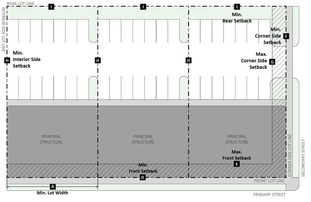
82 82
83 Figure J-B. VC District Requirements: 3-D 83
 for provisions related to accessory structures. Table 156.06.")
84 K I Industrial District Requirements Table K-A. I District Requirements, Figure K-A. I District Requirements: Plan, and Figure K-B. I District Requirements: 3-D establish bulk and setback regulations for the I District. See also D (Accessory Structures and Uses) for provisions related to accessory structures. Table K-A. I District Requirements Bulk Requirements Minimum Lot Area 10,000 sf A Minimum Lot Width 50 ft B Maximum Principal Building Height 50 ft Maximum Lot Coverage 80% Setback Requirements C Minimum Front Setback 15 ft D Minimum Corner Side Setback 15 ft E Minimum Interior Side Setback 0 ft F Minimum Rear Setback 20 ft Figure K-A. I District Requirements: Plan 84
85 Figure K-B. I District Requirements: 3-D 85
86 L FO Floodplain Overlay District Requirements 1. Purpose. The purpose of the FO Floodplain Overlay District is to reduce the potential for property damage and hazards to life caused by flooding. The regulations are intended to implement and ensure consistency with the 615 ILCS 5/18(g) Rivers, Lakes, and Streams Act and the National Flood Insurance Program. The intent of this overlay district is to: a. Encourage the utilization of appropriate construction practices in order to prevent or minimize flood damage in the future. b. Minimize the occurrence of future blight areas in the floodplain. c. Prevent increases in flood heights that could increase flood damage and result in conflicts between property owners. d. Reduce financial burdens imposed on the community, its governmental units, and its residents by controlling development which, alone or in combination with other development, will create additional burden to pay the costs of rescue, relief, emergency preparedness measures, pumping, and temporary dikes or levees in areas subject to flooding. e. Comply with federal, state, and Kane County floodplain management requirements. 2. Administration. The Zoning Administrator shall administer the requirements of this section per C.4 (Floodplain Development Permit). 3. Applicability. a. Definition of Applicability. The requirements of the FO Floodplain Overlay District shall apply to all areas of the 100 year floodplain within the jurisdiction of the Village that are identified by the Federal Emergency Management Agency (FEMA) as flood areas at high risk of flooding, with accompanying Flood Insurance Rate Maps (FIRMs), as may be revised by FEMA. The FIRMs are adopted by reference and declared to be part of this Ordinance. The FIRMs are on file at the Village. The FO District includes the following zones: (1) Floodway. Those areas of the floodplain that are designated as floodway on the Flood Insurance Rate Map adopted by L.3.a (Definition of Applicability). (2) Flood Fringe. Those areas of the 100 year floodplain that are located outside of the floodway on the Flood Insurance Rate Map adopted by L.3.a (Definition of Applicability). b. Platted Lots Within Floodplain. If a lot is located either partially or totally within the 100 year floodplain, the requirements of the FO District shall be applied to the entire lot. c. Relationship to Other Regulations. The requirements of the FO District do not abrogate, supersede, or limit the permitting requirements or authority of the State as administered by IDNR- OWR for floodplains or the requirements of the Kane County Stormwater Management Ordinance. However, where the FO District imposes stricter rules, those stricter rules apply. These standards also do not require that approvals or other letters of exemption be obtained from IDNR- OWR in situations covered by the statewide floodplain construction permitting program. 4. General Requirements. a. Base Flood Height Increases. No development shall be allowed in floodplain areas which will: (1) Obstruct flow by blocking the conveyance of floodwaters by itself or with other development, increasing base flood height. (2) Increase base flood height due to floodplain storage area lost, which equals or exceeds 0.01 foot. b. Required Setback. A minimum setback of 50 feet shall be maintained from any waterbody or wetland, as measured from the shoreline, to help prevent flooding and the natural process of erosion from threatening structures and their foundations. (1) No principal or accessory structures shall encroach within the required setback area. (2) Required setback areas shall be comprised of native vegetation. 86
87 (3) Exceptions to the native vegetation requirement may be allowed to facilitate water dependent activities, utility maintenance, or recreational access such as beaches and boat launches, as determined appropriate by the Zoning Administrator. Pedestrian or bicycle paths, wayfinding and educational signs, or maintenance accessways for utilities may be permitted to encroach within the required setback, with Floodplain Development Permit approval (refer to C.4 (Floodplain Development Permit). 5. Uses Allowed in Floodway. The following uses shall be permitted in the designated floodway upon approval of a Floodplain Development Permit. Any use not listed is prohibited. a. Community garden b. Park c. Utility, not requiring structures d. Open Space e. Multi-modal path or trail 6. Development Standards in Flood Fringe. Development is allowed in the Flood Fringe area upon approval of a Floodplain Development Permit (refer to C.4 (Floodplain Development Permit)), subject to all standards of the underlying zoning district and the standards of this Section. a. Uses Allowed in Flood Fringe. Any building, structure, or use allowed as a permitted or special use in the underlying zoning district is permitted in the Flood Fringe area, subject to compliance with the general requirements (see L.4 (General Requirements)) and floodproofing requirements (see L.6.b (Floodproofing Required)) of the FO District, which shall control when more restrictive. b. Floodproofing Required. Any building, structure, or use constructed in the Flood Fringe area shall be designed to withstand flood velocities, forces, and other factors associated with the base flood. Floodproofing measures shall be designed to protect the structure or development to the flood protection elevation and such measures shall be certified by a registered professional engineer or architect. (1) All flood-proofing measures shall be designed to: (a) Withstand floor pressures, depths, velocities, uplift and impact forces, and other base flood factors. (b) Protect structures to the flood protection elevation. (c) Anchor structures to foundations to resist flotation and lateral movement. (d) Ensure that structural walls and floors are watertight to the flood protection elevation, and the interior remains completely dry during flooding without human intervention. (e) Place essential utilities above the flood protection elevation. (2) Examples of flood-proofing measures include the following: (a) Installation of watertight doors, bulkheads and shutters. (b) Reinforcement of walls and floors to resist rupture or collapse caused by water pressure or floating debris. (c) Use of paints, membranes, or mortars to reduce seepage of water through walls. (d) Addition of mass or weight to structures to prevent flotation. (e) Installation of pumping facilities and/or subsurface drainage systems to relieve foundation wall and basement floor pressures and to lower water levels in structures. (f) Construction of water supply wells and waste treatment systems to prevent the entry of flood waters. (g) Installation of cutoff valves on sewer lines or the elimination of gravity basement drains. 87
88 M Principal Structure Encroachments 1. Applicability. The following standards for principal structure encroachments apply to all zoning districts. 2. Principal Structure Encroachments. Table M-A. Permitted Principal Structure Encroachments establishes the components of a principal structure that are permitted to encroach into required yards, provided that all additional requirements are met. Accessory structures are permitted to encroach into required yards in accordance with D (Accessory Structures and Uses). Table M-A. Permitted Principal Structure Encroachments Type of Encroachment Front Setback Interior Side Setback Corner Side Setback Rear Setback Additional Requirements Accessibility Ramps Y Y Y Y None Awning or Canopy Encroach up to 4 ft; min. clearance of 8 (absent signage) 1 Y Y Y Y ft Encroach up to 4 ft; min. 2 ft above Balcony Y Y Y Y ground for residential districts and clearance of 8 ft for commercial districts Bay Window Y Y Y Y Encroach up to 3ft Chimney Y Y Y Y Encroach up to 3ft Eave or Gutter Y Y Y Y Encroach up to 3ft Fire Escape Y Y Y Encroach up to 5 ft; shall be open to the elements. Porch (roofed or unroofed), Stairs, or Y Y Y Y No closer than 5 ft from any lot line Stoop Window Well Y Y Y Encroach up to 3 ft 1 See D.2.a (Awning Signs) and D.2.b (Canopy-Mounted Signs) for regulations pertaining to awning and canopy-mounted signs. 88
89 SECTION : USES A General Provisions B Use Table C Use Standards D Accessory Structures and Uses E Temporary Structures and Uses F Environmental Performance Standards A General Provisions 1. Purpose. The purpose of this Article is to establish the uses of land allowed by this Ordinance. 2. General Standards. The following standards apply generally to the uses allowed by this Ordinance. a. Federal, State, and Local Requirements. All uses shall comply with relevant federal, state, and local standards including licensing, health, and safety requirements. b. Number of Principal Uses. A lot may contain more than one principal use. c. Principal, Accessory, and Temporary Uses. Each use may function as a principal, accessory, or temporary use on a lot, unless otherwise specified. d. Uses within Enclosed Buildings or Structures. Each use shall be located within an enclosed building or structure, unless otherwise specified in this Ordinance. All buildings and structures shall comply with the applicable requirements of this Article and (Zoning District Regulations). e. Exempt Public Uses. The following public uses are allowed to be erected, constructed, altered, or maintained in any zoning district: (1) Traffic signals, fire hydrants, and other similar public safety devices. (2) Utility poles, wires, mains, drains, pipes, conduits, and cables necessary for public services. f. A change in the use of a lot in any zoning district shall require site plan review approval (refer to C.2 (Site Plan Review)). 3. Interpretation. Some of the uses included in this Article are defined as broad, generic categories that contain a group of similar uses. See (Definitions) for definitions of the uses included in this Article. a. Unlisted Similar Use. If a use is not listed in this Article, but is similar in nature and impact to a permitted or special use allowed within a zoning district, the Zoning Administrator may interpret the unlisted use as an allowed use. (1) The unlisted use shall be subject to any use standards that apply to the similar allowed use. (2) The Zoning Administrator may interpret the unlisted use as requiring the approval of a special use permit if the similar allowed use requires the approval of a special use permit. b. Unlisted Dissimilar Use. If a use is not listed and cannot be interpreted as similar in nature and impact to a permitted or special use, the use is not allowed and may only be approved through an amendment of this Ordinance (refer to C.6 (Zoning Text or Map Amendment)) B Use Table 1. Use Table. Table B-1 Use Table establishes the uses allowed in each zoning district. Each use is given one of the following designations for each zoning district. a. Permitted Use ( P ). A P indicates that a use is allowed by-right within the designated district provided that it meets all applicable use standards set forth in C (Use Standards). 89
90 b. Special Use ( S ). An S indicates that the use requires the approval of a special use permit (refer to C.3 (Special Use Permit)) in order to be allowed within the designated district, and must meet all applicable use standards set forth in C (Use Standards). c. No Designation. The absence of a letter (a blank space) or the absence of the use from the table indicates that the use is not allowed within the designated district. 2. Use Standards. Uses that are designated as Permitted Uses or Special Uses may have use standards that must be met, as established in C (Use Standards). Table B-1. Use Table Uses Districts Use Standards Residential F R-1 R-2 R-3 B-1 B-2 VC I Bed and Breakfast P See C.4 Community Residence P P P P P See C.7 Dwelling Above the Ground Floor P P P None Live/Work Dwelling P P P See C.12 Multi-unit Dwelling P P P P None Residential Care Facility P P P P None Single-unit Dwelling P P P P None Townhouse Dwelling S P P None Two-unit Dwelling P P P None Civic and Institutional F R-1 R-2 R-3 B-1 B-2 VC I College or University S S S S S S S S None Community Garden P P P S S See C.6 Cultural Facility P S S S P P P None Elementary or Middle School S S S S S S S See C.23 Government Facility P P P P P P P P See C.10 Hospital S S None High School S S S S S S S See C.23 Park P P P P P P P P None Place of Worship P P P P P None Vocational School S S S S S None Commercial F R-1 R-2 R-3 B-1 B-2 VC I Adult Use S See C.1 Animal Boarding S S S S S See C.2 Animal Day Care S P P P P See C.3 Animal Grooming S P P P P None Animal Hospital S P P S None Animal Shelter S S See C.2 Banquet Hall P P P None Bar/Tavern P P P None Body Art Establishment P P P None Day Care Center P P S None Day Care Home P P P P See C.8 Drive-Thru Facility S S S See C.9 Financial Institution P P P None Funeral Home P P S P None Garden Center P P P None Hotel/Motel P P P None Indoor Entertainment or Recreation P P P P See C.11 Medical Marijuana Dispensary S S S See C.13 Micro-brewery P P P P None Micro-distillery P P P P None Motor Vehicle Operations Facility P See C.15 90
91 Motor Vehicle Rental P P See C.16 Motor Vehicle Sales, Repair, and/or Service S P S See C.16 Outdoor Dining P P P See C.17 Outdoor Entertainment or Recreation S See C.18 Outdoor Storage Area S S See C.19 Personal Services Establishment S P P P None Professional Office P P P P None Research/Development Facility P None Restaurant P P P None Retail Goods Establishment P P P None Self-Service Storage P P P None Manufacturing F R-1 R-2 R-3 B-1 B-2 VC I Heavy Manufacturing P None Light Manufacturing S P None Mining Operation S S See C.14 Warehousing, Storage, or Distribution Facility P None Wholesale Establishment S P None Other Uses F R-1 R-2 R-3 B-1 B-2 VC I Agriculture P None Club, Lodge, or Hall S P P S None Commercial Stable S See C.5 Parking Garage S S S See C.20 Parking Lot (Primary Use) S S S See C.21 Planned Development S S S S S S S S See C.22 Solar Farm P S See C.24 Utility S S S S S S S S See C.25 Wireless Telecommunication Facility S S S S P P P P See C.26 Wireless Telecommunication Tower S S S S S S S S See C.26 Table Key P: Allowed by-right and shall meet the requirements of C (Use Standards) when applicable. S: Allowed with special use permit and shall meet the requirements of C (Use Standards) when applicable C Use Standards The following standards apply to uses as designated in the Use Standards column of Table B-1. Use Table. 1. Adult Use. a. Minimum Spacing. An adult use shall not be located within 500 feet of any residential district, day care center, preschool, elementary or middle school, high school, park, place of worship, or another adult use. An adult use shall not be located within 300 feet of the centerline of Illinois Route 25, Illinois Route 31, Sundown Road, Umbdenstock Road, North Lancaster Road, and Randall Road. b. Protection of Public Interest. An adult use shall be designed, located, and operated so that the public health, safety, comfort, convenience, and general welfare will be protected. c. Property Value. An adult use shall not cause substantial injury to the value of other property in the neighborhood in which it is located. d. Public Expense. An adult use shall not cause additional public expense for fire or police protection. e. Off-Site Observation. An adult use shall not be conducted in a manner that permits the observation of material relating to specified sexual activities or specified anatomical areas from any right-of-way or adjacent property. 91
92 2. Animal Boarding, Animal Shelter, or Animal Hospital. a. Location. Animal boarding and animal shelters are not allowed directly adjacent to any residential use with the exception of facilities that are entirely enclosed. b. Outdoor Boarding. Two outdoor dog runs per establishment are allowed. All outdoor animal boarding facilities shall be located in the interior side and/or rear yard and shall be enclosed with an opaque fence that is a minimum height of six feet. c. Noise. Noise shall be managed so as not to create a public nuisance for surrounding properties in compliance with F.1 (Noise) and all other local noise regulations. 3. Animal Day Care. a. Hours of Care. No animals may be kept on premises overnight, which for purposes of this provision, shall be between the hours of 9:00pm and 6:00am. b. Limitation of Animals. Livestock may not be kept on premises. 4. Bed and Breakfast. a. Owner Occupancy. A bed and breakfast must be owner occupied. b. Residential Character. A bed and breakfast must be designed originally as a single-unit dwelling. The location and operation of the facility shall not alter the residential character of the neighborhood, and the facility shall incorporate a residential design that is compatible with the surrounding neighborhood. 5. Commercial Stable. a. Location of Structures. Structures associated with a commercial stable must be located a minimum of 50 feet from any lot line. b. Safety. All stables must be designed to ensure the safety, health, and well-being of the animals on site, including protection from predators, the elements, and inclement weather. 6. Community Garden. a. Site Design. The community garden shall be designed and maintained to minimize the amount of water and/or fertilizer that drains or runs off onto adjacent property. b. Sales. There shall be no retail sales of any products on-site, except following approval of a Temporary Use Permit for a farmstand. 7. Community Residence. a. Location. A community residence may not be located within 660 feet of another community residence, and more than one community residence shall not be located on a block. b. Residential Character. The location and operation of the facility shall not alter the residential character of the neighborhood, and the facility shall incorporate a residential design that is compatible with the surrounding neighborhood. 8. Day Care Home. a. Residential Character. The location and operation of the facility shall not alter the residential character of the neighborhood, and the facility shall incorporate a residential design that is compatible with the surrounding neighborhood. b. Residency of Operator. The day care home shall be the primary residence of the operator. c. Employees. Additional nonresident employees are allowed to work in a day care home. d. Minimize Adverse Impacts. The design of the facility shall minimize traffic congestion, pedestrian hazards, noise, and other adverse impacts on surrounding properties. 9. Drive-Thru Facility. Refer to Figure C-1. Drive-Thru Facility. 92

93 a. Minimum Spacing. Drive-Thru facilities associated with financial institutions along Randall Road shall not be located within 2,500 ft of other such drive-thru facilities. b. Location. The drive-through window shall be located on the interior side or rear façade of the principal structure. c. Screening. The drive-thru facility shall be screened from view of the street by building and/or landscape screening in accordance with the requirements of E.3 (Parking Lot Perimeter Landscape). Screening shall be designed in such a way as to avoid interference with visibility or access. Figure C-1. Drive-Thru Facility 10. Government Facility. Government facilities are exempt from the maximum driveway widths established in J (Driveways). 11. Indoor Entertainment or Recreation. a. Minimize Adverse Impacts. The location of entrances and exits, service areas, and parking and loading docks shall minimize traffic congestion, pedestrian hazards, and adverse impacts on surrounding properties. b. Noise. Any noise associated with the facility shall be managed so as not to create a public nuisance for surrounding properties and shall comply with F.1 (Noise) and all other local noise regulations. 12. Live/Work Dwelling. a. Sales. On-site retail transactions associated with a live/work dwelling are allowed. b. Residency of Operator. The live/work dwelling shall be the primary residence of the operator. A portion of a live/work dwelling may be leased as a work space to an operator that does not reside in the dwelling. c. Employees. Two additional nonresident employees are allowed to work in a live/work dwelling. d. Space Limitation. No more than 50 percent of the total square footage of the dwelling may be used for residential uses. All activities associated with the live/work dwelling shall occur entirely within the dwelling unit. 93
94 e. Signs. Signs for occupations within live/work units are permitted in accordance with the homebased business sign standards in D.1 (Permanent Signs Exempt from Permit Requirement). 13. Medical Marijuana Dispensary. a. Compliance with State Regulations. Medical marijuana dispensaries must comply with all applicable rules and regulations enacted by the State of Illinois, including licensing and registration requirements and minimum spacing of 1,000 feet from preschools, elementary or middle schools, high schools, day care centers, and day care homes. When such State regulations are amended, such regulations control over this Ordinance. b. Minimum Spacing. A medical marijuana dispensary shall not be located within 500 feet of another medical marijuana dispensary. c. Security. The site design shall incorporate adequate security measures, such as exterior lighting, surveillance cameras, and/or fencing. 14. Mining Operation. a. Design. Mining operations are subject to the following design regulations. (1) All mining operations shall comply with relevant federal, state, and local standards including licensing, health, and safety requirements. Noise, odor, dust, air pollution, glare, heat, vibration, fire and explosion hazards, electromagnetic interference, and water discharge shall comply with relevant federal, state, and local standards, including F Environmental Performance Standards. (2) Screening and buffers must be provided along all public roads adjacent to a mining operation as specified by the Village Board upon approval of a special use permit. Existing trees and groundcover along the public right-of-way adjoining the property must be preserved and maintained for screening purposes to the greatest extent possible. (3) No more than one entrance and one exit from a road may be provided to the mining operation unless otherwise specified by the Village Board. Such entrance must be located to avoid routing trucks to and from the mining operation using residential streets. The mining operation shall provide a paved road from the entrance and exit of the area of operation a minimum of 300 feet from the public right-of-way in order to minimize accumulating dirt and gravel on the public right-of-way. Entrances and exits to the mining operation must be provided with gates that may be securely locked. (4) Trucks used to haul materials to and from the mining operation must be loaded to prevent spillage onto the public right-of-way. Any spillage on the public right-of-way from overloading or from material adhering to truck tires must be removed periodically at the expense of the operator. (5) Overburden must not be removed in excess of the area that is expected to be mined within one year following its removal. (6) As specified by the approved reclamation plan, development toward reclamation must progress as areas of the property are mined, unless the reclamation of such areas would prevent the conduct of mining operations on the remaining property. Groundcover or other planting indicated on the approved reclamation plan must be installed in areas where excavation is complete and before further overburden is removed in order to ensure development as operations proceed. (7) Weeds and other unsightly or noxious vegetation visible from the public right-of-way must be maintained as necessary. (8) Graded or backfilled areas must be covered with topsoil to a minimum of six inches and seeded with appropriate ground cover. Such topsoil must have a minimum of 25% organic material except that no greater depth of topsoil or percentage of organic material is required than originally existing on the property prior to the commencement of mining operations. 94
95 b. Hours of Operation (1) Mining operations may be conducted from 6:00 a.m. to 6:00 p.m. Monday through Friday and 6:00 a.m. to 4:00 p.m. on Saturday, except during an emergency situation or as specified by the Village Board. (2) The sale and loading of previously stockpiled products may be conducted from 2:00 p.m. to 5:00 p.m. on Saturday and from 9:00 a.m. to 2:00 p.m. on Sunday in addition to the hours specified above. (3) Mining operations and the sale and loading of previously stockpiled products cannot be conducted on holidays or Sundays except as specified above. c. Setback Requirement. Production, processing, and excavation associated with a mining operation must be set back from the boundary of any adjacent property that is not covered by a mining lease by a minimum of ten feet plus one and one-half times the depth of the intended excavation, unless otherwise specified by the Village Board. d. Explosives. No explosives may be used or stored upon the property of a mining operation or elsewhere in the Village in connection with a mining operation unless such use is expressly authorized by the Village Board or as part of an annexation agreement. If the use of explosives is authorized in connection with the conduct of mining operations, the following regulations apply. (1) The use, handling, and storage of explosives shall comply with the Illinois Explosives Act (ILCS Ch. 225, Act 210, et seq.) and with all other applicable statutes, ordinances, rules, and regulations. (2) Explosives may be detonated from 8:00 a.m. to 5:30 p.m. Monday through Friday and from 8:00 a.m. to 3:30 p.m. on Saturday unless otherwise specified by the Village Board. (3) Blast vibrations are permitted in accordance with Appendix B of the U.S. Department of the Interior, Bureau of Mines Report of Investigations/1980 RI 8507 or any subsequent updated version. (4) Airblast created as a result of the use of explosives is limited and controlled as set forth in paragraph (e)(1) of the Permanent Regulatory Program Implementing 501(b) of the Surface Mining Control Reclamation Act of 1977, U.S. Department of the Interior, as amended. (5) Mining operations that use explosives are required to have a seismograph to determine ground disturbance with the following minimum capabilities. (a) The ability to respond to particle velocity in each of the three mutually perpendicular planes. (b) The ability to record velocity time histories in each of the three mutually perpendicular planes. (c) The ability to record an airblast time history. (d) A seismic frequency response of 2.0 to 200 Hz +/- 3dB. (e) A particle velocity dynamic range of 0.02 to 4.0 ips. (f) A sound measuring range of 110 to 140dB. (g) A sound frequency response of 5 to 200 Hz +/- 3dB flat response. e. Ready Mix Plants. Plants for making ready mixed concrete using aggregate taken from a mining operation are allowed with a separate special use permit application that may be combined with the application for a special use permit to conduct a mining operation. All mixing equipment, buildings, and structures associated with a ready mix plant operation must be removed from a site upon the cessation of operations or the expiration of the special use permit. f. Expiration of Special Use Permit. A special use permit issued for a mining operation is valid for ten years from the date of approval by the Village Board unless otherwise specified by the Village Board or an annexation agreement. The renewal of a special use permit must be approved by the Village Board and cannot exceed a period of ten years. All renewals are subject to the same conditions as the original special use permit, as well as any new conditions required by the Village Board. 95
96 g. Assignment. Authorization to conduct a mining operation may not be assigned or transferred at any time without the written consent of the Village Board unless otherwise specified by the Village Board or an annexation agreement. h. Inspection. The Zoning Administrator must be granted reasonable access to a mining operation to periodically monitor its conduct and determine compliance with the requirements of this Ordinance. i. Cessation of Operations. Upon cessation of mining operations, the operator shall be responsible for the complete removal of all buildings, structures, and equipment used in connection with the mining operation within 18 months of such cessation. All stockpiled materials must be removed within two years following cessation of mining operations and the area occupied by such stockpiled materials must be reclaimed as provided in the approved reclamation plan. 15. Motor Vehicle Operations Facility. a. Outdoor Storage. Disabled or inoperable vehicles and those awaiting pick-up may be stored outdoors if the following conditions are met: (1) Location. Outdoor storage of vehicles is prohibited in the front yard and corner side yard. Motor vehicles may not be stored in the public right-of-way. (2) Screening. To the extent practicable, storage areas shall be screened from view of the street by building and/or landscape screening in accordance with the requirements of E.3 (Parking Lot Perimeter Landscape). b. Location for Repairs. All repairs must occur inside an enclosed building. 16. Motor Vehicle Rental or Motor Vehicle Sales, Repair and/or Service. a. Outdoor Storage. Disabled or inoperable vehicles and those awaiting pick-up may be stored outdoors if the following conditions are met: (1) Location. Outdoor storage of vehicles is prohibited in the front yard and corner side yard. Motor vehicles may not be stored in the public right-of-way. (2) Screening. To the extent practicable, storage areas shall be screened from view of the street by building and/or landscape screening in accordance with the requirements of E.3 (Parking Lot Perimeter Landscape). (3) Storage Duration. Motor vehicle repair and/or service facilities may not store the same vehicles outdoors for more than 20 days. b. Location for Repairs. All repairs must occur inside an enclosed building. c. Screening. Street frontage not occupied by building or driveways shall be improved with landscape screening in accordance with the requirements of E.3 (Parking Lot Perimeter Landscape). d. Stacking Spaces. Stacking spaces must comply with the requirements of I (Vehicular Stacking Requirements). e. Exterior Lighting. The illumination of any outdoor sales and display area shall not exceed 10 footcandles as measured at any location on the lot. f. Minimum Street Frontage Requirement. Gas stations shall be exempt from the minimum street frontage requirements established in (Zoning District Regulations). g. Drainage. Car washes shall not drain onto adjacent properties or into the right-of-way. 17. Outdoor Dining. a. Location. Outdoor dining shall be located on private property unless otherwise allowed by the Village. Outdoor dining shall not be located in any yard that is adjacent to a residential use or district, except when such residential use is an element of a mixed-use structure or development. Outdoor dining areas shall be delineated from the public right-of-way and parking areas with masonry walls, planters, bollards, temporary fencing, or similar elements. 96

97 b. Sidewalk Clearance. A minimum of four feet of sidewalk clearance must remain available for pedestrians in accordance with the Americans with Disabilities Act Accessibility Guidelines. c. Parking Lot Clearance. Outdoor dining shall not interfere with the drive aisles and parking spaces of a parking lot. 18. Outdoor Entertainment or Recreation. a. Minimize Adverse Impacts. The location of entrances and exits, service areas, and parking and loading docks shall minimize traffic congestion, pedestrian hazards, and adverse impacts on surrounding properties. b. Noise. Any noise associated with the facility shall be managed so as not to create a public nuisance for surrounding properties and shall comply with all local noise regulations. 19. Outdoor Storage Area. a. Location. Outdoor storage areas shall be located on an improved surface in the interior side yard or rear yard. b. Height. Outdoor storage area materials shall not exceed eight feet in height within 20 feet of any lot line. c. Uses. Outdoor storage areas are allowed as a principal use in association with the following principal uses: heavy manufacturing, light manufacturing, motor vehicle rental, motor vehicle sales, repair and/or service, and garden center. Outdoor storage areas may be allowed for additional uses with prior written approval by the Zoning Administrator. d. Screening. The requirements of G (Screening Requirements) shall apply to outdoor storage areas. 20. Parking Garage. In the VC District, a use listed in Table B-1 Use Table as an allowed commercial, civic, or institutional use must occupy the first 30 feet of building depth on the ground floor along a minimum of 50 percent of the street-facing façade (refer to Figure C-2. Parking Garage). Figure C-2. Parking Garage 97
98 21. Parking Lot or Parking Lot (Primary Use). Screening. The requirements of E.3 (Parking Lot Perimeter Landscape) shall apply to all off-street parking lots. 22. Planned Development. Refer to the requirements of D (Planned Developments). 23. Preschool, Elementary, Middle or High school. Minimize Adverse Impacts. The location of entrances, exits, service areas, parking areas, and loading docks shall minimize traffic congestion, pedestrian hazards, and adverse impacts on surrounding properties. 24. Solar Farm. a. Lot coverage. Fixed solar panels shall be considered impervious surface as part of the calculation of the lot coverage limitations. b. Setbacks. Solar farms shall have a minimum setback of five feet in all yards. c. Grid Interconnection. The applicant must provide evidence that the appropriate electric utility has been informed of the applicant s intent to install a solar farm with a grid interconnection. d. On-Site Power Lines. On-site power lines shall be installed underground to the greatest extent practical. 25. Utility. Screening. The street frontage adjacent to the utility shall be treated with landscape screening in accordance with the requirements of E.3 (Parking Lot Perimeter Landscape). 26. Wireless Telecommunication Facility and/or Tower. a. General Requirements. All wireless telecommunication facilities and towers shall be subject to the following. (1) Lighting. A wireless telecommunication facility or tower shall not include lights unless required by the Federal Communications Commission, the Federal Aviation Administration, or the Village. (2) Signs. A wireless telecommunication facility or tower shall not display signs except that such facilities or towers may include information required for government regulation, such as Federal Communications Commission registration information. (3) Screening. A wireless telecommunication facility or tower shall include landscape screening in accordance with the requirements of G (Buffer Yards), except that a required fence shall be a minimum of eight feet and maximum of 10 feet in height. b. Wireless Telecommunication Facility. (1) Height. The maximum height of a wireless telecommunication facility shall be 15 feet. (2) Use. A wireless telecommunication facility may house equipment and supplies for operation of a wireless telecommunication tower. Such facility shall be unstaffed and shall not be used for equipment that is not used as part of the operation of the facility. c. Wireless Telecommunication Tower. (1) Height. The maximum height of a wireless telecommunication tower is 50 feet, unless a taller height is required to function satisfactorily; in such case, the applicant must present a report indicating the need for a height in excess of 50 feet. (2) Design. A wireless telecommunication tower shall be designed to accommodate at least three telecommunication providers and their accompanying wireless telecommunication facilities. A wireless telecommunication tower shall have a galvanized gray or silver finish unless otherwise required by the Federal Communications Commission, the Federal Aviation Administration, or the Village D Accessory Structures and Uses Accessory structures and uses shall be subject to the requirements of this Section. 98
99 1. General Provisions for Accessory Structures. Accessory structures shall be subject to the following standards, unless otherwise established by this Ordinance. a. Construction Phasing. No accessory structure shall be constructed prior to the construction of the principal building to which it is accessory. b. Location. Accessory structures may be located in the front, corner side, interior side, and rear yards, unless otherwise specifically allowed by this Ordinance. Accessory structures shall not be allowed in any easement. c. Setback. Accessory structures, except fences and walls, shall be located a minimum of five feet from any lot line. d. Height. The maximum height of an accessory structure shall be 20 feet. e. Exemption for Agriculture Use. Accessory structures for an approved Agriculture use are exempt from the dimensional requirements of this section. 2. Accessory Structures Table. Table D-1. Accessory Structures includes common accessory structures that may be located in each zoning district within the Village. For accessory structures not listed, the Zoning Administrator will review a proposed accessory structure and determine if it is similar to those listed and therefore subject to the applicable standards. a. Permitted ( P ). A P indicates that the accessory structure does not require a building permit and is allowed by-right within the designated district provided that it meets all applicable standards set forth in this Section. b. Permitted with Building Permit ( B ). A B indicates that the accessory structure requires the approval of a building permit in accordance with Chapter 150 (Building Regulations) and shall meet the use standards set forth in this Section in order to be allowed within the designated district. c. No Designation. The absence of a letter (a blank space) indicates that the structure is not allowed within the designated district. d. Use Standards. Accessory structures that are designated as Permitted or Permitted with Building Permit may have use standards that must be met, as established in D.3 (Use Standards for Accessory Structures). Table D-1. Accessory Structures Accessory Structures Districts F R-1 R-2 R-3 B-1 B-2 VC I Use Standards Accessory Storage Building B B B B B B B B See D.3.a Arbor, Pergola, or Trellis P P P P P P P P None Ball Court B B B B B B B B See D.3.b Boat Launch B B B B B None Compost Bin P P P P P P P P None Deck or Patio B B B B B B B B See D.3.c Electrical Generator B B B B B B B B None Electric Vehicle Charging Station B B B B B B B B None Fence or Wall B B B B B B B B See D.3.d Flag Pole P P P P P P P P See D.3.e Garden P P P P P P P P See D.3.f Gazebo B B B B B B B B See D.3.g Green Roof or Blue Roof B B B B B B B B None Hoophouse P P P P P P P P See D.3.h Mechanical Equipment B B B B B B B B See D.3.i Outdoor Fire Pit P P P P P P P See D.3.j Rain Barrel P P P P P P P P None Rain Garden P P P P P P P P See D.3.k Rainwater Cistern P P P P P P P P None 99
100 Accessory Structures Districts F R-1 R-2 R-3 B-1 B-2 VC I Use Standards Recreation Equipment P P P P P P P P See D.3.l Refuse, Recycling, or Grease Container P P P P P P P P See D.3.m Satellite Dish P P P P P P P P See D.3.n Small Wind Energy System B B B B B B B B See D.3.o Solar Energy Collection System B B B B B B B B See D.3.p Swimming Pool B B B B B B B See D.3.q Treehouse B B B B See D.3.r Wireless Telecommunication Antenna B B B B B B B B See D.3.s Table Key P: Allowed by-right and shall meet the requirements of C (Use Standards for Accessory Structures) when applicable. B: Allowed with building permit and shall meet the requirements of C (Use Standards for Accessory Structures) when applicable. 3. Use Standards for Accessory Structures. The following standards apply to accessory structures designated as permitted ( P ) or permitted with building permit ( B ) in the districts noted in the Use Standards column of Table D-1 Accessory Structures. a. Accessory Storage Building. (1) Location. Accessory storage buildings are allowed in the interior side yard and rear yard. (2) Number. A maximum of two accessory storage buildings are allowed per lot in the R-1, R-2, and R-3 Districts. (3) Overhead Doors. Accessory storage buildings shall not be permitted to have an overhead door unless connected to a public right of way by a driveway constructed of a permanent, dust-free material. b. Ball Court. Location. Ball courts are allowed in the rear yard, except that one fixed basketball standard and backboard shall be allowed in any yard in the F, R-1, R-2, and R-3 Districts. c. Deck or Patio. Location. Decks and patios are allowed in all yards. Decks and patios located in the front yard, must be contiguous to the principal structure. d. Fence or Wall. The following requirements apply to fences and walls unless otherwise specifically established in this Ordinance. (1) Location. Fences and walls, including all posts, bases, and other structural parts, shall be located completely within the boundaries of the lot on which it is located. (a) Residential Districts. In residential districts, fences and walls are allowed in the front yard, corner side yard, interior side yard, and rear yard. (b) Non-Residential Districts. In non-residential districts, fences and walls are allowed in the interior side yard and rear yard. (2) Height. The maximum height of a fence or wall shall be measured from the ground at the base of the fence or wall. (a) Residential Districts. In residential districts, the maximum height of a fence or wall shall be four feet in the front and corner side yard, and six feet in an interior side or rear yard. Except that fences or walls located within a corner side yard may be six feet if they are within the minimum corner side setback of the principal structure. (b) Non-Residential Districts. In non-residential districts, the maximum height of a fence or wall shall be eight feet in an interior side or rear yard. (3) Materials and Construction. The following requirements for materials apply to the construction of fences, walls, and any associated gates. (a) Construction, Design and Appearance. In all zoning districts, both sides of a fence or wall shall be similar in construction, design, and appearance. The finished side of a fence or wall shall face outward from the lot so that all posts are located on the property owner s side of the fence or wall. 100
101 (b) Residential Districts. Fences used or designed to screen or conceal a front yard shall not be permitted. In residential districts, fences and walls may be constructed of treated wood, simulated wood, vinyl, chain link without slats, wrought iron, brick, and stone. (c) Non-Residential Districts. In non-residential districts, fences and walls may be constructed of treated wood, simulated wood, vinyl, chain link with slats of a uniform color or without slats, metal mesh, corrugated metal, wrought iron, brick, stone, cinderblock, and concrete block. (d) Prohibited Materials. Fences shall not be constructed of snow fencing, barbed wire, electrically charged wire, or razor wire, except in the F District where barbed wire may be used for agricultural purposes with prior written approval from the Zoning Administrator. e. Flag Pole. Location. Flag poles are allowed in all yards. f. Garden. (1) Location. Gardens are allowed in all yards, but shall be limited to 50 percent of the pervious area of the front yard and corner side yard. Lots within the F District are exempt from this standard. (2) Height. The maximum height of any structure used to grow items in a garden, such as raised planting beds or hoophouses, shall be three feet in the front or corner side yard, and six feet in the interior side or rear yard. (3) On-Site Sales. On-site sales of vegetables or any other goods associated with a garden are prohibited. (4) Loose Soil. Loose soil associated with a garden must be covered or confined so that the soil does not spillover from the garden area. (5) Exemptions. Lots within the F District are exempt from the use standards for Garden. g. Gazebo. (1) Location. Gazebos are allowed in the interior side yard and rear yard. (2) Design. Each side of a gazebo shall be at least 25 percent open. h. Hoophouse. Use Limitation. Hoophouses are only allowed in conjunction with residential uses, community gardens, and garden centers. i. Mechanical Equipment. (1) Location. Ground-mounted mechanical equipment shall only be located in the interior side yard or rear yard. Roof-mounted mechanical equipment shall be located a minimum of six feet from any supporting wall to facilitate safe access. (2) Screening. The requirements of G (Screening Requirements) shall apply to mechanical equipment. j. Outdoor Fire Pit. (1) Location. Outdoor fire pits are allowed in the interior side yard and rear yard. (2) Setback. Outdoor fire pit shall be located a minimum of 10 feet from any structure. k. Rain Garden. (1) Location. Rain gardens are allowed in all yards. (2) Loose Soil. Loose soil associated with a rain garden must be covered or confined so that the soil does not spill over from the garden area. l. Recreation Equipment. Location. Recreation equipment is allowed in the interior side yard and rear yard. m. Refuse, Recycling, and Grease Containers. (1) Applicability. Refuse, recycling, and grease container regulations apply only to those uses that collect refuse, recyclable materials, and grease in commercial containers. (2) Location. Refuse, recycling, and grease containers are prohibited in the front yard. (3) Screening. The requirements of G (Screening Requirements) shall apply to refuse, recycling, and grease containers. 101
102 n. Satellite Dish. Location. Satellite dishes are allowed on the rear or interior side yard façade of a building, or on the roof of a building. o. Small Wind Energy System. Systems may be roof-mounted or ground-mounted in accordance with the following standards. Refer to Figure C-3. Ground-Mounted Small Wind Energy System Standards. (1) General Requirements. All systems shall be subject to the following. (a) Building Permit Application. The application for a building permit shall include drawings of the wind turbine structure, including the tower, base, footings, and location on the site, and of the electrical components in sufficient detail to determine whether the proposed system conforms to pertinent electrical codes. (b) Capacity. Systems shall have a rated capacity of 100 kilowatts or less. (c) Noise. Systems shall not exceed 60 dba, as measured at the closest lot line. This level may be exceeded during short-term events such as utility outages and/or severe storms. (2) Roof-Mounted System. Roof-mounted systems shall adhere to the following. (a) Districts. Roof-mounted systems are allowed in all zoning districts. (b) Location. Systems are allowed anywhere on the roof of a principal structure. Systems on an accessory structure, such as a garage, gazebo, greenhouse, shed, or other structure, must be approved by the Zoning Administrator. (c) Height. The maximum height of a roof-mounted system shall be 15 feet above the height of the principal or accessory structure to which the turbine is mounted. (3) Ground-Mounted System. Ground-mounted systems shall adhere to the following. (a) Districts. Ground-mounted systems are allowed in the F, B-1, B-2, and I Districts. (b) Location. Systems are allowed in the interior side and rear yards. (c) Setback. All components of a ground-mounted system (tower, blade, guy wire anchors, etc.) shall be located a minimum of five feet from any lot line. (d) Height. The maximum height of a ground-mounted system shall be the height limit of the applicable zoning district. (e) Clearance. A ground-mounted system shall have a minimum of 15 feet of clearance. Figure C-3. Ground-Mounted Small Wind Energy System Standards. p. Solar Energy Collection System. Solar energy collection systems may be roof-mounted or groundmounted in accordance with the following standards. 102
103 (1) Roof-Mounted System. Roof-mounted systems shall adhere to the following. (a) Districts. Roof-mounted systems are allowed in all zoning districts. (b) Height. The maximum height of a roof-mounted system shall be five feet above the overall height of the principal or accessory structure to which the system is mounted. (2) Ground-Mounted System. Ground-mounted systems shall adhere to the following. (a) Districts. Ground-mounted systems are allowed in all zoning districts. (b) Location. Ground-mounted systems are allowed in the interior side and rear yards. (c) Height. The maximum height of a ground-mounted system shall be the height limit of the applicable zoning district. q. Swimming Pool. The following standards apply to swimming pools with a maximum depth equal to or greater than 24 inches. (1) Building Code. The installation or replacement of a swimming pool shall comply with all requirements of the International Building Code, including those for swimming pool enclosures and safety devices. (2) Location. Swimming pools are allowed in the rear yard and shall not extend into the corner side or interior side yards. (3) Height. Above-ground pools shall not exceed six feet in height. (4) Distance from Other Structures. A swimming pool shall be a minimum of five feet from any other structure or building on the lot, with the exception of an attached permanent deck or patio. A swimming pool shall be at least five feet from any utility lines or cables, as verified by the Zoning Administrator. r. Treehouse. (1) Location. A treehouse shall be located in the rear yard. (2) Number. A maximum of one treehouse is allowed per lot in the F, R-1, R-2, and R-3 Districts. (3) Size. The maximum size of treehouse shall be 100 square feet. s. Wireless Telecommunication Antenna. (1) General Requirements. Wireless telecommunication antennas shall meet the general requirements for wireless telecommunication facilities and/or towers in C.29.a (General Requirements). (2) Height. (a) A wireless telecommunication antenna shall not increase the height of any building or structure on which it is mounted by more than 10 percent. (b) A wireless telecommunication antenna mounted to a wireless telecommunication tower shall not increase the height of the tower by more than 10 percent. (3) Stealth Design. All wireless telecommunication antennas shall utilize stealth design to blend into the surrounding environment, including those co-located on a wireless telecommunication tower. (a) A wireless telecommunication antenna must be enclosed, camouflaged, screened, or obscured so that it is not readily apparent to a casual observer. (b) A wireless telecommunication antenna shall blend into another part of the structure upon which it is mounted, such as a rooftop, tower, spire, or other similar feature. 4. Accessory Dwelling Units. Accessory dwelling units are permitted in all residential zoning districts within a principal or accessory structure subject to approval of site plan review ( A.2 (Site Plan Review)) and provided that the following standards are met. a. Accessory Dwelling Unit. (1) Location. An accessory dwelling unit located in a principal structure may be located anywhere within a principal structure. An accessory dwelling unit located in an accessory structure is allowed in the rear yard only. 103
104 (2) Number. The number of accessory dwelling units on a lot shall be no greater than the number of principal dwelling units on a lot. (3) Size. The maximum size of an accessory dwelling unit shall be 900 square feet (4) Design. An accessory dwelling unit shall be designed to be clearly secondary to the principal dwelling unit on the site. For accessory dwelling units located in an accessory structure, the exterior materials of the dwelling unit must be compatible with the primary dwelling unit, including siding and trim materials, window design, roof shape, roof pitch, and roof material. 5. Home-based Businesses. A home-based business is permitted within any dwelling unit in the Village as part of a principal or accessory structure provided that the following standards are met. a. Residential Character. The location and operation of the home based business shall not alter the residential character of the dwelling. b. Uses. Examples of allowed home-based businesses include, but are not limited to, artist, consultant, counselor, craftsperson, designer, tutor, writer, and instructor of music, craft, or fine art. c. Sales. No on-site retail or wholesale transactions are allowed. d. Hours of Operation. Home-based businesses with outside visitors may be allowed to operate from 7:00 AM to 9:00 PM. e. Residency of Operator. The operator of the home based business shall reside in the dwelling unit in which the home occupation is located. f. Employees. One additional employee who does not reside in the dwelling unit is allowed for a home-based business. g. Visitors. A maximum of four visitors (clients, customers, pupils, etc.) associated with the home based business may be present at any given time. h. Parking. Any parking needs associated with the home-based business shall be accommodated onsite within an existing driveway or garage. i. Deliveries. Deliveries and shipments are not allowed to or from the premises, with the exception of carriers that typically provide service to residential neighborhoods, such as the U.S. Postal Service and/or express shipping services (UPS, FedEx, DHL). j. Signs. Signs for home-based businesses are permitted in accordance with D.1 (Permanent Signs Exempt from Permit Requirement) E Temporary Structures and Uses Temporary structures and uses shall be subject to the requirements of this section. 1. Temporary Structures and Uses Table. Table E-1. Temporary Structures and Uses establishes the allowed temporary structures and uses for each zoning district. Table E-1 is not an exhaustive list of temporary structures and uses that may be located within the Village. Each structure or use is given one of the following designations for each zoning district. a. Permitted ( P ). A P indicates that the temporary structure or use does not require a temporary use permit and is allowed by-right within the designated district provided that it meets all applicable use standards set forth in this Section. b. Permitted with Temporary Use Permit ( T ). A T indicates that the temporary structure or use requires the approval of a temporary use permit (refer to C.10 (Temporary Use Permit)) and must meet any applicable use standards set forth in this Section in order to be allowed within the designated district. c. No Designation. The absence of a letter (a blank space) indicates that the use is not allowed within the designated district. 104
105 d. Use Standards. Temporary structures or uses that are designated as Permitted or Permitted with Temporary Use Permit may have use standards that must be met, as established in E.2 (Use Standards for Temporary Structures and Uses). Table E-1. Temporary Structures and Uses Accessory Structures Districts F R-1 R-2 R-3 B-1 B-2 VC I Use Standards Contractor Trailer P P P P P P P P See E.2.a Farmers Market T T T T T T T T See E.2.b Farmstand P P P P P P P None Garage or Yard Sale P P P P P See E.2.c Mobile Food Facility P P P P See E.2.d Model Unit P P P P P P P See E.2.e Sidewalk Sale P P P See E.2.f Temporary Outdoor Entertainment T T T T T T See E.2.g Temporary Outdoor Sale T T T See E.2.h Temporary Storage Container P P P P P P P P See E.2.i Table Key P: Allowed by-right and shall meet the requirements of E.2 (Use Standards for Temporary Structures and Uses) when applicable. T: Allowed with temporary use permit and shall meet the requirements of E.2 (Use Standards for Temporary Structures and Uses) when applicable. 2. Use Standards for Temporary Structures and Uses. The following standards apply to temporary structures and uses designated as permitted ( P ) or permitted with temporary use permit ( T ) in the districts noted in the Use Standards column of Table E.1. Temporary Structures and Uses. Temporary uses may be located outdoors or within an enclosed building or structure. a. Contractor Trailer. Contractor trailers shall be limited to the period of active construction of the project. Contractor trailers shall not contain accommodations for sleeping or cooking. b. Farmers Market. (1) Timeframe. The timeframe of a farmers market, including number of days per week and overall duration of the event, will be determined and approved as part of the temporary use permit. A temporary use permit for a farmers market can be issued on a yearly basis, which allows for a schedule of days per week and number of weeks per year. (2) Management Plan Required. A management plan is required for a farmers market, to be submitted as part of the temporary use permit application, that demonstrates the following: (a) The on-site presence of a manager during hours of operation who directs the operations of vendors participating in the market. (b) An established set of operating rules addressing the governance structure of the market, hours of operation, and maintenance when open to the public. (c) A general site plan of vendor stalls, visitor facilities, such as any seating areas and restrooms, and all ingress and egress points to the site. (d) Provision for waste removal. (e) The days and hours of internal operation, including vendor set-up and take-down times. c. Garage or Yard Sale. Garage and rummage sales shall be limited to a period of six days for the same residence within a 12-month period. d. Mobile Food Facility. (1) The operator must keep the area clear of litter and debris during business hours and provide a trash receptacle for customer use if such receptacles are not already provided on site or in the right-of-way. (2) Outdoor seating may be provided on the site, but no seating may be permanently installed. (3) A permanent water or wastewater connection is prohibited. 105
106 (4) Electrical service may be provided only by temporary service or other connection provided by an electric utility, or an on-board generator. (5) Drive-thru service is prohibited. e. Model Unit. Model units, including temporary real estate offices, shall be limited to the period of active selling and/or leasing of space in the development, or six months after issuance of the final certificate of occupancy, whichever is less. Model units shall not be used for sleeping, bathing, or cooking purposes. f. Sidewalk Sale. (1) Duration. Sidewalk sales shall be limited to a period of four consecutive days. A maximum of three sidewalk sales shall be allowed for the same retailer within a 12-month period. (2) Sidewalk Clearance. A minimum of four feet of sidewalk clearance must remain available for pedestrians in accordance with the Americans with Disabilities Act Accessibility Guidelines. (3) Storage. Merchandise must be stored inside the building during non-business hours. g. Temporary Outdoor Entertainment. (1) Duration. Temporary outdoor entertainment shall be limited to a period of seven consecutive days. (2) Frequency. A maximum of two temporary outdoor entertainment permits may be issued per year for any lot. (3) Other Local Regulations. Temporary outdoor entertainment shall comply with the requirements of the Municipal Code (Chapter 112: Amusements) and other local regulations. (4) Temporary Use Permit Application. Approval of the temporary use permit shall be based on the adequacy of the lot area, provision of parking, traffic access, and public safety, as well as the absence of undue adverse impacts on adjacent properties. The temporary use permit application shall include the following: (a) Site Plan. As part of the temporary use permit application, the operator of the event must submit a site plan to the Village prior to the event that illustrates the location of major site components and ingress and egress routes for emergency vehicles. (b) Proof of State Inspection. The operator of the event shall provide proof that all amusement devices have been inspected and approved by the State of Illinois Department of Labor. (5) Bulk and Yard Requirements. Temporary outdoor entertainment is exempt from (Zoning District Regulations). h. Temporary Outdoor Sale. (1) Temporary Use Permit Application. Approval of a temporary use permit for a temporary outdoor sale shall be based on the adequacy of the lot area, provision of parking, traffic access, and public safety, as well as the absence of undue adverse impacts on other properties. (2) Duration. Temporary outdoor sale uses shall be limited to a period of up to 45 days. The Zoning Administrator may grant additional time or successive permits through the temporary use permit process. i. Temporary Storage Container. (1) Duration. Temporary storage containers shall be located on a lot for a period of no more than 45 consecutive days unless used in conjunction with an approved building permit. (2) Frequency. A maximum of two instances of temporary storage container installation are allowed per year. (3) Improved Surface. The temporary storage container shall be located on an improved surface. Containers shall not be permanently attached to the ground, have permanent utility service, or be stacked atop one another F Environmental Performance Standards 106
107 All uses in all zoning districts shall comply with the performance standards established in this Section unless any federal, state, county, or local regulation establishes a more restrictive standard, in which case the more restrictive standard shall apply. 1. Noise. No activity or use shall be conducted in a manner that generates a level of sound, as measured on another property, greater than that allowed by federal, state, county, and local regulations. These limits shall not apply to construction noises, noises emanating from safety signals or warning devices, noises not directly under the control of the owner or occupant of the property, and transient noises from moving sources, such as motor vehicles, railroads, and aircraft. 2. Odor. No activity or use shall be conducted in a manner that generates odors of such intensity and character as to be harmful to the health, welfare, or comfort of the public. Any such use shall be stopped or modified so as to remove the odor. 3. Dust and Air Pollution. Dust and air pollution carried by the wind from sources such as mining, storage areas, yards, roads, equipment, and the like, within lot boundaries, shall be kept to a minimum by appropriate landscaping, screening, paving, wetting, or other acceptable means. 4. Glare and Heat. No activity or use shall be conducted in a manner that generates glare or heat that may be detected at any point off the lot on which the use is located. Light sources shall be shielded so as not to cause a nuisance across lot lines. 5. Vibration. No activity or use shall be conducted in a manner that generates earthborn vibration which can be detected at any point off the lot on which the use is located. 6. Fire and Explosion Hazards. Materials that present potential fire and explosion hazards shall be transported, stored, and used only in conformance with all applicable federal, state, county, and local regulations. 7. Electromagnetic Interference. Electromagnetic interference from the operation of any use that is not in compliance with the rules and regulations of the Federal Communications Commission must not adversely affect the operation of any equipment located off the lot on which such interference originates. 8. Hazardous, Radioactive, and Toxic Materials. No activity or use shall produce hazardous, radioactive, or toxic material without prior notice to the Village. Notice shall be given to the Zoning Administrator at least 30 days before the operation is commenced. The transport, handling, storage, discharge, clean-up, and disposal of all hazardous, radioactive, or toxic materials, including waste, shall comply with applicable federal, state, county, and local regulations. 9. Industrial Wastewater. Industrial wastewater shall be disposed into a sanitary sewer unless an alternative disposal is approved by the Village Engineer. The Village Engineer may require pretreatment, a sampling manhole, and an industrial wastewater discharge permit. Industrial wastewater quality must meet the requirements of the Fox River Water Reclamation District. 10. Stormwater Disposal. All stormwater, groundwater, and landscaping run-off must be discharged into an adequate body of water, storm sewer, or approved on-site disposal system. Disposal methods and the determination of the adequacy of the receiving systems require the approval of the Village Engineer. 107
108 SECTION : PARKING AND LOADING A General Provisions B Required Off-Street Parking Spaces C Parking Reductions D Shared Parking E Required Bicycle Parking F Parking Design Standards G Pedestrian Circulation Standards H Loading Facility Requirements I Vehicular Stacking Requirements J Driveways K Recreational Vehicle Parking A General Provisions 1. Purpose. The purpose of this Section is to promote the health, safety, and general welfare of the public by providing for safe and efficient traffic circulation, ensuring an appropriate quantity of vehicular and bicycle parking areas to support a variety of land uses, minimizing impervious surface coverage associated with parking and loading, and providing for adequate site access and loading facilities. 2. Applicability. The requirements of this Section shall apply to the following: a. New construction of a principal structure or principal use. b. Planned developments. c. Alteration of an existing structure or a change in use that results in an increase in the number of required parking spaces. d. The construction of new parking facilities, loading facilities, drive-thrus, and/or driveways. e. The reconfiguration, expansion, or reconstruction of an existing parking lot. 3. General Requirements. The following requirements apply to all parking and loading areas. a. Site Plan Review Approval. Site plan review approval is required prior to either the construction of a new parking lot, or the expansion of an existing parking lot (see A.2 (Site Plan Review)). b. Certificate of Occupancy. Construction of off-street parking lots and loading areas required by this Section shall be completed prior to the issuance of a certificate of occupancy for the uses served by the parking lots and loading areas. c. Change in Use. When an existing use is changed to a new use, parking and loading spaces shall be provided as required for the new use. Additional parking and/or loading spaces shall be required in the amount by which the requirements for the new use exceed the existing number of parking spaces. If the number of existing parking spaces is more than the number of spaces required for the new use, the number of parking spaces may be decreased to meet the minimum requirement for the new use. d. Materials. (1) Pervious and Semi-Pervious Materials. All off-street parking lots, loading areas, drive-thru facilities, and driveways shall be constructed using a hard surface, all-weather, dustless material. Semi-pervious materials and permeable pavements may also be used subject to the prior written approval of the Zoning Administrator. 108
109 (2) Recycled Materials. When asphalt paving is utilized for off-street parking lots, the asphalt mixture must contain a minimum of 20 percent recycled materials. Parking areas that serve single-unit, two-unit, and townhouse dwellings are exempt from this requirement. e. Location. In the B-1, B-2, VC, and I Districts, parking areas shall only be permitted in the allowable yards stated in each district s design requirements (see (Zoning District Regulations)). f. Encroachment. Parking lots are allowed to encroach into the required interior side and/or rear yard, but shall be at least one foot from any lot line in the VC District, and at least five feet from any lot line in the B-1 District, provided no parking lot perimeter landscape (see E.3 (Parking Lot Perimeter Landscape)) or buffer yard (see F (Buffer Yards)) is required. g. Maintenance Responsibility. All parking and loading areas shall be maintained and kept in good repair by the property owner B Required Off-Street Parking Spaces 1. General Requirements. Off-street parking spaces shall be provided in accordance with the following standards. a. Availability of Spaces. All parking spaces approved as part of the issuance of a certificate of occupancy shall be made available to the residents, customers, employees, guests, and/or other users of the principal use. Spaces shall not be utilized for motor vehicle repair, service, or sale, or for long-term storage or display of vehicles, materials, or goods. b. Accessible Parking. (1) State Requirements. Accessible parking spaces shall be designed and provided as required by the Illinois Accessibility Code, as amended from time to time, and all additional applicable laws. (2) Applicability. Accessible parking shall be provided for all off-street parking lots that provide parking for employees, visitors, or both, with the exception of single-unit and two-unit dwellings. (3) Minimum Parking Requirements. The number of accessible parking spaces may be counted toward the total number of off-street parking spaces required. (4) Other Laws and Regulations. In the event of a conflict between this Section and any applicable state law or regulation, the provision requiring the greatest number of accessible parking spaces shall control. c. Off-Premises Parking Facilities. Parking facilities for uses other than single-unit, two-unit, and townhouse dwellings may be provided off-premises with prior written Zoning Administrator approval, provided that the following conditions are met: (1) Location. (a) Residential Uses. Any off-premises parking facility for a residential use must be located within 400 feet, along a pedestrian route, of the nearest principal entrance for which the parking is required. (b) Nonresidential Uses. Any off-premises parking facility for a non-residential use must be located within 800 feet, along a pedestrian route, of the nearest principal entrance of the building for which the parking is required. (2) Parking Agreement. A written agreement for off-premise parking facilities shall be executed between the landowner and the lessee in a form satisfactory to the Village Attorney and shall be recorded in the Office of the Recorder of Deeds of Kane County, as applicable. The agreement shall include: (a) A guarantee between the landowner and lessee for access to and use of the parking facility. (b) A guarantee that the off-street parking spaces will be provided, maintained, and reserved for the uses served for as long as such uses are in operation. d. Maximum Number of Parking Spaces. No use shall provide parking spaces in excess of 125 percent of the required minimum parking amount shown in Table B-1. Off-Street Parking Requirements, with the following exceptions: 109
110 (1) In residential districts, maximum off-street parking requirements shall not apply to residential uses. (2) Any use required to provide less than 10 parking spaces may exceed the maximum allowable amount, but may not provide more than 15 spaces. (3) With Zoning Administrator approval, the maximum parking amount may be exceeded by up to 50 percentage points, for a total of 175 percent, provided that: (a) The area exceeding the maximum parking requirement is constructed with pervious paving materials. (b) The 10-year, 24-hour storm event, as calculated for the portion of the lot exceeding the maximum parking requirement, is retained on-site utilizing green infrastructure techniques, such as rain gardens and bioretention facilities. e. Tandem Parking. Tandem parking may be granted by the Zoning Administrator through an application for Minor Site Plan Review (see A.2.b(2) (Minor Site Plan Review)). Tandem parking is permitted for residential uses only and both parking spaces must be allotted to the same dwelling unit and located on the same lot as the dwelling unit. 2. Computation. Off-street parking spaces shall be calculated using the following standards. a. Units of Measurement. The following shall be utilized to calculate the number of required parking spaces. (1) Gross Floor Area. Unless otherwise stated, parking standards for non-residential uses shall be calculated on the basis of gross floor area (GFA) in square feet. (2) Occupancy- or Capacity-Based Requirements. Parking spaces required per seat, employee, student, or occupant shall be calculated based on the maximum number of employees on the largest shift, or maximum fire-rated capacity of the building, whichever measurement is applicable. b. Fractions of Parking Spaces. When computation of required parking spaces results in a fraction, any fraction of less than one-half shall be disregarded, and any fraction of one-half or more shall be counted as one parking space. c. Multiple Uses on a Lot. When there are multiple uses on a lot, the amount of parking spaces required shall be the sum of the parking requirements for each individual use. d. Use of Off-Street Loading Area. Area allocated to any off-street loading spaces shall not be used to satisfy parking space requirements. e. Parking Reductions and Shared Parking. The amount of parking required for a use may be reduced if the use qualifies for a parking reduction as established in C (Parking Reductions) or shared parking as established in D (Shared Parking). 3. Off-Street Parking Requirements. Table B-1. Off-Street Parking Requirements establishes the minimum vehicular parking requirements for the listed uses. Any use not specified in Table B- 1. Off-Street Parking Requirements shall adhere to the requirements provided for the most similar use as determined by the Zoning Administrator. Table B-A. Off-Street Parking Requirements Uses Parking Requirement Residential Accessory Dwelling Unit 1 Bed and Breakfast 3 per dwelling unit + 1 per 2 guestrooms Community Residence 0.5 per bed Dwelling Above the Ground Floor 1 per dwelling unit Live/Work Dwelling 1 per dwelling unit + additional spaces as required for additional uses Multi-unit Dwelling 1.5 per dwelling unit 110
111 Uses Residential Care Facility Assisted Living Facility Independent Living Facility Nursing Home or Hospice Memory Care Facility Single-unit Dwelling Townhouse Dwelling Two-unit Dwelling Civic and Institutional College or University Community Garden Cultural Facility Library or Museum Elementary or Middle School Government Facility High School Hospital Park Place of Worship Vocational School Commercial Adult Use Animal Boarding Animal Hospital Animal Shelter Banquet Hall Bar/Tavern Body Art Establishment Day Care Center Day Care Home Financial Institution Funeral Home Garden Center Gas Station Hotel/Motel Indoor Entertainment Indoor Recreation Bowling Alley Medical Marijuana Dispensary Micro-brewery or Micro-distillery Motor Vehicle Operations Facility Motor Vehicle Rental Motor Vehicle Sales, Repair and/or Service Multi-Tenant Commercial Center Off-Track Betting Facility Outdoor Entertainment Parking Requirement 0.5 per dwelling unit 1 per dwelling unit 0.5 per bed 0.5 per bed 3 per dwelling unit 2 per dwelling unit 2 per dwelling unit 1 per classroom + 1 per 200 sf of office space + 1 per 5 students based on maximum enrollment None 1 per 1,000 sf of GFA 1 per 750 sf of GFA 1 per classroom + 1 per 200 sf of office space 1 per 500 sf of GFA 1 per classroom + 1 per 200 sf of office space + 1 per 10 students based on maximum enrollment 3 per bed None 25% of maximum capacity of largest single area for assembly purposes 1 per classroom + 1 per 200 sf of office space + 1 per 10 students based on maximum enrollment 1 per 300 sf of GFA 1 per 500 sf of GFA, any outdoor area excluded 1.5 per exam room 1 per 500 sf of GFA, any outdoor area excluded 10% of maximum capacity 1 per 100 sf of GFA 1 per 300 sf of GFA 1 per 500 sf of GFA None 1 per 300 sf of GFA 15 per chapel or parlor + 1 per business vehicle 1 per 1,000 sf of combined GFA and outdoor sales and display area 1 per 500 sf of GFA of any accessory convenience retail and/or food service use 1 per room + 10% of maximum capacity for meeting rooms. Additional spaces as required for additional uses. 10% of maximum capacity 1 per 300 sf of GFA 2 per lane + additional spaces as required for restaurant and/or bar 1 per 400 sf of GFA 1 per 1,000 sf of GFA + 1 per 300 sf of GFA of any public tasting area 1 per 500 sf of GFA 1 per 1,500 sf of office area 1 per 1,000 sf of showroom + 2 per service bay + additional spaces as required for retail uses 1 per 200 sf of GFA 1 per 60 sf of public seating area 10% of maximum capacity 111
112 Uses Outdoor Recreation Personal Services Establishment Gym/Health Club Laundromat Professional Office Research/Development Facility Restaurant Retail Goods Establishment Grocery Store Self-Service Storage Industrial Heavy or Light Industrial Mining Operation Warehousing, Storage, or Distribution Facility Wholesale Establishment Other Uses Agriculture Club, Lodge, or Hall Commercial Stable Solar Farm Utility Parking Requirement 1 per 500 sf of lot area 1 per 300 sf of GFA 1 per 200 sf of exercise area 1 per 4 washing and/or drying machines 1 per 400 sf of GFA 1 per 500 sf of GFA 1 per 100 sf of GFA 1 per 300 sf of GFA 1 per 200 sf of GFA 1 per 25 storage units 1 per 1,000 sf of GFA up to 20,000 sf, then 1 per 2,000 sf of GFA in excess of 20,000 sf None 1 per 500 sf of office GFA + 1 per 20,000 sf of warehouse or storage space GFA 1 per 500 sf of GFA None 10% of maximum capacity None 1 per 3 employees 1 per 3 employees C Parking Reductions 1. Parking Reductions. The off-street parking requirements established in Table B-1. Off-Street Parking Requirements may be reduced by the following measures, as applicable. a. VC District Exemption. The requirements of Table B-1. Off-Street Parking Requirements shall not apply to non-residential uses in the VC District. b. Proximity to a Bus Stop. Nonresidential uses that are located within 500 feet of a public transit bus stop with regular, scheduled service, as measured from any point along the lot line, may reduce the total number of off-street parking spaces required by 5 percent. c. Proximity to a Municipal Parking Lot. Nonresidential uses that are located within 500 feet of a municipally-owned parking lot, as measured from any point along the lot line, may reduce the total number of off-street parking spaces required by 25 percent. d. Fee-In-Lieu. A fee-in-lieu of providing parking spaces may be permitted by the Zoning Administrator. The fee required shall be based upon a uniform fee per parking space established annually by the Village Board. Such payment shall be placed into a fund to be used by the Village for the acquisition, construction, and maintenance of public off-street parking lots within the same zoning district as the subject use or within adjacent zoning districts of reasonable proximity to serve the subject use. The property granted the reduction in the number of required off-street spaces shall be credited permanently by ordinance with the number of spaces for which payment was received by the Village. e. Electric Vehicle Charging Station. Each parking space used as an electric vehicle charging station may be counted as three off-street parking spaces, provided that the space is reserved exclusively for electric vehicle charging purposes, for a credit of up to 10 percent of the total number of required off-street spaces. f. Car-Share. Multi-unit dwellings that provide car-share parking spaces may reduce the total number of required parking spaces by five parking spaces for each car-share parking space provided. The applicant shall provide documentation of an agreement with a car-share company 112
113 in a format approved by the Village Attorney. If this agreement should terminate at any point, then the applicant shall either arrange a new agreement with a car-share company to avoid service interruption, or meet the minimum parking requirements established by this Section. g. Long-Term Bicycle Parking. Each four long-term bicycle parking spaces provided in accordance with E.4.b (Long-Term Bicycle Parking) may be credited as one motor vehicle space, for a credit of up to 20 percent of the total number of required off-street spaces D Shared Parking 1. Applicability. For multiple uses that share a parking lot, a reduction of the total required off-street parking spaces may be granted by the Zoning Administrator through an application for Minor Site Plan Review (see C.2.b(2) (Minor Site Plan Review)). 2. General Requirements. The following requirements apply to all shared parking agreements. a. Any change in ownership or use of a lot shall cause the applicant or property owner to meet the minimum parking requirements established by this Section, or arrange a new shared parking agreement. In the event that a change in ownership or use should occur, the applicant or property owner must provide written notification to the Zoning Administrator. Within 60 days of that notice, the applicant shall provide a satisfactory resolution to the Zoning Administrator that provides adequate parking or the condition will be considered a zoning violation. b. Shared parking may be located off-site provided it complies with the location requirements of B.1.c(1) (Off-Premises Parking Facilities). 3. Shared Parking Among Lots Under Different Ownership. When a shared parking reduction is applied to uses on lots under different ownership, the following shall be provided to the Zoning Administrator: a. A site plan that provides for interconnected lots. b. Recorded easements that provide: (1) Cross-access among the parking areas to permit pedestrian access and off-street parking by the different uses in the connected properties. (2) Allocation of maintenance responsibilities. (3) A pedestrian circulation system that connects uses and parking areas. 4. Calculation. Shared parking allows a reduction in the total number of required parking spaces in situations where a parcel is occupied by two or more uses which typically do not experience peak parking demands at the same time. When any land or building is used for two or more uses that are listed in Table D-A. Shared Parking Calculation, the minimum total number of required parking spaces may be determined by the following procedure: a. Multiply the minimum required parking for each individual use by the appropriate percentage listed in Table D-A. Shared Parking Calculation for each of the designated time periods. b. Calculate a sum for all uses for each of the five time periods in each column. The minimum parking requirement is the highest of these sums. Table D-A. Shared Parking Calculation Weekday Use Night Day (12 AM to 6 AM) (6 AM to 6 PM) Evening (6 PM to 12 AM) Day (6 AM to 6 PM) Weekend Evening (6 PM to 6 AM) Residential 100% 60% 90% 80% 90% Office, Industrial, or Government Facility 5% 100% 10% 10% 5% 113
114 Use Restaurant or Bar/Tavern Retail or Personal Services Night (12 AM to 6 AM) Weekday Day (6 AM to 6 PM) Evening (6 PM to 12 AM) Day (6 AM to 6 PM) Weekend Evening (6 PM to 6 AM) 50% 70% 100% 70% 100% 5% 70% 90% 100% 70% Hotel or Motel 100% 80% 100% 50% 100% Place of Worship 0% 25% 50% 100% 50% All Others 100% 100% 100% 100% 100% 5. Special Shared Parking Study. As an alternative to the methodology established in D.4 (Calculation), an applicant may submit a special shared parking study to the Zoning Administrator to demonstrate that the parking demand for multiple uses is less than the cumulative parking requirements for each individual use. The special shared parking study shall be conducted by a qualified professional at the applicant's expense E Required Bicycle Parking 1. Applicability. Minimum bicycle parking requirements shall apply to the specified categories of land use set forth in Table E-A. Bicycle Parking Requirements, provided that those use categories meet the development thresholds listed in A.2 (Applicability). If no requirement is listed in Table E-A. Bicycle Parking Requirements for a particular use, no bicycle parking is required. 2. Computation. When the bicycle parking requirement is based on the number of dwelling units, the total number of bicycle spaces required shall be based on the total number of dwelling units in the development. 3. Minimum Requirement. Where bicycle parking is required, a minimum of two spaces shall be provided. 4. Bicycle Parking Design. Bicycle parking spaces shall be designed in accordance with the following requirements: a. General Design Standards. The following standards apply to all long-term and short-term bicycle parking spaces, see Figure E-A. Bicycle Parking Design. (1) Dimensions. Each bicycle parking space shall have a minimum width of two feet, minimum length of six feet, and minimum vertical clearance of seven feet. (2) Access. An aisle with a minimum width of five feet, such as a sidewalk or shared path, shall be provided adjacent to bicycle parking facilities to ensure adequate maneuvering space. (3) Racks and Structures. Secure racks and supporting structures shall be provided for each bicycle parking space, and shall be designed to accommodate both chain and U-shaped locking devices. (4) Visibility and Maintenance. Areas used for bicycle parking shall be designed and maintained to be well-lit and reasonably free from standing water, mud, and dust. (5) Signage. If required bicycle parking spaces for non-residential uses are not visible from the street, signage shall be posted indicating the location of such parking. b. Long-Term Bicycle Parking. Long-term bicycle parking is not required, but as a means of encouraging the provision of long-term bicycle parking spaces for employees and bicycle 114
115 commuters, motor vehicle parking credit is offered in accordance with C.1 (Long-Term Bicycle Parking). (1) Location. Long-term bicycle parking shall be located within an enclosed, limited-access area designed to protect bicycles from inclement weather, unauthorized use, and theft, and shall adhere to the following: (a) Long-term bicycle parking shall be provided within the building containing the use that it is intended to serve, or within a structure that has a principal entrance no more than 200 feet from the principal entrance to such building. (b) Long-term bicycle parking serving multiple uses or buildings may be combined into a single area, enclosure, or facility. (c) Where long-term bicycle parking is located adjacent to vehicular parking or loading facilities, a physical barrier shall be provided to prevent damage to bicycles by motor vehicles. (2) Facilities. Long-term bicycle parking spaces may be provided within the following types of facilities: (a) Enclosed spaces within a building, such as bicycle rooms or garages. (b) Bicycle sheds. (c) Bicycle lockers or fixed-in-place containers. (d) Other enclosed spaces that are monitored at all times by an attendant or other security system. c. Short-Term Bicycle Parking. The following standards apply to required short-term bicycle parking spaces, as established in Table E-A. Bicycle Parking Requirements. (1) Location. Short-term bicycle parking shall be located in a highly visible, publicly-accessible space within 50 feet of the principal entrance to a building containing the use it serves. For buildings or uses requiring more than eight short-term bicycle parking spaces, some of the required spaces may be located at a greater distance from the entrances, provided that eight short-term spaces are located within 50 feet of any principal entrance. (2) Facilities. Short-term bicycle parking spaces shall permit the locking of the bicycle frame and one wheel to the rack, and shall support a bicycle in a stable position without damage to the wheels, frame, or components. (3) Safe Access. Parking areas shall be located to permit safe travel to and from the use served, easily accessible from the street or bike path, and protected from motor vehicles. (4) Spaces Within Right-Of-Way. With the permission of the Village Engineer, the property owner may install the required short-term bicycle parking spaces within in the public right-of-way. (5) Credit for Existing Public Parking Facilities. Existing public bicycle parking spaces located in the right-of-way or on Village property may contribute to compliance with required short-term bicycle parking when located adjacent to the applicable use. (6) Fee-In-Lieu. A fee-in-lieu of providing short-term bicycle parking spaces may be permitted with written approval of the Zoning Administrator. The fee required shall be based upon a uniform fee per short-term bicycle space established annually by the Village Board. Such payment shall be placed into a fund to be used by the Village for the acquisition, construction, and maintenance of short-term bicycle parking located in the public right-of-way or Village owned property within the same zoning district as the subject use or within adjacent zoning districts of reasonable proximity to serve the subject use. The property granted the reduction in the number of required short-term bicycle parking spaces shall be credited permanently by ordinance with the number of spaces for which payment was received by the Village. 115
116 Table E-A. Short-Term Bicycle Parking Requirements Use Residential Multi-Unit Dwelling Residential Care Facility Civic and Institutional Government or Cultural Facility, Library School, Elementary or Secondary Hospital Commercial Banquet Hall, Indoor Entertainment or Recreation, Place of Worship Multi-Tenant Retail Center Office, Professional Personal Services Establishment, Restaurant, Bar Outdoor Entertainment or Recreation Minimum Number of Short-Term Bicycle Parking Spaces Required 1 per 20 dwelling units 1 per 25 dwelling units or beds, whichever is applicable 1 per 3,000 sf gross floor area 4 per classroom 1 per 35,000 sf gross floor area; Minimum 4 spaces 10% of maximum capacity 1 per 10,000 sf gross floor area 1 per 6,000 sf gross floor area 1 per 10,000 sf gross floor area 10% of maximum capacity Retail Goods Establishment 1 per 10,000 sf gross floor area Industrial Manufacturing, Research/Development Facility, Wholesale, Nursery 1 per 15,000 sf gross floor area Figure E-A. Bicycle Parking Design 116
117 F Parking Design Standards 1. Dimensions. All off-street parking aisles and spaces shall be designed in compliance with the requirements established in E (Parking Lot Landscape), Table F-A. Off-Street Parking Dimensions and Figure F-A. Parking Lot Layout. a. Compact Spaces. Up to 10 percent of the total off-street parking requirement may be met with compact parking spaces. Compact spaces shall generally be located in one or more contiguous areas, and shall not be mixed with spaces designed for full-size cars if possible. b. Vertical Clearance. Each parking space shall have a minimum vertical clearance of seven feet. Table F-A. Off-Street Parking Dimensions Angle 0 (Parallel) (Head-In) Car Type Space Width (W) Space Depth (D) Aisle Width: One Way (O) Aisle Width: Two Way Full Size 9 ft 20 ft 12 ft 24 ft Compact 8.5 ft 18 ft 12 ft 24 ft Full Size 9 ft 18 ft 12 ft 24 ft Compact 8.5 ft 17 ft 12 ft 24 ft Full Size 9 ft 20 ft 18 ft 24 ft Compact 8.5 ft 17 ft 18 ft 24 ft Full Size 9 ft 18 ft 24 ft 24 ft Compact 8.5 ft 17 ft 24 ft 24 ft Figure F-A. Parking Lot Layout 2. B-1 District Standards. Parking lots in the B-1 District shall have a maximum of two rows of parking located in the front or corner side yard in accordance with I (B-1 Gateway Business District Requirements). 117
118 3. Access. a. Parking Lots. Parking lots shall be designed with adequate means of vehicular access from a driveway, street, or alley in a manner that minimizes interference with traffic movement. Parking facilities must be designed to allow the driver to proceed forward into traffic, rather than back out. Parking facilities that serve single-unit, two-unit, and townhouse dwellings are exempt from this requirement. b. Parking Spaces. Each parking space within a parking lot shall open directly into an aisle or driveway of sufficient width to provide adequate means of vehicular access to the parking space. 4. Pedestrian Circulation. Parking areas shall meet the applicable requirements of G (Pedestrian Circulation Standards). 5. Snow Storage. a. Provision for Snow Storage. Snow storage areas shall be provided on or adjacent to all off-street parking areas subject to the standards of this Section. b. Obstructions. Snow shall be stored in a manner that does not restrict access, circulation, or sight lines for pedestrians or vehicles at driveways, sidewalks, or other access points. Required offstreet parking spaces, driveways, access aisles, and walkways shall not be used for the purpose of snow storage. c. Storage in Landscape Areas. Landscape areas shall not be used for snow storage unless designed for that use, with non-compacted soils, adequate area to accommodate snow piles, and plantings selected for salt-tolerance and durability. d. Storage in Stormwater Management Facilities. Snow should not be stored on top of storm drain catch basins or stormwater management facilities. e. Off-Site Snow Storage. If appropriate snow storage cannot be accommodated on-site, the applicant shall make arrangements for off-site snow storage with approval from the Zoning Administrator. 6. Striping. Off-street parking lots shall delineate parking spaces with paint or another permanent, durable material, which shall be maintained in order to remain clearly visible. 7. Wheel Stops. Wheel stops, bumper stops, or curbing shall be permanently and securely installed along the perimeter of the parking lot to prevent vehicles from encroaching on sidewalks, landscape areas, fencing, walls, or buildings. 8. Drainage. Off-street parking lots shall be graded for proper drainage, as approved by the Village Engineer. On-site retention and filtration of stormwater shall be provided where practical. Water from the parking area shall not drain across a public walkway. 9. Landscape Requirements. Parking areas shall meet the applicable requirements of (Landscape Standards). 10. Lighting Requirements. Parking areas shall meet the applicable requirements of H (Outdoor Lighting) G Pedestrian Circulation Standards 1. Purpose. The pedestrian standards of this section are intended to promote a safe, convenient, and comfortable network of pedestrian walkways to avoid conflict between pedestrians and traffic. The design and installation of pedestrian circulation systems to provide safety and connection is a matter of Village-wide concern and shall be provided as set forth in the following standards. 118
 or seeking Planned Development approval (refer to 156.03.D (Planned Developments)). 3. General Requirements. a. Public Sidewalks.")
119 2. Applicability. The pedestrian circulation standards of this section apply to all projects requiring major site plan review (refer to C.2 (Site Plan Review) or seeking Planned Development approval (refer to D (Planned Developments)). 3. General Requirements. a. Public Sidewalks. The Village is authorized to require the installation of public sidewalks subject to the applicability of this Section, for any platted lot where sidewalks have not been constructed. b. Frontage Sidewalk. A sidewalk, with a minimum width of seven feet, shall be required along the full length of any building frontage containing a primary entrance that is directly abutted by a parking row, driveway, or drive aisle. Refer to Figure G-A. Frontage Sidewalk. Figure G-A. Frontage Sidewalk c. On-Site Pedestrian Circulation. In conjunction with any planned development or application for major site plan review, an on-site pedestrian circulation system must be provided in accordance with the following requirements (Refer to Figure G-B. On-Site Pedestrian Circulation): (1) Connection to the Street. The on-site pedestrian circulation system must connect all adjacent public rights-of-way to the main building entrance. The connection must follow a direct route and not involve significant out-of-direction travel for system users. (2) Connection to Adjacent Areas. The on-site pedestrian circulation system must provide at least one connection to all adjacent properties. Connections must provide access to existing paths or sidewalks on adjacent properties or to the likely future location of paths or sidewalks on those properties. Upon the determination of the Zoning Administrator that no path or sidewalk exists on a neighboring property or that the likely location of future path or sidewalk connections cannot be determined, and that extending a connection would create a safety hazard on either property, no connection is required. (3) Internal Connections. The on-site pedestrian circulation system must connect all buildings on the site and provide connections to other site areas likely to be used by pedestrians, such as parking areas, bicycle parking, recreational areas, and common outdoor areas. 119

120 Figure G-B. On-Site Pedestrian Circulation 4. Design Standards. a. Public Sidewalks. Public sidewalks shall be designed and constructed in accordance with the standards and specifications of the South Elgin Design Manual. b. On-Site Pedestrian Circulation. Required on-site pedestrian circulation facilities must be designed and constructed in accordance with the following requirements: (1) The on-site pedestrian circulation system must be paved, with a minimum width of five feet. (2) Where the on-site pedestrian circulation system crosses driveways, drive aisles, or loading areas, it must be clearly marked through grade differences, a change in materials, special pavers, or stamped asphalt or concrete. Painted striping shall not meet this requirement. (3) Where a pedestrian walkway is parallel and adjacent to a driveway or drive aisle, it must be a raised path at least 6 inches above the auto travel lane surface and separated from the auto travel lane by a raised curb, and may also include intervening landscaping, decorative bollards, or other architectural features. (4) Pedestrian circulation systems should be integrated with required parking lot landscaping in accordance with E (Parking Lot Landscaping) where appropriate H Loading Facility Requirements 1. Applicability. Commercial, civic, institutional, industrial, and multi-unit dwelling uses shall provide off-street loading spaces as established in Table H-A. Loading Requirements. The Zoning Administrator may approve a reduction in the minimum loading requirements, or approval for shared use of loading spaces for multiple users, through an application for Minor Site Plan Review (see A.2.b(2) (Minor Site Plan Review)). 120
121 2. Computation. Off-street loading spaces shall be calculated on the basis of gross floor area (GFA) in square feet. a. Fractions of Loading Spaces. When computation of required loading spaces results in a fraction, any fraction of less than one-half shall be disregarded, and any fraction of one-half or more shall be counted as one loading space. b. Maximum Number of Loading Spaces. The maximum number of loading spaces required for any property shall be four spaces. 3. Dimensions. All required loading spaces shall have a minimum width of 10 feet, minimum length of 65 feet, and minimum vertical clearance of 14 feet. 4. Location. All loading spaces shall be located on the same lot as the use served, unless an alternate location has been approved by the Zoning Administrator through the site plan review process (see A.2 (Site Plan Review)). a. Side or Rear yard. Loading facilities shall be located on the side and/or rear yard of the lot. A designated loading area may be located within a drive aisle with prior written approval from the Zoning Administrator. b. Residential Districts. No loading space shall be closer than 50 feet to any property in a residential district, unless the space is screened by a solid fence or wall with a minimum height of six feet. 5. Access. Each required off-street loading space shall have appropriate means of vehicular access from a driveway, street or alley in a manner that minimizes interference with traffic movement. No loading space shall project into or block a street, alley, access drive, or parking area. Loading facilities must be designed to allow the driver to proceed forward into traffic, rather than back out. Table H-A. Loading Requirements Gross Floor Area Loading Spaces Required Multi-Unit Residential Uses 20,000 sf or more 1 Commercial, Civic, and Institutional Uses 10,000 to 100,000 sf 1 Each additional 100,000 sf 1 Industrial Uses 5,000 to 40,000 sf 1 Each additional 60,000 sf I Vehicular Stacking Requirements Refer to Figure I-A. Stacking Spaces. 1. Space Requirements. Each drive-thru facility shall provide a minimum of two stacking spaces per drive-thru lane, with the exception that drive-thrus for restaurant uses shall provide a minimum of six stacking spaces per drive-thru lane. 2. Dimensions. All stacking spaces shall have a minimum width of nine feet, as measured from the outermost edge of the last point of service, such as a drive-thru window, to the edge of the drivethru lane, and a minimum length of 18 feet, as measured along the centerline of the drive-thru. 3. Location. Stacking spaces shall be located behind the vehicle parked at the last point of service, such as a drive-thru window or car wash bay, and shall be placed in a line within the drive-thru lane. 121

122 Stacking spaces shall be located so that they do not obstruct ingress or egress to the site or to required parking and loading spaces. Figure I-A. Stacking Spaces J Driveways Driveways providing access to a property from an alley, private drive, right-of-way, or other vehicular access shall adhere to the following. 1. Location. Driveways are permitted to encroach into the required front yard, corner side yard, interior side yard and/or rear yard, but shall be at least one foot from the interior side lot line, except when the driveway provides shared access for two adjacent properties. 2. Quantity. One driveway per street frontage is allowed, provided that the minimum frontage requirements established in (Zoning District Regulations) are met. Driveways shall be located at least 60 feet from a signalized intersection, and 30 feet from all other intersections. Lots with a street frontage of at least 100 linear feet of frontage may incorporate one additional driveway along that frontage. On properties for which more than one driveway is permitted, the distance between the driveways shall be a minimum of 50 feet. 3. Driveway Width. Driveways shall be constructed in compliance with Table J-A. Maximum Driveway Width. Driveway width shall be measured at the lot line. 122

123 Table J-A. Maximum Driveway Width Uses One-Way Driveway Two-Way Driveway Single-Unit and Two-Unit Dwellings n/a 28 ft Townhouse Dwelling Units n/a 28 ft Multi-Unit Dwellings 12 ft 28 ft Commercial, Civic, and Institutional 12 ft 34 ft Industrial 15 ft 34 ft 4. Visibility. No building, structure, sign, or landscape element shall obstruct the area between three feet and seven feet in height within the sight triangle area on each side of any driveway. Beginning at the intersection of the driveway with the lot line, the sight triangle shall be formed by measuring 10 feet along the lot line in the opposite direction of the driveway and 10 feet along the driveway in the opposite direction of the lot line, then connecting the endpoints of the lines across the subject property (refer to Figure J-A. Visibility at Driveways). Figure J-A. Visibility at Driveways 5. Intersection of Sidewalk or Sidepath and Driveway. a. Sidewalk. In locations where a sidewalk is crossed by a driveway, the sidewalk shall be constructed of a permanent, concrete surface with a minimum width of five feet. b. Sidepath. In locations where a sidepath is crossed by a driveway, the sidepath may be constructed of a material other than concrete that is a continuation of the adjacent sidepath material. c. Driveway Aprons. Driveway aprons installed within the right-of-way shall be constructed of concrete material and in compliance with the South Elgin Engineering Inspection and Design Policy Manual. d. Slope. A sidewalk or sidepath shall remain level across the driveway with a running slope not to exceed the grade of the adjacent roadway, and a cross slope not to exceed 2 percent. Refer to Figure J-B. Sidewalk and Driveway Intersection Designs. 123


124 Figure J-B. Sidewalk and Driveway Intersection Designs 6. Residential Driveways. A driveway apron the width of the garage, carport, or parking pad served by the driveway is permitted to extend up to 20 feet in depth from the garage doors or rear edge of the carport or parking pad before tapering back to the required driveway width, see Figure J-C. Garage Apron Width. Figure J-C. Garage Apron Width 7. Driveway Parking. Parked vehicles for single-unit, two-unit, and townhouse dwellings are permitted to park on private driveways provided that the parked vehicles do not encroach into the right-of-way. 8. Shared Driveways. Single-unit, two-unit, and townhouse dwellings that share a common driveway are permitted a maximum driveway width of 26 feet K Recreational Vehicle Parking and Storage 1. Timeframes for Recreational Vehicle Parking and Storage. a. Recreational Vehicle Parking. Recreational vehicle parking is allowed from April 1 through October 31. b. Recreational Vehicle Storage. Recreational vehicle storage is allowed from November 1 through March Number. No more than two recreational vehicles may be parked and/or stored on a lot; however for lots located adjacent to the Fox River, three recreational vehicle may be parked and/or stored on a lot. A recreational vehicle and the trailer used to convey it shall be considered one recreational vehicle. Non-motorized personal watercraft, such as canoes and kayaks, that are parked and/or 124
125 stored off the ground shall not be included as part of the total number of recreational vehicles allowed on a lot. 3. Use. Recreational vehicles shall not be used for living, sleeping or housekeeping purposes while located within Village boundaries. Recreational vehicles shall not be connected to sewer, water, or other utilities for any period of time, except for temporary service connections for basic maintenance. 4. Principal and Accessory Structures. Recreational vehicles shall not be permitted on a lot without a principal structure. Recreational vehicles shall not be used as accessory structures, but may be kept within an enclosed accessory structure provided that the accessory structure is allowed in accordance with the requirements of D (Accessory Structures and Uses). 5. Maintenance. Recreational vehicles shall remain operable at all times and shall be parked and/or stored in a safe, secure, orderly, and well-maintained condition. Recreational vehicles shall not be permanently affixed to the ground in a manner that would prevent timely removal. 6. Proprietorship. Recreational vehicles shall be owned, leased or rented by the occupant of the property on which the recreational vehicles are parked and/or stored. 7. Location. a. Recreational Vehicle Parking. Recreational vehicle parking is allowed in the front yard, interior side yard, and/or rear yard. b. Recreational Vehicle Storage. Recreational vehicle storage is allowed in the interior side yard and/or rear yard, however for lots located adjacent to the Fox River, recreational vehicle storage is allowed in the front yard, corner side yard, interior side yard, and rear yard. c. Right-of-Way. Recreational vehicles, including attachments and appurtenances, shall not encroach into the right-of-way. d. Setback. Recreational vehicles, including attachments and appurtenances, shall be parked and/or stored at least one foot from the interior side lot line, except when the driveway provides shared access for two adjacent properties and at least seven and one-half feet from the rear lot line. 8. Storage Area. Recreational vehicles must be parked and/or stored on a hard surface, all-weather, dustless material equal in length and width to the recreational vehicles being parked and/or stored. 125
126 SECTION : LANDSCAPE STANDARDS A General Provisions B Tree Preservation C Design, Installation, and Maintenance D Street Trees E Parking Lot Landscape F Buffer Yards G Screening Requirements H Outdoor Lighting A General Provisions 1. Purpose. The purpose of this Section is to establish landscape requirements that will enhance the Village s character and livability, improve air quality and reduce the heat island effect, improve water quality and reduce the rainfall volume conveyed to storm sewer systems, and provide for transitions between zoning districts. 2. Applicability. The requirements of this Section apply to the following: a. New developments that require site plan review approval. b. Planned developments. c. The construction of any new parking lot of 10 spaces or more. d. The expansion or reconstruction of any existing parking lot that results in a total of 10 aggregate spaces or more. e. Removal of existing trees, per the requirements of B Tree Preservation. 3. Certificate of Occupancy. The requirements of this Section shall be met and landscape elements shall be fully installed and be in good health and condition, as determined by the Zoning Administrator, prior to the issuance of a certificate of occupancy. a. Seasonal Conditions. If seasonal conditions preclude the completion of landscape installation, the applicant shall provide the Village with a letter of credit, escrow, performance bond, or other surety as approved by the Zoning Administrator equal to 125 percent of the remaining costs of installation, as estimated by a qualified landscape architect or similar professional, in order to receive a certificate of occupancy. b. Permit Revocation. Failure to implement the approved landscape plan or maintain installed landscape elements shall be cause for revocation of the certificate of occupancy and/or the application of fines and penalties. All landscape elements are subject to periodic inspection for compliance with the approved landscape plan. 4. Landscape Plan. A landscape plan shall be submitted to the Village as part of any site improvement that meets the criteria of A.2 (Applicability), and shall be approved by the Zoning Administrator. The landscape plan shall be evaluated and approved based on the standards included in this Section (Landscape Standards). a. Licensed Landscape Architect. The landscape plan shall be prepared and stamped by a licensed landscape architect registered in the State of Illinois if the project meets the criteria of A.2 (Applicability). b. Contents. The landscape plan shall contain the following: (1) Location and dimensions of all existing and proposed structures, parking stalls, landscape islands, buffer yards, street lights, utilities, easements, and other site elements. 126
127 (2) Location, quantity, size, spacing, and name, both botanical and common, of all existing plant material, including trees and plant material in the right-of-way. The landscape plan shall indicate whether existing plant material will be retained or removed (refer to B (Tree Preservation)). (3) Location, quantity, size, spacing, and name, both botanical and common, of all proposed plant material including the type of tree stock, such as balled and burlapped, containerized or bare root. (4) Planting details for all plantings and BMPs, including type, depth and quantity of soil. (5) Existing and proposed grading of the site indicating contours at one-foot intervals. (6) Elevations of all fences and retaining walls proposed for the site. (7) Location of snow storage areas. (8) Information and specifications on how existing trees will be preserved and protected during site disturbance. (9) Construction information, including temporary roads, construction equipment points of access, location of staging areas, material storage, and other related activities. c. Operations and Maintenance Plan. Maintenance of all elements of a landscape plan located on private property shall be the responsibility of the property owner. Prior to approval of a landscape plan, an Operations and Maintenance Plan including detail on the maintenance procedures to ensure ongoing compliance with this Section must be signed by the owner and submitted to the Village. 5. Credit for Existing Vegetation. The Zoning Administrator may credit existing vegetation toward the required buffer area, tree canopy coverage area, and/or landscape element requirements, provided that the existing vegetation is in good health, an acceptable species, is adequately protected during the construction process, and meets all applicable specifications of this Section B Tree Preservation 1. Applicability. Existing trees shall not be removed, wholly or in part, without having first obtained approval from the Zoning Administrator of a tree preservation and removal plan as described herein. Nothing in this section shall apply to removal of trees located on private property on a lot having a single-unit or two-unit dwelling located thereon. a. Procedure. The Zoning Administrator s approval shall be evidenced in writing, specifying the tree for which removal is permitted. Such written approval is not required if the removal is performed by Village employees, Village contractors, or Village agents. b. Criteria for Removal of Mature Trees. Every reasonable effort shall be made to retain existing trees on the aforementioned tree survey through the integration of those trees into the site plan and landscape plan for a proposed development. The Zoning Administrator must determine that one of the following criteria apply prior to granting approval to remove a mature tree: (1) The tree is dead, dying, diseased, or a threat to public health or safety. (2) The tree interferes with the provision of public services or is a hazard to traffic. (3) The location of the tree prevents development or redevelopment that cannot be designed to protect the tree. 2. Replacement Standards. Mature trees to be removed shall be replaced in accordance with the following standards. Refer to Figure B-A. Tree Measurement and Table B-A. Tree Replacement Rates. a. Replacement Rate. The tree to be removed shall be replaced within one year of the date of approval, or the applicant shall immediately pay to the Village an amount equaling the full value of the tree to be removed, at the option of the Zoning Administrator. 127
 In the event that a tree designated for preservation is destroyed, damaged, or removed during the construction process, such tree shall be replaced at three times the applicable rate specified in")
128 (1) Any tree designated for removal on an approved Tree Preservation and Removal Plan shall be replaced at the rate specified in Table B-A. Tree Replacement Rates. (2) In the event that a tree designated for preservation is destroyed, damaged, or removed during the construction process, such tree shall be replaced at three times the applicable rate specified in Table B-A. Tree Replacement Rates. b. Tree Valuation. The full value of the tree shall be determined by the Zoning Administrator in accordance with appraisal methods developed by the Council of Tree and Landscape Appraisers and published by the International Society of Arboriculture in the most recent Guide for Plant Appraisal. Figure B-A. Tree Measurement Table B-A. Tree Replacement Rates Caliper of tree to be removed Number of Replacement Trees Required 30 or greater C Design, Installation, and Maintenance 1. Design and Installation. a. National Standards. All landscape elements shall be installed in accordance with the practices and procedures established by AmericanHort. Landscape materials shall be healthy and hardy upon installation, and shall be planted with appropriate space and soils to ensure sustained growth. b. Soil Requirements. Soil type, volume, width, and depth requirements shall be used as required by this Section, to provide adequate soil to help ensure tree survival and growth. Refer to Figure B-B. Minimum Soil Depth and Figure B-C. Minimum Planting Bed Width. 128

129 Figure B-B. Minimum Soil Depth and Planting Bed Width c. Plant Size Requirements. Landscape materials shall be installed at or above the minimum sizes and at or below the maximum sizes specified in Table C-A. Required Landscape Material Size at Installation, unless otherwise noted in this Ordinance. Table C-A. Required Landscape Material Size at Installation Landscape Material Type Minimum Size Maximum Size Deciduous Shade Tree, Single Trunk 1.5 in caliper 2.5 in caliper Deciduous Shade Tree, Multiple Trunks 8 ft height 10 ft height Ornamental Tree 1.5 in caliper 2.5 in caliper Evergreen Tree 4 ft height 6 ft height Shrubs 18 in height 36 in height d. Species Diversity. Tree and plant species that are native or naturalized to northeastern Illinois, as well as drought- and salt-tolerant plant materials, shall be used as required by this Section, except for single-unit, two-unit, and townhouse dwellings. Refer to The South Elgin Tree Species List for preferred tree species and Table C-B. Species Diversity Requirements, for specifications. Table C-B. Species Diversity Requirements Minimum Percent Drought Lot Size & Salt Tolerant Species Lot under 0.5 acres 50% None Lot between 0.5 and 5 acres 60% Lot over 5 acres 75% Species Diversity Requirement Total plant material, excluding turf, shall not be comprised of more than 30% of any single species, 50% of any genus, nor 70% of any family Total plant material, excluding turf, shall not be comprised of more than 5% of any single species, 10% of any genus, nor 20% of any family 129
130 e. Runoff Infiltration. All required parking lot perimeter landscape, buffer yards, and landscape islands shall be designed to accept and facilitate stormwater runoff infiltration through curb design, adequate soil depth, appropriate plant selection, and site grading to convey stormwater to the landscaped areas. Where practical, all landscaped areas shall create bioretention and infiltration areas to assist in water quality protection and facilitate groundwater recharge. f. Irrigation. Permanent irrigation systems are not required. All irrigation systems shall be designed to minimize the use of water, and require submittal of certification that the system is water efficient (e.g. EPA WaterSense certified). Irrigation systems are not allowed in the right-of-way. 2. Planting Location and Visibility. All landscape elements shall be located in compliance with the visibility standards of D.3 (Visibility Obstruction) and J.4 (Visibility). 3. Maintenance. All landscape elements shall be maintained in good condition at all times to ensure healthy vegetation and an orderly appearance. a. Maintenance Responsibility. Landscape elements, such as vegetation and trees, irrigation systems, fences, and walls, shall be maintained. The property owner shall be responsible for the maintenance, repair, and replacement of landscape elements to keep them in good condition for the lifespan of the development and/or parking lot. b. Surety. A letter of credit, escrow, performance bond, or other surety as approved by the Zoning Administrator, equal to 125 percent of the value of the landscaping shall remain in place for two years after installation to ensure proper maintenance in accordance with this Section. c. Establishment of Landscape Elements. All installed landscape material shall be watered, fertilized, and replaced as needed until fully established. d. Ongoing Maintenance. All landscape elements shall be maintained in good condition in perpetuity and shall have a healthy, neat, and orderly appearance. Any landscape element that is removed due to disease, damage, death, or any other reason shall be replaced within 30 days after the beginning of the growing season, in accordance with the requirements of this Section and the approved landscape plan D Street Trees 1. Purpose. The purpose of this Section is to aid in beautifying and shading the Village by providing consistent and appropriately spaced street trees. 2. Applicability. The requirements of this Section apply to existing and proposed parkway area(s) adjacent to new developments that require site plan review or planned development approval. 3. Street Tree Requirements. Refer to the South Elgin Tree Species List of allowed plant species. a. Frequency. Shade trees shall be installed at a minimum rate of one large shade tree per 30 linear feet. Trees shall be placed on center, or at a rate that matches the existing tree spacing pattern on adjacent parkways, whichever results in a greater density of tree plantings. Spacing may be adjusted to ensure adequate room for streetlights and utilities, with prior written Zoning Administrator approval. b. Tree Wells. Tree wells shall be utilized in locations where the sidewalk extends from the back of the curb to the lot line. c. Structural Soil. A minimum volume of 1,000 cubic feet of structural soil is required per large shade tree to accommodate subsurface root expansion. Whenever possible, tree plantings should be located to connect subsurface root spaces. A minimum soil depth of 36 inches and minimum planting bed width of six feet is required for all tree planting areas, per C.1.b (Soil Requirements). 130

131 d. Drought and Salt Tolerance. All street trees proposed to be planted shall be drought- and salttolerant. Refer to South Elgin Tree Species List for preferred plant species E Parking Lot Landscape 1. Purpose. The purpose of this Section is to improve the aesthetic appeal of parking lots, minimize impervious surface coverage, and create functional green space that reduces the heat island effect and facilitates stormwater management. 2. Tree Canopy Coverage. Tree plantings shall be located within perimeter yards and interior landscape islands such that shade canopy is provided for a minimum of 40 percent of the parking area hardscape, including all parking spaces, travel lanes, and other impervious areas not exempted by this Section. Refer to Figure E-A. Tree Canopy Coverage. a. Calculation. Coverage credit for each tree shall be calculated using the projected full canopy width at maturity. Coverage credit for trees planted in perimeter landscape or buffer yards shall be credited in the amount that such plantings cover the parking area hardscape. Refer to South Elgin Tree Species List for canopy coverage estimates. b. Loading Areas. Designated loading areas shall not be included in the total hardscape amount for the purpose of this requirement. c. Solar Energy Collection Systems. Any portion of this requirement may be met through installation of solar energy systems that provide shade to the parking area, with the approval of the Zoning Administrator, and in compliance with this Ordinance. d. Modification of Requirements. The Zoning Administrator may modify shading requirements for sites located under power lines or other obstructions that prohibit strict compliance, and grant credit for new off-site trees provided in lieu of required on-site plantings, where appropriate. Figure E-A. Tree Canopy Coverage 131
132 3. Parking Lot Perimeter Landscape. Refer to Figure E-B. Location of Landscape Requirements and Figure E-C. Parking Lot Perimeter Landscape. a. Applicability. The requirements of this Section apply to properties in all zoning districts on which a parking lot is located adjacent to the front or corner side lot line, and to other uses as established in Section (Uses). b. Landscape Requirements. (1) Location. The parking lot perimeter landscape shall be located directly adjacent to the front or corner side lot line. (2) Minimum Parking Lot Perimeter Landscape. A parking lot perimeter landscape with a minimum depth of eight feet is required along the length of the parking lot that abuts the front or corner side lot line, excluding any driveways. (3) Landscape Elements. The parking lot perimeter landscape shall meet all standards of C (Design, Installation, and Maintenance) and include all of the following: i. A continuous hedge comprised of individual small shrubs of an appropriate species that are adaptable to being grown as a hedge, with a minimum width of 24 inches, spaced 36 inches on center, and maximum height at maturity of 30 to 42 inches. ii. One large shade tree per 30 linear feet or one medium shade tree per 25 linear feet of perimeter area, or any combination thereof. Trees may be spaced evenly or grouped. iii. A minimum volume of 1,000 cubic feet of structural soil is required per large shade tree, or 750 cubic feet per medium shade tree, to accommodate subsurface root expansion. Whenever possible, tree plantings should be located to connect subsurface root spaces. A minimum soil depth of 36 inches and minimum planting bed width of six feet is required for all tree planting areas, per C.1.b (Soil Requirements). iv. Any portion of the parking lot perimeter landscape not covered by hedges and trees shall be planted with turf, clump or no-mow grasses, other perennial groundcover, or mulched. (4) Fence. Fencing may be installed to further screen the parking lot from view of the street and shall be subject to the following. i. The fence shall be located a minimum of two feet from the back of the parking lot curb to allow for vehicle overhang. The required parking lot perimeter landscape shall be located between the fence and sidewalk to provide visual interest from the street. ii. The fence shall be a minimum height of three feet and maximum height of four feet. iii. A paved opening with a minimum width of three feet shall be provided at least every 50 feet to allow pedestrian access to the parking lot. iv. Ornamental metal, masonry, and wood are permitted materials. Chain link is prohibited. 132
 Spacing.")
 Size.")
133 Figure E-B. Location of Landscape Requirements Figure E-C. Parking Lot Perimeter Landscape 4. Parking Lot Interior Landscape. Refer to Figure E-D. Parking Lot Interior Landscape and Figure E-B. Location of Landscape Requirements. a. Landscape Island Requirements. (1) Spacing. One landscape island shall be provided for every 10 contiguous parking spaces. All rows of parking shall be terminated by a landscape island or landscape area. (2) Size. For a single parking row, the landscape island shall have a minimum length equal to the length of the adjacent parking stall and a minimum area of 100 square feet. When double rows 133
 Alternate Configuration.")
134 of parking are provided, the required landscape islands shall have a minimum length equal to the total length of the adjacent parking stalls and a minimum area of 200 square feet. (3) Alternate Configuration. In conjunction with landscape plan approval, the Zoning Administrator may permit a different configuration of landscape islands and landscape areas to allow for more efficient site design or permit larger landscape areas that support tree health or stormwater management objectives. However, the overall area and number of plantings required for landscape islands pursuant to this section shall be met. (4) Trees. A minimum of one shade tree shall be provided per landscape island. Landscape islands provided for double rows of parking shall include a minimum of two shade trees. (5) Structural Soil. A minimum volume of 1,000 cubic feet of structural soil is required per large shade tree, or 750 cubic feet per medium shade tree, to accommodate subsurface root expansion. Whenever possible, tree plantings should be located to connect subsurface root spaces. A minimum soil depth of 36 inches and minimum planting bed width of six feet is required for all tree planting areas, per C.1.b (Soil Requirements). (6) Groundcover. A minimum of 80 percent of each landscape island shall be planted with turf or other live groundcover, perennials, or ornamental or native grasses. Shrubs shall not be permitted in landscape islands. (7) Curbing. Landscape islands shall be protected with concrete curbing, have a minimum height of six inches as measured from the parking lot surface. Curbing may contain inlets to accept drainage, unless it is determined by the Zoning Administrator that inlets would result in greater runoff volume inflow than could be supported by the landscape island. Wheel stops and other alternate landscape protections may be approved by the Zoning Administrator to facilitate certain stormwater management facilities. Refer to Figure E-E. Curb Inlet Design. Figure E-D. Parking Lot Interior Landscape 134

135 Figure E-E. Curb Inlet Design F Buffer Yards Refer to Figure F-A. Buffer Yards and Figure E-B. Location of Landscape Requirements. 1. Purpose. The purpose of this Section is to buffer more intensive zoning districts and uses from less intensive zoning districts and uses, and to provide for transitions between zoning districts. 2. Applicability. A buffer yard is required adjacent to lot lines where the proposed development meets one or more of the following criteria. For the purposes of this Section, properties shall not be considered directly adjacent to one another if a public alley or other right-of-way separates the properties. Any reconstruction of existing parking lots of less than 15 parking spaces shall be exempt from buffer yard requirements. a. Non-Residential District. The property is located in the B-1, B-2, VC, or I District and is directly adjacent to property located in the F-1, R-1, R-2, or R-3 Districts. b. Non-Residential Use in Residential Districts. The property is located in the F-1, R-1, R-2, or R-3 District, contains a non-residential use, and is directly adjacent to a residential use in the F-1, R-1, R-2, or R-3 District. Parks are exempt from this requirement. c. R-3 District. The property is located in the R-3 District, contains a use other than a single-unit dwelling, two-unit dwelling, townhouse, or park, and is directly adjacent to property located in the R-1 or R-2 Districts. 3. Buffer Yard Requirements. a. Location. The buffer yard shall be located directly adjacent to the affected interior side and/or rear lot line, along the entire length of the lot line. b. Minimum Buffer Yard Area. The buffer yard shall have a minimum depth of eight feet. c. Landscape Elements. The buffer yard shall include the following: (1) A continuous hedge comprised of individual small shrubs of an appropriate species that are adaptable to being grown as a hedge, with a minimum width of 24 inches, spaced 36 inches on center. (2) One evergreen tree for every 15 linear feet of buffer area. Trees may be spaced evenly or grouped. (3) A minimum volume of 1,000 cubic feet of structural soil is required per evergreen tree to accommodate subsurface root expansion. Whenever possible, tree plantings should be located to connect subsurface root spaces. A minimum soil depth of 36 inches and minimum planting 135
 Any portion of the buffer yard not covered by hedges and trees shall be planted with turf, clump or no-mow grasses, perennial groundcover, or mulched.")
136 bed width of six feet is required for all tree planting areas, per C.1.b (Soil Requirements). (4) Any portion of the buffer yard not covered by hedges and trees shall be planted with turf, clump or no-mow grasses, perennial groundcover, or mulched. (5) A continuous hedge of individual shrubs may be allowed in lieu of providing evergreen trees within a buffer yard with prior written Zoning Administrator approval, provided that the hedge height at maturity is taller than 42 inches. d. Fence. Fences in buffer yards are optional for uses in all applicable zoning districts. (1) Location. The fence shall be located along the entire length of the affected interior side or rear lot line. (2) Height. In residential and commercial districts, fences shall not exceed a maximum of six feet in height. In the industrial district, fences shall not exceed a maximum of eight feet in height. Figure F-A. Buffer Yards G Screening Requirements 1. Purpose. The purpose of this Section is to screen refuse areas, and outdoor storage areas from view of the street and adjacent properties. 2. Applicability. The requirements of this Section apply to refuse areas, outdoor storage areas, groundmounted utilities, and off-street loading areas. 3. Refuse Area, Ground-Mounted Utilities, and Outdoor Storage Area Screening Requirements. Refer to Figure G-A. Refuse Area, Ground-Mounted Utilities, and Outdoor Storage Area Screening. a. Location. Refuse areas shall be located in the interior side yard or rear yard. Refer to D.3.k (Mechanical Equipment) and C.22 (Outdoor Storage Areas) for outdoor storage, mechanical equipment, and electrical generator standards. b. Opaque Fence or Wall. The refuse area or outdoor storage area shall be completely screened by an opaque masonry wall or solid or simulated wood fence on three sides, and an opaque gate on the fourth side. The wall of a principal structure may serve as a screening wall. (1) Height. The fence or wall shall not exceed eight height in height. (2) Complementary Design. Screening elements should complement the architectural style of the primary building on-site and use building materials similar to those used for the primary building. (3) Gate. The enclosure of the refuse area or outdoor storage area shall be gated, and remain locked except during times of refuse deposit or collection. c. Landscape Elements. Landscape shrubs or native grasses may be installed on three sides of the area, with plantings located between the fencing and back of curb, and screening the full length of 136

137 each side. Installed shrubs shall form a continuous hedge comprised of individual small shrubs of an appropriate species that are adaptable to being grown as a hedge, with a minimum width of 24 inches, spaced 36 inches on center. 4. Off-Street Loading Area Screening Requirements. The area adjacent to any off-street loading areas, shall be treated with landscaping and buffering per the requirements of E-C (Parking Lot Perimeter Landscape). Figure G-A. Refuse Area, Ground-Mounted Utilities, and Outdoor Storage Area Screening H Outdoor Lighting 1. Purpose. The purpose of this Section is to prevent light trespass, promote energy efficiency, and minimize light pollution. 2. Applicability. The requirements of this Section apply to all new or replacement outdoor lighting, with the exception of unshielded lighting for holiday decorations or permitted temporary uses as established in E (Temporary Structures and Uses). The Zoning Administrator may impose reasonable restrictions on the use of such lighting for temporary uses as necessary to protect the health, safety, and welfare of the public. 3. General Requirements. a. Photometric Plan. A photometric plan prepared by a professional shall be approved by the Zoning Administrator prior to installation of outdoor light fixtures for nonresidential uses. b. Prohibited Lighting. Any outdoor lighting that may be confused with a traffic control device shall be prohibited except as authorized by federal, state, county, or local government. Flashing lights, strobe lights, and laser lights are prohibited. c. Design That Prevents Glare. All lighting shall be designed to prevent glare and interference with residential property, and motor vehicle, bicycle, and pedestrian traffic. d. Fixtures. All new and replacement outdoor lighting shall employ full cut-off or fully shielded fixtures. 137
138 e. Façade Illumination. Building façade illumination shall be limited to fully shielded fixtures directed towards the façade. All light from such fixtures shall be concentrated on the exterior wall surface of the building being illuminated. f. Automatic Lighting Controls. All outdoor lighting on non-residential properties shall be controlled by a photo sensor, occupancy sensor, or timer to automatically reduce outdoor lighting when sufficient daylight is available, and to automatically extinguish lights no more than one hour following the close of business, excluding security lighting. g. Energy-Efficient Technology. The use of Light Emitting Diodes (LED) or similar technology is encouraged. 4. Illumination Standards. a. Illumination. (1) Non-Residential Uses. Outdoor lighting shall not exceed one foot-candle at any point on a lot line for a lot containing a non-residential use, unless otherwise specified in this Ordinance. (2) Residential Uses. Outdoor lighting shall not exceed one-half foot-candle at any point on a lot line for a lot containing a residential use, unless otherwise specified in this Ordinance. (3) Recreational Facilities. The average maintained outdoor lighting level for recreational uses shall not exceed 50 foot-candles, with the exception of golf-related facilities, which shall be limited to a maximum average lighting level of five foot-candles for courses and 20 foot-candles for driving range facilities. (4) Sign Illumination. Sign illumination shall conform to the provisions of Section (Signs). b. Height. The maximum height of light poles and building-mounted lighting is established herein unless otherwise required by the Building Code. (1) Non-Residential Uses. Light poles and building-mounted fixtures shall not exceed 24 feet in height for non-residential uses. Light poles for educational facilities or outdoor recreational facilities shall not exceed 60 feet in height. Outdoor lighting for all outdoor recreation areas is subject to review of building permit and photometric plan. (2) Residential Uses. Light poles shall not exceed 24 feet in height for residential uses. Buildingmounted fixtures, including under-soffit lighting, shall not exceed 15 feet in height. 138
139 SECTION : SIGNS A Purpose B General Construction and Design Standards C Sign Measurement Standards D Permanent Signs E Temporary Signs F Prohibited Signs A Purpose 1. Purpose. The purpose of this Section is to establish regulations to govern the display, design, construction, installation, maintenance, and removal of signs. The regulations in this Section shall: a. Promote and protect the health, safety, and general welfare of the Village from signs that are unsafe, conflict with traffic control devices, or interfere with motorists, bicyclists, or pedestrians. b. To enhance economic development and community activities by promoting the reasonable, orderly, and effective display of signs, and encouraging better communication with the public. c. Improve the appearance of signs to create a more attractive economic climate in the Village. d. Recognize free speech rights by regulating signs in a content-neutral manner. e. Ensure that signs are compatible with surrounding land uses and architecture. f. Discourage signs that are unsightly, inappropriate, or excessive in area or number B General Construction and Design Standards 1. General Requirements. All signs shall meet the construction and design standards of this Article and of Chapter 150 (Building Regulations). 2. Installation. All signs shall be installed so that necessary supports and braces are an integral part of the sign design. 3. Location. All signs shall comply with the following standards. a. Public Property. Signs may only be placed on public property by a government agency or as authorized by this Section. Any sign placed on public property without authorization may be removed without notice. b. Private Property. Signs may only be placed on private property with prior consent of the property owner and, if applicable, pursuant to an approved minor site plan review issued by the Zoning Administrator. c. Building Exterior. A sign mounted on the exterior of a building shall not conceal any windows, doors, or unique architectural features. This standard does not apply to window signs. d. Visibility Obstruction. Minimum clear sight distance at all intersections shall be in accordance with D.3 (Visibility Obstruction) and other applicable guidelines, whichever is greater. e. Special Areas of Control. The Village Board may designate geographic areas within the Village as a special area of control for purposes of these regulations. A special area of control is an area in which special standards are drafted in order to incorporate a wider variety of sign design, or to address unique communication needs. (1) The Village designates park lands within the Village of South Elgin as Special Areas of Control. Any organization that has executed a formal contract with the Village concerning the use of park land and that has a published set of by-laws, rules or regulations governing sponsorship relationships that is consistent with Village ordinances and policies, may apply for a sponsorship sign permit to permit that organization to affix signage advertising the businesses and other sponsors of the organization. The application for sponsorship sign permits shall be 139
140 reviewed by the Village. After review and comment by the Village, the proposed signage program shall be subject to approval by the Village Board. (2) Nothing contained herein shall constitute a declaration by the Village that park lands are now a public forum nor shall anything contained herein constitute a waiver of any time, place and manner restrictions on assemblies or speech in Village parks. 4. Illumination. All signs shall comply with the following illumination standards. a. Electrical Components. All electrical components used in the construction of a sign shall be installed and maintained as required by Chapter 150 (Building Regulations). b. Light Level. (1) LED Lighting. The light level of an illuminated sign lit with LED bulbs shall be no greater than 5,000 nits of luminance from dawn to dusk, and no greater than 150 nits of luminance from dusk to dawn. (2) Non-LED Lighting. The light level of an illuminated sign lit with bulbs other than LED bulbs shall be no greater than one foot-candle at any time of day as measured at the curb line. c. Direct Light and Glare. All sign illumination shall be located, shielded, and directed to illuminate only the sign face and to prevent direct light or glare from being cast upon adjacent rights-of-way and surrounding properties. No sign illumination may be combined with reflective materials, such as mirrors, polished metal, or highly-glazed tiles, which would increase glare. d. External Illumination. Externally illuminated signs shall be illuminated by steady, stationary, fully shielded light sources concentrated on the face of the sign so as not to cause glare. e. Neon Signs. Marquee signs may be illuminated with neon. Window signs that are illuminated with neon are allowed in accordance with the standards of D.2.h (Window Signs). f. Hours of Operation. Illuminated signs shall be turned off from 11:00 p.m. until 7:00 a.m., or 30 minutes after close of business, whichever is later. Uses that remain in operation between 11:00 p.m. until 6:00 a.m. are exempt from this requirement during the period of operation only. 5. Message Substitution. Any sign may contain, in lieu of any other message or copy, any lawful noncommercial message, so long as the sign complies with the size, height, area, location, and other requirements of this Section. 6. Maintenance, Inspection, and Removal. a. Maintenance. All signs, support structures, and the area immediately adjacent to signs shall be regularly maintained, including cleaning, repainting, and repairs. No sign may be constructed, erected, or maintained in a manner that is unsafe, insecure, or a danger to the public. b. Inspection. The Village may inspect any sign regulated by this Section at any time to determine whether the sign is in need of repair or removal, or whether it is in conformance with the provisions of this Section. c. Removal of Unsafe Signs. Any sign that is an immediate peril to persons or property may be removed by the Village without prior notice to the owner thereof. The cost of removal will be billed to the property owner. d. Removal of Obsolete Signs. Any permitted sign may remain in place after a corresponding commercial use has vacated the subject premises, provided the sign is left non-illuminated and sign copy is removed within 30 days after the use vacates the premises. If a new on-site use for the sign has not commenced within six months of the previous use vacating the premises, the sign shall be deemed abandoned, and is subject to the provisions of D.6 (Discontinuation or Abandonment of Nonconforming Signs) C Sign Measurement Standards The following standards shall control the measurement of sign area and sign height. 140

141 1. Measurement of Sign Area. Refer to Figure C-A. Sign Area Measurement and Figure C- B. Measurement for Signs with Multiple Faces. a. Signs with Backgrounds. For signs mounted upon a background, sign area is measured as the entire area of the sign face or background of the sign used to distinguish the sign from the structure upon which it is placed, unless otherwise noted in this Section. Sign area does not include any supporting framework or bracing, unless such framework or bracing is part of the message or sign face. b. Signs with Freestanding Letters and/or Logos. For signs consisting of freestanding letters and/or logos, sign area is measured as the total area of the smallest geometric shapes that will enclose each word and graphic in the display. Sign area does not include any supporting framework or bracing, unless the framework or bracing is part of the message or sign face. c. Signs with Multiple Faces. For signs with multiple faces, if the interior angle between the sign faces is 45 degrees or less, sign area is the area of one sign face. If the angle between the sign faces is greater than 45 degrees, sign area is the sum of the areas of the sign faces. Sign area does not include any supporting framework or bracing, unless such framework or bracing is part of the message or sign face. Figure C-A. Sign Area Measurement Measuring a Sign on a Background Measuring a Sign with Freestanding Letters and/or Logos Figure C-B. Measurement for Signs with Multiple Faces 2. Measurement of Sign Height. a. Ground-Mounted Signs. The height of a ground-mounted sign shall be calculated as the vertical distance measured from grade to the highest point of the sign. 141
142 b. Building-Mounted Signs. The height of a building-mounted sign shall be calculated as the vertical distance from the base of the sign face to the highest point of the sign face, unless otherwise noted in this Section D Permanent Signs 1. Permanent Signs Exempt from Permit Requirement. The following types of permanent signs are exempt from the minor site plan review requirements of C (Site Plan Review) and are allowed in all zoning districts provided that they comply with the following standards. a. Flags. b. Government Signs. c. Headstones. d. Historical Markers. Historical markers shall be constructed of bronze or other incombustible materials, and shall not exceed four square feet in area per sign. e. Miscellaneous Information Signs. f. Parking Lot Signs. Parking lot signs shall not exceed six square feet in area per sign. g. Parking Lot Driveway Signs. Two parking lot driveway signs are allowed per driveway access from a public street, one parking lot driveway sign is allowed per intersection of internal driveways. h. Residential Signs. One wall sign or window sign shall be allowed per lot zoned residential. Such sign shall not exceed two square feet in area and shall not be illuminated. i. Street Address Signs. Street address signs shall not be internally-illuminated and shall not exceed two square feet in area per sign. j. Warning Signs. k. Wayfinding signs. 2. Permanent Signs with Permit Requirement. The following permanent signs require minor site plan review approval, in accordance with C (Site Plan Review), and shall comply with the following standards. 142
 Awning signs are allowed in the B-1, B-2, VC, and I Districts, and in all residential districts for non-residential uses and multi-unit dwelling uses.")
143 a. Awning Signs. Awnings that do not display signs are not subject to the regulations of this Section. Refer to Figure D-A. Awning Sign. (1) Location. (a) Awning signs are allowed in the B-1, B-2, VC, and I Districts, and in all residential districts for non-residential uses and multi-unit dwelling uses. (b) An awning sign may project from the front, side, rear, or corner side façade of the building to which it is attached, but shall not project more than six feet. (c) No portion of the awning on which the awning sign is attached shall be located lower than seven feet above grade. (d) An awning sign shall not project higher than the highest point of the awning to which is it attached or lower than the lowest point of the awning to which it is attached. (e) Awning signs shall be generally aligned with awning signs that are attached to adjacent buildings to maintain a sense of visual continuity. (f) An awning sign shall not project within two feet of the curb of a street or driveway. (g) Awnings may project over the lot line. (2) Size. An awning sign shall not exceed 30 percent of the area of the awning on which it is located. For awnings extending across the building frontage of more than one ground floor tenant, the awning area for each tenant shall be measured from the limits of each building frontage. Awning signs are exempt from the measurement standard of C.1.a. (Signs with Backgrounds) and shall follow the measurement standard of C.1.b. (Signs with Freestanding Letters and/or Logos). (3) Illumination. Externally illuminated awning signs are allowed only in accordance with B.4 (Illumination). Awning signs shall not be back-lit. (4) Display Standards. (a) Awning signs shall be displayed on awnings constructed out of durable, weather-resistant material such as canvas, nylon, vinyl-coated fabric, or metal. (b) Awning signs shall not be displayed on round, arched, casement, bullnose, bubble, box, or waterfall awnings. Figure D-A. Awning Sign Front View Side View 143
144 b. Canopy-Mounted Signs. Refer to Figure D-B. Canopy-Mounted Sign. (1) Location. (a) Canopy-mounted signs are allowed in the B-1, B-2, VC, and I Districts, and in all residential districts for non-residential uses and multi-unit dwelling uses. (b) The canopy upon which the canopy-mounted sign is displayed may project from the front, side, rear, or corner side façade of the building to which it is attached, but shall not project more than six feet, or within two feet of the curb of a street or driveway. (c) The canopy upon which the canopy-mounted sign is displayed shall be located at least seven feet above grade, and the canopy-mounted sign shall not extend below the lowest point of the canopy on which it is displayed. (2) Quantity. One canopy-mounted sign is allowed per tenant entrance. (3) Size. (a) Area. The total area of canopy-mounted signs shall not exceed one square foot of sign area per linear foot of the building façade to which the sign will be affixed. (b) Height. Canopy-mounted signs shall not exceed two feet in height as measured from the top of the canopy. (4) Illumination. Internally and externally illuminated canopy-mounted signs are allowed only in accordance with B.4 (Illumination). Figure D-B. Canopy-Mounted Sign Front View Side View 144
 Drive-thru signs shall be located a minimum of 15 feet from any residential zoned lot line. (2) Quantity. Two drive-thru signs are allowed per drive-thru lane. (3) Size.")
145 c. Drive-Thru Signs. Refer to Figure D-C. Drive-Thru Sign. (1) Location. (a) Drive-thru signs are allowed for any drive-thru establishment. (b) Drive-thru signs shall be located a minimum of 15 feet from any residential zoned lot line. (2) Quantity. Two drive-thru signs are allowed per drive-thru lane. (3) Size. Drive-thru signs shall not exceed 100 square feet in area and seven feet in height. (4) Illumination. (a) Internally illuminated drive-thru signs are allowed only in accordance with B.4 (Illumination). (b) Drive-thru signs may include an electronic screen to display information to customers. (5) Display Standards. Drive-thru signs shall be displayed as wall signs or monument signs. In the event of a conflict between the provisions of D.2.c (Drive-Thru Signs) and the applicable provisions of D.2.e (Monument Signs), the provisions of this D.2.d shall control. Figure D-C. Drive-Thru Sign 145
 A marquee sign may project from the front or corner side façade of the building to which it is attached, but shall not project within two feet of the curb of a street or driveway.")
146 d. Marquee Signs. Refer to Figure D-D. Marquee Sign. (1) Location. (a) Marquee signs are allowed in the B-1, B-2, and VC Districts. (b) A marquee sign may project from the front or corner side façade of the building to which it is attached, but shall not project within two feet of the curb of a street or driveway. (c) A marquee sign must be located a minimum of one foot from the edges of the façade to which it is attached, except for marquee signs that wrap around a building corner. (d) Marquee signs shall be located at least eight feet above grade. (2) Quantity. One marquee sign is allowed per frontage containing primary tenant entrance. (3) Size. Marquee signs shall not exceed eight feet in height, including any individual letters, logos, and/or representation mounted on top of the roof of the marquee. (4) Components. An electronic message sign or manually changeable copy sign is allowed as a component of a marquee sign, in accordance with D.2.i (Electronic Message Signs) and D.2.j (Manually Changeable Copy Signs). (5) Illumination. Internally illuminated marquee signs are allowed in accordance with B.4 (Illumination). (6) Display Standards. A marquee sign shall be supported solely by the building to which it is attached, and shall not be supported by ground-mounted columns or posts. Figure D-D. Marquee Sign 146
 Monument signs are allowed in the B-1, B-2, VC, I, and in all residential districts for residential development identification and non-residential uses.")
147 e. Monument Signs. Refer to Figure D-E. Monument Sign. (1) Location. (a) Monument signs are allowed in the B-1, B-2, VC, I, and in all residential districts for residential development identification and non-residential uses. (b) Monument signs shall be located a minimum of five feet from any front or corner side lot line, and 10 feet from any interior side lot line. (2) Quantity. (a) For lots with less than 300 feet of lot width, one monument sign is allowed per street frontage. (b) For lots with 300 feet or more of lot width, two monument signs are allowed per street frontage. A minimum distance of 100 feet is required between any monument signs on a lot. (3) Size. (a) In the B-1 and VC Districts, as well as in residential districts when allowed by this Section, monument signs shall not exceed 40 square feet in area per sign and six feet in height. (b) In the B-2 and I Districts, monument signs shall not exceed 75 square feet in area per sign and 20 feet in height. (4) Components. An electronic message sign or manually changeable copy sign is allowed as a component of a monument sign, in accordance with D.2.i (Electronic Message Signs) and D.2.j (Manually Changeable Copy Signs). (5) Illumination. Internally and externally illuminated monument signs are allowed only in accordance with B.4 (Illumination). (6) Landscape. All monument signs shall provide landscape around its base. Landscape must extend a minimum of two feet from the sign base on all sides around the perimeter of the sign base. The remainder of the required landscape area must be planted with trees, perennials, or other live groundcover. Figure D-E. Monument Sign 147
148 f. Projecting Signs. Refer to Figure D-F. Projecting Sign. (1) Location. (a) Projecting signs are allowed in the B-1, B-2, VC, and I Districts. (b) Projecting signs shall be located at least seven feet above grade. (c) A projecting sign shall not project more than six feet from the face of the building to which it is attached, including the area between the sign and the face of the building. (d) A projecting sign and its structural supports shall not project above the roof of the building to which the sign is attached. All structural supports shall be attached to the façade of the building, and shall not be attached to the roof. (e) A projecting sign shall not project within two feet of the curb of a street or driveway. (2) Quantity. One projecting sign is allowed per street frontage per tenant located on the ground floor. (3) Size. Projecting signs shall not exceed 24 square feet in area per sign and six feet in height. (4) Illumination. Internally and externally illuminated projecting signs are allowed only in accordance with B.4 (Illumination). Figure D-F. Projecting Sign Side View 148
149 g. Wall Signs. Refer to Figure D-G. Wall Sign. (1) Location. (a) Wall signs are allowed in the B-1, B-2, VC, and I Districts, and in all residential districts for non-residential uses and multi-unit dwelling uses. (b) Wall signs shall be installed on the building façade and shall not project more than one foot from the face of the building. (c) Wall signs shall be located at a generally uniform height throughout multi-tenant commercial developments. (d) A wall sign shall not project above the top of the wall to which it is attached. (e) Painted wall signs displaying a business name, products, or services may be displayed on all building façades, if such signs are professionally painted. (2) Quantity. (a) One wall sign is allowed per street frontage per unit. (b) One additional wall sign is allowed per unit on the side or rear façade of the building. (3) Size. (a) The total area of wall signs on the front or corner side façade shall not exceed one and onehalf square feet of sign area per linear foot of the building façade to which the sign will be affixed, as measured along the front or corner side façade, or 40 square feet, whichever is greater. (b) The total area of wall signs on the rear or interior side façade shall not exceed one square foot of sign area per linear foot of the building façade to which the sign will be affixed. (c) The allowable wall sign area measured for any façade shall only be applicable for use on that façade, and is not transferable to other façades. (4) Illumination. Internally and externally illuminated wall signs are allowed only in accordance with B.4 (Illumination). Figure D-G. Wall Sign 149
150 h. Window Signs. Refer to Figure D-H. Window Sign. (1) Location. Window signs are allowed in the B-1, B-2, VC, and I Districts, and in all residential districts for non-residential uses and multi-unit dwelling uses. (2) Size. Window signs shall not occupy more than 25 percent of the total ground floor window area on each building façade. Window signs located in stories above the ground floor shall not occupy more than 25 percent of the total window area of that story on each building façade. (3) Illumination. Internally illuminated window signs, including neon signs that do not exceed six square feet in area per sign, are allowed only in accordance with B.4 (Illumination). Figure D-H. Window Sign 150
 Electronic message signs shall be allowed as components of marquee or monument signs. An electronic message sign is subject to the regulations pertaining to the sign type upon which it is located.")
151 i. Electronic Message Signs. Refer to Figure D-I. Electronic Message Sign. (1) Location. (a) Electronic message signs are allowed in the B-1, B-2, and I Districts. (b) Electronic message signs shall be allowed as components of marquee or monument signs. An electronic message sign is subject to the regulations pertaining to the sign type upon which it is located. (c) Electronic message signs shall not be located within one mile of the property line of a lot containing an electronic message sign, as measured by following the nearest roadway. (2) Quantity. One electronic message sign is allowed per lot. (3) Size. An electronic message sign shall not occupy more than 50 percent of the total sign area of the marquee or monument sign on which it is displayed. (4) Illumination. (a) Internally illuminated electronic message signs are allowed only in accordance with B.4 (Illumination). (b) Electronic message signs are allowed to change their message no more than once every 10 seconds, and the transitions between messages shall be instantaneous. (c) Electronic message signs shall display static messages that do not contain a light source that flashes, blinks, strobes, travels, chases, rotates, or changes in intensity, brightness, or color. (d) Electronic message signs shall be designed to default to a static display in the event of mechanical failure. (5) Special Use Permit. Electronic message signs shall require a special use permit, per C.3 (Special Use Permit). Figure D-I. Electronic Message Sign 151
 Manually changeable copy signs are allowed in the B-1, B-2, VC, and I Districts, and in all residential districts for non-residential uses.")
152 j. Manually Changeable Copy Signs. Refer to Figure D-J. Manually Changeable Copy Sign. (1) Location. (a) Manually changeable copy signs are allowed in the B-1, B-2, VC, and I Districts, and in all residential districts for non-residential uses. (b) Manually changeable copy signs shall be allowed as components of marquee, monument, pole, or wall signs. A manually changeable copy sign is subject to the regulations pertaining to the sign type upon which it is located. (2) Quantity. One manually changeable copy sign or electronic message sign is allowed per lot. (3) Size. A manually changeable copy sign shall not occupy more than 80 percent of the total sign area of the marquee, monument, pole, or wall sign on which it is displayed. (4) Illumination. Internally illuminated manually changeable copy signs are allowed only in accordance with B.4 (Illumination). Figure D-J. Manually Changeable Copy Sign 152
153 E Temporary Signs Temporary signs are allowed in accordance with the provisions of this Section, except that where other Sections of this Ordinance regulate such signs, the more restrictive regulation shall apply. 1. General Provision. Temporary signs shall not be illuminated. 2. Temporary Signs Exempt from Permit Requirement. The following temporary signs do not require a Temporary Sign Permit and shall comply with the following standards. a. Temporary Window Signs. (1) Location. Window signs are allowed in all zoning districts. (2) Size. Temporary window signs shall not occupy more than 25 percent of the total ground floor window area on each building façade. (3) Display Period. Temporary window signs are limited to a display period of four weeks per calendar year. b. Yard Signs. (1) Location. Yard signs are allowed in all zoning districts. (2) Quantity. Two yard signs are allowed per street frontage. Additionally, one yard sign is allowed per street frontage for each of the following qualifying conditions, limited to the display period listed for each: (a) The applicant has an active, approved building permit for activities on the property on which the sign is placed. Such yard sign shall be removed no later than 10 days after expiration of the building permit, or issuance of a certificate of occupancy, whichever occurs first. (b) The subject property, or buildings therein, are currently for sale, lease, or rent. Such yard sign shall be removed no later than seven days after the sale, rental, or lease agreement signing for the subject property. (c) A number of yard signs equal to the number of candidate positions and proposed referendums that appear in an upcoming election are allowed per street frontage. There is no display period for these signs. (3) Size. (a) In residential districts, yard signs shall not exceed five square feet in area per sign and six feet in height. (b) In non-residential districts, yard signs shall not exceed 20 square feet in area per sign and eight feet in height. 3. Temporary Signs with Permit Requirement. The following temporary signs require a Temporary Sign Permit, issued by the Zoning Administrator, and shall comply with the following standards. a. A-Frame Signs. (1) Location. (a) A-frame signs are allowed in all non-residential districts, and in all residential districts for non-residential uses. (b) A-frame signs may be located on the sidewalk, but at least four feet of sidewalk width must be maintained on the sidewalk so as not to interfere with pedestrian traffic or accessibility. (c) A-frame signs must be located within 15 feet of the primary entrance of the business. (2) Quantity. One A-frame sign is allowed per business. (3) Size. A-frame signs shall not exceed eight square feet in area and four feet in height. (4) Display Period. 153
154 (a) A-frame signs may be displayed on a daily basis, but the display shall be limited to business hours. A-frame signs must be stored indoors at all other times. (b) A-frame signs shall not be displayed when severe weather conditions exist that may damage the sign or creates a safety risk, such as high winds or heavy snow. b. Banner Signs. (1) Location. (a) Banner signs are allowed for non-residential uses in all zoning districts. (b) Banner signs shall not project above the roof of the building to which it is attached. (c) Banner signs shall not encroach into the public right-of-way. (2) Quantity. One banner sign is allowed per business, which may be displayed as a wall sign or window sign. (3) Size. Banner signs shall not exceed 32 square feet in area. (4) Display Period. Banner signs are limited to a display period of 30 days per calendar year F Prohibited Signs It shall be unlawful to erect the following prohibited signs or devices in any zoning district. 1. Attention Getting Devices. 2. Bandit Signs. 3. Banner Flag Signs. 4. Flashing Signs. 5. Inflatable Devices. 6. Moving Signs. No sign or other advertising device shall have moving, revolving, or rotating parts. Moving signs shall not include barber poles, electronic message signs, flags, pennant signs, street clocks, and other signs as established by this Section. 7. Obscene Signs. 8. Portable Signs. 9. Roof Signs. 10. Signs that Interfere with Traffic. No sign or other advertising device shall interfere with, obstruct the view of, or be confused with any traffic sign, signal, or device because of its position, shape, illumination, or color. 11. Vehicle Signs. 12. Video Display Signs. 154
155 SECTION : NONCONFORMITIES A Purpose B Applicability C Nonconforming Uses D Nonconforming Structures E Nonconforming Lots of Record A Purpose The purpose of this Section is to regulate uses, structures, and lots that were in compliance with previous zoning regulations, but do not conform to current zoning regulations as a result of adoption of or amendments to this Ordinance. The intent of this Section is to specify the circumstances under which legal nonconforming uses, structures, and lots may be continued, altered, or expanded as well as circumstances under which such nonconformities shall be gradually eliminated B Applicability 1. Authority to Continue. a. Any use, structure, or lot that was established legally as of the effective date of this Ordinance, or its subsequent amendments, may continue as long as it remains lawful. b. Any use, structure, or lot that was established legally as of the effective date of this Ordinance, or its subsequent amendments, and has been made nonconforming due to the regulations of this Ordinance, or its subsequent amendments, is a legal nonconforming use, structure, or lot and may continue subject to the provisions of this Section as long as it remains otherwise lawful. c. Any use, structure, or lot that was established illegally as of the effective date of this Ordinance, or its subsequent amendments, shall remain illegal if it does not conform with the requirements of this Ordinance. 2. Nonconforming Status. The legal nonconforming status of a nonconforming use, structure, or lot rests with the property and shall not be affected by changes in property ownership, tenancy, or management. 3. Burden of Establishing Legal Status. The burden of establishing the legal status of a nonconforming use, structure, or lot under the provisions of this Ordinance shall be the responsibility of the owner of such use, structure, or lot C Nonconforming Uses 1. Applicability. A legal nonconforming use is the use of land that at one time conformed to applicable zoning regulations, but no longer conforms due to subsequent amendments to this Ordinance. 2. Expansion of Use. A legal nonconforming use shall not be expanded, enlarged, or increased in intensity to include any land area or structure not previously occupied by such legal nonconforming use. 3. Relocation of Use. A legal nonconforming use shall not be relocated on the same lot or any other lot unless the relocation of such use meets the requirements of the zoning district in which the use is relocated. 155
156 4. Damage or Destruction of Use. a. In the event that any structure devoted in whole or in part to a legal nonconforming use is damaged or destroyed to the extent of 50 percent or more of its replacement value, then the use cannot be continued unless it meets the requirements of the subject zoning district. b. In the event that a legal nonconforming structure is damaged or destroyed to the extent of less than 50 percent of its replacement value, the structure may be repaired provided that: (1) The repairs will not create any new nonconformity or increase the degree of any existing nonconformity. (2) A building permit is obtained for such repairs within 180 days of the date of damage or destruction, and such repairs are completed within one year of issuance of the building permit. c. The replacement value of the legal nonconforming structure shall be established by: (1) The sale of the structure within the previous year, or if that is not applicable; (2) An appraisal of the structure within the last two years, or if that is not available; (3) The amount for which the structure was insured prior to the date of damage or destruction, or if that is not available; (4) An alternative method determined acceptable by the Village. 5. Change of Use. A legal nonconforming use shall not be changed to any other use unless the use is allowed within the subject zoning district. 6. Discontinuation or Abandonment of Use. If a legal nonconforming use is discontinued, or the structure that it occupies becomes vacant or remains unoccupied for a continuous period of at least 90 days, such use shall be deemed abandoned and shall not be reestablished regardless of the intent to continue the use. Any subsequent use or occupancy of such land or structure shall meet the requirements of the subject zoning district D Nonconforming Structures 1. Applicability. A legal nonconforming structure is a principal or accessory structure that at one time conformed to applicable zoning regulations, but no longer conforms due to subsequent amendments to this Ordinance. For the purposes of this Section, legal nonconforming structures shall include signs, on-site development, off-street parking and loading facilities, and landscape characteristics. 2. Ordinary Maintenance and Repair. Ordinary maintenance and repair may be performed on any legal nonconforming structure provided that such activities will not create any new nonconformity or increase the degree of any existing nonconformity. 3. Structural Alterations, Enlargements, and Additions. Structural alterations, enlargements, and additions shall not be performed on any legal nonconforming structure, except in the following situations: a. When the alteration, enlargement, or addition is required by law or is necessary to restore the structure to a safe condition upon the order of any official representative of the Village. b. When the alteration, enlargement, or addition is for the purpose of creating a conforming structure. c. When the alteration, enlargement, or addition will not create any new nonconformity or increase the degree of any existing nonconformity. 156
157 4. Relocation. A legal nonconforming structure shall not be relocated on the same lot or any other lot unless the relocation of such structure meets the requirements of the zoning district to which the structure is relocated. 5. Damage or Destruction. a. In the event that a legal nonconforming structure is damaged or destroyed to the extent of 50 percent or more of its replacement value, then the structure may not be repaired unless it meets the requirements of the zoning district in which the structure is located. b. In the event that a legal nonconforming structure is damaged or destroyed to the extent of less than 50 percent of its replacement value, the structure may be repaired provided that: (1) The repairs will not create any new nonconformity or increase the degree of any existing nonconformity. (2) A building permit is obtained for such repairs within 180 days of the date of damage or destruction, and such repairs are completed within one year of issuance of the building permit. c. The replacement value of the legal nonconforming structure shall be established by: (1) The sale of the structure within the previous year, or if that is not applicable; (2) An appraisal of the structure within the last two years, or if that is not available; (3) The amount for which the structure was insured prior to the date of damage or destruction, or if that is not available; (4) An alternative method determined acceptable by the Village. 6. Discontinuation or Abandonment of Nonconforming Signs. A legal nonconforming sign may not remain in use if the property on which the sign is located is vacant and unoccupied for a period of 60 days or more E Nonconforming Lots of Record 1. Applicability. A legal nonconforming lot of record is a lot of record that at one time conformed to applicable zoning regulations, but no longer conforms due to subsequent amendments to this Ordinance. 2. Contiguous Nonconforming Lots of Record. If two or more contiguous lots of record are owned by a single party, or by related parties, and one or more of the lots does not meet the requirements for lot area or lot width as established by this Ordinance, then the lots of record shall be developed as a single entity. A building permit shall not be issued for the development of such contiguous lots of record in violation of this Section. 3. Individual Nonconforming Lots of Record in Residential Districts. In the R-1 and R-2 Districts, a singleunit dwelling may be developed on a legal nonconforming lot of record provided that the owner of that lot of record, or a related party, does not own any lots of record that are contiguous to the subject lot of record and that the principal structure meets all of the bulk and yard requirements of the zoning district in which it is located. 157
158 SECTION : DEFINITIONS A Purpose B Definitions A Purpose The purpose of this Section is to define the terms used throughout this Ordinance B Definitions Accessory Dwelling Unit (ADU): A small, self-contained residential dwelling unit that is secondary to a larger residential dwelling unit located on the same lot. Accessory Storage Building (ASB): An accessory building used for the parking of motor vehicles and the storage of various equipment. Accessory storage buildings include garages, greenhouses, sheds, and similar buildings. Accessory Structure: A structure located on the same lot as a principal structure, and that is subordinate in structure and use to the principal structure. Accessory Use: A use located on the same lot as a principal use that is subordinate to the principal use. Active Park Areas: Areas specifically adapted and planned for a wide range of physical activity such as group games, physical education, sports, and athletics. Facilities usually include, but are not limited to, playfields, game courts, rinks, pools, skate parks, tennis courts, community centers, and play apparatus. Addition: Construction that increases the size of a building or structure in terms of height, length, width, floor area, or lot coverage. Adjacent: Property or a right-of-way that touches a lot line of the subject property or is separated by only an alley. Properties shall not be considered adjacent to one another if a named or numbered rightof-way separates the properties. Administrative Adjustment. Authorization granted by the Zoning Administrator to allow development that deviates from the specific regulations of this Chapter within a narrowly defined set of circumstances. Adult Cabaret: An establishment that features any of the following: persons who appear nude or seminude; live performances that are distinguished or characterized by an emphasis on the exposure, depiction, or description of Specified Anatomical Areas or the conduct or simulation of Specified Sexual Activities ; or films, motion pictures, videos, slides, computer displays, or other visual representations or recordings that emphasize Specified Anatomical Areas or Specified Sexual Activities. Adult Store: An establishment having a substantial or significant portion of its sales or stock in trade devoted to books, magazines, periodicals, other printed matter, instruments, novelties, devices, paraphernalia, films, motion pictures, videos, digital materials, or other visual representations that are 158

159 distinguished or characterized by their emphasis on matter depicting, describing, or relating to Specified Sexual Activities or Specified Anatomical Areas. This shall include any establishment with a segment or section devoted to the sale or display of such materials, or an establishment that publicly claims itself as a purveyor of such materials based upon its signage, advertising, displays, actual sales, presence of booths, or any other factors showing the establishment s primary purpose is to purvey such material. Adult Theater: An establishment that, as a substantial or significant portion of its business, presents films, motion pictures, videos, digital materials, or other visual representations that are distinguished or characterized by an emphasis on matter depicting, describing, or relating to Specified Sexual Activities or Specified Anatomical Areas. Adult Use: Adult Use shall include Adult Cabarets, Adult Stores, Adult Theaters, and other similar uses. A-Frame Sign: A movable ground sign constructed in the shape of an A or some variation thereof. Refer to Figure A. A-Frame Sign. Figure A. A-Frame Sign Agriculture: The use of land for farming, animal husbandry, dairying, pasturage, horticulture, floriculture, viticulture, apiculture, aquaculture, hydroponics, tree farms, and sod farms where these uses are the principal use of the land. Agriculture does not include "Mining Operations" or Garden Center. Alley: A narrow public or private right-of-way typically located at the side or rear of lots that is used to minimize the need for curb cuts and driveways along other streets and provide access to parking, loading, and service areas for adjacent properties. Alteration: A change in the supporting members of a building or structure, such as bearing walls, partitions, columns, beams, or girders, or a substantial change to the roof or exterior walls. Animal Boarding: An establishment where pet animals are temporarily boarded. Animal Boarding does not include Animal Hospitals. 159
160 Animal Day Care: An establishment for the temporary sheltering and care of domesticated animals weighing less than 200 pounds, and may provide such services as obedience classes, training, behavioral counseling, and socializing. Animal Grooming: An establishment where animals are brought for grooming and does not contain boarding facilities. Animal Hospital: An establishment for the care and treatment of ill or injured pet animals that may be temporarily boarded during the period of care and treatment. Animal Shelter: An establishment where pet animals are temporarily boarded while permanent homes are found for them. Antenna: A linear antenna designed to send and/or receive television, radio, communication, data, or other similar signals from other antennas. Arbor: A freestanding structure that serves to support climbing plants, often used to define an access point to a garden. Attention Getting Device: A sign that directs attention to a business, product, or service using streamers, spinners, propellers, paddle wheels, or other ornamentation designed to move in the wind. Attention Getting Devices do not include Banner Flag Signs or Inflatable Devices. Awning: A roof-like cover, often constructed of flexible fabric and/or metal, which projects from the wall of a structure over a window, sidewalk, or door and is designed for protection from the weather or as a decorative element. Balcony: A platform that projects from the exterior wall of a building, which is exposed to the open air, has direct access to the interior of the building, and is not supported by columns extending to the ground. Ball Court: A paved area used to play sports and/or games. Bandit Sign: A sign affixed, posted, painted, or pasted to any tree, utility pole, hydrant, bench, fence, stake, trash receptacle, sidewalk, curb, parkway, street, median, or similar location, located on either public or private property. Banner Flag Sign: A sign typically made of lightweight fabric or other flexible material that is mounted to a pole and designed to move in the wind. Banner Flag Signs do not include Attention Getting Devices. Refer to Figure B. Banner Flag Sign. 160

161 Figure B. Banner Flag Sign Banner Sign: A sign typically made of lightweight fabric or other flexible material with or without a frame. Banner Signs do not include Attention Getting Devices. Banquet Hall: An establishment that provides accommodations for private functions, such as weddings, anniversaries, or other similar celebrations. Such use may include facilities for the preparation of food, sale of alcoholic beverages for on-premises consumption, and outdoor reception facilities. Bar/Tavern: An establishment that sells alcoholic beverages for consumption on the premises, and may serve food for consumption on the premises in a manner that is incidental to the sale of alcoholic beverages. Base Flood: A flood that has a one percent chance of being equaled or exceeded in any given year. Base Flood Elevation: The level to which floodwater is anticipated to rise during a base flood. Basement: A portion of a building located partly or entirely underground that has no more than one half of its height above grade. Bed and Breakfast: A single-unit dwelling which offers lodging services on a short-term basis for a fee which may offer breakfast meals to guests. Bed and Breakfast does not include Home Occupation. Best Management Practice (BMP): A structural device, measure, or program used to reduce pollution in stormwater runoff. BMPs regulate the quantity of stormwater runoff and improve the quality of the runoff before it enters groundwater. Bicycle Parking Space: An area used to park a bicycle that may or may not be located on a right-of-way. Bioretention: The process of utilizing a shallow vegetated basin to collect and absorb stormwater runoff as part of systems such as bioretention cells, bioretention curb extensions, and bioretention planters 161
162 Bioswale: A shallow vegetated basin that collects, absorbs, and conveys stormwater runoff. Block: Land bounded on all sides by street rights-of-way, utility rights-of-way, and/or physical barriers such as bodies of water or public open spaces. Blue Roof: A roof that is designed to store and discharge rainfall. Boat Launch: An on shore ramp used to move watercraft to and from a body of water. Body Art Establishment: An establishment that provides physical body adornment, alteration or modification that may include, but shall not be limited to, piercing, tattooing, branding, braiding, implantation or scarification. Brewery/Distillery: An establishment that produces alcoholic and/or non-alcoholic malt liquor on site, which may include an accessory or adjacent taproom where customers are allowed to sample and purchase products manufactured on-site. The sale of beer or other alcoholic liquors manufactured outside the premises is prohibited. Buffer Yard: A yard or landscape component used to separate uses or structures, diminish light trespass, or fulfill other similar purposes. Building: A structure with substantial walls and a substantial roof that is securely affixed to land and separated on all sides from similar structures by space or by walls that do not have communicating doors, windows, or similar openings. Building Height: For a building with a flat roof, the vertical distance measured from the ground immediately adjacent to the building to its highest point. For a building with a gable, hip, or gambrel roof, the vertical distance measured from the ground immediately adjacent to the building to the mean point between the eaves and the ridge. For a building with a mansard roof, the vertical distance measured from the ground immediately adjacent to the building to the deck line. Regardless of roof type, the following projections shall not be included when determining building height: chimneys, towers, spires, steeples, parapet walls, staircase enclosures, elevator enclosures, tanks, cooling towers, green roofs, blue roofs, mechanical equipment, and similar projections. See Figure C. Building Height and Roof Types. 162
163 Figure C. Building Height and Roof Types Canopy: A rigid roof-like cover, often constructed of metal and/or glass, which projects from the wall of a structure over a window, sidewalk, or door and is designed for protection from the weather or as a decorative element. A canopy may include ground-mounted support posts. Carnival or Circus: A traveling group of rides, animal displays, shows, games, and/or concessions. Chicken Coop: An enclosure used to house chickens. Club, Lodge, or Hall: A meeting, recreational, or social facility primarily established for the use of the members and guests of a non-profit or private organization. College or University: A facility for post-secondary higher learning that grants associate or bachelor degrees. The institution may also have research facilities and/or professional schools that grant master and doctoral degrees. College or University may include ancillary uses such as dormitories, cafeterias, restaurants, athletic facilities, and similar uses. Commercial Stable. An establishment where equines are sheltered for hire or sale. Lessons, boarding of equines, therapeutic riding, and recreational riding are allowed activities as part of the operation of a commercial stable. Commercial Vehicle: A motor vehicle operated for the transportation of people or property in furtherance of a commercial enterprise. Community Garden: Land that is collectively cultivated and maintained by a group of people. 163
164 Community Residence: A group residence consisting of a group home or specialized residential care home serving persons with disabilities that is licensed, certified, or accredited by the appropriate state or federal agencies. Such residence shall serve as a single housekeeping unit for the housing of unrelated people with functional disabilities who share responsibilities, meals, social activities, and other aspects of residential living. Community Residence does not include Residential Care Facility, and does not include a residence that serves persons as an alternative to incarceration for a criminal offense. Compost Bin: A container used to store and break down organic matter to produce material that facilitates fertilizing and conditioning soil. Conforming Structure: A structure that complies with the bulk and setback regulations of this Ordinance for the zoning district in which such structure is located. Conforming Use: A use that complies with the use regulations of this Ordinance for the zoning district in which such use is located. Contractor Trailer: A portable building or structure which may include office space and/or facilities for equipment storage for a construction project. Corner Lot: A parcel of land located at the intersection of at least two streets and that has frontage on each street. Corner Side Façade: Any façade that faces and is most closely parallel to the corner side lot line. Corner Side Lot Line: The boundary of a lot that is approximately perpendicular to the front and rear lot lines, which separates the longest street right-of-way frontage of a corner lot from the street right-ofway. Refer to Figure D. Lot Lines and Yards. 164

165 Figure D. Lot Lines and Yards Corner Side Yard: The area on a lot extending from the corner side façade of a building to the corner side lot line between the front yard and the rear lot line. Refer to Figure D. Lot Lines and Yards. Cross Slope: The incline of a path perpendicular to the direction of travel. Cultural Facility: A use that provides cultural services including, but not limited to, museums, cultural centers, historical societies, and libraries. Curb Extension: An extension of the curb line into the street, across the parking lane to the edge of the travel lane. Day Care Center: An establishment providing care for more than three children or adults in a protective setting for less than 24 hours per day that is not located within a residential dwelling unit. Day Care Center does not include day care programs operated by an Educational Facility or a Place of Worship. Day Care Home: A facility within a residential dwelling unit that provides care for children or adults in a protective setting for less than 24 hours per day. 165
166 Deck: A roofless outdoor platform that is elevated from the ground and connects to the exterior wall of a building. Design Vehicle: The vehicle type selected from the American Association of State Highway and Transportation Officials (AASHTO) classification system for the purpose of creating geometric designs for a highway or street. Development: Any human-made change to improved or unimproved real estate, including but not limited to construction of or substantial improvements to buildings or other structures, the placement of mobile homes, mining, dredging, filling, grading, paving, excavation, or drilling operations. Dog Run: A fenced-in area located within a yard that provides space for a dog to exercise. Drive-Thru Facility: A facility used to provide products or services through a window, attendant, or automated machine to people in motor vehicles. A Drive-Thru Facility may be established in combination with other uses, such as a Financial Institution, Personal Services Establishment, Restaurant, or Retail Goods Establishment. A Drive-Thru Facility shall not be considered to be established in combination with a Motor Vehicle, Sales, Repair and/or Service. Drive-Thru Sign: A sign that displays items for sale or service at an establishment with Drive-Thru Facilities. Driveway: An unobstructed area that provides access to a parking or loading space. Dwelling Above the Ground Floor: A dwelling unit located on the upper floor(s) of a building that contains non-residential uses on its ground floor. Dwelling Unit: A structure, or portion of a structure, providing complete, independent living facilities for one or more persons, including permanent provisions for living, sleeping, eating, cooking, and sanitation. Dwelling Unit does not include a RV, motor home, trailer, tent, or portable building. Easement: Land which has been designated by lawful agreement between the owner of the land and another person for a specified use by such person. Eave: The projecting lower edge of a roof that overhangs the wall of a building. Effective Turning Radius: The minimum radius appropriate for turning from the right-hand travel lane on the approach street to the appropriate lane of the receiving street, measured along the path a vehicle follows when turning. This measurement is determined by the selection of the design vehicle appropriate for the street, and will typically be larger than the actual radius, as it accounts for the presence of on-street parking, bicycle lanes and other elements in a turning vehicle s path onto the destination street. Electrical Vehicle Charging Station: A location used to supply energy to electric vehicles. Electrical Generator: A device that generates electrical power. 166
167 Electronic Message Sign: A sign that displays a changeable message with text, or simple images using an electronic display. Electronic Message Signs shall not include Video Display Signs. Encroachment: The location of a structure within a required setback. Environmental Performance Standards: Criteria established to regulate noise, odor, dust, air pollution, glare, heat, vibration, fire, explosion hazards, or hazardous materials generated by the use of land or buildings. Externally Illuminated Sign: A sign that is lit by a source of light located outside the sign so that light shines onto the sign face. Façade: The exterior face of a building, including, but not limited to, the wall, windows, windowsills, doorways, and design elements. Farmers Market: An outdoor market located in a designated area for the sale of agricultural products, such as fruits, vegetables, juices, flowers, plants, herbs, spices, dairy goods, meats, by the vendors who typically produce such items, as well as baked goods, arts and crafts, and other value-added goods. Farmerstand: An open air stand for the seasonal sale of agricultural produce which is produced on the same property. Fence: A barrier typically constructed of brick, stone, treated wood, simulated wood, PVC, steel, or a combination of materials, that is erected to separate, screen, or enclose an area. Financial Institution: A bank, credit union, savings and loan office, currency exchange, payday loan establishment, or an automated teller machine established by such an entity. Flag: A sign made of flexible material which is mounted on a pole and symbolizes any governmental, political, civic, educational, religious, or corporate organization. Flashing Sign: A sign which contains an intermittent or sequential light source that may flash, blink, strobe, travel, chase, rotate, or change in intensity, brightness, or color. Flashing Signs do not include Electronic Message Signs, or Video Display Signs. Flat Roof: A flat roof structure with no visible slope, which is located on all street-facing façades and may or may not have overhanging eaves. See Figure C. Building Height and Roof Types. Flood Fringe: The portion of the 100 year floodplain that is located outside of the designated floodway. Floodplain: The land adjacent to a body of water with ground surface elevations at or below the base flood, which has been or may be covered by flood water. The floodplain includes the Floodway and Flood Fringe. Floodproofing: A combination of structural provisions or changes to properties and structures subject to flooding primarily for the reduction or elimination of flood damages to properties, water and sanitary facilities, structures and contents of structures in floodprone areas. 167
168 Floodway: The bed of the wetland or lake and the channel of a watercourse and those portions of the adjoining floodplain which are reasonably required to carry or store the base flood discharge. Foot-candle: A measure of the illuminance cast upon a surface that is one foot from a uniform light source of one candela, and which is equal to one lumen per square foot. Front Façade: Any façade that faces and is most closely parallel to the front lot line. Front Lot Line: The boundary of a lot that is adjacent to a street right-of-way. For corner lots, the front lot line shall be the shortest street frontage of the lot. For irregularly shaped lots, the front lot line shall be the entire length of the lot line that is adjacent to a street right-of-way. Refer to Figure D. Lot Lines and Yards. Front Yard: The area on a lot extending from the front façade of a building to the front lot line between the side lot lines. Refer to Figure D. Lot Lines and Yards. Fully Shielded Lighting: A fixture that prevents light from being emitted above a horizontal plane running from the lowest point of the fixture that emits light. Funeral Home: An establishment where services are conducted for the deceased, including facilities to prepare the deceased for display, burial, and/or cremation. Garage: A building, either attached or detached, which is used or designed for the parking and storage of motor vehicles, and the storage of various equipment. Garage or Yard Sale: The sale of a variety of used household items, which is typically held in the garage or front yard of a residential dwelling unit. Garage or Yard Sale Sign: A sign advertising the sale of items typically held in a garage or yard. Garden: An area dedicated to the cultivation of plants. Garden Center: An establishment that sells plants grown or stored on site. Gazebo: A freestanding open-sided structure that provides shade and shelter in outdoor areas. Government Facility: A building or structure owned, operated, and/or occupied by a governmental agency to provide services to the public. Government Facility includes public safety facilities, public works facilities, post offices, and administrative offices, but does not include Park, Preschool or Elementary School, or Secondary School. Government Sign: A sign, such as a traffic control sign, public safety sign, emergency sign, or public notice, that is required by applicable federal, state, county, or local regulations. Grade: The average level of the finished surface of the ground adjacent to the exterior walls of the building. 168
169 Greenhouse: A building for the cultivation and protection of plants, which is typically constructed of transparent glass, metal, and/or plastic. Green Infrastructure: Systems that use vegetation, soils, and natural processes to collect and absorb stormwater runoff, such as Blue Roofs, Green Roofs, Permeable Pavement, Rain Gardens, and Rainwater Cisterns. Green Roof: A roof that is partially or completely covered with vegetation, a growing medium, and a waterproof membrane, that absorbs rainwater and reduces the heat absorbed by a building or structure. Gross Floor Area: The total horizontal area of the floors of a building as measured from the outside face of the walls. Half Street: A portion of the width of a right-of-way, usually along the edge of a development, where the remaining portion of the right-of-way is provided as part of the future development of the adjacent property. Headstone: A non-commercial sign in the form of a tombstone, tablet, grave marker, statuary, or memorial, that offers a remembrance of persons or events. Heavy Industrial: The manufacturing of products from unprocessed or raw materials, which may include the use of highly flammable material, toxic matter, or explosives. Heavy industrial processes ordinarily have a significant impact on the environment and adjacent properties. Typical heavy industrial uses include, but shall not be limited to, chemical processing, grain milling, metal casting, metal smelting, motor vehicle assembly, petroleum refining, rendering, tire assembly, and asphalt, brick, concrete, or tile manufacturing. Historical Marker: A sign displaying information of historic significance such as a building s name, date of erection, or location. Home Occupation: An occupation carried on in a dwelling unit by a resident, which is accessory to the residential use of the dwelling unit. Home Occupation does not include Bed and Breakfast. Hospital: An institution that provides healthcare and medical services for the sick and injured, which may include, but shall not be limited to, in-patient facilities, out-patient facilities, training facilities, offices, and laboratories. Hotel/Motel: An establishment that provides sleeping accommodations and lodging services on a shortterm basis for a fee and amenities which may include, but shall not be limited to, restaurants, meeting rooms, health clubs, and swimming pools. Illegal Structure: A structure that did not legally exist prior to the adoption of this ordinance and does not conform with the current ordinance requirements for the district in which it is located. Illegal Use: An activity or facility that does not enjoy a legal conforming or legal nonconforming status, as defined in this ordinance. 169
170 Indoor Entertainment: An enclosed building where spectator uses are conducted by a for-profit entity that typically charges patrons a fee to enter. Typical Indoor Entertainment uses include, but shall not be limited to, indoor theaters, indoor music venues, and indoor sports arenas. Indoor Entertainment uses may include refreshment stands that provide products for consumption on the premises. Indoor Entertainment does not include Adult Use or Indoor Recreation. Indoor Recreation: An enclosed building where recreational activities are conducted by a for-profit entity that typically charges patrons a fee to enter. Typical Indoor Recreation uses may include, but shall not be limited to, bowling alleys, pool halls, health clubs, sporting and training facilities, children s play facilities, arcades, indoor miniature golf courses, indoor swimming pools, indoor tennis courts, and indoor skating facilities. Indoor Recreation uses may include refreshment stands that provide products for consumption on the premises. Indoor Recreation does not include Indoor Entertainment, Park, Preschool or Elementary School, or Secondary School. Industrial Street: A medium capacity street designed for low to moderate speeds with a right-of-way that accommodates larger vehicles than other street types. Inflatable Device: An advertising display that consists of flexible fabric or similar material that can be filled with air or gas and that may or may not be tethered to a specific location, and may move using a fan. Inflatable Devices do not include Attention Getting Devices. Interior Lot: A parcel of land that has street frontage along at least one lot line and is flanked by lots along its side lot lines. Interior Side Façade: Any façade that faces and is most closely parallel to the interior side lot line. Interior Side Lot Line: The boundary of a lot that is approximately perpendicular to the front and rear lot lines and is not adjacent to the street right-of-way. Refer to Figure D. Lot Lines and Yards. Interior Side Yard: The area on a lot extending from the interior side façade of a building to the interior side lot line between the front yard and the rear yard. Refer to Figure D. Lot Lines and Yards. Internally Illuminated Sign: A sign that is lit by a source of light located inside the sign so that light shines outward from within the sign. Irregular Lot: A lot of such a shape or configuration that technically meets the area, frontage, and width to depth requirements of this ordinance but meets these requirements by incorporating unusual elongations, angles, curvilinear lines unrelated to topography or other natural land features. Library: An institution that provides literary, musical, artistic, and reference material to the public. Light Industrial: The manufacturing of products from prepared materials or finished products. Light industrial processes ordinarily have a minimal impact on the environment and adjacent properties. Typical light industrial uses include, but shall not be limited to, the processing, fabrication, assembly, treatment, and packaging of products as well as the incidental storage and distribution of such products. Live/Work Dwelling: A dwelling unit consisting of both residential and commercial components as principal uses. 170

171 Loading Space: An unobstructed area provided and maintained for the temporary parking of motor vehicles in order to load and unload materials. Long-Term Bicycle Parking: Bicycle parking intended for long-term or overnight storage, typically provided for employees, residents, or other persons requiring storage of a bicycle for a substantial portion of the day. Lot: A parcel or tract of land intended to be separately owned, developed, or otherwise used. Lot Area: The area of a zoning lot contained within its lot lines. Lot Coverage: The proportion of the gross area of a lot occupied by surfaces that do not allow stormwater infiltration, such as principal structures, accessory structures, decks, walkways, paved parking lots, and paved driveways. Lot Depth: The distance between the midpoint of the front lot line and the midpoint of the rear lot line See Figure E. Lot Depth. Figure E. Lot Depth Lot Line: The boundary line of any lot. Lot of Record: A legally created lot established by plat, deed, or contract, as duly recorded by the Kane County Recorder of Deeds. Lot Width: The distance between the side lot lines measured at the front lot line. See Figure F. Lot Width. 171

172 Figure F. Lot Width Low-volume Neighborhood Street: The Village s lowest capacity street, designed to accommodate slow speeds and minimize the impervious surface area required for the roadway. It primarily serves the residential areas directly adjacent to it. Major Thoroughfare: A high capacity street with a wider right-of way than other street types, designed for moderate speeds. It serves higher-intensity development and provides crosstown connections. Manually Changeable Copy Sign: A sign designed to allow modifications of messages, letters, characters, illustrations, or other symbols by hand. Manually Changeable Copy Signs shall not include Electronic Message Signs. Marquee Sign: A sign with two or three sign faces that is mounted to a permanent roof-like structure extending from the façade of a building. Maximum Front Setback: The maximum distance that a building or structure shall be located from a front lot line, as required by the zoning district regulations. Maximum Corner Side Setback: The maximum distance that a building or structure shall be located from a corner side lot line, as required by the zoning district regulations. Maximum Lot Coverage: The maximum proportion of the gross area of a lot occupied by surfaces that do not allow stormwater infiltration, such as principal structures, accessory structures, walkways, paved parking lots, and paved driveways. Maximum Lot coverage shall include Maximum Primary Lot coverage. 172
173 Maximum Primary Lot coverage: The maximum proportion of the gross area of a lot occupied by principal structures, detached garages, paved parking lots, and paved driveways. Mechanical Equipment: Ground-mounted equipment such as heating, ventilating, generators, and airconditioning (HVAC) units. Medical Marijuana Dispensary: An establishment licensed, certified, or accredited by the appropriate state agencies to acquire medical cannabis from a registered cultivation center for the purpose of dispensing cannabis, paraphernalia, or related supplies and educational materials to registered qualifying patients. Micro-Brewery: A facility for the production and packaging of malt beverages of alcoholic content for wholesale distribution, with a capacity of less than 15,000 barrels per year. Micro-breweries include a tasting room, which allows customers to taste/consume products manufactured on site, and/or a retail space for purchase of products manufactured on site and related items. Breweries that exceed this capacity or breweries not open to the public that only manufacture and distribute malt beverages are considered light industrial uses. Micro-Distillery: A facility for the production and packaging of spirits and liquors in quantities not to exceed twelve 12,000 gallons per year. Micro-distilleries and a tasting room, which allows customers to taste/consume products manufactured on site, and/or a retail space for purchase of products manufactured on site and related items. Distilleries that exceed this capacity or distilleries not open to the public that only manufacture and distribute spirits and liquors are considered light industrial uses. Minimum Corner Side Setback: The minimum distance that a building or structure shall be located from a corner side lot line, as required by the zoning district regulations. Minimum Interior Side Setback: The minimum distance that a building or structure shall be located from an interior side lot line, as required by the zoning district regulations. Minimum Front Setback: The minimum distance that a building or structure shall be located from a front lot line, as required by the zoning district regulations. Minimum Rear Setback: The minimum distance that a building or structure shall be located from a rear lot line, as required by the zoning district regulations. Minimum Street Frontage: The minimum proportion of a building required to be located adjacent to a right-of-way, expressed as a percentage of the total length of the lot line adjacent to the street. Mining Operation: The extraction and processing of mineral or aggregate resources from places of natural occurrence to surface locations, including activities involved in the development of aggregate resource once they are found. Miscellaneous Information Sign: A sign which displays information such as, but without limitation, hours of operation, credit cards accepted, open/closed signs, and push/pull signs, and appears on or adjacent to entry doors or in display windows. Miscellaneous information shall include, without limitation, information located on vending machines, automated teller machines, and gasoline pumps. 173
174 Mobile Food Facility. A motorized vehicle or mobile food unit, such as a pushcart, that is used to sell food items. Model Unit: A building or structure displayed as an example of the dwelling units available for sale or for rent in a residential development. A Model Unit may include sales or rental offices. Motor Vehicle Operations Facility. A facility for the dispatch, storage, and maintenance of emergency medical vehicles, taxis, school buses, and livery vehicles. Motor Vehicle Operations Facility does not include Motor Vehicle Sales, Repair and/or Service, Motor Vehicle Rental or a public safety or public works facility, where vehicles for fire, police, or other municipal departments are dispatched, stored, and maintained. Motor Vehicle Parking Space: An area used to park a motor vehicle that may or may not be located on a right-of-way. Motor Vehicle Rental: An establishment that rents motor vehicles, including incidental facilities for parking and servicing such vehicles. Motor Vehicle Rental does not include Motor Vehicle Operations Facility. Motor Vehicle Sales, Repair and/or Service: An establishment that sells or leases new or used motor vehicles, provides services to adjust, align, repair, repaint, and/or replace motor vehicle parts and systems, sells motor vehicle parts and supplies in an incidental manner, dispenses motor vehicle fuel, and cleans motor vehicles. Motor Vehicle Sales, Repair and/or Service includes facilities for parking and servicing such vehicles, and sells in an incidental manner to the establishment s repair facilities. Moving Sign: A sign that moves or gives the appearance of movement, including any sign that revolves, rotates, or in any way alters position by natural or artificial means. Moving Signs do not include Electronic Message Signs, Inflatable Devices, Flags, Pennant Signs, and signs displaying time and temperature. Multi-unit Dwelling: A building that contains three or more dwelling units where each unit has an individual entrance to a common stairway, hallway, or to the outdoors. Multi-unit Dwelling does not include Townhouse Dwelling or Two-unit Dwelling. Multi-Tenant Retail Center: A group of three or more commercial establishments that are constructed, owned, and managed as a single property. Multi-Tenant Retail Centers are generally configured as shopping centers, shopping malls, and strip centers. Multi-Tenant Retail Centers primarily include Retail Goods Establishments, Personal Service Establishments, Indoor Entertainment, Indoor Recreation, and Professional Offices among other uses. Native Species: A plant or animal that occurs naturally within an area, and was not introduced through human assistance. Neighborhood Street: A low capacity street designed for slow speeds that primarily serves the residential areas directly adjacent to it. Nit: A unit of luminous intensity equal to one candela per square meter. 174
175 Nonconforming Lot: A lot of record that at one time conformed to applicable zoning regulations, but no longer conforms due to subsequent amendments to this Ordinance. Nonconforming Structure: A principal or accessory structure that at one time conformed to applicable zoning regulations, but no longer conforms due to subsequent amendments to this Ordinance. Nonconforming Structure shall also include nonconforming signs, on-site development, off-street parking and loading facilities, and landscape characteristics. Nonconforming Use: A use of land or a structure that at one time conformed to applicable zoning regulations, but no longer conforms due to subsequent amendments to this Ordinance. Obscene Sign: A sign that displays content in which the dominant theme of the material depicts prurient representations of sexual matters that affront contemporary community standards and do not possess redeeming social value, and signs that contain text or graphics: a) of an indecent or immoral nature; b) that advertise unlawful activity; c) that include fighting words; d) that include defamatory material; e) that include threats; f) that encourage incitement to imminent lawless action; and g) that present a clear and present danger due to their potential confusion with traffic control signs or signs that provide public safety information (e.g., signs that use the words Stop, Yield, Caution, Danger, or comparable words, phrases, symbols, or characters in such a manner as to imply a safety hazard that does not exist). Off-Street Parking: An area not located within a right-of-way that is used to park a motor vehicle. Off-Premises Sign: A sign that directs attention to a business, product, service, or other commercial activity that is conducted, sold, or offered at a location other than the premises where such sign is located. On-Street Parking: An area located on a right-of-way that is used to park a motor vehicle. Outdoor Dining: An outdoor seating area which is typically connected to an indoor seating area for a Restaurant or Bar/Tavern. Outdoor Entertainment: An open air or partially enclosed structure in which spectator uses are conducted by a for-profit entity that typically charges patrons a fee to enter. Typical Outdoor Entertainment uses include, but shall not be limited to, outdoor theaters, outdoor music venues, outdoor sports arenas, and amusement parks. Outdoor Entertainment uses may include refreshment stands that provide products for consumption on the premises. Outdoor Entertainment does not include Outdoor Recreation. Outdoor Fire Pit. An outdoor fireplace that is open in design, or equipped with openings for a hearth and chimney and is constructed of steel, concrete, clay, or other noncombustible material. Outdoor Recreation: An open air or partially enclosed structure in which recreational activities are conducted by a for-profit entity that typically charges patrons a fee to enter. Typical Outdoor Recreation uses may include, but shall not be limited to, outdoor miniature golf courses, outdoor swimming pools, outdoor tennis courts, and outdoor skating facilities. Outdoor Recreation uses may include refreshment stands that provide products for consumption on the premises. Outdoor 175
176 Recreation does not include Outdoor Entertainment, Park, Preschool or Elementary School, or Secondary School. Outdoor Sale: The display and sale of products and services outside of a building or structure. Outdoor Storage Area: An area for the storage of materials, equipment, machinery, or motor vehicles used in the conduct of a business. Overhead Door: A door that rotates on a horizontal axis and is supported horizontally when open. Owner: The legal or beneficial title-holder of land, or holder of a written option to contract or purchase the land. Parapet Roof: A low wall that projects above a roof along the perimeter of a building. See Figure C. Building Height and Roof Types. Park: An area for active recreation, passive recreation, and/or resource protection that is open to the public. Park may include, but shall not be limited to, baseball fields, football fields, soccer fields, basketball courts, tennis courts, playgrounds, water parks, and field houses. Park does not include Indoor Recreation or Outdoor Recreation. or Stormwater Basin. Parking Garage: A structure with two or more levels that is used to park motor vehicles. Parking Lot: A paved area not located within a right-of-way that is used to park motor vehicles. Parking Lot Perimeter Landscape. A planted area located around the boundary of a parking lot, between the parking lot and a right-of-way. Parking Lot Driveway Signs: A sign located adjacent a parking lot driveway to guide safe circulation of motorists or pedestrians on the site. Parking Lot Sign: A sign regulating a parking lot, with a message such as No Parking or Tow Zone, that is oriented to an off-street parking area. Parkway: The area between the lot line and the nearest edge of the curb excluding the sidewalk, or in the absence of a curb, between the lot line and the nearest edge of the street. A Parkway typically includes low ground cover and/or street trees. Patio: A roofless hard surfaced area typically constructed of masonry, brick, or concrete that is attached to the ground adjacent to the wall of a building. Pedestrian Realm: An element of the right-of-way, typically comprised of a sidewalk and a parkway area. The parkway area extends from the back of curb or edge of pavement to the sidewalk and serves to buffer pedestrians from vehicular traffic in the vehicle realm. The parkway area may include landscaping, street trees, stormwater management facilities, street furniture, lighting, and signage. 176
177 Pennant Sign: A sign consisting of tapered flags made of lightweight material that are hung in a series and may or may not contain a message. Pennant Signs do not include Attention Getting Devices or Banner Flag Signs. Pergola: A freestanding structure with columns or posts topped with beams and open rafters, which may or may not be connected to the wall of a building. Permanent Sign: A sign constructed of durable materials that is intended to be displayed for the duration of time that the use or occupant is located on the premises. Permeable Pavement: A pavement system designed to collect and absorb stormwater runoff. Permitted Use: A use that is allowed to be established by right in a zoning district, and does not require administrative review or approval. Person: An individual, firm, corporation, partnership, or other similar entity. Personal Services Establishment: A commercial enterprise primarily engaged in the provision of services of a personal nature. Personal Service Establishment uses may include, but shall not be limited to, dry cleaners, laundromats, barbershops, beauty salons, massage therapy establishment, shoe repair shops, and tailor shops. Personal Service Establishment includes facilities that sell products and goods in an incidental manner to the establishment s provision of services. Personal Services Establishment does not include Adult Use. Pitched Roof: A pitched or sloped roof, including hipped roofs, gabled roofs, roofs with a combination of hips and gables, gambrel roofs, and mansard roofs. See Figure C. Building Height and Roof Types. Place of Worship: An institution maintained by a religious body where people assemble for religious purposes, ceremonies, and other similar events. Place of Worship may include housing for members of religious orders, Day Care Centers, Preschools, Elementary Schools, and Secondary Schools. Planned Development: A distinct category of special use permit intended to allow flexibility in the application of the standards of this Ordinance. Planned Developments are intended for significant development proposals that provide amenities to the community which are not required from conventional development applications. Plat: A document that displays property lines and other information for the purpose of identifying and dividing land. Pole Sign: A sign mounted to one or more freestanding poles that does not include a freestanding base and is not attached to a building. Porch: An unenclosed roofed platform projecting from the exterior wall of a building. Portable Sign: A sign with a supporting structure that is designed to be moved or relocated for display. Portable signs include, but shall not be limited to, signs mounted upon a trailer or other non-motorized mobile structure, which may or may not possess wheels. Portable Signs do not include A-Frame Signs. Refer to Figure G. Portable Sign. 177

178 Figure G. Portable Sign Preschool or Elementary School: A public or private educational facility offering instruction to preschool, elementary, and/or junior high school students with a full range of curricular programs. Principal Structure: A structure where the primary use of the lot is conducted. Principal Use: The primary use of a lot or building as distinguished from an accessory use. Professional Office: An establishment that engages in the application, processing, or manipulation of business information or professional expertise, which may or may not offer services to the public or offers health-related outpatient treatment by licensed health professionals. A Professional Office shall not manufacture, assemble, warehouse, or repair goods and products for the retail or wholesale market or engage in the repair of products or the provision of retail services. Professional Office may include, but shall not be limited to, medical offices, dental offices, law firms, insurance agencies, accounting firms, real estate agencies, investment firms, and non-profit organizations. Professional Office does not include Medical Marijuana Dispensary or government offices, which are considered Government Facilities. Projecting Sign: A sign attached to a building or other structure that extends beyond the surface of the building and is typically oriented perpendicular to the façade of the building. Projecting Signs do not include Awning Signs or Marquee Signs. Rain Barrel: A container for storing rainwater installed above-grade and generally storing less than 500 gallons. Rain Garden: A shallow vegetated basin that collects and absorbs stormwater runoff. Rainwater Cistern: A container for storing rainwater which may by installed either above- or belowgrade. Real Estate Sign: A sign advertising property for rent, lease, or sale, or announcing an open house. Rear Façade: Any façade that faces and is most closely parallel to the rear lot line. 178
St. Mary s County Comprehensive Zoning Ordinance Article 1. GENERAL PROVISIONS
 0 0 0 0 ARTICLE. GENERAL PROVISIONS CHAPTER 0 TITLE, PURPOSE AND ORGANIZATION Sections: 0. Title. 0. Authority. 0. Purpose. 0. Organization of the Zoning Ordinance. 0. Official Zoning Map. 0. Applicability.
201 General Provisions
 201 General Provisions 201.01 Title 201.09 Amendments 201.02 Purpose and Intent 201.10 Public Purpose 201.03 Authority 201.11 Variances and Appeals 201.04 Jurisdiction 201.12 Nonconformances 201.05 Enactment
ARTICLE 1 GENERAL PROVISIONS
 ARTICLE 1 GENERAL PROVISIONS SECTION 100 TITLE This Ordinance shall be known and cited as the "Rice Township Subdivision and Land Development Ordinance." SECTION 101 AUTHORITY Rice Township is empowered
TOWN OF WATERVILLE VALLEY NEW HAMPSHIRE SITE PLAN REVIEW REGULATIONS
 TOWN OF WATERVILLE VALLEY NEW HAMPSHIRE Effective date March 17, 1981 Revised March 16, 1982 Revised March 13, 1986 Revised March 10, 1987 Revised March 14, 2013 Revised March 8, 2016 TOWN OF WATERVILLE
WEBSTER TOWNSHIP LAND DIVISION ORDINANCE. Summary Table of Amendments
 WEBSTER TOWNSHIP LAND DIVISION ORDINANCE Ordinance No. 2012 02 As Adopted 04-17-12 Summary Table of Amendments Adoption Date Affected Sections Summary October 10, 3 Added definition of Township Engineer
WAYNE COUNTY, UTAH SUBDIVISION ORDINANCE
 WAYNE COUNTY, UTAH SUBDIVISION ORDINANCE A LAND USE ORDINANCE OF WAYNE COUNTY As Adopted by the Wayne County Board of County Commissioners Effective January 01, 2011 Prepared by: PLANNING AND DEVELOPMENT
ARTICLE 2: General Provisions
 ARTICLE 2: General Provisions 2-10 Intent The basic intent of the Town of Orange s Zoning Ordinance is to implement the goals and objectives of the adopted Town of Orange Comprehensive Plan, hereafter
City of Haslet Zoning Ordinance. Created for Haslet by: KSA Engineers, Inc. and Livable Plans & Codes
 City of Haslet Zoning Ordinance Created for Haslet by: KSA Engineers, Inc. and Livable Plans & Codes Effective December 2, 2017 December 2, 2017 CITY OF HASLET, TEXAS ZONING ORDINANCE Table of Contents
TABLE OF CONTENTS. 1.1 Official Title Effective date Authority
 Chapter 1: GENERAL PROVISIONS TABLE OF CONTENTS 1.1 Official Title... 1-1 1.2 Effective date... 1-1 1.3 Authority... 1-1 1.3.1 General Authority... 1-1 1.3.2 References to North Carolina General Statutes...
ARTICLE VII. NONCONFORMITIES. Section 700. Purpose.
 ARTICLE VII. NONCONFORMITIES. Section 700. Purpose. The purpose of this chapter is to regulate and limit the development and continued existence of legal uses, structures, lots, and signs established either
TOWN OF ENNIS TITLE 11 ZONING ORDINANCE DRAFT UPDATE
 TOWN OF ENNIS TITLE 11 ZONING ORDINANCE DRAFT UPDATE FEBRUARY 6, 2018 CHAPTER 1: TITLE, PURPOSE, AUTHORITY, AND GENERAL ADMINISTRATIVE PROVISIONS The regulations, standards, and procedures contained herein
Deerfield Township Zoning Resolution
 Deerfield Township Zoning Resolution Effective August 5, 2011 Amended December 1, 2016 TABLE OF CONTENTS Article 1: General Provisions... 1-1 Section 1.01: Title... 1-1 Section 1.02: Purpose... 1-1 Section
DISCUSSION DRAFT 1 INTRODUCTORY PROVISIONS
 1 INTRODUCTORY PROVISIONS 1.1 GENERAL...3 Title 3 Authority 3 Applicability 3 Purpose 3 Regulatory Scope 4 Compliance 4 Fines and Penalties 4 Conflicting Provisions 5 Meaning & Intent 5 Text & Graphics
Town of Bristol Rhode Island
 Town of Bristol Rhode Island Subdivision & Development Review Regulations Adopted by the Planning Board September 27, 1995 (March 2017) Formatted: Highlight Formatted: Font: 12 pt Table of Contents TABLE
SUMMARY TABLE OF CONTENTS
 SUMMARY TABLE OF CONTENTS Article 72-1: General Provisions... 1-1 72-10 Title... 1-1 72-11 Authority... 1-1 72-12 General Purpose and Intent... 1-1 72-13 Applicability and Jurisdiction... 1-2 72-14 Procedures
Stem Zoning Ordinance
 Stem Zoning Ordinance Town of Stem North Carolina September 21, 2016 (Supersedes Stem Zoning Ordinance 04/21/2014) ZoningORD_Final_09-21-16.docx Authority Article 1. General and Legal Provisions... 9
13-2 SUBDIVISION PLANS AND PLATS REQUIRED EXCEPTIONS Subdivision Plats Required To be Recorded
 ARTICLE XIII SUBDIVISIONS 13-1 INTENT AND PURPOSE 13-1-1 Intent: It is the intent of the County Commission through the adoption of this Article to more fully avail itself of the power granted under 17-27-601
WELCOME to the Timnath Land Use Code
 WELCOME to the Timnath Land Use Code DISPOSITION OF ORDINANCES ORDINACE SUBJECT SECTION DISPOSITION 10 SERIES 2002 ORIGINAL ADOPTION OF LAND USE CODE ALL 15 SERIES 2015 REPEAL AND REENACT LAND USE CODE
Planning and Zoning Code
 2014 Planning and Zoning Code City of Defiance, Ohio December 2014 Planning and Zoning Code City of Defiance, Ohio CHAPTER 1161. General Provisions... 7 1161. 01. Title... 7 1161. 02. Purpose... 7 1161.
Chapter 401. General Provisions
 GENERAL PROVISIONS 401.010 TITLE 401 Chapter 401. General Provisions Section 401.010 Section 401.020 Section 401.030 Section 401.040 Section 401.050 Section 401.060 Title Authority Purpose Applicability
Elkhart County ZONING ORDINANCE
 Elkhart County ZONING ORDINANCE ADOPTED: December 15, 2014 EFFECTIVE: February 2, 2015 LAST AMENDED: N/A If you are viewing a digital version of this Zoning Ordinance, you may click on any cross-reference
Public Hearing Draft Zoning Ordinance ARTICLE I Administration
 Administration ARTICLE I Public Hearing Draft Zoning Ordinance ARTICLE I Administration Adopted July, 2013 Administration ARTICLE I Table of Contents Chapter 18.02 Purpose and Applicability... I-1 Chapter
Subchapter 16 Subdivisions.
 Subchapter 16 Subdivisions. Sections: 35.16.1 Authority. 35.16.2 Purpose. 35.16.3 Jurisdiction. 35.16.4 Application. 35.16.5 Compliance and Enforcement. 35.16.6 Approval of Plat Required. 35.16.7 Lots,
SUBDIVISION REGULATIONS
 SUBDIVISION REGULATIONS for Lawrence and the Unincorporated Areas of Douglas County, KS Regulations Governing Land Divisions in the City of Lawrence and the Unincorporated Areas of Douglas County, Kansas
Midwest City, Oklahoma Zoning Ordinance
 2010 Midwest City, Oklahoma Zoning Ordinance 9/2/2010 Table of Contents Section 1. General Provisions... 5 1.1. Citation... 5 1.2. Authority... 5 1.3. Purpose... 5 1.4. Nature and Application... 5 1.5.
17.0 NONCONFORMITIES CHAPTER 17: NONCONFORMITIES Purpose and Applicability
 17.0 NONCONFORMITIES 17.1 Purpose and Applicability The purpose of this section is to regulate and limit the continued existence of uses and structures established prior to the effective date of this Ordinance
TOWN OF BUTNER, NORTH CAROLINA LAND DEVELOPMENT ORDINANCE
 TOWN OF BUTNER, NORTH CAROLINA LAND DEVELOPMENT ORDINANCE Adopted: September 24, 2008 Effective: October 1, 2008 As Amended Through December 7, 2017 This Page Intentionally Left Blank Table of Contents
LAND USE AND ZONING OVERVIEW
 OVERVIEW OF PLANNING POLICIES LAND USE AND ZONING OVERVIEW The Minneapolis Plan for Sustainable Growth and Other Adopted Plans Community Planning and Economic Development Development Services Division
CHAPTER 10 Planned Unit Development Zoning Districts
 CHAPTER 10 Planned Unit Development Zoning Districts Section 10.1 Intent and Purpose The Planned Unit Development (PUD) districts are intended to offer design flexibility for projects that further the
CHAPTER 14 PLANNED UNIT DEVELOPMENTS
 9-14-1 9-14-1 CHAPTER 14 PLANNED UNIT DEVELOPMENTS SECTION: 9-14-1: Purpose 9-14-2: Governing Provisions 9-14-3: Minimum Area 9-14-4: Uses Permitted 9-14-5: Common Open Space 9-14-6: Utility Requirements
Sec Body Text 3
 Body Text 2 Sec. 1-1.300 Body Text 3 Body Text 4 Body Text 5 1. List 6 2. Heading 6 (12pt, 0.3/0.6, 9/6pt) Public Review Draft October 2015 Zoning Ordinance 1-A.1 This page is intentionally left blank.
City of Manteca Municipal Code Title 17 Zoning
 City of Manteca Municipal Code Title 17 Zoning Title 17 Zoning Table of Contents City of Manteca Municipal Code Title 17 Zoning Table of Contents Article I Zoning Code Establishment, Administration, and
Castle Danger Subordinate Service District Phase I Land Use Ordinance #1
 Castle Danger Subordinate Service District Phase I Land Use Ordinance #1 Effective February 2, 2010 Castle Danger Subordinate Service District Phase I Land Use Ordinance SECTION I PURPOSE The purpose of
ZONING ORDINANCE Ordinance No January 2011
 ZONING ORDINANCE Ordinance No. 121410 January 2011 McCordsville, Indiana Table of Contents Article I. General Provisions... 7 Section 1.01 Title... 7 Section 1.02 Purpose & Authority... 7 Section 1.03
DENTON Developer's Handbook
 DENTON Developer's Handbook A guide for land development in the City of Denton Department of Development Services 2017 2 Table of Contents 1. City of Denton Development Process...5 Role of the Development
Chapter 22 PLANNED UNIT DEVELOPMENT.
 Chapter 22 PLANNED UNIT DEVELOPMENT. Sec. 22.1 INTENT. The use of land and the construction and use of buildings and other structures as Planned Unit Developments in Georgetown Township may be established
CHAPTER XVIII SITE PLAN REVIEW
 CHAPTER XVIII SITE PLAN REVIEW Section 18.1 Section 18.2 Description and Purpose. The purpose of this chapter is to provide standards and procedures under which applicants would submit, and the Township
City of Xenia, Ohio Official Land Development Code
 City of Xenia, Ohio Official Land Development Code Effective July 9, 2016 Ordinance #16-26 Amendments Effective Date Ordinance # 9/23/2017 17-40 Table of Contents Chapter 1218: General Provisions... 1
PART 1 JURISDICTION, ZONING DISTRICTS, AND LAND USES
 PART 1 JURISDICTION, ZONING DISTRICTS, AND LAND USES ARTICLE 1 TITLE, PURPOSE, JURISDICTION, AND APPLICABILITY Division 1-1.1 Title and Reference Sec. 1-1.1.1 Title This Ordinance shall be known as "The
KLICKITAT COUNTY CODE Chapter RECREATIONAL VEHICLE PARKS
 KLICKITAT COUNTY CODE Chapter 22.08 - RECREATIONAL VEHICLE PARKS 22.08.010 - Applicability. Every recreational park in the unincorporated area of the county shall be located, constructed, altered, expanded
PUBLIC RELEASE DRAFT MAY TEXT AND MAP AMENDMENT. A. Purpose
 ARTICLE 16. ZONING APPLICATION APPROVAL PROCESSES 16.1 TEXT AND MAP AMENDMENT 16.2 SPECIAL USE PERMIT 16.3 VARIANCE 16.4 ADMINISTRATIVE EXCEPTION 16.5 SITE PLAN REVIEW 16.6 PLANNED UNIT DEVELOPMENT 16.7
Salem Township Zoning Ordinance Page 50-1 ARTICLE 50.0: PUD PLANNED UNIT DEVELOPMENT
 Salem Township Zoning Ordinance Page 50-1 ARTICLE 50.0 PLANNED UNIT DEVELOPMENT Section 50.01 Purpose The provisions of this Article provide enabling authority and standards for the submission, review,
Springfield Township Zoning Resolution
 Springfield Township Zoning Resolution EFFECTIVE: May 9, 2011 Page i TABLE OF CONTENTS Article 1: General Provisions... 1-1 Section 1.01 Purpose... 1-1 Section 1.02 Title... 1-1 Section 1.03 Authority...
Zone Lapel. Ancillary Regulations Subdivision Control Ordinance Planned Unit Development (PUD) Standards Building Code
 Standards Building Code") Town of Lapel Unified Development Code Zone Lapel Ancillary Regulations Subdivision Control Ordinance Planned Unit Development (PUD) Standards Building Code Volume 12 of 12 Ancillary Regulations Subdivision
Town of Lapel Unified Development Code Zone Lapel Ancillary Regulations Subdivision Control Ordinance Planned Unit Development (PUD) Standards Building Code Volume 12 of 12 Ancillary Regulations Subdivision
TOWNSHIP OF HARTLAND ORDINANCE NO. 57-1, AN ORDINANCE AMENDING THE LAND DIVISION ORDINANCE
 TOWNSHIP OF HARTLAND ORDINANCE NO. 57-1, AN ORDINANCE AMENDING THE LAND DIVISION ORDINANCE An ordinance to amend the Land Division Ordinance enacted pursuant to but not limited to the State Land Division
CHAPTER 22 SUBDIVISION AND LAND DEVELOPMENT. Part 1 General Provisions. Part 2 Application Procedure and Approval Process
 CHAPTER 22 SUBDIVISION AND LAND DEVELOPMENT Part 1 General Provisions 101. Title 102. Policy 103. Purposes 104. Authority 105. Jurisdiction 106. Interpretation, Conflict and Separability 107. Municipal
SUBDIVISION REGULATIONS for Lawrence and the Unincorporated Areas of Douglas County, KS
 SUBDIVISION REGULATIONS for Lawrence and the Unincorporated Areas of Douglas County, KS December 19, 2006 Edition Amended: 09/11/07; 12/04/07; 03/25/08; 09/10/08 Amended: January 6, 2009 Article 8 Subdivision
ARTICLE 100 SUBDIVISION APPLICATION PROCEDURE AND APPROVAL PROCESS
 ARTICLE 100 SUBDIVISION APPLICATION PROCEDURE AND APPROVAL PROCESS 100.01 General Procedure 100.02 Exempt Subdivision 100.03 Administrative Subdivision 100.04 Major Subdivision 100.05 Signing and Recording
ARTICLE XXIII ADMINISTRATION
 ARTICLE XXIII ADMINISTRATION 20 2301. Duties of the Zoning/Code Enforcement Officer The Zoning/Code Enforcement Officer shall be appointed by the Board of Supervisors and may hold no elective office in
DEVELOPMENT PLAN ORDINANCE
 DEVELOPMENT PLAN ORDINANCE CITY OF GLASGOW Ordinance No. 2026 SECTION A. Section 1. INTENT AND PURPOSE The purpose of this Ordinance is to establish and define development plans, which may be utilized
BARROW COUNTY, GEORGIA
 BARROW COUNTY, GEORGIA Application For Rezoning, Special Use, and Change in Conditions BARROW COUNTY DEPARTMENT OF PLANNING AND DEVELOPMENT 30 North Broad Street Winder, Georgia 30680 770-307-3034 APPLICATION
TOWNSHIP OF WANTAGE ORDINANCE #
 TOWNSHIP OF WANTAGE ORDINANCE #2018-10 AN ORDINANCE OF THE TOWNSHIP OF WANTAGE, COUNTY OF SUSSEX, STATE OF NEW JERSEY, AMENDING CHAPTER 23 OF THE TOWNSHIP OF WANTAGE REVISED GENERAL ORDINANCES ENTITLED
DIVISION 9. PLANNED URBAN DEVELOPMENT CLASSIFICATION BY SPECIAL USE FOR ALL ZONING DISTRICTS Sec Statement Of Purpose: (a) Planned
 Planned") DIVISION 9. PLANNED URBAN DEVELOPMENT CLASSIFICATION BY SPECIAL USE FOR ALL ZONING DISTRICTS Sec. 12-169. Statement Of Purpose: (a) Planned developments are such substantially different character from
DIVISION 9. PLANNED URBAN DEVELOPMENT CLASSIFICATION BY SPECIAL USE FOR ALL ZONING DISTRICTS Sec. 12-169. Statement Of Purpose: (a) Planned developments are such substantially different character from
(voice) (fax) (voice) (fax) Site Plan Review
 (fax) (voice) (fax) Site Plan Review") Town of South Boston PO Box 417 455 Ferry Street South Boston Virginia 24592 Planning Department Public Works Department (Engineering) 434.575.4241 (voice) 434.575.4275 (fax) 434.575.4260 (voice) 434.575.4275
Town of South Boston PO Box 417 455 Ferry Street South Boston Virginia 24592 Planning Department Public Works Department (Engineering) 434.575.4241 (voice) 434.575.4275 (fax) 434.575.4260 (voice) 434.575.4275
ARTICLE 15 - PLANNED UNIT DEVELOPMENT
 Section 15.1 - Intent. ARTICLE 15 - PLANNED UNIT DEVELOPMENT A PUD, or Planned Unit Development, is not a District per se, but rather a set of standards that may be applied to a development type. The Planned
Town of Norwich, Vermont SUBDIVISION REGULATIONS
 Town of Norwich, Vermont SUBDIVISION REGULATIONS Adopted: August 6, 2002 Amended: February 8, 2006 Prepared by Norwich Planning Commission with the assistance of: Burnt Rock Inc. A ssociates in Community
13 NONCONFORMITIES [Revises Z-4]
![13 NONCONFORMITIES [Revises Z-4]](/thumbs/87/97238669.jpg "13 NONCONFORMITIES [Revises Z-4]") Dimensional Standards Building Design Standards Sidewalks Tree Protection & Landscaping Buffers & Screening Street Tree Planting Parking Lot Landscaping Outdoor Lighting Signs 13.1 PURPOSE AND APPLICABILITY
Dimensional Standards Building Design Standards Sidewalks Tree Protection & Landscaping Buffers & Screening Street Tree Planting Parking Lot Landscaping Outdoor Lighting Signs 13.1 PURPOSE AND APPLICABILITY
Article 11.0 Nonconformities
 Sec. 11.1 Generally The purpose of this Article is to establish regulations and limitations on the continued existence of uses, lots, structures, signs, parking areas and other development features that
ARTICLE 1 INTRODUCTION
 ARTICLE 1 INTRODUCTION 1.1 PREFACE 1-1 1.2 A VISION FOR THE CITY OF SARATOGA SPRINGS 1-2 1.2.1 REVIEW & APPROVALS Reference Chart 1-3 1.3 GENERAL PROVISIONS 1-4 1.3.1 Title and Authority 1-4 1.3.2 Consistency
SUBDIVISION REGULATIONS
 CHAPTER 14 SUBDIVISION REGULATIONS 14-100 Provisions 14-200 Preliminary Plat 14-300 Final Plat 14-400 Replat 14-500 Minor Subdivision 14-600 Administrative Replat 14-700 Vacation of Roadways, Public Easements,
PLANNED UNIT DEVELOPMENTS (Ordinance No.: 3036, 12/3/07; Repealed & Replaced by Ordinance No.: 4166, 10/15/12)
") 159.62 PLANNED UNIT DEVELOPMENTS (Ordinance No.: 3036, 12/3/07; Repealed & Replaced by Ordinance No.: 4166, 10/15/12) A. PURPOSE 1. General. The Planned Unit Development (PUD) approach provides the flexibility
159.62 PLANNED UNIT DEVELOPMENTS (Ordinance No.: 3036, 12/3/07; Repealed & Replaced by Ordinance No.: 4166, 10/15/12) A. PURPOSE 1. General. The Planned Unit Development (PUD) approach provides the flexibility
The purpose of this Chapter is to establish rules, regulations, standards and procedures for approval of subdivisions of land to promote and ensure:
 CHAPTER 7 SUBDIVISION SECTION 7.1 PURPOSE The purpose of this Chapter is to establish rules, regulations, standards and procedures for approval of subdivisions of land to promote and ensure: A. Conformity
Unified Development Code. Carbondale, Colorado Effective May 9, 2016
 Unified Development Code Carbondale, Colorado Effective May 9, 2016 Table of Contents Chapter 17.01: General Provisions... 1 1.1 Title... 1 1.2 Effective Date... 1 1.3 Purpose... 1 1.4 Authority... 1
CITY OF FINDLAY ZONING ORDINANCE. Hancock County, Ohio
 CITY OF FINDLAY ZONING ORDINANCE Hancock County, Ohio TABLE OF CONTENTS TABLE OF CONTENTS... I CHAPTER 1101 GENERAL...1 1101.01 AUTHORITY...1 1101.02 PURPOSE...1 1101.03 SCOPE...1 1101.04 VALIDITY...1
BY THE CITY COMMISSION ORDINANCE NO.:
 BY THE CITY COMMISSION ORDINANCE NO.: 2005-0868 AN ORDINANCE BY THE CITY COMMISSION OF THE CITY OF DADE CITY, FLORIDA CREATING A DEVELOPMENT REVIEW PROCEDURES ORDINANCE; PROVIDING FOR INTENT, PURPOSE,
THE ST. MARY'S COUNTY COMPREHENSIVE ZONING ORDINANCE
 THE ST. MARY'S COUNTY COMPREHENSIVE ZONING ORDINANCE ADOPTED AUGUST, 00 EFFECTIVE SEPTEMBER, 00 [THIS PAGE BLANK] PREFACE By the enactment of County Commissioners Ordinance No. Z-0-0, this Comprehensive
CHAPTER 21.01: GENERAL PROVISIONS
 CHAPTER 21.01: GENERAL PROVISIONS 21.01.010 TITLE AND EFFECTIVE DATE... 1-2 21.01.020 AUTHORITY... 1-2 21.01.030 PURPOSE OF THIS TITLE... 1-2 21.01.040 APPLICABILITY AND JURISDICTION... 1-3 A. General...
PLANNED UNIT DEVELOPMENT (PUD)
") SECTION 38.01. ARTICLE 38 PLANNED UNIT DEVELOPMENT (PUD) Purpose The purpose of this Article is to implement the provisions of the Michigan Zoning Enabling Act, Public Act 110 of 2006, as amended, authorizing
SECTION 38.01. ARTICLE 38 PLANNED UNIT DEVELOPMENT (PUD) Purpose The purpose of this Article is to implement the provisions of the Michigan Zoning Enabling Act, Public Act 110 of 2006, as amended, authorizing
CONDITIONAL USE PERMIT (CUP)
") CONDITIONAL USE PERMIT (CUP) LAND DEVELOPMENT APPLICATION FORM DEPARTMENT OF PLANNING 300 East Main Street, Sun Prairie, WI 53590-2227 (608)825-1107 FAX (608)825-1194 Applications will not be processed
CONDITIONAL USE PERMIT (CUP) LAND DEVELOPMENT APPLICATION FORM DEPARTMENT OF PLANNING 300 East Main Street, Sun Prairie, WI 53590-2227 (608)825-1107 FAX (608)825-1194 Applications will not be processed
Article 1: General Provisions... 1
 Zoning Ordinance Update CONSOLIDATED DRAFT MARCH 2018 Syracuse Zoning Ordinance Contents Article 1: General Provisions... 1 1.1 Title and Effective Date... 1 1.2 Purpose... 1 1.3 Authority... 1 1.4 Applicability
CITY OF XENIA, OHIO ORDINANCE NUMBER 16 26
 CITY OF XENIA, OHIO ORDINANCE NUMBER 16 26 ORDINANCE AMENDING PART TWELVE PLANNING AND ZONING CODE OF THE XENIA CODIFIED ORDINANCES TO ENACT A NEW LAND DEVELOPMENT CODE. WHEREAS, the City of Xenia completed
Colleyville, Texas, Land Development Code. Table of Contents
 Table of Contents Chapter 1 General Provisions Section 1.1 Title 1-1 Section 1.2 Applicability 1-1 Section 1.3 Authorization for Adoption of This Land Development Code 1-1 Section 1.4 Purpose of the Land
TOWNSHIP OF LOWER 2600 BAYSHORE ROAD, VILLAS, NJ APPLICATION FOR BUILDING MOVING PERMIT MODULAR HOME
 TOWNSHIP OF LOWER 2600 BAYSHORE ROAD, VILLAS, NJ 08251 609-886-2005 APPLICATION FOR BUILDING MOVING PERMIT MODULAR HOME Complete all information and return to the Lower Township Police Department, 405
ZONING ORDINANCE: OPEN SPACE COMMUNITY. Hamburg Township, MI
 ZONING ORDINANCE: OPEN SPACE COMMUNITY Hamburg Township, MI ARTICLE 14.00 OPEN SPACE COMMUNITY (Adopted 1/16/92) Section 14.1. Intent It is the intent of this Article to offer an alternative to traditional
The Eastern Gateway of the Cincinnati Metropolitan Area
 ZONING RESOLUTION UNIION TOWNSHIIP,, OHIIO (CCl ( llee rrmoonn t CCoouunnt tyy) ) The Eastern Gateway of the Cincinnati Metropolitan Area www.union-township.oh.us As revised through February 13, 2014 ZONING
Subdivision and Land Development Regulations. Jefferson County, West Virginia
 Subdivision and Land Development Regulations Jefferson County, West Virginia Adopted October 9, 2008 Amended September 29, 2016 Amendment Reference This document contains additions and amendments approved
Greenbrier County Building Code Administrative Policy Manual
 Greenbrier County Building Code Administrative Policy Manual ARTICLE I STATE BUILDING CODE The State Building Code has been adopted as The Greenbrier County Building Code ( Code ) with all discretionary
In order to permit maximum applicability of the PUD District, PUD-1 and PUD-2 Districts are hereby created.
 ARTICLE III. PUD ned Unit Development Overlay District 205-128. Purpose. The PUD ned Unit Development Overlay District is intended to provide flexibility in the design of planned projects; to encourage
Article 6: Planned Unit Developments
 LUDC 2013 GARFIELD COUNTY, COLORADO Article 6: Planned Unit Developments ARTICLE 6 PLANNED UNIT DEVELOPMENTS TABLE OF CONTENTS DIVISION 1. GENERAL.... 1 6-101. GENERAL PROVISIONS.... 1 A. Purpose....
ARTICLE 24 SITE PLAN REVIEW
 ARTICLE 24 SITE PLAN REVIEW 24.1 PURPOSE: The intent of these Ordinance provisions is to provide for consultation and cooperation between the land developer and the Township Planning Commission in order
AN ORDINANCE TO AMEND SECTION OF THE RAPID CITY MUNICIPAL CODE TO ALLOW FOR ADMINISTRATIVE DISSOLUTION OF PLANNED DEVELOPMENTS
 Ordinance No. 6231 AN ORDINANCE TO AMEND SECTION 17.50.050 OF THE RAPID CITY MUNICIPAL CODE TO ALLOW FOR ADMINISTRATIVE DISSOLUTION OF PLANNED DEVELOPMENTS WHEREAS, the City of Rapid City has adopted a
Do I Need a Municipal/Land Use Attorney?
 Do I Need a Municipal/Land Use Attorney? Municipal Regulation In 1789, Benjamin Franklin famously wrote that in the world nothing can be said to be certain except death and taxes. Now, more than 200 years
APPLICATION REVIEW CHECKLISTS
 APPLICATION REVIEW CHECKLISTS The following must be submitted with and are part of each application. No application is complete until all required documentation has been submitted to the Community Development
JH:SRF:JMG:brf AGENDA DRAFT 4/06/2016 ESCROW AGREEMENT
 23090-12 JH:SRF:JMG:brf AGENDA DRAFT 4/06/2016 ESCROW AGREEMENT THIS ESCROW AGREEMENT (the Agreement ) is dated as of May 1, 2016, and is entered into by and between the MT. DIABLO UNIFIED SCHOOL DISTRICT
ORDINANCE/TEXT AMENDMENTS
 ORDINANCE/TEXT AMENDMENTS Each Amendment is denoted in this Ordinance by the Preceding Parentheses (01) Z-2010-01 Internet Café Adopted, May 3, 2010 (02) OA-2013-01 Article 14 Flood Damage Prevention -
TOWN OF AVON ZONING ORDINANCE
 TOWN OF AVON ZONING ORDINANCE Certified: Advisory Plan Commission September 24, 2002 Adopted: Avon Town Council: November 14, 2002 Ordinance 2002-14 Subsequent Amendments Avon Town Council Ordinance 2003-06
Town of Prairie du Sac Sauk County, WI. Land Division Ordinance 07-3
 Town of Prairie du Sac Sauk County, WI Land Division Ordinance 07-3 1.01 DISCLAIMER (1) Multiple Jurisdictions. All persons reviewing the provisions of this Ordinance should be aware that the Town of Prairie
The following regulations shall apply in the R-E District:
 "R-E" RESIDENTIAL ESTATE DISTRICT (8/06) The following regulations shall apply in the R-E District: 1. Uses Permitted: The following uses are permitted. A Zoning Certificate may be required as provided
SECTION 16. "PUD" PLANNED UNIT DEVELOPMENT OVERLAY DISTRICT
 SECTION 6. "PUD" PLANNED UNIT DEVELOPMENT OVERLAY DISTRICT Subsection. Purpose. This district is established to achieve the coordinated integration of land parcels and large commercial and retail establishments
Chapter 100 Planned Unit Development in Corvallis Urban Fringe
 100.100 Scope and Purpose. Chapter 100 Planned Unit Development in Corvallis Urban Fringe (1) All applications for land divisions in the Urban Residential (UR) and Flood Plain Agriculture (FPA) zones within
ARTICLE III GENERAL PROCEDURES, MINOR PLANS AND FEE SCHEDULES
 ARTICLE III GENERAL PROCEDURES, MINOR PLANS AND FEE SCHEDULES 301. Prior to Submission a. Copies of this Ordinance shall be available on request, at cost, for the use of any person who desires information
SECTION 1 INTRODUCTION TO THE PANAMA CITY BEACH COMPREHENSIVE GROWTH DEVELOPMENT PLAN
 1. PURPOSE SECTION 1 INTRODUCTION TO THE PANAMA CITY BEACH COMPREHENSIVE GROWTH DEVELOPMENT PLAN The purpose of the City of Panama City Beach's Comprehensive Growth Development Plan is to establish goals,
Genoa Township Zoning Resolution
 Genoa Township Zoning Resolution Delaware Delaware County, County, Ohio Ohio Effective: February 9, 2013 Effective: February 9, 2013 Preface i PREFACE ZONING RESOLUTION FOR GENOA TOWNSHIP DELAWARE COUNTY,
ACQUISITION AGREEMENT
 Quint & Thimmig LLP ACQUISITION AGREEMENT by and between the CITY OF ALAMEDA, CALIFORNIA and CATELLUS ALAMEDA DEVELOPMENT, LLC dated as of 1, 2013 relating to: City of Alameda Community Facilities District
A. Be consistent with the local growth management program;
 6.1. Authority 6.2. Purpose Subject to the conditions and/or restrictions and in accordance with the state of Maine Planning and Land Use Laws, 30-A M.R.S.A., Section 4352, Sub-Section 8, property in the
BOARD OF COUNTY COMMISSIONERS ARCHULETA COUNTY, COLORADO RESOLUTION 2018-
 BOARD OF COUNTY COMMISSIONERS ARCHULETA COUNTY, COLORADO RESOLUTION 2018- ARCHULETA COUNTY IMPROPERLY DIVIDED PARCELS EXEMPTION INTERIM RESOLUTION - A RESOLUTION ADDRESSING PARCELS UNDER THE SIZE OF 35
TOWNSHIP OF EDENVILLE COUNTY OF MIDLAND STATE OF MICHIGAN ORDINANCE NO. 178 LAND DIVISION ORDINANCE TOWNSHIP OF EDENVILLE
 TOWNSHIP OF EDENVILLE COUNTY OF MIDLAND STATE OF MICHIGAN ORDINANCE NO. 178 LAND DIVISION ORDINANCE An ordinance to regulate partitioning or division of parcels or tracts of land, enacted pursuant but
Subdivision Ordinance Update
 Title 17-2010 Update Chapter Index Division I - General Provisions and Administration 17.04 General Provisions 17.08 Definitions 17.12 Maps Required 17.16 Enforcement, Remedies, Certificates of Compliance,
ARTICLE IX. NONCONFORMITIES. Section 900. Purpose.
 ARTICLE IX. NONCONFORMITIES Section 900. Purpose. It is the purpose of this Article to provide for the regulation of nonconforming structures, lots of record and uses, and to specify those circumstances
TITLE 16: SUBDIVISION ORDINANCE TABLE OF CONTENTS
 TITLE 16: SUBDIVISION ORDINANCE TABLE OF CONTENTS Article 1: GENERAL PROVISIONS... 3 16-1-1 TITLE... 3 16-1-2 AUTHORITY... 3 16-1-3 PURPOSE AND INTENT... 3 16-1-4 EFFECTIVE DATE... 4 16-1-5 APPLICABILITY...