Conservation Lands Audit and Online Inventory for Dover, NH
|
|
|
- Harvey Park
- 6 years ago
- Views:
Transcription

1 University of New Hampshire University of New Hampshire Scholars' Repository PREP Publications Institute for the Study of Earth, Oceans, and Space (EOS) Conservation Lands Audit and Online Inventory for Dover, NH Christopher Kane Follow this and additional works at: Part of the Marine Biology Commons Recommended Citation Kane, Christopher, "Conservation Lands Audit and Online Inventory for Dover, NH" (2011). PREP Publications This Report is brought to you for free and open access by the Institute for the Study of Earth, Oceans, and Space (EOS) at University of New Hampshire Scholars' Repository. It has been accepted for inclusion in PREP Publications by an authorized administrator of University of New Hampshire Scholars' Repository. For more information, please contact
2 Conservation Lands Audit and Online Inventory for Dover, NH This report is available at University of New Hampshire Scholars' Repository:
3 CONSERVATION LANDS AUDIT AND ONLINE INVENTORY FOR DOVER, NH Project ID #: 10-LR-2 Contract Number: A Final Report to The Piscataqua Region Estuaries Partnership Submitted by Christopher Kane and Pete Ingraham Project Consultants And Steve Bird, City Planner City of Dover Department of Planning and Community Development 288 Central Avenue, Dover NH January 31, 2011 This project was funded in part by a grant from the Piscataqua Region Estuaries Partnership as authorized by the U.S. Environmental Protection Agency s National Estuary Program, and helps implement the Partnership's Management Plan for the Region's estuaries.
4 TABLE OF CONTENTS Abstract.. 2 Executive Summary Introduction... 2 Project Goals and Objectives... 2 Activities. 3 Outcomes 5 Press Release 6 Appendix: Conservation Lands Audit and Online Inventory for Dover, NH Report Attached Page 1
5 ABSTRACT This project developed a functional inventory of the numerous conservation lands located throughout the City of Dover. The City s inventory of conservation lands was disjointed and clearly in need of organization. A consultant was hired to conduct the research necessary to produce a complete, up to date and easily accessible functional Inventory that is readily accessible to municipal volunteers and the public through the City website. EXECUTIVE SUMMARY The City of Dover has engaged in land protection efforts for over 50 years. Dover is located in an area that represents the best remaining opportunities to conserve critical ecological, biological, and water resources of New Hampshire s coastal watersheds. The City, through its Open Land Committee and Conservation Commission, has had remarkable success in protecting many acres of conservation land, particularly over the last decade. The objective of this project was to complete and implement an updated, City wide computerized, on line functional inventory and associated map of all protected lands in Dover. The completed inventory included formatted data for transmittal and entry into NH GRANIT conservation data layer. According to the criteria established for the Conservation Lands Audit / Inventory, a total of 282 tax parcels were included as conservation land. This represents 3,098 acres of conservation lands in the City. The project yielded an additional 742 acres of conservation parcels previously un-documented by GRANIT in Dover. INTRODUCTION The City of Dover applied for and obtained this grant from the Piscataqua Region Estuaries Partnership to enable the City to be able to hire a qualified and experienced consultant to complete the project. This had been a goal of the Conservation Commission and Open Lands Committee for many years, especially as more properties were being protected through the efforts of municipal staff and dedicated volunteers. The City was fortunate to be able use the PREP funding to hire Kane and Ingraham, a local conservation consulting firm with extensive experience in preparing very similar conservation land inventories in other coastal communities of New Hampshire. PROJECT GOALS AND OBJECTIVES The objective of this project is to complete an updated, City-wide functional inventory of all protected lands in the City of Dover and provide this information on-line via a portal on the City of Dover s website and through New Hampshire's Statewide Geographic Information Systems (GIS) Clearinghouse (GRANIT).. This project primarily implements Piscataqua Region Estuaries Partnership (PREP) Management Plan Actions LND-29 (Provide technical assistance in land protection and management to regional land trusts and municipal conservation commissions), and LND-36 (Encourage conservation easements). Page 2
6 ACTIVITIES Work Completed (by Task): COLLECT AVAILABLE DATA ON PROTECTED LANDS IN DOVER Initial Coordination Meeting A coordination meeting was held on February 26, 2010 between representatives from the Dover Conservation Commission and the Dover Open Lands Committee, the Project Manager from the Planning Department staff, the City GIS Technician, and Chris Kane and Peter Ingraham, the selected consultants. The purpose of this meeting was to discuss the work plan, budget and timeline for this project. Confirm requirements for GRANIT data Kane and Ingraham reviewed the data fields required to conform to the GRANIT requirements and obtained the latest data for Dover. Additional fields were added to the database to include data available from the City s Assessing Office. Care was taken to make sure the information collected would be compatible to GRANIT so that it could be submitted as an update once completed. Meeting and Review of Existing Easement Documents The consultants met with City staff to review property files, to develop property priority guidelines, and to glean information relative to properties in the City that need to be considered as a part of the project. This included obtaining a database of all City parcels from the City s GIS Technician and arranging to review a box of files provided by the former Chairman of the Conservation Commission. The consultant also obtained additional documents and file materials from the Strafford County Registry of Deeds. The consultant began recording all appropriate data into a database that is compatible with the City of Dover s in-house GIS system and GRANIT. The consultant met with the project manager to review the conservation files contained in the Open Lands Committee library in City Hall. During the course of the project, numerous s and telephone conversations between the consultant and the project manager occurred to review the data collected and to discuss the details of particular properties. Compilation of Database The consultant recorded all appropriate data into a database that is compatible with the City of Dover s in-house GIS system and GRANIT. Data categories include GIS data, tax/lot sub-lot numbers, acreage, type of protection, book and page recorded documents and plans, and other relevant data. Page 3
7 In order to sync with City parcel data, each individual tax lot or portion thereof was created and tracked as a separate entry. A total of 249 such polygons comprise the database and GIS spatial data file. The spatial data and database are designed to link for the purposes of administering the GIS data, and to facilitate uploading it to the City website for public use. The data is also organized to be submitted to GRANIT essentially as-is for the updating of the Conservation Lands data layer. On December 17, 2010, the project manager and two members of the Dover Open Lands Committee met to review the conservation lands database information and the conservation lands map that was submitted by the consultant. Utilizing the numerous years of experience of these dedicated volunteers, the information was reviewed for accuracy and completeness. The project manager then communicated the amendments and questions generated to the consultant, who investigated each question to correct and clarify the information. Given the overall number of properties involved, the changes were minimal. As part of the final report, individual Conservation Property Profile sheets were prepared. Each sheet provides pertinent information on each conservation property, including owner, tax map and lot number, size of property, protection type, grantor and grantee. In the future, the City plans to supplement the Conservation Property Profile sheet with an aerial photograph for each property so that the public can get a better sense of the location of each parcel CONSERVATION LANDS INVENTORY ON-LINE ACCESS Conservation Lands Inventory On-line Access The City of Dover has created an on-line portal with a land parcel map on the City of Dover s website that provides access to data collected in section The report prepared by the consultant, including the conservation map, will be available through a link from the Planning Department and Conservation Commission pages. Submit data to GRANIT The City of Dover has submitted the data collected by the consultant to GRANIT for the purposes of updating of the Conservation Lands data layer. The data was organized to be compatible with the GRANIT requirements ISSUE MEDIA/PRESS RELEASE The City of Dover produced and issued a press release describing the project at the end of the project. The press release described the objective of the project and described the results achieved with the funding. The press release is attached. Page 4
8 OUTCOMES The City plans to continue to update the inventory as more property is protected. One idea that resulted from this project was to produce an interactive conservation map that would be on the website and would allow the public to click on a parcel and be directed to information, including a property profile sheet and an aerial photograph, for that particular parcel. You could include any number of other items, including a copy of a deed, a baseline documentation report or more detailed conservation feature maps. The City also wants to explore different variations of the conservation map, which can be produced by sorting the data based on different features or attributes. These different map versions would be added to the web-site so the general public could view them. Page 5


9 January 31, 2011 FOR IMMEDIATE RELEASE: Contact: Christopher Parker, Director of Planning and Community Development Conservation Lands Inventory Completed for City of Dover DOVER, N.H. The Conservation Consulting firm Kane & Ingraham recently completed a comprehensive City-wide functional inventory of all protected lands in the City of Dover. A total of 3,098 acres of lands subject to some form of restrictions for conservation use were tallied in the course of the project. 742 of these acres were newly-documented conservation acres resulting from this study. The results of this project are available for viewing on-line via a portal on the City of Dover s website at For each conservation parcel, a profile sheet has been prepared. Information included on the profile sheet includes name, size, tax parcel number, type of protection, use limitations, and registry of deeds book and page information if applicable. The inventory information will be used to update the conservation data maintained in the New Hampshire's Statewide Geographic Information Systems (GIS) Clearinghouse (GRANIT). This project was funded in part by a grant from the Piscataqua Region Estuaries Partnership, as authorized by the U.S. Environmental Protection Agency s National Estuary Program, and helps implement the Partnership's Management Plan for the Region's estuaries. The information gathered in the inventory will be very helpful as the Planning Board begins the process of updating the Conservation and Open Space chapter of the Master Plan. ### Page 6


10 CONSERVATION LANDS AUDIT AND ONLINE INVENTORY FOR DOVER, NH Summary Report to City of Dover January, 2011 Kane & Ingraham, Conservation Consultants This Conservation Lands Audit and Online Inventory was funded in part by a grant from the Piscataqua Region Estuaries Partnership, as authorized by the U.S. Environmental Protection Agency s National Estuary Program, and helps implement the Partnership's Management Plan for the Region's estuaries.
11 Acknowledgements The authors would like to acknowledge the assistance and advice of a number of people who helped in the development and improvement of this study. They include members of the Dover Conservation Commission and City staff. In particular, the following people were invaluable in their assistance: Steve Bird Tom Fargo Anna Boudreau Marcia Gasses Kathleen Meyers Christopher Parker Assumptions and Limitations of Project The information contained in this report is based principally on stock geographic information systems (GIS) data publicly available from federal and state agencies. While the reader can expect these data to have a high level of spatial, temporal, and content accuracy, these data are meant for broad-scale planning purposes and have not been field verified in the City of Dover. Any propertyspecific land management or conservation activities initiated as a result of this planning effort should seek to verify actual locations of features and property boundaries in the field to provide more refined location information for the features mapped here. Disclaimer Every reasonable effort has been made to maintain a high level of quality in developing this Conservation Lands Audit and On-Line Inventory project and the accompanying large-format map ( The Project ). However, the City of Dover and Kane & Ingraham ( The Producers ) make no warranties, expressed or implied, concerning the accuracy, completeness, reliability, or suitability of the data described or displayed in The Project. The Producers do not assume any liability associated with the use or misuse of this information. The information depicted in The Project is for planning purposes only. It is not adequate for legal boundary definition, regulatory interpretation, or property conveyance purposes. In addition, the resources described and mapped in The Project are subject to alteration by natural and human influences, and thus this project is a static representation of the natural and cultural resources in Dover, one that will benefit from periodic updates. ii
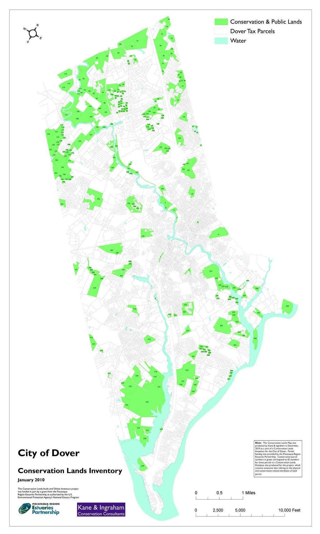
12 TABLE OF CONTENTS I. PROJECT SCOPE AND METHODS... 1 Conservation Lands Database... 2 II. RESULTS AND DISCUSSION... 6 On-line Access... 6 Conservation Parcel Profile Sheets... 6 Tables Table 1. GRANIT Data Fields Table 2. Additional Data Fields Table 3. Acreage of Conservation Lands in Dover by Protection Type Appendices Appendix A: Map of Conservation & Public Lands in Dover, NH Appendix B: Conservation Parcel Profile Sheets iii
13 I. PROJECT SCOPE AND METHODS The foundation of the project was a comprehensive inventory of properties in Dover that are either legally restricted by conservation terms in a deed, or that are otherwise considered conservation land by tradition, intent or vote of the City, or some other means. This Inventory culminated in a Conservation Database produced in MS Excel as single sortable worksheet, which was populated with salient information on each property. Over 300 tax parcels were initially reviewed as possible conservation / public lands over the course of the project. Certain criteria were established by Kane & Ingraham and the Dover Conservation Commission and staff as to which lands would be included in the study. As a result of this filtering process, the following types of properties were included in the results as conservation lands: Properties restricted by conservation easements Properties with conservation restrictions in a fee deed Properties granted to City of Dover or a sub-division thereof, or that have the Dover Conservation Commission mentioned in the deed as an authority to the property Properties not specifically restricted, but owned by an organization whose primary purpose is conservation, such as the N.H. Fish & Game Department, or the Society for the Protection of New Hampshire Forests Relatively large, undeveloped open space properties owned by the City of Dover that do not have legal conservation restrictions, but that are relatively inaccessible and large Lands co-owned by neighbor / owner groups that have Restrictive Covenants for conservation in the deeds or on a plan City of Dover -owned lands that have established conservation uses, but no legal restrictions per se Lands owned by water districts for well-head / water supply protection Lands owned by the City of Dover and devoted primarily to organized recreation, but protected under an overseeing program such as the Land and Water Conservation Fund Consequently parcels in the following categories were excluded from the final Conservation Database: City-owned lands that were acquired for purposes other than conservation Lands owned or primarily used by school districts 1
14 Lands owned by the City but devoted primarily to organized recreation, and not protected under a restrictive program Lands owned for unspecified purposes by the State of New Hampshire Properties held by the NH Department of Transportation Vacant house lots in otherwise developed areas, that do not otherwise provide access to other open space Private lands registered under the Current Use program, but otherwise un-restricted Properties exempt from property taxes, but other but otherwise un-restricted Small parks that are not primarily open space Properties less than 1 acre in size unless specifically protected in some way by conservation restrictions in a deed, or whose apparent intent is for conservation Conservation Lands Database In the research for the Conservation Inventory phase of the project, all references to any lands in Dover that had appeared on any available list as potentially held for conservation purposes were researched. Other sources of data regarding conservation lands were also investigated, including the GIS mapping Conservation Lands data layer administered under the umbrella of GRANIT, the central clearinghouse for geospatial data at Complex Systems at the University of New Hampshire. All available records in the Dover Planning Department were searched, including reports of City-owned open space properties, monitoring files, Conservation Commission property files, old plans, and lists of City lands and Conservation lands. A thorough search was conducted of the records on the Strafford County Registry of Deeds online website. Searches of Grantor/Grantee records were made for the following entities: City of Dover, Society for the Protection of New Hampshire Forests, Strafford County Conservation District, Audubon Society of New Hampshire, The Nature Conservancy, N.H. Fish & Game Department, Strafford Rivers Conservancy, Southeast Land Trust, and the Rockingham Land Trust. Any lead to a potential conservation property was followed using various search methods online. This provided much of the critical information and documents that the Inventory relied on. Some protection methods extend over either portions or complete multiple lots. Others are restricted to a portion of a tax lot. For ease in reference to conservation parcels, the data unit of a tax parcel was chosen. As the information on each property was gathered, it was entered into a database by Tax Map, Lot and Sub-lot number. 70 fields of pertinent information were recorded, to the extent the data was available, for each parcel. To facilitate submission of conservation lands data to GRANIT, the database was designed as an expanded clone of the GRANIT Consland attribute table that forms the data 2
15 background for the GRANIT mapping of conservation lands. These 49 GRANIT data fields and a brief description are shown in Table 1. Table 1. GRANIT Data Fields Field Field Name Field Description # 1 TID GRANIT ID number (GIS Consland Layer) 2 NAME Tract Name 3 NAMEALT Alternate Tract Name 4 P_NAME Parcel Name 5 P_NAMEALT Alternate Parcel Name 6 PPTYPE Primary Protection Type Code 7 PPTYPE_Desc Primary Protection Type Description 8 PPTERMTYPE Term of Protection Code 9 PPTERM_Desc Term of Protection Description (eg. Perpetual) 0 PPTERM Length of Limited Protection Term 11 SPTYPE1 Secondary Protection Type 1 Code 12 SPTYPE1_Desc Secondary Protection Type 1 Description 13 SPTYPE2 Secondary Protection Type 2 Code 14 SPTYPE2_Desc Secondary Protection Type 2 Description 15 PPAGENCY Primary Protecting Agency/Organization Code 16 PPAGENCY_Desc Primary Protecting Agency/Organization Description 17 PPAGENTYPE Type of Primary Protecting Agency Code 18 PPAGENTYPE_Desc Type of Primary Protecting Agency Description 19 SPAGENCY1 Secondary Protection Agencies 1 Code 20 SPAGENCY1_Desc Secondary Protection Agencies 1 Description 21 SPAGENCY2 Secondary Protection Agencies 2 Code 22 SPAGENCY2_Desc Secondary Protection Agencies 2 Description 23 RSIZE Reported Size of Tract (acres) 24 CSIZE Calculated Size of Tract (acres) 25 P_RSIZE Reported Size of Parcel (acres) 26 P_CSIZE Calculated Size of Parcel (acres) 27 PROGRAM Code for Program or agency under whose auspices the protection took place 28 PROGRAM_Desc Description of program or agency under whose auspices the protection took place 29 LEVEL_ Protection Level Code 30 LEVEL_Desc Protection Level Description (eg. Permanent Conservation Land) 3
16 31 MSTATUS Management Status Code 32 MSTATUS_Desc Management Status Description ( eg. entirely protected from conversion of natural land cover) 33 SOURCE Source of information used for mapping the tract 34 ACCURACY Code for general flag to indicate the accuracy of mapping 35 ACCURACY_Desc Description of level of mapping accuracy 36 COBKPG County, Book, Page of recorded deed in Registry of Deeds 37 DATEREC1 Date of recording of first conservation instrument 38 DATEREC2 Date of recording of subsequent for conservation instruments 39 ACCESS Level of Public Access Code 40 ACCESS_Desc Level of Public Access Description 41 DATEADDED Date record (spatial/attribute) was added to the database 42 DATEALTER Date of last revision of any of the tract boundaries or attributes 43 NOTES1 Additional notes field 44 NOTES2 Additional notes field 45 NOTES3 Additional notes field 46 NOTES4 Additional notes field 47 PID Old GRANIT ID number 48 GAP_STATUS Code for level of protection and management allowed 49 GAP_Desc Description of level of protection and management allowed 21 additional fields were added the Conservation database to provide more depth to the data as it relates to the conservation specifics of each parcel. These additional fields are shown in Table 2 below. Table 2. Additional Data Fields Field # Field Name Field Description 50 Map_ID ID assigned to tract on Conservation Lands Inventory map 51 Feature_ID Unique identifier code for linking database to spatial data 52 PID_Dover Parcel ID (links to Dover GIS) 53 Map City of Dover Tax Map 54 Lot Tax Lot 55 Sublot Tax Sublot 56 Grantee Grantee in deed, or property owner 57 Grantor Grantor of deed 58 Location General location of tract 59 Street Street address (if any) 4
17 60 Plan File number of recorded plan at Registry of Deeds 61 Purposes Abstract summary of Conservation Purposes in deed or plan 62 Limitations Abstract summary of Use Limitations in deed or plan 63 LegalNotes Abstract summary of Reserved Rights of other terms in deed 64 SrcNotes Source of data for this project 65 MapNotes Notes regarding new parcel mapping 66 Notes Additional notes field 67 GRANITNotes Notes regarding mapping of and submission to GRANIT 68 DateComplete Date data entry was complete 69 Staff Staff who entered data 70 Owner_Name Name of current property owner As parcel data was completed, each parcel was mapped using the digital Dover tax parcel data as the basis for external boundaries where they apply. In cases where only portions of a tax parcel are protected, the non-protected portions were excluded from the mapping. Plans and legal descriptions were used to map these boundaries with a high level of accuracy. All parcels previously mapped by GRANIT were reviewed for accuracy, and in a number of cases were refined. Each parcel mapped was assigned a Map ID number to use in identifying that parcel on the accompanying GIS map of Dover shown in Appendix B. Some 19,740 data cells constitute the data base, to the extent that data was available. The database is thus much too extensive to practically print, therefore this product was provided to the City of Dover electronically. 5
18 II. RESULTS AND DISCUSSION According to the criteria established for this Conservation Lands Audit / Inventory, a total of 282 tax parcels were included as conservation land. This represents 3,098 acres of conservation lands in the City. Part of this project involved a refinement of the 2010 update to the GRANIT Consland database. After validating, adjusting and correcting this data, a total of 2,356 acres of conservation land were accounted for in Dover. The project yielded an additional 742 acres of conservation parcels previously un-documented by GRANIT in Dover. Table 3. below shows a break-down of the aggregate conservation lands acreage by protection type. Table 3. Acreage of Conservation Lands in Dover by Protection Type Primary Protection Type Code Total Dover Acres Conservation Easement CE 1,367 Deed Restriction DR 139 Flowage Rights or Easement FE 125 Fee Ownership FO 1,223 Protective Easement (for Water Supply Lands) PE 10 Set Aside Open Space Areas of Developments SA 234 Total 3,098 The resulting database and GIS products for this project will form a solid foundation for the ongoing administration of land conservation, and for conservation planning in Dover. The resulting current, comprehensive and accurate mapping will also provide a better picture of the state of conservation in Dover and the region generally. As new properties are protected in the future, they can be added to the database and GIS system according to the same protocol. On-line Access These data have been provided in digital form to the City of Dover GIS department. Once a selection process is complete, select conservation lands will be available for display on the City s GIS website portal as a data layer. Conservation Parcel Profile Sheets The enhanced ability of City staff to track individual tax parcels vis-à-vis any conservation restrictions is a useful outcome of this project. This will be especially useful for those parcels for which the City has stewardship responsibilities. In order to make the extensive data more accessible, 16 select salient fields of data were selected to display on individual sheets that can be filed by tax parcel. Appendix B is comprised of this complete set of Conservation Parcel Profile Sheets, provided in order of tax map, lot and sublot order (same order as Map ID). 6
19 Appendix A: Map of Conservation & Public Lands in Dover, NH
20
21 Appendix B: Conservation Property Profiles
22 Dover Conservation Parcel Profile: Map ID 1 1/ Fisher St. City Trail CITY OF DOVER Conservation Acres: Reported Size: 2.60 Calculated size: 2.71 Fee Ownership Charles P. Kageleiry & Michael J. Kane City of Dover No Purposes. No Use Limitations. Reserved Rights, etc: No Restrictions or conservation terms or intent in deed. SCRD Book & Page: 17/3311/694 Date: SCRD Plan: Not Recorded, in possession of B&M - V2 NH 65-B, 1914 GRANIT Number: New, Dover files B-1
23 Dover Conservation Parcel Profile: Map ID 2 1/ Picnic River Partners of Dover, LLC PICNIC RIVERS PARTNERS OF DOVER LLC Conservation Acres: Reported Size: None Calculated size: 0.46 Conservation Easement Picnic River Partners of Dover, LLC City of Dover Protects 30' trail corridor allows for public non-motorized passive recreation Reserved Rights, etc: grants no other access to remainder of property SCRD Book & Page: 17/3799/646 Date: SCRD Plan: GRANIT Number: Fargo file B-2
24 Dover Conservation Parcel Profile: Map ID 3 1/ Cobble Hill Open Space Conservation Acres: Reported Size: None Calculated size: 4.67 Set Aside Open Space Areas of Developments Cobble Hill Community Association Cobble Hill Community Association alternative design subdivision, "use, enjoyment, and recreation for the residents" no "alteration" (without consent of board), no structures (except as approved by board), no dumping; rules can be overturned by association vote Reserved Rights, etc: "Lot Owner's Rights in Common Property": "enjoyment". Landowner rights/responsibilities: maintain common land (including landscaping) SCRD Book & Page: 17/1478/ /1528/192 Date: SCRD Plan: GRANIT Number: B-3
25 Dover Conservation Parcel Profile: Map ID 4 1/ Guppey Park Pool and Arena CITY OF DOVER Conservation Acres: Reported Size: None Calculated size: Fee Ownership City of Dover no deed found Reserved Rights, etc: SCRD Book & Page: Date: SCRD Plan: GRANIT Number: New, Dover B-4
26 Dover Conservation Parcel Profile: Map ID 5 1/ Park Street Mini-Park CITY OF DOVER Conservation Acres: Reported Size: None Calculated size: 1.05 Fee Ownership Richard Realty Commpany, Inc. City of Dover No conservation terms in deed Reserved Rights, etc: SCRD Book & Page: 17/987/293 Date: SCRD Plan: GRANIT Number: New, Dover B-5
27 Dover Conservation Parcel Profile: Map ID 6 1/ Bardwell Conservation Easement SIXTH STREET STATION CONDOMINIUM Conservation Acres: Reported Size: 1.81 Calculated size: 2.12 Conservation Easement Sixth Street Station, LLC City of Dover Property to be retained forever in undeveloped condition, no use that will impair / interfere with conservation values. 1. Property to be maintained in perpetuity as open space free from industrial, commercial activities, except recreational trail and forestry activities (as defined). 2. Ownership of Property shall not be transferred in ay manner contrary to subdivision/conveyance approvals on Plan ( to be owned in common with 24 lot owners ) unless approved by Grantee (as specified further). 3. No structure / improvement except walking trails. 4. No removal, filling, disturbance of surface / subsurface soils, changes in topography, surface / subsurface water systems, wetlands, natural habitats. 5. No excavation or removal of rocks, minerals, gravel, sad, topsoil, etc. 6. No dumping, injection, burial of hazardous materials, or dumping, burning, etc. of garbage building debris, yard waste, etc. foreign to Property. 7. No outdoor advertising structures such as signs and billboards except for allowed informational / conservation purposes. 8. No use of motorized vehicles. 9. Grantor reserves right to repair damages in conformance with conservation purpose. Reserved Rights, etc: Reserved Rights: Grantor reserves right to use property for recreation / conservation, including access to tennis courts, dock, picnic table, etc. A. To maintain, repair, replace utilities. B. To develop public or private water supplies not to adversely affect Cocheco River, wetlands. C. To post against hunting. D. To post against use by motorized vehicles. E. To conduct forestry, salvage cuts, in accordance with forestry management plan mutually acceptable to Grantor / Grantee, and not to impair scenic quality of property from river or trail. F. Prior notification of above required. SCRD Book & Page: 17/2492/526 Date: SCRD Plan: GRANIT Number: B-6
28 Dover Conservation Parcel Profile: Map ID 7 1/ B- Cassily LCHIP - Cochecho Park LAND AND COMMUNITY HERITAGE INVESTMENT PROGRAM Conservation Acres: Reported Size: Calculated size: Fee Ownership City of Dover Land and Community Heritage Investment Program Authority To protect Property for agricultural, forestry, water quality, open space, public access, transitory low-impact outdoor recreation, and other conservation purposes (RSA 227-M). Deed conveys Executory Interest and Public Access subject to the following conditions: Public pedestrian access conveyed, on and across Property, for recreational purposes, but not camping. Grantor may post against / limit access for activities inconsistent with Purposes, or for public safety. Grantor reserved right to post against vehicles, hunting on active livestock field or during planting / growing season, or on forest land during active forestry. Conveyance of property prohibited. No construction, maintenance, or installation of physical improvements, no alteration of soil surface, except as necessary for allowed uses and purposes. Management according to stewardship plan, forestry according to scientifically-based practices. Activities and management not to materially impair scenic quality of property as viewed form public waterways, roads, trails, and not to harm State-listed rare species. No dumping, storage of hazardous materials, vehicle parts and bodies, etc. Annual inspection for compliance shall be assured by Grantor. Reserved Rights, etc: SCRD Book & Page: 17/3204/699 Date: SCRD Plan: GRANIT Number: B-7
29 Dover Conservation Parcel Profile: Map ID 8 1/ Cassily LCHIP - Cochecho Park LAND AND COMMUNITY HERITAGE INVESTMENT PROGRAM Conservation Acres: Reported Size: 8.31 Calculated size: 8.53 Fee Ownership City of Dover Land and Community Heritage Investment Program Authority To protect Property for agricultural, forestry, water quality, open space, public access, transitory low-impact outdoor recreation, and other conservation purposes (RSA 227-M). Deed conveys Executory Interest and Public Access subject to the following conditions: Public pedestrian access conveyed, on and across Property, for recreational purposes, but not camping. Grantor may post against / limit access for activities inconsistent with Purposes, or for public safety. Grantor reserved right to post against vehicles, hunting on active livestock field or during planting / growing season, or on forest land during active forestry. Conveyance of property prohibited. No construction, maintenance, or installation of physical improvements, no alteration of soil surface, except as necessary for allowed uses and purposes. Management according to stewardship plan, forestry according to scientifically-based practices. Activities and management not to materially impair scenic quality of property as viewed form public waterways, roads, trails, and not to harm State-listed rare species. No dumping, storage of hazardous materials, vehicle parts and bodies, etc. Annual inspection for compliance shall be assured by Grantor. Reserved Rights, etc: SCRD Book & Page: 17/3204/699 Date: SCRD Plan: GRANIT Number: B-8
30 Dover Conservation Parcel Profile: Map ID 9 1/ A- Beckwith Park DOVER BASEBALL Conservation Acres: Reported Size: None Calculated size: 6.07 Fee Ownership Eileen C. Bardwell Dover Northside Little League, Inc. Subject to Grantor retaining an easement on Parcel A (lot line to be abandoned) for the purpose of creating and maintaining a Nature/walking trail along the Cocheco Riverbank for use of general public. Reserved Rights, etc: SCRD Book & Page: 17/1888/795 Date: SCRD Plan: GRANIT Number: New, Dover B-9
31 Dover Conservation Parcel Profile: Map ID 10 1/ Horne Street Park CITY OF DOVER Conservation Acres: Reported Size: None Calculated size: Fee Ownership City of Dover no deed found Reserved Rights, etc: SCRD Book & Page: Date: SCRD Plan: GRANIT Number: New, Dover B-10
32 Dover Conservation Parcel Profile: Map ID 11 1/ Willand Pond CITY OF DOVER Conservation Acres: Reported Size: None Calculated size: 0.84 Fee Ownership City of Dover deed unavailable Reserved Rights, etc: SCRD Book & Page: 17/508/469 Date: SCRD Plan: GRANIT Number: B-11
33 Dover Conservation Parcel Profile: Map ID 12 1/ A- Willand Pond CITY OF DOVER Conservation Acres: Reported Size: None Calculated size: 0.44 Fee Ownership City of Dover deed unavailable Reserved Rights, etc: SCRD Book & Page: 17/508/469 Date: SCRD Plan: GRANIT Number: B-12
34 Dover Conservation Parcel Profile: Map ID 13 1/ Willand Pond CITY OF DOVER Conservation Acres: Reported Size: None Calculated size: 2.68 Fee Ownership City of Dover deed unavailable Reserved Rights, etc: SCRD Book & Page: 17/508/469 Date: SCRD Plan: 41A-86 GRANIT Number: B-13
35 Dover Conservation Parcel Profile: Map ID 14 1/ Willand Pond CITY OF DOVER Conservation Acres: Reported Size: None Calculated size: 0.32 Fee Ownership City of Dover Statement in Deed that City of Dover shall NOT pursue use of pond as municipal water source. Reserved Rights, etc: SCRD Book & Page: 17/508/469, 17/2286/230 Date: SCRD Plan: 41A-86 GRANIT Number: B-14
36 Dover Conservation Parcel Profile: Map ID 15 1/ Willand Park CITY OF DOVER Conservation Acres: Reported Size: 0.66 Calculated size: 0.62 Fee Ownership City of Dover NH Fish and Game Department A perpetual easement for the purpose of providing development of boat ramp, access road, parking and amenities for establishment of public boat launch facility. Reserved Rights, etc: Grantee shall have perpetual right to maintain, operate and manage public boat launch facility, all improvements to remain property of Grantee. Grantee retains right to remove existing improvements as necessary to meet purpose. Free and unfettered public access. SCRD Book & Page: 17/508/469, 17/1905/319 Date: SCRD Plan: 41A-86 GRANIT Number: B-15
37 Dover Conservation Parcel Profile: Map ID 16 1/2011 A-15- Stonecroft OSS STONECROFT HOMEOWNERS' ASSOCIATION Conservation Acres: Reported Size: Calculated size: Set Aside Open Space Areas of Developments Robbins, Brown and Westcott City of Dover A. To protect natural ecosystem of Property. B. To protect natural habitat of wetland / upland complex, storm water storage, nutrient retention. Use Limitation: A. Property shall be maintained in perpetuity as ( Natural forest land / open space ) free from industrial or commercial activities. B. No subdivision of separate parcel conveyance. C. No structures or improvements, removal, filling, disturbance of soils surface, changes to topography, surface / subsurface water systems, wetlands, natural habitats except drainage systems approved by City Engineer, and upon Grantee s written permission, as necessary for conservation purposes. D. No advertising structures signs, billboards. E. No mining, excavation, removal of rocks, gravel, topsoil, etc. from property. Reserved Rights, etc: SCRD Book & Page: 17/3252/225 Date: SCRD Plan: 81-22, 81-23, GRANIT Number: B-16
38 Dover Conservation Parcel Profile: Map ID 17 1/2011 A-19-3 White Tail OSS MIDDLESEX REALTY LLC Conservation Acres: Reported Size: None Calculated size: Set Aside Open Space Areas of Developments Reserved Rights, etc: SCRD Book & Page: Date: SCRD Plan: 78-44, 78-45, 78-46, GRANIT Number: B-17
39 Dover Conservation Parcel Profile: Map ID 18 1/2011 A-23-2 Browne II Easement CITY OF DOVER Conservation Acres: Reported Size: Calculated size: Conservation Easement City of Dover Strafford Rivers Conservancy To assure Property will be retained forever in open space, undeveloped condition, to prevent use that will impair / interfere with conservation values. A. Water quality and supply The perpetual protection of the quality and yield of groundwater / surface water resources on the Property, to safeguard present / future community drinking supplies, and abutting water source Cotton Well / Blackwater Well. B. Preservation and conservation of open spaces, 11.6 acres of farm and forest land. C. Preservation of public scenic values of property as viewed from Blackwater Road. Prohibited Uses and Activities: Any activity inconsistent with Purposes is prohibited. A. No industrial / commercial activities except as otherwise permitted herein. B. No subdivision, division of ownership (except as permitted in Section III.B.) C. No structure, improvement such as a dwelling, tennis court, swimming pool, etc. except as necessary in accomplishment of allowed uses and approved by Grantee. D. No removal, filling, disturbance / erosion of soil surface, above / below water table, changes of topography except as necessary in conjunction with allowed uses (as further described). E. In sanitary zone no mining, excavation or removal of rocks, minerals, gravel, sand, topsoil, ground or surface water, except as otherwise permitted herein. 5 foot vertical minimum distance between altered lad surface and high groundwater level, etc. F. No dumping, burial, storage, injection, etc. of man-made materials including construction debris, trash, tires, vehicle bodie parts, etc. or municipal plowed snow. G. No storage tanks with gaseous / liquid petroleum products. H. No substances that are a hazard to human health to be transported, used, stored, etc. I. Buildings / impervious materials as permitted in Section IV shall cover no more than 10% of property, if within sanitary zone, than subject to Grantee approval. J. Surface / groundwater quality shall be preserved, not polluted or degraded. K. Sustainable groundwater yield shall not be exceeded. L. No activities that would harm State-listed rare, threatened, endangered species. B-18
40 Reserved Rights, etc: Permitted Uses and Activities: A. To develop and maintain a public water supply and associated facilities and improvements (as further described). B. To subdivide Property only as necessary to exercise right above (as further described). C. Agriculture / forestry allowed, including necessary improvements for this use according to management plan (as further described and restricted). D. Outdoor recreation allowed (specific uses in and outside sanitary zone listed). E. No activity / use detrimental or of threat to protection of preset and potential water municipal water system. Rights of Grantee listed. SCRD Book & Page: 17/3021/467 Date: SCRD Plan: GRANIT Number: B-19
41 Dover Conservation Parcel Profile: Map ID 19 1/2011 A-24B- Frazer FRAZER MARDEAN TRUSTEE Conservation Acres: Reported Size: None Calculated size: Conservation Easement Mardean Frazer, Trustee City of Dover A. To ensure Property remains forever in scenic, open space and undeveloped condition. B. To provide limited public access, by reasonable advance notice, for education and promotion of easement conservation values. Intent to allow access as a part of organized groups: field trips, scouts, etc. not necessarily general access. C. To protect groundwater quality. D. To preserve valuable wooded land, wetlands, vernal pools, etc. and natural habiats / wildlife. E. To protect open space and water, forest, agricultural and wildlife resources, for scenic enjoyment of general public. A. No industrial/commercial activities except limited agriculture, forestry, equine activities, all not to degrade productive capacity (allowed activities defined). B. No subdivision of easement area, but subdivision of said area from unrestricted land allowed (lengthy elaboration). C. No structures, improvements such as a dwelling, septic system, tennis courts, etc. No advertising structures except to identify property and trails/use, as mutually agreed upon with Grantee. D. No surface alterations, no filling, removal or disturbance of soils, topograohy, surface/sub-surface water systems,wetlands, etc. E. No mining, quarrying, extraction of minerals, sand, topsoil, etc. F. No dumping, burning, storage, etc. of synthetic or hazardous materials such as tires, refuse, vehicle parfts, etc. G. No storage tanks for gases, petroleum products, etc. H. No substances hazardous to health. I. No (further) impervious surfaces, including buildings or paving. J. Water quality not to be degraded. K. No unsustainable water withdrawals. L. No activities that harm wildlife, listed species. M. No vehicles, motorized or wheeled, except for emergencies. No overnight camping, fires. Reserved Rights, etc: Reserved Rights: A. To post against hunting, camping. B. To post against vehicles. C. To post against unlimited/general recreation inconsistent with Section 2.B above, signage to be mutually agreed upon by Grantor/Grantee. D. To mow fields. E. To develop replacement/expanded water wells/systems for residential/accessory use by structures on unrestricted land of Grantor. F. To maintain, repair, replace utilities to serve unrestricted Grantor land. B-20
42 SCRD Book & Page: 17/3617/899 Date: SCRD Plan: GRANIT Number: New, Dover files B-21
43 Dover Conservation Parcel Profile: Map ID 20 1/2011 A-24- Frazer FRAZER MARDEAN TRUSTEE Conservation Acres: Reported Size: None Calculated size: 6.43 Conservation Easement Mardean Frazer, Trustee City of Dover A. To ensure Property remains forever in scenic, open space and undeveloped condition. B. To provide limited public access, by reasonable advance notice, for education and promotion of easement conservation values. Intent to allow access as a part of organized groups: field trips, scouts, etc. not necessarily general access. C. To protect groundwater quality. D. To preserve valuable wooded land, wetlands, vernal pools, etc. and natural habiats / wildlife. E. To protect open space and water, forest, agricultural and wildlife resources, for scenic enjoyment of general public. A. No industrial/commercial activities except limited agriculture, forestry, equine activities, all not to degrade productive capacity (allowed activities defined). B. No subdivision of easement area, but subdivision of said area from unrestricted land allowed (lengthy elaboration). C. No structures, improvements such as a dwelling, septic system, tennis courts, etc. No advertising structures except to identify property and trails/use, as mutually agreed upon with Grantee. D. No surface alterations, no filling, removal or disturbance of soils, topograohy, surface/sub-surface water systems,wetlands, etc. E. No mining, quarrying, extraction of minerals, sand, topsoil, etc. F. No dumping, burning, storage, etc. of synthetic or hazardous materials such as tires, refuse, vehicle parfts, etc. G. No storage tanks for gases, petroleum products, etc. H. No substances hazardous to health. I. No (further) impervious surfaces, including buildings or paving. J. Water quality not to be degraded. K. No unsustainable water withdrawals. L. No activities that harm wildlife, listed species. M. No vehicles, motorized or wheeled, except for emergencies. No overnight camping, fires. Reserved Rights, etc: Reserved Rights: A. To post against hunting, camping. B. To post against vehicles. C. To post against unlimited/general recreation inconsistent with Section 2.B above, signage to be mutually agreed upon by Grantor/Grantee. D. To mow fields. E. To develop replacement/expanded water wells/systems for residential/accessory use by structures on unrestricted land of Grantor. F. To maintain, repair, replace utilities to serve unrestricted Grantor land. B-22
44 SCRD Book & Page: 17/3617/899 Date: SCRD Plan: GRANIT Number: New, Dover files B-23
45 Dover Conservation Parcel Profile: Map ID 21 1/2011 A-27- Holley I HOLLEY EDITH A TRUSTEE Conservation Acres: Reported Size: Calculated size: Conservation Easement Edith A. Holley, trustee Strafford County Conservation District To protect the Property's agricultural soils / viability / productivity in perpetuity, as well as additional conservation values. A. Preservation and conservation of open spaces, particularly ac. of productive prime, statewide and local important soils, and farm/forest land and wildlife habitat, and scenic enjoyment of general public. B. Purposes consistent with Dover Master Plan. C. Purposes consistent with US IRS Code. A. All agricultural operations must be in accordance with conservation plan prepared in consultation with NRCS and approved by Conservation District. NRCS reserves right to enter property following notice to monitor compliance. Provide copies of plan to NRCS and SCCD. B. Terms regarding compliance / noncompliance resolution process. C. If event NRCS standards for highly erodable land are revised, NRCS will work with Grantor to revise plan. D. Property to be used as open space without industrial/commercial activities, except agriculture/forestry (as defined and limited); E. Commercial Forestry defined. F. Commercial / industrial forestry goals defined. G. Forestry to be performed in accordince with a written forest management plan, submitted to Grantee at least 30 days prior to activities (etc, review procedures). H. FMP approval not to unreasonably be withheld, if clearcut/conversion proposed, must demonstrate consistency with plan, goals and Purposes. I. Forestry according to scientific principles and following erosion BMP's. J. In public areas forestry according to Jones Logging Aestherics guide. K. No subdivision or separate conveyance or separate parcels. L. No structure or improvement including a dwelling, swimming pool, septic system, etc. unless necessary for agriculture/forestry/conservation/habitat management or non-commercial outdoor recreation. M. No removal/filling/disturbance of soils surface or changes in topography, water systems, wetlands, natural habitat except as necessary for allowed uses, and not to harm rare species. N. No outdoor advertising structures. O. No mining, quarrying, removal, etc. of rocks, mineral, gravel, topsoil, etc. except pursuant to allowed uses. P. No dumping/burial of hazardous materials. Production, storage, B-24
46 etc. of pesticides, manure, etc. according to use labels and CP. Q. Maximum impervious surface of 2% (2.55 ac.) of easement area, to include structures permanent and temporary, roads, etc. R. Motorized vehicles prohibited except for farm vehicles, snowmobiles allowed. S. CE not to be used for density requirements. T. No granting of ROW, access easement or utilities, etc. without written approval of Grantee. U. Heavy use, large group activities prohibited. Reserved Rights, etc: Reserved Rights: A. Right to use property for commercial/noncommercial forestry/agriculture, non-commercial low impact recreation as further qualified. B. To create ponds for fire protection and wildlife habitat according to NRCS approved plan. C. To erect, maintain signs to announce allowed uses, historically appropriate, and 10 ft2 max. D. To erect signs with address, 10ft2 max. E. To allow low-impact recreation and education of general public. F. To erect greenhouses, oe windmill and other structures (as qualified) but permanent/temporary residential/recreational structures (listed) prohibited. G. To drill and extract water for agricultural purposes, so as to minimize disturbance of important ag soils. H. To store/compost organic farm waste, and to import manure. I. To permit archological investigations (as defined and qualified). J. To permit or deny permission to use property for low-impact recreation, use secondary to agricultural values. SCRD Book & Page: 17/3438/435 Date: SCRD Plan: 87-96, GRANIT Number: New, Dover files B-25
47 Dover Conservation Parcel Profile: Map ID 22 1/2011 I-27- Holley II HOLLEY EDITH A TRUSTEE Conservation Acres: Reported Size: Calculated size: Conservation Easement Edith A. Holley, trustee City of Dover 1. To protect Property from future development, to conserve unique Property characteristics in present scenic / natural condition. 2. To conserve soil productivity and promote productive capacity. 3. To preserve biological diversity, native flora/fauna, environments, habitats, ecological processes. 4. To preserve Property for scenic enjoyment of general public. 5. To prevent uses/activities detrimental to drainage, flood control, water conservation/quality. 6. Preservation / protection of water quality of surface waters including Clark Brook. 1. Property to be maintained in perpetuity in undeveloped/natural condition. No use or activity inconsistent with CE terms. 2. No commercial, industrial, residential activities, no structures, improvements including a dwelling, septic system (etc., listed) 3. Property shall not be subdivided, nor separate parcels conveyed. 4. Not to be used to satisfy zoning/subdivision requirements. 5. No removal, filling or disturbance of soils, topography, surface/subsurface water systems, wetlands, natural habitats unless commonly necessary for allowed uses, and do not harm NHNHB listed species, and do not impact wetlands, etc. and are not detrimental to CE Purposes. 6. No dumping, burial, etc. of refuse/hazardous materials, vehicles/parts, fertilizer, etc. 7. No additional ROW, access easement, etc. Reserved Rights, etc: Reserved Rights: Right to use property for commercial/noncommercial forestry/agriculture, non-commercial low impact recreation as further qualified. 1. To conduct agricultural activities, (specified), and provided no more than 35% of revenue is from offsite products, and according to a conservation plan and construct / maintain surface roads for that purpose. 2. To harvest wood and timber products (defined) and if commercial/industrial then according to FMP (further specified). 3. To construct / maintain dames, fences, trails, bridges, etc. for allowed uses. 4. To erect, maintain signs to announce allowed uses. 5. To withdraw and remove groundwater sustainably from property so as not to affect Clark Brook/Blackwater Brook, including ancillary structures/improvements not to exceed B-26
48 5,000 ft2. and according to Water Extraction Plan (much further specified). SCRD Book & Page: 17/3438/421 Date: SCRD Plan: GRANIT Number: found in SCRD B-27
49 Dover Conservation Parcel Profile: Map ID 23 1/2011 A-28- Gladiola Way OSS GLADIOLA LANE DEVELOPMENT LLC Conservation Acres: Reported Size: 4.92 Calculated size: 4.93 Set Aside Open Space Areas of Developments Long Hill Realty Investments, LLC City of Dover Notes on Plan Plan Notes: #13. All open spaces to be owned by Homeowners Association, no public access allowed. #14. Open space provided as passive recreation area for Homeowner's Assoc. #19. No disturbance (to vegetation) within open spaces lots. Reserved Rights, etc: SCRD Book & Page: Date: SCRD Plan: 93-39, 93-40, GRANIT Number: New Dover B-28
50 Dover Conservation Parcel Profile: Map ID 24 1/2011 A-28- Gladiola Way OSS GLADIOLA LANE DEVELOPMENT LLC Conservation Acres: Reported Size: 2.63 Calculated size: 2.63 Set Aside Open Space Areas of Developments Long Hill Realty Investments, LLC City of Dover Notes on Plan Plan Notes: #13. All open spaces to be owned by Homeowners Association, no public access allowed. #14. Open space provided as passive recreation area for Homeowner's Assoc. #19. No disturbance (to vegetation) within open spaces lots. Reserved Rights, etc: SCRD Book & Page: Date: SCRD Plan: 93-39, 93-40, GRANIT Number: New Dover B-29
51 Dover Conservation Parcel Profile: Map ID 25 1/2011 A-28- Gladiola Way OSS GLADIOLA LANE DEVELOPMENT LLC Conservation Acres: Reported Size: 1.31 Calculated size: 1.31 Set Aside Open Space Areas of Developments Long Hill Realty Investments, LLC City of Dover Notes on Plan Plan Notes: #13. All open spaces to be owned by Homeowners Association, no public access allowed. #14. Open space provided as passive recreation area for Homeowner's Assoc. #19. No disturbance (to vegetation) within open spaces lots. Reserved Rights, etc: SCRD Book & Page: Date: SCRD Plan: 93-39, 93-40, GRANIT Number: New Dover B-30
52 Dover Conservation Parcel Profile: Map ID 26 1/2011 A-28- Gladiola Way OSS GLADIOLA LANE DEVELOPMENT LLC Conservation Acres: Reported Size: 1.07 Calculated size: 1.07 Set Aside Open Space Areas of Developments Long Hill Realty Investments, LLC City of Dover Notes on Plan Plan Notes: #13. All open spaces to be owned by Homeowners Association, no public access allowed. #14. Open space provided as passive recreation area for Homeowner's Assoc. #19. No disturbance (to vegetation) within open spaces lots. Reserved Rights, etc: SCRD Book & Page: Date: SCRD Plan: 93-39, 93-40, GRANIT Number: New Dover B-31
53 Dover Conservation Parcel Profile: Map ID 27 1/2011 A-29A- Browne I BROWNE RUSSELL T LIVING TRUST 1/2 Conservation Acres: Reported Size: Calculated size: Conservation Easement Russell T. & Frances V. Browne, trustees City of Dover 1. To be maintained forever in undeveloped condition. 2. To protect property from future development, to concerve, preserve and maintain unique characteristics of property substantially in open space condition, with scenic, agricultural, archetectural and historic significance. 3. To preserve biological diversity, native flora/fauna, environments, habitats, ecological processes. 4. To prevent uses/activities detrimental to drainage, flood control, water conservation/quality, but not to preclude agriculture. 5. To preserve Property for permitted uses and conservation values. 1. No subdivision, separate conveyance of lots. 2. No commercial / industrial activities or associated structures/improvements except for existing utilities. Dumpster for temporary construction allowed. 3. No (new) structures allowed for specific agriculture-related education. 4. No removal/filling/disturbance of soils surface or changes in topography, water systems, wetlands, natural habitat, no mining, quarrying, removal, etc. of rocks, mineral, gravel, topsoil, etc. except as necessary for allowed uses, and not to harm rare species. 5. No dumping/burial of hazardous materials. Production, storage, etc. of pesticides, manure, etc. according to use labels and CP. 6. No acts that degrade water quality, are unsustainable, or harm rare species, etc. 7. No outdoor advertising structures except for allowed uses, 10 ft2 max size. 8. No granting of ROW, access easement, roads, etc. without permission. 9. Maximum impervious surface of 2% of easement area, to include structures permanent and temporary, roads, etc. Reserved Rights, etc: Reserved Rights: 1. To exercise allr giths specified. 2. To repair damages to property, according to Purposes. 3. To use Property for non-commercial agriculture & forestry under conditions specified. 4. Agriculture defined, NRCS and SCCD approved conservation plan to be followed (further terms). 5. To harvest timber and wood products, as defined, and according to written and previously approved forest management plan (furthpeter and Lisa Garcia to picnic, camp, etc. Several Rights of Grantee including right to post signs, etc. B-32
54 SCRD Book & Page: 17/3126/273 Date: SCRD Plan: GRANIT Number: B-33
55 Dover Conservation Parcel Profile: Map ID 28 1/2011 A-29A-1 Cotton Well CITY OF DOVER Conservation Acres: Reported Size: None Calculated size: Fee Ownership Dorothy Cotton City of Dover No restrictions in fee deed Reserved Rights, etc: SCRD Book & Page: 17/1533/427 Date: SCRD Plan: 38A-37 GRANIT Number: New Dover, B-34
56 Dover Conservation Parcel Profile: Map ID 29 1/2011 A-31B- McAtavey MCATAVEY NANCY B TRUSTEE Conservation Acres: Reported Size: 1.83 Calculated size: 1.83 Conservation Easement Nancy B. McAtavey City of Dover A. To assure Property is retained forever in undeveloped, scenic, open space condition and to prevent use that will impair conservation values. B. To preserve and protect natural wildlife habitat, conservation of wetlands and riparian zones, and critical buffers to othat habitat. A. Property shall be maintained in perpetuity as open space without industrial or commercial activities, except agriculture and forestry (as defined in i). ii. Agriculture / forestry to be performed in accordance with coordinated management plan (as described). B. No subdivision. C. No structure, improvement such as a dwelling, tennis court, swimming pool, etc. except as necessary in accomplishment of allowed uses. D. No changes in topography, surface / subsurface water systems, wetlands, natural habitats without all required permits. E. No outdoor advertising signs / billboards. F. No mining, quarrying, etc. or removal of rocks, minerals, gravel, sand, etc. G. No dumping, injection, burial of hazardous materials, vehicle parts. H. Property not to be used to meet other municipal approvals. Reserved Rights, etc: Reserved Rights: A. To maintain, repair, replace existing utilities including power and communications lines, septic, etc. B. To create ponds for agriculture, fire protection, wildlife habitat enhancement un accordance with NRCS, etc. plan. C. To post against vehicles and hunting in fields, and access to cropland during growing season, and forest land during harvesting. D. To post against public access. SCRD Book & Page: 17/2953/339 Date: SCRD Plan: GRANIT Number: Fargo file B-35
57 Dover Conservation Parcel Profile: Map ID 30 1/2011 A-32B- Williams WILLIAMS ARTHUR P & BIRGIT K Conservation Acres: Reported Size: Calculated size: Conservation Easement Arthur P. & Birgit K. Williams City of Dover A. To assure Property is retained forever in updeveloped condition, to prevent significant impairment of conservation values. B. To preserve/protect natural wildlife habitat, conservation of wetlands/critical buffers. C. Protection of groundwater quality of Cotton Well, which abuts. D. Scenic enjoyment of general public (from Varney Road, Spaulding Turnpike). E. Preservation of land for outdoor recreation by general public for hiking, bird watching, etc. with prior written permission of Grantor. A. Property to be maintained in perpetuity as open space without commercial / industrial activities except forestry/agricluture (as further defined) No use or activity inconsistent with CE terms. Forestry / agriculture according to written management plan (further defined) B. Property shall not be subdivided nor individual tracts conveyed separately (etc.). C. No structures, inprovements including a dwelling, septic system, tennis court, road, etc. allowed, except ancillary structures/improvements as necessary for allowed uses and not detrimental to scenic, recreational, willdife habitat protection purposes, and not to harm archological/historic vaues. D. No removal, filling or disturbance of soils, topography, surface/subsurface water systems, wetlands, natural habitats unless commonly necessary for allowed uses, and do not harm NHNHB listed species, and do not impact wetlands, etc. and are not detrimental to CE Purposes. E. No outdoor signs except as desireable for allowed uses. F. No mining, quarrying, removal, etc. of rocks, gravel, etc. except pursuant to allowed uses, and none to be removed from Property. G. Waste from off-site not to be disposed of on Property. H. No dumping, burial, etc. of refuse/hazardous materials, etc. I. No acts that would degrade water quality (DES standard), result in unsustainablewater withdrawa or harm listed species. J. Not to be used for density requirements. K. Activities may include community drinking water supply, other already allowed uses, according to stewardship plan with BMP's. Reserved Rights, etc: Reserved Rights: A. To maintain, repair, replace existing utilities including power lines, waste disposal, etc. B. To create ponds for B-36
58 agriculture, fire protection,wildlife according to NRCS developed plan, Grantee to receive 30 day advance written notice. C. To post against vehicles, hunting on active livestock fields, access to cropland during planting/growing season, to forestland during harvesting/planting. SCRD Book & Page: 17/3133/300 Date: SCRD Plan: GRANIT Number: B-37
59 Dover Conservation Parcel Profile: Map ID 31 1/2011 A-36- Vermette VERMETTE STEVE Conservation Acres: Reported Size: Calculated size: Conservation Easement Steve & Corinne Vermette City of Dover Conservation Purpose: For Easement Property to be forever retained in an undeveloped condition, no use to impair conservation value. Use Limitations (and Reserved Rights) 1. To be maintained in perpetuity as open space, no industrial/commercial activities. 2. Ownership transfer only according to approvals shown on plan. 3. To construct a barn, recreational structures such as gazebo, green house, tree house, etc. as accessory to 3.02 ac. non-easement area on plan. 4. To engage in forestry activities, cutting/removal of firewood, gardening, farming, landscapeing, any modifications or improvements, construct a pond, and to grant City od Dover underground utilities easement. Forestry acording to FMP developed in cooperation with NRCS/UNHCE/licensed forester. 5. No dumping, burial, etc. of hazardous material, debris, etc. 6. No outdoor advertising structures escept to protect property and for conservation. 7. To use personal motorized vehicles. 8. Reserved right to repair damages to property from natural or other causes consistent with Purpose. 9. Construction approvals not to be superceded by CE. 10. To grant access/utility easement from cell tower ROW SE to abutting lot, 25 ft. wide. No Public Access to easement Property. Grantee retains enforcement power. Reserved Rights, etc: SCRD Book & Page: 17/3395/830 Date: SCRD Plan: (63-70) GRANIT Number: found in SCRD B-38
60 Dover Conservation Parcel Profile: Map ID 32 1/2011 A-36-1 Perry Conservation Easement HILLS ROBERT B JR Conservation Acres: Reported Size: None Calculated size: 7.34 Conservation Easement Ismalia Perry City of Dover Conservation Purpose: Property to be forever retained in undeveloped condition, no use to impair / interfere with conservation value. Aknlowdgement of beaver dam and pond, conservation significance of Reynor's Brook watershed. 1. Property to be maintained in perpetuity as open space, no industrial / commercial activities. 2. Ownership transfer shall not be contrary to Plan unless approved by Grantee. 3. No structure or improvement except walking trails. 4. No removal, filling, disturbances, etc. of surface / subsurface water systems, wetlands, natural habitats except to prevent erosion / destruction of non-encumbered lot portions (beaver) provided that modifications are necessary to protect against real propety damage, and approved by Grantee in advance. 5. No excavation, removal of rocks, minerals, sand, etc. 6. No dumping, injection, burial, burning, etc. of hazardous materials, garbage, building or yard debris foreign to property. No outdoor advertizing structures, signs except to protect property. 8. No motorized vehicles. 9. Grantor reserves right to repair damages from natural causes. Public Access. No public right of access. Reserved Rights, etc: Rights of To maintain boundaries, determine compliance, post conservation signs, repair natural damage, etc. SCRD Book & Page: 17/2119/550 Date: SCRD Plan: GRANIT Number: B-39
61 Dover Conservation Parcel Profile: Map ID 33 1/2011 A-36-1G Perry Conservation Easement O CONNOR JOSEPH M Conservation Acres: Reported Size: None Calculated size: 0.50 Conservation Easement Ismalia Perry City of Dover Conservation Purpose: Property to be forever retained in undeveloped condition, no use to impair / interfere with conservation value. Aknlowdgement of beaver dam and pond, conservation significance of Reynor's Brook watershed. 1. Property to be maintained in perpetuity as open space, no industrial / commercial activities. 2. Ownership transfer shall not be contrary to Plan unless approved by Grantee. 3. No structure or improvement except walking trails. 4. No removal, filling, disturbances, etc. of surface / subsurface water systems, wetlands, natural habitats except to prevent erosion / destruction of non-encumbered lot portions (beaver) provided that modifications are necessary to protect against real propety damage, and approved by Grantee in advance. 5. No excavation, removal of rocks, minerals, sand, etc. 6. No dumping, injection, burial, burning, etc. of hazardous materials, garbage, building or yard debris foreign to property. No outdoor advertizing structures, signs except to protect property. 8. No motorized vehicles. 9. Grantor reserves right to repair damages from natural causes. Public Access. No public right of access. Reserved Rights, etc: Rights of To maintain boundaries, determine compliance, post conservation signs, repair natural damage, etc. SCRD Book & Page: 17/2119/550 Date: SCRD Plan: GRANIT Number: B-40
62 Dover Conservation Parcel Profile: Map ID 34 1/2011 A-36-1H Perry Conservation Easement BENNETT JOSEPH A JR Conservation Acres: Reported Size: None Calculated size: 0.14 Conservation Easement Ismalia Perry City of Dover Conservation Purpose: Property to be forever retained in undeveloped condition, no use to impair / interfere with conservation value. Aknlowdgement of beaver dam and pond, conservation significance of Reynor's Brook watershed. 1. Property to be maintained in perpetuity as open space, no industrial / commercial activities. 2. Ownership transfer shall not be contrary to Plan unless approved by Grantee. 3. No structure or improvement except walking trails. 4. No removal, filling, disturbances, etc. of surface / subsurface water systems, wetlands, natural habitats except to prevent erosion / destruction of non-encumbered lot portions (beaver) provided that modifications are necessary to protect against real propety damage, and approved by Grantee in advance. 5. No excavation, removal of rocks, minerals, sand, etc. 6. No dumping, injection, burial, burning, etc. of hazardous materials, garbage, building or yard debris foreign to property. No outdoor advertizing structures, signs except to protect property. 8. No motorized vehicles. 9. Grantor reserves right to repair damages from natural causes. Public Access. No public right of access. Reserved Rights, etc: Rights of To maintain boundaries, determine compliance, post conservation signs, repair natural damage, etc. SCRD Book & Page: 17/2119/550 Date: SCRD Plan: GRANIT Number: B-41
63 Dover Conservation Parcel Profile: Map ID 35 1/2011 A-36-1I Perry Conservation Easement NORRIS SANDRA J REV TRUST Conservation Acres: Reported Size: None Calculated size: 3.61 Conservation Easement Ismalia Perry City of Dover Conservation Purpose: Property to be forever retained in undeveloped condition, no use to impair / interfere with conservation value. Aknlowdgement of beaver dam and pond, conservation significance of Reynor's Brook watershed. 1. Property to be maintained in perpetuity as open space, no industrial / commercial activities. 2. Ownership transfer shall not be contrary to Plan unless approved by Grantee. 3. No structure or improvement except walking trails. 4. No removal, filling, disturbances, etc. of surface / subsurface water systems, wetlands, natural habitats except to prevent erosion / destruction of non-encumbered lot portions (beaver) provided that modifications are necessary to protect against real propety damage, and approved by Grantee in advance. 5. No excavation, removal of rocks, minerals, sand, etc. 6. No dumping, injection, burial, burning, etc. of hazardous materials, garbage, building or yard debris foreign to property. No outdoor advertizing structures, signs except to protect property. 8. No motorized vehicles. 9. Grantor reserves right to repair damages from natural causes. Public Access. No public right of access. Reserved Rights, etc: Rights of To maintain boundaries, determine compliance, post conservation signs, repair natural damage, etc. SCRD Book & Page: 17/2119/550 Date: SCRD Plan: GRANIT Number: B-42
64 Dover Conservation Parcel Profile: Map ID 36 1/2011 A-36-1J Perry Conservation Easement NASMAN GARY S Conservation Acres: Reported Size: None Calculated size: 3.46 Conservation Easement Ismalia Perry City of Dover Conservation Purpose: Property to be forever retained in undeveloped condition, no use to impair / interfere with conservation value. Aknlowdgement of beaver dam and pond, conservation significance of Reynor's Brook watershed. 1. Property to be maintained in perpetuity as open space, no industrial / commercial activities. 2. Ownership transfer shall not be contrary to Plan unless approved by Grantee. 3. No structure or improvement except walking trails. 4. No removal, filling, disturbances, etc. of surface / subsurface water systems, wetlands, natural habitats except to prevent erosion / destruction of non-encumbered lot portions (beaver) provided that modifications are necessary to protect against real propety damage, and approved by Grantee in advance. 5. No excavation, removal of rocks, minerals, sand, etc. 6. No dumping, injection, burial, burning, etc. of hazardous materials, garbage, building or yard debris foreign to property. No outdoor advertizing structures, signs except to protect property. 8. No motorized vehicles. 9. Grantor reserves right to repair damages from natural causes. Public Access. No public right of access. Reserved Rights, etc: Rights of To maintain boundaries, determine compliance, post conservation signs, repair natural damage, etc. SCRD Book & Page: 17/2119/550 Date: SCRD Plan: GRANIT Number: B-43
65 Dover Conservation Parcel Profile: Map ID 37 1/2011 A-36-1O Perry Conservation Easement PAULETTI ARTHUR L JR Conservation Acres: Reported Size: None Calculated size: 3.42 Conservation Easement Ismalia Perry City of Dover Conservation Purpose: Property to be forever retained in undeveloped condition, no use to impair / interfere with conservation value. Aknlowdgement of beaver dam and pond, conservation significance of Reynor's Brook watershed. 1. Property to be maintained in perpetuity as open space, no industrial / commercial activities. 2. Ownership transfer shall not be contrary to Plan unless approved by Grantee. 3. No structure or improvement except walking trails. 4. No removal, filling, disturbances, etc. of surface / subsurface water systems, wetlands, natural habitats except to prevent erosion / destruction of non-encumbered lot portions (beaver) provided that modifications are necessary to protect against real propety damage, and approved by Grantee in advance. 5. No excavation, removal of rocks, minerals, sand, etc. 6. No dumping, injection, burial, burning, etc. of hazardous materials, garbage, building or yard debris foreign to property. No outdoor advertizing structures, signs except to protect property. 8. No motorized vehicles. 9. Grantor reserves right to repair damages from natural causes. Public Access. No public right of access. Reserved Rights, etc: Rights of To maintain boundaries, determine compliance, post conservation signs, repair natural damage, etc. SCRD Book & Page: 17/2119/550 Date: SCRD Plan: GRANIT Number: B-44
66 Dover Conservation Parcel Profile: Map ID 38 1/2011 A-36-1P Perry Conservation Easement GALARNEAU MICHAEL B Conservation Acres: Reported Size: None Calculated size: 3.97 Conservation Easement Ismalia Perry City of Dover Conservation Purpose: Property to be forever retained in undeveloped condition, no use to impair / interfere with conservation value. Aknlowdgement of beaver dam and pond, conservation significance of Reynor's Brook watershed. 1. Property to be maintained in perpetuity as open space, no industrial / commercial activities. 2. Ownership transfer shall not be contrary to Plan unless approved by Grantee. 3. No structure or improvement except walking trails. 4. No removal, filling, disturbances, etc. of surface / subsurface water systems, wetlands, natural habitats except to prevent erosion / destruction of non-encumbered lot portions (beaver) provided that modifications are necessary to protect against real propety damage, and approved by Grantee in advance. 5. No excavation, removal of rocks, minerals, sand, etc. 6. No dumping, injection, burial, burning, etc. of hazardous materials, garbage, building or yard debris foreign to property. No outdoor advertizing structures, signs except to protect property. 8. No motorized vehicles. 9. Grantor reserves right to repair damages from natural causes. Public Access. No public right of access. Reserved Rights, etc: Rights of To maintain boundaries, determine compliance, post conservation signs, repair natural damage, etc. SCRD Book & Page: 17/2119/550 Date: SCRD Plan: GRANIT Number: B-45
67 Dover Conservation Parcel Profile: Map ID 39 1/2011 A SMPJ Development, LLC EDDIB BRAHIM Conservation Acres: Reported Size: 3.71 Calculated size: 3.72 Conservation Easement SMPJ Development, LLC City of Dover Conservation Purpose: For Easement Property to be forever retained in an undeveloped condition, no use to impair conservation value. Use Limitations (and Reserved Rights) 1. To be maintained in perpetuity as open space, no industrial/commercial activities. 2. Ownership transfer only according to approvals shown on plan. 3. To construct a barn, recreational structures such as gazebo, green house, tree house, etc. as accessory to 3.02 ac. non-easement area on plan. 4. To engage in forestry activities, cutting/removal of firewood, gardening, farming, landscapeing, any modifications or improvements, construct a pond, and to grant City od Dover underground utilities easement. Forestry acording to FMP developed in cooperation with NRCS/UNHCE/licensed forester. 5. No dumping, burial, etc. of hazardous material, debris, etc. 6. No outdoor advertising structures escept to protect property and for conservation. 7. To use personal motorized vehicles. 8. Reserved right to repair damages to property from natural or other causes consistent with Purpose. 9. Construction approvals not to be superceded by CE. No Public Access to easement Property. Grantee retains enforcement power. Reserved Rights, etc: SCRD Book & Page: 17/3401/495 Date: SCRD Plan: GRANIT Number: found in SCRD B-46
68 Dover Conservation Parcel Profile: Map ID 40 1/2011 A Vermette VERMETTE STEVEN M Conservation Acres: Reported Size: Calculated size: Conservation Easement Steve & Corinne Vermette City of Dover Conservation Purpose: For Easement Property to be forever retained in an undeveloped condition, no use to impair conservation value. Use Limitations (and Reserved Rights) 1. To be maintained in perpetuity as open space, no industrial/commercial activities. 2. Ownership transfer only according to approvals shown on plan. 3. To construct a barn, recreational structures such as gazebo, green house, tree house, etc. as accessory to 3.02 ac. non-easement area on plan. 4. To engage in forestry activities, cutting/removal of firewood, gardening, farming, landscapeing, any modifications or improvements, construct a pond, and to grant City od Dover underground utilities easement. Forestry acording to FMP developed in cooperation with NRCS/UNHCE/licensed forester. 5. No dumping, burial, etc. of hazardous material, debris, etc. 6. No outdoor advertising structures escept to protect property and for conservation. 7. To use personal motorized vehicles. 8. Reserved right to repair damages to property from natural or other causes consistent with Purpose. 9. Construction approvals not to be superceded by CE. 10. To grant access/utility easement from cell tower ROW SE to abutting lot, 25 ft. wide. No Public Access to easement Property. Grantee retains enforcement power. Reserved Rights, etc: SCRD Book & Page: 17/3395/830 Date: SCRD Plan: (63-70) GRANIT Number: found in SCRD B-47
69 Dover Conservation Parcel Profile: Map ID 41 1/2011 A-52- Estes CORRIVEAU ROGER D Conservation Acres: Reported Size: 0.82 Calculated size: 0.82 Conservation Easement Albert & Christine Estes City of Dover 1. To assure Property will be retained forever in undeveloped, scenic, open space conditions, and to prevent impairment or interference with conservation values. 2. To protect unusual natural habitat of Reyner's Brook, adjacent wetlands, waterfowl habitat and beaver ponds. 3. To preserve open spaces, productive forestland, for scenic enjoyment of general public. A. Property shall be maintained in perpetuity as open space without industrial or commercial activities, except agriculture and forestry (as defined in i). ii. Agriculture / forestry to be performed in accordance with coordinated management plan. B. No subdivision. C. No structure, improvement such as a dwelling, tennis court, swimming pool, etc. except as necessary in accomplishment of allowed uses. D. No changes in topography, surface / subsurface water systems, wetlands, natural habitats except as necessary in accomplishment of allowed uses, and in compliance with purposes, and not to harm rare species. E. No outdoor advertising signs / billboards except as necessary in accomplishment of allowed uses, and in compliance with Purposes. F. No mining, quarrying, etc. or removal of rocks, minerals, gravel, sand, etc. except in connection with allowed improvements. G. No dumping, injection, burial of hazardous materials, vehicle parts. Reserved Rights, etc: Reserved Rights: A. To transfer develoment rights for use on land unencumbered by easement as allowed in Zoning Chapter 170. B. To allow utility crossings subject to Dover CC approval, provided all permits obtained, and not to permanently impair scenic quality or purposes. C. To develop public or private water supplies that do not adversely affect Reyner's Brook or adjacent wetlands / unique habitat. D. Advance written notification required. SCRD Book & Page: 17/1781/474 Date: SCRD Plan: GRANIT Number: B-48
70 Dover Conservation Parcel Profile: Map ID 42 1/2011 A Estes JOHNSTONE MARK Conservation Acres: Reported Size: 6.38 Calculated size: 6.44 Conservation Easement Albert & Christine Estes City of Dover 1. To assure Property will be retained forever in undeveloped, scenic, open space conditions, and to prevent impairment or interference with conservation values. 2. To protect unusual natural habitat of Reyner's Brook, adjacent wetlands, waterfowl habitat and beaver ponds. 3. To preserve open spaces, productive forestland, for scenic enjoyment of general public. A. Property shall be maintained in perpetuity as open space without industrial or commercial activities, except agriculture and forestry (as defined in i). ii. Agriculture / forestry to be performed in accordance with coordinated management plan. B. No subdivision. C. No structure, improvement such as a dwelling, tennis court, swimming pool, etc. except as necessary in accomplishment of allowed uses. D. No changes in topography, surface / subsurface water systems, wetlands, natural habitats except as necessary in accomplishment of allowed uses, and in compliance with purposes, and not to harm rare species. E. No outdoor advertising signs / billboards except as necessary in accomplishment of allowed uses, and in compliance with Purposes. F. No mining, quarrying, etc. or removal of rocks, minerals, gravel, sand, etc. except in connection with allowed improvements. G. No dumping, injection, burial of hazardous materials, vehicle parts. Reserved Rights, etc: Reserved Rights: A. To transfer develoment rights for use on land unencumbered by easement as allowed in Zoning Chapter 170. B. To allow utility crossings subject to Dover CC approval, provided all permits obtained, and not to permanently impair scenic quality or purposes. C. To develop public or private water supplies that do not adversely affect Reyner's Brook or adjacent wetlands / unique habitat. D. Advance written notification required. SCRD Book & Page: 17/1781/474 Date: SCRD Plan: GRANIT Number: B-49
71 Dover Conservation Parcel Profile: Map ID 43 1/2011 A-52I- Moll JOHNSTONE MARK Conservation Acres: Reported Size: 5.31 Calculated size: 5.71 Conservation Easement Moll, Nancy Huson City of Dover 1. To assure Property will be retained forever in undeveloped, scenic, open space conditions, and to prevent impairment or interference with conservation values. 2. To protect unusual natural habitat of Reyner's Brook, adjacent wetlands, waterfowl habitat and beaver ponds. 3. To preserve open spaces, productive forestland, for scenic enjoyment of general public. A. Property shall be maintained in perpetuity as open space without industrial or commercial activities, except agriculture and forestry (as defined in i). ii. Agriculture / forestry to be performed in accordance with coordinated management plan. B. No subdivision. C. No structure, improvement such as a dwelling, tennis court, swimming pool, etc. except as necessary in accomplishment of allowed uses. D. No changes in topography, surface / subsurface water systems, wetlands, natural habitats except as necessary in accomplishment of allowed uses, and in compliance with purposes, and not to harm rare species. E. No outdoor advertising signs / billboards except as necessary in accomplishment of allowed uses, and in compliance with Purposes. F. No mining, quarrying, etc. or removal of rocks, minerals, gravel, sand, etc. except in connection with allowed improvements. G. No dumping, injection, burial of hazardous materials, vehicle parts. Reserved Rights, etc: Reserved Rights: A. To transfer develoment rights for use on land unencumbered by easement as allowed in Zoning Chapter 170. B. To allow utility crossings subject to Dover CC approval, provided all permits obtained, and not to permanently impair scenic quality or purposes. C. To develop public or private water supplies that do not adversely affect Reyner's Brook or adjacent wetlands / unique habitat. D. Advance written notification required. SCRD Book & Page: 17/2329/422 Date: SCRD Plan: GRANIT Number: Fargo file B-50
72 Dover Conservation Parcel Profile: Map ID 44 1/2011 A-52L- Garland GARLAND DEBORAH C Conservation Acres: Reported Size: 5.91 Calculated size: 5.74 Conservation Easement Michael & Deborah Garland City of Dover 1. To assure Property will be retained forever in undeveloped, scenic, open space conditions, and to prevent impairment or interference with conservation values. 2. To protect unusual natural habitat, adjacent wetlands, waterfowl habitat and beaver ponds along 1500 ft. of Reyner's Brook. 3. To preserve open spaces, productive forestland, for scenic enjoyment of general public. A. Property shall be maintained in perpetuity as open space without industrial or commercial activities, except agriculture and forestry (as defined in i). ii. Agriculture / forestry to be performed in accordance with coordinated management plan. B. No subdivision. C. No structure, improvement such as a dwelling, tennis court, swimming pool, etc. except as necessary in accomplishment of allowed uses. D. No changes in topography, surface / subsurface water systems, wetlands, natural habitats except as necessary in accomplishment of allowed uses, and in compliance with purposes, and not to harm rare species. E. No outdoor advertising signs / billboards except as necessary in accomplishment of allowed uses, and in compliance with Purposes. F. No mining, quarrying, etc. or removal of rocks, minerals, gravel, sand, etc. except in connection with allowed improvements. G. No dumping, injection, burial of hazardous materials, vehicle parts. Reserved Rights, etc: Reserved Rights: A. To allow utility crossings upon Dover CC approval. B. To develop public or private water supplies that do not adversely affect Reyner s Brook, adjacent wetlands, habitat of area. C. Prior written notification of above to Grantee required. SCRD Book & Page: 17/1781/481 Date: SCRD Plan: GRANIT Number: B-51
73 Dover Conservation Parcel Profile: Map ID 45 1/2011 B-4-11 Alden Woods LYNCH DENNIS P Conservation Acres: Reported Size: None Calculated size: 0.23 Deed Restriction Stabile Homes at Dover, Inc. Stabile Homes at Dover, Inc. Wetland protection no wetland disturbance/development, removal of vegetation limited to 10% of area in 10 year period, no structures Reserved Rights, etc: Protective covenants run for 5 year terms with automatically renewing 5 year terms, however, can be overturned if a majority of owners agree to do so. SCRD Book & Page: 17/2187/133 Date: SCRD Plan: GRANIT Number: B-52
74 Dover Conservation Parcel Profile: Map ID 46 1/2011 B-4-12 Alden Woods CIOTTI DENNIS D TRUSTEE Conservation Acres: Reported Size: None Calculated size: 0.79 Deed Restriction Stabile Homes at Dover, Inc. Stabile Homes at Dover, Inc. Wetland protection no wetland disturbance/development, removal of vegetation limited to 10% of area in 10 year period, no structures Reserved Rights, etc: Protective covenants run for 5 year terms with automatically renewing 5 year terms, however, can be overturned if a majority of owners agree to do so. SCRD Book & Page: 17/2187/133 Date: SCRD Plan: GRANIT Number: B-53
75 Dover Conservation Parcel Profile: Map ID 47 1/2011 B-4-13 Alden Woods LARKIN BENJAMIN C Conservation Acres: Reported Size: None Calculated size: 0.08 Deed Restriction Stabile Homes at Dover, Inc. Stabile Homes at Dover, Inc. Wetland protection no wetland disturbance/development, removal of vegetation limited to 10% of area in 10 year period, no structures Reserved Rights, etc: Protective covenants run for 5 year terms with automatically renewing 5 year terms, however, can be overturned if a majority of owners agree to do so. SCRD Book & Page: 17/2187/133 Date: SCRD Plan: GRANIT Number: B-54
76 Dover Conservation Parcel Profile: Map ID 48 1/2011 B-4-21 Alden Woods SAFIR CAROLYNE P Conservation Acres: Reported Size: None Calculated size: 0.23 Deed Restriction Stabile Homes at Dover, Inc. Stabile Homes at Dover, Inc. Wetland protection no wetland disturbance/development, removal of vegetation limited to 10% of area in 10 year period, no structures Reserved Rights, etc: Protective covenants run for 5 year terms with automatically renewing 5 year terms, however, can be overturned if a majority of owners agree to do so. SCRD Book & Page: 17/2187/133 Date: SCRD Plan: GRANIT Number: B-55
77 Dover Conservation Parcel Profile: Map ID 49 1/2011 B-4-22 Alden Woods HERNANDEZ NELSON JR Conservation Acres: Reported Size: None Calculated size: 0.50 Deed Restriction Stabile Homes at Dover, Inc. Stabile Homes at Dover, Inc. Wetland protection no wetland disturbance/development, removal of vegetation limited to 10% of area in 10 year period, no structures Reserved Rights, etc: Protective covenants run for 5 year terms with automatically renewing 5 year terms, however, can be overturned if a majority of owners agree to do so. SCRD Book & Page: 17/2187/133 Date: SCRD Plan: GRANIT Number: B-56
78 Dover Conservation Parcel Profile: Map ID 50 1/2011 B-4-23 Alden Woods ANDERSON STEVEN C Conservation Acres: Reported Size: None Calculated size: 0.58 Deed Restriction Stabile Homes at Dover, Inc. Stabile Homes at Dover, Inc. Wetland protection no wetland disturbance/development, removal of vegetation limited to 10% of area in 10 year period, no structures Reserved Rights, etc: Protective covenants run for 5 year terms with automatically renewing 5 year terms, however, can be overturned if a majority of owners agree to do so. SCRD Book & Page: 17/2187/133 Date: SCRD Plan: GRANIT Number: B-57
79 Dover Conservation Parcel Profile: Map ID 51 1/2011 B-4-24 Alden Woods SORBELLO PAUL J Conservation Acres: Reported Size: None Calculated size: 1.25 Deed Restriction Stabile Homes at Dover, Inc. Stabile Homes at Dover, Inc. Wetland protection no wetland disturbance/development, removal of vegetation limited to 10% of area in 10 year period, no structures Reserved Rights, etc: Protective covenants run for 5 year terms with automatically renewing 5 year terms, however, can be overturned if a majority of owners agree to do so. SCRD Book & Page: 17/2187/133 Date: SCRD Plan: GRANIT Number: B-58
80 Dover Conservation Parcel Profile: Map ID 52 1/2011 B-4-25 Alden Woods BORISH THOMAS B Conservation Acres: Reported Size: None Calculated size: 1.33 Deed Restriction Stabile Homes at Dover, Inc. Stabile Homes at Dover, Inc. Wetland protection no wetland disturbance/development, removal of vegetation limited to 10% of area in 10 year period, no structures Reserved Rights, etc: Protective covenants run for 5 year terms with automatically renewing 5 year terms, however, can be overturned if a majority of owners agree to do so. SCRD Book & Page: 17/2187/133 Date: SCRD Plan: GRANIT Number: B-59
81 Dover Conservation Parcel Profile: Map ID 53 1/2011 B-4-26 Alden Woods MOELLER MARK S REV LIV TRUST Conservation Acres: Reported Size: None Calculated size: 0.47 Deed Restriction Stabile Homes at Dover, Inc. Stabile Homes at Dover, Inc. Wetland protection no wetland disturbance/development, removal of vegetation limited to 10% of area in 10 year period, no structures Reserved Rights, etc: Protective covenants run for 5 year terms with automatically renewing 5 year terms, however, can be overturned if a majority of owners agree to do so. SCRD Book & Page: 17/2187/133 Date: SCRD Plan: GRANIT Number: B-60
82 Dover Conservation Parcel Profile: Map ID 54 1/2011 B-4-28 Alden Woods GRIMES THOMAS P JR Conservation Acres: Reported Size: None Calculated size: 0.09 Deed Restriction Stabile Homes at Dover, Inc. Stabile Homes at Dover, Inc. Wetland protection no wetland disturbance/development, removal of vegetation limited to 10% of area in 10 year period, no structures Reserved Rights, etc: Protective covenants run for 5 year terms with automatically renewing 5 year terms, however, can be overturned if a majority of owners agree to do so. SCRD Book & Page: 17/2187/133 Date: SCRD Plan: GRANIT Number: B-61
83 Dover Conservation Parcel Profile: Map ID 55 1/2011 B-4-29 Alden Woods MEYER ROBERT H Conservation Acres: Reported Size: None Calculated size: 0.09 Deed Restriction Stabile Homes at Dover, Inc. Stabile Homes at Dover, Inc. Wetland protection no wetland disturbance/development, removal of vegetation limited to 10% of area in 10 year period, no structures Reserved Rights, etc: Protective covenants run for 5 year terms with automatically renewing 5 year terms, however, can be overturned if a majority of owners agree to do so. SCRD Book & Page: 17/2187/133 Date: SCRD Plan: GRANIT Number: B-62
84 Dover Conservation Parcel Profile: Map ID 56 1/2011 B-4-30 Alden Woods PORTER MICHAEL S Conservation Acres: Reported Size: None Calculated size: 0.68 Deed Restriction Stabile Homes at Dover, Inc. Stabile Homes at Dover, Inc. Wetland protection no wetland disturbance/development, removal of vegetation limited to 10% of area in 10 year period, no structures Reserved Rights, etc: Protective covenants run for 5 year terms with automatically renewing 5 year terms, however, can be overturned if a majority of owners agree to do so. SCRD Book & Page: 17/2187/133 Date: SCRD Plan: GRANIT Number: B-63
85 Dover Conservation Parcel Profile: Map ID 57 1/2011 B-4-31 Alden Woods DEPALO TIMOTHY & TRAN TRUSTEES Conservation Acres: Reported Size: None Calculated size: 0.67 Deed Restriction Stabile Homes at Dover, Inc. Stabile Homes at Dover, Inc. Wetland protection no wetland disturbance/development, removal of vegetation limited to 10% of area in 10 year period, no structures Reserved Rights, etc: Protective covenants run for 5 year terms with automatically renewing 5 year terms, however, can be overturned if a majority of owners agree to do so. SCRD Book & Page: 17/2187/133 Date: SCRD Plan: GRANIT Number: B-64
86 Dover Conservation Parcel Profile: Map ID 58 1/2011 B-4-32 Alden Woods SCOGGINS JOHN E Conservation Acres: Reported Size: None Calculated size: 0.24 Deed Restriction Stabile Homes at Dover, Inc. Stabile Homes at Dover, Inc. Wetland protection no wetland disturbance/development, removal of vegetation limited to 10% of area in 10 year period, no structures Reserved Rights, etc: Protective covenants run for 5 year terms with automatically renewing 5 year terms, however, can be overturned if a majority of owners agree to do so. SCRD Book & Page: 17/2187/133 Date: SCRD Plan: GRANIT Number: B-65
87 Dover Conservation Parcel Profile: Map ID 59 1/2011 B-4-33 Alden Woods SLATTERY JEFFREY S Conservation Acres: Reported Size: None Calculated size: 0.38 Deed Restriction Stabile Homes at Dover, Inc. Stabile Homes at Dover, Inc. Wetland protection no wetland disturbance/development, removal of vegetation limited to 10% of area in 10 year period, no structures Reserved Rights, etc: Protective covenants run for 5 year terms with automatically renewing 5 year terms, however, can be overturned if a majority of owners agree to do so. SCRD Book & Page: 17/2187/133 Date: SCRD Plan: GRANIT Number: B-66
88 Dover Conservation Parcel Profile: Map ID 60 1/2011 B-4-34 Alden Woods CAREY CHRISTOPHER S Conservation Acres: Reported Size: None Calculated size: 0.12 Deed Restriction Stabile Homes at Dover, Inc. Stabile Homes at Dover, Inc. Wetland protection no wetland disturbance/development, removal of vegetation limited to 10% of area in 10 year period, no structures Reserved Rights, etc: Protective covenants run for 5 year terms with automatically renewing 5 year terms, however, can be overturned if a majority of owners agree to do so. SCRD Book & Page: 17/2187/133 Date: SCRD Plan: GRANIT Number: B-67
89 Dover Conservation Parcel Profile: Map ID 61 1/2011 B-4-35 Alden Woods CAMACHO JORGE F Conservation Acres: Reported Size: None Calculated size: 0.12 Deed Restriction Stabile Homes at Dover, Inc. Stabile Homes at Dover, Inc. Wetland protection no wetland disturbance/development, removal of vegetation limited to 10% of area in 10 year period, no structures Reserved Rights, etc: Protective covenants run for 5 year terms with automatically renewing 5 year terms, however, can be overturned if a majority of owners agree to do so. SCRD Book & Page: 17/2187/133 Date: SCRD Plan: GRANIT Number: B-68
90 Dover Conservation Parcel Profile: Map ID 62 1/2011 B-4-36 Alden Woods SMITH PETER Conservation Acres: Reported Size: None Calculated size: 0.29 Deed Restriction Stabile Homes at Dover, Inc. Stabile Homes at Dover, Inc. Wetland protection no wetland disturbance/development, removal of vegetation limited to 10% of area in 10 year period, no structures Reserved Rights, etc: Protective covenants run for 5 year terms with automatically renewing 5 year terms, however, can be overturned if a majority of owners agree to do so. SCRD Book & Page: 17/2187/133 Date: SCRD Plan: GRANIT Number: B-69
91 Dover Conservation Parcel Profile: Map ID 63 1/2011 B-4-38 Alden Woods MCDERMOTT KEVIN M Conservation Acres: Reported Size: None Calculated size: 0.25 Deed Restriction Stabile Homes at Dover, Inc. Stabile Homes at Dover, Inc. Wetland protection no wetland disturbance/development, removal of vegetation limited to 10% of area in 10 year period, no structures Reserved Rights, etc: Protective covenants run for 5 year terms with automatically renewing 5 year terms, however, can be overturned if a majority of owners agree to do so. SCRD Book & Page: 17/2187/133 Date: SCRD Plan: GRANIT Number: B-70
92 Dover Conservation Parcel Profile: Map ID 64 1/2011 B-4-39 Alden Woods REWUCKI STEPHEN F Conservation Acres: Reported Size: None Calculated size: 0.46 Deed Restriction Stabile Homes at Dover, Inc. Stabile Homes at Dover, Inc. Wetland protection no wetland disturbance/development, removal of vegetation limited to 10% of area in 10 year period, no structures Reserved Rights, etc: Protective covenants run for 5 year terms with automatically renewing 5 year terms, however, can be overturned if a majority of owners agree to do so. SCRD Book & Page: 17/2187/133 Date: SCRD Plan: GRANIT Number: B-71
93 Dover Conservation Parcel Profile: Map ID 65 1/2011 B-4-40 Alden Woods FERRI KEVIN A Conservation Acres: Reported Size: None Calculated size: 1.13 Deed Restriction Stabile Homes at Dover, Inc. Stabile Homes at Dover, Inc. Wetland protection no wetland disturbance/development, removal of vegetation limited to 10% of area in 10 year period, no structures Reserved Rights, etc: Protective covenants run for 5 year terms with automatically renewing 5 year terms, however, can be overturned if a majority of owners agree to do so. SCRD Book & Page: 17/2187/133 Date: SCRD Plan: GRANIT Number: B-72
94 Dover Conservation Parcel Profile: Map ID 66 1/2011 B-4-41 Alden Woods ELSE DEREK S Conservation Acres: Reported Size: None Calculated size: 3.16 Deed Restriction Stabile Homes at Dover, Inc. Stabile Homes at Dover, Inc. Wetland protection no wetland disturbance/development, removal of vegetation limited to 10% of area in 10 year period, no structures Reserved Rights, etc: Protective covenants run for 5 year terms with automatically renewing 5 year terms, however, can be overturned if a majority of owners agree to do so. SCRD Book & Page: 17/2187/133 Date: SCRD Plan: GRANIT Number: B-73
95 Dover Conservation Parcel Profile: Map ID 67 1/2011 B-4-42 Alden Woods TOWER WILLIAM E III Conservation Acres: Reported Size: None Calculated size: 0.49 Deed Restriction Stabile Homes at Dover, Inc. Stabile Homes at Dover, Inc. Wetland protection no wetland disturbance/development, removal of vegetation limited to 10% of area in 10 year period, no structures Reserved Rights, etc: Protective covenants run for 5 year terms with automatically renewing 5 year terms, however, can be overturned if a majority of owners agree to do so. SCRD Book & Page: 17/2187/133 Date: SCRD Plan: GRANIT Number: B-74
96 Dover Conservation Parcel Profile: Map ID 68 1/2011 B-4-43 Alden Woods MCRAE JOHN C Conservation Acres: Reported Size: None Calculated size: 0.22 Deed Restriction Stabile Homes at Dover, Inc. Stabile Homes at Dover, Inc. Wetland protection no wetland disturbance/development, removal of vegetation limited to 10% of area in 10 year period, no structures Reserved Rights, etc: Protective covenants run for 5 year terms with automatically renewing 5 year terms, however, can be overturned if a majority of owners agree to do so. SCRD Book & Page: 17/2187/133 Date: SCRD Plan: GRANIT Number: B-75
97 Dover Conservation Parcel Profile: Map ID 69 1/2011 B-4-44 Alden Woods PIPER SHAWN Conservation Acres: Reported Size: None Calculated size: 0.18 Deed Restriction Stabile Homes at Dover, Inc. Stabile Homes at Dover, Inc. Wetland protection no wetland disturbance/development, removal of vegetation limited to 10% of area in 10 year period, no structures Reserved Rights, etc: Protective covenants run for 5 year terms with automatically renewing 5 year terms, however, can be overturned if a majority of owners agree to do so. SCRD Book & Page: 17/2187/133 Date: SCRD Plan: GRANIT Number: B-76
98 Dover Conservation Parcel Profile: Map ID 70 1/2011 B-4-45 Alden Woods OTASH CHRISTOPHER Conservation Acres: Reported Size: None Calculated size: 0.15 Deed Restriction Stabile Homes at Dover, Inc. Stabile Homes at Dover, Inc. Wetland protection no wetland disturbance/development, removal of vegetation limited to 10% of area in 10 year period, no structures Reserved Rights, etc: Protective covenants run for 5 year terms with automatically renewing 5 year terms, however, can be overturned if a majority of owners agree to do so. SCRD Book & Page: 17/2187/133 Date: SCRD Plan: GRANIT Number: B-77
99 Dover Conservation Parcel Profile: Map ID 71 1/2011 B-4-47 Alden Woods CANFIELD JEFFERY S Conservation Acres: Reported Size: None Calculated size: 0.40 Deed Restriction Stabile Homes at Dover, Inc. Stabile Homes at Dover, Inc. Wetland protection no wetland disturbance/development, removal of vegetation limited to 10% of area in 10 year period, no structures Reserved Rights, etc: Protective covenants run for 5 year terms with automatically renewing 5 year terms, however, can be overturned if a majority of owners agree to do so. SCRD Book & Page: 17/2187/133 Date: SCRD Plan: GRANIT Number: B-78
100 Dover Conservation Parcel Profile: Map ID 72 1/2011 B-4-48 Alden Woods VENERONI GINO A Conservation Acres: Reported Size: None Calculated size: 1.13 Deed Restriction Stabile Homes at Dover, Inc. Stabile Homes at Dover, Inc. Wetland protection no wetland disturbance/development, removal of vegetation limited to 10% of area in 10 year period, no structures Reserved Rights, etc: Protective covenants run for 5 year terms with automatically renewing 5 year terms, however, can be overturned if a majority of owners agree to do so. SCRD Book & Page: 17/2187/133 Date: SCRD Plan: GRANIT Number: B-79
101 Dover Conservation Parcel Profile: Map ID 73 1/2011 B-4-49 Alden Woods HURLEY MICHAEL E Conservation Acres: Reported Size: None Calculated size: 0.60 Deed Restriction Stabile Homes at Dover, Inc. Stabile Homes at Dover, Inc. Wetland protection no wetland disturbance/development, removal of vegetation limited to 10% of area in 10 year period, no structures Reserved Rights, etc: Protective covenants run for 5 year terms with automatically renewing 5 year terms, however, can be overturned if a majority of owners agree to do so. SCRD Book & Page: 17/2187/133 Date: SCRD Plan: GRANIT Number: B-80
102 Dover Conservation Parcel Profile: Map ID 74 1/2011 B-4-50 Alden Woods CORMAN JOSHUA D Conservation Acres: Reported Size: None Calculated size: 1.85 Deed Restriction Stabile Homes at Dover, Inc. Stabile Homes at Dover, Inc. Wetland protection no wetland disturbance/development, removal of vegetation limited to 10% of area in 10 year period, no structures Reserved Rights, etc: Protective covenants run for 5 year terms with automatically renewing 5 year terms, however, can be overturned if a majority of owners agree to do so. SCRD Book & Page: 17/2187/133 Date: SCRD Plan: GRANIT Number: B-81
103 Dover Conservation Parcel Profile: Map ID 75 1/2011 B-4-51 Alden Woods WORKMAN MARSHALL K Conservation Acres: Reported Size: None Calculated size: 4.01 Deed Restriction Stabile Homes at Dover, Inc. Stabile Homes at Dover, Inc. Wetland protection no wetland disturbance/development, removal of vegetation limited to 10% of area in 10 year period, no structures Reserved Rights, etc: Protective covenants run for 5 year terms with automatically renewing 5 year terms, however, can be overturned if a majority of owners agree to do so. SCRD Book & Page: 17/2187/133 Date: SCRD Plan: GRANIT Number: B-82
104 Dover Conservation Parcel Profile: Map ID 76 1/2011 B-4-52 Alden Woods DODIER SCOTT B Conservation Acres: Reported Size: None Calculated size: 4.27 Deed Restriction Stabile Homes at Dover, Inc. Stabile Homes at Dover, Inc. Wetland protection no wetland disturbance/development, removal of vegetation limited to 10% of area in 10 year period, no structures Reserved Rights, etc: Protective covenants run for 5 year terms with automatically renewing 5 year terms, however, can be overturned if a majority of owners agree to do so. SCRD Book & Page: 17/2187/133 Date: SCRD Plan: GRANIT Number: B-83
105 Dover Conservation Parcel Profile: Map ID 77 1/2011 B-4-59 Alden Woods VANDERLINDE TERESA MARIE Conservation Acres: Reported Size: None Calculated size: 0.99 Deed Restriction Stabile Homes at Dover, Inc. Stabile Homes at Dover, Inc. Wetland protection no wetland disturbance/development, removal of vegetation limited to 10% of area in 10 year period, no structures Reserved Rights, etc: Protective covenants run for 5 year terms with automatically renewing 5 year terms, however, can be overturned if a majority of owners agree to do so. SCRD Book & Page: 17/2187/133 Date: SCRD Plan: GRANIT Number: B-84
106 Dover Conservation Parcel Profile: Map ID 78 1/2011 B-4-60 Alden Woods VAN BLAKE ERIC M Conservation Acres: Reported Size: None Calculated size: 1.44 Deed Restriction Stabile Homes at Dover, Inc. Stabile Homes at Dover, Inc. Wetland protection no wetland disturbance/development, removal of vegetation limited to 10% of area in 10 year period, no structures Reserved Rights, etc: Protective covenants run for 5 year terms with automatically renewing 5 year terms, however, can be overturned if a majority of owners agree to do so. SCRD Book & Page: 17/2187/133 Date: SCRD Plan: GRANIT Number: B-85
107 Dover Conservation Parcel Profile: Map ID 79 1/2011 B-4-61 Alden Woods CANNON SCOTT M Conservation Acres: Reported Size: None Calculated size: 0.60 Deed Restriction Stabile Homes at Dover, Inc. Stabile Homes at Dover, Inc. Wetland protection no wetland disturbance/development, removal of vegetation limited to 10% of area in 10 year period, no structures Reserved Rights, etc: Protective covenants run for 5 year terms with automatically renewing 5 year terms, however, can be overturned if a majority of owners agree to do so. SCRD Book & Page: 17/2187/133 Date: SCRD Plan: GRANIT Number: B-86
108 Dover Conservation Parcel Profile: Map ID 80 1/2011 B-4-62 Alden Woods GROSS STEPHEN E Conservation Acres: Reported Size: None Calculated size: 1.05 Deed Restriction Stabile Homes at Dover, Inc. Stabile Homes at Dover, Inc. Wetland protection no wetland disturbance/development, removal of vegetation limited to 10% of area in 10 year period, no structures Reserved Rights, etc: Protective covenants run for 5 year terms with automatically renewing 5 year terms, however, can be overturned if a majority of owners agree to do so. SCRD Book & Page: 17/2187/133 Date: SCRD Plan: GRANIT Number: B-87
109 Dover Conservation Parcel Profile: Map ID 81 1/2011 B-4-63 Alden Woods MELANSON DAVID R Conservation Acres: Reported Size: None Calculated size: 0.51 Deed Restriction Stabile Homes at Dover, Inc. Stabile Homes at Dover, Inc. Wetland protection no wetland disturbance/development, removal of vegetation limited to 10% of area in 10 year period, no structures Reserved Rights, etc: Protective covenants run for 5 year terms with automatically renewing 5 year terms, however, can be overturned if a majority of owners agree to do so. SCRD Book & Page: 17/2187/133 Date: SCRD Plan: GRANIT Number: B-88
110 Dover Conservation Parcel Profile: Map ID 82 1/2011 B-4-64 Alden Woods LUSSIER CARRIE Conservation Acres: Reported Size: None Calculated size: 0.32 Deed Restriction Stabile Homes at Dover, Inc. Stabile Homes at Dover, Inc. Wetland protection no wetland disturbance/development, removal of vegetation limited to 10% of area in 10 year period, no structures Reserved Rights, etc: Protective covenants run for 5 year terms with automatically renewing 5 year terms, however, can be overturned if a majority of owners agree to do so. SCRD Book & Page: 17/2187/133 Date: SCRD Plan: GRANIT Number: B-89
111 Dover Conservation Parcel Profile: Map ID 83 1/2011 B-4-65 Alden Woods THOMAS MICHAEL A Conservation Acres: Reported Size: None Calculated size: 0.61 Deed Restriction Stabile Homes at Dover, Inc. Stabile Homes at Dover, Inc. Wetland protection no wetland disturbance/development, removal of vegetation limited to 10% of area in 10 year period, no structures Reserved Rights, etc: Protective covenants run for 5 year terms with automatically renewing 5 year terms, however, can be overturned if a majority of owners agree to do so. SCRD Book & Page: 17/2187/133 Date: SCRD Plan: GRANIT Number: B-90
112 Dover Conservation Parcel Profile: Map ID 84 1/2011 B-4-67 Alden Woods WYDRA BRIAN K Conservation Acres: Reported Size: None Calculated size: 0.13 Deed Restriction Stabile Homes at Dover, Inc. Stabile Homes at Dover, Inc. Wetland protection no wetland disturbance/development, removal of vegetation limited to 10% of area in 10 year period, no structures Reserved Rights, etc: Protective covenants run for 5 year terms with automatically renewing 5 year terms, however, can be overturned if a majority of owners agree to do so. SCRD Book & Page: 17/2187/133 Date: SCRD Plan: GRANIT Number: B-91
113 Dover Conservation Parcel Profile: Map ID 85 1/2011 B-4-68 Alden Woods TABOR FAMILY REVOCABLE TRUST Conservation Acres: Reported Size: None Calculated size: 0.49 Deed Restriction Stabile Homes at Dover, Inc. Stabile Homes at Dover, Inc. Wetland protection no wetland disturbance/development, removal of vegetation limited to 10% of area in 10 year period, no structures Reserved Rights, etc: Protective covenants run for 5 year terms with automatically renewing 5 year terms, however, can be overturned if a majority of owners agree to do so. SCRD Book & Page: 17/2187/133 Date: SCRD Plan: GRANIT Number: B-92
114 Dover Conservation Parcel Profile: Map ID 86 1/2011 B-4-69 Alden Woods SUYDAM ROBERT L Conservation Acres: Reported Size: None Calculated size: 1.07 Deed Restriction Stabile Homes at Dover, Inc. Stabile Homes at Dover, Inc. Wetland protection no wetland disturbance/development, removal of vegetation limited to 10% of area in 10 year period, no structures Reserved Rights, etc: Protective covenants run for 5 year terms with automatically renewing 5 year terms, however, can be overturned if a majority of owners agree to do so. SCRD Book & Page: 17/2187/133 Date: SCRD Plan: GRANIT Number: B-93
115 Dover Conservation Parcel Profile: Map ID 87 1/2011 B-8- Day DAY GEORGE TRUSTEE Conservation Acres: Reported Size: Calculated size: Conservation Easement George R. Day, trustee City of Dover A. To protect Property from future development, to conserve unique Property characteristics in present scenic / open space condition. B. To preserve biological diversity, native flora/fauna, environments, habitats, ecological processes. C. To preserve Property for scenic enjoyment of general public. D. To prevent uses/activities detrimental to drainage, flood control, water conservation/quality. A. Except as otherwise described, Property to be maintained in perpetuity in undeveloped/natural condition. No use or activity inconsistent with CE terms. B. No structures, inprovements including a dwelling, septic system, tennis court, road, etc. allowed (see Reserved Rights). C. Property shall not be subdivided nor individual tracts conveyed separately. D. Shall not be used to satisfy density requirements. E. No mining, quarrying, removal, etc. of rocks, gravel, etc. except pursuant to allowed uses, and no removal, filling or disturbance of soils, topography, surface/subsurface water systems, wetlands, natural habitats unless commonly necessary for allowed uses, and do not harm NHNHB listed species, and do not impact wetlands, etc. and are not detrimental to CE Purposes. F. No placing, dumping, burial, etc. of refuse/hazardous materials or vehicles/parts. G. No ROW, access/utility easements or roads, etc. Reserved Rights, etc: Reserved Rights: To use Property for non-commercial agricultural and forestry uses, low-impact outdoor non-commercual recreation, to prevent pollution of water, soil or erosion; not to materially impair scenic quality; not degrade historic/archeological values. A. To conduct agricultural activities as defined. B. To use Property to harvest timber, wood products, construct and maintain permeable surface roads as necessary for such activities, and consistent with Purposes according to herein defined limits and forestry goals, according to a written FMP prepared or approved by licensed forester (etc. etc.) C. To construct/maintain fences, trails, culverts exclusively for on-site agriculture, forestry, recreation, etc. D. To install signs for allowed uses. E. To conduct organized archeological activities (NHDHR plan required). F. To post against B-94
116 hunting, camping, motorized vehicles. G. To develop community drinking water supply to be owned by municipality that does not adversely affect Blackwater Brook (NHDES permit required). Public Access: Limited public access for hiking, fishing, etc. upon reasonable advance notice for education and promotion of conservation/cultural values, intent for organized group access. SCRD Book & Page: 17/3706/784 Date: SCRD Plan: GRANIT Number: New, Dover files B-95
117 Dover Conservation Parcel Profile: Map ID 88 1/2011 B-9- Holley III HOLLEY EDITH TRUSTEE Conservation Acres: Reported Size: 8.05 Calculated size: 7.87 Conservation Easement Edith A. Holley Revocable Trust USA (NRCS) Recitals / A. Grantor owns subject property. B. Grassland and natural characteristics, etc. described in baseline documentation report. C. Grantor intends grassland, conservation values to be preserved, and intends to convey right to restore and conserve same. D. Acquisition authorized by Grassland Reserve Program. Term is perpetual. (Use Limitations): A. Grassland Uses Grantor permitted to graze, hay, harvest, mow, conduct fire rehabilitation activities, etc. No mowing, harvesting during bird nesting season. B. Grantor reserves right to quiet use and enjoyment. C. Grantor not to perform acts inconsistent with purposes. D. No-perennial forage, seed production prohibited (except according to purposes). E. Tree, shrub nursery, fruit/nut production, aquaculture, etc. prohibited. F. Incidental lands may be maintained consistent with CE Deed purposes. G. No alteration of terrain except to restore/maintain grassland viability, prior permission required. H. No dumping, storing, etc. of waste, sewage, debris prohibited, except that animal waste may be applied as fertilizer, prior approval required. I. No mining, development, extraction, etc. of soil, sand, gravel, mineral, etc. except for subsurface exploration/extraction of oil, gas, minerals if disturbance is temporary, if Grantee determines it is consistent with purposes, prior approval necessary. J. Repair, maintenance, replacement of farm-related structures identified in Baseline Report permitted, but o expansion of footprint. New construction of same allowed with prior approval. K. Grantor may maintain watering facilities for livestock, wildlife, prior approval required. L. Existing fences may be repaired, replaced, new ones constructed. M. o paving or covering with concrete, asphalt, etc. and no such new roads. Existing roads may be maintained in current state. N. Trees may be cut to control insects, disease, injury, property damage, for personal firewood, fence construction. Any commercial forestry according to forest management plan. O. Passive recreation allowed such as hiking, hunting, fishing that do not impair grassland, etc. P. No motorized vehicles except for allowed uses, and no courses for snowmobiles, ATV s, etc. allowed. Q. Property not to be subdivided except as B-96
118 permitted in deed. No signs except for trespassing, property ID, sale, etc. 15 ft. square max. S. I Introduction, cultivation, use of exotic species prohibited. T. Subdivision allowed according to deed terms. U. Installation / relocation of public / private utilities prohibited. (see further terms). Grantor reserves right to water rights (see examples) W. Restoration allowed subject to approval. Reserved Rights, etc: Affirmative Rights: A. Grantor agrees to implement Conservation Plan (see further terms). B. Grantor responsible for noxious weed/pest control. C. Commercial forestry only in accordance with forest management plan, to be provided to Grantee. SCRD Book & Page: 17/3493/37 Date: SCRD Plan: GRANIT Number: New, Steve Bird B-97
119 Dover Conservation Parcel Profile: Map ID 89 1/2011 B-10C- The Skeels OSS STONE ARCH BRIDGE HOMEOWNERS' ASSOCIATION Conservation Acres: Reported Size: 9.40 Calculated size: 9.40 Conservation Easement F. Doyle Skeels City of Dover A. To protect property from future development, to conserve and maintain unique characteristics of property substantially in scenic and open space condition. B. To conserve soil productivity for long-term forest/agricultural capacity. C. To preserve biological diversity, native flora/fauna, environments, habitats, ecological processes. D. To preserve Property for scenic enjoyment of general public. E. To prevent uses/activities detrimental to drainage, flood control, water conservation/quality, etc. A. Property to be maintained in perpetuity as undeveloped open space. No use or activity inconsistent with CE terms. B. No commercial, industrial, residential activities and no structures, inprovements including a dwelling, septic system, tennis court, road, etc. allowed. C. Property shall not be subdivided nor individual tracts conveyed separately. D. No mining, quarrying, removal, etc. of rocks, gravel, etc. except pursuant to allowed uses, and no removal, filling or disturbance of soils, topography, surface/subsurface water systems, wetlands, natural habitats unless commonly necessary for allowed uses, and do not harm NHNHB listed species, and do not impact wetlands, etc. and are not detrimental to CE Purposes. E. No placing, dumping, burial, etc. of refuse/hazardous materials or vehicles/parts. F. No tree removal except deseased, damaged trees, and for trail construction. Reserved Rights, etc: Reserved Rights: No obligation by Grantor to create, maintain trails. A. General public access to entire Property except for 100 ft. buffer to Lot 10C-3. Low impact access, motorized vehicles prohibited. B. Grantee may construct at any public access a trail, not to be used by motorized vehicles, or by bicycles. Fishing permitted along brook, but no overnight camping. No Grantee obligation to create/maintain trails, etc. SCRD Book & Page: 17/3457/49 Date: SCRD Plan: GRANIT Number: B-98
120 Dover Conservation Parcel Profile: Map ID 90 1/2011 B-11G- Gabriel BAGDON SAMUEL Conservation Acres: Reported Size: Calculated size: Conservation Easement City of Dover Gabriel, Daniel G. and Margaret M. Retain in scenic and open space condition / maintain conservation values, preserve land for outdoor recreation and education, preservation of productive farm and forest land and rural character. A. maintain as open space (agr. and forestry allowed except where contrary to purposes and where those activities may degrade water quality or cause soil erosion - defined specifically in section A(i) - A(iii)), B. easement encumbered land may not be subdivided, C. no structures of any kind may be built on the property except within the 4,000 sq. ft. sewage disposal area and except as according to the City of Dover's "Water Rights Easement Deed" and except as to facilitate agr., forestry, and recreation (not counter to purposes and conservation and scenic values of property), D. no removal of any substrate except as to facilitate agr. or forestry (which are not counter to purposes or may harm rare or endangered species), E. no outdoor advertising structures, F. no mining, etc., G. no dumping, H. property's acreage may not be used to meet open space subdivision requirements. Reserved Rights, etc: RESERVED RIGHTS: A. maintain existing utilities, particularly within sewage disposal area and "Water Rights Easement Deed", B. create / maintain ponds, C. grantor must notify grantee in writing prior to excercising any reserved right, D. post against vehicles, E. post property to restrict hunting around agr. and forestry areas, however, pedestrian access may not be denied outright; grantor reserves right to select areas with public access, F. reserved rights must be in accordance with zoning and other regulations. AFFIRMATIVE RIGHTS OF GRANTEE: A. access for monitoring, B. pedestrian access (no camping), C. mow field, D. post signs indicating easement protection, E. water withdrawl according to "Water Rights Easement Deed" (SCRD 1563/517) SCRD Book & Page: 17/1563/517 Date: SCRD Plan: 38A-129 & 38A-130 GRANIT Number: B-99
121 Dover Conservation Parcel Profile: Map ID 91 1/2011 B-17-2 Smith, J. A. WINNING WAYS STABLE, INC Conservation Acres: Reported Size: None Calculated size: 3.90 Conservation Easement Smith, James A. City of Dover 1. To ensure Property will remain forever in its scenic / open space condition, and undeveloped except for limited uses (as specified). 2. To provide the public with recreational access between Strafford County Farm to south, and Dover Tax Lot B-11-G. 3. To protect the unusual habitat of the Cocheco River. 4. To preserve open spaces, particularly productive forest land, for scenic enjoyment of general public. 1. Property shall be maintained in perpetuity as open space for recreational access, and other conservation, equine, agricultural and forestry activities (as specified, allowed uses defined). 2. No industrial / commercial activities except equine, agricultural and forest activities (as specified and defined). 3. No structure or improvement such as a dwelling, tennis court, swimming pool, road, etc. except as reasonably required to accomplish equine, agricultural, forestry, habitat management, conservation and recreational uses. 4. No changes in topography, surface / subsurface water systems, wetlands, natural habitat that would harm rare species, and otherwise none except as necessary to accomplish equine, agricultural, forestry, habitat management, conservation and recreational uses. 5. No outdoor advertising structures such as signs and billboards except for allowed uses including trail markers for instance. Signs to discourage access to unrestricted land of Grantor allowed. 6. No mining, quarrying, removal, etc. of rocks, gravel, soil, minerals, etc. except for allowed uses. No removal of said materials from encumbered property. 7. No dumping, injection, burial of hazardous materials including vehicle bodies / parts. Reserved Rights, etc: Reserved Rights: 1. To post property against hunting. 2. To post property against use by motorized vehicles, except snowmobiles. 3. To develop public or private water supplies provided they do not adversely affect Cocheco River, adjacent wetlands, or unique habitat. 4. To maintain, repair / replace utilities that serve Unrestricted Lands of Grantor. 5. To conduct forestry activities limited to removal of diseased / hazardous trees, salvage cuts and forestry in accordance with forestry management plan mutually agreeable to B-100
122 Grantee and Grantor. Prior written notice required. Affirmative Rights of 1. To construct, manage, use and maintain a public footpath not greater than 15 ft. in width to link aforesaid abutting properties. Design and location to be mutually agreed upon by Grantor and Grantee, including consideration of equine jumps. 2. To create, construct, manage, use and maintain vistas / overlooks associated with said trail, location to be mutually agreed upon by Grantor and Grantee. 3. To construct, manage, use and maintain a bridge to allow access over Dead Water Brook, but not an obligation build said bridge. 4. To reasonably access Property for inspection to determine compliance. Assurances of As Specified in Section G. SCRD Book & Page: 17/2018/271 Date: SCRD Plan: GRANIT Number: New, Dover B-101
123 Dover Conservation Parcel Profile: Map ID 92 1/2011 B-17- Winning Ways Stable, Inc. WINNING WAYS STABLE, INC Conservation Acres: Reported Size: Calculated size: Conservation Easement Murphy, Jill E. City of Dover 1. To ensure Property remains forever in scenic / open space, undeveloped condition except for limited allowed uses, to prevent impairment of scenic / conservation values. 2. To provide public receational access between Strafford County property to south (SPNHF CE) and Gabriel Easement property (Dover CE) at confluence of Cocheco and Dead Water Brook. 3. To protect valuable natural habitat of Cocheco River. 4. To preserve open spaces, productive forest land, for scenic enjoyment of public. 1. Property shall be maintained in perpetuity as open space for recreational access and conservation, equine, agricultural and forestry activities (as specified) provided productive capacity for forest / agriclutural products is not degraded. 1a. Allowed equine activities defined. 1b. Allowed agricultural and forestry activities defined. 1c. Agriculture and forestry to be performed according to a coordinated management plan based on scientific principles, and not to materially impair scenic quality as viewed from public waterways, ponds, roads and trails. 2. No industrial / commercial activities except for otherwise allowed uses. 3. No structures, improvements such as dwelling, tennis court, pool, road, etc. except as reasonable required for allowed uses. Temporary equine structures allowed. 4. No changes in topography, surface/subsurface water systems, and no harm to rare/threatened/endangered species. 5. No outdoor advertising structures except as reasonably necessary for allowed uses. 6. No mining, quarrying, etc. of soil, sand, gravel, etc. except in connection with allowed uses, and no removal of same from Property. 7. Property not to be used to meet designated open space (zoning/subdivision) requirements. Reserved Rights, etc: Reserved Rights: 1. To post against hunting / camping. 2. To post against use of motorized vehicles. 3. To restrict access on agricultural cropland during planting / growing season that does not preclude access to other portions of Property. 4. To mow fields that were in existence at closing. 5. To designate the area for pedestrian access. 6. To develop public / private water supplies as not to adversely affect Cocheco River and associated wetlands / habitats. B-102
124 7. To maintain, repair, etc. utilities that serve unrestricted Grantor's land. 8. To conduct forestry activities limited to removal of hazard / diseased tres, etc. according to forestry management plan that does not impair scenic qualities. Affirmative Grantee Rights: 1. Construct, maintain, use, etc. public trail / footpath not greater than 15ft. wide to link to aforementioned properties. Location to be mutually agreed on. 2. Create, construct, etc. vistas and overlooks associated with above trail. 3. Construct, manage, use, etc. a bridge or other trail system over Dear Water Brook (to property specified). 4. Post signs for ID of easement property. SCRD Book & Page: 17/3304/310 Date: SCRD Plan: GRANIT Number: New, Dover files B-103
125 Dover Conservation Parcel Profile: Map ID 93 1/2011 B-18- County Farm Crossing Open Space PAOLINI DAVID Conservation Acres: Reported Size: Calculated size: Set Aside Open Space Areas of Developments 6th Street Associates, Inc. Cornerstone Crossing Association None No conservation restrictions Reserved Rights, etc: SCRD Book & Page: 17/1517/130 Date: SCRD Plan: 37-90, 37-91, 37-92, GRANIT Number: B-104
126 Dover Conservation Parcel Profile: Map ID 94 1/2011 B-20- Strafford County Farm - C.E. #4 STRAFFORD COUNTY Conservation Acres: Reported Size: Calculated size: Conservation Easement Strafford County Society for the Protection of NH Forests (A) provide access to the Cocheco River and to protect scenic roadway frontage (County Farm Road), (B) to protect diverse habitat including that for golden-winged warbler, northern harrier, upland sandpiper, and osrey, and to expand and ehance nearby protected lands, (C) to protect productive agricultural and forest land, (D) to protect groundwater resources, and (E) to preserve historic (Strafford County Asylum site), cultural, and archaeological features. (A) the property shall be maintained as open space with agriculture and forestry allowed subject to best practices(see easement) and management plans, (B) the property shall not be subdivided, (C) no structures shall be built except as to facilitate allowed uses, (D) no removal of soil or filling of wetlands, (E) no advertising signs/billboards, (F) no excavation of any substrate, (G) no dumping, (H) public access must be allowed for passive recreation Reserved Rights, etc: Reserved Rights: (A) groundwater withdrawl and testing and drilling to facilitate such, (B) management of existing utilities, (C) maintenance of detention pond, (D) archaeological investigation SCRD Book & Page: 17/2661/222 Date: SCRD Plan: 68-5 through GRANIT Number: B-105
127 Dover Conservation Parcel Profile: Map ID 95 1/2011 B-20- Strafford County Farm - S.P.C.E. #2 STRAFFORD COUNTY Conservation Acres: Reported Size: 7.92 Calculated size: 8.15 Conservation Easement Strafford County Society for the Protection of NH Forests (A) provide access to the Cocheco River and to protect scenic roadway frontage (County Farm Road), (B) to protect diverse habitat including that for golden-winged warbler, northern harrier, upland sandpiper, and osrey, and to expand and ehance nearby protected lands, (C) to protect productive agricultural and forest land, (D) to protect groundwater resources, and (E) to preserve historic (Strafford County Asylum site), cultural, and archaeological features. (A) the property shall be maintained as open space with agriculture and forestry allowed subject to best practices(see easement) and management plans, (B) the property shall not be subdivided, (C) no structures shall be built except as to facilitate allowed uses, (D) no removal of soil or filling of wetlands, (E) no advertising signs/billboards, (F) no excavation of any substrate, (G) no dumping, (H) public access must be allowed for passive recreation Reserved Rights, etc: Reserved Rights: (A) groundwater withdrawl and testing and drilling to facilitate such, (B) management of existing utilities, (C) maintenance of detention pond, (D) archaeological investigation SCRD Book & Page: 17/2661/222 Date: SCRD Plan: 68-5 through GRANIT Number: B-106
128 Dover Conservation Parcel Profile: Map ID 96 1/2011 B-20- County Farm Road STRAFFORD COUNTY Conservation Acres: Reported Size: None Calculated size: 1.20 Fee Ownership State of NH Water Resources Board City of Dover Property cannot be sold or transferred to others; Property will revert to State (of NH) if and when it ceases to be used as a public recreation area; There shall be public access to the Cocheco River for fishing, boating, etc.; NH Fish & Game Dept. alloweed to construct and maintain fish-related facilities as needed. Reserved Rights, etc: SCRD Book & Page: 17/911/112 Date: SCRD Plan: 68-9 GRANIT Number: B-107
129 Dover Conservation Parcel Profile: Map ID 97 1/2011 B-20-1 Strafford County Farm - C.E. #1 STRAFFORD COUNTY Conservation Acres: Reported Size: 5.35 Calculated size: 5.40 Conservation Easement Strafford County Society for the Protection of NH Forests (A) provide access to the Cocheco River and to protect scenic roadway frontage (County Farm Road), (B) to protect diverse habitat including that for golden-winged warbler, northern harrier, upland sandpiper, and osrey, and to expand and ehance nearby protected lands, (C) to protect productive agricultural and forest land, (D) to protect groundwater resources, and (E) to preserve historic (Strafford County Asylum site), cultural, and archaeological features. (A) the property shall be maintained as open space with agriculture and forestry allowed subject to best practices(see easement) and management plans, (B) the property shall not be subdivided, (C) no structures shall be built except as to facilitate allowed uses, (D) no removal of soil or filling of wetlands, (E) no advertising signs/billboards, (F) no excavation of any substrate, (G) no dumping, (H) public access must be allowed for passive recreation Reserved Rights, etc: Reserved Rights: (A) groundwater withdrawl and testing and drilling to facilitate such, (B) management of existing utilities, (C) maintenance of detention pond, (D) archaeological investigation SCRD Book & Page: 17/2661/222 Date: SCRD Plan: 68-5 through GRANIT Number: B-108
130 Dover Conservation Parcel Profile: Map ID 98 1/2011 B-20-1 Strafford County Farm - C.E. #2 STRAFFORD COUNTY Conservation Acres: Reported Size: Calculated size: Conservation Easement Strafford County Society for the Protection of NH Forests (A) provide access to the Cocheco River and to protect scenic roadway frontage (County Farm Road), (B) to protect diverse habitat including that for golden-winged warbler, northern harrier, upland sandpiper, and osrey, and to expand and ehance nearby protected lands, (C) to protect productive agricultural and forest land, (D) to protect groundwater resources, and (E) to preserve historic (Strafford County Asylum site), cultural, and archaeological features. (A) the property shall be maintained as open space with agriculture and forestry allowed subject to best practices(see easement) and management plans, (B) the property shall not be subdivided, (C) no structures shall be built except as to facilitate allowed uses, (D) no removal of soil or filling of wetlands, (E) no advertising signs/billboards, (F) no excavation of any substrate, (G) no dumping, (H) public access must be allowed for passive recreation Reserved Rights, etc: Reserved Rights: (A) groundwater withdrawl and testing and drilling to facilitate such, (B) management of existing utilities, (C) maintenance of detention pond, (D) archaeological investigation SCRD Book & Page: 17/2661/222 Date: SCRD Plan: 68-5 through GRANIT Number: B-109
131 Dover Conservation Parcel Profile: Map ID 99 1/2011 B-20-1 Strafford County Farm - S.P.C.E. #3 STRAFFORD COUNTY Conservation Acres: Reported Size: Calculated size: Conservation Easement Strafford County Society for the Protection of NH Forests (A) provide access to the Cocheco River and to protect scenic roadway frontage (County Farm Road), (B) to protect diverse habitat including that for golden-winged warbler, northern harrier, upland sandpiper, and osrey, and to expand and ehance nearby protected lands, (C) to protect productive agricultural and forest land, (D) to protect groundwater resources, and (E) to preserve historic (Strafford County Asylum site), cultural, and archaeological features. (A) the property shall be maintained as open space with agriculture and forestry allowed subject to best practices(see easement) and management plans, (B) the property shall not be subdivided, (C) no structures shall be built except as to facilitate allowed uses, (D) no removal of soil or filling of wetlands, (E) no advertising signs/billboards, (F) no excavation of any substrate, (G) no dumping, (H) public access must be allowed for passive recreation Reserved Rights, etc: Reserved Rights: (A) groundwater withdrawl and testing and drilling to facilitate such, (B) management of existing utilities, (C) maintenance of detention pond, (D) archaeological investigation SCRD Book & Page: 17/2661/222 Date: SCRD Plan: 68-5 through GRANIT Number: B-110
132 Dover Conservation Parcel Profile: Map ID 100 1/2011 B-20-1 Strafford County Farm - S.P.C.E. #4 STRAFFORD COUNTY Conservation Acres: Reported Size: 3.86 Calculated size: 4.06 Conservation Easement Strafford County Society for the Protection of NH Forests (A) provide access to the Cocheco River and to protect scenic roadway frontage (County Farm Road), (B) to protect diverse habitat including that for golden-winged warbler, northern harrier, upland sandpiper, and osrey, and to expand and ehance nearby protected lands, (C) to protect productive agricultural and forest land, (D) to protect groundwater resources, and (E) to preserve historic (Strafford County Asylum site), cultural, and archaeological features. (A) the property shall be maintained as open space with agriculture and forestry allowed subject to best practices(see easement) and management plans, (B) the property shall not be subdivided, (C) no structures shall be built except as to facilitate allowed uses, (D) no removal of soil or filling of wetlands, (E) no advertising signs/billboards, (F) no excavation of any substrate, (G) no dumping, (H) public access must be allowed for passive recreation Reserved Rights, etc: Reserved Rights: (A) groundwater withdrawl and testing and drilling to facilitate such, (B) management of existing utilities, (C) maintenance of detention pond, (D) archaeological investigation SCRD Book & Page: 17/2661/222 Date: SCRD Plan: 68-5 through GRANIT Number: B-111
133 Dover Conservation Parcel Profile: Map ID 101 1/2011 B-20-1 Strafford County Farm - S.P.C.E. #5 STRAFFORD COUNTY Conservation Acres: Reported Size: Calculated size: Conservation Easement Strafford County Society for the Protection of NH Forests (A) provide access to the Cocheco River and to protect scenic roadway frontage (County Farm Road), (B) to protect diverse habitat including that for golden-winged warbler, northern harrier, upland sandpiper, and osrey, and to expand and ehance nearby protected lands, (C) to protect productive agricultural and forest land, (D) to protect groundwater resources, and (E) to preserve historic (Strafford County Asylum site), cultural, and archaeological features. (A) the property shall be maintained as open space with agriculture and forestry allowed subject to best practices(see easement) and management plans, (B) the property shall not be subdivided, (C) no structures shall be built except as to facilitate allowed uses, (D) no removal of soil or filling of wetlands, (E) no advertising signs/billboards, (F) no excavation of any substrate, (G) no dumping, (H) public access must be allowed for passive recreation Reserved Rights, etc: Reserved Rights: (A) groundwater withdrawl and testing and drilling to facilitate such, (B) management of existing utilities, (C) maintenance of detention pond, (D) archaeological investigation SCRD Book & Page: 17/2661/222 Date: SCRD Plan: 68-5 through GRANIT Number: B-112
134 Dover Conservation Parcel Profile: Map ID 102 1/2011 B Haven Farm FARMHAVEN DEVELOPMENT ASSOCIATES LLC Conservation Acres: Reported Size: 2.42 Calculated size: 2.42 Conservation Easement Farmhaven Development Associates, LLC City of Dover A. To protect property from future development, to conserve and maintain unique characteristics of property substantially in scenic and open space condition. B. To conserve soil productivity for long-term forest/agricultural capacity. C. To preserve biological diversity, native flora/fauna, environments, habitats, ecological processes. D. To preserve Property for scenic enjoyment of general public. E. To prevent uses/activities detrimental to drainage, flood control, water conservation/quality, etc. 1. Property to be maintained in perpetuity as open space, free from industrial / commercial activities, except forestry as qualified. Management plan, etc. required. 2. No subdivision unless approved by Grantee, Planning Board. 3. No structures, inprovements except walking trails. 4. No removal, filling or disturbance of soils, topography, surface/subsurface water systems, wetlands, natural habitats. 5. No removal of topsoil, material, etc. 6. No dumping, burial, etc. of refuse/hazardous materials. 7. No advertising structures, signs, billboards. 8. No motorized vehicles except for forestry allowed. 9. Grantor reserves right to repair property damages. 10. Public bicycle/pedestrian access to trail from Boxwood Lane to Eric Drive allowed. Reserved Rights, etc: Reserved Rights: A. To maintain, repair, replace utilities that serve unrestricted lands. B. To develop public or private water supplies that do not adversely affect adjacent wetlands, unique habitat. C. To post against hunting. D. To post against motorized vehicle use. E. To conduct forestry, salvage cuts, according to a management plan. F. to excercise aforesaid rights. (Also Affirmative Rights of Grantee listed.) SCRD Book & Page: 17/3466/302 Date: SCRD Plan: 80-35, 80-36, GRANIT Number: B-113
135 Dover Conservation Parcel Profile: Map ID 103 1/2011 B Haven Farm FARMHAVEN DEVELOPMENT ASSOCIATES LLC Conservation Acres: Reported Size: Calculated size: Conservation Easement Farmhaven Development Associates, LLC City of Dover A. To protect property from future development, to conserve and maintain unique characteristics of property substantially in scenic and open space condition. B. To conserve soil productivity for long-term forest/agricultural capacity. C. To preserve biological diversity, native flora/fauna, environments, habitats, ecological processes. D. To preserve Property for scenic enjoyment of general public. E. To prevent uses/activities detrimental to drainage, flood control, water conservation/quality, etc. 1. Property to be maintained in perpetuity as open space, free from industrial / commercial activities, except forestry as qualified. Management plan, etc. required. 2. No subdivision unless approved by Grantee, Planning Board. 3. No structures, inprovements except walking trails. 4. No removal, filling or disturbance of soils, topography, surface/subsurface water systems, wetlands, natural habitats. 5. No removal of topsoil, material, etc. 6. No dumping, burial, etc. of refuse/hazardous materials. 7. No advertising structures, signs, billboards. 8. No motorized vehicles except for forestry allowed. 9. Grantor reserves right to repair property damages. 10. Public bicycle/pedestrian access to trail from Boxwood Lane to Eric Drive allowed. Reserved Rights, etc: Reserved Rights: A. To maintain, repair, replace utilities that serve unrestricted lands. B. To develop public or private water supplies that do not adversely affect adjacent wetlands, unique habitat. C. To post against hunting. D. To post against motorized vehicle use. E. To conduct forestry, salvage cuts, according to a management plan. F. to excercise aforesaid rights. (Also Affirmative Rights of Grantee listed.) SCRD Book & Page: 17/3466/302 Date: SCRD Plan: 80-35, 80-36, GRANIT Number: B-114
136 Dover Conservation Parcel Profile: Map ID 104 1/2011 C-3A- Koutrelakos KOUTRELAKOS GREGORIOS Conservation Acres: Reported Size: 3.00 Calculated size: 2.27 Fee Ownership Koutrelakos, Gregorios and Helen Strafford Rivers Conservancy no restrictions in deed Reserved Rights, etc: SCRD Book & Page: 17/3800/647 Date: SCRD Plan: GRANIT Number: New, Dover B-115
137 Dover Conservation Parcel Profile: Map ID 105 1/2011 C-3C- Koutrelakos KOUTRELAKOS HELEN Conservation Acres: Reported Size: 1.00 Calculated size: 1.39 Fee Ownership Koutrelakos, Gregorios and Helen Strafford Rivers Conservancy no restrictions in deed Reserved Rights, etc: SCRD Book & Page: 17/3800/647 Date: SCRD Plan: 16A-34 GRANIT Number: New, Dover B-116
138 Dover Conservation Parcel Profile: Map ID 106 1/2011 C-3E- Myles Easement SCHADLER JAY L Conservation Acres: Reported Size: None Calculated size: Conservation Easement John & Diane Myles Strafford Rivers Conservancy Preservation of open spaces, particularly 22.3 acres if productive farm / forest land, undeveloped water frontage on Cocheco River, for scenic enjoyment of general public. A. Property shall be maintained in perpetuity as open space without industrial / commercial activities except agriculture and forestry, and not to degrade productive capacity of property (as specified and defined). B. No subdivision. C. No structure or improvement such as a dwelling, tennis court, swimming pool, road, etc. except as reasonably required to accomplish agricultural, forestry, conservation and recreational uses (further specified and restricted). D. No removal, filling, disturbance of soil surface, changes in topography, surface / sub-surface water systems, wetlands, natural habitat that would harm rare species, and otherwise none except as necessary to accomplish allowed uses. E. No outdoor advertising structures such as signs and billboards except for allowed uses. F. No mining, quarrying, removal, etc. of rocks, gravel, soil, minerals, etc. except for allowed uses. No removal of said materials from encumbered property. G. No dumping, injection, burial of hazardous materials. Reserved Rights, etc: Reserved Rights: A. Grantors reserve right to withdraw two building lots (as described, and with numerous conditions) SCRD Book & Page: 17/1902/774 Date: SCRD Plan: GRANIT Number: B-117
139 Dover Conservation Parcel Profile: Map ID 107 1/2011 C-3E- Ayer SCHADLER JAY L Conservation Acres: Reported Size: Calculated size: Conservation Easement Christopher & Britta Ayer Strafford Rivers Conservancy Preservation of open spaces, particularly productive farm / forest land, undeveloped water frontage on Cocheco River, for scenic enjoyment of general public. A. Property shall be maintained in perpetuity as open space without industrial / commercial activities except agriculture and forestry, and not to degrade productive capacity of property (as specified and defined). B. No subdivision. C. No structure or improvement such as a dwelling, tennis court, swimming pool, road, etc. except as reasonably required to accomplish agricultural, forestry, conservation and recreational uses (further specified and restricted). D. No removal, filling, disturbance of soil surface, changes in topography, surface / sub-surface water systems, wetlands, natural habitat that would harm rare species, and otherwise none except as necessary to accomplish allowed uses. E. No outdoor advertising structures such as signs and billboards except for allowed uses. F. No mining, quarrying, removal, etc. of rocks, gravel, soil, minerals, etc. except for allowed uses. No removal of said materials from encumbered property. G. No dumping, injection, burial of hazardous materials. Reserved Rights, etc: SCRD Book & Page: 17/3700/637 Date: SCRD Plan: GRANIT Number: found in SCRD B-118
140 Dover Conservation Parcel Profile: Map ID 108 1/2011 C-4- Strafford County Farm - C.E. #3 STRAFFORD COUNTY Conservation Acres: Reported Size: Calculated size: Conservation Easement Strafford County Society for the Protection of NH Forests (A) provide access to the Cocheco River and to protect scenic roadway frontage (County Farm Road), (B) to protect diverse habitat including that for golden-winged warbler, northern harrier, upland sandpiper, and osrey, and to expand and ehance nearby protected lands, (C) to protect productive agricultural and forest land, (D) to protect groundwater resources, and (E) to preserve historic (Strafford County Asylum site), cultural, and archaeological features. (A) the property shall be maintained as open space with agriculture and forestry allowed subject to best practices(see easement) and management plans, (B) the property shall not be subdivided, (C) no structures shall be built except as to facilitate allowed uses, (D) no removal of soil or filling of wetlands, (E) no advertising signs/billboards, (F) no excavation of any substrate, (G) no dumping, (H) public access must be allowed for passive recreation Reserved Rights, etc: Reserved Rights: (A) groundwater withdrawl and testing and drilling to facilitate such, (B) management of existing utilities, (C) maintenance of detention pond, (D) archaeological investigation SCRD Book & Page: 17/2661/222 Date: SCRD Plan: 68-5 through GRANIT Number: B-119
141 Dover Conservation Parcel Profile: Map ID 109 1/2011 C-4- Strafford County Farm - S.P.C.E. #1 STRAFFORD COUNTY Conservation Acres: Reported Size: Calculated size: Conservation Easement Strafford County Society for the Protection of NH Forests (A) provide access to the Cocheco River and to protect scenic roadway frontage (County Farm Road), (B) to protect diverse habitat including that for golden-winged warbler, northern harrier, upland sandpiper, and osrey, and to expand and ehance nearby protected lands, (C) to protect productive agricultural and forest land, (D) to protect groundwater resources, and (E) to preserve historic (Strafford County Asylum site), cultural, and archaeological features. (A) the property shall be maintained as open space with agriculture and forestry allowed subject to best practices(see easement) and management plans, (B) the property shall not be subdivided, (C) no structures shall be built except as to facilitate allowed uses, (D) no removal of soil or filling of wetlands, (E) no advertising signs/billboards, (F) no excavation of any substrate, (G) no dumping, (H) public access must be allowed for passive recreation Reserved Rights, etc: Reserved Rights: (A) groundwater withdrawl and testing and drilling to facilitate such, (B) management of existing utilities, (C) maintenance of detention pond, (D) archaeological investigation SCRD Book & Page: 17/2661/222 Date: SCRD Plan: 68-5 through GRANIT Number: B-120
142 Dover Conservation Parcel Profile: Map ID 110 1/2011 C-4- Strafford County Farm - S.P.C.E. #6 STRAFFORD COUNTY Conservation Acres: Reported Size: Calculated size: Conservation Easement Strafford County Society for the Protection of NH Forests (A) provide access to the Cocheco River and to protect scenic roadway frontage (County Farm Road), (B) to protect diverse habitat including that for golden-winged warbler, northern harrier, upland sandpiper, and osrey, and to expand and ehance nearby protected lands, (C) to protect productive agricultural and forest land, (D) to protect groundwater resources, and (E) to preserve historic (Strafford County Asylum site), cultural, and archaeological features. (A) the property shall be maintained as open space with agriculture and forestry allowed subject to best practices(see easement) and management plans, (B) the property shall not be subdivided, (C) no structures shall be built except as to facilitate allowed uses, (D) no removal of soil or filling of wetlands, (E) no advertising signs/billboards, (F) no excavation of any substrate, (G) no dumping, (H) public access must be allowed for passive recreation Reserved Rights, etc: Reserved Rights: (A) groundwater withdrawl and testing and drilling to facilitate such, (B) management of existing utilities, (C) maintenance of detention pond, (D) archaeological investigation SCRD Book & Page: 17/2661/222 Date: SCRD Plan: 68-5 through GRANIT Number: B-121
143 Dover Conservation Parcel Profile: Map ID 111 1/2011 C-4- County Farm Road STRAFFORD COUNTY Conservation Acres: Reported Size: None Calculated size: 0.43 Fee Ownership State of NH Water Resources Board City of Dover Property cannot be sold or transferred to others; Property will revert to State (of NH) if and when it ceases to be used as a public recreation area; There shall be public access to the Cocheco River for fishing, boating, etc.; NH Fish & Game Dept. alloweed to construct and maintain fish-related facilities as needed. Reserved Rights, etc: SCRD Book & Page: 17/911/112 Date: SCRD Plan: 68-9 GRANIT Number: B-122
144 Dover Conservation Parcel Profile: Map ID 112 1/2011 C-5- County Farm Road CITY OF DOVER Conservation Acres: Reported Size: None Calculated size: 2.97 Fee Ownership State of NH Water Resources Board City of Dover Property cannot be sold or transferred to others; Property will revert to State (of NH) if and when it ceases to be used as a public recreation area; There shall be public access to the Cocheco River for fishing, boating, etc.; NH Fish & Game Dept. alloweed to construct and maintain fish-related facilities as needed. Reserved Rights, etc: SCRD Book & Page: 17/911/112 Date: SCRD Plan: 68-9 GRANIT Number: B-123
145 Dover Conservation Parcel Profile: Map ID 113 1/2011 C-7- Hopper's Well Aquifer Recharge Area CITY OF DOVER Conservation Acres: Reported Size: None Calculated size: Fee Ownership City of Dover Reserved Rights, etc: SCRD Book & Page: 17/612/330 Date: SCRD Plan: GRANIT Number: B-124
146 Dover Conservation Parcel Profile: Map ID 114 1/2011 C-8- Calderwood Well CITY OF DOVER Conservation Acres: Reported Size: None Calculated size: Fee Ownership City of Dover no deed found Reserved Rights, etc: SCRD Book & Page: 17/617/355 Date: SCRD Plan: GRANIT Number: B-125
147 Dover Conservation Parcel Profile: Map ID 115 1/2011 C-12- Campbell Well CITY OF DOVER Conservation Acres: Reported Size: None Calculated size: Fee Ownership City of Dover No deed known Reserved Rights, etc: SCRD Book & Page: 17/ Date: SCRD Plan: GRANIT Number: B-126
148 Dover Conservation Parcel Profile: Map ID 116 1/2011 C-21- Parks & Forbes CITY OF DOVER Conservation Acres: Reported Size: Calculated size: Deed Restriction Joe B. & Florence E. Parks, Kerry D. & Kathryn P. Forbes City of Dover A Use of right-of-way limited to vehicular traffic only for repair and maintenance of Open Space. B. Grantee shall erect and maintain a gate at Easterly end of 25 ft. ROW between SE corner of Lot 3, and NE corner of Lot 4. Gate shall remain closed at all times except for allowing vehicular access for allowed uses. C. Use of Open Space only for passive use including but not limited to cross-country ski trails, nature trails. D. Grantee shall not construct upon Open Space any buildings or structures. Reserved Rights, etc: SCRD Book & Page: 17/1083/35 Date: SCRD Plan: 19A-52 GRANIT Number: B-127
149 Dover Conservation Parcel Profile: Map ID 117 1/2011 C-30 Bellamy Reservoir Easements BUCK TIMOTHY J Conservation Acres: Reported Size: None Calculated size: 0.31 Flowage Rights or Easement Reserved Rights, etc: SCRD Book & Page: 17/716/11 Date: SCRD Plan: GRANIT Number: B-128
150 Dover Conservation Parcel Profile: Map ID 118 1/2011 C-30-A Bellamy Reservoir Easements ULANOSKY DAVID P Conservation Acres: Reported Size: None Calculated size: 1.22 Flowage Rights or Easement Reserved Rights, etc: SCRD Book & Page: 17/716/11 Date: SCRD Plan: GRANIT Number: B-129
151 Dover Conservation Parcel Profile: Map ID 119 1/2011 C-31 Bellamy Reservoir Easements COEN AMELIA REVOCABLE TRUST Conservation Acres: Reported Size: None Calculated size: Flowage Rights or Easement Reserved Rights, etc: SCRD Book & Page: 17/716/11 Date: SCRD Plan: GRANIT Number: B-130
152 Dover Conservation Parcel Profile: Map ID 120 1/2011 C-32 Bellamy Reservoir Easements SOUTHER ALBERT E Conservation Acres: Reported Size: None Calculated size: Flowage Rights or Easement Reserved Rights, etc: SCRD Book & Page: 17/716/11 Date: SCRD Plan: GRANIT Number: B-131
153 Dover Conservation Parcel Profile: Map ID 121 1/2011 C-33-A Bellamy Reservoir Easements SHANAHAN DARLENE A Conservation Acres: Reported Size: None Calculated size: 0.63 Flowage Rights or Easement Reserved Rights, etc: SCRD Book & Page: 17/716/11 Date: SCRD Plan: GRANIT Number: B-132
154 Dover Conservation Parcel Profile: Map ID 122 1/2011 C-33-B Bellamy Reservoir Easements RICHARDSON WILLIAM B Conservation Acres: Reported Size: None Calculated size: 0.26 Flowage Rights or Easement Reserved Rights, etc: SCRD Book & Page: 17/716/11 Date: SCRD Plan: GRANIT Number: B-133
155 Dover Conservation Parcel Profile: Map ID 123 1/2011 C-33-C Bellamy Reservoir Easements WOODARD MARY ANN Conservation Acres: Reported Size: None Calculated size: 0.22 Flowage Rights or Easement Reserved Rights, etc: SCRD Book & Page: 17/716/11 Date: SCRD Plan: GRANIT Number: B-134
156 Dover Conservation Parcel Profile: Map ID 124 1/2011 C-33-D Bellamy Reservoir Easements SHEVELIN DEBRA Conservation Acres: Reported Size: None Calculated size: Flowage Rights or Easement Reserved Rights, etc: SCRD Book & Page: 17/716/11 Date: SCRD Plan: GRANIT Number: B-135
157 Dover Conservation Parcel Profile: Map ID 125 1/2011 C-34- Bellamy Reservoir U S GOVERNMENT Conservation Acres: Reported Size: None Calculated size: 5.83 Fee Ownership U.S. Government Reserved Rights, etc: SCRD Book & Page: 17/ Date: SCRD Plan: GRANIT Number: B-136
158 Dover Conservation Parcel Profile: Map ID 126 1/2011 C-35- Bellamy Reservoir US GOVERNMENT Conservation Acres: Reported Size: None Calculated size: Fee Ownership U.S. Government Reserved Rights, etc: SCRD Book & Page: 17/ Date: SCRD Plan: GRANIT Number: B-137
159 Dover Conservation Parcel Profile: Map ID 127 1/2011 C-37- Bellamy Reservoir US GOVERNMENT Conservation Acres: Reported Size: None Calculated size: 1.87 Fee Ownership U.S. Government Reserved Rights, etc: SCRD Book & Page: 17/ Date: SCRD Plan: GRANIT Number: B-138
160 Dover Conservation Parcel Profile: Map ID 128 1/2011 C-38 Bellamy Reservoir Easements WOODWARD HARVEY W Conservation Acres: Reported Size: None Calculated size: Flowage Rights or Easement Reserved Rights, etc: SCRD Book & Page: 17/716/11 Date: SCRD Plan: GRANIT Number: B-139
161 Dover Conservation Parcel Profile: Map ID 129 1/2011 C-39-A Bellamy Reservoir Easements GAGNON FAMILY REVOCABLE TRUST Conservation Acres: Reported Size: None Calculated size: 1.82 Flowage Rights or Easement Reserved Rights, etc: SCRD Book & Page: 17/716/11 Date: SCRD Plan: GRANIT Number: B-140
162 Dover Conservation Parcel Profile: Map ID 130 1/2011 C-39-A-1 Bellamy Reservoir Easements RAFEAL WILLIAM JAMES Conservation Acres: Reported Size: None Calculated size: 1.56 Flowage Rights or Easement Reserved Rights, etc: SCRD Book & Page: 17/716/11 Date: SCRD Plan: GRANIT Number: B-141
163 Dover Conservation Parcel Profile: Map ID 131 1/2011 C-39-A-2 Bellamy Reservoir Easements GELLERSON JEFFREY R Conservation Acres: Reported Size: None Calculated size: 1.78 Flowage Rights or Easement Reserved Rights, etc: SCRD Book & Page: 17/716/11 Date: SCRD Plan: GRANIT Number: B-142
164 Dover Conservation Parcel Profile: Map ID 132 1/2011 C-39-B Bellamy Reservoir Easements SHEVELIN DEBRA J Conservation Acres: Reported Size: None Calculated size: 0.50 Flowage Rights or Easement Reserved Rights, etc: SCRD Book & Page: 17/716/11 Date: SCRD Plan: GRANIT Number: B-143
165 Dover Conservation Parcel Profile: Map ID 133 1/2011 C-46- Watson-Dover Recreational Land CITY OF DOVER Conservation Acres: Reported Size: None Calculated size: Fee Ownership Charles A. Watson, Jr. City of Dover None Restrictions: 1. Land shall be used for recreational and nature preservation purposes only. 2. No permanent structures, except as attendant to recreational puurposes. Conveyance allowed, but only to a charitable organization whose purposes are open space recreational land / watershed preservation. Reserved Rights, etc: SCRD Book & Page: 17/1794/428 Date: SCRD Plan: GRANIT Number: B-144
166 Dover Conservation Parcel Profile: Map ID 134 1/2011 C-47- Towle Easement TOWLE SHERRI L Conservation Acres: Reported Size: Calculated size: Conservation Easement Sherri L. Towle Strafford Rivers Conservancy A. To assure Property is retained forever in undeveloped, scenic, open space condition and to prevent use that will impair conservation values. B. To preserve and protect natural wildlife habitat, conservation of wetlands and riparian zones, and critical buffers to that habitat. C. Preservation / conservation of productive farm and forest land, wetlands, critical wildlife habitat undeveloped frontage on Cocheco River. D. Long-term protection of capacity to produce economically valuable / sustainable source of agricultural / forestry products. E. Scenic enjoyment of general public of view shed of Cocheco River. F. Preservation of land for public outdoor recreation including hiking, cross-country skiing, hunting (the last by permission), etc. G. Protection of natural habitat for wildlife. A. Property shall be maintained in perpetuity as open space without industrial / commercial activities except agriculture and forestry, and not to degrade productive capacity of property (as specified and defined). B. No subdivision or separate conveyance of parcels. C. No structure or improvement such as a dwelling, tennis court, swimming pool, road, etc. except as reasonably required to accomplish agricultural, forestry, conservation and recreational uses (further specified and restricted). D. No removal, filling, disturbance of soil surface, changes in topography, surface / sub-surface water systems, wetlands, natural habitat that would harm rare species, and otherwise none except as necessary to accomplish allowed uses. E. No outdoor advertising structures such as signs and billboards except for allowed uses. F. No mining, quarrying, removal, etc. of rocks, gravel, soil, minerals, etc. except for allowed uses. No removal of said materials from encumbered property. G. No dumping, injection, burial of hazardous materials. H. Property not to be used to meet open space requirements for subdivision approval. Reserved Rights, etc: Affirmative Rights of A. Grantee shall have reasonable access to Property for inspection, compliance. B. Hereby conveyed pedestrian access on and across Property for fishing, transitory passive recreation, but not camping, by general public, but not across unrestricted other land of Grantor. C. Grantee shall have right to B-145
167 post signs identifying Property as conservation land. D. Grantee has right to construct, manage, use and maintain a public footpath and to erect signs for same, location may be changed from time to time. SCRD Book & Page: 17/2918/37 Date: SCRD Plan: GRANIT Number: B-146
168 Dover Conservation Parcel Profile: Map ID 135 1/2011 D-1- Smith Well CITY OF DOVER Conservation Acres: Reported Size: None Calculated size: Fee Ownership No deed known Reserved Rights, etc: SCRD Book & Page: 17/ Date: SCRD Plan: GRANIT Number: B-147
169 Dover Conservation Parcel Profile: Map ID 136 1/2011 D-2- Prunier - Tamposi DOVER NORTH PROFESSIONAL CENTER LLC Conservation Acres: Reported Size: 5.46 Calculated size: 5.46 #N/A Gerald R. Prunier, Samuel A. Tamposi, Jr. Exempt Trust, et al City of Dover perpetual easement for the purpose of recreation and for the development of a future roadway " Reserved Rights, etc: SCRD Book & Page: 17/2578/573 Date: SCRD Plan: GRANIT Number: New, Dover B-148
170 Dover Conservation Parcel Profile: Map ID 137 1/2011 D-2- Plaza Drive Easement CA INVESTMENT TRUST Conservation Acres: Reported Size: 0.39 Calculated size: 0.25 Protective Easement (for Water Supply Lands) Yvon & Denise Cormier, trustees City of Dover perpetual easement for wellhead protection Restrictions: A. Easement area shall be maintained in natural state except for structures / activities necessary for well maintenance. B. Land uses shall be only those necessary for well maintenance / and not pose well contamination risk. C. Discharge of collected drainages from fertilized / pesticided areas or roadways / developed areas is prohibited. D. No underground utilities shall be installed except potable water and electrical / communication conduits. Reserved Rights, etc: SCRD Book & Page: 17/2578/576, 17/2766/596 Date: SCRD Plan: GRANIT Number: B-149
171 Dover Conservation Parcel Profile: Map ID 138 1/2011 D-2-1 Prunier - Tamposi CA INVESTMENT TRUST Conservation Acres: Reported Size: 5.49 Calculated size: 5.48 #N/A Gerald R. Prunier, Samuel A. Tamposi, Jr. Exempt Trust, et al City of Dover perpetual easement for the purpose of recreation and for the development of a future roadway " Reserved Rights, etc: SCRD Book & Page: 17/2578/573 Date: SCRD Plan: GRANIT Number: New, Dover B-150
172 Dover Conservation Parcel Profile: Map ID 139 1/2011 D-5- Sullivan Drive CITY OF DOVER Conservation Acres: Reported Size: Calculated size: Fee Ownership Build America of NH, LLC City of Dover no terms found on plan Reserved Rights, etc: SCRD Book & Page: 17/2257/702 Date: SCRD Plan: 46-85, GRANIT Number: Fargo file B-151
173 Dover Conservation Parcel Profile: Map ID 140 1/2011 D-9A- Foster FOSTER GEO J & CO INC Conservation Acres: Reported Size: 1.13 Calculated size: 1.27 Conservation Easement George J. Foster & Co. Inc. City of Dover 1. To ensure that Easement Property to be forever retained in an undeveloped condition, no use to impair conservation value. 2. To protect unusual natural habitat of Reyner's Brook and adjacent wetlands, waterfowl and beaver habitat, 1500 ft. of Reyner s Brook. 3. To preserve open spaces, productive forestland, for scenic enjoyment of general public. A. Property to be maintained in perpetuity as open space, no industrial/commercial activities except agriculture, forestry, all not to degrade productive capacity (allowed activities defined). B. No subdivision. C. No structure or improvement including a dwelling, swimming pool, septic system, etc. unless necessary for agriculture/forestry/conservation/recreation. D. No changes in topography, water systems, wetlands, natural habitat except as necessary for allowed uses, and not to harm rare species. E. No outdoor advertising structures except for allowed uses, etc. F. No mining, quarrying, removal, etc. of rocks, mineral, gravel, topsoil, etc. except pursuant to allowed uses. G. No dumping/burial of hazardous materials. Reserved Rights, etc: Reserved Rights: A. To transfer development rights. B. To allow utility crossings upon Dover CC approval, not to impair scenic quality. C. To develop public or private water supplies provided no adverse affect to adjacent wetlands, habitat. D. Prior written notification of above required. SCRD Book & Page: 17/1794/527 Date: SCRD Plan: GRANIT Number: New Dover B-152
174 Dover Conservation Parcel Profile: Map ID 141 1/2011 D-10A- Long Hill Memorial Park CITY OF DOVER Conservation Acres: Reported Size: None Calculated size: Fee Ownership Laura Marcotte City of Dover No conservation terms in deed Reserved Rights, etc: SCRD Book & Page: 17/981/350 Date: SCRD Plan: GRANIT Number: New, Dover B-153
175 Dover Conservation Parcel Profile: Map ID 142 1/2011 D-11-1 Enterprise Park DOVER IND DEV AUTHORITY Conservation Acres: Reported Size: None Calculated size: Conservation Easement Dover Economic Development Corporation City of Dover 1. To ensure that Easement Property to be forever retained in an undeveloped condition, no use to impair conservation value. 2. To protect unusual natural habitat of Reyner's Brook and adjacent wetlands, waterfowl and beaver habitat. 3. To preserve open spaces, productive forestland, for scenic enjoyment of general public. A. Property to be maintained in perpetuity as open space, no industrial/commercial activities except agriculture, forestry, all not to degrade productive capacity (allowed activities defined). B. No structure or improvement including a dwelling, swimming pool, septic system, etc. unless necessary for agriculture/forestry/conservation/recreation. C. No changes in topography, water systems, wetlands, natural habitat except as necessary for allowed uses, and not to harm rare species. D. No outdoor advertising structures except for allowed uses, etc. E. No mining, quarrying, removal, etc. of rocks, mineral, gravel, topsoil, etc. except pursuant to allowed uses. F. No dumping/burial of hazardous materials. Reserved Rights, etc: Reserved Rights: A. To allow utility crosssings upon Dover CC approval. B. To develop public or private water supplies provided no adverse affect to adjacent wetlands, habitat. C. Prior written notification of above required. SCRD Book & Page: 17/3323/336 Date: SCRD Plan: 41-91, GRANIT Number: B-154
176 Dover Conservation Parcel Profile: Map ID 143 1/2011 D-11-1 Enterprise Park DOVER IND DEV AUTHORITY Conservation Acres: Reported Size: 1.56 Calculated size: 1.56 Conservation Easement Dover Economic Development Corporation City of Dover 1. To ensure that Easement Property to be forever retained in an undeveloped condition, no use to impair conservation value. 2. To protect unusual natural habitat of Reyner's Brook and adjacent wetlands, waterfowl and beaver habitat. 3. To preserve open spaces, productive forestland, for scenic enjoyment of general public. A. Property to be maintained in perpetuity as open space, no industrial/commercial activities except agriculture, forestry, all not to degrade productive capacity (allowed activities defined). B. No structure or improvement including a dwelling, swimming pool, septic system, etc. unless necessary for agriculture/forestry/conservation/recreation. C. No changes in topography, water systems, wetlands, natural habitat except as necessary for allowed uses, and not to harm rare species. D. No outdoor advertising structures except for allowed uses, etc. E. No mining, quarrying, removal, etc. of rocks, mineral, gravel, topsoil, etc. except pursuant to allowed uses. F. No dumping/burial of hazardous materials. Reserved Rights, etc: Reserved Rights: A. To allow utility crosssings upon Dover CC approval. B. To develop public or private water supplies provided no adverse affect to adjacent wetlands, habitat. C. Prior written notification of above required. SCRD Book & Page: 17/3323/336 Date: SCRD Plan: 41-91, GRANIT Number: B-155
177 Dover Conservation Parcel Profile: Map ID 144 1/2011 D-14-1 Enterprise Park DOVER IND DEV AUTHORITY Conservation Acres: Reported Size: None Calculated size: 8.91 Conservation Easement Dover Economic Development Corporation City of Dover 1. To ensure that Easement Property to be forever retained in an undeveloped condition, no use to impair conservation value. 2. To protect unusual natural habitat of Reyner's Brook and adjacent wetlands, waterfowl and beaver habitat. 3. To preserve open spaces, productive forestland, for scenic enjoyment of general public. A. Property to be maintained in perpetuity as open space, no industrial/commercial activities except agriculture, forestry, all not to degrade productive capacity (allowed activities defined). B. No structure or improvement including a dwelling, swimming pool, septic system, etc. unless necessary for agriculture/forestry/conservation/recreation. C. No changes in topography, water systems, wetlands, natural habitat except as necessary for allowed uses, and not to harm rare species. D. No outdoor advertising structures except for allowed uses, etc. E. No mining, quarrying, removal, etc. of rocks, mineral, gravel, topsoil, etc. except pursuant to allowed uses. F. No dumping/burial of hazardous materials. Reserved Rights, etc: Reserved Rights: A. To allow utility crosssings upon Dover CC approval. B. To develop public or private water supplies provided no adverse affect to adjacent wetlands, habitat. C. Prior written notification of above required. SCRD Book & Page: 17/3323/336 Date: SCRD Plan: 41-91, GRANIT Number: New, Dover files B-156
178 Dover Conservation Parcel Profile: Map ID 145 1/2011 D-13-3 Enterprise Park LINDSAY TIMOTHY D Conservation Acres: Reported Size: None Calculated size: 1.32 Conservation Easement Dover Economic Development Corporation City of Dover 1. To ensure that Easement Property to be forever retained in an undeveloped condition, no use to impair conservation value. 2. To protect unusual natural habitat of Reyner's Brook and adjacent wetlands, waterfowl and beaver habitat. 3. To pr A. Property to be maintained in perpetuity as open space, no industrial/commercial activities except agriculture, forestry, all not to degrade productive capacity (allowed activities defined). B. No structure or improvement including a dwelling, swimming pool, septic system, etc. unless necessary for agriculture/forestry/conservation/recreation. C. No changes in topography, water systems, wetlands, natural habitat except as necessary for allowed uses, and not to harm rare species. D. No outdoor advertising structures except for allowed uses, etc. E. No mining, quarrying, removal, etc. of rocks, mineral, gravel, topsoil, etc. except pursuant to allowed uses. F. No dumping/burial of hazardous materials. Reserved Rights, etc: Reserved Rights: A. To allow utility crosssings upon Dover CC approval. B. To develop public or private water supplies provided no adverse affect to adjacent wetlands, habitat. C. Prior written notification of above required. SCRD Book & Page: 17/3323/336 Date: SCRD Plan: 41-91, GRANIT Number: B-157
179 Dover Conservation Parcel Profile: Map ID 146 1/2011 D-11-3 Enterprise Park COWLES HENRY T III TRUSTEE Conservation Acres: Reported Size: 0.63 Calculated size: 0.63 Conservation Easement Dover Economic Development Corporation City of Dover 1. To ensure that Easement Property to be forever retained in an undeveloped condition, no use to impair conservation value. 2. To protect unusual natural habitat of Reyner's Brook and adjacent wetlands, waterfowl and beaver habitat. 3. To preserve open spaces, productive forestland, for scenic enjoyment of general public. A. Property to be maintained in perpetuity as open space, no industrial/commercial activities except agriculture, forestry, all not to degrade productive capacity (allowed activities defined). B. No structure or improvement including a dwelling, swimming pool, septic system, etc. unless necessary for agriculture/forestry/conservation/recreation. C. No changes in topography, water systems, wetlands, natural habitat except as necessary for allowed uses, and not to harm rare species. D. No outdoor advertising structures except for allowed uses, etc. E. No mining, quarrying, removal, etc. of rocks, mineral, gravel, topsoil, etc. except pursuant to allowed uses. F. No dumping/burial of hazardous materials. Reserved Rights, etc: Reserved Rights: A. To allow utility crosssings upon Dover CC approval. B. To develop public or private water supplies provided no adverse affect to adjacent wetlands, habitat. C. Prior written notification of above required. SCRD Book & Page: 17/3323/336 Date: SCRD Plan: 41-91, GRANIT Number: B-158
180 Dover Conservation Parcel Profile: Map ID 147 1/2011 D-13-3 Enterprise Park CIOTTI DENNIS TRUSTEE Conservation Acres: Reported Size: None Calculated size: 1.00 Conservation Easement Dover Economic Development Corporation City of Dover 1. To ensure that Easement Property to be forever retained in an undeveloped condition, no use to impair conservation value. 2. To protect unusual natural habitat of Reyner's Brook and adjacent wetlands, waterfowl and beaver habitat. 3. To pr A. Property to be maintained in perpetuity as open space, no industrial/commercial activities except agriculture, forestry, all not to degrade productive capacity (allowed activities defined). B. No structure or improvement including a dwelling, swimming pool, septic system, etc. unless necessary for agriculture/forestry/conservation/recreation. C. No changes in topography, water systems, wetlands, natural habitat except as necessary for allowed uses, and not to harm rare species. D. No outdoor advertising structures except for allowed uses, etc. E. No mining, quarrying, removal, etc. of rocks, mineral, gravel, topsoil, etc. except pursuant to allowed uses. F. No dumping/burial of hazardous materials. Reserved Rights, etc: Reserved Rights: A. To allow utility crosssings upon Dover CC approval. B. To develop public or private water supplies provided no adverse affect to adjacent wetlands, habitat. C. Prior written notification of above required. SCRD Book & Page: 17/3323/336 Date: SCRD Plan: 41-91, GRANIT Number: B-159
181 Dover Conservation Parcel Profile: Map ID 148 1/2011 D-13-3 Enterprise Park DOVER BUSINESS & IND DEV AUTHORITY Conservation Acres: Reported Size: None Calculated size: 1.21 Conservation Easement Dover Economic Development Corporation City of Dover 1. To ensure that Easement Property to be forever retained in an undeveloped condition, no use to impair conservation value. 2. To protect unusual natural habitat of Reyner's Brook and adjacent wetlands, waterfowl and beaver habitat. 3. To pr A. Property to be maintained in perpetuity as open space, no industrial/commercial activities except agriculture, forestry, all not to degrade productive capacity (allowed activities defined). B. No structure or improvement including a dwelling, swimming pool, septic system, etc. unless necessary for agriculture/forestry/conservation/recreation. C. No changes in topography, water systems, wetlands, natural habitat except as necessary for allowed uses, and not to harm rare species. D. No outdoor advertising structures except for allowed uses, etc. E. No mining, quarrying, removal, etc. of rocks, mineral, gravel, topsoil, etc. except pursuant to allowed uses. F. No dumping/burial of hazardous materials. Reserved Rights, etc: Reserved Rights: A. To allow utility crosssings upon Dover CC approval. B. To develop public or private water supplies provided no adverse affect to adjacent wetlands, habitat. C. Prior written notification of above required. SCRD Book & Page: 17/3323/336 Date: SCRD Plan: 41-91, GRANIT Number: B-160
182 Dover Conservation Parcel Profile: Map ID 149 1/2011 D-13-3 Enterprise Park DOVER BUSINESS & IND DEV AUTHORITY Conservation Acres: Reported Size: None Calculated size: 0.99 Conservation Easement Dover Economic Development Corporation City of Dover 1. To ensure that Easement Property to be forever retained in an undeveloped condition, no use to impair conservation value. 2. To protect unusual natural habitat of Reyner's Brook and adjacent wetlands, waterfowl and beaver habitat. 3. To pr A. Property to be maintained in perpetuity as open space, no industrial/commercial activities except agriculture, forestry, all not to degrade productive capacity (allowed activities defined). B. No structure or improvement including a dwelling, swimming pool, septic system, etc. unless necessary for agriculture/forestry/conservation/recreation. C. No changes in topography, water systems, wetlands, natural habitat except as necessary for allowed uses, and not to harm rare species. D. No outdoor advertising structures except for allowed uses, etc. E. No mining, quarrying, removal, etc. of rocks, mineral, gravel, topsoil, etc. except pursuant to allowed uses. F. No dumping/burial of hazardous materials. Reserved Rights, etc: Reserved Rights: A. To allow utility crosssings upon Dover CC approval. B. To develop public or private water supplies provided no adverse affect to adjacent wetlands, habitat. C. Prior written notification of above required. SCRD Book & Page: 17/3323/336 Date: SCRD Plan: 41-91, GRANIT Number: B-161
183 Dover Conservation Parcel Profile: Map ID 150 1/2011 D-11-7SN2 Enterprise Park DOVER BUSINESS & IND DEV AUTHORITY Conservation Acres: Reported Size: 0.94 Calculated size: 0.94 Conservation Easement Dover Economic Development Corporation City of Dover 1. To ensure that Easement Property to be forever retained in an undeveloped condition, no use to impair conservation value. 2. To protect unusual natural habitat of Reyner's Brook and adjacent wetlands, waterfowl and beaver habitat. 3. To preserve open spaces, productive forestland, for scenic enjoyment of general public. A. Property to be maintained in perpetuity as open space, no industrial/commercial activities except agriculture, forestry, all not to degrade productive capacity (allowed activities defined). B. No structure or improvement including a dwelling, swimming pool, septic system, etc. unless necessary for agriculture/forestry/conservation/recreation. C. No changes in topography, water systems, wetlands, natural habitat except as necessary for allowed uses, and not to harm rare species. D. No outdoor advertising structures except for allowed uses, etc. E. No mining, quarrying, removal, etc. of rocks, mineral, gravel, topsoil, etc. except pursuant to allowed uses. F. No dumping/burial of hazardous materials. Reserved Rights, etc: Reserved Rights: A. To allow utility crosssings upon Dover CC approval. B. To develop public or private water supplies provided no adverse affect to adjacent wetlands, habitat. C. Prior written notification of above required. SCRD Book & Page: 17/3323/336 Date: SCRD Plan: 41-91, GRANIT Number: B-162
184 Dover Conservation Parcel Profile: Map ID 151 1/2011 D-11-8SN1 Enterprise Park DOVER BUSINESS & IND DEV AUTHORITY Conservation Acres: Reported Size: 0.55 Calculated size: 0.55 Conservation Easement Dover Economic Development Corporation City of Dover 1. To ensure that Easement Property to be forever retained in an undeveloped condition, no use to impair conservation value. 2. To protect unusual natural habitat of Reyner's Brook and adjacent wetlands, waterfowl and beaver habitat. 3. To preserve open spaces, productive forestland, for scenic enjoyment of general public. A. Property to be maintained in perpetuity as open space, no industrial/commercial activities except agriculture, forestry, all not to degrade productive capacity (allowed activities defined). B. No structure or improvement including a dwelling, swimming pool, septic system, etc. unless necessary for agriculture/forestry/conservation/recreation. C. No changes in topography, water systems, wetlands, natural habitat except as necessary for allowed uses, and not to harm rare species. D. No outdoor advertising structures except for allowed uses, etc. E. No mining, quarrying, removal, etc. of rocks, mineral, gravel, topsoil, etc. except pursuant to allowed uses. F. No dumping/burial of hazardous materials. Reserved Rights, etc: Reserved Rights: A. To allow utility crosssings upon Dover CC approval. B. To develop public or private water supplies provided no adverse affect to adjacent wetlands, habitat. C. Prior written notification of above required. SCRD Book & Page: 17/3323/336 Date: SCRD Plan: 41-91, GRANIT Number: B-163
185 Dover Conservation Parcel Profile: Map ID 152 1/2011 D-11-1 Enterprise Park DOVER BUSINESS & IND DEV AUTHORITY Conservation Acres: Reported Size: None Calculated size: 0.79 Conservation Easement Dover Economic Development Corporation City of Dover 1. To ensure that Easement Property to be forever retained in an undeveloped condition, no use to impair conservation value. 2. To protect unusual natural habitat of Reyner's Brook and adjacent wetlands, waterfowl and beaver habitat. 3. To preserve open spaces, productive forestland, for scenic enjoyment of general public. A. Property to be maintained in perpetuity as open space, no industrial/commercial activities except agriculture, forestry, all not to degrade productive capacity (allowed activities defined). B. No structure or improvement including a dwelling, swimming pool, septic system, etc. unless necessary for agriculture/forestry/conservation/recreation. C. No changes in topography, water systems, wetlands, natural habitat except as necessary for allowed uses, and not to harm rare species. D. No outdoor advertising structures except for allowed uses, etc. E. No mining, quarrying, removal, etc. of rocks, mineral, gravel, topsoil, etc. except pursuant to allowed uses. F. No dumping/burial of hazardous materials. Reserved Rights, etc: Reserved Rights: A. To allow utility crosssings upon Dover CC approval. B. To develop public or private water supplies provided no adverse affect to adjacent wetlands, habitat. C. Prior written notification of above required. SCRD Book & Page: 17/3323/336 Date: SCRD Plan: 41-91, GRANIT Number: B-164
186 Dover Conservation Parcel Profile: Map ID 153 1/2011 D-14-2 Enterprise Park DOVER BUSINESS & IND DEV AUTHORITY Conservation Acres: Reported Size: None Calculated size: 1.82 Conservation Easement Dover Economic Development Corporation City of Dover 1. To ensure that Easement Property to be forever retained in an undeveloped condition, no use to impair conservation value. 2. To protect unusual natural habitat of Reyner's Brook and adjacent wetlands, waterfowl and beaver habitat. 3. To preserve open spaces, productive forestland, for scenic enjoyment of general public. A. Property to be maintained in perpetuity as open space, no industrial/commercial activities except agriculture, forestry, all not to degrade productive capacity (allowed activities defined). B. No structure or improvement including a dwelling, swimming pool, septic system, etc. unless necessary for agriculture/forestry/conservation/recreation. C. No changes in topography, water systems, wetlands, natural habitat except as necessary for allowed uses, and not to harm rare species. D. No outdoor advertising structures except for allowed uses, etc. E. No mining, quarrying, removal, etc. of rocks, mineral, gravel, topsoil, etc. except pursuant to allowed uses. F. No dumping/burial of hazardous materials. Reserved Rights, etc: Reserved Rights: A. To allow utility crosssings upon Dover CC approval. B. To develop public or private water supplies provided no adverse affect to adjacent wetlands, habitat. C. Prior written notification of above required. SCRD Book & Page: 17/3323/336 Date: SCRD Plan: 41-91, GRANIT Number: New, Dover files B-165
187 Dover Conservation Parcel Profile: Map ID 154 1/2011 D-14-2 Enterprise Park HEINE USA Conservation Acres: Reported Size: None Calculated size: 1.49 Conservation Easement Dover Economic Development Corporation City of Dover 1. To ensure that Easement Property to be forever retained in an undeveloped condition, no use to impair conservation value. 2. To protect unusual natural habitat of Reyner's Brook and adjacent wetlands, waterfowl and beaver habitat. 3. To preserve open spaces, productive forestland, for scenic enjoyment of general public. A. Property to be maintained in perpetuity as open space, no industrial/commercial activities except agriculture, forestry, all not to degrade productive capacity (allowed activities defined). B. No structure or improvement including a dwelling, swimming pool, septic system, etc. unless necessary for agriculture/forestry/conservation/recreation. C. No changes in topography, water systems, wetlands, natural habitat except as necessary for allowed uses, and not to harm rare species. D. No outdoor advertising structures except for allowed uses, etc. E. No mining, quarrying, removal, etc. of rocks, mineral, gravel, topsoil, etc. except pursuant to allowed uses. F. No dumping/burial of hazardous materials. Reserved Rights, etc: Reserved Rights: A. To allow utility crosssings upon Dover CC approval. B. To develop public or private water supplies provided no adverse affect to adjacent wetlands, habitat. C. Prior written notification of above required. SCRD Book & Page: 17/3323/336 Date: SCRD Plan: 41-91, GRANIT Number: New, Dover files B-166
188 Dover Conservation Parcel Profile: Map ID 155 1/2011 D-13-3 Enterprise Park PARK NAMEPLATE LLC Conservation Acres: Reported Size: None Calculated size: 4.37 Conservation Easement Dover Economic Development Corporation City of Dover 1. To ensure that Easement Property to be forever retained in an undeveloped condition, no use to impair conservation value. 2. To protect unusual natural habitat of Reyner's Brook and adjacent wetlands, waterfowl and beaver habitat. 3. To pr A. Property to be maintained in perpetuity as open space, no industrial/commercial activities except agriculture, forestry, all not to degrade productive capacity (allowed activities defined). B. No structure or improvement including a dwelling, swimming pool, septic system, etc. unless necessary for agriculture/forestry/conservation/recreation. C. No changes in topography, water systems, wetlands, natural habitat except as necessary for allowed uses, and not to harm rare species. D. No outdoor advertising structures except for allowed uses, etc. E. No mining, quarrying, removal, etc. of rocks, mineral, gravel, topsoil, etc. except pursuant to allowed uses. F. No dumping/burial of hazardous materials. Reserved Rights, etc: Reserved Rights: A. To allow utility crosssings upon Dover CC approval. B. To develop public or private water supplies provided no adverse affect to adjacent wetlands, habitat. C. Prior written notification of above required. SCRD Book & Page: 17/3323/336 Date: SCRD Plan: 41-91, GRANIT Number: B-167
189 Dover Conservation Parcel Profile: Map ID 156 1/2011 D-14-4 Enterprise Park CHURCHILL MEDICAL SYSTEMS INC Conservation Acres: Reported Size: 0.19 Calculated size: 0.19 Conservation Easement Dover Economic Development Corporation City of Dover 1. To ensure that Easement Property to be forever retained in an undeveloped condition, no use to impair conservation value. 2. To protect unusual natural habitat of Reyner's Brook and adjacent wetlands, waterfowl and beaver habitat. 3. To preserve open spaces, productive forestland, for scenic enjoyment of general public. A. Property to be maintained in perpetuity as open space, no industrial/commercial activities except agriculture, forestry, all not to degrade productive capacity (allowed activities defined). B. No structure or improvement including a dwelling, swimming pool, septic system, etc. unless necessary for agriculture/forestry/conservation/recreation. C. No changes in topography, water systems, wetlands, natural habitat except as necessary for allowed uses, and not to harm rare species. D. No outdoor advertising structures except for allowed uses, etc. E. No mining, quarrying, removal, etc. of rocks, mineral, gravel, topsoil, etc. except pursuant to allowed uses. F. No dumping/burial of hazardous materials. Reserved Rights, etc: Reserved Rights: A. To allow utility crosssings upon Dover CC approval. B. To develop public or private water supplies provided no adverse affect to adjacent wetlands, habitat. C. Prior written notification of above required. SCRD Book & Page: 17/3323/336 Date: SCRD Plan: 41-91, GRANIT Number: B-168
190 Dover Conservation Parcel Profile: Map ID 157 1/2011 D-17- Equine Hospital - Ruth DAVIS BARTOL ERICKSON HOLDINGS LLC Conservation Acres: Reported Size: Calculated size: Conservation Easement Davis Bartol Erickson Holdings, LLC City of Dover 1. To assure the Property is retained forever in undeveloped, scenic, open space condition, and to prevent impairment of conservation values. 2. To preserve open spaces, productuve forest land, for scenic enjoyment of general public. A. Property to be maintained in perpetuity as open space, no industrial/commercial activities except agriculture, forestry, all not to degrade productive capacity (allowed activities defined). B. No subdivision. C. No structure or improvement including a dwelling, swimming pool, septic system, etc. unless necessary for agriculture/forestry/conservation/recreation. D. No changes in topography, water systems, wetlands, natural habitat except as necessary for allowed uses. E. No outdoor advertising structures except for allowed uses. F. No mining, quarrying, removal, etc. of rocks, mineral, gravel, topsoil, etc. except pursuant to allowed uses, and no removal from Property. G. No dumping/burial of hazardous materials, vehicles/parts. Reserved Rights, etc: Reserved Rights: A. To allow utility crossings upon Dover CC approval, and not to permanently impair scenic quality of easement. B. To construct bird houses, etc. C. To post against vehicles, motorized or otherwise, and other recreational activities thatnt to Property. D. Written prior notice to Grantee of above required. SCRD Book & Page: 17/3260/142 Date: SCRD Plan: GRANIT Number: B-169
191 Dover Conservation Parcel Profile: Map ID 158 1/2011 D-18- Northeast Credit Union I NORTHEAST CREDIT UNION Conservation Acres: Reported Size: 5.86 Calculated size: 5.92 Conservation Easement Northeast Credit Union City of Dover 1. Perpetual easement to preserve open space of wetland within sending area described. Agricultural activities and utility crossings allowed. 2. Dover Planning Board may grant conditional use permits to allow streets, roads, utilities, infrastructure to cross wetlands in easement if essential for productive use of easement land, and provided no other possible location exists in non-wetland areas. A. Property to be maintained in perpetuity as open space free from industrial, commercial activities, except agriculture and forestry. (as defined and further specified). B. No subdivision. C. No structure, improvement such as a dwelling, tennis court, swimming pool, etc. except as necessary in accomplishment of allowed uses. D. No outdoor advertising structures such as signs and billboards except for allowed conservation purposes. E. No mining, quarrying, etc. of rocks, mineral, gravel, topsoil, etc. except pursuant to allowed uses, and no removal from property. F. No dumping/burial of hazardous materials, vehicle parts, etc. Reserved Rights, etc: Reserved Rights: A. To transfer development rights. B. To allow utility ad road crossings upon approval of Dover CC that do not permanently impair scenic quality or purposes. C. To develop public / private water supplies so as not to adversely impact wetlands or unique habitat. D. Prior written notification of above to Grantee required. SCRD Book & Page: 17/2070/697 Date: SCRD Plan: GRANIT Number: B-170
192 Dover Conservation Parcel Profile: Map ID 159 1/2011 D-18- Northeast Credit Union II NORTHEAST CREDIT UNION Conservation Acres: Reported Size: 5.00 Calculated size: 5.01 Conservation Easement Northeast Credit Union City of Dover 1. Perpetual easement to preserve open space of wetland within sending area described. Agricultural activities and utility crossings allowed. 2. Dover Planning Board may grant conditional use permits to allow streets, roads, utilities, infrastructure to cross wetlands in easement if essential for productive use of easement land, and provided no other possible location exists in non-wetland areas. A. Property to be maintained in perpetuity as open space free from industrial, commercial activities, except agriculture and forestry. (as defined and further specified). B. No subdivision. C. No structure, improvement such as a dwelling, tennis court, swimming pool, etc. except as necessary in accomplishment of allowed uses. D. No outdoor advertising structures such as signs and billboards except for allowed conservation purposes. E. No mining, quarrying, etc. of rocks, mineral, gravel, topsoil, etc. except pursuant to allowed uses, and no removal from property. F. No dumping/burial of hazardous materials, vehicle parts, etc. Reserved Rights, etc: Reserved Rights: A. To transfer development rights. B. To allow utility ad road crossings upon approval of Dover CC that do not permanently impair scenic quality or purposes. C. To develop public / private water supplies so as not to adversely impact wetlands or unique habitat. D. Prior written notification of above to Grantee required. SCRD Book & Page: 17/3501/57 Date: SCRD Plan: 89-54, GRANIT Number: B-171
193 Dover Conservation Parcel Profile: Map ID 160 1/2011 D-18- Northeast Credit Union III NORTHEAST CREDIT UNION Conservation Acres: Reported Size: 2.00 Calculated size: 1.98 Conservation Easement Northeast Credit Union City of Dover 1. Perpetual easement to preserve open space of wetland within sending area described. Agricultural activities and utility crossings allowed. 2. Dover Planning Board may grant conditional use permits to allow streets, roads, utilities, infrastructure to cross wetlands in easement if essential for productive use of easement land, and provided no other possible location exists in non-wetland areas. A. Property to be maintained in perpetuity as open space free from industrial, commercial activities, except agriculture and forestry. (as defined and further specified). B. No subdivision. C. No structure, improvement such as a dwelling, tennis court, swimming pool, etc. except as necessary in accomplishment of allowed uses. D. No outdoor advertising structures such as signs and billboards except for allowed conservation purposes. E. No mining, quarrying, etc. of rocks, mineral, gravel, topsoil, etc. except pursuant to allowed uses, and no removal from property. F. No dumping/burial of hazardous materials, vehicle parts, etc. Reserved Rights, etc: Reserved Rights: A. To transfer development rights. B. To allow utility ad road crossings upon approval of Dover CC that do not permanently impair scenic quality or purposes. C. To develop public / private water supplies so as not to adversely impact wetlands or unique habitat. D. Prior written notification of above to Grantee required. SCRD Book & Page: 17/3533/146 Date: SCRD Plan: 89-54, GRANIT Number: B-172
194 Dover Conservation Parcel Profile: Map ID 161 1/2011 E-24- Liberty Mutual Insurance Company LIBERTY MUTUAL INSURANCE CO Conservation Acres: Reported Size: Calculated size: Conservation Easement Liberty Mutual Insurance Co. City of Dover A. Preservation of open space with no buildings, parking lots, etc. to preserve open space in natural, park-like setting. B. Preservation of land, Indian Brook, Cocheco River for public outdoor recreation/education. C. Protection of natural habitats. D. Preservation/protection in perpetuity of natural vegetation, soils, hydrology, natural habitat and scenic/aesthetic character. E Prevention of future development, construction, etc. that will impair/interfere withh conservation values of Property. F. Purposes consistent with Dover Master Plan. G. Preservation/conservation of wetlands vegetation, soils, hydrology/habitat according to 2006 VHB Baseleine Doc report, to be updated at least every 10 years. A. Except as otherwise described, Property to be maintained in perpetuity in undeveloped/natural condition. No use or activity inconsistent with CE terms. B. Property shall not be subdivided nor individual tracts conveyed separately. C. No structures, inprovements including a dwelling, septic system, tennis court, road, etc. allowed, except ancillary structures/improvements as necessary for allowed uses and not detrimantal to scenic, recreational, willdife habitat protection purposes. No easement restriction shall limit drainage lines that may cross Trail Easement, any outfall from Indian Brook, or location of water intake facilities. D. No removal, filling or disturbance of soils, topography, surface/subsurface water systems, wetlands, natural habitats unless commonly necessary for allowed uses, and do not harm NHNHB listed species, and do not impact wetlands, etc. and are not detrimental to CE Purposes. E. No outdoor signs except as desireable for allowed uses. F. No mining, quarrying, removal, etc. of rocks, gravel, etc. except pursuant to allowed uses, and none to be removed from Property. G. No dumping, burial, etc. of refuse/hazardous materials. H. No motorized vehicles/equipment allowed. Reserves right to restrict bicycles, and to permit motorized handicap equipment, and provided Grantee provides access for persons with disabilities (further described). I. No fires/barbeques. J. No access by public to Property over other land of Grantor unless they authorize in writing. Public access restricted to entry way along B-173
195 Watson Road on NW end of 171 Watson Road Dover Holding Corp. CE, Grantor reserves right to provide reasonable alternative access. K. No hunting, firing or carrying of weapons, camping, alcoholic beverages. L. All other uses permitted. Reserved Rights, etc: Reserved Rights: A. To allow conservation/passive recreation limited to Trail Easement, provided acticities are in designated areas and with no unreasonable interference/ damage to property. B. To limit use of Property so as not to interfere with other land/buildings of Grantor, use during daylight hours only, unless pre-arranged otherwise. C. To use Property for all purposes consistent with terms, such as company picnic, use of picnic tables, etc. F. To tie into sewer line which occupies same area as Trail Easement. G. 30 days prior written notification to Grantee required. H. To construct a drain pipe outfall as shown on a plan. I. To maintain existing culverts for Indian Brook. J. To stabilize/maintain said culverts. L. To restore said outfall. M. To use, maintain, etc. water intake/pumping facilities. N. To use Trail Easement as an underground utilities corridor, upon written notice to Grantee, and with full restoration afterwards. To permit Grantee to expand passive recreational use of and improve Property by construction of path(s) along Cocheco, and to pedestrian bridge across river for public. Also 3.59 ac. trail easement in deed SCRD Book & Page: 17/3356/921 Date: SCRD Plan: GRANIT Number: New, Dover files B-174
196 Dover Conservation Parcel Profile: Map ID 162 1/2011 E-24- Liberty Mutual Insurance Company LIBERTY MUTUAL INSURANCE CO Conservation Acres: Reported Size: 3.27 Calculated size: 3.27 Conservation Easement Liberty Mutual Insurance Co. City of Dover A. Preservation of open space with no buildings, parking lots, etc. to preserve open space in natural, park-like setting. B. Preservation of land, Indian Brook, Cocheco River for public outdoor recreation/education. C. Protection of natural habitats. D. Preservation/protection in perpetuity of natural vegetation, soils, hydrology, natural habitat and scenic/aesthetic character. E Prevention of future development, construction, etc. that will impair/interfere withh conservation values of Property. F. Purposes consistent with Dover Master Plan. G. Preservation/conservation of wetlands vegetation, soils, hydrology/habitat according to 2006 VHB Baseleine Doc report, to be updated at least every 10 years. A. Except as otherwise described, Property to be maintained in perpetuity in undeveloped/natural condition. No use or activity inconsistent with CE terms. B. Property shall not be subdivided nor individual tracts conveyed separately. C. No structures, inprovements including a dwelling, septic system, tennis court, road, etc. allowed, except ancillary structures/improvements as necessary for allowed uses and not detrimantal to scenic, recreational, willdife habitat protection purposes. No easement restriction shall limit drainage lines that may cross Trail Easement, any outfall from Indian Brook, or location of water intake facilities. D. No removal, filling or disturbance of soils, topography, surface/subsurface water systems, wetlands, natural habitats unless commonly necessary for allowed uses, and do not harm NHNHB listed species, and do not impact wetlands, etc. and are not detrimental to CE Purposes. E. No outdoor signs except as desireable for allowed uses. F. No mining, quarrying, removal, etc. of rocks, gravel, etc. except pursuant to allowed uses, and none to be removed from Property. G. No dumping, burial, etc. of refuse/hazardous materials. H. No motorized vehicles/equipment allowed. Reserves right to restrict bicycles, and to permit motorized handicap equipment, and provided Grantee provides access for persons with disabilities (further described). I. No fires/barbeques. J. No access by public to Property over other land of Grantor unless they authorize in writing. Public access restricted to entry way along B-175
197 Watson Road on NW end of 171 Watson Road Dover Holding Corp. CE, Grantor reserves right to provide reasonable alternative access. K. No hunting, firing or carrying of weapons, camping, alcoholic beverages. L. All other uses permitted. Reserved Rights, etc: Reserved Rights: A. To allow conservation/passive recreation limited to Trail Easement, provided acticities are in designated areas and with no unreasonable interference/ damage to property. B. To limit use of Property so as not to interfere with other land/buildings of Grantor, use during daylight hours only, unless pre-arranged otherwise. C. To use Property for all purposes consistent with terms, such as company picnic, use of picnic tables, etc. F. To tie into sewer line which occupies same area as Trail Easement. G. 30 days prior written notification to Grantee required. H. To construct a drain pipe outfall as shown on a plan. I. To maintain existing culverts for Indian Brook. J. To stabilize/maintain said culverts. L. To restore said outfall. M. To use, maintain, etc. water intake/pumping facilities. N. To use Trail Easement as an underground utilities corridor, upon written notice to Grantee, and with full restoration afterwards. To permit Grantee to expand passive recreational use of and improve Property by construction of path(s) along Cocheco, and to pedestrian bridge across river for public. Also 3.59 ac. trail easement in deed SCRD Book & Page: 17/3356/921 Date: SCRD Plan: GRANIT Number: New, Dover files B-176
198 Dover Conservation Parcel Profile: Map ID 163 1/2011 E-24- Liberty Mutual Insurance Company LIBERTY MUTUAL INSURANCE CO Conservation Acres: Reported Size: 3.59 Calculated size: 3.60 Conservation Easement Liberty Mutual Insurance Co. City of Dover A. Preservation of open space with no buildings, parking lots, etc. to preserve open space in natural, park-like setting. B. Preservation of land, Indian Brook, Cocheco River for public outdoor recreation/education. C. Protection of natural habitats. D. Preservation/protection in perpetuity of natural vegetation, soils, hydrology, natural habitat and scenic/aesthetic character. E Prevention of future development, construction, etc. that will impair/interfere withh conservation values of Property. F. Purposes consistent with Dover Master Plan. G. Preservation/conservation of wetlands vegetation, soils, hydrology/habitat according to 2006 VHB Baseleine Doc report, to be updated at least every 10 years. A. Except as otherwise described, Property to be maintained in perpetuity in undeveloped/natural condition. No use or activity inconsistent with CE terms. B. Property shall not be subdivided nor individual tracts conveyed separately. C. No structures, inprovements including a dwelling, septic system, tennis court, road, etc. allowed, except ancillary structures/improvements as necessary for allowed uses and not detrimantal to scenic, recreational, willdife habitat protection purposes. No easement restriction shall limit drainage lines that may cross Trail Easement, any outfall from Indian Brook, or location of water intake facilities. D. No removal, filling or disturbance of soils, topography, surface/subsurface water systems, wetlands, natural habitats unless commonly necessary for allowed uses, and do not harm NHNHB listed species, and do not impact wetlands, etc. and are not detrimental to CE Purposes. E. No outdoor signs except as desireable for allowed uses. F. No mining, quarrying, removal, etc. of rocks, gravel, etc. except pursuant to allowed uses, and none to be removed from Property. G. No dumping, burial, etc. of refuse/hazardous materials. H. No motorized vehicles/equipment allowed. Reserves right to restrict bicycles, and to permit motorized handicap equipment, and provided Grantee provides access for persons with disabilities (further described). I. No fires/barbeques. J. No access by public to Property over other land of Grantor unless they authorize in writing. Public access restricted to entry way along B-177
199 Watson Road on NW end of 171 Watson Road Dover Holding Corp. CE, Grantor reserves right to provide reasonable alternative access. K. No hunting, firing or carrying of weapons, camping, alcoholic beverages. L. All other uses permitted. Reserved Rights, etc: Reserved Rights: A. To allow conservation/passive recreation limited to Trail Easement, provided acticities are in designated areas and with no unreasonable interference/ damage to property. B. To limit use of Property so as not to interfere with other land/buildings of Grantor, use during daylight hours only, unless pre-arranged otherwise. C. To use Property for all purposes consistent with terms, such as company picnic, use of picnic tables, etc. F. To tie into sewer line which occupies same area as Trail Easement. G. 30 days prior written notification to Grantee required. H. To construct a drain pipe outfall as shown on a plan. I. To maintain existing culverts for Indian Brook. J. To stabilize/maintain said culverts. L. To restore said outfall. M. To use, maintain, etc. water intake/pumping facilities. N. To use Trail Easement as an underground utilities corridor, upon written notice to Grantee, and with full restoration afterwards. To permit Grantee to expand passive recreational use of and improve Property by construction of path(s) along Cocheco, and to pedestrian bridge across river for public. Also 3.59 ac. trail easement in deed SCRD Book & Page: 17/3356/921 Date: SCRD Plan: GRANIT Number: New, Dover files B-178
200 Dover Conservation Parcel Profile: Map ID 164 1/2011 E-27B- Measured Progress 171 WATSON RD OF DOVER HOLDING CORP Conservation Acres: Reported Size: None Calculated size: Conservation Easement 171 Watson Road of Dover Holding Corporation City of Dover Conservation "To preserve open spaces for the scenic enjoyment of the citizens of Dover and their invitees consistent with New Hampshire RSA 79-A: 1 " 1. Easement area to be forever retained in undeveloped condition. 2. To Protect Easement Area from future development, to conserve, preserve, maintain in present scenic, open space condition, endowed with scenic, cultural, natural resource significance. 3. To preserve biological diversity, native flora and fauna, environments, habitats and ecological processes which support them now and as they may evolve. 4. To prevent any use/activity which would be detrimental to drainage, flood control, water conservation and quality, erosion control, or any activity with potential to interfere with or impair conservation values. 5. Consistent with IRS Code Section 170(h). Use Limitations and Reserved Rights, etc.: 1. No motorized vehicles or equipment including snowmobiles except for temporary maitenance, permitted improvements. Use only for passive conservation/recreation including XC skiing, walking, fishing, etc. Grantor reserves right to restrict bicycles, no fires, barbeques. 2. Public access shall be provided, but restricted to entry along sewer easement off Watson Road to Liberty Mutual land. 3. Those using easement area shall ot interfere with other land/buildings of Grantor, and access only during daylight hours unless otherwised arranged. 4. No trash or debris. 5. No firing or carrying of weapons, nor camping, or alcoholic beverages. 6. Right to post signs to identify access, and for conservation purposes. 7. Grantee retains perpetual right to patrol, maintain, clean easement area, with prior notification. 8. Grantee shall at its own cost provide an attractive and suitable limited entrance at Watson Road end, such as boulders, gates, etc. to allow access but prevent motorized vehicles. 9. Grantee shall have right to improve easement area by constructing path(s) for public use, and associated improvements. 10. Grantor reserved right to use Property for its personnel or invitees, including picnics, temporary placement of tables, gazebos, minor structures. Also the right to use easement area as credit for wetlands approvals, etc. and to use all or a portion of sewer easemet as needed for constructing a B-179
201 secondary access to other Grantor land or Measured Progress land that will then NOT be for general public use. Reference to Dover Planning Board approval of this concept. 11. Grantor and Grantee each have right to enforceviolations by a third party. Reserved Rights, etc: p. 1. Reserved Rights and Use Limitations shall cotrol if in conflict with Purposes. SCRD Book & Page: 17/3291/329 Date: SCRD Plan: GRANIT Number: New, Dover files B-180
202 Dover Conservation Parcel Profile: Map ID 165 1/2011 E-35- Waldron Falls DOUGLAS DODD GENERAL CONTRACTOR INC Conservation Acres: Reported Size: None Calculated size: Conservation Easement Douglas Dodd General Contractor, Inc. City of Dover property "to be forever retained in an undeveloped condition" maintain as open space, forestry in accordance with existing plan (Moreno Forestry), may not be transferred in any manner contrary to subdivision plan, no structures or improvements may be made (except walking trails), no soil/wetland disturbance of removal of any substrate, no dumping of any kind (including burning), no outdoor advertizing or billboards, no motorized vehicles (except for forestry) Reserved Rights, etc: Reserved Rights: grantor reserves right to repair property in a manner not counter to purposes, maintain/repair exisiting utilities, well development, post against hunting and/or motor vehicles, forestry (in accordance with forestry plan), grantor must notify grantee prior to excercising rights. Affirmative rights of grantee: access for monitoring, post signs to identify conservation purpose, repair damage by natural or other causes (including wildlife), grantee will defend grantor against legal action brought due to public use, grantee holds right to reassign easement SCRD Book & Page: 17/3308/507 Date: SCRD Plan: GRANIT Number: found in SCRD B-181
203 Dover Conservation Parcel Profile: Map ID 166 1/2011 E-42- The Willows THE WILLOWS MASTER CARD Conservation Acres: Reported Size: 4.60 Calculated size: 4.63 Conservation Easement Philip A. & Bonnie L. Jennison City of Dover 1. To assure Property is retained forever in undeveloped, scenic, open space condition and to prevent use that will impair / interfere with conservation values. 2. To preserve land for outdoor recreation by and/or education of general public, though auspices of Grantee. 3. To protect natural habitat of Cocheco River Corridor. 4. To preserve open spaces, particularly productive riparian and forested land for scenic enjoyment of general public. A. Property shall be maintained in perpetuity as open space managed for wildlife habitat and passive recreation without industrial or commercial activities except forestry (as defined and described) B. No subdivision. C. No structure or improvement shall be constructed, placed, introduced except for clearing of a footpath no greater than 15 ft wide to facilitate Grantor s access to Cocheco River from other abutting properties. D. No changes in topography, surface / sub-surface water systems, wetlands, natural habitat that would harm rare species, and otherwise none except as necessary to accomplish forestry, habitat management, conservation and recreational uses, and not detrimental to Purposes. E. No outdoor advertising signs / billboards. F. No mining, quarrying, etc. or removal of rocks, minerals, gravel, sand, etc. G. No dumping, injection, burial of hazardous materials, vehicle parts. Reserved Rights, etc: Reserved Rights: A. To post against any vehicles. B. To post against hunting. C. To establish a private trail / footpath through and across Property for benefit of unrestricted land or Grantor. Affirmative Rights of A. Grantee shall have reasonable access to Property only along paved internal ways of Grantor s remaining land for inspection, compliance, and not extending to right of general public access. B. Hereby conveyed pedestrian access on and across Property for fishing, transitory passive recreation, but not camping, by general public, but not across unrestricted other land of Grantor. C. Grantee has right to construct, manage, use and maintain a public footpath and create vistas / overlooks along said trail. Trail to be placed no more than 200 ft. from Cocheco River, and be no wider than 15 ft. D. Grantee shall indemnify Grantor and B-182
204 heirs, etc. for and against any claims made by Grantor, etc. for public s use of Property. SCRD Book & Page: 17/1672/610 Date: SCRD Plan: GRANIT Number: B-183
205 Dover Conservation Parcel Profile: Map ID 167 1/2011 E-47- Stern STERN BRIAN Conservation Acres: Reported Size: Calculated size: Conservation Easement Brian T. Stern City of Dover A. Conservation and protection of open spaces, forest land, riparian buffer to Cocheco River. B. Protection of natural habitats of native NH plants, animals. C. Enhancement / enlargement of protected land in vicinity. A. No industrial/commercial activities except limited agriculture, forestry, all not to degrade productive capacity (allowed activities defined). Forestry to be performed in accordince with a written forest management plan. B. No subdivision (see Reserved Rights). C. No structure or improvement including a dwelling, swimming pool, septic system, etc. unless necessary for agriculture / forestry / conservation / habitat management or non-commercial outdoor recreation. D. No removal/filling/disturbance of soils surface or changes in topography, water systems, wetlands, natural habitat except as necessary for allowed uses, and not to harm rare species. E. No outdoor advertising structures except for allowed uses, and not illuminated or over 15 ft2. F. No mining, quarrying, removal, etc. of rocks, mineral, gravel, topsoil, etc. except pursuant to allowed uses. G. No dumping/burial of hazardous materials. H. Limited Public Access over existing trail foot within 50 ft. of Cocheco River. Relocation by mutual agreement of Grantor/Grantee. No hunting, fishing or fires in this area, etc. Reserved Rights, etc: Reserved Rights: A. To subdivide easement land from non-easement land. B. (City of Dover) reserves right to a sewer easement, and sewer construction and mainenance on easement. SCRD Book & Page: 17/3435/379 Date: SCRD Plan: GRANIT Number: New, Dover files B-184
206 Dover Conservation Parcel Profile: Map ID 168 1/2011 E-48B- Allen ALLEN GARY Conservation Acres: Reported Size: None Calculated size: 0.38 Conservation Easement Gary & Carol A. Allen City of Dover 1. To protect property from future development, and to conserve and maintain unique property characteristics in scenic / natural condition. 2. To preserve biological diversity, native flora / fauna, environments, natural habitats, ecological processes. 3. To provide low impact, non-vehicular, public access along Property, and to connect abutting easements by River edge trail. 1. No placing, dumping, storage, etc. of trash, debris, environmentally hazardous waste, vehicles / parts, plowed snow, etc. 2. No rocks, minerals, sand, etc. removed from property, and no filling, mining or disturbance of soil surface, no topographic changes, no disturbance to suface water, wetlands, habitat. Reserved Rights, etc: None SCRD Book & Page: 17/3494/483 Date: SCRD Plan: GRANIT Number: Fargo file B-185
207 Dover Conservation Parcel Profile: Map ID 169 1/2011 E-50- MPJ Development MPJ DEVELOPMENT LLC Conservation Acres: Reported Size: None Calculated size: 0.87 Conservation Easement MPJ Development LLC City of Dover 1. To protect property from future development, and to conserve and maintain unique property characteristics in scenic / natural condition. 2. To preserve biological diversity, native flora / fauna, environments, natural habitats, ecological processes. 3. To provide low impact, non-vehicular, public access along Property, and to connect abutting easements by River edge trail. 1. No placing, dumping, storage, etc. of trash, debris, environmentally hazardous waste, vehicles / parts, plowed snow, etc. 2. No rocks, minerals, sand, etc. removed from property, and no filling, mining or disturbance of soil surface, no topographic changes, no disturbance to suface water, wetlands, habitat. Reserved Rights, etc: None SCRD Book & Page: 17/3494/490 Date: SCRD Plan: GRANIT Number: Fargo file B-186
208 Dover Conservation Parcel Profile: Map ID 170 1/2011 E-67- Whittier Hill ALADDIN DEVELOPMENT CORPORATION Conservation Acres: Reported Size: 9.52 Calculated size: 9.52 Deed Restriction Whittier Hill homeowners committee Protective Covenants: Open Space common land shall remain in natural state except for passive recreation which shall include construction of walking / exercise trails, benches, sitting areas for lot owners. Dead tree / brush pruning, debris removal, preservation of wetlands and aesthetic quality, protection of groundwater, erosion control the responsibility of homeowners committee. Prohibitions: No dumping, injection, burial of hazardous materials, no dumping, burning, burial of building debris, yard waste, garbage, or foreign material. No excavation or removal rocks, minerals, gravel, sand, soil, etc. from Common Land. Reserved Rights, etc: SCRD Book & Page: 17/2946/46 Date: SCRD Plan: GRANIT Number: B-187
209 Dover Conservation Parcel Profile: Map ID 171 1/2011 F-9 Bellamy Reservoir Easements PORTER DONALD W JR & JULIE TRUSTEES Conservation Acres: Reported Size: None Calculated size: 9.05 Flowage Rights or Easement Reserved Rights, etc: SCRD Book & Page: 17/716/11 Date: SCRD Plan: GRANIT Number: B-188
210 Dover Conservation Parcel Profile: Map ID 172 1/2011 F-11 Bellamy Reservoir Easements HAY JAMES R Conservation Acres: Reported Size: None Calculated size: 0.64 Flowage Rights or Easement Reserved Rights, etc: SCRD Book & Page: 17/716/11 Date: SCRD Plan: GRANIT Number: B-189
211 Dover Conservation Parcel Profile: Map ID 173 1/2011 F-11-2 Bellamy Reservoir Easements COLWELL-ELLIS DARLENE TRUSTEE Conservation Acres: Reported Size: None Calculated size: 4.42 Flowage Rights or Easement Reserved Rights, etc: SCRD Book & Page: 17/716/11 Date: SCRD Plan: GRANIT Number: B-190
212 Dover Conservation Parcel Profile: Map ID 174 1/2011 F-12-D-6 Bellamy Reservoir Easements MAY DENNIS M Conservation Acres: Reported Size: None Calculated size: 0.06 Flowage Rights or Easement Reserved Rights, etc: SCRD Book & Page: 17/716/11 Date: SCRD Plan: GRANIT Number: B-191
213 Dover Conservation Parcel Profile: Map ID 175 1/2011 F-12-D-7 Bellamy Reservoir Easements VOLTZ WILLIAM Conservation Acres: Reported Size: None Calculated size: 0.16 Flowage Rights or Easement Reserved Rights, etc: SCRD Book & Page: 17/716/11 Date: SCRD Plan: GRANIT Number: B-192
214 Dover Conservation Parcel Profile: Map ID 176 1/2011 F-12-D-8 Bellamy Reservoir Easements WOODSON PATRICIA D Conservation Acres: Reported Size: None Calculated size: 0.25 Flowage Rights or Easement Reserved Rights, etc: SCRD Book & Page: 17/716/11 Date: SCRD Plan: GRANIT Number: B-193
215 Dover Conservation Parcel Profile: Map ID 177 1/2011 F-12-D-9 Bellamy Reservoir Easements WHITNEY PATRICIA J Conservation Acres: Reported Size: None Calculated size: 0.32 Flowage Rights or Easement Reserved Rights, etc: SCRD Book & Page: 17/716/11 Date: SCRD Plan: GRANIT Number: B-194
216 Dover Conservation Parcel Profile: Map ID 178 1/2011 F-12D-18 Dean Drive Dean Drive Homeowners Association Conservation Acres: Reported Size: 8.37 Calculated size: 8.10 Set Aside Open Space Areas of Developments Dean A. Fornier Dean Drive Homeowners Association no protective covenants document found Reserved Rights, etc: SCRD Book & Page: 17/1539/317 Date: SCRD Plan: GRANIT Number: New Dover B-195
217 Dover Conservation Parcel Profile: Map ID 179 1/2011 F-12D-18 Bellamy Reservoir Easements Dean Drive Homeowners Association Conservation Acres: Reported Size: None Calculated size: 3.38 Flowage Rights or Easement Reserved Rights, etc: SCRD Book & Page: 17/716/11 Date: SCRD Plan: GRANIT Number: B-196
218 Dover Conservation Parcel Profile: Map ID 180 1/2011 F-12D-17 Dean Drive Dean Drive Homeowners Association Conservation Acres: Reported Size: 0.42 Calculated size: 0.42 Set Aside Open Space Areas of Developments Dean A. Fornier Dean Drive Homeowners Association no protective covenants document found Reserved Rights, etc: SCRD Book & Page: 17/1539/317 Date: SCRD Plan: GRANIT Number: New Dover B-197
219 Dover Conservation Parcel Profile: Map ID 181 1/2011 F-13 Bellamy Reservoir Easements GRANT DORIS L Conservation Acres: Reported Size: None Calculated size: 6.47 Flowage Rights or Easement Reserved Rights, etc: SCRD Book & Page: 17/716/11 Date: SCRD Plan: GRANIT Number: B-198
220 Dover Conservation Parcel Profile: Map ID 182 1/2011 F-14- French Cross Road Well CITY OF DOVER Conservation Acres: Reported Size: Calculated size: Fee Ownership Haven F. Porter City of Dover Reserved Rights, etc: SCRD Book & Page: 17/1503/443 Date: SCRD Plan: GRANIT Number: B-199
221 Dover Conservation Parcel Profile: Map ID 183 1/2011 F-14- French Cross Road Well CITY OF DOVER Conservation Acres: Reported Size: None Calculated size: 5.44 Flowage Rights or Easement Reserved Rights, etc: SCRD Book & Page: 17 Date: SCRD Plan: 89-1 GRANIT Number: A -001 B-200
222 Dover Conservation Parcel Profile: Map ID 184 1/2011 F-16 Bellamy Reservoir Easements BERRIE BRUCE S Conservation Acres: Reported Size: None Calculated size: 1.75 Flowage Rights or Easement Reserved Rights, etc: SCRD Book & Page: 17/716/11 Date: SCRD Plan: GRANIT Number: B-201
223 Dover Conservation Parcel Profile: Map ID 185 1/2011 F-16-G Bellamy Reservoir Easements CASWELL BARBARA S Conservation Acres: Reported Size: None Calculated size: 0.70 Flowage Rights or Easement Reserved Rights, etc: SCRD Book & Page: 17/716/11 Date: SCRD Plan: GRANIT Number: B-202
224 Dover Conservation Parcel Profile: Map ID 186 1/2011 F-16-I Bellamy Reservoir UNITED STATES OF AMERICA Conservation Acres: Reported Size: None Calculated size: Fee Ownership U.S. Government Reserved Rights, etc: SCRD Book & Page: 17/771/218 Date: SCRD Plan: GRANIT Number: B-203
225 Dover Conservation Parcel Profile: Map ID 187 1/2011 F-17-W-1 Bellamy Reservoir Easements HSIEH LWO S Conservation Acres: Reported Size: None Calculated size: 0.60 Flowage Rights or Easement Reserved Rights, etc: SCRD Book & Page: 17/716/11 Date: SCRD Plan: GRANIT Number: B-204
226 Dover Conservation Parcel Profile: Map ID 188 1/2011 F-18-F-3 Arlington Drive OSS SCHNEIDER-DANIELS LLC 2/3 INT Conservation Acres: Reported Size: 1.88 Calculated size: 1.88 Set Aside Open Space Areas of Developments Ricky and Dyanna Ledger Scheidner-Daniels, LLC Enforceable under Dover Subdivision Regulations Open Space shall remain open space in perpetuity, never developed or subdivided, kept in natural state. No tree / shrub removal except for water line. Reserved Rights, etc: Note 19 on plan: Open Space shall remain in natural state, no removal of trees / shrubs except to the extent that if needed, open space available for installation of water line, provided upon completion disturbed area will be replanted to natural state disturbance to be no more than 30 feet. SCRD Book & Page: 17/2917/868 Date: SCRD Plan: GRANIT Number: B-205
227 Dover Conservation Parcel Profile: Map ID 189 1/2011 F-18-M-1 Bellamy Reservoir Easements HOGINSKI BARBARA M TRUSTEE Conservation Acres: Reported Size: None Calculated size: 4.48 Flowage Rights or Easement Reserved Rights, etc: SCRD Book & Page: 17/716/11 Date: SCRD Plan: GRANIT Number: B-206
228 Dover Conservation Parcel Profile: Map ID 190 1/2011 F-18-P Bellamy Reservoir Easements STOYKOVICH PETAR & ELISA TRUSTEES Conservation Acres: Reported Size: None Calculated size: 0.61 Flowage Rights or Easement Reserved Rights, etc: SCRD Book & Page: 17/716/11 Date: SCRD Plan: GRANIT Number: B-207
229 Dover Conservation Parcel Profile: Map ID 191 1/2011 F-18-Q Bellamy Reservoir Easements JOHNSTON ROBERT S Conservation Acres: Reported Size: None Calculated size: 1.29 Flowage Rights or Easement Reserved Rights, etc: SCRD Book & Page: 17/716/11 Date: SCRD Plan: GRANIT Number: B-208
230 Dover Conservation Parcel Profile: Map ID 192 1/2011 F-23A- Ezra Green's Farm EZRA GREEN'S FARM HOMEOWNERS ASSOCIATION Conservation Acres: Reported Size: Calculated size: Deed Restriction Ezra Green's Farm Homeowners Association Ezra Green's Farm LLC "preservation" of common land Reserved Rights, etc: "maintenance" of common land (including landscaping), "Open Space Restriction" requires common land remain in natural state except for passive recreation and minor structures to facilitate such recreation, wetlands must be maintained in natural state, easements to facilitate utilities are allowed in common land SCRD Book & Page: 17/2487/64 Date: SCRD Plan: through GRANIT Number: B-209
231 Dover Conservation Parcel Profile: Map ID 193 1/2011 F-42- Barbados Pond Well CITY OF DOVER Conservation Acres: Reported Size: None Calculated size: Fee Ownership City of Dover No deed known Reserved Rights, etc: SCRD Book & Page: 17/ Date: SCRD Plan: GRANIT Number: B-210
232 Dover Conservation Parcel Profile: Map ID 194 1/2011 F-59- City of Portsmouth PORTSMOUTH CITY OF Conservation Acres: Reported Size: None Calculated size: Fee Ownership City of Portsmouth No deed known Reserved Rights, etc: SCRD Book & Page: Date: SCRD Plan: GRANIT Number: New Dover B-211
233 Dover Conservation Parcel Profile: Map ID 195 1/2011 G-7-1 Washington Highlands DOUGLAS DODD GENERAL CONTRACTOR INC Conservation Acres: Reported Size: Calculated size: Conservation Easement Douglas Dodd General Contractor, Inc. City of Dover To assure Property will be retained forever in undeveloped condition, and to prevent impairment or interference with conservation values. Washington Highlands Homeowners Association may adopt management plan to protect natural condition, and protect against invasive species, plan to be developed in consultation with Strafford County Conservation District. 1. Property shall be maintained in perpetuity as in undeveloped / natural condition without industrial or commercial activities and be maintained in natural vegetative state. 2. Ownership of Property shall not be transferred in ay manner contrary to subdivision/conveyance approvals on Plan ( to be owned in common with 24 lot owners ) unless approved by Grantee (as specified further). 3. o structure / improvement except walking trails. 4. No removal, filling, disturbance of surface / subsurface soils, changes in topography, surface / subsurface water systems, wetlands, natural habitats. 5. No excavation or removal of rocks, minerals, gravel, sad, topsoil, etc. 6. No dumping, injection, burial of hazardous materials, or dumping, burning, etc. of garbage building debris, yard waste, etc. foreign to Property. 7. No outdoor advertising structures such as signs and billboards except for allowed informational / conservation purposes. 8. No use of motorized vehicles. 9. Grantor reserves right to repair damages in conformance with conservation purpose. Reserved Rights, etc: Reserved Rights of 1. Right to access to entire property to maintain boundaries, determine compliance, etc. 2. Right to post signs for conservation purposes. 3. Right to repair damage in conformance with purposes. 4. To make alterations deemed necessary to prevent harm to conservation values caused by resident wildlife. SCRD Book & Page: 17/2570/646 Date: SCRD Plan: 65-73, GRANIT Number: B-212
234 Dover Conservation Parcel Profile: Map ID 196 1/2011 G-24-J Goldberg Park WYNDBROOK AT DOVER HOMEOWNERS ASSOCIATION Conservation Acres: Reported Size: Calculated size: Conservation Easement Tolend Road Properties, LLC City of Dover A. To preserve and protect in perpetuity natural vegetation, soils, hydrology, natural habitat, scenic / aesthetic character of Property. B. To prevent future development, construction, or use that would impair / interfere with conservation values of Property. C. Purposes consistent with Dover MP. A. Property shall be maintained in perpetuity as in undeveloped / natural condition without industrial or commercial activities except as described below. B. No subdivision or separate parcel conveyance. C. No structure or improvement shall be constructed, placed, introduced. Grantor shall maintain 40ft buffer from external boundaries. D. No removal, filling, disturbance of soil surface, or changes in topography, surface / sub-surface water systems, wetlands, natural habitat that would harm rare species, and otherwise none except as necessary to accomplish forestry, habitat management, conservation and recreational uses, and not detrimental to Purposes. E. No outdoor advertising signs / billboards. F. No mining, quarrying, etc. or removal of rocks, minerals, gravel, sand, etc. G. No dumping, injection, burial of hazardous materials, vehicle parts. Reserved Rights, etc: Reserved Rights: A. To conduct forestry for non-commercial purposes including thinning, cutting, planting, subject to Purposes, to include establishment and maintenance of trails, but no obligation to establish / maintain Active Recreation Area. B. To construct, maintain appropriate utilities to cross property to benefit Wyndbrook subdivision. C. To post property against prohibited activities. D. Grantor grants to Grantee right to establish passive recreational activities as described. E. Grantor to notify Grantee in writing 30 days prior to exercise of above. Rights of To conduct active recreational activities on5.5 ac. Active Recreation Area as shown on plan. C. In event no active recreational activities on Active Recreation Area limitations of Section 2 apply. D. If active recreation, then extensive list of conditions (listed) apply. SCRD Book & Page: 17/3440/295 Date: B-213
235 SCRD Plan: 88-6 GRANIT Number: B-214
236 Dover Conservation Parcel Profile: Map ID 197 1/2011 G-24-J Tolend Road Properties WYNDBROOK AT DOVER HOMEOWNERS ASSOCIATION Conservation Acres: Reported Size: Calculated size: Set Aside Open Space Areas of Developments Wyndebrook Homeowners Assoc. Tolend Road Properties, LLC Declaration of Covenants: Open Space Restriction (p. 3): Designated open space on plan shall remain in natural state, consistent with Conservation Easement granted to City (Goldberg Park). Open space to be managed to maintain natural character, subject to provisions here and the CE. Semi-annual inspection by Homeowners Assoc. to include debris removal, trail preservation, dead tree and brush pruning, preservation of wetlands and aesthetic quality, groundwater protection, erosion control, protection of natural habitats. Authorized to retain foresters, wetland scientists, etc. Wetlands: Shall be preserved, maintained and protected by Association consistent with applicable laws. Reserved Rights, etc: SCRD Book & Page: 17/3723/205 Date: SCRD Plan: GRANIT Number: B-215
237 Dover Conservation Parcel Profile: Map ID 198 1/2011 G-24-J Tolend Road Properties WYNDBROOK AT DOVER HOMEOWNERS ASSOCIATION Conservation Acres: Reported Size: 0.47 Calculated size: 0.46 Set Aside Open Space Areas of Developments Wyndebrook Homeowners Assoc. Tolend Road Properties, LLC Declaration of Covenants: Open Space Restriction (p. 3): Designated open space on plan shall remain in natural state, consistent with Conservation Easement granted to City (Goldberg Park). Open space to be managed to maintain natural character, subject to provisions here and the CE. Semi-annual inspection by Homeowners Assoc. to include debris removal, trail preservation, dead tree and brush pruning, preservation of wetlands and aesthetic quality, groundwater protection, erosion control, protection of natural habitats. Authorized to retain foresters, wetland scientists, etc. Wetlands: Shall be preserved, maintained and protected by Association consistent with applicable laws. Reserved Rights, etc: SCRD Book & Page: 17/3723/205 Date: SCRD Plan: GRANIT Number: B-216
238 Dover Conservation Parcel Profile: Map ID 199 1/2011 G-24-J Tolend Road Properties WYNDBROOK AT DOVER HOMEOWNERS ASSOCIATION Conservation Acres: Reported Size: 1.94 Calculated size: 2.16 Set Aside Open Space Areas of Developments Wyndebrook Homeowners Assoc. Tolend Road Properties, LLC Declaration of Covenants: Open Space Restriction (p. 3): Designated open space on plan shall remain in natural state, consistent with Conservation Easement granted to City (Goldberg Park). Open space to be managed to maintain natural character, subject to provisions here and the CE. Semi-annual inspection by Homeowners Assoc. to include debris removal, trail preservation, dead tree and brush pruning, preservation of wetlands and aesthetic quality, groundwater protection, erosion control, protection of natural habitats. Authorized to retain foresters, wetland scientists, etc. Wetlands: Shall be preserved, maintained and protected by Association consistent with applicable laws. Reserved Rights, etc: SCRD Book & Page: 17/3723/205 Date: SCRD Plan: GRANIT Number: B-217
239 Dover Conservation Parcel Profile: Map ID 200 1/2011 Dover Conservation Acres: Reported Size: None Calculated size: 0.19 Conservation Easement No deed found Reserved Rights, etc: SCRD Book & Page: 17 Date: SCRD Plan: GRANIT Number: B-218
240 Dover Conservation Parcel Profile: Map ID 201 1/2011 H-17- Bellamy Park CITY OF DOVER Conservation Acres: Reported Size: None Calculated size: #N/A City of Dover no deed found Reserved Rights, etc: SCRD Book & Page: Date: SCRD Plan: GRANIT Number: B-219
241 Dover Conservation Parcel Profile: Map ID 202 1/2011 H-18-D Bellamy Road CITY OF DOVER Conservation Acres: Reported Size: 1.15 Calculated size: 1.25 Deed Restriction State of NH City of Dover 1. To assure Property is retained forever in undeveloped, scenic, open space condition and to prevent use that will impair / interfere with conservation values. 2. To preserve land for outdoor recreation by and/or education of general public, though auspices of Grantee. 3. To preserve open spaces of land area for scenic enjoyment of general public. A. Property shall be maintained in perpetuity as open space without industrial or commercial activities except forestry (as defined and described) B. No subdivision. C. No dwelling, aircraft landing strip, tower, etc. shall be constructed, introduced onto property. Ancillary structures / improvements such as bridge, road, fence allowed as necessary for agriculture, forestry, conservation, outdoor recreational uses, and not detrimental to Purposes. Construction of roads permitting access to contiguous parcels allowed if they conform with US Soil Conservation Service ( now NRCS) specification. i. Such structures / improvements shall be sited to have minimal impact on conservation values, scenic views from public roads, historic archeological values, agricultural production. D. No removal, filling, disturbance of soils surface, changes in topography, surface / sub-surface water systems, wetlands, natural habitat that would harm rare species, and otherwise none unless: i. necessary to accomplish forestry, habitat management, conservation and recreational uses, and ii. do not harm rare species, etc. and iii. not detrimental to Purposes. E. No outdoor advertising signs / billboards. F. No mining, quarrying, etc. or removal of rocks, minerals, gravel, sand, etc. G. No dumping, injection, burial of hazardous materials, vehicle parts. Reserved Rights, etc: Reserved Rights: A. Grantee has right to construct, maintain and repair utilities. b. Right to create ponds for agriculture, fire protection, wildlife in accordance with (NRCS) plan. Affirmative right of A. Pedestrian access for transitory passive recreational purposes, but not camping, allowed. SCRD Book & Page: 17/1849/403 Date: B-220
242 SCRD Plan: GRANIT Number: New Dover B-221
243 Dover Conservation Parcel Profile: Map ID 203 1/2011 H-31- Sousane SOUSANE RUTH K Conservation Acres: Reported Size: Calculated size: Conservation Easement Sousane, Ruth K. Society for the Protection of NH Forests (A) protect habitat of native species, (B) protect productive agricultural and forest land, wildlife habitat and scenic values, (C) preservation of ground and surface water quality (A) the property shall be maintained as open space with agriculture and forestry allowed subject to best practices(see easement) and management plans, (B) the property shall not be subdivided, (C) no structures shall be built except as to facilitate allowed uses, (D) no removal of soil or filling of wetlands, (E) no advertising signs/billboards, (F) no excavation of any substrate, (G) no dumping, (H) <10% of property shall be covered by impervious surfaces Reserved Rights, etc: Reserved Rights: (A) construction/maintenance of ponds, (B) grantee must notify grantor of intent to construct ponds SCRD Book & Page: 17/2052/560 Date: SCRD Plan: GRANIT Number: B-222
244 Dover Conservation Parcel Profile: Map ID 204 1/2011 H-33-E Quinlan QUINLAN DENIS J Conservation Acres: Reported Size: 5.70 Calculated size: 5.76 Conservation Easement Quinlan Dennis J. and Nancy K. Society for the Protection of NH Forests (A) protect habitat of native species, (B) protect productive agricultural and forest land, wildlife habitat and scenic values, (C) preservation of ground and surface water quality (A) the property shall be maintained as open space with agriculture and forestry allowed subject to best practices(see easement) and management plans, (B) the property shall not be subdivided, (C) no structures shall be built except as to facilitate allowed uses, (D) no removal of soil or filling of wetlands, (E) no advertising signs/billboards, (F) no excavation of any substrate, (G) no dumping, (H) <10% of property shall be covered by impervious surfaces Reserved Rights, etc: Reserved Rights: (A) construction/maintenance of ponds, (B) maintenance/relocation of existing well to serve 1 single-family home, (C) grantee must notify grantor of intent to construct ponds or alter well SCRD Book & Page: 17/2052/572 Date: SCRD Plan: GRANIT Number: B-223
245 Dover Conservation Parcel Profile: Map ID 205 1/2011 H-35-D New Meadows THE NEW MEADOWS INC Conservation Acres: Reported Size: Calculated size: Conservation Easement New Meadows, Inc. City of Dover A. preserve for outdoor recreation / education. B. protect open space, upland forest, wetlands, wildlife habitat. C. protect natural qualities and functions. D. prevent development or other impairment of conservation values. A. Maintain in undeveloped and "natural" condition. B. No subdivision. C. No structures except for those which facilitate "conservation or noncommercial outdoor recreation" and are not counter to purposes. D. No surface disturbance except (i) to enhance conservation / recreation values (ii) that do not harm threatened / endangered spp. (iii) do not impact wetlands (iv) are not detrimental to purposes. E. No advertising structures. F. No removal of substrate. G. No dumping. Reserved Rights, etc: Reserved Rights: A. noncommercial forestry for property improvement, consistent with the purposes. B. establish passive recreation area. C. establish protective well radius. D. Grantor must notify grantee 30 days prior to excercising reserved rights. Executory Interest: A. Strafford Rivers Conservancy. B. EI may be transferred to qualified party. SCRD Book & Page: 17/3381/5 Date: SCRD Plan: GRANIT Number: B-224
246 Dover Conservation Parcel Profile: Map ID 206 1/2011 H-35-D New Meadows THE NEW MEADOWS INC Conservation Acres: Reported Size: 1.03 Calculated size: 0.94 Conservation Easement New Meadows, Inc. City of Dover To protect walking path for passive recreation no affirmative requirement for grantee to maintain trail Reserved Rights, etc: grantee is held harmless from liability SCRD Book & Page: 17/3381/1 Date: SCRD Plan: GRANIT Number: Fargo file B-225
247 Dover Conservation Parcel Profile: Map ID 207 1/2011 H-35-D New Meadows THE NEW MEADOWS INC Conservation Acres: Reported Size: 0.56 Calculated size: 0.62 Conservation Easement New Meadows, Inc. City of Dover Nature Trail Easement Reserved Rights, etc: SCRD Book & Page: 17/1363/749 Date: SCRD Plan: GRANIT Number: Fargo file B-226
248 Dover Conservation Parcel Profile: Map ID 208 1/2011 H-35-D New Meadows THE NEW MEADOWS INC Conservation Acres: Reported Size: None Calculated size: 9.52 Protective Easement (for Water Supply Lands) New Meadows, Inc. City of Dover Protects radius around "Ireland Well Pump House". (a) the property shall be maintained in a natural state except for existing buikldings and structures for well maintenance, (b) land uses within radius must be for well maintenance only and may not pose risk to ground water, ( c) discharge of drainage water not allowed, (d) no underground utilities Reserved Rights, etc: SCRD Book & Page: 17/3381/1 Date: SCRD Plan: GRANIT Number: Fargo file B-227
249 Dover Conservation Parcel Profile: Map ID 209 1/2011 H-56- Dowaliby Easement CITY OF DOVER Conservation Acres: Reported Size: 5.60 Calculated size: 5.32 Conservation Easement City of Dover Strafford Rivers Conservancy To assure Property will be retained forever in open space, undeveloped condition, to prevent use that will impair / interfere with conservation values. Water quality and supply The perpetual protection of the quality and yield of groundwater / surface water resources on the Property, to safeguard present / future community drinking supplies, and abutting water source Ireland Well. B. Preservation and conservation of open spaces, 5.6 acres of productive farm / forest land, wetlands, 430 ft. frontage on Bellamy River. C. Preservation of public scenic values of property as viewed from Bellamy River. Prohibited Uses and Activities: Any activity inconsistent with Purposes is prohibited. A. No industrial / commercial activities except as otherwise permitted herein. B. No subdivision, division of ownership (except as permitted in Section III.B.) C. No structure, improvement such as a dwelling, tennis court, swimming pool, etc. except as necessary in accomplishment of allowed uses and approved by Grantee. D. No removal, filling, disturbance / erosion of soil surface, above / below water table, changes of topography except as necessary in conjunction with allowed uses (as further described). E. In sanitary zone no mining, excavation or removal of rocks, minerals, gravel, sand, topsoil, ground or surface water, except as otherwise permitted herein. 5 foot vertical minimum distance between altered lad surface and high groundwater level, etc. F. No dumping, burial, storage, injection, etc. of man-made materials including construction debris, trash, tires, vehicle body parts, etc. or municipal plowed snow. G. No storage tanks with gaseous / liquid petroleum products. H. No substances that are a hazard to human health to be transported, used, stored, etc. I. Buildings / impervious materials as permitted in Section IV shall cover no more than 10% of property, if within sanitary zone, than subject to Grantee approval. J. Surface / groundwater quality shall be preserved, not polluted or degraded. K. Sustainable groundwater yield shall not be exceeded. L. No activities that would harm State-listed rare, threatened, endangered species. M. No activity which is detrimental or a threat to conservation purposes. B-228
250 Reserved Rights, etc: Permitted Uses and Activities: A. To develop and maintain a public water supply and associated facilities and improvements (as further described). B. To subdivide Property only as necessary to exercise right above (as further described). C. Agriculture / forestry allowed, including necessary improvements for this use according to management plan (as further described and restricted). D. Outdoor recreation allowed (specific uses in and outside sanitary zone listed). E. No activity / use detrimental or of threat to protection of preset and potential water municipal water system. Rights of Grantee listed. SCRD Book & Page: 17/2768/421, 17/3021/484 Date: SCRD Plan: GRANIT Number: B-229
251 Dover Conservation Parcel Profile: Map ID 210 1/2011 H-58- Griffin Well CITY OF DOVER Conservation Acres: Reported Size: None Calculated size: Fee Ownership City of Dover No deed known Reserved Rights, etc: SCRD Book & Page: 17/ Date: SCRD Plan: GRANIT Number: B-230
252 Dover Conservation Parcel Profile: Map ID 211 1/2011 H-63- Ireland Well CITY OF DOVER Conservation Acres: Reported Size: None Calculated size: Fee Ownership City of Dover No deed known Reserved Rights, etc: SCRD Book & Page: 17/ Date: SCRD Plan: GRANIT Number: B-231
253 Dover Conservation Parcel Profile: Map ID 212 1/2011 I-2-G Garrison School Recreation Area CITY OF DOVER Conservation Acres: Reported Size: None Calculated size: Fee Ownership City of Dover No conservation terms in deed Reserved Rights, etc: SCRD Book & Page: Date: SCRD Plan: GRANIT Number: New, Dover B-232
254 Dover Conservation Parcel Profile: Map ID 213 1/2011 I-25- Freshet Road Well Field PORTSMOUTH CITY OF Conservation Acres: Reported Size: None Calculated size: Fee Ownership City of Portsmouth City of Portsmouth No deed found Reserved Rights, etc: SCRD Book & Page: Date: SCRD Plan: GRANIT Number: B-233
255 Dover Conservation Parcel Profile: Map ID 214 1/2011 I-25-A Freshet Road Well Field PORTSMOUTH CITY OF Conservation Acres: Reported Size: None Calculated size: 5.00 Fee Ownership City of Portsmouth City of Portsmouth No deed found Reserved Rights, etc: SCRD Book & Page: Date: SCRD Plan: GRANIT Number: B-234
256 Dover Conservation Parcel Profile: Map ID 215 1/2011 I-25-B Wentworth OSS WENTWORTH FRANK Conservation Acres: Reported Size: 1.90 Calculated size: 1.90 Set Aside Open Space Areas of Developments Wentworth Family Homeowners Assoc. City of Dover No deed found Plan Note 5: The open space is not a building lot, and shall remain undeveloped open space in perpetuity, never developed, subdivided or receive wastewater discharge. Open space shall be owned by homeowners association. Reserved Rights, etc: SCRD Book & Page: 17/3349/663 Date: SCRD Plan: GRANIT Number: B-235
257 Dover Conservation Parcel Profile: Map ID 216 1/2011 I-56- Martineau, Raymond trustee DOVER RETIREMENT RESIDENCE LLC Conservation Acres: Reported Size: Calculated size: Conservation Easement Raymond J. Martineau, Jr, trustee City of Dover A. To preserve, protect in perpetuity the natural vegetation, soils, hydrology, natural habitat and scenic/aesthetic character of Property. B. To prevent future development, construction, use that would impair conservation values (see Reserved Rights). C. Consistent with Dover Master Plan. A. A. Property to be maintained in perpetuity in undeveloped/natural condition. No use or activity inconsistent with CE terms. B. Property shall not be subdivided. C. No structures, inmrovements including a dwelling, septic system, tennis court, road, etc. allowed, except as necessary in development of Back River Road Retirement Residence, to minimize detriment to Purposes. D. No removal, filling or disturbance of soils, topography, surface/subsurface water systems, wetlands, natural habitats unless commonly necessary for allowed uses, and do not harm NHNHB listed species, and do not impact wetlands, etc. and are not detrimental to CE Purposes. E. No outdoor signs except as desireable for allowed uses, and 5 ft2 max. F. No mining, quarrying, removal, etc. of rocks, gravel, etc. except pursuant to allowed uses, and none to be removed from Property. G. No dumping, burial, etc. of refuse/hazardous materials, vehicles/parts. Reserved Rights, etc: Reserved Rights: A. To develop installation of utilities shown on approved plan for development of Back River Road Retirement Residence, and utilities (further specified). B. To establish, maintain walking trails, minor ancillary structures and improvements such as bridges, benches, etc. that do not impact wetlands, intended for residents of said Residence. C. To conduct non-commercial forestry including thinning, etc. according to a plan. D. 30 day prior writen notification to Grantee required. SCRD Book & Page: 17/3409/344 Date: SCRD Plan: GRANIT Number: found in SCRD B-236
258 Dover Conservation Parcel Profile: Map ID 217 1/2011 I-128- Schoolhouse Meadow LLC OSS SCHOOLHOUSE MEADOW LLC ET AL Conservation Acres: Reported Size: 1.85 Calculated size: 1.86 Set Aside Open Space Areas of Developments Edward E. and Alice Y. Henry Schoolhouse Meadow, LLC. "protecting the value and desirability" of the property "Open Space Restriction": open space must remain in "natural state", except for construction and maintenance of trails and associated infrastructure for passive recreation Reserved Rights, etc: Legal protections listed in "Declaration of Covenants, Conditions, and Restrictions": Book 2811, Page 324. Landowner rights: maintenance of drainage structures (stormwater retention basin), recreational areas (undefined), gardens, landscaping, easements for utility easements. Dover Planning Board is responsible for enforcing common land restrictions under open-space subdivision regulation (155-20) SCRD Book & Page: 17/2739/867 Date: SCRD Plan: GRANIT Number: B-237
259 Dover Conservation Parcel Profile: Map ID 218 1/2011 J-2- Bellamy River WMA STATE OF NH FISH & GAME Conservation Acres: Reported Size: Calculated size: Fee Ownership NH Fish and Game The Nature Conservancy maintain property in scenic, forested, wetland, and open space condition, maintain as part of GB NERR, preserving native biodiversity (including rare plants, animals, natural communities). manipulation of water levels, filling/dredging wetlands, new structures (except for wildlife habitat or recreation purposes), docks/boat launches, trails (except for recreation), building of roads (except for property management not counter to purposes), any uses counter to GB NERR mission Reserved Rights, etc: 2728/627 - Business Partners to TNC, 2968/811 - TNC to NHF&G SCRD Book & Page: 17/2968/811 & 17/2728/627 Date: SCRD Plan: 69-4 GRANIT Number: B-238
260 Dover Conservation Parcel Profile: Map ID 219 1/2011 J-3- City of Dover Land CITY OF DOVER Conservation Acres: Reported Size: 4.13 Calculated size: Conservation Easement State of NH City of Dover 1. To assure property will be retained forever in undeveloped, scenic, open space condition, no use will be made that will significantly impair or interfere with conservation values of Property. 2. To preserve land for outdoor recreation by and/or education of general public. 3. To preserve open spaces, productive forest land, for scenic enjoyment of general public. Parcel will provide access to State-owned conservation area along Bellamy River. A. Property shall be maintained in perpetuity as open space without industrial / commercial activities except agriculture and forestry, and not to degrade productive capacity of property (as specified and defined). B. No subdivision. C. No structure or improvement such as a dwelling, tennis court, swimming pool, road, etc. except as reasonably required to accomplish agricultural, forestry, conservation and recreational uses (further specified and restricted). D. No removal, filling, disturbance of soil surface, changes in topography, surface / sub-surface water systems, wetlands, natural habitat that would harm rare species, and otherwise none except as necessary to accomplish allowed uses. E. No outdoor advertising structures such as signs and billboards except for allowed uses. F. No mining, quarrying, removal, etc. of rocks, gravel, soil, minerals, etc. except for allowed uses. No removal of said materials from encumbered property. G. No dumping, injection, burial of hazardous materials including vehicle bodies / parts. H. Property may not be used to meet open space requirements as provision of subdivision, etc. Reserved Rights, etc: Reserved rights: repair/maintain utilities on property, create/maintain ponds, 30 right-of-way for driveway and utilities. Affirmative rights of grantee: access rights for monitoring, pedestrian access for hunting, fishing, or recreation, construct/maintain parking area and trails to abutting NHFG-owned property SCRD Book & Page: 17/1533/614 Date: SCRD Plan: Parcel J-3 GRANIT Number: B-239
261 Dover Conservation Parcel Profile: Map ID 220 1/2011 J-6- Bellamy River WMA - West STATE OF NEW HAMPSHIRE Conservation Acres: Reported Size: Calculated size: Fee Ownership Richard A. Cabral et al NH Fish and Game Department no specific purposes given beyond NHFG mission Reserved Rights, etc: subject to LCIP restrictions SCRD Book & Page: 17/1603/198 Date: SCRD Plan: GRANIT Number: B-240
262 Dover Conservation Parcel Profile: Map ID 221 1/2011 J-8A- Bellamy River WMA - West STATE OF NEW HAMPSHIRE Conservation Acres: Reported Size: Calculated size: Fee Ownership Richard A. Cabral et al NH Fish and Game Department no specific purposes given beyond NHFG mission Reserved Rights, etc: subject to LCIP restrictions SCRD Book & Page: 17/1603/198 Date: SCRD Plan: GRANIT Number: B-241
263 Dover Conservation Parcel Profile: Map ID 222 1/2011 J-10- Bellamy River WMA - West STATE OF NEW HAMPSHIRE Conservation Acres: Reported Size: Calculated size: Fee Ownership Richard A. Cabral et al NH Fish and Game Department no specific purposes given beyond NHFG mission Reserved Rights, etc: subject to LCIP restrictions SCRD Book & Page: 17/1603/198 Date: SCRD Plan: GRANIT Number: B-242
264 Dover Conservation Parcel Profile: Map ID 223 1/2011 J-10-6 Bellamy River WMA - West STATE OF NEW HAMPSHIRE Conservation Acres: Reported Size: 1.49 Calculated size: 1.52 Fee Ownership Richard A. Cabral et al NH Fish and Game Department no specific purposes given beyond NHFG mission Reserved Rights, etc: subject to LCIP restrictions SCRD Book & Page: 17/1533/(627, ) Date: SCRD Plan: GRANIT Number: B-243
265 Dover Conservation Parcel Profile: Map ID 224 1/2011 J-20- Bellamy River WMA - West STATE OF NEW HAMPSHIRE Conservation Acres: Reported Size: Calculated size: Fee Ownership Richard A. Cabral et al NH Fish and Game Department no specific purposes given beyond NHFG mission Reserved Rights, etc: subject to LCIP restrictions SCRD Book & Page: 17/1603/198 Date: SCRD Plan: GRANIT Number: B-244
266 Dover Conservation Parcel Profile: Map ID 225 1/2011 J-20-1 Bellamy River WMA - West STATE OF NEW HAMPSHIRE Conservation Acres: Reported Size: Calculated size: Fee Ownership Richard A. Cabral et al NH Fish and Game Department no specific purposes given beyond NHFG mission Reserved Rights, etc: subject to LCIP restrictions SCRD Book & Page: 17/1533/(627, ) Date: SCRD Plan: GRANIT Number: B-245
267 Dover Conservation Parcel Profile: Map ID 226 1/2011 J-22- Huggins Easement HUGGINS ELIZABETH L TRUST Conservation Acres: Reported Size: Calculated size: Conservation Easement Huggins Trust Strafford Rivers Conservancy Historic/ecological preservation of historic salt-water farm and estuary shoreline, scenic values Property shall remain in open space with forestry, agriculture, educational and recreational activity allowed, no subdivision, no structures, no removal of any substrate, no advertizing signs, no dumping Reserved Rights, etc: Reserved rights: access to septic facilities, removal of clay to facilitate septic mainenance, ancillary structures for forestry or agriculture, trails or trail infrastructure for recreation or education SCRD Book & Page: 17/2342/782 Date: SCRD Plan: GRANIT Number: B-246
268 Dover Conservation Parcel Profile: Map ID 227 1/2011 J-23- Hoitt Lot AUDUBON SOCIETY OF NH Conservation Acres: Reported Size: 7.05 Calculated size: 9.61 Fee Ownership The Nature Conservancy (from Carl Hoitt) Audubon Society of NH Maintain open space and conservation values, remain part of Great Bay NERR, preserve native biology of Great Bay watershed, Manipulation of water levels (except to restore natural processes), construction of any kind unless to facilitate recreation or wildlife study, boat launches, building of roads, any use counter to Great Bay NERR purposes, Reserved Rights, etc: Property transferred from Carl Hoitt to TNC, then from TNC to Audubon (as part of Great Bay NERR) SCRD Book & Page: 17/2725/237 & 17/2944/310 Date: SCRD Plan: 69-1 GRANIT Number: B-247
269 Dover Conservation Parcel Profile: Map ID 228 1/2011 J-25- Bellamy River Wildlife Sanctuary AUDUBON SOCIETY OF NH Conservation Acres: Reported Size: Calculated size: Fee Ownership Huggins, Elizabeth, L. Audubon Society of NH Reserved Rights, etc: Deed (1/29/1970) specifies that land may only be used as a wildlife refuge for wildlife study, and that no structures may be built (except for "a shelter"), and that land may only be transferred to another society "whose purpose is substantially the same as" Audubon's. SCRD Book & Page: 17/868/326, 17/937/361, 17/868/50 Date: SCRD Plan: Pocket 1, Folder 13, Plan 22 GRANIT Number: B-248
270 Dover Conservation Parcel Profile: Map ID 229 1/2011 K-1A- Cocheco River Mouth MARTINEAU RAYMOND J JR TRUSTEE Conservation Acres: Reported Size: Calculated size: Fee Ownership The Nature Conservancy / Martineau NH Fish and Game Department DR from TNC to NHF&G: maintain property in scenic, forested, wetland, and open space condition, preserving native biodiversity (including rare plants, animals, natural communities) of Great Bay watershed. DR from TNC to NHF&G: manipulation of water levels, filling/dredging wetlands, new structures (except for wildlife habitat or recreation purposes), docks/boat launches, trails (except for recreation), building of roads (except for property management not counter to purposes). Reserved Rights, etc: 3690/671 - TNC to NHF&G, 3591/636 - Martineau to TNC, grantee has easement via driveway SCRD Book & Page: 17/3690/671 & 17/3591/636 Date: SCRD Plan: GRANIT Number: B-249
271 Dover Conservation Parcel Profile: Map ID 230 1/2011 K-1-B Martineau THE STATE OF NEW HAMPSHIRE Conservation Acres: Reported Size: Calculated size: Fee Ownership The Nature Conservancy / Martineau NH Fish and Game Department DR from TNC to NHF&G: maintain property in scenic, forested, wetland, and open space condition, preserving native biodiversity (including rare plants, animals, natural communities) of Great Bay watershed. CE from Martineau to NHF&G: maintain conservation values of property, maintain open space. DR from TNC to NHF&G: manipulation of water levels, filling/dredging wetlands, new structures (except for wildlife habitat or recreation purposes), docks/boat launches, trails (except for recreation), building of roads (except for property management not counter to purposes). CE from Martineau to NHF&G: agriculture (according to management plan), no subdivision, no structures, no removal of substrate, no advertizing signs, no dumping, may not be used for cluster subdivision acreage. Reserved Rights, etc: 3690/671 - TNC to NHF&G, 3591/636 - Martineau to TNC, 2197/764 - CE from Martineau to NHF&G,, grantee has easement via driveway. Reserved rights under CE from Martineau to NHF&G: prohibit hunting, maintain/replace utilities, removable greenhouse, mow and maintain fields, grantee may convey lot to other party, removal of dead/downed wood without approval SCRD Book & Page: 17/3690/671, 17/3591/636, & 17/2197/764 Date: SCRD Plan: GRANIT Number: B-250
272 Dover Conservation Parcel Profile: Map ID 231 1/2011 K-2- Martineau STATE OF NEW HAMPSHIRE Conservation Acres: Reported Size: Calculated size: Fee Ownership NH Fish and Game The Nature Conservancy protection for GB NERR Water levels shall not be manipulated / wetlands shall not be filled or dredged per GB NERR preservation regulations, NH F&G agrees to protect all threatened, rare, endanged species natural communities Reserved Rights, etc: 2197/762 - deed from Martineau to TNC, 2340/7 - deed from TNC to NHF&G (includes GB NERR restrictions) SCRD Book & Page: 17/2340/7, 17/2197/762 Date: SCRD Plan: GRANIT Number: B-251
273 Dover Conservation Parcel Profile: Map ID 232 1/2011 K-18A-10 Applevale Neighborhood Mini-Park CITY OF DOVER Conservation Acres: Reported Size: None Calculated size: 2.42 Fee Ownership Fischer Homes, Inc. City of Dover No conservation terms in deed Reserved Rights, etc: SCRD Book & Page: 17/991/26 Date: SCRD Plan: GRANIT Number: New, Dover B-252
274 Dover Conservation Parcel Profile: Map ID 233 1/2011 K-19- Varney Brook Lands, LLC VARNEY BROOK LANDS LLC Conservation Acres: Reported Size: Calculated size: Conservation Easement Varney Brook Lands, LLC City of Dover A. Preservation of open space with no buildings, parking lots, etc. to preserve open space in natural, park-like setting. B. Protection of natural habitats in wetland/upland complex, flora/fauna. Preservation of land, Indian Brook, Cocheco River for public outdoor recreation/education. C. Preservation/protection in perpetuity of natural vegetation, soils, hydrology, natural habitat and scenic/aesthetic character. D. Prevention of future development, construction, etc. that will impair/interfere withh conservation values of Property. E. Purposes consistent with Dover Master Plan. F. Preservation/conservation of wetlands vegetation, soils, hydrology/habitat according to 2008 VHB Baseline Doc report in City Clerk's file, to be updated at least every 10 years. A. Except as otherwise described, Property to be maintained in perpetuity in undeveloped/natural condition. No use or activity inconsistent with CE terms. B. Property shall not be subdivided nor individual tracts conveyed separately. C. No structures, inprovements including a dwelling, septic system, tennis court, road, etc. allowed, except ancillary structures/improvements as necessary for allowed uses and not detrimantal to scenic, recreational, willdife habitat protection purposes. No easement restriction shall limit drainage lines that may cross Trail Easement, any outfall from Indian Brook, or location of water intake facilities. D. No removal, filling or disturbance of soils, topography, surface/subsurface water systems, wetlands, natural habitats unless commonly necessary for allowed uses, and do not harm NHNHB listed species, and do not impact wetlands, etc. and are not detrimental to CE Purposes. E. No outdoor signs except as desireable for allowed uses. F. No mining, quarrying, removal, etc. of rocks, gravel, etc. except pursuant to allowed uses, and none to be removed from Property. G. No dumping, burial, etc. of refuse/hazardous materials. H. No motorized vehicles/equipment allowed. Reserves right to restrict bicycles, and to permit motorized handicap equipment, and provided Grantee provides access for persons with disabilities (further described). I. No hunting, firing or carrying of weapons, camping, alcoholic beverages. No B-253
275 fires/barbeques. J. All other uses permitted if consistent with Purposes. Reserved Rights, etc: Reserved Rights: A. To allow conservation/passive recreation limited to Trail Easement, provided activities are in designated areas and with no unreasonable interference/ damage to property. B. To limit use of Property so as not to interfere with other land/buildings of Grantor, public use limited to walkways, paths during daylight hours only. C. To post signs identifying restrictive acces, conservation purposes, etc. D. To conduct non-commercial forest management including thinning, planting, etc. E. Subject to 20ft sewer easement, with reserved right to use motorized equipment to repair, replace, etc. said utilities. SCRD Book & Page: 17/3695/488 Date: SCRD Plan: GRANIT Number: found in SCRD B-254
276 Dover Conservation Parcel Profile: Map ID 234 1/2011 K High Point Village OSS PAOLINI BROTHERS DEVELOPMENT LLC Conservation Acres: Reported Size: None Calculated size: 2.21 Set Aside Open Space Areas of Developments Paolini Brothers Development, LLC City of Dover No deed found Note 13 on Plan: Open space will be owned by homeowner association and permanently preserved as open space. Reserved Rights, etc: SCRD Book & Page: Date: SCRD Plan: GRANIT Number: B-255
277 Dover Conservation Parcel Profile: Map ID 235 1/2011 K-49-A Adams Estates Open Space MEADOWOOD AT DOVER HOMEOWNERS' ASSOCIATI Conservation Acres: Reported Size: Calculated size: Set Aside Open Space Areas of Developments Dover Meadows, LLC Meadowood at Dover Homeowners Association " to develop and preserve a clean and attractive environment, and to assure the peaceful enjoyment of the lots and the common area." 1. subdivision prohibited without express written permission from declarant (Dover Meadows LLC) and Dover Planning Board, 8. open space shall remain in natural state, except for recreation and "minor" structures to facilitate said recreation; the Association will inspect, manage and maintain the open space, 9. wetlands shall be preserved, maintained, and protected, 29. "limited" improvements allowed in common area (per para. 8) by 67% vote of members Reserved Rights, etc: covenants have 25 year term which renews automatically every 10 years SCRD Book & Page: 17/2245/550 Date: SCRD Plan: 58-35, 58-36, GRANIT Number: B-256
278 Dover Conservation Parcel Profile: Map ID 236 1/2011 L-1- Tuttle IV TUTTLE WILLIAM P III Conservation Acres: Reported Size: 6.92 Calculated size: 7.70 Conservation Easement William P. Tuttle III City of Dover A. To protect Property from future development, to conserve / maintain unique characteristics in present scenic and open space condition. B. To conserve soil productivity / promote long-term capacity to produce economically valuable forest / agricultural products. C. To preserve biological diversity, native flora / fauna, natural habitats and processes. D. To preserve Property for scenic enjoyment of general public. E. To prevent any activity detrimental to drainage, flood control, water conservation, water quality, or unique qualities, conservation / preservation of property. A. Property to be maintained in perpetuity as undeveloped open space. No use or activity inconsistent with CE Purposes. B. Except as otherwise permitted in CE, no commercial, industrial, residential activities, no structures, improvements including a dwelling, septic system (etc., listed) C. Property shall not be subdivided, nor separate parcels conveyed. D. Not to be used to satisfy zoning/subdivision requirements. E. No removal, filling or disturbance of soils, topography, surface/subsurface water systems, wetlands, natural habitats unless commonly necessary for allowed uses, and do not harm NHNHB listed species, and do not impact wetlands, etc. and are not detrimental to CE Purposes. F. No dumping, burial, storage, etc. of refuse/hazardous materials, vehicles/parts, fertilizer, etc. G. No additional ROW, access easement, etc. Reserved Rights, etc: Reserved Rights: To use property for commercial/ non-commercial agriculture and forestry, low-impact non-commercial outdoor recreation provided they shall not a) Be inconsistent with Purposes, b) Degrade agricultural/forest capacity, c) Cause significant pollution / degradation of waters, soil, erosion, d) Materially impair scenic quality of public from roads, trails, waters, e) degrade historic / archeological values. A. Grantor restains right to conduct agricultural activities (as defined) and maintain permeable surface roads for such. (Agriculture defined) B. Grantor retains right to harvest timber, etc. and construct / maintain permeable roads 1. Commercial and non-commercial defined, 2. Forestry in accordance B-257
279 with goals as listed. 3. Forestry shall be performed according to management plan by liscenced forester ot other qualified person, no more than 10 years old, etc. 4. Grantee approval not unreasobably withheld as long as in complienace with purposes, etc. 5. Forestry acording to applicable laws and regs. 6. Areas visible to public, in accordance with Jones, G publication. C. Retains right to construct, maintain ancillary structures for allowed uses including dam, shed, fence, etc. of appropriate materials, D. Right to install signs, E. To professionally conduct archological activities. Public Access: No affirmative obligation of public access. SCRD Book & Page: 17/3487/391 Date: SCRD Plan: GRANIT Number: found in SCRD B-258
280 Dover Conservation Parcel Profile: Map ID 237 1/2011 L MacLatchy Conservation Easement MACLATCHY JOHN E Conservation Acres: Reported Size: None Calculated size: 1.64 Conservation Easement John E. MacLatchy City of Dover Purpose: Property to be forever retained in undeveloped condition, with no use that will impair / interfere with its conservation value. 1. Property to be maintained in perpetuity as open space, no industrial / commercial use. 2. No ownership not according to approvals on plan unless approved by Grantee. 3. Grantor reserves right to grant utility easement to City of Dover. 4. No dumping, injection, etc. of hazardous materials, garbage, building debris, etc. 5. No outdoor advertising signs / billboards except to inform about / protect conservation purposes. 6. Grantor reserves right to repair damages from natural causes. Reserved Rights, etc: Dock access to Bellamy River reserved to Grantor SCRD Book & Page: 17/2840/586 Date: SCRD Plan: GRANIT Number: B-259
281 Dover Conservation Parcel Profile: Map ID 238 1/2011 L-51- Bellamy River WMA - East STATE OF N H - FISH & GAME Conservation Acres: Reported Size: Calculated size: Fee Ownership Richard A. Cabral et al NH Fish and Game Department Reserved Rights, etc: SCRD Book & Page: Date: SCRD Plan: GRANIT Number: B-260
282 Dover Conservation Parcel Profile: Map ID 239 1/2011 M-1-2 TNC - Olde Forest NH Fish & Game Department Conservation Acres: Reported Size: 7.50 Calculated size: 7.23 Conservation Easement The Nature Conservancy City of Dover 1. Assure Property is retained in perpetuity in scenic, forested, wetland and open space condition. 2. Protect and conserve native biodiversity of Great Bay and Piscataqua River watershed, including rare plants and animals, exemplary communities, wetlands, waterfowl and migratory bird habitat, and other significant wildlife habitat on Property. 3. Protect and conserve wetlands, shoreland, forest lands on Property and wildlife habitat thereon. Activities Prohibited: 1. Manipulation of water levels and filling or dredging of wetlands, except to restore Property to natural condition, to construct permitted roads and trails, and for conservation and wildlife habitat management. 2. i) Placement or construction of new structures, unless to be used solely for conservation, wildlife habitat management and/or outdoor education purposes and consistent with allowed uses, including right to constuct a new gravel road or other pervious parking area adjacent to Back Road, and ii) Use of existing structures for purposes other than wildlife management, outdoor recreation and educational purposes. 3. Placement or construction of docks or boat launches. 4. Building of trails, except for allowed uses. 5. Building of roads except for allowed uses. Reserved Rights, etc: Basic list of purposes and rectictions. No enforcement provisions or Reserved Rights. SCRD Book & Page: 17/3815/716 17/3887/779 Date: SCRD Plan: GRANIT Number: New, Dover files B-261
283 Dover Conservation Parcel Profile: Map ID 240 1/2011 M-1-3 TNC - Olde Forest NH Fish & Game Department Conservation Acres: Reported Size: 6.68 Calculated size: 5.91 Conservation Easement The Nature Conservancy City of Dover 1. Assure Property is retained in perpetuity in scenic, forested, wetland and open space condition. 2. Protect and conserve native biodiversity of Great Bay and Piscataqua River watershed, including rare plants and animals, exemplary communities, wetlands, waterfowl and migratory bird habitat, and other significant wildlife habitat on Property. 3. Protect and conserve wetlands, shoreland, forest lands on Property and wildlife habitat thereon. Activities Prohibited: 1. Manipulation of water levels and filling or dredging of wetlands, except to restore Property to natural condition, to construct permitted roads and trails, and for conservation and wildlife habitat management. 2. i) Placement or construction of new structures, unless to be used solely for conservation, wildlife habitat management and/or outdoor education purposes and consistent with allowed uses, including right to constuct a new gravel road or other pervious parking area adjacent to Back Road, and ii) Use of existing structures for purposes other than wildlife management, outdoor recreation and educational purposes. 3. Placement or construction of docks or boat launches. 4. Building of trails, except for allowed uses. 5. Building of roads except for allowed uses. Reserved Rights, etc: Basic list of purposes and rectictions. No enforcement provisions or Reserved Rights. SCRD Book & Page: 17/3815/716 17/3887/779 Date: SCRD Plan: GRANIT Number: New, Dover files B-262
284 Dover Conservation Parcel Profile: Map ID 241 1/2011 M-2 TNC - Olde Forest NH Fish & Game Department Conservation Acres: Reported Size: Calculated size: Conservation Easement The Nature Conservancy City of Dover 1. Assure Property is retained in perpetuity in scenic, forested, wetland and open space condition. 2. Protect and conserve native biodiversity of Great Bay and Piscataqua River watershed, including rare plants and animals, exemplary communities, wetlands, waterfowl and migratory bird habitat, and other significant wildlife habitat on Property. 3. Protect and conserve wetlands, shoreland, forest lands on Property and wildlife habitat thereon. Activities Prohibited: 1. Manipulation of water levels and filling or dredging of wetlands, except to restore Property to natural condition, to construct permitted roads and trails, and for conservation and wildlife habitat management. 2. i) Placement or construction of new structures, unless to be used solely for conservation, wildlife habitat management and/or outdoor education purposes and consistent with allowed uses, including right to constuct a new gravel road or other pervious parking area adjacent to Back Road, and ii) Use of existing structures for purposes other than wildlife management, outdoor recreation and educational purposes. 3. Placement or construction of docks or boat launches. 4. Building of trails, except for allowed uses. 5. Building of roads except for allowed uses. Reserved Rights, etc: Basic list of purposes and rectictions. No enforcement provisions or Reserved Rights. SCRD Book & Page: 17/3815/716 17/3887/779 Date: SCRD Plan: GRANIT Number: New, Dover files B-263
285 Dover Conservation Parcel Profile: Map ID 242 1/2011 M-52- Tuttle IV TUTTLE WILLIAM P III Conservation Acres: Reported Size: Calculated size: Conservation Easement William P. Tuttle III City of Dover A. To protect Property from future development, to conserve / maintain unique characteristics in present scenic and open space condition. B. To conserve soil productivity / promote long-term capacity to produce economically valuable forest / agricultural products. C. To preserve biological diversity, native flora / fauna, natural habitats and processes. D. To preserve Property for scenic enjoyment of general public. E. To prevent any activity detrimental to drainage, flood control, water conservation, water quality, or unique qualities, conservation / preservation of property. A. Property to be maintained in perpetuity as undeveloped open space. No use or activity inconsistent with CE Purposes. B. Except as otherwise permitted in CE, no commercial, industrial, residential activities, no structures, improvements including a dwelling, septic system (etc., listed) C. Property shall not be subdivided, nor separate parcels conveyed. D. Not to be used to satisfy zoning/subdivision requirements. E. No removal, filling or disturbance of soils, topography, surface/subsurface water systems, wetlands, natural habitats unless commonly necessary for allowed uses, and do not harm NHNHB listed species, and do not impact wetlands, etc. and are not detrimental to CE Purposes. F. No dumping, burial, storage, etc. of refuse/hazardous materials, vehicles/parts, fertilizer, etc. G. No additional ROW, access easement, etc. Reserved Rights, etc: Reserved Rights: To use property for commercial/ non-commercial agriculture and forestry, low-impact non-commercial outdoor recreation provided they shall not a) Be inconsistent with Purposes, b) Degrade agricultural/forest capacity, c) Cause significant pollution / degradation of waters, soil, erosion, d) Materially impair scenic quality of public from roads, trails, waters, e) degrade historic / archeological values. A. Grantor restains right to conduct agricultural activities (as defined) and maintain permeable surface roads for such. (Agriculture defined) B. Grantor retains right to harvest timber, etc. and construct / maintain permeable roads 1. Commercial and non-commercial defined, 2. Forestry in accordance B-264
286 with goals as listed. 3. Forestry shall be performed according to management plan by liscenced forester ot other qualified person, no more than 10 years old, etc. 4. Grantee approval not unreasobably withheld as long as in complienace with purposes, etc. 5. Forestry acording to applicable laws and regs. 6. Areas visible to public, in accordance with Jones, G publication. C. Retains right to construct, maintain ancillary structures for allowed uses including dam, shed, fence, etc. of appropriate materials, D. Right to install signs, E. To professionally conduct archological activities. Public Access: No affirmative obligation of public access. SCRD Book & Page: 17/3487/391 Date: SCRD Plan: GRANIT Number: B-265
287 Dover Conservation Parcel Profile: Map ID 243 1/2011 M-53A- Tuttle I TUTTLE WILLIAM P III Conservation Acres: Reported Size: Calculated size: Conservation Easement William Penn Tuttle, III City of Dover A. To protect Property from future development, to conserve / maintain unique characteristics in present scenic and open space condition. B. To conserve soil productivity / promote long-term capacity to produce economically valuable forest / agricultural products. C. To preserve Property for scenic enjoyment of general public. D. To prevent any activity detrimantal to drainage, flood control, water conservation, water quality, or unique qualities, conservation / preservation of property. A. Property to be maintained in perpetuity as undeveloped open space. No use or activity inconsistent with CE Purposes. B. CExcept as otherwise permitted in CE, no commercial, industrial, residential activities, no structures, improvements including a dwelling, septic system (etc., listed) C. Property shall not be subdivided, nor separate parcels conveyed. D. Not to be used to satisfy zoning/subdivision requirements. E. No removal, filling or disturbance of soils, topography, surface/subsurface water systems, wetlands, natural habitats unless commonly necessary for allowed uses, and do not harm NHNHB listed species, and do not impact wetlands, etc. and are not detrimental to CE Purposes. 6. No dumping, burial, storage, etc. of refuse/hazardous materials, vehicles/parts, fertilizer, etc. 7. No additional ROW, access easement, etc. Reserved Rights, etc: Reserved Rights: To use property for commercial/ non-commercial agriculture and forestry, low-impact non-commercial outdoor recreation provided they shall not a) Be inconsistent with Purposes, b) Degrade agricultural/forest capacity, c) Cause significant pollution / degradation of waters, soil, erosion, d) Materially impair scenic quality of public from roads, trails, waters, e) degrade historic / archeological values. A. Grantor restains right to conduct agricultural activities (as defined) and maintain permeable surface roads for such. (Agriculture defined) B. Grantor retains right to harvest timber, etc. and construct / maintain permeable roads 1. Commercial and non-commercial defined, 2. Forestry in accordance with goals as listed. 3. Forestry shall be performed according to B-266
288 management plan by liscenced forester ot other qualified person, no more than 10 years old, etc. 4. Grantee approval not unreasobably withheld as long as in complienace with purposes, etc. 5. Forestry acording to applicable laws and regs. 6. Areas visible to public, in accordance with Jones, G publication. C. Retains right to construct, maintain ancillary structures for allowed uses including dam, shed, fence, etc. of appropriate materials, D. Right to install signs, E. To professionally conduct archological activities. Public Access: No affirmative obligation of public access. SCRD Book & Page: 17/3335/59 Date: SCRD Plan: 84-55, GRANIT Number: found in SCRD B-267
289 Dover Conservation Parcel Profile: Map ID 244 1/2011 M-54- Tuttle III TUTTLE WILLIAM P III Conservation Acres: Reported Size: Calculated size: Conservation Easement William P. Tuttle III City of Dover A. To protect Property from future development, to conserve / maintain unique characteristics in present scenic and open space condition. B. To conserve soil productivity / promote long-term capacity to produce economically valuable forest / agricultural products. C. To preserve biological diversity, native flora / fauna, natural habitats and processes. D. To preserve Property for scenic enjoyment of general public. E. To prevent any activity detrimental to drainage, flood control, water conservation, water quality, or unique qualities, conservation / preservation of property. A. Property to be maintained in perpetuity as undeveloped open space. No use or activity inconsistent with CE Purposes. B. Except as otherwise permitted in CE, no commercial, industrial, residential activities, no structures, improvements including a dwelling, septic system (etc., listed) C. Property shall not be subdivided, nor separate parcels conveyed. D. Not to be used to satisfy zoning/subdivision requirements. E. No removal, filling or disturbance of soils, topography, surface/subsurface water systems, wetlands, natural habitats unless commonly necessary for allowed uses, and do not harm NHNHB listed species, and do not impact wetlands, etc. and are not detrimental to CE Purposes. F. No dumping, burial, storage, etc. of refuse/hazardous materials, vehicles/parts, fertilizer, etc. G. No additional ROW, access easement, etc. Reserved Rights, etc: Reserved Rights: To use property for commercial/ non-commercial agriculture and forestry, low-impact non-commercial outdoor recreation provided they shall not a) Be inconsistent with Purposes, b) Degrade agricultural/forest capacity, c) Cause significant pollution / degradation of waters, soil, erosion, d) Materially impair scenic quality of public from roads, trails, waters, e) degrade historic / archeological values. A. Grantor restains right to conduct agricultural activities (as defined) and maintain permeable surface roads for such. (Agriculture defined) B. Grantor retains right to harvest timber, etc. and construct / maintain permeable roads 1. Commercial and non-commercial defined, 2. Forestry in accordance B-268
290 with goals as listed. 3. Forestry shall be performed according to management plan by liscenced forester ot other qualified person, no more than 10 years old, etc. 4. Grantee approval not unreasobably withheld as long as in complienace with purposes, etc. 5. Forestry acording to applicable laws and regs. 6. Areas visible to public, in accordance with Jones, G publication. C. Retains right to construct, maintain ancillary structures for allowed uses including dam, shed, fence, etc. of appropriate materials, D. Right to install signs, E. To professionally conduct archological activities. Public Access: No affirmative obligation of public access. SCRD Book & Page: 17/3433/363 Date: SCRD Plan: 57-97, GRANIT Number: B-269
291 Dover Conservation Parcel Profile: Map ID 245 1/2011 M-54- Tuttle II TUTTLE WILLIAM P III Conservation Acres: Reported Size: Calculated size: Conservation Easement William P. Tuttle III City of Dover To protect the Property's agricultural soils / viability / productivity in perpetuity, as well as additional conservation values. A. Preservation and conservation of open spaces, particularly 11 ac. of productive prime, statewide and local important soils, and farm/forest land and wildlife habitat, and scenic enjoyment of general public. B. Purposes consistent with Dover Master Plan. C. Purposes consistent with US IRS Code. A. All agricultural operations must be in accordance with conservation plan prepared by NRCS. B. NRCS reserves right to enter property following notice to monitor compliance. Terms regarding compliance / non-compliance resolution process. Plan to be provided to Grantee and SRC. C. In event NRCS standards for highly erodible land are revised, NRCS will work with Grantor to revise plan. D. Property to be maintained in perpetuity as open space without industrial/commercial activities, except agriculture/forestry (as defined and limited); E. No subdivision or separate conveyance of separate parcels. F. No structure or improvement including a dwelling, swimming pool, septic system, etc. unless necessary for agriculture/forestry/conservation/habitat management or non-commercial outdoor recreation, subject to impervious surface limit (K below). G. No removal/filling/disturbance of soils surface or changes in topography, water systems, wetlands, natural habitat except as necessary for allowed uses, and not to harm rare species, etc. H. No outdoor advertising structures except for allowed uses, and 10 ft2 max or max allowed by Dover. I. No mining, quarrying, removal, etc. of rocks, mineral, gravel, topsoil, etc. except pursuant to allowed uses. J. No dumping/burial of hazardous materials. Production, storage, etc. of pesticides, manure, etc. according to use labels and CP. K. Maximum impervious surface of 1 ac. of easement area, to include structures permanent and temporary, roads, etc. L. Motorized vehicles prohibited except for farm operations. M. CE not to be used for density requirements. Reserved Rights, etc: Reserved Rights: A. To create ponds for fire protection and wildlife habitat according to NRCS approved plan. B. To post against B-270
292 hunting, fishing, public access from time to time. C. To stockpile and compost stumps, brush, tree limbs (all untreated or unpainted) biodegradable debris from Property, and to import, store and use max of 50% of this amount on Property. D. To convert forest land to farm land according to NRCS Conservation Plan. E. To lease Ag land to one or more parties. F. To permit archeological investigations (as defined, qualified). BLDR in file. SCRD Book & Page: 17/3433/344 Date: SCRD Plan: 87-84, GRANIT Number: New, Dover files B-271
293 Dover Conservation Parcel Profile: Map ID 246 1/2011 M-76-6 Captains Landing HERRING JOHN M Conservation Acres: Reported Size: None Calculated size: 0.27 Conservation Easement Park Avenue Development Corp. City of Dover None specified Easement Conditions: 1. No right of public access, use shall remain exclusively to owners of referenced lots. 2. Property shall be retained forever in undeveloped and scenic condition, no use will be made that will significantly impair or interfere with conservation values of Property. All tree cutting to conform with Forest Plan by C. A. Moreno, Deviation from plan only after written consent from Captain s Landing Home Owners Assoc. and City of Dover. Normal maintenance of drainage permitted. 3. No structure, improvement such as a dwelling, tennis court, swimming pool, road, etc. except as may be necessary for forestry conservation uses of Property. Construction of one dock for recreational accessory uses allowed to provide two slips. 4. No modification in topography, surface / subsurface water systems, wetlands, natural habitat. 5. No outdoor advertising structures such as signs and billboards except for allowed uses. 6. No excavation or removal of rocks, gravel, soil, minerals, etc. except for allowed improvements. 7. No dumping, injection, burial of hazardous materials including vehicle bodies / parts. NO RIGHT OF PUBLIC ACCESS. Reserved Rights, etc: (Reserved Rights): To allow utility crossings if approved by Dover CC that do not permanently impair scenic quality / conservation values. Grantee shall have reasonable access to Property for inspection to determine compliance, enforce terms of easement, etc. Breach of Easement language as specified. SCRD Book & Page: 17/2099/36 Date: SCRD Plan: GRANIT Number: B-272
294 Dover Conservation Parcel Profile: Map ID 247 1/2011 M-76-7 Captains Landing BEAUPRE ANDRE P Conservation Acres: Reported Size: None Calculated size: 0.49 Conservation Easement Park Avenue Development Corp. City of Dover None specified Easement Conditions: 1. No right of public access, use shall remain exclusively to owners of referenced lots. 2. Property shall be retained forever in undeveloped and scenic condition, no use will be made that will significantly impair or interfere with conservation values of Property. All tree cutting to conform with Forest Plan by C. A. Moreno, Deviation from plan only after written consent from Captain s Landing Home Owners Assoc. and City of Dover. Normal maintenance of drainage permitted. 3. No structure, improvement such as a dwelling, tennis court, swimming pool, road, etc. except as may be necessary for forestry conservation uses of Property. Construction of one dock for recreational accessory uses allowed to provide two slips. 4. No modification in topography, surface / subsurface water systems, wetlands, natural habitat. 5. No outdoor advertising structures such as signs and billboards except for allowed uses. 6. No excavation or removal of rocks, gravel, soil, minerals, etc. except for allowed improvements. 7. No dumping, injection, burial of hazardous materials including vehicle bodies / parts. NO RIGHT OF PUBLIC ACCESS. Reserved Rights, etc: (Reserved Rights): To allow utility crossings if approved by Dover CC that do not permanently impair scenic quality / conservation values. Grantee shall have reasonable access to Property for inspection to determine compliance, enforce terms of easement, etc. Breach of Easement language as specified. SCRD Book & Page: 17/2099/36 Date: SCRD Plan: GRANIT Number: B-273
295 Dover Conservation Parcel Profile: Map ID 248 1/2011 M-76-8 Captains Landing GAGNON DEBORAH A REV TRUST Conservation Acres: Reported Size: None Calculated size: 0.33 Conservation Easement Park Avenue Development Corp. City of Dover None specified Easement Conditions: 1. No right of public access, use shall remain exclusively to owners of referenced lots. 2. Property shall be retained forever in undeveloped and scenic condition, no use will be made that will significantly impair or interfere with conservation values of Property. All tree cutting to conform with Forest Plan by C. A. Moreno, Deviation from plan only after written consent from Captain s Landing Home Owners Assoc. and City of Dover. Normal maintenance of drainage permitted. 3. No structure, improvement such as a dwelling, tennis court, swimming pool, road, etc. except as may be necessary for forestry conservation uses of Property. Construction of one dock for recreational accessory uses allowed to provide two slips. 4. No modification in topography, surface / subsurface water systems, wetlands, natural habitat. 5. No outdoor advertising structures such as signs and billboards except for allowed uses. 6. No excavation or removal of rocks, gravel, soil, minerals, etc. except for allowed improvements. 7. No dumping, injection, burial of hazardous materials including vehicle bodies / parts. NO RIGHT OF PUBLIC ACCESS. Reserved Rights, etc: (Reserved Rights): To allow utility crossings if approved by Dover CC that do not permanently impair scenic quality / conservation values. Grantee shall have reasonable access to Property for inspection to determine compliance, enforce terms of easement, etc. Breach of Easement language as specified. SCRD Book & Page: 17/2099/36 Date: SCRD Plan: GRANIT Number: B-274
296 Dover Conservation Parcel Profile: Map ID 249 1/2011 M-76-9 Captains Landing BEAUDIN MICHAEL L Conservation Acres: Reported Size: None Calculated size: 0.53 Conservation Easement Park Avenue Development Corp. City of Dover None specified Easement Conditions: 1. No right of public access, use shall remain exclusively to owners of referenced lots. 2. Property shall be retained forever in undeveloped and scenic condition, no use will be made that will significantly impair or interfere with conservation values of Property. All tree cutting to conform with Forest Plan by C. A. Moreno, Deviation from plan only after written consent from Captain s Landing Home Owners Assoc. and City of Dover. Normal maintenance of drainage permitted. 3. No structure, improvement such as a dwelling, tennis court, swimming pool, road, etc. except as may be necessary for forestry conservation uses of Property. Construction of one dock for recreational accessory uses allowed to provide two slips. 4. No modification in topography, surface / subsurface water systems, wetlands, natural habitat. 5. No outdoor advertising structures such as signs and billboards except for allowed uses. 6. No excavation or removal of rocks, gravel, soil, minerals, etc. except for allowed improvements. 7. No dumping, injection, burial of hazardous materials including vehicle bodies / parts. NO RIGHT OF PUBLIC ACCESS. Reserved Rights, etc: (Reserved Rights): To allow utility crossings if approved by Dover CC that do not permanently impair scenic quality / conservation values. Grantee shall have reasonable access to Property for inspection to determine compliance, enforce terms of easement, etc. Breach of Easement language as specified. SCRD Book & Page: 17/2099/36 Date: SCRD Plan: GRANIT Number: B-275
297 Dover Conservation Parcel Profile: Map ID 250 1/2011 M Captains Landing VANLANDINGHAM RICHARD E Conservation Acres: Reported Size: None Calculated size: 0.38 Conservation Easement Park Avenue Development Corp. City of Dover None specified Easement Conditions: 1. No right of public access, use shall remain exclusively to owners of referenced lots. 2. Property shall be retained forever in undeveloped and scenic condition, no use will be made that will significantly impair or interfere with conservation values of Property. All tree cutting to conform with Forest Plan by C. A. Moreno, Deviation from plan only after written consent from Captain s Landing Home Owners Assoc. and City of Dover. Normal maintenance of drainage permitted. 3. No structure, improvement such as a dwelling, tennis court, swimming pool, road, etc. except as may be necessary for forestry conservation uses of Property. Construction of one dock for recreational accessory uses allowed to provide two slips. 4. No modification in topography, surface / subsurface water systems, wetlands, natural habitat. 5. No outdoor advertising structures such as signs and billboards except for allowed uses. 6. No excavation or removal of rocks, gravel, soil, minerals, etc. except for allowed improvements. 7. No dumping, injection, burial of hazardous materials including vehicle bodies / parts. NO RIGHT OF PUBLIC ACCESS. Reserved Rights, etc: (Reserved Rights): To allow utility crossings if approved by Dover CC that do not permanently impair scenic quality / conservation values. Grantee shall have reasonable access to Property for inspection to determine compliance, enforce terms of easement, etc. Breach of Easement language as specified. SCRD Book & Page: 17/2099/36 Date: SCRD Plan: GRANIT Number: B-276
298 Dover Conservation Parcel Profile: Map ID 251 1/2011 M Captains Landing KAGELEIRY CHARLES & SHEILA Conservation Acres: Reported Size: None Calculated size: 0.55 Conservation Easement Park Avenue Development Corp. City of Dover None specified Easement Conditions: 1. No right of public access, use shall remain exclusively to owners of referenced lots. 2. Property shall be retained forever in undeveloped and scenic condition, no use will be made that will significantly impair or interfere with conservation values of Property. All tree cutting to conform with Forest Plan by C. A. Moreno, Deviation from plan only after written consent from Captain s Landing Home Owners Assoc. and City of Dover. Normal maintenance of drainage permitted. 3. No structure, improvement such as a dwelling, tennis court, swimming pool, road, etc. except as may be necessary for forestry conservation uses of Property. Construction of one dock for recreational accessory uses allowed to provide two slips. 4. No modification in topography, surface / subsurface water systems, wetlands, natural habitat. 5. No outdoor advertising structures such as signs and billboards except for allowed uses. 6. No excavation or removal of rocks, gravel, soil, minerals, etc. except for allowed improvements. 7. No dumping, injection, burial of hazardous materials including vehicle bodies / parts. NO RIGHT OF PUBLIC ACCESS. Reserved Rights, etc: (Reserved Rights): To allow utility crossings if approved by Dover CC that do not permanently impair scenic quality / conservation values. Grantee shall have reasonable access to Property for inspection to determine compliance, enforce terms of easement, etc. Breach of Easement language as specified. SCRD Book & Page: 17/2099/36 Date: SCRD Plan: GRANIT Number: B-277
299 Dover Conservation Parcel Profile: Map ID 252 1/2011 M-83-7 Overlook Subdivision Wetlands SCIRE WILLIAM E Conservation Acres: Reported Size: None Calculated size: 5.04 Conservation Easement Stabile Homes at Overlook, Inc. City of Dover A. To assure Property is retained forever in undeveloped and scenic condition, and no use is made that will significantly impair or interfere with conservation values of Property. B. To preserve natural habitat, important wetlands and critical buffers. A. Property to be maintained in perpetuity as open space, no industrial / commercial use. B. No structure or improvement such as a dwelling, tennis court, swimming pool, road, etc. except as necessary to accomplish on-site, land-based low impact recreational uses, not detrimental to purposes of CE. C. No soil removal, filling, changes in topography, surface / sub-surface water systems, wetlands, natural habitat that would harm rare species, and otherwise none except as necessary to accomplish allowed recreational uses. (No D.) E. No outdoor advertising structures such as signs and billboards except for allowed uses. F. No mining, quarrying, removal, etc. of rocks, gravel, soil, minerals, etc. except for allowed uses. No removal of said materials from property. G. No dumping, injection, burial of hazardous materials, vehicle parts. H. No cutting / removal of vegetation without prior approval of Dover CC, and then as documented in a submitted plan. Reserved Rights, etc: Reserved Rights: A. To maintain, repair, replace utilities including power and communications lines, septic, etc. B. To create ponds for agriculture, fire protection, wildlife habitat enhancement un accordance with NRCS, etc. plan. 30 day prior written notice to Grantee required. C. To post against any vehicles and hunting. SCRD Book & Page: 17/2460/100 Date: SCRD Plan: GRANIT Number: B-278
300 Dover Conservation Parcel Profile: Map ID 253 1/2011 M-83-8 Overlook Subdivision Wetlands ERNSTING PAUL M Conservation Acres: Reported Size: None Calculated size: 0.49 Conservation Easement Stabile Homes at Overlook, Inc. City of Dover A. To assure Property is retained forever in undeveloped and scenic condition, and no use is made that will significantly impair or interfere with conservation values of Property. B. To preserve natural habitat, important wetlands and critical buffers. A. Property to be maintained in perpetuity as open space, no industrial / commercial use. B. No structure or improvement such as a dwelling, tennis court, swimming pool, road, etc. except as necessary to accomplish on-site, land-based low impact recreational uses, not detrimental to purposes of CE. C. No soil removal, filling, changes in topography, surface / sub-surface water systems, wetlands, natural habitat that would harm rare species, and otherwise none except as necessary to accomplish allowed recreational uses. (No D.) E. No outdoor advertising structures such as signs and billboards except for allowed uses. F. No mining, quarrying, removal, etc. of rocks, gravel, soil, minerals, etc. except for allowed uses. No removal of said materials from property. G. No dumping, injection, burial of hazardous materials, vehicle parts. H. No cutting / removal of vegetation without prior approval of Dover CC, and then as documented in a submitted plan. Reserved Rights, etc: Reserved Rights: A. To maintain, repair, replace utilities including power and communications lines, septic, etc. B. To create ponds for agriculture, fire protection, wildlife habitat enhancement un accordance with NRCS, etc. plan. 30 day prior written notice to Grantee required. C. To post against any vehicles and hunting. SCRD Book & Page: 17/2460/100 Date: SCRD Plan: GRANIT Number: B-279
301 Dover Conservation Parcel Profile: Map ID 254 1/2011 M-83-9 Overlook Subdivision Wetlands CHOUINARD SAMUEL C Conservation Acres: Reported Size: None Calculated size: 0.08 Conservation Easement Stabile Homes at Overlook, Inc. City of Dover A. To assure Property is retained forever in undeveloped and scenic condition, and no use is made that will significantly impair or interfere with conservation values of Property. B. To preserve natural habitat, important wetlands and critical buffers. A. Property to be maintained in perpetuity as open space, no industrial / commercial use. B. No structure or improvement such as a dwelling, tennis court, swimming pool, road, etc. except as necessary to accomplish on-site, land-based low impact recreational uses, not detrimental to purposes of CE. C. No soil removal, filling, changes in topography, surface / sub-surface water systems, wetlands, natural habitat that would harm rare species, and otherwise none except as necessary to accomplish allowed recreational uses. (No D.) E. No outdoor advertising structures such as signs and billboards except for allowed uses. F. No mining, quarrying, removal, etc. of rocks, gravel, soil, minerals, etc. except for allowed uses. No removal of said materials from property. G. No dumping, injection, burial of hazardous materials, vehicle parts. H. No cutting / removal of vegetation without prior approval of Dover CC, and then as documented in a submitted plan. Reserved Rights, etc: Reserved Rights: A. To maintain, repair, replace utilities including power and communications lines, septic, etc. B. To create ponds for agriculture, fire protection, wildlife habitat enhancement un accordance with NRCS, etc. plan. 30 day prior written notice to Grantee required. C. To post against any vehicles and hunting. SCRD Book & Page: 17/2460/100 Date: SCRD Plan: GRANIT Number: B-280
302 Dover Conservation Parcel Profile: Map ID 255 1/2011 M Overlook Subdivision Wetlands TREADWELL GARY A Conservation Acres: Reported Size: None Calculated size: 0.51 Conservation Easement Stabile Homes at Overlook, Inc. City of Dover A. To assure Property is retained forever in undeveloped and scenic condition, and no use is made that will significantly impair or interfere with conservation values of Property. B. To preserve natural habitat, important wetlands and critical buffers. A. Property to be maintained in perpetuity as open space, no industrial / commercial use. B. No structure or improvement such as a dwelling, tennis court, swimming pool, road, etc. except as necessary to accomplish on-site, land-based low impact recreational uses, not detrimental to purposes of CE. C. No soil removal, filling, changes in topography, surface / sub-surface water systems, wetlands, natural habitat that would harm rare species, and otherwise none except as necessary to accomplish allowed recreational uses. (No D.) E. No outdoor advertising structures such as signs and billboards except for allowed uses. F. No mining, quarrying, removal, etc. of rocks, gravel, soil, minerals, etc. except for allowed uses. No removal of said materials from property. G. No dumping, injection, burial of hazardous materials, vehicle parts. H. No cutting / removal of vegetation without prior approval of Dover CC, and then as documented in a submitted plan. Reserved Rights, etc: Reserved Rights: A. To maintain, repair, replace utilities including power and communications lines, septic, etc. B. To create ponds for agriculture, fire protection, wildlife habitat enhancement un accordance with NRCS, etc. plan. 30 day prior written notice to Grantee required. C. To post against any vehicles and hunting. SCRD Book & Page: 17/2460/100 Date: SCRD Plan: GRANIT Number: B-281
303 Dover Conservation Parcel Profile: Map ID 256 1/2011 M Overlook Subdivision Wetlands COSTELLO MARK M Conservation Acres: Reported Size: None Calculated size: 1.36 Conservation Easement Stabile Homes at Overlook, Inc. City of Dover A. To assure Property is retained forever in undeveloped and scenic condition, and no use is made that will significantly impair or interfere with conservation values of Property. B. To preserve natural habitat, important wetlands and critical buffers. A. Property to be maintained in perpetuity as open space, no industrial / commercial use. B. No structure or improvement such as a dwelling, tennis court, swimming pool, road, etc. except as necessary to accomplish on-site, land-based low impact recreational uses, not detrimental to purposes of CE. C. No soil removal, filling, changes in topography, surface / sub-surface water systems, wetlands, natural habitat that would harm rare species, and otherwise none except as necessary to accomplish allowed recreational uses. (No D.) E. No outdoor advertising structures such as signs and billboards except for allowed uses. F. No mining, quarrying, removal, etc. of rocks, gravel, soil, minerals, etc. except for allowed uses. No removal of said materials from property. G. No dumping, injection, burial of hazardous materials, vehicle parts. H. No cutting / removal of vegetation without prior approval of Dover CC, and then as documented in a submitted plan. Reserved Rights, etc: Reserved Rights: A. To maintain, repair, replace utilities including power and communications lines, septic, etc. B. To create ponds for agriculture, fire protection, wildlife habitat enhancement un accordance with NRCS, etc. plan. 30 day prior written notice to Grantee required. C. To post against any vehicles and hunting. SCRD Book & Page: 17/2460/100 Date: SCRD Plan: GRANIT Number: B-282
304 Dover Conservation Parcel Profile: Map ID 257 1/2011 M Overlook Subdivision Wetlands SHELTON DEBORAH H Conservation Acres: Reported Size: None Calculated size: 1.20 Conservation Easement Stabile Homes at Overlook, Inc. City of Dover A. To assure Property is retained forever in undeveloped and scenic condition, and no use is made that will significantly impair or interfere with conservation values of Property. B. To preserve natural habitat, important wetlands and critical buffers. A. Property to be maintained in perpetuity as open space, no industrial / commercial use. B. No structure or improvement such as a dwelling, tennis court, swimming pool, road, etc. except as necessary to accomplish on-site, land-based low impact recreational uses, not detrimental to purposes of CE. C. No soil removal, filling, changes in topography, surface / sub-surface water systems, wetlands, natural habitat that would harm rare species, and otherwise none except as necessary to accomplish allowed recreational uses. (No D.) E. No outdoor advertising structures such as signs and billboards except for allowed uses. F. No mining, quarrying, removal, etc. of rocks, gravel, soil, minerals, etc. except for allowed uses. No removal of said materials from property. G. No dumping, injection, burial of hazardous materials, vehicle parts. H. No cutting / removal of vegetation without prior approval of Dover CC, and then as documented in a submitted plan. Reserved Rights, etc: Reserved Rights: A. To maintain, repair, replace utilities including power and communications lines, septic, etc. B. To create ponds for agriculture, fire protection, wildlife habitat enhancement un accordance with NRCS, etc. plan. 30 day prior written notice to Grantee required. C. To post against any vehicles and hunting. SCRD Book & Page: 17/2460/100 Date: SCRD Plan: GRANIT Number: B-283
305 Dover Conservation Parcel Profile: Map ID 258 1/2011 M Overlook Subdivision Wetlands MORE ASHISH Conservation Acres: Reported Size: None Calculated size: 1.13 Conservation Easement Stabile Homes at Overlook, Inc. City of Dover A. To assure Property is retained forever in undeveloped and scenic condition, and no use is made that will significantly impair or interfere with conservation values of Property. B. To preserve natural habitat, important wetlands and critical buffers. A. Property to be maintained in perpetuity as open space, no industrial / commercial use. B. No structure or improvement such as a dwelling, tennis court, swimming pool, road, etc. except as necessary to accomplish on-site, land-based low impact recreational uses, not detrimental to purposes of CE. C. No soil removal, filling, changes in topography, surface / sub-surface water systems, wetlands, natural habitat that would harm rare species, and otherwise none except as necessary to accomplish allowed recreational uses. (No D.) E. No outdoor advertising structures such as signs and billboards except for allowed uses. F. No mining, quarrying, removal, etc. of rocks, gravel, soil, minerals, etc. except for allowed uses. No removal of said materials from property. G. No dumping, injection, burial of hazardous materials, vehicle parts. H. No cutting / removal of vegetation without prior approval of Dover CC, and then as documented in a submitted plan. Reserved Rights, etc: Reserved Rights: A. To maintain, repair, replace utilities including power and communications lines, septic, etc. B. To create ponds for agriculture, fire protection, wildlife habitat enhancement un accordance with NRCS, etc. plan. 30 day prior written notice to Grantee required. C. To post against any vehicles and hunting. SCRD Book & Page: 17/2460/100 Date: SCRD Plan: GRANIT Number: B-284
306 Dover Conservation Parcel Profile: Map ID 259 1/2011 M Overlook Subdivision Wetlands ROUSSEAU PAUL A Conservation Acres: Reported Size: None Calculated size: 0.73 Conservation Easement Stabile Homes at Overlook, Inc. City of Dover A. To assure Property is retained forever in undeveloped and scenic condition, and no use is made that will significantly impair or interfere with conservation values of Property. B. To preserve natural habitat, important wetlands and critical buffers. A. Property to be maintained in perpetuity as open space, no industrial / commercial use. B. No structure or improvement such as a dwelling, tennis court, swimming pool, road, etc. except as necessary to accomplish on-site, land-based low impact recreational uses, not detrimental to purposes of CE. C. No soil removal, filling, changes in topography, surface / sub-surface water systems, wetlands, natural habitat that would harm rare species, and otherwise none except as necessary to accomplish allowed recreational uses. (No D.) E. No outdoor advertising structures such as signs and billboards except for allowed uses. F. No mining, quarrying, removal, etc. of rocks, gravel, soil, minerals, etc. except for allowed uses. No removal of said materials from property. G. No dumping, injection, burial of hazardous materials, vehicle parts. H. No cutting / removal of vegetation without prior approval of Dover CC, and then as documented in a submitted plan. Reserved Rights, etc: Reserved Rights: A. To maintain, repair, replace utilities including power and communications lines, septic, etc. B. To create ponds for agriculture, fire protection, wildlife habitat enhancement un accordance with NRCS, etc. plan. 30 day prior written notice to Grantee required. C. To post against any vehicles and hunting. SCRD Book & Page: 17/2460/100 Date: SCRD Plan: GRANIT Number: B-285
307 Dover Conservation Parcel Profile: Map ID 260 1/2011 M Overlook Subdivision Wetlands BUTT R PETER II Conservation Acres: Reported Size: None Calculated size: 0.62 Conservation Easement Stabile Homes at Overlook, Inc. City of Dover A. To assure Property is retained forever in undeveloped and scenic condition, and no use is made that will significantly impair or interfere with conservation values of Property. B. To preserve natural habitat, important wetlands and critical buffers. A. Property to be maintained in perpetuity as open space, no industrial / commercial use. B. No structure or improvement such as a dwelling, tennis court, swimming pool, road, etc. except as necessary to accomplish on-site, land-based low impact recreational uses, not detrimental to purposes of CE. C. No soil removal, filling, changes in topography, surface / sub-surface water systems, wetlands, natural habitat that would harm rare species, and otherwise none except as necessary to accomplish allowed recreational uses. (No D.) E. No outdoor advertising structures such as signs and billboards except for allowed uses. F. No mining, quarrying, removal, etc. of rocks, gravel, soil, minerals, etc. except for allowed uses. No removal of said materials from property. G. No dumping, injection, burial of hazardous materials, vehicle parts. H. No cutting / removal of vegetation without prior approval of Dover CC, and then as documented in a submitted plan. Reserved Rights, etc: Reserved Rights: A. To maintain, repair, replace utilities including power and communications lines, septic, etc. B. To create ponds for agriculture, fire protection, wildlife habitat enhancement un accordance with NRCS, etc. plan. 30 day prior written notice to Grantee required. C. To post against any vehicles and hunting. SCRD Book & Page: 17/2460/85 Date: SCRD Plan: GRANIT Number: B-286
308 Dover Conservation Parcel Profile: Map ID 261 1/2011 M-84-1 Dover Point Rd. CITY OF DOVER Conservation Acres: Reported Size: Calculated size: Fee Ownership Tamposi, Samuel A. & Lehouiller, Edward N. City of Dover Conveyance made for purpose of dedicating parcel to public uses consistent with open space requirements of Dover Subdivision Regulations. Deed granted upon condition the Dover CC shall be responsible for use of premises for open space purposes, recreational activities and any appropriate use under authorization of Dover CC. If and when use is contrary to purposes expressed herein, the condition of deed having been broken the property shall revert to grantors, their heirs, successors, administrators or assigns. Reserved Rights, etc: SCRD Book & Page: 17/1061/89 Date: SCRD Plan: no plan found GRANIT Number: B-287
309 Dover Conservation Parcel Profile: Map ID 262 1/2011 M-92B- The Cullen Bay OSS CULLEN BAY HOMEOWNERS ASSC Conservation Acres: Reported Size: Calculated size: Set Aside Open Space Areas of Developments City of Dover Lot limited to one residence subject to all conditions of covenants, agricultural use allowed and/or privately-owned equestrian facility for up to 20 horses. All other uses prohibited. Reserved Rights, etc: SCRD Book & Page: 17/1149/102 Date: SCRD Plan: 24A-59 GRANIT Number: B-288
310 Dover Conservation Parcel Profile: Map ID 263 1/2011 M-96A- The Schooner Landing OSS SIX HIGH STREET LLC Conservation Acres: Reported Size: 2.52 Calculated size: 2.36 Set Aside Open Space Areas of Developments Tuey Trust of 2003, Anthony Frangos, trustee City of Dover No deed found Note 12 on plan 91-24: "The open spaces will be owned by a homeowner association and permanently preserved as undeveloped open space." Reserved Rights, etc: SCRD Book & Page: Date: SCRD Plan: 91-24, 91-25, GRANIT Number: B-289
311 Dover Conservation Parcel Profile: Map ID 264 1/2011 M-96A- The Schooner Landing OSS SIX HIGH STREET LLC Conservation Acres: Reported Size: Calculated size: Set Aside Open Space Areas of Developments Tuey Trust of 2003, Anthony Frangos, trustee City of Dover No deed found Note 12 on plan 91-24: "The open spaces will be owned by a homeowner association and permanently preserved as undeveloped open space." Reserved Rights, etc: SCRD Book & Page: Date: SCRD Plan: 91-24, 91-25, GRANIT Number: B-290
312 Dover Conservation Parcel Profile: Map ID 265 1/2011 M-100A- Hunt HUNT NANCY E Conservation Acres: Reported Size: Calculated size: Conservation Easement William C. & Nancy Hunt Strafford Rivers Conservancy To protect the Property's important agricultural soils / viability / productivity in perpetuity, as well as additional conservation values. A. Preservation and conservation of open spaces, particularly 59.3 ac. of productive prime, statewide and locally important soils, and farm/forest land and wildlife habitat, and scenic enjoyment of general public. B. Purposes consistent with Dover Master Plan. C. Purposes consistent with NH RSA 79-A:1. D. To provide public with recreational access to trails as designated by owner. A. All agricultural operations must be in accordance with conservation plan prepared by NRCS. NRCS reserves right to enter property following notice to monitor compliance. B. Terms regarding compliance / non-compliance resolution process. C. In event NRCS standards for highly erodible land are revised, NRCS will work with Grantor to revise plan. D. Property to be maintained in perpetuity as open space without industrial/commercial activities, except agriculture/forestry (as defined and limited); E. No subdivision or separate conveyance of separate parcels. F. No structure or improvement including a dwelling, swimming pool, septic system, etc. unless necessary for agriculture/forestry/conservation/habitat management or noncommercial outdoor recreation, subject to impervious surface limit (K below). G. No removal/filling/disturbance of soils surface or changes in topography, water systems, wetlands, natural habitat except as necessary for allowed uses, and not to harm rare species, etc. H. No outdoor advertising structures except for allowed uses, and 10 ft2 max or max allowed by Dover. I. No mining, quarrying, removal, etc. of rocks, mineral, gravel, topsoil, etc. except pursuant to allowed uses. J. No dumping/burial of hazardous materials. Production, storage, etc. of pesticides, manure, etc. according to use labels and CP. K. Maximum impervious surface of 1 ac. of easement area, to include structures permanent and temporary, roads, etc. L. Motorized vehicles prohibited except for farm operations, fire protection / safety. M. CE not to be used for density requirements. B-291
313 Reserved Rights, etc: Reserved Rights: A. To create ponds for fire protection and wildlife habitat according to NRCS approved plan. B. To post against hunting, fishing, public access from time to time. C. To stockpile and compost stumps, brush, tree limbs (all untreated or unpainted) biodegradable debris from Property, and to import, store and use max of 50% of this amount on Property. D. To convert forest land to farm land according to NRCS Conservation Plan. E. To lease Ag land to one or more parties. F. To permit archeological investigations (as defined, qualified). G. To designate specific areas for pedestrian / equine access to property. Public access limited to trails if designated by Grantor. Al trails off important ag soils to extent possible. SCRD Book & Page: 17/3552/705 Date: SCRD Plan: 91-7 GRANIT Number: B-292
314 Dover Conservation Parcel Profile: Map ID 266 1/2011 N-8-1 Woodwind Farms LLC WOODWIND FARMS LLC Conservation Acres: Reported Size: 7.20 Calculated size: 7.80 Set Aside Open Space Areas of Developments Woodwind Farms, LLC Woodwind Farms, LLC (Consistent with Dover Open Space Subdivision Regulations) 16(b) To be left in natural and open state and managed as such, ( c) passive recreation allowed, (d) playgrounds / picnic areas allowed with consent of board, (e) other buildings not allowed, (f) gathering of dead wood only - live wood cut only with forest management plan, (g) no motorized vehicles, (h) no hunting, (i) ornamental lighting to be installed along roadway adjacent to open space, (j) fencing and signage may be installed along roadways. Reserved Rights, etc: SCRD Book & Page: 17/3622/18 Date: SCRD Plan: GRANIT Number: Fargo file B-293
315 Dover Conservation Parcel Profile: Map ID 267 1/2011 N-8-1 Woodwind Farms LLC WOODWIND FARMS LLC Conservation Acres: Reported Size: 6.10 Calculated size: 6.08 Set Aside Open Space Areas of Developments Woodwind Farms, LLC Woodwind Farms, LLC (Consistent with Dover Open Space Subdivision Regulations) 16(b) To be left in natural and open state and managed as such, ( c) passive recreation allowed, (d) playgrounds / picnic areas allowed with consent of board, (e) other buildings not allowed, (f) gathering of dead wood only - live wood cut only with forest management plan, (g) no motorized vehicles, (h) no hunting, (i) ornamental lighting to be installed along roadway adjacent to open space, (j) fencing and signage may be installed along roadways. Reserved Rights, etc: SCRD Book & Page: 17/3622/18 Date: SCRD Plan: GRANIT Number: Fargo file B-294
316 Dover Conservation Parcel Profile: Map ID 268 1/2011 N-1- Franklin STRAFFORD RIVER CONSERVACY Conservation Acres: Reported Size: Calculated size: Fee Ownership Walter Franklin Strafford Rivers Conservancy preserve open space, preserve ecological and scenic values of Salmon Falls River shoreline maintain as open space, forestry allowed only with management plan, no subdivision, no structures, no property management that would harm listed species (except for forestry or wildlife habitat management), no advertizing signs, no removal of substrate, no dumping Reserved Rights, etc: Reserved rights: removal of 1 cubic yard of sand per year from approved pit, cutting of 10 cords of firewood except in 150 buffer from high tide line. Affirmative rights of grantee: access for monitoring. NOTE: originally a CE to SRC in 1989, willed to SRC in 1993, declared conservation restrictions concurrently. SCRD Book & Page: 17/1483/ /1656/568 Date: SCRD Plan: GRANIT Number: B-295
317 Dover Conservation Parcel Profile: Map ID 269 1/2011 N-3-5 Three Rivers Farm SKLAR DANIEL W TRUSTEE Conservation Acres: Reported Size: Calculated size: Conservation Easement Lucius Hallett III, John D. Davis, et al Strafford Rivers Conservancy A. To assure Property will be retained forever in open space, undeveloped condition, to prevent use that will impair / interfere with conservation values. B. Preservation of open spaces, 5,400 ft. of frontage on Salmon Falls and Cocheco Rivers, for scenic enjoyment of general public. Use Restrictions: A. Property to be maintained in perpetuity as open space, wildlife habitat and farmland, with no industrial / commercial use. B. No subdivision or property division. C. No structure, improvement such as a dwelling, tennis court, swimming pool, etc. except as necessary in accomplishment of allowed uses. D. No removal, filling, disturbance / erosion of soil surface, above / below water table, changes of topography except as necessary in conjunction with allowed uses, and not to harm rare species. E. No outdoor advertising structures such as signs and billboards except for allowed conservation purposes. F. No excavation or removal of rocks, minerals, gravel, sand, topsoil, etc. except for allowed conservation purposes. G. No dumping, injection, burial of hazardous materials, or dumping, burning, etc. of garbage building debris, yard waste, etc. H. No hunting / firing of firearms, except for common pests. I. No motorized / manufactured vehicles without written permission of Grantee, except for allowed uses. J. No fires. K. No camping except for sleeping in open or in tent for one night. L. No formal functions that include tents, tables, chairs, dance floors, catered refreshments, except for burial service. Reserved Rights, etc: Reserved Rights of All rights not prohibited by easement. A. To drive to and on property on established dirt driveway (see plan) for access only, and no motorized vehicles allowed for recreational purposes. B. To mow fields at Grantor s expense. C. To mow Rollins cemetery and use it for burial of Rollins descendants (see plan). D. To convey Lots in Three Rivers Subdivision to Rollins descendants, and to pass / repass accordingly. E. To use property for reasonable recreational purposes (non-motorized). Rights of Grantee listed. B-296
318 SCRD Book & Page: 17/2144/740 Date: SCRD Plan: GRANIT Number: B-297
319 Dover Conservation Parcel Profile: Map ID 270 1/2011 N-4B- Davis Easement DAVIS JOHN D Conservation Acres: Reported Size: Calculated size: Conservation Easement John D. Davis Strafford Rivers Conservancy A. To assure Property will be retained forever in open space, undeveloped condition, to prevent use that will impair / interfere with conservation values. B. To preserve integrity of wildlife resources, open spaces, farmland, 930 ft. of frontage on Salmon Falls River. A. Property to be maintained in perpetuity as open space, wildlife habitat and farmland, with no industrial / commercial use. B. No subdivision or property division. C. No structure, improvement such as a dwelling, tennis court, swimming pool, etc. except as necessary in accomplishment of allowed uses. D. No removal, filling, disturbance / erosion of soil surface, above / below water table, changes of topography except as necessary in conjunction with allowed uses. E. No outdoor advertising structures such as signs and billboards except for allowed conservation purposes. F. No excavation or removal of rocks, minerals, gravel, sand, topsoil, etc. except for allowed conservation purposes. G. No dumping, injection, burial of hazardous materials, or dumping, burning, etc. of garbage building debris, yard waste, etc. H. No hunting / firing of firearms, except for common pests. I. No motorized / manufactured vehicles without written permission of Grantee, except for allowed uses. J. No fires except for allowed uses. K. No overall tree harvesting except as otherwise allowed. Reserved Rights, etc: Reserved Rights: A. To mow fields at the cost of Grantor. B. To harvest wood for Grantor s personal use, or in case of safety concern. C. To reasonable recreational use including walking, cross country skiing, non-motorized bikes, etc. Rights of Grantee include restoration of damage, access for monitoring. SCRD Book & Page: 17/2403/101 Date: SCRD Plan: GRANIT Number: B-298
320 Dover Conservation Parcel Profile: Map ID 271 1/2011 N-8-3 Wisteria Drive OSS WOODWIND FARMS LLC Conservation Acres: Reported Size: 0.21 Calculated size: 0.22 Set Aside Open Space Areas of Developments Woodwind Farms, LLC Dover Narrows, LLC No deed found Note 16 on Plan: Open Space to be owned by homeowners association and permanently protected as undeveloped open space. Reserved Rights, etc: SCRD Book & Page: 17/3873/692 Date: SCRD Plan: GRANIT Number: B-299
321 Dover Conservation Parcel Profile: Map ID 272 1/2011 N-8-3 Wisteria Drive OSS WOODWIND FARMS LLC Conservation Acres: Reported Size: 3.70 Calculated size: 4.01 Set Aside Open Space Areas of Developments Woodwind Farms, LLC Dover Narrows, LLC No deed found Note 16 on Plan: Open Space to be owned by homeowners association and permanently protected as undeveloped open space. Reserved Rights, etc: SCRD Book & Page: 17/3873/692 Date: SCRD Plan: GRANIT Number: B-300
322 Dover Conservation Parcel Profile: Map ID 273 1/2011 N-8-B Wood NH Fish & Game Department Conservation Acres: Reported Size: Calculated size: Deed Restriction The Nature Conservancy NH Fish and Game Department 1. Assure Property will be retained in perpetuity in scenic, forested, wetland and open space condition. 2. To protect and conserve the native biological diversity of Great Bay watershed, any rare plants and animals, exemplary natural communities, wetlands, waterfowl, migratory bird habitat, other significant wildlife habitats. 3. To protect and conserve wetlands and/or forest lands of Property and wildlife therein. Following uses prohibited: 1. Manipulation of water levels, filling, dredging of wetlands, except for restoration to natural condition, or to construct roads / trails for conservation / wildlife habitat management purposes. 2. (i) Placement or construction of new structures, unless to be used solely for conservation, wildlife habitat management and/or outdoor education purposes and consistent with allowed uses, including right to construct a new gravel road or other pervious parking area adjacent to Back Road, and ii) Use of existing structures for purposes other than wildlife management, outdoor recreation and educational purposes. 3. Placement or construction of docks or boat launches. 4. Building of trails, except for allowed uses and in accordance with Access / Dock Agreement. 5. Building of roads except for allowed uses. Reserved Rights, etc: SCRD Book & Page: 17/3887/774 Date: SCRD Plan: GRANIT Number: New Dover B-301
323 Dover Conservation Parcel Profile: Map ID 274 1/2011 N-18-1 AYER STATE OF NEW HAMPSHIRE Conservation Acres: Reported Size: 2.98 Calculated size: 3.17 Fee Ownership NH Fish and Game The Nature Conservancy NOTE: Purposes of Dover CE and TNC DR are identical: 1. Assure Property is retained in perpetuity in scenic, forested, wetland and open space condition. 2. Protect and conserve native biodiversity of Great Bay and Piscataqua River watershed, including rare plants and animals, exemplary communities, wetlands, waterfowl and migratory bird habitat, and other significant wildlife habitat on Property. 3. Protect and conserve wetlands, shoreland, forest lands on Property and wildlife habitat thereon. Limitations of Dover CE & TNC DR are identical: Activities Prohibited: 1. Manipulation of water levels and filling or dredging of wetlands, except to restore Property to natural condition, to construct permitted roads and trails, and for conservation and wildlife habitat management. 2. i) Placement or construction of new structures, unless to be used solely for conservation, wildlife habitat management and/or outdoor education purposes and consistent with allowed uses, including right to constuct a new gravel road or other pervious parking area adjacent to McKone Ln within wooded portion and ii) Use of existing structures for purposes other than wildlife management, outdoor recreation and educational purposes. 3. Placement or construction of docks or boat launches. 4. Building of trails, except for allowed uses. 5. Building of roads except for allowed uses. Reserved Rights, etc: Property subject to CE held by City of Dover (3632/946), Property transferred from TNC to NHF&G subject to DR (3793/585), originally transferred from Ayer to TNC (3632/941) SCRD Book & Page: 17/3793/585 Date: SCRD Plan: GRANIT Number: B-302
324 Dover Conservation Parcel Profile: Map ID 275 1/2011 N-18-3 AYER STATE OF NEW HAMPSHIRE Conservation Acres: Reported Size: Calculated size: Fee Ownership NH Fish and Game The Nature Conservancy NOTE: Purposes of Dover CE and TNC DR are identical: 1. Assure Property is retained in perpetuity in scenic, forested, wetland and open space condition. 2. Protect and conserve native biodiversity of Great Bay and Piscataqua River watershed, including rare plants and animals, exemplary communities, wetlands, waterfowl and migratory bird habitat, and other significant wildlife habitat on Property. 3. Protect and conserve wetlands, shoreland, forest lands on Property and wildlife habitat thereon. NOTE: Limitations of Dover CE and TNC DR are identical: Activities Prohibited: 1. Manipulation of water levels and filling or dredging of wetlands, except to restore Property to natural condition, to construct permitted roads and trails, and for conservation and wildlife habitat management. 2. i) Placement or construction of new structures, unless to be used solely for conservation, wildlife habitat management and/or outdoor education purposes and consistent with allowed uses, including right to constuct a new gravel road or other pervious parking area adjacent to McKone Lane within wooded portion and ii) Use of existing structures for purposes other than wildlife management, outdoor recreation and educational purposes. 3. Placement or construction of docks or boat launches. 4. Building of trails, except for allowed uses. 5. Building of roads except for allowed uses. Reserved Rights, etc: Property subject to CE held by City of Dover (3632/946), Property transferred from TNC to NHF&G subject to DR (3793/585), originally transferred from Ayer to TNC (3632/941) SCRD Book & Page: 17/3793/585 Date: SCRD Plan: GRANIT Number: B-303
325 Dover Conservation Parcel Profile: Map ID 276 1/2011 N-19- Falcon Drive OSS AYER DANIEL W TRUSTEE Conservation Acres: Reported Size: 1.73 Calculated size: 1.73 Set Aside Open Space Areas of Developments Daniel & Jacqueline Ayer City of Dover No deed found Reserved Rights, etc: SCRD Book & Page: Date: SCRD Plan: 80-39, GRANIT Number: B-304
326 Dover Conservation Parcel Profile: Map ID 277 1/2011 N-19- Falcon Drive OSS AYER DANIEL W TRUSTEE Conservation Acres: Reported Size: 0.57 Calculated size: 0.57 Set Aside Open Space Areas of Developments Daniel & Jacqueline Ayer City of Dover No deed found Reserved Rights, etc: SCRD Book & Page: Date: SCRD Plan: 80-39, GRANIT Number: B-305
327 Dover Conservation Parcel Profile: Map ID 278 1/2011 N-20- MALLARD LANE CAVEN BRIAN P & Conservation Acres: Reported Size: None Calculated size: 0.91 Conservation Easement Leslie A. Molleur City of Dover Not specified - presumably for shorefront protection 1. No public access. 2. Property must remain undeveloped - Tree cutting only according to forest plan (on file with Planning Commission) - allows for "normal" management of storm damage. 3. No structures except for docks / slips. 4. No modification of topography, wetlands, etc. 5. No advertising structures. 6. No removal of substrate. 7. No dumping. Reserved Rights, etc: Reserved Rights: allow utility easement across easement area SCRD Book & Page: 17/2557/198 Date: SCRD Plan: GRANIT Number: Fargo file B-306
328 Dover Conservation Parcel Profile: Map ID 279 1/2011 N-20-2 MALLARD LANE BENNETT WENDY A & Conservation Acres: Reported Size: None Calculated size: 0.10 Conservation Easement Leslie A. Molleur City of Dover Not specified - presumably for shorefront protection 1. No public access. 2. Property must remain undeveloped - Tree cutting only according to forest plan (on file with Planning Commission) - allows for "normal" management of storm damage. 3. No structures except for docks / slips. 4. No modification of topography, wetlands, etc. 5. No advertising structures. 6. No removal of substrate. 7. No dumping. Reserved Rights, etc: Reserved Rights: allow utility easement across easement area SCRD Book & Page: 17/2557/198 Date: SCRD Plan: GRANIT Number: Fargo file B-307
329 Dover Conservation Parcel Profile: Map ID 280 1/2011 N-20-3 MALLARD LANE MOLLEUR LESLIE A Conservation Acres: Reported Size: None Calculated size: 1.60 Conservation Easement Leslie A. Molleur City of Dover Not specified - presumably for shorefront protection 1. No public access. 2. Property must remain undeveloped - Tree cutting only according to forest plan (on file with Planning Commission) - allows for "normal" management of storm damage. 3. No structures except for docks / slips. 4. No modification of topography, wetlands, etc. 5. No advertising structures. 6. No removal of substrate. 7. No dumping. Reserved Rights, etc: Reserved Rights: allow utility easement across easement area SCRD Book & Page: 17/2557/198 Date: SCRD Plan: GRANIT Number: Fargo file B-308
330 Dover Conservation Parcel Profile: Map ID 281 1/2011 N-20-4 MALLARD LANE PATENAUDE MICHAEL P & Conservation Acres: Reported Size: None Calculated size: 0.97 Conservation Easement Leslie A. Molleur City of Dover Not specified - presumably for shorefront protection 1. No public access. 2. Property must remain undeveloped - Tree cutting only according to forest plan (on file with Planning Commission) - allows for "normal" management of storm damage. 3. No structures except for docks / slips. 4. No modification of topography, wetlands, etc. 5. No advertising structures. 6. No removal of substrate. 7. No dumping. Reserved Rights, etc: Reserved Rights: allow utility easement across easement area SCRD Book & Page: 17/2557/198 Date: SCRD Plan: GRANIT Number: Fargo file B-309
331 Dover Conservation Parcel Profile: Map ID 282 1/2011 N-20-5 MALLARD LANE MOLLEUR LESLIE A Conservation Acres: Reported Size: None Calculated size: 1.26 Conservation Easement Leslie A. Molleur City of Dover Not specified - presumably for shorefront protection 1. No public access. 2. Property must remain undeveloped - Tree cutting only according to forest plan (on file with Planning Commission) - allows for "normal" management of storm damage. 3. No structures except for docks / slips. 4. No modification of topography, wetlands, etc. 5. No advertising structures. 6. No removal of substrate. 7. No dumping. Reserved Rights, etc: Reserved Rights: allow utility easement across easement area SCRD Book & Page: 17/2557/198 Date: SCRD Plan: GRANIT Number: Fargo file B-310


332 20 Conservation & Public Lands 19 Dover Tax Parcels Water City of Dover 238 Conservation Lands Inventory January 2011 This Conservation Lands Audit and Online Inventory project was funded in part by a grant from the Piscataqua Region Estuaries Partnership, as authorized by the U.S. Environmental Protection Agency s National Estuary Program ,500 1 Miles 5,000 10,000 Feet
Submittal of the Minutes from the March 9, 2011, April 5, 2011, and April 19, 2011 Cabinet Meetings.
 AGENDA BOARD OF TRUSTEES OF THE INTERNAL IMPROVEMENT TRUST FUND JUNE 16, 2011 Attachments to the items below can be viewed at the following link: http://www.dep.state.fl.us/secretary/cab/public_notices.htm
Guidelines for Construction of Recreational Buildings and Improvements Greater than 1000 Square Feet Outside Acceptable Development Areas
 Guidelines for Construction of Recreational Buildings and Improvements Greater than 1000 Square Feet Outside Acceptable Development Areas The following guidelines are established by the Easement Committee
MODEL DEED RESTRICTION FOR THE PENNSYLVANIA STATE PROGRAMMATIC GENERAL PERMIT-3 (PASPGP-3) DECLARATION OF RESTRICTIVE COVENANTS FOR CONSERVATION
 DECLARATION OF RESTRICTIVE COVENANTS FOR CONSERVATION") MODEL DEED RESTRICTION FOR THE PENNSYLVANIA STATE PROGRAMMATIC GENERAL PERMIT-3 (PASPGP-3) DECLARATION OF RESTRICTIVE COVENANTS FOR CONSERVATION THIS DECLARATION OF RESTRICTIVE COVENANTS FOR CONSERVATION
MODEL DEED RESTRICTION FOR THE PENNSYLVANIA STATE PROGRAMMATIC GENERAL PERMIT-3 (PASPGP-3) DECLARATION OF RESTRICTIVE COVENANTS FOR CONSERVATION THIS DECLARATION OF RESTRICTIVE COVENANTS FOR CONSERVATION
Stormwater Ordinance Appendix APPENDIX K EXAMPLE TAR-PAM CONVERSATION EASEMENT
 APPENDIX K EXAMPLE TAR-PAM CONVERSATION EASEMENT Tax Parcel ID # NORTH CAROLINA FRANKLIN COUNTY CONSERVATION EASEMENT Franklin County, North Carolina THIS CONSERVATION EASEMENT (this "Conservation Easement")
WEST VIRGINIA DIVISION OF FORESTRY Cooperative Forest Legacy Program. Sample Conservation Easement
 WEST VIRGINIA DIVISION OF FORESTRY Cooperative Forest Legacy Program Sample Conservation Easement This document is included in the forest legacy kit as an example for information and possible guidance
Baseline Documentation and Inventory Protocol, Version 2
 Rhode Island Conservation Stewardship Collaborative Baseline Documentation and Inventory Protocol, Version 2 September 2014 Carol Lynn Trocki Conservation Biologist Scott Ruhren, Ph.D. Senior Director
THIS DECLARATION OF RESTRICTIVE COVENANTS is made this day of, 20, by ("Covenantor"). RECITALS
. RECITALS") Model for Use with Permits Without Mitigation Plans STATE OF COUNTY OF DECLARATION OF RESTRICTIVE COVENANTS THIS DECLARATION OF RESTRICTIVE COVENANTS is made this day of, 20, by ("Covenantor"). RECITALS
Model for Use with Permits Without Mitigation Plans STATE OF COUNTY OF DECLARATION OF RESTRICTIVE COVENANTS THIS DECLARATION OF RESTRICTIVE COVENANTS is made this day of, 20, by ("Covenantor"). RECITALS
PROJECT SCORING GUIDANCE. Introduction: National Proiect Selection:
 FOREST LEGACY PROGRAM PROJECT SCORING GUIDANCE Introduction: This document provides guidance to the National Review Panel on how to score individual Forest Legacy Program (FLP) projects, including additional
CITY OF FORT COLLINS NATURAL AREAS AND CONSERVED LANDS EASEMENT POLICY
 CITY OF FORT COLLINS NATURAL AREAS AND CONSERVED LANDS EASEMENT POLICY Adopted January 3, 2012 PURPOSE: The purpose of the policy statement is to clarify the policies and procedures of the City of Fort
Submittal of the Minutes from the April 28, 2009 and June 9, 2009 Cabinet Meetings.
 AGENDA BOARD OF TRUSTEES DEPARTMENT OF AGRICULTURE & CONSUMER SERVICES JULY 28, 2009 Attachments to the items below can be viewed at the following link: http://www.fl-dof.com/calendar/public_notices.html
Interpretation of Conservation Purpose INTERNAL REVENUE GUIDANCE AS TO WHAT CONSTITUES A CONSERVATION PURPOSE
 Interpretation of Conservation Purpose INTERNAL REVENUE GUIDANCE AS TO WHAT CONSTITUES A CONSERVATION PURPOSE 170(h)(4)(A) of Title 26, Internal Revenue Code, Subtitle A of the United States Code gives
Georgia Conservation Tax Credit Program Frequently Asked Questions
 Georgia Conservation Tax Credit Program Frequently Asked Questions What are the minimum requirements for eligibility under the Georgia Conservation Tax Credit Program (GCTCP)? Individual and corporate
GRANT OF TRAIL ACCESS EASEMENT, COVENANTS AND RESTRICTIONS
 This is a sample easement provided for discussion and illustrative purposes only. Easements for each property will be customized based upon the needs of each landowner and the Path. GRANT OF TRAIL ACCESS
CONSERVATION EASEMENT INCLUDING MITIGATION
 After recording return to: GRANTOR: GRANTEE: GRANTEE (Trustee): LEGAL DESCRIPTION: TAX PARCEL I.D. #: REFERENCE # s: WHATCOM COUNTY N/A CONSERVATION EASEMENT INCLUDING MITIGATION This grant of a conservation
DRAFT FOR PUBLIC HEARING (rev. March, 2016)
") Chapter 200. ZONING Article VI. Conservation/Cluster Subdivisions 200-45. Intent and Purpose These provisions are intended to: A. Guide the future growth and development of the community consistent with
Chapter 200. ZONING Article VI. Conservation/Cluster Subdivisions 200-45. Intent and Purpose These provisions are intended to: A. Guide the future growth and development of the community consistent with
RESTRICTED USE EASEMENT
 RESTRICTED USE EASEMENT THIS CONSERVATION EASEMENT ("Easement") is made this day of, 2014, by, Individually and Trustee of the Trust (the "Grantor"), and the Compatible Lands Foundation, 1305 East 15 th
CONSERVATION EASEMENT DEED
 Return to: CONSERVATION EASEMENT DEED (Riparian Buffer/Wildlife Habitat Model) WHEREAS,, with a mailing address of (hereinafter referred to as the Grantor, which word where the context requires includes
Working Together to Conserve Land
 Working Together to Conserve Land A Resource for Landowners Protecting land for future generations About Loon Echo was formed as a 501(c)(3)nonprofit organization in 1987 to preserve land in the northern
OPEN SPACE & RECREATION PLAN
 OPEN SPACE & RECREATION PLAN HOPEWELL TOWNSHIP Cumberland County, New Jersey Prepared by: Hopewell Township Environmental Commission Final October 2011 (THIS PAGE INTENTIONALLY LEFT BLANK) PUBLIC MEETINGS
Chapter 210 CONDITIONAL USES
 Chapter 210 CONDITIONAL USES 210.01 Purpose 210.02 Authorization 210.03 Process Type 210.04 Determination of Major or Minor Conditional Use Review 210.05 Approval Criteria 210.06 Conditions of Approval
Chapter 100 Planned Unit Development in Corvallis Urban Fringe
 100.100 Scope and Purpose. Chapter 100 Planned Unit Development in Corvallis Urban Fringe (1) All applications for land divisions in the Urban Residential (UR) and Flood Plain Agriculture (FPA) zones within
WRP COMPATIBLE USE PERMITS
 WRP COMPATIBLE USE PERMITS By statute, WRP easements are acquired to protect, restore, and enhance the functions of wetland ecosystems for migratory birds and wetland dependent wildlife Reservations in
GWINNETT COUNTY CSO CONSERVATION SUBDIVISION OVERLAY DISTRICT REQUIREMENTS
 GWINNETT COUNTY CSO CONSERVATION SUBDIVISION OVERLAY DISTRICT REQUIREMENTS Section 1316. CSO Conservation Subdivision Overlay District. 1. Purposes. The purposes of this overlay district are as follows:
PENINSULA TOWNSHIP DONATION of DEVELOPMENT RIGHTS ORDINANCE (DDR, No. 45)
") PENINSULA TOWNSHIP DONATION of DEVELOPMENT RIGHTS ORDINANCE (DDR, No. 45) THE TOWNSHIP OF PENINSULA, GRAND TRAVERSE COUNTY, MICHIGAN ORDAINS: Section 101 General Provisions A. Title: This Ordinance shall
PENINSULA TOWNSHIP DONATION of DEVELOPMENT RIGHTS ORDINANCE (DDR, No. 45) THE TOWNSHIP OF PENINSULA, GRAND TRAVERSE COUNTY, MICHIGAN ORDAINS: Section 101 General Provisions A. Title: This Ordinance shall
ARTICLE FIVE FINAL DRAFT
 ARTICLE FIVE 021218 FINAL DRAFT Sec. 503.6 Open Space Preservation Option Open Space Preservation Option Open Space Preservation developments may be approved in the AR, R-1, R-2 and R-3 zoning districts,
Sample Baseline Documentation Report (BDR) Annotated Template for Environmentally Important Land
 Annotated Template for Environmentally Important Land") Sample Baseline Documentation Report (BDR) Annotated Template for Environmentally Important Land The baseline documentation report (BDR) provides a snap shot of the biophysical condition of a property
Sample Baseline Documentation Report (BDR) Annotated Template for Environmentally Important Land The baseline documentation report (BDR) provides a snap shot of the biophysical condition of a property
Proposed Offset Easement Provisions: Concerns/Recommendations of Natural Resources Council of Maine and Maine Audubon
 Proposed Offset Easement Provisions: Concerns/Recommendations of Natural Resources Council of Maine and Maine Audubon In Re: Amended Petition for Rezoning and Revised Concept Plan for Plum Creek s Lands
Horse Gulch Management Plan Final Draft: April 18, 2013
 I. INTRODUCTION This Plan provides a framework for the sound stewardship of the City of Durango Horse Gulch open space area. The Plan includes baseline information regarding the area, management objectives
MODEL DEED RESTRICTION
 MODEL DEED RESTRICTION This type of Protective Covenant is the most commonly used. It is a legal agreement between the grantor, typically the property owner or applicant, and the Corps. Please view instructions
Some Points Re Perpetuity - Code and Regulations
 College of William & Mary Law School William & Mary Law School Scholarship Repository William & Mary Annual Tax Conference Conferences, Events, and Lectures 2010 Some Points Re Perpetuity - Code and Regulations
Town of Falmouth s Four Step Design Process for Subdivisions in the Resource Conservation Zoning Overlay District
 Town of Falmouth s Four Step Design Process for Subdivisions in the Resource Conservation Zoning Overlay District All subdivisions shall be designed in accordance with the following four-step process.
TOWN OF PELHAM, NEW HAMPSHIRE
 TOWN OF PELHAM, NEW HAMPSHIRE BUILDOUT ANALYSIS Prepared for the PELHAM CONSERVATION COMMISSION with the assistance of the NASHUA REGIONAL PLANNING COMMISSION TABLE OF CONTENTS I. INTRODUCTION...1 II.
RECITALS. B. WHEREAS, Ranch, its successors and assigns, are referred to in the Easement as the Grantor ; and
 Basic Components of Management Plans Associated with Conservation Easement Acquisitions Where A Land Trust Or other third party Is the Grantee April 17, 2012 Key: Text in normal font, without highlight,
TRENDS IN QUALIFIED CONSERVATION EASEMENTS. By: Melinda M. Beck, Esq.
 TRENDS IN QUALIFIED CONSERVATION EASEMENTS By: Melinda M. Beck, Esq. What is a Conservation Easement? An easement interest granted by a landowner to a land trust or governmental entity that voluntarily
IRS FORM 8283 SUPPLEMENTAL STATEMENT DONATION OF CONSERVATION EASEMENT
 Name(s) shown on income tax return Identifying Number Robert T. Landowner 021-34-1234 Susan B. Landowner 083-23-5555 IRS FORM 8283 SUPPLEMENTAL STATEMENT DONATION OF CONSERVATION EASEMENT On November 12,
Draft Zoning Changes for the 2nd Planning Board Public Hearing, January 22, 2018.
 Draft Zoning Changes for the 2nd Planning Board Public Hearing, January 22, 2018. No changes were made at the 1st Public Hearing. Proposed wording for the 1 st Public Hearing in red, eliminated text in
Central Pennsylvania Conservancy Project Selection Criteria Form
 Central Pennsylvania Conservancy Project Selection Criteria Form The following criteria guide the actions of the Central Pennsylvania Conservancy s Land Protection Committee and Board of Directors in selecting
***** Subchapter A. GENERAL PROVISIONS ***** PERMIT APPLICATIONS
 105.11. Permit requirements. 105.12. Waiver of permit requirements. Title 25 Environmental Protection Part I. Department of Environmental Protection Subpart C. Protection of Natural Resources Article I.
Conservation Design Development Amendment to Zoning Ordinance as adopted by Town Council December 8, 2010
 Conservation Design Development Amendment to Zoning Ordinance as adopted by Town Council December 8, 2010 Definitions Add: Cluster- A site planning technique that concentrates buildings in specific areas
ARTICLE 7. SPECIFIC USE STANDARDS
 ARTICLE 7. SPECIFIC USE STANDARDS Section 7.1 Applicability The following standards apply to specified uses in all zoning districts in which such uses are allowed. Section 7.2 Accessory Apartments (A)
Examples of Agricultural Easement Language
 Examples of Agricultural Easement Language Compiled by: Judy Anderson, Columbia Land Conservancy Jerry Cosgrove, American Farmland Trust October 1999, Updated 2003 Based on the belief that a working, commercially-viable,
CHAPTER Committee Substitute for Committee Substitute for Senate Bill No. 2188
 CHAPTER 2004-372 Committee Substitute for Committee Substitute for Senate Bill No. 2188 An act relating to land development; amending s. 197.502, F.S.; providing for the issuance of an escheatment tax
Tools for Conservation: Land Trusts & Easements
 Tools for Conservation: Land Trusts & s CSS 235 Dr. Ed Krumpe 2 4 Basic Ways to Protect Land Acquisition the only permanent solution? Regulation Protect sensitive areas Control development patterns Address
Understand Exhibit A foundational info. Definition Update triggers Value to an airport Sponsor Where we ve been & where we re at today
 Pulling Together the Exhibit A Presented to: By: Date: 2017 Airports Fall Seminar Gina Mitchell, AICP November 30, 2016 Agenda Understand Exhibit A foundational info Definition Update triggers Value to
Easement Program Guidelines for Water Resources and Stream Work
 Easement Program Guidelines for Water Resources and Stream Work The following guidelines are established by the Easement Committee to create standards for reviewing requests by landowners to conduct stream
Easement Program Guidelines for Locating Septic Systems outside. Acceptable Development Areas (ADA)
") Easement Program Guidelines for Locating Septic Systems outside Acceptable Development Areas (ADA) The following guidelines are established by the Easement Committee to create standards for reviewing requests
Easement Program Guidelines for Locating Septic Systems outside Acceptable Development Areas (ADA) The following guidelines are established by the Easement Committee to create standards for reviewing requests
1. The Deed of Conservation Easement General Definitions, Conditions, Prohibitions and Easement Committee Definitions for Bluestone Mining.
 Guidelines for Commercial Bluestone Mining on Watershed Agricultural Council (WAC) Conservation Easements The following guidelines are established by WAC to create standards for the development of Commercial
About Conservation Easements
 Section Three: Farm Transfer Tools About Conservation Easements Editor s note: One question that our education collaborative has fielded consistently throughout the years is about conservation easements.
Conservation Easement Donations
 Landowner Information Series: Conservation Easement Donations Conservation Easement Donations Thousands of acres of farm and forestland that contribute to the unique, rural character of Vermont have been
DESCRIPTION OF A LAND TRUST
 DESCRIPTION OF A LAND TRUST What is a land trust? Land trusts are non-profit organizations that work hand-in-hand with landowners to protect our valuable natural resources. Land trusts have become increasingly
A. Preserve natural resources as identified in the Comprehensive Plan.
 1370.08 Conservation Residential Overlay District. Subd. 1 Findings. The City finds that the lands and resources within the Conservation Residential Overlay District are a unique and valuable resource
A Comparison of Swainson s Hawk Conservation Easements. County of Sacramento City of Elk Grove. Summary Report
 A Comparison of Swainson s Hawk Conservation Easements County of Sacramento City of Elk Grove Summary Report Shannon McClure Summer 2010 Purpose Sacramento County and its cities have implemented Swainson
CONSERVATION EASEMENTS FREQUENTLY ASKED QUESTIONS
 CONSERVATION EASEMENTS FREQUENTLY ASKED QUESTIONS CCALT Founder and Steamboat rancher, Jay Fetcher notes, You shouldn t even be considering a conservation easement unless two things have happened: (1)
2018 Highlands Region Land Preservation Status Report
 2018 Highlands Region Land Preservation Status Report Highlands Development Credit (HDC) properties (l to r): Tewksbury Township, Hunterdon County; Mount Olive, Morris County; Independence Township, Warren
Chapter XX Purchase of Development Rights Program
 Chapter XX Purchase of Development Rights Program Short Title. This ordinance is to be known and may be cited as the Purchase of Development Rights ( PDR ) Program. Purpose Pursuant to the authority granted
Title 5: ADMINISTRATIVE PROCEDURES AND SERVICES
 Title 5: ADMINISTRATIVE PROCEDURES AND SERVICES Chapter 353: LAND FOR MAINE'S FUTURE Table of Contents Part 15-A. LAND FOR MAINE'S FUTURE... Section 6200. FINDINGS... 3 Section 6201. DEFINITIONS... 3 Section
ARTICLE XI - CONSERVATION SUBDIVISIONS
 ARTICLE XI - CONSERVATION SUBDIVISIONS Section 1101: Purpose and Intent. This Article is intended to provide for residential subdivisions that are designed based first and foremost on the preservation
FACT SHEET Brownfields Cleanup Program (BCP) KEY DEFINITIONS (see also ECL )
 KEY DEFINITIONS (see also ECL )") KEY DEFINITIONS (see also ECL 27-1405) Brownfield A Brownfield is any real property where redevelopment or re-use may be complicated by the presence or potential presence of a hazardous waste, petroleum,
KEY DEFINITIONS (see also ECL 27-1405) Brownfield A Brownfield is any real property where redevelopment or re-use may be complicated by the presence or potential presence of a hazardous waste, petroleum,
WARRANTY DEED OF AGRICULTURAL LAND EASEMENT
 This instrument prepared by and return to: STATE OF NORTH CAROLINA COUNTY OF WARRANTY DEED OF AGRICULTURAL LAND EASEMENT This Deed of Agricultural Land Easement ( ALE ) is granted on this day of, 2017,
Guide to Preliminary Plans
 Guide to Preliminary Plans Introduction The Douglas County is committed to providing open, transparent application processes to the public. This Guide is provided to assist anyone interested in the procedures
Climate Change and Conservation Easement Clause Databank
 Photograph by Alice Kubler of the Archer Taylor Preserve Climate Change and Conservation Easement Clause Databank (May 15, 2009, last edited June 3, 2009) This Databank is a work in progress assembled
VACANT LAND DISCLOSURE REPORT DISCLAIMER
 WISCONSIN REALTORS ASSOCIATION 4801 Forest Run Road Madison, Wisconsin 53704 VACANT LAND DISCLOSURE REPORT Page 1 of 5 DISCLAIMER THIS DISCLOSURE REPORT CONCERNS THE REAL PROPERTY LOCATED AT IN Lot 10,
Implementation of Permanent Easements and Associated Nutrient Load Reductions
 1 Minnesota Nutrient Reduction Strategy Agricultural Sector/BWSR RIM Program Measure Implementation of Permanent and Associated Nutrient Load Reductions Measure Background Visual Depiction The map in Figure
CONSERVATION EASEMENT AND RESTRICTION
 CONSERVATION EASEMENT AND RESTRICTION The purpose of a Conservation Easement is to protect in perpetuity significant natural features and to minimize the environmental impact of activities associated with
Municipality of Colchester. Subdivision Bylaw. March 31, Colchester
 Municipality of Colchester Subdivision Bylaw March 31, 2010 Colchester Municipality of the County of Colchester Subdivision Bylaw (Consolidated Edition) Revisions Adopted by Council January 28, 2010 Effective
Land Conservation Agreements Project Guidance
 Land Conservation Agreements Project Guidance Stakeholder Informed OTHER OPTIONS Introduction Enhanced or permanent protection of corporate lands through land conservation agreements means that companies
Land Use. Existing Land Use
 8 Land Use 8.1 Land Use Chapter Purpose and Contents This element includes a brief summary of existing land use conditions and trends followed by a series of goals, objectives, and recommendations to guide
HOUSE BILL lr3434 A BILL ENTITLED. Department of the Environment Licensing and Permitting Prohibited for Mountaintop Removal Coal Mining
 M HOUSE BILL lr By: Delegate Hucker Introduced and read first time: March, 00 Assigned to: Rules and Executive Nominations A BILL ENTITLED 0 0 AN ACT concerning Department of the Environment Licensing
DECLARATION OF RESTRICTIVE COVENANTS
 DECLARATION OF RESTRICTIVE COVENANTS The Declarant,, is the fee simple owner of the certain real property located in County, Kansas, as described on Exhibit A, which is attached hereto and incorporated
APPENDIX B COMPLIANCE WITH THE GOVERNMENT CODE
 APPENDIX B COMPLIANCE WITH THE GOVERNMENT CODE A. GENERAL PLAN AMENDMENT PROCEDURE In general, local governments may not amend any of the mandatory elements of the General Plan (e.g. Land Use, Open Space,
APPLICATION FOR SUBDIVISION APPROVAL OF A SKETCH PLAN with checklist
 Prior to filing any application for SUBDIVISION approval, the applicant shall request in writing that the zoning administrator schedule a pre-submission conference. APPLICATION TO THE PLANNING BOARD TOWN
Tejon Ranch Conservation and Land Use Agreement Executive Summary
 Tejon Ranch Conservation and Land Use Agreement Executive Summary The Tejon Ranch Company (TRC) and Audubon California, the Endangered Habitats League, Natural Resources Defense Council, Planning and Conservation
ALREADY SUBMITTED FOR HIGHLANDS COUNCIL PRE
 Highlands Preservation Area Approval Application Checklist Items Block 15901 Lot 1, West Milford See Highlands Council Review at: http://www.highlands.state.nj.us/njhighlands/projectreview/ **For advisory
Conservation Easements: Amendments &Violations
 Conservation Easements: Amendments &Violations New Jersey Land Conservation Rally March 16, 2016 James Wyse, Coughlin Duffy LLP Judeth Yeany, Green Acres Program, DEP Session Outline Introduction and overview
2016 Highlands Region Land Preservation Status Report
 State of New Jersey Highlands Water Protection and Planning Council 100 North Road (Route 513) Chester, New Jersey 07930-2322 (908) 879-6737 (908) 879-4205 (fax) www.nj.gov/njhighlands 2016 Highlands Region
Easement Program Conservation Easement Monitoring Guidelines
 A. Purpose of Monitoring Easement Program Conservation Easement Monitoring Guidelines The following guideline establishes the standards and practices associated with routine monitoring of WAC easements
DEED OF CONSERVATION EASEMENT WITNESS THAT:
 DEED OF CONSERVATION EASEMENT THIS DEED OF CONSERVATION EASEMENT is made on this day of, 20, by, having an address of, ( Grantor ), and Compatible Lands Foundation. an Oklahoma nonprofit public benefit
MITIGATION POLICY FOR DISTRICT-PROTECTED LANDS
 MITIGATION POLICY FOR DISTRICT-PROTECTED LANDS Approved by the District Board of Directors on July 18, 2017 The following Mitigation Policy is intended to inform the evaluation of environmental mitigation-related
CHAPTER 3: IDENTIFYING SECTION 4(f) PROPERTIES
 PROPERTIES") CHAPTER 3: IDENTIFYING SECTION 4(f) PROPERTIES Section 4(f) and its provisions state that publicly owned parks, recreation areas, wildlife and waterfowl refuges, and publicly and privately owned historic
CHAPTER 3: IDENTIFYING SECTION 4(f) PROPERTIES Section 4(f) and its provisions state that publicly owned parks, recreation areas, wildlife and waterfowl refuges, and publicly and privately owned historic
PLANNED RESIDENTIAL DEVELOPMENT (PRD)
") PLANNED RESIDENTIAL DEVELOPMENT SECTION 10. PLANNED RESIDENTIAL DEVELOPMENT (PRD) 10.1 Purpose Planned Residential Development allows by special permit from the Board an alternative pattern of residential
PLANNED RESIDENTIAL DEVELOPMENT SECTION 10. PLANNED RESIDENTIAL DEVELOPMENT (PRD) 10.1 Purpose Planned Residential Development allows by special permit from the Board an alternative pattern of residential
CONSERVATION EASEMENTS FREQUENTLY ASKED QUESTIONS
 CONSERVATION EASEMENTS FREQUENTLY ASKED QUESTIONS CCALT Founder and Steamboat rancher, Jay Fetcher notes, You shouldn t even be considering a conservation easement unless two things have happened: (1)
GeorGe F. Frame, CF easement steward
 George F. Frame, CF Easement Steward A Forester sguide to conservation ease- Table of Contents Introduction 1 Part 1: The Basics 2 What is a conservation easement? 2 Do Easements allow forest management?
WARRANTY DEED With Conservation Restrictions
 WARRANTY DEED With Conservation Restrictions KNOW ALL PERSONS BY THESE PRESENTS, that FRYE ISLAND, INC., a Maine corporation, for consideration paid, GRANTS TO the TOWN OF FRYE ISLAND, MAINE, a Maine municipal
CONSERVATION EASEMENT GRANT AND AGREEMENT. ( the "Grantor") - and - Strathcona County ( the "Grantee")
 - and - Strathcona County ( the Grantee)") CONSERVATION EASEMENT GRANT AND AGREEMENT BETWEEN: ( the "Grantor" - and - Strathcona County ( the "Grantee" (the Grantor and the County sometimes referred to jointly as the "Parties" IN CONSIDERATION
CONSERVATION EASEMENT GRANT AND AGREEMENT BETWEEN: ( the "Grantor" - and - Strathcona County ( the "Grantee" (the Grantor and the County sometimes referred to jointly as the "Parties" IN CONSIDERATION
Municipality of Brockton Planning Report. Application: Minor Variance Application. Members of the Committee of Adjustment, Municipality of Brockton
 Municipality of Brockton Planning Report Application: Minor Variance Application File No: A-14-18.34 Date: May 14, 2018 To: From: Subject: Members of the Committee of Adjustment, Municipality of Brockton
MARK TWAIN LAKE MASTER PLAN CLARENCE CANNON DAM AND MARK TWAIN LAKE MONROE CITY, MISSOURI
 MARK TWAIN LAKE MASTER PLAN CLARENCE CANNON DAM AND MARK TWAIN LAKE MONROE CITY, MISSOURI CHAPTER 4 LAND ALLOCATION, LAND CLASSIFICATION, WATER SURFACE, AND EASEMENT LANDS This Master Plan is a land use
Chapter VIII. Conservation Easements: Valuing Property Subject to a Qualified Conservation Contribution
 A. Overview and Purpose Chap. VIII Conservation Easements: Valuing... Jacobson & Becker 91 Chapter VIII Conservation Easements: Valuing Property Subject to a Qualified Conservation Contribution Forest
Building Envelopes in Conservation Easements: Drafting for Perpetuity
 Building Envelopes in Conservation Easements: Drafting for Perpetuity Melinda Beck, Director, Lewis Bess Williams & Weese PC Laura Robinson, Senior Attorney, The Nature Conservancy October 28, 2017 #RALLY2017
EXHIBIT A ENVIRONMENTAL COVENANT AND ACCESS AGREEMENT
 ENVIRONMENTAL COVENANT AND ACCESS AGREEMENT AFTER RECORDING RETURN TO: Laura Wishik, Esq. Director, Environmental Protection Section P. O. Box 94769 Seattle, WA 98124-4769 GRANTOR AND OWNER: City of Seattle
Easement Program Guidelines for Locating Septic Systems
 Easement Program Guidelines for Locating Septic Systems The following guidelines are established by the Easement Committee to create standards for reviewing, when required by the Deed of Conservation Easement,
Application for Validation Order
 Ministry of Municipal Affairs and Housing Application for Validation Order Under Section 57 of the Planning Act Note to applicants: This application form is to be used where the Minister of Municipal Affairs
Conservation Design Subdivisions
 Conservation Design Subdivisions An excerpt from the Rules and Regulations Governing Division of Land in Sheridan County, Wyoming, November 5, 2010 Sheridan County Public Works Department 224 S. Main Street
Conservation Easement Stewardship
 Conservation Easements are effective tools to preserve significant natural, historical or cultural resources. Conservation Easement Stewardship Level of Service Standards March 2013 The mission of the
Planning Justification Report
 Planning Justification Report, Township of Puslinch FARHI HOLDINGS CORPORATION Updated January 27, 2017 Zelinka Priamo Ltd. Page i TABLE OF CONTENTS Page No. 1.0 1.1 1.2 1.3 2.0 2.1 2.2 2.3 2.4 2.5 3.0
Claudia Stuart, Williamson Act Program Manager and Nick Hernandez, Planning Intern
 Land Conservation (Williamson) Act Advisory Committee STAFF REPORT September 15, 2014 Prepared by: Claudia Stuart, Williamson Act Program Manager and Nick Hernandez, Planning Intern Subject: Discussion:
FINAL DRAFT 12/1/16, Rev. to 7/18/17
 FINAL DRAFT 12/1/16, Rev. to 7/18/17 (As Adopted 8/8/17 Effective 9/1/17) SHELTON PLANNING AND ZONING COMMISSION Proposed Amendments to Zoning Regulations I. Amend Section 23 PERMITTED USES by inserting
FINAL DRAFT 10/23/06 ARTICLE VI
 FINAL DRAFT 10/23/06 ARTICLE VI 185-41.1. Planned Residential Development A. Purpose and Intent. The purposes of the Planned Residential Development (PRD) bylaw are to maintain the rural character of Dover,
Conservation Easement Assistance Program
 PENNSYLVANIA LAND TRUST ASSOCIATION Conservation Easement Assistance Program GUIDELINES last updated 3/12/2013 Introduction... 2 Qualify an Organization... 2 The Basics... 2 Open Application Period...
Application Procedures for Easements or Rights of Way on City of Fort Collins Natural Areas and Conserved Lands March 2012
 Application Procedures for Easements or Rights of Way on City of Fort Collins Natural Areas and Conserved Lands March 2012 IMPORTANT NOTE: This document was created to accompany the City of Fort Collins
Subtitle H Agricultural Conservation Easement Program
 1 1 1 1 1 1 0 1 0 1 0 Subtitle H Agricultural Conservation Easement Program SEC.. [1 U.S.C. ] ESTABLISHMENT AND PURPOSES. (a) Establishment. The Secretary shall establish an agricultural conservation easement