Maryville Regional Planning Commission
|
|
|
- Julius Griffith
- 6 years ago
- Views:
Transcription
1 Maryville Regional Planning Commission Agenda February 19, 2018 Monday, February 19, 2018, 5:00 p.m. City of Maryville Municipal Center City Council Chamber 400 W. Broadway Ave. Roll Call Review Meeting Minutes: January 16, 2018 and February 5, 2018 Comments from the Public on Non-Agenda Items Applications 1. Wanis Rghebi is requesting approval of a preliminary plat for Phase I of the Best Road Development (planning region) 2. Derick Jones is requesting approval of a preliminary plat for Eleanor Davis Subdivision (planning region). 3. Concord Properties Inc. is requesting approval of a preliminary plat for Torrey Pines Cottages at Royal Oaks 4. James Burger is requesting annexation of property located on Morganton Road 5. James Burger is requesting approval of the Plan of Services resolution for the annexed area 6. James Burger is requesting approval to amend the Future Land Use Map to designate property at Morganton Road as Commercial 7. James Burger is requesting approval to amend the zoning map to designate property at Morganton Road as Business and Transportation 8. James Burger is requesting annexation of property located on Masters Drive 9. James Burger is requesting approval of the Plan of Services resolution for the annexed area 10. James Burger is requesting approval to amend the Future Land Use Map to designate property on Masters Drive as Residential 11. James Burger is requesting approval to amend the Zoning Map to designate property on Masters Drive as Residential.
2 Comments from the Board Adjournment
3 MINUTES MARYVILLE REGIONAL PLANNING COMMISSION MONDAY JANUARY 16, :00 P.M. CALL TO ORDER Chair Keri Prigmore called the meeting to order at 5:01 p.m. and requested the roll call. Members Present: Members Absent: City Staff: Others Present: Suzette Donovan Steve Greene Greg McClain Tom Hodge Dale Huddleston Dan Monat Lauren Kardatzke Keri Prigmore, Chair Fred Metz Dave Prichard Jordan Clark Michelle Portier Kevin Stoltenberg Derick Jones Scott Davis Wanis Rhegbi Josh Sanderson Coby Smith Leland Gamble Concerned Citizens A quorum was present. Upon a motion by Commissioner Green and a second by Commissioner Donovan, the minutes from the December 18, 2017 meeting were approved as submitted. NON-AGENDA ITEMS: Chair Prigmore asked if anyone in the audience wished to comment on any item not on the agenda. Derick Jones addressed the Commission to ask for them to hear his request to approve a revised preliminary plat for Eleanor Davis subdivision. Mr. Jones explained that the plat was approved recently in December, He explained that TDEC has since reviewed the lot for the plat and established the presence of a stream on the parcel, thus creating the need for a redesign. Though they have the plat completed, they missed the deadline to add it to the agenda. Chair Prigmore asked for comments from staff, who reported that they had not reviewed the plat prior to the meeting. Upon a preliminary glance, the road configuration has changed. Chair Prigmore stated she did not feel comfortable voting on something the staff has not reviewed and could not recommend. Commissioner Hodge asked Mr. Jones what he would need in order to proceed if they prior approval would be enough to begin work. Mr. Jones stated it would not, due to the road changes that have occurred he would not be able to get permits until the revised preliminary plat were approved. Chair Prigmore stated there was no need for the Commission to make a decision since this was not an agenda item, and that the Commission would not consider the request at this time.
4 BUSINESS ITEMS: 1. Final plat: Mesana Investments Inc. is requesting approval of a final plat for Brentwood Subdivision (planning region). Mr. Clark introduced the item, giving statistics and the preliminary plat approval date of April 20, He stated the plat did not have the City Engineer signature due to the incomplete nature of the required stormwater improvements. He further contended that the subdivision regulations state that plats cannot be approved without all the requisite signatures on the plat, so staff cannot recommend approval of the plat until the work is complete and the signatures obtained. He stated the developer was present and had requested the item to remain on the agenda. Mr. Scott Davis, representing Eaglebend Development/Mesana Investments introduced himself and stated he was supposed to close this week but that the only item holding him up from being able to sell lots was the City Engineer signature. He stated he did not understand the process since this was his first plat in the planning region. He then questioned the validity of the MRPC since Blount County has a planning department, thus negating state law. Mr. Davis further contended he wants to close this week, they have all county requirements, all city requirements with the exception of very few punch list items. He addressed staff to ask what the total expenditure of these items would be. City Engineer Kevin Stoltenberg stated it was difficult to put a number on these items as it was many small tasks that were left to be completed as well as stabilization of the site (seed and straw), and things of that nature. Mr. Davis asked if he could bond these items or get a letter of credit in order to close on the lots. Planner Clark stated there was no mechanism under the subdivision regulations that would allow him to do so, further clarifying that only sidewalks could be bonded at this time. Mr. Davis argued that point, stating he had a letter from City Attorney Melanie Davis stating otherwise. She wrote that under certain circumstances, other types of infrastructure have been bonded in the past. Commissioner Greene asked Mr. Davis about the letter from Ms. Davis, after which he read the letter aloud. City Manager McClain asked if anyone remembered approving plats contingent on a bond, but no Commissioners spoke up that they did. Stoltenberg clarified that the other forms of infrastructure that have been bonded were items that could not be completed due to Construction phasing, like the conversion of a sediment basin into a stormwater detention pond, since that can t be done until all building is complete, and for taking out erosion control measures. He clarified that in this particular case, the unfinished work consisted of replacing joints of pipe, digging and pouring inverts within catch basins, physical construction items to be completed, and other things. He felt it would possibly create a situation where a home has been built and occupied, but then perhaps a year later it would be necessary to dig up their yard to fix a problem. He clarified that would be a worst-case scenario, but stated it could happen. Commissioner Monat asked what period of time he estimated for the completion of the punch list items. Stoltenberg estimated it could be completed in a couple of weeks with good weather. Mr. Davis asked about the vegetation requirement for the site, and Stoltenberg clarified that this meant seed and straw.
5 Chair Prigmore expressed concern over approving a plat without all the signatures. Mr. Davis asked if they could approve the plat contingent on a letter of credit or a bond on the remaining items. McClain addressed the applicant explaining that this was more than just a few minor items that historically, that has not held up a plat. Commissioner McClain also clarified the MRPC s role in the planning region, which is allowed by the state. Mr. Davis asked what would happen if it were denied. Planner Clark stated that there were 2 scenarios. The applicant could request a called meeting, costing $500 and requiring a public notification, which would affect scheduling. The second option is to wait until the following month s regularly scheduled meeting. Commissioner Hodge recommended he pull the plat from consideration. The applicant opted to withdraw the plat from the agenda and bring it forward once work was completed, so there was no vote. 2. Wanis Rghebi is requesting approval of a preliminary plat for Phase I of the Best Road Development (planning region). Mr. Clark introduced this item, stating that it was a resubmittal of a preliminary plat previously approved in November, He gave an overview of the statistics and the number of lots. He introduced Mr. Josh Sanderson of Smithbilt Homes, who asked to postpone the plat and come back in February in order to redesign the plat as an Integrally Designed Subdivision. This would allow for smaller lot sizes, which would enable the subdivision to be cost effective. ACTIONS: MOTION: SECOND: VOTE: Commissioner Green moved to postpone the item until the applicant resubmitted. Commissioner Donovan The motion passed unanimously on a roll call vote. 3. Mike Ogle is requesting approval of a final plat for Phase 3 of the Camden Court Condominiums Mr. Clark introduced the plat, stating the preliminary plat for the entire development was originally approved in He further clarified that this plat created the lots so they were in line with the walls of the recently built structures, and that it was in accordance with the preliminary plat. ACTION: MOTION: SECOND: VOTE: Commissioner Green moved to recommend approval of the plat. Commissioner Donovan The motion passed unanimously on a roll call vote.
6 COMMENTS FROM THE BOARD: Commissioner Hodge asked to revisit the infrastructure conversation from the first agenda item. He asked to clarify what the subdivision regulations say. Planner Clark read the section aloud for the Commission, which confirmed that sidewalks were the only infrastructure excluded from the requirements and allowed to be bonded. Commissioner Greene asked how we defined infrastructure. Clark said the infrastructure included the hard items, stating that seed and straw was a site stabilization issue to prevent erosion and stabilize the site. Greene asked if seed and straw could be bonded, to which Clark replied his interpretation was that it was only sidewalks that could be. He stated that state law dictates policies on certain issues, one of which being the conversion of a sediment basin into a detention pond at the end of all building phases, which has led to some leeway with regard to that issue. Commissioner Hodge recommended to add the word only after sidewalks in the regulations to clarify the issue for applicants. Planner Clark addressed the Commission concerning the upcoming DDRB work session, inviting the Commission to attend. He informed the Commission that the DDRB would be discussing an amendment to the Office Transition zone section of the ordinance in advance of their February meeting, which would make a recommendation for the Commission to decide on. He stated that the work session was on Tuesday, January 23, at 5:00 pm in the upstairs conference room. ADJOURNMENT There being no further business, the meeting was adjourned at 5:37. Chair Secretary
7 MINUTES MARYVILLE REGIONAL PLANNING COMMISSION MONDAY FEBRUARY 05, :03P.M. CALL TO ORDER Vice-chair Suzette Donovan called the meeting to order at 5:03 p.m. and requested a roll call. Members Present: Members Absent: City Staff: Others Present: Suzette Donovan Fred Metz Tom Hodge Dan Monat Lauren Kardatzke Steve Greene Greg McClain Dale Huddleston Kerri Prigmore Dave Prichard Jordan Clark Scott Poland Kevin Stoltenberg Derick Jones Scott Davis A quorum was present. No minutes of previous meetings were submitted to the commission for review and approval. NON-AGENDA ITEMS: Vice-chair Donovan asked if anyone in the audience wished to comment on any item not on the agenda. There being no comments she called for the first item. BUSINESS ITEMS: 1. Final plat: Mesana Investments Inc. requested approval of a final plat for Brentwood Subdivision located in the planning region. Mr. Clark introduced the item by stating that Brentwood Subdivision is located within the planning region and contains 86 lots on acres. The final plat is in accordance with the preliminary plat which was approved by the planning commission in April 20, 2017, after a revision was submitted. All signatures have been secured and the city engineer has signed off on the plat. ACTIONS: MOTION: SECOND: VOTE: Commissioner Hodge moved to approve the final plat for Brentwood subdivision based on the fact that all signatures had been obtained. Commissioner Metz seconded the motion. The motion passed unanimously on a roll call vote.
8 ADJOURNMENT There being no further business, the meeting was adjourned at 5:15 p.m. Chair Secretary
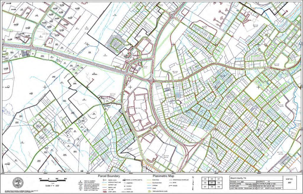
9 Maryville Regional Planning Commission Development Services Staff Report February 19, Subject Wanis Rhgebi is requesting approval of a preliminary plat for property on Best Road southeast of Carpenters Grade Rd. and located within the planning region. Location Map. 2 Facts Location: The proposed subdivision is located south of Carpenters Grade Road between Montvale Air Park Road and Best Road. This property is outside of City limits but within the planning region. The proposed preliminary plat is Phase I of a larger development. The request is for approval of Phase I only. Parcel ID: Tax Map 091 Parcel Zone: Blount County Suburbanizing Size: The total parcel size is acres for Phase I. The proposed subdivision would divide acres with the remaining acreage for future phases.
10 Phases: The preliminary plat is for Phase I of the development. The overall phasing is proposed as 8 phases with the amenities constructed in Phase I. Lot Size: Lots range in size from 6,044 square feet to 23,795 square feet for Phase I. Density: The maximum density allowed in the Residential District is 6.2 dwelling units per acre, which would allow 817 lots for the entire development. Phase I includes 78 lots at a density of 2.35 dwelling units per acre for the area being subdivided. There are 436 lots proposed for Best Road Development, which is 3.24 dwelling units per acre. Subdivision Design: The subdivision is designed as an integrally designed subdivision as defined in the subdivision regulations [Article IX, Section 5]. Subdivision Access: Phase I includes one access point for the subdivision from Best Road. Three entrances in total are proposed for the entire development. Another will be provided from Best Road and one from the adjacent Dominion Downs development, which would eventually access Best Road. Usable Open Space: Phase I includes a 9.98 acre common area. This area would serve the remainder of the phases and meet the usable open space area at least in part for the entire development. The common area is sufficient to meet the 5% open space requirements for Phase I. Lots are less than 7,000 square feet in area. The total area of the lots below the minimum lot size is 6,315 square feet. The common area as shown is sufficient to meet the 5% usable open space requirement as well as the additional square footage required as a result of the lots less than 7,000 square feet. Subsequent phases should be designed to maintain compliance with this requirement as well as take into account acreage added to the open space for lots less than 7,000 square feet in size in subsequent phases. Given the topography of the southwest portion of the common area, information needs to be provided as to how this will be utilized for usable open space Specific plans for the open space can be provided for the site plan review. Attention must be given to the items that cannot be included in the open space requirements. Buildings, sidewalks, parking areas and the like would reduce the amount of usable open space meeting the requirements. Road D is shown as a stub at the common area. Extension of this into common area would reduce the amount that can be counted towards the open space requirement. The developer intends to use the stub as the entry to a driveway for the amenity area. Amenities: The amenities are not yet shown on the plat, but according to the developer, will include a Junior Olympic-sized swimming pool, a clubhouse, and other various facilities in the main common area of Phase I. Streets and Sidewalks: All the lots front and will gain access from the proposed new street network.
11 All block lengths meet the subdivision regulations. Future Improvements Planned: Blount County will widen Best Road from Carpenters Grade Rd. south to the second proposed entry into the subdivision to a minimum width of 18. This will be complete no later than the beginning of home sales for Phase I according to Blount County Highway Department. Blount County will construct a westbound turn lane with a minimum of 150 of traffic storage at the intersection of Carpenters Grade Rd. and Best Rd., to be completed before the end of Phase 4. Blount County will standardize the intersection of Best Rd. and Carpenters Campground Rd. The plan is to make this a 3-way stop intersection. Blount County will further evaluate the need for a northbound right turn lane at the intersection of Mint Rd. and Carpenters Campground Rd. If warranted, Blount County Highway Department will construct. The City of Maryville will add a southbound left turn lane to the intersection of Carpenters Grade Rd and Peterson Ln. as part of its planned widening of Carpenters Grade Rd. Stormwater: A detention easement is needed for the wet weather conveyance. Utilities: City of Maryville sanitary sewer is available to the property and will be providing service to the subdivision. Alcoa electric currently serves this area and will be providing service to the subdivision. South Blount Water currently serves this area and will be providing service to the subdivision. 3 Staff Comments Usable open space is required to be legally and practically accessible to the residents of the development. If sidewalks are not to be used, then some other type of shared use path within the development should be utilized to provide access to the common area. Sidewalks are required for collector streets. There are some fairly large disparities between adjacent lot sizes in some areas, though there is not a provision ruling against this in the subdivision regulations Due to the need for the wetland determination to be completed, the developers are breaking the phases into separate submissions to gain approval for areas not affected by the determination.

12 4 Supporting Images Proposed Preliminary Plat


13 Aerial map showing location of subdivision in relation to City limits. Aerial Map showing property included in Phase I

14 Aerial Map showing entire property proposed for the development

15 Aerial map showing location of wetlands, stream, and wet weather conveyance. Source: GEOServices, LLC

16 Overall Concept Plan for Best Road Development
17 5 Reference CITY OF MARYVILLE ORDINANCE, TITLE 14 ZONING AND LAND USE CONTROL Zoning District: Blount County; combination of Suburbanizing and Residential zones Permissible Use [ ]: NA Nonconforming Use [ ]: NA Supplemental Use Requirements [ ]: NA Landscape and Screening [ ]: NA Density and Dimensional Requirements [ ]: NA MARYVILLE REGIONAL PLANNING COMMISSION SUBDIVISION REGULATIONS Integrally Designed Subdivisions [Article IX Section 5]: In any integrally designed subdivision, the developer may create lots and construct buildings without regard to any minimum lot size, lot width, or setback restrictions except that: o lot boundary setback requirements as found in the City Code shall apply where and to the extent that the subdivided tract abuts land that is not part of the subdivision, and o each lot must be of sufficient size and dimensions that it can support the structure proposed to be located on it, consistent with all other applicable requirements of these regulations and of the City Code. The number of dwelling units in an integrally designed subdivision may not exceed the maximum density allowed in the zone in which the subdivision is located. To the extent reasonably practicable, in residential subdivisions the amount of land saved by creating lots that are smaller than the minimum lot size standard shall be set aside as usable open space. The purpose of this section is to provide flexibility, consistent with the public health and safety and without increasing overall density, to the developer who subdivides property and constructs buildings on the lots created in accordance with a unified and coherent plan of development. Usable Open Space [Article X, Section 3]: A residential development shall be developed so that at least 5% of the total area of the development remains permanently as usable open space. Developments with more than 25 dwelling units or more shall contain 5% of usable open space. Such open space shall consist of: (1) miniparks, (2) open space, or (3) a combination of both at the discretion of the developer. A plan of the minipark or open space shall be submitted to the Planning Commission for review at the final plat submittal. Usable open space means an area reasonably usable for recreation that: o Is not encumbered with any substantial structure, o Is not devoted to use as a roadway, parking area, or sidewalk, o Is left in its natural or undisturbed state if wooded, except for the cutting of trails for walking or jogging, or, if not wooded, is landscaped for ball fields, picnic areas, or similar facilities, or is properly vegetated and landscaped with the objective of creating a wooded area or other area
18 o o o o that is consistent with the objective of creating a wooded area or other area that is consistent with the objectives of an integrally designed subdivision. Is capable of being used and enjoyed for purposes of informal and unstructured recreation and relaxation, but does not include properties devoted to detention or storm water drainage; however, the Planning Commission may determine whether other underground utility easements for water, sewer, power, or other service providers held by local, state, or federal jurisdictions, cooperative, or private corporations may be used for recreational purposes. Is legally and practicably accessible to the residents of the development out of which the required open space is required and may include property that is under and beneath power line easements held by local, state, or federal agencies or jurisdictions. Consists of land, no more than 25% of which, lies within a floodplain or floodway. Is solely devoted to a sidewalk, walkway, or way around in a specific subdivision, or development and such uses may only constitute 25% of the total open space requirement in the subdivision or development. Access to Lots [Article XI, Section 2]. Every lot shall have access to it that is sufficient to afford a reasonable means of ingress and egress for emergency vehicles as well as for all those likely to need or desire access to the property in its intended use. Access to Arterial Streets [Section 3]. Whenever a major subdivision that involves the creation of one or more new streets borders on or contains an existing or proposed arterial street, no direct driveway access may be provided from the lots within this subdivision onto this street. Entrances to Streets [Section 4]. All driveway entrances and other openings onto streets within the City s planning jurisdiction shall be constructed so that: o vehicles can enter and exit from the lot in question without posing any substantial danger to themselves, pedestrians, or vehicles traveling in abutting streets, and o interference with the free and convenient flow of traffic in abutting or surrounding streets is minimized. Specifications for driveway entrances shall be in accordance with those standards set forth by the City Director of Engineering and Public Works or his or her designee or in accordance with standards for access control established by the Institute of Transportation Engineers (ITE). The City Director of Engineering and Public Works or his or her designee shall be responsible for application of such standards. Coordination with Surrounding Streets [Section 5] The street system of a subdivision shall be coordinated with existing, proposed, and anticipated streets outside the subdivision or outside the portion of a single tract that is being divided into lots (hereinafter, Surrounding Streets ) as provided in this section. Collector streets shall intersect with the surrounding collector or arterial streets at safe and convenient locations. Subcollector, local, and minor residential streets shall connect with Surrounding Streets where necessary
19 to permit the convenient movement of traffic between residential neighborhoods or to facilitate access to neighborhoods by emergency service vehicles or for other sufficient reasons, but connections shall not be permitted where the effect would be to encourage the use of such streets by substantial through traffic. Whenever connections to anticipated or proposed surrounding streets are required by this section, the street right-of-way shall be extended and the street developed to the property line of the subdivided property (or to the edge of the remaining undeveloped portion of a single tract) at the point where the connection to the anticipated or proposed street is expected. In addition, the permit-issuing authority may require temporary turnarounds to be constructed at the end of such streets pending their extension when such turnarounds appear necessary to facilitate the flow of traffic or accommodate emergency vehicles. Notwithstanding the other provisions of this subsection, no temporary dead-end street in excess of one thousand (1,000) feet may be created unless no other practicable alternative is available. General Layout of Streets [Article XI, Section 8] Definitions: o Local street: A street whose sole function is to provide access to abutting properties. It serves or is designed to serve at least 10 but no more than 25 dwelling units and is expected to or does handle between 100 and 250 trips per day. o Subcollector. A street whose principal function is to provide access to abutting properties but is also used to collect minor and local streets with collector or arterial streets. Including residences indirectly served through connecting streets, it serves 26 to 100 dwelling units, and is expected to handle between 260 and 2,000 trips per day. o Minor Collector. A street that primarily functions to collect and distribute traffic between local streets and arterials and provides direct access to abutting land. It serves between 2,000 and 10,000 trips per day. Intersection spacing is typically 300 feet or greater. Street width: o Local roads with curb and gutter: 50-foot ROW and 24-foot pavement o Sub-collectors and Minor Collectors with curb and gutter: 50-foot ROW and 28-foot pavement Cul-de-sacs: o Cul-de-sacs and loop streets are encouraged so that through traffic on residential streets is minimized. Similarly, to the extent practicable, driveway access to collector streets shall be minimized to facilitate the free flow of traffic and avoid traffic hazards. o All permanent dead-end streets shall be developed as cul-de-sacs in accordance with the regulation standards. Except where no other practicable alternative is available, such streets may not extend more than 550 feet (measured to the center of the turnaround). o The right-of-way of a cul-de-sac shall have a radius of 50 feet. The radius of the paved portion of the turnaround (measured to the other edge of the pavement) shall be 40 feet. o All lots located on a cul-de-sac or a portion thereof, shall have 30 feet of frontage on the public road. Sidewalks: o Sidewalks shall be required by the Planning Commission within the corporate limits of the City. o All streets classified as collector (residential) shall have sidewalks on both sides.
20 Public Streets and Permanent Private Easements in Subdivisions [Section 10]. The Planning Commission may consider appropriate drainage design and improvements within the permanent private easement if the topography, grade or natural drainage pattern within the easement warrants improvements.
21 Maryville Regional Planning Commission Development Services Staff Report February 19, Subject Billie Sue Hitson is requesting approval of a preliminary plat for property off of Eleanor Davis Dr. in the planning region. The Planning Commission previously approved a preliminary plat for the property on October 16, Due to the discovery of a stream on the property, a revised preliminary plat has been submitted. Location Map. 2 Facts Location/Parcel ID: The proposed subdivision is located outside of the city limits (Tax Map 059 Parcel ) off of an existing county road, Eleanor Davis Road. Eleanor Davis Road is a side street off of E. Lamar Alexander Parkway.
22 Zone: Blount County - Suburbanizing Size: The proposed subdivision contains acres, though only acres is proposed for this subdivision acres is to remain the property of the Hitsons and will not be part of the proposed subdivision development. Lots range between 7,018 square feet (0.161 acres) to 39,263 square feet (0.9 acres) in size. Density: The maximum density allowed by the Subdivision Regulations is 6.2 dwelling units per acre, which would allow 73 lots. There are 28 lots proposed for dwellings, which results in a density of 2.4 units per acre. Subdivision Design: The subdivision is designed as an Integrally Designed Subdivision as defined in the Subdivision Regulations [Article IX, Section 5]. No lots are less than the minimum lot size, however several lots have a width less than 75. Usable Open Space: The area designated as common area on the preliminary plat is acres at the northern edge of the subdivision. The acreage is sufficient to meet the 5% open space requirement of acres. Three lots have direct access to the open space. No other means of provision to the open space for the remaining lots making them practically accessible for the development is provided. Streets: All the lots front and will gain access from the proposed new street network. Internal roads will be classified as minor roads. The cul-de-sac and road lengths are in compliance with subdivision regulations. Pavement and ROW widths are in compliance with subdivision regulations. Stormwater: A detention area is in the southeast corner of the site. Utilities: City of Maryville water is available to the property; City of Maryville sewer is in the vicinity and can be connected to the property to provide service. 3 Staff Comments Better accessibility to the open space needs to be provided either through sidewalks or a multi-use path throughout the subdivision. The open space needs to be practicably accessible to the entire development. The Blount County Highway Department will require improvements to Eleanor Davis Road prior to final plat approval.


23 4 Supporting Images Aerial map. Preliminary Plat proposal.
24 5 Reference BLOUNT COUNTY ZONING REGULATIONS Zoning District: Blount County Suburbanizing MARYVILLE REGIONAL PLANNING COMMISSION SUBDIVISION REGULATIONS Integrally Designed Subdivisions [Article IX Section 5]: In any integrally designed subdivision, the developer may create lots and construct buildings without regard to any minimum lot size, lot width, or setback restrictions except that: o lot boundary setback requirements as found in the City Code shall apply where and to the extent that the subdivided tract abuts land that is not part of the subdivision, and o each lot must be of sufficient size and dimensions that it can support the structure proposed to be located on it, consistent with all other applicable requirements of these regulations and of the City Code. The number of dwelling units in an integrally designed subdivision may not exceed the maximum density allowed in the zone in which the subdivision is located. To the extent reasonably practicable, in residential subdivisions the amount of land saved by creating lots that are smaller than the minimum lot size standard shall be set aside as usable open space. The purpose of this section is to provide flexibility, consistent with the public health and safety and without increasing overall density, to the developer who subdivides property and constructs buildings on the lots created in accordance with a unified and coherent plan of development. Usable Open Space [Article X, Section 3]: A residential development shall be developed so that at least 5% of the total area of the development remains permanently as usable open space. Developments with more than 25 dwelling units or more shall contain 5% of usable open space. Such open space shall consist of: (1) miniparks (defined in subdivision regulations), or (2) open space, or (3) a combination of both at the discretion of the developer. A plan of the minipark or open space shall be submitted to the Planning Commission for review at the final plat submittal. Usable open space means an area reasonably usable for recreation that: o Is not encumbered with any substantial structure, o Is not devoted to use as a roadway, parking area, or sidewalk, o Is left in its natural or undisturbed state if wooded, except for the cutting of trails for walking or jogging, or, if not wooded, is landscaped for ball fields, picnic areas, or similar facilities, or is properly vegetated and landscaped with the objective of creating a wooded area or other area that is consistent with the objective of creating a wooded area or other area that is consistent with the objectives of an integrally designed subdivision. o Is capable of being used and enjoyed for purposes of informal and unstructured
25 o o o recreation and relaxation, but does not include properties devoted to detention or storm water drainage; however, the Planning Commission may determine whether other underground utility easements for water, sewer, power, or other service providers held by local, state, or federal jurisdictions, cooperative, or private corporations may be used for recreational purposes. Is legally and practicably accessible to the residents of the development out of which the required open space is required and may include property that is under and beneath power line easements held by local, state, or federal agencies or jurisdictions. Consists of land, no more than 25% of which, lies within a floodplain or floodway. Is solely devoted to a sidewalk, walkway, or way around in a specific subdivision, or development and such uses may only constitute 25% of the total open space requirement in the subdivision or development. General Layout of Streets [Article XI, Section 8] Collector (residential), subcollector, local, and minor residential streets shall be curved whenever practicable to the extent necessary to avoid conformity of lot appearance. Cul-de-sacs and loop streets are encouraged so that through traffic on residential streets is minimized. Similarly, to the extent practicable, driveway access to collector streets shall be minimized to facilitate the free flow of traffic and avoid traffic hazards. Streets serving subdivisions shall connect or extend to other subdivisions when determined necessary by the Planning Commission. All permanent dead-end streets shall be developed as cul-de-sacs in accordance with the regulation standards. Except where no other practicable alternative is available, such streets may not extend more than 550 feet (measured to the center of the turnaround). The right-of-way of a cul-de-sac shall have a radius of 50 feet. The radius of the paved portion of the turnaround (measured to the other edge of the pavement) shall be 40 feet. Streets shall be laid out so that residential blocks do not exceed 1,000 feet, unless no other practicable alternative is available. However, in cases where the street may exceed this standard, the burden shall be upon the developer to incorporate in the design of the subdivision safe ingress and egress which is acceptable both to the Engineering and Public Works Department and the Planning Commission. All lots located on a cul- de-sac or a portion thereof, shall have 30 feet of frontage on the public road.

26 Maryville Regional Planning Commission Development Services Staff Report February 19, Subject Concord Properties Inc. is requesting approval of a preliminary plat for property off of Legends Way within the Royal Oaks development. Location Map. 2 Facts Location/Parcel ID: Tax Map 068 Parcels and The property is located off of Legends Way in the Royal Oaks Subdivision. Zone: Residential Size: The proposed subdivision contains 22 lots subdividing acres. Density: The maximum density allowed by the Subdivision Regulations is 6.2 dwelling units per acre, which would allow 31 lots. There are 22 lots proposed which results in a density of 4.35 du/units per acre. Subdivision Design: The subdivision is designed as an Integrally Designed Subdivision as defined in the Subdivision Regulations [Article IX, Section 5].
27 Usable Open Space: Open space/common areas of acres are shown as part of the subdivision. The 5% open space requirement amounts to acres. Fourteen of the lots are below 7,000 square feet in area. These lots add an additional 18,221 square feet in area for a total required open space of 0.66 acres. Open space is shown at three different locations along the subdivision which appear to now or at one time have been part of the golf course. For site plan approval, specifics will need to be provided as to how this is usable open space accessible by the residents of the subdivision. Streets: A new road is proposed to extend off of Legends Way. The new road is labeled as Torrey Pines Drive and ends at a cul-de-sac. The proposed cul-de-sac road exceeds the maximum 550 feet allowed in the subdivision regulations. The road as shown does not meet the pavement and right-of-way requirements of subdivision regulations No sidewalks are shown for the new road. Sidewalks are required for new streets within the city. Stormwater: If approved, a site plan will need to address stormwater detention and stormwater quality management plan. Utilities: City of Maryville water is available to the property; the Royal Oaks Subdivision is served by a private sewer system. 3 Staff Comments Better accessibility to the open space needs to be provided either through sidewalks or a multi-use path throughout the subdivision. The open space needs to be practicably accessible to the entire development. The Subdivision Regulations do not allow for more than three lots to be created off of an easement. The proposed subdivision shows a new private road with at least 20 of the lots obtaining access from the private road. The proposed private road exceeds the maximum allowed for a cul-de-sac road in the subdivision regulations. 550 is the maximum allowed for a cul-de-sac road. The proposed road in the subdivision is approximately 630 in length, 80 over the maximum allowed length. To approve the subdivision as proposed, the Planning Commission would need to grant variances for the private road.

28 4 Supporting Images Aerial map.

29 Preliminary Plat proposal.
30 5 Reference CITY OF MARYVILLE ORDINANCE, TITLE 14 ZONING AND LAND USE CONTROL Zoning District [ ]: Residential Permissible Use [ ]: Single family detached residential uses. Nonconforming Use [ ]: NA Supplemental Use Requirements [ ]: NA Landscape and Screening [ ]: NA Density and Dimensional Requirements [ ]: The minimum lot size for Residential Districts is 7,000 square feet with sanitary sewer and public water. MARYVILLE REGIONAL PLANNING COMMISSION SUBDIVISION REGULATIONS Integrally Designed Subdivisions [Article IX Section 5]: In any integrally designed subdivision, the developer may create lots and construct buildings without regard to any minimum lot size, lot width, or setback restrictions except that: o lot boundary setback requirements as found in the City Code shall apply where and to the extent that the subdivided tract abuts land that is not part of the subdivision, and o each lot must be of sufficient size and dimensions that it can support the structure proposed to be located on it, consistent with all other applicable requirements of these regulations and of the City Code. The number of dwelling units in an integrally designed subdivision may not exceed the maximum density allowed in the zone in which the subdivision is located. To the extent reasonably practicable, in residential subdivisions the amount of land saved by creating lots that are smaller than the minimum lot size standard shall be set aside as usable open space. The purpose of this section is to provide flexibility, consistent with the public health and safety and without increasing overall density, to the developer who subdivides property and constructs buildings on the lots created in accordance with a unified and coherent plan of development. Usable Open Space [Article X, Section 3]: A residential development shall be developed so that at least 5% of the total area of the development remains permanently as usable open space. Developments with more than 25 dwelling units or more shall contain 5% of usable open space. Such open space shall consist of: (1) miniparks (defined in subdivision regulations), or (2) open space, or (3) a combination of both at the discretion of the developer. A plan of the minipark or open space shall be submitted to the Planning Commission for review at the final plat submittal. Usable open space means an area reasonably usable for recreation that: o Is not encumbered with any substantial structure,
31 o o o o o o Is not devoted to use as a roadway, parking area, or sidewalk, Is left in its natural or undisturbed state if wooded, except for the cutting of trails for walking or jogging, or, if not wooded, is landscaped for ball fields, picnic areas, or similar facilities, or is properly vegetated and landscaped with the objective of creating a wooded area or other area that is consistent with the objective of creating a wooded area or other area that is consistent with the objectives of an integrally designed subdivision. Is capable of being used and enjoyed for purposes of informal and unstructured recreation and relaxation, but does not include properties devoted to detention or storm water drainage; however, the Planning Commission may determine whether other underground utility easements for water, sewer, power, or other service providers held by local, state, or federal jurisdictions, cooperative, or private corporations may be used for recreational purposes. Is legally and practicably accessible to the residents of the development out of which the required open space is required and may include property that is under and beneath power line easements held by local, state, or federal agencies or jurisdictions. Consists of land, no more than 25% of which, lies within a floodplain or floodway. Is solely devoted to a sidewalk, walkway, or way around in a specific subdivision, or development and such uses may only constitute 25% of the total open space requirement in the subdivision or development. General Layout of Streets [Article XI, Section 8] Collector (residential), subcollector, local, and minor residential streets shall be curved whenever practicable to the extent necessary to avoid conformity of lot appearance. Cul-de-sacs and loop streets are encouraged so that through traffic on residential streets is minimized. Similarly, to the extent practicable, driveway access to collector streets shall be minimized to facilitate the free flow of traffic and avoid traffic hazards. Streets serving subdivisions shall connect or extend to other subdivisions when determined necessary by the Planning Commission. All permanent dead-end streets shall be developed as cul-de-sacs in accordance with the regulation standards. Except where no other practicable alternative is available, such streets may not extend more than 550 feet (measured to the center of the turnaround). The right-of-way of a cul-de-sac shall have a radius of 50 feet. The radius of the paved portion of the turnaround (measured to the other edge of the pavement) shall be 40 feet. Streets shall be laid out so that residential blocks do not exceed 1,000 feet, unless no other practicable alternative is available. However, in cases where the street may exceed this standard, the burden shall be upon the developer to incorporate in the design of the subdivision safe ingress and egress which is acceptable both to the Engineering and Public Works Department and the Planning Commission. All lots located on a cul- de-sac or a portion thereof, shall have 30 feet of frontage on the public road. Public Streets and Permanent Private Easements in Subdivisions (Article XI, Section 10)
32 (a) Except as otherwise provided in this section, all lots created after the effective date of this section shall abut a public street at least to the extent necessary to comply with the access requirements set forth in Section 2. For purposes of this subsection, the term public street includes a pre-existing public street as well as a street created by the subdivider that meets the public street standards and is dedicated and accepted for public use. The recording of a plat which indicates a newly created public street shall constitute an offer of dedication of such street. As outlined in T.C.A. Section , the approval of a plat by the Planning Commission shall not be deemed to constitute any acceptance of the referenced street. (b) Public streets within all subdivisions serving zero lot line developments, standard single family attached or detached residential units, regardless of the number of lots or units, shall be properly engineered, designed, and constructed to public street standards outlined in the Maryville Land Development and Public Works Standards. All drainage designs and facilities shall also be in accordance with the Maryville Land Development and Public Works Standards. (c) A subdivision in which the access requirement of Section 2 is satisfied by a permanent private easement that meets neither the public street standards nor the standards set forth in Section 12 may be developed so long as, since the effective date of these regulations, no more than four (4) lots have been created out of that same tract. One of the four (4) lots must front a public right of way and have direct access onto that right of way. (1) The intent of this subsection is primarily to allow the creation of not more than four (4) lots from one lot developed for single-family residential purposes. Only three (3) lots shall be served by the permanent private easement unless the Commission finds exceptional circumstances upon which the said easement shall serve more than the stated three (3) lots. The remaining lost must front or have direct access to a public street or way accepted or authorized by the Planning Commission. Therefore, the permit-issuing authority may not approve any subdivision served by a permanent private easement authorized by this subsection in which one or more of the lots thereby created is intended for (i) two-family, or multi-family residential use, or (ii) any other residential or nonresidential use that would tend to generate more traffic than that customarily generated by three (3) single-family residences. For safety reasons, the Planning Commission may require that a lot with frontage on a public road only access off of a permanent private easement. (2) To ensure that the intent of this subsection is not subverted, the permit-issuing authority may, among other possible options, require that the approved plans show the types and locations of buildings on each lot or that the lots in a residential subdivision served by a permanent private easement be smaller than the permissible size of lots on which twofamily or multi-family developments could be located or that restrictive covenants limiting the use of the subdivided property in accordance with this section be recorded before the final plat approval. (3) The width of a permanent private easement within the corporate limits and the planning region shall be no less than 30 feet. The Planning Commission may require the width of the easement to be of a greater width if the commission deems appropriate.
33 (4) (4) Within the corporate limits of the City of Maryville, the Planning Commission shall require that the improved portion within the easement be improved to a minimum of sixteen (16) feet with any of the following material: 4 of stone and 1 of asphalt; or 4 of concrete. Within the Urban Growth Boundary, the Planning Commission shall allow the improved portion within the easement to be 4 of gravel, however, the driveway apron from the pavement of the street to 15 behind the common boundary of the right of way/property line shall be designed to follow local and minor street requirements of 6 stone, 3 of binder and 1 of surface course. The Commission may designate the length of the road to be constructed in accordance with the above standards. (5) Two permanent private easements may not run side by side. (6) The Planning Commission may consider appropriate drainage design and improvements within the permanent private easement if the topography, grade or natural drainage pattern within the easement warrants improvements. Variances (Article V, Section 4(d)) Where the applicant/owner can demonstrate that a portion of these regulations would cause unnecessary hardship if strictly adhered to, and when, because of the topographical or other conditions peculiar to the site, in the opinion of the Planning Commission, a departure may be made from the regulations without destroying the intent of the provisions, the Commission may authorize a variance. Any variance authorized and approved by the Commission shall be stated in writing and reported in the minutes of the Commission. The Planning Commission shall not authorize deviations to these regulations unless they shall find based upon the evidence presented and reviewed for each specific case that one or all of the following conditions apply: (1) Because of topographical conditions, surroundings, shape, or size of a specific tract or parcel involved, a particular hardship to the applicant or owner would result as distinguished from mere inconvenience. (2) The conditions upon which the request for a variance is based is particular to the property for which the variation is sought and generally are not applicable to other properties in the immediate area and have not been self-imposed. Development costs or economic reasons alone are not grounds for a variance.
34 Maryville Regional Planning Commission Development Services Staff Report February 19, Subject Mr. James Burger on behalf of Millennium Capital LLC is requesting that property on Morganton Road be annexed into the City of Maryville. Location Map. 2 Facts Location/Parcel ID: The property is located on Morganton Road. Tax Map 057 Parcel Size: 9.22 acres Intent: No development plan is proposed at this time for the property. See Annexation Report for details.
35 3 Staff Comments See annexation report for comments and cost estimates by each department, and the resolution for the Plan of Services. 4 Supporting Images Aerial map. 5 Reference MARYVILLE REGIONAL PLANNING COMMISSION SUBDIVISION REGULATIONS Nonconforming Use [ ]: NA Zoning Districts [ ]: NA Supplemental Uses [ (5)]: NA Landscape and Screening [ ]: NA Density and Dimensional Requirements [ ]: NA
36 Amendments [ ]: (2) Planning commission consideration of proposed amendments. If the council sets a date for a public hearing on a proposed amendment on a zoning matter or annexation matter, it shall also refer the proposed amendment to the planning commission for its consideration. The planning commission shall endeavor to review the proposed amendment in such a timely way that any recommendations it may have can be presented to the council at the public hearing on the amendment. However, if the planning commission is not prepared to make recommendations at the public hearing, it may request the council to delay final action on the amendment until such time as the planning commission can present its recommendations. The council must have before it the recommendations of the planning commission before taking action on a proposed amendment. The council is not bound by any recommendations of the planning commission that are before it at the time it takes action on a proposed amendment. TENNESSEE CODE UNANNOTATED T.C.A (b) Plan of services. 1) Before any territory may be annexed under this part, the governing body of the municipality shall adopt a plan of services establishing at least the services to be delivered and the projected timing of the services. Upon adoption of the plan of services, the municipality shall cause a copy of the plan of services to be forwarded to the county mayor in whose county the territory being annexed is located. The plan of services shall be reasonable with respect to the scope of services to be provided and the timing of the services. 2) The plan of services shall include, but not be limited to: police protection, fire protection, water service, electrical service, sanitary sewer service, solid waste collection, road and street construction and repair, recreational facilities and programs, street lighting, and zoning services. If the municipality maintains a separate school system, the plan shall also include schools and provisions specifically addressing the impact, if any, of annexation on school attendance zones. 3) The plan of services shall include a reasonable implementation schedule for the delivery of comparable services in the territory to be annexed with respect to the services delivered to all citizens of the municipality. 4) Before a plan of services may be adopted, the municipality shall submit the plan of services to the local planning commission, if there is one, for study and a written report, to be rendered within ninety (90) days after such submission, unless by resolution of the governing body a longer period is allowed. Before the adoption of the plan of services, a municipality shall hold a public hearing. Notice of the time, place, and purpose of the public hearing shall be published in a newspaper of general circulation in the municipality not less than fifteen (15) days before the hearing. The notice shall include the locations of a minimum of three (3) copies of the plan of services, which the municipality shall provide for public inspection during all business hours from the date of notice until the public hearing. 5) A municipality may not annex any other territory if the municipality is in default on any prior plan of services. 6) If a municipality operates a school system, and if the municipality annexes territory during the school year, any student may continue to attend such student's present school until the beginning of the next succeeding school year unless the respective boards of education have provided otherwise by agreement.
37 T.C.A (a) Resolution for annexation by referendum -- Notice. A municipality, when petitioned by interested persons, or upon its own initiative, by resolution, may propose extension of its corporate limits by the annexation of territory adjoining to its existing boundaries; provided, however, no such resolution shall propose annexation of any property being used primarily for agricultural purposes. Notwithstanding this part or any other law to the contrary, property being used primarily for agricultural purposes shall be annexed only with the written consent of the property owner or owners. A resolution to effectuate annexation of any property, with written consent of the property owner or owners, shall not require a referendum.
.")
38 Annexation Report The Burger property located on Morganton Road (Blount County parcel ).
39 ANNEXATION RATIONALE Mr. James Burger, on behalf of Millennium Capital LLC, has requested that property located on Morganton Road (Tax Map 057 Parcel ) be annexed into the city. The property is located in the southwestern portion of the current city limits. The property currently borders the city limits to the south and to the north across Morganton Road. Plans to improve Morganton Road are underway as well as an extension of Robert C. Jackson drive which would run through the property. The applicant is requesting commercial designation for the property however, no specific development proposal is presented at this time. The requested zoning is Business and Transportation. DEPARTMENTAL REPORTS (It is difficult to provide information for impact on future costs and revenues since the city does not directly control the pace, scale or type of development activity. The following information is provided using existing conditions and estimated costs, based on the best information available.) POLICE (Raymond Barnhart): The annexation of this property on Morganton Road if developed commercially could increase the call for service volume for the police department. It is believed that the police department can handle the increase in calls for service at this location (if there were any) with existing personnel. Since there is no additional personnel requested, then there would be no cost added for police services FIRE (Mike Caylor): The Fire Department has no issues with this annexation at this time. Any development would result in the normal site requirements. WATER/WASTEWATER (Jesse McWhorter): The Morganton Rd. property is in South Blount s service area for water. Sewer isn t currently available and would require a ~1,500 extension, but it is possible for us to serve the property. ELECTRIC AND STREET LIGHTING (James Bond): The Electric Department can provide service as needed for development per our regulations. The cost will depend upon the development, but should be reasonable. ENGINEERING AND PUBLIC WORKS Engineering (Kevin Stoltenberg): This property is currently undeveloped, and no developments have been proposed yet, although the owner has requested commercial zoning. The City of Maryville s project to extend Robert C Jackson Drive will require 1
40 widening of Morganton Rd and the installation of a traffic signal along the frontage of this property. The owner has recently dedicated the necessary ROW for this project to the City. Streets/Stormwater (Tim Phillips): Cost to maintain City services (Streets) for 95 Properties would be $1.20 per ft. Snow Removal, Street Sweeping, Street Signs, patching, sidewalks etc. (Streets/Stormwater) would be $.80 per ft. Catch Basin repair, ditch cleaning, pipe repair, new pipe installation etc. If this property is designated for commercial purposes we will maintain any areas that are built and then turned over to the City of Maryville to maintain. Stormwater Utilities (Chuck Rowan): There should not be any appreciable negative impact to the Stormwater Department operating budget. Once developed the site will generate additional Stormwater Utility income, but it is not known by how much at this time. Solid Waste (Dan Cantwell): Potential impact to Solid Waste for approximately $ separated out as follows: 4 each for commercial garbage service, estimated cost per year $ $88.70 each for brush pickup service, estimated cost per year $ Grounds (Gary Johnson): If this property is designated for commercial purposes we will maintain any area that is built and turned over to the city of Maryville. To maintain, cost of mowing 5 times a year $ and litter pick up will be $ SCHOOLS (Mike Winstead): No impact on schools. INSPECTIONS AND CODES ENFORCEMENT (Gary Walker): The Codes Department provides review, permitting, inspection, and approval of construction activities. Extending Code Enforcement services to the proposed areas will require an additional Code Enforcement inspector. The additional workload cannot be absorbed by staff under current conditions. The additional workload would be intensive due to the sheer number of properties in addition to the large number of properties just approved for annexation in the last few months as well as a general leap in construction activities. Inspectors are currently scheduling inspections 2-3 days out, which exceeds the one day response time provided and expected over the years. We estimate that this annexation request, along with the others that have been proposed and/or annexed within the last year will decrease our response time to about 3-4 days instead of the current 2-3 days or the more acceptable level of one day. We believe that an additional multi- 2
41 discipline inspector will bring the service level back to the one day response level we have strived for over the years. The cost of an additional inspector is estimated to be $87,000 annually and additional first year cost of $10,045 for vehicle, computer, office space reconfiguration, office furniture, uniforms, etc. This is the same inspector discussed in the last several annexation studies. RECREATION (Joe Huff): No additional costs would be anticipated. TAX REVENUE (Mike Swift): Currently there is no development plan or zoning change. The tax assessor currently lists the assessment of the property at $62,800. It is currently assessed at the residential rate of 25% which would result in $1, additional property taxes for the city. FINANCIAL IMPACT: The tax assessor currently lists the assessment of the property at $62,800. It is currently assessed at the residential rate of 25% which would result in $1, additional property taxes for the city. If developed for commercial purposes, commercial rate of 40% would apply as well as additional revenue from sales tax. 3
42 FINANCIAL IMPACT ESTIMATED COSTS/REVENUES BASED ON DEPARTMENT REPORTS Revenue per One time cost year Recurring cost per year Police $0 $0 $0 Fire $0 $0 $0 Water/wastewater $0 $0 $0 Electric Streetlights $0 $0 $0 Service hook-up $0 $0 $0 Engineering and Public Works Engineering $0 $0 $0 Streets/Stormwater $0 $0 $0 Stormwater Utility $0 $0 $0 Solid Waste $0 $0 $4,931 Grounds $0 $0 $1, Schools* $0 $0 $0 Inspections and Codes Enforcement** $0 $10,045 $87,000 Planning and Zoning $0 $0 $0 Recreation $0 $0 $0 Finance $1, $0 $0 Totals $1, $10,045 $93, *The School System maintains a separate budget, these funds do not directly impact the city's general fund. **This is the same inspector position included in previous annexation studies. 4
43 ANNEXATION SCHEDULE February 19, :00 PM Maryville Regional Planning Commission: Recommendations: Plan of Services Annexation Land Use Designation Rezoning March 6, :51 PM Public Hearings: Plan of Services Annexation Land Use Designation Rezoning Maryville City Council: 1 st reading Rezoning and Land Use Designation Resolution for Annexation and Plan of Services April 3, :00 PM Maryville City Council: 2 nd reading Rezoning and Land Use March 6, 2018 EFFECTIVE DATE OF ANNEXATION 5
44 RESOLUTION NO. A RESOLUTION TO ANNEX PROPERTY LOCATED ON MORGANTON ROAD (BLOUNT COUNTY TAX MAP 057, PARCEL ) AND TO INCORPORATE THE SAME WITHIN THE COPRORATE BOUNDARIES OF THE CITY OF MARYVILLE, TENNESSEE WHEREAS, Tennessee Code Annotated requires that a resolution be adopted by the municipal governing body to extend the corporate boundary; and, WHEREAS, the City of Maryville has received a petition from the affected property owner James Burger to annex the property owned by Millennium Capital LLC, whom the petitioner represents, on Morganton Road; and, WHEREAS, the affected property owners have given written consent for the annexation and thus no referendum is required to effectuate the annexation; and, WHEREAS, a public hearing before this body was held on the 6 th day of March, 2018, and notice thereof published in the Daily Times on February 2, 2018; and, WHEREAS, the annexation of such territory is deemed desirable for the welfare of the residents and property owners of the said affected territory and this City as a whole. NOW, THEREFORE, BE IT RESOLVED BY THE CITY COUNCIL OF THE CITY OF MARYVILLE, TENNESSEE: SECTION 1. In accordance with Tennessee Code Annotated and , by request of the property owners, there is hereby annexed to the City of Maryville, Tennessee, and incorporated within the corporate boundaries thereof, the territory comprising parcel number on tax map 057. All common areas and internal rights of way shown on these plats shall also be included in the annexation. These areas are more clearly illustrated on the attached map that is made a part of this resolution. SECTION 2. Pursuant to the provisions of T.C.A and , there is hereby adopted, for the area bounded as described above, the following plan of services: a) Police: On the effective date of annexation, the Maryville Police Department will provide the services of police patrol coverage using present personnel and equipment, assuming additional personnel has already been added based on previous annexation. b) Fire: Fire protection by the present personnel and equipment of the fire fighting force will be provided on the effective date of annexation. c) Electric: The electric department can provide service as needed for development per the City s regulations.
45 d) Water: Water is provided by the South Blount Utility District. e) Sewer: Sewer will be extended to the area when the properties are developed at the cost to the developer. This will require an approximately 1,500 extension. f) Streets: If local streets are constructed internally as part of a development, they would be constructed at the developer s expense. They would be inspected and approved by the Engineering Department, and ultimately maintained by the Public Works Dept. g) Solid Waste: The same collection services now provided within the City would be extended to the annexed parcel upon the effective date of annexation. h) Schools: Schools are not affected by this annexation. i) Inspections and Codes Enforcement: The Codes Department provides review, permitting, inspection, and approval of construction activities. Any inspection service now provided by the City will begin in the annexed area on the effective date of annexation. j) Planning and Zoning: The planning and zoning jurisdiction of the city will extend to the annexed area on the effective date of annexation. City planning jurisdiction and regulations will thereafter encompass the entirety of the annexed area. The annexation resolution shall be accompanied by ordinances to designate the future land use and zoning of the property. k) Street Lighting: Basic street lighting fixtures will be provided as development occurs by the Maryville Electric Department. Decorative fixtures are available for a fee. l) Recreation: Recreation is not affected by this annexation. SECTION 3. This resolution shall become effective from and after its adoption: ADOPTED THIS 6 th DAY OF MARCH, 2018 ATTEST: Mayor City Recorder APPROVED AS TO FORM: City Attorney
46
47 Maryville Regional Planning Commission Development Services Staff Report February 19, Subject Development Services staff is requesting a land use designation on the City of Maryville Future Land Use Map for the property on Morganton Drive on behalf of James Burger, the current owner, as part of an annexation request. Current Land Use Map. 2 Facts Location/Parcel ID: The property is located on Morganton Road. Tax Map 057 Parcel Size: 9.22 acres Applicant Request: No development proposal has been included with the annexation request. Adjacent Uses. The northern part of the property fronts on Morganton Road. Property to the south is currently vacant. Properties to the east and west are residential.
48 Current Zoning. Blount County Suburbanizing In Accordance with the City s Comprehensive Land Use Plan: The Future Land Use Map would require designation of this parcel to a specific land use for this request to comply with the City s Comprehensive Land Use Plan. 3 Staff Comments Trending Use. Current Land Use Parcels Acres % of City Commercial % Industrial % Institutional % Natural Resources % Residential % Economic Flexibility. A commercial or mixed use designation for the property provides the greatest economic flexibility. Given the proposed transportation improvements discussed below, the property would be suitable for commercial use. Optimal Transportation Connections. The Robert C. Jackson extension is proposed to extend thorough a portion of the property. The right-of-way for the extension has already been provided to the city. Improvements to Morganton Road are also planned with a signalized intersection at the property proposed for annexation. Compatibility. Adjacent properties to the east, west, and south are residential. Property opposite of Morganton Road is designated as Mixed Use.
49 4 Supporting Images Aerial map showing relation to City limits and zoning. Current Land Use Map.
50 Existing Future Land Use Map. Current Zoning City of Maryville and Blount County
51 5 Reference CITY OF MARYVILLE LAND USE PLAN 2035 Purpose. The Plan balances concerns of constraints, opportunities, economic necessities, aesthetics, and the health and welfare of the population into the long-term development of the population across the city and provides a rationale for future changes. It provides the basis for the zoning ordinance, which guide the implementation of the City s vision for development. The future land use map provides the points-of-reference from which the planning commission can deliberate proposed zoning changes. By requiring that zoning changes are in accordance with the planning commission s designations of future land use ensures that zoning addresses the broader concerns of the city. The future land use map and the zoning map provide current and future land owners the development framework for the city on which investment decisions can be made. Adherence to the land use plan and to the zoning ordinance ensures consistency and stability for future development and provides a level of certainty to current and future land owners. Major Land Use Goals. To facilitate a city where citizens and visitors may experience a quality life, the plan has four major goals: Create and sustain a city that is safe, efficient, and manageable Create and sustain a city that is physically attractive, and that enhances marketability Create and sustain a city that is healthful and environmentally responsible Create and sustain a city that is accessible by vehicles and pedestrians With the City s major land use goals in mind, the future land use designations are based on four major factors: Trending Use. Currently, the city s predominant land use is residential and is primarily separated from other land uses. Other separated land uses are industrial, and high intensity commercial and retail. Economic Flexibility. The primary consideration is that the City is positioned to meet the future needs for residential, commercial, industrial, and public (institutional) uses. Optimal Transportation Connections. Future commercial land use will take advantage of primary travel routes and proximity to customer population centers. Mixed Use areas will provide both retail and residential opportunities, thereby reducing vehicle miles traveled for essential goods. Compatibility. To achieve compatibility between land uses, the future land use plan adopts the following rationale: o The most intense land use (industrial) should be a separated land use. o The least intense land use (low density residential) should be a separated land use. o Where feasible, land uses should be spatially tiered. Land uses with the highest potential for creating nuisance should have the most separation from land uses with highest sensitivity to nuisance. Medium intensity uses should buffer separated uses.
52 Maryville Regional Planning Commission Development Services Staff Report February 19, Subject James Burger, on behalf of Millennium Capital LLC is requesting for the property on Morganton Road to be zoned Business and Transportation as part of an annexation request Location Map. 2 Facts Location/Parcel ID: The property is located on Morganton Road. Tax Map 057 Parcel Size: 9.22 acres Applicant Request: No development proposal has been presented with the annexation request. Adjacent Zoning. Adjacent properties to the east and west are zoned Suburbanizing (Blount County). Property to the south is zoned Residential. On the opposite side of Morganton Road, property is zoned Residential and Business and Transportation.
53 Current Zoning. Blount County Suburbanizing In Accordance with the City s Comprehensive Land Use Plan: To be in accordance with the Comprehensive Land Use Plan, commercial zoning districts should occur in areas designated on the Future Land Use Map as mixed use or commercial. 3 Staff Comments The Robert C. Jackson extensions is scheduled to terminate at Morganton Road. A new signalized intersection is proposed as part of this extension. Improvements to Morganton Road are also scheduled for the property. 4 Supporting Images Aerial map showing relation to City limits and zoning.
54 Current Land Use Map. Existing Future Land Use Map.
55 Current Zoning City of Maryville and Blount County 5 Reference CITY OF MARYVILLE ORDINANCE, TITLE 14 ZONING AND LAND USE CONTROL Zoning District: Business and Transportation Permissible Uses for Business and Transportation [ ]: Zoning District [ ]: The Business and Transportation district: the land uses in the area include commercial uses (wholesale and retail), office uses, highway-oriented uses (service stations, convenient stores), light industrial (assembly and light manufacturing), medical (offices or clinics with no more than 10,000 sf of floor area), public/institutional (municipal buildings, recreational facilities), and residential (medium and high density). Intensity of use is moderate to high, with impacts on adjacent areas being of primary concern. Liquor stores, body piercing and tattoo artists are permitted in this district. For more information, see Permissible Use Table [ ]. Prohibited Uses [ ]:
56 Residential: Very low density residential structures, low and medium density residential when more than one dwelling unit per lot, and planned residential developments Commercial: incinerators, slaughter stockyards and rendering facilities, recreation facilities holding more than 1,000 people, non-residential stables, bulk petroleum storage, agricultural operations, and mining operations. Supplemental Use Requirements [ ]: N.A. Density and Dimensional Requirements [ ]: Business and Transportation District. Minimum Lot Size: None. Minimum Lot Width: 100 feet Maximum Building Height: 55 feet Primary Structure Setbacks for Residential Uses: o Front: General requirement: 20 feet If located on a collector street: 40 feet If located on an arterial street: 50 feet o Side: 10 feet o Rear: 20 feet Primary Structure Setbacks for Commercial Uses: o Front: General requirement: 20 feet If located on a collector street: 40 feet If located on an arterial street: 50 feet If business is a gas station, gas pump islands and canopy supports setback from arterial or collector: 35 feet o Side: None unless adjacent to residential, in which case it is a 10 minimum o Rear: None unless adjacent to residential, in which case it is a 10 minimum. Accessory Structure Setbacks: Same as for primary structures no matter whether residential or commercial use Landscape and Screening [ ]: A strip of trees, bushes, and/or a fence is required as a buffer between low intensity (residential) and high intensity (everything else) land uses. In such cases, a landscape plan must be submitted to the department of planning. Outdoor Lighting [ (6)]: A lighting plan may be required; to be determined by the Planning Department. See Ordinance for more complete information. Lighting must not exceed one foot-candle at the property line zone or used for residentia lpurposes. Any luminaire with a lamp(s) rated at a total of more than 1800 lumens, and all flood luminaires with a lamp (s) rated at a total of more than 900 lumens, shall not emit any direct light above a horizontal plane. High intensity light for outdoor advertising or entertainment is prohibited; searchlights for advertising purposes is prohibited. General Provisions [14-201]:
57 Relationship to land use plan. It is the intention of the council that this ordinance implements the planning policies and affects the zoning adopted by the council for the city, as reflected in the land use plan and other planning and zoning documents.

58 Maryville Regional Planning Commission Development Services Staff Report February 19, Subject Mr. James Burger on behalf of 95 Properties LLC is requesting that property at Masters Drive be annexed into the City of Maryville. Location Map. 2 Facts Location/Parcel ID: The property is located between Royal Oaks and the Park at Royal Oaks subdivisions. Tax Map 068 Parcel Size: acres Intent: No development plan is proposed at this time for the property. See Annexation Report for details.
]: NA Landscape and Screening [")
59 3 Staff Comments See annexation report for comments and cost estimates by each department, and the resolution for the Plan of Services. 4 Supporting Images Aerial map. 5 Reference MARYVILLE REGIONAL PLANNING COMMISSION SUBDIVISION REGULATIONS Nonconforming Use [ ]: NA Zoning Districts [ ]: NA Supplemental Uses [ (5)]: NA Landscape and Screening [ ]: NA Density and Dimensional Requirements [ ]: NA Amendments [ ]:
60 (2) Planning commission consideration of proposed amendments. If the council sets a date for a public hearing on a proposed amendment on a zoning matter or annexation matter, it shall also refer the proposed amendment to the planning commission for its consideration. The planning commission shall endeavor to review the proposed amendment in such a timely way that any recommendations it may have can be presented to the council at the public hearing on the amendment. However, if the planning commission is not prepared to make recommendations at the public hearing, it may request the council to delay final action on the amendment until such time as the planning commission can present its recommendations. The council must have before it the recommendations of the planning commission before taking action on a proposed amendment. The council is not bound by any recommendations of the planning commission that are before it at the time it takes action on a proposed amendment. TENNESSEE CODE UNANNOTATED T.C.A (b) Plan of services. 1) Before any territory may be annexed under this part, the governing body of the municipality shall adopt a plan of services establishing at least the services to be delivered and the projected timing of the services. Upon adoption of the plan of services, the municipality shall cause a copy of the plan of services to be forwarded to the county mayor in whose county the territory being annexed is located. The plan of services shall be reasonable with respect to the scope of services to be provided and the timing of the services. 2) The plan of services shall include, but not be limited to: police protection, fire protection, water service, electrical service, sanitary sewer service, solid waste collection, road and street construction and repair, recreational facilities and programs, street lighting, and zoning services. If the municipality maintains a separate school system, the plan shall also include schools and provisions specifically addressing the impact, if any, of annexation on school attendance zones. 3) The plan of services shall include a reasonable implementation schedule for the delivery of comparable services in the territory to be annexed with respect to the services delivered to all citizens of the municipality. 4) Before a plan of services may be adopted, the municipality shall submit the plan of services to the local planning commission, if there is one, for study and a written report, to be rendered within ninety (90) days after such submission, unless by resolution of the governing body a longer period is allowed. Before the adoption of the plan of services, a municipality shall hold a public hearing. Notice of the time, place, and purpose of the public hearing shall be published in a newspaper of general circulation in the municipality not less than fifteen (15) days before the hearing. The notice shall include the locations of a minimum of three (3) copies of the plan of services, which the municipality shall provide for public inspection during all business hours from the date of notice until the public hearing. 5) A municipality may not annex any other territory if the municipality is in default on any prior plan of services. 6) If a municipality operates a school system, and if the municipality annexes territory during the school year, any student may continue to attend such student's present school until the beginning of the next succeeding school year unless the respective boards of education have provided otherwise by agreement.
61 T.C.A (a) Resolution for annexation by referendum -- Notice. A municipality, when petitioned by interested persons, or upon its own initiative, by resolution, may propose extension of its corporate limits by the annexation of territory adjoining to its existing boundaries; provided, however, no such resolution shall propose annexation of any property being used primarily for agricultural purposes. Notwithstanding this part or any other law to the contrary, property being used primarily for agricultural purposes shall be annexed only with the written consent of the property owner or owners. A resolution to effectuate annexation of any property, with written consent of the property owner or owners, shall not require a referendum.
62 Annexation Report The Burger property located on Masters Drive (Blount County parcel ).
63 ANNEXATION RATIONALE Mr. James Burger, on behalf of 95 Properties LLC, has requested that property located on Masters Drive (Tax Map 068 Parcel ) be annexed into the city. The property is approximately acres of undeveloped land located adjacent to the Royal Oaks Subdivision and the Morganton Reserve Subdivision. The property is located in the southwestern portion of the city and currently surrounded by other land within the city limits. The applicant is requesting residential designation for the property however, no specific development proposal is presented at this time. While no development proposal is submitted with the request, the property could generate lots a maximum build out. Development constraints, including wetlands and streams, may limit the amount of land that can be utilized on the property. DEPARTMENTAL REPORTS (It is difficult to provide information for impact on future costs and revenues since the city does not directly control the pace, scale or type of development activity. The following information is provided using existing conditions and estimated costs, based on the best information available.) POLICE (Raymond Barnhart): This annexation could possibly require more services from the police department. Since it could be divided up into residential property there would be an increase in calls for service but it is believed that the police department could handle that increase in call volume with existing personnel. Since there is no additional personnel requested, then there would be no cost added for police services. FIRE (Mike Caylor): The Fire Department has no issues with this annexation at this time. Any development would result in the normal site requirements. WATER/WASTEWATER (Jesse McWhorter): The Masters Drive property would require a short sewer extension from Brookwood Ln (200 ), but water is available. ELECTRIC (James Bond): The Electric Department can provide service as needed for development per our regulations. The cost will depend upon the development, but should be reasonable. For residential subdivisions, the department installs facilities to serve each lot at full cost to the developer, then the developer can receive refunds based upon provision of service to completed residences. The developer is eligible for a $600 per lot refund once a house passes final electrical inspection. The refund is available for a five-year period from the completion of 1
64 distribution. This method effectively covers our up-front cost, then we provide refunds once there are houses that will begin to generate revenue. STREET LIGHTING (James Bond): In residential subdivisions with underground electric distribution, the cost to the City is the installed cost of a basic street light setup, which consists of a wood pole, a standard LED luminaire with a six foot arm, miscellaneous materials, and labor. This comes to $1,225 per light. We usually install lights where we have facilities to serve them, and on an average subdivision, we end up with a light on about every other lot corner on one side of the street. There are variations based on each subdivision layout. For a rough estimate, I'd say we would have about one light for every 3.5 to 4 lots. If the developer decides to upgrade to a decorative pole and fixture (most common), we charge the developer based on the cost difference from the standard installation. We have very limited options (a black aluminum pole and two types of LED fixtures) to limit inventory requirements. The new standard decorative option which we have used exclusively since converting to LED-only for new lights is a $940 per fixture charge to the developer. Regardless of the type of pole/light, the City incurs the energy usage for the lights. ENGINEERING AND PUBLIC WORKS Engineering (Kevin Stoltenberg): This area is currently un-developed and no plans for development have been proposed. There is a gravel drive through the property which connects existing Brookwood Ln (public street) to existing Masters Drive (private street), which will remain gravel and not maintained by the City of Maryville. If development occurs, it is expected that new/proposed roadways will be public and dedicated to the city, however Masters Drive will remain private. Streets/Stormwater (Tim Phillips): Cost to maintain City services (Streets) for 95 Properties would be $1.20 per ft. Snow Removal, Street Sweeping, Street Signs, patching, sidewalks etc. (Streets/Stormwater) would be $.80 per ft. Catch Basin repair, ditch cleaning, pipe repair, new pipe installation etc. If local streets are constructed internally as part of a development, they would be at the developer s expense, then inspected and approved by the Engineering Department, and maintained by the Public Works Dept. Stormwater Utilities (Chuck Rowan): There should not be any appreciable negative impact to the Stormwater Department operating budget. The revenue to the utility is $47.64 annually per residential lot.. 2
65 Solid Waste (Dan Cantwell): $ each for residential garbage service. $88.70 for brush/bulk pickup service. Grounds (Gary Johnson): No mowing, provide leaf pick up 5 times per year at a cost of $ SCHOOLS (Mike Winstead): We are pushing against our capacity limits in the three elementary schools, especially Foothills Elementary. We will need 3-5 additional teachers in grades K-3 in We will need to have a solution to expand the capacity in our elementary schools by the school year. INSPECTIONS AND CODES ENFORCEMENT (Gary Walker): The Codes Department provides review, permitting, inspection, and approval of construction activities. Extending Code Enforcement services to the proposed areas will require an additional Code Enforcement inspector. The additional workload cannot be absorbed by staff under current conditions. The additional workload would be intensive due to the sheer number of properties in addition to the large number of properties just approved for annexation in the last few months as well as a general leap in construction activities. Inspectors are currently scheduling inspections 2-3 days out, which exceeds the one day response time provided and expected over the years. We estimate that this annexation request, along with the others that have been proposed and/or annexed within the last year will decrease our response time to about 3-4 days instead of the current 2-3 days or the more acceptable level of one day. We believe that an additional multidiscipline inspector will bring the service level back to the one day response level we have strived for over the years. The cost of an additional inspector is estimated to be $87,000 annually and additional first year cost of $10,045 for vehicle, computer, office space reconfiguration, office furniture, uniforms, etc. This is the same inspector discussed in the last several annexation studies. RECREATION (Joe Huff): No additional costs would be anticipated. TAX REVENUE (Mike Swift): Currently there is no development plan or zoning change. The property assessor currently lists the assessment at $6,525 which would result in property tax revenues for the city of $ FINANCIAL IMPACT: No development proposal is included with the annexation request. Immediate financial impact would be $ in property taxes. Staff has included three development scenarios to gauge the potential financial impact should the property be developed in the future. 3
66 FINANCIAL IMPACT Undeveloped ESTIMATED COSTS/REVENUES BASED ON DEPARTMENT REPORTS Revenue per One time cost year Recurring cost per year Police $0 $0 $0 Fire $0 $0 $0 Water/wastewater $0 $0 $0 Electric Streetlights $0 $0 $0 Service hook-up $0 $0 $0 Engineering and Public Works Engineering $0 $0 $0 Streets/Stormwater $0 $0 $0 Stormwater Utility $0 $0 $0 Solid Waste $0 $0 $0 Grounds $0 $0 $0 Schools* $0 $0 $0 Inspections and Codes Enforcement** $0 $0 $0 Planning and Zoning $0 $0 $0 Recreation $0 $0 $0 Finance $ $0 $0 Totals $ $0 $0 *The School System maintains a separate budget, these funds do not directly impact the city's general fund. ** This is the same inspector position included in previous annexation studies. 4
67 FINANCIAL IMPACT Medium 40 Single Family Lots 1,200 linear feet of new public streets ESTIMATED COSTS/REVENUES BASED ON DEPARTMENT REPORTS Revenue per One time cost year Recurring cost per year Police $0 $0 $0 Fire $0 $0 $0 Water/wastewater $0 $0 $0 Electric Streetlights $0 $13,475 $0 Service hook-up $0 $0 $0 Engineering and Public Works Engineering $0 $0 $0 Streets/Stormwater $0 $0 $2,400 Stormwater Utility $1,905.6 $0 $0 Solid Waste $0 $0 $7,776 Grounds $0 $0 $ Schools* $0 $0 $0 Inspections and Codes Enforcement** $0 $10,045 $87,000 Planning and Zoning $0 $0 $0 Recreation $0 $0 $0 Finance*** $36,560 $0 $0 Totals $38,465.6 $23,520 $97, *The School System maintains a separate budget, these funds do not directly impact the city's general fund. **This is the same inspector position included in previous annexation studies. ***Calculated based on the average appraised value for a single family residential property of $161,000 would result in average property tax revenue of $914 per lot 5
68 FINANCIAL IMPACT Maximum 75 Single Family Lots 2,000 linear feet of new public streets ESTIMATED COSTS/REVENUES BASED ON DEPARTMENT REPORTS Revenue per One time cost year Recurring cost per year Police $0 $0 $0 Fire $0 $0 $0 Water/wastewater $0 $0 $0 Electric Streetlights $0 $25,725 $0 Service hook-up $0 $0 $0 Engineering and Public Works Engineering $0 $0 $0 Streets/Stormwater $0 $0 $4,000 Stormwater Utility $3,573 $0 $0 Solid Waste $0 $0 $14,580 Grounds $0 $0 $ Schools* $0 $0 $0 Inspections and Codes Enforcement $0 $10,045 $87,000 Planning and Zoning $0 $0 $0 Recreation $0 $0 $0 Finance*** $68,550 $0 $0 Totals $72,123 $35,770 $106, *The School System maintains a separate budget, these funds do not directly impact the city's general fund. ** This is the same inspector position included in previous annexation studies. ***Calculated based on the average appraised value for a single family residential property of $161,000 would result in average property tax revenue of $914 Assumptions for a maximum development scenario: 2,000 linear feet of roads at 50 ROW = 100,000 square feet 10% of the lot for stormwater facilities = 62,781 square feet Results in 525,031 square feet (12.05 acres) for developable lots 525,031/7,000 minimum lot size =75 lots 6
69 ANNEXATION SCHEDULE February 19, :00 PM Maryville Regional Planning Commission: Recommendations: Plan of Services Annexation Land Use Designation Rezoning March 6, :51 PM Public Hearings: Plan of Services Annexation Land Use Designation Rezoning Maryville City Council: 1 st reading Rezoning and Land Use Designation Resolution for Annexation and Plan of Services April 3, :00 PM Maryville City Council: 2 nd reading Rezoning and Land Use March 6, 2018 EFFECTIVE DATE OF ANNEXATION 7
70 RESOLUTION NO. A RESOLUTION TO ANNEX PROPERTY LOCATED ON MASTERS DRIVE (BLOUNT COUNTY TAX MAP 068, PARCEL ) AND TO INCORPORATE THE SAME WITHIN THE COPRORATE BOUNDARIES OF THE CITY OF MARYVILLE, TENNESSEE WHEREAS, Tennessee Code Annotated requires that a resolution be adopted by the municipal governing body to extend the corporate boundary; and, WHEREAS, the City of Maryville has received a petition from the affected property owner James Burger to annex the property owned by 95 Properties LLC, whom the petitioner represents, on Masters Drive; and, WHEREAS, the affected property owners have given written consent for the annexation and thus no referendum is required to effectuate the annexation; and, WHEREAS, a public hearing before this body was held on the 6 th day of March, 2018, and notice thereof published in the Daily Times on February 2, 2018; and, WHEREAS, the annexation of such territory is deemed desirable for the welfare of the residents and property owners of the said affected territory and this City as a whole. NOW, THEREFORE, BE IT RESOLVED BY THE CITY COUNCIL OF THE CITY OF MARYVILLE, TENNESSEE: SECTION 1. In accordance with Tennessee Code Annotated and , by request of the property owners, there is hereby annexed to the City of Maryville, Tennessee, and incorporated within the corporate boundaries thereof, the territory comprising parcel number on tax map 068. All common areas and internal right of ways shown on these plats shall also be included in the annexation. These areas are more clearly illustrated on the attached map that is made a part of this resolution. SECTION 2. Pursuant to the provisions of T.C.A and , there is hereby adopted, for the area bounded as described above, the following plan of services: a) Police: On the effective date of annexation, the Maryville Police Department will provide the services of police patrol coverage using present personnel and equipment, assuming additional personnel has already been added based on previous annexation. b) Fire: Fire protection by the present personnel and equipment of the fire fighting force will be provided on the effective date of annexation. c) Electric: The electric department can provide service as need for development per the city s regulations.
71 d) Water: Water service is available to the property. e) Sewer: Sewer can be extended to the area when the properties are developed at the cost to the developer. This will require an approximately 200 extension from Brookwood Lane. f) Streets: If local streets are constructed internally as part of a development, they would be constructed at the developer s expense. They would be inspected and approved by the Engineering Department, and ultimately maintained by the Public Works Dept. g) Solid Waste: The same collection services now provided within the City would be extended to the annexed parcel upon the effective date of annexation. h) Schools: Any school age children within the annexed area may attend the Maryville City school system. i) Inspections and Codes Enforcement: The Codes Department provides review, permitting, inspection, and approval of construction activities. Any inspection service now provided by the city will begin in the annexed area on the effective date of annexation. j) Planning and Zoning: The planning and zoning jurisdiction of the city will extend to the annexed area on the effective date of annexation. City planning jurisdiction and regulations will thereafter encompass the entirety of the annexed area. The annexation resolution shall be accompanied by ordinances to designate the future land use and zoning of the property. k) Street Lighting: Basic street lighting fixtures will be provided as development occurs by the Maryville Electric Department. Decorative fixtures are available for a fee. l) Recreation: Recreation is not affected by this annexation. SECTION 3. This resolution shall become effective from and after its adoption: ADOPTED THIS 6 th DAY OF MARCH, 2018 ATTEST: Mayor City Recorder APPROVED AS TO FORM: City Attorney
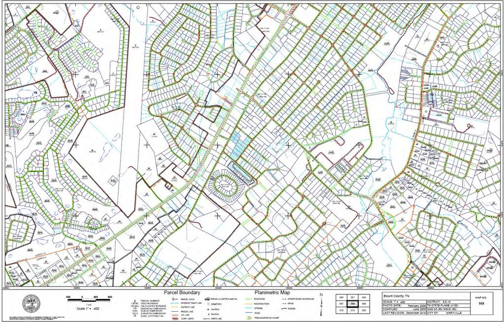
72


73 Maryville Regional Planning Commission Development Services Staff Report February 19, Subject Development Services staff is requesting a land use designation on the City of Maryville Future Land Use Map for the property on Masters Drive on behalf of James Burger, the current owner, as part of an annexation request. Current Land Use Map. 2 Facts Location/Parcel ID: The property is located between Royal Oaks and the Park at Royal Oaks subdivisions. Tax Map 068 Parcel Size: acres Applicant Request: No development proposal has been included with the annexation request.
74 Adjacent Uses. The property is surrounded by land developed for residential purposes. Consequently, all property around the parcel is designated as Residential on the Future Land Use Map Current Zoning. Blount County Suburbanizing In Accordance with the City s Comprehensive Land Use Plan: The Future Land Use Map would require designation of this parcel to a specific land use for this request to comply with the City s Comprehensive Land Use Plan. 3 Staff Comments Trending Use. Current Land Use Parcels Acres % of City Commercial % Industrial % Institutional % Natural Resources % Residential % Economic Flexibility. Given the surrounding residential nature of adjacent properties, residential use of the property is the most appropriate. Optimal Transportation Connections. Masters Drive is a private road that terminates at the edge of the property. A small private drive runs through the property connecting to Brookwood Lane in the Park at Royal Oaks. As the property is landlocked by the city and current development, any future development at the property would require construction of a new road. Compatibility. Residential uses are compatible with surrounding property. Small scale commercial or mixed use may also be appropriate in certain circumstances.
75 4 Supporting Images Aerial map showing relation to City limits and zoning. Current Land Use Map.

76 Existing Future Land Use Map. Current Zoning City of Maryville and Blount County
77 5 Reference CITY OF MARYVILLE LAND USE PLAN 2035 Purpose. The Plan balances concerns of constraints, opportunities, economic necessities, aesthetics, and the health and welfare of the population into the long-term development of the population across the city and provides a rationale for future changes. It provides the basis for the zoning ordinance, which guide the implementation of the City s vision for development. The future land use map provides the points-of-reference from which the planning commission can deliberate proposed zoning changes. By requiring that zoning changes are in accordance with the planning commission s designations of future land use ensures that zoning addresses the broader concerns of the city. The future land use map and the zoning map provide current and future land owners the development framework for the city on which investment decisions can be made. Adherence to the land use plan and to the zoning ordinance ensures consistency and stability for future development and provides a level of certainty to current and future land owners. Major Land Use Goals. To facilitate a city where citizens and visitors may experience a quality life, the plan has four major goals: Create and sustain a city that is safe, efficient, and manageable Create and sustain a city that is physically attractive, and that enhances marketability Create and sustain a city that is healthful and environmentally responsible Create and sustain a city that is accessible by vehicles and pedestrians With the City s major land use goals in mind, the future land use designations are based on four major factors: Trending Use. Currently, the city s predominant land use is residential and is primarily separated from other land uses. Other separated land uses are industrial, and high intensity commercial and retail. Economic Flexibility. The primary consideration is that the City is positioned to meet the future needs for residential, commercial, industrial, and public (institutional) uses. Optimal Transportation Connections. Future commercial land use will take advantage of primary travel routes and proximity to customer population centers. Mixed Use areas will provide both retail and residential opportunities, thereby reducing vehicle miles traveled for essential goods. Compatibility. To achieve compatibility between land uses, the future land use plan adopts the following rationale: o The most intense land use (industrial) should be a separated land use. o The least intense land use (low density residential) should be a separated land use. o Where feasible, land uses should be spatially tiered. Land uses with the highest potential for creating nuisance should have the most separation from land uses with highest sensitivity to nuisance. Medium intensity uses should buffer separated uses.

78 Maryville Regional Planning Commission Development Services Staff Report February 19, Subject James Burger, on behalf of 95 Properties LLC, is requesting for the property on Masters Drive to be zoned Residential as part of an annexation request Location Map. 2 Facts Location/Parcel ID: The property is located between Royal Oaks and the Park at Royal Oaks subdivisions. Tax Map 068 Parcel Size: acres Applicant Request: No development proposal has been presented with the annexation request. Adjacent Zoning. All adjacent properties are zoned Residential. Current Zoning. Blount County Suburbanizing
79 In Accordance with the City s Comprehensive Land Use Plan: To be in accordance with the Comprehensive Land Use Plan, low-density residential zoning districts should occur in areas designated on the Future Land Use Map as residential uses. 3 Staff Comments The property is currently surrounded by residential properties. Residential zoning for the property is appropriate given the adjacent land uses. 4 Supporting Images Aerial map showing relation to City limits and zoning.

80 Current Land Use Map. Existing Future Land Use Map.
DEVELOPMENT PLAN ORDINANCE
 DEVELOPMENT PLAN ORDINANCE CITY OF GLASGOW Ordinance No. 2026 SECTION A. Section 1. INTENT AND PURPOSE The purpose of this Ordinance is to establish and define development plans, which may be utilized
The following information is for use by the Lincoln County Planning Board at their meeting/public hearing on February 3, 2014.
 LINCOLN COUNTY PLANNING & INSPECTIONS DEPARTMENT 302 NORTH ACADEMY STREET, SUITE A, LINCOLNTON, NORTH CAROLINA 28092 704-736-8440 OFFICE 704-736-8434 INSPECTION REQUEST LINE 704-732-9010 FAX To: Planning
TOWN OF LEWISTON PLANNING BOARD APPLICATION
 TOWN OF LEWISTON PLANNING BOARD APPLICATION DESCRIPTION OF PROPOSED REQUEST: Name of Property Owner: Phone #: Name of Applicant:Phone #: Address or Location of Proposal:_SBL# Size of Parcel or Structure:Existing
DAUPHIN CREEK ESTATES SUBDIVISION
 # 12 SUB-000076-2017 DAUPHIN CREEK ESTATES SUBDIVISION Engineering Comments: FINAL PLAT COMMENTS (should be addressed prior to submitting the FINAL PLAT for review and/or signature by the City Engineer):
ARTICLE 15. RULES, REGULATIONS AND DEFINITIONS
 ARTICLE 15. RULES, REGULATIONS AND DEFINITIONS Section 1. Interpretation and Construction: The following rules and regulations regarding interpretation and construction of the Ulysses-Grant County, Kansas,
Chapter Plat Design (LMC)
") Chapter 18.14 Plat Design (LMC) Sections: 18.14.010 Lot width 18.14.020 Right-of-way requirements 18.14.030 Pipe stem lots 18.14.040 Division resulting in minimum lot sizes 18.14.050 Flood prone and bad
Chapter 18.14 Plat Design (LMC) Sections: 18.14.010 Lot width 18.14.020 Right-of-way requirements 18.14.030 Pipe stem lots 18.14.040 Division resulting in minimum lot sizes 18.14.050 Flood prone and bad
Staff Report: Date: Applicant: Property Identification: Acreage of Request: Current Zoning of Requested Area: Requested Action: Attached:
 Staff Report: Completed by Jeff Palmer Director of Planning & Zoning Date: November 7, 2018, Updated November 20, 2018 Applicant: Greg Smith, Oberer Land Developer agent for Ronald Montgomery ET AL Property
New Private Way Ordinance Westbrook Planning Board Workshop , Planning Board Public Hearing Definitions
 201 Definitions Private Right of Way; Private way A strip of land at least fifty feet wide, meeting the minimum standards for the construction of a gravel base for a public road, over which abutters may
ARTICLE VI. SUBDIVISION STANDARDS, PUBLIC
 ARTICLE VI. SUBDIVISION STANDARDS, PUBLIC IMPROVEMENTS, AND DESIGN REQUIREMENTS ARTICLE VI. SUBDIVISION STANDARDS, PUBLIC IMPROVEMENTS, AND DESIGN REQUIREMENTS DIVISION 1. GENERAL PROVISIONS Sec. 21-6100.
Organized with a "core" curriculum (the first five modules) and "electives" (the remaining modules in the program.
 and electives (the remaining modules in the program.") Introduction Sponsored by The North Carolina Chapter - American Planning Association These materials are the result of an effort by volunteer members of the North Carolina Chapter of the American Planning
Introduction Sponsored by The North Carolina Chapter - American Planning Association These materials are the result of an effort by volunteer members of the North Carolina Chapter of the American Planning
1. Michelle and Richard Bishop are requesting approval of a preliminary plat located at 800, 802, and 810 Montvale Road and 420 Indiana Avenue.
 AGENDA MARYVILLE REGIONAL PLANNING COMMISSION Monday, May 15, 2017, 5:00 PM. City of Maryville Municipal Center City Council Chamber 400 W. Broadway Ave. Development Services Department 416 West Broadway
Section Preliminary Plat Checklist and Application Forms
 Section 201 - Preliminary Plat Checklist and Application Forms PRELIMINARY SUBDIVISION PLAT REVIEW PROCESS CHART PRELIMINARY SUBDIVISION PLAT APPLICATION PRELIMINARY PLAT REVIEW CHECKLIST CITY OF NAMPA
ORDINANCE NO. 41. PRIVATE ROAD ORDINANCE As Amended Through April 10, 2008
 ORDINANCE NO. 41 PRIVATE ROAD ORDINANCE As Amended Through April 10, 2008 An Ordinance to protect the health, safety, and general welfare of the inhabitants of Port Sheldon Township. The Township of Port
May 21, ACHD Board of Commissioners Stacey Yarrington, Planner II DRH /DRH
 Development Services Department May 21, 2013 TO: FROM: SUBJECT: ACHD Board of Commissioners Stacey Yarrington, Planner II DRH13-00106/DRH13-00108 Executive Summary: This is a design review application
SUBJECT PARCEL(S) Property Owner(s) TMS Number Approximate Acreage Carolina Park Development, LLC
 Property Owner(s) TMS Number Approximate Acreage Carolina Park Development, LLC") Staff Report Special Planning Commission Meeting November 19, 2014 For reference, the Zoning Code and Land Development Regulations are available online. AGENDA ITEM 5c. SKETCH PLAN APPROVAL REQUEST: Request
Staff Report Special Planning Commission Meeting November 19, 2014 For reference, the Zoning Code and Land Development Regulations are available online. AGENDA ITEM 5c. SKETCH PLAN APPROVAL REQUEST: Request
LAND DEVELOPMENT AND SUBDIVISION ORDINANCE
 LAND DEVELOPMENT AND SUBDIVISION ORDINANCE (CHAPTER 18 OF THE MUNICIPAL CODE OF ORDINANCES) TO BE IMPLEMENTED BY: THE CITY OF FLORENCE July 2007 TABLE OF CONTENTS ARTICLE I: IN GENERAL... 1 1.1 Title...
BYRON TOWNSHIP ZONING APPLICATION
 BYRON TOWNSHIP ZONING APPLICATION Phone: (616) 878-9104 * Fax: (616) 878-3980 * Website: www.byrontownship.org This application will not be accepted if incomplete. APPLICATION FOR & REQUIRED COPIES Private
610 LAND DIVISIONS AND PROPERTY LINE ADJUSTMENTS OUTSIDE A UGB
 ARTICLE VI: LAND DIVISIONS AND PROPERTY LINE ADJUSTMENTS VI-21 610 LAND DIVISIONS AND PROPERTY LINE ADJUSTMENTS OUTSIDE A UGB 610-1 Property Line Adjustments (Property Line Relocation) A property line
ELK RAPIDS TOWNSHIP ANTRIM COUNTY, MICHIGAN ORDINANCE NO
 ELK RAPIDS TOWNSHIP ANTRIM COUNTY, MICHIGAN ORDINANCE NO. 3-2011 AN ORDINANCE TO REPLACE THE SUBDIVISION CONTROL ORDINANCE WITH A NEW SUBDIVISION DEVELOPMENT ORDINANCE, IN ACCORD WITH THE LAND DIVISION
The following regulations shall apply in the R-E District:
 "R-E" RESIDENTIAL ESTATE DISTRICT (8/06) The following regulations shall apply in the R-E District: 1. Uses Permitted: The following uses are permitted. A Zoning Certificate may be required as provided
PRELIMINARY PLATS. The following documents are provided as required by the City of Conroe for use in the above titled platting submittals:
 Public Works Engineering Division CITY OF CONROE PRELIMINARY PLATS The following documents are provided as required by the City of Conroe for use in the above titled platting submittals: Submittal Questionnaire
Committed to Service
 Committed to Service Paul Woods, President Rebecca W. Arnold, Vice President Sara M. Baker, Commissioner Jim D. Hansen, Commissioner Kent Goldthorpe, Commissioner August 25, 2017 Development Services TO:
a. provide for the continuation of collector streets and thoroughfare streets between adjacent subdivisions;
 Section 7.07. Intent The requirements of this Section are intended to provide for the orderly growth of the Town of Holly Springs and its extra-territorial jurisdiction by establishing guidelines for:
APPLICATION PROCEDURE
 ANTRIM PLANNING BOARD P. O. Box 517 Antrim, New Hampshire 03440 Phone: 603-588-6785 FAX: 603-588-2969 APPLICATION FORM AND CHECKLIST FOR MINOR OR MAJOR SITE PLAN REVIEW File Date Received By APPLICATION
-MENDOCINO COUNTY PLANNING AND BUILDING SERVICES- DIVISION OF LAND REGULATIONS TITLE 17
 ARTICLE VI -- GENERAL REGULATIONS AND PROVISIONS Sec. 17-50. Sec. 17-51 General Plan. Sec. 17-52 Lot and Block Design and Configuration. Sec. 17-53 Lot Access. Sec. 17-54 Private Roads. Sec. 17-55 Water
ARTICLE 23 CONDOMINIUM STANDARDS
 ARTICLE 23 CONDOMINIUM STANDARDS Section 23.01 Intent. The intent of this Article is to provide regulatory standards for condominiums and site condominiums similar to those required for projects developed
SUBDIVISION DESIGN PRINCIPLES AND STANDARDS
 SECTION 15-200 SUBDIVISION DESIGN PRINCIPLES AND STANDARDS 15-201 STREET DESIGN PRINCIPLES 15-201.01 Streets shall generally conform to the collector and major street plan adopted by the Planning Commission
Condominium Unit Requirements.
 ARTICLE 19 CONDOMINIUM REGULATIONS Section 19.01 Purpose. The purpose of this Article is to regulate projects that divide real property under a contractual arrangement known as a condominium. New and conversion
ARTICLE 8C SITE CONDOMINIUM DEVELOPMENT ORDINANCE
 ARTICLE 8C SITE CONDOMINIUM DEVELOPMENT ORDINANCE SECTION 8C.01 PURPOSE It is the purpose of this Ordinance to insure that plans for development within Oceola Township proposed under the provisions of
4. No subdivision shall contain a lot that is less than the minimum dimensions set out in the applicable zoning district regulations.
 Article 8 Subdivisions Part 1 Major and Minor Subdivisions Section 161: Purpose The intent of these regulations is to protect the public health, safety and welfare by providing for the orderly growth and
Guide to Minor Developments
 Guide to Minor Developments Introduction The Douglas County (DCD) is committed to providing open, transparent application processes to the public. This Guide is provided to assist anyone interested in
I. Requirements for All Applications. C D W
 108-16.1. Application checklists. Checklist for Required Submissions to the Planning Board or Zoning Board of Adjustment of Monroe Township All required submissions are to be made to the Administrative
SECTION 10.7 R-PUD (RESIDENTIAL PLANNED UNIT DEVELOPMENT) ZONE
 ZONE") Article X Zones 10-20 SECTION 10.7 R-PUD (RESIDENTIAL PLANNED UNIT DEVELOPMENT) ZONE A. PURPOSE AND INTENT: The R-PUD Residential PUD Zone is intended to provide alternative, voluntary zoning procedures
Article X Zones 10-20 SECTION 10.7 R-PUD (RESIDENTIAL PLANNED UNIT DEVELOPMENT) ZONE A. PURPOSE AND INTENT: The R-PUD Residential PUD Zone is intended to provide alternative, voluntary zoning procedures
SECTION 7000 LAND DEVELOPMENT REQUIREMENTS
 SECTION 7000 LAND DEVELOPMENT REQUIREMENTS 7000 LAND DEVELOPMENT REQUIREMENTS... 1 7001 LEGISLATIVE AUTHORITY... 1 7001.1 LAND DEVELOPMENT... 1 7001.1.1 Title 40, Idaho Code... 1 7001.1.2 Idaho Code 40-1415
Staff Report: Date: Applicant: Property Identification: Acreage of Request: Current Zoning of Requested Area: Requested Action: Attached:
 Staff Report: Completed by Jeff Palmer Director of Planning & Zoning Date: November 7, 2018 Applicant: Greg Smith, Oberer Land Developer agent for Ronald Montgomery ET AL Property Identification: Frontage
CHAPTER XVIII SITE PLAN REVIEW
 CHAPTER XVIII SITE PLAN REVIEW Section 18.1 Section 18.2 Description and Purpose. The purpose of this chapter is to provide standards and procedures under which applicants would submit, and the Township
M-43 CORRIDOR OVERLAY ZONE
 ARTICLE 26.00 M-43 CORRIDOR OVERLAY ZONE Section 26.01 Findings A primary function of the M-43 state highway is to move traffic through the Township and to points beyond. As the primary east-west arterial
JUSTIFICATION STATEMENT Minor Subdivision - Plat Raymond F. Kravis Center for the Performing Arts, Inc. Initial Submittal: September 11, 2018
 JUSTIFICATION STATEMENT Minor Subdivision - Plat Raymond F. Kravis Center for the Performing Arts, Inc. Initial Submittal: September 11, 2018 REQUEST On behalf of the Applicant, WGI is requesting a Minor
CHAPTER 25 REVIEW AND APPROVAL OF SITE CONDOMINIUM AND CONDOMINIUM PROJECTS
 CHAPTER 25 REVIEW AND APPROVAL OF SITE CONDOMINIUM AND CONDOMINIUM PROJECTS Section 25.1. Purpose and Scope. 1. Tracts of land that are developed and sold as site condominium developments and condominium
ARTICLE IV: DEVELOPMENT STANDARDS
 ARTICLE IV: DEVELOPMENT STANDARDS IV-53 409 PRIVATE STREETS A private street means any way that provides ingress to, or egress from, property by means of vehicles or other means, or that provides travel
Date: March 16, Jake Centers ERD, LLC P.O. Box 1610 Eagle, ID Elevation Ridge Subdivision (SUB & PUD ) Street Address
 Street Address") Rebecca W. Arnold, President Sara M. Baker, Vice President John S. Franden, Commissioner Carol A. McKee, Commissioner David L. Case, Commissioner Date: March 16, 2012 To: Jake Centers ERD, LLC P.O. Box
Rebecca W. Arnold, President Sara M. Baker, Vice President John S. Franden, Commissioner Carol A. McKee, Commissioner David L. Case, Commissioner Date: March 16, 2012 To: Jake Centers ERD, LLC P.O. Box
Appendix J - Planned Unit Development (PUD)
") Appendix J - Planned Unit Development (PUD) Intent and Purpose The purpose of the PUD is: 1. To provide development that is consistent with the Comprehensive Land Use Plan and promote the goals and objectives
Appendix J - Planned Unit Development (PUD) Intent and Purpose The purpose of the PUD is: 1. To provide development that is consistent with the Comprehensive Land Use Plan and promote the goals and objectives
CHAPTER 22 SUBDIVISION AND LAND DEVELOPMENT
 CHAPTER 22 SUBDIVISION AND LAND DEVELOPMENT 22-101. Title 22-102. Legislative Intent Part 1 General Provisions 22-201. Development Permits Part 2 Administration 22-301. Fee Schedule Part 3 Fee Schedule
ASPEN GLEN PUD. Eighth Amended PUD Guidelines
 ASPEN GLEN PUD Eighth Amended PUD Guidelines A. Applicability Statement To carry out the purposes and provisions of the Garfield County Zoning Regulations, as amended, The Aspen Glen Club Planned Unit
ARTICLE 3 DEFINITIONS
 Sections: 3-1 Rules of Construction 3-2 Definitions ARTICLE 3 DEFINITIONS SECTION 3-1 RULES OF CONSTRUCTION 3-101. a. The language set forth in these regulations shall be interpreted in accordance with
LINCOLN COUNTY PLANNING & INSPECTIONS DEPARTMENT
 LINCOLN COUNTY PLANNING & INSPECTIONS DEPARTMENT 30 NORTH ACADEMY STREET, SUITE A, LINCOLNTON, NORTH CAROLINA 809 704-736-8440 OFFICE 704-736-8434 INSPECTION REQUEST LINE 704-73-900 FAX To: Board of Commissioners
CONDOMINIUM REGULATIONS
 ARTICLE 37 CONDOMINIUM REGULATIONS SECTION 37.01. Purpose The purpose of this Article is to regulate projects that divide real property under a contractual arrangement known as a condominium. New and conversion
THE COUNTY BOARD OF SUPERVISORS OF THE COUNTY OF DOUGLAS DOES ORDAIN AS FOLLOWS:
 8.1 SUBDIVISION CONTROL ORDINANCE THE COUNTY BOARD OF SUPERVISORS OF THE COUNTY OF DOUGLAS DOES ORDAIN AS FOLLOWS: SECTION I. GENERAL INTERPRETATION This ordinance shall not repeal, impair or modify private
Guide to Preliminary Plans
 Guide to Preliminary Plans Introduction The Douglas County is committed to providing open, transparent application processes to the public. This Guide is provided to assist anyone interested in the procedures
13-2 SUBDIVISION PLANS AND PLATS REQUIRED EXCEPTIONS Subdivision Plats Required To be Recorded
 ARTICLE XIII SUBDIVISIONS 13-1 INTENT AND PURPOSE 13-1-1 Intent: It is the intent of the County Commission through the adoption of this Article to more fully avail itself of the power granted under 17-27-601
SUBDIVISION REGULATIONS ANDERSON COUNTY TENNESSEE. As Adopted by Anderson County Regional Planning Commission NOVEMBER 2007
 SUBDIVISION REGULATIONS OF ANDERSON COUNTY TENNESSEE As Adopted by Anderson County Regional Planning Commission NOVEMBER 2007 1 TABLE OF CONTENTS ARTICLE I PURPOSE, AUTHORITY, AND JURISDICTION 4 A. Purpose
Chapter Planned Residential Development Overlay
 Chapter 19.29 Planned Residential Development Overlay Sections 010 Purpose 020 Scope 030 Definitions 030 Minimum Size 040 Allowable Uses 050 Minimum Development Standards 060 Density Bonus 070 Open Space
PLANNED DEVELOPMENT DISTRICT STANDARDS. Cadence Site
 PLANNED DEVELOPMENT DISTRICT STANDARDS Cadence Site A Planned Development District 1. Statement of General Facts, Conditions and Objectives Property Size: Approximately 57.51 Acres York County Tax Map
ARTICLE FIVE FINAL DRAFT
 ARTICLE FIVE 021218 FINAL DRAFT Sec. 503.6 Open Space Preservation Option Open Space Preservation Option Open Space Preservation developments may be approved in the AR, R-1, R-2 and R-3 zoning districts,
MINOR PLAT. The following documents are provided as required by the City of Conroe for use in the above titled platting submittals:
 Public Works - Engineering Division CITY OF CONROE MINOR PLAT The following documents are provided as required by the City of Conroe for use in the above titled platting submittals: Submittal Questionnaire
MINUTES OF THE LAKE COUNTY PLANNING COMMISSION July 31, 2007
 MINUTES OF THE LAKE COUNTY PLANNING COMMISSION July 31, 2007 The Lake County Planning Commission hereby finds and determines that all formal actions were taken in an open meeting of this Planning Commission
Draft Model Access Management Overlay Ordinance
 Draft Model Access Management Overlay Ordinance This model was developed using the City of Hutchinson and the Trunk Highway 7 corridor. The basic provisions of this model may be adopted by any jurisdiction
Subdivision and Land Development Regulations. Jefferson County, West Virginia
 Subdivision and Land Development Regulations Jefferson County, West Virginia Adopted October 9, 2008 Amended September 29, 2016 Amendment Reference This document contains additions and amendments approved
ORDINANCE NO. Be it ordained by the City Council of the City of Abilene, Texas:
 ORDINANCE NO. An ordinance repealing Chapter 23, Subpart B of the Code of the City of Abilene, Texas, entitled Mobile Homes and Vacation Travel Trailers; stating the authority; setting forth the scope
Residential Minor Subdivision Review Checklist
 Residential Minor Subdivision Review Checklist Plan Submittal Requirements: 2 full sets of stamped plans Electric submittal - all plans contained in a single PDF 3 full sets if commercial kitchen or dining
BEAR CREEK TOWNSHIP EMMET COUNTY, MICHIGAN. PRIVATE ROAD ORDINANCE Ordinance No. 11A-99. (to replace prior Private Road Ordinance No.
 BEAR CREEK TOWNSHIP EMMET COUNTY, MICHIGAN PRIVATE ROAD ORDINANCE Ordinance No. 11A-99 (to replace prior Private Road Ordinance No. 11-99) An Ordinance to protect the health, safety, and general welfare
CITY OF ALBERT LEA PLANNING COMMISSION ADVISORY BOARD
 CITY OF ALBERT LEA PLANNING COMMISSION ADVISORY BOARD 9/1/2015, 5:30 p.m. City Council Chambers AGENDA A. CALL TO ORDER AND ROLL CALL B. APPROVAL OF THE AGENDA C. APPROVAL OF MINUTES 1. PC Minutes from
LETTER OF APPLICATION
 Description of Proposed Land Division: LETTER OF APPLICATION The proposed land division would split a 1.94 acres rectangular lot into two lots. The general configuration would have one lot in front of
9. REZONING NO Vicinity of the northwest corner of 143 rd Street and Metcalf Avenue
 9. REZONING NO. 2002-15 Vicinity of the northwest corner of 143 rd Street and Metcalf Avenue 1. APPLICANT: Andrew Schlagel is the applicant for this request. 2. REQUESTED ACTION: The applicant is requesting
Residential Major Subdivision Review Checklist
 Residential Major Subdivision Review Checklist Plan Submittal Requirements: 2 full sets of stamped plans Electric submittal - all plans contained in a single PDF 3 full sets if commercial kitchen or dining
BRIDGETON SUBDIVISION APPLICATION CHECKLIST
 APPLICATION NAME AND # CHECKLIST COMPLETED BY: DATE: Signature and printed name BRIDGETON SUBDIVISION APPLICATION CHECKLIST TO SUBDIVISION APPLICANTS: The attached checklist is to assist you in the submission
Initial Subdivision Applications Shall Include the Following:
 Initial Subdivision Applications Shall Include the Following: 1) Subdivision Application Form: completely filled out (12 copies) 2) Plat: The Plat must adhere to the requirements set forth in the Town
PALM BEACH COUNTY ENGINEERING DEPARTMENT. ZONING COMMISSION SUBDIVISION VARIANCE STAFF REPORT October 1, 2015
 PALM BEACH COUNTY ENGINEERING DEPARTMENT ZONING COMMISSION SUBDIVISION VARIANCE STAFF REPORT October 1, 2015 APPLICATION NO. CODE REQUIRED PROPOSED VARIANCE SECTION SD-147 11.E.9.B.2 When lots are platted
Site Plan Application
 Site Plan Application City of St. Pete Beach Community Development Department 155 Corey Avenue St. Pete Beach, Florida 33706 (727) 367-2735 www.stpetebeach.org Case Number: PROPERTY OWNER: Name: Address:
New Electronic Planning Commission Submittal Process
 New Electronic Planning Commission Submittal Process STANDARD OPERATING PROCEDURE Purpose: To outline the electronic submittal process for applications to the Planning Commission. Background: Procedure:
Application for Sketch Plan Review
 Town of Standish 175 Northeast Road Standish, ME - 04084 Phone: (207)642-3461 Fax: (207) 642-5181 Application for Sketch Plan Review Applicant & Owner Information 1) Name of Applicant: Address: Phone:
Cover Letter with Narrative Statement
 Cover Letter with Narrative Statement March 31, 2017 rev July 27, 2017 RE: Rushton Pointe Residential Planned Unit Development Application for Public Hearing for RPUD Rezone PL2015 000 0306 Mr. Eric Johnson,
Certified Survey Map (CSM) Submittal Updated: 6/29/18
 Submittal Updated: 6/29/18") Certified Survey Map (CSM) Submittal Updated: 6/29/18 Town of Middleton 7555 W. Old Sauk Road Verona, WI 53593-9700 Phone: 608-833-5887 Fax: 608-833-8996 info@town.middleton.wi.us The Town of Middleton
Certified Survey Map (CSM) Submittal Updated: 6/29/18 Town of Middleton 7555 W. Old Sauk Road Verona, WI 53593-9700 Phone: 608-833-5887 Fax: 608-833-8996 info@town.middleton.wi.us The Town of Middleton
ARTICLE 13 CONDOMINIUM REGULATIONS
 ARTICLE 13 CONDOMINIUM REGULATIONS Section 13.01 Purpose. The purpose of this Article is to regulate projects that divide real property under a contractual arrangement known as a condominium. New and conversion
RP-2, RP-3, RP-4, AND RP-5 PLANNED RESIDENTIAL DISTRICTS
 6.10 - RP-2, RP-3, RP-4, AND RP-5 PLANNED RESIDENTIAL DISTRICTS 6.10.1 GENERAL DESCRIPTION: 6.10.1.1 The regulations established in this Section are intended to provide optional methods of land development
PLANNED UNIT DEVELOPMENT & SUBDIVISION STAFF REPORT Date: April 18, 2019
 PLANNED UNIT DEVELOPMENT & SUBDIVISION STAFF REPORT Date: April 18, 2019 DEVELOPMENT NAME SUBDIVISION NAME Springhill Village Subdivision Springhill Village Subdivision LOCATION 4350, 4354, 4356, 4358,
Planning Department Oconee County, Georgia
 Planning Department Oconee County, Georgia STAFF REPORT REZONE CASE #: 6985 DATE: October 31, 2016 STAFF REPORT BY: Andrew C. Stern, Planner APPLICANT NAME: Williams & Associates, Land Planners PC PROPERTY
ARTICLE 24 PRIVATE ROAD, SHARED PRIVATE DRIVEWAY AND ACCESS EASEMENT STANDARDS
 ARTICLE 24 PRIVATE ROAD, SHARED PRIVATE DRIVEWAY AND ACCESS EASEMENT STANDARDS SECTION 24.00 INTENT AND PURPOSE The standards of this Article provide for the design, construction and maintenance of private
Staff Report to the North Ogden Planning Commission
 Staff Report to the North Ogden Planning Commission SYNOPSIS / APPLICATION INFORMATION Application Request: Consideration and action on an administrative application for final approval for the Legacy North
Chapter 100 Planned Unit Development in Corvallis Urban Fringe
 100.100 Scope and Purpose. Chapter 100 Planned Unit Development in Corvallis Urban Fringe (1) All applications for land divisions in the Urban Residential (UR) and Flood Plain Agriculture (FPA) zones within
PLANNING COMMISSION REPORT REGULAR AGENDA
 PP-4-4-11 Item No. 9-1 PLANNING COMMISSION REPORT REGULAR AGENDA PC Staff Report 06/22/11 ITEM NO 9: PRELIMINARY PLAT; KASOLD WATER TOWER ADDITION; SE OF TAM O SHANTER & KASOLD DR (MKM) PP-4-4-11: Consider
Community Development Department 333 Broadalbin Street SW, P.O. Box 490 Albany, OR 97321
 SUMMARY Community Development Department 333 Broadalbin Street SW, P.O. Box 490 Albany, OR 97321 STAFF REPORT Application for Tentative Partition Plat Review Planning File PA-06-17 Phone: 541-917-7550
Subdivision and Land Development Regulations. Jefferson County, West Virginia
 Subdivision and Land Development Regulations Jefferson County, West Virginia Adopted October 9, 2008 Amended April 16, 2015 Amendment Reference This document contains additions and amendments approved
CITY OF EAU CLAIRE, WISCONSIN. SPECIAL ASSESSMENT POLICY (Dated: November 8, 2016)
") CITY OF EAU CLAIRE, WISCONSIN SPECIAL ASSESSMENT POLICY (Dated: November 8, 2016) (Adopted by reference by Ordinance No. 7207 adopted November 8, 2016) PURPOSE The purpose of this Policy is to assure fair
CITY OF EAU CLAIRE, WISCONSIN SPECIAL ASSESSMENT POLICY (Dated: November 8, 2016) (Adopted by reference by Ordinance No. 7207 adopted November 8, 2016) PURPOSE The purpose of this Policy is to assure fair
Staff Report to the North Ogden City Council
 Staff Report to the North Ogden City Council SYNOPSIS / APPLICATION INFORMATION Application Request: Consideration and action on an administrative application to provide comments on the preliminary plan
Proposed Overland Park Kansas Ordinance RE-1 Residential Estates Community
 18.171 RE-1 Residential Estate Community 18.171.010 Statement of intent. The zoning of property as RE-1, (Residential Estates Community, 1 dwelling unit per Gross acre density), is intended to provide
KEIZER COMMUNITY DEVELOPMENT DEPARTMENT STAFF RECOMMENDATION Subdivision Case No
 KEIZER COMMUNITY DEVELOPMENT DEPARTMENT STAFF RECOMMENDATION Subdivision Case No. 2014-01 TO: FROM: Cynthia Domas, Keizer Hearings Officer Sam Litke, Senior Planner SUBJECT: Subdivision Case No. 2014-01
Planned Residence District (PR) To review a plan to construct 11 single family homes on approximately 4.01 acres.
 To review a plan to construct 11 single family homes on approximately 4.01 acres.") STAFF REPORT PLANNING & ZONING COMMISSION Village Green Municipal Building, Council Chambers 47 Hall Street Wednesday, March 13, 2019 7:00 P.M. 1. FINAL DEVELOPMENT PLAN REVIEW Applicant: Romanelli and
STAFF REPORT PLANNING & ZONING COMMISSION Village Green Municipal Building, Council Chambers 47 Hall Street Wednesday, March 13, 2019 7:00 P.M. 1. FINAL DEVELOPMENT PLAN REVIEW Applicant: Romanelli and
LETTER OF APPLICATION
 Description of Proposed Land Division: LETTER OF APPLICATION The proposed land division would split a 1.94 acres rectangular lot into two lots. The general configuration would have one lot in front of
c) Stub streets shall be required as follows:
 Stub streets shall be required as follows:") Sec. 7.2.1 / Streets 7.2 DESIGN STANDARDS 7.2.1 Streets A) Interconnectivity 1) Conformity with Apex Transportation Plan. The subdivision s street system shall conform to the Apex Transportation Plan.
Sec. 7.2.1 / Streets 7.2 DESIGN STANDARDS 7.2.1 Streets A) Interconnectivity 1) Conformity with Apex Transportation Plan. The subdivision s street system shall conform to the Apex Transportation Plan.
1. APPLICANT: Polsinelli, Shalton & Welte is the applicant for this request.
 5. REVISED PRELIMINARY PLAN APPROVAL - THE RETREAT AT MAPLECREST - Vicinity of the northeast corner of 159 th Street and U.S. 69 Highway 1. APPLICANT: Polsinelli, Shalton & Welte is the applicant for this
PLANNED UNIT DEVELOPMENT & SUBDIVISION STAFF REPORT August 18, 2016
 PLANNED UNIT DEVELOPMENT & SUBDIVISION STAFF REPORT August 18, 2016 DEVELOPMENT NAME SUBDIVISION NAME Mullinax Ford Subdivision Mullinax Ford Subdivision LOCATION CITY COUNCIL DISTRICT District 6 Southeast
FREQUENTLY USED PLANNING & ZONING TERMS
 City Of Mustang FREQUENTLY USED PLANNING & ZONING TERMS Abut: Having property lines, street lines, or zoning district lines in common. Accessory Structure: A structure of secondary importance or function
This Ordinance is adopted under the authority and provisions of the General Statutes of North Carolina, Article 6, Chapter 153A 121.
 Section 74, Regulations Governing Manufactured Home Parks 1. Purpose The purpose of these regulations to be known and cited as the Madison County Manufactured Home Park Ordinance is to regulate and guide
PUD Ordinance - Cascade Lakes Plat #10 of 1995
 PUD Ordinance - Cascade Lakes Plat #10 of 1995 CASCADE CHARTER TOWNSHIP Ordinance #10 of 1995 AN ORDINANCE TO AMEND THE CASCADE CHARTER TOWNSHIP ZONING ORDINANCE AND ZONING MAP TO ESTABLISH THE CASCADE
MINUTES CITY OF LINDSTRÖM PLANNING COMMISSION MEETING WEDNESDAY, JULY 7, :00 P.M. City Hall Chambers Sylvan Ave.
 MINUTES CITY OF LINDSTRÖM PLANNING COMMISSION MEETING WEDNESDAY, JULY 7, 2015 7:00 P.M. City Hall Chambers 13292 Sylvan Ave., Lindstrom, MN CALL TO ORDER/PLEDGE: Vice Chair Erlandson called the meeting
TOWN OF NORTHWOOD, NEW HAMPSHIRE
 TOWN OF NORTHWOOD, NEW HAMPSHIRE OFFICE OF THE PLANNING BOARD 818 First New Hampshire Turnpike, Northwood NH 03261 (603)942-5586 Extension 205 Facsimile: (603)942-9107 Major Subdivision Application Form
ZONING AMENDMENT, PLANNED UNIT DEVELOPMENT & SUBDIVISION STAFF REPORT Date: August 8, 2013
 ZONING AMENDMENT, PLANNED UNIT DEVELOPMENT & SUBDIVISION STAFF REPORT Date: August 8, 2013 NAME SUBDIVISION NAME PV-Magnolia, LLC Twelve Trees Subdivision LOCATION 2860, 2862 and 2866 Pleasant Valley Road
E L M E R B O R O U G H L A N D U S E B O A R D APPLICATION COVER SHEET (to be completed for all applications and appeals)
") E L M E R B O R O U G H L A N D U S E B O A R D APPLICATION COVER SHEET (to be completed for all applications and appeals) 1. Name(s): 2. Address: 3. Telephone Number(s): 4. E-mail: 5. Owner Name(s) (if
E L M E R B O R O U G H L A N D U S E B O A R D APPLICATION COVER SHEET (to be completed for all applications and appeals) 1. Name(s): 2. Address: 3. Telephone Number(s): 4. E-mail: 5. Owner Name(s) (if
ARTICLE 15 - PLANNED UNIT DEVELOPMENT
 Section 15.1 - Intent. ARTICLE 15 - PLANNED UNIT DEVELOPMENT A PUD, or Planned Unit Development, is not a District per se, but rather a set of standards that may be applied to a development type. The Planned