OCEAN ISLE BEACH SHORELINE PROTECTION PROJECT NORTH CAROLINA DIVISION OF COASTAL MANAGEMENT MAJOR PERMIT APPLICATION.
|
|
|
- Vernon Gilmore
- 6 years ago
- Views:
Transcription
1 OCEAN ISLE BEACH SHORELINE PROTECTION PROJECT NORTH CAROLINA DIVISION OF COASTAL MANAGEMENT MAJOR PERMIT APPLICATION Prepared for: The Town of Ocean Isle Beach Prepared by: 4038 Masonboro Loop Road Wilmington, North Carolina Submitted to: North Carolina Department of Environment and Natural Resources Division of Coastal Management Wilmington Regional Office October 2015
2 Ocean Isle Beach Shoreline Protection Project NCDCM Major Permit Application Contents 1 FORMS DCM MP DCM MP DCM MP DCM MP ATTACHMENTS DCM MP-1. ADDITIONAL INFORMATION a. Project Narrative b and c. Work Plats and Location Maps d. A copy of the deed (with state application only) or other instrument under which the applicant claims title to the affected properties h. Signed Agent Authorization Form j. Signed AEC Hazard Notice Appendices Appendices Appendix A: Work Plats and Location Maps Appendix B: Signed Agent Authorization Form and AEC Notice Appendix C: Inlet Management Plan Appendix D: Financial Assurance Appendix E: Pending Easements Appendix F: Adjacent Riparian Landowner Notifications Appendix G: Habitat Mapping Plan
 Ocean Isle Beach Shoreline Management Project Last")
3 1 FORMS 1.1 DCM MP-1 APPLICATION for Major Development Permit (last revised 12/27/06) North Carolina DIVISION OF COASTAL MANAGEMENT 1. Primary Applicant/ Landowner Information Business Name Town Of Ocean Isle Beach Applicant 1: First Name Debbie MI S Project Name (if applicable) Ocean Isle Beach Shoreline Management Project Last Name Smith Applicant 2: First Name MI Last Name If additional applicants, please attach an additional page(s) with names listed. Mailing Address PO Box City State 3 West Third Street Ocean Isle Beach NC ZIP Country Phone No. FAX No USA ext Street Address (if different from above) City State ZIP - mayor@oibgov.com 2. Agent/Contractor Information Business Name Coastal Planning & Engineering of North Carolina, Inc. Agent/ Contractor 1: First Name Brad Agent/ Contractor 2: First Name Greg MI MI Last Name Rosov Last Name Finch Mailing Address PO Box City State 4038 Masonboro Loop Road Wilmington NC ZIP FAX No Phone No ext. Contractor # Federal ID # Phone No ext. Street Address (if different from above) City State ZIP - brad.rosov@cbi.com; greg.finch@cbi.com 1
4 3. Project Location County (can be multiple) Brunswick Street Address Eastern End of Ocean Isle Beach and Shallotte Inlet and near 469 East 3rd St. State Rd. # N/A Subdivision Name City State Zip N/A N/A NC N/A - Phone No. N/A - - ext. a. In which NC river basin is the project located? Lumber c. Is the water body identified in (b) above, natural or manmade? Natural Manmade Unknown e. Is proposed work within city limits or planning jurisdiction? Yes No Lot No.(s) (if many, attach additional page with list) N/A,,,, b. Name of body of water nearest to proposed project Shallotte Inlet and the Atlantic Ocean d. Name the closest major water body to the proposed project site. Atlantic Ocean f. If applicable, list the planning jurisdiction or city limit the proposed work falls within. Town of Ocean Isle Beach 4. Site Description a. Total length of shoreline on the tract (ft.) 3214 ft. (Accretion Fillet) c. Size of individual lot(s) N/A,,, (If many lot sizes, please attach additional page with a list) b. Size of entire tract (sq.ft.) ~535,748 s.f. (Accretion Fillet); ~3,619,854 (Borrow Area) d. Approximate elevation of tract above NHW (normal high water) or NWL (normal water level) ~0 to 15' MSL NHW or NWL e. Vegetation on tract Typical beach and dune vegetation. f. Man-made features and uses now on tract Single family residential structures, sandbags, man-made dunes and beach fill. Recreational beach usage and public access. g. Identify and describe the existing land uses adjacent to the proposed project site. Single family residences, recreational beach uses. h. How does local government zone the tract? Residential (R-1) i. Is the proposed project consistent with the applicable zoning? (Attach zoning compliance certificate, if applicable) Yes No NA j. Is the proposed activity part of an urban waterfront redevelopment proposal? Yes No k. Has a professional archaeological assessment been done for the tract? If yes, attach a copy. Yes No NA If yes, by whom? l. Is the proposed project located in a National Registered Historic District or does it involve a National Register listed or eligible property? Yes No NA 2
5 m. (i) Are there wetlands on the site? (ii) Are there coastal wetlands on the site? Yes Yes No No (iii) If yes to either (i) or (ii) above, has a delineation been conducted? (Attach documentation, if available) There are coastal wetlands near the offloading area. All wetlands will be avoided and delineated as necessary prior to construction. n. Describe existing wastewater treatment facilities. Municipal Yes No o. Describe existing drinking water supply source. Municipal p. Describe existing storm water management or treatment systems. N/A 5. Activities and Impacts a. Will the project be for commercial, public, or private use? Commercial Public/Government b. Give a brief description of purpose, use, and daily operations of the project when complete. Private/Community The project purpose is to mitigate erosion on the eastern portion on the Town s oceanfront shoreline so as to preserve the integrity of its infrastructure, provide protection to existing development and ensure the continued use of the oceanfront beach. c. Describe the proposed construction methodology, types of construction equipment to be used during construction, the number of each type of equipment and where it is to be stored. A hydraulic pipeline dredge and pipeline, bulldozers, front-end loaders and other earth moving machines will be used during construction. Storage of the equipment will not typically be a concern as the work will likely occur 24 hours a day. A 20 wide temporary trestle will be installed parallel to the alignment of the terminal groin. The trestle would be removed upon completion of the rubblemound portion of the terminal groin. Trestle length will be approximately 950, dependent on existing grade and beach conditions at the time of construction. A crane will be placed upon the structure thereby allowing it to move stones into position in the water. Temporary sand placement for construction pads will not be necessary. d. List all development activities you propose. The proposed activity includes the construction of a terminal groin along with beach nourishment and any required mitigation measures. e. Are the proposed activities maintenance of an existing project, new work, or both? New f. What is the approximate total disturbed land area resulting from the proposed project? Approx. 100 Sq.Ft or Acres g. Will the proposed project encroach on any public easement, public access way or other area that the public has established use of? Yes No NA h. Describe location and type of existing and proposed discharges to waters of the state. The placement location is the oceanfront beach adjacent to the eastern end of Ocean Isle Beach. i. Will wastewater or stormwater be discharged into a wetland? If yes, will this discharged water be of the same salinity as the receiving water? j. Is there any mitigation proposed? If yes, attach a mitigation proposal. Only in the event of negative impacts. See inlet management plan in Appendix C. Yes No NA Yes No NA Yes No NA 3
6
7 1.2 DCM MP-2 EXCAVATION and FILL (Except for bridges and culverts) Attach this form to Joint Application for CAMA Major Permit, Form DCM MP-1. Be sure to complete all other sections of the Joint Application that relate to this proposed project. Please include all supplemental information. Describe below the purpose of proposed excavation and/or fill activities. All values should be given in feet. Access Channel (NLW or NWL) Canal Boat Basin Boat Ramp Rock Groin Rock Breakwater Other (excluding shoreline stabilization) Length Avg. 3800' Width Avg. 950' Avg. Existing Depth Final Project Depth 15 at top; 75 at bottom -6' MLW NA NA -2.5 NAVD88-15' MLW NA NA -6.6 NAVD EXCAVATION This section not applicable a. Amount of material to be excavated from below NHW or NWL in cubic yards. ~264,000 cy within Shallotte Inlet Borrow Area; 2,000 to 3,000 cy for landward 250 of rubblemound portion of terminal groin. c. (i) Does the area to be excavated include coastal wetlands/marsh (CW), submerged aquatic vegetation (SAV), shell bottom (SB), or other wetlands (WL)? If any boxes are checked, provide the number of square feet affected. CW SAV SB WL None (ii) Describe the purpose of the excavation in these areas: N/A b. Type of material to be excavated. Beach quality sand d. High-ground excavation in cubic yards. None 2. DISPOSAL OF EXCAVATED MATERIAL This section not applicable a. Location of disposal area. Oceanfront shoreline along the eastern end of Ocean Isle Beach between Charlotte St. and the end of E 3rd St. b. Dimensions of disposal area. Irregular, 3214 length, 535,749 s.f. c. (i) Do you claim title to disposal area? Yes No NA (ii) If no, attach a letter granting permission from the owner. Easements e. (i) Does the disposal area include any coastal wetlands/marsh (CW), submerged aquatic vegetation (SAV), shell bottom (SB), or other wetlands (WL)? If any boxes are checked, provide the number of square feet affected. CW SAV SB d. (i) Will a disposal area be available for future maintenance? Yes No NA (ii) If yes, where? Same location f. (i) Does the disposal include any area in the water? Yes No NA (ii) If yes, how much water area is affected? ~516,000 s.f. 5
8 WL None (ii) Describe the purpose of disposal in these areas: 3. SHORELINE STABILIZATION This section not applicable (If development is a wood groin, use MP-4 Structures) a. Type of shoreline stabilization: Bulkhead Riprap Breakwater/Sill Other: Terminal Groin c. Average distance waterward of NHW or NWL: 423 from 2013 shoreline (most recent survey data). b. Length: 1050 Width: 65' d. Maximum distance waterward of NHW or NWL: based on 2013 shoreline (most current survey data). e. Type of stabilization material: Sheet pile, bedding and armor stone g. Number of square feet of fill to be placed below water level. Bulkhead backfill Riprap Breakwater/Sill Other Bedding and Armor Stone- 69,670 s.f.; Accretion Fillet- 493,967 s.f. Based on 2013 survey. i. Source of fill material. Offsite to be determined for terminal groin materials, Shallotte Inlet borrow area for accretion fillet. f. (i) Has there been shoreline erosion during preceding 12 months? Yes No NA (ii) If yes, state amount of erosion and source of erosion amount information. 8'/yr. based on DCM maps. h. Type of fill material. Bedding and armor stone; sand 4. OTHER FILL ACTIVITIES This section not applicable (Excluding Shoreline Stabilization) a. (i) Will fill material be brought to the site? Yes No NA If yes, (ii) Amount of material to be placed in the water (iii) Dimensions of fill area (iv) Purpose of fill b. (i) Will fill material be placed in coastal wetlands/marsh (CW), submerged aquatic vegetation (SAV), shell bottom (SB), or other wetlands (WL)? If any boxes are checked, provide the number of square feet affected. CW SAV SB WL None (ii) Describe the purpose of the fill in these areas: 6
9
10 1.3 DCM MP-3 UPLAND DEVELOPMENT (Construction and/or land disturbing activities) Attach this form to Joint Application for CAMA Major Permit, Form DCM MP-1. Be sure to complete all other sections of the Joint Application that relate to this proposed project. Please include all supplemental information. GENERAL UPLAND DEVELOPMENT a. Type and number of buildings, facilities, units or structures proposed. None b. Number of lots or parcels. NA c. Density (give the number of residential units and the units per acre). NA d. Size of area to be graded, filled, or disturbed including roads, ditches, etc. Temporary staging areas and construction corridor: 37,132 s.f. (0.85 ac.). e. If the proposed project will disturb more than one acre of land, the Division of Land Resources must receive an erosion and sedimentation control plan at least 30 days before land-disturbing activity begins. (i) If applicable, has a sedimentation and erosion control plan been submitted to the Division of Land Resources? Yes No NA (ii) If yes, list the date submitted: f. List the materials (such as marl, paver stone, asphalt, or concrete) to be used for impervious surfaces. NA g. Give the percentage of the tract within the coastal shoreline AEC to be covered by impervious and/or built-upon surfaces, such as pavement, building, rooftops, or to be used for vehicular driveways or parking. NA. Temporary staging areas and construction corridor only. i. Give the percentage of the entire tract to be covered by impervious and/or built-upon surfaces, such as pavement, building, rooftops, or to be used for vehicular driveways or parking. NA. Temporary staging areas and construction corridor only. h. Projects that require a CAMA Major Development Permit may also require a Stormwater Certification. (i) Has a site development plan been submitted to the Division of Water Quality for review? Yes No NA (ii) If yes, list the date submitted: j. Describe proposed method of sewage disposal. NA k. Have the facilities described in Item (i) received state or local approval? Yes No NA If yes, attach appropriate documentation. l. Describe location and type of proposed discharges to waters of the state (e.g., surface runoff, sanitary wastewater, industrial/ commercial effluent, wash down and residential discharges). NA m. Does the proposed project include an innovative stormwater design? Yes No NA If yes, attach appropriate documentation. 8
11
12 1.4 DCM MP-4 STRUCTURES (Construction within Public Trust Areas) Attach this form to Joint Application for CAMA Major Permit, Form DCM MP-1. Be sure to complete all other sections of the Joint Application that relate to this proposed project. Please include all supplemental information. 1. DOCKING FACILITY/MARINA CHARACTERISTICS This section not applicable a. (i) Is the docking facility/marina: Commercial Public/Government Private/Community b. (i) Will the facility be open to the general public? Yes No c. (i) Dock(s) and/or pier(s) (ii) Number (iii) Length (iv) Width (v) Floating Yes No e. (i) Are Platforms included? Yes No If yes: (ii) Number (iii) Length (iv) Width (v) Floating Yes No Note: Roofed areas are calculated from dripline dimensions. g. (i) Number of slips proposed (ii) Number of slips existing d. (i) Are Finger Piers included? Yes No If yes: (ii) Number (iii) Length (iv) Width (v) Floating Yes No f. (i) Are Boatlifts included? Yes No If yes: (ii) Number (iii) Length (iv) Width h. Check all the types of services to be provided. Full service, including travel lift and/or rail, repair or maintenance service Dockage, fuel, and marine supplies Dockage ( wet slips ) only, number of slips: Dry storage; number of boats: Boat ramp(s); number of boat ramps: Other, please describe: i. Check the proposed type of siting: Land cut and access channel Open water; dredging for basin and/or channel Open water; no dredging required Other; please describe: j. Describe the typical boats to be served (e.g., open runabout, charter boats, sail boats, mixed types). k. Typical boat length: l. (i) Will the facility be open to the general public? Yes No m. (i) Will the facility have tie pilings? Yes No (ii) If yes number of tie pilings? 10
13 2. DOCKING FACILITY/MARINA OPERATIONS This section not applicable a. Check each of the following sanitary facilities that will be included in the proposed project. Office Toilets Toilets for patrons; Number: ; Location: Showers Boatholding tank pumpout; Give type and location: b. Describe treatment type and disposal location for all sanitary wastewater. c. Describe the disposal of solid waste, fish offal and trash. d. How will overboard discharge of sewage from boats be controlled? e. (i) Give the location and number of No Sewage Discharge signs proposed. (ii) Give the location and number of Pumpout Available signs proposed. f. Describe the special design, if applicable, for containing industrial type pollutants, such as paint, sandblasting waste and petroleum products. g. Where will residue from vessel maintenance be disposed of? h. Give the number of channel markers and No Wake signs proposed. i. Give the location of fuel-handling facilities, and describe the safety measures planned to protect area water quality. j. What will be the marina policy on overnight and live-aboard dockage? k. Describe design measures that promote boat basin flushing? l. If this project is an expansion of an existing marina, what types of services are currently provided? 11
14 m. Is the marina/docking facility proposed within a primary or secondary nursery area? Yes No n. Is the marina/docking facility proposed within or adjacent to any shellfish harvesting area? Yes No o. Is the marina/docking facility proposed within or adjacent to coastal wetlands/marsh (CW), submerged aquatic vegetation (SAV), shell bottom (SB), or other wetlands (WL)? If any boxes are checked, provide the number of square feet affected. CW SAV SB WL None p. Is the proposed marina/docking facility located within or within close proximity to any shellfish leases? Yes No If yes, give the name and address of the leaseholder(s), and give the proximity to the lease. 3. BOATHOUSE (including covered lifts) This section not applicable a. (i) Is the boathouse structure(s): Commercial Public/Government Private/Community (ii) Number (iii) Length (iv) Width Note: Roofed areas are calculated from dripline dimensions. 4. GROIN (e.g., wood, sheetpile, etc. If a rock groin, use MP-2, Excavation and Fill.) This section not applicable a. (i) Number (ii) Length (iii) Width 5. BREAKWATER (e.g., wood, sheetpile, etc.) This section not applicable a. Length b. Average distance from NHW, NWL, or wetlands c. Maximum distance beyond NHW, NWL or wetlands 6. MOORING PILINGS and BUOYS This section not applicable a. Is the structure(s): Commercial Public/Government Private/Community c. Distance to be placed beyond shoreline Note: This should be measured from marsh edge, if present. b. Number d. Description of buoy (color, inscription, size, anchor, etc.) e. Arc of the swing 12
15
16 2 ATTACHMENTS 2.1 DCM MP-1. ADDITIONAL INFORMATION a. Project Narrative Project Purpose and Description The Town of Ocean Isle Beach is seeking federal and state permits to allow development of a shoreline protection project. The proposed project is designed to mitigate chronic erosion on the eastern portion on the Town s oceanfront shoreline. The project would serve to preserve the integrity of the Town s infrastructure, provide protection to existing development and ensure the continued use of the oceanfront beach along this area. The main concern of residents and property owners at Ocean Isle Beach are economic losses resulting from damages to structures and their contents due to hurricane and storm activity and the loss of beachfront land due to the ongoing shoreline erosion along the east end of the island in proximity to Shallotte Inlet. A review of historical data suggests that current shoreline management strategies have not been successful in providing the proper shoreline protection sought by the Town. With a tax value of property within the limits of Ocean Isle Beach equaling approximately $1,816,012,300 (based on the 2012 reappraisal), the Town realizes the need to protect homes and infrastructure along the east end of the island. This valuation includes 3,247 commercial and residential structures and property and 1,456 vacant lots (Ivey, pers. comm.). The proposed project includes the construction of a terminal groin located 148 feet east of baseline station Components of the structure will include a 300-foot shore anchorage section (to protect against possible flanking of the landward end of the structure) and a 750-foot rubble mound section extending 600 feet seaward of the baseline (Figure 1, Appendix A). The 300-foot shore anchorage section would be constructed with either steel or concrete sheet pile. The sheet piles would have a top elevation of +4.9 feet NAVD for a distance of approximately 130 feet between the landward end of the rubblemound section and the existing dune. The top elevation of the shore anchorage section would be reduced to +4.5 feet NAVD for the remaining 170 feet (Sheet 7 of 12, Appendix A). The top of the landward most portion of the shore anchorage section would be below the existing ground level. The 750-foot rubblemound portion of the terminal groin would be constructed with loosely placed armor stone on top of a foundation mat or mattress and would have a crest elevation of +4.9 feet NAVD (Sheet 7 of 12, Appendix A). The rubblemound portion of the groin will not include a core and will be arranged such that it will remain leaky and will facilitate the movement of littoral material through the structure. In addition, the relative low crest elevation of +4.9 feet NAVD would allow some sediment to pass over the structure during periods of high tide. In addition to the construction of the terminal groin, a pre-filled accretion fillet would be constructed along a 3,214-foot section of oceanfront shoreline adjacent to the structure. The fillet would be formed with approximately 264,000 cubic yards of material excavated from the borrow area utilized by the USACE within Shallotte Inlet. Dredging will be performed by a hydraulic 14
17 cutter-suction pipeline dredge (pipeline dredge) during the environmental dredge window of November 15 through April 30. Thirty-five (35) easements will be obtained to allow for the constriction of this project. This includes twenty-seven (27) easements along the oceanfront shoreline, seven (7) within the shore anchorage section and associated construction corridor, and one (1) within the footprint of the proposed offloading area in proximity to the AIWW. At this time, all easements have been obtained with the exception of one (1) along the oceanfront shoreline due to the inability to locate the current owners. In addition, one (1) parcel located within the shore anchorage section of the groin has not executed it s easement due to the pending sale of this property. The prospective buyer, however, has verbally confirmed to the Town that they will sign the easement once the sale is finalized Construction Methodology The initial construction of the terminal groin and the placement of associated beach fill are not intended to be coordinated with the construction of the federal Coastal Storm Damage Reduction Project (CSDRP) that overlaps a portion of fill area. Rather, the initial construction should be considered to be an independently contracted project by the Town of Ocean Isle Beach. Maintenance events, however, would be coordinated to coincide with the maintenance of the CSDRP. The eastern terminus of the federal project is located at station (Shallotte Boulevard). The fill for the terminal groin fillet would extend to station 30+00; therefore, the fillet will overlap 2,000 feet of the CSDRP between station and Generally, the USACE s navigation disposal activities on the east end of Ocean Isle Beach occur from approximately station 0+00 (1,000 feet east of Shallotte Boulevard) and extend to around station (1,000 feet west of Shallotte Boulevard). The exact area covered by the USACE disposal operations, however, depends on the volume of material to be removed from the AIWW/Shallotte Inlet crossing. Preliminary methodology to transport the stone required to construct the terminal groin to Ocean Isle Beach would be via the AIWW with barges loaded from a rail terminal similar to one located in Wilmington, NC. The stone would be off-loaded on to trucks at the north end of Shallotte Boulevard (Figure 4, Appendix A). The stone would be transported by trucks from the offloading facility down Shallotte Boulevard and E. 4th Street to a temporary stone storage area located on the beach at the end of E. 4th Street. The rubblemound portion of the terminal groin would be constructed from a temporary trestle installed parallel to the alignment of the terminal groin. The trestle would be removed upon completion of the rubblemound portion of the terminal groin. Actual logistics and construction details are to be determined and are subject to change. A minimal amount of excavation or leveling would be required for the landward 150 to 250 feet of the rubblemound portion of the structure in order to place the foundation stone or mattress at an elevation of -6.6 feet NAVD (Sheet 7 of 12, Appendix A). From that point seaward, the foundation stone/mattress would be placed on grade. The sheet pile for the landward portion of the terminal groin would be transported directly to the site by truck from where it would be offloaded and driven into place with typical pile driving equipment. A 50-foot wide construction corridor would be established on either side of the shore 15
18 anchorage section. The construction corridor would be restored to pre-construction conditions as much as possible by grading any disturbed land and replanting with native vegetation Shoreline and Inlet Management Plan Summary See Appendix C for the complete plan. In summary, the shoreline and inlet management plan for the Ocean Isle Beach project would include the following components: 1. Beach profile surveys every 6 months covering 27,000 feet of shoreline on Ocean Isle Beach and 10,000 feet of shoreline east of Shallotte Inlet on Holden Beach. 2. The beach profiles will be spaced at 500-foot intervals along both Ocean Isle Beach and Holden Beach. 3. Annual hydrographic surveys of Shallotte Inlet extending from the confluence of the inlet with the AIWW seaward to the -30-foot NAVD depth contour in the ocean. The hydrographic surveys will cover the area from approximately station on Holden Beach to station 0+00 on Ocean Isle Beach. 4. The 9 radial profiles on the east end of Ocean Isle Beach and the 8 radial profiles on the west end of Holden Beach will be surveyed each spring and graphs prepared to show changes over time. 5. The sand spit shoreline east of the terminal groin will be mapped from the aerial photos taken each spring and plots of the changes in the spit shoreline shown graphically. 6. Similar shoreline mapping will also be performed on the Holden Beach side of Shallotte Inlet. 7. An annual report will be prepared summarizing changes observed during the year and identifying any profile stations where the shoreline change thresholds are exceeded. 8. The report will include a summary of significant meteorological events (tropical and extratropical), manmade activities (beach nourishment), and any other factors that had occurred that could have an impact of past as well as future shoreline changes. 9. The report will discuss if measures are needed to correct any observed negative shoreline impacts and if so provide recommendations on how to address the impacts. If mitigation beach fill is needed on either the west end of Holden Beach or along portions of Ocean Isle Beach west of station 30+00, the mitigation beach fill would be accomplished during regularly scheduled periodic nourishment of the Ocean Isle Beach project. The location of possible future mitigation beach fill will not be known until the after the beach monitoring surveys are completed and analyzed. Should the need to provide beach fill to mitigate for project related shoreline impacts be determined, the Town of Ocean Isle Beach would apply for appropriate state and federal permits. All environmental documentation and required information will be included with these permit applications. Since the location for the mitigation beach fill cannot be determined in advance, the permit process could not begin until the monitoring program identifies where the impacts have occurred. As a result, the time lapse between the identification of a shoreline erosion problem and the initiation of construction to provide the beach fill could be as long as three (3) years. This includes one year to identify the problem and two years to verify if the problem still exists. During the first year of verification, work will begin to obtain the necessary permits. Any mitigation measure would be limited to the November 16 to March 31 environmental dredging window. 16
19 No agreement between the USACE, Holden Beach and Ocean Isle Beach has been executed nor is one expected to be in the future. The statement indicating that one may be obtained has been removed from the Inlet Management Plan. Refer to the Inlet Management Plan (Appendix C). The erratic behavior of the shoreline along the east shoulder of Shallotte Inlet on the Holden Beach side, particularly in the area between the two islands, and the apparent tendency of the extreme western tip of Holden Beach opposite the inlet gorge to erode under exiting conditions makes it virtually impossible to establish a shoreline position along the west end of Holden Beach that could serve as a shoreline a threshold similar to what is proposed for the Ocean Isle Beach side. This notwithstanding, the shoreline condition on the west end of Holden Beach adjacent to Shallotte Inlet will be monitored using aerial photographs at the Town s expense. Should changes in the inlet shoreline pose a threat to existing development on the west end of Holden Beach, methods to mitigate the threat would be evaluated. Consideration of mitigation measures around the inlet shoreline on the Holden Beach side would be coordinated with the USACE, NCDCM and the Town of Holden Beach. The proposed SDI-5 project, proposed 30-Year Island-Wide Shoreline Protection Plan, federal CSDRP, and any potential mitigation on Holden Beach, if required as a result of the proposed terminal groin project, all use the same borrow area within Shallotte Inlet. Although each these projects have been designed to excavate a pre-determined volume from the borrow area, the amount removed from Shallotte Inlet as a result of these projects would not be cumulative. Engineering analysis has determined the required beach fill density along the Town s oceanfront shoreline. It is not anticipated that any project would be implemented to place fill above the stated density requirement. The applicant acknowledges that the borrow source may be used for these projects and proposes no action that would jeopardize the availability of material for any existing or proposed projects Monitoring All monitoring activities as stated within the forthcoming permit conditions issued by both CAMA and the Department of Army along with the terms and conditions set forth within the USFWS Biological Opinion will be abided by the Town of Ocean Isle Beach. Should some of these monitoring requirements be performed by another entity (i.e. USACE, NCWRC, etc.), the Town will ensure that all requirements are fully met. Ultimately, the Town is fully responsible for each monitoring requirement as outlined in the permit conditions, the Biological Opinion, and the Inlet Management Plan. A brief description of potential monitoring requirements is as follows. Construction Observations (material color, escarpments, water quality) Several initiatives will be undertaken by the Town of Ocean Isle Beach, the Engineer or his duly authorized representative to monitor construction practices. Construction observation and contract administration will be periodically performed during periods of active construction. Most observations will be during daylight hours; however, random nighttime observations may be conducted. The Town of Ocean Isle Beach, the Engineer, or his duly authorized representative will provide onsite observation by an individual with training or experience in beach 17
20 nourishment and construction observation and testing, and that is knowledgeable of the project design and permit conditions. Biological Monitoring Bird Monitoring The North Carolina Wildlife Resource Commission and partners have performed breeding surveys for colonial nesting waterbirds within proximity to the Permit Area since Specifically, surveys have been conducted along the eastern and western portion of the island in proximity to Tubbs Inlet and Shallotte Inlet. Surveys for breeding piping plovers have been conducted since 1989 at the same locations. Surveys for non-breeding piping plovers have been conducted in more recent years. These surveys include data from breeding and non-breeding seasons for several listed bird species as well as other shorebirds and waterbirds. This monitoring is expected to continue for the foreseeable future. Through a formal consultation process with the US Fish and Wildlife Service, it is expected that a robust bird monitoring program may be required on an annual basis for up to three years post-construction. The applicant will coordinate with NCWRC to determine if the State s effort may satisfy this requirement. If it does not, the Town will assume the responsibility and perform bird monitoring as required by the USFWS Biological Opinion. Seabeach Amaranth Ocean Isle Beach has been surveyed by the USACE for seabeach amaranth since 1992 (Piatkowski, pers. comm.). This monitoring is anticipated to continue for the foreseeable future. Through a formal consultation process with the US Fish and Wildlife Service, it is expected that a seabeach amaranth monitoring program may be required on an annual basis for up to three years post-construction. The applicant will coordinate with USACE to determine if their proposed effort may satisfy this requirement. If it does not, the Town will assume the responsibility and perform seabeach amaranth monitoring as required by the USFWS Biological Opinion. Sea Turtles The Ocean Isle Beach Sea Turtle Patrol has been actively monitoring sea turtle nests on their beach since Currently, the Ocean Isle Beach Sea Turtle Protection Organization provides monitoring along the island. This monitoring is anticipated to continue for the foreseeable future. Through a formal consultation process with the US Fish and Wildlife Service, it is expected that a sea turtle monitoring program may be required on an annual basis for up to three years postconstruction. The applicant will coordinate with the Ocean Isle Beach Sea Turtle Protection Organization to determine if their proposed effort may satisfy this requirement. If it does not, the Town will assume the responsibility and perform sea turtle monitoring as required by the USFWS Biological Opinion. Habitat Mapping The implementation of the proposed project has the potential to impact certain biological resources and habitats found within the proposed project area, particularly within the Shallotte Inlet complex. These include resources such as shellfish habitat, salt marsh, and intertidal communities found within the area to be investigated. Determining the baseline conditions of these resources prior to construction is a fundamental step in quantifying changes in response to 18
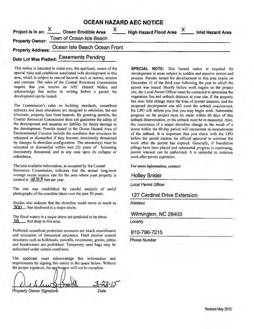
21 the implementation of the proposed project. The Town has developed a baseline habitat map. After initial construction, updates to the habitat map will occur on an annual basis for three years to assess the extent of habitat change within the designated boundary. See Appendix G for a brief description of the habitat mapping plan and the geographic extent of this effort. Physical Monitoring The USACE established a comprehensive inlet and shoreline management plan in December 2002 for the Federal storm damage reduction project (USACE, 2002). The various aspects of that plan, which are described in full within Appendix C of this permit application package and summarized above in Section , are adopted for the Ocean Isle Beach preferred shoreline management project involving a terminal groin and beach fill along the eastern end of the island b and c. Work Plats and Location Maps. See Appendix A d. A copy of the deed (with state application only) or other instrument under which the applicant claims title to the affected properties. The town is currently in the process of securing easements that will allow for the proposed construction and maintenance of the project. See Appendix E h. Signed Agent Authorization Form. See Appendix B j. Signed AEC Hazard Notice. See Appendix B. 19
22 3 APPENDICES Appendix A: Work Plats and Location Maps
23

24

25
26


27
28
29 Appendix B: Signed Agent Authorization Form and AEC Notice
30
31 Appendix C: Inlet Management Plan Ocean Isle Beach Shoreline and Inlet Management Plan Introduction The legislation passed by the NC General Assembly in June 2011 authorizing the permitting of terminal groins at four (4) inlets in North Carolina carried with it the requirement to provide a plan for managing inlet and the estuarine and ocean shorelines likely to be under the influence of the inlet. During the 2013 legislative session, the General Assembly adopted Session Law (Senate Bill 151) that modified some of the requirements that have to be met in order to permit a terminal groin. Most notably, the 2013 legislation no longer requires the applicant to demonstrate structures and infrastructure are imminently threatened only that they are threatened by erosion. The 2013 legislation still requires the applicant to implement an inlet management plan that includes the following: (1) A monitoring plan. (2) A baseline for assessing adverse impacts and thresholds for when adverse impact must be mitigated. (3) A description of mitigation measures to address adverse impacts. (4) A plan to modify or remove the terminal groin if adverse impacts cannot be mitigated. As stated in the legislation: The inlet management plan monitoring and mitigation requirements must be reasonable and not impose requirements whose costs outweigh the benefits. The inlet management plan is not required to address sea level rise. The USACE established a comprehensive inlet and shoreline management plan in December 2002 for the Federal storm damage reduction project (USACE, 2002). The various aspects of that plan, which are described below, are adopted for the Ocean Isle Beach preferred shoreline management project involving a terminal groin and beach fill along the eastern end of the island (Alternative 5). Some aspects of the USACE monitoring program have been modified to address specific issues associated with the implementation of a terminal groin project adjacent to the west side of Shallotte Inlet that are needed to comply with State Legislation. In addition to the USACE monitoring program and modification described below, which would serve to satisfy items (1) and (2) of the mandated management plan listed above, measures to mitigate project related adverse impacts as well as plans to modify or remove the terminal groin if adverse impacts cannot be mitigate are discussed in the following sections. (1) Monitoring Plan. The expressed purpose of the USACE monitoring program is to: 1) Monitor the Ocean Isle Beach and Holden Beach shorelines adjacent to Shallotte Inlet to verify the anticipated response of the inlet shoulders and ebb-tide shoal to dredging of the inlet as a borrow area.
32 2) Provide data to track the performance of the beach fill placement in order to plan and schedule the periodic renourishment of the Federal project. 3) Monitor the performance of Shallotte Inlet as a borrow area and sediment trap in order to plan dredging for the periodic renourishment. The scope of the USACE monitoring program, detailed below, would be generally sufficient to track impacts of the terminal groin on the shoreline of Ocean Isle Beach east and west of the terminal groin, evaluate structure induced changes in the behavior of the inlet shoulders, and determine if the structure is negatively impacting shoreline behavior on the west end of Holden Beach. However, measures to track changes on the extreme west end of Holden Beach and the east end of Ocean Isle Beach have been added to supplement the USACE monitoring program. With the federal storm damage reduction project having been completed in 2001 followed by subsequent periodic nourishment events in , 2010, and 2014, all of which used the borrow area in Shallotte Inlet, the impacts of the federal project following the implementation of the terminal groin project would continue. Therefore, in order to assess incremental impacts of the terminal groin on the adjacent shorelines as well as the environs around Shallotte Inlet, postterminal groin changes in these areas would need to be compared with changes that were occurring during the time in which only the federal project was active. The evaluation of habitat changes in the vicinity of Shallotte Inlet will be accomplished through analysis of aerial photographs that are included as part of the routine monitoring program. These same aerial photographs will be used to monitoring shoreline changes along the AIWW east and west of Shallotte Inlet. The shoreline change analysis will include the AIWW shoreline west to Shallotte Boulevard on the Ocean Isle side and east to the mouth of the Shallotte River including Monks Island situated immediately behind the west end of Holden Beach. Monitoring Program. The USACE monitoring program includes beach profile surveys covering 27,000 feet of shoreline on Ocean Isle Beach and 10,000 feet of shoreline on the west end of Holden Beach (Figure 6.2), radial profiles around the east and west shoulders of Shallotte Inlet, hydrographic survey of the inlet, and aerial photos. The beach profiles, which are spaced at 500- foot intervals, are surveyed every six months (fall and spring) while the inlet radial profiles are to be taken each spring. The aerial photos are also taken in the spring. To date, the USACE has published two monitoring reports, the first in December 2002 (USACE, 2002) and the second in June 2005 (USACE, 2005). While subsequent monitoring reports have not been published, the USACE has continued to collect monitoring data along the east end of the federal project and the west end of Holden Beach and has used the data to design the 2010 and 2014 periodic nourishment operations. Some of the same monitoring data was used in the evaluation of the various shoreline and inlet management alternatives included in this document. However, beginning in 2010, budget shortfalls resulted in the USACE modifying the survey coverage with most surveys limited to the area on Ocean Isle Beach that fall within the limits of the federal project. In order to continue survey coverage for the entire town, the Town of Ocean Isle Beach initiated a beach profile monitoring program that includes areas on the east and west ends of the island that have not been surveyed by the USACE since about The east end surveys include the radial profiles around the east shoulder of Shallotte Inlet starting at station -
33 30+00 and extending west along the beach to baseline station (Figure 6.2). The west end coverage starts at baseline station and extends west to baseline station The numerical modeling of the terminal groin alternative indicated there would not be any shoreline impact, either positive or negative, west of station on Ocean Isle Beach or on the west end of Holden Beach. With model indicated impacts ending at station on Ocean Isle Beach, there would not be any terminal groin related impacts on Tubbs Inlet, located about 5.3 miles west of the proposed location of the terminal groin, nor would there be any terminal groin related impacts on Sunset Beach. Therefore, the USACE monitoring program is more than sufficient to satisfy the legislative requirements. (2) Shoreline Change Thresholds. As part of the monitoring plan, the USACE developed shoreline change thresholds for Ocean Isle Beach and Holden Beach using shoreline change data developed by the NC Division of Coastal Management (NCDCM) for the time period 1938 to 1992 supplemented by a March 2001 pre-construction shoreline interpreted from aerial photographs (USACE, 2002). The USACE used least square analysis to establish shoreline trends at each 50-meter transect included in the NCDCM data set and to establish 95% confidence limits around the computed shoreline change trends. Next, the USACE matched the NCDCM transects to the beach profile monitoring profiles shown in Figure 6.1 and computed average shoreline change rates and average 95% confidence intervals for each profile. With the monitoring profiles spaced every 500 feet and the NCDCM transects every 50 meters, the averages were based on NCDCM transects on each side of the profile station. In general, the average shoreline change rates and confidence intervals applicable to each 500-foot profile station represent the average of 7 NCDCM transects. In establishing the shoreline change thresholds, the USACE excluded areas on the west end of Holden Beach and the east end of Ocean Isle Beach that are included in the area presently designated as an Inlet Hazard Area. The USACE found shoreline changes within the Inlet Hazard Area to be too erratic to establish long-term trends. The excluded areas are shown in Figure 6.4. The shoreline change rates, 95% confidence intervals, and the shoreline change threshold adopted by the USACE for each profile station on Ocean Isle Beach and Holden Beach are provided in Table 6.1. The shoreline change rate threshold adopted by the USACE was computed by subtracting one-half of the 95% confidence interval from the average shoreline change rate at each profile. For the area on the west end of Holden Beach between profile stations 375 and 400, the overall change in the shoreline was accretion, however; the USACE could not establish definitive shoreline change trends due to the unpredictable influence of the Shallotte Inlet bar channel on the shoreline. For this area the USACE adopted a threshold rate of 0 feet/year applicable to profiles 375 to 400. While the past behavior of the west end of Holden Beach has been somewhat erratic, particularly since completion of initial construction of the federal storm damage reduction project on Ocean Isle Beach, the shoreline change thresholds for the west end of Holden Beach used by the USACE were modified for the terminal groin project by applying the same protocol between stations 375 and 400 as used to establish thresholds for the other transects. Adopting this protocol results in positive, i.e., accretionary, shoreline change thresholds between stations 375 and 400 rather than 0
34 feet/year adopted by the USACE. These revised shoreline change threshold values for the extreme west end of Holden Beach are provided in Table 6.1. The use of 95% confidence intervals in establishing shoreline change rate thresholds provides a degree of certainty that observed shoreline change rates that exceed the threshold values are indicative of changes that would not have been expected to occur under pre-project conditions.

35 Figure 6.1. Beach profiles included in the USACE Ocean Isle Beach monitoring program (Figure copied from USACE, 2002).

36 Figure 6.2. Inlet radial profiles included in the USACE Ocean Isle Beach monitoring program (Figure copied from USACE, 2002).
 Interval (ft/yr) (ft/yr) (1) 5-2.8 4.0-4.")
37 Figure 6.3. Existing Inlet Hazard Area for Shallotte Inlet (Figure copied from USACE, 2002). Table 6.1. USACE shoreline change thresholds for Ocean Isle Beach and the west end of Holden Beach. Ocean Isle Beach Shoreline Change Thresholds Average Rate Average 95% Shoreline Change Beach Shoreline Confidence Rate Threshold Profile No. Change (ft/yr) Interval (ft/yr) (ft/yr) (1)
38
39 Holden Beach Shoreline Change Thresholds Beach Profile No. (2) Average Rate Shoreline Change (ft/yr) Average 95% Confidence Interval (ft/yr) Shoreline Change Rate Threshold (ft/yr) (1) (1) Shoreline change rate threshold equal to average rate (½ x 95% confidence interval). (2) Threshold rate of 0 ft/yr adopted for profiles 375 to 400 due to influence of Shallotte Inlet bar channel. To account for possible short-term shoreline changes that could be caused by storm events or other factors, the USACE adopted a 2-year confirmation period, i.e., should observed shoreline change rate exceed the threshold rate at any profile station; an additional 2-year period would follow to confirm the trend. Should the shoreline change rate exceed the threshold over the entire 2-year confirmation period, an assessment of the proper responsive measures would be made. If the shoreline change rate decreases below the threshold rate during the confirmation period, the 2- year confirmation period would be reset.
40 In the event the area is impacted by a catastrophic storm such as a hurricane or severe nor easter that causes major changes in the shoreline, subsequent shoreline change rates would likely exceed the threshold rates for some time. If after the two year post-storm confirmation period shoreline change rates are still being impacted by the storm induced changes and some of the measured shoreline change rates still exceed the threshold rates, an assessment will be made to determine if a new reference shoreline condition is needed in order to adequately evaluate potential project induced shoreline impacts that occur post storm. Comparable shoreline change rate thresholds were not established by the USACE for the radial profile lines around the inlet s east and west shoulders (Figure 6.2) due to the variable nature of the shoreline changes and the lack of definitive shoreline trends. However, the radial transects would be monitored during the life of the project and the behavior of the inlet shorelines as depicted by the radial profiles used to determine if modifications in the Shallotte Inlet borrow area are needed. As mentioned above, the shoreline and inlet monitoring program and shoreline change rate thresholds established by the USACE for the Ocean Isle Beach storm damage reduction project are adopted for the Ocean Isle Beach Shoreline Management Project with the exception of profiles 375 to 400 on the west end of Holden Beach, which were revised based on the same protocol used to establish the thresholds at all the other transects. In this regard, should Federal funding for the monitoring program fall short in any given year, the Town of Ocean Isle Beach would provide the necessary funding to assure the program is accomplished as planned. The Town of Ocean Isle Beach presently pays $17,000 to survey 34 profiles on the east and west end of the island, or $500 per profile. If the Town had to assume the cost of surveying the federal project between station 0+00 and , the cost to survey these 37 profiles would be an additional $18,500. The USACE monitoring program also includes 21 profiles on the west end of Holden Beach. Again, if the USACE were unable to survey the west end of Holden Beach due to a lack of federal funds, the Town of Ocean Isle Beach would assume that responsibility. The cost to survey the 21 profiles on the west end of Holden Beach would be $10,500. Thus, the total cost of the beach profile surveys that would become the responsibility of the Town of Ocean Isle Beach in the absence of federal funding for this activity would be $29,000 per year. Ocean Isle Beach Sand Spit. The area on Ocean Isle Beach located east of profile station 5+00 was not included in the USACE shoreline change threshold evaluation since this area falls within the existing Inlet Hazard Area established by the NC Coastal Resources Commission. Also, the sand spit, it its present form, did not exist prior to the construction of the Federal project.
")
41 Figure 6.4. Sand spit shorelines on east end Ocean Isle Beach March 1999 to January Shoreline changes along the sand spit have been highly variable as shown by the shoreline positions of the sand spit traced from Google Earth aerial photos taken between March 1999 (preconstruction) and January 2013 shown on Figure 6.4. The shorelines on Figure 6.4 do not represented a particular elevation such as mean high water or mean low water; rather the shorelines simply represent the approximate interface of the water with the dry sand beach as shown by the wet/dry line on the photos. Based on this set of aerial photos, the eastward projection of the sand spit reached a maximum in October 2007 (yellow line in Figure 6.4). Between October 2007 and October 2010 (dark blue line), the sand spit rotated counter clockwise resulting in a landward recession of the shoreline of between 400 feet and 600 feet on the extreme eastern end of the sand spit. The re-curved nature of the sand spit normally results in the formation of a shallow pond between the old spit shoreline and the backside of the new spit. Between October 2010 and January 2013 (red line), the
42 shoreline along the eastern end of the sand spit moved seaward 250 feet to 350 feet in response to a new slug of sand moving to the east. Eastward movement of the slug of sand stopped when it reached the main inlet channel and the sand spit again rotated counter clockwise and eventually merged with the previous sand spit. This cyclic nature of sand spit behavior should continue following the implementation of Alternative 5. The approximate 1,000 feet of shoreline measured from the last house on the east end of Ocean Isle Beach represents the trailing end of the sand spit. Shoreline behavior in this area is also highly variable but not to the same degree as the eastern tip of the sand spit. This shoreline position variability is due in part to the movement of beach nourishment material being transported to the east off the east end of the federal storm damage reduction project. In this regard, the October 2009 shoreline (green line in Figure 6.4), which was taken about 6 months prior to the April-May 2010 nourishment operation, had the landward most position of all of the shorelines in the photo dataset. Even though the establishment of shoreline change thresholds at each radial transect is not practical for the spit area, the March 1999 configuration of the sand spit, as shown in Figure 6.4, is adopted as a threshold for the sand spit area on the east end of Ocean Isle Beach. Post-terminal groin construction changes in the sand spit will be monitored using aerial photographs. Should the sand spit diminish in size to that comparable to the March 1999 threshold, consideration will be given to modifying the structure to allow more sediment to move from west to east past the structure. Beach nourishment in this area would also be considered as a mitigation option. Holden Beach - Shallotte Inlet Shoreline. A comparison of shoreline changes on the extreme west end of Holden Beach adjacent to Shallotte Inlet is provided in Figure 6.5. The dates of the shorelines shown in Figure 6.5 are the same as the dates shown for the Ocean Isle Beach sand spit in Figure 6.4 and were obtained from Google Earth photos. The March 1999 shoreline, shown in black in Figure 6.5, represents the position of the shoreline prior to the initial construction of the Ocean Isle Beach federal storm damage reduction project. Between March 1999 and October 2005 (blue line in Figure 6.5), the western tip of Holden Beach on the ocean side experienced considerable amount of accretion as the result of the onshore migration of a portion of the ebb tide delta located off the west end of Holden Beach. This onshore migration was attributed to the initial excavation of the Shallotte Inlet borrow area in At the narrowest point between Holden Beach and Ocean Isle Beach inside the inlet, commonly referred to as the inlet gorge, the shoreline moved east (i.e., eroded) approximately 600 feet between March 1999 and January 2013 as shown by comparing the black and red lines in Figure 6.5. The erratic behavior of the shoreline along the east shoulder of Shallotte Inlet on the Holden Beach side, particularly in the area between the two islands, and the apparent tendency of the extreme western tip of Holden Beach opposite the inlet gorge to erode under exiting conditions makes it virtually impossible to establish a shoreline position along the west end of Holden Beach which could serve as a shoreline threshold similar to what is proposed for the Ocean Isle Beach side. This notwithstanding, the shoreline condition on the west end of Holden Beach adjacent to Shallotte inlet will be monitored using aerial photographs. Should changes in the inlet shoreline pose a threat to existing development on the west end of Holden Beach, methods to mitigate the threat would be evaluated. Consideration of mitigation measures around the inlet shoreline on the
 Mitigation Measures.")
43 Holden Beach side would be coordinated with the USACE, NCDCM and the Town of Holden Beach. Figure 6.5. Shoreline changes on the extreme west end of Holden Beach next to Shallotte Inlet March 1999 to January (3) Mitigation Measures. Should shoreline responses along Ocean Isle Beach or Holden Beach exceed the shoreline change thresholds presented above and continue to exceed the thresholds throughout the 2-year verification period, the terminal groin would be evaluated to determine if modifications to the structure could be made that would mitigate the negative shoreline impacts. If modification of the terminal groin would not address the problem, beach nourishment would be provided in the affected areas to compensate for the structure related impacts. Once the need to provide beach fill to mitigate for project related shoreline impacts is determined, the Town of Ocean Isle Beach would apply for appropriate State and Federal permits. Since the location for the mitigation beach fill cannot be determined in advance, the permit process could not begin until the monitoring program identifies where the impacts have occurred. As a result,
44 the time lapse between the identification of a shoreline erosion problem and the initiation of construction to provide the beach fill could be as long as three (3) years. This includes one year to identify the problem and two years to verify if the problem still exists. During the first year of verification, work will begin to obtain the necessary permits. Any mitigation measure would be limited to the November 16 to March 31 environmental dredging window. Material for the mitigation beach fill would be obtained from the Shallotte Inlet borrow area. Depending on the timing of when the need for mitigation beach fill is determined, the mitigation beach fill could possibly be provided during the normal periodic nourishment operation. If the timing does not coincide with the normal periodic cycle, the mitigation fill would be provided during a separate nourishment operation. Under the existing Federal storm damage reduction project, mitigation of adverse impacts of the Shallotte Inlet borrow area on Holden Beach would be the responsibility of the Town of Ocean Isle Beach. Separating terminal groin and borrow area impacts on the west end of Holden Beach would be difficult if not impossible. However, with the Town of Ocean Isle Beach being responsible for mitigation in both instances, identifying the culpable feature (borrow area or terminal groin) would not be required. In the event the negative impacts of the terminal groin cannot be mitigated with beach nourishment or possible modifications to the design of the terminal groin, the terminal groin would be removed. Removal would entail the extraction of the sheet pile from the shore anchorage section and the complete removal of all stone, including bedding and armor stone. The terminal groin construction materials would be transported off the island and placed in an appropriate storage site. The terminal groin material, particularly the sheet pile and stone, would have some salvage value; however, the opinion on the cost for removal of the terminal groin, excluding any salvage value, is $2.0 million. (4) Project Modifications. The terminal groin proposed for the east end of Ocean Isle Beach in the applicant s preferred alternative (Alternative 5) is designed to allow littoral sediment to move over, though, and/or around the structure. The so-called leaky nature of the design, a nomenclature suggested by Olsen & Associates for the terminal groin on Amelia Island, Florida, should allow sufficient volumes of sand to move past the structure and continue east along the sand spit to maintain the integrity of the spit. As indicated above, the March 1999 configuration of the sand spit on the Ocean Isle Beach side of Shallotte Inlet will be used as a threshold in determining if modifications to the structure are needed to allow more sediment to move past the structure. No such threshold is possible for the inlet shoreline on the Holden Beach side due to the document erratic behavior of the shoreline prior to and following the initial construction of the Ocean Isle Beach federal storm damage reduction project. In this regard, mitigation on the Holden Beach side would be dictated by shoreline changes that exceed the thresholds established for the federal project. Consideration would also be given to possibly nourishing the area east of the terminal groin on the Ocean Isle Beach side as a means of restoring the character of the sand spit. The postconstruction configuration of the sand spit will be evaluated through interpretation of the aerial photographs. As stated above, should the sand spit diminish in size comparable to the March 1999
45 condition, consideration will be given to modifying the structure to allow more sediment to move from west to east past the structure of possibly providing beach fill to the area east of the terminal groin during regularly scheduled periodic nourishment operations. Modification to the structure could include removal of stones to increase permeability, shortening the structure, or lowering the crest elevation. The appropriate measures, i.e., structure modifications or beach fill, would be determined following an assessment of the degree of impact the structure is having on the area. Reporting. Annual reports, comparable to the two monitoring reports previously published by the USACE, would be prepared and submitted to the USACE Wilmington District Regulatory Office and the NC Division of Coastal Management. The reports will summarize shoreline changes observed during the previous year and will compare updated shoreline changes to shoreline change thresholds. The results will be provided in both tabular and graphical form. Should the monitoring surveys detect shoreline change rates exceeding the threshold rates, the profile where the thresholds are exceeded will be red flagged. Subsequent monitoring reports over the following two years will closely follow changes at these profiles to determine if corrective actions are needed. Summary of Shoreline and Inlet Management Plan. The shoreline and inlet management plan for the Ocean Isle Beach project would include the following: (1) Beach profile surveys every 6 months covering 27,000 feet of shoreline on Ocean Isle Beach and 10,000 feet of shoreline east of Shallotte Inlet on Holden Beach. (2) The beach profiles will be spaced at 500-foot intervals along both Ocean Isle Beach and Holden Beach. (3) Annual hydrographic surveys of Shallotte Inlet extending from the confluence of the inlet with the AIWW seaward to the -30-foot NAVD depth contour in the ocean. The hydrographic surveys will cover the area from approximately station on Holden Beach to station 0+00 on Ocean Isle Beach. (4) The 9 radial profiles on the east end of Ocean Isle Beach and the 8 radial profiles on the west end of Holden Beach, as shown in Figure 6.2, will be surveyed each spring and graphs prepared to show changes over time. (5) The sand spit shoreline east of the terminal groin will be mapped from the aerial photos taken each spring and plots of the changes in the spit shoreline shown graphically. (6) Similar shoreline mapping will also be performed on the Holden Beach side of Shallotte Inlet. (7) An annual report will be prepared summarizing changes observed during the year and identifying any profile stations where the shoreline change thresholds are exceeded. (8) The report will include a summary of significant meteorological events (tropical and extratropical), man-made activities (beach nourishment), and any other factors that had occurred that could have an impact of past as well as future shoreline changes. (9) The report will discuss if measures are needed to correct any observed negative shoreline impacts and if so provide recommendations on how to address the impacts.
46 Appendix D: Financial Assurance
47 Appendix E: Pending Easements


. 2.")

48 ATLANTIC INTRACOASTAL WATERWAY E FIFTH ST SHALLOTTE BLVD E SIXTH ST E SEVENTH ST BAYWATCH DR OCEAN ISLE BEACH SHORELINE PROTECTION PROJECT EASEMENT PARCELS E FOURTH ST CHARLOTTE ST E THIRD ST COLUMBIA ST G:\Enterprise\Brunswick\147426_Ocean Isle Beach EIS\mxd\Easement_Parcels_Clip_Easement_Parcel.mxd ATLANTIC OCEAN LEGEND: NOTES: EASEMENT PARCELS PARCELS 50FT. CONSTRUCTION BUFFER SHEET PILE ACCRETION FILLET TERMINAL GROIN 1. COORDINATES ARE IN FEET BASED ON THE NORTH CAROLINA STATE PLANE COORDINATE SYSTEM, NORTH AMERICAN DATUM OF 1983 (NAD 83) BACKGROUND IMAGERY IS FROM THE NC ONEMAP IMAGERY SERVICE Feet COASTAL PLANNING & ENGINEERING OF NORTH CAROLINA, INC. DATE: BY: 05/13/15 HMV COMM NO.: SHEET: MASONBORO LOOP RD. PH. (910) WILMINGTON, NC FAX (910)
49 G:\Enterprise\Brunswick\147426_Ocean Isle Beach EIS\mxd\Easement_Table.mxd ID PIN Owner Address City State ZipCode MARITIME PLACE PROPERTY OWNERS ASSN. INC PO BOX 8126 OCEAN ISLE BEACH NC OCEAN ISLE LLC 2450 SHADYWOOD CI CROFTON MD KERNODLE DENNIS 4880 SARTIN ROAD BURLINGTON NC SOUTHER DAN L ET FRIEDA 4219 FARLIN AVE GREENSBORO NC MILLIKEN JEFFREY A ETALS PO BOX 6609 SHALLOTTE NC MUELLER ROBERT E ETUX POLLY PO BOX 3755 MEDINA OH MILHEN LLC 419 LIGHTWOOD LANE SHALLOTTE NC JENNINGS ROGER A III ETUX MARLEEN O 9053 DEER HILL ROAD BELEWS CREEK NC LW LEGACY ASSETS LLC & DW LEGACY ASSETS LLC 11 CAUSEWAY DRIVE OCEAN ISLE BEACH NC LW LEGACY ASSETS LLC & DW LEGACY ASSETS LLC 11 CAUSEWAY DRIVE OCEAN ISLE BEACH NC LW LEGACY ASSETS LLC & DW LEGACY ASSETS LLC 11 CAUSEWAY DRIVE OCEAN ISLE BEACH NC LW LEGACY ASSETS LLC & DW LEGACY ASSETS LLC 11 CAUSEWAY DRIVE OCEAN ISLE BEACH NC MCMURTRIE BARRY & TONI TITONE 5887 LYCIA LN OCEAN ISLE BEACH NC BLEVINS THOMAS S ETUX 478 EAST THIRD STREET OCEAN ISLE BEACH NC ROBERTS ROBERT JAMES JR ETALS 474 E THIRD STREET OCEAN ISLE BEACH NC JURANICH PETER F ETUX DENISE A 25 OLD FORT DR HILTON HEAD SC ZORZI KERRY & HEATHER 9204 CONCORD HILL CT RALEIGH NC LW LEGACY ASSETS LLC & DW LEGACY ASSETS LLC 11 CAUSEWAY DRIVE OCEAN ISLE BEACH NC LW LEGACY ASSETS LLC & DW LEGACY ASSETS LLC 11 CAUSEWAY DRIVE OCEAN ISLE BEACH NC MCMURTRIE BARRIE ETUX TONI TITONE 5887 LYCIA LANE OCEAN ISLE BEACH NC VENABLE ONETA MICHELLE PO BOX 1685 ANDERSON SC LW LEGACY ASSETS LLC & DW LEGACY ASSETS LLC 11 CAUSEWAY DRIVE OCEAN ISLE BEACH NC DYE JOHN R ET JACQUELINE H 4915 LAKESHORE DR KILLEEN TX LW LEGACY ASSETS LLC & DW LEGACY ASSETS LLC 11 CAUSEWAY DRIVE OCEAN ISLE BEACH NC HENLEY DONNA D 1514 LANGDON VILLAGE DR CLEMMONS NC LW LEGACY ASSETS LLC & DW LEGACY ASSETS LLC 11 CAUSEWAY DRIVE OCEAN ISLE BEACH NC OCEAN ISLE BEACH SHORELINE PROTECTION PROJECT EASEMENT PARCELS COASTAL PLANNING & ENGINEERING OF NORTH CAROLINA, INC. DATE: BY: 05/13/15 HMV COMM NO.: SHEET: MASONBORO LOOP RD. PH. (910) WILMINGTON, NC FAX (910)
50 EASEMENT STATE OF NORTH CAROLINA COUNTY OF BRUNSWICK THIS EASEMENT, made this day of May, 2015, by and between and, hereinafter, whether one or more, referred to as "GRANTOR," and Town of Ocean Isle Beach, a North Carolina municipal corporation, Three West Third Street, Ocean Isle Beach, NC 28469, hereinafter, whether one or more, referred to as "GRANTEE": W I T N E S S E T H : THAT WHEREAS, Grantee is undertaking a Terminal Groin Project within the Town to help control erosion and protect waterfront lots; and WHEREAS, in order to properly construct and complete the project, it is necessary for Grantee to acquire certain easements for said project from affected property owners; and WHEREAS, Grantor is the owner of that certain tract of land located in Ocean Isle Beach, Brunswick County, North Carolina, more particularly described as, which property is affected by said project; and WHEREAS, Grantor acknowledges that they will also benefit from said project; and WHEREAS, Grantee has requested and Grantor has agreed to convey the necessary easement to Grantee to enable it to undertake said project; NOW, THEREFORE, the Grantor, for a valuable consideration, including the benefits Grantor may derive from said project, the receipt of which is hereby acknowledged, has and by these presents does give, grant, bargain, dedicate and convey unto the Grantee and its successors and assigns a perpetual, irrevocable and assignable easement and right-of-way in, on, over, through and across the land hereinafter described for the use by the Grantee and its
51 representatives, agents, employees, officials, engineers, consultants, surveyors, contractors, subcontractors, and assigns. The easement area shall be all of the above-described property. Grantor also conveys and grants to Grantee a non-exclusive access easement across any portion of the above-described property for the purpose of permitting Grantee s inspection and, if necessary, observation, maintenance and repair of the Grantee s work and activities within the easement area ( the Access Easement ).. This easement is granted for the purpose of allowing Grantee to use the Easement Area for the placement of beach compatible material, utilization of heavy machinery to place said material, construction of the terminal groin and anchor section, and the staging and transportation of construction materials together with the right of ingress and egress for such work. Grantee may use the Easement Area to evaluate, survey, inspect, construct, preserve, patrol, protect, operate, maintain, repair, rehabilitate, and replace a public beach, a dune system, and other erosion control and storm damage reduction measures including the construction of a terminal groin and its associated shore anchorage system together with appurtenances thereto, including the right to (a) deposit sand; (b) accomplish any alterations of contours on said land; construct berms and dunes; (c) nourish and re-nourish periodically; (d) move, store and remove equipment and supplies; (e) perform any other work necessary and incident to the construction, periodic re-nourishment and maintenance of the Project; (f) plant vegetation on said dunes and berms; (g) erect, maintain and remove silt screens and sand fences; (h) facilitate preservation of dunes and vegetation through the limitation of access to dune areas; (i) trim, cut, fell, and remove from said land all trees, underbrush, debris, obstructions, and any other vegetation, structures and obstacles within the boundaries of the Easement Area that would hinder the above described activities, and (j) removal of the terminal groin in its entirety if directed by order of the U S Army Corps of Engineers.. There is reserved, however, to the Grantor, their heirs and assigns, all such rights and privileges as may be used without interfering with or abridging the rights and easement hereby acquired. TO HAVE AND TO HOLD the aforesaid easement (including access easement) and all privileges and appurtenances thereunto belonging to the Grantee and its successors and assigns forever. Grantee shall have the right to temporarily or permanently assign this easement to the federal, state or county governments, or any agency or department thereof or any other governmental authority formed to implement beach re-nourishment or stabilization of the beach within the Town. 2 Prepared by Michael R. Isenberg
52 AND the Grantor covenants with the Grantee that Grantor is seized of the premises in fee simple, has the right to convey this easement, that the property is free from encumbrances and that it will warrant and defend the said title to the same against the claims of all persons whomsoever. IN WITNESS WHEREOF, the Grantor has hereunto executed this easement the day and year first above written. (SEAL) (NAME) (SEAL) (NAME) STATE OF NORTH CAROLINA COUNTY OF I,, a Notary Public in and for the State and County aforesaid, do hereby certify that and personally appeared before me this day and acknowledged the due and voluntary execution of the foregoing instrument for the purposes set forth therein. Witness my hand and notarial seal, this the day of, My commission expires:, NOTARY PUBLIC 3 Prepared by Michael R. Isenberg
53 EASEMENT STATE OF NORTH CAROLINA COUNTY OF BRUNSWICK THIS EASEMENT, made this day of May, 2015, by and between and, hereinafter, whether one or more, referred to as "GRANTOR," and Town of Ocean Isle Beach, a North Carolina municipal corporation, Three West Third Street, Ocean Isle Beach, NC 28469, hereinafter, whether one or more, referred to as "GRANTEE": W I T N E S S E T H : THAT WHEREAS, Grantee is undertaking a Terminal Groin Project within the Town to help control erosion and protect waterfront lots; and WHEREAS, in order to properly construct and complete the project, it is necessary for Grantee to acquire certain easements for said project from affected property owners; and WHEREAS, Grantor is the owner of that certain tract of land located in Ocean Isle Beach, Brunswick County, North Carolina, more particularly described as PIN no which property is affected by said project; and WHEREAS, Grantor acknowledges that they will also benefit from said project; and WHEREAS, Grantee has requested and Grantor has agreed to convey the necessary easement to Grantee to enable it to undertake said project; NOW, THEREFORE, the Grantor, for a valuable consideration, including the benefits Grantor may derive from said project, the receipt of which is hereby acknowledged, has and by these presents does give, grant, bargain, dedicate and convey unto the Grantee and its successors and assigns a perpetual, irrevocable and assignable easement and right-of-way in, on, over, through and across the land hereinafter described for the use by the Grantee and its representatives, agents, employees, officials, engineers, consultants, surveyors, contractors, subcontractors, and assigns. The easement area shall include all of that portion of the above-described property. located 100 feet south (landward) of the Mean High Water shoreline along the Atlantic Intracoastal Waterway. Grantor also conveys and grants to Grantee a non-exclusive access easement across any portion of the above-described property for the purpose of permitting Grantee s inspection and, if necessary, observation, maintenance and repair of the Grantee s work and activities within the easement area ( the Access Easement )..
54 This easement is granted for the purpose of allowing Grantee to use the Easement Area for the construction of temporary offloading facilities, stockpiling of materials, utilization of heavy machinery to place and remove said material, and the staging and transportation of construction materials together with the right of ingress and egress for such work. Grantee may use the Easement Area to evaluate, survey, inspect, construct, preserve, patrol, protect, operate, maintain, repair, rehabilitate, and replace a public beach, a dune system, and other erosion control and storm damage reduction measures including the construction of a terminal groin and its associated shore anchorage system together with appurtenances thereto, including the right to (a) deposit sand; (b) accomplish any alterations of contours on said land; (c) move, store and remove equipment and supplies; (d) perform any other work necessary and incident to the construction, periodic re-nourishment and maintenance of the Project; (e) plant vegetation ; (f) erect, maintain and remove silt screens and sand fences; (g) trim, cut, fell, and remove from said land all trees, underbrush, debris, obstructions, and any other vegetation, structures and obstacles within the boundaries of the Easement Area that would hinder the above described activities, and (h) removal of the terminal groin in its entirety if directed by order of the U S Army Corps of Engineers.. There is reserved, however, to the Grantor, their heirs and assigns, all such rights and privileges as may be used without interfering with or abridging the rights and easement hereby acquired. TO HAVE AND TO HOLD the aforesaid easement (including access easement) and all privileges and appurtenances thereunto belonging to the Grantee and its successors and assigns forever. Grantee shall have the right to temporarily or permanently assign this easement to the federal, state or county governments, or any agency or department thereof or any other governmental authority formed to implement beach re-nourishment or stabilization of the beach within the Town. AND the Grantor covenants with the Grantee that Grantor is seized of the premises in fee simple, has the right to convey this easement, that the property is free from encumbrances and that it will warrant and defend the said title to the same against the claims of all persons whomsoever. written. IN WITNESS WHEREOF, the Grantor has hereunto executed this easement the day and year first above (SEAL) (NAME) (SEAL) (NAME) 2 Prepared by Michael R. Isenberg
55 STATE OF NORTH CAROLINA COUNTY OF I,, a Notary Public in and for the State and County aforesaid, do hereby certify that and personally appeared before me this day and acknowledged the due and voluntary execution of the foregoing instrument for the purposes set forth therein. Witness my hand and notarial seal, this the day of, My commission expires:, NOTARY PUBLIC 3 Prepared by Michael R. Isenberg
56 EASEMENT STATE OF NORTH CAROLINA COUNTY OF BRUNSWICK THIS EASEMENT, made this day of May, 2015, by and between and,, hereinafter, whether one or more, referred to as "GRANTOR," and Town of Ocean Isle Beach, a North Carolina municipal corporation, Three West Third Street, Ocean Isle Beach, NC 28469, hereinafter, whether one or more, referred to as "GRANTEE": W I T N E S S E T H : THAT WHEREAS, Grantee is undertaking a Terminal Groin Project within the Town to help control erosion and protect waterfront lots; and WHEREAS, in order to properly construct and complete the project, it is necessary for Grantee to acquire certain easements for said project from affected property owners; and WHEREAS, Grantor is the owner of that certain tract of land located in Ocean Isle Beach, Brunswick County, North Carolina, more particularly described as, which property is affected by said project; and WHEREAS, Grantor acknowledges that they will also benefit from said project; and WHEREAS, Grantee has requested and Grantor has agreed to convey the necessary easement to Grantee to enable it to undertake said project; NOW, THEREFORE, the Grantor, for a valuable consideration, including the benefits Grantor may derive from said project, the receipt of which is hereby acknowledged, has and by these presents does give, grant, bargain, dedicate and convey unto the Grantee and its successors and assigns a perpetual, irrevocable and assignable easement and right-of-way in, on, over, through and across the land hereinafter described for the use by the Grantee and its
57 representatives, agents, employees, officials, engineers, consultants, surveyors, contractors, subcontractors, and assigns. The easement area shall be that portion of the above-described property located between (1) the mean high water mark of the Atlantic Ocean, and (2) the landward toe of a sandbag revetment (if present). In the absence of a sandbag revetment, the easement area shall be that portion of the Property located between (3) the mean high water mark of the Atlantic Ocean, and (4) a point 15 feet seaward of the seaward most edge of any Permanent Structure located on the Property as of the date of this Easement. In the absence of a sandbag revetment or a Permanent Structure, the easement area shall be that portion of the Property located between (5) the mean high water mark of the Atlantic Ocean, and (6) an eastern and/or western extension of the easement area for the property or properties adjoining the Property whose comparable easement areas have been established using either the sandbag revetment or a Permanent Structure located on such adjoining property (the "Easement Area"). Grantor also conveys and grants to Grantee a non-exclusive access easement across any portion of the above-described property for the purpose of permitting Grantee s inspection and, if necessary, observation, maintenance and repair of the Grantee s work and activities within the easement area ( the Access Easement ).. This easement is granted for the purpose of allowing Grantee to use the Easement Area for the placement of beach compatible material, utilization of heavy machinery to place said material, construction of the terminal groin and anchor section, and the staging and transportation of construction materials together with the right of ingress and egress for such work. Grantee may use the Easement Area to evaluate, survey, inspect, construct, preserve, patrol, protect, operate, maintain, repair, rehabilitate, and replace a public beach, a dune system, and other erosion control and storm damage reduction measures including the construction of a terminal groin and its associated shore anchorage system together with appurtenances thereto, including the right to (a) deposit sand; (b) accomplish any alterations of contours on said land; construct berms and dunes; (c) nourish and re-nourish periodically; (d) move, store and remove equipment and supplies; (e) perform any other work necessary and incident to the construction, periodic re-nourishment and maintenance of the Project; (f) plant vegetation on said dunes and berms; (g) erect, maintain and remove silt screens and sand fences; (h) facilitate preservation of dunes and vegetation through the limitation of access to dune areas; (i) trim, cut, fell, and remove from said land all trees, underbrush, debris, obstructions, and any other vegetation, structures and obstacles within the boundaries of the Easement Area that would hinder the above described activities, and (j) removal of the terminal groin in its entirety if directed by order of the U S Army Corps of Engineers. 2 Prepared by Michael R. Isenberg
58 . There is reserved, however, to the Grantor, their heirs and assigns, all such rights and privileges as may be used without interfering with or abridging the rights and easement hereby acquired. For purposes of this easement, the following definitions shall apply: Permanent Structure: A building, including a principal building and any accessory building(s), covered decks, swimming pool, and improvements associated with a swimming pool, but not including any uncovered decks or any improved dune walkover access or any associated gazebos or other improved portions of an improved dune walkover access. Sandbag Revetment: A stack of sandbags installed along the ocean side of the property to provide temporary erosion protection. TO HAVE AND TO HOLD the aforesaid easement (including access easement) and all privileges and appurtenances thereunto belonging to the Grantee and its successors and assigns forever. Grantee shall have the right to temporarily or permanently assign this easement to the federal, state or county governments, or any agency or department thereof or any other governmental authority formed to implement beach re-nourishment or stabilization of the beach within the Town. AND the Grantor covenants with the Grantee that Grantor is seized of the premises in fee simple, has the right to convey this easement, that the property is free from encumbrances and that it will warrant and defend the said title to the same against the claims of all persons whomsoever. IN WITNESS WHEREOF, the Grantor has hereunto executed this easement the day and year first above written. (SEAL) (NAME) (SEAL) (NAME) STATE OF NORTH CAROLINA COUNTY OF 3 Prepared by Michael R. Isenberg
59 I,, a Notary Public in and for the State and County aforesaid, do hereby certify that and personally appeared before me this day and acknowledged the due and voluntary execution of the foregoing instrument for the purposes set forth therein. Witness my hand and notarial seal, this the day of, My commission expires:, NOTARY PUBLIC 4 Prepared by Michael R. Isenberg
60 Appendix F: Adjacent Riparian Landowner Notifications and Session Law Notification
61 4038 MASONBORO LOOP ROAD, WILMINGTON, NC PHONE FAX May 14, 2015 Re: Town of Ocean Isle Beach Shoreline Protection Project Adjacent Riparian Landowner Notification Dear Sir or Madam: On behalf of the Town of Ocean Isle Beach (Town), Coastal Planning & Engineering of North Carolina (CPE-NC), Inc. is submitting a Coastal Area Management Act (CAMA) Major Permit application to the North Carolina Division of Coastal Management (NC DCM) for work occurring within an Area of Environmental Concern. As more completely described in the attached application, the Town intends to submit a CAMA Major Permit application to allow for the construction of a terminal groin and associated sand placement on the eastern end of the Town s oceanfront shoreline. Attached to this notice, please find a copy of the application as submitted to the NC DCM office. Within 30 days from receipt of this notice, you may submit comments regarding the referenced project to the following address: Attn: Holley Snider Division of Coastal Management North Carolina Department of Environment and Natural Resources 127 Cardinal Drive Extension Wilmington, North Carolina Sincerely, Greg Finch, Agent, CPE-NC Enclosures: Application for Major Development Permit
62 Pursuant to the requirement of Session Law Senate Bill 151 Part II (e) (3), the Town of Ocean Isle Beach is notifying all property owners and local governments that may be affected by the construction of the proposed terminal groin and accompanying beach nourishment project. Information on the proposed Ocean Isle Beach Shoreline Protection Project, which includes the construction of a terminal groin and associated beach nourishment, can be found on the Town s website at Comments regarding the referenced project may be submitted to the following address: Attn: Holley Snider Division of Coastal Management North Carolina Department of Environment and Natural Resources 127 Cardinal Drive Extension Wilmington, North Carolina 28405

63 Appendix G: Habitat Mapping Purpose and Goals It is anticipated that the implementation of the proposed project has the potential to impact certain biological resources and habitats found within the proposed Permit Area, particularly within the complex of Shallotte Inlet. These include resources such as shellfish habitat, salt marsh, and intertidal communities found within the area to be investigated. Determining the baseline conditions of these resources prior to construction is a fundamental step in quantifying changes in response to the implementation of Alternative 5. Existing data were utilized to delineate and characterize habitats and select species within the proposed Permit Area. Data gathered from these activities provided the baseline conditions of a number of biological resources as reported in Chapter 4 of this document. The purpose of the baseline habitat mapping effort was to identify the current extent of the biological resources within the area prior to the construction of the terminal groin and subsequent beach fill and will serve as the baseline assessment of the subject resources within the identified Shallotte Inlet Habitat Mapping Area, as designated in Figure 1. Subsequent habitat mapping efforts will be utilized to assess the extent of change to these habitats within the designated boundary following construction activities. Figure 1- Shallotte Inlet Habitat Mapping Area Monitoring Schedule
Directions For Filling Out A CAMA MINOR Permit
 Directions For Filling Out A CAMA MINOR Permit Please fill out the application completely including applicant's signature on the second page. Be sure to complete the "statement of ownership" and the "adjacent
Shoreline Permit Requirements
 CITY OF MERCER ISLAND, WASHINGTON 9611 SE 36 th Street Mercer Island, WA 98040-3732 (206) 275-7605 FAX (206) 275-7726 www.mercergov.org Shoreline Permit Requirements All development within the Shoreline
ORDINANCE NO WHEREAS, the Town of Jupiter ( Town ) has adopted a Comprehensive Plan
 has adopted a Comprehensive Plan") 0 0 ORDINANCE NO. -0 AN ORDINANCE OF THE TOWN COUNCIL OF THE TOWN OF JUPITER, FLORIDA, AMENDING CHAPTER OF THE TOWN CODE TO AMEND SECTION -, ENTITLED INTENT TO ADD PERMITTING LANDGUAGE; TO AMEND SECTION
0 0 ORDINANCE NO. -0 AN ORDINANCE OF THE TOWN COUNCIL OF THE TOWN OF JUPITER, FLORIDA, AMENDING CHAPTER OF THE TOWN CODE TO AMEND SECTION -, ENTITLED INTENT TO ADD PERMITTING LANDGUAGE; TO AMEND SECTION
SHORELINE PERMIT REQUIREMENTS
 CITY OF MERCER ISLAND, DEVELOPMENT SERVICES GROUP 9611 S.E. 36 ST., MERCER ISLAND, WA 98040 (206) 236-5300 FAX: (206) 236-3599 SHORELINE PERMIT REQUIREMENTS Introduction: This guideline provides general
Regulatory Agency Contact Information
 Regulatory Agency Contact Information Virginia Marine Resources Commission (VMRC) Habitat Management Division 2600 Washington Avenue, 3 rd Floor Newport News, Virginia 23607-0756 Phone: (757) 247-2200,
FIRE ISLAND INLET TO MORICHES INLET FIRE ISLAND STABILIZATION PROJECT TECHNICAL SUPPORT DOCUMENT
 FIRE ISLAND INLET TO MORICHES INLET FIRE ISLAND STABILIZATION PROJECT TECHNICAL SUPPORT DOCUMENT EVALUATION OF A STABILIZATION PLAN FOR STORM DAMAGE REDUCTION COST APPENDIX U.S. Army Corps of Engineers
Regulatory Agency Contact Information
 Regulatory Agency Contact Information Virginia Marine Resources Commission (VMRC) Habitat Management Division 2600 Washington Avenue, 3 rd Floor Newport News, Virginia 23607-0756 Phone: (757) 247-2200,
Construction & Earthwork Request Form (CERF)
") ShoreLand Traditions Construction & Earthwork Request Form (CERF) SECTION 1 SECTION 2 SECTION 3 Definitions and Points to Remember Requirements and Process Site Sketch Requirements and Sample If you have
ShoreLand Traditions Construction & Earthwork Request Form (CERF) SECTION 1 SECTION 2 SECTION 3 Definitions and Points to Remember Requirements and Process Site Sketch Requirements and Sample If you have
Rules for Use of Submerged Lands-Permitting, Dredging, Construction
 Rules for Use of Submerged Lands-Permitting, Dredging, Construction http://www.mrc.virginia.gov/regulations/subaqueous_guidelines.shtm Section I Subaqueous Guidelines VA Constitution Article XI C. General
INFORMATION REQUIRED FOR ALABAMA GENERAL PERMITS - BW&T LAKES
 INFORMATION REQUIRED FOR ALABAMA GENERAL PERMITS - BW&T LAKES THE FOLLOWING COMPLETED DOCUMENTS MUST BE RETURNED BEFORE PERMIT CAN BE ISSUED: 1. DESCRIPTION INFORMATION LIST 2. JOINT APPLICATION FORM 1668-02
Department of Legislative Services Maryland General Assembly 2010 Session
 Department of Legislative Services Maryland General Assembly 2010 Session SB 1128 FISCAL AND POLICY NOTE Revised Senate Bill 1128 (Senator Colburn) Education, Health, and Environmental Affairs Environmental
EDISTO BEACH COASTAL STORM DAMAGE REDUCTION GENERAL INVESTIGATION STUDY APPENDIX K REAL ESTATE
 EDISTO BEACH COASTAL STORM DAMAGE REDUCTION GENERAL INVESTIGATION STUDY APPENDIX K REAL ESTATE Table of Contents REAL ESTATE APPENDIX... I... i SECTION 1. THE REAL ESTATE REPORT... 1 1.1 Statement of Purpose...
Rarity Pointe Commercial Recreation and Residential Development on Tellico Reservoir, Loudon and Monroe Counties, TN
 ======================================================================= Federal Register: September 10, 2003 (Volume 68, Number 175) =======================================================================
CHARLES CITY COUNTY SITE PLAN ORDINANCE. This Ordinance shall be known as the Charles City County Site Plan Ordinance.
 CHARLES CITY COUNTY SITE PLAN ORDINANCE Section 1. Title This Ordinance shall be known as the Charles City County Site Plan Ordinance. Section 2. Authority. This Ordinance is enacted pursuant to the authority
Article 5. Environmentally Sensitive Areas
 Article 5. Environmentally Sensitive Areas This Article establishes standards and regulations governing environmental constraints. These regulations are intended to encourage preservation of lands designated
K. All adjoining lots under common deed, for use as a single residence, are considered to be one lot.
 Yadkin Project Shoreline Management Plan (FERC No. 2197) Appendix E: Specifications for Private Recreation Facilities at High Rock and Narrows Reservoirs I. General A. These Specifications of Cube Yadkin
Public Notice U.S. ARMY CORPS OF ENGINEERS, GALVESTON DISTRICT AND TEXAS COMMISSION ON ENVIRONMENTAL QUALITY
 Public Notice U.S. Army Corps Permit Application No: SWG-2016-00384 Of Engineers Date Issued: 27 December 2018 Galveston District Comments Due: 29 January 2019 U.S. ARMY CORPS OF ENGINEERS, GALVESTON DISTRICT
APPENDIX F REAL ESTATE
 APPENDIX F REAL ESTATE Real Estate Plan For Broward County, Florida Shore Protection Project Segments II and III General Reevaluation Report 1. Statement Of Purpose. The Real Estate Plan is tentative in
APPENDIX D REAL ESTATE PLAN
 APPENDIX D REAL ESTATE PLAN APPENDIX D REAL ESTATE PLAN TABLE OF CONTENTS 1. STATEMENT OF PURPOSE 2. REFERENCES 3. AUTHORIZATION 4. BACKGROUND 5. LOCATION 6. REAL ESTATE REQUIREMENTS 7. OWNERSHIP OF REAL
February 29, To: Sarah Absher Senior Planner Tillamook County Department of Community Development
 February 29, 2016 To: Sarah Absher Senior Planner Tillamook County Department of Community Development From: Richard Hook Chair, Neskowin Citizen Advisory Committee Subject: Application 851-15-000265-PLNG:
Ministry of Forest, Lands and Natural Resource Operations
 WHEREAS: PROVINCIAL GENERAL PERMISSION FOR THE USE OF CROWN LAND FOR PRIVATE MOORAGE VERSION: January 17, 2017 (Land Act) A. The Ministry of Forests, Lands and Natural Resource Operations ( the Ministry
APPLICATION FOR A COASTAL WORKS PERMIT SEAWALLS, LAUNCHING RAMPS, GROYNES & SHORELINE MODIFICATION APPLICATION INSTRUCTIONS
 APPLICATION FOR A COASTAL WORKS PERMIT SEAWALLS, LAUNCHING RAMPS, GROYNES & SHORELINE MODIFICATION APPLICATION INSTRUCTIONS ACTIVITIES THAT REQUIRE A COASTAL WORKS PERMIT Activities which extend seaward
INSTRUCTIONS AND INFORMATION FOR LAND LEASE APPLICATION
 TED STEVENS ANCHORAGE INTERNATIONAL AIRPORT Department of Transportation & Public Facilities Airport Leasing & Property Management PO Box 196960, Anchorage AK 99519-6960 Phone: 907-266-2420 Fax: 907-266-2458
I. General. 1 Property managed by Cube includes the land below waters of the reservoirs and the generating facilities.
 Yadkin Project Shoreline Management Plan (FERC No. 2197) Appendix E: Specifications for Private Recreation Facilities at High Rock and Narrows Reservoirs I. General A. These Specifications of Cube Yadkin
V. Economic Assessment
 V. Economic Assessment A. Overview of Economic Considerations The potential economic impact to State and local governments, and the private sector from erosion due to shifting inlets was assessed. Using
***** Subchapter A. GENERAL PROVISIONS ***** PERMIT APPLICATIONS
 105.11. Permit requirements. 105.12. Waiver of permit requirements. Title 25 Environmental Protection Part I. Department of Environmental Protection Subpart C. Protection of Natural Resources Article I.
JOINT APPLICATION FOR JOINT COASTAL PERMIT
 JOINT APPLICATION FOR JOINT COASTAL PERMIT AUTHORIZATION TO USE SOVEREIGNTY SUBMERGED LANDS FEDERAL DREDGE AND FILL PERMIT FLORIDA DEPARTMENT OF ENVIRONMENTAL PROTECTION U.S. ARMY CORPS OF ENGINEERS DEP
Preliminary Subdivision Application (Major) (Four (4) lots or more)
 (Four (4) lots or more)") Gunnison City Offices www.gunnisoncity.org 38 West Center Gunnison, Utah 84634 (435) 528 7969 Date of Application: Preliminary Subdivision Application (Major) (Four (4) lots or more) APPLICANT INFORMATION
Gunnison City Offices www.gunnisoncity.org 38 West Center Gunnison, Utah 84634 (435) 528 7969 Date of Application: Preliminary Subdivision Application (Major) (Four (4) lots or more) APPLICANT INFORMATION
Town of Surf City. City Council Presentation April 2, 2013 PETER A. RAVELLA, PRINCIPAL PAR CONSULTING, LLC
 Town of Surf City City Council Presentation April 2, 2013 PETER A. RAVELLA, PRINCIPAL CONSULTING, LLC I. Review Workshop schedule & Input SC-NTB Federal Project Plan 1550 Funding Contributors You re Not
A Fiscal Analysis of Shifting Inlets and Terminal Groins in North Carolina
 Attachment 1 A Fiscal Analysis of Shifting Inlets and Terminal Groins in North Carolina Andrew S. Coburn, Associate Director Program for the Study of Developed Shorelines Western Carolina University 294
ARTICLE IV: DEVELOPMENT STANDARDS
 ARTICLE IV: DEVELOPMENT STANDARDS IV-53 409 PRIVATE STREETS A private street means any way that provides ingress to, or egress from, property by means of vehicles or other means, or that provides travel
Some Social and Policy Implications of Shore Erosion. James G. Titus U.S. Environmental Protection Agency
 Some Social and Policy Implications of Shore Erosion James G. Titus U.S. Environmental Protection Agency Four copyrighted photos included in briefing as fair use Deleted because duplication may violate
FIGURE EIGHT ISLAND HOMEOWNERS ASSOCIATION, INC. Case Study
 FIGURE EIGHT ISLAND HOMEOWNERS ASSOCIATION, INC. Case Study by Howard O. Rockness Professor of Accounting University of North Carolina Wilmington Joanne W. Rockness Camerson Professor of Accounting University
LABEL PLEASE NOTE: ALL APPLICATIONS AND SITE PLANS MUST BE COMPLETED IN BLACK OR BLUE INK ONLY Intake by:
 STAFF USE ONLY Thurston County Resource Stewardship 2000 Lakeridge Dr. S.W. Olympia, WA 98502 (360)786-5490 / (360)754-2939 (Fax) TDD Line (360) 754-2933 Email: permit@co.thurston.wa.us Supplemental Application
Floodplain Development Land Use Review
 PUBLIC WORKS - COMMUNITY DEVELOPMENT 333 Broadalbin Street SW, PO Box 490, Albany, Oregon 97321-0144 BUILDING 541-917-7553 PLANNING 541-917-7550 Floodplain Development Land Use Review Application Information
******************************************************************************
 AGENDA BOARD OF TRUSTEES OF THE INTERNAL IMPROVEMENT TRUST FUND OCTOBER 10, 2013 Attachments to the items below can be viewed at the following link: http://www.dep.state.fl.us/secretary/cab/public_notices.htm
CITY OF FORT COLLINS NATURAL AREAS AND CONSERVED LANDS EASEMENT POLICY
 CITY OF FORT COLLINS NATURAL AREAS AND CONSERVED LANDS EASEMENT POLICY Adopted January 3, 2012 PURPOSE: The purpose of the policy statement is to clarify the policies and procedures of the City of Fort
Honolulu District U.S. Army Corps of Engineers
 Honolulu District U.S. Army Corps of Engineers Nationwide Permit Pre-Construction Notification (PCN) This PCN template integrates requirements of the U.S. Army Corps of Engineers (Corps) Nationwide Permit
COMMERCIAL AND MULTI-USE DOCK PERMIT APPLICATION PINELLAS COUNTY WATER AND NAVIGATION
 Direct all correspondence to: Clerk, Water and Navigation, 5 th Floor 315 Court Street Clearwater, FL 33756 COMMERCIAL AND MULTI-USE DOCK PERMIT APPLICATION I. PROPERTY OWNER INFORMATION: PINELLAS COUNTY
Town of Jupiter Island Delegated Mangrove Authority For the State of Florida
 Town of Jupiter Island Delegated Mangrove Authority For the State of Florida Mangroves are regulated by the State of Florida. The Town of Jupiter Island is a delegated regulatory agency for the State for
Instructions to the Applicant
 CONDITIONAL USE PERMIT APPLICATION Lake of the Woods County Land and Water Planning Office 206 8 th Avenue Southeast, Suite #290 Baudette MN 56623-2867 www.co.lake-of-the-woods.mn.us Phone: (218) 634-1945
APPLICATION TO CONSTRUCT A DOCK
 APPLICATION TO CONSTRUCT A DOCK (In Accordance with Orange County Code Chapter 15, Article IX, Orange County Code) Mail or Orange County Environmental Protection Division Deliver To: 3165 McCrory Place,
Chapter 5. Floodplain Management. 5.0 Introduction. 5.1 Floodplain Management and Regulation
 5.0 Introduction This chapter summarizes the Town s rules and regulations regarding floodplain management and development. The requirements presented in this chapter should be used by the design engineer
APPENDIX H. Real Estate Plan
 INTEGRATED FEASIBILITY REPORT AND ENVIRONMENTAL IMPACT STATEMENT COASTAL STORM DAMAGE REDUCTION BOGUE BANKS, CARTERET COUNTY NORTH CAROLINA APPENDIX H Real Estate Plan US Army Corps of Engineers Wilmington
APPENDIX H REAL ESTATE REQUIREMENTS
 Malden River Ecosystem Restoration Detailed Project Report APPENDIX H REAL ESTATE REQUIREMENTS April 2007 Malden River Ecosystem Restoration Real Estate Report 1. PURPOSE: The Detailed Project Report
EXPERIMENTAL AQUACULTURE LEASE APPLICATION
 EXPERIMENTAL AQUACULTURE LEASE APPLICATION This is an application for an experimental aquaculture lease. You are encouraged to review the experimental lease regulations and application instructions to
Electronic Questions and Answers
 Electronic Questions and Answers General Question: In order to price the jobs effectively my firm would like to have our project manager drive around and get a visual of the debris. How might a potential
Final General Reevaluation Report and Final Environmental Impact Statement. Hurricane Protection and Beach Erosion Control
 Final General Reevaluation Report and Final Environmental Impact Statement on Hurricane Protection and Beach Erosion Control WEST ONSLOW BEACH AND NEW RIVER INLET (TOPSAIL BEACH), NORTH CAROLINA Appendix
Our Staff Member are committed to helping you during this process.
 Sandbridge General Permit Sand Management Sandbridge General Permit Application Instructions The Virginia Beach Wetlands Board adopted a General Permit for Sand Management & Sand Placement for properties
Preliminary Subdivision Application (Minor) (Three (3) lots or less)
 (Three (3) lots or less)") Gunnison City Offices www.gunnisoncity.org 38 West Center Gunnison, Utah 84634 (435) 528 7969 Date of Application: Preliminary Subdivision Application (Minor) (Three (3) lots or less) APPLICANT INFORMATION
Gunnison City Offices www.gunnisoncity.org 38 West Center Gunnison, Utah 84634 (435) 528 7969 Date of Application: Preliminary Subdivision Application (Minor) (Three (3) lots or less) APPLICANT INFORMATION
Local and Federal Funding for Mainland Beach Restoration Projects
 Local and Federal Funding for Mainland Beach Restoration Projects Presented by: Andrew Wycklendt (CB&I) Hawaii Shore and Beach Preservation Association 2014 Beach Restoration Workshop November 24, 2014
CHESAPEAKE BAY PRESERVATION AREA EXCEPTION APPLICATION INSTRUCTIONS
 City of Chesapeake Department of Planning Post Office Box 15225 Chesapeake, Virginia 23328-5225 (757) 382-6176 FAX (757) 382-6406 CHESAPEAKE BAY PRESERVATION AREA EXCEPTION APPLICATION INSTRUCTIONS PURPOSE
Ensure community interests are protected with respect to the management and disposition of public land;
 Energy, Mines and Resources Land Management Branch 320-300 Main Street Whitehorse, Yukon Y1A 2B5 667-5215 Fax 667-3214 www.emr.gov.yk.ca WATER LOT LEASE Land Application Policy OBJECTIVE To allow for land
Chapter 100 Planned Unit Development in Corvallis Urban Fringe
 100.100 Scope and Purpose. Chapter 100 Planned Unit Development in Corvallis Urban Fringe (1) All applications for land divisions in the Urban Residential (UR) and Flood Plain Agriculture (FPA) zones within
CHAPTER 24 F FLOOD ZONE OVERLAY DISTRICT
 CHAPTER 24 OVERLAY DISTRICT SECTION 24.01 PURPOSE It is the intent of this district to apply special regulation to the use of land in those areas subject to periodic inundation. Such regulation is deemed
CHECKLIST FOR DEVELOPMENT REVIEW
 CHECKLIST FOR DEVELOPMENT REVIEW Petitions and related documents and plans for land development or other proposals regulated by Title 16 of the Municipal Code (Development Ordinance) and Title 17 of the
ARTICLE 7 UTILITIES AND EASEMENTS
 7.1 PLACEMENT OF UTILITIES ARTICLE 7 UTILITIES AND EASEMENTS 7.1.1 All authorized public underground utilities shall be located within the right-of-way of a public street or within an easement designated
Appendix H: Real Estate Plan
 APPENDIX H Spring Creek North Ecosystem Restoration Feasibility Study Appendix H: Real Estate Plan New York District U.S. Army Corps of Engineers October 2016 Revised: 13 April 2017 Spring Creek North
FLORIDA DEPARTMENT OF ENVIRONMENTAL PROTECTION
 FLORIDA DEPARTMENT OF ENVIRONMENTAL PROTECTION NOTICE OF INTENT TO USE S. 403.9327, F.S., GENERAL PERMIT FOR MANGROVE TRIMMING OR APPLICATION FOR S. 403.9328, F.S., INDIVIDUAL PERMIT TO TRIM OR ALTER MANGROVES
APPENDIX M. Real Estate Plan
 APPENDIX M Real Estate Plan Poplar Island Environmental Restoration Project September 2005 General Reevaluation Report (GRR) and Supplemental Environmental Impact Statement (SEIS) REAL ESTATE PLAN (REP)
(Chapter Flood Damage Prevention)
") Chapter 13.10 Flood Damage Prevention Section: 13.10.010 Purpose and Policy 13.10.020 Definitions 13.10.030 Applicability and Areas of Special Flood Hazard 13.10.040 Administration 13.10.050 Provisions
Chapter 13.10 Flood Damage Prevention Section: 13.10.010 Purpose and Policy 13.10.020 Definitions 13.10.030 Applicability and Areas of Special Flood Hazard 13.10.040 Administration 13.10.050 Provisions
WALWORTH COUNTY RESOURCE MANAGEMENT/CONSERVATION (262) Land Disturbance/Erosion Control Fay Amerson, Urban Program Specialist
 Land Disturbance/Erosion Control Fay Amerson, Urban Program Specialist") WALWORTH COUNTY LAND USE AND RESOURCE MANAGEMENT SHORELAND ZONING Michael Cotter, Director Lou Olson, Deputy Director WALWORTH COUNTY LAND USE Ph # (262) 741-4972 Fax (262) 741-4974 Deb Grube, Sr. Zoning
WALWORTH COUNTY LAND USE AND RESOURCE MANAGEMENT SHORELAND ZONING Michael Cotter, Director Lou Olson, Deputy Director WALWORTH COUNTY LAND USE Ph # (262) 741-4972 Fax (262) 741-4974 Deb Grube, Sr. Zoning
JANUARY 2016 MAMARONECK & SHELDRAKE RIVERS NEW YORK FLOOD RISK MANAGEMENT GENERAL REEVALUATION REPORT FOR THE VILLAGE OF MAMARONECK APPENDIX E
 U.S. Army Corps of Engineers New York District MAMARONECK & SHELDRAKE RIVERS NEW YORK FLOOD RISK MANAGEMENT GENERAL REEVALUATION REPORT FOR THE VILLAGE OF MAMARONECK JANUARY 2016 APPENDIX E REAL ESTATE
U.S. Army Corps of Engineers - Charleston District Checklist for 2017 Nationwide Permit Review Nationwide Permit 48
 U.S. Army Corps of Engineers - Charleston District Checklist for 2017 Nationwide Permit Review Nationwide Permit 48 Commercial Shellfish Aquaculture Activities (10/404) SAC#: Applicant Name: Waterway/Location:
APPLICATION PROCEDURE
 ANTRIM PLANNING BOARD P. O. Box 517 Antrim, New Hampshire 03440 Phone: 603-588-6785 FAX: 603-588-2969 APPLICATION FORM AND CHECKLIST FOR MINOR OR MAJOR SITE PLAN REVIEW File Date Received By APPLICATION
APPLICATION. Telephone Fax Address. Telephone Fax Address FOR MARTIN COUNTY USE ONLY
 APPLICATION PRESERVE AREA MANAGEMENT PLAN/ ABBREVIATED PRESERVE AREA MANAGEMENT PLAN Growth Management Department Environmental Division PART 1: Applicant Information A. Land Owner(s) Name Title and Company
JOINT APPLICATION FOR INDIVIDUAL ENVIRONMENTAL RESOURCE PERMIT/ AUTHORIZATION TO USE STATE-OWNED SUBMERGED LANDS/ FEDERAL DREDGE AND FILL PERMIT
 Form 62-330.060(1) JOINT APPLICATION FOR INDIVIDUAL ENVIRONMENTAL RESOURCE PERMIT/ AUTHORIZATION TO USE STATE-OWNED SUBMERGED LANDS/ FEDERAL DREDGE AND FILL PERMIT FLORIDA DEPARTMENT OF ENVIRONMENTAL PROTECTION/
This is a New Findings of Adequacy for a Recorded Plat (Plat Book 179, Page 131) LAND USE Vacant Effective Plan: Pompano Beach
 LAND USE Vacant Effective Plan: Pompano Beach") Page 1 of 11 Board of County Commissioners, Broward County, Florida Environmental Protection and Growth Management Department Planning and Development Management Division DEVELOPMENT REVIEW REPORT PROJECT
Page 1 of 11 Board of County Commissioners, Broward County, Florida Environmental Protection and Growth Management Department Planning and Development Management Division DEVELOPMENT REVIEW REPORT PROJECT
M-43 CORRIDOR OVERLAY ZONE
 ARTICLE 26.00 M-43 CORRIDOR OVERLAY ZONE Section 26.01 Findings A primary function of the M-43 state highway is to move traffic through the Township and to points beyond. As the primary east-west arterial
CHAPTER 3 PRELIMINARY PLAT
 10-3-1 10-3-3 SECTION: CHAPTER 3 PRELIMINARY PLAT 10-3-1: Consultation 10-3-2: Filing 10-3-3: Requirements 10-3-4: Approval 10-3-5: Time Limitation 10-3-6: Grading Limitation 10-3-1: CONSULTATION: Each
1105 SUBDIVISIONS, PARTITIONS, REPLATS, CONDOMINIUM PLATS, AND VACATIONS OF RECORDED PLATS
 1105 SUBDIVISIONS, PARTITIONS, REPLATS, CONDOMINIUM PLATS, AND VACATIONS OF RECORDED PLATS 1105.01 PURPOSE AND APPLICABILITY Section 1105 is adopted to provide standards, criteria, and procedures under
Door County Shoreland Zoning. Door County Land Use Services Department June 26, 2018
 Door County Shoreland Zoning Door County Land Use Services Department June 26, 2018 Wisconsin ShorelandZoning: Background June 12, 1968: State-mandated date for counties to begin administering shoreland
Walton County Planning and Development Services
 Walton County Planning and Development Services 31 Coastal Centre Boulevard, Suite 100 47 N 6 th Street Santa Rosa Beach, Florida 32459 DeFuniak Springs, Florida 32433 Phone 850-267-1955 Phone 850-892-8157
Town of Middleborough Conservation Commission 2014 Policy
 Approved February 20, 2014 Town of Middleborough Conservation Commission 2014 Policy The Wetland Protection Act under M.G.L. c. 131, sec. 40 and regulations 310 CMR 10.02(1)(a-f) & 310 CMR 10.02 (2)(a)
Alfred J. Malefatto & Keri Ann C. Baker Lewis, Longman & Walker, P.A. Tyler Chappell The Chappell Group, Inc.
 Alfred J. Malefatto & Keri Ann C. Baker Lewis, Longman & Walker, P.A. Tyler Chappell The Chappell Group, Inc. Coastal construction activities are regulated by the State to prevent imprudent construction
Larimer County Planning Dept. Procedural Guide for 1041 PERMITS
 - Larimer County Planning Dept. Procedural Guide for 1041 PERMITS PLEASE NOTE: A PRE-APPLICATION CONFERENCE IS REQUIRED PRIOR TO SUBMITTING THIS APPLICATION. PURPOSE: State Statutes allow local governments
Water Rights: Beds, Boats & Beaches
 Water Rights: Beds, Boats & Beaches James W. Williams III Chicago Title Insurance Co. 3/16/2005 Chicago Title 1 Introduction Public Trust Doctrine & Submerged Lands Federal Navigational Servitude Who Owns
GUIDE FOR APPLICANTS APPLYING FOR A PERMIT FOR DOCKING AND MOORING. Completed application form
 Town of Milo, New York Department of Buildings 137 Main Street Town Hall Penn Yan, New York 14527 Telephone No.: (315) 531-8042 Facsimile No.: (315) 536-9760 Email: codeofficer@townofmilo.com GUIDE FOR
JOINT PUBLIC NOTICE CORPS OF ENGINEERS STATE OF ARKANSAS Application Number: Date: December 9, 2016 Comments Due: January 3, 2017
 US Army Corps of Engineers Little Rock District JOINT PUBLIC NOTICE CORPS OF ENGINEERS STATE OF ARKANSAS Application Number: 2016-00183-1 Date: December 9, 2016 Comments Due: January 3, 2017 TO WHOM IT
HASHAMOMUCK COVE, SOUTHOLD, NEW YORK COASTAL STORM RISK MANAGEMENT FEASIBILITY STUDY APPENDIX F REAL ESTATE PLAN
 U.S. Army Corps of Engineers New York District HASHAMOMUCK COVE, SOUTHOLD, NEW YORK COASTAL STORM RISK MANAGEMENT FEASIBILITY STUDY APPENDIX F REAL ESTATE PLAN AUGUST 2016 HASHAMOMUCK COVE, SOUTHOLD, NEW
DEVELOPMENT PLAN ORDINANCE
 DEVELOPMENT PLAN ORDINANCE CITY OF GLASGOW Ordinance No. 2026 SECTION A. Section 1. INTENT AND PURPOSE The purpose of this Ordinance is to establish and define development plans, which may be utilized
Medical Marijuana Special Exception Use Information
 Medical Marijuana Special Exception Use Information The Special Exception Use information below is a modified version of the Unified Development Code. It clarifies the current section 5:104 Special Exceptions
STAFF REPORT. Arthur and Kathleen Quiggle 4(b)
") STAFF REPORT Application: Requests related to the construction of a 28' x 41' dwelling and 6' wrap-around open deck to replace an existing 24' x 32' cabin and wrap-around open deck and the installation
STAFF REPORT Application: Requests related to the construction of a 28' x 41' dwelling and 6' wrap-around open deck to replace an existing 24' x 32' cabin and wrap-around open deck and the installation
REGULATIONS OF WALLER COUNTY, TEXAS
 REGULATIONS OF WALLER COUNTY, TEXAS FOR THE CONSTRUCTION OF DRIVEWAYS AND/OR CULVERTS ON COUNTY EASEMENTS AND RIGHTS-OF-WAY Adopted: 9/11/07 Revised: 3/10/11 TABLE OF CONTENTS SECTION 1 AUTHORITY 1 SECTION
Township of Collier 2418 Hilltop Road Presto, PA 15142
 Township of Collier 2418 Hilltop Road Presto, PA 15142 Fees: Major: 2 checks $600 + $50 per lot & $1700 Escrow) APPLICATION FOR SUBDIVISION major FINAL only Plans must be folded Rolled plans will not be
MINNESOTA POLLUTION CONTROL AGENCY GENERAL PERMIT FOR DISPOSAL OF UNCOMTAMINATED CONCRETE
 MINNESOTA POLLUTION CONTROL AGENCY GENERAL PERMIT FOR DISPOSAL OF UNCOMTAMINATED CONCRETE ISSUANCE DATE: December 23, 2013 EXPIRATION DATE: December 23. 2018 This permit is a General Permit issued pursuant
Initial Project Report Appl # Brink/Harrison
 1. 6:30 P.M. 2018-02-21 KPAC Agenda Documents: 2 21 18 KPAC Agenda.pdf 2018-02-21 Initial Project Report Appl #876518 Brink/Harrison Documents: Brink-Harrison IPR KPAC-DB.pdf MEETING AGENDA KEY PENINSULA
TOWNSHIP OF EGG HARBOR ZONING BOARD ADJUSTMENT CHECK LIST
 TOWNSHIP OF EGG HARBOR ZONING BOARD ADJUSTMENT CHECK LIST Schedule A - General Requirements 1. Where the application involves only a variance one (1) original and nineteen (19) copies of the appropriate
PUBLIC NOTICE. Attn: David Syster 5315 South College Road., Suite E Wilmington, North Carolina 28412
 US Army Corps Of Engineers Wilmington District PUBLIC NOTICE Issue Date: April 23, 2013 Comment Deadline: May 23, 2013 Corps Action ID #: SAW-2003-00214 The Wilmington District, Corps of Engineers (Corps)
10. GENERAL PLAN 11. ZONING 12. LAND USE 13. ASSESSOR S PARCEL NUMBER 18. PROPOSED ZONING 19. PROPOSED LAND USE 20. NO. UNITS 21.
 STAFF USE ONLY ACCEPTED BY Application for Discretionary Permit Development Services Department / Planning Division (760) 435-3520 Oceanside Civic Center 300 North Coast Highway Oceanside, California 92054-2885
Special Use Permit - Planned Unit Development Checklist. Property Address:
 Special Use Permit - Planned Unit Development Checklist Special Use Permit Number. Parcel Code/s #28-11- - - Property Address: Applicant: ARTICLE VIII Ordinance Reference - Section 8.1.2 Permit Procedures:
Applicant s Agent Lisa Murphy, Esq. Staff Planner PJ Scully. Lot Recordation 12/01/1972 Map Book 94, Page 33 GPIN
 Property Owner and Applicant Address 3925 Shore Drive Public Hearing September 24, 2018 City Council District Bayside Agenda Item 6 Variance Request Encroachment into the Resource Protection Area (RPA)
A. General Information
 Important: When filling out forms on the computer, use only the tab key to move your cursor - do not use the return key. Massachusetts Department of Environmental Protection A. General Information 1. Project
JEFFERSON COUNTY, ALABAMA
 JEFFERSON COUNTY, ALABAMA Major Development Checklist, Notes and Information A Major Development is any proposed new structure or addition to an existing structure which will cause a change in the topography
City of Sanibel. Planning Department STAFF REPORT
 City of Sanibel Planning Department STAFF REPORT Planning Commission Meeting: July 23, 2013 Planning Commission Agenda Item: No 7b. Application Number: 13-7438DP Applicant Name: Attorney Beverly Grady
CITY OF MARATHON, FLORIDA
 Sunset Beach House Inc. 57642 Overseas Highway Marathon, FL 33050 CITY OF MARATHON, FLORIDA 1 November 2016 RE Amended Letter of Current Site Condition RE No 00373870-000000. Dear applicant: At your request,
Alabama State Lands Division Submerged Lands Permitting
 ALABAMA DEPARTMENT OF CONSERVATION AND NATURAL RESOURCES Alabama State Lands Division Submerged Lands Permitting Placement and Configuration or Piers and other Improvements On State Submerged Lands Jurisdiction
APPENDIX D - REAL ESTATE
 APPENDIX D - REAL ESTATE 1. Purpose Real Estate Plan For Feasibility Study For Lake Lou Yaeger Section 206 Aquatic Ecosystem Restoration Continuing Authorities Project Feasibility Study This report is
A. General Information
 Important: When filling out forms on the computer, use only the tab key to move your cursor - do not use the return key. Massachusetts Department of Environmental Protection A. General Information 1. Project
First Name Last Name. Company Name (if applicable) Street Address City State Zip. Owner Phone. . First Name Last Name
 Street Address City State Zip. Owner Phone. . First Name Last Name") MAIW 20 - APPLICATION TO PERFORM MISCELLANEOUS ACTIVITIES IN WETLANDS This EPC application is for all miscellaneous activities in wetlands (MAIW) as provided in Section 1-11.10 Wetlands, Rules of the EPC.
MAIW 20 - APPLICATION TO PERFORM MISCELLANEOUS ACTIVITIES IN WETLANDS This EPC application is for all miscellaneous activities in wetlands (MAIW) as provided in Section 1-11.10 Wetlands, Rules of the EPC.