Market Survey and Benchmark Value Estimates for Central Alberta
|
|
|
- George McKenzie
- 6 years ago
- Views:
Transcription

1 Market Survey and Benchmark Value Estimates for Central Alberta Prepared For Client Prepared By Serecon Inc. Current Date

2 Current Date Mr. President Dear Sir/Madam: RE: MARKET SURVEY AND BENCHMARK VALUE ESTIMATES FOR CENTRAL ALBERTA OUR FILE # As requested, please find the current market survey and benchmark land value estimates for lands within central Alberta. The effective date of the benchmark value estimates is April 28, It is hereby certified that we inspected the subject areas and market indices. To the best of our knowledge and belief, statements contained in this market survey and benchmark value report, subject to the limiting conditions set forth, are true and correct. We hereby certify that we have no present or contemplated interest in any of the properties within the market area which would in any way affect statements of value expressed herein. Employment in and compensation for making this market survey are in no way contingent upon the values reported. Our findings and conclusions relative to the market survey and benchmark values are included in the following report and are summarized at the beginning. Yours truly, SERECON INC. Glen Doll, AACI, P.Ag. Edmonton Office Enclosure /da
3 Table of Contents 1.0 SUMMARY OF SALIENT FACTS AND CONCLUSIONS PURPOSE OF THE APPRAISAL PURPOSE DEFINITION DATES OF INSPECTION STATEMENT OF LIMITING CONDITIONS AND SCOPE OF THE APPRAISAL LIMITING CONDITIONS SCOPE Area Analysis Physical Inspection Comparable Search STUDY AREA GENERAL AREA INFORMATION DESCRIPTION OF THE STUDY AREA BY MUNICIPALITY Lacombe County Stettler County Ponoka County Camrose County County of Wetaskiwin BENCHMARK MARKET VALUE ESTIMATES STANDARD APPROACHES DIRECT COMPARISON APPROACH TO VALUE BENCHMARK CATEGORIES GENERAL MARKET FACTORS LAND USE COMPARABLE SALES AND ANALYSIS RED DEER COUNTY COMPARABLE SALES LACOMBE COUNTY COMPARABLE SALES STETTLER COUNTY COMPARABLE SALES PONOKA COUNTY COMPARABLE SALES CAMROSE COUNTY COMPARABLE SALES COUNTY OF WETASKIWIN COMPARABLE SALES LAND TREND ANALYSIS ESTIMATED BENCHMARK VALUES CERTIFICATION AS TO THE APPRAISAL APPRAISER S QUALIFICATIONS... 40
4 1.0 Summary of Salient Facts and Conclusions Market Study Area Townships 38 through 44 Ranges 20 through 24 West of the 4 th Meridian Effective Date of Appraisal April 28, 2016 Dates of Inspection April 28, 2016 Current Land Use Zoning Highest and Best Use Agricultural Production; Annual and Perennial Crops and Pasture Land; Recreation Holding, Country Residential Agricultural Primarily Agricultural Production; Some General Large Parcel Recreational and Country Residential Uses Benchmark Values: Township 38, Range 24, W4 Township 39, Range 24, W4 Township 39, Range 23, W4 Township 39, Range 22, W4 Township 40, Range 24, W4 Township 40, Range 23, W4 Township 40, Range 22, W4 Township 40, Range 21, W4 Township 41, Range 24, W4 Township 41, Range 23, W4 Township 41, Range 22, W4 Township 43, Range 22, W4 Township 43, Range 21, W4 Township 43, Range 20, W4 Township 44, Range 22, W4 File # P a g e 1
5 2.0 Purpose of the Appraisal 2.1 Purpose The purpose of this report is to complete a current market survey and provide benchmark bareland market value estimates in Fee Simple, for typical lands within the study area. The appraisers have conducted a current survey of recent arm slength market transactions within the region specified and have provided benchmark market value ranges for the various land uses and size categories that will represent the subject lands within the study areas. The effective date of this report is April 1, The following land value estimates for various land use categories will assist in future negotiations with landowners. 2.2 Definition Market value is defined as: the most probable price which a property should bring in a competitive and open market under all conditions requisite to a fair sale, the buyer and seller each acting prudently and knowledgeably, and assuming the price is not affected by any undue stimulus. Implicit in this definition is the consummation of the sale as of a specified date and the passing of title from seller to buyer under conditions whereby: 1) buyer and seller are typically motivated; 2) both parties are well informed or well advised, and acting in what they consider to be their best interests; 3) a reasonable time is allowed for exposure in the open market; 4) payment is made in terms of Canadian dollars or in terms of financial arrangements comparable thereto; and 5) the price represents the normal consideration for the property sold unaffected by special or creative financing or sales concessions granted by anyone associated with the sale. Source: Canadian Uniform Standards of Professional Appraisal Practice, Appraisal Institute of Canada. Rights in Fee Simple are those rights assigned to ownership under the Land Titles Act of Alberta and include the right to use the property, to sell it, to enter it, to lease it, to give it away, or to refuse to do any of these. 2.3 Date of Inspection Inspection of the subject area in the course of completing this report took place on April 28, File # P a g e 2
6 3.0 Statement of Limiting Conditions and Scope of the Appraisal 3.1 Limiting Conditions Information furnished by others and contained in this market survey and benchmark analysis has been cross-checked wherever possible during the course of this analysis and is assumed to be accurate. The photographs and maps are included in the report only as an aid in the interpretation. No attempt has been made by the appraisers to verify the accuracy of these. The appraisers are not qualified to test or detect the existence of potentially toxic or hazardous material located on any of the comparable properties. We have not retained experts or other qualified persons to ascertain whether any potentially toxic or hazardous materials exist, or the costs associated with removal, correction, or treatment of same. Therefore, this report does not address the potential impacts that such materials could have on the market value of any of the lands along the proposed route. The market value estimates exclude the Goods and Services Tax (GST). The benchmark categories will vary based on differences in physical characteristics and locational characteristics that will represent where the value breaks are within the study area. The study areas will be analyzed and their value ranges provided by the appraisers. Use of this report is reserved for the main recipient, and its use shall be for the specific purposes outlined. 3.2 Scope The appraisers have been asked to provide benchmark land value estimates for lands. It is acknowledged that some individual properties within the subject area may have unique features and therefore, may have a value outside the expected typical range of values. The range of values provided is expected to reflect properties that are considered typical for the area. For properties with unique characteristics, it is recommended that a property specific appraisal be obtained. The purpose of this section is to identify the extent of data research and analysis necessary to prepare this report for its intended use and to comply with the Canadian Uniform Standards of Professional Appraisal Practice (The Standards) of the Appraisal Institute of Canada. Following is a summary outlining the scope of data collection and analysis completed. File # P a g e 3
7 3.2.1 Area Analysis Soil data was obtained from Canada Land Inventory, Soil Capability for Agriculture Map, Red Deer 83-A. Land use data was obtained from an inspection of the subject area and the Municipal appropriate Land Use Bylaw. General market data was obtained from area realtors, landowners and the appraiser s familiarity with the areas Physical Inspection The comparable properties were inspected on April 28, 2016 by Glen Doll AACI, P.Ag. and Trevor Birchall AIC Candidate Member, P.Ag. Land use areas were confirmed with inspection and aerial photographs. Unless otherwise specifically indicated in this report, all of the comparable properties used in the market survey and benchmark value estimates were viewed by the appraisers Comparable Search The information regarding the comparable properties was obtained from land title transfers, MLS data and area realtors. The sales data utilized within this report have been confirmed with the vendor and/or purchaser involved in the transaction where possible, or with other involved parties such as realtors and lenders. In all cases the title transfer was obtained from Land Titles, or the confirmed sales data was obtained prior to transfer from realtors. Inspection of each parcel has been relied on by the appraisers to confirm information from other sources. File # P a g e 4
8 4.0 Study Area 4.1 General Area Information The study area stretches from roughly the Red Deer River in the south, east of the City of Red Deer, to the north side of Red Deer Lake in the north. The area is bound by Buffalo Lake in the east and the Village of Clive to the west. Major urban centers include Red Deer, Lacombe and Ponoka to the west of the subject area, Stettler to the east and Wetaskiwin and Camrose to the north. The study area has been defined by land use, locational, and physical features, which is then considered as the market area for which groups of appropriate land sales data are compiled. This area encompasses all areas north of the Red Deer River within Townships 38 through 44 and Ranges 20 through 24. The appraisers are not completing appraisals on any specific lands within the market study area. The appraisers have been asked to provide benchmark market value estimates for the parcel sizes that are prevalent in the defined market study area. The benchmark values will be provided only for parcel sizes in excess of 79 acres. Although most of the land within the study area is used for agriculture production, there is significant variation in the physical characteristics. The land uses include pasture (both native and improved), hay land, annual cultivated land, recreational land and land used for country residential purposes. The study area is more fully described in the following section. File # P a g e 5

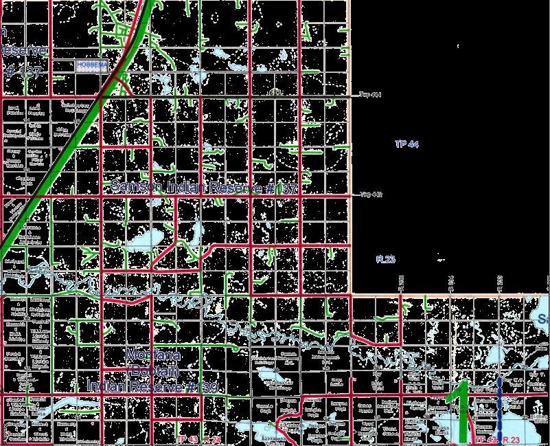
9 Study Ar ea File # P a g e 6
10 4.2 Description of the Study Area by Municipality Red Deer County The very southern portion of the study area encompasses the northern portion of Red Deer County. This area is adjacent to the southern side of the Red Deer River. Land use in this area is predominately forage and pasture land. However, there also is a significant amount of cultivated land. As well this area attracts a lot of hobby farmers and recreation land users due to the close proximity to the City of Red Deer and aesthetic features of the river Valley Lacombe County The eastern portion of Lacombe County encompasses a large majority of the subject area including the southwest and west portion of the study area. This area includes Townships 38, 39, 40 and 41 and Ranges 21, 22, 23 and 24. This area includes the Red Deer River to the south, Buffalo Lake to the east and the Villages of Alix and Clive. Land use in this area is dominated by annual cultivation with some pasture and hay land on the less productive soils. Soils in the area are primarily Class 2 and 3 and 4 with some Class 5 scattered throughout Stettler County The southeast portion of the study area is located within the western portion of Stettler County. This area south of Buffalo Lake and west of the Town of Stettler is contained within Township 40, Range 21. Soils in this area are generally Class 4 with some Class 3 and 5. Generally the soil classes improve as you travel south. Land uses are mixed with everything from open annually cultivated lands to native pasture and recreational properties near Buffalo Lake Ponoka County Ponoka County encompasses much of the north and northwest portion of the subject area. This is an area south and west of Red Deer Lake and includes Townships 42 and 43 in Range 22. The subject area within Ponoka County is primarily Class 2 soils with some Class 1, 3 and 4. As would be expected with the higher Class soils the predominant land use is for annual cultivation with some hay and pasture land as well Camrose County The southwest portion of Camrose County is the northeast portion of the study area. This area, primarily east of Red Deer Lake is dominated by cultivated lands with soils in Class 2, 3 and 4. The subject area with Camrose County is located within Township 43 and Ranges 20 and County of Wetaskiwin The County of Wetaskiwin acts as the northern boundary of the subject area. This area north of Red Deer Lake includes lands in Township 44 and Range 22. Soils in this area are primarily Class 2, 3 and 4. File # P a g e 7
11 5.0 Benchmark Market Value Estimates 5.1 Standard Approaches In estimating the market value of real property, there are three standard approaches utilized. These are the Cost Approach, the Direct Comparison Approach, and the Income Approach. The Cost Approach arrives at a value estimate of land, treated as though vacant, and adds to this the depreciated value of the improvements. The value of the land is ascertained by the Comparative Method, that is comparing the subject property to other properties of the same type and class which have sold, which have been offered for sale, or on which offers have been made in the same or competing areas, at or about the same time as the effective date of the appraisal. The Direct Comparison Approach arrives at a value estimate of the subject property as a unit. The unit, a combination of land and buildings, is compared to similar properties or the same type and class which have sold, which have been offered for sale, or on which offers have been made in the same or competing areas at or about the same effective date. In the case of bareland, the Cost Approach and the Direct Comparison Approach are considered equivalent and may simply be referred to as the Comparative Method. The Income Approach arrives at an estimate of value by determining the present value of expected future returns to the subject property. It is therefore the capitalization of the expected net returns over a given time period. 5.2 Direct Comparison Approach to Value The appraisers have been asked to arrive at benchmark bareland market value estimates. As the Direct Comparison Approach and the Cost Approach are considered equivalent for bareland, we have used the Comparative Method which is considered the most applicable approach in determining the bareland market value. The appraisers have compiled land sales data related to the principal land uses in the study area, considered to be primarily agricultural production. The following outlines the further limitations and scope in providing the proposed benchmark values: only land sales where the land base is greater than 79 acres are considered; only bareland values are provided. No adjustments are made to the comparable sales; and benchmark land values are established based on average properties in the subject area. The range of values provided is expected to reflect properties that are considered typical for the area. File # P a g e 8
12 5.3 Benchmark Categories General Market Factors We herein provide the following outline of the various factors considered in the overall market survey for this area, and the various components to consider when establishing the various benchmark categories for the total study area. Time: The subject area is generally located outside of the direct influence of any major urban center. Land in the study area is used primarily for agricultural, recreational and country residential purposes. Values of agricultural lands have continued to increase over the past number of years, with significant increases in the last three. Recreational and country residential lands; however, have remained steady after peaking in this area in The best approach to establishing a time adjustment is to find sales of the same property over time and complete a Paired Sales Analysis. We have not identified any re-sales of properties in the subject area. As a result, we have analyzed statistics from Farm Credit Canada (FCC) which indicate the annual farm value trends. The most recent FCC statistics for Alberta are provided below. Annual Percent C hange in Alberta F armlan d Values % 4.8% 6.1% 8.8% 8.7% 9.1% 8.9% 9.0% 12.9% 13.3% 17.4% 0.0% 2.0% 4.0% 6.0% 8.0% 10.0% 12.0% 14.0% 16.0% 18.0% 20.0% Source: Farm Credit Canada The comparable properties contained within this report include parcels that have transferred between January 1 and April 30. We have been unable to identify any resales of properties to quantify a time adjustment in the subject areas, so other data has been utilized. Highest and Best Use of the properties is the most important factor when analyzing time adjustments. Properties which are not being utilized for purposes other than agriculture and are not included in the speculative market, are valued on an agricultural basis. These Agricultural properties have continued to increase in value, as can be seen in the following graph, over the past few years. Properties, however, which are valued based on some other factor than productive agricultural value, have been more elastic in price. Values for recreational, country residential and speculative land, specifically closer to urban areas, have fluctuated greatly in price over the past few years. Because of this complexity and the scope of the overall report, no time adjustment has been made to comparable sales. File # P a g e 9
13 Physical Characteristics: The subject area is primarily an agricultural area. Therefore, the quality of land and soil productivity for agricultural purposes impacts value. The soil rating and quality is also considered under physical features. In addition, there is a difference in the value of lands due to variations in productivity, parcel shape and size, and potential crops grown. The Canada Land Inventory Soil Capability for Agriculture Map, Red Deer 83-A, rates the soils in the subject area (map shown on following page). The subject area crosses through land with CLI Class 1 through 6. The following is an explanation of the classes included in the CLI rating system. CLI Classes Class 1 soils have no significant limitations in use for crops. Class 2 soils have moderate limitations that restrict the range of crops or require moderate conservation practices. Class 3 soils have moderately severe limitations that restrict the range of crops or require special conservation practices. Class 4 soils have severe limitations that restrict the range of crops or require special conservation practices, or both. Class 5 soils have very severe limitations that restrict their capability to producing perennial forage crops, and improvement practices are feasible. Class 6 soils are capable only of producing perennial forage crops, and improvement practices are not feasible. Class 7 soils have no capability for arable culture or permanent pasture. Organic soils are not placed in any capability class. CLI Sub-Classes The subclasses are based on the kinds of limitations. The following are the subclasses of the soils that the proposed line crosses through. Subclass C: adverse climate The main limitation is low temperature or low or poor distribution of rainfall during the cropping season, or a combination of these. Subclass D: soil structure Undesirable soil structure and or low permeability. The soils are difficult to till, absorb water slowly or the depth of the rooting zone is restricted. Subclass M: moisture holding capacity Low moisture holding capacity caused by adverse inherent soil characteristics which limits crop growth. Subclass S: soil limitations A combination of two or more subclasses D, F, M, and N. Subclass T: adverse topography Either steepness or the pattern of slopes limits agricultural use. Subclass W: excess water Excess water other than from flooding limits use for agriculture. The excess water may be due to poor drainage, a high water table, seepage or runoff from surrounding areas. Subclass "X" refers to minor cumulative limitations which have a moderate limiting effect on the soil capability. File # P a g e 10

14 CLI Soil Capabilit y for A g ricul ture Map, Red Deer 8 3 -A File # P a g e 11
15 Access/ Distances to urban centres (in particular major centres), good accessibility and location on a paved roadway, all have a bearing on value in this area. Generally areas closer to urban centres are considered to have a superior location. Parcel Size: Generally, the value per acre increases as parcel size decreases in this market area. Most of the comparable properties are quarter sections or include multiple quarters. There are several comparable properties approximately 80 acres in size. However, because the Highest and Best Use is considered to be for agriculture purposes, the parcel size is not considered to have a significant impact on value. Many Counties and Municipal Districts also limit the number of subdivisions permitted on previously unsubdivided land. Therefore, for parcels that have first parcels removed or have been subdivided into two 80 acre parcels, the opportunity for further subdivision is limited. Motivation: There are many motivations that affect specific land purchases and influence price paid. The land may be adjacent to other holdings or there are other specific factors that result in a premium price paid beyond typical market prices. It is noted that although we have grouped the analysis into specific areas for ease of analysis, it is difficult to define specific market areas. Transitions in soil characteristics, climatic sub-regions, proximity to urban centres, and individual physical features make it difficult to define specific market areas and provide a relatively narrow range of values. 5.4 Land Use The lands in the subject area, for the most part, have a basic Agricultural zoning through the municipalities Land Use Bylaws. The majority of the subject lands have good soil capabilities for agricultural production with some small pockets of land with poorer soil and non-arable components. These current uses are all compatible with the current zoning. Throughout most of the study area, factors impacting agricultural use (soil, topography, location, climate, access) are the principle factors impacting Highest and Best Use and value of the lands. There is some demand for recreational and country residential uses throughout the study area. It is the appraisers opinion that the Highest and Best Use of the lands within the subject area are generally as follows: CLI Soil Classes 1 to 4 Essentially agricultural uses; annual and perennial crop production CLI Soil Class 5 to Organic Agricultural use as pasture or general recreational use File # P a g e 12
16 6.0 Comparable Sales and Analysis As previously mentioned, the study area includes lands within six different municipalities, and for simplicity we have used these municipal boundaries as general smaller study areas. These six municipalities as previously outlined are summarized as follows: Red Deer County Lacombe County Stettler County Ponoka County Camrose County County of Wetaskiwin The following sections detail the comparable sales analyzed within each municipality and summarize the estimated benchmark land values for specific areas within each region. All sales utilized have been inspected and are considered to be normal, arm s-length transactions, unless otherwise noted. The appraisers have made every effort to confirm the details on the comparable properties. However, because the intent of this report is to provide benchmark values and not estimate a value for specific properties, the details of all comparable sales have not been confirmed. The appraisers have analyzed the general trends in values for multiple areas and therefore, it was not considered necessary to confirm each sale if the value appeared to fit with other real estate sales activity occurring in the area. File # P a g e 13


 5 SW-6 038-25 W4 6 [082 5582] 7 1 1 032")


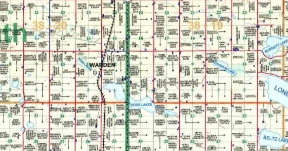
17 6.1 Red Deer County Comparable Sales Comparable Map SW W4 Listed: February, 2014 for $380, E. Purdie 6 TRANSMISS N/A acres pasture land, 70 acres could be broke Soil and Topography: CLI rated 50% 2T, 30% 4T and 20% 3T, coulee bottom 8 ( ) 5 SW W4 6 [ ] R Improvements: Nil 9.6 km east of Red Deer sure Pipelines and Wells current to March 31, 2014 *** Low Pressure Pipelines current to November 1, SECONDARY ROAD Transmission line runs across property Bareland Value: $2, per acre File # P a g e 14
18 5 75) PIPELINE (094 R/W1736) PIPELI NE R/W ( M a r k e t S u r v e y a n d B e n c h m a r k V a l u e E s t i m a t e s f o r 2. SE W4 Sold: August, 2013 for $650, H. & M. Valckx G. & T. Vincent acres primarily cultivated Soil and Topography: CLI rated 2T, undulating Improvements: Surface leases 11.2 km east of Red Deer A treed area along the north boundary Bareland Value: $4, per acre ( ) and Wells current to March 31, 2014 *** Low Pressure Pipelines current to November 1, SE W4 [ ] ( ) ( ) SE W4 Sold: December, 2012 for $580, H. Lynass Strong Heart Holdings Ltd. 160 acres all cultivated land and riverbank Soil and Topography: CLI rated 50% 5M, 25% 3T, 15% 6T and 10% 4DM, undulating Improvements: Bareland Value: Surface lease 8.0 km north of Delburne Has river frontage $3, per acre ines and Wells current to March 31, 2014 *** Low Pressure Pipelines current to November 1, 2005 SE W4 8 1 [ ] ROADWA 4. W ½ W4 Sold: May, 2013 for $1,040, C. & N. Simpson M. & L. Allison acres all cultivated Soil and Topography: CLI rated 70% 2T and 30% 3T, undulating Improvements: Bareland Value: Surface Lease 9.6 km north and 1.6 km east of Delburne Many pot holes on property, acreage subdivided out $3, per acre NE W4 SE W4 nd Wells current to March 31, 2014 *** Low Pressure Pipelines current to November 1, 2005 NW W4 SW W4 ( ) 26 NE W4 SE W4 File # P a g e 15
19 M a r k e t S u r v e y a n d B e n c h m a r k V a l u e E s t i m a t e s f o r 5. NE W4 Listed: For $500, D. Bonham N/A 156 acres primarily hay Soil and Topography: CLI rated 50% 2T and 50% 3T, undulating Improvements: Surface lease 8.0 km east and 9.6 km north of Delburne Acreage subdivided out Bareland Value: $3, per acre E R/W ( ) 29 ( ) ( ) ure Pipelines and Wells current to March 31, 2014 *** Low Pressure Pipelines current to November 1, NE W4 (5952 KS) EU NE W4 Listed: For $550, D. Bonham N/A acres pasture land Soil and Topography: CLI rated 50% 2T, 40% 6T and 10% 3T Improvements: Dug out 8.8 km east and 8.8 km north of Delburne Has river frontage Bareland Value: $3, per acre ROADWAY BM nd Wells current to March 31, 2014 *** Low Pressure Pipelines current to November 1, NE W4 ( ) 16 9 PIPELINE R File # P a g e 16


 (1517 KS) R. Hoppus L. & J.")

 (952 4516) OIL (782 0326) ure")
20 OIL (5116 NY) ( ) M a r k e t S u r v e y a n d B e n c h m a r k V a l u e E s t i m a t e s f o r 6.2 Lacombe County Comparable Sales Comparable Map NW W4 HAYNES CREEK Sold: September, 2013 for $430, (2604 RS) (1517 KS) R. Hoppus L. & J. Cornelssen 160 acres, pasture and hayland Soil and Topography: CLI rated 50% 6T, 30% 3T and 20% 4T Improvements: Surface leases 1.6 km east of Haynes Creek running through property Bareland Value: $2, per acre 16 E R/W 9 OIL FLOW LINE R/W (272 TR) ( ) OIL ( ) ure Pipelines and Wells current to March 31, 2014 *** Low Pressure Pipelines current to November 1, OIL ( ) NW W4 [ ] WATER 2 (4528 RS) File # P a g e 17
 Soil and Topography: CLI rated 60% 4T and 40% 3T SE-13 039-24 W4 PIPELINE R Improvements: Surface leases, old farm buildings 3 2 1 4.")
21 8. SE W4 Sold: February, 2013 for $430, A. Nelsen J. & M. Jones acres primarily cultivated ( ) Soil and Topography: CLI rated 60% 4T and 40% 3T SE W4 PIPELINE R Improvements: Surface leases, old farm buildings km east and 3.2 km north of Haynes ( ) Many sloughs and pot holes Bareland Value: $2, per acre e Pipelines and Wells current to March 31, 2014 *** Low Pressure Pipelines current to November 1, NW W4 Sold: September, 2013 for $420, R. Nelson C. Haas 160 acres primarily cultivated Soil and Topography: CLI rated 4T Improvements: Surface leases 3.2 km east and 4.0 km north of Haynes Undulating land, few pot holes Bareland Value: $2, per acre ( ) s and Wells current to March 31, 2014 *** Low Pressure Pipelines current to November 1, NW W ( ) 10. NE 18 and E ½ W4 Sold: March, 2014 for $1,004, L. Nielsen B. Allison & D. Oldach 480 acres, pasture and cultivated land Soil and Topography: CLI rated 70% 4T and 30% (60% 5T, 30% 4T and 10% 6W) Improvements: Bareland Value: Surface leases 6.4 km west of Alex Sold through realtor; was also purchased with NW 20, value of which is not included in sale price given $2, per acre File # P a g e 18
 and 50% 4T Improvements: Bareland Value: Compressor sight, old farm buildings, grain")

22 ( ) ( ) ( ) M a r k e t S u r v e y a n d B e n c h m a r k V a l u e E s t i m a t e s f o r 11. NW W4 Listed: For $507, E. Nielsen N/A 160 acres mix of pasture and cultivated Soil and Topography: CLI rated 50% (60% 5T, 30% 4T and 10% 6W) and 50% 4T Improvements: Bareland Value: Compressor sight, old farm buildings, grain storage 5.6 km west of Alix Creek $3, per acre 12. Pt. SW W4 Listed: February, 2014 for $359, K. Chessor N/A 125 acres rolling pasture Soil and Topography: CLI rated 60% 5T, 30% 4T and 10% 6W Improvements: Surface lease 4.0 km south west of Alix Bareland Value: $2, per acre 13. SW W4 12 ( ) 11 Sold: July 2013 for $290, C. Wright R. & S. Quesseth acres of pasture Soil and Topography: CLI rated 4M ( ) SW W4 6 Improvements: Surface lease 9.6 km north east of Alix Sold through realtor 4 ( ) 3 [ ] Bareland Value: $2, per acre File # P a g e 19

![00 per acre 9 [112 2935] (092 0499) [112 2972] 2 1 15 16 NE-9 040-24 W4 10 9 [112 2950] (792 2968) 6 7 8 (062 7865) 15. NE 4-40-25-W4 Listed: March, 2014 for $750,000.00 A.](/docs-images/73/68854036/images/23-3.jpg "Rainforth N/A 158 acres of gently rolling cultivated land Soil and Topography: CLI rated 50% 2T and 50% 3T Improvements: Bareland Value: Nil 16.")
23 ( ) ( ) M a r k e t S u r v e y a n d B e n c h m a r k V a l u e E s t i m a t e s f o r 14. NE W4 Sold: March, 2013 for $720, S. Hecht J. Meinema 158 acres cultivated acres Soil and Topography: CLI rated 75% 2T, 15% 4T, 10% 3T Improvements: Surface Leases 4.0 km south and 2.4 km east of Clive Sold through realtor Bareland Value: $4, per acre 9 [ ] ( ) [ ] NE W [ ] ( ) ( ) 15. NE W4 Listed: March, 2014 for $750, A. Rainforth N/A 158 acres of gently rolling cultivated land Soil and Topography: CLI rated 50% 2T and 50% 3T Improvements: Bareland Value: Nil 16.8 km southeast of Lacombe Realtor indicated conditional sale on property $4, per acre 16. NW W4 Sold: March, 2013 for $592, J., D., B. & R. Grose & A. Sayers M. & D. Wagner 160 acres rolling cultivated land Soil and Topography: CLI rated 75% 3T and 25% 2T Improvements: Nil 13.6 km east of Lacombe Very nice cultivated quarter Bareland Value: $3, per acre File # P a g e 20


24 17. SE W4 Listed: January, 2014 for $650, W. Meston N/A 160 acres pasture land Soil and Topography: CLI rated 85% 4T and 15% 3T Improvements: Surface Lease 0.8 km south of Tees Large treed area Bareland Value: $4, per acre 18. Pt. NW W4 Listed: March, 2014 for $359, W. Vandepol N/A 122 acres tame hay and pasture Soil and Topography: CLI rated Class 3 MT Improvements: Surface lease 4.0 km north west of Alix On highway Bareland Value: $2, per acre 19. NW W4 Sold: June, 2013 for $280, S. Parlby J. & L. Allan 160 acres Soil and Topography: CLI rated 40% 3T, 40% 4T and 20% 5T Improvements: Bad access, dead end road 4.0 km north of Alix Dead end road Bareland Value: $1, per acre File # P a g e 21


25 20. NW W4 Listed: March, 2014 for $450, C. Barritt N/A 160 acres rolling pasture and treed land Soil and Topography: CLI rated Class 4M Improvements: Surface lease 8.0 km east of Alix Large slough and few treed areas Bareland Value: $2, per acre 21. NW W4 Sold: May, 2013 for $225, T. Krossa Hutterian Brethren Church of Alix acres gently rolling, open cultivated Soil and Topography: CLI rated Class 3M Improvements: Yard site 6.4 km east and 2.4 km north west of Alix Adjacent to large slough Bareland Value: $1, per acre 22. NW W4 Sold: January, 2013 for $415, S. & C, Bexson A. & C. Vanderburg acres rolling cultivated land Soil and Topography: CLI rated 70% 3MT and 30% 4T Improvements: Surface lease 7.2 km north of Alix Large treed area Bareland Value: $2, per acre File # P a g e 22
![[132 3690] (092 7288) (832 1599) (094 0655) M a r k e t S u r v e y a n d B e n c h m a r k V a l u e E s t i m a t e s f o r 23. E ½ 27-41-23-W4 Sold: January, 2013 for $1,517,000.](/docs-images/73/68854036/images/26-1.jpg "00 700176 Alberta Ltd. Drew Meadows Ltd. 319.95 acres rolling cultivated with treed patches Soil and Topography: CLI rated 70% 3D and 30% 4T Improvements: Bareland Value: Surface leases 9.")
26 [ ] ( ) ( ) ( ) M a r k e t S u r v e y a n d B e n c h m a r k V a l u e E s t i m a t e s f o r 23. E ½ W4 Sold: January, 2013 for $1,517, Alberta Ltd. Drew Meadows Ltd acres rolling cultivated with treed patches Soil and Topography: CLI rated 70% 3D and 30% 4T Improvements: Bareland Value: Surface leases 9.6 km north and 6.4 km west of Mirror High ground, some treed areas $4, per acre 24. Section W4 Sold: December, 2012 for $2,500, A. Hallbauer Alberta Ltd acres, rolling cultivated Soil and Topography: CLI rated 90% 4T and 10% 3T Improvements: Surface lease 9.6 km north and 6.4 km west of Mirror High ground, some treed areas Bareland Value: $3, per acre GAS ( ) ( ) R3054 ( ) ( ) NW W ( ) SW W4 27 NE W4 SE W ( ) ( ) SW W4 Sold: November, 2013 for $625, D. Graden A & A Seed Farms Ltd acres Soil and Topography: CLI rated 60% 3MT, 20% 4T, 20% 5W Improvements: Surface lease 2.4 km northeast of Clive Sold through realtor Bareland Value: $3, per acre ( ) ( ) ( ) ( ) ( ) ( ) ( ) SW W EO ( ) File # P a g e 23
27 ( ) PIPELI NE R/W ( ) PIPELI NE R/W PIPELI NE R/W ( ) M a r k e t S u r v e y a n d B e n c h m a r k V a l u e E s t i m a t e s f o r 26. SE W4 Sold: January, 2012 for $706, M. & P. Law R. Vogel & C. Vogul 160 acres Soil and Topography: CLI rated 80% 3D, 20% 2T Improvements: Nil 4.8 km southeast of Clive Confirmed with a realtor Bareland Value: $4, per acre 7 2 SE W E ½ SW 21 & NE W4 SW W4 SE W4 Sold: January, 2012 for $1,059, M. & P. Law BirdHill Farms Ltd. 240 acres Soil and Topography: CLI rated 70% 3D, 30% 2T Improvements: Surface lease 4.8 km southeast of Clive Confirmed with a realtor Bareland Value: $4, per acre ROADWAY 6647 ET NW W4 SW W4 21 NE W4 SE W4 PIPELI NE R/W ( ) NW W4 NE W4 File # P a g e 24


28 6.3 Stettler County Comparable Sales Comparable Map File # P a g e 25


29 28. NE W4 Sold: January, 2014 for $600, D. & C. Munro Nemetz Seeds Ltd. 158 acres undulating, tame hay Soil and Topography: CLI rated 90% 2D and 10% 5W Improvements: Nil 0.8 km southwest of Stettler Large slough Bareland Value: $3, per acre 29. SW W4 Sold: June, 2013 for $400, S. & B. Feisst E. & S. Osterud acres rolling, mix of pasture and cultivated land Soil and Topography: CLI 90% 4T and 10% 6W Improvements: Bareland Value: Surface Lease 8.0 km north and 1.6 km west of Stettler Many sloughs $2, per acre 30. SW W4 Sold: January, 2013 for $500, K. & C. Anderson L. & L. Brown acres, rolling cultivated Soil and Topography: CLI rated 50% 4T, 40% 4T and 10% 6W Improvements: Nil 8.0 km north and 12.0 km west of Stettler Adjacent to highway Bareland Value: $3, per acre File # P a g e 26


30 6.4 Ponoka County Comparable Sales Comparable Map File # P a g e 27
31 31. NW W4 Sold: December, 2013 for $305, Estate of M. Rodwell W. & C. Berg 160 acres, approximately 85 acres cultivated Soil and Topography: CLI rated 80% 3T, 20% 6W; undulating Improvements: Surface lease 17.6 km east and 4.8 km south of Ponoka McLeans Lake located in southwest corner Bareland Value: $1, per acre NW W NE W4 Sold: February, 2014 for $640, L. Scott H. & G. Krijger 160 acres, approximately 42 acres cultivated Soil and Topography: CLI rated 2T; undulating Improvements: Bareland Value: Nil 7.2 km east and 1.6 km south of Ponoka Mixed parcel; cultivated, treed and pasture land $4, per acre NE W NE W4 Sold: February, 2013 for $419, J. & G. Fillinger C. & M. De With 160 acres, primarily cultivated Soil and Topography: CLI rated 3T; undulating Improvements: Surface leases 24.8 km east and 1.6 km south of Ponoka Treed, small creek through property Bareland Value: $2, per acre NE W File # P a g e 28
32 M a r k e t S u r v e y a n d B e n c h m a r k V a l u e E s t i m a t e s f o r 34. Pt. SW W4 (Plan , Block 1, Lot 3) 5 Sold: October, 2012 for $230, Redquest Developments Ltd. M. Clark acres, primarily treed Soil and Topography: CLI rated 60% 6W, 40% 3T; sloped to Chain Lakes Improvements: Bareland Value: Nil 8.0 km east and 7.2 km south of Ponoka Adjacent to Chain Lakes $3, per acre 8 1 CHAIN LAKES SW W N ½ & SW 15, Pt. NE 22 and NW W4 Sold: February, 2013 for $3,510, Meyer Seed Potatoes Inc. Country View Chicken Farms Ltd acres, mostly cultivated Soil and Topography: CLI rated 80% 2T, 20% 3D; level to gently undulating Improvements: Bareland Value: Surface leases 10.4 km north of Ponoka Open cultivated land $5, per acre NE W4 SE W4 NW W4 SW W4 15 NE W4 NE W4 SE W4 NW W4 SW W NW W File # P a g e 29
33 14 11 ( ) AER High Pressure Pipelines and Wells current to March 31, 2014 *** Low Pressure Pipelines current to November 1, M a r k e t S u r v e y a n d B e n c h m a r k V a l u e E s t i m a t e s f o r 36. Pt. S ½ W4 Sold: May, 2013 for $350, Triple V Cattle Co. Ltd Alberta Ltd., Alberta Ltd., and Alberta Ltd acres, approximately 110 acres cultivated Soil and Topography: CLI rated 50% 1, 50% 5T; level Improvements: Bareland Value: Surface leases South of Red Deer Lake Contains significant accretion land $1, per acre NW W4 SW W NE W4 SE W NE W4 Sold: October, 2012 for $458, G. Fuerst D. & K. Riske acres cultivated Soil and Topography: CLI rated Class 1, level Improvements: Nil 14.4 km northwest of Bashaw Sold for appraised value Bareland Value: $2, per acre ( ) 10 ( ) NE W4 ( ) ( ) ( ) ( ) ( ) ( ) NW W4 38. NW W Sold: June, 2013 for $302, HIGHWAY JY JY 2164 JY G. Pugh W. Finkbeiner acres, open pasture land Soil and Topography: CLI rated Class 3T; undulating Improvements: Nil 12.8 km east of Ponoka Small lake on south portion of property Bareland Value: $2, per acre NW W LAKE No File # P a g e 30
34 39. SW W4 Sold: July, 2013 for $350, J. Robinson B. & J. Deleeuw acres, approximately 40 acres cultivated Soil and Topography: CLI rated 60% 3MT, 40% 3M; undulating Improvements: Bareland Value: Surface lease 7.2 km south and 24.0 km east of Ponoka Primarily pasture land $2, per acre SW W File # P a g e 31


35 6.5 Camrose County Comparable Sales Comparable Map File # P a g e 32
36 M a r k e t S u r v e y a n d B e n c h m a r k V a l u e E s t i m a t e s f o r 40. Pt. NW W4 Sold: March, 2013 for $108, D. Boese J. Wiebe acres, primarily open pasture Soil and Topography: CLI rated 80 3T, 20% 6T; undulating Improvements: Nil 11.2 km east and 10.4 km north of Bashaw Low pasture land Bareland Value: $2, per acre ( ) NW W4 ( ) ( NE W4 Sold: March, 2013 for $561, I. & I. Megli I. & K. Birch 160 acres, open cultivated Soil and Topography: CLI rated 70% 2D, 30% (90% 2T, 10% 6W); undulating Improvements: Bareland Value: Nil 18.4 km south of Camrose Limited access $3, per acre NE W SE W4 Sold: March, 2013 for $450, I. & I. Megli L. & S. Baerg 158 acres, primarily cultivated Soil and Topography: CLI rated 2T Improvements: Nil 2.4 km east and 14.4 km south of Camrose Normal arm s-length sale Bareland Value: $2, per acre 6 3 ROADWAY 425 EO 7 2 SE W4 8 1 File # P a g e 33
37 M a r k e t S u r v e y a n d B e n c h m a r k V a l u e E s t i m a t e s f o r 43. SW W4 Sold: May, 2013 for $510, Estate of C. Borgstrom Lidberg Farms Ltd acres, mostly cultivated Soil and Topography: CLI rated 2D; undulating Improvements: Surface leases 6.4 km east and 11.2 km north of Bashaw Estate sale Bareland Value: $3, per acre SW W NW W4 Sold: September, 2013 for $300, M. & R. Jiranek and E. & O. Mirvald G. & I. Reich acres, mostly open pasture Soil and Topography: CLI rated 70% (90% 5T, 10% 7W), 30% (90% 4T, 10% 7W; rolling Improvements: Bareland Value: Nil 0.8 km west and 7.2 km north of Bashaw Northeast corner borders Red Deer Lake $1, per acre 16 9 LAKE No NW W4 ( ) [ ] SE W4 Sold: August, 2013 for $537, A. & B. Andrews Alberta Ltd. 160 acres primarily cultivated Soil and Topography: CLI rated 90% 4T, 10% 6W; rolling Improvements: Surface leases, bins 9.6 km north of Bashaw Pot holes Bareland Value: $3, per acre SE W File # P a g e 34
38 1963 AER High Pressure Pipelines and Wells current to March 31, 2014 *** Low Pressure Pipelines current to November 1, ( ) ( ) M a r k e t S u r v e y a n d B e n c h m a r k V a l u e E s t i m a t e s f o r 46. Pt. SW W4 Sold: August, 2013 for $379, A. & B. Andrews Hunter Holsteins Ltd. 113 acres mostly cultivated Soil and Topography: CLI rated 90% 4T, 10% 6W; rolling Improvements: Nil 0.8 km west and 9.6 km north of Bashaw Located along Red Deer Lake Bareland Value: $3, per acre PELINE R/W ( ) 9 [ ] SW W4 EER LAKE NW W4 Sold: May, 2012 for $501, I. Rutz Wilkie Farms Ltd acres cultivated Soil and Topography: CLI rated 40% (60% 3T, 10% 6W) & 60% (90% 4T, 10% 6W) gently rolling NW W4 Improvements: Nil km north of Bashaw PIPELINE (052 R/W 0173) Sold by tendor 11 Bareland Value: $3, per acre File # P a g e 35

39 6.6 County of Wetaskiwin Comparable Sales Comparable Map SW W4 and NW & S ½ W4 Listed: January, 2014 for $2,950, H. & C. Adriaans N/A acres, primarily cultivated Soil and Topography: CLI rated 90% 2T, 10% 6W; gently undulating Improvements: Surface leases 8.0 km west and 19.2 km north of Bashaw Adjacent to Highway #822 Bareland Value: $4, per acre SW W W4 NW W4 NE W4 NW W4 SW W4 SE W4 SW File # P a g e 36
40 6.7 Land Trend Analysis Farm Credit Canada Tracks land values in the Province of Alberta, based on their own information. As was indicated earlier in the report land values have been steadily increasing in Alberta. According to FCC the average provincial change in values since 2012 has been: +13.3% in 2012 and +12.9% in 2013 for a total of 26.2% since the end of Most of the increase in 2013 was the first half of the year, with the trend slowing down in the later half. It has been observed that land values have increased into 2014 as well, but at a much slower rate than 2012 and According to industry representatives and Serecon s own internal database, the range in cultivated land values for the subject counties are: County Range Average Red Deer $2,000 - $5,300 $3,301 Lacombe $3,500 - $4,500 $4,150 Stettler $1,000 - $2,400 $1,692 Ponoka $2,500 - $5,000 $4,019 Camrose $2,000 - $3,500 $2, Estimated Benchmark Values Benchmark estimates are for typical lands in the subject area which are: not unique; not highly desirable aesthetically pleasing parcels; cultivated, hay land, pasture, treed or a mixed use; good developed access; and are not located along a highway, rail line or urban center boundary. In estimating benchmark values the appraisers have not only relied upon sales and listings but have also relied upon Farm Credit of Canada information, time trend information, discussions with local market participants and realtors and the appraisers own familiarity with the market areas. Although no formal adjustments are made, market value ranges are determined having regard to physical differences. Most importantly, time of sale is given major consideration as values have increased significantly over the time frame analyzed between 2012 and the present, in most of the subject area. Adjustments for time have been incorporated into the following benchmark value ranges. The values below are representative ranges for land within the following townships. The lower end of the range encompasses land that has some topographical issues for agriculture and lower quality soils. The top end of the range indicates the best quarter of land with high soil quality and a very conducive topography. Benchm ark Value Ranges Township 38, Range 24, W4 Township 39, Range 24, W4 Township 39, Range 23, W4 Township 39, Range 22, W4 File # P a g e 37
41 Township 40, Range 24, W4 Township 40, Range 23, W4 Township 40, Range 22, W4 Township 40, Range 21, W4 Township 41, Range 24, W4 Township 41, Range 23, W4 Township 41, Range 22, W4 Township 43, Range 22, W4 Township 43, Range 21, W4 Township 43, Range 20, W4 Township 44, Range 22, W4 File # P a g e 38
42 7.0 Certification as to the Appraisal I certify that, to the best of my knowledge and belief: The statements of fact contained in this report are true and correct. The reported analyses, opinions, and conclusions are limited only by the reported assumptions and limiting conditions, and are my personal, unbiased professional analyses, opinions, and conclusions. I have no present or contemplated interest in the property that is the subject of this report, and I have no personal interest or bias with respect to the parties involved. My compensation is not contingent upon the reporting of a predetermined value or direction in value that favours the cause of the client, the amount of the value estimate, the attainment of a stipulated result, or the occurrence of a subsequent event. My analysis, opinions, and conclusions were developed, and this report has been prepared, in conformity with the Canadian Uniform Standards of Professional Appraisal Practice. I have completed and fulfilled the Mandatory Re-certification Program requirements of the Appraisal Institute of Canada. The subject area and comparable sales were personally inspected by Glen Doll AACI, P.Ag. and Trevor Birchall P.Ag., AIC Candidate Member on April 28, Bruce Simpson did not inspect the area. Glen Doll, Bruce Simpson and Trevor Birchall are licenced appraisers under the Real Estate Council of Alberta. The effective date of the appraisal is April 28, The date of certification is May 21, Glen Doll, AACI, P.Ag. Reviewed by: Bruce Simpson, AACI, P.Ag. File # P a g e 39
43 8.0 Appraiser s Qualifications Glen W. Doll, AACI, P.AG. Education and Professional Designations Accredited Appraiser Canadian Institute (AACI), Professional Appraiser (P. App.), 2010 Professional Agrologist (P.Ag.), 2009 Post Graduate Certificate in Real Property Valuation, University of British Columbia, Distance Education, 2009 Bachelor of Agriculture, University of Alberta, Edmonton, Alberta, September 2000 May 2005 Completed Bachelor of Science in Agriculture with a major in Agricultural Economics. Convocated with distinction. Areas of Concentration Agricultural Economics Farm Finance and Management Real Estate Appraisals Land Use Impacts Litigation Support Summary of Experience Glen provides agricultural and rural consulting services. He has completed numerous real estate appraisals relating to expropriation and surface rights situations throughout Alberta, and provided expert testimony concerning real estate appraisal and agrology before the Alberta Court of Queen s Bench, the Alberta Surface Rights Board, and the Alberta Utilities Commission. Glen has also worked on numerous feasibility studies, viability assessments, impact assessments and land use studies relating to agriculture. Selected consulting projects include the following: Study analyzing various impact scenarios with transmission lines in Alberta. Study looking at the impact of transmission lines on the value of rural residential acreages. Study looking at the impact of transmission lines on agricultural land values. Study looking at the impacts of transmission lines on urban property values. Study assessing the impacts of transmission lines on agriculture. Viability and feasibility assessments regarding the establishment and expansion of numerous farm and agribusinesses, including the valuation of all related assets. Land appraisals for large land acquisition projects for Public Works Canada. Glen has completed appraisals in the following areas: Surface rights appraisals including wellsite, pipeline and power line appraisals estimating market value, loss of use and adverse effect. Expropriation appraisals including market value, severance damage, injurious affection and incidental damages; highway expropriations, irrigation dam projects, power plant projects. File # P a g e 40
To all Appraisers: Brief Overview:
 To all Appraisers: As the appraisal industry continues to change, the demand for alternative valuation solutions grows. That is why is excited to announce the addition of a new product - the Desktop Appraisal
R-11. REPORT ON SUBDIVISION WITHIN THE AGRICULTURAL LANDRESERVE FILE NO. 212/2017 (Simpson) PEACE RIVER REGIONAL DISTRICT DEVELOPMENT SERVICES
 PEACE RIVER REGIONAL DISTRICT DEVELOPMENT SERVICES") PEACE RIVER REGIONAL DISTRICT DEVELOPMENT SERVICES REPORT ON SUBDIVISION WITHIN THE AGRICULTURAL LANDRESERVE FILE NO. 212/2017 (Simpson) OWNER: David A. Simpson DATE: October 19, 2017 AREA: Electoral Area
PEACE RIVER REGIONAL DISTRICT DEVELOPMENT SERVICES REPORT ON SUBDIVISION WITHIN THE AGRICULTURAL LANDRESERVE FILE NO. 212/2017 (Simpson) OWNER: David A. Simpson DATE: October 19, 2017 AREA: Electoral Area
As Of: Prepared For: Prepared By:
 of 216 SW 131st St As Of: 06/11/11 Prepared For: Prime Pacific Bank 2502 196th St SW Lynnwood WA 98036 Prepared By: Cynthia A. Nagle, CREA 922 N Cedar St Tacoma, WA 98406 RESTRICTED APPRAISAL REPORT Restriction
City of Grande Prairie Development Services Department
 City of Grande Prairie Development Services Department COUNTRYSIDE SOUTH OUTLINE PLAN Prepared by: GPEC Consulting Ltd. #202, 10712-100th Street Grande Prairie, AB Council Resolution of August 20, 2001
REPORT ON EXCLUSION FROM THE AGRICULTURAL LAND RESERVE (ALR) FILE NO. 191/2015
 FILE NO. 191/2015") Peace River Regional District DEVELOPMENT SERVICES REPORT ON EXCLUSION FROM THE AGRICULTURAL LAND RESERVE (ALR) FILE NO. 191/2015 OWNER: Marguerite Gladysz DATE: September 1, 2015 AREA: Electoral Area
Peace River Regional District DEVELOPMENT SERVICES REPORT ON EXCLUSION FROM THE AGRICULTURAL LAND RESERVE (ALR) FILE NO. 191/2015 OWNER: Marguerite Gladysz DATE: September 1, 2015 AREA: Electoral Area
REPORT ON SUBDIVISION WITHIN THE AGRICULTURAL LAND RESERVE (ALR) FILE NO. 075/2015
 FILE NO. 075/2015") Peace River Regional District DEVELOPMENT SERVICES REPORT ON SUBDIVISION WITHIN THE AGRICULTURAL LAND RESERVE (ALR) FILE NO. 075/2015 OWNER: Audrey LeClere DATE: April 27, 2015 AREA: Electoral Area B LEGAL:
Peace River Regional District DEVELOPMENT SERVICES REPORT ON SUBDIVISION WITHIN THE AGRICULTURAL LAND RESERVE (ALR) FILE NO. 075/2015 OWNER: Audrey LeClere DATE: April 27, 2015 AREA: Electoral Area B LEGAL:
A Demonstration Appraisal Report. Of a. Located at. Date of Appraisal. Prepared for. Prepared by
 A Demonstration Appraisal Report Of a Located at Date of Appraisal Prepared for Prepared by International Association of Assessing Officers Professional Designation Subcommittee 314 W. 10 th Street Kansas
Mike Dalton Jr. and Associates. Christina Adams INVOICE NUMBER Mike Dalton Jr. and Associates 8191 Wethersfield Drive. PB125 Germantown, TN 38138
 Mike Dalton Jr. and Associates FROM: INVOICE Christina Adams INVOICE NUMBER Mike Dalton Jr. and Associates 8191 Wethersfield Drive Germantown, TN 38138 DATE 08/14/2016 Telephone Number: (901) 674-0239
REED APPRAISAL COMPANY REAL PROPERTY APPRAISERS AND CONSULTANTS
 REAL PROPERTY APPRAISERS AND CONSULTANTS 100 SOUTH KENTUCKY AVENUE #230 ip.o. BOX 1645 ilakeland, FLORIDA 33802-1645 OFFICE: (863) 688-6718 ifax: (863) 688-5993iEMAIL: stan@reedappraisalco.com TO: Henry
LAND APPRAISAL REPORT
 IDENTIFICATION LAND APPRAISAL REPORT Page #1 File No. Borrower None Census Tract * Map Reference 462820011000315 Property Address NWC Gaar and Pleasant View Roads City Richmond County Wayne State IN Zip
RESTRICTED APPRAISAL REPORT
 Restricted Use Appraisal Report Thomas J. Schulte & Associates Page #1 RESTRICTED APPRAISAL REPORT SUBJECT ASSIGNMENT Property City: Zip Code: County: Legal Description: Assessor's Parcel #: Tax Year:
Uniform Agricultural Appraisal Report
 File No. Uniform Agricultural Appraisal Report Prepared For: Intended User: Prepared By: Date Prepared: UAAR Agri management Uniform Agricultural Appraisal Report File No # Property Identification Owner/Occupant:
RAINS COUNTY APPRAISAL DISTRICT
 RAINS COUNTY APPRAISAL DISTRICT 2017 MASS APPRAISAL SUMMARY REPORT mass appraisal report 2017 uspap_appr_report RAINS COUNTY APPRAISAL DISTRICT 2017 MASS APPRAISAL SUMMARY REPORT Identification of Subject:
A Demonstration Appraisal Report. Of a. Located at. Date of Appraisal. Prepared for. Prepared by
 A Demonstration Appraisal Report Of a Located at Date of Appraisal Prepared for Prepared by International Association of Assessing Officers Professional Designation Subcommittee 314 West 10 th Street Kansas
FILE: EFFECTIVE DATE: May 15, 2013 AMENDMENT: 1
 APPROVED AMENDMENTS: Effective Date Briefing Note /Approval Summary of Changes: June 1, 2011 BN 175892 Policy and Procedure update to reflect reorganization of resource ministries April 2011 May 15, 2013
FIRST AMENDMENT TO LEASE
 Attachment 1 FIRST AMENDMENT TO LEASE THIS FIRST AMENDMENT TO LEASE, dated, 2013 ( First Amendment ), by and between the State of California, acting by and through its Department of General Services, (hereinafter
Dear Valuation Professional
 Dear Valuation Professional First American Mortgage Solutions LLC has a new product offering that we would like you to consider adding to your list of services with us - (Property Assessment Collateral
In This Issue. Overall Market Trends. Overall Arable Land Market Trends Non-Arable Market Trends Improved Farm Sales Profile
 Sp r i n g 2 1 4 Agricultural Newsletter market overview Overall Market Trends Strong commodity prices, record yields and low interest rates have created a strong demand for agricultural arable (cultivated)
Appraisal and Market Analysis of Indoor Waterpark Resorts
 Appraisal and Market Analysis of Indoor Waterpark Resorts By David J. Sangree, MAI, CPA, ISHC An appraisal of an indoor waterpark resort is similar to other appraisals in that it is a professional appraiser
BUSI 330 Suggested Answers to Review and Discussion Questions: Lesson 1
 BUSI 330 Suggested Answers to Review and Discussion Questions: Lesson 1 1. The three characteristics necessary to gain professional recognition are: Integrity, Competence, and Provide Quality Work. Students
APPRAISAL OF REAL PROPERTY LOCATED AT: FOR: AS OF: BY:
 APPRAISAL OF REAL PROPERTY LOCATED AT: 489 MEADOWS EDGE COURT DEED BOOK 2896, PAGE 2759 CLEMMONS, NC 27012 FOR: ESTATE OF WILLIAM C. McINTOSH % BAILEY & THOMAS P.O. BOX 52 WINSTON-SALEM, NC 27102 AS OF:
Anatomy Of An Appraisal
 Anatomy Of An Appraisal Leslie A. Fields The most important thing to know about an appraisal report is how to review and critique it. Leslie A. Fields a partner with the Law Firm of Faegre & Benson LLP,
APPRAISAL OF REAL PROPERTY
 Main File No. Busick 1706 Page #1 APPRAISAL OF REAL PROPERTY LOCATED AT Burnsville, NC Deed Book 725 Page 505 FOR 8777 Holiday Springs Rd Rockledge, FL 32955 OPINION OF VALUE 660,000 AS OF 06/26/2017 BY
ASSESSMENT METHODOLOGY
 2019 ASSESSMENT METHODOLOGY COMMERCIAL RETAIL AND OFFICE CONDOMINIUMS A summary of the methods used by the City of Edmonton in determining the value of commercial retail and office condominium properties
RENITA HURDSMAN BEAR RIVER STATE PARK LAND EXCHANGE PROPOSAL
 DETAILED ANALYSIS RENITA HURDSMAN BEAR RIVER STATE PARK LAND EXCHANGE PROPOSAL June 1, 2006 Prepared by the Office of State Lands and Investments Herschler Building, 3W 122 West 25 th Street Cheyenne,
APPRAISAL REPORT OF THE REAL PROPERTY LOCATED AT. Enterprise Rd Dillon, SC Ronnie Gardner. March 1, 2018
 APPRAISAL REPORT OF THE REAL PROPERTY LOCATED AT Dillon, SC 29536 for as of March 1, 2018 by David McLaurin 105 West Harrison Street Dillon, SC 29536 IDENTIFICATION NEIGHBORHOOD SITE MARKET DATA ANALYSIS
APPRAISAL REPORT OF GROSS ACRES/17.72± USABLE ACRES OF VACANT COMMERCIAL LAND
 APPRAISAL REPORT OF 20.22 GROSS ACRES/17.72± USABLE ACRES OF VACANT COMMERCIAL LAND LOCATED AT NORTHWEST CORNER OF LAND O LAKES BOULEVARD & SUNTERRA DRIVE LAND O LAKES, FLORIDA 34638 Job No.: 14-0227 Prepared
Uniform Agricultural Appraisal Report
 File No. Uniform Agricultural Appraisal Report Prepared For: Intended User: Prepared By: Date Prepared: Uniform Agricultural Appraisal Report Executive Summary USE OF APPRAISAL CLIENT/OWNER INSPECTION
B-1 a) PEACE RIVER REGIONAL DISTRICT DEVELOPMENT SERVICES ZONING AMENDMENT REPORT BYLAW NO. 2226, rd Reading and Adoption PROPOSAL
 PEACE RIVER REGIONAL DISTRICT DEVELOPMENT SERVICES ZONING AMENDMENT REPORT BYLAW NO. 2226, rd Reading and Adoption PROPOSAL") PEACE RIVER REGIONAL DISTRICT DEVELOPMENT SERVICES ZONING AMENDMENT REPORT BYLAW NO. 2226, 2016 3 rd Reading and Adoption OWNER: Rudy Willms DATE: August 3, 2016 AGENT: Tryon Land Surveying Ltd. AREA:
PEACE RIVER REGIONAL DISTRICT DEVELOPMENT SERVICES ZONING AMENDMENT REPORT BYLAW NO. 2226, 2016 3 rd Reading and Adoption OWNER: Rudy Willms DATE: August 3, 2016 AGENT: Tryon Land Surveying Ltd. AREA:
Swisher County Appraisal District 2017 Mass Appraisal Report
 Swisher County Appraisal District 2017 Mass Appraisal Report Prepared Pursuant to Standard 6 of the Uniform Standards of Professional Appraisal Practice 1 TABLE OF CONTENTS Introduction 3 Listing of Taxing
VALUE FINDING APPRAISAL REPORT
 RE 90 Rev. 01-2014 VALUE FINDING APPRAISAL REPORT (Compensation not to exceed $65,000) COUNTY John Doe 2880 Lancaster-Newark Rd. (SR 37), Pleasant Twp., 43030 Owner Mailing Address of Owner East side of
Copyright, 1999, 2002, 2004, Freddie Mac. All Rights Reserved.
 Page 1 of 13 Engineering Requirements/Chapter 12: Appraiser and Appraisal Requirements/12.1: General requirements 12.1: General requirements For all multifamily purchase programs and products, the Seller/Servicer
AN APPRAISAL OF Acre Residential Site Northwest Corner Pleasant View Road & Gaar Road Richmond, Indiana 47374
 AN APPRAISAL OF 3.75 Acre Residential Site Northwest Corner Pleasant View Road & Gaar Road Richmond, Indiana 47374 American United Appraisal Company, Inc. Real Estate Appraisers Jay E. Allardt, SRA August
SUBDIVISION APPLICATION
 PLANNING AND DEVELOPMENT SERVICES 38106 Rge Rd 275, Red Deer County, AB T4S-2L9 Phone: (403) 350-2170 Fax: (403) 346-9840 For Office Use Only File # Roll # Fee Submitted Date Deemed Complete Reference
Existing Land Use. Typical densities for single-family detached residential development in Cumberland County: 1
 Existing Land Use A description of existing land use in Cumberland County is fundamental to understanding the character of the County and its development related issues. Economic factors, development trends,
INTERNATIONAL LAW REGARDING REAL ESTATE Rhonda L. C. Hull,
 INTERNATIONAL LAW REGARDING REAL ESTATE Rhonda L. C. Hull, 2008-2009 There are no universal laws regarding real estate no uniform set of rules or regulations that apply in all countries with respect to
SURFACE RIGHTS ACT (hereinafter "the Act") SURFACE RIGHTS BOARD (hereinafter "the Board").
 SURFACE RIGHTS BOARD (hereinafter the Board).") Before: SURFACE RIGHTS ACT (hereinafter "the Act") SURFACE RIGHTS BOARD (hereinafter "the Board"). IN THE MATTER OF certain lands subject to a surface lease in Lot 4, Plan 9822408 (SE ¼-8-49-7-W5M), in
Before: SURFACE RIGHTS ACT (hereinafter "the Act") SURFACE RIGHTS BOARD (hereinafter "the Board"). IN THE MATTER OF certain lands subject to a surface lease in Lot 4, Plan 9822408 (SE ¼-8-49-7-W5M), in
Demonstration Appraisal Report Utilizing a Form Report
 Demonstration Appraisal Report Utilizing a Form Report National Association of Independent Fee Appraisers 330 North Wabash Avenue, Suite 2000 Chicago, IL 60611 Phone: (312) 321-6830 Fax: (312) 673-6652
Comprehensive Plan /24/01
 IV The is a central component of the Comprehensive Plan. It is an extension of the general goals and policies of the community, as well as a reflection of previous development decisions and the physical
Data Verification. Professional Excellence Bulletin [PP-14-E] February 1995
![Data Verification. Professional Excellence Bulletin [PP-14-E] February 1995](/thumbs/90/101597168.jpg "Data Verification. Professional Excellence Bulletin [PP-14-E] February 1995") Professional Excellence Bulletin [PP-14-E] February 1995 Although obviously a cornerstone of appraisal practice, data verification has not been considered a major problem to real estate appraisers in the
Professional Excellence Bulletin [PP-14-E] February 1995 Although obviously a cornerstone of appraisal practice, data verification has not been considered a major problem to real estate appraisers in the
APPRAISAL OF REAL PROPERTY
 Page # 2 APPRAISAL OF REAL PROPERTY LOCATED AT Block 7, Castle Brewer Court, Plat Book 10, Page 18 FOR Sanford Housing Authority 94 Castle Brewer Ct. OPINION OF VALUE 30,000 AS OF 12/14/2012 BY William
8Land Use. The Land Use Plan consists of the following elements:
 8Land Use 1. Introduction The Land Use Plan consists of the following elements: 1. Introduction 2. Existing Conditions 3. Opportunities for Redevelopment 4. Land Use Projections 5. Future Land Use Policies
REAL ESTATE MARKET OVERVIEW 1 st Half of 2015
 REAL ESTATE MARKET OVERVIEW 1 st Half of 2015 With Comparisons to the 2 nd Half of 2014 September 4, 2015 Prepared for: First Bank of Wyoming Prepared by: Ken Markert, AICP MMI Planning 2319 Davidson Ave.
APPRAISING COMMERCIAL INVESTMENT PROPERTY
 APPRAISING COMMERCIAL INVESTMENT PROPERTY Cydney G. Bender-Reents, MAI President Jared M. Calabrese, MAI Senior Appraiser YOUR HOUSE AS SEEN BY: Yourself Your Lender YOUR HOUSE AS SEEN BY: Your Buyer Your
BOARD REPORT. Agricultural Land Commission (ALC) Application Section 20(3) Non-Farm Use in the ALR
 Application Section 20(3) Non-Farm Use in the ALR") BOARD REPORT TO: Chair and Directors File No: LC2534A SUBJECT: DESCRIPTION: RECOMMENDATION #1: Agricultural Land Commission (ALC) Application Section 20(3) Non-Farm Use in the ALR Lodestar Ventures Report
BOARD REPORT TO: Chair and Directors File No: LC2534A SUBJECT: DESCRIPTION: RECOMMENDATION #1: Agricultural Land Commission (ALC) Application Section 20(3) Non-Farm Use in the ALR Lodestar Ventures Report
PEACE RIVERREGIONALDISTRICT DEVELOPMENT SERVICES REPORT ON SUBDIVISION AND NON-FARM USE WITHIN THE
 PEACE RIVERREGIONALDISTRICT DEVELOPMENT SERVICES REPORT ON SUBDIVISION AND NON-FARM USE WITHIN THE AGRICULTURAL LAND RESERVE (ALR) FILE NO. 015/2015 ALL MEMBERS PARTICIPATE OWNER: Karl Mattson DATE: February
APPRAISAL OF REAL PROPERTY LOCATED AT: FOR: AS OF: BY:
 APPRAISAL OF REAL PROPERTY LOCATED AT: 627/631 NW 14 STREET SEE ADDENDUM FOR COMPLETE LEGAL DESCRIPTION FLORIDA CITY, FL 33034 FOR: 1261 HOMESTEAD ROAD LEHIGH ACRES, FL 33936 AS OF: 10/20/2014 BY: LINDA
Case 9:15-cv DMM Document Entered on FLSD Docket 11/22/2017 Page 1 of 12
 Case 9:15-cv-80946-DMM Document 181-5 Entered on FLSD Docket 11/22/2017 Page 1 of 12 APPRAISAL OF A 1.31 ACRE SITE LOCATED AT: XXX 77th Trl N (long legal description/see page #1) Palm Beach Gardens, FL
Comprehensive Plan 2030
 Introduction Land use, both existing and future, is the central element of a Comprehensive Plan. Previous chapters have discussed: Projected population growth. The quality housing available in the Township
APPRAISAL OF 1117 MONROE STREET, VICKSBURG, MS 39180
 APPRAISAL OF 1117 MONROE STREET, VICKSBURG, MS 39180 CLIENT/INTENDED USER: GLENN TRIPLETT INTENDED USE/USER: TO ASSIST THE CLIENT IN MAKING A PURCHASING DECISION. THIS REPORT IS NOT INTENDED FOR ANY OTHER
R-9 REPORT ON SUBDIVISION WITHIN THE AGRICULTURAL LANDRESERVE FILE NO. 190/2017 PEACE RIVER REGIONAL DISTRICT DEVELOPMENT SERVICES
 PEACE RIVER REGIONAL DISTRICT DEVELOPMENT SERVICES REPORT ON SUBDIVISION WITHIN THE AGRICULTURAL LANDRESERVE FILE NO. 190/2017 R-9 OWNER: Martin and Allison Mackay DATE: November 6, 2017 AREA: Electoral
Restricted Use Appraisal Report Of a development site
 A development site Located at: 700' E of SEC of 6th Avenue and 328 St Homestead, Florida As of November 7, 2017 Restricted Use Appraisal Report Of a development site Restricted Use Appraisal Report Of
PLANNING REPORT. Lot 5, SDR Lot 6 and 7 Concession 3 Township of Normanby Municipality of West Grey County of Grey
 PLANNING REPORT Dwelling Surplus to a Farm Operation Official Plan and Zoning By-law Amendment and Consent to Sever Lot 5, SDR Lot 6 and 7 Concession 3 Township of Normanby Municipality of West Grey County
AG-AMERICA COMMERCIAL FARM AND RANCH COLLATERAL VALUATION GUIDE
 AG-AMERICA COMMERCIAL FARM AND RANCH COLLATERAL VALUATION GUIDE Table of Contents CHAPTER CV101 COLLATERAL VALUATION STANDARDS AND GUIDES... 1 CV101.1 Overview... 1 General Guidance on Terms:... 1 CHAPTER
619 STANDARD 2: REAL PROPERTY APPRAISAL, REPORTING
 619 STANDARD 2: REAL PROPERTY APPRAISAL, REPORTING 620 In reporting the results of a real property appraisal, an appraiser must communicate each analysis, 621 opinion, and conclusion in a manner that is
APPRAISAL OF REAL PROPERTY
 Page # 2 APPRAISAL OF REAL PROPERTY LOCATED AT Lake Monroe Ter. Lengthy Legal FOR Sanford Housing Authority 94 Castle Brewer Ct. OPINION OF VALUE 105,000 AS OF 12/14/2012 BY William Berkey Beaumont Matthes
INVOICE $ $ $ $ $ $ Date: File No. Case No. 05/24/07 APN Prepared for:
 INVOICE Date: 05/24/07 File No. APN 933-050-026 Prepared for: SHULMAN, HODGES & BASTIAN LLP 26632 TOWNE CENTER DRIVE #300 FOOTHILL RANCH, CA 92610 Property Appraised: BRIONES/KOKEE APN: 933-050-026 (VIA
EMPLOYEE RELOCATION COUNCIL SUMMARY APPRAISAL REPORT
 EMPLOYEE RELOCATION COUNCIL SUMMARY APPRAISAL REPORT Client: Client File #: Client Address: Suite #: Homeowner: Subject Property Address: County: Appraiser Company Name: TOMAINO APPRAISAL Appraiser File
APPRAISAL REPORT. NNA Canal St Coeur d' Alene ID PREPARED FOR. Prestige Realty of North Idaho 805 E Sherman Ave CDA, ID AS OF
 APPRAISAL REPORT OF NNA Canal St Coeur d' Alene ID 83814 PREPARED FOR Prestige Realty of North Idaho 805 E Sherman Ave CDA, ID 83814 AS OF July 21, 2008 PREPARED BY 12536 Kensington Ave Hayden Lake, ID
Analysis of an Amendment of the Petroleum and Natural Gas Act to Include Regulations Regarding Surface Leases
 Analysis of an Amendment of the Petroleum and Natural Gas Act to Include Regulations Regarding Surface Leases University of British Columbia Prepared by Rachelle Tink Appraiser, Aspen Grove Property Services
REPORT ON SUBDIVISION WITHIN THE AGRICULTURAL LAND RESERVE FILE NO. 072/2014
 PEACE RIVER REGIONAL DISTRICT DEVELOPMENT SERVICES REPORT ON SUBDIVISION WITHIN THE AGRICULTURAL LAND RESERVE FILE NO. 072/2014 ALL MEMBERS PARTICIPATE OWNER: Pollyanne Moorman DATE: May 26 th, 2014 AREA:
MAGNOLIA OAKS APPRAISALS, INC.
 MAGNOLIA OAKS APPRAISALS, INC. File No. 20170304 APPRAISAL OF VACANT LAND LOCATED AT: Lot 1001, Bear Paw Ridge Dahlonega, GA 30533 FOR: David Sharpe 9811 Blaine Court Golden Oak, FL 32836 BORROWER: SHARPE,
Village of Scarsdale
 Village of Scarsdale VILLAGE HALL / 1001 POST ROAD / SCARSDALE, NY 10583 914.722.1110 / WWW.SCARSDALE.COM Village Wide Revaluation Frequently Asked Questions Q1. How was the land value for each parcel
Multi-Family Methodology Analysis
 Multi-Family Methodology 2018 Analysis Assessment Department February, 2018 2018 Multi-Family Assessment Methodology Property assessments in the City of Medicine Hat reflect the fee simple market value
METHODOLOGY GUIDE VALUING LANDS IN TRANSITION IN ONTARIO. Valuation Date: January 1, 2016
 METHODOLOGY GUIDE VALUING LANDS IN TRANSITION IN ONTARIO Valuation Date: January 1, 2016 August 2017 August 22, 2017 The Municipal Property Assessment Corporation (MPAC) is responsible for accurately assessing
Appraisal Stream Restricted Use Residential Appraisal Report
 Appraisal Stream Restricted Use Residential Appraisal Report File No. 769kemplin This report is limited to the sole and exclusive use of the client. The appraiser's opinions and conclusions set forth in
JORDAO PROPERTY ± RIPARIAN IRRIGATED CROPLAND. $2,438,000 ($23,000/Acre)
") JORDAO PROPERTY ±106.00 RIPARIAN IRRIGATED CROPLAND Located at: 7505 Hogin Road Crows Landing, Stanislaus County, CA 95313 APN s 057-026-009 & 057-026-008 Offered for $2,438,000 ($23,000/Acre) Presented
JORDAO PROPERTY ±106.00 RIPARIAN IRRIGATED CROPLAND Located at: 7505 Hogin Road Crows Landing, Stanislaus County, CA 95313 APN s 057-026-009 & 057-026-008 Offered for $2,438,000 ($23,000/Acre) Presented
January 11, 2017 MEMORANDUM. Issue. Background. Commissioner s Recommendation
 State Board of Regents Board of Regents Building, The Gateway 60 South 400 West Salt Lake City, Utah 84101-1284 TAB Q Phone 801.321.7101 Fax 801.321.7199 TDD 801.321.7130 www.higheredutah.org January 11,
Introduction. Market Value Assessment in Saskatchewan Handbook. Introduction
 Market Value Assessment in Saskatchewan Handbook Saskatchewan Assessment Management Agency 2012 This document is a derivative work based upon a handbook entitled the "Market Value and Mass Appraisal for
BADGER Appraisals, LLC
 BADGER Appraisals, LLC PO Box 2222 Appleton, WI 54912 T (920) 687-9000 / F (920) 687-9244 info@badgerappraisals.com www.badgerappraisals.com Residential Appraisal Service Brown * Calumet * Outagamie *
BADGER Appraisals, LLC
 BADGER Appraisals, LLC PO Box 2222 Appleton, WI 54912 T (920) 687-9000 / F (920) 687-9244 info@badgerappraisals.com www.badgerappraisals.com Appraisal Service Brown * Calumet * Outagamie * Winnebago APPRAISAL
Cindy Campbell Owner: St. Croix County 1101 Carmichael Rd Hudson, WI TO: FROM:
 DATE: 03/13/2013 TO: FROM: Cindy Campbell Owner: St. Croix County 1101 Carmichael Rd Hudson, WI 54016 LuAnne N. Larson P. O. Box 37 Hudson, WI 54016 RE: 46 222nd Avenue, Somerset, WI 54025 Dear Ms. Campbell:
STATEMENT OF LIMITING CONDITIONS AND APPRAISER'S CERTIFICATION
 DEFINITION OF MARKET VALUE:The most probable price which a property should bring in a competitive and open market under all conditions requisite to a fair sale, the buyer and seller, each acting prudently,
API PropertyPRO Pro-forma Report
 Organisation/Lender: Commonwealth Bank of Australia Valex Ref: 6601457 Fax/Email to: VOXBusinessSupport@cba.com.au Contact: Tejas Purohit Borrower: Test Test Purpose of Report: Mortgage Loan Ref..: VOX000076173227
Land, Agricultural Improvements, CAFO, Rural Residence, Farm
 *--FSA Appraisal Guidelines Land, Agricultural Improvements, CAFO, Rural Residence, Farm The following information elements and content descriptions are provided as guidelines to assist lenders and appraisers
Colorado Appraisal Consultants
 Colorado Appraisal Consultants SUBJECT Individual Condominium Unit Appraisal Report File # The purpose of this summary appraisal report is to provide the lender/client with an accurate, and adequately
Interagency Appraisal and
 Interagency Appraisal and Evaluation (IAEG) Workshop Purpose (77456) Supersedes the 1994 Interagency Appraisal & Evaluation Guidelines Address supervisory matters relating to real estate appraisal and
Individual Condominium Unit Appraisal Report
 The purpose of this summary appraisal report is to provide the lender/client with an accurate, and adequately supported, opinion of the market value of the subject property. SUBJECT Property Address Unit
What is an Appraisal? Equity Valuations and Consulting Services Ltd.
 What is an Appraisal? Equity Valuations and Consulting Services Ltd. Reid Umlah AACI designation since 1993 Principal of Equity Valuations and Consulting Services Ltd. Experience with First Nations Lands
Collateral Valuation Matters Improving Client s Appraisal Experience with Farmer Mac. April 18, 2017
 Collateral Valuation Matters Improving Client s Appraisal Experience with Farmer Mac April 18, 2017 Collateral Valuation Matters Workshop Objectives Aid lenders/clients in how to obtain acceptable appraisals
Filing a property assessment complaint and preparing for your hearing. Alberta Municipal Affairs
 Filing a property assessment complaint and preparing for your hearing Alberta Municipal Affairs Alberta s Municipal Government Act, the 2018 Matters Relating to Assessment Complaints Regulation, and the
Mass Appraisal of Income-Producing Properties
 Chapter 10 Mass Appraisal of Income-Producing Properties Whether valuing income-producing property or residential property, you can use similar information and methods for collecting and analyzing data
City of Hammond Purchasing Department. RFP # Invitation to Bid for. "Sale of City-Owned Property"
 City of Hammond Purchasing Department RFP # 14 19 Invitation to Bid for "Sale of City-Owned Property" Bids Shall Be Received by the Purchasing Department City of Hammond 310 East Charles Street P.O. Box
Wapiti Ridge Estates Area Structure Plan SE W5M. December Prepared For:
 SE 13-20-1 W5M December 2000 Prepared For: 393494 Alberta Limited, and The Municipal District of Foothills No. 31 Prepared By: Kristi Beunder Professional Planning Services Calgary, Alberta Ph: 201-3309
How to Read a Real Estate Appraisal Report
 How to Read a Real Estate Appraisal Report Much of the private, corporate and public wealth of the world consists of real estate. The magnitude of this fundamental resource creates a need for informed
Misconceptions about Across-the-Fence Methodology
 Misconceptions about Across-the-Fence Methodology BY JOHN SCHMICK Across-the-fence methodology (ATF) is an appraisal tool frequently used in valuation assignments where the subject is part of railroad
Appraisal Review: Analyzing the 1004
 Appraisal Review: Analyzing the 1004 1 LIVE ONLINE PARTICIPANT GUIDE Version: 8.12 Table of Contents The Purpose of the Appraisal... 3 Define Market Value... 3 Scenario 1 (John Johnson report) - 1004 Uniform
REPORT ON SUBDIVISION WITHIN THE AGRICULTURAL LAND RESERVE FILE NO. 220/2013
 PEACE RIVER REGIONAL DISTRICT DEVELOPMENT SERVICES REPORT ON SUBDIVISION WITHIN THE AGRICULTURAL LAND RESERVE FILE NO. 220/2013 ALL MEMBERS PARTICIPATE OWNER: Thomas and Marilyn Steward DATE: January 15,
Exterior Only Inspection Residential Appraisal Report File #
 SUBJECT Summary Appraisal Report Brian J. Davis & Associates Exterior Only Inspection Residential Appraisal Report File # Page #3 The purpose of this summary appraisal report is to provide the lender/client
The TAUREAN Residential Valuation System An Overview
 The TAUREAN Residential Valuation System An Overview By Michael L. Robbins, Ph.D., CRE Taurean Residential Valuation Services, LLC 150 N. Sunny Slope Road, Suite 225, Brookfield, WI 53005 Phone: (262)
ILLINOIS HOUSING DEVELOPMENT AUTHORITY APPRAISAL SCOPE AND GUIDELINES December 2015
 ILLINOIS HOUSING DEVELOPMENT AUTHORITY APPRAISAL SCOPE AND GUIDELINES December 2015 As part of the Common Application for Multifamily Financing, the Illinois Housing Development Authority (IHDA) requires
APPLICATION FOR DEVELOPMENT PERMIT General Information
 General Information COMPLETE THE ATTACHED APPLICATION FORM by printing clearly or filling out all of the required fields electronically. The application must be signed by the registered owner(s) of the
INVENTORY POLICY For Real Property
 INVENTORY POLICY For Real Property (Broader Public Sector Entities) Page 1-12 CONTENTS 1. TITLE... 3 2. OVERVIEW... 3 3. PURPOSE... 3 4. POLICY STATEMENT... 3 5. APPLICATION... 7 6. EVALUATION AND REVIEW...
UPDATED MARKET VALUE APPRAISAL. Day Care/Senior Center Property and Excess Parcel Governors Drive Olympia Fields, Illnois.
 J _,i UPDATED MARKET VALUE APPRASAL Day Care/Senior Center Property and Excess Parcel 20080 Governors Drive Olympia Fields, llnois _ as of: March 16, 2007 Prepared for: Mr. Steve Townsend, Vice President
PLANNING SERVICES FORM 3.3 SUBDIVISION APPLICATION COMMERCIAL OR BUSINESS PURPOSES
 FOR OFFICE USE ONLY Date of Receipt File Number Fee Submitted SUBDIVISION APPLICATION COMMERCIAL OR BUSINESS PURPOSES Accepted by Please note that the information provided in these forms is crucial to
APPRAISAL REVIEW REPORT
 APPRAISAL REVIEW REPORT REVIEW OF APPRAISALS BY BECCARIA & WEBER, INC. RE: BUENA VISTA MOBILE HOME PARK PALO AL TO, CALIFORNIA REVIEWED BY JAMES BRABANT, MAI PREPARED FOR Law Foundation of Silicon Valley,
Regression Estimates of Different Land Type Prices and Time Adjustments
 Regression Estimates of Different Land Type Prices and Time Adjustments By Bill Wilson, Bryan Schurle, Mykel Taylor, Allen Featherstone, and Gregg Ibendahl ABSTRACT Appraisers use puritan sales to estimate
2. Is the information in the contract section complete and accurate? Yes No Not Applicable If Yes, provide a brief summary.
 The purpose of this appraisal field review report is to provide the lender/client with an opinion on the accuracy of the appraisal report under review. Property Address City State Zip Code Borrower Owner
110 ACRE BEECHER FARM
 110 ACRE BEECHER FARM Northeast corner of E. Kentucky. Rd & S. Klemme Rd. For more information contact: 1-815-741-2226 mgoodwin@bigfarms.com Goodwin & Associates Real Estate, LLC is an AGENT of the SELLERS.
Matt Berry Neighbourhood Structure Plan
 Matt Berry Neighbourhood Structure Plan Office Consolidation October 2011 Prepared by: Planning and Policy Services Branch Planning and Development Department City of Edmonton Bylaw 8936, was adopted by