AGENDA. Richard Townsend, Planning Director Richard Appicello, City Attorney. Kate Daschel, Assistant Planner
|
|
|
- Gertrude Jenkins
- 5 years ago
- Views:
Transcription
1 AGENDA Lincoln City Planning Commission Tuesday, July 21, 2015, 6:00 P.M. Council Chambers, Lincoln City Civic Center Complex 801 SW Highway 101, Lincoln City, Oregon 1. CALL TO ORDER, PLEDGE OF ALLEGIANCE, & ROLL CALL Robinson, Bruce Long, Nathan Cunningham, Gary Bryson, Doug Griffiths, Steve Hinton, Diana Hoagland, Riley Richard Townsend, Planning Director Richard Appicello, City Attorney Debra Nicholson, Senior Planner Kate Daschel, Assistant Planner 2. AGENDA CHANGES OR REVISIONS 3. MINUTES 3.1 July 7, 2015 Request for Approval 4. PUBLIC COMMENTS ON NON-AGENDA ITEMS, OR MATTERS NOT INVOLVING A PUBLIC HEARING (Please limit comments to 3 minutes per speaker. Speakers should keep in mind that they are being broadcast on live television.) 5. FINAL ORDERS, RESOLUTIONS, & WRITTEN COMMUNICATIONS 5.1 Final Recommendation File CPA & ZC Comprehensive Plan Map and Zoning Map Amendment to Vacation Rental Zone approximately 7 acres located south of SW Bard Road and east of SW Coast Avenue request to re-designate to the Vacation Rental (VR) zone for properties now zoned Multiple-Family Residential (RM) and Single-Family Residential (R-1-5) property owners Olivia Beach LLC, John and Ellen Arnold, Marc and Adrienne Feuer, LaWynn Johnson, and Genesis Family Properties LLC (tentative decision is to recommend approval of the requested rezoning). 5.2 Final Order File CUP Conditional Use Permit for a Restaurant with Drive-Through Lanes property in the 3800 block of NE Highway 101, south of the Pig N Pancake restaurant, in the General Commercial zone. The applicant is architect Terry J. Novak, agent for Taco Bell. The property owner is Pac Coast Investors LLC, attn.: Zachary Poole (tentative decision is for approval with conditions).
2 Planning Commission Agenda July 21, 2015 Page 2 6. PUBLIC HEARINGS/DELIBERATIONS 6.1 Files PUD & SUB Amendment to Planned Unit Development and Partial Subdivision Replat to amend the master plan for the Devils Lake Golf and Racquet Club Townhouses, originally recorded in 1984, to remove approximately 1.09 acres, comprised of 13 lots and portions of Tracts A and B common area (open space and private street). The applicant also requests a replat of these 13 lots and portions of common tracts into one lot, to allow development of a 29-unit apartment complex. The subject property is on the east side of NE Devils Lake Boulevard, north of Highway 101, in the Multiple-Family Residential (RM) zone. The applicant is Joe Barnes, and the property owner is Gary Peters, for Eva Sharlene Peters, Trustee. 7. OLD BUSINESS None scheduled. 8. NEW BUSINESS None scheduled. 9. REPORTS & COMMENTS 9.1 Community Development Director 9.2 City Attorney 9.3 Planning Commissioners 9.4 Public Comments on Non-Agenda Items not involving a Public Hearing (Please limit comments to 3 minutes) 10. FUTURE AGENDA ITEMS & NEXT MEETINGS 10.1 Next Scheduled Meetings: Tuesday, August 4, :00 PM Joint Work Session with City Council: Transportation System Plan Tuesday, August 11, :00 PM Special Meeting as Vacation Rental Dwelling License Appeals Board Tuesday, August 18, :00 PM Training Webinar on Form-Based Codes 11. ADJOURN All information for this meeting is available on the City of Lincoln City website at and this meeting will be televised live on Charter Channel 4 Lincoln City and rebroadcast at various times. Planning Commission meetings are streamed live on the Internet through a link on the City of Lincoln City website, and can also be viewed following the meeting. The meeting location is accessible to persons with disabilities. A request for an interpreter for the hearing impaired, for a hearing impaired device, or for other accommodations for persons with disabilities, should be made at least 48 hours in advance of the meeting to Cathy Steere, City Recorder, at
3 LINCOLN CITY PLANNING COMMISSION MINUTES July 7, CALL TO ORDER The meeting of the Lincoln City Planning Commission was called to order by Chair Bruce Robinson at 6:00 PM in the Council Chambers at City Hall, 801 SW Highway 101, Lincoln City, Oregon, with the following Commission members and staff in attendance: Cunningham, Gary Hinton, Diana Long, Nathan Robinson, Bruce Richard Townsend, Planning Director Richard Appicello, City Attorney Debra Nicholson, Senior Planner Kate Daschel, Assistant Planner Commissioners Bryson, Griffiths and Hoagland are absent. 2. AGENDA CHANGES OR REVISIONS None. 3. MINUTES 3.1 June 16, 2015 Request for Approval. Commissioner Long moved and Commissioner Cunningham seconded a motion to approve the June 16, 2015 minutes as submitted. The motion passed unanimously. 4. PUBLIC COMMENTS ON NON-AGENDA ITEMS, OR MATTERS NOT INVOLVING A PUBLIC HEARING None. 5. FINAL ORDERS, RESOLUTIONS, & WRITTEN COMMUNICATIONS 5.1 Final Order File PUD Olivia Beach Phase 3 Planned Unit Development (preliminary master plan) - a residential planned unit development on 6.73 acres on the east side of SW Coast Avenue, and south side of SW Bard Road. The Olivia Beach Phase 3 PUD proposes 47 lots; all lots will be developed with detached single-family dwellings. The subject property is located in the Multiple-Family Residential (RM) zone. The applicant/owner is Walker John, c/o Olivia Beach LLC. Debra Nicholson explained that the final order is intended to accurately reflect the tentative action taken earlier by the planning commission, and is not a second vote on the matter. She has proposed amended conditions based on discussion at the June 2 nd hearing and deliberations. Commissioner Hinton asked about size of replacement trees. Ms. Nicholson suggested no greater than 2-inch caliper trees. She said the commission could suggest different sizes for building lots vs. common areas. She said trees on individual building lots remain until a permit is sought. Following discussion, Commissioner Hinton suggested modifying conditions #23 and #24 to require 2-inch trees for street trees and common area tracts (or an equivalent 6 7 Planning Commission Minutes July 7, 2015 Page 1
4 conifer). No changes were made to condition #25. Commissioner Long moved and Commissioner Hinton seconded a motion to adopt Final Order , approving the preliminary master plan for Olivia Beach Phase 3, with conditions included with the order, and amending conditions #23 and #24 to require trees at least 2-inch caliper at time of planting. The motion passed as follows: (ayes Robinson, Hinton, Long; nays Cunningham). Commissioner Cunningham explained his no vote, stating that he felt the existing code requirements are adequate. 6. PUBLIC HEARINGS/DELIBERATIONS 6.1 File CPA & ZC Comprehensive Plan Map and Zoning Map Amendment to Vacation Rental Zone approximately 7 acres located south of SW Bard Road and east of SW Coast Avenue request to re-designate to the Vacation Rental (VR) zone for properties now zoned Multiple-Family Residential (RM) and Single-Family Residential (R-1-5) property owners Olivia Beach LLC, John and Ellen Arnold, Marc and Adrienne Feuer, LaWynn Johnson, and Genesis Family Properties LLC. Chair Robinson opened the public hearing and asked if any commissioners had ex parte communications, bias or conflict of interest. No abstentions were declared. Richard Townsend listed the substantive criteria and presented the staff report. He provided a history of the Olivia Beach development, and compared the RM and R-1 zones with the requested VR zone. He said the approval criteria are consistency with the city s comprehensive plan, the statewide planning goals, and the purpose of the Vacation Rental zone. Chair Robinson asked if the proposed re-zoning is considered a downzoning. Mr. Townsend said it is, but this is property owner initiated. Mr. Townsend summarized the relevant plan goals and state goals, as well as the VR locational criteria. He said the planning commission s role is to make a recommendation to the city council. Commissioner Long asked about existing VR zones. Mr. Townsend said there are no properties currently zoned VR. He explained that the city council has withdrawn all of the city-initiated VR zoning proposals. If owners want to apply to re-zone their own property, that options remains. Commissioner Hinton asked about the property surrounded by the Olivia Beach phase 3 land (Johnson). Mr. Townsend said Ms. Johnson was contacted and has no objection to being re-zoned. Commissioner Hinton asked if the other homes on SW Dune (new homes) are currently VRDs. Mr. Townsend said he didn t know, but the applicant will. Commissioner Hinton asked if the properties are in the tsunami inundation area; they are not. Applicant s Testimony: Walker John showed a video highlighting the Olivia Beach development. He said the beach access and central park is used by the entire neighborhood. He mentioned that prior to the Olivia Beach PUD, a large multi-family development was proposed and was not supported by the Nelscott neighborhood. Commissioner Hinton asked if the applicant had discussed the proposed re-zoning with the Nelscott Neighborhood Association. He said he worked with the neighborhood on the development itself, but had not consulted on this proposal. Commissioner Hinton asked about the percentage of homes that are VRDs in Olivia Beach. Mr. John estimated that about 40% of homes are VRDs. The two new homes on SW Planning Commission Minutes July 7, 2015 Page 2
5 Dune Avenue are second homes, but are not vacation rentals. Commissioner Hinton asked if Olivia Beach will be the property manager for all VRDs. Mr. John said he doesn t own the management company. It is the owner s option. They recommend that owners use the Olivia Beach management company, but it isn t a requirement. Public comment: 1. Gerald Silver, 2320 SW Bard Loop. Mr. Silver expressed disappointment that the city council withdrew the city-initiated VR rezoning. He is not an advocate of Olivia Beach and didn t see the benefit to Lincoln City or to adjacent homeowners. He said it doesn t seem fair that this applicant can pay one filing fee of $2500 for 32 lots, but if an individual applies for one lot, they still must pay $2500. Chair Robinson asked staff if groups of homeowners can apply together with one fee; Mr. Appicello said this is allowed. There was no additional testimony, and no request to hold the record open. The applicant waived final written argument. Commissioner Cunningham moved and Commissioner Long seconded a motion to close the public hearing and record for CPA & ZC Olivia Beach et-al. The motion passed unanimously. Mr. Appicello said the commission must determine if the VR zone locational criteria and purpose are met, and whether the request is consistent with the city s comprehensive plan and statewide planning goals. Mr. Townsend said the commission s role is to make a recommendation to city council, who will hold an additional hearing and make a decision. Deliberations: Commissioner Cunningham said he saw no reason not to recommend approval of the request. Commissioner Hinton commented that she felt the addition of the three additional owners was a good idea. She said she had hoped management of the VRDs could be consolidated with one company, but realized that is not in their control. Chair Robinson asked for clarification on filing fees based on earlier testimony. Mr. Appicello said the $2500 is the land use filing fee for a re-zoning request; it is established to cover the estimated cost of processing the application. It is not the fee for operating a VRD; that is a separate application with its own fees and review process. Commissioner Long asked about the current zoning of Olivia Beach phases 1 and 2. Mr. Townsend said it is zoned Single-Family Residential (R-1-7.5). The phase 3 land is Multiple-Family Residential (RM) and the properties to the south (not owned by Olivia Beach) are zoned Single-Family Residential (R-1-5). It was noted that the first phases of Olivia Beach as currently zoned are subject to the accessory use requirement for vacation rental dwellings. Commissioner Hinton moved and Commissioner Cunningham seconded a motion to recommend that the properties identified in CPA & ZC Olivia Beach LLC, Arnold, Feuer, Johnson, and Genesis Family Properties LLC, be approved for re-zoning to Vacation Rental (VR). The motion passed unanimously. Staff will return with a final recommendation at the next meeting. Planning Commission Minutes July 7, 2015 Page 3
6 6.2 File CUP Conditional Use Permit for a Restaurant with Drive- Through Lanes property in the 3800 block of NE Highway 101, south of the Pig N Pancake restaurant, in the General Commercial zone. The applicant is architect Terry J. Novak, agent for Taco Bell. The property owner is Pac Coast Investors LLC, attn.: Zachary Poole. Chair Robinson opened the public hearing and asked if any commissioners had ex parte communications, bias or conflict of interest. No abstentions were declared. Debra Nicholson listed the substantive criteria and presented the staff report. She said there has also been a site plan review for this development. She reviewed required criteria for a conditional use permit, and discussed the project and its design. Commissioner Hinton asked about the proposed ornamental cherry trees and whether they will survive here. Ms. Nicholson said all plant materials are in the recommended list except one, and the developer will provide a substitution. Chair Robinson expressed concern for the left turn onto Highway 101, and asked if there was a traffic study. Ms. Nicholson said a study was not required for this development. She said there is an option to use the shared access that serves Pig N Pancake, Walgreens, and McDonald s, and leads to the signalized intersection. The applicant may have more information to share on this question. Applicant s Testimony: In attendance were Terry Novak, architect; David Bottoms, franchisee; and Dan Allen, contractor. Mr. Novak said they are excited to bring Taco Bill to the community. He discussed some modifications made to the plan since the site plan review meeting. This includes some changes to window orientation and addition of pedestrian weather protection on the west side. Commissioner Hinton asked if there is seating under the trellis; Mr. Novak said there is some. Chair Robinson and Commissioner Long asked about egress from the site, and thought signage could encourage motorists to use the traffic signal. Mr. Novak said he will discuss this with the property owner, Mr. Poole. Commissioner Hinton expressed concern for the large number of vehicles that could be directed through Pig N Pancake, Walgreens, and McDonalds, leading to the traffic light. Ms. Nicholson said other options could be investigated. There was no additional testimony, and no requests to hold the record open. The applicant waived final written argument. Commissioner Long moved and Commissioner Cunningham seconded a motion to close the hearing and record for CUP Taco Bell. The motion passed unanimously. Commissioner Long moved and Commissioner Hinton seconded a motion to approve CUP Taco Bell with conditions as listed in the staff report, including a condition recommending that the applicant investigate signage for traffic control. The motion passed unanimously. A final order for this tentative decision will be presented at the next meeting. 7. OLD BUSINESS None. 8. NEW BUSINESS None. 9. REPORTS & COMMENTS Planning Commission Minutes July 7, 2015 Page 4
7 9.1 Community Development Director. No comments. Debra Nicholson and Kate Daschel summarized dates for upcoming events related to the Transportation System Plan. 9.2 City Attorney. No comments. 9.3 Planning Commissioners. No comments. 9.4 Public Comments on Non-Agenda Items not involving a Public Hearing. None. 10. FUTURE AGENDA ITEMS & NEXT MEETING. The next meeting is Tuesday, July 21 st. This meeting will include a proposed amendment to a planned unit development, and adoption of a final recommendation and final order for matters heard tonight. 11. ADJOURNMENT. The meeting was adjourned at 7:50 PM. Respectfully submitted, Kate Daschel Assistant Planner Nathan Long Acting Chair Planning Commission Minutes July 7, 2015 Page 5
8 LINCOLN CITY PLANNING COMMISSION IN THE MATTER OF Comprehensive plan map amendment ) and zoning map amendment CPA/ZC ) Final Recommendation for 32 tax lots relating to the ) No Vacation Residential (VR) zone and ) comprehensive plan district ) NATURE OF THE APPLICATION CPA/ZC represents comprehensive plan amendments and zone changes to rezone 32 tax lots which are now zoned Multiple-Family Residential (RM) and Single-Family Residential (R-1-5), to the Vacation Rental District (VR). These properties are located on the east side of SW Coast Avenue and south side of SW Bard Avenue in the Nelscott neighborhood of Lincoln City. The properties proposed for re-zoning include four residences and 28 undeveloped or developing lots, primarily within land proposed for Phase 3 of the Olivia Beach planned unit development. Four of the subject tax lots are outside the boundary of the proposed Olivia Beach PUD. The subject properties are identified as Assessor s Map AC, Tax Lots 2600, 2700, 2800, 3000, 3100 and 3200; Map BD, Tax Lots 501, 508, 509, 511, 512, 700 and 701; Map CA, Tax Lots 100, 101, 102 and 103; and Map DB, Tax Lots 2000, 2100, 2200, 2300, 2400, 2500, 2600, 2700, 2800, 2900 and 3000 (applicant/owner Olivia Beach LLC and additional owners John and Ellen Arnold, and Marc and Adrienne Feuer). Additional properties requested for re-zoning are identified as Map CA, Tax Lots 5700, 5703 and 5704 (applicant/owner Genesis Family Properties LLC). The city is including a property for consideration, identified as Map AC, Tax Lot 2900 (owner LaWynn L. Johnson) as this lot is entirely surrounded by properties requesting re-zoning. BACKGROUND INFORMATION Applicant: Property Owner(s): Olivia Beach LLC P.O. Box 7534 Olympia, WA Olivia Beach LLC, John and Ellen Arnold, Marc and Adrienne Feuer, Genesis Family Properties LLC, and LaWynn L. Johnson Tax Lots See the list attached as Exhibit B Location Acreage South of SW Bard Road and east of SW Coast Avenue. See map attached as Exhibit A. Approximately 7 acres 1
9 Current Comprehensive Plan Designation Current Zoning Proposed Comprehensive Plan Designation Proposed Zoning High Density Residential District (R-M) and Single-Family Residential District (R-5) Multi-Family Residential (R-M) and Single-Family Residential Zone (R-1-5) Vacation Residential District (VR) Vacation Residential Zone (VR) Surrounding North: Single-Family Residential (R-1-5) and Open Space Land Uses South: Single-Family Residential (R-1-5 and R-1-7.5) & Zoning East: Single-Family Residential (R-1-7.5) and Open Space West: Single-Family Residential (R-1-5 and R-1-7.5) Public Notice Authority: Applicable Substantive Criteria: On June 17, 2015 the city mailed notice to the owners of all properties within 250 feet of the subject properties. The News Guard published the public hearing notice on June 24, Section of the Zoning Ordinance authorizes the Planning Commission to review the proposed plan amendment/zone change and make a recommendation to the City Council to either approve or deny the amendment/ zone change. The amendment must be found in conformance with the Statewide Planning Goals, the Comprehensive Plan, and the applicable provisions of the Zoning Ordinance. On July 7, 2015, the Planning Commission held a duly noticed public hearing on this matter. A staff report, attached as Exhibit C to this final recommendation, was presented to the Commission. All persons who wished to do so were given an opportunity to present testimony to the Planning Commission. FINAL RECOMMENDATION Based on the evidence presented at the public hearing, including the staff report, the Planning Commission recommends that the City Council: 1. Amend the Comprehensive Plan map to change the map designation on the subject lots from their current designations of High-Density Residential District (R-M) and Single-Family Residential District (R-5) to Vacation Residential, and 2. Amend the Zoning Map designation on the subject lots from their current designations of Multi-Family Residential (R-M) and Single-Family Residential (R-1-5) to Vacation Residential (VR). 2
10 APPROVED THIS 21 st DAY OF JULY Nathan Long, Vice-Chair Planning Commission ATTEST: Richard Townsend, Director Planning & Community Development Exhibits: A Map of Properties B List of Properties & Ownership C Staff Report 3

11 SW Bard Road Exhibit A SW Coast Avenue SW Dune Avenue Vicinity Map Date: CPA/ZC Ë City of Lincoln City government use only. Use for any other purpose is entirely at the risk of the user. This product is for informational purposes and may not have been prepared for, or be suitable for legal, engineering, or surveying purposes. Users of this information should review or consult the primary data and information sources to ascertain the usability of the information. Location
12 Exhibit B - List of Property Owners A B C D E PARCELID OwnName Address1 Address2 CtyStZip BD OLIVIA BEACH CONSTRUCTION COMPANY LLC PO BOX 7534 OLYMPIA, WA BD OLIVIA BEACH CONSTRUCTION COMPANY LLC PO BOX 7534 OLYMPIA, WA AC FEUER MARC & FEUER ADRIENNE 5350 N 33RD ST PHOENIX, AZ AC OLIVIA BEACH LLC PO BOX 7534 OLYMPIA, WA AC OLIVIA BEACH LLC PO BOX 7534 OLYMPIA, WA BD OLIVIA BEACH CONSTRUCTION COMPANY LLC PO BOX 7534 OLYMPIA, WA AC OLIVIA BEACH LLC PO BOX 7534 OLYMPIA, WA AC OLIVIA BEACH LLC PO BOX 7534 OLYMPIA, WA AC OLIVIA BEACH LLC PO BOX 7534 OLYMPIA, WA AC JOHNSON LAWYNN L PO BOX 721 LINCOLN CITY, OR CA OLIVIA BEACH LLC PO BOX 7534 OLYMPIA, WA BD OLIVIA BEACH CONSTRUCTION COMPANY LLC PO BOX 7534 OLYMPIA, WA BD OLIVIA BEACH CONSTRUCTION COMPANY LLC PO BOX 7534 OLYMPIA, WA BD OLIVIA BEACH CONSTRUCTION COMPANY LLC PO BOX 7534 OLYMPIA, WA BD OLIVIA BEACH CONSTRUCTION COMPANY LLC PO BOX 7534 OLYMPIA, WA CA OLIVIA BEACH LLC PO BOX 7534 OLYMPIA, WA CA OLIVIA BEACH LLC PO BOX 7534 OLYMPIA, WA CA OLIVIA BEACH LLC PO BOX 7534 OLYMPIA, WA CA GENESIS FAMILY PROPERTIES LLC ATTN WILLIAMS DEBRA P 2625 SW DUNE AVE LINCOLN CITY, OR CA GENESIS FAMILY PROPERTIES LLC ATTN WILLIAMS DEBRA P 2625 SW DUNE AVE LINCOLN CITY, OR CA GENESIS FAMILY PROPERTIES LLC ATTN WILLIAMS DEBRA P 2625 SW DUNE AVE LINCOLN CITY, OR DB OLIVIA BEACH LLC PO BOX 7534 OLYMPIA, WA DB OLIVIA BEACH LLC PO BOX 7534 OLYMPIA, WA DB OLIVIA BEACH LLC PO BOX 7534 OLYMPIA, WA DB OLIVIA BEACH LLC PO BOX 7534 OLYMPIA, WA DB OLIVIA BEACH LLC PO BOX 7534 OLYMPIA, WA DB OLIVIA BEACH LLC PO BOX 7534 OLYMPIA, WA DB OLIVIA BEACH LLC PO BOX 7534 OLYMPIA, WA DB OLIVIA BEACH LLC PO BOX 7534 OLYMPIA, WA DB OLIVIA BEACH LLC PO BOX 7534 OLYMPIA, WA DB OLIVIA BEACH LLC PO BOX 7534 OLYMPIA, WA DB ARNOLD JOHN S & ARNOLD ELLEN R 157 KEEN RD RICHLAND, WA 99352
13 PLANNING COMMISSION STAFF REPORT MEETING DATE: July 7, 2015 Report prepared by Richard Townsend, Planning & Community Development Director CPA/ZC Rezoning 32 lots near Olivia Beach to Vacation Rental Zone CPA/ZC represents comprehensive plan amendments and zone changes to re-zone 32 tax lots which are now zoned Multiple-Family Residential (RM) and Single-Family Residential (R-1-5), to the Vacation Rental District (VR). These properties are located on the east side of SW Coast Avenue and south side of SW Bard Avenue in the Nelscott neighborhood of Lincoln City. The properties proposed for re-zoning include four residences and 28 undeveloped or developing lots, primarily within land proposed for Phase 3 of the Olivia Beach planned unit development. Four of the subject tax lots are outside the boundary of the proposed Olivia Beach PUD. The subject properties are identified as Assessor s Map AC, Tax Lots 2600, 2700, 2800, 3000, 3100 and 3200; Map BD, Tax Lots 501, 508, 509, 511, 512, 700 and 701; Map CA, Tax Lots 100, 101, 102 and 103; and Map DB, Tax Lots 2000, 2100, 2200, 2300, 2400, 2500, 2600, 2700, 2800, 2900 and 3000 (applicant/owner Olivia Beach LLC and additional owners John and Ellen Arnold, and Marc and Adrienne Feuer). Additional properties requested for re-zoning are identified as Map CA, Tax Lots 5700, 5703 and 5704 (applicant/owner Genesis Family Properties LLC). The city is including a property for consideration, identified as Map AC, Tax Lot 2900 (owner LaWynn L. Johnson) as this lot is entirely surrounded by properties requesting re-zoning. Applicant: Property Owner(s): Olivia Beach LLC P.O. Box 7534 Olympia, WA Olivia Beach LLC, John and Ellen Arnold, Marc and Adrienne Feuer, Genesis Family Properties LLC, and LaWynn L. Johnson Tax Lots See the list attached as Exhibit B Location Acreage Current Comprehensive Plan Designation Current Zoning South of SW Bard Road and east of SW Coast Avenue. See map attached as Exhibit A. Approximately 7 acres High Density Residential District (R-M) and Single-Family Residential District (R-5) Multi-Family Residential (R-M) and Single-Family Residential Zone (R-1-5) 1
14 Proposed Comprehensive Plan Designation Proposed Zoning Vacation Residential District (VR) Vacation Residential Zone (VR) Surrounding North: Single-Family Residential (R-1-5) and Open Space (OS) Land Uses South: Single-Family Residential (R-1-5 and R-1-7.5) & Zoning East: Single-Family Residential (R-1-7.5) and Open Space (OS) West: Single-Family Residential (R-1-5 and R-1-7.5) Public Notice Authority: Applicable Substantive Criteria: On June 17, 2015 the city mailed notice to the owners of all properties within 250 feet of the subject properties. The News Guard published the public hearing notice on June 24, Section of the Zoning Ordinance authorizes the Planning Commission to review the proposed plan amendment/zone change and make a recommendation to the City Council to either approve or deny the amendment/ zone change. The amendment must be found in conformance with the Statewide Planning Goals, the Comprehensive Plan, and the applicable provisions of the Zoning Ordinance. BACKGROUND After a period of growth in the number of vacation rental dwellings (VRDs) in residential zones, some members of the community expressed increasing anxiety about the impacts of VRDs on their neighborhoods. Others asserted that there was no problem with VRDs, or if there was, it had been addressed through increased enforcement by the city staff. Differences between the two groups became contentious and City Council meetings often were consumed by heated debates over the VRD issue. In response the City Council retained a conflict resolution expert to convene a committee of concerned residents to come up with a solution to the controversy. This committee became known as the Vacation Rental Consensus Working Group. Ultimately the consensus group issued a report containing 20 recommendations, among which was a recommendation to establish areas in which VRDs would be permitted as outright uses (as opposed to accessory uses, which they currently are in residential zones), and other areas where VRDs would be prohibited. These became known as the Yes/No zones. The consensus committee also produced maps showing where, in the group s opinion, the Yes/No zones should be located. The City Council held public hearings on the Yes/No zone proposal, the accompanying maps, and staff s suggestions regarding the zones. In response to testimony received at the hearings the City Council directed staff to make various revisions to the proposed ordinance creating the 2
15 Yes/No zones. The result was a new zone called the Vacation Rental (VR) zone. The VR zone is a new mixed use zone that is almost identical to the R-1 zone and that allows residences and all other uses currently allowed in the R-1 zone. The only difference in terms of allowed uses is that the VR zone allows people with vacation rental dwellings (VRDs) to rent them to visitors without the existing accessory use limitation applicable to residential zones. The applicants propose to rezone their properties into the new VR zone. ANALYSIS The proposed VR rezoning must be found in with the Statewide Planning Goals, the Comprehensive Plan, and the applicable provisions of conformance the Zoning Ordinance. Staff does not expect the proposed comprehensive plan and zoning map amendments to generate large volumes of traffic or to change the general character of land use in the affected area. Staff considers the proposed changes to be Minor Revisions in accordance with the policies of the Land Use Planning Goal of the Comprehensive Plan, given that the proposal will affect a relatively small area (about 7 acres) and only a few different ownerships (32 lots in five ownerships). Accordingly the amendments must be found in conformance with the Comprehensive Plan, the Statewide Planning Goals, and the applicable provisions of the Zoning Ordinance. A. Lincoln City Comprehensive Plan Goals 1. Land Use Planning Goal To establish a land use planning process and policy framework as a basis for all decisions and actions related to use of land and to assure an adequate factual base for such decisions and actions." The City Council established a land use policy framework and implementing ordinance through adoption of a comprehensive plan and zoning ordinance, respectively. The City of Lincoln City s Comprehensive Plan and implementing land development regulations (including Zoning Title 17) have been acknowledged by the Land Conservation and Development Commission as complying with the Statewide Planning Goals. Review of these amendments in accordance with the Lincoln City Comprehensive Plan and the applicable zoning ordinance provisions, including the provisions of LCMC Chapter establishes conformance with this goal. The Comprehensive Plan Land Use Planning element identifies Zoning as the most common method of land use regulation and control. The plan states: Essentially, zoning is a means of ensuring that the land uses of an area are properly situated in relation to one another. It provides adequate amounts of space for each type of development. 3
16 Therefore, zoning asks if there is enough land devoted to a specific use and is it in the correct location. The proposed map amendment would convert an area largely zoned R-M for multiplefamily development (plus a small area zoned R-1 for single-family residences) to a new zone that differs from the R-1 zone only by allowing vacation rental dwellings (VRDs) to operate without the R-1 zone s accessory use limitation. The existing Zoning Code states that vacation rentals are permitted uses in commercial zones (including mixed use) and accessory uses in residential zones. Therefore there is already a large amount of land available for this use (although it is limited in residential zones). The proposed map amendments adjust the limitation in the residential zones in response to the increasing popularity of VRDs as demonstrated by the growth in the number of VRDs over the last several years. In the present instance the map amendments would focus VRDs near attractions such as the beach, restaurants, and the Olivia Beach development, and near lands zoned for commercial use, making the VR zone a transition area between the more purely commercial zones and the more purely residential zones. Accordingly, the proposed map amendments are consistent with the purposes of the plan in properly situating uses in relation to each other. 2. Citizen Involvement Goal Develop a Citizen Involvement Program which ensures the continued participation of citizens in the land use planning process." The Comprehensive Plan s Citizen Involvement Program goal is Develop a Citizen Involvement Program (CIP) which ensures the continued participation of citizens in the land use planning process. The City has developed a Citizen Involvement Program through Resolution The public hearing process for the proposed map amendments included mailed, published, and internet posted notice to the public and property owners, and review of proposals by the Planning Commission and the City Council, consistent with the Plan, Goal and Resolution. Among the policies under the City s Citizen Involvement Program goal is one that says Lincoln City shall assure that a reasonable effort is made to encourage the opportunity for citizens to attend public meetings. The Planning Commission and City Council meetings are publicized widely with hearing notices mailed to property owners in the affected area, and published in The News Guard weekly newspaper and on the City s website. The City holds public hearings in the evening in order to encourage public attendance. Moreover, for those unable to attend in person, the meetings are televised live and rebroadcast on cable television and are streamed live over the internet. Video of meetings and packet materials is also available on the City s website for review, free of charge. This constitutes a more than reasonable effort to encourage citizens to attend public meetings. Additionally the City Council established a VRD consensus committee staffed by a neutral convener. The committee came up with recommendations which the Planning Commission and City Council considered at earlier hearings. The committee recommended inclusion of the subject properties in an area allowing VRDs as a permitted use. 4
17 3. Public Services and Utilities Goal To plan and develop a timely, orderly, and efficient arrangement of public facility and services which compliment the area and serve as a framework for urban and rural development." Public services and utilities are already in place in the area affected by the proposed map amendments. The area currently is being served by public services and utilities as follows: a. Pacific Power provides electric power; b. The City of Lincoln City provides water service; c. The City of Lincoln City provides sanitary sewer service; d. NW Natural provides natural gas service; e. Various providers provide land line and cellular telephone service This goal is satisfied. 4. Urbanization Goal To promote an orderly and efficient transition of land uses from rural to urban." The area affected by the proposed map amendments all is within the urban growth boundary and the city limits. All of it is already urbanized. This goal is met. 5. Natural Hazard Goal The City shall control development in hazardous areas to protect life and property from natural disasters and hazards." The area of the proposed map amendments is not subject to identified natural hazards. The city has provisions in place that control development in hazardous areas through such things as requirements for compliance with federal floodplain development regulations and geotechnical engineering review. These provisions will ensure appropriate review if any unknown hazards are discovered. This goal is met. 6. Housing Goal To provide for the housing needs of all citizens. The proposed rezoning ordinance would convert part of an area largely zoned R-M (but already subdivided for single-family development) plus a small area zoned R-1 for single family residences to the new VR zone. The VR zone allows exactly the same uses as the R-1 singlefamily zone, with the exception of allowing VRDs as a principal use rather than as an accessory use. Since the use of a dwelling as a full-time VRD is considered to be a commercial use, the proposed ordinance could result in the conversion of some land currently zoned for residential use to commercial use. However, all the land proposed for rezoning to the VR zone will continue to be available for residential development since residential use will be a permitted outright use, just as it is in the R-1 zone. The city performed a buildable lands inventory in One of the conclusions of that study was that there was a sufficient supply of residential land in the city. Since that time the city has 5
18 rezoned substantial areas zoned for residential development into the open space zone, rendering it unavailable for residential development. But much of the open space area was considered unsuitable for development due to steep slopes and the presence of significant wetlands, and therefore was not counted in the 2006 land inventory. And also since that time the city has increased the opportunities for housing development by expanding the areas where mixed uses (residential and commercial) are allowed. More recently the city adopted an ordinance allowing accessory dwelling units and another allowing cottage clusters. These have allowed residential development at greater densities than formerly allowed, conserving and expanding the supply of residential land. The small number of properties subject to this application will still be available for residential development, and if converted to full time VRD use will not substantially affect the availability of residential land. The creation of the VR zone was intended in part to allow the city to draw a line between areas of the city where VRDs are allowed only as an accessory use (i.e. the R-1 zone) and other areas of the city. This is done in order to protect and stabilize existing residential areas from incompatible development (in this case, commercial VRDs). This is in direct accord with the comprehensive plan s policies in that regard. 7. Economy Goal To support the tourist industry and achieve a degree of diversity in the community which will allow a balanced economy that will, in turn, support an adequate level of services for all members of the area. The Comprehensive Plan states that Lincoln City s primary industry is tourism and concludes that tourism will continue to function as the city s basic industry. VRDs are tourist accommodations and are important contributors to the city s tourist economy. The use of homes as vacation rentals has economic value to the city and the city as a whole benefits from economic activity by tourists. By establishing an additional area where VRDs are allowed as the primary or principal use of a property the proposed rezoning would provide more opportunities for lawful tourist accommodations, thereby supporting the tourist economy of the city. This goal is met. 8. Aesthetic Goal To develop a livable and pleasing city which enhances man s activities while protecting the exceptional aesthetic quality of the area." The proposed ordinance does not itself alter the aesthetic character of the areas it would rezone from R-M and R-1 to VR. To extent the R-1 zone (the development standards of which singlefamily development in the R-M zone is subject) addresses aesthetics the VR zone is identical (e.g. in terms of required yard setbacks and required design features). Moreover, the municipal code, in other sections, addresses such aesthetic matters for VRDs as landscaping, helping to protect the aesthetic quality of areas in which they are allowed. Since the existing zoning ordinance has been found to be consistent with the comprehensive plan, including this goal, this goal is satisfied. 6
19 9. Transportation Goal To provide a safe, convenient and rapid transportation network to facilitate the movement of goods and people." The VR zone does not allow development at a density greater than that already allowed by the existing R-M and R-1 zone. Thus there will not be more intensive development as a result of the rezoning, and accordingly the city s transportation system should not be adversely affected. Moreover, since the area proposed for VR zoning are close to attractions and commercial facilities it is likely that visitors staying in VRDs allowed will tend to take relatively short trips and likely they will take may trips as pedestrians. The VR zone contains locational criteria requiring the full complement of public facilities and services in order for the zone to be applied. The areas proposed for VR zoning in this ordinance do have the full complement of public facilities, including public streets. Limitations on the size and occupancy of VRDs found in the building and housing codes the city has adopted help to put a cap on the impacts of VRDs on public facilities, including transportation facilities. Additionally, the area proposed for rezoning to the VR zone is centered on SW Bard Avenue, which is a collector, and SW Coast Avenue, which while not officially designated as a collector, serves as one and draws traffic off of the other neighborhood streets. This will reduce the traffic impacts to the remaining R-1 areas. This goal is satisfied. 10. Energy Goal To conserve energy." The VR zone contains locational criteria that would be applied by the proposed rezoning, placing tourists in close proximity to recreational opportunities and attractions. By directing tourists to such areas and authorizing additional VRD usage (above the existing limited residential authorization), energy savings can be realized. This savings is based on the notion that the length of vehicle trips to daily goods, services and attractions would be reduced, and even eliminated by walking, if tourists were located closer to those destinations and services. Therefore, the goal is satisfied. 11. Overall Environmental Goal To achieve a balance between the need to provide housing and services and the need to protect and enhance the natural environment of the city." The proposed rezoning does not by itself authorize any development that is not already allowed. The area proposed for VR zoning already is fully urbanized. The City compiled an inventory of natural resources, including wetlands, riparian areas, fish and wildlife habitat, and aesthetic and scenic areas. Resources deemed to be significant were evaluated to determine whether, and to what extent, to allow conflicting uses. The City adopted a protection program, the Natural Resources Overlay, which balances protection and land use. These protections will apply in the VR zone exactly as they do now in the R-1- zone. This goal is satisfied. 7
20 12. Shoreland, Beaches, Dunes, Estuary, and Ocean Resources Goal To conserve, protect, and enhance the coastal resources of the city." The area proposed for rezoning to the VR zone is within the city s coastal shorelands, which include, among other areas, all land west of Highway 101. These coastal shorelands include some areas of residential zoning, and also include areas that have been designated as significant aesthetic resources. The proposed VR zoning does not by itself authorize any changes in development in the coastal shorelands area since it relates only to development already allowed under the zoning ordinance. The VR zone does not alter any of the existing and acknowledged protective measures for the above-referenced resources. Therefore the VRD amendments are consistent with this goal. B. Statewide Planning Goals 1. Goal 1 Citizen Involvement The subject application was made available at no cost on the City s website and also was available for public review and purchase at the counter. Assistance was available to explain the proposal and technical information. The city published hearing notices in the local newspaper in accordance with notice requirements. Mailed notices were sent to impacted property owners pursuant to Measure 56. The findings concerning the Comprehensive Plan Citizen Involvement are incorporated herein by this reference. The amendments are consistent with Goal Goal 2 - Land Use Planning" This goal is to establish a land use planning process and policy framework as a basis for all decisions and actions related to use of land and to insure an adequate factual basis for such decisions and actions. The Lincoln City Comprehensive Plan and its implementation measure, the Lincoln City Zoning Ordinance, was adopted by the City Council of Lincoln City after public hearings and reviewed on a periodic cycle to take into account changing public policies and circumstances. Opportunities were provided for review and comment by citizens and affected governmental units during preparation, review, and revision of the plan and implementing ordinances. Review of this proposed rezoning in accordance with the Lincoln City Comprehensive Plan and the applicable zoning ordinance provisions establishes conformance with this goal. The proposed rezoning is integrated and consistent with the planning process and policy framework; specifically the ordinance furthers compliance with existing policies to stabilize and protect existing residential neighborhoods from incompatible uses as well as supporting the tourist economy. The ordinance is consistent with Goal Goal 3 Agricultural Lands The areas affected by the proposed rezoning are located within the City s Urban Growth Boundary. The area is currently designated and zoned for urban development and will remain as such. No agricultural lands will be affected by the rezoning. Therefore, Goal 3 is not applicable. 4. Goal 4 Forest Lands" The areas affected by the proposed rezoning are located within the City s Urban Growth Boundary. The area is zoned for urban development. 8
21 Moreover, the affected areas do not contain any designated forest lands. Therefore, Goal 4 is not applicable. 5. Goal 5 Open Spaces, Scenic and Historic Areas and Natural Resources" The areas affected by the proposed rezoning are located within the City s Urban Growth Boundary. They do not include any areas currently zoned Open Space or Park. They do not include the city s one property listed on the National Register of Historic Places, the Dorchester House. The findings concerning the Overall Environmental Goal as well as the Shoreland, Beaches, Dunes, Estuary & Ocean Resources Goal are incorporated herein by this reference. The proposed ordinance is consistent with Goal Goal 6 Air, Water and Land Resources Quality" Because the proposed rezoning allows only uses already allowed under the existing zoning (except that VRs would be allowed as principal uses rather than just as accessory uses), the rezoning will not serve to increase the waste and process discharges already being generated within the affected areas. Such discharges include solid waste, thermal, noise, atmospheric or water pollutants, contaminants or products therefrom. The proposed VR district requires the availability of the full complement of public facilities and services before its application. The findings concerning the Overall Environmental Element are incorporated herein by this reference. The proposed ordinance is consistent with Goal Goal 7 Areas Subject to Natural Disasters and Hazards" The areas affected by the proposed rezoning do not include any identified Natural Hazards areas. The city already has acknowledged ordinance standards relating to development in these areas, and the VR zone does not authorize (or exempt) any development inconsistent with these natural hazard standards. The findings concerning the Natural Hazard Element are incorporated herein by this reference. The proposed ordinance is consistent with Goal Goal 8 Recreational Needs" The areas affected by the proposed rezoning do not include any areas zoned for open space or park use, nor does the VR zone authorize any development inconsistent with the recreational needs of the community, region, or state. The area proposed for rezoning is adjacent to or close to such recreational resources as the beach and the Olivia Beach green and pool. The proposed ordinance is consistent with Goal Goal 9 Economic Development" The proposed rezoning does not adversely affect the availability of land suitable for industrial and commercial development. The existing Zoning Code, implementing the Comprehensive Plan directs full time commercial vacation rental operations into commercial and mixed use zones, and the new VR zone is a mixed use zone. As noted in the findings relating to the city s Economy Goal point out, allowing commercial use of VRDs supports the tourist economy of the city. The findings concerning the Economy Goal are incorporated herein by this reference. The proposed rezoning is consistent with Goal 9. 9
22 9. Goal 10 Housing" The proposed rezoning does not directly affect residential development. All the property proposed for rezoning to the VR zone will continue to be available for residential use. The findings concerning the city s housing goal and are incorporated herein by this reference. The proposed ordinance is consistent with Goal Goal 11 Public Facilities and Services" Existing City water and sewer infrastructure and treatment facilities will not be affected by the proposed rezoning, as the proposed rezoning area already is full served by city services. Similarly their ability to serve surrounding properties will not be affected because the rezoning does not authorize any uses not already allowed by the existing zoning. The findings concerning the Public Services and Utilities goal are incorporated herein by this reference. The proposed rezoning is consistent with Goal Goal 12 Transportation" The proposed rezoning is consistent with the City s Comprehensive Plan and Transportation Master Plan because it does not adversely affect any transportation facility since it relates only to uses already allowed. Further the new VR zone requires the full complement of public facilities and services as part of any application. The findings concerning the city s Transportation goal are incorporated herein by this reference. The proposed rezoning is consistent with Goal Goal 13 Energy Conservation" The proposed rezoning does not change any land use patterns from what is already allowed in the area proposed for rezoning and therefore will not have any effect on Energy Conservation.. The findings concerning the city s Energy goal are incorporated herein by this reference. Therefore, the amendments are consistent with Goal Goal 14 Urbanization" The proposed rezoning affects a relatively small area of land zoned for multiple-family development and rezoning it would result in a slight decrease in the allowed density of the development in the area. But the area already is platted for single-family development, which is an allowed use under the R-M zone. Accordingly the proposed rezoning does not tend to promote the expansion of the Urban Grown Boundary. The findings concerning the Comprehensive Plan Land Use goal, Housing goal and Urbanization goal are incorporated herein by this reference. The proposed rezoning is consistent with Goal Goal 15 Willamette Greenway The proposed rezoning does not affect any areas within the Willamette River Greenway. Therefore, Goal 15 is not applicable. 16. Goal 16 Estuarine Resources The proposed rezoning does not affect any areas adjacent to the Siletz Bay estuary. Therefore, Goal 16 is not applicable. 17. Goal 17 Coastal Shorelands The city s coastal shorelands include all land west of Highway 101. In the area of the proposed rezoning the coastal shorelands already are zoned for residential development and are fully urbanized. The VR zone does not 10
23 alter any of the regulations governing the protection of the identified resources. The findings concerning the Shoreland, Beaches, Dunes, Estuary & Ocean Resources Element are incorporated herein by this reference. Goal 17 is met. 18. Goal 18 Beaches & Dunes" The proposed rezoning does not affect any areas located within a beach or active dune area. The findings concerning the city s Shoreland, Beaches, Dunes, Estuary & Ocean Resources goal are incorporated herein by this reference. Therefore, Goal 18 is met or not applicable. 19. Goal 19: Ocean Resources" Because the area of the proposed rezoning is solely on the dry land area of the city, the proposed rezoning will not affect the nearshore ocean and continental shelf. The findings concerning the Shoreland, Beaches, Dunes, Estuary & Ocean Resources goal are incorporated herein by this reference. The proposed rezoning is consistent with Goal 19. C. VR Zone Criteria Ordinance No , which established the VR zone, includes some criteria against which an area s suitability for rezoning to the VR zone must be measured. These are addressed here. 1. Proximity to attractions and recreation uses According to LCMC the VR zone is provided to facilitate lodging alternatives for vacationers in areas in close proximity to the community s attractions and recreation uses. The subject property abuts the city s Agnes Creek open space and features a direct, established connection to the open space trail network. Additionally the subject property is adjacent to, and is intended to become a part of (with the exception of a small portion in separate ownership) the Olivia Beach development, which includes a public beach access, a public green featuring volleyball court and playground equipment, and a swimming pool. The beach clearly is the area s greatest recreational attraction, and it is supplemented by the others mentioned. This criterion is satisfied. 2. Public facilities and Services Areas of VR zoning are expected to have sufficiently sized public facilities and services to accommodate the intensity of vacation rental use. The subject area is fully served with city water and sewer services and the Public Works Department has indicated that adequate capacity is available in both systems to serve the subject property and expected development in surrounding areas. While Bard Road (unpaved to the east of the subject property) and Coast Avenue are relatively narrow, Coast leads directly to the new 32 nd Street intersection with Highway 101, which will be signalized by the end of this year, and most traffic is expected to go in that direction to take advantage of the easier access to Highway 101. This criterion is met. 11
24 3. Discrete geographic area VR zoned areas are to be established in discrete geographic areas devoted to vacation rentals or as a transition between commercial zones and purely residential zones, and therefore [facilitate] the protection and stability of established neighborhoods. The subject property is a relatively compact, discrete geographic area of about 7 acres lying between the existing Olivia Beach development and the Agnes Creek open space. Most of it is intended to become a part of the Olivia Beach development, which consists almost entirely of second homes and existing VRDs. The portion of the subject property that is intended to remain outside of Olivia Beach hosts a large VRD and is committed to that use. The area s topography and the limits of the Agnes Creek open space generally separate the subject property from surrounding residential neighborhoods outside of Olivia Beach, thus protecting them from the impacts of VRD usage. This criterion is met. RECOMMENDATION Staff recommends that the Planning Commission hold a public hearing on the proposed rezoning to Vacation Rental designations, and if warranted by the evidence presented at the hearing recommend that the City Council amend the Comprehensive Plan Map and Zoning Map to redesignate the subject properties from their current residential designations to Vacation Rental designations by adopting appropriate ordinances. Exhibits: A Map of properties proposed for rezoning B List of properties proposed for rezoning C Application materials 12
25 LINCOLN CITY PLANNING COMMISSION IN THE MATTER OF Conditional use permit (CUP) ) for Taco Bell on US 101 in Wecoma, ) NO Assessor s Map CB, ) Tax Lots 401, 1000 and 1001 ) APPLICANT/ OWNER INFORMATION Applicant: Property Owner: Terry J. Novak, agent for Taco Bell Pac Coast Investors LLC, attn: Zachary Poole P.O. Box 9 Lincoln City, Oregon NATURE OF THE APPLICATION The applicant proposes to construct a 2,159 square foot building for a drive-through restaurant. Associated site improvements are utilities, drive-through canopy, parking and loading areas, landscaping, and pedestrian amenities, including outdoor seating, a ramp from US 101. The site is in the General Commercial (GC) zone and in the Wecoma pearl district. Lincoln City Municipal Code (LCMC) Section 17.32, General Commercial and Section 17.74, Commercial Design Standards apply. BACKGROUND FACTS Site Location: Directly south of Pig N Pancake at 3910 NE Hwy 101 Map & Lot No: Map CB, Tax Lots 401, 1000 and 1001 Comprehensive Plan Designation: Zoning: Surrounding Land Uses Zoning: General Commercial G-C, General Commercial North: restaurant; G-C, General Commercial South: a vacant lot and a construction business; G-C, General Commercial East: vacant; G-C, General Commercial West: offices; G-C, General Commercial Final Order Page 1
26 Public Notice: Applicable Substantive Criteria: On June 5, 2015, the city mailed a notice for the site plan review meeting to property owners within 250 feet of the subject site. On June 17, 2015, the city mailed a notice of public hearing for the conditional use permit to property owners within 250 feet of the subject site. On June 24, 2015, the News-Guard published notice of the public hearing for the conditional use permit. Lincoln City Municipal Code Sections: G-C, General Commercial Supplemental regulations Conditional Uses Commercial Design Standards Testimony 1. Debra Nicholson, Senior Planner, presented the staff report. 2. Architect Terry Novak, representing the applicant, presented the project. All those wishing to address the planning Commission were given an opportunity to do so. 3. The Planning Commission received a written staff report prior to the meeting that included the application materials. The report and all other material submitted at the public hearing are part of the record. FINDINGS On July 7, 2015, the Planning Commission held a public hearing on this application and made the following findings: 1. The proposal is in compliance with the Comprehensive Plan. The Commission finds that the city adopted the Zoning Ordinance in compliance with the Comprehensive Plan. The ordinance allows a drive-through restaurant as a conditional use in the G-C, General Commercial zone. Staff conducted a site plan review meeting on June 25 and generated a list of proposed conditions for Taco Bell to ensure conformance with the zoning ordinance. The Commission concludes that the project, with a conditional use permit and operating in conformance with all conditions, is in compliance with the Comprehensive Plan and meets this criterion. 2. The site for the proposed use is adequate in size and shape to accommodate the use and all yards, spaces, walls and fences, parking, loading, landscaping and other features required by this title. The Commission finds the General Commercial zone does not require yard setbacks where adjoining properties are also in commercial zones. The site, with 140 feet of highway frontage, exceeds the minimum width requirement for drive-through restaurants (100 feet). The plans show no outdoor storage or display areas. N:\CUP\2015\Taco Bell Page 2
27 The Commission finds the Taco Bell site design meets the city s clear vision (10-foot by 50-foot) triangle at the intersection of the shared driveway with US 101 and that it will be free of obstructions over 2.5 feet in height. The applicant is working to meet ODOT s visibility restrictions for access onto the highway and to get the permits required by the state. The Commission finds Taco Bell s site landscape plan meets the requirements of Section , which requires 15% of the area (3,900 square feet) to be landscaped with plants and groundcover. The plan shows landscape areas that total 7,519 square feet (29%). The Commission finds that a revised site plan presented at the public hearing provides a minimum four-foot buffer around the off-street parking and vehicle use area. The Commission finds Section Trash for the restaurant will be at the southeast corner of the site and understands that North Lincoln Sanitary Service has approved the enclosure. The Commission finds the perimeter landscaping and the islands at the end of the rows of parking spaces suffice in meeting the city s parking lot landscaping requirements in Section H and in B.3.a. The Commission finds the Taco Bell site plan provides a sufficient parking lot for 52 seats and seven employees. The plan provides two ADA spaces. The striped space in the northwest corner provides a turnaround for vehicles that have entered the parking lot, but whose drivers do not want to proceed through the service aisle. The Commission finds the project does not require RV spaces or loading spaces. The Commission finds that the building has a pedestrian entrance facing the highway and a pedestrian entrance facing the parking lot. The entrance facing the highway is 40 feet from the right-of-way line. Site design criteria require that 50% of the building be within 20 feet of the right-of-way and all of the building be within 40 feet. The characteristics of the drive-through site plan do not meet the 20 foot criteria, requiring more setback, as detailed below. (The six foot sidewalk is in the right-of-way, so does not count in the setback). 5 feet for ADA ramp (parallel to the sidewalk 6 feet of landscaping 14 feet for the driving aisle (including curbs) 8 feet of landscaping 7 foot pedestrian access to west door 40 feet total The Commission finds the retaining wall between the highway right-of-way and the drive through aisle will be no higher than four feet, but will need to support a surcharge, which requires engineering. Other retaining walls of no more than four feet will not require engineering. The Commission finds that the retaining wall adjacent to the public right-of- N:\CUP\2015\Taco Bell Page 3
28 way must incorporate rusticated concrete block, striated or battered concrete, or natural stone. The Commission concludes that with the recommended conditions, Taco Bell can meet this criterion. 3. The site for the proposed use relates to streets and highways adequate in width and degree of improvement to handle the quantity and kind of vehicular traffic that would be generated by the proposed use. The Commission finds Taco Bell fronts on US 101, which is the city s primary arterial street. The restaurant s vehicular traffic will access the site from US 101 via a 35-foot three-lane driveway shared with Pig N Pancake directly north. The Commission finds that by addressing ODOT s requirements, Taco Bell can meet this criterion. 4. The proposed use will have a minimal adverse impact upon adjoining properties and the improvements thereon. In making this determination, the Commission shall consider, but not be limited to, the proposed location of the improvements on the site, vehicle ingress/egress and internal circulation, pedestrian access, setbacks, height and bulk of buildings, walls, and fences, landscaping, screening, exterior lighting and signage. The Commission finds that surrounding properties all are zoned for commercial use and now are occupied by commercial use or are vacant. The access is directly from US 101 both for pedestrians and vehicular traffic. The building sits towards the front of the site, adding vitality to the street frontage, with parking spaces to the side and in the rear. The drive through wraps around the front of the building and extends along the south side of the building where a change in grade and a four-foot retaining wall buffers the vacant lot to the south. Proposed retaining walls are four feet or less in height, and except for the wall adjoining US 101, face into the site. The Commission finds within three years, living groundcover must cover 25% of the required planting area in the flat (zero to 1:6 slope) area, and near the east property line where slope approaches 1:2, living groundcover must cover a minimum 75%. The landscape plan specifies adequate bark mulch to meet code requirements. The Commission finds the landscape plan is short on trees by city standards, showing only 16 (12 large trees and four small trees), but triples the shrub requirement with 430. The Commission finds the location, species, and number of plantings generally is appropriate and meets the intent of the ordinance. The Commission finds that although buildings and tall trees on the west side of the highway block any potential ocean view, having fewer trees and more low plantings is consistent with the city s requirement LCMC G.2.c. Plantings shall not be higher than five feet if they would block the view of any shoreline of the Pacific Ocean, Siletz Bay or Devils Lake. The Commission finds that with conditions, the Taco Bell plans meet this criterion. N:\CUP\2015\Taco Bell Page 4
29 5. In areas designated as requiring preservation of historic, scenic or cultural attributes, proposed structures will be of a design complimentary to the surrounding area. The Commission finds the proposed conditional use is not in one of these designated areas and this criterion is not applicable. Staff report. The Commission adopts the staff report dated July 7, 2014, attached as Exhibit A to this order and incorporated by reference as if fully set forth herein, as additional findings for the decision insofar as it does not conflict with this final order. ORDER AND CONDITIONS OF APPROVAL Based upon the foregoing, the Planning Commission unanimously approves CUP , subject to the conditions of approval in Exhibit A. APPROVED THIS 21 st DAY OF JULY ATTEST: Bruce Robinson, Chair Planning Commission Richard Townsend, Director Planning & Community Development N:\CUP\2015\Taco Bell Page 5
30 EXHIBIT A PLANNING COMMISSION CONDITIONS OF APPROVAL For TACO BELL These recommended conditions are for the proposed development of a Taco Bell drivethrough restaurant on the east side of Highway 101 (3800 block), south of the Pig N Pancake restaurant in Lincoln City. The applicant is architect Terry J. Novak, agent for Taco Bell. The property owner is Pac Coast Investors LLC, attn.: Zachary Poole. The conditions are based on plans the city received on May 12, 2015, on a site plan review meeting on June 25, 2015, and the Planning Commission s public hearing on July 7, Conditions of Approval (Planning) The applicant is responsible for conformance to all local, state and federal requirements. The applicant agrees to develop the project as shown in the plans submitted on May 12, 2015 and displayed at the planning commission s public hearing, except as necessary to address the following conditions of approval: Generally: 1. The property owner shall execute a restrictive lot line covenant to tie all lots in the project together, making them legally one lot. 2. Applicant shall provide engineering for the west side retaining walls that will support a surcharge. 3. Applicant shall explain how any failures to meet code requirements are justified by alternative design and how added features that address the intent compensate for shortcomings. 4. The applicant will investigate and alternate routes and directional signage to assist south-bound drivers leaving the restaurant , Landscaping and , Commercial Design Standards - Landscaping 5. The planting strip shall be a minimum of four feet in depth around the entire perimeter of the parking area. 6. Applicant shall verify that plants are wind-resistant, and shall propose substitutions for any that are not. 7. Within three years, living groundcover must cover 25% of the required planting area in the flat (zero to 1:6 slope) area, and near the east property line where slope approaches 1:2, living groundcover must cover a minimum 75% , Lighting. 7. Applicant shall provide examples of fixture and photometric information depicting how the light will spread from the source. Any light poles must be no more than 20 feet in height. Artificial lighting shall focus downward and shall not shine or create glares in any residential zone, adjacent dwelling unit or in a public right-of-way. Lighting shall be not more than four foot candles in the parking area and shall be at least 1-2 foot candles in pedestrian access areas. Parking lot lights will be on only when the store is open. N:\CUP\2015\Taco Bell Page 6
31 17.56 Off-Street Parking 8. Lighting for the off-street parking areas shall not project light rays directly upon any adjoining property in residential zones. 9. The plan will specify surface material (i.e., a combination of asphalt and concrete) of the parking lot and label the striped area in the northwest corner of the plan as a turnaround Sign Regulations 10. Applicant shall apply for permits for wall and pole signs. The applicant may include the required building permits for the signs in the overall building permit application or apply for them separately Commercial Design Standards Building Design 11. The protection over the west door must be a minimum of five feet. 12. The pedestrian overhead protection on the north side must be a solid roof for the first five feet adjoining the building. 13. The applicant must provide proposed retaining wall detail drawings that meet the approval of the planning director. 14. The windows on the west and north must be consistent with the vertically oriented windows on the south side, but result in no less transparency. 15. Building must have a base below the storefront windows with changes in volume or material, to give a sense of strength and symmetry (11.c). 16. Glass for windows and doors shall be clear and non-reflective Commercial Design Standards Other standards 17. All planting beds around the perimeter of the parking and driving areas shall be a minimum of four feet. 18. Consider use of timers to eliminate unnecessary lighting ( ). Conditions of Approval (Public Works) Engineering Plans 19. The applicant shall submit two copies of engineering plans for all improvements to the Department of Public Works for review and approval either as submitted or as modified in accordance with requirements of the City Engineer. The City Engineer s review and any required modifications shall be for the purpose of assuring that the improvements shall be consistent with the provisions of this condition of approval. Erosion Control Plans 20. The applicant shall submit two copies of erosion control plans to the Department of Public Works. The City Engineer will review and approve all erosion control plans. Approved soil erosion control measures must be in place and inspected by the Department of Public Works prior to any construction activities. N:\CUP\2015\Taco Bell Page 7
32 Storm Water 21. The applicant agrees to construct storm water facilities on-site as necessary to meet the requirements of the Lincoln City Public Works Design Standards for storm water detention, conveyance, and water quality treatment. Detention and water quality treatment is required for storm water generated by the total additional impervious area only. The applicant shall submit two copies of engineering plans and calculations showing storm water conveyance, detention, water quality treatment, and drainage features and facilities to the Department of Public Works. The engineering calculations shall demonstrate that the existing detention system is capable of detaining the increased flow from this development. The City Engineer will review and approve either as submitted or as modified in accordance with City standard. Water Utilities 22. The applicant agrees to construct water facilities on-site as necessary to meet the requirements of the Lincoln City Public Works Design Standards. Prior to any development under the site plan, the applicant agrees to insure existing water connection pressure and flow will be sufficient under City Standards to meet the needs of the development for water supply and fire protection if necessary. The applicant shall be responsible for conducting any flow tests required to establish water pressure and flow information. The applicant shall give the Department of Public Works 24 hours advance notice of any flow testing to be performed. A water distribution member shall be on site at the time of flow testing and all data acquired from testing shall be shared with the Department of Public Works. If the pressure and flow are not sufficient, the connection or water system must be modified as necessary. Sanitary Sewer Utilities 23. Prior to any development under the site plan, the applicant agrees to insure that the existing public sewer infrastructure is adequate to meet the needs of the development for conveyance and capacity. The applicant shall be responsible for verifying the invert elevations and the location of existing public and private sewer facilities. Street Improvements 24. The applicant shall submit two copies of engineering plans for the frontage improvements within the public right-of-way. All work in the public right-of-way shall be to current Public Works and ODOT specifications. The applicant is responsible for coordinating with ODOT, meeting ODOT requirements, and securing permits for all work in the ODOT right-of-way. Applicant shall submit a new road approach application and obtain ODOT approval for the submitted road approach application. N:\CUP\2015\Taco Bell Page 8
33 As-Constructed Drawings 25. Within 30 days after construction is complete the applicant shall submit a complete set of full-size, survey-verified record drawings. The record drawings shall be established in model space using the state plane coordinate system, Oregon North Zone 3601, with horizontal survey control of NAD 83 and vertical control of NAVD 88. The record drawings shall depict all changes from the approved plans made in the field by the contractor. Information shown on the record drawings shall include, but not be limited to, sanitary sewer connection, storm water system, water services and vaults and any other service related structure or feature constructed under the site plan as well as actual locations, depths, sizes, arrangements, widths, slopes and other pertinent information for new utility or street construction within the public right-of-way or other locations noted by the LC PWD. LC PWD shall review the submitted record drawings (hard copy review set) for accuracy and completeness and shall require updates if warranted. Once the hard copy has been accepted, record drawings shall be provided via electronic AutoCAD file in disk format. N:\CUP\2015\Taco Bell Page 9

34 PLANNING COMMISSION STAFF REPORT MEETING DATE: July 21, 2015 RE: Partial Re-plat of Devils Lake Golf and Racquet Club Townhomes PUD and Subdivision AUTHOR: Debra Nicholson, Senior Planner PUD Partial Replat of Devils Lake Golf and Racquet Club Townhomes Applicant Joe Barnes requests approval of a partial re-plat of Devils Lake Golf and Racquet Club Townhomes Planned Unit Development final master plan (File PUD ) and subdivision to exclude the south 1.09 acres on the east side of NE Devils Lake Boulevard at the south end of NE Windward Place (a private street). The re-plat would allow for development of 29 apartment units on the 1.09 acres. PROJECT INFORMATION Applicant Owner Acreage Map & Tax Lots Comprehensive Plan & Zoning Surrounding Land Uses & Zoning Joe Barnes 1727 NE E Devils Lake Road Otis, Oregon The Estate of Eva Sharlene Peters, Gary Peters Trustee P.O. Box 909 Neskowin, OR acres, including 0.11 acres of Tract B (a private street) Lincoln County Assessor s Map AB, Tax Lots 2300 through 3500 (13 tax lots, plus portions of Tax Lots 400 and 5400, Tracts A and B within the Devils Lake Golf & Racquet Club Townhouses) Comprehensive Plan: High-density residential district (R-M) Zoning: Residential, Multi-family (R-M) North: High-density residential district (R-M) East and West: Single-family residential (R-1-7.5) South: G-C, General Commercial 1
35 Public Notice Applicable Substantive Criteria On July 1, 2015, the city mailed a public hearing notice to property owners within 500 feet of the project site. On July 8, 2015, the NewsGuard published the public notice. Lincoln City Municipal Code , Access Requirements Lincoln City Municipal Code , Landscape Requirements Lincoln City Municipal Code , Tree Protection and Removal Lincoln City Municipal Code , Planned Unit Developments Lincoln City Municipal Code , Subdivision Approval Authority Lincoln City Municipal Code 16.12, Subdivision - Design Standards Lincoln City Municipal Code 17.20, Multi-family Residential (R-M) Zone BACKGROUND Applicant Joe Barnes submitted the application for an amendment to the Devils Lake Golf and Racquet Club and subdivision re-plat on April 29, 2015 along with a site plan for a 29 unit apartment building with an office. The applicant submitted a revised site plan for the property on June 1 and another revised plan on July 14. The proposed amendment removes 13 lots and portions of Tracts A and B in the Devils Lake Golf and Racquet Club Townhouses Planned Unit Development (PUD), which the city approved in The developer of the PUD constructed NE Windward Place and approximately 170 feet of NE 47 th Street as private streets, labeling them in the plat as Tract B. The developer installed utilities for 22 lots fronting on NE Windward. Dwelling units occupy only seven of the lots. The other 15 lots fronting on NE Windward are vacant. All of the 26 lots in the portion of the PUD north of NE 47 th Street are vacant. The city does not enforce Covenants, Conditions, and Restrictions (CC&Rs) for private developments. The CC&Rs for Devils Lake Golf and Racquet Club Townhouses are the responsibility of the owners. According to the applicant, the owners have amended the CC&Rs following a homeowners meeting on July 7 to allow the PUD amendment and re-plat. Staff and the applicant held a site plan review meeting on July 9, 2015, from which staff generated a summary of the project and comments for the planning commission s hearing and deliberations. These comments are presented to the commission as proposed conditions of approval. The applicant submitted two revisions of the site plan following the site plan review meeting, the latest on July 14. The city has received written testimony regarding the proposal, as follows: MerryAnn Blanchard s July 6 letter describes her expectation of a neighborhood of zero lot line town homes, as specified in the CC&Rs. Her letter charges that changing to twice as many apartments will create density that the street will not support. She describes increasing need for affordable single family homes, which she says engender more pride of ownership. The letter expresses concern for the adjoining wetlands. 2
36 AUTHORITY Mel Blanchard s July 8 letter states that owners of the existing townhouses have counted on development of other two-bedroom townhouses, as specified in the CC&Rs. He asserts that the 29 apartments would change the character ( peace ) of their subdivision. Jane King wrote on July 8 to request a delay to allow existing homeowners a change to have legal review of the changes. [The applicant was not willing to delay]. Dennis Regen on July 15 wrote a letter providing history of the property and support of the project and the R-M zoning. Gary Peters, majority owner of the lots in the Devils Lake Golf and Racquet Club PUD, stated in his letter that the proposal makes sense and fits other aspects of multi-family living nearby. The letter expresses support for multi-family housing at this location. The Planning Commission s consideration includes the proposed amendment to the PUD and the re-plat of land as development proposes combining 13 lots and portions of Tracts A and B into one lot. The site plan review of the apartment complex is a staff function. Section R.2 regulates the process for amending an approval final master plan. It says, Proposals to make changes in the final master plan after it has been approved shall be considered the same as a new PUD application and shall be permitted only in accordance with all of the procedures set out in this section, including but not limited to the requirement of a hearing before the planning commission, except that the application materials required to be submitted shall be only such materials supplementing the original application as are needed to identify the proposed changes and to demonstrate that the changed planned unit development will meet the criteria established by this section. ANALYSIS Staff s analysis of the impacts of the proposed amendment to Devils Lake Golf and Racquet Club Townhouses PUD considers how both the proposed new lot and the amended PUD meet applicable substantive criteria and the planned unit development approval criteria. The site plan for the 29 apartments illustrates how the proposed amendment and re-plat could change the PUD and the neighborhood. Applicable Substantive Criteria These are requirements established in the municipal code s titles for zoning and subdivision. Following is a summary of how the proposed amendment and re-plat relate to these requirements. Permitted Uses in the R-M Zone. LCMC allows multi-family dwellings in the R-M zone. The area of the portion proposed for re-plat is 47,410 square feet (1.09 acres). Approximately 33,668 square feet of the re-plat area is within 150 feet of a commercial zone, where zoning 3
37 allows high-density multi-family development; 13,742 square feet is more than 150 feet from a commercial zone, where the code allows multi-family development at a lower density. Using the methodology in the ordinance ( C), staff determined that the lot has adequate area for the 29 units, which is the number the applicant proposes in the site plan. The plans propose only one principal building and no accessory buildings. Building coverage is approximately 20%, well under the maximum allowed of 45%. After the proposed amendment, the Devils Lake Golf and Racquet Club Townhouses PUD would include 179,792 square feet of gross area. The gross area times 0.83 yields a net area of 149,227 square feet. The net area divided by 5,000 square feet (the minimum area for a singlefamily lot in the R-M zone) results in a maximum of 29 allowed units in the amended PUD. The original plat shows 26 single-family lots, so the PUD would remain conforming. Availability of City Services. LCMC 17.20, Multi-family zone prohibits development unless all city services are available to the site. In this context city services means water, sewer service, and a storm water system. The required city services would be available for area of the re-plat and also for the amended PUD. See the analysis under individual approval criterion for details and the proposed conditions from the public works department. Lot Requirements. LCMC requires a 20-foot front yard and side and rear yards that are at least five feet, increased by one-half foot for each foot by which the building height exceeds 15 feet. The PUD ordinance ( ) allows deviations from these standards, except for required yards at the perimeter of the proposed development, so doesn t afford flexibility in this case. In the subdivision re-plat, the applicant proposes to create on large lot by combining the 13 lots and parts of Tracts A and B, so minimum subdivision requirements do not pose a problem. The R-M zone requires a minimum 60-foot lot width for a building of three or more units. The proposed re-plat has about 370 feet of frontage on NE Devils Lake Boulevard (a public street) and 24 feet on NE Windward Place (a private street that provides access). The apartment building in the site plan reviewed at the July 9 meeting did not meet all required setbacks, but revised plans submitted later show that, depending on the height of the building, the building may meet setbacks. The proposed retaining walls may be in the required setbacks only if they are under four feet in height and do not support a surcharge. The project as shown complies with the 45% maximum building coverage. The R-M zone does not have a maximum impervious surface coverage for multi-family development. The R-M zone requires 250 square feet of recreation space for each unit, and the landscape requirements in require seven percent landscaping in the parking area. The lot must accommodate required parking for the apartment complex, which for the proposed 29 apartments would be 49 parking spaces. As shown, some of the compact spaces do not appear to meet the required 16-foot length found in LCMC I, however, and more than an acceptable number back onto the private street contrary to the requirement of LCMC A. 4
38 Access Requirement The application would result in a lot for the apartments with adequate frontage to meet , Access Requirement that Every lot shall abut a street, other than an alley, for at least 25 feet. The apartment lot would have 370 feet of frontage on NE Devils Lake Blvd and 24 feet of frontage on Windward Place, which would provide the vehicular access. The PUD amendment and re-plat would not change the access for the remainder of the lots, except that the lots on Windward Place and NE 47 th would share access with traffic from the 29 apartments rather than with future development on the 13 vacant lots. Planned Unit Development Approval Criteria. The municipal code contains a set of general criteria that planned unit developments (and amendments to PUDs) must meet. The Commission should keep in mind that the proposed amendment and re-plat would separate the area of the site plan for the apartments from the rest of the Devils Lake Golf and Racquet Club PUD. The apartment project would be on the standalone lot, zoned for multi-family development, and would no longer be part of a PUD. The amendment to the final master plan of the PUD must follow the same process as the original PUD in LCMC and the amendment must not render the original PUD nonconforming. The Commission must decide if the proposed amendment meets each criterion or can meet the criterion with conditions. Each criterion is printed below in italics followed by staff s analysis. a. The proposed planned unit development will be substantially compatible with existing development in the surrounding area; and undeveloped land in the surrounding area can be developed in a manner substantially compatible with the proposed planned unit development. To approach this criterion, staff interprets substantially to mean mostly and compatible to mean capable of existing together without discord or disharmony. The test then is whether the proposed PUD amendment would allow development that would be mostly capable of existing together with present and future development in the surrounding area without discord or disharmony. In determining the proposed amendment s compatibility with uses on surrounding properties, four factors are useful: 1) the proposed use of the subject property, 2) the proposed density (units per acre), 3) the proposed lot sizes, and 4) the general style and ambiance of the proposed development. These factors overlap with the approval criteria described in a following section of this report. Traffic from new development also can affect compatibility. 1) Proposed Use Lots in the Devils Lake Golf and Racquet Club Townhouses PUD are zoned for multi-family residential use, but platted for attached single-family residences, as approved in the PUD. Adjoining property to the east is vacant wetland, zoned R To the west is a single-family neighborhood, zoned R-7.5. To the south is G-C, General Commercial use, including the Department of Motor Vehicles, Lincoln County Human Resources, and a vacant law office. The property north of the PUD, zoned R-1-7.5, is not shown as wetlands. 5
39 Property owners of neighboring lots that front on NE Windward Lane have submitted letters (attached) that voice concern about the compatibility of the proposed apartments with their townhouses. The majority owner of the vacant lots in the PUD supports the proposal. 2) Proposed Density The total area for the 29 proposed apartments is 47,410 square feet (1.09 acres), an average of 1,635 square feet per unit. By comparison, the same area under the existing PUD allows for only 13 units. The original (current) Devils Lake Golf and Racquet Club PUD, totals 222,202 square feet in area for 48 lots, an average of 4,733 square feet per unit. In Sunridge by the Lake (west of the project area), 36 lots share 323,734 square feet for an average density of 8,992 square feet. Pacific Rim Estates, a planned unit development of 839,433 square feet, has 47 lots, all single family, except for Tax Lot 100, which has a multi-family development of 41 units. The Pacific Rim Estates development of 87 units averages overall 9,649 square feet per unit. Lot 100 of the Pacific Rim Estates (known as Beacon Crest Apartments) alone has the 41 multi-family units on 228,964 square feet, for an average 5,584 square feet per unit. Gross densities per acre (including interior streets) are: Proposed 29 unit apt building 29.0 units/acre Devils Lake Golf and Racquet PUD 9.2 units/acre Sunridge By the Lake 4.8 units/acre Beacon Crest apartments 7.8 units/acre Pacific Rim Estates, including apts 4.5 units/acre Development that could result from the proposed amendment and re-plat is clearly far denser than the original PUD or neighboring residential uses. To the south, however, the proposed re-plat borders commercial development. The city s R-M regulations encourage higher density multi-family development adjoining commercial use than in areas over 150 feet from commercial zoning. Letters from the local realtor and the property owner support the amendment and the multi-family development. 3) Proposed lot size The applicant proposes a 1.09 acre lot (47,410 square feet) for the 29 apartments. Lots in the original PUD range from 1,800 to 3,300 square feet, which are appropriate for attached single-family residences. 4) Appearance and Ambiance To achieve harmony and avoid discord, a proposed development should incorporate the feel or mood of the area in which it is placed. Trees, landscape, building and site design, and street design and pedestrian amenities are contributors to this factor. Trees. The PUD has a thick tree canopy north of 47 th Street. Further south, trees are mainly along the perimeter of the property. The applicant has not yet conducted the required tree inventory or prepared a tree protection plan or landscape plan for the apartment development. The city s tree regulations ( ) will not allow tree removal for development until the city has issued tree removal and grading permits. The City allows tree removal from a building lot only after issuing a building permit for 6
40 construction. Landscaping must meet the city s requirements in The city must receive a landscape plan prior to issuing a building permit. Building and Site Design. The proposed 29-unit apartment building is three stories, near or at the height maximum of 35 feet for the zone. Because the elevation drops abruptly 10 feet from the right-of-way to the building site, only the top two stories of the apartment building would be visible from the street and neighborhoods to the west. At the same ground elevation and to the north of the proposed apartment building, the tri-plex on the west side of NE Windward Place is three stories in height; the lowest level provides garages. The attached single-family units on the east side of Windward Place are singlestory. The single-story home to the north has windows on the end of the building facing the project site. The three-story triplex to the north has one small south-facing window. The proposed apartment building has no windows on either end. The width of the building wall facing the neighbors to the north is 32 feet extended with balconies of up to eight feet. The neighboring buildings south facing walls are approximately 35 feet (west building) and 66 feet (east building), measured from the edges of the eaves. The proposed apartment building is similar in style to the Beacon Crest apartments across NE Devils Lake Boulevard, except that Beacon Crest buildings are two-story. The Beacon Crest building facing NE Devils Lake Boulevard has windows on the all sides visible from the street. Street design/pedestrian amenities. The proposed apartment development that depends on the PUD amendment and re-plat would contribute sidewalk to NE Devils Lake Boulevard, which would serve the neighborhood. The amendment and re-plat would not add new street, using NE Windward Place and NE 47 th for ingress and egress to NE Devils Lake Boulevard. The surface of the private street NE Windward Place, now over 30 years old, is deteriorating (see photos). The applicant has committed to repairing and resurfacing it as part of the apartment development. He has not committed to repairing and resurfacing NE 47 th Street, which is also private. The project includes a recreation space of approximately 3,000 square feet. It will not be visible from neighboring residences, but could be an amenity, if available to the neighborhood The Planning Commission must decide whether the proposed re-plat and amendment to the PUD would meet this criterion, or could meet the criterion with conditions. b. The number of years proposed for completion of the development or each phase of the development is reasonable taking into consideration the possibility of changing land use patterns in or requirements of the City over time. In order to ensure that the development will be compatible with land use patterns in and requirements of the city 7
41 at the time of approval of a final master plan, the planning commission shall establish an expiration date for the preliminary master plan approval, not sooner than two years after approval of the preliminary master plan; may impose conditions requiring that a final master plan or phases thereof be submitted for commission review within a specified period or periods of time, not sooner than one year after approval of the preliminary master plan; or may impose conditions requiring commission reevaluation of as yet unbuilt portions of the development, for conformity with then-existing city zoning ordinance requirements in relation to then-existing conditions, not sooner than five years after approval of the preliminary master plan, and at such periodic intervals of not less than five years thereafter as the commission deems appropriate to ensure conformity. The Devils Lake Golf and Racquet Club PUD has been stagnant for nearly 30 years. The applicant who proposes the amendment apparently intends to construct the apartments relatively soon. The site plan approval for the apartments would become void two years after approval unless within that time, construction has commenced and progressed toward completion. Staff is of the opinion that the proposed PUD meets this criterion. c. Construction of the development can be accomplished in a manner that does not create unreasonable negative impacts on the area surrounding the development or in the city. In order to assure the avoidance or mitigation of negative construction impacts on the area surrounding the development or in the city, the planning commission may impose conditions including but not limited to: i. Requirements that removal of existing landscaping during construction be limited to areas of the planned unit development to be constructed shortly following removal and to portions of those areas on which construction will occur; ii. Prohibitions of open burning on the site during construction; iii. Prohibitions or limitations on construction track-out; iv. Restrictions on construction noise; and v. Restrictions on construction traffic. This criterion addresses the impacts to the surrounding area from the construction activities related to the proposed development. Typically such impacts include noise, smoke, track-out of mud, and traffic. The applicant would submit a traffic control plan prior to commencing work on the site. Construction traffic and daytime noise may have unavoidable impact on the surrounding properties. The City has a noise control ordinance that limits noise level between the hours of 7 p.m. and 7 a.m. The Commission could place a restriction on construction traffic for the same hours. The developer must minimize dirt, mud, and gravel track out from the site by setting up a wash-down area for construction equipment at the entrance to NE Windward Place public streets. Staff has recommended this as a condition of approval for the site plan; the Commission may want to add this condition, if approving the re-plat. The Commission also 8
42 may wish to add a condition requiring the wash-down area to be restored to its preconstruction condition upon completion of the construction. Grading and filling require permits that are tied to the timing of actual construction. Following the land use approvals, the public works department may issue a permit for infrastructure development. The city does not issue grading and filling permits for individual lots until a building permit is active. The apartment project would be subject to erosion control measures to reduce potential negative impacts to adjacent properties. The city does not allow open burning on the site. Staff concludes that with conditions, the PUD amendment and re-plat could meet this criterion. d. The development will not create unreasonable negative impacts on the area surrounding the development or in the city. In order to assure the avoidance or mitigation of negative impacts, the planning commission may require the filing of restrictions in the county deed records including but not limited to restrictions: i. Prohibiting the removal of specified landscaping; and ii. Prohibiting open burning during construction. This criterion addresses the impacts of the development itself, as opposed to the construction of the development addressed in the previous criterion. The application would increase the number of approved households by 16 (from 13 to 29), which would likely increase the amount of traffic on NE Windward Place, NE 47 th Street, and NE Devils Lake Boulevard by 107 trips per weekday (according to the Trip Generator 7 th Edition, Vol. 2, Institute of Transportation Engineers table for all apartments). The applicant has committed to repairing and resurfacing NE Windward Place, but not NE 47 th Street. The city did not require a traffic impact analysis for NE Devils Lake Boulevard, which will handle much more traffic as the Village of Cascade Head and Lincoln Palisades continue to develop. The project would add much needed sidewalk to the NE Devils Lake Blvd frontage. Letters from owners of neighboring property express concern about the impacts of the 29-unit apartment building on their townhouse development and their private streets. The Commission must decide whether the proposal meets this criterion, or whether the Commission could require conditions to ensure that it does. e. Street, water, sewer, drainage and drainage pre-treatment, storm water detention, and other similar facilities in the area surrounding the development and in the City are or will be adequate to provide for the health, safety, and welfare for the development s population densities and the type of development proposed, taking into consideration existing and projected future demands on those facilities. This criterion addresses adequacy of all facilities and conditions in the area surrounding the proposed development. Staff summarizes the city s infrastructure related to the PUD, as follows. See the Public Works proposed conditions of approval for more details. 9
43 1) Streets- The apartments allowed by the amendment of the PUD would use NE Windward Place, NE 47 th Street, and NE Devils Lake Blvd. The applicant did not provide a traffic impact analysis for the 16 additional units on those streets, but a reliable source (see citation above) predicts 107 additional trips per weekday. The city has no concerns about NE Devils Lake Blvd handing traffic. 2) Water- City water is available to the site through the existing main under NE Windward Place and is adequate for the proposed use. North Lincoln Fire and Rescue needs the applicant to demonstrate adequate water pressure for fire flow. Other mains and the water treatment system have adequate capacity to handle the increased density. 3) Sewer- The site has access to a city sewer main that extends under NE Windward Place and the city s existing system has capacity to handle sewage from this development. The downstream sewer facilities, including the recently upgraded West Devils Lake Road pump station, have sufficient capacity to handle the increased density. 4) Drainage, Drainage Pre-Treatment, and Storm water Detention Storm water from this PUD will drain to the adjoining wetlands. The applicant must build an on-site detention facility to pre-treat the storm water before it enters the wetlands. f. Street, water, sewer, drainage and drainage pre-treatment, storm water detention and other similar facilities proposed to be constructed as part of the development are adequate to provide for the health, safety and welfare for the population densities and the type of the development proposed. This criterion addresses the adequacy of facilities existing or proposed within the development. Staff characterizes the planned utilities for the PUD, as follows: 1) Streets- The applicant proposes to incorporate the south portion of NE Windward Place into a parking lot for the apartments. Since it is a private street, the city does not control it or need to vacate it for the conversion to take place. For vehicle ingress and egress, the apartment dwellers would share the north part of NE Windward Place and NE 47 th Street with residents of existing dwellings that front on those streets. As previously mentioned, the applicant has committed to repairing and resurfacing NE Windward, but has not committed to improving NE 47 th Street. 2) Water- Water for the apartment building would come from an existing city-owned main that extends under NE Windward Place. The applicant would have to provide an easement for the utility allowing the city to access it. 3) Sewer- The apartment building would have gravity sewer service, flowing to a main under the private street. The applicant would have to provide an easement for the utility allowing the city to access it. 4) Drainage, Drainage Pre-treatment, and Storm water Detention The applicant must build an on-site detention facility to pretreat storm water from the site before it enters the wetlands. g. The proposed number of residential units does not exceed the maximum permitted number of residential units; and at least 15 percent of the gross area is dedicated to landscaping. 10
44 According to the density calculation in Section D, as a standalone lot in the R-M zone, the 1.09 acres of the apartment lot could support 29 units. The applicant proposes 29 units, plus an office. The area of the amended PUD could support a maximum of 29 singlefamily units. The number of existing lots in the amended PUD would be 26. City standards require that landscape areas comprise 15% of the gross area of the PUD. The landscape areas on tracts in the amended PUD would total 30% of the gross area of the amended PUD. In a detached single-family development, the bulk of the landscape area is in the individual yards. In the R-1 and R-M zones, Section limits detached single family lots to a maximum building coverage of 45% and a maximum impervious surface coverage of 55% of each lot. The common spaces and the required 45% pervious (i.e., landscape) area on individual lots would be well over the requirement of 15%. Staff concludes that the proposed amendment and re-plat meet this criterion. RECOMMENDATION Staff recommends that the Planning Commission consider the staff report, the written communications, and testimony presented at the hearing, make appropriate findings in relation to the proposed amendment and re-plat. Following its decision, the Commission should direct staff to prepare findings, conclusions, and a final order. The Commission may approve, approve with conditions, or deny the request for an amendment to the Devils Lake Golf and Racquet Club Townhouses PUD. If the Commission chooses to approve, it should include in its motion any conditions it deems are necessary to ensure the project meets every approval criterion for the PUD and plat approval. Staff s conditions in Exhibit E are from the site plan review for the proposed apartment development, modified to reflect some of the changes in recent revisions. The Commission does not need to repeat all of those conditions in its decision, but should include any conditions it deems are necessary to ensure that the amendment and re-plat allow only development that is substantially compatible with existing development in the surrounding area, that provides adequate street and utilities, and that will not create unreasonable negative impacts on the area surrounding the development or in the city. Exhibits Following: Exhibit A Application Materials Exhibit B Written Testimony submitted through July 16, 2015 Exhibit C Photos of site Exhibit D Aerial showing Devils Lake Golf and Racquet Club PUD and proposed plat Exhibit E Aerial of proposed plat overlaid with apartment site plan. Exhibit F - Summary and Conditions of Approval from July 9 site plan review 11
45
46


47
48
49

50
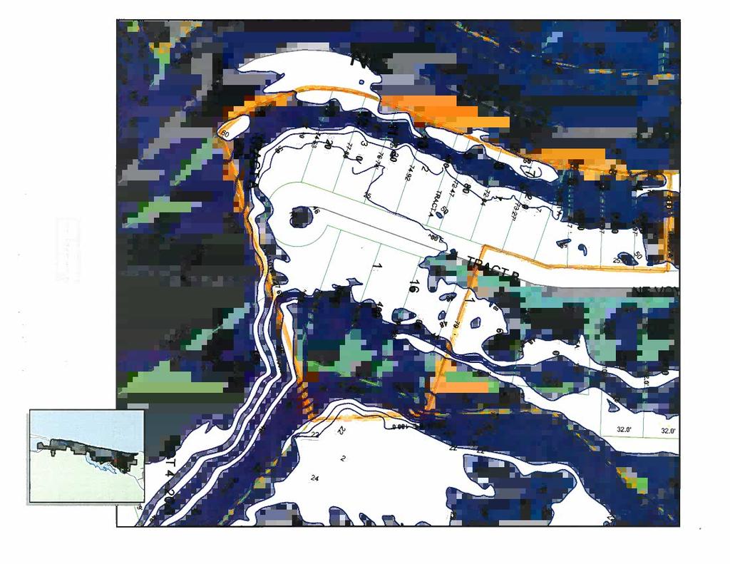
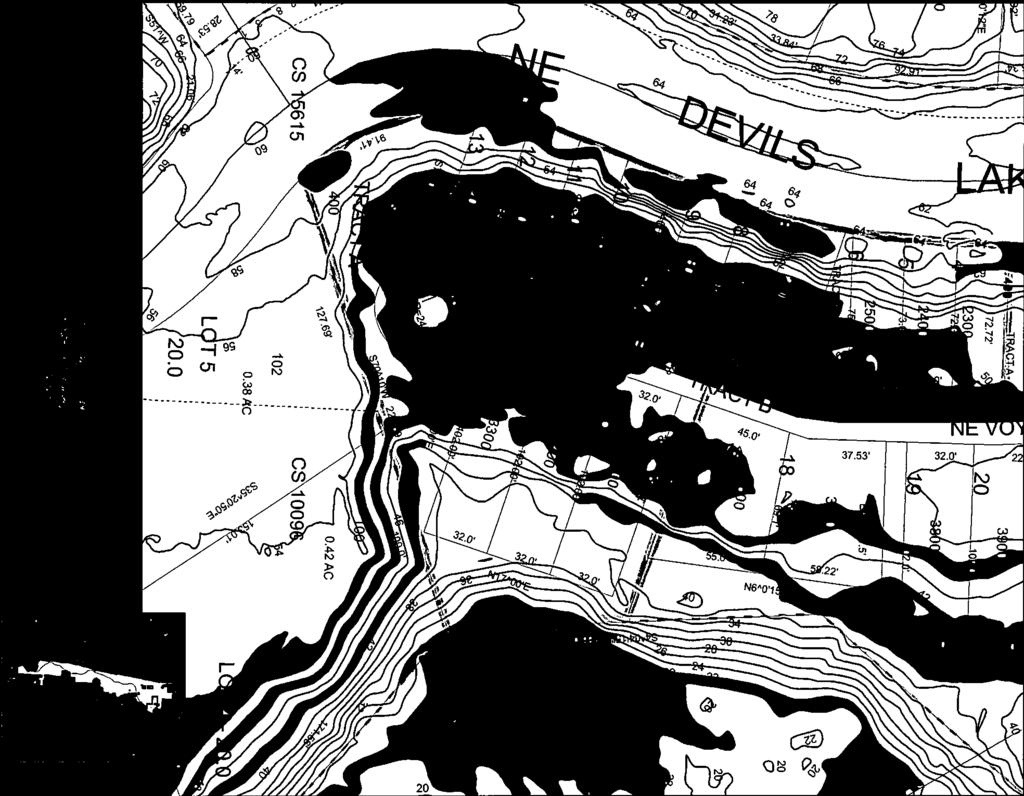
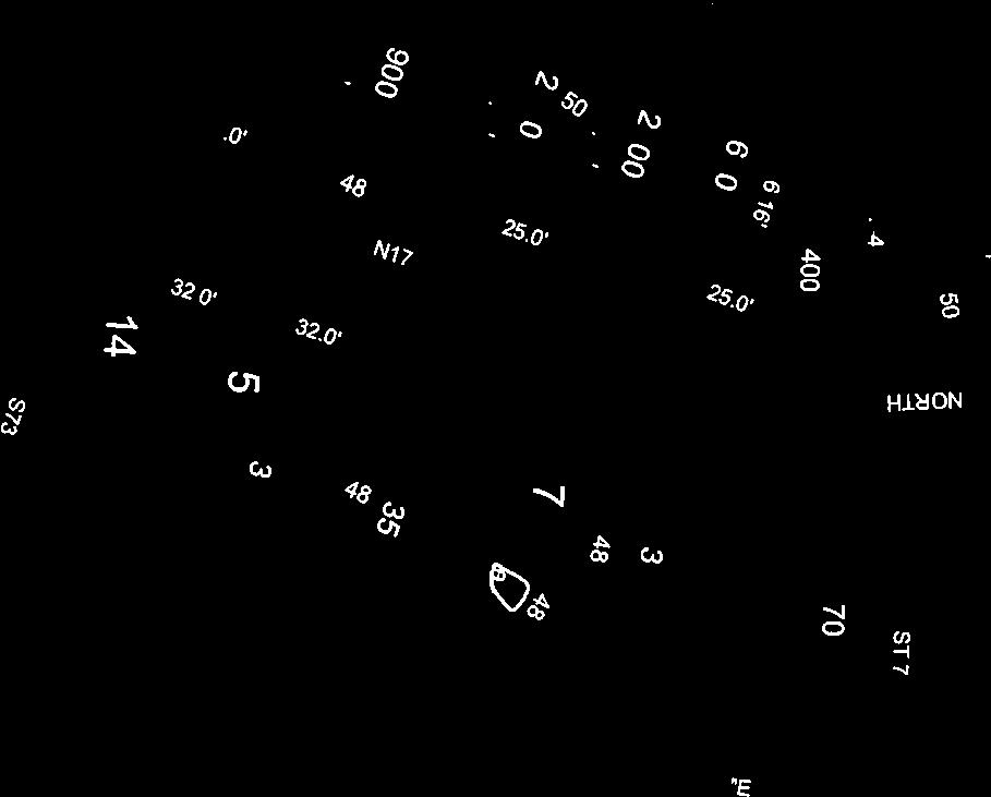


51

52
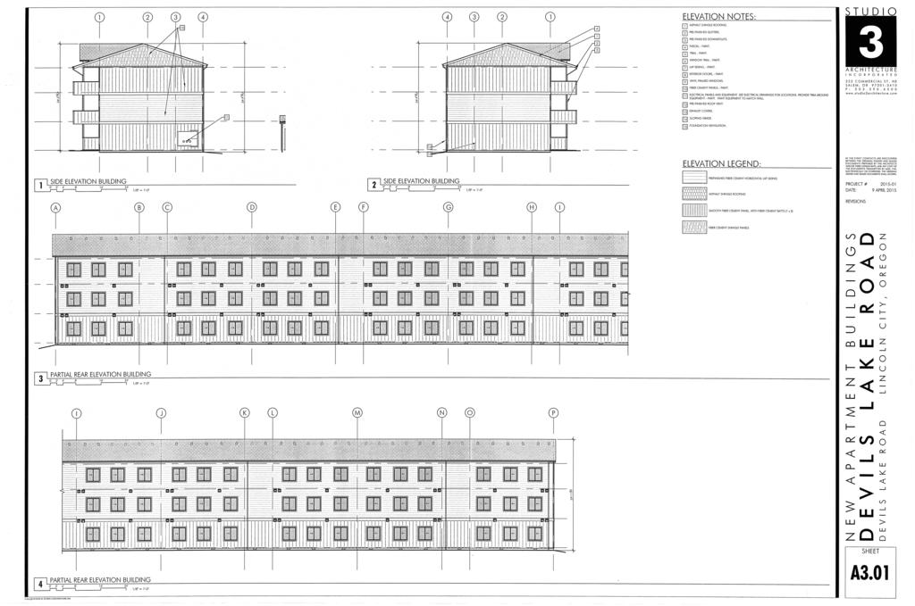
53
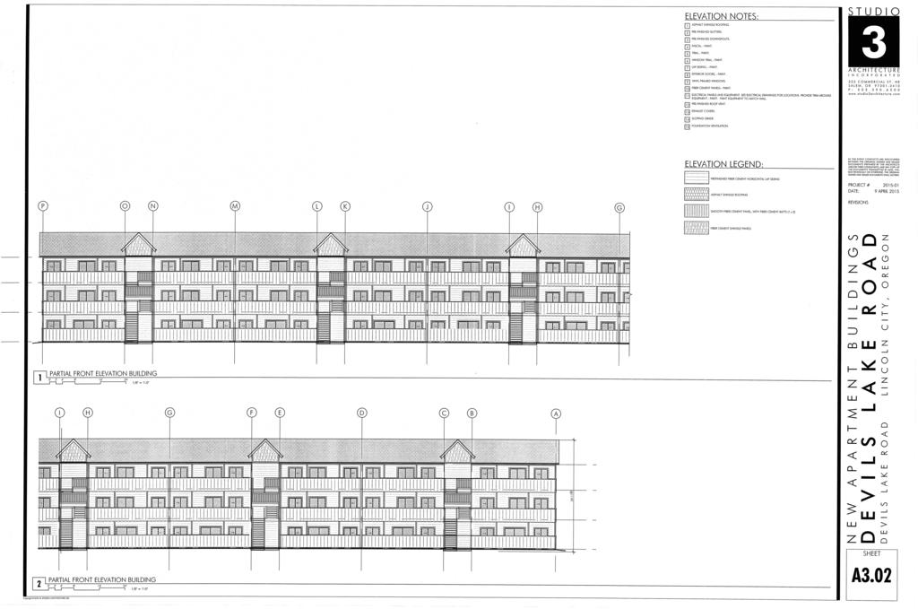
54
55 GENERAL NOTES: S T U D I O 1. THE LOCATIONS OF EXISTING UNDERGROUND UTILITIES ARE SHOWN IN AN APPROXIMATE WAY ONLY AND HAVE NOT BEEN INDEPENDENTLY VERIFIED BY THE OWNER OR ITS REPRESENTATIVES. THE CONTRACTOR SHALL DETERMINE THE EXACT LOCATION OF ALL EXISTING UTILITIES BEFORE COMMENCING WORK AND AGREES TO BE FULLY RESPONSIBLE FOR ANY AND ALL DAMAGES WHICH MIGHT BE OCCASIONED BY THE CONTRACTORS FAILURE TO EXACTLY LOCATE AND PRESERVE ANY AND ALL UNDERGROUND UTILITIES. A R C H I T E C T U R E I N C O R P O R A T E D 2. PROVIDE CONSTRUCTION FENCING AS REQUIRED TO SECURE SITE AND BUILDING DURING CONSTRUCTION C O M M E R C I A L S T. N E S A L E M, O R P : w w w. s t u d i o 3 a r c h i t e c t u r e. c o m SD SD TO EXIST STORM 4" FIRE LINE TO BLDG W W SD SD SD SD SD SD SD SD SD SD SD PUBLIC SD W W W W W W W W SS SS WEST DEVILS LAKE BOULEVARD C C 10 APARTMENT 14 C 16 BLDG 3 STORIES 30 UNITS C C SS SS SS SS SS SS SS SS SS SS SS PLAY AREA 2900 SF W W W W W W W W W W W SD SD SD SD SD SD SD C 13 C C TRASH MAIL C C C C SS SS SS SS SS SS SS SS 6 PARKING 29 UNITS / 1 OFFICE 9 UNITS AT ELDERLY 20 UNITS GENERAL 5 4 SS SS SS SS SS SS W W W W W W W SS SS TO EXIT SANITARY LINE LANDSCAPE PAVEMENT 3. EXTREME CARE SHOULD BE TAKEN TO PRESERVE EXISTING ROOTS OF TREES TO REMAIN. 4. REFER TO CIVIL DRAWINGS FOR GRADING. SITE IS REQUIRED TO MEET THE LAWS OF FHA AND ADA. ACCESSIBLE ROUTES SHALL NOT EXCEED 5% (1 IN 20) OR CROSS SLOPES SHALL NOT EXCEED 2% (1 IN 50). ALL AT GRADE SIDEWALKS ARE ACCESSIBLE ROUTES. 5. JOINTS IN CONCRETE WALKS NOTED AS E.J. ARE TO BE CONSTRUCTED AS EXPANSION JOINTS. ALL OTHER JOINTS SHOWN, TO BE TOOLED CONTROL JOINTS, SEE CIVIL. 6. SEE LANDSCAPE DRAWINGS FOR LANDSCAPE AND IRRIGATION ELEMENTS. 7. SEE ELECTRICAL DRAWINGS FOR SITE LIGHTING. IN TH E EVENT CONF LICTS A RE DISCO VERED BETWEEN THE ORIGINAL SIGNED AND SEALED DOCUMENTS PREPARED BY THE ARCHITECTS AND/OR THEIR CONSULTANTS, AND ANY COPY OF THE DOCUMENTS TRANSMITTED BY MAIL, FAX, ELECTRONICALLY OR OTHERWISE, THE ORIGINAL SIGNED AND SEALED DOCUMENTS SHALL GOVERN. PROJECT # DATE: REVISIONS JULY 2015 SD SD SD SD 49 SPACES REQUIRED 49 PROVIDED PLAY AREA DETENTION PIPE CONCRETE RETAINING WALL W SD SS W PROPOSED WATER LINE PROPOSED SD LINE PROPOSED SS LINE SITE SIZE 47,410 SF 100% PAVEMENT 20,223 SF 42.6 % LANDSCAPE 13,751 SF 29.0 % TRASH 256 SF 0.1 % BLDG FOOT PRINT 9,590 SF 20.2 % SITE PLAN 1 0' 4' 8' 16' 24' 48' 1'-0" = 1/16" PLAY AREA 2,900 SF DECKS GRND FLR 1,140 SF DECKS UPPER 3,540 SF TOTAL AREA 7,580 SF SHEET A1.01 Copyright , STUDIO 3 ARCHITECTURE, INC.
56

57
58


59

60

61

62


63 Exhibit C - Photos of Devils Lake Golf and Racquet Club and surrounding neighborhood Figure 1 NE Windward Place from NE 47th Street Figure 2 Looking north on NE Windward Place to townhouses


64 Figure 3 Condition of NE Windward Place Figure 4 Trees on apartment site


65 Figure 5 NE Devils Lake Blvd from NE 47th Street Figure 6 Neighboring Beacon Crest Apartments
Richard Townsend, Planning Director Richard Appicello, City Attorney. Kate Daschel, Assistant Planner
 AGENDA Lincoln City Planning Commission Tuesday, April 21, 2015, 6:00 P.M. Council Chambers, Lincoln City Civic Center Complex 801 SW Highway 101, Lincoln City, Oregon 1. CALL TO ORDER, PLEDGE OF ALLEGIANCE,
EXHIBIT B FINDINGS OF FACT BEND DEVELOPMENT CODE (BDC) UPDATE AMENDMENT PZ
 UPDATE AMENDMENT PZ") EXHIBIT B FINDINGS OF FACT BEND DEVELOPMENT CODE (BDC) UPDATE AMENDMENT PZ 18-0524 Procedural Findings Notice of the proposed amendments was provided to the Department of Land Conservation and Development
EXHIBIT B FINDINGS OF FACT BEND DEVELOPMENT CODE (BDC) UPDATE AMENDMENT PZ 18-0524 Procedural Findings Notice of the proposed amendments was provided to the Department of Land Conservation and Development
Department of Land Conservation and Development 635 Capitol Street, Suite 150 Salem, OR Theodore R. Kulongoski, Governor (503)
") Oregon Department of Land Conservation and Development 635 Capitol Street, Suite 150 Salem, OR 97301-2540 Theodore R. Kulongoski, Governor (503) 373-0050 AMENDED NOTICE OF ADOPTED AMENDMENT November 2,
Oregon Department of Land Conservation and Development 635 Capitol Street, Suite 150 Salem, OR 97301-2540 Theodore R. Kulongoski, Governor (503) 373-0050 AMENDED NOTICE OF ADOPTED AMENDMENT November 2,
LYONS PLANNING COMMISSION MEETING & PUBLIC HEARING Tuesday, January 10, 2017, Meeting: 6:30 pm Hearing: 7:00 pm AGENDA
 LYONS PLANNING COMMISSION MEETING & PUBLIC HEARING Tuesday, January 10, 2017, Meeting: 6:30 pm Hearing: 7:00 pm AGENDA We welcome you to today s meeting of the Lyons Planning Commission. This is an open
Kitsap County Department of Community Development
 Kitsap County Department of Community Development Staff Report and Recommendation Annual Comprehensive Plan Amendment Process for 2018 George s Corner LAMIRD Boundary Adjustment Report Date 7/16/2018 Hearing
CITY OF RIO VISTA PLANNING COMMISSION STAFF REPORT
 MEETING DATE: January10, 2018 CITY OF RIO VISTA PLANNING COMMISSION STAFF REPORT AGENDA ITEM #4.2 PREPARED BY: Lamont Thompson, Planning Manager SUBJECT: Vesting Tentative Tract No. 2017-001: To consider
MINUTES OF THE WORK STUDY MEETING OF THE QUEEN CREEK PLANNING AND ZONING COMMISSION AGENDA
 November 14, 2012, Page 1 of 5 MINUTES OF THE WORK STUDY MEETING OF THE QUEEN CREEK PLANNING AND ZONING COMMISSION WHEN: WEDNESDAY, NOVEMBER 14, 2012 WHERE: TOWN HALL COUNCIL CHAMBERS TIME: 6:00 p.m. Pursuant
PUD Ordinance - Cascade Lakes Plat #10 of 1995
 PUD Ordinance - Cascade Lakes Plat #10 of 1995 CASCADE CHARTER TOWNSHIP Ordinance #10 of 1995 AN ORDINANCE TO AMEND THE CASCADE CHARTER TOWNSHIP ZONING ORDINANCE AND ZONING MAP TO ESTABLISH THE CASCADE
1. Roll Call. 2. Minutes a. September 24, 2018 Special Joint Meeting with Clay County Planning Commission. 3. Adoption of the Agenda
 1. Roll Call City of Vermillion Planning Commission Agenda 5:30 p.m. Regular Meeting Tuesday, October 9, 2018 City Council Chambers 2 nd Floor City Hall 25 Center Street Vermillion, SD 57069 2. Minutes
Chapter 210 CONDITIONAL USES
 Chapter 210 CONDITIONAL USES 210.01 Purpose 210.02 Authorization 210.03 Process Type 210.04 Determination of Major or Minor Conditional Use Review 210.05 Approval Criteria 210.06 Conditions of Approval
DRAFT. 1. Determination of Quorum Eric Young called the meeting to order at 1:31 p.m. The following members and staff were present:
 WASHOE COUNTY PARCEL MAP REVIEW COMMITTEE Meeting Minutes Parcel Map Review Committee Members Thursday, December 8, 2016 1:30 p.m. James Barnes, Planning Commission James English, Health District Tim Simpson,
MINUTES OF A REGULAR MEETING OF THE INDEPENDENCE CITY COUNCIL TUESDAY, FEBRUARY 10, :30 P.M.
 MINUTES OF A REGULAR MEETING OF THE INDEPENDENCE CITY COUNCIL TUESDAY, FEBRUARY 10, 2009 7:30 P.M. 1. CALL TO ORDER. Pursuant to due call and notice thereof, a regular meeting of the Independence City
WHEREAS, the staff of The Maryland-National Capital Park and Planning Commission recommended APPROVAL of the application with conditions; and
 R E S O L U T I O N WHEREAS, Redeemed Christian Church of God is the owner of a 2.83-acre parcel of land known as Lot 9, Lot 19, P/O Lot 1 and P/O Lot 18, Block B, Plat Book A, Plat 5, said property being
PROPOSED FINDINGS OF FACT BENDER URBAN GROWTH BOUNDARY EXPANSION AND ANNEXATION REQUEST April 3, Background
 PROPOSED FINDINGS OF FACT BENDER URBAN GROWTH BOUNDARY EXPANSION AND ANNEXATION REQUEST April 3, 2016 Background The owners of TL300, 301, 302, 303, and 304, 3N1027BD - properties abutting the City Limits
The following regulations shall apply in the R-E District:
 "R-E" RESIDENTIAL ESTATE DISTRICT (8/06) The following regulations shall apply in the R-E District: 1. Uses Permitted: The following uses are permitted. A Zoning Certificate may be required as provided
Special Use Permit - Planned Unit Development Checklist. Property Address:
 Special Use Permit - Planned Unit Development Checklist Special Use Permit Number. Parcel Code/s #28-11- - - Property Address: Applicant: ARTICLE VIII Ordinance Reference - Section 8.1.2 Permit Procedures:
COMMUNITY DEVELOPMENT. Staff Report. Site Plan Review. SP June 19, 2018
 COMMUNITY DEVELOPMENT 333 Broadalbin Street SW, PO Box 490, Albany, Oregon 97321-0144 BUILDING 541-917-7553 PLANNING 541-917-7550 Staff Report Site Plan Review SP-18-18 June 19, 2018 Summary On May 1,
City of Astoria Comprehensive Plan URBAN GROWTH
 URBAN GROWTH CP.110 CP.110. Background Summary. Astoria has a population of 9,477 (2010 US Census). The total land area within the Urban Growth Boundary (UGB) is 3,474.2 acres with total land area of 4,450
Staff Report: Date: Applicant: Property Identification: Acreage of Request: Current Zoning of Requested Area: Requested Action: Attached:
 Staff Report: Completed by Jeff Palmer Director of Planning & Zoning Date: November 7, 2018, Updated November 20, 2018 Applicant: Greg Smith, Oberer Land Developer agent for Ronald Montgomery ET AL Property
AGENDA PLANNING COMMISSION Tuesday, April 18, :00 PM City Council Chambers 125 East Avenue B, Hutchinson, Kansas
 AGENDA PLANNING COMMISSION Tuesday, April 18, 2017 5:00 PM City Council Chambers 125 East Avenue B, Hutchinson, Kansas 1. ROLL CALL Macklin Woleslagel Bisbee (Chair) Hamilton Peirce Vacant Carr Hornbeck
NOTICE OF MEETING. The City of Lake Elmo Planning Commission will conduct a meeting on Wednesday, November 14, 2012 at 7:00 p.m.
 3800 Laverne Avenue North Lake Elmo, MN 55042 (651) 777-5510 www.lakeelmo.org NOTICE OF MEETING The City of Lake Elmo Planning Commission will conduct a meeting on Wednesday, November 14, 2012 at 7:00
PLANNED UNIT DEVELOPMENT (PUD) AREA PLAN/REZONING REVIEW PROCEDURE
 AREA PLAN/REZONING REVIEW PROCEDURE") PLANNED UNIT DEVELOPMENT (PUD) AREA PLAN/REZONING REVIEW PROCEDURE Professional inquiries will be made to our Township Planning Consultant, Township Engineer, and Township Attorney to get their opinions
PLANNED UNIT DEVELOPMENT (PUD) AREA PLAN/REZONING REVIEW PROCEDURE Professional inquiries will be made to our Township Planning Consultant, Township Engineer, and Township Attorney to get their opinions
Town of Cary, North Carolina Rezoning Staff Report 14-REZ-31 Cary Park PDD Amendment (Waterford II) Town Council Meeting January 15, 2015
 Town Council Meeting January 15, 2015") Town of Cary, North Carolina Rezoning Staff Report 14-REZ-31 Cary Park PDD Amendment (Waterford II) Town Council Meeting January 15, 2015 REQUEST To amend the Town of Cary Official Zoning Map by amending
Town of Cary, North Carolina Rezoning Staff Report 14-REZ-31 Cary Park PDD Amendment (Waterford II) Town Council Meeting January 15, 2015 REQUEST To amend the Town of Cary Official Zoning Map by amending
MINUTE ORDER BONNER COUNTY COMMISSIONERS PUBLIC HEARING MINUTES AUGUST 6, 2015
 MINUTE ORDER BONNER COUNTY COMMISSIONERS PUBLIC HEARING MINUTES AUGUST 6, 2015 CALL TO ORDER: Chair Cary Kelly called the Bonner County Commissioners hearing to order at 1:00 p.m. in the 3rd floor meeting
BOUNDARY LINE ADJUSTMENT
 DEPARTMENT OF COMMUNITY DEVELOPMENT 621 Sheridan Street, Port Townsend, WA 98368 Tel: 360.379.4450 Fax: 360.379.4451 Web: www.co.jefferson.wa.us/communitydevelopment E-mail: dcd@co.jefferson.wa.us BOUNDARY
GARDEN GROVE PLANNING COMMISSION Council Chamber, Community Meeting Center Stanford Avenue, Garden Grove, CA 92840
 CALL TO ORDER: 7:00 p.m. ROLL CALL: GARDEN GROVE PLANNING COMMISSION Council Chamber, Community Meeting Center 11300 Stanford Avenue, Garden Grove, CA 92840 Chair Kanzler Vice Chair Brietigam Commissioner
19.12 CLUSTER RESIDENTIAL DISTRICT
 Chapter 19.12 CLUSTER RESIDENTIAL DISTRICT (Adopted 12/22/2003; Ordinance #0061970). Amended 7/3/17, Ordinance #079100. Section 19.12.010 - Declaration of Intent. The Cluster Residential District provides
Chapter 100 Planned Unit Development in Corvallis Urban Fringe
 100.100 Scope and Purpose. Chapter 100 Planned Unit Development in Corvallis Urban Fringe (1) All applications for land divisions in the Urban Residential (UR) and Flood Plain Agriculture (FPA) zones within
Rezone property from RR(T)D3, D1(T)D3, and RR(T)D15 to D3 and D15 along North Douglas Highway.
D3, D1(T)D3, and RR(T)D15 to D3 and D15 along North Douglas Highway.") DATE: TO: FROM: Planning Commission Chrissy McNally, Planner Community Development Department FILE NO.: AME2013 0016 PROPOSAL: Rezone property from RR(T)D3, D1(T)D3, and RR(T)D15 to D3 and D15 along North
DATE: TO: FROM: Planning Commission Chrissy McNally, Planner Community Development Department FILE NO.: AME2013 0016 PROPOSAL: Rezone property from RR(T)D3, D1(T)D3, and RR(T)D15 to D3 and D15 along North
Community Development Department 333 Broadalbin Street SW, P.O. Box 490 Albany, OR 97321
 SUMMARY Community Development Department 333 Broadalbin Street SW, P.O. Box 490 Albany, OR 97321 STAFF REPORT Application for Tentative Partition Plat Review Planning File PA-06-17 Phone: 541-917-7550
Planned Unit Development (PUD). Sections:
. Sections:") Chapter 19.07. Planned Unit Development (PUD). Sections: 19.07.01. Purpose. 19.07.02. PUD Definition and Design Compatibility. 19.07.03. General PUD Standards. 19.07.04. Underlying Zones. 19.07.05. Permitted
Chapter 19.07. Planned Unit Development (PUD). Sections: 19.07.01. Purpose. 19.07.02. PUD Definition and Design Compatibility. 19.07.03. General PUD Standards. 19.07.04. Underlying Zones. 19.07.05. Permitted
TOWN OF FARMINGTON ZONING BOARD OF APPEALS MEETING MINUTES. Approved MINUTES
 TOWN OF FARMINGTON ZONING BOARD OF APPEALS MEETING MINUTES Approved MINUTES The following minutes are a written summary of the main points that were made and the actions taken at the Town of Farmington
City of San Juan Capistrano Agenda Report
 City of San Juan Capistrano Agenda Report TO: FROM: DATE: Planning Commission Development Services Department Submitted and Reviewed by,s~r9j9 Klotz, AICP, Assistant Development Services Director ~ Prepared
Draft Model Access Management Overlay Ordinance
 Draft Model Access Management Overlay Ordinance This model was developed using the City of Hutchinson and the Trunk Highway 7 corridor. The basic provisions of this model may be adopted by any jurisdiction
MINUTES OF THE ST. MARY S COUNTY PLANNING COMMISSION MEETING ROOM 14 * GOVERNMENTAL CENTER * LEONARDTOWN, MARYLAND Monday, May 8, 2006
 MINUTES OF THE ST. MARY S COUNTY PLANNING COMMISSION MEETING ROOM 14 * GOVERNMENTAL CENTER * LEONARDTOWN, MARYLAND Monday, May 8, 2006 Members present were Joseph St. Clair, Chair; Steve Reeves, Vice Chair;
BEFORE THE GALLATIN COUNTY COMMISSION GALLATIN COUNTY, MONTANA
 BEFORE THE GALLATIN COUNTY COMMISSION GALLATIN COUNTY, MONTANA IN THE MATTER OF THE APPLICATION OF TOM MURPHY, MANAGING MEMBER OF THE BRIDGER CENTER, LLC, FOR A ZONE MAP AMENDMENT TO THE GALLATIN COUNTY/BOZEMAN
1. Consider approval of the June 13, 2017 Regular Meeting Minutes
 Board of Adjustment Regular Meeting Agenda Tuesday August 8, 2017-6:30 PM Town Hall A. Roll Call, Determination of Quorum B. Approval of Minutes of Previous Meeting 1. Consider approval of the June 13,
Initial Project Review
 Pierce County Department of Planning and Land Services, 2401 South 35th Street, Tacoma, WA (253) 798-7037 Initial Project Review Major Amendment to Preliminary Plat: Hawks Ridge Division 1 Application
City of Lake Elmo Planning Commission Meeting Minutes of January 14, 2013
 City of Lake Elmo Planning Commission Meeting Minutes of January 14, 2013 Chairman Williams called to order the workshop of the Lake Elmo Planning Commission at 7:00pm COMMISSIONERS PRESENT: Fliflet, Obermueller,
VILLAGE OF HINSDALE ZONING BOARD OF APPEALS MINUTES OF THE MEETING October 15, 2014
 0 0 0 0 VILLAGE OF HINSDALE ZONING BOARD OF APPEALS MINUTES OF THE MEETING October, 0. CALL TO ORDER Chairman Bob called the regularly scheduled meeting of the Zoning Board of Appeals to order on Wednesday,
MIDWAY CITY Municipal Code
 MIDWAY CITY Municipal Code TITLE 9 ANNEXATION CHAPTER 9.01 PURPOSE CHAPTER 9.02 GENERAL REQUIREMENTS CHAPTER 9.03 PROPERTY OWNER INITIATION OF ANNEXATION CHAPTER 9.04 PROCEDURES FOR CONSIDERATION OF PETITION
1. Roll Call. 2. Minutes a. May 29, 2018 Regular Meeting. 3. Adoption of the Agenda. 4. Visitors to Be Heard
 1. Roll Call City of Vermillion Planning Commission Agenda 5:30 p.m. Regular Meeting Tuesday, May 29, 2018 City Council Chambers 2 nd Floor City Hall 25 Center Street Vermillion, SD 57069 2. Minutes a.
Comprehensive Plan /24/01
 IV The is a central component of the Comprehensive Plan. It is an extension of the general goals and policies of the community, as well as a reflection of previous development decisions and the physical
8/17/16 PC Meeting 1
 1 GENERAL INFORMATION OWNER/APPLICANT: Thomas Corff & Terry Moberly (1943 13 th St.) 19328 Towercrest Dr. Oregon City, OR 97045 Michael & Jill Parker (1983 13 th St.) 1708 Oak St. Lake Oswego, OR 97034
CHAPTER XVIII SITE PLAN REVIEW
 CHAPTER XVIII SITE PLAN REVIEW Section 18.1 Section 18.2 Description and Purpose. The purpose of this chapter is to provide standards and procedures under which applicants would submit, and the Township
550 North 800 West West Bountiful, Utah Phone (801) FAX (801) PLANNING COMMISSION MEETING
 FAX (801) PLANNING COMMISSION MEETING") Mayor Kenneth Romney City Council James Ahlstrom James Bruhn Kelly Enquist Debbie McKean Mark Preece WEST BOUNTIFUL CITY 550 North 800 West West Bountiful, Utah 84087 Phone (801) 292-4486 FAX (801) 292-6355
Mayor Kenneth Romney City Council James Ahlstrom James Bruhn Kelly Enquist Debbie McKean Mark Preece WEST BOUNTIFUL CITY 550 North 800 West West Bountiful, Utah 84087 Phone (801) 292-4486 FAX (801) 292-6355
Medical Marijuana Special Exception Use Information
 Medical Marijuana Special Exception Use Information The Special Exception Use information below is a modified version of the Unified Development Code. It clarifies the current section 5:104 Special Exceptions
Cover Letter with Narrative Statement
 Cover Letter with Narrative Statement March 31, 2017 rev July 27, 2017 RE: Rushton Pointe Residential Planned Unit Development Application for Public Hearing for RPUD Rezone PL2015 000 0306 Mr. Eric Johnson,
Village of Queen Charlotte OCP and Bylaw Review Open House April 29, 2017 Highlights, Policy Directions, and Choices
 Village of Queen Charlotte OCP and Bylaw Review Open House April 29, 2017 Highlights, Policy Directions, and Choices Purpose The purposes of the open house were: 1) to receive community input on topics
SUBDIVISION REGULATIONS
 CHAPTER 14 SUBDIVISION REGULATIONS 14-100 Provisions 14-200 Preliminary Plat 14-300 Final Plat 14-400 Replat 14-500 Minor Subdivision 14-600 Administrative Replat 14-700 Vacation of Roadways, Public Easements,
ANOKA PLANNING COMMISSION REGULAR MEETING ANOKA CITY HALL TUESDAY, MAY 16, :00 P.M.
 ANOKA PLANNING COMMISSION REGULAR MEETING ANOKA CITY HALL TUESDAY, MAY 16, 2017 7:00 P.M. CALL TO ORDER: The regular meeting of the Anoka Planning Commission was called to order at 7:00 p.m. ROLL CALL:
LOCATION MAP: AERIAL PHOTOGRAPH, 2015:
 LOCATION MAP: AERIAL PHOTOGRAPH, 2015: ORDINANCE NO. AN ORDINANCE OF THE CITY OF BRYAN, TEXAS, AMENDING CHAPTER 130, ZONING, OF THE CITY OF BRYAN CODE OF ORDINANCES, BY CHANGING THE ZONING CLASSIFICATION
Chair Mark Seifert Presiding. 1. Roll Call. 2. Approval of Agenda. 3. Recognition by Planning Commission of Interested Citizens.
 If Commissioners have any comments, concerns or questions, they should contact the staff Project Manager prior to the scheduled meeting date. Also, if you are for any reason unable to attend the meeting,
MAPLE GROVE PLANNING COMMISSION May 26, 2015
 MAPLE GROVE PLANNING COMMISSION CALL TO ORDER A meeting of the Maple Grove Planning Commission was held at 7:00 p.m. on at the Maple Grove City Hall, Hennepin County, Minnesota. Chair Colson called the
STAFF REPORT. Community Development Director PO Box 4755 Beaverton, OR 97076
 STAFF REPORT HEARING DATE: July 7, 2010 TO: Planning Commission STAFF: Jana Fox, Assistant Planner PROPOSAL: Southeast Beaverton Office Commercial Zoning Map Amendment (ZMA2010-0006) LOCATION: The subject
Salem Township Zoning Ordinance Page 50-1 ARTICLE 50.0: PUD PLANNED UNIT DEVELOPMENT
 Salem Township Zoning Ordinance Page 50-1 ARTICLE 50.0 PLANNED UNIT DEVELOPMENT Section 50.01 Purpose The provisions of this Article provide enabling authority and standards for the submission, review,
PUD Ordinance - Caravelle Village #7 of 1995
 PUD Ordinance - Caravelle Village #7 of 1995 CASCADE CHARTER TOWNSHIP Ordinance #17 of 1995 AN ORDINANCE TO AMEND THE CASCADE CHARTER TOWNSHIP ZONING ORDINANE AND ZONING MAP TO ESTABLISH THE CARAVELLE
Burlington Unincorporated Community Plan
 Burlington Unincorporated Community Plan June 30, 2010 Meeting Page 1 of 24 Table of Contents (Page numbers to be inserted) I. Background a. Location and Community Description b. Planning of Unincorporated
Marion County Board of County Commissioners
 Marion County Board of County Commissioners Date: 12/29/2015 P&Z: 12/28/2015 BCC: 1/12/2016 Item Number 160113Z Type of Application Rezoning Request From: A-1 (General Agriculture) To: PUD (Planned Unit
R E S O L U T I O N. a. Remove Table B from the plan.
 R E S O L U T I O N WHEREAS, Werrlein Property is the owner of a 0.3902-acre parcel of land in the 5th Election District of Prince George s County, Maryland, being zoned One-Family Detached Residential
URBANDALE PLANNING AND ZONING COMMISSION MINUTES. July 9, 2018
 URBANDALE PLANNING AND ZONING COMMISSION MINUTES The Urbandale Planning and Zoning Commission met in regular session on Monday,, at the Urbandale City Hall, 3600 86th Street. Chairperson Jeff Hatfield
NOTICE OF MEETING The City of Lake Elmo Planning Commission will conduct a meeting on Monday July 24, 2017 at 7:00 p.m. AGENDA
 3800 Laverne Avenue North Lake Elmo, MN 55042 (651) 747-3900 www.lakeelmo.org NOTICE OF MEETING The City of Lake Elmo Planning Commission will conduct a meeting on Monday July 24, 2017 at 7:00 p.m. AGENDA
Staff Report. Planning Commission Public Hearing: October 17, 2007 Staff Recommendation: Denial
 COUNTY OF PRINCE WILLIAM 5 County Complex Court, Prince William, Virginia 22192-9201 PLANNING (703) 792-6830 Metro 631-1703, Ext. 6830 FAX (703) 792-4401 OFFICE Internet www.pwcgov.org Stephen K. Griffin,
REPORT TO THE SHASTA COUNTY PLANNING COMMISSION
 REPORT TO THE SHASTA COUNTY PLANNING COMMISSION PROJECT IDENTIFICATION: REGULAR AGENDA GENERAL PLAN AMENDMENT GPA18-0003 AND ZONE AMENDMENT ZA18-0004 AREA 3 - SOUTHWEST PALO CEDRO: GILBERT DRIVE CONTINUED
MINUTE ORDER. BONNER COUNTY PLANNING and ZONING COMMISSION PUBLIC HEARING MINUTES NOVEMBER 5, 2015
 MINUTE ORDER BONNER COUNTY PLANNING and ZONING COMMISSION PUBLIC HEARING MINUTES NOVEMBER 5, 2015 CALL TO ORDER: Chair Temple called the Bonner County Planning and Zoning Commission hearing to order at
TOWN OF GILMANTON ZONING BOARD OF ADJUSTMENT THURSDAY, AUGUST 21, PM. ACADEMY BUILDING MINUTES
 Chair Elizabeth Hackett called the meeting to order at 7:08 PM. Members attending: Elizabeth Hackett, Perry Onion, Mike Teunessen, & Nate Abbott. Members not attending: none Also in attendance: Annette
SUBDIVISION REGULATIONS for Lawrence and the Unincorporated Areas of Douglas County, KS
 SUBDIVISION REGULATIONS for Lawrence and the Unincorporated Areas of Douglas County, KS December 19, 2006 Edition Amended: 09/11/07; 12/04/07; 03/25/08; 09/10/08 Amended: January 6, 2009 Article 8 Subdivision
IN THE OFFICE OF ADMINISTRATIVE HEARINGS CASE NUMBER S SNYDER DEVELOPMENT CORPORATION THIRD ASSESSMENT DISTRICT DATE HEARD: JULY 2, 2014
 IN THE OFFICE OF ADMINISTRATIVE HEARINGS CASE NUMBER 2014-0039-S SNYDER DEVELOPMENT CORPORATION THIRD ASSESSMENT DISTRICT DATE HEARD: JULY 2, 2014 ORDERED BY: DOUGLAS CLARK HOLLMANN ADMINISTRATIVE HEARING
DLCD ACKNOWLEDGMENT or DEADLINE TO APPEAL: Thursday, October 20, 2011
 epartment of Land Conservation and evelopment Capitol Street, Suite 0 Salem, OR 0 1-0 (0) -000 Fax (0) - www. lc d. s tat e. or. us NOTICE OF AOPTE AMENMENT îbua /0/0 TO: FROM: Subscribers to Notice of
LOCAL PLANNING AGENCY MEETING Martin County Commissioner Chambers 2401 S.E. Monterey Road Stuart, Florida MEETING MINUTES- November 5, 2015
 LOCAL PLANNING AGENCY MEETING Martin County Commissioner Chambers 2401 S.E. Monterey Road Stuart, Florida 34996 MEETING MINUTES- November 5, 2015 Present: Chairman Jim Moir Vice Chairperson Crystal Lucas
ADA TOWNSHIP PLANNING COMMISSION MINUTES OF THE JUNE 15, 2017 MEETING
 ADA TOWNSHIP PLANNING COMMISSION MINUTES OF THE JUNE 15, 2017 MEETING A meeting of the was held on Thursday, June 15, 2017, 7:00 p.m. at the Ada Township Offices, 7330 Thornapple River Dr., Ada, MI. I.
CITY OF ELK GROVE CITY COUNCIL STAFF REPORT
 AGENDA ITEM NO. 9.2 CITY OF ELK GROVE CITY COUNCIL STAFF REPORT AGENDA TITLE: A public hearing to consider a Specific Plan Amendment to the Laguna Ridge Specific Plan and a Rezone of approximately 4.14
COUNTY PLANNING COMMISSION Staff Report for Transitional and Supportive Housing Ordinance Amendments 1.0 REQUEST
 COUNTY PLANNING COMMISSION Staff Report for Transitional and Supportive Housing Ordinance Amendments Hearing Date: May 3, 2017 Staff Report Date: April 25, 2017 Case Nos.: 17ORD-00000-00002 and 17ORD-00000-00003
COMMUNITY DEVELOPMENT DEPARTMENT 333 Broadalbin Street SW, P.O. Box 490 Albany, OR 97321
 HEARING BODY COMMUNITY DEVELOPMENT DEPARTMENT 333 Broadalbin Street SW, P.O. Box 490 Albany, OR 97321 NOTICE OF PUBLIC HEARING Planning Commission HEARING DATE Monday, December 3, 2018 HEARING TIME HEARING
Minutes of a Regular Meeting of the Development Review Board Held on the fifth day of December, 2018
 Minutes of a Regular Meeting of the Development Review Board Held on the fifth day of December, 2018 Members Present: Member(s) Absent: Others Present: Chairman Craig Powers, Vice Chair Orland Campbell,
DEWITT CHARTER TOWNSHIP 1401 W. HERBISON ROAD, DeWITT, MI PLANNING COMMISSION MINUTES TUESDAY, SEPTEMBER 5, 2006
 DEWITT CHARTER TOWNSHIP 1401 W. HERBISON ROAD, DeWITT, MI PLANNING COMMISSION MINUTES TUESDAY, SEPTEMBER 5, 2006 The regularly scheduled meeting of the DeWitt Charter Township Planning Commission was called
PUD, HPUD, OSC Rezoning & Conceptual Plan Application (Planned Unit Development, Haggerty Road Planned Unit Development, Open Space Community)
") Township Use Only RZ #: Date: Hearing Date: Fee Paid: PUD, HPUD, OSC Rezoning & Conceptual Plan Application (Planned Unit Development, Haggerty Road Planned Unit Development, Open Space Community) Project
Township Use Only RZ #: Date: Hearing Date: Fee Paid: PUD, HPUD, OSC Rezoning & Conceptual Plan Application (Planned Unit Development, Haggerty Road Planned Unit Development, Open Space Community) Project
CITY OF OROVILLE PLANNING COMMISSION
 OROVILLE PLANNING COMMISSION Council Chambers 1735 Montgomery Street Oroville, CA. 95965 March 28, 2019 REGULAR MEETING OPEN SESSION 7:00 PM AGENDA CITY OF OROVILLE PLANNING COMMISSION CHAIR: VICE-CHAIR:
PALM BEACH COUNTY PLANNING, ZONING AND BUILDING DEPARTMENT ZONING DIVISION
 PALM BEACH COUNTY PLANNING, ZONING AND BUILDING DEPARTMENT ZONING DIVISION Application No.: Z-2016-00663 Application Name: Autism School Control No.: 2014-00133 Applicant: Dayna2, LLC Owners: Dayna2, LLC
NOTICE OF MEETING AND AGENDA FOR THE PLANNING COMMISSION OF SPRINGVILLE, UTAH... JANUARY 23, 2018
 NOTICE OF MEETING AND AGENDA FOR THE PLANNING COMMISSION OF SPRINGVILLE, UTAH............................ JANUARY 23, 2018 Notice is hereby given that the Planning Commission will hold a public meeting
STAFF REPORT. Permit Number: Porter. Kitsap County Board of Commissioners; Kitsap County Planning Commission
 STAFF REPORT Permit Number: 15 00461 Porter DATE: November 9, 2015 TO: FROM: Kitsap County Board of Commissioners; Kitsap County Planning Commission Katrina Knutson, AICP, Senior Planner, DCD and Jeff
VILLAGE OF PALM SPRINGS VILLAGE COUNCIL MINUTES REGULAR MEETING, COUNCIL CHAMBERS, JULY 25, 2013
 VILLAGE OF PALM SPRINGS VILLAGE COUNCIL MINUTES REGULAR MEETING, COUNCIL CHAMBERS, JULY 25, 2013 CALL TO ORDER, ROLL CALL, INVOCATION, AND PLEDGE OF ALLEGIANCE Mayor Bev Smith called the regular meeting
CITY OF BONITA SPRINGS ZONING ORDINANCE NO
 CITY OF BONITA SPRINGS ZONING ORDINANCE NO. 05-11 A ZONING ORDINANCE OF THE CITY OF BONITA SPRINGS, FLORIDA; APPROVING A REQUEST BY ROCKPOINT/RONTO NAPLES, LLC IN REFERENCE TO EAST BONITA ACTIVE ADULT
Staff Report PLANNED DEVELOPMENT. Salt Lake City Planning Commission. From: Lauren Parisi, Associate Planner; Date: December 14, 2016
 Staff Report PLANNING DIVISION COMMUNITY & NEIGHBORHOODS To: Salt Lake City Planning Commission From: Lauren Parisi, Associate Planner; 801-535-7932 Date: December 14, 2016 Re: 1611 South 1600 East PLANNED
RECOMMENDATION REPORT
 DEPARTMENT OF CITY PLANNING RECOMMENDATION REPORT City Planning Commission Date: August 27, 2009 Time: After 8:30 AM Place: City Hall 200 North Spring Street Los Angeles, CA 90012 Public Hearing: Completed
RESIDENTIAL VACATION RENTALS
 RESIDENTIAL VACATION RENTALS WHAT IS A RESIDENTIAL VACATION RENTAL? A residential vacation rental is the renting of a house, apartment, or room for a period of less than thirty days to a person or group
9. REZONING NO Vicinity of the northwest corner of 143 rd Street and Metcalf Avenue
 9. REZONING NO. 2002-15 Vicinity of the northwest corner of 143 rd Street and Metcalf Avenue 1. APPLICANT: Andrew Schlagel is the applicant for this request. 2. REQUESTED ACTION: The applicant is requesting
Staff Report. State Environmental Policy Act (SEPA): The proposal requires review under the State Environmental Policy Act.
: The proposal requires review under the State Environmental Policy Act.") Staff Report Major Amendment to Preliminary Plat / Planned Development District: Oakpointe at Sunrise PDD, Phase 1 (aka Emerald Ridge PDD) Application Number: 865995 Tax Parcel Number: 6026455560 South
Staff Report Major Amendment to Preliminary Plat / Planned Development District: Oakpointe at Sunrise PDD, Phase 1 (aka Emerald Ridge PDD) Application Number: 865995 Tax Parcel Number: 6026455560 South
CLACKAMAS COUNTY BOARD OF COMMISSIONERS 2051 Kaen Road, Oregon City BCC Hearing Room - 4th Floor. LAND USE HEARING August 1, :30 AM
 CLACKAMAS COUNTY BOARD OF COMMISSIONERS 2051 Kaen Road, Oregon City BCC Hearing Room - 4th Floor LAND USE HEARING August 1, 2018 9:30 AM The item will not begin before time noted. Interested parties may
NOTICE OF MEETING The City of Lake Elmo Planning Commission will conduct a meeting on Monday December 10, 2018 at 7:00 p.m. AGENDA
 3800 Laverne Avenue North Lake Elmo, MN 55042 (651) 747-3900 www.lakeelmo.org NOTICE OF MEETING The City of Lake Elmo Planning Commission will conduct a meeting on Monday December 10, 2018 at 7:00 p.m.
STAFF REPORT. Meeting Date: April 25, 2017
 Meeting Date: April 25, 2017 Agency: City of Belmont Staff Contact: Damon DiDonato, Community Development Department, (650) 637-2908; ddidonato@belmont.gov Agenda Title: Amendments to Sections 24 (Secondary
Guide to Preliminary Plans
 Guide to Preliminary Plans Introduction The Douglas County is committed to providing open, transparent application processes to the public. This Guide is provided to assist anyone interested in the procedures
UPPER ALLEN TOWNSHIP PLANNING COMMISSION REGULAR MEETING August 27, :00 P.M.
 UPPER ALLEN TOWNSHIP PLANNING COMMISSION REGULAR MEETING August 27, 2018 7:00 P.M. PC MEMBERS TOWNSHIP OFFICIALS - PRESENT R. Wayne Willey, Chairperson Jennifer Boyer, Comm. Dev. Director Philip Cerveny,
City of Talent. Planning Commission. Public Meeting Thursday, February 27, :30 PM. Talent Community Center, 206 East Main Street AGENDA
 City of Talent Planning Commission Public Meeting Thursday, February 27, 2014 6:30 PM Talent Community Center, 206 East Main Street AGENDA The Planning Commission of the City of Talent will meet on Thursday,
MESA COUNTY PLANNING COMMISSION OCTOBER 28, 2004, PUBLIC HEARING MINUTES
 MESA COUNTY PLANNING COMMISSION OCTOBER 28, 2004, PUBLIC HEARING MINUTES Chairman Bruce Kresin called a scheduled hearing of the Mesa County Planning Commission to order at 7:01 p.m. Chairman Kresin led
French, Bruce. The applicant is requesting a zone change from Suburban to Rural Service Center.
 BONNER COUNTY PLANNING DEPARTMENT PLANNING AND ZONING COMMISSION STAFF REPORT FOR FEBRUARY 2, 2017 Project Name: French, Bruce File Number,Type: ZC358-16, Zone Change Request: The applicant is requesting
ORDINANCE NO OA
 ORDINANCE NO. 2013 11-OA AN ORDINANCE OF THE TOWNSHIP OF BERKELEY, COUNTY OF OCEAN, STATE OF NEW JERSEY, AMENDING THE TOWNSHIP CODE OF THE TOWNSHIP OF BERKELEY, SO AS TO CREATE ARTICLE XX, ENTITLED VOLUNTARY
LAND USE PLANNING. General Discussion. Objectives
 GOAL 2: LAND USE PLANNING General Discussion To establish a land use planning process for the County as a basis for all decisions and actions related to use of land and to ensure an adequate factual base
13 Sectional Map Amendment
 13 Sectional Map Amendment Introduction This chapter reviews land use and zoning policies and practices in Prince George s County and presents the proposed zoning in the sectional map amendment (SMA) to
MOHAVE VALLEY IRRIGATION & DRAINAGE DISTRICT
 MOHAVE VALLEY IRRIGATION & DRAINAGE DISTRICT APPROVED: MAY 1, 2012 MINUTES OF THE REGULAR BOARD MEETING HELD TUESDAY, APRIL 3, 2012 AT THE OFFICES OF THE MOHAVE VALLEY IRRIGATION & DRAINAGE DISTRICT (