SITE FEASIBILITY ASSESSMENT 2501 WEST BRAKER LANE SITE
|
|
|
- Neal Gordon
- 5 years ago
- Views:
Transcription

1 SITE FEASIBILITY ASSESSMENT FOR THE 2501 WEST BRAKER LANE SITE AUSTIN, TRAVIS COUNTY TEXAS Prepared for: TAYLOR COMMERCIAL 900 Congress Avenue, Suite L-165 Austin, Texas Prepared by: BURY+PARTNERS, INC. 221 West Sixth Street, Suite 600 Austin, Texas JULY 2011
2 SITE FEASIBILITY ASSESSMENT FOR THE 2501 WEST BRAKER LANE SITE AUSTIN, TRAVIS COUNTY, TEXAS Prepared for: TAYLOR COMMERCIAL 900 Congress Avenue, Suite L-165 Austin, Texas Prepared by: BURY+PARTNERS, INC. 221 West Sixth Street, Suite 600 Austin, Texas TBPE Registration No. F-1048 BPI Project No JULY 2011
3 TABLE OF CONTENTS Page Introduction... 1 North Burnet/Gateway Neighborhood Planning Area... 1 North Burnet Gateway Zoning... 2 Impervious Cover...12 Texas Commission on Environmental Quality...13 Stormwater and Detention...13 Water Quality Controls...14 Subdivision...15 Consolidated Site Plan...15 Landscape and Tree Protection...16 Transportation and Access...17 Traffic Impact Analysis...17 Building Permit...17 Water and Wastewater Service...17 Electric Easements...18 Utilities...19 Conclusion...19
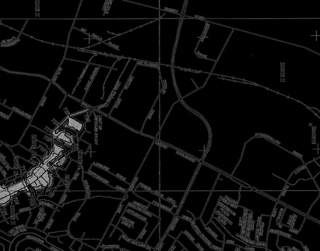
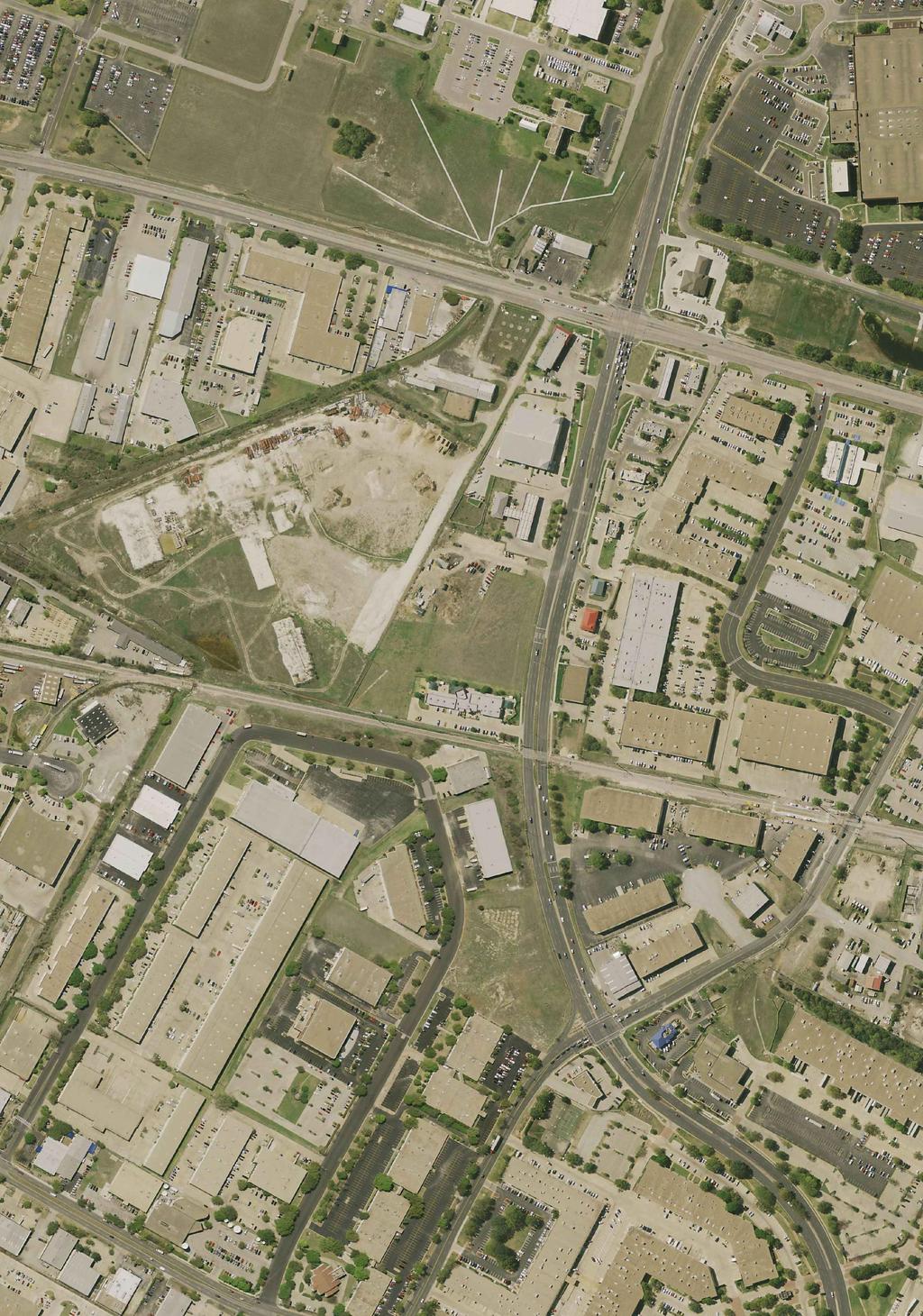
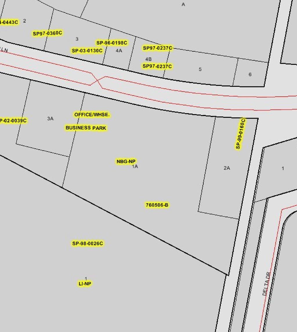
4 INTRODUCTION This site is approximately acres and its Travis County Appraisal District (TCAD) Parcel Identification number is According to TCAD, the parcel is owned by Bill Gaston Inc. and is currently undeveloped. The site is a platted lot and described as Lot 1A, Block A of the Braker at Burnet Section 3 Resubdivision. The parcel is zoned North Burnet Gateway Neighborhood Plan (NBG-NP) and within the Transit Oriented Development (TOD) Zone. Development regulations are based upon the North Burnet/Gateway Regulating Plan (NBG) and current City of Austin ordinances. NORTH BURNET/GATEWAY NEIGHBORHOOD PLANNING AREA The North Burnet/Gateway Planning Area is located in the north part of Austin's Urban Core. The boundaries for the planning area are Walnut Creek on the north, Metric Boulevard on the east, U.S. 183 (Research Boulevard) on the south and southwest, Braker Lane on the northwest, and MoPac (Loop 1) on the west. The subject property falls within the boundaries of the North Burnet/Gateway Planning Area and is therefore subject to the land use and development regulations associated with the planning area. The North Burnet/Gateway master plan was approved in 2007 and presents a long-term vision for the area to redevelop the existing low density, auto-oriented and industrial uses into a higher density mixed-use neighborhood that is more pedestrian-friendly and takes advantage of the links to commuter rail transit and the area s key position within Austin s Urban Core. The intent is to allow a significant number of new residents to move into the area to accommodate some of the expected population growth in the region. Additionally, the intent is to provide the associated community and neighborhood services, parks, and public spaces important to making a great neighborhood. These may include restaurants, small local businesses, retailers, and multi-story, mixed-use buildings with direct pedestrian access to public transit. An important element of the plan is to enhance development design quality and create great places where people can live, work, shop, interact and recreate within walking distance of each activity and transit. The plan also identified future land use designations for properties within the district. The subject property is designated as High Density Mixed-Use future land use on the approved future land use map. The City Council approved the NBG zoning district and associated North Burnet/Gateway Regulating Plan on March 12, This approval rezoned the majority of the properties within the district boundary to North Burnet Gateway (NBG); thereby creating a new zoning district and associated standards, along with many associated development guidelines. The approved North Burnet Gateway Regulating Plan is based upon the originally adopted North Burnet/Gateway Master Plan; the Regulating Plan outlines zoning sub-districts, permitted land uses, site development regulations, design guidelines, etc. Development of this property will require 1
5 adherence to the Regulating Plan; this plan supersedes the previous zoning and associated regulations. It also supersedes the Commercial Design Standards ordinance. NORTH BURNET GATEWAY ZONING The subject property is zoned NBG-NP and all of the property lies within the Transit-Oriented Development (TOD) Subdistrict. The NBG map is attached for reference along with Zoning Ordinance which added the neighborhood plan combining district to the base zoning districts for the North Burnet/Gateway plan. The following are noteworthy highlights from the NBG regulating plan: The plan outlines general provisions and applicability; land use; circulation, connectivity and streetscape; site development standards; building design standards; development bonus standards; sidewalks; parking; connectivity and circulation; exterior lighting; signage, etc. Compliance with the standards is required for new construction, redevelopment and major rehabilitation of a site. Alternative equivalent compliance may be pursued if 100percent compliance with the regulating plan and district standards is unachievable. The purpose of permitting alternative equivalent compliance is to encourage creative and original design and to accommodate projects where the particular site conditions or the proposed use prevent strict compliance with the plan. Proposals for alternative equivalent compliance must meet the intent of the plan, and it is not a general waiver of the regulations. The parcel lies within the TOD sub-district and must comply with the standards applicable to the district (a summary of the standards is included and referenced below). Per the Plan, the TOD sub-district is the most intensively developed land use zone and will typically be expressed as high density residential or office over active ground floor uses, such as retail. This land use designation is concentrated near the CapMetro commuter rail station. This parcel fronts roadways that are identified as a Core Transit Corridors (CTC) and must comply with the applicable standards. The NBG zoning district has an approved land use table associated with it and is divided into sub-districts. The NBG land use table supersedes the standard zoning land use table in Chapter 25-2 of the LDC. The NBG land use table outlines the permitted, conditional and prohibited uses. A mix of residential, including multi-family, and commercial uses are permitted in the TOD zone. Also per the plan, drive-thru s are prohibited in the TOD sub-district. The specific details regarding design and TOD sub-district standards should be reviewed in the regulating plan in detail to understand the effects on a potential user. 2
6 Below is a general summary of the site development standards for the TOD sub-district. Attached is the TOD sub-district summary sheet for reference. There are no maximum units per acre requirements. There are no minimum site area requirements. Maximum building coverage shall be equal to the maximum impervious cover permitted. Compatibility standards do not apply. Minimum Lot Size: 2,500 square feet (sq. ft.) Minimum Lot Width: 20 feet (ft) Minimum Setbacks: a. Front Yard and Street Side Yard: No ground-level front yard or street side yard setbacks are required. Instead development must meet building placement standards in Section 4.3 (detailed further below). b. Front and Street Side Upper-Story Building Façade Step-backs: The building façade at the sixth (6th) story and above must be stepped back 30 feet from the ground-level building façade line. c. Interior Side Yard: 0 feet. d. Rear Yard: 0 feet. Maximum Impervious Cover: 80 percent per the zoning requirements Floor to Area Ratio: 1:1 (based on previous zoning) with the ability to develop up to 5:1 with a development bonuses (development bonus options are detailed further below) Building Height: a. Minimum building height: two (2) stories b. Maximum building height: 120 feet with the ability to develop up to 360 feet with development bonuses; however after five (5) stories the building must be offset 30 feet away from the property boundary Below is a breakdown of the additional standards outlined in the regulating plan that will likely apply to development of this site. For the following sections the North Burnet/Gateway Regulating plan is included, so you can refer to the plan. A detailed review of the regulating plan is recommended as this is a summary and does not include every applicable regulation from the plan. North Burnet/Gateway Regulating Plan Sidewalk Standards (Section 3.3) This requirement must be met on all adjacent roadway types. Where required, the sidewalk shall extend onto private property to fulfill the minimum requirement, with a sidewalk easement provided. For Core Transit Corridors the minimum total sidewalk width is 15 feet and 12 feet for Pedestrian Priority Collectors (PPC). Sidewalks shall consist of two (2) zones: a street tree/furniture zone located adjacent to the curb, and a clear zone. The following applies: 3
7 Street Tree/Furniture Zone: a. The street tree/furniture zone shall have a minimum width of eight (8) feet along Core Transit Corridors and seven (7) feet along Pedestrian Priority Collectors. This zone shall be continuous and located adjacent to the curb. b. Street trees are required at an average spacing not greater than 30 feet on center along all roadways. c. While not required, the zone is intended for the placement of street furniture including seating, street lights, waste receptacles, bike racks, etc. Clear Zone: a. The clear zone shall be a minimum of seven (7) feet along Core Transit Corridors and five (5) feet along Pedestrian Priority Collectors. This zone shall be located adjacent to the street tree/furniture zone, and shall comply with ADA and Texas Accessibility Standards. b. The clear zone shall be unobstructed by any permanent or nonpermanent element for the required minimum width and a minimum height of eight (8) feet. Utilities: a. All utility lines shall be underground from the building to the property line. Utility lines within the right-of-way (ROW) shall be placed underground or relocated to the rear of the site to the maximum extent practicable as determined by the Director. On-street Parking (Section 3.4) On-street parking is not permitted on Burnet Road. On-street parallel parking is encouraged along all NBG Pedestrian Priority Collectors and shall be permitted subject to the approval of the Director of the Public Works Department. Connectivity and Circulation (Section 3.5) All projects must provide a project circulation plan as part of the subdivision review process (or site plan if a subdivision is not required). The project circulation plan shall be developed and reviewed for its consistency with the NBG collector street plan which illustrates conceptual locations for new collector streets. The project circulation plan must be approved by the Directors of Neighborhood Planning and Zoning. There is one required new collector street in close proximity to the site. The proposed roadway and its ultimate alignment will effect development of the site. The preliminary location for the new collector is along the western property line. The collector plan map is attached in the North Burnet/ Gateway Regulation Plan for reference. 4
8 Dedication of NBG Collector Streets (Section 3.5.2) ROW shall be dedicated for collector streets as identified on the NBG collector street plan in conformance with the Land Development Code. New collector streets shall follow one (1) of the primary collector street crosssections provided in Appendix A. The proposed collector street shown running north/south (through the subject property) located east along the western property line shall follow the primary collector street (35 MPH or less) off-street bikeway option cross-section. If a site is five (5) acres or larger in size and required to build a new street(s) to meet the block size standards, a street alignment shall follow the collector street alignment identified on the collector street plan. Block Standards (Section 3.5.4) A site five (5) acres or larger shall be generally divided into internal blocks. Streets connecting the blocks shall form an interconnected, grid-like transportation system on the site. The maximum length of any block face shall be 660 feet and the maximum block perimeter shall be 1,800 feet as measured from the curb line. There are exemptions to these standards if there are special circumstances, including restricted access due to easements, rail ROW, natural features, and existing development. Curb Cut Spacing Standards (Section 3.5.5) Curb cuts for vehicular connections between the site and any adjacent NBG CTC shall not occur more frequently than every 330 feet. An NBG pedestrian priority collector does not count as a curb cut. Building Placement (Section 4.3.3) Building placement applies to the sites Principal Street which is defined as the highest priority level street. Since Braker Lane is a Core Transit Corridors, it will be considered the priority street for this site and control the placement of the building. Also, since this site is greater than five (5) acres, Internal Circulation Routes (ICR) will be required and building placement standards will apply to development along the ICRs. A minimum of 75 percent of the net frontage length of the property (or of the block if internal blocks are created within a site) along the principal street must consist of continuous building façade built up to the property line, clear zone, or supplemental zone if one is provided. If the street ROW is less than 60 feet in width, the minimum front yard setback for buildings three (3) or more stories in height shall be 30 feet from the center line of the street to ensure adequate fire access. 5
9 For a site with internal blocks, each block is required to determine the principal street according to priorities established in Section and follow building placement standards established in Section Supplemental Zones (Section 4.3.4) A supplemental zone may be provided, at the option of the applicant, between the street-facing façade line and the required sidewalk clear zone. If a supplemental zone is provided, up to 30 percent of the linear frontage of the supplemental zone may be a maximum of 30 feet wide and the remainder of the supplemental zone shall be a maximum of 20 feet wide. The following elements may be located within the supplemental zone: a. Accessory outdoor dining, provided that the dining area may be separated from the sidewalk only with planters, shrubs, or fencing with a maximum height of 42 inches; b. balconies, pedestrian walkways, porches, handicap ramps, and stoops; provided that no such feature shall extend beyond the supplemental zone without a license agreement; c. terraces, provided they have a maximum finished floor height of 24 inches above the sidewalk elevation and shall be surrounded by a guardrail that meets City specifications; d. landscape and water quality features; e. plazas; and f. incidental display and sales. Parking Requirements (Section 4.4.2) Minimum Parking Requirement: 60% of that prescribed by the LDC Section 25-6 Appendix A. Maximum Parking Requirement: 100% of that prescribed by Appendix A; or 110 percent of that prescribed by Appendix A if the following qualifications are met: a. Any parking spaces provided over 100 percent of the calculated LDC rate in Appendix A are made available for public use; and b. signage is provided indicating where public parking is available. Reduction of Minimum Off-Street Parking Requirements (Section 4.4.3) Off-street parking can be reduced by the following: By one (1) space for each on-street parking space located adjacent to the site. By up to 10 percent to preserve significant strands of trees or protected trees in addition to those required to be preserved by code. 6
10 By 20 spaces for every car-sharing vehicle provided in a program that complies with the requirements prescribed by the Director. By one (1) motor vehicle parking space for each fully enclosed and lockable bicycle parking space. By 10 percent if parking spaces are leased or sold separately from occupied spaces. Unless otherwise specified, the above reductions may be applied cumulatively, but in no case may the minimum off-street parking requirements be reduced to less than 30 percent of requirements in Appendix A. Parking Design Standards (Section 4.4.4) For all roadway types except NBG highway, off-street parking is prohibited between the principal street and the corresponding street-facing façade line. Any off-street surface parking along a NBG core transit corridor shall have landscape buffering in accord with Section of the LDC between the clear zone (or supplemental zone if provided) and the parking area. The buffering method chosen must include shade trees unless already provided in an adjacent street tree/furniture zone. Private Common Open Space and Pedestrian Amenities (Section 4.9) Open air and semi-enclosed public gathering spaces can act as central organizing elements in development. They can also help to shape the relationship between different land uses and provide focal points and anchors for pedestrian activity. Goals and requirements for common open space and pedestrian amenities complement the LDC requirements for dedicated public open space and parks, and serve similar purposes. Standards for Private Common Open Space and Pedestrian Amenities (Section 4.9.3) Percentage of Net Site Area a. If a site is between two (2) acres and 20 acres in size, the development shall devote a minimum of two (2) percent of net site area to private common open space. Amenity Required. The private common open space shall consist of one or more of the following types of private common open space or pedestrian amenities: a. A natural and undisturbed private common open space, for use of the residents, employees, and visitors to the development. Developments with primarily residential uses are encouraged to comply with this requirement. b. A landscape area other than one required by Article 9 (Landscaping), provided such landscaped area has a minimum depth and width of ten (10) feet and a minimum total area of 200 square feet. The area shall include pedestrian amenities to support these places as gathering areas. 7
11 c. A playground, patio, or plaza with outdoor seating areas, provided the playground, patio, or plaza has a minimum depth and width of ten (10) feet and a minimum total area of 300 square feet The area shall include pedestrian amenities to support these places as gathering areas. d. A combination of the above-listed amenities. Parkland Dedication (Section ) On-Site Parkland Dedication Allowance. If as part of the development project, the parkland dedication requirement established in Section 25-1, Article 14 of the LDC is met in part or in full with a dedication of public parkland on site, FAR calculations for the non-dedicated portion of the site shall be made based on the total site area prior to the dedication. The City of Austin Code requires the following: A developer of a residential project must provide for the parkland needs of the residents by the dedication of suitable land for park and recreational purposes. Additionally, there is a Restrictive Covenant on file (Vol , Pg. 0004) that states that before the property may be used or developed for any residential purpose, adequate parkland must be provided to serve the residences, according to City of Austin standards. If parkland dedication requirements can not be met on-site, there is an option of paying a fee-in-lieu of dedicating land. If a residential component (including multi-family) is planned on this property, parkland dedication requirements will apply. On June 21, 2007, the Austin City Council passed new regulations relating to parkland dedication and established a fee-in-lieu parkland cost for each dwelling unit rather than a fee based on the appraised value of the land. In calculating a deposit (fee-in-lieu), the parkland cost for each dwelling unit is $650. The parkland dedication fee may be paid at subdivision or site plan. If parkland dedication is preferred, rather than a fee-in-lieu, the following criteria will determine the amount of land needed to satisfy parkland dedication requirements. The amount of parkland required to be dedicated to the City is five (5) acres for every 1,000 residents, as determined by the following criteria: 5 X (Number of Units) X (Residents per Unit) = Acres of Parkland 1,000 In calculating the amount of parkland to be dedicated, the number of residents in each dwelling unit is based on the density as follows: 8
12 Dwelling Units Per Acre Residents in Each Dwelling Unit Not more than six (6) 2.8 More than six (6) and not more than More than Building Entrance Standards for Pedestrians (Section 5.3.1) Primary customer and/or resident entrances shall face the principal street and connect directly to the sidewalk clear zone or supplemental zone along the principal street. Supplemental customer and/or resident entrances are encouraged on any other building frontage. Window Glazing Standards (Section 5.4.3) All mixed-use development, non-residential development, and development along an active edge shall satisfy the following: a. At least 40 percent of the wall area along the principal street that is between two (2) feet and ten (10) feet shall consist of glazing. b. The second floor façade along the principal street must provide a minimum of 25 percent glazing between the finished second story floor and the finished third story floor or building eave. c. At least one-half of the total area of all glazing on the ground-floor facades that face the principal street shall have a visible transmittance of six tenths (.6) or higher. d. For all other street facing facades, at least 25 percent of the wall area between two (2) feet and ten (10) feet above grade shall consist of glazing. Development containing only residential units that is not along an active edge shall satisfy the following: a. At least 25 percent of the principal street ground floor wall area between two (2) feet and ten (10) feet shall consist of glazing; and b. the second floor façade along the principal street must provide a minimum of 25 percent glazing between the finished second story floor and the finished third story floor or building eave. Building Façade Articulation Standards (Section 5.6.2) Along the principal street, building facades greater than 100 feet. in length shall: a. Include at least one (1) vertical change in plane with a depth of at least 24 inches. b. The distance from the inside edge of a building projection to the nearest inside edge of an adjacent projection shall not be less than 20 feet and not greater than 100 feet. 9
13 c. For the purposes of meeting the requirements of this section, changes in plane shall not be deducted from the net frontage length requirement in Section Building Placement so long as they do not exceed the maximum allowable supplemental zone standards as established in Subsection Along all streets, building facades, or portions of building facades, greater than 40 feet in length shall include at least one (1) discernible architectural element, such as: a. Changes in material, color, and/or texture either horizontally or vertically at intervals not less than 20 feet and not greater than 100 feet.; or b. bay windows, display windows, arcades, balconies, cornices, bases, pilasters, and columns. Green Building Standards (Section 5.7.2) All buildings must achieve a minimum one star rating from Austin Energy Green Building using the rating system version in use at the time of application for building permit. Development Bonus Intent (Section 6.1.1) Enable Developers in the NBG Zoning District to build projects with density higher than previously allowed by zoning in exchange for the provision of community benefits. Development Bonus Standards (Section 6.2.1) Interim Development Bonus Standards a. A development bonus shall be granted to a development that meets the NBG design standards as required and either the affordable housing or collector street standards if applicable (detailed further below). b. The development bonus allows development on a site to exceed its maximum FAR by right limitation and maximum height by right limitation up the maximum FAR with development bonus limitation and maximum height with development bonus limitation. c. For purposes of applying standards in this section, the bonus area is: 1. The gross floor area that exceeds the site s maximum FAR by right limitation; or 2. the gross floor area that exceeds the maximum height by right limitation; or 3. in cases where both the maximum FAR by right limitation and maximum height by right limitation are exceeded, the bonus area is the greater of the gross floor area calculations of either subsections a. or b. above. 10
14 NBG Design Standards. a. Unless exempted, at a minimum, all development shall comply with the development standards listed below to be eligible for a development bonus. 1. Sidewalk standards in Section 3.3; 2. landscape buffering for surface parking between the clear zone or the existing sidewalk and the parking area, according to the off-street parking design standards in Section 4.4; 3. bicycle parking requirements according to section 4.4.5; and 4. screening of equipment and utilities according to Section 4.7. Provision of Affordable Housing To be eligible for the development bonus described above through the provision of affordable housing, habitable space equal to a minimum of ten (10) percent of the bonus area granted shall be reserved as affordable in residential or residential mixed-use developments. The ten (10) percent requirement may be met by providing Owneroccupied units, rental units, or a combination of both. The following requirements assign the specific level of affordability for each unit type which shall run with the land. a. Affordability Requirement for Owner-Occupied Units. Habitable space equal to a minimum of ten (10) percent of the bonus area of the development shall be reserved as affordable through a City approved affordable housing land trust or other shared equity model approved by the Director of NHCD, for not less than 99 years from the date a certificate of occupancy is issued, for ownership and occupancy by households earning no more than 80 percent of the annual median family income. b. Affordability Requirements for Rental Units. Habitable space equal to a minimum of ten (10) percent of the bonus area of the development shall be reserved as affordable, for a minimum of 40 years following the issuance of the certificate of occupancy, for rental by households earning no more than 60 percent of the annual median family income. c. Other Requirements. 1. The development must comply with the City s SMART Housing Program; and 2. the City may elect to subsidize an additional ten (10) percent of residential units in the building for ownership or rental purposes for residents at any level of affordability pursuant to criteria and procedures established by the Director of the NHCD. 3. The Director may require the Developer to execute an agreement, restrictive covenant, or other binding restriction on land use that preserves affordability for the required period. d. Affordability Definition. For purposes of this section, a unit is affordable for purchase or rental if the household is required to spend no more than 30 percent of its gross monthly income on mortgage or rental payments for 11
15 the unit, or up to 35 percent of its gross income on mortgage if a household member received City-approved homebuyer counseling, in addition to meeting the requirements of this section. e. Fee-in-Lieu Payments for Affordable Housing and Community Benefits. Subject to approval of the Director of the NHCD, a Developer may pay a fee-in-lieu payment instead of providing affordable housing on-site. 1. For a residential use, the Developer shall pay into the Housing Assistance Fund 100 percent of the fee prescribed below for each square foot of the bonus area; or 2. For a commercial or mixed-use: i. The Developer shall pay into the Housing Assistance Fund 50 percent of the fee prescribed below for each square foot of the bonus area granted; and ii. Pay into the Community Benefits Fund 50 percent of the fee prescribed below for each square foot of the bonus area granted. iii. The current fee to be paid into the City funds for each square foot of bonus area is established as $6.00. This fee is to be analyzed annually to determine if new fee amounts are appropriate. iv. The Developer must pay the fee prior to the issuance of the certificate of occupancy. f. Construction of New Collector Streets. As described in Section Project Circulation Plan, ROW shall be dedicated for collector streets identified on the NBG Collector Street Plan. If a site is less than five (5) acres in size, or would otherwise not be required to provide a new street(s) on the site in compliance with the block size standards in Section or any other requirement, and the project builds the collector street in accordance with one of the Primary Collector Street cross-sections provided in Appendix A, the site may be eligible for a development bonus as descried above. In exchange for building the collector street in the required collector street ROW, a development bonus shall be granted to the maximum FAR with development bonus and the maximum height with development bonus limits. FAR calculations for the non-dedicated portion of the site shall be made based on the total site area prior to dedication. It should not be necessary to rezone or amend the NBG Regulating Plan to accommodate for a multi-family development. However, in order to develop singlestory retail uses, it will be necessary to amend the zoning on the retail portion of the site. Generally, the City of Austin zoning process takes approximately four (4) to six (6) months. This timeline can vary based on project support, opposition, etc. IMPERVIOUS COVER Allowable impervious cover is dictated by both the zoning and watershed a site falls within. The most restrictive impervious cover regulations apply. This site is within the 12
16 Little Walnut Creek Watershed which is an Urban Watershed which has no restrictions on impervious cover; therefore the North Burnet/Gateway Zoning District will be the determining factor. Per Figure 4-6 of the NBG regulating plan, 80% impervious cover is permitted. TEXAS COMMISSION ON ENVIRONMENTAL QUALITY This site is located in the Edwards Aquifer Transition Zone. Any proposed development within the Edwards Aquifer will require an on-site water quality pond to provide for pollutant removal as required by Texas Commission on Environmental Quality (TCEQ) standards for treatment of stormwater runoff generated by the proposed development. In all cases, before any work begins, you must install Erosion and Sediment (E/S) controls that meet the requirements of the Edwards Aquifer rules, and you must maintain these controls throughout the construction process. On September 9, 1992, the United States Environmental Protection Agency passed the National Pollutant Discharge Elimination System. On March 5, 2003, TCEQ became the permitting authority for these discharges, now known as the Texas Pollutant Discharge Elimination System (TPDES). The TPDES provides federal guidelines for the management of stormwater runoff for the State of Texas. These regulations will affect the stormwater discharges associated with industrial activities and construction sites with a disturbed area of one (1) acre or greater. Since this tract is more than one (1) acre, a TPDES application will need to be prepared for the property. The main objective of the TPDES is to control filtration of stormwater runoff from construction sites through the use of temporary erosion/sedimentation controls. The owner/developer will be required to file a Notice of Intent (NOI) with the TCEQ. The NOI must be postmarked 48 hours prior to the commencement of construction activities. If additional information is needed, the TCEQ will notify the applicant in writing within seven (7) days. The NOI is incorporated into a Stormwater Pollution Prevention Plan (SWPPP) that must be kept at the construction site for the duration of construction activities until all disturbed soil is stabilized and erosion controls are removed. The SWPPP contains pollution prevention measures, inspection and maintenance schedules and contact information. STORMWATER AND DETENTION This site is located within the Little Walnut Creek Watershed which is classified as a Urban Watershed by the City of Austin. Any development of the site will be subject to the current City of Austin watershed ordinances. Development in the City of Austin must provide for stormwater detention on-site or participate in the Regional Stormwater Management Program (RSMP) to detain increased flows from the site for the 2-, 10-, 25- and 100-year storm events. 13
17 The North Burnet Gateway area is challenged with an existing development pattern that was largely in place prior to Austin s current stormwater management policies. As a result, stormwater management is an important issue influencing the future sustainability in the NBG area. All new development and redevelopment is required to comply with the City s current stormwater management regulations. Redevelopment of this area also presents an opportunity to integrate innovative stormwater management techniques into an urban development pattern. New development is encouraged to enter into cooperative agreements with surrounding properties to provide detention or other stormwater management facilities that serve multiple properties; the facilities would treat the water volume from all or a portion of the properties. Based on section 4.11 and appendix D of the NBG Regulating Plan and if the fee was paid to the City of Austin, detention should be in place to accommodate for the future development of this site. If this is not the case, it will be necessary to participate in the regional detention program or provide on-site detention. We recommend discussing this with the City of Austin early in the planning process. According to the Flood Insurance Rate Map Community Panel No C0265H, dated September 26, 2008 and issued by the Federal Emergency Management Agency (FEMA), no portion of the site is within FEMA s defined 100- or 500-year floodplain. WATER QUALITY CONTROLS Water quality controls are required by LDC Section for new or redevelopment projects, including those to be built in the NBG Zoning District. In urban watersheds, water quality controls are required if impervious cover is greater than 5,000 square feet and new development must provide for removal of floating debris from stormwater runoff. This site may also be available to pay a fee-in-lieu of water quality measures. Fee-inlieu was initially set up by the City of Austin in order to allow smaller developments or redevelopments the option to contribute to a fund for City water quality improvements. Recent experience with the City on this matter has shown that developments over one acre are required to provide some sort of on site water quality measures. For development in an urban watershed (Little Walnut Creek), the volume of on-site water quality controls may be reduced in cases where site-specific circumstances limit the ability to treat 100% of the Water Quality Volume (WQV) on-site as follows: If at least 75 percent of WQV is achieved with on-site Innovative Controls, staff may allow the remaining 25 percent of WQV to be fulfilled via fee-in-lieu. Innovative Water Quality Controls are those presented in Environmental Criteria Manual (ECM) Section WPDR staff will maintain the ability currently allowed by ECM to further reduce the level of required WQV on-site control if special circumstances exist which warrants the reduction. Appendix C of the North Burnet/Gateway Regulating Plan 14
18 illustrates Innovative Water Quality Controls (ECM 1.6.7) and other Water Quality Control Best Management Practices as described in ECM Section1.6. In addition, the NBG regulating plan also encourages innovative water quality controls and the use of other water quality control Best Management Practices (BMPs) (Section ). Further review is recommended once a user and their associated development plans are known. SUBDIVISION The subject tract is a acre platted lot described as Lot 1A, Block A of Braker at Burnet Section 3 Resubdivision. The subdivision was established with case number C A. In addition, the NBG regulating plan requires submittal of a project circulation plan as part of the subdivision process (or site plan process if a subdivision is not required). A project circulation plan must demonstrate compliance with Section 3.5 Connectivity and Circulation of the regulating plan. The requirements for the plan should be analyzed further based on potential users and their development plans for the property. Note, a subdivision or site plan may not be approved if the project circulation plan in not approved. CONSOLIDATED SITE PLAN There are no existing consolidated site plans on file for this property. In order to develop this property, it will be necessary to complete and submit an application for a City of Austin consolidated site plan permit. The consolidated site plan permit is issued upon submittal of an application, review and approval of the consolidated site plan. A consolidated site plan application requires a land use site plan reflecting the layout of proposed parking and buildings, proposed grading, stormwater filtration plan, site utility plan, erosion/sedimentation control plan, tree protection plan, etc. The application requires review by the City of Austin s Watershed Protection and Development Review Department and can be approved administratively, provided there are no variances associated with the application. If variances are proposed which deviate from the City of Austin LDC, the variances will require approval by the City of Austin Planning Commission and possibly the Environmental Review Board or Board of Adjustment. An application may be submitted at any time to the City of Austin. The City Staff review time for initial comments is 28 days. Formal update submittals are necessary to clear City Staff s comments. Each update should be reviewed and returned within 14 days. The current approval time for obtaining a site development permit is approximately five (5) to six (6) months depending on the nature of the project. 15
19 LANDSCAPE AND TREE PROTECTION Since the property is located in the City of Austin full purpose city limits, new development will be subject to the City s landscape and tree protection requirements. The City s tree protection ordinance requires all sites with trees eight (8) inches in diameter and larger be surveyed. For any trees eight (8) inches or larger in diameter that are proposed to be removed, the City of Austin will likely require mitigation, including the planting of replacement trees as a condition of site plan approval. All trees with a diameter of 19 inches or more when measured four and one-half ft. (4 ½ ) above natural grade are considered protected trees by the City of Austin and require approval of a permit for removal. On February 4, 2010 the City approved a Heritage Tree Ordinance, making it more difficult to remove certain trees 24 inches or greater in diameter, measured four and one-half ft. (4 ½ ) above natural grade. The following species are classified as Heritage Trees: Ash, Texas; Cypress, Bald; Elm, American; Elm, Cedar; Madrone, Texas; Maple, Bigtooth; All Oaks; Pecan; Walnut, Arizona; and Walnut, Eastern Black. Heritage trees larger than 24 inches but smaller than 30 inches will require an administrative variance prior to removal, and Heritage trees larger than 30 inches will require a land use commission public hearing and approval before a variance is granted. The Ordinance became effective February 15, 2010 and could potentially affect the removal of trees on-site. If Heritage trees on-site are over 30 inches in diameter, a public hearing will be required if removal is requested. Also, the City Arborist can require any Heritage tree removal request (under 30 inches) be presented and approved by the Land Use Commission. This could potentially delay a project, so we recommend completing the tree survey early in the process to determine and identify if there are Heritage Trees on-site that will require removal to accommodate future development plans. In addition, the City of Austin requires a landscape plan be prepared by a Registered Landscape Architect as a part of the site plan application. The plan should reflect compliance with the City of Austin landscape requirements. The landscape plan requires street-yard calculations to determine the area to be landscaped. For new developments, 20 percent of the street-yard area is required to be landscaped. However, alternative compliance methods may be utilized where strict compliance with the landscape regulations is not possible. Alternative compliance guidelines set forth options to achieve the required street-yard area requirements as well as requirements for trees and shrubs to be utilized as a screening. Prior to release of the site development permit, a non-refundable landscape inspection fee and refundable E/S control fiscal will need to be posted to the City of Austin. The landscape inspection fee is based on the gross site acreage to be developed. The E/S control fiscal is calculated based upon the amount of temporary E/S controls proposed 16
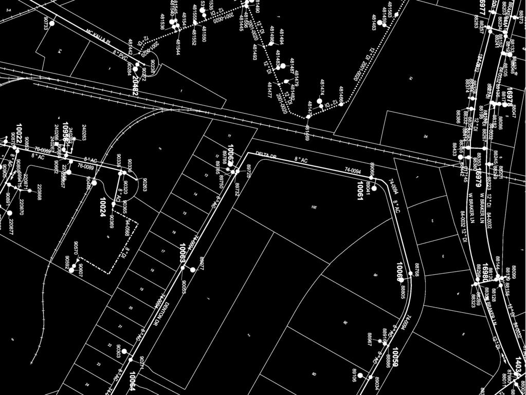
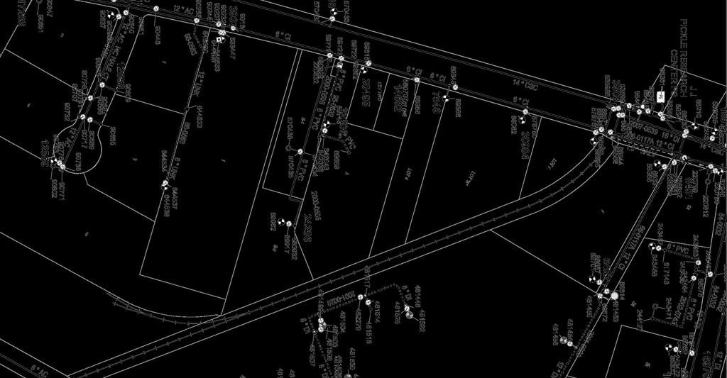
20 to maintain the stormwater run-off from the site. Once the final certificate of occupancy is received, reimbursement of the fiscal can be requested. TRANSPORTATION AND ACCESS West Braker Lane is the only existing roadway that can provide access to this site. It is classified as a 6 lane divided NBG Core Transit Corridor and there is a 330 feet driveway spacing requirement per the NBG Regulating Plan. There is currently an existing driveway located in the northwest corner of the site. Per the NBG collector plan map, there is one street along the western boundary of the site identified as required new collector streets with required ROW dedication. This north/south roadway is identified as a Pedestrian Priority Collector with encouraged parallel parking (35 mph or less). The subject property is adjacent to the CapMetro rail line and near the Kramer Station. Kramer Station is just north of the subject property near the intersection of Kramer Lane and Brockton Drive. The CapMetro rail line runs from downtown Austin north to Leander with a total of nine (9) transit stops. Local bus routes also serve the station. TRAFFIC IMPACT ANALYSIS A Traffic Impact Analysis (TIA) is determined on the basis of the existing and proposed traffic volumes estimated to be generated by a proposed development. A TIA is required for any development, which produces an increase of more than 2,000 trips per day. On average, multi-family developments of 311 units or more and retail developments of 14,900 sq. ft. or more, require a TIA. A TIA will likely be required, and it must be submitted to the City of Austin for review and approval with the site development permit. BUILDING PERMIT This site is located within the City of Austin full purpose limits and must comply with the City of Austin building code requirements. Therefore, a building permit will be required for this site. The building permit application must be accompanied by the required pre-requisite reviews for the Health Department, Fire Department, and Industrial Waste. In addition, energy and lighting budget calculations must be submitted for review in accordance with those set by the code review sections. WATER AND WASTEWATER SERVICE The City of Austin is the water and wastewater service provider for this site. Based on current City of Austin water and wastewater maps, both water and wastewater services are adjacent to the site. Service level and capacity must be verified based on the proposed user. 17
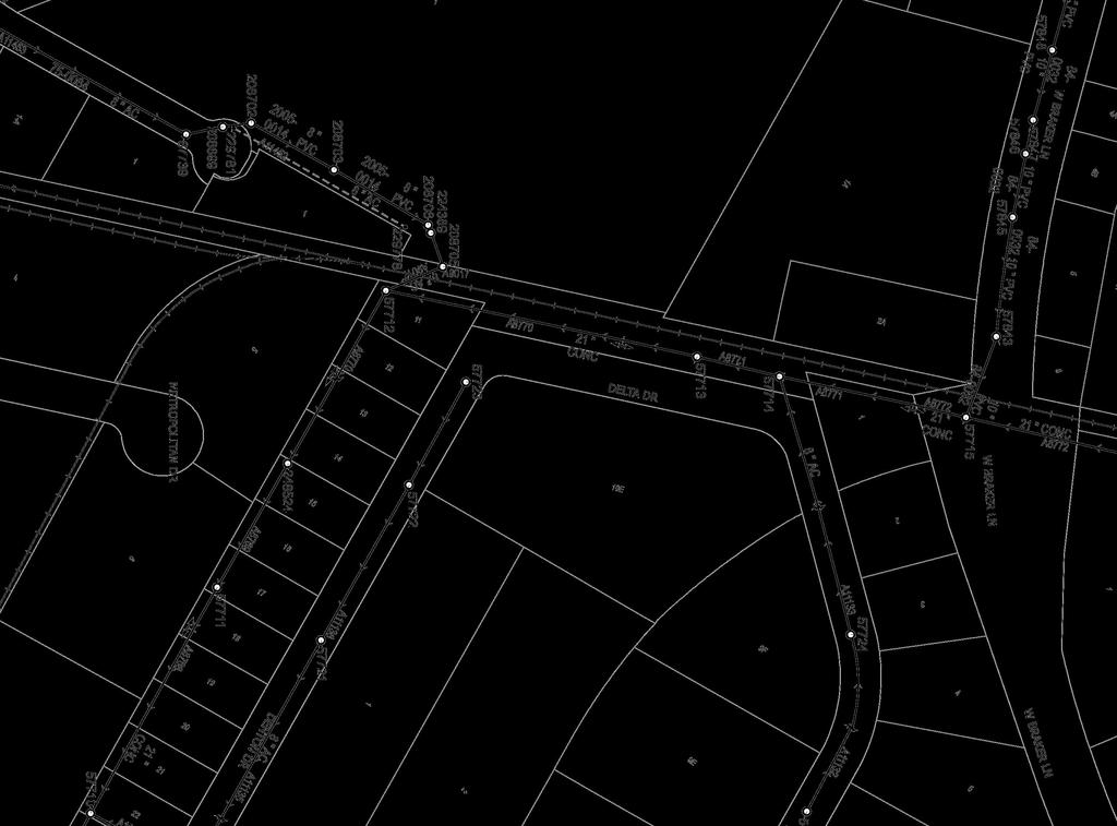
21 There is a 12 inch Ductile Iron (DI) water distribution line that traverses West Braker Lane located on the northern boundary of the site. Along the southern boundary of the site, there is a proposed 12 inch DI water distribution that could potentially provide service to the site. There is a 10 inch PVC wastewater collection line that traverses Braker Lane located on the northern boundary line of the site. This wastewater line could provide service to the site. Service Extension Requests (SER) may be required for water and wastewater to determine if improvements, extensions or upgrades may be necessary. Peak domestic flows and fire requirements should be analyzed and discussed early in the development process. ELECTRIC EASEMENTS There appears to be an overhead electric transmission line running north to south along the eastern property boundary of this parcel. Per the subdivision plat, there is a 25-foot Electric Easement that lies adjacent to the southeastern property line along the Longhorn Railroad Track and a 25 foot Public Utility Easement that traverses the northern boundary line along Braker Lane. A copy of the subdivision plat for this site has been attached for reference. LCRA regulations and City of Austin regulations will apply to development under and offset of the electric easements. Per LCRA s Electric Transmission Easement and ROW Use Guide, the following obstructions should not be constructed within an LCRA electric easement: Permanent structures Combustible materials Ponds, channels, septic systems Spoils and storage of cut/fill materials Certain grading, earth-retaining systems, excavations Certain plantings (full mature height may not exceed ten (10) feet Roadways and parking may be negotiable on a case-by-case basis. If you are considering constructing within an LCRA easement, we recommend contacting LCRA early in the development process. Also, LCRA requires review of plans which typically takes four (4) to six (6) weeks. Written responses are provided for each project. We understand Austin Energy s requirements to be similar to LCRA. It will be necessary to coordinate directly with Austin Energy on any proposed development within their electric easements. 18
22 UTILITIES Electrical Service This site is located within the Austin Energy service zone. Coordination between the Developer and Austin Energy will be required to verify service and load requirement and any improvement necessary to provide new service. Also note there are existing overhead utility lines currently on the site. Telephone Service AT&T is the phone service provider for this area. The cost to extend telephone service to this site is the Developer s responsibility. The cost of any improvements will be based upon the project needs and the information provided. Gas Service Texas Gas Service is the service provider for the area. Coordination between the Developer and Texas Gas will be required in order to provide new service due to any new development on the site. The cost of any improvements will be based upon the project needs and the information provided. Cable Service Time Warner Cable is the service provider for cable television, high-speed internet and residential telephone services to this property. The cost to extend cable service to this site is the Developer s responsibility. The cost of any improvement will be based upon the project needs and the information provided. CONCLUSION Obtain a current title policy and perform a title survey of the property to identify title issues as well as existing easements or other restrictions on the property. The subject property is located in the City of Austin s full purpose jurisdiction and is zoned NBG-NP and within the TOD sub-district. Since the site is zoned NBG, development must comply with the North Burnet Gateway Regulating Plan and associated zoning district requirements. The regulating plan outlines site development regulations, permitted land uses, design standards, height, lighting, signage, landscape, etc. requirements for properties zoned NBG. A detailed review of the Plan is recommended. It will be necessary to amend the zoning in order to allow for single-story retail. The zoning process takes approximately four (4) to six (6) months. However, it 19
23 should not be necessary to amend the zoning in order to develop multi-family on the parcel. The site is currently platted as Lot 1A, Block A at Braker at Burnet Section 3 Resubdivision Per the NBG regulating plan, a project circulation plan will be required prior to approval of a subdivision plat or a site development permit. Per the regulating plan, impervious cover is determined the by North Burnet/Gateway zoning district requirements. Therefore development will be limited to 80 percent impervious cover. A TIA may be required depending upon development plans for the property. If development will trigger more than 2,000 trips per day, it will be necessary to prepare and submit a TIA. The subject property lies within close proximity of the CapMetro Rail Kramer Station. The new proposed collector street should be coordinated and discussed early in the development process. Driveway and access requirements should be coordinated with the City of Austin. A geotechnical assessment is recommended and will help determine if any site specific measures will be necessary with respect to design foundations, roadway subgrade, parking areas, etc. A geotechnical report will be required for all construction plan submittals. Completion of a Phase I environmental assessment is also recommended. No portion of the site is located within the 100 year floodplain as defined by FEMA maps. The property lies in the Edwards Aquifer Transition Zone. Therefore, it will be necessary to submit a SWPPP and meet TCEQ water quality control standards. On-site water quality ponds will be required to provide for pollutant removal as required by TCEQ standards and City of Austin for treatment of stormwater run-off generated by the proposed development. Water and wastewater service will be provided by the City of Austin. It may be necessary to submit SERs in order to extend service to the property. This should be analyzed in detail once development plans are known. Coordinate with LCRA and Austin Energy on overhead electric lines and easements. Any proposed development within the easements must be approved by the appropriate entity. Coordinate with the various utility providers to verify if they have the ability and infrastructure to serve the proposed development. It appears that service can be made available to the site but more detailed information about the density and actual use of the proposed development will be needed to determine if adequate capacity is available from the existing utilities, or if additional improvements are needed. 20


24
25

26
27
28
29
30
31

32
Composition of traditional residential corridors.
 Page 1 of 7 St. Petersburg, Florida, Code of Ordinances >> PART II - ST. PETERSBURG CITY CODE >> Chapter 16 - LAND DEVELOPMENT REGULATIONS >> SECTION 16.20.060. CORRIDOR RESIDENTIAL TRADITIONAL DISTRICTS
Cover Letter with Narrative Statement
 Cover Letter with Narrative Statement March 31, 2017 rev July 27, 2017 RE: Rushton Pointe Residential Planned Unit Development Application for Public Hearing for RPUD Rezone PL2015 000 0306 Mr. Eric Johnson,
REGULATING PLAN for the Plaza Saltillo TOD Station Area Plan (SAP)
") REGULATING PLAN for the Plaza Saltillo TOD Station Area Plan (SAP) Adopted: December 11, 2008 Effective: March 1, 2009 REGULATING PLAN for the Plaza Saltillo TOD Station Area Plan (SAP) CONTENTS BACKGROUND...iv
REGULATING PLAN for the Plaza Saltillo TOD Station Area Plan (SAP) Adopted: December 11, 2008 Effective: March 1, 2009 REGULATING PLAN for the Plaza Saltillo TOD Station Area Plan (SAP) CONTENTS BACKGROUND...iv
The Philadelphia Code. In order to be eligible for any floor area bonuses pursuant to this section:
 1 of 16 2/17/2015 2:47 PM The Philadelphia Code 14-702. Floor Area and Height Bonuses. 225.1 (1) Purpose. The intent of the floor area bonus provisions is to encourage certain types of development and
Residential Major Subdivision Review Checklist
 Residential Major Subdivision Review Checklist Plan Submittal Requirements: 2 full sets of stamped plans Electric submittal - all plans contained in a single PDF 3 full sets if commercial kitchen or dining
REPORT TO THE SHELBY COUNTY PLANNING COMMISSION From the Department of Development Services Planning Services. February 4, 2019
 REPORT TO THE SHELBY COUNTY PLANNING COMMISSION From the Department of Development Services Planning Services February 4, 2019 Case No. Request for Rezoning Approval From E-1 to E-2 SD This is a request
3. IMPACT, SITE DEVELOPMENT PERMIT, BUIDLING PERMIT AND OTHER FEES
 Art at Bratton s Edge Page 2 of 13 TABLE OF CONTENTS A. EXECUTIVE SUMMARY 1. PROJECT OVERVIEW 2. DUE DILIGENCE STATEMENT B. SITE SUMMARY ITEMS 1. ZONING REQUIREMENTS 2. SUBDIVISION REQUIREMENTS 3. DEVELOPMENT
PLANNED DEVELOPMENT DISTRICT STANDARDS. Cadence Site
 PLANNED DEVELOPMENT DISTRICT STANDARDS Cadence Site A Planned Development District 1. Statement of General Facts, Conditions and Objectives Property Size: Approximately 57.51 Acres York County Tax Map
The Philadelphia Code. Table : Commercial and Commercial Mixed-Use Districts {For a printable PDF version, click HERE}
 1 of 19 2/17/2015 2:48 PM The Philadelphia Code 14-402. Commercial and Commercial Mixed-Use Districts. (1) General. (a) Districts. (.1) List. The City s Commercial and Commercial Mixed-Use zoning districts
Chapter 100 Planned Unit Development in Corvallis Urban Fringe
 100.100 Scope and Purpose. Chapter 100 Planned Unit Development in Corvallis Urban Fringe (1) All applications for land divisions in the Urban Residential (UR) and Flood Plain Agriculture (FPA) zones within
SITE DEVELOPMENT PLAN REQUIREMENTS CHECKLIST
 SITE DEVELOPMENT PLAN REQUIREMENTS CHECKLIST Completed DRC Application for Review Required for Application Process DRC Processing Fee 1 Commercial $2,500.00 Fire Department Review Fee 150.00 Total $2,650.00
ARTICLE 887. PD 887. Valley View - Galleria Area Special Purpose District
 ARTICLE 887. PD 887. Valley View - Galleria Area Special Purpose District SEC. 51P-887.101. LEGISLATIVE HISTORY. PD 887 was established by Ordinance No. 29032, passed by the Dallas City Council on June
Enclosed are amended PUD documents for The Grove at Shoal Creek Proposed by
 Enclosed are amended PUD documents for The Grove at Shoal Creek Proposed by The Bull Creek Road Coalition (BCRC) was formed in 2012 and is made up of residents in the six neighborhoods surrounding the
CITY OF OCOEE LAND DEVELOPMENT CODE SUFFICIENCY TABLE WITH NOTES
 CITY OF OCOEE LAND DEVELOPMENT CODE SUFFICIENCY TABLE WITH NOTES The Sufficiency Table is a checklist to help identify the types of information and documentation needed for various types of projects. The
Rezoning Petition Pre-Hearing Staff Analysis April 17, 2017
 Rezoning Petition 2017-041 Pre-Hearing Staff Analysis April 17, 2017 REQUEST Current Zoning: R-5 (single family residential), R-22MF (multifamily residential), and I-1 (light industrial) Proposed Zoning:
Residential Minor Subdivision Review Checklist
 Residential Minor Subdivision Review Checklist Plan Submittal Requirements: 2 full sets of stamped plans Electric submittal - all plans contained in a single PDF 3 full sets if commercial kitchen or dining
. \. structure. portion of a. yard setback. in height. for that. above 45 ft. structure above. 20-ft. front. 2, additional.
 Z089-254(RB) E-1 REGULATIONS Front Yard YARD, LOT, AND SPACE 00. \.,, Max.-6Oft. Mm. 15 ft. maximum front yard right-of-ways other way is dedicated existing Ft. Worth ft. from Ft. Worth Ave. or rights
BOROUGH OF HOPATCONG ORDINANCE No
 BOROUGH OF HOPATCONG ORDINANCE No. 10-2014 AN ORDINANCE OF THE BOROUGH OF HOPATCONG, SUSSEX COUNTY, NEW JERSEY TO ADOPT A FORM BASED CODE AS AN OVERLAY DISTRICT AFFECTING PORTIONS OF THE B-1 AND R-1 ZONING
DEVELOPMENT DEPARTMENT STAFF REPORT STAFF REPORT EASTSIDE CHAMBLEE LINK DCI
 DEVELOPMENT DEPARTMENT STAFF REPORT Public Hearing Date: April 12, 2018 Item #: PZ-2018-248 STAFF REPORT EASTSIDE CHAMBLEE LINK DCI Request: Development of Community Compact (DCI), ten concurrent variances,
Part 4.0 DEVELOPMENT REGULATIONS
 M A I N S T R E E T N O R T H Part 4.0 DEVELOPMENT REGULATIONS 4.1 Districts 4.2 Permitted and Prohibited Uses, Standards and Standard Specific Criteria and Other General Provisions 4.3 DPS REGULATIONS
Appendix J - Planned Unit Development (PUD)
") Appendix J - Planned Unit Development (PUD) Intent and Purpose The purpose of the PUD is: 1. To provide development that is consistent with the Comprehensive Land Use Plan and promote the goals and objectives
Appendix J - Planned Unit Development (PUD) Intent and Purpose The purpose of the PUD is: 1. To provide development that is consistent with the Comprehensive Land Use Plan and promote the goals and objectives
DRAFT -- PROPOSED EXPANSION AND REVISIONS TO DIVISION 24. SPECIAL DISTRICT--COLLEGE AND UNIVERSITY NEIGHBORHOODS DISTRICT
 DRAFT -- PROPOSED EXPANSION AND REVISIONS TO DIVISION 24. SPECIAL DISTRICT--COLLEGE AND UNIVERSITY NEIGHBORHOODS DISTRICT Sec. 28-831. Purpose. The college and university neighborhoods district purposes
PERMITTED USES: Within the MX-1 Mixed Use Neighborhood District the following uses are permitted:
 6.25 MX-1 - MIXED USE NEIGHBORHOOD 6.25.1 INTENT: The purpose of the MX-1 Mixed Use Neighborhood District is to accommodate the development of a wide-range of residential and compatible non-residential
Division Development Impact Review.
 Division 51-4.800. Development Impact Review. SEC. 51-4.801. PURPOSE. The general objectives of this division are to promote and protect the health, safety, and general welfare of the public through the
DEVELOPMENT DEPARTMENT STAFF REPORT THE PARK AT 5 TH
 DEVELOPMENT DEPARTMENT STAFF REPORT ARB Meeting Date: July 3, 2018 Item #: _PZ2018-293_ THE PARK AT 5 TH Request: Site Address: Project Name: Parcel Number: Applicant: Proposed Development: Current Zoning:
PLANNED UNIT DEVELOPMENTS (Ordinance No.: 3036, 12/3/07; Repealed & Replaced by Ordinance No.: 4166, 10/15/12)
") 159.62 PLANNED UNIT DEVELOPMENTS (Ordinance No.: 3036, 12/3/07; Repealed & Replaced by Ordinance No.: 4166, 10/15/12) A. PURPOSE 1. General. The Planned Unit Development (PUD) approach provides the flexibility
159.62 PLANNED UNIT DEVELOPMENTS (Ordinance No.: 3036, 12/3/07; Repealed & Replaced by Ordinance No.: 4166, 10/15/12) A. PURPOSE 1. General. The Planned Unit Development (PUD) approach provides the flexibility
ZONING AMENDMENT & SUBDIVISION STAFF REPORT Date: November 3, 2016
 ZONING AMENDMENT & SUBDIVISION STAFF REPORT Date: November 3, 2016 APPLICANT NAME SUBDIVISION NAME David Shumer 5955 Airport Subdivision CITY COUNCIL DISTRICT District 6 5955 Airport Boulevard, 754 Linlen
the conditions contained in their respective Orders until January 1, 2025, at the discretion of the Director of Planning, Property and Development.
 Part 4: Use Regulations Temporary Uses and Structures Purpose the conditions contained in their respective Orders until January 1, 2025, at the discretion of the Director of Planning, Property and Development.
PD No. 15 Authorized Hearing
 PD No. 15 Authorized Hearing Community Meeting No. 2 February 19, 2019 6:30 p.m. Hyer Elementary School Cafetorium 8385 Durham St Andrew Ruegg Senior Planner PD No. 15 Authorized Hearing On September 7,
DAUPHIN CREEK ESTATES SUBDIVISION
 # 12 SUB-000076-2017 DAUPHIN CREEK ESTATES SUBDIVISION Engineering Comments: FINAL PLAT COMMENTS (should be addressed prior to submitting the FINAL PLAT for review and/or signature by the City Engineer):
PLANNED UNIT DEVELOPMENT & SUBDIVISION STAFF REPORT Date: April 18, 2019
 PLANNED UNIT DEVELOPMENT & SUBDIVISION STAFF REPORT Date: April 18, 2019 DEVELOPMENT NAME SUBDIVISION NAME Springhill Village Subdivision Springhill Village Subdivision LOCATION 4350, 4354, 4356, 4358,
PLANNING COMMISSION REPORT Regular Agenda -Public Hearing Item
 PDP-13-00518 Item No. 3B- 1 PLANNING COMMISSION REPORT Regular Agenda -Public Hearing Item PC Staff Report 2/24/14 ITEM NO. 3B PRELIMINARY DEVELOPMENT PLAN FOR HERE @ KANSAS; 1101 INDIANA ST (SLD) PDP-13-00518:
4 DEVELOPMENT STANDARDS FOR
 4 DEVELOPMENT STANDARDS FOR RESIDENTIAL MIXED-USE PROJECTS This chapter presents standards for residential mixed-use projects in the Ashland-Cherryland Business District and the Castro Valley Central Business
SPECIAL ZONING DISTRICTS
 SPECIAL ZONING DISTRICTS 5.01 5.99 RESERVED 5.100 PLANNED DEVELOPMENTS: Purpose: This district is intended to accommodate unified design of residential, commercial, office, professional services, retail
Section 4 Master Plan Framework
 Section 4 Master Plan Framework 4.1 PURPOSE The Master Plan, as an implementation tool of the SPC District, establishes the primary framework for the overall development of the Property. Detailed site
Condominium Unit Requirements.
 ARTICLE 19 CONDOMINIUM REGULATIONS Section 19.01 Purpose. The purpose of this Article is to regulate projects that divide real property under a contractual arrangement known as a condominium. New and conversion
CITY PLAN COMMISSION STAFF REPORT
 CITY PLAN COMMISSION STAFF REPORT SUBJECT: Request for a Change of Zoning and Preliminary Development Plan FROM: Mara Perry, Director of Planning & Development MEETING DATE: November 6, 2017 PETITION:
ARTICLE 23 CONDOMINIUM STANDARDS
 ARTICLE 23 CONDOMINIUM STANDARDS Section 23.01 Intent. The intent of this Article is to provide regulatory standards for condominiums and site condominiums similar to those required for projects developed
2.35 BVT G Bow Valley Trail General Commercial District [ ]
![2.35 BVT G Bow Valley Trail General Commercial District [ ]](/thumbs/94/119006025.jpg "2.35 BVT G Bow Valley Trail General Commercial District [ ]") 2.35 BVT G Bow Valley Trail General Commercial District [2014 07] 2.35.1 Purpose This district is intended to form the core of Canmore s visitor accommodation outside the resorts and provide a variety
2.35 BVT G Bow Valley Trail General Commercial District [2014 07] 2.35.1 Purpose This district is intended to form the core of Canmore s visitor accommodation outside the resorts and provide a variety
The following regulations shall apply in the R-E District:
 "R-E" RESIDENTIAL ESTATE DISTRICT (8/06) The following regulations shall apply in the R-E District: 1. Uses Permitted: The following uses are permitted. A Zoning Certificate may be required as provided
SUBJECT: Application for Planned Unit Development and Rezoning 1725 Winnetka Road
 TO: FROM: CHAIRMAN BILL VASELOPULOS AND MEMBERS OF THE PLAN & ZONING COMMISSION STEVE GUTIERREZ DIRECTOR OF COMMUNITY DEVELOPMENT MEETING DATE: September 5, 2017 SUBJECT: Application for Planned Unit Development
PD No. 15 Authorized Hearing Steering Committee Meeting #11
 PD No. 15 Authorized Hearing Steering Committee Meeting #11 January 7, 2019 Andrew Ruegg, Senior Planner Sustainable Development and Construction City of Dallas Staff Recommendation Steering committee
Chapter SPECIAL USE ZONING DISTRICTS
 Chapter 20.20 Sections: 20.20.010 Urban Transition (U-T) Zoning District 20.20.020 Planned Development (P-D) Zoning Districts 20.20.010 Urban Transition (U-T) Zoning District A. Purpose. The purpose of
CD-1 (264) 101 Terminal Avenue By-law No (Being a By-law to Amend By-law 3575, being the Zoning and Development By-law)
 101 Terminal Avenue By-law No (Being a By-law to Amend By-law 3575, being the Zoning and Development By-law)") Zoning and Development By-law Community Services, 453 W. 12th Ave Vancouver, BC V5Y 1V4 604.873.7344 fax 873.7060 planning@city.vancouver.bc.ca CD-1 (264) 101 Terminal Avenue By-law No. 6744 (Being a By-law
Zoning and Development By-law Community Services, 453 W. 12th Ave Vancouver, BC V5Y 1V4 604.873.7344 fax 873.7060 planning@city.vancouver.bc.ca CD-1 (264) 101 Terminal Avenue By-law No. 6744 (Being a By-law
FINAL DRAFT 10/23/06 ARTICLE VI
 FINAL DRAFT 10/23/06 ARTICLE VI 185-41.1. Planned Residential Development A. Purpose and Intent. The purposes of the Planned Residential Development (PRD) bylaw are to maintain the rural character of Dover,
ARTICLE IV: DEVELOPMENT STANDARDS
 ARTICLE IV: DEVELOPMENT STANDARDS IV-53 409 PRIVATE STREETS A private street means any way that provides ingress to, or egress from, property by means of vehicles or other means, or that provides travel
ARTICLE 12 PLANNED UNIT DEVELOPMENT DISTRICTS (PUDS) Sec Intent CHARTER TOWNSHIP OF BRIGHTON ZONING ORDINANCE
 Sec Intent CHARTER TOWNSHIP OF BRIGHTON ZONING ORDINANCE") ARTICLE 12 PLANNED UNIT DEVELOPMENT DISTRICTS (PUDS) Sec. 12-01 Intent 1 2 (a) The intent of this Article is to permit the coordinated development on larger sites, protect significant natural features
ARTICLE 12 PLANNED UNIT DEVELOPMENT DISTRICTS (PUDS) Sec. 12-01 Intent 1 2 (a) The intent of this Article is to permit the coordinated development on larger sites, protect significant natural features
DRAFT FOR DISCUSSION PURPOSES ONLY. Port Credit Local Area Plan Built Form Guidelines and Standards DRAFT For Discussion Purposes
 Port Credit Local Area Plan Built Form Guidelines and Standards DRAFT For Discussion Purposes 1 Local Area Plan - Project Alignment Overview Directions Report, October 2008 (General Summary Of Selected
ARTICLE FIVE FINAL DRAFT
 ARTICLE FIVE 021218 FINAL DRAFT Sec. 503.6 Open Space Preservation Option Open Space Preservation Option Open Space Preservation developments may be approved in the AR, R-1, R-2 and R-3 zoning districts,
Montreal Road District Secondary Plan [Amendment #127, October 9, 2013]
![Montreal Road District Secondary Plan [Amendment #127, October 9, 2013]](/thumbs/72/66783104.jpg "Montreal Road District Secondary Plan [Amendment #127, October 9, 2013]") [Amendment #127, October 9, 2013] 1.0 General The following policies are applicable to the Montreal Road District as set out in Schedule 1. 1.1 District Objectives The objective of this Plan is to guide
[Amendment #127, October 9, 2013] 1.0 General The following policies are applicable to the Montreal Road District as set out in Schedule 1. 1.1 District Objectives The objective of this Plan is to guide
(a) Commercial uses on Laurel Avenue, abutting the TRO District to the
 Commercial uses on Laurel Avenue, abutting the TRO District to the") 32X Zoning Code 150.36 TRANSITIONAL RESIDENTIAL OVERLAY DISTRICT. (A) Intent and purpose. (1) It is the intent of the Transitional Residential Overlay District (hereinafter referred to as the "TRO District")
32X Zoning Code 150.36 TRANSITIONAL RESIDENTIAL OVERLAY DISTRICT. (A) Intent and purpose. (1) It is the intent of the Transitional Residential Overlay District (hereinafter referred to as the "TRO District")
BROADWAY THREE NOTCH ROAD SUBDIVISION
 # 3 SUB-000803-2018 BROADWAY THREE NOTCH ROAD SUBDIVISION Engineering Comments: FINAL PLAT COMMENTS (should be addressed prior to submitting the FINAL PLAT for review and/or signature by the City Engineer):
320 Maple Mixed Use PDR Narrative Fort Collins, CO Project # 1525
 320 Maple Mixed Use PDR Narrative Fort Collins, CO Project # 1525 July 28, 2015 (a) What are you proposing/use? A 47,00 S.F., 3-story, mixed used project with 30 for-sale condo residential units and 2
International Village By-law No (Being a By-law to Amend By-law 3575, being the Zoning and Development By-law)
") Zoning and Development By-law Community Services, 453 W. 12th Ave Vancouver, BC V5Y 1V4 F 604.873.7344 fax 604.873.7060 planning@vancouver.ca CD-1 (265) International Village By-law No. 6747 (Being a By-law
Zoning and Development By-law Community Services, 453 W. 12th Ave Vancouver, BC V5Y 1V4 F 604.873.7344 fax 604.873.7060 planning@vancouver.ca CD-1 (265) International Village By-law No. 6747 (Being a By-law
Policy and Standards for Public Local Residential Streets And Private Streets
 Appendix A City of Toronto Development Infrastructure Policy & Standards Policy and Standards for Public Local Residential Streets And Private Streets November 2005 Policy and Standards For Public Local
Town of Cary, North Carolina Rezoning Staff Report 12-REZ-27 Morris Branch Town Council Public Hearing January 24, 2013
 Town of Cary, North Carolina Rezoning Staff Report 12-REZ-27 Morris Branch Town Council Public Hearing January 24, 2013 REQUEST To amend the Town of Cary Official Zoning Map to rezone approximately 9.0
Zoning Regulations of the Town of Redding Connecticut
 Zoning Regulations of the Town of Redding Connecticut Statutory zoning authority was adopted for the Town of Redding, and a Zoning Commission established as provided by law, at a Town Meeting held May
Open Space Model Ordinance
 Open Space Model Ordinance Section I. Background Open space development has numerous environmental and community benefits, including: 1) Reduces the impervious cover in a development. Impervious cover
Section 1: US 19 Overlay District
 Section 1: US 19 Overlay District Section 1.1 Intent and Purpose The purpose of the US Highway 19 Overlay District is to manage access to land development along US Highway 19 in a manner that preserves
E L M E R B O R O U G H L A N D U S E B O A R D APPLICATION COVER SHEET (to be completed for all applications and appeals)
") E L M E R B O R O U G H L A N D U S E B O A R D APPLICATION COVER SHEET (to be completed for all applications and appeals) 1. Name(s): 2. Address: 3. Telephone Number(s): 4. E-mail: 5. Owner Name(s) (if
E L M E R B O R O U G H L A N D U S E B O A R D APPLICATION COVER SHEET (to be completed for all applications and appeals) 1. Name(s): 2. Address: 3. Telephone Number(s): 4. E-mail: 5. Owner Name(s) (if
Wilson Bridge Corridor Zoning. Department of Planning & Building
 Wilson Bridge Corridor Zoning Department of Planning & Building Background: Wilson Bridge Road Corridor Study The City conducted a strategic study of one of the community s primary economic centers, the
DEVELOPMENT STANDARDS FOR RESIDENTIAL PROJECTS RESIDENTIAL BUILDING TYPES: APPROPRIATE ZONES AND DENSITIES 2-1
 2 DEVELOPMENT STANDARDS FOR RESIDENTIAL PROJECTS RESIDENTIAL BUILDING TYPES: APPROPRIATE ZONES AND DENSITIES 2-1 This Chapter presents the development standards for residential projects. Section 2.1 discusses
Chapter Planned Residential Development Overlay
 Chapter 19.29 Planned Residential Development Overlay Sections 010 Purpose 020 Scope 030 Definitions 030 Minimum Size 040 Allowable Uses 050 Minimum Development Standards 060 Density Bonus 070 Open Space
ARTICLE I ZONE BASED REGULATIONS
 ARTICLE I ZONE BASED REGULATIONS RZC 21.08 RESIDENTIAL REGULATIONS 21.08.290 Cottage Housing Developments A. Purpose. The purpose of the cottage housing requirements is to: 1. Provide a housing type that
In order to permit maximum applicability of the PUD District, PUD-1 and PUD-2 Districts are hereby created.
 ARTICLE III. PUD ned Unit Development Overlay District 205-128. Purpose. The PUD ned Unit Development Overlay District is intended to provide flexibility in the design of planned projects; to encourage
City of Reno October 30, 2012 Draft Midtown Zoning Text Amendments 1
 Section 18.08.405 Regional Center and Transit Corridor Overlay Districts (i) SVTC South Virginia Street Transit Corridor Overlay Zoning District. (1) Applicability. This Section 18.08.405(l)'s standards
CITY OF FATE, TEXAS UNIFIED DEVELOPMENT ORDINANCE. Article III Zoning Districts
 CITY OF FATE, TEXAS UNIFIED DEVELOPMENT ORDINANCE Article III Zoning Districts 3.1. General to all Zoning Districts and Zoning Map 3.1.1. Zoning Districts Established This article establishes the zoning
4. facilitate the construction of streets, utilities and public services in a more economical and efficient manner;
 PVPC MODEL BYLAW BY-RIGHT CLUSTER ZONING BYLAW Prepared by Pioneer Valley Planning Commission Revised: October 2001 1.00 Development 1.01 Development Allowed By Right Development in accordance with this
TRANSIT-ORIENTED DEVELOPMENT PLAN EXISTING CONDITIONS REPORT LAWRENCE TO BRYN MAWR MODERNIZATION
 TRANSIT-ORIENTED DEVELOPMENT PLAN EXISTING CONDITIONS REPORT LAWRENCE TO BRYN MAWR MODERNIZATION March 2018- FINAL DRAFT SITE SPECIFIC DEVELOPMENT CONCEPTS SITE SPECIFIC DEVELOPMENT CONCEPTS This report
FREQUENTLY USED PLANNING & ZONING TERMS
 City Of Mustang FREQUENTLY USED PLANNING & ZONING TERMS Abut: Having property lines, street lines, or zoning district lines in common. Accessory Structure: A structure of secondary importance or function
SECTION 16. "PUD" PLANNED UNIT DEVELOPMENT OVERLAY DISTRICT
 SECTION 6. "PUD" PLANNED UNIT DEVELOPMENT OVERLAY DISTRICT Subsection. Purpose. This district is established to achieve the coordinated integration of land parcels and large commercial and retail establishments
Staff Report for Council Public Meeting
 Agenda Item 3.3 Staff Report for Council Public Meeting Date of Meeting: September 27, 2017 Report Number: SRPRS.17.134 Department: Division: Subject: Planning and Regulatory Services Development Planning
AMENDED ZONING BY-LAW ARTICLE SENIOR LIVING COMMUNITY
 AMENDED ZONING BY-LAW ARTICLE 13.5 - SENIOR LIVING COMMUNITY ARTICLE : To see if the Town will vote to amend the Zoning Bylaw as follows: 2. By deleting existing Section 13.5, Senior Living Community,
3.1. OBJECTIVES FOR RESIDENTIAL LAND USE DESIGNATIONS GENERAL OBJECTIVES FOR ALL RESIDENTIAL DESIGNATIONS
 3. RESIDENTIAL LAND USE DESIGNATIONS INTRODUCTION The Residential land use designations provide for housing and other land uses that are integral to, and supportive of, a residential environment. Housing
AN ORDINANCE OF THE CITY OF MINNEAPOLIS. By Palmisano
 AN ORDINANCE OF THE CITY OF MINNEAPOLIS By Palmisano Amending Title 20, Chapter 520 of the Minneapolis Code of Ordinances relating to Zoning Code: Introductory Provisions. The City Council of the City
Land Use, Transportation, and Infrastructure Committee of Denver City Council FROM: Scott Robinson, Senior City Planner DATE: December 6, 2018 RE:
 Community Planning and Development Planning Services 201 W. Colfax Ave., Dept. 205 Denver, CO 80202 p: 720.865.2915 f: 720.865.3052 www.denvergov.org/cpd TO: Land Use, Transportation, and Infrastructure
ORDINANCE NO. 208 BE IT ORDAINED BY THE CITY COUNCIL OF THE CITY OF UNIVERSITY HEIGHTS, JOHNSON COUNTY, IOWA:
 ORDINANCE NO. 208 AN ORDINANCE AMENDING ORDINANCE NO. 79 (ZONING) TO CREATE A COMMERCIAL HOTEL ZONE AND PERMIT DEVELOPMENT PURSUANT TO A COMMERCIAL HOTEL PUD BE IT ORDAINED BY THE CITY COUNCIL OF THE CITY
ARTICLE 9 SPECIFICATIONS FOR DOCUMENTS TO BE SUBMITTED
 ARTICLE 9 SPECIFICATIONS FOR DOCUMENTS TO BE SUBMITTED SECTION 950 GENERALLY All applications shall be properly signed and filed by the owner or, with the owner s specific written consent, a contract purchaser
APPLICATION PROCEDURE
 ANTRIM PLANNING BOARD P. O. Box 517 Antrim, New Hampshire 03440 Phone: 603-588-6785 FAX: 603-588-2969 APPLICATION FORM AND CHECKLIST FOR MINOR OR MAJOR SITE PLAN REVIEW File Date Received By APPLICATION
4 LAND USE 4.1 OBJECTIVES
 4 LAND USE The Land Use Element of the Specific Plan establishes objectives, policies, and standards for the distribution, location and extent of land uses to be permitted in the Central Larkspur Specific
COMMERCIAL ZONING DISTRICTS (Amended 11/13/14) Part I. C-1 Restricted Commercial District
 Part I. C-1 Restricted Commercial District") ARTICLE XI. COMMERCIAL ZONING DISTRICTS (Amended 11/13/14) Part I. C-1 Restricted Commercial District Section 152: Purpose This district is designed to accommodate commercial uses which act as a transition
ARTICLE XI. COMMERCIAL ZONING DISTRICTS (Amended 11/13/14) Part I. C-1 Restricted Commercial District Section 152: Purpose This district is designed to accommodate commercial uses which act as a transition
Medical Marijuana Special Exception Use Information
 Medical Marijuana Special Exception Use Information The Special Exception Use information below is a modified version of the Unified Development Code. It clarifies the current section 5:104 Special Exceptions
WIREGRASS RANCH DRI/MPUD MASTER ROADWAY PLAN CONDITIONS OF APPROVAL PDD DRC
 WIREGRASS RANCH DRI/MPUD MASTER ROADWAY PLAN CONDITIONS OF APPROVAL DRC 1. This Master Roadway Plan (the MRP) replaces and supersedes the Roadway Alignment and Construction Phasing Plan (File No. GM06-737)
MOTEL STRIP LOCATION 1. VIEW CORRIDORS/RESIDENTIAL STREETS URBAN DESIGN GUIDELINES
 Development in the former Motel Strip (Humber Bay Shores Area) will be consistent with the following urban design guidelines. The guidelines correspond to the Motel Strip Secondary Plan #11, found in Chapter
Conditional Use Permit case no. CU 14-06: Bristol Village Partners, LLC
 PLANNING AND ZONING COMMISSION STAFF REPORT August 7, 2014 Conditional Use Permit case no. CU 14-06: Bristol Village Partners, LLC CASE DESCRIPTION: LOCATION: LEGAL DESCRIPTION: EXISTING LAND USE: ZONING:
8.5.1 R1, Single Detached Residential District
 8.5.1 R1, Single Detached Residential District The purpose of this district is to provide for residential development in the form of single detached dwellings. Dwelling, Single Detached Home Business,
5. That the Owner shall agree that all development Blocks shown within the Draft Plan will be connected to full municipal services.
 Conditions Relating to Draft Plan of Subdivision Approval East Fonthill 26T 01014 (Draft Plan dated December 1, 2013, and revised August 28, 2014), the Town of Pelham 1. This approval applies to the Draft
Proposed Development at Ajax Plaza Windcorp Grand Harwood Place Ltd.
 Proposed Development at Ajax Plaza Windcorp Grand Harwood Place Ltd. Presentation to Ajax Council July 4, 2013 Introduction 1. Background 2. Planning Policies and Regulations 3. Downtown Community Improvement
City of Colleyville City Council Agenda Briefing
 City of Colleyville City Council Agenda Briefing City Hall 100 Main Street Colleyville, Texas 76034 www.colleyville.com Agenda Number 5a Agenda Date 01/06/2015 Number Ordinance O-14-1942 Type Ordinance
Appendix1,Page1. Urban Design Guidelines. Back to Back and Stacked Townhouses. DRAFT September 2017
 Appendix1,Page1 Urban Design Guidelines DRAFT September 2017 Back to Back and Stacked Townhouses Appendix1,Page2 Table of Contents 1 Introduction 1 1.1 Purpose 1 1.2 Urban Design Objectives 1 1.3 Building
Special Use Infill Options and Design Tools Available Through the Neighborhood Plan Combining District (NPCD) May 2012
 May 2012") Special Use Infill Options and Design Tools Available Through the Neighborhood Plan Combining District (NPCD) May 2012 Neighborhood Mixed-Use Building Corner Store Neighborhood Urban Center Residential
Special Use Infill Options and Design Tools Available Through the Neighborhood Plan Combining District (NPCD) May 2012 Neighborhood Mixed-Use Building Corner Store Neighborhood Urban Center Residential
Article 7: Residential Land Use and Development Requirements
 Article 7: Residential Land Use and Section 701: Statement of Intent (A) (B) (C) The intent of Article 7 is to develop certain land use and development requirements for the residential uses within Cumru
Cluster Development Princeton Township, Mercer County
 Cluster Development Princeton Township, Mercer County Division 9 Residential Clusters Section 10B-189 Statement of purposes. The township committee to implement the goals and objectives of the Princeton
Town of Cary, North Carolina Rezoning Staff Report 14-REZ-31 Cary Park PDD Amendment (Waterford II) Town Council Meeting January 15, 2015
 Town Council Meeting January 15, 2015") Town of Cary, North Carolina Rezoning Staff Report 14-REZ-31 Cary Park PDD Amendment (Waterford II) Town Council Meeting January 15, 2015 REQUEST To amend the Town of Cary Official Zoning Map by amending
Town of Cary, North Carolina Rezoning Staff Report 14-REZ-31 Cary Park PDD Amendment (Waterford II) Town Council Meeting January 15, 2015 REQUEST To amend the Town of Cary Official Zoning Map by amending
MONTGOMERY COUNTY PLANNING DEPARTMENT THE MARYLAND-NATIONAL CAPITAL PARK AND PLANNING COMMISSION
 MONTGOMERY COUNTY PLANNING DEPARTMENT THE MARYLAND-NATIONAL CAPITAL PARK AND PLANNING COMMISSION MCPB Item No.: Date: 06-21-12 The Plantations, Preliminary Plan -120090240 Benjamin Berbert, Senior Planner,
Section 7.22: Multifamily Assisted Housing in AA-30 Residential Zone (MAHZ) [Note: an additional line will be added to the Table in Article 3, 3.1.
 [Note: an additional line will be added to the Table in Article 3, 3.1.") Section 7.22: Multifamily Assisted Housing in AA-30 Residential Zone (MAHZ) [Note: an additional line will be added to the Table in Article 3, 3.1.1A] 7.22.1 Purpose The purpose of this Special Regulation
Section 7.22: Multifamily Assisted Housing in AA-30 Residential Zone (MAHZ) [Note: an additional line will be added to the Table in Article 3, 3.1.1A] 7.22.1 Purpose The purpose of this Special Regulation
ARTICLE 7 UTILITIES AND EASEMENTS
 7.1 PLACEMENT OF UTILITIES ARTICLE 7 UTILITIES AND EASEMENTS 7.1.1 All authorized public underground utilities shall be located within the right-of-way of a public street or within an easement designated
UPPER MOUNT BETHEL TOWNSHIP NORTHAMPTON COUNTY, PENNSYLVANIA
 UPPER MOUNT BETHEL TOWNSHIP NORTHAMPTON COUNTY, PENNSYLVANIA JOINDER DEED / LOT CONSOLIDATION TOWNSHIP REVIEW PROCESS When accepting proposed Joinder Deeds / Lot Consolidations, review the Joinder Deed
Cobb County Community Development Agency Zoning Division 1150 Powder Springs St. Marietta, Georgia 30064
 Cobb County Community Development Agency Zoning Division 1150 Powder Springs St. Marietta, Georgia 30064 Case # Z-63 Public Hearing Dates: PC: 11-06-18 BOC: 11-20-18 SITE BACKGROUND Applicant: Loyd Development
Final Plats for Major Residential and Commercial Subdivisions Checklist
 Project Name: : This form is a checklist of Zoning Ordinance requirements for major residential and commercial subdivision plats to assist the applicant in their submittal. It is not intended to be a comprehensive