WEST BOUNTIFUL PLANNING COMMISSION
|
|
|
- MargaretMargaret Pope
- 5 years ago
- Views:
Transcription
1 Mayor Kenneth Romney City Engineer/ Zoning Administrator Ben White City Recorder Cathy Brightwell WEST BOUNTIFUL PLANNING COMMISSION 550 North 800 West West Bountiful, Utah Phone (801) FAX (801) Chairman Denis Hopkinson Commissioners Laura Charchenko Mike Cottle Alan Malan Corey Sweat THE WEST BOUNTIFUL PLANNING COMMISSION WILL HOLD A REGULAR MEETING AT 7:30 PM ON TUESDAY, OCTOBER 24, 2017 AT THE CITY OFFICES AGENDA AS FOLLOWS: Welcome. Prayer/Thought by Invitation 1. Accept agenda. 2. Public hearing to consider request to remove all but lot 1 of the proposed McKean subdivision from the Historic Overlay District. 3. Consider removing The Manors at McKean Meadows, 1065 N 800 West, from the Historic Overlay District. 4. Consider final plat for The Manors at McKean Meadows subdivision. 5. Consider Planned Unit Development for Kinross Estates at Porter Ln and 1100 West by Hamlet Homes. 6. Discuss request from Denise Montgomery to rezone her property on 400 North from A-1 to B-U (Agriculture-1 acre minimum to Blended Use). 7. Discuss preliminary plat for Highgate Estates and set public hearing. 8. Staff report. 9. Consider approval of minutes from October 10, 2017 meeting. 10. Adjourn Individuals needing special accommodations including auxiliary communicative aids and services during the meeting should notify Cathy Brightwell at twenty-four (24) hours before the meeting. This notice has been sent to the Clipper Publishing Company, and was posted on the State Public Notice website and the City s website on October 20, 2017 by Cathy Brightwell, City Recorder.
2 Mayor Kenneth Romney City Engineer/ Zoning Administrator Ben White City Recorder Cathy Brightwell WEST BOUNTIFUL PLANNING COMMISSION 550 North 800 West West Bountiful, Utah Phone (801) FAX (801) Chairman Denis Hopkinson Commissioners Laura Charchenko Mike Cottle Alan Malan Corey Sweat NOTICE OF PUBLIC HEARING The West Bountiful Planning Commission will hold a Public Hearing on Tuesday, October 24, 2017 at 7:30 p.m., or as soon thereafter as possible, at the City offices, 550 North 800 West. The purpose of the hearing is to receive public comment regarding a request to remove all but Lot 1 of the proposed McKean Estates subdivision from the Historic Overlay Zone, at 1065 N 800 West. A copy of the proposal may be viewed on the City website: All interested parties are invited to participate. Written comments may be submitted to the City Offices prior to the meeting. Cathy Brightwell City Recorder
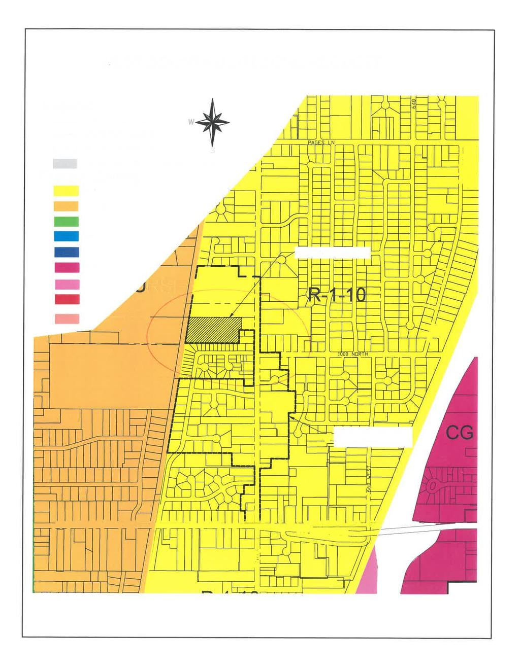
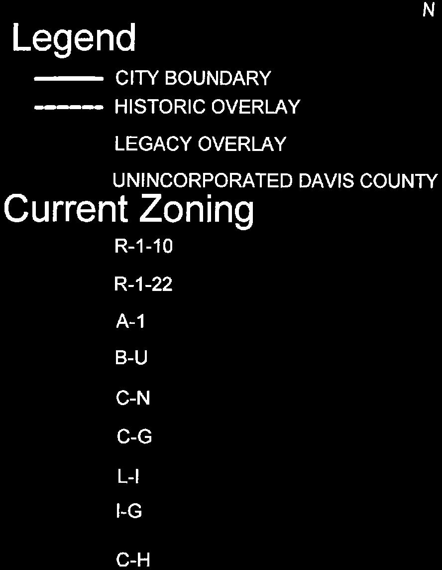
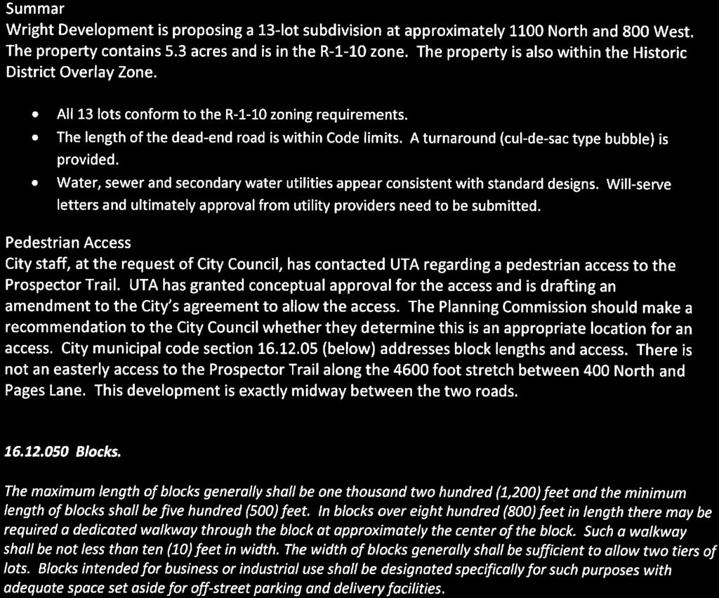
3 MEMORANDUM TO: Planning Commission DATE: October 18, 2017 FROM: Ben White RE: Rezone Request 1065 N 800 West The McKean family has entered a contract with Wright Development to purchase property on 800 West. The property is in the Historic Overlay District. The Historic Overlay District is a zoning subsection to the R-1-10 zone. Besides the standard requirements for the entire R-1-10 zone, properties within the Historic District must also comply with specific architectural requirements. Wright Development has requested that the property, except for Lot 1, be removed from the Historic District. They do recognize the City s desire to preserve the historic character of the homes that front 800 West Street and are proposing to leave Lot 1 in the District. When considering whether to grant the rezone request, the following findings should be considered. Findings why the property should remain in the Historic District: A. The city used some rational when forming the Historic District and felt it should be included. B. For the Historic District to have meaningful synergy, a minimum size is needed. Findings why the property should be removed from the Historic District: A. Removal of this property from the Historic District does not detract from the District s intended purpose. B. The property owner does not want properties that do not front on 800 West to be located in the Historic District, nor construct houses that meet the Historic District design criteria. C. The City included the specific property in the original Historic District zoning boundaries because it was part of a larger land parcel that includes frontage on 800 West. 550 North 800 West, West Bountiful, UT (801)
4

5
6
7

8

9
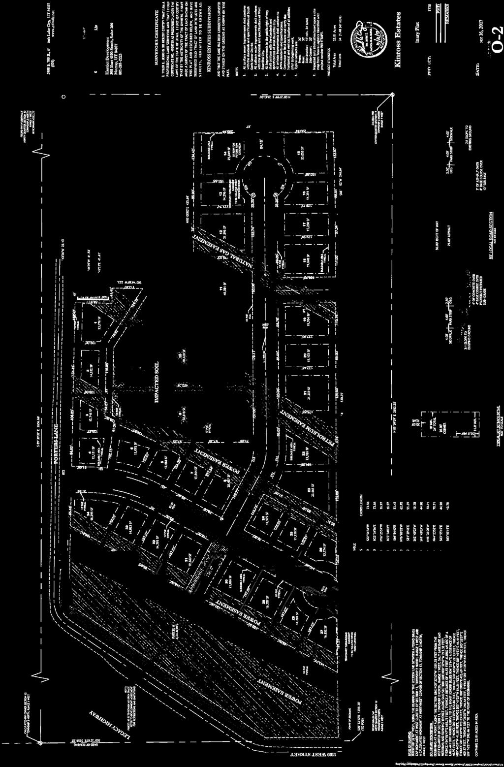
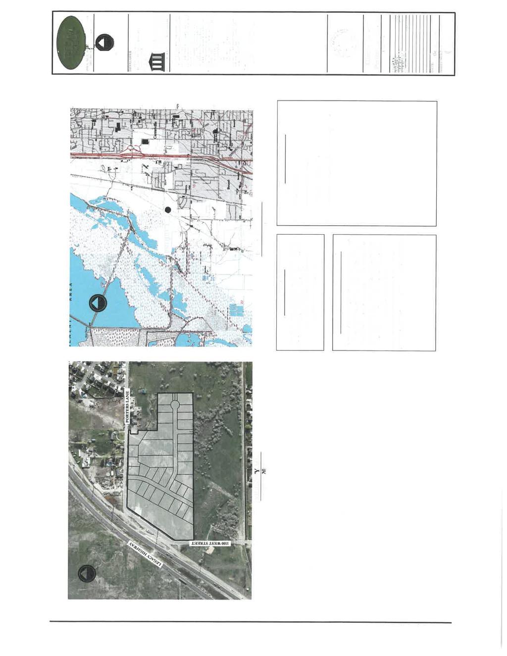
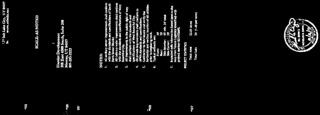
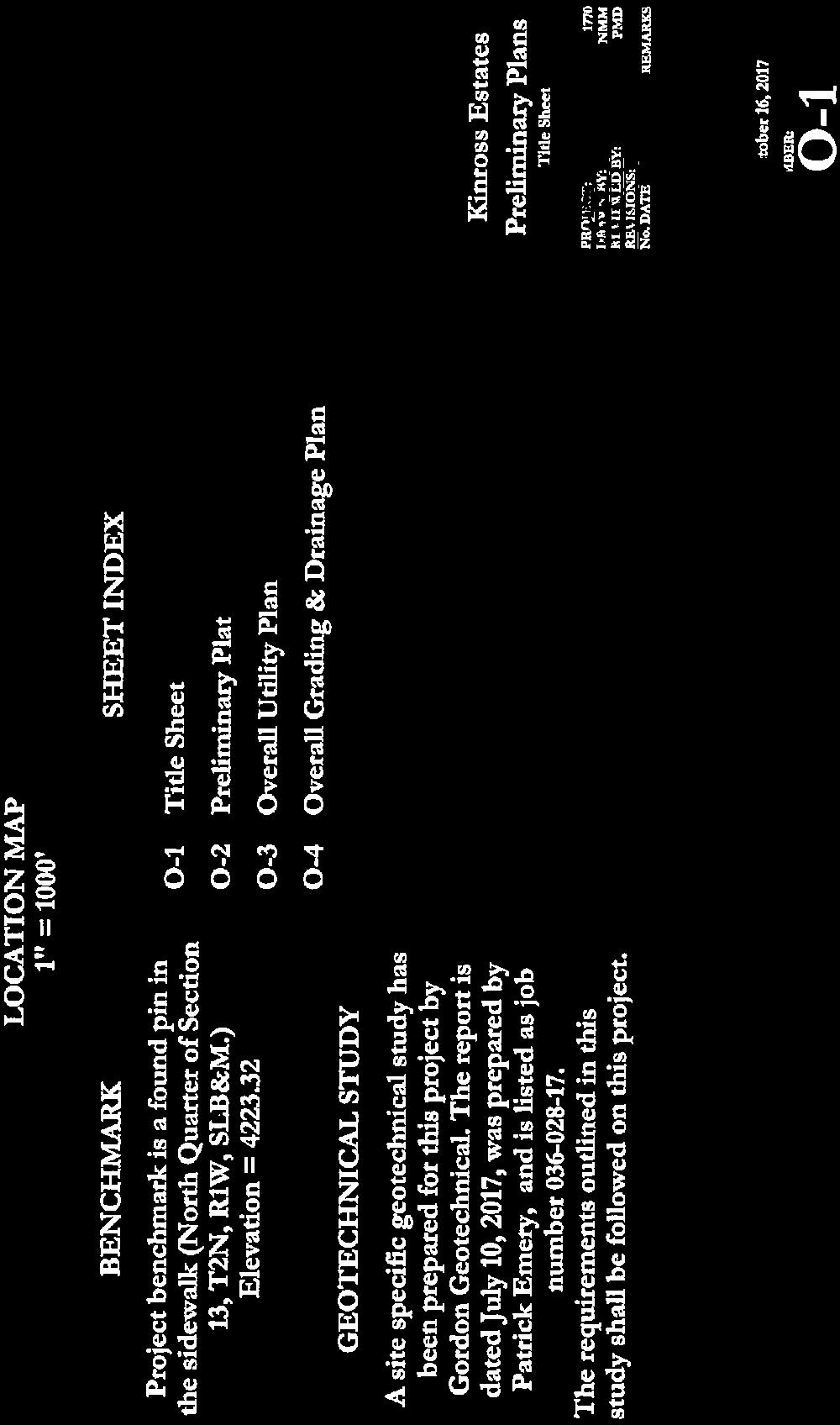
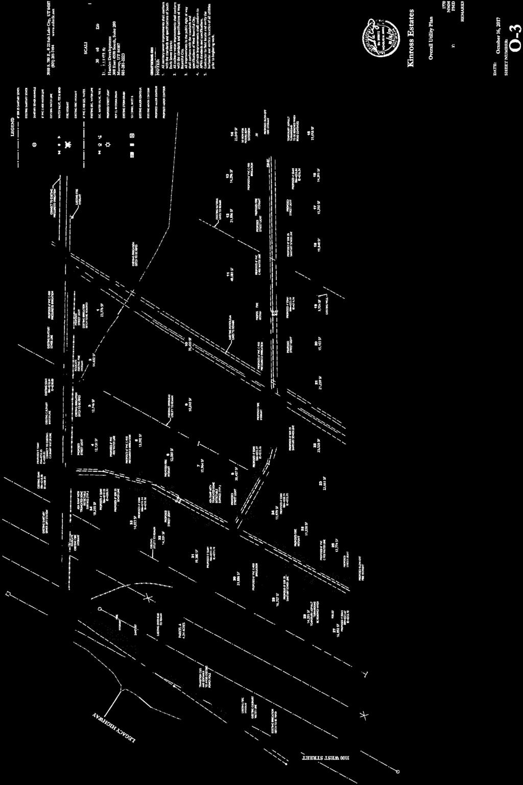
10 MEMORANDUM TO: Planning Commission DATE: October 19, 2017 FROM: Ben White, City Engineer RE: Kinross Estates PUD Application Hamlet Development has submitted a Planned Unit Development (PUD) application for a 34-lot residential subdivision on the corner of 1100 West and Porter Lane. The property is 23 acres and is in the R-1-22 zoning district. PUD applications are treated like a rezone request. A public hearing was held during the October 10 th Planning Commission meeting. Since that time, staff and the Planning Commission chair met with the developer to review the comments and concerns expressed during the Planning Commission meeting. The draft development agreement and exhibits in your packet have been updated since the last meeting. Below is a summary of the PUD requirements, items specific or unique to this project, and comments related to the information contained in the draft development agreement. PROJECT DENSITY A base density plan was previously submitted to the planning commission that contained 34 lots which could meet the zoning requirements. The PUD proposal is also for 34 lots. In short, the developer is not requesting any bonus density. DEVELOPMENT AGREEMENT Legal Counsel has reviewed the draft development agreement. His main concern yet to be resolved is that the agreement seems to be a three way agreement with the City, Developer and a Trust which will retain ownership of Lots 9-11, although it is not an issue that needs to be addressed today. Items in the development agreement that the Planning Commission should be specifically aware of include: Paragraph 6.f includes the provision for a construction and sales trailer. Paragraph 18.j includes the requirement for the developer to provide the environmental indemnification. EXHIBIT A - LEGAL DESCRIPTION As previously stated, the property consists of acres. The property descriptions on file with the County indicate that the property is over 24 acres. A survey of the property determined that it is only acres. EXHIBIT B - PRELIMINARY PLAT The plat includes the request by the Planning Commission to stub a future road south toward the easterly end of the project. 550 North 800 West, West Bountiful, UT (801)
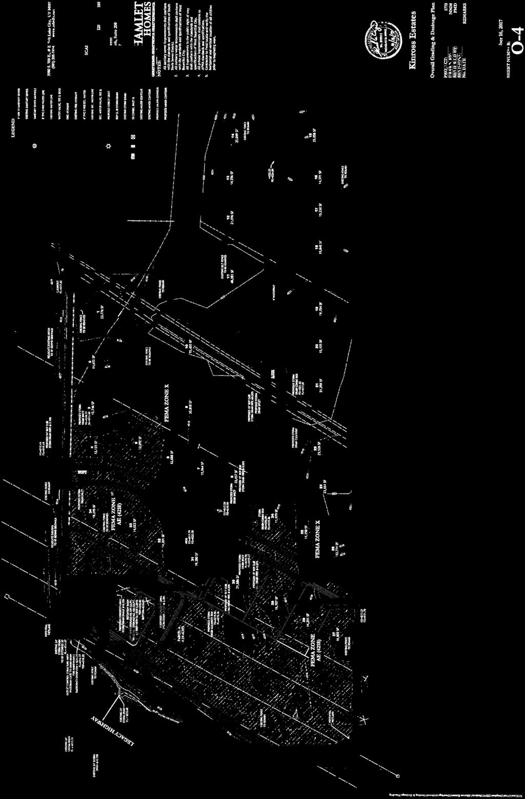
11 Lot 4 is now 12,131 square feet where it was just over 10,000 square feet in our last meeting. The developer has provided an exhibit showing what homes on lots 3-5 would look like. The widths of lots 23 and 27 can easily be adjusted to be wider lots. The street extension to 1100 West has been deleted. Without a second access, the subdivision now contains a dead-end street about 1700 feet long. The stub street to the east should be extended to the east property line even if the turnaround bubble were constructed where currently shown (or provisions for its future construction be provided). Notes related to the environmental restrictions for the impacted lots should be added to the plat. An open space easement in favor of the city should be placed over Parcel A and the rear half of Lots 9 thru 11. This is to help protect the city open space position should land use laws change in the future. The pavement cross section needs to be updated to reflect the city s minimum standard requirement. EXHIBIT C - IMPROVEMENT PLANS Curb and sidewalk is included along all of 1100 West. One of the large steel electrical towers is in the way of the curb. The curb has been modified to go around the pole. Proposed street lights, fire hydrants and other utility lines are included. Utilities need to extend all the way to the plat boundary on the dead-end streets. The east dead-end street should extend to the plat boundary or an agreement be put into place for who pays for the road extension. Public Works has not had an opportunity to review the requirement to include water in the street extending south. EXHIBIT D - CCRs Paragraph 2.4 contains requirements and limitations on the open space use and maintenance of adjoining public property. A question regarding open space and remnant parcels was raised at the last meeting. The municipal code related to these items reads as follows, Rezone Application Requirements Project considerations all PUD requests will include the following, as applicable: 1. Open spaces. Preservation, maintenance and ownership of all open spaces within the development shall be accomplished by either: a. Dedication of land to the City as a public park or parkway system; or b. Creation of a permanent, open space easement on and over private open spaces to guarantee that the open space remains perpetually as open space or as an agricultural or recreational use, as the case may be, with ownership and maintenance being the responsibility of a corporation or other association established with articles of association and bylaws or similar rules, which are satisfactory to the City. As part of the subdivision process for a PUD, the applicant shall submit a detailed improvement plan indicating the landscaping, trails, facilities, and other amenities proposed in the development. Upon approval of the amenities package by the City Council, the applicant will be required to complete all improvements in accordance with the development approval. Furthermore, if any open space area is anticipated to be dedicated to West Bountiful City, the 550 North 800 West, West Bountiful, UT (801)
12 landscaping materials, irrigation system and other improvements shall be completed in accordance with any design or improvement standards adopted by West Bountiful City Lots A. The lot arrangement, design and shape will be such that lots will provide satisfactory and desirable sites for buildings, be properly related to topography, and conform to requirements set forth herein. Lots shall not contain peculiarly shaped elongations which would be unusable for normal purposes solely to provide necessary square footage. H. All remnants of lots below minimum size left over after the subdivision of a large tract must be added to adjacent lots rather than allowed to remain as unusable parcels Paragraph 2.7 contains language allowing a model home sales office and a construction trailer. Paragraph 2.14 mirrors the city s farm animal ordinance. Paragraph 2.15 is reworded related to vehicles stored on site. Clothes line paragraph is deleted Paragraph 2.18 lots cannot be further subdivided Paragraph contains limitations on Lots 9, 10 and 11 until the Department of Environmental Quality provides a release. Paragraph naming the city as a third-party beneficiary is a requirement of legal counsel. EXHIBIT E - DRAINAGE/GRADING PLAN Rear yard drains will need to be provided Storm drain on Porter Lane needs to be piped and not an open ditch. The pipe in the front yard is acceptable rather than being in the street. The drainage path through the bottom of the detention basin is included as a concrete swale. EXHIBIT F - LANDSCAPE PLAN The development proposes park strip trees and sod in the park strip along streets with abutting lots. There are no trees proposed the 1100 West frontage with concrete in the park strip due to the adjoining land use (open space parcel). An agricultural fence is proposed around the boundary of the open space parcel and lots An additional rail fence is proposed along the subdivision street frontage for lots EXHIBIT G - ELEVATIONS Proposed house elevation designs are included in Exhibit G. These are actual designs the Developer intends to construct. A new modern design plan has been added. Additional designs beyond those provided, but of a similar architecture, are intended to be constructed as well. EXHIBIT H - GEOTECHNICAL STUDY The geotechnical study for the property has been prepared. Due to the document s size, a paper copy was not provided. Paper copies are available at city hall for review. 550 North 800 West, West Bountiful, UT (801)
13 EXHIBIT I - WETLAND STUDY A wetland delineation and Corps of Engineers Jurisdictional Determination has been completed. Due to the document s size, a paper copy was not provided. Paper copies are available at city hall for review. EXHIBIT J - WASATCH ENVIRONMENTAL REPORT Exhibit J contains two documents provided by Wasatch Environmental regarding the 1991 gasoline and diesel fuel pipeline leak. The first document contains an environmental summary using lay terms explaining remediation efforts and health risks. The second document is an environmental summary with more technical terms and data. EXHIBIT K - DRAFT INDEMNITY AGREEMENT A draft indemnity has been provided which would release the City and Developer of future claims resulting from the contamination. Also included is the overall PUD description together with the Base Density Plan. POSSIBLE MOTIONS 1. Motion to deny the PUD request. This motion should include rational for denying the request as well as the items that are favorable. The rational should be included because the PUD rezone request will still be forwarded to the City Council for their deliberation. 2. A motion to recommend approval of the PUD rezone request with any findings and conditions the Planning Commission wishes to include. Due to the size of the documents, the following documents are available at city hall for review: 1. Geotechnical Study 2. Wetland Study 3. Wasatch Environmental Report 4. Drainage Calculations 5. PUD Application 6. Preliminary Title Report 550 North 800 West, West Bountiful, UT (801)
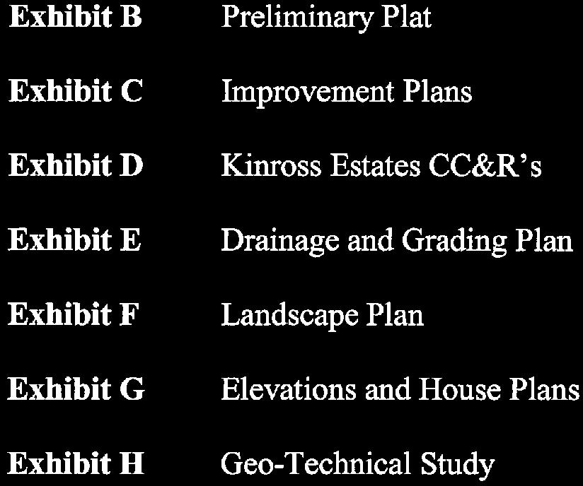
14 DEVELOPMENT AGREEMENT Kinross Estates This DEVELOPMENT AGREEMENT ( Agreement ) is made and entered into effective, 2017 (the Effective Date ), by and among KINROSS ESTATES LLC ( Developer ); THE THOMAS AND JEANETTE WILLIAMS FAMILY TRUST (the Trust ); and WEST BOUNTIFUL CITY, a Utah municipal corporation (the City ). RECITALS A. Developer intends to develop acres of real property located within the City, as more particularly described in the attached Exhibit A (the Property ). Developer proposes to subdivide the Property as a Planned Unit Development ( PUD ) pursuant to Chapter et seq. of the West Bountiful Municipal Code, as amended (the Code ), under the name of Kinross Estates (the Subdivision ). The proposed Subdivision will be generally consistent with the preliminary plat attached as Exhibit B (the Preliminary Plat ). B. Following approval of the Subdivision, Developer will own Lot Nos. 1-8, 12-34, and Parcel A of the Subdivision (the Developer Lots ) as outlined in the Preliminary Plat (Exhibit B). The Trust will retain Lot Nos (the Trust Lots ). Developer and its successors in interest are willing to maintain the Developer Lots in accordance with this Agreement and the CC&R s (as defined below). The Trust is willing to maintain the Trust Lots pending construction of single family homes on the Trust Lots in accordance with this Agreement and the CC&R s. C. Developer desires to develop the Property as a combination of various lot sizes, targeted to a wide demographic of the population. A homeowners association (the HOA ) will administer the various restrictions and architectural standards applicable to the Property and the Trust will maintain the storm water detention facilities in accordance with this Agreement and the CC&R s. D. If developed as a standard subdivision within the applicable R-1-22 zoning district, the Property would yield a maximum of thirty-four (34) lots. The Developer is requesting to develop a PUD with thirty-four (34) lots and no density bonus. E. Following the execution of this Agreement, Developer intends to submit to the City for approval the Preliminary Plat and a final plat for the Subdivision consistent with the Preliminary Plat (the Final Plat ). F. The City s approval of the Final Plat is subject to (1) the execution of this Agreement; (2) the delivery of security acceptable to the City for the satisfactory completion and warranty of all onsite and offsite improvements required for the Subdivision (collectively, the Improvements ); and (3) compliance with the requirements of this Agreement and the City s zoning ordinances and development regulations, including Titles 16 and 17 of the Code.
15 2 G. Developer is willing to complete the Improvements and develop the Subdivision in harmony with the long-range goals and policies of the City s general plan and in compliance with the Final Plat, the Code and this Agreement. The City is willing to grant Developer certain development rights subject to the requirements of this Agreement, the Code, the City s subdivision standards and specifications, and all other applicable laws and requirements (collectively, the Subdivision Requirements ). NOW THEREFORE, for good and valuable consideration, including the mutual covenants contained in this Agreement, the receipt and sufficiency of which are hereby acknowledged, the parties agree as follows: 1. DEVELOPMENT OF SUBDIVISION. The approved uses, density, intensity, and configuration of the components of the Subdivision are depicted and described in the Preliminary Plat (Exhibit B); the improvement plans attached as Exhibit C (the Improvement Plans ); the Declaration of Covenants, Conditions and Restrictions attached as Exhibit D (the CC&Rs ); the drainage and grading plan attached as Exhibit E (the Drainage and Grading Plan ); the landscape plan attached as Exhibit F (the Landscape Plan ); and the elevations and house plans attached as Exhibit G (the Elevations ). (Exhibits C, E, F, and G are sometimes referred to in this Agreement as the Drawings. ) Developer will develop the Subdivision in conformity with the requirements of this Agreement, including the Final Plat, the Drawings, and the CC&Rs; the Geo-Technical Study attached as Exhibit H; the Wetland Delineation and Corps of Engineers Jurisdictional Determination attached as Exhibit I; and the report of Wasatch Environmental, Inc., attached as Exhibit J. 2. OWNERSHIP OF SUBDIVISION. Prior to recordation of the Final Plat, Developer will provide the City appropriate evidence, including a preliminary title report, of Developer s and the Trust s ownership of all real property within the Subdivision. 3. COMPLETION OF IMPROVEMENTS. Developer will provide, construct, and install the Improvements in a satisfactory manner in compliance with the Subdivision Requirements. Developer will complete all the Improvements within 18 months after the date the Final Plat is recorded; provided, that upon written application submitted prior to the expiration of the 18-month period, the City, through its City Council, may extend the time for completing all of the Improvements for up to an additional six (6) months for good cause shown. 4. SPECIFIC STANDARDS FOR IMPROVEMENTS. The Improvements will be constructed and installed in accordance with the following standards: a. Scope of Improvements. The Improvements include all onsite and offsite improvements, both those intended for public dedication (the Public Improvements ) and otherwise, depicted or described in the Preliminary Plat or the Drawings. b. Culinary Water. All culinary water main lines within the Subdivision will be constructed and tied to the City s existing culinary water system in strict compliance with the Code and all other applicable standards and engineering requirements of the City and the Utah State Division of Drinking Water. Development Agreement Kinross Estates
16 c. Secondary Irrigation Water. All pressurized secondary irrigation water lines within the Subdivision will be constructed and tied to the Weber Basin Water Conservancy District main trunk line in strict compliance with all applicable standards and engineering requirements of the Weber Basin Water Conservancy District. d. Sanitary Sewer. All sanitary sewer lines within the Subdivision will be constructed and tied to the South Davis Sewer Improvement District s main sewer trunk lines in strict compliance with all applicable standards and engineering requirements of the South Davis Sewer Improvement District. 3 e. Storm Drainage. Developer will construct and install adequate storm drainage collection systems, sub-surface collection systems and other surface and underground water drainage facilities in accordance with the Drawings, and in strict compliance with the Subdivision Requirements. In particular, Developer will provide rear yard drains and drain lines and a detention basin in accordance with the Drainage and Grading Plan (Exhibit E), as well as the Subdivision Requirements. Developer will obtain a UPDES permit from the State of Utah for storm water pollution prevention. Developer will maintain the permit in place until (1) all disturbed land within the Subdivision is stabilized (meaning paved and concreted, with homes built and landscaping installed, or vegetation re-established); or (2) Developer s construction is complete in accordance with this Agreement and all lots in the Subdivision have been conveyed to third parties, whichever occurs first. f. Amenity Contribution. Developer will provide approximately four (4) acres of open space on the westerly boundary of the Property, as depicted in the Preliminary Plat (Exhibit B) (the Open Space Property ). The Open Space Property will be offered for sale to individuals and be designated for agricultural use in order to maintain the rural feel of West Bountiful along the Legacy Highway. This requirement will be enforced by the CC&R s and an open space easement in favor of the City. The owner of the Open Space Property shall be responsible for its maintenance, including contiguous sidewalks and landscaping. Permitted uses on the property are grazing livestock and cultivation of hay. The owner shall be permitted to construct shelters on the Open Space Property designed for livestock use; provided, such shelters do not interfere with the detention basin required under this Agreement. Entrance monuments will be placed at the entrances to the Property to create a welcoming and upscale feel for its residents. g. Detention Basin. A portion of the Open Space Property as depicted in the Preliminary Plat (Exhibit B) will act as a detention basin in accordance with the Drainage and Grading Plan (Exhibit E). The Open Space Property will be privately owned and the ownerwill maintain the detention basin and the City will maintain the associated storm drain pipes and appurtenances. h. Street Improvements. All street, parking, and hardscape improvements, including curb and gutter, sidewalk, street construction, road surfacing, drainage swales, drive approaches in drainage swales, bridges, trails, walking paths, and associated road improvement Development Agreement Kinross Estates
17 4 structures will be constructed and fully improved in strict compliance with the Drawings, the Code, and all other applicable standards and engineering requirements of the City. i. Landscape Improvements. Developer will provide landscape improvements to the Subdivision, in accordance with the Landscape Plan attached as Exhibit F. j. Architectural Standards. Each dwelling will be of a design and materials specified in the Elevations attached as Exhibit G and the CC&Rs (Exhibit D). Developer will not locate dwellings of the same or similar elevation adjacent to each other or directly across the street from each other. Developer may add additional house plans to this approved list, subject to the City s written approval. 5. COVENANTS, CONDITIONS AND RESTRICTIONS. Developer will record covenants, conditions and restrictions against the Property in substantially the same form as the CC&Rs attached as Exhibit D. No amendment to the CC&Rs or termination of the CC&Rs may be made without the City s written approval. The City will be an intended third-party beneficiary of the CC&Rs for purposes of enforcing architectural standards required under the CC&Rs. 6. CONSTRUCTION. a. Construction Period. Developer will: procedures; (1) Develop the Subdivision in accordance with accepted development (2) Take all precautions reasonably necessary to prevent injury to persons or property during the construction period; activities; (3) Take reasonable steps to contain and abate dust resulting from construction (4) Provide such road surface, including road base and gravel, during construction as will render the streets and parking areas within the Subdivision reasonably accessible and conducive to travel by trucks and heavy equipment; (5) Take all necessary precautions to prevent undue amounts of dirt or debris from being tracked onto or deposited upon the properties and public streets adjoining the Subdivision; (6) Be responsible for all expenses incurred by the City or others in cleaning such properties or public streets of any undue amount of dirt or debris deposited as a result of construction activities within the Subdivision; (7) Prevent and abate weeds on property within the Subdivision in accordance with the Code for as long as Developer owns such property; and Development Agreement Kinross Estates
18 5 (8) Avoid damaging streets, curbs, sidewalks, and other improvements within or adjacent to the Subdivision during development and construction; and repairing any such damage at Developer s own expense. b. Unforeseen Circumstances. The City has provided certain drawings and other information to Developer with respect to the location of existing water lines, storm drain lines, and other subsurface infrastructure within the Subdivision or necessary for the development of the Subdivision. The City does not warrant the precise locations of such subsurface infrastructure. Any unforeseen circumstances relative to the Improvements arising during construction, including subsurface infrastructure and soil conditions, will be the sole responsibility of Developer. c. Diligent Prosecution of Work. Developer will diligently prosecute the work of constructing and installing the Improvements to completion. All Improvements will be constructed and installed in a workmanlike manner in compliance with applicable laws and industry standards. All Improvements will be of a high quality, and will be consistent with the provisions of this Agreement. d. Building Permit Prerequisites. The City will authorize the construction of any building within the Subdivision only after the following requirements have been satisfied: (1) Fire Protection. Each building will be located on a lot that lies within 500 feet of a fire hydrant that is fully charged with water and under sufficient pressure to provide adequate fire protection. (2) Street and Parking Surfaces. The building will be located on a lot served by a street surface and parking areas improved to the extent necessary to be passable for fire fighting and other emergency equipment and apparatus. The street surface must be constructed the full width of the final street design, including curb and gutter. All street and parking surfaces must be constructed, at a minimum, with either an asphalt surface course or compacted gravel road base placed to the final finish elevation of the asphalt surface (additional thickness may be required if building construction is to begin during any month from October through March). (3) Sewer Connection. The City has received an acceptance letter from South Davis Sewer District approving connection to the sanitary sewer system. (4) As-built Drawings. Acceptable record/as-built drawings have been submitted to the City for review and acceptance. e. Stop Work Order. In the event the City determines Developer is in violation of any provision of this Agreement, including the foregoing standards for Improvements, and sufficient cause exists to stop the work, then, upon five (5) days written notice to Developer, the City may shut down all work on the Subdivision and prevent further construction or building activity until Developer remedies the violation and is once again in full compliance with the Development Agreement Kinross Estates
19 6 provisions of this Agreement. Any such stop work order will be without prejudice to any other right or remedy of the City. f. CONSTRUCTION OFFICE. Notwithstanding anything contained herein to the contrary, a construction office located in a trailer may be erected, maintained and operated on any Lot, provided that such office is used and operated only in connection with the construction of the homes on the Lots owned by the Developer. The construction office shall be removed from the Property within 30 days of the last use and occupancy being issued by the City for the home construction on the lots owned by the Developer. 7. DEDICATION OF PUBLIC IMPROVEMENTS. Upon the satisfactory completion and final inspection of the Improvements, Developer will dedicate to the City all Public Improvements, including the culinary water system, storm drain lines (except for the rear yard drain lines) streets, sidewalk, curb and gutter. The owner of each lot in the Subdivision will own and maintain the rear yard drain and that portion of the rear yard drain lines within the lot s boundaries. The owner of the Open Space Parcel will maintain the detention basin shown on Exhibit E and the City will be responsible for the associated storm drain piping and Storm Drain Boxess. Developer will continue to repair and replace the Public Improvements as necessary during the Warranty Period, as provided below. 8. WARRANTY OF IMPROVEMENTS. Developer warrants that the Improvements and any improvements restored by Developer will comply with the Subdivision Requirements and will remain in good condition, free from all defects in workmanship or materials during the Warranty Period (as defined below), without charge or cost to the City. For purposes of this Agreement, Warranty Period means the one-year period beginning on the date the City provides Developer written acceptance of the completed Improvements in accordance with Section N of the Code. 9. SECURITY FOR DEVELOPER S OBLIGATIONS. To secure the satisfactory completion of the Improvements and Developer s warranty obligations under the Code and this Agreement, Developer and the City will enter into a bond agreement or agreements in a form acceptable to the City (collectively, the Bond Agreement ). Under the Bond Agreement, the City or a federally insured bank will hold in a separate escrow account (the Escrow Account ) an amount of money specified in the Bond Agreement (the Proceeds ), subject to authorized disbursements, pending expiration of the Warranty Period. The Proceeds represent 120 percent of the estimated cost of the Improvements, as itemized in the Bond Agreement. Developer will assign to the City all of its right, title, and interest in and to the principal amount of the Escrow Account as an independent guaranty for the satisfactory completion of the Improvements, and the City will be entitled to immediate access to the Proceeds, as provided in the Bond Agreement. Developer will remain fully liable to complete and warrant the Improvements and surface of the Subdivision property even if the Proceeds are inadequate to fully cover the cost to install, repair, or replace them. 10. FEES AND CHARGES. Developer will pay all fees and charges required by the Code, including plat fees, storm drain impact fees, public improvement inspection fees, and water rights fees (if Developer does not dedicate water rights to the City), before the Final Plat is Development Agreement Kinross Estates
20 7 recorded; and all lot-specific required fees and charges, including building permit fees, before any building permit is issued. 11. DEFAULT. Developer will be in default under this Agreement if any of the following occurs: a. Abandonment. Developer abandons the Subdivision, as determined by the City in its sole discretion. b. Failure to Perform. (1) Failure to Complete Improvements. Developer fails to complete the Improvements according to the Subdivision Requirements within the time specified in this Agreement. (2) Failure during Warranty Period. The City finds any of the Improvements to be substandard or defective during the Warranty Period and, after ten (10) days written notice of such failure, Developer has not repaired or replaced the substandard or defective Improvements at Developer s own expense; or, if the failure is not capable of being cured within such time, Developer has not commenced to cure the failure within such time and diligently completed the cure at its own expense within a reasonable time thereafter, as determined by the City in its sole discretion. (3) Emergency Situation. The City determines, in its sole discretion, that an emergency situation exists relative to the Improvements and, after verbal notice followed by written notice within three (3) days, Developer has not remedied the emergency situation within a reasonable time, as determined by the City in its sole discretion. (4) Other Failure. Developer otherwise substantially fails to perform its obligations under this Agreement and, after ten (10) days written notice from the City of such failure, Developer has not cured the failure; or, if the failure is not capable of being cured within such time, has not commenced to cure the failure within such time and diligently completed the cure within a reasonable time thereafter, as determined by the City in its sole discretion. c. Insolvency. Developer becomes insolvent, a receiver is appointed for Developer, or a voluntary or involuntary petition in bankruptcy pertaining to Developer is filed at any time before Developer s obligations under this Agreement have been satisfied. d. Foreclosure. Foreclosure proceedings are commenced against any property owned by Developer within the Subdivision or such property is conveyed in lieu of foreclosure before Developer s obligations under this Agreement have been satisfied. 12. REMEDIES. In the event of Developer s default under this Agreement, the City will be entitled to pursue any remedies allowed under this Agreement, at law, or in equity, including the following: Development Agreement Kinross Estates
21 8 a. Disbursement of Proceeds. The City will be entitled to withdraw some or all of the Proceeds from the Escrow Account upon written request, in accordance with the Bond Agreement. The City will utilize the withdrawn Proceeds for the purpose of satisfactorily completing, repairing, or replacing the Improvements. In the event the City receives Proceeds in excess of those required to complete, repair, or replace the Improvements, the City will pay the excess Proceeds plus interest to Developer upon final approval of the Improvements at the end of the Warranty Period. b. Completion of Improvements by the City. The City may elect to complete, repair, or replace the Improvements, as it deems necessary. Developer hereby grants to the City, its officers, employees, agents and contractors, the unrestricted right to enter upon the Subdivision property for the purpose of completing or remedying the Improvements in the event of Developer s default. All costs the City incurs in completing or remedying the Improvements, including attorney fees, administrative fees, and court costs, whether incurred in litigation or otherwise, will be included in the cost of the Improvements. The amount of such costs will be deducted from the Proceeds available for disbursement to Developer upon final approval of the Improvements at the end of the Warranty Period. c. Deficiency. Upon written notice, Developer will compensate the City for all costs the City incurs as a result of Developer s failure to perform its obligations under this Agreement to the extent such costs are not covered by the Proceeds. Such costs include all costs described in Section 12.f. d. Suspension of Building Permits. The City may suspend the issuance of new building permits within the Subdivision until: (1) the Improvements are satisfactorily completed, repaired, or replaced; (2) a substitute bond agreement has been executed and delivered to the City, and the City Council agrees to accept the substitute bond agreement; or (3) other arrangements acceptable to the City Council have been made to insure the satisfactory completion, repair, or replacement of the Improvements. e. Specific Enforcement. The City may specifically enforce Developer s obligations under this Agreement, including the obligation to install, pay for, and warrant the Improvements. f. Costs and Attorney Fees. The City may recover from Developer all costs necessary to complete, repair, or replace the Improvements or enforce this Agreement, including all administrative costs; inspection fees; permit fees; and reasonable attorney, engineering, consultant, and expert witness fees, whether incurred in litigation or otherwise. The City s remedies under this Agreement, at law, and in equity are cumulative. 13. INDEMNIFICATION. a. Generally. To the fullest extent permitted by law, Developer will indemnify, defend, and hold harmless the City and its officers, employees, agents, consultants and contractors, from and against all liability, claims, demands, suits or causes of action arising out Development Agreement Kinross Estates
22 9 of or otherwise resulting from the Improvements until such time as the Improvements have been finally completed, whether by Developer or by the City, and the Improvements have been approved and accepted by the City at the expiration of the Warranty Period, except to the extent of any gross negligence or intentional misconduct attributable to the City. b. For Insufficient Proceeds. In the event the City elects to complete the Improvements or remedy substandard or defective Improvements, Developer will indemnify, defend, and hold harmless the City and its officers, employees, agents, consultants and contractors, from and against all liability in excess of the Proceeds for the payment of any labor or material liens which may result from the work of any contractor (including subcontractors and materialmen of any such contractor) hired by the City or which may arise due to insufficient Proceeds. c. Defense of Claims. With respect to Developer s agreement to defend the City, the City will have the option of either providing for its own defense, or requiring Developer to undertake the defense of the City, either of which will be at Developer s sole cost and expense. 14. INSURANCE. Developer will maintain during the development of the Subdivision and the Warranty Period insurance in types and amounts reasonably acceptable to the City, covering liability, damage, loss, or injury to any person or property, including damage to Developer or its property, as a result of the work of any contractor or other agent of Developer in the development of the Subdivision, including the installation or construction of the Improvements or the completion or repair of the Improvements by the City. Developer s indemnity obligations under this Agreement shall include any liability that exceeds the insurance policy limits. Developer will provide at least annually proof of the insurance required under this Agreement. If Developer fails to maintain insurance as required, the City, at its option, may obtain such insurance and collect from Developer the cost of insurance premiums as part of the City s recoverable costs, as described in Section 12.f. The City may suspend the issuance of any building permits until such insurance is in place. 15. DEVELOPER S INDEPENDENT OBLIGATIONS. Developer s obligations to complete and warrant the Improvements and fulfill its other obligations under this Agreement and the other Subdivision Requirements: (a) are independent of any obligation or responsibility of the City, express or implied; (b) are not conditioned upon the commencement of actual construction work in the Subdivision or upon the sale of any lots or part of the Subdivision; and (c) are independent of any other remedy available to the City to secure completion of the Improvements. Developer may not assert as a defense that the City has remedies against other entities or has other remedies in equity or at law that would otherwise relieve Developer of the duty to perform its obligations, or preclude the City from requiring Developer to perform its obligations, under this Agreement. 16. CONNECTION TO CITY SYSTEMS. The City will permit Developer to connect the Improvements to the City s water and storm drain systems upon Developer s performance of its obligations under this Agreement and compliance with the Subdivision Requirements, including payment of all connection, review, and inspection fees. Development Agreement Kinross Estates
23 17. INSPECTION AND PAYMENT. 10 a. Inspection of Improvements. Notwithstanding any provision of this Agreement to the contrary, the Improvements, their installation, and all other work performed by Developer or its agents under this Agreement may be inspected at such times as the City may reasonably require; in particular, an inspection will be required before any trench containing Improvements is closed. Developer will pay any required connection fees, impact fees, and inspection fees required by City ordinance or resolution prior to such inspection. b. Right to Enter Subdivision. Developer grants to the City, its officers, employees, agents and contractors, the unrestricted right to enter upon the property within the Subdivision for the purpose of inspecting, completing, repairing, or replacing the Improvements and taking any other necessary remedial action, both before and during the Warranty Period and for ninety (90) days thereafter. c. Payment to Third Parties. Developer will timely pay all third parties for labor and materials provided for the Improvements. Developer will promptly remove all liens for labor and materials from the Subdivision property, and will indemnify, defend, and hold harmless the City and its officers, employees, agents, consultants and contractors, from and against all liability for such liens. The disbursement of Proceeds under the Bond Agreement will be conditioned on the waiver or satisfaction of all such liens. 18. MISCELLANEOUS PROVISIONS. a. Covenants Run with the Land. Developer will not assign any rights or delegate any obligations under this Agreement without the City s prior written consent, which the City may withhold in its sole discretion. Subject to the foregoing, the covenants contained in this Agreement will be construed as covenants that touch and concern real property and will run with the land. Such covenants will be binding upon the successors, permitted assigns, agents, and legal representatives of Developer and the Trust in the ownership or development of any portion of the Subdivision. The City may record this Agreement or a memorandum of this Agreement. b. Expiration. This Agreement will expire without further notice to either party if Developer does not record the Final Plat within twelve (12) months after the Effective Date; provided, that upon written application submitted prior to the expiration of the 12-month period, the City, through its City Council, may extend the time for recording the Final Plat for up to an additional six months for good cause shown. c. Severability. The provisions of this Agreement are severable, and the invalidity or unenforceability of any provision of this Agreement will not affect the validity or enforceability of the remaining provisions. d. Captions. The section and paragraph headings contained in this Agreement are for the purpose of reference only and will not limit or otherwise affect the construction of any provision of this Agreement. Development Agreement Kinross Estates
24 11 e. Entire Agreement; Modification; Waiver. This Agreement constitutes the entire agreement and understanding of the parties with respect to its subject matter, and supersedes all previous or contemporaneous representations or agreements of the parties in that regard. No modification of this Agreement will be valid or binding unless made in writing and signed by all parties. Any waiver of any provision of this Agreement must be in writing and must be signed by the party waiving the provision. f. No Third-Party Beneficiaries. This Agreement is made for the exclusive benefit of the parties and their respective heirs, successors, and assigns. No other person or entity, including lot purchasers, contractors, subcontractors, laborers, and suppliers, will have any interest under this Agreement or be classified as a third-party beneficiary. The City will not be liable to any claimant, in any way, for any obligation of Developer under this Agreement or otherwise. g. Time of Essence. Time is of the essence in the performance of all obligations under this Agreement. h. Governing Law. THIS AGREEMENT WILL BE GOVERNED BY AND CONSTRUED IN ACCORDANCE WITH THE LAWS OF THE STATE OF UTAH, EXCEPT AS SUCH LAWS MAY BE PREEMPTED OR SUPERSEDED BY THE LAWS OF THE UNITED STATES. THE PARTIES HEREBY CONSENT TO THE JURISDICTION OF THE COURTS OF THE STATE OF UTAH, OR THE COURTS OF THE UNITED STATES OF AMERICA LOCATED IN THE STATE OF UTAH, AS THE CASE MAY BE, WITH VENUE IN DAVIS COUNTY, AS THE SOLE FORUM FOR ANY LITIGATION ARISING OUT OF THIS AGREEMENT. i. No Partnership. The transactions contemplated under this Agreement pertain to Developer s development of the Subdivision, including installation and warranty of the Improvements, and do not constitute a partnership, joint venture or other association among the parties. j. Environmental Consideration. The Trust Lots were impacted by an oil spill in Studies recently completed by Wasatch Environmental, Inc. (Exhibit J) indicate that no imminent health risk is associated with the Trust Lots; however, because of levels of impacted soils below grade, the Trust Lots are not ready to be built upon. The Trust Lots may only be used for agricultural uses until such a time as the Utah Department of Environmental Quality issues a letter identifying that the Trust Lots have been cleaned to residential standards and that homes may be built upon them. The agricultural uses may include grazing of livestock and or cultivation of hay. The Trust and any successors in interest will be responsible to maintain the Trust Lots along with any contiguous sidewalk and landscaping; however, they are not responsible for the development activities required under this Agreement. Only Developer is responsible for the fulfillment of Developer s obligations under this Agreement. As a condition to recordation of the Final Plat, Developer will deliver to the City a duly executed indemnity agreement in favor of the City with respect to the Property substantially in the form of the attached Exhibit K. Development Agreement Kinross Estates
25 12 k. Notices. All notices required under this Agreement must be in writing and will be deemed to have been sufficiently given or served when presented personally or when deposited in the United States Mail, by registered or certified mail, addressed as follows: TO DEVELOPER: TO THE CITY: Kinross Estates LLC Its manager, Hamlet Homes IV Corporation Attn: Michael Brodsky 308 East 4500 South #200 Salt Lake City, UT West Bountiful City Attention: City Administrator 550 North 800 West West Bountiful, Utah Either party may designate a different address by written notice to the other party. Any notice given under this Agreement will be deemed given as of the date delivered or mailed. k. Warranty of Authority. The persons signing this Agreement on behalf of the parties hereby warrant that they have the requisite authority to execute this Agreement on behalf of the respective parties, which have agreed to be and are bound hereby. l. Exhibits. All exhibits to this Agreement, as described in the attached exhibit list, are incorporated in this Agreement by reference and are binding upon Developer. m. Joint and Several Liability. If Developer consists of more than one person or entity, the obligations of Developer under this Agreement are joint and several. Notwithstanding the foregoing, Developer is solely responsible for the fulfillment of Developer s obligations under this Agreement. The Trust s responsibility is limited to application for approval of the Subdivision and the ownership and maintenance of the Trust Lots as required under this Agreement. [The remainder of this page is intentionally left blank; signatures on following page.] Development Agreement Kinross Estates
26 Date. 13 IN WITNESS WHEREOF, the parties have executed this Agreement as of the Effective DEVELOPER: KINROSS ESTATES LLC Hamlet Homes IV Corporation, its Manager By: Michael Brodsky, Chairman THE TRUST: THE THOMAS AND JEANETTE WILLIAMS FAMILY TRUST Steven Larry Williams, Trustee THE CITY: WEST BOUNTIFUL CITY Kenneth Romney, Mayor ATTEST: Cathy Brightwell, City Recorder Development Agreement Kinross Estates


27

28

29
30
31


32

33


34
35
36 DECLARATION OF COVENANTS, CONDITIONS AND RESTRICTIONS FOR KINROSS ESTATES HOMEOWNERS ASSOCIATION THIS DECLARATION OF COVENANTS, CONDITIONS AND RESTRICTIONS FOR KINROSS ESTATES HOMEOWNERS ASSOCIATION (the "Declaration") made this day of 2017, by Kinross Estates, LLC, a Utah limited liability company (the "Declarant"). RECITALS A. The Declarant is the owner of certain Property in West Bountiful City, Davis County, Utah, shown on the Plat (as herein after defined), recorded among the Office of the Davis County Recorder. All the real Property situated in West Bountiful City, Davis County, Utah, which is more particularly described as Exhibit A attached hereto and made a part hereof by this reference and any additional land that is annexed (the Property ) shall be subject to this Declaration. B. It is the intention of the Declarant to develop the Property as a residential community and to insure therefore a uniform plan and scheme of development, and unto that end the Declarant has adopted, imposed and subjected the Property hereinafter described to certain covenants, conditions, restrictions, easements, charges and liens (collectively, the "Covenants"), as set forth herein for the following purposes: 1) To ensure uniformity in the development of the Lots (as hereinafter defined) in the Community (as hereinafter defined). 2) To facilitate the sale by the Declarant, its successors and assigns, of the land in the Community by reason of its ability to assure such purchasers of uniformity. 3) To make certain that the Covenants shall apply uniformly to all Lots for the mutual advantage of the Declarant, the Owners and any Mortgagee (as such capitalized terms are defined herein) and to all those who may in the future claim title through any of the above. 4) To provide for the benefit of the Owners, the preservation of the value and amenities in the Community, and the maintenance of certain reserved open spaces, including but not limited to easements, charges and liens, herein below set forth, and for the creation of an Association to be delegated and assigned the powers of maintaining, administering and enforcing all applicable Covenants and Restrictions, and collecting and disbursing the assessments and charges hereinafter created; which Association shall be incorporated under the laws of the State of Utah, as a nonprofit corporation, for the purpose of exercising the functions as aforesaid. NOW, THEREFORE, KNOW ALL MEN BY THESE PRESENTS: THAT the Declarant does hereby establish and impose upon the Property the Covenants for the benefit of and to be observed and enforced by the Declarant, its successors and assigns, as well as by all purchasers of Lots, to wit: ARTICLE I - DEFINITIONS The following words when used in this Declaration (unless the context otherwise requires) shall have the following meanings: 1.1 "Association" shall mean and refer to the KINROSS ESTATES HOMEOWNERS ASSOCIATION, INC
37 1.2 Builder shall mean any person or entity other than the Declarant, which shall, in the ordinary course of such person s business, construct a Dwelling on a Lot. 1.3 City means West Bountiful City, Utah. 1.4 Community shall mean and refer to all of the land hereby made subject to this Declaration by an instrument in writing, duly executed and recorded in the Recorder s Office and any Additional Property (as such term is hereinafter defined) that may hereafter expressly be made subject to this Declaration by an instrument in writing, duly executed and recorded in the Recorder's Office. The Community is not a cooperative, nor does it contain any condominiums governed by the Utah Condominium Ownership Act. 1.5 Declarant shall mean and refer to Kinross Estates, LLC, and any successor or assign thereof to whom it shall expressly (a) convey or otherwise transfer all of its right, title and interest in the Property as an entirety, without reservation of any kind; or (b) transfer, set over and assign all of its right, title and interest under this Declaration, or any amendment or modification thereof. 1.6 Development Period shall mean the time between the date of recordation of this Declaration with the Recorder s Office and ending on the date the last Lot is conveyed to a Class A Member who intends to reside on such Lot. No rights, easements or other powers or privileges of Declarant under this Declaration shall terminate upon the expiration of the Development Period, unless the duration of any such right, easement, power or privilege is expressly limited to the Development Period. 1.7 Dwelling shall mean the residential Dwelling unit together with any other Structures on the same Lot. 1.8 Lot and/or Lots shall mean and refer to those portions of the Property that are subdivided parcels of land shown and defined as Lots or plots of ground, designated by numerals on the Plat, on which a Dwelling is proposed to be constructed. 1.9 Mortgage means any Mortgage or deed of trust encumbering any Lot, and any other security interest existing by virtue of any other form of security instrument or arrangement, provided that such Mortgage, deed of trust or other form of security instrument, and an instrument evidencing any such other form of security arrangement, has been recorded among the Recorder's Office Mortgagee means the person secured by a Mortgage Plat shall mean and refer to the Plat entitled, "KINROSS ESTATES" recorded among the Recorder's Office of Davis County, Utah, and any Plats recorded among the Recorder's Office in substitution therefor or amendment thereof, plus any Plats hereafter recorded among the Recorder's Office of any Additional Property that may hereafter expressly be made subject to this Declaration by an instrument in writing, duly executed, and recorded among the Recorder's Office Property shall mean and refer to all of the real Property described in Exhibit A attached hereto, and any additional land at such time as it is hereafter expressly made subject to this Declaration by an instrument in writing, duly executed and recorded among the Recorder's Office. The Property governed by these CC&Rs are the Lots and parcels shown on the Plat Owner or Owners shall mean, refer to and include the person, firm, corporation, trustee, or legal entity, or the combination thereof, including contract sellers, holding the fee simple record title to a Lot, as said Lot is now or may from time to time hereafter be created or established, either in his, - 2 -
38 her, or its own name, as joint tenants, tenants in common, tenants by the entireties, or tenants in copartnership, if the Lot is held in such real Property tenancy or partnership relationship. If more than one (1) person, firm, corporation, trustee, or other legal entity, or any combination thereof, hold the record title to any one (1) Lot, whether it is in a real Property tenancy, or partnership relationship, or otherwise, all of the same, as a unit, shall be deemed a single Owner and shall be or become a single member of the Association by virtue of ownership of such Lot. The term "Owner," however, shall not mean, refer to or include any contract purchaser nor shall it include a Mortgagee Structure means any thing or device, the placement of which upon the Property (or any part thereof) may affect the appearance of the Property (or any part thereof) including, by way of illustration and not limitation, any building, trailer, garage, porch, shed, greenhouse, bathhouse, coop or cage, covered or uncovered patio, clothesline, radio, television or other antenna or "dish," fence, sign, curbing, paving, wall, roadway, walkway, exterior light, landscape, hedge, trees, shrubbery, planting, signboard or any temporary or permanent living quarters (including any house trailer), or any other temporary or permanent improvement made to the Property or any part thereof. "Structure" shall also mean (i) any excavation, fill, ditch, diversion, dam or other thing or device which affects or alters the natural flow of surface waters from, upon or across the Property, or which affects or alters the flow of any waters in any natural or artificial stream, wash or drainage channel from, upon or across the Property, and (ii) any change in the grade of the Property (or any part thereof) of more than six inches (6") from that existing at the time of first ownership by an Owner hereunder other than the Declarant. ARTICLE II - COVENANTS, CONDITIONS AND RESTRICTIONS 2.1 ADMINISTRATION; ARCHITECTURAL REVIEW COMMITTEE. The Architectural Review Committee, which shall be appointed by the Declarant during the Development Period and thereafter by the Board of Directors of the Association (the "Architectural Review Committee") shall have all the rights, powers and duties granted to it pursuant to this Declaration. The initial members of the Architectural Review Committee are Jon Southern, Barry Gittleman, and Phil Mosher. The Architectural Review Committee shall at all times be comprised of at least three (3) members. At any time, or from time to time, during the Development Period, the initial members of the Architectural Review Committee may be replaced for any reason (including death or resignation) with other individuals selected by the Declarant in its sole discretion. All questions shall be decided by a majority of the members of the Architectural Review Committee, and such majority shall be necessary and sufficient to act in each instance and on all matters. Each member of the Architectural Review Committee, now or hereafter appointed shall act without compensation for services performed pursuant to this Declaration. The Declarant hereby grants to the Architectural Review Committee, its successors and assigns, the right to establish architectural design criteria for the Community (the "Design Guidelines"), which shall be made available to all members, and to waive such portion or portions of the Covenants numbered 2.3 through 2.23 of this Article II as the Architectural Review Committee, in its sole discretion, may deem advisable and in the best interests of the Community. 2.2 ARCHITECTURAL REVIEW. (a) No Structure (other than construction or development by, for or under contract with Declarant) shall be constructed on any Lot nor shall any addition (including awnings and screens), change, or alteration therein or thereto (including any retreatment by painting or otherwise of any exterior part thereof unless the original color and material are used) (collectively, "Alterations") be made to the exterior of any Structure and/or contour of any Lot, nor shall any work be commenced or performed which may result in a change of the exterior appearance of any Structure until the plans and specifications, in duplicate, showing the nature, kind, shape, dimensions, material, floor plans, color scheme, location, proposed topographical changes, together with the estimated costs of said Alterations or construction, the proposed construction schedule, and a designation of the party or parties to perform the work, have been - 3 -
39 submitted to and approved in writing by the Architectural Review Committee, its successors and assigns, and until all necessary permits and any other governmental or quasi-governmental approvals have been obtained. The approval of the Architectural Review Committee of any Structure or Alterations shall in no way be deemed to relieve the Owner of any Lot from its obligation to obtain any and all permits and approvals necessary from local governmental authorities for such Structure or Alterations. (b) The Architectural Review Committee shall consider applications for approval of plans, specifications, etc., upon the basis of conformity with this Declaration, applicable law and the Design Guidelines, if any, and shall be guided by the extent to which such proposal will insure conformity and harmony in exterior design and appearance, based upon, among other things, the following factors: the quality of workmanship; nature and durability of materials; harmony of external design with existing Structures; choice of colors; changes in topography, grade elevations and/or drainage; the ability of the party or parties designated by the Owner to complete the Structure or Alterations proposed in accordance with this Declaration, including, without limiting the foregoing, such factors as background, experience, skill, quality of workmanship, financial ability; factors of public health and safety; the effect of the proposed Structure or Alterations on the use, enjoyment and value of other neighboring properties, and/or on the outlook or view from adjacent or neighboring properties; and the suitability of the proposed Structure or Alterations with the general aesthetic appearance of the surrounding area. (c) The Architectural Review Committee shall have the right to refuse to approve any such plans or specifications, including grading and location plans, which are not suitable or desirable in its opinion, for aesthetic or other considerations. Written requests for approval, accompanied by the foregoing described plans and specifications or other specifications and information as may be required by the Architectural Review Committee from time to time shall be submitted to the Architectural Review Committee by registered or certified mail or in person. In the event the Architectural Review Committee fails to approve or disapprove any plans within sixty (60) days of receipt thereof, such plans shall be deemed approved. Approval of any particular plans and specifications or design shall not be construed as a waiver of the right of the Architectural Review Committee to disapprove such plans and specifications, or any elements or features thereof, in the event such plans and specifications are subsequently submitted for use in any other instance. The Architectural Review Committee shall have the right to charge a processing fee for such requests, which shall be retained by the Association and not the Architectural Review Committee. (d) Construction of Alterations in accordance with plans and specifications approved by the Architectural Review Committee pursuant to the provisions of this Article shall be commenced within six (6) months following the date of approval and completed within twelve (12) months of commencement of the Alterations, or within such other period as the Architectural Review Committee shall specify in its approval. In the event construction is not commenced within the period aforesaid, then approval of the plans and specifications by the Architectural Review Committee shall be conclusively deemed to have lapsed and compliance with the provisions of this Article shall again be required. After construction, all Structures and Alterations shall be maintained continuously in strict conformity with the plans and specifications so approved and all applicable laws. (e) If any Structure is altered, erected, placed or maintained on any Lot other than in accordance with approved plans and specifications therefor and applicable law, such action shall be deemed to be a violation of the provisions of this Declaration and, promptly after the Association gives written notice thereof to its Owner, such Structure shall be removed or restored to its condition prior to such action, and such use shall cease, so as to terminate such violation. If within thirty (30) days after having been given such notice, such Owner has not taken reasonable steps to terminate such violation, any agent of the Association may enter upon such Lot and take such steps as are reasonably necessary to terminate such violation. Such Owner shall be personally liable to the Association for the cost thereof, to the same extent as he is liable for an Assessment levied against such Lot, and, upon the failure of the Owner to pay such cost within ten (10) days after such Owner's receipt of written demand therefor from the Association, the - 4 -
40 Association may establish a lien therefor upon such Lot in accordance with and subject to the provisions of this Declaration applicable to an assessment lien. (f) Any member of the Architectural Review Committee, upon the occurrence of a violation of the provisions of this Declaration, and after the Association or the Architectural Review Committee gives written notice thereof to the Owner of the applicable Lot, at any reasonable time, may enter upon and inspect any Lot and the exterior of any Structure thereon to ascertain whether the maintenance, construction or alteration of such Structure or Alteration are in accordance with the provisions hereof. (g) Solar Collection Systems. Any installation of solar panels or other solar collection systems on any Lot shall require the prior written approval of the Architectural Review Committee, provided, however, if a Builder has prewired for the installation of solar panels on the roof of a Dwelling, then approval of the Architectural Review Committee shall not be required for the installation of such solar panels but said installation remains subject to any requirements under applicable law. Owner shall be required to obtain building permits from the local jurisdiction for the installation of solar panels and a copy of the building permit is to be submitted to the Architectural Review Committee prior to commencement of construction. 2.3 LAND USE. The Lots, except as hereinafter provided in Section 2.4 and Section 11.11, shall be used for private and residential purposes only and no Dwelling of any kind whatsoever shall be erected, altered or maintained thereon except a private Dwelling house for the sole and exclusive use of the Owner or occupant of the Lot. None of the lots shall at any time be used for apartments or other types of multiple housing units; it being the intention of the Declarant that each and every one of the Lots be used solely for one (1) single Family attached Dwelling, and no other purposes, except such purposes as may be specifically reserved in the succeeding sections of this Declaration. No industry, business, trade or profession of any kind, whether or not for profit, shall be conducted, maintained or permitted on any part of the residential Lots except that any part of any Structure now or hereafter erected on any Lot may be used as an office or studio, provided that (i) the person using such office or studio actually resides in the Structure in which such office or studio is located, (ii) such office or studio is operated in full compliance with all applicable zoning and other laws, (iii) the operation of such office or studio does not involve the employment of any more than one (1) non-resident employee, (iv) the person owning such Lot has obtained the prior written approval of the Architectural Review Committee, and (v) such office or studio does not occupy more than twenty-five percent (25%) of the total floor area of such Structure. 2.4 AMENITY CONTRIBUTION. Developer will provide approximately four (4) acres of open space on the westerly boundary of the Property, as depicted in the Plat (Exhibit A) (the Open Space Parcel ). The Open Space Parcel will be offered for sale to individuals and be designated for agricultural use in order to maintain the rural feel of West Bountiful along the Legacy Highway. The owner of the Open Space Parcel shall be responsible for its maintenance, including contiguous sidewalks and landscaping. Permitted uses on the Open Space Parcel are grazing of livestock and cultivation of hay. The owners shall be permitted to construct shelters on the Open Space Parcel designed for livestock use. Entrance monuments will be placed at the entrance to the Community to create a welcoming and upscale feel for its new residents. 2.5 INTENTIONALLY OMITTED. 2.6 TEMPORARY STRUCTURES. No Structure of a temporary character, trailer, basement, tent, shack, garage, or other outbuildings shall be used on any Lot at any time as a residence, either temporarily or permanently. Nothing in this Declaration shall be deemed to prohibit an Owner from placing upon its Lot reasonably sized garden sheds, greenhouses or other similar accessory Structures approved in advance by the Architectural Review Committee
41 2.7 MODEL HOME AND CONSTRUCTION OFFICE. Notwithstanding anything contained herein to the contrary, a model home and related signs, may be erected, maintained and operated on any Lot, or in any Structure now or hereafter located thereon, provided such office, and signs, are used and operated only in connection with the development and/or initial sale of any Lot or Lots, and/or the initial construction of improvements on any Lot now or hereafter laid out or created in the Community. Nothing herein, however, shall be construed to permit any real estate sales office, or sign after such initial development, sales, and/or construction is completed. Notwithstanding anything contained herein to the contrary, a construction office located in a trailer may be erected, maintained and operated on any Lot, provided that such office is used and operated only in connection with the construction of the homes on the Lots owned by the Developer. The construction office shall be removed from the Property within 30 days of the last use and occupancy being issued by the City for the home construction on the lots owned by the Developer. Except as expressly permitted herein above, neither any part of any Lot, nor any improvement now or hereafter erected on any Lot, shall be used for any real estate sales or construction office or trailer, nor shall any sign used in conjunction with such uses be erected. 2.8 INTENTIONALLY OMITTED. 2.9 TRAFFIC VIEW. No Structure, landscaping, shrubbery or any other obstruction shall be placed on any Lot so as to block the clear view of traffic on any streets, nor shall any planting be done on any corner Lots closer than twenty feet (20') from either street line that will exceed three feet (3') in height (except shade trees which shall be trimmed so that a clear view may be maintained to the height of eight feet (8')) as compliant with City Code 2.10 FRONT LAWN. The area within the front of a Dwelling shall be kept only as a lawn for ornamental or decorative planting of grass, trees and shrubbery FENCES AND WALLS. Except for fences as may be installed and/or constructed by the Declarant or Builder simultaneously with the initial construction of a Dwelling on a Lot by the Declarant and/or Builder, no fence, wall or other similar enclosure maybe built on the front of any Lot. The foregoing restriction shall not be construed to prohibit the growth of an ornamental hedge fence, which shall be kept neatly trimmed, and shall be trimmed to a hedge of not more than three feet (3') in the front yard of any Lot. Any fence to be constructed on any of the Lots shall require approval from the Architectural Committee 2.12 NEAT APPEARANCE. Owners shall, at all times, maintain their Lots and all appurtenances thereto in good repair and in a state of neat appearance, keeping all sidewalks contiguous to the Lot, neat, clean and in good repair, and free of ice and snow, the pruning and cutting of all trees and shrubbery and the painting (or other appropriate external care) of all Structures on the Lot, all in a manner and with such frequency as is consistent with good Property management and maintenance, pursuant and consistent with city ordinance. If, in the opinion of the Architectural Review Committee, any Owner fails to perform the duties imposed hereunder, the Association, on affirmative action of a majority of the Board of Directors, after fifteen (15) days written notice to such Owner to remedy the condition in question, and upon failure of the Owner to remedy the condition, shall have the right (but not the obligation), through its agents and employees, to enter upon the Lot in question and to repair, maintain, repaint and restore the Lot and the improvements or Structures thereon, and the cost thereof shall be a binding, personal obligation of such Owner, as an additional assessment on the Lot NUISANCES. No noxious or offensive trade or activity shall be carried on upon any Lot, nor shall anything be done or placed thereon which may become an annoyance or nuisance to the - 6 -
42 neighborhood or any adjoining Property owners. Without limiting the generality of the foregoing, no speaker, horn, whistle, siren, bell, amplifier or other sound device, except such properly maintained and operated devices as may be used exclusively for security purposes, shall be located, installed or maintained upon the exterior of any Dwelling or upon the exterior of any other Structure constructed upon any Lot. No snowmobiles, go-carts, motorbikes, trail bikes, other loud-engine recreational vehicles or skateboard ramps shall be run or operated upon any Lot or upon any roadways serving the Property ANIMALS. West Bountiful City Municipal Code Farm Animal Regulations A. Farm animals may be kept on properties according to the following requirements: 1. For each acre, a parcel, or adjacent properties, whether owned or leased, shall be eligible to contain or house farm animals rating one hundred (100) points or prorated for any part thereof. a. Large animals such as horses, ponies, donkeys, mules, llamas and cows require a minimum area of.40 acres: Forty (40) points each. b. Medium animals such as sheep and goats, and other animals of similar size: Twenty (20) points each. c. Small animals such as ducks, chickens, geese, rabbits and turkeys: Four (4) points each. d. Pigs, provided that pens are located at least two hundred (200) feet from neighboring dwellings: Forty (40) points each. e. Miniature or pygmy farm animals will have one-half the points of the normal sized species. 2. The points listed in Subsection A.1 above may be decreased for large, medium and small animals subject to approval of a conditional use permit by the planning commission pursuant to Chapter of the West Bountiful Municipal Code and the provisions below. a. The minimum points allowed shall be twenty-five (25) for each large animal, ten (10) for each medium animal, and two (2) for each small animal. b. Neighbors adjoining the applicant s property for which the conditional use permit is requested will be notified by city staff at least five (5) days prior to the public meeting. Such notification will include the name and address of the applicant, the specific reason for the application, and the date, time and location of the planning commission meeting at which the application will be discussed. 3. Dependent offspring, up to nine (9) months of age, shall not be counted in determining the total number of animals on the parcel(s). 4. Adopted dependent offspring, up to nine (9) months of age, shall not be counted in determining the total number of animals on the parcel(s), subject to approval of a conditional use permit as outlined in Subsection A.2. above. Such conditional use permit shall be valid for no longer than nine months, as determined by the planning commission. 5. Honeybees, pursuant to the requirements of Title 4, Chapter 11 of the Utah Code. B. For multiple properties to be eligible for combined point calculation under Subsection A, the following criteria must be met: 1. The properties shall be owned or leased by the same person or entity. 2. All properties used for the combined point calculation must be contiguous. 3. If one or more properties are leased: a. The lease must be in writing and signed by both parties. b. The leased property, in its totality, must be used in some meaningful way by lessee in the keeping of farm animals. C. All animals, except bees, must be kept in an area enclosed by a fence or structure sufficient to prevent escape
43 D. Setbacks for all structures shall meet applicable zoning requirements for each parcel, as well as the following requirements, as applicable. 1. No animal shelter, including pens, coops, and beehives, may be located less than six (6) feet from any property line or dwelling. 2. Barns, stables, corrals, or similar structures used to house medium and large animals may not be located less than seventy-five (75) feet from any neighboring dwelling. 3. An apiary, housing colonies of bees, must be at least six (6) inches above the ground and, if located less than fifteen (15) feet from a property line, a solid six (6) foot vertical barrier running along or near the property line and extending at least four (4) feet beyond the apiary in each direction is required. E. To protect the health, safety and welfare of the animals and the public, animal waste, debris, noise, odor, and drainage shall be kept in accordance with usual and customary health standards associated with that type of animal. F. Failure to comply with any portion of this section shall invalidate any use specified in this section and shall subject the owner to penalties and/or fines as specified elsewhere in this title. Adopted by Ord on 11/18/2015 The Open Space Parcel bordering 1100 West as shown in Exhibit A, and the Trust Lots (as defined below), are permitted to be used to graze livestock and/or to cultivate hay. Shelters for the livestock may be constructed on the Open Space Parcel and subject to the provision of paragraph RECREATIONAL VEHICLES. (a) Other than private passenger vehicles, RV s, ATV s, boats, vans, trucks or permitted commercial vehicles in regular operation, no other motor vehicles or inoperable, unlicensed, unregistered, junk or junked cars or other similar machinery or equipment of any kind or nature (except for such equipment and machinery as may be reasonable, customary and usual in connection with the use and maintenance of any Lot) shall be kept on the Property or repaired on any portions of the Property except in emergencies. For the purposes hereof, a vehicle shall be deemed inoperable unless it is licensed, contains all parts and equipment, including properly inflated tires and is in such good condition and repair as may be necessary for any person to drive the same on a public highway. (b) Commercial vehicles, owned and/or operated by Owners or Owners tenants, may be parked in designated parking spaces, to include parking overnight, provided that such commercial vehicle is of such size that it may fit in a single parking space. Commercial vehicles not owned or operated by Owners or Owner s tenants shall not be left parked on any part of the Property, including, without limitation, any street or Lot, longer than is necessary to perform the business function of such vehicle in the area, it being the express intention of this restriction to prevent parking of commercial vehicles not owned and/or operated by Owners or Owners tenants upon the Property, including, without limitation, the streets or Lots in the Community, for a time greater than that which is necessary to accomplish the aforesaid business purpose. (c) Trailers, buses, tractors or any type of recreational vehicle shall not be parked, stored, maintained or repaired on any Lot or parked upon any streets. (d) Notwithstanding the above, during construction of Dwellings, the Declarant and any Builder may maintain commercial vehicles and trailers on the Property for purposes of construction and for use as a field or sales office. (e) No person shall operate a Vehicle in the Community other than in a safe and quiet manner and with due consideration for the rights of all Owners and occupants, or without holding a valid driver s license
44 2.16 LIGHTING AND WIRING. The exterior lighting on Lots shall be directed downward and shall not be directed outward from, or extend beyond, the boundaries of any Lot. All wiring on any Lot shall be underground ANTENNAE. No radio aerial, antenna or satellite or other signal receiving dish, or other aerial or antenna for reception or transmission, shall be placed or kept on a Lot outside of a Dwelling, except on the following terms: (a) An Owner may install, maintain and use on its Lot one (1) or, if approved, more than one (1) Small Antenna (as hereinafter defined) in the rear yard of a Lot, at such location, and screened from view from adjacent Dwellings in such a manner and using such trees, landscaping or other screening material, as are approved by the Architectural Review Committee, in accordance with Article II. Notwithstanding the foregoing terms of this Subsection, (i) if the requirement that a Small Antenna installed on a Lot be placed in the rear yard of a Lot would impair such Small Antenna's installation, maintenance or use, then it may be installed, maintained and used at another approved location on such Lot where such installation, maintenance or use would not be impaired; (ii) if and to the extent that the requirement that such Small Antenna be screened would result in any such impairment, such approval shall be on terms not requiring such screening; and (iii) if the prohibition against installing, maintaining and using more than one (1) Small Antenna on a Lot would result in any such impairment, then such Owner may install on such Lot additional Small Antennae as are needed to prevent such impairment (but such installation shall otherwise be made in accordance with this Subsection). (b) In determining whether to grant any approval pursuant to this Section, neither Declarant, the Architectural Review Committee nor the Board of Directors shall withhold such approval, or grant it subject to any condition, if and to the extent that doing so would result in an impairment; provided however, that any Small Antenna shall be placed in the rear of each Lot, notwithstanding any other provision in this Section (c) As used herein, (i) "impair" has the meaning given it in 47 Code of Federal Regulations Part 1, Section , as hereafter amended; and (ii) "Small Antenna" means any antenna (and accompanying mast, if any) of a type, the impairment of the installation, maintenance or use of which is the subject of such regulation. Such antennae are currently defined thereunder as, generally, being one (l) meter or less in diameter or diagonal measurement and designed to receive certain types of broadcast or other distribution services or programming SUBDIVISION. No Lot shall be divided or subdivided and no portion of any Lot (other than the entire Lot) shall be transferred or conveyed for any purpose; provided, however, this shall not prohibit transfers of parts of Lots between adjoining Lot owners where the transfer is not for the purpose of creating a new building Lot. The provisions of this Subsection shall not apply to the Declarant and, further, the provisions hereof shall not be construed to prohibit the granting of any easement or right-ofway to any person for any purpose SIGNAGE. Except for entrance signs, directional signs, signs for traffic control or safety, Community "theme areas" or "For Sale" signs (not larger than two feet by three feet (2' x 3')), and except as provided in Section 2.7 of this Article II, no signs or advertising devices of any character shall be erected, posted or displayed upon, in or about any Lot or Structure. The provisions and limitations of this subsection shall not apply to any institutional first Mortgagee of any Lot who comes into possession of the Lot by reason of any proceeding, arrangement, assignment or deed in lieu of foreclosure TRASH AND OTHER MATERIALS. No lumber, metals, bulk materials, refuse or trash shall be kept, stored or allowed to accumulate on any Lot, except (a) building material during the course of construction of any approved Dwelling or other permitted Structure, and (b) firewood, which shall be cut - 9 -
45 and neatly stored at least six inches (6") off the ground and twelve inches (12") away from any wooden Structure. No burning of trash shall be permitted on any Lot. All residential lot Owners shall place trash or other refuse into refuse containers provided by the Association at locations designated for trash deposits. Owners may not place any trash outside of such refuse containers or in any other location or container, except as designated by the Association. The cost of refuse containers shall be paid as an Association expense collected as part of the Annual Assessments NON-INTERFERENCE WITH UTILITIES. No Structure, planting or other material shall be placed or permitted to remain upon any Lot which may damage or interfere with any easement for the installation or maintenance of utilities, or which may unreasonably change, obstruct or retard direction or flow of any drainage channels. No poles and wires for the transmission of electricity, telephone and the like shall be placed or maintained above the surface of the ground on any Lot. ARTICLE III - PROPERTY SUBJECT TO THIS DECLARATION AND ADDITIONS THERETO 3.1 PROPERTY. The real Property which is, and shall be, transferred, held, sold, conveyed and occupied subject to this Declaration is located in the Community, and is described on Exhibit A attached hereto, all of which real Property is referred to herein as the "Property." 3.2 ADDITIONS TO PROPERTY. (a) The Declarant, its successors and assigns, shall have the right for fifteen (15) years from the date hereof or such lesser time as may be required by applicable law, to bring Additional Property within the scheme of this Declaration and within the Community (the "Additional Property") without the consent of the Class A members of the Association. (b) The additions authorized under this Subsection shall be made by filing a supplemental declaration of record with respect to the Additional Property which shall extend the scheme of the Declaration to such Additional Property, and which Additional Property shall thereupon become part of the Property. Upon the filing of any supplemental declaration, Owners of Additional Property shall be subject to the same obligations and entitled to the same privileges as apply to the Owners of the Property. Such supplemental declaration may contain such complementary additions and modifications to the Declaration as may be necessary to reflect the different character, if any, of the Additional Property not inconsistent with the scheme of this Declaration. In no event, however, shall such supplemental declaration revoke, modify or add to the Covenants established by this Declaration for the Property as of the date hereof. ARTICLE IV - MEMBERSHIP AND VOTING RIGHTS IN THE ASSOCIATION 4.1 MEMBERSHIP. Every Owner of a Lot that shall become and be a member of the Association. Membership shall be appurtenant to and may not be separated from ownership of any Lot. 4.2 CLASSES OF MEMBERSHIP. (a) The Association shall have two (2) classes of voting membership: (i) Class A. Except for the Declarant and any Builder, which shall initially be the Class B members, the Class A members shall be all Owners holding title to one (1) or more Lots; provided, however, that any Mortgagee or any other person or entity who holds such interest solely as security for performance of an obligation shall not be a Class A member solely on account of such interest. Each Class A member shall be entitled to one (1) vote per Lot, for each Lot owned by it, in all proceedings in which action shall be taken by members of the Association
46 (ii) Class B. The Class B members shall be the Declarant and any Builder. The Class B members shall be entitled to three (3) votes per Lot for each Lot owned by them, in all proceedings in which actions shall be taken by members of the Association. Notwithstanding anything contained herein to the contrary, each Builder shall be conclusively deemed during the Development Period: (A) To have given the Declarant an irrevocable and exclusive proxy entitling the Declarant, at each meeting of the membership held while such Builder holds such title, to cast the votes in the Association's affairs which such Builder holds under the foregoing provisions of this Section on each question which comes before such meeting; (B) To have agreed with the Declarant that such proxy is given to and relied upon by the Declarant in connection with the Declarant's development, construction, marketing, sale and leasing of any or all of the Property and is coupled with an interest; and (C) Such proxy shall cease with respect to the votes appurtenant to a Lot when a Dwelling has been constructed on such Lot and legal title to such Lot is conveyed to a person who intends to occupy such Dwelling as a residence. (b) If more than one (1) person, firm, corporation, trustee, or other legal entity, or any combination thereof, holds the record title to any Lot, all of the same, as a unit, and not otherwise, shall be deemed a single member of the Association. The vote of any member comprised of two (2) or more persons, firms, corporation, trustees, or other legal entities, or any other combination thereof, shall be cast in the manner provided for in the Articles of Incorporation and/or By-Laws of the Association, or as the several constituents may determine, but in no event shall all such constituents cast more than one (1) vote per Lot for each Lot owned by them. 4.3 CONVERSION. The Class B membership in the Association shall cease and be converted to Class A membership in the Association subject to being revived upon Additional Property being annexed to the Property pursuant to this Declaration, upon the earlier to occur of (i) December 31, 2055; or (ii) at such time as the total number of votes entitled to be cast by Class A members of the Association equals or exceeds the total number of votes entitled to be cast by the Class B members of the Association. If after such conversion additional Property is made subject to the Declaration, then the Class B membership shall be reinstated until December 3l, 2055, or such earlier time as the total number of votes entitled to be cast by Class A members again equals or exceeds the total number of votes entitled to be cast by Class B members. The Declarant and any Builder shall thereafter remain a Class A member of the Association as to each and every Lot from time to time subject to the terms and provisions of this Declaration in which the Declarant or the Builder then holds the interest otherwise required for Class A membership. Additionally, the Declarant or Builder can at any time, in its sole and absolute discretion give up its Class B membership and immediately convert to a Class A member. ARTICLE V - DECLARANT'S RESERVED RIGHTS AND OBLIGATIONS 5.1 RESERVED RIGHTS OF DECLARANT. Each Owner shall own its Lot subject to the following: (a) The reservation to Declarant, its successors and assigns, of non-exclusive easements and rights of way over those strips or parcels of land designated or to be designated on the Plat as "Drainage and Utility Easement," "Sewer Easement," "Drainage and Sewage Easement," and "Open Space," or otherwise designated as an easement area over any road, and over those strips of land running along the front, rear, side and other Lot lines of each Lot shown on the Plat, except for the common side lines on the Lots, for the purposes of proper surface water drainage, for ingress and egress, for the
47 installation, construction, maintenance, reconstruction and repair of public and private utilities to serve the Property and the Lots therein, including but not limited to the mains, conduits, lines, meters and other facilities for water, storm sewer, sanitary sewer, gas, electric, telephone, cable television, and other public or private services or utilities deemed by Declarant necessary or advisable to provide service to any Lot, or in the area or on the area in which the same is located, which openings and excavations thereon, which openings and excavations shall be restored in a reasonable period of time, and for such alterations of the contour of the land as may be necessary or desirable to effect such purposes. Within the aforesaid easement areas, no Structure, planting or other material shall be placed or permitted to remain which may damage or interfere with the installation and maintenance of utilities or change the direction of the flow of drainage channels or obstruct or retard the flow of water through drainage channels. The reserved easement areas of each Lot and all improvements therein, except improvements for which a public authority or utility company is responsible, shall be maintained continuously by the Owner of the Lot. In addition, Declarant reserves unto itself and its designees a non-exclusive easement over and through the Property for installation, constructions, operation and perpetual maintenance of all telecommunications distribution systems located on and/or servicing the Property or reasonably necessary to serve the Property. (b) The reservation to Declarant and its successors and assigns, of a non-exclusive easement and right-of-way in, thru, over and across the Open Space Parcel for the purpose of the storage of building supplies and materials, and for all other purposes reasonably related to the completion of construction and development of the project and the provision of utility services, and related services and facilities. (c) The designation of streets, avenues, roads, courts and places upon the Plat is for the purpose of description only and not dedication, and the rights of the Declarant in and to the same are specifically reserved, and the Declarant hereby reserves unto itself, and its successors and assigns, the right to grade, regrade and improve the streets, avenues, roads, courts and places as the same may be located on the Plat, including the creation or extension of slopes, banks, or excavation in connection therewith and in the construction of and installation of drainage Structures therein. The Declarant further reserves unto itself, and its successors and assigns, the bed, in fee, of all streets, avenues and public highways in the Community, as shown on the Plat. (d) The Declarant further reserves unto itself, and its successors and assigns, the right to grant easements, rights-of-way and licenses to any person, individual, corporate body or municipality, to install and maintain pipelines, underground or above-ground lines, with the appurtenances necessary thereto for public utilities, or quasi-public utilities or to grant such other licenses or permits as the Declarant may deem necessary for the improvement of the Community in, over, thru, upon and across any and all of the roads, streets, avenues, alleys, and open space and in, over, thru, upon and across each and every Lot in any easement area set forth in this Declaration or as shown on the Plat. Declarant reserves unto itself, and its successors and assigns, the right to install electric meters and gas meters on the end walls of the Dwellings. Any maintenance required as a result of the installation of said meters shall be the responsibility of the Association. (e) The Declarant further reserves unto itself and its successors and assigns, the right to dedicate all of said roads, streets, alleys, rights of way or easements, including easements in the areas designated as "open space" and storm water management reservation, to public use all as shown on the Plat. No road, street, avenue, alley, right of way or easement shall be laid out or constructed through or across any Lot or Lots in the Community except as set forth in this Declaration, or as laid down and shown on the Plat, without the prior written approval of the Architectural Review Committee. (f) Declarant further reserves unto itself and its successors and assigns, the right at or after the time of grading of any street or any part thereof for any purpose, to enter upon any abutting Lot and grade a portion of such Lot adjacent to such street, provided such grading does not materially interfere
48 with the use or occupancy of any Structure built on such Lot, but Declarant shall not be under any obligation or duty to do such grading or to maintain any slope. Similarly, Declarant reserves the right unto itself, and its successors and assigns, and, without limitation, the Association, to enter on any Lot during normal business hours for the purpose of performing the maintenance obligations of the Association, as more particularly described in Section 6.4; provided, however, that Declarant shall have no obligation to perform such maintenance. No right shall be conferred upon any Owner by the recording of any Plat relating to the development of the Property in accordance with such Plat, Declarant expressly reserving unto itself the right to make such amendments to any such Plat or Plats as shall be advisable in its best judgment and as shall be acceptable to public authorities having the right to approval thereof. (g) Declarant further reserves unto itself, for itself and any Builder and their respective successors and assigns, the right, notwithstanding any other provision of the Declaration, to use any and all portions of the Property other than those Lots conveyed to Owners for all purposes necessary or appropriate to the full and final completion of construction of the Community. Specifically, none of the provisions of Article II concerning architectural control or use restrictions shall in any way apply to any aspect of the Declarant's or Builder's activities or construction, and notwithstanding any provisions of this Declaration, none of the Declarant's or Builder's construction activities or any other activities associated with the development, marketing, construction, sales management or administration of the Community shall be deemed noxious, offensive or a nuisance. The Declarant reserves the right for itself and any Builder, and their successors and assigns, to store materials, construction debris and trash during the construction period on the Property without keeping same in containers. The Declarant will take reasonable steps, and will ensure that any Builder takes reasonable steps, to avoid unduly interfering with the beneficial use of the Lots by Owners. 5.2 INCORPORATION BY REFERENCE; FURTHER ASSURANCES. Any all grants made with respect to any Lots shall be conclusively deemed to incorporate the foregoing reservations, whether or not specifically set forth in such instruments. At the request in writing of any party hereto, any other party shall from time to time execute, acknowledge and deliver such further assurances of such reservations as may be necessary. 5.3 DECLARANT S RIGHTS DURING PERIOD OF ADMINISTRATIVE CONTROL. During the Period of Administrative Control (as described below), Declarant shall retain the authority to appoint or remove the members of the Board of Directors. For purposes of this Declaration and the By- Laws, the term Period of Administrative Control shall mean and refer to the period of time beginning on the date of this Declaration and ending on the first to occur of the following: (a) sixty (60) days after 75% of the Lots are conveyed to Owners, other than the Declarant or Builder; (b) seven (7) years after Declarant (or any assignee declarant) is no longer selling any Lots; or (c) the date the Declarant, after giving written notice to the Owners, records an instrument in the Office of the Davis County Recorder in which Declarant voluntarily surrenders all rights to appoint or remove the members of the Board of Directors. ARTICLE VI - ENCROACHMENTS 6.1 If any Structure or any part thereof, now or at any time hereafter, encroaches upon an adjoining Lot or Open Space Parcel, whether such encroachment is attributable to construction, settlement or shifting of the Structure or any other reason whatsoever beyond the control of the Board of Directors or any Owner, there shall forthwith arise, without the necessity of any further or additional act or instrument, a good and valid easement for the maintenance of such encroachment, for the benefit of the Owner, its heirs, personal representatives and assigns, to provide for the encroachment and non-disturbance of the Structure. Such easement shall remain in full force and effect so long as the encroachment shall continue. The conveyance or other disposition of a Lot shall be deemed to include and convey, or be subject to, any
49 easements arising under the provisions of this Article without specific or particular reference to such easement. ARTICLE VII - COVENANT FOR ASSESSMENT 7.1 COVENANT FOR ASSESSMENT. The Declarant for each Lot owned by it within the Property, hereby covenants, and each Owner, by acceptance of a deed hereafter conveying any such Lot to it, whether or not so expressed in such deed or other conveyance, shall be deemed to have covenanted and agreed to pay the Association (a) in advance, an annual assessment (the "Annual Assessment") equal to the member's proportionate share of the sum required by the Association, as estimated by the Board of Directors, for annual assessments or charges, and (b) special assessments or charges, for capital improvements, such Annual Assessments and special assessments and charges to be established and collected as hereinafter provided. The Annual Assessments and special assessments or charges shall be a charge and continuing lien upon each of the Lots against which the assessment is made in accordance with the terms and provisions of this Article VIII and shall be construed as a real covenant running with the land. Such assessments or charges, together with interest at a rate of twelve percent (12%) per annum, and costs and reasonable attorneys' fees incurred or expended by the Association in the collection thereof, shall also be the personal obligation of the Owner holding title to any Lot at the time when the assessment fell due or was payable. The personal obligation for any delinquent assessment or charge, together with interest, costs and reasonable attorneys' fees, however, shall not pass to the Owner's successor or successors in title unless expressly assumed by such successor or successors. 7.2 USE OF ASSESSMENTS. The assessments and charges levied by the Association shall be used exclusively for the purpose of promoting the recreation, health, safety, and welfare of the residents of the Community, and in particular for (a) the costs of utilities and other services which may be provided by the Association for the Community as may be approved from time to time by a majority of the members of the Association; and (b) the cost of labor, equipment, insurance, materials, management and supervision incurred or expended in performing all of the foregoing. 7.3 ANNUAL ASSESSMENT. (a) Until January 1 of the year immediately following the conveyance of the first Lot to an Owner other than the Declarant or a Builder, the annual assessment shall be the aggregate of $0.00 for each Lot, payable at the rate of $0.00 per month. The attached Budget is shown as Exhibit B. (b) From and after such date, the annual assessment may be increased each year by not more than fifteen percent (15%) of the annual assessment for the previous year without a vote of the membership of the Association. (c) From and after such date the annual assessment may be increased above the fifteen percent (15%) limitation specified in the preceding sentence only by a vote of two-thirds (2/3) of each class of members of the Association, voting in person or by proxy, at a meeting duly called for such purpose. (d) For any Lot upon which Declarant or Builder holds title to a completed Dwelling, which Dwelling shall have had a use and occupancy permit issued six (6) months prior, Declarant or Builder shall pay the assessments or charges described herein with the following allowance in each instance: annual assessments or charges made or levied against any Lot to which the Declarant or Builder hold record title shall equal twenty-five percent (25%) of the annual assessment or charge made or levied against any other Lot laid out on the Property, to the end and intent that the Declarant or Builder shall not pay more, or less, than twenty-five percent (25%) of the per Lot annual assessment established by the Association under this Section. For any Lot upon which no Dwelling has been constructed or no use and occupancy permit has yet aged six (6) months, and for any Lot upon which models are constructed by Declarant or Builder until such model is converted to residential use, no assessment or charge shall be made or levied by the
50 Association. 7.4 INITIAL CAPITAL CONTRIBUTION AND REINVESTMENT FEE. To ensure adequate funds to meet the initial operating expenses of the Association, each Owner other than Declarant and Builder shall pay to the Association an amount equal to one (1) month of the amount of the then monthly Regular Assessment for that Lot ( Initial Capital Contribution ), as determined by the Board of Directors of the Association. The payment from each Owner (except for Declarant and any Builder) shall be due at the time such Owner takes title to any Lot and shall be applicable to both initial sales of Lots and all resales of Lots. Should the buyer of a Lot which has been resold by an Owner (other than Declarant or Builder) fail to pay the Initial Capital Contribution, then the selling Owner shall be liable for such amount to the Association. In addition to the foregoing, during the Development Period, Declarant has the right, but not the obligation, to make loans from time to time to the Association if Declarant deems the same to be appropriate, in its sole and absolute discretion, to enable the Association to pay all debts and maintain sufficient cash flow. If any such loans are made, repayment will be made to the Declarant, on such terms as Declarant may require, from time to time, and be paid from the Initial Capital Contribution, as determined in the sole discretion of the Board of Directors of the Association. The amounts set forth herein are not to be considered in lieu of annual Regular Assessments or any other Assessments levied by the Association. 7.5 SPECIAL ASSESSMENTS. In addition to the Annual Assessments authorized above, the Association may levy in any assessment year, a special assessment, applicable for that year only, for the purpose of meeting any other deficit of the Association or any emergency or unforeseen expenses of the Association; provided that such assessment shall first be approved by two-thirds (2/3) of the votes of the members of the Association, voting in person or by proxy at a meeting duly called for such purpose. 7.6 NOTICE AND QUORUM FOR ANY ACTION AUTHORIZED UNDER SECTIONS 7.3 AND 7.4. Written notice of any meetings of members of the Association called for the purpose of taking any action authorized under Sections 7.3 and 7.4 of this Article shall be sent to all members not less than thirty (30) days, nor more than sixty (60) days, in advance of the meeting. At the first such meeting called, the presence at the meeting of members or of proxies, entitled to cast sixty percent (60%) of all of the votes of each class of members entitled to be cast at such a meeting shall be necessary and sufficient to constitute a quorum. If the required quorum is not present, another meeting may be called subject to the same notice requirements, and the required quorum at any subsequent meeting shall be onehalf (½) of the required quorum at the preceding meeting, provided that no such subsequent meeting shall be held more than sixty (60) days following the preceding meeting. 7.7 COMMENCEMENT DATE OF ANNUAL ASSESSMENTS. (a) Subject to Subsection 7.3(d) above, the Annual Assessments as to any Lot shall commence on the date the Lot is conveyed to any person or entity other than the Declarant. The annual assessments shall be due and payable on a monthly basis on the first (1st) calendar day of each month, and shall be a lien for any month after the fifteenth (15th) day of that month. (b) The due date of any special assessment under Section 7.4 shall be fixed in the resolution authorizing such special assessment. 7.8 DUTIES OF THE BOARD OF DIRECTORS. (a) The Board of Directors shall determine the amount of the maintenance assessments annually, but may do so at more frequent intervals should circumstances so require. Upon resolution of the Board of Directors, installments of annual assessments may be levied and collected on a quarterly, semiannual or annual basis rather than on the monthly basis herein above provided for. Any member may prepay one or more installments of any maintenance assessment levied by the Association, without premium or penalty
51 (b) At least annually the Board of Directors shall prepare and adopt a budget for the Association. The Board of Directors shall present the adopted budget to the Owners at a meeting of the Owners. A budget is disapproved if within 45 days after the date of the meeting at which the Board of Directors presents the adopted budget: (a) there is a vote of disapproval by at least 51% of all the allocated voting interests of the Owners; and (b) the vote is taken at a special meeting called for that purpose by Owners under this Declaration, the Articles of Incorporation, or the By-Laws. If a budget is disapproved, the budget that the Board of Directors last adopted that was not disapproved by Owners continues as the budget until and unless the Board of Directors presents another budget to Owners and that budget is not disapproved. During the Development Period, Owners may not disapprove a budget. Written notice of the Annual Assessments shall thereupon be sent to all members of the Association. The omission by the Board of Directors, before the expiration of any assessment period, to fix the amount of the Annual Assessment hereunder for that or the next period, shall not be deemed a waiver or modification in any respect of the provisions of this Article or a release of any member from the obligation to pay the Annual Assessment, or any installment thereof, for that or any subsequent assessment period; but the Annual Assessment fixed for the preceding period shall continue until a new Annual Assessment is fixed. No member may exempt itself from liability for assessments by abandonment of any Lot owned by such member. (c) The Association shall, upon demand at any time, furnish to any Owner liable for assessment, a certificate in writing signed by an officer of the Association setting forth whether said assessment has been paid. Such certificate shall be conclusive evidence of payment of any assessment therein stated as having been paid. A charge not to exceed ten dollars ($10.00) may be levied in advance by the Association for each certificate so delivered. 7.9 ADDITIONAL ASSESSMENTS. Additional assessments may be fixed against any Lot only as provided for in this Declaration. Any such assessments shall be due as provided by the Board of Directors in making any such assessment NONPAYMENT OF ASSESSMENT. Any assessment or portion thereof not paid within thirty (30) days after the due date thereof shall be delinquent and shall bear interest from the date of delinquency at the rate of twelve percent (12%) per annum, and shall be subject to a late charge of Ten Dollars ($10.00) per month until paid, or ten percent (10%) of the assessment, whichever is greater, and the Board of Directors shall have the right to declare the entire balance of the assessment and accrued interest thereon to be immediately due and payable. The Association may bring an action at law against the Owner personally obligated to pay the same, and/or without waiving any other right, at equity to foreclose the lien against the Lot in the same manner and subject to the same requirements as are specified by the law of Utah for the foreclosure of Mortgages or deeds of trust containing a power of sale or an assent to a decree, and there shall be added to the amount of such assessment the reasonable costs of preparing and filing the complaint of such action, and in the event that judgment is obtained, such judgment shall include interest on the assessment as above provided, late fees and reasonable attorneys' fees to be fixed by the court together with the cost of the action SUBORDINATION OF LIEN TO MORTGAGE. The lien of the assessments provided for herein shall be subordinate to the lien of any first Mortgage(s) or deed(s) of trust now or hereafter placed upon the Lot; provided, however, that the sale or transfer of any Lot pursuant to Mortgage or deed of trust foreclosure, or any proceeding in lieu thereof, shall extinguish the lien of such assessments as to payments which became due prior to such sale or transfer. Such sale or transfer shall not relieve such Lot from liability for any assessments thereafter becoming due, nor from the lien of any such future assessment ENFORCEMENT OF LIEN; APPOINTMENT OF TRUSTEE. (a) The Association may establish and enforce the lien for any assessment, annual, special, or otherwise, pursuant to the provisions of this Declaration. The lien is imposed upon the Lot against which such assessment is made. The lien may be established and enforced for damages, interest,
52 costs of collection, late charges permitted by law, and attorneys' fees provided for herein or awarded by a court for breach of any of the Covenants herein. (b) Each Owner by accepting a deed to a Lot hereby irrevocably appoints and accepts Barry Gittleman, as Trustee, and hereby confers upon said Trustee the power of sale set forth with particularity in Utah Code Annotated, as amended (including Subsection (1)(a)(i) or (iv). In addition, each Owner hereby transfers in trust to said Trustee all of his right, title and interest in and to the real Property for the purpose of securing his performance of the obligations set forth herein. Declarant hereby conveys and warrants pursuant to U.C.A. Sections and 57-8a-302 to Barry Gittleman, with power of sale, the Lots and all improvements to the Lots for the purpose of securing payment of assessments under the terms of this Declaration RESERVES FOR REPLACEMENTS. (a) The Association shall establish and maintain a reserve fund. Such fund shall be conclusively deemed to be a common expense of the Association and may be deposited with any banking institution, the accounts of which are insured by an agency of the United States of America or may, in the discretion of the Board of Directors, be invested in obligations of, or fully guaranteed as to principal by, the United States of America. (b) The Association may establish such other reserves for such other purposes as the Board of Directors may from time to time consider to be necessary or appropriate. The proportional interest of any member of the Association in any such reserves shall be considered an appurtenance of such Owner's Lot and shall not be separated from the Lot to which it appertains and shall be deemed to be transferred with such Lot. ARTICLE VIII - INSURANCE AND CASUALTY LOSSES 8.1 HAZARD INSURANCE ON IMPROVED LOTS. Each Owner of an improved Lot must also maintain fire and extended coverage insurance or other appropriate damage and physical loss insurance. 8.2 OBLIGATION OF LOT OWNER TO REPAIR AND RESTORE. (a) In the event of any damage or destruction of the improvements on a Lot, the insurance proceeds from any insurance policy on an improved Lot, unless retained by a Mortgagee of a Lot, shall be applied first to the repair, restoration or replacement of the damaged or destroyed improvements. Any such repair, restoration or replacement shall be done in accordance with the plans and specifications for such improvements originally approved by the Declarant or the Architectural Review Committee; unless the Owner desires to construct improvements differing from those so approved, in which event the Owner shall submit plans and specifications for the improvements to the Architectural Review Committee and obtain its approval prior to commencing the repair, restoration or replacement. (b) If any Owner of an improved Lot fails to maintain the insurance required by Section 8.1 of this Article, the Association may, but shall not be obligated to, obtain such insurance and pay any premiums required in connection with obtaining such insurance. Such Owner shall be personally liable to the Association for any costs incurred by the Association in obtaining such insurance, to the same extent as such Owner is liable for assessments levied against its Lot, and, upon the failure of the Owner to pay such costs within ten (10) days after such Owner's receipt of a written demand therefor from the Association, the Association may establish a lien therefor upon the Owner's Lot in accordance with and subject to the provisions of this Declaration applicable to an assessment lien
53 ARTICLE IX - RIGHTS OF MORTGAGEES 9.1 GENERAL. (a) Regardless of whether a Mortgagee in possession of a Lot is its Owner, (i) such Mortgagee in possession shall have all of the rights under the provisions of this Declaration, the Plat, the Articles of Incorporation, the By-Laws and applicable law, which would otherwise be held by such Owner, subject to the operation and effect of anything to the contrary contained in its Mortgage, and (ii) the Association and each other Owner or person shall be entitled, in any matter arising under the provisions of this Declaration and involving the exercise of such rights, to deal with such Mortgagee in possession as if it were the Owner thereof. (b) Any Mortgagee in possession of a Lot shall (subject to the operation and effect of the provisions of this Declaration, the Articles of Incorporation, the By-Laws and applicable law) bear all of the obligations under the provisions thereof which are borne by its Owner; provided, that nothing in the foregoing provisions of this Section shall be deemed in any way to relieve any Owner of any such obligation, or of any liability to such Mortgagee on account of any failure by such Owner to satisfy any of the same. 9.2 INSPECTION; STATEMENT AND NOTICE. A Mortgagee shall, upon delivery of a written request to the Association, be entitled to (a) inspect the Association's books and records during normal business hours; (b) receive an annual financial statement of the Association within ninety (90) days after the end of any fiscal year of the Association; (c) be given timely written notice of all meetings of the Membership, and designate a representative to attend all such meetings; (d) be given timely written notice by the Association of failure to pay assessments by the Owner of such Mortgagee's Lot which is not cured within thirty (30) days after such default commences, but the failure to give such notice shall not affect the validity of the lien for any assessments levied pursuant to this Declaration. 9.3 APPROVAL BY FEDERAL HOUSING ADMINISTRATION AND VETERANS ADMINISTRATION. Until the Class B membership terminates pursuant to the provisions of Article IV, Section 4.3, the consent or approval of the Federal Housing Administration, the Veterans Administration and/or the Department of Housing and Urban Development shall be obtained with respect to any of the following actions taken while a Mortgage is in effect which is insured by such entity: (a) (b) an amendment of this Declaration; and annexation of additional properties. ARTICLE X MISCELLANEOUS 10.1 TERM. This Declaration shall run with the land and shall be binding for a period of thirty (30) years from the date this Declaration is recorded, after which time this Declaration shall automatically be extended for successive periods of ten (10) years each unless and until an instrument has been recorded, by which this Declaration, in whole or in part, is amended, modified or revoked pursuant to the provisions of Section
54 10.2 ENFORCEMENT. (a) Enforcement of this Declaration shall be by proceedings at law or in equity against any person or persons violating or attempting to violate any covenant, either to restrain the violation or to recover damages, or both. In acquiring title to any Lot in the Community, the purchaser or purchasers violating or attempting to violate any covenant, agree to reimburse the Association and/or any Owners for all costs and expenses for which it or they may be put as a result of the said violation or attempted violation, including but not limited to, court costs and attorneys' fees. (b) These Covenants shall inure to the benefit of and be enforceable by the Association or by the Owner(s) of any land included in the Community and their respective legal representatives, successors and assigns, and all persons claiming by, through or under them. (c) The City, as an intended third-party beneficiary of this Declaration, may bring proceedings at law or in equity to enforce the provisions of this Declaration. The City may recover its costs, including attorney fees, incurred in any such proceeding in which it is the prevailing party NO WAIVER. The failure or forbearance by the Association to enforce any covenant or restriction herein contained shall in no event be deemed a waiver of the right to do so thereafter INCORPORATION BY REFERENCE ON RESALE. In the event any Owner sells or otherwise transfers any Lot, any deed purporting to affect such transfer shall be deemed to contain a provision incorporating by reference the covenants, restrictions, servitudes, easements, charges and liens set forth in this Declaration, whether or not the deed actually so states NOTICES. Any notice required to be sent to any member or Owner under the provisions of this Declaration shall be deemed to have been properly sent when mailed, by ordinary mail, postage paid, to the last known address of the person who appears as member or Owner on the records of the Association at the time of such mailing DETENTION BASIN. A portion of the Open Space Property as depicted in the Preliminary Plat (Exhibit A) will act as a detention basin in accordance with the Drainage and Grading Plan (Exhibit C). The Open Space Property will be privately owned and the owner will maintain the detention basin and the City will maintain the associated storm drain pipes and appurtenances SEVERABILITY. Invalidation of any one of these covenants or restrictions by judgment, decree or order shall in no way affect any other provisions hereof, each of which shall remain in full force and effect CAPTIONS AND GENDERS. The captions contained in this Declaration are for convenience only and are not a part of this Declaration and are not intended in any way to limit or enlarge the terms and provisions of this Declaration. Whenever the context so requires, the male shall include all genders and the singular shall include the plural AMENDMENT. (a) For so long as there is a Class B membership of the Association, this Declaration may be amended by an instrument in writing, signed and acknowledged by the Declarant and by the President or Vice-President and Secretary or Assistant Secretary of the Association after approval of the amendment at a meeting of the Association duly called for such purpose. The vote (in person or by proxy) or written consent of at least two-thirds (2/3) of the Association shall be required to add to, amend, revise or modify this Declaration. Following the lapse of the Class B membership in the Association, as provided in Article IV hereof, this Declaration may be amended by an instrument in writing, signed and acknowledged by the President or Vice-President and Secretary or Assistant Secretary of the Association with the approval, in the manner set forth above, of at least two-thirds (2/3) of the Class A members of the Association at a meeting of the Association duly called for such purpose
55 (b) An amendment or modification shall be effective when executed by the President or Vice-President and Secretary or Assistant Secretary of the Association who shall certify that the amendment or modification has been approved as herein above provided. The amendment shall be recorded in the Recorder s Office of Davis County. Unless a later date is specified in any such instrument, any amendment to this Declaration shall become effective on the date of recording. For the purpose of recording such instrument, each Owner, other than the Declarant, hereby grants to the president or Vice-President and Secretary or Assistant Secretary of the Association an irrevocable power of attorney to act for and on behalf of each and every Owner in certifying, executing and recording said instrument. Notwithstanding anything to the contrary contained herein, in no event may any of Declarant's rights or privileges under the Articles of Incorporation or By-Laws of the Association or this Declaration be terminated, altered or amended without Declarant's prior written consent. (c) Notwithstanding any provision of this Declaration to the contrary, no amendment or modification will be effective, nor may it be recorded, without the City s prior written consent as authorized by its city council REQUIREMENTS TO TAKE LEGAL ACTIONS. Notwithstanding the foregoing, neither the Association nor any person acting or purporting to act on its behalf shall (a) file or otherwise commence, or prosecute, in any jurisdiction whatsoever, any (i) civil, criminal or administrative proceeding in or with any court or administrative body or officer, or (ii) appeal of or objection to any decision or other action made or taken by any court or administrative body or officer, in any judicial or administrative proceeding, or (b) testify or submit evidence (except where required by law, subpoena or formal order of such court, administrative body or officer), or otherwise take a formal position on any issue under consideration, in any such proceeding or appeal, in all cases until such action is approved in writing by, or by the vote of, both Members entitled to cast at least seventy-five percent (75%) of the votes held by all Owners other than Declarant, and at least seventy-five percent (75%) of the votes of Class B Member. Nothing in this Subsection shall apply to a civil or administrative proceeding which the Association commences or prosecutes with a court or administrative body or officer (a) to collect an Assessment, or enforce or foreclose a lien securing an Assessment, (b) otherwise to enforce the Association s rights or another person s obligations under the Declaration, Bylaws or Articles on account of a default or otherwise or (c) any action taken by the Declarant at any time or action undertaken by the Architectural Committee during the Development Period. Notwithstanding the foregoing, the limitations in this section shall not apply to any proceeding brought by the City to enforce the provisions of this Declaration ENVIRONMENTAL CONSIDERATION acres of land within the Property and defined on the Plat as Lot numbers 9, 10 and 11, owned by The Thomas and Jeanette Williams Family Trust (the Trust Lots ), were impacted by an oil spill in Studies recently completed by Wasatch Environmental indicate that no imminent health risk is associated with the Trust Lots; however, because of levels of impacted soils below grade, the Trust Lots are not ready to be built upon. The Trust Lots may only be used for agricultural uses until such a time as the Utah Department of Environmental Quality issues a letter identifying that the Trust Lots have been cleaned to residential standards and that homes may be built upon them. The agricultural uses may include grazing of livestock and/or cultivation of hay. The Trust and any future Owner of the Trust Lots will be responsible for the maintenance of the Trust Lots along with any contiguous sidewalk and landscaping CITY AS THIRD-PARTY BENEFICIARY. The City is an intended third-party beneficiary of this Declaration
56 WITNESS the hand and seal of the Declarant hereto on the day herein above first written. WITNESS/ATTEST: DECLARANT: KINROSS ESTATES, LLC By: Hamlet Homes IV Corporation Its Manager By: Barry Gittleman, President STATE OF UTAH, COUNTY OF SALT LAKE, TO WIT: I HEREBY CERTIFY that on this day of 2017 before, me, the subscriber, a Notary Public of the State of Utah, personally appeared Barry Gittleman, known to me or suitably proven, who acknowledged himself to be the President of Hamlet Homes IV Corporation, the Manager of Kinross Estates, LLC, the Declarant named in the foregoing Declaration of Covenants, Conditions and Restrictions, and who, being authorized to do so, in my presence, signed and sealed the same and acknowledged the same to be the act and deed of the Declarant. AS WITNESS my hand and seal. Notary Public My Commission Expires:
57 CONSENT AND AGREEMENT OF TRUSTEE AND BENEFICIARY and are, respectively, the Trustee and the Beneficiary, along with The Thomas and Jeanette Williams Family Trust is the Trust and Owner of the Trust Lots under that certain Deed of Trust dated and recorded as Entry No. in Book at Pages of the Official Records of Davis County, Utah hereby join in the foregoing Declaration of Covenants, Conditions and Restrictions for the express purpose of subordinating all of their respective right, title and interest under such Deed of Trust in and to the real Property described in Exhibit A such to the operation and effect of such Declaration. Nothing in the foregoing provisions of this Consent and Agreement of Trustee and Beneficiary shall be deemed in any way to create between the person named in such Declaration as "the Declarant" and any of the undersigned any relationship of partnership or joint venture, or to impose upon any of the undersigned any liability, duty or obligation whatsoever. IN WITNESS WHEREOF, the Trustee and Beneficiary have executed and sealed this Consent and Agreement of Trustee and Beneficiary or caused it to be executed and sealed on its behalf by its duly authorized representatives, this day of WITNESS/ATTEST: TRUSTEE: TBD By: Its: WITNESS/ATTEST: BENEFICIARY: TBD By: Its: WITNESS/ATTEST: THE TRUST: THE THOMAS AND JEANETTE WILLIAMS FAMILY TRUST By: Steven Larry Williams Its: Trustee
58 STATE OF UTAH: COUNTY OF : TO WIT: I HEREBY CERTIFY that on this day of, 2017, before me, a Notary Public for the state aforesaid, personally appeared, known to me or satisfactorily proven to be the person whose name is subscribed to the foregoing instrument, who acknowledged that he has executed it on behalf of the Trustee for the purposes therein set forth, and that it is his act and deed. IN WITNESS WHEREOF, I have set my hand and Notarial Seal, the day and year first above written. Notary Public My commission expires on STATE OF UTAH, COUNTY OF : TO WIT: I HEREBY CERTIFY that on this day of, 2017, before me, a Notary Public for the state aforesaid, personally appeared,, known to me or satisfactorily proven to be the person whose name is subscribed to the foregoing instrument, who acknowledged that he/she has executed it as Beneficiary for the purposes therein set forth, and that it is his/her act and deed. IN WITNESS WHEREOF, I have set my hand and Notarial Seal, the day and year first above written. Notary Public My commission expires on STATE OF UTAH, COUNTY OF : TO WIT: I HEREBY CERTIFY that on this day of, 2017, before me, a Notary Public for the state aforesaid, personally appeared Steven Larry Williams, Trustee of The Thomas and Jeanette Williams Family Trust, (the Trust and Owner of the Trust Lots), known to me or satisfactorily proven to be the person whose name is subscribed to the foregoing instrument, who acknowledged that he/she has executed it as Beneficiary for the purposes therein set forth, and that it is his/her act and deed. IN WITNESS WHEREOF, I have set my hand and Notarial Seal, the day and year first above written. Notary Public My commission expires on

59


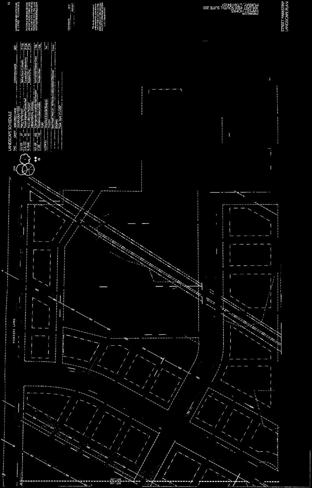

60
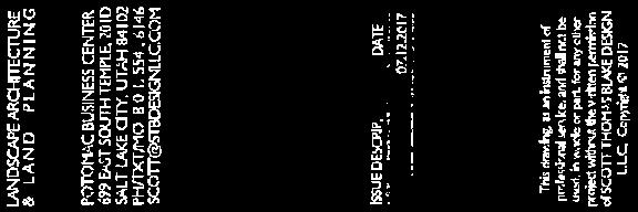
61
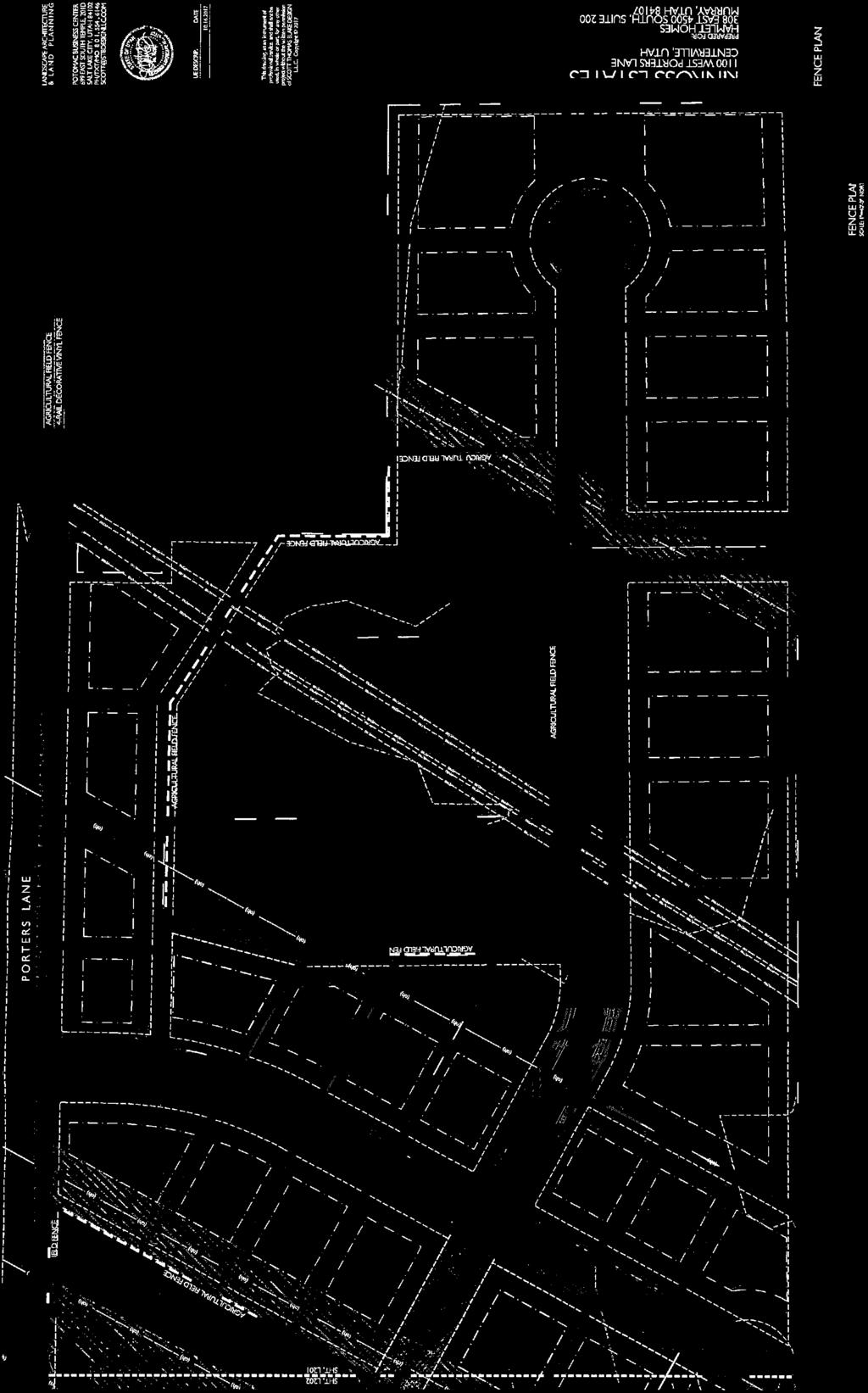
62
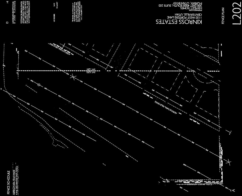

63
64
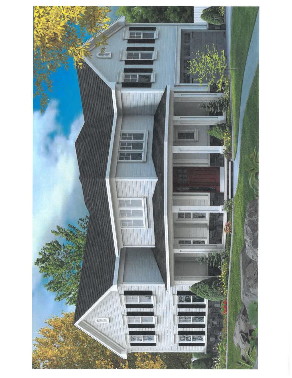

65
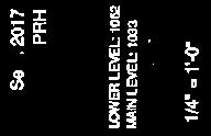


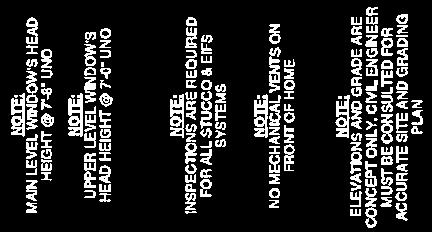

66

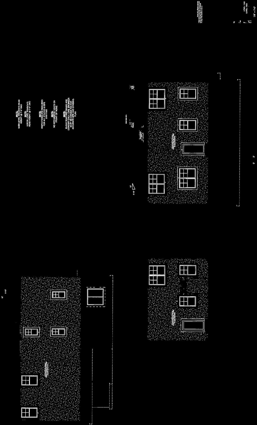

67
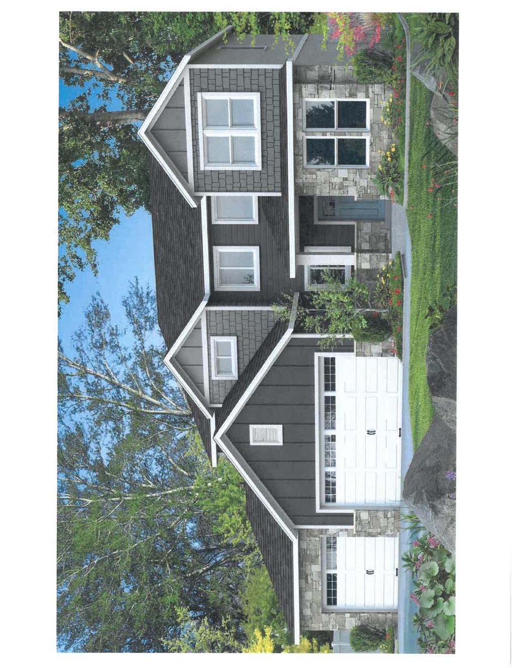
68

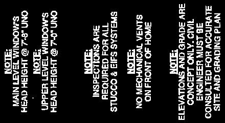

69
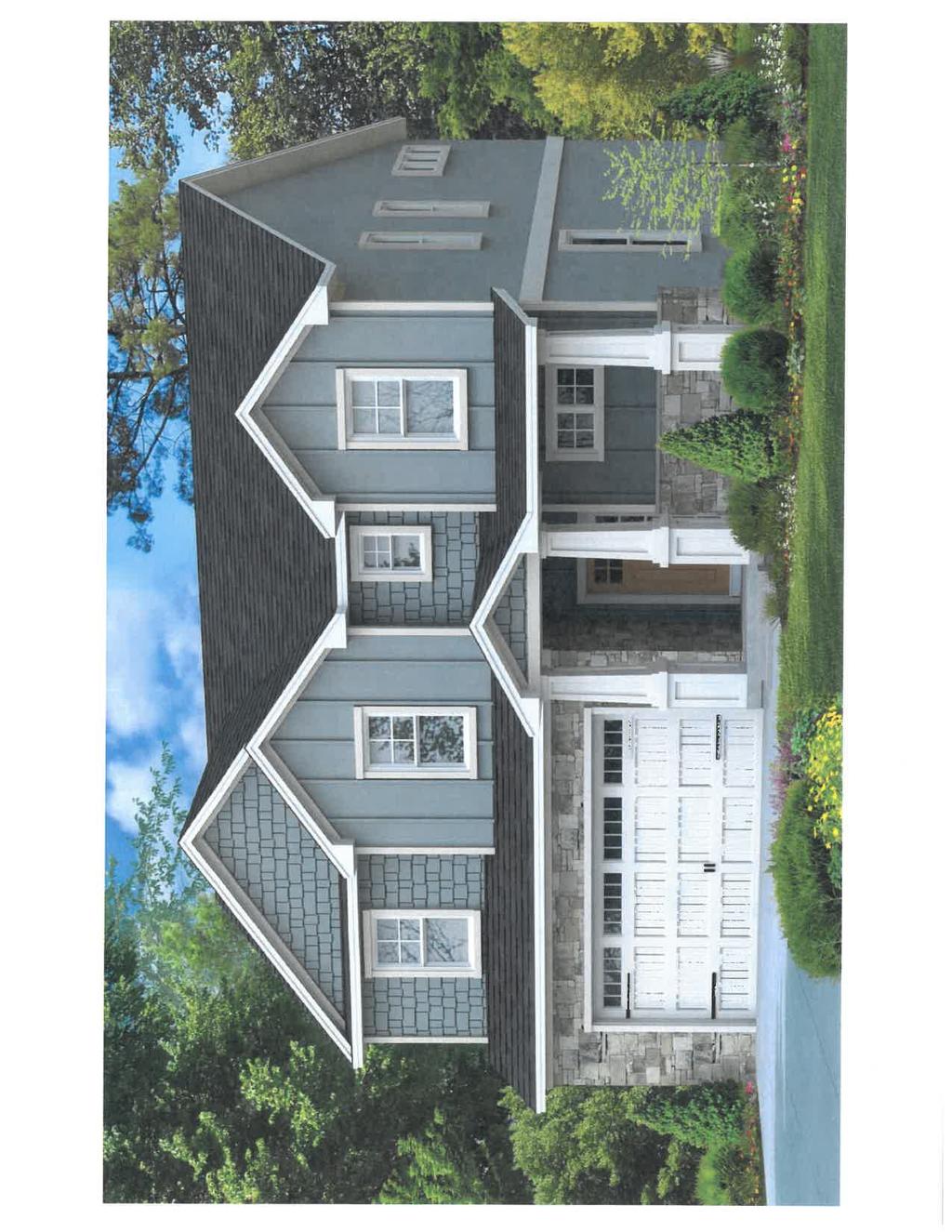

70


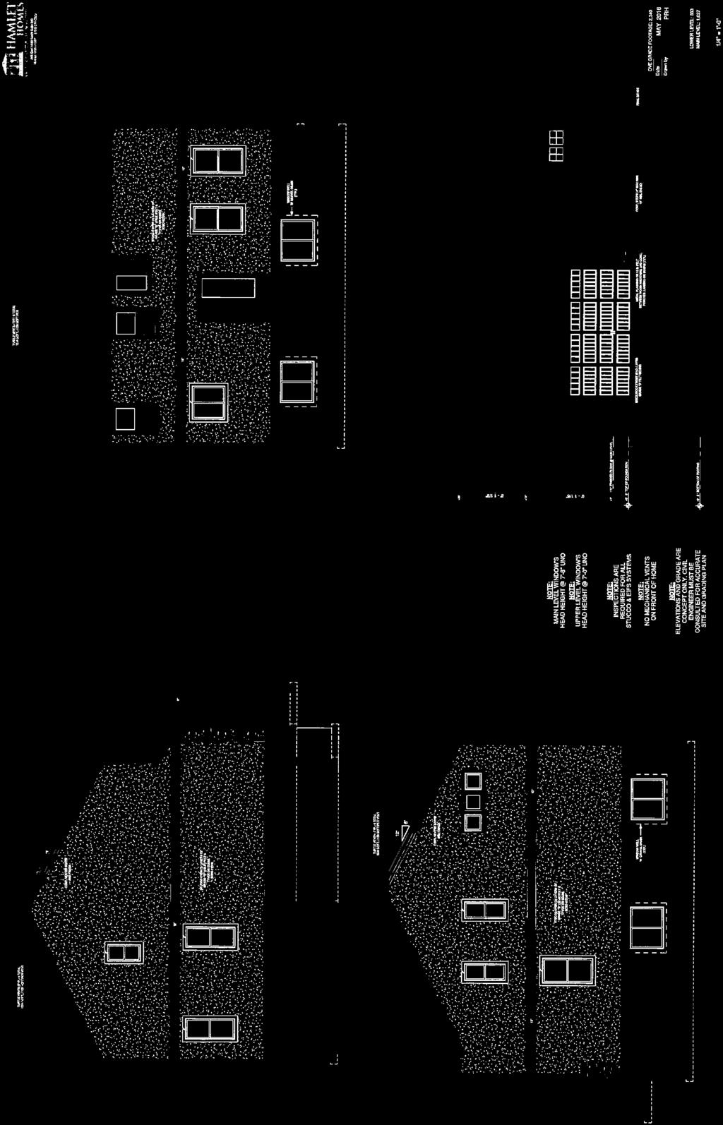
71
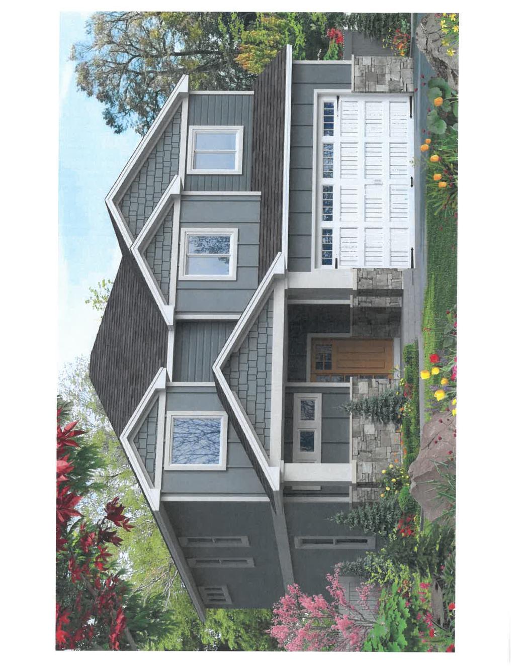


72


73
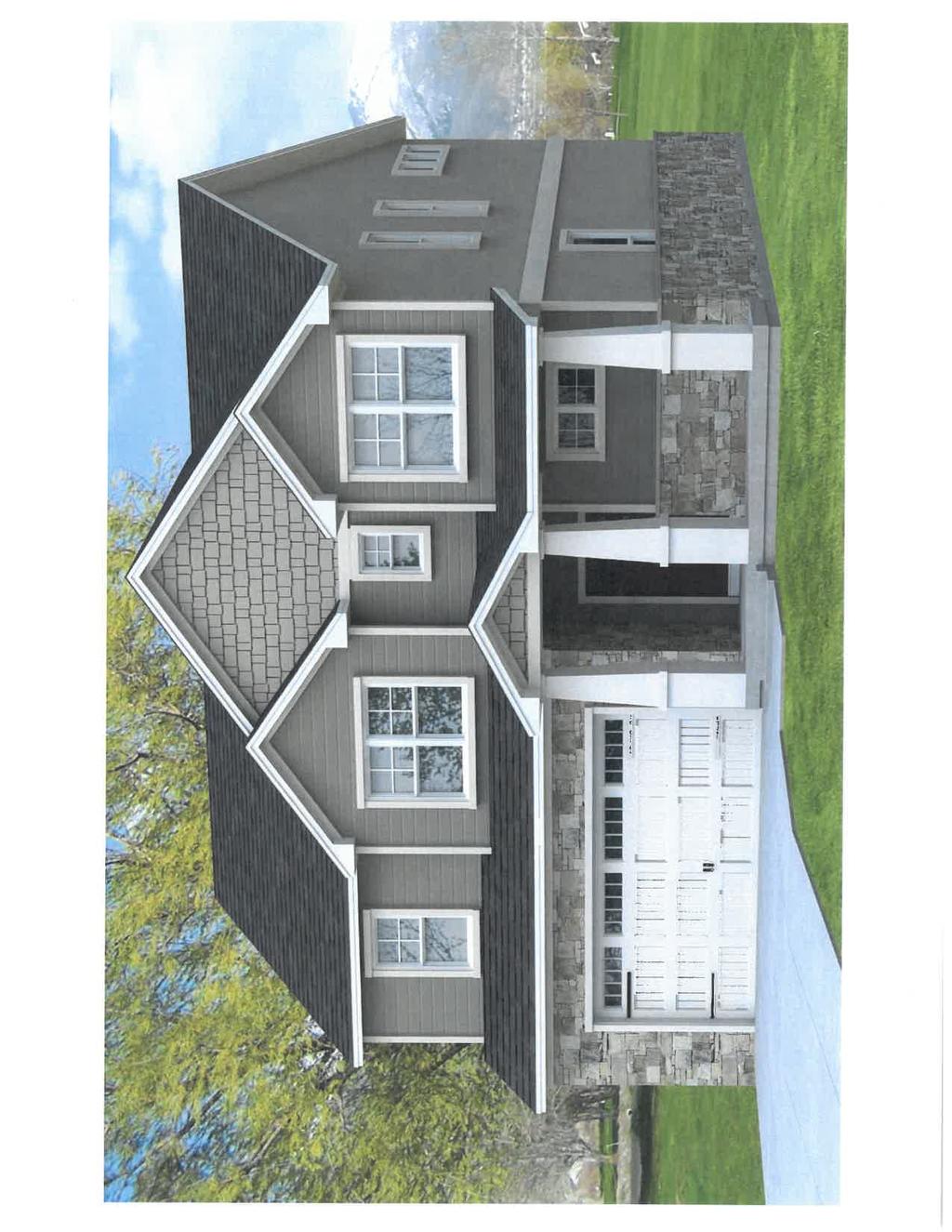


74

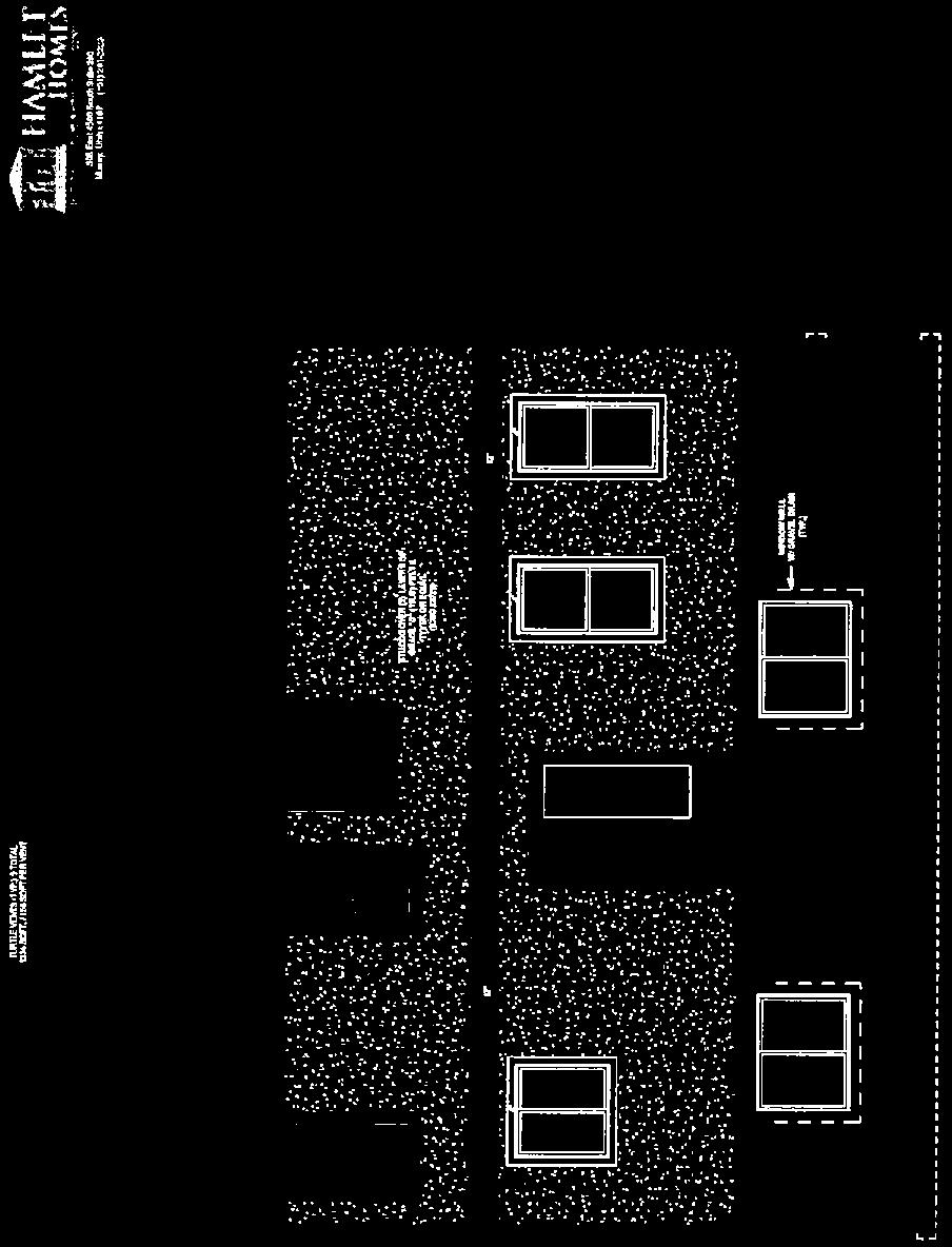
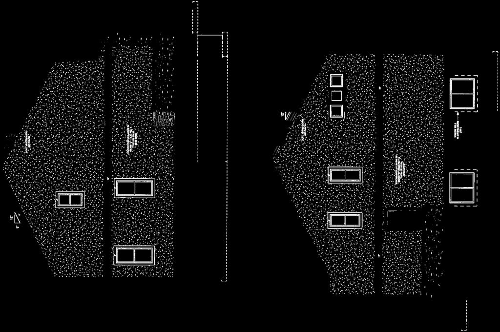

75


76


77
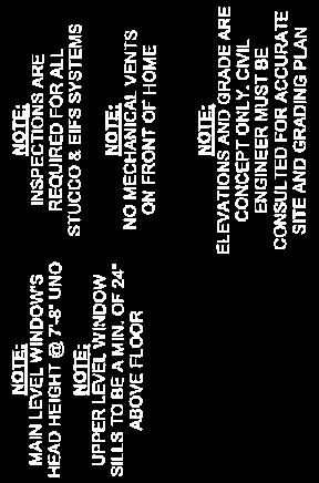


78
79 September 15`th, 2017 PUD Development Plan Submittal Kinross Estates by Hamlet Development Residential Land Use Acres Zoned R Porter Lane, West Bountiful, UT Written Description of Subject Property Kinross Estates is a acre community located at 940 W Porter Lane and will contain 34 single family detached lots. The Property is zoned R-1-22 and is designed to a density of 1.48 Lots per acre. The theme and feel of Kinross Estates is intended to be consistent with West Bountiful and maintain a rural feel. Furthermore, by landscaping all of the homes front and side yards and streetscapes, Kinross Estates will have a warm cohesive community feel. The CC+Rs for the community will provide requirements for the homeowners to properly maintain their home sites. Entrance monuments will be placed at both entrances to the community to create a welcoming and upscale feel for its new residents. In maintaining the rural feel of the neighborhood, the westerly four acres of the property will be maintained for agricultural use either as farm land or pastures and will be offered for sale to the adjacent lot owners or to individuals. This condition will be included in the CC+Rs. This community will have only one phase. The Property to the north is currently residential zoned A-1. To the west of the Property lies the Legacy Parkway. The south and east side of the community is undeveloped land currently zoned R Conceptual Development Plan Please see attached Improvement Plans. Conceptual Building Elevations and Materials Please see attached conceptual renderings for Kinross Estates. Proposed Street Cross Sections Please see Improvement Plans. Recreational Amenities Kinross Estates will have a trail head into the Legacy Trail Head on Porter Lane. Flexibility Being Requested The density we are proposing is consistent with the current R-1-22 Zone. The flexibility we are requesting is to permit a large open pasture to buffer Legacy Highway and the power line corridor consequently creating smaller lots than ½ acre while still staying well below the permitted density. The four acres of the Property bordering Legacy Highway are designed to remain as open pastures for agricultural use in order to maintain the rural feel of West Bountiful along the Legacy Highway.
80 Environmental Consideration Within this application, we have included a description of the diesel fuel spill that occurred on a portion of this property in While most of the impacts have been remediated there still exists an approximately 3-acre portion of the property that is still impacted. Studies recently completed by Wasatch Environmental clearly indicate no health risk associated with the property, however because of levels of impacted soils below grade, this property is not ready to be built upon. The three lots impacted have been identified and among other restrictions, the CC&Rs identify that these lots may only be used for agricultural uses until such a time as the Department of Environmental Quality issues a letter identifying that these lots have been cleaned to residential standards. Conceptual Improvement Plan Please see attached Improvement Plan. Development Agreement Draft Will be developed as the entitlement process unfolds. Project Expectations Each home will provide a minimum of four parking spaces (two in the garage and two in the driveway.) Hamlet Homes will be offering a range of different house styles. The choice on each lot will be market driven by our customer's choices. No two homes with the same elevations will be built next to each other. In addition to the plans we are submitting with this package, we intend to develop more home plans that will be similar in style and in architecture. Materials used on the homes will comply with West Bountiful requirements. Living area square footage will range from approx square feet to approx square feet. Please see attached renderings of homes that will be similar to what we will build in Kinross Estates. Project Considerations Hamlet Homes will be the builder and each lot sold is to be maintained by the individual that purchases the home. The four acres of the Property bordering Legacy Highway are designed to remain as open pastures for agricultural use in order to maintain the rural feel of West Bountiful along the Legacy Highway. Kinross Estates will have a trail head connection via sidewalk to the Legacy Trail Head on Porter Lane. Entrance monuments will be placed at both entrances to the community to create a welcoming and upscale feel for its new residents.
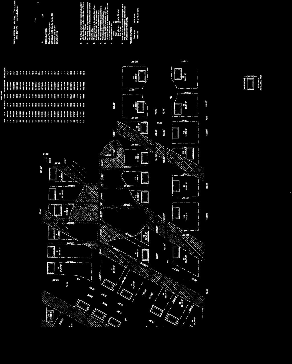
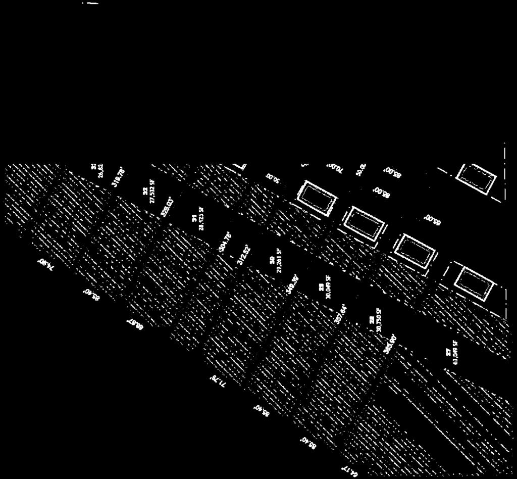


81
82 MEMORANDUM TO: Planning Commission DATE: October 18, 2017 FROM: Ben White, City Engineer RE: Zoning Request at approx W 400 North Ms. Denise Montgomery lives in Jessie s Meadow and owns adjacent vacant property with frontage on 400 North. The property is in an A-1 (Agricultural Residential one acre) zone. As she explains in her letter, she would like to develop equestrian uses on the property. The equestrian use is consistent with the A-1 zone. The difficulty is the request for a retail store. Commercial and retail businesses, except for home occupational businesses, are not allowed in the A-1 zone. As Ms. Montgomery explains, she does not care what mechanism is used to amend the zoning. Her request is simply to amend the zoning to accommodate a retail business. There appear to be three most logical options. 1. CREATE A NEW ZONE A new zoning designation could be developed that would permit retail and other uses on this property and other properties within the same zone. For instance, the C-N zone in the northeast corner of the city meets the retail requirements, but not the equestrian requirements. 2. MODIFY THE A-1 TO ALLOW RETAIL USES The A-1 zone text language could be modified to permit retail and commercial uses within the zone. 3. REZONE PROPERTY TO BE INCLUDED IN THE B-U ZONE A rezone to the B-U zone would most likely include rezoning a large section of property to the west too. All three options have their challenges. The options are listed in the order the staff feels would be most successful to least successful. A. Creating a new zone limits the places within the City s residential districts where retail and commercial uses could be accomplished. B. Modifying the A-1 zone to allow the requested use would also allow similar uses throughout the entire zone. This could have a dramatic effect on land use within the zone. Examples of possible changes that could minimize the impact to residential properties include: a. Generous setbacks; b. Architectural requirements; c. Limits on merchandise; d. Size of parcels. C. zone permits both residential and commercial uses within the same zone. This seems to be a likely rezone possibility. The B-U zone did not intend for a mix of residential and commercial uses in the same area, and was intended for larger projects to be approved instead of small piecemeal projects within the zone. The Planning Commission has the responsibility to evaluate a rezone request and make a recommendation to City Council. 550 North 800 West, West Bountiful, UT (801)

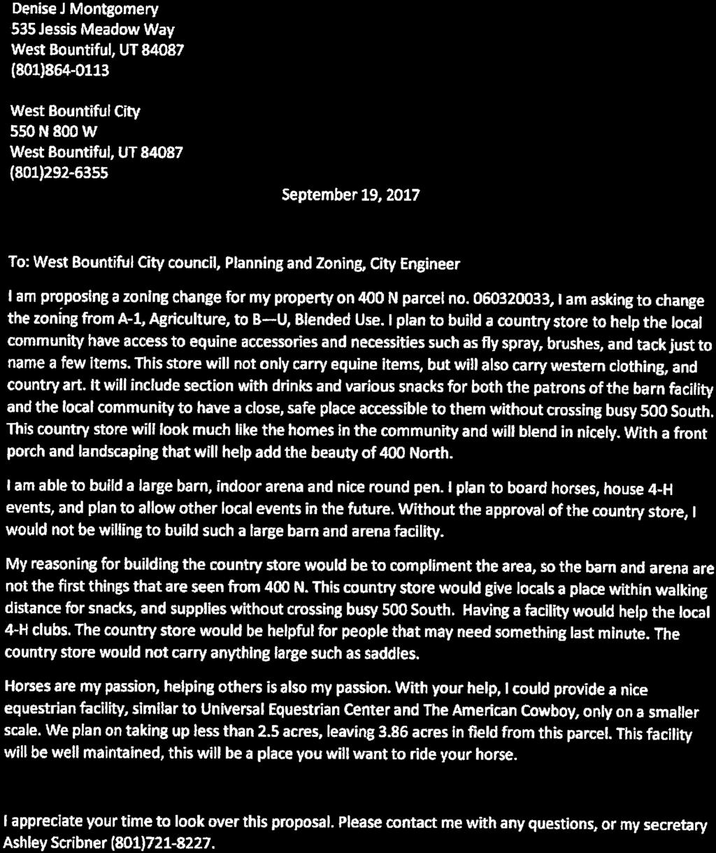
83
84 WEST BOUNTIFUL CURRENT ZONING MAP Legend CITY BOUNDARY HISTORIC OVERLAY LEGACY OVERLAY UNINCORPORATED DAVIS COUNTY Current Zoning R-1-10 A-1 CN L-I R-1-22 A-1 R-1-10 B-U R-1-22 C-N C-G A-1 PARK L-I I-G R-1-22 C-H GOLF COURSE R-1-10 A-1 B-U PROPOSED RETAIL LOCATION CG B-U A-1 R-1-10 CG B-U R-1-22 I-G L-I C-H

85 MEMORANDUM TO: Planning Commission DATE: October 20, 2017 FROM: Ben White RE: High Gate Subdivision Onion Patch Securities, LLC, is proposing a 27-1 acre lot residential development located between 1100 W and 1450 W south of the Mill Creek canal. The development includes lots that conform to the A-1 zone requirements and open space parcels to be maintained by an H.O.A. As with nearly all properties left to develop, this property has its own unique challenges. 1. The principal entrance to the development will be off of 1100 West at approximately 100 South. The Development includes a 110 foot by 800 foot strip of land which will be the entry into the development. This entry road will create unbuildable parcels on each side of the road which will be maintained by an H.O.A. A six-foot-wide sidewalk along one side of the street is proposed along this section of road. An entry landscape island is proposed to be constructed in the middle of the street right of way. Holly Frontier owns the property to the north and Jack Williams owns the property to the south. 2. The second means of access to the development is a southerly continuation of 1450 West. The developer did not own all the property for the street continuation in its current alignment. He has reached an agreement for the right of way dedication and street construction with the adjoining property owner. The agreement is not available for public review yet. 3. A portion of the Mill Creek channel is located within this development. The Developer owns the ground and Davis County has an easement. As the plat is currently drawn, Mill Creek is included within the lots. A fence will be maintained between the Mill Creek channel and the home owners rear yards. This means that property owners who own parts of the Mill Creek channel will not have direct access to portions of their property. 4. The tentative storm drainage plan is to have storm water plan has been submitted. Some more work is needed before a fair evaluation can be offered. 5. The Developer owns a large parcel of land west of this development. A future street is shown adjacent to lot 25, 26 and 27. The storm water detention basin is currently proposed at the west end of this road. Staff does not believe that any of the three homes will have their primary access on this road. The timing of the road construction and any necessity for a temporary turn around should be discussed. 550 North 800 West, West Bountiful, UT (801)
86 6. Lot 26 is proposed to be a quasi-flag lot. The lot has the required amount of frontage on the street to the south. However, if the home owner does not want to cross the canal with their driveway, an access easement on the north side of lot 25 is available West is included to extend south. The proposed right of way includes enough ground to construct the entire street, but not the sidewalk on the west side. Additional discussions regarding the timing of these improvements may also be merited. There is a 0.5 acre parcel at the south end of the road that can be approved as a commercial use. It is in the B-U zone and not the A-1 zone. 8. Street lights are included along the entry road off 1100 West and at intersections and in the cul-desacs. 9. Fire hydrants are shown on the preliminary plat. To conform to our 400 foot spacing requirement, a couple more fire hydrants will need to be added. 10. More detail is needed on the utility drawings to offer comment (pipe sizes, text is over-writing utilities, etc.) 11. A Holly Frontier wastewater drain line cuts through the property which needs to be protected, replaced or rerouted. 12. A remnant parcel of ground is property off 1450 N against Mill Creek Meadows. Staff would suggest that Davis County be offered the property. The property is encumbered by a county drainage easement already. 13. Jack Williams owns the property to the south of the development. He has expressed a desire for street access. As proposed, the development will provide access to the Williams property at the west end (1450 W) and at the east end of Lot 14 where the right of way aligns with the south property boundary. 550 North 800 West, West Bountiful, UT (801)


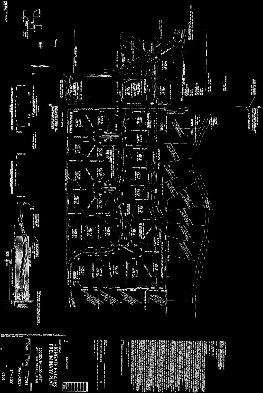
87
WEST BOUNTIFUL CITY ORDINANCE NO
 WEST BOUNTIFUL CITY ORDINANCE NO. 376-16 AN ORDINANCE CREATING A PLANNED UNIT DEVELOPMENT FOR 9.13 ACRES OF REAL PROPERTY (PREVIOUSLY KNOWN AS PONY HAVEN ) LOCATED WITHIN THE CITY AT APPROXIMATELY 690
ESCROW AGREEMENT - MAINTENANCE
 ESCROW AGREEMENT - MAINTENANCE This ESCROW AGREEMENT (the Agreement ) is made and entered into this day of,, by and between the City of O Fallon, Missouri, a Missouri municipal corporation (hereinafter
WEST BOUNTIFUL PLANNING COMMISSION
 Mayor Kenneth Romney City Engineer/ Zoning Administrator Ben White City Recorder Cathy Brightwell WEST BOUNTIFUL PLANNING COMMISSION 550 North 800 West West Bountiful, Utah 84087 Phone (801) 292-4486 FAX
WASHINGTON STATE COUNTY AUDITOR/RECORDER'S INDEXING FORM
 AFTER RECORDING RETURN TO: The City of Gig Harbor Attn: City Clerk 3510 Grandview St. Gig Harbor, WA 98335 WASHINGTON STATE COUNTY AUDITOR/RECORDER'S INDEXING FORM Document Title(s) (or transactions contained
City of Melissa, Texas Plat Dedication Language
 City of Melissa, Texas Plat Dedication Language [INCLUDE THE FOLLOWING DEDICATION LANGUAGE FOR INDIVIDUALS (MODIFY APPROPRIATELY TO REFLECT EXACTLY AS SHOWN ON PROPERTY DEED)]: NOW THEREFORE, KNOW ALL
550 North 800 West West Bountiful, Utah Phone (801) FAX (801) PLANNING COMMISSION MEETING
 FAX (801) PLANNING COMMISSION MEETING") Mayor Kenneth Romney City Council James Ahlstrom James Bruhn Kelly Enquist Debbie McKean Mark Preece WEST BOUNTIFUL CITY 550 North 800 West West Bountiful, Utah 84087 Phone (801) 292-4486 FAX (801) 292-6355
Mayor Kenneth Romney City Council James Ahlstrom James Bruhn Kelly Enquist Debbie McKean Mark Preece WEST BOUNTIFUL CITY 550 North 800 West West Bountiful, Utah 84087 Phone (801) 292-4486 FAX (801) 292-6355
CONTRACT TO BUY AND SELL REAL ESTATE
 CONTRACT TO BUY AND SELL REAL ESTATE THIS CONTRACT TO BUY AND SELL REAL ESTATE ( Contract ) is made and entered into as of April 9, 2018 (the Effective Date ) by and between the City of Pueblo, Colorado,
SUBDIVISION IMPROVEMENTS AND MAINTENANCE AGREEMENT AND COVENANT SUBDIVISION:
 SUBDIVISION IMPROVEMENTS AND MAINTENANCE AGREEMENT AND COVENANT SUBDIVISION: I. PARTIES The parties to this Agreement are the below-referenced subdivider ( Subdivider ) and the Board of County Commissioners
DEVELOPER S AGREEMENT BETWEEN THE TOWN OF CLIFTON AND
 DEVELOPER S AGREEMENT BETWEEN THE TOWN OF CLIFTON AND THIS AGREEMENT, made and entered into this day of, by and between the Town of Clifton, a municipal corporation organized under the laws of the State
PROPERTY LEASE AGREEMENT
 Attachment FAC-1 PROPERTY LEASE AGREEMENT THIS AGREEMENT ( Lease Agreement, Lease or Agreement ), is entered into as of the day of, 2013 by and between the MIDDLETOWN TOWNSHIP BOARD OF EDUCATION, a public
UTILITY EASEMENT AGREEMENT
 THIS INSTRUMENT PREPARED BY AND RETURN TO: Roy K. Payne, Esq. Chief Assistant City Attorney 400 S. Orange Avenue Orlando, FL 32801 Roy.Payne@CityofOrlando.Net UTILITY EASEMENT AGREEMENT THIS UTILITY EASEMENT
CITY AND COUNTY OF BROOMFIELD SUBDIVISION IMPROVEMENT AGREEMENT FOR (PROPERTY NAME - ALL CAPS)
") CITY AND COUNTY OF BROOMFIELD SUBDIVISION IMPROVEMENT AGREEMENT FOR (PROPERTY NAME - ALL CAPS) THIS AGREEMENT, made and entered into this day of, 20, by and between The CITY AND COUNTY OF BROOMFIELD, a
CITY AND COUNTY OF BROOMFIELD SUBDIVISION IMPROVEMENT AGREEMENT FOR (PROPERTY NAME - ALL CAPS) THIS AGREEMENT, made and entered into this day of, 20, by and between The CITY AND COUNTY OF BROOMFIELD, a
DEVELOPMENT AGREEMENT RIVER EDGE COLORADO PLANNED UNIT DEVELOPMENT
 DEVELOPMENT AGREEMENT RIVER EDGE COLORADO PLANNED UNIT DEVELOPMENT THIS AGREEMENT, is made and entered into between the BOARD OF COUNTY COMMISSIONERS OF THE COUNTY OF GARFIELD, a body politic and corporate
RECITALS. Page 1 of 9
 INTERLOCAL AGREEMENT BETWEEN THE COUNTY OF VOLUSIA AND THE CITY OF DEBARY FOR REIMBURSEMENT OF UTILITY CONSTRUCTION AND A UTILITY SERVICE AGREEMENT FOR POTABLE WATER THIS AGREEMENT is entered into by and
VIRGINIA ASSOCIATION OF REALTORS Commercial Purchase Agreement
 VIRGINIA ASSOCIATION OF REALTORS Commercial Purchase Agreement Each commercial transaction is different. This form may not address your specific purpose. This is a legally binding document. If not understood,
To achieve the conservation purposes, the following conditions and restrictions are set forth:
 DEED OF CONSERVATION EASEMENT (Conservation Subdivision District) STATE OF GEORGIA COUNTY OF COBB THIS DEED OF CONSERVATION EASEMENT (herein "Conservation Easement") is made this day of, 20, by and between
INTERLOCAL AGREEMENT FOR LEESVILLE BRANCH LIBRARY BETWEEN CITY OF RALEIGH, NORTH CAROLINA AND WAKE COUNTY, NORTH CAROLINA
 DRAFT 01-23-08 INTERLOCAL AGREEMENT FOR LEESVILLE BRANCH LIBRARY BETWEEN CITY OF RALEIGH, NORTH CAROLINA AND WAKE COUNTY, NORTH CAROLINA Dated as of, 2008 INTERLOCAL AGREEMENT THIS INTERLOCAL AGREEMENT
DECLARATION OF DRAINAGE EASEMENTS. Document No. Document Title. (Declarant) Recording Data Return Address
 Recording Data Return Address") Document No. DECLARATION OF DRAINAGE EASEMENTS Document Title (Declarant) Recording Data Return Address DOCUMENT PREPARED BY AND AFTER RECORDING RETURN TO: Parcel No. - - - - - - DECLARATION OF DRAINAGE
Document No. DECLARATION OF DRAINAGE EASEMENTS Document Title (Declarant) Recording Data Return Address DOCUMENT PREPARED BY AND AFTER RECORDING RETURN TO: Parcel No. - - - - - - DECLARATION OF DRAINAGE
PERMANENT EASEMENT AGREEMENT
 PERMANENT EASEMENT AGREEMENT This Permanent Easement Agreement ("Agreement") effective this day of, 2016, by and between Goin Straight, LLC, a Colorado limited liability company (Grantor"), whose mailing
DEVELOPMENT AGREEMENT
 DEVELOPMENT AGREEMENT This Development Agreement ( Agreement ) is entered into between the developer Highland Gate Itasca LLC, a Delaware Corporation authorized to do business in Illinois ( Developer )
DECLARATION OF EASEMENTS AND COST SHARING AGREEMENT
 PREPARED BY AND AFTER RECORDING RETURN TO: James Johnston, Esq. Shutts & Bowen LLP 300 S. Orange Avenue Suite 1000 Orlando, Florida 32801 Tax Parcel I.D.s: 25-21-29-0000-00-032 25-21-29-4432-00-001 DECLARATION
CITY OF WEATHERFORD DEVELOPER AGREEMENT WITH CITY PARTICIPATION
 CITY OF WEATHERFORD DEVELOPER AGREEMENT WITH CITY PARTICIPATION STATE OF TEXAS Subdivision Name: Town Creek Phase II Developer Name: Ms. Marina Sears, Square S COUNTY OF PARKER Construction and Development
DEPOSIT AGREEMENT GUARANTEEING SITE PLAN IMPROVEMENTS WITH CASH ESCROW
 DEPOSIT AGREEMENT GUARANTEEING SITE PLAN IMPROVEMENTS WITH CASH ESCROW This Deposit Agreement Guaranteeing Site Plan Improvements with Cash Escrow (the Agreement ) is made and entered into as of the day
DECLARATION OF PARTY WALL RIGHTS, COVENANTS, CONDITIONS, RESTRICTIONS AND EASEMENTS
 DECLARATION OF PARTY WALL RIGHTS, COVENANTS, CONDITIONS, RESTRICTIONS AND EASEMENTS This Declaration of Party Wall Rights, Covenants, Conditions, Restrictions and Easements (the Declaration) is made this
EXCHANGE AGREEMENT R E C I T A L S
 EXCHANGE AGREEMENT This Exchange Agreement (the Agreement ) is made and entered into by and between the LaVerkin Bench Canal Company, a not for profit corporation organized under the laws of Utah (the
AGREEMENT FOR SALE AND PURCHASE
 AGREEMENT FOR SALE AND PURCHASE Agreement for Sale and Purchase This Agreement for Sale and Purchase ( Agreement ) is entered into this day of,, 2013, by and between the CITY OF PORT ST. LUCIE, a Florida
CONSENT ACTION BY THE BOARD OF DIRECTORS OF VENETO IN MIRAMAR CONDOMINIUM ASSOCIATION, INC.
 CONSENT ACTION BY THE BOARD OF DIRECTORS OF VENETO IN MIRAMAR CONDOMINIUM ASSOCIATION, INC. The undersigned, being all of the members of the Board of Directors of Veneto in Miramar Condominium Association,
DEVELOPMENT AGREEMENT
 STATE OF NORTH CAROLINA COUNTY OF CHATHAM DEVELOPMENT AGREEMENT This Development Agreement (this Agreement ) is made and entered into as of the day of, 2009 (the Effective Date ), by and between the COUNTY
JH:SRF:JMG:brf AGENDA DRAFT 4/06/2016 ESCROW AGREEMENT
 23090-12 JH:SRF:JMG:brf AGENDA DRAFT 4/06/2016 ESCROW AGREEMENT THIS ESCROW AGREEMENT (the Agreement ) is dated as of May 1, 2016, and is entered into by and between the MT. DIABLO UNIFIED SCHOOL DISTRICT
WATER SERVICE AGREEMENT. Water One Assurance Monitoring Service
 WATER SERVICE AGREEMENT Water One Assurance Monitoring Service This agreement ("Agreement") is entered into and is effective as of between Evoqua Water Technologies LLC, (hereinafter "Seller") and (hereinafter
COMMERICAL PURCHASE AGREEMENT
 COMMERICAL PURCHASE AGREEMENT Each commercial transaction is different. This form may not address your specific purpose. This is a legally binding document. If not understood, seek competent advice before
WATER LINE & INGRESS/EGRESS EASEMENT AGREEMENT WITNESSETH:
 Prepared by and return to: Carie E. Shealy, MMC, City Clerk City of Cocoa 65 Stone Street Cocoa, Florida 32922 Parcel ID. #(s): WATER LINE & INGRESS/EGRESS EASEMENT AGREEMENT THIS EASEMENT AGREEMENT is
STATE OF SOUTH CAROLINA ) AGREEMENT ) OF COUNTY OF RICHLAND ) PURCHASE AND SALE
 AGREEMENT ) OF COUNTY OF RICHLAND ) PURCHASE AND SALE") STATE OF SOUTH CAROLINA ) AGREEMENT ) OF COUNTY OF RICHLAND ) PURCHASE AND SALE THIS AGREEMENT (the Agreement ) executed the day of, 2010 (the Effective Date ), by and between COLUMBIA VENTURE, LLC, a
STATE OF SOUTH CAROLINA ) AGREEMENT ) OF COUNTY OF RICHLAND ) PURCHASE AND SALE THIS AGREEMENT (the Agreement ) executed the day of, 2010 (the Effective Date ), by and between COLUMBIA VENTURE, LLC, a
ACCESS AND OPTION AGREEMENT TEMPLATE FOR REAL PROPERTY PARTNERSHIP PROJECTS
 ACCESS AND OPTION AGREEMENT TEMPLATE FOR REAL PROPERTY PARTNERSHIP PROJECTS Appendix 3 This ACCESS AND OPTION AGREEMENT (this Agreement ) is entered into as of, 201 (the Execution Date ), by and between
ARIZONA DEPARTMENT OF TRANSPORTATION RIGHT OF WAY GROUP/PROPERTY MANAGEMENT SECTION EXCESS LAND PURCHASE AGREEMENT AND RECEIPT FOR DEPOSIT
 ARIZONA DEPARTMENT OF TRANSPORTATION RIGHT OF WAY GROUP/PROPERTY MANAGEMENT SECTION EXCESS LAND PURCHASE AGREEMENT AND RECEIPT FOR DEPOSIT Project No.: 010 MA 151 H7441 Date: Month Day, Year Sale No. L-C-047
EASEMENT AGREEMENT (Distributor Performance Non-Exclusive)
") EASEMENT AGREEMENT (Distributor Performance Non-Exclusive) THIS EASEMENT AGREEMENT, effective the day of, 20, is made between WITNESSETH:, hereafter called Grantor, (whether grammatically singular or plural)
EASEMENT AGREEMENT (Distributor Performance Non-Exclusive) THIS EASEMENT AGREEMENT, effective the day of, 20, is made between WITNESSETH:, hereafter called Grantor, (whether grammatically singular or plural)
PRE-ANNEXATION AGREEMENT
 City of Commerce City 7887 East 60th Avenue Commerce City, Colorado 80022 p: 303.289.3683 f: 303.289.3731 c3gov.com PRE-ANNEXATION AGREEMENT PRE-ANNEXATION AGREEMENT THIS PRE-ANNEXATION AGREEMENT ( Agreement
CHAPTER 154 RIGHTS OF WAY
 CHAPTER 154 RIGHTS OF WAY 154.01 Purpose and Rule of Interpretation 154.09 City Construction and Paving 154.02 Franchise, License or Lease Required 154.10 Design Notice to City 154.03 Fees Required 154.11
ESCROW AGREEMENT. Recitals
 ESCROW AGREEMENT THIS ESCROW AGREEMENT (the Agreement ) is made as of, 20 among Private Motorsports Group, LLC., ( Company ) an Arizona limited liability company and [ ], ( Member ) and Arizona Escrow
This is a sample form for information ONLY. UTILITY INFRASTRUCTURE CONVEYANCE AND SERVICE AGREEMENT
 This is a sample form for information ONLY. A CSA will be tailored to your project at the appropriate time during the development process. Please contact the Development Services Team for additional information.
CONSENT TO ASSIGNMENT OF LEASE
 CONSENT TO ASSIGNMENT OF LEASE TO: AND TO: AND TO: AND TO: * ("Assignor" * ("Assignee" * ("Indemnifier" * ("Landlord" DATE: * WHEREAS A. By a lease dated the ** day of **, ** (the "Lease", the Landlord
OFFER TO PURCHASE AND CONTRACT
 1 NORTH CAROLINA WAKE COUNTY OFFER TO PURCHASE AND CONTRACT WHEREAS, ( Buyer ) hereby agrees to purchase and Wake County Board of Education ( Seller ) hereby agrees to convey a parcel of land at,,, being
CONTRACT FOR SALE AND PURCHASE
 Page 1 of 5 CONTRACT FOR SALE AND PURCHASE THIS ( Contract ) is made this day of, 20, by and between the Southwest Florida Water Management District, a public corporation of the State of Florida, having
PROPERTY EXCHANGE AGREEMENT
 PROPERTY EXCHANGE AGREEMENT This Property Exchange Agreement is effective this day of, 2015, between the City of Star, Idaho, a municipal corporation (the City ); DBSI Pristine Meadows, LLC, an Idaho limited
HEAVY-HAULING AGREEMENT. THIS HEAVY-HAULING AGREEMENT amended by Resolution #1, January 2010,
 HEAVY-HAULING AGREEMENT THIS HEAVY-HAULING AGREEMENT amended by Resolution #1, January 2010, (this Agreement ) is dated as of, 201, and is by and between: BOARD OF SUPERVISORS OF WASHINGTON TOWNSHIP, Greene
AGENDA ITEM FORM INFORMATION ONLY PRESENTATION DISCUSSION ONLY ACTION ITEM
 Town of Dumfries Council Meeting AGENDA ITEM FORM Meeting Date: Agenda Item# February 5, 2019 XIII-A TYPE OF AGENDA ITEM: PURPOSE OF ITEM: CONSENT AGENDA INFORMATION ONLY PRESENTATION DISCUSSION ONLY ACTION
RIVER EDGE COLORADO SUBDIVISION IMPROVEMENTS AGREEMENT FILING NO. THIS RIVER EDGE COLORADO SUBDIVISION IMPROVEMENTS AGREEMENT
 RIVER EDGE COLORADO SUBDIVISION IMPROVEMENTS AGREEMENT FILING NO. THIS RIVER EDGE COLORADO SUBDIVISION IMPROVEMENTS AGREEMENT FILING NO. ("SIA") is made and entered into this day of, 20, by and between
CITY OF SARALAND FINAL SUBDIVISION PLAT REVIEW
 CITY OF SARALAND FINAL SUBDIVISION PLAT REVIEW Application Number: Date Plat Submitted: Name of Subdivision: Name of Owner: Owner Address: (Street or P.O. Box) Telephone #: (City) (State) (Zip) E-mail:
LEASE AGREEMENT WITNESSETH:
 LEASE AGREEMENT THE STATE OF ALABAMA HOUSTON COUNTY This lease executed in Houston County, Alabama, on this the day of, 201, by and between HOUSTON COUNTY, ALABAMA, BY AND THROUGH THE HOUSTON COUNTY COMMISSION,
LEASE-LEASEBACK SUBLEASE AGREEMENT. Dated as of April 1, Between. Newark Unified School District. and. Environmental Systems, Inc.
 LEASE-LEASEBACK SUBLEASE AGREEMENT Dated as of April 1, 2014 Between Newark Unified School District and Environmental Systems, Inc., Phase 1 District-Wide {SR134676.DOC} LEASE-LEASEBACK SUBLEASE AGREEMENT
HIGHLANDS TRANSFER OF DEVELOPMENT RIGHTS PROGRAM DEED OF EASEMENT (For Non-Agricultural Property with Bonus Highlands Development Credit Allocation)
") SAMPLE DRAFT EASEMENT PREPARED BY Signature Typed or Printed Name HIGHLANDS TRANSFER OF DEVELOPMENT RIGHTS PROGRAM DEED OF EASEMENT (For Non-Agricultural Property with Bonus Highlands Development Credit
SAMPLE DRAFT EASEMENT PREPARED BY Signature Typed or Printed Name HIGHLANDS TRANSFER OF DEVELOPMENT RIGHTS PROGRAM DEED OF EASEMENT (For Non-Agricultural Property with Bonus Highlands Development Credit
NOTICE OF SEALED BID FOR SALE OF REAL PROPERTY
 NOTICE OF SEALED BID FOR SALE OF REAL PROPERTY The City of Red Oak, Texas (the "City") is accepting sealed bids for the purchase of the following real property (the Property ) for the purpose of residential
PURCHASE AND SALE AND ASSIGNMENT AGREEMENT [Germania Hall Participation Interest]
![PURCHASE AND SALE AND ASSIGNMENT AGREEMENT [Germania Hall Participation Interest]](/thumbs/93/113955153.jpg "PURCHASE AND SALE AND ASSIGNMENT AGREEMENT [Germania Hall Participation Interest]") PURCHASE AND SALE AND ASSIGNMENT AGREEMENT [Germania Hall Participation Interest] This Purchase and Sale and Assignment Agreement ( Agreement ) is entered into as of this day of, 201 7, by and between
PURCHASE AND SALE AND ASSIGNMENT AGREEMENT [Germania Hall Participation Interest] This Purchase and Sale and Assignment Agreement ( Agreement ) is entered into as of this day of, 201 7, by and between
STAFF REPORT. DATE: December 12, 2012
 STAFF REPORT DATE: December 12, 2012 TO: FROM: SUBJECT: The Honorable Mayor and City Council John Penrod, City Attorney CONSIDERATION OF APPROVING AN ASSIGNMENT AGREEMENT AND AN EASEMENT THAT WOULD TRANSFER
PISMO BEACH COUNCIL AGENDA REPORT
 PISMO BEACH COUNCIL AGENDA REPORT Agenda Item #5.K SUBJECT/TITLE: APPROVAL OF FINAL MAP, SUBDIVISION IMPROVEMENT AGREEMENT AND AUTHORIZATION OF EASEMENT VACATION FOR TRACT 3058 COSTA AZURE RECOMMENDATION:
AGREEMENT FOR TEMPORARY CONSTRUCTION EASEMENT AND PERMANENT SEWER UTILITY EASEMENT
 AGREEMENT FOR TEMPORARY CONSTRUCTION EASEMENT AND PERMANENT SEWER UTILITY EASEMENT This Agreement for Temporary Construction Easement and Permanent Sewer Utility Easement (hereinafter the "Agreement")
BID PROPOSAL FORMS FOR THE SALE OF REAL PROPERTY LOCATED IN THE CITY OF CORONA IN THE COUNTY OF RIVERSIDE
 150813 BID PROPOSAL FORMS FOR THE SALE OF REAL PROPERTY LOCATED IN THE CITY OF CORONA IN THE COUNTY OF RIVERSIDE Bid Proposal to Purchase Real Property February 5, 2013 11:00 a.m. This Real Property is
EQUIPMENT LEASE AGREEMENT
 EQUIPMENT LEASE AGREEMENT THIS AGREEMENT is made and entered into on, by and between Utility Energy Systems, Inc., a Minnesota Corporation, hereinafter referred to as Lessor, and, hereinafter referred
CHAPTER 2 RELATED DOCUMENTS AND FORMS
 CHAPTER 2 RELATED DOCUMENTS AND FORMS TABLE OF CONTENTS CHAPTER 2 RELATED DOCUMENTS AND FORMS Resolution R00- Establishing Public Improvement Design Standards Page 1 Current Plans Review & Construction
STANDARD COMMERCIAL PURCHASE AND SALE AGREEMENT (With Contingencies)
") STANDARD COMMERCIAL PURCHASE AND SALE AGREEMENT (With Contingencies) The parties make this Agreement this day of,. This Agreement supersedes and replaces all obligations made in any prior Letter of Intent,
STANDARD COMMERCIAL PURCHASE AND SALE AGREEMENT (With Contingencies) The parties make this Agreement this day of,. This Agreement supersedes and replaces all obligations made in any prior Letter of Intent,
PURCHASE AND SALE AGREEMENT
 PURCHASE AND SALE AGREEMENT This Purchase and Sale Agreement (this Agreement ) made and entered into as of the day of, 2017 (the Effective Date ), by and between the Greenville County Library System (the
REAL ESTATE PURCHASE AGREEMENT
 REAL ESTATE PURCHASE AGREEMENT This Real Estate Purchase Agreement (the Agreement ) between Platinum Properties, LLC, a limited liability company organized and existing under the laws of the State of Indiana
PROPERTY ACQUISITION AND TRANSFER AGREEMENT
 STATE OF ALABAMA ) ) JEFFERSON COUNTY ) PROPERTY ACQUISITION AND TRANSFER AGREEMENT THIS PROPERTY ACQUISITION AND TRANSFER AGREEMENT (the Agreement ) is made this day of, 2017, by and between the BIRMINGHAM
EASEMENT AGREEMENT. hereinafter called Grantor, (whether grammatically singular or plural) and the:
 and the:") EASEMENT AGREEMENT THIS EASEMENT AGREEMENT, made and entered into as of the day of,, by and between: hereinafter called Grantor, (whether grammatically singular or plural) and the: hereinafter called Distributor.
EASEMENT AGREEMENT THIS EASEMENT AGREEMENT, made and entered into as of the day of,, by and between: hereinafter called Grantor, (whether grammatically singular or plural) and the: hereinafter called Distributor.
Affordable Housing Agreement CITY OF ATASCADERO (FOR-SALE INCLUSIONARY AND DENSITY BONUS UNITS ON-SITE NO PUBLIC FINANCING) ADMINISTRATIVE CHECKLIST
 ADMINISTRATIVE CHECKLIST") Affordable Housing Agreement CITY OF ATASCADERO (FOR-SALE INCLUSIONARY AND DENSITY BONUS UNITS ON-SITE NO PUBLIC FINANCING) ADMINISTRATIVE CHECKLIST (Remove Upon Completion) BLANK LINES: CHECKLIST Date
Affordable Housing Agreement CITY OF ATASCADERO (FOR-SALE INCLUSIONARY AND DENSITY BONUS UNITS ON-SITE NO PUBLIC FINANCING) ADMINISTRATIVE CHECKLIST (Remove Upon Completion) BLANK LINES: CHECKLIST Date
CONSTRUCTION AGENCY AGREEMENT. dated as of March 1, between. BA LEASING BSC, LLC, as Lessor, and
 EX-10.1 2 nsconstructionagmt-030519.htm CONSTRUCTION AGENCY AGREEMENT EXECUTION VERSION CONSTRUCTION AGENCY AGREEMENT dated as of March 1, 2019 between BA LEASING BSC, LLC, as Lessor, and NORFOLK SOUTHERN
TRANSBAY JOINT POWERS AUTHORITY
 STAFF REPORT FOR CALENDAR ITEM NO.: 15 FOR THE MEETING OF: March 10, 2011 TRANSBAY JOINT POWERS AUTHORITY BRIEF DESCRIPTION: Approving a Temporary Easement Agreement (Temporary Easement) between the Transbay
Commercial Lease Agreement
 Commercial Lease Agreement This Commercial Lease Agreement ("Lease") is made and effective [Date], by and between [Landlord] ("Landlord") and [Tenant] ("Tenant"). Landlord is the owner of land and improvements
ENCROACHMENT AGREEMENT
 THIS INSTRUMENT PREPARED BY: Roy K. Payne, Esq. Chief Assistant City Attorney City of Orlando 400 S. Orange Avenue Orlando, Florida 32801 (407) 246-3495 ENCROACHMENT AGREEMENT THIS ENCROACHMENT AGREEMENT,
DECLARATION OF DECLARANT SEPTEMBER 2007
 DECLARATION OF COVENANTS, CONDITIONS AND RESTRICTIONS EPHRAIM INDUSTRIAL PARK II DECLARANT EPHRAIM CITY, UTAH SEPTEMBER 2007 - Ind. Park II.DOC 0895805/HCH/msp (2126677) THIS DECLARATION is made as of
EASEMENT AGREEMENT. WHEREAS, Hall Brothers owns certain real property located in Weber County, Utah ( Hall Brothers Property );
;") When Recorded Return to: Parcel No. EASEMENT AGREEMENT THIS EASEMENT AGREEMENT ( Agreement ) is entered into this day of, 2016 by and between VALLEY DREAMS PROPERTIES, LLC, a Utah limited liability company
When Recorded Return to: Parcel No. EASEMENT AGREEMENT THIS EASEMENT AGREEMENT ( Agreement ) is entered into this day of, 2016 by and between VALLEY DREAMS PROPERTIES, LLC, a Utah limited liability company
CONTRACT TO PURCHASE
 CONTRACT TO PURCHASE This CONTRACT TO PURCHASE is entered into this day of, 20 by and between Buffalo Erie Niagara Land Improvement Corporation, a New York not-for-profit corporation having an office for
PUBLIC WORKS DEPARTMENT
 PUBLIC WORKS DEPARTMENT Council Meeting Date: June 16, 2015 Staff Report #: 15-104 PUBLIC HEARING: Adopt a Resolution to Abandon Public Right-of-Way, Sidewalk Easements, and Public Utility Easements Within
STANDARD FORM Proposal to Purchase and Agreement for Transfer of Ownership of Distribution Systems Form No
 PROPOSAL TO PURCHASE AND AGREEMENT FOR TRANSFER OF OWNERSHIP OF DISTRIBUTION SYSTEMS This Proposal to Purchase ( Proposal ) and Agreement for Transfer of Ownership of Distribution Systems ( Agreement )
PROPERTY MANAGEMENT AGREEMENT
 Lake Havasu City Properties PROPERTY MANAGEMENT AGREEMENT REAL SOLUTIONS. REALTOR SUCCESS 1. PARTIES The pre-printed portion of this form has been drafted by the Arizona Association of REALTORS. Any change
ARKANSAS COMMERCIAL LEASE AGREEMENT
 ARKANSAS COMMERCIAL LEASE AGREEMENT This Commercial Lease Agreement ("Lease") is made and effective [Date], by and between [Landlord]("Landlord") and [Tenant] ("Tenant"). Landlord is the owner of land
BUY/SELL AGREEMENT. 4. Possession will be given to Buyer at closing. Exceptions: Subject to tenant s rights.
 BUY/SELL AGREEMENT THIS BUY/SELL AGREEMENT made this 13 th day of September, 2016, by and between the undersigned, Steven Smith, Court Appointed Receiver for Cornelius Whitthome of 9505 Groh Rd., Suite
PAYMENT IN LIEU OF TAXES AGREEMENT
 PAYMENT IN LIEU OF TAXES AGREEMENT THIS AGREEMENT is made and entered into this the day of, 2014, by and among MOUNDSVILLE POWER, LLC, a Delaware limited liability company ( Moundsville Power ), THE COUNTY
ARTICLE 1 GENERAL PROVISIONS
 ARTICLE 1 GENERAL PROVISIONS SECTION 100 TITLE This Ordinance shall be known and cited as the "Rice Township Subdivision and Land Development Ordinance." SECTION 101 AUTHORITY Rice Township is empowered
CITIZENS PROPERTY INSURANCE CORPORATION. and. REGIONS BANK, as Indenture Trustee and Escrow Agent ESCROW DEPOSIT AGREEMENT.
 GT Draft No. 3 11/20/14 CITIZENS PROPERTY INSURANCE CORPORATION and REGIONS BANK, as Indenture Trustee and Escrow Agent ESCROW DEPOSIT AGREEMENT Relating to Citizens Property Insurance Corporation High-Risk
RESIDENTIAL ACCESS AGREEMENT. ( Owner ) and Butte-Silver Bow County ( BSB ) enter into this Residential Access Agreement ( Agreement ) this day of.
 and Butte-Silver Bow County ( BSB ) enter into this Residential Access Agreement ( Agreement ) this day of.") RESIDENTIAL ACCESS AGREEMENT ( Owner ) and Butte-Silver Bow County ( BSB ) enter into this Residential Access Agreement ( Agreement ) this day of. RECITALS A. BSB has received funding to conduct certain
RESIDENTIAL ACCESS AGREEMENT ( Owner ) and Butte-Silver Bow County ( BSB ) enter into this Residential Access Agreement ( Agreement ) this day of. RECITALS A. BSB has received funding to conduct certain
RNB PROPERTY MANAGEMENT
 O-RUA THIS IS INTENDED TO BE A LEGALLY BINDING AGREEMENT (PLEASE READ CAREFULLY) This Express Rent-Up Agreement and Authorization (this Agreement ) is made this day of, 20 by and between RNB PROPERTY MANAGEMENT
PURCHASE AGREEMENT. 4. CONTINGENCIES. This Purchase Agreement is contingent upon the satisfaction of the following conditions:
 PURCHASE AGREEMENT 1. PARTIES. This purchase agreement (the Purchase Agreement ) is made this day of, 2017, by and between the County of Carver, Minnesota, a public body politic and corporate having the
Village of Morton Grove Façade Improvement Program PARTICIPATION AGREEMENT
 Village of Morton Grove Façade Improvement Program PARTICIPATION AGREEMENT THIS PARTICIPATION AGREEMENT Agreement is entered into on this day of, 20 Effective Date, by and between the Village of Morton
Explanation of Permanent Stormwater Management Facilities Maintenance Agreement
 Explanation of Permanent Stormwater Management Facilities Maintenance Agreement The Permanent Stormwater Management Facilities Maintenance Agreement for a site is comprised of the following elements: 1.
MORTGAGE. THIS INSTRUMENT ( Mortgage )
") MORTGAGE THIS INSTRUMENT ( Mortgage ) WITNESSES That and, whose address is (individually, collectively, jointly, and severally, Mortgagor ), in consideration of One Dollar ($1) and other good and valuable
MORTGAGE THIS INSTRUMENT ( Mortgage ) WITNESSES That and, whose address is (individually, collectively, jointly, and severally, Mortgagor ), in consideration of One Dollar ($1) and other good and valuable
Assignment of Leases and Rents
 Assignment of Leases and Rents This ASSIGNMENT OF LEASES AND RENTS (this Assignment ) is given as of the day of, 20 by ( Assignor ) to ( Assignee ). RECITALS A. Assignor is the owner of the real property
UNIVERSITY OF ROCHESTER STANDARD CONTRACT FOR CONSTRUCTION (OWNER-CONTRACTOR LUMP SUM AGREEMENT)
") UNIVERSITY OF ROCHESTER STANDARD CONTRACT FOR CONSTRUCTION (OWNER-CONTRACTOR LUMP SUM AGREEMENT) Project: Project Number: Owner: UNIVERSITY OF ROCHESTER Campus Planning, Design & Construction Management
UNIVERSITY OF ROCHESTER STANDARD CONTRACT FOR CONSTRUCTION (OWNER-CONTRACTOR LUMP SUM AGREEMENT) Project: Project Number: Owner: UNIVERSITY OF ROCHESTER Campus Planning, Design & Construction Management
LAND INSTALLMENT CONTRACT
 RECORDER S STAMP: This document must be executed in duplicate, and original executed documents must be provided to each party. The Seller must cause this document to be recorded within 20 days after it
SOLAR LAND PURCHASE AGREEMENT
 SOLAR LAND PURCHASE AGREEMENT THIS SOLAR LAND PURCHASE AGREEMENT (the Agreement ) is made and entered into as of this day of, 2013, by and between ( Seller ) and Geronimo Solar Energy, LLC, a Minnesota
Landlord is the owner of land and improvements commonly known and numbered as. (address) and
 and") KENTUCKY COMMERICAL LEASE AGREEMENT This Commercial Lease Agreement ( Lease ) is made and effective this day of, 2, by and between ( Landlord ) and ( Tenant ). Landlord is the owner of land and improvements
KENTUCKY COMMERICAL LEASE AGREEMENT This Commercial Lease Agreement ( Lease ) is made and effective this day of, 2, by and between ( Landlord ) and ( Tenant ). Landlord is the owner of land and improvements
APARTMENT LEASE AGREEMENT
 APARTMENT LEASE AGREEMENT This Apartment Lease Agreement ("Lease") is made and effective this day of, 201_ by and between Aguas Properties LLC. ("Landlord") and ("Tenant," whether one or more). This Lease
Legally Described as: Lot(s) - in BROOKHAVEN ESTATES PLAT 1, pursuant to the Plat thereof (the, Property ).
 - in BROOKHAVEN ESTATES PLAT 1, pursuant to the Plat thereof (the, Property ).") LOT PURCHASE AGREEMENT FOR BROOKHAVEN ESTATES PLAT 1 SUBDIVISION Buyer(s) First, Middle, Last or Full Company Name Current Address PRINT NAMES OF BUYERS AS THEY ARE TO APPEAR ON DEED (WITH MIDDLE INITIALS,
LOT PURCHASE AGREEMENT FOR BROOKHAVEN ESTATES PLAT 1 SUBDIVISION Buyer(s) First, Middle, Last or Full Company Name Current Address PRINT NAMES OF BUYERS AS THEY ARE TO APPEAR ON DEED (WITH MIDDLE INITIALS,
RESOLUTION NO. A RESOLUTION AUTHORIZING EXECUTION OF AN EASEMENT AGREEMENT TO ILLINOIS BELL TELEPHONE COMPANY D.B.A. AT&T ILLINOIS
 RESOLUTION NO. A RESOLUTION AUTHORIZING EXECUTION OF AN EASEMENT AGREEMENT TO ILLINOIS BELL TELEPHONE COMPANY D.B.A. AT&T ILLINOIS BE IT RESOLVED by the Village Council of the Village of Downers Grove,
ACQUISITION AGREEMENT
 Quint & Thimmig LLP ACQUISITION AGREEMENT by and between the CITY OF ALAMEDA, CALIFORNIA and CATELLUS ALAMEDA DEVELOPMENT, LLC dated as of 1, 2013 relating to: City of Alameda Community Facilities District
Recitals. WHEREAS, Grantor owns real property ("Property"), under which Improvements (as defined in Section 1 below) will pass; and
, under which Improvements (as defined in Section 1 below) will pass; and") EASEMENT AGREEMENT This Easement Agreement ("Agreement") effective this 24 th day of April, 2017, by and between YMCA Community Campus, LLC, whose address is 3200 Spaulding Avenue, Pueblo, CO 81008 ( Grantor
EASEMENT AGREEMENT This Easement Agreement ("Agreement") effective this 24 th day of April, 2017, by and between YMCA Community Campus, LLC, whose address is 3200 Spaulding Avenue, Pueblo, CO 81008 ( Grantor
WEST BOUNTIFUL PLANNING COMMISSION
 Mayor Kenneth Romney City Engineer/ Zoning Administrator Ben White City Recorder Cathy Brightwell WEST BOUNTIFUL PLANNING COMMISSION 550 North 800 West West Bountiful, Utah 84087 Phone (801) 292-4486 FAX
Commercial Lease Agreement
 Commercial Lease Agreement This Commercial Lease Agreement (Lease) is entered into on this day of, 20, by and between (Landlord) and (Tenant). Landlord is the owner of land and improvements whose address
ATM SPACE LEASE. C&C shall supply paper for transaction receipts at no charge.
 ATM SPACE LEASE THIS SPACE LEASE (hereinafter referred to as the Lease ) is made this day of,, ( Effective Date ) by and between ( Lessor ), a corporation, and CABE & CATO, INC., a Georgia Corporation
The purpose of this Chapter is to establish rules, regulations, standards and procedures for approval of subdivisions of land to promote and ensure:
 CHAPTER 7 SUBDIVISION SECTION 7.1 PURPOSE The purpose of this Chapter is to establish rules, regulations, standards and procedures for approval of subdivisions of land to promote and ensure: A. Conformity