SUBDIVISION AND DEVELOPMENT APPEAL BOARD AGENDA
|
|
|
- Buddy Matthews
- 5 years ago
- Views:
Transcription
1 SUBDIVISION AND DEVELOPMENT APPEAL BOARD AGENDA January 30, 2019 ROCKY VIEW COUNTY COUNCIL CHAMBERS ROCKY VIEW POINT ROCKY VIEW COUNTY, AB T4A 0X2 A B CALL MEETING TO ORDER DEVELOPMENT APPEALS 9:00 AM APPOINTMENTS 1. Division 9 File: ; PRDP Page 2 Appeal against the Development Authority s decision to refuse a development permit for the construction of an accessory building (oversize pole structure) and the relaxation of the maximum height requirement at Range Road 42, NW W5M, located approximately 0.81 km (1/2 mile) north of Highway 567 and on the east side of Highway 22. Appellant: Applicant: Owners: William McArthur Mandy Goodliff William McArthur and Lauren McArthur 10:30 AM APPOINTMENTS 2. Division 3 File: ; PL Page 30 PRELIMINARY MATTER - LATE APPEAL Appeal against the Subdivision Authority s conditional approval of a Subdivision Application with respect to Range Road 32, NW W5M, general location 6.3 kilometers (3.9 miles) west of the city of Calgary, approximately 1.3 km (4/5 mile) west of Range Road 31, and approximately 1.6 kilometers (1 mile) south of Lower Springbank Road. Appellant/Applicant/Owner: Kevin Peterson C CLOSE MEETING D NEXT MEETING: February 20, 2019
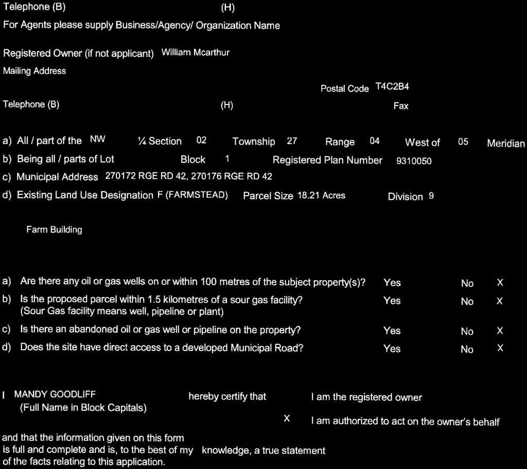
2 B-1 Page 1 of 28 PLANNING & DEVELOPMENT SERVICES TO: Subdivision and Development Appeal Board DATE: January 30, 2019 DIVISION: 09 FILE: APPLICATION: B-2; PRDP SUBJECT: Construction of an Accessory Building PROPOSAL: Construction of an accessory building (oversize pole structure) and relaxation of the maximum height requirement APPLICATION DATE: October 10, 2018 APPEAL DATE: January 3, 2019 APPELLANT: William McArthur LEGAL DESCRIPTION: Block 1, Plan (NW W05M) LAND USE DESIGNATION: Farmstead District (F) PERMITTED/DISCRETIONARY USE: Accessory buildings are a permitted when less than sq. m ( sq. ft.) and discretionary between sq. m ( sq. ft.) and sq. m (2, sq. ft.) PUBLIC SUBMISSIONS: The application was circulated to eight adjacent landowners. At the time this report was prepared, no letters were received in support or objection to the application. GENERAL LOCATION: Located approximately 0.81 km (1/2 mile) north of Hwy. 567 and on the east side of Hwy. 22 DEVELOPMENT AUTHORITY DECISION: Refused DEVELOPMENT AUTHORITY DECISION DATE: December 31, 2018 APPLICANT: Mandy Goodliff MUNICIPAL ADDRESS: Range Road 42 GROSS AREA: ± 7.37 hectares (± acres) DEVELOPMENT VARIANCE AUTHORITY: The Development Authority may grant a variance up to 25.00% of the maximum height requirement. LAND USE POLICIES AND STATUTORY PLANS: County Plan (C ) Land Use Bylaw (C ) EXECUTIVE SUMMARY: This application is for the construction of an accessory building (oversize pole structure), and relaxation of the maximum height requirement. The subject lands are designated Farmstead District and are surrounded by agricultural land. The proposed accessory building (oversize pole structure) is sq. m (2, sq. ft.) in size, which is within the allowable size limits for discretionary accessory buildings as specified in Section 47.3 of the Land Use Bylaw. The proposed building also complies with the minimum setback requirements for the Farmstead District as outlined in Section Page 2 of 80


3 B-1 Page 2 of 28 Page 3 of 80
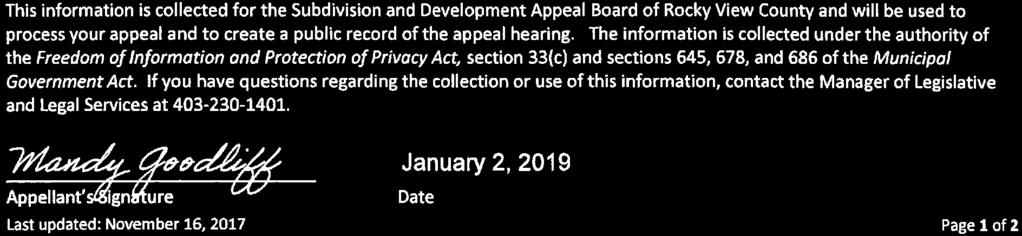
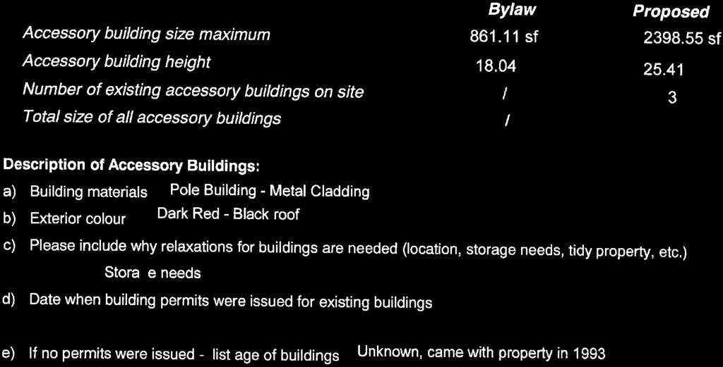
4 B-1 Page 3 of 28 DEVELOPMENT PERMIT REPORT Application Date: October 10, 2018 File: Application: PRDP Legal Description: Block 1, Plan (NW W05M) Land Use Designation: Farmstead District (F) Applicant/Owner: Mandy Goodliff / William & Lauren McArthur General Location: Located approximately 0.81 km (1/2 mile) north of Hwy. 567 and on the east side of Hwy. 22 Gross Area: ± 7.37 hectares (± acres) File Manager: Paul Simon Division: 09 PROPOSAL: This proposal is for the construction of an accessory building (oversize pole structure) and relaxation of the maximum height requirement. Building Dimensions (Sections 47.2 & 47.3) Permitted: Accessory building area sq. m ( sq. ft.) Discretionary: >80.00 sq. m ( sq. ft.) accessory building area and sq. m (2, sq. ft.) Proposed accessory building: sq. m (2, sq. ft.) Setback Requirements (Section 47.5) Front yard setback from a County road: o o Required: m ( ft.) Proposed accessory building: m ( ft.) Side yard setback from all other: o o Required: 6.00 m (19.69 ft.) Proposed accessory building: m ( ft.) / Lots Rear yard setback from all other: o o Required: m (49.20 ft.) Proposed accessory building: Lots Height Requirement (Section 47.7) Permitted: 5.50 m (18.04 ft.) Proposed accessory building: 7.75 m (25.42 ft.) o As per Section 12.2 of the Land Use Bylaw, the Development Authority may grant up to a 25% variance to the maximum height requirement. The requested relaxation equates to 40.91%, beyond the variance discretion of the Development Authority. Therefore the application had to be refused. Additional Information The property contains a dwelling and two accessory buildings (barn/quonset & quonset). Page 4 of 80
5 B-1 Page 4 of 28 The accessory building (barn/quonset they are connected) is approximately sq. m (4, sq. ft.) in size. o o This includes sq. m (2, sq. ft.) for the barn; and sq. m (1, sq. ft.) for the quonset. The accessory building (quonset) is approximately sq. m (1, sq. ft.) in size. While these buildings are not encroaching on any setbacks, they fall within the discretionary size limit for accessory buildings in the Farmstead District. The County does not have any records for the existing accessory buildings, indicating that they have been on the lands prior to redesignation and subdivision (1993) and were likely used in a previous farming operation for the quarter section. They are shown on the Applicant s site plan (RPR) from January 21, The County s Land Use Bylaw was updated in 1997, so when these buildings were placed, they would have been regulated under Land Use Bylaw C Under the Agricultural 2 District regulations, accessory buildings less on parcels greater than 4.05 ha (10.00 ac) less than 500 sq. m (5, sq. ft.) were permitted uses not requiring a development permit. Because these buildings were brought out of compliance due to changes made at the discretion of the County, they can remain as legal, non-confirming buildings. Note: There are no regulations in the Farmstead District that restrict the total number of accessory buildings or the total building area for all accessory buildings. Section 12 Decisions on Development Permit Applications 12.2 (c) Upon receipt of a completed application for a Development Permit for a use, discretionary, the Development Authority may decide upon an application for a Development Permit, notwithstanding that the proposed development does not comply with required yard, front, yard, side, yard, rear or building height dimensions set out in this Bylaw, if, in the opinion of the Development Authority, the granting of the variance would not: Property History: (ii) materially interfere with or affect the use, enjoyment, or value of the neighbouring properties and the amount of the variance does not exceed 25% of the required distance or height, or does not exceed 10% of the required maximum building area for an accessory building or does not exceed 10% of the required maximum floor area for an Accessory Dwelling Unit; August 9, 1993; Board Order was issued for a mobile home. o The application was subsequently renewed by the Subdivision and Development Appeal Board five times. The latest renewal was Board Order 84-10, issued on November 23, On August 21, 2015, the Applicant confirmed that the mobile home was no longer needed, and it was removed from site. January 7, 1993; Plan was registered, creating the subject lands. In summary, the application was refused for the following reason: 1. The height of the proposed accessory building (oversize pole structure) does not meet the maximum height requirement, as defined in Section 47.7 of the Land Use Bylaw. Required: 5.50 m (18.04 ft.); Proposed: 7.75 m (25.42 ft.) Page 5 of 80
6 B-1 Page 5 of 28 STATUTORY PLANS: The subject land does not fall within any Statutory Plans. INSPECTOR S COMMENTS: No inspection completed at the time this report was prepared. CIRCULATIONS: Alberta Transportation The proposed development falls within the control distance of a provincial highway as outlined in the Highways Development and Protection Act / Regulation, and will require a Roadside Development Permit from Alberta Transportation. o On December 14, 2018, Permit No. RSDP was issued by Alberta Transportation. Building Services, Rocky View County No comments received. Enforcement Services, Rocky View County OPTIONS: Option #1 Recommend that all construction debris and garbage be contained at all times during construction. That the appeal against the decision of the Development Authority to refuse to issue a Development Permit for the construction of an accessory building (oversize pole structure) and relaxation of the maximum height requirement at Block 1, Plan (NW W05M) ( RANGE ROAD 42) be upheld, that the decision of the Development Authority be revoked, and that the Development Permit be issued, subject to the following conditions: Description: 1) That the construction of an accessory building (oversize pole structure) may take place on the subject lands in accordance with the site plan, drawings submitted with the application (Integrity Built, Drawing No. MDD-IPS ) and conditions of this permit. 2) That the maximum height for the accessory building (oversize pole structure) is relaxed from 5.50 m (18.04 ft.) to 7.75 m (25.42 ft.). Permanent: 3) That the accessory building shall not be used for commercial purposes at any time, except for the Home-Based Business, Type I, or an approved Home-Based Business, Type II. 4) That the accessory building shall not be used for residential occupancy at any time. Advisory: 5) That any required building permits and/or sub-trade permits for the proposed accessory building shall be obtained through Building Services. 6) That any other federal, provincial or County permits, approvals, and/or compliances, are the sole responsibility of the Applicants/Owners. Page 6 of 80
7 B-1 Page 6 of 28 Option #2 That the appeal against the decision of the Development Authority to refuse to issue a Development Permit for the construction of an accessory building (oversize pole structure) and relaxation of the maximum height requirement at Block 1, Plan (NW W05M) ( RANGE ROAD 42) be denied, and that the decision of the Development Authority be upheld. Page 7 of 80
8 B-1 Proposal: Construction Page of an 7 of 28 accessory building (oversize pole structure) and relaxation of the maximum height requirement Date: 22-Jan-19 Division # 9 NW W05M Block:1 Plan: LOCATION PLAN File: Page 8 of 80
9 B-1 Page 8 of 28 Existing dwelling Existing accessory building (barn/quonset): sq. m (4, sq. ft.) Proposed accessory building (oversize pole structure): sq. m (2, sq. ft.) Existing accessory building (quonset): sq. m (1,140 sq. ft.) Date: 22-Jan-19 Division # 9 NW W05M Block:1 Plan: File: SITE PLAN Page 9 of 80
10 B-1 Page 9 of 28 Ranch and Farm B-1 Highway Business RF2 Ranch and Farm Two B-2 General Business RF3 Ranch and Farm Three B-3 Limited Business AH Agricultural Holding B-4 Recreation Business F Farmstead B-5 Agricultural Business R-1 Residential One B-6 Local Business R-2 Residential Two NRI Natural Resource Industrial R-3 Residential Three HR-1 Hamlet Residential Single Family DC Direct Control HR-2 Hamlet Residential (2) PS Public Service HC Hamlet Commercial AP Airport LAND USE MAP Date: 22-Jan-19 Division # 9 NW W05M Block:1 Plan: File: Page 10 of 80

11 B-1 Page 10 of 28 Note: Post processing of raw aerial photography may cause varying degrees of visual distortion at the local level. Date: 22-Jan-19 Division # 9 NW W05M Block:1 Plan: AIR PHOTO Spring 2018 File: Page 11 of 80

12 B-1 Page 11 of 28 Contours are generated using 10m grid points, and depict general topographic features of the area. Detail accuracy at a local scale cannot be guaranteed. They are included for reference use only. TOPOGRAPHY Contour Interval 2 M Date: 22-Jan-19 Division # 9 NW W05M Block:1 Plan: File: Page 12 of 80
13 B-1 Page 12 of m 7.75 m 7.75 m 7.75 m *Average Height Calculation: 7.75 m X 4 = / 4 = 7.75 m Date: 22-Jan-19 Division # 9 NW W05M Block:1 Plan: ELEVATIONS File: Page 13 of 80

14 B-1 Page 13 of 28 Legend Letters in Opposition Letters in Support Circulation Area Subject Lands LANDOWNER CIRCULATION AREA Date: 22-Jan-19 Division # 9 NW W05M Block:1 Plan: File: Page 14 of 80


15 B-1 Page 14 of 28 Page 15 of 80


16 B-1 Page 15 of 28 Page 16 of 80


17 B-1 Page 16 of 28 Page 17 of 80

18 B-1 Page 17 of 28 Page 18 of 80


19 B-1 Page 18 of 28 Page 19 of 80


20 B-1 Page 19 of 28 Page 20 of 80


21 B-1 Page 20 of 28 Page 21 of 80


22 B-1 Page 21 of 28 Page 22 of 80


23 B-1 Page 22 of 28 Page 23 of 80


24 B-1 Page 23 of 28 Page 24 of 80


25 B-1 Page 24 of 28 Page 25 of 80


26 B-1 Page 25 of 28 Page 26 of 80


27 B-1 Page 26 of 28 Page 27 of 80


28 B-1 Page 27 of 28 Page 28 of 80
29 B-1 Page 28 of 28 SUMMARY TABLE Building Area (sq. m) Front Yard Setback (m) Side Yard Setback (m) Side Yard Setback (m) Rear Yard Setback (m) Height (m) Bylaw Requirement County Road Other Other Other Dwelling/Accessory Building 1 Oversize Pole Structure lots lots 7.75 Variance Required? N/A N/A N/A N/A N/A 40.91% Page 29 of 80
30 B-2 Page 1 of 51 PLANNING & DEVELOPMENT SERVICES TO: Subdivision & Development Appeal Board DATE: January 30, 2019 DIVISION: 3 FILE: APPLICATION: PL SUBJECT: Subdivision Item Residential One District PROPOSAL: To create a ± 0.82 hectare (± 2.02 acre) parcel (Lot 1) with a ± 1.37 hectare (± 3.39 acre) remainder parcel. (Lot 2) LEGAL DESCRIPTION: Lot 1, Block 1, Plan within NW W05M APPLICANT: Kevin Peterson OWNER: Kevin and Jolene Peterson LAND USE DESIGNATION: Residential One District (R-1) DATE APPLICATON DEEMED COMPLETE: May 17, 2018 TECHNICAL REPORTS SUBMITTED: Level 3 Private Sewage Treatment System (PSTS) Assessment of Site Suitability (Sedulous Engineering, May 2018) Conceptual Level Site-Specific Storm Water management Plan Report Private Site (Sedulous Engineering, May 1, 2018) Slope Stability Assessment Revision 1 (E2K Engineering Ltd., March 19, 2018) Slope Stability Assessment Revision 2 (E2K Engineering Ltd., April 26, 2018) Slope Stability Assessment Revision 3 (E2K Engineering Ltd., September 19, 2018) GENERAL LOCATION: Located 6.3 kilometers (3.9 miles) west of the city of Calgary, approximately 1.3 km (4/5 mile) west of Range Road 31, and approximately 1.6 kilometers (1 mile) south of Lower Springbank Road. GROSS AREA: ±2.24 hectares (5.54 acres) RESERVE STATUS: Municipal Reserves were provided on the panhandle of proposed Lot 1 (Plan ); they are owing on the balance of the lands in question. LEVIES INFORMATION: Transportation Off-Site Levy is applicable in this case APPEAL BOARD: Subdivision & Development Appeal Board LAND USE POLICIES AND STATUTORY PLANS: County Plan (C ) Central Springbank Area Structure Plan (Bylaw C ) EXECUTIVE SUMMARY: On December 11, 2018, Council approved application PL The conditions of approval satisfy the requirements of the Municipal Government Act, the Subdivision and Development Regulations, statutory plans, bylaws, and County policies. On January 11, 2019, the Applicant appealed Council s decision to include conditions numbered 9 and 12, which read: Page 30 of 80
31 B-2 Page 2 of 51 9) The provision of Reserve in the amount of 10 percent of the area of Lots 1 and 2, as determined by the Plan of Survey, is to be provided by payment of cash-in-lieu in accordance with the per acre value as listed in the land appraisal 1, pursuant to Section 666(3) of the Municipal Government Act. 12) The Owner shall legally amend the existing Homeowners Association (HOA), and an encumbrance or instrument shall be concurrently registered against the title of each new lot created (Lot 1), requiring that each individual Lot Owner is a member of the Home Owners or Lot Owners Association: a) The HOA agreement shall specify the future maintenance obligations of the Homeowners Association for on-site pathways and community landscaping, residential solid waste collection at minimum. The Applicant requested that Council remove the requirement for Municipal Reserves and Transportation Off-site Levy. Council declined the request for removal of Municipal Reserves, but amended the requirement for Transportation Off-site Levy to the proposed new parcel only, excluding the remainder parcel with the existing single family dwelling. The conditions of approval from Council are attached to this report (Appendix B ) The Applicant has provided reasons for appeal, which are included in the Notice of Appeal attached to this report (Appendix C ). Home Owner s Association The existing development in Grand View Estates is part of a Homeowners Association (HOA), which is responsible for maintenance of the trail system, among other community benefits. As with the other landowners in the Grand View Estates subdivision, those using the facilities and services are members of the HOA. Lot 1 would be required to join the existing HOA immediately, as it would access the existing Grand View Estates subdivision via the existing panhandle access point that was created with the original approval of the Grand View Estates in The remainder parcel, Lot 2, containing the existing single family residence, would not be required to join the HOA, but would instead be required to use the existing access through the adjacent parcel to the north. Municipal Reserve The requirement to provide municipal reserve at the time of subdivision is enacted in section 661 of the Municipal Government Act. Reserves are collected when a parcel has limited further subdivision potential under current statutory policies; therefore, reserve is to be collected on both Lots 1 and 2. As the resulting parcels cannot be subdivided any further, Municipal Reserves are now required. Further, Legal and Land Administration recommended that reserves be provided by taking cash in lieu. Summary As detailed in the original staff report (Appendix A ), Administration recommended approval of this subdivision application, subject to specific conditions of approval presented for Council s consideration that were intended to satisfy the requirements of the Municipal Government Act, the Subdivision and Development Regulations, statutory plans, bylaws, and County policies. Administration does not recommend the removal of any of the conditions as approved by Council, as each has been included to ensure that the Subdivision Authority s obligations under the Municipal Government Act have been met. Administration is prepared to discuss this application and provide further information at the appeal hearing. 1 R Home Appraisals, File dated October 25, 2018 Page 31 of 80

32 B-2 Page 3 of 51 Page 32 of 80
33 APPENDIX 'A': Original December 11, 2018 Staff Report B-2 Page 4 of 51 TO: PLANNING & DEVELOPMENT SERVICES Subdivision Authority DATE: December 11, 2018 DIVISION: 3 FILE: APPLICATION: PL SUBJECT: 1 POLICY DIRECTION: Subdivision Item - Residential One District The application was evaluated against the terms of Section 654 of the Municipal Government Act, Section 7 of the Subdivision and Development Regulations, the policies found within the Central Springbank Area Structure Plan (CSASP), and the Grand View Estates Conceptual Scheme and was found to be compliant: The application is consistent with the Central Springbank Area Structure Plan (CSASP); The proposal is consistent with the Grand View Estates Conceptual Scheme; The subject lands hold the appropriate land use designation; and The technical aspects of the subdivision proposal were considered and are further addressed through the conditional approval requirements. EXECUTIVE SUMMARY: The purpose of this application is to create a ±0.82 hectare (2.02 acre) parcel (Lot 1), with a ±1.37 hectare (3.39 acre) remainder (Lot 2). The subject lands consist of a 5.54 acre parcel that currently accesses Range Road 32 via an existing access easement agreement with the adjacent lot to the north. The parcel currently contains a dwelling, which is located within the boundaries of proposed Lot 2. Servicing to the existing dwelling is provided via private sewage treatment system (PSTS) and water connection to Westridge Utilities. Lot 1 is proposed to be serviced by the same means. Proposed Lot 1 has panhandle access to Grandview Rise, which would require construction of an approach. The subject lands hold the Residential One District land use designation, which allows for the creation of a 2.00 acre parcel. The applicant prepared a slope stability assessment in consideration of the steep slopes located on the southern portion of the parcel, which was used by both the Level 3 PSTS Assessment and Conceptual Stormwater Management Plan to provide guidance on setbacks for septic (15 m) and structure (10m) from the crest of the slope, and the recommendations were accepted and included as conditions of approval as appropriate. The applicant would also be required to join the existing Homeowner s Association for proposed Lot 1. Lot 2 would not be required to join the Homeowner s Association, as access to the parcel is separate. The Applicant would be required to update the existing access easement for Lot 2 with the adjacent landowner, stating that only Lot 2 shall use the access. Administration determined that the application meets policy. PROPOSAL To create a ± 0.82 hectare (± 2.02 acre) parcel (Lot 1) with a ± 1.37 ha (± 3.39 acre) remainder parcel. (Lot 2) GENERAL LOCATION Located 6.3 kilometers (3.9 miles) west of the city of Calgary, approximately 1.3 km (4/5 mile) west of Range 1 Administration Resources Oksana Newmen, Planning & Development Services Erika Bancila, Planning & Development Services Page 33 of 80
34 APPENDIX 'A': Original December 11, 2018 Staff Report B-2 Page 5 of 51 Road 31, and approximately 1.6 kilometers (1 mile) south of Lower Springbank Road. LEGAL DESCRIPTION: Lot 1, Block 1, Plan within NW W05M APPLICANT: Kevin Peterson OWNER: Kevin and Jolene Peterson LAND USE DESIGNATION: Residential One District DATE APPLICATION RECEIVED: May 9, 2018 DATE DEEMED COMPLETE: May 17, 2018 TECHNICAL REPORTS SUBMITTED: Level 3 Private Sewage Treatment System (PSTS) Assessment of Site Suitability (Sedulous Engineering, May 2018) Conceptual Level Site-Specific Storm Water management Plan Report Private Site (Sedulous Engineering, May 1, 2018) Slope Stability Assessment Revision 1 (E2K Engineering Ltd., March 19, 2018) Slope Stability Assessment Revision 2 (E2K Engineering Ltd., April 26, 2018) Slope Stability Assessment Revision 3 (E2K Engineering Ltd., September 19, 2018) GROSS AREA: ±2.24 hectares (5.54 acres) RESERVE STATUS: Municipal Reserves were provided on the panhandle of proposed Lot 1 (Plan ); they are owing on the balance of the lands in question. LEVIES INFORMATION: Transportation Off- Site Levy is applicable in this case APPEAL BOARD: Subdivision and Development Appeal Board LAND USE POLICIES AND STATUTORY PLANS: Central Springbank Area Structure Plan (Bylaw C- C ) County Plan (C ) PUBLIC & AGENCY SUBMISSIONS: Five letters in opposition to the application were received out of 106 landowners notified (see Appendix D ). The application was also circulated to a number of internal and external agencies. The responses are available in Appendix B. HISTORY: May 8, 2018 May 5, 2006 March 31, 1995 March 29, 1995 Redesignation from Residential Two to Residential One District (PL ) Plan was registered, consolidating a portion of plan (road panhandle) with Lot 4, Block 1, Plan (subject lands) Building Permit 1995-BP-4528 was issued for a single family dwelling. Plan was registered, creating a 1.62 ha parcel and a 2.03 ha (subject lands) parcel. TECHNICAL CONSIDERATIONS: This application was evaluated in accordance with the matters listed in Section 7 of the Subdivision and Development Regulation, which are as follows: Page 34 of 80
35 APPENDIX 'A': Original December 11, 2018 Staff Report B-2 Page 6 of 51 a) The site s topography The topography of the lands contain a relatively flat portion, as well as a portion of steep terrain. The flat portion, generally around 3% slope, is located at the top of a slope that extends downwards to Springbank Creek. The existing home is located on the flat portion, and the proposed building area for Lot 1 is also located in the flat area. The sloped area varies from 15% to 30% slope, and is covered in trees and associated undergrowth. The slope area is not developed, and remains unused and undisturbed. Furthermore, the sloped area located on the southern portion of the property is under a restrictive covenant. Restrictions require that the lands not be developed or used for anything other than single family residential purposes, and that no buildings or structure except a deck or patio shall be constructed within the designated area. Conditions: None b) The site s soil characteristics Discussions with County Engineering staff yielded that the area is prone to impacts by underground springs. The applicant submitted two geotechnical reports by E2K Engineering that reference a February 2018 Geotechnical investigation completed by Lone Pine Geotechnical Ltd. The Level III PSTS Analysis also notes that the soil structure is of medium texture and has good structure, which is moderately well drained and has good to moderate permeability. In summary, the reports found that using a 10 m setback from the slope would meet or exceed the required industry standard stability safety factors, and that the proposed residence on Lot 1 can be constructed with a minimum setback of 10m from the crest of the slope. The report goes on to note that if a smaller setback was required for the proposed development, additional options such as retaining walls, slope reinforcement, or deep foundation could be explored. The report also noted that both the current and proposed conditions were modeled to show that the addition of a home at this location would not affect the overall stability of the slope. The report noted that no additional fill should be added to the property within 10 m of the crest of the slope, that drainage should be maintained so that no ponding of water could occur near the top of the slope, that septic fields should be kept away from the crest of the slope by a minimum of 15 m, that any re-configuration of the topography of the land should be verified prior to modification, and that any changes to the loading conditions from either the house or additional grade supported elements in the yard should be reviewed by a professional geotechnical expert. Based on review of the submitted reports, Administration has determined that soil characteristics are not an issue with either the proposed subdivision or the subsequent construction of a single family residence on the site when abiding by the recommendations in the geotechnical studies. Conditions: None c) Stormwater collection and disposal The Conceptual Level Site-Specific Storm Water Management Plan Report prepared for the site indicates that the proposed Lot 1 is suitable for the intended purposes of the subdivision from a stormwater perspective. It concludes that no formal stormwater pond or other stormwater infrastructure is required for the development. Condition: 8 Page 35 of 80
36 APPENDIX 'A': Original December 11, 2018 Staff Report B-2 Page 7 of 51 d) Any potential for flooding, subsidence, or erosion of the land As discussed above, steep slopes exist on the southern portion of the subject property. Guidelines regarding development of the site include setbacks from the slope. The presence of an existing restrictive covenant also adds security to slope impacts from development. The slope stability assessment also noted that since historical slope movement has somewhat stabilized, as evidenced by many years of stable conditions, and with improved drainage, movement that occurred in the past is not expected to occur outside of a significant precipitation event. The Level III PSTS Assessment noted that the site appears to be well drained with no evidence of standing water, and that the Elbow River is approximately 280 m to the southwest. In consideration of these points, the report concluded that the lands are not identified as being in a floodway, flood fringe, or overland flow flood fringe as per the AEP Flood Hazard Mapping, and that the lands did not flood during recent heavy precipitation events (i.e. 2005, 2007, or 2013 as per information received from the landowner). The Landowner/Applicant also stated a willingness to plant willow stakes along the steep southern slope in an effort to support slope stability. Condition: None e) Accessibility to a road The subject lands consist of a 5.54 acre parcel that currently accesses Range Road 32 via an existing access easement agreement with the adjacent lot to the north. Proposed Lot 1 has panhandle access to Grandview Rise, which would require construction of an approach. Transportation Offsite Levy Payment of the Transportation Offsite Levy is required for the total gross acreage of the lands proposed to be subdivided and is required to be provided through the conditions of subdivision approval, in accordance with Bylaw C : Base Levy = $4,595/ac x 5.54 ac = $25,456 Special Area 4 Levy = $11,380/ac x 5.54 ac = $63,045 Estimated TOL payment = $25,456 + $63,045 = $88,501 Conditions: 4, 5, 10 f) Water supply, sewage and solid waste disposal The Applicant has entered into a Water Supply Agreement with Doran Consulting Services Ltd. for supply of water from the Westridge Utility System. Westridge hascommitted to the provision of potable water to the future lot development. The existing home is also provided water service by Westridge. A Level 3 Private Sewage Treatment System Assessment was submitted, which indicates that the proposed new parcel is suitable for a PSTS. Specifically, the report recommends the use of a packaged sewage treatment system for the new lot due to the relatively high density in the surrounding area, and in order to adhere to County Policy. The Central Springbank ASP also states that parcels greater than 2 acres in size having suitable site conditions may employ a private sewage system. (Section 2.8.3) The Level 3 Assessment notes that the existing septic field for the existing house may need to be relocated in order to meet the recommended setbacks from the property line. The Applicant Page 36 of 80
37 APPENDIX 'A': Original December 11, 2018 Staff Report B-2 Page 8 of 51 agreed to relocate it should it be necessary and indicated that the existing septic system is in good working order. The proposed septic system (and potential relocation of the existing one) must also observe a 15 m setback from the crest of the slope. The Applicant currently transports their own solid waste off-site to their business site for disposal. The applicant indicated that the HOA does not currently include solid waste as part of the servicing, as multiple waste pickup services are in operation through private contracts with homeowners in the subdivision. The Applicant is in discussions with the Grand View Estates Home Owner s Association regarding membership, and based on feedback from the Applicant, both sides have a preliminary understanding regarding the scope of the agreement terms. The County would require that the new parcel join the HOA, and that the existing home-site parcel would continue to gain access through the access agreement with the parcel to the north, not through Grand View Estates. Conditions: 3, 6, 12 g) The use of the land in the vicinity of the site The subject site is located within the Grand View Estates Conceptual Scheme, which is residential and is consistent with the Central Springbank Area Structure Plan. To the north is the entirety of the Grand View Estates residential area, to the east and south is a large residential parcel with adjacent ranch and farm use, and to the west is agricultural use. Residential parcels in Grand View Estates are designated Residential One District, with minimum parcel sizes of 1.98 acres. Therefore, as this site is of the same land use designation, the proposed parcels at 2.02 and 3.39 acres are consistent with land use and parcel sizes in the area. As the site is included in Area B of the Grand View Estates Conceptual Scheme (Bylaw C ), the proposed subdivision and subsequent anticipated residential development of Lot 1 is consistent with land use in the area. Conditions: None h) Other matters While Municipal Reserve was provided for the panhandle portion of Lot 1 (0.156 hectares) when the subject lands were originally subdivided, the reserve calculations did not include the remainder of the subject parcel. Municipal Reserves were calculated based on Area A of the Grand View Estates subdivision, and did not include Area B. As such, Municipal Reserves are required for the subject parcel,excluding the panhandle. Lot 2: 3.39 acres X 10% = acres owing to be provided by cash in lieu (approximate calculation $61,773.33, final amount to be determined by plan of survey), in accordance with the Appraisal Report prepared by R Home Appraisals, file , dated October 17, 2018, in the amount of $182, per acre. Lot 1 (excluding panhandle of 0.39 acres) = [ = 1.63]: 1.63 acres X 10% = acres owing to be provided by cash in lieu (approximate calculation $29,702.22, final amount to be determined by plan of survey), in accordance with the Appraisal Report prepared by R Home Appraisals, file , dated October 17, 2018, in the amount of $182, per acre. Condition: 9 Page 37 of 80
38 APPENDIX 'A': Original December 11, 2018 Staff Report B-2 Page 9 of 51 POLICY CONSIDERATIONS: Interim Growth Plan The lands are within the Central Springbank Area Structure Plan, which is contemplated in the Interim Growth Plan. As such, this application is consistent. Intermunicipal Development Plan The lands are within the Policy Area of the Rocky View County/City of Calgary Intermunicipal Development Plan, and in accordance with the policies of that document, the City of Calgary was notified of the application. The City has no concerns with the proposal. County Plan The lands are located in an area designated as Country Residential, which requires development to proceed in accordance with the Central Springbank Area Structure Slan. As this proposed subdivision is in conformance, the site is consistent with the County Plan. Land Use Bylaw The Residential One District land use designation allows for parcels a minimum of 0.80 hectares (1.98 acres) in size and is intended for primarily residential purposes. The proposed parcel meets the minimum size provision, and the proposal is in alignment with the provisions of the Land Use Bylaw. Central Springbank Area Structure Plan The Central Springbank ASP identifies the subject lands as New Residential Areas. Section of the Central Springbank ASP identifies the general residential development policies and requires a conceptual scheme for this area; the Grand View Estates Conceptual Scheme (GVECS) was adopted in 2005 and is applicable to the subject lands. Section of the Central Springbank ASP provides guidance on development in the New Residential Areas. Policies 2.9.4(e) and 2.9.4(f) of the ASP are the most relevant to this development proposal. Policy 2.9.4(e) requires a minimum parcel size of 0.8 hectares (2.0 acres), and policy 2.9.4(f) requires a maximum of 64 lots per quarter section. This application proposes lots that are greater than 2 acres in size, and given that the subject lands span across two quarter sections, the proposal does not exceed the maximum requirement of 64 lots per quarter. Therefore, the application is consistent with the Central Springbank ASP. Policy of the conceptual scheme requires that redesignation and subdivision proposals that seek to create more than two lots be supported by an Outline Plan. As the application only seeks the ultimate creation of two lots, and given that the proposed parcel sizes do not allow for further subdivision, an Outline Plan is not required at this time. Grand View Estates Conceptual Scheme The proposed subdivision would result in parcels of 0.82 hectares (2.02 acres) and 1.37 hectares (3.39 acres). The Conceptual Scheme requires a minimum parcel size of 0.8 hectares (1.98 acres), and requires the maximum number of residential parcels on a quarter section to be 64. The proposed subdivision aligns with these requirements. The GVECS requires that redesignation and subdivision proposals that seek to create more than two lots be supported by an Outline Plan. As the application only seeks the ultimate creation of two lots (one new lot), and given that the proposed parcel sizes do not allow for further subdivision, an Outline Plan is not required. The Applicant provided a subdivision design that is consistent with the relevant plans and existing development and addresses all technical concerns in accordance with these policies. The existing development in Grand View Estates (Area A) is part of a Homeowners Association (HOA), Page 38 of 80
39 APPENDIX 'A': Original December 11, 2018 Staff Report B-2 Page 10 of 51 which is responsible for maintenance of the trail system, among other community benefits. In collaboration with the existing HOA, Lot 1 would be required to join the existing HOA immediately, while Lot 2 would be required to use the existing access through the adjacent parcel to the north. The proposed subdivision is compliant with the relevant Conceptual Scheme policies in terms of parcel size and servicing, and the remainder would be required to comply with as appropriate. Grand View Estates Outline Plan The Grand View Estates Conceptual Scheme includes an Appendix that pertains specifically to the subject site, and the Grand View Estates Subdivision. Section 1.2 notes that only Area A is subject to the rules of the Outline Plan, and Area B (which includes the subject property) would be required to complete their own background and site analysis prior to redesignation and subdivision. Policy states that, as part of the redesignation and subdivision process, Area B shall be required to demonstrate that any further subdivision is feasible and consistent with the GVECS and the Central Springbank ASP. The proposed subdivision complies with this policy. The Outline Plan also calls out the panhandle proposed for access of the subject parcel to ultimately provide access and to integrate the two existing residential parcels into Grand View Estates, and to be used for water, sanitary sewer, and private utilities. This was already accomplished, and Municipal Reserve was paid on this portion. CONCLUSION: The application meets the spirit and intent of the Central Springbank ASP, and the subject lands hold the appropriate land use designation for the intended parcel sizes. It appears as though a suitable building envelope is provided on proposed Lot 1. The most significant technical issue with the application pertains to stormwater management and placement of the septic system. Necessary setbacks from the steep slope for septic and structures would be provided as outlined in the technical and geotechnical studies, and as such, these technical issues are appropriately addressed through the conditions of approval. OPTIONS: Option #1: Option #2: THAT Subdivision Application PL be approved with the conditions noted in Appendix A. THAT Subdivision Application PL be refused per the reasons noted. Respectfully submitted, Concurrence, Sherry Baers Executive Director Community Development Services ON/rp Rick McDonald Interim County Manager APPENDICES: APPENDIX A : Approval Conditions APPENDIX B : Application Referrals APPENDIX C : Map Set APPENDIX D : Landowner comments Page 39 of 80
40 APPENDIX 'A': Original December 11, 2018 Staff Report B-2 Page 11 of 51 APPENDIX A: APPROVAL CONDITIONS A. That the application to create an ± 0.82 hectare (± 2.02 acre) parcel (Lot 1) with a ± 1.37 hectare (± 3.39 acre) remainder (Lot 2) from Lot 1, Block 1, Plan within NW W05M has been evaluated in terms of Section 654 of the Municipal Government Act and Section 7 of the Subdivision and Development Regulations. Having considered adjacent landowner submissions, it is recommended that the application be approved as per the Tentative Plan for the reasons listed below: 1. The application is consistent with the Central Springbank Area Structure Plan; 2. The subject lands hold the appropriate land use designation; and, 3. The technical aspects of the subdivision proposal were considered, and there are no technical limitations to the proposal. B. The Owner is required, at their expense, to complete all conditions attached to and forming part of this conditional subdivision approval prior to Rocky View County (the County) authorizing final subdivision endorsement. This requires submitting all documentation required to demonstrate each specific condition has been met, or agreements (and necessary securities) have been provided to ensure the condition will be met, in accordance with all County Policies, Standards and Procedures, to the satisfaction of the County, and any other additional party named within a specific condition. Technical reports required to be submitted as part of the conditions must be prepared by a Qualified Professional, licensed to practice in the Province of Alberta, within the appropriate field of practice. The conditions of this subdivision approval do not absolve an Owner from ensuring all permits, licenses, or approvals required by Federal Provincial, or other jurisdictions are obtained. C. Further, in accordance with Section 654 and 655 of the Municipal Government Act, the application is approved subject to the following conditions of approval: Plan of Subdivision 1) Subdivision is to be effected by a Plan of Survey, pursuant to Section 657 of the Municipal Government Act, or such other means satisfactory to the Registrar of the South Alberta Land Titles District. 2) The Owner is to provide a Site Plan, prepared by an Alberta Land Surveyor, which illustrates the following in relation to the new property lines: a) The Site Plan is to confirm that all existing private sewage treatment systems are located within the boundaries of Lot 2, in accordance with the The Alberta Private Sewage Systems Standard of Practice Development Agreement Site Improvements/Services Agreement 3) The Owner is to enter into a Development Agreement (Site Improvements / Services Agreement) with the County and shall: a) Be in accordance with the Level 3 Private Sewage Treatment Systems (PSTS) Assessment of Site Suitability of Lot 1, Block 1, Plan prepared by Sedulous Engineering for the construction of a packaged Private Sewage Treatment System; and b) Be in accordance with the Slope Stability Assessment (Revision 3) prepared by e2k Engineering Ltd. Page 40 of 80
41 APPENDIX 'A': Original December 11, 2018 Staff Report B-2 Page 12 of 51 Transportation and Access 4) The Owner shall construct a new paved approach on Grandview Rise in order to provide access to Lot 1. If a mutual approach is constructed, the Owner shall: a) Provide an access right of way plan; and b) Prepare and register respective easements on each title, where required, with those lots using the access route, and then be required to join the Homeowner s Association. 5) The Applicant/Owner shall enter into an Access Easement Agreement with the adjacent landowner at Lot 3, Block 1, Plan , within SW W5M to provide access to Lot 2 only, as per the approved Tentative Plan, which shall include: a) Registration of the applicable access right-of-way plan. Water Servicing 6) The Owner is to provide confirmation of tie-in for connection to the Westridge Utility System, an Alberta Environment licensed piped water supplier, for Lot 1, as shown on the Approved Tentative Plan. This includes providing the following information: o Documentation proving that water supply has been purchased for proposed Lot 1; o Documentation proving that all necessary water infrastructure is installed. Erosion and Sediment Control Plan 7) The Owner is to provide a Sediment Control Plan. Stormwater Conditions 8) The Owner is to provide and implement a Site Specific Stormwater Management Plan, which meets the requirements outlined in the Springbank Master Drainage Plan.: a) Should the (Site Specific) Stormwater Management Plan indicate that improvements are required, the Applicant/Owner shall enter into a Development Agreement (Site Improvements/Services Agreement) with the County; b) Provision of necessary Alberta Environment and Parks registration documentation and approvals for the stormwater infrastructure system. Municipal Reserves 9) The provision of Reserve in the amount of 10 percent of the area of Lots 1 and 2, as determined by the Plan of Survey, is to be provided by payment of cash-in-lieu in accordance with the per acre value as listed in the land appraisal 2, pursuant to Section 666(3) of the Municipal Government Act. Payments and Levies 10) The Owner shall pay the Transportation Off-Site Levy in accordance with Bylaw C The County shall calculate the total amount owing. a) From the total gross acreage of the Lands to be subdivided as shown on the Plan of Survey. 11) The Owner shall pay the County subdivision endorsement fee, in accordance with the Master Rates Bylaw, for the creation of one new Lot. 2 R Home Appraisals, File dated October 25, 2018 Page 41 of 80
42 APPENDIX 'A': Original December 11, 2018 Staff Report B-2 Page 13 of 51 Homeowners Association Taxes 12) The Owner shall legally amend the existing Homeowners Association (HOA), and an encumbrance or instrument shall be concurrently registered against the title of each new lot created (Lot 1), requiring that each individual Lot Owner is a member of the Home Owners or Lot Owners Association: a) The HOA agreement shall specify the future maintenance obligations of the Homeowners Association for on-site pathways and community landscaping, residential solid waste collection at minimum. 13) All taxes owing, up to and including the year in which subdivision is to be registered, are to be paid to Rocky View County prior to signing the final documents pursuant to Section 654(1) of the Municipal Government Act. D. SUBDIVISION AUTHORITY DIRECTION: 1) Prior to final endorsement of the Subdivision, the Planning Department is directed to present the Owner with a Voluntary Recreation Contribution Form and ask them if they will contribute to the Fund in accordance with the contributions prescribed in the Master Rates Bylaw. Page 42 of 80
43 APPENDIX 'A': Original December 11, 2018 Staff Report B-2 Page 14 of 51 APPENDIX B: APPLICATION REFERRALS AGENCY COMMENTS School Authority Rocky View Schools No objection. Calgary Catholic School District Public Francophone Education Catholic Francophone Education No response. No response. No response. Province of Alberta Alberta Environment Alberta Transportation Alberta Sustainable Development (Public Lands) Not required for circulation. Not required for circulation. Not required for circulation. Alberta Culture and Community Spirit (Historical Resources) Not required for circulation. Alberta Energy Resources Conservation Board No response. Alberta Health Services Thank you for inviting our comments on the above-referenced application. Alberta Health Services (AHS) understands that this application is proposing to subdivide the subject lands to create a 2.02 acre parcel with 3.39 remaining. We provide the following comments for your consideration with regard to planning future development on the site: 1. The application indicates that potable water will be supplied by Westridge Utilities. AHS recommends that it is confirmed that the existing water system will be able to meet any increased water demand resulting from this proposed development. 2. Any existing or proposed private sewage disposal systems should be completely contained within the proposed property boundaries and must comply with the setback distances Page 43 of 80
44 APPENDIX 'A': Original December 11, 2018 Staff Report B-2 Page 15 of 51 AGENCY COMMENTS outlined in the most recent Alberta Private Sewage Systems Standard of Practice. Prior to installation of any sewage disposal system, a proper geotechnical assessment should be conducted by a qualified professional engineer and the system should be installed in an approved manner. 3. The property must be maintained in accordance with the Alberta Public Health Act, Nuisance and General Sanitation Guideline 243/2003 which stipulates, No person shall create, commit or maintain a nuisance. A person who creates, commits or maintains any condition that is or might become injurious or dangerous to the public health or that might hinder in any manner the prevention or suppression of disease is deemed to have created, committed or maintained a nuisance. If any evidence of contamination or other issues of public health concern are identified at any phase of development, AHS wishes to be notified. Please call (403) or carol.brittain@ahs.ca if you have any questions. Public Utility ATCO Gas ATCO Pipelines AltaLink FortisAlberta No response. No concerns. No response. Thank you for contacting FortisAlberta regarding the above application for subdivision. We have reviewed the plan and determined that no easement is required by FortisAlberta. FortisAlberta is the Distribution Wire Service Provider for this area. The developer can arrange installation of electrical services for this subdivision through FortisAlberta. Please have the developer contact 310-WIRE ( ) to make application for electrical services. Please contact FortisAlberta land services at landserv@fortisalberta.com or by calling (403) for any questions. Page 44 of 80
45 APPENDIX 'A': Original December 11, 2018 Staff Report B-2 Page 16 of 51 AGENCY Telus Communications Direct Energy TransAlta Calgary Airport Authority COMMENTS No response. Not circulated. No response. Not required for circulation. Adjacent Municipality The City of Calgary No objection. Other External Agencies EnCana Corporation Enmax No response. No response. Rocky View County Boards and Committees Agricultural Service Board Farm Members and Agricultural Fieldman Not required for circulation. Rocky View West Recreation Board Cash in lieu. Internal Departments Legal and Land Administration Development Authority This location has not been identified for future Municipal Reserve acquisition to support public park, open space, pathway or trail development; therefore, the Municipal Lands office recommends the taking cash in lieu of land dedication for any outstanding reserves owing associated with lands subject to this application. No objections or comments. GeoGraphics No response. Page 45 of 80
46 APPENDIX 'A': Original December 11, 2018 Staff Report B-2 Page 17 of 51 AGENCY Bylaw and Municipal Enforcement COMMENTS No comments. Fire Services Planning & Development Services - Engineering Having reviewed the circulation, The Fire Service has only one comment which is to ensure that the grade of the driveway does not exceed the grade required in the RVC Servicing Standards or the Alberta Building Code. No further comments at this time. General The review of this file is based upon the application submitted. These conditions/recommendations may be subject to change to ensure best practices and procedures. Geotechnical - Section requirements: Due to steep slopes present on the property, the Applicant has been required to prepare a Slope Stability Assessment. o A slope stability Assessment dated March 19, 2018 has been prepared by E2K and an updated report dated April 26. To assess the global stability of the site, two sections deemed representative worst-case scenarios were analyzed. The report demonstrated that the addition of a home positioned with a setback of 10 m from the crest of the slope, will not affect the stability of the slope. A safety factor of 1.6 was calculated, which is above the industry standard of 1.5. The area is known to have high groundwater levels and there were slope movements in the past (2005). Since then, it is expected the area has somewhat stabilized, now has improved drainage patterns and therefore the same movement is not expected to occur outside of a significant precipitation event (1:50 or 1:100). The Geotechnical Engineer s opinion is that the proposed development will not have a negative impact on the slopes and the slopes condition would be the same as under postdevelopment. The subject lands have a restrictive covenant in place with the following stipulations: o The lands shall not be developed or used other than for single family residential purposes; o No buildings or structure except a deck or patio shall be constructed within the Area Required for Restrictive Covenant Purposes, Plan The Applicant has demonstrated the new lot has over 1 acre Page 46 of 80
47 APPENDIX 'A': Original December 11, 2018 Staff Report B-2 Page 18 of 51 AGENCY COMMENTS developable area through Figure 4, prepared by Sedulous Engineering dated September 18, Transportation - Section requirements: The applicant currently has access to RGE RD 32 through a registered access easement agreement with the owner of the north adjacent lot (instrument ); As a condition of Subdivision endorsement, the applicant will be required to build a single paved road approach connecting to Grandview Rise Road, as per Rocky View County standards; Prior to the installation of the approaches, the developer shall make a road approach application with the Road Operations Department; As a condition of Subdivision, if a mutual (shared) access is to be used benefitting the existing as well as new parcel, the applicant shall provide a Right-of-Way Plan and Access Easement Agreement to register on the title of each parcel. o It is noted the panhandle does not meet current Rocky View County standards of 12.5 m due to the existing approximately 10 m ROW; The applicant has registered access easement agreement benefiting the owner of the south adjacent lot (Kestrel Farms) for RR 32 access (instrument ). It is noted this is the main/most used access to Kestrel Farms lands. As a condition of Subdivision endorsement, the applicant will be required to provide payment of the Transportation Offsite Levy (TOL) in accordance with applicable levy at time of Subdivision and/or Development Permit approval, as amended, for the total gross acreage of 5.54 acres. The estimated levy payment owed at time of subdivision endorsement is $88,501 (Base =$4,595/ac x 5.54 ac = $25,456; Special Area 4 = $11,380/ac x 5.54 ac = $63,045). Sanitary/Waste Water - Section requirements: As a condition of Subdivision, the owner shall enter into a Site Improvements/ Services Agreement (SISA) with the County to ensure construction of a Packaged Sewage Treatment System to the satisfaction of the County; The SISA will also ensure recommendations of the April 26 th 2018 Slope Stability Assessment Report prepared by E2K Engineering are followed at future Development Permit/Building Permit stage. o As per Policy 449, for residential developments relying on PSTS, where lot sizes are equal to, or greater than, Page 47 of 80
48 APPENDIX 'A': Original December 11, 2018 Staff Report B-2 Page 19 of 51 AGENCY COMMENTS 1.98 acres but less than 3.95 acres the County requires the use of Packaged Sewage Treatment Plant on individual lots which meet the Bureau de Normalisation du Quebeq (NBQ) standards for treatment and the requirements set out in Procedure 449; o Septic fields should be kept away from the crest of the slope by a minimum 15 m setback. Water Supply And Waterworks - Section & requirements: The Applicant/ Owner had entered into a Water Supply Agreement with Doran Consulting Services for the Supply of Water from the Westridge Utility System. A confirmation letter dated January 2, 2018 has been provided that the water supply is available for the proposed Lot 2 and 3; As a condition of subdivision, the Owner is to provide confirmation of the tie-in for connection to Westridge Utility. This includes providing the following information: o Documentation proving that water supply has been purchased for the newly created lot; o Documentation proving that water supply infrastructure requirements including servicing to the properties have been installed or installation is secured between the developer and water supplier, to the satisfaction of the water supplier and the County. Storm Water Management Section requirements: As a condition of Subdivision, a site specific storm water management report (SSIP) report will be required in accordance with the Springbank Master Drainage Plan prepared 2016 MPE Engineering. The report has to demonstrate site drainage will not negatively impact the site slope stability. Should the SSIP indicate that improvements are required the Applicant/Owner shall enter into a Site Improvement/Services Agreement with the County for the implementation of specific improvements; Any re-configuration of the topography of the land should be verified by E2K prior to modification, to ensure slope stability meets the required safety factor. o The applicant has submitted a conceptual level site specific storm water management report (SSIP) prepared by Sedulous Engineering, dated May 1, The report indicates the land that is proposed to be subdivided, is suitable for the purpose for which the subdivision is intended, from a storm water management perspective and no formal stormwater pond or other formal stormwater infrastructure is required for this Page 48 of 80
49 APPENDIX 'A': Original December 11, 2018 Staff Report B-2 Page 20 of 51 AGENCY COMMENTS development. Also, the site conforms to the MDP criteria. o Drainage should be maintained so that no ponding water can occur near the top of the slope. Environmental Section requirements: As a condition of subdivision, an Erosion and Sediment Control plan will be required. o Approximately 3000 m³ of the southwest portion of the remainder parcel is labeled as riparian area in the Alberta Merged Wetland Inventory. A very small portion of the newly created lot falls in the riparian area category. These lands fall within Section 41 regulation of the current land use bylaw in effect (Bylaw C ) and also form part of the restrictive covenant area. Transportation Services Capital Project Management Utility Services Property access must be from Grandview Rise and not from private driveway to the south. Application for approach off Grandview Rise has been approved. No concerns. Because this parcel falls within the Central Springbank ASP, (formerly) Agricultural Services has no concerns. Circulation Period: June 6, 2018 July Page 49 of 80

50 B-2 Page 21 of 51 APPENDIX 'B': Transmittal of Decision Rocky View Point Rocky View County, AB, T4A OX2 ROCKY VIEW COUNTY Date Mailed: Wednesday, December 19, 2018 Peterson, Kevin File: PL RE: SUBDIVISION TRANSMITTAL OF DECISION Pursuant to a decision of the Subdivision Authority for Rocky View County on December 11, 2018, your Subdivision Application was conditionally approved. The conditions of approval are outlined below: A. That the application to create an ± 0.82 hectare (± 2.02 acre) parcel (Lot 1) with a ± 1.37 hectare (± 3.39 acre) remainder (Lot 2) from Lot 1, Block 1, Plan within NW W05M has been evaluated in terms of Section 654 of the Municipal Government Act and Section 7 of the Subdivision and Development Regulations. Having considered adjacent landowner submissions, it is recommended that the application be approved as per the Tentative Plan for the reasons listed below: 1) The application is consistent with the Central Springbank Area Structure Plan; 2) The subject lands hold the appropriate land use designation; and, 3) The technical aspects of the subdivision proposal were considered, and there are no technical limitations to the proposal. B. The Owner is required, at their expense, to complete all conditions attached to and forming part of this conditional subdivision approval prior to Rocky View County (the County) authorizing final subdivision endorsement. This requires submitting all documentation required to demonstrate each specific condition has been met, or agreements (and necessary securities) have been provided to ensure the condition will be met, in accordance with all County Policies, Standards and Procedures, to the satisfaction of the County, and any other additional party named within a specific condition. Technical reports required to be submitted as part of the conditions must be prepared by a Qualified Professional, licensed to practice in the Province of Alberta, within the appropriate field of practice. The conditions of this subdivision approval do not absolve an Owner from ensuring all permits, licenses, or approvals required by Federal Provincial, or other jurisdictions are obtained. C. Further, in accordance with Section 654 and 655 of the Municipal Government Act, the application is approved subject to the following conditions of approval: Plan of Subdivision 1) Subdivision is to be effected by a Plan of Survey, pursuant to Section 657 of the Municipal Government Act, or such other means satisfactory to the Registrar of the South Alberta Land Titles District. 2) The Owner is to provide a Site Plan, prepared by an Alberta Land Surveyor, which illustrates Page 50 of 80
51 APPENDIX 'B': Transmittal of Decision B-2 Page 22 of 51 ROCKY VIEW COUNTY the following in relation to the new property lines: Rocky View Point Rocky View County, AB, T4A OX a) The Site Plan is to confirm that all existing private sewage treatment systems are located within the boundaries of Lot 2, in accordance with the The Alberta Private Sewage Systems Standard of Practice Development Agreement- Site Improvements/Services Agreement 3) The Owner is to enter into a Development Agreement (Site Improvements I Services Agreement) with the County and shall: a) Be in accordance with the Level 3 Private Sewage Treatment Systems (PSTS) Assessment of Site Suitability of Lot 1, Block 1, Plan prepared by Sedulous Engineering for the construction of a packaged Private Sewage Treatment System; and b) Be in accordance with the Slope Stability Assessment (Revision 3) prepared by e2k Engineering Ltd. Transportation and Access 4) The Owner shall construct a new paved approach on Grandview Rise in order to provide access to Lot 1. If a mutual approach is constructed, the Owner shall: a) Provide an access right of way plan; and b) Prepare and register respective easements on each title, where required, with those lots using the access route, and then be required to join the Homeowner's Association. 5) The Applicant/Owner shall enter into an Access Easement Agreement with the adjacent landowner at Lot 3, Block 1, Plan , within SW W5M to provide access to Lot 2 only, as per the approved Tentative Plan, which shall include: a) Registration of the applicable access right-of-way plan. Water Servicing 6) The Owner is to provide confirmation of tie-in for connection to the Westridge Utility System, an Alberta Environment licensed piped water supplier, for Lot 1, as shown on the Approved Tentative Plan. This includes providing the following information: a) Documentation proving that water supply has been purchased for proposed Lot 1; b) Documentation proving that all necessary water infrastructure is installed. Erosion and Sediment Control Plan 7) The Owner is to provide a Sediment Control Plan. Stormwater Conditions 8) The Owner is to provide and implement a Site Specific Stormwater Management Plan, which meets the requirements outlined in the Spring bank Master Drainage Plan.: a) Should the (Site Specific) Stormwater Management Plan indicate that improvements are required, the Applicant/Owner shall enter into a Development Agreement (Site Improvements/Services Agreement) with the County; Page 51 of 80
52 APPENDIX 'B': Transmittal of Decision B-2 Page 23 of 51 ROCKY VIEW COUNTY Rocky View Point Rocky View County, AB, T4A OX b) Provision of necessary Alberta Environment and Parks registration documentation and approvals for the stormwater infrastructure system. Municipal Reserves 9) The provision of Reserve in the amount of 1 0 percent of the area of Lots 1 and 2, as determined by the Plan of Survey, is to be provided by payment of cash-in-lieu in accordance with the per acre value as listed in the land appraisal (RHome Appraisals; File dated October 25, 2018), pursuant to Section 666(3) of the Municipal Government Act: Payments and Levies 10) The Owner shall pay the Transportation Off-Site Levy in accordance with Bylaw C The County shall calculate the total amount owing. a) From the total gross acreage of Lot 1 to be subdivided as shown on the Plan of Survey; and b) That payment of the Transportation Off-Site Levy on Lot 2 to be subdivided as shown on the Plan of Survey be deferred. 11) The Owner shall pay the County subdivision endorsement fee, in accordance with the Master Rates Bylaw, for the creation of one new Lot. Homeowners Association Taxes 12) The Owner shall legally amend the existing Homeowners' Association (HOA), and an encumbrance or instrument shall be concurrently registered against the title of each new lot created (Lot 1}, requiring that each individual Lot Owner is a member of the Home Owners' or Lot Owners' Association: a) The HOA agreement shall specify the future maintenance obligations of the Homeowners' Association for on-site pathways and community landscaping, residential solid waste collection at minimum. 13) All taxes owing, up to and including the year in which subdivision is to be registered, are to be paid to Rocky View County prior to signing the final documents pursuant to Section 654(1) of the Municipal Government Act. D. SUBDIVISION AUTHORITY DIRECTION: 1) Prior to final endorsement of the Subdivision, the Planning Department is directed to present the Owner with a Voluntary Recreation Contribution Form and ask them if they will contribute to the Fund in accordance with the contributions prescribed in the Master Rates Bylaw. Prior to the submission of any final documents, we advise that it is the applicant's responsibility to ensure that all conditions of approval have been met and all approval fees paid within ONE YEAR of the approval date, and that the Municipality has received documented evidence to this effect. Pursuant to the Municipal Government Act, and in keeping with the instructions set out in the attached Page 52 of 80
53 APPENDIX 'B': Transmittal of Decision B-2 Page 24 of 51 'ROCKY VIEW COUNTY Rocky View Point Rocky View County, AB, T4A OX Notice of Appeal form, an appeal or dispute from this decision, or the conditions, may be commenced within 21 days from the date of this letter by: a) the applicant; b) a Government Department where a referral is required pursuant to the Subdivision and Development Regulation; and/or c) a school authority with respect to Reserve An appeal to this decision rests with the Subdivision and Development Appeal Board. Use of the attached Notice of Subdivision Appeal form is required for submission of the appeal. DUE TO THE POSSIBILITY OF APPEALS, any development or steps necessary to meet the conditions of approval should not occur within 21 days from the date of this letter. The Subdivision Authority reserves the right to make corrections to any technical or clerical errors or omissions to this decision. Should you have any questions or concerns, please contact Oksana Newmen at for assistance and quote the file number as noted above. Charlotte Satink Municipal Clerk csatink@rockyview.ca cc: Peterson, Kevin & Jolene Page 53 of 80
54 Subdivision Proposal: To create a± 0.82 hectare(± 2.02 acre) parcel with ±1.37 hectare(± 3.39 acre) remainder. N I') 0 ~ RockY viewiounty CONDI IONAL APPROVAL ON: DEC w This Tentative Plan forms part of the ~ :' ~-~9_qi_xlai.of..1- Ac.1lfOr l y"s --d.ecision for! , LL..._. thi~ ~~tnc J.,.1s1m1 ai1d - iil s.?c-coo~.pany _-_ , >, ffie l ransmittal of Decision lefit!rdatea ~J \\ ~ ~ DEC : ~.. signed: L t!ja:bn l( Legend D Accessory Building ~ Dwelling = Access Existing Driveway 3S 'o/ Septic System APPENDIX 'B': Transmittal of Decision B-2 Page 25 of 51 t Lot2 ± 1.37 ha (± 3.39 ac) '... ' '. '.. ' ' '. /', \ ' '. '. ' ' ' '. \, ' -- ' I ' ' \ \ I,: '\, \... I ' ~ \ \I ', \ ',,, ' ' ' : r.....,.,.,,j ,-, ~, rv ~,,, I Lot 1 ± 0.82 ha (± 2.02 ac) J Surveyor's Notes: 1. Parcels must meet minimum size and setback requirements of Land Use Bylaw C Refer to Notice of Transmittal for approval conditions related to this Tentative Plan. Lot:1 Block:1 Plan: NW WOSM Date: May 23, 2018 Division# 3 File: TENTATIVE PLAN Page 54 of 80
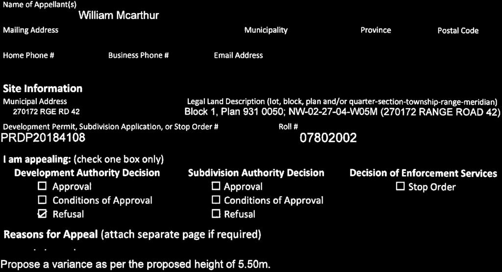
55 APPENDIX 'C': Notice of Appeal Form B-2 Page 26 of 51 Notice of Appeal Subdivision and Development Appeal Board Development Authority Decision D Approval ~nditions of Approval 0 Refusal Subdivision Authority Decision OApproval 0 Conditions of Approval 0 Refusal Decision of Enforcement Services D Stop Order Reasons for Appeal (attach separate page if required) This information is collected for Subdivision and Development Appeal Board of Rocky View County and will be used to process your appeal and to create a public record of the appeal hearing. The Information Is collected under the authority of the Freedom of Information ond Protection of Prlvocy Ad, section 33(c) and sections 645, 678, and 686 of the Municipal Government Ad. If you have questions regarding the collection or use of this Information, contact the Manager of Legislative and Legal Services at :, 401. ~. rgnature Last updated: November 16, 2017 L Page lof 2 Page 55 of 80
56 APPENDIX 'C': Notice of Appeal Form B-2 Page 27 of 51 From: holtnusery ] Sent: Friday, January 11, :01 AM To: Oksana Newmen Subject: Fw: Kevin Peterson Appeal -Jan 11, 2019 Oksana Find attached my notice of appeal Not sure whether it was the mail strike or Christmas but I only received the letter 1st of this week Kevin Forwarded Message From: Jolene M To: Sent: Friday, January 11, 2019, 07:54:28 AM MST Subject: Kevin Peterson Appeal -Jan 11, 2019 Scanned with TurboScan. 1 Page 56 of 80
57 B-2 Page 28 of 51 Lot:1 Block:1 Plan: NW W05M Date: May 23, 2018 Division # 3 LOCATION PLAN File: Page 57 of 80
58 B-2 Subdivision Proposal: Page 29 of 51 To create a ± 0.82 hectare (± 2.02 acre) parcel with ±1.37 hectare (± 3.39 acre) remainder. Legend Accessory Building Dwelling Access Existing Driveway Septic System Lot 2 ± 1.37 ha (± 3.39 ac) Lot 1 ± 0.82 ha (± 2.02 ac) Surveyor s Notes: 1. Parcels must meet minimum size and setback requirements of Land Use Bylaw C Refer to Notice of Transmittal for approval conditions related to this Tentative Plan. Lot:1 Block:1 Plan: NW W05M Date: May 23, 2018 Division # 3 TENTATIVE PLAN File: Page 58 of 80

59 B-2 Page 30 of 51 Ranch and Farm B-1 Highway Business RF2 Ranch and Farm Two B-2 General Business RF3 Ranch and Farm Three B-3 Limited Business AH Agricultural Holding B-4 Recreation Business F Farmstead B-5 Agricultural Business R-1 Residential One B-6 Local Business R-2 Residential Two NRI Natural Resource Industrial R-3 Residential Three HR-1 Hamlet Residential Single Family DC Direct Control HR-2 Hamlet Residential (2) PS Public Service HC Hamlet Commercial AP Airport LAND USE MAP Lot:1 Block:1 Plan: NW W05M Date: May 23, 2018 Division # 3 File: Page 59 of 80

60 B-2 Page 31 of 51 Note: Post processing of raw aerial photography may cause varying degrees of visual distortion at the local level. Lot:1 Block:1 Plan: NW W05M Date: May 23, 2018 Division # 3 AIR PHOTO Spring 2016 File: Page 60 of 80

61 B-2 Page 32 of 51 Contours are generated using 10m grid points, and depict general topographic features of the area. Detail accuracy at a local scale cannot be guaranteed. They are included for reference use only. TOPOGRAPHY Contour Interval 2 M Lot:1 Block:1 Plan: NW W05M Date: May 23, 2018 Division # 3 File: Page 61 of 80


62 B-2 Page 33 of Lot:1 Block:1 Plan: NW W05M Date: May 23, 2018 Division # 3 File: Page 62 of 80


63 B-2 Page 34 of Lot:1 Block:1 Plan: NW W05M Date: May 23, 2018 Division # 3 File: Page 63 of 80

 File: 04711031")
64 B-2 Page 35 of 51 Lot:1 Block:1 Plan: NW W05M Date: May 23, 2018 Division # 3 LEVEL 3 PSTS MAP (By Sedulous Engineering) File: Page 64 of 80

65 B-2 Page 36 of 51 LAND CAPABILITY CLASSIFICATION LEGEND Limitations refer to cereal, oilseeds and tame hay crops CLI Class Limitations 1 - No significant limitation B - brush/tree cover N - high salinity 2 - Slight limitations C - climate P 3 - Moderate limitations D - low permeability R 4 - Severe limitations E - erosion damage S - high sodicity 5 - Very severe limitations F - poor fertility T 6 - Production is not feasible G - Steep slopes U 7 - No capability H - temperature V I - flooding J - field size/shape K - shallow profile development M - low moisture holding, adverse texture - excessive surface stoniness - shallowness to bedrock - adverse topography - prior earth moving - high acid content W - excessive wetness/poor drainage X - deep organic deposit Y - slowly permeable Z - relatively impermeable SOIL MAP Lot:1 Block:1 Plan: NW W05M Date: May 23, 2018 Division # 3 File: Page 65 of 80
66 B-2 Page 37 of 51 Legend Plan numbers First two numbers of the Plan Number indicate the year of subdivision registration. Plan numbers that include letters were registered before 1973 and do not reference a year Lot:1 Block:1 Plan: NW W05M Date: May 23, 2018 Division # 3 HISTORIC SUBDIVISION MAP File: Page 66 of 80

67 B-2 Page 38 of 51 Legend Letters in Opposition Letters in Support Circulation Area Subject Lands LANDOWNER CIRCULATION AREA Lot:1 Block:1 Plan: NW W05M Date: May 23, 2018 Division # 3 File: Page 67 of 80

68 B-2 Page 39 of 51 Page 68 of 80
69 B-2 Page 40 of 51 Page 69 of 80
70 B-2 Page 41 of 51 Page 70 of 80
71 B-2 Page 42 of 51 Page 71 of 80
72 B-2 Page 43 of 51 Page 72 of 80
73 B-2 Page 44 of 51 Page 73 of 80

74 B-2 Page 45 of 51 Page 74 of 80
The Chair called the meeting to order at 9:00 a.m. with all members present with the exception of Councillor Wright and Councillor Kissel.
 Page 1 A regular meeting of Rocky View County Council was held in the Council Chambers of the County Hall, 262075 Rocky View Point, Rocky View County, Alberta on commencing at 9:00 a.m. Present: Division
MUNICIPAL DISTRICT OF ROCKY VIEW NO. 44 ELBOW VALLEY WEST DIRECT CONTROL DISTRICT BYLAW C
 This document has been consolidated for convenience only. A current listing of any and all amendments can be obtained from the Municpal District Office Bylaw No. Date of Approval Amendment Type Bylaw C-6042-2005
MINUTES OF THE MUNICIPAL PLANNING COMMISSION Tuesday, May 5, 2015 Red Deer County Council Chambers, Red Deer County Centre
 MINUTES OF THE MUNICIPAL PLANNING COMMISSION Tuesday, May 5, 2015 Red Deer County Council Chambers, Red Deer County Centre Present: Absent: Chairman Councillor P.J.R. Massier, Mayor J.J. Wood, Councillors
A.3. ARTICLE 7 PLAN REQUIREMENTS FOR MINOR SUBDIVISION AND/OR LAND DEVELOPMENT
 700. 701.A.3. ARTICLE 7 PLAN REQUIREMENTS FOR MINOR SUBDIVISION AND/OR LAND DEVELOPMENT SECTION 700 PURPOSE The purpose of this Article is to set forth a streamlined set of Plan Requirements for minor
SUBDIVISION APPLICATION
 PLANNING AND DEVELOPMENT SERVICES 38106 Rge Rd 275, Red Deer County, AB T4S-2L9 Phone: (403) 350-2170 Fax: (403) 346-9840 For Office Use Only File # Roll # Fee Submitted Date Deemed Complete Reference
ROCKY VIEW COUNTY COUNCIL MEETING MINUTES February 24, 2015 Page 1
 Page 1 A regular meeting of the Council of Rocky View County was held in Council Chambers of the Municipal Administration Complex, 911 32 nd Avenue NE, Calgary, Alberta on commencing at 9:00 a.m. Present:
PLANNING SERVICES FORM 3.3 SUBDIVISION APPLICATION COMMERCIAL OR BUSINESS PURPOSES
 FOR OFFICE USE ONLY Date of Receipt File Number Fee Submitted SUBDIVISION APPLICATION COMMERCIAL OR BUSINESS PURPOSES Accepted by Please note that the information provided in these forms is crucial to
Subdivision - Application
 Planning and Development Services, 2001 Sherwood Drive, Sherwood Park, AB T8A 3W7 Phone 780-464-8080 Fax 780-464-8109 Email: Landuse&policyplanning@strathcona.ca (Page 1 of 5) This form is to be completed
DEVELOPMENT APPEAL COMMITTEE AGENDA
 DEVELOPMENT APPEAL COMMITTEE AGENDA December 19, 2016 9:00 a.m. 911 32 AVENUE NE CALGARY, AB, T2E 6X6 A CALL MEETING TO ORDER B DEVELOPMENT APPEALS 1. 101-16 DIVISION 7 9:00 a.m. Page 2 Appeal against
ACCESSORY DWELLING UNITS
 ACCESSORY DWELLING UNITS LAND USE BYLAW C-4841-97 ACCESSORY DWELLING UNIT (ADU): means a subordinate dwelling unit attached to, created within or detached from the principal dwelling, single detached,
ROCKY VIEW COUNTY COUNCIL MEETING MINUTES September 13, 2016 Page 1
 Page 1 A regular meeting of the Council of Rocky View County was held in Council Chambers of the Municipal Administration Complex, 911 32 nd Avenue NE, Calgary, Alberta on commencing at 9:00 a.m. Present:
Conceptual Scheme SE W4
 December 2012 1. PURPOSE 1.1. The purpose of a Conceptual Scheme (CS) is as follows: a) To provide a framework for the subsequent subdivision and/or development of land within the Country Residential Policy
Special Use Permit - Planned Unit Development Checklist. Property Address:
 Special Use Permit - Planned Unit Development Checklist Special Use Permit Number. Parcel Code/s #28-11- - - Property Address: Applicant: ARTICLE VIII Ordinance Reference - Section 8.1.2 Permit Procedures:
EXCERPTS FROM HALIFAX REGIONAL MUNICIPALITY CHARTER
 EXCERPTS FROM HALIFAX REGIONAL MUNICIPALITY CHARTER Municipal planning strategy 227 The Council may adopt a municipal planning strategy for all, or part, of the Municipality and there may be separate strategies
ARTICLE 8C SITE CONDOMINIUM DEVELOPMENT ORDINANCE
 ARTICLE 8C SITE CONDOMINIUM DEVELOPMENT ORDINANCE SECTION 8C.01 PURPOSE It is the purpose of this Ordinance to insure that plans for development within Oceola Township proposed under the provisions of
Prt. NE W5. Prepared for: Municipal District of Foothills #31. Prepared by:
 Prt. NE 22-22-3-W5 Prepared for: Municipal District of Foothills #31 Prepared by: Bowwood Land Services Inc. R.R. 1, Dewinton, Alberta T0L 0X0 Tel: 403-995-2225 Fax: 403-938-4787 " OFFICIAL COPY " ADOPTED
A Guide to the Municipal Planning Process in Saskatchewan
 A Guide to the Municipal Planning Process in Saskatchewan A look at the municipal development permit and the subdivision approval process in Saskatchewan May 2008 Prepared By: Community Planning Branch
Town of Beaumont Municipal Planning Commission Meeting Thursday, July at 11:00 a.m. Beaumont Town Office Council Chambers ~ AGENDA ~
 Town of Beaumont Municipal Planning Commission Meeting Thursday, July 20 2017 at 11:00 a.m. Beaumont Town Office Council Chambers FILE: 0562-M01 ~ AGENDA ~ 1. CALL TO ORDER 2. MODIFICATION TO THE AGENDA
City of Grande Prairie Development Services Department
 City of Grande Prairie Development Services Department COUNTRYSIDE SOUTH OUTLINE PLAN Prepared by: GPEC Consulting Ltd. #202, 10712-100th Street Grande Prairie, AB Council Resolution of August 20, 2001
Chapter 100 Planned Unit Development in Corvallis Urban Fringe
 100.100 Scope and Purpose. Chapter 100 Planned Unit Development in Corvallis Urban Fringe (1) All applications for land divisions in the Urban Residential (UR) and Flood Plain Agriculture (FPA) zones within
LAND USE AMENDMENT SPRINGBANK HILL (WARD 6) ELMONT DRIVE SW AND 69 STREET SW BYLAW 114D2017
 ELMONT DRIVE SW AND 69 STREET SW BYLAW 114D2017") Page 1 of 8 EXECUTIVE SUMMARY This land use amendment application proposes to redesignate and subdivide 1.15 hectares of land located within the southwest community of East Springbank to accommodate 17
Page 1 of 8 EXECUTIVE SUMMARY This land use amendment application proposes to redesignate and subdivide 1.15 hectares of land located within the southwest community of East Springbank to accommodate 17
SUBDIVISION AND DEVELOPMENT APPEAL BOARD PARKLAND COUNTY. DATE: May 29, 2018 FILE NO.: 18-S-003
 SUBDIVISION AND DEVELOPMENT APPEAL BOARD PARKLAND COUNTY Legislative Services Parkland County Centre 53109A HWY 779 Parkland County, AB T7Z 1R1 Telephone: (780) 968-3234 Fax: (780) 968-8413 DATE: May 29,
Issue Summary Report 4.1. MUNICIPAL PLANNING COMMISSION MINUTES FEBRUARY 4, 2014 # Commission. Executive Summary
 Issue Summary Report 4.1. MUNICIPAL PLANNING COMMISSION MINUTES FEBRUARY 4, 2014 #20140130002 Meeting : February 4, 2014 Municipal Planning Commission Meeting Type : Municipal Planning Commission Presenter
APPLICATION FOR SUBDIVISION APPROVAL Summary of Application Review & Approval Process and Application Form April 1, 2009
 Land Planning Branch, (K-320LP) Phone 667-8877 Fax 393-6340 APPLICATION FOR SUBDIVISION APPROVAL Summary of Application Review & Approval Process and Application Form April 1, 2009 THE SUBDIVISION APPLICATION,
Village of Barons LAND USE BYLAW NO January Consolidated to Bylaw No. 710, October 2018
 Village of Barons LAND USE BYLAW NO. 677 January 2013 Consolidated to Bylaw No. 710, October 2018 Prepared by. January 2013 Village of Barons Land Use Bylaw No. 677 Amendments Bylaw No. Amendment Description
ARTICLE SINGLE FAMILY SITE CONDOMINIUM DEVELOPMENT STANDARDS
 ARTICLE 28.00 SINGLE FAMILY SITE CONDOMINIUM DEVELOPMENT STANDARDS Section 28.01 PURPOSE The purpose of this Article is to recognize that conventional single family developments, traditionally developed
SUBMITTAL REQUIREMENTS: The number indicates the number of copies for submittal (if applicable).
.") Office Use Only Preliminary Long Plat Long Subdivision Applicant Checklist PLANNING, COMMUNITY, & ECONOMIC DEVELOPMENT DEPARTMENT PRELIMINARY LONG PLAT LONG SUBDIVISION CHECKLIST Mailing Address: P.O.
Office Use Only Preliminary Long Plat Long Subdivision Applicant Checklist PLANNING, COMMUNITY, & ECONOMIC DEVELOPMENT DEPARTMENT PRELIMINARY LONG PLAT LONG SUBDIVISION CHECKLIST Mailing Address: P.O.
SUBDIVISION AND DEVELOPMENT REGULATION
 Province of Alberta MUNICIPAL GOVERNMENT ACT SUBDIVISION AND DEVELOPMENT REGULATION Alberta Regulation 43/2002 With amendments up to and including Alberta Regulation 188/2017 Office Consolidation Published
LAND USE BYLAW NO SEPTEMBER 2017
 LAND USE BYLAW NO. 397 17 SEPTEMBER 2017 Prepared by TABLE OF CONTENTS ADMINISTRATION GENERAL Section 1 Title... Administration 1 Section 2 Purpose... Administration 1 Section 3 Effective Date... Administration
Preliminary Subdivision Application (Minor) (Three (3) lots or less)
 (Three (3) lots or less)") Gunnison City Offices www.gunnisoncity.org 38 West Center Gunnison, Utah 84634 (435) 528 7969 Date of Application: Preliminary Subdivision Application (Minor) (Three (3) lots or less) APPLICANT INFORMATION
Gunnison City Offices www.gunnisoncity.org 38 West Center Gunnison, Utah 84634 (435) 528 7969 Date of Application: Preliminary Subdivision Application (Minor) (Three (3) lots or less) APPLICANT INFORMATION
Financial Impact Statement There are no immediate financial impacts associated with the adoption of this report.
 STAFF REPORT Planning and Development Department Subject: Application by RYC Property to rezone a portion of lands on John Murray Dr. and Megan Lynn Dr. from R2 to R3 and to enter into a Development Agreement
Greenfield Development Requirements
 Greenfield Development Requirements Planning & Engineering Department City of Yorkton Saskatchewan 2014 Summary Greenfield Development refers to the development of raw land to a finished state as residential,
COUNTY COUNCIL MEETING AGENDA August 4, 2009 (to follow MPC Meeting)
") COUNTY COUNCIL MEETING AGENDA August 4, 2009 (to follow MPC Meeting) Page 1.0 CALL TO ORDER 2.0 APPROVAL OF AGENDA 2.1 Additional Agenda Items 3.0 MINUTES 3-8 3.1 Minutes of the regular meeting of County
COUNTY COUNCIL MEETING AGENDA August 4, 2009 (to follow MPC Meeting) Page 1.0 CALL TO ORDER 2.0 APPROVAL OF AGENDA 2.1 Additional Agenda Items 3.0 MINUTES 3-8 3.1 Minutes of the regular meeting of County
These can be obtained at the City s Engineering Department or on the City s website (
 Subdivision Application Guide This handout provides information on the requirements and processes for a subdivision of land. It is intended for general guidance only. Applicants should also refer to: Official
MUNICIPAL PLANNING COMMISSION AGENDA October 30, :30 AM
 Page MUNICIPAL PLANNING COMMISSION AGENDA October 30, 2018 9:30 AM 1.0 CALL TO ORDER 2.0 APPROVAL OF AGENDA 2.1 Additional Agenda Items 3.0 CONFIRMATION OF THE MINUTES 2-9 3.1 Minutes of the Municipal
Wapiti Ridge Estates Area Structure Plan SE W5M. December Prepared For:
 SE 13-20-1 W5M December 2000 Prepared For: 393494 Alberta Limited, and The Municipal District of Foothills No. 31 Prepared By: Kristi Beunder Professional Planning Services Calgary, Alberta Ph: 201-3309
Subdivision Application Package RURAL MUNICIPALITY
 Subdivision Application Package RURAL MUNICIPALITY Oldman River Regional Services Commission 3105 16 th Avenue North Lethbridge AB T1H 5E8 Phone: 403-329-1344 or 1-844-279-8760 Website: www.orrsc.com Email:
ROCKY VIEW COUNTY SUBDIVISION AND DEVELOPMENT APPEAL BOARD
 ROCKY VIEW COUNTY SUBDIVISION AND DEVELOPMENT APPEAL BOARD Board Order No.: 48-18 File No.: 04727012; PRDP20181660 Appeal by: Appeal Against: Owners: Darcie Parkhurst (Applicant, Owner) Development Authority
April 1, 2014 Municipal Planning Commission
 April 1, 2014 Municipal Planning Commission Tuesday, April 01, 2014 Start time 10:00 AM County of Grande Prairie No. 1 Community Services Building, 10808-100 Avenue, Clairmont, AB AGENDA 1. CALL TO ORDER
SUBDIVISION APPLICATION CHECKLIST SKETCH PLAN PRELIMINARY PLAT FINAL PLAT
 RECEIVED STAMP SUBDIVISION APPLICATION CHECKLIST SKETCH PLAN PRELIMINARY PLAT FINAL PLAT A checklist of background information and submission requirements for processing of a sketch plan, preliminary plat
Subdivision Application Package URBAN MUNICIPALITY
 Subdivision Application Package URBAN MUNICIPALITY Oldman River Regional Services Commission 3105 16 th Avenue North Lethbridge AB T1H 5E8 Phone: 403 329 1344 Website: www.orrsc.com Email: subdivision@orrsc.com
COUNTY OF BRANT DEVELOPMENT SERVICES DEPARTMENT COMMITTEE OF ADJUSTMENT. Chair and Members of the Committee of Adjustment
 COUNTY OF BRANT DEVELOPMENT SERVICES DEPARTMENT COMMITTEE OF ADJUSTMENT TO: FROM: Chair and Members of the Committee of Adjustment Ruchika Angrish, Senior Planner DATE: January 23, 2014 REPORT: CA-14-06
UPPER MOUNT BETHEL TOWNSHIP NORTHAMPTON COUNTY, PENNSYLVANIA
 UPPER MOUNT BETHEL TOWNSHIP NORTHAMPTON COUNTY, PENNSYLVANIA JOINDER DEED / LOT CONSOLIDATION TOWNSHIP REVIEW PROCESS When accepting proposed Joinder Deeds / Lot Consolidations, review the Joinder Deed
COMPLETE AND SIGN LAND USE AMENDMENT APPLICATION FORM (attached) MUNICIPAL DISTRICT OF GREENVIEW NO. 16
 MUNICIPAL DISTRICT OF GREENVIEW NO. 16") LAND USE AMENDMENT APPLICATION PACKAGE Municipal District of Greenview 4806 36 Avenue, Box 1079, Valleyview AB T0H 3N0 T 780.524.7600 F 780.524.4307 Toll Free 1.866.524.7608 www.mdgreenview.ab.ca COMPLETE
LAND USE AMENDMENT APPLICATION PACKAGE Municipal District of Greenview 4806 36 Avenue, Box 1079, Valleyview AB T0H 3N0 T 780.524.7600 F 780.524.4307 Toll Free 1.866.524.7608 www.mdgreenview.ab.ca COMPLETE
Subdivision By-law No. 5208
 No. 5208 Being a By-law to Control the Subdivision of Land THE COUNCIL OF THE CITY OF VANCOUVER in open meeting assembled, enacts as follows: 1 Short Title 1.1 This By-law may be cited as the. 2 Definitions
Preliminary Subdivision Application (Major) (Four (4) lots or more)
 (Four (4) lots or more)") Gunnison City Offices www.gunnisoncity.org 38 West Center Gunnison, Utah 84634 (435) 528 7969 Date of Application: Preliminary Subdivision Application (Major) (Four (4) lots or more) APPLICANT INFORMATION
Gunnison City Offices www.gunnisoncity.org 38 West Center Gunnison, Utah 84634 (435) 528 7969 Date of Application: Preliminary Subdivision Application (Major) (Four (4) lots or more) APPLICANT INFORMATION
SUBDIVISION BY-LAW MUNICIPALITY OF THE COUNTY OF INVERNESS
 SUBDIVISION BY-LAW MUNICIPALITY OF THE COUNTY OF INVERNESS APPROVED BY COUNCIL: JUNE 15, 1998 EFFECTIVE DATE: SEPTEMBER 23, 1998 Page 2 TABLE OF CONTENTS PART 1: SHORT TITLE... 5 PART 2: INTERPRETATION...
SECTION 10.7 R-PUD (RESIDENTIAL PLANNED UNIT DEVELOPMENT) ZONE
 ZONE") Article X Zones 10-20 SECTION 10.7 R-PUD (RESIDENTIAL PLANNED UNIT DEVELOPMENT) ZONE A. PURPOSE AND INTENT: The R-PUD Residential PUD Zone is intended to provide alternative, voluntary zoning procedures
Article X Zones 10-20 SECTION 10.7 R-PUD (RESIDENTIAL PLANNED UNIT DEVELOPMENT) ZONE A. PURPOSE AND INTENT: The R-PUD Residential PUD Zone is intended to provide alternative, voluntary zoning procedures
I. Requirements for All Applications. C D W
 108-16.1. Application checklists. Checklist for Required Submissions to the Planning Board or Zoning Board of Adjustment of Monroe Township All required submissions are to be made to the Administrative
BYLAW C
 BYLAW C-7356-2014 7599-2016 THIS BEING WHEREAS AND WHEREAS AND WHEREAS AND WHEREAS AND WHEREAS a Bylaw of the Rocky View County in the Province of Alberta, to authorize an off-site transportation levy
Tentative Map Application Review Procedures
 FOR REFERENCE ONLY This page is not part of the application. Tentative Map Application Review Procedures The tentative map process in Churchill County is designed to provide a mechanism in order to divide
Lorne and Leanne Read Sundance Trail Phase II Area Structure Plan Amendment
 A SPRING 2008 CO-14264 Municipal District of Foothills No. 31 Lorne and Leanne Read Sundance Trail Phase II Area Structure Plan Amendment Lorne and Leanne Read SUNDANCE TRAIL AREA STRUCTURE PLAN - AMENDMENT
4. facilitate the construction of streets, utilities and public services in a more economical and efficient manner;
 PVPC MODEL BYLAW BY-RIGHT CLUSTER ZONING BYLAW Prepared by Pioneer Valley Planning Commission Revised: October 2001 1.00 Development 1.01 Development Allowed By Right Development in accordance with this
ARTICLE 24 SITE PLAN REVIEW
 ARTICLE 24 SITE PLAN REVIEW 24.1 PURPOSE: The intent of these Ordinance provisions is to provide for consultation and cooperation between the land developer and the Township Planning Commission in order
Town of Bristol Rhode Island
 Town of Bristol Rhode Island Subdivision & Development Review Regulations Adopted by the Planning Board September 27, 1995 (March 2017) Formatted: Highlight Formatted: Font: 12 pt Table of Contents TABLE
Plans shall be drawn at a readable scale, signed, and sealed by a Florida Registered Engineer. The application package shall include:
 CHAPTER 400. SECTION 403. PERMIT TYPES AND APPLICATIONS SITE DEVELOPMENT 403.3. Preliminary Site Plans (PSP) A. Intent and Purpose PSPs are used to identify existing site conditions and demonstrate general
E L M E R B O R O U G H L A N D U S E B O A R D APPLICATION COVER SHEET (to be completed for all applications and appeals)
") E L M E R B O R O U G H L A N D U S E B O A R D APPLICATION COVER SHEET (to be completed for all applications and appeals) 1. Name(s): 2. Address: 3. Telephone Number(s): 4. E-mail: 5. Owner Name(s) (if
E L M E R B O R O U G H L A N D U S E B O A R D APPLICATION COVER SHEET (to be completed for all applications and appeals) 1. Name(s): 2. Address: 3. Telephone Number(s): 4. E-mail: 5. Owner Name(s) (if
Guide to Preliminary Plans
 Guide to Preliminary Plans Introduction The Douglas County is committed to providing open, transparent application processes to the public. This Guide is provided to assist anyone interested in the procedures
Guide to Combined Preliminary and Final Plats
 Guide to Combined Preliminary and Final Plats Introduction The Douglas County is committed to providing open, transparent application processes to the public. This Guide is provided to assist anyone interested
PUBLIC HEARING INFORMATION PACKAGE
 PUBLIC HEARING INFORMATION PACKAGE ADDRESS: APPLICANT: 8522 Nottman Street Analytical Consulting PLANNING FILE(S): OCP17-002 R17-015 This Public Hearing Information Package has been compiled to provide
MUNICIPALITY OF THE DISTRICT OF CLARE SUBDIVISION BY-LAW
 MUNICIPALITY OF THE DISTRICT OF CLARE SUBDIVISION BY-LAW 1 Table of Contents PART 1 - TITLE... 4 PART 2 - INTERPRETATION... 4 PART 3 - DEFINITIONS... 4 PART 4 - PROCEDURE FOR APPROVAL OF PLANS OR INSTRUMENTS
MAJOR SUBDIVISION APPLICATION
 Revised 2.26.18 The Department is here to assist you with your development application pursuant to the Community Development Code (CDC). This publication outlines the Major Subdivision Development Application
Applicant: Address: Fee Owner: Address: Property Location (Address and Complete (long) Legal Description: Detailed Reason for Request:
 Legal Description: Detailed Reason for Request:") Date Received: Received By: Permit #: LAND USE APPLICATION Comprehensive Plan Zoning District Amend Zoning Text Amend Variance*(see below) Zoning Appeal Conditional Use Permit (C.U.P.) Flood Plain C.U.P.
Date Received: Received By: Permit #: LAND USE APPLICATION Comprehensive Plan Zoning District Amend Zoning Text Amend Variance*(see below) Zoning Appeal Conditional Use Permit (C.U.P.) Flood Plain C.U.P.
Subdivision Information Package
 Subdivision Information Package County of Northern Lights January 2018 Title Page a Photo courtesy of: Shawn Elliot ISL Engineering and Land Services Ltd. is an award-winning full-service consulting firm
Planned Residential Development ( PRD ) Application
 Application") FOR PLANNING USE ONLY Application # PRD Application Fee $ Receipt No. Filing Date Completeness Date Planned Residential Development ( PRD ) Application A. PROJECT INFORMATION 1. Project Name: 2. Address
FOR PLANNING USE ONLY Application # PRD Application Fee $ Receipt No. Filing Date Completeness Date Planned Residential Development ( PRD ) Application A. PROJECT INFORMATION 1. Project Name: 2. Address
Issue Summary Report 4.1. MPC SEPTEMBER 10, 2013 MINUTES FOR APPROVAL # Commission. Executive Summary
 Issue Summary Report 4.1. MPC SEPTEMBER 10, 2013 MINUTES FOR APPROVAL #20130918003 Meeting : September 24, 2013 Municipal Planning Commission Meeting Type : Municipal Planning Commission Presenter : Donna
Richmond County Subdivision By-law
 Richmond County Subdivision By-law SHORT TITLE 1. This By-law may be cited as the "Subdivision By-law" and shall apply to all lands within the Municipality of the County of Richmond. INTERPRETATION 2.
CITY OF SARALAND FINAL SUBDIVISION PLAT REVIEW
 CITY OF SARALAND FINAL SUBDIVISION PLAT REVIEW Application Number: Date Plat Submitted: Name of Subdivision: Name of Owner: Owner Address: (Street or P.O. Box) Telephone #: (City) (State) (Zip) E-mail:
MUNICIPAL PLANNING COMMISSION AGENDA June 12, :30 AM
 Page MUNICIPAL PLANNING COMMISSION AGENDA June 12, 2018 9:30 AM 1.0 CALL TO ORDER 2.0 APPROVAL OF AGENDA 2.1 Additional Agenda Items 3.0 CONFIRMATION OF THE MINUTES 2-12 3.1 Minutes of the Municipal Planning
A BY-LAW RESPECTING THE SUBDIVISION OF LAND IN THE MUNICIPALITY OF THE DISTRICT OF LUNENBURG
 A BY-LAW RESPECTING THE SUBDIVISION OF LAND IN THE MUNICIPALITY OF THE DISTRICT OF LUNENBURG Approved by Municipal Council on May 4, 1999 CONSOLIDATED EDITION This CONSOLIDATED EDITION is prepared for
CITY OF KELOWNA SUBDIVISION, DEVELOPMENT AND SERVICING BYLAW NO. 7900
 CITY OF KELOWNA SUBDIVISION, DEVELOPMENT AND SERVICING BYLAW NO. 7900 REVISED: March 19, 2012 CONSOLIDATED FOR CONVENIENCE TO INCLUDE BYLAWS NO. 8382, 8398, 8349, 8572, 8680, 8712, 8762, 8847, 8993, 9051,
CITY OF GROVER BEACH COMMUNITY DEVELOPMENT DEPARTMENT Tentative Map Checklist
 CITY OF GROVER BEACH COMMUNITY DEVELOPMENT DEPARTMENT Tentative Map Checklist The following list includes all of the items you must submit for a complete application. Some specific types of information
Watertown City Council
 City of Watertown Watertown City Council 2/14/2017 Agenda Item: Riverpointe Subdivision 2 nd Replat Request for Action: Sketch Plan Department: Planning Request for Action Request: Paxmar, LLC (Applicant)
WASCO COUNTY PRELIMINARY SUBDIVISION APPLICATION
 WASCO COUNTY PRELIMINARY SUBDIVISION APPLICATION DETAILED SPECIFIC WRITTEN REQUEST File Number: SDV- Number of Proposed Lots & their Dimensions: PRELIMINARY SUBDIVISION PLAN REQUIREMENTS The approval of
SUBMITTAL REQUIREMENTS: The number indicates the number of copies for submittal (if applicable).
.") Office Use Only Preliminary Long Plat Long Subdivision Applicant Checklist PLANNING, COMMUNITY, & ECONOMIC DEVELOPMENT DEPARTMENT FINAL LONG PLAT LONG SUBDIVISION CHECKLIST Mailing Address: P.O. Box 547,
Office Use Only Preliminary Long Plat Long Subdivision Applicant Checklist PLANNING, COMMUNITY, & ECONOMIC DEVELOPMENT DEPARTMENT FINAL LONG PLAT LONG SUBDIVISION CHECKLIST Mailing Address: P.O. Box 547,
SITE DEVELOPMENT PLAN REQUIREMENTS CHECKLIST
 SITE DEVELOPMENT PLAN REQUIREMENTS CHECKLIST Completed DRC Application for Review Required for Application Process DRC Processing Fee 1 Commercial $2,500.00 Fire Department Review Fee 150.00 Total $2,650.00
FINAL SUBDIVISION AND LAND DEVELOPMENT PLAN CHECKLIST. Plan Name. Applicant's Name:
 TOWNSHIP OF UPPER ST. CLAIR FINAL SUBDIVISION AND LAND DEVELOPMENT PLAN CHECKLIST Date Filed Plan Name PLC Applicant's Name: Phone Filing Date for Final Application Final Plat 114.22. FINAL APPLICATION
SUBDIVISION Application Information
 Application Information COMPLETE THE ATTACHED APPLICATION FORM by printing clearly or filling out all of the required fields electronically. The application must be signed by the registered owner(s) of
PRELIMINARY PLAT CHECK LIST
 PRELIMINARY PLAT CHECK LIST Name of Proposed Subdivision: The following items must be included with the initial submittal of a Preliminary Plat: Application, filled out completely Project Narrative Pre-application
Subdivision Application Form
 Subdivision Application Form Preliminary Layout Acceptance PLA Extension PLA Amendment Strata Conversion Form P Form P Amendment Final Approval Contact Information Name of Applicant (Contact Person): *If
MCPC MONONGALIA COUNTY PLANNING COMMISSION 243 High Street, Rm 110, Morgantown, WV Phone Fax
 GENERAL APPLICATION FOR DEVELOPMENT OF SIGNIFICANT IMPACT This application shall be used for all Level III reviews of developments of significant impact (DSI) that have a broader impact. Such impacts would
SUBDIVISION AND DEVELOPMENT STANDARDS BYLAW. Date: Monday, April 27, Annacis Room. 4:30-4:45 pm
 L P SUBDIVISION AND DEVELOPMENT STANDARDS BYLAW Date: Monday, April 27, 2015 I. Location: Time: Annacis Room 4:30-4:45 pm Presentation: Steven Lan, Director of Engineering Background Materials: Memorandum
SUPPLEMENTARY REQUIREMENTS SPECIFIED PENALTIES FOR OFFENCES RIPARIAN SETBACK MATRIX MODEL RURAL APPROACH STANDARDS POLICY COMMUNITY STANDARDS BYLAW
 APPENDICES APPENDIX A APPENDIX B APPENDIX C APPENDIX D APPENDIX E APPENDIX F APPENDIX G APPENDIX H APPENDIX I APPENDIX J APPENDIX K SUPPLEMENTARY REQUIREMENTS TELECOMMUNICATION TOWERS CONFINED FEEDING
AGENDA 1. CALL TO ORDER :00 P.M.
 MUNICIPAL PLANNING COMMISSION REGULAR MEETING CITY HALL COUNCIL CHAMBERS SEPTEMBER 24, 2015 AGENDA 1. CALL TO ORDER ------------------------------------------------------------------------ 7:00 P.M. 2.
SUBDIVISION APPLICATION (CHECK THE BOX THAT APPLIES)
") GARFIELD COUNTY Building & Planning Department 108 8 th Street, Suite 401 Glenwood Springs, Colorado 81601 Telephone: 970.945.8212 Facsimile: 970.384.3470 www.garfield-county.com SUBDIVISION APPLICATION
GARFIELD COUNTY Building & Planning Department 108 8 th Street, Suite 401 Glenwood Springs, Colorado 81601 Telephone: 970.945.8212 Facsimile: 970.384.3470 www.garfield-county.com SUBDIVISION APPLICATION
FINAL SPUD APPLICATION
 The Planning & Development Services Department is here to assist you with your development application pursuant to the Community Development Code (CDC). This publication outlines the Final SPUD Development
TENTATIVE MAP INFORMATION SHEET
 TENTATIVE MAP INFORMATION SHEET GENERAL INFORMATION This information sheet explains how your Tentative Map application will be processed, what fees you must pay, and what plans you must submit. If you
FINAL DRAFT 12/1/16, Rev. to 7/18/17
 FINAL DRAFT 12/1/16, Rev. to 7/18/17 (As Adopted 8/8/17 Effective 9/1/17) SHELTON PLANNING AND ZONING COMMISSION Proposed Amendments to Zoning Regulations I. Amend Section 23 PERMITTED USES by inserting
ARTICLE V PRELIMINARY PLAN SUBMISSION
 ARTICLE V PRELIMINARY PLAN SUBMISSION 501. Plan Requirements a. On or before the 25 th day of the month prior to a regularly scheduled meeting of the Planning Commission, the applicant shall submit two
APPLICATION REVIEW CHECKLISTS
 APPLICATION REVIEW CHECKLISTS The following must be submitted with and are part of each application. No application is complete until all required documentation has been submitted to the Community Development
Condominium Unit Requirements.
 ARTICLE 19 CONDOMINIUM REGULATIONS Section 19.01 Purpose. The purpose of this Article is to regulate projects that divide real property under a contractual arrangement known as a condominium. New and conversion
ARTICLE FIVE FINAL DRAFT
 ARTICLE FIVE 021218 FINAL DRAFT Sec. 503.6 Open Space Preservation Option Open Space Preservation Option Open Space Preservation developments may be approved in the AR, R-1, R-2 and R-3 zoning districts,
SUBDIVISION AND DEVELOPMENT APPEAL BOARD AGENDA
 SUBDIVISION AND DEVELOPMENT APPEAL BOARD AGENDA Thursday, 9:00 A.M. May 17, 2018 Hearing Room No. 3 Churchill Building, 10019-103 Avenue NW, Edmonton, AB Hearing Date: Thursday, May 17, 2018 2 SUBDIVISION
Telecommunications Development Permit Application Package
 Telecommunications Development Permit Application Package POLICY POL#308 Title: Policy Guidelines to Evaluate Commercial Communications Facilities Legal References: Radio Communication Act Municipal Government
COUNTY COUNCIL MEETING AGENDA APRIL 6, 2010 (to follow MPC Meeting)
") COUNTY COUNCIL MEETING AGENDA APRIL 6, 2010 (to follow MPC Meeting) Page 1.0 CALL TO ORDER 2.0 APPROVAL OF AGENDA 2.1 Additional Agenda Items 3.0 MINUTES 3-10 11 3.1 Minutes of the regular meeting of County
COUNTY COUNCIL MEETING AGENDA APRIL 6, 2010 (to follow MPC Meeting) Page 1.0 CALL TO ORDER 2.0 APPROVAL OF AGENDA 2.1 Additional Agenda Items 3.0 MINUTES 3-10 11 3.1 Minutes of the regular meeting of County
Staff Report: Date: Applicant: Property Identification: Acreage of Request: Current Zoning of Requested Area: Requested Action: Attached:
 Staff Report: Completed by Jeff Palmer Director of Planning & Zoning Date: November 7, 2018, Updated November 20, 2018 Applicant: Greg Smith, Oberer Land Developer agent for Ronald Montgomery ET AL Property
DRAFT FOR PUBLIC HEARING (rev. March, 2016)
") Chapter 200. ZONING Article VI. Conservation/Cluster Subdivisions 200-45. Intent and Purpose These provisions are intended to: A. Guide the future growth and development of the community consistent with
Chapter 200. ZONING Article VI. Conservation/Cluster Subdivisions 200-45. Intent and Purpose These provisions are intended to: A. Guide the future growth and development of the community consistent with
This Ordinance is adopted under the authority and provisions of the General Statutes of North Carolina, Article 6, Chapter 153A 121.
 Section 74, Regulations Governing Manufactured Home Parks 1. Purpose The purpose of these regulations to be known and cited as the Madison County Manufactured Home Park Ordinance is to regulate and guide
Initial Subdivision Applications Shall Include the Following:
 Initial Subdivision Applications Shall Include the Following: 1) Subdivision Application Form: completely filled out (12 copies) 2) Plat: The Plat must adhere to the requirements set forth in the Town
8.5.1 R1, Single Detached Residential District
 8.5.1 R1, Single Detached Residential District The purpose of this district is to provide for residential development in the form of single detached dwellings. Dwelling, Single Detached Home Business,