|
|
|
- Meghan Murphy
- 5 years ago
- Views:
Transcription
1
2
3
4
5
6
7
8
9
10
11

12
13
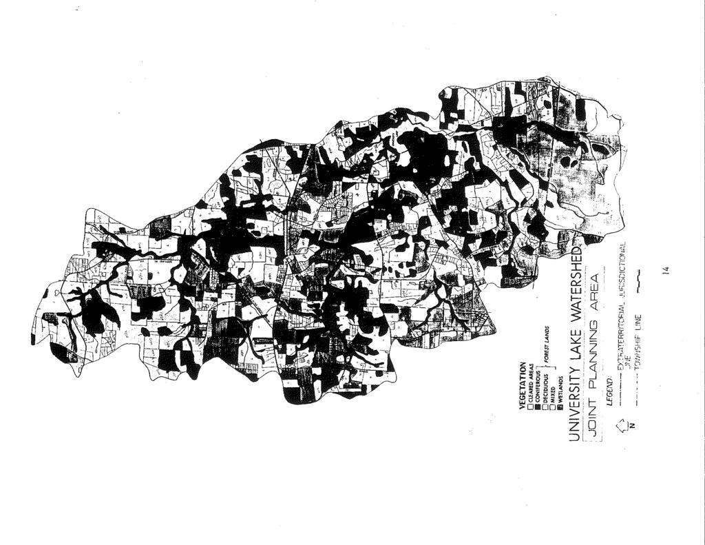
14
15
16
17

18
19
20
21
22
23
24
25
26
27
28
29
30
31
32
33
34
35

36
37
38
39
40
41
42
43
44
45
46
47
48
49
50
51
52
53

54
55
56
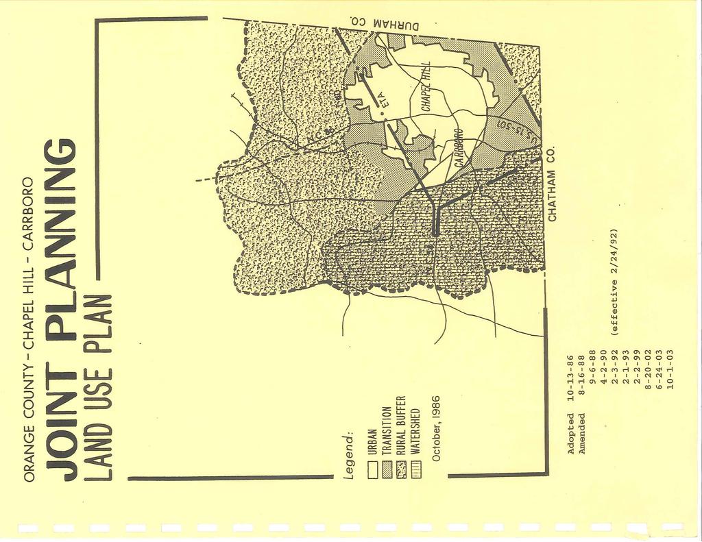
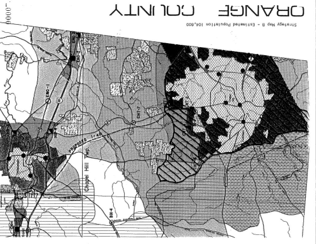
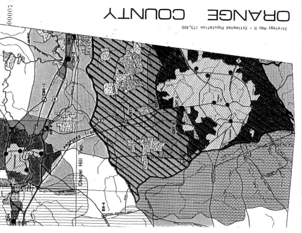
57 ORANGE COUNTY LAND USE PLAN CATEGORIES Amended 2/3/92 (effective 2/24/92) Basic Category Developed Transition Community Rural Conservation Land Use Plan Category Urban Existing Urban Activity Node Proposed Urban Activity Node Ten-Year Transition Twenty-Year transition Commercial Transition Activity Node Commercial-Industrial Transition Activity Node Rural Community Activity Node Rural Buffer Rural Residential Agricultural Residential Rural Neighborhood Activity Node Rural Industrial Activity Node Public Interest District Water Supply Watershed Water Quality Critical Area New Hope Creek Corridor Open Space ********************************************************************************* *JOINT PLANNING AREA LAND USE PLAN CATEGORIES *Amended 4/2/90 2/3/92 (effective 2/24/92) 6/9/14 Major Class Subclass Land Use Plan Category Transition Rural Conservation Transition Transition I Transition II Rural Buffer 57 Resource Protection Public- Private Open space New Hope Creek Corridor Open Space Suburban Residential Urban Residential Office- Institutional Future UNC Development Retail Trade Light Industrial Disposal Use University Lake Watershed Resource Protection Public-Private open Space New Hope creek Corridor open Space Rural Residential and Agricultural Retail Trade Extractive Use

58
59
60 *Suburban Residential Areas are designated for housing densities ranging from one (1) to five (5) dwelling units per acre. Such areas are located where land is changing from rural to urban, suitable for urban densities, and to be provided with public utilities and services. Housing types range from single-family to duplexes to multi-family dwellings. *However, densities may be lower than one dwelling unit per acre in Suburban Residential Areas. Chapel Hill as part of its Southern Small Area Plan has identified certain areas in the Southern Triangle as being suitable for densities not exceeding one (1) unit per acre for areas immediately east of U.S and densities not exceeding one (1) unit per five (5) acres for areas immediately west of Old Lystra Road. *Amended 2/1/93 Urban Residential Areas are similar to Suburban Residential Area in terms of both housing types and public services availability. However, densities are higher, ranging from six (6) to thirteen (13) dwelling units per acre. Office-Institutional Areas is a category consisting of establishments which offer an array of financial, insurance, real estate, legal, medical, and business services. Such areas generally have public utilities and services available and are located adjacent to heavily traveled streets. Future UNC Development is a category established for lands owned by the University of North Carolina, including Horace Williams Airport and adjacent parcels. Such lands are contemplated for expansion of the UNC campus, provided the Airport is relocated. Retail Trade Areas are limited in Transition Areas, including existing establishments at Starpoint and Calvander. Modest room for expansion was projected in Transition Areas. Light Industrial Areas are singular, consisting of the Chapel Hill Industrial Park on Eubanks Road and the proposed site between Eubanks Road and Homestead Road are included in this category. Disposal Use Areas consist of landfill sites, either existing or future. The existing landfill on Eubanks Road and the proposed site between Eubanks Road and Homestead Road are included in this category. *Amended 4/2/90 2/3/92 (effective 2/24/92) 6/9/14 6/17/14 4/7/15 *Rural Buffer and Conservation The basic categories of Rural Buffer and Conservation have been combined in the Joint Planning Area Land Use Plan to form a single land use classification Rural Buffer. The Rural Buffer is defined as being a low-density area consisting of single-family homes situated on large lots having a minimum size of two (2) acres. The Rural Buffer is further defined as land which, although adjacent to an Urban or Transition Area, is rural in character and which will remain rural and not require urban services (public utilities and other Town services). The Rural Buffer is expected to contain low density residential uses, agricultural uses exempt from zoning regulations, and low-intensity agricultural support uses and consists of the following Joint Planning Area Land Use Plan categories: Rural Residential and Agricultural; Public-Private Open Space; Resource Conservation; New Hope Creek Corridor Open Space; Extractive Use; and the overlay category designated University Lake Watershed Area. Rural Residential and Agricultural Areas are low-density areas consisting of single-family homes situated on large lots with a minimum lot size of two acres, except when part of a cluster subdivision and then adhering to a density limit of 1 unit for every 2 acres of property. Cluster subdivisions, reducing parcels to 1 60
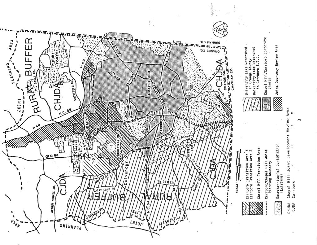
61 acre in area, are allowed so long as established density limits for the entire subdivision are maintained. In that respect, Rural Residential Areas are identical to the definition of the Rural Buffer. The area includes property supporting farming operations, including forestry activities, established in accordance with the provisions of the North Carolina General Statutes. Public-Private Open Space Areas include major land areas owned or controlled by public and private interests in the Rural Buffer. Such holdings as Duke Forest, Camp New Hope, U.S. Government lands associated with Jordan Lake, the 100-foot buffer along I-40, and Orange Water and Sewer Authority lands adjacent to University Lake and the quarry site on N.C. Highway 54 provide open space through research, educational, forest management, and recreational functions. Resource Conservation Areas in the Rural Buffer are identical to those in the Transition Areas; i.e., floodplains, wetlands along drainage tributaries, and steep slope areas (15% or greater). The areas form the basis for a parks and open space system (see Strategy Map) which provided the framework within which other land uses are situated. New Hope Creek Corridor Open Space Areas include some of the Resource Protection Areas and a portion of the Public/Private Open Space Areas which were designated as significant and worthy of protection according to the New Hope Corridor Open Space Master Plan completed in April of (See Master Plan Map following Strategy Maps). The areas are part of a system of open space in Durham and Orange Counties along New Hope Creek and its tributaries between Eno River State Park and U.S. Army Corps of Engineers land north and south of Jordan Lake. This category is made up of critical environmental areas such as steam beds, floodplains, steep slopes, and larger tracts of historic, educational, or recreational value. Extractive Use Areas encompass mining and quarry operations. Only one such site exists in the Rural Buffer, the American Stone Company quarry on N.C. Highway 54 west of Carrboro. Retail Trade Areas in the Rural Buffer include low intensity neighborhood centers which serve the immediate area and generate low traffic volumes. Only one such area is designated in the Rural Buffer Blackwood station on N.C. Highway 86. *Amended 4/2/90 6/9/14 *University Lake Watershed Area The University Lake Watershed Area includes all lands which drain into the University Lake reservoir. Density within this area is limited to 1 dwelling unit for every 5 acres with a required minimum lot size of 2 acres. Based on a preferred watershed protection strategy of land use controls as recommended by Camp, Dresser and McKee in the University Lake Watershed Study, only low-intensity residential uses are permitted. Cluster subdivisions with lot sizes of not less than one (1) acre are also allowed so long as density limits are adhered to. There is an allowance for the creation of 5 lots at a density of 1 unit per 2 acres for property legally in existence as of October 2, Additional lots shall be allowed consistent with the 1 unit per 5 acre density as detailed herein. 60-a
62 LOCATION STANDARDS The principal task in formulating a land use plan is determining where specific land uses will be located. The primary elements feeding into this step include the operating principles outlined previously and a defined set of location standards. The location standards proposed for the preparation of the Joint Planning Area Land Use Plan are based upon previously enumerated background elements natural environment and compatibility with existing land use patterns. On the accompanying page, there elements are listed on the horizontal axis of the Location Standards Matrix. Included in the matrix, but not previously defined are various street classifications listed under Transportation Accessibility. These classifications are defined as follows: STREET CLASSIFICATIONS STREET TYPE FUNCTION SPEED ROW DAILY VOLUME TRIP LENGTH ACCESS TRAVEL LANES INTERSTATE Movement 55 mph >40K >3 mi. Limited 4 ARTERIAL Movement 45 mph K-25K >1 mi. Unlimited 4 COLLECTOR Movement/A 35 mph K <1 mi. Unlimited 2 ccess LOCAL Access 25 mph <1/2 mi. Unlimited 2 Listed on the vertical axis are the general land use planning categories. By locating the desired land plan category on the vertical axis, it is possible to read from left to right and identify by the X symbol desired locations for each land use type. CONCEPTS AND STRATEGIES Following the November Public Information Meeting, four alternative strategy maps were prepared with illustrated various development scenarios for the Joint Planning Area. The four maps sought to identify those areas which would be classified as urban, transition, and rural buffer without identifying specific 10 and 20 year growth areas. The four maps are reproduced in sketch form on the following pages. The basis premises governing each alternative are listed below. 61
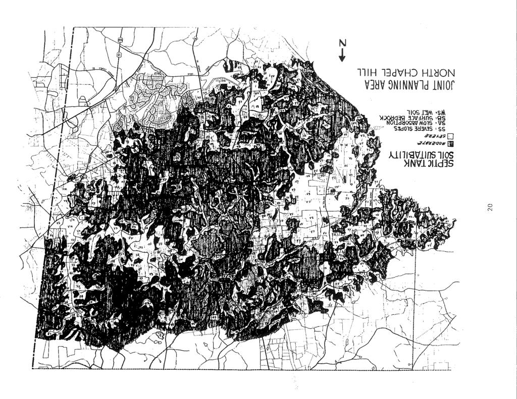
63 Amended 6/9/14 LOCATION STANDARDS MATRIX SLOPE LAND SUITABILITY SOIL STABILITY VEGETATION COMPATIBILITY WITH EXISTING LAND USE RESIDENTIAL COMMER. OPEN AREA TRANSPORTATION ACCESSIBILITY ½% 7½ - 15% 15% + SLIGHT MODERATE SEVERE CLEAR FOREST WETLAND LAND USE CLASSIFICATION RESIDENTIAL Rural and Agricultural x x x x x x x x x x x x x x x x x Suburban x x x x x x x x x x x x x Urban x x x x x x x x x x x x x COMMERCIAL Office x x x x x x x x x x x x x Retail x x x x x x x x x x x x x INDUSTRIAL x x x x x x x RESOURCE-CONSERVATION Recreational x x x x x x x x x x x x x x x x x x Forestry x x x x x x x x x x x x x x x RURAL SUBURBAN URBAN HIGH URBAN OFFICE RETAIL PUBLIC/QUASI-PUBLIC INDUSTRIAL RECREATIONAL AGRICULTURAL FORESTRY INTERSTATE ARTERIAL COLLECTOR LOCAL
64
65
66
67
68
69
70
71
72
73
74

75
76
77
78

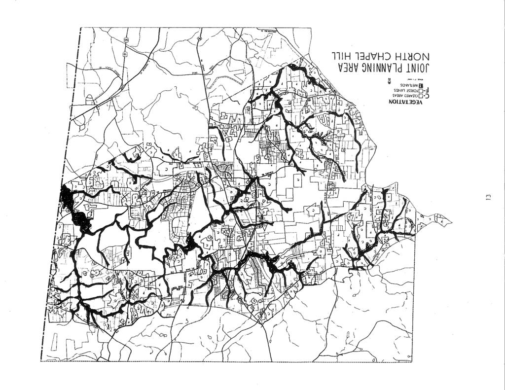
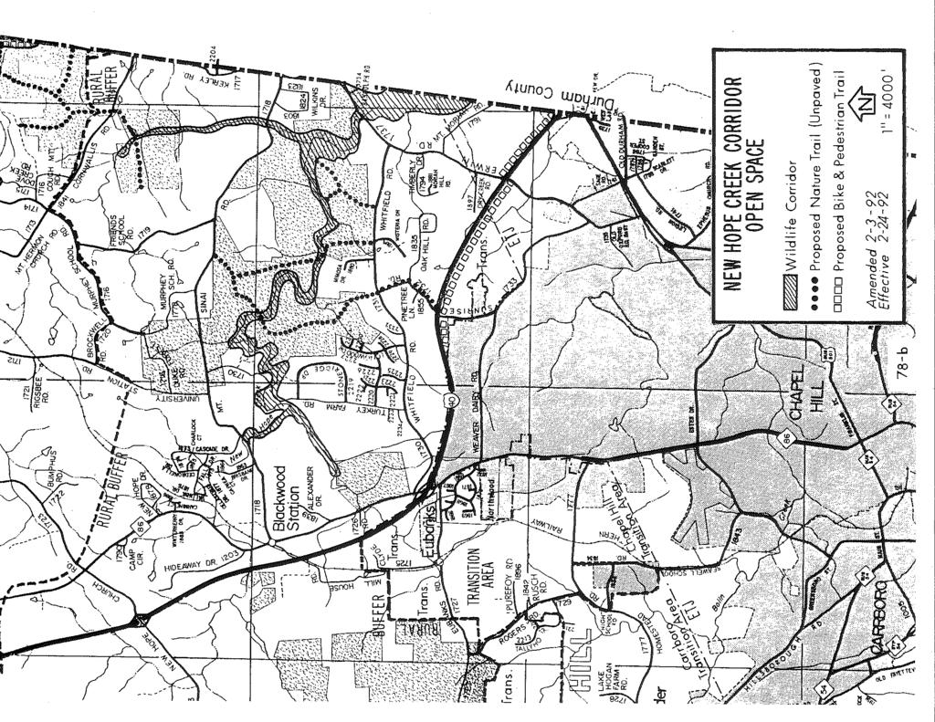
79 *THE RURAL BUFFER *Amended 4/2/90 2/3/92 (effective 2/24/92) 6/9/14 Seven categories of Rural Buffer land use have been depicted on the Land Use Plan. These categories include Resource Protection Areas, Public-Private Open Space Areas, Rural 81
80 Residential and Agricultural Areas, Retail Trade Areas, Extractive Uses, and the overlay category designated University Lake Watershed Area. Resource Protection Areas As was the case with Transition Areas, Resource Protection Areas have been designated on the Land Use Plan to include flood plains, and wetlands along drainage tributaries and steep slope areas (15% or greater). These areas form the basis for a comprehensive parks and open space system which provides the framework within which other land use categories are to function. Parks have been generally located throughout the Joint Planning Area using a neighborhood park one-half mile service radius. The parks, as well as portions of Duke Forest, are linked together by a system of greenways extending along drainageways, and pedestrian routes (sidewalks) along thoroughfares. Public/Private Open Space Areas Major land areas owned or controlled by both public and private interests in the Joint Planning Area have been designated on the Land Use Plan. These areas include the following: 1. Duke Forest; 2. University of North Carolina lands (excluding Horace Williams Airport and adjacent properties); 3. U.S. Government lands associated with conservation areas around the Jordan Lake Reservoir; 4. Orange Water and Sewer Authority lands associated with conservation areas around University Lake and raw water storage in the former quarry site on NC Highway 54: and 5. Camp New Hope conference and recreational center. A Public/Private Open Space Area has also been designated along Interstate 40 to recognize the Major Transportation Corridor (MTC) district established to provide a 100-foot buffer along that route. The Plan recommends utilization of portions of the buffer to link proposed park and greenway areas together. While the status of such holdings as Duke Forest, UNC lands and Camp New Hope is uncertain in the future, their continued existence appears likely during the planning period. This is due to the research, educational, forest management and recreational functions related to such areas. If decisions are made to change the use of such large tracts of land, negotiations should be initiated to secure the use of all or portions of the tracts for recreation and/or open space purposes. Such areas contribute greatly to the natural setting of the Joint Planning Area and every effort should be made to retain such features. New Hope Creek Corridor Open Space Areas include some of the Resource Protection Areas and a portion of the Public/Private Open Space Areas which are designated as significant and worthy of protection according to the New Hope Corridor Open Space Master Plan completed in April of (See Master Plan Map following Strategy Maps). The areas are part of a system of open space in Durham and Orange Counties along New Hope Creek and its tributaries between Eno River State Park and U.S. Army Corps of Engineers land north of Jordan Lake. This category is made up of critical environmental areas such as stream beds, floodplains, steep slopes, and larger tracts of historic, educational, or recreational value. The New Hope Corridor Open Space Master Plan describes these areas in detail and makes specific recommendations as to how they should be protected or utilized for environmental, educational, and/or recreational purposes. 82
81 *University Lake Watershed Area *Amended 4/2/90 6/9/14 The University Lake Watershed Area includes all lands which drain into the University Lake Reservoir. Density within this area is limited to 1 dwelling unit for every 5 acres with a required minimum lot size of 2 acres. Based on a preferred watershed protections strategy of land use controls as recommended by Camp, Dresser and McKee in the University Lake Watershed Study, only low-density residential uses are permitted. Cluster subdivisions with lot sizes of not less than one (1) acre are also allowed so long as density limits are adhered to. There is an allowance for the creation of 5 lots at a density of 1 unit per 2 acres for property legally in existence as of October 2, Additional lots shall be allowed consistent with the 1 unit per 5 acre density as detailed herein. *Rural Residential and Agricultural *Amended 4/2/90 6/9/14 6/17/14 4/7/15 The Rural Residential category is a low-density area consisting of single-family homes situated on large lots with a minimum lot size of two acres, except when part of a cluster subdivision and then adhering to a density limit of 1 unit for every 2 acres of property. Cluster subdivisions, reducing parcels to 1 acre in area, are allowed as long as established density limits are maintained. The Rural Residential designation is identical to the Rural Buffer category contained in the current Orange County Land Use Plan. The Rural Buffer category is described in the Plan as land adjacent to an Urban or Transition area which is rural in character and which should remain rural; contain very low-density residential uses, agricultural uses exempt from zoning regulations, and low-intensity agricultural support uses; and not require urban services (water and sewer) during the Plan period. Agricultural areas existing within Transition Areas are expected to change from rural to urban uses as Chapel Hill and Carrboro continue to grow and as public water and sewer services are expanded. Agricultural areas are located principally in University Lake Watershed but are also prominent along the northern perimeter of the Planning Area boundary. As development occurs in these areas, it will be of very low-density in nature and will generally consist of farm dwelling and outbuildings in support of agricultural operations. To the north of Chapel Hill and Carrboro in the New Hope Creek drainage basin, low-density residential development has taken place along Whitfield Road, Sunrise Road and Erwin Road. Residential developments similar to Sedgefield, Stoneridge, Oak Hills, Birchwood Lake Estates and Falls of the New Hope are expected to continue, relying on wells and septic tanks for water supply and sewer disposal. To the west of Carrboro, Rural Residential development is also expected in University Lake Watershed. However, only low-density residential and agricultural uses are anticipated. Development will continue to rely on wells and septic tanks for water supply and sewage disposal. 83
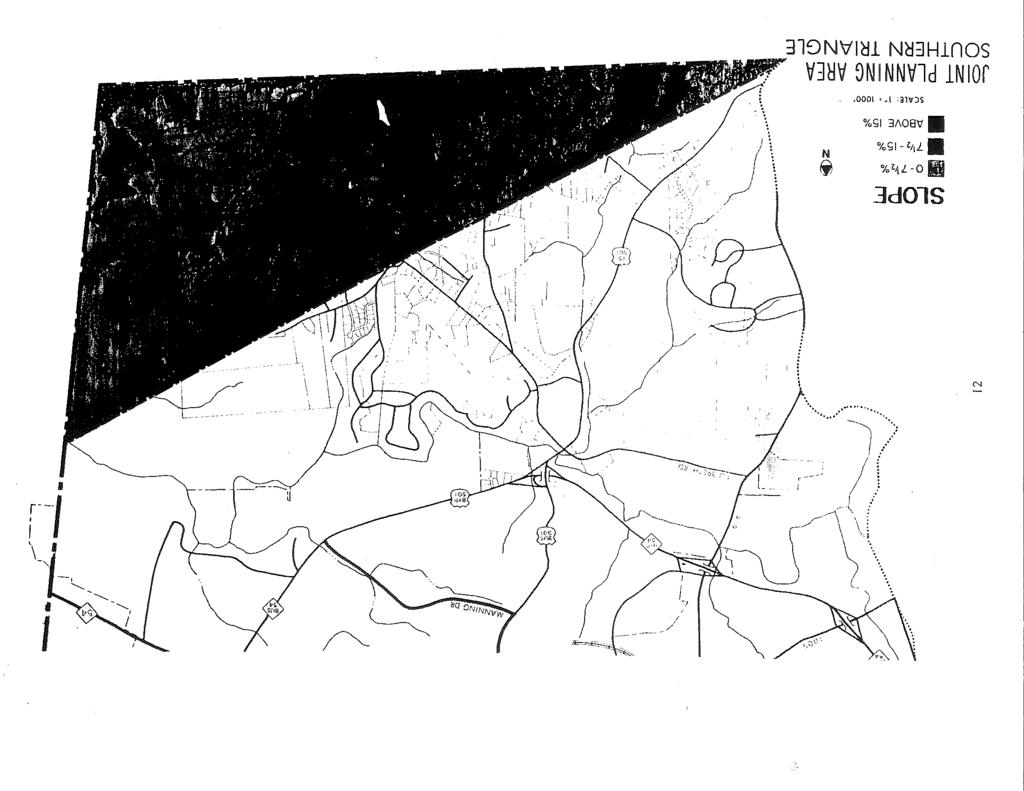
82 The remaining area designated for Rural Residential and Agricultural development is the Southern Triangle area in the extreme southeastern portion of the County. The area drains to the southeast toward Jordan Lake and is beyond the ridge line of the Morgan Creek basin, an area which can be served by gravity sewer lines. The Southern Triangle is also characterized by environmental constraints such as steep slopes, flood plains and soils with poor stability, so lowdensity development is projected. There are approximately 9,260 acres of land designated for Rural Residential and Agricultural purposes in the Land Use Plan. If developed at an average density of one dwelling unit per two acres with 15% of the area subtracted out for streets and roads, the holding capacity of the area in terms of dwellings is 3,935. If multiplied by the 1980 Census figure for population per household (2.6), the estimated population would be 10,231. Retail Trade Areas No new retail areas have been designated in the Rural Buffer. Any substantial increase in retail acreage is expected to take place in the planning jurisdictions of Chapel Hill and Carrboro. The existing activity node at Blackwood Station has been retained, and there is room for modest expansion of low intensity commercial and service uses. The approximate retail acreage at Blackwood Station is 16.1 acres. Extractive Uses This Land Use Plan category, along with Disposal Uses in Transition Areas, has been established to identify sites which pose problems in terms of planning for appropriate land uses. One such site has been identified in the Rural Buffer, the American Stone Quarry west of Carrboro on N.C. Highway
83
84
85
86
87
88
89
90
91
92 JOINT PLANNING AGREEMENT September 22, 1987 Amended April 2, 1990 Amended September 30, 1998 Amended February 2, 1999 Amended August 20, 2002 Amended June 24, 2003 Amended June 9, 2014 Amended June 17, 2014 Amended April 7, 2015 Amended December 7, 2015 THIS AGREEMENT, made and entered into this 2nd day of November, 1987, by and between the COUNTY OF ORANGE, a political subdivision of the State of North Carolina, the TOWN OF CHAPEL HILL, and the TOWN OF CARRBORO, municipal corporations duly created and existing under the laws of North Carolina. WITNESSETH: In consideration of the public benefits expected to flow from the cooperative efforts of the parties in establishing a coordinated and comprehensive system of planning within their respective areas of public concern, the parties to this Agreement hereby mutually agree as follows: ARTICLE 1. PURPOSE, DEFINITIONS, EFFECTIVE DATE, LINKAGE Section 1.1 Purpose of the Agreement The purpose of this Agreement is to establish a method of coordinated and comprehensive planning in the Orange County-Chapel Hill-Carrboro Joint Planning Area, as defined herein. Section 1.2 Definitions 1
93 A. Joint Planning Area. The area within the Rural Buffer and Transition Areas designated on the Joint Planning Area Land Use Map lying outside the extraterritorial planning jurisdiction of Chapel Hill and Carrboro. B. Joint Planning Area Land Use Plan. The Orange County-Chapel Hill-Carrboro Joint Planning Land Use Plan dated April, 1986, adopted by Orange County August 19, 1986 (revised October 13, 1986), amended May 4, 1987 and as it may be amended from time to time. C. Joint Planning Area Land Use Map. The Orange County-Chapel Hill-Carrboro Joint Planning Area Land Use Map, adopted August 19, 1986 (revised October 13, 1986) and as it may be amended from time to time. D. Carrboro Joint Development Review Area (CJDA). The area lying generally west of a division of the Joint Planning Area and shown as such on the copy of the Joint Planning Area Land Use Map attached to this Agreement, labeled Exhibit A, and incorporated herein by reference. Exhibit A is appended to this Agreement solely for the purpose of indicating the CJDA and the CHJDA boundary. Exhibit A is an accurate copy of the Joint Planning Area Land Use Map as of the effective date of this agreement. However, it will only be changed as the Joint Planning Area Land Use Map is amended if the Map amendments change the location of either the CJDA or the CHJDA. E. Chapel Hill Joint Development Review Area (CHJDA). The area lying generally east of a division of the Joint Planning Area and shown as such on the copy of the Joint Planning Area Land Use Map attached to this Agreement, labeled Exhibit A, and 2
94 incorporated herein by reference. Exhibit A is appended to this Agreement solely for the purpose of indicating the CJDA and the CHJDA boundary. Exhibit A is an accurate copy of the Joint Planning Area Land Use Map as of the effective date of this agreement. However, it will only be changed as the Joint Planning Area Land Use Map is amended if the Map amendments change the location of either the CJDA or the CJJDA. F. Joint Courtesy Review Area. A portion of the northern Rural Buffer Area bounded on the east by I-40 and shown as such on Exhibit A. G. Rural Buffer. That portion of the Joint Planning Area designated on the Joint Planning Area Land Use Map as such and designated in the Joint Planning Area Land Use Plan as Rural Residential and Agricultural, Public/Private Open Space, Resource Conservation, Extractive/Disposal Use and the overlay district designated University Lake Watershed Area. This area is further defined as being a low-density area consisting of single-family homes situated on large lots having a minimum size of two (2) acres, unless the cluster subdivision option is used and density limits are maintained. The Rural Buffer is further defined as land which, although adjacent to an Urban or Transition area, is rural in character and which will remain rural, contain low-density residential uses, agricultural uses exempt from zoning regulations, and low-intensity agricultural support uses and not require urban services (public utilities and other town services). Agricultural support uses are those designated in the County s Unified Development Ordinance as allowable in the RB (Rural Buffer) 3
95 general use zoning district or those permitted through the ASE-CZ conditional zoning district. H. Transition Area. That portion of the Joint Planning Area designated on the Joint Planning Area Land Use Map as such. This area is further defined as being in transition from rural to urban or already urban in density. Urban services (public utilities and other town services) are now provided to this area or are projected to be provided to this area. The portion of the Transition Area located in the CJDA shall be further divided into Transition Area I and Transition Area II on the Joint Planning Area Land Use Map. The Joint Planning Area Land Use Plan shall provide that, within Transition Area II, no tract may, after the effective date of this Agreement, be approved for development at a density that exceeds one (1) housing unit per gross acre until at least 75% of the gross land area of Transition Area I consists of any combination of: 1. lots containing one acre or less; 2. residential developments approved for development at a density of at least one unit per acre; 3. streets, roads and utility easements located outside of lots containing one acre or less; 4. lots or tracts that are used for commercial, industrial, institutional or governmental purposes; 5. tracts that are owned by the University of North Carolina or other non-profit entities and that are not available for development. 4
96 This density limitation does not apply to Village Mixed Use districts or Office/Assembly districts as provided for in the Facilitated Small Area Plan for Carrboro s Northern Study Area. I. Development Permit. Major subdivision preliminary plat approval and any discretionary permit (whether called conditional or special use permit or some other term) issued by the Orange County Board of Commissioners, the Chapel Hill Town Council, or the Carrboro Board of Aldermen. J. Involuntary Annexation. Annexation authorized or undertaken pursuant to G.S. 16OA-31, Article 4A, Part 3. K. Voluntary Annexation. Annexation authorized or undertaken pursuant to G.S. Chapter 16OA-31 or G.S. Chapter 160A, Article 4A, Part 4. Section 1.3 Effective Date and Duration A. This Agreement, except as provided below, shall become effective on the effective date of an Orange County ordinance (1) adopting this Agreement (after it has been approved by Chapel Hill and Carrboro); (2) amending Orange County's Zoning Ordinance (including Zoning Atlas) and Subdivision Regulations as prescribed in Section 2.1 of this Agreement; (3) amending the Joint Planning Area Land Use Plan to reflect the existence of Transition Area I and Transition Area II; and (4) amending the Joint Planning Area Land Use Map to show the location of Transition Area I and Transition Area II as indicated on Exhibit A. Any previously adopted Agreements shall become null and void upon this date. The Appendix to this Agreement shall become effective upon the execution of this Agreement. 5
97 B. This Agreement, including any Appendix hereto, shall remain in effect until terminated by mutual agreement or by withdrawal of any party. Subject to termination provisions of this Agreement, annexation provisions of this Agreement shall be valid for not more than 20 years and may thereafter be renewed. A party may not withdraw until it holds a public hearing on the proposed withdrawal followed by written notices to the other parties within thirty (30) days of the public hearing. The withdrawal shall be effective one (1) year following receipt by the other party of the written notice. Withdrawal of one party shall not invalidate the Agreement with respect to remaining parties. C. Upon execution of this Agreement, the parties agree that each will take, in a timely manner and without unnecessary delay, all steps (including but not limited to preparation and adoption of Zoning maps, appointment of Transition Area representatives to Planning Boards and Boards of Adjustment, and all required land use ordinance amendments) required to cause this Agreement to become effective, and will notify the other parties when those steps have been taken. Orange County will notify the Towns by resolution when this Agreement becomes effective. This Agreement may become effective as to two parties pending completion of steps necessary to make effective a 3-party Agreement. Section 1.4 Agreement Linkage with the Water and Sewer Management, Planning and Boundary The Water and Sewer Management, Planning and Boundary Agreement (hereinafter WSMPBA) is incorporated into this agreement by reference. A copy of the WSMPBA is Exhibit B to this agreement. Termination of the WSMPBA does not terminate this 6
98 agreement. The withdrawal by a party from the WSMPBA does not constitute withdrawal from this agreement. Termination of this agreement or withdrawal from this agreement can only be accomplished as provided in this agreement. ARTICLE 2. ADOPTION, ADMINISTRATION AND AMENDMENT OF STANDARDS Section 2.1 Standards Within the Transition Area A. Chapel Hill shall prepare a Zoning Map for that portion of the Transition area that lies within the CHJDA and shall recommend its adoption by Orange County which, upon approval and adoption as prescribed in Subsection C of this Section, shall become part of the Orange County Zoning Ordinance. The Zoning Map shall be prepared using zoning districts which correspond to the text of the Chapel Hill Land Development Ordinance and which correspond with the density designations and plan classifications as prescribed in the adopted Joint Planning Area Land Use Plan and the adopted Joint Planning Area Land Use Map for the CHJDA. B. Carrboro shall prepare a Zoning Map for that portion of the Transition area that lies within the CJDA and shall recommend its adoption by Orange County, which upon approval and adoption as prescribed in Subsection C of this Section, shall become part of the Orange County Zoning Ordinance. The Zoning Map shall be prepared using zoning districts which correspond with the density designations and plan classifications as prescribed in the adopted Joint Planning Area Land Use Plan and the adopted Joint Planning Area Land Use Map for the CJDA. Transition Area II shall have density limited pursuant to Section 1.2H. 7
99 C. Upon completion of the Zoning Maps referred to in Section 2.lA and B above, Orange County shall amend its Zoning Atlas in accordance with said Maps. Orange County shall also adopt by reference (i) the Chapel Hill Land Development Ordinance and make its provisions applicable to that portion of the Transition area located within the CHJDA, and (ii) the Carrboro Land Use Ordinance and makes its provisions applicable to that portion of the Transition area located within the CJDA. Section 2.2 Standards Within the Rural Buffer Within the Rural Buffer, the Orange County Zoning Ordinance (including Zoning Atlas) and Subdivision Regulations that are in effect on the effective date of this Agreement shall remain in effect unless amended in accordance with Section 2.6 of this Agreement. Section 2.3 Permit Administration Within the Transition Area A. Except as otherwise provided in Sections 2.5 and 2.6, the Town of Chapel Hill and the Town of Carrboro, respectively, shall perform all functions related to the administration of the ordinances referenced in Section 2.1C. Subject to the remainder of this Section, Chapel Hill and Carrboro shall administer the referenced ordinances just as if the land were located within the respective Towns' planning jurisdictions. Administration shall include, but not be limited to, the following: 1. Receipt and processing of applications; 2. Issuance of any required permits and certifications; 3. Review and approval of required site/construction plans; 4. Conducting necessary site/building inspections; 5. Enforcement of all standards; 8
100 6. Any other acts or things necessary to administer the Ordinances; and shall be carried out in a manner so as to insure that a developer complies with all applicable ordinance requirements and the terms and conditions of any permit issued by the respective towns. The towns may also charge fees for processing applications, conducting site/construction plan reviews, and carrying out site/building inspections in accordance with fee schedules applicable within their respective planning jurisdictions. B. Whenever Chapel Hill or Carrboro receives an application for a development permit as defined in this Agreement relating to land within their respective portions of the Transition area, it shall forward copies of the application to Orange County for review. The towns shall establish timetables to insure that Orange County has an opportunity to make recommendations regarding such applications within the framework of the County's regularly scheduled meeting dates. To the extent possible, the timetables of the County and the towns shall provide for simultaneous review to expedite application processing; provided, however, the towns may not vote to issue or deny a permit until they have received the recommendations of Orange County or until the expiration of forty-five (45) days after orange County has received the application, whichever comes first. C. From time to time a development moratorium is appropriate in order to address exigent circumstances or the results of a study of density designations, plan classifications or other matters prescribed by the adopted Joint Planning Area Land Use Plan, the Joint Planning Area Land Use Map or any of the land use ordinances of the Town of Chapel Hill or the Town of Carrboro. To preserve the status quo pending the consideration of a land use ordinance amendment designed to address exigent circumstances or the results of a study, 9
101 the Town of Carrboro or the Town of Chapel Hill may propose the adoption of a development moratorium pending consideration of the ordinance amendment. With respect to the CJDA, any proposed moratorium shall not be effective until adopted by the Town of Carrboro and approved by Orange County following a public hearing conducted by the Town of Carrboro. With respect to the CHJDA, any proposed moratorium shall not be effective until adopted by the Town of Chapel Hill and approved by Orange County following a public hearing conducted by the Town of Chapel Hill. Any such adopted and approved moratorium shall initially be no more than six months in duration and may be extended one time for no more than six months for the reasons and following the procedures prescribed here. Section 2.4 Permit Administration in the Rural Buffer A. Except as otherwise provided in Section 2.6 and the remaining provisions of this Section, Orange County shall perform all functions related to the administration of the ordinances referenced in Section 2.2 in the same manner as if the land were located outside the Joint Planning Area. B. Whenever Orange County receives an application for a development permit relating to land located within the CHJDA Rural Buffer or the Joint Courtesy Review Area, it shall forward copies of the application to Chapel Hill for review. Similarly, whenever Orange County receives an application for a development permit relating to land located within the CJDA Rural Buffer or the Joint Courtesy Review Area, it shall forward copies of the application to Carrboro for review. The County shall establish timetables to insure that the towns have an opportunity to make recommendations regarding such applications within 10
102 the framework of their respective regularly scheduled meeting dates. To the extent possible, the timetables of the respective towns and the County shall provide for simultaneous review to expedite application processing; provided, however, Orange County may not vote to issue or deny a permit until it has received the recommendations of the respective Towns or until the expiration of forty-five (45) days after the respective towns have received the application, whichever occurs first. C. From time to time a development moratorium is appropriate in order to address exigent circumstances or the results of a study of density designations, plan classifications or other matters prescribed by the adopted Joint Planning Area Land Use Plan, the Joint Planning Area Land Use Map or any of the land use ordinances of Orange County. To preserve the status quo pending the consideration of a land use ordinance amendment designed to address exigent circumstances or the results of a study, Orange County may propose the adoption of a development moratorium pending consideration of the ordinance amendment. Any proposed moratorium shall not be effective until adopted by Orange County following a public hearing conducted by Orange County. Any such adopted moratorium shall initially be no more than six months in duration and may be extended one time for no more than six months for the reasons and following the procedures prescribed here. Section 2.5 Enforcement Remedies. A. Permit revocation, if necessary and authorized by ordinance, shall be handled by the same individual or board authorized to issue the original permit. 11
103 B. Within those portions of the Joint Planning Area where the ordinances specified in Section 2.lC are administered by the respective towns, enforcement efforts through the use of civil penalties, criminal penalties or injunctive relief shall be initiated by the respective towns. The towns shall have the duty to defend at their own expense and shall indemnify and hold harmless, to the extent they can legally do so, Orange County, its Board of Commissioners, its advisory boards, its staff and all members of its boards and staffs, in their official and individual capacities, from any and all claims, actions, proceedings, expenses, damages or liabilities, including attorneys' fees and courts costs, resulting from the towns' administration of the ordinances specified in Sections 2.1(C). C. Orange County shall notify the respective towns and the towns shall notify Orange County as soon as practicable thereafter of any such claim, action or proceeding. Section 2.6 Text and Map Amendments A. Proposed amendments to the Joint Planning Area Land Use Plan and/or the Joint Planning Area Land Use Map may be initiated by (i) Orange County or (ii) the Towns or any other party by filing a request for such an amendment with Orange County. Any petition or request to amend the Joint Planning Area Land Use Plan received by the County shall be referred to the respective Towns. No such amendment may become effective until after it has been adopted by Orange County, Chapel Hill and Carrboro following a joint public hearing by all three governing bodies. B. Except as provided herein, proposed amendments to the text of the Orange County Unified Development Ordinance that are applicable within the Rural Buffer as well as proposed changes in zoning district classifications (i.e., zoning map changes) that affect property 12
104 within the Rural Buffer shall be initiated and adopted in accordance with the procedures set forth in those County ordinances. All such proposals that affect the CHJDA shall be referred to Chapel Hill for review and recommendation, and all such proposed amendments that affect the CJDA shall be referred to Carrboro for review and recommendation. Orange County may not adopt such proposed amendments until the respective Towns have made their recommendations, or until the expiration of thirty (30) days following such referral, whichever occurs first. In the case of agricultural support uses, both the ASE-CZ conditional zoning districts and the agricultural support uses added to the RB (Rural Buffer) general use zoning district in 2015, Orange County shall not materially change the text of its Unified Development Ordinance, as it pertains to the Rural Buffer, unless the amendment is heard at a joint public hearing and adopted by Orange County, Chapel Hill, and Carrboro. Examples of material changes, in this case, are adding or deleting uses to/from the Table of Permitted Uses and/or adding, deleting, or changing the use-specific standards in Article 5 of the Unified Development Ordinance. C. Whenever Chapel Hill proposes to amend the text of its Land Development Ordinance, and whenever Carrboro proposes to amend the text of its Land Use Ordinance, the respective towns shall deliver a copy of the full text of the proposed amendment to Orange County not later than thirty (30) days before the date of the public hearing on any such amendment. However, with the written consent of the Orange County Manager or his designate, this thirty (30) day period may be reduced to not less than ten (10) days. Unless Orange County files with the respective towns a written objection on or before the date of 13
105 the public hearing on the proposed ordinance amendment, then adoption of the amendment by the respective town shall automatically effect a corresponding amendment to the applicable ordinance adopted by reference by Orange County as provided in Section 2.1C. Any such objection shall be based on a determination by Orange County that the proposed amendment is inconsistent with the adopted Joint Planning Area Land Use Plan. If a town adopts an amendment despite Orange County's objection, then it shall refer such amendment to Orange County with a request that the County make corresponding changes as expeditiously as reasonably possible so that the town may continue to enforce within its portion of the Transition area the same standards that it enforces within its own planning jurisdiction. In the event of objection by Orange County as provided herein, no such amendment shall be effective within the Joint Planning Area until it is adopted by Orange County. D. Orange County may not unilaterally amend the text of its zoning or subdivision ordinances applicable to the Transition areas (i.e., those ordinances adopted by reference pursuant to Section 2.lC). Amendments to the ordinances referenced in Section 2.lC by Orange County may be accomplished only pursuant to subsection C above (including adoption by Orange County following a request to do so by the applicable town). Any petitions or request to amend these ordinances received by the County or initiated by the County shall be referred to the respective Towns. E. With respect to property that is located within the CHJDA Transition area, changes in zoning classifications may not be made unless and until an ordinance approving such zoning map amendment has been approved both by Orange County and Chapel Hill 14
106 following a joint public hearing by the two governing bodies. With respect to property that is located within the CJDA Transition area, changes in zoning classifications, including the creation of or changes to the floating conditional use districts designed to implement the recommendations of the Facilitated Small Area Plan for Carrboro s Northern Study Area (Village Mixed Use conditional use districts or Office/Assembly conditional use districts) may not be made unless and until an ordinance approving such zoning map amendment has been approved both by Orange County and Carrboro following a joint public hearing by the two governing bodies. Requests for rezonings within the Transition areas that are filed with the County shall be referred to the respective towns to initiate the amendment process. F. Proposed amendments to the text of this Agreement shall not become effective until approved by the towns and an Orange County ordinance adopting the amendment is adopted by Orange County. Section 2.7 Representation of Transition Area Residents Chapel Hill: Chapel Hill shall revise its Land Use Development Ordinance to provide that in addition to one Extraterritorial Jurisdiction representative on the Planning Board and Board of Adjustment that the County Commission appoints one additional representative from the Joint Planning Area or the Extraterritorial Jurisdiction. If an appointment by the County Commission is unable to be secured within 90 days of a vacancy, the Town Council may fill the vacant seat with a Chapel Hill resident. Chapel Hill shall notify Orange County of any vacancies for which Orange County is to make an appointment, 15
107 within ten days of a vacancy. At the request of the County Commission, the Town Council may extend the 90 day time limit. Carrboro: Carrboro shall revise its Land Use Ordinance to provide that at least one resident of Town's Transition area shall be appointed to the Town's respective planning board and board of adjustment, in the same manner as representation of extraterritorial planning area residents is provided for in the Town's ordinance. ARTICLE 3. LIMITATIONS ON ANNEXATIONS Section 3.1 No Annexation Into Rural Buffer Except pursuant to the written consent of all parties to this Agreement, neither Chapel Hill nor Carrboro may annex into the Rural Buffer (whether by voluntary or involuntary annexation or any other method authorized by law) nor shall any party seek special legislation accomplishing such annexation. Section 3.2 No Annexation by One Town Into Another Town's Transition Area Except pursuant to the written consent of the other town, neither Chapel Hill nor Carrboro may annex into the other's Transition area (whether voluntary or involuntary annexation) or any other method authorized by law, nor shall either Town seek special legislation accomplishing such annexation. 16
108
109
110
111
112
113
114
115
116
117
118
119
120
121
122
123
124
125
126
127
128
129
130
131
132
133
134
135
136

137
138
139
140
141
WAKE COUNTY SUBDIVISION ORDINANCE ANNOTATED
 WAKE COUNTY SUBDIVISION ORDINANCE ANNOTATED The Wake County Subdivision Ordinance makes up Chapters 3-1 through 3-5 of the Wake County Code of General Ordinances (as reflected in the numbering of its sections).
CITY OF DURHAM DURHAM COUNTY NORTH CAROLINA. Zoning Map Change Report. RR Existing Zoning. Rural Rural Density Residential Site Characteristics
 CITY OF DURHAM DURHAM COUNTY NORTH CAROLINA Zoning Map Change Report Meeting Date: February 26, 2007 Reference Name Arrowhead () Jurisdiction County Proposed Zoning RR Existing Zoning RS-20 Request Proposed
ARTICLE 1 GENERAL PROVISIONS
 ARTICLE 1 GENERAL PROVISIONS SECTION 100 TITLE This Ordinance shall be known and cited as the "Rice Township Subdivision and Land Development Ordinance." SECTION 101 AUTHORITY Rice Township is empowered
Chapter 100 Planned Unit Development in Corvallis Urban Fringe
 100.100 Scope and Purpose. Chapter 100 Planned Unit Development in Corvallis Urban Fringe (1) All applications for land divisions in the Urban Residential (UR) and Flood Plain Agriculture (FPA) zones within
Title 6 - Local Government Provisions Applicable to Special Purpose Districts and Other Political Subdivisions
 Title 6 - Local Government Provisions Applicable to Special Purpose Districts and Other Political Subdivisions CHAPTER 29. SOUTH CAROLINA LOCAL GOVERNMENT COMPREHENSIVE PLANNING ENABLING ACT OF 1994 1994
Appendix J - Planned Unit Development (PUD)
") Appendix J - Planned Unit Development (PUD) Intent and Purpose The purpose of the PUD is: 1. To provide development that is consistent with the Comprehensive Land Use Plan and promote the goals and objectives
Appendix J - Planned Unit Development (PUD) Intent and Purpose The purpose of the PUD is: 1. To provide development that is consistent with the Comprehensive Land Use Plan and promote the goals and objectives
SUBDIVISION APPLICATION: RECOMBINATION PLAT or EXEMPT PLAT
 SUBDIVISION APPLICATION: RECOMBINATION PLAT or EXEMPT PLAT Pursuant to Article 7, Section 155.706 of the Unified Development Code, an owner of land within the jurisdiction of the Town (or a duly authorized
Planning Department Oconee County, Georgia
 Planning Department Oconee County, Georgia STAFF REPORT REZONE CASE #: 6985 DATE: October 31, 2016 STAFF REPORT BY: Andrew C. Stern, Planner APPLICANT NAME: Williams & Associates, Land Planners PC PROPERTY
ORDINANCE NO AN ORDINANCE AMENDING THE CODE OF ORDINANCES OF THE CITY OF PORT ARANSAS, TEXAS, BY ADOPTING A NEW CHAPTER
 ORDINANCE NO. 2008-09 AN ORDINANCE AMENDING THE CODE OF ORDINANCES OF THE CITY OF PORT ARANSAS, TEXAS, BY ADOPTING A NEW CHAPTER TWENTY-SIX CONCERNING IMPACT FEES FOR ROADWAY FACILITIES; INCORPORATING
I. Requirements for All Applications. C D W
 108-16.1. Application checklists. Checklist for Required Submissions to the Planning Board or Zoning Board of Adjustment of Monroe Township All required submissions are to be made to the Administrative
610 LAND DIVISIONS AND PROPERTY LINE ADJUSTMENTS OUTSIDE A UGB
 ARTICLE VI: LAND DIVISIONS AND PROPERTY LINE ADJUSTMENTS VI-21 610 LAND DIVISIONS AND PROPERTY LINE ADJUSTMENTS OUTSIDE A UGB 610-1 Property Line Adjustments (Property Line Relocation) A property line
E L M E R B O R O U G H L A N D U S E B O A R D APPLICATION COVER SHEET (to be completed for all applications and appeals)
") E L M E R B O R O U G H L A N D U S E B O A R D APPLICATION COVER SHEET (to be completed for all applications and appeals) 1. Name(s): 2. Address: 3. Telephone Number(s): 4. E-mail: 5. Owner Name(s) (if
E L M E R B O R O U G H L A N D U S E B O A R D APPLICATION COVER SHEET (to be completed for all applications and appeals) 1. Name(s): 2. Address: 3. Telephone Number(s): 4. E-mail: 5. Owner Name(s) (if
RECITALS. WHEREAS, the GMA requires counties to adopt county-wide planning policies in cooperation with cities within the County; and
 AN INTERLOCAL AGREEMENT FOR THE IMPLEMENTATION OF A DEMONSTRATION PROJECT TO TRANSFER DEVELOPMENT RIGHTS FROM RURAL UNINCORPORATED KING COUNTY TO THE DENNY TRIANGLE IN DOWNTOWN SEATTLE This Agreement is
HOW TO APPLY FOR A USE PERMIT
 HOW TO APPLY FOR A USE PERMIT MENDOCINO COUNTY PLANNING AND BUILDING SERVICES What is the purpose of a use permit? Throughout the County, people use their properties in many different ways. They build
9. REZONING NO Vicinity of the northwest corner of 143 rd Street and Metcalf Avenue
 9. REZONING NO. 2002-15 Vicinity of the northwest corner of 143 rd Street and Metcalf Avenue 1. APPLICANT: Andrew Schlagel is the applicant for this request. 2. REQUESTED ACTION: The applicant is requesting
Town of Cary, North Carolina Rezoning Staff Report 12-REZ-27 Morris Branch Town Council Public Hearing January 24, 2013
 Town of Cary, North Carolina Rezoning Staff Report 12-REZ-27 Morris Branch Town Council Public Hearing January 24, 2013 REQUEST To amend the Town of Cary Official Zoning Map to rezone approximately 9.0
Special Use Permit - Planned Unit Development Checklist. Property Address:
 Special Use Permit - Planned Unit Development Checklist Special Use Permit Number. Parcel Code/s #28-11- - - Property Address: Applicant: ARTICLE VIII Ordinance Reference - Section 8.1.2 Permit Procedures:
B. Subarea Provisions, including the Design Elements and Area of Special Concern and Potential Park/Open Space/Recreation Requirements;
 ARTICLE III: LAND USE DISTRICTS III-1 300 INTRODUCTION Article III of the Washington County Community Development Code consists of the primary and overlay districts which apply to the unincorporated areas
WHEREAS, the staff of The Maryland-National Capital Park and Planning Commission recommended APPROVAL of the application with conditions; and
 R E S O L U T I O N WHEREAS, Redeemed Christian Church of God is the owner of a 2.83-acre parcel of land known as Lot 9, Lot 19, P/O Lot 1 and P/O Lot 18, Block B, Plat Book A, Plat 5, said property being
COMPREHENSIVE PLAN FUTURE LAND USE MAP AMENDMENT APPLICATION
 COUNTY STAFF DATA ONLY Date Received: Project No. CPA-20 - GADSDEN COUNTY DEPARTMENT OF PLANNING & COMMUNITY DEVELOPMENT 1-B East Jefferson Street, Post Office Box 1799, Quincy, FL 32353-1799 PLANNING
Comprehensive Plan /24/01
 IV The is a central component of the Comprehensive Plan. It is an extension of the general goals and policies of the community, as well as a reflection of previous development decisions and the physical
ORDINANCE WHEREAS, the adoption of this Ordinance shall not be construed as an admission that the aforesaid claim has merit or is correct; and
 ORDINANCE 12-24 AN ORDINANCE OF THE CITY OF WINTER GARDEN, FLORIDA, REPEALING ORDINANCE 12-02 AND REPLACING IT WITH THE AMENDMENTS TO ARTICLE V OF CHAPTER 118 OF THE WINTER GARDEN CODE OF ORDINANCES CONTAINED
Midwest City, Oklahoma Zoning Ordinance
 2010 Midwest City, Oklahoma Zoning Ordinance 9/2/2010 Table of Contents Section 1. General Provisions... 5 1.1. Citation... 5 1.2. Authority... 5 1.3. Purpose... 5 1.4. Nature and Application... 5 1.5.
MIDWAY CITY Municipal Code
 MIDWAY CITY Municipal Code TITLE 9 ANNEXATION CHAPTER 9.01 PURPOSE CHAPTER 9.02 GENERAL REQUIREMENTS CHAPTER 9.03 PROPERTY OWNER INITIATION OF ANNEXATION CHAPTER 9.04 PROCEDURES FOR CONSIDERATION OF PETITION
From Policy to Reality
 From Policy to Reality Updated ^ Model Ordinances for Sustainable Development 2000 Environmental Quality Board 2008 Minnesota Pollution Control Agency Funded by a Minnesota Pollution Control Agency Sustainable
MASTER INTERLOCAL AGREEMENT FOR GROWTH MANAGEMENT ACT IMPLEMENTATION IN YAKIMA COUNTY TABLE OF CONTENTS
 MASTER INTERLOCAL AGREEMENT FOR GROWTH MANAGEMENT ACT IMPLEMENTATION IN YAKIMA COUNTY TABLE OF CONTENTS I. PREAMBLE A. Purpose... 1 B. Background... 2 II. AGREEMENT A. Parties to Agreement... 3 B. Authority...
City of Sanibel. Planning Department STAFF REPORT
 City of Sanibel Planning Department STAFF REPORT Planning Commission Meeting: July 23, 2013 Planning Commission Agenda Item: No 7b. Application Number: 13-7438DP Applicant Name: Attorney Beverly Grady
Town of Bristol Rhode Island
 Town of Bristol Rhode Island Subdivision & Development Review Regulations Adopted by the Planning Board September 27, 1995 (March 2017) Formatted: Highlight Formatted: Font: 12 pt Table of Contents TABLE
ORDINANCE NO. 208 BE IT ORDAINED BY THE CITY COUNCIL OF THE CITY OF UNIVERSITY HEIGHTS, JOHNSON COUNTY, IOWA:
 ORDINANCE NO. 208 AN ORDINANCE AMENDING ORDINANCE NO. 79 (ZONING) TO CREATE A COMMERCIAL HOTEL ZONE AND PERMIT DEVELOPMENT PURSUANT TO A COMMERCIAL HOTEL PUD BE IT ORDAINED BY THE CITY COUNCIL OF THE CITY
Planning Department Oconee County, Georgia STAFF REPORT
 Planning Department Oconee County, Georgia STAFF REPORT REZONE CASE #: 7332 DATE: November 28, 2017 STAFF REPORT BY: Gabriel Quintas, Planner APPLICANT NAME: Smith Planning Group PROPERTY OWNER: John Hadden
Draft Model Access Management Overlay Ordinance
 Draft Model Access Management Overlay Ordinance This model was developed using the City of Hutchinson and the Trunk Highway 7 corridor. The basic provisions of this model may be adopted by any jurisdiction
(Res. No R003, ) NON-REGIONAL ROAD CAPITAL EXPANSION FEE [2] Footnotes: --- (2) Findings.
![(Res. No R003, ) NON-REGIONAL ROAD CAPITAL EXPANSION FEE [2] Footnotes: --- (2) Findings.](/thumbs/90/101801632.jpg "(Res. No R003, ) NON-REGIONAL ROAD CAPITAL EXPANSION FEE [2] Footnotes: --- (2) Findings.") 9.5. - NON-REGIONAL ROAD CAPITAL EXPANSION FEE [2] Footnotes: --- (2) --- Editor's note Res. No. 12262006R003, adopted Dec. 26, 2006, deleted former 9.5, and enacted a new 9.5 as set out herein. The former
9.5. - NON-REGIONAL ROAD CAPITAL EXPANSION FEE [2] Footnotes: --- (2) --- Editor's note Res. No. 12262006R003, adopted Dec. 26, 2006, deleted former 9.5, and enacted a new 9.5 as set out herein. The former
Town of. River Falls. Land Use Element Vierbicher Associates, Inc
 Town of River Falls 2005 Vierbicher Associates, Inc Contents Contents s. 66.1001(2)(h) Wis. Stats................................................. ii Introduction................................................................
SUBDIVISION REGULATIONS
 CHAPTER 14 SUBDIVISION REGULATIONS 14-100 Provisions 14-200 Preliminary Plat 14-300 Final Plat 14-400 Replat 14-500 Minor Subdivision 14-600 Administrative Replat 14-700 Vacation of Roadways, Public Easements,
Town of Onalaska. A scale map depicting the portion of Pineview Drive to be officially laid out as a Town highway is attached hereto as Exhibit A.
 Town of Onalaska Special Meeting Minutes for March 31, 2011 The Town Board met on site of the Pineview Road and County OT in Onalaska for the purpose of viewing the lay out of the road as required by law.
ARTICLE 15. RULES, REGULATIONS AND DEFINITIONS
 ARTICLE 15. RULES, REGULATIONS AND DEFINITIONS Section 1. Interpretation and Construction: The following rules and regulations regarding interpretation and construction of the Ulysses-Grant County, Kansas,
Town of Norwich, Vermont SUBDIVISION REGULATIONS
 Town of Norwich, Vermont SUBDIVISION REGULATIONS Adopted: August 6, 2002 Amended: February 8, 2006 Prepared by Norwich Planning Commission with the assistance of: Burnt Rock Inc. A ssociates in Community
1.0 REQUEST. SANTA BARBARA COUNTY ZONING ADMINISTRATOR Coastal Zone Staff Report for Vincent New Single-Family Dwelling & Septic System
 SANTA BARBARA COUNTY ZONING ADMINISTRATOR Coastal Zone Staff Report for Vincent New Single-Family Dwelling & Septic System Hearing Date: February 26, 2007 Supervisorial District: First Staff Report Date:
MAJOR SUBDIVISION PRELIMINARY PLAT CHECKLIST
 TOWNSHIP OF EGG HARBOR PLANNING BOARD/ZONING BOARD OF ADJUSTMENT 3515 BARGAINTOWN ROAD EGG HARBOR TOWNSHIP, NJ 08234 MAJOR SUBDIVISION PRELIMINARY PLAT CHECKLIST The following checklist is designed to
FOR OFFICE USE ONLY Date Submitted Received By Fees Paid $ Receipt No. Received By Application No. Application Complete Final Action Date
 COMMERCIAL, INDUSTRIAL, & MANUFACTURING SITE PLAN (CIM) APPLICATION Mariposa County Planning Department 5100 Bullion Street, P.O. Box 2039 Mariposa, CA 95338 Telephone (209) 966-5151 FAX (209) 742-5024
Subject: Ordinance 1657, Annexation of 3.55 acres of land at 3015 and 3001 Parker Road.
 Agenda Report 2016-12-12-09 Date: December 8, 2016 To: From: Russ Axelrod, Mayor Members, West Linn City Council Jennifer Arnold, Planning Department Through: John Boyd, Interim Community Development Director
City of Valdosta Land Development Regulations
 Title 2 Land Use and Zoning Chapter 202 Section 202-1 General Provisions Purpose Title 2 is intended to implement the purposes set forth in Section 102-2, and further is enacted for the purposes of promoting
Staff Report: Date: Applicant: Property Identification: Acreage of Request: Current Zoning of Requested Area: Requested Action: Attached:
 Staff Report: Completed by Jeff Palmer Director of Planning & Zoning Date: November 7, 2018, Updated November 20, 2018 Applicant: Greg Smith, Oberer Land Developer agent for Ronald Montgomery ET AL Property
BEAR CREEK TOWNSHIP EMMET COUNTY, MICHIGAN. PRIVATE ROAD ORDINANCE Ordinance No. 11A-99. (to replace prior Private Road Ordinance No.
 BEAR CREEK TOWNSHIP EMMET COUNTY, MICHIGAN PRIVATE ROAD ORDINANCE Ordinance No. 11A-99 (to replace prior Private Road Ordinance No. 11-99) An Ordinance to protect the health, safety, and general welfare
Guide to Combined Preliminary and Final Plats
 Guide to Combined Preliminary and Final Plats Introduction The Douglas County is committed to providing open, transparent application processes to the public. This Guide is provided to assist anyone interested
Burke County WATERSHED PROTECTION ORDINANCE
 Burke County WATERSHED PROTECTION ORDINANCE ARTICLE 100: AUTHORITY AND GENERAL REGULATIONS Section 101. Authority and Enactment. The Legislature of the State of North Carolina has, in Chapter [153A], Article
SECTION 4: PRELIMINARY PLAT
 SECTION 4: PRELIMINARY PLAT After the completion of the sketch plan process, if submitted, the owner or developer shall file with the City an application for preliminary plat. The preliminary plat stage
19.12 CLUSTER RESIDENTIAL DISTRICT
 Chapter 19.12 CLUSTER RESIDENTIAL DISTRICT (Adopted 12/22/2003; Ordinance #0061970). Amended 7/3/17, Ordinance #079100. Section 19.12.010 - Declaration of Intent. The Cluster Residential District provides
Salem Township Zoning Ordinance Page 50-1 ARTICLE 50.0: PUD PLANNED UNIT DEVELOPMENT
 Salem Township Zoning Ordinance Page 50-1 ARTICLE 50.0 PLANNED UNIT DEVELOPMENT Section 50.01 Purpose The provisions of this Article provide enabling authority and standards for the submission, review,
Subchapter 16 Subdivisions.
 Subchapter 16 Subdivisions. Sections: 35.16.1 Authority. 35.16.2 Purpose. 35.16.3 Jurisdiction. 35.16.4 Application. 35.16.5 Compliance and Enforcement. 35.16.6 Approval of Plat Required. 35.16.7 Lots,
Larimer County Planning Dept. Procedural Guide for 1041 PERMITS
 - Larimer County Planning Dept. Procedural Guide for 1041 PERMITS PLEASE NOTE: A PRE-APPLICATION CONFERENCE IS REQUIRED PRIOR TO SUBMITTING THIS APPLICATION. PURPOSE: State Statutes allow local governments
MINOR SUBDIVISION INFORMATION
 A. POINTS OF CONTACT: MINOR SUBDIVISION INFORMATION Surveyor: Address: Phone #: Fax # E-Mail Address: Representative (If different from applicant): Address: Phone #: Fax # E-Mail Address: B. GENERAL INFORMATION:
GRAHAM COUNTY WATERSHED PROTECTION ORDINANCE
 GRAHAM COUNTY WATERSHED PROTECTION ORDINANCE GRAHAM COUNTY WATERSHED PROTECTION ORDINANCE APPENDIX: ARTICLE 100: AUTHORITY AND GENERAL REGULATIONS Section: 101 Section: 102 Section: 103 Section: 104 Section:
NC General Statutes - Chapter 106 Article 61 1
 Article 61. Agricultural Development and Preservation of Farmland. Part 1. General Provisions. 106-735. Short title, purpose, and administration. (a) This Article shall be known as "The Agricultural Development
MS MINOR SUBDIVISION TREVITHICK
 MS-02-015 341.12 MINOR SUBDIVISION TREVITHICK A request by Danny Trevithick for a one-lot Minor Subdivision on five acres. The property is zoned A-35 (Agricultural) District and is located ¼ mile south
A Guide to the Municipal Planning Process in Saskatchewan
 A Guide to the Municipal Planning Process in Saskatchewan A look at the municipal development permit and the subdivision approval process in Saskatchewan May 2008 Prepared By: Community Planning Branch
COASTAL DEVELOPMENT PERMIT APPLICATION
 COUNTY OF MENDOCINO DEPARTMENT OF PLANNING AND BUILDING SERVICES 501 Low Gap Road, Room 1440 Ukiah, California 95482 Telephone 707-463-4281 FAX 707-463-5709 790 South Franklin Street Fort Bragg, California
Town of Cary, North Carolina Rezoning Staff Report 13-REZ-13 An Zou Property Town Council Meeting November 21, 2013
 Town of Cary, North Carolina Rezoning Staff Report 13-REZ-13 An Zou Property Town Council Meeting November 21, 2013 REQUEST To amend the Town of Cary Official Zoning Map by rezoning 0.63 acres located
Instructions to the Applicant
 CONDITIONAL USE PERMIT APPLICATION Lake of the Woods County Land and Water Planning Office 206 8 th Avenue Southeast, Suite #290 Baudette MN 56623-2867 www.co.lake-of-the-woods.mn.us Phone: (218) 634-1945
WESTMINSTER PARK SUBDIVISION
 WESTMINSTER PARK SUBDIVISION Engineering Comments: FINAL PLAT COMMENTS (should be addressed prior to submitting the FINAL PLAT for review and/or signature by the City Engineer): A. Provide all of the required
TOWN OF ROXBURY PLANNING BOARD
 UPDATED: APRIL 2011 TOWN OF ROXBURY PLANNING BOARD Applicant s Guide for Subdivision Review The Town Planning Board administers the subdivision review process. This guide has been prepared in order to
FINAL DRAFT 12/1/16, Rev. to 7/18/17
 FINAL DRAFT 12/1/16, Rev. to 7/18/17 (As Adopted 8/8/17 Effective 9/1/17) SHELTON PLANNING AND ZONING COMMISSION Proposed Amendments to Zoning Regulations I. Amend Section 23 PERMITTED USES by inserting
PRELIMINARY PLAT Checklist
 PRELIMINARY PLAT Checklist 3715 Bridgeport Way W University Place, WA 98466 PH: (253) 566-5656 FAX: (253) 460-2541 This is a checklist of materials required for a Preliminary Plat. This checklist is provided
St. Mary s County Comprehensive Zoning Ordinance Article 1. GENERAL PROVISIONS
 0 0 0 0 ARTICLE. GENERAL PROVISIONS CHAPTER 0 TITLE, PURPOSE AND ORGANIZATION Sections: 0. Title. 0. Authority. 0. Purpose. 0. Organization of the Zoning Ordinance. 0. Official Zoning Map. 0. Applicability.
SECTION 7000 LAND DEVELOPMENT REQUIREMENTS
 SECTION 7000 LAND DEVELOPMENT REQUIREMENTS 7000 LAND DEVELOPMENT REQUIREMENTS... 1 7001 LEGISLATIVE AUTHORITY... 1 7001.1 LAND DEVELOPMENT... 1 7001.1.1 Title 40, Idaho Code... 1 7001.1.2 Idaho Code 40-1415
Cobb County Community Development Agency Zoning Division 1150 Powder Springs St. Marietta, Georgia 30064
 Cobb County Community Development Agency Zoning Division 1150 Powder Springs St. Marietta, Georgia 30064 Case # Z-63 Public Hearing Dates: PC: 11-06-18 BOC: 11-20-18 SITE BACKGROUND Applicant: Loyd Development
Mohave County General Plan
 63 64 65 66 67 68 69 70 71 The Land Use Diagram is not the County's zoning map. 13 It is a guide to future land use patterns. Zoning and area plan designations may be more restrictive than the land use
MASTER SUBDIVISION FINAL PLAT APPLICATION Town of Apex, North Carolina
 MASTER SUBDIVISION FINAL PLAT APPLICATION Town of Apex, North Carolina This document is a public record under the North Carolina Public Records Act and may be published to the Town s website or disclosed
INDIANA DRAINAGE LAW. Title 36 Article 9 Chapter 27
 INDIANA DRAINAGE LAW Title 36 Article 9 Chapter 27 IC 36-9-27 Chapter 27. Drainage Law IC 36-9-27-1 Application of chapter Sec. 1. This chapter applies to all counties. However, sections 6, 7, 9, 10, 30,
ARTICLE 2: General Provisions
 ARTICLE 2: General Provisions 2-10 Intent The basic intent of the Town of Orange s Zoning Ordinance is to implement the goals and objectives of the adopted Town of Orange Comprehensive Plan, hereafter
ARTICLE 9: VESTING DETERMINATION, NONCONFORMITIES AND VARIANCES. Article History 2 SECTION 9.01 PURPOSE 3
 ARTICLE 9 VESTING DETERMINATIONS, NONCONFORMITIES, AND VARIANCES Table of Contents Article History 2 SECTION 9.01 PURPOSE 3 SECTION 9.02 LOT OF RECORD AND VESTING DETERMINATIONS FOR NONCONFORMING DEVELOPMENTS
PLANNED UNIT DEVELOPMENTS
 PLANNED UNIT DEVELOPMENTS SECTION 9.01 DESCRIPTION AND PURPOSE. A. The purpose of a planned unit development (PUD) is to permit greater flexibility in development than is generally possible under standard
Article XII. R-1 Agricultural-Low Density Residential District
 Article XII R-1 Agricultural-Low Density Residential District Section 1200. Declaration of Legislative Intent In expansion of the Declaration of Legislative Intent and Statement of Community Development
Group Sewer Only** 80 Ft Frontage* 20,000 Sq. Ft. (.46 acre) Minimum** 120 Ft Frontage* 20,000 Sq. Ft. (.46acre) Minimum** 150 Ft Frontage*
 Minimum** 120 Ft Frontage* 20,000 Sq. Ft. (.46acre) Minimum** 150 Ft Frontage*") Residential Lots Minimum Chart The minimum lot size of any minor subdivision where there is no public sewers shall be as shown below or as required by township zoning and/or the Tuscarawas General Health
Residential Lots Minimum Chart The minimum lot size of any minor subdivision where there is no public sewers shall be as shown below or as required by township zoning and/or the Tuscarawas General Health
Chapter 136. SOIL EROSION
 1 of 8 12/19/2011 4:17 PM Township of Andover, NJ Monday, December 19, 2011 Chapter 136. SOIL EROSION [HISTORY: Adopted by the Township Committee of the Township of Andover by Ord. No. 77-11 (Ch. XVII
(c) County board of commissioners means 1 of the following, as applicable: (ii) In all other counties, 1 of the following:
 County board of commissioners means 1 of the following, as applicable: (ii) In all other counties, 1 of the following:") TOWNSHIP PLANNING Act 168 of 1959, as amended, (including 2001 amendments, 2006 amendments) AN ACT to provide for township planning; for the creation, organization, powers and duties of township planning
TOWNSHIP PLANNING Act 168 of 1959, as amended, (including 2001 amendments, 2006 amendments) AN ACT to provide for township planning; for the creation, organization, powers and duties of township planning
ARTICLE IX. DEVELOPMENT FEES
 ARTICLE IX. DEVELOPMENT FEES ARTICLE IX. DEVELOPMENT FEES DIVISION 1: GENERAL PROVISIONS Sec. 21-9100. Purpose Sec. 21-9110. Methods of Satisfaction Sec. 21-9120. Development Fee Accounts Sec. 21-9130.
Final Plats for Major Residential and Commercial Subdivisions Checklist
 Project Name: : This form is a checklist of Zoning Ordinance requirements for major residential and commercial subdivision plats to assist the applicant in their submittal. It is not intended to be a comprehensive
Initial Subdivision Applications Shall Include the Following:
 Initial Subdivision Applications Shall Include the Following: 1) Subdivision Application Form: completely filled out (12 copies) 2) Plat: The Plat must adhere to the requirements set forth in the Town
ARTICLE 3 ZONING DISTRICTS AND ZONING MAP. Table of Contents
 ARTICLE 3 ZONING DISTRICTS AND ZONING MAP Table of Contents 3-1 Establishment of Zoning Districts... 1 A. General Use Zoning Districts... 1 B. Conditional Zoning Districts... 3 C. Overlay Zoning Districts...
ARTICLE 7 SUBDIVISION PROCEDURES AND DESIGN STANDARDS. Table of Contents
 ARTICLE 7 SUBDIVISION PROCEDURES AND DESIGN STANDARDS Table of Contents 7-1 PURPOSE AND INTENT... 1 7-2 REGULATION OF SUBDIVISIONS IN GENERAL... 1 A. Exclusion Determination... 1 B. Approval Required...
Dennis Bordeaux Inspections Manager NOTICE OF PUBLIC HEARING NEW HANOVER COUNTY PLANNING BOARD MARCH 7, 2013
 NEW HANOVER COUNTY PLANNING & INSPECTIONS DEPARTMENT 230 GOVERNMENT CENTER DRIVE, SUITE 110 WILMINGTON, NORTH CAROLINA 28403 TELEPHONE (910) 798-7165 FAX (910) 798-7053 Chris O Keefe, AICP Planning & Inspections
CHAPTER 3 PRELIMINARY PLAT
 10-3-1 10-3-3 SECTION: CHAPTER 3 PRELIMINARY PLAT 10-3-1: Consultation 10-3-2: Filing 10-3-3: Requirements 10-3-4: Approval 10-3-5: Time Limitation 10-3-6: Grading Limitation 10-3-1: CONSULTATION: Each
WAYNE COUNTY, UTAH SUBDIVISION ORDINANCE
 WAYNE COUNTY, UTAH SUBDIVISION ORDINANCE A LAND USE ORDINANCE OF WAYNE COUNTY As Adopted by the Wayne County Board of County Commissioners Effective January 01, 2011 Prepared by: PLANNING AND DEVELOPMENT
REGULAR FINAL PLAT SUBDIVISION APPLICATION
 REGULAR FINAL PLAT SUBDIVISION APPLICATION Name of Subdivision (Subdivision Name must be approved by at 856-6216) ( )Cluster Subdivision ( )Lot-by-Lot Subdivision ( )Open Space Subdivision Name of Subdivision
NC General Statutes - Chapter 153A Article 9 1
 Article 9. Special Assessments. 153A-185. Authority to make special assessments. A county may make special assessments against benefited property within the county for all or part of the costs of: (1)
ARTICLE 15 - PLANNED UNIT DEVELOPMENT
 Section 15.1 - Intent. ARTICLE 15 - PLANNED UNIT DEVELOPMENT A PUD, or Planned Unit Development, is not a District per se, but rather a set of standards that may be applied to a development type. The Planned
Affordable Rental Housing in Chapel Hill Challenges and Opportunities. Presented to Mayor s Affordable Housing Task Force June 6, 2013
 Affordable Rental Housing in Chapel Hill Challenges and Opportunities Presented to Mayor s Affordable Housing Task Force June 6, 2013 1 Challenges High Barriers to Entry Land costs Entitlement costs Development
Article III. Erosion and Sedimentation Control
 Article III. Erosion and Sedimentation Control Section 9.6 Erosion and Sedimentation Control Plan Requirements Section 9.6.1 Plan Submission A plan shall be prepared for all land-disturbing activities
VACANT LAND SALES CONTRACT
 VACANT LAND SALES CONTRACT 1. Mutual Covenants. DAVID L. ANDERSON and SUSAN B. ANDERSON ( ANDERSON ), MICHAEL D. UNZICKER and CHRISTY J. UNZICKER ( UNZICKER ), and DARIN S. HOFFMIRE and JANE ANN HOFFMIRE
Coal Mining Zoning Map Amendment Application 01/ /8
 OWENSBORO METROPOLITAN PLANNING COMMISSION Amendment Application 01/18 111 1/8 Please be advised that no application will be accepted after 4:30 PM on the scheduled filing date; refer to Form 108 for filing
PREPARED BY PLANNING DEPARTMENT ORANGE COUNTY NORTH CAROLINA
 PREPARED BY PLANNING DEPARTMENT ORANGE COUNTY NORTH CAROLINA Return to: DONNA PUCKETT 1555 NC 56 SUITE 2 CREEDMOOR, NC 27522 DECLARATION OF DEVELOPMENT RESTRICTIONS AND REQUIREMENTS RECORDED CONCURRENTLY
EXHIBIT A. City of Corpus Christi Annexation Guidelines
 City of Corpus Christi Annexation Guidelines Purpose: The purpose of this document is to describe the City of Corpus Christi s Annexation Guidelines. The Annexation Guidelines provide the guidance and
Community Development
 Land Use Petition RZ-16-002 Date of Staff Recommendation Preparation: April 15, 2016 (CEL) Date of Planning Commission Recommendation: May 3, 2016 PROJECT LOCATION: DISTRICT/SECTION/LANDLOT(S): ACREAGE
Town of Jamestown Planning Board Zoning Staff Report June 14, 2010
 Town of Jamestown Planning Board Zoning Staff Report June 14, 2010 The information provided in this staff report has been included for the purpose of reviewing proposed zoning changes. Since the zoning
BY THE CITY COMMISSION ORDINANCE NO.:
 BY THE CITY COMMISSION ORDINANCE NO.: 2005-0868 AN ORDINANCE BY THE CITY COMMISSION OF THE CITY OF DADE CITY, FLORIDA CREATING A DEVELOPMENT REVIEW PROCEDURES ORDINANCE; PROVIDING FOR INTENT, PURPOSE,
TITLE 25. SUBDIVISIONS 1
 TITLE 25. SUBDIVISIONS 1 Sections: Chapter 25.01 General Provisions. Section 25.01.01 Short Title. Section 25.01.02 Purposes. Section 25.01.03 Final Plat Required Before Lots May be Sold. Section 25.01.04
CITY PLANNING COMMISSION COMPREHENSIVE PLAN AND REVIEW CRITERIA
 Page 3 CITY PLANNING COMMISSION COMPREHENSIVE PLAN AND REVIEW CRITERIA COMPREHENSIVE PLAN: The City Planning Commission uses the Comprehensive Plan as a guide in all land use matters. The Plan is available
WEBSTER TOWNSHIP LAND DIVISION ORDINANCE. Summary Table of Amendments
 WEBSTER TOWNSHIP LAND DIVISION ORDINANCE Ordinance No. 2012 02 As Adopted 04-17-12 Summary Table of Amendments Adoption Date Affected Sections Summary October 10, 3 Added definition of Township Engineer
APPENDIX B. SUBMISSION REQUIREMENTS
 Master Major Site Minor Site Landscape Section B.1 Table of /Plat Requirements Proposed or approved name of development, project, subdivision, and/or phase. Location, including township, county, and state.