Wayzata Planning Commission. Meeting Agenda
|
|
|
- Osborne Barton
- 5 years ago
- Views:
Transcription
1 Wayzata Planning Commission Meeting Agenda Monday, October 30, 2017 Community Room 600 Rice Street East Wayzata, Minnesota :00 p.m. 1. Call to Order & Roll Call 2. Approval of Agenda 3. Consent Agenda a. None 4. Old Business Items a. None 5. Public Hearing Items a. Walgreens 1055 Wayzata Blvd E PUD Amendment b. Harrington Gates 309 and 341 Ramsey Rd Preliminary and Final Plat Subdivision, Variances c. 253 Condominiums 253 Lake St E Rezoning, PUD Concept Plan, Variance, Shoreland Impact Plan/Conditional Use Permit 6. Other Items: a. Review of development activities b. Next meeting is November 20, Adjournment NOTES: 1 Members of the Planning Commission and some staff may gather at the Wayzata Bar and Grill immediately after the meeting for a purely social event. All members of the public are welcome.
2 Project Name: Applicant Address of Request: Prepared by: Staff Report October 30, 2017 Walgreens PUD Amendment Walgreens 1055 Wayzata Blvd E 60 Day Deadline: November 17, 2017 Jeff Thomson, Director of Planning and Building Background Information On January 21, 2014, the City Council approved a planned unit development (PUD) agreement for Walgreens at 1055 Wayzata Blvd E that included hours of operation. Walgreens is requesting additional evening hours between Thanksgiving and Christmas, as well as the ability to have early deliveries on one day a week during the entire year. Development Application Introduction The applicant, Walgreens, has submitted a development application to amend the existing PUD at 1055 Wayzata Blvd E. The proposed PUD amendment is to increase their hours of operation at their store located at 1055 Wayzata Boulevard East. The applicant is proposing to be open for business until 12 midnight from November 24 through and including December 25. Additionally, the applicant is requesting to permanently allow deliveries as early as 5 a.m. on one day a week for the entire year. The proposed amendment would not include any changes to the design, size, footprint, or height of the existing building. Property Information The property identification number and owner of the property are as follows: Address PID Owner 1055 Wayzata Blvd E Pomco LLC The current zoning and comprehensive plan land use designation for the property are as follows:

3 Walgreens PUD Amendment Page 2 of 7 Current zoning: Comp Plan designation: Overlay districts: PUD/Planned Unit Development Commercial N/A Project Location The property is located on the northwest corner of the Wayzata Blvd E/Central Ave S intersection. Map 1: Project Location Adjacent Land Uses. The following table outlines the uses, zoning, and Comprehensive Plan land use designations for adjacent properties: Direction Adjacent Use Zoning Comp Plan Land Use Designation North Anchor Bank PUD/Planned Unit Commercial Development East Colonial Square C-2/Shopping Center Commercial Business District South Commercial building C-3/Service District Commercial West Residential building R-3A/Single and Two Family Residential District Low Density Single Family Residential
4 Walgreens PUD Amendment Page 3 of 7 Application Requests As part of the submitted development application, the applicant is requesting approval of the following items: PUD Amendment: Any deviation or modification from the terms or conditions of an approved PUD permit or any alteration in a project for which a PUD permit has been approved requires an amendment of the original PUD permit. (City Code Section Subd. 9.A) Public Hearing Notice The public hearing notice was published in the Lakeshore Weekly News on October 19, The public hearing notice was also mailed to all property owners located within 350 feet of the subject property on October 20, Analysis of Application City staff has reviewed the pertinent information and City Code requirements for the development application, and provides the following analysis and information: Hours of Operation The following summarizes the hours of operation of other commercial business in the area: Business Open Close Anchor Bank 9 am 5 pm TCF Bank 9 am 6 pm Photo King 9 am 6 pm Eurosport of Wayzata 8 am 5 pm Bruegger s Bagels 6 am 5 pm Jimmy John s 11 am 9 pm Punch Pizza 11 am 9:30 pm Chipotle Mexican Grill 10:45 am 10 pm McDonald s 5 am Midnight Caribou Coffee 6 am 7 pm Lunds and Byerlys 6 am Midnight Current Conditions The existing PUD states, Walgreens may not be open for business between 10:00 p.m. and 6:00 a.m., and deliveries and garbage pickup may only occur between 8:00 a.m. and 8:00 p.m. Walgreens current operating hours are 7:00 a.m. to 10:00 p.m. on weekdays, and 8:00 a.m. to 10:00 p.m. on weekends. There is a residential property located directly west of the Walgreens property. The Walgreens loading dock is located on the west side of the building. There is currently a
5 Walgreens PUD Amendment Page 4 of 7 wooden fence screening the residential property from the loading dock. The fence is approximately 5 feet high. Action Steps After considering the items outlined in this report and the public hearing held at the meeting, the Planning Commission should direct staff to prepare a Planning Commission Report and Recommendation, with appropriate findings, reflecting a recommendation on the application for review and adoption at the next Planning Commission meeting. Attachments Applicant s Narrative Existing Site Plan Resolution Approving Walgreens PUD
6 Applicable Code Provisions for Review Walgreens PUD Amendment Page 5 of 7 Purpose of PUDs: Section of the Zoning Ordinance provides for the establishment of Planned Unit Developments to allow greater flexibility in the development of neighborhoods and/or non-residential areas by incorporating design modifications as part of a PUD conditional use permit or a mixture of uses when applied to a PUD District. The PUD process, by allowing deviation from the strict provisions of the Zoning Ordinance related to setbacks, lot area, width and depth, yards, etc., is intended to encourage: A. Innovations in development to the end that the growing demands for all styles of economic expansion may be met by greater variety in type, design, and placement of structures and by the conservation and more efficient use of land in such developments. B. Higher standards of site and building design through the use of trained and experienced land planners, architects, landscape architects, and engineers. C. More convenience in location and design of development and service facilities. D. The preservation and enhancement of desirable site characteristics such as natural topography and geologic features and the prevention of soil erosion. E. A creative use of land and related physical development which allows a phased and orderly development and use pattern. F. An efficient use of land resulting in smaller networks of utilities and streets thereby lower development costs and public investments. G. A development pattern in harmony with the objectives of the Wayzata Comprehensive Plan. (PUD is not intended as a means to vary applicable planning and zoning principles.) H. A more desirable and creative environment than might be possible through the strict application on zoning and subdivision regulations of the City. PUD General Standards. Section A sets forth the general standards for review of a PUD application. These are: A. Health Safety and Welfare. In reviewing the PUD application, the Council shall evaluate the effects of the proposed project upon the health, safety and welfare of residents of the community and the surrounding area. B. Intent and Purpose of PUDs. In reviewing the PUD application, the Council shall evaluate the project s conformance with the overall intent and purpose of Section 33 of the Zoning Ordinance.
7 Walgreens PUD Amendment Page 6 of 7 C. Ownership. Applicant/s must own all of the property to be included in the PUD. D. Comprehensive Plan. The PUD project must be consistent with the City s Comprehensive Plan. E. Sanitary Sewer Plan. The PUD project must be consistent with the City s Sanitary Sewer Plan. F. Common Space. The PUD project must provide common private or public open space and facilities at least sufficient enough to meet the minimum requirements established in the Comprehensive Plan, and contain provisions to assure the continued operation and maintenance of such. G. Density. The PUD project must meet the density standards agreed upon by the applicant and City, which must be consistent with the Comprehensive Plan. H. Utilities. All utilities associated with the PUD must be installed underground and meet the utility connection requirements of Section A.10. I. Roadways. All roadways associated with the PUD must conform to the Design Standards and Wayzata Subdivision Regulations, unless otherwise approved by City Council. J. Landscaping. All landscaping associated with the PUD must be according to a detailed plan approved by the City Council. In assessing the plan, the City Council shall consider the natural features of the particular site, the architectural characteristics of the proposed structure and the overall scheme of the PUD plan. K. Setbacks. The front, rear and side yard restrictions on the periphery of the PUD shall be the same as imposed in the respective districts. Comprehensive Plan The Comprehensive Plan land use designation for the subject property is Mixed Use Commercial. The objective of the Mixed Use Commercial land use category is to maintain and enhance these areas for primarily general retail and other commercial uses, while allowing the integration of a residential component. The Comprehensive Plan includes the follow 1 st Tier priorities for the Mixed Use Commercial areas: 1st Tier Priority Mixed Use Commercial and Mixed Use Residential Policies 3.1 Allow for a broad range commercial and residential uses that provide daily goods and services, as well as a variety of housing opportunities. 3.2 Increase the walkability of eastern Wayzata Blvd. where possible, through improvements in the public and private realm.
8 Walgreens PUD Amendment Page 7 of Plan development of parking so that it is not a focal point, but rather placed behind buildings with appropriate buffers and landscaping. 3.4 Give particular attention in commercial and services areas to building design and scale, street trees, and extensive use of landscaping to minimize the effects of buildings, parking areas and driveways. 3.5 Consolidate access to streets wherever possible. 3.6 Develop and enforce ordinances to eliminate the visual pollution created by signs and "franchise" architecture. 3.7 Adequately screen or buffer all service and commercial uses from any adjacent residential neighborhoods. 3.8 Create safe and convenient pedestrian movement within all service and commercial districts. 3.9 Strictly regulate and enforce outdoor commercial storage and environmental quality maintenance Enact and enforce a commercial maintenance code to help ensure that commercial development continues to maintain community character Identify ecological and water quality impacts on the lake and other water bodies caused by proposed land use developments, for example stormwater runoff, and work to mitigate these impacts.
9

10
11 o RESOLUTION NO RESOLUTION APPROVING PUD AMENDMENT, CONCURRENT PRELIMINARY AND FINAL PLAT, DRIVE- THRU CUPS, PROJECT DESIGN, AND SITE PLAN FOR 1055 WAYZATA BLVD E. AND 141, 155 CENTRAL AVE N BE IT RESOLVED by the City Council of Wayzata, Minnesota as follows: Section 1. BACKGROUND 1. 1 Proiect Anchor Bank and the Leo 8 Algena Lund Partnership ( collectively, the Applicant) have submitted an application attached hereto as Attachment A ( the Application") for approval of a new development that would include a new 4, 012 SF Anchor Bank building with drive-thru at the northeast corner of the site, a new 14, 500 SF Walgreens store with drive-thru, a widened Wooddale Ave, and three 3) new single family detached residential lots (collectively, the Project") Application Reauests. As part of the Application, the Applicant is requesting approval of the following items: A. Amendment to existing PUD under Section to allow two commercial structures on the Property and amendment to applicable provisions in a 1992 PUD Contract that governs the Property (collectively, the PUD Amendment") B. Concurrent Preliminary and Final Plat Subdivision for approval under Section 805 to adjust lot lines of the Commercial Parcel ( the " Commercial Plat ) and Preliminary Plat Subdivision approval under Section 805 to create three ( 3) Residential Parcels ( the " Residential Plat") ( collectively, the Proposed Subdivision")( Note: the Final Plat for the Residential Parcels will be formally submitted and reviewed at a later date) C. Drive-thru CUP approval under Sections for bank drive-thru and Walgreens drive-thru ( the Drive-thru CUPs") D. Project Design (" Design ) approval under Section ( Design Standards) for two( 2) commercial structures E. Site Plan approval under Section ( the "Site Plan") 1. 3 LeQal Description. The address, property identification number and owners of the property included in the Application ( collectively, the Property") are: 1055 Wayzata Blvd E First National Bank of Wayzata

12 CITY OF WAYZATA Resolution No Page Central Ave N Leo & Algena Lund Partnership 155 Central Ave N Leo & Algena Lund Partnership The first parcel above is sometimes referred to in this Resolution as the Commercial Parcel" and the second and third parcels, as the " Residential Parcels" Land Use. The land use designations for the Property are: Commercial Parcel Residential Parcels Zoning: Planned Unit R-3A Single and Two Development ( PUD) Family Residential Comp Plan: Mixed Use Commercial Low Density Single Family MUC) Residential Design District: Wayzata Blvd Design District n/ a 142, 133 square feet( SF) Total lot size: or acres ( together with Residential Parcels) 1. 5 PUD Aareement. The Commercial Parcel is encumbered by a PUD Contract that was entered into in 1992 and restricts use and further development on the Commercial Property Notice. Notice of a public hearing on the Application at the August 5, 2013 Planning Commission Meeting was published in the Lakeshore Weekly on July 23, A copy of the notice was mailed to all properly owners located within 350 feet of the Property on July 24, A notice of the September 16, 2013 Planning Commission Meeting was mailed to all properly owners located within 350 feet of the Property on September 10, Planninca Commission Action. The Planning Commission reviewed the Application and held a public hearing at its August 5, 2013 regular meeting. At the conclusion of that meeting, the Planning Commission moved to continue its review of the Application and requested additional information from the Applicant for the Planning Commission' s September 16, 2013 meeting. The Planning Commission continued review of the Application at its September 16, 2013 meeting, received further public comment, and voted four (4) in favor and three 3) opposed to direct City Staff to prepare a draft Planning Commission Report and Recommendation on the Application for review at its October 7, 2013
 in favor and")
13 CITY OF WAYZATA Resolution No Page 3 meeting. The Planning Commission continued review of the Application at its October 7, 2013 meeting. At that meeting, a motion to recommend approval of the Application to the City Council and adopt the draft Planning Commission Report and Recommendation failed on a vote of two ( 2) in favor and three ( 3) opposed, with two ( 2) commissioners absent. The Planning Commission then voted three (3) in favor and two ( 2) opposed, with two (2) commissioners absent, to adopt findings of fact and a recommendation of denial of all requests in the Application. Section 2. STANDARDS 2. 1 PUD Amendment. A. Application Procedures. Any deviation or modification from the terms or conditions of an approved PUD permit or any alteration in a project for which a PUD permit has been approved shall require an amendment of the original permit. An application for amendment of the original PUD permit specifying the proposed variance or alteration shall be submitted to the City, together with a fee established by City Council resolution and such information as is required by the City or as the applicant deems necessary to fully explain his application. Should the applicant request an amendment of a PUD permit to erect an additional building or buildings, the applicant fee therefor shall be established by City Council resolution. In either case, the applicant also shall pay, as an additional fee, any consulting expenses which are incurred by the City in review of the application. The same application and hearing procedure for an amendment of a PUD permit shall be followed as was followed with respect to the applicant's Concept Plan, as outlined in Section B. Action bv the Planninq Commission and Citv Council. The same review procedure by the Planning Commission and City Council shall be followed for an amendment of a PUD permit as was followed with respect to the applicant's Concept Plan, outlined in Section and of the Zoning Ordinance. The affirmative majority vote (3 of 5) of the City Council shall be required for approval of an amendment of a PUD permit. C. Council Discretion. If the Council determines that the proposed PUD project will not be detrimental to the health, safety and welfare of residents of the community and the surrounding area and that the project does conform with the overall intent and purpose of Section 33 of the Zoning Ordinance, it may approve the PUD, although it shall not be required to do so. Section A. D. Intent and Purpose of PUDs. The PUD process, outlined in Section of the Zoning Ordinance, allows deviation from the strict provisions
14 CITY OF WAYZATA Resolution No Page 4 of the Zoning Ordinance related to setbacks, lot area, width and depth, yards, etc., for the purpose of encouraging: 1. Innovations in development to the end that the growing demands for all styles of economic expansion may be met by greater variety in type, design, and placement of structures and by the conservation and more efficient use of land in such developments. 2. Higher standards of site and building design through the use of trained and experienced land planners, architects, landscape architects, and engineers. 3. More convenience in location and design of development and service facilities. 4. The preservation and enhancement of desirable site characteristics such as natural topography prevention of soil erosion. and geologic features and the 5. A creative use of land and related physical development which allows a phased and orderly development and use pattern. 6. An efficient use of land resulting in smaller networks of utilities and streets thereby lower development costs and public investments. 7. A development pattern in harmony with the objectives of the Wayzata Comprehensive Plan. ( PUD is not intended as a means to vary applicable planning and zoning principles.) 8. A more desirable and creative environment than might be possible through the strict application on zoning and subdivision regulations of the City. E. General Standards. Section A of the Zoning Ordinance sets forth the general standards for review of any PUD application. These are: 1. Health Safetv and Welfare; Intent and Purvose of PUDs. In reviewing the PUD application, the Council shall consider comments on the application of those persons appearing before the Council, the report and recommendations of the Planning Commission, the recommendations on design and any staff report on the application. The Council also shall evaluate the effects of the proposed project upon the health, safety and welfare of residents of the community and the surrounding area and shall evaluate the project's conformance with the overall intent and purpose of Section 33 of the PUD Ordinance.

15 CITY OF WAYZATA Resolution No Page 5 2. Ownership. Applicant/s must own all of the property to be included in the PUD. 3. Comqrehensive Plan Consistencv. The PUD project must be consistent with the City's Comprehensive Plan. 4. Sanitarv Sewer Plan Consistencv. The PUD project must be consistent with the City's Sanitary Sewer Plan. 5. Common Oqen Space. The PUD project must provide common private or public open space and facilities at least sufficient enough to meet the minimum requirements established in the Comprehensive Plan, and contain provisions to assure the continued operation and maintenance of such. 6. Operating and Maintenance Reauirements. Whenever common private or public open space or service facilities are provided within a PUD, the PUD plan must contain provisions to assure the continued operation and maintenance of such open space and service facilities to a predetermined reasonable standard. Common private or public open space and service facilities within a PUD must be placed under the ownership of one of the following, as approved by the City Council: ( i) dedicated to the public, where a community- wide use is anticipated, ( ii) Landlord control, where only tenant use is anticipated, or ( iii) Property Owners Association, provided the conditions of A.6. c are meet. 7. Staqina of Public and Common Open Space. When a PUD provides for common private or public open space, and is planned as a staged development over a period of time, the total area of common or public open space or land escrow security in any stage of development shall, at a minimum, bear the same relationship to the total open space to be provided in the entire PUD as the stages or units completed or under development bear to the entire PUD. 8. Densi. The PUD project must meet the density standards agreed upon by the applicant and City, which must be consistent with the Comprehensive Plan. 9. Utilities. All utilities associated with the PUD must be installed underground and meet the utility connection requirements of Section A Utilitv Connections. All utilities associated with proposed PUD must meet the utility connection requirements of Section A.10.
16 CITY OF WAYZATA Resolution No Page Roadwavs. All roadways associated with the PUD must conform to the Design Standards and Wayzata Subdivision Regulations, unless otherwise approved by City Council. 12. Landscapina. All landscaping associated with the PUD must be according to a detailed plan approved by the City Council. In assessing the plan, the City Council shall consider the natural features of the particular site, the architectural characteristics of the proposed structure and the overall scheme of the PUD plan. 13. Setbacks. The front, rear and side yard restrictions on the periphery of the Planned Unit Development site at a minimum shall be the same as imposed in the underlying districts, if a PUD conditional use permit, or the previous zoning district, if a PUD District. No building shall be located less than fifteen ( 15) feet from the back of the curb line along those roadways which are part of the intemal street pattem. No building within the PUD project shall be nearer to another building than one-half ( 1/ 2) the sum of the building heights of the two ( 2) buildings. In PUD Districts for parcels that were zoned commercial prior to PUD and which exceed 13 acres, the allowable setbacks shall be as negotiated and agreed upon befinreen the applicant and the City. 14. Heiaht. The maximum building height to be considered within a PUD District shall be thirty five ( 35) feet and three ( 3) stories, whichever is lesser. There shall be no deviation from the height standards applied within the applicable zoning districts for PUD conditional use permits. In PUD Districts for parcels that were zoned commercial prior to PUD and which exceed 13 acres, the maximum allowable height and number of floors shall be as negotiated and agreed upon between the applicant and the City. F. PUD Aqreement. A 1992 PUD Contract encumbers the Commercial Property, which contains numerous restrictions on further development of the Commercial Property. The City Council would need to approve an amendment to this PUD Agreement in order for the Project to be constructed Preliminarv and Final Plat. Chapter 805 of the Wayzata City Code, ( the "Subdivision Ordinance") sets forth the procedure and substantive review criteria for applications for a subdivision. Before any plat can be recorded or of any validity, it must be referred to the City Planning Commission and approved by the City Council as having fulfilled the requirements of the Subdivision Ordinance. Section of the Wayzata
17 CITY OF WAYZATA Resolution No Page 7 Subdivision Ordinance allows the City to review a proposed preliminary and final plat simultaneously. A. Goals. Under Section b of the Subdivision Ordinance, subdivisions approved under the Subdivision Ordinance must be guided by the following: 1. Preserve and enhance Wayzata' s " small town" character Comprehensive Plan). 2. Respect the existing scale, character and pattem of the City, recognizing existing neighborhoods and commercial areas Wayzata Physical Plan). 3. Support a pedestrian environment at a human, not automotive scale ( Wayzata Physical Plan). 4. Relate development/ redevelopment to the natural characteristics of the land to enhance the development through the preservation of attractive natural amenities ( i. e., lakes, wetlands, creeks, wooded areas, slopes, etc.) (Comprehensive Plan). B. Criteria for Approval. Under Section e of the Subdivision Ordinance, the Planning Commission must consider the possible adverse effects of a preliminary plat and report its findings and recommendation to City Council. Its judgment must be based upon, but not limited to, the following factors: 1. The proposed subdivision or lot combination shall be consistent with the Wayzata Comprehensive Plan. 2. Building pads that result from a subdivision or lot combination shall preserve sensitive areas such as lakes, streams, wetlands, wildlife habitat, trees and vegetation, scenic points, historical locations, or similar community assets. 3. Building pads that result from subdivision or lot combination shall be selected and located with respect to natural topography to minimize filling or grading. 4. Existing stands of significant trees shall be retained where possible. Building pads that result from a subdivision or lot combination shall be sensitively integrated into existing trees. 5. The creation of a lot or lots shall not adversely impact the scale, pattem or character of the City, its neighborhoods, or its commercial areas.
18 CITY OF WAYZATA Resolution No Page 8 6. The design of a lot, the building pad, and the site layout shall respond to and be reflective of the surrounding lots and neighborhood character. 7. The lot size that results from a subdivision or lot combination shall not be dissimilar from adjacent lots or lots found in the surrounding neighborhood or commercial area. 8. The architectural appearance, scale, mass, construction materials, proportion and scale of roof line and functional plan of a building proposed on a lot to be divided or combined shall be similar to the characteristics and quality of existing development in the City, a neighborhood or commercial area. 9. The design, scale and massing of buildings proposed on a subdivided or combined lot shall be subject to the architectural guidelines and criteria for the Downtown Architectural District, Commercial and Institutional Architectural Districts, and Residential Architectural Districts and the Design Review Board/ City Council review process outline in Section 9 of the Wayzata Zoning Ordinance. 10. The proposed lot layout and building pads shall conform with all relevant performance standards. 11. The proposed subdivision or lot combination shall not tend to or actually depreciate the values of neighboring properties in the area in which the subdivision or lot combination is proposed. 12. The proposed subdivision or lot combination shall be accommodated with existing public services, primarily related to transportation and utility systems, and will not overburden the City's service capacity Drive-Thru CUPs. A drive through service window is permitted as a conditional use under Sections and F A. Compatibility. The architectural appearance, scale, construction materials, and functional plan of the building and site shall not be dissimilar to the existing nearby commercial and residential buildings, and shall not cause impairment in property values, or constitute a blighting influence within a reasonable distance of the site. B. Vehicle Access. Vehicular access points shall be limited, shall create a minimum of conflict with through traffic movements.
19 CITY OF WAYZATA Resolution No Page 9 C. SurFacing. The entire area other than that portion occupied by buildings or structures or plantings shall be surfaced with a material which will control dust and drainage and which is subject to the approval of the City. D. Drive-through Windows. Service windows shall be allowed if the following additional criteria are satisfied: 180) feet of 1. Stacking. Not less than one hundred eighty ( segregated automobile stacking lane(s) must be provided for the service window. 2. Traffic Control. The stacking lane and its access must be designed to control traffic in a manner to protect the pedestrians, buildings and green area on the site. 3. Use of Street. No part of the public street or boulevard may be used for stacking of automobiles. 4. Noise. The stacking lane, service intercom, and service window shall be designed and located in such a manner as to minimize automobile and communication noises, emissions, and headlight glare upon adjacent premises, particularly residential premises, and to maximize maneuverability of vehicles on the site. Levels of noise, light, and air quality shall occur and be measured at property lines and shall satisfy established state regulations. 5. Hours. Hours of operation shall be limited as necessary to minimize the effect of nuisance factors such as traffic, noise and glare upon any existing neighboring residential uses. 6. Green Strip. At any common boundary shared with a residential district, a strip of not less than five ( 5) feet shall be landscaped and screened so as to create an effective visual and sound buffer and separation of uses. 7. The provisions of Section F of the Zoning Ordinance are considered and satisfactorily met. Section F requires City Council to consider possible adverse effects of the proposed conditional use. Their judgment shall be based upon ( but not limited to) the following factors: A. The proposed action in relation to the specific policies and provisions of the official City Comprehensive Plan. B. The proposed use's compatibility with present and future uses of the area.
20 CITY OF WAYZATA Resolution No Page Desiqn Standards. C. The proposed use's conformity with all performance standards contained herein ( i. e., parking, loading, noise, etc.). D. The proposed use' s effect on the area in which it is proposed. E. The proposed use's impact upon property values in the area in which it is developed. F. Traffic generated by the proposed use is in relation to capabilities of streets serving the property. G. The proposed use's impact upon existing public services and facilities including parks, schools, streets and utilities, and the City's service capacity. A. The design of all new buildings and exterior improvements to the public side of nonresidential and/or multifamily buildings in Wayzata which clearly alter the appearance of a structure are subject to the review and approval of the Wayzata Planning Commission and City Council. City Code Section The relevant design criteria for the Wayzata Blvd District" which are applicable to the Project are included in the attached Design Critique ( Attachment C). There are two ( 2) deviations requested from the Design Standards for the new buildings that are a part of the Project: 1. Sections A and G Percent of Accent Materials More than 10% metal on building facades for the new Anchor Bank and Walgreens buildings 2. Section Farade Transparency Less than 50% facade transparency on Wayzata Blvd for new Walgreen building 3. Section H. 2 Parapet Coping at five (5) inches B. With the exception of Section 7 of the Design Standards, a deviation from any section of the Design Standards requires a finding by the City Council after considering the Planning Commission' s recommendation) that the negative impact of such deviation is oufinreighed by one or more of the following factors: 1. The extent to which the project advances specific policies and provisions of the City's Comprehensive Plan. 2. The extent to which the deviation permits greater conformity with other Standards, policies behind the Standards, or with other Zoning Ordinance standards.

21 CITY OF WAYZATA Resolution No Page The positive effect of the project on the area in which the project is proposed. 4. The alleviation of an undue burden, taking into account current leasing, housing and commercial conditions. 5. The accommodation of future possible uses contemplated by the Design Standards, the Zoning Ordinance or the Comprehensive Plan. 6. A national, state or local historic designation. 7. The project is the remodeling of an existing building which largely otherwise conforms to the Design Standards Site Plan. Site and construction plans must be submitted to and approved by the Building Official prior to the issuance of any building permit. Except in the case of individual single family uses and minor projects, additions or alterations as determined by the Zoning Administrator and all building and site plans as specified by Section of this Ordinance shall be subject to review by the Planning Commission and approval by the City Council. All site and construction plans officially submitted to the City shall be treated as a formal agreement between the building contractor and the City. Once approved, no changes, modifications or alterations shall be made to any plan detail, standard or specifications without prior submission of a plan modification request to the Building Official for his review and approval. City Code Section Street and Public Easement Vacation. Section 70 of the Wayzata City Charter provides that the City Council shall have the exclusive power, by ordinance passed by a unanimous vote of all the members thereof, to vacate or discontinue highways, streets and alleys within the city. Such vacations may be made only after notice and hearing of affected property owners and upon such further terms and by such procedure as the council may, by ordinance, prescribe. A record of each such vacation shall be filed in the office of the Register of Deeds of Hennepin County. Section 3. FINDINGS The City Council of the City of Wayzata hereby confirms and memorializes that the PUD Amendment, Concurrent Preliminary and Final Plat Subdivision, Drive-Thru CUPs, Design, Site Plan, and Street Vacation depicted in the Application and subsequent submittals by the Applicant, if approved with the conditions set forth in this approval
22 CITY OF WAYZATA Resolution No Page 12 resolution, would meet the applicable requirements of Wayzata' s Design Standards, Wayzata's Zoning Ordinance and Subdivision Ordinance, based upon the following findings of fact made on the record ( as well as all Application materials, staff reports, public comment presented at the hearing, and the Recommendation of the Planning Commission): 3. 1 PUD Amendment. A. Intent and Purpose of PUDs. The PUD Amendment ( resulting in the Amended PUD") conforms with the overall intent and purpose of a PUD as outlined in Section 33 of the Zoning Ordinance and Section 2. 1 of this Resolution. Comments of persons appearing before the Planning Commission at the Public Hearing were mixed, with some neighbors favoring the Project and some against. The main concems of the Planning Commission with the Amended PUD centered on tra c impacts, impacts to the adjacent residential neighborhood, and potential intensification of use the site. The conditions placed on the approval of the Amended PUD in this Resolution are intended to address these concerns. B. General Standards. The Amended PUD, as presented, satisfies all of the fourteen ( 14) general standards listed in Section A and in Section 2. 1 of this Resolution. The following standards are met: 1. Application Complete. The Application contains all of the information and materials required by or requested pursuant to Section C. 2. Ownership. All of the property to be included in the Amended PUD is owned by Applicant. 3. Comprehensive Plan. The proposed Amended PUD conforms with the applicable guidance of, and is consistent with the goals of the Comprehensive Plan. 4. Common Space. The Amended PUD would provide sufficient common private or public open space and facilities. 5. Landscapina. Landscaping in the Amended PUD would be according to a detailed plan approved by the City Council. 6. Health. Safetv, and Welfare. Provided the recommended 3. 2 Preliminarv and Final Plat. conditions of approval are met, the Amended PUD would not have a negative effect on the welfare of residents of the community and the surrounding area.
23 CITY OF WAYZATA Resolution No Page 13 A. Goals. The Proposed Subdivision is consistent with the goals of the Subdivision Ordinance. B. Criteria for Apqroval. 1. The Project associated with the Proposed Subdivision is consistent with the Wayzata Comprehensive Plan. The proposed Subdivision conforms with commercial use and low density single family residential development for this area. The proposed lot combination would provide for the redesign and realignment of Elm Lane to serve as an access point for the commercial components and the platting of two existing residential lots into three single family residential lots which would meet the R-3A District lot area minimums. 2. The commercial building pads associated with the Project Proposed Building Pads ) would not negatively impact any sensitive areas. The proposed commercial building pads utilize the existing Anchor Bank site. The Applicant has provided a landscaping plan for the screening of the two commercial new buildings to the adjacent residential neighborhood. The Applicant has provided three conceptual building pads for the three residential lots, however would be required to retum to the Planning Commission and City Council for review of final building pad locations prior any construction activity of the Residential Parcels. 3. The Proposed Building Pads have been selected and located with respect to natural topography to minimize filling or grading. The Project proposes some grading work for the building pad locations and realignment of Elm Lane, but will utilize the existing Anchor Bank site for the location of the new structures. 4. Existing significant trees would be retained where possible on the Property. As part of the Project, there would be a net reduction of 39 trees on the entire site but additional trees would be planted when the Residential Parcels are developed. 5. The Proposed Subdivision would not adversely impact the scale, pattem or character of the City, its neighborhoods, or its commercial areas as it would be consistent with the surrounding area. Further review and approval of the building plans for the residential lots of the Project within the Subdivision would be required as a condition of approval.
24 CITY OF WAYZATA Resolution No Page The design of the lots, the proposed building pads, and the site layout of the Proposed Subdivision responds to and is reflective of the surrounding lots and neighborhood character. The residential building pads would be required to come back for additional review and approval, but are similar in size to other properties in the area. The Project proposes to screen the adjacent residential properties from the two commercial uses. 7. The lot sizes that result from the Proposed Subdivision would not be dissimilar from adjacent lots or lots found in the surrounding neighborhood. The proposed lot sizes are similar to other residential properties in the adjacent area. The proposed lot sizes for the Residential Plat are similar to those in the area. The proposed lots conform with and exceed the R- 3A District and Comprehensive Plan minimums for lot area. The commercial lots sizes are similar to other commercial lots in the area. 8. The architectural appearance, scale, mass, construction materials, proportion and scale of roof line and functional plan of the buildings for the new residential lots created by the Subdivision is not known at this time but would presumably be similar to the characteristics and quality of existing development in the City and neighborhood. Further review and approval of the building plans for the residential lots within the Subdivision should be required as a condition of approval. The Applicant has provided design review submittals for the two commercial components of the Application in Attachment C of the Staff Report. At this time, the Applicant does not have single family residential design plans completed for the three residential lots, but will provide those plans for review at a future time. As a condition of approval, the Applicant and/ or future homeowner shall be required to submit plans for review and approval by the City depicting architectural appearance, scale, mass, construction materials, proportion and scale of roof line and functional plan of the residential structures proposed to demonstrate similarity to the characteristics and quality of the existing homes in the neighborhood as required under Section e. 8 and e The proposed lot layout and Proposed Building Pads of the Proposed Subdivision would conform will all relevant performance standards. The proposed lot layout for the three residential lots meets the performance requirements of R-3A District. As a condition of any approval, the specific building pad design will be reviewed by the Planning Commission and City Council at a future date.
25 CITY OF WAYZATA Resolution No Page The Proposed Subdivision is not likely to tend to or actually depreciate the values of neighboring properties in the area in which the Subdivision is proposed. The Project includes screening of the commercial activity to the adjacent residential properties to the west. 11. The Proposed Subdivision would be accommodated with existing public services, primarily related to transportation and utility systems, and will not overburden the City's service capacity. C. Parkland Dedication. The Applicant shall be required to pay a minimum of two thousand five hundred dollars ($2, ) or ten percent ( 10%) of the 3. 3 Drive-Thru CUPs. determined land value, whichever is greater, for Parkland Dedication fees, as required under Section ( i)( 1) of the Subdivision Ordinance for the creation of each new single-family lot. A. Compatibility. The architectural appearance, scale, construction materials, and functional plan of the new proposed Anchor Bank building, new proposed Walgreens building, and site would not be dissimilar to the existing nearby commercial and residential buildings, and would not cause impairment in property values, or constitute a blighting influence within a reasonable distance of the site. B. Vehicle Access. Vehicular access points would be limited, and create a minimum of conflict with through traffic movements. C. Surtacing. The entire area other than that portion occupied by buildings or structures or plantings would be surfaced with a material which will control dust and drainage. D. Drive- through Windows. The following criteria for service windows would be satisfied: 1. Stacking. Not less than one hundred eighty ( 180) feet of segregated automobile stacking lane(s) must be provided for the service window. The site contains 180 feet of stacking and adjacent drive lanes for vehicle queuing for both drive-thru operations. 2. Traffic Control. The stacking lane and its access must be designed to control traffic in a manner to protect the pedestrians, buildings and green area on the site.
26 CITY OF WAYZATA Resolution No Page Use of Street. No part of the public street or boulevard may be used for stacking of automobiles. 4. Noise. The stacking lane, service intercom, and service window shall be designed and located in such a manner as to minimize automobile and communication noises, emissions, and headlight glare upon adjacent premises, particularly residential premises, and to maximize maneuverability of vehicles on the site. Levels of noise, light, and air quality shall occur and be measured at property lines and shall satisfy established state regulations. 5. Hours. Hours of operation shall be limited as necessary to minimize the effect of nuisance factors such as traffic, noise and glare upon any existing neighboring residential uses. 6. Green Strip. At any common boundary shared with a residential district, a strip of not less than five (5) feet shall be landscaped and screened so as to create an effective visual and sound buffer and separation of uses. 7. General CUP Criteria: A. The use/s associated with the Drive-thru CUP ( the Proposed Use") does not contravene any specific policies and provisions of the official City Comprehensive Plan. B. The Proposed Use conforms with present and future land uses in the area. The Commercial Parcel is currently guided for Mixed Use Commercial in the City Comprehensive Plan. C. Other than those aspects of the Proposed Use for which a design deviation has been requested, the Proposed Use will not affect pertormance standards contained in the Zoning Ordinance. D. The Proposed Use will not have a significant impact upon property values in the adjacent Residential and Commercial Districts. E. The Proposed Use will not generate traffic that would have a negative impact on the surrounding area according to traffic studies conducted on the Project by the Applicant and the City. F. The Proposed Use will not have a negative impact on the surrounding area.

27 CITY OF WAYZATA Resolution No Page 17 G. The Proposed Use is compatible or will be required to be compatible with all of the performance standards contained in Section as a conditional of approval Proiect Desiqn Review. A. The Project Design as proposed in the Application meets the criteria of the applicable Design Standards as described in Attachment C, with the exception of the following Design deviations noted in the Design Critique: 1. Sections A and G Percent of Accent Materials More than 10% metal on building facades for the new Anchor Bank and Walgreens buildings 2. Section Facade Transparency Less than 50% facade transparency on Wayzata Blvd for new Walgreen building 3. Section H. 2 Parapet Coping at five (5) inches B. The negative impact of such deviations is oufinreighed by the positive effect the Project will have on the area in which it is proposed due to the use of high quality materials Site Plan. The current Site Plan conforms with the applicable requirements of the Wayzata Zoning Ordinance. As a condition of approval, prior to the issuance of any building permits for the Property, the final Site Plan shall be reviewed and approved by Staff to ensure conformance with the approved PUD Plan. Section 4. CITY COUNCIL ACTION Based on the Findings of this Resolution, the City Council takes the following action failure to comply with any one of the conditions of approval shall result in the revocation of the approval conditioned thereby): 4. 1 PUD Amendment. The request for approval of the PUD Amendment, as set forth in the Application, is APPROVED, subject to the following conditions, which shall be made a part of the PUD Amendment: A. Development Aareement. The Applicant must enter into a development agreement, binding it and all future owners of the Property, addressing matters related to the Project, in form and content acceptable to City Staff and the City Attorney, setting forth the approvals granted in this Resolution along with all applicable conditions, the major concems the conditions are intended to address, the details on the timing and stages of the various phases of the Project, and a requirement that the commercial operations that are part of the Project may not be open for business until a certificate
28 CITY OF WAYZATA Resolution No Page 18 of occupancy has been issued for the first house constructed on the Residential Parcels that are a part of the Project. B. Deed Restriction. The Applicant must agree to and file a deed restriction for the Residential Parcels that are part of the Project, restricting each parcel to single family residential uses. C. Construction Times and Timinq. 1. All construction and related work on the Project must be limited to normal business hours as defined in City Code. If it is necessary to work on the weekend, work may start no earlier than 9am. 2. Walgreens may not be open for business until a certificate of occupancy has been issued for the first house constructed on the Residential Parcels that are a part of the Project. D. PUD Reauirements. 1. All new tree plantings shall be at least three ( 3) caliper inches in diameter. 2. All parking lot lights shall be downward facing, be equipped with shields around the light source, and all illuminated signage shall be equipped with dimmers. 3. HVAC equipment or similar building equipment must be screened from view of adjacent properties. 4. All garbage receptacles within the PUD shall be located within the respective buildings or sufficiently screened so that they are not visible from adjacent properties. Garbage pickup times must occur between 8:00 a. m and 8: 00 p.m. 5. The emergency access point depicted on the PUD Plan must be built as specified in the PUD Plan so as not to be obtrusive to the adjacent neighborhood. 6. Lighted exterior signage shall be restricted tb the south and east facing exterior walls of the buildings in the PUD. No lighted exterior signage may exist on the north or west sides of the buildings in the PUD. All illuminated signage must be equipped with dimmers and be tumed off in the evening at the close of business operation. 7. Outside lighting ( other than permitted signage) must be downward facing with shield protection.
29 CITY OF WAYZATA Resolution No Page All reasonable efforts must be made to shield the sounds emanating from the speakers of the Walgreens and Anchor Bank drive-thrus from reaching the adjacent neighborhood, including shielding barriers to the west of the drive-thru windows. 9. Landscaping within the PUD ( Attachment D) shall be dense and adequate to screen the buildings and access point from the Benton Avenue neighborhood. Landscaping will include a variety of types of trees, including evergreens and deciduous trees with multiple heights. Responsibility for maintaining and as replacing landscaping shall be the ongoing responsibility of the property tenants and owners. 10. A walking path, as depicted on the PUD Plan, between the adjacent neighborhood and Central Avenue shall be included in the PUD and maintained by the owner of the Commercial Parcels. 11. The drainage plan for the Property must be reviewed and approved by the City Engineer to ensure proper flow away from the adjacent neighborhood and towards Central Ave N. 12. The Applicant must construct the commercial building designs as included in the Application, and depicted on Attachment B. 13. The Applicant must construct the proposed modifications to Wooddale Ave and the private driveway to the Residential Parcels to meet State Fire Code requirements and provide adequate space for snow removal and vehicle traffic. D. Operational Reauirements. 1. Walgreens may not be open for business between 10: 00 p. m. and 6: 00 a. m., and deliveries and garbage pickup may only occur between 8:00 a. m. and 8:00 p. m. 2. The exterior of Walgreens must remain free of outside storage and product offerings, such as a Redbox dispenser, salt bags, firewood, propane tanks and other store merchandise. 3. No advertisements, banners or similar material may appear on the windows of or exterior walls of the Walgreens or the Anchor Bank buildings.

30 CITY OF WAYZATA Resolution No Page All Walgreens and Anchor Bank signage must be dimmed at night after each business is closed until open for business the following day. 5. Drive-thru speakers at Walgreens and Anchor Bank must be kept at the lowest decibel volume possible for acceptable operation. 6. Responsibility for maintaining and as replacing landscaping within the PUD shall be the ongoing responsibility of the property tenants and owners. 7. Maintenance and upkeep of the walking path between the adjacent neighborhood and Central Avenue shall be the ongoing responsibility of the property tenants and owners. 8. Garbage and dumpsters must be located within the interior of the Walgreens and Anchor Bank structures or be sufficiently screened from adjacent residential properties. E. Recordina. The Applicant must record the deed restriction, PUD Amendment and Development Agreement with the appropriate officials at Hennepin County. F. Citv Expenses. All expenses of the City of Wayzata related to the review of the Application and Project, including consultant, expert, legal, and planning fees incurred, must be fully reimbursed by the Applicant. G. Other Permits. The Applicant must secure all necessary building, grading or other such permits for construction, and follow all laws and regulations applicable to the Project. The Applicant must also secure any necessary permits required by Hennepin County and comply with their requirements for Right-of-Way dedication and access realignment. H. Street Vacation or Altemative: One of the following receiving City Council approval: ( a) the Street Vacation; ( b) an easement and license from the City to the Applicant to use Elm Lane as necessary for and consistent with the design of the Project; or (c) vacation of Elm Lane coupled with a grant of easement rights in favor of the City to utilize the entrance road to the Project and an enhanced connection with Wooddale Avenue for pedestrian and vehicular traffic, drainage and utilities, such easements exercisable by the City in the future upon terms to be negotiated with the Applicant Proposed Subdivision. The request for approval of the Proposed Subdivision ( for the Commercial Parcel and the Residential Parcels), as set forth in the
 the Street Vacation; ( b) an easement and license from the City to the Applicant to use Elm Lane as necessary for and consistent with the")
31 CITY OF WAYZATA Resolution No Page 21 Application and depicted in Attachment E, is hereby APPROVED, subject to the following conditions: A. The PUD Amendment being approved. B. One of the following receiving City Council approval: ( a) the Street Vacation; ( b) an easement and license from the City to the Applicant to use Elm Lane as necessary for and consistent with the design of the Project; or ( c) vacation of Elm Lane coupled with a grant of easement rights in favor of the City to utilize the entrance road to the Project and an enhanced connection with Wooddale Avenue for pedestrian and vehicular traffic, drainage and utilities, such easements exercisable by the City in the future upon terms to be negotiated with the Applicant. C. The Applicant and/ or future homeowner submit plans for review and approval by the City depicting architectural appearance, scale, mass, construction materials, proportion and scale of roof line and functional plan of the residential structures proposed to demonstrate similarity to the characteristics and quality of the existing homes in the neighborhood as required under Section e. 8 and e.9. D. The Applicant and/ or future homeowner/s submit a final plat for the Residential Parcels for review by the Planning Commission, and obtain the approval of City Council for that final plat. E. The Applicant pay subdivision of the Residential Property. the required parkland dedic tion fees for the F. The Applicant records the Commercial Parcel Final Plat document with the appropriate Hennepin County officials within one hundred twenty ( 120) days in conformance with Section E. 7, and provides a recorded copy to the City. G. The Final Plat must include easement language for emergency access and pedestrian use Drive-Thru CUPs. The request for approval of the Drive-thru CUPs, as set forth in the Application, is hereby APPROVED, provided the PUD Amendment is approved and the Applicant and any future owner of the Commercial Parcel comply with all of the applicable Zoning Ordinance criteria for Drive-thru CUPs Proiect Desian. The request for approval of the Project Design and requested deviations, as set forth in the Application, and depicted in Attachment B, is hereby APPROVED subject to the following conditions: A. The PUD Amendment being approved.
32 CITY OF WAYZATA Resolution No Page 22 B. The Applicant shall incorporate photos of historical Wayzata scenes within the windows facing Wayzata Blvd of the Walgreens building to screen views into the structure. C. The Applicant shall use a twelve ( 12) inch metal architectural cap for the parapet Site Plan. The request for approval of the Site Plan, as set forth in the Application, is hereby APPROVED subject to the following conditions: A. The PUD Amendment being approved. Council approval: ( a) the Street B. One of the following receiving City Vacation; ( b) an easement and license from the City to the Applicant to use Elm Lane as necessary for and consistent with the design of the Project; or (c) vacation of Elm Lane coupled with a grant of easements in favor of the City to utilize the entrance road to the Project and an enhanced connection with Wooddale Avenue for pedestrian and vehicular traffic, drainage and utilities, such easement rights exercisable by the City in the future, upon terms to be negotiated with the Applicant. C. That prior to the issuance of any building permits for the Property, the final Site Plan must be reviewed and approved by City Staff to ensure conformance with the approved PUD Plan. D. The Applicant shall modify the site plan to remove four (4) parking spaces adjacent to the Walgreens drive-thru island, and construct a three foot vegetated buffer to screen the drive-thru from adjacent properties. Adopted by the Wayzata City Council this 21 st day of January, i Mayor Ken Willcox ATTEST: City a ge Heidi Nelson
33 CITY OF WAYZATA Resolution No Page 23 ACTION ON THIS RESOLUTION: Motion for adoption: Tanner Seconded by: Amdal Voted in favor of: Amdal, Tanner, Willcox Voted against: Anderson Abstained: None Absent: Mullin Resolution adopted. I hereby certify that the foregoing is a true and correct copy of a resolution adopted by the City Council of the City of Wayzata, Minnesota, at a duly authorized meeting held on ugc. r al Becky Malone, Deputy City Clerk SEAL
34 Staff Report October 30, 2017 Project Name: Applicant Addresses of Request: Prepared by: Harrington Gates Kent and Amanda Adams 309 and 341 Ramsey Road Jeff Thomson, Director of Planning and Building Development Application Introduction The applicants, Kent and Amanda Adams, and the property owner, John Fauth, have submitted a development application to adjust the property line between the two properties at 309 and 341 Ramsey Road. In addition to the property line adjustment, the applicant is proposing to add a garage addition to the existing house at 341 Ramsey Road, which would not meet the rear yard setback requirement. The development application requests approvals of a setback variance, and preliminary and final plat with variances for the property line adjustment. Property Information The property identification number and owner of the properties are as follows: Address PID Owner 309 Ramsey Rd Amanda A & Kent R Adams Trustees 341 Ramsey Rd Harrington Gates, LLC The current zoning and comprehensive plan land use designation for the properties are as follows: Current zoning: Comp plan designation: Overlay districts: R-1A/Low Density Single Family Estate District Estate Single Family Residential Shoreland Overlay District Project Location The properties are located at the end of Ramsey Road:

35 Harrington Gates Page 2 of 8 Map 1: Project Location Application Requests As part of the submitted development application, the applicant is requesting approval of the following items: A. Concurrent Preliminary and Final Plat Subdivision: The proposal requires preliminary and final plat review to subdivide the two existing lots along a new line. B. Lot Variances: Although the proposed subdivision does not create any new lots, the reconfigured 341 Ramsey Rd lot would not meet the lot area and lot width requirements, and the 309 Ramsey Rd property would not meet the lot width requirements of the R-1A zoning district. C. Rear Yard Setback Variance: The proposed garage addition would be set back 14.2 feet from the rear property line, which does not meet the 50-foot setback requirement of the R-1A zoning district. Adjacent Land Uses. The following table outlines the uses, zoning, and Comprehensive Plan land use designations for adjacent properties: Direction Adjacent Use Zoning Comp Plan Land Use Designation North Single Family Home R-1A/Low Density Single Family Estate District Estate Single Family Residential East Lake Minnetonka N/A N/A
36 Harrington Gates Page 3 of 8 South Single Family Home R-1A/Low Density Single Family Estate District West Single Family Home R-1A/Low Density Single Family Estate District Estate Single Family Residential Estate Single Family Residential Public Hearing Notice The public hearing notice was published in the Lakeshore Weekly Newson October 19, The public hearing notice was also mailed to all property owners located within 350 feet of the subject property on October 20, Analysis of Application City staff has reviewed the pertinent information and City Code requirements for the development application, and provides the following analysis and information: Proposed Subdivision The two properties each currently contain a single family residential home. The proposed subdivision would not create any new lots, but would simply adjust the shared property line between the two existing properties. Currently, the 309 Ramsey Road lot is nonconforming in terms of lot area and lot width, and the 341 Ramsey Road property meets all of the R-1A lot requirements. With the adjustment of the lot line, the 309 Ramsey Road lot would have a conforming lot size, but would continue to have a lot width that doesn t meet the R-1A requirements. The reconfigured 341 Ramsey Rd property would not meet the minimum lot area and lot width requirements. Given the total lot size and lot frontage of the two lots, there is not a way to reconfigure the two lots such that both lots meet all of the R-1A lot requirements. The following tables outlines the R-1A lot requirements, the existing lot information, and proposed lot information: R-1A Requirements 309 Ramsey Rd 341 Ramsey Rd Existing Lot Area 80,000 sq. ft. 51,305 sq. ft.* 95,214 sq. ft. Existing Lot Width 200 ft. 0 ft.* 281 ft. Existing Lot Depth 200 ft. 288 ft. 205 ft. Proposed Lot Area 80,000 sq. ft. 102,953 sq. ft. 43,566 sq. ft.** Proposed Lot Width 200 ft. 110 ft.** 172 ft.** Proposed Lot Depth 200 ft. 302 ft. 205 ft. *The existing 309 Ramsey Rd lot has non-conforming lot area and lot width. **The reconfigured 341 Ramsey Rd lot would not meet the minimum lot area and lot width requirements, and the reconfigured 309 Ramsey Rd lot would not meet the lot width requirement.
37 Harrington Gates Page 4 of 8 Proposed Garage Addition In addition to the lot line reconfiguration, the applicant is proposing to construct a garage addition on the 341 Ramsey Rd property. The plans include preliminary concept elevations for the new garage. The proposed plans would not comply with all requirements of the R-1A zoning district, specifically the rear yard setback requirement. The current house and garage were constructed before the current setback requirements were put in place, and the current garage is nonconforming. Construction of the new garage would continue the non-conformity and therefore the applicant is request the variance to allow for the new garage with the same setback as the existing garage. Setback Requirements In the R-1A zoning district, a garage not exceeding one thousand (1,000) square feet shall be considered an integral part of the principal building if it is attached to the principal building. The proposed garage will be attached, and is thus subject to setback requirements for principal buildings in this zoning district. The proposed garage would not meet the setback requirements for the R-1A zoning district for single family homes: Front Yard Side Yard Rear Yard R-1A Requirements 45 ft. 20 ft. 50 ft. 341 Ramsey Road Garage Setbacks 150+ ft ft ft. Surrounding Lot Sizes The following summarizes the lot areas of the single family lots in the area: Address Lot area 532 Harrington Rd 181,060 sq. ft. 516 Harrington Rd 79,521 sq. ft. 556 Harrington Rd 245,619 sq. ft. 562 Harrington Rd 62,767 sq. ft. 553 Harrington Rd 94,339 sq. ft. 542 Harrington Rd 110,321 sq. ft. 525 Harrington Rd 30,798 sq. ft. 390 Ferndale Rd W 46,386 sq. ft. 306 Ferndale Rd W 99,654 sq. ft. 308 Ferndale Rd W 83,690 sq. ft. 480 Ferndale Rd S 87,194 sq. ft. 358 Ferndale Rd S 69,955 sq. ft. Tree Preservation The proposed garage addition would be constructed over the existing garage. Therefore, there would be no increase in impervious surface, and there would be not tree removal for the proposed garage.
38 Harrington Gates Page 5 of 8 Action Steps After considering the items outlined in this report and the public hearing held at the meeting, the Planning Commission should direct staff to prepare a Planning Commission Report and Recommendation, with appropriate findings, reflecting a recommendation on the application for review and adoption at the next Planning Commission meeting. Attachments Applicant s Narrative Proposed Plans
39 Harrington Gates Page 6 of 8 Applicable Code Provisions for Review Comprehensive Plan: The City s comprehensive plan includes the following policies for residential land uses: 1. Enhance individual character elements of residential neighborhoods through public improvements and private investment. 2. Protect property values through the consistent relationship of land uses, streets, sidewalks, natural features, and the maintenance of properties. 3. Protect residential neighborhoods from encroachment or intrusion by incompatible uses or incompatible higher densities. 4. Pursue programs to improve housing condition and maintenance, including implementing a rental housing inspection program. 5. Aggressively eliminate violations of property maintenance, outside storage or accessory building regulations which infringe upon residential neighborhood quality, pose public health and safety problems, or threaten neighboring property values. 6. Provide for continuing review, updating and enforcement of zoning, subdivision, and design standards to ensure high standards of planning and design. 7. Identify ecological and water quality impacts on the lake and other water bodies caused by proposed land use developments, for example stormwater runoff, and work to mitigate these impacts. Preliminary Plat Criteria (Section E): The Planning Commission shall consider possible adverse effects of the preliminary plat. Its judgment shall be based upon, but not limited to, the following factors: 1. The proposed subdivision or lot combination shall be consistent with the Wayzata Comprehensive Plan. 2. Building pads that result from a subdivision or lot combination shall preserve sensitive areas such as lakes, streams, wetlands, wildlife habitat, trees and vegetation, scenic points, historical locations, or similar community assets. 3. Building pads that result from subdivision or lot combination shall be selected and located with respect to natural topography to minimize filing or grading.
40 Harrington Gates Page 7 of 8 4. Existing stands of significant trees shall be retained where possible. Building pads that result from a subdivision or lot combination shall be sensitively integrated into existing trees. 5. The creation of a lot or lots shall not adversely impact the scale, pattern or character of the City, its neighborhoods, or its commercial areas. 6. The design of a lot, the building pad, and the site layout shall respond to and be reflective of the surrounding lots and neighborhood character. 7. The lot size that results from a subdivision or lot combination shall not be dissimilar from adjacent lots or lots found in the surrounding neighborhood or commercial area. 8. The architectural appearance, scale, mass, construction materials, proportion and scale of roof line and functional plan of a building proposed on a lot to be divided or combined shall be similar to the characteristics and quality of existing development in the City, a neighborhood or commercial area. 9. The design, scale and massing of buildings proposed on a subdivided or combined lot shall be subject to the architectural guidelines and criteria for the Downtown Architectural District, Commercial and Institutional Architectural Districts, and Residential Architectural Districts and the Design Review Board/City Council review process outline in Section 9 of the Wayzata Zoning Ordinance. 10. The proposed lot layout and building pads shall conform with all performance standards contained herein. 11. The proposed subdivision or lot combination shall not tend to or actually depreciate the values of neighboring properties in the area in which the subdivision or lot combination is proposed. 12. The proposed subdivision or lot combination shall be accommodated with existing public services, primarily related to transportation and utility systems, and will not overburden the City s service capacity. Variance Standards: Section C provides the criteria for reviewing variances from the zoning ordinance, which are as follows: A. Variances shall only be permitted when they are: (i) in harmony with the general purposes and intent of this Ordinance; and (ii) consistent with the Comprehensive Plan.
41 Harrington Gates Page 8 of 8 B. Variances may be granted when the Applicant for the variance establishes that there are practical difficulties in complying with this Ordinance. C. Practical difficulties, as used in connection with the granting of a variance, means that: (i) the property owner s proposal for the property is reasonable but not permitted by this Ordinance; (ii) the plight of the landowner is due to circumstances unique to the property, and not created by the landowner; and (iii) the variance, if granted, will not alter the essential character of the locality. D. Economic considerations alone do not constitute practical difficulties. Practical difficulties include, but are not limited to, inadequate access to direct sunlight for solar energy systems. E. Variances shall be granted for earth sheltered construction as defined in Minnesota Statutes, section 216C.06, subdivision 14, when in harmony with this Ordinance. F. The City Council shall not permit as a variance any use that is not allowed under this Ordinance for property in the zoning district where the affected person s land is located, except the City Council may permit as a variance the temporary use of a one family dwelling as a two family dwelling. G. The City Council may impose conditions in the granting of variances. A condition must be directly related to and must bear a rough proportionality to the impact created by the variance. H. An application for a variance shall set forth reasons that the variance is justified under the criteria of this section in order to make reasonable use of the land, structure or building.
42
43
44
45
46
47
48
49
50
51

52 Project Name: Applicant Property Owner Addresses of Request: Prepared by: Staff Report October 30, Condominiums Weber Architects & Planners Continental Property Group 253 Lake St E 60 Day Deadline: November 17, 2017 Jeff Thomson, Director of Planning and Building Development Application Introduction The applicant, Weber Architects & Planners, and the property owner, Continental Property Group, have submitted a development application to redevelop the property at 253 Lake Street East. The proposal includes demolition of the existing building and construction of a three story building with 16 residential units with one level of underground parking. Background Information On September 5 th, the City Council, Planning Commission, and HRA held a joint workshop to discuss redevelopment plans along Lake Street, west of Manitoba Avenue. The goal of the workshop was to discuss the individual development projects, potential tax increment financing (TIF), and next steps. The subject property is one of the individual development sites in redevelopment area. The applicant has submitted the formal development application for the project. The proposed PUD concepts plans are similar to what was presented by the property owner at the joint workshop meeting. Property Information The property identification number and owner of the property are as follows: Address PID Owner 253 Lake St E Berry and Co, Inc. The current zoning and comprehensive plan land use designations for the property as follows:

53 253 Condominiums Page 2 of 14 Current zoning: Comp Plan designation: Overlay districts: C-4A/Limited Central Business District Central Business District S/Shoreland Overlay District W/Wetland Overlay District Project Location The property is located on the north side of Lake Street, between Barry Avenue and Edgewood Court: Map 1: Project Location Adjacent Land Uses. The following table outlines the uses, zoning, and Comprehensive Plan land use designations for adjacent properties: Direction Adjacent Use Zoning North Wayzata Villa Condominiums R-5/Average Density Multiple Residential District Comp Plan Land Use Designation High Density Multiple Family East Wayzata Blu PUD/Planned Unit Central Business District Development Site Development South Lake Street N/A N/A West Coldwell Banker Burnet Building C-4A/Limited Central Business District Central Business District
54 253 Condominiums Page 3 of 14 Application Requests As part of the submitted development application, the applicant is requesting approval of the following items: A. Rezoning from C-4A to PUD/Planned Unit Development: The properties are currently zoned C-4A and the applicant is requesting a rezoning to PUD. B. PUD Concept Plan of Development Review: A rezoning to PUD requires both concept and general plan of development review. The applicant is requesting concept plan review prior to submitting the full development application for general plan of development and design review. C. Variance from the maximum building height requirement: The maximum building height in the PUD zoning district is 35 feet and 3 stories, whichever is less. The proposed building would be 3 stories in height, but would be 40 feet in height, which requires a variance. D. Shoreland Impact Plan/Conditional Use Permit for the building height: In addition to the PUD zoning district, the shoreland overlay district also includes a maximum height requirement of 35 feet. The shoreland ordinance states that building heights of over 35 feet may be allowed through approval of a shoreland impact plan/conditional use permit. Public Hearing Notice The public hearing notice was published in the Lakeshore Weekly News on October 19, The public hearing notice was also mailed to all property owners located within 350 feet of the subject property on October 20, Project Overview The development application includes demolition of the existing commercial building and out buildings, and construction of a new three-story building. The lower level would include 32 enclosed parking stalls and would be partially located above grade. The three stories include a total of 16 residential condominiums. The entrance to the lower level parking garage would be located on the back of the building, and access would be provided from Barry Ave via an easement from the adjacent Wayzata Blu development. Public Parking As a consideration of the PUD, the applicant is willing to donate the land behind the proposed building to the City for parking and parking access. This is consistent with the City s approval of the Wayzata Blu project, which includes an easement to the City that allows for the construction of parking on the back of the property to provide for additional public parking in the area.
55 253 Condominiums Page 4 of 14 Planned Unit Development Process The planned unit development zoning district is unique compared to a standard zoning district in that the development plans that are submitted with an application and approved by the City Council, are the regulating documents for the zoning of the property. Any future changes to the development must be consistent with the approved plans, or the property owner must apply to amend the PUD. In Wayzata, there is a two phase review of a PUD request. The first phase of PUD review is the concept plans, which provides an overview of the development and a general schematic design of the project, but does not include detailed engineering and architectural design of the buildings and site improvements. The intent of the concept plan is to review the general project characteristics such as consistency with the Comprehensive Plan, consistency with the purpose and intent of the PUD district, and compliance with the general standards outlined in the PUD zoning district. The second phase of a PUD review is the general plan, which is a more detailed review of the site and building design. On many recent development applications, the City has received applications for concurrent review of both the concept and general plans of development, which is allowed by the PUD ordinance. In this case, City staff, the Planning Commission, and the City Council review both the general framework of the PUD and the details of the project at the same time. The applicant is requesting review of only the concept plans for the current application. If the City Council approves the PUD rezoning and concept plans, the applicant would submit the general plan, design review, and any other required development applications for future review by City staff, the Planning Commission, and the City Council. If the City approves the PUD concept plans, it does not bind the City to subsequent approval of the general plans. Analysis of Application City staff has reviewed the pertinent information and City Code requirements for the PUD concept plan, and provides the following analysis and information: Comprehensive Plan The Comprehensive Plan land use designation for the subject property is Central Business District. The Comprehensive Plan includes the following discussion for the Central Business District: The Central Business District (CBD) includes the main thoroughfare of Lake Street and is generally referred to as downtown. The CBD continues to evolve into a diverse environment of retail stores, offices, restaurants, and residential land uses. This diversity is seen as healthy in that it attracts a wide variety of people into the downtown area at all times of the day. This diversity along with its proximity to Lake Minnetonka, make the CBD a destination place in the region.
56 253 Condominiums Page 5 of 14 Zoning The property is currently zoned C-4A/Limited Central Business District, and is located within the shoreland and wetland overlay districts. The following table outlines the zoning standards for the C-4A, PUD, and shoreland overlay districts: C-4A Zoning Height (max.) 2 stories and 30 feet, whichever is less Floor Area Ratio (max.) Impervious Surface (max.) Property Line Setbacks (min.) Lot Requirements (min.) PUD Zoning 3 stories and 35 feet, whichever is less Shoreland Overlay District Proposed PUD 35 feet 3 stories 40 feet 2.0 None None 0.89 None None 25% 75% with stormwater management 100% with shoreland impact plan/cup None (not adjacent to residential district) 12,000 sq ft total lot area 33% (Final impervious surface coverage is dependent on design of public parking area) None None North: 42 ft. East: 0 ft. South: 12 ft. West 10 ft. None Same as underlying zoning district 54,624 sq ft Building Height Per the zoning ordinance, the building height is measured from the average grade along the building footprint to the top of the flat roof. The proposed building would be three stories with an overall height of 40 feet, as measured from grade to the top of the flat roof. The proposed building also includes a basement level for underground parking, which would extend 6 feet above grade level. The zoning ordinance states that a basement level can extend up to 6 feet above grade before it is considered an additional story. Therefore, as defined by the zoning ordinance, the proposed building is 3 stories with a basement level. Differences between C-4A and PUD Zoning The PUD zoning district is a tool that the City use to allow for greater flexibility in development by incorporating design modifications from the strict application of the typical zoning district requirements. The PUD zoning district allows modifications of the strict standards for projects that meet a specific purpose, as outlined in Applicable Code Provisions section of this report. In addition, the PUD zoning district establishes general standards for a PUD, which are also outlined below.
57 253 Condominiums Page 6 of 14 The differences between the C-4A district and PUD district, as they pertain to the proposed project, include allowing flexibility for the building height and the uses on the first floor of the building. The C-4A district has a maximum building height requirement of 30 feet and 2 stories, and the PUD district has a maximum building height of 35 feet and 3 stories. The proposed rezoning to PUD would allow for a taller building than is allowed by the current C-4A zoning. The C-4A district also requires that at least 50 percent of the building frontage on the Lake Street ground level must be used for retail or service commercial uses. The proposed building would have 100 percent residential uses on the ground level, which would not meet the requirements of the C-4A district. The City s Comprehensive Plan includes objectives that pertain to the differences between the PUD and C-4A requirements. The Comp Plan states that within the Central Business District, commercial buildings on Lake Street, west of Barry Avenue, should not be required to have a first floor retail use, although it is allowed and encouraged. In addition, the Comp Plan states that the City will consider third story uses with appropriate considerations for design and scale. Commercial and residential uses are allowed as a third story, but the third story must be set back significantly more from the front façade of the floor below. Density The PUD zoning district states that the residential area standards of the R-5 zoning district apply to multiple family residential PUD projects, as determined by the City Council. The R-5 zoning district would require a minimum of 2,000 square feet of lot area per dwelling unit. The proposed PUD would have a lot area per dwelling unit of 3,414 sq. ft. with the proposed 16 dwelling units. Therefore, the proposed PUD would meet the residential area requirements of the R-5 zoning district. Parking The City s parking ordinance establishes the minimum number of parking stalls that must be provided in a development. For a multiple family development, the parking ordinance requires a minimum of two fee-free spaces for each dwelling unit, of which one must be enclosed. The proposed building consists of 16 dwelling units and 32 enclosed parking spaces within the underground garage. The proposed project provides two stalls per dwelling unit, which meets the requirements of the City s parking ordinance. Site Access and Circulation The site currently has a single access drive from Lake Street that is partially located on the adjacent property at 259 Lake St E. The existing vehicular access drive from Lake Street would be removed, and the access to the underground parking garage would be provided from Barry Avenue via an easement from the adjacent property owner. As part of the project, the applicant is proposing a pedestrian access along the west side of the property which would connect the parking lot in the back of the development to Lake Street.
58 253 Condominiums Page 7 of 14 Action Steps After considering the items outlined in this report and the public hearing held at the meeting, the Planning Commission should direct staff to prepare a Planning Commission Report and Recommendation, with appropriate findings, reflecting a recommendation on the application for review and adoption at the next Planning Commission meeting. Attachments Applicant s Narrative Existing Conditions PUD Concept Plans Site Concept January 2005 Site Concept July 2015 Site Concept August 2015
59 253 Condominiums Page 8 of 14 Applicable Code Provisions for Review Comprehensive Plan The Comprehensive Plan land use designation for the subject property is Central Business District. The objective of the Central Business District land use category is to promote a diversity of retail, office, service, and residential land uses at a high level of development quality to enhance it as a regional destination. The Comprehensive Plan includes the follow 1 st Tier priorities for the Central Business District: Allow a mix of commercial, office, and residential uses that strengthen the CBD as the shopping, employment, and entertainment destination of Wayzata. Update development standards continually to assure the highest development quality possible for the Central Business District. Complement the CBD and its strong sense of place through land use choices, urban design principles, traffic, parking, and architectural style. Investigate strategies to increase retail vitality throughout the CBD. Define and evaluate on-street/off-street parking needs consistent with land use, and requirements within the CBD so as to emphasize circulation ease and access control. Continue to provide a safe, comfortable, and attractive pedestrian scale environment through the enhancement of the pedestrian circulation system by improving sidewalks, walkways and street furniture; mitigating conflicts with traffic and street intersections, and by providing proper demarcation and sign control. Enhance the image and identity of the CBD by emphasizing street trees and landscaping elements. Plan for an orderly transition between the CBD development and adjacent residential neighborhoods. Accommodate traffic without negatively compromising the integrity of the downtown and its adjacent neighborhoods. Consider complementing abutting edges, both residential and retail/commercial. Consider public financial support that is fiscally responsible and provides value to the City's infrastructure and community systems. Consider ways to assist with redevelopment when properties become a liability to the community.
60 253 Condominiums Page 9 of 14 Commercial buildings on Lake Street, west of Barry Avenue, should not be required to have a first floor retail use, although it is allowed and encouraged. Transparency requirements under the Lake Street District of the Design Standards remain in effect. Identify ecological and water quality impacts on the lake and other water bodies caused by proposed land use developments, for example stormwater runoff, and work to mitigate these impacts. In addition, the Comprehensive Plan includes the following 2 nd Tier priorities: Plan development of parking so that it is not a focal point but rather placed behind buildings with appropriate buffers and landscaping. Adjust City s Zoning Ordinance to address concerns of sun-orientation on southern side of Lake Street by requiring upper story setbacks for al1 new construction to avoid shading the north side of Lake Street. Continue to evaluate ways to encourage a variety of housing options for upperstory housing. Consider 3rd story' uses with appropriate considerations for design and scale. Commercial and residential uses are allowed as a third story, but the third story must be set back significantly more from the front facade of the floor below. Amendments to Zoning Ordinance (Section F): City Council has the discretion and authority under state law and City Code to amend the City s Zoning Ordinance. Minn. Stat. Section ; Wayzata City Code Section A zoning ordinance amendment may be initiated by the governing body, the planning agency or by petition of affected property owners. Minn. Stat. Section , Subd. 4. In considering a proposed amendment to the Zoning Ordinance, the Planning Commission and City Council shall consider the possible adverse effects of the proposed amendment. Its judgment shall be based upon (but not limited to) the following factors: A. The proposed action in relation to the specific policies and provisions of the official City Comprehensive Plan. B. The proposed use s conformity with present and future land uses of the area. C. The proposed use s conformity with all performance standards contained herein (i.e., parking, loading, noise, etc.). D. The proposed use s effect on the area in which it is proposed. E. The proposed use s impact upon property value in the area in which it is
61 253 Condominiums Page 10 of 14 proposed. F. Traffic generation by the proposed use in relation to capabilities of streets serving the property. G. The proposed use s impact upon existing public services and facilities including parks, schools, streets, and utilities, and the City s service capacity. Purpose of PUDs: Section of the Zoning Ordinance provides for the establishment of Planned Unit Developments to allow greater flexibility in the development of neighborhoods and/or non-residential areas by incorporating design modifications as part of a PUD conditional use permit or a mixture of uses when applied to a PUD District. The PUD process, by allowing deviation from the strict provisions of the Zoning Ordinance related to setbacks, lot area, width and depth, yards, etc., is intended to encourage: A. Innovations in development to the end that the growing demands for all styles of economic expansion may be met by greater variety in type, design, and placement of structures and by the conservation and more efficient use of land in such developments. B. Higher standards of site and building design through the use of trained and experienced land planners, architects, landscape architects, and engineers. C. More convenience in location and design of development and service facilities. D. The preservation and enhancement of desirable site characteristics such as natural topography and geologic features and the prevention of soil erosion. E. A creative use of land and related physical development which allows a phased and orderly development and use pattern. F. An efficient use of land resulting in smaller networks of utilities and streets thereby lower development costs and public investments. G. A development pattern in harmony with the objectives of the Wayzata Comprehensive Plan. (PUD is not intended as a means to vary applicable planning and zoning principles.) H. A more desirable and creative environment than might be possible through the strict application on zoning and subdivision regulations of the City. PUD General Standards. Section A sets forth the general standards for review of a PUD application. These are:
62 253 Condominiums Page 11 of 14 A. Health Safety and Welfare. In reviewing the PUD application, the Council shall evaluate the effects of the proposed project upon the health, safety and welfare of residents of the community and the surrounding area. B. Intent and Purpose of PUDs. In reviewing the PUD application, the Council shall evaluate the project s conformance with the overall intent and purpose of Section 33 of the Zoning Ordinance. C. Ownership. Applicant/s must own all of the property to be included in the PUD. D. Comprehensive Plan. The PUD project must be consistent with the City s Comprehensive Plan. E. Sanitary Sewer Plan. The PUD project must be consistent with the City s Sanitary Sewer Plan. F. Common Space. The PUD project must provide common private or public open space and facilities at least sufficient enough to meet the minimum requirements established in the Comprehensive Plan, and contain provisions to assure the continued operation and maintenance of such. G. Density. The PUD project must meet the density standards agreed upon by the applicant and City, which must be consistent with the Comprehensive Plan. H. Utilities. All utilities associated with the PUD must be installed underground and meet the utility connection requirements of Section A.10. I. Roadways. All roadways associated with the PUD must conform to the Design Standards and Wayzata Subdivision Regulations, unless otherwise approved by City Council. J. Landscaping. All landscaping associated with the PUD must be according to a detailed plan approved by the City Council. In assessing the plan, the City Council shall consider the natural features of the particular site, the architectural characteristics of the proposed structure and the overall scheme of the PUD plan. K. Setbacks. The front, rear and side yard restrictions on the periphery of the PUD shall be the same as imposed in the respective districts. Variance Standards: Section C provides the criteria for reviewing variances from the zoning ordinance, which are as follows: A. Variances shall only be permitted when they are: (i) in harmony with the general purposes and intent of this Ordinance; and
63 253 Condominiums Page 12 of 14 (ii) consistent with the Comprehensive Plan. B. Variances may be granted when the Applicant for the variance establishes that there are practical difficulties in complying with this Ordinance. C. Practical difficulties, as used in connection with the granting of a variance, means that: (i) the property owner s proposal for the property is reasonable but not permitted by this Ordinance; (ii) the plight of the landowner is due to circumstances unique to the property, and not created by the landowner; and (iii) the variance, if granted, will not alter the essential character of the locality. D. Economic considerations alone do not constitute practical difficulties. Practical difficulties include, but are not limited to, inadequate access to direct sunlight for solar energy systems. E. Variances shall be granted for earth sheltered construction as defined in Minnesota Statutes, section 216C.06, subdivision 14, when in harmony with this Ordinance. F. The City Council shall not permit as a variance any use that is not allowed under this Ordinance for property in the zoning district where the affected person s land is located, except the City Council may permit as a variance the temporary use of a one family dwelling as a two family dwelling. G. The City Council may impose conditions in the granting of variances. A condition must be directly related to and must bear a rough proportionality to the impact created by the variance. H. An application for a variance shall set forth reasons that the variance is justified under the criteria of this section in order to make reasonable use of the land, structure or building. Conditional Use Permits: City Code Section F. states that the Planning Commission and City Council shall consider possible adverse effects of the proposed conditional use. Their judgment shall be based upon (but not limited to) the following factors: A. The proposed action in relation to the specific policies and provisions of the official City Comprehensive Plan. B. The proposed use's compatibility with present and future uses of the area. C. The proposed use's conformity with all performance standards contained herein (i.e., parking, loading, noise, etc.).
64 D. The proposed use's effect on the area in which it is proposed. 253 Condominiums Page 13 of 14 E. The proposed use's impact upon property values in the area in which it is developed. F. Traffic generated by the proposed use is in relation to capabilities of streets serving the property. G. The proposed use's impact upon existing public services and facilities including parks, schools, streets and utilities, and the City's service capacity. Shoreland Impact Plan/Conditional Use Permit: Section A states that landowners or developers desiring to develop land or construct any dwelling or any other artificial obstruction on land located within any Shoreland District within the City of Wayzata shall first submit a conditional use permit application as regulated by Section of this Ordinance and a plan of development, hereinafter referred to as "Shoreland Impact Plan", which shall set forth proposed provisions for sediment control, water management, maintenance of landscaped features, and any additional matters intended to set forth proposed changes requested by the applicant and affirmatively disclose what, if any, change will be made in the natural condition of the earth, including loss of change of earth ground cover, destruction of trees, grade courses and marshes. The plan shall minimize tree removal, ground cover change, loss of natural vegetation, and grade changes as much as possible, and shall affirmatively provide for the relocation or replanting of as many trees as possible which are proposed to be removed. The purpose of the shoreland impact plan shall be to eliminate and minimize as much as possible potential pollution, erosion and siltation. Section C states that all conditional use permits for consideration under the Shoreland District shall be subject to the following stipulations: 1. The projects shall be analyzed to determine the impact of impervious surfaces, storm water runoff, floodplain, and water quality implications. Only those projects shall be allowed where the adverse impacts have been mitigated through approved means to the extent possible. 2. Storm water treatment measures including, but not limited to, sediment basins (debris basins), desilting basins or silt traps, installation of debris guards, and microsilt basins on storm water inlets, oil skimming devices, etc. shall be required subject to the review of the City Engineer and the Minnehaha Creek Watershed District on projects where applicable. 3. Projects shall be analyzed in terms of provisions for maintenance and enhancement of landscape features, and change in the natural condition of the soil, trees, grade courses and marshes. The vegetative planting plan shall contain trees, when fully mature, that will exceed the building height. The plan shall also minimize tree removal, ground cover change, loss of natural
65 253 Condominiums Page 14 of 14 vegetation, and grade changes as much as possible. It shall further provide for the relocation or replanting of trees which are proposed to be removed. 4. Projects shall be analyzed in terms of the appearance of the structure when viewed from the lake's surface. Building materials, and color shall be analyzed to determine which facade and roof materials minimize the appearance and blend the structure into the shoreland and vegetation. 5. Building heights shall be analyzed to determine the impact on surrounding structures and views from the lake surface or other shores. Structures shall not be allowed to exceed a height beyond that is allowed by the base zoning district or cannot be screened by landscaping or other design measures. 6. Residential densities on a project basis shall not be allowed to exceed the maximum allowed density of the base zoning district for which the project is proposed. For higher density residential development and planned unit developments, the density shall not be allowed to exceed the density standards as specified in the R-5 District of this Ordinance. 7. Lot coverage on a project basis shall be restricted to the provisions for maximum impervious surface coverage as provided for in this Ordinance. 8. Overall residential densities in the shoreland area shall not exceed the surplus development capacity for residential density, as calculated for Lake Minnetonka, Gleason and Peavey Lakes, as specified in the Wayzata Comprehensive Plan/Shoreland Management Plan, as may be amended. 9. Overall lot coverage in the shoreland area shall not exceed the surplus development capacity for impervious surface coverage calculated for Lake Minnetonka, Gleason and Peavey Lakes, as specified in the Wayzata Comprehensive Plan/Shoreland Management Plan, as may be amended. 10. All projects shall be in conformance with the Stormwater Management Plan for the City of Wayzata, May 1988, as may be amended and/or approved by the City Engineer. 11. All projects shall be in conformance with the Wayzata Comprehensive Plan/Shoreland Management Plan, as may be amended. 12. All projects shall be subject to the review of the Minnehaha Creek Watershed District.
66 19 October 2017 CONCEPT PLAN 253 EAST LAKE STREET TRITON DEVELOPMENT NARRATIVE SUMMARY We are presenting a concept plan for the West end of Lake Street and specifically 253 East Lake Street. This area of Wayzata is unique in that it will require cooperation of all the owners in the area to arrive at a solution that would allow individual development of their own sites in such a way that meets the long-term goals of the owners and the City of Wayzata. The goal here is to present a plan that will provide a framework for the development of the properties while at the same time accomplish a public parking element for the west Lake Street area. To see how the current plan has been arrived at we must see what was done in the past. While some plans have been presented in the past that does not provide for a public parking element we will only look at the concepts that do provide public parking. PROJECT HISTORY; EXISTING CONDITIONS: The 200 block of west lake street is in need of development. The City of Wayzata is interested in providing public parking CONCEPT BY CITY OF WAYZATA: In 2005 the City of Wayzata developed a concept of buildings being developed in front of a parking mass at the rear of the site. The plans we have developed carry forth that same concept. CONCEPT PLAN OF JULY 2015: The plan showed office development with private and public parking behind the buildings. This would have been an expensive approach for both the public and private sectors. It did show shared access points. CONCEPT PLAN OF AUGUST 2015: This plan was similar to the previous proposal except that it simplified the parking element and allowed private development of the site along Lake Street. SITE CONCEPT: CONCEPT PLAN OF AUGUST 2017:
67 This plan is perhaps the best and least costly plan so far. It allows for public parking as surface parking now with the option of structured parking in the future when the need increases. Basic elements of the plan include; Limited vehicular access points on Lake Street due to shared access points. We reduce the number of curb cuts from 4 to on at mid-block. Provides a pedestrian access to Lake Street between Hughes and Hoyt with that access acting also as a fire access. Allows for the development of a pocket park behind Wayzata Blu to enhance the surrounding properties and an inviting access to public parking. Easily allows for individual development of the three properties facing Lake Street. Wayzata Blu and Hoyt essentially self-park which leaves the parking area behind for public parking, the Boatworks easement parking and any parking that might be needed for the Hughes development. The land behind the Hoyt building, and the pocket park will be donated to the City for parking and parking access. BUILDING CONCEPT; The building is a three-story building on top of a parking level. It has 16 condo units and is based on the same building concept as the Garrison Landing project. The first floor is a max of 6 0 above grade. The building is set back from Lake Street at every level. The following items describe in more detail the concept submitted; 1. BUILDING MASSING The preliminary sketch up models show how the building massing is set back from the street and the side. The building has a narrow face toward Lake Street and spaces between the Wayzata Blu project to the east and the future office building to the west. 2. PROJECT PARKING We have 16 condo units in the building. There are 32 parking spaces (2 per unit) inside the building 3. HEIGHT and HEIGHT VARIANCE We are applying for the same type of height variance which was applied to Garrison Landing. The parking level will be designed to be below grade with the level of the first floor being 6 or less from the average grade. This means that the building will be 3 floors with a maximum height of 40 feet. This means that we will need a height variance of 5 feet with a max of 40 feet above grade. Our use is consistent with the Comprehensive Plan. The circumstances of the high water table is beyond our control. 4. ACCESS TO INDOOR PARKING Access to our indoor parking is achieved thru the access point from Berry. Access has been agreed to by Wayzata Blu. This means that access to our indoor parking will not cross public property.
68 5. POCKET PARK The project provides a pocket park at the rear of the Wayzata Blu project to the east. The intent is to provide a landscaped area as a welcome entrance to the public parking behind the three individual properties. 6. PUBLIC PARKING The area behind our development will be donated to the City of Wayzata for use of public parking at the west end of Wayzata. The City would be able to provide surface parking initially with the potential of structured parking when the need exists. 7. PEDESTRIAN ACCESS TO PUBLIC PARKING We are suggesting that pedestrian access to and from the public parking to the rear occur between 253 and the Hughes property. A well designed and landscaped space between the buildings will keep separate vehicular and pedestrian traffic thus increasing the safety for all as well as enhancing the space between building. The plan will also mean that there will be only one vehicular access to Lake Street on this block. 8. TIF FINANCING We are applying for TIF financing. We are donating the rear portion of the site to the City of Wayzata for the use of public parking.
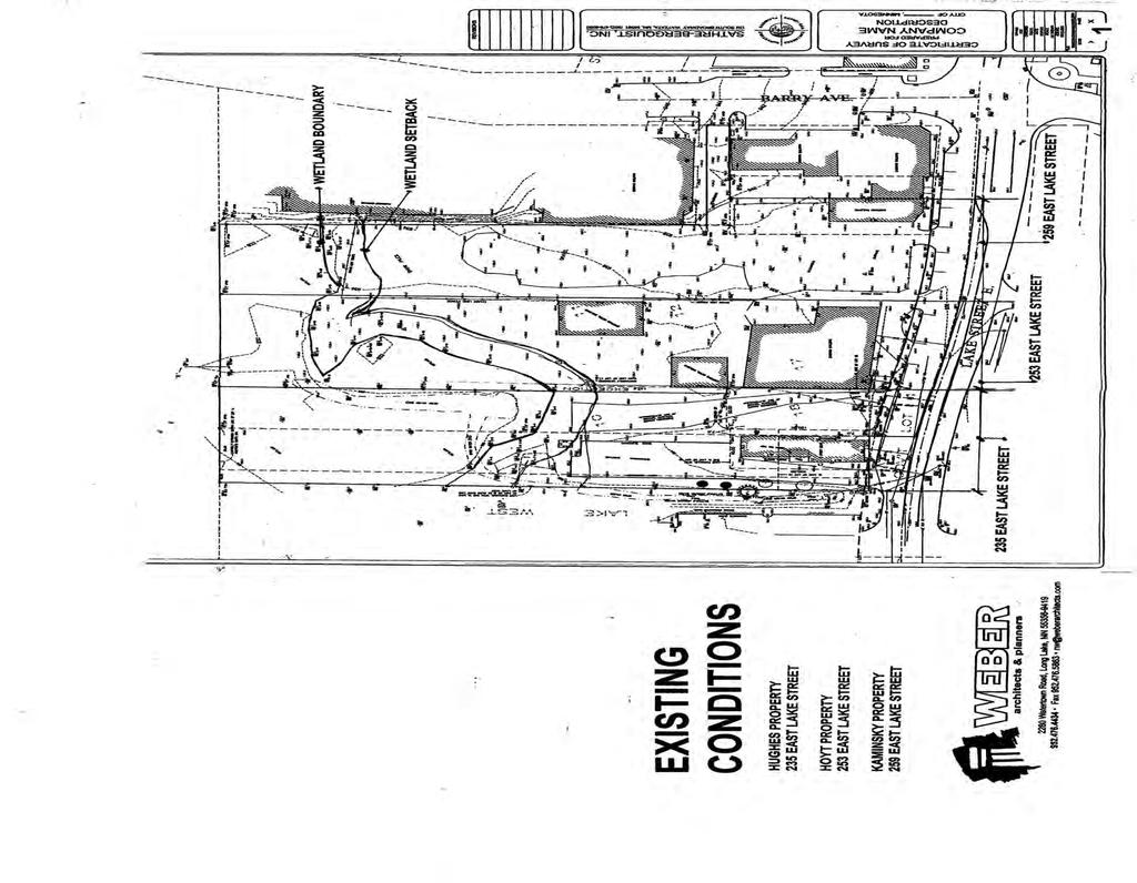
69
70
71
72
73
74
75
76
77

78
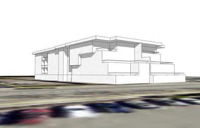
79
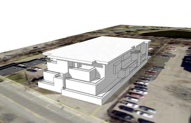
80
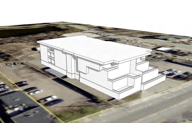
81
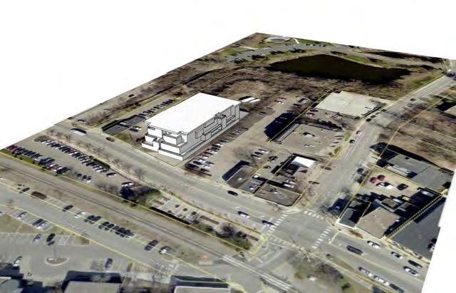
82
SECTION 16. "PUD" PLANNED UNIT DEVELOPMENT OVERLAY DISTRICT
 SECTION 6. "PUD" PLANNED UNIT DEVELOPMENT OVERLAY DISTRICT Subsection. Purpose. This district is established to achieve the coordinated integration of land parcels and large commercial and retail establishments
CHAPTER 10 Planned Unit Development Zoning Districts
 CHAPTER 10 Planned Unit Development Zoning Districts Section 10.1 Intent and Purpose The Planned Unit Development (PUD) districts are intended to offer design flexibility for projects that further the
MINNETONKA PLANNING COMMISSION June 2, A conditional use permit for 2,328 square feet of accessory structures at 4915 Highland Road
 MINNETONKA PLANNING COMMISSION June 2, 2016 Brief Description A conditional use permit for 2,328 square feet of accessory structures at Recommendation Recommend the city council adopt the resolution approving
In order to permit maximum applicability of the PUD District, PUD-1 and PUD-2 Districts are hereby created.
 ARTICLE III. PUD ned Unit Development Overlay District 205-128. Purpose. The PUD ned Unit Development Overlay District is intended to provide flexibility in the design of planned projects; to encourage
The following regulations shall apply in the R-E District:
 "R-E" RESIDENTIAL ESTATE DISTRICT (8/06) The following regulations shall apply in the R-E District: 1. Uses Permitted: The following uses are permitted. A Zoning Certificate may be required as provided
PLANNED UNIT DEVELOPMENTS (Ordinance No.: 3036, 12/3/07; Repealed & Replaced by Ordinance No.: 4166, 10/15/12)
") 159.62 PLANNED UNIT DEVELOPMENTS (Ordinance No.: 3036, 12/3/07; Repealed & Replaced by Ordinance No.: 4166, 10/15/12) A. PURPOSE 1. General. The Planned Unit Development (PUD) approach provides the flexibility
159.62 PLANNED UNIT DEVELOPMENTS (Ordinance No.: 3036, 12/3/07; Repealed & Replaced by Ordinance No.: 4166, 10/15/12) A. PURPOSE 1. General. The Planned Unit Development (PUD) approach provides the flexibility
ARTICLE 15 - PLANNED UNIT DEVELOPMENT
 Section 15.1 - Intent. ARTICLE 15 - PLANNED UNIT DEVELOPMENT A PUD, or Planned Unit Development, is not a District per se, but rather a set of standards that may be applied to a development type. The Planned
UPPER MOUNT BETHEL TOWNSHIP NORTHAMPTON COUNTY, PENNSYLVANIA
 UPPER MOUNT BETHEL TOWNSHIP NORTHAMPTON COUNTY, PENNSYLVANIA JOINDER DEED / LOT CONSOLIDATION TOWNSHIP REVIEW PROCESS When accepting proposed Joinder Deeds / Lot Consolidations, review the Joinder Deed
Planned Unit Development (PUD). Sections:
. Sections:") Chapter 19.07. Planned Unit Development (PUD). Sections: 19.07.01. Purpose. 19.07.02. PUD Definition and Design Compatibility. 19.07.03. General PUD Standards. 19.07.04. Underlying Zones. 19.07.05. Permitted
Chapter 19.07. Planned Unit Development (PUD). Sections: 19.07.01. Purpose. 19.07.02. PUD Definition and Design Compatibility. 19.07.03. General PUD Standards. 19.07.04. Underlying Zones. 19.07.05. Permitted
ARTICLE VII. NONCONFORMITIES. Section 700. Purpose.
 ARTICLE VII. NONCONFORMITIES. Section 700. Purpose. The purpose of this chapter is to regulate and limit the development and continued existence of legal uses, structures, lots, and signs established either
Staff Report: Date: Applicant: Property Identification: Acreage of Request: Current Zoning of Requested Area: Requested Action: Attached:
 Staff Report: Completed by Jeff Palmer Director of Planning & Zoning Date: November 7, 2018, Updated November 20, 2018 Applicant: Greg Smith, Oberer Land Developer agent for Ronald Montgomery ET AL Property
ARTICLE 14 PLANNED UNIT DEVELOPMENT (PUD) DISTRICT
 DISTRICT") ARTICLE 14 PLANNED UNIT DEVELOPMENT (PUD) DISTRICT Section 14.01 Intent. It is the intent of this Article to allow the use of the planned unit development (PUD) process, as authorized by the Michigan Zoning
ARTICLE 14 PLANNED UNIT DEVELOPMENT (PUD) DISTRICT Section 14.01 Intent. It is the intent of this Article to allow the use of the planned unit development (PUD) process, as authorized by the Michigan Zoning
PLANNED UNIT DEVELOPMENT (PUD)
") SECTION 38.01. ARTICLE 38 PLANNED UNIT DEVELOPMENT (PUD) Purpose The purpose of this Article is to implement the provisions of the Michigan Zoning Enabling Act, Public Act 110 of 2006, as amended, authorizing
SECTION 38.01. ARTICLE 38 PLANNED UNIT DEVELOPMENT (PUD) Purpose The purpose of this Article is to implement the provisions of the Michigan Zoning Enabling Act, Public Act 110 of 2006, as amended, authorizing
ARTICLE 24 SITE PLAN REVIEW
 ARTICLE 24 SITE PLAN REVIEW 24.1 PURPOSE: The intent of these Ordinance provisions is to provide for consultation and cooperation between the land developer and the Township Planning Commission in order
CHAPTER XVIII SITE PLAN REVIEW
 CHAPTER XVIII SITE PLAN REVIEW Section 18.1 Section 18.2 Description and Purpose. The purpose of this chapter is to provide standards and procedures under which applicants would submit, and the Township
Article 7: Residential Land Use and Development Requirements
 Article 7: Residential Land Use and Section 701: Statement of Intent (A) (B) (C) The intent of Article 7 is to develop certain land use and development requirements for the residential uses within Cumru
TOOELE COUNTY LAND USE ORDINANCE CHAPTER 31 Page 1
 CHAPTER 31 PLANNED COMMUNITY ZONE (P-C) Section 31-1 Definitions. 31-2 Purpose. 31-3 Land use districts. 31-4 P-C zone area minimum requirements. 31-5 Permitted uses. 31-6 Conditional uses. 31-7 Planning
CITY OF NAPLES STAFF REPORT
 Meeting of 05/13/15 Conditional Use Petition 15-CU3 CITY OF NAPLES STAFF REPORT To: Planning Advisory Board From: Planning Department Subject: Conditional Use Petition 15-CU3 Petitioner: Hazelden Betty
CHAPTER 14 PLANNED UNIT DEVELOPMENTS
 9-14-1 9-14-1 CHAPTER 14 PLANNED UNIT DEVELOPMENTS SECTION: 9-14-1: Purpose 9-14-2: Governing Provisions 9-14-3: Minimum Area 9-14-4: Uses Permitted 9-14-5: Common Open Space 9-14-6: Utility Requirements
AN ORDINANCE TO AMEND SECTION OF THE RAPID CITY MUNICIPAL CODE TO ALLOW FOR ADMINISTRATIVE DISSOLUTION OF PLANNED DEVELOPMENTS
 Ordinance No. 6231 AN ORDINANCE TO AMEND SECTION 17.50.050 OF THE RAPID CITY MUNICIPAL CODE TO ALLOW FOR ADMINISTRATIVE DISSOLUTION OF PLANNED DEVELOPMENTS WHEREAS, the City of Rapid City has adopted a
Charter Township of Plymouth Zoning Ordinance No. 99 Page 208 Article 21: Residential Unit Developments Amendments: ARTICLE XXI
 Charter Township of Plymouth Zoning Ordinance No. 99 Page 208 ARTICLE XXI RESIDENTIAL UNIT DEVELOPMENTS PURPOSE The purpose of the Residential Unit Development (RUD) is to permit two (2) optional methods
City of Brooklyn Park Planning Commission Staff Report
 City of Brooklyn Park Planning Commission Staff Report Agenda Item: 6D Meeting Date: August 9, 2017 Originating Agenda Section: Public Hearing Department: Community Development Resolution: X Ordinance:
Salem Township Zoning Ordinance Page 50-1 ARTICLE 50.0: PUD PLANNED UNIT DEVELOPMENT
 Salem Township Zoning Ordinance Page 50-1 ARTICLE 50.0 PLANNED UNIT DEVELOPMENT Section 50.01 Purpose The provisions of this Article provide enabling authority and standards for the submission, review,
PLANNED UNIT DEVELOPMENT (East), PLANNED UNIT DEVELOPMENT (West) STAFF REPORT Date: September 18, 2014
, PLANNED UNIT DEVELOPMENT (West) STAFF REPORT Date: September 18, 2014") PLANNED UNIT DEVELOPMENT (East), PLANNED UNIT DEVELOPMENT (West) STAFF REPORT Date: September 18, 2014 DEVELOPMENT NAME LOCATION McGowin Park, LLC PLANNED UNIT DEVELOPMENT (East) 1401 Satchel Paige Drive
PLANNED UNIT DEVELOPMENT (East), PLANNED UNIT DEVELOPMENT (West) STAFF REPORT Date: September 18, 2014 DEVELOPMENT NAME LOCATION McGowin Park, LLC PLANNED UNIT DEVELOPMENT (East) 1401 Satchel Paige Drive
Box Elder County Land Use Management & Development Code Article 3: Zoning Districts
 Chapter 3-6 Mobile Homes, Mobile Home Subdivisions, & Recreational Vehicle Parks Box Elder Zoning Ordinance as Adopted October 2007 Sections. 3-6-010. Purpose and Intent. 3-6-020. Conditional Use Permit
City Council Agenda Item #10_ Meeting of May 18, Resolution approving a conditional use permit for an accessory structure at 1721 Oakland Road
 City Council Agenda Item #10_ Meeting of May 18, 2015 Brief Description Recommendation Resolution approving a conditional use permit for an accessory structure at Adopt the resolution approving the request
DRAFT FOR PUBLIC HEARING (rev. March, 2016)
") Chapter 200. ZONING Article VI. Conservation/Cluster Subdivisions 200-45. Intent and Purpose These provisions are intended to: A. Guide the future growth and development of the community consistent with
Chapter 200. ZONING Article VI. Conservation/Cluster Subdivisions 200-45. Intent and Purpose These provisions are intended to: A. Guide the future growth and development of the community consistent with
PLANNED UNIT DEVELOPMENT & SUBDIVISION STAFF REPORT Date: April 18, 2019
 PLANNED UNIT DEVELOPMENT & SUBDIVISION STAFF REPORT Date: April 18, 2019 DEVELOPMENT NAME SUBDIVISION NAME Springhill Village Subdivision Springhill Village Subdivision LOCATION 4350, 4354, 4356, 4358,
Special Use Permit - Planned Unit Development Checklist. Property Address:
 Special Use Permit - Planned Unit Development Checklist Special Use Permit Number. Parcel Code/s #28-11- - - Property Address: Applicant: ARTICLE VIII Ordinance Reference - Section 8.1.2 Permit Procedures:
PLANNED DEVELOPMENT DISTRICT STANDARDS. Cadence Site
 PLANNED DEVELOPMENT DISTRICT STANDARDS Cadence Site A Planned Development District 1. Statement of General Facts, Conditions and Objectives Property Size: Approximately 57.51 Acres York County Tax Map
Understanding the Conditional Use Process
 Understanding the Conditional Use Process The purpose of this document is to explain the process of applying for and obtaining a conditional use permit in the rural unincorporated towns of Dane County.
ARTICLE XI CONDITIONAL USE PERMITS
 ARTICLE XI CONDITIONAL USE PERMITS 11.1 Purpose. The City of Hailey recognizes that certain uses possess unique and special characteristics with respect to their location, design, size, method of operation,
Staff Report PLANNED DEVELOPMENT. Salt Lake City Planning Commission. From: Lauren Parisi, Associate Planner; Date: December 14, 2016
 Staff Report PLANNING DIVISION COMMUNITY & NEIGHBORHOODS To: Salt Lake City Planning Commission From: Lauren Parisi, Associate Planner; 801-535-7932 Date: December 14, 2016 Re: 1611 South 1600 East PLANNED
5.03 Type III (Quasi-Judicial) Decisions
 Decisions") 5.03 Type III (Quasi-Judicial) Decisions 5.03 General Requirements A. The purpose of this Section is to identify what types of actions are considered Type III decisions. Type III decisions involve significant
5.03 Type III (Quasi-Judicial) Decisions 5.03 General Requirements A. The purpose of this Section is to identify what types of actions are considered Type III decisions. Type III decisions involve significant
Special Land Use. SLU Application & Review Standards
 review and approval is needed for certain uses of property that have the potential to impact adjacent properties and the neighborhood. The application and review procedure is intended to ensure that the
ARTICLE 12 PLANNED UNIT DEVELOPMENT DISTRICTS (PUDS) Sec Intent CHARTER TOWNSHIP OF BRIGHTON ZONING ORDINANCE
 Sec Intent CHARTER TOWNSHIP OF BRIGHTON ZONING ORDINANCE") ARTICLE 12 PLANNED UNIT DEVELOPMENT DISTRICTS (PUDS) Sec. 12-01 Intent 1 2 (a) The intent of this Article is to permit the coordinated development on larger sites, protect significant natural features
ARTICLE 12 PLANNED UNIT DEVELOPMENT DISTRICTS (PUDS) Sec. 12-01 Intent 1 2 (a) The intent of this Article is to permit the coordinated development on larger sites, protect significant natural features
4.2 RESIDENTIAL ZONING DISTRICTS
 4.2 RESIDENTIAL ZONING DISTRICTS A. Purpose: To define regulations and standards for each residential zoning district in the City. The following sections identify uses, regulations, and performance standards
PLANNING COMMISSION STAFF REPORT. Merrimac PLNSUB Planned Development 38 West Merrimac November 9, Request. Staff Recommendation
 PLANNING COMMISSION STAFF REPORT Merrimac PLNSUB2011-00374 Planned Development 38 West Merrimac November 9, 2011 Planning and Zoning Division Department of Community and Economic Development Applicant:
ARTICLE 23 CONDOMINIUM STANDARDS
 ARTICLE 23 CONDOMINIUM STANDARDS Section 23.01 Intent. The intent of this Article is to provide regulatory standards for condominiums and site condominiums similar to those required for projects developed
DEVELOPMENT DEPARTMENT STAFF REPORT DRESDEN HEIGHTS PHASE II DCI
 DEVELOPMENT DEPARTMENT Meeting Date: January 10, 2019 Item #: PZ2019-393 Project Name: Applicant and Owner: Proposed Development: Requests: STAFF REPORT DRESDEN HEIGHTS PHASE II DCI Dresden Heights Phase
SECTION 10.7 R-PUD (RESIDENTIAL PLANNED UNIT DEVELOPMENT) ZONE
 ZONE") Article X Zones 10-20 SECTION 10.7 R-PUD (RESIDENTIAL PLANNED UNIT DEVELOPMENT) ZONE A. PURPOSE AND INTENT: The R-PUD Residential PUD Zone is intended to provide alternative, voluntary zoning procedures
Article X Zones 10-20 SECTION 10.7 R-PUD (RESIDENTIAL PLANNED UNIT DEVELOPMENT) ZONE A. PURPOSE AND INTENT: The R-PUD Residential PUD Zone is intended to provide alternative, voluntary zoning procedures
Chapter SPECIAL USE ZONING DISTRICTS
 Chapter 20.20 Sections: 20.20.010 Urban Transition (U-T) Zoning District 20.20.020 Planned Development (P-D) Zoning Districts 20.20.010 Urban Transition (U-T) Zoning District A. Purpose. The purpose of
Chapter 22 PLANNED UNIT DEVELOPMENT.
 Chapter 22 PLANNED UNIT DEVELOPMENT. Sec. 22.1 INTENT. The use of land and the construction and use of buildings and other structures as Planned Unit Developments in Georgetown Township may be established
Draft Zoning Changes for the 2nd Planning Board Public Hearing, January 22, 2018.
 Draft Zoning Changes for the 2nd Planning Board Public Hearing, January 22, 2018. No changes were made at the 1st Public Hearing. Proposed wording for the 1 st Public Hearing in red, eliminated text in
MEMORANDUM. DATE: August 31, Honorable Mayor and City Councilmembers Patrick Klaers, City Administrator. Matthew Bachler, Associate Planner
 NEW BUSINESS 8B MEMORANDUM DATE: August 31, 2015 TO: FROM: Honorable Mayor and City Councilmembers Patrick Klaers, City Administrator Matthew Bachler, Associate Planner SUBJECT: Planning Case #15-016 Applicant:
ZONING ORDINANCE: OPEN SPACE COMMUNITY. Hamburg Township, MI
 ZONING ORDINANCE: OPEN SPACE COMMUNITY Hamburg Township, MI ARTICLE 14.00 OPEN SPACE COMMUNITY (Adopted 1/16/92) Section 14.1. Intent It is the intent of this Article to offer an alternative to traditional
PUD Ordinance - Cascade Lakes Plat #10 of 1995
 PUD Ordinance - Cascade Lakes Plat #10 of 1995 CASCADE CHARTER TOWNSHIP Ordinance #10 of 1995 AN ORDINANCE TO AMEND THE CASCADE CHARTER TOWNSHIP ZONING ORDINANCE AND ZONING MAP TO ESTABLISH THE CASCADE
Midwest City, Oklahoma Zoning Ordinance
 2010 Midwest City, Oklahoma Zoning Ordinance 9/2/2010 Table of Contents Section 1. General Provisions... 5 1.1. Citation... 5 1.2. Authority... 5 1.3. Purpose... 5 1.4. Nature and Application... 5 1.5.
b) Tangerine Corridor Overlay District 1) Tangerine Corridor District Regulations
 Tangerine Corridor Overlay District 1) Tangerine Corridor District Regulations") Attachment 1 Tangerine Road Corridor Overlay District Section 27.10.D.3.f.vi.b Initiation of Code Amendment September 2, 2014, Planning and Zoning Commission b) Tangerine Corridor Overlay District 1) Tangerine
Attachment 1 Tangerine Road Corridor Overlay District Section 27.10.D.3.f.vi.b Initiation of Code Amendment September 2, 2014, Planning and Zoning Commission b) Tangerine Corridor Overlay District 1) Tangerine
Waseca County Planning and Zoning Office
 Waseca County Planning and Zoning Office 300 North State Street Waseca, Minnesota 56093 Phone: 507-835-0650 Fax: 507-837-5310 Form no. PZ 081009 Web Site: www.co.waseca.mn.us FEES: 1) CUP FEE- $400.00
Staff Report: Date: Applicant: Property Identification: Acreage of Request: Current Zoning of Requested Area: Requested Action: Attached:
 Staff Report: Completed by Jeff Palmer Director of Planning & Zoning Date: November 7, 2018 Applicant: Greg Smith, Oberer Land Developer agent for Ronald Montgomery ET AL Property Identification: Frontage
PLANNED RESIDENTIAL DEVELOPMENT (PRD)
") PLANNED RESIDENTIAL DEVELOPMENT SECTION 10. PLANNED RESIDENTIAL DEVELOPMENT (PRD) 10.1 Purpose Planned Residential Development allows by special permit from the Board an alternative pattern of residential
PLANNED RESIDENTIAL DEVELOPMENT SECTION 10. PLANNED RESIDENTIAL DEVELOPMENT (PRD) 10.1 Purpose Planned Residential Development allows by special permit from the Board an alternative pattern of residential
City of Harrisburg Variance and Special Exception Application
 City of Harrisburg Variance and Special Exception Application Note: The Planning Bureau will review all applications for completeness; incomplete applications may cause a delay in processing. Contact Ben
ADMINISTRATIVE HEARING STAFF REPORT
 ADMINISTRATIVE HEARING STAFF REPORT Providence Place Apartments Utility Box No. 2 Conditional Use Petition PLNPCM2011-00426 309 East 100 South September 22, 2011 Planning and Zoning Division Department
ADUs and You! Common types of ADUs include mother-in-law suite, garage apartments and finished basements.
 ADUs and You! Accessory Dwelling Units Town of Lyons Accessory Dwelling Units (ADUs) are a form of housing that can be an important tool for diversifying and increasing the local housing stock. Lyons lost
LAND USE AND ZONING OVERVIEW
 OVERVIEW OF PLANNING POLICIES LAND USE AND ZONING OVERVIEW The Minneapolis Plan for Sustainable Growth and Other Adopted Plans Community Planning and Economic Development Development Services Division
Article 6: Planned Unit Developments
 LUDC 2013 GARFIELD COUNTY, COLORADO Article 6: Planned Unit Developments ARTICLE 6 PLANNED UNIT DEVELOPMENTS TABLE OF CONTENTS DIVISION 1. GENERAL.... 1 6-101. GENERAL PROVISIONS.... 1 A. Purpose....
Guide to Preliminary Plans
 Guide to Preliminary Plans Introduction The Douglas County is committed to providing open, transparent application processes to the public. This Guide is provided to assist anyone interested in the procedures
REPORT TO PLANNING & ZONING COMMISSION - CITY OF MARYLAND HEIGHTS
 APPLICATION NUMBER APPLICATION (PROJECT) NAME APPLICANT NAME PROPERTY OWNER NAME CUP16-0003 CENTRAL POWER SYSTEMS & SERVICES, INC. Central Power Systems & Services, Inc. 900 Liberty Drive, Liberty, MO
a. provide for the continuation of collector streets and thoroughfare streets between adjacent subdivisions;
 Section 7.07. Intent The requirements of this Section are intended to provide for the orderly growth of the Town of Holly Springs and its extra-territorial jurisdiction by establishing guidelines for:
ARTICLE B ZONING DISTRICTS
 ARTICLE B ZONING DISTRICTS Sec. 8-3021 Established. In order to protect the character of existing neighborhoods; to prevent excessive density of population in areas which are not adequately served with
CHAPTER 3 PERMITS, PLANS AND ANNEXATION
 CHAPTER 3 PERMITS, PLANS AND ANNEXATION SECTION: 10-3-1: General Regulations 10-3-2: Building Permit 10-3-3: Plans 10-3-4: Certificate of Compliance and Occupancy 10-3-5: Conditional Use Permits 10-3-6:
EXHIBIT D. Planned Unit Development Written Description April 13, 2016 Rouen Cove Phase II PUD
 1 EXHIBIT D Planned Unit Development Written Description April 13, 2016 Rouen Cove Phase II PUD Development # 8986.001 Developer: Curtis L. Hart Hart Resources LLC 8051 Tara Lane Jacksonville, Florida
City Council Agenda Item #14_ Meeting of Oct. 8, Concept plan for Marsh Run Two Redevelopment at and Wayzata Blvd.
 City Council Agenda Item #14_ Meeting of Oct. 8, 2018 Brief Description Recommendation Concept plan for Marsh Run Two Redevelopment at 11650 and 11706 Wayzata Blvd. Continue discussion of the concept plan
Planning Department Oconee County, Georgia
 Planning Department Oconee County, Georgia STAFF REPORT REZONE CASE #: 6985 DATE: October 31, 2016 STAFF REPORT BY: Andrew C. Stern, Planner APPLICANT NAME: Williams & Associates, Land Planners PC PROPERTY
Cover Letter with Narrative Statement
 Cover Letter with Narrative Statement March 31, 2017 rev July 27, 2017 RE: Rushton Pointe Residential Planned Unit Development Application for Public Hearing for RPUD Rezone PL2015 000 0306 Mr. Eric Johnson,
RESOLUTION NO CITY OF MAPLE GROVE
 RESOLUTION NO. 18-122 CITY OF MAPLE GROVE RESOLUTION GRANTING PLANNED UNIT DEVELOPMENT CONCEPT STAGE PLAN, PLANNED UNIT DEVELOPMENT - DEVELOPMENT STAGE PLAN, AND PRELIMINARY PLAT FOR TERRITORIAL GREENS
1. Allow a workable, interrelated mix of diverse land uses;
 5-24 PUD Planned Unit Development 5-24.1 Purpose A. The Planned Unit Development (PUD) District is intended to encourage flexible and innovative design in the development of appropriate sites as integrated
Section 7.22: Multifamily Assisted Housing in AA-30 Residential Zone (MAHZ) [Note: an additional line will be added to the Table in Article 3, 3.1.
 [Note: an additional line will be added to the Table in Article 3, 3.1.") Section 7.22: Multifamily Assisted Housing in AA-30 Residential Zone (MAHZ) [Note: an additional line will be added to the Table in Article 3, 3.1.1A] 7.22.1 Purpose The purpose of this Special Regulation
Section 7.22: Multifamily Assisted Housing in AA-30 Residential Zone (MAHZ) [Note: an additional line will be added to the Table in Article 3, 3.1.1A] 7.22.1 Purpose The purpose of this Special Regulation
Special Exception Use Order Application
 Development Services Department Planning Division CITY OF OVIEDO 400 Alexandria Boulevard Oviedo, Florida 32765 Application No. Date Received Pre-application Meeting Date Phone: (407) 971-5775 (407)971-5819
Conditional Use Permit case no. CU 14-06: Bristol Village Partners, LLC
 PLANNING AND ZONING COMMISSION STAFF REPORT August 7, 2014 Conditional Use Permit case no. CU 14-06: Bristol Village Partners, LLC CASE DESCRIPTION: LOCATION: LEGAL DESCRIPTION: EXISTING LAND USE: ZONING:
Glades County Staff Report and Recommendation Unified Staff Report for Small Scale Plan Amendment and Rezoning
 Glades County Staff Report and Recommendation Unified Staff Report for Small Scale Plan Amendment and Rezoning CASE NUMBERS: COMP17-02 and RZ17-02 DATE of STAFF REPORT: May 1, 2017 CASE TYPE: Application
Plan nt Plan Filing and
 PARISH OF ASCENSION OFFICE OF PLANNING AND DEVELOPMENT PLANNING DEPARTMENT APPENDIX VI PLANNED UNIT DEVELOPMENT (PUD) CODE Contents: 17-601. General Purpose: Procedures... 3 17-602. General Character:...
CHAPTER XV PUD PLANNED UNIT DEVELOPMENT DISTRICT
 CHAPTER XV PUD PLANNED UNIT DEVELOPMENT DISTRICT Section 15.1 Planned Unit Development. Planned Unit Development (PUD) includes cluster zoning, plan development, community unit plan, planned residential
Kitsap County Department of Community Development. Administrative Staff Report
 Kitsap County Department of Community Development Administrative Staff Report Report Date: Application Complete Date: March 15, 2018 Application Submittal Date: March 12, 2018 Project Name: Nikki Lee Salon
PALM BEACH COUNTY PLANNING, ZONING AND BUILDING DEPARTMENT ZONING DIVISION ZONING COMMISSION VARIANCE STAFF REPORT 06/07/2012
 PALM BEACH COUNTY PLANNING, ZONING AND BUILDING DEPARTMENT ZONING DIVISION ZONING COMMISSION VARIANCE STAFF REPORT 06/07/2012 APPLICATION NO. CODE SECTION REQUIRED PROPOSED VARIANCE ZV-2009-03300 Variance
STATE OF MICHIGAN COUNTY OF BERRIEN ORONOKO CHARTER TOWNSHIP PRIVATE ROAD ORDINANCE ORDINANCE NO. 65
 STATE OF MICHIGAN COUNTY OF BERRIEN ORONOKO CHARTER TOWNSHIP PRIVATE ROAD ORDINANCE ORDINANCE NO. 65 AN ORDINANCE TO REQUIRE THAT ALL LOTS OR PARCELS OF LAND WHICH DO NOT ABUT PUBLIC STREETS ABUT A PRIVATE
P. H. Robinson Consulting Urban Planning, Consulting and Project Management
 PLANNING RATIONALE REPORT FOR SITE PLAN AND DRAFT PLAN OF CONDOMINIUM APPLICATIONS 73-75 HARVEY STREET CITY OF OTTAWA PREPARED BY: P H ROBINSON CONSULTING AUGUST 2012 1 This report has been prepared on
Legal Description Part of the Western Half of the Eastern Half of the Northwest Quarter of Section 30, Le Ray Township
 Owner and Applicant s 20448 State Highway 83 Mankato, MN 56001 Request and Location Request for review and approval of a Conditional Use Permit to allow an Elder Care Residential Unit to be constructed
TOTTENHAM SECONDARY PLAN
 TOTTENHAM SECONDARY PLAN AMENDMENT NO. 11 TO THE OFFICIAL PLAN OF THE TOWN OF NEW TECUMSETH The following text and schedules to the Official Plan of the Town of New Tecumseth constitute Amendment No. 11
CHAPTER34 PRUD - PLANNED RESIDENTIAL UNIT DEVELOPMENT
 CHAPTER34 PRUD - PLANNED RESIDENTIAL UNIT DEVELOPMENT 17-34-1 17-34-2 17-34-3 17-34-4 17-34-5 17-34-6 17-34-7 17-34-8 17-34-9 Purpose Planned Residential Unit Development Defined Planned Residential Unit
DEVELOPMENT DEPARTMENT STAFF REPORT THE PARK AT 5 TH
 DEVELOPMENT DEPARTMENT STAFF REPORT ARB Meeting Date: July 3, 2018 Item #: _PZ2018-293_ THE PARK AT 5 TH Request: Site Address: Project Name: Parcel Number: Applicant: Proposed Development: Current Zoning:
ARTICLE 8C SITE CONDOMINIUM DEVELOPMENT ORDINANCE
 ARTICLE 8C SITE CONDOMINIUM DEVELOPMENT ORDINANCE SECTION 8C.01 PURPOSE It is the purpose of this Ordinance to insure that plans for development within Oceola Township proposed under the provisions of
CITY OF INVER GROVE HEIGHTS 8150 Barbara Avenue Inver Grove Heights, MN (651)
") 8150 Barbara Avenue Inver Grove Heights, MN 55077 (651) 450-2545 www.invergroveheights.org FINAL PLANNED UNIT DEVELOPMENT (City Code Section 10-13A) The following must be submitted prior to review and
8150 Barbara Avenue Inver Grove Heights, MN 55077 (651) 450-2545 www.invergroveheights.org FINAL PLANNED UNIT DEVELOPMENT (City Code Section 10-13A) The following must be submitted prior to review and
DIVISION 9. PLANNED URBAN DEVELOPMENT CLASSIFICATION BY SPECIAL USE FOR ALL ZONING DISTRICTS Sec Statement Of Purpose: (a) Planned
 Planned") DIVISION 9. PLANNED URBAN DEVELOPMENT CLASSIFICATION BY SPECIAL USE FOR ALL ZONING DISTRICTS Sec. 12-169. Statement Of Purpose: (a) Planned developments are such substantially different character from
DIVISION 9. PLANNED URBAN DEVELOPMENT CLASSIFICATION BY SPECIAL USE FOR ALL ZONING DISTRICTS Sec. 12-169. Statement Of Purpose: (a) Planned developments are such substantially different character from
City and County of Broomfield, Colorado
 City and County of Broomfield, Colorado CITY COUNCIL AGENDA MEMORANDUM To: From: Mayor and City Council George Di Ciero, City and County Manager Teri Malies, Principal Planner Terrance Ware, Planning Director
ARTICLE I ZONE BASED REGULATIONS
 ARTICLE I ZONE BASED REGULATIONS RZC 21.08 RESIDENTIAL REGULATIONS 21.08.290 Cottage Housing Developments A. Purpose. The purpose of the cottage housing requirements is to: 1. Provide a housing type that
PUD Ordinance - Caravelle Village #7 of 1995
 PUD Ordinance - Caravelle Village #7 of 1995 CASCADE CHARTER TOWNSHIP Ordinance #17 of 1995 AN ORDINANCE TO AMEND THE CASCADE CHARTER TOWNSHIP ZONING ORDINANE AND ZONING MAP TO ESTABLISH THE CARAVELLE
FINAL DRAFT 12/1/16, Rev. to 7/18/17
 FINAL DRAFT 12/1/16, Rev. to 7/18/17 (As Adopted 8/8/17 Effective 9/1/17) SHELTON PLANNING AND ZONING COMMISSION Proposed Amendments to Zoning Regulations I. Amend Section 23 PERMITTED USES by inserting
Planning Report. Wayzata Planning Commission Monday, August 15, 2011
 Planning Report Wayzata Planning Commission Monday, August 15, 2011 File Case No: PR 2011-9 Applicant: Wayzata Yacht Club and Wayzata Sailing Foundation Address of Request: 1000 Eastman Lane, 1100 Eastman
STAFF REPORT. City of Ormond Beach Department of Planning. Exception for Outdoor Activity
 STAFF REPORT City of Ormond Beach Department of Planning DATE: March 7, 2019 SUBJECT: Lucky s Market, 101 East Granada Boulevard: Special Exception for Outdoor Activity APPLICANT: Wendy L. Petrillo-Rundle,
A. Preserve natural resources as identified in the Comprehensive Plan.
 1370.08 Conservation Residential Overlay District. Subd. 1 Findings. The City finds that the lands and resources within the Conservation Residential Overlay District are a unique and valuable resource
ARTICLE VI. SPECIAL EXCEPTION REGULATIONS
 ARTICLE VI. SPECIAL EXCEPTION REGULATIONS SECTION 601. GENERAL DESCRIPTION Special exceptions are deemed to be permitted uses in their respective districts, subject to the satisfaction of the requirements
Operating Standards Attachment to Development Application
 Planning & Development Services 2255 W Berry Ave. Littleton, CO 80120 Phone: 303-795-3748 Mon-Fri: 8am-5pm www.littletongov.org Operating Standards Attachment to Development Application 1 PLANNED DEVELOPMENT
Financial Impact Statement There are no immediate financial impacts associated with the adoption of this report.
 STAFF REPORT Planning and Development Department Subject: Application by RYC Property to rezone a portion of lands on John Murray Dr. and Megan Lynn Dr. from R2 to R3 and to enter into a Development Agreement
II. What Type of Development Requires Site Plan Review? There are five situations where a site plan review is required:
 I. What is a Site Plan Review? Site Plan Review is a process where the construction of new buildings, new additions, and certain types of canopies and/or tax-exempt institutions are reviewed by the City
ORDINANCE NO. 208 BE IT ORDAINED BY THE CITY COUNCIL OF THE CITY OF UNIVERSITY HEIGHTS, JOHNSON COUNTY, IOWA:
 ORDINANCE NO. 208 AN ORDINANCE AMENDING ORDINANCE NO. 79 (ZONING) TO CREATE A COMMERCIAL HOTEL ZONE AND PERMIT DEVELOPMENT PURSUANT TO A COMMERCIAL HOTEL PUD BE IT ORDAINED BY THE CITY COUNCIL OF THE CITY
DEVELOPMENT PLAN ORDINANCE
 DEVELOPMENT PLAN ORDINANCE CITY OF GLASGOW Ordinance No. 2026 SECTION A. Section 1. INTENT AND PURPOSE The purpose of this Ordinance is to establish and define development plans, which may be utilized
CITY OF MERCED SMALL LOT SINGLE-FAMILY HOME DESIGN GUIDELINES
 CITY OF MERCED SMALL LOT SINGLE-FAMILY HOME DESIGN GUIDELINES Development Services Department Planning and Permitting Adopted August 15, 2005 SMALL LOT SINGLE FAMILY HOME GUIDELINES A. Purpose and Applicability.
PERMITTED USES: Within the MX-1 Mixed Use Neighborhood District the following uses are permitted:
 6.25 MX-1 - MIXED USE NEIGHBORHOOD 6.25.1 INTENT: The purpose of the MX-1 Mixed Use Neighborhood District is to accommodate the development of a wide-range of residential and compatible non-residential