TOWN OF BRINY BREEZES. EVALUATION AND APPRAISAL REPORT September 23, 2010
|
|
|
- Homer Burns
- 5 years ago
- Views:
Transcription

1 TOWN OF BRINY BREEZES EVALUATION AND APPRAISAL REPORT September 23, 2010 Town of Briny Breezes 4802 North Ocean Boulevard Briny Breezes, Florida Prepared by the Planning and Zoning Board of the Town of Briny Breezes, acting as the Town s Local Planning Agency
2 TOWN OF BRINY BREEZES PLANNING & ZONING BOARD/LOCAL PLANNING AGENCY (P&Z/LPA) MEMBERSHIP ROSTER Jerry Lower, Chairman John Stanley, Vice Chairman Lee Godby, Member Ira Friedman, Member Jim Leming, Member Jim Phillipi, Alternate Member Angela Usher, Representative for Palm Beach County School District FORMER MEMBERS WHO PARTICIPATED IN THE EAR REVIEW Barbara Orf, Member Jack Lee, Alternate Member SECRETARIAL ASSISTANCE: Kathleen Bray, Town Clerk, pro tem LEGAL ASSISTANCE: Jerome F. Skrandel, Town Attorney EVALUATION AND APPRAISAL REPORT Prepared, Approved and Adopted as Amended by P&Z/LPA on September 10, 2010 and Approved and Adopted as Amended by Briny Breezes Town Council on September 23, 2010 i
3 EVALUATION AND APPRAISAL REPORT TABLE OF CONTENTS SUBJECT PAGE 1. CONSIDERATIONS RELATED TO THE EVALUATION AND 1 APPRAISAL REPORT PROCESS Town s Origin and Location 1 Town s Present Comprehensive Plan 1 Purpose of the Report 1 Revision of the Town s 2007 EAR 4 Major Issues for EAR Review 4 Public Participation Process 4 Relevant Changes in Growth Management Laws 5 Consideration of the Ten-Year Water Supply Work Plan 5 2. REVIEW OF FUTURE LAND USE ELEMENT 6 Introduction 6 Land Ownership 6 Existing Land Use Single Family Limitation 7 Population 10 Present Land Utilization Characteristics 15 Planning for the Town s Future Development 17 Conventional Multi-Family Housing Units 17 Sites for Future Development by Annexation 21 Annexation of Enclaves 21 Annexation of County Pockets to the South 24 Sites for Future Development on Vacant Land 24 New Site Locations by Redevelopment of Obsolete Areas Section 6 25 Planning for Innovative Types of Single-Family Housing Units Katrina Cottages 27 Consideration of the Ten-Year Water Supply Work Plan 31 Natural Resources 32 Historic Resources 32 Recreational Facilities 32 Public Facilities and Services 33 Flood Prone Areas 34 Recommendations REVIEW OF TRANSPORTATION ELEMENT 35 Introduction 35 Mapped Data 35 Street Pattern 36 Traffic Volume for SR A1A 38 Accident Data and Traffic Safety Concerns 38 ii
4 SUBJECT TABLE OF CONTENTS PAGE Municipal Traffic Control Agreement 39 Level of Service 39 Existing Transportation Needs 40 Future Needs 41 Recommendations REVIEW OF HOUSING ELEMENT 43 Introduction 43 Existing Conditions - Housing Types 43 Housing Conditions 43 Housing Values 44 Housing Rentals 45 Rent-to-Income Ratios 45 Mortgage-to-Income Ratios 45 Previous Redevelopment Strategies 45 Present Redevelopment Strategies 46 Other Housing Data 47 Needs Analysis - Group Homes and Subsidized Housing 47 Affordable Housing 47 Housing Needs 47 Private Sector Delivery Process 47 Identification of Conservation, Rehabilitation or Demolition Activities 48 Elimination of Substandard Housing 48 Recommendations REVIEW OF INFRASTRUCTURE ELEMENT 49 Introduction 49 Wastewater Facilities Sub-Element 49 Collection System 49 Treatment System 50 Needs Assessment 51 Solid Waste Sub-Element 52 Collection System 52 Needs Assessment 53 Potable Water Supply 55 Water Distribution System 56 Needs Assessment 56 Consideration of the Ten-Year Water Supply Work Plan 56 Drainage Facility Sub-Element 57 Rainfall 57 Terrain 57 Run-Off Quantities 57 Drainage Facilities 58 iii
5 TABLE OF CONTENTS SUBJECT PAGE Needs Assessment 59 Natural Groundwater Aquifer Recharge Sub-Element 59 Groundwater 59 Needs Assessment 60 Recommendations REVIEW OF COASTAL MANAGEMENT ELEMENT 60 Introduction 60 Water-Dependent and Water-Related Uses 61 Land Uses and Facilities Related to the Coastal Zone 61 Coastal Construction Control Line 65 Public Beach Access 66 Private Beach Access 66 Public Access to the Intracoastal Waterway 66 Private Access to the Intracoastal Waterway Shoreline 67 Conflicts among Shoreline Uses 67 Historic Resources 67 Hurricane Preparedness 67 Element Evaluation 68 Recommendations REVIEW OF CONSERVATION ELEMENT 69 Introduction 69 Conservation of Vegetative Cover 70 Relationship to Coastal Management Element 70 Environmental Setting 71 Natural Water Resources 71 Atlantic Ocean 71 Intracoastal Waterway 71 Geology 72 Coastal Ridge Vegetation 72 Air and Air Quality 72 Countywide Sources of Air Pollution 73 Briny Breezes Air Quality 73 Soils and Soil Erosion 73 Floodplains 73 Minerals 75 Hazardous Waste 75 Potable Water Needs and Sources 76 Consideration of the Ten-Year Water Supply Work Plan 76 Water Conservation 76 Resource Protection Standards 79 iv
6 TABLE OF CONTENTS SUBJECT PAGE Recommendations REVIEW OF RECREATION & OPEN SPACE ELEMENT 80 Introduction 80 Existing Conditions 80 Public Regional Facilities 81 Pedestrian Trails 81 Open Space along Intracoastal Waterway 82 Needs Assessment 82 Recommendations REVIEW OF INTERGOVERNMENTAL COORDINATION ELEMENT 83 Introduction - Existing Conditions 83 Consideration of the Ten-Year Water Supply Work Plan 84 Public Education and Health 85 Programs Affecting the Intracoastal Waterway 87 Recommendation REVIEW OF CAPITAL IMPROVEMENT ELEMENT 87 Introduction 87 Inventory of Needs from Other Elements 88 Transportation 88 Potable Water System 88 Consideration of the Ten-Year Water Supply Work Plan 88 Solid Waste Removal 89 Storm Drainage 90 Sanitary Sewer System 90 Recreation 90 Financial Resources 90 Property or Ad Valorem Taxes 90 Charges for Services 90 Intergovernmental Revenues 91 Miscellaneous General Fund Revenues 91 Borrowing 91 Federal Funding 91 Town Policies and Practices 91 Fiscal Implications of Deficiencies and Cost Estimates 92 Public Education and Health Care Facility Implications 92 Land Use Plan Implications 92 Revenue Projections 92 Tax Base 93 v
7 TABLE OF CONTENTS SUBJECT PAGE Debt Capacity 93 Implications from Town s Fiscal Analysis 94 Implementation of Five-Year Schedule of Capital Improvements 94 Capital Improvement Programs 94 Recommendations 95 LOCATION OF FIGURES PAGE Figure 1 Regional Location Map 2 Figure 2 Town s Geographic Location 3 Figure 3 Detailed Map Showing the Town s Layout 9 Figure 4 Existing Land Use Map of Town of Briny Breezes 16 Figure 5 Proposed Future Land Use Map of Town of Briny Breezes 20 Figure 6 Enclaves within the Town Boundaries 23 Figure 7 Potential Redevelopment Area, Designated as Section 6, Showing 26 Present Land Uses Figure 8 Recreational Facilities 32 Figure 9 Road Network for the Town of Briny Breezes 37 Figure 10 Location of Water-Dependent & Water-Related Uses within the Town 62 Figure 11 Location of the CCCL in the Town of Briny Breezes 65 Figure 12 Concurrency Letter from the Palm Beach County School District 86 LOCATION OF TABLES PAGE Table 1 Snowbirds and the Census 11 Table 2 Population Estimate from Town s 1989 Plan 12 Table U.S. Census Data for the Town of Briny Breezes 13 Table 4 Town s Present Estimated Population 14 Table 5 Projected Population by 2015 at End of 5-Year Planning Period 30 Table 6 Daily Traffic Volume on SR A1A Through Town 38 Table 7 Standards for Levels of Service 40 Table 8 Existing And Future Levels of Service for SR A1A 42 Table 9 Sewage Flow Projections for the Town 52 Table 10 Solid Waste Disposal 54 Table 11 Town s Suitability for Listed Species 63 Table 12 Flood Insurance Classification Zones for Briny Breezes 74 Table 13 Flood Insurance Rate Map 75 Table 14 Town s Current Water Consumption 78 Table 15 Financial Data for the Town of Briny Breezes 93 DESCRIPTION OF APPENDICES NUMBER OF PAGES Appendix A Town Ordinance No. 1 08, Public Participation Procedures 5 Pages Appendix B Changes to Chapter 163, Florida Statutes 33 Pages Appendix C - Changes to Rule 9J-5, Florida Administrative Code 14 Pages vi
8 EVALUATION AND APPRAISAL REPORT TOWN OF BRINY BREEZES, FLORIDA 1. CONSIDERATIONS RELATED TO THE EVALUATION AND APPRAISAL REPORT PROCESS Town s Origin and Location The Town of Briny Breezes was incorporated on March 19, 1963 pursuant to the former provisions of Chapter 165 of the Florida Statues. The governing officials consist of a Town Mayor and five Aldermen who are elected at large. The Town is located on the Atlantic Ocean in the southern part of Palm Beach County. Appearing on the following pages are Figure 1, a regional location map for the Town, and Figure 2, a map showing the Town in reference to its adjoining cities and geographical landmarks. Town s Present Comprehensive Plan The Town s present Comprehensive Plan was adopted in January, An Amended Comprehensive Plan was given preliminary adoption by the Town Council on April 27, 2007 by Ordinance No and was submitted to the Department of Community Affairs (DCA) for review and comment. On June 29, 2007, the DCA issued its Objections, Recommendations, and Comments (ORC) Report, finding the Town s Plan Amendment to be inconsistent as submitted. The Town took no further action on the recommendations contained in the DCA s ORC Report, deciding instead to turn its attention to the completion of the Town s Evaluation and Appraisal Report. Purpose of the Report The purpose of this Evaluation and Appraisal Report (EAR) is to determine how well the present Comprehensive Plan has served the Town and to provide statements to update the Plan regarding anticipated increases in population, the extent of developable land within the Town, deciding where that new development will occur, and analyzing the financial ability of the Town to implement any anticipated increase in infrastructure that would be required to maintain satisfactory levels-of-service to a future increase in population. 1
9 Figure 1 Regional Location Map 2
10 Figure 2 Town s Geographic Location 3
11 Revision of the Town s 2007 EAR The work on the Town s EAR was done by the Town s Planning and Zoning Board, acting as the Local Planning Agency (P&Z/LPA). It represents a revision to a previous EAR dated April 19, 2007 which the Town adopted by Resolution No , and submitted to the DCA for review and comment on April 26, The DCA issued its Final Sufficiency Report Letter to the Town on June 29, 2007 stating that the document had six issues of sufficiency and made recommendations for compliance. The issues identified were Population Growth, Financial Feasibility of Infrastructure, Relevant Changes in Growth Management Laws, Assessment and Shortcomings of Each Element, Consideration of the Water Management District s Water Supply Plan, and Evaluation of Property Rights in Coastal High Hazard Areas. All of theses sufficiency issues are addressed in this revised EAR. Major Issues for EAR Review In deciding the scope of this Report, the P&Z/LPA selected the future development of the Town as its issue of major concern. It also addressed the six sufficiency issues, and analyzed and evaluated the several elements comprising the Town s Comprehensive Plan, namely: Future Land Use, Transportation, Infrastructure, Coastal Management, Conservation, Recreation, Intergovernmental Coordination, and Capital Improvements. Public Participation Process Town Ordinance No adopted the public participation procedures that were followed by the P&Z/LPA in its preparation of this Report. The Ordinance is patterned after Section , F.S., and is designed to provide the public with the necessary notice and opportunity to be heard in the EAR review process. To prepare the EAR Report, the P&Z/LPA began with a series of monthly public meetings from April, 2008 to December, It focused its attention on each elements of the Town s present Comprehensive Plan. The P&Z/LPA sent the Town Council reports on each of its meetings, and submitted a preliminary Evaluation and Appraisal Report, marked Revised, December 11, 2008, for the Council s review and approval. In May, 2009, the Town Council submitted the Proposed EAR Report to the DCA, with copies to interested governmental agencies, for a preliminary review and informal comment. In September, 2009, the P&Z/LPA resumed its meetings to review the comments received on the 4
12 Proposed EAR and continued meeting intermittently until October, 2010, when it approved this revised EAR and recommended its adoption to the Town Council. The P&Z/LPA and the Town Council gave proper public notice of each meeting held in the EAR review process by posting written notices in public display at the entrance to the Town Hall and at two other prominent places within the Town at least three (3) days before the meeting dates. The notices gave the date, time, place, and general purpose of the meetings and its agenda. A roster of names was kept for attendees who offered their comments at each meeting. It is the practiced policy of the P&Z/LPA and the Town Council to comply with the strict requirements of the law by giving proper notice of its public meetings and whenever publication of a notice of a public hearing is required by a legal advertisement in a newspaper printed in Palm Beach County, the P&Z/LPA and the Town Council has done so. A copy of Ordinance No is contained in Appendix A. Relevant Changes In Growth Management Laws There have been many changes in the growth management laws since the adoption of the Town s present Comprehensive Plan in January, 1989 that are relevant to the Town s EAR Report. A list of the amendments to Chapter 163, Florida Statutes, is contained in Appendix B. A list of the amendments to Rule 9J-5 of the Florida Administrative Code is contained in Appendix C. Consideration of the Ten-Year Water Supply Work Plan The P&Z/LPA recognizes that the EAR review is required to consider the applicable regional water supply plans prepared by the South Florida Water Management District (SFWMD in its review of the Future Land Use, Infrastructure, Conservation, Intergovernmental Coordination, and Capital Improvements Elements. At the time the Town amends its Comprehensive Plan, it is also required to adopt a Water Supply Facilities Work Plan that complies with the SFWMD S requirements. Since the EAR is not intended to present the specific amendments to the Comprehensive Plan, the Town s Ten-Year Water Supply Facilities Work Plan is not included in this report. Issues pertaining to the Town s water supply and water consumption and the SFWMD S Ten-Year Water Supply Facilities Work Plan are discussed in the review of each of the above mentioned Elements. The main discussion of the subject appears in the review of the Conservation Element, which includes an assessment of the Town s current and projected water needs and sources, and in the review of the Capital Improvements Element, which considers 5
13 whether any capital improvement projects may be needed within the five-year and ten-year planning periods to insure the continued availability of potable water supplies for projected increases in the Town s size and population. The Town s Ten-Year Water Supply Facilities Work Plan will be prepared as independent document and when completed, it will be submitted for review and approval as required by law. 2. REVIEW OF FUTURE LAND USE ELEMENT Introduction The Future Land Use Element is a major local issue for the Town s Evaluation and Appraisal Report. Because it directly affects the future growth and development of the Town, the LPA/P&Z regarded it as the most important elements to be addressed by the EAR. The Town of Briny Breezes is an oceanfront, residential mobile home community located in what is generally referred to as a barrier island between the Atlantic Ocean and the Intracoastal Waterway in south Palm Beach County. The Town is divided to the east and west by State Road A1A (SR A1A) which is the only north/south road in Palm Beach County located on the barrier island that extends from Boca Raton on the south to the Town of Palm Beach on the north. Immediately north of the Town is the Town of Ocean Ridge, a residential community with a mix of single family and multifamily dwellings. At the Town s south boundary, on the east side of SR A1A, there is a pocket of unincorporated Palm Beach County which is developed mostly as single family residential with some multifamily and business properties. At the Town s south boundary on the west side of SR A1A lies a small enclave of the City of Boynton Beach. Land Ownership All of the land in the Town of Briny Breezes is owned by Briny Breezes, Inc., a Florida corporation (BB, Inc.) In the late 1950s, BB, Inc. purchased a 46.5 acre tract land in unincorporated Palm Beach County. The land had been subdivided in 1926, but the plat had been abandoned. BB, Inc. decided to operate a mobile home subdivision without undertaking a new formal subdivision platting procedure, and it allocated the property into 550 separate mobile home sites. In 1963, a select group of citizens, acting as freeholders and registered voters 6
14 living in the mobile home park, formally assembled to incorporate the area as a new municipality. The incorporation process was completed under the provisions of Section , Florida Statutes, on March 19, 1963, and the name of Briny Breezes was selected for the Town. Excluding the areas dedicated for public rights-of-way, BB, Inc. operates a acre area within the Town s municipal limits as a residential mobile home cooperative under the provisions of The Florida Cooperative Act, Section 719, Florida Statutes. Residential cooperatives operate under a land management system similar to that used by condominium associations. Under BB, Inc. s, overall control, a resident owns his mobile home and has a vested right to occupy the site on which it is located. The homeowner is given one or more voting shares in BB, Inc., based on the size of the lot. BB, Inc., is responsible for maintenance and installation of certain park facilities, such as the internal private street system, automobile parking areas, electrical service hook-ups, sewer and water service hook-ups, the storm drainage system, and the collection and disposal of recyclable solid wastes. BB, Inc. also provides and maintains the recreational facilities for residents. In its operation of the park as a cooperative association, BB, Inc., is funded by maintenance assessments billed to its member s, the mobile home owners. Existing Land Use - Single Family Limitation All residential structures in the Town are single-family mobile homes, including modular and manufactured home types. Most units were in place on the designated home sites in The units are generally in sound condition. Many units have been replaced since the initial development, and residents are continually encouraged to replace outdated units to enjoy the comforts offered by newer models. The relatively low damage to the mobile home park from Hurricane Wilma in October, 2005 has been repaired. At the time of the 1989 Comprehensive Plan, the Briny Breezes Mobile Home Park had 550 lots designated as mobile home sites. During the last several years, that number has been reduced to the present number of 488. This reduction resulted from a program by BB, Inc., that allowed residents who desired more spacious living accommodations to consolidate two or three abutting lots into a single enlarged mobile home site under a unity-of-title agreement by residents who desired more spacious living accommodations. Although it did not result in a 7
15 reduction in the number of mobile home lots, in 2007, BB, Inc., terminated its rental program for travel trailers in District V of the park. District V, which formerly accommodated up to 26 RV rentals, is now a vacant parcel that has been cleared and landscaped as an open lawn area. Most lots in the mobile home park are rectangular in shape, ranging from 30 to 70 feet in length and from 20 to 40 feet in width. The size of the lots in area ranges from 800 to 3,000 square feet. The present gross density of the Town, based on the total land area divided by the number of the Town s dwelling units, is less than 12 units per acre. When the computation is based upon lesser area of the Town that is zoned for residential use, that is, only the lots on which mobile homes are located, the average residential density rises to approximately 23 units per acre. The maximum density presently allowed under the Town s Land Development Regulations is 26 dwelling units per acre. For the most part, the Town is fully developed except for vacated District V. Adjoining District V are some areas of the Town where the existing improvements are nearing the end of their useful life. This presents a realistic opportunity for a program of redevelopment that is presently under consideration by BB, Inc. The Town is a unique municipality because of its location, housing type, and BB, Inc. s, role in operating the Briny Breezes Mobile Home Park as a cooperative residential development. Figure 3 on the following page is a map showing a detailed layout of the Town. 8
16 Figure 3 Detailed Map Showing the Town s Layout 9
17 Population The 488 mobile home owners are all shareholders in the Briny Breezes Corporation. Some are joint shareholders, such as husband and wife, and some shares are held by land trusts for the benefit of multiple owners. There is no way to determine the Town s population from either the number of shareholders or by the number of mobile home units. Many owners traditionally come to Briny Breezes in the fall months of October and November. This influx increases further from January to April when the population is at its highest. Based on the reported observations of long-time property owners, the Town s population could reach as high as 1,000 persons during the height of the winter season. With the beginning of May, the population begins to decrease, with the lowest population levels being reached in the period from July through the end of September. A seasonal low of 200 persons being present in the Town during these summer months is not unusual. The population information for the Town s 1989 Comprehensive Plan included data from the 1980 Decennial Census conducted by the U.S. Bureau of Census, which listed the Town s population at 387. The Plan also used the population projections made by the University of Florida Bureau of Economics and Business Research, hereafter referred to as the BEBR, which interpolated the U.S. Census data and estimated the Town s population in 1988 at 369. Based on the anecdotal information from long time Town residents, the Town s 1988 population was estimated to be as high as 400 persons, but no actual head count was made to support that figure. The Town s 1989 Comprehensive Plan recognized that there was an undercount for the population figures stated in both the official Census report and the estimate by BEBR. This was due to the use of Census procedures that only count a community s resident population, which is defined as those persons who live there at least six months of the year. The problem this creates is the subject of a study by Stanley K Smith and Mark House, Bureau of Economic and Business Research, University of Florida, Gainesville, entitled Snowbirds, Sunbirds, and Stayers: Seasonal Migration of Elderly Adults in Florida, Copyright 2006 by the Gerontological Society of America. Table 1 which follows is an excerpt from this article that shows the impact temporary migrants have on communities such as the Town of Briny Breezes and why their numbers are missed in the typical census count to determine a Town s population. 10
18 Table 1 Snowbirds and the Census Florida is a major destination for elderly temporary migrants, but temporary migration of elderly adults is far from unique to Florida. Large seasonal inflows have been reported in Arizona (e.g., Happel & Hogan 2002), Massachusetts (e.g., Cuba, 1989), Texas (e.g., Martin, Hoppe, Larson, & Leon, 1987), Spain (e.g., Gustafson, 2002) and Mexico (e.g., Truly, 2002). Large seasonal outflows have been reported in Arizona (e.g., McHugh, Hogan & Happel, 1995), Minnesota (e.g., Hogan & Steinnes, 1996), and New York (e.g., Krout, 1983). Many other places undoubtedly have large numbers of elderly temporary migrants as well, but they go undocumented because of a lack of data. The numbers are likely to increase over the next few decades as incomes grow and the baby boom generation ages. The impact of elderly temporary migrants on areas of origin and destination can be substantial (e.g. Happel & Hogan 2002; Monahan & Greene, 1982; Rose & Kingman, 1989). Temporary migration affects traffic patterns, housing prices, retail sales, and the use of public transportation, medical services, recreational facilities, and a wide variety of other publicly and privately provided goods and services. Indeed for many businesses and government agencies, effective budgeting, planning, and analysis cannot be accomplished without an accurate accounting for the number, timing, and duration of temporary moves. Unfortunately, there are no data sources capable of providing complete, consistent coverage of temporary migration in the United States, for elderly adults or any other demographic group. This severely limits researchers ability to analyze the determinants and consequences of temporary migration or even to determine the number and timing of temporary moves. Although investigators can cobble together estimates from a variety of administrative records, business statistics, and sample surveys, those data sources are often insufficient to provide complete, reliable estimates (e.g., Smith 1989). According to the long time residents and confirmed by the management of BB, Inc., this temporary migration of adults with their family members increases the Town s population during the winter seasons to a peak of almost 1,000 persons. Even prior to the adoption of the 1989 Plan, the Town regularly experienced a repetitive cycle of having a low population in the summer and a high one during the winter months. The Town s 1989 Comprehensive Plan recognized this trend and compensated for the census count s exclusion of the annual influx of the Town s seasonal population. As shown on Table 2 on the following page, in determining the Town s population for the year 1988, the 1989 Plan added 531 persons to the 381 census figure and estimated that the Town had an average of 912 permanent residents for planning purposes. 11
19 Table 2 Population Estimate from Town s 1989 Plan 12
20 The P&Z/LPA also recognized that the recurring seasonal increase in the Town s population must be added to the official U.S. Census data for the Town s planning purposes. The 2000 Decennial Census by the U.S. Bureau of Census states that the Town had 534 housing units, of which 266 were occupied by 411 persons, which gives an average household size of 1.55 persons per unit. The Census also divided the Town s housing units into 49.8% as occupied by permanent residents, 49.1% as available for seasonable, recreational, or occasional use, and 1.1% as vacant. The housing count made by BB, Inc., the operator of the mobile home park, confirms that presently, and for the past several years, the Town has 488 housing units, rather than 534. The last population projection by BEBR estimated the Town s resident population for 2008 at 417. Table 3, below, is an excerpt from the official U.S. Census for the Town s that shows the population and the types of households for the Town. Table U.S. Census Data for the Town of Briny Breezes HOUSEHOLD BY TYPE Total households Family households (families) With own children under 18 years Married-couple family With own children under 18 years 1.1 Female householder, no husband t With own children under 18 years Nonfamily households Householder living alone Householder 65 years and over Households with individuals under 18 years Households with individuals 65 years and over Average household size 1.55 (X) Average family size 2.06 (X) HOUSING OCCUPANCY Total housing units Occupied housing units Vacant housing units For seasonal, recreational, or occasional use
21 Table 4 which follows estimates the Town s peak seasonal population for the year 2010 for planning purposes. The computation uses 488 for the total number of the Town s housing units instead of 534 used by the Census, and uses 417 as the number for the Town s permanent resident population. It also uses the 2000 Census percentages for the Town s permanent, seasonal, and vacant housing units. The figure for the average number of persons per household for the permanent residents has been recomputed, using the reduced number of total households. This same figure is used for estimating the low number of persons per household for the seasonal residents. Because most of the Town s winter visitors arrive as family groups that exceed the average household size of the permanent residents, the figure of 2.50 is used for estimating the high number of the seasonal residents. The computation in Table 4 adds an average of 507 seasonal residents to the 417 permanent Town residents officially counted by the Census takers, for a total population estimate of 924 persons. For the remainder of the EAR report, that figure will be used for the Town s population for the year In the opinion of the P&Z/PLA, there has been little, if any, change in the size of the Town s peak seasonal population in the last several years and it is also applicable as the Town s population for years 2008 and In comparison, the Town s 1989 Comprehensive Plan added a seasonal population of 500 persons to the data from the 1980 Census to project an estimated population of 849 persons for the year Table 4 Town s Present Estimated Population 488 Total Housing Units x 49.8% = 243 units occupied by 417 permanent residents 488 Total Housing Units x 49.1% = 240 units occupied by additional seasonal residents 488 Total Housing Units x 1.1% = 5 units that are vacant and unoccupied 243 Housing Units occupied by 417 permanent residents = 1.72 persons per unit as the average number of permanent residents per household 240 Housing 1.72 persons per unit = 413 as the low average number of seasonal residents per household 240 Housing 2.50 persons per unit = 600 as the high average number of seasonal residents per household Estimated Low Average for Peak Seasonal Population: = 830 Estimated High Average for Peak Seasonal Population: = 1,017 14
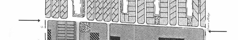
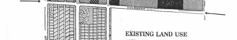
22 Estimated Average Peak Seasonal Population in 2010 for planning purposes: 924 (This is also considered applicable as the Town s estimated population for 2008 and 2009.) Present Land Utilization Characteristics Present land uses in Briny Breezes are essentially unchanged since the adoption of the 1989 Comprehensive Plan. A small amount of commercial use and several semi-public buildings owned by BB, Inc., are located along the frontage of SR AlA. Shared parking and landscaped areas line a number of the local streets. The Town s earlier Comprehensive Plan in 1981 included some areas for multifamily housing in an effort to encourage that type of development. The 1981 Plan assumed that the mobile home units would eventually become obsolete and require removal, leaving the former home-site vacant. Once an enterprising property owner accumulated sufficient number of vacant lots, the real estate market would motivate him to build multifamily housing. This did not occur as planned. There were few vacant lots that became available for sale. When the mobile homes became outdated, they were replaced with new ones, and there was little consolidation of ownership. Therefore, when the 1989 Comprehensive Plan was adopted, no future for multifamily housing was expected. It was completely eliminated from the 1989 Plan as shown on the Town s Land Use Map in Figure 4 on the following page. 15
23 Figure 4 Existing Land Use Map of Town of Briny Breezes 16
24 Planning for the Town s Future Development Conventional Multi-Family Housing Units In the aftermath of the destruction of southeast Florida by Hurricane Andrew on August 24, 1992, the direction of the Town s future development began to change to an acceptance of multifamily land use. In 1995 the Town received a grant from the Florida Department of Community Affairs as part of the Coastal Management Program of the National Oceanic and Atmospheric Administration to conduct a study for an updated Emergency Evacuation Plan. On December 28, 1995, the Town adopted Resolution 95-5 which created the Coastal Hazards Project Committee to study the effects hurricane related disasters would have on the Town s residents and their homes. Over a series of meetings during 1996, the Committee created an up-dated Hurricane Emergency Policy for the Town that addressed hurricane preparedness and evacuation procedures. The Committee also recommended that should the Town be destroyed by a hurricane, it should be rebuilt with both mobile homes and conventionally constructed multi-family units. In March, 1997 the Town Council adopted the Committee s Hurricane Emergency Policy and also approved a Post-Disaster Recovery Plan that had two alternative types of development. Plan A called for continuing the Town as a mobile home community but designed with larger home sites and with more spacing between the units. This Plan retained the current community preference for mobile home residences, but reduced the total number of lots from 550 to 475. According to computations made at that time, if the reduction in lots remained unchanged, it would displace a portion of the Town s residents. Plan B proposed new low, medium, and high density residential zoning districts and a mixed use zone that, combined, would permit up to approximately 960 housing units. The types of housing units allowed would be mobile homes on the present small sized lots and all other types of conventional single-family and multi-family housing units. This Post Disaster Development Plan was premised upon the threshold occurrence of the substantial destruction of the Town s existing development as a mobile home community due to a hurricane or other natural disaster. The Plan would be implemented by amending the Comprehensive Plan and adopting the enabling amendments to the Town s Land Development 17
25 Regulations to create the application and approval procedures, the land development criteria, the several new zoning districts, and by rezoning the necessary land areas for these changes. At the time of the Town s active consideration of the Disaster Recovery Plan, alternate Plan B received the greater degree of support. If implemented, it would have resulted in an increase in the Town s peak seasonal population to approximately 1,815 persons. The Town began the planning and legislative process to accomplish these changes by communications with Department of Community Affairs in 1997 and However, due to objections raised by residents opposed to any changes in the Town s status quo as a mobile home community, the Comprehensive Plan Amendment and the legislative procedures to effectuate either one of the two proposed plans were not completed by the Town. The community s interest in housing units and land development other than that limited exclusively to mobile homes arose again in March, 2006 when the Board of Directors of BB, Inc., sought competitive offers for a plan to redevelop its entire real estate holdings. In December, 2006, with the approval of 82% of BB, Inc. s, shareholders, it entered into a Sale and Merger Agreement with a real estate company for a planned redevelopment of the Town to other than mobile home type living units. As a result of this agreement, in April, 2007, the Town Council adopted a preliminary ordinance amending the Town s Comprehensive Plan to coordinate with the proposed redevelopment. The Council also adopted an EAR having recommendations that mirrored the proposed Comprehensive Plan Amendment. The Plan Amendment eliminated mobile homes entirely and replaced them with a resort hotel, condominiums, limited commercial uses and a greatly expanded marina facility. The proposal anticipated that by the completion date of 2020, there would be a population increase, but did not provide a specific build-out population figure. In the process of reviewing the Comprehensive Plan Amendment, some of the reviewing agencies estimated the proposal would result in 3,500 to 4,000 permanent residents. Before the proposed plan of development of BB, Inc. s property could be started, the project was terminated by mutual agreement of the parties in July, Further work on the Town s ordinance and on 18
26 the related procedures to amend its Comprehensive Plan to accommodate the development proposal were halted. BB, Inc. s, intentions to redevelop its property have continued. In July, 2008, BB, Inc., requested the P&Z/LPA in its preparation of the EAR to consider approval of multi-family housing within the Town and expansion of the commercial uses to better serve the needs of the area residents. This request establishes a basis for the P&Z/LPA to recommend such future development to the Town Council. The P&Z/LPA began its work on the EAR with the knowledge of these past events and with an understanding that the Town was poised for some degree of future growth and redevelopment. In response to these trends, the P&Z/LPA concentrated its efforts on the review of the Town s Future Land Use Element. In a departure from the rigidity of the 1989 Comprehensive Plan, the P&Z/LPA concluded that the Town s Future Land Use Element should provide for a broad mix of all types of residential living units, allowing single and multi-story construction, single family and multi-family occupancy, and the use of conventional and innovative building construction methods. This accommodation would be in addition to the continued acceptance of all of the present allowable types of mobile homes, manufactured homes, modular homes and recreational vehicles. The Town s Zoning Code needs to be amended to allow these new housing types in the present Mobile Home Zoning Districts. The P&Z/LPA concluded that these changes to the allowable types of residential living units would be followed by the construction of new units, leading to an increase in the Town s population. The proposed Future Land Use Map of the Town is shown by Figure 5 on the following page. 19
27 Figure 5 Proposed Future Land Use Map of Town of Briny Breezes 20
28 The P&Z/LPA also recommends revisions to the Town s zoning code that would up-grade the allowable types of retail commercial land use to better serve the needs of the Town residents and the persons living in the adjoining communities. Consideration was given to combining residential and commercial uses into innovative mixed zoning categories. Any such new zoning districts would also have to include provision for the continuation of the present recreational and service amenities which are located in Section 6 of the Town, which is the prime area proposed for redevelopment. Sites for Future Development by Annexation The Town has experienced a recent interest in annexation issues in general and there is some possibility that the total land area of the Town could increase in the future through the annexation process. In March, 2010, the P&Z/LPA adopted Resolution No. P&Z to recommend that the Town Council should participate in a pending governmental process with Palm Beach County and the City of Boynton Beach for the creation an Interlocal Service Boundary Agreement affecting the unincorporated area of Palm Beach County abutting the Town s southern boundary. Annexation of Enclaves One possibility for the enlargement of the Town would be for the Town to annex one or both of the two enclaves which are presently surrounded by the Town s boundaries but remain as part of the unincorporated area of Palm Beach County. Since they are not within the Town s jurisdiction, the buildings and structures located on these sites do not receive police and fire protection services from the Town. Likewise, the enclaves are subject to the County s, rather than the Town s, building inspection, zoning ordinances, and land use controls. There are specific procedures under the state statutes governing the annexation of enclave areas into the municipalities they abut, and the Town would have to adhere to these legal requirements if annexation were to take place. In addition, annexation would require the Town to commence providing all the previously mentioned municipal services to these areas in place of whatever County services are available to them presently. As of the time of this EAR review, no negotiations have begun between the Town and the owners of either enclave parcel regarding the possibility of annexation. 21
29 Both enclaves front on the west side of SR A1A and are presently developed for commercial uses. The south parcel is developed as a motor vehicle service station. It has a width of 72 feet and extends for a length of 240 feet north from Cordova Avenue. The Town s jurisdiction then resumes for 271 feet further north, where it reaches the property line of the north parcel, which is developed with a bank building and a real estate sales office. It has a width of 62 feet and a length of 244 feet. The Town s jurisdiction then resumes for 158 feet further north to the Town s northerly boundary line. Annexation of these properties would have the beneficial effect of increasing the size of the Town s land area and its tax base. Since both parcels are commercial, rather than residential, properties, however, their annexation would not have a direct effect on the size of the Town s population. In addition, since both parcels are already developed for their respective commercial purposes, it would be highly unlikely that there would be any change in those uses if they were to be annexed into the Town. Both enclaves are located within the area that the P&Z/LPA has identified as Section 6 and recommended as the primary site for the Town s plan of future development. With or without annexation of the enclaves by the Town, the P&Z/LPA recognizes that there needs to be a sufficient degree of compatibility between the proposed redevelopment of Section 6 and the existing development of the enclaves. In this regard, the P&Z/LPA will give full consideration that the buildings and structures designed and constructed for the redevelopment of Section 6 for the mixed uses of residential, commercial, and recreational purposes will be compatible with the present development of the enclaves. The two enclaves within the Town s boundaries are shown on Figure 6 on the following page. 22


30 Figure 6 Enclaves within the Town Boundaries 23
31 Annexation of the County Pockets to the South The other possibility involves annexation of the county pockets which abut the Town s south boundary along Briny Breezes Boulevard, east of SR A1A. Acquisition of this territory would have a direct effect on both the Town s size and its population. Much of this land has been divided into small individual home-sites and all the parcels are privately owned. The larger extent of this land has been developed. It contains a mixture of singlefamily residences, seasonal residential properties, and vacant lots, together with commercial retail uses fronting on SR A1A. The roads servicing this area are, for the most part, paved and provide good access and circulation. Potable water supply and some sanitary sewer service are provided to these residents and businesses by the City of Boynton Beach. Annexation would immediately provide other municipal services to this area by the Town of Briny Breezes, but no such services are provided now. Should the Town decide to pursue a policy to annex the abutting county pockets to the south, the Town would be able to meet its financial responsibilities to provide municipal services to the residents and businesses in these areas. If the Town were to obtain jurisdiction over undeveloped or under-developed land by annexation of the county pockets, it could provide an additional area for the future development of the Town. However, since the possibility of the Town s annexation of the county pockets is presently only speculation, the P&Z/LPA has deferred further analysis of the effect this might have on the future development of the Town or in increasing the Town s population. Sites for Future Development on Vacant Land No vacant land in the Town is affected by any present development orders. Except for District V, there are no buildable sites in the Town s Vacant Land Inventory. The other vacant lands within the Town are unsuited for development due to their small size, odd configuration, or particular location. For example, there are small tracts of land abutting the seawalls along the canals and the Intracoastal Waterway on the Town s west boundary, and BB, Inc. s privately owned ocean front beach lies on the Town s eastern boundary. Collectively, these areas constitute natural resource land and are presently set aside by BB, Inc., for passive recreational uses by the members of the cooperative. The P&Z/LPA 24
32 considers this to be compatible with the amenities that make the Town of Briny Breezes a pleasant and enjoyable community in which to live. At the present time, these areas have their highest and best use for passive recreational purposes. As previously stated, District V of the mobile home park was previously used to rent spaces for recreational vehicles, an activity that BB, Inc., discontinued in The area has been landscaped and remains vacant at the present time. It is rectangular in shape, and consists of approximately 0.6 acres. As an individual parcel, the Town s present zoning would allow it to be re-sectioned into eight mobile home lots. It has greater potential if it is included as part of the planned re-development area of Section 6, as proposed by P&Z/LPA. New Site Locations by Redevelopment of Obsolete Areas Section 6 Other than expanding the Town boundaries by annexation of the county pockets to the south, the future development of the Town will have to occur within the Town s present boundaries. This means using District V, mentioned above, and re-using properties having minimal development, such as the shuffle board courts, the extra parking spaces, the north and south storage lots and the maintenance area. These areas are readily available for development but others areas are occupied by buildings and structures that have become old and outdated. These would have to be razed to make way for the new construction. For example, there are several potential building sites for new construction which are presently occupied by old Quonset-Hut type structures which no longer are the best and highest use for the land they occupy. It is convenient that District V is located adjacent to the obsolete buildings and structures that would be razed to form the Section 6 development area. This area consists of a the north-south strip of land fronting on SR A1A and extending one block westward to Banyan Boulevard, and bounded by the Town s north and south boundaries. For identification purposes in the planning process, this redevelopment area has been designated as Section 6 of the Town of Briny Breezes, and is shown as Figure 7 on the following page. 25


33 Figure 7 Potential Redevelopment Area, Designated as Section 6, Showing Present Land Uses NORTH 26
34 The buildings and structures located on this strip of land are privately owned by BB, Inc., and are utilized to support the operation of the mobile home park as it now exists. If it is to be redeveloped, the plan will be to put the property to better, more productive use. Located within this area are many of the major recreational facilities BB, Inc., provides for the Town residents. This includes the arts and crafts building, the community center, the swimming pool, the auditorium, the hobby shop, the billiards room, and the woodworking club. It also includes commercial uses for a beauty shop, a drug store, the Town Hall, BB, Inc. s, business office, storage sheds, and storage yards. All of these uses are in conformity with the Existing Land Use Map and the current zoning classifications for this property. It is of paramount importance that any redevelopment in this area must insure the continuation of these recreational facilities and commercial use, either by incorporation into the new development plan or by relocation to an appropriate alternate site. If this potential re-development area were to be cleared of its present buildings and structures, it would add approximately 2.75 acres to the Town s vacant land inventory. Based on the present maximum allowable density of 26 units per acre under the Town s present Land Development Code, this area could theoretically provide 71 multi-family housing units. The P&Z/LPA expects that providing the public with the larger, more storm-worthy construction offered by conventionally constructed condominium units would attract new owners and young families with children to come to live in the Town. As a result, the P&Z/LPA estimates that the average size household for these condominium units will be 3.00 persons per housing unit. To allow the time required for the adoption of an Amended Comprehensive Plan, for the revision of the Land Development Regulations, and for amendments to the zoning code, the P&Z/LPA considers this new construction will not be completed until mid-year 2013, and that the units will not be fully occupied until the end of the 5-year planning period in Planning for Innovative Types of Single-Family Housing Units - Katrina Cottages Another option the P&Z/LPA proposes for the Town s future development would be to allow owners to replace their existing mobile homes with residential structures that would meet an upgraded building code making them hurricane resistant. This would allow innovative 27
35 manufactured homes, such as the so called Katrina Cottages. The concept for Katrina Cottages began in the aftermath of the destruction to the Mississippi/Louisiana Gulf Coast by Hurricane Katrina on August 29, In post-disaster recovery efforts, Mississippi Governor, Haley Barber, met with Andres Duany, a renowned Miami, Florida, architect and town planner, in late 2005 to discuss different kinds of temporary emergency housing units that could serve as better alternatives to the typical mobile homes supplied by FEMA for that purpose. This resulted in first a sketch of a plan and later design drawings of a practical, easily constructed building having a more traditional appearance as a house with a structure that was sturdier and more wind-resistant than that of the traditional FEMA trailer. The further objective was to have a structure that offered the added advantage of being a permanent rather than temporary housing unit. Other prominent architect/designers, such as Marianne Cusato, Steve Oubref, Eric Moser, and Steve Mouzon, applied their talents and participated in the further development of the Katrina Cottage concept. The result was the creation of a large variety of plans for one-story and two-story single-family housing units that can be quickly and economically built, and are so sturdy and durable that they meet the wind loading requirements of most hurricane codes. Most of the Katrina Cottages, including some of the two-story models, are designed and engineered to fit the same site that is occupied by the contemporary mobile homes in Briny Breezes. The P&Z/LPA foresees both permanent and seasonal residents changing to one-story and two-story Katrina Cottages as a major part of the Town s future development. The P&Z/LPA expects there would be a preference for the two-story units that can provide as much as 1,200 square feet of living space. Since this type of upgrade uses the same footprint as the mobile home unit that it replaces, there would be an even exchange of the types of dwellings. Therefore, this transition would not increase the total number of housing units for the Town. As with the increase in occupancy anticipated by the P&Z/LPA for the Town s future development with traditionally constructed condominium units, the P&Z/LPA expects that replacing the present mobile homes with the larger, more storm-worthy construction offered by the available Katrina Cottages would attract younger persons and families with children to come to live in the Town. Because of this, the P&Z/LPA estimates that the average size household for the two- 28
36 story Katrina Cottages will increase to be 3.00 persons per housing unit. To allow the time required for the adoption of an Amended Comprehensive Plan, for the revision of the Land Development Regulations, and for amendments to the zoning code, the P&Z/LPA considers that Katrina Cottages would not be constructed until the year The P&Z/LPA also anticipates that the public may be hesitant at first to choose the innovative one-story or twostory Katrina Cottages over the more traditional types of housing units. Therefore the P&Z/LPA estimates that only five percent (5%) of the Town s present mobile home units will be replaced by two-story Katrina Cottages by the end of the 5-year planning period at Replacement by the one-story Katrina Cottages would also occur, but this would not be expected to change the Town s population figures. To implement the Town s redevelopment as recommended in the EAR, the P&Z/LPA proposes that the Town amend its Comprehensive Plan to include all the new housing unit categories for residential, commercial, and recreational buildings and structures, including mixed uses. The P&Z/LPA also proposes that the Town s Land Development Regulations be amended to include the new zoning districts, to state the land development criteria for each such type of development, to create the application and approval procedures for obtaining the development approvals necessary for each, to change the future land use map to include these future uses, to adopt the several new zoning district ordinances, and to rezone the necessary land areas involved for these changes. Based on the above assumptions, Table 5 on the next page shows the P&Z/LPA s computation for the Town s projected population at end of the 5-year planning period by year
37 Table 5 Projected Population for 2015 at End of 5 Year Planning Period 71 Total Condominium Housing 1.1% Vacancy Rate is 1 Vacant Unit 70 Condominium 3.00, Average Persons per Household, is Two-Story Katrina Cottage Housing 1.1% Vacancy Rate is 1 Vacant Unit 23 Two-Story Katrina Cottage 3.00, Average Persons per Household 12 Two-Story Katrina Cottage Units for the Permanent Residents is Two-Story Katrina Cottage Units for the Seasonal Residents is Conventional Mobile Home Housing 1.1% Vacancy Rate is 5 Vacant Units 243 Permanent Mobile Housing Home Units Less 12 Mobile Housing Home Units Replaced by Two-Story Katrina Cottages 232 Permanent Mobile Home 1.72, Average Persons per Household, is 99 Sub-Total of Above Seasonal Mobile Home Housing Units Less 11 Replaced by Two-Story Katrina Cottages 229 Seasonal Mobile Home Housing 1.72, Average Persons per Household: Seasonal Mobile Home Housing 2.50, Average Persons per Household: 572 Low Estimate for Peak Seasonal Population: = 1,072 High Estimate for Peak Seasonal Population: = 1,250 Estimate for Projected Peak Seasonal Population for Planning Purposes for 2015: 1,161 Estimate for Projected Number of Housing Units 558 Estimate for Overall Average Number of Persons per Household 2.08 These Estimates also Apply to the Town s Projected Population for 2020 at End of the 10 Year Planning Period The P&Z/LPA anticipates that the Town s redevelopment of Section 6 as a multi-story, multi-use corridor along SR A1A will breathe new life into the area where these outdated buildings are now located. The leasing and/or sale of these new mixed-use structures will provide a new income stream to benefit BB, Inc., and its shareholders. The P&Z/LPA expects that the larger, more storm-worthy construction offered by the condominium units will attract younger persons and families with children to the Town. The P&Z/LPA also recognizes that condominiums are 30
38 a major transition for the Town and that only if this initial project proves to be successful would BB, Inc. repeat the process. If completion of the first condominium building is successful, then it could lead to a continuing process of similar new development. Likewise, the success of the Katrina Cottage concept in the Town will depend entirely on the extent of the public s acceptance of innovative types of housing units. Since there is no way to predict the future success for either the condominium project or the Katrina Cottage concept after the transition process has begun, the P&Z/LPA has decided that it will continue its population projection in Table 5 for the year 2015 to apply equally as its population projection for the Town for the year The P&Z/LPA recommends that the Town work closely with BB, Inc., to ensure that there will be no long term displacement of residents throughout the transition process. The exact areas selected for changing from mobile homes to new types of housing and the timing for such changes will have to be closely controlled to avoid haphazard or inappropriate results. Consideration of the Ten-Year Water Supply Work Plan When the Town revises its Land Development Regulations (LDR s) to provide for alternative types of housing units, it will require that water supplies and facilities are available to serve the new development no later than the date on which the Town anticipates issuing a certificate of occupancy (CO). The LDR changes Town will also provide that the Town will first consult with its then potable water supplier prior to approving such building permits to determine whether adequate water supplies will be available to serve the development by the CO date. The Town anticipates no problem in continuing to receive an adequate supply of potable water from the City of Boynton Beach which will be adequate to serve the needs of the Town s peak winter population of 1,161 persons within the next ten-year planning period, without a loss in the present level of adequate service. The details of the water supply capacity of the Boynton Beach municipal water system and a description of the water distribution system owned and operated by the Town of Briny Breezes are discussed in the review of the Capital Improvements Element of the Comprehensive Plan. 31


39 Natural Resources The Town s significant natural resources are the Atlantic Ocean, including its beach, dunes and accompanying vegetation, and the Intracoastal Waterway and its shoreline. Historic Resources The Town s investigation has determined that there are no historic resources located within the Town. Recreational Facilities Except for the Town Library, all of the recreation facilities and programs provided for the community are operated by BB, Inc., and are shown on Figure 8 below. Figure 8 Recreation Facilities 32
40 Figure 8 shows the community s four main recreation areas. The first is the oceanfront, the second is located along the east side of State Road AlA (SR AlA), the third is on the west side of SR AlA, and the fourth lies along the Intracoastal Waterway. The ocean-front facility contains a club house with banquet and meeting facilities, a patio with chairs and benches, and a private beach with cabanas and walkways. The facilities along the east side of SR AlA include BB, Inc. s butterfly garden, the shuffle board courts, a club room, a card players room, and the Town s library. On the west side of SR A1A, and included in the area proposed for redevelopment, is the community center building, the fine arts building, a large swimming pool, a cabana, an auditorium building, hobby shops for arts and crafts, and one for wood-working. As previously stated, any redevelopment in this strip area fronting on SR A1A must insure the continuation of these recreational facilities, either by incorporation into the new development plan or by relocation to an appropriate alternate site. The fourth recreational area is located further to the west and fronts on the Intracoastal Waterway. It consists of two large and three small open parkways for picnicking and viewing the marine activity on the waterway, and a yacht basin, which has an operating marina. Public Facilities and Services Since the adoption of the 1989 Comprehensive Plan, the Town has acquired ownership of the water and sewer utility distribution system and is responsible for providing these services to the residents. Since acquisition, the Town has made extensive improvements to the water lines, installed fire hydrants, and provided upgrades to the sanitary sewer lines and lift stations. The Town has contractual arrangements with an adjoining municipality to provide the potable water supply. There are no well-fields within or near the Town boundaries. The Town is one of the original participants in the establishment of the regional sanitary sewage disposal facility which is operated under the joint management of the Cities of Boynton Beach and Delray Beach. The Town also has contractual arrangements with adjoining municipalities for Police, Fire and Emergency Medical Technician Services. BB, Inc., is responsible for the storm drainage facilities within the Mobile Home Park and has the primary responsibility for the pick-up and disposal of solid waste. As will be further 33
41 addressed in the Transportation Element, most of the local streets within the Town are privately owned and maintained by BB, Inc. The Town is responsible for maintenance of the two local public streets, Briny Breezes Boulevard and Old Ocean Boulevard, and the Florida Department of Transportation (FDOT) is responsible for maintenance of SR A1A. The present levels of service (LOS) for all public facilities and roads within the Town are sufficient. They are more than adequate to meet the needs for Town s present population of 924 during the peak winter season. During the ten-year planning period that the Town expects its seasonal population to increase to 1,161 people, the Town will be able to maintain adequate levels of service for all public facilities. Flood Prone Areas The Flood Insurance Rate Map or Flood Hazard Boundary Map of the Town of Briny Breezes is shown on Table 10 in the discussion of the Conservation Element. The Flood Zone Map shows that much of the Town is in the 100-year flood plain, and gives the designations that apply to the other flood zones that are not within the 100-year flood hazard areas. Although storm drainage is BB, Inc. s, responsibility, the Town s earlier attempt for a redevelopment strategy for multi-family, permanent construction was a step to improve the drainage problems. The proposed development plan will now achieve this goal. The Town s Development Regulations require the sound anchoring of mobile homes in conformance with State and Federal standards. These regulations together with the Town s adherence to the emergency evacuation plan outlined in the Coastal Management Element will continue to be the Town s successful flood damage prevention strategies. Recommendations 1. The Town s Future Land Use Element and Development Regulations should be revised to provide for all types of single and multi-story construction and single family and multifamily dwelling units of conventional and innovative construction methods, in addition to allowing the present types of mobile home structures. 2. The Town s Future Land Use Element and Development Regulations should be revised to provide for new zoning districts that combine residential, commercial and recreational 34
42 uses into innovative mixed zoning categories to better serve the community needs. 3. The Town s Future Land Use Element and Development Regulations should be revised to allow the types and kinds of permitted retail commercial uses to better serve the needs of the community and the neighboring residential areas. 4. The Town s Future Land Use Element and Development Regulations should be revised to allow mobile home owners to replace their existing mobile homes with residential structures such as Katrina Cottages that meet an upgraded hurricane resistant building code standard. 5. The Town s Future Land Use Element and Development Regulations should be revised to provide new zoning districts needed for redevelopment, to state the land development criteria for each such type of development within the zoning districts, and to provide the application procedures for obtaining development approvals that incorporate the requirements of the Town s Ten-year Water Supply Facilities Work Plan. 6. The Town s Future Land Use Map should be revised to provide for the projected future development of the Town to take place within the present internal Town boundaries and to replace any outdated or obsolete buildings and structures. 7. The Town s Future Land Use Map should be revised to provide for the projected future development of a multi-story, multi-use commercial/residential corridor along SR A1A with provision for recreational facilities to replace any outdated or obsolete buildings and structures. 3. REVIEW OF TRANSPORTATION ELEMENT Introduction SR A1A, also known as North Ocean Boulevard, is the only arterial roadway serving the Town. The portion of its traffic volume attributable to the Town will vary in direct proportion to the seasonal changes in the Town s population. Presently and for the past several years, the Town has had a peak population of approximately 924 persons during the height of the winter season. Each year this begins to decrease in the month of April and reaches a low of about 200 persons during the months of July through September. SR A1A has always provided the residents of Briny Breezes with an adequate level of service, even during the periods of the Town s peak population. Mapped Data The data used for the inventory of the existing system include current roadway functional 35
43 classifications and the most recent available traffic volume count of the average daily traffic. The existing roadway functional types, the number of lanes, the locations of boat docking facilities, and other water-related facilities have been mapped. Facilities for limited access roadways, airports and seaports are not present in the Town and are omitted. Street Pattern SR A1A is an arterial two-lane highway maintained by the Florida Department of Transportation (FDOT). It is the Town s main road for north-south travel. It also provides residents of Briny Breezes with two connections across the Intracoastal Waterway to the mainland on the west. The closer of the two is Woolbright Road, which is about 0.5 miles to the north in the Town of Ocean Ridge. The longer connector is George Bush Boulevard, which is about 3.0 miles to the south in the City of Delray Beach. The Town s other north-south roadway is Old Ocean Boulevard, a local two-lane road that traverses the length of the Town and is the most easterly street. It intersects with the Town s east-west streets and provides a grid pattern for the internal traffic circulation of the entire area east of SR A1A. It is primarily used by Town residents as a local street not a through route. As its name implies, it is a short segment of previous right-of-way for SR A1A that was aligned closer to the ocean front. On the north, Old Ocean Boulevard runs up to the Town of Ocean Ridge. The south end of Old Ocean Boulevard ends at the Town s other public roadway, Briny Breezes Boulevard. This is two-lane road that runs west along the Town s south boundary to intersect with SR A1A. Figure 9 on the following page shows the Towns present road system. 36


44 Figure 9 Road Network for the Town of Briny Breezes 37
45 Traffic Volume for SR A1A The Town does not have a substantial amount of through trips by vehicles on SR AlA because of the low vehicle speeds and limited commercial opportunities caused by its frequent curves. Table 6 shows the average daily trips on SR A1A from George Bush Boulevard to Woolbright Road passing through the Town of Briny Breezes for the period 2003 to Table 6 Daily Traffic Volume on SR A1A Through Town Year Volume 11,774 10,175 10,718 10,874 8,665 7,846 Source: Palm Beach County Traffic Division, Historic Traffic Growth Table, 2008 The last traffic volume data available to the P&Z/LPA for SR A1A was taken on March 10, It showed a reduction in traffic volume of 9.88 % over the previous year. The a.m. peak hour traffic on that date for travel in both directions was 512 vehicles. The p.m. peak hour traffic on that date for travel in both directions was 651 vehicles. This indicates that SR A1A was operating at an acceptable level of service during the peak of the Town s winter season in 1988 when the estimated population was 924 persons. The P&Z/LPA expects that SR A1A will continue to operate at an acceptable level of service when the Town s population increases by 237 more people to the 1,161 peak seasonal population projected for the years 2015 and There are no traffic counts for the two local roads maintained by the Town, Breezes Boulevard and Old Ocean Boulevard. Observation by residents of the Town confirms that both roadways are operating at acceptable levels of service. Accident Data and Traffic Safety Concerns There is no traffic accident report information for the Town for the period of 2003 to During the EAR review, residents expressed their concern with traffic safety issues, especially the hazard created by motorists on SR A1A who fail to stop for the red light signal at the Cordova Avenue intersection. Several residents recounted instances when driving their automobiles on 38
46 Cordova Avenue, they stopped at SR A1A to wait for their green light before proceeding, and upon start-up, had to break abruptly to avoid a collision from a vehicle driven on SR A1A that ran its red light. Under the Town s direction, this hazardous situation was documented by occurrence reports prepared by several of the local residents involved. These reports were sent to FDOT s traffic safety section with a request for assistance. This matter is in process of review by FDOT. In addition to driving motor vehicles, Town residents frequently travel through the Town by golf carts, bicycles, and on foot. Crossing SR A1A by this non-automobile traffic poses additional safety hazards for the public. The P&Z/LPA have expressed its concern over these safety issues and find that there is a need for the Town to adopt appropriate traffic regulations to address the situation. Municipal Traffic Control Agreement Discussions by the P&Z/LPA with ways to improve traffic safety within the Town ultimately led to a traffic control traffic control agreement that was entered into between the Town and the Briny Breezes Corporation in April, Authority for such agreements is contained in Section , Florida Statutes, which extends the jurisdiction of the local police to enforce the state traffic code on the private streets of residential developments that are located within a town s municipal limits. Town traffic ordinances are also enforceable on the private streets to control one-way street travel, provide stop signs, post speed limits, and regulate parking. The further cooperation between the Town and BB, Inc. to implement the Municipal Traffic Control Agreement will result in improvements to the safety for motor vehicle operators and pedestrians. Level of Service The level of service (LOS) of a roadway is defined as the ability of vehicles to pass over a given section of roadway during a specified time period while maintaining a given operating condition. In order to establish a peak hour level of service standard, the existing level of service for SR A1A was calculated using the ratio of peak hourly volume to average daily volume. Table 7 on the following page shows the standardized descriptions of service levels used in transportation planning. 39
47 Table 7 Standards for Levels of Service LOS A: Highest LOS which describes primarily free-flow traffic operations at average travel speeds. Vehicles are completely unimpeded in their ability to maneuver within the traffic stream. Stopped delay at intersections is minimal. LOS B: Represents reasonably unimpeded traffic flow operations at average travel speeds. The ability to maneuver within the traffic stream is only slightly restricted and stopped delays are not bothersome. Drivers are not generally subjected to appreciable tensions. LOS C: Represents stable traffic flow operations. However, ability to maneuver and change lanes may be more restricted than in LOS B, and longer queues and/or adverse signal coordination may contribute to lower average travel speeds. Motorists will experience an appreciable tension while driving. LOS D: Borders on a range in which small increases in traffic flow may cause substantial increases in approach delay and, hence, decreases in speed. This may be due to adverse signal progression, inappropriate signal timing, high volumes, or some combinations of these. LOS E: This represents traffic flow characterized by significant delays and lower operating speeds. Such operations are caused by some combination or adverse progression, high signal density, extensive queuing at critical intersections, and inappropriate signal timing. LOS F: This represents traffic flow characterized at extremely low speeds. Intersection congestion is likely at critical signalized locations, with high approach delays resulting. Adverse signal progression is frequently a contributor to this condition. Source: Florida Department of Transportation & Palm Beach County Traffic Department Existing Transportation Needs Field observations indicate that no transportation deficiencies presently exist in the Town of Briny Breezes. All public roadways currently operate at LOS C, or better, which is an acceptable level of service, even during the Town s existing estimated peak seasonal population of In 2007, the State added three-foot shoulders to each side of SR A1A. Neither the State nor Palm Beach County have any further plans for widening or otherwise improving SR A1A within Briny Breezes. The Town of Briny Breezes has no plans to improve or widen 40
48 Briny Breezes Boulevard and Old Ocean Boulevard. There are no limited access roadways under consideration for this area of Palm Beach County that affect the Town of Briny Breezes. The Town of Briny Breezes has special concern regarding the preservation of SR AlA as a two-lane roadway with the above mentioned improvements. Its present width for vehicular travel is in keeping with the character of the community. Coordinating the Transportation system with the Town s Future Land Use Element, other local governments, and regional plans will continue to be a Town priority. SR A1A is the only roadway within the Town for which levels of service have been applied. This information is shown on Table 8 on the following page. Future Needs No significant needs to the Town s transportation system are anticipated for the future planning periods. The P&Z/LPA expects the traffic volume on SR AlA attributable to the Town will increase by the same percentage as the Town s projected increase in population. The additional 237 persons needed to reach the Town s projected peak winter population of 1,161 persons for years 2015 to 2020 is an increase of 25.6%. The traffic volume data for SR A1A shown on Table 5 for the years 2008 to 2010 has been increased by this same 25.6% in Table 7, below, to estimate the increased level in traffic resulting from the Town s projected increase in population. The increase in traffic volume from the additional 237 residents that are projected will not reduce the LOS on SR A1A to a level that would be below the C standard, and the widening of this roadway will not be required. No through traffic routes other than SR AlA exist, so the Town will only need to provide road maintenance and shoulder repair for its two local streets. These repairs are expected to be adequately funded by the Town s annual budget appropriations as may be needed. For Table 8, the existing LOS for SR A1A is based on the Town s present estimated peak seasonal population of 924 for years 2008 to The future LOS is based on the projected 24.6% increase to a peak seasonal population of 1,161 for years 2015 to
49 Table 8 Existing And Future Level of Service for SR A1A Existing Level Hourly Peak Hour V/C Ratio LOS Of Service, Capacity , C Future Level 1, C Of Service, The following V/C Rations were utilized for determining Existing and Future Level of Services. Level of Service Volume/Capacity or V/C Ratio A - Less than or Equal to 0.30 B - Less than or Equal to 0.50 C - Less than or Equal to 0.75 D - Less than or Equal to 0.90 E - Less than or Equal to 1.00 Source: Florida Department of Transportation & Palm Beach County Traffic Department Recommendations 1. The Town should continue its present road maintenance program for Briny Breezes Boulevard and Old Ocean Boulevard which are the local public roads serving the Town. 2. The Town should continue to cooperate with the Florida Department of Transportation (FDOT) for the maintenance of SR A1A, the minor arterial roadway which it maintains, which will always remain as the main thoroughfare for the Town. 3. The Town should cooperate with BB, Inc., to continue its maintenance program for the local street system. 4. The Town and BB, Inc., should implement the Agreement for Municipal Traffic Control to improve the vehicular and pedestrian safety for travel over the local street system. 5. The Town should adopt appropriate traffic regulations to improve motor vehicle, golf cart, bicycle, and pedestrian safety along SR A1A. 42
50 4. REVIEW OF HOUSING ELEMENT Introduction The 1989 Comprehensive Plan for Briny Breezes described the community as being unique in that the housing stock is composed entirely of mobile homes. That categorization has remained the same in the ensuing 20 years, as the Town has continued to be an all mobile home community. The ownership arrangement further distinguishes the Town of Briny Breezes from its neighbors because BB, Inc., as a Florida corporation, is the sole owner of the entire land area comprising the Town limits of Briny Breezes. Every resident becomes a member and shareholder in BB, Inc. when he/she purchases a mobile home housing unit. BB, Inc., operates the mobile home park as a residential mobile home cooperative under the provisions of The Florida Cooperative Act, Section 719, Florida Statutes. This business arrangement results in the efficient maintenance of the mobile home park facilities and encourages participation by the residents in housing matters on both BB, Inc. s, and the municipal government s level. Existing Conditions Housing Types All housing units in Briny Breezes are single-family mobile homes. The original units were placed during the 1950s and 1960s on a variety of lot sizes. Most mobile homes have been replaced at least once since that time. Housing Conditions In 1989, the majority of the housing stock was ten to fifteen years old. At that time the units were well maintained and replaced when necessary so there were no structurally substandard units. Traditionally, when applied to the housing units in the Town of Briny Breezes, the term substandard means that the unit is of an age or condition that necessitates its replacement. No units are overcrowded and all units contain adequate plumbing, heating and kitchen facilities. Since the 1989 Comprehensive Plan, a significant change has occurred in the attitude of the shareholder/unit owners regarding BB, Inc s, proposal to sell the community. The proposal to sell BB, Inc. s, land holdings arose in 2006 and was supported early in 2007 by 82 percent of the stockholders. As a result of the expected sale, many unit owners lost interest in the routine 43
51 maintenance and upkeep of their homes. During 2007 and early 2008, the replacement and renovation of the existing units slowed drastically. Only a handful of new units have been installed in Briny Breezes in the last several years. Reductions in construction activity would be expected to continue as long as the residents remain uncertain as to whether BB, Inc., will sell to a developer. More recently, requests for building permits have increased, which may indicate a change in the public s expectations for the Town s future which will have construction and repair activity returning to normal during the coming winter season. Under BB, Inc., rules, applications for the replacement of mobile homes and applications for building permits for repairs and renovation may only be requested during the winter months. Repairs may be made during the summer months, but only if permits were obtained during the winter season. The only permits granted during the summer months are for air conditioner replacements. Housing Values In 1989, the average value of housing in Briny Breezes was below the County s average. Briny Breezes homes were then valued at $52,800 on an average, just 2.5 percent less than the average Palm Beach County home value of $55,300. Because the Town s housing type is limited to mobile homes, Briny Breezes then had no high value units. The price range ran from the highest valued unit, which listed at $65,000, to the lowest unit, at $32,500. The proposal to sell BB, Inc. s, land holdings in 2006 and 2007 caused the property values in Briny Breezes to skyrocket. The average price for mobile home property rose in 2007 and 2008 to figures in excess of $250,000. The subsequent fallout from the weak real estate market nationwide has affected the Town with mixed results. It has increased the number of properties on the market. In 2009 there were seventeen properties listed for sale in the Town, and by 2010 there were forty-six. It has effectively reduced the price of the low-end units, but has had the opposite effect of increasing the price on the more prestigious ones. The sale prices asked in ranged from $209,000 for the small units to $435,000 for the largest. As of April, 2010, the sale price on some of the smaller units has declined to as low as $125,000, while the price for some of the high-end units have risen to as high as $585,000. This escalation in sale prices has caused considerable concern among long-term residents in the Town, who see the 44
52 potential of greatly increased taxes because of these high increases in the property values. Housing Rentals In 1989, the few rental units had a mean rental rate of $332 per month, which was higher than the County mean monthly rental rate by almost $100. Through its control in the operation of the mobile home park, BB, Inc. does not allow unit owners to rent their units on a yearly basis. Only seasonal rentals are permitted. From 2007 to 2009, rental prices rose in line with the price increase in the proposals to sell, and the seasonal rentals in Briny Breezes ran from $1,100 to $2,400 per month. The weak real estate market had the same effect on rental rates that it had on sale prices. By April, 2010, the monthly seasonal rental rates for the low-end units have declined to $875, and for the most desirable ones, they have risen to $2,500. The combination of favorable weather and the proximity to the Atlantic Ocean account for the Town being a desirable location for seasonal renters. Rent-To-Income Ratios The rent-to-income ratio of the households in Briny Breezes is not comparable to those of a typical community in which most renter households are retirees on fixed incomes and as a result pay a great deal of their annual incomes for rent. There are very few renter households in the Town of Briny Breezes, so the rental figures discussed above are not a reliable comparison to the cost of the housing in the Town. Mortgage-To-Income Ratios The majority of owner-occupied units in Briny Breezes are not mortgaged. Of those that are, most are financed at a cost that did not place an excessive burden on the participating household s income. Most households paid between 15 percent and 24 percent of their incomes for mortgages. Only six percent of owner-occupied households paid more than 35 percent of their incomes for mortgages. Most of the households were retirees with fixed incomes. Previous Redevelopment Strategies In 1989 it was thought that certain housing units would continue to reach an age where replacement became necessary. At that time, 10 units were replaced. The Town and BB, Inc., 45
53 attempted to reduce densities by leasing vacant lots to abutting homeowners. Under the plan, whenever a lot became vacant, the adjacent landowner on each side was encouraged to lease the lot. These homeowners would then split the leased lot between them and incorporate the halves into their existing holdings. The practice was not successful because the high cost of leasing the additional land was usually beyond the financial means of the abutting owners. Also, more often than not, when the departing resident left, he or she would sell the mobile home which was left in place for the new owner who would assume the land lease, thus continuing the status quo. Present Redevelopment Strategies The composition of the types of housing in the Town of Briny Breezes is expected to change in the coming years. This is demonstrated in the Future Land Use Element with the suggestion that multi-story condominiums, conventionally constructed single family homes, and one-story and two-story Katrina Cottages are destined to occur in the Town. These changes in construction types would undoubtedly occur at a more rapid pace if future hurricanes should devastate the mobile homes located in this high-risk coastal area. BB, Inc., has entertained the possibility of development beyond the present mobile homes in the Town. From 1989 through 2007, BB, Inc., operated a parcel of land dedicated to true mobile homes by allowing travel trailers as rental units. Persons were allowed to park their towed travel trailers in the park area called District V, for a monthly rental fee. BB, Inc., first limited these travel trailer spaces to two-year periods, using the supposition that persons interested in residing in the area could find suitable housing within two-year period and then move out of the District V location. However, in 2007 BB, Inc., ceased the travel trailer space rental business. Members of its Board of Directors have expressed a belief that that commonly owned non-residential property in Briny Breezes could be better used for commercial development. The possibility of multi-story buildings in commonly owned areas would include structures with parking and business space on ground floors, and locate the residential units within a limited number of upper stories. This multiple housing approach would have an impact on the Town s population, which is expected to rise to an estimated seasonal high of 1,161 residents by the end of the five-year and ten-year planning periods. 46
54 Other Housing Data There are no subsidized units, group homes or historic houses in the Town of Briny Breezes. Up until now, housing construction has not been applicable in the Town. Currently, very few mobile homes are being replaced. There are few vacant units in the park and there are no abandoned units. Needs Analysis - Group Homes and Subsidized Housing Briny Breezes currently does not have subsidized housing facilities or group homes because it is a built-out mobile home park. The residents however are almost entirely senior citizens. The creation of vacant land for the new construction will likely occur by razing obsolete buildings and structures that are presently being used for storage and no-residential uses. Affordable Housing It should be noted that Briny Breezes was developed during the late 1950s and early 1960s and contains numerous replacement units. There are no significant historical housing resources in the community. Housing Needs The proposed introduction of multi-family housing into the Town will require BB, Inc., to undertake, or sponsor, the necessary construction activity to create these new residential living units. Prior to that, however, the Town must first amend its Comprehensive Plan to allow the new uses, revise its LDR's to create the necessary application and approval procedures and the land development criteria for the new zoning districts, and rezoning the areas where this construction will occur. The Town s housing needs applicable to the existing mobile home dwelling are limited to avoiding neighborhood conflicts from divergent types of housing units and in monitoring the condition of the mobile home units to forestall any structural deterioration caused by age. The location and character of the Town s development are not applicable to rural or farm-worker housing. Private Sector Delivery Process All housing in Briny Breezes is privately owned and occupied by the residents through the 47
55 medium of BB, Inc., as the owner and operator of the cooperative. There are no apparent private market constraints to buying mobile homes to move into the park, or to the resale of units in place, or to the construction of the proposed new multi-family residential units and/or commercial structures. The Town s role in the system will be to create and oversee the permitting process that allows the stated development activity. BB, Inc., will continue to provide services as set forth in the homeowner agreements, as discussed in the Future Land Use Element. Identification of Conservation, Rehabilitation or Demolition Activities Thus far, all such rehabilitation and demolition activity has been accomplished in the form of mobile home replacements. As new types of mobile home models and manufactured housing units become available, the older and obsolete units have been replaced. Most mobile home units have been replaced two or three times so that the typical unit is less than ten years old. Elimination of Substandard Housing Since there is no substandard housing, this issue is not applicable to the Town. There is no need for housing rehabilitation or demolition because it results from mobile home replacement. There are no historic housing units within the Town. Recommendations 1. The Town should support the efforts of BB, Inc., in revising its present restrictions which limit unit owners from replacing, repairing and renovating their existing units during the winter months only, and to allow such changes to be made on a year-round basis. 2. The Town should allow BB, Inc., to undertake, or sponsor, the necessary construction activity to create a new mix of residential living units composed of multi-story condominiums and conventionally constructed single-family homes within the Town. 3. The Town should undertake amending the Comprehensive Plan and adopting the enabling amendments to the Town s Land Development Regulations to create the application and approval procedures, the land development criteria, the several new zoning districts, and the re-zonings necessarily involved for these changes. 48
56 5. REVIEW OF INFRASTRUCTURE ELEMENT Introduction The 1989 Comprehensive Plan contained an Infrastructure Element which described the Town s system of public works. The Plan also contained a Capital Improvements Element which analyzed the financial requirements necessary for the Town to continue to maintain its public facilities. In reviewing the 1989 Plan for the Evaluation and Appraisal Report, the separate treatment of these two subjects will continue except where it is necessary to analyze the Town s options for financing major public works improvement projects. In the preparation of the final report, however, they will be combined into a single Capital Improvements Element. The ten-year planning period for the Town s future infrastructure needs extends to the year The 1989 Infrastructure Element was based on the assumption that there would be no increase in the Town s population. Therefore, the plan predicted no improvements would be required in the Town s public facilities. In this respect, the 1989 Infrastructure Element failed its purpose. Although the population level remained relatively unchanged over the next five-years, a substantial change in the Town s infrastructure occurred in 1994 when the Town acquired ownership of and substantially upgraded the water and sewer utility system, a service which had previously been provided to the residents by BB, Inc. The infrastructure for wastewater, solid waste, drainage, potable water facilities, and natural groundwater aquifer recharge are presented in separate sub-elements. Each of the sub-elements (except groundwater) includes an inventory of the current system, geographic service areas, facility capacities, current demand, projected demand, and levels of service. Problems and needs are identified and policies to provide for future system requirements are outlined. The evaluation of facility needs has been based on the best available demographic and land use data and projections. Wastewater Facilities Sub-Element Collection System Public sanitary sewers serve the entire Town in compliance with Chapter 10D-6 Florida Administrative Code for the operation and maintenance of a sanitary sewer collection system. The 49
57 main sewer lines lay buried underground near the centerlines of the several local roads and streets within the Town. The sewer mains and lift stations comprising the system are now owned and maintained by the Town. Ownership and maintenance of this collection system was transferred to from BB, Inc., to the Town in At that time, the entire water and sewer system within the Town was in need of substantial expansion and repair. In preparation for the acquisition, the Town issued a Request for Proposals and contracted for the services of Hutcheon Engineers, a Division of Kimley-Horn and Associates, Inc., who were appointed and designated as the Town Engineer. The first assignment for the Town Engineer was to evaluate the physical condition of the entire water and sewer distribution system to determine the extent of its shortcomings. An engineering report was promptly issued outlining a sequence of improvement projects for both services. Based upon the Town Engineer s report, the Town went forward to validate a $2 Million Water Revenue Bond issue. One-half of the bonds were issued and sold and the funds were used to defray the costs of several public works improvement projects to upgrade the utility system. The remaining bonds were not issued, but held in reserve for any possible future financing needs of the utility system. The initial work consisted of replacing all of the collections lines west of SR A1A, which entailed the displacement and repaving of the several local streets and roadways affected. Additional construction projects followed and the Town replaced its lift stations over a period of the next four years. The replacement program for lift stations was completed in October The Town owns seven sewage lift stations each containing two pumps. The local service connection lines to the individual mobile homes and corporation buildings, which input to the Town s sewer collection mains, are owned by BB, Inc. Individual septic systems are not permitted. The main transmission line for the Town s wastewater system runs south along Banyan Boulevard to connect with a major lift station to transmit the wastewater through a sub-aqueous line beneath the Intracoastal Waterway to the regional wastewater treatment plant on the mainland. Treatment System The original Briny Breezes sewage treatment facility was formally closed in October, 1984, when the Town entered into an Interlocal Agreement with the City of Boynton Beach providing for the interconnection of the Town s wastewater transmission line to the South Central Regional Wastewater Treatment and Disposal Plant. At that time the Town of Briny Breezes and the 50
58 Village of Golf were part of the original participants who joined with the two major operational cities, Delray Beach and Boynton Beach, in the creation of a regional sewer system. The Town of Briny Breezes obtained a Step II/III Federal Grant from the United States Environmental Protection Agency for improvements to the Town s wastewater system. Federal grants were also obtained by the South Central Regional Wastewater Treatment and Disposal Board of Palm Beach County to create the regional facility, which is presently jointly operated by the cities of Boynton Beach and Delray Beach. In order to qualify for its Federal Grant, the Town adopted a uniform Sewer System Utilization and Performance Ordinance in compliance with the Federal Water Pollution Control Act of 1972, which currently remains in force and effect and regulates the usage and operation of the Town s sanitary sewer system. The South Central Regional Plant is capable of treating a maximum amount of 24 million gallons of wastewater per day and is currently treating million gallons per day. This figure escalates during the Town s peak residential season. The Town of Briny Breezes contributes far less than one percent of the daily volume of waste processed by the regional sewer system and will produce a slightly higher amount at the end of the ten-year period. This estimated increase will occur if projections of peak period population rise to 1,161 as projected in the Town s Future Land Use Element. The amount of sewage from Briny Breezes is based upon the Town s level of water usage at a rate of 88.2 GPD per person. Records indicate that fluids returned to treatment facilities amount to about 2/3rds of the total amount of potable water consumed. Based on this rule of thumb, the Town would be expected to generate wastewater at the rate of 58.7 GPD per person. For the Town s present peak seasonal population of 924 persons this would amount to 54,239 GPD. Town s projected peak seasonal population of 1,161 persons would amount to 68,150 GPD. Needs Assessment The South Central Regional Waste Treatment Authority anticipates having adequate capacity to handle the Town s wastewater needs well into the future, as indicated in Table 9. Boynton Beach City officials indicate that there are no plans in the immediate future for added sewage treatment plant construction. 51
59 Table 9 Sewage Flow Projections for the Town Town Population By Year Town s Total Wastewater GPD Rate Generated by Town Per GPD) Person Total Capacity of Waste Water Facility (GPD) Amount of Facility s Capacity Used to Treat the Town s Waste water ,200 15,000, ,239 24,000, , ,150 24,000, Solid Waste Sub-Element Sources: South Central Regional Waste Treatment Authority, Collection System In Briny Breezes, the collection and disposal of residential and commercial solid waste operate efficiently and provide Town residents with an excellent level of service that matches or exceeds industry standards for smaller communities. The Town participates, as do the other municipal governments in Palm Beach County, in a countywide solid waste disposal program through an Interlocal Agreement between the Town and the Palm Beach County Solid Waste Authority (SWA). This Interlocal Agreement allows the solid waste generated by the Town to be received for disposal at the authorized and approved landfill sites operated by the SWA. Through cooperative citizen participation, the solid waste material generated within the Town is deposited at a central collection site provided by BB, Inc. The material is trucked by a private waste hauler to a transfer station on Lantana Road where refuse is consolidated for mass transport for disposal at the SWA s landfill in northern Palm Beach County, off Jog Road, just west of the Florida Turnpike. In addition to the disposable solid waste program, the SWA also has a program for the collection and 52
60 processing of recyclable materials at the SWA Recyclable Facility located off 45 th Street, west of the Turnpike in West Palm Beach. The Town residents participate in a modified version of the SWA s curbside recycling program by bringing their recyclable materials to a central collection site provided by BB, Inc. A private waste hauler hired by BB, Inc., picks up the recyclables and transports them to the SWA North County Resource Recovery Facility for processing. BB, Inc., coordinates with the Town in participating in both programs by contracting for the pick-up and transportation services with the private solid waste hauler for both residential and commercial solid waste and the recyclable materials. BB, Inc., also contracts for tree trimming and lawn maintenance service for the mobile home park area with a commercial landscaping company on a regular schedule and orders special collections as needed. The services include collecting and transporting the lawn clippings and tree debris for disposal at a designated dump site, as provided by the Town s Interlocal Agreement with the SWA. All countywide solid waste collections in Palm Beach County are eventually deposited at that the SWA s Jog Road landfill. This facility has adequate capacity to handle the entire volume of county solid waste for the next several years. Current projections by SWA officials indicate the Jog Road landfill will continue to provide disposal services for the entire county to the year Palm Beach County Commissioners have discussed the need for future landfill sites to continue disposal service thereafter, but thus far, nothing has been approved. Projections made when the use of the Jog Road landfill first began indicated a capacity of 200,000 tons a day or 400,000,000 pounds. However, SWA records show that the average daily dumpage at the landfill is only 2,100 tons a day. The average annual dumpage has reached 761,000 tons. Needs Assessment SWA officials estimate residential waste generation at 4.5 pounds per capita per day countywide and a commercial rate at approximately 2.5 pounds per capita per day. Since there are no industrial land users to generate industrial or hazardous waste in the Town of Briny Breezes, the 2.5 pounds per capita estimate has no application. Based upon BB, Inc. s, payments to its private contractors for waste haulage services, the total waste generated in the Town is projected to remain constant, averaging less than 2 pounds per person per day. Corporate records show that 53
61 the Briny Breezes residents discard between 2.5 and 4.5 yards of compacted solid waste every 10 days in non-peak seasons. Corporation officials report that a collection compactor becomes full in about 10 days. The SWA tables indicate that a yard of compacted garbage weighs 402 pounds. The compacted garbage in non-peak seasons runs between 1,005 and 1,809 pounds every 10 days. The peak season population of Briny Breezes produces between 8,000 and 9,900 pounds of waste every 10 days. This indicated that the residents of the Town of Briny Breezes produce about one ton of garbage every collection day, i.e., every 10 days, during non-peak seasons and about three tons a collection day in peak population periods. These figures indicate that each Briny Breezes resident contributes less than 2 pounds a day, which rate is nearly one-half of the county average. Table 10 below shows that the Town s projected population increase to 1,161 persons will not adversely affect the SWA s total capacity for solid waste disposal. Table 10 Solid Waste Disposal (Note: The daily rate of discard in 1988 was listed at 6.5. The figure presently used by SWA is 4.5) Peak Daily Consumption Daily Waste Population by Per Person (lbs) Generated (lbs) Year Daily Capacity of County Facility Briny Breezes Percentage of County , ,000,000 pounds , , ,000,000 pounds , , ,000,000 pounds Source Palm beach County Solid Waste Authority Potable Water Facility Sub-Element 54
62 Potable Water Supply Potable water for Briny Breezes is supplied by the City of Boynton Beach water treatment plant. The two Boynton Beach plants have a design capacity of 28,000,000 gallons per day (mgd). However, an average of 23 mgd is available for daily use. The historical high for daily usage was mgd. The City of Boynton Beach plans to further expand its potable water capacity by constructing a reverse osmosis plant in the Eastern Wellfield, which will add an additional 7.5 mgd. Demand attributable to Briny Breezes in the 1989 Comprehensive Plan was estimated at 94,200 gallons based on per capita water usage of 100 gallons daily. This figure is below the 150 gallon per day estimate for all residential users in the Boynton Beach system. As shown by Table 14 in the Conservation Element, the P&Z/LPA estimates that the Town s present water consumption is 88.2 GPD per person, and this should be used as the figure for determining the Town s future water needs, subject to revision downward if substantial reduction in water usage is realized from the Town s water conservation efforts. Prior strategy relied on the belief that small parcels of land and small mobile home type housing units will continue to consume the same amount of water as before, but this has not been borne out by present usage. The P&Z/LPA also expects that if there is a future shift in the type of residential units from mobile homes to conventional styled residences, the Town s implementation of modern day water conservation methods will serve to maintain this low level of water usage. The Town participates in the countywide water conservation policies that are mandated by the South Florida Water Management District. The City of Boynton Beach s water usage data show that Briny Breezes uses about.07 percent per day of the total waterworks capacity. The potential growth of Briny Breezes to 1,161 as outlined in the Future Land Use Element should continue to keep the Briny Breezes consumption figure significantly below the consumption rate of surrounding communities. This assumption is based on the usage of Briny Breezes neighbor to the north, the Town of Ocean Ridge. Figures from the City of Boynton Beach show that the consumption rate of Ocean Ridge is.027 percent per day of the total waterworks capacity for that Town s population of 1,713. The Ocean Ridge figure is consistent with the county per capita estimate of 150 gallons a day. 55
63 Water Distribution System The water distribution system in Briny Breezes is owned by the Town. The main water transmission lines (those normally found beneath the streets of Briny) and the fire hydrant system are owned and maintained by the Town. This system was transferred from BB, Inc., to the Town in At that time, in the area east of SR A1A, the Town replaced all the existing water mains, installed a new 8-inch water main along Old Ocean Boulevard and added five fire hydrants to the distribution system. In 2005, work was completed in the area west of SR A1A where the Town installed a new 8-inch water main along Banyan Road together with five more fire hydrants. The ownership of the Town s system extends to the point of delivery of service to the mobile homes and corporate buildings. BB, Inc., owns the feed lines from the point of service to the individual consumers, and has initiated a program to improve any residential service feed connections that have become outmoded. Needs Assessment The Town predicts a slight increase in water demand if the proposals of limited multi-story buildings and homes, other than the mobile home variety, become reality. The Town s potable water supply needs will continue to be served by the City of Boynton Beach. The Town will work closely with its service provider to assure that potable water needs continue to be met satisfactorily, including keeping the level of service at 100 gallons per person per day. As noted above, an increase to 1,161 residents should keep the Town consumption below the figures for the Town of Ocean Ridge, where per person consumption runs about 150 gallons a day. Consideration of the Ten-Year Water Supply Work Plan The P&Z/LPA recognizes that the Town is required to consider the applicable regional water supply plans prepared by the South Florida Water Management District (SFWMD) in its review of the Infrastructure Element as part of the EAR process. When amending its Comprehensive Plan, the Town is also required to adopt a Water Supply Facilities Work Plan that meets SFWMD S requirements. The City of Boynton Beach is responsible for providing potable water in Briny Breezes. Details of the water supply capacity of the Boynton Beach municipal water system and a description of the water distribution system 56
64 owned and operated by the Town of Briny Breezes are discussed in the review of the Capital Improvements Element of the Comprehensive Plan. The Town anticipates no problems in reaching satisfactory arrangements with the City of Boynton Beach for continued potable water supply service for the Town which will be adequate to serve the needs of the Town s peak winter population of 1,161 persons within the next ten-year planning period, without a loss in the present level of adequate service. Drainage Facilities Sub-Element Rainfall Average annual rainfall is about 60 inches and the total for 2006 (the last annual figure available) was inches. The annual level varies substantially, but is usually between 40 inches and 80 inches annually. The lowest annual rainfall reported was 38 inches in 1971 and the highest was 85 inches in The one-month record for South Palm Beach County, according to the U.S. Weather Bureau, was September, 2004, when inches of rain fell. The lowest monthly figure was.04 inches in April, More than 75 percent of the precipitation occurs between May and October, with an average of over 7.5 inches of rain in each of these months. During the dry season, rainfall averages between 1 and 3.5 inches per month. The one-day, ten-year frequency storm has about 9 inches of rainfall and the twenty five-year storm has about 10.5 inches of rainfall. Terrain Briny Breezes is located on a barrier island characterized by gently sloping terrain rising from near sea level at the Intracoastal and Atlantic Ocean to slightly more than eight feet at the center of the island. Most of the drainage swales in Briny Breezes empty into places which are composed of fine sand with rapid to very rapid percolation rates to the groundwater channel. Run-Off Quantities According to the Palm Beach County Comprehensive Plan, an estimated 47 percent of the rainfall in the County is discharged to the Intracoastal Waterway or the Atlantic Ocean through natural 57
65 drainage. Based upon the average rainfall recorded for Palm Beach County, if Briny Breezes were to receive an annual rainfall 60 inches, the average daily rainfall drainage discharge for the Town would be approximately 35,000 gallons. The highly localized and seasonal characteristics of rainfall in the form of summer thundershowers in Palm Beach County prohibit a more accurate estimate of average daily flows. During the wet months when Briny Breezes can receive over six inches of rainfall in a given month, the drainage flow can rise to over 45,000 gallons per day. Drainage Facilities There are three public agencies which own and maintain drainage facilities in Briny Breezes. The Florida Department of Transportation is responsible for maintaining drainage on SR A1A. The Army Corps of Engineers maintains the Intracoastal Waterway. BB, Inc., is responsible for maintaining local storm water drains. Surface water runoff also drains into the Atlantic Ocean through natural processes. The drainage facilities in Briny Breezes are located on the private property owned by BB, Inc. This drainage system uses what is known as the French Drain design, which consists of perforated pipe filled with small stones and laid underground to disperse storm water runoff by providing seepage into the groundwater table. Storm water is also drained through two storm water outfall lines sized between six and ten inches in diameter, located in the seawall along the Intracoastal Waterway. One site in Briny Breezes was identified as having inadequate drainage facilities to handle heavy rains of short duration. The Town experienced some minor flooding in the area bounded by Dock Drive on the south, Banyan Boulevard on the east, Flamingo Drive on the north, and Marine Way on the west. BB, Inc. made arrangements to alleviate the situation by constructing a drainage system of inlets and culverts to direct runoff to a collection sump fitted with a 7.5 horsepower pump to discharge the stormwater into the Intracoastal Waterway. The other areas of the Town drain rapidly enough to prevent long-term street or yard flooding, even during normal to moderately severe storm water events. Prolonged heavy rains in the area 58
66 can produce some degree of flooded streets and driveways, but the effects are only temporary. Needs Assessment The drainage facilities in Briny Breezes are located on the private property of BB, Inc., and are maintained by it. The facilities are adequate to handle storm water runoff. Regular maintenance of the drainage infrastructure by BB, Inc., and the replacement of facilities when needed will minimize drainage problems. Natural Groundwater Aquifer Recharge Sub-Element Groundwater The water table is only a few feet above sea level in Briny Breezes and has a slight grade toward sea level at the Atlantic Ocean and the Intracoastal Waterway. Although urbanization has increased the amount of surface water runoff, the rate of infiltration remains high. The variation in hydraulic conditions makes quantitative assessment of groundwater in the Town very difficult to determine with a significant degree of accuracy. Areas of natural groundwater recharge and discharge constantly change in relation to the intensity, distribution, and duration of rainfall. Groundwater quantity conditions are affected by evaporation from plants since the water table is so near the ground surface and penetrated by root systems. Rainfall penetrates the ground and flows through the Pamlico sand and Anastasia limestone formations into the shallow aquifer. Downward penetration is prevented by the confining beds of Tamiami formation. The groundwater then flows laterally on a slight gradient toward the coast. Withdrawal of fresh water near the coast can result in salt-water intrusion. Therefore, there are no wells in Briny Breezes to withdraw groundwater. Recharge of the shallow aquifer in Briny Breezes occurs from surface water infiltration and the storm water drainage system. During the wet season, water seeps outward from the canals to the water table. During the dry season, groundwater flows into the canals and is discharged into the Intracoastal Waterway. Recharge characteristics vary considerably from area to area in Palm 59
67 Beach County; significant recharge occurs in the western water conservation areas. Briny Breezes is not identified as being in a prime aquifer recharge area. Needs Assessment Briny Breezes does not contain any prime aquifer recharge area or areas that are prone to contamination or excessive groundwater withdrawals. The regulations and programs of Palm Beach County and the South Florida Water Management District govern water withdrawal for land use and development and are adequate to protect water recharge functions. Recommendations 1. The Town should continue its present policy of timely maintenance of the sewer mains and lift stations comprising its wastewater collection system. 2. The Town should continue its present policy of cooperating with the South Central Regional Wastewater Treatment and Disposal Board of Palm Beach County and the cities of Boynton Beach and Delray Beach for the adequate treatment and disposal of its wastewater discharge. 3. The Town should continue its present policy of participating in the countywide water conservation regulations of the South Florida Water Management District for present and future development. 4. The Town should continue its present policy of cooperating with the City of Boynton Beach, its service provider, to assure that the Town s potable water needs continue to be satisfactorily met, including maintaining the present level of service in the range of 68 to 74 gallons per person per day when the expected increase in the Town s population occurs. 5. The Town should continue its present policy of timely maintenance of the Town s water distribution mains and fire hydrant system to provide adequate service for the needs of the Town s residents. 6. REVIEW OF COASTAL MANAGEMENT ELEMENT Introduction Located entirely on a barrier island, the Town of Briny Breezes is wholly within the coastal area of Palm Beach County. Thus, the coastal area boundaries of Briny Breezes are coterminous with the municipal limits of the Town's jurisdiction. There are two coastal interfaces within the Town, namely the beach frontage of the Atlantic Ocean on the Town s east boundary, and the seawall 60
68 frontage facing the Intracoastal Waterway on the west. Both areas are zoned R-1 Zoning District on the Town s Official Zoning Map, which is the Town s Recreation Zone. This zoning classification imposes significant restrictions upon the allowable uses for any future development of these areas. Water-Dependent and Water-Related Uses The water-related uses within the Town s coastal zone are BB, Inc. s clubhouse on the Atlantic Ocean beach, and BB, Inc. s, open parkways fronting on the Intracoastal Waterway on the west. The water-dependent use located within the Town is BB, Inc. s, marina adjacent to the Intracoastal Waterway, and the three finger canals. There are no land uses within the Town that provide support or service for water-dependent uses other than for housing. Figure 10 on the following page shows the location of the water-dependent and water-related uses within the Town. Land Uses and Facilities Related to the Coastal Zone Since the adoption of the Coastal Management Element of the 1989 Comprehensive Plan, the Town s coastal zone has remained essentially unchanged. At the beachfront of the Atlantic Ocean, improvements were made in 1991 to modernize and improve BB, Inc. s, previous oceanfront clubhouse and cabanas. This was accomplished without any increase in the original building s footprint or mass that otherwise would have lessened the excellent amenities of the natural beauty of the oceanfront. In addition to complementing the bathing and swimming activities, the location of the clubhouse on the beach affords the Town s residents with a permanent structure for use as a community center for indoor social events that provides an unobstructed ocean view from its veranda. 61


69 Figure 10 Location of Water-Dependent & Water-Related Uses within the Town At the Town s western boundary, two open parkway areas are located at the foot of the Intracoastal Waterway, and provide residents with passive outdoor recreational opportunities of picnicking and fishing in a setting with a waterway view. The Town s coastal zone also includes a yacht basin, which has been improved as a marina, and three finger canals, which are undeveloped. The yacht basin and the finger canals are all improved with seawalls except for the west where they open into the Intracoastal Waterway. By applying the recreational zoning restrictions on the beachfront and the parkways, the Town has allowed these portions of the 62
70 coastal zone to be used for low intensity, passive recreational uses, while still preserving the environment and conserving the natural features within those areas. The seawall enclosed area of the yacht basin does not provide the same amenities as the beach and parkways or need the same protective measures, so it is a coastal area more appropriately developed for marina use. There is no plan at present to further develop or add improvements to the three finger canals. The Town's natural resources, including vegetative cover and marine and estuarine wetlands were fully addressed in the Coastal Management Element of the 1989 Comprehensive Plan. An on-site environmental assessment was conducted by Environmental Services, Inc. of Jupiter, Florida, in 2007 and the technicians found no state or federal listed species in the Town. However, they did identify the ocean beach front and the Intracoastal Waterway as suitable habitat for several species as shown in Table 11 below. Table 11 Town s Suitability for Listed Species Species Status 63 _Agency Johnson s seagrass (Halophila johnsonii) T USDA Florida manatee (Trichechus manatus latirostrus) E FWS, FWC Brown pelican (Pelecanus occidentalis) SSC FWC American oystercatcher (Haematopus palliatus) SSC FWC Osprey (Pandion haliaetus) SSC FWC Least tern (Sterna antillarum) T FWC Royal tern (Sterna maxima) SSC FWC Little blue heron (Egretta caerulea) SSC FWC Tricolored heron (Egretta tricolor) SSC FWC Loggerhead (Caretta caretta) T FWS, FWC Green turtle (Chelonia mydas) E FWS, FWC Leatherback (Dermochelys coriacea) E FWS, FWC Hawksbill (Eretmochelys imbriacata) E FWS, FWC Kemp s ridley (Lepidochelys kempii) E FWS, FWC E = Endangered Species T = Threatened Species SSC = Species of Special Concern Source: Environmental Assessment, Briny Breezes, prepared by Todd Mimnaugh, Environmental Services, Inc., Jupiter, Florida (March 2007) A review of this Environmental Assessment was subsequently submitted to the P&Z/LPA in conjunction with the preparation of this Report by Paul Davis, the Environmental Manager of the Palm Beach County Department of Environmental Resources Management. In his evaluation, Mr. Davis stated, in part, that he was confident, based upon his familiarity with local conditions
71 in the Town of Briny Breezes and his 28 years of professional experience in listed species management in Palm Beach County, that all of the species listed in the above Environmental Assessment, with the possible exception of the American oystercatcher (Haematopus palliatus), have been observed and can be found within or immediately adjacent to the Town. Because the State of Florida is declared to be a refuge and sanctuary for the Florida manatee or sea cow, the Florida state marine mammal, protection of manatees and enforcement of applicable rules and laws are an important consideration in the Town of Briny Breezes. Given the Town s proximity to the Intracoastal Waterways, the Town deems implementation of manatee protection programs, as well as the protection programs for all other Florida marine and wildlife species, to be an important component in the Town s planned redevelopment to the estimated peak winter season population of 1,161 persons in the next five-year and ten-year planning periods. A major portion of the town lies within the Coastal High-Hazard Area. Section (1)(m) requires local governments to evaluate whether there has been any past reduction in land use density that impairs the property rights of current residents when redevelopment occurs. Since the Town s adoption of its 1989 Comprehensive Plan, the only redevelopment within the Coastal High-Hazard Area has been the application by BB, Inc., to modernize and improve its oceanfront clubhouse and cabanas, which was approved and constructed as planned in There have been no other development applications for lands lying within the Town s Coastal High-Hazard Area that have sought to increase the Town s existing density limitations. The Town has not imposed a hindrance upon the development rights of BB, Inc., or those of the private mobile home owners whose property is located within the Coastal High-Hazard Area.. It is the Town s intent to preserve the available open space at the beachfront and parkways areas for the continued recreational uses presently enjoyed by the Town s residents and at the same time, to allow the opportunity for the natural habitats of desirable, non-endangered species of wildlife, fish, or flora to flourish. These open areas will also continue to serve the people as sites for observing scenic beauty or vistas, which offer passive recreational enjoyment. It is the intent of the Town that such existing open space areas shall be left in their present natural state to the 64


72 greatest extent possible, rather than be developed as the location for intense recreational uses. The Town will limit any future development in these portions of the coastal zone to low density and low intensity of use. Any construction activity in the these areas which involve structural changes or exterior remodeling, or any new development require the issuance of a special exception by the Town prior to the issuance of a building permit for any work. Vehicular traffic is specifically prohibited in environmentally sensitive areas and is restricted to a necessary minimum elsewhere in the coastal zone under the limitations of the recreational zoning district. Coastal Construction Control Line The Coastal Construction Control Line ("CCCL") for the Town is generally located landward of Old Ocean Boulevard. In addition to the restrictions imposed under the Town s recreation zoning district, all redevelopment within the Town s CCCL will be required to comply with the requirements of the Beach and Shoreline Preservation Act pursuant to Parts 1 and 2 of Chapter 161, Florida Statutes, and also comply with base elevation requirements established by FEMA. Figure 11 shows the location of the CCCL in the Town of Briny Breezes. Figure 11 Location of the CCCL in the Town of Briny Breezes 65
73 Public Beach Access Public beach and shoreline access is provided by four public parks in nearby locations. There are three parks in the Town of Ocean Ridge to the north of the Town. These are the Palm Beach County Dunes Hammock Park, the Palm Beach County Ocean Inlet Park, and the City of Boynton Beach Public Park. In addition to these parks, public beach access is available at points where public streets of Ocean Ridge terminate at the beach. The Palm Beach County Dunes Hammock Park is currently undeveloped but it does provide public parking and access ways from the public street to the beach. The oceanside portion of the Ocean Inlet Park, which is on the south side of the South Lake Worth-Boynton Beach Inlet, is served by parking across SR A1A. The City of Boynton Beach Park is a fully developed beachfront recreation park offering a picnic area, restrooms/bath houses, a concession stand, and 255 parking spaces. A pavilion and walkovers provide scenic beach overlooks and access to the beach at a number of points. The fourth area park, the Gulfstream County Park, is located south of the Town on SR A1A in the unincorporated area of Palm Beach County. The facility includes a picnic area, restroom/bath houses, parking, and beach access. Private Beach Access The Town residents and their guests have access to the beach and shoreline by means of private parklands and access points that are owned and maintained by BB, Inc. The use of these recreational facilities is open to all residents of the Town. Private beach access within the Town of is also available offered at points where private streets terminate at the beach front. The major access to the beach is at the Atlantic Ocean Club which is located on the east side of Old Ocean Boulevard at the terminus of Ruthmary Avenue. This facility has a clubhouse for indoor recreation and landscaped picnic areas at the beach. There are other private beach access points at the terminus of Cordova Avenue and Briny Breezes Boulevard. Public Access to the Intracoastal Waterway Limited public access to the Intracoastal Waterway and the Lake Worth lagoon are provided by the 66
74 Briny Breezes Marina, which is owned by BB, Inc. Facilities are provided for the dockage and fixed mooring of vessels but not for boat launching. The marina has 68 slips which are available to both Town residents and the general public. About 40 percent of the marine's customers are nonresidents of the Town. In the adjoining area to the north, additional public access to the Intracoastal Waterway is provided at the Palm Beach County Beach and Marina in the Town of Ocean Ridge. This marina offers public boat dockage facilities on a day use basis, a picnic area, a concession stand, and swimming and fishing areas. The park provides 150 parking spaces for visitors. Private Access to the Intracoastal Waterway Shoreline BB, Inc., owns and maintains the two parkways located on the shoreline of the Intracoastal Waterway; they are available to all Briny Breezes residents. This is in addition to the access afforded the several mobile homes that front on the water. Conflicts among Shoreline Uses Except for the marina operation, all of the Intracoastal and ocean shoreline uses within the Town are developed for residential use or are maintained as recreation areas. All shorelines uses are compatible with each other in terms of land use and density or intensity of development. No conflicts among shoreline uses have been identified. Historic Resources No historic sites or resources within Briny Breezes have been listed on the National Register of Historic Places or the Florida Master Site File. No areas within the Town have been designated for historic preservation. Hurricane Preparedness Since the 1989 Plan, the Town adopted a Hurricane/Emergency Policy in July, 1996, which included a hurricane evacuation plan which has been updated annually to include changes in data. In June, 2008, the Town conducted a major review of its preparedness plan for hurricane disaster 67
75 and included a post-disaster redevelopment plan. It was formally adopted as the Town s Emergency Preparedness Manual, and is kept updated with current information as needed. The Town is a participating member of the Palm Beach County Local Mitigation Strategy (LMS) and has adopted the 2009 Revised Palm Beach County Unified Local Mitigation Strategy Plan in its entirety. This Plan was revised by the LMS and is approved by the Palm Beach County Board of County Commissioners, the Florida Division of Emergency Management, and the Federal Emergency Management Agency. As a mobile home community that is located in the Coastal High-Hazard Area and experienced with facing hurricane storms, the Town is well versed in the importance of instituting preparedness and mitigation techniques that harden structures before a storm, that promptly adheres to pre-planned evacuation routes from a storm, that understands the proper responses during a storm, and participates in effective post-disaster actions to recover after a storm. If the Town s future development changes it from a mobile home park to a residential community with different types of housing units, the Town will adapt and make the appropriate changes to its hurricane disaster preparedness program as needed for the public s continued safety. Element Evaluation The Coastal Management Element of the 1989 Comprehensive Plan has served the Town well. The nature, extent and area of the Town s coastal zone has remained essentially unchanged since the time of the Plan s adoption The Coastal Management Element fully addressed the numerous other issues relating to the Town's natural resources, including vegetative cover and marine and estuarine wetlands, and the waters and submerged lands of the Intracoastal Waterway and the Atlantic Ocean. It also adequately evaluated the living marine resources supported by the Town's wetlands, the functioning of those portions of the coastal barrier island within the Town's municipal limits, including the Atlantic beach and dune system. Except for the information presented by the environmental assessment conducted by Environmental Services, Inc. of Jupiter, Florida, in 2007, there has been little change in these natural conditions since the Plan s adoption, and therefore, these subjects do not need to be further addressed for purposes of this EAR review. 68
76 Recommendations 1. The Town should continue its present policy of applying the recreational zoning restrictions on the beachfront and the parkway areas for low intensity, passive recreational uses which preserve the environment and conserve the natural features within those areas. 2. Given the Town s location on the Intracoastal Waterway, the Town should adopt and implement the state and county manatee protection programs, as well as the governmental protection programs promulgated for all other threatened or endangered Florida marine and wildlife species. 3. The Town should continue its present policy of allowing the small areas of open space at the beachfront and parkways to be used for passive recreational activities by the Town s residents and allowing the natural habitats of desirable non-endangered species of wildlife, fish, and flora located thereon to flourish. These open areas are desirable as special locations unique within the Town which provide the residents with the opportunity to observe nature s scenic beauty and vistas, and are not of appropriate size, configuration or location to be developed for intense recreational uses. 4. The Town should continue its present policy that vehicular traffic shall be specifically prohibited in environmentally sensitive areas and restricted to a necessary minimum elsewhere in the coastal hazard zone under the limitations contained in the recreational zoning district regulations. 5. The Town should continue its present policy of periodically updating its Hurricane Emergency Policy and its Emergency Preparedness Manual to meet hurricane and natural disaster emergencies. The Town should also continue to update its post-disaster redevelopment plan in coordination with the Town s future development plans. 7. REVIEW OF CONSERVATION ELEMENT Introduction The Conservation Element of the Briny Breezes Comprehensive Plan identifies the existing natural resource systems, resource uses, and pollution problems and evaluates the potential for conserving, utilizing and protecting the identified resources. This element has successfully served the needs of the Town and the Briny Breezes community up to the present. Before urban development began in southern Palm Beach County, the barrier island setting gave Briny Breezes a highly dynamic ecosystem with mangroves, sand pines, palmettos 69
77 and dune formations. This ecosystem had changed decades prior to the 1989 Plan by the urbanization of the Town which reduced the natural environment to its present two locations for a habitat for wild life. These are the Atlantic Ocean beach on the Town s easterly boundary, where stands of sea oats and sea grape still flourish, and the strip of land on the Town s west boundary, fronting the sea-walled banks of the Intracoastal Waterway, which is maintained as grassed over, open space. Neither the ocean front clubhouse, which was rebuilt on its original site in 1991 nor the cabana which was added to the swimming pool area in 1993, intruded into the limited space available for a wildlife habitat. In 2007, the elimination of travel trailer rentals from Zoning District V gave the Town an additional 0.6 acre of open space. This area was cleared of surface improvements and then sodded with grass so that it presently has no potential for exotic plant growth. With this one exception, there has been no change in the nature or extent of the Town s natural preservation area since the current Plan was adopted. Conservation of Vegetative Cover It is the Town s policy that every effort should be made to retain native vegetation associated with the ocean dunes. This vegetation moderates storm impacts and repels the dominance of exotic plants. Since Briny Breezes is presently substantially developed as a mobile home community, it does not anticipate any large changes in regard to the amount of native vegetation based upon projected population increases which may result from changes in the number and type of housing units anticipated in the future. Relationship to Coastal Management Element The Conservation Element for Briny Breezes is closely related to the Coastal Management Element because the Town is wholly located within the coastal area as defined pursuant to Florida statutes and administrative regulations. Both elements address the natural resources of the Town. Those resources and conservation issues that are not considered central to coastal management are addressed in the Conservation Element, including air and air quality, soils, minerals, floodplains, hazardous wastes, and potable water needs and sources. The Coastal Construction Control Line, which runs west of Old Ocean Boulevard, imposes substantial limitations on any further new construction to the east. Only the important 70
78 natural resources are discussed in this element. A more detailed treatment of the Town s natural resources appears in the Coastal Management Element. Environmental Setting The environmental setting of Briny Breezes is characterized by a sub-tropical marine climate, as the relatively long summer season has warm temperatures and frequent rainfall. The winters are distinguished by mild temperatures and infrequent precipitation. The topography of the coastal ridge provides elevations reaching 9.5 feet above sea level at the highest point in Briny Breezes just east of SR A1A. Natural Water Resources As stated above, the two dominant water resource features of Briny Breezes are the Atlantic Ocean and the Intracoastal Waterway. The Intracoastal Waterway on the Town s western boundary contains the marina area and three finger canals, all of which are maintained by BB, Inc. There are no rivers, lakes or ponds in Briny Breezes. Atlantic Ocean This area includes the beach territory of Briny Breezes from the mean high-water mark landward. The ocean is the dominant factor affecting life in Briny Breezes. Vegetation and dunes along the ocean are critical to moderating the effects of large storms. Retention of all remaining vegetation is essential. Intracoastal Waterway The Army Corps of Engineers has authority over the Intracoastal Waterway as part of its comprehensive system of water navigation. A 1939 act of Congress authorized the Corps to dredge and maintain a navigable channel between the Florida mainland and the outer Florida barrier islands from Jacksonville to Miami. For most of its length, it is maintained at a minimum depth of 12 feet. Due to reductions in available funding for dredging 71
79 projects, some parts of the waterway are assigned to having a minimum depth of 9 feet and others to a minimum of only 7 feet. For dredging purposes, the Intracoastal Waterway in Palm Beach County is divided into four districts. Briny Breezes lies in District IV, which extends from Hypoluxo Island on the north to the south county line in Boca Raton. The dredging frequency for this segment of the waterway is presently set for every 11 years. Geology Barrier islands are coastal ridges that are additionally separated from the mainland on their landward sides. The geology is characterized by Pleistocene sand and Holocene sand deposits. The typical beach dune is composed of quartz and calcareous sands with a high PH. Ancient interior dunes and topsoil are composed of highly leached quartz sands with a low PH. Coastal Ridge Vegetation In its native form, coastal ridges contain sand pines, woody scrubs, palmettos, and sea-oats on the actual dune formations. The dunes are composed of highly permeable sands which provide shelter to scrub-jays, songbirds, gophers, tortoises, rodents and reptiles. Dunes can be subject to invasion and dominance by Australian pines. This invasion of exotics is accelerated when dune vegetation is destroyed. The Town contains few native functioning coastal ridge vegetative areas landward of the secondary dunes of the Atlantic Ocean. Air and Air Quality The Environmental Protection Agency (EPA) through its partner agencies calculates the Air Quality Index (AQI) and provides national air quality information. The Index is a standards indicator that reports five major air pollutants regulated by the Clean Air Act: ground-level ozone, particle pollution (also known as particulate matter), carbon monoxide, sulfur dioxide, and nitrogen dioxide. For each of these pollutants, the EPA has established national air quality standards to protect the public health. 72
80 The level of each pollutant is assigned a health rating based upon National Ambient Air Quality Standards. The standards for the Town are contained within the statistics for Palm Beach County as a whole and are rated in the Good category for each of the five pollutants, which is the highest classification. In prior years the Pollutant Standard Index for Palm Beach County showed that the early morning levels of pollutants were rated "good" 97 percent of the time, and "moderate" rating three percent of the time. The afternoon levels of pollutants registered "good" 95 percent of the time and "moderate" five percent of the time. Countywide Sources of Air Pollution The present Air Quality Reports for Palm Beach County indicate that transportation activities produced 63 percent of the total pollutants in the county. Other sources of emission include sugar cane burning, fuel combustion, mineral products, solid waste disposal and volatile organic emissions. None of these are significantly applicable to Briny Breezes. Briny Breezes Air Quality Air quality in the Town is excellent due to the presence of the ocean breezes and the absence of the common sources of emission within and adjacent to the Town which are present in other areas of Palm Beach County. Soils and Soil Erosion There has been no change in the descriptive analysis of the soil classifications present within the Town since the 1989 Comprehensive Plan. No significant water or wind induced soil erosion has been observed in upland Briny Breezes. Floodplains The Town of Briny Breezes contains flood plain areas. The Federal Emergency Management Agency (FEMA) insures buildings and personal property located in flood plain areas against loss from flooding under the National Flood Insurance Program. FEMA has defined specific kinds of flood zones in order to rate its risk, as an insurer, against the potential for flood loss according to the flood zone in which the property is located. Floodplains that are inundated during a 100-year rain- 73
81 induced flood event are called A Zones. Areas subject to coastal storm surge flooding are called V Zones. These flood classification zones and the other flood zones for the Town that are not within the 100-year floodplain are listed below on Table 12. Table 12 Flood Insurance Classification Zones for Briny Breezes The following three zones are high risk areas: Zone V8 Coastal areas subject to the 100-year coastal flood with a 1 % or greater chance of flooding and an additional hazard associated with storm waves. These areas have a 26 % chance of flooding over the life of a 30-year mortgage. Water can be expected to reach 10 feet above Mean Sea Level. In the calculation of this base flood elevation, wave velocity has been taken into consideration. Zone A5 Areas that are subject to the 100-year flood with a 1 % annual chance of flooding and a 26 % chance of flooding over the life of a 30-year mortgage. Water can be expected to reach 7 feet above Mean Sea Level. Zone AH Areas with a 1 % annual chance of shallow flooding, usually in the form of a pond, with an average depth ranging from 1 to 3 feet above ground level. These areas have a 26 % chance of flooding over the life of a 30-year mortgage. The following three zones are low risk areas: Zones B, C and X: These areas lie outside the 1 % annual chance flood plain, or are areas of 1 % annual chance of sheet flow flooding where average depths are less than 1 foot, or are areas of 1 % annual stream flooding where the contributing drainage area is less than 1 square mile, or are areas protected from the 1 % annual chance flood by levees. No base flood elevations or depths are shown within these zones. Flood insurance purchase is not required in these zones. These are moderate to low risk areas. Source Federal Emergency Management Agency (FEMA) Under the Flood Insurance Program, FEMA has identified flood plain areas nationwide for each city and town in the country, and has assigned flood insurance classification zones to specific geographical areas in each municipality. These designated flood zones are shown on Flood Insurance Rate Maps or Flood Hazard Boundary Maps. The Flood Insurance Rate Map applicable to the Town is shown on Table 13 on the following page. 74


82 Table 13 Flood Insurance Rate Map As shown on the Flood Insurance Rate Map, the Town s flood prone areas include Zone V8, which is located along the Atlantic shoreline; Zone A5, which covers most of the Town lying west of SR A1A; and Zone AH, which includes a circular area centering on the middle of Ruthmary Avenue. Minerals There are no known deposits of commercially valuable minerals in the Town. Hazardous Waste Hazardous waste, as defined in Florida's Administrative Code, is one of the primary threats to 75
83 the natural environment. Hazardous waste generators are classified by the Department of Environmental Regulation as either large or small quantity generators, and typically include auto painting and body shops, truck or automobile repair shops, furniture refinishing shops, and dry cleaning shops. There are no large or small hazardous waste generators in the Town of Briny Breezes. Potable Water Needs and Sources Consideration of the Ten-Year Water Supply Work Plan The City of Boynton Beach is responsible for providing potable water in Briny Breezes. Details of the water supply capacity of the Boynton Beach municipal water system and a description of the water distribution system owned and operated by the Town of Briny Breezes are discussed in the review of the Infrastructure Element of the Comprehensive Plan. There are no water wells in or near the Town. The Town anticipates no problems in reaching satisfactory arrangements with the City of Boynton Beach for continued potable water supply service for the Town which will be adequate to serve the needs of the Town s peak winter population of 1,161 persons within the next ten-year planning period, without a loss in the present level of adequate service. Water Conservation From its analysis of the Conservation Element, the P&Z/LPA expects a substantial reduction in the Town s water usage from three factors. First, the P&Z/LPA recommends that the Town enforce the landscape irrigation water restrictions for Palm Beach County issued by the South Florida Water Management District effective September 26, These regulations limit landscape irrigation for two days a week, using alternate days for odd and even property addresses, and limits daytime watering to the hours of 12 a.m. to 10 a.m. and/or 4 p.m. to p.m. No daily watering is allowed between the hours 10 a.m. and 4 p.m. Second, the Town is urged to cooperate with BB, Inc., in a leak detection and correction program to stop needless waste of water. According to the information available from the U.S. Department of the Interior, a U.S. Geological Survey reports that a leak of one drip per minute leak for two faucets in 100 homes wastes 19 gallons of potable water each day for a total of 76
84 6,943 gallons per year. The Town is aware that water leakage is a problem for some of its 488 mobile home customers. Because there are no individual residential meters, the problem has not been corrected. There may also be minor leakage from defects in the Town s underground water lines. This will be corrected by planned future maintenance. Third, additional water conservation is expected to come from the Town s redevelopment. The P&Z/LPA recommends that the Town revise its building codes to require all new residential units to install the water saving plumbing fixtures and kitchen appliances that are now available, and these will replace the high water-usage models which are now commonly found throughout the Town. The P&Z/LPA s assessment of the Town s current water consumption is shown by Table 14. The figures were compiled by Larry Bray, past President of the Town Council, who compared the Town s water consumption for the months of December, 2006, and March and April, 2007, with the usage for the same months for the respective following years. President Bray considered the survey months he used to represent the peak times of the Town s seasonal population. The example uses the Town s presently estimated population of 924 persons. The average consumption for these six months was 81,468 gallons per day (GPD). By dividing the total GPD by 924 persons gives the Town an average water consumption rate of 88.2 GPD per person. This is significantly less than the estimate of 100 GPD per person that was used as the Town s water consumption rate in its 1989 Comprehensive Plan. The Town has three water meters, each of which measures the number of gallons of treated water it receives from the City of Boynton Beach. Table 14 shows the readings President Bray took from each of the three meter and added them to arrive at the Town s total consumption for the each of the three months he sampled for the indicated years. 77
85 Table 14 Town s Current Water Consumption December 2006 December ,000 1,655,000 58,000 32, ,000 1,210,000 1,688,000 2,897,000 April 2007 April ,425,000 1,310,000 61,000 37, , ,000 2,481,000 2,242,000 March 2007 March ,255,000 2,075,000 61,000 40, ,000 1, ,206,000 3,965,000 (31 day total) Average Daily Consumption for the Six Months Surveyed: 81,468 Gallons per Day Month with Highest Average Daily Consumption, March 2008: 127,903 Gallons per Day If the Town s consumption rate remains the same, it will increase by 20,931 GPD to 102,400 GPD when the Town s projected future peak seasonal population reaches 1,161 persons by the end of the 5-year planning period in year 2015 and at the end of the 10-year planning period in year Table 14 also shows the Town s highest daily average water usage occurred in the month of March, 2008, with an average of 127,903 GPD. This indicates that the Town s average daily per person water consumption rate can increase by 50.2 GPD to peak at gallons per person per day. It is to be noted that this peak rate is still 25,503 GPD less than that estimated for the Town s future average daily demand of 102,400 gallons per day and that the Town s water supply and distribution system is capable of meeting this increased demand. 78
86 The P&Z/LPA considers the Town s future potable water supply is a manageable problem that will be resolved between the Town and the City of Boynton Beach at the time the Town approves the construction of the new types of residential units. The Town s implementation of the three water conservation methods of enforcement of the limited landscape irrigation restrictions, waste reduction through the leak detection and correction program, and savings through the utilization of modern low-water appliances in new construction will reduce the Town s water consumption needed for its projected increased population. Resource Protection Standards In 1991, the Town adopted Ordinance 1-90 which contained twelve Articles comprising the Briny Breezes Land Development Code. Article V of the these Regulations contains provisions for tree protection, the preservation of shrubs and vegetation, beach dune growth, and environmentally sensitive lands and the protection and conservation of potable water supplies. Article IX of these Regulations prohibited those kinds of operations within the Town that created excessive noise, vibration, air pollution, odor, fire or explosive hazard toxic liquid or solid waste hazards electromagnetic interference and burdensome traffic congestion. The purpose and objective of these regulations were to protect the public interest against such adverse impacts and to promote the health and welfare of the citizens and residents of the Town. Recommendations 1. The Town should implement the three available methods for water conservation: restricted landscape irrigation; leak detection and correction; and, building code amendments that require low water consumption appliance in new construction. 2. The Town should make such adjustments to its potable water supply agreement with the City of Boynton Beach as may be necessary to continue to provide water service for the Town based upon the expected future increase in the Town s peak winter population of 1,161 persons within the next ten-year planning period without any reduction in the present level of service. 3. The Town should continue its policy established by Article V of the Town s Land Development Code containing provisions for tree protection, the preservation of shrubs and vegetation, beach dune growth, and environmentally sensitive lands and the protection and conservation of potable water supplies. 4. The Town should continue its policy established by Article IX of the Town s Land Development Code containing provisions that prohibit those kinds of operations within the 79
87 Town that created excessive noise, vibration, air pollution, odor, fire or explosive hazard, toxic liquid or solid waste hazards, electromagnetic interference and burdensome traffic congestion. 5. The Town should update the policies contained in its Land Development Code which are designed to protect the public interest against the adverse impacts of uncontrolled growth and development for the continued promotion of the health and welfare of the citizens and residents of the Town. 8. REVIEW OF RECREATION AND OPEN SPACE ELEMENT Introduction The Recreation Element identifies existing public and private recreation facilities within the Town and the surrounding region. Recreational needs in the traditional method of determining minimum acreages and facilities for each type of recreational use are not followed because the demographics of the population enable BB, Inc., to adequately meet the community s recreational needs without any public or Town role. Existing Conditions Although the recreational facilities are privately owned and maintained by BB, Inc., they are available to all Town residents. The location of these recreation areas has been previously shown on Figure 8. BB, Inc., has three main facilities. The first one is the Atlantic Ocean Clubhouse and the adjoining beach amenities that are located east of Old Ocean Boulevard. These consist of a club house, private beach and a landscaped park with tables and benches available for cookouts and picnics. The clubhouse provides facilities for all sorts of social gatherings. The second facility is the community s activity center located on the west side of SR AlA. It consists of a swimming pool, cabana, arts building, auditorium, community center, a woodworking shop and a club room. Activities offered include swimming, painting, arts, activities, woodworking craftsmanship and community events such as socials, lectures and dances. 80
88 The third facility consists of a small clubroom, a library and a shuffleboard court, and is located on the east side of SR AlA, approximately opposite from the previously mentioned activity center. BB, Inc., also owns and operates a marina that opens directly into the Intracoastal Waterway and provides dockage for up to 60 boats. Public Regional Facilities BB, Inc., provides its members with private beach access at four locations within the Town, all of which are located near its Ocean Clubhouse. There are also five regional parks close to the Town. The City of Boynton Beach operates a city park approximately 1.5 miles to the north of the Town. The facility has a picnic area, restrooms, bath houses, a concession stand, and parking for more than 250 vehicles. It is open to the public without charge, except for parking. Ocean Inlet Park is operated by Palm Beach County and is located north of the Town of Ocean Ridge at the Boynton Beach inlet. It opened in the late 1980s and in addition to beach access, it provides picnic facilities, walking trails, restrooms, a concession stand, and parking. Law enforcement at the park is provided by the County Sheriff and County Marine Patrol Officers who are stationed there. Gulfstream County Park is a multi-use facility located south of Briny Breezes on SR AlA. In addition to beach access, it has a picnic area, restrooms, bath houses, parking, and a children s play area. In additional to the three parks named above, the Town of Ocean Ridge recently opened a new recreational facility on the Atlantic Ocean called Hammock Park which is located just north of the Ocean Ridge Town Hall. It also has a new scenic park with an observation tower overlooking the Intracoastal Waterway that is reached by a pedestrian walkway running from the end of Corrine Street. Pedestrian Trails The Town constructed sidewalks along SR AlA, Old Ocean Boulevard and Briny Breezes Boulevard which provide an opportunity for pedestrian passage and recreation. As used by the public thus far, they have proved to be safe and convenient amenities for both pedestrians and bicyclists. 81
89 Open Space along Intracoastal Waterway BB, Inc., owns and maintains approximately 1,500 feet of open space along the Intracoastal Waterway which arte interspersed with several picnic areas. It also provides three small parkway areas for the use of its members. Two are located at the easterly ends of the two northerly finger canals and the third is at the north side of the marina yacht basin. Needs Assessment The private facilities owned by BB, Inc., comprise about 3.5 acres, are designed for the specific demographic needs of the community, and are available to all Town residents. Based on the County's 1989 minimum criteria of 2.5 acres per 1,000 residents, the current recreational facilities within the Town are sufficient to serve a population of 1,400 persons. The present recreational facilities are more than adequate for the Town s present population of 924 persons, and also meet its projected population of 1,161 persons for the end of the five and ten-year planning periods. The P&Z/LPA recommend that the Town should cooperate with BB, Inc., to keep the present facilities properly maintained and available for the residents, and to urge BB, Inc., to increase the recreational space within the Town, if needed, to maintain the present level of service. There are several other kinds of recreational facilities located within a short distance of the Town. Several public and private golf courses, marinas, and boat ramps are located within 10 to 15 miles of the Town. Palm Beach County parks within a 10-mile radius of the Town include the 65-acre John Prince Memorial Park, Kreusler Beach Park, Lake Ida Park, and Caloosa Regional Park, located off Congress Avenue south of Woolbright Road. The Town should continue its policy established by Article V of the Town s Land Development Code that the wide variety of indoor and outdoor facilities provided by BB, Inc., are for all the Town s residents to use and enjoy. 82
90 Recommendations 1. The Town should establish a policy of cooperating with BB, Inc., to encourage it to maintain the present 3.5 acres of recreational facilities available for the use of the Town residents, and to expand such facilities to the meet the minimum standard of 2.5 acres per 1,000 persons in the event an increase in the Town s future peak seasonal population should so require. 2. The Town should continue its policy of cooperating with BB, Inc., to provide a wide variety of both indoor and outdoor recreational activities to meet the residents leisure time needs. 9. REVIEW OF INTERGOVERNMENTAL COORDINATION ELEMENT Introduction - Existing Conditions The Town has established intergovernmental relations with Palm Beach County and with adjacent municipalities whereby it has been able to effectively provide the municipal services needed by its residents. Examples of this intergovernmental cooperation include the following: 1. The South Central Regional Wastewater Authority sanitary sewage system was completed in 1984 and the Town has participated in using this facility through an Interlocal Agreement with the City of Boynton Beach since the discontinuance of its own formerly used system. The Agreement stipulates that the Town is billed based on the volume of sewage treated. 2. The Palm Beach County Solid Waste Authority (SWA) is responsible for the Town s trash disposal through the SWA s Interlocal Agreement with the Town. The SWA s large land fill site in Northern Palm Beach County has adequate capacity until at least Though the SWA s Service Contract with a major provider, the Town also has a piggy-back Service Agreement with that same provider for the removal of hurricane generated debris within the Town. 3. The Town has an Interlocal Agreement with the City of Boynton Beach to provide the Town residents potable drinking water. The City bills the Town based on the amount of potable water supplied. 4. The Town is a member of the Issues Forum Committee with other municipal governments in Palm Beach County that acts in conjunction with the Palm Beach County Intergovernmental Coordination Program Clearinghouse. 83
91 5. The Town is a member of the Palm Beach League of Cities with the other municipal governments in Palm Beach County. 6. Since 1998, Briny Breezes has a contractual arrangement with City of Boynton Beach to provide Fire Protection and Emergency Medical Services. The arrangement is working satisfactorily. 7. Since 1998, Briny Breezes has a contractual arrangement with an adjoining municipality to provide Police Protection Services. The arrangement is working satisfactorily. 8. The Treasure Coast Regional Planning Council has been designated as the agency responsible for mediating disputes between local governments in Palm Beach County. Town Council has formalized procedures used in this process. 9. The Town is a member in the Unified Disaster Preparedness Partnership with other municipal governments in Palm Beach County that acts in conjunction with the Local Mitigation Strategy Committee of Palm Beach County for storm related emergency operations under the state s Emergency Operations Program. 10. The Town maintains membership in the Florida League of Cities and the Florida Association of Municipal Clerks. Consideration of the Ten-Year Water Supply Work Plan The Town recognizes its responsibility to coordinate its plans for future development by amending its Land Development Regulations to conform to the applicable regional water supply plans of the South Florida Water Management District (SFWMD). The Town s Ten-Year Water Supply Facilities Work Plan is still in process of completion, and when the Town has completed the process for Plan adoption and approval, it will enter into an interlocal agreement with SFWMD that meets SFWMD S requirements for compliance. The City of Boynton Beach is responsible for providing potable water to the Town. Details of the water supply capacity of the Boynton Beach municipal water system and a description of the water distribution system owned and operated by the Town of Briny Breezes are discussed in the review of the Conservation Element of the Comprehensive Plan. The Town anticipates no problems in reaching satisfactory 84
92 arrangements with the City of Boynton Beach for continued potable water supply service for the Town which will be adequate to serve the needs of the Town s peak winter population of 1,161 persons within the next ten-year planning period, without a loss in the present level of adequate service. Public Education and Health To the extent needed, the residents of the Town rely upon the private sector for education and medical services and those public services which are provided by Palm Beach County. Section (1)(k), F.S., requires the EAR and Comprehensive Plan to coordinate with existing public schools and those identified in the areas educational facilities plan. There are no public schools within the Town of Briny Breezes. The Town does not provide either public education or health services to its residents and no county health facilities are located in the Town. There are presently two school age children residing in the Town of Briny Breezes so it has an insignificant impact on the Palm Beach County School District. The Town participates in Palm Beach County s Concurrency Program that plans for all school expansion. Figure 12 which follows is a letter from the Palm Beach County School District indicating that the Town is in compliance with the Concurrency Palm for Public Education. 85

93 Figure 12 Concurrency Letter from the Palm Beach County School District 86
94 The Mayor and Town Council have the prime responsibility for coordinating the Town s interlocal service agreement with the corresponding governmental provider. All of the agreements run smoothly and the P&Z/LPA sees no future problems that would cause a change. In addition to the benefits from its intergovernmental relationships, the Town is aided in providing for the needs of its residents by the cooperative participation by BB, Inc., in a variety of community programs. Programs Affecting the Intracoastal Waterway In the past, the Town's impact upon the Intracoastal Waterway estuary was so minimal there had been no need to invoke any intergovernmental coordination. The Town s present position favors adopting and implementing the state and county protection programs for manatees and other threatened or endangered Florida marine and wildlife species present in the waterway. Recommendations 1. The Town should continue its present policy of cooperation with state and local government agencies through the process of interlocal agreements in fulfilling its obligation to adequately meet the civic needs of the members of the public that it serves. 2. The Town should coordinate its plans for future development by amending its Land Development Regulations to conform to the applicable regional water supply plans of the South Florida Water Management District (SFWMD). 10. REVIEW OF CAPITAL IMPROVEMENT ELEMENT Introduction The purpose in reviewing the Capital Improvements Element is to determine the adequacy of the Town s financial ability to fund the public improvements that were determined to be necessary according to the Town s 1989 Comprehensive Plan. BB, Inc., is responsible for maintenance and replacement of infrastructure that would otherwise be funded by the Town. BB, Inc. s, prime source of revenue comes from the assessments it charges its corporate shareholders who are also its resident members. In the past, BB, Inc., and the Town Council have worked together to apportion the costs of providing the services and facilities necessary to meet the civic needs of the town s residents. 87
95 Inventory of Needs from Other Elements No specific needs for municipal capital projects during the five-year or ten-year planning periods have evolved from the P&Z/LPA s review of the other elements of the Town s Comprehensive Plan. As a result, the P&Z/LPA considers that the Town's level of service requirements will continue to be adequately met for each of the following types of capital improvements. Transportation Any major improvements to SR A1A would be the responsibility of FDOT. The Town opposes the widening of this roadway beyond its present two lanes of travel. BB, Inc., maintains the private streets within the Town by a systematic repaving program. The Town meets its responsibility for maintaining its two local public streets, Briny Breezes Boulevard and Old Ocean Boulevard, when and as the need arises. At present there is no need for improvements to any of the roads within the Town. Potable Water System The water distribution system in Briny Breezes is owned by the Town up to the point of delivery of service to the mobile homes and to the commercial buildings owned by BB, Inc. The City of Boynton Beach supplies the treated water to the Town s distribution mains which the Town maintains. BB, Inc., is responsible for the customer s side of the service lines that supply the individual mobile homes and the buildings owned by BB, Inc. Consideration of the Ten-Year Water Supply Work Plan In its review of the Capital Improvements Element, the P&Z/LPA has considered whether capital improvement projects may be needed within the next ten years for the Town to continue to provide an adequate supply of potable water to its residential and commercial customers. The present size of the Town has been estimated in Table 4 at 488 housing units with a population of 924 for planning purposes. The Town s present water transmission and distribution infrastructure is adequate to meet the public s present potable water requirements. The development trends facing the Town present the potential for the increase in the Town housing units and its population. Table 5 projects that Town will have 558 housing units and a population of 1,161 by the year 2015, and will remain the same through the year If the 88
96 commercial uses within the Town are expanded from their present modest size, this will also increase the demand on the water supply. At the present time, however, there is no information available to predict the extent of future commercial activity in the Town. Before any construction can begin for the redevelopment of the Town as envisioned by the EAR, the Town s Comprehensive Plan will first need to be amended to provide for the new residential and commercial uses. Once that is accomplished, the Town s Land Development Regulations will have to be amended to include the new zoning districts and to provide the criteria for each type of land use. The P&Z/LPA will be tasked to make recommendations to the Town Council on all such amendments. As part of the process in creating the application and approval procedures for such development, the P&Z/LPA will have the opportunity to address whether there is need for constructing any new infrastructure necessary for water utility service for such projects. The P&Z/LPA will also address the developer s responsibility for payment for the cost of constructing any new infrastructure that may be needed to provide adequate services of all types. The P&Z/LPA has concluded that the need to upgrade the Town s water distribution system will depend on the increase in demand resulting from the construction of the new types of residential and commercial units in the anticipated redevelopment of the Town. In addition to the above considerations, the P&Z/LPA expects a reduction in the Town s daily personal water consumption from the conservation methods discussed in the Conservation Element. For these reasons, the P&Z/LPA has concluded that at this time it is not able to predict the extent to which capital improvements to the Town s water system may, or may not, be required. The P&Z/LPA intends to give due consideration to include the input of the Town s anticipated increase in its population and residential and commercial units when it prepares the Town s response to the state mandated Ten-Year Water Supply Facilities Work Plan. Solid Waste Removal The Town has an Interlocal Agreement with the Palm Beach County Solid Waste Authority (SWA) which allows the solid waste generated within the Town to be disposed at the SWA s landfill site. BB, Inc., has a contract with a private waste hauler for the pick-up and 89
97 transportation of the solid waste materials from the Town to the SWA disposal site. Storm Drainage There are no significant public drainage deficiencies. BB, Inc., has adequately handled minor drainages problems in the past and continues to do so. Sanitary Sewer System The Town owns the sanitary sewage collection mains and lift station system for delivery of the Town s wastewater by a sub-aqueous transmission line to the regional facility operated by the Cities of Delray Beach and Boynton Beach for treatment and disposal pursuant to an Interlocal Agreement. Recreation No park improvements are recommended at this time. Any new planned recreational amenities would be provided by BB, Inc. Financial Resources The following is an outline of the Town s revenue sources: Property or Ad Valorem Taxes Assessed taxes produce a major portion of the operating fees for the Town of Briny Breezes. For the budget year, the Town had a millage rate of $ per $1,000 in valuation of assessable real and personal property, and received $104,556 in ad valorem taxes. Due to an increase in the cost of water, sewer service, and the fire and police protection services it receives from the City of Boynton Beach, the Town increased its millage rate to mills for the budget year. This brought in $389,363 in ad valorem tax revenue. Charges for Services Some of the major expenditures incurred by the Town are for obtaining the supply of the potable water the Town distributes to the residents, for the cost of wastewater disposal the Town collects and 90
98 transmits for treatment, and for the Town s cost in providing professional police protection, fire department and emergency medical technician services which the Town obtains by its interlocal agreements with other municipalities. The Town bills BB, Inc., with a significant portion of these expenditures which are funded by BB, Inc., as a pass through by assessments to its members. Intergovernmental Revenues Currently, the Town receives about five percent (5%) of its annual tax revenues from telecommunications tax, retail sales tax, gasoline tax, and utility service taxes. Miscellaneous General Fund Revenues Fines, franchise taxes, interest and permit fees constitute the remaining five percent of the Town s budget. Borrowing The Town has issued one series of Water and Sewer Revenue Bonds to finance $1 Million in improvements to its water and sewer utility system. Those Bonds are now retired. It has another $1 Million of validated but unissued Water and Sewer Revenue Bonds in reserve for possible future upgrades to the utility system in the event they are needed. No improvements are planned at present. The Town has no outstanding bonded indebtedness and enjoys an excellent bond rating. Federal Funding The Town received several Federal funding grants in the past for various civic projects. No Federal grant programs are presently under way for the Town. The Town would like to apply for future Federal Grants under the anticipated Green Incentives Program. Town Policies and Practices Since Briny Breezes is fully developed with most facilities provided by BB, Inc. other cities or the County, the policies relative to municipal improvements are geared solely to maintenance within the two existing Town street rights-of-way rather than major new facilities. There is no need for additional road capacity. The Town Clerk coordinates the preparation of the Town s annual 91
99 budget by working directly with the Town Council. Fiscal Implications of Deficiencies and Cost Estimates As indicated in the inventory section above, there are no municipal public facility deficiencies cited in the plan. Based upon the Land Use Plan goals, any future project planning will give first priority to those projects that enhance the residential community. Public Education and Health Care Facility Implications No school construction or expansion is planned and no health care facilities are planned for the Town of Briny Breezes. Land Use Plan Implications The thrust of the 1989 Comprehensive Plan was to preserve the character of the Town as a fully developed mobile home park. As noted in the discussion of the Future Land Use Element, some increase in commercial retail activity is expected to occur within the Town. Also, projected in the Future Land Use Element are changes in the types of residential dwellings as replacements for some or all of the present mobile homes. This plan was originally proposed as an alternative to mobile homes in the event of a major disaster devastating Briny Breezes but is now considered as the intended direction for the Town s development within the next five-year and ten-year planning periods. Revenue Projections No specific projects have been suggested for the Town s five-year and ten-year planning periods. However, unforeseen circumstances might arise that would cause this to change. Accordingly, the following analysis provides a general framework to show the Town s ability to underwrite the cost of improvements in the event needed. Table 15 below shows the predicted progression of revenues/expenditures and property valuations for 1988 to The Town s 1989 Plan was correct in predicting that revenues, expenditures, and property valuations would increase at a rate in excess of 10 percent during that period. That figure changed after the millennium as revenues and property valuations rose even further. The 92
100 Town currently receives no Federal funds, has no impact fees, and does not anticipate any bond financing during the five-year planning period. Tax Base Table 15 also shows a rise in the Town's assessed valuation from 2005 to 2006, and then a reduction to the present. This was due to the depressed state of the real estate market in Palm Beach County, and in the nation generally. There was a little increase in the Town s property valuations from 2008 to It is noteworthy that the Town of Briny Breezes was the only municipality in Palm Beach County that had an increase, albeit slight, in its property valuations for the year Table 15 Financial Data for the Town of Briny Breezes Year Revenues/ Assessed Expenditures Valuation 1988 $176,203 $14,616, ,206 15,506, ,979 16,450, ,154 17,452, ,350 34,551, ,480 41,648, ,433 40,888, ,791 38,073, ,205,992 38,943,696 Source Figures from 1988 to 1994 were projections taken from the 1989 Comprehensive Plan. The figures for 2005 to 2009 are actual figures obtained from the Palm Beach County Property Appraiser s office. All Revenue/Expenditure figures from 2005 to 2009 are a combination of the General Fund and Enterprise Fund Budgets. Debt Capacity The Town has no charter or similar legal constraints on its ability to sell bonds. The practical constraint would be the bond market and ability to repay. At present, no bond issue financing is anticipated during the five-year or ten-year planning periods. 93
101 Implications from Town s Fiscal Analysis 1. The Town's tax base should remain relatively stable for the next ten years. This ad valorem tax income will continue to be supplemented by other sources, such as the assistance provided by BB, Inc. 2. This suggests that only limited scale capital improvement projects can be adequately funded out of the Town s annual operating budget revenues by judicious financial planning. 3. Therefore, the Town has three options for funding capital improvement projects: a. Rely upon the private sector, either by cooperation with the BB, Inc. or through the initiative of private developers, to fund such improvement projects that are mandated amenities for approval of the proposed development; or, b. Rely upon the Town s financial borrowing strength to finance capital improvement projects by a municipal bond issue; or, c. Limit approvals for capital improvement projects to only those which the Town can adequately finance with revenues derived within its annual budget for the current fiscal year. Implementation of Five-Year Schedule of Capital Improvements No municipal projects are presently planned for implementation during the five-year planning period ending in 2015 or for the ten-year planning period ending in Capital Improvements Program For purposes of monitoring and evaluation, the Town has taken the following actions and adopted the following concepts for a sound Capital Improvements Program: 1. The Town has established an annual program and budget planning process, including project selection criteria, in conjunction with BB, Inc., even if no municipal projects have been undertaken as a result. 2. The Town has adopted a Land Development Code which assures conformance to the "concurrency" requirements relative to development orders, levels of service and public facility timing. 3. The Town is aware of the potential source of revenue available from selected impact fees to fund such projects as water and sewer utility system improvements. 4. The Town is aware of the potential source of revenue available from special assessments to fund such projects as residential street improvements. 5. The Town is aware of the financial implications of annexation that would strengthen its tax base, as well as achieve other civic objectives. 94
102 Recommendations 1. The Town should establish a policy enabling it to determine the adequacy of the levels of service for its present public facilities and for any future improvements in public facilities needed to serve an increase in the Town s residents. 2. The Town should continue its present policy of cooperation with BB, Inc., to assure its continued maintenance of the consumer s portion of the water and sewer service connections, the private street system, the recreational amenities, and the local storm drainage facilities for the Town residents as it has in the past. 3. The Town should continue its policy of applying for funding appropriate public improvement projects through state and Federal grant programs including Federal Grants under the initiatives of the anticipated Green Incentives Program. 95
103 APPENDIX A Town Ordinance No. 1 08, Public Participation Procedures 5 Pages
104 ORDINANCE NO Section Public Notice for Public Meetings and Public Hearings 1. Before a public meeting or a public hearing is held by the Town Council, or by the Local Planning Agency, or by the Planning and Zoning Board, or by the Board of Adjustment, or by the Land Development Regulation Commission, the Town shall give public notice of such meeting and/or hearing shall by posting a written notice thereof in public display at the entrance to the Town Hall and at two other prominent places within the Town at least three (3) days before the date of the public meeting or public hearing. The notice shall contain sufficient information to identify the date, time, place, and general purpose of the public meeting or public hearing. This notice may be in the form of a copy of the agenda for the public meeting that identifies the public hearing listed thereon and contains the additional information as herein above set forth. Publication of a notice of a public meeting or a public hearing that appears as a legal advertisement in a newspaper printed in Palm Beach County may be omitted unless otherwise required by law. 2. In the event that the specific action to be taken at a public meeting or at a public hearing by the Town Council, or by the Local Planning Agency, or by the Planning and Zoning Board, or by the Board of Adjustment, or by the Land Development Regulation Commission requires that the public notice thereof shall be published in a newspaper as a legal notice thereof, then the Town shall publish such legal notice according to the notice procedures required and described by the governing law applicable thereto. Section Review by Local Planning Agency Applications to amend the Town s Comprehensive Plan shall be reviewed by the Planning and Zoning Board sitting as the Local Planning Agency for the Town as provided by law. The review of the application to amend the Comprehensive Plan shall be the subject of a public hearing and the Local Planning Agency shall forward its recommendations to the Town Council for final action. Section Evaluation and Appraisal Report; Relation to Amending the Comprehensive Plan The duties of the Planning and Zoning Board acting as the LPA shall include the preparation of an Evaluation and Appraisal Report, hereafter referred to as the EAR, and to make recommendation to the Town Council for the adoption thereof in conformity with the provisions of , F.S. When completed by the Town and approved after review by the Department of Community Affairs, the EAR will form the basis for Amendments to update the Comprehensive Plan. The EAR shall assess and evaluate the success or failure of the Town s present Comprehensive Plan, including the validity of the projections, the realization of the goals and objectives, the implementation of the Plan s policies, and the changes in community conditions since the adoption of the Plan. The findings and recommendations contained in the Town s EAR shall also address the effect those changes have in recommending an update of the Plan to meet the present and the future needs of the community. The scope of review of the present Comprehensive Plan which will be needed to complete the EAR will cover many factors. It is the intention of the Town that the work of the LPA can best be done in segments over a series of public meetings where attention is focused separately on each of the individual elements or specific portions of the elements which comprise the entire Comprehensive Plan and the effect they have on the community. After completing its review on each segment, the LPA shall make its recommendations to the Town Council for adoption, limited each time to those individual Page 1 of 5
105 areas it has reviewed. It is the intention of the Town that the work of the LPA and the Council be coordinated in a continuous process whereby the several individual elements comprising the EAR are presented, reviewed and made the subject of recommendations by the LPA for adoption by the Town Council in stages and collected until all the work has been completed and the LPA can make its final recommendation to the Town Council for the adoption of a complete and final EAR document. Section Composition of the Planning and Zoning Board. The Planning and Zoning Board, also acting as the Local Planning Agency, shall consist of five (5) regular members, two (2) alternate members, and an additional non-voting member who is a representative of the Palm Beach County School District. The Town Council shall appoint all regular and all alternate members of the Planning and Zoning Board. The Palm Beach County School Board shall appoint the additional member of the Planning and Zoning Board that serves as the representative of the Palm Beach County School District, pursuant to the requirements mandated by , Florida Statutes. Unless the absence is excused by the Planning and Zoning Board, the attendance of the School District s representative is required for all meetings of the Planning and Zoning Board at which the Board considers rezonings that would, if approved, increase residential density on the property that is the subject of the application. The only qualifications for membership of the regular and alternate members of the Planning and Zoning Board shall be residency in the Town of Briny Breezes, attainment of the age of majority, good moral character and a willingness and interest to serve on the Board. The members of the Board, other than the representative of the school district, shall be placed in office as follows: 1. Each year at the first meeting following the annual election, the Town Council shall appoint the persons who will serve as members of the Board for a term of one (1) year. 2. The members of the Board shall be selected from a list of candidates, which shall be arranged in reference to the candidate s residence in each of the several residential zoning districts of the Town. The Town Council and all property owners and residents in Briny Breezes may submit the names of interested parties to be included on said list of candidates. 3. The Council shall select four (4) of the five (5) regular members of the Board on the basis of their individual residency in one of four (4) residential zoning districts, so that one (1) regular member each shall reside in Residential Zoning District I, District II, District III, and District IV of the Town. 4. The fifth (5 th ) regular member and the two (2) alternate members of the Board shall be appointed by a majority vote of the Town Council from the list of candidates at large, which members may reside in any Residential Zoning District. 5. The alternate members shall be designated as alternate number one (1) and alternate number two (2), respectively, to determine their priority for eligibility for voting privileges. Alternate members may sit and participate at all Board meetings for purposes of discussion and for making and seconding motions but shall only have voting privileges when a regular member is absent and shall always count toward establishing a quorum of members present. 6. Whenever the list of candidates presents the opportunity to do so, the Town Council shall select at least one (1) regular member of the Board who has the endorsement of the Board of Directors of Briny Breezes, Inc. Section Functions, Powers and Duties The functions, powers and duties of the Planning and Zoning Board shall include and be in conformity with the provisions of , et seq., F.S., as may be necessary to the proper functioning of this Board under the Briny Breezes Land Development Code and all the Page 2 of 5
106 amendments thereto, and the Local Government Comprehensive Planning Act, including the preparation and recommendation for adoption of an Evaluation and Appraisal Report and amendments to the Comprehensive Plan for the Town. Section Hearings and Recommendations The Planning and Zoning Board shall hear and make recommendations to the Town Council and/or the Board of Adjustment on applications and project assignments for the following matters: 1. Comprehensive Plan and Plan Amendments when acting as the Local Planning Agency 2. Evaluation and Appraisal Reports and Amendments when acting as the Local Planning Agency 3. Changes to the Zoning Ordinances and Rezoning 4. Special Permits 5. Site Plan Review of all Development or Subdivision Requests 6. Transfer of Development Rights 7. Special Exceptions Permitted within Each Zoning District 8. Variance Requests Section Local Planning Agency Established Pursuant to the authority of , et seq., Florida Statutes, entitled the Local Government Comprehensive Planning and Land Development Act, the Town of Briny Breezes hereby designates and establishes the Local Planning Agency of the Town of Briny Breezes. Pursuant to , Florida Statutes, entitled Local Planning Agency, the Town Council hereby appoints and designates the members of the Briny Breezes Planning and Zoning Board, together with an additional non-voting member who is a representative of the Palm Beach County School District, to serve as the members of the Local Planning Agency of the Town of Briny Breezes which shall hereafter be referred to as the LPA. The Palm Beach County School Board shall appoint the additional member of the Local Planning Agency that serves as the representative of the Palm Beach County School District, pursuant to the requirements mandated by , Florida Statutes. Unless the absence is excused by the LPA, the attendance of the School District s representative shall be required for all meetings of the Local Planning Agency at which the LPA considers Comprehensive Plan amendments that would, if approved, increase residential density on the property that is the subject of the application. This appointment is for all purposes required by the said Local Government Comprehensive Planning and Land Development Regulation Act for the representative of the Palm Beach County School District and the members of the Planning and Zoning Board to act and serve as the LPA in regard to the Comprehensive Plan, Plan Amendments, and the preparation and amendments of the Evaluation and Appraisal Report. Section Officers and Minutes of the Meetings The LPA shall elect a chairman and a vice chairman from among its regular members. The LPA shall appoint a secretary who may be a member of the LPA, the Town Clerk, a contract worker, or a volunteer, who shall keep the minutes of the meetings and proceedings of the LPA. The chairman shall be responsible for the prompt sending of a copy of the approved minutes of each meeting of the LPA to the Town Council and to be available at the meeting of the Town Council to keep the members of Town Council fully informed of the LPA S meetings, work and related activities. Section Dual Function Page 3 of 5
107 Whenever the proper application of the law requires it, the actions of the Planning and Zoning Board, together with the representative of the school district, shall be made and performed as those of the LPA. All powers and authority hereinafter specified for the LPA shall be equally proper to and enjoyed by the Planning and Zoning Board in matters not related to the Comprehensive Plan. Section Functions, Powers and Duties The functions, powers and duties of the representative of the school district and the Planning and Zoning Board acting as the LPA shall be in conformity with the provisions of , et seq., Florida Statutes, entitled the Local Government Comprehensive Planning and Land Development Act and as hereinafter set forth. The LPA shall also perform any other functions, duties, and responsibilities assigned to it by the Town Council or by general or special law. Section Report by LPA As promptly as possible, but at least within thirty (30) days after receipt from the Town Council or other official source of any application or referral for a review, for a requested report or for a hearing regarding a LPA matter, the LPA shall hold a public hearing, and record its review, analysis and recommendations in written form. When the Town Council requests the LPA to prepare recommendations for projects which are complex and require a lengthy time for completion, the such as preparation of the Town s Evaluation and Appraisal Report and amendments to the Comprehensive Plan, the LPA may hold a series of meeting over an extended period as may be needed to accomplish the entire task. In such instances, the LPA shall make its recommendations to the Town Council on such portions of the project as the LPA may complete in each stage of its progress together with its final recommendation on the complete document or amendment at the end of the LPA S work. All recommendations by the LPA shall be promptly forwarded to the Town Council. Upon receipt of recommendations from the LPA, the Town Council shall make reasonable and timely provision for taking action thereon. Section Public Participation in the Comprehensive Planning Process; Intent; Alternative Dispute Resolution 1. It is the intent of the Town of Briny Breezes that the public participate in the comprehensive planning process to the fullest extent possible. Towards this end, the Town Council, the Local Planning Agency, the Land Development Regulation Commission, and the Planning and Zoning Board of the Town of Briny Breezes adopt procedures contained in Section , F.S., by reference, as if fully set forth herein, in order to provide effective public participation in the comprehensive planning process and to provide real property owners with notice of all official actions which will regulate the use of their property. The provisions and procedures hereby adopted are the minimum requirements towards this end. 2. During consideration of the proposed comprehensive plan or amendments thereto by the Local Planning Agency or by the Town Council, the procedures shall provide for broad dissemination of the proposals and alternatives, opportunity for written comments, public hearings as provided herein, provisions for open discussion, communications programs, information services, and consideration of and response to public comments. No amendment to the Comprehensive Plan shall be adopted until after a public hearing with due public notice at which citizens and parties having interest shall have an Page 4 of 5
108 opportunity to be heard. At the public hearings, all persons interested shall be heard for or against the proposal and any changes or revisions thereof. The public hearings may be adjourned from time to time until the completion and final adoption thereof. 3. In the event that the Town Council considers undertaking a publicly financed capital improvement project, it shall use the procedures herein set forth for the purpose of allowing public participation in the decision and resolution of disputes. For the purpose of this Ordinance, a publicly financed capital improvement project is hereby defined as a physical structure or structures, the funding for construction, operation, and maintenance of which is financed entirely from public funds. (a) Prior to the date of a public hearing on the decision on whether to proceed with the proposed project, the Town Council shall publish public notice of its intent to decide the issue according to the notice procedures described by Section (3) (c)2.b., F.S. (b) By the Town Council s use of this process, an affected person may not institute or intervene in an administrative hearing objecting to the project as not consistent with the Town s Comprehensive Plan unless, and then only to the extent to which, the affected person raised, through written or oral comments, the same issues between the date of publication of the public notice and the conclusion of the public hearing. However, this limitation shall not apply to issues arising either from significant changes to the location, type, or use of the project, or to significant new information about the project site which becomes known after the public hearing as a result of subsequent site study and analysis, if required. (c) If an affected person requests an administrative hearing pursuant to Sections and , F.S., that person shall file the petition no later than 30 days after the public hearing or no later than 30 days after the change or new information is made available to the public, whichever is later. Affected local governments, the state land planning agency, or other affected persons may intervene, if provided by law, and the provisions of the Administrative Procedure Act shall govern the proceedings and the final disposition thereof. 4. In the event that the Town denies an owner's request for an amendment to the Comprehensive Plan which is applicable to the property of the owner, the Town shall afford an opportunity to the owner for informal mediation or other alternative dispute resolution. The costs of the mediation or other alternative dispute resolution shall be borne equally by the Town and the owner. If the owner requests mediation, the time for bringing a judicial action shall be tolled until the completion of the mediation or 120 days, whichever is earlier. EFFECTIVE DATE: This Ordinance shall take effect immediately upon adoption. ORDINANCE NO was passed and adopted by the Town Council of the Town of Briny Breezes, Florida, in regular session, on first reading on the 28 th day of February, 2008 and, in regular session, on second and final reading on the 22nd day of May, Page 5 of 5
109 APPENDIX B Changes to Chapter 163, Florida Statutes 33 Pages
110
111
112
113
114
115
116
117

118
119
120

121
122
123
124
125
126
127
128
129
130
131
132
133
134
135
136
137
138
139
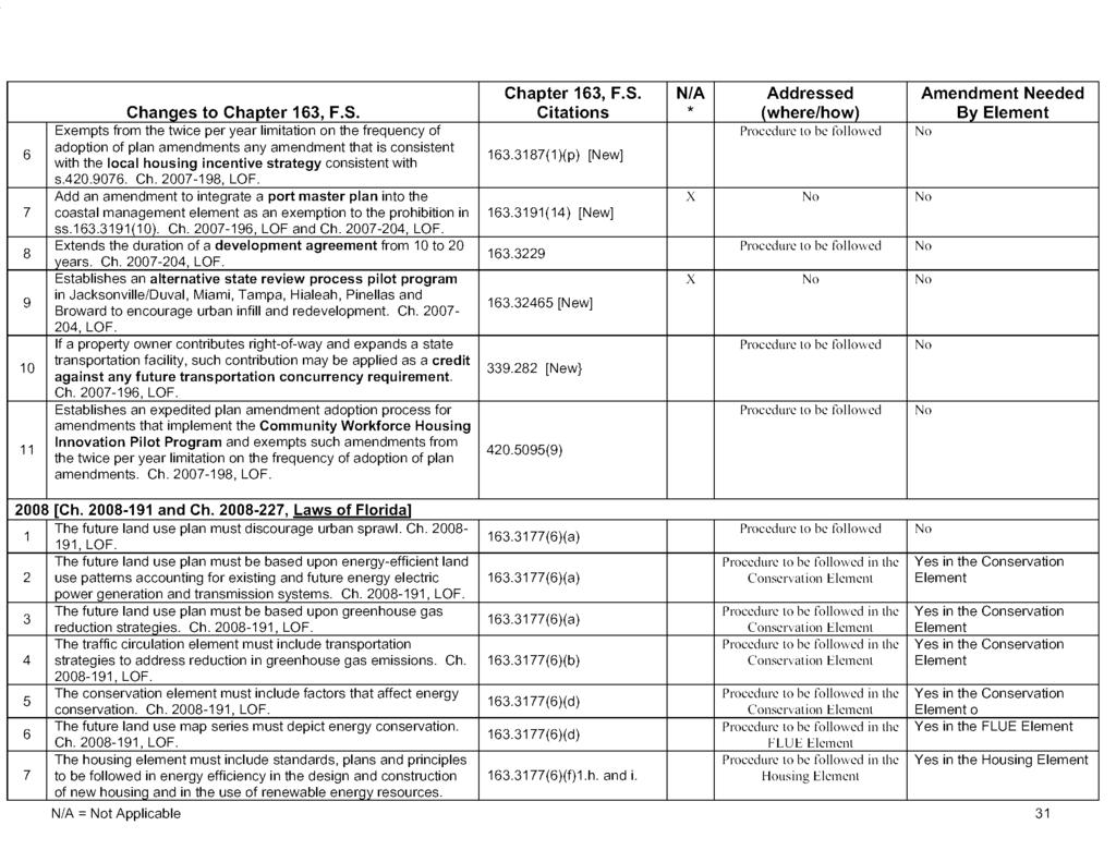
140

141
EVALUATION AND APPRAISAL REPORT TOWN OF BRINY BREEZES, FLORIDA
 EVALUATION AND APPRAISAL REPORT TOWN OF BRINY BREEZES, FLORIDA Prepared by the Planning & Zoning Board/Local Planning Agency of the Town of Briny Breezes Revised, April 15, 2010 Membership Roster Planning
FUTURE LAND USE. City of St. Augustine Comprehensive Plan EAR-Based Amendments
 FUTURE LAND USE City of St. Augustine Comprehensive Plan EAR-Based Amendments Future Land Use Element FLU Goal To create an environment within the City and adjacent areas in which its residents have the
TREASURE COAST REGIONAL PLANNING COUNCIL M E M O R A N D U M. To: Council Members AGENDA ITEM 4F
 TREASURE COAST REGIONAL PLANNING COUNCIL M E M O R A N D U M To: Council Members AGENDA ITEM 4F From: Date: Subject: Staff January 18, 2008 Council Meeting Local Government Comprehensive Plan Review Draft
EVALUATION AND APPRAISAL REPORT OF THE CITY OF FELLSMERE COMPREHENSIVE PLAN APPENDIX D HOUSING ELEMENT
 OBJECTIVE H-A-1: ALLOW AFFORDABLE HOUSING AND ADEQUATE SITES FOR VERY LOW, LOW, AND MODERATE INCOME HOUSING. The City projects the total need for very low, low, and moderate income-housing units for the
TREASURE COAST REGIONAL PLANNING COUNCIL M E M O R A N D U M
 TREASURE COAST REGIONAL PLANNING COUNCIL M E M O R A N D U M To: Council Members AGENDA ITEM 5F From: Date: Subject: Staff July 16, 2010 Council Meeting Local Government Comprehensive Plan Review Draft
SECTION 1 INTRODUCTION TO THE PANAMA CITY BEACH COMPREHENSIVE GROWTH DEVELOPMENT PLAN
 1. PURPOSE SECTION 1 INTRODUCTION TO THE PANAMA CITY BEACH COMPREHENSIVE GROWTH DEVELOPMENT PLAN The purpose of the City of Panama City Beach's Comprehensive Growth Development Plan is to establish goals,
Chapter 100 Planned Unit Development in Corvallis Urban Fringe
 100.100 Scope and Purpose. Chapter 100 Planned Unit Development in Corvallis Urban Fringe (1) All applications for land divisions in the Urban Residential (UR) and Flood Plain Agriculture (FPA) zones within
CHAPTER Committee Substitute for Committee Substitute for Senate Bill No. 2188
 CHAPTER 2004-372 Committee Substitute for Committee Substitute for Senate Bill No. 2188 An act relating to land development; amending s. 197.502, F.S.; providing for the issuance of an escheatment tax
HOUSING ELEMENT GOAL, OBJECTIVES & POLICIES
 HOUSING ELEMENT GOAL, OBJECTIVES & POLICIES GOAL HO. HOUSING FOR THE PUBLIC. GOAL, OBJECTIVES & POLICIES It is the goal of the City of Casselberry to ensure an adequate supply of a wide range of housing
HOUSING ELEMENT GOALS, OBJECTIVES, & POLICIES
 HOUSING ELEMENT GOALS, OBJECTIVES, & POLICIES GOAL H-1: ENSURE THE PROVISION OF SAFE, AFFORDABLE, AND ADEQUATE HOUSING FOR ALL CURRENT AND FUTURE RESIDENTS OF WALTON COUNTY. Objective H-1.1: Develop a
MIDWAY CITY Municipal Code
 MIDWAY CITY Municipal Code TITLE 9 ANNEXATION CHAPTER 9.01 PURPOSE CHAPTER 9.02 GENERAL REQUIREMENTS CHAPTER 9.03 PROPERTY OWNER INITIATION OF ANNEXATION CHAPTER 9.04 PROCEDURES FOR CONSIDERATION OF PETITION
Title 6 - Local Government Provisions Applicable to Special Purpose Districts and Other Political Subdivisions
 Title 6 - Local Government Provisions Applicable to Special Purpose Districts and Other Political Subdivisions CHAPTER 29. SOUTH CAROLINA LOCAL GOVERNMENT COMPREHENSIVE PLANNING ENABLING ACT OF 1994 1994
EXHIBIT A. City of Corpus Christi Annexation Guidelines
 City of Corpus Christi Annexation Guidelines Purpose: The purpose of this document is to describe the City of Corpus Christi s Annexation Guidelines. The Annexation Guidelines provide the guidance and
MUNICIPAL SERVICE BENEFIT UNIT (MSBU) CREATION AND ADMINISTRATION POLICY 16-01
 CREATION AND ADMINISTRATION POLICY 16-01") MUNICIPAL SERVICE BENEFIT UNIT (MSBU) CREATION AND ADMINISTRATION POLICY 16-01 PURPOSE: POLICY: The purpose of this policy is to provide an orderly and efficient method for utilizing the statutory authority
MUNICIPAL SERVICE BENEFIT UNIT (MSBU) CREATION AND ADMINISTRATION POLICY 16-01 PURPOSE: POLICY: The purpose of this policy is to provide an orderly and efficient method for utilizing the statutory authority
Housing Characteristics
 CHAPTER 7 HOUSING The housing component of the comprehensive plan is intended to provide an analysis of housing conditions and need. This component contains a discussion of McCall s 1990 housing inventory
Nassau County Department of Planning & Economic Opportunity Nassau Place Yulee, Florida 32097
 Nassau County Department of Planning & Economic Opportunity 96161 Nassau Place Yulee, Florida 32097 APPLICATION AND INSTRUCTIONS FOR FUTURE LAND USE MAP AMENDMENT (TEN (10) ACRES OR MORE) NOTICE: Florida
NANTUCKET ISLANDS LAND BANK AFFORDABLE HOUSING POLICY Adopted by the vote of the Land Bank Commission on November 10, 2015
 NANTUCKET ISLANDS LAND BANK AFFORDABLE HOUSING POLICY Adopted by the vote of the Land Bank Commission on November 10, 2015 In recent history, the island of Nantucket has experienced a shortage of affordable,
8Land Use. The Land Use Plan consists of the following elements:
 8Land Use 1. Introduction The Land Use Plan consists of the following elements: 1. Introduction 2. Existing Conditions 3. Opportunities for Redevelopment 4. Land Use Projections 5. Future Land Use Policies
HOUSING ELEMENT GOALS, OBJECTIVES, AND POLICIES
 HOUSING ELEMENT GOALS, OBJECTIVES, AND POLICIES GOAL 1: To promote the preservation and development of high-quality, balanced, and diverse housing options for persons of all income levels throughout the
PROPOSED AMENDMENTS TO THE DERBY ZONING REGULATIONS AUGUST 12, 2008
 ARTICLE II Definitions and word usage 195-7. Definitions and word usage. Modify the following: HOUSING FOR THE ELDERLY OLDER PERSONS Housing in accordance with and as defined in the United States Fair
Goals, Objectives and Policies
 Goals, Objectives and Policies 1. GOAL SUPPORT THE PROVISION OF DECENT, SAFE AND SOUND HOUSING IN A VARIETY OF TYPES, SIZES, LOCATIONS AND COSTS TO MEET THE NEEDS OF CURRENT AND FUTURE RESIDENTS OF UNINCORPORATED
PLANNED RESIDENTIAL DEVELOPMENT (PRD)
") PLANNED RESIDENTIAL DEVELOPMENT SECTION 10. PLANNED RESIDENTIAL DEVELOPMENT (PRD) 10.1 Purpose Planned Residential Development allows by special permit from the Board an alternative pattern of residential
PLANNED RESIDENTIAL DEVELOPMENT SECTION 10. PLANNED RESIDENTIAL DEVELOPMENT (PRD) 10.1 Purpose Planned Residential Development allows by special permit from the Board an alternative pattern of residential
HOUSING ELEMENT OF THE CITY OF PEMBROKE PINES COMPREHENSIVE PLAN ADOPTION DOCUMENT
 HOUSING ELEMENT OF THE CITY OF PEMBROKE PINES COMPREHENSIVE PLAN RULES 9J-5.010, FAC City of Pembroke Pines, Florida ADOPTION DOCUMENT HOUSING ELEMENT HOUSING ELEMENT ADOPTION DOCUMENT VI. GOALS, OBJECTIVES
PLANNED UNIT DEVELOPMENTS (Ordinance No.: 3036, 12/3/07; Repealed & Replaced by Ordinance No.: 4166, 10/15/12)
") 159.62 PLANNED UNIT DEVELOPMENTS (Ordinance No.: 3036, 12/3/07; Repealed & Replaced by Ordinance No.: 4166, 10/15/12) A. PURPOSE 1. General. The Planned Unit Development (PUD) approach provides the flexibility
159.62 PLANNED UNIT DEVELOPMENTS (Ordinance No.: 3036, 12/3/07; Repealed & Replaced by Ordinance No.: 4166, 10/15/12) A. PURPOSE 1. General. The Planned Unit Development (PUD) approach provides the flexibility
HOUSING ELEMENT. 3. group and foster home construction. 1. increase the supply of new affordable housing with: a regional housing trust fund;
 Goal 8.0. Facilitate an adequate supply of decent, safe, and sanitary housing in suitable neighborhoods, including housing for special needs populations; available in a range of housing types, architectural
Special Use Permit - Planned Unit Development Checklist. Property Address:
 Special Use Permit - Planned Unit Development Checklist Special Use Permit Number. Parcel Code/s #28-11- - - Property Address: Applicant: ARTICLE VIII Ordinance Reference - Section 8.1.2 Permit Procedures:
CHAPTER House Bill No. 963
 CHAPTER 2000-401 House Bill No. 963 An act relating to Manatee County; merging the Anna Maria Fire Control District and Westside Fire Control District to create a new district; creating and establishing
HOUSING ELEMENT Inventory Analysis
 HOUSING ELEMENT Inventory Analysis 2.100 INVENTORY Age of Housing Stock Table 2.25 shows when Plantation's housing stock was constructed. The latest available data with this kind of breakdown is 2010.
CHAPTER 7 HOUSING. Housing May
 CHAPTER 7 HOUSING Housing has been identified as an important or very important topic to be discussed within the master plan by 74% of the survey respondents in Shelburne and 65% of the respondents in
TREASURE COAST REGIONAL PLANNING COUNCIL M E M O R A N D U M
 TREASURE COAST REGIONAL PLANNING COUNCIL M E M O R A N D U M To: Council Members AGENDA ITEM 6A From: Date: Subject: Staff May 20, 2011 Council Meeting Local Government Comprehensive Plan Review Draft
LAND USE AND ZONING OVERVIEW
 OVERVIEW OF PLANNING POLICIES LAND USE AND ZONING OVERVIEW The Minneapolis Plan for Sustainable Growth and Other Adopted Plans Community Planning and Economic Development Development Services Division
Project File #: VA Project Name: Beauperthuy Variance Parcel Nos.: , , , ,
 COMMISSIONERS: DARRYL GLENN (PRESIDENT) MARK WALLER (PRESIDENT PRO TEMPORE) STAN VANDERWERF LONGINOS GONZALEZ PEGGY LITTLETON PLANNING AND COMMUNITY DEVELOPMENT DEPARTMENT CRAIG DOSSEY, EXECUTIVE DIRECTOR
ORDINANCE NO
 ORDINANCE NO. 2014-160 AN ORDINANCE OF THE CITY COUNCIL OF THE CITY OF MENIFEE, CALIFORNIA, REPEALING SECTION 10.35 OF RIVERSIDE COUNTY LAND USE ORDINANCE NO. 460.152 AS ADOPTED BY THE CITY OF MENIFEE
SATELLITE BEACH OFFICIAL CODE OF ORDINANCES PART II. CITY CODE CHAPTER 52. STORMWATER UTILITY
 1/7 SATELLITE BEACH OFFICIAL CODE OF ORDINANCES PART II. CITY CODE CHAPTER 52. STORMWATER UTILITY SATELLITE BEACH CHAPTER 52. STORMWATER UTILITY 2/7 Table of Contents 52-1. Finding and purpose 52-2. Definitions
THE REDEVELOPMENT PLAN
 PAGE 37 THE REDEVELOPMENT PLAN FUTURE LAND USE The Silver Terrace Redevelopment Area is currently designated as Redevelopment Area #4 on the City of Delray Beach Future Land Use Map (FLUM). This designation
The following regulations shall apply in the R-E District:
 "R-E" RESIDENTIAL ESTATE DISTRICT (8/06) The following regulations shall apply in the R-E District: 1. Uses Permitted: The following uses are permitted. A Zoning Certificate may be required as provided
(c) County board of commissioners means 1 of the following, as applicable: (ii) In all other counties, 1 of the following:
 County board of commissioners means 1 of the following, as applicable: (ii) In all other counties, 1 of the following:") TOWNSHIP PLANNING Act 168 of 1959, as amended, (including 2001 amendments, 2006 amendments) AN ACT to provide for township planning; for the creation, organization, powers and duties of township planning
TOWNSHIP PLANNING Act 168 of 1959, as amended, (including 2001 amendments, 2006 amendments) AN ACT to provide for township planning; for the creation, organization, powers and duties of township planning
WOODLAND AREA GENERAL PLAN URBAN DEVELOPMENT POLICY
 APPENDIX A WOODLAND AREA GENERAL PLAN URBAN DEVELOPMENT POLICY The following text indicates proposed amendments to the Woodland Area General Plan Urban Development Policy currently adopted and included
DIVISION 1 PURPOSE OF DISTRICTS
 ARTICLE 2 ZONING DISTRICTS AND MAP DIVISION 1 PURPOSE OF DISTRICTS Section 2.101 Zoning Districts. For the purpose of this Ordinance, the City of Richmond is hereby divided into districts as follows: DISTRICT
Town of Bristol Rhode Island
 Town of Bristol Rhode Island Subdivision & Development Review Regulations Adopted by the Planning Board September 27, 1995 (March 2017) Formatted: Highlight Formatted: Font: 12 pt Table of Contents TABLE
Marion County Board of County Commissioners
 Marion County Board of County Commissioners Date: 6/4/217 P&Z: 9/25/217 BCC Transmittal: 1/17/217 BCC Adopt: TBD Amendment No: 217-L6 Type of Application Large-Scale Comp Plan Amendment Request: Change
2. LAND USE DESIGNATIONS AND PRINCIPLES FOR DEVELOPMENT
 2. LAND USE DESIGNATIONS AND PRINCIPLES FOR DEVELOPMENT General areas have been designated for specific types of land use on the Future Land Use Map and are described in this section. In order to satisfy
UPPER MOUNT BETHEL TOWNSHIP NORTHAMPTON COUNTY, PENNSYLVANIA
 UPPER MOUNT BETHEL TOWNSHIP NORTHAMPTON COUNTY, PENNSYLVANIA JOINDER DEED / LOT CONSOLIDATION TOWNSHIP REVIEW PROCESS When accepting proposed Joinder Deeds / Lot Consolidations, review the Joinder Deed
REPORT OF THE PLANNING AND DEVELOPMENT DEPARTMENT FOR APPLICATION FOR REZONING ORDINANCE TO PLANNED UNIT DEVELOPMENT SEPTEMBER 22, 2016
 BEL REPORT OF THE PLANNING AND DEVELOPMENT DEPARTMENT FOR APPLICATION FOR REZONING ORDINANCE 2016-576 TO PLANNED UNIT DEVELOPMENT SEPTEMBER 22, 2016 The Planning and Development Department hereby forwards
Oregon Statutes Relevant to Quiet Water Home Owners Association
 Oregon Statutes Relevant to Quiet Water Home Owners Association 1 1 1 1 0 1 0 1 0 1 PLANNED COMMUNITIES (General Provisions).0 Definitions for ORS.0 to.. As used in ORS.0 to.: (1) Assessment means any
ZONING AMENDMENT & SUBDIVISION STAFF REPORT Date: November 3, 2016
 ZONING AMENDMENT & SUBDIVISION STAFF REPORT Date: November 3, 2016 APPLICANT NAME SUBDIVISION NAME David Shumer 5955 Airport Subdivision CITY COUNCIL DISTRICT District 6 5955 Airport Boulevard, 754 Linlen
EXCERPTS FROM HALIFAX REGIONAL MUNICIPALITY CHARTER
 EXCERPTS FROM HALIFAX REGIONAL MUNICIPALITY CHARTER Municipal planning strategy 227 The Council may adopt a municipal planning strategy for all, or part, of the Municipality and there may be separate strategies
Planning Commission Hearing Date: 2/21/2017 Board of County Commissioners Hearing Date: 3/8/2017
 COMMISSIONERS: DARRYL GLENN (PRESIDENT) MARK WALLER (PRESIDENT PRO TEMPORE) STAN VANDERWERF LONGINOS GONZALEZ PEGGY LITTLETON PLANNING AND COMMUNITY DEVELOPMENT DEPARTMENT CRAIG DOSSEY, EXECUTIVE DIRECTOR
Town of Yucca Valley GENERAL PLAN 1
 Town of Yucca Valley GENERAL PLAN 1 This page intentionally left blank. 3 HOUSING ELEMENT The Housing Element is intended to guide residential development and preservation consistent with the overall values
TREASURE COAST REGIONAL PLANNING COUNCIL M E M O R A N D U M. To: Regional Planning Council Members AGENDA ITEM 5D
 TREASURE COAST REGIONAL PLANNING COUNCIL M E M O R A N D U M To: Regional Planning Council Members AGENDA ITEM 5D From: Date: Subject: Staff March 20, 2009 Regional Planning Council Meeting Local Government
ARTICLE VII. NONCONFORMITIES. Section 700. Purpose.
 ARTICLE VII. NONCONFORMITIES. Section 700. Purpose. The purpose of this chapter is to regulate and limit the development and continued existence of legal uses, structures, lots, and signs established either
Reading Plats and the Complexities of Antiquated Subdivisions Presented by: David W. Depew, PhD, AICP, LEED AP Morris-Depew Associates, Inc.
 Presented by: David W. Depew, PhD, AICP, LEED AP Morris-Depew Associates, Inc. Introduction Plat is a term for a survey of a piece of land to identify boundaries, easements, flood zones, roadway, and access
CITY AND COUNTY OF HONOLULU DEPARTMENT OF BUDGET & FISCAL SERVICES ADMINISTRATIVE GUIDELINES FOR COMMUNITY FACILITIES DISTRICTS
 Working Draft of May 14, 2004 Working Draft of August 11, 2004 Working Draft of September 8, 2004 CITY AND COUNTY OF HONOLULU DEPARTMENT OF BUDGET & FISCAL SERVICES ADMINISTRATIVE GUIDELINES FOR COMMUNITY
STANDARDS FOR EVALUATING PROPOSALS
 STANDARDS FOR EVALUATING PROPOSALS Amended by Resolution No. 2011-1; February 2, 2011 Pursuant to Government Code Section 56375, Santa Cruz LAFCO has established standards for the evaluation of proposals.
To: Ogunquit Planning Board From: Lee Jay Feldman, Director of Planning Date: April 18, 2018 Re: Senior/Affordable Multi-Family Housing Assessment
 To: Ogunquit Planning Board From: Lee Jay Feldman, Director of Planning Date: April 18, 2018 Re: Senior/Affordable Multi-Family Housing Assessment I. Introduction The Planning Board held a workshop on
REZONING APPLICATION INSTRUCTIONS
 REZONING APPLICATION INSTRUCTIONS All required information, as stated on the Rezoning Application Checklist, must be included to qualify as a complete application. Upon receipt, staff will review the application
HOUSING ELEMENT GOALS, OBJECTIVES, & POLICIES
 HOUSING ELEMENT GOALS, OBJECTIVES, & POLICIES GOAL H-1: ENHANCE WALTON COUNTY S SUSTAINABILITY AS A COMMUNITY BY ENCOURAGING THE DEVELOPMENT OF AFFORDABLE, SAFE, AND SANITARY HOUSING WITH VARIETY IN TYPE,
PLANNING COMMISSION STAFF REPORT
 PLANNING COMMISSION STAFF REPORT West Capitol Hill Zoning Map Amendment Petition No. PLNPCM2011-00665 Located approximately at 548 W 300 North Street, 543 W 400 North Street, and 375 N 500 West Street
CITY OF COLLEGE STATION SERVICE PLAN FOR THE AREA TO BE ANNEXED EFFECTIVE 14 APRIL 2011
 CITY OF COLLEGE STATION SERVICE PLAN FOR THE AREA TO BE ANNEXED EFFECTIVE 14 APRIL 2011 I. ANNEXATION AREA The annexation area is located on the southwest side of the City of College Station, in the City
C HAPTER 15: N ONCONFORMITIES
 SECTION 15.1: PURPOSE AND APPLICABILITY The purpose of this Chapter is to regulate and limit the continued existence of uses and structures established prior to the effective date of this Code (or any
17.0 NONCONFORMITIES CHAPTER 17: NONCONFORMITIES Purpose and Applicability
 17.0 NONCONFORMITIES 17.1 Purpose and Applicability The purpose of this section is to regulate and limit the continued existence of uses and structures established prior to the effective date of this Ordinance
City of Lonsdale Section Table of Contents
 City of Lonsdale City of Lonsdale Section Table of Contents Page Introduction Demographic Data Overview Population Estimates and Trends Population Projections Population by Age Household Estimates and
13 NONCONFORMITIES [Revises Z-4]
![13 NONCONFORMITIES [Revises Z-4]](/thumbs/87/97238669.jpg "13 NONCONFORMITIES [Revises Z-4]") Dimensional Standards Building Design Standards Sidewalks Tree Protection & Landscaping Buffers & Screening Street Tree Planting Parking Lot Landscaping Outdoor Lighting Signs 13.1 PURPOSE AND APPLICABILITY
Dimensional Standards Building Design Standards Sidewalks Tree Protection & Landscaping Buffers & Screening Street Tree Planting Parking Lot Landscaping Outdoor Lighting Signs 13.1 PURPOSE AND APPLICABILITY
City of Grande Prairie Development Services Department
 City of Grande Prairie Development Services Department COUNTRYSIDE SOUTH OUTLINE PLAN Prepared by: GPEC Consulting Ltd. #202, 10712-100th Street Grande Prairie, AB Council Resolution of August 20, 2001
CHAPTER 3 PRELIMINARY PLAT
 10-3-1 10-3-3 SECTION: CHAPTER 3 PRELIMINARY PLAT 10-3-1: Consultation 10-3-2: Filing 10-3-3: Requirements 10-3-4: Approval 10-3-5: Time Limitation 10-3-6: Grading Limitation 10-3-1: CONSULTATION: Each
MULTI-FAMILY DWELLING UNIT SUBDIVISION ORDINANCE TOWN OF SIDNEY, MAINE
 MULTI-FAMILY DWELLING UNIT SUBDIVISION ORDINANCE TOWN OF SIDNEY, MAINE I. GENERAL A. Title B. Purpose C. Administration D. Scope II. DEFINITIONS A. Building Height B. Dwelling Unit C. Family D. Multi-Unit
1. Cuyler-Brownsville planned neighborhood conservation (P-N-C) districtphase I (section ). (2) Single-family semiattached dwellings;
 districtphase I (section ). (2) Single-family semiattached dwellings;") Sec. 8-3035. Planned unit development multifamily (PUD-M). A. Purpose. The PUD-M district is intended to allow a variety of residential development including single-family residential, two-family residential,
Sec. 8-3035. Planned unit development multifamily (PUD-M). A. Purpose. The PUD-M district is intended to allow a variety of residential development including single-family residential, two-family residential,
Box Elder County Land Use Management & Development Code Article 3: Zoning Districts
 Chapter 3-6 Mobile Homes, Mobile Home Subdivisions, & Recreational Vehicle Parks Box Elder Zoning Ordinance as Adopted October 2007 Sections. 3-6-010. Purpose and Intent. 3-6-020. Conditional Use Permit
APPENDIX A MONITORING AND EVALUATION PROCEDURES
 APPENDIX A MONITORING AND EVALUATION PROCEDURES At least once every seven years from the adoption date, the City shall monitor, evaluate and update this Comprehensive Plan. The following criteria shall
Midwest City, Oklahoma Zoning Ordinance
 2010 Midwest City, Oklahoma Zoning Ordinance 9/2/2010 Table of Contents Section 1. General Provisions... 5 1.1. Citation... 5 1.2. Authority... 5 1.3. Purpose... 5 1.4. Nature and Application... 5 1.5.
A Guide to the Municipal Planning Process in Saskatchewan
 A Guide to the Municipal Planning Process in Saskatchewan A look at the municipal development permit and the subdivision approval process in Saskatchewan May 2008 Prepared By: Community Planning Branch
PALM BEACH COUNTY PLANNING, ZONING AND BUILDING DEPARTMENT ZONING DIVISION
 PALM BEACH COUNTY PLANNING, ZONING AND BUILDING DEPARTMENT ZONING DIVISION Application No.: CA-2012-00688 Control No.: 2011-00552 Applicant: Garry Bernardo Owners: Garry Bernardo Agent: Frogner Consulting,
CODING: Words stricken are deletions; words underlined are additions. hb er
 1 2 3 4 5 6 7 8 9 10 11 12 13 14 15 16 17 18 19 20 21 22 23 24 25 26 An act relating to local government environmental financing; providing a short title; amending s. 212.055, F.S.; expanding the uses
Contents Lists of Figures and Tables xi About the Author xiii Foreword xv Acknowledgments xvi Part I Introduction
 CHAPTER # Contents Lists of Figures and Tables... xi About the Author... xiii Foreword...xv Acknowledgments...xvi Part I Introduction... 1 1 Overview of Land Valuation Assignments and Adjustment Procedures...
Glades County Staff Report and Recommendation Unified Staff Report for Small Scale Plan Amendment and Rezoning
 Glades County Staff Report and Recommendation Unified Staff Report for Small Scale Plan Amendment and Rezoning CASE NUMBERS: COMP17-02 and RZ17-02 DATE of STAFF REPORT: May 1, 2017 CASE TYPE: Application
Guide to Preliminary Plans
 Guide to Preliminary Plans Introduction The Douglas County is committed to providing open, transparent application processes to the public. This Guide is provided to assist anyone interested in the procedures
Plans shall be drawn at a readable scale, signed, and sealed by a Florida Registered Engineer. The application package shall include:
 CHAPTER 400. SECTION 403. PERMIT TYPES AND APPLICATIONS SITE DEVELOPMENT 403.3. Preliminary Site Plans (PSP) A. Intent and Purpose PSPs are used to identify existing site conditions and demonstrate general
CHAPTER Committee Substitute for Committee Substitute for House Bill No. 447
 CHAPTER 2016-225 Committee Substitute for Committee Substitute for House Bill No. 447 An act relating to local government environmental financing; providing a short title; amending s. 212.055, F.S.; expanding
AN ORDINANCE AMENDING AND SUPPLEMENTING THE REVISED GENERAL ORDINANCES OF THE CITY OF BAYONNE THE, CHAPTER 33 PLANNING AND DEVELOPMENT REGULATIONS
 AN ORDINANCE AMENDING AND SUPPLEMENTING THE REVISED GENERAL ORDINANCES OF THE CITY OF BAYONNE THE, CHAPTER 33 PLANNING AND DEVELOPMENT REGULATIONS WHEREAS, pursuant to N.J.S.A. 40:48-2, the Legislature
SECTION 23 PLANNED RESIDENTIAL DEVELOPMENT FOR ELDERLY PERSONS
 SECTION 23 PLANNED RESIDENTIAL DEVELOPMENT FOR ELDERLY PERSONS 23.1 General: In order to provide for the special needs of elderly and handicapped persons who may require multifamily type living accommodations,
PIN , Part 1, Plan SR-713 in Lot 2, Concession 5, Township of McKim (1096 Dublin Street, Sudbury)
") STAFF REPORT Applicant: Dalron Construction Limited Location: PIN 02124-0103, Part 1, Plan SR-713 in Lot 2, Concession 5, Township of McKim (1096 Dublin Street, Sudbury) Official Plan and Zoning By-law:
STAFF REPORT Applicant: Dalron Construction Limited Location: PIN 02124-0103, Part 1, Plan SR-713 in Lot 2, Concession 5, Township of McKim (1096 Dublin Street, Sudbury) Official Plan and Zoning By-law:
Request Subdivision Variance to Sections 4.4 (b) & (d) of the Subdivision Regulations. Staff Planner Kevin Kemp
 & (d) of the Subdivision Regulations. Staff Planner Kevin Kemp") Applicant Property Owner Rhae Adams, Jr. Public Hearing June 8, 2016 City Council Election District Lynnhaven Agenda Item 4 Request Subdivision Variance to Sections 4.4 (b) & (d) of the Subdivision Regulations.
Applicant Property Owner Rhae Adams, Jr. Public Hearing June 8, 2016 City Council Election District Lynnhaven Agenda Item 4 Request Subdivision Variance to Sections 4.4 (b) & (d) of the Subdivision Regulations.
Guide to Combined Preliminary and Final Plats
 Guide to Combined Preliminary and Final Plats Introduction The Douglas County is committed to providing open, transparent application processes to the public. This Guide is provided to assist anyone interested
Change 6, September 1, TITLE 18 WATER AND SEWERS 1
 Change 6, September 1, 2011 18-1 TITLE 18 WATER AND SEWERS 1 CHAPTER 1. MISCELLANEOUS. 2. CITY WASTEWATER SYSTEM. 3. WASTEWATER TREATMENT (SEWER) SYSTEM. 4. WATER. 5. CONNECTIONS WITH PUBLIC WATER SUPPLY.
Residential Neighborhoods and Housing
 Residential Neighborhoods and Housing 3 GOAL - To protect Greenwich as a predominantly residential community and provide for a variety of housing options The migration of businesses and jobs from New York
SUBDIVISION, PLANNED UNIT DEVELOPMENT, ZONING AMENDMENT, & SIDEWALK WAIVER STAFF REPORT Date: July 19, 2018
 SUBDIVISION, PLANNED UNIT DEVELOPMENT, ZONING AMENDMENT, & SIDEWALK WAIVER STAFF REPORT Date: July 19, 2018 NAME SUBDIVISION NAME LOCATION West Mobile Properties, LLC U.S. Machine Subdivision 556, 566,
ARTICLE XI - CONSERVATION SUBDIVISIONS
 ARTICLE XI - CONSERVATION SUBDIVISIONS Section 1101: Purpose and Intent. This Article is intended to provide for residential subdivisions that are designed based first and foremost on the preservation
FREQUENTLY USED PLANNING & ZONING TERMS
 City Of Mustang FREQUENTLY USED PLANNING & ZONING TERMS Abut: Having property lines, street lines, or zoning district lines in common. Accessory Structure: A structure of secondary importance or function
HOUSING ELEMENT I. GOALS, OBJECTIVES AND POLICIES
 HOUSING ELEMENT I. GOALS, OBJECTIVES AND POLICIES GOAL 1: IN ORDER TO ACHIEVE A BALANCED HOUSING SUPPLY (AND A BALANCED POPULATION AND ECONOMIC BASE), EVERY EFFORT SHOULD BE MADE TO PROVIDE A BROAD RANGE
H-POLICY 1: Preserve and improve existing neighborhoods. Ensure that Prince William County achieves new neighborhoods with a high quality of life.
 HOUSING Intent The intent of the Housing Plan is to provide a framework for providing for the housing needs of all residents of Prince William County. These needs are expressed in terms of quality, affordability,
LLANO CENTRAL APPRAISAL DISTRICT REAPPRAISAL PLAN FOR TAX YEARS 2017 & 2018 AS ADOPTED BY THE BOARD OF DIRECTORS
 LLANO CENTRAL APPRAISAL DISTRICT REAPPRAISAL PLAN FOR TAX YEARS 2017 & 2018 AS ADOPTED BY THE BOARD OF DIRECTORS TABLE OF CONTENTS ITEM PAGE Executive Summary 5 Revaluation Decision (Statutory or Administrative)
PUTNAM COUNTYCOMPREHENSIVE PLAN
 COMPREHENSIVE PLAN EXHIBIT AA COMPREHENSIVE PLAN A. Future Land Use Element Goals, Objectives, Policies This section proposed objectives and policies, which will assist Putnam County Commissioners and
ANNEXATION. The Handbook for Georgia Mayors and Councilmembers 1
 ANNEXATION Growing and prosperous Georgia cities create a growing and prosperous Georgia. Although cities comprise only 6.8% of Georgia s land area, approximately 40% of the state s population lives in
TREASURE COAST REGIONAL PLANNING COUNCIL M E M O R A N D U M. To: Council Members AGENDA ITEM 4G
 TREASURE COAST REGIONAL PLANNING COUNCIL M E M O R A N D U M To: Council Members AGENDA ITEM 4G From: Date: Subject: Staff March 16, 2007 Council Meeting Local Government Comprehensive Plan Review Draft
TOWN OF WATERVILLE VALLEY NEW HAMPSHIRE SITE PLAN REVIEW REGULATIONS
 TOWN OF WATERVILLE VALLEY NEW HAMPSHIRE Effective date March 17, 1981 Revised March 16, 1982 Revised March 13, 1986 Revised March 10, 1987 Revised March 14, 2013 Revised March 8, 2016 TOWN OF WATERVILLE
ARTICLE XVIII MISCELLANEOUS
 88 ARTICLE XVIII MISCELLANEOUS Section 1801 Design and Construction Standards The design and construction of all sanitary sewers connected, either directly or indirectly to the wastewater treatment system
42-Acre Parcel Rezoning and Master Plan Amendment. Danny Cagle and Patrick Stanley 6301 Duckweed Rd. Lake Worth, FL 33449
 STAFF REPORT CITY OF PARKLAND DEVELOPMENT SERVICES DEPARTMENT Date Prepared: May 2, 2014 I. Petition Description Petition No.: Project Name: Owners: RZ14-001; MPA14-002 42-Acre Parcel Rezoning and Master
Findings and Recommendations of the Dover Planning Commission And Annexation Report Information
 PETITION FOR Annexation Plan Amendment to Comprehensive Plan Update 2003 and PETITION TO ANNEX AND ZONE PROPERTY Before The Dover City Council November 8, 2004 Owner: Equitable Owner: Location: Tax Map
DRAFT Subject to Modifications
 TREASURE COAST REGIONAL PLANNING COUNCIL M E M O R A N D U M DRAFT Subject to Modifications To: Council Members AGENDA ITEM 5L From: Date: Subject: Staff September 17, 2010 Council Meeting Local Government
Cedar Hammock Fire Control District
 Cedar Hammock Fire Control District FY 2015 Fire/Rescue Impact Fee Study February 24, 2016 Prepared by: February 24, 2016 Mr. Jeff Hoyle Fire Chief 5200 26 th St W Bradenton, FL 34207 Re: FY 2015 Impact