Waterfront Project Summary ATTACHMENT 3
|
|
|
- Carol Fitzgerald
- 5 years ago
- Views:
Transcription


1 Waterfront Project Summary ATTACHMENT 3


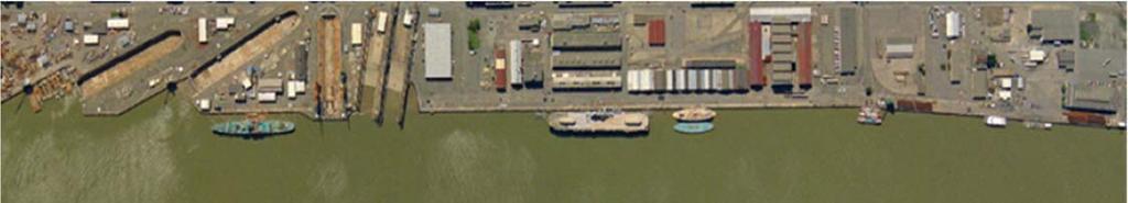
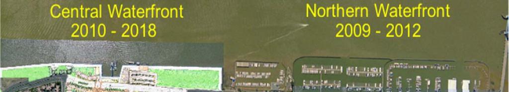
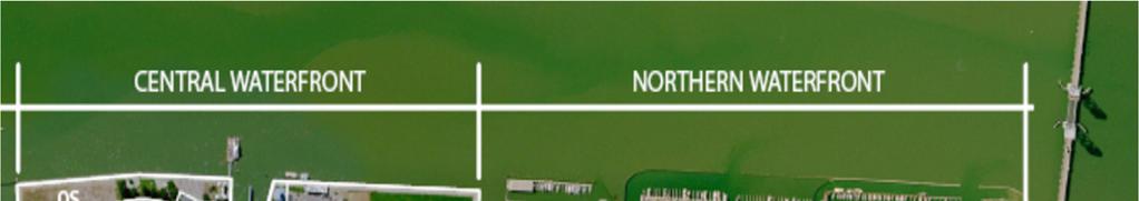
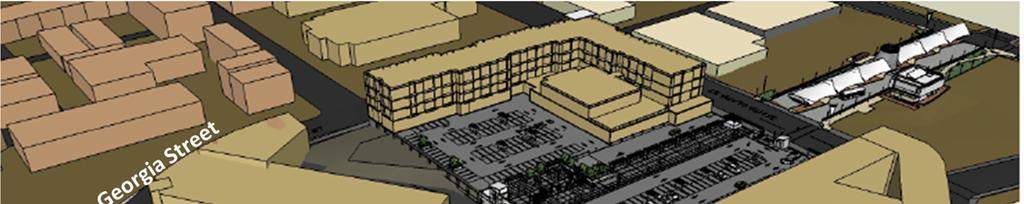
2 Central North & Central ATTACHMENT 3 South Waterfront Areas View from the front of the Ferry Building, looking up Georgia Street of the proposed development of Parcel L2
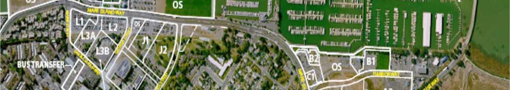
3 ATTACHMENT 3 Parcel Development Profiles The Central Waterfront - North Parcel Location Max. Building Height Development Profile Parcel J 9.3 acres East of Mare Island Way between the Georgia and Capitol Street extensions, west of Civic Center Drive Maximum height of the building on Parcel J1 is 45 feet along Mare Island Way and the Festival Green for a minimum depth of 30 feet, with the remainder of the building to be limited to a height of 55 feet. Maximum height of the building on Parcel J2 is 45 feet along Mare Island Way to Capitol Street for a minimum depth of 30 feet, with the remainder of such building to be limited to a maximum height of 55 feet. Up to 286 stacked flat residential condominium dwellings up to four levels built on top of one level parking garage, potentially half above the half below-grade. Dwellings will contain between one and three bedrooms averaging 1,050 square feet. Garage parking will provide up to 516 spaces. The residential development will also include on-site landscaping in courtyards and perimeter landscaping. Retail uses on the ground floor up to 25,000 square feet are required of the building on Parcel J1 as defined and allowed in Table 3: Permitted and Conditional Land Uses Commercial and Industrial Types. Civic Center Drive: 0.9-acre roadway Capitol Street Extension: 0.8-acre roadway (potentially) Festival Green: 0.9-acre open space Unity Plaza Extension: 0.4-acre open space Source: Waterfront Planned Development Master Plan

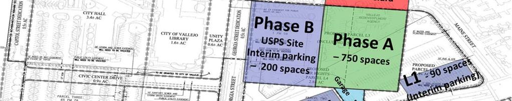

4 ATTACHMENT 3 Vallejo StaƟon (in Central South Waterfront Area) CURRENTLY Phase B L3 & L4 Phase A L2 L1 FROM PDMP
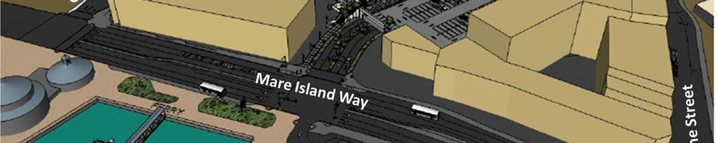
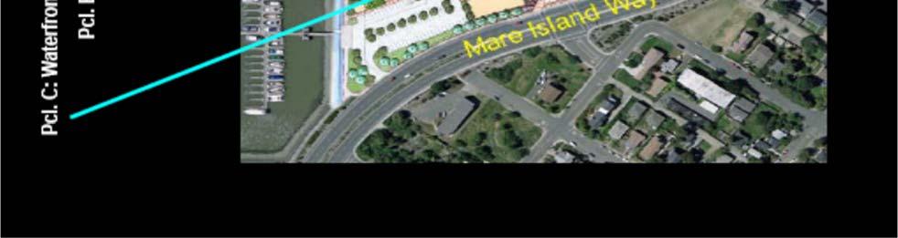
5 ATTACHMENT 3 Parcel Development Profiles The Central Waterfront South (including the Vallejo Station Project) Parcel L 8.4 acres Parcel Location Between Mare Island Way and Santa Clara Street, Maine Street and the Georgia Street extension Max. Building Height Building heights shall be established in relation to specific zones of Parcel L, including the street frontages of Mare Island Way, Maine Street, Georgia Street, and Santa Clara Street. Parcel 1 building heights range from 45 feet to 65 feet. Parcel L2 shall be limited to a maximum height of 45 feet. Parcel L3 is the Vallejo Station garage and has a maximum height of 35 feet. Development Profile Parcel L4 shall be limited to a maximum height of 55 feet. Residential, commercial/office, parking garage, and park space: - Up to 140 residential units. - Up to 102,000 gross square feet retail/commercial and office space. - Up to 200,000 square feet of commercial uses for a 200 room hotel, restaurant, and conference center. - Up to 1,868 parking spaces. Parcel L1: a 1.9-acre parcel developed with up to 140 single-family residential condominium units in a two- to five-story structure over two levels of parking (241 spaces) and up to 12,000 gross square feet of retail commercial space. At the corner of Mare Island Way and Georgia Street, a setback of the building shall be provided to create a public open space plaza of no less than 1,900 square feet, as depicted in Figure H, which may include outdoor seating. Parcel L2: a 1.9-acre parcel developed with approximately 63,000 gross square feet of office/commercial space in a two- and three-story structure over a single-level parking garage (215 spaces). On Parcel L2, retail uses on the ground floor of the building as defined and allowed in Table 3: Permitted Uses. Parcel L3: a 4.6-acre parcel providing a two-level Ferry Parking Garage with 1,190 parking spaces reserved for the ferry and Performing Arts Center patrons. Note: Phase A was completed in 2012 with 750 spaces. Phase B is currently unfunded.
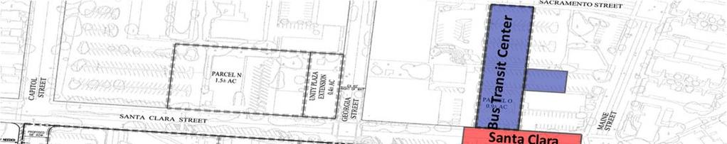
6 ATTACHMENT 3 Parcel Development Profiles The Central Waterfront South (including the Vallejo Station Project) Parcel L4: a 2.8 acre vertical subdivision private development parcel on the top level of the L3 garage structure developed in two and four story building with approximately 25,000 square feet of first floor retail/commercial uses fronting on Georgia and Santa Clara Streets. The 200,000 square foot, 200-room hotel located on the second to fourth floors will include a two-level 32,000 square foot, two-story restaurant and meeting center facility. Parking for 172 cars will be provided on the first and second levels of the private development structure to serve the retail, hotel, restaurant, and meeting center uses. Parcel Location Max. Building Height Development Profile Source: Waterfront Planned Development Master Plan Parcel L5: a 1.40 acre vertical subdivision public development parcel on the top level of the L3 garage structure. This parcel will be developed with a public open space paseo providing pedestrian access between the Bus Transfer enter on Parcel O and the Ferry Terminal as well as public open space serving the Vallejo Station project and downtown area. The parcel will provide an access driveway from Santa Clara Street including 50 short term parking spaces to serve the retail and restaurant uses. The driveway will also provide emergency fire service access for the benefit of Parcels L2 and L4. Park Spaces: neighborhood Paseo Park, (approximately 0.5 new acres). Parcel L5 would include a pedestrian access way through the site from the Bus Transfer Center to the Ferry Terminal at the waterfront, with open space amenities and landscaping. Parcel O (already complete) 0.9 acres Portion of 6.2-acre area bounded by Santa Clara, Sacrament, Maine, and Georgia Streets 50 feet Bus Transfer Center. Includes 10,000 gross square feet of public transit office floor area and associated parking.

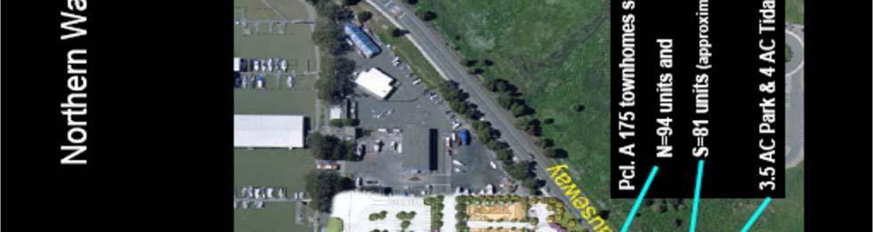
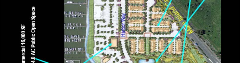
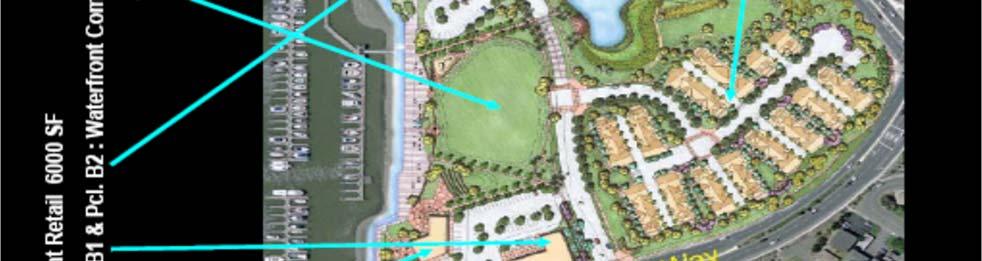
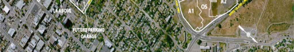
7 Northern Waterfront Area ATTACHMENT 3
8 ATTACHMENT 3 Parcel Development Profiles The Northern Waterfront Parcel A 14.8 acres Parcel Location South of Mare Island Causeway, west of the realigned Harbor Way, north of Mare Island Way Max. Building Height Heights of the residential buildings shall not exceed 45 feet in the Northern Residential Neighborhood and 38 feet in the Southern Residential Neighborhood. Development Profile Up to 175 dwelling units on 10.8 acres and a 4 acre Wetland Park (Parcel D-1) centrally located between the two residential neighborhoods. Parcel B-1, B-2 B-1 building pad of 0.7 acre and B-2 building pad of 0.4 acre, parking per the City of Vallejo zoning code will be provided, 4.0 acre Promenade Park (Parcel D-2) Parcel Location West of Harbor Way and east of Municipal Marina Max. Building Height 25 feet Development Profile Up to 12,000 gross square feet of single-store waterfront-oriented commercial/retail space, plus parking; 4 acre Promenade Park located between Parcels B & C providing access to the Waterfront for pedestrians and bicyclists. Parcel C C building pad of 0.5 acre, parking per the City of Vallejo zoning code will be provided Parcel Location Southwest corner of Harbor Way and Mare Island Way Max. Building Height 25 feet Development Profile Up to 10,000 gross square feet of single-story waterfront-oriented commercial/retail space, potentially including restaurants, plus parking Source: Waterfront Planned Development Master Plan
Community Advisory Committee (CAC) Meeting #7 West Anaheim Youth Center May 26, 2016
 Meeting #7 West Anaheim Youth Center May 26, 2016") Community Advisory Committee (CAC) Meeting #7 West Anaheim Youth Center May 26, 2016 1 Project Team City: David Belmer Planning and Building Director Jonathan Borrego, AICP Planning Services Manager Gustavo
Community Advisory Committee (CAC) Meeting #7 West Anaheim Youth Center May 26, 2016 1 Project Team City: David Belmer Planning and Building Director Jonathan Borrego, AICP Planning Services Manager Gustavo
2.0 LAND USE FRAMEWORK
 Land Use Framework 2.0 LAND USE FRAMEWORK FOLSOM BOULEVARD 2.1 LAND USE OVERVIEW The proposed land uses for Easton Place offer local and regional employment, shopping, and entertainment, highlighting the
Cherokee Webster Development, LP. City of Webster, Texas Planned Development No. 3. Proposed Revision No. 4
 Cherokee Webster Development, LP. City of Webster, Texas Planned Development No. 3 Proposed Revision No. 4 October 2013 1 Statement of Intent This Revision No. 4 of the Statement of Intent is written in
LeBreton Flats Redevelopment Development Summary Chart (First Subdivision)
") Redevelopment Development Summary Chart (First Subdivision) Development Analysis Chart NOTE: THE FOLLOWING TABLE REPRESENTS THE RESULTS OF THE NCC'S DEMONSTRATION OF DEVELOPMENT CAPACITY. WHILE ACTUAL
Redevelopment Development Summary Chart (First Subdivision) Development Analysis Chart NOTE: THE FOLLOWING TABLE REPRESENTS THE RESULTS OF THE NCC'S DEMONSTRATION OF DEVELOPMENT CAPACITY. WHILE ACTUAL
DRAFT Plan Incentives. Part A: Basic Discount
 DRAFT 2030 Plan Incentives July 26, 2006 Part A: Basic Discount In order for a development to be eligible for any 2030 Land Resource Management Plan Discounts it must be located in the Urban Corridor and
8.5.1 R1, Single Detached Residential District
 8.5.1 R1, Single Detached Residential District The purpose of this district is to provide for residential development in the form of single detached dwellings. Dwelling, Single Detached Home Business,
table of contents 3670 Wilshire, Los Angeles, CA 450 North Palm, Beverly Hills, CA 9200 Wilshire, Beverly Hills, CA Neptune Marina, Marina del Rey, CA
 table of contents T H E C AVA L L A R I G R O U P K E Y P E R S O N N E L P R O F I L E S C O M P L E T E D P R O J E C T S Jefferson at Raccoon Creek, Denver, CO Jefferson at Greenwood Village, Denver,
The 12.1-net acre property is the premier development site in the western United States, sitting at the gateway of San Diego s Broadway office
 The 12.1-net acre property is the premier development site in the western United States, sitting at the gateway of San Diego s Broadway office corridor with over one-quarter mile of water-frontage on the
BUILDING HEIGHTS. The following diagram depicts the maximum allowable building height in a +3 zone.
 BUILDING HEIGHTS The following diagram depicts the allowable building height in a +1 zone in an area with substantial topography. As the diagram demonstrates, the building has 4 floors (and would have
Back to Back and Stacked Townhouses
 Back to Back and Stacked Townhouses Draft Urban Design Guidelines & Proposed Zoning Regulations March 29, 2017 What have we done so far? September 19, 2016 Report to PDC summarizing positive and negative
PLANNING UNIT REPORT DEPARTMENT OF PLANNING AND DEVELOPMENT of April 24, 2006
 PLANNING UNIT REPORT DEPARTMENT OF PLANNING AND DEVELOPMENT of RE: I.D. # 03279: Zoning Map Amendment I.D. 3179 to Rezone from PUD- SIP to Amended PUD-SIP 1. Requested Actions: Approval of a request to
Bunker Hill Part II Urban Design. Specific Plan. Case No. CPC SP TABLE OF CONTENTS
 Bunker Hill Part II Urban Design Specific Plan Case No. CPC-2011-684-SP TABLE OF CONTENTS Section 1. Section 2. Section 3. Section 4. Section 5. Section 6. Section 7. Section 8. Section 9. Section 10.
Town Center Joint Commission Public Hearing #1: January 20, 2016
 Town Center Joint Commission Public Hearing #1: January 20, 2016 PROCESS PUBLIC HEARINGS Hearing 1 January 20 - Vision - Building height - Affordable Housing - Setbacks and massing Hearing 2 March 9 -
Article 2. Rules of Interpretation
 Article 2. Rules of Interpretation Article 2. Rules of Interpretation Sec. 2.1. Building Types 2.1.1. Building Type Descriptions... 2-2 Sec. 2.2. Rules Applicable to all Districts 2.2.1. Site... 2-5 2.2.2.
4 DEVELOPMENT STANDARDS FOR
 4 DEVELOPMENT STANDARDS FOR RESIDENTIAL MIXED-USE PROJECTS This chapter presents standards for residential mixed-use projects in the Ashland-Cherryland Business District and the Castro Valley Central Business
40-58 Widmer Street - Zoning Amendment Application - Preliminary Report
 STAFF REPORT ACTION REQUIRED 40-58 Widmer Street - Zoning Amendment Application - Preliminary Report Date: April 19, 2013 To: From: Wards: Reference Number: Toronto and East York Community Council Director,
MACK URBAN SITE 1 & 1a (VTT-72702) PROJECT DESCRIPTION (REVISED )
 PROJECT DESCRIPTION (REVISED )") MACK URBAN SITE 1 & 1a (VTT-72702) PROJECT DESCRIPTION 1114-1154 S. GRAND AVENUE, 309-321 W. 12 TH STREET, 1147-1155 S. OLIVE STREET (REVISED 2-13-14) Project Location The proposed Mack Urban Site 1 &1a
MACK URBAN SITE 1 & 1a (VTT-72702) PROJECT DESCRIPTION 1114-1154 S. GRAND AVENUE, 309-321 W. 12 TH STREET, 1147-1155 S. OLIVE STREET (REVISED 2-13-14) Project Location The proposed Mack Urban Site 1 &1a
Director, Community Planning, Etobicoke York District
 STAFF REPORT ACTION REQUIRED 3555 Don Mills Road Zoning By-law Amendment Application Preliminary Report Date: May 22, 2012 To: From: Wards: Reference Number: North York Community Council Director, Community
Multi-Family Residential
 2600 Frontview Crescent Completed: 2009 Project consisted of 31 Condominiums and nine luxury townhome residences with spectacular views of downtown Denver and within walking distance to Invesco Field.
Article 04 Single Family Residential Districts
 Article 04 Article 04 Section 04.01 Intent (a) R1A Residence District. The R1A Single Family Residential District is established to include areas of low density single-family residences and limited agricultural
Project Overview. Washington s Exciting Destination for Office & Retail. For More Information, Visit CapitolCrossingDC.com PROPERTY GROUP PARTNERS
 Project Overview Washington s Exciting Destination for Office & Retail PROPERTY GROUP PARTNERS For More Information, Visit Project Overview Washington D.C. s Landmark Destination Project Highlights 2.2
Director, Community Planning, North York District
 STAFF REPORT ACTION REQUIRED 1-35, 45-69 and 6-66 Adra Villaway, 1-25, 2-24, 30-44 and 37-53 Grado Villaway, 1-29 and 2-28 Tomar Villaway Official Plan and Zoning By-law Amendment Applications and Rental
Appendix1,Page1. Urban Design Guidelines. Back to Back and Stacked Townhouses. DRAFT September 2017
 Appendix1,Page1 Urban Design Guidelines DRAFT September 2017 Back to Back and Stacked Townhouses Appendix1,Page2 Table of Contents 1 Introduction 1 1.1 Purpose 1 1.2 Urban Design Objectives 1 1.3 Building
Church Street and 117 Dundas Street East - Zoning Amendment Application - Preliminary Report
 STAFF REPORT ACTION REQUIRED 215-229 Church Street and 117 Dundas Street East - Zoning Amendment Application - Preliminary Report Date: February 26, 2015 To: From: Wards: Reference Number: Toronto and
City of Reno October 30, 2012 Draft Midtown Zoning Text Amendments 1
 Section 18.08.405 Regional Center and Transit Corridor Overlay Districts (i) SVTC South Virginia Street Transit Corridor Overlay Zoning District. (1) Applicability. This Section 18.08.405(l)'s standards
71 RUSSELL AVENUE. PLANNING RATIONALE FOR SITE PLAN CONTROL APPLICATION (Design Brief)
") ` 71 RUSSELL AVENUE Ottawa September 14, 2018 PLANNING RATIONALE FOR SITE PLAN CONTROL APPLICATION (Design Brief) Introduction The intent of this Planning Rationale and Design Brief is to provide planning
` 71 RUSSELL AVENUE Ottawa September 14, 2018 PLANNING RATIONALE FOR SITE PLAN CONTROL APPLICATION (Design Brief) Introduction The intent of this Planning Rationale and Design Brief is to provide planning
3928 Lorain Avenue. Cleveland, Ohio 44113
 3928 Lorain Avenue Cleveland, Ohio 44113 9,441 SF building plus 3,882 SF basement Mixed Use building for Sale or Lease In line retail space with excellent frontage and visibility on Lorain Avenue 2nd and
Bridgewater Project April 20, 2016 at 7 p.m. Burlington Lions Club Hall, 471 Pearl Street. Notes
 Bridgewater Project April 20, 2016 at 7 p.m. Burlington Lions Club Hall, 471 Pearl Street Notes Attendees: Councillor Marianne Meed Ward Charles Mulay, Senior Planner, City of Burlington Georgie Gartside,
DTLA RETAIL OR RESTAURANT FOR LEASE Adjacent to Fashion District & Arts District E WASHINGTON BLVD, LOS ANGELES, CA Offering Memorandum
 DTLA RETAIL OR RESTAURANT FOR LEASE Adjacent to Fashion District Arts District 1225 E BLVD, LOS ANGELES, CA 90021 Offering Memorandum Retail Store or Restaurant For Lease 2,200± SF Available 1225 E Washington
Chapter DOWNTOWN ZONING DISTRICTS
 Chapter 20.14 Sections: 20.14.010 Purpose of the Downtown Zoning Districts 20.14.020 Land Use Regulations for Downtown Zoning Districts 20.14.030 Development Standards for Downtown Zoning Districts 20.14.010
THE WHEELER BUILDING SUBDIVISION
 THE WHEELER BUILDING SUBDIVISION Engineering Comments: FINAL PLAT COMMENTS (should be addressed prior to submitting the FINAL PLAT for review and/or signature by the City Engineer): A. Provide all of the
RETAIL/RESTAURANT FOR LEASE
 RETAIL/RESTAURANT FOR LEASE 413 S High Street Just a short walk to Harbor East, Fells Point and Downtown (with entrances in the 900 block of Eastern Avenue) LOCATED IN A SPECIAL NEIGHBORHOOD... Historic
1237 W. 7 th Street. DLANC: Planning and Land Use Committee Meeting. November 21, 2017 DIR DB-SPP ENV EAF
 1237 W. 7 th Street DIR-2017-11-DB-SPP ENV-2017-3539-EAF DLANC: Planning and Land Use Committee Meeting November 21, 2017 Project Team Developer : Architects: Traffic Engineers: Environmental: Land Use
Exhibit A 1525 Industrial Street Camden Industrial Lofts Project
 Exhibit A 1525 Industrial Street Camden Industrial Lofts Project Requested Entitlements 1. Pursuant to Section 11.5.6 of the Municipal Code, a General Plan Amendment to the Central City North Community
2 Holiday Drive - Zoning Application - Preliminary Report
 STAFF REPORT ACTION REQUIRED 2 Holiday Drive - Zoning Application - Preliminary Report Date: June 12, 2007 To: From: Wards: Reference Number: Etobicoke York Community Council Director, Community Planning,
1221 BROADWAY RETAIL AVAILABLE IN PROMINENT DOWNTOWN OAKLAND PLAZA. Nadine Whisnant lic
 1221 BROADWAY RETAIL AVAILABLE IN PROMINENT DOWNTOWN OAKLAND PLAZA Nadine Whisnant lic 00966437 nadine.whisnant@colliers.com 510 433 5858 Gregory Hunter lic 01958872 gregory.hunter@colliers.com 510 433
CITY OF LEBANON RUSSELL DRIVE AREA MIXED USE NEIGHBORHOOD CENTER FINAL IMPLEMENTATION PLAN
 CITY OF LEBANON RUSSELL DRIVE AREA MIXED USE NEIGHBORHOOD CENTER FINAL IMPLEMENTATION PLAN TGM Contract 2G-01 #22425 Deliverable 15.5 Prepared by: Satre Associates, P.C. Planners, Landscape Architects,
3.0 Project Description
 3.0 Project Description City of Long Beach Shoreline Gateway Project Environmental Impact Report 3.0 PROJECT DESCRIPTION 3.1 PROJECT LOCATION AND SETTING PROJECT LOCATION The proposed Shoreline Gateway
SUBDIVISION, PLANNED UNIT DEVELOPMENT, & REZONING STAFF REPORT Date: March 23, 2017
 SUBDIVISION, PLANNED UNIT DEVELOPMENT, & REZONING STAFF REPORT Date: March 23, 2017 APPLICANT NAME SUBDIVISION NAME DEVELOPMENT NAME LOCATION Sarah & Michael Stashak Old Shell at Ashland Place Subdivision
Urban Revitalization Strategies:
 Urban Revitalization Strategies: Leveraging Federal Land to Expand the Economic Base The Case of Washington, D.C. Valerie Santos Young Chief Operating Officer Government of the District of Columbia Office
FLEX/CREATIVE OFFICE SPACE FOR LEASE Adjacent to Fashion District & Arts District
 FLEX/CREATIVE OFFICE SPACE FOR LEASE Adjacent to Fashion District Arts District 1201 E BLVD, LOS ANGELES, CA 90021 Offering Memorandum Flex/Creative Space 4,000± SF Available 1201 E Washington Boulevard,
EVENT SPACE BANQUET HALL RETAIL DTLA LEASE OPPORTUNITY Adjacent to Fashion District & Arts District
 EVENT SPACE BANQUET HALL RETAIL DTLA LEASE OPPORTUNITY Adjacent to Fashion District Arts District 1207 E BLVD, LOS ANGELES, CA 90021 Offering Memorandum Spectacular Event Space Banquet Hall Creative Office
th Avenue NW Early Design Guidance Meeting - SDCI # EDG Meeting
 - Proposed New Residential Construction Project (SDCI #3024352) 1 SEATTLE DESIGN REVIEW Date of EDG Meeting Early Design Guidance Meeting 1 PROJECT SUMMARY The proposed project consists of 74 residential
Development Standards
 Development Standards 3.0 DEVELOPMENT STANDARDS This chapter outlines detailed development standards for a number of potential prototypes that could be used for residential, commercial, and office development.
Director, Community Planning, Toronto and East York District
 STAFF REPORT September 1, 2005 To: From: Subject: Toronto and East York Community Council Director, Community Planning, Toronto and East York District Further Report Applications to amend Official Plan
Pentagon Centre (SP#297) PDSP & Phase I Site Plan Amendments SPRC #1
 PDSP & Phase I Site Plan Amendments SPRC #1") Pentagon Centre (SP#297) PDSP & Phase I Site Plan Amendments SPRC #1 CPHD February 23, 2015 Meeting Agenda Background on relevant planning context, guidance, and County policy Brief update on original
Pentagon Centre (SP#297) PDSP & Phase I Site Plan Amendments SPRC #1 CPHD February 23, 2015 Meeting Agenda Background on relevant planning context, guidance, and County policy Brief update on original
5.1 Site Planning & Building Form
 5 Built Form 5.1 Site Planning & Building Form Pearson Dogwood Policy Statement Site Planning & Building Form The redevelopment of Pearson Dogwood will create an attractive and sustainable urban community
320 Maple Mixed Use PDR Narrative Fort Collins, CO Project # 1525
 320 Maple Mixed Use PDR Narrative Fort Collins, CO Project # 1525 July 28, 2015 (a) What are you proposing/use? A 47,00 S.F., 3-story, mixed used project with 30 for-sale condo residential units and 2
Downtown 2025 Sector Development Plan
 Existing Sector / Corridor / Design Overlay Zone Summary Sheet 2025 Sector Web Address: https://www.cabq.gov/planning/documents/copy_of_2025_dec14r.pdf Joint plan with Bernalillo County No Date Adopted/Amended
CITY OF SIGNAL HILL SUBJECT: PUBLIC HEARING THE COURTYARD RESIDENTIAL DEVELOPMENT OF 10 CONDOMINIUMS AND A NEW SPECIFIC PLAN
 CITY OF SIGNAL HILL 2175 Cherry Avenue Signal Hill, CA 90755-3799 AGENDA ITEM TO: FROM: HONORABLE CHAIR AND MEMBERS OF THE PLANNING COMMISSION SELENA ALANIS ASSOCIATE PLANNER SUBJECT: PUBLIC HEARING THE
Chapter URBAN VILLAGE ZONING DISTRICTS
 Chapter 20.16 Sections: 20.16.010 Purpose of the Urban Village Zoning Districts 20.16.020 Land Use Regulations for the Urban Village Zoning Districts 20.16.030 Development Standards & Guidelines for the
PLANNING COMMISSION. Study Session: Beach Boulevard Specific Plan Workshop
 PLANNING COMMISSION Study Session: Beach Boulevard Specific Plan Workshop Project Background Sustainable Communities Grant Funding Phase 1 Outreach: Improve the Boulevard A Specific Plan is a long-term
4.2.8 Westwood/VA Hospital Station Area
 4.2.8 Westwood/VA Hospital Station Area The Westwood/VA Hospital Station area is north of the VA Hospital and surrounded by large, open landscaped areas and several parking lots. I-405 is a prominent visual
City Council Presentation
 City Council Presentation Downtown Housing Strategy Summary June 21, 2007 Introduction Objectives for Housing Strategy Identify housing opportunities Support overall neighborhood objectives and City infill
MONTGOMERY COUNTY PLANNING DEPARTMENT THE MARYLAND-NATIONAL CAPITAL PARK AND PLANNING COMMISSION
 MONTGOMERY COUNTY PLANNING DEPARTMENT THE MARYLAND-NATIONAL CAPITAL PARK AND PLANNING COMMISSION MCPB Item Date: 06/01/17 900 Thayer Avenue: Project Plan Amendment No. 92005003B and Site Plan Amendment
Administration Peer Review
 CHAPTER 5 : T H E C O D E STANDARDS FOR THE PRIVATE REALM 5.1.010 - Purpose This Chapter of the North Montclair Downtown Specific Plan provides detailed regulations for development and new land uses within
PLANNING COMMISSION REPORT Regular Agenda -Public Hearing Item
 PDP-13-00518 Item No. 3B- 1 PLANNING COMMISSION REPORT Regular Agenda -Public Hearing Item PC Staff Report 2/24/14 ITEM NO. 3B PRELIMINARY DEVELOPMENT PLAN FOR HERE @ KANSAS; 1101 INDIANA ST (SLD) PDP-13-00518:
50 and 52 Neptune Drive Rezoning Preliminary Report
 STAFF REPORT ACTION REQUIRED 50 and 52 Neptune Drive Rezoning Preliminary Report Date: February 11, 2010 To: From: Wards: Reference Number: North York Community Council Director, Community Planning, North
D E V E LO P M E N T S I T E
 CHEL AN WATERFRONT D E V E LO P M E N T S I T E C O N T E N T S 1) Executive Summary * Investment Highlights 2) Survey * Property Profile * Location Overview Offered By: 3) Floor Plans 4) Zoning * Permitted/Conditional
MINUTES CITY OF SUWANEE, GEORGIA PLANNING AND ZONING COMMISSION. February 2, 2016
 MINUTES CITY OF SUWANEE, GEORGIA PLANNING AND ZONING COMMISSION PLANNING AND ZONING MEMBERS: Present: Pete Charpentier, Anthony Manners, Lila Adams, Michelle Budd and Glenn Weyant. Staff members present:
CITY OF TORONTO. BY-LAW No (OMB)
") CITY OF TORONTO BY-LAW No. 1101-2006(OMB) To amend the Employment Districts Zoning By-law No. 24982 (South Agincourt Employment District), as amended, of the former City of Scarborough with respect to
CITY OF TORONTO BY-LAW No. 1101-2006(OMB) To amend the Employment Districts Zoning By-law No. 24982 (South Agincourt Employment District), as amended, of the former City of Scarborough with respect to
PLANNING AND ZONING COMMISSION AGENDA MEMORANDUM
 City and County of Broomfield, Colorado PLANNING AND ZONING COMMISSION AGENDA MEMORANDUM To: Planning and Zoning Commission From: John Hilgers, Planning Director Anna Bertanzetti, Principal Planner Meeting
Article 10 Marina District
 Michigan City MD Article 10 Article 10 ection 10.01 Intent (a) MD. The MD is to be applied to the waterfront areas of Michigan City, including Washington ark and Marina, as well as development along the
R E S O L U T I O N. 1. Request: A Departure from Parking and Loading Standards (DPLS-449) for 32 parking spaces.
 for 32 parking spaces.") R E S O L U T I O N WHEREAS, the Prince George s County Planning Board has reviewed Departure from Parking and Loading Standards No. DPLS-449 requesting a departure to allow a reduction of 32 parking spaces
R E S O L U T I O N WHEREAS, the Prince George s County Planning Board has reviewed Departure from Parking and Loading Standards No. DPLS-449 requesting a departure to allow a reduction of 32 parking spaces
Creative Approaches to Land Acquisition
 2007 Legislative Session Review CALIFORNIA TRANSIT ASSOCIATION JANUARY/FEBRUARY 2008 Creative Approaches to Land Acquisition Result From Creative Approaches to Land Acquisition It should not surprise anyone
- Urban Growth Centre (Downtown) Zones (UGC)
 Zones (UGC)") SECTION 6 Page 1 of 7 SECTION 6 - Urban Growth Centre (Downtown) Zones (UGC) The Urban Growth Centre Zones apply to lands designated City Centre District, Civic District, Innovation District and Market
SECTION 6 Page 1 of 7 SECTION 6 - Urban Growth Centre (Downtown) Zones (UGC) The Urban Growth Centre Zones apply to lands designated City Centre District, Civic District, Innovation District and Market
PROJECT DESCRIPTION STATION 1300
 PROJECT DESCRIPTION STATION 1300 Introduction Several principles underpin Greenheart Land Company s design of Station 1300. Primary was to create a community resource: a place where people eat, shop, recreate,
900 BURRARD STREET CD-1 GUIDELINES (BY-LAW NO. 6421) (CD-1 NO. 229) CONTENTS. 1 Application and Intent... 1
 (CD-1 NO. 229) CONTENTS. 1 Application and Intent... 1") 50 City of Vancouver Land Use and Development Policies and Guidelines Community Services, 453 W. 12th Ave Vancouver, BC V5Y 1V4 F 604.873.7344 fax 873.7060 planning@city.vancouver.bc.ca 900 BURRARD STREET
50 City of Vancouver Land Use and Development Policies and Guidelines Community Services, 453 W. 12th Ave Vancouver, BC V5Y 1V4 F 604.873.7344 fax 873.7060 planning@city.vancouver.bc.ca 900 BURRARD STREET
 Attachment Part 1 Full Environmental Assessment Form Mineola Village Green 199 Second Street Incorporated Village of Mineola Proposed Mixed Use Building Page 1, Question A: Brief Description of Proposed
EIA Model Test 7: R-O to R-O
 1 SUPPLEMENTARY MODEL: DETERMINING LARGEST BUILDING POSSIBLE 2 Name of Project: Park Plaza II Apartment Homes Current Code R-O Proposed Code R-O 3 Project Development Category (drop down menu, select one)
SECTION 10: COMMERCIAL AND MIXED USE ZONES
 10.5a MIXED USE MEDIUM DENSITY PEDESTRIAN FOCUS (C5a) ZONE Explanatory Note: The C5a Zone is typically located along pedestrian oriented streets where permitted commercial and residential uses create an
Bidders Conference 4 th /5 th & Arizona
 WILSHIRE BLVD. Arizona LINCOLN BLVD. Bidders Conference 4 th /5 th & Arizona 5 th Street 4 th Street June 11, 2012 A sophisticated urban neighborhood a place symbolic of California coastal life. - Resident
BYLAW NO. 15/026 A BYLAW OF THE REGIONAL MUNICIPALITY OF WOOD BUFFALO TO AMEND THE LAND USE BYLAW NO. 99/059
 Attachment 2 BYLAW NO. 15/026 A BYLAW OF THE REGIONAL MUNICIPALITY OF WOOD BUFFALO TO AMEND THE LAND USE BYLAW NO. 99/059 WHEREAS Section 639 of the Municipal Government Act requires every municipality
a. To insure compatible relationships between land use activities;
 PART B SECTION VIII INSTITUTIONAL DISTRICTS Article 1 Planned Institutional District 1. Purpose and Intent: It is the purpose and intent of this district to permit and encourage the orderly, cooperative
MINIMUM PARKING STANDARDS DRIVEWAY WIDTH AND SLOPE TABLES LESS THAN 13 STALLS
 MINIMUM PARKING STANDARDS DRIVEWAY AND TABLES LESS THAN STALLS SINGLE FAMILY RES. - - - - In 8* In 8 In 6 In 6 In 6 TO 99 STALLS - - - - 8-6 - In 8* In 8 In 6 In 6 STALLS OR MORE * Required for the first
Toronto and East York Community Council. Acting Director, Community Planning, Toronto and East York District
 STAFF REPORT ACTION REQUIRED 238-280 Wellesley Street East and 650 Parliament Street Official Plan Amendment, Zoning Amendment and Rental Housing Demolition Applications Preliminary Report Date: June 7,
SECTION 10: COMMERCIAL ZONES
 10.5 MIXED USE MEDIUM DENSITY (C5) ZONE Explanatory Note: The C5 Zone is found along collector and arterial Roads where the zone permits a range of retail, service, commercial, entertainment, and residential
Chapter 7 Riverfront District
 Chapter 7 Riverfront District Downtown Capital District Master Plan Trenton, New Jersey Riverfront District Trenton will reclaim its connection with the Delaware River to enhance the experience of living,
SITE PLAN REVIEW COMMITTEE MEETING AGENDA Clarendon Boulevard Conference Rooms C & D Arlington, VA 22201
 SITE PLAN REVIEW COMMITTEE MEETING AGENDA DATE: Monday, July 24, 2017 TIME: 7:00 9:00 p.m. PLACE: 2100 Clarendon Boulevard Conference Rooms C & D Arlington, VA 22201 Item 1. 6711 Lee Highway (SP #3) (RPC#
ZONING ORDINANCE PRESENTATION
 July 25, 2012 Village of Mundelein, Illinois ZONING ORDINANCE PRESENTATION Presented by Camiros, Ltd. GOALS FOR ORDINANCE A Zoning Ordinance that: Implements the land use policies of the Village Is understandable
8.1 Single Detached (RSI/A-H, J-K; RS2/A-H, J-K
 8. Residential Zones 8.1 Single Detached (RSI/A-H, J-K; RS2/A-H, J-K 8.1.1 Purpose The zone provides for single detached housing with a range of compatible secondary uses. Subdivision standards vary by
PLANNING AND ZONING COMMISSION AGENDA MEMORANDUM
 To: From: Agenda Title City and County of Broomfield, Colorado PLANNING AND ZONING COMMISSION AGENDA MEMORANDUM Planning and Zoning Commission John Hilgers, Planning Director Lynn Merwin, Principal Planner
J U N I O N. The. Bothell, Washington. For Leasing Info Maria Royer
 The J U N CT I O N Downtown Bothell, Washington Bothell A District of Neighborhoods known areas such as Canyon Park, Thrasher s Corner and North Creek. As new development occurs, the city s downtown district,
DEVELOPMENT STANDARDS FOR RESIDENTIAL PROJECTS RESIDENTIAL BUILDING TYPES: APPROPRIATE ZONES AND DENSITIES 2-1
 2 DEVELOPMENT STANDARDS FOR RESIDENTIAL PROJECTS RESIDENTIAL BUILDING TYPES: APPROPRIATE ZONES AND DENSITIES 2-1 This Chapter presents the development standards for residential projects. Section 2.1 discusses
City Wide Design Guidelines Attachment A Proposed Ordinance
 City Wide Design Guidelines Attachment A Proposed Ordinance ORDINANCE NO. Adopted by the Sacramento City Council Date Adopted AN ORDINANCE AMENDING SECTIONS 17.600.100, 17.600.105, 17.600.110, AND 17.600.125
ARTICLE 5.0 SCHEDULE OF REGULATIONS
 ARTICLE 5.0 SCHEDULE OF REGULATIONS Section 5.101 Table of Dimensional Standards by District. Dimensional Standards AG AG with sewer Districts Rural Residential Business Other SF SF with sewer R-1 R-1
DAUPHIN CREEK ESTATES SUBDIVISION
 # 12 SUB-000076-2017 DAUPHIN CREEK ESTATES SUBDIVISION Engineering Comments: FINAL PLAT COMMENTS (should be addressed prior to submitting the FINAL PLAT for review and/or signature by the City Engineer):
1 Valhalla Inn Road - Zoning Amendment - Preliminary Report
 STAFF REPORT ACTION REQUIRED 1 Valhalla Inn Road - Zoning Amendment - Preliminary Report Date: March 9, 2007 To: From: Wards: Reference Number: Etobicoke York Community Council Director, Community Planning,
Draft Strategy Plan Concepts. CAC Meeting #9
 Downtown San Leandro Transit-Oriented Development Strategy Draft Strategy Plan Concepts Discussion & Conclusions CAC Meeting #9 23 January 2007 Land Use Plan & Specific Areas New mixed-use districts Context-sensitive
355 King St W and 119 Blue Jays Way - OPA & Rezoning Applications - Preliminary Report
 STAFF REPORT ACTION REQUIRED 355 King St W and 119 Blue Jays Way - OPA & Rezoning Applications - Preliminary Report Date: May 27, 2008 To: From: Wards: Reference Number: Toronto and East York Community
500 N Fort Harrison Ave Clearwater FL
 OFFERING MEMORANDUM for OUR EXCLUSIVE LISTING of 500 N Fort Harrison Ave Clearwater FL PAGE: 2 500 N Fort Harrison Ave Clearwater FL 3802 Ehrlich Road, Suite 303 Tampa, FL 33624 Office: 813-908-1560 www.yellowtailcommercial.com
Composition of traditional residential corridors.
 Page 1 of 7 St. Petersburg, Florida, Code of Ordinances >> PART II - ST. PETERSBURG CITY CODE >> Chapter 16 - LAND DEVELOPMENT REGULATIONS >> SECTION 16.20.060. CORRIDOR RESIDENTIAL TRADITIONAL DISTRICTS
Director, Community Planning, North York District NNY 10 OZ and NNY 10 RH
 STAFF REPORT ACTION REQUIRED 847 873 Sheppard Avenue West - Official Plan Amendment and Zoning By-law Amendment and Rental Housing Demolition and Conversion Applications - Preliminary Report Date: April
2 OVERVIEW & GUIDE. 2.1 ZONING ATLAS OVERVIEW...9 Zoning Districts 9 Transit Areas 10 Pedestrian Streets 10
 2 OVERVIEW & GUIDE 2.1 ZONING ATLAS OVERVIEW...9 Zoning Districts 9 Transit Areas 10 Pedestrian Streets 10 2.2 BUILDING TYPES OVERVIEW...11 General 11 Building Assembly 11 Understanding the Building Type
DTLA PRIME CREATIVE OFFICE SPACE LEASE OPPORTUNITY Adjacent to Fashion District & Arts District
 DTLA PRIME CREATIVE OFFICE SPACE LEASE OPPORTUNITY Adjacent to Fashion District Arts District 1214 E 18TH STREET, LOS ANGELES, CA 90021 Offering Memorandum Spectacular Creative Office Space 8,000± SF Available
Urban Design Brief 6233, 6237, 6241 and 6245 Main Street, Stouffville Pace Savings and Credit Union June 15, 2012
 Pace Savings and Credit Union June 15, 2012 1.0 Introduction 3 2.0 The Proposal 4 3.0 Site and Development Context 5 4.0 Planning Background 7 5.0 Design Rationale 8 5.1 Limited Opportunities 5.2 Overall
ARLINGTON COUNTY, VIRGINIA
 ARLINGTON COUNTY, VIRGINIA County Board Agenda Item Meeting of September 17, 2005 DATE: September 6, 2005 SUBJECT: SP #196 SITE PLAN AMENDMENT to renew and extend conversion of approximately 3,802 square
Prime Multi-Family / Commercial Development Site 1.96 ACRES
 Prime Multi-Family / Commercial Development Site 1.96 ACRES Exclusively Marketed By: Jim Abbott Rustin Mork DRE Lic# 00769697 DRE Lic# 01448642 213.627.3338 x288 213.627.3338 x206 abbott@raginc.com rustin@raginc.com
Planning Rationale for Christ Church Cathedral Lands: Site Plan Control Application
 Planning Rationale for Christ Church Cathedral Lands: Site Plan Control Application March 14, 2011 Prepared for Windmill Development Group 1749 Woodward Drive Ottawa, Ontario K2C 0P9 Prepared by FoTenn
ONE TEN PLAZA THE CENTER OF IT ALL 110 WEST A STREET // DOWNTOWN SAN DIEGO // 92101
 ONE TEN PLAZA THE CENTER OF IT ALL 110 WEST A STREET // DOWNTOWN SAN DIEGO // 92101 // // // // // // RENOVATED LOBBY & PLAZA is an approximate 335,000 square foot, Class A office project on the west side