1012 & 1024 MCGARRY TERRACE
|
|
|
- Benedict Terry
- 5 years ago
- Views:
Transcription

1 0 & 0 MCGARRY TERRACE December, 07 Planning Rationale and Design Brief Official Plan Amendment, Zoning By-law Amendment, and Site Plan Control
2 0 & 0 McGARRY TERRACE OFFICIAL PLAN AMENDMENT, ZONING BY-LAW AMENDMENT AND SITE PLAN CONTROL PLANNING RATIONALE AND DESIGN BRIEF Prepared for 0 McGarry Terrace Inc. (Lepine Corporation) Prepared by Fotenn Consultants Inc. McLeod Street Ottawa, ON KP 0Z December 07 FOTENN The information contained in this document produced by Fotenn is solely for the use of the Client identified above for the purpose for which it has been prepared and Fotenn undertakes no duty to or accepts any responsibility to any third party who may rely upon this document. All rights reserved. No section or element of this document may be removed from this document, reproduced, electronically stored or transmitted in any form without the written permission of Fotenn Consultants Inc.
3 CONTENTS.0 Introduction. Purpose of the Applications.0 Site Context. Existing Conditions. Surrounding Area.0 Site Photos 5.0 Site Inventory and Analysis 7. Transit Network 7. Cycling Routes and Multi-Use Pathways. Road Network Proposed Development Policy and Regulatory Framework 6. Provincial Policy Statement (0) 6. City of Ottawa Official Plan 6. City of Ottawa Official Plan Amendment No South Nepean Town Centre Secondary Plan South Nepean Town Centre Community Design Plan 6.6 Urban Design Guidelines for High Rise Housing 6.7 Urban Design Guidelines for Transit-Oriented Development 6. City of Ottawa Zoning By-law Design Proposal 6 7. Site Plan 6 7. Landscape Plan 7 7. Massing 7. Elevations Views 7.6 Shadow Analysis 5.0 Conclusions 7
4 .0 INTRODUCTION Fotenn Consultants Inc., acting as agents for 0 McGarry Terrace Inc. (Lepine Corporation), is pleased to submit the enclosed Planning Rationale in support of Zoning By-law and Official Plan Amendments and a Site Plan Control application for the lands municipally known as 0 and 0 McGarry Terrace in the City of Ottawa. The intent of this Planning Rationale is to assess the proposed development against the applicable policy and regulatory framework, and determine if the development is appropriate for the site and compatible with adjacent development and the surrounding community. The subject property is currently vacant and is located in the South Nepean Town Centre (SNTC) in the Barrhaven community of the City of Ottawa. The SNTC comprises an area of approximately 65 hectares and is bounded by Strandherd Drive in the north, Longfields Drive in the east, the Jock River to the south, and the Kennedy-Burnett Drain to the west. The Town Centre is serviced by a north-south bus-rapid transit (BRT) Transitway connection and is planned for future service by an east-west BRT line across Chapman Mills Drive. The Town Centre is largely vacant, aside from the Strandherd Retail District located at the north end, abutting Strandherd Drive which acts as an important retail node for the Barrhaven community. The Community Design Plan and Secondary Plan for the Town Centre, approved in 006, envision that the area will develop as a compact, urban community with a range of uses, parks and open space, and a balance transportation network.. Purpose of the Applications The purpose of the current applications is to facilitate the development of a high-rise residential apartment building on the subject lands. The proposal includes an -storey residential use building including residential units within 00 metres of existing rapid transit stations. The site s location in proximity to transit, and within the South Nepean Town Centre, make it an ideal location for a increased height and density. Official Plan Amendment, Zoning By-law Amendment, and Site Plan Control applications are being submitted to facilitate the development. The intent of each of these applications is described below... Official Plan Amendment The purpose of the Official Plan Amendment application is to amend the policies of the South Nepean Town Centre Community Design Plan and South Nepean (Area 7) Secondary Plan to permit a high-rise building on the subject property. Currently, the plans designated the subject properties as High Rise Mixed-Use, which permits a maximum height of twelve () storeys. The site is ideally located for additional height and density within 00 metres of existing rapid transit stations, and within the mixed-use Town Centre area... Zoning By-law Amendment The subject property is currently zoned Mixed- Use Centre, Exception, Maximum height 0 metres (MC [] H(0)). The permitted uses on the property include a range of residential, retail, commercial and institutional uses. The purpose of the Zoning By-law Amendment application is submitted to amend the zoning to permit the greater building height proposed (6 metres/ storeys) whereas the By-law currently permits a maximum building height of 0 metres (6 storeys)... Site Plan Control The Site Plan Control application seeks to permit the approval of the proposed development once the Zoning By-law and Official Plan have been appropriately amended.

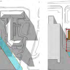
5 Figure : Proposed Development (looking south from McGarry Terrace)
 lots of record with a combined area of 0.6 hectares (.57 acres) and frontage of approximately 7 metres on McGarry Terrace. Both properties are currently vacant.")
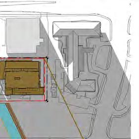
6 .0 SITE CONTEXT. Existing Conditions The subject property is located on the east side of McGarry Terrace, south of Strandherd Drive and west of Longfields Drive. The subject property consists of two () lots of record with a combined area of 0.6 hectares (.57 acres) and frontage of approximately 7 metres on McGarry Terrace. Both properties are currently vacant. The subject property is legally described as Blocks and on Plan M-0. LONGFIELDS DRIVE The subject property is located within the South Nepean (Barrhaven) Town Centre (SNTC). The Town Centre consists of 65 hectares of land bounded by Strandherd Drive to the north, Longfields Drive to the east, the Jock River to the south, and the Kennedy-Burnett Drain to the west. The Town Centre is divided east-west by Greenbank Road and divided north-south by the future Chapman Mills Drive. STRANDHERD STATION STRANDHERD DRIVE CLEARBROOK DRIVE The majority of the Town Centre is undeveloped. The Barrhaven Town Centre and RioCan Marketplace are two large-format retail projects on either side of Greenbank Road, with the latter being adjacent to the subject property on the west side of McGarry Terrace. The Town Centre is serviced by a north-south bus-rapid transit (BRT) that is part of the City of Ottawa s Transitway system. Future BRT extensions are planned to the south and east to provide improved service to the Town Centre. GREENBANK ROAD TRANSITWAY MARKETPLACE AVENUE MARKETPLACE STATION Figure : Site Context
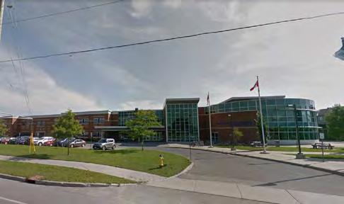
7 . Surrounding Area The subject properties are located in Ottawa s southwest, in the community of Barrhaven. The surrounding area is predominantly made up of large format commercial/retail and restaurant uses, a range of residential dwelling types, and institutional uses that primarily serve members of the local community. The following identifies the land uses that surround the site: North: The lands directly to the north of the subject properties consist of a vacant lot that is zoned Mixed-Use Centre and permits development up to six (6) storeys. Further north, on the north side of Strandherd Drive is a child care centre and a lowrise residential subdivision with a range of dwelling types. East: East of the subject property is a retirement home/ residential care facility known as The Court at Barrhaven. Beyond Longfields Drive to the east, is a French Catholic high school (École secondaire catholique Pierre-Savard) and lands designated for open space and for environmental protection. (9) storey retirement home while further south is the Minto Ampersand community which includes four () storey condominium buildings, stacked townhomes, and a municipal park. Further south are additional lands within the Town Centre owned by Minto and others that are presently vacant. West: West of the subject property is the Strandherd Retail District which includes a range of retail, retail food, entertainment, and restaurant uses. Immediately west of the subject property, abutting McGarry Terrace, is the rear facade of a Wal-Mart store. Within the retail district is a the bus rapid transit corridor which terminates just south of the retail area at Barrhaven Centre station. The transit corridor provides a connection to the north to the City s Transitway which proceeds directly to downtown. Southwest of the retail district is the balance of the Town Centre which is primarily vacant and planned for mixed-use and residential development. South: The lands directly to the south of the subject property, abutting Marketplace Avenue, were approved for redevelopment with a 6-storey mixed-use building in 0 but are currently vacant aside from a two-storey detached dwelling and accessory garage structures. Lands on the south side of Marketplace Avenue are planned for a nine


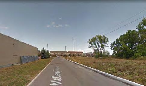
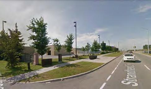
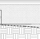
8 .0 SITE PHOTOS

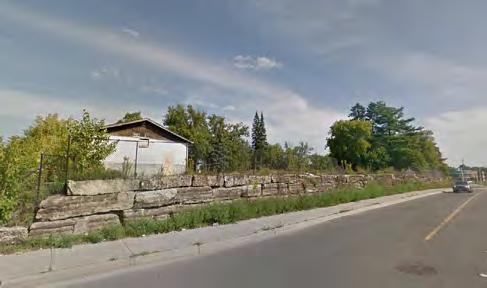
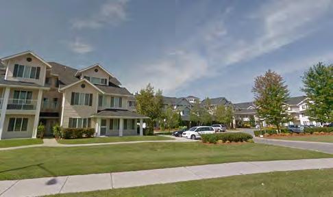
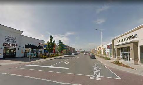
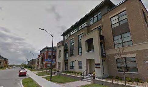
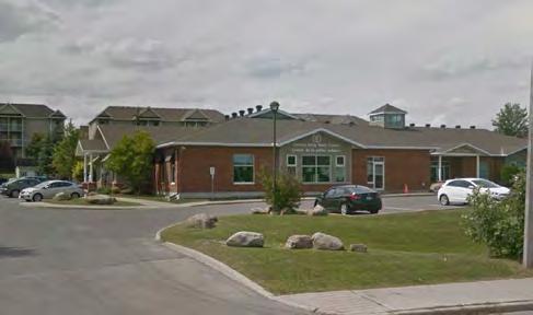
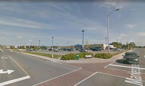
9

10 .0 SITE INVENTORY AND ANALYSIS 7. Transit Network The subject property is located within 00 metres of Strandherd and Marketplace Stations and within 600 metres of Barrhaven Centre Station. The subject property is also served by several local bus routes. Priority service is to the Transitway and along Chapman Mills Drive which reflects the future intent for BRT to travel east along Chapman Mills Drive to Riverside South. Planned connections identified in the Transportation Master Plan and Official Plan include the extension of the Transitway from Barrhaven Centre Station south along Greenbank Road to Barrhaven South, and east along Chapman Mills Drive to ultimately connect with the Trillium Line, the City s north-south light rail transit line which is currently being extended to Riverside South. Figure : Transit Network
11 . Cycling Routes and Multi-Use Pathways Strandherd Drive and Longfields Drive both have cycle lanes in proximity to the site. East of Longfields, the cycle lane on the south side of Strandherd Drive transitions to a multi-use pathway. LONGFIELDS DRIVE Existing parks in proximity to the site include the Chapman Mills West Woodlot to the east and a recently constructed community park to the south, forming part of the Ampersand community. STRANDHERD AVENUE MARKETPLACE AVENUE CLEARBROOK DRIVE Multi-Use Pathway Cycle Lanes Park Future Rideau Canal Figure : Parks, Pathways, and Cycling Routes

12 9. Road Network McGarry Terrace connects directly to Strandherd Drive which is designated as an Arterial Road in the City of Ottawa Official Plan. Other streets within the Town Centre, including Marketplace Avenue and RioCan Avenue are designated as collectors, while Longfields Drive is a Major Collector. LONGFIELDS DRIVE Arterial roads are intended to carry large volumes of traffic over the longest distance. Collector roads connect communities and distribute traffic between the arterial and local roads. STRANDHERD AVENUE MARKETPLACE AVENUE CLEARBROOK DRIVE Existing Arterial Proposed Arterial Existing Major Collector Existing Collector Proposed Collector Figure 5: Road Network

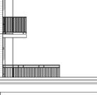
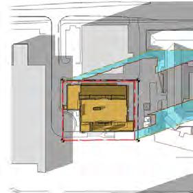
13 5.0 PROPOSED DEVELOPMENT 0 The subject property is a vacant parcel located within the South Nepean Town Centre and within 00 metres of two () rapid transit stations. The proposed development develops the lands with a dense housing form appropriate for the Town Centre in an appropriate and compatible manner. Lepine is proposing to construct an -storey, 6 metre residential apartment building. The proposed building would contain apartment units and associated amenity areas. The site layout and design is largely dictated by the surface easement affecting the property. The easement extends across nearly 6 metres of the site s frontage on McGarry Terrace for a depth of 6.5 metres. The easement also extends along the full width of the southerly property line for approximately 0 metres. No portion of the building above-grade is permitted to be located within the easement. As a result, most of the building is set back from McGarry Terrace. The proposed development includes a five (5) storey podium abutting McGarry Terrace. The height of five (5) storeys relates to the planned development approved in 0 on the lands to the immediate south, which proposed a five (5) storey facade along McGarry Terrace. The height helps frame the street while fostering a pedestrian scale. The high-rise ( storey) building generally sits atop a one () storey base. The tower is located centrally on the site to provide appropriate separation to Figure 6: Proposed Development (looking northeast from Marketplace Avenue)
14 adjacent properties and the planned high-rise building to the south. Given the grade change on the property, the ground floor of the building at McGarry Terrace is above-grade at the east end of the property where exit doors from parking level (P) exit at-grade. The single storey podium provides an appropriate scale at the rear of the property for the adjacent retirement home. The roof of parking level P, which extends all the way around the building has been landscaped to provide additional outdoor amenity area for the residents of the building. Ground floor units will also have private outdoor amenity area that extends into this space. The building has a comprehensive amenity package for residents including a pool, gym and reception room, in addition to outdoor amenity areas. Amenity spaces are located on the ground floor, adjacent to the street to provide active uses abutting the pedestrian realm. The primary vehicular access to the site is also from McGarry Terrace. The existing turning circle will be retained and the vehicular access to the underground parking garage and for moving in/out is from the turning circle. Two levels of underground parking are provided which include a total of 5 parking spaces which includes visitor parking spaces. A total of 0 bike parking spaces are also provided both on the ground floor and within the parking garage. As discussed and agreed at the Pre-Application Consultation meeting with staff, the parking garage for the proposed development extends under the temporary turning circle along McGarry Terrace. Municipal services run along the south edge of the property, and the proposed development leaves approximately 0 metres of area along the south property line undisturbed for these services. The extension of the garage allows for a more efficient underground garage. Ultimately, the turning circle will also be removed and the street extended. The primary pedestrian access to the building is along the west facade, from McGarry Terrace. McGarry Terrace has an existing sidewalk along the east side that will provide access to the building from Strandherd Drive. Ultimately, McGarry Terrace is envisioned to extend south to Marketplace Avenue which will provide an additional vehicular and pedestrian route. The current application does not contemplate this connection as the lands to the south are owned by others.
15 6.0 POLICY AND REGULATORY FRAMEWORK 6. Provincial Policy Statement (0) The Provincial Policy Statement (PPS) came into effect April 0, 0. The PPS provides policy direction on matters of provincial interest related to land use planning and development. While local land use planning authorities are permitted and encouraged to compliment these provincial policies within their local Official Plans, local planning decisions shall be consistent with the policies of the PPS. The PPS directs development to locate within built-up areas to efficiently use land with existing infrastructure and where services and infrastructure are readily available in order to avoid the need for unjustified and uneconomical expansions. In order to meet this policy objective, planning authorities must identify and promote opportunities for intensification and redevelopment [Policy...]. The proposal meets the following policies, among others: Promotes efficient development and land use patterns which sustain the financial wellbeing of the Province and municipalities over the long term [Policy...a]; Accommodates an appropriate range and mix of residential, employment, commercial and open space uses to meet long-term needs [Policy...b]; Promotes cost-effective development standards to minimize land consumption and servicing costs [Policy...a]; Directs development of new housing towards locations where appropriate levels of infrastructure and public service facilities are available to support current and projected needs [Policy...c]; Promotes densities for new housing which efficiently use land, resources, infrastructure and public service facilities and support the use of alternative transportation modes and public transit where it exists or is to be developed [Policy...d]; Promotes a land use pattern, density and mix of uses that minimize the length and number of vehicle trips and support current and future use of transit and active transportation [Policy.6.7.]; and Supports energy efficiency and improves air quality through land use and development patterns which promote the use of active transportation and transit in and between residential, employment (including commercial and industrial) and institutional uses and other areas [Policy...b]. The proposed development is consistent with the Provincial Policy Statement in that: It capitalizes on an infill opportunity of an underutilized site within the City s built-up area where services are readily available; It proposes to intensify a site situated in proximity to employment, rapid transit and other amenities contributing to the creation of complete communities and development patterns that are more sustainable over the long term; It promotes densities that contribute to more sustainable land use patterns and contribute to the range and mix of residential housing types; and. It promotes the use of active transportation and transit by building in proximity to existing and planned stations. 6. City of Ottawa Official Plan The City of Ottawa Official Plan (00, as amended) is composed of eight sections, each addressing a different aspect of the planned function of the City as a whole. Section of the Official Plan provides strategic direction for growth and development within the City. The Plan anticipates that the number of households in Ottawa will increase faster than the rate of population growth and that approximately 5,000 new homes may be needed by 0. The majority of that demand is expected to be satisfied with smaller units such as apartments. The City plans to meet the challenge of accommodating this growth by managing it in ways that support liveable communities and healthy environments. The Official Plan directs growth towards key locations with a mix of housing, shopping, recreation, and employment locations that are easily accessible by transit and that encourage walking. The City anticipates that by pursuing a mix of land uses and a compact form of development, it will be able to support a highquality transit service and make better use of existing roads and other infrastructure.
16 In order to meet these and other objectives of the Official Plan, the City has committed to pursuing strategic directions in four () key areas, two () of which are applicable and relevant to this proposal.. Managing Growth (Section.) The City will manage growth by directing it to the urban area where services already exist or where they can be provided efficiently. Growth in the urban area will be directed to areas where it can be accommodated in compact and mixed-use development, and served with quality transit, walking and cycling facilities.. Building Liveable Communities (Section.5) Growth will be managed in ways that create complete communities with a good balance of facilities and services to meet people s everyday needs, including schools, community facilities, parks, a variety of housing, and places to work and shop. Attention to design will help create attractive communities where buildings, open space and transportation work well together. 6.. Managing Growth The Official Plan promotes efficient land-use patterns through intensification at locations strategically aligned with the transportation network and in particular the rapid transit network. Residential intensification means intensification of a property, building, or area that results in a net increase in residential units or accommodation and includes: Redevelopment (the creation of new units, uses or lots on previously developed land in existing communities), including the redevelopment of Brownfield sites; The development of vacant or underutilized lots within previously developed areas, being defined as adjacent areas that were developed four or more years prior to new intensification; Infill development; The conversion or expansion of existing industrial, commercial, and institutional buildings for residential use; and The conversion or expansion of existing residential buildings to create new residential units or accommodation, including secondary dwelling units and rooming houses. The proposed redevelopment of the vacant subject property adjacent to previously builtup areas with a new, residential building is intensification, as defined by the Official Plan. Policy of Section.. identifies target areas for intensification including the Central Area, Mixed- Use Centres, Mainstreets, and Town Centres. For the Barrhaven (South Nepean) Town Centre, the minimum target density post-0 is 0 people and jobs per gross hectare. This is as compared to the 006 actual density of people and jobs per gross hectare. The additional height and density proposed for the subject property is in conformity with the intent of the Official Plan policies on managing growth within the City. The subject property is located within a Mixed-Use Centre which has been identified by the Official Plan as a target area for intensification. With a site area of 0.6 hectares and the proposed residential units, the proposed development achieves a density of 6 units per gross hectare, helping to achieve the minimum density target prescribed in the Official Plan for the Barrhaven Town Centre. 6.. Land Use Designation The subject property is designated Mixed-Use Centre on Schedule B Urban Policy Plan of the City of Ottawa Official Plan and are also located within an identified Town Centre area. The Mixed-Use Centre designation applies to areas that are strategically located with respect to the transportation system and that are easily accessible by transit, walking, cycling and automobile. They are centered on rapid-transit stations and contain one or more arterial roads with all-day, frequent transit service. Further, they offer substantial opportunities for new development or redevelopment and represent a key element in the Official Plan s strategy to accommodate and direct growth in the city. Mixed-Use Centres allow for a wide variety of transit-supportive uses including offices,

17 secondary and post secondary schools, hotels, hospitals, large institutional buildings, retail, restaurant, medium and high density residential, and mixed-use developments with a combination of the uses listed above, amongst others. The designation also sets employment density targets of 5,000 jobs, or 0,000 jobs in the case of Town Centres, as is the case with the subject property. Furthermore, Community Design Plans (CDPs), which are developed for all mixed-use centres, require that residential uses be a component of all developments in this designation. The proposed development conforms to the policies of the Mixed-Use Centre designation by proposing a compact development in proximity to existing infrastructure, active transportation routes, services, amenities, and within 00 metres of two () rapid transit stations. General Urban Area Employment Area Major Open Space Urban Natural Features Mixed Use Centre Arterial Mainstreet Traditional Mainstreet Subject Property Figure 7: City of Ottawa Official Plan - Schedule B
18 5 6.. Building Liveable Communities Section.5 of the Official Plan states that Ottawa s communities should be built on the basics of good housing, employment, ample greenspace, and a sense of history and culture, but also focusing on community design and by engaging in collaborative community building especially in and around Mixed-Use Centres and Mainstreets where there is the greatest potential for growth. Section.5. provides guidance as to how to achieve compatibility between form and function when introducing new development into existing areas. Compatible development means development that, although not necessarily the same as or similar to existing buildings in the vicinity, nonetheless enhances an established community and coexists with existing development without causing undue adverse impact on surrounding properties. It fits well within its physical context and works well among those functions that surround it. Section.5. provides design objectives and associated principles to guide development to achieve a good fit within the existing context. New development is evaluated at five scales: Citywide, neighbourhood, street, subject property, and building. The following objectives are considered the most applicable to the proposed development: The proposed development enhances the sense of community by creating and maintaining places with their own distinct identity. The proposed development will contribute to the vibrancy of the Town Centre by developing a vacant property with a compact residential building. The proposed development will utilize and support existing services and amenities, and will utilize existing and planned rapid transit infrastructure. The proposed development defines quality public and private spaces through development. The proposed development defines the public streetscape and creates quality private spaces as part of the development. The new building will frame the street and create a pedestrian scale and continuity of street frontages along McGarry Terrace. In the future, when the turning circle is removed, additional landscaping can be added to contribute to a positive streetscape along the public right-of-way. Private outdoor amenity spaces to serve the individual units and buildings have been designed to mitigate noise and wind impacts, and will provide quality space for residents. The proposed development creates places that are safe, accessible and are easy to get to, and move through. The proposed development caters to residents and visitors with easy access to public transit routes and, given the proximity to the retail district, will promote active modes of transportation to meet daily needs. The proposed development ensures that new development respects the character of existing areas. The subject property is adjacent to a mix of retail, residential, and institutional uses. The proposed development utilizes podiums, setbacks and step backs, to integrate the proposed building into it s planned context, while respecting the character envisioned for the Town Centre. Additionally, an increase in residential density will assist in achieving the overall target densities for the Town Centre designation. The proposed development considers adaptability and diversity by creating places that can adapt and evolve easily over time and that are characterized by variety and choice. The residential development proposes a range of unit sizes and bedroom counts to accommodate a variety of people and incomes. The proximity of transit service, and other amenities (retail, services,
19 6 entertainment, etc.) the proposed development represents the evolution of the Town Centre into the compact mixeduse hub it was always envisioned to become. 6.. Design Priority Areas The Official Plan designates Mixed-Use Centres as Design Priority Areas within the City. The objectives of the Official Plan are to direct growth to these areas, to protect and enhance the character and sustainability of these places as mixed-use communities, and to provide a focus for coordinating urban design efforts and enhancements. A pre-application consultation with the City of Ottawa s Urban Design Review Plan (UDRP) took place on June 7, 07. The comments from the UDRP, and from staff as provided through various pre-application meetings, have been incorporated into the currently proposed development Compatibility The criteria in Section. provide a means to objectively evaluate the compatibility of infill development. The following is an evaluation of the criteria in relation to the proposed development. Traffic Vehicular Access Parking Requirements Outdoor Amenity Areas Loading and Service Areas, Outdoor Storage A Transportation Impact Statement has been prepared evaluating the impact of the proposed development on the surrounding area. No adverse traffic impacts are anticipated as a result of the proposed development. All traffic movements will be from McGarry Terrace, and by extension Strandherd Drive - an arterial road intended to carry large volumes of traffic. The proximity of rapid transit services will encourage the use of transit and will mitigate potential traffic impacts. Vehicular access to the proposed development s underground parking is provided from the McGarry Terrace turning circle. While no other uses currently exist on McGarry Terrace, the proposed development minimizes headlight glare on other potential impacts on adjacent properties as all parking is located below-grade. The two () storey underground parking garage will contain a total of 5 vehicular spaces. The provided parking spaces meet the Zoning By-law s requirements for minimum resident and visitor parking spaces, which are reduced given the site s proximity to rapid transit services. A total of 0 bike parking spaces are provided, also exceeding the zoning requirement. Spaces are provided on the ground floor and within the underground parking garage. Given the surrounding uses, there are minimal outdoor amenity areas in proximity to the subject lands. For the abutting retirement home to the east, the parking and service areas generally abut the subject property while the amenity areas are abutting the property to the north. The proposed development provides generous setbacks from all property lines that mitigate any concerns of overlook or loss of privacy on adjacent properties. All loading and service for the building will occur within the parking garage. A short-term parking space is provided to facilitate move-ins/outs. No outdoor storage is proposed.
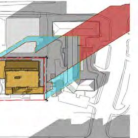
20 7 Lighting Noise and Air Quality Sunlight Microclimate Supporting Neighbourhood Services Lighting will be designed and installed to provide a safe and secure environment while meeting the City s requirements and ensuring no undue adverse impacts on adjacent properties. A lighting plan will be approved through the Site Plan Control approval. Paterson Group Inc. prepared a Noise Study for the proposed development application which found that noise levels are not out of typical ranges, and that upgraded building components would sufficiently mitigate noise impacts for the residential use. No significant impacts related to noise or air quality are expected as a result of the proposed development. The impacts of shadowing on adjacent properties has been evaluated in a shadow study completed by NEUF Architects. The study, as summarized here, shows that shadows in the summer and shoulder seasons move quickly and have short-term impacts on the adjacent retirement home s rear yard, outdoor amenity area throughout the day. In the summer months, when the amenity space is most likely to be in use later in the day, there are no shadow impacts. Throughout the winter, longer shadows are cast by the proposed building. The shadow impacts on the adjacent properties is generally consistent with the as-of-right shadow, with the increases largely impacting the Strandherd Drive or the building area. A Pedestrian Level Wind Study was prepared by Gradient Wind Engineering Inc. in support of the current development applications. The study involved simulation of wind speeds for selected wind directions in a three-dimensional (D) computer model, combined with meteorological data integration, to assess pedestrian comfort and safety within and surrounding the development site. Based on the results, the study concludes that, outside of localized storm events, no areas over the study site are considered uncomfortable or unsafe. The subject property s location within South Nepean Town Centre corresponds to its proximity to a wide range of amenities located within one () kilometre of the site including: Three () rapid transit stations (Strandherd, Marketplace, and Barrhaven Centre); Several regular OC Transpo bus routes: 0, 95, 99, 70, 7, 7, 75, 76, 77, 05; Retail and commercial uses within the adjacent Strandherd Retail District; Schools, daycares, and retirement homes; and, Several local parks.
21 Policy 7 of Section. defines high-rise development as a building of 0 storeys or more. Policy states that high-rise buildings may be considered within the Central Area, Mixed-Use Centre and Town Centres, Employment Area and Enterprise Areas and along Traditional and Arterial Mainstreets. The subject property is located within the South Nepean (Barrhaven) Town Centre and is therefore an appropriate location for the consideration of high-rise buildings of 0 storeys or greater, per the policies of Section.. Policy.() sets out architectural and urban design considerations that the City will evaluate for new high-rise building proposals. Considerations include: How the scale, massing and height of the proposed development relates to adjoining buildings and the existing and planned context for the surrounding area in which it is located; How the proposal enhances existing or creates new views, vistas and landmarks; The effect on the skyline of the design of the top of the building; The quality of architecture and urban design, particularly as expressed in Councilapproved design guidelines, and; How the proposal enhances the public realm, including contribution to and interaction with its surroundings at street level. Policy discusses the integration of taller buildings within an area characterized by a lower built form. Issues of compatibility and integration with surrounding land uses can be addressed by ensuring an effective transition between varying built forms. Transitions should be accomplished through a variety of means, including measures such as: Incremental changes in building height (e.g. angular places or stepping building profile up or down); Massing (e.g. inserting ground-oriented housing adjacent to the street as part of a high profile development or incorporating podiums along a Mainstreet); Character (e.g. scale and rhythm, exterior treatments, use of colour and complimentary building finishes); Architectural design (e.g. the use of angular planes, cornice lines); and, Building Setbacks. Though not all developed, the properties adjacent to the subject property all have development permissions for building heights of at least 0 metres (6 storeys). The abutting property to the south, was approved for a highrise (57 metre) development in 0. The proposed development accounts for this planned context, while also recognizing the existing development on the block in the form of the two () storey retirement home to the east and utilizes a number of the transition measures described in policy of section. to achieve compatibility and transition. Incremental changes in building height are used to frame the public right-of-way and to create a pedestrian-scale along the street. The five (5) storey podium along McGarry Terrace is also reflective of the planned developments to the north and south where five (5) storeys was proposed along the street. The balance of the property has a one () and two () storey podium (dependent on the grade from where the measurement is taken) where the tower of the building is set well back to ensure appropriate transition. The north and east facade of the ground floor propose residential units that, although accessed from the interior, will have private outdoor terraces that will break up the facade of the building and add visual interest. The materials chosen for the exterior of the proposed development are reflective of the colours used on surrounding developments and reflect the quality of the building. The proposed development also utilizes large setbacks from the adjacent property lines. The tower of the building is located over 0 metres from the side (north and south) property lines, and over.5 metres from the rear (east) property line. The resulting separation provides appropriate transition to the adjacent developments and mitigates any potential concerns regarding overlook and loss of privacy.
22 9 6. City of Ottawa Official Plan Amendment No. 50 In 0, the City of Ottawa updated its Official Plan, resulting in numerous changes to its land use policies. The Ministry of Municipal Affairs and Housing issued approval of Official Plan Amendment (OPA) 50 in April 0, but the Amendment is currently under appeal before the Ontario Municipal Board (OMB). As OPA 50 is currently under appeal, the current policies of the City of Ottawa Official Plan (00) remain in full force and effect and have been used to review and evaluate the proposed development. Although OPA 50 is not in full force and effect, the new policies relevant to the proposed development have been considered as the intended direction of City Council and are described below. Section.. of the Official Plan which was entitled Managing Growth, is amended in OPA 50 to Managing Intensification with the Urban Area. This section has been revised to better reflect the general focus on intensification throughout the urban area where there are opportunities to accommodate more jobs and housing and to increase transit use. Intensification is to be directed to target areas which have the potential to develop at moderate to high densities in a compact form. Mixed-Use Centres remain as target areas of intensification given their location on the Rapid Transit and Transit Priority Network as identified on Schedule D. The revised Schedule D included as part of OPA 50 continues to identify rapid transit within the Town Centre, including bus-rapid transit (BRT) service connecting east along Chapman Mills Drive to Riverside South and the LRT, and south to Barrhaven South. Section.. also revises previous minimum density targets, instead noting them as requirements. The density target for the Barrhaven Town Centre remains at 0 people and jobs per gross hectare by 0. Policy..(0) states that taller buildings should be located in areas that support the rapid transit network, in areas with a mix of uses, and in areas that can accommodate large-scale intensification. Building heights and densities for different areas may be established through a secondary plan. The distribution of appropriate building heights will be determined by the location in a target area and the design and compatibility of the development with the surrounding existing context and planning function, as detailed in section.. Policy..() states that the location of highrise buildings is influenced by the need to provide an adequate separation distance between other existing and potential future high-rise buildings as detailed in Section. (discussed below). The policies of the Mixed-Use Centre land use designation have been revised to limit the permitted building heights. Specifically, policy.6.() states that, except where a secondary plan specifies otherwise, or where existing zoning permits greater heights, building heights permitted in the mixed-use centre designation are a maximum of storeys, where transition to adjacent lowrise residential in accordance with section. is proposed. The section also requires a minimum building height of four () storeys for residential and office development. The proposed development supports the vision of OPA 50 to concentrate intensification and density in proximity to the rapid transit network. The proposed development will assist in achieving the overall density target for the Town Centre, and will support the rapid transit network with a built form that is both compatible and appropriate. As discussed in section 6. of this report, the proposed development has currently been identified in the applicable secondary plan as a site for four () to six (6) storeys. The proposed Official Plan Amendment will amend the Secondary Plan to permit the additional height proposed. Section., renamed Urban Design and Compatible Development, has been revised to contain more robust policies related to building and site design. Policy 5 requires proponents to also demonstrate how the design of the development fits with the existing desirable character and planned function. Revised Policy 6 contains new design requirements for principal entrances, windows, and other architectural elements. Policy specifies that building height and massing
23 0 transitions will be accomplished through a variety of means, including incremental changes in building height, massing, or building setbacks and step-backs. A new policy has also been added which seeks to ensure that high-rise buildings have a sufficient separation distance and that future development on adjacent lots can be accommodated, as appropriate. Buildings are to be designed to minimize wind and shadowing impacts and to maintain sunlight penetration to public places, maintain privacy, and preserve public views and sky views, among other elements. The achieve this, policy states that the tower portion of the building should: Be appropriately separated from adjacent towers. A minimum separation distance of metres is required, though developments proposing less than metres shall: Demonstrate that the objectives stated above are met through the use of a smaller floor plate, building orientation, and/or building shape; and, Demonstrate that the potential for future high-rise buildings on adjacent lots can be developed and meet the separation distance and setback distances above. The proposed residential tower provides generous separation from the adjacent properties with over 0 metres from the north and south, and over metres from the east. As a result, the proposed development will not preclude high-rise development on abutting properties. 6. South Nepean Town Centre Secondary Plan The South Nepean Town Centre Secondary Plan was approved by Nepean City Council in 997 and establishes land use policies, residential densities, built form requirements, and urban design guidelines to determine the Town Centre s future development. The Area 7 Secondary Plan has remained the statutory planning document guiding development in the Town Centre since its approval in 997, after being re-adopted by the City of Ottawa in 00 and reconfirmed in the Official Plan in May 00. The foundation of the Secondary Plan is a series of goals and objectives which guide future development in the Town Centre. The goals relate to such things as compact urban form, high quality urban design, mixture of uses, diverse greenspace network, efficient transportation systems, and anticipation of growth. The South Nepean Town Centre Secondary Plan designates the subject property as Mid-Rise Mixed Use. This designation represents a lower-scale, mid-rise mixed-use area within the Town Centre with the intent of establishing opportunities for livework units and medium density housing forms. The Mid Rise Mixed-Use policy area is intended to be a transition between the High Rise Mixed-Use policy area and the adjacent lower density residential neighbourhoods, both within the Town Centre an in surrounding communities. The Mid-Rise Mixed-use policies are set out in Section. of the Secondary Plan. They prescribe a minimum building height of four () storeys and a maximum of six (6) storeys. The net density target for residential uses is 00 units per hectares. Policy states that the maximum lot coverage for standalone residential buildings within the designation is 50% of the total area of any block. The proposed Official Plan Amendment would re-designate the subject property from Mid-Rise Mixed-use to High-Rise Mixed-Use to permit the proposed high-rise development. The High Rise Mixed-Use policy area is intended to be a lively and active mixed-use shopping district, with an emphasis on commercial and residential uses in the same building with retail uses located at-grade, but also single use retail and office commercial uses and residential apartments. The policies for the High-Rise Mixed-Use policy area, stated in Section., state that permitted uses within the designation include apartments, retail, office and service commercial facilities, public and institutional uses, schools, places of worship, and community facilities. The minimum height within the designation is six (6) storeys and the maximum is twelve () storeys. Finally, the net density target for residential uses within the designation is 50 units per hectare and the maximum lot coverage permitted for stand-alone residential buildings is 0% of the total area of any
24 SUE HOLLOWAY LONGFIELDS School / RIOCAN MCGARRY LONGFIELDS block. The proposed Official Plan Amendment application requests a special exception to the High-Rise Mixed-Use policy designation to permit; A maximum building height of storeys (6 metres); and, Remove the maximum lot coverage policy for stand-along residential buildings. STRANDHERD The proposed revisions conform to the policies of the Official Plan with respect to intensification in proximity to rapid transit stations and within Mixed-Use Centres. The proposed development is within 00 metres of two transit stations and is appropriate for the increased density. JOCKVALE TRANSITWAY MARKETPLACE LINDENSHADE The proposed development has a lot coverage of approximately SOUTH 6% NEPEAN with the - balance AREA 7 of the site as landscaped NEPEAN-SUD area. - The SECTEUR proposed 7 Official Plan Amendment SECONDARY PLAN would / PLAN remove SECONDAIRE the limit on lot coverage to allow flexibility for the Schedule - Land Use Plan redevelopment. Increased lot coverage, in an Annexe - Plan d'utilisation du sol GREENBANK SUE HOLLOWAY LINDENSHADE High Rise Mixed-Use / Immeubles de grande hauteur à utilisations polyvalentes Mid Rise Mixed-Use / Immeubles de hauteur moyenne à utilisations polyvalentes High Rise Residential / Immeubles résidentiels de grande hauteur CHAPMAN MILLS Mid Rise Residential / Immeubles résidentiels de hauteur moyenne Neighbourhood Park / Parc de quartier District Park / Parc de district Figure : South Nepean Town Centre - Schedule
25 appropriate way, helps advance the policies for the Town Centre and foster the compact, mixeduse community envisioned by the Secondary Plan. The development is also able to provide sufficient separation from abutting properties, despite the increased lot coverage. The increased building height and coverage also achieves the over-arching goals objectives of the Secondary Plan as it contributes to the creation of a dense, compact, and transitsupportive build form; exhibits high-quality urban design; and contributes to the range of uses within the Town Centre. 6.5 South Nepean Town Centre Community Design Plan The South Nepean Urban Design Strategy was initiated in 00 to provide updated direction for the Town Centre from that of Area 7 of the Secondary Plan. The Community Design Plan (CDP) is the land use planning document that will guide the development of the Town Centre as a compact, mixed-use, walkable, pedestrian-scaled, and transitsupportive community. The subject properties are within the Mid Rise Mixed Use designation, with the same provisions as the Secondary Plan. McGarry Terrace is identified as a 0-metre rightof-way in Table of the Plan. Streets are required to have sidewalks on both sides as per policy 6.., and the Zoning By-law requires bicycle parking to be provided in order to promote pedestrian and cycling connections. Urban design policies and guidelines are contained in Section 5 of the plan and must be considered in the development. The density targets identified in Sections. through.6 are ultimate build out targets and are to be considered on an area basis and not by each development block. While these targets may not be achieved from the outset, it must be demonstrated, as per Section., how these targets could be met in the long term. The Town Centre is planned to be a compact, urban area within the broader south Nepean community. The highest densities are envisioned around the transit hub and along Greenbank Road north of Chapman Mills Drive. The following urban design guidelines outlined in the CDP are directly applicable to the proposed development: The proposal provides front yard entrances that are easily visible and accessible (Guideline #); The proposal allows for views all around the building for safety and security (Guideline #); The proposal steps back above a one storey podium, and once more after the fifth storey, to maintain a human-scale development for pedestrians (Guideline #); The proposal provides transitions in height and massing, which will limit the impact of the proposed tower on adjacent developments (Guideline #5); The proposal landscapes the space between the building and the sidewalk along McGarry Terrace with natural elements such as trees (Guideline #); The proposal locates a moving van parking lane along the side of the building, to its south, which will minimize disruptions along McGarry Terrace (Guideline #6); The proposal locates and designs its parking garage entrance in a sensitive way to ensure it does not visually dominate the façade, thanks in part to a recessed entrance (Guideline #0); and, The proposal provides outdoor amenity space that is in view of residential units and well connected to the public streetscape. Additional communal amenity space is provided on rooftops (Guideline #). The proposed development complies with the relevant provisions of the South Nepean Town Centre CDP by providing increase density in proximity to transit, and contributing to the range of uses within the Town Centre. Currently, the Town Centre is primarily residential and so the proposed residential use will support the existing services and transit network. The proposed development also achieves several of the urban design guidelines within the CDP intended to guide future development. The proposed development contributes to a
26 compact, mixed-use, and transit-supportive community. 6.6 Urban Design Guidelines for High Rise Housing The Urban Design Guidelines for High-Rise Housing deal with seven elements of design: context, built form, pedestrian and public realm, open space, amenities, environmental considerations, site circulation and parking and services and utilities. Not every guideline will apply to every development and as such, the intent is not to use the guidelines as a checklist but to demonstrate a general adherence to the design direction provided in these documents. The proposed development meets the following applicable design guidelines, among others: Uses the height of a fifth-storey stepback and its tower to define the building s relationship with adjacent developments (Guideline #b); Creates a sense of transition between a highrise building and existing adjacent lowerprofile areas on the west east through the location and orientation of the building base and tower (Guideline #5); Ensures that the building s base has direct street frontage along McGarry Terrace (Guideline #0); Orients, sizes, and locates the high-rise tower to minimize the extent or duration of the shadowing on adjacent sites (Guideline #); Provides a high level of glazing and fenestration, especially at the ground level, to emphasize accessibility and visibility (Guideline #); Proposes an architecturally detailed façade to avoid any blank or obtrusive walls (Guideline #); Provides sufficient separation between the proposed tower and other towers on adjacent sites (Guideline #0); Includes outdoor amenity spaces in the form of balconies and terraces (Guideline #); Encourages the use of trees to define the pedestrian realm along McGarry Terrace and pedestrian walkways around the building (Guideline #6); Provides outdoor amenity spaces in the form of terraces on top of the podium and private balconies (Guidelines #0/); Locates parking for all of its residents and visitors underground (Guideline #56); Locates the garage entry point in a recessed area that makes it less prominent on the streetscape (Guideline #5); Provides secure long-term bicycle storage within the building. (Guideline #59); and, Locates mechanical and garbage disposal areas within the building (Guidelines #6/6). The proposed development generally meets the design direction provided in the Urban Design Guidelines for High Rise Housing. 6.7 Urban Design Guidelines for Transit-Oriented Development The intent of these guidelines is to provide an urban design standard for assessing, promoting and achieving appropriate Transit-Oriented Development (TOD) within the City of Ottawa. TOD is defined as a mix of moderate to high-density transit-supportive land uses located within an easy walk of a rapid transit stop or station that is oriented and designed to facilitate transit use. The guidelines are to be applied for all development within a 600-metre walking distance of a rapid transit stop or station. Not every guideline will apply to every development and as such, the intent is not to use the guidelines as a checklist but to demonstrate a general adherence to the design direction provided in these documents. The proposed development meets the following applicable design guidelines: Encourages transit-supportive uses by providing a high residential density that will contribute to increased transit ridership in the Town Centre (Guideline #); Locates the proposed building at the street edge to minimize the distances away from public transit routes and stops and other nearby buildings (Guideline #7); Steps back the proposed building to maintain a human scale along McGarry Terrace and to
27 reduce shadow and wind impacts along the street (Guideline #); Uses a high percentage of glass, especially at the lower pedestrian podium level, to provide ease of entrance, visual interest, and additional safety on the street (Guideline #5); Provides all of the development s resident and visitor parking through an underground garage (Guideline #9); Encloses mechanical and garbage disposal areas underground (Guideline #5). The proposed development generally meets the design direction provided in the Transit-Oriented Development Guidelines. 6. City of Ottawa Zoning By-law The subject property is zoned Mixed-Use Centre, Exception, Maximum height 0 metres (MC[] H(0)). The purpose of the Mixed-Use Centre zone is to ensure that areas designated as such in the Official Plan accommodate a combination of transit-supportive uses such as offices, secondary and post secondary schools, hotels, hospitals, large institutional buildings, community recreation and leisure centres, day care centres, retail uses, entertainment uses, service uses such as restaurants and personal service businesses, and high- and medium-density residential uses. Further, the MC zone promotes a compact and pedestrian-oriented built form in mixed-use buildings or side by side in separate buildings. The MC zone permits a broad range of uses including retail, service commercial, office, residential and institutional uses, including mixed-use buildings, all contributing to a transitsupportive environment along Preston Street, which is itself a Traditional Mainstreet. Exception outlines changes to the minimum northerly interior side yard setback and to the rear yard setback. The proposed Zoning By-law Amendment would amend the site-specific zoning provisions to permit the proposed development. The proposed development is evaluated against the provisions of the current zoning in the following table. Provisions subject to the Zoning By-law Amendment are highlighted. With regards to minimum parking requirements, the subject property is located within Area C - Suburban on Schedule A of the Zoning By-law. Per the provisions of Section 0(5)(d), given that the building entrance is located within 600 metres of a rapid transit station, the minimum parking required for the development is calculated according to the requirements for Area X. This applies to both the minimum residential parking Figure 9: City of Ottawa Zoning By-law
28 5 Table : Zoning Provisions Required Proposed Minimum Lot Area No minimum, square metres Minimum Lot Width No minimum 7 metres Maximum Front Yard Setback No minimum.7 metres Minimum Interior Side Yard Setback North Interior Side Yard: metre South Interior Side Yard: No minimum North Interior Side Yard:.0m South Interior Side Yard: 0.0m Minimum Rear Yard Setback metres. metres Maximum Floor Space Index No maximum 5.0 Building Height Minimum: 6.7 metres 6 metres Maximum: 0 metres Minimum Width of Landscaped No minimum metre Area Location of Storage Storage must be completed enclosed within a building Completely within the building Vehicular Parking Residential: 0.5 spaces per unit ( spaces) Residential Visitor: 0. spaces per unit, excluding the first units ( spaces) Total Required: 6 spaces Maximum Permitted:.75 spaces per unit (99 spaces) Residential: spaces Residential Visitor: spaces Total provided: 5 spaces Bicycle Parking Amenity Area Minimum Aisle and Driveway Width 0.5 spaces per unit ( spaces) A minimum of 5% of the required spaces must be located indoors 6 square metres per unit (,6 square metres) 50% of the required total amenity area is required to be communal (6 square metres) 6 metres for a double traffic driveway accessing a parking garage 6 metres for an aisle serving parking spaces between 56 and 90 degrees within a parking garage spaces All spaces are located indoors 9 square metres of communal indoor amenity area square metres of communal outdoor amenity area 75 square metres of private amenity area (balconies and terraces) Total Provided:,6 square metres 6. metres

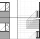
29 .0%.% EASEMENT EASEMENT.0%.%.0%.0%.0%.%.0%.0%.0%.0%.0% 0.5TW 0.5TW 0.5TW 0.5TW 99.5BW 99.60BW 99.56BW 99.5BW # N 7.0 DESIGN PROPOSAL 6 7. Site Plan The proposed Site Plan reflects the easements along the southern property line and develops the site with careful transition and attention to the potential development or redevelopment of adjacent properties in the future. EXISTING HYDRO POLE TO BE REMOVED (ELECTRICAL SERVICES TO BE BUILT UNDERGROUND) EXISTING HYDRO LINE CENTER LINE TO BE REMOVED FUTURE DEVELOPMENT - 5 STORIES PIN MC [0] H(0) The proposed tower is located centrally on the site, with a five (5) storey podium abutting McGarry Terrace. The main pedestrian entrance to the street is directly accessible from McGarry Terrace with the vehicular parking garage access from the turning circle. When McGarry Terrace is extended in the future, the turning circle may be removed and the area in front of the building can be adjusted accordingly. [ PRINTED ON :0:5 ] C:\Users\jlemay\Documents\79_HOWARD GRANT_ARCHITECTURE_jlemay.rvt EXISTING BUILDING WALMART PIN 07-5 MC H(0) EX. STMMH T/G=0.5 EX.INV=9.0 EX. SL ELEV=9.56 PROPOSED INV=9.7 EX.INV=9. EX. SL ELEV=9. PROPOSED INV=9. 0.5m-50mm WATERMAIN EX. STMMH T/G=0. NW INV=9.0 NE INV=97.97 EX. 55mm STM 0.5 PROPOSED SIDEWALK McGARRY TERRACE ALL CAR PARKING WILL BE IN BASEMENT SNOW WILL BE REMOVED OFF-SITE SITEWORK BY LANDSCAPE ARCHITECT EXISTING HYDRO POLE TO BE REMOVED (ELECTRICAL SERVICES TO BE BUILT UNDERGROUND) MARQUISE OF ENTRANCE (000mm OVERHEAD CLEARANCE) EXISTING HYDRO LINE CENTER LINE TO BE REMOVED PUBLIC ROAD AS PER SURVEYOR PLAN 0.57 EXISTING HYDRO POLE TO BE REMOVED (ELECTRICAL SERVICES TO BE BUILT UNDERGROUND) ALL BICYCLE PARKING WILL BE IN THE BUILDING ON GROUND FLOOR AND PARKING LEVELS m-50mm %.5%.% 0.TC 0.06BC BW 0.TW BC 0.50TC 0.5BC TC 0.BC.0% BW 0.TW EASEMENT SITEWORK BY LANDSCAPE ARCHITECT R 7 EXIT (GF) ROOF 5th FLOOR PARKING ENTRANCE & EXIT MOVING AISLE ROOF 5th FLOOR EX. 55mm CONC STM ROOF PARKING LEVEL.9% A BW 0.TW PIN MC []-h 0.00 ROOF st FLOOR EXIT (GF) SITEWORK BY LANDSCAPE ARCHITECT ELEVATOR PENTHOUSE MOVING ACCESS (GF) ROOF th FLOOR.0% ROOF st FLOOR EXIT (GF) BW 0.TW 0. STAIRS # EXIT (GF).0% % 00.BW 0.TW COMMUNAL AMENITIES %.0% ROOF PARKING LEVEL %.0%.%.0%.0% 99.5 : 00 EXIT (P) EXIT (P).0%.% A A EXISTING EASEMENT LINE EX. STMMH EX. STMMH Figure 0: Site Plan SITE PLAN EXISTING BUILDING THE COURT AT BARRHAVEN PIN 07-5 MC [7] H(0) A0 ZO Z C PER FRO McG (WE INTE SET INTE SET REA (EA DEN BUI LAN MIN MIN HAN MIN VIS TOT MIN BIC TO PR TO CO AR


30 7 7. Landscape Plan The proposed landscape plan highlights the building s interface with the public street and the main entrance on McGarry Terrace. Figure : Landscape Plan
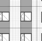
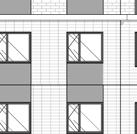
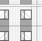
31 7. Massing Howard Grant is a residential building that will be part of the Barrhaven Town Centre and as such will have an important role to play as part of the urban realm. The massing of the building was designed to define the McGarry Terrace street edge with a five (5) storey podium which is continuous from one end of the property to the other. This podium base offers a human-scaled street wall that is particularly animated at ground level with the main entry to the building and several public spaces such as offices, the fitness centre, and the party room facing the street. The main tower is oriented perpendicular to McGarry Terrace in order to limit the visual impact of the building on its neighbors, namely the seniors residence to the east and the future development to the north and south. This orientation is also ideal for sun and shade projection. EXISTING BUILDING (RETAIL USE) FLOORS Mc GARRY TERRACE 5 FLOORS FUTURE DEVELOPMENT (DYMON STORAGE) 6 FLOORS FLOOR FLOORS STRANDHERD Dr. EXISTING BUILDING (THE COURT AT BARRHAVEN) FLOORS 5 FLOORS FLOOR VACANT LOT RCHITECTURE_jlemay.rvt MARKET PLACE AVE. Figure : Context Plan


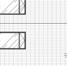
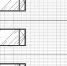


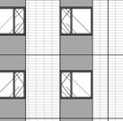
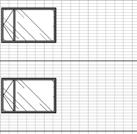
32 5TH FLOOR T NEUFarchitectes.com 6 9 ION Elevations The building 900 will be clad in architectural precast 0TH FLOOR concrete which will be composed of a palette of light, warm colors. The architectural treatment 700 of the facades 9TH FLOOR will emphasize the base, middle, and crown of the building as well as articulation that highlights the centre of the tower on its four TH FLOOR facades. Texture will play an important architectural role in highlighting certain areas with stone and 00 brick patterns. 7TH FLOOR 6 0 The design 9 00has been developed so that the 6TH FLOOR tower will play a role at the scale of the city when seen from a distance and at the scale of the neighborhood when experienced from the street. McGARRY TERRACE 700 TH FLOOR 500 TH FLOOR 00 TH FLOOR 5 00 TH FLOOR 5TH FLOOR 00 TH FLOOR RD FLOOR ND FLOOR 0 00 GROUND FLOOR 9 00 P PARKING LEVEL P PARKING LEVEL 000 ZONING BY-LAW HEIGHT LIMIT 0 6 GROUND AVERAGE GRADE A00 [ PRINTED ON ::7 ] C:\Users\jlemay\Documents\79_HOWARD GRANT_ARCHITECTURE_jlemay.rvt EXTERIOR MATERIAL LEGEND # NOTE DESCRIPTION PRECAST - PATTERN: STANDARD BRICK - COLOUR: LIGHT GREY PRECAST - PATTERN: LARGE BRICK - COLOUR: LIGHT BEIGE PRECAST - PATTERN: SMOOTH FINISH - COLOUR: WHITE PRECAST - PATTERN: SMOOTH FINISH - COLOUR: DARK GREY 5 PRECAST - PATTERN: LARGE BRICK - COLOUR: WHITE 6 PRECAST - PATTERN: LARGE PANEL- COLOUR: WHITE 7 PRECAST CORNICE - COLOUR: LIGHT GREY 7 PRECAST CORNICE - COLOUR: LIGHT GREY NEUF ARCHITECTES SENCRL 0-0 March Road, Ottawa, ON, KK-E T F OUVRAGE Project HOWARD GRANT 7 00 EMPLACEMENT Location NO PROJET No. 0 & 0 McGARRY 79 NO RÉVISION DATE (aa-mm-jj) A FOR COORDINATION B FOR COORDINATION 07 C FOR COORDINATION 07 0 D FOR COORDINATION ISSUED FOR SITE PLAN APPROVAL SCEAU / Seal CLIENT Client TERRACE BARRHAVEN, OTTAWA DESSINÉ PAR Drawn by VÉRIFIÉ PAR Checked by KP BSJ DATE (aa.mm.jj) ÉCHELLE Scale MM JL LM TITRE DU DESSIN Drawing Title NORTH NATURAL GRADE GENERAL ELEVATION RÉVISION Revision.0 : 50 NO. DESSIN Dwg Number A T/O PARAPET 6 05 H.P. T/ O STEEL TH FLOOR TH FLOOR TH FLOOR TH FLOOR 700 TH FLOOR 500 TH FLOOR 00 TH FLOOR 5 00 TH FLOOR 900 0TH FLOOR 700 9TH FLOOR TH FLOOR 00 7TH FLOOR TH FLOOR TH FLOOR 00 TH FLOOR RD FLOOR ND FLOOR 0 00 GROUND FLOOR 0 6 GROUND AVERAGE GRADE 9 00 P PARKING LEVEL P PARKING LEVEL 000 ZONING BY-LAW HEIGHT LIMIT Figure : Side (North) Elevation NORTH ELEVATION : 50 McGARRY TERRACE A00 GEN # NOTE PROPERTY LINE SETBACKS EASEMENT PARKING P AND P - 5 TOWER - OUTLINE 6 FLOOR ND TO 5TH - O 7 POOL - OUTLINE GROUND FLOOR - OUT 9 CANOPY FOOTPRINT 0 ENTRANCE CANOPY EXISTING ROAD MOUNTED SIGN PRIVATE TERRACE PRIVATE BALCONY 5 HYDRO TRANSFORME 6 GAS METER EXTERIOR # NOTE PRECAST - PATTERN: GREY PRECAST - PATTERN: PRECAST - PATTERN: PRECAST - PATTERN: 5 PRECAST - PATTERN: 6 PRECAST - PATTERN: 7 PRECAST CORNICE - C 7 PRECAST CORNICE - C


![GRADE A00 [ PRINTED ON 07--0 7:7: ]](/docs-images/95/124556581/images/33-8.jpg "C:\Users\jlemay\Documents\79_HOWARD")

")


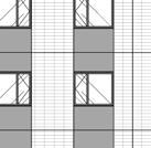
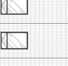
33 5TH FLOOR T NEUFarchitectes.com I 6 9 ION McGARRY TERRACE 700 TH FLOOR 500 TH FLOOR 00 TH FLOOR 5 00 TH FLOOR 900 0TH FLOOR 700 9TH FLOOR TH FLOOR 00 7TH FLOOR TH FLOOR TH FLOOR 00 TH FLOOR RD FLOOR ND FLOOR 0 00 GROUND FLOOR 9 00 P PARKING LEVEL P PARKING LEVEL 000 ZONING BY-LAW HEIGHT LIMIT 0 6 GROUND AVERAGE GRADE A00 [ PRINTED ON :7: ] C:\Users\jlemay\Documents\79_HOWARD GRANT_ARCHITECTURE_jlemay.rvt EXTERIOR MATERIAL LEGEND # NOTE DESCRIPTION FUTURE DEVELOPMENT - 5 STORIES PIN MC [0] H(0) PRECAST - PATTERN: STANDARD BRICK - COLOUR: LIGHT GREY PRECAST - PATTERN: LARGE BRICK - COLOUR: LIGHT BEIGE PRECAST - PATTERN: SMOOTH FINISH - COLOUR: WHITE PRECAST - PATTERN: SMOOTH FINISH - COLOUR: DARK GREY 5 PRECAST - PATTERN: LARGE BRICK - COLOUR: WHITE 6 PRECAST - PATTERN: LARGE PANEL- COLOUR: WHITE 7 PRECAST CORNICE - COLOUR: LIGHT GREY 7 PRECAST CORNICE - COLOUR: LIGHT GREY SCEAU / Seal CLIENT Client OUVRAGE Project EMPLACEMENT Location DESSINÉ PAR Drawn by DATE (aa.mm.jj) K J H G F.9 F E. E D C B A VÉRIFIÉ PAR Checked by TITRE DU DESSIN Drawing Title RÉVISION Revision NEUF ARCHITECTES SENCRL 0-0 March Road, Ottawa, ON, KK-E T F HOWARD GRANT 0 & 0 McGARRY TERRACE BARRHAVEN, OTTAWA NO PROJET No. NO RÉVISION DATE (aa-mm-jj) A FOR COORDINATION 07 0 B FOR COORDINATION C FOR COORDINATION 07 0 D FOR COORDINATION ISSUED FOR SITE PLAN APPROVAL 07 MM JL LM NORTH GENERAL ELEVATION.0 79 KP BSJ ÉCHELLE Scale : 50 NO. DESSIN Dwg Number A00 NATURAL GRADE H.P. T/ O STEEL TH FLOOR TH FLOOR TH FLOOR TH FLOOR 700 TH FLOOR 500 TH FLOOR 00 TH FLOOR 5 00 TH FLOOR 900 0TH FLOOR 700 9TH FLOOR TH FLOOR 00 7TH FLOOR TH FLOOR TH FLOOR 00 TH FLOOR RD FLOOR ND FLOOR 0 00 GROUND FLOOR 9 00 P PARKING LEVEL P PARKING LEVEL T/O PARAPET 000 ZONING BY-LAW HEIGHT LIMIT 0 6 GROUND AVERAGE GRADE Figure : Rear (West) Elevation WEST ELEVATION : 50 A0 GEN # NOTE PROPERTY LINE SETBACKS EASEMENT PARKING P AND P - 5 TOWER - OUTLINE 6 FLOOR ND TO 5TH - O 7 POOL - OUTLINE GROUND FLOOR - OUT 9 CANOPY FOOTPRINT 0 ENTRANCE CANOPY EXISTING ROAD MOUNTED SIGN PRIVATE TERRACE PRIVATE BALCONY 5 HYDRO TRANSFORME 6 GAS METER EXTERIOR # NOTE PRECAST - PATTERN: GREY PRECAST - PATTERN: PRECAST - PATTERN: PRECAST - PATTERN: 5 PRECAST - PATTERN: 6 PRECAST - PATTERN: 7 PRECAST CORNICE - C 7 PRECAST CORNICE - C


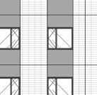

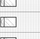


34 5TH FLOOR T NEUFarchitectes.com SCEAU / Seal 700 TH FLOOR 500 TH FLOOR 00 TH FLOOR 5 00 TH FLOOR 900 0TH FLOOR GEN # NOTE PROPERTY LINE SETBACKS EASEMENT PARKING P AND P - 5 TOWER - OUTLINE 6 FLOOR ND TO 5TH - O 7 POOL - OUTLINE GROUND FLOOR - OUT 9 CANOPY FOOTPRINT 0 ENTRANCE CANOPY EXISTING ROAD MOUNTED SIGN PRIVATE TERRACE PRIVATE BALCONY 5 HYDRO TRANSFORME 6 GAS METER 700 9TH FLOOR TH FLOOR 00 7TH FLOOR TH FLOOR 000 ZONING BY-LAW HEIGHT LIMIT CLIENT Client NEUF ARCHITECTES SENCRL 0-0 March Road, Ottawa, ON, KK-E T F T/O PARAPET 6 05 H.P. T/ O STEEL TH FLOOR TH FLOOR TH FLOOR TH FLOOR 700 TH FLOOR TH FLOOR OUVRAGE Project HOWARD GRANT TH FLOOR 00 TH FLOOR 00 TH FLOOR EMPLACEMENT Location 0 & 0 McGARRY TERRACE BARRHAVEN, OTTAWA NO PROJET No TH FLOOR 900 0TH FLOOR McGARRY TERRACE RD FLOOR ND FLOOR 0 00 GROUND FLOOR 9 00 P PARKING LEVEL P PARKING LEVEL 0 6 GROUND AVERAGE GRADE A00 EXTERIOR MATERIAL LEGEND # NOTE DESCRIPTION PRECAST - PATTERN: STANDARD BRICK - COLOUR: LIGHT GREY PRECAST - PATTERN: LARGE BRICK - COLOUR: LIGHT BEIGE PRECAST - PATTERN: SMOOTH FINISH - COLOUR: WHITE PRECAST - PATTERN: SMOOTH FINISH - COLOUR: DARK GREY 5 PRECAST - PATTERN: LARGE BRICK - COLOUR: WHITE 6 PRECAST - PATTERN: LARGE PANEL- COLOUR: WHITE 7 PRECAST CORNICE - COLOUR: LIGHT GREY 7 PRECAST CORNICE - COLOUR: LIGHT GREY [ PRINTED ON ::0 ] C:\Users\jlemay\Documents\79_HOWARD GRANT_ARCHITECTURE_jlemay.rvt NO RÉVISION DATE (aa-mm-jj) A FOR COORDINATION 07 0 B FOR COORDINATION C FOR COORDINATION 07 0 D FOR COORDINATION ISSUED FOR SITE PLAN APPROVAL 07 DESSINÉ PAR Drawn by MM JL LM McGARRY TERRACE DATE (aa.mm.jj) TITRE DU DESSIN Drawing Title NORTH GENERAL ELEVATION RÉVISION Revision VÉRIFIÉ 5 PAR 6 Checked 6 by KP BSJ 6 6 ÉCHELLE Scale : 50 NO. DESSIN Dwg Number A NATURAL GRADE TH FLOOR TH FLOOR 00 7TH FLOOR TH FLOOR TH FLOOR 00 TH FLOOR RD FLOOR ND FLOOR 0 00 GROUND FLOOR 0 6 GROUND AVERAGE GRADE 9 00 P PARKING LEVEL P PARKING LEVEL Figure 5: Side (South) Elevation SOUTH ELEVATION : ZONING BY-LAW HEIGHT LIMIT A0 EXTERIOR # NOTE PRECAST - PATTERN: GREY PRECAST - PATTERN: PRECAST - PATTERN: PRECAST - PATTERN: 5 PRECAST - PATTERN: 6 PRECAST - PATTERN: 7 PRECAST CORNICE - C 7 PRECAST CORNICE - C


 TITRE DU DESSIN Drawing Title RÉVISION Revision NEUF")


35 5TH FLOOR T NEUFarchitectes.com I 6 9 ION McGARRY TERRACE 700 TH FLOOR 500 TH FLOOR 00 TH FLOOR 5 00 TH FLOOR 900 0TH FLOOR 700 9TH FLOOR TH FLOOR 00 7TH FLOOR TH FLOOR TH FLOOR 00 TH FLOOR RD FLOOR ND FLOOR 0 00 GROUND FLOOR 9 00 P PARKING LEVEL P PARKING LEVEL 000 ZONING BY-LAW HEIGHT LIMIT 0 6 GROUND AVERAGE GRADE A00 EXTERIOR MATERIAL LEGEND # NOTE DESCRIPTION PRECAST - PATTERN: STANDARD BRICK - COLOUR: LIGHT GREY PRECAST - PATTERN: LARGE BRICK - COLOUR: LIGHT BEIGE PRECAST - PATTERN: SMOOTH FINISH - COLOUR: WHITE PRECAST - PATTERN: SMOOTH FINISH - COLOUR: DARK GREY 5 PRECAST - PATTERN: LARGE BRICK - COLOUR: WHITE 6 PRECAST - PATTERN: LARGE PANEL- COLOUR: WHITE 7 PRECAST CORNICE - COLOUR: LIGHT GREY 7 PRECAST CORNICE - COLOUR: LIGHT GREY [ PRINTED ON :: ] C:\Users\jlemay\Documents\79_HOWARD GRANT_ARCHITECTURE_jlemay.rvt SCEAU / Seal CLIENT Client OUVRAGE Project EMPLACEMENT Location A B C D E E. F F.9 G H J K A FOR COORDINATION 07 0 B FOR COORDINATION C FOR COORDINATION 07 0 D FOR COORDINATION ISSUED FOR SITE PLAN APPROVAL 07 DESSINÉ PAR Drawn by DATE (aa.mm.jj) TITRE DU DESSIN Drawing Title RÉVISION Revision NEUF ARCHITECTES SENCRL 0-0 March Road, Ottawa, ON, KK-E T F HOWARD GRANT 0 & 0 McGARRY TERRACE BARRHAVEN, OTTAWA NO PROJET No. NO RÉVISION DATE (aa-mm-jj) MM JL LM NORTH GENERAL ELEVATION VÉRIFIÉ PAR Checked by KP BSJ ÉCHELLE Scale : 50 NO. DESSIN Dwg Number A NATURAL GRADE H.P. T/ O STEEL TH FLOOR TH FLOOR TH FLOOR TH FLOOR 700 TH FLOOR 500 TH FLOOR 00 TH FLOOR 5 00 TH FLOOR 900 0TH FLOOR 700 9TH FLOOR TH FLOOR 00 7TH FLOOR TH FLOOR TH FLOOR 00 TH FLOOR RD FLOOR ND FLOOR 0 00 GROUND FLOOR 0 6 GROUND AVERAGE GRADE 9 00 P PARKING LEVEL P PARKING LEVEL Figure 6: Front (East) Elevation : EAST ELEVATION 6 0 T/O PARAPET 000 ZONING BY-LAW HEIGHT LIMIT A0 # NOTE # NOTE
")
36 7.5 Views Figure 7: Proposed Development (looking south from Strandherd Drive and McGarry Terrace Intersection)

37 Figure : Proposed Development (looking north from Marketplace Avenue)


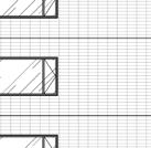
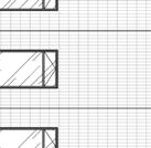
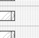
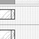
38 5 7.6 Shadow Analysis The impacts of shadowing on adjacent properties has been evaluated in a shadow study completed by NEUF Architects. The study, as summarized here, shows that shadows in the summer and shoulder seasons move quickly and have shortterm impacts on the adjacent retirement home s rear yard, outdoor amenity area throughout the day. In the summer months, when the amenity space is most likely to be in use later in the day, there are no shadow impacts. Throughout the winter, longer shadows are cast by the proposed building. The shadow impacts on the adjacent properties is generally consistent with the as-of-right shadow, with the increases largely impacting the Strandherd Drive or the building area. STRANDHERD Dr. STRANDHERD Dr. STRANDHERD Dr. McGARRY Ter. McGARRY Ter. McGARRY Ter. LONGFIELDS Dr. June - :00am June - 0:00am June - :00pm STRANDHERD Dr. STRANDHERD Dr. McGARRY Ter. McGARRY Ter. LONGFIELDS Dr. September - :00am September - 0:00am LONGFIELDS Dr. LONGFIELDS Dr. LONGFIELDS Dr. STRANDHERD Dr. STRANDHERD Dr. STRANDHERD Dr. PROPOSED SHADOW OUTLINE AS OF RIGHT SHADOW OUTLINE McGARRY Ter. McGARRY Ter. McGARRY Ter. AS OF RIGHT BUILDING OUTLINE PROPOSED DEVELOPMENT NEW NET SHADOW INCREASE LONGFIELDS Dr. LONGFIELDS Dr. LONGFIELDS Dr. NEW NET SHADOW REDUCTION December - 9:00am December - 0:00am December - :00am


39 6 STRANDHERD Dr. STRANDHERD Dr. STRANDHERD Dr. STRANDHERD Dr. STRANDHERD Dr. STRANDHERD Dr. McGARRY Ter. McGARRY Ter. McGARRY Ter. LONGFIELDS Dr. STRANDHERD Dr. LONGFIELDS Dr. LONGFIELDS Dr. STRANDHERD Dr. McGARRY Ter. McGARRY Ter. McGARRY Ter. LONGFIELDS Dr. STRANDHERD Dr. LONGFIELDS Dr. STRANDHERD Dr. McGARRY Ter. McGARRY Ter. McGARRY Ter. LONGFIELDS Dr. LONGFIELDS Dr. STRANDHERD Dr. McGARRY Ter. McGARRY Ter. LONGFIELDS Dr. June - :00pm June - :00pm June - 6:00pm June - :00pm September - :00pm September - :00pm September - :00pm September - 6:00pm STRANDHERD Dr. McGARRY Ter. LONGFIELDS Dr. LONGFIELDS Dr. LONGFIELDS Dr. LONGFIELDS Dr. December - :00pm December - :00pm December - :00pm December - :00pm
40 .0 CONCLUSIONS 7 In considering the proposed development and applicable policy framework, it is our professional opinion that the proposed development: Is Consistent with the Provincial Policy Statement The proposed development is consistent with the Provincial Policy Statement which promotes the efficient development of serviced, underutilized lands located within settlement areas. The proposed development on the subject property will achieve a greater density in a pattern that efficiently uses and supports available infrastructure and transit services, and supports existing neighbourhood amenities. Conforms to the City of Ottawa Official Plan The subject property is designated Mixed- Use Centre in the Official Plan. The proposed residential use is permitted and encouraged within mixed-use centres to support the rapid transit network and a mix of uses within these areas. As discussed above, the subject property has been identified as a suitable site for intensification given its location in a mixed-use centre and its proximity to rapid transit. The proposed development implements the vision for Mixed-Use Centres and Town Centres as compact, mixed-use area with pedestrian facilities and an active street frontage. The proposed development will not generate undue adverse impacts on the neighbouring properties and fulfills the compatibility objectives and design principles outlined in Section.5. and the compatibility criteria outlined in Section.. Has Regard for Official Plan Amendment No. 50 The proposed development supports the vision of intensification within a target area of Official Plan Amendment No. 50 and within proximity to transit. The tower separation, though less than required by OPA 50, meets the intent of the policy by ensuring that the specific objectives for separation continue to be met including allowing sunlight to penetrate public spaces and ensuring privacy is maintained. Maintains the General Intent of the South Nepean Town Centre Secondary Plan and Community Design Plan The South Nepean Town Centre Secondary Plan and Community Design Plan set as goals the creation of a compact, mixed-use, transitsupportive Town Centre focused around the transit network. The proposed development contributes to the mix of uses within the town centre in a compact form of development and will support the existing services and transit network. Meets Applicable Design Guidelines The proposed development generally meets the design direction provided in the Urban Design Guidelines for High-Rise Housing and Transit- Oriented Development. The proposed building takes advantage of an infill opportunity and achieves a compatible building in terms of form and design.


41 Maintains the General Intent of the Zoning By-Law The zoning of the subject property is proposed to be amended to reflect the proposed Official Plan amendment and the proposed development. The proposed use is permitted in the MC zone, and aside from the requested building height, the proposal complies with all other applicable zoning provisions. Represents Good Planning Overall, the proposed development advances several key policy objectives at the Provincial and Municipal levels including: optimizing the use of serviced lands within the existing urban boundary, encouraging growth within the urban boundary, intensification along in an identified target area served by transit, and contributing to the range and availability of housing for all ages and incomes. Based on the above analysis, it is our opinion that the proposed development represents good planning and is therefore in the public interest. Nico Church, M.Pl. Planner Paul Black, MCIP RPP Senior Planner Miguel Tremblay, MCIP RPP Director, Planning and Development
ADELAIDE APARTMENTS TOWER EXTENSION
 ADELAIDE APARTMENTS TOWER EXTENSION SEPTEMBER 2016 CONTENTS INTRODUCTION 1 PURPOSE OF THE APPLICATIONS 1 SITE CONTEXT 2 EXISTING CONDITIONS 2 SURROUNDING AREA 3 SITE PHOTOS 4 PUBLIC TRANSIT 6 ROAD NETWORK
Zoning By-law Amendment & Site Plan Control Application
 1560 SCOTT Zoning By-law Amendment & Site Plan Control Application February 2014 1560 SCOTT Prepared by: FOTENN Consultants Inc. 223 McLeod Street Ottawa, ON K2P 0Z8 613-730-5709 fotenn.com Prepared for:
112 Montreal Road. 314 Gardner Street. + Site Plan Control. Zoning By-law Amendment. September 2014
 112 Montreal Road + 314 Gardner Street Zoning By-law Amendment + Site Plan Control September 2014 Prepared by: FOTENN Consultants Inc. 223 McLeod Street Ottawa, ON K2P 0Z8 613-730-5709 Prepared for: 1147310
320 MCRAE AVENUE (320 MCRAE AVENUE SCOTT STREET TWEEDSMUIR AVENUE) Planning Rationale Zoning By-law Amendment Application
 Planning Rationale Zoning By-law Amendment Application") 320 MCRAE AVENUE (320 MCRAE AVENUE + 1976 SCOTT STREET + 315 TWEEDSMUIR AVENUE) Planning Rationale Zoning By-law Amendment Application February 2016 Prepared by: FOTENN Consultants Inc. 223 McLeod Street
320 MCRAE AVENUE (320 MCRAE AVENUE + 1976 SCOTT STREET + 315 TWEEDSMUIR AVENUE) Planning Rationale Zoning By-law Amendment Application February 2016 Prepared by: FOTENN Consultants Inc. 223 McLeod Street
770 BROOKFIELD ROAD Site Plan Control Atlantis Investments November 2017
 770 BROOKFIELD ROAD Site Plan Control Atlantis Investments November 2017 Prepared for: Atlantis Investments Inc. Prepared by: Fotenn Planning + Design 223 McLeod Street Ottawa, ON K2P 0Z8 fotenn.com October
774 BRONSON AVENUE MINOR ZONING BY-LAW AMENDMENT + SITE PLAN CONTROL PLANNING RATIONALE + DESIGN BRIEF
 774 BRONSON AVENUE MINOR ZONING BY-LAW AMENDMENT + SITE PLAN CONTROL PLANNING RATIONALE + DESIGN BRIEF JANUARY 2016 Prepared for: Textbook Suites 51 Caldari Road, Suite A1M Concord, ON L4K 4G3 T: 416 477
900 ALBERT STREET PLANNING RATIONALE ADDENDUM NO. 2
 900 ALBERT STREET PLANNING RATIONALE ADDENDUM NO. 2 March 26, 2018 Planning Rationale Addendum No. 2 Official Plan and Zoning By-law Amendment Prepared for: TIP Albert GP Inc. 485 Bank Street, Suite 200
Montreal Road District Secondary Plan [Amendment #127, October 9, 2013]
![Montreal Road District Secondary Plan [Amendment #127, October 9, 2013]](/thumbs/72/66783104.jpg "Montreal Road District Secondary Plan [Amendment #127, October 9, 2013]") [Amendment #127, October 9, 2013] 1.0 General The following policies are applicable to the Montreal Road District as set out in Schedule 1. 1.1 District Objectives The objective of this Plan is to guide
[Amendment #127, October 9, 2013] 1.0 General The following policies are applicable to the Montreal Road District as set out in Schedule 1. 1.1 District Objectives The objective of this Plan is to guide
371 Richmond Road. Zoning By-law Amendment Site Plan Control
 371 Richmond Road Zoning By-law Amendment Site Plan Control August 2014 Prepared by: FOTENN Consultants 223 McLeod Street Ottawa, ON K2P 0Z8 613-730-5709 fotenn.com Prepared for: Domicile Developments
MCGARRY TERRACE & LONGFIELDS DRIVE
 DEVELOPMENT LAND FOR SALE MCGARRY TERRACE & LONGFIELDS DRIVE OTTAWA, ONTARIO STRANDHERD DRIVE GREENBANK ROAD 1034 MCGARRY TERRACE & 1117 LONGFIELDS DRIVE VIMY MEMORIAL BRIDGE 1034 MCGARRY TERRACE & 1117
50+54 BELL STREET NORTH
 50+54 BELL STREET NORTH SITE PLAN CONTROL APPLICATION OCTOBER 2014 PREPARED BY: FOTENN Consultants Inc. 223 Mcleod Street Ottawa, ON K2P OZ8 (613) 730-5709 PREPARED FOR: Ottawa Chinese Alliance Church
PLANNING RATIONALE REPORT CODEAU BUILDING LTD RIDEAU STREET OTTAWA DECEMBER 2013
 PLANNING RATIONALE REPORT CODEAU BUILDING LTD 541-545 RIDEAU STREET OTTAWA DECEMBER 2013 1 This report has been prepared on behalf of Codeau Building Ltd. in support of a Zoning By-law Amendment Application
DRAFT FOR DISCUSSION PURPOSES ONLY. Port Credit Local Area Plan Built Form Guidelines and Standards DRAFT For Discussion Purposes
 Port Credit Local Area Plan Built Form Guidelines and Standards DRAFT For Discussion Purposes 1 Local Area Plan - Project Alignment Overview Directions Report, October 2008 (General Summary Of Selected
M:\2016\116063\DATA\APPLICATIONS\SITE PLAN\PLANNING ADDENDUM\PLANNING BRIEF WATERFORD.DOCX.PAGE 1
 December 8, 2016 Development Review Services City of Ottawa 110 Laurier Ave West, 4 th Floor Ottawa, ON K1P 1J1 Attention: Reference: Don Herweyer, Manager, Development Review South 125 Marketplace Ave/101A
P. H. Robinson Consulting Urban Planning, Consulting and Project Management
 PLANNING RATIONALE REPORT FOR SITE PLAN AND DRAFT PLAN OF CONDOMINIUM APPLICATIONS 73-75 HARVEY STREET CITY OF OTTAWA PREPARED BY: P H ROBINSON CONSULTING AUGUST 2012 1 This report has been prepared on
Ashcroft Homes Trim Road Development Planning Rationale
 18 Antares Drive Ottawa, ON K2E 1A9 Ashcroft Homes Trim Road Development Planning Rationale Proposed Site Plan & Zoning Amendment Applications File No: D02-02-17-0129 & D07-12-17-0175 August 2018 Planning
PLANNING RATIONALE 680 BRONSON AVENUE OTTAWA, ONTARIO PROPOSED ZONING BY-LAW AMENDMENT
 PLANNING RATIONALE 680 BRONSON AVENUE OTTAWA, ONTARIO PROPOSED ZONING BY-LAW AMENDMENT FRANK PARAVAN APRIL 2014 Planning Rationale Introduction FOTENN Consultants Inc. has been engaged by Frank and Michael
99 FIFTH AVENUE TACT. Zoning By-law Amendment Application. and Design Brief ARCHITECTURE
 99 FIFTH AVENUE TACT ARCHITECTURE November 28, 2017 Planning Rationale and Design Brief Zoning By-law Amendment Application 99 FIFTH AVENUE ZONING BY-LAW AMENDMENT PLANNING RATIONALE AND DESIGN BRIEF Prepared
MINTO COMMUNITIES INC. AVALON WEST STAGE 4 PLANNING RATIONALE. July Prepared for:
 MINTO COMMUNITIES INC. AVALON WEST STAGE 4 PLANNING RATIONALE July 2015 Prepared for: MINTO COMMUNITIES INC. 200 180 Kent Street Ottawa, Ontario K1P 0B6 Prepared by: J.L. RICHARDS & ASSOCIATES LIMITED
3.1. OBJECTIVES FOR RESIDENTIAL LAND USE DESIGNATIONS GENERAL OBJECTIVES FOR ALL RESIDENTIAL DESIGNATIONS
 3. RESIDENTIAL LAND USE DESIGNATIONS INTRODUCTION The Residential land use designations provide for housing and other land uses that are integral to, and supportive of, a residential environment. Housing
PLANNING PRIMER. Elective: Understanding Residential Intensification and Infill. Planning and Growth Management Department.
 PLANNING PRIMER Elective: Understanding Residential Intensification and Infill Planning and Growth Management Department Amended 2015 Agenda Information re: Infill and Intensification Initiatives Residential
6208 Jeanne D Arc Boulevard North. Planning Rationale. Site Plan Control
 Site Plan Control Prepared By: NOVATECH Suite 200, 240 Michael Cowpland Drive Ottawa, Ontario K2M 1P6 November / 24 / 2015 Novatech File: 115100 Ref: R-2015-179 November 24, 2015 City of Ottawa 110 Laurier
113 AND 115 ECHO DRIVE OFFICIAL PLAN AND ZONING BY-LAW AMENDMENT
 113 AND 115 ECHO DRIVE OFFICIAL PLAN AND ZONING BY-LAW AMENDMENT SEPTEMBER 2015 Prepared by: FOTENN Consultants Inc. 223 McLeod Street Ottawa, Ontario K2P 0Z8 613.730.5709 fotenn.com Prepared for: Uniform
Planning Justification Report
 Planning Justification Report 101 Kozlov Street, Barrie, Ont. Destaron Property Management Ltd. November 2015 Revised February 2017 TABLE OF CONTENTS Page 1.0 INTRODUCTION... 1 2.0 DESCRIPTION OF SUBJECT
Planning Rationale in Support of an Application for Site Plan Control
 Planning Rationale in Support of an Application for Site Plan Control 18 McArthur Avenue City of Ottawa Prepared by: Holzman Consultants Inc. Land Development Consultants May 19, 2016 TABLE OF CONTENTS
PLANNING RATIONALE REPORT
 PLANNING RATIONALE REPORT Zoning By-law Amendment Application 2920 Danbury Way Prepared for: Bravar Custom Builders Inc. and Village View Estates Ltd. by: 6393 Roslyn Street Ottawa (Orleans), Ontario K1C
1417, , 1427 & 1429 Yonge Street - Official Plan Amendment and Zoning Amendment Applications - Preliminary Report
 STAFF REPORT ACTION REQUIRED 1417, 1421-1425, 1427 & 1429 Yonge Street - Official Plan Amendment and Zoning Amendment Applications - Preliminary Report Date: March 24, 2015 To: From: Wards: Reference Number:
REDEVELOPMENT OF 403 TWEEDSMUIR AVENUE
 REDEVELOPMENT OF 403 TWEEDSMUIR AVENUE December 20, 2017 Planning Rationale Zoning By-law Amendment Prepared for: Claude Leclair 844 Aurele Road Casselman, ON K0A 1M0 casselview.com Prepared by: Fotenn
Sherwood Forest (Trinity) Housing Corporation. Urban Design Brief
 Housing Corporation. Urban Design Brief") Sherwood Forest (Trinity) Housing Corporation Sherwood Place Affordable Housing Apartments Trinity Presbyterian Church Orchard Park Nursery School 590 Gainsborough Road, London Urban Design Brief REVISED
Sherwood Forest (Trinity) Housing Corporation Sherwood Place Affordable Housing Apartments Trinity Presbyterian Church Orchard Park Nursery School 590 Gainsborough Road, London Urban Design Brief REVISED
Jasper 115 Street DC2 Urban Design Brief
 Jasper 115 Street DC2 Urban Design Brief Greenlong Construction Ltd. Stantec Consulting Ltd. 2017 Overview The proposed rezoning application supports the development of two mixed-use high-rise buildings
222 BEECHWOOD AVENUE, OTTAWA PLANNING RATIONALE ZONING BY-LAW AMMENDMENT
 222 BEECHWOOD AVENUE, OTTAWA PLANNING RATIONALE ZONING BY-LAW AMMENDMENT DECEMBER 2011 INTRODUCTION FoTenn Consultants Inc. have been engaged by Domicile Developments Inc., Owners, to assess the appropriateness
207 BELL STREET NORTH
 207 BELL STREET NORTH November 17, 2017 Planning Rationale Zoning By-law Amendment Prepared for: CLV Group 485 Bank Street, Suite 200 Ottawa, ON K2P 1Z2 clvgroup.com Prepared by: Fotenn Planning + Design
Planning Justification Report
 Planning Justification Report Kellogg s Lands City of London E&E McLaughlin Ltd. June 14, 2017 Zelinka Priamo Ltd. Page i TABLE OF CONTENTS Page No. 1.0 2.0 2.1 2.2 3.0 4.0 5.0 5.1 5.2 5.3 5.4 5.5 5.6
Bylaw No , being "Official Community Plan Bylaw, 2016" Schedule "A" DRAFT
 Bylaw No. 2600-2016, being "Official Community Plan Bylaw, 2016" Schedule "A" Urban Structure + Growth Plan Urban Structure Land use and growth management are among the most powerful policy tools at the
Figure 1: Area Context. Municipal
 Introduction This Planning Rationale has been prepared in support of a Zoning By-law Amendment and Official Plan Amendment for lands located at 101 Norman Street in the City of Ottawa. The purpose of the
307 Sherbourne Street - Zoning Amendment Application - Preliminary Report
 STAFF REPORT ACTION REQUIRED 307 Sherbourne Street - Zoning Amendment Application - Preliminary Report Date: August 14, 2015 To: From: Wards: Reference Number: Toronto and East York Community Council Director,
Planning Rationale in Support of an Application for Plan of Subdivision and Zoning By-Law Amendment
 Planning Rationale in Support of an Application for Plan of Subdivision and Zoning By-Law Amendment The Kilmorie Development 21 Withrow Avenue City of Ottawa Prepared by: Holzman Consultants Inc. Land
PLANNING REPORT Gordon Street City of Guelph. Prepared on behalf of Ontario Inc. March 17, Project No. 1507
 PLANNING REPORT 1131 Gordon Street City of Guelph Prepared on behalf of 1876698 Ontario Inc. March 17, 2016 Project No. 1507 423 Woolwich Street, Suite 201, Guelph, Ontario, N1H 3X3 Phone (519) 836-7526
STAFF REPORT PLN September 11, 2017
 Page: 1 TO: SUBJECT: GENERAL COMMITTEE APPLICATIONS FOR OFFICIAL PLAN AMENDMENT AND ZONING BY-LAW AMENDMENT 37 JOHNSON STREET WARD: WARD 1 PREPARED BY AND KEY CONTACT: SUBMITTED BY: GENERAL MANAGER APPROVAL:
FEASIBILITY REPORT. 1486, 1490 and 1494 Clementine. Prepared by: Lloyd Phillips & Associates Ltd. For: Ottawa Salus
 DRAFT FEASIBILITY REPORT 1486, 1490 and 1494 Clementine Prepared by: Lloyd Phillips & Associates Ltd. For: Ottawa Salus LPA File No. 1008 Lloyd Phillips & Associates June 9, 2010 Feasibility Report Page
Urban Design Brief Dundas Street. London Affordable Housing Foundation. November Zelinka Priamo Ltd.
 Urban Design Brief 1039-1047 Dundas Street London Affordable Housing Foundation November 2017 Zelinka Priamo Ltd. TABLE OF CONTENTS Page No. INTRODUCTION... 3 SECTION 1 LAND USE PLANNING CONTEXT... 3 1.1
Urban Design Brief. Italian Seniors Project 1090, 1092, 1096 Hamilton Road City of London
 Urban Design Brief Italian Seniors Project City of London October 1, 2017 TABLE OF CONTENTS Page No. INTRODUCTION... 2 1.0 LAND USE PLANNING CONCEPT... 2 1.1 Subject Lands... 2 1.2 Official Plan and Zoning
LAND USE AND BUILT FORM
 5 LAND USE AND BUILT FORM The existing zoning on Bank Street already allows for considerable general intensification, since the permitted Floor Space Index (FSI) would already allow several times more
Urban Design Brief (Richmond) Corp. 1631, 1635, 1639, 1643 and 1649 Richmond Street City of London
 Corp. 1631, 1635, 1639, 1643 and 1649 Richmond Street City of London") Urban Design Brief 1635 (Richmond) Corp. 1631, 1635, 1639, 1643 and 1649 Richmond Street City of London Site Plan Control Application Holding Provision Application April 1, 2015 Prepared for: Rise Real
Urban Design Brief 1635 (Richmond) Corp. 1631, 1635, 1639, 1643 and 1649 Richmond Street City of London Site Plan Control Application Holding Provision Application April 1, 2015 Prepared for: Rise Real
PLANNING RATIONALE 560 RIDEAU
 PLANNING RATIONALE 560 RIDEAU 1.0 INTRODUCTION FOTENN Consultants Inc. has been retained by Richcraft Homes to prepare a Planning Rationale in support of an Official Plan Amendment and Zoning By-law Amendment
Site Plan Control & Zoning By-law Amendment Planning Rationale PERSPECTIVE VIEWS
 45 Site Plan Control & Zoning By-law Amendment Planning Rationale September 2013 PERSPECTIVE VIEWS 45 Prepared by: FOTENN Consultants Inc. 223 McLeod Street Ottawa, ON K1Y 0T1 613-730-5709 fotenn.com Prepared
Plan Dutch Village Road
 Plan Dutch Village Road Objective: The lands around Dutch Village Road are a minor commercial area that services the larger Fairview community. Maintaining the vibrancy of the area by planning for redevelopment
ST.LAURENT BOULEVARD PLANNING RATIONALE FOR ZONING BY-LAW AMENDMENT APPLICATION ADDENDUM # 1
 460 ////////////////////////////////////////////////////////////////////////////////////////////////////////////////////////////////////////////////////// ST.LAURENT BOULEVARD PLANNING RATIONALE FOR ZONING
Yonge Street and 3 Gerrard Street East - Zoning Amendment Application - Preliminary Report
 STAFF REPORT ACTION REQUIRED 363-391 Yonge Street and 3 Gerrard Street East - Zoning Amendment Application - Preliminary Report Date: May 22, 2015 To: From: Wards: Reference Number: Toronto and East York
KoL at BLACKSTONE. Planning Rationale. April Prepared in support of a Site Plan Control and Draft Plan of Condominium
 KoL at BLACKSTONE April 2015 Planning Rationale Prepared in support of a Site Plan Control and Draft Plan of Condominium KoL at BLACKSTONE P L A N N I N G R A T I O N A L E Contents List of Figures...
Toronto and East York Community Council. Director, Community Planning, Toronto and East York District
 STAFF REPORT ACTION REQUIRED 1481, 1491, 1501 Yonge Street, 25 & 27 Heath Street East and 30 Alvin Avenue Official Plan and Zoning Amendment Application 06 199698 STE 22 OZ Preliminary Report Date: March
150 Eglinton Avenue East - Zoning Amendment Application - Preliminary Report
 STAFF REPORT ACTION REQUIRED 150 Eglinton Avenue East - Zoning Amendment Application - Preliminary Report Date: May 15, 2015 To: From: Wards: Reference Number: Toronto and East York Community Council Director,
LITTLE MOUNTAIN ADJACENT AREA REZONING POLICY
 LITTLE MOUNTAIN ADJACENT AREA REZONING POLICY JANUARY 2013 CONTENTS 1.0 INTENT & PRINCIPLES...1 2.0 APPLICATION...2 3.0 HOUSING TYPES, HEIGHT & DENSITY POLICIES...3 3.1 LOW TO MID-RISE APARTMENT POLICIES...4
Eglinton Avenue East and 3-7 Cardiff Road Official Plan and Zoning Amendment Applications Request for Direction
 STAFF REPORT ACTION REQUIRED 492 498 Eglinton Avenue East and 3-7 Cardiff Road Official Plan and Zoning Amendment Applications Request for Direction Date: May 16, 2017 To: From: Wards: Reference Number:
Planning Rationale in Support of an Application for Zoning By-law Amendment and Site Plan Control
 in Support of an Application for Zoning By-law Amendment and Site Plan Control 1131 Teron Road Prepared by Holzman Consultants Inc. Land Development Consultants April 5, 2012 TABLE OF CONTENTS Page 1.0
8.5.1 R1, Single Detached Residential District
 8.5.1 R1, Single Detached Residential District The purpose of this district is to provide for residential development in the form of single detached dwellings. Dwelling, Single Detached Home Business,
45 & 77 Dunfield Avenue - Zoning Amendment Application - Preliminary Report
 STAFF REPORT ACTION REQUIRED 45 & 77 Dunfield Avenue - Zoning Amendment Application - Preliminary Report Date: January 22, 2014 To: From: Wards: Reference Number: Toronto and East York Community Council
Director, Community Planning, Toronto and East York District
 STAFF REPORT September 1, 2005 To: From: Subject: Toronto and East York Community Council Director, Community Planning, Toronto and East York District Further Report Applications to amend Official Plan
6040 Bathurst Street and 5 Fisherville Road Zoning Bylaw Amendment Application Preliminary Report
 STAFF REPORT ACTION REQUIRED 6040 Bathurst Street and 5 Fisherville Road Zoning Bylaw Amendment Application Preliminary Report Date: January 24, 2017 To: From: Wards: Reference Number: North York Community
67 & 71. Marquette Avenue. Zoning By-law Amendment and Site Plan Control Application
 67 & 71 Marquette Avenue Zoning By-law Amendment and Site Plan Control Application April 2014 Prepared by: FOTENN Consultants Inc. 223 McLeod Street Ottawa, ON K2P 0Z8 613-730-5709 www.fotenn.com Prepared
66 Isabella Street Rezoning Application - Preliminary Report
 STAFF REPORT ACTION REQUIRED 66 Isabella Street Rezoning Application - Preliminary Report Date: November 15, 2010 To: From: Wards: Reference Number: Toronto and East York Community Council Director, Community
50 and 52 Finch Avenue East - Official Plan and Zoning By-law Amendment Applications - Preliminary Report
 STAFF REPORT ACTION REQUIRED 50 and 52 Finch Avenue East - Official Plan and Zoning By-law Amendment Applications - Preliminary Report Date: August 16, 2016 To: From: Wards: Reference Number: North York
40-58 Widmer Street - Zoning Amendment Application - Preliminary Report
 STAFF REPORT ACTION REQUIRED 40-58 Widmer Street - Zoning Amendment Application - Preliminary Report Date: April 19, 2013 To: From: Wards: Reference Number: Toronto and East York Community Council Director,
LAURIER AVENUE FRIEL STREET PLANNING RATIONALE SEPTEMBER OFFICIAL PLAN AMENDMENT & ZONING BY-LAW AMENDMENT
 261 265 271 275 281 & 400 LAURIER AVENUE E A S T FRIEL STREET SEPTEMBER 2 0 1 3 PLANNING RATIONALE OFFICIAL PLAN AMENDMENT & ZONING BY-LAW AMENDMENT PREPARED BY: PREPARED FOR: VINER ASSETS INC. 223 MCLEOD
In support of the previous Plan of Subdivision application, the following studies and reports were previously submitted to the City of Ottawa:
 July 24, 2013 Resubmission of Plan of Subdivision Application Minto Developments 850 Champlain Street, Orléans, City of Ottawa Updated Planning Rationale Introduction and Background On behalf of Minto
Planning Rationale in Support of an Application for Zoning By-law Amendment and Site Plan Control
 in Support of an Application for Zoning By-law Amendment and Site Plan Control Prepared by Holzman Consultants Inc. Land Development Consultants and Farrow Dreessen Architects Inc. October 2013 TABLE OF
PLANNING REPORT. Starwood Drive and Watson Parkway North City of Guelph. Coletara Development. November 12, Project No. 1307
 PLANNING REPORT Starwood Drive and Watson Parkway North City of Guelph Coletara Development November 12, 2013 Project No. 1307 423 Woolwich Street, Suite 201, Guelph, Ontario, N1H 3X3 Phone (519) 836-7526
STAFF REPORT. March 14, Toronto and East York Community Council. Director, Community Planning, South District
 STAFF REPORT March 14, 2005 To: From: Subject: Toronto and East York Community Council Director, Community Planning, South District Preliminary Report Official Plan Amendment and Rezoning Application 05
13. OFFICIAL PLAN AMENDMENT AND ZONING CRESTHAVEN DRIVE MODIFICATION AU PLAN OFFICIEL ET ZONAGE - 350, PROMENADE CRESTHAVEN
 292 COMITÉ DE L URBANISME 13. OFFICIAL PLAN AMENDMENT AND ZONING - 350 CRESTHAVEN DRIVE MODIFICATION AU PLAN OFFICIEL ET ZONAGE - 350, PROMENADE CRESTHAVEN COMMITTEE RECOMMENDATIONS That Council: 1. Approve
Yonge Street, 5-9 St. Joseph Street and 11-19, 25 St. Nicholas Street Rezoning Application - Preliminary Report
 STAFF REPORT ACTION REQUIRED 606-618 Yonge Street, 5-9 St. Joseph Street and 11-19, 25 St. Nicholas Street Rezoning Application - Preliminary Report Date: December 11, 2008 To: From: Wards: Reference Number:
4650 Eglinton Avenue West - Zoning By-law Amendment Application - Preliminary Report
 STAFF REPORT ACTION REQUIRED 4650 Eglinton Avenue West - Zoning By-law Amendment Application - Preliminary Report Date: August 14, 2015 To: From: Wards: Reference Number: Etobicoke York Community Council
Director, Community Planning, North York District
 STAFF REPORT ACTION REQUIRED 3, 5, 11, 17, 21 Allenbury Gardens & 3, 5 Kingslake Road Official Plan and Zoning By-law Amendment and Rental Housing Demolition Applications Final Report Date: February 6,
3636 Bathurst Street Zoning By-law Amendment Application - Preliminary Report
 STAFF REPORT ACTION REQUIRED 3636 Bathurst Street Zoning By-law Amendment Application - Preliminary Report Date: February 29, 2012 To: From: Wards: Reference Number: North York Community Council Director,
20 Edward Street Zoning Amendment Application - Preliminary Report
 STAFF REPORT ACTION REQUIRED 20 Edward Street Zoning Amendment Application - Preliminary Report Date: January 20, 2015 To: From: Wards: Reference Number: Toronto and East York Community Council Director,
Planning Rationale. 224 Cooper Street
 Submitted by: Robertson Martin Architects Tel 613.567.1361 Fax 613.567.9462 216 Pretoria Ave, Ottawa, Ontario, K1S 1X2 Planning Rationale 224 Cooper Street Planning Rationale Application to City of Ottawa
230 Oak Street- Official Plan Amendment and Zoning Bylaw Amendment Applications - Preliminary Report
 STAFF REPORT ACTION REQUIRED 230 Oak Street- Official Plan Amendment and Zoning Bylaw Amendment Applications - Preliminary Report Date: February 6, 2014 To: From: Wards: Reference Number: Toronto and East
25 Leonard Avenue - Official Plan Amendment and Zoning Amendment Applications - Preliminary Report
 STAFF REPORT ACTION REQUIRED 25 Leonard Avenue - Official Plan Amendment and Zoning Amendment Applications - Preliminary Report Date: March 8, 2017 To: From: Wards: Reference Number: Toronto and East York
PLANNING REPORT: BANK STREET SITE PLAN CONTROL APPLICATION
 URBAN CAPITAL 488-500 BANK ST JULY 2014 1 July 31, 2014 Erin O Connell City of Ottawa 110 Laurier Avenue West Ottawa, ON K1P 1J1 PLANNING REPORT: 488 500 BANK STREET SITE PLAN CONTROL APPLICATION FOTENN
605 Longfields Drive Block 13 Plan 4M 1463
 Longfields Station Community 605 Longfields Drive Block 13 Plan 4M 1463 Planning Rationale Report December 2017 Prepared for Campanale Homes Paquette Planning Associates Ltd. 56 Hutchison Avenue Ottawa,
Housing & Residential Intensification Study Discussion Paper Township of King
 Housing & Residential Intensification Study Discussion Paper Prepared by Planning Department January 2011 1.0 Background 1.1 Provincial Policies (Greenbelt and Growth Plan) Since 2001, the Province of
KANATA WEST RETAIL CENTRE
 KANATA WEST RETAIL CENTRE June 13, 2017 Zoning By-law Amendment and Site Plan Control Prepared for: 225 Metcalfe Street, Suite 708 Ottawa, ON K2P 1P9 Prepared by: Fotenn Planning + Design 223 McLeod Street
5 to 25 Wellesley Street West and 14 to 26 Breadalbane Street - Zoning Amendment Application - Preliminary Report
 STAFF REPORT ACTION REQUIRED 5 to 25 Wellesley Street West and 14 to 26 Breadalbane Street - Zoning Amendment Application - Preliminary Report Date: May 16, 2013 To: From: Wards: Reference Number: Toronto
3.1 Existing Built Form
 3.1 Existing Built Form There is a wide variety of built form in the study area, generally comprising 2 and 3 storey buildings. This stretch of Queen Street East is somewhat atypical of Toronto's main
PREPARED FOR: ADI DEVELOPMENT GROUP INC.
 Acronym Urban Design and Planning/Mark Sterling Consulting Inc. 111 Clendenan Avenue, Toronto, Ontario M6P 2W7 URBAN DESIGN BRIEF PROPOSED DEVELOPMENT 4880 VALERA ROAD, CITY OF BURLINGTON PREPARED FOR:
200 St. Clair Ave W - Official Plan Amendment and Zoning Amendment Applications - Preliminary Report
 STAFF REPORT ACTION REQUIRED 200 St. Clair Ave W - Official Plan Amendment and Zoning Amendment Applications - Preliminary Report Date: December 15, 2014 To: From: Wards: Reference Number: Toronto and
10 St Mary Street - Zoning Amendment Application - Preliminary Report
 STAFF REPORT ACTION REQUIRED 10 St Mary Street - Zoning Amendment Application - Preliminary Report Date: May 14, 2015 To: From: Wards: Reference Number: Toronto and East York Community Council Director,
Church Street and 117 Dundas Street East - Zoning Amendment Application - Preliminary Report
 STAFF REPORT ACTION REQUIRED 215-229 Church Street and 117 Dundas Street East - Zoning Amendment Application - Preliminary Report Date: February 26, 2015 To: From: Wards: Reference Number: Toronto and
Planning Justification Report for 324 York Street
 Planning Justification Report for 324 York Street June 1 2018 This Planning Justification Report demonstrates how the continued use of the subject lands as a commercial surface area parking lot accords
50 Wellesley Street East - Official Plan Amendment & Zoning Amendment Applications - Preliminary Report
 STAFF REPORT ACTION REQUIRED 50 Wellesley Street East - Official Plan Amendment & Zoning Amendment Applications - Preliminary Report Date: July 18, 2014 To: From: Wards: Reference Number: Toronto and East
Director, Community Planning, North York District
 STAFF REPORT ACTION REQUIRED 35-53 and 101-113 Valley Woods Road and 1213-1229 York Mills Road Official Plan, Rezoning, Draft Plan of Subdivision and Rental Housing Demolition Applications Final Report
CASTLES OF CALEDON URBAN DESIGN REPORT
 CASTLES OF CALEDON URBAN DESIGN REPORT PROPOSED RESIDENTIAL DEVELOPMENT CALEDON, ONTARIO 10 JULY, 2015 TABLE CONTENTS: 1.0 DEVELOPMENT 4.0 CONCLUSION 1.1 Introduction 1.2 Castles of Caledon- Urban Design
44 Jackes Avenue and 33 Rosehill Avenue - Zoning Amendment Application - Preliminary Report
 STAFF REPORT ACTION REQUIRED 44 Jackes Avenue and 33 Rosehill Avenue - Zoning Amendment Application - Preliminary Report Date: March 16, 2017 To: From: Wards: Reference Number: Toronto and East York Community
The City of Burlington 4880 VALERA ROAD PLANNING JUSTIFICATION REPORT. December 2017 ZONING BY-LAW AMENDMENT. AJC Project Number:
 The City of Burlington 4880 VALERA ROAD PLANNING JUSTIFICATION REPORT ZONING BY-LAW AMENDMENT December 2017 AJC Project Number: 178295 Table of Contents 1 Introduction... 2 2 Description of Subject Lands
85, 87, 89, 91 Broadway Avenue & 198 Redpath Avenue Zoning Amendment and Rental Housing Demolition Applications Request for Direction Report
 REPORT FOR ACTION 85, 87, 89, 91 Broadway Avenue & 198 Redpath Avenue Zoning Amendment and Rental Housing Demolition Applications Request for Direction Report Date: August 17, 2017 To: Toronto and East
For Vintages of Four Mile Creek Town of Niagara on the Lake, Ontario
 Planning Impact Analysis For Vintages of Four Mile Creek Town of Niagara on the Lake, Ontario Prepared by: Upper Canada Consultants 261 Martindale Road Unit #1 St. Catharines, Ontario L2W 1A1 Prepared
Toronto and East York Community Council. Director, Community Planning, Toronto and East York District
 1000 Bay Street Rezoning Application Final Report Date: August 10, 2010 STAFF REPORT ACTION REQUIRED To: From: Wards: Reference Number: Toronto and East York Community Council Director, Community Planning,
BROCKVILLE CITY OF BROCKVILLE COMPREHENSIVE ZONING BY-LAW REVIEW DISCUSSION PAPER OCTOBER 2013 FINAL D
 BROCKVILLE CITY OF BROCKVILLE COMPREHENSIVE ZONING REVIEW DISCUSSION PAPER OCTOBER 2013 FINAL D14-13-010 TABLE OF CONTENTS 1. INTRODUCTION... 1 1.1 Purpose and Goals of this Project... 1 1.2 Study Process...
Bathurst Street Zoning Amendment Application and Rental Housing Demolition Application under Municipal Code Chapter 667 Final Report
 STAFF REPORT ACTION REQUIRED 1996-2000 Bathurst Street Zoning Amendment Application and Rental Housing Demolition Application under Municipal Code Chapter 667 Final Report Date: January 26, 2017 To: Toronto
PIN , Part 1, Plan SR-713 in Lot 2, Concession 5, Township of McKim (1096 Dublin Street, Sudbury)
") STAFF REPORT Applicant: Dalron Construction Limited Location: PIN 02124-0103, Part 1, Plan SR-713 in Lot 2, Concession 5, Township of McKim (1096 Dublin Street, Sudbury) Official Plan and Zoning By-law:
STAFF REPORT Applicant: Dalron Construction Limited Location: PIN 02124-0103, Part 1, Plan SR-713 in Lot 2, Concession 5, Township of McKim (1096 Dublin Street, Sudbury) Official Plan and Zoning By-law:
Richmond Street West - Zoning Amendment Application - Preliminary Report
 STAFF REPORT ACTION REQUIRED 457-457 Richmond Street West - Zoning Amendment Application - Preliminary Report Date: March 10, 2017 To: From: Wards: Reference Number: Toronto and East York Community Council