Planning Rationale in Support of an Application for Zoning By-law Amendment and Site Plan Control
|
|
|
- Lewis Griffith
- 5 years ago
- Views:
Transcription
1 in Support of an Application for Zoning By-law Amendment and Site Plan Control 1131 Teron Road Prepared by Holzman Consultants Inc. Land Development Consultants April 5, 2012
2 TABLE OF CONTENTS Page 1.0 Introduction Site Overview & History Development Proposal Planning Context Provincial Policy Statement Official Plan Urban Design Guidelines for High-Rise Housing Zoning By-law Design Statement Integrated Environmental Review Stage 1 Archaeological Assessment Geotechnical Review Phase 1 Environmental Site Assessment Adequacy of Existing Services Tree Conservation Report Noise Study Transportation Impact Study Sun Shadow Study Planning Context Conformity with the Provincial Policy Statement Conformity with the Official Plan Conformity with the Comprehensive Zoning By-law Draft Zoning By-law Provisions Summary and Conclusions 36 EXHIBITS A Air Photo (2008) B Surveyors Real Property Report C Conceptual Plans of Proposed Development D Official Plan - Schedule B
3 TABLE OF CONTENTS E Official Plan - Schedule C F Official Plan - Schedule D G Official Plan - Schedule G H Official Plan - Schedule I I Zoning Bylaw
4 1.0 Introduction Holzman Consultants Inc. ( HCI ) has been retained by Ontario inc., (the Owner ) to prepare a in support of an application for Zoning By-law Amendment a parcel of land municipally known as 1131 Teron Road in the (the Subject Property ). This report will also be used to support a pending application for Site Plan Control for the development of the Subject Property. The Applicant s development proposal calls for the development of a multi-storey residential building along with 6 townhomes, underground parking and other elements to be discussed in detail in Section 2.1. The requirements for this are outlined in a September 30, from Mark Young, Planner II, Planning Approvals, Suburban West Area to HCI following a formal pre-consultation meeting held on September 27, A typically examines the relevant policies in the Provincial Policy Statement, the Official Plan and the Zoning By-law of the in the context of the application as well as justification for the development proposal. 2.0 Site Overview & History The Subject Property consists of a rectangular parcel of land along the east side of Teron Road and a large triangular parcel of land wedged between Teron Road and March Road in an area of the known as the Beaverbrook Community within the former City of Kanata. The Subject Property is approximately 1.48 hectares in area. It is currently occupied by a single storey commercial office building located on the rectangular portion. This structure contains approximately 90 square metres of gross floor area and was built in 1958 as a single family dwelling but was converted some time ago to the present use. There are two private approaches to the rectangular portion of the Subject Property, both along Teron Road. The northerly approach leads to a parking lot that contains approximately 7 parking spaces along the north edge of the rectangular portion of the Subject Property while a second private approach leads to the single car garage at the southern area of the Subject Property. The location and site features are illustrated on Exhibit A attached to this report. The Subject Property is relatively flat but slopes very slightly from southwest to northeast. There is perimeter vegetation around the rectangular portion consisting of a mix of trees and shrubs along the north limit, a cedar hedge along the east limit, and a mixture of mature trees along the south and west (Teron Road frontage) consisting of 0.25m m diameter at breast height. There is 1
5 second growth scrub on the large triangular portion except for a row of mature deciduous trees between the hydro line and March Road. This is illustrated on the site photos that are attached as Exhibit C. There are two hydro electric overhead lines along the eastern edge of the Subject Property running parallel to March Road. Both lines and towers are owned by Hydro-One and are protected through significantly wide easements. In general, the easements exist to protect the poled lines, to allow free and clear access for Hydro-One crews and to protect the public. The most easterly line is a wood pole line carrying 100KV with one double wood pole located near the southern edge of the Subject Property, while the other is on steel lattice structures carrying 230KV power with a single structure at the extreme north end of the Subject Property. The easement extends up to the edge of the proposed building while the closest overhead line has been surveyed to be 15.0m at rest and the lowest point at 104.5m above sea level, approximately 15 metres above the existing grade of the Subject Property. HydroOttawa owns two pad mount transformers located along Teron Road and at the intersection of Teron Road and March Road, both within the road allowances. Surrounding uses include commercial office and light industrial along the east side of March Road and at the northwest corner of Teron Road and March Road, a major employment area with the Kanata area of the, a fairly mature multi-family dwelling development along the west side of Teron Road and south/southeast of the Subject Property along the east side of Teron Road. The neighbourhood offers schools & parks, local convenience shopping, employment and other retail services in close proximity to the Subject Property Teron Road (the rectangular parcel) is legally described as: Part of Lot 5, Concession IV, former Geographic Township of March, former City of Kanata, now in the, PIN The larger triangular parcel of land is unassigned and legally described as: Part of Lot 5, Concession IV, former Geographic Township of March, former City of Kanata, now in the, PIN The Surveyor s Real Property Report (plan) is attached as Exhibit B. The structure is not designated under Part IV of the Ontario Heritage Act nor is the area within a heritage conservation district. There is an existing site plan approval for the rectangular portion of the Subject Property from 2000 for the formal conversion of the structure and site to the current use. 2
6 Teron Road operates as a two way undivided roadway with a widened asphalt driving surface and line painted for cycling lane in both directions. Sidewalks extend along the entire west side and from the site south along the east side of Teron Road. There is excellent transit service along Teron Road in both directions weekdays, both with an express route #60 and the peak service #169 which both pass by the Subject Property every 30 minutes during the a.m. and p.m. peak times, while the #93 operates everyday with frequency of service at 20 minutes weekdays and 30 minutes weekends. These routes all run through the Transitway Service & Station located at Teron and Campeau Drive. An ongoing study by the entitled The West Transitway Connection Highway 417/Eagleson Road to Old Carp Road North Environmental Assessment project has considered both Teron Road and March Road as the corridor for a BRT (Bus Rapid Transit) route to serve the area to the north. The recommended route should be determined this year with construction in the future. Either corridor will benefit the Subject Property by improved unimpeded OC Transpo service in the future. The site is currently serviced by municipal water with the stormwater draining into municipal storm sewer in Teron Road. There is no sanitary service to the Subject Property at this time and the structure is served by a private sewage disposal system. Other utilities such as bell, cable and hydro extend from the public lines within the Teron road allowance. A meeting was held in September 2011 between members of the development team and residents of the neighbouring condominium townhouse development known as the Bethune Condominium located immediately adjacent to the Subject Property. The presentation of preliminary design concepts was discussed and initial feedback was received by the team. The main issues included a reduction of privacy for those units adjacent to the development lands, setback and height concerns, and traffic impact on Teron Road. Arising out of that meeting, and in response to many of the issues, was an evolution of the design to the current development proposal. A followup informal meeting was held on March 28, 2012 with representatives of the Condo Board and from the Beaverbrook Community Association to present the revised preliminary building plans for a brief discussion. 2.1 Development Proposal The development proposal includes a single apartment building ranging in height of 10 and 15 storeys from north to south along with 6 three storey townhouse units at the south end of the site. The approximate height of the tallest part of the building is 53.8m from the ground floor to top of the residential penthouse. The mechanical penthouse will extend above that height. The shape of the Subject 3
7 Property and the nature of the hydro easement and lines create a fairly small building footprint but an opportunity to design a unique shaped building with many planes to create an interesting streetscape and exterior design of the buildings. The presence of the adjacent 2 storey townhouse development south and east of the southern portion of the site has been considered in the transitioning of the proposed building heights. All of the units will be condominium units with certain elements owned in common amongst the unit owners. The structures will site above a multi-level underground parking garage with controlled access to the underground parking area located back from the front lot line and within the building footprint to buffer the car activities and headlights from adjacent existing residential uses, and to provide adequate on-site storage/queuing and to control circulation within the site. Handicapped accessible and some visitor parking will be located at grade under the central tower with additional surface parking located between the townhouse units and the front lot line along Teron Road. There will be 231 parking spaces within the 4 storey underground parking complex. Each of the townhouse units will have a single car garage and room in their respective driveways for an additional vehicle. The total number of parking spaces provided is 252 including 6 visitor parking spaces at grade under the tower, 12 spaces for the 6 townhouse units and 3 visitor spaces at the end of the private way. There will be a single 2- way private approach to the development located at grade approximately at the mid point of the developed portion of the Subject Property and will run fairly flat into the site. There will be a total of 179 units which includes the 6 townhouse units. The units in the apartment building will be a combination of 1 and 2 bedroom units ranging in size from 700ft2 1350ft2 each with an outdoor private amenity area (balcony or terrace). Communal amenity areas will be provided within and around the complex for the enjoyment of the residents. The townhouse units will have a gross floor area of approximately 2,100ft2 along with their own amenity area. The proposed development will require the connection to full municipal services, including extending the sanitary sewer northward along Teron Road to the frontage of the Subject Property. A new public sidewalk will be constructed along the entire property frontage on Teron Road to the corner of March Road. The design of the project along with other elements will be discussed in greater detail in Section 4.0 and shown on Exhibit C-1. The project will require a Zoning Bylaw Amendment and Site Plan Control approval based on the current zoning and development control requirements for the. This will be discussed in greater detail in subsequent sections. 4
8 3.0 Planning Context 3.1 Provincial Policy Statement According to the Provincial Policy Statement ( PPS ), the vision for Ontario s land use planning system is to carefully manage land to ensure appropriate development to satisfy current and future needs. In addition, land planning must promote efficient development patterns with a mix of housing, employment, open spaces and multi-modal transportation. The PPS ultimately aims to encourage communities that are economically strong and environmentally sound and that foster social well-being. Section of the PPS states that settlement areas shall be the focus of growth and their vitality and regeneration shall be promoted. The PPS defines settlement areas as urban areas (and rural settlement areas) within municipalities that are: built up areas where development is concentrated and which have a mix of land uses; and lands which have been designated in an official plan for development over the long term planning horizon, The relevant policies are found in Section as follows; Land use patterns within settlement areas shall be based on: And; a. densities and a mix of land uses which: 1. efficiently use land and resources; 2. are appropriate for, and efficiently use, the infrastructure and public service facilities which are planned or available, and avoid the need for their unjustified and/or uneconomical expansion; and 3. minimize negative impacts to air quality and climate change, and promote energy efficiency in accordance with policy 1.8; and b. a range of uses and opportunities for intensification and redevelopment in accordance with the criteria in policy New development taking place in designated growth areas should occur adjacent to the existing built-up area and shall have a compact form, mix of uses and densities that allow for the efficient use of land, infrastructure and public service facilities. The relevant policies with respect to housing; 5
9 1.4.3 Planning authorities shall provide for an appropriate range of housing types and densities to meet projected requirements of current and future residents of the regional market area by: a. establishing and implementing minimum targets for the provision of housing which is affordable to low and moderate income households. However, where planning is conducted by an upper-tier municipality, the upper-tier municipality in consultation with the lower-tier municipalities may identify a higher target(s) which shall represent the minimum target(s) for these lower-tier municipalities; b. permitting and facilitating: 1. all forms of housing required to meet the social, health and well-being requirements of current and future residents, including special needs requirements; and 2. all forms of residential intensification and redevelopment in accordance with policy ; c. directing the development of new housing towards locations where appropriate levels of infrastructure and public service facilities are or will be available to support current and projected needs; d. promoting densities for new housing which efficiently use land, resources, infrastructure and public service facilities, and support the use of alternative transportation modes and public transit in areas where it exists or is to be developed; and e. establishing development standards for residential intensification, redevelopment and new residential development which minimize the cost of housing and facilitate compact form, while maintaining appropriate levels of public health and safety. The PPS also focuses growth within settlement areas and away from significant or sensitive resources and areas which may pose a risk to public health and safety. The Subject Property does not have any of these characteristics that would preclude development opportunities. 3.2 Official Plan The Official Plan Volume 1 ( OP ) contains a set of guiding principles in Section 1.3. The Guiding Principles contain a description the important foundations of the City s OP. The following is one of the seven principles and accompanying objectives that must be balanced when making decisions. 6
10 A City of Distinct, Liveable Communities A Sense of Community All communities look right and feel right. They have an identity that defines them and fosters pride and belonging among residents. Complete Communities Ottawa s communities have a variety of housing choices, employment, parks and a wide range of services and facilities accessible by walking, cycling and transit. The City s Growth Management Strategy is illustrated in Section 2.1, with the following opening statement being of critical importance; As migration from elsewhere in Canada and other countries continues, Ottawa s population is projected to grow by up to 30 per cent by 2031 compared to and because the average number of people in each household is gradually declining, the number of households in Ottawa is projected to increase even faster than the rate of population growth by about 40 per cent over this time period. This means that approximately 145,000 new homes may be needed in Ottawa by As the children of baby-boomers leave home and form their own households, both parents and children will live in smaller households. In addition, the aging of the population is creating more seniors households. Thus, much of the demand for new housing after 2006 is expected to be for smaller units, such as apartments. Almost two-thirds of the added housing stock will be located outside the city s Greenbelt. Many of the new dwellings there will be in the form of single-detached homes, but at least 40 per cent will be either townhouses or apartments. Figure 2.2 suggests the need for 32,000 new households in the outer Greenbelt urban areas from 2011 to The Subject Property is so located. Section provides guidance for any opportunities for intensification outside of target areas. The relevant policy is as follows: Intensification Outside of Target Areas 13. The City also supports intensification throughout the urban area; including areas designated General Urban Area. The City will promote opportunities for intensification in the following cases, provided that all other policies in the Plan are met: a. Lands within 600 metres of future or existing rapid-transit stations with potential to develop as compact, mixed-use and pedestrian-friendly cores; 14. The interior portions of stable, low-rise residential neighbourhoods will continue to be characterized by low-rise buildings (as defined in Section 4.11, policy 7). The City supports intensification in the General Urban Area where it will enhance and complement its desirable characteristics and long term renewal. Generally, new development, including redevelopment, proposed within the interior of established neighbourhoods will be designed to complement the area's pattern of built form and open spaces. The Subject Property is located within 600 metres of a future rapid transit station 7
11 as shown on Exhibit F. A portion of the Subject Property immediately adjacent to March Road, and coinciding with where the hydro easements are located is designated Employment Area on Schedule B: Urban Policy Plan, and included as Exhibit D. The lands are not intended for development consistent with the terms of that easement thus the policies of that designation are not relevant. The portion of the Subject Property where the structures are proposed is designated as General Urban Area as shown in Exhibit D, which is Schedule B from the City s Official Plan. The following introductory statement in Section 3.6 of the OP provides an overview of the intentions of this designation; And; The General Urban Area designation permits the development of a full range and choice of housing types to meet the needs of all ages, incomes and life circumstances, in combination with conveniently located employment, retail, service, cultural, leisure, entertainment and institutional uses. This will facilitate the development of complete and sustainable communities. A broad scale of uses is found within this designation, from ground-oriented single-purpose to multi-storey mixed-use; from corner store to shopping centre. Subject to the policies below, the City supports infill development and other intensification within the General Urban Area in a manner that enhances and complements the desirable characteristics and ensures the long-term vitality of the many existing communities that make up the city. The specific permitted uses include the following; 1. General Urban Area areas are designated on Schedule B. The General Urban Area designation permits all types and densities of housing, as well as employment, retail uses, service, industrial, cultural, leisure, greenspace, entertainment and institutional uses. 2. The evaluation of development applications, studies, other plans and public works undertaken by the City in the General Urban Area will be in accordance with Section and Section When considering a proposal for residential intensification through infill or redevelopment in the General Urban Area, the City will: a. Recognize the importance of new development relating to existing community character so that it enhances and builds upon desirable established patterns and built form; b. Apply the policies of Section and Section 4.11; c. Consider its contribution to the maintenance and achievement of a balance of housing types and tenures to provide a full range of housing for a variety of demographic profiles throughout the General Urban Area; d. Assess ground-oriented multiple housing forms, such as duplex, triplex and 8
12 fourplex, as one means of intensifying within established low-rise residential communities. 4. Major Urban Facilities are permitted in the General Urban Area in accordance with Section The General Urban Area permits uses that may generate traffic, noise or other impacts that have the potential to create conflicts with the surrounding residential community. These types of uses are often large and serve or draw from broader areas. The City will ensure that anticipated impacts can be adequately mitigated or otherwise addressed. Such uses will be directed to: a. Locations along the rapid-transit system, or an arterial or major collector road with sufficient capacity to accommodate the anticipated traffic generated and where frequent, all-day transit service can be provided; b. Suitable locations on the perimeter of, or isolated from, established residential neighbourhoods. In this regard, existing or proposed building orientation, massing and design, and the presence of mitigating circumstances such as distance, changes in topography, or the presence of features such as significant depths of mature forest may be taken into account. The reference to Section is important as the respective policies deal with compatibility of new development into existing communities. The design criteria are referenced (directed to Section 4.11) and contain the following key introductory statement; Compatibility The City's growth management strategy includes intensification of development in the urban area over the next 20 years and concentrating rural development in Villages. Introducing new development in existing areas that have developed over a long period of time requires a sensitive approach to differences between the new development and the established area. This Plan provides guidance on measures that will mitigate these differences and help achieve compatibility of form and function. Allowing for some flexibility and variation that complements the character of existing communities is central to successful intensification. In general terms, compatible development means development that, although it is not necessarily the same as or similar to existing buildings in the vicinity, nonetheless enhances an established community and coexists with existing development without causing undue adverse impact on surrounding properties. It fits well within its physical context and works well among those functions that surround it. Generally speaking, the more a new development can incorporate the common characteristics of its setting in its design, the more compatible it will be. Nevertheless, a development can be designed to fit and work well in a certain existing context without being the same as the existing development. Where a new vision for an area is established through a Community Design Plan or other similar Council-approved planning exercise, addressing compatibility will permit development to evolve toward the achievement of that vision while respecting overall community character. Objective criteria can be used to evaluate compatibility and these are set out in Section Development applications and proposals for public works will be evaluated in the context of this section. Within Section 2.5.1, various Design Objectives are outlined to guide 9
13 development, of which the following principles are considered most applicable to the proposed development; 2. To define quality public and private spaces through development Principles: Design should: Clearly define and connect public and private spaces by: o Defining and enclosing spaces using buildings, structures and landscaping. o Recognizing every building as being part of a greater whole that contributes to the overall coherency of the urban fabric. Enhance and enliven the quality, character and spatial delineation of public spaces. Consider streets as public spaces. Encourage a continuity of street frontages. Where continuous building facades are not a dominant feature of the streetscape, the gradual infilling of empty spaces between buildings and between the building and the street edge is promoted to occur over time. Depending on the stage of evolution of the street, it may be appropriate to achieve this principle in a number of ways e.g., building form, landscape treatment, architectural ornamentation. Address the relationship between buildings and between buildings and the street. 4. To ensure that new development respects the character of existing areas. Principles: Design should: Integrate new development to complement and enliven the surroundings. Allow the built form to evolve through architectural style and innovation. Complement the massing patterns, rhythm, character, and context. 5. To consider adaptability and diversity by creating places that can adapt and evolve easily over time and that are characterized by variety and choice. [OMB decision #2649, September 21, 2006] Principles: Design should: Achieve a more compact urban form over time. Provide flexibility for buildings and spaces to adapt to a variety of possible uses in response to changing social, economic and technological conditions. Allow for varying stages of maturity in different areas of the city, and recognize that buildings and site development will exhibit different characteristics as they evolve over time. Accommodate the needs of a range of people of different incomes and 10
14 lifestyles at various stages in the life cycle. 6. To understand and respect natural processes and features in development design 7. To maximize energy-efficiency and promote sustainable design to reduce the resource consumption, energy use, and carbon footprint of the built environment. Principles: Design should: Orient development to maximize opportunities for passive solar gain, natural ventilation, and use energy efficient development forms and building measures. Consider use of renewable energy and alternative energy systems. Maximize opportunities for sustainable transportation modes (walking, cycling, transit facilities and connections). Reduce hard surfaces and maximize landscaping and site permeability on site. Consider use of innovative green spaces such as green roofs, and measures that will reduce the urban heat island effect. Maximize re-use and recycling of resources and materials. Utilize green building technologies and rating systems such as Leadership in Energy and Environmental Design (LEED). Utilize advanced water conservation and efficiency measures. The Design Statement in Section 4.0 below outlines how these objectives have been addressed and incorporated into the proposed development. Section 4.11 sets out policies that must be respected when the municipality is reviewing a development application. The following are the relevant introductory remarks from this section; At the city-wide scale, issues of compatibility are addressed in the Official Plan through the appropriate designation of land and associated policies that direct where and how certain categories of land use should be permitted to develop. Locational policies are therefore required in order to direct uses that have the potential to generate negative impacts to appropriate locations, most typically at the periphery of residential neighbourhoods. It is recognized that because land use designations such as General Urban Area, Mainstreets and Employment Area contain broad use permissions, it will be necessary for the zoning by-law to establish more specific permitted use lists and development regulations within areas and on individual sites in a manner that achieves compatibility among proximate uses and built forms. At the scale of neighbourhoods or individual properties, issues such as noise, spillover of light, accommodation of parking and access, shadowing, and micro-climatic conditions are prominent considerations when assessing the relationships between new and existing development. Often, to arrive at compatibility of scale and use will demand a careful design response, one that appropriately addresses the impact generated by infill or intensification. Consequently, the issue of context is a dominant theme of this Plan 11
15 where it speaks to compatibility and design. Infill development may occur virtually anywhere in the city. Infill generally occurs on a single lot or a consolidated number of small lots, on sites that are vacant or underdeveloped. The resulting development may be similar in use and size with adjacent uses, in which case it is generally straightforward to design the infill to be compatible with-or fit well with-its surroundings. The following is a review of the proposed development against the criteria for compatibility set out in Section : Policy Traffic: Roads should adequately serve the development, with sufficient capacity to accommodate the anticipated traffic generated; Vehicular Access: The location and orientation of vehicle access and egress should address matters such as the impact of noise, headlight glare and loss of privacy on development adjacent or immediately opposite; Parking Requirements: The development should have adequate on-site parking to minimize the potential for spillover parking on adjacent areas; Building Height and Massing: New buildings should have regard to the area context the massing and height of adjacent buildings, and planned function for the area; Impact The traffic generated by the proposed development has been evaluated by a Transportation Impact Study and it has concluded that the adjacent roadway system is adequate to handle the anticipated traffic subject to the installation of an eastbound left turn lane on Teron Road at the proposed access. The proposed development will contain a single private approach at the approximate mid-point along the development built form that is well buffered from any surrounding uses. The substantial distance from the access to the residential uses located on the west side of Teron Road along with the significant vegetated buffer of coniferous and deciduous trees along the west side of the roadway will mitigate any negative impacts from the headlights of vehicles existing the site onto those properties. The location has been reviewed and deemed acceptable by the Transportation Consultant. Parking will be provided in accordance with Zoning Bylaw as amended. There is ample on-site parking for both residents and visitors. The proposed development has been designed to be compatible with the adjacent buildings and site context. The Design Statement details the design approach. 12
16 Outdoor Amenity Areas: The development should respect the outdoor amenity areas of adjacent residential units and minimize any undesirable impacts through the sitting and design of the buildings and the use of screening, lighting, landscaping are other mitigative design measures; Loading Areas, Service Areas, Outdoor Storage: The operational characteristics and visual appearance of loading facilities, service areas, parking and areas used for outdoor storage should be mitigated; Lighting: The potential for light spillover or glare from any lighting source onto adjacent light sensitive areas should be avoided or mitigated; There are both indoor and outdoor private and communal amenity areas for the project. Plans for a larger outdoor amenity within the hydro easement are being contemplated as well and will be refined at the site plan control stage. These activities are being proposed within the development where practical. No dedicated loading space is required under the Zoning Bylaw as the one time move in/move out operations would likely take place within the widened right-of-way of Teron Road. All daily deliveries will be conducted within the site at the front lobby area of the building. An indoor refuse area is located on the ground floor easily accessible to garbage trucks. There will be a new lighting source from the development with the majority will be private lighting from building units. Common areas at the rear of the building will have lighting on outdoor patios and terraces as well as lighting at the building lobby and main entrance. All light fixtures will be sharp cut-off fixtures that ensure no spill over onto adjacent residential properties and, at the same time, provide illumination to create a pleasing form. Light fixtures will no, in general, point to the sky to add light pollution but will be ground orientated fixtures that enhance the building features, including illumination of landscape and pedestrian walkways. 13
17 Noise and Air Quality: The development should be located and designed to minimize the potential for significant adverse effects on adjacent sensitive uses related to noise, odours, and other emissions; Sunlight: the development should minimize shadowing on adjacent properties, to the extent practicable, particularly on outdoor amenity areas, through the sitting of buildings or other design measures; Microclimate: The development should be designed to minimize adverse effects related to wind, snow drifting, and temperature on adjacent properties; Supporting Neighbourhood Services: The development should contribute to or be adequately served by existing or proposed services and amenities such as health facilities, schools, parks and leisure areas. No adverse impacts of noise or air quality from this development are anticipated. Noise from service vehicles such as garbage trucks are under the building and away from the existing residential uses. Mechanical noise, for the most part, will be located in the penthouse at the top of the building and will not affect building residents or adjacent developments. The impacts of shadowing are illustrated on the Sun Shadow study submitted in support of this development. The tall point tower will result in a quickly moving shadow on adjacent lands while the townhouse units create typical shadowing at the winter solstice period. The adverse impacts regarding any of these issues are being minimized through the setbacks of the new structures from the lot lines abutting the existing residential development at the south and southeast. The ability to transform the existing hydro easement area into pedestrian and landscaped features, including a stormwater management facility to service the development will enhance the opportunity for improved habitation for certain plants, animals and insects. No adverse impacts to neighbourhood services are anticipated. The Subject Property is located in close proximity to parks, office, service commercial and other neighbourhood services. Other relevant polices are found in Section 4.11 as follows: 3. Development proponents will indicate how the proposed development addresses the intent of the Design Objectives and Principles. The Design Considerations, set out in Annex 3, offer some ways in which the Design Objectives and Principles might be realized. The importance of each principle will be evaluated and weighted according to the specific circumstances under consideration. While all Design Objectives and Principles must be considered, not all elements will apply in all cases and not all will apply with equal importance. The City will work with the proponent and will consult with 14
18 And; the community to best determine how the design framework will be implemented in the local context. Building Profile 7. The following guidance is provided as a guide for the preparation of secondary plans and community design plans, and for consideration when reviewing development applications: a. Low-Rise a one to four storey building; b. Medium-Rise a five to nine storey building; c. High-Rise a building 10 storeys or more. 8. High-rise buildings may be considered on lands within the following designations as defined on Schedule B of this Plan, provided all other policies of this Plan are met: a. Central Area; b. Mixed-use Centres and Town Centres; c. Employment Areas that are principally prestige business parks and Enterprise Areas, subject to the provision of appropriate built form transitions between the Employment or Enterprise Area and adjacent residential communities built at lower profiles; and d. Traditional and Arterial Mainstreets, provided the provisions of policy 10 below are satisfied. 9. In addition to provisions in policy 8 above, high-rise buildings may be considered in the following locations, provided all other policies of this Plan have been met: a. Within areas characterized by high-rise buildings that have direct access to an arterial road, or; b. Within 600 metres of a rapid transit station as identified on Schedule D, or; c. Where a community design plan, secondary plan, or other similar Councilapproved planning document identifies locations suitable for the creation of a community focus on a strategic corner lot, or at a gateway location or on a terminating site to strategic view, or a site that frames important open spaces, or at a location where there are significant opportunities to support transit at a transit stop or station by providing a pedestrian and transitoriented mix of uses and activities, or; d. Within areas identified for high-rise buildings where these building profiles are already permitted in the Zoning By-law approved by Council, or; e. Within areas where a built form transition as described in policy 12 below is appropriate. The proposed development, in part, would be considered as meeting 7.c. and 9.b. and thus the Subject Property is a candidate for the proposed development scheme. And; Building Profile and Compatibility 11. A high-rise building will be considered both as an example of architecture in its own right and as an element of urban design sitting within a wider context. In this regard, the City will consider proposals submitted for High-Rise buildings in light of the 15
19 following measures: a. How the scale, massing and height of the proposed development relates to adjoining buildings and the existing and planned context for the surrounding area in which it is located; b. How the proposal enhances existing or creates new views, vistas and landmarks; c. The effect on the skyline of the design of the top of the building; d. The quality of architecture and urban design, particularly as expressed in Council-approved design guidelines; and e. How the proposal enhances the public realm, including contribution to and interaction with its surroundings at street level (e.g. the provision of publicly accessible landscaped area, amenity space and pedestrian respite areas, street trees public art, active land use frontages, legible entrances and views to the street, canopies, awnings and colonnades for continuous weather protection). Building Transitions 12. Integrating taller buildings within an area characterized by a lower built form is an important urban design consideration, particularly in association with intensification. Development proposals will address issues of compatibility and integration with surrounding land uses by ensuring that an effective transition in built form is provided between areas of different development profile. Transitions in built form will serve to link proposed development with both planned, as well as existing uses, thereby acknowledging that the planned function of an area as established though Councilapproved documents such as a secondary plan, a community design plan or the Zoning By-law, may anticipate a future state that differs from the existing situation. Transitions should be accomplished through a variety of means, including measures such as: a. Incremental changes in building height (e.g. angular planes or stepping building profile up or down); b. Massing (e.g. inserting ground-oriented housing adjacent to the street as part of a high profile development or incorporating podiums along a Mainstreet); c. Character (e.g. scale and rhythm, exterior treatment, use of colour and complementary building finishes); d. Architectural design (e.g. the use of angular planes, cornice lines); and e. Building setbacks. The use of transitions may vary according to such factors as the size of the development area, the planned intensity of use in the immediate area, the size of the lower-profile area, the street widths and the analysis of impacts on adjacent areas. 13. The need to provide transitions in built form may be offset or reduced where natural buffers and features or changes in grade and topography exist, or through the orientation of buildings and the arrangement of land use patterns. The Design Statement reinforces how the proposed development complies with the relevant provisions, specifically how the at grade level of the tower and the townhouse units assist in addressing b. above. The requirements of compatibility and design are reinforced in the Design Statement in Section 4.0 of this report. 16
20 Section 7.1 of the Official Plan indicates that subdivisions, major site plans and major rezoning applications must be accompanied by an integrated environmental review statement. The request to amend the zoning to permit an additional use is considered a major rezoning. The Integrated Environmental Review Statement based on the nature of the intended uses of the Subject Property follows in Section 5.0. The Subject Property is located adjacent to an On-road Cycling Route as illustrated on Exhibit E which is Schedule C to the Official Plan. The combination of existing on-road cycling lanes along Teron Road and proposed pathway connections from the proposed development through to March Road will provide excellent opportunities for cycling use by residents of the development. These pathways are shown conceptually on Exhibit C-1 and will be included in the site plan control application. As stated above, the Subject Property is located within 600 metres of a planned rapid transit station. This is illustrated on Exhibit F which is Schedule D of the Official Plan. Staff has indicated that the eventual location will likely be at the Teron/March Road intersection. This meets the criteria for consideration of highrise as per Section b). The Subject Property is located on Teron Road which is designated as an existing major collector road, as illustrated on Schedule F to the Official Plan and included as Exhibit G to this report. These types of roadways are capable of handling significant local traffic collected from adjacent neighbourhoods and connect with Arterial Roadways, as is the case for Teron Road adjoining March Road at the northwest and Campeau Drive to the southeast. This is discussed in greater detail in the Transportation Impact Study. The Subject Property is also located adjacent to a Scenic-Entry Route, identified on Exhibit H which is an excerpt from Schedule I to the Official Plan. With this preferred location comes the requirement for upgrading of site features and building design. The proposed development will be of high quality materials and reviewed in detail at the site plan control stage Urban Design Guidelines for High-Rise Housing The has developed a series of guidelines to provide direction to both the proponent as well as to City Council when designing and reviewing certain development proposals. The above referenced guidelines were approved by City Council in 2009 and include a definition for a high-rise building, the stated purpose of the guidelines, the objectives and the content and issues that are often raised during the 17
21 formulation and approval of a high-rise development. The issues that most often need to be addressed include a number of design concerns related to fit and compatibility, impact on the pedestrian environment and open spaces, the quality of materials, and the building operations that require extra attention. The urban design guidelines for high-rise housing are set out in 7 main components followed by a glossary and list of figures. These components include the following sections: Context Built Form Pedestrian and the Public Realm Open Space and Amenities Environmental Considerations Site Circulation and Parking Services and Utilities Section 4.0 provides an analysis of how the applicable guidelines have been addressed through the design strategy for the project: 3.3 Zoning By-law By-law is the applicable Zoning By-law for the. This bylaw was adopted by City Council in 2008 and is in force. The zoning for the large triangular portion of the Subject Property is DR Development Reserve while the small rectangular portion is zoned R1M [773] which is a Residential First Density Subzone. This is illustrated on Exhibit I to this report. By-law outlines the purpose of the DR zone as follows; (1) recognize lands intended for future urban development in areas designated as General Urban Area and Developing Communities in the Official Plan, and future village development in areas designated as Village in the Official Plan; (2) limit the range of permitted uses to those which will not preclude future development options; and (3) impose regulations which ensure a low scale and intensity of development to reflect the characteristics of existing land uses. By-law outlines the purpose of the R1 zone as follows; (1) restrict the building form to detached dwellings in areas designated as General Urban Area in the Official Plan; (2) allow a number of other residential uses to provide additional housing choices within detached dwelling residential areas; (3) permit ancillary uses to the principal residential use to allow residents to work at home; (4) regulate development in a manner that is compatible with existing land use patterns so 18
22 that the detached dwelling, residential character of a neighbourhood is maintained or enhanced. The permitted residential uses in the R1 zone are as follows; (1) The following uses are permitted uses subject to: (a) the provisions of subsection 155 (3) to (6); (b) a maximum of three guest bedrooms in a bed and breakfast; (c) a maximum of ten residents is permitted in a group home; and (d) a maximum of ten residents is permitted in a retirement home, converted. bed and breakfast community garden detached dwelling diplomatic mission group home home-based business home-based daycare park retirement home secondary dwelling unit Conditional Permitted Uses (2) The following conditional use is also permitted in the R1 zone, subject to the following: (a) it is located on a lot fronting on and having direct vehicular access to an Arterial or Major Collector Road, such roads which are indicated on Schedule 3 Urban Road Network; and (b) a maximum of seven rooming units, or a maximum of one dwelling unit and six rooming units. rooming house, converted Teron Road is so classified, thus a rooming house, converted would be a permitted conditional use. The uses are subject to the following provisions; I Sub- Zone II Minimum Lot Width (m) III Minimum Lot Area (m 2 ) IV Maximum Building Height (m) V Minimum Front Yard Setback (m) VI Minimum Corner Side Yard Setback (m) VII Minimum Rear Yard Setback (m) VIII Minimum Interior Side Yard Setback (m) IX Maximum Lot Coverage (And Other Provisions) M na 4 X End Notes (see Table 156B) The following additional zoning provisions affect the minimum rear yard setback as noted in endnote 4. 19
23 I Endnote Number II Additional Zoning Provisions 4 Minimum rear yard setback is 25% of the lot depth which must comprise at least 25% of the area of the lot; however it may not be less than 6.0 m and need not exceed 7.5 m. Despite the foregoing, on lots with depths of 15 metres or less, the minimum rear yard setback is 4 m. The Exception [773] provides for the additional provision specific to the Subject Property (rectangular portion); I Exception Number II Applicable Zone III Additional Land Uses Permitted IV Land Uses Prohibited Exception Provisions V Provisions 773 R1M[773] R2S[773] - office - maximum office gross floor area 110 m 2 - landscaped buffer along the north-west interior side lot line may be reduced to a width of 3 m The proposed use for the development of the Subject Property is considered as an apartment building, mid-high rise and multiple attached dwelling in a planned unit development built form. These are not listed as permitted uses in either zone and thus a Zoning By-law amendment application is required. The definition of these uses is as follows; Apartment Dwelling, Mid-High Rise means a residential use building of more than four storeys in height containing four or more principal dwelling units, other than a Multiple Attached Dwelling. Multiple Attached Dwelling means a residential use building containing three or more attached principal dwelling units divided vertically. Planned unit development means two or more residential use buildings on the same lot, but does not include: (a) a garden suite; (b) more than one detached dwelling, mobile home or bunk house dwelling for farm help permitted to locate on the same lot in an AG-Agricultural Zone, and (c) accessory buildings on a lot where they are otherwise permitted. The R5 - Residential Fifth Density Zone, with suggested exceptions, is appropriate for the Subject Property. The details are discussed in the Design Statement, Section 4.0 and the Planning Analysis, Section 6.0 to this report but 20
24 the basic premise and provisions for the R5 zone are as follows. The purpose of the Residential Fifth Density Zone is; (1) allow a wide mix of residential building forms ranging from detached to mid-high rise apartment dwellings in areas designated as General Urban Area, Mixed Use Centre or Central Area in the Official Plan; (2) allow a number of other residential uses to provide additional housing choices within the fifth density residential areas; (3) permit ancillary uses to the principal residential use to allow residents to work at home and to accommodate convenience retail and service uses of limited size; (4) ensure that residential uses predominate in selected areas of the Central Area, while allowing limited commercial uses; and (5) regulate development in a manner that is compatible with existing land use patterns so that the mixed building form, residential character of a neighbourhood is maintained or enhanced. The permitted typical uses include the following; (1) The following uses are permitted uses subject to: (a) the provisions of subsection 163 (3) to (18); (b) a maximum of ten guest bedrooms in a bed and breakfast ; (c) a maximum of ten residents are permitted in a group home. (By-law ) (d) (By-law ) apartment dwelling, low rise apartment dwelling, mid-high rise bed and breakfast community garden converted dwelling detached dwelling diplomatic mission duplex dwelling dwelling unit group home home-based business home-based daycare linked-detached dwelling multiple attached dwelling park planned unit development residential care facility retirement home, converted retirement home rooming house, converted rooming house secondary dwelling unit semi-detached dwelling shelter stacked dwelling three-unit dwelling Conditional Permitted Uses 21
25 (2) Conditional uses are also permitted in the R5 zone, subject to the following: (a) they are listed in Column III of Table 164A; and (b) they are subject to additional provisions as identified by the subscript in Column III of Table 164A, which refers to a number in Column I of Table 164B which sets out the additional provision. The conditional uses are those ancillary uses listed in Note 1 below. The typical provisions for the R5 zone are as follows from Table 164A; I Sub - Zon e A II Prohibited Uses Duplex, Detache d, Linkeddetache d, Semi- Detache d III Conditional Uses Ancilla ry Uses 1 IV Principal Dwelling Types Planned unit developm ent V Minimu m Lot Widt h (m) VI Minimu m Lot Area (m 2 ) VII Maximu m Buildin g Height (m) 18 1,400 As per dwelling type VIII Minimum Front Yard Setba ck (m) IX Minimum Corne r Side Yard Setba ck (m) X Minimum Rear Yard Setba ck (m) XI Minimu m Interior Side Yard Setbac k (m) XII Endnote s (see Tabl e 164 B) varies 2 varies 2 1,2 Apartment 25 1,000 varies , 51 dwelling, mid-high rise Apartment dwelling, low rise, Stacked Three Unit Multiple Attached The following additional zoning provisions affect the maximum building height, minimum side yard setback, and minimum rear yard setback as noted in endnotes 1, 2 & 51. I Endnote number 1 II Additional Zoning Provision Convenience store, personal service business, bank, pharmacy, laundromat uses are permitted if: a) it is located on the ground floor or basement, and b) the gross floor area does not exceed 25% of the ground floor area. 22
26 2 For a yard abutting a lot, the yard setback is 3 m for the first 21 m back from a street lot line. In all other circumstances, the yard setback is 6 m. Notwithstanding the foregoing, for any yard adjacent to an apartment dwelling, mid-high rise and apartment dwelling, low rise or stacked dwelling within a planned unit development, the yard setback provisions for that use apply. 51 Maximum building height is either shown with an H(#) on the Zoning Map, on a Schedule or in the exception zone. The City s Development Information Officer Justyna Garbos has confirmed that for the purpose of implementing the zoning provisions, since the lot is considered as a through corner lot, the front lot line is that portion of the Teron Road frontage that connects to March Road since it is the shortest of the street frontages. The rest of Teron Road and the March Road lot lines are considered as corner lot lines, while the lot line abutting the Bethune Condominium to the east and south is an interior lot line, and the rear lot line is the lot line that extends perpendicular to Teron Road and abuts the Bethune Condominium development. The Zoning By-law requires that a Planned Unit Development (PUD s) must meet the zoning requirements as set out in the applicable table for the respective zoning as well as for each type of dwelling for certain provisions within the applicable zone. That is to say that for the tower structure, the standard apartment dwelling, high-rise setbacks within an R5A zone would apply: Minimum front yard setback of 6.0 metres Minimum corner side yard setback of 4.5 metres Minimum interior side yard setback of 7.5 metres Minimum rear yard setback of 7.5 metres. For the townhouse portion of the development, the following would apply: Minimum corner side yard setback of 4.5 metres Minimum interior side yard setback of 1.5 metres Minimum rear yard setback of 6.0 metres Based on the conceptual plans included in the application, the proposed development will respect all of the zoning provisions of the R5A zone except for the following modifications to those standards; Minimum corner side yard setback for the apartment dwelling, high rise of 3.0 metres Minimum interior side yard setback of 1.0 metres for the retaining wall for the underground parking garage of the apartment dwelling, high rise The minimum rear yard setback of 2.5 metres for the townhouse portion. The maximum building height would be set at 50.3 metres as a site specific provision to allow for a finished floor elevation of up to 0.6 metres above existing 23
27 grade and 15 floors of residential units. A mechanical penthouse would extend above that height but as a permitted projection. Final site grading will confirm the actual final building height dimension and will likely be reduced slightly. The permitted projections into yards for such elements as the front terraces for the ground floor units along Teron Road would allow for a 2.0 metre projection but no closer than 1.0 metre from a lot line. This standard zoning provision would be respected for all of the proposed terraces and all balconies on each side of the structure. The parking rates in the Zoning By-law require parking for residents at a rate of 1.2 per dwelling unit for the 173 apartment dwelling, mid-high rise units and 0.75 per dwelling unit for the multiple attached dwellings. This is being respected for the proposed development. The required visitor parking for the apartment dwelling, mid-high rise of 0.2 per dwelling unit is also being respected and exceeded with spaces within the parking garage and at grade under the tower. There is no requirement for designated visitor spaces for the townhouse units within a PUD, but each unit would have an internal space and an additional legal space in their driveway. There are 4 additional visitor spaces conveniently located at the end of the private way that serve the units. The relevant provisions for a PUD are included in Section 131 of the Zoning Bylaw and are as follows; TABLE 131- PROVISIONS FOR PLANNED UNIT DEVELOPMENT I ZONING MECHANISM (1) Minimum width of private way 6 metres (2) Minimum setback for any wall of a residential use building to a private way (3) Minimum setback for any garage or carport entrance from a private way (By-law ) (4) Minimum separation area between buildings within a planned unit development (a) where the height of abutting buildings within the PUD is less than or equal to 14.5 metres (b) all other cases II PROVISION Notwithstanding any front yard setback requirement associated with any zone or subzone, the minimum setback for any wall of a residential use building to a private way is 1.8 metres 5.2 metres 1.2 metres 3 metres 24
28 (5) Parking In addition to providing parking pursuant to Section 100 of this by-law, parking within a planned unit development may be located anywhere within the development, whether or not the development parcels within the planned unit development are severed. (6) Parking Required visitor parking may be provided as parallel parking on a private way, provided the private way has a minimum width of 8.5 metres. All of these provisions are being respected through the proposed development. The relevant amenity space provisions are as follows; Table 137- Amenity Area I II III IV (2) Land Use Apartment Building, midhigh rise Total Amenity Area 6m 2 per dwelling unit, and 10% of the gross floor area of each rooming unit Communal Amenity Area A minimum of 50% of the required total amenity area Layout of Communal Amenity Area Aggregated into areas up to 54 m 2, and where more than one aggregated area is provided, at least one must be a minimum of 54 m 2 There provisions will be met through the site plan with private terraces, balconies and common areas within the apartment dwelling portion of the site. As previously mentioned, the amenity area for the townhouse units will be in each the rear yard of each unit. 4.0 Design Statement The urban design for the project and resulting design statement is the result of the thorough consideration of the comments from area stakeholders to date, the policies of the Official Plan, specifically Section 2.5 and 4.11, and to the Urban Design Guidelines for High-Rise Housing. Specific attention has been paid to the balance between the Subject Property and the existing built form in the immediate surrounding neighbourhoods, and in the context of the Subject Property to the wider community. These conclusions determined the built form that is being proposed and design elements. Following initial discussions with area residents in August of 2011, the initial design was revised to eliminate a low-rise portion of the tower in the southeast 25
29 area of the Subject Property in favour of a group of 6 - three storey townhouses, each with private garages and an additional surface parking space along a private way. This built form is more consistent in look and mass with the adjacent existing development both to the southeast, as well as across Teron Road. The townhouses are setback 6 metres from the interior/rear property line to provide a respectful setback from the adjacent townhouse developments for their private rear yard amenity area. The 2.5 metre setback provided on the eastern property line is similarly consistent with typical side yard setbacks abutting low rise medium density housing. They are served by a private way that runs parallel to Teron Road which is similar to other townhouse developments along that street including directly across Teron Road from the Subject Property. In terms of the tower, it is important to note that one of the design/marketing considerations for the height was to allow for a substantial portion of the building to be clear of the existing hydro wires that bisect the property. Based on survey information, they would impact up to and including the 6 th floor to some extent. This additional height of the tower would provide the maximum number of units with the long range views offered by the Ottawa River and the Gatineau Hills, while the orientation of the building to the north, the variety in vertical planes and notches, along with the strategic placement of the private balconies will reduce the intruding views towards the existing residential units and associated amenity areas of the Bethune Condominium abutting the Subject Property to the east and southeast. A point tower design for the tallest portion was also chosen to reduce the width and thus time of shadowing onto adjacent properties. The location of the elevators is located within the centre of the tallest portion to adequately serve the units on each floor. The additional building height also reflects the removal of a number of units created by the change to townhouse units at the south end of the site. Ground floor terraces have been added to the ground floor units along Teron Road to create an identity with the street and public sidewalk that is being proposed along the entire frontage of the property and to connect the building to the public domain. This will also help to reduce the mass of the project through this ground level activity and the individual landscaping of these private terraces. Some of the units along the north side of the building will also have private terraces as an amenity feature. These terraces and balconies have been strategically located so as to reduce any intrusion into the private amenity areas of the Bethune Condominium units. A significant portion of Subject Property that cannot be developed with structures will contribute to the landscaped space for occupants of the building and possibly to the community at large. This could include landscape features such as walking paths, storm water retention ponds, dog-walking areas and other features that are attractive and still comply with the requirements from HydroOne including the provision of access to the overhead power lines. 26
30 The proposed development has been reviewed in the context of the Urban Design Guidelines for High-Rise Housing. A summary of the analysis is outlined below; GUIDELINE PURPOSE Context 1a integrate into context and urban fabric NOTES townhouses match scale and density/design of urban fabric; tower creates node and iconic image at intersection and for city skyline 1b develop new urban fabric tower establishes development scale and pattern for node and style/type of development for high density residential living at node 2a 2b design as landmark...or as background tower will become landmark; visible across empty fields from March road and as icon for node development; creates views of river and Gatineau Hills to the north; sets precedent for skyline development of community and node 3 create human scaled street townhouses and private drive to them create a pedestrian scale to Teron; low terraces and landscape at ground level plane create same for tower 4 create sense of transition townhouses create transition from low residences to the east to higher density of tower; pedestrian scaled street level entrance and roof elements 5 create transitions see #4 6 relate form and massing in appropriate scale 7 enhance activity nodes and use innovative designs 8 design with pedestrian amenities at corners scale and massing of materials and built form at street level of tower is scaled to existing built form; note that existing form on Teron is, for the most part, set back from the road so there is little precedent tower will create activity on site and development will enhance sense of place at landscaped area to the north and improve access and use of vacant lands tower is a close to corner as possible; landscaping of balance of site to the north will create and improve on pedestrian uses of the land and open space 9 preserve and enhance important views and vistas not applicable to existing views; new development will create views for occupants of Gatineau hills and river 10 orient for microclimate minimal shadowing on northern part of site except in winter months; building's base has direct street access and access is provided to landscaped area for resident use 11 minimize extent of shadows on adjacent sites Built Form 12 establish form and massing that relates to top, middle and podium minimal shadowing from site onto adjacent lands except in winter months podium level/ground plane is treated at lobby/entrance and different coloured material/texture for lower level plus treatment of top of building are different 27
31 13 support pedestrian/human scale at streetscape yes, terraces and landscaping at lower level, lobby windows and access/roof line, point tower reduces massing yes 14 clear windows and doors at pedestrian level 15 higher floor to floor heights at not really applicable, though ground floor ceiling height is lower level to accommodate higher than typical floors range of uses 16 locate active uses near street yes, lobby entrance clearly visible from street with direct access 17 pedestrian entrance at grade yes; also marked with paving treatments, sidewalk and distinct roof line 18 architecturally detailed facades 19 break up façade with different materials to reduce bulk 20 create sufficient separation between towers 21 compact floor plates to maximize views and light and ventilation 22 orient tower to avoid close balcony-balcony designs 23 design top of buildings to be "fifth façade" Yes yes, dealt with thru material and colour and texture yes; due to hydro setbacks, there will be no other tower near by to crowd the skyline Yes not applicable yes, design is in development with orientation of roof lines and mechanical systems/infrastructure to create pleasing roof line 24 design top of podium for communal amenity space yes, rear terraces are for community uses and lead to landscaped areas north of the building Pedestrians and the Public Realm 25 wide sidewalks yes, provided and connected to surface treatment of paved areas to create a walkable site with clear routes and circulation 26 planting of street trees yes, have to check the site plan and landscape plan 27 curb side boulevard for street furniture 28 augment width of pedestrian space at grade 29 maintain pedestrian safe links not really applicable not really applicable yes, would need to explore to what extent what will be maintained if formalized paths are developed in landscaped area and to link to transit stops in and around the site 30 barrier free/universal access Yes 31 provide view opportunities to yes, lots of balconies and views and lower level terraces streets, open spaces, etc 32 protect pedestrians from not really applicable weather 33 setback with landscaping Yes and private terraces along street edge 34 coordinate with transit yes, adjacent OC Transpo service and stops, future transit station in close proximity 28
32 Open Space & Amenities 35 frame the edge of open spaces/create open spaces around buildings 36 establish open space to address sun, wind and views 37 surround open spaces with indoor/outdoor active uses 38 provide a range of uses and amenities in the open area 39 locate public art at grade not applicable 40 create communal space for residents at grade 41 locate and size private amenity areas to work with the design Environmental Considerations 42 orient the building towards the sun for day lighting benefits 43 harness the potential for wind generation 44 design and position to minimize wind funneling 45 maximize resource and energy efficiency 46 choose quality materials for a durable building 47 employ green roofs and other means to reduce heat island effect yes; land to the north is open space (under hydro easement) and area around the building is landscaped at the street edge and transitions to the open area. Site entrance creates a courtyard space of arrival at the site with townhouses to the east, tower on the west and framed view to the open area to the north yes, point tower frames view between tower and townhouses (see #35); landscape transitions at rear from communal amenity areas (more formal) to more open areas to the north not really applicable; outdoor terrace use at rear of building (communal amenity area inside) has direct connection? landscape concept provides for amenities in open space area yes; communal indoor area (fitness centre on plans) connects to communal outdoor area at rear of building; communal lobby area with waiting area and fireplace/reception foyer is directly accessible and visible to the street and pedestrians yes; private amenity areas are set out for each residential unit and are of a proportion and scale that is appropriate for the units yes; the building is provided with plentiful windows and glazing types will be selected to address different types of glazing needs for solar gain and solar reflectance no, not looked at for this type of the project yes; as building is primarily the only tall structure in the area, no adverse effects from wind are expected on the surrounding area; the street trees and landscaping along the grade/sidewalk edge are expected to mitigate any wind issues at the ground plane yes; building will be designed to meet or exceed code requirements (new code requirements effective Jan 2012); building concept is also to be LEED target Silver yes; building concept is to be LEED Silver and achieve a "durable building" point as well as minimize site disturbance and waste; building is clad in stone and brick with good quality finishes at interior and exterior for low maintenance and long life heat island effect isn't anticipated to be a big issue as the site is not an urban/downtown location; green roof is expected over some areas of the site but isn't practical for the main roof of the building at this time 29
33 48 protect birds from collisions with glass 49 use light coloured/high adelbo paving to reduce heat island 50 improve soft landscaping against the street Site Circulation and Parking 51 provide amenities for different travel modes 52 provide pedestrian access from main doors to public sidewalk and transit 53 ensure public sidewalk is continuous across vehicle access and egress points 54 distinguish walkways from driveways with varied paving 55 locate drop-off zones at the side or rear of buildings to be convenient 56 avoid parking lots and drive lanes adjacent to the street 57 provide a landscaped buffer against the street 58 locate garage entry point away from walkways 59 provide bike parking near entrances yes, will be addressed as designs of the windows and window systems are developed yes, in general; there is little exposed paving on the proposed site design and what is there is anticipated to include light coloured paving stones to create pedestrian walkways yes; there is no current sidewalk along the street but one will be provided as part of the design (yes??) and will include significant street trees and landscaping to create a pleasant environment for pedestrians there is barrier free parking near the entrance along with ample space for a Para Transpo (small) bus or taxi to pick up or drop off residents or visitors; there is surface bike parking under a covered area; the majority of the parking is below grade and there is a "turn around" spot before the parking entrance for vehicles to back up and turn around yes; sidewalk is provided and leads to planned sidewalk at the street; expected as part of design to plan walking paths through site to future rapid transit station yes; see plan yes; will show up on landscape plan at site plan control stage yes; see plan yes; driveway to townhouses is adjacent to street but separated by landscaped buffer yes, see plans yes, see plans; garage is set back from street and partially below grade to reduce impact of garage on streetscape yes, some is provided near entrance under covered area and others is provided in basement for secure storage and access by residents 60 provide for car sharing has not been explored to date, but could be considered Services and Utilities 61 integrate and concealed from view roof top or other HVAC equipment 62 locate electrical and other infrastructure indoors all equipment is expected to be at roof of the building and screened from view as well as isolated acoustically; exception would be residential a/c units at townhouses which are expected to be small and consistent with others in the adjacent developments yes, this is planned to be located in the basement; garbage room access is located partially below grade and away from public view 30
34 63 locate service areas away from public view 64 enclose garbage areas which are external to the building 65 design for easy operation of garbage and recycling 66 design outdoor lighting to be task oriented and avoid light spillage 67 conceal building exhaust and intake grilles 68 respect clearances to overhead and underground utilities not anticipated to be an issue for the project not applicable access to garbage and recycling for residents is easily located; access for trucks is direct and easily managed with minimal turning or complex access lighting is predominantly individual lighting at private amenity spaces (balconies and terraces); central building lighting at lobby entrance, driveways and parking will be task based and have sharp cut off fixtures to avoid light spillage and reduce light pollution yes; will be developed as design advances there are no overhead utilities at the front of the site; the building design anticipates clearances to the overhead hydro lines at the rear of the property; any underground utilities will be respected 5.0 Integrated Environmental Review As per Section of the Official Plan, an Integrated Environmental Review was undertaken. This review is a comprehensive understanding of the relationship between the natural environment and the built environment and as such, is the foundation of site design and subdivision planning, as well as planning for the larger areas subject to community design plans. The integrated environmental review considers as a whole the significant findings from individual support studies (ie., tree preservation and protection plans, environmental impact statements, stormwater site management plans, Phase 1 Environmental Site Assessments). It also ensures that development proceeds in keeping with the analysis and recommendations of any watershed and subwatershed studies and federal or provincial environmental assessments documents, where applicable. The integrated environmental review ensures that development design complies with the environmental policies contained in Section 4 of the OP, and that the principles of design with nature have been applied. The technical reports that have been prepared in support of the development of the Subject Property, as requested by the at the aforementioned pre-consultation meeting, are as follows with the following conclusions and recommendations: 5.1 Stage 1 Archaeological Assessment A Stage 1 Archaeological Assessment was undertaken by Kinickinick Heritage Consultants in December 21, 2011 for the Subject Property. This report indicated that prior to the development of modern Kanata in the 1970 s the parcel of land 31
35 was part of a famer s filed in March Township. Historically, March Road carried more traffic north of Carling Avenue, while south of that busy intersection it was only of local importance. There were no structures present prior to 1879, nor up to Some drainage works were done between 1930 and 1965 and a bungalow (the present) structure was constructed shortly thereafter. The report concludes that there is no evidence to support a Stage 2 field assessment. 5.2 Geotechnical Review A Geotechnical Review was prepared by PatersonGroup Consulting Engineers dated March 7, This report examined the proposed development and made recommendations to address both the design and the construction of the proposed development. The subsurface profile consists of deep silty clay deposit with inferred bedrock expected at approximately 17 metres below the existing grade. From a geotechnical perspective, the report states that the site is considered suitable for the proposed building and it is expected that the building will be founded on conventional spread footings, eng bearing piles or on a raft foundation. It notes that special attention should be given to the prevention of groundwater lowering within the vicinity of the development such as by using a waterproof system for a portion of the parking garage. 5.3 Phase 1 Environmental Site Assessment A Phase 1 Environmental Site Assessment was undertaken by Affiliated Property Group and dated February 15, The report was prepared under the systematic process described in CSA Z in order to determine whether the particular property is or may be subject to actual or potential contaminants. The results indicate that the property was developed in 1958 with the residential masonry building that exists today and an asphalt parking area that has been added since that time. The site use has been predominantly residential and vacant lands. The report did note the presence of a transformer on site, sewage system, and certain building materials but did not recommend the need for a Phase 2 Environmental Site Assessment. 5.4 Adequacy of Existing Services An Adequacy of Existing Services was prepared by David Schaeffer Engineering Ltd. in November 2011 for the subject site and proposed development. The results indicated that the existing watermain located on Teron Road has sufficient water supply for the proposed building service and provides for the recommended pressure range. The existing sanitary sewer located southeast of the subject property on Teron Road has adequate capacity for the wastewater generated by the proposed development and must be extended along Teron Road to the site. The site will have to attenuate stormwater at the prescribed rate provided by the and can be met through retention on the roof top and cistern system. Finally, erosion and sediment control will be installed prior to 32
36 any on-site construction to limit the runoff from the construction activity. 5.5 Tree Conservation Report A Tree Conservation Report was prepared by Corush Sunderland Wright Limited dated March This report noted no endangered species or trees of significance size except for 1 ash tree. The report concluded that the construction activity would remove 21 existing trees, no existing trees would be preserved, no existing trees within the public road allowance would be removed or negatively impacted and a minimum of 50 new trees would be planted on the site and recommended amongst standard suggestions, protection fencing along the edge of the property to protect the existing cedar hedge located on the adjacent residential property to the southeast. 5.6 Noise study A Preliminary Noise Assessment was undertaken by UAL Urban Aerodynamics Ltd., dated January 30, This report evaluated the impact of the only noise source in the area, that being the two adjacent roadways. The report concludes that certain additional acoustical insulation is needed along the southwest exterior wall, the installation of central air conditioning is required for the units along the southwest side of the building, and a Type D warning clause inserted into the deeds for those units. The units along the northeast side of the building can be constructed to Ontario Building Code standards without consideration of additional acoustical insulation, the builder must make provision in the heating system for future installation of central air conditioning, and a Type C warning clause inserted into the deeds for those units. 5.7 Transportation Impact Study A Transportation Impact Study was prepared by D. J. Halpenny & Associates Ltd., dated March 27, 2012 to assess the impact the proposed development would have on the adjacent road network and to determine if any roadway modifications would be required to support the development. The report notes that the private approach meets the City s Private Approach Bylaw and is located in a satisfactory location along Teron Road. The report recommends the installation of a left turn lane into the site from Teron Road to address the turning movements into the site at full build out plus 5 years of background growth. The report concludes that there would be no requirement for modifications to the Steacie Drive/Teron Road or the March Road/Teron Road intersections as a result of the development of the subject lands. 5.8 Sun Shadow Study A Sun Shadow Study was undertaken by Farrow Architects Inc. in February The results indicate that the proposed development will have no 33
37 shadowing for the existing residential units along the south side of Teron Road (across the street) during any of the standard testing periods. The existing townhouse units along Teron Road on the north (same) side of Teron would not be impacted by the proposed development at any of the reporting periods. It is interesting to note that during the winter solstice 9:00 a.m. period, some shadowing FROM the adjacent townhouse building onto the proposed townhouse units will be expected. The only shadowing created by the proposed development will be at very limited time during the winter solstice 3:00 p.m. period onto the existing townhouse units southeast of the development lands. Some shadowing is experienced during the equinox 4:00 p.m. time frame on the end units southeast of the site only but due to the narrow point tower, the shadow would move quickly across the adjacent site. It is interesting to note that during the winter solstice 3:00 p.m. time period, there is no shadowing from either the 10 or 15 storey tower onto adjacent residential lands. The proposed 3 storey townhouse units do project a shadow onto the neighbouring units but the units on the other side of Teron Road cast a shadow across Teron Road onto the proposed development. 6.0 Planning Analysis 6.1 Conformity with the Provincial Policy Statement Based on a detailed examination of the Provincial Policy Statement with respect to the proposed development, the Subject Property is located within a settlement area and thus as set out in Section of the PPS it is a suitable location for urban development. Furthermore, the proposed use of the Subject Property for a residential development with a significant number of both apartment and townhouse type dwelling units would fulfill the objectives of Sections , and Section of the PPS. The proposed development would represent an efficient use of land and services. Finally, the proposed development will not conflict with the policies with respect to the protection of significant or sensitive resources, or health and safety of the community. 6.2 Conformity with the Official Plan Based on a thorough review of the project having regard to the Official Plan policies in effect, the development proposal for the Subject Property will in part, addresses the significant issue of meeting the required housing units in the suburban areas outside of the Greenbelt to avoid and delay urban sprawl. It will also address the policy of providing a mix and range of housing types of units and tenure. 34
38 The location of the Subject Property is appropriate for the intended use and built form based on the context of the immediate neighbourhood and the surrounding land uses which include both residential and non-residential uses. It is important that all communities within the consider accepting some of the required density in the form of intensification on underutilized parcels of readily serviced land, where appropriate, to help in achieving these objectives. The application for zoning bylaw amendment and subsequent site plan control application would address in part the guiding principles outlined in Section 1.3, the City s growth management strategy outlined in Section 2.1 and 2.2, and the policies of the General Urban Area designation contained in Section 3.6. The details of the design of the project discussed in the Design Statement of this report respect Section of the OP, and meet the criteria outlined in Section 4.11 as evidenced through an examination contained in Section 4.0 of this report. The proposed development addresses most of the suggested Urban Design Guidelines for High-Rise Housing adopted by City Council to help guide and evaluate these types of development projects. The Subject Property is well situated at the periphery of the existing residential community, along major roadways, cycling and transit priority corridors and a future rapid transit station, parks and other infrastructure. The Subject Property is ideal for the intended use as the site is accessible by many modes of transportation. The Atrium Condominium project at 960 Teron Road is a significant residential landmark at the southerly entrance to the Beaverbrook Community. The introduction of a significant residential development at the other (north) end of Teron Road on the Subject Property would provide some physical balance and choice for the community which contains predominantly low and medium density residential uses between the two end points. Finally other forms of development have been considered for the site but the unique shape combined with the existing hydro easement and lines render the site underperforming if low density development is pursued. The cost of extending the sanitary service to the Subject Property also contributes to the need for higher yield of units. A significant reduction in the number of new dwelling units would not meet the objectives of the Official Plan to utilize serviced land in an efficient manner. 6.3 Conformity with Comprehensive Zoning By-law An amendment to the Zoning By-law is required to accommodate the proposed development. It is important to note that the current RIM[773] zoning on the southwestern most part of the Subject Property permits a maximum building height that is not being challenged by the proposed townhouse units in that location. The existing DR zoning is intended to recognize future urban 35
39 development opportunities in areas designated as General Urban Area. The proposed amendment to an R5 subzone would be appropriate for the site. The building shape and design would comply with most of the standard zone requirements, recognizing that the yard adjacent to the most southeasterly townhouse is for all practical purposes, functioning as an interior side yard, while the rear yard of the 6 townhouse units functions as a rear yard and abuts the amenity area of the adjacent townhouse units within the Bethune Condominium development. The reduction in building setback along Teron Road and the resulting terraces along the street edge would create a more pleasing streetscape and achieve more efficient development. The proposed development would provide in excess in the typical on-site parking supply by providing 252 parking spaces for the 179 residential units. This exceeds the Bylaw requirements for both the apartment dwellings and the townhouse units. This is to ensure that the proposed development will have no negative impact on the surrounding uses from spillover parking. 7.0 Draft Zoning By-law Provisions The following are the details of the required Zoning Bylaw Amendment: 1. The Subject Property known as 1131 Teron Road as shown on Exhibit A be rezoned from R1M[773] Residential First Density Subzone M Exception 773 and DR Development Reserve to R5A Residential Fifth Density Subzone A exception. 2. Add exception to Section 239 with text similar in effect to the following: Exception [xxxx] a) Minimum corner side yard setback for the apartment dwelling, high rise of 3.0 metres b) Minimum interior side yard setback of 1.0 metres for the retaining wall for the underground parking garage of the apartment dwelling, high rise c) The minimum rear yard setback of 2.5 metres for the townhouse portion d) The maximum building height would be 50.3 metres 8.0 Summary and Conclusions The proposed development complies with the Provincial Policy Statement with respect to land use development patterns within a Settlement Area including providing for a mix of residential types of uses and efficient development. 36
40 The proposed development complies with the City s Official Plan in terms of meeting the objectives for the growth strategy within the Greenbelt, efficient development, and the design and compatibility policies and criteria, and the relevant urban design guidelines. The proposed development will have minimal impact on the surrounding residential community. The proposed development has been analysed through the preparation of a number of technical studies and all have concluded the appropriateness and suitability of the Subject Property for the intended use. It is my professional land use planning opinion that the applications for zoning bylaw amendment and site plan control for the Subject Property should be approved and that the resultant development will provide a residential form of development that will assist in achieving the objectives and complying with the City s Official Plan and will result in a desirable outcome for Subject Property and for the Beaverbrook Community. Prepared by; William S. Holzman, MCIP, RPP April 1, 2012 President Holzman Consultants Inc. 37
41
42
43
44
45
46
47
48
49
50
51
52
53
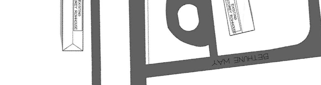
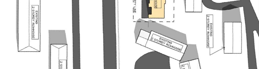
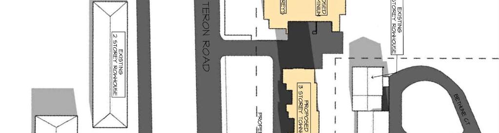
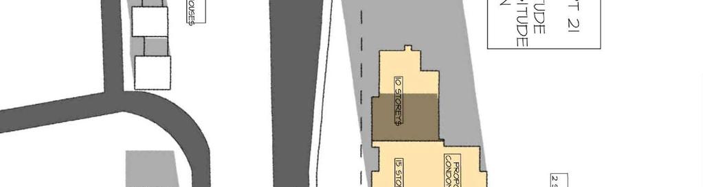
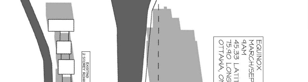
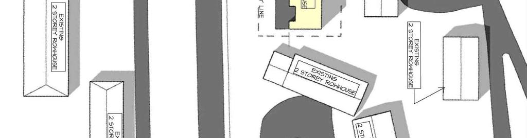
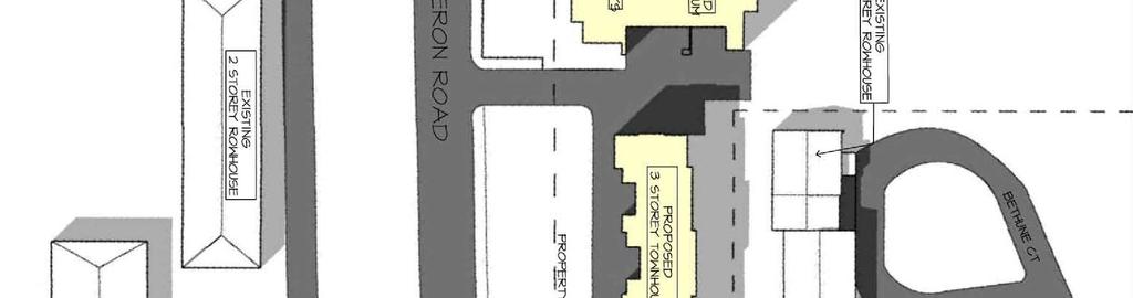
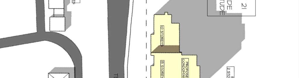
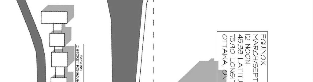
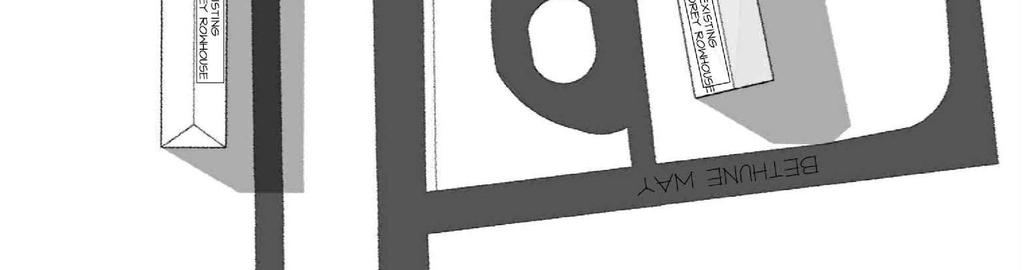
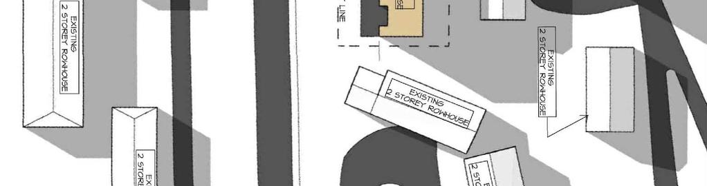
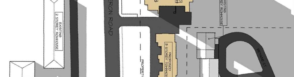
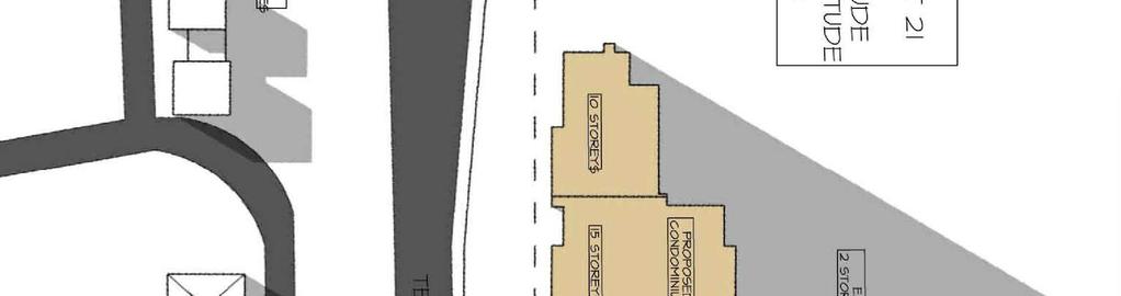
54
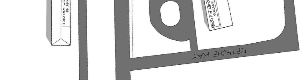
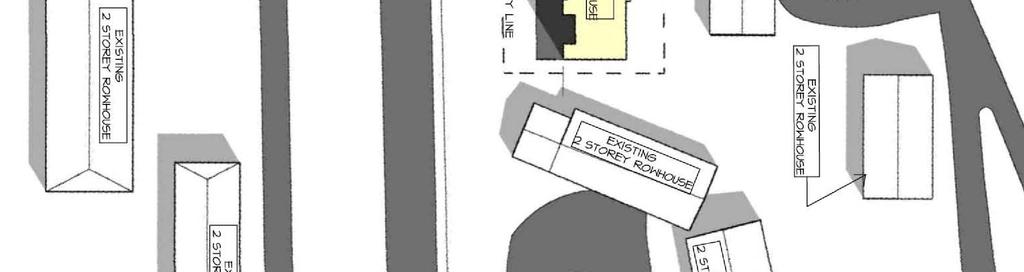
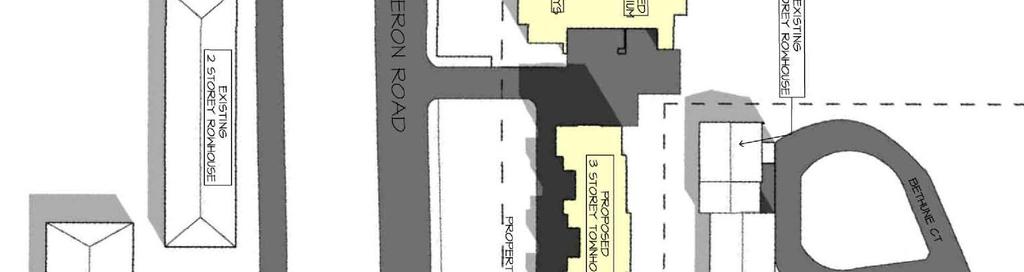
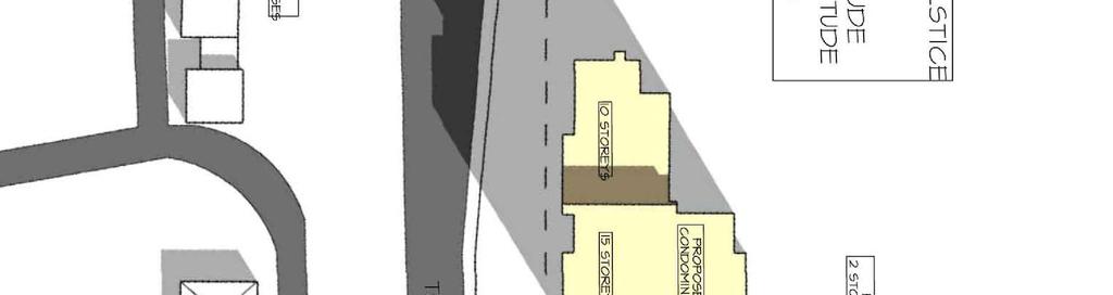
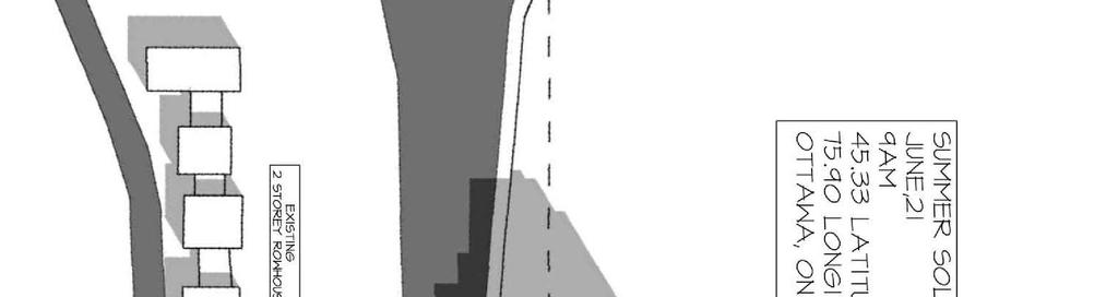
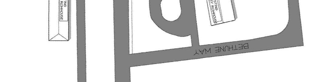
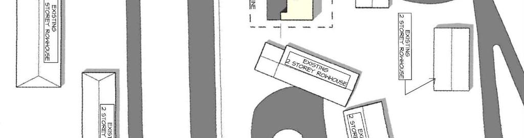
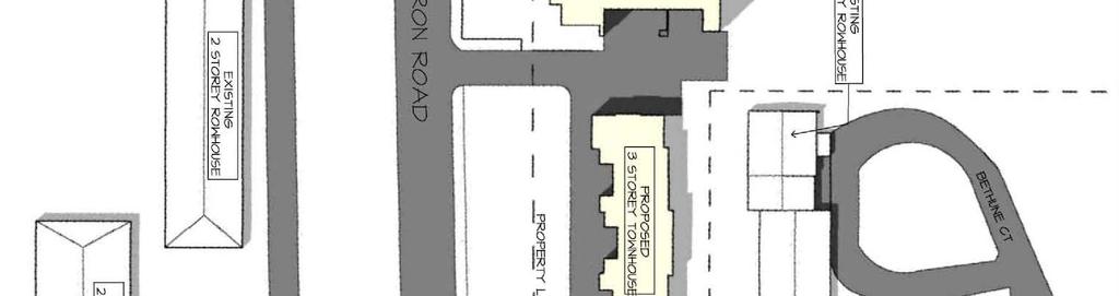
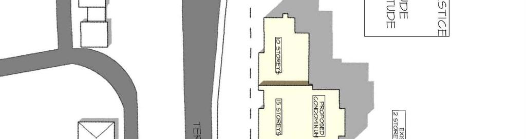
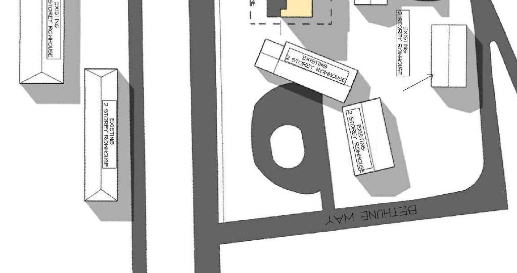
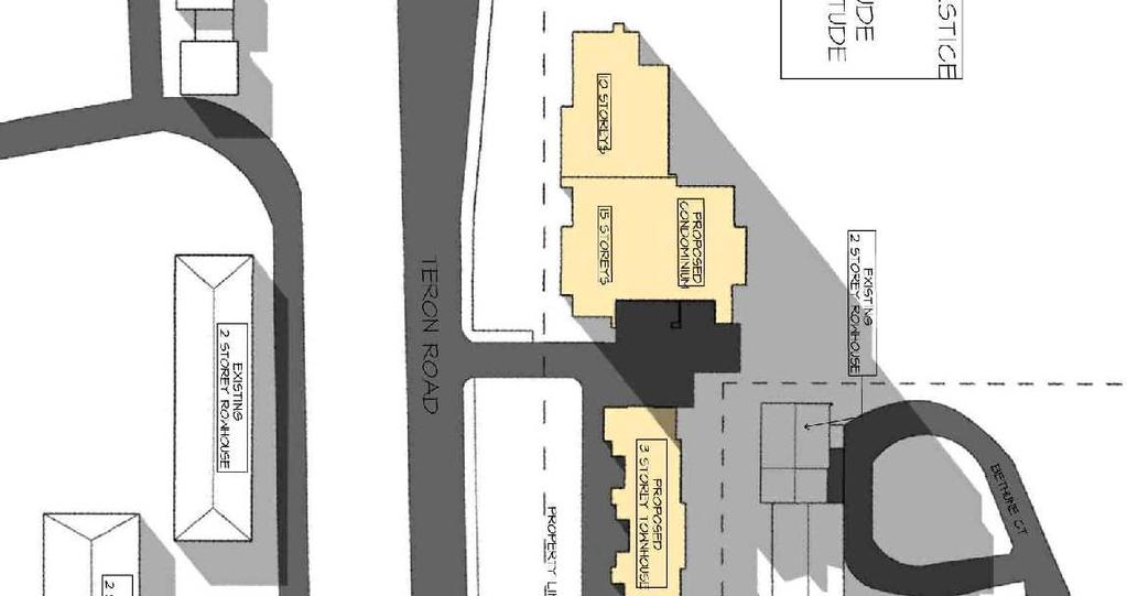
55
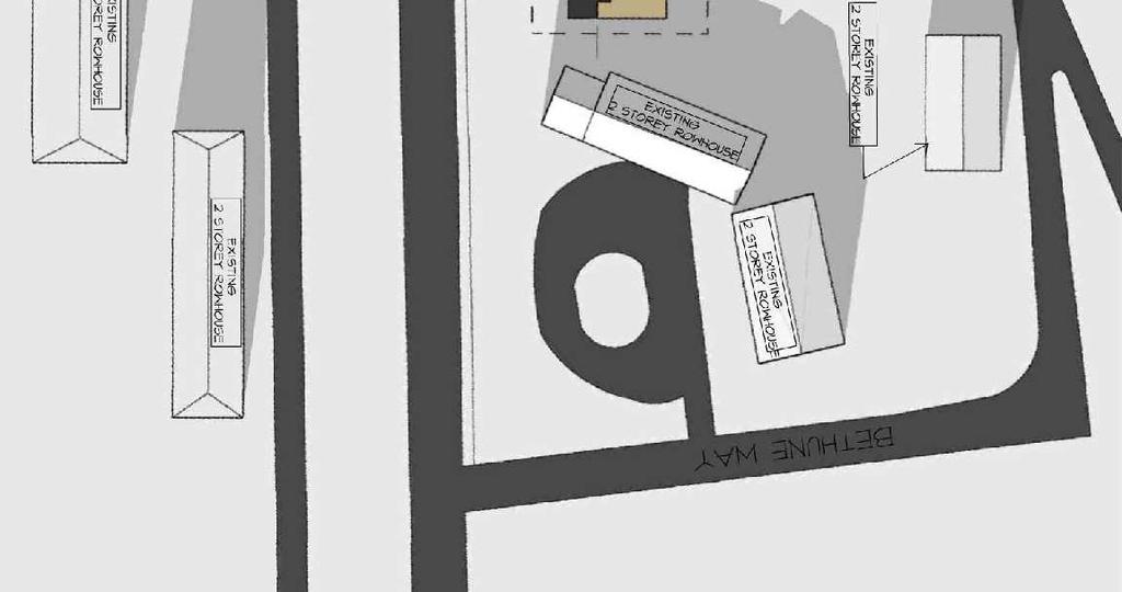
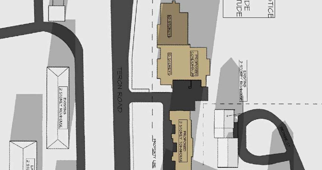
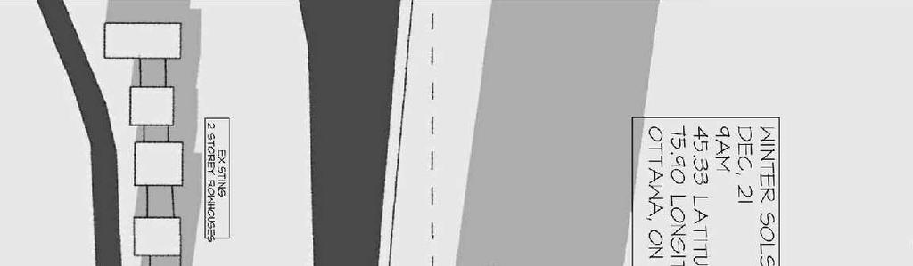
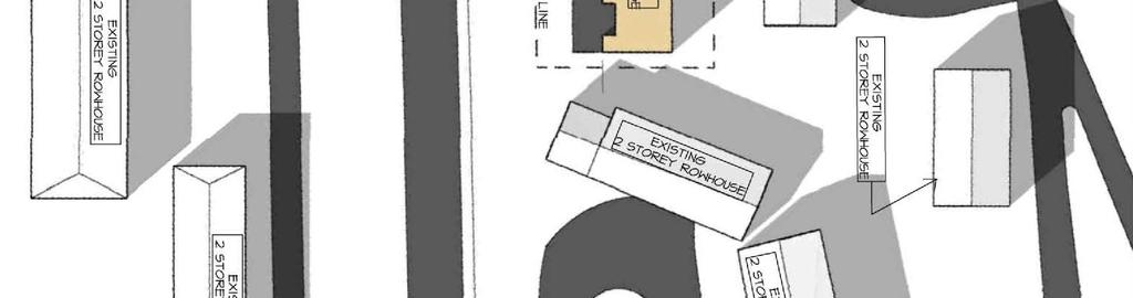
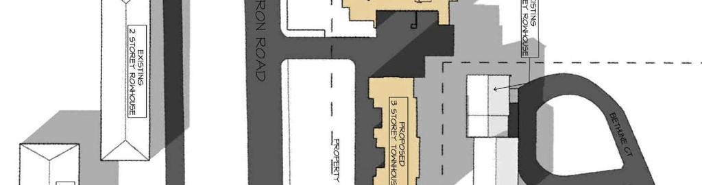
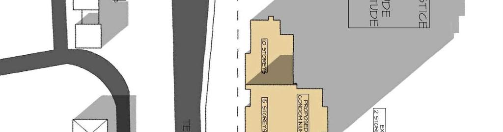
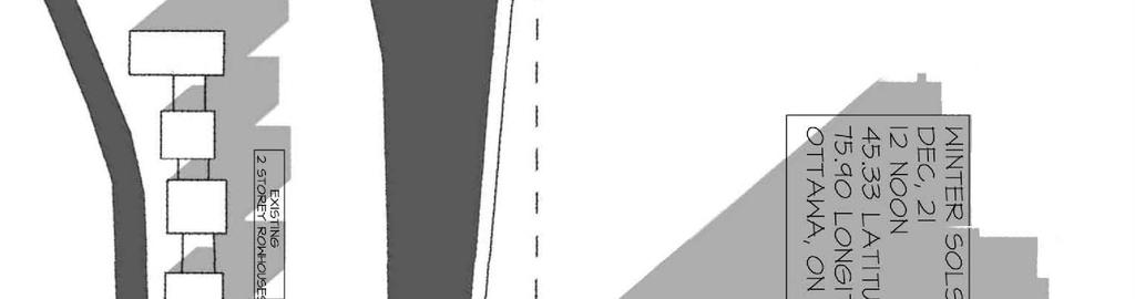
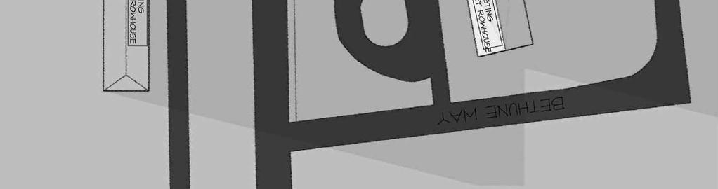
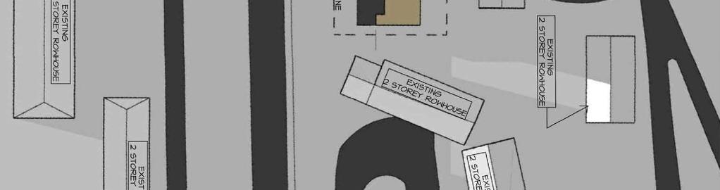
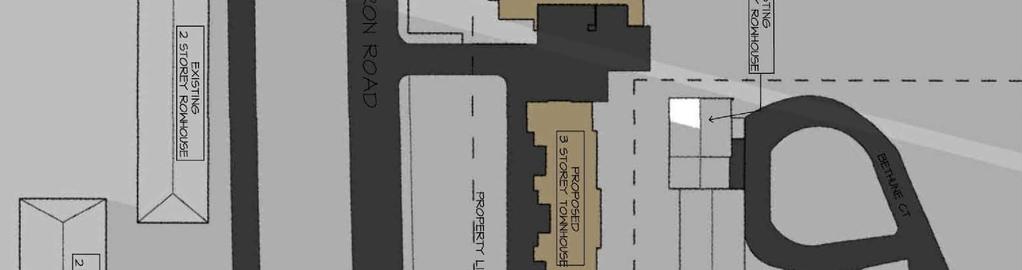

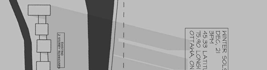
56

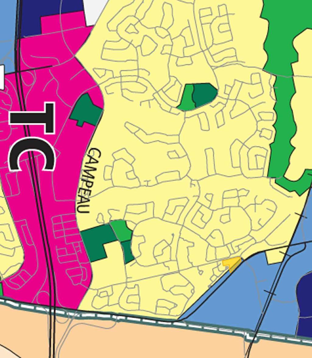
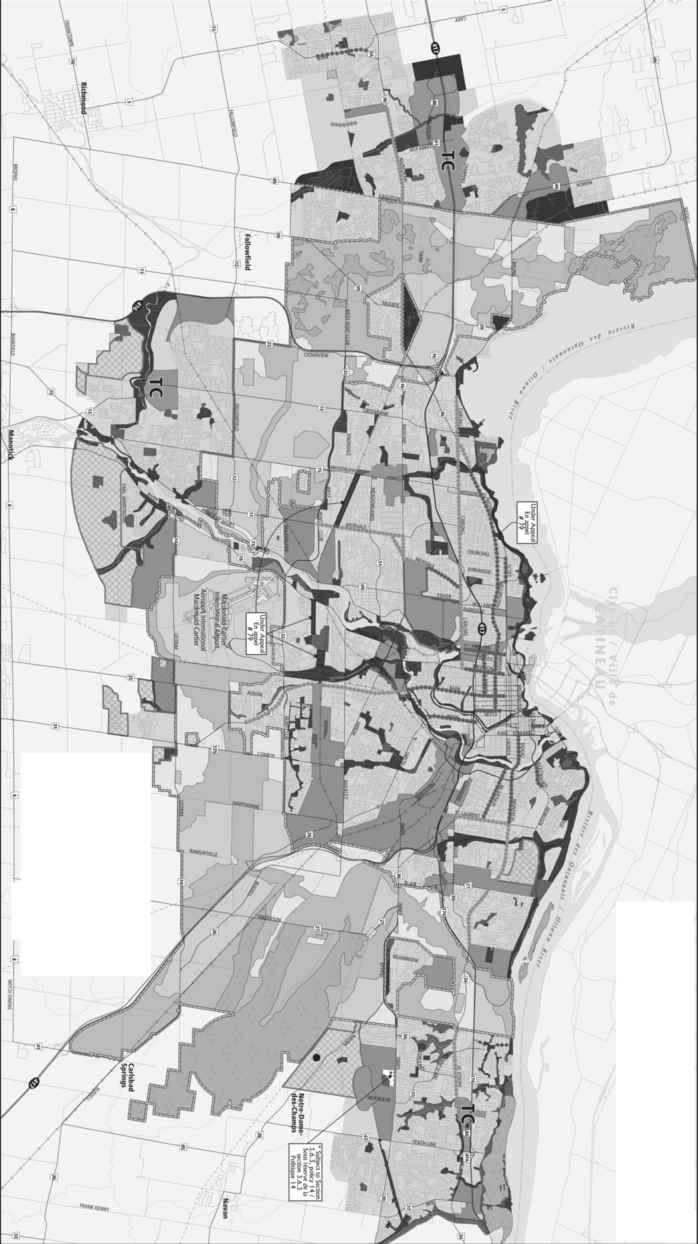
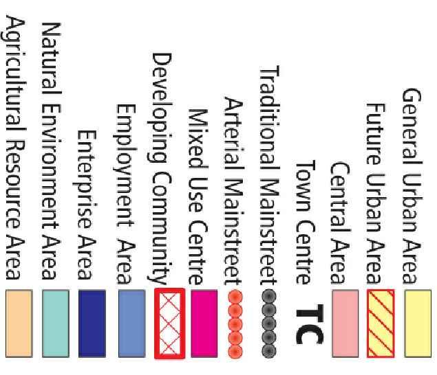
57
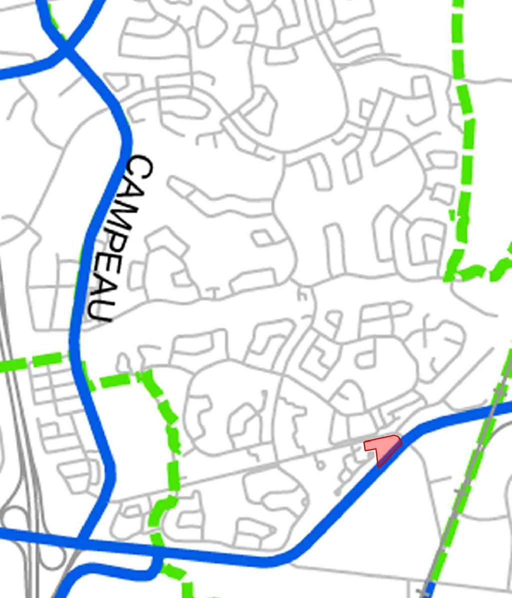
58

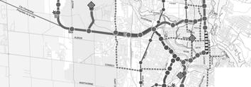
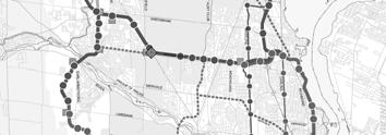


59
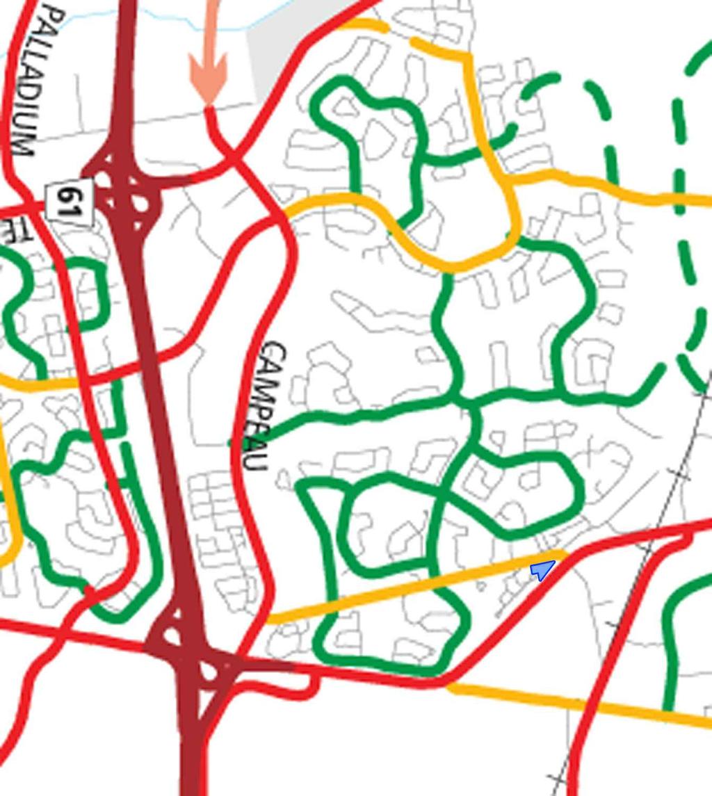
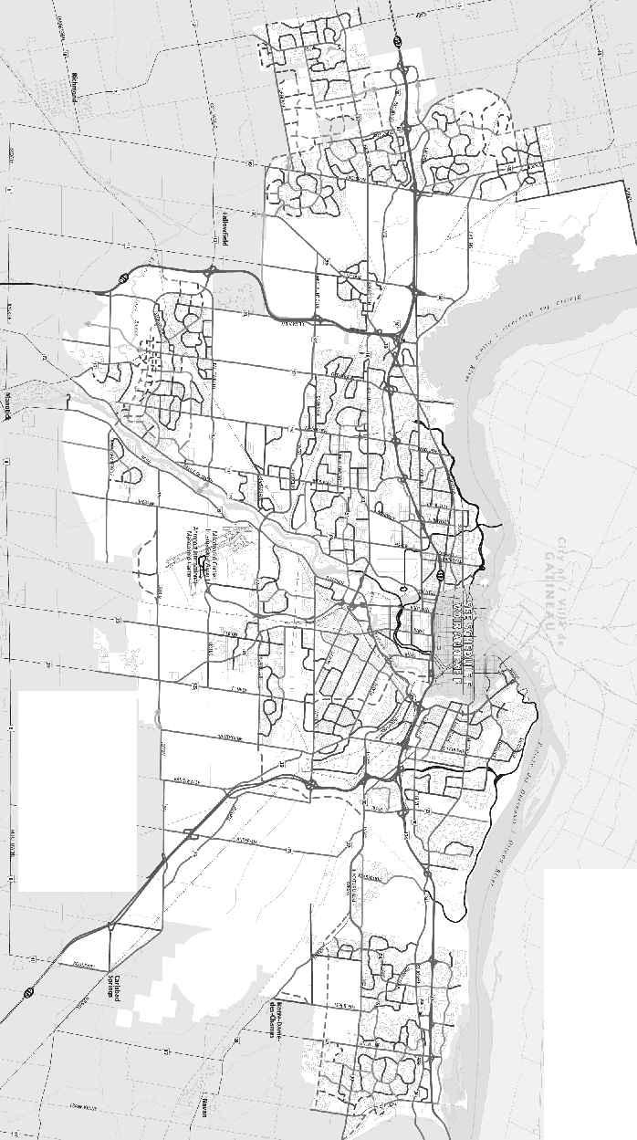
60
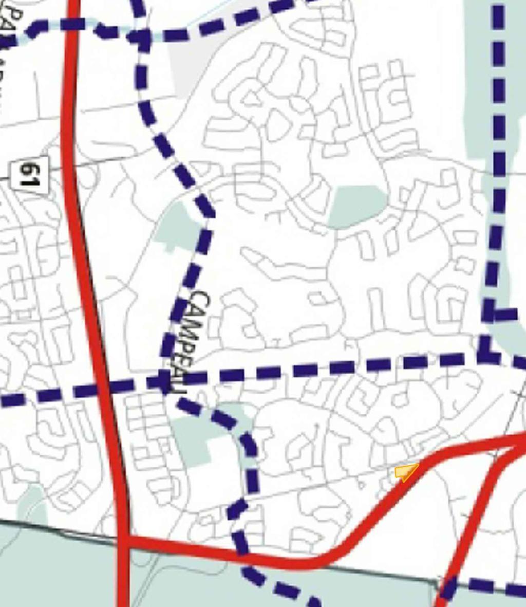


61
Planning Rationale in Support of an Application for Zoning By-law Amendment and Site Plan Control
 in Support of an Application for Zoning By-law Amendment and Site Plan Control Prepared by Holzman Consultants Inc. Land Development Consultants and Farrow Dreessen Architects Inc. October 2013 TABLE OF
PLANNING RATIONALE REPORT
 PLANNING RATIONALE REPORT Zoning By-law Amendment Application 2920 Danbury Way Prepared for: Bravar Custom Builders Inc. and Village View Estates Ltd. by: 6393 Roslyn Street Ottawa (Orleans), Ontario K1C
P. H. Robinson Consulting Urban Planning, Consulting and Project Management
 PLANNING RATIONALE REPORT FOR SITE PLAN AND DRAFT PLAN OF CONDOMINIUM APPLICATIONS 73-75 HARVEY STREET CITY OF OTTAWA PREPARED BY: P H ROBINSON CONSULTING AUGUST 2012 1 This report has been prepared on
770 BROOKFIELD ROAD Site Plan Control Atlantis Investments November 2017
 770 BROOKFIELD ROAD Site Plan Control Atlantis Investments November 2017 Prepared for: Atlantis Investments Inc. Prepared by: Fotenn Planning + Design 223 McLeod Street Ottawa, ON K2P 0Z8 fotenn.com October
MINTO COMMUNITIES INC. AVALON WEST STAGE 4 PLANNING RATIONALE. July Prepared for:
 MINTO COMMUNITIES INC. AVALON WEST STAGE 4 PLANNING RATIONALE July 2015 Prepared for: MINTO COMMUNITIES INC. 200 180 Kent Street Ottawa, Ontario K1P 0B6 Prepared by: J.L. RICHARDS & ASSOCIATES LIMITED
Planning Rationale in Support of an Application for Plan of Subdivision and Zoning By-Law Amendment
 Planning Rationale in Support of an Application for Plan of Subdivision and Zoning By-Law Amendment The Kilmorie Development 21 Withrow Avenue City of Ottawa Prepared by: Holzman Consultants Inc. Land
3.1. OBJECTIVES FOR RESIDENTIAL LAND USE DESIGNATIONS GENERAL OBJECTIVES FOR ALL RESIDENTIAL DESIGNATIONS
 3. RESIDENTIAL LAND USE DESIGNATIONS INTRODUCTION The Residential land use designations provide for housing and other land uses that are integral to, and supportive of, a residential environment. Housing
Montreal Road District Secondary Plan [Amendment #127, October 9, 2013]
![Montreal Road District Secondary Plan [Amendment #127, October 9, 2013]](/thumbs/72/66783104.jpg "Montreal Road District Secondary Plan [Amendment #127, October 9, 2013]") [Amendment #127, October 9, 2013] 1.0 General The following policies are applicable to the Montreal Road District as set out in Schedule 1. 1.1 District Objectives The objective of this Plan is to guide
[Amendment #127, October 9, 2013] 1.0 General The following policies are applicable to the Montreal Road District as set out in Schedule 1. 1.1 District Objectives The objective of this Plan is to guide
DRAFT FOR DISCUSSION PURPOSES ONLY. Port Credit Local Area Plan Built Form Guidelines and Standards DRAFT For Discussion Purposes
 Port Credit Local Area Plan Built Form Guidelines and Standards DRAFT For Discussion Purposes 1 Local Area Plan - Project Alignment Overview Directions Report, October 2008 (General Summary Of Selected
8.5.1 R1, Single Detached Residential District
 8.5.1 R1, Single Detached Residential District The purpose of this district is to provide for residential development in the form of single detached dwellings. Dwelling, Single Detached Home Business,
PLANNING PRIMER. Elective: Understanding Residential Intensification and Infill. Planning and Growth Management Department.
 PLANNING PRIMER Elective: Understanding Residential Intensification and Infill Planning and Growth Management Department Amended 2015 Agenda Information re: Infill and Intensification Initiatives Residential
PLANNING RATIONALE REPORT CODEAU BUILDING LTD RIDEAU STREET OTTAWA DECEMBER 2013
 PLANNING RATIONALE REPORT CODEAU BUILDING LTD 541-545 RIDEAU STREET OTTAWA DECEMBER 2013 1 This report has been prepared on behalf of Codeau Building Ltd. in support of a Zoning By-law Amendment Application
PLANNING RATIONALE 680 BRONSON AVENUE OTTAWA, ONTARIO PROPOSED ZONING BY-LAW AMENDMENT
 PLANNING RATIONALE 680 BRONSON AVENUE OTTAWA, ONTARIO PROPOSED ZONING BY-LAW AMENDMENT FRANK PARAVAN APRIL 2014 Planning Rationale Introduction FOTENN Consultants Inc. has been engaged by Frank and Michael
FEASIBILITY REPORT. 1486, 1490 and 1494 Clementine. Prepared by: Lloyd Phillips & Associates Ltd. For: Ottawa Salus
 DRAFT FEASIBILITY REPORT 1486, 1490 and 1494 Clementine Prepared by: Lloyd Phillips & Associates Ltd. For: Ottawa Salus LPA File No. 1008 Lloyd Phillips & Associates June 9, 2010 Feasibility Report Page
900 ALBERT STREET PLANNING RATIONALE ADDENDUM NO. 2
 900 ALBERT STREET PLANNING RATIONALE ADDENDUM NO. 2 March 26, 2018 Planning Rationale Addendum No. 2 Official Plan and Zoning By-law Amendment Prepared for: TIP Albert GP Inc. 485 Bank Street, Suite 200
Planning Justification Report
 Planning Justification Report 101 Kozlov Street, Barrie, Ont. Destaron Property Management Ltd. November 2015 Revised February 2017 TABLE OF CONTENTS Page 1.0 INTRODUCTION... 1 2.0 DESCRIPTION OF SUBJECT
774 BRONSON AVENUE MINOR ZONING BY-LAW AMENDMENT + SITE PLAN CONTROL PLANNING RATIONALE + DESIGN BRIEF
 774 BRONSON AVENUE MINOR ZONING BY-LAW AMENDMENT + SITE PLAN CONTROL PLANNING RATIONALE + DESIGN BRIEF JANUARY 2016 Prepared for: Textbook Suites 51 Caldari Road, Suite A1M Concord, ON L4K 4G3 T: 416 477
320 MCRAE AVENUE (320 MCRAE AVENUE SCOTT STREET TWEEDSMUIR AVENUE) Planning Rationale Zoning By-law Amendment Application
 Planning Rationale Zoning By-law Amendment Application") 320 MCRAE AVENUE (320 MCRAE AVENUE + 1976 SCOTT STREET + 315 TWEEDSMUIR AVENUE) Planning Rationale Zoning By-law Amendment Application February 2016 Prepared by: FOTENN Consultants Inc. 223 McLeod Street
320 MCRAE AVENUE (320 MCRAE AVENUE + 1976 SCOTT STREET + 315 TWEEDSMUIR AVENUE) Planning Rationale Zoning By-law Amendment Application February 2016 Prepared by: FOTENN Consultants Inc. 223 McLeod Street
PLANNING REPORT Gordon Street City of Guelph. Prepared on behalf of Ontario Inc. March 17, Project No. 1507
 PLANNING REPORT 1131 Gordon Street City of Guelph Prepared on behalf of 1876698 Ontario Inc. March 17, 2016 Project No. 1507 423 Woolwich Street, Suite 201, Guelph, Ontario, N1H 3X3 Phone (519) 836-7526
112 Montreal Road. 314 Gardner Street. + Site Plan Control. Zoning By-law Amendment. September 2014
 112 Montreal Road + 314 Gardner Street Zoning By-law Amendment + Site Plan Control September 2014 Prepared by: FOTENN Consultants Inc. 223 McLeod Street Ottawa, ON K2P 0Z8 613-730-5709 Prepared for: 1147310
Urban Design Brief Dundas Street. London Affordable Housing Foundation. November Zelinka Priamo Ltd.
 Urban Design Brief 1039-1047 Dundas Street London Affordable Housing Foundation November 2017 Zelinka Priamo Ltd. TABLE OF CONTENTS Page No. INTRODUCTION... 3 SECTION 1 LAND USE PLANNING CONTEXT... 3 1.1
PREPARED FOR: ADI DEVELOPMENT GROUP INC.
 Acronym Urban Design and Planning/Mark Sterling Consulting Inc. 111 Clendenan Avenue, Toronto, Ontario M6P 2W7 URBAN DESIGN BRIEF PROPOSED DEVELOPMENT 4880 VALERA ROAD, CITY OF BURLINGTON PREPARED FOR:
Sherwood Forest (Trinity) Housing Corporation. Urban Design Brief
 Housing Corporation. Urban Design Brief") Sherwood Forest (Trinity) Housing Corporation Sherwood Place Affordable Housing Apartments Trinity Presbyterian Church Orchard Park Nursery School 590 Gainsborough Road, London Urban Design Brief REVISED
Sherwood Forest (Trinity) Housing Corporation Sherwood Place Affordable Housing Apartments Trinity Presbyterian Church Orchard Park Nursery School 590 Gainsborough Road, London Urban Design Brief REVISED
Jasper 115 Street DC2 Urban Design Brief
 Jasper 115 Street DC2 Urban Design Brief Greenlong Construction Ltd. Stantec Consulting Ltd. 2017 Overview The proposed rezoning application supports the development of two mixed-use high-rise buildings
PIN , Part 1, Plan SR-713 in Lot 2, Concession 5, Township of McKim (1096 Dublin Street, Sudbury)
") STAFF REPORT Applicant: Dalron Construction Limited Location: PIN 02124-0103, Part 1, Plan SR-713 in Lot 2, Concession 5, Township of McKim (1096 Dublin Street, Sudbury) Official Plan and Zoning By-law:
STAFF REPORT Applicant: Dalron Construction Limited Location: PIN 02124-0103, Part 1, Plan SR-713 in Lot 2, Concession 5, Township of McKim (1096 Dublin Street, Sudbury) Official Plan and Zoning By-law:
Urban Design Brief (Richmond) Corp. 1631, 1635, 1639, 1643 and 1649 Richmond Street City of London
 Corp. 1631, 1635, 1639, 1643 and 1649 Richmond Street City of London") Urban Design Brief 1635 (Richmond) Corp. 1631, 1635, 1639, 1643 and 1649 Richmond Street City of London Site Plan Control Application Holding Provision Application April 1, 2015 Prepared for: Rise Real
Urban Design Brief 1635 (Richmond) Corp. 1631, 1635, 1639, 1643 and 1649 Richmond Street City of London Site Plan Control Application Holding Provision Application April 1, 2015 Prepared for: Rise Real
66 Isabella Street Rezoning Application - Preliminary Report
 STAFF REPORT ACTION REQUIRED 66 Isabella Street Rezoning Application - Preliminary Report Date: November 15, 2010 To: From: Wards: Reference Number: Toronto and East York Community Council Director, Community
Planning Justification Report
 Planning Justification Report 103 and 105 Toronto Street Town of Markdale, Municipality of Grey Highlands Maverick Developments November 5, 2016 Zelinka Priamo Ltd. Page i TABLE OF CONTENTS Page No. 1.0
6208 Jeanne D Arc Boulevard North. Planning Rationale. Site Plan Control
 Site Plan Control Prepared By: NOVATECH Suite 200, 240 Michael Cowpland Drive Ottawa, Ontario K2M 1P6 November / 24 / 2015 Novatech File: 115100 Ref: R-2015-179 November 24, 2015 City of Ottawa 110 Laurier
For Vintages of Four Mile Creek Town of Niagara on the Lake, Ontario
 Planning Impact Analysis For Vintages of Four Mile Creek Town of Niagara on the Lake, Ontario Prepared by: Upper Canada Consultants 261 Martindale Road Unit #1 St. Catharines, Ontario L2W 1A1 Prepared
Planning Rationale in Support of an Application for Site Plan Control
 Planning Rationale in Support of an Application for Site Plan Control 18 McArthur Avenue City of Ottawa Prepared by: Holzman Consultants Inc. Land Development Consultants May 19, 2016 TABLE OF CONTENTS
Zoning By-law Amendment & Site Plan Control Application
 1560 SCOTT Zoning By-law Amendment & Site Plan Control Application February 2014 1560 SCOTT Prepared by: FOTENN Consultants Inc. 223 McLeod Street Ottawa, ON K2P 0Z8 613-730-5709 fotenn.com Prepared for:
50+54 BELL STREET NORTH
 50+54 BELL STREET NORTH SITE PLAN CONTROL APPLICATION OCTOBER 2014 PREPARED BY: FOTENN Consultants Inc. 223 Mcleod Street Ottawa, ON K2P OZ8 (613) 730-5709 PREPARED FOR: Ottawa Chinese Alliance Church
LITTLE MOUNTAIN ADJACENT AREA REZONING POLICY
 LITTLE MOUNTAIN ADJACENT AREA REZONING POLICY JANUARY 2013 CONTENTS 1.0 INTENT & PRINCIPLES...1 2.0 APPLICATION...2 3.0 HOUSING TYPES, HEIGHT & DENSITY POLICIES...3 3.1 LOW TO MID-RISE APARTMENT POLICIES...4
1202 & 1204 Avenue Road Zoning By-law Amendment Application - Preliminary Report
 STAFF REPORT ACTION REQUIRED 1202 & 1204 Avenue Road Zoning By-law Amendment Application - Preliminary Report Date: March 17, 2017 To: From: Wards: Reference Number: North York Community Council Director,
LAND USE AND BUILT FORM
 5 LAND USE AND BUILT FORM The existing zoning on Bank Street already allows for considerable general intensification, since the permitted Floor Space Index (FSI) would already allow several times more
Ashcroft Homes Trim Road Development Planning Rationale
 18 Antares Drive Ottawa, ON K2E 1A9 Ashcroft Homes Trim Road Development Planning Rationale Proposed Site Plan & Zoning Amendment Applications File No: D02-02-17-0129 & D07-12-17-0175 August 2018 Planning
371 Richmond Road. Zoning By-law Amendment Site Plan Control
 371 Richmond Road Zoning By-law Amendment Site Plan Control August 2014 Prepared by: FOTENN Consultants 223 McLeod Street Ottawa, ON K2P 0Z8 613-730-5709 fotenn.com Prepared for: Domicile Developments
1417, , 1427 & 1429 Yonge Street - Official Plan Amendment and Zoning Amendment Applications - Preliminary Report
 STAFF REPORT ACTION REQUIRED 1417, 1421-1425, 1427 & 1429 Yonge Street - Official Plan Amendment and Zoning Amendment Applications - Preliminary Report Date: March 24, 2015 To: From: Wards: Reference Number:
3390, 3392, 3394, 3396 and 3398 Bayview Avenue - Official Plan Amendment, Zoning By-law Amendment Application - Preliminary Report
 STAFF REPORT ACTION REQUIRED 3390, 3392, 3394, 3396 and 3398 Bayview Avenue - Official Plan Amendment, Zoning By-law Amendment Application - Preliminary Report Date: March 14, 2016 To: From: Wards: Reference
ADELAIDE APARTMENTS TOWER EXTENSION
 ADELAIDE APARTMENTS TOWER EXTENSION SEPTEMBER 2016 CONTENTS INTRODUCTION 1 PURPOSE OF THE APPLICATIONS 1 SITE CONTEXT 2 EXISTING CONDITIONS 2 SURROUNDING AREA 3 SITE PHOTOS 4 PUBLIC TRANSIT 6 ROAD NETWORK
6040 Bathurst Street and 5 Fisherville Road Zoning Bylaw Amendment Application Preliminary Report
 STAFF REPORT ACTION REQUIRED 6040 Bathurst Street and 5 Fisherville Road Zoning Bylaw Amendment Application Preliminary Report Date: January 24, 2017 To: From: Wards: Reference Number: North York Community
Church Street and Gloucester Street - Rezoning Application - Preliminary Report
 STAFF REPORT ACTION REQUIRED - Rezoning Application - Preliminary Report Date: May 25, 2010 To: From: Wards: Reference Number: Toronto and East York Community Council Director, Community Planning, Toronto
5. Housing. Other Relevant Policies & Bylaws. Several City-wide policies guide our priorities for housing diversity at the neighbourhood level: Goals
 5. Housing Other Relevant Policies & Bylaws Several City-wide policies guide our priorities for housing diversity at the neighbourhood level: Goals 1. Encourage more housing diversity while maintaining
3 and 5 Southvale Dr - Official Plan Amendment and Zoning Amendment Applications - Preliminary Report
 STAFF REPORT ACTION REQUIRED 3 and 5 Southvale Dr - Official Plan Amendment and Zoning Amendment Applications - Preliminary Report Date: August 20, 2015 To: From: Wards: Reference Number: North York Community
230 Oak Street- Official Plan Amendment and Zoning Bylaw Amendment Applications - Preliminary Report
 STAFF REPORT ACTION REQUIRED 230 Oak Street- Official Plan Amendment and Zoning Bylaw Amendment Applications - Preliminary Report Date: February 6, 2014 To: From: Wards: Reference Number: Toronto and East
Yonge Street and 3 Gerrard Street East - Zoning Amendment Application - Preliminary Report
 STAFF REPORT ACTION REQUIRED 363-391 Yonge Street and 3 Gerrard Street East - Zoning Amendment Application - Preliminary Report Date: May 22, 2015 To: From: Wards: Reference Number: Toronto and East York
Accessory Coach House
 Updated July 2018 Accessory Coach House Development Permit Guidelines 1 Accessory Coach House Development Permit Guidelines Zoning Bylaw, 1995 DIVISION VII C. Contents Part I General Reglations 1 Introduction
KoL at BLACKSTONE. Planning Rationale. April Prepared in support of a Site Plan Control and Draft Plan of Condominium
 KoL at BLACKSTONE April 2015 Planning Rationale Prepared in support of a Site Plan Control and Draft Plan of Condominium KoL at BLACKSTONE P L A N N I N G R A T I O N A L E Contents List of Figures...
12, 14, 16 and 18 Marquette Avenue and 7 Carhartt Street Zoning By-law Amendment Application - Preliminary Report
 STAFF REPORT ACTION REQUIRED 12, 14, 16 and 18 Marquette Avenue and 7 Carhartt Street Zoning By-law Amendment Application - Preliminary Report Date: July 17, 2014 To: From: Wards: Reference Number: North
Islington Avenue - Official Plan and Zoning By-law Amendment Application - Preliminary Report
 STAFF REPORT ACTION REQUIRED 3002-3014 Islington Avenue - Official Plan and Zoning By-law Amendment Application - Preliminary Report Date: Febuary 2, 2016 To: From: Wards: Reference Number: Etobicoke York
355 King St W and 119 Blue Jays Way - OPA & Rezoning Applications - Preliminary Report
 STAFF REPORT ACTION REQUIRED 355 King St W and 119 Blue Jays Way - OPA & Rezoning Applications - Preliminary Report Date: May 27, 2008 To: From: Wards: Reference Number: Toronto and East York Community
20 Edward Street Zoning Amendment Application - Preliminary Report
 STAFF REPORT ACTION REQUIRED 20 Edward Street Zoning Amendment Application - Preliminary Report Date: January 20, 2015 To: From: Wards: Reference Number: Toronto and East York Community Council Director,
71 RUSSELL AVENUE. PLANNING RATIONALE FOR SITE PLAN CONTROL APPLICATION (Design Brief)
") ` 71 RUSSELL AVENUE Ottawa September 14, 2018 PLANNING RATIONALE FOR SITE PLAN CONTROL APPLICATION (Design Brief) Introduction The intent of this Planning Rationale and Design Brief is to provide planning
` 71 RUSSELL AVENUE Ottawa September 14, 2018 PLANNING RATIONALE FOR SITE PLAN CONTROL APPLICATION (Design Brief) Introduction The intent of this Planning Rationale and Design Brief is to provide planning
307 Sherbourne Street - Zoning Amendment Application - Preliminary Report
 STAFF REPORT ACTION REQUIRED 307 Sherbourne Street - Zoning Amendment Application - Preliminary Report Date: August 14, 2015 To: From: Wards: Reference Number: Toronto and East York Community Council Director,
Church Street and 117 Dundas Street East - Zoning Amendment Application - Preliminary Report
 STAFF REPORT ACTION REQUIRED 215-229 Church Street and 117 Dundas Street East - Zoning Amendment Application - Preliminary Report Date: February 26, 2015 To: From: Wards: Reference Number: Toronto and
AMENDMENT NUMBER 38 TO THE OFFICIAL PLAN OF THE TOWNSHIP OF WEST LINCOLN (COMPLIANCE)
") AMENDMENT NUMBER 38 TO THE OFFICIAL PLAN OF THE TOWNSHIP OF WEST LINCOLN (COMPLIANCE) 2013 AMENDMENT NUMBER 38 TO THE OFFICIAL PLAN OF THE TOWNSHIP OF WEST LINCOLN PART 1 - THE PREAMBLE 1.1 TITLE This
AMENDMENT NUMBER 38 TO THE OFFICIAL PLAN OF THE TOWNSHIP OF WEST LINCOLN (COMPLIANCE) 2013 AMENDMENT NUMBER 38 TO THE OFFICIAL PLAN OF THE TOWNSHIP OF WEST LINCOLN PART 1 - THE PREAMBLE 1.1 TITLE This
Appendix1,Page1. Urban Design Guidelines. Back to Back and Stacked Townhouses. DRAFT September 2017
 Appendix1,Page1 Urban Design Guidelines DRAFT September 2017 Back to Back and Stacked Townhouses Appendix1,Page2 Table of Contents 1 Introduction 1 1.1 Purpose 1 1.2 Urban Design Objectives 1 1.3 Building
Planning Justification Report
 Planning Justification Report Kellogg s Lands City of London E&E McLaughlin Ltd. June 14, 2017 Zelinka Priamo Ltd. Page i TABLE OF CONTENTS Page No. 1.0 2.0 2.1 2.2 3.0 4.0 5.0 5.1 5.2 5.3 5.4 5.5 5.6
CASTLES OF CALEDON URBAN DESIGN REPORT
 CASTLES OF CALEDON URBAN DESIGN REPORT PROPOSED RESIDENTIAL DEVELOPMENT CALEDON, ONTARIO 10 JULY, 2015 TABLE CONTENTS: 1.0 DEVELOPMENT 4.0 CONCLUSION 1.1 Introduction 1.2 Castles of Caledon- Urban Design
Director, Community Planning, North York District
 STAFF REPORT ACTION REQUIRED 3, 5, 11, 17, 21 Allenbury Gardens & 3, 5 Kingslake Road Official Plan and Zoning By-law Amendment and Rental Housing Demolition Applications Final Report Date: February 6,
Urban Design Brief. Italian Seniors Project 1090, 1092, 1096 Hamilton Road City of London
 Urban Design Brief Italian Seniors Project City of London October 1, 2017 TABLE OF CONTENTS Page No. INTRODUCTION... 2 1.0 LAND USE PLANNING CONCEPT... 2 1.1 Subject Lands... 2 1.2 Official Plan and Zoning
40-58 Widmer Street - Zoning Amendment Application - Preliminary Report
 STAFF REPORT ACTION REQUIRED 40-58 Widmer Street - Zoning Amendment Application - Preliminary Report Date: April 19, 2013 To: From: Wards: Reference Number: Toronto and East York Community Council Director,
PLANNING COMMISSION REPORT Regular Agenda -Public Hearing Item
 PDP-13-00518 Item No. 3B- 1 PLANNING COMMISSION REPORT Regular Agenda -Public Hearing Item PC Staff Report 2/24/14 ITEM NO. 3B PRELIMINARY DEVELOPMENT PLAN FOR HERE @ KANSAS; 1101 INDIANA ST (SLD) PDP-13-00518:
PLANNING REPORT. 33 Arkell Road City of Guelph. Prepared on behalf of OHM Arkell Inc. August 4, Project No. 1327
 PLANNING REPORT 33 Arkell Road City of Guelph Prepared on behalf of OHM Arkell Inc. August 4, 2015 Project No. 1327 423 Woolwich Street, Suite 201, Guelph, Ontario, N1H 3X3 Phone (519) 836-7526 Fax (519)
Housing & Residential Intensification Study Discussion Paper Township of King
 Housing & Residential Intensification Study Discussion Paper Prepared by Planning Department January 2011 1.0 Background 1.1 Provincial Policies (Greenbelt and Growth Plan) Since 2001, the Province of
Article 3. SUBURBAN (S-) NEIGHBORHOOD CONTEXT
 NEIGHBORHOOD CONTEXT") Article 3. SUBURBAN (S-) NEIGHBORHOOD CONTEXT this page left intentionally blank Contents ARTICLE 3. SUBURBAN (S-) NEIGHBORHOOD CONTEXT DIVISION 3.1 NEIGHBORHOOD CONTEXT DESCRIPTION...3.1-1 Section 3.1.1
Article 3. SUBURBAN (S-) NEIGHBORHOOD CONTEXT this page left intentionally blank Contents ARTICLE 3. SUBURBAN (S-) NEIGHBORHOOD CONTEXT DIVISION 3.1 NEIGHBORHOOD CONTEXT DESCRIPTION...3.1-1 Section 3.1.1
LOT AREA AND FRONTAGE
 LOT AREA AND FRONTAGE Lot Area & Frontage for the R2.1 Zone Lot Area & Frontage for the R2.4 Zone Minimum Lot Minimum Lot Zone Area Width R2.1 700 sq m 18 m R2.4 600 sq m 16 m Lot Area means the total
Planning & Development. Background. Subject Properties
 Planning & Development APPLICATION BRIEFING Prepared For: Planning Advisory Committee Submitted by: Jason Fox, Director of Planning & Development Date: Subject: Application by Meech Holdings Limited to
Richmond Street West - Zoning Amendment Application - Preliminary Report
 STAFF REPORT ACTION REQUIRED 457-457 Richmond Street West - Zoning Amendment Application - Preliminary Report Date: March 10, 2017 To: From: Wards: Reference Number: Toronto and East York Community Council
Bylaw No , being "Official Community Plan Bylaw, 2016" Schedule "A" DRAFT
 Bylaw No. 2600-2016, being "Official Community Plan Bylaw, 2016" Schedule "A" Urban Structure + Growth Plan Urban Structure Land use and growth management are among the most powerful policy tools at the
605 Longfields Drive Block 13 Plan 4M 1463
 Longfields Station Community 605 Longfields Drive Block 13 Plan 4M 1463 Planning Rationale Report December 2017 Prepared for Campanale Homes Paquette Planning Associates Ltd. 56 Hutchison Avenue Ottawa,
Paul D. Ralph, BES, RPP, MCIP, Commissioner, Development Services Department
 Public Report To: From: Report Number: Development Services Committee Paul D. Ralph, BES, RPP, MCIP, Commissioner, Development Services Department DS-16-50 Date of Report: April 14, 2016 Date of Meeting:
900 BURRARD STREET CD-1 GUIDELINES (BY-LAW NO. 6421) (CD-1 NO. 229) CONTENTS. 1 Application and Intent... 1
 (CD-1 NO. 229) CONTENTS. 1 Application and Intent... 1") 50 City of Vancouver Land Use and Development Policies and Guidelines Community Services, 453 W. 12th Ave Vancouver, BC V5Y 1V4 F 604.873.7344 fax 873.7060 planning@city.vancouver.bc.ca 900 BURRARD STREET
50 City of Vancouver Land Use and Development Policies and Guidelines Community Services, 453 W. 12th Ave Vancouver, BC V5Y 1V4 F 604.873.7344 fax 873.7060 planning@city.vancouver.bc.ca 900 BURRARD STREET
25 St. Dennis Drive - Zoning By-law Amendment Application - Preliminary Report
 STAFF REPORT ACTION REQUIRED 25 St. Dennis Drive - Zoning By-law Amendment Application - Preliminary Report Date: February 4, 2016 To: From: Wards: Reference Number: North York Community Council Director,
200 St. Clair Ave W - Official Plan Amendment and Zoning Amendment Applications - Preliminary Report
 STAFF REPORT ACTION REQUIRED 200 St. Clair Ave W - Official Plan Amendment and Zoning Amendment Applications - Preliminary Report Date: December 15, 2014 To: From: Wards: Reference Number: Toronto and
Director, Community Planning, Toronto and East York District
 STAFF REPORT September 1, 2005 To: From: Subject: Toronto and East York Community Council Director, Community Planning, Toronto and East York District Further Report Applications to amend Official Plan
Plan Dutch Village Road
 Plan Dutch Village Road Objective: The lands around Dutch Village Road are a minor commercial area that services the larger Fairview community. Maintaining the vibrancy of the area by planning for redevelopment
3005 Bloor Street West and 14 Humbervale Boulevard - Official Plan and Zoning Amendment Applications - Preliminary Report
 STAFF REPORT ACTION REQUIRED 3005 Bloor Street West and 14 Humbervale Boulevard - Official Plan and Zoning Amendment Applications - Preliminary Report Date: March 10, 2018 To: From: Wards: Reference Number:
Sheppard Ave East and 6, 8 and 10 Greenbriar Road - Official Plan Amendment and Zoning Amendment Applications - Preliminary Report
 STAFF REPORT ACTION REQUIRED 625-627 Sheppard Ave East and 6, 8 and 10 Greenbriar Road - Official Plan Amendment and Zoning Amendment Applications - Preliminary Report Date: April 15, 2016 To: From: Wards:
Director, Community Planning, Scarborough District ESC 44 OZ & ESC 44 SB
 STAFF REPORT ACTION REQUIRED 6175, 6183 Kingston Road and 1, 2, 4, 5, 7,10 & 11 Franklin Avenue - Official Plan Amendment, Zoning Amendment and Draft Plan of Subdivision Applications Preliminary Report
39 Thora Avenue Zoning Amendment Application Preliminary Report
 STAFF REPORT ACTION REQUIRED 39 Thora Avenue Zoning Amendment Application Preliminary Report Date: January 28, 2014 To: From: Wards: Reference Number: Scarborough Community Council Director, Community
6. RESIDENTIAL ZONE REGULATIONS
 6. RESIDENTIAL ZONE REGULATIONS PART 6A PURPOSE OF CHAPTER (1) The purpose of this Chapter is to provide detailed regulations and requirements that are relevant only to residential zones and specific residential
45 & 77 Dunfield Avenue - Zoning Amendment Application - Preliminary Report
 STAFF REPORT ACTION REQUIRED 45 & 77 Dunfield Avenue - Zoning Amendment Application - Preliminary Report Date: January 22, 2014 To: From: Wards: Reference Number: Toronto and East York Community Council
Planning and Building Department
 Page 1 of Report PB-83-13 TO: Development and Infrastructure Committee Planning and Building Department SUBJECT: OP & Rezoning 5001 Corporate Drive Appleby Gardens LJM Developers Report Number: PB-83-13
Director, Community Planning, North York District NNY 10 OZ and NNY 10 RH
 STAFF REPORT ACTION REQUIRED 847 873 Sheppard Avenue West - Official Plan Amendment and Zoning By-law Amendment and Rental Housing Demolition and Conversion Applications - Preliminary Report Date: April
4650 Eglinton Avenue West - Zoning By-law Amendment Application - Preliminary Report
 STAFF REPORT ACTION REQUIRED 4650 Eglinton Avenue West - Zoning By-law Amendment Application - Preliminary Report Date: August 14, 2015 To: From: Wards: Reference Number: Etobicoke York Community Council
Financial Impact Statement There are no immediate financial impacts associated with the adoption of this report.
 STAFF REPORT Planning and Development Department Subject: Application by RYC Property to rezone a portion of lands on John Murray Dr. and Megan Lynn Dr. from R2 to R3 and to enter into a Development Agreement
STAFF REPORT PLN September 11, 2017
 Page: 1 TO: SUBJECT: GENERAL COMMITTEE APPLICATIONS FOR OFFICIAL PLAN AMENDMENT AND ZONING BY-LAW AMENDMENT 37 JOHNSON STREET WARD: WARD 1 PREPARED BY AND KEY CONTACT: SUBMITTED BY: GENERAL MANAGER APPROVAL:
PLANNING REPORT. Starwood Drive and Watson Parkway North City of Guelph. Coletara Development. November 12, Project No. 1307
 PLANNING REPORT Starwood Drive and Watson Parkway North City of Guelph Coletara Development November 12, 2013 Project No. 1307 423 Woolwich Street, Suite 201, Guelph, Ontario, N1H 3X3 Phone (519) 836-7526
Director, Community Planning, Etobicoke York District
 STAFF REPORT ACTION REQUIRED 3555 Don Mills Road Zoning By-law Amendment Application Preliminary Report Date: May 22, 2012 To: From: Wards: Reference Number: North York Community Council Director, Community
(1) The following uses are permitted uses subject to:
 The following uses are permitted uses subject to:") SECTION 4 - RESIDENTIAL SECOND DENSITY (R2) ZONE PURPOSE OF THE ZONE The purpose of the R2 Residential Second Density Zone is to: () restrict the building form to low density residential uses in areas
SECTION 4 - RESIDENTIAL SECOND DENSITY (R2) ZONE PURPOSE OF THE ZONE The purpose of the R2 Residential Second Density Zone is to: () restrict the building form to low density residential uses in areas
250, 252, 254 and 256 Royal York Road and 8 and 10 Drummond Street - Zoning By-law Amendment Application - Preliminary Report
 STAFF REPORT ACTION REQUIRED 250, 252, 254 and 256 Royal York Road and 8 and 10 Drummond Street - Zoning By-law Amendment Application - Preliminary Report Date: May 28, 2013 To: From: Wards: Reference
507, 509 and 511 Kingston Road - Official Plan and Zoning By-law Amendment Applications - Preliminary Report
 STAFF REPORT ACTION REQUIRED 507, 509 and 511 Kingston Road - Official Plan and Zoning By-law Amendment Applications - Preliminary Report Date: March 9, 2017 To: From: Wards: Reference Number: Toronto
H4. Residential Mixed Housing Suburban Zone
 H4. Residential Mixed Housing Suburban Zone H4.1. Zone description The Residential Mixed Housing Suburban Zone is the most widespread residential zone covering many established suburbs and some greenfields
Director, Community Planning, North York District
 STAFF REPORT ACTION REQUIRED 35-53 and 101-113 Valley Woods Road and 1213-1229 York Mills Road Official Plan, Rezoning, Draft Plan of Subdivision and Rental Housing Demolition Applications Final Report
3445 Sheppard Avenue East - Zoning Amendment Application - Preliminary Report
 STAFF REPORT ACTION REQUIRED 3445 Sheppard Avenue East - Zoning Amendment Application - Preliminary Report Date: August 14, 2013 To: From: Wards: Reference Number: Scarborough Community Council Director,
10 St Mary Street - Zoning Amendment Application - Preliminary Report
 STAFF REPORT ACTION REQUIRED 10 St Mary Street - Zoning Amendment Application - Preliminary Report Date: May 14, 2015 To: From: Wards: Reference Number: Toronto and East York Community Council Director,
44 Jackes Avenue and 33 Rosehill Avenue - Zoning Amendment Application - Preliminary Report
 STAFF REPORT ACTION REQUIRED 44 Jackes Avenue and 33 Rosehill Avenue - Zoning Amendment Application - Preliminary Report Date: March 16, 2017 To: From: Wards: Reference Number: Toronto and East York Community
50 and 52 Finch Avenue East - Official Plan and Zoning By-law Amendment Applications - Preliminary Report
 STAFF REPORT ACTION REQUIRED 50 and 52 Finch Avenue East - Official Plan and Zoning By-law Amendment Applications - Preliminary Report Date: August 16, 2016 To: From: Wards: Reference Number: North York