Developing a Prototype Marine Cadastre for Chedabucto Bay, Nova Scotia, Canada or is it St. Margaret s Bay?
|
|
|
- Anissa Johnston
- 5 years ago
- Views:
Transcription
1 Developing a Prototype Marine Cadastre for Chedabucto Bay, Nova Scotia, Canada or is it St. Margaret s Bay? Dr. Michael Sutherland, CANADA Chair-Elect, Commission 4 FIG EILAT 2009, FIG WORKING WEEK, EILAT, ISRAEL MAY 3-8, 2009 LEGAL ISSUES TECHNICAL ISSUES COINAtlantic Marine Cadastre Prototype INTRODUCTION
 UNB/FIG Workshop on Ocean Governance and Marine Cadastre Canada 2003 PCGIAP Workshop on Administering the")
2 LEGAL ISSUES TECHNICAL ISSUES COINAtlantic Marine Cadastre Prototype Working Group 4.3 Administering Marine Spaces (Joint with Commission 7- Cadastre and Land Management) Dr. Michael Sutherland Canada MEETINGS FIG Meetings and Working Weeks (International research) UNB/FIG Workshop on Ocean Governance and Marine Cadastre Canada 2003 PCGIAP Workshop on Administering the Marine Environment Kuala Lumpur, Malaysia th Regional Conference, San José, Costa Rica, November, 2007 General discussion of issues Asia and Pacific Region Europe North America Africa Small Island Developing States
3 The Governance Challenge Norms, Social Values Context Context Stakeholders Technical Social Informal, formal arrangements Knowledge Resources Laws Many Types of Information Accurate Up-to-date Complete GOOD GOVERNANCE
4 Stakeholder Identification Addressing: Lack of knowledge Government silos Single issue focus Property rights uncertainties Jurisdictional uncertainties, gaps, and overlaps Stakeholder Engagement and Input Addressing: Genuine consultation Collaboration, coordination, cooperation, integration Horizontal Coordination Temporal Coordination Government Vertical Coordination National Present Local Future Government Other Stakeholders After Prescott [1985]
5 Sovereignty Legislative jurisdiction Administrative authority Complex private and public rights Overlaps and gaps Boundaries: not defined or ill-defined 350 N.mi Legal Continental Shelf 200 N.mi Exclusive Economic Zone 24 N.mi Contiguous Zone 12 N.mi Territorial Sea High Seas 2500 Metres U.N Convention on the Law of the Sea N.mi After Nichols, 2003 The Area

6 Many Other Types of Marine Boundaries Public Access Rights Fishing Rights Customary Rights Navigation Rights Seabed Use Rights Riparian Rights Development Rights Mineral Rights After Sutherland, THE AUSTRALIAN MODEL


7 Web-GIS / Mapping Technologies Internet Applet Viewer Internet Source 1 Caris files ESRI shape files Source X Oracle 9i Orthophotography
 to develop, implement")
8 Marine Cadastre - Part of a Marine Geo-Spatial Data Infrastructure (MGDI) Sources Datasets & Metadata Institutional Policies & Information Arrangements[McLaughlin Standards & Nichols, Technologies 1992] Networks & Access Mechanisms McLaughlin/Nichols [1993] Value-Added Data Users Requirements initiative of the Atlantic Coastal Zone Information Steering Committee (ACZISC) to develop, implement and sustain a network of data providers and users that will support secure access to data, information and applications, for decision-making by coastal and ocean managers and users of coastal and ocean space and resources


9 Dr. Sue Nichols, UNB; Dr. Michael Sutherland, UWI; Mr. Brad Fay, Nova Scotia; Ms. Katie Komjathy, UNB; Mr. Daniel Jones, UWI
10
11
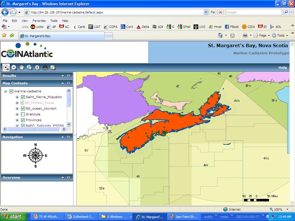
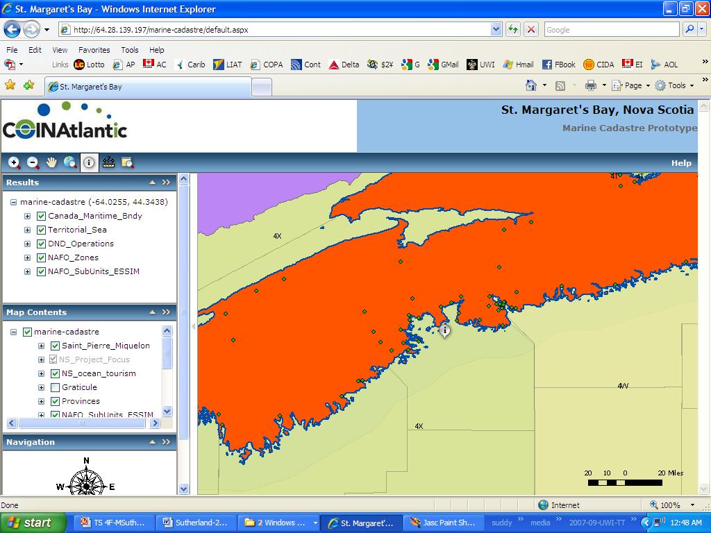
12 COINAtlantic Search Utility: COINAtlantic Marine Cadastre Prototype:
13 Developing a Prototype Marine Cadastre for Chedabucto Bay, Nova Scotia, Canada or is it St. Margaret s Bay? Dr. Michael Sutherland, CANADA Chair-Elect, Commission 4 FIG EILAT 2009, FIG WORKING WEEK, EILAT, ISRAEL MAY 3-8, 2009
Developing a Prototype Marine Cadastre for Chedabucto Bay, Nova Scotia
 Michael SUTHERLAND and Susan NICHOLS, Canada Keywords: Marine Cadastre; Marine Information System; Coastal Zone Management; Ocean Governance; Administration of Marine Spaces ABSTRACT The idea of a marine
Effects of the Law on the Marine Cadastre: Title, Administration, Jurisdiction, and Canada s Outer Limit
 Effects of the Law on the Marine Cadastre: Sara COCKBURN and Dr. Susan NICHOLS, Canada Key words: ABSTRACT When considering the legal framework for the marine cadastre, four things must be taken into account.
The Multipurpose Marine Cadastre A Tool for Planning & Decision Making in the Marine Environment
 The Multipurpose Marine Cadastre A Tool for Planning & Decision Making in the Marine Environment Christine Taylor Minerals Management Service (MMS) Brian Smith NOAA Coastal Services Center Maurice Hill
Croatian SDI: a Tool for Accelerated Development of the Geo-Conscious Society
 STATE GEODETIC ADMINISTRATION Croatian SDI: a Tool for Accelerated Development of the Geo-Conscious Society Prof.Dr.Sc. Željko Bačić, Mr.Sc. Ljerka Rašić FIG Working Week 2009 - Surveyors Key Role in Accelerated
STATUS REPORT
 Working Group 3 Land Administration STATUS REPORT 2006-2009 2009 Prof Ian Williamson (Chair) Mr Ahmad Fauzi Nordin (Vice Chair) Assoc. Prof Abbas Rajabifard (Vice Chair) 18th UNRCC-AP Conference Bangkok
Marine Spatial Data Infrastructure (MSDI) & The Marine Cadastre Application. April 10, 2018
 & The Marine Cadastre Application. April 10, 2018") Marine Spatial Data Infrastructure (MSDI) & The Marine Cadastre Application April 10, 2018 A Collaborative Pilot Project Vision of CHS: A framework of geographic data, metadata, users and tools Intent
Marine Spatial Data Infrastructure (MSDI) & The Marine Cadastre Application April 10, 2018 A Collaborative Pilot Project Vision of CHS: A framework of geographic data, metadata, users and tools Intent
Flying high and Keeping the feet on the ground
 Building the Capacity The Agenda and Achievements 2007-2010 FIG handover ceremony, FIG headquarters, Copenhagen, 26 November 2010 The Agenda Building the Capacity through Flying high and Keeping the feet
Overview of PCGIAP-WG3 and Spatially Enabled Government
 Working Group 3 3 rd Land Administration Forum Overview of and Spatially Enabled Government Abbas Rajabifard Vice Chair, Established in 2000 based on a Resolution from the 15th UNRCC-AP in Malaysia. With
Sustainable land information for sustainable development
 Sustainable land information for sustainable development Clare Hadley Ordnance Survey Commonwealth Peoples Forum, Malta, November 2005 This Presentation Why is land information necessary for sustainable
The Message FIG-WB Partnership on Land Governance in Support of the Global Agenda
 FIG-WB Partnership on Land Governance in Support of the Global Agenda Prof. Stig Enemark, Denmark President 2007-2010 Mr. Teo Chee Hai, Malaysia President Elect 2011-2014 WORLD BANK LAND GROUP, WASHINGTON,
Land Administration And Spatial Data Infrastructures
 Land Administration And Spatial Data Infrastructures Ian WILLIAMSON, Donald GRANT and Abbas RAJABIFARD Centre for SDIs and Land Administration Department of Geomatics University of Melbourne, Australia
COMMISSION 7 CADASTRE AND LAND MANAGEMENT WORK PLAN
 Appendix to item 34.7 FIG Congress in Washington, 19-26 April 2002 COMMISSION 7 CADASTRE AND LAND MANAGEMENT WORK PLAN 2002 2006 1. Title Cadastre and Land Management 2. Terms of Reference Commission 7
Report and update from Working Group A on Core Data
 JOINT UN-GGIM: EUROPE ESS MEETING ON THE INTEGRATION OF STATISTICAL AND GEOSPATIAL INFORMATION LUXEMBOURG 31 MARCH 2017 Report and update from Working Group A on Core Data François Chirié, Dominique Laurent,
A beautiful setting. The Evolving Role of Cadastral Systems in Support of Good Land Governance. Setting the scene
 The Evolving Role of Cadastral Systems in Support of Good Land Governance Prof. Stig Enemark President Aalborg University, Denmark THE DIGITAL CADASTRAL MAP FIG COMMISSION 7 OPEN SYMPOSIUM KARLOVY VARY,
DEFINING A MARINE CADASTRE FOR AUSTRALIA
 DEFINING A MARINE CADASTRE FOR AUSTRALIA P.A. COLLIER, F.J. LEAHY and I.P. WILLIAMSON Key Words: marine cadastre, maritime boundaries, spatial data infrastructure, marine rights and responsibilities ABSTRACT
Theme Strategic Plan for Cadastral Theme
 Theme Strategic Plan for Cadastral Theme Bureau of Land Management Cadastral Survey Federal Geographic Data Committee (FGDC) 2017 2021 April 2017 - Progress and Update Cadastral Theme Implementation Plan
Lessons for federated countries that have state land registries the Australian experience
 Lessons for federated countries that have state land registries the Australian experience Ian Williamson Centre for SDI and Land Administration Department Infrastructure Engineering University of Melbourne
Coastal Zone Management Land Administration Capacity Building
 Closing Address Prof. Stig Enemark President 6th FIG Regional Conference Coastal Areas and Land Administration - Building the Capacity San José, Costa Rica, 12 15 November 2007 Three Main Themes Coastal
Croatian NSDI - An example of AGISEE country web-page. Vlado Cetl and Miljenko Lapaine
 Croatian NSDI - An example of AGISEE country web-page Vlado Cetl and Miljenko Lapaine Introduction 2/18 Guidelines AGISSE Country Pages should provide an overview of the situation of SDIs in the countries
Chapter 9: 3D Visualisation as a Tool to Facilitate Managing Land and Properties
 Chapter 9: 3D Visualisation as a Tool to Facilitate Managing Land and Properties Davood Shojaei Overview The rapid population growth and decrease of natural resources have concerned decision makers about
Digitalisation of the Real Property Rights Towards Spatially enabled E-Government
 Digitalisation of the Real Property Rights Towards Spatially enabled E-Government Lise Schroeder, Bent Hulegaard Jensen, Esben Munk Soerensen & Line Hvingel Istanbul, Turkey 25 june 201 Overview Introduction
Cadastre a role model for Private-Public-People-Partnership
 Cadastre 4.0 - a role model for Private-Public-People-Partnership Gerda Schennach, Austria Chair of FIG Commission 7 1 Who owns... buildings? the mountains? land? forests? the sea? infrastructure? 2 From
FGDC Cadastral Data Subcommittee. December 2008
 FGDC Cadastral Data Subcommittee Annotated Bibliography: Foundational Documents for Building a Cadastral National Prepared by David Stage and Nancy von Meyer for the FGDC Cadastral Data Subcommittee Annotated
Geodetic Infrastructure in Samoa. FIG Pacific Small Islands Developing States Symposium September 2013, Suva, FIJI.
 Geodetic Infrastructure in Samoa. FIG Pacific Small Islands Developing States Symposium 18 20 September 2013, Suva, FIJI. FIG Commission 5 Position and Measurement United Nations Global Geospatial Information
National Spatial Data Infrastructure development in Republic of Macedonia
 National Spatial Data Infrastructure development in Republic of Macedonia Sonja Dimova, state advisor for geomatics AGENCY FOR REAL ESTATE CADASTRE September 6-th, 2017, Strasbourg AREC competence for
REGISTRATION OF PROPERTIES IN STRATA
 REGISTRATION OF PROPERTIES IN STRATA REPORT ON THE WORKING SESSIONS INTRODUCTION A cadastre is usually, and in most countries, a parcel-based, and up-to-date land information system containing records
SURVEYING BOUNDARIES FORESHORE AND PROPERTY OUTLINE DEFINITIONS JURISDICTIONAL ISSUES TENURE ISSUES PRACTICAL SURVEY ISSUES RECOMMENDATIONS
 SURVEYING BOUNDARIES OUTLINE DEFINITIONS JURISDICTIONAL ISSUES TENURE ISSUES PRACTICAL SURVEY ISSUES RECOMMENDATIONS DEFINITIONS FORESHORE: the part of the seashore between the high water mark and the
FGDC SUBCOMMITTEE FOR CADASTRAL DATA. October 2004 Albuquerque, New Mexico Meeting
 FGDC SUBCOMMITTEE FOR CADASTRAL DATA October 2004 Albuquerque, New Mexico Meeting The National Spatial Data Infrastructure is the means to assemble geographic information that describes the arrangements
Smart Infrastructure Benefits and Key Players from a Global Perspective
 Smart Infrastructure Benefits and Key Players from a Global Perspective Spatial@gov 2010 October 5-7 Canberra Jude Wallace and Abbas Rajabifard Centre for Spatial Data Infrastructures and Land Administration
LIS a motivation for SDI initiative
 Eric Mwaikambo Ardhi University Dar es Salaam Tanzania Overview Status of LIS in Tanzania Relationship between SDI and LIS Spatial Standards LIS a motivation for SDI initiative Conclusion & Recommendations
Real Estate Administration at the Vancouver Port Authority (VPA) Presentation by Ron McMillan - GIS/LIS Coordinator December 13, 2004
 Presentation by Ron McMillan - GIS/LIS Coordinator December 13, 2004") Real Estate Administration at the Vancouver Port Authority (VPA) Presentation by Ron McMillan - GIS/LIS Coordinator December 13, 2004 Introduction Overview of the Vancouver Port Authority (VPA) How CAD
Real Estate Administration at the Vancouver Port Authority (VPA) Presentation by Ron McMillan - GIS/LIS Coordinator December 13, 2004 Introduction Overview of the Vancouver Port Authority (VPA) How CAD
Cadastral Template 2003
 PCGIAP-Working Group 3 "Cadastre" FIG-Commission 7 "Cadastre and Land Management" Cadastral Template 2003 The establishment of a cadastral template is one of the objectives of Working Group 3 "Cadastre"
AFRICAN FORESTRY AND WILDLIFE COMMISSION
 January 2016 FO:AFWC/2016/5.1 E AFRICAN FORESTRY AND WILDLIFE COMMISSION TWENTIETH SESSION Nairobi, Kenya, 1-5 February 2016 HARMONIZING SECTORIAL POLICIES AND LAWS TO REDUCE GROWING CONFLICT ON LAND USE
A CADASTRAL GEODATA BASE FOR LAND ADMINISTRATION USING ARCGIS CADASTRAL FABRIC MODEL A CASE STUDY OF UWANI ENUGU, ENUGU STATE, NIGERIA
 A CADASTRAL GEODATA BASE FOR LAND ADMINISTRATION USING ARCGIS CADASTRAL FABRIC MODEL A CASE STUDY OF UWANI ENUGU, ENUGU STATE, NIGERIA BY Ndukwu, Raphael. Ike Department of Geoinformatics & Surveying University
THE XXV FIG INTERNATIONAL CONGRESS IN MALAYSIA Kuala Lumpur, Malaysia, June 2014 at Kuala Lumpur Convention Centre
 CALL FOR PAPERS TO THE XXV FIG INTERNATIONAL CONGRESS IN MALAYSIA Kuala Lumpur, Malaysia, 16 21 June 2014 at Kuala Lumpur Convention Centre Dear Friend and Colleague, It is our privilege and honour to
Initial inventory of 3D Cadastre use cases in the Caribbean
 Initial inventory of 3D Cadastre use cases in the Caribbean Presented at the FIG Working Week 2017, May 29 - June 2, 2017 in Helsinki, Finland Freddy Every (Aruba), Charisse Griffith-Charles (Trinidad
Determining Cadastral System Conformity to the VGGTs
 Determining Cadastral System Conformity to the VGGTs Charisse GRIFFITH-CHARLES, and Michael SUTHERLAND, Trinidad and Tobago Key words: Cadastre, VGGT, SUMMARY There are specific guidelines within the Food
Flying high and Keeping the feet on the ground
 Building the Capacity The FIG Agenda and Achievements 2007-2010 Prof. Stig Enemark President FACING THE CHALLENGES BUILDING THE CAPACITY FIG CONGRESS, SYDNEY, AUSTRALIA, 11-16 APRIL 2010 The Agenda Building
FIG Commission 3 Spatial Information Management. Report of Activities 2009
 Appendix to item 10.3 Report to the 33 rd General Assembly FIG Congress in Sydney, Australia 2010 FIG Commission 3 Spatial Information Management Report of Activities 2009 1. General Since 2007, FIG Commission
Cadastral Parcels in INSPIRE. Lisbon, 27 February 2013
 Cadastral Parcels in INSPIRE Lisbon, 27 February 2013 Dominique.laurent@ign.fr Plan INSPIRE context The modeling approach for theme Cadastral Parcels Implementation of INSPIRE theme Cadastral Parcels Context
The Development of a Cadastral Template
 Daniel Steudler, Ian P. Williamson, and Abbas Rajabifard Department of Geomatics, The University of Melbourne, Australia Abstract While many country reports have been compiled in the area of land administration
Developing a Performance Review Questionnaire for Hong Kong Cadastral Survey System
 Developing a Performance Review Questionnaire for Hong Kong Cadastral Survey System Haodong ZHANG and Conrad TANG, Hong Kong SAR, CHINA Key words: Fit-for-Purpose, Cadastral Surveying, Land Administration,
3rd FIG Young Surveyors European Meeting
 3rd FIG Young Surveyors European Meeting 16 May 2015 Sofia, Bulgaria International Federation of Surveyors Fédération Internationale des Géomètres Internationale Vereingung der Vermessungsingenieure What
Presented by: Stewart Information International, Inc. Jack McKenna
 Presented by: Stewart Information International, Inc. Jack McKenna Held at the: 2007 ESRI Survey & Engineering GIS Summit San Diego Convention Center San Diego, California June 16-19, 2007 Integrating
Iranian Cadastre System. Nasrollah Jahangard Iran s Deeds and Properties Registration Organization I.R. of Iran 14 th PCGIAP, KL, Malaysia 2008
 Iranian Cadastre System Nasrollah Jahangard Iran s Deeds and Properties Registration Organization I.R. of Iran 14 th PCGIAP, KL, Malaysia 2008 General Information Europe Middle East Asia Africa Middle
FIG Recommendations for Good Practices in Compulsory Purchase and Compensation Draft
 FIG Recommendations for Good Practices in Compulsory Purchase and Compensation Draft Prof. Kauko Viitanen, Ms. Heidi Falkenbach and Ms. Katri Nuuja Finland TS 3F Compulsory Purchase and Compensation I
Test and Implementation of DATR System in Hungary
 Test and Implementation of DATR System in Hungary, Hungary Key words: unified land registry, cadastral map, Hungary SUMMARY During the last years there has been an important development in the Hungarian
3D CADASTRES IN THE WORLD
 FIG - 06.05.2009 Eilat 1 WORLD OF 3D CADASTRE How is the development in the world of cadastre towards more than two dimensions? This presentation will give some details on both cadastre and dimensions
3D DIGITAL CADASTRE JOURNEY IN VICTORIA, AUSTRALIA
 3D DIGITAL CADASTRE JOURNEY IN VICTORIA, AUSTRALIA D. Shojaei a, *, H. Olfat a, M. Briffa a, A. Rajabifard b a Land Use Victoria, Department of Environment, Land, Water & Planning, Level 18, 570 Bourke
The Cadastral Modelling Future and The Land Surveyors Role
 The Cadastral Modelling Future and The Land Surveyors Role Ian Harper Geodata Australia ESRI Survey Summit July 2013 The Land Surveyors Future Role From Custodians of the Cadastre to Custodians of the
TERMS OF REFERENCE FOR CONSULTANCY SERVICES TO PREPARE PROJECT DOCUMENT FOR CADASTRAL MAPPING IN THE GAMBIA
 Ministry of Lands and Regional Government United Nations Development Program UNDP April 2017 TERMS OF REFERENCE FOR CONSULTANCY SERVICES TO PREPARE PROJECT DOCUMENT FOR CADASTRAL MAPPING IN THE GAMBIA
NSDI assessment for the Netherlands
 for the Netherlands Ruby Beltman, Geonovum May 24 2007 Presentation the Dutch public geo-information playing field Geonovum and the Dutch NSDI need for results The Dutch public geo-information playing
Aspect of preliminary activities in the function of supporting NSDI
 Sonja DIMOVA, Republic of Macedonia Key words: e-governance, geospatial data, NSDI, INSPIRE, metadata SUMMARY The successful establishment of the NSDI in the true sense of the word cannot be performed
The New Technology of a Survey Data Model and Cadastral Fabric as the Foundation for a Future Land Administration System.
 The New Technology of a Survey Data Model and Cadastral Fabric as the Foundation for a Future Land Ian HARPER, Australia Key words: cadastral modelling, survey data model, Survey Accuracy, Cadastre 2014
Using ArcGIS Server for National Property Information System
 Using ArcGIS Server for National Property Information System Shota Chachkhunashvili (National Agency of Public Registry, Georgia) Mikheil Tsiklauri (Geographic, Georgia) San Diego, 2008 About us National
LADM-based Crowdsourced 3D Cadastral Surveying Potential and Perspectives
 National Technical University Of Athens School of Rural and Surveying Engineering LADM-based Crowdsourced 3D Cadastral Surveying Potential and Perspectives Maria Gkeli, Surveying Engineer, PhD student
MINING LAW, SALAVAGE LAW, AND PROPERTY RIGHTS IN OUTER SPACE
 MINING LAW, SALAVAGE LAW, AND PROPERTY RIGHTS IN OUTER SPACE by Wayne N. White Jr. Oceaneering Space Systems 16665 Space Center Blvd. Houston, TX 77058 281-228-5566 wwhite@oceaneering.com SPACE STUDIES
EXPANDING AVAILABILITY OF BROADBAND ACCESS AND ADOPTION
 Single point information Ilija Kepevski Agency for Electronic Communications Regional Conference for Europe EXPANDING AVAILABILITY OF BROADBAND ACCESS AND ADOPTION 28-29 September 2015 - Budva, Montenegro
Cadastral NSDI Reference Document
 Cadastral NSDI Reference Document Version 12 October 2012 FGDC Subcommittee for Cadastral Data Cadastral NSDI Reference Document Table of Contents 1. Purpose... 1 2. Business Applications... 1 3. Terminology
OGC Land Administration Domain Working Group
 Land Administration Domain Working Group Denise McKenzie Open Geospatial Consortium dmckenzie@opengeospatial.org Functions of a Domain Working Group Provide a forum for discussion Develop Change Requests
ParcelMap BC Compiling a Parcel Fabric for the Province of British Columbia. Presented by: Ellen Styner (General Manager) and Wendy Amy (GIS Manager)
 and Wendy Amy (GIS Manager)") ParcelMap BC Compiling a Parcel Fabric for the Province of British Columbia Presented by: Ellen Styner (General Manager) and Wendy Amy (GIS Manager) Who is MNC? MNC is a geomatics engineering firm with
ParcelMap BC Compiling a Parcel Fabric for the Province of British Columbia Presented by: Ellen Styner (General Manager) and Wendy Amy (GIS Manager) Who is MNC? MNC is a geomatics engineering firm with
A Vision for a Fully Digital Cadastral Survey System
 A Vision for a Fully Digital Cadastral Survey System Anselm HAANEN, Trent GULLIVER, New Zealand Key words: cadastral survey system, digital cadastre, survey plans SUMMARY Surveyors have traditionally prepared
Participants of the Ministerial Meeting on Housing and Land Management on 8 October 2013 in Geneva
 Summary At its meeting on 2 April 2012, the Bureau of the Committee on Housing and Land Management of the United Nations Economic Commission for Europe agreed on the need for a Strategy for Sustainable
G. Schennach / Chair Commission 7. Common Vision Conference 5-6 Oct 2017, Vienna, Austria
 Cadastre 4.0 - Integrating the community for global security on land tenure Gerda Schennach, Austria Chair of FIG Commission 7 1 200 years of innovation Fiscal Legal Local Digital Taxation Land Tenure
The Register of the Domain of the State, Cadastre 2014 and LADM
 The Register of the Domain of the State, Cadastre 2014 and LADM Bruno Gilbert, Christian Lord, Daniel Roberge Foncier Québec 29 e réunion ISO/TC 211 Québec, 4 novembre 2009 Presentation plan Context Modernization
CADASTRE 2014: New Challenges and Direction
 CADASTRE 2014: New Challenges and Direction Anna KRELLE and Abbas RAJABIFARD, Australia Key words: Cadastre, Cadastre 2014, Land Administration SUMMARY Land and land related activities form part of the
UN-HABITAT s Mission and Vision. Sustainable urban development Adequate shelter for all
 GLTN contributes to the implementation of pro poor land policies to achieve secure land rights for all www.gltn.net GLTN Secretariat, facilitated by PO Box 30030, Nairobi 00100, Kenya Tel: +254 20 762
A Geocoded Cadastral Fabric as a Precondition for a Sustainable Land Management System
 A Geocoded Fabric as a Precondition for a Sustainable Land Management System Gottfried KONECNY, Germany; J.P. LAUZON, Canada; Abdul Salam MOHAMMED, India Key words: SDI,, Parcel Boundaries, GPS-GNSS, Land
First Nations Land Registry
 First Nations Land Registry Making Sense of the ILRS Steven Patterson, Sitka Geomatics Inc. www.sitkageo.com Land Titles a brief history Land titles were traditionally managed within the community, and
INSPIRE Thematic Working. Cadastral parcels. September 2008
 INSPIRE Thematic Working Cadastral parcels September 2008 The INSPIRE context The INSPIRE Directive Its aim is to build the INfrastructure for Spatial InfoRmation in Europe The INSPIRE Directive has been
PAD-US (CBI Edition) Version 2. Metadata: Metadata also available as
 Version 2. Metadata: Metadata also available as") PAD-US (CBI Edition) Version 2 Metadata also available as Metadata: Identification_Information Data_Quality_Information Spatial_Data_Organization_Information Spatial_Reference_Information Entity_and_Attribute_Information
PAD-US (CBI Edition) Version 2 Metadata also available as Metadata: Identification_Information Data_Quality_Information Spatial_Data_Organization_Information Spatial_Reference_Information Entity_and_Attribute_Information
Re-engineering engineering the cadastre to support e-governmente
 Centre for SDIs and Land Administration Department of Geomatics Re-engineering engineering the cadastre to support e-governmente Ian Williamson UN sponsored Third Land Administration Forum, Tehran, 2009
National Technical University of Athens School of Rural and Surveying Engineering
 National Technical University of Athens School of Rural and Surveying Engineering INFORMAL SETTLEMENTS REAL ESTATE MARKET NEED FOR GOOD LAND ADMINISTRATION AND PLANNING FIG COM3, UNECE CHLM & WPLA JOINT
Legal Aspects of 3D Property Rights, Restrictions and Responsibilities in Greece and Cyprus
 Legal Aspects of 3D Property Rights, Restrictions and Responsibilities in Greece and Cyprus Efi DIMOPOULOU, National Technical University of Athens, Greece and Elikkos ELIA, Cyprus Department of Lands
Map Modernization Modernization Program
 FEMA Map Modernization Program Presented to Maryland Association of Floodplain and Stormwater Managers October 27, 2005 Map Modernization Program Autorun.exe 2 Map Modernization Program Outline Map Mod
ParcelMap BC. Compiling a Parcel Fabric for the Province of British Columbia. WENDY AMY and ELLEN STYNER
 ParcelMap BC Compiling a Parcel Fabric for the Province of British Columbia WENDY AMY and ELLEN STYNER Who is MNC? Established in 1997, MNC is a geomatics engineering firm located in Calgary, Alberta.
KCA ORGANIZATION GOVERNMENT OF KOSOVA MINSTRY OF PUBLIC SERVICES GOVERNMENT OF KOSOVA MINSTRY OF PUBLIC SERVICES
 Development of Cadastre and Land Management in Kosovo Prof. Dr. sc. Murat Meha, chief executive Hyzri Llabjani-Cadastral Expert * Hajzer Bublaku-Lawyer FIG Working Week 2004 in Athens, Greece, May 22-27,
PREPARING SURVEY TENDER GIS DATABASE OUTCOMES
 PREPARING SURVEY TENDER SPECIFICATIONS FOR PROJECT GIS DATABASE OUTCOMES Presentation by Ian Harper GEODATA AUSTRALIA ESRI User Conference 2009 24 st July 2009 BACKGROUND GIS databases now provide a more
New Developments in the Hellenic Cadastre
 New Developments in the Hellenic Cadastre Prof. M. Kavouras Vice-president Ktimatologio S.A. (Hellenic Cadastre) The Hellenic Cadastre Background The Hellenic National Cadastre Organizational and institutional
MANIAPOTO MAORI TRUST BOARD
 TAKUTAI MOANA INFORMATION MANIAPOTO MAORI TRUST BOARD Stemming from the Foreshore and Seabed Act 2004 (repealed), the Marine and Coastal Area (Takutai Moana) Act 2011 was enacted amidst concerns that the
UNDERSTANDING THE URGENCY FOR 3D CADASTRE IN INDONESIA: DEVELOPMENT & VISUALIZATION OF A HYBRID 3D CADASTRE MODEL
 UNDERSTANDING THE URGENCY FOR 3D CADASTRE IN INDONESIA: DEVELOPMENT & VISUALIZATION OF A HYBRID 3D CADASTRE MODEL Trias Aditya 1, *, Subaryono 1, Waljiyanto 1, Istarno 1, Diyono 1, Untung Raharja 1, Rochmad
Cadastral NSDI Reference Document July 2006
 Cadastral NSDI Reference Document July 2006 Purpose This document describes the Cadastral NSDI, its components and the public and private business processes that define the content. The Cadastral National
Developing Infrastructure Framework To Facilitate The Malaysia Multipurpose 3D Cadastre
 Developing Infrastructure Framework To Facilitate The Malaysia Multipurpose 3D Cadastre Sr Dr. Tan Liat Choon Sr Looi Kam Seng University of Technology Malaysia Department of Survey and mapping Malaysia
A 3D Digital Cadastre for New Zealand by 2021: Leveraging the Current System and Modern Technology
 A 3D Digital Cadastre for New Zealand by 2021: Leveraging the Current System and Modern Technology Trent GULLIVER, Anselm HAANEN and Mark GOODIN, New Zealand Key words: 3D Cadastral System, 3D Cadastre,
Ownership Data in Cadastral Information System of Sofia (CIS Sofia) from the Available Cadastral Map
 from the Available Cadastral Map") Ownership Data in Cadastral Information System of Sofia (CIS Sofia) from the Available Cadastral Map Key words: ABSTRACT Lydmila LAZAROVA, Bulgaria CIS Sofia is created and maintained by GIS Sofia ltd,
Ownership Data in Cadastral Information System of Sofia (CIS Sofia) from the Available Cadastral Map Key words: ABSTRACT Lydmila LAZAROVA, Bulgaria CIS Sofia is created and maintained by GIS Sofia ltd,
LAUNCH OF CADASTRAL TEMPLATE 2.0
 LAUNCH OF CADASTRAL TEMPLATE 2.0 Dr. Daniel Steudler Scientific Associate, swisstopo Prof. Abbas Rajabifard Director Centre for SDIs and Land Administration, Melbourne University FIG-Commission 7, Annual
FIG WORKING WEEK Athens, Greece May 22-27, 2004 MEETING PROGRAMME
 FIG WORKING WEEK Athens, Greece May 22-27, 2004 MEETING PROGRAMME Friday May 21, 2004 09:00-17:00 Council Meeting (by invitation only) 19:00- Council Dinner To be announced (by invitation only) Saturday
Towards European Marine Cadastral system
 Baltic Sea region MSP Data Expert Sub-Group 7 th meeting Helsinki, Finland, 13-14 September 2017 Towards European Marine Cadastral system Rik Wouters ( WPLA/EULIS) Evangelia Balla (PCC/NCMA) Acknowledgement
LAND TENURE IN ASIA AND THE PACIFIC CHALLENGES, OPPORTUNITIES AND WAY FORWARD
 LAND TENURE IN ASIA AND THE PACIFIC CHALLENGES, OPPORTUNITIES AND WAY FORWARD Workshop on Land Administration and Management 20th United Nations Regional Cartographic Conference for Asia and the Pacific
Meeting the Changing National Geospatial Information Needs. Palitha Udayakantha Surveyor General - Sri Lanka
 Meeting the Changing National Geospatial Information Needs Palitha Udayakantha Surveyor General - Sri Lanka Sri Lanka Location Latitude 5 55 10-9 50 6 North Longitude 79 31 19-81 52 36 East Area 65610
The Cadastral Template 2.0, From Design to Implementation
 Abbas RAJABIFARD (Australia), Daniel Steudler (Switzerland), Ali AIEN, and Mohsen KALANTARI, Australia Key words: Cadastral Template 2.0, Cadastral Template Project, Land Administration, PCGIAP SUMMARY
FIG Task Force on: Property and Housing
 International Federation of Surveyors Fédération Internationale des Géomètres International Vereinigung der Vermessungsingenieure FIG Task Force on: Property and Housing Chryssy Potsiou, Assist Prof, FIG
The Profession between Cadastre and Citizen
 The Profession between Cadastre and Citizen Gerda Schennach, Austria Chair of FIG Commission 7 1 A human right UN DECLARATION OF HUMAN RIGHTS Article 17 par (1) Everyone has the right to own property alone
Creation Land Administration in Formal and Informal Environment. FIG Commission 7 Working Group 1
 Creation Land Administration in Formal and Informal Environment András OSSKÓ, Hungary Key words: land administration, informal land tenure, customary tenure, sustainable Development. SUMMARY FIG Commission
Commission Chair
 Commission no. 8 Nominee Name Country Marije Louwsma Netherlands Contact Address PO Box 9046 7300 GH Apeldoorn The Netherlands E-mail address marije.louwsma@kadaster.nl Age 38 Degrees and educational background
THE 2030 AGENDA, CITIES AND URBAN GOVERNANCE A CENTRAL ROLE FOR LAND AND GEOSPATIAL INFORMATION
 THE 2030 AGENDA, CITIES AND URBAN GOVERNANCE A CENTRAL ROLE FOR LAND AND GEOSPATIAL INFORMATION Abbas Rajabifard Immediate Past President and Executive Board Member, GSDI Association Director, Centre for
Cadastral Template Project
 Annual Meeting FIG-Commission 7 Clermont-Ferrand, France, 13 Sept. 2004 Cadastral Template Project Daniel Steudler Swiss Federal Directorate of Cadastral Surveying In cooperation with: Ian P. WILLIAMSON,
The Challenge to Implement International Cadastral Models Case Finland 1
 The Challenge to Implement International Cadastral Models Case Finland 1 Tarja MYLLYMÄKI and Tarja PYKÄLÄ, Finland Key words: cadastre, modelling, LADM, INSPIRE SUMMARY Efforts are currently made to develop
Implementation of a New Survey Control Standard for New Zealand
 Nic DONNELLY and Matt AMOS, New Zealand Key words: Geodesy, Reference Systems, Datum Maintenance, Standards, Geodetic Networks SUMMARY In September 2009 Land Information New Zealand promulgated a new standard
Greetings from Denmark. Property Rights, Restrictions and Responsibilities - A Global Land Management Perspective. Wonderful Copenhagen
 Property Rights, Restrictions and Responsibilities - A Global Land Management Perspective Greetings from Denmark 43,000 sq km Prof. Stig Enemark President Aalborg University, Denmark Aalborg Copenhagen