Introduction. Management Strategies for Central Maritime Chaparral. Reasons for Protection
|
|
|
- Ruth Bailey
- 5 years ago
- Views:
Transcription

 Photo by Gary A. Klee Monterey Ceanothus (Ceanothus cuneatus var.")

1 Management Strategies for Central Maritime Chaparral by Tami Nakahara Introduction The central maritime chaparral community (CMC) in the Elkhorn Slough Watershed, North Monterey County, California is classified by various federal, state, and local agencies as a rare type of native plant community Several rare native plant species are located here Pajaro Manzanita (Arctostaphylos pajaroensis) Photo by Gary A. Klee Hooker s Manzanita (Arctostaphylos hookeri ssp. hookeri) Photo by Gary A. Klee Monterey Ceanothus (Ceanothus cuneatus var. rigidus) Reasons for Protection Since these rare species are not currently listed under the Federal Endangered Species Act (ESA), as threatened or endangered, they are not protected under the ESA Development in these habitats could push these rare species and entire communities toward extinction if not protected now 1


2 Purpose To gather comprehensive scientific and regulatory information on CMC and make recommendations on the types of strategies that could be used to manage the CMC community in North Monterey County To examine the current use of CMC conservation easements for residential developments to determine if and what guidelines could be implemented to protect CMC from further decline Objective 1 To conduct an extensive literature review and interview various federal, state, and local agencies and organizations to collect comprehensive information on Ecology of CMC Strategies and recommendations for the management of this rare plant community Objective 2 To examine established conservation easements to determine if there is a correlation between the dimensions of easements and the percent cover of nonnative species Management Issues in North Monterey County Habitat loss and fragmentation Fire suppression Succession to oak woodland High fuel load Invasion by non-native species Hybridization Sudden Oak Death Syndrome Habitat Loss and Fragmentation Fire Suppression Succession to Oak Woodland 2


 Iceplant")
3 Fire Suppression High Fuel Load Fire Suppression High Fuel Load Jubata grass, pampas grass (Cortaderia jubata) Photo by Gary A. Klee Pampas Grass Along Trail Hottentot fig, iceplant (Carpobrotus edulis) Iceplant Choking Out Coyote Brush 3


4 Blue gum eucalyptus (Eucalyptus globulus) Low Species Diversity in Eucalyptus Understory Non-native Grasses Non-native Grasses in Disturbed Areas Management Strategies Botanical surveys/baseline studies Mitigations In situ approches Mitigation agreements Monitoring plans/agreements Management Strategies Easements Local Coastal Program (LCP) Size, shape, spatial arrangement, connectivity Buffer zones Easement contracts Purchase easements/donations 4


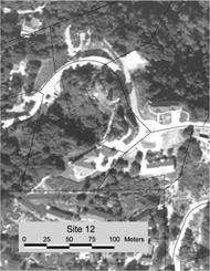
5 Management Strategies Prescribed burns Maintain shifting mosaic of age classes Crush and burn Multicutting /strategic recycling/chipped biomass Cutting/mowing 3,000 seedlings per acre after burning compared to 29 seedlings per acre after cutting (Harding ESE, Inc. 2002a) Management Strategies Weed control Bradley method Sudden Oak Death Syndrome Methods Map of Study Area Study area Coastal zone and adjacent non-coastal area in Elkhorn Slough Watershed, North Monterey County No large wildfires have occurred in this region in approximately 80 years due to fire suppression Data Collection Easement 1a Vegetation Surveys Conducted from June to September 2001 Identified 40 residential parcels with CMC botanical surveys conducted from 1987 to January 1999 Contacted owners of the 33 parcels with conservation easements designated on them Final pool of ten parcels contained a combined total of 13 easements 5


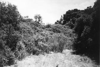
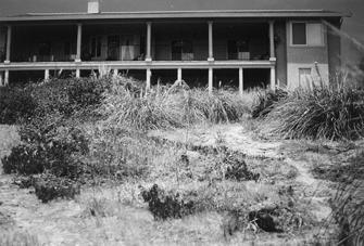
6 Easement 1a Easement 1a Easements 12a and b Easement 12a Easement 12b Easement 17 6


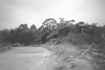
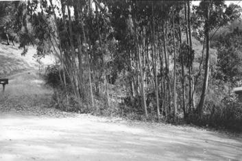
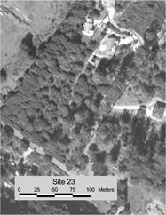
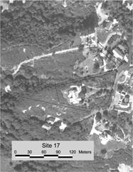
7 Easement 17 Easements 21a, b, c, d, and e Easement 21a Easement 21d Easement 21e Easement 23 7


8 Easements 26a and b Easement 26a Easement 28 Data Collection Percent cover of each species Transects Average of 50-meters long Randomly placed Quadrats 1 m 2 quadrats were placed at 5-meter intervals along each transect Tree, shrub, and herb layer measured Data Analysis For the vegetation surveys, a Product Moment Correlation statistical test was done to determine whether there was a significant correlation between The average percent cover of non-native or native species in an easement and the easement size, shape, and distance to the nearest source of non-natives and CMC Data Collection Agency interviews Conducted from February to September 2002 Interviewed 9 federal, state, and local agencies and organizations Interviewed 1 to 2 people from each agency Each interviewee was asked a standard list of questions regarding their agency s policies, strategies, and recommendations for managing CMC 8
9 Data Analysis Information from the literature review and the agency interviews was compared to determine What is known about the biological and ecological requirements of CMC Which strategies and policies are currently being used and which are recommended for the conservation of CMC Results of Vegetation Surveys For non-native and natives No significant correlation between % cover and area % cover and the distance to the nearest sources of non-natives % cover and the distance to the nearest sources of CMC Significant correlation between % cover and edge-to-area ratio r 0.553, α = 0.05 Area vs. Perimeter Easement Perimeter (m) Area (m 2 ) Relationship Between Non-natives and Edge-to-Area Ratio Relationship Between Natives and Edgeto-Area Ratio Edge to area ratio Edge to area ratio Percent cover of non-natives Percent cover of natives Figure. Correlation between percent cover of natives in quadrats and edge to area ratio of easement. 9
10 Results of Agency Interviews Loss of habitat or habitat fragmentation listed as the management concern that has the highest priority for CMC (55%) Two other management concerns for CMC listed as having the highest priority: fire suppression and invasive non-native plant species (33% each) Summary of Interviews with Agencies and Organizations Do your principal management plans involve any of the following tools?: Conservation Impact Prescribed Easements? restrictions? Mitigations? burning? Mowing? California Coastal Commission Yes. Yes. Yes. No. No. US Bureau of Land Management Fort Ord No. Yes. Yes. Yes. No. US Fish and Wildlife Service Yes. Yes. Yes. Yes. No. USDA Natural Resources Conservation Service No. Yes. Yes. Yes. No. California Department of Fish and Game Yes. Yes. Yes. No. No. County of Monterey Planning and Building Inspection Yes. Yes. Yes. No. No. Monterey County Parks No. Yes. No. No. No. California Native Plant Society, Monterey Bay Chapter Yes. Yes. Yes. Yes. No. Elkhorn Slough Foundation No. Yes. No. No. No. Percentage with yes responses. 56% 100% 78% 44% 0% Summary of Interviews with Agencies and Organizations Do your principal management plans involve any of the following tools?: Specific Control of policies for invasives? Restoration? Monitoring? Enforcement? CMC? California Coastal Commission No. Yes. Yes. Yes. Yes. US Bureau of Land Management Fort Ord Yes. Yes. Yes. Yes. Yes. US Fish and Wildlife Service Yes. Yes. Yes. Yes. No. USDA Natural Resources Conservation Service Yes. Yes. Yes. Yes. No. California Department of Fish and Game Yes. Yes. Yes. Yes. No. County of Monterey Planning and Building Inspection Yes. No. No. Yes. Yes. Monterey County Parks Yes. No. No. No. No. California Native Plant Society, Monterey Bay Chapter Yes. Yes. Yes. Yes. No. Elkhorn Slough Foundation Yes. Yes. Yes. No. Yes. Percentage with yes responses. 89% 78% 78% 78% 44% Results of Agency Interviews According to the agencies, the non-natives that are the biggest threats to CMC, in order of importance, are: Pampas grass Eucalyptus Iceplant French broom (Genista monspessulana) Non-native grasses Other Agency Recommendations 1. Conserve more habitat Conservation easements Mitigation banks Buffer zones Conservation Easements Monterey County s use of conservation easements in proposed developments is inconsistent Lack of maintenance, monitoring, and enforcement County does not enforce Right of Entry provision Easement boundaries were not marked on the ground 10
11 Other Agency Recommendations 2. Prescribed burns Burn frequency Fort Ord Habitat Management Plan suggests interval of about years 3 agencies stated that the 15-year interval was too short and should be closer to 30 or 35 years Other Agency Recommendations 3. Update General Plan Periodic updates Necessary for long-term management and protection 1. Large tracts of interconnected natural habitat should be protected before development occurs 2. Mitigation banks or conservation banks should be established to preserve large tracts of land that will not be developed 3. Easements should be consistently designated across all sensitive habitats such that the edge to area ratio is minimized 4. Monitoring programs should be established for scenic and conservation easements and deed restrictions Combination of aerial/infrared photos with easement and parcel boundaries overlaid and field visits Monitoring intervals should be determined on a caseby-case basis, but generally done annually 5. Monitoring, maintenance, restoration personnel, and researchers should be granted the authority for on-site access to easements and parcels as a condition of the Conservation and Scenic Easement Deed and deed restrictions 6. Easement boundaries must be clearly marked so that they can be easily identified in the field by landowners and monitoring personnel Permanent markers GPS coordinates Aerial photos with easement and parcel boundaries overlaid included with easement deeds 7. Violations of development restrictions for scenic and conservation easements and deed restrictions should be strictly enforced 8. Incentive programs should be established for landowners who establish conservation easements on their properties 9. Buffer zones should be included in subdivision design plans for use between large areas of CMC habitat or preserves and developments Smaller buffer zones of native vegetation between easements and development envelopes 11
12 10. Before a development permit is issued, a biological survey of the property should be conducted by a qualified biologist/botanist familiar with CMC habitats and species Done during time of year when species identifiable Identify all plant species Vegetation maps Identify impacts and mitigations 11. Development envelopes should be clustered to preserve as much continuous open space as possible and reduce edge effects Development clusters should be located as far from CMC as possible 12. A program to monitor construction activities and mitigate impacts should be implemented for all proposed developments Mitigation agreements should be required as part of development permit Should contain assurances of implementation, monitoring, and maintenance 13. Prescribed burning should be implemented on preserves at established intervals to create a mosaic of various vegetation age classes 14. Mowing/cutting without burning is not recommended as a way to promote CMC regeneration 15. A program to control and monitor invasive non-native plant species should be implemented on undeveloped and developed parcels Non-chemical methods should be used whenever feasible New invasive non-native species should be monitored and controlled for 16. Landowners should be restricted from planting invasive non-native plants in their landscaping Native, fire-resistant plants should be used whenever possible 17. The removal of CMC species and the construction of paths or trails through CMC should be restricted Public access should be restricted or limited If access allowed, areas should be monitored and controlled for weeds, erosion, and other impacts 18. Mitigation for the removal of sensitive plant species should require impacted species to be replaced on site at a minimum of a 2:1 ratio Ratio should be higher for species that are more rare 19. When creating a restoration program, environmental professionals with specific experience in the restoration of CMC communities should be consulted Restoration activities should include soil preparation, weed control, and erosion control All plant materials should be gathered from the same watershed where restoration is occurring 12
13 20. After prescribed burns, any surface erosion control on steep slopes involving reseeding should use deep-rooted native perennial grasses Deep-rooted, dense, woody chaparral vegetation should be restored for permanent slope stability 21. Sudden Oak Death Syndrome should be carefully monitored and controlled for in CMC 22. All native wildlife populations should be protected Predators/prey that become pests should be relocated Poisons should be prohibited Fencing should allow wildlife to cross Curbs should be at low angle of 50 degrees All surface water should be protected and enhanced 23. Public education programs should be implemented to increase awareness of the importance of CMC conservation and encourage community involvement and cooperation in management efforts Conclusions Biggest threat to CMC in North Monterey County is habitat loss Fire suppression is second Invasive non-native plant species are third Conclusions Top management strategy recommended in the literature and by agencies and organizations is more habitat protection Conservation easement policies need to be improved in North Monterey County Central maritime chaparral is a fire-adapted plant community and prescribed burning is necessary for its continued existence Conclusions Management strategies need to take an ecosystem approach to conservation Public education and community involvement in CMC management are important since the majority of the chaparral is located on private land in this part of the county Further research on the needs of this ecosystem and adaptive management will help to improve future management efforts 13
ARTICLE FIVE FINAL DRAFT
 ARTICLE FIVE 021218 FINAL DRAFT Sec. 503.6 Open Space Preservation Option Open Space Preservation Option Open Space Preservation developments may be approved in the AR, R-1, R-2 and R-3 zoning districts,
Introduction to INRMP Implementation Options
 El Dorado County Integrated Natural Resources Management Plan Introduction to INRMP Implementation Options 1 Our approach to the options evaluation is based on the INRMP components as they are currently
RECITALS. B. WHEREAS, Ranch, its successors and assigns, are referred to in the Easement as the Grantor ; and
 Basic Components of Management Plans Associated with Conservation Easement Acquisitions Where A Land Trust Or other third party Is the Grantee April 17, 2012 Key: Text in normal font, without highlight,
( ) Ordinance. Environmental Resources Management
 Ordinance. Environmental Resources Management") PALM BEACH COUNTY BOARD OF COUNTY COMMISSIONERS AGENDA ITEM SUMMARY Agenda Item #:5 I/" 3 Meeting Date: April 1,2008 ( ) Consent Department Submitted By: Submitted For: ( ) Ordinance Environmental Resources
PALM BEACH COUNTY BOARD OF COUNTY COMMISSIONERS AGENDA ITEM SUMMARY Agenda Item #:5 I/" 3 Meeting Date: April 1,2008 ( ) Consent Department Submitted By: Submitted For: ( ) Ordinance Environmental Resources
DRAFT FOR PUBLIC HEARING (rev. March, 2016)
") Chapter 200. ZONING Article VI. Conservation/Cluster Subdivisions 200-45. Intent and Purpose These provisions are intended to: A. Guide the future growth and development of the community consistent with
Chapter 200. ZONING Article VI. Conservation/Cluster Subdivisions 200-45. Intent and Purpose These provisions are intended to: A. Guide the future growth and development of the community consistent with
Environment and Natural Resources Trust Fund Request for Proposals (RFP)
") Environment and Natural Resources Trust Fund 2012-2013 Request for Proposals (RFP) Project Title: Southeast Minnesota Sensitive Habitat Protection Program (SHPP) ENRTF ID: 067-D Topic Area: D. Land Acquisition
Environment and Natural Resources Trust Fund 2012-2013 Request for Proposals (RFP) Project Title: Southeast Minnesota Sensitive Habitat Protection Program (SHPP) ENRTF ID: 067-D Topic Area: D. Land Acquisition
LLC & MLLC Property Bismark Meadows Bonner County, Idaho
 Vital Ground Property Management Plan LLC & MLLC Property Bismark Meadows Bonner County, Idaho December 10, 2009 (updated 2/12/13) Ryan Lutey The Vital Ground Foundation Building T-2, Fort Missoula Road
Wildlife Habitat Conservation and Management Program
 EXHIBIT 1 PC-2015-4106 ODFW Guide Wildlife Habitat Conservation and Management Program Manual for Counties and Cities Oregon Department of Fish and Wildlife March 2006 Table of Contents 1. Introduction
Conservation Easement Stewardship
 Conservation Easements are effective tools to preserve significant natural, historical or cultural resources. Conservation Easement Stewardship Level of Service Standards March 2013 The mission of the
Submittal of the Minutes from the March 9, 2011, April 5, 2011, and April 19, 2011 Cabinet Meetings.
 AGENDA BOARD OF TRUSTEES OF THE INTERNAL IMPROVEMENT TRUST FUND JUNE 16, 2011 Attachments to the items below can be viewed at the following link: http://www.dep.state.fl.us/secretary/cab/public_notices.htm
The Maryland Puritan Tiger Beetle Habitat Conservation Program
 The Maryland Puritan Tiger Beetle Habitat Conservation Program Maryland Department of Natural Resources Annapolis, MD 21401 October 2011 The Maryland Puritan Tiger Beetle Habitat Conservation Program October
Application Procedures for Easements or Rights of Way on City of Fort Collins Natural Areas and Conserved Lands March 2012
 Application Procedures for Easements or Rights of Way on City of Fort Collins Natural Areas and Conserved Lands March 2012 IMPORTANT NOTE: This document was created to accompany the City of Fort Collins
Using Easements to Conserve Biodiversity. Jeff Lerner Defenders of Wildlife
 Using Easements to Conserve Biodiversity Jeff Lerner Defenders of Wildlife jlerner@defenders.org Northeast LTA June 10, 2006 Defenders of Wildlife Mission: to protect native wild animals and plants in
Georgia Conservation Tax Credit Program Frequently Asked Questions
 Georgia Conservation Tax Credit Program Frequently Asked Questions What are the minimum requirements for eligibility under the Georgia Conservation Tax Credit Program (GCTCP)? Individual and corporate
Neds Corner Station. What is a Conservation Covenant?
 Neds Corner Station What is a Conservation Covenant? www.trustfornature.org.au What is a conservation covenant? A conservation covenant (deed of covenant) is a voluntary, legal agreement made between a
APPLICATION. Telephone Fax Address. Telephone Fax Address FOR MARTIN COUNTY USE ONLY
 APPLICATION PRESERVE AREA MANAGEMENT PLAN/ ABBREVIATED PRESERVE AREA MANAGEMENT PLAN Growth Management Department Environmental Division PART 1: Applicant Information A. Land Owner(s) Name Title and Company
Town of Falmouth s Four Step Design Process for Subdivisions in the Resource Conservation Zoning Overlay District
 Town of Falmouth s Four Step Design Process for Subdivisions in the Resource Conservation Zoning Overlay District All subdivisions shall be designed in accordance with the following four-step process.
IRS FORM 8283 SUPPLEMENTAL STATEMENT DONATION OF CONSERVATION EASEMENT
 Name(s) shown on income tax return Identifying Number Robert T. Landowner 021-34-1234 Susan B. Landowner 083-23-5555 IRS FORM 8283 SUPPLEMENTAL STATEMENT DONATION OF CONSERVATION EASEMENT On November 12,
Sample Baseline Documentation Report (BDR) Annotated Template for Environmentally Important Land
 Annotated Template for Environmentally Important Land") Sample Baseline Documentation Report (BDR) Annotated Template for Environmentally Important Land The baseline documentation report (BDR) provides a snap shot of the biophysical condition of a property
Sample Baseline Documentation Report (BDR) Annotated Template for Environmentally Important Land The baseline documentation report (BDR) provides a snap shot of the biophysical condition of a property
4. If any perennial surface water passes through or along the property lines of the acreage, a minimum of 200 feet or frontage should be required.
 b. Provide adequate acreage for appropriate productive use of rural residential land, such as small numbers of livestock, large gardens, etc. 3. Minimum of 200 feet of frontage on an improved county or
SUBURBAN AND URBAN RESIDENTIAL LAND USE
 SUBURBAN AND URBAN RESIDENTIAL LAND USE GOAL 1 DISCOURAGE URBAN AND SUBURBAN DEVELOPMENT OUTSIDE INCORPORATED AREAS IN WHITMAN COUNTY, EXCEPT WITHIN DESIGNATED UNINCORPORATED COMMUNITIES, AND THOSE AREAS
Antelope Ridge Wind Farm Habitat Mitigation Plan November 2011
 Antelope Ridge Wind Farm Habitat Mitigation Plan November 2011 I. Introduction The Antelope Ridge Wind Farm will be constructed in two phases, in the locations as shown on the attached map, Exhibit A.
Implementation Tools for Local Government
 Information Note #5: Implementation Tools for Local Government This Information Note is a guide only. It is not a substitute for the federal Fisheries Act, the provincial Riparian Areas Regulation, or
MODEL DEED RESTRICTION FOR THE PENNSYLVANIA STATE PROGRAMMATIC GENERAL PERMIT-3 (PASPGP-3) DECLARATION OF RESTRICTIVE COVENANTS FOR CONSERVATION
 DECLARATION OF RESTRICTIVE COVENANTS FOR CONSERVATION") MODEL DEED RESTRICTION FOR THE PENNSYLVANIA STATE PROGRAMMATIC GENERAL PERMIT-3 (PASPGP-3) DECLARATION OF RESTRICTIVE COVENANTS FOR CONSERVATION THIS DECLARATION OF RESTRICTIVE COVENANTS FOR CONSERVATION
MODEL DEED RESTRICTION FOR THE PENNSYLVANIA STATE PROGRAMMATIC GENERAL PERMIT-3 (PASPGP-3) DECLARATION OF RESTRICTIVE COVENANTS FOR CONSERVATION THIS DECLARATION OF RESTRICTIVE COVENANTS FOR CONSERVATION
Central Pennsylvania Conservancy Project Selection Criteria Form
 Central Pennsylvania Conservancy Project Selection Criteria Form The following criteria guide the actions of the Central Pennsylvania Conservancy s Land Protection Committee and Board of Directors in selecting
Conservation Design Subdivisions
 Conservation Design Subdivisions An excerpt from the Rules and Regulations Governing Division of Land in Sheridan County, Wyoming, November 5, 2010 Sheridan County Public Works Department 224 S. Main Street
APPLICATION FOR PERMIT: (Pursuant to Ord & Reso ) 4d Habitat Loss Permit Vegetation Removal Tree Removal. Address:
 4d Habitat Loss Permit Vegetation Removal Tree Removal. Address:") CITY OF ESCONDIDO Planning Division 201 North Broadway Escondido, CA 92025-2798 (760) 839-4671 Fax: (760) 839-4313 APPLICATION FOR PERMIT: (Pursuant to Ord. 91-54 & Reso. 94-436) Case No: FOR INTERNAL
CITY OF ESCONDIDO Planning Division 201 North Broadway Escondido, CA 92025-2798 (760) 839-4671 Fax: (760) 839-4313 APPLICATION FOR PERMIT: (Pursuant to Ord. 91-54 & Reso. 94-436) Case No: FOR INTERNAL
GWINNETT COUNTY CSO CONSERVATION SUBDIVISION OVERLAY DISTRICT REQUIREMENTS
 GWINNETT COUNTY CSO CONSERVATION SUBDIVISION OVERLAY DISTRICT REQUIREMENTS Section 1316. CSO Conservation Subdivision Overlay District. 1. Purposes. The purposes of this overlay district are as follows:
ARTICLE XI - CONSERVATION SUBDIVISIONS
 ARTICLE XI - CONSERVATION SUBDIVISIONS Section 1101: Purpose and Intent. This Article is intended to provide for residential subdivisions that are designed based first and foremost on the preservation
PROJECT SCORING GUIDANCE. Introduction: National Proiect Selection:
 FOREST LEGACY PROGRAM PROJECT SCORING GUIDANCE Introduction: This document provides guidance to the National Review Panel on how to score individual Forest Legacy Program (FLP) projects, including additional
March 25, Wet Weather Community Engagement Board of Directors Workshop. What are our requirements? 8/28/2015
 Wet Weather Community Engagement Board of Directors Workshop March 25, 2015 Nine Minimum Controls NMC 7 Pollution Prevention NMC 8 Public Notification Partial Consent Decree CSO Signage CSO Notification
Interpretation of Conservation Purpose INTERNAL REVENUE GUIDANCE AS TO WHAT CONSTITUES A CONSERVATION PURPOSE
 Interpretation of Conservation Purpose INTERNAL REVENUE GUIDANCE AS TO WHAT CONSTITUES A CONSERVATION PURPOSE 170(h)(4)(A) of Title 26, Internal Revenue Code, Subtitle A of the United States Code gives
Resource Protection Area Map Update - Frequently Asked Questions
 DEPARTMENT OF ENVIRONMENTAL SERVICES Office of Sustainability and Environmental Management 2100 Clarendon Boulevard, Suite 705, Arlington, VA 22201 TEL 703-228-4488 FAX 703-228-7134 TTY 703-228-4611 www.arlingtonva.us
Conservation Stewardship Collaborative. Inventorying, Monitoring, and Managing Natural Resources on Conservation Lands
 Conservation Stewardship Collaborative Inventorying, Monitoring, and Managing Natural Resources on Conservation Lands December 2009 Scott Ruhren, Ph.D. Senior Director of Conservation Audubon Society of
ALREADY SUBMITTED FOR HIGHLANDS COUNCIL PRE
 Highlands Preservation Area Approval Application Checklist Items Block 15901 Lot 1, West Milford See Highlands Council Review at: http://www.highlands.state.nj.us/njhighlands/projectreview/ **For advisory
COASTAL CONSERVANCY. Staff Recommendation August 2, 2012 HARE CREEK BEACH COASTAL ACCESS TRAIL. Project No Project Manager: Lisa Ames
 COASTAL CONSERVANCY Staff Recommendation August 2, 2012 HARE CREEK BEACH COASTAL ACCESS TRAIL Project No. 08-001-02 Project Manager: Lisa Ames RECOMMENDED ACTION: Authorization to disburse up to $60,000
MONTEREY COUNTY STANDARD SUBDIVISION COMMITTEE
 MONTEREY COUNTY STANDARD SUBDIVISION COMMITTEE Meeting: May 11, 2006 Agenda Item: 1 Project Description: Standard Subdivision Amendment of recorded Markham Ranch Subdivision Map to relocate building envelope
Horse Gulch Management Plan Final Draft: April 18, 2013
 I. INTRODUCTION This Plan provides a framework for the sound stewardship of the City of Durango Horse Gulch open space area. The Plan includes baseline information regarding the area, management objectives
Biodiversity Planning Policy and Guidelines for (LEP) Rezoning Proposals
 Rezoning Proposals") Council Policy Biodiversity Planning Policy and Guidelines for (LEP) Rezoning Proposals Table of Contents Table of Contents... 1 Policy... 2 Policy Objectives... 2 Policy Statement... 2 Guidelines... 2
Council Policy Biodiversity Planning Policy and Guidelines for (LEP) Rezoning Proposals Table of Contents Table of Contents... 1 Policy... 2 Policy Objectives... 2 Policy Statement... 2 Guidelines... 2
The University of Texas System Systemwide Policy. Policy: UTS Title. Environmental Review for Acquisition of Real Property. 2.
 1. Title 2. Policy Environmental Review for Acquisition of Real Property Sec. 1 Sec. 2 Policy Statement. It is the policy of The University of Texas System to minimize its potential for exposure to claims
Chestnut Street and Eliot Street
 BASELINE DOCUMENTATION REPORT and LAND MANAGEMENT PLAN Massachusetts Executive Office of Energy and Environmental Affairs Local Acquisitions for Natural Diversity (LAND) Grant Program Property name: Warren
THE COUCHICHING CONSERVANCY LAND STEWARDSHIP POLICY. As approved by the Board, April 30, 2007
 THE COUCHICHING CONSERVANCY LAND STEWARDSHIP POLICY As approved by the Board, April 30, 2007 When one tugs at a single thing in nature, he finds it attached to the rest of the world. John Muir This policy
Land Trust of Santa Cruz County. Strategic Plan. July 2012 to June This is a public version of a more detailed internal plan.
 Land Trust of Santa Cruz County Strategic Plan July 2012 to June 2015 This is a public version of a more detailed internal plan. Over the next three years the Land Trust will pursue four critical strategies.
ZANDER ASSOCIATES. Environmental Consultants. June 6, Owen Lawlor Moss Beach Associates 612 Spring Street Santa Cruz, CA 95060
 ZANDER ASSOCIATES Environmental Consultants June 6, 2017 Owen Lawlor Moss Beach Associates 612 Spring Street Santa Cruz, CA 95060 Development Plan Review Moss Beach Ocean Development Moss Beach, California
Chapter Planned Residential Development Overlay
 Chapter 19.29 Planned Residential Development Overlay Sections 010 Purpose 020 Scope 030 Definitions 030 Minimum Size 040 Allowable Uses 050 Minimum Development Standards 060 Density Bonus 070 Open Space
Larimer County Planning Dept. Procedural Guide for 1041 PERMITS
 - Larimer County Planning Dept. Procedural Guide for 1041 PERMITS PLEASE NOTE: A PRE-APPLICATION CONFERENCE IS REQUIRED PRIOR TO SUBMITTING THIS APPLICATION. PURPOSE: State Statutes allow local governments
Oxbow Park and Preserve Management Plan
 Oxbow Park and Preserve Management Plan INTRODUCTION This Plan establishes a framework for the sound stewardship of Oxbow Park and Preserve. Policies, management objectives and envisioned future improvements
SECTION 6 SUBAREA PLAN IMPLEMENTATION POLICIES
 SECTION 6 SUBAREA PLAN IMPLEMENTATION POLICIES This section describes subarea plan implementation actions to be taken by the City of Escondido. These actions are specific to the city and are supplemental
Easement Program Guidelines for Water Resources and Stream Work
 Easement Program Guidelines for Water Resources and Stream Work The following guidelines are established by the Easement Committee to create standards for reviewing requests by landowners to conduct stream
CITY OF FORT COLLINS NATURAL AREAS AND CONSERVED LANDS EASEMENT POLICY
 CITY OF FORT COLLINS NATURAL AREAS AND CONSERVED LANDS EASEMENT POLICY Adopted January 3, 2012 PURPOSE: The purpose of the policy statement is to clarify the policies and procedures of the City of Fort
Validation Checklist. Date submitted: How to use this check-list. Ecosystem Credit Accounting System. Version 1.1&2. Project Information
 Ecosystem Credit Accounting System Version 1.1&2 Last updated April 21, 2017 Validation Checklist Date submitted: Project Information Project Name Trading Area Name Trading Area Type (e.g., TMDL, TNC Ecoregion)
LAKE OF THE WOODS COUNTY WETLAND CONSERVATION ORDINANCE OF 2002
 Ordinance # LAKE OF THE WOODS COUNTY WETLAND CONSERVATION ORDINANCE OF 2002 ARTICLE 1 TITLE AND PURPOSE Section 1.1. Title This Ordinance shall be known, cited and referred to as the Lake of the Woods
CONDITIONAL USE PERMIT Application Packet
 CONDITIONAL USE PERMIT Application Packet Community Development Department 1020 East Pioneer Road, Draper, UT 84020 (801) 576-6539 Fax (801) 576-6526 Dear Applicant, This application packet has been developed
CHALLENGES IN MANAGING MULTIPLE USE LANDS & TOOLS TO ENABLE SUCCESS
 CHALLENGES IN MANAGING MULTIPLE USE LANDS & TOOLS TO ENABLE SUCCESS Rocky Mountain Land Use Institute Conference March 13, 2015 Susan Culp Principal, NextWest Consulting, LLC Challenges to Achieving Conservation
LIVING LANDS BIODIVERSITY GRANTS: INFORMATION AND APPLICATION. Due: January 16, 2009
 LIVING LANDS BIODIVERSITY GRANTS: INFORMATION AND APPLICATION Due: January 16, 2009 PURPOSE OF LIVING LANDS PROJECT Defenders of Wildlife s Living Lands project provides financial, technical and educational
Martin Correctional Institution and Work Camp
 A Conceptual Land Use Plan for Martin Correctional Institution and Work Camp Martin County, Florida 2009-2019 Florida Department of Corrections Land Management Section, Bureau of Procurement and Supply
BEFORE THE HEARING EXAMINER FOR THURSTON COUNTY
 COUNTY COMMISSIONERS Cathy Wolfe District One Diane Oberquell District Two Robert N. Macleod District Three HEARING EXAMINER BEFORE THE HEARING EXAMINER FOR THURSTON COUNTY In the Matter of the Application
Annotated Baseline Documentation Report (BDR) Template for Natural Heritage Lands Owned by a Land Trust
 Template for Natural Heritage Lands Owned by a Land Trust") Annotated Baseline Documentation Report (BDR) Template for Natural Heritage Lands Owned by a Land Trust This Annotated Baseline Documentation Report (BDR) Template was prepared by the request of the Ontario
Annotated Baseline Documentation Report (BDR) Template for Natural Heritage Lands Owned by a Land Trust This Annotated Baseline Documentation Report (BDR) Template was prepared by the request of the Ontario
IMPLEMENTING AGREEMENT. for the EAST CONTRA COSTA COUNTY HABITAT CONSERVATION PLAN/ NATURAL COMMUNITY CONSERVATION PLAN.
 IMPLEMENTING AGREEMENT for the EAST CONTRA COSTA COUNTY HABITAT CONSERVATION PLAN/ NATURAL COMMUNITY CONSERVATION PLAN by and between EAST CONTRA COSTA COUNTY HABITAT CONSERVANCY, COUNTY OF CONTRA COSTA,
Innovative Local Government Land Conservation Techniques
 Innovative Local Government Land Conservation Techniques Three new successful land conservation programs used in Maryland by Baltimore and Carroll Counties are worthy of further examination. Baltimore
ATTACHMENT A: FINDINGS
 ATTACHMENT A: FINDINGS 1.0 CEQA FINDINGS 1.1 ENVIRONMENTAL IMPACT REPORTS Findings pursuant to public resources code Section 21081 and the California Environmental Quality Act Guidelines Sections 15090
MONTGOMERY COUNTY PLANNING DEPARTMENT THE MARYLAND-NATIONAL CAPITAL PARK AND PLANNING COMMISSION
 MONTGOMERY COUNTY PLANNING DEPARTMENT THE MARYLAND-NATIONAL CAPITAL PARK AND PLANNING COMMISSION MCPB Item No. Date: 10-03-13 Preliminary Plan Amendment No. 11999034B Alvermar Woods, Lot 17 (In Response
Chesapeake Bay Preservation Area (CBPA) Map Update. Presentation to the County Board July 15, 2017
 Map Update. Presentation to the County Board July 15, 2017") Chesapeake Bay Preservation Area (CBPA) Map Update Presentation to the County Board July 15, 2017 Chesapeake Bay Program Comprehensive Plan Chesapeake Bay Preservation Ordinance (1992) (Chapter 61, Arlington
Chesapeake Bay Preservation Area (CBPA) Map Update Presentation to the County Board July 15, 2017 Chesapeake Bay Program Comprehensive Plan Chesapeake Bay Preservation Ordinance (1992) (Chapter 61, Arlington
Rezoning Staff Report St. Croix County Community Development Committee Gerald & Joan Mellgren Hearing Date: July 16, 2015
 Rezoning Staff Report St. Croix County Community Development Committee Gerald & Joan Mellgren Hearing Date: Property Owners: Gerald & Joan Mellgren Agent: William Mellgren Site Address: 97 230 th Street
Kent/MSU Extension Attn: Stacy Byers 775 Ball Ave NE Grand Rapids, MI Tel: (616)
") 2017 KENT COUNTY PURCHASE OF DEVELOPMENT RIGHTS (PDR) PROGRAM Kent/MSU Extension Attn: Stacy Byers 775 Ball Ave NE Grand Rapids, MI 49503 Email: stacy@sheridanland.com Tel: (616) 632-7878 FOR OFFICIAL
2017 KENT COUNTY PURCHASE OF DEVELOPMENT RIGHTS (PDR) PROGRAM Kent/MSU Extension Attn: Stacy Byers 775 Ball Ave NE Grand Rapids, MI 49503 Email: stacy@sheridanland.com Tel: (616) 632-7878 FOR OFFICIAL
CONSERVATION EASEMENT INCLUDING MITIGATION
 After recording return to: GRANTOR: GRANTEE: GRANTEE (Trustee): LEGAL DESCRIPTION: TAX PARCEL I.D. #: REFERENCE # s: WHATCOM COUNTY N/A CONSERVATION EASEMENT INCLUDING MITIGATION This grant of a conservation
ORDINANCE NO. 875 (AS AMENDED THROUGH 875
 ORDINANCE NO. 875 (AS AMENDED THROUGH 875.1) AN ORDINANCE OF THE COUNTY OF RIVERSIDE TO ESTABLISH A LOCAL DEVELOPMENT MITIGATION FEE FOR FUNDING THE PRESERVATION OF NATURAL ECOSYSTEMS IN ACCORDANCE WITH
CHAPTER 3 SPECIAL DISTRICTS
 CHAPTER 3 SPECIAL DISTRICTS Part 4: Conservation/Cluster Developments Sec. 13-3-11 Conservation/Cluster Developments. (a) Title. These regulations shall specifically be known cited and referred to as the
Kent Land Trust Strategic Reassessment Project Final Report
 Kent Land Trust Strategic Reassessment Project Final Report Prepared For: Connecticut Institute for Resilience and Climate Adaptation (CIRCA) Prepared by: Michael A. Benjamin, Land Steward, Kent Land Trust
Chapter 100 Planned Unit Development in Corvallis Urban Fringe
 100.100 Scope and Purpose. Chapter 100 Planned Unit Development in Corvallis Urban Fringe (1) All applications for land divisions in the Urban Residential (UR) and Flood Plain Agriculture (FPA) zones within
FIRE DEPARTMENT INFORMATION BULLETIN #007
 SUBJECT: WEED ABATEMENT FIRE DEPARTMENT INFORMATION BULLETIN #007 Fire Department 955 Sonoma Ave Santa Rosa, CA 95404 (707) 543-3500 FAX (707) 543-3520 www.santarosafd.com Code References: Santa Rosa City
Chapter VIII. Conservation Easements: Valuing Property Subject to a Qualified Conservation Contribution
 A. Overview and Purpose Chap. VIII Conservation Easements: Valuing... Jacobson & Becker 91 Chapter VIII Conservation Easements: Valuing Property Subject to a Qualified Conservation Contribution Forest
CATALOGING, MONITORING AND MANAGING INVASIVE SPECIES ON POST LANDS. PSU Geog596A Capstone Proposal Dale Jantzen Dec 17, 2015
 CATALOGING, MONITORING AND MANAGING INVASIVE SPECIES ON POST LANDS PSU Geog596A Capstone Proposal Dale Jantzen Dec 17, 2015 PROJECT OUTLINE AND PURPOSE Define a particular need within a non-profit land
Staying Connected in the Northern Appalachians
 Staying Connected in the Northern Appalachians Potential Conservation Easement Provisions Designed to Explicitly Address Connectivity in the Northern Appalachians Updated and Revised May 2012 In this document,
Land Conservation Agreements Project Guidance
 Land Conservation Agreements Project Guidance Stakeholder Informed OTHER OPTIONS Introduction Enhanced or permanent protection of corporate lands through land conservation agreements means that companies
EAST GOSHEN TOWNSHIP CHESTER COUNTY, PENNSYLVANIA ORDINANCE NO.
 EAST GOSHEN TOWNSHIP CHESTER COUNTY, PENNSYLVANIA ORDINANCE NO. AN ORDINANCE AMENDING THE EAST GOSHEN TOWNSHIP ZONING ORDINANCE OF 1997, AS AMENDED, WHICH IS CODIFIED IN CHAPTER 240 OF THE EAST GOSHEN
Texas Land Trust Conference March 6, 2015
 Texas Land Trust Conference March 6, 2015 James D. Bradbury James D. Bradbury, PLLC Austin Fort Worth An Overview Unique area of law where the government can take private property Protected by the US Constitution
CHAPTER 8. IMPLEMENTATION COSTS AND FUNDING SOURCES
 Working Draft Content Subject to Change Implementation Costs and Funding Sources Chapter 1 1 1 1 1 1 1 1 0 1 0 1 CHAPTER. IMPLEMENTATION COSTS AND FUNDING SOURCES Table of Contents Page.1 Introduction...
Shari Rodriguez Wildlife and Fisheries Biology Clemson University M. Nils Peterson, NCSU Chester Lowder, NC Farm Bureau
 Landowner Preferences for Participation in Conservation Programs in North Carolina Shari Rodriguez Wildlife and Fisheries Biology Clemson University M. Nils Peterson, NCSU Chester Lowder, NC Farm Bureau
2018 JMGBL Awards Application
 2018 JMGBL Awards Application Submission Date 2018-06-21 10:41:59 This application is for: Project Title County/Counties Staff Contact Job Title E-mail Address J. Mitchell Graham Memorial Award The Independent
A. Preserve natural resources as identified in the Comprehensive Plan.
 1370.08 Conservation Residential Overlay District. Subd. 1 Findings. The City finds that the lands and resources within the Conservation Residential Overlay District are a unique and valuable resource
Claudia Stuart, Williamson Act Program Manager and Nick Hernandez, Planning Intern
 Land Conservation (Williamson) Act Advisory Committee STAFF REPORT September 15, 2014 Prepared by: Claudia Stuart, Williamson Act Program Manager and Nick Hernandez, Planning Intern Subject: Discussion:
CHAPTER 8. IMPLEMENTATION COSTS AND FUNDING SOURCES
 0 0 0 CHAPTER. IMPLEMENTATION COSTS AND FUNDING SOURCES. INTRODUCTION The Endangered Species Act (ESA) requires that habitat conservation plans specify the funding that will be available to implement actions
OPEN-SPACE CONVERSION REQUEST
 OPEN-SPACE CONVERSION REQUEST Applicant: Board Meeting: February 9, 2017 Landowner: Normandy Capital, LLC VOF Easement: BAT-03678 Table of Contents: Cover Page 1 Table of Contents 2 Application Overview
Auckland Council Rates Remission and Postponement Policy Consultation Submission
 Auckland Council Rates Remission and Postponement Policy Consultation Submission 13 April 2018 To: Auckland Council Private Bag 92300 Auckland 1142 From: Queen Elizabeth the Second National Trust PO Box
Baseline Documentation and Inventory Protocol, Version 2
 Rhode Island Conservation Stewardship Collaborative Baseline Documentation and Inventory Protocol, Version 2 September 2014 Carol Lynn Trocki Conservation Biologist Scott Ruhren, Ph.D. Senior Director
Proposed Management Plan for SCE&G Future Development Property December 2007
 Proposed Management Plan for SCE&G Future Development Property December 2007 BASELINE 1984 License Classifications Future Development Forest and Game Management Easement Project Works Recreation (Current
NOTICE OF LAND USE DECISION BY THE COOS COUNTY PLANNING DIRECTOR
 NOTICE OF LAND USE DECISION BY THE COOS COUNTY PLANNING DIRECTOR Coos County Planning 225 N. Adams St. Coquille, OR 97423 http://www.co.coos.or.us/ Phone: 541-396-7770 Fax: 541-396-1022 Date of Notice:
CHAPTER 6 CHESAPEAKE BAY PRESERVATION AREAS AND STREAM PROTECTION AREAS
 CHAPTER 6 CHESAPEAKE BAY PRESERVATION AREAS AND STREAM PROTECTION AREAS 6.1 INTRODUCTION Virginia s Chesapeake Bay Preservation Area (CBPA) Designation and Management Regulations (9VAC10-20 et seq.) require
Land Use. Existing Land Use
 8 Land Use 8.1 Land Use Chapter Purpose and Contents This element includes a brief summary of existing land use conditions and trends followed by a series of goals, objectives, and recommendations to guide
COMMUNITY DEVELOPMENT AGENCY C O U N T Y O F N E V A D A PLANNING DEPARTMENT
 COMMUNITY DEVELOPMENT AGENCY C O U N T Y O F N E V A D A PLANNING DEPARTMENT Eric Rood Administration Bldg. 950 Maidu Avenue Nevada City, California 95959-8617 Phone: (530) 265-1222 FAX: (530) 265-9851
BRISTOL CONSERVATION COMMISSION INLAND WETLANDS AGENCY FORM IW-1 (Application for a Wetlands Permit)
") APPLICATION NO. BRISTOL CONSERVATION COMMISSION INLAND WETLANDS AGENCY FORM IW-1 (Application for a Wetlands Permit) DATE FILED: APPROVED: DENIED: 1. APPLICANT: Name: Signature: Address: City: State: Zip
APPLICATION NO. BRISTOL CONSERVATION COMMISSION INLAND WETLANDS AGENCY FORM IW-1 (Application for a Wetlands Permit) DATE FILED: APPROVED: DENIED: 1. APPLICANT: Name: Signature: Address: City: State: Zip
METROPOLITAN COUNCIL 390 North Robert Street, St. Paul, MN Phone (651) TDD (651)
 TDD (651)") METROPOLITAN COUNCIL 390 North Robert Street, St. Paul, MN 55101 Phone (651) 602-1000 TDD (651) 291-0904 DATE: December 26, 2012 TO: Metropolitan Parks and Open Space Commission FROM: Jan Youngquist, AICP;
METROPOLITAN COUNCIL 390 North Robert Street, St. Paul, MN 55101 Phone (651) 602-1000 TDD (651) 291-0904 DATE: December 26, 2012 TO: Metropolitan Parks and Open Space Commission FROM: Jan Youngquist, AICP;
SUBCHAPTER 59F CONSERVATION RESERVE ENHANCEMENY ENHANCEMENT PROGRAM (CREP) STATE PORTION OF THE PROGRAM
 STATE PORTION OF THE PROGRAM") SUBCHAPTER 59F CONSERVATION RESERVE ENHANCEMENY ENHANCEMENT PROGRAM (CREP) STATE PORTION OF THE PROGRAM SECTION.0100 - CONSERVATION RESERVE ENHANCEMENT PROGRAM (CREP) -- STATE PORTION OF THE PROGRAM 02
SUBCHAPTER 59F CONSERVATION RESERVE ENHANCEMENY ENHANCEMENT PROGRAM (CREP) STATE PORTION OF THE PROGRAM SECTION.0100 - CONSERVATION RESERVE ENHANCEMENT PROGRAM (CREP) -- STATE PORTION OF THE PROGRAM 02
CHAPTER 3 PRELIMINARY PLAT
 10-3-1 10-3-3 SECTION: CHAPTER 3 PRELIMINARY PLAT 10-3-1: Consultation 10-3-2: Filing 10-3-3: Requirements 10-3-4: Approval 10-3-5: Time Limitation 10-3-6: Grading Limitation 10-3-1: CONSULTATION: Each
Open Space Model Ordinance
 Open Space Model Ordinance Section I. Background Open space development has numerous environmental and community benefits, including: 1) Reduces the impervious cover in a development. Impervious cover
Walton County Planning and Development Services
 Walton County Planning and Development Services 31 Coastal Centre Boulevard, Suite 100 47 N 6 th Street Santa Rosa Beach, Florida 32459 DeFuniak Springs, Florida 32433 Phone 850-267-1955 Phone 850-892-8157
Amendment to the Zoning and Subdivision Ordinances; Consider Repeal Cluster Development Standards
 2 Board of Supervisors Meg Bohmke, Chairman Gary F. Snellings, Vice Chairman Jack R. Cavalier Thomas C. Coen L. Mark Dudenhefer Wendy E. Maurer Cindy C. Shelton February 28, 2018 Thomas C. Foley County
CHAPTER34 PRUD - PLANNED RESIDENTIAL UNIT DEVELOPMENT
 CHAPTER34 PRUD - PLANNED RESIDENTIAL UNIT DEVELOPMENT 17-34-1 17-34-2 17-34-3 17-34-4 17-34-5 17-34-6 17-34-7 17-34-8 17-34-9 Purpose Planned Residential Unit Development Defined Planned Residential Unit
MANAGEMENT PLAN FOR THE TOWN-OWNED LAND ("PROTECTED PROPERTY ), Norwich, Vermont (Updated April 2008) I. INTRODUCTION
, Norwich, Vermont (Updated April 2008) I. INTRODUCTION") MANAGEMENT PLAN FOR THE TOWN-OWNED LAND ("PROTECTED PROPERTY ), Norwich, Vermont (Updated April 2008) I. INTRODUCTION This document is the Management Plan for the "Protected Property" defined herein, as
MANAGEMENT PLAN FOR THE TOWN-OWNED LAND ("PROTECTED PROPERTY ), Norwich, Vermont (Updated April 2008) I. INTRODUCTION This document is the Management Plan for the "Protected Property" defined herein, as