Greetings from Henry Glascock
|
|
|
- Violet Stevenson
- 5 years ago
- Views:
Transcription


1
2 Table of Contents Greetings from Henry Glascock... 1 Property Description... 2 Location Maps... 3 Tax Map Aerial... 5 Plat... 6 Hamilton County Zoning Map... 7 Topography Map... 8 Aerial Photos of the Property... 9 Individual Tract Descriptions and Photos Property Record Card R-2 Urban Residential District Zoning Regulations Deed Previous Deed Language - Legible Frequently Asked Questions Sample Auction Contract Auction Terms and Conditions Disclaimer... 43

3 Greetings from Henry Glascock To: From: Subject: Prospective Bidders Henry B. Glascock Auction Chickamauga Lake 7 Tracts May 18 th, 2017 at 6pm Property Location: 7035 Glover Road Chattanooga, TN This property information package has been prepared to assist you in your pre-auction due diligence. Please carefully review the disclaimer and the auction terms. We encourage and invite you to attend. Please call us with any questions, perform your due diligence and plan to attend this important auction event, ready to buy at your price. Sincerely, Henry B. Glascock Henry B. Glascock Company
4 Property Description Mark your calendar! Thursday, May 18 th at 6:00 pm is an important date to remember. On this day over 44 acres on Chickamauga Lake will be sold in 7 separate tracts or will be sold as a whole. This parcel of land has never been offered for sale divided up into smaller tracts. This property was originally purchased from the Tennessee Valley Authority in 1945 by the Provident Life and Accident Company (Provident Club) in The property was then improved with a club house, swimming pool, tennis courts, basketball court, several pavilions, several docks, a boat ramp, a care takers residence and other recreational use structures. Many years later, Provident gave the property to the YMCA who subsequently sold it to the present owners, YNOT, LLC. The YNOT lake property is spectacular, consisting of approximately 44.5 rolling, wooded Chickamauga Reservoir acres with over 3,400 linear feet of shoreline on the contour. This property has never before been available in smaller tracts and this auction presents a once in a lifetime opportunity. The property has been preliminarily divided into 7 smaller tracts, each in excess of five acres and each accessed by a fifty foot wide ingress/egress and utility easement that runs primarily along existing roadways. Only one of the tracts will require additional road construction for access. This property is one of the last remaining larger tracts within the Chickamauga Reservoir and no other available property is this well located relative to Chattanooga. Owners of these tracts will have superior privacy and lake front footage that is unheard of in this market. To get to the property, take Highway 58 from Highway 153 to its intersection with Hickory Valley Road. Go left at the Mapco Mart (see auction sign) and take Hickory Valley Road to its terminus at Harrison Pike/Glover Road. Merge onto Glover Road and follow it all the way to the entrance to the YNOT property. Utilities provided on Glover Road include a six inch water line and overhead power. OPEN HOUSE SCHEDULE Saturday April 29 th 12:00 to 4:00 Sunday April 30 th 12:00 to 4:00 Saturday May 6 th 12:00 to 4:00 Sunday May 7 th 12:00 to 4:00 Saturday May 13 th 12:00 to 4:00 Sunday May 14 th 12:00 to 4:00 2

5 Location Maps 7035 Glover Road Chattanooga, TN


6 4

7 Tax Map Aerial 5

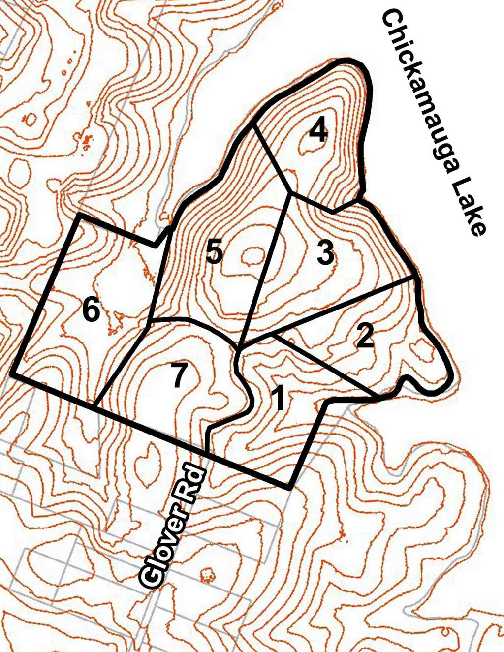
8 Plat Tract # Approximate Acres Approximate Lake Frontage 1 5 +/- 265' +/ /- 925' +/ / / /- 1,170' +/ /- 400' +/ / /- and Shared Boat Ramp & Dock /- Shared Boat Ramp & Dock 6

9 Hamilton County Zoning Map 7
10 Topography Map 8


11 Aerial Photos of the Property Aerial view of the Chickamauga Lake Shoreline, Tracts 2 and 3 shorelines seen Tract 2 shoreline 9

12 Individual Tract Descriptions and Photos Tract One is located on the right side of the entrance gate and on the right side of the present paved driveway. The tract has gentle sloping topography that is oriented to the east for a very nice view of Harrison Bay. The tract is estimated to consist of over 5.5 acres with over 265 feet of lake frontage. It is wooded, has excellent road access and there are several building sites that provide privacy and enhanced lake access. Included is a dock located in a slough shared by Southern Realty Company (adjoining owner). Lake view from Tract 1 10


13 Tract Two is the location of the Provident club house, swimming pool, caretaker s residence and the majority of the water use facilities added by Provident. These include a sea wall and two docks as well as several picnic areas. This tract is also on a gentle slope but it includes land that extends out into the Reservoir creating a peninsula that is unmatched. The tract consists of over 5 acres and it includes over 925 feet of lake front footage. Tract 2 looking down the hill towards the clubhouse and shoreline Beautiful lake views from Tract 2 11


14 View looking southeast from Tract 2 shoreline 12


15 Tract 2 stone steps and walkway leading from the club house down to the docks Tract 2 view from the clubhouse pavilion down to the lake 13


16 Tract 2 as seen from the lake 14


17 Tract Three has good road access from existing street improvements and it is oriented northeast with excellent views of and access to Chickamauga Lake. It is a wooded tract with several Provident improvements including a basketball court. The tract consists of an estimated 6 acres and it has over 435 feet of lake front footage. View of lake from possible building site on Tract 3 Tract 3 shoreline 15


18 Tract Four is the only tract that will require a road extension for access. However, it includes a knoll with potential for a promontory having a nearly 270 view overlooking Chickamauga Lake and the extended Tennessee River and surrounding topographical undulations. This wooded peninsula includes a pavilion and consists of an estimated 5 acres. Its dockable lake front footage is estimated to be over 1,170 front feet. Expansive views of the lake from Tract 4 Tract 4 shoreline 16


19 Tract Five is a 7+ acre tract on the east side of a slough shared with land owned by the State of Tennessee. It is a wooded tract that includes the tennis courts added by Provident. Its estimated lakefront footage will be approximately 400 feet. Tract 5 shoreline seen in the left side of the photopraph Access to Tract 5 17


20 Tract Six is estimated to consist of over eight acres and it adjoins a golf course on its west boundary and the State of Tennessee on its north line. This tract has a pavilion and a substantial boat ramp that was built by Provident. Use of that ramp will be shared with Tract Seven. Included with this tract will be an approximate 200 feet of shoreline along the east bank of the slough shared by the State of Tennessee. This will allow for construction and use of a dock to be shared with Tract Seven. Tract 6 looking southwest, away from the lake Tract 6 boat ramp and parking 18

21 Tract Seven, a wooded tract consisting of over an estimated five and one half acres, is the only tract with no lake front footage. However, Tract Seven will include the right to jointly construct and share use of a dock along the shoreline of Tract Six. Tract Seven will also have the right to shared use of the boat ramp with Tract Six. 19
22 Access and Utilities - So that access and utilities can be provided to all of the planned tracts, a road construction and maintenance association will be formed that will include all successful bidders as members. Each successful bidder will be required to pay an additional $25,000 per tract purchased to fund road and underground utility construction. Purchasers of Tracts Three, Four and Five will be granted joint use of the new road creating access and utilities to Tract Four. 20

23 Property Record Card 21
24 22
25 R-2 Urban Residential District Zoning Regulations 23
26 24
27 25
28 26
29 27
30 Deed 28
31 29
32 30
33 31
34 32
35 Previous Deed Language - Legible Record Book 966 Page 595 THIS INDENTURE, made and entered into by and between the United States of America, hereinafter called the Grantor acting herein by and through its legal agent, the Tennessee Valley Authority (hereinafter sometimes referred to as the Authority ), a corporation created and existing under an Act of Congress, known as the Tennessee Valley Authority Act of 1933, as amended, and The Provident Club, a Tennessee Corporation, hereinafter call the Grantee. WITNESSETH; WHEREAS, Section 4 (k) (a) of the above mentioned Act of Congress authorities the Authority in the name of the United States of America, to covey any real property in its possession or under its control to any person for the purpose of recreation or for use as a summer resident; and WHEREAS, no permanent dam, hydroelectric power plant, fertilizer plant, or munitions plant is located on the land hereinafter described; and WHEREAS, the sale of the land hereinafter described has been duly approved by the President of the United States; and WHEREAS, after due advertisement said land was offered for sale at public auction on the 11 day of February 1948 at 10:00 o clock a.m. at Room 204 Old Post Office Building city of Chattanooga, county of Hamilton, State of Tennessee, and was finally struck off and sold to the Grantee for the sum of Five Thousand One Hundred and No/100 dollars ($5,100.00) that being the highest and best bid made at said auction sale. NOW, THEREFORE, in consideration of the premises and the full payment of the aforesaid bid, receipt whereof is hereby acknowledged, the Grantor does hereby, subject to the conditions hereinafter set forth, grant, bargain, sell, transfer and convey unto the Grantee, for the purpose of recreation by a private club only. A tract of land lying in the Second Civil District of Hamilton County, State of Tennessee on the west shores of Harrison Bay of Chickamauga Lake, approximately 2 miles north of New Harrison, and more particularly described as follows: TVA 2822 (LA-6-47) Beginning at US-TVA Monument 82-3 (Coordinate: N. 273,444, E 2,254,438) in the boundary of the United States of America s land at a corner to the lands of J.M. Glover, D.N. Lamon and Edgar B. Brewster; thence with the United States of America boundary line, N E. 775 feet to a point in the center line of a road; the said point being S W. 14 feet from US-TVA Monument 9-5; thence leaving the United States of America s boundary line, S E. 365 feet to US-TVA Monument 9-6 in the center line of a hollow; thence along the hollow N E. 102 feet to US-TVA Monument 9-7 at the head of the foot contour at the south end of an inlet of Harrison Bay; thence with the feet contour as it meanders in the north westerly direction to the 33
36 mouth of the inlet and subsequently up the bay in a general southerly direction for a total distance of approximately 3540 feet to an angle iron at the head of the contour in the center line of the hollow; thence leaving the contour S W. 413 feet to US-TVA Monument 82.2 in the boundary of the United States of America s land; thence with the United State of America s boundary line N W feet to the point of beginning, and containing 44.5 acres, more or less. FURTHERMORE, the rights to construct and maintain water use facilities at locations and upon plans to be approved in advance by the Authority and suitable ingress and egress over the adjoining land lying between the foot contour elevation and the water or the lake, upon the express condition that said rights shall be subject to and shall not in any way interfere with the Authority s statutory program for river control and development, including, but without limitations by reason of enumeration, the Authority deems necessary or desirable in the promotion of malaria control, flood control, navigation, or other essential programs, and the Authority shall not be liable for any loss or damage resulting therefrom. The positions of corner and directions of lines are referred to the Tennessee Coordinate System. The contour elevation is based on MSL Data as established by the USC&GS Southeastern Supplementary Adjustment of The boundary market designated US- TVA Monument are concrete monuments capped by bronze tablets imprinted with the given number and letters. The above described tract of land is conveyed subject to such rights as may be vested in the public and in the county to road rights of way and to such rights as may be vested in third parties in an existing road. The above described tract of land is a part of the same land acquired by the United State of America by virtue of the deed from Harry W. Durand, Jr. and Hugh T. Vinson, Trustees, dated March 11, 1937, recorded in Deed Book L. Vol 29 page 639 in the Register s office of Hamilton County, Tennessee. It is hereby agreed that this conveyance is made upon the express condition that the land herein described shall be used solely for recreational purposes by a private club. Upon breach of this condition, either in whole or in part, the Grantor, and its successors shall have the right to re-enter and take possession of said land, and to hold, own, and possess the same in the same manner and to the same extent as if this conveyance had never been made. Any failure on the part of the Grantor to re-enter and take possession of said land shall not be construed to be a waiver of this condition. T 2822 (modified) In making this conveyance, however, the Grantor expressly reserves the following described easement rights: (1) The right to maintain any existing boundary and traverse monuments and silt range stations upon the land above described. 34
37 (2) On and over that portion of the above described land which is located below the 690-foot contour elevation (all contour elevations referred to herein are based upon mean level as established by the 1936 Southeastern Supplementary Adjustment U.S. C. & G. S.) the right to enter upon said portion of said land and do any and all things that Grantor considers necessary and desirable in connection with its statutory program for river control and development, this right shall include but not be limited to, by reason of lack of specific enumeration, the right to temporarily or permanently flood said portion of said land with backwater created by the erection and operation of any dam or dams across the Tennessee River and its tributaries; the right to clean (illegible) and drain said land and apply larvicides and chemicals thereon; to carry on bank protection work, to erect or remove structures, and do any and all other things which Grantor deems necessary or desirable in the promotion and furtherance of malaria control, flood control, and navigation, and the right to prohibit the dumping or draining into the waters of any stream or reservoir, under Grantor s control, of any refuse, sewage or other material which might tend to pollute or render said water unsanitary. (3) And in addition, on and over the portion of the above described land which is located within a distance of 250 feet of the shore line ( Shore Line as used herein refers to the foot contour elevation) of any stream or reservoir under Grantor s control, the right to erect and maintain navigation aids and do such clearing as Grantor may deem necessary to ensure visibility. All uranium, thorium and all other materials determined pursuant to section 5 (b) (1) of the Atomic Energy Act of 1946 (60 sts. 761) to be peculiarly essential to the production of fissionable material, contained, in whatever concentration, in deposits in the lands covered by this instrument are hereby reserved for the use of the United States, together with the right of the United State through its authorized agents or representatives at any time to enter upon the land and prospect for mine, remove the same, making just compensations for any damage or injury occasioned thereby. However, such land may be used and any rights otherwise acquired by this disposition may be exercised, as if no reservation of such materials had been made; exempt that, when such use results in the extraction of any such material from the land in quantities which may not be transferred or delivered without a license under the Atomic Energy Act of 1946, as it now exists or may hereafter be amended, such material shall be the property of the United States Atomic Energy Commission, and the Commission may require delivery of such material to it by any possessor thereof after such material has been separated as such from the area in which it was contained. If the Commission requires the delivery of such material to it, it shall pay to the person mining or extracting the same, or to such other person as the Commission determines to be entitled thereto, such sums, including profits, as the commission deem fair and reasonable for the discovery, mining, developments, production, extraction, and other service performed with respect to such material prior to such delivery, but such payment shall not include any amount on account of the value of such material before removal from its place of deposit in nature. If the Commission does not require delivery of such 35
38 material to it, the reservation hereby made shall be of no further force or effect. Grantor further reserves, for the benefit of other properties of the Grantor or its assigns, in common with the Grantee, a right of way 50 feet wide for the construction, maintenance, and use of a road on, over and across the above described land, the first portion of the said right of way lying Northeast of and adjacent to a portion of the Southwest boundary of the described land and extending from a Southeast boundary line at the most Southerly property corner in a Northwesterly direction approximately 1030 feet, the second portion of the right of way extending from the Northwest end of the first described portion in a Northeasterly direction approximately 250 feet to an existing road and then along the existing road in a Northerly direction approximately 450 feet to a North boundary line at a point N W, 130 feet, more or less from the previously mentioned US-TVA monument 9-6; together with the right to do the necessary work of construction and maintenance of said road and the necessary work in construction maintenance of any draining ditches and other road appurtenance lying outside of but adjacent to the limits of the right of way. TVA 2522 (Modified) Grantor further reserves a permanent easement and right of way for. (illegible)... purposes timely: The perpetual right to enter and to erect, maintain, repair, rebuild, operate and patrol one or more electric power transmission lines, and one or more telephone lines, including the right to erect such poles and other transmission line structures, wires, cables, and any necessary appurtenances: the right to clear said right of way and keep the same clear of brush, timber, structures, and fire hazards, and the right to remove danger trees, if any, located beyond the limits of said right of way; all over, upon, across, and under the following described land to wit: A strip of land 30 feet wide lying 15 feet on each side of the center line of an existing transmission line, owned and operated by the Chattanooga Electric Power Board, across the said land, the said existing transmission line beginning at a power pole 5 feet, more or less, southwest of the southwest boundary line and 400 feet, more or less, northeast of the previously mentioned US-TVA Monument 82.2 and extending in a northwesterly direction approximately 450 feet to a power pole at the end of the transmission line. Neither the authority nor the United States of America shall be liable for any damage incidental to the exercise of any of the rights reserved except that the authority shall remain liable for any additional damage caused by its construction forces to the property (above described and hereby conveyed) as a result of the erection, maintenance, or rebuilding of its electrical power transmission and telephone lines on the right of way reserved. In accepting this conveyance, however, the grantee, for himself, his heirs, successors, and assigns, covenants and agrees to and with the grantor that the following shall constitute real covenants which shall attach to end run with the above described land and shall be binding upon anyone who may hereafter come into ownership thereof, whether by purchase, devise, decent or succession; (1) In the interest of public health and sanitation and in order that the land above described and all other land in the same locality may be benefited by a decrease in the hazards of stream pollution and by the protection of water supplies, recreation, wildlife and other public uses of Grantor s reservoir waters and shore lands, he 36
39 will not use the above described property for any purpose that would result in the draining or dumping into the reservoir of any refuse, sewage, or other material, which might tend to pollute the waters of said reservoir. (2) In order to foster the development of said land for the recreational purposes herein set forth, the Grantees (a) will not construct or maintain or cause or suffer to be constructed or maintained on said land any buildings or structures other than a club house, cabins/lodges, recreational facilities, and necessary and appurtenant outbuildings; (b) will construct for use with said buildings either septic tanks or outdoor toilets in accordance with the standards of the State and County public health officials; and (c) will not constructor maintain or cause or suffer to be constructed or maintained on said land any building located nearer than 25 feet from any aide or back line of said land and not hearer than 35 feet from the margin of the right of way of any road. (3) He will not construct or maintain any buildings or other structures except water use, facilities constructed in accordance with plans approved by the authority on any portion of the above described land which is located below the 690 feet contour elevation. To have and to hold said land and premises, subject to the condition hereinabove stated, unto the Grantee, his heirs, successors, and assigns in fee simple, together with all and singular the hereditaments and appurtenances thereunto belonging or in anywise appertaining. And the Authority does hereby covenant that the Unites States of America is seized and possessed of the above described land; that the Authority as legal agent of the United States is duly authorized to convey the same, that said land is free and clear of liens and encumbrances; and that, subject only to such exceptions, conditions, restrictions, and or limitations as may be expressly mentioned above, it will warrant and defend the title thereto against the lawful demands of all persons claiming by,.. or under the United States of America, but not further or otherwise. Wherever in this instrument the context requires the singular number and masculine gender as herein used may be read as plural and feminine, or neuter respectively, In Witness Whereof, the Tennessee Valley Authority, noting herein as legal agent of the United States of America, and being duly authorized so to do, has caused this instrument to be executed, in the name of the United States of America, by its authorizes officers and its corporate seal to be hereunto affixed on this the 11 day of February
40 Frequently Asked Questions Q. Will there be any liens, back property taxes or past debts on the property when I purchase? A. The property will be sold free and clear of any liens, back property taxes or past debts. Current property taxes will be prorated to date of closing. Purchaser must buy title insurance to insure clear title at closing. Q. How much earnest money is due on Auction day? A. Ten percent (10%) of the purchase price is due on auction day on all properties. As an example: High bid of $1,000 Buyer s premium $ 100 Purchase price $1,100 Earnest money (10%) $ 110 Balance due in 30 days $ 990 Q. What other expenses will the buyer have at closing? A. The cost to record the deed plus the transfer taxes based on the purchase price. Also, the cost of title insurance and any Purchaser s closing fees or property tax pro-rations. Purchaser pays the cost of surveying their tract(s), with the cost of surveying intermediate lines being split with adjacent property owners (if property sells divided) at the rate of $0.75 per linear foot. Q. Is there a minimum bid required? A. No. However, this is a reserve auction. The Seller can accept or reject high bids at his/her sole discretion. Q. Is electricity and water available at the property? A. Yes. City water (six-inch water line) and power are available at the property entrance. If the property sells divided, successful bidders will be required to pay an additional $25,000 per tract to be deposited into an escrow account to fund roadway and utilities construction. The construction and maintenance of roads and utilities will be implemented by an elected board of directors of a road construction and maintenance association consisting of the new tract owners. (See Exhibit B on the attached sample sales contract.) Q. Who will maintain the private roads leading to the various tracts? A. The above described property owner s association will be created on or before date of closing and will administer the road and utility maintenance fees. All private roads shall have a 50 foot wide easement for road and utility construction. (see Plat). Q. When is the closing? A. On or before 30 days after the auction with The Title Guaranty & Trust Company of Chattanooga (423) Seller has the option to extend the closing date. Q. Are there any deed restrictions? A. The property is restricted to recreational use by a private club. Each private club may construct cabins, cottages, lodges, club houses and recreational facilities that can be used year-round. (See Exhibit C on the attached sample sales contract) Q. Can you build a dock on individual tracts? A. Yes, subject to approval by TVA. TVA accepts or rejects dock permit applications on an individual, case by case basis. 38
41 Q. Can individual tracts be subdivided into smaller tracts at a later date? A. If the road construction and maintenance association constructs County specification roadways from the present entrance to respective tracts and provides County specification road access to potential lots, yes, the tracts may be further subdivided provided their uses comply with deed restrictions. 39

42 Sample Auction Contract 40
43 41
44 Auction Terms and Conditions AUCTION LOCATION: The auction will be held Thursday, May 18th at 6:00 PM at the SpringHill Suites Marriott Riverfront Parkway - Chattanooga, TN INSPECTION: The Property is open for inspection during Open Houses or by appointment. Open houses will be held from 12:00 to 4:00 on the weekends of 4/29, 4/30, 5/6, 5/7, 5/13 and 5/14. If you are unable to attend an open house, call Henry Glascock to schedule a site visit at BIDDING TERMS: Pay 20% (of the purchase price) earnest money down at the auction and sign Contract of Sale. Balance due at closing within 30 days. A copy of the contract may be reviewed prior to the auction by contacting the auctioneer. BUYER S PREMIUM: There is a 10% buyer s premium being charged at this auction. Example: For each $10,000 of bid amount, there will be a $1,000 buyer s premium added to arrive at a purchase price of $11,000. CLOSING: Balance of the purchase price is due on or before June 19 th, CLOSING ATTORNEY: Closings will be conducted by Brian Copet with The Title Guaranty and Trust Company of Chattanooga (423) Deed preparation and attorney s fees will be paid by the seller; all other normal closing costs will be paid by the purchaser. Taxes will be prorated as of date of closing. Title insurance through Title Guaranty & Trust shall be paid by purchaser. AGENCY: Henry B. Glascock Company, auction firm/broker and Don Harris, auctioneer, are acting exclusively as agents for the seller. SPECIAL NOTE: Property is selling as-is, where-is with all faults and is selling subject to easements, leases, restrictions, covenants, conditions, zoning and all other matters revealed by a current survey or an inspection of the property or contained in public records. The only representation and warranties made are those contained in the Contract of Sale. Seller reserves the right to add or delete property, or cancel the sale, prior to the auction. Properties will be conveyed by Limited Warranty Deed. Information contained herein was obtained from sources deemed reliable. The property will sell asis, where-is with no warranty, express or implied, as to improvements, soil condition, environmental and wetlands, or zoning. Although every precaution has been taken to ensure accuracy, neither the seller, Henry B. Glascock Company nor their agents will be responsible for any errors or omissions herein. Bidders should carefully verify all information and make their own decisions as to the accuracy thereof before submitting their bid. The terms of the Contract of Sale are controlling in the event of any perceived inconsistency between its terms and any statements in this brochure or other advertisements. Announcements made at the auction will take precedence over written matters. TN LIC #4513 AUCTIONEER DON HARRIS TNAL #
45 Disclaimer Seller reserves the right cancel the sale prior to the auction. Property will be conveyed by Limited Warranty Deed. The property will sell as-is, where-is with no warranty, express or implied, as to improvements, soil condition, environmental and wetlands, or zoning. Information contained herein was obtained from sources deemed reliable. Although every precaution has been taken to ensure accuracy, neither the seller, Henry B. Glascock nor their agents will be responsible for any errors or omissions herein. Bidders should carefully verify all information and make their own decisions as to the accuracy thereof before submitting their bid. AGENCY DISCLOSURE Henry B. Glascock Company, with Henry B. Glascock as principal broker and Don Harris, auctioneer, is hereby giving notice that they are agents and representatives of the owner/seller of the property described in this property information package. ATTORNEY REVIEW RECOMMENDED It is recommended that all information included in this property information package and all other auction-related material be carefully reviewed by your attorney. Additionally, all terms and procedures are subject to and may be superseded by changes distributed or announced to bidders prior to the auction. The property is being sold on an as is, where is basis with all faults, and seller makes no representations or warranties except for the warranty of title set forth in the Limited Warranty Deed to be delivered to the purchaser at closing. PROPERTY INSPECTION Your complete inspection and the inspection of the property by your professionals prior to the auction are encouraged. Those inspecting the property assume all risks associated with any inspection of the property. Acreage amount and dimensions described herein are approximate. OPEN HOUSE SCHEDULE Saturday April 29 th 12:00 to 4:00 Sunday April 30 th 12:00 to 4:00 Saturday May 6 th 12:00 to 4:00 Sunday May 7 th 12:00 to 4:00 Saturday May 13 th 12:00 to 4:00 Sunday May 14 th 12:00 to 4:00 43
Greetings from Henry Glascock
 Table of Contents Greetings from Henry Glascock... 1 Property Description... 2 Location Maps... 3 Tax Map Aerial... 5 Plat... 6 Hamilton County Zoning Map... 7 Topography Map... 8 Aerial Photos of the
1 Acre Lot - Nickajack Lake
 1 Acre Lot - Nickajack Lake 17915 Highway 41 Chattanooga, TN 37419 COURT ORDERED ABSOLUTE AUCTION Property must sell for division among heirs Saturday, April 1 st at 11:00 A.M. Eastern Time Sale Site:
AUCTION! 140 +/- Acres Meigs County, TN
 AUCTION! 140 +/- Acres Retired Owner Selling for Health Reasons Property Sells Divided or as a Whole Saturday, October 15th at 11:00 A.M. Sale Site: on Location at the Property 168 Benson Ln - Decatur,
- AUCTION. By Order of Executor To Settle Estate Saturday April 21 st at 11am Held at the Home Maywood Lane Chattanooga, TN 37416
 - AUCTION By Order of Executor To Settle Estate Saturday April 21 st at 11am Held at the Home 4618 Maywood Lane Chattanooga, TN 37416 Table of Contents Property Description... 1 Open House Schedule...
EXHIBIT C TVA TRACT NO. XTBRDC-1, LOT REDBUD SUBDIVISION SPECIAL WARRANTY DEED
 EXHIBIT C THIS DEED WOULD BE USED FOR LAND OWNED BY TVA AND WHERE THE LOTS ARE NOT ON THE WATERFRONT. A STATEMENT OF SUBDIVISION STANDARDS AND SHORELINE MANAGEMENT ZONE (SAMPLES ATTACHED HERETO AS EXHIBITS
Hamilton County Court 2 Duplexes (4 units) on Plumwood Rd. Court Ordered Absolute Auction Saturday June 10, :00am
 on Plumwood Rd. Court Ordered Absolute Auction Saturday June 10, :00am") WHO WHAT Hamilton County Court 2 Duplexes (4 units) on Plumwood Rd. 3407 & 3409 3411 & 3413 Plumwood Rd., Chattanooga, TN WHY WHEN Court Ordered Absolute Auction Saturday June 10, 2017 11:00am WHERE Auction
WHO WHAT Hamilton County Court 2 Duplexes (4 units) on Plumwood Rd. 3407 & 3409 3411 & 3413 Plumwood Rd., Chattanooga, TN WHY WHEN Court Ordered Absolute Auction Saturday June 10, 2017 11:00am WHERE Auction
APARTMENT DEED WITH COVENANTS
 LAND COURT SYSTEM Return by Mail Pickup To: REGULAR SYSTEM TITLE OF DOCUMENT: APARTMENT DEED WITH COVENANTS PARTIES TO DOCUMENT: GRANTOR: 3702 LOWER HONOAPIILANI, LLC, a Colorado limited liability company
GENERAL WARRANTY DEED
 PROJECT. # 89008160 TRACT NO.:10 PARCEL ID NO.:PL199032200000001003 OWNERS NAME: Park Hill School District SITUS ADDRESS:5520 N. Northwood: KANSAS CITY, MISSOURI MAILING ADDRESS:7703 NW Barry Rd. Kansas
RESOLUTION OF INDIAN LAKE BOROUGH. *, 1997 the Borough Council. WHEREAS, Bernie Wires submitted a proposed plan for an elevated sand mound on
 RESOLUTION 1997-2 OF INDIAN LAKE BOROUGH AND NOW, this 1 3 t h day of m *, 1997 the Borough Council of Indian Lake Borough hereby resolves as follows: WHEREAS, Bernie Wires submitted a proposed plan for
EXHIBIT B AGREEMENT OF TRANSFER. Between TENNESSEE VALLEY AUTHORITY. And UNITED STATES DEPARTMENT OF THE INTERIOR NATIONAL PARK SERVICE.
 EXHIBIT B AGREEMENT OF TRANSFER Between TENNESSEE VALLEY AUTHORITY And UNITED STATES DEPARTMENT OF THE INTERIOR NATIONAL PARK SERVICE Relating To LANDS IN SWAIN COUNTY, NORTH CAROLINA THIS AGREEMENT OF
STATE OF GEORGIA, Athens-Clarke County
 Warranty Deed STATE OF GEORGIA, Athens-Clarke County This INDENTURE made and entered into this 19th day of August, in the year of our Lord One Thousand Nine Hundred and Ninety Eight (1998) between MARION
REAL ESTATE PURCHASE AND SALE AGREEMENT. SALE NO. «Sale»
 REAL ESTATE PURCHASE AND SALE AGREEMENT SALE NO. «Sale» This Real Estate Purchase and Sale Agreement (the "Agreement") is made effective this 31st day of January, 2015, by and between Idaho Department
Lake Jordan Overlook Sealed Bid Wetumpka, AL. OFFERED FOR SALE BY SEALED BID BID SUBMISSION DEADLINE: Thursday, September 4, 2014 at 4:00 P.M.
 29-020 Lake Jordan Overlook Sealed Bid Wetumpka, AL OFFERED FOR SALE BY SEALED BID BID SUBMISSION DEADLINE: Thursday, September 4, 2014 at 4:00 P.M. 29-020 Lake Jordan Overlook is offered in three parcels
REAL ESTATE PURCHASE AND SALE AGREEMENT. SALE NO. «Sale»
 REAL ESTATE PURCHASE AND SALE AGREEMENT SALE NO. «Sale» This Real Estate Purchase and Sale Agreement (the "Agreement") is made effective this 28th day of August, 2015, by and between Idaho Department of
REAL ESTATE CONTRACT (A&M SYSTEM - SELLER)
") REAL ESTATE CONTRACT (A&M SYSTEM - SELLER) This Real Estate Contract (this Contract ) is made and entered into by and between the BOARD OF REGENTS OF THE TEXAS A&M UNIVERSITY SYSTEM, an agency of the State
REAL ESTATE CONTRACT (A&M SYSTEM - SELLER) This Real Estate Contract (this Contract ) is made and entered into by and between the BOARD OF REGENTS OF THE TEXAS A&M UNIVERSITY SYSTEM, an agency of the State
PUBLIC AUCTION SEALED BID PACKET
 Sara M. Baker, President Rebecca W. Arnold, Vice President Jim D. Hansen, Commissioner Kent Goldthorpe, Commissioner Paul Woods, Commissioner PUBLIC AUCTION SEALED BID PACKET FOR PUBLIC AUCTION SALE OF:
GENESIS PIPELINE CANADA LIMITED AGREEMENT FOR EASEMENT PROVINCE OF ONTARIO
 EASEMENT AGREEMENT GENESIS PIPELINE CANADA LIMITED Property Identification No.: GST #: Yes No GST# AGREEMENT FOR EASEMENT PROVINCE OF ONTARIO I, (We), (the "Owner(s)"), being registered as owner(s) or
SUNDAY, NOVEMBER 4, 2018 AT 2 PM
 SUNDAY, NOVEMBER 4, 2018 AT 2 PM PROPERTY & AUCTION LOCATION: From the north edge of Mexico, MO, take Highway 15 north 6 miles to Audrain County Road 344, turn right onto ACR 344 and go 1 mile to the property
MECKLENBURG COUNTY Land Use & Environmental Services Agency Groundwater & Wastewater Services
 MECKLENBURG COUNTY Land Use & Environmental Services Agency Groundwater & Wastewater Services Instructions for Permitting On-Site Sewage Treatment & Disposal Systems Requiring a Septic System Easement,
BILL NO (Emergency Measure) ORDINANCE NO. 5072
 ORDINANCE NO. 5072") BILL NO. 5210 (Emergency Measure) ORDINANCE NO. 5072 AN ORDINANCE AUTHORIZING THE MAYOR TO EXECUTE WITH MICHELSON-HADLEY HEIGHTS DEVELOPMENT, LLC, A CONTRACT AND QUIT CLAIM DEED CONVEYING CERTAIN PROPERTIES
BILL NO. 5210 (Emergency Measure) ORDINANCE NO. 5072 AN ORDINANCE AUTHORIZING THE MAYOR TO EXECUTE WITH MICHELSON-HADLEY HEIGHTS DEVELOPMENT, LLC, A CONTRACT AND QUIT CLAIM DEED CONVEYING CERTAIN PROPERTIES
OPTION TO PURCHASE REAL ESTATE AGREEMENT BETWEEN CITY OF WICHITA, KANSAS AND DSW BROADVIEW, LLC
 OPTION TO PURCHASE REAL ESTATE AGREEMENT BETWEEN CITY OF WICHITA, KANSAS AND DSW BROADVIEW, LLC OPTION TO PURCHASE REAL ESTATE AGREEMENT THIS OPTION TO PURCHASE REAL ESTATE AGREEMENT ( Option Agreement
OFFER TO PURCHASE AND CONTRACT
 1 NORTH CAROLINA WAKE COUNTY OFFER TO PURCHASE AND CONTRACT WHEREAS, ( Buyer ) hereby agrees to purchase and Wake County Board of Education ( Seller ) hereby agrees to convey a parcel of land at,,, being
AGREEMENT FOR DEED. Articles of Agreement Made this day of A.D. 2016, between Seller, ( Seller ) and Buyers, ( Buyers ).
 and Buyers, ( Buyers ).") Prepared by and after Recording return to: Joseph M. Kosteck Law Office of Joseph M. Kosteck Ltd. 10201 W. Lincoln Hwy Frankfort, IL 60423 AGREEMENT FOR DEED Articles of Agreement Made this day of A.D.
Prepared by and after Recording return to: Joseph M. Kosteck Law Office of Joseph M. Kosteck Ltd. 10201 W. Lincoln Hwy Frankfort, IL 60423 AGREEMENT FOR DEED Articles of Agreement Made this day of A.D.
PURCHASE AND SALE AGREEMENT
 PURCHASE AND SALE AGREEMENT This Purchase and Sale Agreement (this Agreement ) made and entered into as of the day of, 2017 (the Effective Date ), by and between the Greenville County Library System (the
ORDINANCE NO.:
 ORDINANCE NO.: 2013-098 Authorizing the City Manager to execute a Limited Warranty Deed conveying the improvements (an approximate 300 space parking garage) known as the Bell South Parking Garage constructed
REAL ESTATE PURCHASE AND SALE AGREEMENT. SALE NO. «Sale_Number»
 REAL ESTATE PURCHASE AND SALE AGREEMENT SALE NO. «Sale_Number» This Real Estate Purchase and Sale Agreement (the "Agreement") is made effective this 15th day of June, 2018, by and between Idaho Department
Pavilion, NY Real Estate Auction
 Pavilion, NY Real Estate Auction Thursday May 23, 2013 at 5:00 PM Pavilion Center Road, Pavilion, New York Selling: Two parcels! Parcel #1: Approximately 35.4 acres on the west side of Pavilion Center
PROPERTY EXCHANGE & CONVEYANCE AGREEMENT RECITALS
 PROPERTY EXCHANGE & CONVEYANCE AGREEMENT This Property Exchange and Conveyance Agreement ( Agreement ) is entered into as of the date of execution by and between Laramie Church of Christ, Inc., a Wyoming
NORTH CAROLINA DEED OF TRUST
 NORTH CAROLINA DEED OF TRUST SATISFACTION: The debt secured by the within Deed of Trust together with the note(s) secured thereby has been satisfied in full. This the day of, 20 Signed: Parcel Identifier
CONTRACT TO BUY AND SELL REAL ESTATE
 CONTRACT TO BUY AND SELL REAL ESTATE THIS CONTRACT TO BUY AND SELL REAL ESTATE ( Contract ) is made and entered into as of April 9, 2018 (the Effective Date ) by and between the City of Pueblo, Colorado,
THIS FORM HAS IMPORTANT LEGAL CONSEQUENCES AND THE PARTIES SHOULD CONSULT LEGAL AND TAX OR OTHER COUNSEL BEFORE SIGNING.
 THIS FORM HAS IMPORTANT LEGAL CONSEQUENCES AND THE PARTIES SHOULD CONSULT LEGAL AND TAX OR OTHER COUNSEL BEFORE SIGNING. AUCTION CONTRACT TO BUY AND SELL REAL ESTATE This Auction Contract to Buy and Sell
REAL ESTATE PURCHASE AGREEMENT
 REAL ESTATE PURCHASE AGREEMENT This Real Estate Purchase Agreement (this Agreement ) is made this day of, 2014 (the Effective Date ), by and between South Euclid-Lyndhurst School District, Ohio ( Seller
Tax Map Key Nos. (1) : 003, :004 and :008 CPR No. Total Pages: Unit No.
 : 003, :004 and :008 CPR No. Total Pages: Unit No.") LAND COURT SYSTEM AFTER RECORDATION: RETURN BY MAIL ( ) PICK UP ( ) REGULAR SYSTEM Tax Map Key Nos. (1) 2-3-016: 003, :004 and :008 CPR No. Total Pages: Unit No. LIMITED WARRANTY UNIT DEED, ENCUMBRANCES
LAND COURT SYSTEM AFTER RECORDATION: RETURN BY MAIL ( ) PICK UP ( ) REGULAR SYSTEM Tax Map Key Nos. (1) 2-3-016: 003, :004 and :008 CPR No. Total Pages: Unit No. LIMITED WARRANTY UNIT DEED, ENCUMBRANCES
CONDITIONS OF SALE. The conditions of the present public sale are as follows:
 Prepare in duplicate. Post copy during sale and then give it to Purchaser. The conditions of the present public sale are as follows: CONDITIONS OF SALE 1. The property to be sold is a tract of improved
Sketch & Legal Description of Mitigation Bank and Ingress/Egress Access Easements
 Appendix H: Sketch & Legal Description of Mitigation Bank and Ingress/Egress Access Easements Tippen Bay Wetland Mitigation Bank DeSoto County, Florida Prepared by: September, 2017 Original file
HOME PROGRAM HOMEOWNER REHABILITATION NOTE, Tennessee, 20
 $ HOME PROGRAM HOMEOWNER REHABILITATION NOTE, Tennessee, 20 For value received and hereby acknowledged, _ ( Maker ), promises to pay to the order of _ ( Holder ) the principal sum of and 00/100 Dollars
Spinler Farms Dispersal
 Friday, May 15th, at 10:00AM 8081 Hall Road, Cassadaga, New York REAL ESTATE BID PACKET RE: Approximately 297.7 acres to be offered in multiple parcels. The farm has a total of approximately 252 acres
PERMANENT EASEMENT AGREEMENT. good and valuable consideration, the sufficiency and receipt of which is hereby acknowledged, The Esther Harrison
 PERMANENT EASEMENT AGREEMENT For and in consideration of the sum of Seven thousand thirty and 00/100 dollars ($7,030.00) and other good and valuable consideration, the sufficiency and receipt of which
Dallas Sloan General Manager Barron Area Phone: (715) Toll Free: Fax: (715) NEW SERVICE PROCESS
 Toll Free: Fax: (715) NEW SERVICE PROCESS") Barron Area Phone: (715) 537-3171 Toll Free: 800-322-1008 Fax: (715) 637-1906 Dallas Sloan General Manager NEW SERVICE PROCESS Paperwork: Membership application social security number required for credit
Barron Area Phone: (715) 537-3171 Toll Free: 800-322-1008 Fax: (715) 637-1906 Dallas Sloan General Manager NEW SERVICE PROCESS Paperwork: Membership application social security number required for credit
THIS CONTRACT HAS IMPORTANT LEGAL CONSEQUENCES AND THE PARTIES SHOULD CONSULT LEGAL AND TAX OR OTHER COUNSEL BEFORE SIGNING.
 OREGON THIS CONTRACT HAS IMPORTANT LEGAL CONSEQUENCES AND THE PARTIES SHOULD CONSULT LEGAL AND TAX OR OTHER COUNSEL BEFORE SIGNING. AUCTION CONTRACT TO BUY AND SELL REAL ESTATE This Auction Contract to
Dated October 14, 1966 As to Acknowledged October 14, 1966 University Hills No. 2 Subdivision Reported October 18, 1966 Liber 1954, Page 28
 Orchard Lane Land Company Declaration of Restrictions Dated October 14, 1966 As to Acknowledged October 14, 1966 University Hills No. 2 Subdivision Reported October 18, 1966 Liber 1954, Page 28 This Declaration,
ABSOLUTE LINCOLN COUNTY Real Estate Auction
 ABSOLUTE LINCOLN COUNTY Real Estate Auction THURSDAY, AUGUST 23, 2018 AT 6 PM AUCTION & PROPERTY LOCATION: 6321 Cuivre Ford Road, Troy, MO 63379 Directions: From Troy, MO take Hwy. 61 north 8 miles to
WEDNESDAY, FEB. 6, 2019 AT 10 AM AUCTION LOCATION:
 SHELBY COUNTY REAL ESTATE AUCTION WEDNESDAY, FEB. 6, 2019 AT 10 AM AUCTION LOCATION: The Moonshiners Hall in Shelbyville, MO Directions to property: From Shelbina, MO take Hwy. 36 west 6 miles to Highway
AUCTION REAL ESTATE SALES CONTRACT
 STATE OF OHIO COUNTY OF OTTAWA BIDDER# AUCTION REAL ESTATE SALES CONTRACT THIS CONTRACT, made this the day of 2017, by and between CLEARWATER PRESERVE, LLC, ( Seller ) whose address is 1613 S DEFIANCE
FIRST AMENDED DEED RESTRICTION
 RECORDED AT THE POLK COUNTY COURTHOUSE IN VOLUME 349, PAGES 850 TO 854 STATE OF TEXAS COUNTY OF POLK FIRST AMENDED DEED RESTRICTION WHEREAS, the undersigned DON E. WARFIELD, and C. L. CONNER, CO- TRUSTEES,
COMMUNITY DEVELOPMENT DEPARTMENT. To: Board of Commissioners VIA: Finance Committee. From: David Hainley, Director. Re:
 COMMUNITY DEVELOPMENT DEPARTMENT 1725 Reynolds Street, Suite 200, Brunswick, GA 31520 To: Board of Commissioners VIA: Finance Committee From: David Hainley, Director Re: Accepting 0.744 acres of land and
NORTH CAROLINA DEED OF TRUST NORTH CAROLINA HOUSING FINANCE AGENCY $15,000 DPA Program Only
 NORTH CAROLINA DEED OF TRUST NORTH CAROLINA HOUSING FINANCE AGENCY $15,000 DPA Program Only After recording, return the executed document back to the Originating Lender (not NCHFA) within 24 hours of closing.
NOTICE OF SEALED BID FOR SALE OF REAL PROPERTY
 NOTICE OF SEALED BID FOR SALE OF REAL PROPERTY The City of Red Oak, Texas (the "City") is accepting sealed bids for the purchase of the following real property (the Property ) for the purpose of residential
WATSON ROAD REAL ESTATE AUCTION
 Tuesday, October 11 th, 2016 at 3:00P.M. 5393 Watson Road, Elba, New York OFFERING AT PUBLIC AUCTION: Real Estate: 816 square foot cottage style home, two bedrooms and one bath. Updated mechanics, needs
ARCHITECTURAL CONTROL
 ARCHITECTURAL CONTROL The Franklin Valley Restrictions, or covenants, form a legally recorded document prepared by prior owners of the land on which the community is located. The purpose of restrictions
AMENDED INVITATION TO BID (ITB) PACKAGE SPC # SALE OF REAL PROPERTY OWNED BY THE STATE OF GEORGIA PROPERTY LOCATION:
 PACKAGE SPC # SALE OF REAL PROPERTY OWNED BY THE STATE OF GEORGIA PROPERTY LOCATION:") AMENDED INVITATION TO BID (ITB) PACKAGE SALE OF REAL PROPERTY OWNED BY THE STATE OF GEORGIA PROPERTY LOCATION: THE GULCH TRACTS ATLANTA, GEORGIA 30303 (FULTON COUNTY) Questions relating to the ITB Process
AMENDED INVITATION TO BID (ITB) PACKAGE SALE OF REAL PROPERTY OWNED BY THE STATE OF GEORGIA PROPERTY LOCATION: THE GULCH TRACTS ATLANTA, GEORGIA 30303 (FULTON COUNTY) Questions relating to the ITB Process
NOTE: This agreement must be properly executed.
 NOTE: This agreement must be properly executed. Execution of this agreement by individuals must be witnessed in all cases and an Affidavit of Execution must be appended. THIS AGREEMENT MADE THIS DAY OF,
FEE SIMPLE OPTION AGREEMENT Ecosystem Enhancement Program SPO File Number
 STATE OF NORTH CAROLINA COUNTY OF Prepared by State Property Office Return after recording to: Blane Rice, State Property Office 1321 Mail Service Center Raleigh, NC 27699-1321 FEE SIMPLE OPTION AGREEMENT
EASEMENT AGREEMENT (Distributor Performance Non-Exclusive)
") EASEMENT AGREEMENT (Distributor Performance Non-Exclusive) THIS EASEMENT AGREEMENT, effective the day of, 20, is made between WITNESSETH:, hereafter called Grantor, (whether grammatically singular or plural)
EASEMENT AGREEMENT (Distributor Performance Non-Exclusive) THIS EASEMENT AGREEMENT, effective the day of, 20, is made between WITNESSETH:, hereafter called Grantor, (whether grammatically singular or plural)
General Terms and Conditions of Sealed Bid Auction Auction Date October 4, 2017
 General Terms and Conditions of Sealed Bid Auction Auction October 4, 2017 INITIAL OFFER FORMAT: Initial Offer is to be submitted on the Written Bid & Registration Form and the Bidder Certification form
THIS INSTRUMENT IS AN OPEN-ENDED MORTGAGE FOR PURPOSES OF TCA
 THIS INSTRUMENT PREPARED BY: The maximum principal indebtedness for Tennessee recording tax purposes is $0 (Governmental Entity) Tennessee Housing Development Agency 502 Deaderick Street, Third Floor Nashville,
CONSENT ACTION BY THE BOARD OF DIRECTORS OF VENETO IN MIRAMAR CONDOMINIUM ASSOCIATION, INC.
 CONSENT ACTION BY THE BOARD OF DIRECTORS OF VENETO IN MIRAMAR CONDOMINIUM ASSOCIATION, INC. The undersigned, being all of the members of the Board of Directors of Veneto in Miramar Condominium Association,
REAL ESTATE AUCTION R17-216B
 REAL ESTATE AUCTION R17-216B 430 VAUGHN RD, DOVER-FOXCROFT, ME MONDAY, OCTOBER 23RD @ 10:30 AM 10/23/17 430 Vaughn Rd, Dover-Foxcroft, ME PREVIEW: MONDAY, OCTOBER 9TH @ 11-12 PM or by appt. MAP/LOT 011-023B
PURCHASE AND SALE AGREEMENT
 PURCHASE AND SALE AGREEMENT THIS AGREEMENT made this day of July, 2017, by and between JPMCC 2011- C5 APPLETREE MALL LLC, having an address at c/o Torchlight Loan Services, 475 5th Avenue, 10 th Floor,
EASEMENT AGREEMENT. hereinafter called Grantor, (whether grammatically singular or plural) and the:
 and the:") EASEMENT AGREEMENT THIS EASEMENT AGREEMENT made and entered into as of the day of,, by and between: hereinafter called Grantor, (whether grammatically singular or plural) and the: hereinafter called Distributor.
EASEMENT AGREEMENT THIS EASEMENT AGREEMENT made and entered into as of the day of,, by and between: hereinafter called Grantor, (whether grammatically singular or plural) and the: hereinafter called Distributor.
Sample Hunting Lease Agreement
 Sample Hunting Lease Agreement STATE OF NORTH CAROLINA COUNTY OF This Hunting Lease Agreement, made and entered into this day of, 20, by and between, hereinafter called Lessor and, hereinafter called Lessee.
EASEMENT AGREEMENT. WHEREAS, Ferguson is the 100% owner of the property described on Exhibit B attached hereto (the Williams Property );
;") EASEMENT AGREEMENT THIS EASEMENT AGREEMENT ( Agreement ) is entered into as of this day of, 2016, by and between CRAIG FERGUSON ( Ferguson ), and MAMIE DAVIS and JERRY MOORE ( Davis & Moore ), whose legal
EASEMENT AGREEMENT THIS EASEMENT AGREEMENT ( Agreement ) is entered into as of this day of, 2016, by and between CRAIG FERGUSON ( Ferguson ), and MAMIE DAVIS and JERRY MOORE ( Davis & Moore ), whose legal
REAL ESTATE CONTRACT (SHORT FORM)
") REAL ESTATE CONTRACT (SHORT FORM) IT IS AGREED between WATERHOUSE FAMILY ("Sellers"); and ("Buyers"). Sellers agree to sell and Buyers agree to buy real estate in Jefferson County, Iowa, described as:
REAL ESTATE CONTRACT (SHORT FORM) IT IS AGREED between WATERHOUSE FAMILY ("Sellers"); and ("Buyers"). Sellers agree to sell and Buyers agree to buy real estate in Jefferson County, Iowa, described as:
AMENDMENT TO POWER PURCHASE AGREEMENT
 AMENDMENT TO POWER PURCHASE AGREEMENT This Amendment Power Purchase and Agreement ( Amendment ) is entered into as of, 2012, by and between, (hereinafter RMW ) a Nevada limited liability company, and The
Public Sealed Bid Auction. State of Ohio Ohio University. Tract II and 919 East State Street Athens, Ohio 45701
 Public Sealed Bid Auction State of Ohio Ohio University Tract II 739-903 and 919 East State Street Athens, Ohio 45701 Bid Package Table of Contents: Notice of Sale by Sealed Bid Description of Property
Oak St, Batavia REAL ESTATE AUCTION
 Thursday October 27 th at 4:00PM 45 Oak St, Batavia, New York OFFERING AT PUBLIC AUCTION: 1,728 sq ft home. 3 bedrooms, 1.5 bathrooms, plus a rear addition currently used as a salon! Lots of possibilities.
ADDENDUM TO PURCHASE AGREEMENT (WITH HOMEBUYER) NOTICE AND DISCLOSURE OF DEFERRED WATER AND SEWER CHARGES
 NOTICE AND DISCLOSURE OF DEFERRED WATER AND SEWER CHARGES") ADDENDUM TO PURCHASE AGREEMENT (WITH HOMEBUYER) NOTICE AND DISCLOSURE OF DEFERRED WATER AND SEWER CHARGES Pursuant to Section 14-117 of the Real Property Article of the Annotated Code of Maryland, and
ADDENDUM TO PURCHASE AGREEMENT (WITH HOMEBUYER) NOTICE AND DISCLOSURE OF DEFERRED WATER AND SEWER CHARGES Pursuant to Section 14-117 of the Real Property Article of the Annotated Code of Maryland, and
LAND CONTRACT. hereinafter referred to as the "Seller" whose address is and, hereinafter referred to as the "Purchaser" whose address is.
 LAND CONTRACT This Contract, made this day of, 20, between hereinafter referred to as the "Seller" whose address is and, hereinafter referred to as the "Purchaser" whose address is. Witnesseth: 1. THE
RUSHLAND FARMS AUCTION 1 PURCHASE CONTRACT
 RUSHLAND FARMS AUCTION 1 PURCHASE CONTRACT STATE OF GEORGIA, COUNTY OF TROUP. The undersigned Purchaser,, agrees to buy and the undersigned Seller,, agrees to sell the following described real property,
REAL ESTATE PURCHASE AGREEMENT (This is a legally binding contract; if not understood, seek competent advice before signing.)
") 23 W. FRANKLIN ROAD ROANOKE, VIRGINIA 24011 540-342-3560 or 800-551-3588 FAX 540-342-3741 E-mail: info@woltz.com REAL ESTATE PURCHASE AGREEMENT (This is a legally binding contract; if not understood, seek
23 W. FRANKLIN ROAD ROANOKE, VIRGINIA 24011 540-342-3560 or 800-551-3588 FAX 540-342-3741 E-mail: info@woltz.com REAL ESTATE PURCHASE AGREEMENT (This is a legally binding contract; if not understood, seek
BUY/SELL AGREEMENT. 4. Possession will be given to Buyer at closing. Exceptions: Subject to tenant s rights.
 BUY/SELL AGREEMENT THIS BUY/SELL AGREEMENT made this 13 th day of September, 2016, by and between the undersigned, Steven Smith, Court Appointed Receiver for Cornelius Whitthome of 9505 Groh Rd., Suite
DEED AND DEDICATION FOR PUBLIC RIGHT OF WAY
 TO : BOARD OF DIRECTORS FROM : GARY PLATT, EXEC. DIRECTOR BUSINESS AND OPERATIONS SUBJECT : CITY OF STANWOOD CONSTRUCTION EASEMENT AND RIGHT-OF-WAY DEDICATION DATE : MARCH 17, 2009 TYPE : ACTION NEEDED
CONRAD LUFT LAND & WATER RIGHT AUCTION
 CONRAD LUFT LAND & WATER RIGHT AUCTION W/RESERVE Thursday, April 10, 2014-10:30 am, MT 117.6 +/- Acres Adjacent to the city of Sterling, CO 3 Parcels - Combo - Single Unit Flood Irrigated - Potential Commercial
TUESDAY, DECEMBER 5, 2017 AT 10 AM
 MONROE COUNTY TUESDAY, DECEMBER 5, 2017 AT 10 AM AUCTION LOCATION: 4-H Building at the Monroe County Fairgrounds 315 North Washington Street, Paris, MO 65275 PROPERTY LOCATION: From Paris, MO take Hwy.
STATE OF SOUTH CAROLINA ) AGREEMENT ) OF COUNTY OF RICHLAND ) PURCHASE AND SALE
 AGREEMENT ) OF COUNTY OF RICHLAND ) PURCHASE AND SALE") STATE OF SOUTH CAROLINA ) AGREEMENT ) OF COUNTY OF RICHLAND ) PURCHASE AND SALE THIS AGREEMENT (the Agreement ) executed the day of, 2010 (the Effective Date ), by and between COLUMBIA VENTURE, LLC, a
STATE OF SOUTH CAROLINA ) AGREEMENT ) OF COUNTY OF RICHLAND ) PURCHASE AND SALE THIS AGREEMENT (the Agreement ) executed the day of, 2010 (the Effective Date ), by and between COLUMBIA VENTURE, LLC, a
DISCLOSURE OF TERMS AND CONDITIONS OF SALE "LINN PROPERTY" SCOTTS BLUFF COUNTY, NEBRASKA
 DISCLOSURE OF TERMS AND CONDITIONS OF SALE "LINN PROPERTY" SCOTTS BLUFF COUNTY, NEBRASKA Wetlands America Trust, Inc. ("Seller") (a supporting organization of Ducks Unlimited, Inc.), is selling by sealed
TERMS AND CONDITIONS OF SALE
 TERMS AND CONDITIONS OF SALE 1. Auction Firm is Tranzon Auction Properties with offices at 93 Exchange Street, Portland, Maine (hereinafter called Auction Firm ). The Seller is Danjus LLC, (hereinafter
BID PROPOSAL FORMS FOR THE SALE OF REAL PROPERTY LOCATED IN THE CITY OF CORONA IN THE COUNTY OF RIVERSIDE
 150813 BID PROPOSAL FORMS FOR THE SALE OF REAL PROPERTY LOCATED IN THE CITY OF CORONA IN THE COUNTY OF RIVERSIDE Bid Proposal to Purchase Real Property February 5, 2013 11:00 a.m. This Real Property is
SCHEDULE U : EASEMENT FOR PARKING TERMS OF INSTRUMENT PART 2
 SCHEDULE U : EASEMENT FOR PARKING [attach Land Title Act Form C General Filing Instrument Part 1] TERMS OF INSTRUMENT PART 2 This Easement dated for reference the day of,. BETWEEN: AND AND WHEREAS: bcimc
PIPELINE RIGHT-OF-WAY EASEMENT
 PIPELINE RIGHT-OF-WAY EASEMENT THIS RIGHT-OF-WAY EASEMENT made this day of March, 2014, by the City of Rochester Hills, a municipal corporation in the State of Michigan,, having an address at 1000 Rochester
EASEMENT AGREEMENT. hereinafter called Grantor, (whether grammatically singular or plural) and the:
 and the:") EASEMENT AGREEMENT THIS EASEMENT AGREEMENT, made and entered into as of the day of,, by and between: hereinafter called Grantor, (whether grammatically singular or plural) and the: hereinafter called Distributor.
EASEMENT AGREEMENT THIS EASEMENT AGREEMENT, made and entered into as of the day of,, by and between: hereinafter called Grantor, (whether grammatically singular or plural) and the: hereinafter called Distributor.
AUCTION REAL ESTATE PURCHASE AGREEMENT (This is a legally binding contract; if not understood, seek competent advice before signing.
 23 FRANKLIN ROAD SW ROANOKE, VIRGINIA 24011 540-342-3560 or 800-551-3588 FAX 540-342-3741 Email: info@woltz.com AUCTION REAL ESTATE PURCHASE AGREEMENT (This is a legally binding contract; if not understood,
Keenan Auction Company
 Keenan Auction Company PROPERTY INFORMATION PACKAGE Our 6,424 th Auction Real Estate Foreclosure Auction 13-237 Raised Ranch Style Home 21 Wardwell Rd., Orland, Maine Tuesday, August 27, 2013 at 3:30PM
QUITCLAIM DEED CR 202 THE STATE OF TEXAS KNOW ALL MEN BY THESE PRESENTS: COUNTY OF WILLIAMSON
 QUITCLAIM DEED CR 202 THE STATE OF TEXAS KNOW ALL MEN BY THESE PRESENTS: COUNTY OF WILLIAMSON That WILLIAMSON COUNTY, TEXAS, hereinafter referred to as Grantor, whether one or more, for and in consideration
RESTRICTIONS PLAT RESTRICTIONS
 RESTRICTIONS WHEREAS Hewitt-Boggs Co. hereinafter called Developer. Is the owner Of land in Stow, Summit County, Ohio which it intends to develop into a single family residential community. WHEREAS, Developer
,2, day of May, 2013, by RB Homes, Inc., a Colorado corporation (the "Declarant")
") DECLARATION AND P ARTY WALL AGREEMENT This DECLARATION and PARTY WALL AGREEMENT ("Agreement") is made this_,2, day of May, 2013, by RB Homes, Inc., a Colorado corporation (the "Declarant") WHEREAS, Declarant
DECLARATION AND P ARTY WALL AGREEMENT This DECLARATION and PARTY WALL AGREEMENT ("Agreement") is made this_,2, day of May, 2013, by RB Homes, Inc., a Colorado corporation (the "Declarant") WHEREAS, Declarant
ARIZONA DEPARTMENT OF TRANSPORTATION RIGHT OF WAY GROUP/PROPERTY MANAGEMENT SECTION EXCESS LAND PURCHASE AGREEMENT AND RECEIPT FOR DEPOSIT
 ARIZONA DEPARTMENT OF TRANSPORTATION RIGHT OF WAY GROUP/PROPERTY MANAGEMENT SECTION EXCESS LAND PURCHASE AGREEMENT AND RECEIPT FOR DEPOSIT Project No.: 010 MA 151 H7441 Date: Month Day, Year Sale No. L-C-047
PROPERTY INFORMATION PACKAGE #
 PROPERTY INFORMATION PACKAGE # 8-1070 Mortgagee s Foreclosure AUCTION THURSDAY, OCTOBER 16 TH AT 11AM ON-SITE LAFAYETTE RD./RT. 1 & KENDELL LN., SALISBURY, MA Essex South Plan Book & Plan Book 171 Page
Town of South Berwick Contact: Public Sale of Tax Acquired Property. Tax Map 10 Lot 30. Bid Packet
 Town of South Berwick Public Sale of Tax Acquired Property Tax Map 10 Lot 30 Bid Packet Contents: 1. Notice of Sale of Tax Acquired Property 2. Bid Response Form 3. Notice of Bid Withdrawal Form 4. Purchase
6. No existing structure shall be moved onto any part of the premises within this plat.
 ADACROFT COMMONS BUILDING RESTRICTIONS (copy of original document as recorded w/ Kent Co. Register of Deeds, Liber 2274, pages 1182-1187) WHEREAS, Maryland Development Company, a Michigan corporation,
INVITATION TO BID (ITB) PACKAGE GBA # SALE OF REAL PROPERTY OWNED BY THE GEORGIA BUILDING AUTHORITY PROPERTY LOCATION:
 PACKAGE GBA # SALE OF REAL PROPERTY OWNED BY THE GEORGIA BUILDING AUTHORITY PROPERTY LOCATION:") INVITATION TO BID (ITB) PACKAGE SALE OF REAL PROPERTY OWNED BY THE GEORGIA BUILDING AUTHORITY PROPERTY LOCATION: Pullman Yard 225 Rogers Street, NE Atlanta, DeKalb County, Georgia 30308 Questions relating
INVITATION TO BID (ITB) PACKAGE SALE OF REAL PROPERTY OWNED BY THE GEORGIA BUILDING AUTHORITY PROPERTY LOCATION: Pullman Yard 225 Rogers Street, NE Atlanta, DeKalb County, Georgia 30308 Questions relating
Request for Bids Sale of Surplus Property 2000 Mack MR 6885 Pak-Mar 30 Yds. City of Isle of Palms, South Carolina
 Request for Bids 2016-06 Sale of Surplus Property 2000 Mack MR 6885 Pak-Mar 30 Yds. City of Isle of Palms, South Carolina In compliance with the City of Isle of Palms procurement ordinances, the City is
DLA Piper LLP (US) 6225 Smith Avenue Baltimore, Maryland
 6225 Smith Avenue Baltimore, Maryland") DLA Piper LLP (US) 6225 Smith Avenue Baltimore, Maryland 21209-3600 SUBSTITUTE TRUSTEES SALE OF SEVEN TOWNHOMES LOCATED IN THE RIDGELY FOREST DEVELOPMENT OF ELKTON MARYLAND (LOTS 15, 43-48); EACH LOT CONSISTING
DLA Piper LLP (US) 6225 Smith Avenue Baltimore, Maryland 21209-3600 SUBSTITUTE TRUSTEES SALE OF SEVEN TOWNHOMES LOCATED IN THE RIDGELY FOREST DEVELOPMENT OF ELKTON MARYLAND (LOTS 15, 43-48); EACH LOT CONSISTING
CHAPTER 2 RELATED DOCUMENTS AND FORMS
 CHAPTER 2 RELATED DOCUMENTS AND FORMS TABLE OF CONTENTS CHAPTER 2 RELATED DOCUMENTS AND FORMS Resolution R00- Establishing Public Improvement Design Standards Page 1 Current Plans Review & Construction
Town of Chelsea, Maine Notice of Public Sale of Tax Acquired Property OFFICIAL NOTICE
 Town of Chelsea, Maine Notice of Public Sale of Tax Acquired Property OFFICIAL NOTICE Please take notice that the Town of Chelsea will conduct a public sale of the following properties located in Chelsea,
DECLARATIONS OF COVENANTS, RESTRICTIONS, CONDITIONS AND RESERVATIONS
 THIS DECLARATION, made this 30 th day of December, 1969, by Jasper Valley Development Corporation, hereinafter called the Developer. WITNESSETH: Whereas, Developer is the owner of the real property described
Town of Poland, Maine Notice of Public Sale of Tax Acquired Property
 Town of Poland, Maine Notice of Public Sale of Tax Acquired Property OFFICIAL NOTICE Please take notice that the Town of Poland (hereinafter the Town ) will conduct a public sale of the following property
To achieve the conservation purposes, the following conditions and restrictions are set forth:
 DEED OF CONSERVATION EASEMENT (Conservation Subdivision District) STATE OF GEORGIA COUNTY OF COBB THIS DEED OF CONSERVATION EASEMENT (herein "Conservation Easement") is made this day of, 20, by and between
PURCHASE AGREEMENT. 4. CONTINGENCIES. This Purchase Agreement is contingent upon the satisfaction of the following conditions:
 PURCHASE AGREEMENT 1. PARTIES. This purchase agreement (the Purchase Agreement ) is made this day of, 2017, by and between the County of Carver, Minnesota, a public body politic and corporate having the
WHEREAS, it is the desire and intent of the party of the first part to convey unto
 THIS DEED OF SUBDIVISION, DEED OF CONVEYANCE and DEED OF EASEMENT, made this 24th day of August, 1984, by and between LAKEPOINTE DEVELOPMENT CORPORATION, a Virginia corporation, party of the first part;